Trusted and Experienced Since 1962 • Supporting over 15 million GIS parcels over 500 communities everyday • Certified Geographic Information Systems Professionals • Professional Land Surveyors • Esri Business Partner for over 20 years, Strategic Partners Trimble Navigation, Pictometry • 2014 supported nearly 400,000,000 request for local government data • In business since 1962 • Women owned business

Trusted and Experienced Since 1962 Supporting over 15 million GIS parcels over 500 communities everyday Certified Geographic Information Systems Professionals.
Dec 17, 2015
Welcome message from author
This document is posted to help you gain knowledge. Please leave a comment to let me know what you think about it! Share it to your friends and learn new things together.
Transcript
Trusted and Experienced
Since 1962
• Supporting over 15 million GIS parcels over 500 communities everyday
• Certified Geographic Information Systems Professionals• Professional Land Surveyors• Esri Business Partner for over 20 years, Strategic Partners
Trimble Navigation, Pictometry• 2014 supported nearly 400,000,000 request for local
government data• In business since 1962• Women owned business
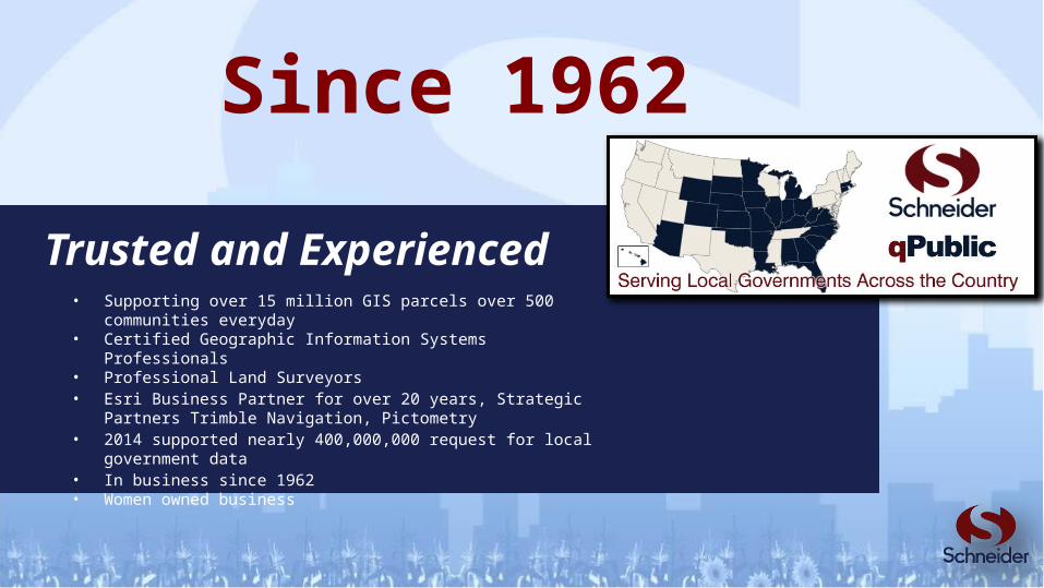
September 25, 2013
700 Block Front Street, Georgetown SC
Georgetown County, SC

$2.5 million, 7 Commercial and Historic Buildings


Emergency Management Office and Damage Assessment team from the Tax Assessor’s office
Damage Assessment team using mobile device to enter damages into IDAM system

Damage Assessment team using mobile device to enter damages into IDAM system

Damage Assessment team using mobile device to enter damages into IDAM system

FEMA Forms exported

“Thanks to the use of IDAM we had answers and accurate information ready for the governor the minute she stepped off the plane. Also, If it were not for IDAM I am sure the relief from the state and the federal government would have been delayed for many more days.” Sam Hodge, Georgetown County Emergency Manager
Governor visit

Executive Emergency Order from Governor Haley

Ownership Report

Public Outreach• SCEMD Recovery Chief worked with property
owners to determine the losses as a Preliminary Damage Assessment for the state

Small Business Administration came down for 3 days to work with affected individuals

Small Business Administration came down to complete their Damage Assessment to determine the needs and see what programs would be available.

What were the results?• 24 hours after the fire was put out the State of
South Carolina declared this a disaster thus making state aid available.
• Within just a few days the business owners received approval for federal aid from Small Business Association.
• This money was designated for small businesses affected by the fire, its purpose was to help these shops, restaurants, etc. stay afloat while closed and expedite their reopening.

Mitigation's Value to Society
http://www.fema.gov/what-mitigation

After a natural disaster your community will need to;• Provide data so that decision-makers can act swiftly
to the needed disaster responses (i.e., "declaring the disaster” or not)
– Where on the map in the community– Initial estimates of damage by connecting to the property
appraiser / assessor data
• Documented estimates produce FEMA forms• Report your damages to FEMA• Support organization, coordination and
communication after a natural disaster • When a disaster happens it’s not the time to learn
the hard way.
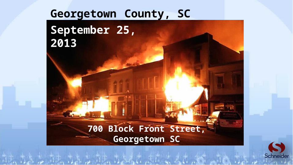
Damage Assessment for Local Government

Damage Assessment for Local Government
• How does FEMA get involved in a State disaster?
– State has declared a state of emergency,– State will evaluate the recovery
capabilities of the State and Local Governments.
– Governor will send a request letter to the President, directed through the Regional Director of the appropriate FEMA region.
– The President then makes the decision whether or not to declare a major disaster or emergency.
http://www.fema.gov/public-assistance-frequently-asked-questions#Q02

• How does FEMA get involved in a State disaster?
– After a presidential declaration has been made, FEMA will designate the area eligible for assistance and announce the types of assistance available. FEMA provides supplemental assistance for State and local government recovery expenses, and the Federal share will always be at least 75 percent of the eligible costs.
http://www.fema.gov/public-assistance-frequently-asked-questions#Q02
Damage Assessment for Local Government

Damage Assessment for Local Government
Integrated Damage Assessment Model

• qPublic.net ™, Beacon™ – CAMA Integration• GIS Integration and Interactive Mapping• Custom Workflows
CAMA
FEMA Reports
GIS
Field Collection
Assessment
Damage Surveys
Damage Surveys
Mobile

• Perform individual assistance and public assistance damage surveys
• Must provide completed FEMA forms
• IDAM™ tracks and manages field teams
• IDAM™ provides the ability to upload damage and debris photos from the field
• IDAM™ provides command-center with real-time views to track the overall assessment progress with live updates from the field
• IDAM™ connects to current GIS and Assessment data to organize affected parcels
• No additional hardware or software needed
• Automated workflow management
• Automated email notifications• Better Information Tracking and
Access• Increased Time Savings
Damage Assessment for Local GovernmentIntegrated Damage Assessment Model

• Home / Events• View Map• Dashboard• Search / Edit• Administration• My Account
• Repot• Public Assistance• Help• Sign Out• Chat
Damage Assessment for Local GovernmentIntegrated Damage Assessment Model

• Home / Events– Pick or create new event– Assign Teams– View Damage Reports
Damage Assessment for Local GovernmentIntegrated Damage Assessment Model

• Team Selection
Damage Assessment for Local GovernmentIntegrated Damage Assessment Model
• View Map - GIS integration and display
Damage Assessment for Local GovernmentIntegrated Damage Assessment Model

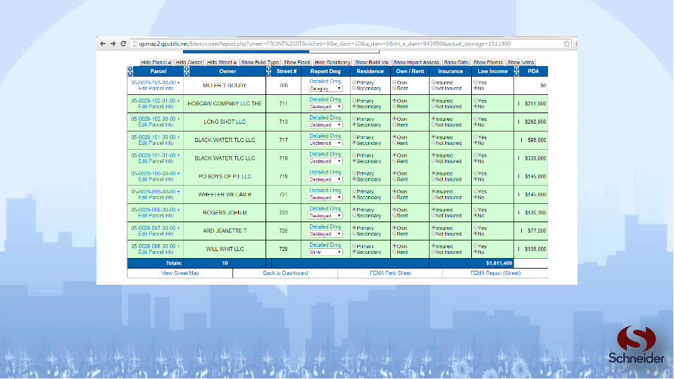
• GIS integration with reports and assessment
Damage Assessment for Local GovernmentIntegrated Damage Assessment Model
Assign teams by location

• Bulk Property Updates
Damage Assessment for Local GovernmentIntegrated Damage Assessment Model

• Single Property Assessment
Damage Assessment for Local GovernmentIntegrated Damage Assessment Model

• 3rd Party Integration
Damage Assessment for Local GovernmentIntegrated Damage Assessment Model
Bing
Pictometry

• Debris Mapping / Tracking / Reporting
Damage Assessment for Local GovernmentIntegrated Damage Assessment Model

• Dashboard
Damage Assessment for Local GovernmentIntegrated Damage Assessment Model

• Search and Edit
Damage Assessment for Local GovernmentIntegrated Damage Assessment Model

• Reporting
Damage Assessment for Local GovernmentIntegrated Damage Assessment Model


Public Assistance
Damage Assessment for Local GovernmentIntegrated Damage Assessment Model
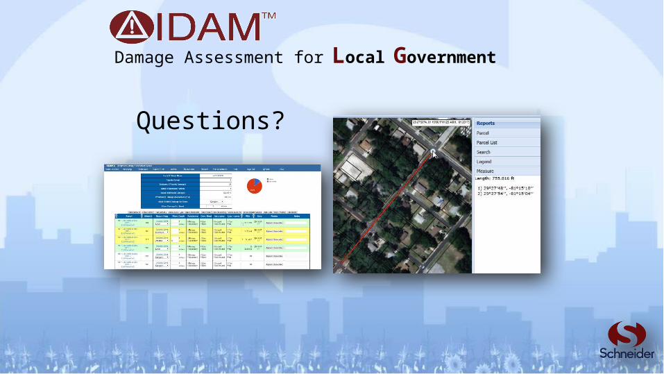
Questions?
Damage Assessment for Local Government
Related Documents