Tropical Rainfall Measuring Mission observation and regional model study of precipitation diurnal cycle in the New Guinean region Li Zhou 1 and Yuqing Wang 1 Received 1 March 2006; revised 23 May 2006; accepted 8 June 2006; published 9 September 2006. [1] The diurnal cycle of precipitation in the New Guinean region is studied on the basis of satellite observations from Tropical Rainfall Measuring Mission (TRMM) Precipitation Radar (PR) measurements and regional atmospheric model simulations. The study focuses on the effects of both the land-sea breeze and the orographic forcing on the diurnal evolution of precipitation during the rainy season (January – March) in the region. The 7-year TRMM PR data composite reveals several distinct features of the precipitation diurnal cycle in the region. Precipitation bands develop in the inland coastal region in the late morning to early afternoon and migrate inland from both northeast and southwest sides of the New Guinean Island following the inland penetration of the sea-breeze fronts. A separate convective rainband develops over the central mountain ridge in the early afternoon as a result of the development of the upslope winds due to the elevated surface warming over the mountain in the morning hours. This mountain ridge rainband intensifies and becomes the dominant rainband as the coastal rainbands associated with the sea-breeze fronts weaken during the late afternoon and the early evening. In the midnight to the early morning the rainband over the mountaintop weakens as downslope winds develop and splits into two rainbands, propagating away from the mountain ridge, one to the north and one to the south, and weakens over the lowland some distance away from the coasts. Meanwhile a coastal rainband develops offshore on each side of the island in the late evening to midnight and remains strong through early morning before it migrates offshore. As a result, the rainfall rate peaks in the late afternoon to early evening in most land areas except for in the lowland regions between the coastlines and the mountain where the rainfall rate peaks during the midnight, while the rainfall rate peaks in the late evening to early morning in most coastal regions offshore. The distribution of the diurnal amplitude shows two maxima: one over the mountains and the other in the coastal regions offshore. Convective rainfall rate peaks in the late afternoon while stratiform rainfall rate peaks in the midnight to early morning. The latter dominates the large diurnal amplitude over the mountain areas in the early morning. The above broad features are simulated reasonably well in a control experiment with a high-resolution regional atmospheric model. A sensitivity experiment with the terrain removed is conducted to elucidate the role of orographic forcing in the diurnal evolution of both the local circulation and rainfall patterns. The results show that the orographic forcing affects the diurnal precipitation through three major processes. First, the orography increases the moisture convergence at low levels by blocking and deflecting the mean flow. Second, the upslope winds help initiate convection in the afternoon at the mountaintop. Finally, the deep convection over the mountain acts as a source of propagating gravity waves, which help initiate rainbands in the coastal regions offshore in the late evening to early morning. Implication of the results is discussed. Citation: Zhou, L., and Y. Wang (2006), Tropical Rainfall Measuring Mission observation and regional model study of precipitation diurnal cycle in the New Guinean region, J. Geophys. Res., 111, D17104, doi:10.1029/2006JD007243. 1. Introduction [2] The islands of the Maritime Continent play an im- portant role in both global general circulation and regional weather and climate [e.g., Chang et al., 2004, 2005a, 2005b]. Convective activity over the Maritime Continent is one of the major energy sources driving the global JOURNAL OF GEOPHYSICAL RESEARCH, VOL. 111, D17104, doi:10.1029/2006JD007243, 2006 Click Here for Full Articl e 1 International Pacific Research Center and Department of Meteorology, School of Ocean and Earth Science and Technology, University of Hawaii at Manoa, Honolulu, Hawaii, USA. Copyright 2006 by the American Geophysical Union. 0148-0227/06/2006JD007243$09.00 D17104 1 of 18

Welcome message from author
This document is posted to help you gain knowledge. Please leave a comment to let me know what you think about it! Share it to your friends and learn new things together.
Transcript
Tropical Rainfall Measuring Mission observation and regional model
study of precipitation diurnal cycle in the New Guinean region
Li Zhou1 and Yuqing Wang1
Received 1 March 2006; revised 23 May 2006; accepted 8 June 2006; published 9 September 2006.
[1] The diurnal cycle of precipitation in the New Guinean region is studied on the basis ofsatellite observations from Tropical Rainfall Measuring Mission (TRMM) PrecipitationRadar (PR) measurements and regional atmospheric model simulations. The study focuseson the effects of both the land-sea breeze and the orographic forcing on the diurnalevolution of precipitation during the rainy season (January–March) in the region. The 7-yearTRMMPR data composite reveals several distinct features of the precipitation diurnal cyclein the region. Precipitation bands develop in the inland coastal region in the late morning toearly afternoon and migrate inland from both northeast and southwest sides of the NewGuinean Island following the inland penetration of the sea-breeze fronts. A separateconvective rainband develops over the central mountain ridge in the early afternoon as aresult of the development of the upslope winds due to the elevated surface warming over themountain in the morning hours. This mountain ridge rainband intensifies and becomes thedominant rainband as the coastal rainbands associated with the sea-breeze fronts weakenduring the late afternoon and the early evening. In the midnight to the early morning therainband over the mountaintop weakens as downslope winds develop and splits intotwo rainbands, propagating away from the mountain ridge, one to the north and one tothe south, and weakens over the lowland some distance away from the coasts.Meanwhile a coastal rainband develops offshore on each side of the island in the lateevening to midnight and remains strong through early morning before it migratesoffshore. As a result, the rainfall rate peaks in the late afternoon to early evening inmost land areas except for in the lowland regions between the coastlines and the mountainwhere the rainfall rate peaks during the midnight, while the rainfall rate peaks in thelate evening to early morning in most coastal regions offshore. The distribution of thediurnal amplitude shows two maxima: one over the mountains and the other in the coastalregions offshore. Convective rainfall rate peaks in the late afternoon while stratiformrainfall rate peaks in the midnight to early morning. The latter dominates the large diurnalamplitude over the mountain areas in the early morning. The above broad features aresimulated reasonably well in a control experiment with a high-resolution regionalatmospheric model. A sensitivity experiment with the terrain removed is conducted toelucidate the role of orographic forcing in the diurnal evolution of both the local circulationand rainfall patterns. The results show that the orographic forcing affects the diurnalprecipitation through three major processes. First, the orography increases the moistureconvergence at low levels by blocking and deflecting the mean flow. Second, the upslopewinds help initiate convection in the afternoon at the mountaintop. Finally, the deepconvection over the mountain acts as a source of propagating gravity waves, which helpinitiate rainbands in the coastal regions offshore in the late evening to early morning.Implication of the results is discussed.
Citation: Zhou, L., and Y. Wang (2006), Tropical Rainfall Measuring Mission observation and regional model study of precipitation
diurnal cycle in the New Guinean region, J. Geophys. Res., 111, D17104, doi:10.1029/2006JD007243.
1. Introduction
[2] The islands of the Maritime Continent play an im-portant role in both global general circulation and regionalweather and climate [e.g., Chang et al., 2004, 2005a,2005b]. Convective activity over the Maritime Continentis one of the major energy sources driving the global
JOURNAL OF GEOPHYSICAL RESEARCH, VOL. 111, D17104, doi:10.1029/2006JD007243, 2006ClickHere
for
FullArticle
1International Pacific Research Center and Department of Meteorology,School of Ocean and Earth Science and Technology, University of Hawaiiat Manoa, Honolulu, Hawaii, USA.
Copyright 2006 by the American Geophysical Union.0148-0227/06/2006JD007243$09.00
D17104 1 of 18
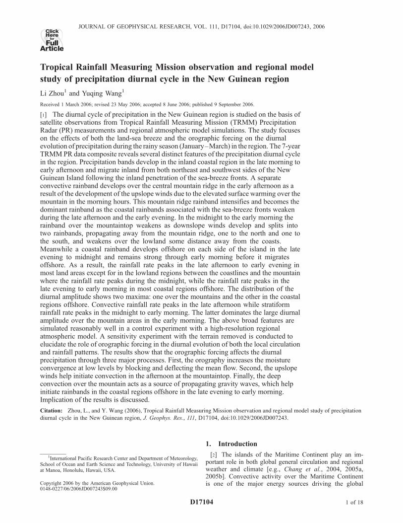
circulation [McBride et al., 2003; Neale and Slingo, 2003].The convective activity is strongly affected by orographyover this region and shows remarkable diurnal variation[Holland and Keenan, 1980; Kubota and Nitta, 2001;Liberti et al., 2001; Wu et al., 2003; Mori et al., 2004;Byon and Lim, 2005; Sakurai et al., 2005]. Recent obser-vational studies by Hsu and Lee [2005] show that small andmesoscale mountains in the Maritime Continent region canconsiderably modulate the activity of large-scale tropicalconvection and regulate the Madden-Julian Oscillation(MJO). The New Guinean Island is located in the easternend of the Maritime Continent with a width of about 600 kmand is elongated in the northwest-southeast direction. Itscentral mountain ridge is the largest and highest in theMaritime Continent region and has a peak elevation over3000 m above the mean sea level (Figure 1).[3] Despite its importance to large-scale circulation, con-
vection over the Maritime Continent is hard to be accuratelysimulated by most global general circulation models(GCMs), partly because of the coarse spatial resolutionand partly because of the use of inaccurate physics param-eterizations. This gives rise to the low skills of many GCMsin simulating the MJO [Slingo et al., 1996; Sperber et al.,1996]. In addition to insufficient resolution to resolve thedetailed land-sea contrasts and orography, most GCMs havesystematic bias in simulating the diurnal evolution of cloudsand precipitation in the tropics [Yang and Slingo, 2001;Betts and Jakob, 2002; Slingo et al., 2004; Dai andTrenberth, 2004; Neale and Slingo, 2003]. Recent studiesshow that diurnal cycle of clouds and precipitation canaffect the model behavior at longer timescales, such as themean climate and low-frequency variability [Neale andSlingo, 2003; Wang et al., 2006]. Therefore current GCMbiases in simulating the large-scale convective activity overthe Maritime Continent could be partially attributed to thesystematic bias in the simulation of diurnal cycle of cloudsand precipitation.[4] Simulation of diurnal variation of clouds and precip-
itation provides a key test of many aspects of the physicalparameterizations in an atmospheric model, from radiativetransfer and surface exchanges through to boundary layerand cloud and precipitation processes [Yang and Slingo,2001]. Further, in case of coastal areas and mountains, thisalso a test for the ability of a model to capture the correctscale of thermally forced circulations, such as land-seabreeze and upslope/downslope winds. Recent efforts havebeen made either to improve/evaluate the simulation ofdiurnal cycle in climate models [Betts and Jakob, 2002;Slingo et al., 2004; Dai and Trenberth, 2004; Wang et al.,2006] or to improve the understanding of physical processeskey to the diurnal variation of clouds and precipitation [Suiet al., 1997; Liberti et al., 2001; Saito et al., 2001; Kubotaet al., 2004; Kataoka and Satomura, 2005].[5] Although diurnal cycle of clouds and precipitation is
ultimately related to solar heating, it is subject to greatregionality and seasonality and depends largely on bothlarge-scale circulation and regional forcing, such as theland-sea contrast and orographic forcing [Wallace, 1975;Liberti et al., 2001; Nesbitt and Zipser, 2003; Yang et al.,2004; Tian et al., 2005; Hong et al., 2005]. In particular,recent studies with high-resolution satellite measurementshave revealed many detailed characteristics of diurnal cycle
of clouds and precipitation in the Maritime Continent region[Kubota and Nitta, 2001; Liberti et al., 2001; Wu et al.,2003;Mori et al., 2004; Byon and Lim, 2005; Sakurai et al.,2005]. These studies show that rainfall rate generally peaksin the late afternoon to early evening over the land and thelocal time of rainfall peak migrates offshore because ofeither the reversal of land-sea breeze or gravity wavesforced by deep convection previously developed over theland or both [Liberti et al., 2001; Mapes et al., 2003; Moriet al., 2004; Sakurai et al., 2005].[6] By great chance, recent observational and modeling
studies have mainly focused on the diurnal cycle of con-vection over the Sumatra Island [Mori et al., 2004; Sakuraiet al., 2005; Kataoka and Satomura, 2005]. The diurnalcycle of clouds and precipitation over the New Guinea,however, has received much less attention although it hasthe highest mountain ridge among the islands of theMaritime Continent. The first comprehensive observationalstudy of diurnal cycle of cloud systems was made by Libertiet al. [2001], who examined the effects of New Guinea andother major islands on the diurnal cycle of clouds within thesurrounding ocean areas from Geostationary MeteorologicalSatellite (GMS) infrared radiation (IR) data. They found thatthe precipitating cloud systems were forced by low-levelconvergence between the large-scale flow and a possibleland breeze over the land and then propagated offshore upto 600 km away from the coast of New Guinea at an averagespeed of about 15 m s�1. Although GMS IR data provideboth high temporal and spatial resolution cloud image, theycould not provide either rainfall rate or the nature ofconvective or stratiform precipitation. These however arekey to both understanding the nature of precipitation systemand validating numerical model simulations.[7] In this study, we first examine the diurnal cycle of
precipitation over the New Guinea and surrounding oceansin the rainy season (January to March) using the 7-yearTropical Rainfall Measuring Mission (TRMM) PrecipitationRadar (PR) 3G68 data, which provide hourly convectiveand stratiform rainfall rates with a resolution of 0.5� longitudeby 0.5� latitude from 1998 to 2004. A control simulation is
Figure 1. Model computational domain and terrain heightin meters, together with the ERA40 3 month (January toMarch 1998) mean wind vector (in m s�1) at 925 hPa.
D17104 ZHOU AND WANG: PRECIP. DIURNAL CYCLE OVER NEW GUINEA
2 of 18
D17104
then conducted with a high-resolution regional climate modelwith dual objectives: to test the model’s ability in simulatingthe diurnal evolution of clouds and precipitation, and toexamine the evolution of the associated three-dimensionalstructure of the local circulation. Finally a sensitivity exper-imentwithmountains removed is performed to investigate thepossible effect of orography on the diurnal cycle of clouds andprecipitation in the region.[8] The rest of the paper is organized as follows. The next
section describes the TRMM PR 3G68 data and the regionalatmospheric model used in this study, together with a briefdescription of the design of numerical experiments. Section 3discusses the composite diurnal cycle of precipitationfrom 7-year TRMM PR observations. The results froma control simulation are analyzed in section 4, which isfollowed by a discussion on the results from a sensitivityexperiment with the model orography removed in section 5.Our main findings are summarized in the last section.
2. TRMM PR Data, Model, and ExperimentalDesign
2.1. TRMM PR Data
[9] The observed rainfall rates in this study were takenfrom the Tropical Rainfall Measuring Mission (TRMM)3G68 precipitation radar (PR) data covering 7 consecutiveyears from 1998 to 2004. These data represent instanta-neous values of the rain rate (also provided is the fraction ofthe rain rate estimated to be of convective origin) on 0.5 �0.5 degree latitude/longitude grids. Given the limited sam-pling provided by the TRMM satellite, these data arecomposited for each grid box and each hour of the dayfrom the January–March period in 7 consecutive years(1998–2004). Although it suffers from both a narrow swathand coarse sampling time intervals, the TRMM 3G68 dataset is still a very useful data set to represent the precipitationdiurnal cycle [e.g., Negri et al., 2002]. As suggested byNegri et al., a 4-hour running mean was applied to thecomposite diurnal cycle to reduce the noise level.[10] The TRMM 3G68 rain type (convective/stratiform)
classification is based on the Version 6 TRMM PR products(containing TRMM 2A12 [Kummerow et al., 2001], 2A25[Iguchi et al., 2000], and 2B31 [Haddad et al., 1997]),which classifies the rain type according to vertical structure,such as bright-band identification, echo-top height, andmaximum reflectivity in the vertical profile, and horizontalvariability of the echo, such as peakedness and local echointensity [Houze, 1997]. Although the algorithm for the raintype classification could not be perfect because of criteriaused, the 3G68 rain types have been the only and the bestproducts that can resolve the diurnal cycle of precipitationwith a global coverage. The overall features that we willdiscuss should not be affected significantly by the uncer-tainties in the algorithm.
2.2. Model
[11] The model used in this study is the regional climatemodel, IPRC–RegCM, developed at the International Pa-cific Research Center (IPRC), University of Hawaii. Adetailed description of the model and its performance insimulating regional climate over East Asia and over theeastern Pacific is given by Wang et al. [2003, 2004a,
2004b]. A recent application of the model to the study oflarge-scale diurnal cycle of tropical precipitation over theMaritime Continent is given in Wang et al. [2006]. Themodel uses hydrostatic primitive equations in sphericalcoordinates with s (pressure normalized by surface pres-sure) as the vertical coordinate. The model equations aresolved with a 4th-order conservative horizontal finite dif-ference scheme on a longitude/latitude grid system and aleapfrog scheme with intermittent use of the Euler backwardscheme for the time integration.[12] The model physics include a cloud microphysics
scheme for grid-scale moist processes [Wang, 2001]; anonlocal E-e turbulence closure scheme for subgrid-scalevertical mixing [Langland and Liou, 1996]; a Monin-Obkuhov similarity scheme for surface flux calculation overthe ocean [Fairall et al., 2003]; the Biosphere-AtmosphereTransfer Scheme (BATS) of Dickinson et al. [1993] for landsurface processes; the radiation package originally devel-oped by Edwards and Slingo [1996] and further improvedlater by Sun and Rikus [1999]; and the mass flux convectiveparameterization scheme for subgrid-scale shallow, midle-vel, and penetrative convection originally developed byTiedtke [1989], and later modified by Nordeng [1995].The modified convective parameterization scheme uses aCAPE closure instead of the original moisture convergenceclosure for deep convection. Cloud amount is diagnosedusing the Xu and Randall [1996] semiempirical parameter-ization scheme. In order to improve the simulation ofprecipitation diurnal cycle, the convective lateral entrain-ment/detrainment rate for shallow convection in the Tiedtkescheme was taken to be 2 � 10�3 m�1 as recommended bySiebesma and Holtslag [1996] and Wang et al. [2006].[13] The model has its own rain type classification based
on the grid resolved motion. Subgrid-scale convection isallowed to occur only when a grid box is conditionallyconvectively unstable [Tiedtke, 1989] and has an averagedrelative humidity larger than 80% in the detected cloudcolumn [Wang et al., 2003]. Grid-scale condensation occurswhen the relative humidity of the grid box is at 100% andthe resulted precipitation is regarded as stratiform precipi-tation in the model. This definition is quite different fromthat used in the TRMM PR product. Therefore comparisonof the fraction of stratiform versus total precipitation shouldnot be considered quantitative but just suggestive as areference.
2.3. Design of Numerical Experiments
[14] The experimental design follows Wang et al. [2006].The model domain covers the region 125–155�E and15�S–5�N over New Guinea with a horizontal grid spacingof 0.15 degrees in both longitude and latitude, which canresolve reasonably well the central mountains over NewGuinea (Figure 1). The model has 28 s levels in the verticalwith stretched high resolution in the lower troposphere tobetter represent the atmospheric boundary layer processes.The USGS high-resolution topographic data set (0.0833� �0.0833�) was used to obtain the model envelope orography.The high-resolution vegetation type data from USGS isreanalyzed for the model based on the dominant vegetationtype in each grid box.[15] The European Center for Medium-Range Weather
Forecast (ECMWF) reanalysis (ERA40) available at every
D17104 ZHOU AND WANG: PRECIP. DIURNAL CYCLE OVER NEW GUINEA
3 of 18
D17104
6 hour intervals with a resolution of 2.5� � 2.5� in thehorizontal and 17 pressure levels up to 10 hPa was used todefine both the initial and lateral boundary conditions forthe regional model. Sea surface temperatures (SSTs) overthe ocean were obtained from the National Oceanic andAtmospheric Administration (NOAA) version 2 optimuminterpolation (OI) weekly SST data with horizontal resolu-tion of 1� � 1� [Reynolds et al., 2002], which wereinterpolated into the model grids by cubic spline interpola-tion in space and linearly interpolated in time. Note thatthese SST values have no diurnal variation, a limitation forrealistic simulation of precipitation diurnal cycle over theoceans [Wang et al., 2006]. Over the land, the initial surfacesoil and canopy temperatures were obtained from the lowestmodel level with a standard lapse rate of 6�C/km. Soilmoisture fields were initialized depending on the vegetationand soil types following Giorgi and Bates [1989]. Themodel was initialized from 0000 UT on 1 January 1998and integrated continuously through 31 March for 3 months.This is the rainy season of the New Guinean region wherethe cross-equatorial flow originated from the northeastwinter monsoon from the Northern Hemisphere meets thewesterlies to the south of the equator as seen from the 3month mean winds at 925 hPa from the ERA40 (Figure 1).[16] Two experiments were performed. In a control ex-
periment (CNTRL), the default settings were used with therealistic orography. In a sensitivity experiment (No-TOP),the model settings were the same as in CNTRL except forthe model orography was reset to 0.1 m in the modeldomain so that the orographic effect was removed.[17] Note that 1998 was accidentally a strong El Nino
year. The year was selected because the same year wasstudied in another study by the authors with the focus on theeffect of convective entrainment/detrainment rate on thesimulation of tropical precipitation diurnal cycle in the wholeMaritime Continent region [Wang et al., 2006]. Generally,mean precipitation during the strong El Nino year over thewestern Pacific warm pool region (including the NewGuinean region) is below normal [Chang et al., 2005b].Therefore comparison of model simulation with 7-yearTRMM observations should be with caution. However,the characteristics of the 3-month mean diurnal cycleshould not be subject to significant interannual variabilityalthough the diurnal amplitude could be modulated inresponse to the total rainfall in the region. We thus do notexpect considerable changes for the conclusions madefrom this study if a different year is chosen.
3. Observed Diurnal Cycle of Precipitation
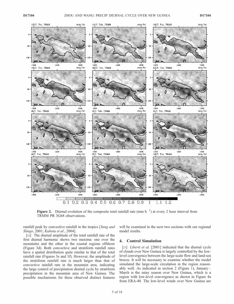
[18] Figure 2 shows the diurnal evolution of the compos-ite total rainfall rate at every 2 hour interval obtained fromTRMM PR 3G68 data. A weak rainband develops near thecoastal region onshore on each side of the island in the earlyafternoon (1200–1400 LT), then migrates inland as a resultof the inland penetration of the sea-breeze front, and finallyweakens during the late afternoon and early evening (1800–2000 LT). Meanwhile, a narrow rainband forms along thecentral mountain ridge at about 1200 LT and continuouslyintensifies until the rainfall rate reaches the maximum in theearly evening (2000 LT). This mountain rainband splits intotwo rainbands along each side of the mountain ridge during
the midnight (2200–2400 LT) to the early morning. Thetwo rainbands then migrate away from the mountain areas,one to the south and one to the north. At the same time, aconvective rainband develops over the coastal region off-shore (0000–0400 LT), triggered by the land breeze andgravity waves forced by convection earlier over the moun-tain areas (see further discussions in sections 4 and 5). Asthe inland rainbands migrate toward the coastal regions andweaken, the coastal rainband offshore intensifies (0400–0600 LT) and migrate offshore (0800–1200 LT). Therainfall rate decreases as the distance increases offshore(1200–1800 LT).[19] Liberti et al. [2001] studied the diurnal cycle of
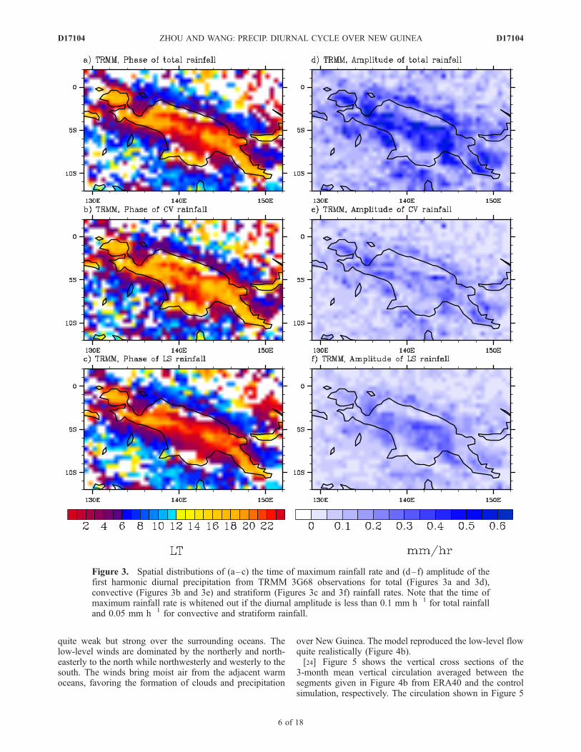
clouds over the New Guinea based on hourly high-resolutionbrightness temperature images from GMS data and revealedvery similar features. However, the phase of diurnal cycle ofclouds that they found seems about 2 hours earlier than thephase of precipitation described in this study. They showedthat the coldest clouds develop from about 1000 LT over thehighest mountains and the coastal areas but start todevelop offshore of northern coast from 0200 LT. How-ever, we found the rainfall is initiated around 1200 LTover the mountain ridge and the rainbands in the coastalregions offshore form during the midnight. The differ-ences between theirs and ours are understandable sincewe show the 7-year composite diurnal cycle of rainfallrate while Liberti et al. showed the cloud systems in a 4monthperiod between November 1992 and February 1993.Consistent with their results, TRMM PR data also showan offshore migration of the diurnal signal in the direc-tion roughly perpendicular to the coastline during 0800–1600 LT.[20] Figure 3 shows the spatial distributions of the time of
the maximum rainfall rate (Figures 3a–3c) and the ampli-tude (Figures 3d–3f) of the first harmonic diurnal precip-itation from TRMM observations for total, stratiform, andconvective rainfall rates, respectively. The total rainfall ratepeaks in the late afternoon to early evening in most landareas except for in the regions between the coastlines andthe mountain area where the rainfall rate peaks between lateevening to midnight (Figure 3a). This is consistent with theoff mountain migration of the split rainbands over themountain ridge earlier during the day seen in Figure 2.Along the coastal region the rainfall rate generally peaks inthe midnight to early morning. Further offshore to the northof New Guinea the rainfall rate peaks in the afternoon, aclear signal of offshore diurnal migration of precipitation.[21] The time of the maximum convective rainfall rate has
a similar pattern to that of the total rainfall rate but generallyleads that of the total rainfall rate maximum by about 1–2 hours (Figure 3b). In contrast, the time of maximumstratiform rainfall rate generally lags that of maximumtotal rainfall rate by about 1–2 hours or lags that ofmaximum convective rainfall rate by about 3–4 hours.This is an important feature that has not been discussedfor the region previously although the potential importance ofsuch a phase difference was discussed by Houze [1997] andRickenbach [2004]. Our results indicate that both convectiveand stratiform precipitation contribute to the diurnal cycle ofprecipitation with the latter delays the time of the overallrainfall peak. Previous studies show predominant control of
D17104 ZHOU AND WANG: PRECIP. DIURNAL CYCLE OVER NEW GUINEA
4 of 18
D17104
rainfall peak by convective rainfall in the tropics [Yang andSlingo, 2001; Kubota et al., 2004].[22] The diurnal amplitude of the total rainfall rate of the
first diurnal harmonic shows two maxima: one over themountains and the other in the coastal regions offshore(Figure 3d). Both convective and stratiform rainfall rateshave a spatial distribution quite similar to that of the totalrainfall rate (Figures 3e and 3f). However, the amplitude ofthe stratiform rainfall rate is much larger than that ofconvective rainfall rate in the mountain area, indicatingthe large control of precipitation diurnal cycle by stratiformprecipitation in the mountain area of New Guinea. Thepossible mechanisms for these observed distinct features
will be examined in the next two sections with our regionalmodel results.
4. Control Simulation
[23] Liberti et al. [2001] indicated that the diurnal cycleof clouds over New Guinea is largely controlled by the low-level convergence between the large-scale flow and land-seabreeze. It will be necessary to examine whether the modelsimulated the large-scale circulation in the region reason-ably well. As indicated in section 2 (Figure 1), January–March is the rainy season over New Guinea, which is aregion with low-level convergence as shown in Figure 4afrom ERA-40. The low-level winds over New Guinea are
Figure 2. Diurnal evolution of the composite total rainfall rate (mm h�1) at every 2 hour interval fromTRMM PR 3G68 observations.
D17104 ZHOU AND WANG: PRECIP. DIURNAL CYCLE OVER NEW GUINEA
5 of 18
D17104
quite weak but strong over the surrounding oceans. Thelow-level winds are dominated by the northerly and north-easterly to the north while northwesterly and westerly to thesouth. The winds bring moist air from the adjacent warmoceans, favoring the formation of clouds and precipitation
over New Guinea. The model reproduced the low-level flowquite realistically (Figure 4b).[24] Figure 5 shows the vertical cross sections of the
3-month mean vertical circulation averaged between thesegments given in Figure 4b from ERA40 and the controlsimulation, respectively. The circulation shown in Figure 5
Figure 3. Spatial distributions of (a–c) the time of maximum rainfall rate and (d–f) amplitude of thefirst harmonic diurnal precipitation from TRMM 3G68 observations for total (Figures 3a and 3d),convective (Figures 3b and 3e) and stratiform (Figures 3c and 3f) rainfall rates. Note that the time ofmaximum rainfall rate is whitened out if the diurnal amplitude is less than 0.1 mm h�1 for total rainfalland 0.05 mm h�1 for convective and stratiform rainfall.
D17104 ZHOU AND WANG: PRECIP. DIURNAL CYCLE OVER NEW GUINEA
6 of 18
D17104
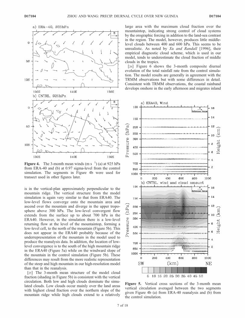
is in the vertical-plan approximately perpendicular to themountain ridge. The vertical structure from the modelsimulation is again very similar to that from ERA40. Thelow-level flows converge onto the mountain area andascend over the mountain and diverge in the upper tropo-sphere above 300 hPa. The low-level convergent flowextends from the surface up to about 700 hPa in theERA40. However, in the simulation there is a low-levelreturning flow at the level of the mountaintop, forming alow-level cell, to the north of the mountain (Figure 5b). Thisdoes not appear in the ERA40 probably because of theunderrepresentation of the mountain in the model used toproduce the reanalysis data. In addition, the location of low-level convergence is to the south of the high mountain ridgein the ERA40 (Figure 5a) while on the windward slope ofthe mountain in the control simulation (Figure 5b). Thesedifferences may result from the more realistic representationof the steep and high mountain in our high-resolution modelthan that in the reanalysis.[25] The 3-month mean structure of the model cloud
fraction (shading in Figure 5b) is consistent with the verticalcirculation. Both low and high clouds dominate the simu-lated clouds. Low clouds occur mainly over the land areaswith highest cloud fraction over the northern slope of themountain ridge while high clouds extend to a relatively
large area with the maximum cloud fraction over themountaintop, indicating strong control of cloud systemsby the orographic forcing in addition to the land-sea contrastin the region. The model, however, produces little middle-level clouds between 400 and 600 hPa. This seems to beunrealistic. As noted by Xu and Randall [1996], theirempirical diagnostic cloud scheme, which is used in ourmodel, tends to underestimate the cloud fraction of middleclouds in the tropics.[26] Figure 6 shows the 3-month composite diurnal
evolution of the total rainfall rate from the control simula-tion. The model results are generally in agreement with theTRMM observations but with some differences in detail.Consistent with TRMM observations, the coastal rainbanddevelops onshore in the early afternoon and migrates inland
Figure 4. The 3-month mean winds (m s�1) (a) at 925 hPafrom ERA-40 and (b) at 0.97 sigma-level from the controlsimulation. The segments in Figure 4b were used fortransect used in other figures later.
Figure 5. Vertical cross sections of the 3-month meanvertical circulation averaged between the two segmentsgiven Figure 4b (a) from ERA-40 reanalysis and (b) fromthe control simulation.
D17104 ZHOU AND WANG: PRECIP. DIURNAL CYCLE OVER NEW GUINEA
7 of 18
D17104
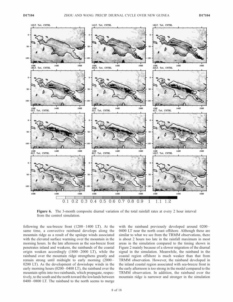
following the sea-breeze front (1200–1400 LT). At thesame time, a convective rainband develops along themountain ridge as a result of the upslope winds associatedwith the elevated surface warming over the mountain in themorning hours. In the late afternoon as the sea-breeze frontpenetrates inland and weakens, the rainbands of the coastalorigin weaken accordingly (1800–2000 LT), while therainband over the mountain ridge strengthens greatly andremain strong until midnight to early morning (2000–0200 LT). As the development of downslope winds in theearly morning hours (0200–0400 LT), the rainband over themountain splits into two rainbands, which propagate, respec-tively, to the south and the north toward the lowlands between0400–0800 LT. The rainband to the north seems to merge
with the rainband previously developed around 0200–0400 LT near the north coast offshore. Although these aresimilar to what we see from the TRMM observations, thereis about 2 hours too late in the rainfall maximum in mostareas in the simulation compared to the timing shown inFigure 2 mainly because of a slower migration of the diurnalsignal in the simulation. Meanwhile, the rainband in thecoastal region offshore is much weaker than that fromTRMM observation. However, the rainband developed inthe inland coastal region associated with sea-breeze front inthe early afternoon is too strong in the model compared to theTRMM observation. In addition, the rainband over themountain ridge is narrower and stronger in the simulation
Figure 6. The 3-month composite diurnal variation of the total rainfall rates at every 2 hour intervalfrom the control simulation.
D17104 ZHOU AND WANG: PRECIP. DIURNAL CYCLE OVER NEW GUINEA
8 of 18
D17104
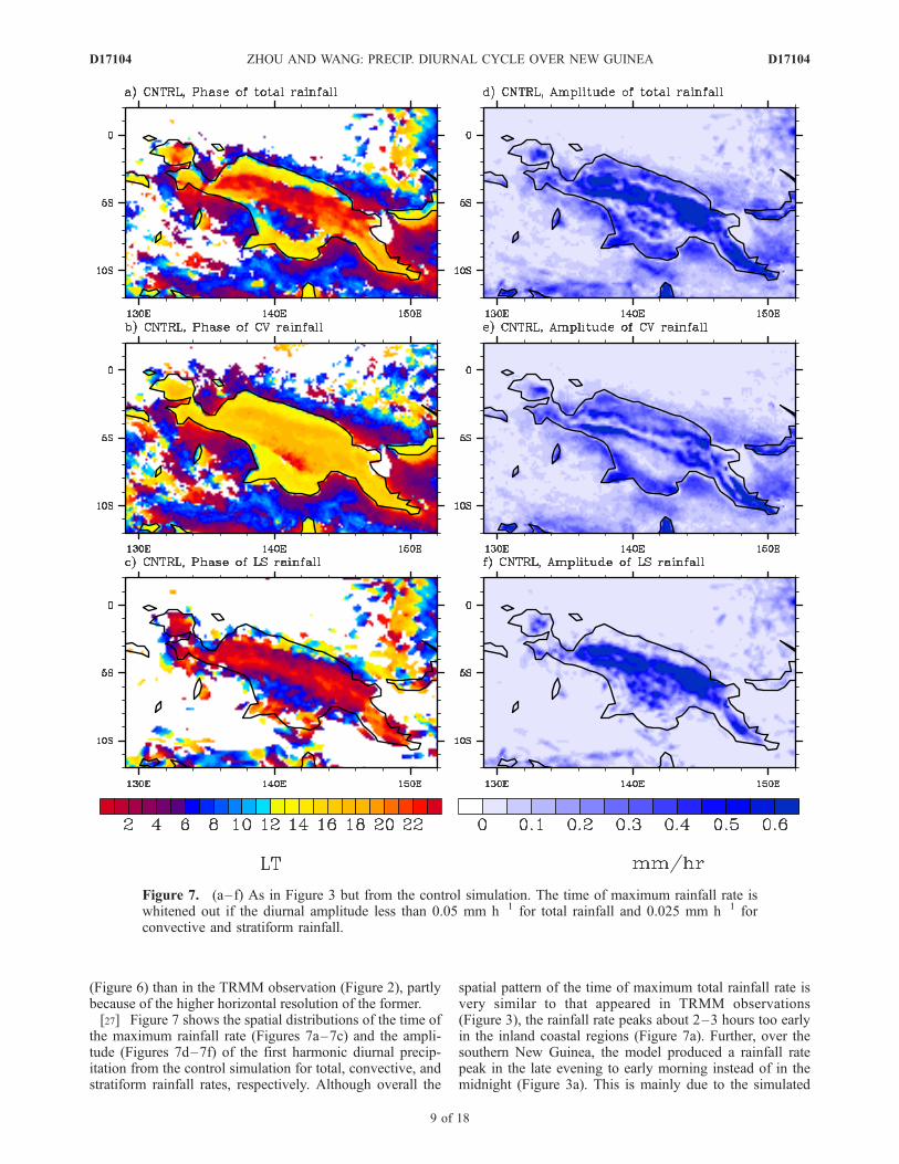
(Figure 6) than in the TRMM observation (Figure 2), partlybecause of the higher horizontal resolution of the former.[27] Figure 7 shows the spatial distributions of the time of
the maximum rainfall rate (Figures 7a–7c) and the ampli-tude (Figures 7d–7f) of the first harmonic diurnal precip-itation from the control simulation for total, convective, andstratiform rainfall rates, respectively. Although overall the
spatial pattern of the time of maximum total rainfall rate isvery similar to that appeared in TRMM observations(Figure 3), the rainfall rate peaks about 2–3 hours too earlyin the inland coastal regions (Figure 7a). Further, over thesouthern New Guinea, the model produced a rainfall ratepeak in the late evening to early morning instead of in themidnight (Figure 3a). This is mainly due to the simulated
Figure 7. (a–f) As in Figure 3 but from the control simulation. The time of maximum rainfall rate iswhitened out if the diurnal amplitude less than 0.05 mm h�1 for total rainfall and 0.025 mm h�1 forconvective and stratiform rainfall.
D17104 ZHOU AND WANG: PRECIP. DIURNAL CYCLE OVER NEW GUINEA
9 of 18
D17104
stratiform precipitation that peaks in the early morning inthe area (Figure 7c), several hours later than that fromTRMM observation (Figure 3c). Since the amplitude ofdiurnal precipitation in most of this area is relatively small(Figure 7f), this phase difference should not be a seriousproblem in the simulation.[28] The time of the maximum convective rainfall rate is
about 2–3 hours too early over most of the land area in thesimulation (Figure 7b). This bias is common to most GCMsand seems acceptable since most GCMs produce the rainfallpeak in the region about 5–6 hours too early [Neale andSlingo, 2003]. The time of maximum stratiform rainfall rate(Figure 7c) is generally comparable to that from the TRMMobservations (Figure 3c) except for about 1–2 hour too late.Overall the phase difference between the convective andstratiform precipitation from the simulation is about 2–3hours longer than that from the TRMM observations(Figure 3). Note that the definitions of the stratiformprecipitation in TRMM observations and the model sim-ulation is quite different (see section 2), this comparisononly provides a rough reference from a different perspec-tive but is suggestive in the sense that the stratiformprecipitation peaks about several hours after the peak ofconvective precipitation. This indicates the possible con-tribution of convection to the subsequent large-scalestratiform precipitation in the tropics [Houze, 1997].[29] The spatial distribution of the diurnal amplitude of
the first harmonic total rainfall rate is quite similar to thatfrom the TRMM observations (Figure 7d) except that thesimulated amplitude is too small in the coastal regionscompared to observations (Figure 3d). Again consistentwith observations, the amplitude of stratiform rainfall rateis much larger than that of convective rainfall rate in themountain area (Figures 3e and 3f). Note that since theTRMM PR data suffer from both the narrow swath andinsufficient sampling time intervals, the 7-year compositefrom TRMM PR data discussed in section 3 can give anoverall climatology of precipitation diurnal cycle. Althoughour model has both higher spatial and temporal resolutionsthan the TRMM PR data, we only performed one simulationfor 1998. This limits somewhat the direct comparability ofthe data and the model results. Nevertheless, the abovecomparison provides further confidence with our model’sability in simulating the diurnal cycle of precipitation overNew Guinea. Therefore the model results can further helpunderstand the physical mechanisms that control the pre-cipitation diurnal cycle in the region, such as the possibleeffect of orographic forcing.[30] Figure 8 shows the diurnal evolution of vertical
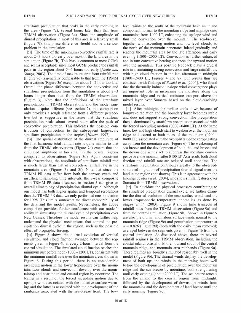
circulation and cloud fraction averaged between the seg-ments given in Figure 4b at every 2-hour interval from thecontrol simulation. The simulated cloud fraction reaches theminimum just before noon (1000–1200 LT), consistent withthe minimum rainfall rate over the mountain areas shown inFigure 6. During this period, there is no considerableascending motion in the lower troposphere over the moun-tain. Low clouds and convection develop over the moun-taintop and near the inland coastal region by noontime. Theformer is a result of the forced ascending motion due toupslope winds associated with the radiative surface warm-ing and the latter is associated with the development of therainbands associated with the sea-breeze front. The low-
level winds to the south of the mountain have an inlandcomponent normal to the mountain ridge and impinge ontomountains from 1400 LT, enhancing the upslope wind andthus the convection over the mountain. The sea-breeze,together with ascending motion and low-level clouds, tothe north of the mountain penetrates inland gradually andreaches the mountain area by the late afternoon and earlyevening (1800–2000 LT). Convection is further enhancedand in turn convective heating enhances the upward motionover the mountain. This positive feedback plays a crucialrole in maintaining strong convection and large rainfall ratewith high cloud fraction in the late afternoon to midnight(1800–2400 LT, Figures 4 and 8). Our results thus areconsistent with findings of Sasaki et al. [2004], who foundthat the thermally induced upslope wind convergence playsan important role in increasing the moisture along themountain ridge and vertical moisture transport above themixed layer over Sumatra based on the cloud-resolvingmodel results.[31] After midnight, the surface cools down because of
longwave radiation and the boundary layer becomes stableand does not support strong convection. The precipitationthen is dominated by stratiform precipitation associated withthe forced ascending motion (0000–0400 LT). At the sametime, low and high clouds start to weaken over the mountainridge and extend to both sides of the mountain (0200–0400 LT), associated with the two split rainbands propagatingaway from the mountain area (Figure 6). The weakening ofsea breeze and the development of both the land breeze andthe downslope winds act to suppress the moisture conver-gence over themountain after 0400 LT.As a result, both cloudfraction and rainfall rate are reduced until noontime. Thestratiform precipitation contributes greatly to the observed/simulated migration of precipitation diurnal signal over theland in the region (not shown). This is in agreement with thefindings byMori et al. [2004], who show similar features overSumatra from TRMM observations.[32] To elucidate the physical processes contributing to
the simulated precipitation diurnal cycle, we further exam-ine the diurnal evolution of the near surface winds and thelower tropospheric temperature anomalies as done byMapes et al. [2003]. Figure 9 shows time transects ofrainfall rates from the TRMM observation (Figure 9a) andfrom the control simulation (Figure 9b), Shown in Figure 9are also the diurnal anomalous surface winds normal to themountain ridge (Figure 9c) and perturbation temperature ats = 0.826 (Figure 9d) (both with the daily mean removed)averaged between the segments given in Figure 4b from thecontrol simulation. As discussed above, there are severalrainfall regimes in the TRMM observation, including thecoastal inland, coastal offshore, lowland south of the centralmountain ridge, and mountain area rainbands (Figure 9a).These regimes are broadly simulated reasonably well in themodel (Figure 9b). The diurnal winds display the develop-ment of both upslope winds in the morning hours wellbefore the development of precipitation over the mountainridge and the sea breeze by noontime, both strengtheninguntil early evening (about 2000 LT). The sea breeze retreatsfrom the inland to the coastal region from midnight,followed by the development of downslope winds fromthe mountains and the development of land breeze until theearly morning (Figure 9c).
D17104 ZHOU AND WANG: PRECIP. DIURNAL CYCLE OVER NEW GUINEA
10 of 18
D17104
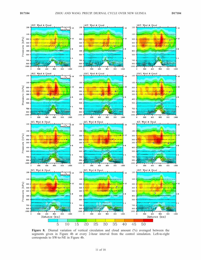
Figure 8. Diurnal variation of vertical circulation and cloud amount (%) averaged between thesegments given in Figure 4b at every 2-hour interval from the control simulation. Left-to-rightcorresponds to SW-to-NE in Figure 4b.
D17104 ZHOU AND WANG: PRECIP. DIURNAL CYCLE OVER NEW GUINEA
11 of 18
D17104
[33] Note that there is an asymmetry between the pro-gression of sea breeze and land breeze. The inland penetra-tion of sea breeze is relatively slow while the withdrawal ofsea breeze and the following development of land breeze ismuch faster. More importantly, there appears a diurnal wavepropagating from the mountain area to the open ocean witha phase speed of around 10–15 m s�1 in both southwest andnortheast directions. This is consistent with the offshoremigration speed of cloud systems in the same region asdocumented by Liberti et al. [2001], who attributed theoffshore migration to the interaction of mean flow and theland breeze, a mechanism proposed by Houze et al. [1981].Mapes et al. [2003] examined the diurnal perturbationtemperature and found that gravity waves forced by deepconvection earlier over the mountain play a critical role intriggering nocturnal convection in the coastal region off-shore in Northwest South America. We have performed asimilar analysis for our control simulation. As seen fromFigure 9d, the perturbation temperature has a very similarspatiotemporal evolution as reported by Mapes et al. [2003,Figure 7]. The propagation speed of the temperature wavesis about 10–15 m s�1 as well, indicating that the nocturnalrainbands in the offshore coastal regions are triggered by acombined effect of land breeze and the gravity wavespreviously forced by deep convection over the mountainridge. This will be further confirmed by the sensitivity
experiment with orography removed as discussed in thenext session.
5. Sensitivity Experiment
[34] Although the results discussed above demonstratethe orographic control of the simulated diurnal cycle ofclouds and precipitation over New Guinea, it is, however,hard to isolate the orographic effect from the effect of land-sea contrast. We thus conduct a sensitivity experiment inwhich the model terrain was reset to 0.1 m in the modeldomain. In such an extreme case (No-TOP), the orographiceffect is almost removed in the simulation. (Strictly speak-ing, this is not the case since the large-scale forcing used todrive the regional model from the ERA-40 reanalysis hasincluded the orographic effect. However, since the orogra-phy was much underrepresented in the model used for thereanalysis, the resulted orographic effect thus is greatlysuppressed.) Comparison of the results from the sensitivityexperiment with the control simulation can provide insightsinto the orographic effect on both the simulated diurnalcycle and longer-term mean of clouds and precipitation inthe region.[35] Figure 10 shows the 3-month mean horizontal winds
and the corresponding horizontal divergence fields averagedbetween 500 and 1000 hPa from the control simulation(Figure 10a) and the sensitivity experiment (Figure 10b),
Figure 9. Time transects of rainfall rates (in mm h�1) (a) from the TRMM observation and (b) from thecontrol simulation, (c) the diurnal anomalous surface winds (in m s�1) normal to the mountain ridge, and(d) perturbation temperature (in K) at s = 0.826 (both with the daily mean removed) averaged betweenthe segments given in Figure 4b from the control simulation. The two solid vertical lines show thesouthwest and northeast coastal lines of New Guinea, and the dashed lines show the location of theaveraged mountain ridge.
D17104 ZHOU AND WANG: PRECIP. DIURNAL CYCLE OVER NEW GUINEA
12 of 18
D17104
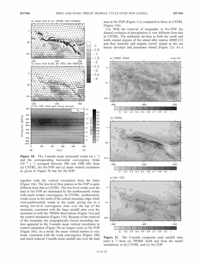
together with the vertical circulation from the latter(Figure 10c). The low-level flow pattern in No-TOP is quitedifferent from that in CNTRL. The low-level winds over theland in No-TOP are dominated by the northwesterly windswith much weaker convergence. In CNTRL, northwesterlywinds occur to the north of the central mountain ridge whilewest-southwesterly winds to the south, giving rise to astrong low-level convergence zone over the top of themountain, consistent with the large rainfall rates over themountain in both the TRMM observations (Figure 11a) andthe control simulation (Figure 11b). Because of the removalof the mountain, the orographically forced ascending mo-tion appeared in the 3-month mean vertical circulation incontrol simulation (Figure 5b) no longer exists in No-TOP(Figure 10c). As a result, the mean vertical motion is veryweak, consistent with the weak convergence (Figure 10b)and much reduced 3-month mean rainfall rate over the land
area in No-TOP (Figure 11c) compared to those in CNTRL(Figure 11b).[36] With the removal of orography in No-TOP, the
diurnal evolution of precipitation is very different from thatin CNTRL. The rainbands develop in both the south andnorth coastal regions of the island after sunrise (0800 LT)and then intensify and migrate slowly inland as the seabreeze develops and penetrates inland (Figure 12). As a
Figure 10. The 3-month mean horizontal winds (m s�1)and the corresponding horizontal convergence fields(10�6 s�1) averaged between 500 and 1000 hPa from(a) CNTRL, (b) No-TOP and (c) mean vertical circulationas given in Figure 5b but for No-TOP.
Figure 11. The 3-month composite total rainfall rates(mm h�1) from (a) TRMM 3G68 and from the modelsimulations in (b) CNTRL and (c) No-TOP.
D17104 ZHOU AND WANG: PRECIP. DIURNAL CYCLE OVER NEW GUINEA
13 of 18
D17104
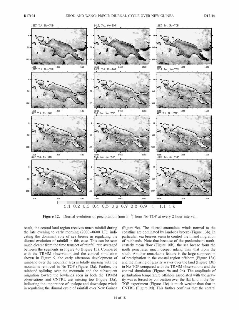
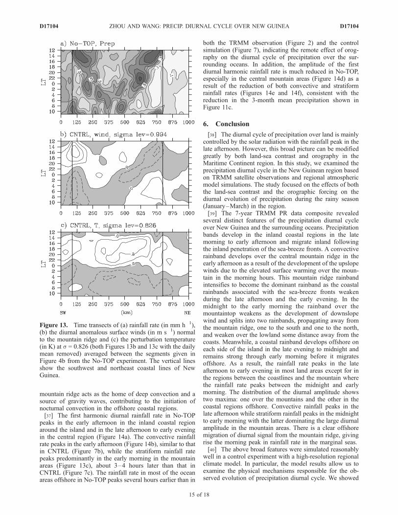
result, the central land region receives much rainfall duringthe late evening to early morning (2000–0600 LT), indi-cating the dominant role of sea breeze in regulating thediurnal evolution of rainfall in this case. This can be seenmuch clearer from the time transect of rainfall rate averagedbetween the segments in Figure 4b (Figure 13). Comparedwith the TRMM observation and the control simulationshown in Figure 9, the early afternoon development ofrainband over the mountain area is totally missing with themountains removed in No-TOP (Figure 13a). Further, therainband splitting over the mountain and the subsequentmigration toward the lowlands seen in both the TRMMobservations and CNTRL are missing too (Figure 13a),indicating the importance of upslope and downslope windsin regulating the diurnal cycle of rainfall over New Guinea
(Figure 9c). The diurnal anomalous winds normal to thecoastline are dominated by land-sea breeze (Figure 13b). Inparticular, sea breezes seem to control the inland migrationof rainbands. Note that because of the predominant north-easterly mean flow (Figure 10b), the sea breeze from thenorth penetrates much deeper inland than that from thesouth. Another remarkable feature is the large suppressionof precipitation in the coastal region offshore (Figure 13a)and the missing of gravity waves over the land (Figure 13b)in No-TOP compared with the TRMM observations and thecontrol simulation (Figures 9a and 9b). The amplitude ofperturbation temperature offshore associated with the grav-ity waves forced by convection over the flat land in the No-TOP experiment (Figure 13c) is much weaker than that inCNTRL (Figure 9d). This further confirms that the central
Figure 12. Diurnal evolution of precipitation (mm h�1) from No-TOP at every 2 hour interval.
D17104 ZHOU AND WANG: PRECIP. DIURNAL CYCLE OVER NEW GUINEA
14 of 18
D17104
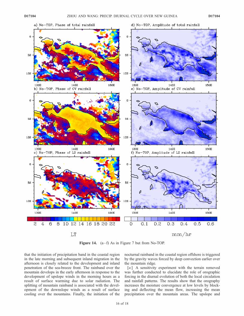
mountain ridge acts as the home of deep convection and asource of gravity waves, contributing to the initiation ofnocturnal convection in the offshore coastal regions.[37] The first harmonic diurnal rainfall rate in No-TOP
peaks in the early afternoon in the inland coastal regionaround the island and in the late afternoon to early eveningin the central region (Figure 14a). The convective rainfallrate peaks in the early afternoon (Figure 14b), similar to thatin CNTRL (Figure 7b), while the stratiform rainfall ratepeaks predominantly in the early morning in the mountainareas (Figure 13c), about 3–4 hours later than that inCNTRL (Figure 7c). The rainfall rate in most of the oceanareas offshore in No-TOP peaks several hours earlier than in
both the TRMM observation (Figure 2) and the controlsimulation (Figure 7), indicating the remote effect of orog-raphy on the diurnal cycle of precipitation over the sur-rounding oceans. In addition, the amplitude of the firstdiurnal harmonic rainfall rate is much reduced in No-TOP,especially in the central mountain areas (Figure 14d) as aresult of the reduction of both convective and stratiformrainfall rates (Figures 14e and 14f), consistent with thereduction in the 3-month mean precipitation shown inFigure 11c.
6. Conclusion
[38] The diurnal cycle of precipitation over land is mainlycontrolled by the solar radiation with the rainfall peak in thelate afternoon. However, this broad picture can be modifiedgreatly by both land-sea contrast and orography in theMaritime Continent region. In this study, we examined theprecipitation diurnal cycle in the New Guinean region basedon TRMM satellite observations and regional atmosphericmodel simulations. The study focused on the effects of boththe land-sea contrast and the orographic forcing on thediurnal evolution of precipitation during the rainy season(January–March) in the region.[39] The 7-year TRMM PR data composite revealed
several distinct features of the precipitation diurnal cycleover New Guinea and the surrounding oceans. Precipitationbands develop in the inland coastal regions in the latemorning to early afternoon and migrate inland followingthe inland penetration of the sea-breeze fronts. A convectiverainband develops over the central mountain ridge in theearly afternoon as a result of the development of the upslopewinds due to the elevated surface warming over the moun-tain in the morning hours. This mountain ridge rainbandintensifies to become the dominant rainband as the coastalrainbands associated with the sea-breeze fronts weakenduring the late afternoon and the early evening. In themidnight to the early morning the rainband over themountaintop weakens as the development of downslopewind and splits into two rainbands, propagating away fromthe mountain ridge, one to the south and one to the north,and weaken over the lowland some distance away from thecoasts. Meanwhile, a coastal rainband develops offshore oneach side of the island in the late evening to midnight andremains strong through early morning before it migratesoffshore. As a result, the rainfall rate peaks in the lateafternoon to early evening in most land areas except for inthe regions between the coastlines and the mountain wherethe rainfall rate peaks between the midnight and earlymorning. The distribution of the diurnal amplitude showstwo maxima: one over the mountains and the other in thecoastal regions offshore. Convective rainfall peaks in thelate afternoon while stratiform rainfall peaks in the midnightto early morning with the latter dominating the large diurnalamplitude in the mountain areas. There is a clear offshoremigration of diurnal signal from the mountain ridge, givingrise the morning peak in rainfall rate in the marginal seas.[40] The above broad features were simulated reasonably
well in a control experiment with a high-resolution regionalclimate model. In particular, the model results allow us toexamine the physical mechanisms responsible for the ob-served evolution of precipitation diurnal cycle. We showed
Figure 13. Time transects of (a) rainfall rate (in mm h�1),(b) the diurnal anomalous surface winds (in m s�1) normalto the mountain ridge and (c) the perturbation temperature(in K) at s = 0.826 (both Figures 13b and 13c with the dailymean removed) averaged between the segments given inFigure 4b from the No-TOP experiment. The vertical linesshow the southwest and northeast coastal lines of NewGuinea.
D17104 ZHOU AND WANG: PRECIP. DIURNAL CYCLE OVER NEW GUINEA
15 of 18
D17104
that the initiation of precipitation band in the coastal regionin the late morning and subsequent inland migration in theafternoon is closely related to the development and inlandpenetration of the sea-breeze front. The rainband over themountain develops in the early afternoon in response to thedevelopment of upslope winds in the morning hours as aresult of surface warming due to solar radiation. Thesplitting of mountain rainband is associated with the devel-opment of the downslope winds as a result of surfacecooling over the mountains. Finally, the initiation of the
nocturnal rainband in the coastal region offshore is triggeredby the gravity waves forced by deep convection earlier overthe mountain ridge.[41] A sensitivity experiment with the terrain removed
was further conducted to elucidate the role of orographicforcing in the diurnal evolution of both the local circulationand rainfall patterns. The results show that the orographyincreases the moisture convergence at low levels by block-ing and deflecting the mean flow, increasing the meanprecipitation over the mountain areas. The upslope and
Figure 14. (a–f) As in Figure 7 but from No-TOP.
D17104 ZHOU AND WANG: PRECIP. DIURNAL CYCLE OVER NEW GUINEA
16 of 18
D17104
downslope winds over the mountains due to diurnal radia-tive heating/cooling play a critical role in regulating theprecipitation diurnal cycle not only over the mountains butalso over the surrounding oceans. The central mountain actsas the home of deep convection and a source of gravitywaves, contributing to the initiation of nocturnal convectionin the offshore coastal regions.[42] Although there are still several discrepancies in our
control simulation, such as too small diurnal amplitude overthe oceans and too weak signal of offshore migration inprecipitation diurnal cycle to the north of the New GuineanIsland, our model successfully simulated the precipitationbands associated with both the land/sea breeze and theupslope/downslope winds in the mountain areas and theirinteractions. The results from this study thus demonstratethat in order to simulate precipitation diurnal cycle realis-tically in the Maritime Continent region and over thesurrounding oceans, very high model resolutions are re-quired to resolve both the land-sea contract and small-scaleand mesoscale mountains. Alternatively, some parameteri-zation schemes should be developed to represent thesesubgrid-scale effects accurately in relatively coarse resolu-tion climate models.
[43] Acknowledgments. The authors are grateful to Brian Mapes forhelpful discussions and to three reviewers for their constructive comments.Thanks are also due to Jan Hafner and Yongsheng Zhang for helping in thedata preparation. This study has been supported in part by the JAMSTEC,Japan, through its sponsorship to the International Pacific Research Centerand in part by the NASA institutional grant to the IPRC. InternationalPacific Research Center contribution IPRC-404 and School of Ocean andEarth Science and Technology contribution SOEST-6822.
ReferencesBetts, A. K., and C. Jakob (2002), Evaluation of the diurnal cycle ofprecipitation, surface thermodynamics, and surface fluxes in the ECMWFmodel using LBA data, J. Geophys. Res., 107(D20), 8045, doi:10.1029/2001JD000427.
Byon, J.-Y., and G.-H. Lim (2005), Diurnal variation of tropical convectionduring TOGA COARE IOP, Adv. Atmos. Sci., 22, 685–702.
Chang, C.-C., P. A. Harr, and H.-J. Chen (2004), Synoptic disturbancesover the equatorial South China Sea and western Maritime Continentduring boreal winter, Mon. Weather Rev., 133, 489–503.
Chang, C.-P., Z. Wang, J. McBride, and C.-H. Liu (2005a), Annual cycle ofSoutheast Asia-Maritime Continent rainfall and the asymmetric monsoontransition, J. Clim., 18, 287–301.
Chang, C.-P., Z. Wang, J. Ju, and T. Li (2005b), On the relationship be-tween Maritime Continent monsoon rainfall and ENSO during northernwinter, J. Clim., 18, 665–672.
Dai, A., and K. E. Trenberth (2004), The diurnal cycle and its depiction inthe Community Climate System Model, J. Clim., 17, 930–951.
Dickinson, R. E., A. Henderson-Sellers, and P. J. Kennedy (1993), Bio-sphere-atmosphere transfer scheme (BATS) version 1e as coupled to theNCAR Community Climate Model, NCAR Tech. Note, NCAR/TN-387+STR, 72pp., Natl. Cent. for Atmos. Res., Boulder, Colo.
Edwards, J. M., and A. Slingo (1996), Studies with a flexible new radiationcode. I: Choosing a configuration for a large-scale model, Q. J. R. Me-teorol. Soc., 122, 689–719.
Fairall, C. W., E. F. Bradley, J. E. Hare, A. A. Grachev, and J. B. Edson(2003), Bulk parameterization of air–sea fluxes: Updates and verificationfor the COARE algorithm, J. Clim., 16(4), 571–591.
Giorgi, F., and G. T. Bates (1989), The climatological skill of a regionalmodel over complex terrain, Mon. Weather Rev., 117, 2325–2347.
Haddad, Z. S., E. A. Smith, C. D. Kummerow, T. Iguchi, M. R. Farrar, S. L.Durden, M. Alves, and W. S. Olson (1997), The TRMM ‘Day-1’ radar/radiometer combined rain-profiling algorithm, J. Meteorol. Soc. Jpn., 75,799–809.
Holland, G. J., and T. D. Keenan (1980), Diurnal variations of convectionover the ‘‘Maritime Continent’’, Mon. Weather Rev., 108, 223–225.
Hong, Y., K. Hsu, S. Sorooshian, and X. Gao (2005), Improved representa-tion of diurnal variability of rainfall retrieved from the Tropical RainfallMeasurement Mission Microwave Imager adjusted Precipitation Estima-
tion From Remotely Sensed Information Using Artificial Neural Net-works (PERSIANN) system, J. Geophys. Res., 110, D06102,doi:10.1029/2004JD005301.
Houze, R. A., Jr. (1997), Stratiform precipitation in regions of convection:A meteorological paradox?, Bull. Am. Meteorol. Soc., 78, 2179–2196.
Houze, R. A., Jr., S. G. Geotis, F. D. Marks Jr., and A. K. West (1981),Winter monsoon convection in the vicinity of north Borneo. Part I:Structure and time variation of the clouds and precipitation, Mon. Weath-er Rev., 109, 1595–1614.
Hsu, H.-H., and M.-Y. Lee (2005), Topographic effects on the eastwardpropagation and initiation of the Madden-Julian Oscillation, J. Clim., 18,795–809.
Iguchi, T., T. Kozu, R. Meneghine, J. Awaka, and K. Okamoto (2000),Rain-profiling algorithm for the TRMM precipitation radar, J. Appl. Me-teorol., 39, 2038–2052.
Kataoka, A., and T. Satomura (2005), Numerical simulation on the diurnalvariation of precipitation over northeastern Bangladesh: A case study ofan active period 14–21 June 1995, Sci. Online Lett. Atmos., 1, 205–208.
Kubota, H., and T. Nitta (2001), Diurnal variations of tropical convectionobserved during the TOGA-COARE, J. Meteorol. Soc. Jpn., 79, 815–830.
Kubota, H., A. Numaguti, and S. Emori (2004), Numerical experimentsexamining the mechanism of diurnal variation of tropical convection,J. Meteorol. Soc. Jpn., 82, 1245–1260.
Kummerow, C. D., Y. Hong,W. S. Olson, S. Yang, R. F. Adler, J. McCollum,R. Ferraro, G. Petty, D. B. Shin, and T. T. Wilheit (2001), Theevolution of the Goddard profiling algorithm (GPROF) for rainfallestimation from passive microwave sensors, J. Appl. Meteorol., 40,1801–1840.
Langland, R. H., and C.-S. Liou (1996), Implementation of an E-parameterization of vertical subgrid-scale mixing in a regional model,Mon. Weather Rev., 124, 905–918.
Liberti, G. L., F. Cheruy, and M. Desbois (2001), Land effect on the diurnalcycle of clouds over the TOGA COARE area, as observed from GMS IRdata, Mon. Weather Rev., 129, 1500–1517.
Mapes, B. E., T. T. Warner, and M. Xu (2003), Diurnal patterns of rainfallin northwest South America. Part III: Diurnal gravity waves and noctur-nal convection offshore, Mon. Weather Rev., 131, 830–844.
McBride, J. L., M. R. Haylock, and N. Nicholls (2003), Relationship be-tween the Maritime Continent heat source and the El Nino-SouthernOscillation phenomenon, J. Clim., 16, 2905–2914.
Mori, S., et al. (2004), Diurnal land-sea rainfall peak migration over Suma-tra Island, Indonesia maritime continent, observed by TRMM satelliteand intensive rawinsonde soundings, Mon. Weather Rev., 132, 2021–2039.
Neale, R., and J. Slingo (2003), The Maritime Continent and its role inglobal climate: A GCM study, J. Clim., 16, 834–848.
Negri, A. J., T. L. Bell, and L. Xu (2002), Sampling of the diurnal cycle ofprecipitation using TRMM, J. Clim., 16, 834–848.
Nesbitt, S. W., and E. J. Zipser (2003), The diurnal cycle of rainfall andconvective intensity according to three years of TRMM measurements,J. Clim., 16(10), 1456–1475.
Nordeng, T. E. (1995), Extended versions of the convective parameteriza-tion scheme at ECMWF and their impact on the mean and transientactivity of the model in the tropics, Tech. Memo., 2006, 41pp., Res.Dep., Eur. Cent. for Med.-Range Weather Forecasts, Reading, U. K.
Reynolds, R. W., N. A. Rayner, T. M. Smith, D. C. Stokes, and W. Wang(2002), An improved in situ and satellite SSTanalysis for climate, J. Clim.,15, 1609–1625.
Rickenbach, T. M. (2004), Nocturnal cloud systems and the diurnal varia-tion of clouds and rainfall in southwestern Amazonia,Mon. Weather Rev.,132, 1201–1219.
Saito, K., T. D. Keenon, G. J. Holland, and K. Puri (2001), Numericalsimulation of the diurnal evolution of tropical island convection overthe Maritime Continent, Mon. Weather Rev., 129, 378–400.
Sakurai, N., et al. (2005), Diurnal cycle of cloud system migration overSumatra Island, J. Meteorol. Soc. Jpn., 83, 835–850.
Sasaki, T., P. Wu, S. Mori, J. Hamada, Y. I. Tauhid, M. D. Yamanaka,T. Sribimawati, T. Yoshikane, and F. Kimura (2004), Vertical moisturetransport above the mixed layer around the mountains in western Sumatra,Geophys. Res. Lett., 31, L08106, doi:10.1029/2004GL019730.
Siebesma, A. P., and A. A. M. Holtslag (1996), Model impacts of entrain-ment and detrainment rates in shallow cumulus convection, J. Atmos.Sci., 53, 2354–2364.
Slingo, A., K. I. Hodges, and G. R. Robinson (2004), Simulation of thediurnal cycle in a climate model and its evaluation using data fromMeteosat 7, Q. J. R. Meteorol. Soc., 130, 1449–1467.
Slingo, J. M., et al. (1996), Intraseasonal oscillations in 15 atmosphericgeneral circulation models: Results from an AMIP diagnostic subproject,Clim. Dyn., 12, 325–357.
D17104 ZHOU AND WANG: PRECIP. DIURNAL CYCLE OVER NEW GUINEA
17 of 18
D17104
Sperber, K. R., J. M. Slingo, P. M. Inness, and K.-M. Lau (1996), On themaintenance and initiation of the intraseasonal oscillation in the NCEP/NCAR reanalysis and the GLA and UKMO AMIP simulations, Clim.Dyn., 13, 769–795.
Sui, C.-H., K.-M. Lau, Y. N. Takayabu, and D. A. Short (1997), Diurnalvariation in tropical oceanic cumulus convection during TOGA COARE,J. Atmos. Sci., 54, 639–655.
Sun, Z., and L. Rikus (1999), Improved application of exponential sumfitting transmissions to inhomogeneous atmosphere, J. Geophys. Res.,104, 6291–6303.
Tian, B., I. M. Held, N. Lau, and B. J. Soden (2005), Diurnal cycle ofsummertime deep convection over North America: A satellite perspec-tive, J. Geophys. Res., 110, D08108, doi:10.1029/2004JD005275.
Tiedtke, M. (1989), A comprehensive mass flux scheme for cumulus para-meterization in large-scale models, Mon. Weather Rev., 117, 1779–1800.
Wallace, J. M. (1975), Diurnal variations in precipitation and thunderstormfrequency over the conterminous United States, Mon. Weather Rev., 103,406–419.
Wang, Y. (2001), An explicit simulation of tropical cyclones with a triplynested movable mesh primitive equation model: TCM3. Part I: Modeldescription and control experiment,Mon. Weather Rev., 129, 1370–1394.
Wang, Y., O. L. Sen, and B. Wang (2003), A highly resolved regionalclimate model (IPRC_RegCM) and its simulation of the 1998 severeprecipitation event over China. Part I: Model description and verificationof simulation, J. Clim., 16, 1721–1738.
Wang, Y., S.-P. Xie, H. Xu, and B. Wang (2004a), Regional model simula-tions of marine boundary layer clouds over the southeast Pacific off
South America. Part I: Control experiment, Mon. Weather Rev., 132,274–296.
Wang, Y., H. Xu, and S.-P. Xie (2004b), Regional model simulations ofmarine boundary layer clouds over the southeast Pacific off South Amer-ica. Part II: Sensitivity experiments, Mon. Weather Rev., 132, 2650–2668.
Wang, Y., L. Zhou, and K. P. Hamilton (2006), Effect of convective en-trainment/detrainment on simulation of tropical precipitation diurnal cy-cle, Mon. Weather Rev, in press.
Wu, P., J.-I. Hamada, S. Mori, Y. I. Tauhid, and M. D. Yamanaka (2003),Diurnal variation of precipitable water over a mountainous area of Su-matra Island, J. Appl. Meteorol., 42, 1107–1115.
Xu, K.-M., and D. A. Randall (1996), A semiempirical cloudiness para-meterization for use in climate models, J. Atmos. Sci., 53, 3084–3102.
Yang, G.-Y., and J. M. Slingo (2001), The diurnal cycle in the tropics, Mon.Weather Rev., 129, 784–801.
Yang,K., K. Toshio, H. Fujii, T. Tamura, X. Xu, L. Bian, andM. Zhou (2004),The daytime evolution of the atmospheric boundary layer and convectionover the Tibetan Plateau: Observation and simulations, J. Meteorol. Soc.Jpn., 6, 1777–1792.
�����������������������Y. Wang and L. Zhou, International Pacific Research Center and
Department of Meteorology, School of Ocean and Earth Science andTechnology, University of Hawaii at Manoa, 1680 East-West Road,Honolulu, HI 96822, USA. ([email protected]; [email protected])
D17104 ZHOU AND WANG: PRECIP. DIURNAL CYCLE OVER NEW GUINEA
18 of 18
D17104
Related Documents


![Diurnal and Nocturnal Animals. Diurnal Animals Diurnal is a tricky word! Let’s all say that word together. Diurnal [dahy-ur-nl] A diurnal animal is an.](https://static.cupdf.com/doc/110x72/56649dda5503460f94ad083f/diurnal-and-nocturnal-animals-diurnal-animals-diurnal-is-a-tricky-word-lets.jpg)