Rijksuniversiteit Groningen Tribes and Territories In Transition The central east Jordan Valley and surrounding regions in the Late Bronze and Early Iron Ages: a study of the sources Proefschrift ter verkrijging van het doctoraat in de Godgeleerdheid en Godsdienstwetenschap aan de Rijksuniversiteit Groningen op gezag van de Rector Magnificus, Dr. F. Zwarts, in het openbaar te verdedigen op donderdag 19 december 2002 om 13.15 uur door Eveline Johanna van der Steen geboren op 3 oktober 1957 te Soest

Welcome message from author
This document is posted to help you gain knowledge. Please leave a comment to let me know what you think about it! Share it to your friends and learn new things together.
Transcript
Rijksuniversiteit Groningen
Tribes and TerritoriesIn Transition
The central east Jordan Valley and surroundingregions in the Late Bronze and Early Iron Ages: a
study of the sources
Proefschrift
ter verkrijging van het doctoraat in deGodgeleerdheid en Godsdienstwetenschap
aan de Rijksuniversiteit Groningenop gezag van de
Rector Magnificus, Dr. F. Zwarts,in het openbaar te verdedigen op
donderdag 19 december 2002om 13.15 uur
door
Eveline Johanna van der Steen
geboren op 3 oktober 1957te Soest

promotor: Prof. dr. E. Noort
referent: Dr. M.L. Steiner
beoordelingscommissie: Prof. dr. I. Finkelstein Prof. dr. A. Schoors
Prof. dr. J.N. Bremmer
Foreword
It has been said before, many times, that for an author the best part of a book is theforeword. Writing the foreword means that the work is done, the book is ready for theprinter and one can finally lean back and relax. With the book that lies before you now the word ‘finally’ deserves a special emphasis,because it is the result of 12 years work. In those 12 years it has been through numerousups and downs, it has several times been on the verge of being turned into a bonfire,always to be rescued at the last minute, by people who saw the value of it when I couldno longer see it. It is largely thanks to those people, that the work is finally done.
In 1990 I was excavating as a staff member at Tell Abu Sarbut, an Islamic site close toDeir 'Alla in the Jordan Valley. At the end of the season Margreet Steiner, who was oneof the directors, suggested that we should spend a few days surveying some of the sitesin the region, that were mentioned by Nelson Glueck and in the East Jordan Valleysurvey. While surveying I began to wonder why there were so many Late Bronze Agesites in this area, since the Late Bronze Age was a period that was notorious for its lackof settlement. That was the beginning. I turned this relatively simple question into a pilot study that was funded, during 11months, by the Dutch Organization for Scientific Research, a time that was largely spentstudying the available literature. Some of this literature had been collected by theDepartment of Anthropology of Yarmuk University, where I spent a month studying it. Ialso got permission from Prof. Mo’awiyah Ibrahim to study the pottery from the EastJordan Valley Survey, which was stored at the University of Jordan, Amman. Thepottery from Nelson Glueck’s Explorations in Eastern Palestine proved to be less easy tofind. After the Israel Antiquities Authorities had given me permission to study it, I spenttwo weeks with Alon de Groot from the IAA in real detective work, trying to locate theit. The good thing was that Alon became a good friend, and he still is. The first part of the research for this thesis has been conducted at Leiden University, andI want to thank the staff of the department of Archaeology for the facilities they providedme with. The Archeology department also funded part of the excavations of Tell el-Hammeh, as part of the Deir 'Alla project. Another part was funded by the Departmentof Antiquities in Amman. Henk Franken taught me to look at pottery, and encouraged me to publish my analysis ofthe Deir 'Alla pottery, even though he disagreed with my conclusions.
The Walk through the Zerqa was made possible through a grant from the Foundation forAnthropology and Prehistory in the Netherlands. That four-day trip through the WadiZerqa in spring was an unforgettable experience, and I want to thank those who made itpossible: the students Eva Kapteyn, Carmen Harmsen and Ellis Grootveld; our guidefrom the Department of Antiquities, Ali el-Khayyat, who never lost his temper, andGhazi Saudi, who offered us hospitality in his farm in Jal’ad.
At the beginning of the project I had asked myself a simple question: why are there somany Late Bronze Age sites around Deir 'Alla? When I started looking for answers, Istumbled upon another question, a much bigger one: to what extent does the tribalsociety of the eighteenth and nineteenth centuries reflect human behaviour in earlierperiods, and what does that mean for the interpretation of the archaeological record?
That question opened a Pandora’s box of ideas and possibilities, that is yet far fromexhausted. Over time it has influenced and changed my views, and consequently theoriginal scope of the project, as it played an ever increasing role in the answers that Ifound. In places this process is still visible in the book: some chapters, such as chapter 5,reflect ideas that I had several years ago, but that have developed since then. Should Ihave to write that chapter now, I would write it differently. Sometimes I feared that my ideas were far-fetched, but when I shared them with others,reluctantly, there were always people who believed in them. The first time that happenedwas in 1997, at the SBL conference in San Francisco. I was extremely nervous aboutwhat I was going to say, but after I had finished, Anson Rainey came up to me to tell mehow much he appreciated my ideas. He has never stopped encouraging me since. Sincethat time there have been many more people who shared my enthousiasm andencouraged me to go on: Israel Finkelstein, Gloria London, Piotr Bienkowski, MervynRichardson, and last but not least, Prof. Ed Noort, my supervisor during the last stages ofthe research, without whose encouragement and occasional pushing there would nothave been a book now. Mervyn Richardson also kindly offered to correct my English and remove the Dutchismsfrom it, and he has been very thorough.
A special paragraph of thanks goes to Margreet Steiner. She has stood at the cradle ofthis project, just like she stood at the beginning of so many other episodes in my life. Inthe past 12 years we have not only shared our love for the archaeology of Palestine andJordan, but the ideas, emotions, enthousiasm and frustrations that were the result of thatlove. She has given me the lion’s share of the feedback that I needed to finish it.
Eke Bakker and Kees Donkersloot proved to be invaluable friends, who were alwaysthere when I needed to unwind from too many potsherds and Bedouin.
Last but not least I want to thank my parents for their support, love and encouragement,and for making it all possible in the first place. This book is dedicated to them.
Leiden, October 2002
Contents
Introduction 1
Section I: The published material I-1 Historical sources 8I-2 Ecology 19I-3 Material remains: excavations 29I-4 Material remains: surveys 56
Section II: The ethnographic sources II-5 Aspects of nomadism and settlement 76II-6 Survival and Adaptation 94
Section III: Pottery in the regionIII-7 Published pottery 108III-8 The transition at Deir 'Alla: the pottery 132
Section IV: New materialsIV-9 The excavations at Tell el-Hammeh 147IV-10 Deir 'Alla Square M: the unpublished material 159IV-11 Survey of the region 164IV-12 A walk through the Zerqa 191
Section V: Models and TheoryV-13 Existing Theories, Models and Hypotheses 199 V-14 A new model? 212
Appendices 224
Bibliography 230
Nederlandse samenvatting 253
1
Introduction
“In an effort to make archaeology an exact science, the New Archaeology tried to findgeneral, “covering laws”. Such laws were hard to find, or are defined in such broadterms that they become meaningless. The heavy use of jargon was disturbing. Modelsoften became an end rather than the tool for creating a more meaningful analysis. Thenew archaeology focused primarily on prehistoric phases and on cultural changes, andneglects historical cases. At least in its more dogmatic forms, it failed to discuss politicalborders in a satisfactory way, since it created a sharp dichotomy between pots andpeople – as if pots were independent beings.”
This rather harsh judgment, by Raz Kletter (Kletter 1999, 21-22), of the tools and thephilosophy of New Archaeology, may seem a strange opening sentence for anintroduction that deals with models, models being the flagship of New Archaeology.That is, of course, the reason why it is used here. The quote contains some usefulwarnings, puts the concept of model-building into perspective, and underlines thepurposes of this study.
“... the new archaeology tried to find general, “covering laws”...”Covering laws, or models that can predict human behaviour within a set of specifiedcircumstances (such as climate, surroundings, population density) are indeed hard tofind, basically because humans do not behave like numbers, or chemical substances thatturn from solid to fluid to gas under specified pressure and temperature. We want humanbehaviour to be predictable. And it is, or can be, to a certain extent. But only to a certainextent; human reactions can be compared to those of other living creatures (Wilson1975), and so ‘universal’ laws can be described in order to explain, analyse and ‘predict’historical events and situations. But like other living creatures, humans and theirreactions can never be completely predicted. On the other hand, deviations from thegeneral laws do not invalidate them.Any model that describes or explains human behaviour, should be based on reality. Thismay seem self evident, but as Kletter states: “Such laws were hard to find, or are definedin such broad terms that they become meaningless.” Even in general models for humanbehaviour, we must be aware that sometimes models may be valid, or represent realityfor one situation, period or group, but not for another. We must be prepared to limitourselves, in order to remain meaningful. The reality that I propose here, and that limitsmy model in a spatial sense, although hardly in a temporal one, is that the SouthernLevant has always, at least since the Early Bronze Age, been a ‘tribal’ society.The word ‘tribal’ has many connotations. In western society, and in New Archaeology, itis associated with a relatively low level of social organisation (Renfrew and Bahn 1991,153ff, with references). In Near Eastern contexts it is often associated with economicbehaviour, notably the herding of sheep and goats, and the breeding of camels. That,however, is not the essence of ‘tribalism’. Sometimes the word ‘tribal’ is replaced by‘kin-based’ (Joffe 1993), or ‘ethnic’ (Kamp and Yoffee 1980), or ‘family’ (Stager 1985).The meaning of these terms, however, also covers only part of what Levantine societywas about. Much information has come down to us about tribal or Bedouin society in the southernLevant in the past centuries, both from western travellers and researchers and from the
TRIBES AND TERRITORIES IN TRANSITION
2
Bedouin themselves.1 These nineteenth century and earlier sources define Levantinetribalism within a framework of characteristics that, together, can describe what I wouldcall a ‘model’ for society in the Southern Levant, not only in the period under study, butthat can be detected already in the Early Bronze Age (van der Steen 2002a), and thestructural basis of which never ceased to exist. In some periods this structural basisbecame especially clear, particularly in periods of change and instability. In theseperiods, which may have been caused by external powers, or by climate changes, societyhad to regroup itself, re-divide territories, find new modes of existence and ofcooperation. In those periods the tribal structure of society was decisive in the course ofevents and in determining the eventual new situation that evolved. In periods of stability the tribal structural basis may have been less clear, ‘sleeping’ as itwere, but it never died, because the next crisis always saw it reawaken and become themajor force in restructuring society. This is what happened in the transition from the LateBronze to the Early Iron Age, the period under study here.
Information from nineteenth century AD and earlier sources can be used to describe thecharacteristics that determine this structural basis. They are:
- loyalty. A person’s loyalty was always first to his family, to his clan, and to the tribe towhich he belonged. On the other side, the tribe as a whole was responsible for theindividual member: for his subsistence in case of emergencies (such as a raid by a rivaltribe, which sometimes left members without anything to eat), for his protection, or, ifthat failed, for avenging him. This two-way loyalty was formalised by creating ‘familyties’ between the members of the tribes: patriarchs from which all members weresupposed to descend. It is a well-known fact that these ties were created and could bechanged easily in order to create new loyalties, should circumstances demand that. Theterm khawa, being a tribute paid by one tribe to another, or by an individual or group ofindividuals in order to be able to travel through a tribe’s territory, literally means‘brotherhood’, and so denotes the fact that by paying it, the person became a temporary‘brother’ of the tribe, a member of the family, and so shared in the ties of loyalty andresponsibility. Tribal loyalties, although they may have been meaningless to all practical purposes, didnot cease to exist in periods of stability, or strong external power. They were alwaysmaintained, albeit on a low level.
1 I am obliged to the staff of the department of Anthropology of Yarmuk University, Irbed, for givingme access to the archive of the Jordan Valley Project. This archive, which has unfortunately closeddown now, contains publications, published and unpublished reports, photos and newspaper clippings,maps etc., providing information on geological, geographical, agricultural and climatological issuesconcerning the Jordan Valley, many of which have changed dramatically in the past fifty years, as wellas ethnographic and demographic data.
3
- Second is flexibility in economic pursuits. Tribes and their members had access todifferent, customised economic pursuits (Salzman 1980, 4). They could be herders ofgoats or sheep, professional camel breeders, agriculturalists or horticulturalists. TheHoweitat, for example, were famous camel breeders for the Hajj and the regular tradeand they had vast date palm groves around Aqaba. Besides, they controlled a number ofagricultural villages in Edom, where members of smaller tribes grew tobacco and othergoods for the benefit of the Hajj. According to Bocco (cited in Layne 1994, 46) “even
archetypical camel-herding Bedouin were probably never exclusively pastoralists butrelied on a multi-resource economy that included raiding, the collection of tribute(khawa) and trading for their subsistence”. It was because of this ability to adapt, that theBedouin could control the economy of the region, and create a virtually independentsociety in the late eighteenth and early nineteenth centuries AD, even adapting toexternal influences such as the demands of the European trade with India.
The third characteristic is mobility, which directly involves the relationship of the tribeto the land. Most tribes are mobile to a certain extent. Sometimes they were part-timefarmers, and had summer and winter quarters; sometimes segments of tribes had becomesedentary, while other segments remained pastoral nomads. Many continued to live intents as a symbol of mobility, even after they had become full-time farmers or otherwisesedentary. The tent was the symbol of their inheritance, and therefore had a symbolicstatus that was denied to a house. Honoured guests were, and sometimes still are,received in a tent, rituals and parties are still often performed in tents.A tribe had its territory or territories, but could only assert rights to this, when actuallypresent. It did not ‘own’ the land. Lancaster (1981, 121) describes the relation of theRwala Bedouin to their land as based on “a prior claim of usufruct (a claim not a right)”.A person “only rules (the land) when he is there and he only owns it under the samecircumstances”. They own it by right of dominance and not exclusively. Other tribescame into the territory when the Rwala had gone, or even when they were present, byright of tradition or strength. The continuing high symbolic status of the tent mentionedabove shows that this flexible relationship to the land did not change, even in periods ofstability and settlement.
The fourth characteristic is the interrelationship of different tribes. Tribes interacted, bothin a positive and a negative sense. In a positive sense they crossed and used each other’sterritories and wells, often according to a formalised system of khawa, they intermarried,they made alliances and formed confederations. Judges from associated tribes weresometimes called in to solve legal disputes.Negative interaction consisted of ghazus¸ intertribal raiding, and sometimes even actualwars between tribes, usually over territory. These wars regularly led to a profoundchange in the balance of power, and changes in the traditional territories of tribes,leading to a ‘domino-effect’ that could eventually have repercussions over longdistances, as uprooted tribes had to go and look elsewhere for new territories. Thesources show that these changes in power balance usually coincided with internationalpolitical crises: in the Islamic period (622-1918 AD) the changes from one governmentto another always resulted in a complete change in power balance and territorial divisionamong the Near Eastern tribes (Oppenheim 1943, 6-12, with references). This is the framework within which society in the Southern Levant has functioned eversince the Early Bronze Age. There may have been times when a strong external
TRIBES AND TERRITORIES IN TRANSITION
4
government managed to subdue the power of the independent tribes, but they were nevercapable of extinguishing the tribal structure of the local population (Joffe 1993, 48, 61).
“The new archaeology focused primarily on prehistoric phases and on cultural changes,and neglects historical cases...”.The problem with ‘historical periods’, i.e. periods for which written sources areavailable, is that these written sources cannot very well be ignored. In the past, before thetime of the New Archaeology, archaeology was usually made subject to these writtensources, and used to illustrate them. The Bible is a case in point, specifically for theregion under study. The nineteenth century spirit of discovery was reflected in therealms of Christianity as well. The need was felt not only to ‘illustrate’ the Bible, but toprove it by identifying (and excavating) holy places. In 1865 the Palestine ExplorationFund had been established as “A society for the accurate and systematic investigation ofthe Archaeology, the Topography, the Geology and Physical Geography, the Mannersand Customs of the Holy Land for Biblical Illustration” (PEQ 1968, frontispiece); theAmerican School for Oriental Research, established in 1900 had as its main goal “todefend the Bible”. Numerous explorers travelled the ‘Land of the Bible’ and identified(sometimes with scant evidence) place-names mentioned in the Bible (Ben-Arieh 1979,with numerous references). The fact that they travelled through tribal territories, andtherefore had to deal with the existing tribal system, and the meticulous accounts theyleft us of these travels, now gives us a rare insight in the tribal society of the nineteenthcentury AD.
With the rise of New Archaeology this situation was changed. Archaeological evidencecame into its right as an independent source of information. That meant that writtensources became a disturbing factor, since the evidence presented by them often disagreedwith the archaeological remains. Hence the tendency of New Archaeology to turn to‘prehistoric’ periods and situations. However, both the written sources and the archaeological remains have a tale to tell,about the same period and the same people, so if the two diverge it is our task to explainwhy they diverge and to find a historical explanation in which both have their role (cf.Weippert 1967, 133-139). We cannot ignore one or the other because they do not fit inour hypothesis. If that is the case the hypothesis is wrong.
This study starts with an overview of the different available sources of evidence (part I).Chapter 1 reviews written sources dating from and/or relating to the period of the LateBronze and Early Iron Ages. These sources play an important role in the hypothesis.Many of them come from an Egyptian, Late Bronze Age context. They are the accountsof Canaanite society by the conquerors and therefore very one-sided, although none theless valuable for that. They create a picture of the period from one point of view, that ofthe foreign ruler. The Amarna letters, an important source of information, add thedimension of the viewpoint of the local rulers. Their split loyalty, on the one hand to theforeign ruler that put them – and kept them– in their position, and on the other hand totheir own people, provides a valuable insight in the social structure of the times. Finallythe editors of the books of the Old Testament, writing much later, in the exilic or post-exilic period, give us an account of the Early Iron Age in Israel the way they saw it.Their view was coloured as well, by time and ideology, and reflected to a large extentsociety as it was in the Late Iron Age. If anything, this shows us that even in the LateIron Age, society was still largely conceived of as tribal (LaBianca 1999, van der Steen,forthcoming). The world was ordered along lines of kinship and loyalties or enmities
INTRODUCTION
5
based on legends of tribal feuds. As in earlier periods (Joffe 1993, 61) contact with thegreat empires and their organisation could not wipe out this kin-based structure. It wasalways there, dormant perhaps, but never dead.The second chapter describes the physical world in which this society originated andflourished: the soil and its fertility, the climate and the topography.Chapters 3 and 4 give an overview of the available archaeological evidence, excavationsand settlement patterns. The importance of settlement patterns lies for a large part in that they are often the only physical evidence of the presence of a non-settled population.Nomads are notorious in that they leave no archaeological remains such as pottery,architecture and the like (see the discussion in Finkelstein 1995, 23 ff, with references).The only indications of their presence in a certain society can be the way they influencesettlement patterns. In the first half of the nineteenth century AD in the East JordanValley there were no settlements, and in the Belqa the only settlement was Salt. TheAdwan and the Beni Sakhr both claimed these territories and struggled over it. Theyregularly robbed villages and eventually scared away the settled population (Burckhardt1822, 349 ff; 368 ff). When the Ottoman government finally managed to subdue theBeni Sakhr in the second half of the nineteenth century a power vacuum ensued in theregion, which was quickly filled up with small villages and farmsteads (Schumacher1889, 22).
“... it failed to discuss political borders in a satisfactory way...”The second section deals with the political borders of the nineteenth and early twentiethcentury AD and the ways in which the different groups defined their territories in a socialand geographical sense, by loyalty, by positive or negative interaction and by mobility. Itis a period in which the tribal society of the southern Levant flourished, and that has beendescribed extensively by both western and eastern writers and researchers. The results ofthis analysis are then used to understand the mechanisms that were at work in thetransition from the Late Bronze to the Early Iron Age. I have stated above that thestructural basis in the area of study remained the same from the Early Bronze Age to themost recent past. This structural basis dictated the reactions of the population to thechanging society, both in the nineteenth and early twentieth centuries AD and in theLate Bronze – Early Iron Age transitional period. The ethnographers and travellers in theregion tell us how the population of the nineteenth and early twentieth centuries reactedand adapted to these changes, and therefore may give us an insight into how thepopulation of the Late Bronze – Early Iron Age transitional period reacted.
“...since it created a sharp dichotomy between pots and people – as if pots wereindependent beings.”Pots, obviously, are not independent beings, nor is any other artefact. They are theprecipitation of a culture, of a person, a group or a sequence of people who performed anactivity that created, made use of, and discarded the artefact that we now hold in ourhands. It is the people behind the pots that we have to find. Henk Franken used to saythat archaeologists tended to use potsherds as if they had fallen from trees, for them touse as dating criteria (cf. Steiner 1994, thesis 8). We have to close the gap between potsand people again, but in a meaningful way. We have to ask ourselves who the peoplewere that made the pots, who the people were that used and discarded them. We have toask what the meaning is of changes in the pottery, what it tells us about those people.That is the essence of the two chapters of the third section.In Chapter 7 an overview is given of the pottery that has been published fromexcavations in the region under study and the surrounding area. In Chapter 8, using Deir
TRIBES AND TERRITORIES IN TRANSITION
6
'Alla as a case study, I try to analyse what the actual meaning and significance is ofchanges in pottery shapes and functional repertoire, for the understanding of the historyof a certain site. The fourth section is devoted to the results of new research, some of which is publishedhere for the first time. The first two seasons at Tell el-Hammeh in the Zerqa valley(Chapter 9) produced unexpected results. The remains of the oldest iron smelting site inthe world found so far were excavated (Veldhuizen and van der Steen 1999). Theexcavations also revealed the existence of a number of Late Bronze Age layers, no tracesof which had ever been found by any of the surveys on the site. These results went a longway to confirm the hypothesis of a trade route through the Zerqa valley, conducted byindependent traders.The Early Iron Age at Deir 'Alla has been published by Franken (1969) with theexception of one square, Square M. The material from this square was given to me byHenk Franken for study and publication. It is published here, in Chapter 10. The remainsin this square, which include some heavy walls, may somewhat alter the outlook on thebeginnings of the Iron Age of Deir 'Alla , and consequently the whole region. It mainlygoes to prove that the ‘squatters’, or the seasonal transhumant groups that occupied thesite in the earliest Iron Age phases, had a more diverse and complicated background thanis usually assumed. The region that this study focuses on in particular, the area between the watershed of theWadi Kufrinjeh in the north and that of the Wadi Zerqa in the south, has been chosenbecause of its high concentration of Late Bronze Age sites (Leonard 1989) compared tothe rest of the East Jordan Valley. This concentration is revealed by a number of surveys,as very few sites in the area had been excavated and even fewer published. In 1994 someof the sites that had been discovered by earlier surveys, such as those of Nelson Glueck,and of the Jordan Valley Survey, were revisited and pottery collected from them. Inaddition to this, the pottery from the Jordan Valley Survey was studied in Amman, andthat of Nelson Glueck in Jerusalem. The results, and the conclusions that can be drawn inregard to the occupation history of the area, are presented in Chapter11.Finally, one part of the hypothesis, that of a trade route through the Wadi Zerqa in theLate Bronze Age, was tested in the field in 2000. A small expedition was organised to tryand find the best route from the Jordan Valley, through the Wadi Zerqa towards KhirbetUmm ed-Dananir. A donkey accompanied us, to carry the luggage and to test whetherthe route we took could be walked by a loaded donkey as well. The results of thisexpedition are presented in Chapter12.
“Models often became an end rather than the tool for creating a more meaningfulanalysis....”.In the exact sciences, the purpose of research is to find universal laws and to test whetherthese are really universally valid. The final purpose in historical sciences, such as historyor archaeology, is arguable. In New Archaeology, as stated by Kletter, models becamean end in themselves, and history and archaeology were used to test and refine the‘universal’ models that were developed to predict human behaviour. That is, of course, aperfectly valid approach, provided that the models as such were adapted to fit thehistorical facts. This proved to be complicated, especially in historical periods; hence thetendency of New Archaeology to concentrate on less complicated, prehistoric periods.Of course, these periods were, or seemed, less complicated, only because we knew somuch less about them. The other approach is to use the models as tools to explain andunderstand historical events and situations. Then they form the basis for a hypothesis, ananalysis of a specific period, group or event.
INTRODUCTION
7
Several efforts have been made to devise models for the Late Bronze and Early IronAges in the Levant. Some of these were broad models, encompassing the period inquestion in a long lasting development, usually starting in the Chalcolithic or the EarlyBronze Age. Most of these models had a cyclical character. Other models, or hypotheseswere developed explicitly to find an explanation for the Late Bronze – Early Iron Agetransition, more specifically (most of them) to find an explanation for the beginnings of Early Israel. These hypotheses do not usually claim universal value, unlike some of thecyclical models.Chapter13 gives an overview of models and hypotheses that have been developed andused for the Late Bronze – Early Iron Age transition in the Southern Levant. Chapter14 finally gives my own hypothesis for this period. This hypothesis is based onthe model that I have outlined above, that of a society that has always remainedessentially tribal. I have explained why I think that this model is universally valid in theSouthern Levant, at least from the Early Bronze Age, until the twentieth century AD.There may have been periods in which it was more visible than in others, but the simplefact that it is applicable for every period of crisis or change in the history of the SouthernLevant shows clearly enough that it was always present. I am tempted to state that it stillexists to a certain extent. I will not expand on the validity of the model in periods otherthan that under study; I have done that elsewhere (van der Steen 2002b; id. forthcoming;Bienkowski and van der Steen 2000). This chapter is an integration of the historical factsand figures that have been outlined in the previous chapters, and the concept of abasically tribal society. The result, I think, is a more meaningful analysis and explanationof the archaeological remains that time has left us.
Finally, a word about terminology. Throughout this study I have used the term ‘EarlyIron Age’, instead of Iron Age I. This is because the terms ‘Iron Age I’, or ‘Iron Age II’imply more or less exact dates, and a sharp division between periods. I prefer to be‘vague’ where these periods are concerned for the following reasons: - The transition from the Late Bronze Age and the following period, Early Iron Age, orIron Age I, was the end of an era and the beginning of a new one. However, when thefirst era ended and the next began is still a matter of debate, and dependent on whatcriteria we use for the end (or beginning) of an era, as well as on which particular part ofthe Levant we look at. The Late Bronze Age did not end everywhere at the samemoment, as most people now agree. - A political landslide ended the Late Bronze Age and eventually forced people to adaptthemselves to a new economic layout, a new set of rules, a new society. The materialprecipitation of this new society is what we call the ‘Early Iron Age’. There is, however,no clear beginning, no date or place that we can lay a finger on and say ‘this is where itstarted’. All we have is a material culture: pottery, architecture and settlement patternsthat differ from that of the preceding period. I cannot, by giving a name to that culture,define its margins in time and place. That is why I prefer a term that does not haveclearly fixed dates attached to it.
TRIBES AND TERRITORIES IN TRANSITION
8
I-1. Historical sources
The historical sources for the Late Bronze Age in the region have come largely fromEgypt (Kitchen 1992, with literature). They will be discussed here in chronological orderof writing.
The Topographical list of Thutmose III
The oldest text that directly concerns the period and region under study is thetopographical list of Thutmose III (±1450) in the Amun temple in Karnak. It is a series oflists of conquests of the great Pharaoh. Every place name consists of an oval,representing a conquered city, accompanied by a representation of a bound captive.The interpretation of these lists as well as their value for the reconstruction of the historyof Canaan has been the subject of much debate (Redford 1982 gives an overview). Theidentification of P-h-r, ring 33 in the list, with Pella (Simons 1937, 116; Smith 1973, 24)is generally accepted. It is followed by k-n-n-r-t, identified as Kinnereth, Tell Oremeh(Fritz 1990, 176).Redford (1982) has suggested that the lists were composed from pre-existing itinerariesfor Western Asia, which were used by Egyptian couriers in the fifteenth century. He hasinterpreted rings 89-101 of this list as an itinerary describing a route from Damascus toKerak across the Transjordanian Plateau. The following place names are involved: 89 Hykrym90 Ybr91 Utra'a92 Ybr93 Kntwt
94 Mkrpwt95 ‘yn96 Krmn97 Btiy398 Tpwn
99 Ybr100 Yrwtw101 Hrkr
Numbers 90, 92, 99, all Ybr, are identified as major wadis, in his interpretation the WadiYarmuk, Wadi Zerqa and Wadi Mujib. Nr. 93 is interpreted as a wine-press, nr. 94 as a'fertile depression'. Nr. 95-96 is taken together and translated as a spring in a vine-bearing country. It is identified with Tell 'Umeiri. Nr. 97 is identified with Jalul. Foursites have been identified on philological grounds: Hykrym, Utra'a, Tpwn and Yrwtw, butat none of these has Late Bronze Age occupation been found. Redford’s hypothesis has been accepted by several scholars but with modifications:while Redford identifies Krmn (the Abel Keramin from Judges 11, 33), with 'Umeiri,Kafafi (1985, 17) suggests that it is Sahab, and Knauf (1984, 119) thinks it is Jalul. Allthese sites have Late Bronze I remains. Yarut (Yarwtw, nr 100 on the list), has no LateBronze pottery, but a site in the Wadi Fawwar, below Yarut, does (Worschech 1990, 127n 16). Worschech thinks that Yarut should be identified with Yn()d(w), mentioned byRamses II. Hrkr (nr. 101) has been identified with Kerak by Redford, who assumes thatthere was an old road through Wadi Kerak. However, Kafafi thinks that the structure ofthe Wadi makes this unlikely. If the route suggested by Redford did indeed exist, it musthave come through Wadi Fawwar to the Dead Sea. Based on Redford’s interpretationKitchen (1992, 73) has reconstructed a trade route across the Moab Plains to Syria,largely following the later King's Highway, and passing most of the few Late BronzeAge sites between Wadi Zerqa and Wadi Kerak. Although Redford identifies and/or explains every name, his explanations are not alwaysconvincing from an archaeological point of view (also Na‘aman 1994 n7). According toRedford (1982, 73) the fact that no Late Bronze Age occupation has been found on a site,does not mean that it does not exist: it may not have been recognised, or it may besomewhere else on the site. This is of course possible, but it seems improbable that it
HISTORICAL SOURCES
9
should be true for all the identified sites. Another possibility, according to Redford, isthat the name refers to a region or wadi in which this site lay. However, if, as Redfordstates simultaneously, the three largest wadis on the route (Yarmuk, Zerqa and Mujib),have not been given names, but are simply referred to as 'wadi', this is an unlikely option.
Pella (Pihil, or Pihilu(m)) and Shechem are mentioned in the Middle Bronze AgeExecration texts. Pella is also mentioned twice in inscriptions from Amenophis III (1411- 1375): on a statue-socle from Thebes, and on the list from the Soleb temple in Nubia(Smith 1973, 25). The Soleb list may also have mentioned Moab for the first time (Timm1989, 13), although the actual name was not preserved.
The Amarna Letters
The Amarna letters are a corpus of 382 clay tablets found at Tell el-Amarna, the capitalof the Egyptian empire during the reign of Amenophis IV (Akhenaten). According toMoran (1992, xxxiv) they span the period between the 30th year of Amenophis III untilthe first year of Tutankhamun, when the court at Amarna was abandoned (1360-1333).They are part of the official correspondence between the Pharaoh and the rulers of hisvassal city states in Canaan. The language, obviously some kind of lingua franca, was aWest-Semitic dialect of Akkadian. According to Moran (1992, xxii) 'The language canonly be described as an entirely new code, only vaguely intelligible (if at all) to the westSemitic because of the lexicon, and to the Babylonian because of the grammar'. Even though, with a few exceptions, only one side of the correspondence has beenfound, namely the letters to the Pharaoh, this correspondence is very informative aboutthe political situation of the period and the interrelationships between the city-states. Allthe city-states are formally subjected to the Pharaoh in Egypt and to his commissioner orrepresentative (his Rabu). Every letter from a city-state regent pledges this loyalty,before beginning its actual message. Many of the letters simply ask for the sending oftroops to fight against the Hapiru. Often these demands are supported by accusationsagainst the regents of other city-states, who are accused of conspiring with each otherand with the Hapiru against the lands of the king. Notorious are Lab’ayu of Shechem andhis sons, and Milkilu of Gezer and his father-in-law Tagi. Abdi-Hepa of Jerusalem isaccused of being ‘a second Lab’ayu’ (EA 280), taking the cities of the king. The lettersfrom these brigands themselves however, also to the king, are specifically written toassure him of their loyalty. They obviously are the victims of slander. Both Abdi-Hepaand Milkilu even accuse Ianhamu, the king’s Rabu, of conspiring against them (EA 270,286). Often the city-state regents have to stand up against their own people, who tend tosupport the Hapiru, and who sometimes even kill their own regents (EA 138, 162, 248,288).The general impression that we gain from these letters is that there were a number ofgroups or factions, who, although legally subjected to the Egyptian king, were in practicemostly left to their own devices and to their own petty territorial fights over thehegemony of their city-states. Only occasionally does the king see fit to interfere. Rib-Addi from Byblos (EA 68-138) was left to fend for himself, surrounded by Hapiru andthreatened by Amurru, until all his towns deserted him and he was expelled from Byblos.Amurru was the tribal state that was created by Abdi-Aširta and later taken over by hisson Aziru. Starting somewhere east of present Tripoli, it expanded to the south, andeventually included most of the Lebanese coastal area (Finkelstein 2002). One gets theimpression that the Egyptian king had little interest in this region and was not prepared to
TRIBES AND TERRITORIES IN TRANSITION
10
invest in it like he (occasionally) did in the more northerly regions, such as Acco (EA88). The sea-route along the southern coast is likewise neglected (EA 101, 105).The principles of ransom and ‘protection’ were well known among the different parties.Aziru of Amurru took prisoners for ransom (EA 55, 114). The siege of a city could bepaid off (EA 91). A certain Addudani (EA 292) was being harassed by ‘the people fromthe mountains’, who were prepared to leave for 30 shekels of silver. Trade caravans alsofeature regularly in the correspondence. In letters EA 7 and 8 Burnaburiaš of Karaduniašaccused the šakin mati (regent) of several city-states, Acco among them, of havingconspired to rob his trade caravans. Another caravan, consisting of 13 Egyptianmerchants, was robbed in Palestine (EA 313). References to the trade route confirm thatit probably went through Pella (EA 255) and the Damascus region. (EA 194, 199,possibly 226).Aspects of the correspondence suggest that the city-states of Canaan were essentiallytribal. The word bitu, ‘house’, is often used with the meaning ‘family’ or perhaps ‘clan’(EA 33 , 38, 74, 89, 287). Family ties seem to determine loyalty, as in the case ofLab’ayu and his son Mutba’lu who ruled Pella; and in the case of Milkilu and his father-in-law Tagi.Tribute consisted mostly of servants and slaves (EA 268, 288), but also cattle (EA 242,301) were sent to Egypt, and weapons (EA 266) and building materials such as wood(EA 160) and stone (EA 314, 323).One of the measures taken by the Egyptian king was to send for the regents to come tocourt and explain themselves. The letters show that this was an unpopular measure,perhaps partly because the regent in question never knew if and when he would return tohis country (EA 59). The letters show that the regents tried with all sorts of excuses toavoid having to go (EA 165). Another measure was the taking of hostages: members ofthe ruling family of a city state (EA 187, 198, 296), who were brought to the court inEgypt. Already Amenophis II prided himself on having taken several hundred princesand ‘brothers of princes’ from Retenu. They were probably hostages, sons of kings andother leaders, taken to the Egyptian court in order to secure the loyalty of these leaders,and train their sons to become loyal subjects of Egypt once they succeeded their fathers(Redford 1992, 198 with references).
Lab'ayu of Shechem and Mutba’lu of PellaThe letters concerning Lab'ayu, lord of Shechem, have been analysed by Campbell(1965). In EA 244 Biridiya, lord of Megiddo, complains that Lab'ayu is set on takingMegiddo: “Look, Lab'ayu has no other purpose. He seeks simply the seizure ofMagidda.”1. Another letter, probably also from Biridiya (EA 245) tells that a coalition ofcities has delivered Megiddo, but that the ruler of Acco, Surata, let Lab'ayu off after hehad paid a ransom. A second effort to capture Lab'ayu led to his death, according to EA250, by the people of Gina, possibly Jenin: “The sons of Lab'ayu have made theirpurpose the loss of the land of the king, over and above the loss that their fathercaused..... The sons of Lab'ayu keep saying to me: “Wage war against the people of Ginafor having killed our father....”. EA 249, among others, shows that there was a coalitionbetween Lab’ayu and Milkilu of Gezer. Lab’ayu’s sons continued his policy ofsupporting the Hapiru (EA 246 from Biridiya): “The two sons of Lab'ayu have indeedgiven their money to the Hapiru in order to wage war against me...”. Lab'ayu himselfnever stopped to profess allegiance to the king, and to protest his innocence, putting theblame on others: “Here is my act of rebellion and here is my delinquency: when I entered
1 The transliteration of proper names in these quotations is that of Moran 1992
HISTORICAL SOURCES
11
Gazru, I spoke as follows: “The king treats us kindly”.” “Now there is indeed no otherpurpose except the service of the king, and whatever the king orders, I obey.” (EA 253).“.....Moreover, the king wrote for my son. I did not know that my son was consortingwith the Hapiru. I herewith hand him over to Addaya.” (EA 254). Mutba'lu, lord of Pella claimed to be a son of Lab'ayu. In EA 255 Mutba'lu defendshimself against accusations of having delayed a trade caravan on its way to Hanigalbat(Mitanni): “Who am I that I would not send on a caravan of the king, my lord, seeingthat Lab'ayu, my father, used to serve the king, his lord, and he himself used to send offall the caravans that the king would send to Hanagalbat”. In EA 256 he has to defendhimself again, this time against accusations that he has fled the city, after having hiddena rebel: “How can it have been said in your presence, "Mutba’lu has fled, he has hiddenAyyab"? How can the king of Pihilu flee from the commissioner: sukini of the king, mylord?....Ayyab is not in Pihilu. In fact, he has been in the field for two months”.An interesting inference from EA 255 may be that the crossing of the Jordan betweenBeth Shean and Pella was in the hands of the family of Lab’ayu and Mutba’lu.
Hapiru and Šasu
Hapiru and Šasu have both only been identified in texts. These are usually understood asreferring to nomadic tribes (Šasu) or a mobile social class (Hapiru). Nomadic or mobilegroups leave few or no material traces (see the discussion between Finkelstein and Rosenin Finkelstein 1995, 23 ff). That does not mean that they are not archaeologicallydetectable. Settlement patterns are determined, at least partly, by power structures, and asthe Amarna letters among other sources demonstrate, the Hapiru were an importantfactor in the power structure of the region. The same can be said of the Šasu, as will bedemonstrated below.
HapiruReferences to Hapiru in the Middle and Late Bronze Age literature are numerous.Bottéro (1981) has listed 235 cuneiform and 14 Egyptian references. Most references byfar, certainly for the Late Bronze Age, come from the Amarna letters. As a matter of fact,Egyptian references to Hapiru are relatively few, and they depict the Hapiru as enemiesof the Egyptian empire. One of the first references is by Amenophis II in Memphis,where he boasts of having taken 3600 Hapiru prisoner. There are regular references toHapiru slaves in Egypt: two letters (Pap. Leiden 348 and 349, Loretz 1984, 39 and note161) refer to the Hapiru who are carrying stones for the temple of Ramses Miamum.Other references, dated to the end of the Late Bronze Age, mention Hapiru as prisonersof war, and slaves, such as the list of gifts to the Amun temple in Heliopolis by RamsesIII (Pap. Harris I, 31, 8; Loretz 1984, 39), or the list of prisoners of war from RamsesIV’s expedition in the Wadi Hammamath (Loretz 1984, 40).In the Amarna letters the Hapiru are sometimes described as besieging and plunderingcities: “The Hapiru have plundered and burnt Mahzibti, Giluni, Magdali, Ušte, cities ofthe king. They tried to take Hazi, but we beat them. And the Hapiru found refuge withAmanhatbi. He has become one of them” (EA 185). “When the Hapiru conqueredTushulti, true city of the king...and plundered it and burnt it with fire, and went beforeAmanhatbi, man of Tushulti, Amanhatbi...gave the Hapiru food and....” (EA 186). More often, however, the populations of the cities threaten to join the Hapiru, deposingof their overlord, especially in the north (EA 73, 74, 76, 77, 81, 88, 111, 116, 117, 127).In some cases, all of which can be found in the south, the rulers of the city statesthemselves seem to have allied themselves to the Hapiru: Lab’ayu of Shechem and his
TRIBES AND TERRITORIES IN TRANSITION
12
sons (EA 244, 246), Mutba’lu of Pella, and possibly Milkilu of Gezer and his father-in-law Tagi of Gintikirmil (EA 287). Abdi-Hepa of Jerusalem is accused of having becomea ‘second Lab’ayu’ (EA 280). The Hapiru themselves are the steadfast allies of theAmurru, the large and powerful tribe or confederation in the north, that eventuallymanaged to create an independent state.
One of the stelae found in Beth Shean, from the time of Seti I (ANET 255) mentions askirmish between the Hapiru of Mount Yarmuta and the ‘Asiatics of Rehem’. In thisinscription the king mainly seems annoyed that they dare to disturb the peace with theirpetty little conflicts, and so he restores order. The Amarna letters have no clear references to any ‘territory’ of the Hapiru. They seemto be found everywhere. One letter (EA 67) compares them to ‘runaway dogs’, whoobviously have no home. A letter from the Pharaoh to the ruler of Damascus, from thetime of the Amarna-letters, orders Zalaja, the ‘man from Damascus’ to send a group ofHapiru for resettlement in Nubia (Kaša) (Edzard 1970, 55-57).
The Sumerian logogram LÚ-SA-GAZ, or SA-GAZ, which in the Late Bronze Age is oftenused as a synonym for Hapiru, means ‘armed robber’ (Bottéro 1972-75, 22), and this isthe meaning most often applied to the word. In the account of the taking of Jaffa,Papyrus Harris (ANET 22), from the time of Thutmose III, horses and chariots must bebrought into the town to prevent them from being stolen by Hapiru. However, as Bottéropoints out (1972-75, 24), this representation of them is always given by their enemies.Bottéro sums up occupations exerted by Hapiru according to the documents: servants ofthe Palace or of private persons; temple servants; messengers; jewellers; scribes (Bottéro1972-75, 24). A prism of king Tunip-Teššup of Tikunani, a Hurrian king from the daysof Hattušili I, lists a total of 438 Hapiru workers in the service of the king. They areorganised as sabe (ERINMES), workers or soldiers. Many of the personal names of theHapiru are Hurrian, others are Semitic and others are of unknown origin. There is oneKassite name (Salvini 1996). In Theban graves 39 and 155 (Säve-Söderberg 1952, 5-6),which are dated to the eighteenth dynasty, reliefs were found depicting Hapiru strainingout wine in a vineyard. The workmen depicted have no characterizing features, but asthey are slaves, this may not be significant. If they were actually Hapiru, they may havebeen employed in wine-making because of their Canaanite background. Most of thereferences in the Amarna letters refer to the Hapiru as mercenaries (EA 71, 87, 195,246), or simply as robbers or militant outlaws (EA 90, 91, 104, 264, 313, 318). Eitherthey are being paid to fight, or they fight for themselves, siding with whoever is strongest(EA 73, 76, 79, 82). On one occasion a Hapiru is hired as a messenger, possibly becauseother messengers could not travel safely anymore in the Hapiru-infested country (EA112). It is clear from the letters that the Hapiru were constantly rebelling against the kingand the city-states of the empire, and some city-states, like Shechem, Gezer, and possiblyUrusalim sided with them to further their own interests of power (EA 280). The role that the Hapiru played in the decline of the Egyptian empire in Palestine is stilla matter of debate. So is the question whether the Hapiru/Habiru/ ‘Apiru are in any way,etymologically, ethnically or sociologically related to the Ibri, or Hebrews of the Bible.These discussions will be summarised in Ch. V-13.
HISTORICAL SOURCES
13
ŠasuIn most inscriptions and depictions of Šasu they are enemies of Egypt. Apart from a veryearly – possible – reference to a town named Šasu in the Brussels Execration Texts(Posener 1940, 91) most of these references come from the end of the Middle Bronzeand the beginning of the Late Bronze Age. Amenophis II (Giveon 1971, 12), on a stelefrom Memphis, boasted of having taken 15200 living Šasu prisoner together with 3600Hapiru, 36300 Kharu and 15070 living Nouhassah. The figures may well beexaggerated, and it is unlikely that the prisoners were all taken in one campaign. On atoponym list of Thutmose IV (Giveon 1971, 15) the Šasu appear beside Naharin,Babylon, Tunip, Qadesh and Takhsi. Giveon suggests that this list may have been acompilation of conquests by Amenophis II, the father of Thutmose IV. It does, howeverplace the Šasu among the traditional opponents of the Empire. In the time of Seti I theŠasu are mentioned in one breath with countries like Hatti, Naharin, Retenu and Cyprus,and cities like Babylon, Qadesh and Megiddo (Giveon 1971, 60, 63). Ramses IIrepeatedly refers to his conquest of the ‘land of the Šasu’, demonstrating that they werestill a menace in his days (Giveon 1971, 78 ff).
References to the territory of the Šasu are far from clear-cut. An inscription in the Amuntemple in Karnak describes how Thutmose III defeated the Šasu before entering Retenu.This places them geographically in the northern Sinai, or perhaps even in the Negev. Aninscription on the Seti I reliefs in the Amun temple in Karnak also locates the Šasu in theSinai and Negev: (the land of) the Šasu, from the fortress of Sileh to the town of Canaan(Giveon 1971, 56). Sileh is possibly Tell Akhmar (Helck 1962, 310) in the Delta, the‘town of Canaan’ is identified by Giveon as (possibly) Gaza (Giveon 1971, 59). On atoponym list from Amenophis III, however, found in Thebes (Giveon 1971, 22), EinŠasu, ‘the well of the Šasu’, is mentioned as a place-name in the northern half ofPalestine. The territorial significance of this reference is probably limited, and may referto a local tradition involving a wandering Šasu tribe. Papyrus Anastasi I, from the end ofthe Late Bronze Age, mentions Šasu as highway robbers on to the road to Megiddo, inthe north (Giveon 1971, 127). A toponym list from Amenophis III, in the Amun templein Soleb, gives a number of place names ‘in the land of the Šasu’ (Giveon 1971, 26):Smt, Yahwe and Trbr. But none of them can be identified. Yahwe and Trbr are also foundon the Medinet Habu inscriptions. A Ramses II toponym list in Amarah west (Giveon1971, 74) mentions places in ‘the land of Šasu’: Seir, Laban, Pyspys, Samath, Yahweand Arbel. Giveon suggests that Yahwe refers to a ‘house of Yahwe’, a temple, locatedin Seir. This assumption fits in well with the hypothesis locating the origin of the laterIsraelite Yahweh religion in Seir. Towards the end of the Late Bronze Age the Šasu are usually located in Edom and Seir.An inscription in the Abu Simbel temple (Giveon 1971, 71) tells how Ramses IIdeported large groups of his enemies: the Nubians to the north; the Asiatics to Nubia; theŠasu to the west; the Lybians to the mountains. This suggests that the Šasu came fromthe mountains in the East, from Edom or Seir. Papyrus Wilbour, from the time ofRamses V (Giveon 1971, 147), mentions a place called Pen Šasu, as well as a temple (?)of Hathor of Šasu. These places are located somewhere west of the Nile, according toGiveon, and may have been occupied by the Šasu that were deported by Seti I. Papyrus Anastasi IV, the famous letter from the time of Merneptah (Giveon 1971, 131),mentions the passage of the Šasu-tribes from Edom to the pastures of Per Atom inTjekku in order to feed their flocks, suggesting that there were still Šasu left in Edom.
TRIBES AND TERRITORIES IN TRANSITION
14
Šasu were involved in various economic activities. The ones in the letter from the time ofMerneptah mentioned above were nomadic pastoralists. Papyrus Harris (Giveon 1971,134), from the time of Ramses III, mentions the defeat of ‘the people of Seir among theŠasu, and I have pillaged their tents, their people and their goods, as well as theircountless troops”, suggesting a nomadic lifestyle. However, the place names on thetoponym list from Amenophis III in the Amun temple in Soleb show that there weretowns, possibly strongholds, in the territory of the Šasu. An inscription from the time ofRamses II (Giveon 1971, 114) at Tell er-Rabati says: ....who made a great massacre inthe land of the Šasu, who plundered their hills, killed them, and who built in their cities(?) in his name forever.... The translation of the last sentence is not entirely clear, but theword for ‘town’ is not doubted. Giveon has tried to identify Šasu on reliefs in several tombs in Amarna (Giveon 1971,31). Their characteristics, according to him, and based on the reliefs in Karnak from SetiI (Giveon 1971, 51) are a tasselled kilt, a head band, shoulder-long hair, a pointed beardand a pronounced profile, although the only exclusive Šasu attribute was the headdress.They are depicted as mercenaries in Egyptian service. If Giveon is right these depictionsin the Amarna tombs would be the earliest depictions of Šasu as mercenaries in Egyptianservice. Ward however (1972, 45-50) suggests they may be Asiatics rather than Šasu. Inthe Medinet Habu reliefs (Giveon 1971, 137), from the time of Ramses III, many Šasuare depicted, either as prisoners, or as mercenaries in the Egyptian army.The Karnak reliefs have numerous references to the Šasu. Here they are depicted asrebels: their chiefs have collected in the mountains of Kharu, they disregard the ‘laws ofthe palace’, and fight among each other. In the end, of course, Seti restores order. Anepisode in the account of the Battle of Qadesh (Giveon 1971, 65) tells how two Šasutribe members came to the king offering that all the Šasu tribes desert from the service ofthe Hittite king, in favour of His Majesty. The inference here is clearly that there wereŠasu mercenaries on the Hittite side as well. One of the reliefs of the Battle shows Šasu,distinguished by their headdress, defending the town. The reliefs of the conquest ofAshkelon in Karnak, from the time of Ramses II, likewise show Šasu being led away asprisoners.
Šasu could also be highway robbers, as demonstrated in Papyrus Anastasi I (Giveon1971, 127): ‘You have never been to the region of the Šasu with the army....where thesky is darkened by pine trees....Lions are more numerous there than leopards and bears.It is surrounded by Šasu on all sides’. The famous passage about the road to Megiddosays: “..the narrow valley is dangerous with Bedouin, hidden under the bushes. Some ofthem are of four or five cubits (2-2.5 metres), (from) their noses to the heel, and fierce offace. Their hearts are not mild, and they do not listen to wheedling.” (ANET 477). Papyrus Turin B, from the time of Ramses II (Giveon 1971, 121) gives a list ofmerchandise from the Canaan region: several types of oil, unguent and wood, coveringsfor horses and chariots, and weapons. Šasu-unguent is among them, but without anyindication as to its use or origin.According to Ward (1972, 36 ff) the name Šasu eventually became an equivalent forBedouin in general. He mentions an ‘early’ reference from the XXth dynasty, referringto the Šasu that lived in the Hijaz. Giveon (1970-71, 51-53) has suggested that this rathermeans a change in territory of the Šasu who lived in Edom, after their defeat by RamsesIII. On the other hand, the Hijaz may have been part of the Šasu territory long before theXXth dynasty.
HISTORICAL SOURCES
15
Rainey (2001) suggests that the early settlers in the western highlands, the groups thatare identified with the later Israelites, may have descended from groups of Šasu, thusaccepting a natural flexibility both in territory and economic pursuits.
Šasu are often identified by the dress in which they are depicted in Egyptian art (seeabove). Ward however points out that this dress was generally used to depict Asiatics,and therefore is not a sure way of identifying Šasu. According to Giveon (1971, 251)the headdress is the only exclusive Šasu characteristic. If Giveon is right, we mayperhaps assume that other elements of dress, like the tasselled kilt, as opposed to thefull length dress, denoted a lifestyle, nomadic versus urban, whereas the head dresswas an expression of ethnic or political loyalty. Parallels to this can still be found inthe modern ‘dress code’ of the Middle East, where the headdress is also used as apolitical as well as an ‘ethnic’ statement.
Taanach lettersAt Tell Taanach a number of clay tablets were found, dated to the same period as theAmarna letters. Albright analysed four of these letters, addressed to the ‘prince ofTaanach’, Rewašša (Albright 1944, 16-27). In one of the letters the writer complains thathe has been ambushed in Gurra, located near Jenin (Albright 1944, 21 n 52), and that heholds Rewašša responsible for reparation. It seems thus that Gurra was part of the citystate of Taanach. The letters are further concerned with corvée, military service andtribute, all stressing the vassal status of Taanach.
Moab in Egyptian textsThe name Moab occurred several times in Egyptian topographical lists. It was found onthe base of a statue of Ramses II in Luxor (Kitchen, 1992, n 31, for references). Anothertopographical text from the forecourt of Ramses II in the Luxor proved to be apalimpsest. The original text, which apparently also dated from the reign of Ramses II,was plastered over. The original text said (Kitchen 1992, 27) "Town that Pharaoh's armcaptured in the land of Moab: Btrt" In the second scene two place names are mentioned,Yn(?)d in the mountain of Mrrn, and a "town that pharaoh's arm captured: Tbn". Kitchenhas identified Btrt with Raba Batora, and Tbn with Dibon. However, his identificationshave been attacked and the identification of both place names is still a cause for debate(Helck 1962; Görg 1978; Parker in Homès-Frédericq and Hennessy 1989:359; Knauf1985; Worschech 1990:102 n 44; Miller 1992:77; Kitchen 1992:28). Worschech mostrecently has identified Btrt with Jabal Batra (Worschech 1997, 231). According to himthe identification of Tbn with Dibon (which he identifies with modern Dhiban) isobvious: 'the schematic drawing….of the fortified town of Tbn can clearly be identifiedas Dibon…, known also from the Meša inscription and the Hebrew Bible..'. Thisargument seems rather weak in the face of the several hundreds of years that lie betweenthe 'schematic drawing' and the two sources mentioned. I have recently suggested (vander Steen 2002b; forthcoming) that Tbn of the Egyptian sources may have been a tribe,not a town, in which case the ‘town of (the) Tbn’ mentioned in the Luxor relief would bea tribal stronghold, that could be anywhere in the territory.
Other Egyptian textsAt the entrance to the hypostyle hall of the great Amun temple in Karnak is atopographical list of Ramses II. This list mentions "phr, hmt, bt šr, yn<w>m", Pella,Hamath, Beth Shean, Yanoam (Simons 1937, 160-161)
TRIBES AND TERRITORIES IN TRANSITION
16
The large stele of Seti I, found in Beth Shean (ANET 253) describes the rebellion ofHamath: "The wretched foe who is in the town of Hamath is gathering to himself manypeople, while he is seizing the town of Beth Shean. (Then there will be) an alliance withthem of Pahel. He does not permit the Prince of Rehob to go outside." Divisions are sentto Hamath, Beth Shean and Yanoam as a result of this rebellion. Strangely enough, nodivision is sent to Pella (Pahel). Rehob is identified with Tell es-Sarem, 7 km south ofBeth Shean (Mazar in Stern 1993,1272), Yanoam is probably situated somewhere in theBashan (Liebowitz in Stern 1993, 1515), and Hamath has been identified by Albrightwith Tell el-Hammeh at the southern entrance to the Beth Shean valley (Cahill andTarler in Stern 1993, 561). The Balu'a stele derives its name from the site where it was found in 1930 (see Chapter3). It consists of a slab of black basalt, with two panels: the top one with an inscriptionthat is so worn as to be illegible, the bottom one with a low relief depicting what mayhave been a god and goddess handing a sceptre to a local ruler. It is generally dated tothe twelfth or thirteenth century (but see H. Weippert 1988, 666). Ward and Martin(1964) extensively discuss the script used, as well as the stylistic implications of therelief. Their conclusion - still generally accepted - is that, although the text is illegible,the relief represents a Šasu chief (contra Timm 1989, 14, 33, and 92 n 1, who states thatŠasu was mentioned in Egyptian lists as a separate country), identified mainly by hisheaddress, flanked on the left and right by a god and goddess, respectively. Therepresentation is Egyptianising, probably made by a local artist who had knowledge ofand used Egyptian iconography: the god wears the double crown of Upper and LowerEgypt, and the goddess wears a crown similar to the headdress of Osiris (Ward andMartin 1964, Mattingly 1992, 60). Ward and Martin suggest on the basis of the facialfeatures that the god and goddess were Semitic, although an Egyptian background isusually assumed by most other writers, suggesting an Egyptian presence in Moab.Zayadine (1991, 37) actually suggests they were Amun-Re and Hathor. According toDearman (1992, 71) the stele points to the presence of an administrative centre,controlling the passage through the Wadi Mujib.The stele from Rujm el-'Abd, or the 'Šihan warrior stele’ is even more difficult to date,with dates ranging from the third millennium. BC down to the ninth - eighth century.Arguments for dating are based variously on stylistic details or circumstantial evidence(Mattingly 1992:60 with references). It depicts a warrior, or possibly a war god, dressedin a short kilt and holding a spear. The warrior has Egyptian as well as Hittitecharacteristics. Warmenbol (1983) dates it to the fourteenth-thirteenth century on thebasis of artistic features. Mattingly reverts the argument, and says that it may date to theEarly Iron Age, “since its Neo-Hittite and Syrian characteristics could reflect an actualmovement of people from these areas to Moab at an early stage in Moab's evolution”. Zayadine (1991:37) suggests that both the Balu'a stele and the Šihan stele may havecome from the same place originally. Kitchen (1992:29) takes this hypothesis one stepfurther and argues that these stelae point to the existence of an organised society. Noarguments for either of these suggestions are given, however.
The victory stele of Merneptah, the 'Israel stele' (ANET 378), is one of the mostimportant arguments in the discussion about early (or ‘proto’) Israel. It provides theoldest existing reference to the name ‘Israel’, in a list of conquered towns and regions inAsia:"Plundered is the Canaan with every evil; Carried off is Aškelon; seized upon is Gezer;
HISTORICAL SOURCES
17
Yanoam is made as that which does not exist; Israel is laid waste, his seed is not; Hurru is become a widow for Egypt!" Israel is the only name that has a ‘people’ determinative. Both the name and thedeterminative have been subject to much debate (Hess 1993, 133 for literature) and arestill important arguments in the various theories about the settlement of early Israel. The central Jordan Valley: Deir 'Alla The only written sources from the Deir 'Alla region have been found at Deir 'Alla itself:undeciphered clay tablets from the Late Bronze Age sanctuary. A cartouche of QueenTaousert (Franken 1992, 31 fig 3-9, 5) who reigned between 1198-1196, on a faiencevase was found inside the cella, dating its destruction to somewhere after that date. Franken found several clay tablets in the rooms east of the cella (Franken 1992, 59;64).Knauf (1987) published three of them. In later excavations more tablets have been found,but these have not been published. Their script is probably alphabetic, but apart fromthat, nothing can be said for certain about the language or the contents of the tablets. The discussion about the tablets and their contents is still continuing, as Knauf (1987, 14)rightly states: "These tablets are perfectly readable, but still untranslateable. A number ofscholars have offered readings and translations, but they failed to convince theircolleagues". Two parties can be recognised in this discussion: those that ascribe them toAegean groups (e.g. J. Tubb, excavator of Sa’idiyeh), and those that ascribe them toSemites (e.g. Franken). The fact that the same arguments are used by both parties showsthat it has become a discussion about Late Bronze Age economic and politicalrelationships rather than a linguistic discussion. It seems clear that until they aredeciphered the tablets cannot possibly be used as an argument in the debate.
The BibleThe Bible is the most prominent literary source for this region, but also the mostcontroversial one. An important reason for this is the fact that although the traditions thatlay at the roots of the existing text can be very old, the text itself is late, exilic to post-exilic, and edited with specific political and theological purposes. The questions asked by archaeologists are determined partly by the nature of their finds,and the purposes of their projects. Partly they are determined by the (im)probability of areliable answer. In the case of the history of the origins of Israel and its neighboursquestions about the historicity of specific persons or events mentioned in the Bible aredifficult or impossible to answer. More useful seem questions relating to the social andhistorical context of these events. The answers to these questions, which are the scope ofOld Testament scholarship, are not straightforward either, but they do permit a glimpse(seldom more) into the society in which the traditions originated. Even here one has totread with care, since the final 'version' of the stories that represented the events musthave been coloured over time by the perception and the 'Sitz im Leben' of those thathanded the stories down. They may eventually reflect the social background of thestoryteller as much as that of the original story. The literature on the subject is vast, andcannot be treated extensively here (e.g. Otto 1979, Kaiser 1984, Donner 1984, Lemche1988, 1996, Thompson 1992, with literature). A few examples will have to suffice. How-ever, even from these few examples a picture emerges of diversity, of differentbackgrounds for different sources (Hess 1993, 132): - Elements that probably originated in a semi-nomadic background are the stories of thepatriarchs, the stories that underlined the traditional hostility between the Israelites andthe Canaanites, and the formulation of some of the law codes (Kaiser 1984, 31, 65 ff,
TRIBES AND TERRITORIES IN TRANSITION
18
with references). Donner (1984, 57) has suggested that these nomads originated east ofthe Jordan, in the Belqa, the homeland of the Aramaeans. Even though the credo inDeuteronomy 26, 5 ‘my father was a wandering Aramaean’ is very late, ties with the eastside of the Jordan are unmistakeable, for example in the Jacob/Israel cycle (Otto 1979,89-108; Kaiser 1984, 81). - Other passages seem to come from a more agricultural, and therefore usuallyinterpreted as Canaanite, background (Donner 1984, 75; Kaiser 1984, 33 ff): localtraditions, etiological sagas concerning sanctuaries or natural phenomena (typical of agri-cultural communities), and different literary formulae. M. Weippert (1967, 19-20 and n45) suggests that some Canaanite cities were accepted within the clan structure, at leastin the tribe of Manasseh.- Israel's religion is often seen as originating in Midian or Edom (the 'Kenite hypothesis',see M. Weippert 1967, 105 n.3). Weippert (1979, 33) concludes that the stories about thepatriarchs originated in the mountains of the northern Negev as part of the Late BronzeAge nomadic population tradition. If the stories of the patriarchs are to be part of Israel’sproto-history, that can only mean that the Šasu population of Canaan, to which thepatriarchs belonged, formed the later basis for Israel. - The Exodus-cycle is often associated with slaves fleeing Egypt when the Empire beganto disintegrate. Egyptian sources show that there were many Canaanite slaves in Egypt(Redford 1992, 221 ff, with references; contra Donner 1984, 91).- Numerous passages can be found demonstrating that the editors of the Bible were wellacquainted with the international literature of the age and used it. As the editors of thesestories may have lived in the heart of Mesopotamian society, this is not surprising. Onthe other hand, Lemche (1996, 161-170) has argued for the existence of an epic literarytradition that can already be found in the Late Bronze Age, and that must have beenwidespread and largely oral. Themes from this tradition were used in the ‘historical’monumental literature such as the Idrimi inscription, and found their way into the biblicalstories about Jacob, Joseph and David. The find in Megiddo of a fifteenth century frag-ment of the epic of Gilgameš (Goetze and Levy 1959) demonstrates that the great mythsof creation and flood that originated in Mesopotamia were known in Canaan in the LateBronze Age. They may easily have passed on into the Israelite tradition.- A strong sense of tribalism pervades the final editions of the biblical books. These finaleditions were written either during or after the Exile and influenced by the nationalfeelings that the Exile had induced. It is clear that these national feelings were bestexpressed by laying a strong emphasis on the tribal structural basis of the group, byreminding them who they were and where they came from. This, however, was onlypossible if that tribal structural basis had always existed, and had been, and remained, anessential part of the national identity throughout the formative stages of Israel, the periodof the United Kingdom as well as the periods of the divided kingdom, the Assyrian andthe Babylonian periods. In that sense the Bible, even though, or actually because, it waswritten long after the actual events it describes took place, presents a strong case for thetribal structure of the origins of Israel in the Early Iron Age.
19
I-2: Ecology
Jordan Valley About 50 years ago an unparalleled population influx, in combination with increasinglymodern methods of agriculture and horticulture, changed the landscape of the JordanValley, possibly for ever. Before that time the general ecology and landscape werebasically the same as they had been in the Late Bronze and Early Iron Ages. This chapteris therefore devoted to a description of the landscape, soils, climate and general ecologyof the wider region in so far as they have not changed, or can be reconstructed for theLate Bronze and Early Iron Ages. Landscape, soil and climate obviously play animportant role in the settlement history of an area, determining settlement patterns andsystems, and food procurement strategies, among other things. The region has been divided into four different areas: The Central East Jordan Valley,which is the central area of study, the regions that are traditionally named Moab andAmmon, and the Highlands west of the Jordan. These four areas, although closelyconnected, were culturally and politically separate not only as a result of their differentgeological and ecological lay-out, but also because of the natural boundaries thatseparated them.
The Central East Jordan Valley
The Jordan Valley forms a narrow trough between Lake Tiberias and the Dead Sea. Itslength is about 100 km. Its width at Jericho - South Shunah is 25 km, at Kereimeh it is 8km. At Lake Tiberias the bottom is 225 m below sea level; at the north end of the DeadSea it has sloped down to -392 m. The Valley can be divided into four ecological zones:- The Zor area: a low-lying, relatively wide flood plain in which the Jordan river flows,40-50 m below the Valley floor.- The Katarrh (bad lands): the transition between the Zor and the Ghor, cut by numerousgullies. It consists mainly of marl.- The Ghor area: bench-like terraces flanking the flood plain.- The foothills.
The soilThe Jordan Valley and Wadi Arabah are part of the 6000 km long Great Rift Valley. Itcuts through and exposes formations from Precambrian upwards. The earliest exposedformations in the area are the (Triassic and early Jurassic) Zerqa and Kurnub formations.These are marine sediments, increasing in thickness as one moves north (the southerncoastline of the Tethys Sea in this period ran roughly east - west, halfway across thepresent Dead Sea). These formations are exposed along the Wadi Zerqa, at the mouth ofthe Wadi el-Huni: Crystalline limestone alternating with shale, followed by 20-30 m ofgypsum, argillaceous marly lime, shales and iron-rich stone and sandstone, rich in fossils(the 'Ma'in formation'). In the Wadi el-Huni and along the Arda road dolomitic, massive,crystalline limestone with marl, clay and sandstones are exposed (the 'Azab formation).These are followed by layers from the Early Cretaceous, exposed in the Wadi Zerqa:sandstone followed by multicoloured layers of sand, clay and marl with marine fossils.The Ajlun group (Cenomanian - Early Campanian) is exposed in the Wadi Kufrinjeh andWadi Rajib, as well as in the Wadi Zerqa and along the Arda road: alternating nodularlimestone, marl and dolomite layers, and flint.
TRIBES AND TERRITORIES IN TRANSITION
20
During the Oligocene period part of the Tethys was closed off, and consequentlyevaporated, forming a layer of stone salts: the 'Sodom formation'. At the end of theTertiary, the Great Rift Valley, to which the Jordan Valley and the Wadi Arabah belong,was formed, together with the large east-west wadis: Wadi Hasa, Wadi Mujib, WadiZerqa and on the west side Wadi Murabba'at, Wadi en-Nar and Wadi Far'ah. Samra, andlater Lisan-deposits (Late Pleistocene), formed at the bottom of the Valley. Thesedeposits are exposed at Damieh. They are composed of marl, silt, calcareous andgypsiferous clay, alternating with layers of sand, conglomeritic sand and gravel.Towards the top they contain more saline deposits caused by the evaporation of LakeLisan. The Holocene layers covering these formations on the Valley floor consist ofalluvial fluviatile and eolic deposits, interleaving with or super-facially covering theLisan-lake deposits (Bender 1968, Negenman 1982, Naser 1991).
The east Jordan Valley contains 60,584 ha of land, of which 42,000 ha are consideredirrigable and arable. In general the clay and clay loams of the Valley are calcareous innature, with a deficiency in nitrogen and phosphorus (Sorenson 1978: appendix 3). Soilsare either shallow or stony, or both. The texture of the soil changes from north to south,from fine-textured soil to silt loam and sandy loams immediately north of the Dead Sea.In the Deir 'Alla region the texture is described as 'silty clay loam'. Water infiltration inthe soil is no problem, even with the fine-textured soils, but they are sticky and plasticwhen wet, and when they are too wet they cannot be tilled (Hazleton 1978:I-5).The different zones in the Valley have different fertilities. The best soil is found in theZor, because of the new layers of soil being regularly deposited (Hazleton 1974:9). Theyconsist of red or greyish-brown marly soil with up to 6% humus (Bender 1968). Adisturbing factor here is the salt-bearing Lisan marl, which underlies and interleaves withthe alluvial fans. In the katarrh, the transitional zone between the low-lying Zor and thehigher Ghor, the fertile topsoil has eroded away. It is a hilly strip, consisting mainly ofrather infertile Cretaceous and Tertiary marl. The Ghor and the foothills consist ofYellow Mediterranean soil (see Appendix A), suitable for pasture and for dry or irrigatedfarming. At the mouths of the Jordan tributaries wadi-deposits are found: sand, silt andclay with pebbles and boulders of chert and limestone (Naser 1991).
ClimateAverage temperatures in Deir 'Alla between 1975-1980 ranged from around 14º in January to around 32º in July and August, with maxima of 47º and minima of just over0º. No frost was recorded between 1975 and 1989 (Dept. of Statistics, StatisticalYearbooks). Frost does occur occasionally however: between 1990 and 1994 bananacrops in the Valley were destroyed several times by night frost.The prevailing winds come from the north and northwest. In the spring the khamsinblows from the east. Deir 'Alla and its surroundings regularly get eastern winds, becauseof its position at the mouth of the Zerqa valley, which acts as a wind-tunnel.The Valley is a rain shadow area: it receives less rain than the mountainous areassurrounding it. Between 1938 - 1967 average rainfall in the Valley was:
South 100-200 mm (1938-1967) Central 200-300 North 300-400 Foothills 300-600
I-2 ECOLOGY
21
The rainy season runs from November to April. Average rainfall in Deir 'Alla between1950 and 1970 was 267 mm, sufficient for dry farming on a marginal level. However,the wide variations in yearly rainfall make dry farming risky.
WaterThe wadis in the region are partly fed directly by rainfall, partly through several aquifersystems. The Amman - Wadi es-Sir aquifer system is one of the largest in the region. Itrecharges mainly from rainfall, supplemented by indirect recharge from the basaltaquifer of Jebel el-Arab to the northeast. Discharge is mainly as base flow through thewadis, especially along their upper courses, and generally along the Valley escarpment. The Kurnub sandstone aquifers, below the Amman - Wadi es-Sir system, outcrop alongthe lower banks of the Jordan tributaries. Water from these aquifers contains salt (>3000ppm), which dissolves out of the sandstone of the Zerqa and Kurnub groups. There islittle direct recharge from rainfall (Naser 1991). This salt accumulation renders theJordan river below Lake Tiberias of little value for irrigation (Hazleton 1974:9). Allgroundwater within a 30 km long and 3-6 km wide strip north of the Dead Sea is verysaline (Bender 1968). Groundwater in the northern part of the Valley is of better quality.Depth to groundwater level ranges from about 100 m at the escarpment foothills to about5 m in the Zor. Water level in the escarpment's wells is generally closer to the surfaceand varies according to the geologic structures and location relative to the wadis (Hirzalla1973). But here also salinity is a problem. Wells drilled in the Zerqa region, and springsand seeps issuing from the Zerqa and Kurnub sandstone groups, have excessive salinities(>3000 ppm), especially at or near the Valley floor level.
60% of the total drainage of the Jordan is formed by the drainage areas of the Yarmuk inthe north, and the Zerqa in the Deir 'Alla region. The other 40% come from smaller sidewadis on east and west. The wadis in the Deir 'Alla region (Wadi Kufrinjeh, Wadi Rajiband Wadi Zerqa) all used to be perennial streams. The Zerqa has a drainage area of 3400km² (111 and 84 for Wadi Kufrinjeh and Wadi Rajib, respectively). It receives 710MCM rain annually (62 and 41). The Zerqa has an average stream flow of 70 MCM (6and 4; Hirzalla 1973: table IV.1). Water for irrigation and drinking used to come mainlyfrom these wadis.In the Wadi Zerqa there used to be a hot spring. “There was formerly at the mouth of theZerqa a large hot spring, or perhaps more than one.... the water was very hot. But inIbrahim Pasha's time (AD 1832 - 40) a great canal, which is still in use, was dug near andabove it to carry water from the river, and thus the spring was ruined. It is now nearlyfilled up and the water is merely tepid” (34.5º, according to Bender). “There is a tell nearit, which retains the name tell el-Hamma, and also a level plain just about the spring iscalled Ard el-Hamma” (Merrill 1881, 193).
The salinity of the soil is one of the main problems in the Valley. The salty soil extractswater from the plant roots, and causes uneven plant growth. Native soils tend to besomewhat higher in salt than those which have been farmed and irrigated for severalyears (Hazleton 1978, III-1), because the excess water used in irrigation causes naturaldrainage, washing away the salt. 'Efficient' irrigation using a minimum of water,however, increases salinity, because the water used for irrigation usually contains somesalt as well, while evaporation brings salt to the surface. The natural vegetation of theValley is partly determined by the soil's high salinity: Euphrates poplar and tamariskhave a high tolerance for salt.
TRIBES AND TERRITORIES IN TRANSITION
22
When there is little or no human interference, the Valley becomes covered with trees. Inthe 6th century Bishop Arculf described the Sea of Galilee as surrounded by thick woods(Boggis 1939:15). Merrill, in 1876, saw that “For six miles or more, up the valley northof the Zerqa, the plain is covered with trees...” (Merrill 1881:191). Tristram (1866, Ch22) describes the Zor as “an impenetrable tangle of forest” with tamarisk, white poplar,willow, with an undergrowth of bushes. According to Tarawneh's informants (1989:18),until the 1940's the Deir 'Alla region was “a tropical forest consisting of huge cedar treesand dense bushes called botom”.
The climate in the Valley is conducive to malaria, which used to be endemic. Especiallywhen the rains were late in the season people tended to stay in the Ghor longer andmalaria increased. There usually was a period of 5 years between epidemics because ofimmunity (Lumsden and Yofe 1950).
ConclusionBased on this information it has often been stated that the Jordan Valley is a marginalzone, compared to the surrounding areas. Living conditions are uncomfortable, and evenused to be dangerous, especially in the summer. Farming conditions were hampered bythe high salinity of the soil.On the other hand, the climatic conditions, which are unique for the region, causedfarming products, such as cereals, fruit and vegetables, to ripen several weeks earlier inthe season than anywhere else in the region, which has always been an importanteconomic advantage. In the winter, conditions in the Valley are generally better than inthe highlands, because it is less cold. The valley therefore has always been popular withmobile groups, whether pastoral or farming.
Moab
'Moab' is the geographical name used for the region south of the area of study. It isbordered on the south side by the Wadi Hasa, south of which is Edom, on the east side bythe Arabian desert, and on the west side by the Dead Sea and Wadi Arabah. The northernborder has changed through time. In some periods it coincided with the Wadi Mujib. Inother periods it was somewhere north of the Wadi Mujib. Moabs northern neighbourswere Ammon and Israel. Usually Moab is subdivided into three subregions:
North Moab - the part north of the Mujib Central Moab - between Wadi Mujib and Wadi KerakSouth Moab - between Wadi Kerak and Wadi Hasa.
From west to east Moab can be subdivided into four zones: Wadi Arabah/Dead Sea valley the Foothills
the Plateau the Eastern Desert.
The soil(General information on geology, geography and ecology is taken from Bender 1968,with additions from Mattingly 1983 and Miller 1991 for the Kerak Plateau, and LaBianca1986 for the Hesban region.)The nature of the soil on the Plateau is dominated by upper Cretaceous to Eocenesediments, the Belqa series. These are marine (Tethys) sediments, Cenomane andSenonian, running up against the Nubian-Arabian shield of the Precambrian and
I-2 ECOLOGY
23
Cambrian eras. The sediments consist of marl, lime, chalk, and chert layers. Further tothe south, around the south end of the Dead Sea, layers of the colourful late Nubiansandstone and clay are exposed. The westside of the Plateau is tilted up, forming thesteep east ridge of the Arabah / Dead Sea valley, part of the Great Rift Valley. This ridge,together with the wadis that cut deep into the Plateau, forms the mountainous area thatBender (1968) has named the Transjordanian block. The highest ridge is found in thesouthern part of these mountains, to the north it slopes down. South of Kerak thedifference in height is 1700 m over a distance of 13 km horizontally.In Zerqa Ma'in, Wadi Hesban and the western Wadi Mujib there are Triassic formationsof marine lime, with layers of shells and rich in marine fossils. They are followed by marland volcanic ash layers. Early Cretaceous sandstone formations with chert and quartzlayers are exposed in Zerqa Ma'in. They are followed by layers of nodular lime, rich infossils, from Late Cretaceous formations. A thick layer of grey flint, with lime andphosphorite, and increasing concentrations of phosphate, can be found everywhere in theupper Late Cretaceous formations. The deposits in the Wadi Arabah are formed by erosion from the hillsides and wadis andeolic deposits. The water of the Dead Sea is a saturated salt solution. This is the result ofthe disclosure of the saltstone layers of the Oligocene - Pliocene Sodom formation.Volcanic activity in this period resulted in the formation of layers of basalt in the northand on both sides of Wadi Mujib. There is a Pleistocene basalt volcano west of thespring area of Zerqa Ma'in, and a group on the south side of Zerqa Ma'in. A large field ofPleistocene basalt is found south of the Wadi Mujib around Jebel Šihan, there are small,isolated concentrations on the Kerak - Wadi Fihan rift, and another field on the edge ofthe Plateau immediately north of Wadi Hasa. On the hillsides and wadis is a layer ofYellow Mediterranean soil. A thin layer of fertile Red Mediterranean soil (terra rossa -see Appendix A) has formed on the Plateau. Further east, where there is lessprecipitation, the Red Mediterranean soil changes into Yellow Mediterranean soil, andstill further east into Yellow (steppe) soil. Where the fertile soils have eroded away,mainly on hilltops and along wadis, nari (see Appendix A) can be found. In the lowerparts and hollows of the Plateau mudflats have formed.
WaterSprings can be found wherever aquicludes are cut. Hot sulphurous springs are found inZerqa Ma'in (Baaru on the Madaba map), with a temperature of around 60°. 4 km southof Zerqa Ma'in are the hot springs of Zara (Kallirhoe), with a temperature of around 40°.On the Kerak Plateau the only springs of significance are found in the Wadi Mujib, andin the Wadi Hasa. Groundwater level is too deep to dig pits. Agriculture is thereforemainly dependent on the five to six months of rain that fall every year.
ClimateWet winters, with temperatures occasionally below zero, and warm, dry summers (butnot as warm as in the Valley) are responsible for a relatively mild climate. The windblows mainly from the southwest in winter and from the west in summer. On occasionsin spring and autumn the khamsin blows from the east. From the valley a steep slope rises about 1300 m to its highest point. Because of thepredominantly westerly wind this causes a drop in temperature and relatively highrainfall, about 350 mm on average, on the slopes and the western half of the Plateau.These are therefore suitable for dry farming. The central Plateau forms a transitionalzone, and the eastern part is too dry for permanent settlement, since there are few naturalsprings on the Plateau, and groundwater is too deep to dig pits.
TRIBES AND TERRITORIES IN TRANSITION
24
ConclusionThe Moab Plateau attracts settlement for a number of reasons: it consists of relatively flatcountry, which makes travelling easy, and it is fertile. The landscape is dotted with hillsconsisting of nari. These provide ideal spots for settlement because they are easilydefended, do not take up valuable soil, and provide building material. It is not surprisingthat nearly every hill shows traces of settlement (LaBianca 1986).
AmmonThe region southeast of the area of study, here referred to as Ammon, forms part of theBiblical 'mountains of Gilead'. The region consists largely of a highland plateau, thenorthern continuation of the Transjordanian Plateau. On the west side this plateau hasbeen tilted up, creating differences in height of up to 1400 m between the highlands andthe bottom of the Jordan Valley. The Baq’ah Valley, located 15-20 km northwest ofAmman, is a broad, flat valley, which stands in sharp contrast to the surrounding terrainof hills and deep wadis (McGovern 1986, 1-6 gives a description of the geology andecology of the Baq'ah Valley).
The soilGeologically the region can be divided into: the foothills and mountains, where Early andLate Cretaceous layers are exposed, and along the Wadi Zerqa Triassic and Jurassicformations, colourful and rich in fossils. These layers consist of hard limestone andsandstone, and have protected the relatively soft late limestone on the plains north andsouth of the Zerqa valley against erosion. On the Plateau occasional mudflats are foundand nari layers with a thickness of up to 2 m.The Zerqa valley forms a wedge between the northern and southern Plateau. Its floor iscovered with fertile river sediments. The early formations of the Plateau, exposed in theWadi Zerqa and Baq'ah, are basically the same as those of the Plateau in Moab, but themarine sediments of the Triassic, Jurassic and Cretaceous eras are thicker. The Baq'ahvalley is situated in a bend in the Zerqa. Two wadi systems, the Wadi Umm ed-Dananirand the Wadi Shueib, encircle the valley and start the drop down into the Jordan Valley.The soil of the Baq'ah valley consists of Red Mediterranean Soil.About 35 km northwest of Amman (at Mugharet el-Wardah, on the edge of the area ofstudy) is a heavy layer of iron ore, mainly hematite and limonite, an early Cretaceousformation. According to Bender (1968, 150) this is the only exploitable amount of ironore in Jordan.The western side of the Plateau consists mainly of Red Mediterranean soil, withoccasional nari hills. East of Amman there is a strip about 10 km wide consisting ofYellow Mediterranean soil, and east of that are Yellow (steppe) soils. On the transitionbetween the Valley and the hills there is a strip of Yellow Mediterranean soils as well,because precipitation here is lower than it is further east. The western half of the ZerqaValley has very fertile river deposits.
Water and ClimateThe most important water source of the region is the Zerqa and its springs. The springsalong the lower course are saline, but higher up the springs are good, and they contributemuch to the yearly baseflow of 38 MCM (Hirzalla 1973, Table IV.1). The Baq'ah valleyis surrounded by springs which come from the higher drainage system, the Amman –Wadi es-Sir aquifer system, and it is therefore the best watered area in the region, in spiteof the relatively low rainfall of 400 mm.
I-2 ECOLOGY
25
The climate on the Plateau is moderate. Average day and night temperatures are 32-18°in summer and 12-4° in winter. In the winter northern winds occasionally lowertemperatures, but the prevailing wind blows from the west. Sometimes in spring andautumn the khamsin blows, drying out the air and bringing dust from the desert.Precipitation varies from 600 mm in the north to 400 mm at Madaba, and decreases fromwest to east because of the westerly winds. Most of it falls in the winter, in the form ofsnow, rain and hail. The plain is suitable for dry farming.
The western Plateau is covered in forests consisting of Aleppo pine (Pinus halepensis)and varying foliage trees, mostly types of oak, as was, and for a part still is, the upper halfof the connecting mountainous area. Towards the east as well as the west these forestschange into a maqui-like growth, consisting of grass and varying shrubs (Zohari 1982).
ConclusionsIn general the Amman Plateau offers reasonably good conditions both for settlement andfor a more mobile, pastoral mode of life. Water is abundant, especially in the northernhalf where the Zerqa and its tributaries provide water. The Baq'ah valley offersparticularly good conditions for settlement and agriculture, with fertile RedMediterranean Soil and a number of good, perennial springs. The area is linked to thenorth and west through several valleys, and with the south, the region of Moab, by anatural continuation of the Plateau.
West of the Jordan
Much literature is available about the geology and ecology of this region. The followingresumé is taken from Negenman (1982) with additions from Aharoni (1979), Karmon(1983), and Zertal (1991) for the region of Manasseh.The region west of the Jordan that borders on the area of study stretches from the BethShean valley in the north to Shiloh in the south, and from the Jordan in the east to thebeginning of the lowlands in the west. It is the region ascribed in the Bible to the tribe ofManasseh, together with the northern part of Ephraim, with which it eventually formedSamaria1.
The eastern part of the region is part of the Jordan Valley. Mirroring the east side of theriver, it consists of the Zor, the basin proper of the river, 1-2 km wide, which has cut deepinto the Lisan marl; the katarrh further to the west, partly eroded hills of Lisan marlwhich bridge the 20-40 m difference in height between the Zor and the Ghor; and theGhor. A number of streams flow into the Jordan here. Between the Beth Shean valley andthe Wadi Far'ah 20 km south of it, the Ghor is narrow, less than 2 km wide.
The soilThe western Highlands were formed in the Cretaceous (Cenomanian and Turonian) era.They consist of marine lime, which is exposed in the northern part of the area. On top ofthis formation another layer of marine lime, with marl, chert and silicium is exposed inthe southern part, between Nablus and Jenin. The mountains are cut by numerous wadisand gullies and contain many aquifers. The Beth Shean valley and the Wadi Far'ah wereformed during the same events that formed the Great Rift Valley.
3. For the sake of convenience biblical names of regions and sites will be used throughout if they arewell known and generally accepted as geographical names.
TRIBES AND TERRITORIES IN TRANSITION
26
The hills south and partly north of Shechem consist of Cenomanian lime, which makesgood building material. The topsoil is Red Mediterranean soil. North of Shechem thelower hills consist of Eocene lime, with more or less the same qualities. The soil in thewadis and the Jordan Valley is formed by fluvial deposits, and is very fertile.
The mountains south of Wadi Far'ah are higher than those on the north side, and dividedby two long valleys: a northeast-southwest valley cutting the area in two, and anothervalley cutting through the north-western half. The meeting point of these valleys forms alarge plain, which is accessible from all sides (Campbell 1991:93).The broad valley is guarded to the west by Mount Ebal and Mount Gerizim, 940 and 881m high respectively, and by Shechem, in the valley itself. This plain is a fertileagricultural area as well as an important crossroads for traffic from all directions. Thesefactors have determined the importance of the Shechem plain through time.
WaterThe Beth Shean Valley is one of the most fertile valleys in the country. It has a width of20 km and a total surface of 178 km². The soil is fertile, and especially the western parthas many springs, where the aquifers in the hard lime of the mountains are cut, providing130 MCM of water yearly, part of which, however, is saline. Much of the soil is saline aswell.The Samarian mountains south of the Beth Shean valley are cut by several northwest-southeast wadis, the largest of which is the Wadi Far'ah. This wadi cuts several aquifers,and is therefore well provided with perennial springs. The smaller valleys are fertile, andmost have good springs. The Jordan itself has never been suitable for irrigation: its courselies too low, and its water is saline. As noted above, the valley has always been verysusceptible to malaria.
ClimateThe mountains west of the Jordan have a lower precipitation than those on the east, firstof all because the eastern mountains are higher, but also because of the predominantlywestern winds in the region.The differences in temperature in the western area are determined mainly by differencesin height. Average day and night temperatures in the highlands are in summer 30-18°, inwinter 13-5°. Occasionally there is snow in winter. The Jordan Valley temperatures are10° higher on average. Summer maxima in Beth Shean are 37-39°. On the other hand,night frost is still a regular phenomenon in winter. Precipitation is 600-700 mm on themountains, diminishing eastward to 100-200 mm in the Jordan Valley. Practically all ofit falls in the winter months.
The hills have a Mediterranean climate, with matching flora: Aleppo pine (Pinushalepensis), combined with oak and other trees like terebinth (Pistachia palaestinensis).On the eastern hills carob trees (Ceretonis siliqua) and mastic trees (Pistacia lentiscus)are found. The valleys were ideal for grazing, because the Tabor oak (Quercusithaburensis) used to grow there, which permits little undergrowth.The Zor vegetation consisted mainly of Euphrates poplar (Populus euphratica) andtamarisk, both trees that are salt-tolerant (Zohari 1982, 21), reed (Phragmitis australis)and papyrus (Cyprus papyrus); the Ghor, because of its lower level of precipitation, has amore steppe-like vegetation: low bushes, shrubs and grass (Zohari 1982, 28 ff).
I-2 ECOLOGY
27
ConclusionsMuch has been written about the suitability of the western highlands for settlement,particularly in the context of the settlement wave at the beginning of the Early Iron Age,which is generally seen as the beginnings of ‘proto-Israel’. It is its variability that makesit suitable both for pastoral pursuits, and for agriculture and horticulture. Its mostconspicuous phenomenon in this context seems to be the variability in the landscape,which limits every economic pursuit to a relatively small scale, thus creating a ‘small-scale society’ with the possibility of a high level of economic independence for itsmembers.
Climate in the Late Bronze - Early Iron Age
In the past years it has been argued (Thompson 1992, 215-218) that the climate of theregion under study changed to a drier and warmer stage during the last phases of the LateBronze Age and Iron Age I, and that this may well have been one of the reasons for theeconomic and political decline in this period. The evidence for this, however, remainsdoubtful, and arguments against a deterioration in this period seem as valid as argumentsfor it.Neumann and Parpola (1987) have summed up the evidence for a change in climate inMesopotamia at the end of the Late Bronze Age:- the existence of a dry, powdery soil under the destruction layer of Ugarit (1187) asnoted by Schaeffer, which according to him indicated a hot, dry period (but this couldjust as well be explained as the result of a great fire).- a peak-flow curve for the Tigris-Euphrates over the past 6000 years based on thecombined results of pollen analysis in different areas, Lake Van levels and sedimentationrates (by Kay and Johnson in 1981) indicate a sharp rise in 1450, reaching its maximumin 1350-1250, a sharp decline in 1150 and a rise again in 950.- a major period of salinisation of Babylonian agricultural soil in 1300-900 indicates achange in agricultural methods, using more efficient irrigation, and possibly less rainfall.- an analysis of woods from charcoals from highland sites just north of the Negev(Lipschitz 1979, cited in Neumann and Parpola 1987) indicates a shift from aMediterranean towards a Saharan vegetation at the beginning of the Iron Age. Neumann and Parpola conclude on the basis of this evidence that around 1500 BC arelatively cool period started in the Near East, which lasted until about 1200 BC, whentemperatures started to increase and a relatively warm and dry period started. This lasteduntil 950-900 BC when the climate again became cooler and wetter.
There is, however, also evidence suggesting that there was no change in climate in thisperiod, certainly not for the worse. A study by Neev and Emery (1967), cited by Crown(1972), analysed the runoff/evaporation ratios of the Dead Sea. Their conclusionsindicate a humid spell until ca 2300 BC followed by a dry episode, after which theclimate remained stable until 0 BC, being 'mostly dry with some humid episodes'. Asudden increase in run-off around 500 AD was probably the result of the destruction ofthe Romano-Byzantine irrigation systems. The results of this study were confirmed byother studies in the area: Horowitz (1971, cited in Crown 1972) came to the sameconclusions for the Huleh area. The results were modified later by D. Neev (cited inNeumann and Parpola 1987, 161): according to him the results suggested a rise in sealevel starting about 2000 BC, with a stable sea level lasting until Hellenistic times. Crown suggests that “alternatively, the Dead Sea pattern may be largely insensitive toany but the most drastic periods of change”, but he does not really seem to believe that.
TRIBES AND TERRITORIES IN TRANSITION
28
He states very clearly that “a third cultural break between the Late Bronze Age and theEarly Iron Age (ca 1300-1000 BC) has no parallel records in the sediments of the DeadSea and is an obvious warning against too determinist an attitude (1972, 322).” It is certainly difficult to accept that the Dead Sea level would be insensitive to majorperiods of drought and rise in temperature: its inflow is exclusively by water from wadisand aquifers which are all ultimately fed by rainfall in the area; its drainage is exclusivelyfrom evaporation. A warm and dry period would have at least as serious an impact as thedestruction of the Roman/Byzantine irrigation systems had in 500 AD.
Shedadeh (1985, 27) states that maximum aridity in the second millennium BC in Jordanwas reached between 1800 and 1300 BC. Around 1000 BC rainfall became more or lessequivalent to rainfall in the first half of this century. However, he seems to base hisconclusions at least partly on the fact that “sedentary life in the marginal areas of Jordanwas not existent until the thirteenth century BC”.According to Thompson (1992) the strongest evidence for a period of aridity and rise intemperature is a severe drop in sea level at the end of the thirteenth century (Thompson1992, 218). Ritter-Kaplan has cited a (world-wide) severe drop in sea level around thelate thirteenth - early twelfth century BC on the basis of the available literature (1983,summary p 14*).Here Thompson seriously misinterprets the evidence. A world-wide drop in sea levelpoints to a generally cooler (and usually wetter) climate, not a hotter and dryer one. Therecent discussions about the effects on general sea levels of the greenhouse effect makethat clear. Global warming melts the ice-caps on the north and south pole, effecting a risein sea level. Alternatively a cooler and wetter climate would make the ice caps grow andbind the sea water, thus effecting a world wide lowering of the sea level.
So on the whole there is very little convincing evidence that there was a seriousdeterioration in climate towards the end of the Late Bronze Age, and this argument mustbe treated with distrust.
29
I-3: Material remains: excavations
Both east and west of the River Jordan numerous sites have been excavated, many ofwhich have revealed remains from the Late Bronze and Early Iron Ages.Unfortunately only a relatively small number of these sites have been published, andmany of these only partly. Only the published results are being presented here, as far asthey are relevant for the period under study. The division into four different areas thathas been introduced in Chapter 2 is maintained here. The boundaries between the regionswere politically significant only in the Later Iron Age. However, both settlement patternsand material culture in these areas show that already in the Late Bronze Age each regionhad its own cultural, social and political history.
Moab
Moab's northern neighbour was Ammon, but where exactly in the area north of the WadiMujib the boundary between the two ran is still not clear, although much research on itis being done currently and some of the mist seems to be clearing (Daviau 1997). It isevident that the northern border of Moab was disputed territory, and changed over time.In fact, in the period under study, the Late Bronze and Early Iron ages, there was no clearborder, although the name Moab may have been used by Egypt as a designation for thisregion already in the Late Bronze Age (Ch. 1). Usually the area immediately north of theWadi Mujib, where most of the sites are found, is considered to be part of Moab, and thisconvention is followed here.
All the sites in Moab that can be identified with a biblical place name lie north of theWadi Mujib (MacDonald 2000, 171). So do most of the excavated sites, suggesting thatthis area was more settled than the Plateau south of the Wadi Mujib. This may be true, atleast partly. The northern Plateau has always been more open to the outside world andwas a bone of contention between Ammon, Israel and Moab (Miller 1997, 195 ff). Thesestruggles over territory are likely to have left their traces in the material record. On theother hand, because of its associations with ‘biblical’ place-names this region has alwaysreceived more attention from archaeologists and other researchers than the region southof the Wadi Mujib, and so may have distorted the picture.
Medeinet el-Mu'arradjehMedeinet el-Mu'arradjeh, south of the Wadi Mujib, was excavated by Olàvarri (1983).Its location is strategic, on the edge of the Kerak Plateau and the eastern half of the WadiMujib, where it is easiest to cross (Golding 1938, 325). On the top of the site was anenclosed area. The north and east walls of the enclosure, where the slopes are steep, weresingle, the west side had a double wall, with space between the walls. It had towers instrategic places, and a large gate with stone benches inside it. Inside the gate was a housewith a courtyard and pillars. Olàvarri tried to interpret this as a four-room building, butthe similarities seem superficial (contra Miller 1992, 78).
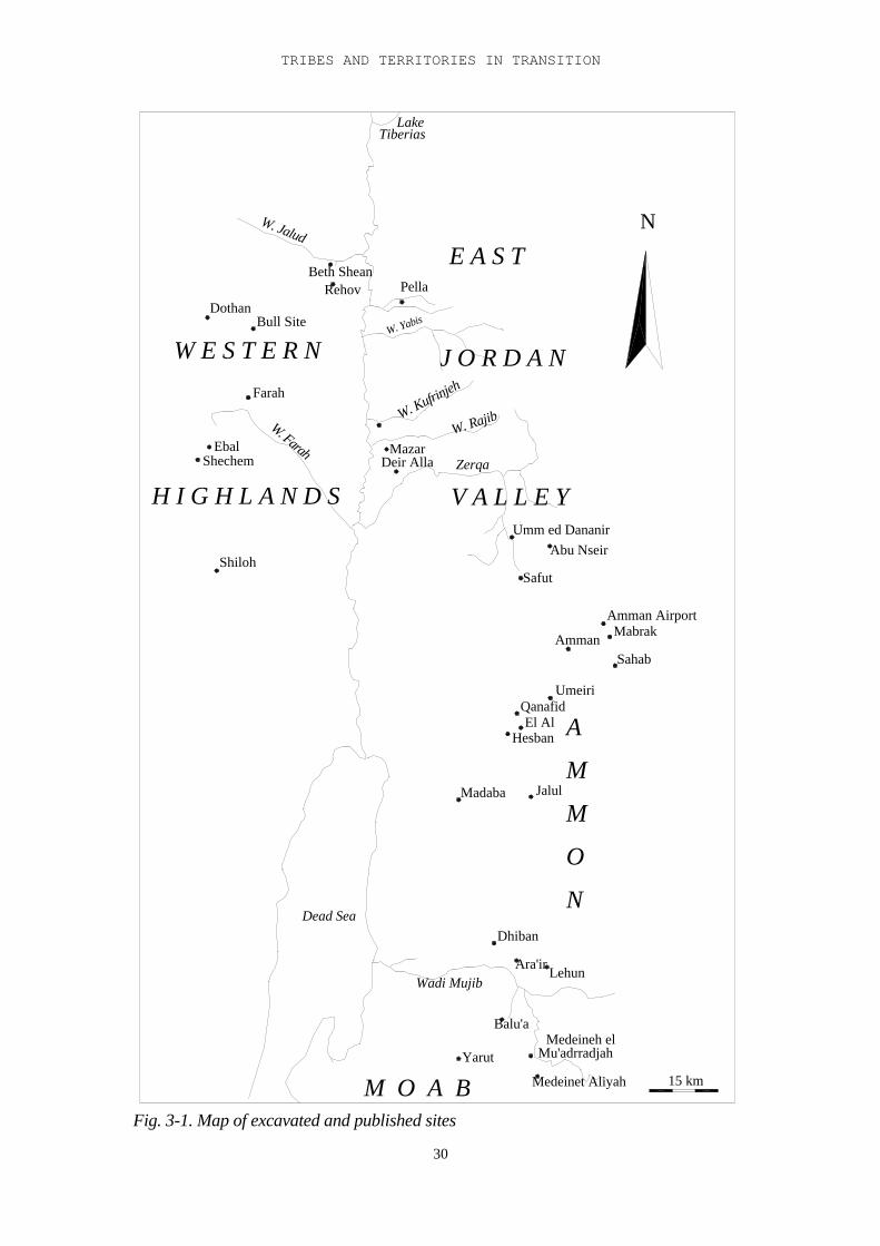
TRIBES AND TERRITORIES IN TRANSITION
30
Safut
MabrakAmman Airport
M O A B
N
O
M
M
A
Dead Sea
Qanafid
Amman
Umeiri
JalulMadaba
Hesban
Lehun
Medeineh el
Medeinet Aliyah
Mu'adrradjah
Balu'a
Wadi Mujib
Yarut
Ara'ir
Dhiban
El Al
Sahab
15 km
H I G H L A N D S V A L L E Y
J O R D A N
E A S T
W E S T E R N
W. Jalud
TiberiasLake
Pella
W. Rajib
Zerqa
Abu NseirUmm ed Dananir
RehovDothan
Farah
ShechemEbal
W. Farah
Bull Site
Shiloh
Deir AllaMazar
W. Kufrinjeh
W. Yabis
Beth Shean
N
Fig. 3-1. Map of excavated and published sites
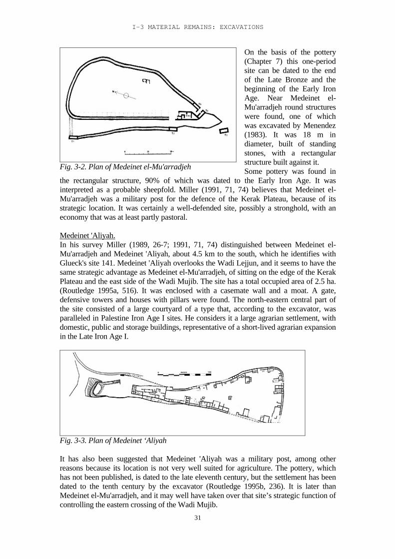
I-3 MATERIAL REMAINS: EXCAVATIONS
31
Fig. 3-2. Plan of Medeinet el-Mu'arradjeh
On the basis of the pottery(Chapter 7) this one-periodsite can be dated to the endof the Late Bronze and thebeginning of the Early IronAge. Near Medeinet el-Mu'arradjeh round structureswere found, one of whichwas excavated by Menendez(1983). It was 18 m indiameter, built of standingstones, with a rectangularstructure built against it.Some pottery was found in
the rectangular structure, 90% of which was dated to the Early Iron Age. It wasinterpreted as a probable sheepfold. Miller (1991, 71, 74) believes that Medeinet el-Mu'arradjeh was a military post for the defence of the Kerak Plateau, because of itsstrategic location. It was certainly a well-defended site, possibly a stronghold, with aneconomy that was at least partly pastoral.
Medeinet 'Aliyah.In his survey Miller (1989, 26-7; 1991, 71, 74) distinguished between Medeinet el-Mu'arradjeh and Medeinet 'Aliyah, about 4.5 km to the south, which he identifies withGlueck's site 141. Medeinet 'Aliyah overlooks the Wadi Lejjun, and it seems to have thesame strategic advantage as Medeinet el-Mu'arradjeh, of sitting on the edge of the KerakPlateau and the east side of the Wadi Mujib. The site has a total occupied area of 2.5 ha.(Routledge 1995a, 516). It was enclosed with a casemate wall and a moat. A gate,defensive towers and houses with pillars were found. The north-eastern central part ofthe site consisted of a large courtyard of a type that, according to the excavator, wasparalleled in Palestine Iron Age I sites. He considers it a large agrarian settlement, withdomestic, public and storage buildings, representative of a short-lived agrarian expansionin the Late Iron Age I.
Fig. 3-3. Plan of Medeinet ‘Aliyah
It has also been suggested that Medeinet 'Aliyah was a military post, among otherreasons because its location is not very well suited for agriculture. The pottery, whichhas not been published, is dated to the late eleventh century, but the settlement has beendated to the tenth century by the excavator (Routledge 1995b, 236). It is later thanMedeinet el-Mu'arradjeh, and it may well have taken over that site’s strategic function ofcontrolling the eastern crossing of the Wadi Mujib.
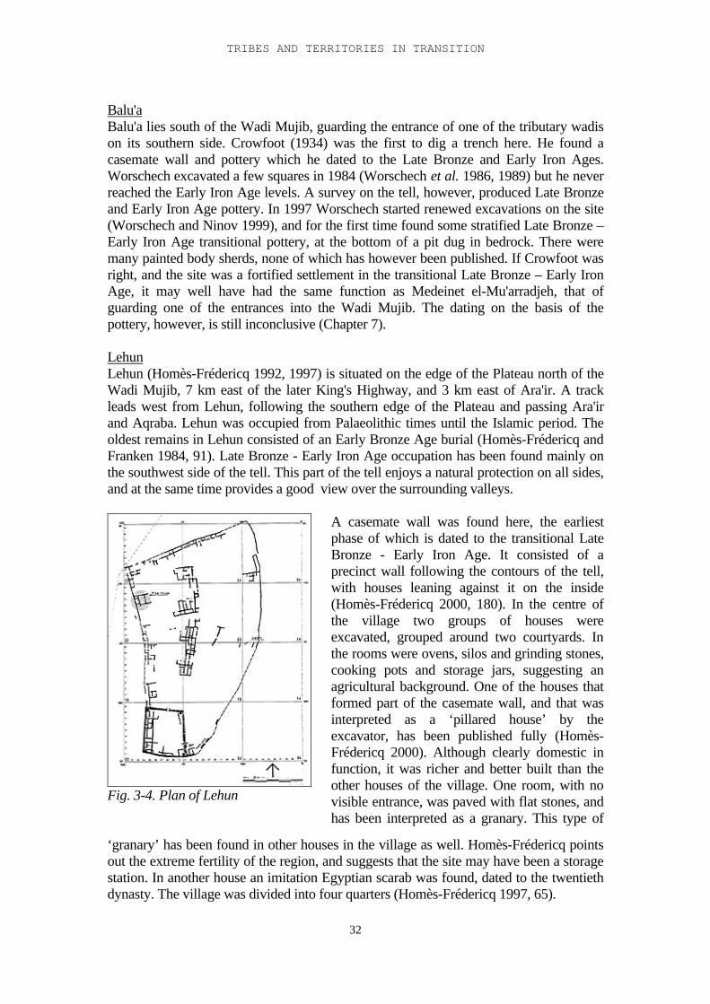
TRIBES AND TERRITORIES IN TRANSITION
32
Balu'aBalu'a lies south of the Wadi Mujib, guarding the entrance of one of the tributary wadison its southern side. Crowfoot (1934) was the first to dig a trench here. He found acasemate wall and pottery which he dated to the Late Bronze and Early Iron Ages.Worschech excavated a few squares in 1984 (Worschech et al. 1986, 1989) but he neverreached the Early Iron Age levels. A survey on the tell, however, produced Late Bronzeand Early Iron Age pottery. In 1997 Worschech started renewed excavations on the site(Worschech and Ninov 1999), and for the first time found some stratified Late Bronze –Early Iron Age transitional pottery, at the bottom of a pit dug in bedrock. There weremany painted body sherds, none of which has however been published. If Crowfoot wasright, and the site was a fortified settlement in the transitional Late Bronze – Early IronAge, it may well have had the same function as Medeinet el-Mu'arradjeh, that ofguarding one of the entrances into the Wadi Mujib. The dating on the basis of thepottery, however, is still inconclusive (Chapter 7).
LehunLehun (Homès-Frédericq 1992, 1997) is situated on the edge of the Plateau north of theWadi Mujib, 7 km east of the later King's Highway, and 3 km east of Ara'ir. A trackleads west from Lehun, following the southern edge of the Plateau and passing Ara'irand Aqraba. Lehun was occupied from Palaeolithic times until the Islamic period. Theoldest remains in Lehun consisted of an Early Bronze Age burial (Homès-Frédericq andFranken 1984, 91). Late Bronze - Early Iron Age occupation has been found mainly onthe southwest side of the tell. This part of the tell enjoys a natural protection on all sides,and at the same time provides a good view over the surrounding valleys.
Fig. 3-4. Plan of Lehun
A casemate wall was found here, the earliestphase of which is dated to the transitional LateBronze - Early Iron Age. It consisted of aprecinct wall following the contours of the tell,with houses leaning against it on the inside(Homès-Frédericq 2000, 180). In the centre ofthe village two groups of houses wereexcavated, grouped around two courtyards. Inthe rooms were ovens, silos and grinding stones,cooking pots and storage jars, suggesting anagricultural background. One of the houses thatformed part of the casemate wall, and that wasinterpreted as a ‘pillared house’ by theexcavator, has been published fully (Homès-Frédericq 2000). Although clearly domestic infunction, it was richer and better built than theother houses of the village. One room, with novisible entrance, was paved with flat stones, andhas been interpreted as a granary. This type of
‘granary’ has been found in other houses in the village as well. Homès-Frédericq pointsout the extreme fertility of the region, and suggests that the site may have been a storagestation. In another house an imitation Egyptian scarab was found, dated to the twentiethdynasty. The village was divided into four quarters (Homès-Frédericq 1997, 65).
I-3 MATERIAL REMAINS: EXCAVATIONS
33
Homès-Frédericq suggests that there may have been a crossing of the Wadi Mujibbetween Balu'a and Lehun. Members of the expedition have followed the path thatconnects the two sites. According to them the distance can be covered by an averagecaravan in 5-7 hours, following the contours of the Wadi Balu'a. This path is still in usewith the local population. Homès-Frédericq suggests this may have been part of theKing’s Highway.Somewhere during the Early Iron Age the doors of the houses were blocked and thevillage was abandoned by its inhabitants. In Iron Age II the remains of the houses werepartly cleared to make space for a fortress.
Ara'irOlàvarri (1965, 1969) has conducted excavations at Ara'ir, on the north bank of theMujib, generally identified with Biblical Aroer “which is upon the bank of the riverArnon” (Joshua 12, 20). No structures have been found from before the time of Mesha,but there was Late Bronze and Early Iron Age pottery. Both Ara'ir and Lehun may haveguarded the northern passes through the Wadi Mujib, while Balu'a and Medeinet el-Mu'arradjeh guarded the south side. The pottery repertoire seems to confirm this (seeChapter 7).
DhibanDhiban was first excavated by Winnett and Reed (1964), and is generally identified withBiblical Dibon. The Mesha stele was found here in 1868. Dhiban lies north of the WadiMujib, on a natural hill, surrounded by fertile land, but with no dependable water supply.This fact has led Tushingham (in Homès-Frédericq and Hennessy 1989, 206-210) toconclude that the site must always have been relatively dependent on pastoralism.Although Dhiban lies on the route of the later King's Highway, no conclusions should bedrawn from this, as it is unlikely that this route already existed in the Early Iron Age(Bienkowski, in press). Excavations at Dhiban have revealed little from the Late Bronzeand Early Iron Ages, but some possible Early Iron Age pottery has been found in filllayers, with no stratigraphic context.MacDonald (2000, 76) sees Dhiban as the capital of Moab and therefore identifies itwith biblical Ar-Moab, the city of Moab. There is however little evidence for occupationof the site before the time of Mesha.
MadabaTwo multiple burial caves were found in Madaba. Tomb A was published by Hardingand Isserlin in 1953. It had an opening at the top, and it had been used in the transitionalLate Bronze - Early Iron Age (1200-1160, according to the excavators). Hardingconsidered the presence of iron bracelets and toggle pins to be typical for the Iron Age.Tomb B was published by Piccirillo (1975) and H. Thompson (1986), who concludedthat this tomb had been in use from the beginning of the Early Iron Age until thetenth-ninth century. The quantity as well as the quality of the pottery from both tombssuggested a moderate economy: some imported, and good, but not top quality pottery.Multiple burial caves such as these are generally considered to be representative of theCanaanite mountainous culture (Gonen 1992, 6). The two tombs seem to have been inuse contemporaneously, at least for a certain period. This suggests that they must havebelonged to different families, clans, or possibly tribal groups.Excavations on the tell itself were started by Harrison in 1995. So far the earliest levelsfound belonged to the Iron Age II (Harrison 1997, 53-4; 2000, 579-81, Harrison et al.2000, 211 ff).
TRIBES AND TERRITORIES IN TRANSITION
34
JalulExcavations were conducted at Jalul by R. Younker and D. Merling from AndrewsUniversity in consortium with the Madaba Plains Project. These excavations revealedmainly Iron Age II remains, underneath which were debris fills containing pottery fromthe tenth and ninth century, as well as some sherds from the Early, Middle and LateBronze Ages. No occupation layers from these periods have been excavated so far(Younker 2000).
HesbanHesban lies on the western edge of the Transjordanian Plateau, 10 km north of Madaba.It is a prominent tell that has been described by passing travellers from the nineteenthcentury AD onwards, including Seetzen in 1806, Warren in 1869 and Musil in 1902.Excavations have been conducted since 1968 by Andrews University, directed by Hornand Boraas, and by Boraas and Geraty. The earliest remains were found in a cleftbetween two vertical bedrock faces: two stone cross walls, with Early Iron Age pottery,which has, however, not been published. Part of the floor between these walls was pavedwith small cobbles, with ash layers on top. The bedrock faces were partly plastered.Large amounts of pig bone were found here (Sauer in Boraas and Horn 1975, Boraas andGeraty 1976, 1978).LaBianca and Ray (1999) have re-excavated part of the trench and found much EarlyIron Age pottery, including some Manasseh bowls1 (see Chapter 7), only one of whichwas published. According to Sauer the pottery from the earliest Early Iron Age layers inHesban resembles that of Tell 'Umeiri (see below). It has been suggested that the trenchwas a defensive moat, since parallels for it have now been found in the vicinity atKhirbet Ayun Musa and Khirbet al-Mukhayyat, as well as south of Wadi Mujib, atKhirbet Al-Mudayneh al-Mraygha and Khirbet Medeinet 'Aliyah, which are dated to theEarly Iron Age as well (LaBianca and Ray 1999, 120).
El-'AlEl-'Al lies about 1 km north of Hesban on a natural hill. It was excavated in 1962 byReed (Reed 1972). Reed made four trenches on the westside. The lowest levels consistedof walls made of rough boulders, with Early and Late Iron Age pottery, none of whichwas published, however. Reed thinks the site may have been part of the King’s Highway(but see above).
Tell el-'UmeiriThis site has been excavated more or less continually between 1984 – 2000, by AndrewsUniversity, under the directorship of L. Geraty and L. Herr as part of the Madaba PlainsProject (Herr et al., eds. 1991, 1997; Herr 2000). The excavation at 'Umeiri waspreceded by a survey on the tell, using and testing Portugali's tell survey method(Portugali 1982).All in all the site has revealed strata dated from the Early Bronze Age to the Persianperiod. Its importance may partly be due to the fact that the only water source between
1 The Manasseh bowl acquired its name because of its frequent occurrence in the Manasseh area. It isa large open bowl, 40 cm in diameter, with a thickened, inverted, rounded rim (Zertal 1987, 125).Zertal considered it characteristic of early Israelite sites and postulated a Canaanite prototype,somewhat smaller in diameter, 10-15 cm. This type of bowl has now been found on several sites east ofthe Jordan as well (quite a large number of them have been found in Deir 'Alla), and seems thereforemuch more widespread, although its largest concentration is still the area of Manasseh.
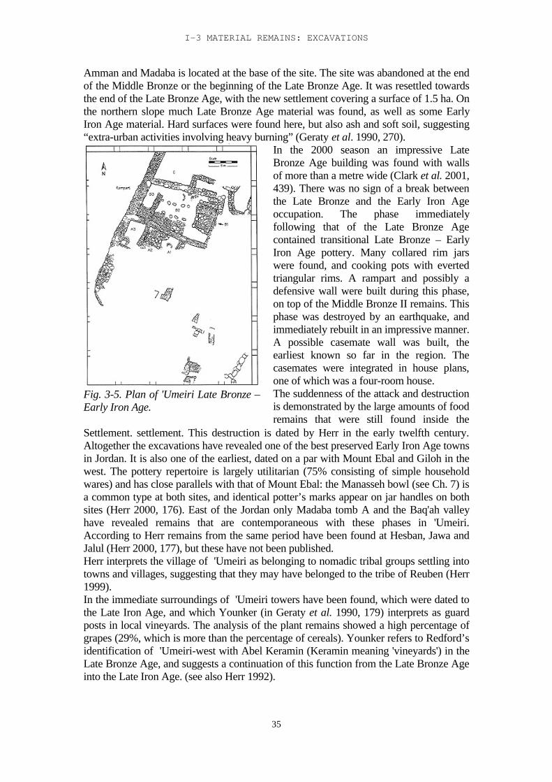
I-3 MATERIAL REMAINS: EXCAVATIONS
35
Amman and Madaba is located at the base of the site. The site was abandoned at the endof the Middle Bronze or the beginning of the Late Bronze Age. It was resettled towardsthe end of the Late Bronze Age, with the new settlement covering a surface of 1.5 ha. Onthe northern slope much Late Bronze Age material was found, as well as some EarlyIron Age material. Hard surfaces were found here, but also ash and soft soil, suggesting“extra-urban activities involving heavy burning” (Geraty et al. 1990, 270).
Fig. 3-5. Plan of 'Umeiri Late Bronze –Early Iron Age.
In the 2000 season an impressive LateBronze Age building was found with wallsof more than a metre wide (Clark et al. 2001,439). There was no sign of a break betweenthe Late Bronze and the Early Iron Ageoccupation. The phase immediatelyfollowing that of the Late Bronze Agecontained transitional Late Bronze – EarlyIron Age pottery. Many collared rim jarswere found, and cooking pots with evertedtriangular rims. A rampart and possibly adefensive wall were built during this phase,on top of the Middle Bronze II remains. Thisphase was destroyed by an earthquake, andimmediately rebuilt in an impressive manner.A possible casemate wall was built, theearliest known so far in the region. Thecasemates were integrated in house plans,one of which was a four-room house.The suddenness of the attack and destructionis demonstrated by the large amounts of foodremains that were still found inside the
Settlement. settlement. This destruction is dated by Herr in the early twelfth century.Altogether the excavations have revealed one of the best preserved Early Iron Age townsin Jordan. It is also one of the earliest, dated on a par with Mount Ebal and Giloh in thewest. The pottery repertoire is largely utilitarian (75% consisting of simple householdwares) and has close parallels with that of Mount Ebal: the Manasseh bowl (see Ch. 7) isa common type at both sites, and identical potter’s marks appear on jar handles on bothsites (Herr 2000, 176). East of the Jordan only Madaba tomb A and the Baq'ah valleyhave revealed remains that are contemporaneous with these phases in 'Umeiri.According to Herr remains from the same period have been found at Hesban, Jawa andJalul (Herr 2000, 177), but these have not been published.Herr interprets the village of 'Umeiri as belonging to nomadic tribal groups settling intotowns and villages, suggesting that they may have belonged to the tribe of Reuben (Herr1999).In the immediate surroundings of 'Umeiri towers have been found, which were dated tothe Late Iron Age, and which Younker (in Geraty et al. 1990, 179) interprets as guardposts in local vineyards. The analysis of the plant remains showed a high percentage ofgrapes (29%, which is more than the percentage of cereals). Younker refers to Redford’sidentification of 'Umeiri-west with Abel Keramin (Keramin meaning 'vineyards') in theLate Bronze Age, and suggests a continuation of this function from the Late Bronze Ageinto the Late Iron Age. (see also Herr 1992).
TRIBES AND TERRITORIES IN TRANSITION
36
Ammon
The region north of Moab corresponds with the later kingdom of Ammon, and formspart of the Biblical 'mountains of Gilead'. From the west it is approached through theWadi Zerqa. The largest part of this region, the highlands, lies on the TransjordanianPlateau.There are no contemporary literary sources mentioning the region in the Late BronzeAge. Redford (1982) has suggested that some place-names on the topographical list ofThutmose III may refer to places in Ammon, but his arguments are not convincing (Ch1). This lack of sources does not necessarily mean that the region fell outside theEgyptian sphere of influence (Hübner 1992, 162), but it is unlikely that it was part of theEmpire at any stage, although the archaeological record shows Egyptian influence.Younker suggests that the Egyptian sources referring to Šasu, mentioning Syria, Moab,Edom and Palestine as their habitat, can be interpreted as indirect literary evidence thatŠasu must have been roaming the Ammon region as well: “If the inhabitants of LB IIAAmmon were not Šasu, they must have strongly resembled them” (Younker 1999b,199). Biblical passages relating to the region are some geographical references inDeuteronomy 2 and 3, and the story of Jephta (Judges 11-12), which were composedmuch later (Kaiser 1984, 150).According to Younker (1999b, 189-218, with references) there is little archaeologicalevidence for actual settlement in the first part of the Late Bronze Age. The evidence doesshow that the area was not devoid of human activity, but only the latter part of LateBronze IIB witnessed a surge in occupation of the highlands. Twenty sites in Ammonare dated to the Late Bronze-Early Iron Age, as well as a number of tombs.
SahabSahab lies 12 km southeast of Amman on the Plateau, in the transitional zone betweenthe highlands and the desert. A multiple-burial cave, dated to the Late Bronze - EarlyIron Age, was found: Tomb C (Dajani 1970, Ibrahim 1972). From 1972 onwards Sahabhas been excavated by the Jordanian Department of Antiquities, under the directorship ofM. Ibrahim (1972, 1974, 1987). In 1983 the excavations were supplemented by a surveyin the area, also directed by Ibrahim.In the Late Bronze Age the occupied area was larger than in the Middle Bronze Age. Ithad an oval-shaped town wall, with a deep stone-lined foundation trench, which mayhave served as a hidden passage, according to the excavator. A seal impression on astorage jar handle dates this wall to the time of Thutmose III, at the beginning of theeighteenth dynasty. A seal in tomb C was from the same period. The pottery confirmsthese dates. This makes it one of the first walled towns in the Late Bronze Age. Abuilding with walls constructed of dressed stones was found which was dated to thefourteenth-thirteenth century on the basis of the pottery. The outer walls were 1.20 mwide and the east - west walls had a minimum length of 17 m. Outside one of the wallswas a tower-like projection. The walls of the building were plastered with red clay, and ithad clay floors, with a layer of occupation accumulation. Its function is not clear, but itseems likely that it was some kind of public building (Ibrahim 1974, 61). Relations withthe Aegean can be seen in the presence of imported and imitation pottery.No cultural break is attested in the transition from Late Bronze to Early Iron Age: thetomb remained in use, and there was no break in the repertoire of burial gifts (Ibrahim1987, 78; Dornemann 1983, 32). Part of the town wall was re-used as a house wall. Theoccupied area in the Early Iron Age was larger than that in the Late Bronze Age, but theIron Age town had no town walls. According to R. Younker (1999a, 13) this continuity
I-3 MATERIAL REMAINS: EXCAVATIONS
37
is “of special significance....., since this is the period when the Ammonites emerge in theland”.The settlement appears to have been destroyed in the twelfth century. The houses wererebuilt after the destruction, but the settlement remained smaller than before thedestruction (Ibrahim 1972). Ibrahim (1987, 76) suggests that Sahab in the Late BronzeAge may have been a military post, possibly part of a limes, meant to counter attacksfrom the desert.
The tomb contained a number of double pithos burials using collared rim jars (Ibrahim1972, 32). There were also two wooden coffins, older than the collared rim jar burials.Burial gifts consisted of oil lamps, small bowls, jars, locally produced alabaster ware,Egyptian objects (Ibrahim 1987), weapons, jewellery, and artefacts made of bronze andiron, all pointing to a date in the twelfth century. Seal impressions on some of the jarssuggested Syrian influence (Ibrahim 1972, 34; 1987, 78). Some of the bones were burnt.
Mabrak
Fig. 3-6. Plan of the Mabrak building.
At Mabrak, 4 km southeast of the AmmanAirport Building, a rectangular buildingwas found, measuring 18 x 24 m (Yassine1983), with a cistern. It had a centralcourtyard, accessible from most rooms.The outer walls were 2 m wide andconstructed of large boulders. In thebedrock on which the building stood was adepression several metres deep, below thecourtyard, that may have been connectedwith a depression outside the building,suggesting a use as cistern for thedepression inside the building. Thearchitecture of the building stronglyresembled that of the Amman AirportBuilding (see below), although it isunclear whether it had the same type offoundation. There are also strongresemblances to the Rujm al-Henubuilding (see below). According to theexcavator it was an unfinished residentialbuilding.
Amman Airport BuildingExcavations at the Amman Airport Building were conducted in 1955 by the Departmentof Antiquities of Jordan, under the direction of Lancaster Harding (1958), in 1966 by theBritish School for Archaeology, directed by Hennessy (1966), and in 1976 by theAmerican School for Oriental Research, directed by Herr, before the building wasremoved in 1978.
TRIBES AND TERRITORIES IN TRANSITION
38
Fig. 3-7. Plan of the Amman Airportbuilding: the last building phase before itsfinal destruction.
A square building was found, 15 x 15 m,with walls 2 m wide. According toLancaster Harding it was a temple (1958,10). It was situated centrally in an ovalplain, 1 km east of the Zerqa river. Therewas much imported material: Mycenaeanpottery, an Egyptian khepesh sword,bronze weapons and vessels, jewellery ofgold and other materials, and scarabs andcylinder seals. The scarabs were of anEgyptian type, dated by Ward (1964)between 1900-1350, the seals were in theSyrian - Mitannian tradition.Hennessy distinguished three occupationphases: The outer walls were built in thefirst phase, in a foundation trench.Inside these walls was a layer of yellowclay and red earth, 15 cm thick, in whichwere concentrations of burnt clay, ash andbones, interpreted by the excavator asfoundation deposits. There were alsopersonal luxury items: jewellery, golden
objects, beads, Egyptian scarabs and Syrian-Mitannian cylinder seals, artefacts made ofbone and ivory. The imported pottery has been analysed by Hankey (1974). It consistedof Mycenaean IIA - IIIB and Simple Style pottery, dated to the second half of thefifteenth century. The plan of the building consisted of a square central space with sixsurrounding rooms. In the centre of the central space stood two stone cylinders on top ofeach other in a separate foundation trench, in which many spear- and arrowheads werefound. This structure was interpreted by the excavator as an altar. Its top was charred. Ontop of the fill of the foundation trench was a 2-5 cm thick accumulation. In thisaccumulation isolated remains of fires were found, and bone fragments.The concentration of finds in the central space was striking, especially the concentrationof spear- and arrowheads. Many fragments of Egyptian stone bowls were also found. Atwo metre wide strip on the northern and northeastern side of the building was coveredwith crushed limestone. (Hennessy in Homès-Frédericq and Hennessy 1989:167 ff).The second occupation phase consisted of a pavement of large slabs inside the building.Everything above this floor was removed in the 1955 excavation.The third phase saw a fundamental change in the lay-out of the building: the centralspace was divided into two rooms, and the 'altar' became incorporated in the divisionwall. The old entrance was closed, and a new one made elsewhere. Since in none of theexcavations mention has been made of roof constructions, Hennessy suggests that thewhole building may have been open to the sky (Hennessy 1985).92 percent of the bone fragments found in the building were identified as human. Theyconsisted of small, partly burnt fragments. Excavations outside the building on the northside (Herr 1983a, 22; 1983b, 226) uncovered a structure consisting of two parallel rowsof stones four metre apart, the space between them filled with rubble and smaller stones.Many stones were discoloured by fire. This installation has been reconstructed as asquare plateau, two rows high, with a flat top on which something has been burned.Many lamps were found around this installation, as well as a large amount of Egyptianstone bowl fragments, with traces of burning. Again many small fragments of partly
I-3 MATERIAL REMAINS: EXCAVATIONS
39
burnt human bone were found. Analysis of the bone material shows that most of theburnt bones came from the upper part of the body, suggesting that the bodies werearticulated when burnt. Little (in Herr 1983a:47 ff) tentatively suggests the possibilitythat they were Indo-Europeans.Herr dates the building in the thirteenth century, on the basis of Hankey's potteryanalysis. The local pottery (Kafafi in Herr 1983a) suggests a later date, in the transitionalLate Bronze - Early Iron Age period.The function of the building is a matter of debate. It has been alternatively described as atemple for human sacrifice (Hennessy, among others), or a crematorium (Herr). Fritz,writing before the bone material was analysed as human, argued convincingly against atemple-function (Fritz 1971). Herr suggested the building might have been acrematorium, possibly of a Hittite group (1983b, 228). Cremation was not unusualamong Hittites, although it is found among other groups as well (in Hamath, Azor andQasile in the Early Iron Age evidence of cremation has been found; see also Zwickel1994, 77-78). The finds showed more affinity with Mesopotamia than with the west. Inthe first phase of the building a cylinder seal has been found with a Babylonian textrelating to Marduk and Sarpanitu, the main deities of the Kassite pantheon in the timethe building was in use. Bodies were burnt on the outside installation, and the remainsand funerary gifts were kept inside the building, which was, therefore, fortified in orderto defend it against robbers and thieves. The bone material consisted of very smallfragments, which may well have come from a large number of different people (Littlegives only a minimum number of individuals, but the tiny fragments may have been theremains of a large number of individuals as well). In general it is not unusual for theremains from a cremation to be crushed after burning, in order to fit them into acontainer of some kind. This would result in a residue of bone splinters from manydifferent individuals around the place where the bones were crushed. No containers havebeen found, so they may have been taken by relatives, or have consisted of some organicmaterial which has disappeared. This would explain the fragmentary state of the bonematerial, and still be an argument in favour of the crematorium theory. The presence of(even then) very old Egyptian stone vessels (dated by Herr to the Early Dynastic periodin some cases) also point, according to Herr (1983b, 226), to a funerary function.
A site with related pottery was found several hundred metres to the east (Harding1958:10-12; Hennessy 1966:159).
Jebel NuzhaIn a burial cave at Jebel Nuzha, Amman, Late Bronze to Early Iron Age pottery wasfound (Dajani 1966). According to Dornemann (1983, 31 ff.) almost every Early IronAge pottery shape that has ever been found has parallels in the Jebel Nuzha repertoire,and its quality is better than usual in the twelfth and eleventh century. He dates the tombin the Early Iron Age, mainly because the repertoire lacked imported pottery.
SafutSafut lies 12 km northwest of Amman, south of the Wadi Suweileh, on the south side ofthe Baq'ah Valley. Excavations here started in 1982 and still continue, under thedirection of D. Wimmer (Wimmer 1987, 1997). According to him the site was alreadyoccupied in the Middle Bronze Age. On the south side of the tell Late Bronze occupationwas found: a stone wall, that may have surrounded a sanctuary. A chalice was foundhere, a large amount of charred two-row barley and a bronze, partly gilded statuette of aseated male deity flanked by two terracotta pillar figurines. Elsewhere on the tell remains
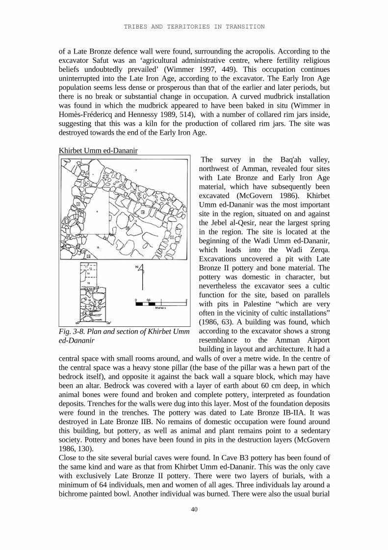
TRIBES AND TERRITORIES IN TRANSITION
40
of a Late Bronze defence wall were found, surrounding the acropolis. According to theexcavator Safut was an ‘agricultural administrative centre, where fertility religiousbeliefs undoubtedly prevailed’ (Wimmer 1997, 449). This occupation continuesuninterrupted into the Late Iron Age, according to the excavator. The Early Iron Agepopulation seems less dense or prosperous than that of the earlier and later periods, butthere is no break or substantial change in occupation. A curved mudbrick installationwas found in which the mudbrick appeared to have been baked in situ (Wimmer inHomès-Frédericq and Hennessy 1989, 514), with a number of collared rim jars inside,suggesting that this was a kiln for the production of collared rim jars. The site wasdestroyed towards the end of the Early Iron Age.
Khirbet Umm ed-Dananir
Fig. 3-8. Plan and section of Khirbet Ummed-Dananir
The survey in the Baq'ah valley,northwest of Amman, revealed four siteswith Late Bronze and Early Iron Agematerial, which have subsequently beenexcavated (McGovern 1986). KhirbetUmm ed-Dananir was the most importantsite in the region, situated on and againstthe Jebel al-Qesir, near the largest springin the region. The site is located at thebeginning of the Wadi Umm ed-Dananir,which leads into the Wadi Zerqa.Excavations uncovered a pit with LateBronze II pottery and bone material. Thepottery was domestic in character, butnevertheless the excavator sees a culticfunction for the site, based on parallelswith pits in Palestine “which are veryoften in the vicinity of cultic installations”(1986, 63). A building was found, whichaccording to the excavator shows a strongresemblance to the Amman Airportbuilding in layout and architecture. It had a
central space with small rooms around, and walls of over a metre wide. In the centre ofthe central space was a heavy stone pillar (the base of the pillar was a hewn part of thebedrock itself), and opposite it against the back wall a square block, which may havebeen an altar. Bedrock was covered with a layer of earth about 60 cm deep, in whichanimal bones were found and broken and complete pottery, interpreted as foundationdeposits. Trenches for the walls were dug into this layer. Most of the foundation depositswere found in the trenches. The pottery was dated to Late Bronze IB-IIA. It wasdestroyed in Late Bronze IIB. No remains of domestic occupation were found aroundthis building, but pottery, as well as animal and plant remains point to a sedentarysociety. Pottery and bones have been found in pits in the destruction layers (McGovern1986, 130).Close to the site several burial caves were found. In Cave B3 pottery has been found ofthe same kind and ware as that from Khirbet Umm ed-Dananir. This was the only cavewith exclusively Late Bronze II pottery. There were two layers of burials, with aminimum of 64 individuals, men and women of all ages. Three individuals lay around abichrome painted bowl. Another individual was burned. There were also the usual burial
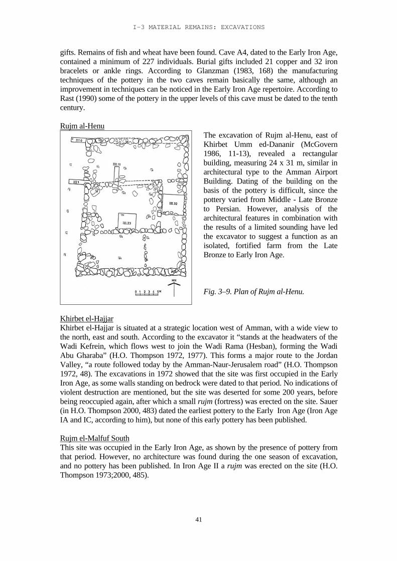
I-3 MATERIAL REMAINS: EXCAVATIONS
41
gifts. Remains of fish and wheat have been found. Cave A4, dated to the Early Iron Age,contained a minimum of 227 individuals. Burial gifts included 21 copper and 32 ironbracelets or ankle rings. According to Glanzman (1983, 168) the manufacturingtechniques of the pottery in the two caves remain basically the same, although animprovement in techniques can be noticed in the Early Iron Age repertoire. According toRast (1990) some of the pottery in the upper levels of this cave must be dated to the tenthcentury.
Rujm al-Henu The excavation of Rujm al-Henu, east ofKhirbet Umm ed-Dananir (McGovern1986, 11-13), revealed a rectangularbuilding, measuring 24 x 31 m, similar inarchitectural type to the Amman AirportBuilding. Dating of the building on thebasis of the pottery is difficult, since thepottery varied from Middle - Late Bronzeto Persian. However, analysis of thearchitectural features in combination withthe results of a limited sounding have ledthe excavator to suggest a function as anisolated, fortified farm from the LateBronze to Early Iron Age.
Fig. 3–9. Plan of Rujm al-Henu.
Khirbet el-HajjarKhirbet el-Hajjar is situated at a strategic location west of Amman, with a wide view tothe north, east and south. According to the excavator it “stands at the headwaters of theWadi Kefrein, which flows west to join the Wadi Rama (Hesban), forming the WadiAbu Gharaba” (H.O. Thompson 1972, 1977). This forms a major route to the JordanValley, “a route followed today by the Amman-Naur-Jerusalem road” (H.O. Thompson1972, 48). The excavations in 1972 showed that the site was first occupied in the EarlyIron Age, as some walls standing on bedrock were dated to that period. No indications ofviolent destruction are mentioned, but the site was deserted for some 200 years, beforebeing reoccupied again, after which a small rujm (fortress) was erected on the site. Sauer(in H.O. Thompson 2000, 483) dated the earliest pottery to the Early Iron Age (Iron AgeIA and IC, according to him), but none of this early pottery has been published.
Rujm el-Malfuf SouthThis site was occupied in the Early Iron Age, as shown by the presence of pottery fromthat period. However, no architecture was found during the one season of excavation,and no pottery has been published. In Iron Age II a rujm was erected on the site (H.O.Thompson 1973;2000, 485).
TRIBES AND TERRITORIES IN TRANSITION
42
A third tower, also excavated by H.O. Thompson, Rujm al-Mekheizin, north-east ofAmman, also seems to have been built on the site of a former Early Iron Age site. A fewEarly Iron Age sherds were found on the site (H.O. Thompson 2000, 487)
Tell Jawa SouthTell Jawa was excavated, originally under direction of Daviau and Younker, and laterunder direction of Daviau (Daviau 1992). In the first season a probe was made in whichEarly Iron Age walls and destruction debris were found, on top of Middle Bronze Agelayers. The following seasons concentrated on the later periods of occupation, in which acasemate wall was found, dating to Iron Age II. No pottery from the Early Iron Agelayers has been published so far.
Jordan Valley
PellaThe site of Pella is situated in the foothills, close to two important trade routes: the north-south route through the Jordan Valley, and the west-east route from the coast through theJezreel Valley. Pella consists of a complex of sites separated by valleys and wadis. Mostsignificant are Tabaqat Fahl, the tell proper, and the natural hill of el-Husn. Excavationshave been carried out in 1967 by Wooster College, directed by R.H. Smith (Smith 1973),and from 1979 on by Sydney University and Wooster College, directed by Hennessy,McNicoll and Smith, and later by Bourke (McNicoll et al. 1982; Bourke et al. 1994;Bourke 1997). On the south-east side of the tell of Tabaqat Fahl domestic architecturewas discovered, in three occupation levels, which lasted throughout the Late BronzeAge. A multi-roomed structure was found with two phases, dated to the Middle Bronze-Late Bronze transition, and Late Bronze IB-IIA, respectively. The excavated partcontained a number of plastered bins filled with pottery, and this has been interpreted bythe excavator as a public temple/repository, where libation vessels were stored andpurified (Bourke et al. 1998, 194). A second building was contemporary with the secondphase of this temple / repository. This building, a multi-roomed courtyard building, hadthree building phases. The first consisted of neat mudbrick walls laid on stonefoundations and plastered floors. In the second phase some new, poorly constructedwalls were set inside the older structure, and a number of stone-lined pits constructed.The third phase (Late Bronze IIAB) shows evidence of semi-permanent structures withinthe courtyard areas. A street separated this building from a third building, labelled by theexcavators a 'Governor's Residence' (following Oren 1985, 1992). The occupationalhistory of this building matched that of its opposite neighbour. It went out of use at theend of the fourteenth century (Bourke 1997, 108). Although the architecture is indeedsuggestive of an 'Egyptian residence', it is dated at least 200 years earlier than the otherresidence buildings described by Oren.Elsewhere on the site recent excavations have uncovered a stone-built Migdol Temple,the largest that has been found so far in the Levant, with parallels at Megiddo, Shechemand Tell Hayyat (Bourke in Egan and Bikai 1999, 495). It was probably constructedaround 1450, and went through a number of major rebuilding phases before it finallywent out of use in the 9th century. West of the Migdol temple was a massive mudbrickbuilding, with heavy walls. Its reconstruction was dated to 1300 BC, its destructionaround 850 BC. The excavators suggest that this may be the “long sought after palace ofthe Iron Age rulers of Pella” (Bourke in Egan and Bikai 1999, 496).
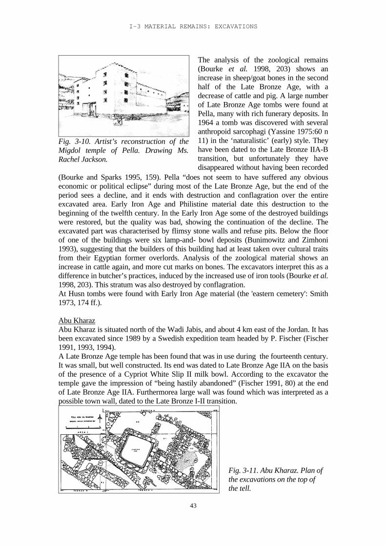
I-3 MATERIAL REMAINS: EXCAVATIONS
43
Fig. 3-10. Artist’s reconstruction of theMigdol temple of Pella. Drawing Ms.Rachel Jackson.
The analysis of the zoological remains(Bourke et al. 1998, 203) shows anincrease in sheep/goat bones in the secondhalf of the Late Bronze Age, with adecrease of cattle and pig. A large numberof Late Bronze Age tombs were found atPella, many with rich funerary deposits. In1964 a tomb was discovered with severalanthropoid sarcophagi (Yassine 1975:60 n11) in the ‘naturalistic’ (early) style. Theyhave been dated to the Late Bronze IIA-Btransition, but unfortunately they havedisappeared without having been recorded
(Bourke and Sparks 1995, 159). Pella “does not seem to have suffered any obviouseconomic or political eclipse” during most of the Late Bronze Age, but the end of theperiod sees a decline, and it ends with destruction and conflagration over the entireexcavated area. Early Iron Age and Philistine material date this destruction to thebeginning of the twelfth century. In the Early Iron Age some of the destroyed buildingswere restored, but the quality was bad, showing the continuation of the decline. Theexcavated part was characterised by flimsy stone walls and refuse pits. Below the floorof one of the buildings were six lamp-and- bowl deposits (Bunimowitz and Zimhoni1993), suggesting that the builders of this building had at least taken over cultural traitsfrom their Egyptian former overlords. Analysis of the zoological material shows anincrease in cattle again, and more cut marks on bones. The excavators interpret this as adifference in butcher’s practices, induced by the increased use of iron tools (Bourke et al.1998, 203). This stratum was also destroyed by conflagration.At Husn tombs were found with Early Iron Age material (the 'eastern cemetery': Smith1973, 174 ff.).
Abu KharazAbu Kharaz is situated north of the Wadi Jabis, and about 4 km east of the Jordan. It hasbeen excavated since 1989 by a Swedish expedition team headed by P. Fischer (Fischer1991, 1993, 1994).A Late Bronze Age temple has been found that was in use during the fourteenth century.It was small, but well constructed. Its end was dated to Late Bronze Age IIA on the basisof the presence of a Cypriot White Slip II milk bowl. According to the excavator thetemple gave the impression of “being hastily abandoned” (Fischer 1991, 80) at the endof Late Bronze Age IIA. Furthermorea large wall was found which was interpreted as apossible town wall, dated to the Late Bronze I-II transition.
Fig. 3-11. Abu Kharaz. Plan ofthe excavations on the top ofthe tell.
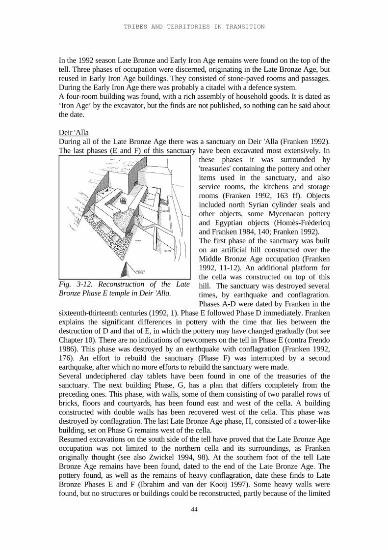
TRIBES AND TERRITORIES IN TRANSITION
44
In the 1992 season Late Bronze and Early Iron Age remains were found on the top of thetell. Three phases of occupation were discerned, originating in the Late Bronze Age, butreused in Early Iron Age buildings. They consisted of stone-paved rooms and passages.During the Early Iron Age there was probably a citadel with a defence system.A four-room building was found, with a rich assembly of household goods. It is dated as‘Iron Age’ by the excavator, but the finds are not published, so nothing can be said aboutthe date.
Deir 'AllaDuring all of the Late Bronze Age there was a sanctuary on Deir 'Alla (Franken 1992).The last phases (E and F) of this sanctuary have been excavated most extensively. In
Fig. 3-12. Reconstruction of the LateBronze Phase E temple in Deir 'Alla.
these phases it was surrounded by'treasuries' containing the pottery and otheritems used in the sanctuary, and alsoservice rooms, the kitchens and storagerooms (Franken 1992, 163 ff). Objectsincluded north Syrian cylinder seals andother objects, some Mycenaean potteryand Egyptian objects (Homès-Frédericqand Franken 1984, 140; Franken 1992).The first phase of the sanctuary was builton an artificial hill constructed over theMiddle Bronze Age occupation (Franken1992, 11-12). An additional platform forthe cella was constructed on top of thishill. The sanctuary was destroyed severaltimes, by earthquake and conflagration.Phases A-D were dated by Franken in the
sixteenth-thirteenth centuries (1992, 1). Phase E followed Phase D immediately. Frankenexplains the significant differences in pottery with the time that lies between thedestruction of D and that of E, in which the pottery may have changed gradually (but seeChapter 10). There are no indications of newcomers on the tell in Phase E (contra Frendo1986). This phase was destroyed by an earthquake with conflagration (Franken 1992,176). An effort to rebuild the sanctuary (Phase F) was interrupted by a secondearthquake, after which no more efforts to rebuild the sanctuary were made.Several undeciphered clay tablets have been found in one of the treasuries of thesanctuary. The next building Phase, G, has a plan that differs completely from thepreceding ones. This phase, with walls, some of them consisting of two parallel rows ofbricks, floors and courtyards, has been found east and west of the cella. A buildingconstructed with double walls has been recovered west of the cella. This phase wasdestroyed by conflagration. The last Late Bronze Age phase, H, consisted of a tower-likebuilding, set on Phase G remains west of the cella.Resumed excavations on the south side of the tell have proved that the Late Bronze Ageoccupation was not limited to the northern cella and its surroundings, as Frankenoriginally thought (see also Zwickel 1994, 98). At the southern foot of the tell LateBronze Age remains have been found, dated to the end of the Late Bronze Age. Thepottery found, as well as the remains of heavy conflagration, date these finds to LateBronze Phases E and F (Ibrahim and van der Kooij 1997). Some heavy walls werefound, but no structures or buildings could be reconstructed, partly because of the limited
I-3 MATERIAL REMAINS: EXCAVATIONS
45
area excavated. More clay tablets have been found of the same nature as those found byFranken, and some collared rim jars. None of these finds have been published. A testtrench in one of the gullies on the south slope has revealed the presence, on the southside of the tell, of earlier phases of the Late Bronze Age also (personal observation).The earliest Iron Age occupation on Deir 'Alla followed the latest Late Bronze Agephase almost immediately, according to the excavator. There are, however, noindications that the newcomers had caused the end of the preceding occupation.(Franken 1969, 20). The Early Iron Age occupation has been divided into two mainperiods: Phases A-D and Phases E-L. The excavator characterises the first period(Phases A-D) as follows:- The tell may still have been used as a sanctuary, in line with older traditions (Coogan1987). This has been suggested by the large numbers of incense burners that were found,and the presence of two heavy walls in Square M (see Chapter 10), which might havebeen part of a new sanctuary.- The newcomers came from a semi-nomadic background: no houses have been foundon the tell, only a few postholes, which may have been the remains of tents (but seeChapter10).- The walls found in this period belonged to furnaces or to courtyards. There were manypits. The combination of furnaces, courtyards without houses, and pits suggests anindustrial function for the tell in this period. Franken related this to copper or bronzeindustry. A succession of thin layers of burnt clay would point to a seasonal industrialactivity. Renewed excavations in the area of the Phase B furnaces have rendered the useof these furnaces for metal working highly unlikely (personal observation). The actualfunction of these furnaces has not been clarified so far.- The site was occupied during winter, but deserted in summer. Agriculture waspractised on a small scale, as is shown by the large number of flint sickle blades, and thepresence of animal bones suggests pastoralism and hunting. A picture is painted of asemi-nomadic population living on the tell in winter, practising some agriculture andanimal husbandry, and involved in some – so far unknown - industry, and moving backto the hills in summer.Phase E sees the coming of a new population, but again, there are no traces of violence.Differences to be noted from the preceding population are:- Heavy walls and town planning right from the beginning- Pottery, although related to the pottery of the preceding period, was developedindependently of that used by the semi-nomads. This pottery is not typically Palestine innature, but suggests relations with the east.- No wheel-burnished pottery is found.This period is dated by Franken to the eleventh and tenth century.
MazarTell Mazar is situated 3 km northwest of Deir 'Alla, and 3 km east of the Jordan.Excavations have been carried out here by Jordan University, directed by Yassine in1977, 1979 and 1981. The Early Iron Age levels have not been published, with theexception of a building 220 metres northwest of the main tell, on a low hill. According tothe excavator this was a temple (Yassine 1984). The building consists of three roomswith a forecourt, surrounded by a wall. The outer walls are made of mudbrick and 1.20m wide. There is only one building phase, with a number of occupation phases.The finds from the earliest phase are contemporaneous with Deir 'Alla Iron Age Phase F.In the central room one half of the floor was paved with stones and the other half withmudbricks. The western room had low benches along two walls. A stone bowl was set in
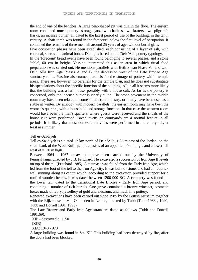
TRIBES AND TERRITORIES IN TRANSITION
46
the end of one of the benches. A large pear-shaped pit was dug in the floor. The easternroom contained much pottery: storage jars, two chalices, two kraters, two pilgrim’sflasks, an incense burner, all dated to the latest period of use of the building, in the tenthcentury. A shaft tomb was found in the forecourt, below the first level of occupation. Itcontained the remains of three men, all around 25 years of age, without burial gifts.Five occupation phases have been established, each consisting of a layer of ash, withcharcoal, sherds and animal bones. Dating is based on the Deir 'Alla pottery typology.In the 'forecourt' bread ovens have been found belonging to several phases, and a stone'table', 60 cm in height. Yassine interpreted this as an area in which ritual foodpreparation was carried out. He mentions parallels with Beth Shean Phase VI, and withDeir 'Alla Iron Age Phases A and B, the depression west of the Late Bronze Agesanctuary ruins. Yassine also names parallels for the storage of pottery within templeareas. There are, however, no parallels for the temple plan, and he does not substantiatehis speculations about the specific function of the building. All in all it seems more likelythat the building was a farmhouse, possibly with a house cult. As far as the pottery isconcerned, only the incense burner is clearly cultic. The stone pavement in the middleroom may have been related to some small-scale industry, or it may have been used as astable in winter. By analogy with modern parallels, the eastern room may have been thewomen's quarters, with a household and storage function. In that case the western roomwould have been the men's quarters, where guests were received and the rituals of thehouse cult were performed. Bread ovens on courtyards are a normal feature in allperiods. It is likely that most domestic activities were performed in the courtyards, atleast in summer.
Tell es-Sa'idiyehTell es-Sa'idiyeh is situated 12 km north of Deir 'Alla, 1.8 km east of the Jordan, on thesouth bank of the Wadi Kufrinjeh. It consists of an upper tell, 40 m high, and a lower tellwest of it, 20 m high.Between 1964 - 1967 excavations have been carried out by the University ofPennsylvania, directed by J.B. Pritchard. He excavated a succession of Iron Age II levelson top of the tell (Pritchard 1985). A staircase was found from the Early Iron Age, whichled from the foot of the tell to the Iron Age city. It was built of stone, and had a mudbrickwall running along its centre which, according to the excavator, provided support for aroof of wooden beams. It was dated between 1200-900 BC. A cemetery was found onthe lower tell, dated to the transitional Late Bronze - Early Iron Age period, andcontaining a number of rich burials. One grave contained a bronze wine-set, cosmeticboxes made of ivory, jewellery of gold and electrum, and much fine pottery.Renewed excavations have been carried out since 1985 by the British Museum togetherwith the Rijksmuseum van Oudheden in Leiden, directed by Tubb (Tubb 1988a, 1990;Tubb and Dorrell 1991, 1993).The Late Bronze and Early Iron Age strata are dated as follows (Tubb and Dorrell1991:69): XII: - destroyed c. 1150 (XIB) XIA: 1040 - 970A large building was found in Str. XII. This building had been destroyed by fire, afterthe doors had been blocked.
I-3 MATERIAL REMAINS: EXCAVATIONS
47
This is the building known as the 'Governor's Residence'. Along the western slope of thetell a 3.5 m wide casemate wall was found, set in foundation trenches into which piséhad been poured as a foundation matrix. The casemates were filled with rubble. Againstthe wall a large building was set, the 'palace', dating from the same period as theGovernor’s Residence. Both buildings show Egyptian architectural traits: deep mudbrickfoundations without use of stone, a pisé matrix, and double walls with a narrow spacebetween them. A possible 'bath' was found in the palace, consisting of two connectedbasins with a drainage system, and a channel leading from the top of the staircase to thebasins. Another basin may have served as a cooling system for wine, according to theexcavator. The staircase was re-examined, and proved to descend to a spring. It had beenin use from Str. XII or possibly earlier. Str. XIB has been encountered in a few placesonly, consisting mainly of hearths and grinding stones. It was probably the remains ofnomadic squatter occupation in the ruins of Str. XII. The pottery from this stratum is thesame as that from Str. XII. Str. XI A starts with the levelling of the Str. XII remains. Ontop of this a house was built, consisting of two rooms, with a niche in the wall of thesmallest room. In this niche a flat stone was set, and in front of that was a fireplace, witha channel leading to a pit at the other side of the room. In front of the fireplace stood anincense burner. This has been interpreted by the excavator as a kind of sanctuary. Westof this building stood a stone tower. A street has been found dated to the Early Iron Age,separating the upper and lower tells.
Tell es-Sa'idiyeh: Burials on the lower tellOn the lower tell the American expedition found 45 burials (Pritchard 1980). The Britishexpedition excavated almost 400 additional burials in six seasons of excavation. Most ofthe burials had been dug through the underlying Early Bronze Age levels.The largest group of burials consisted of rectangular or oval pits, sometimes lined withstones or bricks from the underlying Early Bronze Age layers. Another group consistedof rectangular pits lined and covered with new bricks. A group consisting of two parallelrows of burial pits may have been dug in advance, because some appeared not to havebeen used at all. There were many jar burials of children, and a number of double pithosburials. A striking observation was that only this type of burial had been robbed inantiquity. According to Tubb this suggests that these were burials of an allochthonous
Fig. 3-13. The Governor’sResidence at Tell es-Sa’idiyeh
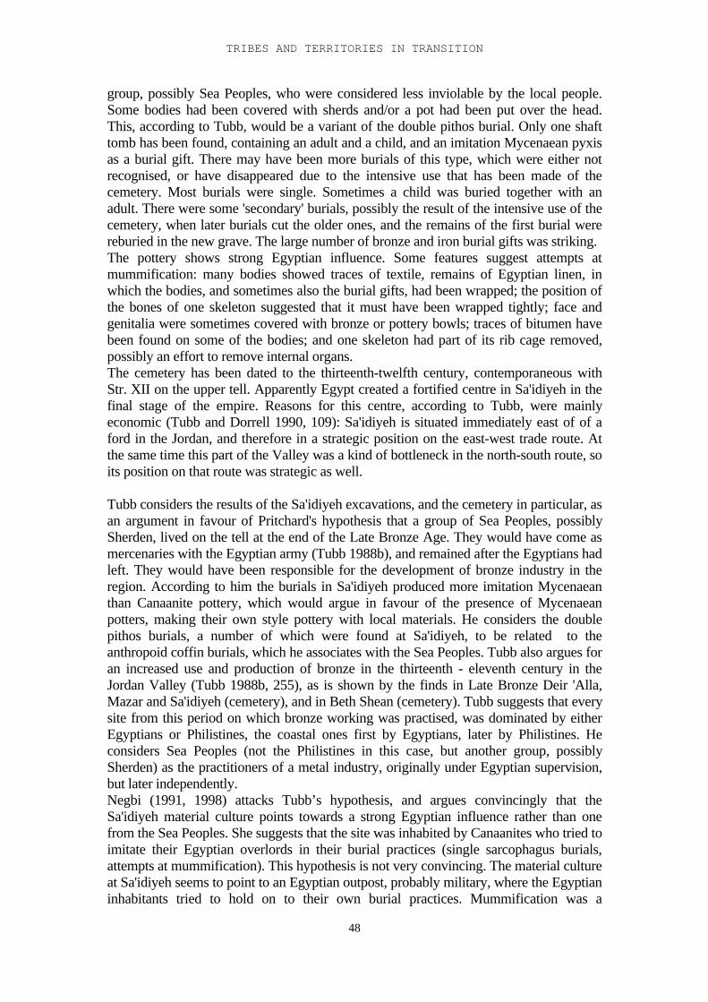
TRIBES AND TERRITORIES IN TRANSITION
48
group, possibly Sea Peoples, who were considered less inviolable by the local people.Some bodies had been covered with sherds and/or a pot had been put over the head.This, according to Tubb, would be a variant of the double pithos burial. Only one shafttomb has been found, containing an adult and a child, and an imitation Mycenaean pyxisas a burial gift. There may have been more burials of this type, which were either notrecognised, or have disappeared due to the intensive use that has been made of thecemetery. Most burials were single. Sometimes a child was buried together with anadult. There were some 'secondary' burials, possibly the result of the intensive use of thecemetery, when later burials cut the older ones, and the remains of the first burial werereburied in the new grave. The large number of bronze and iron burial gifts was striking.The pottery shows strong Egyptian influence. Some features suggest attempts atmummification: many bodies showed traces of textile, remains of Egyptian linen, inwhich the bodies, and sometimes also the burial gifts, had been wrapped; the position ofthe bones of one skeleton suggested that it must have been wrapped tightly; face andgenitalia were sometimes covered with bronze or pottery bowls; traces of bitumen havebeen found on some of the bodies; and one skeleton had part of its rib cage removed,possibly an effort to remove internal organs.The cemetery has been dated to the thirteenth-twelfth century, contemporaneous withStr. XII on the upper tell. Apparently Egypt created a fortified centre in Sa'idiyeh in thefinal stage of the empire. Reasons for this centre, according to Tubb, were mainlyeconomic (Tubb and Dorrell 1990, 109): Sa'idiyeh is situated immediately east of of aford in the Jordan, and therefore in a strategic position on the east-west trade route. Atthe same time this part of the Valley was a kind of bottleneck in the north-south route, soits position on that route was strategic as well.
Tubb considers the results of the Sa'idiyeh excavations, and the cemetery in particular, asan argument in favour of Pritchard's hypothesis that a group of Sea Peoples, possiblySherden, lived on the tell at the end of the Late Bronze Age. They would have come asmercenaries with the Egyptian army (Tubb 1988b), and remained after the Egyptians hadleft. They would have been responsible for the development of bronze industry in theregion. According to him the burials in Sa'idiyeh produced more imitation Mycenaeanthan Canaanite pottery, which would argue in favour of the presence of Mycenaeanpotters, making their own style pottery with local materials. He considers the doublepithos burials, a number of which were found at Sa'idiyeh, to be related to theanthropoid coffin burials, which he associates with the Sea Peoples. Tubb also argues foran increased use and production of bronze in the thirteenth - eleventh century in theJordan Valley (Tubb 1988b, 255), as is shown by the finds in Late Bronze Deir 'Alla,Mazar and Sa'idiyeh (cemetery), and in Beth Shean (cemetery). Tubb suggests that everysite from this period on which bronze working was practised, was dominated by eitherEgyptians or Philistines, the coastal ones first by Egyptians, later by Philistines. Heconsiders Sea Peoples (not the Philistines in this case, but another group, possiblySherden) as the practitioners of a metal industry, originally under Egyptian supervision,but later independently.Negbi (1991, 1998) attacks Tubb’s hypothesis, and argues convincingly that theSa'idiyeh material culture points towards a strong Egyptian influence rather than onefrom the Sea Peoples. She suggests that the site was inhabited by Canaanites who tried toimitate their Egyptian overlords in their burial practices (single sarcophagus burials,attempts at mummification). This hypothesis is not very convincing. The material cultureat Sa'idiyeh seems to point to an Egyptian outpost, probably military, where the Egyptianinhabitants tried to hold on to their own burial practices. Mummification was a
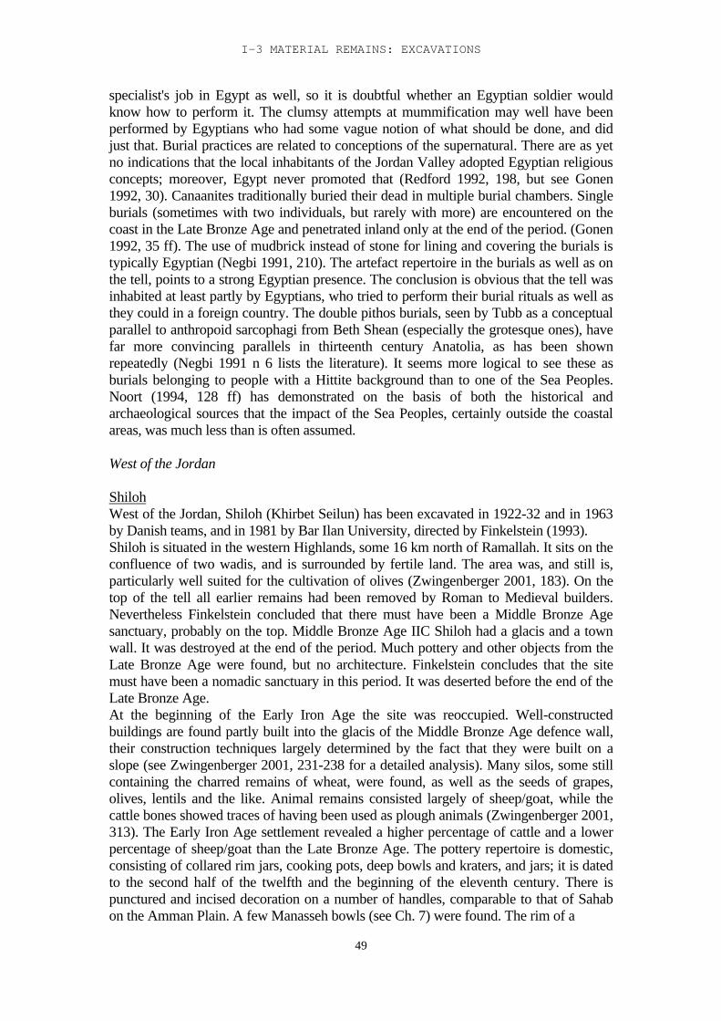
I-3 MATERIAL REMAINS: EXCAVATIONS
49
specialist's job in Egypt as well, so it is doubtful whether an Egyptian soldier wouldknow how to perform it. The clumsy attempts at mummification may well have beenperformed by Egyptians who had some vague notion of what should be done, and didjust that. Burial practices are related to conceptions of the supernatural. There are as yetno indications that the local inhabitants of the Jordan Valley adopted Egyptian religiousconcepts; moreover, Egypt never promoted that (Redford 1992, 198, but see Gonen1992, 30). Canaanites traditionally buried their dead in multiple burial chambers. Singleburials (sometimes with two individuals, but rarely with more) are encountered on thecoast in the Late Bronze Age and penetrated inland only at the end of the period. (Gonen1992, 35 ff). The use of mudbrick instead of stone for lining and covering the burials istypically Egyptian (Negbi 1991, 210). The artefact repertoire in the burials as well as onthe tell, points to a strong Egyptian presence. The conclusion is obvious that the tell wasinhabited at least partly by Egyptians, who tried to perform their burial rituals as well asthey could in a foreign country. The double pithos burials, seen by Tubb as a conceptualparallel to anthropoid sarcophagi from Beth Shean (especially the grotesque ones), havefar more convincing parallels in thirteenth century Anatolia, as has been shownrepeatedly (Negbi 1991 n 6 lists the literature). It seems more logical to see these asburials belonging to people with a Hittite background than to one of the Sea Peoples.Noort (1994, 128 ff) has demonstrated on the basis of both the historical andarchaeological sources that the impact of the Sea Peoples, certainly outside the coastalareas, was much less than is often assumed.
West of the Jordan
ShilohWest of the Jordan, Shiloh (Khirbet Seilun) has been excavated in 1922-32 and in 1963by Danish teams, and in 1981 by Bar Ilan University, directed by Finkelstein (1993).Shiloh is situated in the western Highlands, some 16 km north of Ramallah. It sits on theconfluence of two wadis, and is surrounded by fertile land. The area was, and still is,particularly well suited for the cultivation of olives (Zwingenberger 2001, 183). On thetop of the tell all earlier remains had been removed by Roman to Medieval builders.Nevertheless Finkelstein concluded that there must have been a Middle Bronze Agesanctuary, probably on the top. Middle Bronze Age IIC Shiloh had a glacis and a townwall. It was destroyed at the end of the period. Much pottery and other objects from theLate Bronze Age were found, but no architecture. Finkelstein concludes that the sitemust have been a nomadic sanctuary in this period. It was deserted before the end of theLate Bronze Age.At the beginning of the Early Iron Age the site was reoccupied. Well-constructedbuildings are found partly built into the glacis of the Middle Bronze Age defence wall,their construction techniques largely determined by the fact that they were built on aslope (see Zwingenberger 2001, 231-238 for a detailed analysis). Many silos, some stillcontaining the charred remains of wheat, were found, as well as the seeds of grapes,olives, lentils and the like. Animal remains consisted largely of sheep/goat, while thecattle bones showed traces of having been used as plough animals (Zwingenberger 2001,313). The Early Iron Age settlement revealed a higher percentage of cattle and a lowerpercentage of sheep/goat than the Late Bronze Age. The pottery repertoire is domestic,consisting of collared rim jars, cooking pots, deep bowls and kraters, and jars; it is datedto the second half of the twelfth and the beginning of the eleventh century. There ispunctured and incised decoration on a number of handles, comparable to that of Sahabon the Amman Plain. A few Manasseh bowls (see Ch. 7) were found. The rim of a
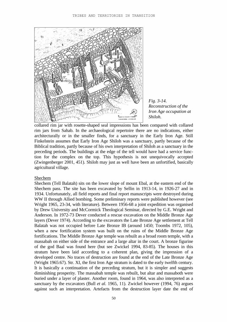
TRIBES AND TERRITORIES IN TRANSITION
50
collared rim jar with rosette-shaped seal impressions has been compared with collaredrim jars from Sahab. In the archaeological repertoire there are no indications, eitherarchitecturally or in the smaller finds, for a sanctuary in the Early Iron Age. StillFinkelstein assumes that Early Iron Age Shiloh was a sanctuary, partly because of theBiblical tradition, partly because of his own interpretation of Shiloh as a sanctuary in thepreceding periods. The buildings at the edge of the tell would have had a service func-tion for the complex on the top. This hypothesis is not unequivocally accepted(Zwingenberger 2001, 451). Shiloh may just as well have been an unfortified, basicallyagricultural village.
ShechemShechem (Tell Balatah) sits on the lower slope of mount Ebal, at the eastern end of theShechem pass. The site has been excavated by Sellin in 1913-14, in 1926-27 and in1934. Unfortunately, all field reports and final report manuscripts were destroyed duringWW II through Allied bombing. Some preliminary reports were published however (seeWright 1965, 23-34, with literature). Between 1956-68 a joint expedition was organisedby Drew University and McCormick Theological Seminar, directed by G.E. Wright andAnderson. In 1972-73 Dever conducted a rescue excavation on the Middle Bronze Agelayers (Dever 1974). According to the excavators the Late Bronze Age settlement at TellBalatah was not occupied before Late Bronze IB (around 1450; Toombs 1972, 105),when a new fortification system was built on the ruins of the Middle Bronze Agefortifications. The Middle Bronze Age temple was rebuilt as a broad room temple, with amassabah on either side of the entrance and a large altar in the court. A bronze figurineof the god Baal was found here (but see Zwickel 1994, 83-85). The houses in thisstratum have been laid according to a coherent plan, giving the impression of adeveloped centre. No traces of destruction are found at the end of the Late Bronze Age(Wright 1965:67). Str. XI, the first Iron Age stratum is dated to the early twelfth century.It is basically a continuation of the preceding stratum, but it is simpler and suggestsdiminishing prosperity. The massabah temple was rebuilt, but altar and massaboth wereburied under a layer of plaster. Another room, found in 1964, was also interpreted as asanctuary by the excavators (Bull et al. 1965, 11). Zwickel however (1994, 76) arguesagainst such an interpretation. Artefacts from the destruction layer date the end of
Fig. 3-14.Reconstruction of theIron Age occupation atShiloh.
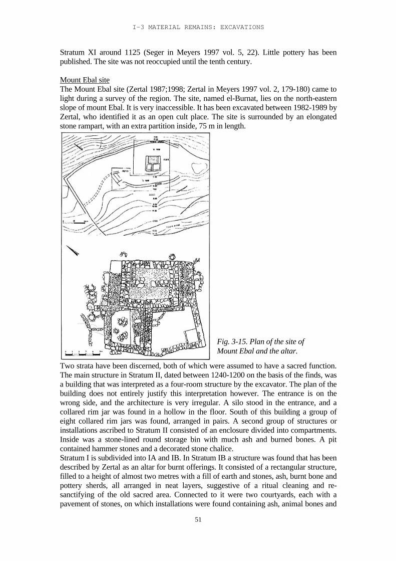
I-3 MATERIAL REMAINS: EXCAVATIONS
51
Stratum XI around 1125 (Seger in Meyers 1997 vol. 5, 22). Little pottery has beenpublished. The site was not reoccupied until the tenth century.
Mount Ebal siteThe Mount Ebal site (Zertal 1987;1998; Zertal in Meyers 1997 vol. 2, 179-180) came tolight during a survey of the region. The site, named el-Burnat, lies on the north-easternslope of mount Ebal. It is very inaccessible. It has been excavated between 1982-1989 byZertal, who identified it as an open cult place. The site is surrounded by an elongatedstone rampart, with an extra partition inside, 75 m in length.
Two strata have been discerned, both of which were assumed to have a sacred function.The main structure in Stratum II, dated between 1240-1200 on the basis of the finds, wasa building that was interpreted as a four-room structure by the excavator. The plan of thebuilding does not entirely justify this interpretation however. The entrance is on thewrong side, and the architecture is very irregular. A silo stood in the entrance, and acollared rim jar was found in a hollow in the floor. South of this building a group ofeight collared rim jars was found, arranged in pairs. A second group of structures orinstallations ascribed to Stratum II consisted of an enclosure divided into compartments.Inside was a stone-lined round storage bin with much ash and burned bones. A pitcontained hammer stones and a decorated stone chalice.Stratum I is subdivided into IA and IB. In Stratum IB a structure was found that has beendescribed by Zertal as an altar for burnt offerings. It consisted of a rectangular structure,filled to a height of almost two metres with a fill of earth and stones, ash, burnt bone andpottery sherds, all arranged in neat layers, suggestive of a ritual cleaning and re-sanctifying of the old sacred area. Connected to it were two courtyards, each with apavement of stones, on which installations were found containing ash, animal bones and
Fig. 3-15. Plan of the site ofMount Ebal and the altar.
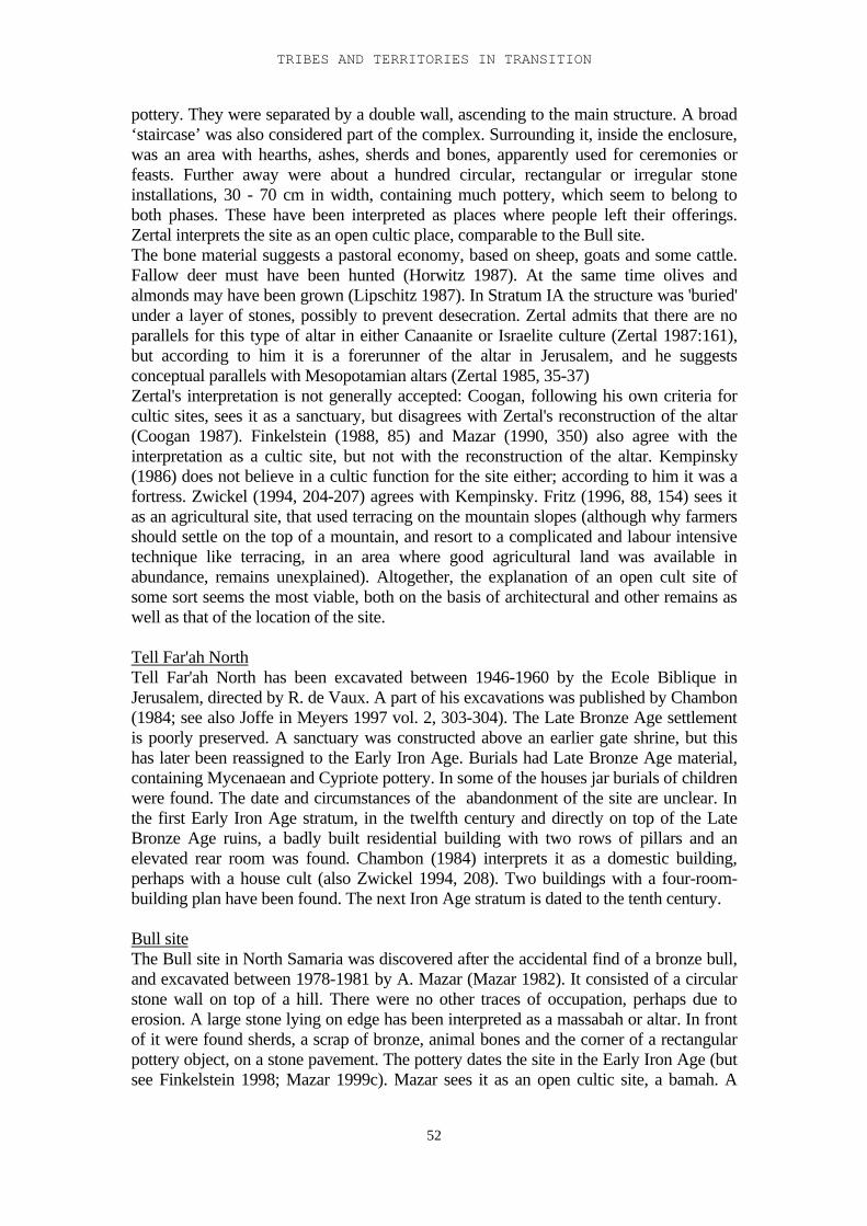
TRIBES AND TERRITORIES IN TRANSITION
52
pottery. They were separated by a double wall, ascending to the main structure. A broad‘staircase’ was also considered part of the complex. Surrounding it, inside the enclosure,was an area with hearths, ashes, sherds and bones, apparently used for ceremonies orfeasts. Further away were about a hundred circular, rectangular or irregular stoneinstallations, 30 - 70 cm in width, containing much pottery, which seem to belong toboth phases. These have been interpreted as places where people left their offerings.Zertal interprets the site as an open cultic place, comparable to the Bull site.The bone material suggests a pastoral economy, based on sheep, goats and some cattle.Fallow deer must have been hunted (Horwitz 1987). At the same time olives andalmonds may have been grown (Lipschitz 1987). In Stratum IA the structure was 'buried'under a layer of stones, possibly to prevent desecration. Zertal admits that there are noparallels for this type of altar in either Canaanite or Israelite culture (Zertal 1987:161),but according to him it is a forerunner of the altar in Jerusalem, and he suggestsconceptual parallels with Mesopotamian altars (Zertal 1985, 35-37)Zertal's interpretation is not generally accepted: Coogan, following his own criteria forcultic sites, sees it as a sanctuary, but disagrees with Zertal's reconstruction of the altar(Coogan 1987). Finkelstein (1988, 85) and Mazar (1990, 350) also agree with theinterpretation as a cultic site, but not with the reconstruction of the altar. Kempinsky(1986) does not believe in a cultic function for the site either; according to him it was afortress. Zwickel (1994, 204-207) agrees with Kempinsky. Fritz (1996, 88, 154) sees itas an agricultural site, that used terracing on the mountain slopes (although why farmersshould settle on the top of a mountain, and resort to a complicated and labour intensivetechnique like terracing, in an area where good agricultural land was available inabundance, remains unexplained). Altogether, the explanation of an open cult site ofsome sort seems the most viable, both on the basis of architectural and other remains aswell as that of the location of the site.
Tell Far'ah NorthTell Far'ah North has been excavated between 1946-1960 by the Ecole Biblique inJerusalem, directed by R. de Vaux. A part of his excavations was published by Chambon(1984; see also Joffe in Meyers 1997 vol. 2, 303-304). The Late Bronze Age settlementis poorly preserved. A sanctuary was constructed above an earlier gate shrine, but thishas later been reassigned to the Early Iron Age. Burials had Late Bronze Age material,containing Mycenaean and Cypriote pottery. In some of the houses jar burials of childrenwere found. The date and circumstances of the abandonment of the site are unclear. Inthe first Early Iron Age stratum, in the twelfth century and directly on top of the LateBronze Age ruins, a badly built residential building with two rows of pillars and anelevated rear room was found. Chambon (1984) interprets it as a domestic building,perhaps with a house cult (also Zwickel 1994, 208). Two buildings with a four-room-building plan have been found. The next Iron Age stratum is dated to the tenth century.
Bull siteThe Bull site in North Samaria was discovered after the accidental find of a bronze bull,and excavated between 1978-1981 by A. Mazar (Mazar 1982). It consisted of a circularstone wall on top of a hill. There were no other traces of occupation, perhaps due toerosion. A large stone lying on edge has been interpreted as a massabah or altar. In frontof it were found sherds, a scrap of bronze, animal bones and the corner of a rectangularpottery object, on a stone pavement. The pottery dates the site in the Early Iron Age (butsee Finkelstein 1998; Mazar 1999c). Mazar sees it as an open cultic site, a bamah. A
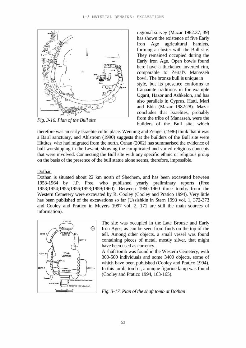
I-3 MATERIAL REMAINS: EXCAVATIONS
53
Fig. 3-16. Plan of the Bull site
regional survey (Mazar 1982:37, 39)has shown the existence of five EarlyIron Age agricultural hamlets,forming a cluster with the Bull site.They remained occupied during theEarly Iron Age. Open bowls foundhere have a thickened inverted rim,comparable to Zertal's Manassehbowl. The bronze bull is unique instyle, but its presence conforms toCanaanite traditions in for exampleUgarit, Hazor and Ashkelon, and hasalso parallels in Cyprus, Hatti, Mariand Ebla (Mazar 1982:28). Mazarconcludes that Israelites, probablyfrom the tribe of Manasseh, were thebuilders of the Bull site, which
therefore was an early Israelite cultic place. Wenning and Zenger (1986) think that it wasa Ba'al sanctuary, and Ahlström (1990) suggests that the builders of the Bull site wereHittites, who had migrated from the north. Ornan (2002) has summarised the evidence ofbull worshipping in the Levant, showing the complicated and varied religious conceptsthat were involved. Connecting the Bull site with any specific ethnic or religious groupon the basis of the presence of the bull statue alone seems, therefore, impossible.
DothanDothan is situated about 22 km north of Shechem, and has been excavated between1953-1964 by J.P. Free, who published yearly preliminary reports (Free1953;1954;1955;1956;1958;1959;1960). Between 1960-1960 three tombs from theWestern Cemetery were excavated by R. Cooley (Cooley and Pratico 1994). Very littlehas been published of the excavations so far (Ussishkin in Stern 1993 vol. 1, 372-373and Cooley and Pratico in Meyers 1997 vol. 2, 171 are still the main sources ofinformation).
The site was occupied in the Late Bronze and EarlyIron Ages, as can be seen from finds on the top of thetell. Among other objects, a small vessel was foundcontaining pieces of metal, mostly silver, that mighthave been used as currency.A shaft tomb was found in the Western Cemetery, with300-500 individuals and some 3400 objects, some ofwhich have been published (Cooley and Pratico 1994).In this tomb, tomb I, a unique figurine lamp was found(Cooley and Pratico 1994, 163-165).
Fig. 3-17. Plan of the shaft tomb at Dothan
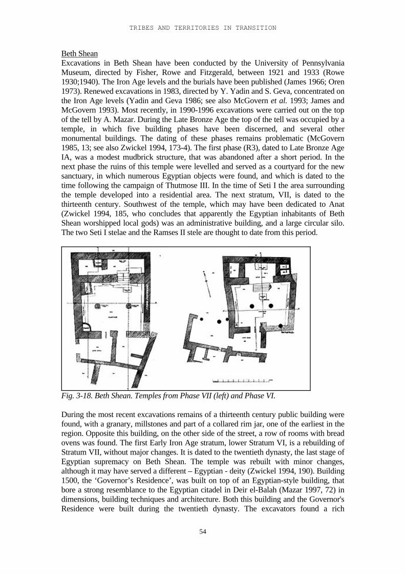
TRIBES AND TERRITORIES IN TRANSITION
54
Beth SheanExcavations in Beth Shean have been conducted by the University of PennsylvaniaMuseum, directed by Fisher, Rowe and Fitzgerald, between 1921 and 1933 (Rowe1930;1940). The Iron Age levels and the burials have been published (James 1966; Oren1973). Renewed excavations in 1983, directed by Y. Yadin and S. Geva, concentrated onthe Iron Age levels (Yadin and Geva 1986; see also McGovern et al. 1993; James andMcGovern 1993). Most recently, in 1990-1996 excavations were carried out on the topof the tell by A. Mazar. During the Late Bronze Age the top of the tell was occupied by atemple, in which five building phases have been discerned, and several othermonumental buildings. The dating of these phases remains problematic (McGovern1985, 13; see also Zwickel 1994, 173-4). The first phase (R3), dated to Late Bronze AgeIA, was a modest mudbrick structure, that was abandoned after a short period. In thenext phase the ruins of this temple were levelled and served as a courtyard for the newsanctuary, in which numerous Egyptian objects were found, and which is dated to thetime following the campaign of Thutmose III. In the time of Seti I the area surroundingthe temple developed into a residential area. The next stratum, VII, is dated to thethirteenth century. Southwest of the temple, which may have been dedicated to Anat(Zwickel 1994, 185, who concludes that apparently the Egyptian inhabitants of BethShean worshipped local gods) was an administrative building, and a large circular silo.The two Seti I stelae and the Ramses II stele are thought to date from this period.
Fig. 3-18. Beth Shean. Temples from Phase VII (left) and Phase VI.
During the most recent excavations remains of a thirteenth century public building werefound, with a granary, millstones and part of a collared rim jar, one of the earliest in theregion. Opposite this building, on the other side of the street, a row of rooms with breadovens was found. The first Early Iron Age stratum, lower Stratum VI, is a rebuilding ofStratum VII, without major changes. It is dated to the twentieth dynasty, the last stage ofEgyptian supremacy on Beth Shean. The temple was rebuilt with minor changes,although it may have served a different – Egyptian - deity (Zwickel 1994, 190). Building1500, the ‘Governor’s Residence’, was built on top of an Egyptian-style building, thatbore a strong resemblance to the Egyptian citadel in Deir el-Balah (Mazar 1997, 72) indimensions, building techniques and architecture. Both this building and the Governor'sResidence were built during the twentieth dynasty. The excavators found a rich
I-3 MATERIAL REMAINS: EXCAVATIONS
55
assemblage of luxury goods, containing many Egyptian or Egyptianised features. Mostof the Egyptian pottery proved to have been locally produced (Mazar 1997, 71-72).McGovern et al. (1993) state that during the Egyptian supremacy in Beth Shean themajority of the population consisted of Canaanites in Egyptian service. Lower StratumVI was destroyed by conflagration.Upper Stratum VI, dated to the late twelfth or early eleventh century, is often seen as thefirst non-Egyptian stratum. Flimsy walls and rebuilt walls, many pits and functionalpottery characterise this stratum. In the recent excavations many storage compartmentsfilled with grain were found, as well as a group of bronze arrowheads. Building 1700,found during the excavations of Pennsylvania University, was redated by Mazar to thefirst post-Egyptian stratum: upper Stratum VI (Mazar 1997, 72). In the former templearea two buildings were found, also interpreted as temples, partly because of theirlocation, and partly because of the many cultic stands found there (Coogan 1987). Theyhave been dated to the second half of the eleventh and the tenth century. Garfinkel(1987) has suggested that the oldest Early Iron Age strata should be taken together andseen as one semi-nomadic occupation stratum, with re-use of older structures (sometimeswith small additions), and many pits. The pottery of Stratum VI is a continuation of theLate Bronze Age repertoire. Small open bowls have straight or everted rims.In the northern cemetery more than 50 fragments of anthropoid coffins have been found,five of which are of the 'grotesque' type (Dothan 1982; Oren 1973, 138). The dating ofthis type of sarcophagus is a matter of debate. Pritchard (1968, 108-109) dates them inthe thirteenth century, on the basis of analogies in the burial gifts with the cemetery ofSa'idiyeh. Dothan (1982, 268-275) dates them in the second half of the eleventh century.Oren (1973, 148) considers them to be burials of mercenaries in the Egyptian army, anddates them to the 19th or XXth dynasty. The repertoire of burial gifts strongly resembledthat of Deir el-Balah: including much pottery, Mycenaean bronze vessels, ushabti,jewellery, ivory and weapons.
RehovWhile Beth Shean was an Egyptian administrative and military centre in the Late BronzeAge, Rehov was the main Canaanite town in the region (Mazar 1999a, 2). Rehov is oneof the largest mounds in Israel. It is situated 5 km south of Beth Shean. Excavationsstarted here in 1997, directed by A. Mazar (Mazar 1999a). Several Late Bronze Agelevels were exposed, but on a small scale. They consisted of a number of superimposedlarge buildings. In the third of these phases, dated to the twentieth dynasty (early twelfthcentury), two lamp-and-bowl deposits were found (see Bunimowitz and Zimhoni 1993).The pottery from this phase was similar to that of Beth Shean in the same period, butEgyptian forms were rare. According to the excavator the next phase was “an extremelydisturbed area”, consisting of a rapid accumulation of flimsy walls and surfaces with thinlayers of dirt and dust. Bread ovens and other installations were found there. The potterywas similar to that of the previous phase.No fortification remains were found in the Early Iron Age layers (Mazar 1999b). Thepottery from the Late Bronze and Early Iron Age layers has not yet been published.
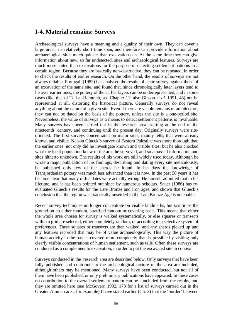
56
I-4. Material remains: Surveys
Archaeological surveys have a meaning and a quality of their own. They can cover alarge area in a relatively short time span, and therefore can provide information aboutarchaeological sites much quicker than excavation can. At the same time they can giveinformation about new, so far undetected, sites and archaeological features. Surveys aremuch more suited than excavations for the purpose of detecting settlement patterns in acertain region. Because they are basically non-destructive, they can be repeated, in orderto check the results of earlier research. On the other hand, the results of surveys are notalways reliable. Portugali (1982) has analysed the results of a site survey against those ofan excavation of the same site, and found that, since chronologically later layers tend tolie over earlier ones, the pottery of the earlier layers can be underrepresented, and in somecases (like that of Tell al-Hammeh, see Chapter 11; also Gibson et al. 1991, 48) not berepresented at all, distorting the historical picture. Generally surveys do not revealanything about the nature of a given site. Even if there are visible remains of architecture,they can not be dated on the basis of the pottery, unless the site is a one-period site.Nevertheless, the value of surveys as a means to detect settlement patterns is invaluable.Many surveys have been carried out in the research area, starting at the end of thenineteenth century, and continuing until the present day. Originally surveys were site-oriented. The first surveys concentrated on major sites, mainly tells, that were alreadyknown and visible. Nelson Glueck’s survey of Eastern Palestine was more thorough thanthe earlier ones: not only did he investigate known and visible sites, but he also checkedwhat the local population knew of the area he surveyed, and so amassed information andsites hitherto unknown. The results of his work are still widely used today. Although hewrote a major publication of his findings, describing and dating every site meticulously,he published only few of the sherds he found. In his days the knowledge ofTransjordanian pottery was much less advanced than it is now. In the past 50 years it hasbecome clear that many of his dates were actually wrong. He himself admitted that in hislifetime, and it has been pointed out since by numerous scholars. Sauer (1986) has re-evaluated Glueck’s results for the Late Bronze and Iron ages, and shown that Glueck’sconclusion that the region was practically unsettled in the Late Bronze Age is untenable.
Recent survey techniques no longer concentrate on visible landmarks, but scrutinise theground on an either random, stratified random or covering basis. This means that eitherthe whole area chosen for survey is walked systematically, or else squares or transectswithin a grid are selected, either completely random, or according to a selective system ofpreferences. These squares or transects are then walked, and any sherds picked up andany features recorded that may be of value archaeologically. This way the picture ofhuman activity in the past is covered more completely than is possible by visiting onlyclearly visible concentrations of human settlement, such as tells. Often these surveys areconducted as a complement to excavation, in order to put the excavated site in context.
Surveys conducted in the research area are described below. Only surveys that have beenfully published and contribute to the archaeological picture of the area are included,although others may be mentioned. Many surveys have been conducted, but not all ofthem have been published, or only preliminary publications have appeared. In these casesno contribution to the overall settlement pattern can be concluded from the results, andthey are omitted here (see McGovern 1992, 173 for a list of surveys carried out in theGreater Amman area, for example).I have stated earlier (Ch. 3) that the ‘border’ between
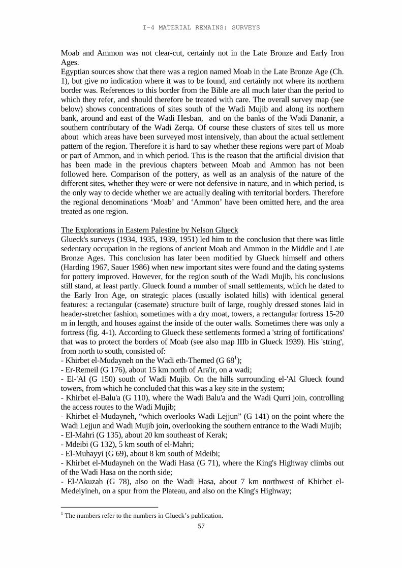
I-4 MATERIAL REMAINS: SURVEYS
57
Moab and Ammon was not clear-cut, certainly not in the Late Bronze and Early IronAges.Egyptian sources show that there was a region named Moab in the Late Bronze Age (Ch.1), but give no indication where it was to be found, and certainly not where its northernborder was. References to this border from the Bible are all much later than the period towhich they refer, and should therefore be treated with care. The overall survey map (seebelow) shows concentrations of sites south of the Wadi Mujib and along its northernbank, around and east of the Wadi Hesban, and on the banks of the Wadi Dananir, asouthern contributary of the Wadi Zerqa. Of course these clusters of sites tell us moreabout which areas have been surveyed most intensively, than about the actual settlementpattern of the region. Therefore it is hard to say whether these regions were part of Moabor part of Ammon, and in which period. This is the reason that the artificial division thathas been made in the previous chapters between Moab and Ammon has not beenfollowed here. Comparison of the pottery, as well as an analysis of the nature of thedifferent sites, whether they were or were not defensive in nature, and in which period, isthe only way to decide whether we are actually dealing with territorial borders. Thereforethe regional denominations ‘Moab’ and ‘Ammon’ have been omitted here, and the areatreated as one region.
The Explorations in Eastern Palestine by Nelson GlueckGlueck's surveys (1934, 1935, 1939, 1951) led him to the conclusion that there was littlesedentary occupation in the regions of ancient Moab and Ammon in the Middle and LateBronze Ages. This conclusion has later been modified by Glueck himself and others(Harding 1967, Sauer 1986) when new important sites were found and the dating systemsfor pottery improved. However, for the region south of the Wadi Mujib, his conclusionsstill stand, at least partly. Glueck found a number of small settlements, which he dated tothe Early Iron Age, on strategic places (usually isolated hills) with identical generalfeatures: a rectangular (casemate) structure built of large, roughly dressed stones laid inheader-stretcher fashion, sometimes with a dry moat, towers, a rectangular fortress 15-20m in length, and houses against the inside of the outer walls. Sometimes there was only afortress (fig. 4-1). According to Glueck these settlements formed a 'string of fortifications'that was to protect the borders of Moab (see also map IIIb in Glueck 1939). His 'string',from north to south, consisted of:- Khirbet el-Mudayneh on the Wadi eth-Themed (G 681);- Er-Remeil (G 176), about 15 km north of Ara'ir, on a wadi;- El-'Al (G 150) south of Wadi Mujib. On the hills surrounding el-'Al Glueck foundtowers, from which he concluded that this was a key site in the system;- Khirbet el-Balu'a (G 110), where the Wadi Balu'a and the Wadi Qurri join, controllingthe access routes to the Wadi Mujib;- Khirbet el-Mudayneh, “which overlooks Wadi Lejjun” (G 141) on the point where theWadi Lejjun and Wadi Mujib join, overlooking the southern entrance to the Wadi Mujib;- El-Mahri (G 135), about 20 km southeast of Kerak;- Mdeibi (G 132), 5 km south of el-Mahri;- El-Muhayyi (G 69), about 8 km south of Mdeibi;- Khirbet el-Mudayneh on the Wadi Hasa (G 71), where the King's Highway climbs outof the Wadi Hasa on the north side;- El-'Akuzah (G 78), also on the Wadi Hasa, about 7 km northwest of Khirbet el-Medeiyineh, on a spur from the Plateau, and also on the King's Highway;
1 The numbers refer to the numbers in Glueck’s publication.
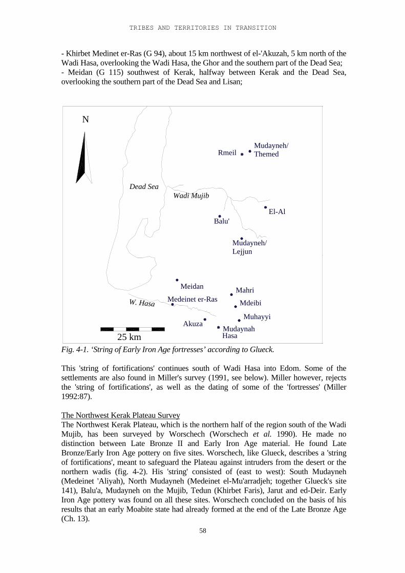
TRIBES AND TERRITORIES IN TRANSITION
58
- Khirbet Medinet er-Ras (G 94), about 15 km northwest of el-'Akuzah, 5 km north of theWadi Hasa, overlooking the Wadi Hasa, the Ghor and the southern part of the Dead Sea;- Meidan (G 115) southwest of Kerak, halfway between Kerak and the Dead Sea,overlooking the southern part of the Dead Sea and Lisan;
Mudayneh/
ThemedMudayneh/
Mudaynah
Muhayyi
Mdeibi
Akuza
25 km Hasa
W. Hasa
Dead Sea
Balu'
Meidan Mahri
Lejjun
Wadi Mujib
Rmeil
N
El-Al
Medeinet er-Ras
Fig. 4-1. ‘String of Early Iron Age fortresses’ according to Glueck.
This 'string of fortifications' continues south of Wadi Hasa into Edom. Some of thesettlements are also found in Miller's survey (1991, see below). Miller however, rejectsthe 'string of fortifications', as well as the dating of some of the 'fortresses' (Miller1992:87).
The Northwest Kerak Plateau SurveyThe Northwest Kerak Plateau, which is the northern half of the region south of the WadiMujib, has been surveyed by Worschech (Worschech et al. 1990). He made nodistinction between Late Bronze II and Early Iron Age material. He found LateBronze/Early Iron Age pottery on five sites. Worschech, like Glueck, describes a 'stringof fortifications', meant to safeguard the Plateau against intruders from the desert or thenorthern wadis (fig. 4-2). His 'string' consisted of (east to west): South Mudayneh(Medeinet 'Aliyah), North Mudayneh (Medeinet el-Mu'arradjeh; together Glueck's site141), Balu'a, Mudayneh on the Mujib, Tedun (Khirbet Faris), Jarut and ed-Deir. EarlyIron Age pottery was found on all these sites. Worschech concluded on the basis of hisresults that an early Moabite state had already formed at the end of the Late Bronze Age(Ch. 13).
I-4 MATERIAL REMAINS: SURVEYS
59
Tedun / Khirbet FarisBalu'a
25 km
W. Hasa
ed-Deir
Yarut
Dead Sea
Mudaynah
Wadi Mujib
Medeinet
'AliyahMedeinet
Mu'arradjeh
N
Fig. 4-2. String of Iron Age fortifications according to Worschech
The archaeological survey of the Kerak PlateauThis was executed by Miller in the 1980's (Miller 1991), and it covered the whole regionbetween the Wadi Hasa to the south and the Wadi Mujib to the north. 443 sites weresurveyed, 109 of which had Late Bronze material, and 72 Early Iron Age material (fig. 4-
Wadi Mujib
25 km
W. Hasa
Dead Sea
N Late Bronze AgeEarly Iron Age
Fig. 4-3. Late Bronze and Early Iron Age sites according to Miller 1991.
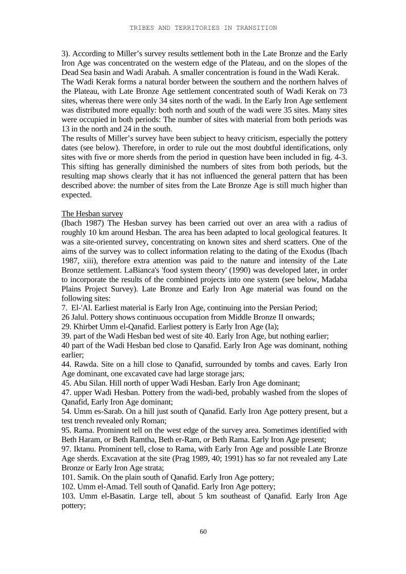
TRIBES AND TERRITORIES IN TRANSITION
60
3). According to Miller’s survey results settlement both in the Late Bronze and the EarlyIron Age was concentrated on the western edge of the Plateau, and on the slopes of theDead Sea basin and Wadi Arabah. A smaller concentration is found in the Wadi Kerak.The Wadi Kerak forms a natural border between the southern and the northern halves ofthe Plateau, with Late Bronze Age settlement concentrated south of Wadi Kerak on 73sites, whereas there were only 34 sites north of the wadi. In the Early Iron Age settlementwas distributed more equally: both north and south of the wadi were 35 sites. Many siteswere occupied in both periods: The number of sites with material from both periods was13 in the north and 24 in the south.The results of Miller’s survey have been subject to heavy criticism, especially the potterydates (see below). Therefore, in order to rule out the most doubtful identifications, onlysites with five or more sherds from the period in question have been included in fig. 4-3.This sifting has generally diminished the numbers of sites from both periods, but theresulting map shows clearly that it has not influenced the general pattern that has beendescribed above: the number of sites from the Late Bronze Age is still much higher thanexpected.
The Hesban survey(Ibach 1987) The Hesban survey has been carried out over an area with a radius ofroughly 10 km around Hesban. The area has been adapted to local geological features. Itwas a site-oriented survey, concentrating on known sites and sherd scatters. One of theaims of the survey was to collect information relating to the dating of the Exodus (Ibach1987, xiii), therefore extra attention was paid to the nature and intensity of the LateBronze settlement. LaBianca's 'food system theory' (1990) was developed later, in orderto incorporate the results of the combined projects into one system (see below, MadabaPlains Project Survey). Late Bronze and Early Iron Age material was found on thefollowing sites:7. El-'Al. Earliest material is Early Iron Age, continuing into the Persian Period;26 Jalul. Pottery shows continuous occupation from Middle Bronze II onwards;29. Khirbet Umm el-Qanafid. Earliest pottery is Early Iron Age (Ia);39. part of the Wadi Hesban bed west of site 40. Early Iron Age, but nothing earlier;40 part of the Wadi Hesban bed close to Qanafid. Early Iron Age was dominant, nothingearlier;44. Rawda. Site on a hill close to Qanafid, surrounded by tombs and caves. Early IronAge dominant, one excavated cave had large storage jars;45. Abu Silan. Hill north of upper Wadi Hesban. Early Iron Age dominant;47. upper Wadi Hesban. Pottery from the wadi-bed, probably washed from the slopes ofQanafid, Early Iron Age dominant;54. Umm es-Sarab. On a hill just south of Qanafid. Early Iron Age pottery present, but atest trench revealed only Roman;95. Rama. Prominent tell on the west edge of the survey area. Sometimes identified withBeth Haram, or Beth Ramtha, Beth er-Ram, or Beth Rama. Early Iron Age present;97. Iktanu. Prominent tell, close to Rama, with Early Iron Age and possible Late BronzeAge sherds. Excavation at the site (Prag 1989, 40; 1991) has so far not revealed any LateBronze or Early Iron Age strata;101. Samik. On the plain south of Qanafid. Early Iron Age pottery;102. Umm el-Amad. Tell south of Qanafid. Early Iron Age pottery;103. Umm el-Basatin. Large tell, about 5 km southeast of Qanafid. Early Iron Agepottery;
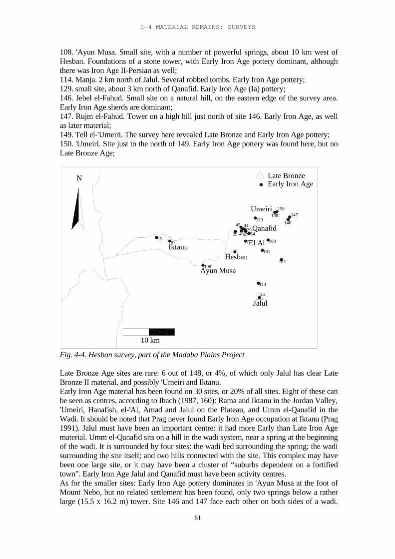
I-4 MATERIAL REMAINS: SURVEYS
61
108. 'Ayun Musa. Small site, with a number of powerful springs, about 10 km west ofHesban. Foundations of a stone tower, with Early Iron Age pottery dominant, althoughthere was Iron Age II-Persian as well;114. Manja. 2 km north of Jalul. Several robbed tombs. Early Iron Age pottery;129. small site, about 3 km north of Qanafid. Early Iron Age (Ia) pottery;146. Jebel el-Fahud. Small site on a natural hill, on the eastern edge of the survey area.Early Iron Age sherds are dominant;147. Rujm el-Fahud. Tower on a high hill just north of site 146. Early Iron Age, as wellas later material;149. Tell el-'Umeiri. The survey here revealed Late Bronze and Early Iron Age pottery;150. 'Umeiri. Site just to the north of 149. Early Iron Age pottery was found here, but noLate Bronze Age;
Hesban
45
39
97Iktanu
95
108Ayun Musa
4740 54
Jalul26
114
101
El Al7
102
103
Umeiri
4429Qanafid
129
150149
146
147
N
10 km
Late BronzeEarly Iron Age
Fig. 4-4. Hesban survey, part of the Madaba Plains Project
Late Bronze Age sites are rare: 6 out of 148, or 4%, of which only Jalul has clear LateBronze II material, and possibly 'Umeiri and Iktanu.Early Iron Age material has been found on 30 sites, or 20% of all sites. Eight of these canbe seen as centres, according to Ibach (1987, 160): Rama and Iktanu in the Jordan Valley,'Umeiri, Hanafish, el-'Al, Amad and Jalul on the Plateau, and Umm el-Qanafid in theWadi. It should be noted that Prag never found Early Iron Age occupation at Iktanu (Prag1991). Jalul must have been an important centre: it had more Early than Late Iron Agematerial. Umm el-Qanafid sits on a hill in the wadi system, near a spring at the beginningof the wadi. It is surrounded by four sites: the wadi bed surrounding the spring; the wadisurrounding the site itself; and two hills connected with the site. This complex may havebeen one large site, or it may have been a cluster of “suburbs dependent on a fortifiedtown”. Early Iron Age Jalul and Qanafid must have been activity centres.As for the smaller sites: Early Iron Age pottery dominates in 'Ayun Musa at the foot ofMount Nebo, but no related settlement has been found, only two springs below a ratherlarge (15.5 x 16.2 m) tower. Site 146 and 147 face each other on both sides of a wadi.
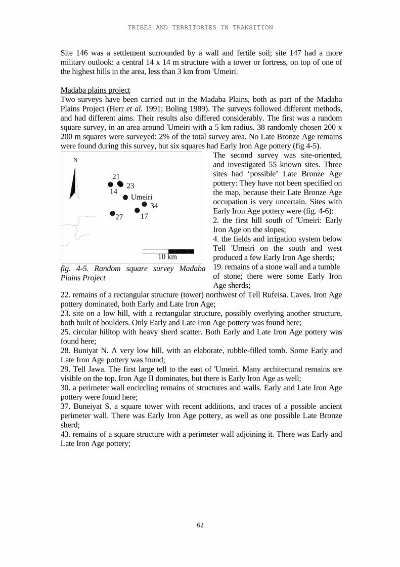
TRIBES AND TERRITORIES IN TRANSITION
62
Site 146 was a settlement surrounded by a wall and fertile soil; site 147 had a moremilitary outlook: a central 14 x 14 m structure with a tower or fortress, on top of one ofthe highest hills in the area, less than 3 km from 'Umeiri.
Madaba plains projectTwo surveys have been carried out in the Madaba Plains, both as part of the MadabaPlains Project (Herr et al. 1991; Boling 1989). The surveys followed different methods,and had different aims. Their results also differed considerably. The first was a randomsquare survey, in an area around 'Umeiri with a 5 km radius. 38 randomly chosen 200 x200 m squares were surveyed: 2% of the total survey area. No Late Bronze Age remainswere found during this survey, but six squares had Early Iron Age pottery (fig 4-5).
N
Umeiri23
27
14
21
1734
10 km
fig. 4-5. Random square survey MadabaPlains Project
The second survey was site-oriented,and investigated 55 known sites. Threesites had ‘possible’ Late Bronze Agepottery: They have not been specified onthe map, because their Late Bronze Ageoccupation is very uncertain. Sites withEarly Iron Age pottery were (fig. 4-6):2. the first hill south of 'Umeiri: EarlyIron Age on the slopes;4. the fields and irrigation system belowTell 'Umeiri on the south and westproduced a few Early Iron Age sherds;19. remains of a stone wall and a tumbleof stone; there were some Early IronAge sherds;
22. remains of a rectangular structure (tower) northwest of Tell Rufeisa. Caves. Iron Agepottery dominated, both Early and Late Iron Age;23. site on a low hill, with a rectangular structure, possibly overlying another structure,both built of boulders. Only Early and Late Iron Age pottery was found here;25. circular hilltop with heavy sherd scatter. Both Early and Late Iron Age pottery wasfound here;28. Buniyat N. A very low hill, with an elaborate, rubble-filled tomb. Some Early andLate Iron Age pottery was found;29. Tell Jawa. The first large tell to the east of 'Umeiri. Many architectural remains arevisible on the top. Iron Age II dominates, but there is Early Iron Age as well;30. a perimeter wall encircling remains of structures and walls. Early and Late Iron Agepottery were found here;37. Buneiyat S. a square tower with recent additions, and traces of a possible ancientperimeter wall. There was Early Iron Age pottery, as well as one possible Late Bronzesherd;43. remains of a square structure with a perimeter wall adjoining it. There was Early andLate Iron Age pottery;
I-4 MATERIAL REMAINS: SURVEYS
63
N
10 km
37
4
30
2
25 28
22
29 Jawa
23
19
43
The results of both surveys combined give the following picture:
Random Square Survey Site Survey
Late Bronze - 3? (5.5%) sites Iron Age I 9 (23.7%) 12 (21.8%) sites
The results confirm that during the Early Iron Age the number of small settlementsincreased. The random square survey did not produce any Late Bronze Age sherds, butthe site oriented survey shows the possible presence of Late Bronze Age sites. Theseresults agree with those of the Hesban survey. Analysis of the ecology of the region, andintegration of the results with the results of the surveys shows that there was a variedlandscape with forest and fertile soil, with most settlements on the boundary between thetwo.
The Archaeological Survey of Greater AmmanThis covered an area of over 570 km2 in the municipality of Amman (Abu Dayyah et al.1991, fig. 1). Part of the area was walked in transects; another part of it was more or less‘site-oriented’, trying to find the sites recorded by Glueck in 1938. Part of the pottery hasbeen published, and the recorded sites have been listed (Abu Dayyah et al. 1991, table 2).Only very few sites with either Late Bronze or Early Iron Age material has been found,and no conclusions can be drawn from the results, at least not for the period in question.
Sahab surveyAs part of the Sahab excavations an area of 192 km2 was surveyed, east of the site, in1983. Three wadi systems cut through the area, which is considered by the surveyors as atransitional area between ‘the desert and the sown’. Only three actual tells were identifiedin the survey area. The Late Bronze – Early Iron Age witnessed a decline in occupation,with only minor occupation. Later in the Iron Age (although it is not clear from the reporthow much later) three possible secondary sites related to Sahab itself have beenidentified: Zumlat al-'Aliyah, Abu al-Hajjat and ad-Dabayba. According to the surveyorsa network of forts and hilltop watchtowers seems to have been introduced in this period(Gustavson-Gaube and Ibrahim 1986). The area was abandoned at the end of the IronAge.
Fig. 4-6. Site oriented survey, MadabaPlains Project.
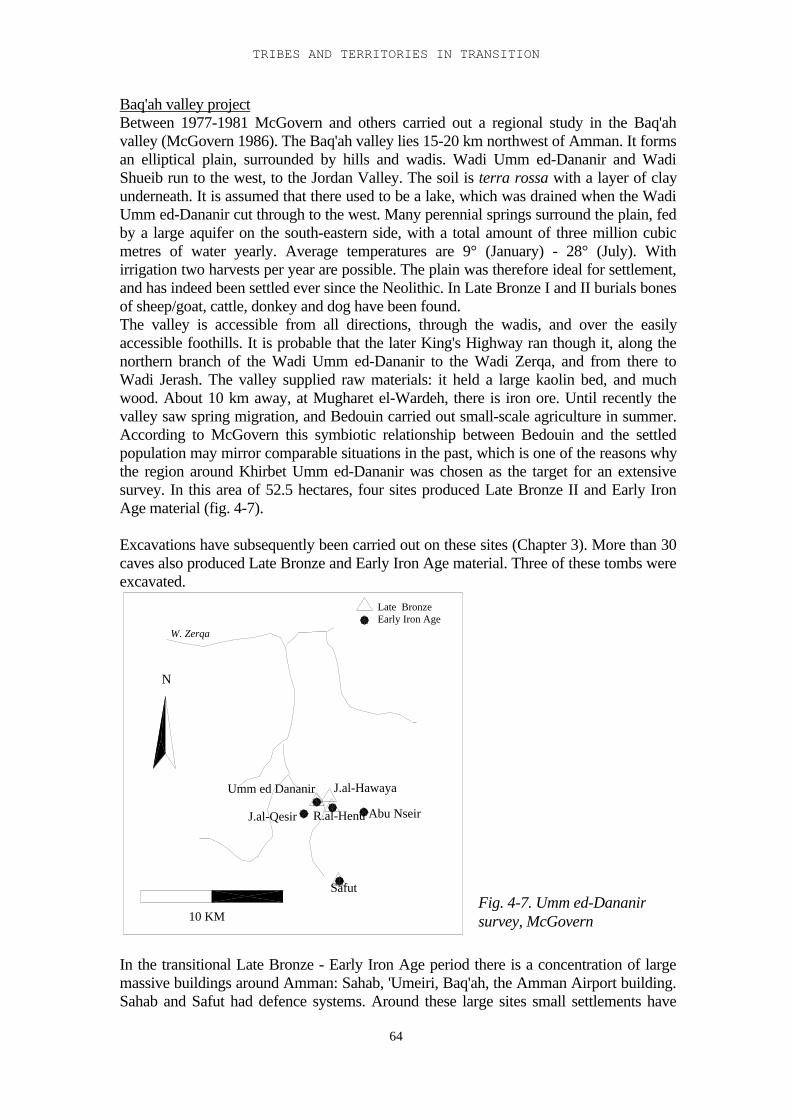
TRIBES AND TERRITORIES IN TRANSITION
64
Baq'ah valley projectBetween 1977-1981 McGovern and others carried out a regional study in the Baq'ahvalley (McGovern 1986). The Baq'ah valley lies 15-20 km northwest of Amman. It formsan elliptical plain, surrounded by hills and wadis. Wadi Umm ed-Dananir and WadiShueib run to the west, to the Jordan Valley. The soil is terra rossa with a layer of clayunderneath. It is assumed that there used to be a lake, which was drained when the WadiUmm ed-Dananir cut through to the west. Many perennial springs surround the plain, fedby a large aquifer on the south-eastern side, with a total amount of three million cubicmetres of water yearly. Average temperatures are 9° (January) - 28° (July). Withirrigation two harvests per year are possible. The plain was therefore ideal for settlement,and has indeed been settled ever since the Neolithic. In Late Bronze I and II burials bonesof sheep/goat, cattle, donkey and dog have been found.The valley is accessible from all directions, through the wadis, and over the easilyaccessible foothills. It is probable that the later King's Highway ran though it, along thenorthern branch of the Wadi Umm ed-Dananir to the Wadi Zerqa, and from there toWadi Jerash. The valley supplied raw materials: it held a large kaolin bed, and muchwood. About 10 km away, at Mugharet el-Wardeh, there is iron ore. Until recently thevalley saw spring migration, and Bedouin carried out small-scale agriculture in summer.According to McGovern this symbiotic relationship between Bedouin and the settledpopulation may mirror comparable situations in the past, which is one of the reasons whythe region around Khirbet Umm ed-Dananir was chosen as the target for an extensivesurvey. In this area of 52.5 hectares, four sites produced Late Bronze II and Early IronAge material (fig. 4-7).
Excavations have subsequently been carried out on these sites (Chapter 3). More than 30caves also produced Late Bronze and Early Iron Age material. Three of these tombs wereexcavated.
N
10 KM
W. Zerqa
J.al-Qesir
Umm ed Dananir J.al-Hawaya
Safut
R.al-Henu Abu Nseir
Late BronzeEarly Iron Age
In the transitional Late Bronze - Early Iron Age period there is a concentration of largemassive buildings around Amman: Sahab, 'Umeiri, Baq'ah, the Amman Airport building.Sahab and Safut had defence systems. Around these large sites small settlements have
Fig. 4-7. Umm ed-Dananirsurvey, McGovern
I-4 MATERIAL REMAINS: SURVEYS
65
been found, usually close to water and fertile soil. According to McGovern (1992) thispoints to an increase in the settled population in the Late Bronze Age. He suggests theexistence of a city state concentrated around Amman in the Late Bronze Age. Hübner,while agreeing with the suggestion of the existence of city states, postulates that theremust have been several of them concentrated around Sahab, Amman and Khirbet Ummed-Dananir (Hübner 1992, 159-160).A comparable development was suggested for the Plateau north of the Zerqa, and forMoab. In other parts of the Amman region, however (Boling 1988:30-35), the number ofsites was found to have diminished. McGovern suggests that an increase in sites east ofthe Jordan coincided with a decrease west of the Jordan (see also Gonen 1984).The Iron Age shows a pattern of smaller, more dispersed settlements, still centred aroundthe Amman citadel. The transition to this new settlement pattern has been a gradualprocess. There was, however, a clear break in occupation between the Early and Late IronAge (McGovern 1989).
The most striking result in this summary of surveys in the plains east of the Dead Sea isthat of Miller’s survey. Partly this is due to the fact that the surveys covered differentareas: Miller‘s the area south of the Mujib; Ibach’s and Boling’s the area north of theMujib. But apart from that Miller’s results deviate from the expected pattern of relativelylittle sedentism in the Late Bronze Age, followed by a strong increase in smallsettlements in the Early Iron Age. Miller explains this, at least partly, with the potterydates: most of the Late Bronze pottery is Late Bronze II, and he assumes a gradualtransition from pastoral/nomadic to sedentary occupation which already started in theLate Bronze Age. However, recently his pottery dates have been doubted (Bienkowski1998, 164)2, and it seems that much of the pottery which he dates in the Late Bronze Agebelongs to other periods such as the Roman or Islamic period. The reliability of hisresults is therefore doubtful.A general conclusion that can be drawn from the survey results is that Glueck’s originalstatement that the area was largely uninhabited, or at least not settled in the Late BronzeAge, was not invalidated by the later surveys. Very few sites have been found with LateBronze Age material; only Jalul has clear Late Bronze II pottery.On the other hand, the results from the excavations (see Chapter 3) have shown that therewas Late Bronze Age occupation on a number of sites, which has not been found by thesurveys: Medeinet el-Mu'arradjeh, Balu'a, Lehun, Ara'ir. Survey material from 'Umeiriand Jalul contained Late Bronze Age material. The Late Bronze tomb at Madaba can beseen as a special case, as cave tombs generally are not covered by surveys. Therefore,although survey techniques are now much advanced since the days of Glueck, it seemsthat we still have to be careful about the conclusions we draw from them.
2 An examination of the survey material has shown that in a number of pottery drawings the stance hasbeen wrong, producing a completely different shape from the one intended (P. Bienkowski, personalcommunication)
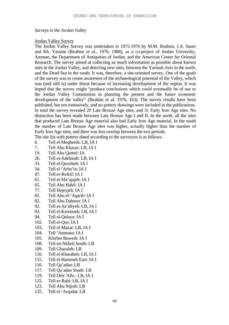
TRIBES AND TERRITORIES IN TRANSITION
66
Surveys in the Jordan Valley
Jordan Valley SurveyThe Jordan Valley Survey was undertaken in 1975-1976 by M.M. Ibrahim, J.A. Sauerand Kh. Yassine (Ibrahim et al., 1976, 1988), as a co-project of Jordan University,Amman, the Department of Antiquities of Jordan, and the American Center for OrientalResearch. The survey aimed at collecting as much information as possible about knownsites in the Jordan Valley, and detecting new sites, between the Yarmuk river in the north,and the Dead Sea in the south. It was, therefore, a site-oriented survey. One of the goalsof the survey was to create awareness of the archaeological potential of the Valley, whichwas (and still is) under threat because of increasing development of the region. It washoped that the survey might “produce conclusions which could eventually be of use tothe Jordan Valley Commission in planning the present and the future economicdevelopment of the valley” (Ibrahim et al. 1976, 163). The survey results have beenpublished, but not extensively, and no pottery drawings were included in the publications.In total the survey revealed 20 Late Bronze Age sites, and 31 Early Iron Age sites. Nodistinction has been made between Late Bronze Age I and II. In the north, all the sitesthat produced Late Bronze Age material also had Early Iron Age material. In the souththe number of Late Bronze Age sites was higher, actually higher than the number ofEarly Iron Age sites, and there was less overlap between the two periods.The site list with pottery dated according to the surveyors is as follows:6. Tell el-Meqbereh: LB, IA I7. Tell Abu Kharaz: LB, IA I19. Tell Abu Qamel: IA26. Tell es-Sakhinah: LB, IA I33. Tell el-Qeseibeh: IA I34. Tell el-‘Arba’in: IA I47. Tell er-Refeif: IA I61. Tell el-Ma’ajajeh: IA I65. Tell Abu Habil: IA I77. Tell Hejeyjeh: IA I81. Tell Abu el-‘Aqarib: IA I82. Tell Abu Dahnun: IA I92. Tell es-Sa’idiyeh: LB, IA I93. Tell el-Kereimeh: LB, IA I94. Tell el-Qelaya: IA I102. Tell el-Qos: IA I103. Tell el-Mazar: LB, IA I104. Tell ‘Ammata: IA I105. Khirbet Buweib: IA I108. Tell en-Nkheil South: LB109. Tell Ghazaleh: LB110. Tell el-Kharabeh: LB, IA I115. Tell el-Hammeh East: IA I116. Tell Qa’adan: LB117. Tell Qa’adan South: LB119. Tell Deir 'Alla : LB, IA I122. Tell er-Rabi: LB, IA I123. Tell Abu Nijrah: LB125. Tell el-‘Arqadat: LB
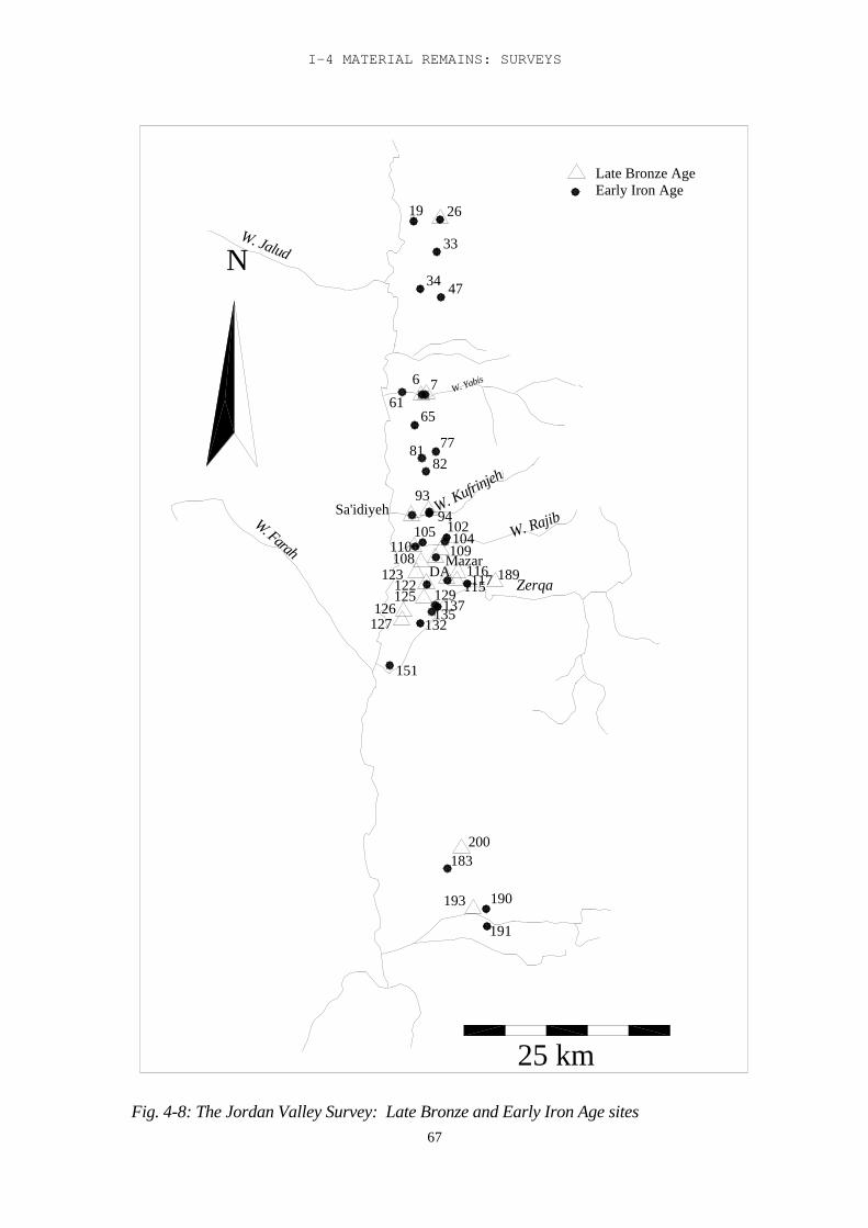
I-4 MATERIAL REMAINS: SURVEYS
67
N
25 km
191
190
189
W. Kufrinjeh
81
193
183200
W. Farah
137125
151
127126 135
132
123122
110
Sa'idiyeh
DA 117116
104108
129
Mazar
105109
102
115
9493
82
W. Jalud
61W. Yabis
65
77
76
34 47
33
19 26
W. Rajib
Zerqa
Late Bronze AgeEarly Iron Age
Fig. 4-8: The Jordan Valley Survey: Late Bronze and Early Iron Age sites
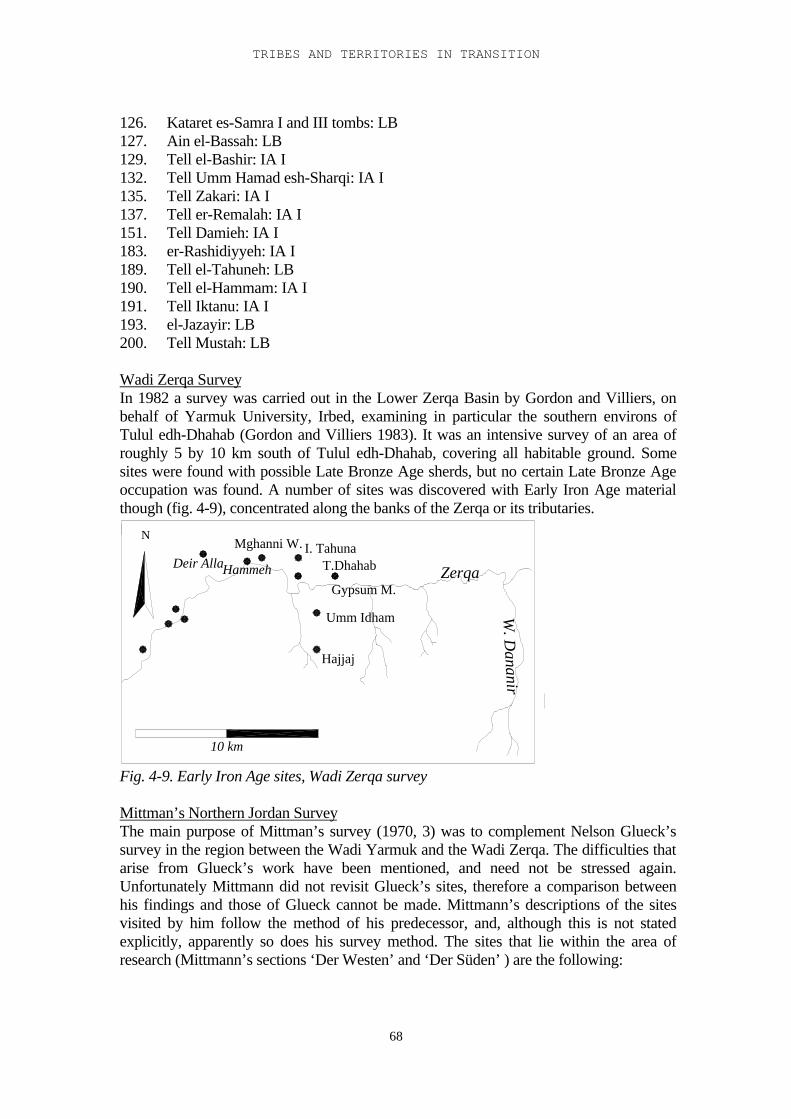
TRIBES AND TERRITORIES IN TRANSITION
68
126. Kataret es-Samra I and III tombs: LB127. Ain el-Bassah: LB129. Tell el-Bashir: IA I132. Tell Umm Hamad esh-Sharqi: IA I135. Tell Zakari: IA I137. Tell er-Remalah: IA I151. Tell Damieh: IA I183. er-Rashidiyyeh: IA I189. Tell el-Tahuneh: LB190. Tell el-Hammam: IA I191. Tell Iktanu: IA I193. el-Jazayir: LB200. Tell Mustah: LB
Wadi Zerqa SurveyIn 1982 a survey was carried out in the Lower Zerqa Basin by Gordon and Villiers, onbehalf of Yarmuk University, Irbed, examining in particular the southern environs ofTulul edh-Dhahab (Gordon and Villiers 1983). It was an intensive survey of an area ofroughly 5 by 10 km south of Tulul edh-Dhahab, covering all habitable ground. Somesites were found with possible Late Bronze Age sherds, but no certain Late Bronze Ageoccupation was found. A number of sites was discovered with Early Iron Age materialthough (fig. 4-9), concentrated along the banks of the Zerqa or its tributaries.
Mghanni W. I. TahunaDeir Alla
Hajjaj
Umm Idham
Gypsum M.
T.Dhahab Zerqa
W. D
ananir
Hammeh
N
10 km
Fig. 4-9. Early Iron Age sites, Wadi Zerqa survey
Mittman’s Northern Jordan SurveyThe main purpose of Mittman’s survey (1970, 3) was to complement Nelson Glueck’ssurvey in the region between the Wadi Yarmuk and the Wadi Zerqa. The difficulties thatarise from Glueck’s work have been mentioned, and need not be stressed again.Unfortunately Mittmann did not revisit Glueck’s sites, therefore a comparison betweenhis findings and those of Glueck cannot be made. Mittmann’s descriptions of the sitesvisited by him follow the method of his predecessor, and, although this is not statedexplicitly, apparently so does his survey method. The sites that lie within the area ofresearch (Mittmann’s sections ‘Der Westen’ and ‘Der Süden’ ) are the following:
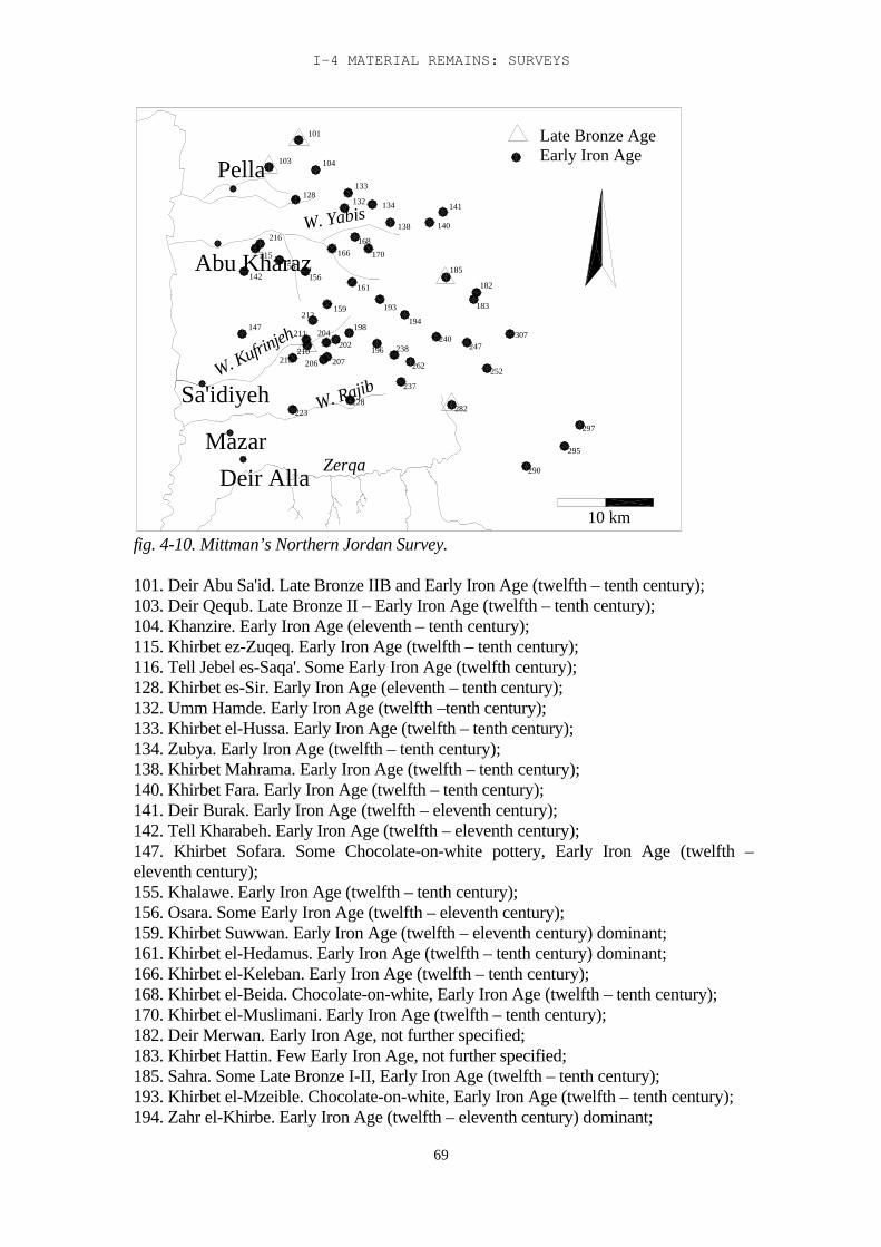
I-4 MATERIAL REMAINS: SURVEYS
69
194
W. Kufrinjeh
Deir Alla
Sa'idiyeh
147
Mazar297
Zerqa
198
228W. Rajib
202204
207206215210
211
223
237
262
196 238
290
307247
240
282
252
295
103
216
Abu Kharaz215
142
Pella133
132
161
W. Yabis128
166
156
159
155
212
134
170
138
193
168
104
101
141
182
140
185
183
Early Iron AgeLate Bronze Age
10 km
fig. 4-10. Mittman’s Northern Jordan Survey.
101. Deir Abu Sa'id. Late Bronze IIB and Early Iron Age (twelfth – tenth century);103. Deir Qequb. Late Bronze II – Early Iron Age (twelfth – tenth century);104. Khanzire. Early Iron Age (eleventh – tenth century);115. Khirbet ez-Zuqeq. Early Iron Age (twelfth – tenth century);116. Tell Jebel es-Saqa'. Some Early Iron Age (twelfth century);128. Khirbet es-Sir. Early Iron Age (eleventh – tenth century);132. Umm Hamde. Early Iron Age (twelfth –tenth century);133. Khirbet el-Hussa. Early Iron Age (twelfth – tenth century);134. Zubya. Early Iron Age (twelfth – tenth century);138. Khirbet Mahrama. Early Iron Age (twelfth – tenth century);140. Khirbet Fara. Early Iron Age (twelfth – tenth century);141. Deir Burak. Early Iron Age (twelfth – eleventh century);142. Tell Kharabeh. Early Iron Age (twelfth – eleventh century);147. Khirbet Sofara. Some Chocolate-on-white pottery, Early Iron Age (twelfth –eleventh century);155. Khalawe. Early Iron Age (twelfth – tenth century);156. Osara. Some Early Iron Age (twelfth – eleventh century);159. Khirbet Suwwan. Early Iron Age (twelfth – eleventh century) dominant;161. Khirbet el-Hedamus. Early Iron Age (twelfth – tenth century) dominant;166. Khirbet el-Keleban. Early Iron Age (twelfth – tenth century);168. Khirbet el-Beida. Chocolate-on-white, Early Iron Age (twelfth – tenth century);170. Khirbet el-Muslimani. Early Iron Age (twelfth – tenth century);182. Deir Merwan. Early Iron Age, not further specified;183. Khirbet Hattin. Few Early Iron Age, not further specified;185. Sahra. Some Late Bronze I-II, Early Iron Age (twelfth – tenth century);193. Khirbet el-Mzeible. Chocolate-on-white, Early Iron Age (twelfth – tenth century);194. Zahr el-Khirbe. Early Iron Age (twelfth – eleventh century) dominant;
TRIBES AND TERRITORIES IN TRANSITION
70
196. Khirbet Hamid. Some Late Bronze I, Early Iron Age (twelfth – tenth century);198. Khirbet Kedade. Early Iron Age (twelfth – tenth century);202. Khirbet er-Ruweis. Early Iron Age (twelfth – tenth century);204. Khirbet Safit. One chocolate-on-white sherd, Early Iron Age (twelfth – tenthcentury) dominant;206. Khirbet Amriye. Early Iron Age (end of period);207. Debbet Kanaš. Early Iron Age (eleventh – tenth century);210. Khirbet el-Mansura. End of Late Bronze and Early Iron Age;211. Khirbet el-Mšerfe. Early Iron Age (twelfth – tenth century);212. Khirbet el-Gubb. Early Iron Age (twelfth century);215. Khirbet el-Hammam. Early Iron Age (twelfth – tenth century);223. Tell Kharabe. Early Iron Age (not specified);228. Sahne. Early Iron Age (twelfth – tenth century);237. Khirbet Umm Joze. Early Iron Age (twelfth – tenth century);238. Khirbet Umm Jalud. Early Iron Age, little. Not specified;240. Suf. Chocolate-on-white, Early Iron Age (twelfth – tenth century);247. Khirbet Abu el-‘Asafir. Early Iron Age (eleventh – tenth century);252. Jeraš. White-slip ware, Early Iron Age (twelfth – tenth century);259. Remun. Early Iron Age (eleventh – tenth century);262. Khirbet el-Hemer. Early Iron Age (twelfth – tenth century);282. Ras el-Kwem. Late Bronze I and II; Early Iron Age (eleventh – tenth century);290. Tell Jen'abe. Chocolate-on-white, Early Iron Age (twelfth –tenth century);295. Tell el-Merame. Early Iron Age (eleventh – tenth century);297. Khirbet el-Qneye. Some Early Iron Age, not specified;307. El-Hute. Some Early Iron Age, not specified;Mittmann’s conclusion is that the concentration of new Early Iron Age sites in this regionpoints to the presence of newly arrived Israelite tribes (Mittmann 1970, 218). Thisconclusion seems far-fetched, and is based more on other considerations than on theresults of the survey. The results of this survey however, stress the fact that Late BronzeAge II sites are extremely rare in the region, and therefore it helps to locate the limits ofthe concentration of sites from that period in the region around Deir 'Alla and Sa'idiyeh.
Wadi el-Yabis surveyA survey has been carried out in the Wadi el-Yabis, 15 km north of Wadi Kufrinjeh, and7 km south of Pella (Mabry and Palumbo 1988, Palumbo et al. 1990 and Palumbo 1992).In the Zerqa area the Valley is 12 km wide, narrowing to the north. Between WadiKufrinjeh and the Sea of Tiberias its width is about 5 km. Climate, soil, ecological zonesfrom west to east and vegetation are the same as those in the research area. The Yabisflows from the highlands, 1200 m above sea level, into the Jordan. Its springs are foundin the highlands and the upper part of the foothills, and the area gets 600 mm rainfall. Itflows through three vegetation zones: the highlands, with red Mediterranean soil andrendzina, and woods of pine and oak; the foothills, with fluvial deposits, and bushes andshrubs; and the ghor, with mostly acacia and different grasses. Along the wadi one findscypress, tamarisk, oleander, reeds etc, which are typical for wadi banks in this region andwhich also appear along the Zerqa and in the Zor.The area has been surveyed by Glueck (1951:210-231), by de Contenson and by the EastJordan Valley Survey (Ibrahim et al. 1976). However, most of the sites were foundduring the Wadi el-Yabis surveys. A stratified random survey was conducted on anumber of transects from north to south, covering the three ecological zones. Sites knownfrom earlier surveys were revisited (fig. 4-11).
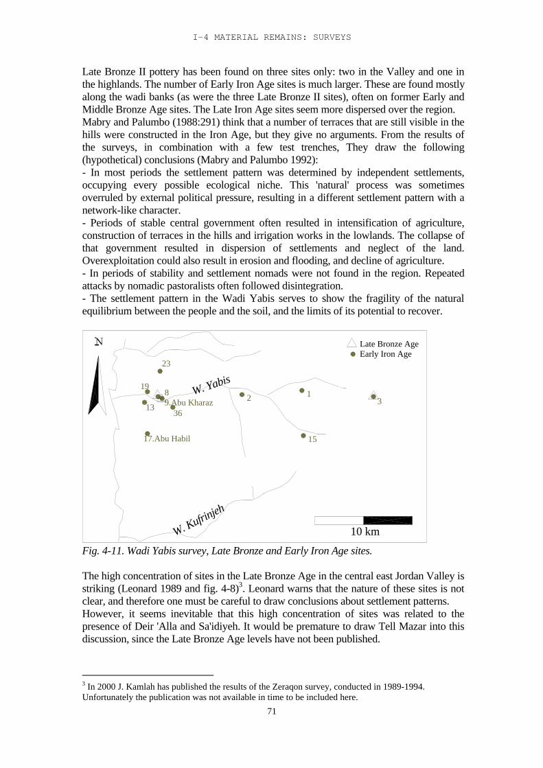
I-4 MATERIAL REMAINS: SURVEYS
71
Late Bronze II pottery has been found on three sites only: two in the Valley and one inthe highlands. The number of Early Iron Age sites is much larger. These are found mostlyalong the wadi banks (as were the three Late Bronze II sites), often on former Early andMiddle Bronze Age sites. The Late Iron Age sites seem more dispersed over the region.Mabry and Palumbo (1988:291) think that a number of terraces that are still visible in thehills were constructed in the Iron Age, but they give no arguments. From the results ofthe surveys, in combination with a few test trenches, They draw the following(hypothetical) conclusions (Mabry and Palumbo 1992):- In most periods the settlement pattern was determined by independent settlements,occupying every possible ecological niche. This 'natural' process was sometimesoverruled by external political pressure, resulting in a different settlement pattern with anetwork-like character.- Periods of stable central government often resulted in intensification of agriculture,construction of terraces in the hills and irrigation works in the lowlands. The collapse ofthat government resulted in dispersion of settlements and neglect of the land.Overexploitation could also result in erosion and flooding, and decline of agriculture.- In periods of stability and settlement nomads were not found in the region. Repeatedattacks by nomadic pastoralists often followed disintegration.- The settlement pattern in the Wadi Yabis serves to show the fragility of the naturalequilibrium between the people and the soil, and the limits of its potential to recover.
2
W. Kufrinjeh
13
17.Abu Habil
19 W. Yabis
9.Abu Kharaz36
8
23
15
13
10 km
Late Bronze AgeEarly Iron Age
Fig. 4-11. Wadi Yabis survey, Late Bronze and Early Iron Age sites.
The high concentration of sites in the Late Bronze Age in the central east Jordan Valley isstriking (Leonard 1989 and fig. 4-8)3. Leonard warns that the nature of these sites is notclear, and therefore one must be careful to draw conclusions about settlement patterns.However, it seems inevitable that this high concentration of sites was related to thepresence of Deir 'Alla and Sa'idiyeh. It would be premature to draw Tell Mazar into thisdiscussion, since the Late Bronze Age levels have not been published.
3 In 2000 J. Kamlah has published the results of the Zeraqon survey, conducted in 1989-1994.Unfortunately the publication was not available in time to be included here.
TRIBES AND TERRITORIES IN TRANSITION
72
Four Late Bronze sites are found on the border zone between Katarrh and Ghor: AbuNijrah, Nkheil, Kharabeh and Sa'idiyeh. One lies in the Katarrh, Kataret es-Samra, butthis was basically a burial site, according to Leonard (1985). Most of the sites are foundin the Ghor, and Meidan is the only Late Bronze site on the Zerqa. Kereimeh, on theWadi Kufrinjeh lies nearest to the foothills.There seems to be no preference for settlement near the wadis. In the Iron Age thesituation is the other way round: 17 out of 24 sites are found along the wadis. They aremore or less equally distributed over the ecological zones, with an understandablepreference for the Ghor. The Late Bronze Age sites that were abandoned at the end of theperiod were all situated in the inlands.
Surveys in the Western Hill Country
The highlands of Palestine have been surveyed repeatedly, and most of these surveyshave been published. Unfortunately many of these publications are in Hebrew, andtherefore not readily accessible to the general public. The extensive publications by Zertalof his survey of Manasseh are a case in point.The survey of the west bank by Kochavi, between 1968-1972, was also in Hebrew(1972). The results of this survey have been re-examined through several other surveys:among others the one that was done by Finkelstein (1988), reproduced in the SouthernSamaria Survey (Finkelstein et al. 1997).
Ephraim survey.Finkelstein (1988) conducted a survey in the highlands, the region of Ephraim, as part ofthe Survey of Southern Samaria (Finkelstein et al. 1997). His survey covered an area of1050 km2. The north-eastern part of this area is relevant to our study: the Desert Fringe(DF) and the Northern Central Range (NCR) (Fig. 4-12).
er-Ras
Dawara
Qabalan
NCR32
Qarqafa
NCR34
NCR41
Ras Zeid Atarud
et-Tell
NCR30
NCR25
Abu Zarad
Alyata
Ghuraba
Shiloh
NCR26
NCR19
Sur
Khirbe
Shuna
NCR31
Rafid
Ebal
Einabus
Nabi
Rujan Kurum
Jib'itKulesun
DF8
Marajim
DF11Rahaya
Jurish
NCR28
NCR24
NCR39
QariqNCR35
Sh.Hatim
NCR17
Khuneifis
DF6
DF7
Mazar
Shuweiha
Tana el
YanunNabi Nun
Jarayish
DF1
Ibn Nasir
Urma
Sh.Nasrallah
Ghannam
et TahtaTana
Deir Alla
W. Farah
Zerq
a
10 km
Late Bronze AgeEarly Iron Age
Fig. 4-12. Finkelstein’s Efraim Survey
Only three Late Bronze Age sites were found: Khirbet Seilun (identified with Shiloh, andexcavated by Finkelstein, see Chapter 3); Khirbet El Urma; and Tell Abu Zarad. Thedifference in settlement density between the Late Bronze Age and the Early Iron Age,
I-4 MATERIAL REMAINS: SURVEYS
73
although not unexpected, is still striking when seen on the maps of the Ephraim Survey.57 sites have been recorded in the relevant area, which is the most densely occupied inthis period. Most of the sites are smaller than 0.3 ha, ten are between 0.3 and 1 ha, andfour are between 1.1 and 2 ha. The three sites occupied in the Late Bronze Age were alsooccupied in the Early Iron Age. Both Shiloh and Tell Abu Zarad grew from a very small(0.3 ha) site to a 1.1-2 ha site; Khirbet El-Urma remained 0.3-1 ha in size.Finkelstein has drawn several conclusions from the results of his own survey, incombination with other surveys (mainly the Manasseh survey, see below):- 90% of the earliest Early Iron Age sites (twelfth and early eleventh century BC) werelocated in the eastern part of the survey region (Finkelstein 1988, 191); according toFinkelstein these are the areas best suited for cereal crops and pastoralism.- The distribution of ‘large’ and ‘small’ villages was such that there was “no more thanone large site in each of the intermontane valleys of the northern central range. Thepattern of settlement was thus one of prominent central sites with a peripheral populaceconnected to it...” (Finkelstein 1988, 193).Tell Abu Zarad has been identified with Tappuah by several scholars. It is a large tell,with a group of 14 agricultural towers. The tomb of sheikh Abu Zarad gives it its presentname (Finkelstein et al. 1997, 606-7).R.D. Miller (2000) has resurveyed some of the sites surveyed by Kochavi and addedinformation concerning the redating of Kochavi’s results. He found five additional siteswith late Bronze Age material, two of which fall outside our research area. The otherthree were Khirbet Er-Rama (3), Khirbet Anakhum (8), and Khirbet Brijmeh (18). Allsites were found to the west of a north-south line through Nablus. Miller also found sevenEarly Iron Age sites, four of which were also occupied in the Late Bronze Age.The discrepancy of the results of Miller’s renewed surveys with those of Finkelstein etal., rather suggests a difference in dating of the sherd material than a difference in actualsettlement patterns. It is likely that Finkelstein dates certain types of pottery to the veryearliest Iron Age, which Miller still dates to the Late Bronze Age. Therefore thisdiscrepancy may be less significant than it seems at first, except to confirm that this wasan area that was settled very early in the Early Iron Age, and that a better label for it maybe ‘transitional’.
Shechem surveyA site-oriented survey was carried out as part of the Shechem excavations in 1965-68(Campbell 1991). Assuming that the area - the valley and the surrounding hills - formedan ecological unit the survey aimed to provide a better insight in the functioning of thissystem. Fourteen Late Bronze II sites were found, two possible Late Bronze sites and twosites from the transitional period. There were eleven Early Iron Age sites, and threepossible Early Iron Age sites. Eight sites were occupied in both periods. The surveyconfirmed the results of the Shechem excavations, that there was no occupation before1450. Very little pottery has been published from this survey. According to the list of‘periods attested’ (Campbell 1991, 9-10) in the Late Bronze Age, six sites were found tohave been settled in Late Bronze IIA, four of which also had Late Bronze IIB sherds.Three sites had only Late Bronze IIB sherds.Based on the survey results Campbell has suggested a hypothetical reconstruction of theregion in the Late Bronze Age (fig. 4-13): The valley had seven points of entrance,everyone controlled by a village or guard post, and some by two, on either side of theentrance. Tel Sofar and Kumeh controlled the entrance from the west, while Shechemitself controlled the entrance from the east. The other passes were controlled by Khirbet
TRIBES AND TERRITORIES IN TRANSITION
74
el-Urmah (Arumah) together with Shurrab, Beth Dajan, Khirbet Tana el-Foqa withKhirbet Tana et-Tahta, Beth el-Khirbeh, Khirbet Maqneh el-Foqa and Kefr Kuz.
3
23
7Ebal
1.Shechem37
240
31.B.el-Khirbeh
33.M.el-Foqa
42
52-Sofar
54. Kumah
Mazar
Deir Alla
W. Farah
17.Tana el-Foqa16.B.Dajan15
18.Tana el-Tahta
1220
7.Kefr Kuz
27.Shurrab
26.Urmah
Farah
W. Kufrinjeh
Zerq
aSa'idiyeh
10 km
Late Bronze AgeEarly Iron Age
Fig. 4-13. Survey of the Shechem region
The Shechem pass was part of an important route from the sea to the Jordan Valley.Lab'ayu, lord of Shechem in the Amarna period, recognised this importance and used it tostrengthen his position. Campbell’s reconstruction therefore makes good sense. Outsidethe valley were fortified towns, which Campbell relates to Shechem: Tell Miskeh; TellSheikh Abu Zarad; Tell el-Far'ah; Khirbet edh-Dhuq; Tubas; Dothan; Shiloh; and Bethel.No traces have been found of unfortified sites outside the Valley. Lab'ayu's strongholdwas isolated and protected, and the other settlements within his protection were fortified.
I-4 MATERIAL REMAINS: SURVEYS
75
At the end of the Late Bronze Age the population of Shechem seems to disperse, formingsatellite villages in the valley (Campbell 1991:94). This dispersion coincides with Level 1at the Mount Ebal site. Occupation stops in Shechem ca 1125, and in the valley ca 1100.Eleven sites with Late Bronze and Early Iron Age material have been brought to light bythis and other surveys. Furthermore there is a number of exclusively Early Iron Age sites.Based on these Campbell assumes:- continuation in occupation in the thirteenth-twelfth century;- gradual transition in pottery shapes;- a number of new sites coming into existence around 1200;- discontinuity on all sites at the end of the twelfth century. He suggests that there was asymbiosis between Canaanites living in the region and new settlers, possibly Israelites.
Manasseh surveyZertal (1987, 1991) has conducted a survey in the Manasseh area, the northern half of thecentral hill country. The survey area, with a total area of 2000 km2, is situated betweenBeth Shean and Gilgal, opposite the Deir 'Alla region. 116 Middle Bronze Age sites, 39Late Bronze Age sites (22 of which had Late Bronze II material) and 136 Early Iron Agesites were found. The distribution of sites over the region is significant: 43% of theMiddle and Late Bronze sites, but only 19% of the Early Iron Age sites, were situated inand around the valleys. 13% of the Middle and Late Bronze Age sites and 38% of theEarly Iron Age sites were situated on the terra rossa of the highlands. In the hillsthemselves 15% of the Middle and Late Bronze Age sites were found and 53% of theEarly Iron Age sites.
Based on his analysis of the material culture of these sites Zertal draws severalconclusions:- The newcomers of the Early Iron Age were of one origin. He recognises three stages inthe settlement process:1. Semi-nomads grazing their flocks between Wadi Far'ah and Wadi Malih.2. Permanent settlement and the beginning of cultivation in the valleys. Based on thepottery shapes he thinks that there was a shift to the west in this stage.3. The end of the twelfth century sees the beginning of cultivation of olives and grapes,and occupation of the southern and western hills.- He has reconstructed an economy based on pastoralism and agriculture. The presence ofcattle points to sedentarisation, as does the presence of olive groves and vineyards.- Material culture on these sites is the same as that on Mount Ebal. The combination of alarge cultic site (Ebal) with settlements surrounding it suggests a relatively high degree oforganisation on a tribal or multi-tribal basis, according to him.The settlement pattern suggests a symbiosis between Canaanites and early Israelites. Inthis reconstruction the Canaanites held the springs in the valleys, while the newcomershad to buy the right-of-use of these springs. Only the spring-system of the Wadi Far'ahand Wadi Malih was too complex and large for the Canaanites to control, and here arelatively large number of Early Iron Age settlements of the “transitional pastoralism-settlement” type was found.- The high concentration of sites in Manasseh and Ephraim, compared to other parts ofthe country (Judah had 20 Early Iron Age sites, Ephraim and Manasseh 200 in an areatwice as large), together with the fact that the earliest cultic traditions (Ebal and Shiloh)were situated in this area, all seem to point to this area as the ‘cradle’ of early Israel.

TRIBES AND TERRITORIES IN TRANSITION
76
Zertal's hypothesis is based for a large part on his dating of the cooking pots, thepresence or absence of the Manasseh bowl (Zertal 1987) and a certain type of decorationon handles (also found in the Deir 'Alla region: Franken 1992:5.15:25).30% of the pottery from the hill sites consisted of collared rim jars.
76
II-5: Aspects of nomadism and settlement
The nineteenth and twentieth centuries AD were a period of change in Transjordan.International developments had their impact on a largely rural and pastoral society,changing it completely. In this section these changes and the mechanisms that lie behindthem will be examined, with special reference to the Central Jordan Valley. A picture ispainted here of a changing society, which may, to a certain extent, reflect changes thattook place in the same region in the transitional period between the Late Bronze and theEarly Iron Age. The material remains of this period have been described in the precedingchapters: literary sources, archaeological remains and surveys, and the ecological context.Ethnoarchaeology relates human behaviour to these material remains, so that“explanatory hypotheses may be thereby fruitfully constructed as predictions of the pastwhich can be verified (or falsified) by the recovery of new data or better (more inclusive,parsimonious and internally consistent) explanations” (Kamp and Yoffee 1980, 86). Therecent history of the Transjordanian Plateau and its interactions with the Jordan Valleycan provide some of the explanations for the transition from the Late Bronze to the EarlyIron Age, and although the picture that emerges is far from complete or even coherent, itgives a perspective on the socio-economic backgrounds of society in those periods.The use of ethnographic analogies in order to reconstruct ancient societies has itsdangers. Ancient societies were different in many ways from modern society. Therefore,in order to make a valid comparison that adds to our knowledge of how those societiesfunctioned, it is essential to make a distinction between behaviour that is related tomodern society and concepts, and behaviour that is timeless, and based on unchanging,Darwinian (sociobiological) motives. These motives are the production and procurementof food, the protection against enemies and against nature, and the acquiring of status andpower (Wilson 1975, 547-76). The economic and social strategies that a tribal societyresorts to can vary within a continuum that involves complete settlement at one end, andcomplete mobility at the other (Salzman 1980). Within those extremes almost anyeconomic activity is possible, whether it be pastoralism, agriculture, robbing and raiding,protection or trade, provided that it is profitable within the specific circumstances thatmake up the economical or ecological niche of the moment. This conforms to whatLaBianca (1990: 13-14) has described as a ‘resilient system’, which functioned within theHesban region in the Iron Age, as reflected in the archaeological record.
The theory
Until the very recent past nomadism was often seen as part of a cyclic process in whichBraudel’s ‘longue durée’ concept played an important role. Periods of dense settlementalternated with periods in which the population returned to a largely nomadic way of lifeas pastoralists, herding sheep and goats, and forming the ‘pool’ from which the settlerscame when resettlement started again. That this, for a number of reasons, is anoversimplification has been made clear by several scholars. The distinction betweennomadic, pastoralist groups and settled populations is still taken for granted in manystudies about Levantine society, both relatively recent and relatively ancient (e.g. Rowton1973a, 1973b, 1974, 1976, 1977). Steve Rosen has taken this argument further and statesthat both groups not only always leave traceable remains, but also that these remains, bytheir very nature, can be ascribed to one or the other. So if there are no archaeologicaltraces of nomads, there simply were no nomads (Rosen 1988, 1992). He bases this viewson Rowton’s model of the dimorphic society, the sedentary versus non-sedentary
II-5 ASPECTS OF NOMADISM AND SETTLEMENT
77
population (Rowton 1974, 1976, 1977), each, according to Rosen, with their specificarchaeological repertoire. However, as Salzman (1980) and others have shown, the concept of a dimorphic societycan be replaced by a more convincing one, that of a continuum between two extremes,and groups of people moving constantly within this continuum. They adapt themselvestime and again to the prevailing circumstances, and move from one economic activity toanother, if that proves profitable. Their niches are not fixed in any way, economically,ecologically or geographically. Even in periods of dense settlement, towns and cities with stratified societies, nomadicpastoralists played a role, if only as providers of meat, dairy products, wool and leather(Finkelstein 1995, 26; Rowton 1974). Their social and economic importance can bedetermined by the presence of ample remains of sheep/goat in towns and cities, whichmust have been provided by a nomadic or transhumant population, due to the nature ofthe animals. Their role in the trade and economy must have been considerable, and theirterritorial needs and claims are bound to have influenced the settlement pattern.That means that it is not as easy as Rosen suggests, to ascribe material remains to either asedentary or a non-sedentary population. We can, at the very best, only pinpoint remainsto a specific activity, at a specific time. The group that left them, may have been involvedin other activities as well, at the same time, or a few days later, activities that leavedifferent traces, or perhaps no traces at all (cf. Finkelstein 1995, 37). In the past a number of possible explanations have been analysed by several scholars andpresented as models to explain the fluctuations between ‘the desert and the sown’,between the settled and non-settled components of society over time. Factors likeclimate, disease, population pressure, economic decline or its opposite, economic revival,international politics, have all been used as possible explanations, but not one of them canclaim to provide the final answer. Which of these, or which combination of them, is validmay differ with every event.
Humans, like every living being, are primarily driven by the need to procreate, to pass ontheir own genetic material (Wilson 1975, 547-76). In practice this means:- Procurement of food that contains all the basic nutrients to feed oneself and one’soffspring.- Protection against nature and against human enemies. This can be provided by thebuilding of fortifications or by making alliances. Alliances can be made with possibleprotectors or confederates, or with possible attackers, in order to disarm them.- Status and power provide better chances for oneself and one’s offspring to procure foodand protection, and also put one higher in the mating hierarchy.- Mating strategies are designed for men to produce a maximum offspring, for women toprovide the best chances of survival and procreation for her offspring. In practice thisusually means polygyny for men, and for women a high-status marital attachment.These can be seen as basic human motives, irrespective of time, place or circumstances.They leave few tangible traces in the archaeological record; nevertheless they must haveinfluenced this record considerably, as they determine interhuman relations as well asman’s relation with nature. They can however be translated into conditions for humanbehaviour that do leave traces, like settlement patterns, town planning and strategies forprocuring and storing food. How basic motives like the quest for food, or the need forstatus and power can influence settlement patterns, modes of life, and social relations, forexample, is outlined below.
TRIBES AND TERRITORIES IN TRANSITION
78
Bedouin in the 19 th and 20 th century
The most significant aspect of Bedouin society in the past two centuries was itsflexibility. Abujaber et al. (1987, 41) have described the Bedouin as exploring amultitude of resources. Sheep and goats, but camels especially, gave prestige. TheBedouins’ income originally came from camel-trade, robbing and raiding, caravan-escortetc. When these resources dried up with the coming of the modern state, they becamesmugglers, cultivators of their land, or they found employment with oil companies or inthe army of one of the new states. Lancaster has described the same process for the Rwala Bedouin (Lancaster 1981, 97 ff).The process started in the second half of the nineteenth century, and is, in fact, stillcontinuing (Lancaster 1981, 139 ff). There are several reasons for the shift in economicpursuits. First the Bedouin lost some important sources of income due to the introductionof the railway, and later that of the automobile, which gradually replaced the camel (amain source of income for large groups of Bedouin) as the main form of transport(Hourani 1991, 293, 334; Abujaber et al. 1987, 41). Secondly, in 1858 the Ottomanauthorities, in an effort to develop agriculture, introduced the Land Laws (Hourani 1991,287). These laws made the Bedouin tribes de facto owners of their territory, with theobligation to pay taxes. As the sheikhs of the tribes were made responsible for thecollection of the taxes, they gradually entered into formal relations with the state. At thesame time the authorities began to take action against raiding and robbing practices,which eventually had its effects. Robbing and raiding had been a substantial source ofincome for the Bedouin, either directly, or indirectly, by providing ‘protection’ forvillages and travellers.The human factors involved in the change may be subdivided into 1) the quest for food;2) local and international political factors; 3) population pressure. The different aspects ofthese factors, and their impact on the society of the nineteenth and twentieth centuriesare worth looking at more closely.
The quest for food
In societies where the availability of food is the key factor for survival the quest for foodis often the primary motive for human action (LaBianca 1990). There are different ways of looking at this quest for food. We can look at the actualstrategies used to obtain food, like hunting, gathering, pastoralism, or different forms ofagriculture. In Near Eastern society, at least since the domestication of plants andanimals, all these strategies have, to a certain extent, always existed side by side. Another way to look at the quest for food, is from the point of view of social relations.Here two different strategies can be discerned: 1) direct production, and 2) obtaining foodfrom the direct producers. While direct production is only concerned with the primarynecessities of life, the second strategy also determines the relations of power in a region,as will be made clear in the next section.In the Jordan Valley food production in the second millennium BC (as well as in thesecond millennium AD) was mainly by farming and pastoralism, although hunting andgathering never completely stopped (van der Kooij and Ibrahim 1989, 41). Most of themammals formerly living in the Jordan Valley are now extinct, mainly as a result ofhunting.
II-5 ASPECTS OF NOMADISM AND SETTLEMENT
79
Bedouin and pastoralistsIn the early nineteenth century AD the southern Levant, although officially part of theOttoman empire, was in practice ruled by a number of Bedouin tribes: the Beni Sakhrin northern Transjordan, the Uhedat in the Negev and Sinai, and the Howeitat insouthern Transjordan were the largest and most powerful of them. The Beni Sakhr had conquered the territory of the Transjordanian highlands and theJordan valley on the Adwan. The continuing territorial struggles between the Adwan,the Abbad and the Beni Sakhr, as well as the tyranny of the Beni Sakhr themselves,left the region rather desolate. There was no settled occupation in the Jordan Valley. Inthe Belqa Salt was the only inhabited town (Burckhardt 1822, 167). “People of localArab tribes camped at some of the ancient sites, made use of old buildings as storehouses and sowed a little wheat or barley round about, but the only extensive area ofregular cultivation was around Salt.” (Lewis 1987, 23). The town was controlled byseveral tribes, and paid protection to the Beni Sakhr. Other villages and towns weredeserted, left in ruins, after their inhabitants had fled. And as long as the Beni Sakhrruled the area, this situation remained unaltered. Efforts at farming were frustrated bynomadic raids, travellers had to pay khawa (protection money) and even the Hajj wasnot safe, in spite of the large sums that were paid to the Bedouin in order to ‘protect’(i.e. ‘not to rob’ ) the pilgrims (Doughty 1908, 1-3; Oppenheim 1943, 233).The Ottoman government undertook several efforts to regain control over the region.In 1810 the Ottoman army confronted the Beni Sakhr, and lost. It was not untilhalfway through the nineteenth century that the government managed, by variousmeasures, to finally break the power of the Beni Sakhr. This resulted in a break-up ofthe tribe, some families of which moved to the west of the Jordan and put up theirtents around Beth Shean. With the power of the Beni Sakhr broken, the area became quickly settled. Villagessprang up through the highlands and in the Jordan valley. The inhabitants came partlyfrom some smaller tribes, that had been controlled by the Beni Sakhr, and partly theycame from elsewhere. The government settled Circassians in the region (as part of thestrategy to keep the tribes under control), and farmers came from the west side of theJordan, fleeing political unrest (Oppenheim 1943, 180). The Land Laws of 1858 hadgiven ownershop of the land to the Bedouin, with the obligation to pay taxes. Thesheikhs of the Beni Sakhr now hired Palestinian fellaheen, and forced some of thesmaller tribes to work the land, and so contributed to the settlement of the region(Oppenheim 1943, 235; Tarawneh 1989, 30).Kerak, a town further south, had for a long time been in the power of the Beni Amrtribe who extorted so much from the town that it was reduced to beggary. But around1750 AD the sheikh of the town allied himself with the Howeitat tribe and togetherthey defeated the Beni Amr, who then retreated to the Belqa where they joined theAdwan. But they were driven out from there as well, and then moved to Jerusalem.Later they returned to Kerak and threw themselves upon the mercy of the sheikh ofKerak, who turned them into an advanced guard for the town. That way Kerak gainedcomplete mastery over the region and considerable influence in the affairs of the Belqa.The inhabitants of Kerak were of varied origin, some originating from the Jebal, otherswith roots in the north. There were traders from Nablus and Hebron, and a group ofdescendants of the Turkish Janissars. The townspeople intermarried with some of theBedouin tribes, like the Anazeh. The sheikh of Kerak had influence as well as the rightof judgment in the whole district down to the Wadi Hasa, and received tribute fromsome of the smaller tribes. On the other hand, Kerak paid tribute to the Howeitat andthe Beni Sakhr.
TRIBES AND TERRITORIES IN TRANSITION
80
Officially Kerak belonged to the Pashalik Damascus, but efforts from the governmentto control Kerak were never successful. Only Ibrahim Pasha held the place for a while,but after he was defeated, the town remained in tribal hands until 1896. The fieldsaround Kerak were worked by townspeople and members of some of the allied tribes.The main commodity was corn, which was traded with the wandering tribes andtransported to Jerusalem, but there were gardens and orchards as well.
The River Jordan was not depleted and running low because of extensive irrigation, asit is now. Especially in the winter and spring crossing the river was a dangerousundertaking. Several travellers (Seetzen 1854-59, 301, 320, 374, Porter 1891, 104)have described the difficulties people encountered when they tried to cross. That wasin the days before there were bridges in the south, when only the tribes of the JordanValley were able to cross the river and maintain the trade with the west (Boggis 1939,29; Burckhardt 1822, 345). Certainly in the first half of the nineteenth century in theeyes of western travellers the Jordan was a border between relatively ‘civilised’Palestine and ‘wild’ and dangerous Transjordan (Kinglake 1879, 154;157; Rogers1862, 177).
Nomadism is often associated with pastoralism, although the two are far from identical(Cribb 1991:17). Farmers had and still own livestock: sheep, goats, chickens and cows. Inthe Valley these were kept for private consumption, with eggs, dairy products and one ortwo lambs for ritual and festive occasions (Layne 1994, 45). They therefore continued toplay an important social, and perhaps also symbolic role in the daily life of the Valleyfarmers1. However, if sheep and goats (or camels) were a main source of income, theywere moved from pasture to pasture, on a nomadic, semi-nomadic or transhumance base(see also Cribb 1991, table 3.1a and b), spending only the winter in the Valley.Until the seventeenth century the Jordan Valley had been a flourishing agriculturalregion, but from the seventeenth century onward pastoralists increasingly dominated thearea (Layne 1994, 38). In the nineteenth century AD the Valley was the exclusiveterritory of pastoral - camel - Bedouin. Lynch (1849, 199) describes the lower Ghor as “aperfect desert, traversed by warlike tribes”. According to Tristram (1866, 572) the Ghornorth of Pella was uninhabited, and in the power of the Beni Sakhr (whom he calls the‘S’hoor’ i.e. Sukhur). Merrill, in March 1876, noticed many Bedouin tents between WadiYabis and Pella “scattered at different points”. By the Zerqa he saw “multitudes of blacktents, and the fields covered with camels”. These were the Beni Sakhr, who had comedown to pasture their flocks. “The Jordan Valley, from the sea of Galilee as far south asthe Zerqa we have found to be full of Arabs: flocks, herds and tents. They came from theMoab plains and the Hauran....They will soon, however, begin to move up into themountains, ascending a short distance at a time, until they reach the plains again in earlysummer” (Merrill 1881, 194). According to Steuernagel, in 1901 the Ghor was ‘Bedouinterritory’.
Until very recently tribes came to the Valley to graze their flocks every winter. In badtimes they even came from as far away as Saudi Arabia (Hazleton 1978, 29). Farmers inthe Valley used to buy all their manure from Bedouin (Maandag and Macksoud 1969,ch.4). The Abbadi tribes used the Valley in spring to sow their crops, and profit from the
1 The high prices for all kinds of meat in Jordan at the end of 1993 immediately resulted in an increase ofprivately kept animals of all kinds: chickens, geese, goats, rabbits etc., in the village of Deir 'Alla.
II-5 ASPECTS OF NOMADISM AND SETTLEMENT
81
early spring pasturage for their flocks. In summer they moved up to the hills east andwest of the Valley. They sold or traded wool and dairy products in Jerusalem, Nablus andSalt in exchange for coffee, tea, sugar and other supplies. According to Oppenheim(1943, 227) the Abbadi flocks, in the first half of the twentieth century amounted to about20,000 sheep.
Dry farming and irrigation farmingThe need for cereals as a basic nutrient has been a major factor in the sedentarisation -nomadisation processes in the area in every period. Bell described how even the most'excluded' or the poorest Bedouin had bread or rice (although there are instances whereBedouin lived solely on camel milk for months on end). If it was not possible to buy orrob grain, they would have to grow it themselves (Bell 1907, 16, 119). The Jordan Valleyis well suited for farming. Between 200 and 300 mm rainfall (Hirzalla 1973, 26: averagerainfall in Deir 'Alla between 1950-1970 was 267 mm) permit dry farming, but with highrisks involved. When cultivation was on a rain-fed basis the amount of land undercultivation varied yearly depending on the amount of rainfall; the risk of crop failure washigh. Among the crops grown in rainfed areas wheat was the most important. In drierareas barley was grown rather than wheat. There was a maximum of one crop per year.Sometimes crop rotation was practised with wheat and lentils, but a wheat-fallow croprotation was more common (Aydin 1985, 13).Most farming in the Valley, however, has always been irrigated farming. It is often takenfor granted that irrigation farming requires a complex society, with a highly developedhierarchical structure. Examples are usually taken from Mesopotamia. In the Valley,thanks to the physical landscape, there seem to have been no such restrictions. Thephysical features of the Valley are such that small-scale irrigation does not necessarilyinvolve a complicated hierarchical structure. In fact, the Jordan Valley is ideal forirrigated farming on a small scale: it slopes down on both sides to the river Jordan.Perennial streams, or what used to be perennial streams, come down from the slopes ofthe mountains and the foothills, and can easily be diverted into small irrigation canals thatalso follow the slope down into the Jordan.Lynch (1849, 203) noticed cultivated patches of wheat and barley in the Galilee Zor,almost ripe, although the only occupants of the region he could see were a number ofBedouin tents scattered over the Zor. Tristram (1866, 527) found small-scale irrigationfarming in Kufrein, in the southern part of the Central Jordan Valley: “...cultivation inirregular patches and a small party of semi-nomad dependents of the ‘Adwan had erectedtheir huts and were reaping and threshing their barley”. Merrill, in 1876, saw wadisbetween the Yabis and Menadirah diverted into irrigation canals. The different users hadarranged a division in which each user had one day on which he irrigated his land. Healso noticed large fields of grain, between the tents of the Beni Sakhr north of the Zerqa(Merrill 1881, 191). The Bedouin in the Central Jordan Valley organised their ownirrigation agriculture. “Through cooperation of members of a tribe, irrigation works werebrought back into operation on all the main side wadis. A type of agriculture appearedwhich, though still heavily dependent on grazing, included the growing of irrigatedcrops”. Where water rights were not clear they were claimed by force (Watson 1961,135). A dam in the Zerqa, constructed in earlier centuries, was repaired when agriculturerestarted in the Deir 'Alla area in the nineteenth century, and three main canals, that alsofunctioned as territorial boundaries branched off from it. Minor canals in their turnbranched off from these. Clan leaders gathered daily, to distribute the water, and organiserepairs if necessary (Tarawneh 1989, 46).
TRIBES AND TERRITORIES IN TRANSITION
82
Subsistence-based farming versus market-based farmingSchumacher (1886, 1888) has described a number of small villages in the Hauran and theJaulan. Most of these hamlets and villages were subsistence-based. They were usuallysmall, about 150 inhabitants on average. Most of them had vegetable gardens, beside aspring or stream, sometimes communal, sometimes private. Powell’s study comparing asubsistence-based with a market-based farmers’ village shows that in the subsistence-based village all but six of the families had a haqura, a small private vegetable garden (½- 2 dunums in size) near their home. The market-based village had six haqura’saltogether (Powell 1987). Mundy and Smith have studied a village in Beni Hassanterritory (Mundy and Smith 1990). In the first half of the twentieth century the peoplehere lived from agro-pastoral production, on a subsistence base. After the first rains theland was sown. Until the harvest people lived in caves, and the animals grazed oncommunal land. After the harvest, which was stored in the caves, the animals grazed onthe harvested land, fertilizing it. In the 1930s sheikhs in the Deir 'Alla region occasionally tried to introduce market-oriented agriculture, sometimes with disastrous results. The production of surplusesresulted in the destruction of large parts of the harvest, because there was not enoughmanpower to harvest all before the rains started. The sheikhs tried to trade the surplus onthe market in Nablus, but since the Zor woodlands were full of outlaws, only well-armedexpeditions had a chance of passing to the west. A large part of the surplus was also spenton banquets and guest meals, in order to establish and maintain the social relations onwhich the sheikh’s status depended (Tarawneh 1989, Ch 3; Lancaster 1981, 140). In theend outside influences brought about the change from this subsistence-based economy toa real market economy. These external forces were the Palestinian influx, internationalcapital and the introduction of merchant capital.The influx of Palestinians led to an increasing need for agricultural products. Newterrains and techniques were exploited, which needed capital. On the one hand this camefrom foreign aid, and on the other hand from merchants and moneylenders, who thusacquired large plots of land. The capitalist market economy proved a vicious circle: thefarmer became dependent on the market as well as on the people who provided him withcapital, and fell deeper and deeper into debt. “Until the mid-1960s usury in the JordanValley worked as a mechanism for land transfer from fellaheen and their traditionalleaders to the merchants” (Tarawneh 1989, 75).Schumacher (1886, 22, 87-89, 91) demonstrates that already in the nineteenth centurysome of the larger villages were dependent on moneylenders from Damascus, whichsuggests they had been experimenting with market-farming. The same development hasbeen described by Kippenberg (1978) for the Judean hill country in the Persian andSeleucid periods (Kippenberg 1978, 42-106). The Persian system of taxing forced thefarmers to produce a surplus, and so created an underclass, dependent on foreignmerchants. Nehemiah’s reforms changed this situation, but the continuing tax demandsnow led to a division within the community: an upper class, and those dependent onthem. The Seleucid tax system, based on crop sharing, increased the social differences.
Obtaining food from the direct producersMarket-based farming, and therefore trade, was one way in which food was transferredfrom the producer to the consumer. The Bedouin had regular trade-relations with thesedentary population, as can be seen in the cases of Salt and Dera'a. Around 1800 Saltwas a regional market town. Bedouin pastoralists, from the Beni Sakhr and the Belqatribes came to the Salt market to exchange their pastoral products for grain and otherthings. Bell’s description of the selling of corn to the Sherarat by Namrud, a trader from
II-5 ASPECTS OF NOMADISM AND SETTLEMENT
83
Tneib, is a beautiful example of this trade (Bell 1907, 40-41). The Bedouin alsofunctioned as middlemen for markets in the Nablus and Jerusalem districts, as well as forthe eastern tribes (Abujaber 1989, Ch 4). Likewise Dera'a, a village of 4000-5000inhabitants, described by Schumacher (1886) as the capital of the region, functioned as aregional market; it was surrounded by the tents of Damascene merchants. So thereexisted a network of markets covering the region, maintained by Bedouin merchants.
Raiding and protection as economic pursuitsThe world of the Bedouin in the nineteenth century was based on the principle ofsurvival of the fittest. It consisted of the tribe, and those bonded or allied to them.Everybody else was considered an enemy. Raiding and robbing one's enemies wasperfectly legal, as a display of strength, as well as a source of income. Therefore ghazus(raids) were regularly undertaken on other tribes, with the sole purpose of robbing eachother's sheep, goats and camels (Bell 1907, 65). The inhabitants of Dana and Buseirah inEdom regularly stole each other's cattle (Burckhardt 1822, 410). In 1811, in a famousghazu, the Beni Sakhr robbed the Howeitat of 1200 camels (Burckhardt 1822). Raidingvillages, trade caravans and travellers therefore was also justified, especially as this tookplace in what the tribe considered its territory. It could be bought off by paying khawa.Khawa literally means ‘brotherhood’, and payment of it provided protection by creating atemporary ‘kinship relation’ with the tribe. Lancaster describes khawa as a mutualagreement between the Bedouin and the villages, “the necessary regulatory mechanismfor symbiosis in a system where coercion is not possible” (Lancaster 1981:123). If the khawa was not paid, the Bedouin effectively stripped the village or trade caravan ofeverything worth taking. Especially in the early nineteenth century, when thegovernment was powerless to protect them, life was difficult for the settled population, aswell as for traders and travellers. In 1802, when the Egyptian government refused to paythe Howeitat for their job as carriers for the Hajj, they replied by robbing an Egyptiantrade caravan of several thousand camel loads of coffee. Following this raid, coffeebecame so cheap among the Bedouin that it was traded for wheat on a one to one basis(Burckhardt 1822, 413). Even the Hajj itself was not safe: although the government paidthe Bedouin tribes along the route a generous khawa, they still would occasionally attackstragglers (Palmer 1871, 429; Schumacher 1886, 110). Numerous nineteenth centurytravellers in the Valley have described this practice and the effect it had on thepopulation. Lynch (1849, 182) describes the ruins of the villages of Delhemiyeh andBuk'ah on either side of the river. Here the Bedouin robbed the fellaheen of their harvest,forcing them to leave their villages, or live off whatever they could find, until the next“harvest and the robber”. Tristram described the village of Dibbun: “once a Christianvillage, now a desolate heap of mouldering walls....and so the Bedouin are laying wastevillage after village”(Tristram 1866, 546). Even some of the villages belonging to theBeni Sakhr in the Southern Ghor were robbed occasionally. Sedentary population in theValley had virtually disappeared before 1850, chased away by the Bedouin’s continuousraiding and robbing. Lewis (1987, Ch 1) has described the same process for Syria andNorth Jordan. The villages and hamlets in the mountains were better protected against robbing thanthose in the valley, as can be seen by Schumacher’s description of the Hauran and Jaulan(1886), because the terrain was difficult for the horse-mounted Bedouin (Abujaber 1989,30). Still they always feared attacks, and for that reason the villages were built onhilltops. People also tended to cluster in larger villages for safety, deserting the smallones. Esh-Shajarah in the Jaulan consisted largely of immigrants: fellaheen from othervillages who sought protection against raiding practices, and Bedouin “who make their
TRIBES AND TERRITORIES IN TRANSITION
84
first essays in town life” (Schumacher 1886, 86). Tristram (1866, 572) described theregion north-east of Pella as a region “studded with villages, containing from 500-1000inhabitants each, few of which are marked in the maps, and which are utterly unknownbeyond their own neighbourhood”, concentrated around the village of Tibneh. Theinhabitants were not Bedouin, and all the villages were situated on hilltops, for safety.The presence of a sheikh from an important tribal family provided some protectionagainst raiding (Schumacher 1886). Abu Obeidah in the central Valley seems to have hadreasonably effective protection from its weli (a Muslim saint, whose grave had protectivepower). The same has been noticed by Merrill, for a hamlet a mile south of Wadi Yabisin the Valley, around the grave of a Muslim saint. It was not permanently inhabited, butserved as a storage-place for grain, and according to the people it was not robbed, onaccount of the protection of the saint that was buried here. (More examples of theprotective power of welis can be found in Sonnen 1952:102 ff).An important extra source of income came from the khawa which villages paid to theBedouin, to prevent them from raiding. Schumacher describes how the 'Anazeh hadabsolute power in the Hauran until about 1850, where they either ‘protected’ or raidedvillages (Schumacher 1886). The farming clans in Deir 'Alla in the nineteenth centurypaid khawa to the 'Ajlun clans (Tarawneh 1989:53). The protection money that nineteenth century travellers and caravans paid for the right totravel though the territory of the different tribes, was also called khawa. Upon paymentthey were provided with a rafiq, a guide whose presence guaranteed their safety with thetribe and all allied tribes in the territory. Stories about these guides can be found in everynineteenth century travel account. Boggis (1939:29) tells the story of Th.H. Molyneux in1847, who was travelling with a boat down the Jordan river. From Beth Shean to AbuObeidah he had a rafiq from the Beni Sakhr, but then he entered the territory of the BeniAmr. Negotiations over the new rafiq did not go very well, and Molyneux went onwithout a guide - but not very far. The expedition was attacked and robbed of everythingthey had, and forced to flee back to Tiberias.
Social relations of productionThe social relations of production in agriculture are determined by the extent to whichdifferent parties have an interest in the produce from a certain plot of land. At thebeginning of the nineteenth century some tribal lands were already subdivided betweenindividual households, first on the Plateau, but later also in the Valley, as a result of thebeginning of a tendency among Bedouin to start agriculture. This type of division of landis still called tribal division (Abujaber 1989, Ch 4).In the 1850s the Ottoman government began actively to encourage agriculture in thetribal territories. The people who worked the land of the tribal owners were often farmersfrom Palestine, but there were also members of the tribe of the tribal owners, or of other,subjected tribes who worked the land. This was already common practice in Edom, forexample, where the Howeitat had control over several villages that were inhabited bysubjected tribes, who performed agriculture and horticulture for trading purposes(Burckhardt 1822, 403, 407). The Howeitat themselves owned large date plantations inthe Aqaba region (Oppenheim 1943, 291). In the Jordan Valley the 'Adwan also employed slaves (Abujaber 1989, 69 ff). TheOttoman Land Laws of 1858 did not change the existing social relations of production; inthe Valley they were more or less a confirmation of the status quo. Their main effect wasthat they brought the landowners, the Bedouin, into the sphere of influence of the state. Different tribes reacted differently to the need to cultivate the land, but in most cases thetribal owners did not live in the Valley. Sometimes the land was worked by hired
II-5 ASPECTS OF NOMADISM AND SETTLEMENT
85
labourers, tenants or sharecroppers. In other cases members of the family worked theland. They came to the Valley in the sowing and harvesting seasons. In some cases thiseventually led to permanent settlement in the Valley (Steuernagel 1925, 216). Betweenthe First and Second World Wars farming in the region north of Deir 'Alla was mainlycarried out by the owners and their families, with the aid of retainers and employees.Tenant farming was rare (Watson 1961, 137). In the south most of the land was in thehands of relatively few people, mainly tribal families or moneylenders who did not live inthe valley. There were few owner-producers.In 1942 a few people lived in the Valley throughout the year, carrying out small-scalecultivation and irrigating the land in summer. Most of the cultivated land was owned bypeople in the hills, who came down to cultivate it in spring, and who stayed until theharvest in midsummer (Lumsden and Yofe 1950, 65).After the first influx of Palestinian refugees in 1948 the government redistributed theland, creating a large number of family farms, each with a minimum size of 30 dunums.However, some of the traditional owners, the tribal families, managed to keep large plotsfor themselves, using their extended family ties. This land they hired out. A UNRWAstudy on East and West bank shortly after the land reforms shows that 54% of the farmswas owner-occupied, 30% was fully tenanted, 15% was of mixed tenure (Anbar 1984). Astudy by the Dept. of Statistics in 1961 again shows an increase in sharecroppers, at thecost of owner-occupants and tenants:
Type perc. perc. land avg. size Share croppers: 56 % 39 % 43 dunums
owner-occupied 25 % 33 % 81 dunums mixed tenure 13 %
There was also a small number of cash-renters and rent-free occupants. The small family-farm, either owned or tenanted, was not strong enough for the competitive market-economy that now developed in the Valley. The farmers had to borrow money, eitherfrom professional moneylenders or from their landlords, who thereby strengthened theirhold on the land and its produce. After the construction of the East Ghor canal 60% of thecultivated land and holdings in the East Jordan Valley was sharecropped.With the influx of Palestinian refugees came the need for more land. New lands werecleared of brushwood. In the Zor and along the banks of the Jordan tens of thousands ofdunums were opened up. Between 1953 and 1965 the area used for farming increasedfrom 280,000 dunums to 380,000 dunums, mainly at the cost of grazing land, andtherefore of sheep and goats.In the case of owner producers, only one interested party holds the means of production,and is therefore entitled to the entire produce. At the other end of the scale is the slavewho works someone else’s land. The landowner owns everything, including the slave’slabour, and is therefore entitled to the whole produce, from which he only has to give theslave enough to keep him fit to work. Between these extremes there is a continuum, andthe existing agricultural social relations of production are found somewhere within thiscontinuum. The means of production are: land, water, mechanical equipment, seeds, fertilizers,insecticides, irrigation modes and labour (Pollock 1983, 15). Except in the case of theowner-producer, the landlord owns the land, while ownership of the other items varies.According to Pollock the division of the produce was as follows:
tenant landlord shared division labour land, water other 50% - 50%
labour other 33% - 67% other land 85% - 15%
TRIBES AND TERRITORIES IN TRANSITION
86
The last case comes close to cash-tenancy.
Social relations of production in the Deir 'Alla regionThe Ottoman Land laws divided the land into a number of categories. The mostimportant in the Deir 'Alla region was miri land, which was owned by the state, andleased for a restricted period. By custom it could pass from father to son, but there was nolegal right of inheritance. In the Deir 'Alla region settlements were raided regularly by the'Adwan until the 1920s. Some of the cultivators therefore returned their miri land to thegovernment in exchange for protection. This transaction turned them from owner-producers into state-sharecroppers (Tarawneh 1989, Ch 2). For the tribal lands the sheikhs, the heads of the tribal families, were given official rightof appropriation and expropriation in the service of the state. They distributed the landamong the producers according to certain rules and appropriated the surplus. The landwas redistributed every two years, and divided among the married males, the size of eachplot being determined by the distance to water. The sheikhs were also appointedmultazim, state tax collectors for their territory. Eventually this resulted in the ‘kharrath -economy’, a society in which someone’s status depended on clan membership. There wasa basic division into three levels (Tarawneh 1989, Ch 3). The khurr clans formed thetraditional Bedouin clan structure. These clans had relatively few members but held mostof the land. The ghawarnah clans had many members, but relatively little land. The 'beedfamilies were descendants of the slaves that had been brought into the Valley from theSudan in the preceding centuries to work in the sugar industry. They had no clanstructure and no land and were either servants or kharratheen (ploughmen). Only thekhurr had political influence.The usual social relation of production in khurr territories was that of landowner-kharrath. Officially the kharrath was a sharecropper, but since the landowner determinedthe production, and provided land, water, working animals, and food for the kharrath andhis family during the production cycle, with three quarters of the produce going to thesheikh, the social relation of production was one of complete one-sided dependency.Expiring contracts were automatically renewed. Within the ghawarnah territories the kharrath was found as well as the sharecropper. Inthis relationship a sharecropper usually had kinship ties with the landowner, since bothwere members of the same clan. His relationship with the landlord was on a much moreequal base than that in Khurr territories. The sharecropper kept most of the produce, anddecided what he wanted to produce. In the Deir 'Alla region the end of the kharratheconomy only came with the land reforms of the 1950s.
National and international political powers
The Ottoman empire of the nineteenth century stretched from the Euphrates in the Eastto the Danube in the West, Egypt in the South to Russia in the North. But by the end ofthe eighteenth century it had seriously weakened. In 1798 Napoleon conquered Egypt.This was the first serious challenge to the empire, and immediately exposed its militaryand strategic weakness. The Ottoman empire was crumbling through ages of inertia andneglect. The west, on which it had always looked down, was now in power.As so often happens, the attacks from outside awoke a slumbering uneasiness inside.Powers began to stir. The Wahabi, a religious movement from the south, took hold, andin a few years it threatened the empire from inside. It started as a strictly religiousmovement but soon became a political revolt, aimed against the Ottoman government. Itsfollowers were mainly Bedouin, and its success can partly be explained by the rigid
II-5 ASPECTS OF NOMADISM AND SETTLEMENT
87
standards of justice imposed by the Wahabi leaders, and by the peace that reigned in theareas ruled by them, a stark contrast to other parts of the Ottoman empire. The centralgovernment was too weak to do anything to stop it. The only chance came from the sideof Egypt. In 1815 Mohammed Ali, Pasha of Egypt, undertook the task. Eventually hesucceeded and broke the power of the Wahabis. But he did not stop there. He, and laterhis son Ibrahim, continued north, moved up to Acco and Damascus and Aleppo, andchallenged the empire itself. He would have finished the Ottoman empire if foreignforces, England and Russia, had not prevented it and driven him back to Egypt.It was vital for the leading trading countries of Europe, England, France and Germany tohave peace and quiet in the Near East and open and safe trade routes. They pursued theseinterests not only by interfering with internal troubles like those caused by MohammedAli and Ibrahim Pasha, but they had also been establishing trade houses and consulates inthe main cities. Now they created and safeguarded ports along the coast and createdrailways. The first railway was opened in 1856 in Egypt. In 1863 the French created aport in Beirut, and a carriage way from Beirut to Damascus. In 1869 the Suez Canal wasopened. The Turkish government, seeing that it could not stop this development, tried tokeep up with it, in order to keep control, and started building the Hijaz railway, fromDamascus to Medina, and the Baghdad railway, with the financial and technical supportof England and Germany.With the west came new ideas, of nationalism and democracy, which led to internalunrest and the initiation of national movements (Lewis 1995, 307-308; Hitti 1970, 745ff). At the same time, however, the powers of the west declared the Ottoman Empirebankrupt and a danger to their interests. European conflicts were reflected in the MiddleEast. Towards the end of the nineteenth century Germany cultivated ever closer ties withthe Ottoman empire, to the discomfort of England and France. These two countriesstarted a policy aiming for the overthrow of the Ottoman government. They used Arabnationalism to fight the Turks – and incidentally Germany - organizing an Arab revolt inHijaz in 1916, where the Bedouin aided the British forces against the Turkish/Germanforces, in exchange for promises of independence and material aid. The promisedindependence was deferred, however. This, in its turn, led to a series of nationalistmovements involving religious and nationalist feelings. Eventually these led toindependence. After WW I Palestine came under British Mandate. Large scale Jewish immigration inwestern Palestine, which had begun by the end of the nineteenth century, continued andwas encouraged by the British. The growth of national socialism in Germany, with itsanti-Semitic policy resulted in an enormous influx of Jews. By the early 1940s Jewsowned some 20% of the cultivable land. After the end of WW II a new influx of Jewishsurvivors of the war ensued. The creation of the State of Israel in 1948 was immediatelyfollowed by a war, in which two-thirds of the Arab population of Western Palestine lefttheir homes and became refugees, completely upsetting the balance of the Transjordanianpopulation.The 1967 Israeli occupation of the West Bank caused a second influx of Palestinianrefugees into Jordan, an acute overpopulation of the region, and a radical change in thedivision of water sources.
Population pressure
Population pressure can be caused either by an increase in population, throughimmigration or natural growth, or by a diminution of the available space, for which
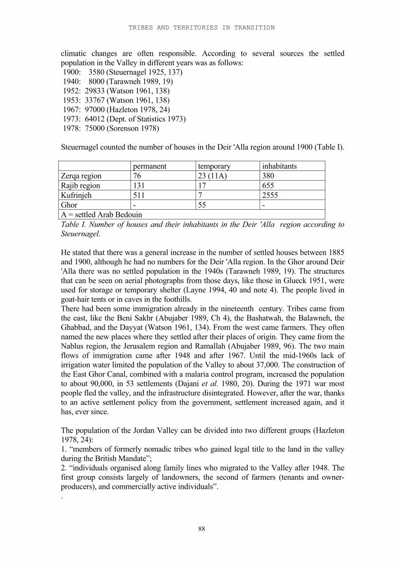
TRIBES AND TERRITORIES IN TRANSITION
88
climatic changes are often responsible. According to several sources the settledpopulation in the Valley in different years was as follows: 1900: 3580 (Steuernagel 1925, 137) 1940: 8000 (Tarawneh 1989, 19) 1952: 29833 (Watson 1961, 138) 1953: 33767 (Watson 1961, 138) 1967: 97000 (Hazleton 1978, 24) 1973: 64012 (Dept. of Statistics 1973) 1978: 75000 (Sorenson 1978)
Steuernagel counted the number of houses in the Deir 'Alla region around 1900 (Table I).
permanent temporary inhabitantsZerqa region 76 23 (11A) 380Rajib region 131 17 655Kufrinjeh 511 7 2555Ghor - 55 -A = settled Arab BedouinTable I. Number of houses and their inhabitants in the Deir 'Alla region according toSteuernagel.
He stated that there was a general increase in the number of settled houses between 1885and 1900, although he had no numbers for the Deir 'Alla region. In the Ghor around Deir'Alla there was no settled population in the 1940s (Tarawneh 1989, 19). The structuresthat can be seen on aerial photographs from those days, like those in Glueck 1951, wereused for storage or temporary shelter (Layne 1994, 40 and note 4). The people lived ingoat-hair tents or in caves in the foothills.There had been some immigration already in the nineteenth century. Tribes came fromthe east, like the Beni Sakhr (Abujaber 1989, Ch 4), the Bashatwah, the Balawneh, theGhabbad, and the Dayyat (Watson 1961, 134). From the west came farmers. They oftennamed the new places where they settled after their places of origin. They came from theNablus region, the Jerusalem region and Ramallah (Abujaber 1989, 96). The two mainflows of immigration came after 1948 and after 1967. Until the mid-1960s lack ofirrigation water limited the population of the Valley to about 37,000. The construction ofthe East Ghor Canal, combined with a malaria control program, increased the populationto about 90,000, in 53 settlements (Dajani et al. 1980, 20). During the 1971 war mostpeople fled the valley, and the infrastructure disintegrated. However, after the war, thanksto an active settlement policy from the government, settlement increased again, and ithas, ever since.
The population of the Jordan Valley can be divided into two different groups (Hazleton1978, 24):1. “members of formerly nomadic tribes who gained legal title to the land in the valleyduring the British Mandate”;2. “individuals organised along family lines who migrated to the Valley after 1948. Thefirst group consists largely of landowners, the second of farmers (tenants and owner-producers), and commercially active individuals”. .
II-5 ASPECTS OF NOMADISM AND SETTLEMENT
89
Settlement patterns
The farmers who came from the west in the nineteenth century settled mainly in thehighlands, among the local fellaheen, and those former slaves from the Sudan who hadsettled there. The Valley, as stated above, was Bedouin territory and often confronted therefugees with the same situation from which they had fled. Villages were usuallyhomogeneous, each village consisting of people from one region, and often named afterthat region.In 1948 the situation in the Valley was different. It was now cultivated, the acute menaceof the Bedouin tribes had abated, and it had a relatively low population. When the firstinflux of refugees came, eleven refugee camps were built by UNRWA workers, but thiswas not enough. People began to squat in the Valley. In the early 1960s an agriculturalirrigation scheme was planned, in order to settle the refugees. It did however not involvehousing schemes. The result was much illegal squatting on private and governmentalland. The squatting pattern is revealing. It was clear that the squatters avoided goodagricultural land; on the other hand, they wanted to be close to water and roads. Thisresulted in a linear settlement pattern, which is still characteristic of the Valley housing:people “squatted linearly along the main valley highway and parallel to the canal” (Grava1985, 1). When the East Ghor Canal was extended to the south so was settlement.Settlement maps (Grava 1985 map 2) also show linear settlement patterns on thebadlands between Ghor and Zor, especially in the southern half of the Valley, and alongthe banks of the Zerqa. In 1967 the next influx of refugees came, and six new refugeecamps were built, the largest near Kereimeh (25,000 inhabitants). After 1967, when the Valley was the scene of frequent fighting, most people fled to themountains and 60% of the dwellings were destroyed, either by the war itself or by theresults of abandonment. Less than 5000 people remained in the Valley. After 1970 mostof the people returned (Grava 1985, 1).
Until 1948 settlement was primarily in the north and south of the Valley. Between 1947and 1951 people settled equally throughout the valley, but after that there was again atendency to settle in the north and south (Watson 1961, table 45). A survey carried out atthe end of the 1950s shows that in the south of the Valley the tendency was to a less‘settled’ way of living than in the north: few stone or cement houses, more wooden huts,tents and caves (Watson 1961 table 50). Houses of mudbrick or mud and stone weredivided more or less equally over the Valley. In the Deir 'Alla region settlement tended to be dispersed, not concentrated in villages(Watson 1961, 74). One of the problems the Jordanian government had to face when theyintroduced education programmes was the fact that in the southern valley “....a largeproportion of the population is ‘semi-nomadic’ ... moving from permanent houses invillages to temporary shelters on farm lands during the period of planting and harvesting”(Watson 1961, 74). In 1985 89% of the Valley population lived in recognisablesettlements. The others lived on farms, scattered over the countryside. A villageconsisted (and often still consists) of a core of dwellings, surrounded by garden plots forfruit trees and vegetables, around which were the orchards; still further away thecultivated fields and on the periphery the grazing fields. These tendencies can already beseen in Schumacher’s description of the Hauran and the Jaulan in the 1880s (Schumacher1886;1888).
TRIBES AND TERRITORIES IN TRANSITION
90
The link with the past Because of its climate the Ghor is often considered a marginal area, in relation to thesurrounding areas. That means that in times with little agricultural settlement the Ghorwill be the last to be permanently settled. Its climate is, however, very suitable for a(semi)- nomadic or transhumant way of living; in winter it is mild, compared to thehighlands. Nomadic pastoralists used to visit the Valley in winter, returning to thehighlands in spring.Coexistence of farmers and pastoral nomads is rare in the Valley, whereas it is the normin the highlands (Mundy and Smith 1990, Abujaber (1989, Ch 4). The Plateau, andplaces like the Baq'ah valley are ideal for agriculture, which means that at most timespastoralists and farmers shared the land and cooperation would be profitable for bothgroups (Lancaster 1981, 99 ff). Since the Valley is a marginal area, it is only denselysettled in periods that see intensive settlement in general. These tend to coincide with adecline of pastoralism, so coexistence of both modes of life would rarely occur in theValley. Whenever a combination of both economic pursuits was encountered, theyproved to be in the control of (although not necessarily practised by) one and the sametribe.Agriculture and settlement was one of the Bedouin's answers to a changing society.Salzman recognizes this adaptive strategy as “the assertion of societal continuity inchanging or new circumstances” (1980, 6), a general mechanism that allows for anystrategy, or mode of existence that is the most profitable in specific situations. Thecircumstances that triggered settlement in the Valley in the nineteenth century werepressure from the government, as well as population pressure in the highlands. Territorialdivisions in the Valley, which had been created in the previous period remained intact inthis process of settlement.Although rain-fed farming is possible in the Valley, the risk involved is high. On theother hand, the structure of the Valley is such that small-scale irrigation is easy and canbe done without complicated hierarchical structures. Small-scale irrigated farming wouldresult in a linear settlement pattern along the wadis. A more highly organised societywould be able to dig and maintain larger irrigation systems, resulting in a more dispersedsettlement pattern, but still concentrated on the wadis, as can be seen in the case of Deir'Alla, where the canals that were reopened were the remnants of an earlier, moreorganised society. Its maintenance already involved a relatively complicatedorganisation, which developed consequently.
The Jordan Valley in the Late Bronze - Early Iron Age TransitionUntil the building of the Ghor Canal, which made large-scale irrigation in the Valleypossible, the ecological context of the region was basically the same as in the LateBronze and Early Iron Ages. Settlement in the Late Bronze Age in the area of study washigh compared to other regions in the same period (Map fig. 11-2; Leonard 1989). The Late Bronze Age settlement pattern in the region of Deir 'Alla and Sa'idiyeh suggeststhe presence of an organised society and a reasonably strong government that stimulatedsettlement. Most of the sites were settled towards the end of the Late Bronze Age (Ch.11). Only a few sites were settled early in the Late Bronze Age, and most of these weredeserted towards the end of that period. The significance of this settlement developmentwill be discussed in Ch. 11. The most important aspect of it in the present context is theconcentration of Late Bronze Age sites in a period that was notorious for its lack ofsettled occupation outside the large towns.
II-5 ASPECTS OF NOMADISM AND SETTLEMENT
91
Most of the sites that were settled towards the end of the Late Bronze Age are foundalong the wadis; most of the sites that were deserted towards the end of the period arefound on the plain, away from the wadis. This tendency, to settle alongside water iscomparable to the situation in the Valley after the construction of the Ghor canal and theinflux of large groups of refugees. Most of the sites are found in the Ghor, the areapreferred for agriculture.
Pastoralists and farmersThe Valley used to be a winter station for pastoralists because of its mild winter climateand fertility. The nineteenth century Bedouin considered their winter pastures in theValley part of their territory, and this was acknowledged by the Ottoman and Britishauthorities in their land divisions. The Bedouin of the nineteenth century had managed todrive away most of the farmers. The few that were left were regularly robbed, and theBedouin themselves also practised some agriculture on a small scale. This situation wasmade possible because government was weak and did not interfere with the affairs of theBedouin. The same situation may be found in the Late Bronze Age, north and south ofthe area of study, where (apart from the city state of Pella) virtually no settled occupationwas found. Historical arguments for the existence of nomadic robber bands in this regionhave been touched upon in Chapter 1 and will be discussed in Chapter 14.At the same time a different kind of pastoralism may have existed in the area under study.McGovern (1986, 6) mentions the spring migration that until recently took place betweenthe Jordan Valley and the Baq'ah Valley, through the Wadi Zerqa, and assumes theexistence at the end of the Late Bronze Age of a symbiotic relationship in the Baq'ahValley between the settled population and a semi-nomadic population, which migrated tothe Valley in winter.The settlement pattern that evolved in the Early Iron Age shows some of the samecharacteristics as that of the period after 1948: close to water (Wadi Zerqa, Wadi Rajiband Wadi Kufrinjeh all used to be perennial streams), and close to fertile soil, but not onit. It seems that at the end of the Late Bronze Age the inhabitants of the region moved tosites closer to water, which resulted in the new settlement pattern. The ethnographicmaterial, however, suggests that a group of newcomers from elsewhere were partlyresponsible for the new settlements. So does the fact that the number of settlements at theend of the Late Bronze Age and in the Early Iron Age is much larger than that in theearlier Late Bronze Age. The settlement pattern indicates that these newcomers practisedfarming. Most of the new sites were found along the Zerqa. The Zerqa valley is one ofthe main routes from the Valley into the highlands, and the very fertile Baq'ah valley.Comparison of Deir 'Alla final Late Bronze and Early Iron Age pottery with that of theBaq'ah region shows a similarity in household vessels that strongly suggests a relationbetween the two regions (van der Steen 1997; Chapter 7).
Reasons for settlementSedentarisation of (semi)nomads may have different causes. First there is the basicdifference between 'falling out of the nomadic cycle' at the top, or at the bottom (Barth1961, 105 ff; Cribb 1991, Chapter 4). Examples of rich tribe members that fell out 'at thetop', because of too much wealth, are given by Abujaber for the process ofsedentarisation on the highlands at the end of the eighteenth and in the nineteenthcentury. They still had considerable influence in the dealings of the tribe. Falling out 'atthe bottom', because of lack of resources, also leads to settlement, as shown above, but inthe marginal areas and/or in the service of the rich pastoral nomads.
TRIBES AND TERRITORIES IN TRANSITION
92
Although used by Bedouin as winter pasture in the nineteenth century, the Valley wasonly settled by people who had fallen, or rather been driven, out of the nomadic cycle onthe highlands, usually in the service of those Bedouin. The scale of these movements wasnever large; the settled population in the Valley around 1900 was still only about 3600people. It was population pressure in other areas, the highlands and western Palestine,that led to maximum settlement in the Valley, only limited by the available amount ofwater, and this not exclusively by settling nomads, but by a mixed population of settlingnomads, farmers and artisans. MacDonald (1992) has suggested that population pressureis usually the main reason for settling in a marginal zone. Reasons for the shifts into theValley of settlers were territorial struggles, in the nineteenth as well as the twentiethcentury, which were the result of population pressure. The same development is beingsuggested here for the beginning of the Early Iron Age in the Deir 'Alla region. Thereasons for population pressure in the transitional period should most probably be soughtin the international developments which also caused the Sea Peoples to move northtogether with the breakdown of the Egyptian empire. The archaeological record suggeststhat in the Amman region and the Baq'ah valley in the Late Bronze Age a complex socialstructure existed, possibly a city state structure (Hübner 1992, 159; McGovern 1986). Ithas been suggested, on the basis of the archaeological record, that (trade) relations existedbetween the Amman region and regions in Syria. Among other things, the potteryrepertoire strongly points in that direction (Dornemann 1983, 31 ff). The Amman region,as a trade centre, had a complex socio-economic structure and a high population. Wheninternational trade was disrupted, the social and economic structure of the regioncollapsed. According to the mechanisms described in Renfrew's 'Dark Age model', whichis used by McGovern to describe and explain the events in the transitional period (seealso Chapter 13), the collapse of this structure would lead to: “the establishment of smalloutlying village communities....a transference of Late Bronze technologies (notably coilbuilding of large vessels and iron industry) to the Early Iron Age frontier villages”(McGovern 1986, 343 ff). As the areas were already in contact, these outlying villagecommunities may well have formed in the Valley, along the lower course of the Zerqa.
Tribalism and territorialityTribalism, although well attested in the recent history of the region as well as incontemporary literature of the Bronze and Iron Ages, is hard to detect archaeologically. Ithas been stated repeatedly that tribes, or, as Kamp and Yoffee prefer to call them, ethnicgroups, are not by definition nomads or pastoralists; they can be found in all socioculturallevels in society, and furthermore membership of an ethnic group is on pragmaticgrounds, for political or military interests, sometimes around a strong leader. Groups canattach themselves to tribal communities, or detach themselves from them. Kinshiprelations are then formulated to 'legitimise' membership and strengthen loyalty to thetribal group (Kamp and Yoffee 1980, Cribb 1991, 52 ff, among others). Historicalsources stress the importance of this legitimisation: Rowton (1973) has extensivelyanalysed the Mari texts relating to Amorites; Egyptian and other texts concerning Šasuhave been analysed by Giveon (1971); numerous passages in the Bible show theimportance of ethnicity for Israelite ideology in the Iron II period. Kamp and Yoffee donot want to relate ethnicity to any territorial contiguity; Cribb, however, lays a clear linkbetween territory and tribalism, defining a tribe as an organisation for the control ofterritory, a territorial system. In times of unrest territorial fights can occur, resulting inshifts in territory which are consolidated in the following period. The history of Jordan inthe nineteenth century, as well as the historic sources that concern the Levant, seem to
II-5 ASPECTS OF NOMADISM AND SETTLEMENT
93
confirm this link with territory, at least in situations where the tribe has a reasonablystrong pastoralist component.
In the case of the Jordan Valley in the transitional period, the archaeological evidence isstill very sketchy. Still, some suggestions can be made. It has been proposed above that agroup of transhumant pastoralists from the Baq'ah Valley used the region around theZerqa as winter pasture in the last phase of the Late Bronze Age. With the decline of thesocial structure in the Baq'ah valley they came down the Zerqa, possibly with otherpeople from the Baq'ah Valley, and settled along the Zerqa, and possibly the Wadi Rajibas well. They may have already considered this region part of their territory. The earliestIron Age phases at Deir 'Alla have been interpreted as pastoralists in the process ofsettling (Franken 1969). The settlement pattern (see above) as well as the material culturesuggest a mixed society: pastoralists, farmers and artisans (the pottery repertoire hassimilar traits to that from the Baq'ah Valley, see also Franken 1969, 20; there weremetallurgists, as the excavations at Deir 'Alla have shown). If they still formed one group,in order to survive in their new environment, they would form a tribe or ethnic group,according to the definitions given above, and they may actually have seen themselves asone.
94
II-6 Survival and adaptation
Introduction
The Late Bronze Age in Palestine was dominated by the Egyptian empire. Even thoughEgypt was more interested in the region north of Palestine, Lebanon and Syria, it hadcontrol over Palestine, inasmuch as it was a passage towards its trading partners to thenorth and east. The main centres under Egyptian control were situated at strategiclocations and had strategic functions in relation to this trade network. Opinions differ as to the socio-economic situation in Palestine as a result of this Egyptiandomination; some scholars argue that, at least in the areas controlled by Egypt thepopulation flourished culturally as well as economically, and suffered only marginallyfrom the taxes in grain and other sustenance levied by the Egyptians (e.g. Weinstein1981, Bienkowski 1989), others state that the area deteriorated as a result ofdepopulation (Redford 1992, 208) and taxing (Knapp 1989). Towards the end of the LateBronze Age, possibly as a consequence of increased pressure by foreign powers (the SeaPeoples) or increased internal discontent (the Hapiru), Egyptian presence in the regionincreased and garrisons were stationed in the country. Possibly because of the extrapressure this caused on the economy, possibly because of internal problems in Egyptitself (Bienkowski 1989), possibly because of the external pressure, or because of acombination of all these factors, the Egyptian empire collapsed at the end of the LateBronze Age.
The effects of the Egyptian power structure and of its collapse at the end of the period onlife on the east side of the Jordan are much less clear than they are in Palestine. First ofall, we do not know exactly how far Egypt’s power extended across the Jordan, althoughit seems clear that the border of the area over which it had control occasionally shifted.The information we have for this area is limited. There are a few surveys: NelsonGlueck's survey of Transjordan (Glueck 1951); the Jordan Valley Survey conducted byIbrahim, Sauer and Yassine (1976, 1988); Gordon and Villiers' survey of the Zerqavalley (Gordon and Villiers 1983); the Wadi Yabis survey (Mabry and Palumbo 1988),Mittmann's survey of Gilead (Mittmann 1970); and McGovern's survey of the Baq'ahvalley (McGovern 1986, 7-17) provide the settlement pattern (see Chapter 4). At the endof the Late Bronze Age this consists of a number of smaller and larger sites, withconcentrations around Deir 'Alla and in the Amman area. In the Early Iron Age thenumber of small sites increased, especially along the wadis, but several Late Bronze Agesites were abandoned. Some of these sites have been excavated: in the Jordan ValleyDeir 'Alla, Sa'idiyeh, Pella, Kataret es-Samra and Abu Kharaz; and on the plains theBaq'ah valley project, Sahab, Safut and the Amman Airport Building, as well as anumber of burial caves. Few written sources are available for this period. The mostimportant are some Amarna letters from the fourteenth century BC referring to Pella, andsome thirteenth century Egyptian inscriptions, among them the Beth Shean stele, datedaround 1300 BC, which also refers to Pella. West of the Jordan there were land routes crossing from south to north, and sea-routesgoing further north to the towns of Phoenicia: Tyre; Byblos; Ugarit; and later Sumur.There were routes branching off from these, roads going east. One of the main routesinvolved the crossing over the river Jordan, past the Beth Shean garrison. After crossingthe Jordan, this route turned south past Pella towards Deir 'Alla , where it turned east andfollowed the Wadi Zerqa until it came into the Baq'ah Valley and the Plain of Amman.This was a major market area, which in its turn had connections with the north ( Chapter
II-6 SURVIVAL AND ADAPTATION
95
3 and van der Steen 1996). This trade network seems to have shaped the history of theregion east of the Jordan and been instrumental in the events that followed. Therefore inthis chapter three main stages of this - proposed – route, Pella, the region of Deir 'Alla,and the Amman Plateau, will be examined and compared to parallel circumstances in thenineteenth century AD.
Pella: Robbers of the trade caravans
The Jordan Valley in the nineteenth century ADNineteenth and twentieth century sources show that the Jordan Valley was Bedouinterritory (cf. Chapter 5 and van der Steen 1995). In the beginning of the nineteenthcentury the Pasha of Damascus still officially received tribute from the Bedouin but oftenthey withheld their share. This usually resulted in skirmishes and sometimes in war. TheBedouin had their own economy, independent of the empire. They had their own towns,like Salt, Nablus, Kerak, Hebron, and their own trade between them. In the Belqa the only inhabited place was Salt. It was governed by a coalition of tribes,and it was the political and economic centre of the region (Burckhardt 1822, 349).Depending on their means of living, it was not unusual for members of a tribe to settleand build strongholds, or sometimes to use and rebuild older strongholds that had goneout of use. Bell (1907, 35) mentions a Saracen fort, repaired by a Beni Sakhr sheikh,'with a splendour unknown to the desert'. The Howeitat built towers or small castles inthe villages they controlled in Edom (Burckhardt 1822, 403 ff). Areas where the Bedouin ruled, like the Galilee and Jezreel, the Ghor and the Belqa wereconsidered very dangerous areas for travelling. Travelling to Amman or to Kerak was aparticularly dangerous undertaking, because of the wars between the Beni Sakhr, theAbbad and the Adwan tribes. At the same time, to make things even more complicated,there were large parties of Sherarat Bedouin from the south, who pastured their camels inthe area. There was little the government could do. In 1810 the Ottoman army had foughtthe Beni Sakhr and lost (Burckhardt 1822, 368). The disastrous expedition in 1847 ofMolyneux down the Jordan with a boat, in 1847, which was robbed because they refusedto pay the khawa is a case in point. Even at the beginning of the twentieth century Belldescribes the Bedouin's constant ghazus, and every traveller’s fear of them (1927, 195;1907, 10). She still could not travel without rafiqs, guide/protectors belonging to the tribethrough whose territory she had to pass. They were replaced every time she passed intoanother tribe's territory and had to be paid handsomely.
Pella in the Late Bronze AgePella, opposite Beth Shean, and the first stop east of the Jordan on the west - to - easttrade route, was an important site for Egypt to control. Actual Egyptian presence at leastat some stage is suggested by the Egyptian sarcophagi found there (Yassine 1975, 60n.11, Bourke and Sparks 1995). Pella is mentioned in a number of Egyptian sources(Smith 1973, 23 ff, and see Chapter 1). These mainly show that it was not exactly a loyalsubject. The Amarna letters from the fourteenth century BC show that, at least in theperiod in which they were written, Pella came under Egyptian supervision, possibly as akind of city state. In letters 255 and 256 the ruler of Pella, Mutba'lu, defends himselfagainst accusations of delaying a trade caravan and hiding a rebel (Moran 1992, 308-310). Shortly after these letters were written Pella seems to have wrenched itself free ofthe clutches of the Egyptian empire. The Beth Shean stele from around 1300 (ANET253) describes a conspiracy of Pella with other towns against Beth Shean. Pharaoh Seti Isends troops to Hamath, to Yanoam and to Beth Shean, but not to Pella. In the same
TRIBES AND TERRITORIES IN TRANSITION
96
period, the first half of the thirteenth century BC, Pella appears regularly in lists of citiesconquered by Seti I and Ramses II. These lists are standardised, repeating the same city-names in the same order every time: Pella; Hamath; Beth Shean; Yanoam. This list maywell have become a pars pro toto for a rebellious region, and it is doubtful that all thesecities were actually conquered in these campaigns, especially since Pella lay on the otherside of the Jordan. It does show, however, that Pella was no longer subject to Egypt. Anindependent and rebellious Pella may have proved disastrous for Egyptian trade to theeast, since Pella was in an ideal position to rob the trade caravans passing by its gates. The quality of the architecture in Pella deteriorated gradually in the course of the LateBronze Age. On the other hand, the evidence from the tombs shows that the quality oflife did not suffer; the fourteenth and thirteenth century tombs were rich in luxuriousfinds (Smith 1973, 13 ff), and while the indigenous material culture deteriorates, theamount of luxurious import goods increases. The area around Pella was largelyuninhabited in the Late Bronze Age. A survey of the JADIS database (Palumbo 1994)suggests that Late Bronze presence in the area mainly consisted of scattered sherds, witha temple at Abu Kharaz as a possible exception. In the hills east of Pella were twofortified sites (JADIS nrs 2221.001 and 2422.007). The archaeological evidence from Pella so far does not suggest a change of populationduring the Late Bronze Age. It may therefore have been a tribal stronghold at thebeginning of the Late Bronze Age, the 'Residence Building' being part of it. Early in theLate Bronze Age, Egypt must have either conquered it, or, more likely, made a trucewith it, in order to safeguard its trade route to the east. The settlement pattern suggeststhat the Ghor and the foothills around Pella were not a safe area to live in during most ofthe Late Bronze Age. The main evidence of Late Bronze occupation consists of sherdscatters, most indicative of a nomadic or semi-nomadic population in occasional contactwith a more sedentary population (from which they acquired their pottery), and somefortifications in the mountains.The truce lasted until sometime after the Amarna letters were written, but the Egyptiansources suggest that it stopped soon after that. The temple at Abu Kharaz existed untilLate Bronze IIA, and “gives the impression of being hastily abandoned” (Fisher 1991,80) at a moment that may well coincide with the time when Egypt finally lost its hold onthe area.
Pella, once it had regained its independence, and become fully dominant in the area, maywell have proved a robbers' den, a stronghold held by a rich tribal family or sheikh, whoruled the area and controlled operations from his eagle's nest. Trade caravans, in order topass through, would either have to be heavily protected by soldiers, or buy safe passage.The archaeological evidence suggests that at the end of the Late Bronze Age theEgyptians were actually forced to change part of the trade route. They started to cross theJordan south of Pella, and they built a fortress to protect this crossing, Tell es-Sa'idiyehbeside the Jordan. This was built at the very end of the Late Bronze Age, possibly at theend of the thirteenth or the beginning of the twelfth century, as an Egyptian fortress(Chapter 3). Tubb has interpreted one of the buildings as another 'Governor's Residence'.Its position is strategic, in order to protect a ford in the river Jordan on the side whereEgypt's control was weakest. Its architecture and the burial site that belongs to it stronglysuggest that it was built and used by Egyptians (Tubb and Dorrell 1991, 69; Tubb andChapman 1990, 109). The evidence of the Beth Shean stele (see Chapter 1) suggests thatthe raiders of Pella may have reacted to this move by extending their field of operation tothe other side of the Jordan.
II-6 SURVIVAL AND ADAPTATION
97
Settlement patterns and the regional market at Deir 'Alla
The next stop on the route was the sanctuary of Deir 'Alla. In the Late Bronze Age thiswas a well-populated area, certainly compared to the areas north and south of it (Leonard1989). Franken, excavator of Deir 'Alla, has maintained that Deir 'Alla was the centre ofa regional market, where goods were exchanged and contracts validated in the sanctuary(Franken 1992, 165 ff). Taking this idea one step further would mean that it is probablethat this market was part of the west-to-east trade route. Deir 'Alla itself was a Canaanitesite, as is clearly shown by the archaeological record. There are, however, clearindications that Egypt had control of the Deir 'Alla market region. One of these is thestronghold at Tell es-Sa'idiyeh, built by Egyptians to protect the route at its weakestpoint. There are, however, ethnographic arguments as well. Settlement patterns in the nineteenth century ADIn the nineteenth and twentieth centuries settlement in the Valley was generally north ofthe Deir 'Alla district (Watson 1961). With every settlement wave the Deir 'Alla districtwas the last to be settled. There were several very practical reasons for this. In the norththe soil was better and so was the water, if only because there was less salt in it (aoBender 1968, and Chapter 2). The climate may also have been better because the area isnot so low. Our sources show that settlement and safety are closely connected. Areas ruled byBedouin were never popular with settled populations. Nineteenth century travellers havegiven us a lively description of the Valley, when the Bedouin roamed free. Lynch forexample described it as "a perfect desert, traversed by warlike tribes". Villages wereraided season after season by the Bedouin, until the inhabitants gave up and left (e.g.Tristram 1866, 546).Where raiding Bedouin roamed settlement disappeared. On the other hand safety andstrong governments protected the area and enhanced settlement. A settled population wasclearly in the interest of a government, either local or national. In recent historygovernments actively stimulated settlement, because a settled population is easier tocontrol, and because it is much easier to extract taxes from it. One of the reasons why theOttoman government invented the Land Laws in 1858 and encouraged agriculture wasthat it needed money to compete with the industrialised West. Examples of stimulated oreven forced settlement of nomadic groups by governments can be found in many studieson Near Eastern nomadism and sedentarisation (a.o. Salzman 1980, Lancaster 1981).
Settlement patterns in the Late Bronze AgeIn the Late Bronze Age the area that was best suited for settling, the area around Pella,was practically devoid of settlements. This strongly suggests that the area was not verysafe to live in, possibly because of the robbing and raiding practices of the inhabitants ofPella. On the other hand, the area around Deir 'Alla was relatively densely settled (mapfig. 11-2, see also map in Leonard 1989). This settlement started in the second half of theLate Bronze Age. This density of settlement in the Deir 'Alla region points to some kindof government, which, either by its presence alone and the safety and stability it providedor by active stimulation, must have caused a concentration of settlements in an area thatunder different circumstances would have been one of the last to see permanentsettlement. The question whether they were simply farmsteads or part of a larger‘planning’, and if so how it was organised can only be determined if we know the natureof the individual sites, which of course is impossible without excavating them.Unfortunately very few of these sites have been excavated (see Chapter 9 for one of
TRIBES AND TERRITORIES IN TRANSITION
98
them), and many of them have now disappeared, victims of the intensive horticulture ofthe region.
A trading centre on the Amman Plateau
The last area to be reviewed is the Baq'ah Valley and the Amman Plain, at the east endof the Wadi Zerqa, from here on called the Amman region. This again was a marketarea, connecting the trade with the west (Deir 'Alla) and the north. Although it was partof a trade route supported by the Egyptian empire there are no clear indications that theEmpire actually controlled this area (also Ji 1997, 30). First of all there are no writtensources referring to this area. Redford (1982) has suggested that in the early days of theLate Bronze Age the King's Highway passed through the area, but his arguments are notconvincing (Chapter 1). As for the material remains, a number of sites, the AmmanAirport Building (Harding 1958, Hennessy 1966, 1985); Mabrak (Yassine 1983); Rujmal-Henu (McGovern 1989, 13); and Khirbet Umm ed-Dananir (see Chapter 3 for adescription of these sites); have revealed buildings that are related architecturally. Eventhough the buildings themselves may have had different functions, they seem to havebeen the achievement of the same cultural group. Architecture, pottery, the function ofthe Amman Airport building (if the interpretation of Herr (1983) is correct, which itprobably is), the habit of cremating the dead, and possibly even some of the bones(Little in Herr 1983) suggest the presence of a northern group, possibly Hittites. Khirbet Umm ed-Dananir was the centre of a relatively densely settled area, the Baq'ahvalley at the entrance of the Zerqa valley. This gateway position, as well as its fertilityand resources all made the area one of the most important links in the trade route.Khirbet Umm ed-Dananir itself appears to have had a cultic function (McGovern 1989).The repertoire of the burial caves as well as the habit of burying the dead in multipleburial caves are again indicative of a Canaanite population.A number of other burial sites have been found in the region, at Abu Nseir (Ghanimeh1984), Jebel Nuzha (Dajani 1966) and in the Baq'ah valley (McGovern 1989), all ofwhich were multiple cave burials.
Sahab was continuously occupied from the fifteenth century into the Iron Age, andseems to have been a large and possibly walled town for most of this period (Chapter 3;Ibrahim 1972, 1974, 1987). There were Egyptian finds in the town as well as in theassociated burial caves, but nothing that suggests actual Egyptian presence. Thearchitecture was Canaanite in character, as were the multiple burials. Only the presenceof possible wooden coffins in one of the caves might suggest an incidental presence ofEgyptians (although burial in multiple burial caves must have been a conceptcompletely alien to them). On the other hand, the same cave revealed bones which mayhave been cremated (Ibrahim 1972), a cultural trait more at home in the north andpossibly related to the Amman Airport Building; it also revealed double pithos burialswhich similarly seem to originate in the north (Negbi 1991, 1998).
Trade relations in the nineteenth century ADRegional market centres or market regions were not uncommon in nineteenth centuryJordan. Bedouin caravans transporting trade goods were a well-known phenomenon, aswas smuggling by Bedouin (e.g. Lancaster 1981, 105). Dera’a, which in Schumacher'sdays was considered the capital of the Bashan region, functioned as such a regionalmarket. Traders from Damascus came here to exchange their goods (Schumacher 1886,121 ff). He describes it as surrounded by the tents of the Damascene traders.
II-6 SURVIVAL AND ADAPTATION
99
Surrounding the town were villages which were also involved in the trade, either asproduction centres or as trading outposts. Many of them had large gardens and orchards.
El-Mezeirib, close to Dera'a, was the first stop for the Hajj from Damascus, and thehabitual stop for Bedouin caravans carrying grain from the west and for the pilgrims toMecca. It had a well-stocked suq and was frequented by fellaheen and Bedouin alike.
Salt too was a regional market where Bedouin came to exchange their products for grainand other things (Abujaber 1989, 69 ff). It also functioned as a transit market for themarkets in Nablus and elsewhere. There was no empire or actual governmentcontrolling this arrangement: it was a system that functioned more or less independentlyand was in the hands of the two main tribes who were dependent on it, the 'Adwan andthe Beni Sakhr. It kept itself going, as long as there was a balance in incoming andoutgoing trading goods, and all the parties involved benefited from it. The Salt region,which was on the fringe of the desert, and therefore of the territory of the Bedouintribes, formed a natural trading area. In Yadudeh in the nineteenth century there was acommercial corn-grower, and also in Tneib, where corn was sold to the Bedouin (Bell1907, 26, 40) In nineteenth century Salt nomads from different areas functioned asmiddlemen for the markets in Nablus and Jerusalem. In the early days there were nobridges across the Jordan, and the Bedouin were the only ones who knew how andwhere to cross the river in winter (Burckhardt 1822, 345) so it was they who as a matterof course conducted trade with the other side of the Jordan.
That tribal control of trade did not limit itself to regional exchange of foodstuffs isdemonstrated by the examples of Gaza and Hebron. Gaza (Stanley 1856, 257) was thefrontier city of Syria and the desert for the southwest, as was Damascus for thenortheast. It was a central market place for the Bedouin, and one of the starting points ofthe Hajj. In the time of van de Velde (1851-2) Gaza was a large unwalled town,surrounded by olive groves. According to him the town was a gathering place fortraders travelling from and to Egypt (1854, 180). It counted about 16,000 inhabitants.Porter (1891, 204) describes Gaza as a cluster of villages, with cultivated fields aroundand between it. The population consisted of "a fierce and lawless set of fanatics", settledBedouin involved in agriculture and trade, mostly belonging to the Tarabin and theHanajera. The appointed governor had enough authority to protect travellers within thetown but not outside it (also van de Velde 154, 180). The black tents of the tribes couldbe seen everywhere in the valley of Gerar. Smith (1896, 181) also noticed the fertility ofthe area around the town, with 15 wells and broad gardens. The Arabian trade withEgypt came through Gaza, and the pilgrimage to Sinai, to Jebel Musa, was alsoorganised from Gaza.In the middle of the nineteenth century Hebron had 5000-7000 inhabitants (Seetzen1854, 44; van de Velde 1854, 89). It was surrounded by cultivated gardens and fields(also Stanley 1856, 99) with wheat, olives, figs, cherry trees and vineyards. The townitself had some industry, soap and glass, and a lively market. It had been and still was acentral point for a number of trade routes: to Gaza to provide the Egyptian market;through the Negev direct to the Egyptian Hajj route; and to Edom, where Hebronmerchants were stationed. Bedouin tribes controlled this trade and provided the camelsnecessary for it. There were several tribes living in the area, like the Sowakera, theJehaleen and the Ka'abene. Sometimes the Tarabin and the Tiaha also camped aroundHebron. The government had some control over Hebron, but according to van de Velde
TRIBES AND TERRITORIES IN TRANSITION
100
the area to the south of it was Bedouin territory, over which the government had nopower. This situation was more or less the same at the end of the nineteenth century (Smith1896, 318), although Gaza had outstripped Hebron as the port of the desert. Eventhough Hebron fell within the area of effective control of the government, the power ofthe Bedouin was considerable, since they controlled the trade with the south.
Trade in the Late Bronze Age It can be assumed that in the Late Bronze Age trade, nomads or transhumant pastoralistsplayed an important role in the trade-based economy, not only as providers of meat andother animal products, but also as traders and carriers of trade goods. The lack ofwritten sources as well as the very limited Egyptian remains in the Amman region(including Sahab) make it unlikely that Egypt controlled this market. The materialremains point to a basically Canaanite population, with possibly a strong presence ofpeople with a northern background. As in the nineteenth century AD, merchants orrepresentatives of northern cultures may have been stationed in the area, for thisstationing of merchants in trade colonies or foreign trade centres was not unusual.Already in the nineteenth century BC the Assyrians had a trade colony in the city ofKanesh in Anatolia where representatives were stationed on a permanent basis (Veenhof1986). It is possible that these northerners were in control of the market area. That seemsunlikely however, in the light of the geographic and economic position of Sahab.However remote it may have been from the core of the central area, geographicallyspeaking, the finds suggest that Sahab was the main trade centre in the area. At the sametime its position, on the fringe of the desert and the sown, made it into a gateway town,connecting the people of the desert with the Amman plains market area. This stronglysuggests that control was in the hands of the indigenous population.
So the area taken as a whole sustained a mixed population consisting of Canaanites,either settled or (semi-)nomadic, who must have formed the original population, andpeople from the north, who entered the area in the Late Bronze Age. Egyptians, if therewere any at all, must have formed a very small part of the population. It seems likelythat Egyptian traders did not come this far east, but traded their goods in Deir 'Alla,from where they were taken further east by other merchants, who travelled between theAmman region and Deir 'Alla, and possibly also between the Amman region and thenorth. These people may have belonged to the local Canaanite population, or they mayhave been northern colonists. Perhaps elements of both populations were involved inthis track of the trade route.
McGovern (1989, 6) has already suggested that there was a transhumance route betweenthe Baq'ah valley and the Jordan valley, through the Zerqa valley (see Chapter 12). Ifwe assume that these people had their winter quarters on the lower course of the Zerqa,they must have considered this area as part of their territory. The surveys so far haverevealed Late Bronze Age material on a number of sites in this area: the northern banksof the lower Wadi Zerqa. All of this material can be dated to the second half of the LateBronze Age (Chapter 11). Recent excavations at another site in the Wadi Zerqa, Tel el-Hammeh, have revealed thepresence of Late Bronze Age I and II layers (Chapter 9; van der Steen 2001). Theoccupation consisted of surfaces where household activities like cooking had takenplace. No structures were found, with the possible exception of one or two partitions
II-6 SURVIVAL AND ADAPTATION
101
made of loose boulders. Only a very small area has been excavated and the presence ofstructures in other areas cannot yet be excluded. So far, however, the evidence supportsnomadic or semi-nomadic (seasonal) activities. The pottery, on the other hand, was ofgood quality, well made and sometimes very fine in nature. It was luxury ware, notsuitable for the rough day-to-day activities of a pastoralist group. It seems perfectlypossible that this was, at least during the Late Bronze Age, a temporary camp used bypeople involved in the trade.
In a nutshell, the situation east of the Jordan at the end of the Late Bronze Age showsPella, in the time of the Amarna letters still in the Egyptian sphere of influence, havingwrenched itself free and now a menace and a threat to its environment. The area aroundSa'idiyeh and Deir 'Alla was a market area controlled by Egypt, the starting point of thetrade route through the Zerqa valley. This trade route ended on the Amman plains,where there was another market area, a transit market for goods from differentdirections, controlled by the local population and possibly colonists from the north.
The collapse: the Amman region
At the end of the Late Bronze Age the great empires of the Levant started to crumble,and with them the international trade, which had been upset by international events. Inthe north the Hittite empire collapsed from causes that are not entirely clear, but theyseem to have affected the Balkan and the Aegean world, and they may also have causeda population movement that we know as the coming of the Sea Peoples. The SeaPeoples are best known to us from the inscriptions in Medinet Habu by Ramses III(ANET 262-263), where five different groups of people are mentioned, either asmercenaries or as enemies of Egypt. One of these groups were the Peleset, thePhilistines of the Bible. These groups have been connected with a series of destructionsalong the Levantine coast at the beginning of the Early Iron Age, and with new elementsin the material culture of the southern Levant, notably a new pottery style (Dothan1981). Both the historical sources and the material culture suggest that this ‘invasion’ ofSea Peoples was a gradual process, that may have lasted several decades (see also Noort1994). Populations in the north, probably the Aegean, were made homeless because ofevents in their homeland and, looking for a new home, they settled along the SouthernLevantine coast in small groups amongst the Canaanites. Over the years more wavescame, from the same area and probably for the same reasons. Their adaptation to theirnew homeland took different forms, as some (of the earliest groups) becamemercenaries in the Egyptian army, whereas others built villages and towns and tried torebuild their old life in the new country. Some tried to fight their way in, as both theinscriptions in Medinet Habu and the destructions in the coastal region show. It is to be expected that the same events that uprooted these groups also affected thetrade between the Amman Plateau and the north. What the archaeological record showsis that some major events at the end of the thirteenth century seriously affected thewhole area: sites either disappeared or changed completely at the end of the Late BronzeAge and the beginning of the transition to the Iron Age (McGovern 1986). 'UmeiriPhase 4 in field C differed considerably from the preceding Phase 5: a retaining wallwas built, and there are indications of industrial activity (Geraty et al. 1989, 270). Phase4 is dated at the very beginning of the transitional period. In Sahab the change came atthe end of the thirteenth century: the town wall went out of use and occupation wasmore extensive, but there seems to have been a decline in architecture, and a destructiontook place somewhere in Iron Age I. Egyptian objects were however still found,
TRIBES AND TERRITORIES IN TRANSITION
102
especially in the burial caves (Ibrahim 1972; 1974; 1987). The Amman Airport Buildingexisted until the end of the thirteenth century, although some of the local pottery hasbeen dated to the transitional period (Hankey 1974; Kafafi 1983). This pottery,however, may have belonged to the latest phase of the building, in which it had acompletely different lay-out and function from the preceding period. In Safut there wasno break in occupation, but the Iron Age population seems to have been less dense andprosperous than the preceding Late Bronze Age population (Wimmer 1987). KhirbetUmm ed-Dananir was destroyed at the end of Late Bronze Age IIB (McGovern 1986,61). One of the the three burial caves attributed to it continued to be used into the EarlyIron Age, although no occupation has been found that can be dated to the Early IronAge, with the exception of some scattered sherds (JADIS site 2216.009). Some sites,like the building at Rujm al-Henu (McGovern 1986:13) and the Jebel Nuzha cave(Dajani 1966), seem to have continued to function without interruption.We cannot deduce from these changes alone what made them happen. Nothing points toinvasions of any kind. There are no new influences, no new pottery, no cultural break.In some places the people seem to have lived their lives uninterrupted, the only changebeing a decline in prosperity. Khirbet Umm ed-Dananir, the gateway between the ZerqaValley and the Baq'ah Valley, was deserted. Other sites became smaller, like Safut, orunderwent a change in function, like 'Umeiri. Sahab grew larger, if anything. And, likeeverywhere in the region, the number of small sites increased with the beginning of theIron Age.The next phase was marked by a more egalitarian society with smaller settlements.
In general the human factors involved in change can be divided into: 1) the quest forfood, 2) local and international political pressure, and 3) population pressure (Chapter 5;also van der Steen 1995, 144). These factors tend to influence each other, andexplanations for particular events usually turn out to be a combination of them. In thecase of the collapse of Late Bronze Age society, the 'international politics' factors arethe unknown events in the north that brought the Sea Peoples to the coast of Palestine,and the decline and disintegration of the Egyptian empire. The importance of thisdecline for the changes in the region has never been doubted, and the disintegration ofthe infrastructure supporting it and supported by it offers part of the explanation. It has been stated above that the Amman region was in fact independent and not aperipheral part of the Egyptian empire. The events at the end of the Late Bronze Ageand following the collapse of the trade confirm this. There are, for example, noarchaeological indications for decline in the second half of the Late Bronze Age, asthere were in the peripheral areas of the Empire (Bienkowski 1989, 61). Egypt couldtrade with the Amman region but it could not tax it and drain its resources, as it did withits own peripheries (a.o. Redford 1992, 209 ff). Since the economy in the Ammanregion was completely dependent on trade, the main cause for the collapse here was thisexclusive dependency, which could, in a way, be seen as overspecialisation (Renfrew1979, 487). As long as the trade flourished, so did the region. When external causes puta stop to the trade, this affected every economic activity involved and collapse wasunavoidable.Since markets, trade and prosperity always attract people, it was a densely settled area.Overpopulation must therefore have become a problem. With a large number of peopleinvolved in trade, food production must have been specialised. There were producers,buyers, and probably also importers and exporters of food. So the different aspects ofthe 'quest for food' were regulated along certain formalised lines. These lines wereinterrupted and the people had to look for other ways to acquire their daily bread.
II-6 SURVIVAL AND ADAPTATION
103
Traders and colonists from the north no longer came to the area, so specialised sites, likethe Amman Airport cremation site or the cultic centre at Khirbet Umm ed-Dananir, losttheir function and disappeared. Other sites with a regional function turned intoinconspicuous villages, like the temple at Safut. Its inhabitants may still have countedon the protection the local deity had to offer, but the temple lost its regional function.
Collapse in the nineteenth and twentieth century ADIt is a well-known phenomenon in our times, that sudden impoverishment and thedisintegration of societies drives people from the country into the cities. The shantytowns of Africa and Latin America are sad examples. The most recent example is that ofEastern Europe, where the collapse of communist society resulted in the disintegrationof the economy and of the society (urban as well as rural), since communism and itsinstitutions had previously been regulating life in most of its aspects. Here also theeffect was an exodus from the countryside into the cities and the development of shantytowns. A direct comparison of this phenomenon with the Late Bronze Age is of coursedangerous because of differences in scale and economic structure, to mention only twofactors. Still, they may have some points in common, which deserve to be stressed herein an effort to understand what happened in Sahab. Cities are activity centres,interacting with and performing a service function for the region. In a region that isinvolved in trade, especially long distance trade, the city may become the trade centre,where transactions are settled and where the different trading 'houses' have theirrepresentatives (like the Assyrian representatives in Kanesh - see above). Wealth,prosperity and material goods tend to concentrate in cities, usually in the form of small,portable items, like precious metals and jewellery and, nowadays, banks and bankaccounts. It is also a well-known phenomenon in the nomadic societies of the Near East,that the rich sheikhs of very prosperous tribes had houses in the cities that were lavishlydecorated and where they could show off their wealth (Bell 1907, 112; 1927, 134;Steuernagel 1925, 216). Therefore, cities as trading centres were not only rich, but alsohad the reputation of being rich, which is a guarantee for attracting people, keen togather the scraps of this presumed wealth. Furthermore, because of the concentration ofwealth, the city built up economic reserves for bad times. The general decline willeventually strike the city as well as the country, but as long as the wealth is not drainedout of the city itself it may be able to fend off the disastrous results for a while. Whenpoverty strikes the countryside, people are drawn to the cities (see also Safrai 1998, 130ff).
Sahab in the Early Iron AgeSahab was a town that may have been home to a few thousand inhabitants. Itsprosperity can be seen in the town itself and in the burials; the variety of burial habitssuggests a mixed society, with a dominant Canaanite element. It is likely to have beenthe economic and possibly administrative centre of the Amman region as well as thelink between the desert and the sown. The people who organised and conducted thetrade were to be found here, or had their representatives here, and their wealth musthave accumulated. When the trade declined and the economy of the region collapsed atthe end of the Late Bronze Age the whole region was suddenly confronted with a loss ofincome. People reacted in different ways, as can be deduced from the archaeologicalrecord. The number of new small settlements in the area indicates that many reverted toagriculture, and probably also pastoralism, on a subsistence base. Some moved downthe Zerqa valley to the Jordan valley and integrated into the Deir 'Alla market area that
TRIBES AND TERRITORIES IN TRANSITION
104
was still functioning (see below). But the archaeological record shows that a largenumber of people, probably those who were poorest, moved to the city, the centre ofwealth and prosperity, in search of food and protection.If the town had been an Egyptian administrative centre it would have been dismantledand, deprived of its wealth, it would have been one of the first elements in the system todisintegrate. That is what happened somewhat later in the Deir 'Alla market area.Nothing of the kind seems to have happened here however, which is another indicationthat the region’s economy was independent.
Immigration in the Jordan Valley
Another response to the collapse of the infrastructure and the social system was forpeople to move out of the region and find a new place to live. Oppenheim (1943, 148)states that tribes, when uprooted and looking for new territories, tend to go to places thatthey already know, and consider part of their territory: “Sonst bestätigt sich dieErfahrung daß die Stämme in derjenigen Richtung auswandern, welche sie bei demWechsel zwischen Winter- und Sommerweide einschlagen, auch in Transjordanien”. For the transhumant groups who had been involved in the trade through the Wadi Zerqain the previous period, the place to go was the Jordan Valley, alongside the lower banksof the Zerqa, a region that they knew and considered part of their territory.
Immigrants in the nineteenth and twentieth century ADThe immigration into the Deir 'Alla area following the collapse of the Amman trademarket can be compared to what happened in the East Jordan Valley in 1948, when astream of refugees started to arrive from Palestine. At that time the East Jordan valleywas settled, but not very densely. In the area of Deir 'Alla itself people lived in tents, butthe 'settled' population (people living in houses) in the Valley amounted to some 8000people in 1940 (Tarawneh 1989, 19).In 1858 the Ottoman land laws had set the standards for land ownership, agriculturalproduction and, most important from their point of view, tax collection. Ninety yearslater, in 1948, the infrastructure and social hierarchy had hardly changed (Tarawneh1989, 53 ff). Land and water were controlled by the clan leaders, who exploited directproducers, the kharratheen (ploughmen). The main products from the Deir 'Alla regionwere wheat, barley, white maize and sesame. Part of the surplus went to the state as tax;the rest was divided between the kharrath and the sheikh. The sheikhs sometimes tradedsome of this surplus on the markets of Nablus or Salt. In the nineteenth century part ofthe surplus was also given to the 'Ajlun clans as khawa, protection money.In the 1940s there were only a few villages in the Valley (Aresvik 1976, 30; Glueck1951). The Palestinians entered a social environment that was comparable to that whichthey had left behind.The craftsmen - smiths, carpenters, potters, etc. - settled in thisenvironment with relative ease and speed. Originally many settled in the existingvillages, which grew considerably after 1948. With the growing population new villageswere created. In 1952 the population of the Valley had grown from 8000 to 29,833, in1953 to 33,767 (Watson 1961, 138). For those who had been farmers in Palestine the situation was less easy. It was clear thatthe people who already lived in the area had the strongest claims. Still, the newcomersmanaged to find a place in the existing society. Some of the Palestinian farmersobtained jobs in the service of the old clans. Others started to cultivate the lessfavourable areas that had so far been left alone by the old clans. Large new areas wereopened up and claimed for farming (e.g. Tarawneh 1989, ch. 4).
II-6 SURVIVAL AND ADAPTATION
105
Refugee camps were built by UNRWA workers, but these soon filled up and, as thepeople continued to come, the Valley filled with squatters. Other needs became urgent,the need for water and cultivable land being the first. In the early 1960s an agriculturalirrigation scheme was planned. which would open up more land to agriculture andprovide water to a larger area. The plans did not, however, include housing schemes,and the result was that people, as they had done before, squatted illegally on private andgovernment land, along the lines of the new canal and of the new roads as they werebuilt. Although the squatters would not use good agricultural land to build on theywanted to be close to it, as well as to water and roads. The result is the characteristiclinear settlement pattern of the Valley housing, along the badlands between Ghor andZor, especially in the southern half of the Valley, and along the banks of the Zerqa.
Deir 'Alla: Immigrants at the close of the Late Bronze Age.When the infrastructure in the Amman region collapsed some of its population movedto regions where a comparable infrastructure still functioned, like the Deir 'Alla region.Here they could try to integrate into a society they knew and continue as best theycould, the kind of life with which they were acquainted. The archaeological record ofDeir 'Alla shows an influx of craft specialisations from the east, at the very end of theLate Bronze Age, in a period just before the infrastructure collapsed here as well.Pottery shapes and production methods, and possibly a metal industry, were brought inby wanderers from the Amman plains (Chapter 8 and van der Steen 1997). It is to beexpected that some of the immigrants from the Amman plains were farmers. For themthe situation must have been as difficult as it was for the Palestinian farmers, for theyhad entered an area where farming was already well developed and where few nichesremained for them to occupy. In fact, the only area that does not seem to have beencultivated, even though it was suitable for cultivation, was along the banks of the Zerqa.This is the area where most of the new sites were founded at the end of the Late BronzeAge and in the transitional period following it.Some of the immigrants were potters. They started making their pottery for a newmarket and with considerable success, as can be seen from the technological changes inthe pottery from Deir 'Alla Late Bronze Phases E and F (Chapter 8).The settlement map changed considerably (see Chapter 11). Many new settlements werecreated, mostly along the northern banks of the Zerqa, and some alongside the banks ofthe other wadis, creating a linear settlement pattern. Some of the older Late Bronze Agesites were deserted.
The collapse: the Deir 'Alla region
For the Deir 'Alla market area the end came with an earthquake that destroyed thetemple. An effort to rebuild it was interrupted by a second earthquake, after which nonew attempts were made. The place was not immediately deserted, however. Sa'idiyehStr XII, the 'Governor's Residence', was destroyed around 1150, the same time as thetemple at Deir 'Alla. The doors had been blocked and the place set on fire, possibly bythe garrison itself before leaving. The site turned into a squatter area. A period hadended. The local population stayed behind, but they had to fend for themselves. Theirsituation was different from that in the Amman region. The trade in the Deir 'Allaregion, and therefore the infrastructure, had been organised and supervised by Egypt.Deir 'Alla and Sa'idiyeh were the centres for the region, and, unlike Sahab in theAmman region, they were the first to disintegrate. A large part of the trade revenues
TRIBES AND TERRITORIES IN TRANSITION
106
must have been used or shipped off to Egypt immediately, and when the Egyptiansfinally left they took the rest with them. Unlike Sahab, there was no buffer here.Deir 'Alla was turned into a stronghold: a heavy building with double walls was setclose to the place of the former sanctuary. It was soon destroyed by a heavy fire, andreplaced by a tower-like structure; this was eventually destroyed and abandoned as well(Late Bronze Phases G and H, Franken 1992, 101-103).
After the Late Bronze Age infrastructure disintegrated in the Valley, farming wascontinued (or started) by part of the local population, on a subsistence base. Thesettlement pattern suggests that they also moved closer to the wadis. At the same timepeople from the Amman plains continued to enter the area, also looking for a place tolive. The reorganisation of society must have caused a complete redivision andreorganisation of the available soil. It is to be expected that this reorganisation andredivision was controlled to a certain extent by those who had the strongest claims to theland and the power to stake those claims. So actual power in the area must have movedinto the hands of one, or perhaps a few, powerful tribes with traditional claims to theland.
Power and territory in the nineteenth century ADThis fight for power is very difficult to grasp historically, but again events on theHighlands and in the Jordan Valley in the nineteenth century may throw some light onit. Throughout the Levant there was a complicated pattern of clans and tribes who wereeither interrelated and interdependent or they were each other's deadly enemies.Powerful tribes or confederations, such as the Beni Sakhr, the Adwan or the Howeitat,headed a network of related or dependent clans and smaller or impoverished tribes. Therelationships between these networks were determined by the relationships between themain tribes, which were very often a state of virtual war. Even though the concept ofterritory was rather a loose one, with the tribes travelling large parts of the Levantduring the year, fights could be over territory. Most of the time, however, clans andtribes fought and raided each other simply because their adversaries belonged to anothernetwork (Bell 1907, 24, 40, 65 ff). On the other hand, loyalties within the networkswere not very constant; a clan could easily move from one network into another if theother leading tribe offered better prospects. To complicate things further, there were alsoother populations: the Druse were distinguished by a different religion as well as adifferent - more settled – lifestyle; the non-Arab Circassians (Bell 1907, 56) hadmigrated into the area from the Balkans and were now settling mainly in the area ofAmman, to the disgust of the Arab tribes, although there was very little they could doabout it. In the nineteenth century the 'Adwan and Beni Sakhr tribes were masters in thehighlands of Jordan, which they considered their territory. With the growth of thepopulation, land became scarcer and some of the weaker tribes were driven out of thehighlands. The Mihdawi were forced to settle in the Jordan Valley. The populationcontinued to increase, however, and at the same time the traditional sources of incomeof the Bedouin dried up. The government put a stop to raiding and robbing practices;camel transport was gradually replaced by trains and later by cars. The governmentbegan to tax the land and the Bedouin were more or less forced to start developing it.The Adwan now claimed the Valley as well, driving the Mihdawi out once more. Theseeventually settled in Palestine (Abujaber 1989, 68-69). On the other hand, when theAdwan claimed the valley they employed related tribes or tribes who were dependent onthem, to cultivate the land for them, (re)introducing hierarchical levels. All this
II-6 SURVIVAL AND ADAPTATION
107
demonstrates that these were not only fights over territory but also over power andcontrol, efforts to fill a power vacuum.
Power and territory in the Early Iron AgeThe reorganisation of society at the beginning of the Early Iron Age in the East JordanValley must have caused a complete redivision and reorganisation of the available soil.It is to be expected that these changes involved a considerable amount of territorialfights. The actual power relations between the different groups in the Early Iron Agecannot be deduced from the archaeological record (or from any other available source).It is clear, however, that the power vacuum left by Egypt in the Deir 'Alla region had tobe filled up. The transhumants who, during the Late Bronze Age, had been traversingbetween the plain of Amman and the lower banks of the Zerqa may have claimed thisarea as their territory and settled there. The local population of the Valley consisted ofone or more groups with tribal ties which played their role in the territorial claims. Theinhabitants of the Pella region were also confronted with a changing society and astructural loss of income (now that there were no more trade caravans to rob). They mayhave become involved in the struggle over territory as well. The stronghold and tower atDeir 'Alla suggest that someone, or some group, tried to keep up the central function atDeir 'Alla, defending it against an unknown rival. Therefore the construction of astronghold and tower, as well as their destruction and abandonment, can be seen as areflection of the struggle for power that took place in this period.We do not know who the winners were in this contest but we may be able to saysomething about the losers. With a population that was already high and still growingand an economy that was moving back to a subsistence base, it is likely that in thecourse of this struggle for power several of the weaker groups were forced to move outagain, or perhaps simply fled, just as happened to the Mihdawi tribe in the nineteenthcentury AD. The development of the settlement pattern (see Chapter 11) suggests thatthese losers belonged to the older tribes of the region, the groups that had lived in thearea during the Late Bronze Age, rather than the newcomers. The people who stayedbehind must have formed some coalition, which would seem to have been in the interestof all the parties involved. There were no more fortified sites in the area in the EarlyIron Age.
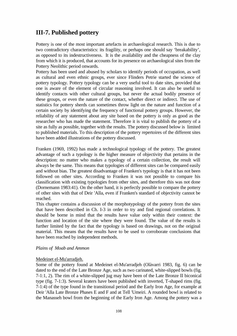
108
III-7. Published pottery
Pottery is one of the most important artefacts in archaeological research. This is due totwo contradictory characteristics: its fragility, or perhaps one should say ‘breakability’,as opposed to its indestructiveness. It is the availability and the cheapness of the clayfrom which it is produced, that accounts for its presence on archaeological sites from thePottery Neolithic period onwards.Pottery has been used and abused by scholars to identify periods of occupation, as wellas cultural and even ethnic groups, ever since Flinders Petrie started the science ofpottery typology. Pottery typology can be a very useful tool to date sites, provided thatone is aware of the element of circular reasoning involved. It can also be useful toidentify contacts with other cultural groups, but never the actual bodily presence ofthese groups, or even the nature of the contact, whether direct or indirect. The use ofstatistics for pottery sherds can sometimes throw light on the nature and function of acertain society by identifying the frequency of functional pottery groups. However, thereliability of any statement about any site based on the pottery is only as good as theresearcher who has made the statement. Therefore it is vital to publish the pottery of asite as fully as possible, together with the results. The pottery discussed below is limitedto published materials. To this description of the pottery repertoires of the different siteshave been added illustrations of the pottery discussed.
Franken (1969, 1992) has made a technological typology of the pottery. The greatestadvantage of such a typology is the higher measure of objectivity that pertains in thedescription: no matter who makes a typology of a certain collection, the result willalways be the same. This means that typologies of different sites can be compared easilyand without bias. The greatest disadvantage of Franken's typology is that it has not beenfollowed on other sites. According to Franken it was not possible to compare hisclassification with existing typologies from other sites, and therefore this was not done(Dornemann 1983:41). On the other hand, it is perfectly possible to compare the potteryof other sites with that of Deir 'Alla, even if Franken's standard of objectivity cannot bereached.This chapter contains a discussion of the morphotypology of the pottery from the sitesthat have been described in Ch. I-3 in order to try and find regional correlations. Itshould be borne in mind that the results have value only within their context: thefunction and location of the site where they were found. The value of the results isfurther limited by the fact that the typology is based on drawings, not on the originalmaterial. This means that the results have to be used to corroborate conclusions thathave been reached by independent methods.
Plains of Moab and Ammon
Medeinet el-Mu'arradjeh.Some of the pottery found at Medeinet el-Mu'arradjeh (Olàvarri 1983, fig. 6) can bedated to the end of the Late Bronze Age, such as two carinated, white-slipped bowls (fig.7-1:1, 2). The rim of a white-slipped jug may have been of the Late Bronze II biconicaltype (fig. 7-1:3). Several kraters have been published with inverted, T-shaped rims (fig.7-1:4) of the type found in the transitional period and the Early Iron Age, for example atDeir 'Alla Late Bronze Phases E and F and at Tell 'Umeiri. A rounded bowl is related tothe Manasseh bowl from the beginning of the Early Iron Age. Among the pottery was a
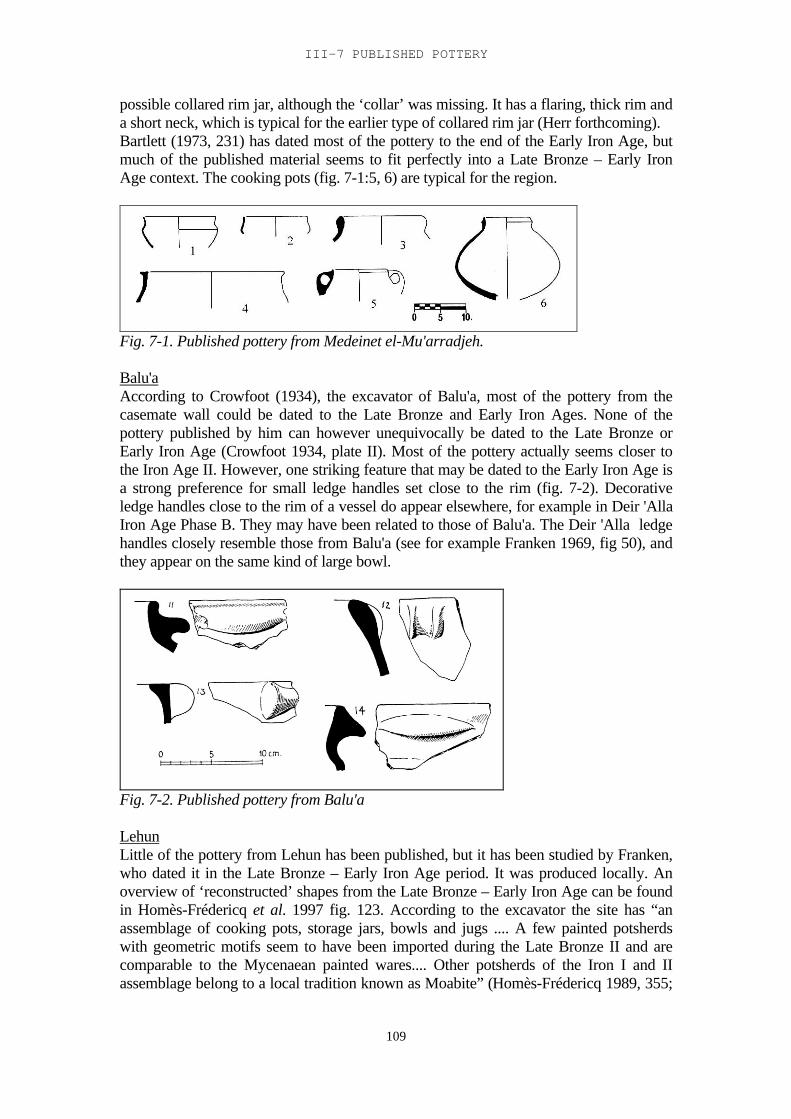
III-7 PUBLISHED POTTERY
109
possible collared rim jar, although the ‘collar’ was missing. It has a flaring, thick rim anda short neck, which is typical for the earlier type of collared rim jar (Herr forthcoming).Bartlett (1973, 231) has dated most of the pottery to the end of the Early Iron Age, butmuch of the published material seems to fit perfectly into a Late Bronze – Early IronAge context. The cooking pots (fig. 7-1:5, 6) are typical for the region.
Fig. 7-1. Published pottery from Medeinet el-Mu'arradjeh.
Balu'aAccording to Crowfoot (1934), the excavator of Balu'a, most of the pottery from thecasemate wall could be dated to the Late Bronze and Early Iron Ages. None of thepottery published by him can however unequivocally be dated to the Late Bronze orEarly Iron Age (Crowfoot 1934, plate II). Most of the pottery actually seems closer tothe Iron Age II. However, one striking feature that may be dated to the Early Iron Age isa strong preference for small ledge handles set close to the rim (fig. 7-2). Decorativeledge handles close to the rim of a vessel do appear elsewhere, for example in Deir 'AllaIron Age Phase B. They may have been related to those of Balu'a. The Deir 'Alla ledgehandles closely resemble those from Balu'a (see for example Franken 1969, fig 50), andthey appear on the same kind of large bowl.
Fig. 7-2. Published pottery from Balu'a
LehunLittle of the pottery from Lehun has been published, but it has been studied by Franken,who dated it in the Late Bronze – Early Iron Age period. It was produced locally. Anoverview of ‘reconstructed’ shapes from the Late Bronze – Early Iron Age can be foundin Homès-Frédericq et al. 1997 fig. 123. According to the excavator the site has “anassemblage of cooking pots, storage jars, bowls and jugs .... A few painted potsherdswith geometric motifs seem to have been imported during the Late Bronze II and arecomparable to the Mycenaean painted wares.... Other potsherds of the Iron I and IIassemblage belong to a local tradition known as Moabite” (Homès-Frédericq 1989, 355;
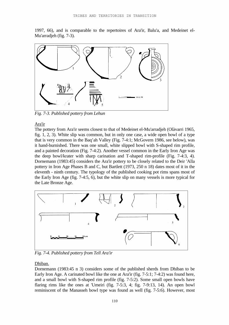
TRIBES AND TERRITORIES IN TRANSITION
110
1997, 66), and is comparable to the repertoires of Ara'ir, Balu'a, and Medeinet el-Mu'arradjeh (fig. 7-3).
Fig. 7-3. Published pottery from Lehun
Ara'irThe pottery from Ara'ir seems closest to that of Medeinet el-Mu'arradjeh (Olàvarri 1965,fig. 1, 2, 3). White slip was common, but in only one case, a wide open bowl of a typethat is very common in the Baq’ah Valley (Fig. 7-4:1; McGovern 1986, see below), wasit hand-burnished. There was one small, white slipped bowl with S-shaped rim profile,and a painted decoration (Fig. 7-4:2). Another vessel common in the Early Iron Age wasthe deep bowl/krater with sharp carination and T-shaped rim-profile (Fig. 7-4:3, 4).Dornemann (1983:45) considers the Ara'ir pottery to be closely related to the Deir 'Allapottery in Iron Age Phases B and C, but Bartlett (1973, 250 n 18) dates most of it in theeleventh - ninth century. The typology of the published cooking pot rims spans most ofthe Early Iron Age (fig. 7-4:5, 6), but the white slip on many vessels is more typical forthe Late Bronze Age.
Fig. 7-4. Published pottery from Tell Ara'ir
Dhiban.Dornemann (1983:45 n 3) considers some of the published sherds from Dhiban to beEarly Iron Age. A carinated bowl like the one at Ara'ir (fig. 7-5:1; 7-4:2) was found here,and a small bowl with S-shaped rim profile (fig. 7-5:2). Some small open bowls haveflaring rims like the ones at 'Umeiri (fig. 7-5:3, 4; fig. 7-9:13, 14). An open bowlreminiscent of the Manasseh bowl type was found as well (fig. 7-5:6). However, most
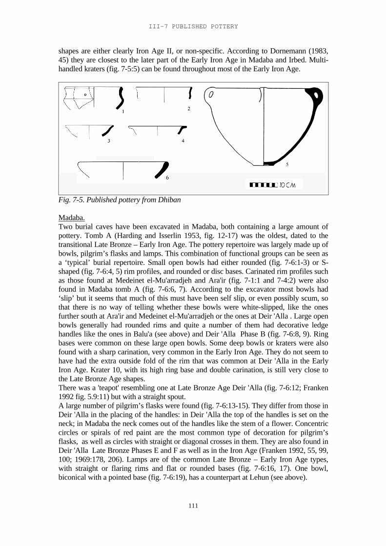
III-7 PUBLISHED POTTERY
111
shapes are either clearly Iron Age II, or non-specific. According to Dornemann (1983,45) they are closest to the later part of the Early Iron Age in Madaba and Irbed. Multi-handled kraters (fig. 7-5:5) can be found throughout most of the Early Iron Age.
Fig. 7-5. Published pottery from Dhiban
Madaba.Two burial caves have been excavated in Madaba, both containing a large amount ofpottery. Tomb A (Harding and Isserlin 1953, fig. 12-17) was the oldest, dated to thetransitional Late Bronze – Early Iron Age. The pottery repertoire was largely made up ofbowls, pilgrim’s flasks and lamps. This combination of functional groups can be seen asa ‘typical’ burial repertoire. Small open bowls had either rounded (fig. 7-6:1-3) or S-shaped (fig. 7-6:4, 5) rim profiles, and rounded or disc bases. Carinated rim profiles suchas those found at Medeinet el-Mu'arradjeh and Ara'ir (fig. 7-1:1 and 7-4:2) were alsofound in Madaba tomb A (fig. 7-6:6, 7). According to the excavator most bowls had‘slip’ but it seems that much of this must have been self slip, or even possibly scum, sothat there is no way of telling whether these bowls were white-slipped, like the onesfurther south at Ara'ir and Medeinet el-Mu'arradjeh or the ones at Deir 'Alla . Large openbowls generally had rounded rims and quite a number of them had decorative ledgehandles like the ones in Balu'a (see above) and Deir 'Alla Phase B (fig. 7-6:8, 9). Ringbases were common on these large open bowls. Some deep bowls or kraters were alsofound with a sharp carination, very common in the Early Iron Age. They do not seem tohave had the extra outside fold of the rim that was common at Deir 'Alla in the EarlyIron Age. Krater 10, with its high ring base and double carination, is still very close tothe Late Bronze Age shapes.There was a 'teapot' resembling one at Late Bronze Age Deir 'Alla (fig. 7-6:12; Franken1992 fig. 5.9:11) but with a straight spout.A large number of pilgrim’s flasks were found (fig. 7-6:13-15). They differ from those inDeir 'Alla in the placing of the handles: in Deir 'Alla the top of the handles is set on theneck; in Madaba the neck comes out of the handles like the stem of a flower. Concentriccircles or spirals of red paint are the most common type of decoration for pilgrim’sflasks, as well as circles with straight or diagonal crosses in them. They are also found inDeir 'Alla Late Bronze Phases E and F as well as in the Iron Age (Franken 1992, 55, 99,100; 1969:178, 206). Lamps are of the common Late Bronze – Early Iron Age types,with straight or flaring rims and flat or rounded bases (fig. 7-6:16, 17). One bowl,biconical with a pointed base (fig. 7-6:19), has a counterpart at Lehun (see above).
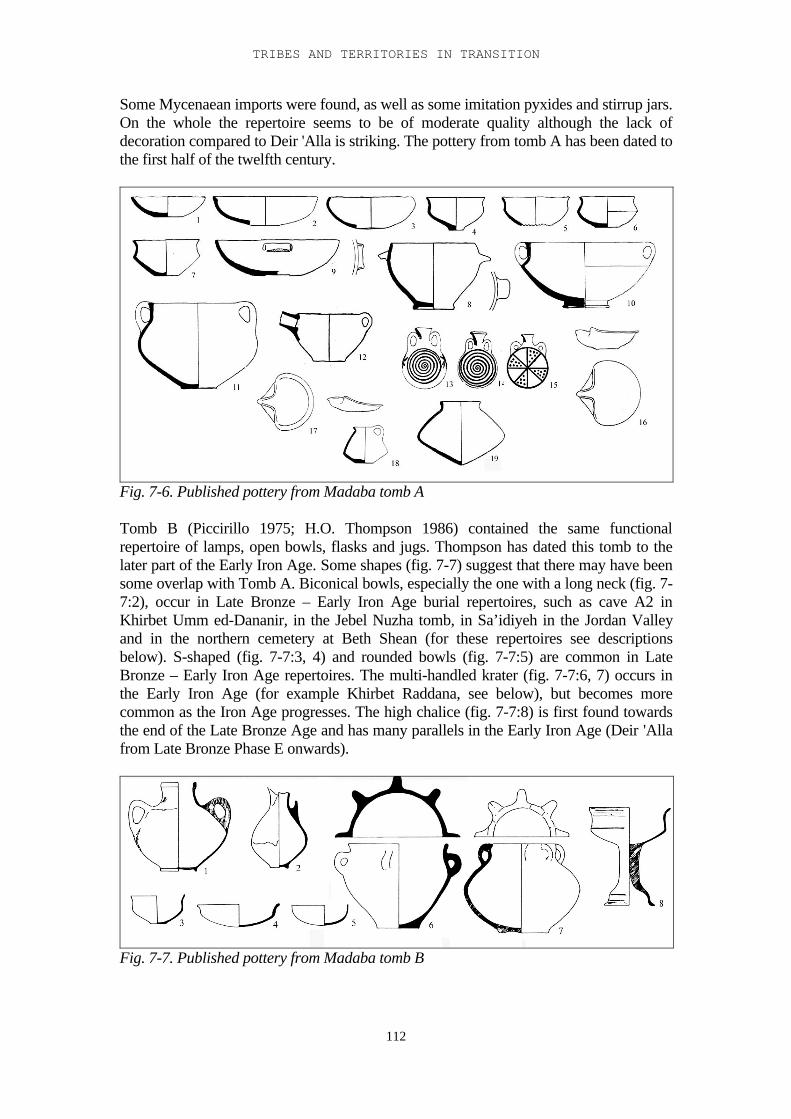
TRIBES AND TERRITORIES IN TRANSITION
112
Some Mycenaean imports were found, as well as some imitation pyxides and stirrup jars.On the whole the repertoire seems to be of moderate quality although the lack ofdecoration compared to Deir 'Alla is striking. The pottery from tomb A has been dated tothe first half of the twelfth century.
Fig. 7-6. Published pottery from Madaba tomb A
Tomb B (Piccirillo 1975; H.O. Thompson 1986) contained the same functionalrepertoire of lamps, open bowls, flasks and jugs. Thompson has dated this tomb to thelater part of the Early Iron Age. Some shapes (fig. 7-7) suggest that there may have beensome overlap with Tomb A. Biconical bowls, especially the one with a long neck (fig. 7-7:2), occur in Late Bronze – Early Iron Age burial repertoires, such as cave A2 inKhirbet Umm ed-Dananir, in the Jebel Nuzha tomb, in Sa’idiyeh in the Jordan Valleyand in the northern cemetery at Beth Shean (for these repertoires see descriptionsbelow). S-shaped (fig. 7-7:3, 4) and rounded bowls (fig. 7-7:5) are common in LateBronze – Early Iron Age repertoires. The multi-handled krater (fig. 7-7:6, 7) occurs inthe Early Iron Age (for example Khirbet Raddana, see below), but becomes morecommon as the Iron Age progresses. The high chalice (fig. 7-7:8) is first found towardsthe end of the Late Bronze Age and has many parallels in the Early Iron Age (Deir 'Allafrom Late Bronze Phase E onwards).
Fig. 7-7. Published pottery from Madaba tomb B
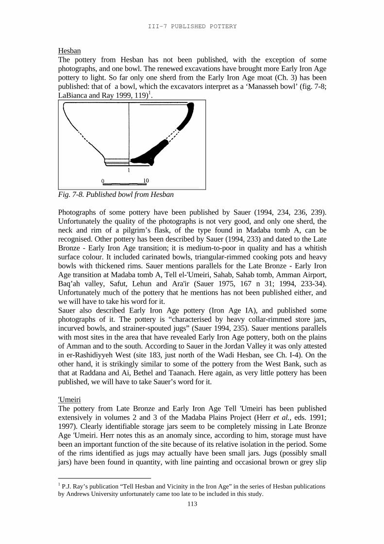
III-7 PUBLISHED POTTERY
113
HesbanThe pottery from Hesban has not been published, with the exception of somephotographs, and one bowl. The renewed excavations have brought more Early Iron Agepottery to light. So far only one sherd from the Early Iron Age moat (Ch. 3) has beenpublished: that of a bowl, which the excavators interpret as a ‘Manasseh bowl’ (fig. 7-8;LaBianca and Ray 1999, 119)1.
Fig. 7-8. Published bowl from Hesban
Photographs of some pottery have been published by Sauer (1994, 234, 236, 239).Unfortunately the quality of the photographs is not very good, and only one sherd, theneck and rim of a pilgrim’s flask, of the type found in Madaba tomb A, can berecognised. Other pottery has been described by Sauer (1994, 233) and dated to the LateBronze - Early Iron Age transition; it is medium-to-poor in quality and has a whitishsurface colour. It included carinated bowls, triangular-rimmed cooking pots and heavybowls with thickened rims. Sauer mentions parallels for the Late Bronze - Early IronAge transition at Madaba tomb A, Tell el-'Umeiri, Sahab, Sahab tomb, Amman Airport,Baq’ah valley, Safut, Lehun and Ara'ir (Sauer 1975, 167 n 31; 1994, 233-34).Unfortunately much of the pottery that he mentions has not been published either, andwe will have to take his word for it.Sauer also described Early Iron Age pottery (Iron Age IA), and published somephotographs of it. The pottery is “characterised by heavy collar-rimmed store jars,incurved bowls, and strainer-spouted jugs” (Sauer 1994, 235). Sauer mentions parallelswith most sites in the area that have revealed Early Iron Age pottery, both on the plainsof Amman and to the south. According to Sauer in the Jordan Valley it was only attestedin er-Rashidiyyeh West (site 183, just north of the Wadi Hesban, see Ch. I-4). On theother hand, it is strikingly similar to some of the pottery from the West Bank, such asthat at Raddana and Ai, Bethel and Taanach. Here again, as very little pottery has beenpublished, we will have to take Sauer’s word for it.
'UmeiriThe pottery from Late Bronze and Early Iron Age Tell 'Umeiri has been publishedextensively in volumes 2 and 3 of the Madaba Plains Project (Herr et al., eds. 1991;1997). Clearly identifiable storage jars seem to be completely missing in Late BronzeAge 'Umeiri. Herr notes this as an anomaly since, according to him, storage must havebeen an important function of the site because of its relative isolation in the period. Someof the rims identified as jugs may actually have been small jars. Jugs (possibly smalljars) have been found in quantity, with line painting and occasional brown or grey slip
1 P.J. Ray’s publication “Tell Hesban and Vicinity in the Iron Age” in the series of Hesban publicationsby Andrews University unfortunately came too late to be included in this study.
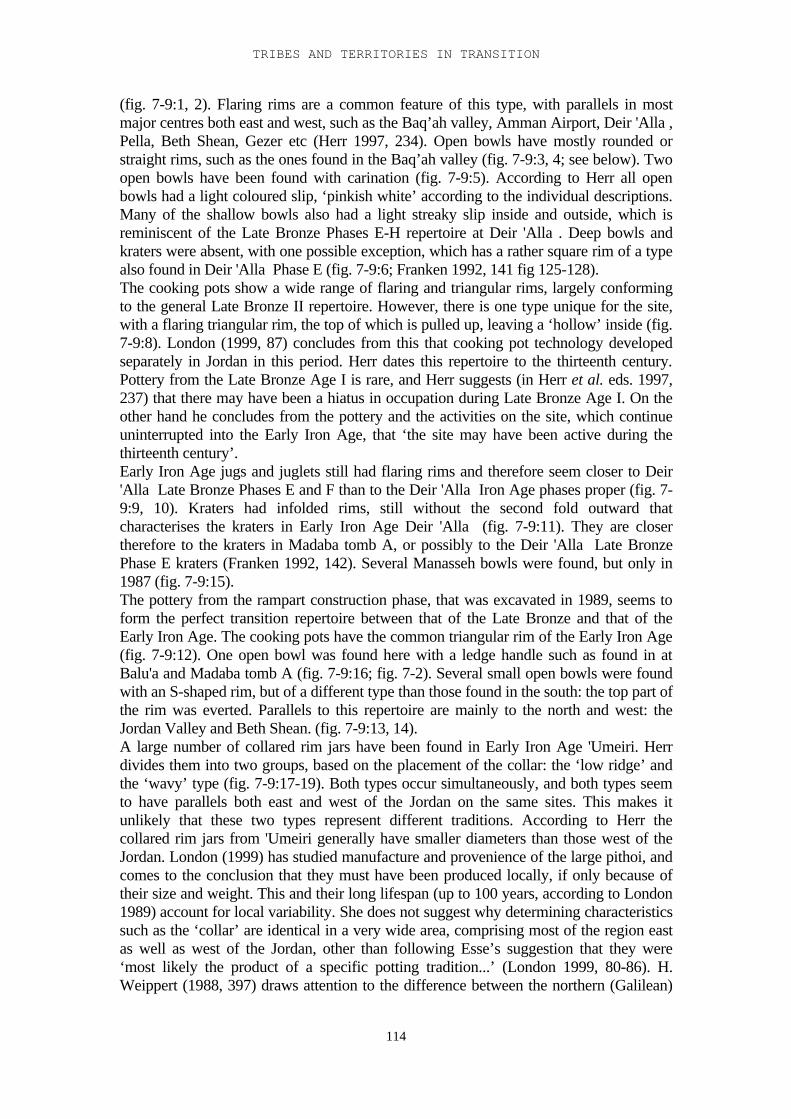
TRIBES AND TERRITORIES IN TRANSITION
114
(fig. 7-9:1, 2). Flaring rims are a common feature of this type, with parallels in mostmajor centres both east and west, such as the Baq’ah valley, Amman Airport, Deir 'Alla ,Pella, Beth Shean, Gezer etc (Herr 1997, 234). Open bowls have mostly rounded orstraight rims, such as the ones found in the Baq’ah valley (fig. 7-9:3, 4; see below). Twoopen bowls have been found with carination (fig. 7-9:5). According to Herr all openbowls had a light coloured slip, ‘pinkish white’ according to the individual descriptions.Many of the shallow bowls also had a light streaky slip inside and outside, which isreminiscent of the Late Bronze Phases E-H repertoire at Deir 'Alla . Deep bowls andkraters were absent, with one possible exception, which has a rather square rim of a typealso found in Deir 'Alla Phase E (fig. 7-9:6; Franken 1992, 141 fig 125-128).The cooking pots show a wide range of flaring and triangular rims, largely conformingto the general Late Bronze II repertoire. However, there is one type unique for the site,with a flaring triangular rim, the top of which is pulled up, leaving a ‘hollow’ inside (fig.7-9:8). London (1999, 87) concludes from this that cooking pot technology developedseparately in Jordan in this period. Herr dates this repertoire to the thirteenth century.Pottery from the Late Bronze Age I is rare, and Herr suggests (in Herr et al. eds. 1997,237) that there may have been a hiatus in occupation during Late Bronze Age I. On theother hand he concludes from the pottery and the activities on the site, which continueuninterrupted into the Early Iron Age, that ‘the site may have been active during thethirteenth century’.Early Iron Age jugs and juglets still had flaring rims and therefore seem closer to Deir'Alla Late Bronze Phases E and F than to the Deir 'Alla Iron Age phases proper (fig. 7-9:9, 10). Kraters had infolded rims, still without the second fold outward thatcharacterises the kraters in Early Iron Age Deir 'Alla (fig. 7-9:11). They are closertherefore to the kraters in Madaba tomb A, or possibly to the Deir 'Alla Late BronzePhase E kraters (Franken 1992, 142). Several Manasseh bowls were found, but only in1987 (fig. 7-9:15).The pottery from the rampart construction phase, that was excavated in 1989, seems toform the perfect transition repertoire between that of the Late Bronze and that of theEarly Iron Age. The cooking pots have the common triangular rim of the Early Iron Age(fig. 7-9:12). One open bowl was found here with a ledge handle such as found in atBalu'a and Madaba tomb A (fig. 7-9:16; fig. 7-2). Several small open bowls were foundwith an S-shaped rim, but of a different type than those found in the south: the top part ofthe rim was everted. Parallels to this repertoire are mainly to the north and west: theJordan Valley and Beth Shean. (fig. 7-9:13, 14).A large number of collared rim jars have been found in Early Iron Age 'Umeiri. Herrdivides them into two groups, based on the placement of the collar: the ‘low ridge’ andthe ‘wavy’ type (fig. 7-9:17-19). Both types occur simultaneously, and both types seemto have parallels both east and west of the Jordan on the same sites. This makes itunlikely that these two types represent different traditions. According to Herr thecollared rim jars from 'Umeiri generally have smaller diameters than those west of theJordan. London (1999) has studied manufacture and provenience of the large pithoi, andcomes to the conclusion that they must have been produced locally, if only because oftheir size and weight. This and their long lifespan (up to 100 years, according to London1989) account for local variability. She does not suggest why determining characteristicssuch as the ‘collar’ are identical in a very wide area, comprising most of the region eastas well as west of the Jordan, other than following Esse’s suggestion that they were‘most likely the product of a specific potting tradition...’ (London 1999, 80-86). H.Weippert (1988, 397) draws attention to the difference between the northern (Galilean)
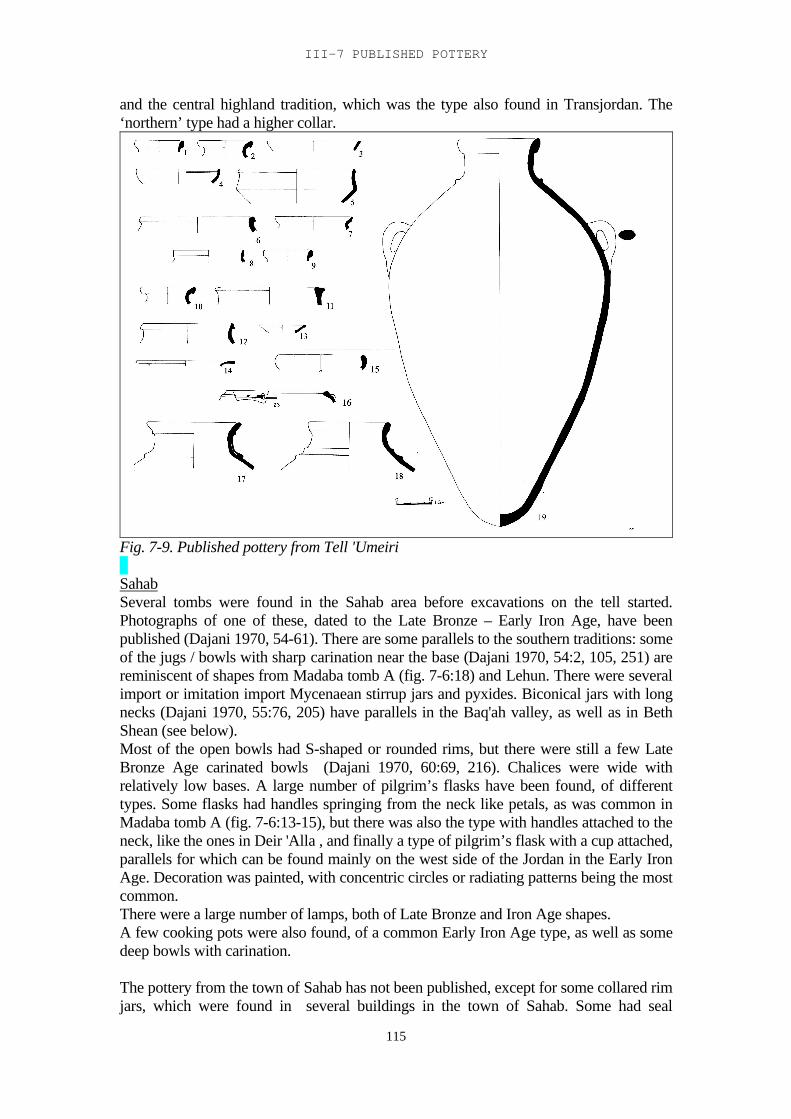
III-7 PUBLISHED POTTERY
115
and the central highland tradition, which was the type also found in Transjordan. The‘northern’ type had a higher collar.
Fig. 7-9. Published pottery from Tell 'Umeiri
SahabSeveral tombs were found in the Sahab area before excavations on the tell started.Photographs of one of these, dated to the Late Bronze – Early Iron Age, have beenpublished (Dajani 1970, 54-61). There are some parallels to the southern traditions: someof the jugs / bowls with sharp carination near the base (Dajani 1970, 54:2, 105, 251) arereminiscent of shapes from Madaba tomb A (fig. 7-6:18) and Lehun. There were severalimport or imitation import Mycenaean stirrup jars and pyxides. Biconical jars with longnecks (Dajani 1970, 55:76, 205) have parallels in the Baq'ah valley, as well as in BethShean (see below).Most of the open bowls had S-shaped or rounded rims, but there were still a few LateBronze Age carinated bowls (Dajani 1970, 60:69, 216). Chalices were wide withrelatively low bases. A large number of pilgrim’s flasks have been found, of differenttypes. Some flasks had handles springing from the neck like petals, as was common inMadaba tomb A (fig. 7-6:13-15), but there was also the type with handles attached to theneck, like the ones in Deir 'Alla , and finally a type of pilgrim’s flask with a cup attached,parallels for which can be found mainly on the west side of the Jordan in the Early IronAge. Decoration was painted, with concentric circles or radiating patterns being the mostcommon.There were a large number of lamps, both of Late Bronze and Iron Age shapes.A few cooking pots were also found, of a common Early Iron Age type, as well as somedeep bowls with carination.
The pottery from the town of Sahab has not been published, except for some collared rimjars, which were found in several buildings in the town of Sahab. Some had seal
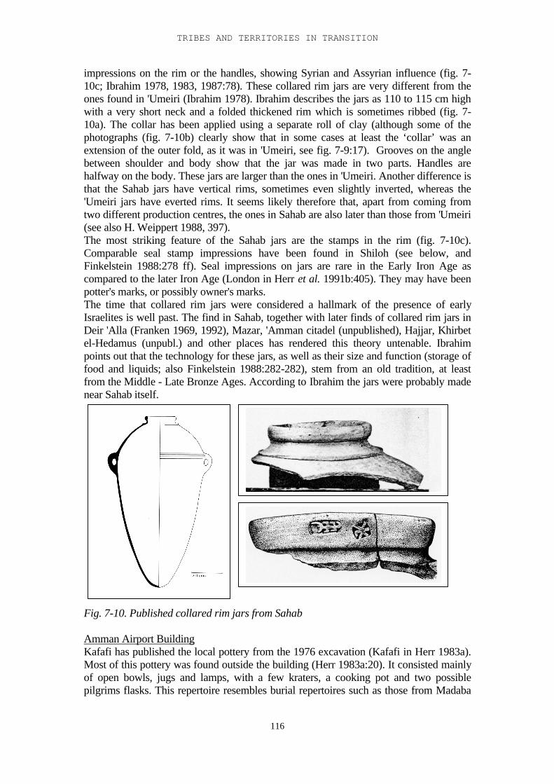
TRIBES AND TERRITORIES IN TRANSITION
116
impressions on the rim or the handles, showing Syrian and Assyrian influence (fig. 7-10c; Ibrahim 1978, 1983, 1987:78). These collared rim jars are very different from theones found in 'Umeiri (Ibrahim 1978). Ibrahim describes the jars as 110 to 115 cm highwith a very short neck and a folded thickened rim which is sometimes ribbed (fig. 7-10a). The collar has been applied using a separate roll of clay (although some of thephotographs (fig. 7-10b) clearly show that in some cases at least the ‘collar’ was anextension of the outer fold, as it was in 'Umeiri, see fig. 7-9:17). Grooves on the anglebetween shoulder and body show that the jar was made in two parts. Handles arehalfway on the body. These jars are larger than the ones in 'Umeiri. Another difference isthat the Sahab jars have vertical rims, sometimes even slightly inverted, whereas the'Umeiri jars have everted rims. It seems likely therefore that, apart from coming fromtwo different production centres, the ones in Sahab are also later than those from 'Umeiri(see also H. Weippert 1988, 397).The most striking feature of the Sahab jars are the stamps in the rim (fig. 7-10c).Comparable seal stamp impressions have been found in Shiloh (see below, andFinkelstein 1988:278 ff). Seal impressions on jars are rare in the Early Iron Age ascompared to the later Iron Age (London in Herr et al. 1991b:405). They may have beenpotter's marks, or possibly owner's marks.The time that collared rim jars were considered a hallmark of the presence of earlyIsraelites is well past. The find in Sahab, together with later finds of collared rim jars inDeir 'Alla (Franken 1969, 1992), Mazar, 'Amman citadel (unpublished), Hajjar, Khirbetel-Hedamus (unpubl.) and other places has rendered this theory untenable. Ibrahimpoints out that the technology for these jars, as well as their size and function (storage offood and liquids; also Finkelstein 1988:282-282), stem from an old tradition, at leastfrom the Middle - Late Bronze Ages. According to Ibrahim the jars were probably madenear Sahab itself.
Fig. 7-10. Published collared rim jars from Sahab
Amman Airport BuildingKafafi has published the local pottery from the 1976 excavation (Kafafi in Herr 1983a).Most of this pottery was found outside the building (Herr 1983a:20). It consisted mainlyof open bowls, jugs and lamps, with a few kraters, a cooking pot and two possiblepilgrims flasks. This repertoire resembles burial repertoires such as those from Madaba
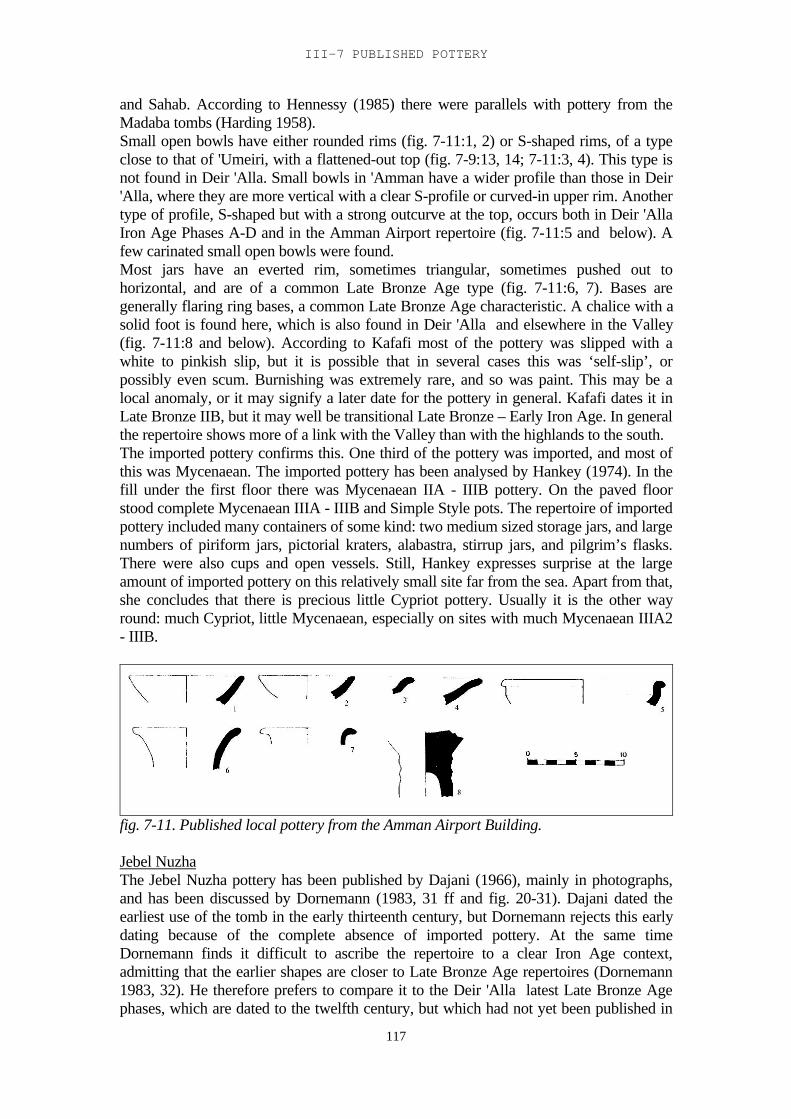
III-7 PUBLISHED POTTERY
117
and Sahab. According to Hennessy (1985) there were parallels with pottery from theMadaba tombs (Harding 1958).Small open bowls have either rounded rims (fig. 7-11:1, 2) or S-shaped rims, of a typeclose to that of 'Umeiri, with a flattened-out top (fig. 7-9:13, 14; 7-11:3, 4). This type isnot found in Deir 'Alla. Small bowls in 'Amman have a wider profile than those in Deir'Alla, where they are more vertical with a clear S-profile or curved-in upper rim. Anothertype of profile, S-shaped but with a strong outcurve at the top, occurs both in Deir 'AllaIron Age Phases A-D and in the Amman Airport repertoire (fig. 7-11:5 and below). Afew carinated small open bowls were found.Most jars have an everted rim, sometimes triangular, sometimes pushed out tohorizontal, and are of a common Late Bronze Age type (fig. 7-11:6, 7). Bases aregenerally flaring ring bases, a common Late Bronze Age characteristic. A chalice with asolid foot is found here, which is also found in Deir 'Alla and elsewhere in the Valley(fig. 7-11:8 and below). According to Kafafi most of the pottery was slipped with awhite to pinkish slip, but it is possible that in several cases this was ‘self-slip’, orpossibly even scum. Burnishing was extremely rare, and so was paint. This may be alocal anomaly, or it may signify a later date for the pottery in general. Kafafi dates it inLate Bronze IIB, but it may well be transitional Late Bronze – Early Iron Age. In generalthe repertoire shows more of a link with the Valley than with the highlands to the south.The imported pottery confirms this. One third of the pottery was imported, and most ofthis was Mycenaean. The imported pottery has been analysed by Hankey (1974). In thefill under the first floor there was Mycenaean IIA - IIIB pottery. On the paved floorstood complete Mycenaean IIIA - IIIB and Simple Style pots. The repertoire of importedpottery included many containers of some kind: two medium sized storage jars, and largenumbers of piriform jars, pictorial kraters, alabastra, stirrup jars, and pilgrim’s flasks.There were also cups and open vessels. Still, Hankey expresses surprise at the largeamount of imported pottery on this relatively small site far from the sea. Apart from that,she concludes that there is precious little Cypriot pottery. Usually it is the other wayround: much Cypriot, little Mycenaean, especially on sites with much Mycenaean IIIA2- IIIB.
fig. 7-11. Published local pottery from the Amman Airport Building.
Jebel NuzhaThe Jebel Nuzha pottery has been published by Dajani (1966), mainly in photographs,and has been discussed by Dornemann (1983, 31 ff and fig. 20-31). Dajani dated theearliest use of the tomb in the early thirteenth century, but Dornemann rejects this earlydating because of the complete absence of imported pottery. At the same timeDornemann finds it difficult to ascribe the repertoire to a clear Iron Age context,admitting that the earlier shapes are closer to Late Bronze Age repertoires (Dornemann1983, 32). He therefore prefers to compare it to the Deir 'Alla latest Late Bronze Agephases, which are dated to the twelfth century, but which had not yet been published in
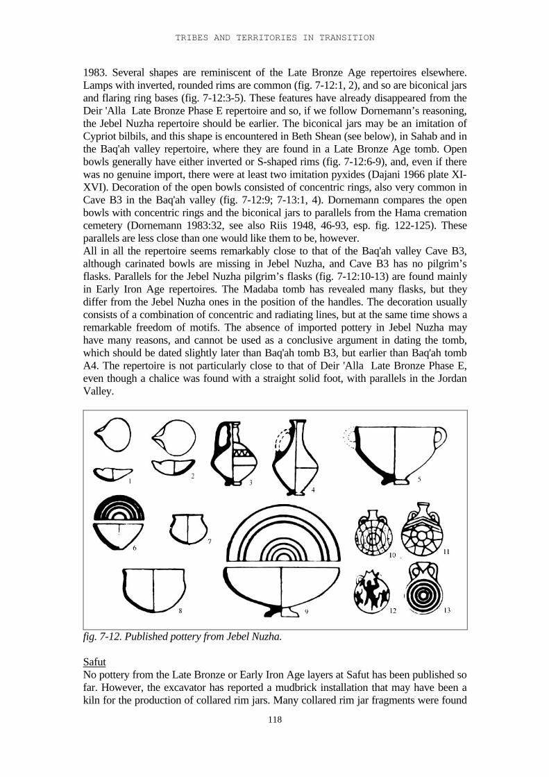
TRIBES AND TERRITORIES IN TRANSITION
118
1983. Several shapes are reminiscent of the Late Bronze Age repertoires elsewhere.Lamps with inverted, rounded rims are common (fig. 7-12:1, 2), and so are biconical jarsand flaring ring bases (fig. 7-12:3-5). These features have already disappeared from theDeir 'Alla Late Bronze Phase E repertoire and so, if we follow Dornemann’s reasoning,the Jebel Nuzha repertoire should be earlier. The biconical jars may be an imitation ofCypriot bilbils, and this shape is encountered in Beth Shean (see below), in Sahab and inthe Baq'ah valley repertoire, where they are found in a Late Bronze Age tomb. Openbowls generally have either inverted or S-shaped rims (fig. 7-12:6-9), and, even if therewas no genuine import, there were at least two imitation pyxides (Dajani 1966 plate XI-XVI). Decoration of the open bowls consisted of concentric rings, also very common inCave B3 in the Baq'ah valley (fig. 7-12:9; 7-13:1, 4). Dornemann compares the openbowls with concentric rings and the biconical jars to parallels from the Hama cremationcemetery (Dornemann 1983:32, see also Riis 1948, 46-93, esp. fig. 122-125). Theseparallels are less close than one would like them to be, however.All in all the repertoire seems remarkably close to that of the Baq'ah valley Cave B3,although carinated bowls are missing in Jebel Nuzha, and Cave B3 has no pilgrim’sflasks. Parallels for the Jebel Nuzha pilgrim’s flasks (fig. 7-12:10-13) are found mainlyin Early Iron Age repertoires. The Madaba tomb has revealed many flasks, but theydiffer from the Jebel Nuzha ones in the position of the handles. The decoration usuallyconsists of a combination of concentric and radiating lines, but at the same time shows aremarkable freedom of motifs. The absence of imported pottery in Jebel Nuzha mayhave many reasons, and cannot be used as a conclusive argument in dating the tomb,which should be dated slightly later than Baq'ah tomb B3, but earlier than Baq'ah tombA4. The repertoire is not particularly close to that of Deir 'Alla Late Bronze Phase E,even though a chalice was found with a straight solid foot, with parallels in the JordanValley.
fig. 7-12. Published pottery from Jebel Nuzha.
SafutNo pottery from the Late Bronze or Early Iron Age layers at Safut has been published sofar. However, the excavator has reported a mudbrick installation that may have been akiln for the production of collared rim jars. Many collared rim jar fragments were found
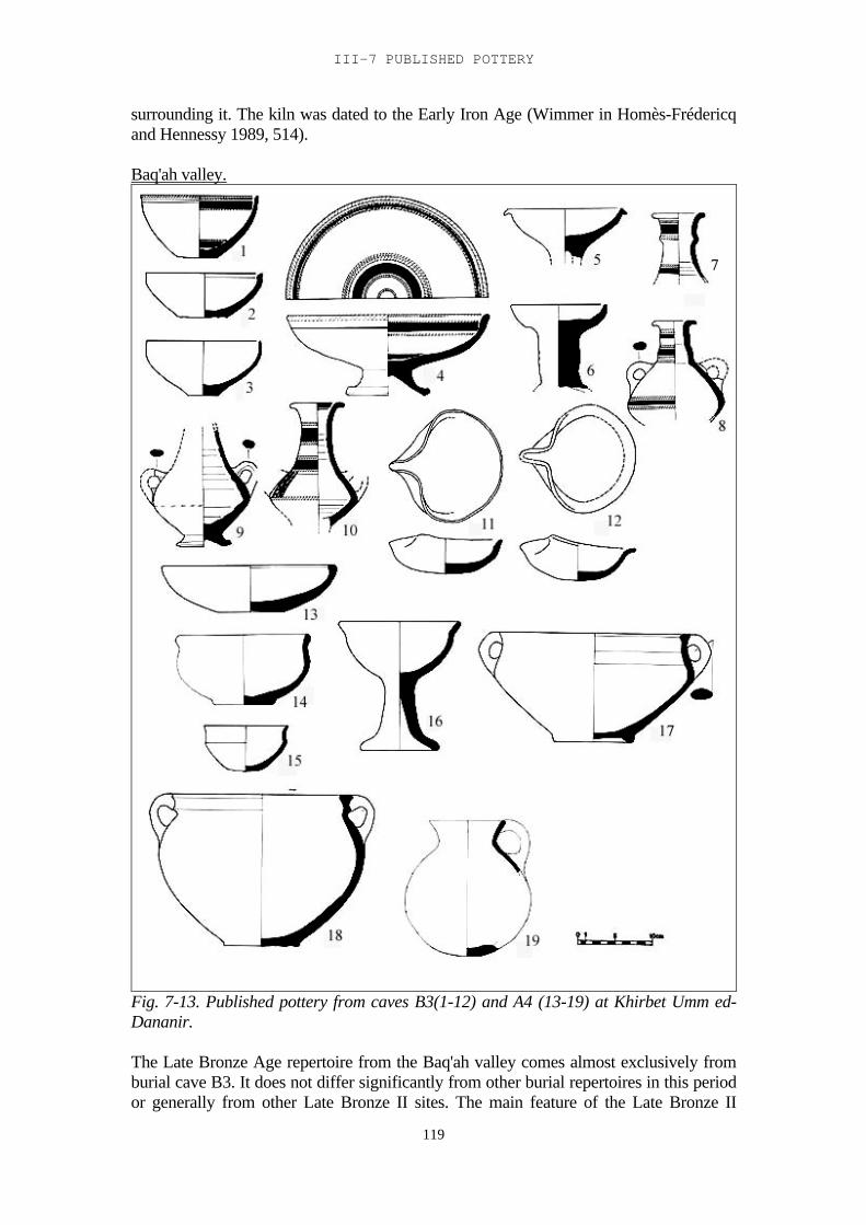
III-7 PUBLISHED POTTERY
119
surrounding it. The kiln was dated to the Early Iron Age (Wimmer in Homès-Frédericqand Hennessy 1989, 514).
Baq'ah valley.
Fig. 7-13. Published pottery from caves B3(1-12) and A4 (13-19) at Khirbet Umm ed-Dananir.
The Late Bronze Age repertoire from the Baq'ah valley comes almost exclusively fromburial cave B3. It does not differ significantly from other burial repertoires in this periodor generally from other Late Bronze II sites. The main feature of the Late Bronze II
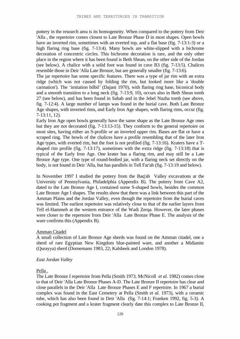
TRIBES AND TERRITORIES IN TRANSITION
120
pottery in the research area is its homogeneity. When compared to the pottery from Deir'Alla , the repertoire comes closest to Late Bronze Phase D in most shapes. Open bowlshave an inverted rim, sometimes with an everted top, and a flat base (fig. 7-13:1-3) or ahigh flaring ring base (fig. 7-13:4). Many bowls are white-slipped with a bichromedecoration of concentric circles. This bichrome decoration is rare, and the only otherplace in the region where it has been found is Beth Shean, on the other side of the Jordan(see below). A chalice with a solid foot was found in cave B3 (fig. 7-13:5). Chalicesresemble those in Deir 'Alla Late Bronze, but are generally smaller (fig. 7-13:6).The jar repertoire has some specific features. There was a type of jar rim with an extraridge (which was not caused by folding the rim, but looked more like a 'doublecarination'). The ‘imitation bilbil’ (Dajani 1970), with flaring ring base, biconical bodyand a smooth transition to a long neck (fig. 7-13:9, 10), occurs also in Beth Shean tomb27 (see below), and has been found in Sahab and in the Jebel Nuzha tomb (see above,fig. 7-12:4). A large number of lamps was found in the burial cave. Both Late BronzeAge shapes, with inverted rims, and Early Iron Age shapes, with flaring rims, occur (fig.7-13:11, 12).Early Iron Age open bowls generally have the same shape as the Late Bronze Age onesbut they are not decorated (fig. 7-13:13-15). They conform to the general repertoire onmost sites, having either an S-profile or an inverted upper rim. Bases are flat or have ascraped ring. The bowls of the chalices have a profile resembling that of the later IronAge types, with everted rim, but the foot is not profiled (fig. 7-13:16). Kraters have a T-shaped rim profile (fig. 7-13:17), sometimes with the extra ridge (fig. 7-13:18) that istypical of the Early Iron Age. One krater has a flaring rim, and may still be a LateBronze Age type. One type of round-bodied jar, with a flaring neck set directly on thebody, is not found in Deir 'Alla, but has parallels in Tell Far'ah (fig. 7-13:19 and below).
In November 1997 I studied the pottery from the Baq'ah Valley excavations at theUniversity of Pennsylvania, Philadelphia (Appendix B). The pottery from Cave A2,dated to the Late Bronze Age I, contained some S-shaped bowls, besides the commonLate Bronze Age I shapes. The results show that there was a link between this part of theAmman Plains and the Jordan Valley, even though the repertoire from the burial caveswas limited. The earliest repertoire was relatively close to that of the earlier layers fromTell el-Hammeh at the western entrance of the Wadi Zerqa. However, the later phaseswere closer to the repertoire from Deir 'Alla Late Bronze Phase E. The analysis of theware confirms this (Appendix B).
Amman CitadelA small collection of Late Bronze Age sherds was found on the Amman citadel, one asherd of rare Egyptian New Kingdom blue-painted ware, and another a Midianite(Qurayya) sherd (Dornemann 1983, 22; Kalsbeek and London 1978).
East Jordan Valley
Pella .The Late Bronze I repertoire from Pella (Smith 1973, McNicoll et al. 1982) comes closeto that of Deir 'Alla Late Bronze Phases A-D. The Late Bronze II repertoire has clear andclose parallels in the Deir 'Alla Late Bronze Phases E and F repertoire. In 1967 a burialcomplex was found in the East Cemetery at Pella (Smith et al. 1973), with a ceramictube, which has also been found in Deir 'Alla (fig. 7-14:1; Franken 1992, fig. 5-3). Acooking pot fragment and a krater fragment clearly date this complex to Late Bronze II,
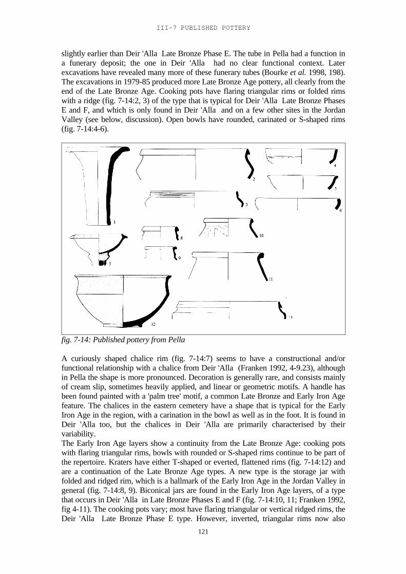
III-7 PUBLISHED POTTERY
121
slightly earlier than Deir 'Alla Late Bronze Phase E. The tube in Pella had a function ina funerary deposit; the one in Deir 'Alla had no clear functional context. Laterexcavations have revealed many more of these funerary tubes (Bourke et al. 1998, 198).The excavations in 1979-85 produced more Late Bronze Age pottery, all clearly from theend of the Late Bronze Age. Cooking pots have flaring triangular rims or folded rimswith a ridge (fig. 7-14:2, 3) of the type that is typical for Deir 'Alla Late Bronze PhasesE and F, and which is only found in Deir 'Alla and on a few other sites in the JordanValley (see below, discussion). Open bowls have rounded, carinated or S-shaped rims(fig. 7-14:4-6).
fig. 7-14: Published pottery from Pella
A curiously shaped chalice rim (fig. 7-14:7) seems to have a constructional and/orfunctional relationship with a chalice from Deir 'Alla (Franken 1992, 4-9.23), althoughin Pella the shape is more pronounced. Decoration is generally rare, and consists mainlyof cream slip, sometimes heavily applied, and linear or geometric motifs. A handle hasbeen found painted with a 'palm tree' motif, a common Late Bronze and Early Iron Agefeature. The chalices in the eastern cemetery have a shape that is typical for the EarlyIron Age in the region, with a carination in the bowl as well as in the foot. It is found inDeir 'Alla too, but the chalices in Deir 'Alla are primarily characterised by theirvariability.The Early Iron Age layers show a continuity from the Late Bronze Age: cooking potswith flaring triangular rims, bowls with rounded or S-shaped rims continue to be part ofthe repertoire. Kraters have either T-shaped or everted, flattened rims (fig. 7-14:12) andare a continuation of the Late Bronze Age types. A new type is the storage jar withfolded and ridged rim, which is a hallmark of the Early Iron Age in the Jordan Valley ingeneral (fig. 7-14:8, 9). Biconical jars are found in the Early Iron Age layers, of a typethat occurs in Deir 'Alla in Late Bronze Phases E and F (fig. 7-14:10, 11; Franken 1992,fig 4-11). The cooking pots vary; most have flaring triangular or vertical ridged rims, theDeir 'Alla Late Bronze Phase E type. However, inverted, triangular rims now also
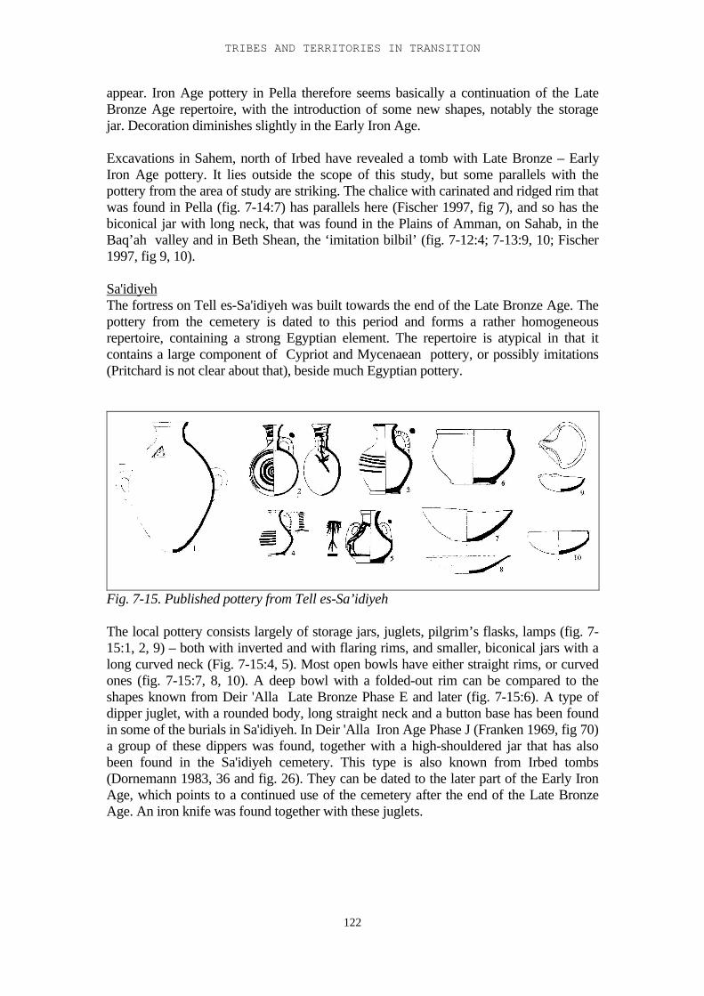
TRIBES AND TERRITORIES IN TRANSITION
122
appear. Iron Age pottery in Pella therefore seems basically a continuation of the LateBronze Age repertoire, with the introduction of some new shapes, notably the storagejar. Decoration diminishes slightly in the Early Iron Age.
Excavations in Sahem, north of Irbed have revealed a tomb with Late Bronze – EarlyIron Age pottery. It lies outside the scope of this study, but some parallels with thepottery from the area of study are striking. The chalice with carinated and ridged rim thatwas found in Pella (fig. 7-14:7) has parallels here (Fischer 1997, fig 7), and so has thebiconical jar with long neck, that was found in the Plains of Amman, on Sahab, in theBaq’ah valley and in Beth Shean, the ‘imitation bilbil’ (fig. 7-12:4; 7-13:9, 10; Fischer1997, fig 9, 10).
Sa'idiyehThe fortress on Tell es-Sa'idiyeh was built towards the end of the Late Bronze Age. Thepottery from the cemetery is dated to this period and forms a rather homogeneousrepertoire, containing a strong Egyptian element. The repertoire is atypical in that itcontains a large component of Cypriot and Mycenaean pottery, or possibly imitations(Pritchard is not clear about that), beside much Egyptian pottery.
Fig. 7-15. Published pottery from Tell es-Sa’idiyeh
The local pottery consists largely of storage jars, juglets, pilgrim’s flasks, lamps (fig. 7-15:1, 2, 9) – both with inverted and with flaring rims, and smaller, biconical jars with along curved neck (Fig. 7-15:4, 5). Most open bowls have either straight rims, or curvedones (fig. 7-15:7, 8, 10). A deep bowl with a folded-out rim can be compared to theshapes known from Deir 'Alla Late Bronze Phase E and later (fig. 7-15:6). A type ofdipper juglet, with a rounded body, long straight neck and a button base has been foundin some of the burials in Sa'idiyeh. In Deir 'Alla Iron Age Phase J (Franken 1969, fig 70)a group of these dippers was found, together with a high-shouldered jar that has alsobeen found in the Sa'idiyeh cemetery. This type is also known from Irbed tombs(Dornemann 1983, 36 and fig. 26). They can be dated to the later part of the Early IronAge, which points to a continued use of the cemetery after the end of the Late BronzeAge. An iron knife was found together with these juglets.
III-7 PUBLISHED POTTERY
123
The region west of the Jordan
Beth Shean (Yadin and Geva 1986, James 1966).Pottery from the Late Bronze Age levels VIII and VII has been published by McGovern(James and McGovern 1993). These levels belong to a time when Beth Shean was anEgyptian garrison city. Still the local pottery conforms largely to the general Late BronzeAge repertoire that has also been found on the east side of the Jordan.
fig. 7-16. Published pottery from Late Bronze Age Beth Shean
Late Bronze Age open bowls usually have rounded rims (fig. 7-16:1). One large groupof open bowls had a straight or slightly flaring rim, and red paint on the top of the rim(fig. 7-16:2, 3) .Open bowls with a high, flaring ring base and concentric (bichrome)decoration occur occasionally (fig. 7-16:4). This type has also been found in a burialcave in the Baq'ah valley. Bichrome decoration in general is common in Level VIII, rarein Level VII. Lamps have inverted rims, kraters have straight inverted rims with a T-shaped profile (fig. 7-16:5). Cooking pots have flaring rims with a triangular profile (fig.7-16:6). Two collared rim jars were found (fig. 7-16:7).In Level VII open bowls are generally rounded, sometimes carinated or with ahorizontal flaring rim (fig. 7-16:8), but the S-shaped profile is rare. Cooking pots haveeverted, folded out rims, with an extra ridge, comparable to the Deir 'Alla Late BronzePhase E cooking pots (fig. 7-16:9, 10). Kraters often have flaring rims and a carinationcreating a horizontal frieze which is generally decorated, either with geometric motifs, or
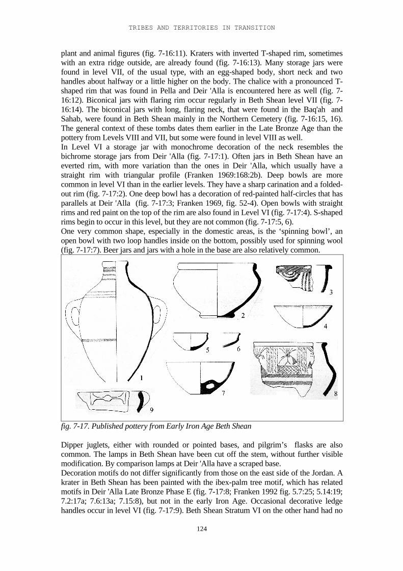
TRIBES AND TERRITORIES IN TRANSITION
124
plant and animal figures (fig. 7-16:11). Kraters with inverted T-shaped rim, sometimeswith an extra ridge outside, are already found (fig. 7-16:13). Many storage jars werefound in level VII, of the usual type, with an egg-shaped body, short neck and twohandles about halfway or a little higher on the body. The chalice with a pronounced T-shaped rim that was found in Pella and Deir 'Alla is encountered here as well (fig. 7-16:12). Biconical jars with flaring rim occur regularly in Beth Shean level VII (fig. 7-16:14). The biconical jars with long, flaring neck, that were found in the Baq'ah andSahab, were found in Beth Shean mainly in the Northern Cemetery (fig. 7-16:15, 16).The general context of these tombs dates them earlier in the Late Bronze Age than thepottery from Levels VIII and VII, but some were found in level VIII as well.In Level VI a storage jar with monochrome decoration of the neck resembles thebichrome storage jars from Deir 'Alla (fig. 7-17:1). Often jars in Beth Shean have aneverted rim, with more variation than the ones in Deir 'Alla, which usually have astraight rim with triangular profile (Franken 1969:168:2b). Deep bowls are morecommon in level VI than in the earlier levels. They have a sharp carination and a folded-out rim (fig. 7-17:2). One deep bowl has a decoration of red-painted half-circles that hasparallels at Deir 'Alla (fig. 7-17:3; Franken 1969, fig. 52-4). Open bowls with straightrims and red paint on the top of the rim are also found in Level VI (fig. 7-17:4). S-shapedrims begin to occur in this level, but they are not common (fig. 7-17:5, 6).One very common shape, especially in the domestic areas, is the ‘spinning bowl’, anopen bowl with two loop handles inside on the bottom, possibly used for spinning wool(fig. 7-17:7). Beer jars and jars with a hole in the base are also relatively common.
fig. 7-17. Published pottery from Early Iron Age Beth Shean
Dipper juglets, either with rounded or pointed bases, and pilgrim’s flasks are alsocommon. The lamps in Beth Shean have been cut off the stem, without further visiblemodification. By comparison lamps at Deir 'Alla have a scraped base.Decoration motifs do not differ significantly from those on the east side of the Jordan. Akrater in Beth Shean has been painted with the ibex-palm tree motif, which has relatedmotifs in Deir 'Alla Late Bronze Phase E (fig. 7-17:8; Franken 1992 fig. 5.7:25; 5.14:19;7.2:17a; 7.6:13a; 7.15:8), but not in the early Iron Age. Occasional decorative ledgehandles occur in level VI (fig. 7-17:9). Beth Shean Stratum VI on the other hand had no
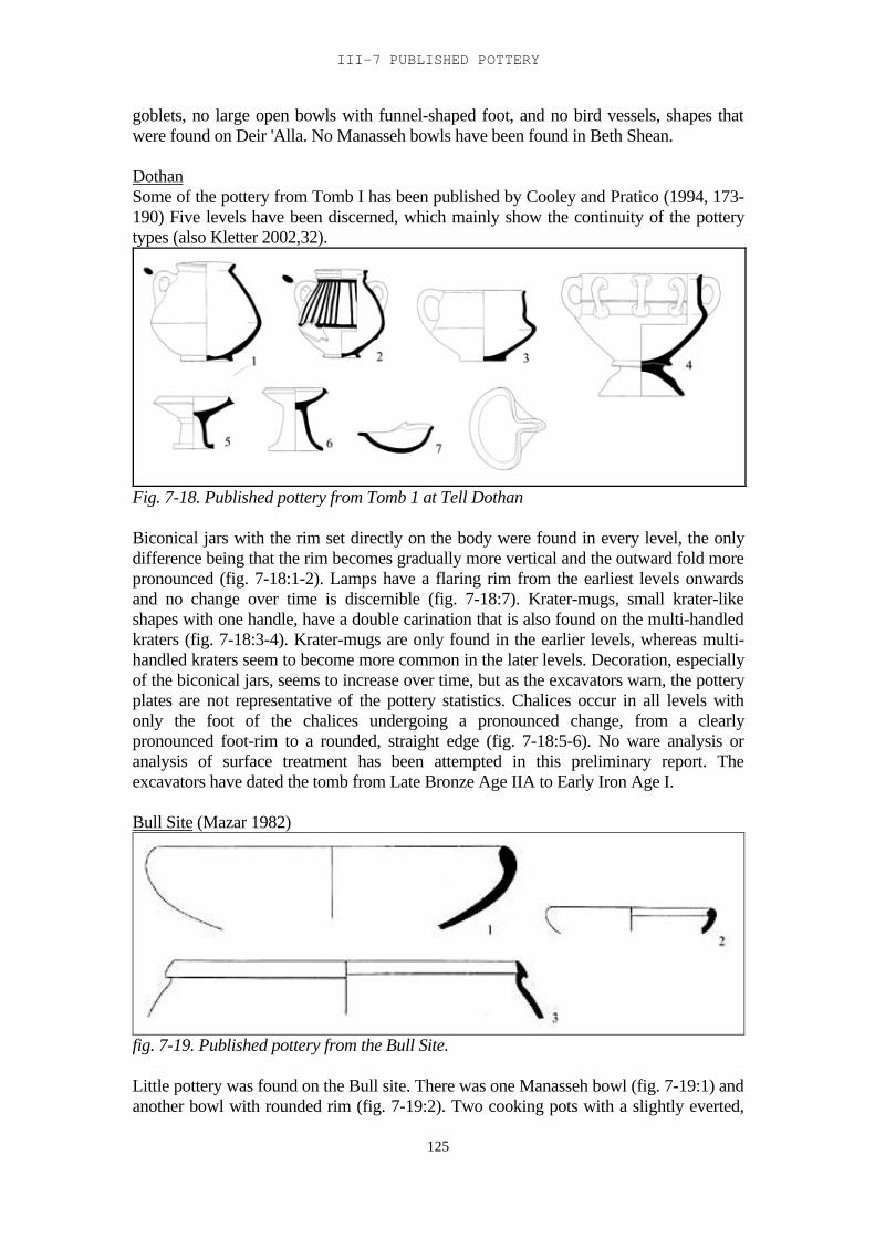
III-7 PUBLISHED POTTERY
125
goblets, no large open bowls with funnel-shaped foot, and no bird vessels, shapes thatwere found on Deir 'Alla. No Manasseh bowls have been found in Beth Shean.
DothanSome of the pottery from Tomb I has been published by Cooley and Pratico (1994, 173-190) Five levels have been discerned, which mainly show the continuity of the potterytypes (also Kletter 2002,32).
Fig. 7-18. Published pottery from Tomb 1 at Tell Dothan
Biconical jars with the rim set directly on the body were found in every level, the onlydifference being that the rim becomes gradually more vertical and the outward fold morepronounced (fig. 7-18:1-2). Lamps have a flaring rim from the earliest levels onwardsand no change over time is discernible (fig. 7-18:7). Krater-mugs, small krater-likeshapes with one handle, have a double carination that is also found on the multi-handledkraters (fig. 7-18:3-4). Krater-mugs are only found in the earlier levels, whereas multi-handled kraters seem to become more common in the later levels. Decoration, especiallyof the biconical jars, seems to increase over time, but as the excavators warn, the potteryplates are not representative of the pottery statistics. Chalices occur in all levels withonly the foot of the chalices undergoing a pronounced change, from a clearlypronounced foot-rim to a rounded, straight edge (fig. 7-18:5-6). No ware analysis oranalysis of surface treatment has been attempted in this preliminary report. Theexcavators have dated the tomb from Late Bronze Age IIA to Early Iron Age I.
Bull Site (Mazar 1982)
fig. 7-19. Published pottery from the Bull Site.
Little pottery was found on the Bull site. There was one Manasseh bowl (fig. 7-19:1) andanother bowl with rounded rim (fig. 7-19:2). Two cooking pots with a slightly everted,
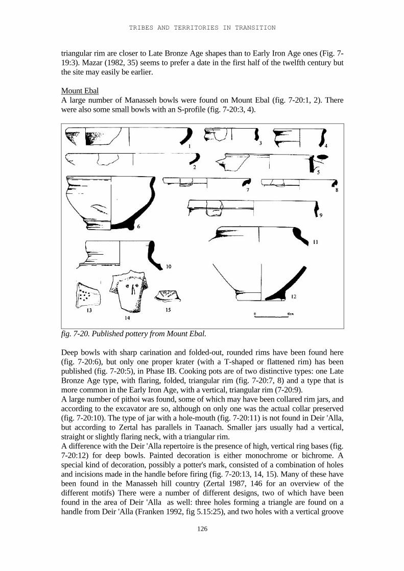
TRIBES AND TERRITORIES IN TRANSITION
126
triangular rim are closer to Late Bronze Age shapes than to Early Iron Age ones (Fig. 7-19:3). Mazar (1982, 35) seems to prefer a date in the first half of the twelfth century butthe site may easily be earlier.
Mount EbalA large number of Manasseh bowls were found on Mount Ebal (fig. 7-20:1, 2). Therewere also some small bowls with an S-profile (fig. 7-20:3, 4).
fig. 7-20. Published pottery from Mount Ebal.
Deep bowls with sharp carination and folded-out, rounded rims have been found here(fig. 7-20:6), but only one proper krater (with a T-shaped or flattened rim) has beenpublished (fig. 7-20:5), in Phase IB. Cooking pots are of two distinctive types: one LateBronze Age type, with flaring, folded, triangular rim (fig. 7-20:7, 8) and a type that ismore common in the Early Iron Age, with a vertical, triangular rim (7-20:9).A large number of pithoi was found, some of which may have been collared rim jars, andaccording to the excavator are so, although on only one was the actual collar preserved(fig. 7-20:10). The type of jar with a hole-mouth (fig. 7-20:11) is not found in Deir 'Alla,but according to Zertal has parallels in Taanach. Smaller jars usually had a vertical,straight or slightly flaring neck, with a triangular rim.A difference with the Deir 'Alla repertoire is the presence of high, vertical ring bases (fig.7-20:12) for deep bowls. Painted decoration is either monochrome or bichrome. Aspecial kind of decoration, possibly a potter's mark, consisted of a combination of holesand incisions made in the handle before firing (fig. 7-20:13, 14, 15). Many of these havebeen found in the Manasseh hill country (Zertal 1987, 146 for an overview of thedifferent motifs) There were a number of different designs, two of which have beenfound in the area of Deir 'Alla as well: three holes forming a triangle are found on ahandle from Deir 'Alla (Franken 1992, fig 5.15:25), and two holes with a vertical groove
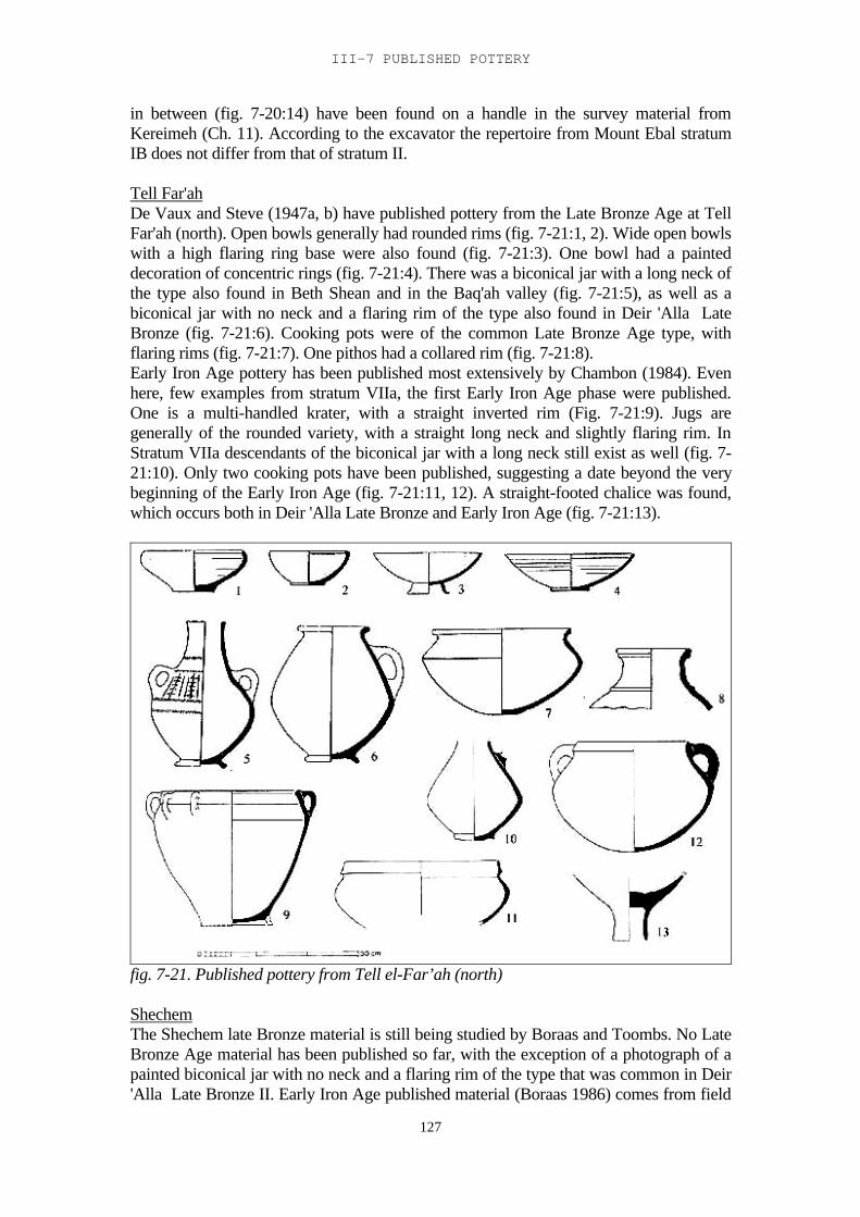
III-7 PUBLISHED POTTERY
127
in between (fig. 7-20:14) have been found on a handle in the survey material fromKereimeh (Ch. 11). According to the excavator the repertoire from Mount Ebal stratumIB does not differ from that of stratum II.
Tell Far'ahDe Vaux and Steve (1947a, b) have published pottery from the Late Bronze Age at TellFar'ah (north). Open bowls generally had rounded rims (fig. 7-21:1, 2). Wide open bowlswith a high flaring ring base were also found (fig. 7-21:3). One bowl had a painteddecoration of concentric rings (fig. 7-21:4). There was a biconical jar with a long neck ofthe type also found in Beth Shean and in the Baq'ah valley (fig. 7-21:5), as well as abiconical jar with no neck and a flaring rim of the type also found in Deir 'Alla LateBronze (fig. 7-21:6). Cooking pots were of the common Late Bronze Age type, withflaring rims (fig. 7-21:7). One pithos had a collared rim (fig. 7-21:8).Early Iron Age pottery has been published most extensively by Chambon (1984). Evenhere, few examples from stratum VIIa, the first Early Iron Age phase were published.One is a multi-handled krater, with a straight inverted rim (Fig. 7-21:9). Jugs aregenerally of the rounded variety, with a straight long neck and slightly flaring rim. InStratum VIIa descendants of the biconical jar with a long neck still exist as well (fig. 7-21:10). Only two cooking pots have been published, suggesting a date beyond the verybeginning of the Early Iron Age (fig. 7-21:11, 12). A straight-footed chalice was found,which occurs both in Deir 'Alla Late Bronze and Early Iron Age (fig. 7-21:13).
fig. 7-21. Published pottery from Tell el-Far’ah (north)
ShechemThe Shechem late Bronze material is still being studied by Boraas and Toombs. No LateBronze Age material has been published so far, with the exception of a photograph of apainted biconical jar with no neck and a flaring rim of the type that was common in Deir'Alla Late Bronze II. Early Iron Age published material (Boraas 1986) comes from field
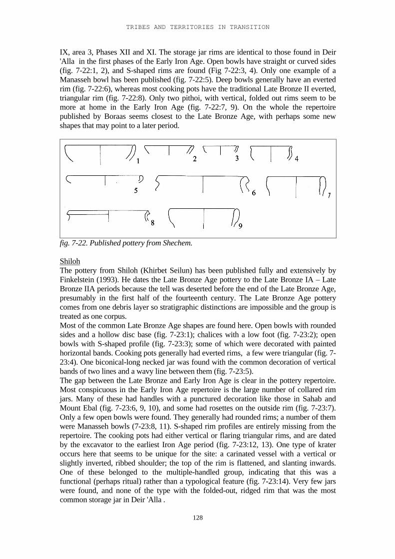
TRIBES AND TERRITORIES IN TRANSITION
128
IX, area 3, Phases XII and XI. The storage jar rims are identical to those found in Deir'Alla in the first phases of the Early Iron Age. Open bowls have straight or curved sides(fig. 7-22:1, 2), and S-shaped rims are found (Fig 7-22:3, 4). Only one example of aManasseh bowl has been published (fig. 7-22:5). Deep bowls generally have an evertedrim (fig. 7-22:6), whereas most cooking pots have the traditional Late Bronze II everted,triangular rim (fig. 7-22:8). Only two pithoi, with vertical, folded out rims seem to bemore at home in the Early Iron Age (fig. 7-22:7, 9). On the whole the repertoirepublished by Boraas seems closest to the Late Bronze Age, with perhaps some newshapes that may point to a later period.
fig. 7-22. Published pottery from Shechem.
ShilohThe pottery from Shiloh (Khirbet Seilun) has been published fully and extensively byFinkelstein (1993). He dates the Late Bronze Age pottery to the Late Bronze IA – LateBronze IIA periods because the tell was deserted before the end of the Late Bronze Age,presumably in the first half of the fourteenth century. The Late Bronze Age potterycomes from one debris layer so stratigraphic distinctions are impossible and the group istreated as one corpus.Most of the common Late Bronze Age shapes are found here. Open bowls with roundedsides and a hollow disc base (fig. 7-23:1); chalices with a low foot (fig. 7-23:2); openbowls with S-shaped profile (fig. 7-23:3); some of which were decorated with paintedhorizontal bands. Cooking pots generally had everted rims, a few were triangular (fig. 7-23:4). One biconical-long necked jar was found with the common decoration of verticalbands of two lines and a wavy line between them (fig. 7-23:5).The gap between the Late Bronze and Early Iron Age is clear in the pottery repertoire.Most conspicuous in the Early Iron Age repertoire is the large number of collared rimjars. Many of these had handles with a punctured decoration like those in Sahab andMount Ebal (fig. 7-23:6, 9, 10), and some had rosettes on the outside rim (fig. 7-23:7).Only a few open bowls were found. They generally had rounded rims; a number of themwere Manasseh bowls (7-23:8, 11). S-shaped rim profiles are entirely missing from therepertoire. The cooking pots had either vertical or flaring triangular rims, and are datedby the excavator to the earliest Iron Age period (fig. 7-23:12, 13). One type of krateroccurs here that seems to be unique for the site: a carinated vessel with a vertical orslightly inverted, ribbed shoulder; the top of the rim is flattened, and slanting inwards.One of these belonged to the multiple-handled group, indicating that this was afunctional (perhaps ritual) rather than a typological feature (fig. 7-23:14). Very few jarswere found, and none of the type with the folded-out, ridged rim that was the mostcommon storage jar in Deir 'Alla .
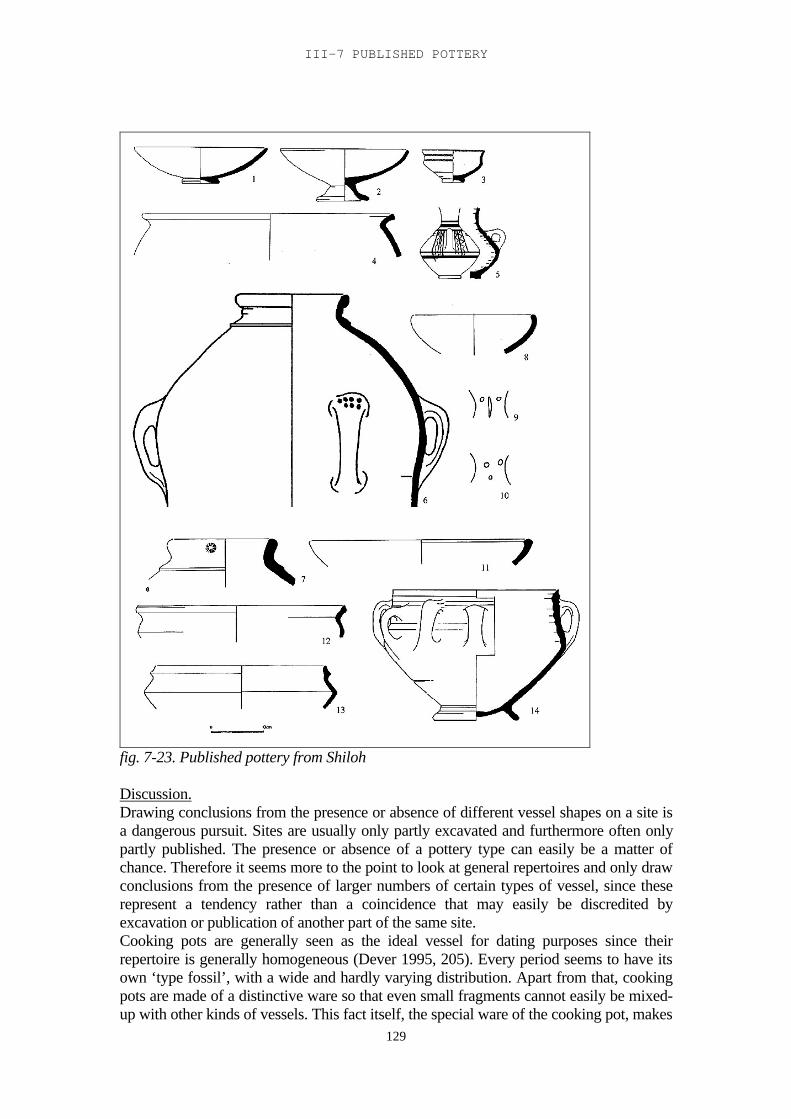
III-7 PUBLISHED POTTERY
129
fig. 7-23. Published pottery from Shiloh
Discussion.Drawing conclusions from the presence or absence of different vessel shapes on a site isa dangerous pursuit. Sites are usually only partly excavated and furthermore often onlypartly published. The presence or absence of a pottery type can easily be a matter ofchance. Therefore it seems more to the point to look at general repertoires and only drawconclusions from the presence of larger numbers of certain types of vessel, since theserepresent a tendency rather than a coincidence that may easily be discredited byexcavation or publication of another part of the same site.Cooking pots are generally seen as the ideal vessel for dating purposes since theirrepertoire is generally homogeneous (Dever 1995, 205). Every period seems to have itsown ‘type fossil’, with a wide and hardly varying distribution. Apart from that, cookingpots are made of a distinctive ware so that even small fragments cannot easily be mixed-up with other kinds of vessels. This fact itself, the special ware of the cooking pot, makes
TRIBES AND TERRITORIES IN TRANSITION
130
it likely that there were certain production centres specializing in the production ofcooking pots (Vilders 1993), which may also account for their homogeneity. Thereforetaking cooking pots as a ‘case study’ for the development of pottery in the transitionalperiod in general, as Dever (1995) does, is hardly justified. Cooking pots are a specialcase, both technologically and in their relevance in society. From the second half of theMiddle Bronze Age until the end of the Iron Age the basic shape of the cooking pot didnot change: a rounded base with an equally rounded body. There may have been adifference in technology; from the end of the Late Bronze Age the body was shaped in amould, while earlier vessels may have been coiled or made on the wheel (Homès-Frédericq and Franken 1984, 161). The most conspicuous changes, certainly until theEarly Iron Age, were in the shape of the rim. Later the pot as a whole becameprogressively smaller. The end of the Late Bronze Age sees one major type of cookingpot, one with a flaring, folded-out triangular rim. On most sites west of the Jordan theflaring triangular rim continues into the Early Iron Age and is sometimes seen as ahallmark for the earliest Early Iron Age layers: the Bull Site; Mount Ebal; Far’ah;Shechem; Shiloh. But also in Hesban (according to Sauer), this type continues into theEarly Iron Age. The later types, with vertical, triangular or elongated ridged rims, arefound both east and west of the Jordan again. In the central east Jordan Valley the LateBronze flaring rim is followed by a type with a vertical, folded and ridged rim. In Deir'Alla this is the exclusive type for the Late Bronze – Early Iron Age transition. In Pella itoccurs in the Late Bronze II layers alongside the more common flaring triangular rim. Itseems therefore that there was a separate workshop for cooking pots, that was active inthe east Jordan Valley in the transition from Late Bronze to Early Iron Age (some sherdshave also been found during the survey of the Deir 'Alla region, see Ch. IV-13). So farthe only place outside the east Jordan Valley where sherds of this type of cooking pothave surfaced is Beth Shean Level VII. Why specimens of this type turned up here is notclear at present, but it suggests a special link between Beth Shean and the East JordanValley. This type developed into what would become one of the two main types ofcooking pot rim in the later stages of the Early Iron Age, both east and west of theJordan, but in this early period its distribution seems to be limited to the few sitesmentioned above.The other pottery groups, both typological and functional, show a much more varieddistribution pattern than the cooking pots. In Late Bronze tombs in the Baq’ah Valleythere has been found a kind of open bowls, with painted concentric circles inside,sometimes on a white slip. This type also occurs in the Jebel Nuzha tomb to the southand in Beth Shean on the other side of the Jordan. It often appears together with a type ofbiconical jug with a long curved neck. These jugs were also found in the burial caves ofSahab, in the cemetery of Sa’idiyeh, and some examples have been found in Shiloh andTell Far’ah. Perhaps they were part of a specific ritual and/or burial tradition.Small bowls with an S-shaped profile, starting in the Late Bronze Age and continuing inthe Early Iron Age, appear at most sites, but are conspicuously absent from some sitessuch as 'Umeiri and the Amman Airport building, and in the cemetery of Sa'idiyeh in theJordan Valley. On the Amman plains a different type of open bowl was common, with awidely flaring rim. This type was found in 'Umeiri and in the Amman Airport building.Some examples have also been found in the Jordan Valley, in Deir 'Alla and Pella. InShiloh a comparable shape was found in the Late Bronze Age repertoire.Decorative ledge handles on large open bowls were a common feature in Balu'a, andthey have also been found on other sites. In Deir 'Alla they were particularly commononly in Iron Age Phase B, and in Madaba Tomb A they were also frequent. Although
III-7 PUBLISHED POTTERY
131
they have been found occasionally on other sites, they seem to have represented a short-lived, limited practice with roots in the plains of Moab.Another type that is conspicuous is the collared rim jar. This enormous pithos has forsome time been seen as a hallmark of early Israel. However, the find of large collectionsof collared rim jars east of the Jordan has modified this view and it is now largely seen asa characteristic of a certain lifestyle rather than of an ethnic or cultural group (London1989). The sheer size and weight of the collared rim jar makes it likely that it wasproduced locally (contra Wengrow 1996). This is confirmed by the ware analysis thathas been done on a – very limited – number of jars. Even when empty a jar would weighbetween 30-100 kg. With this in mind the homogeneity of the type on different sites,sometimes far apart, is remarkable. Even so, there are typological differences: Herrconsiders the flaring, folded-out rim and short neck as belonging to the ‘earlier’ type,which occurs on a number of sites. The two types that Herr distinguishes at 'Umeiri, andwhich he considers to be early both belong to this type. The collared rim jars found inSahab differ from these early types in that they are larger, have a vertical rim, and oftenseal stamps on the rim, or punctured marks on the handles, which are possibly potter’smarks. This is the type that has been found in Shiloh and on Mount Ebal as well.Incidental finds of collared rim jars on a number of other sites demonstrate howwidespread the type actually was, and that it was not, in fact, strictly limited to the hillcountry sites. A possibility is that they were made by travelling potters who specialisedin the production of this type of jar on-site.Another type that has formerly been seen as a hallmark for early Israel is the Manassehbowl. It was very common in the Manasseh region in the earliest Iron Age layers. It wasalso found in the Jordan Valley, at Pella and Deir 'Alla from Late Bronze Phase Donwards, and it is found in 'Umeiri in the Early Iron Age layers. No Manasseh bowlshave been found in Beth Shean. It is possible that this tradition originated in the JordanValley, and was taken to the other side of the Jordan in the Early Iron Age, where itbecame particularly popular among certain groups.
From this overview of some frequent vessel types it becomes clear that there is acomplicated pattern of relationships, at least where pottery traditions are concerned. Inthe case of collared rim jars this may be because producers travelled from site to site tomake their jars. Cooking pots could only be produced where the basic materials wereavailable, and may have had a wide range of circulation. But other types sometimesappear simultaneously on sites far apart whereas they are missing on neighbouring sites,and there are no clear groups of vessel types that appear together. Clear regional potterytraditions cannot be discerned. On the whole it can be said that Late Bronze Age potterytraditions continue into the Iron Age, such as the S-shaped bowl, the Manasseh bowl orthe neckless biconical jars, all of which can be found both in Late Bronze Age and inEarly Iron Age contexts, although modified in some cases, and not always on the samesites, even moving back and forth across the Jordan. Some shapes disappear in the EarlyIron Age, such as the wide open bowls with concentric rings, and the biconical long-necked jars, or the white slip decoration. Some new shapes appear, such as the folded-out rims and ridges on larger shapes. This fits in with a picture of moving populations atthe end of the Late Bronze Age: small groups with a mixed cultural background andmoving only relatively short distances. Pastoralists, farmers and craftsmen alike were onthe move, taking their own traditions with them, as well as absorbing others whereverthey settled down.
132
III-8. The transition at Deir 'Alla : the pottery
Introduction
Tell Deir 'Alla has been settled more or less continuously from the Middle Bronze Ageuntil the end of the Persian period. Later, in the Islamic period, it was in use as a burialground, a practice that continues to this day. The transition from the Late Bronze to theEarly Iron Age has been established by Franken after Phase H of his Late Bronze Agesequence. The Phases G and H, which have, at least in the excavated areas, a differentarchitecture from that of the preceding phases, nevertheless show influences that linkthem to the previous period rather than to the following period, according to Franken(1992). The pottery from these phases is more or less identical to that of Phases E and Fof the Late Bronze Age sequence and it differs slightly from that of the following phases.On the other hand, a much more significant break in pottery shapes is seen betweenPhases D and E of the Late Bronze Age sequence.Franken puts the transition between the Late Bronze and the Early Iron Age at the end ofPhase H, because according to him the next phase represents a different population fromthat of the preceding phases. These people were squatters, meaning that occupation in thefirst Iron Age phases was possibly only seasonal. This break in population represents thebeginning of a new society not only at Deir 'Alla but in the whole area, and therefore thestart of a new period. Changes in pottery alone cannot in themselves represent thebeginning of a new period. It is possible that they coincide with the social or culturalchanges that mark the new era, if these changes directly affect pottery making in theregion. If they do not, however, and potters can continue their trade, it is difficult or evenimpossible to discern between two periods on the basis of pottery shapes. In those casesit may be possible to discern the changes in the layout of a site, its architecture, or, on awider scale, settlement patterns. In the end, however, only an integrated approach,including all these archaeological elements, can identify the transition from one period toanother.The settlement pattern in the Deir 'Alla region will be analysed in the next chapter. Inthis chapter the changes in pottery in the different phases, in relation to the architecturewill be examined.
During the Late Bronze Age there was a sanctuary on Deir 'Alla, surrounded at the endof the period, by 'treasuries' containing the pottery and other items used in the sanctuaryand by service rooms (Franken 1992, 163 ff). The first sanctuary was built on anartificial hill constructed over the Middle Bronze Age occupation (Franken 1992, 11-12).This sanctuary was destroyed several times, by earthquakes and conflagration (Phases A-D). Franken has dated it in the sixteenth - thirteenth century (Franken 1992, 1). Phase E,immediately following Phase D and dated to the late thirteenth century, shows significantchanges in the pottery. It was destroyed, again by an earthquake with conflagration(Franken 1992, 176). The end of this sanctuary is dated somewhere after 1180 BC on thebasis of a cartouche from Queen Taousert (Yoyotte 1962; Franken 1992, XVII). Aneffort to rebuild it (Phase F) was interrupted by a second earthquake, after which nomore efforts were made.The next building phase, Phase G, has a plan that differs completely from the precedingones (Franken 1992, 101). This phase has been found east and west of the cella: walls,some of which consisted of two parallel rows of bricks, floors and courtyards. A buildingconstructed with double walls has been recovered west of the cella. This phase wasdestroyed by conflagration. Phase H (Franken 1992, 103) consisted of a tower-like
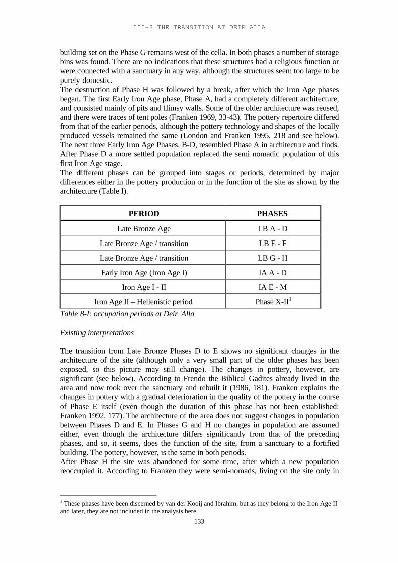
III-8 THE TRANSITION AT DEIR ALLA
133
building set on the Phase G remains west of the cella. In both phases a number of storagebins was found. There are no indications that these structures had a religious function orwere connected with a sanctuary in any way, although the structures seem too large to bepurely domestic.The destruction of Phase H was followed by a break, after which the Iron Age phasesbegan. The first Early Iron Age phase, Phase A, had a completely different architecture,and consisted mainly of pits and flimsy walls. Some of the older architecture was reused,and there were traces of tent poles (Franken 1969, 33-43). The pottery repertoire differedfrom that of the earlier periods, although the pottery technology and shapes of the locallyproduced vessels remained the same (London and Franken 1995, 218 and see below).The next three Early Iron Age Phases, B-D, resembled Phase A in architecture and finds.After Phase D a more settled population replaced the semi nomadic population of thisfirst Iron Age stage.The different phases can be grouped into stages or periods, determined by majordifferences either in the pottery production or in the function of the site as shown by thearchitecture (Table I).
PERIOD PHASES
Late Bronze Age LB A - D
Late Bronze Age / transition LB E - F
Late Bronze Age / transition LB G - H
Early Iron Age (Iron Age I) IA A - D
Iron Age I - II IA E - M
Iron Age II – Hellenistic period Phase X-II1
Table 8-I: occupation periods at Deir 'Alla
Existing interpretations
The transition from Late Bronze Phases D to E shows no significant changes in thearchitecture of the site (although only a very small part of the older phases has beenexposed, so this picture may still change). The changes in pottery, however, aresignificant (see below). According to Frendo the Biblical Gadites already lived in thearea and now took over the sanctuary and rebuilt it (1986, 181). Franken explains thechanges in pottery with a gradual deterioration in the quality of the pottery in the courseof Phase E itself (even though the duration of this phase has not been established:Franken 1992, 177). The architecture of the area does not suggest changes in populationbetween Phases D and E. In Phases G and H no changes in population are assumedeither, even though the architecture differs significantly from that of the precedingphases, and so, it seems, does the function of the site, from a sanctuary to a fortifiedbuilding. The pottery, however, is the same in both periods.After Phase H the site was abandoned for some time, after which a new populationreoccupied it. According to Franken they were semi-nomads, living on the site only in
1 These phases have been discerned by van der Kooij and Ibrahim, but as they belong to the Iron Age IIand later, they are not included in the analysis here.
TRIBES AND TERRITORIES IN TRANSITION
134
winter and practising agriculture as well as animal husbandry. Frendo thinks they wereIsraelites.
An alternative interpretation
The history of the site of Deir 'Alla shows that the transition from the Late Bronze Age tothe Early Iron Age can be characterised as a series of changes. The breaks between LateBronze Phases D and E, between Late Bronze Phases F and G and between Late BronzePhase H and Iron Age Phase A are all steps in this process. The first step, from Phase Dto Phase E, is determined by significant changes in pottery, but not in architecture orfunction of the excavated area: both in Phases D and E it was a sanctuary. The secondstep, from Phase F to Phase G, is characterised by a significant change in architectureand function of the excavated area: from a sanctuary to a defensive building, perhaps astronghold. But there are no differences in pottery technology or repertoire. The thirdstep, from Late Bronze Phase H to Iron Age Phase A, shows a change in architecture andfunction again: the site is no longer a stronghold, but has become a seasonal camp foragro-pastoralists. There is also a slight change in the functional pottery repertoire but notin technology or basic morphology.The existing explanations for these changes were all based on the assumption that thepottery was locally made, by potters who belonged to the same population group as thepopulation of Deir 'Alla. However, no traces of pottery production in the form of wastersor kilns have been found on either Late Bronze or Iron Age Deir 'Alla (Franken 1969,38), which makes it unlikely that pottery was produced on the tell.An alternative explanation would be that there were production centres that provided alarger area, including Deir 'Alla, with the vessels it needed. Technological andmorphological changes in the pottery thus reflect shifts within or between potteryproduction centres, which do not necessarily reflect changes in the population of Deir'Alla itself. On the other hand, changes in the population of the site do not necessarilyinclude the pottery production centres, and therefore the pottery repertoire may remainthe same, since the new population of the site acquired its vessels from the sameproduction centres as the former population. Social or economic changes on the site maythen be reflected in a change in functional pottery repertoire, but not in general potterytechnology or morphology.
In order to distinguish between these different explanations and to clarify the events thattriggered the transition from Late Bronze to Early Iron Age in this area, the pottery of thefirst four periods, which mark the transition from Late Bronze to Early Iron Age, hasbeen analysed on three levels: the functional, the technological and the morphologicallevel. The data for Late Bronze Phase E and Iron Age Phase B have been taken fromFranken 1969 and 1992, supplemented with my own observations. The pottery fromPhases G-H has not been published before and the observations are entirely my own.
Functional groups
A classification into functional groups is always tricky. It presumes that differencesbetween these groups are the outcome of differences in function. It also presumes thatthe evolution of the shape of a pot, or of a certain part of it, is directly related to itsfunction. But very often we do not even know what that function was. The problemsinvolved in determining the function of a certain vessel or type of vessel are numerous(Orton et al. 1993, 217 ff). Physical features involved include capacity, width of neck
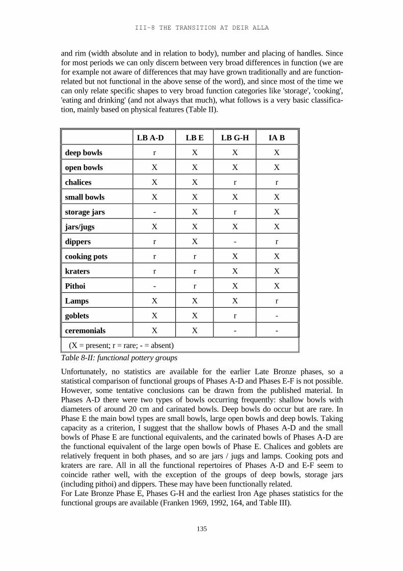
III-8 THE TRANSITION AT DEIR ALLA
135
and rim (width absolute and in relation to body), number and placing of handles. Sincefor most periods we can only discern between very broad differences in function (we arefor example not aware of differences that may have grown traditionally and are function-related but not functional in the above sense of the word), and since most of the time wecan only relate specific shapes to very broad function categories like 'storage', 'cooking','eating and drinking' (and not always that much), what follows is a very basic classifica-tion, mainly based on physical features (Table II).
LB A-D LB E LB G-H IA B
deep bowls r X X X
open bowls X X X X
chalices X X r r
small bowls X X X X
storage jars - X r X
jars/jugs X X X X
dippers r X - r
cooking pots r r X X
kraters r r X X
Pithoi - r X X
Lamps X X X r
goblets X X r -
ceremonials X X - -
(X = present; r = rare; - = absent)Table 8-II: functional pottery groups
Unfortunately, no statistics are available for the earlier Late Bronze phases, so astatistical comparison of functional groups of Phases A-D and Phases E-F is not possible.However, some tentative conclusions can be drawn from the published material. InPhases A-D there were two types of bowls occurring frequently: shallow bowls withdiameters of around 20 cm and carinated bowls. Deep bowls do occur but are rare. InPhase E the main bowl types are small bowls, large open bowls and deep bowls. Takingcapacity as a criterion, I suggest that the shallow bowls of Phases A-D and the smallbowls of Phase E are functional equivalents, and the carinated bowls of Phases A-D arethe functional equivalent of the large open bowls of Phase E. Chalices and goblets arerelatively frequent in both phases, and so are jars / jugs and lamps. Cooking pots andkraters are rare. All in all the functional repertoires of Phases A-D and E-F seem tocoincide rather well, with the exception of the groups of deep bowls, storage jars(including pithoi) and dippers. These may have been functionally related.For Late Bronze Phase E, Phases G-H and the earliest Iron Age phases statistics for thefunctional groups are available (Franken 1969, 1992, 164, and Table III).
TRIBES AND TERRITORIES IN TRANSITION
136
deepbowl
openbowl
smallbowl
storagejar
smalljar
cookpot dipper krater cere-
monial total
LB-E 37 48 138 46 74 11 39 30 80 503G-H 13 10 19 4 17 7 8 2 80IA-B 252 170 174 424 146 124 11 24 13 1338
LB-E 7, 4% 9, 5% 27, 4% 9, 1% 14, 7% 2, 2% 7, 8% 6, 0% 15, 9% 100%G-H 16, 3% 12, 5% 23, 8% 5, 0% 21, 3% 8, 8% 0, 0% 10, 0% 2, 5% 100%IA-B 18, 8% 12, 7% 13, 0% 31, 7% 10, 9% 9, 3% 0, 8% 1, 8% 1, 0% 100%Table 8-III. Numbers and percentages of sherds from the three main periods.
There are no statistics for Late Bronze Phase F, and according to Franken the materialfrom Iron Age Phase A may have been too mixed up with earlier material to serve as areliable sample for the Iron Age (Franken 1969, 240). Therefore the transition from LateBronze to Iron Age is visualised using the functional repertoire of Late Bronze Phase E,Phases G-H and Iron Age Phase B only (fig. 8-1).
0%
10%
20%
30%
40%
50%
60%
70%
80%
90%
100%
LB-E G-H IA-B
ceremonial
krater
dipper
cooking pot
small jar
storage jar
small bowl
open bowl
deep bowl
Fig. 8-1: percentages of functional groups
The reliability range for this statistical comparison has been calculated (for method seeFranken and Steiner 1990, 69). For the small bowls, the largest class (32.8%) thereliability range of the Late Bronze Phase E sample is ± 5.8% for Z=1.96, and ± 3.4% forZ=1.15, meaning that there is a 95% chance that the actual percentage (of the wholepopulation) lies within a range of ±5.8 of 32.8%, and a 75% chance that it lies within arange of ± 3.4 of 32.8%. The reliability range for the small bowls of Late Bronze PhasesG-H (23.8%) is ± 9.3 for Z=1.96 and ± 5.4 for Z=1.15 respectively. For Iron Age PhaseB the reliability range for the storage jars, the largest class (31.7%) reliability is ±2.5 forZ=1.96 and ±1.5 for Z=1.15. Therefore comparison is primarily between Late BronzePhase E and Iron Age Phase B. Most of the functional groups present in the Late BronzeAge are also found in the Early Iron Age, with the exception of the ceremonial vessels
III-8 THE TRANSITION AT DEIR ALLA
137
(including goblets: Table 8-II), which were directly related to the temple and thereforenot to be expected in the later period. If we look at the relative percentages however (fig.1), there are some outstanding differences: larger bowls were far less common in theLate Bronze than in the Iron Age, and, on the other hand, in the Late Bronze Agerepertoire we find far more small bowls than in the Iron Age. Storage jars form a largepart (31.7%) of the Iron Age repertoire, but a relatively small part (9.5%) of the LateBronze repertoire. Hardly any cooking pots (1.2%) were found in the Late Bronze (9.3%in the Iron Age), but a relatively large number (15.4%) of dippers (0.8% in the IronAge).As for Late Bronze Phases G-H: the percentages of cooking pots, open bowls and deepbowls coincide with those of the Iron Age. The relative number of kraters and jars/jugs islarge compared to the preceding as well as the following phases. There were very fewstorage jars and, except for one goblet rim, no ceremonial vessels.Technology - waregroups
The term 'technological' is restricted to the descriptions given in Franken 1969 and 1992.For the Late Bronze Age pottery a systematic ware analysis has been published (Franken1992, 106 ff). Eight different ware groups were found in the Late Bronze Age, two ofwhich, A and B, were considered local. The percentages of the wares, whether local orforeign, do not differ significantly over the phases (Franken 1992, 113), with theexception of ware C pottery, which is present in considerable amounts in Phases B-D,and somewhat less prominent in Phase A. After Phase D it occurs only sporadically.Ware C has been described as having a strong lime component and very fine quartz asnatural components of the clay (Franken 1992, 108). Basalt sand has been added, makingit clear that this pottery comes from a basalt area, probably from the north according toFranken, although large basalt areas can also be found in Moab. Why this importsuddenly comes to a virtual halt after Phase D is a question that cannot be answered bythe archaeological record. However, it seems likely that it is related to the changes in thegeneral pottery repertoire in this period, which were caused by events affecting thewhole region (see below).No statistics have been given for the transitional Phases G and H in Franken 1992, but Ihad the opportunity to analyse these groups myself, and I have included the results in thegraph of fig. 8-2 (NG-H = 134). It coincides with those from the preceding phases, mainlyE and F. (Franken 1992, 113). I have studied a sample of sherds from Iron Age Phase B,and found that most sherds are made of either ware A or B. According to Frendo (1986,154) the ware in both periods is basically the same, but the Iron Age pottery is moreneatly finished and less coarse than that of the Late Bronze Age.Cooking pots in all phases are made from clay with a calcite temper. They may havecome from specialised production centres, and have been distributed over a relativelylarge region (Vilders 1993, 155). Franken has suggested the possibility that ceremonialware may have been produced in a separate workshop; its use was limited to thesanctuary and was therefore of marginal significance commercially. Apart from that ithad a ritual function, so it may well be that its production was also surrounded by ritual.
TRIBES AND TERRITORIES IN TRANSITION
138
0%
10%
20%
30%
40%
50%
60%
70%
80%
90%
100%
a b c d e f gh
H
G
F
E
D
C
B
A
Fig. 8- 2: ware groups in the Late Bronze Age
Technology - manufacture
Significant differences in pottery manufacture between Late Bronze Phases A-D andPhase E are “the marked absence of paint, the presence of heavy, thick-walled pots, andbases cut off and filled with dung-tempered clay” in the latter phase (London andFranken 1995, 215). The main cause for most of the differences is that the fast wheel hasgone out of use and all the pottery is made on the turntable (Franken 1992, 151-2) withleaner clays. A fast wheel enables the potter to use centrifugal forces to shape a vessel,and to make thin-walled vessels by turning. The use of leaner clays, and consequently aslow wheel or turntable, requires different techniques. Walls were made thinner byscraping when the clay was leather hard. This led to less 'elegant', coarser vessels anddifferent shapes.Franken states that this change of technique slowed down the production of pottery.Generally mass production of pottery coincides with less decoration, because decorationslows up the process. “But the evidence from Deir 'Alla seems to contradict this. In theearly days there is wheel thrown decorated pottery and in the end one finds only turn-table pottery practically without decoration of any sort” (Franken 1992, 150). Thisdiscrepancy has not been explained, but there is a possibility that leaner clays were usedin order to speed up the drying and firing of the vessels and therefore of the wholeprocess of pottery production. Lean clays cannot be used with a fast wheel because thecentrifugal forces would tear the clay apart, and the sand in the clay would act as sandpaper on the hands of the potter. Therefore a slow wheel or turntable would have to beused. This would explain the disappearance of the time-consuming decorations on thepottery as well.
The manufacture of the different types of Late Bronze Phases E-H and of the earliestIron Age phases can be compared for each functional group, since both have beendescribed by Franken (1969, 1992).
III-8 THE TRANSITION AT DEIR ALLA
139
Cooking pots.Each period had its own type of cooking pot (Franken 1969, 119-121). Both types wereshaped in moulds and they differ only in the manufacture of the rim: the Late BronzeAge type had a fold inwards, which was pushed against the inner wall and pulledupwards creating a ridge (fig. 8-3:1); the rim of the Iron Age type has an extra foldoutwards (fig. 8-3:2, 3). Both types were found in Late Bronze Age Phases G-H.
fig. 8-3: Cooking pots from Tell Deir 'Alla
Deep bowls.The Late Bronze Age deep bowls in general show the same characteristics as Iron Agedeep bowls type 3 (described in Franken 1969, 137 and Franken 1992, 156, *C2), with arim that has been finished by folding the surplus clay at the top of the rim inwards andsmoothing it (fig. 8-4:1, 2). Iron Age type 1, which has an extra outward fold of the rim,occurred occasionally in the Late Bronze Age (Franken 1992, fig 7.21:30) but becamepopular only in the Early Iron Age (fig 8-3:3, 4). In Late Bronze Phases G-H nine bowlsof this last type were found, and four bowls of the Late Bronze Age type, indicating thatthis type was slowly becoming more common.
fig. 8-4: Deep bowls from Tell Deir 'Alla
Kraters.
fig. 8-5. Kraters from Tell Deir 'Alla
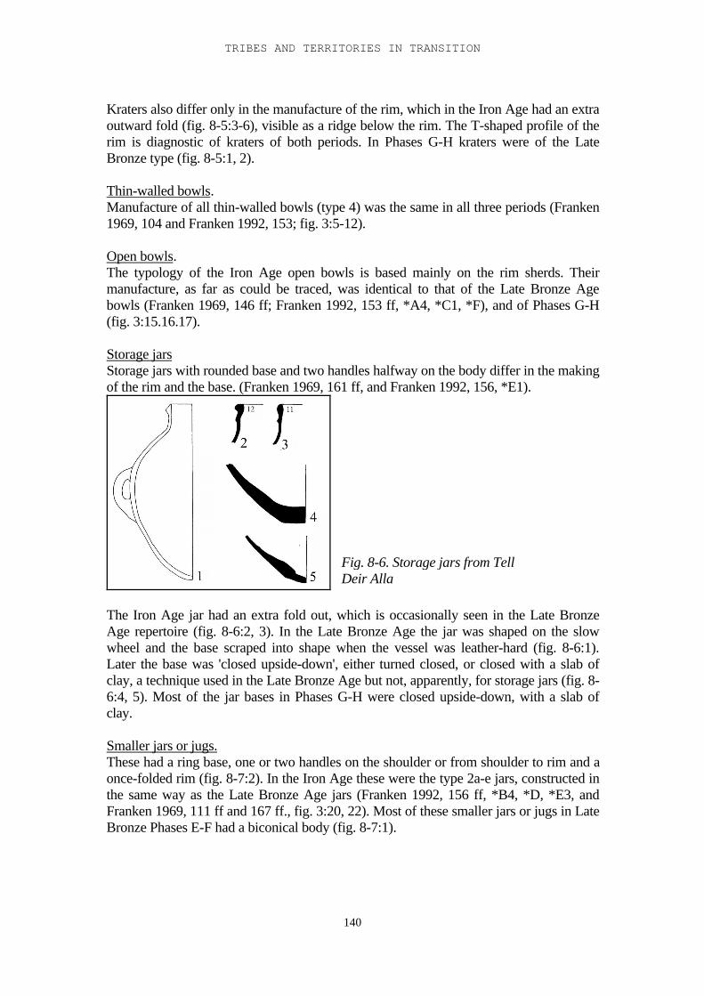
TRIBES AND TERRITORIES IN TRANSITION
140
Kraters also differ only in the manufacture of the rim, which in the Iron Age had an extraoutward fold (fig. 8-5:3-6), visible as a ridge below the rim. The T-shaped profile of therim is diagnostic of kraters of both periods. In Phases G-H kraters were of the LateBronze type (fig. 8-5:1, 2).
Thin-walled bowls.Manufacture of all thin-walled bowls (type 4) was the same in all three periods (Franken1969, 104 and Franken 1992, 153; fig. 3:5-12).
Open bowls.The typology of the Iron Age open bowls is based mainly on the rim sherds. Theirmanufacture, as far as could be traced, was identical to that of the Late Bronze Agebowls (Franken 1969, 146 ff; Franken 1992, 153 ff, *A4, *C1, *F), and of Phases G-H(fig. 3:15.16.17).
Storage jarsStorage jars with rounded base and two handles halfway on the body differ in the makingof the rim and the base. (Franken 1969, 161 ff, and Franken 1992, 156, *E1).
The Iron Age jar had an extra fold out, which is occasionally seen in the Late BronzeAge repertoire (fig. 8-6:2, 3). In the Late Bronze Age the jar was shaped on the slowwheel and the base scraped into shape when the vessel was leather-hard (fig. 8-6:1).Later the base was 'closed upside-down', either turned closed, or closed with a slab ofclay, a technique used in the Late Bronze Age but not, apparently, for storage jars (fig. 8-6:4, 5). Most of the jar bases in Phases G-H were closed upside-down, with a slab ofclay.
Smaller jars or jugs.These had a ring base, one or two handles on the shoulder or from shoulder to rim and aonce-folded rim (fig. 8-7:2). In the Iron Age these were the type 2a-e jars, constructed inthe same way as the Late Bronze Age jars (Franken 1992, 156 ff, *B4, *D, *E3, andFranken 1969, 111 ff and 167 ff., fig. 3:20, 22). Most of these smaller jars or jugs in LateBronze Phases E-F had a biconical body (fig. 8-7:1).
Fig. 8-6. Storage jars from TellDeir Alla
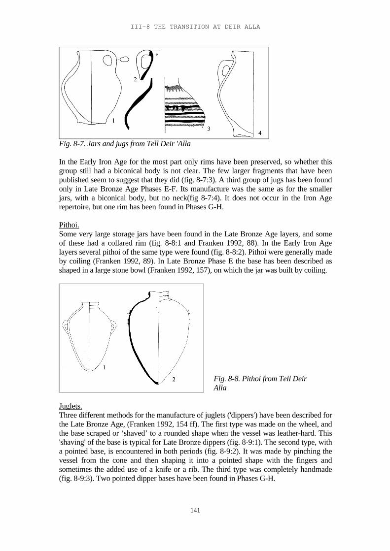
III-8 THE TRANSITION AT DEIR ALLA
141
Fig. 8-7. Jars and jugs from Tell Deir 'Alla
In the Early Iron Age for the most part only rims have been preserved, so whether thisgroup still had a biconical body is not clear. The few larger fragments that have beenpublished seem to suggest that they did (fig. 8-7:3). A third group of jugs has been foundonly in Late Bronze Age Phases E-F. Its manufacture was the same as for the smallerjars, with a biconical body, but no neck(fig 8-7:4). It does not occur in the Iron Agerepertoire, but one rim has been found in Phases G-H.
Pithoi.Some very large storage jars have been found in the Late Bronze Age layers, and someof these had a collared rim (fig. 8-8:1 and Franken 1992, 88). In the Early Iron Agelayers several pithoi of the same type were found (fig. 8-8:2). Pithoi were generally madeby coiling (Franken 1992, 89). In Late Bronze Phase E the base has been described asshaped in a large stone bowl (Franken 1992, 157), on which the jar was built by coiling.
Juglets.Three different methods for the manufacture of juglets ('dippers') have been described forthe Late Bronze Age, (Franken 1992, 154 ff). The first type was made on the wheel, andthe base scraped or ‘shaved’ to a rounded shape when the vessel was leather-hard. This'shaving' of the base is typical for Late Bronze dippers (fig. 8-9:1). The second type, witha pointed base, is encountered in both periods (fig. 8-9:2). It was made by pinching thevessel from the cone and then shaping it into a pointed shape with the fingers andsometimes the added use of a knife or a rib. The third type was completely handmade(fig. 8-9:3). Two pointed dipper bases have been found in Phases G-H.
Fig. 8-8. Pithoi from Tell DeirAlla
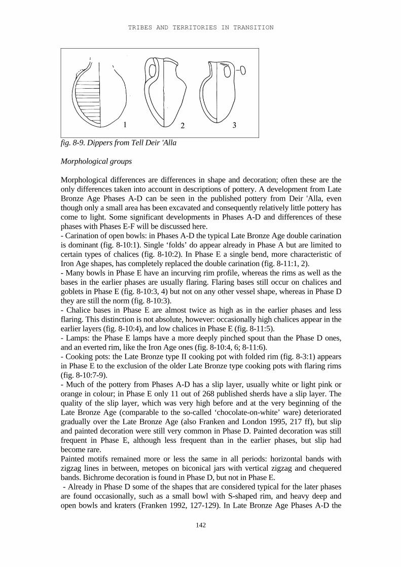
TRIBES AND TERRITORIES IN TRANSITION
142
fig. 8-9. Dippers from Tell Deir 'Alla
Morphological groups
Morphological differences are differences in shape and decoration; often these are theonly differences taken into account in descriptions of pottery. A development from LateBronze Age Phases A-D can be seen in the published pottery from Deir 'Alla, eventhough only a small area has been excavated and consequently relatively little pottery hascome to light. Some significant developments in Phases A-D and differences of thesephases with Phases E-F will be discussed here.- Carination of open bowls: in Phases A-D the typical Late Bronze Age double carinationis dominant (fig. 8-10:1). Single ‘folds’ do appear already in Phase A but are limited tocertain types of chalices (fig. 8-10:2). In Phase E a single bend, more characteristic ofIron Age shapes, has completely replaced the double carination (fig. 8-11:1, 2).- Many bowls in Phase E have an incurving rim profile, whereas the rims as well as thebases in the earlier phases are usually flaring. Flaring bases still occur on chalices andgoblets in Phase E (fig. 8-10:3, 4) but not on any other vessel shape, whereas in Phase Dthey are still the norm (fig. 8-10:3).- Chalice bases in Phase E are almost twice as high as in the earlier phases and lessflaring. This distinction is not absolute, however: occasionally high chalices appear in theearlier layers (fig. 8-10:4), and low chalices in Phase E (fig. 8-11:5).- Lamps: the Phase E lamps have a more deeply pinched spout than the Phase D ones,and an everted rim, like the Iron Age ones (fig. 8-10:4, 6; 8-11:6).- Cooking pots: the Late Bronze type II cooking pot with folded rim (fig. 8-3:1) appearsin Phase E to the exclusion of the older Late Bronze type cooking pots with flaring rims(fig. 8-10:7-9).- Much of the pottery from Phases A-D has a slip layer, usually white or light pink ororange in colour; in Phase E only 11 out of 268 published sherds have a slip layer. Thequality of the slip layer, which was very high before and at the very beginning of theLate Bronze Age (comparable to the so-called ‘chocolate-on-white’ ware) deterioratedgradually over the Late Bronze Age (also Franken and London 1995, 217 ff), but slipand painted decoration were still very common in Phase D. Painted decoration was stillfrequent in Phase E, although less frequent than in the earlier phases, but slip hadbecome rare.Painted motifs remained more or less the same in all periods: horizontal bands withzigzag lines in between, metopes on biconical jars with vertical zigzag and chequeredbands. Bichrome decoration is found in Phase D, but not in Phase E. - Already in Phase D some of the shapes that are considered typical for the later phasesare found occasionally, such as a small bowl with S-shaped rim, and heavy deep andopen bowls and kraters (Franken 1992, 127-129). In Late Bronze Age Phases A-D the
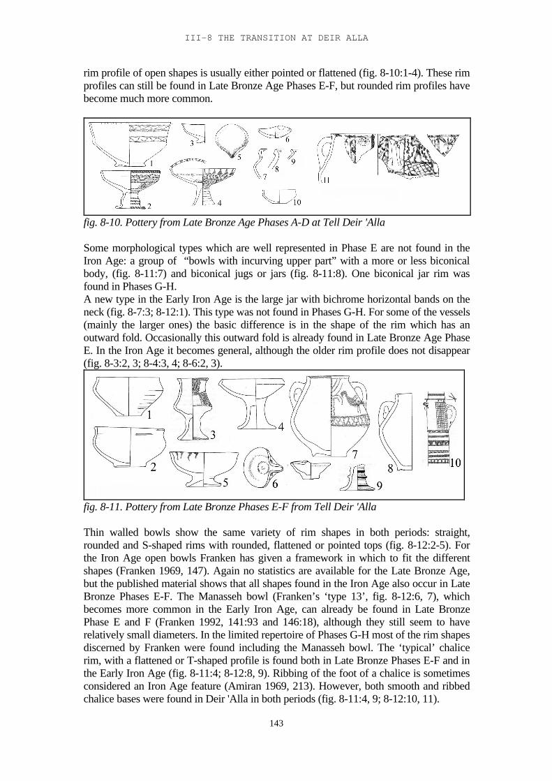
III-8 THE TRANSITION AT DEIR ALLA
143
rim profile of open shapes is usually either pointed or flattened (fig. 8-10:1-4). These rimprofiles can still be found in Late Bronze Age Phases E-F, but rounded rim profiles havebecome much more common.
fig. 8-10. Pottery from Late Bronze Age Phases A-D at Tell Deir 'Alla
Some morphological types which are well represented in Phase E are not found in theIron Age: a group of “bowls with incurving upper part” with a more or less biconicalbody, (fig. 8-11:7) and biconical jugs or jars (fig. 8-11:8). One biconical jar rim wasfound in Phases G-H.A new type in the Early Iron Age is the large jar with bichrome horizontal bands on theneck (fig. 8-7:3; 8-12:1). This type was not found in Phases G-H. For some of the vessels(mainly the larger ones) the basic difference is in the shape of the rim which has anoutward fold. Occasionally this outward fold is already found in Late Bronze Age PhaseE. In the Iron Age it becomes general, although the older rim profile does not disappear(fig. 8-3:2, 3; 8-4:3, 4; 8-6:2, 3).
fig. 8-11. Pottery from Late Bronze Phases E-F from Tell Deir 'Alla
Thin walled bowls show the same variety of rim shapes in both periods: straight,rounded and S-shaped rims with rounded, flattened or pointed tops (fig. 8-12:2-5). Forthe Iron Age open bowls Franken has given a framework in which to fit the differentshapes (Franken 1969, 147). Again no statistics are available for the Late Bronze Age,but the published material shows that all shapes found in the Iron Age also occur in LateBronze Phases E-F. The Manasseh bowl (Franken’s ‘type 13’, fig. 8-12:6, 7), whichbecomes more common in the Early Iron Age, can already be found in Late BronzePhase E and F (Franken 1992, 141:93 and 146:18), although they still seem to haverelatively small diameters. In the limited repertoire of Phases G-H most of the rim shapesdiscerned by Franken were found including the Manasseh bowl. The ‘typical’ chalicerim, with a flattened or T-shaped profile is found both in Late Bronze Phases E-F and inthe Early Iron Age (fig. 8-11:4; 8-12:8, 9). Ribbing of the foot of a chalice is sometimesconsidered an Iron Age feature (Amiran 1969, 213). However, both smooth and ribbedchalice bases were found in Deir 'Alla in both periods (fig. 8-11:4, 9; 8-12:10, 11).
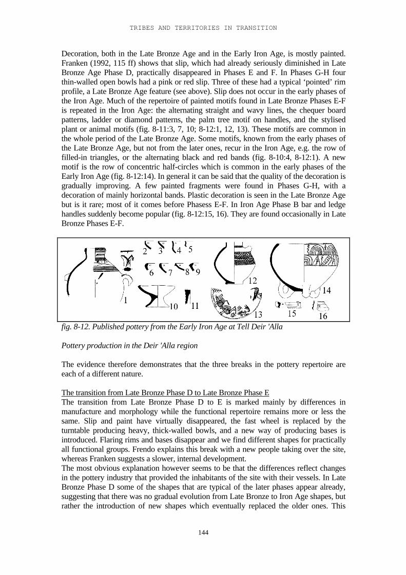
TRIBES AND TERRITORIES IN TRANSITION
144
Decoration, both in the Late Bronze Age and in the Early Iron Age, is mostly painted.Franken (1992, 115 ff) shows that slip, which had already seriously diminished in LateBronze Age Phase D, practically disappeared in Phases E and F. In Phases G-H fourthin-walled open bowls had a pink or red slip. Three of these had a typical ‘pointed’ rimprofile, a Late Bronze Age feature (see above). Slip does not occur in the early phases ofthe Iron Age. Much of the repertoire of painted motifs found in Late Bronze Phases E-Fis repeated in the Iron Age: the alternating straight and wavy lines, the chequer boardpatterns, ladder or diamond patterns, the palm tree motif on handles, and the stylisedplant or animal motifs (fig. 8-11:3, 7, 10; 8-12:1, 12, 13). These motifs are common inthe whole period of the Late Bronze Age. Some motifs, known from the early phases ofthe Late Bronze Age, but not from the later ones, recur in the Iron Age, e.g. the row offilled-in triangles, or the alternating black and red bands (fig. 8-10:4, 8-12:1). A newmotif is the row of concentric half-circles which is common in the early phases of theEarly Iron Age (fig. 8-12:14). In general it can be said that the quality of the decoration isgradually improving. A few painted fragments were found in Phases G-H, with adecoration of mainly horizontal bands. Plastic decoration is seen in the Late Bronze Agebut is it rare; most of it comes before Phasess E-F. In Iron Age Phase B bar and ledgehandles suddenly become popular (fig. 8-12:15, 16). They are found occasionally in LateBronze Phases E-F.
fig. 8-12. Published pottery from the Early Iron Age at Tell Deir 'Alla
Pottery production in the Deir 'Alla region
The evidence therefore demonstrates that the three breaks in the pottery repertoire areeach of a different nature.
The transition from Late Bronze Phase D to Late Bronze Phase EThe transition from Late Bronze Phase D to E is marked mainly by differences inmanufacture and morphology while the functional repertoire remains more or less thesame. Slip and paint have virtually disappeared, the fast wheel is replaced by theturntable producing heavy, thick-walled bowls, and a new way of producing bases isintroduced. Flaring rims and bases disappear and we find different shapes for practicallyall functional groups. Frendo explains this break with a new people taking over the site,whereas Franken suggests a slower, internal development.The most obvious explanation however seems to be that the differences reflect changesin the pottery industry that provided the inhabitants of the site with their vessels. In LateBronze Phase D some of the shapes that are typical of the later phases appear already,suggesting that there was no gradual evolution from Late Bronze to Iron Age shapes, butrather the introduction of new shapes which eventually replaced the older ones. This
III-8 THE TRANSITION AT DEIR ALLA
145
suggests that during the time of Late Bronze Age Phase D, probably towards the end ofthe period, potters from elsewhere entered the region and started practising their trade.
The transition from Late Bronze Phases E-F to Late Bronze Phases G-H.In Late Bronze Phases E-F the sanctuary was still functioning. There was no change inpopulation from Phase D to Phase E. The pottery they used, however, came fromdifferent workshops, established by potters from elsewhere, possibly from the AmmanPlateau. These potters had to deal with new material and therefore some of their productsmay have been clumsy in the earliest periods. However, they managed to establishthemselves in the region and eventually their new techniques and shapes dominated themarket.Based on the distribution of household as compared to ceremonial pottery, Franken hasascribed a storage or household function to the rooms west of the cella. Most of thestorage jars were found here as well as the three registered cooking pots. Dippers,chalices, small bowls and jugs as well as kraters, were found both east and west of thecella, suggesting that, although not strictly ceremonial, they may have been used in theservice of the temple.In the transition from Late Bronze Phases E-F to G 'luxury' and ceremonial vessels, likechalices and dippers, virtually disappear whereas the household vessels, like cookingpots, deep bowls and large open bowls, such as had been found in the rooms west of thecella, become more common; this suggests a change in economy (but not necessarily inpopulation). The number of storage jars is extremely low in both periods. Storage mayhave been mainly in storage bins, many of which were found in these phases. Thesedifferences can be explained by a change in function of the site: the disappearance of thetemple in Phase G, and the building of a fortress and later a tower in the area of theformer sanctuary.
The transition from Late Bronze Phases G-H to the Early Iron Age.After the tower of Phase H was abandoned the site seems to have been deserted forperhaps 20-25 years. The next phases, the earliest Early Iron Age phases, see a completechange in architectural layout. The changes in the pottery repertoire are much lessobvious and concern the distribution of the functional groups. A sharp increase in storagejars is the most notable change in the pottery repertoire. Apparently the Early Iron Agesettlers had different storage methods from their predecessors. At the same time thenumbers of small bowls, small jars and kraters, three functional groups most likelyconnected with eating and drinking habits, decrease sharply. All this points to a changein the nature of the settlement and a new group of occupants.
As shown above, pottery manufacture remained virtually the same from Late BronzePhase E into the Iron Age. The pottery production centres that functioned at the end ofthe Late Bronze Age were still functioning in the beginning of the Early Iron Age. Anew type of jar made its appearance, the storage jar with bichrome decoration on theneck, but most shapes remained virtually unchanged. The potters did, however, introduceone, or perhaps two, major technological changes that seriously improved the quality ofthe vessels, the folding out of the rim, found occasionally already in Late Bronze Phase Eand F and seen mostly in the larger vessels such as storage jars, deep bowls and kraters.The second change seems to be that biconical shapes now became more rounded. Bothchanges had a positive effect on the strength of the vessel.According to Franken, potters do not change their mode of production unless forced todo so (1982, 142). This may be because their basic material changes or because their
TRIBES AND TERRITORIES IN TRANSITION
146
market changes. By the end of the Late Bronze Age, in the course of Late Bronze PhaseE, new technological and morphological types of vessels were introduced in the Deir'Alla region, most likely by newly arrived potters. There is no reason to assume that theold production centres simply disappeared, but now they had to compete with the newpotters. In this scenario rapid changes in the production of vessel types are possible, suchas are seen in the transition from Late Bronze Phase D to E.Some changes took more time to evolve, like the second fold in the rim of the largervessels and the appearance of a new shape of jar, showing that this introduction of newpottery techniques was a gradual process that continued into the beginning of the IronAge. In Late Bronze Age Phases E and F the second fold in the rim is foundoccasionally; in Phases G-H 16 out of a total of 95 rims or one-fifth is folded; in IronAge Phases A and B it is more or less general on the large vessels.The rim of a pot is usually the most vulnerable part. A heavier and therefore stronger rimwould be an important improvement. But only if there were a certain amount ofcompetition would potters go through the extra trouble, a thicker rim takes longer to dry,and there is the extra risk of it cracking during firing because of the difference inthickness. The fact that an extra ridge below the rim on the outside becomes accentuatedin certain types (kraters, jars) suggests that it may have been a mark of quality. The samecan be said about the increasing roundness of the body. A rounded vessel can take morepressure than a biconical one, which tends to break on the carination. However, biconicalshapes are easier to make, especially when coiling techniques are used. These twodevelopments therefore suggest the presence of a certain amount of competition in theregion.Franken has proposed to ascribe the locally produced pottery of Late Bronze Phases Eand F to two different workshops (Franken 1992, 107-108). He distinguished two locallyproduced wares, A and B. About two-thirds of the locally produced pottery was madefrom ware A. Both centres produced all functional groups but there are some typologicaldifferences: Small bowls from workshop B have an S-shaped profile with a thickenedrim. Large bowls were generally made in workshop A and the few exceptions have a dif-ferent profile.These morphological differences support Franken’s suggestion of (at least) two differentworkshops in the Late Bronze Age. As no comparable ware-analysis has been done forthe Early Iron Age nothing explicit can be said about workshops in that period.
147
IV-9. The excavations at Tell el-Hammeh.
In 1996 and 1997 two seasons of small-scale excavations were conducted at Tell el-Hammeh on the north bank of the lower course of the Zerqa1 (fig. 9-1). Tell el-Hammehlies 2.5 km east of Tell Deir 'Alla , at the point where the Zerqa enters the foothills. Itrises seven metres above its surroundings and still stands out from the relatively flatlandscape of the Zerqa flood plain. It is at present occupied with a large farmstead thathouses two families. The tell has been visited by several survey expeditions (Glueck1951, 313; Gordon and Villiers 1983; Ibrahim et al. 1988) and was believed to have beensettled in the Early Bronze Age, and also from the Early Iron Age up to the Persianperiod. Some Roman sherds were found as well. The German institute at Amman has acollection of sherds from the site.
Excavations were started in order to clarify settlement patterns in the transitional LateBronze - Early Iron Age and at the beginning of the Iron Age in relation to Deir 'Alla ,and to investigate the possibility of a trade route from the Deir 'Alla area through theWadi Zerqa to the Baq'ah valley (van der Steen 1996). An additional reason forexcavation of this site was the fact that a large segment of the tell had recently been cutaway for agricultural purposes; this on the one hand stressed the need for research, andon the other hand it provided a section through a large part of the tell, which simply hadto be cleaned. The excavations were directed towards two main aims:- To clean and draw the bulldozer cut, in order to get an overview of the occupationhistory of the site;- To determining in which period the tell was resettled in the transitional period and thenature of this reoccupation.Bad weather conditions (heavy eastern winds, coming from the Wadi Zerqa to the east,which functioned as a ‘wind-tunnel’, in the first season, and much rain in the secondseason) seriously hampered the excavations. Still, large parts of the bulldozer cut werecleaned on both ends and in the centre, and a clear occupational sequence could beidentified. The earliest occupation found was Chalcolithic and Early Bronze Age. This isconcentrated on the southwest end of the tell, where a mudbrick wall belonging to thisearly occupation could be seen in the section.On top of these early layers came the first surprise, material from the Middle and LateBronze Ages. None of the previous surveys (see above) had produced even one sherdfrom those periods. The material consisted of rather fine pottery with white and pink slipand painted decoration. The highest concentration of this pottery was found in the centralpart of the tell, although sherds were found scattered over the whole site. On top of thisthe Iron Age occupation covered most of the tell.The biggest surprise however came when the northern part of the bulldozer cut wascleaned; heavy ash and slag layers, as well as remains of three furnaces, revealed thepresence of a large scale iron smelting industry. This was the side of the site that wasmost open to the eastern winds that are so frequent here. On the basis of the pottery theselayers have been provisionally dated to the early eighth century BC2.
1 The excavations were part of the Deir 'Alla expedition, headed by Dr. G. van der Kooij on behalf ofLeiden University, and Dr. Z. Kafafi on behalf of Yarmuk University. E. van der Steen directed theexcavations. The second season was partly funded by the Department of Antiquities of Jordan.
2 The remains of the iron industry at Tell el-Hammeh are at present being studied by H.A. Veldhuizenat the University of London.
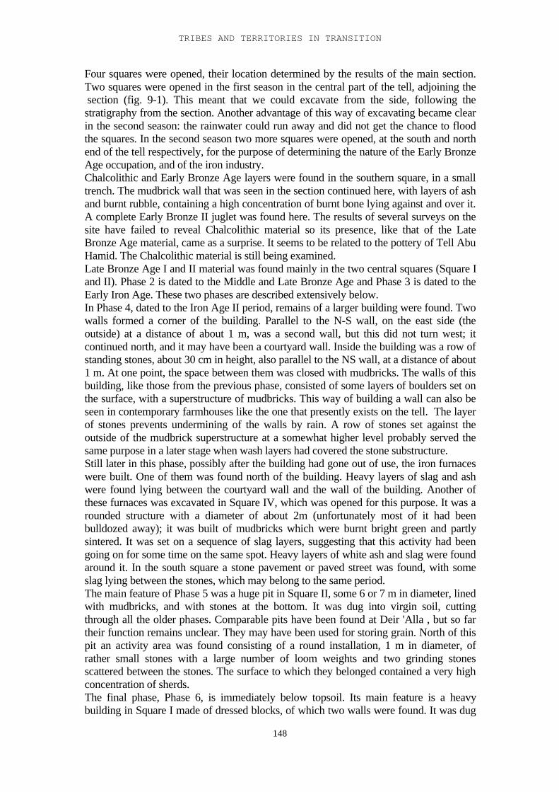
TRIBES AND TERRITORIES IN TRANSITION
148
Four squares were opened, their location determined by the results of the main section.Two squares were opened in the first season in the central part of the tell, adjoining the section (fig. 9-1). This meant that we could excavate from the side, following thestratigraphy from the section. Another advantage of this way of excavating became clearin the second season: the rainwater could run away and did not get the chance to floodthe squares. In the second season two more squares were opened, at the south and northend of the tell respectively, for the purpose of determining the nature of the Early BronzeAge occupation, and of the iron industry.Chalcolithic and Early Bronze Age layers were found in the southern square, in a smalltrench. The mudbrick wall that was seen in the section continued here, with layers of ashand burnt rubble, containing a high concentration of burnt bone lying against and over it.A complete Early Bronze II juglet was found here. The results of several surveys on thesite have failed to reveal Chalcolithic material so its presence, like that of the LateBronze Age material, came as a surprise. It seems to be related to the pottery of Tell AbuHamid. The Chalcolithic material is still being examined.Late Bronze Age I and II material was found mainly in the two central squares (Square Iand II). Phase 2 is dated to the Middle and Late Bronze Age and Phase 3 is dated to theEarly Iron Age. These two phases are described extensively below.In Phase 4, dated to the Iron Age II period, remains of a larger building were found. Twowalls formed a corner of the building. Parallel to the N-S wall, on the east side (theoutside) at a distance of about 1 m, was a second wall, but this did not turn west; itcontinued north, and it may have been a courtyard wall. Inside the building was a row ofstanding stones, about 30 cm in height, also parallel to the NS wall, at a distance of about1 m. At one point, the space between them was closed with mudbricks. The walls of thisbuilding, like those from the previous phase, consisted of some layers of boulders set onthe surface, with a superstructure of mudbricks. This way of building a wall can also beseen in contemporary farmhouses like the one that presently exists on the tell. The layerof stones prevents undermining of the walls by rain. A row of stones set against theoutside of the mudbrick superstructure at a somewhat higher level probably served thesame purpose in a later stage when wash layers had covered the stone substructure.Still later in this phase, possibly after the building had gone out of use, the iron furnaceswere built. One of them was found north of the building. Heavy layers of slag and ashwere found lying between the courtyard wall and the wall of the building. Another ofthese furnaces was excavated in Square IV, which was opened for this purpose. It was arounded structure with a diameter of about 2m (unfortunately most of it had beenbulldozed away); it was built of mudbricks which were burnt bright green and partlysintered. It was set on a sequence of slag layers, suggesting that this activity had beengoing on for some time on the same spot. Heavy layers of white ash and slag were foundaround it. In the south square a stone pavement or paved street was found, with someslag lying between the stones, which may belong to the same period.The main feature of Phase 5 was a huge pit in Square II, some 6 or 7 m in diameter, linedwith mudbricks, and with stones at the bottom. It was dug into virgin soil, cuttingthrough all the older phases. Comparable pits have been found at Deir 'Alla , but so fartheir function remains unclear. They may have been used for storing grain. North of thispit an activity area was found consisting of a round installation, 1 m in diameter, ofrather small stones with a large number of loom weights and two grinding stonesscattered between the stones. The surface to which they belonged contained a very highconcentration of sherds.The final phase, Phase 6, is immediately below topsoil. Its main feature is a heavybuilding in Square I made of dressed blocks, of which two walls were found. It was dug
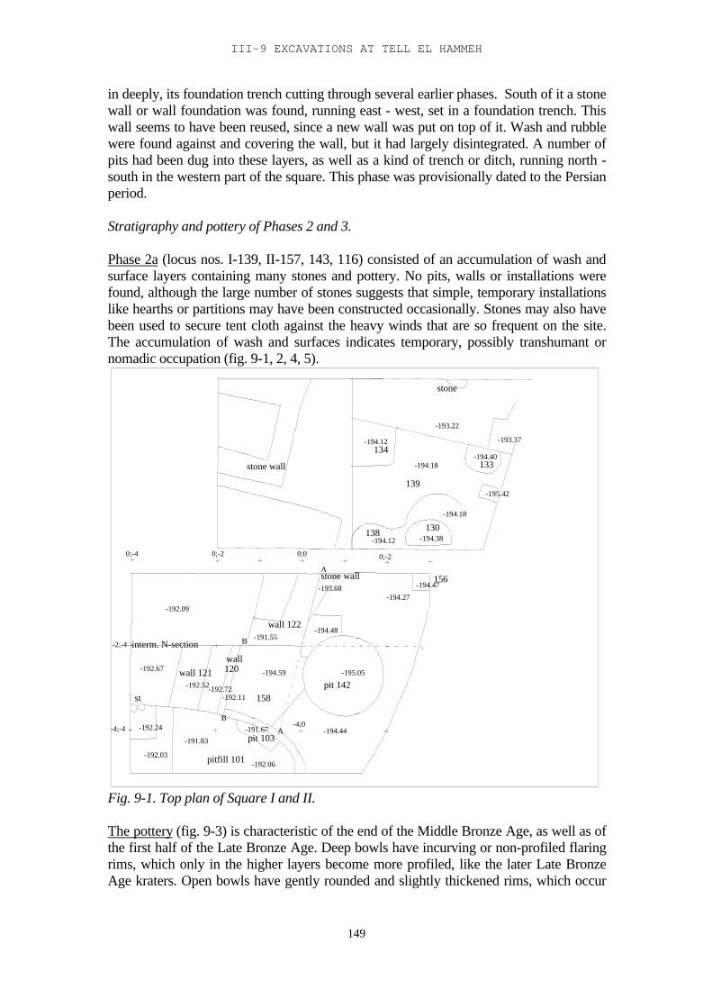
III-9 EXCAVATIONS AT TELL EL HAMMEH
149
in deeply, its foundation trench cutting through several earlier phases. South of it a stonewall or wall foundation was found, running east - west, set in a foundation trench. Thiswall seems to have been reused, since a new wall was put on top of it. Wash and rubblewere found against and covering the wall, but it had largely disintegrated. A number ofpits had been dug into these layers, as well as a kind of trench or ditch, running north -south in the western part of the square. This phase was provisionally dated to the Persianperiod.
Stratigraphy and pottery of Phases 2 and 3.
Phase 2a (locus nos. I-139, II-157, 143, 116) consisted of an accumulation of wash andsurface layers containing many stones and pottery. No pits, walls or installations werefound, although the large number of stones suggests that simple, temporary installationslike hearths or partitions may have been constructed occasionally. Stones may also havebeen used to secure tent cloth against the heavy winds that are so frequent on the site.The accumulation of wash and surfaces indicates temporary, possibly transhumant ornomadic occupation (fig. 9-1, 2, 4, 5).
-194.12134
-194.18
139
-193.22
-194.12138
-194.38130
-194.18
-195.42
-194.40133
-193.37
stone
0;-2
stone wall
0;0
wall 122
st
-4;-4
-192.03
-192.24
-192.67
-192.06
-191.83
pitfill 101
B
-192.52
wall 121wall
-192.72-192.11
120
pit 103-191.67 A
-194.59
158
-192.09
interm. N-section-2;-4
0;-4
B -191.55
-194.44-4;0
pit 142-195.05
-194.47
-194.48
stone wall-193.68
A
-194.27
0;-2
156
Fig. 9-1. Top plan of Square I and II.
The pottery (fig. 9-3) is characteristic of the end of the Middle Bronze Age, as well as ofthe first half of the Late Bronze Age. Deep bowls have incurving or non-profiled flaringrims, which only in the higher layers become more profiled, like the later Late BronzeAge kraters. Open bowls have gently rounded and slightly thickened rims, which occur
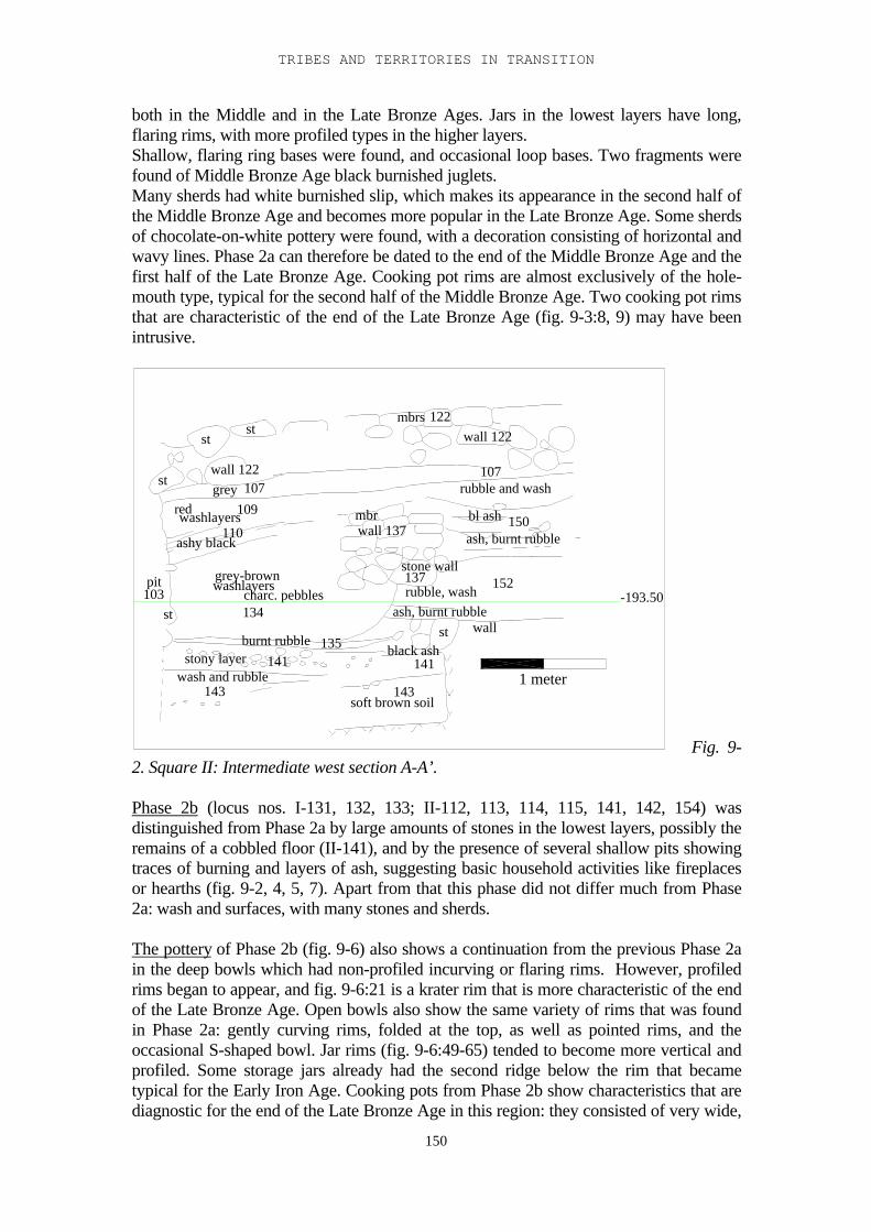
TRIBES AND TERRITORIES IN TRANSITION
150
both in the Middle and in the Late Bronze Ages. Jars in the lowest layers have long,flaring rims, with more profiled types in the higher layers.Shallow, flaring ring bases were found, and occasional loop bases. Two fragments werefound of Middle Bronze Age black burnished juglets.Many sherds had white burnished slip, which makes its appearance in the second half ofthe Middle Bronze Age and becomes more popular in the Late Bronze Age. Some sherdsof chocolate-on-white pottery were found, with a decoration consisting of horizontal andwavy lines. Phase 2a can therefore be dated to the end of the Middle Bronze Age and thefirst half of the Late Bronze Age. Cooking pot rims are almost exclusively of the hole-mouth type, typical for the second half of the Middle Bronze Age. Two cooking pot rimsthat are characteristic of the end of the Late Bronze Age (fig. 9-3:8, 9) may have beenintrusive.
redwashlayers109grey 107wall 122
stst
st
ashy black110
pit103
st
grey-brownwashlayers
charc. pebbles134
burnt rubble 135stony layer 141
wash and rubble143
soft brown soil143
141black ash
stash, burnt rubble
rubble, wash
stone wall137
mbrwall 137
rubble and wash
bl ash
ash, burnt rubble150
107
wall 122
152
wall
mbrs 122
-193.50
1 meter
Fig. 9-2. Square II: Intermediate west section A-A’.
Phase 2b (locus nos. I-131, 132, 133; II-112, 113, 114, 115, 141, 142, 154) wasdistinguished from Phase 2a by large amounts of stones in the lowest layers, possibly theremains of a cobbled floor (II-141), and by the presence of several shallow pits showingtraces of burning and layers of ash, suggesting basic household activities like fireplacesor hearths (fig. 9-2, 4, 5, 7). Apart from that this phase did not differ much from Phase2a: wash and surfaces, with many stones and sherds.
The pottery of Phase 2b (fig. 9-6) also shows a continuation from the previous Phase 2ain the deep bowls which had non-profiled incurving or flaring rims. However, profiledrims began to appear, and fig. 9-6:21 is a krater rim that is more characteristic of the endof the Late Bronze Age. Open bowls also show the same variety of rims that was foundin Phase 2a: gently curving rims, folded at the top, as well as pointed rims, and theoccasional S-shaped bowl. Jar rims (fig. 9-6:49-65) tended to become more vertical andprofiled. Some storage jars already had the second ridge below the rim that becametypical for the Early Iron Age. Cooking pots from Phase 2b show characteristics that arediagnostic for the end of the Late Bronze Age in this region: they consisted of very wide,
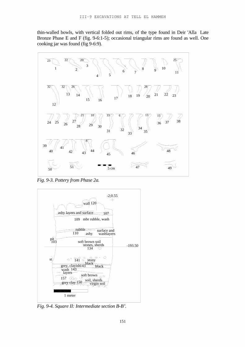
III-9 EXCAVATIONS AT TELL EL HAMMEH
151
thin-walled bowls, with vertical folded out rims, of the type found in Deir 'Alla LateBronze Phase E and F (fig. 9-6:1-5); occasional triangular rims are found as well. Onecooking jar was found (fig 9-6:9).
23
1
22
23
20
9 10
4 56 7
8
25
3232
11
12
13 14
26
17 1815 16
28
3321 10
19 20 21 22 23
24 25 2627
28 29 3031
156 13
3233
3435
36 37 38
3940
41
8
42 43 4445 46
47
48
495051 5 cm
Fig. 9-3. Pottery from Phase 2a.
wall 120
ashy layers and surface 107
109 mbr rubble, wash
rubble110
pit103
ashysurface andwashlayers
soft brown soilstones, sherds
134
141 stonyblack
grey, clayish143 blackwashlayers
143
157soft brown
soil, sherdsvirgin soilgrey clay 150
st
-2;0.55
-193.50
1 meter
Fig. 9-4. Square II: Intermediate section B-B’.
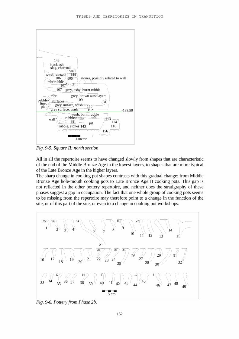
TRIBES AND TERRITORIES IN TRANSITION
152
wall st
rubble, stones 143
rubble141
ash, charc.154
wash, burnt rubblegrey surface, wash 152
grey surface, wash 150pit
pebble-lined surfaces
mbr grey, brown washlayers109
grey, ashy, burnt rubble107107 st
mbr rubble st
146black ashslag, charcoal
wall144wash, surface
106 105 stones, possibly related to wall
st
153
pit113
114
156116
-193.50
1 meter
Fig. 9-5. Square II: north section
All in all the repertoire seems to have changed slowly from shapes that are characteristicof the end of the Middle Bronze Age in the lowest layers, to shapes that are more typicalof the Late Bronze Age in the higher layers.The sharp change in cooking pot shapes contrasts with this gradual change: from MiddleBronze Age hole-mouth cooking pots to Late Bronze Age II cooking pots. This gap isnot reflected in the other pottery repertoire, and neither does the stratigraphy of thesephases suggest a gap in occupation. The fact that one whole group of cooking pots seemsto be missing from the repertoire may therefore point to a change in the function of thesite, or of this part of the site, or even to a change in cooking pot workshops.
1 2
35 35
43
14 16
5
6 7 8 9
27
10 11 12 1314
28 28 33
9 10 81412
15
16 1718 19 20
21 22 23 2425
2627
28
29
30
31
32
33 3435 36 37 38 39 40 41 42 43 44
4546 47 48
49
5 cm
Fig. 9-6. Pottery from Phase 2b.
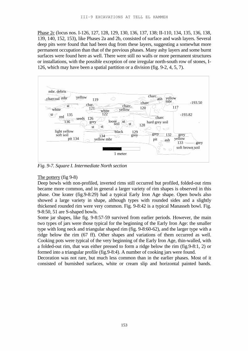
III-9 EXCAVATIONS AT TELL EL HAMMEH
153
Phase 2c (locus nos. I-126, 127, 128, 129, 130, 136, 137, 138; II-110, 134, 135, 136, 138,139, 140, 152, 153), like Phases 2a and 2b, consisted of surface and wash layers. Severaldeep pits were found that had been dug from these layers, suggesting a somewhat morepermanent occupation than that of the previous phases. Many ashy layers and some burntsurfaces were found here as well. There were still no walls or more permanent structuresor installations, with the possible exception of one irregular north-south row of stones, I-126, which may have been a spatial partition or a division (fig. 9-2, 4, 5, 7).
mbr. debris
mbr yellow 119charcoal
char.st
135white
red seeds
white yellow122
126
121
st
light yellowsoft soil
pit 134
stgrey
stloose soil
yellow mbr134
129
128stst
black
charc.
grey
hard grey soil
charc120
grey
yellowmbr
117
charc.ash
132
charc
greyyellowpit ash
soft brown soil133 grey
-193.82
136
-193.50
1 meter
Fig. 9-7. Square I. Intermediate North section
The pottery (fig 9-8)Deep bowls with non-profiled, inverted rims still occurred but profiled, folded-out rimsbecame more common, and in general a larger variety of rim shapes is observed in thisphase. One krater (fig.9-8:29) had a typical Early Iron Age shape. Open bowls alsoshowed a large variety in shape, although types with rounded sides and a slightlythickened rounded rim were very common. Fig. 9-8:42 is a typical Manasseh bowl. Fig.9-8:50, 51 are S-shaped bowls.Some jar shapes, like fig. 9-8:57-59 survived from earlier periods. However, the maintwo types of jars were those typical for the beginning of the Early Iron Age: the smallertype with long neck and triangular shaped rim (fig. 9-8:60-62), and the larger type with aridge below the rim (67 ff). Other shapes and variations of them occurred as well.Cooking pots were typical of the very beginning of the Early Iron Age, thin-walled, witha folded-out rim, that was either pressed to form a ridge below the rim (fig.9-8:1, 2) orformed into a triangular profile (fig.9-8:4). A number of cooking jars were found.Decoration was not rare, but much less common than in the earlier phases. Most of itconsisted of burnished surfaces, white or cream slip and horizontal painted bands.
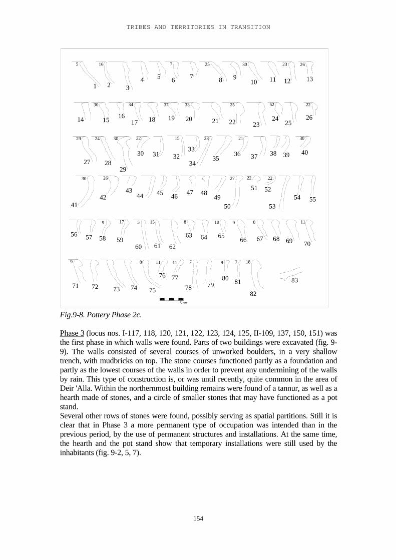
TRIBES AND TERRITORIES IN TRANSITION
154
5 16 7 25 23
29 30
26
32
26
21
27
23
22
15
30 22
11
8 11
18
59
5 cm
8
15 89
911
34
1 2
30
24
7 7
2537 33
30
225230
17
9
10
34 5 6 7 8 9
10 11 12 13
14 15 1617 18 19 20 21 22 23
2425
26
27 2829
30 31 3233
3435
36 37 38 39 40
4142
4344 45 46 47 48
4950
51 52
5354 55
56 57 58 5960 61 62
63 64 65 66 67 68 69 70
71 72 73 74 75
76 7778 79
80 81
82
83
Fig.9-8. Pottery Phase 2c.
Phase 3 (locus nos. I-117, 118, 120, 121, 122, 123, 124, 125, II-109, 137, 150, 151) wasthe first phase in which walls were found. Parts of two buildings were excavated (fig. 9-9). The walls consisted of several courses of unworked boulders, in a very shallowtrench, with mudbricks on top. The stone courses functioned partly as a foundation andpartly as the lowest courses of the walls in order to prevent any undermining of the wallsby rain. This type of construction is, or was until recently, quite common in the area ofDeir 'Alla. Within the northernmost building remains were found of a tannur, as well as ahearth made of stones, and a circle of smaller stones that may have functioned as a potstand.Several other rows of stones were found, possibly serving as spatial partitions. Still it isclear that in Phase 3 a more permanent type of occupation was intended than in theprevious period, by the use of permanent structures and installations. At the same time,the hearth and the pot stand show that temporary installations were still used by theinhabitants (fig. 9-2, 5, 7).
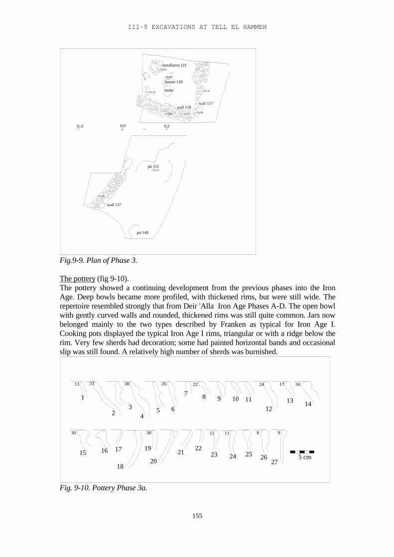
III-9 EXCAVATIONS AT TELL EL HAMMEH
155
wall 137
-193.20
pit 151-193.53
pit 149
0;0 0;20;-2
-193.16
-192.80
wall 118-192.97
stone
-192.90
-193.18
wall 117
installaton 121
tannur 120-193.40
-193.42
Fig.9-9. Plan of Phase 3.
The pottery (fig 9-10).The pottery showed a continuing development from the previous phases into the IronAge. Deep bowls became more profiled, with thickened rims, but were still wide. Therepertoire resembled strongly that from Deir 'Alla Iron Age Phases A-D. The open bowlwith gently curved walls and rounded, thickened rims was still quite common. Jars nowbelonged mainly to the two types described by Franken as typical for Iron Age I.Cooking pots displayed the typical Iron Age I rims, triangular or with a ridge below therim. Very few sherds had decoration; some had painted horizontal bands and occasionalslip was still found. A relatively high number of sherds was burnished.
1
2
8
3
13 33 22 34
30 9
2638
11 11
24 17
30
45 6
7 8 9 10 1112
13 14
15 16 17
18
19
2021 22
23 24 25 2627
5 cm
Fig. 9-10. Pottery Phase 3a.
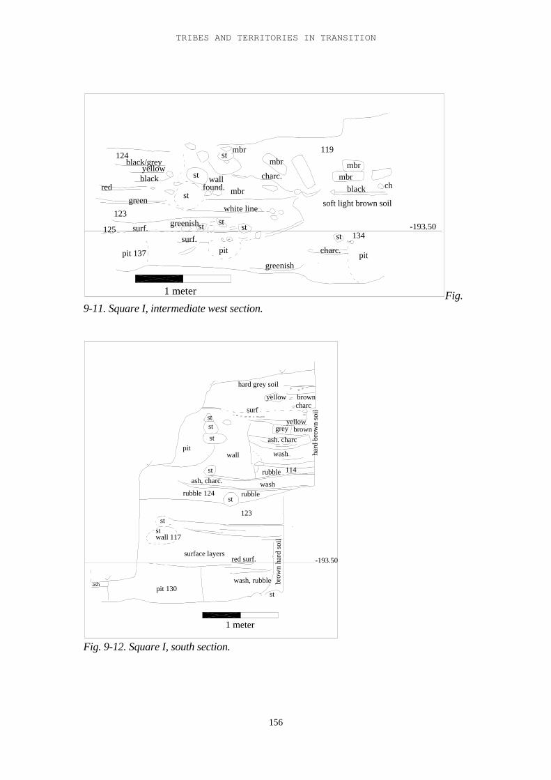
TRIBES AND TERRITORIES IN TRANSITION
156
119
mbrmbr
mbr
ch
soft light brown soil
black
charc.
mbrst
mbrwall
found.st
st
white line
greenish
pit
stststgreenish
surf.
pit 137
125 surf.
123
green
redblackyellow
124black/grey
st 134
charc. pit
-193.50
1 meter Fig.9-11. Square I, intermediate west section.
hard grey soil
yellow browncharc
grey brownash. charc
surf
yellow
hard
bro
wn
soil
wash
rubble
washrubble
114
123
st
red surf.
wash, rubble brow
n ha
rd s
oil
st
stst
stpit
wall
stash, charc.
rubble 124
ststwall 117
surface layers
pit 130ash
-193.50
1 meter
Fig. 9-12. Square I, south section.
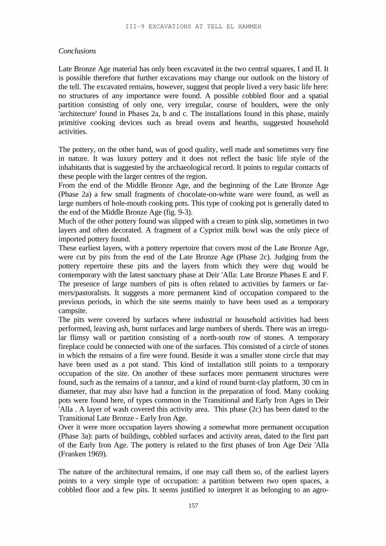
III-9 EXCAVATIONS AT TELL EL HAMMEH
157
Conclusions
Late Bronze Age material has only been excavated in the two central squares, I and II. Itis possible therefore that further excavations may change our outlook on the history ofthe tell. The excavated remains, however, suggest that people lived a very basic life here:no structures of any importance were found. A possible cobbled floor and a spatialpartition consisting of only one, very irregular, course of boulders, were the only'architecture' found in Phases 2a, b and c. The installations found in this phase, mainlyprimitive cooking devices such as bread ovens and hearths, suggested householdactivities.
The pottery, on the other hand, was of good quality, well made and sometimes very finein nature. It was luxury pottery and it does not reflect the basic life style of theinhabitants that is suggested by the archaeological record. It points to regular contacts ofthese people with the larger centres of the region.From the end of the Middle Bronze Age, and the beginning of the Late Bronze Age(Phase 2a) a few small fragments of chocolate-on-white ware were found, as well aslarge numbers of hole-mouth cooking pots. This type of cooking pot is generally dated tothe end of the Middle Bronze Age (fig. 9-3).Much of the other pottery found was slipped with a cream to pink slip, sometimes in twolayers and often decorated. A fragment of a Cypriot milk bowl was the only piece ofimported pottery found.These earliest layers, with a pottery repertoire that covers most of the Late Bronze Age,were cut by pits from the end of the Late Bronze Age (Phase 2c). Judging from thepottery repertoire these pits and the layers from which they were dug would becontemporary with the latest sanctuary phase at Deir 'Alla: Late Bronze Phases E and F.The presence of large numbers of pits is often related to activities by farmers or far-mers/pastoralists. It suggests a more permanent kind of occupation compared to theprevious periods, in which the site seems mainly to have been used as a temporarycampsite.The pits were covered by surfaces where industrial or household activities had beenperformed, leaving ash, burnt surfaces and large numbers of sherds. There was an irregu-lar flimsy wall or partition consisting of a north-south row of stones. A temporaryfireplace could be connected with one of the surfaces. This consisted of a circle of stonesin which the remains of a fire were found. Beside it was a smaller stone circle that mayhave been used as a pot stand. This kind of installation still points to a temporaryoccupation of the site. On another of these surfaces more permanent structures werefound, such as the remains of a tannur, and a kind of round burnt-clay platform, 30 cm indiameter, that may also have had a function in the preparation of food. Many cookingpots were found here, of types common in the Transitional and Early Iron Ages in Deir'Alla . A layer of wash covered this activity area. This phase (2c) has been dated to theTransitional Late Bronze - Early Iron Age.Over it were more occupation layers showing a somewhat more permanent occupation(Phase 3a): parts of buildings, cobbled surfaces and activity areas, dated to the first partof the Early Iron Age. The pottery is related to the first phases of Iron Age Deir 'Alla(Franken 1969).
The nature of the architectural remains, if one may call them so, of the earliest layerspoints to a very simple type of occupation: a partition between two open spaces, acobbled floor and a few pits. It seems justified to interpret it as belonging to an agro-
TRIBES AND TERRITORIES IN TRANSITION
158
pastoral, perhaps mobile, temporary population. What is at odds with it, however, is thenature of the pottery.There were some chocolate-on-white sherds from the earliest layers. Also in the laterphases much of the pottery was made of fine ware, often decorated. Apparently, althoughthe people who lived here, or camped here, may have led a primitive, simple life, theywere in contact with the greater culture that surrounded them, and possibly were lessprimitive or rural than their architecture or lack of it suggests.We can think of several explanations for this phenomenon. In the light the proximity ofTell el-Hammeh to the Deir 'Alla market area and its position on the trade route to theeast, it seems possible that this was, at least during the Late Bronze Age, a temporarycamp used by people involved in trading during their stay in the Deir 'Alla area, whichthey revisited whenever they came. It had the basic requirements for a temporary camp:water was near at hand, and cobbles and boulders were lying everywhere around toquickly build temporary structures and installations. The pottery from the earliest layersshows that this camp was used from the end of the Middle Bronze Age or the verybeginning of the Late Bronze Age. Hole-mouth cooking pots are mainly known fromsites west of the Jordan (on Deir 'Alla some sherds of hole-mouth cooking pots havebeen found, but these have not yet been published; and a rim of a hole-mouth cookingpot was found in Kataret es-Samra, fig.11-13:1). Therefore the most likely option seemsto be that Tell el-Hammeh was a ‘road stop’ for travellers through the Zerqa Valley: thelast stop before entering the valley, or the first stop after they came out of it. On theother end Khirbet Umm ed-Dananir (Chapter I-3) may have had the same function. Atrade route through the Wadi Zerqa is the most likely reason for these activities.At the end of the Late Bronze Age the trade route went out of use. Some of thepopulation from the Amman Plateau moved down into the Jordan Valley. In Chapter 6 itwas argued that these belonged to the transhumant groups who, in the Late Bronze Age,were involved in the trade between the Jordan Valley and the Amman Plateau. Theywould be familiar with the region they came to, and settled first on the sites that theyalready knew and possibly considered part of their territory. Tell el-Hammeh must havebeen one of these sites. The architecture of Phase 3 is the result of the first settlement ofthese people.
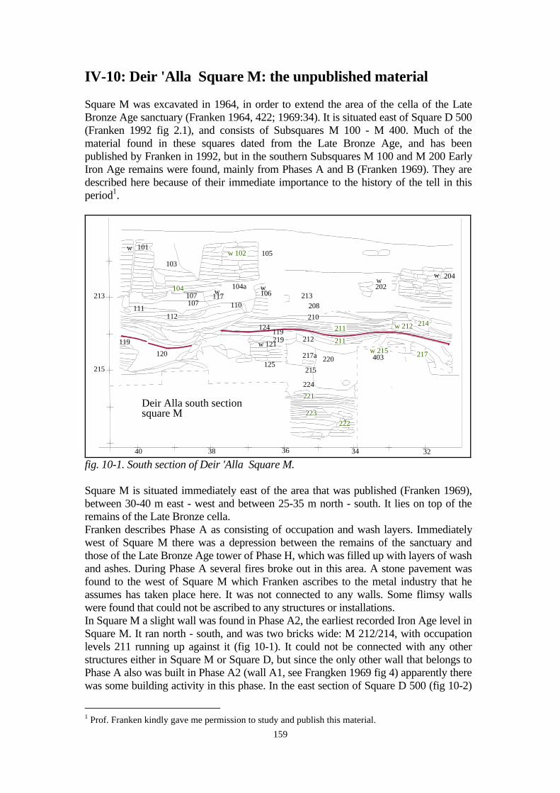
159
IV-10: Deir 'Alla Square M: the unpublished material
Square M was excavated in 1964, in order to extend the area of the cella of the LateBronze Age sanctuary (Franken 1964, 422; 1969:34). It is situated east of Square D 500(Franken 1992 fig 2.1), and consists of Subsquares M 100 - M 400. Much of thematerial found in these squares dated from the Late Bronze Age, and has beenpublished by Franken in 1992, but in the southern Subsquares M 100 and M 200 EarlyIron Age remains were found, mainly from Phases A and B (Franken 1969). They aredescribed here because of their immediate importance to the history of the tell in thisperiod1.
215
40 38 36 34 32
w 101
111
103
104107107
112
120
119
w 102
104aw
117110
105
w106
124 119
w 121219
125
213208210
212
217a 220
211
211
215
224
221
223w222
w202
w 215
w 204
214
217
w 212
403
Deir Alla south sectionsquare M
213
fig. 10-1. South section of Deir 'Alla Square M.
Square M is situated immediately east of the area that was published (Franken 1969),between 30-40 m east - west and between 25-35 m north - south. It lies on top of theremains of the Late Bronze cella.Franken describes Phase A as consisting of occupation and wash layers. Immediatelywest of Square M there was a depression between the remains of the sanctuary andthose of the Late Bronze Age tower of Phase H, which was filled up with layers of washand ashes. During Phase A several fires broke out in this area. A stone pavement wasfound to the west of Square M which Franken ascribes to the metal industry that heassumes has taken place here. It was not connected to any walls. Some flimsy wallswere found that could not be ascribed to any structures or installations.In Square M a slight wall was found in Phase A2, the earliest recorded Iron Age level inSquare M. It ran north - south, and was two bricks wide: M 212/214, with occupationlevels 211 running up against it (fig 10-1). It could not be connected with any otherstructures either in Square M or Square D, but since the only other wall that belongs toPhase A also was built in Phase A2 (wall A1, see Frangken 1969 fig 4) apparently therewas some building activity in this phase. In the east section of Square D 500 (fig 10-2)
1 Prof. Franken kindly gave me permission to study and publish this material.
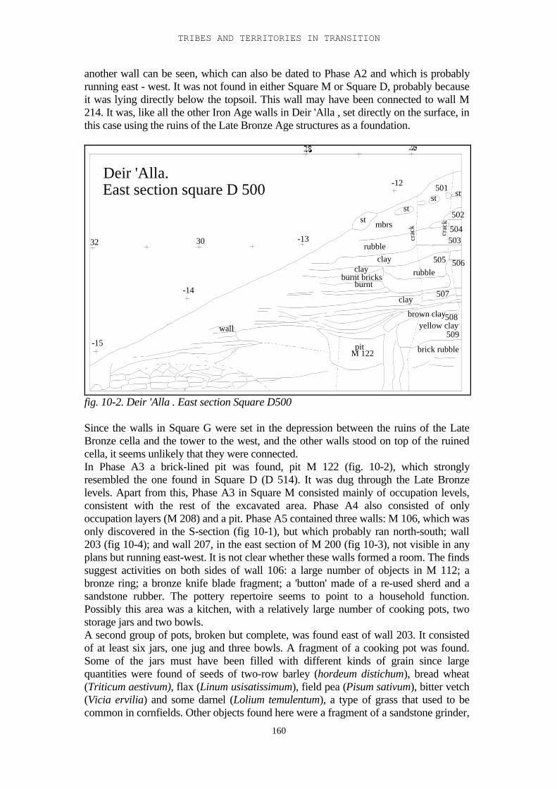
TRIBES AND TERRITORIES IN TRANSITION
160
another wall can be seen, which can also be dated to Phase A2 and which is probablyrunning east - west. It was not found in either Square M or Square D, probably becauseit was lying directly below the topsoil. This wall may have been connected to wall M214. It was, like all the other Iron Age walls in Deir 'Alla , set directly on the surface, inthis case using the ruins of the Late Bronze Age structures as a foundation.
3032
-15
-14
-13
-12
crac
k
crac
k
st
stst
st501
502
503504
505 506
507
508
509
rubble
brown clayyellow clay
brick rubble
mbrs
rubbleclay
clayburnt bricks
burnt
clay
pitM 122
wall
Deir 'Alla.East section square D 500
fig. 10-2. Deir 'Alla . East section Square D500
Since the walls in Square G were set in the depression between the ruins of the LateBronze cella and the tower to the west, and the other walls stood on top of the ruinedcella, it seems unlikely that they were connected.In Phase A3 a brick-lined pit was found, pit M 122 (fig. 10-2), which stronglyresembled the one found in Square D (D 514). It was dug through the Late Bronzelevels. Apart from this, Phase A3 in Square M consisted mainly of occupation levels,consistent with the rest of the excavated area. Phase A4 also consisted of onlyoccupation layers (M 208) and a pit. Phase A5 contained three walls: M 106, which wasonly discovered in the S-section (fig 10-1), but which probably ran north-south; wall203 (fig 10-4); and wall 207, in the east section of M 200 (fig 10-3), not visible in anyplans but running east-west. It is not clear whether these walls formed a room. The findssuggest activities on both sides of wall 106: a large number of objects in M 112; abronze ring; a bronze knife blade fragment; a 'button' made of a re-used sherd and asandstone rubber. The pottery repertoire seems to point to a household function.Possibly this area was a kitchen, with a relatively large number of cooking pots, twostorage jars and two bowls.A second group of pots, broken but complete, was found east of wall 203. It consistedof at least six jars, one jug and three bowls. A fragment of a cooking pot was found.Some of the jars must have been filled with different kinds of grain since largequantities were found of seeds of two-row barley (hordeum distichum), bread wheat(Triticum aestivum), flax (Linum usisatissimum), field pea (Pisum sativum), bitter vetch(Vicia ervilia) and some darnel (Lolium temulentum), a type of grass that used to becommon in cornfields. Other objects found here were a fragment of a sandstone grinder,
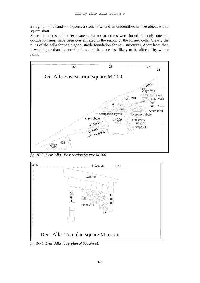
III-10 DEIR ALLA SQUARE M
161
a fragment of a sandstone quern, a stone bowl and an unidentified bronze object with asquare shaft.Since in the rest of the excavated area no structures were found and only one pit,occupation must have been concentrated in the region of the former cella. Clearly theruins of the cella formed a good, stable foundation for new structures. Apart from that,it was higher than its surroundings and therefore less likely to be affected by winterrains.
Deir Alla East section square M 200
30 28 26
213
211
clay wash
clay wash206ashy
topsoil 200
occup. layers
occupationclay rubble
stst
st
208
fine gritty
201
floor 210wash 211
st
pit 209=118
red brick rubblered washyellow clay
clay rubbleoccupation layers
207
wall
waterhole
402
fig. 10-3. Deir 'Alla . East section Square M 200
Wall 202
Wal
l 203 W
all 205
Floor 204
st
st
S-section 30.535.5
Deir 'Alla. Top plan square M: room
fig. 10-4. Deir 'Alla . Top plan of Square M.
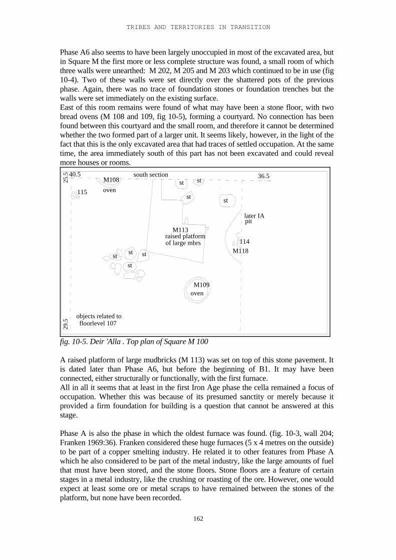
TRIBES AND TERRITORIES IN TRANSITION
162
Phase A6 also seems to have been largely unoccupied in most of the excavated area, butin Square M the first more or less complete structure was found, a small room of whichthree walls were unearthed: M 202, M 205 and M 203 which continued to be in use (fig10-4). Two of these walls were set directly over the shattered pots of the previousphase. Again, there was no trace of foundation stones or foundation trenches but thewalls were set immediately on the existing surface.East of this room remains were found of what may have been a stone floor, with twobread ovens (M 108 and 109, fig 10-5), forming a courtyard. No connection has beenfound between this courtyard and the small room, and therefore it cannot be determinedwhether the two formed part of a larger unit. It seems likely, however, in the light of thefact that this is the only excavated area that had traces of settled occupation. At the sametime, the area immediately south of this part has not been excavated and could revealmore houses or rooms.
36.5
later IApit
st
M109oven
M113raised platformof large mbrs
st st
stst
south sectionst st
st
M108
oven
objects related tofloorlevel 107
29.5
114M118
40.5
25.5
115
fig. 10-5. Deir 'Alla . Top plan of Square M 100
A raised platform of large mudbricks (M 113) was set on top of this stone pavement. Itis dated later than Phase A6, but before the beginning of B1. It may have beenconnected, either structurally or functionally, with the first furnace.All in all it seems that at least in the first Iron Age phase the cella remained a focus ofoccupation. Whether this was because of its presumed sanctity or merely because itprovided a firm foundation for building is a question that cannot be answered at thisstage.
Phase A is also the phase in which the oldest furnace was found. (fig. 10-3, wall 204;Franken 1969:36). Franken considered these huge furnaces (5 x 4 metres on the outside)to be part of a copper smelting industry. He related it to other features from Phase Awhich he also considered to be part of the metal industry, like the large amounts of fuelthat must have been stored, and the stone floors. Stone floors are a feature of certainstages in a metal industry, like the crushing or roasting of the ore. However, one wouldexpect at least some ore or metal scraps to have remained between the stones of theplatform, but none have been recorded.
III-10 DEIR ALLA SQUARE M
163
In fact, later excavations in the area of the furnaces have demonstrated that there werehardly any remains of actual copper ore or slag, or any other indications that thesefurnaces were used in metal production. Apart from that, the size and shape of thefurnaces is completely different from that of any other metal furnace in the wholeregion during this period. It seems therefore that these furnaces had some other, thus farunknown function.No remains of the Phase B furnaces have been found in Square M. The only remainsfound in Square M belong to Phase B1, the most important being a heavy wall, runningnorth-south, M 101 (fig 10-3). Another stone floor was found in the west part of thesquare. In the rubble overlying the room from A6 a fragment of a Philistine bowl wasfound. The remainder of this bowl was found in the clay debris north of the secondfurnace, which is Phase B 2, so it is likely that this debris covered the room as well.(Since it was found directly under topsoil this could not be confirmed stratigraphically).Finally, possibly in Phase C, possibly even later, a foundation trench was dug, and wallM 102 built, parallel to M 101.
Conclusions
The excavation results show that at the very beginning of the Early Iron Age occupationon Deir 'Alla, the first occupation after the gap that came at the end of the Late BronzeAge, some slight structures were built on the site. That these were built on top of theremains of the cella may not be accidental. We do not know whether the new occupantswere in any way acquainted with the former status of the site. If, as has been argued,they came from the Amman Plateau and had been involved in the trade between theAmman Plateau and the Jordan Valley, it is likely that they knew it. In that case onewould expect that the structure that was built on top of the old sanctuary had a special,ritual function as well. There is, however, nothing that indicates a special function here,except perhaps the fact that it is the only structure found so far in this phase. On theother hand, the new occupants may simply have used the elevated position and the hardfoundation formed by these remains, as a suitable substratum for a new house.The architecture of Phase A resembles that of Phase 3 at Tell el-Hammeh, except thatthe occupants of Deir 'Alla did not use a stone foundation. This may have been becausethey brought a different architectural tradition with them, or it could simply mean thatstones were less readily available at Deir 'Alla than they were at Tell el-Hammeh, wherethe adjoining Wadi Zerqa was a ready source for stones and boulders of all sizes.In any case it is clear that both the population on Tell el-Hammeh and the population atDeir 'Alla conform to the picture painted here of the beginning of the Early Iron Age inthe region, that of small groups of people who settled on sites that had been desertedrecently (or, in the case of Tell el-Hammeh, had only been settled on a temporary,transhumant basis), where they started to build simple structures and at the same timeadhered to traditions of a more transitory nature: the use of temporary installations suchas hearths, some of which were found at Tell el-Hammeh, and the use of tents, as isdemonstrated by the post holes at Deir 'Alla (Franken 1969, 20).The huge furnaces, the first of which was built at the end of Phase A, represent someindustrial activity, although it is at present not clear what kind of industry it represents.Many small drops of metal were found surrounding them, but they were not used forcasting bronze or smelting copper. It is clear, however, that whatever activity wasperformed here it was done on a professional, industrial scale, and the population musthave brought the skill to perform it from wherever it was they came from.
164
IV-11. Survey of the region
In 1994, during the excavations at Tell Deir 'Alla, weekends were used to conduct asurvey of the region. This survey was site-oriented, aimed at finding and rechecking thesites that had been found during earlier surveys, those of Nelson Glueck (Glueck 1939,280-322) and of the East Jordan Valley Survey (Ibrahim, Sauer and Yassine 1976,1988)1. The original reason for this survey was the fact that from the three main surveysthat had been carried out in the area earlier (Nelson Glueck’s Transjordanian survey; theEast Jordan Valley Survey from 1975-76; and the Zerqa Survey by Gordon and Villiersfrom 1982) the results had been published but not the pottery. Therefore pottery wascollected from as many of these sites as possible, and checked against the publishedresults of the earlier surveys. The survey methods were very simple: during a given timea specified number of people walked over the site, and collected all the sherds theyfound. These were checked afterwards and diagnostics preserved. Later I took advantageof an opportunity to check the actual material from these three earlier surveys as well.The results of both the 1994 survey and the three earlier surveys are presented here (table11-1)2.
Tell KereimehTell Kereimeh was surveyed by Glueck (G 169) and by the East Jordan Valley Survey(JVS 93). It sits on the south bank of the Wadi Kufrinjeh, which was a perennial streamin the days of Glueck, and it is one of the sites that are located along the eastern foothills.On top of the tell were some old stone foundations, which were partly used asfoundations for the Arab Legion Police station. An irrigation canal conducting waterfrom the Wadi Kufrinjeh ran past it. Glueck found many sherds, which he dated to theIron Age I-II period, and some Late Bronze II sherds, as well as Roman-Byzantinesherds. According to the East Jordan Valley Survey the site yielded pottery from the LateBronze Age, and from Iron Age IB and II. Examination of this pottery suggests acontinuing occupation from the Late Bronze Age II into the Iron Age II (fig. 11-1).The only Late Bronze Age specimen is cooking pot 11-1:2, which dates to the very endof the Late Bronze Age. Bowl 11-1:7 could belong to Late Bronze II, but it was veryworn. Cooking pot 1 is of the transitional type, known from Deir 'Alla Late BronzePhases E and F (Franken 1969, 119). A group of three deep bowls/kraters, fig. 11-1: 4-6,can be dated to the Early Iron Age, perhaps starting in the transitional period. Openbowls with straight flaring rims are not uncommon in the Late Bronze Age (e.g.Franken 1992 fig. 7-9, Phase D), whereas rounded rims such as fig. 11-1:8 are morecommon in the Early Iron Age. The profiled rim 11-1:12 can be found in Deir 'Alla from
1 Several students participated in this project: Lucas Petit, Deborah Zuidwijk, Manon van Diemen,Anna Labadie, Jennifer Peersmann, Kien van Rijn van Alkemade and Xander Veldhuizen. Eveline vander Steen directed the project. The government representative for the excavations at Deir 'Alla,Mohammed al-Balawneh, also gave much of his time to join us and he was a great help in locating thesites.2 The material from the Jordan Valley survey and from the Zerqa survey is stored in the JordanUniversity, Amman, where I studied it with kind permission from Dr. Mo’awiyah Ibrahim.Nelson Glueck’s survey material is located in Jerusalem, where I found it with the valued help of Dr.Alon de Groot from the Israel Antiquities Authority. Both collections were examined in January 1992,with a grant from the Dutch Organisation for Scientific Research. Not all the material from eithersurvey could be checked. However, from the sites that have been identified, the pottery was drawn, andthe drawings are presented here.
IV-11 SURVEY OF THE REGION
165
the end of the Early Iron age on. The tall, thin jar neck and rim 11-1:13 is mainlyencountered in the first half of the Early Iron Age.The site was not visited during the 1994 survey.
21 24 25 23 29 20
10
1 2 3 45
6
7 89 10 11
12
13 14
fig. 11-1. Kereimeh pottery found by the East Jordan Valley Survey
Glueck JVS Gordon-Villiers
1994survey
Kereimeh 169 93Buweib 181 105 xQos 175 102Ammata 176 104 xKharabeh 110Ghazaleh 177 109Nkheil 179 108Qa'adan 183 116, 117Abu Zaghan 159Ekhsas 186 xAbu Nijrah 187 123Arqadat 125Meidan 191Rikabi 192 130Asiyeh 193 xMaqal 194 137Zakari 196 135 xKataret esSamra 126Umm Hamad 199 132 xBashir 129 xRabi 122Damieh 200 151Mugharet 351Dhahab 344, 345 167 21, 22Hajjaj 25Qelaya 171 94Adliyeh 182 112
Table 11-1. Sites visited byNelson Glueck, the East JordanValley Survey, Gordon andVilliers’ Zerqa Survey, and the1994 survey (pottery studied isrepresented by bold numbering)
TRIBES AND TERRITORIES IN TRANSITION
166
FOOTHILLS
GHOR
KATARRH
ZOR
Late Bronze Age sites
Early Iron Age sites
W. KUFRINJEHKereimeh
Sa' idiyeh
W. RAJIB
Qos
Ammata
JORDAN
Mugharetel
Wardeh
Ghazaleh
Mazar
Kharabeh
Nkheil
DEIRALLA
Abu Nijrah
Ekhsas
Qa' adan NQa' adan S
Abu Zaghan
MeidanRikabi
AsiyehBashir
Arqadat
Maqaler
RmeilehZakari
W. Z
ERQA
Kataretes
Samra
Umm HamadHajjaj
Dhahab
Buweib
Qelaya
Rabi
Hammeh
Adliyeh
4 kmfig. 11-2. Sites in the area of study visited by Nelson Glueck, by the East Jordan ValleySurvey, the Zerqa survey and the 1994 survey.
IV-11 SURVEY OF THE REGION
167
Tell el-QelayaQelaya was visited by Glueck (G 171) and by the East Jordan Valley Survey (JVS 94). Itis situated opposite Tell Kereimeh, on the south bank of the Wadi Kufrinjeh, and at thebeginning of the foothills. Glueck found here the remains of some Islamic buildings andsome Iron Age I-II sherds. According to the East Jordan Valley Survey Iron Age IB wasdominant. According to the surveyors the occupation did not continue into the Iron AgeII. No sherds have been examined from either of these surveys, and the site was notvisited during the 1994 survey.
Khirbet BuweibKhirbet Buweib was visited by Glueck (G 181) and by the East Jordan Valley Survey(JVS 105). It is situated on the border between the Ghor and the Katarrh, 2.5 km south ofTell es-Sa’idiyeh. It is a low rise and at its southwestern foot a number of springs rise,the Ayun el-Buweib, which form a small wadi that flows to the west into the Jordan.Glueck found the remains of a modern stone hut on the top. Sherds were dated mainly tothe Middle Bronze I period, with some Iron Age I-II sherds, as well as Roman-Byzantineones (fig. 11-3).
24 8
12
Fig. 11-3:1 may belong to a Late Bronze Age krater (compare Franken 1992 fig.7.12:13), although a much later (Islamic) date cannot be excluded. The sherd was wheelmade, and had no particular surface treatment. Fig. 11-3:2 is a jar rim, from a well-known Iron Age I-II type.The site was visited again by the 1994 survey. It was hardly visible, being part of theKatarrh hills. The field in which it lies had been ploughed recently, but revealed verylittle pottery (fig. 11-4). Bowl fig. 11-4:2 is a Late Bronze Age deep bowl. Figs 11-4:1and 6 are typical of the very beginning of the Early Iron Age, the decoration from 6being a continuation from the Late Bronze Age. Bowl 11-4:1 has parallels in McGovern1986: cave A4 (also fig 7-13:17). The three jars 3-5 can be dated to Iron Age II.
1 2 3 4 5 6
Fig. 11-4. Khirbet Buweib. Sherds from the 1994 survey.
Tell el-QosQos was visited by Glueck (G 175) and by the East Jordan Valley Survey (JVS 102). Itlies about 0.5 km northeast of Tell Ammata. It is a prominent site, part of the foothillsdirectly to the north of Wadi Rajib. The site must have been easy to defend with theWadi Rajib flowing to the south of it, while to the east a sharp decline descends into asmall valley and to the north runs a dry wadi bed. Consequently the site was accessible
fig. 11-3. Khirbet Buweib: potteryfound by Nelson Glueck
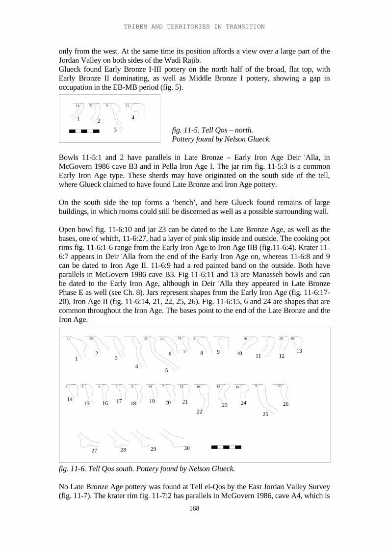
TRIBES AND TERRITORIES IN TRANSITION
168
only from the west. At the same time its position affords a view over a large part of theJordan Valley on both sides of the Wadi Rajib.Glueck found Early Bronze I-III pottery on the north half of the broad, flat top, withEarly Bronze II dominating, as well as Middle Bronze I pottery, showing a gap inoccupation in the EB-MB period (fig. 5).
914 21 31
1 2
3
4
Bowls 11-5:1 and 2 have parallels in Late Bronze – Early Iron Age Deir 'Alla, inMcGovern 1986 cave B3 and in Pella Iron Age I. The jar rim fig. 11-5:3 is a commonEarly Iron Age type. These sherds may have originated on the south side of the tell,where Glueck claimed to have found Late Bronze and Iron Age pottery.
On the south side the top forms a ‘bench’, and here Glueck found remains of largebuildings, in which rooms could still be discerned as well as a possible surrounding wall.
Open bowl fig. 11-6:10 and jar 23 can be dated to the Late Bronze Age, as well as thebases, one of which, 11-6:27, had a layer of pink slip inside and outside. The cooking potrims fig. 11-6:1-6 range from the Early Iron Age to Iron Age IIB (fig.11-6:4). Krater 11-6:7 appears in Deir 'Alla from the end of the Early Iron Age on, whereas 11-6:8 and 9can be dated to Iron Age II. 11-6:9 had a red painted band on the outside. Both haveparallels in McGovern 1986 cave B3. Fig 11-6:11 and 13 are Manasseh bowls and canbe dated to the Early Iron Age, although in Deir 'Alla they appeared in Late BronzePhase E as well (see Ch. 8). Jars represent shapes from the Early Iron Age (fig. 11-6:17-20), Iron Age II (fig. 11-6:14, 21, 22, 25, 26). Fig. 11-6:15, 6 and 24 are shapes that arecommon throughout the Iron Age. The bases point to the end of the Late Bronze and theIron Age.
9 25 22 20 18 30 20 20 28
8 9 9 9 9 14 7 12 10 16 10 9 10
12
3
45
6 7 8 9 10 11 1213
1415 16 17 18 19 20 21
2223 24
25
26
27 28 29 30
fig. 11-6. Tell Qos south. Pottery found by Nelson Glueck.
No Late Bronze Age pottery was found at Tell el-Qos by the East Jordan Valley Survey(fig. 11-7). The krater rim fig. 11-7:2 has parallels in McGovern 1986, cave A4, which is
fig. 11-5. Tell Qos – north.Pottery found by Nelson Glueck.
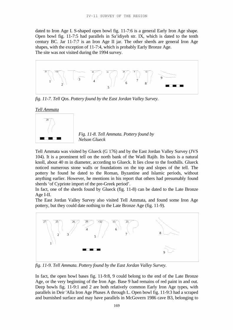
IV-11 SURVEY OF THE REGION
169
dated to Iron Age I. S-shaped open bowl fig. 11-7:6 is a general Early Iron Age shape.Open bowl fig. 11-7:5 had parallels in Sa’idiyeh str. IX, which is dated to the tenthcentury BC. Jar 11-7:7 is an Iron Age II jar. The other sherds are general Iron Ageshapes, with the exception of 11-7:4, which is probably Early Bronze Age.The site was not visited during the 1994 survey.
25 >32 16 31 29 9 12
12
3 4
56
78
9
fig. 11-7. Tell Qos. Pottery found by the East Jordan Valley Survey.
Tell Ammata
29
Tell Ammata was visited by Glueck (G 176) and by the East Jordan Valley Survey (JVS104). It is a prominent tell on the north bank of the Wadi Rajib. Its basis is a naturalknoll, about 40 m in diameter, according to Glueck. It lies close to the foothills. Gluecknoticed numerous stone walls or foundations on the top and slopes of the tell. Thepottery he found he dated to the Roman, Byzantine and Islamic periods, withoutanything earlier. However, he mentions in his report that others had presumably foundsherds ‘of Cypriote import of the pre-Greek period’.In fact, one of the sherds found by Glueck (fig. 11-8) can be dated to the Late BronzeAge I-II.The East Jordan Valley Survey also visited Tell Ammata, and found some Iron Agepottery, but they could date nothing to the Late Bronze Age (fig. 11-9).
27 25 26 20 >32 15 25
1
2 3
4
5
67 8
9
fig. 11-9. Tell Ammata. Pottery found by the East Jordan Valley Survey.
In fact, the open bowl bases fig. 11-9:8, 9 could belong to the end of the Late BronzeAge, or the very beginning of the Iron Age. Base 9 had remains of red paint in and out.Deep bowls fig. 11-9:1 and 2 are both relatively common Early Iron Age types, withparallels in Deir 'Alla Iron Age Phases A through L. Open bowl fig. 11-9:3 had a scrapedand burnished surface and may have parallels in McGovern 1986 cave B3, belonging to
Fig. 11-8. Tell Ammata. Pottery found byNelson Glueck
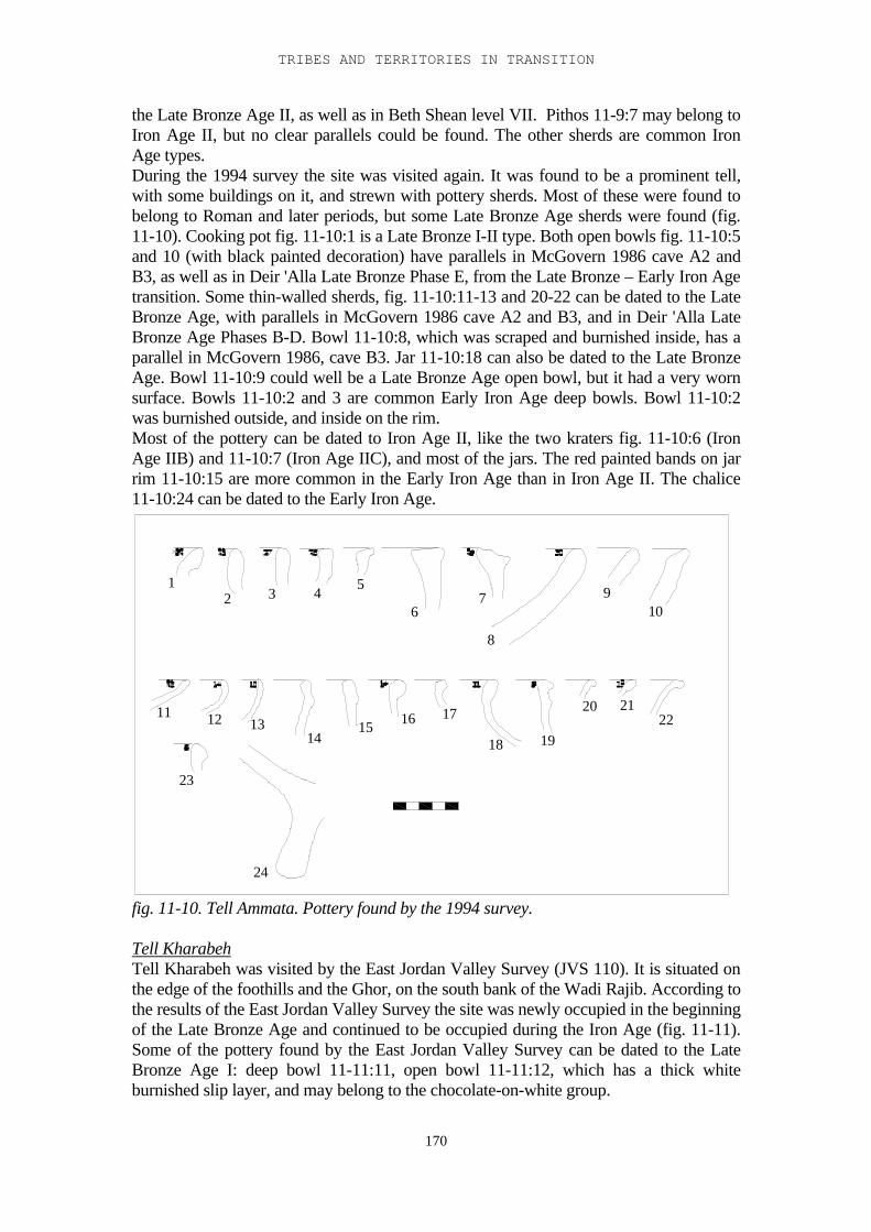
TRIBES AND TERRITORIES IN TRANSITION
170
the Late Bronze Age II, as well as in Beth Shean level VII. Pithos 11-9:7 may belong toIron Age II, but no clear parallels could be found. The other sherds are common IronAge types.During the 1994 survey the site was visited again. It was found to be a prominent tell,with some buildings on it, and strewn with pottery sherds. Most of these were found tobelong to Roman and later periods, but some Late Bronze Age sherds were found (fig.11-10). Cooking pot fig. 11-10:1 is a Late Bronze I-II type. Both open bowls fig. 11-10:5and 10 (with black painted decoration) have parallels in McGovern 1986 cave A2 andB3, as well as in Deir 'Alla Late Bronze Phase E, from the Late Bronze – Early Iron Agetransition. Some thin-walled sherds, fig. 11-10:11-13 and 20-22 can be dated to the LateBronze Age, with parallels in McGovern 1986 cave A2 and B3, and in Deir 'Alla LateBronze Age Phases B-D. Bowl 11-10:8, which was scraped and burnished inside, has aparallel in McGovern 1986, cave B3. Jar 11-10:18 can also be dated to the Late BronzeAge. Bowl 11-10:9 could well be a Late Bronze Age open bowl, but it had a very wornsurface. Bowls 11-10:2 and 3 are common Early Iron Age deep bowls. Bowl 11-10:2was burnished outside, and inside on the rim.Most of the pottery can be dated to Iron Age II, like the two kraters fig. 11-10:6 (IronAge IIB) and 11-10:7 (Iron Age IIC), and most of the jars. The red painted bands on jarrim 11-10:15 are more common in the Early Iron Age than in Iron Age II. The chalice11-10:24 can be dated to the Early Iron Age.
12 3 4
5
67
8
910
11 12 1314
15 16 17
18 19
20 2122
23
24
fig. 11-10. Tell Ammata. Pottery found by the 1994 survey.
Tell KharabehTell Kharabeh was visited by the East Jordan Valley Survey (JVS 110). It is situated onthe edge of the foothills and the Ghor, on the south bank of the Wadi Rajib. According tothe results of the East Jordan Valley Survey the site was newly occupied in the beginningof the Late Bronze Age and continued to be occupied during the Iron Age (fig. 11-11).Some of the pottery found by the East Jordan Valley Survey can be dated to the LateBronze Age I: deep bowl 11-11:11, open bowl 11-11:12, which has a thick whiteburnished slip layer, and may belong to the chocolate-on-white group.
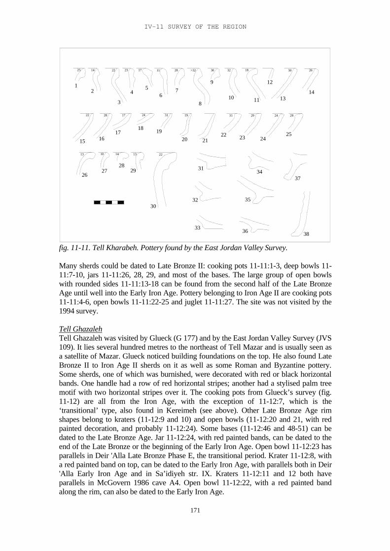
IV-11 SURVEY OF THE REGION
171
24
312928
27
30
26
33
32
36
35
34
2
15
1
13
22
1817
16
54
3
131410
28 17 24
1425 172322
129
212019
8
76
22
31 19
242322
1110
31 29
30>322811 1832
38
37
25
1413
28
2630
fig. 11-11. Tell Kharabeh. Pottery found by the East Jordan Valley Survey.
Many sherds could be dated to Late Bronze II: cooking pots 11-11:1-3, deep bowls 11-11:7-10, jars 11-11:26, 28, 29, and most of the bases. The large group of open bowlswith rounded sides 11-11:13-18 can be found from the second half of the Late BronzeAge until well into the Early Iron Age. Pottery belonging to Iron Age II are cooking pots11-11:4-6, open bowls 11-11:22-25 and juglet 11-11:27. The site was not visited by the1994 survey.
Tell GhazalehTell Ghazaleh was visited by Glueck (G 177) and by the East Jordan Valley Survey (JVS109). It lies several hundred metres to the northeast of Tell Mazar and is usually seen asa satellite of Mazar. Glueck noticed building foundations on the top. He also found LateBronze II to Iron Age II sherds on it as well as some Roman and Byzantine pottery.Some sherds, one of which was burnished, were decorated with red or black horizontalbands. One handle had a row of red horizontal stripes; another had a stylised palm treemotif with two horizontal stripes over it. The cooking pots from Glueck’s survey (fig.11-12) are all from the Iron Age, with the exception of 11-12:7, which is the‘transitional’ type, also found in Kereimeh (see above). Other Late Bronze Age rimshapes belong to kraters (11-12:9 and 10) and open bowls (11-12:20 and 21, with redpainted decoration, and probably 11-12:24). Some bases (11-12:46 and 48-51) can bedated to the Late Bronze Age. Jar 11-12:24, with red painted bands, can be dated to theend of the Late Bronze or the beginning of the Early Iron Age. Open bowl 11-12:23 hasparallels in Deir 'Alla Late Bronze Phase E, the transitional period. Krater 11-12:8, witha red painted band on top, can be dated to the Early Iron Age, with parallels both in Deir'Alla Early Iron Age and in Sa’idiyeh str. IX. Kraters 11-12:11 and 12 both haveparallels in McGovern 1986 cave A4. Open bowl 11-12:22, with a red painted bandalong the rim, can also be dated to the Early Iron Age.
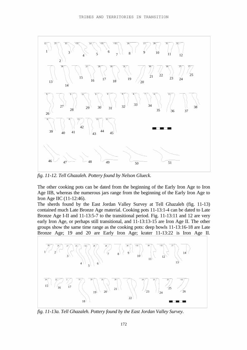
TRIBES AND TERRITORIES IN TRANSITION
172
12 25 32 >32 14 >32 >32 26 17 28 31 32
12
28 30 3130 27 30 30 25 17
9 9 11 9 9 9 8 7 6 11
119 8 11
1
2
34 5
67 8 9 10 11 12
1314
1516 17 18
1920
21 2223 24
25
26
2728 29 30 31 32 33 34
35 36 3738
39 40 4142
4344 45
46 47 48 49 50 51
fig. 11-12. Tell Ghazaleh. Pottery found by Nelson Glueck.
The other cooking pots can be dated from the beginning of the Early Iron Age to IronAge IIB, whereas the numerous jars range from the beginning of the Early Iron Age toIron Age IIC (11-12:46).The sherds found by the East Jordan Valley Survey at Tell Ghazaleh (fig. 11-13)contained much Late Bronze Age material. Cooking pots 11-13:1-4 can be dated to LateBronze Age I-II and 11-13:5-7 to the transitional period. Fig. 11-13:11 and 12 are veryearly Iron Age, or perhaps still transitional, and 11-13:13-15 are Iron Age II. The othergroups show the same time range as the cooking pots: deep bowls 11-13:16-18 are LateBronze Age; 19 and 20 are Early Iron Age; krater 11-13:22 is Iron Age II.
28 29 27 25 >32 28 28 30 >32 30 >32 27
24 22 2 31 20 25 28 24 25 25 >32
1 23
45
6
7 8 910
1112
13
14
15 16 17
18
19 2021
22
23 2425
26
fig. 11-13a. Tell Ghazaleh. Pottery found by the East Jordan Valley Survey.
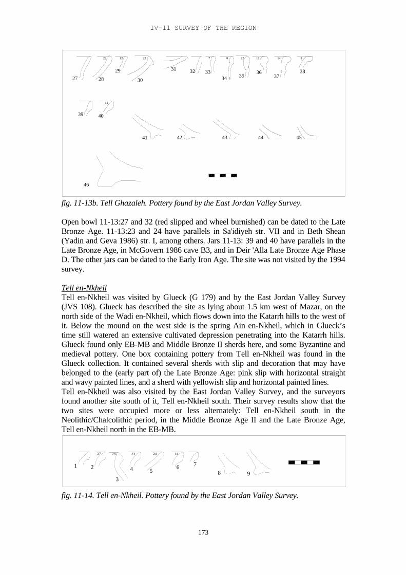
IV-11 SURVEY OF THE REGION
173
46
29
23
4039
2827
12
872212
31
41
30
4342
343332
8141112
44
3736
35
45
38
fig. 11-13b. Tell Ghazaleh. Pottery found by the East Jordan Valley Survey.
Open bowl 11-13:27 and 32 (red slipped and wheel burnished) can be dated to the LateBronze Age. 11-13:23 and 24 have parallels in Sa'idiyeh str. VII and in Beth Shean(Yadin and Geva 1986) str. I, among others. Jars 11-13: 39 and 40 have parallels in theLate Bronze Age, in McGovern 1986 cave B3, and in Deir 'Alla Late Bronze Age PhaseD. The other jars can be dated to the Early Iron Age. The site was not visited by the 1994survey.
Tell en-NkheilTell en-Nkheil was visited by Glueck (G 179) and by the East Jordan Valley Survey(JVS 108). Glueck has described the site as lying about 1.5 km west of Mazar, on thenorth side of the Wadi en-Nkheil, which flows down into the Katarrh hills to the west ofit. Below the mound on the west side is the spring Ain en-Nkheil, which in Glueck’stime still watered an extensive cultivated depression penetrating into the Katarrh hills.Glueck found only EB-MB and Middle Bronze II sherds here, and some Byzantine andmedieval pottery. One box containing pottery from Tell en-Nkheil was found in theGlueck collection. It contained several sherds with slip and decoration that may havebelonged to the (early part of) the Late Bronze Age: pink slip with horizontal straightand wavy painted lines, and a sherd with yellowish slip and horizontal painted lines.Tell en-Nkheil was also visited by the East Jordan Valley Survey, and the surveyorsfound another site south of it, Tell en-Nkheil south. Their survey results show that thetwo sites were occupied more or less alternately: Tell en-Nkheil south in theNeolithic/Chalcolithic period, in the Middle Bronze Age II and the Late Bronze Age,Tell en-Nkheil north in the EB-MB.
27 28 23 24 14
1 2
3
4 56 7
8 9
fig. 11-14. Tell en-Nkheil. Pottery found by the East Jordan Valley Survey.
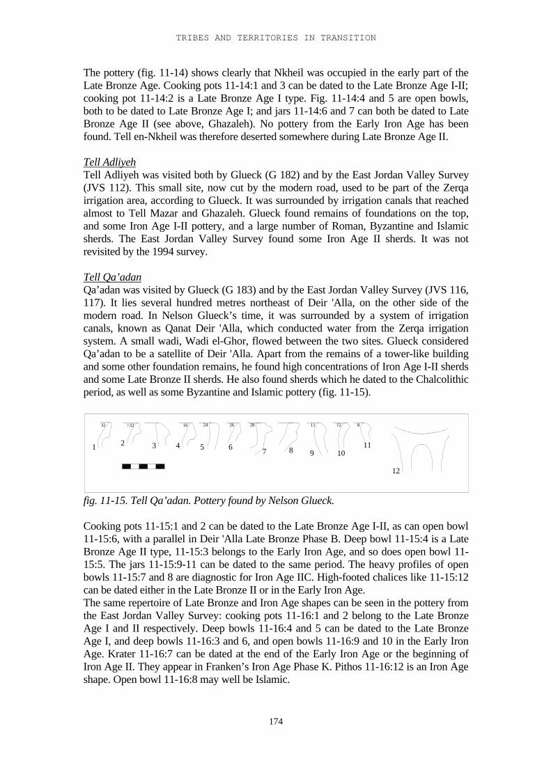
TRIBES AND TERRITORIES IN TRANSITION
174
The pottery (fig. 11-14) shows clearly that Nkheil was occupied in the early part of theLate Bronze Age. Cooking pots 11-14:1 and 3 can be dated to the Late Bronze Age I-II;cooking pot 11-14:2 is a Late Bronze Age I type. Fig. 11-14:4 and 5 are open bowls,both to be dated to Late Bronze Age I; and jars 11-14:6 and 7 can both be dated to LateBronze Age II (see above, Ghazaleh). No pottery from the Early Iron Age has beenfound. Tell en-Nkheil was therefore deserted somewhere during Late Bronze Age II.
Tell AdliyehTell Adliyeh was visited both by Glueck (G 182) and by the East Jordan Valley Survey(JVS 112). This small site, now cut by the modern road, used to be part of the Zerqairrigation area, according to Glueck. It was surrounded by irrigation canals that reachedalmost to Tell Mazar and Ghazaleh. Glueck found remains of foundations on the top,and some Iron Age I-II pottery, and a large number of Roman, Byzantine and Islamicsherds. The East Jordan Valley Survey found some Iron Age II sherds. It was notrevisited by the 1994 survey.
Tell Qa’adanQa’adan was visited by Glueck (G 183) and by the East Jordan Valley Survey (JVS 116,117). It lies several hundred metres northeast of Deir 'Alla, on the other side of themodern road. In Nelson Glueck’s time, it was surrounded by a system of irrigationcanals, known as Qanat Deir 'Alla, which conducted water from the Zerqa irrigationsystem. A small wadi, Wadi el-Ghor, flowed between the two sites. Glueck consideredQa’adan to be a satellite of Deir 'Alla. Apart from the remains of a tower-like buildingand some other foundation remains, he found high concentrations of Iron Age I-II sherdsand some Late Bronze II sherds. He also found sherds which he dated to the Chalcolithicperiod, as well as some Byzantine and Islamic pottery (fig. 11-15).
32 >32 16 24 26 28 11 12 8
1 2 3 4 5 6 7 8 9 1011
12
fig. 11-15. Tell Qa’adan. Pottery found by Nelson Glueck.
Cooking pots 11-15:1 and 2 can be dated to the Late Bronze Age I-II, as can open bowl11-15:6, with a parallel in Deir 'Alla Late Bronze Phase B. Deep bowl 11-15:4 is a LateBronze Age II type, 11-15:3 belongs to the Early Iron Age, and so does open bowl 11-15:5. The jars 11-15:9-11 can be dated to the same period. The heavy profiles of openbowls 11-15:7 and 8 are diagnostic for Iron Age IIC. High-footed chalices like 11-15:12can be dated either in the Late Bronze II or in the Early Iron Age.The same repertoire of Late Bronze and Iron Age shapes can be seen in the pottery fromthe East Jordan Valley Survey: cooking pots 11-16:1 and 2 belong to the Late BronzeAge I and II respectively. Deep bowls 11-16:4 and 5 can be dated to the Late BronzeAge I, and deep bowls 11-16:3 and 6, and open bowls 11-16:9 and 10 in the Early IronAge. Krater 11-16:7 can be dated at the end of the Early Iron Age or the beginning ofIron Age II. They appear in Franken’s Iron Age Phase K. Pithos 11-16:12 is an Iron Ageshape. Open bowl 11-16:8 may well be Islamic.
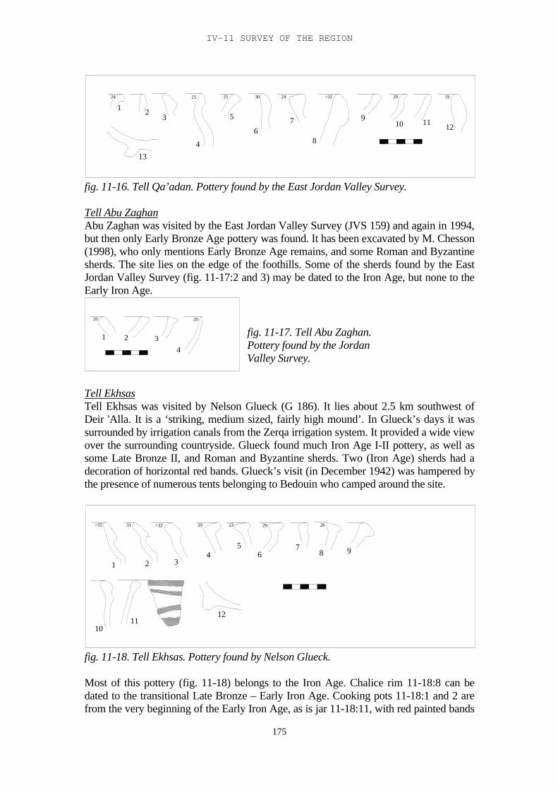
IV-11 SURVEY OF THE REGION
175
24 25 25 30 24 >32 20 19
1 23
4
5
67
8
910 11
12
13
fig. 11-16. Tell Qa’adan. Pottery found by the East Jordan Valley Survey.
Tell Abu ZaghanAbu Zaghan was visited by the East Jordan Valley Survey (JVS 159) and again in 1994,but then only Early Bronze Age pottery was found. It has been excavated by M. Chesson(1998), who only mentions Early Bronze Age remains, and some Roman and Byzantinesherds. The site lies on the edge of the foothills. Some of the sherds found by the EastJordan Valley Survey (fig. 11-17:2 and 3) may be dated to the Iron Age, but none to theEarly Iron Age.
20 20
1 2 34
Tell EkhsasTell Ekhsas was visited by Nelson Glueck (G 186). It lies about 2.5 km southwest ofDeir 'Alla. It is a ‘striking, medium sized, fairly high mound’. In Glueck’s days it wassurrounded by irrigation canals from the Zerqa irrigation system. It provided a wide viewover the surrounding countryside. Glueck found much Iron Age I-II pottery, as well assome Late Bronze II, and Roman and Byzantine sherds. Two (Iron Age) sherds had adecoration of horizontal red bands. Glueck’s visit (in December 1942) was hampered bythe presence of numerous tents belonging to Bedouin who camped around the site.
>32 31 >32 29 23 29 26
1 2 34
56
78 9
1011
12
fig. 11-18. Tell Ekhsas. Pottery found by Nelson Glueck.
Most of this pottery (fig. 11-18) belongs to the Iron Age. Chalice rim 11-18:8 can bedated to the transitional Late Bronze – Early Iron Age. Cooking pots 11-18:1 and 2 arefrom the very beginning of the Early Iron Age, as is jar 11-18:11, with red painted bands
fig. 11-17. Tell Abu Zaghan.Pottery found by the JordanValley Survey.
TRIBES AND TERRITORIES IN TRANSITION
176
on it. Jar 11-18:10 and base 12 are also Early Iron Age types. Kraters 11-18:4, 5 and 7are Iron Age II types, as are open bowls 11-18:6 and 9.
13610
24
24
20>32
>32
8
3025
910
27
>32
19
31
20 21
22812
31
30
11 11
12 3 4 5
6
7 89
1011
12
13 14
15 16 17 1819
20 21 22
23 24
25
26 27
2829
3031
32
33
34 35 36 37
38 39
40 41
4243 44
45
fig. 11-19. Tell Ekhsas. Pottery from the 1994 survey.
The site was also visited by the 1994 survey (fig. 11-19). It was found to be a large tell,with a television mast on top.Cooking pots 11-19:1 and 2, and open bowl 27 could bedated to the Late Bronze Age. Cooking pots 11-19:3 and 4, deep bowl 13 and jar 31 haveparallels in the transitional Late Bronze – Early Iron Age. Most of the other sherds couldbe dated to the Iron Age: deep bowls 11-19:10, 11 and 14-16, as well as the body sherdswith red painted decoration 11-19:43-45 and the handles with incised marks on them,11-19:40-41. The decorative ledge handle on sherd 11-19:42 has many parallels in Deir'Alla Iron Age Phase B. Open bowls 1-19:24 and 25 are Manasseh bowls, also dated tothe Early Iron Age, and so are 29 and 30. Cooking pots 11-19:7 and 8, kraters 20 and 21,jars 33-36 and open bowl 26, with transverse red painted lines on top of the rim, arefound in the Early Iron Age as well as in the first half of Iron Age II. Cooking jars 11-19:5 and 6 and jars 37-39 are Iron Age IIC shapes. Juglet 11-19:32 is an Iron Age IIshape. The red painted decoration on the body sherds points to a Late Bronze – EarlyIron Age date for these sherds (e.g. Franken 1992, fig. 3-7:9 and 10).
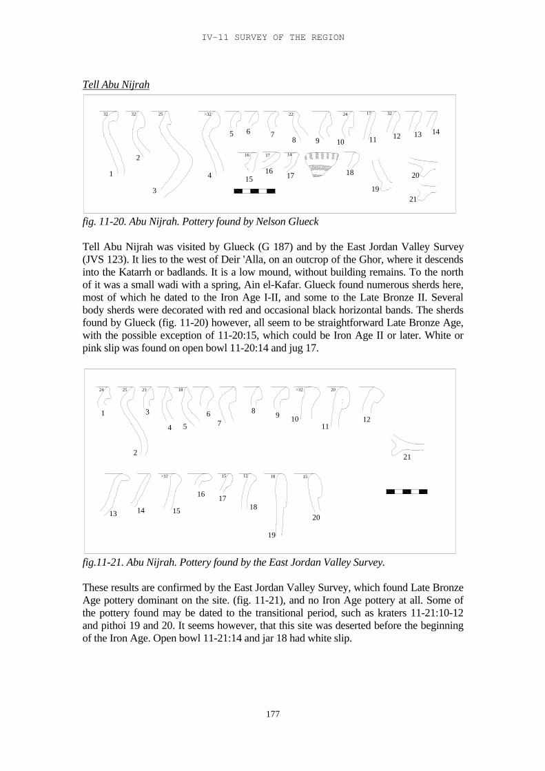
IV-11 SURVEY OF THE REGION
177
Tell Abu Nijrah
32 32 25 >32 22 24 17 32
16 17 14
1
2
3
4
5 6 78 9 10 11 12 13 14
1516 17 18
19
20
21
fig. 11-20. Abu Nijrah. Pottery found by Nelson Glueck
Tell Abu Nijrah was visited by Glueck (G 187) and by the East Jordan Valley Survey(JVS 123). It lies to the west of Deir 'Alla, on an outcrop of the Ghor, where it descendsinto the Katarrh or badlands. It is a low mound, without building remains. To the northof it was a small wadi with a spring, Ain el-Kafar. Glueck found numerous sherds here,most of which he dated to the Iron Age I-II, and some to the Late Bronze II. Severalbody sherds were decorated with red and occasional black horizontal bands. The sherdsfound by Glueck (fig. 11-20) however, all seem to be straightforward Late Bronze Age,with the possible exception of 11-20:15, which could be Iron Age II or later. White orpink slip was found on open bowl 11-20:14 and jug 17.
24 25 23 18 >32 20
15181215>32
1
2
3
4 5
67
8 9 1011
12
13 14 15
16 1718
19
20
21
fig.11-21. Abu Nijrah. Pottery found by the East Jordan Valley Survey.
These results are confirmed by the East Jordan Valley Survey, which found Late BronzeAge pottery dominant on the site. (fig. 11-21), and no Iron Age pottery at all. Some ofthe pottery found may be dated to the transitional period, such as kraters 11-21:10-12and pithoi 19 and 20. It seems however, that this site was deserted before the beginningof the Iron Age. Open bowl 11-21:14 and jar 18 had white slip.
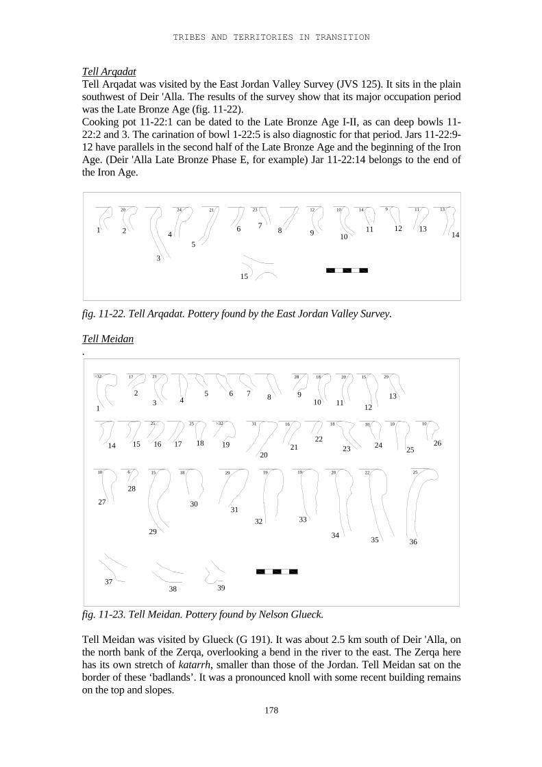
TRIBES AND TERRITORIES IN TRANSITION
178
Tell ArqadatTell Arqadat was visited by the East Jordan Valley Survey (JVS 125). It sits in the plainsouthwest of Deir 'Alla. The results of the survey show that its major occupation periodwas the Late Bronze Age (fig. 11-22).Cooking pot 11-22:1 can be dated to the Late Bronze Age I-II, as can deep bowls 11-22:2 and 3. The carination of bowl 1-22:5 is also diagnostic for that period. Jars 11-22:9-12 have parallels in the second half of the Late Bronze Age and the beginning of the IronAge. (Deir 'Alla Late Bronze Phase E, for example) Jar 11-22:14 belongs to the end ofthe Iron Age.
20 24 21 23 12 10 14 9 11 13
1 2
3
45
6 78 9 10
11 12 1314
15
fig. 11-22. Tell Arqadat. Pottery found by the East Jordan Valley Survey.
Tell Meidan.
>32 17 21 28 18 20 15 29
25 25 >32 31 16 18 10 10 10
10 6 15 18 29 19 19 20 22 25
1
23 4
5 6 7 8 910 11 12
13
14 15 16 17 18 1920
2122
23 24 2526
27
28
29
3031
32 33
34 35 36
3738 39
fig. 11-23. Tell Meidan. Pottery found by Nelson Glueck.
Tell Meidan was visited by Glueck (G 191). It was about 2.5 km south of Deir 'Alla, onthe north bank of the Zerqa, overlooking a bend in the river to the east. The Zerqa herehas its own stretch of katarrh, smaller than those of the Jordan. Tell Meidan sat on theborder of these ‘badlands’. It was a pronounced knoll with some recent building remainson the top and slopes.
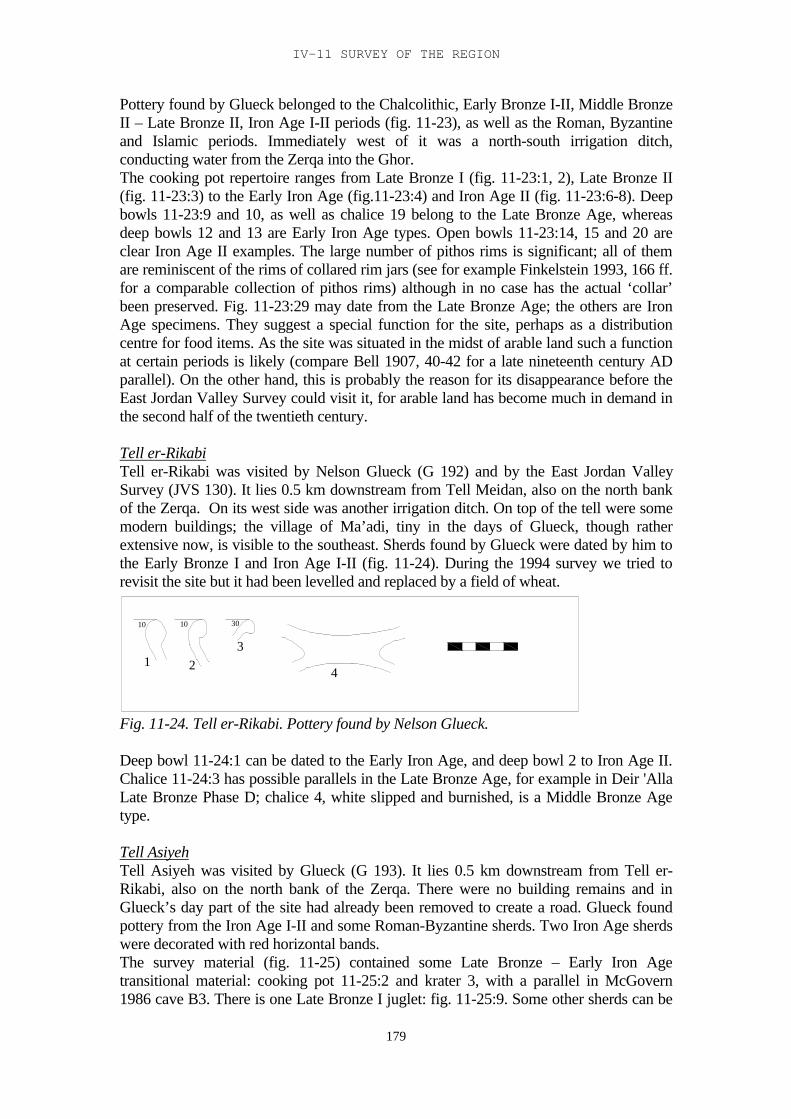
IV-11 SURVEY OF THE REGION
179
Pottery found by Glueck belonged to the Chalcolithic, Early Bronze I-II, Middle BronzeII – Late Bronze II, Iron Age I-II periods (fig. 11-23), as well as the Roman, Byzantineand Islamic periods. Immediately west of it was a north-south irrigation ditch,conducting water from the Zerqa into the Ghor.The cooking pot repertoire ranges from Late Bronze I (fig. 11-23:1, 2), Late Bronze II(fig. 11-23:3) to the Early Iron Age (fig.11-23:4) and Iron Age II (fig. 11-23:6-8). Deepbowls 11-23:9 and 10, as well as chalice 19 belong to the Late Bronze Age, whereasdeep bowls 12 and 13 are Early Iron Age types. Open bowls 11-23:14, 15 and 20 areclear Iron Age II examples. The large number of pithos rims is significant; all of themare reminiscent of the rims of collared rim jars (see for example Finkelstein 1993, 166 ff.for a comparable collection of pithos rims) although in no case has the actual ‘collar’been preserved. Fig. 11-23:29 may date from the Late Bronze Age; the others are IronAge specimens. They suggest a special function for the site, perhaps as a distributioncentre for food items. As the site was situated in the midst of arable land such a functionat certain periods is likely (compare Bell 1907, 40-42 for a late nineteenth century ADparallel). On the other hand, this is probably the reason for its disappearance before theEast Jordan Valley Survey could visit it, for arable land has become much in demand inthe second half of the twentieth century.
Tell er-RikabiTell er-Rikabi was visited by Nelson Glueck (G 192) and by the East Jordan ValleySurvey (JVS 130). It lies 0.5 km downstream from Tell Meidan, also on the north bankof the Zerqa. On its west side was another irrigation ditch. On top of the tell were somemodern buildings; the village of Ma’adi, tiny in the days of Glueck, though ratherextensive now, is visible to the southeast. Sherds found by Glueck were dated by him tothe Early Bronze I and Iron Age I-II (fig. 11-24). During the 1994 survey we tried torevisit the site but it had been levelled and replaced by a field of wheat.
10 10 30
1 23
4
Fig. 11-24. Tell er-Rikabi. Pottery found by Nelson Glueck.
Deep bowl 11-24:1 can be dated to the Early Iron Age, and deep bowl 2 to Iron Age II.Chalice 11-24:3 has possible parallels in the Late Bronze Age, for example in Deir 'AllaLate Bronze Phase D; chalice 4, white slipped and burnished, is a Middle Bronze Agetype.
Tell AsiyehTell Asiyeh was visited by Glueck (G 193). It lies 0.5 km downstream from Tell er-Rikabi, also on the north bank of the Zerqa. There were no building remains and inGlueck’s day part of the site had already been removed to create a road. Glueck foundpottery from the Iron Age I-II and some Roman-Byzantine sherds. Two Iron Age sherdswere decorated with red horizontal bands.The survey material (fig. 11-25) contained some Late Bronze – Early Iron Agetransitional material: cooking pot 11-25:2 and krater 3, with a parallel in McGovern1986 cave B3. There is one Late Bronze I juglet: fig. 11-25:9. Some other sherds can be
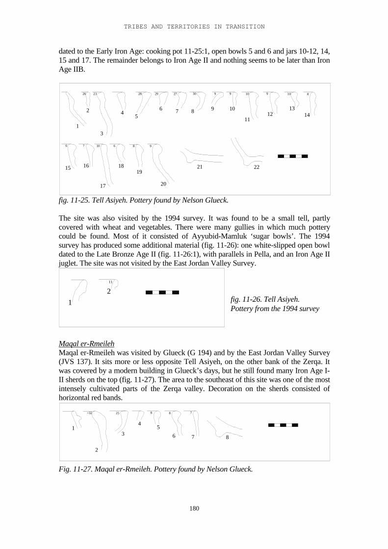
TRIBES AND TERRITORIES IN TRANSITION
180
dated to the Early Iron Age: cooking pot 11-25:1, open bowls 5 and 6 and jars 10-12, 14,15 and 17. The remainder belongs to Iron Age II and nothing seems to be later than IronAge IIB.
26 23 28 29 27 30 9 9 10 9 10 8
6 7 10 6 8 9
1
2
3
45
6 7 8 9 10
1112
1314
15 16
17
1819
20
21 22
fig. 11-25. Tell Asiyeh. Pottery found by Nelson Glueck.
The site was also visited by the 1994 survey. It was found to be a small tell, partlycovered with wheat and vegetables. There were many gullies in which much potterycould be found. Most of it consisted of Ayyubid-Mamluk ‘sugar bowls’. The 1994survey has produced some additional material (fig. 11-26): one white-slipped open bowldated to the Late Bronze Age II (fig. 11-26:1), with parallels in Pella, and an Iron Age IIjuglet. The site was not visited by the East Jordan Valley Survey.
11
12
Maqal er-RmeilehMaqal er-Rmeileh was visited by Glueck (G 194) and by the East Jordan Valley Survey(JVS 137). It sits more or less opposite Tell Asiyeh, on the other bank of the Zerqa. Itwas covered by a modern building in Glueck’s days, but he still found many Iron Age I-II sherds on the top (fig. 11-27). The area to the southeast of this site was one of the mostintensely cultivated parts of the Zerqa valley. Decoration on the sherds consisted ofhorizontal red bands.
>32 25 8 8 7
1
2
3
45
6 7 8
Fig. 11-27. Maqal er-Rmeileh. Pottery found by Nelson Glueck.
fig. 11-26. Tell Asiyeh.Pottery from the 1994 survey
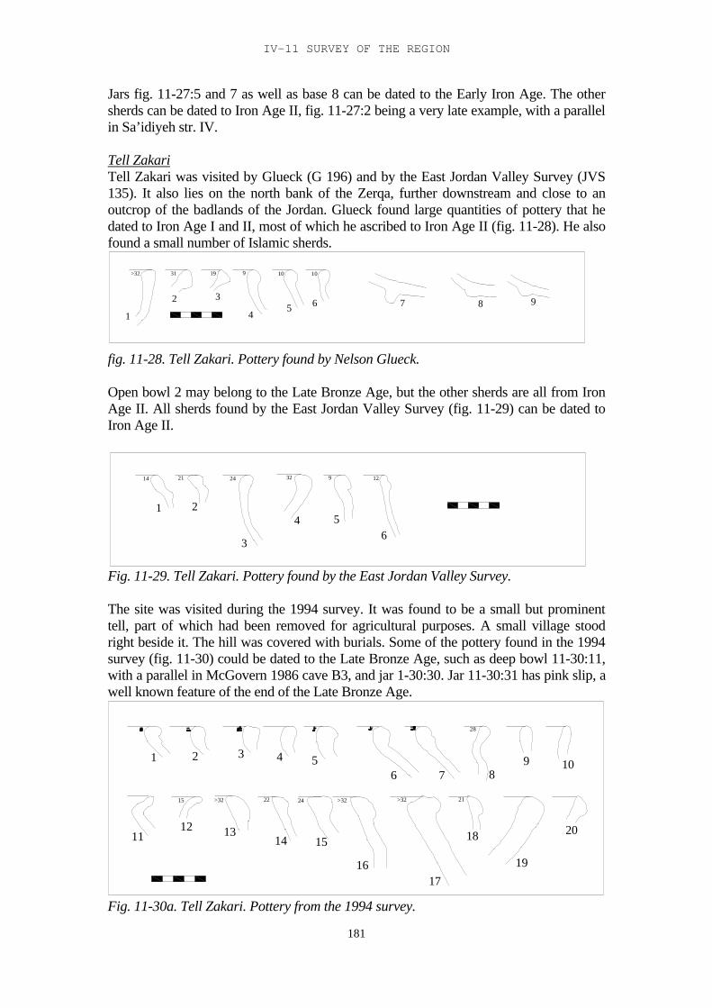
IV-11 SURVEY OF THE REGION
181
Jars fig. 11-27:5 and 7 as well as base 8 can be dated to the Early Iron Age. The othersherds can be dated to Iron Age II, fig. 11-27:2 being a very late example, with a parallelin Sa’idiyeh str. IV.
Tell ZakariTell Zakari was visited by Glueck (G 196) and by the East Jordan Valley Survey (JVS135). It also lies on the north bank of the Zerqa, further downstream and close to anoutcrop of the badlands of the Jordan. Glueck found large quantities of pottery that hedated to Iron Age I and II, most of which he ascribed to Iron Age II (fig. 11-28). He alsofound a small number of Islamic sherds.
>32 31 19 9 10 10
1
2 3
45 6 7 8 9
fig. 11-28. Tell Zakari. Pottery found by Nelson Glueck.
Open bowl 2 may belong to the Late Bronze Age, but the other sherds are all from IronAge II. All sherds found by the East Jordan Valley Survey (fig. 11-29) can be dated toIron Age II.
14 21 24 32 9 12
1 2
3
4 56
Fig. 11-29. Tell Zakari. Pottery found by the East Jordan Valley Survey.
The site was visited during the 1994 survey. It was found to be a small but prominenttell, part of which had been removed for agricultural purposes. A small village stoodright beside it. The hill was covered with burials. Some of the pottery found in the 1994survey (fig. 11-30) could be dated to the Late Bronze Age, such as deep bowl 11-30:11,with a parallel in McGovern 1986 cave B3, and jar 1-30:30. Jar 11-30:31 has pink slip, awell known feature of the end of the Late Bronze Age.
15
16
12
15
11
1
1413
432
22>32
65
>32>3224
1917
18
87
21
28
20
109
Fig. 11-30a. Tell Zakari. Pottery from the 1994 survey.
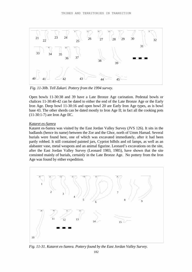
TRIBES AND TERRITORIES IN TRANSITION
182
4140 42 4443 45
2221
3337
8
9
10 7
23 24
3536
34
13 10
26 2725
38
7
28 29 30
39
13 8
32
31
Fig. 11-30b. Tell Zakari. Pottery from the 1994 survey.
Open bowls 11-30:38 and 39 have a Late Bronze Age carination. Pedestal bowls orchalices 11-30:40-42 can be dated to either the end of the Late Bronze Age or the EarlyIron Age. Deep bowl 11-30:16 and open bowl 20 are Early Iron Age types, as is bowlbase 43. The other sherds can be dated mostly to Iron Age II; in fact all the cooking pots(11-30:1-7) are Iron Age IIC.
Kataret es-SamraKataret es-Samra was visited by the East Jordan Valley Survey (JVS 126). It sits in thebadlands (hence its name) between the Zor and the Ghor, north of Umm Hamad. Severalburials were found here, one of which was excavated immediately, after it had beenpartly robbed. It still contained painted jars, Cypriot bilbils and oil lamps, as well as analabaster vase, metal weapons and an animal figurine. Leonard’s excavations on the site,after the East Jordan Valley Survey (Leonard 1983, 1985), have shown that the siteconsisted mainly of burials, certainly in the Late Bronze Age. No pottery from the IronAge was found by either expedition.
20 21 >32 25 >32 32 28
28 19 31 13
1
23
45
6
7
8 9
10
11 12 1314 15
Fig. 11-31. Kataret es-Samra. Pottery found by the East Jordan Valley Survey.
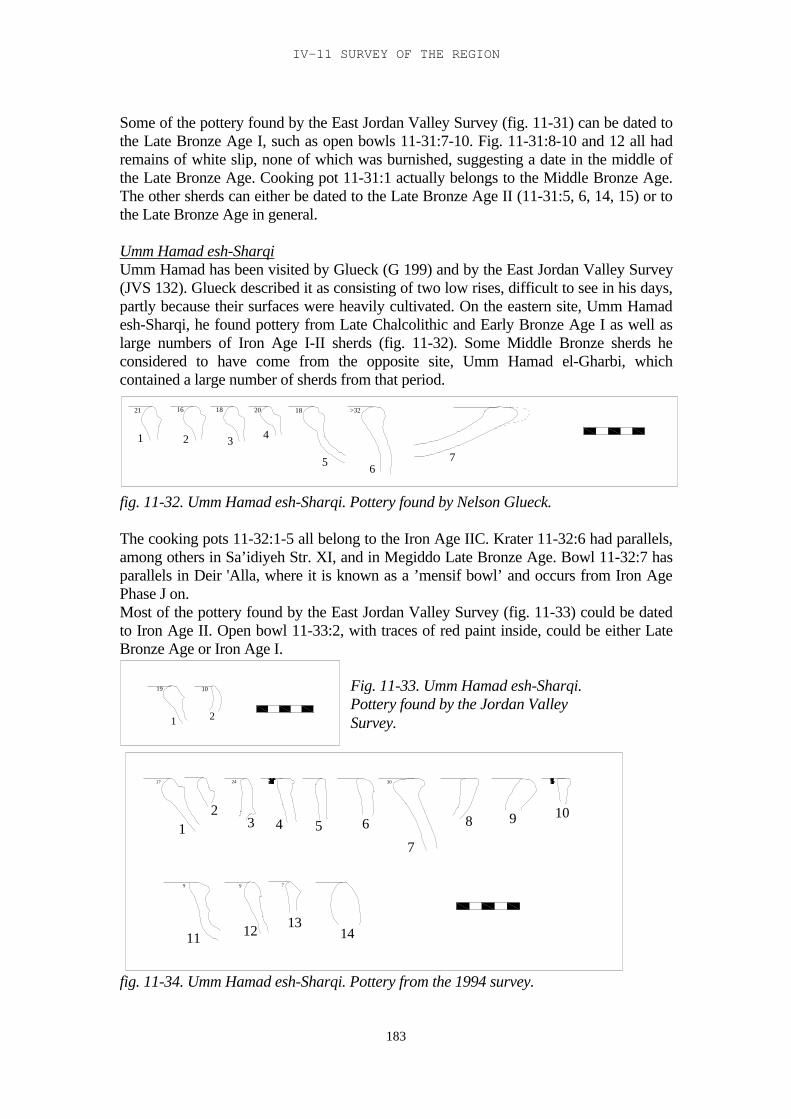
IV-11 SURVEY OF THE REGION
183
Some of the pottery found by the East Jordan Valley Survey (fig. 11-31) can be dated tothe Late Bronze Age I, such as open bowls 11-31:7-10. Fig. 11-31:8-10 and 12 all hadremains of white slip, none of which was burnished, suggesting a date in the middle ofthe Late Bronze Age. Cooking pot 11-31:1 actually belongs to the Middle Bronze Age.The other sherds can either be dated to the Late Bronze Age II (11-31:5, 6, 14, 15) or tothe Late Bronze Age in general.
Umm Hamad esh-SharqiUmm Hamad has been visited by Glueck (G 199) and by the East Jordan Valley Survey(JVS 132). Glueck described it as consisting of two low rises, difficult to see in his days,partly because their surfaces were heavily cultivated. On the eastern site, Umm Hamadesh-Sharqi, he found pottery from Late Chalcolithic and Early Bronze Age I as well aslarge numbers of Iron Age I-II sherds (fig. 11-32). Some Middle Bronze sherds heconsidered to have come from the opposite site, Umm Hamad el-Gharbi, whichcontained a large number of sherds from that period.
21 16 18 20 18 >32
1 2 3 4
5 67
fig. 11-32. Umm Hamad esh-Sharqi. Pottery found by Nelson Glueck.
The cooking pots 11-32:1-5 all belong to the Iron Age IIC. Krater 11-32:6 had parallels,among others in Sa’idiyeh Str. XI, and in Megiddo Late Bronze Age. Bowl 11-32:7 hasparallels in Deir 'Alla, where it is known as a ’mensif bowl’ and occurs from Iron AgePhase J on.Most of the pottery found by the East Jordan Valley Survey (fig. 11-33) could be datedto Iron Age II. Open bowl 11-33:2, with traces of red paint inside, could be either LateBronze Age or Iron Age I.
19 10
1 2
17
79
24
9
30
12
3 4 5 6
7
8 9 10
11 12 1314
fig. 11-34. Umm Hamad esh-Sharqi. Pottery from the 1994 survey.
Fig. 11-33. Umm Hamad esh-Sharqi.Pottery found by the Jordan ValleySurvey.
TRIBES AND TERRITORIES IN TRANSITION
184
The site was visited again during the 1994 survey. It was found to be a large site withmany recent burials. The pottery found in 1994 can all be dated to Iron Age II (with theexception of 11-34:3, 5 and 9, which are Early Bronze Age).
Tell BashirTell Bashir was visited by the East Jordan Valley Survey (JVS 129). It lies on the northbank of the Zerqa, east of Tell Asiyeh.
>32 32 24 >32 28 32
12
3
4
5 6
fig. 11-35. Tell Bashir. Pottery found by the East Jordan Valley Survey.
(fig. 11-35). The two cooking pots 11-35:1 and 2 can be dated to the Early Iron Age, andso can deep bowl 11-35:3 and open bowls 5 and 6, both Manasseh bowls. Deep bowl 11-35:4 can be dated to Iron Age II.The site was also visited by the 1994 survey. It was found to be a small tell, with somehouses and small buildings along the foot on the south side. This survey found someLate Bronze Age sherds (fig. 11-36).
23 3232 23
29
2932 1824
26 1613
19 9
6
11 12 299
1 2 3 45 6 7
89
1011
1213
1415 16 17
18 19 20 21
22 23 2425
26
2728
29
fig. 11-36. Tell Bashir. Pottery from the 1994 survey.
Cooking pots 11-36:1 and 2 can be dated to the first half of the Late Bronze Age, and socan open bowl 20. Jar 11-36:21, with traces of pink slip, and jar 27, with a doublewhite/pink slip layer, may date from the end of the Late Bronze Age. Deep bowl 11-36:6is a transitional Late Bronze – Early Iron Age shape, as is krater 11, with a parallel in
IV-11 SURVEY OF THE REGION
185
McGovern 1986 cave B3, and krater 11-36:13 and 14, both with plastic decoration onthe outside of the rim. Open bowls 11-36:18 and 19 and jar 22 are also transitionalshapes. Deep bowls 11-36:7, 8 and 9, krater 12, jar 26 and pithos 28 are all clear EarlyIron Age shapes. From the end of the Early Iron Age or the beginning of Iron Age II arecooking pots 11-36:4 and 5, ‘mensif bowl’ 17 and jar 25. The other sherds can be datedto Iron Age II.
Tell er-Rabi
31 >32 12 28 29 26 21 18 21
89131020221616
12
34 5
6 7
8
910
11
12 13 14 15
16 1718
19 2021
22 23
fig. 11-37. Tell er-Rabi. Pottery found by the East Jordan Valley Survey.
Tell er-Rabi was visited by the East Jordan Valley Survey (JVS 122). It lies beside TellEkhsas, west of Deir 'Alla in the Ghor. The pottery from the East Jordan Valley Survey(fig. 1-37) can all be dated to the Iron Age, much of it to the Early Iron Age, like cookingpots 11-37:1, 2, 4 and 5, bowl 11, with black and red bands outside on the rim, jars 16,17, 18 and 21, and bowl 22. The other sherds are dated to Iron Age II.
DamiehDamieh lies immediately south of the area of research. It was visited by Nelson Glueck(G 200) and again by the East Jordan Valley Survey (JVS 151). Glueck pointed out itsstrategic location “guarding to the west the bridge that spans the Jordan and the road thatleads up the Wadi el-Far’ah to Nablus, and to the east the road that leads past the ArabLegion police post on the top of a katarrh hill, about 1 km. to the east-southeast – east ofit, to es-Salt, in the hill country of Gilead” (Glueck 1951, 330-331).
18 20 32 32 29 26 22 11
10 6 9 11 11 10 9 11
12
3 45
6 78
9
10
11
12 13 1415
16 17 18 19 20
fig. 11-38. Damieh. Pottery found by Nelson Glueck.
TRIBES AND TERRITORIES IN TRANSITION
186
Some sherds had red or black horizontal bands. Practically all of the pottery fromGlueck’s survey can be dated to the Iron Age, although he himself stated that he hadfound some Late Bronze II sherds. Open bowl 11-38:8, with a parallel in Pella, openbowl 10 and jar 19, both of which had red painted lines in and out, may be from thetransitional Late Bronze – Early Iron Age. Deep bowl 11-38:6, jar 11 and jars 15-18 canall be dated to the Early Iron Age. Krater 11-38:5 could be from the end of the EarlyIron Age or the beginning of Iron Age II. The cooking pots can all be dated to Iron AgeII, as can most of the jars.
28 23 23 26 17 18 16 22 25 22
171112892626262528
12
3
4
5 6 78
9 10
11
12
13
14 1516
1718 19 20 21
22 23
fig. 11-39. Damieh. Pottery found by the Jordan Valley Survey.
The East Jordan Valley Survey has found some Late Bronze Age pottery in Damieh (fig.11-39). The flaring rims of the two jars, 11-39:22 and 23 have parallels in the LateBronze Age. The other pottery found by the East Jordan Valley Survey could all besafely dated to the Iron Age. Open bowl 11-39:17 is a Manasseh bowl. The cooking pots11-39:1 and 2 can be dated to the Early Iron Age; the other cooking pots are from IronAge II. Deep bowl 11-39:10 is an Early Iron Age shape. Most of the other sherds areIron Age II shapes.
Mugharet el-WardehMugharet el-Wardeh was visited by Glueck (G 351). It is a site in the foothills thatborder the Jordan Valley on the east side. It lies in the centre of a field of iron ore,according to Bender (1968, 150) the only workable amount of ore in the wider region.
9 31 22 17 23 11 9 10 27
8 10 8 9 7 11 9 10 8
1 2 34 5 6 7 8
9 10
1112 13
1415 16 17 18
19 20 21 22 23
fig. 11-40. Mugharet el-Wardeh. Pottery found by Nelson Glueck.
IV-11 SURVEY OF THE REGION
187
All the pottery (fig. 11-40) can safely be dated to the Iron Age. The earliest shapes seemto be the bowls 11-40:6-10 with their rounded sides; these are more common in theearlier period. In the later period there are some striking parallels with Tell es-Sa’idiyehto the west, for example open bowls 1-40:11-13 and jars 14-17, which all have parallelsin Sa’idiyeh Str. IX.
Tulul edh-DhahabTulul edh-Dhahab was visited by Glueck (G 344, 345), by the East Jordan ValleySurvey, and by Gordon and Villiers as part of a survey of the surrounding area. The siteconsists of two peaks facing each other across a bend in the Zerqa. (fig. 11-41).
Fig. 11-41. Tulul edh-Dhahab. Pottery found by the East Jordan Valley Survey and bythe Gordon-Villiers Zerqa survey.
Cooking pot 11-41:14, and possibly 7 also may be of the transitional Late Bronze –Early Iron Age type, and therefore the earliest (but see Ch.IV-12). Krater 27 had pink
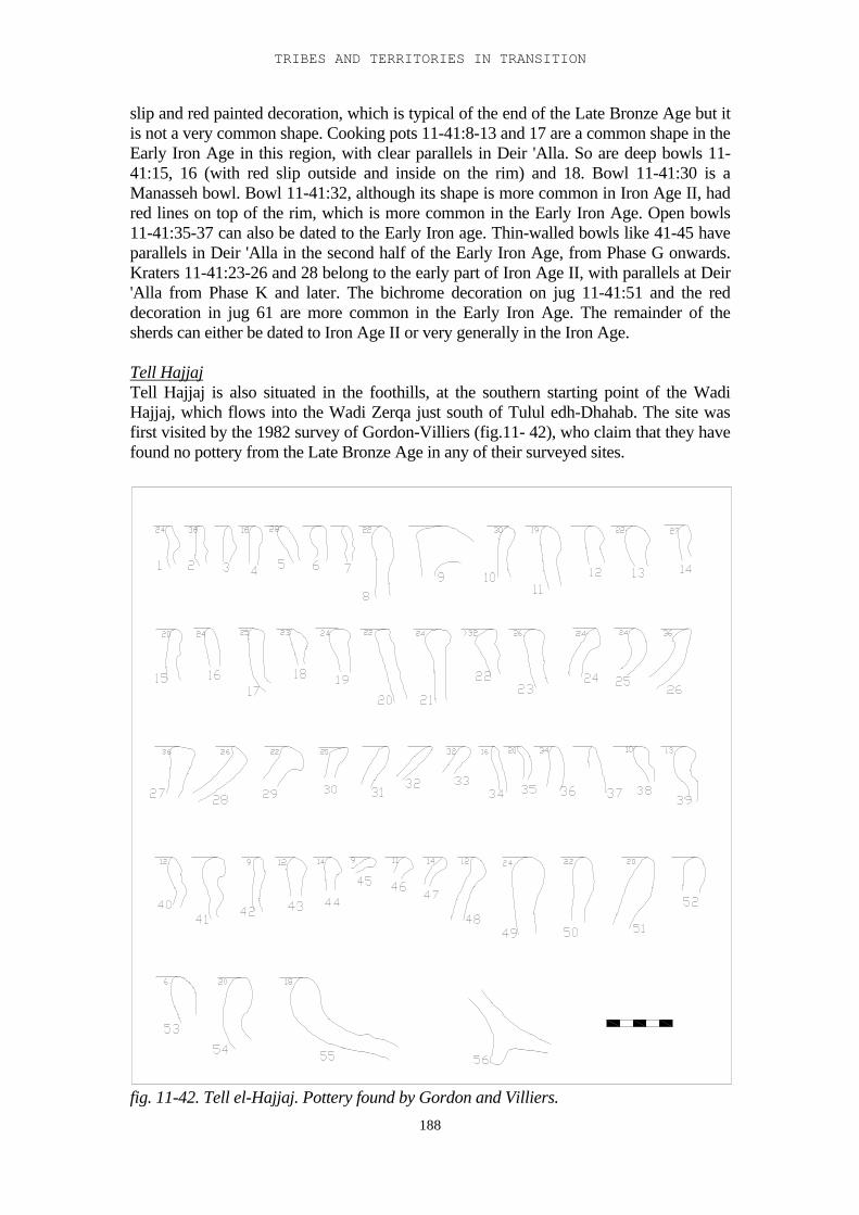
TRIBES AND TERRITORIES IN TRANSITION
188
slip and red painted decoration, which is typical of the end of the Late Bronze Age but itis not a very common shape. Cooking pots 11-41:8-13 and 17 are a common shape in theEarly Iron Age in this region, with clear parallels in Deir 'Alla. So are deep bowls 11-41:15, 16 (with red slip outside and inside on the rim) and 18. Bowl 11-41:30 is aManasseh bowl. Bowl 11-41:32, although its shape is more common in Iron Age II, hadred lines on top of the rim, which is more common in the Early Iron Age. Open bowls11-41:35-37 can also be dated to the Early Iron age. Thin-walled bowls like 41-45 haveparallels in Deir 'Alla in the second half of the Early Iron Age, from Phase G onwards.Kraters 11-41:23-26 and 28 belong to the early part of Iron Age II, with parallels at Deir'Alla from Phase K and later. The bichrome decoration on jug 11-41:51 and the reddecoration in jug 61 are more common in the Early Iron Age. The remainder of thesherds can either be dated to Iron Age II or very generally in the Iron Age.
Tell HajjajTell Hajjaj is also situated in the foothills, at the southern starting point of the WadiHajjaj, which flows into the Wadi Zerqa just south of Tulul edh-Dhahab. The site wasfirst visited by the 1982 survey of Gordon-Villiers (fig.11- 42), who claim that they havefound no pottery from the Late Bronze Age in any of their surveyed sites.
fig. 11-42. Tell el-Hajjaj. Pottery found by Gordon and Villiers.
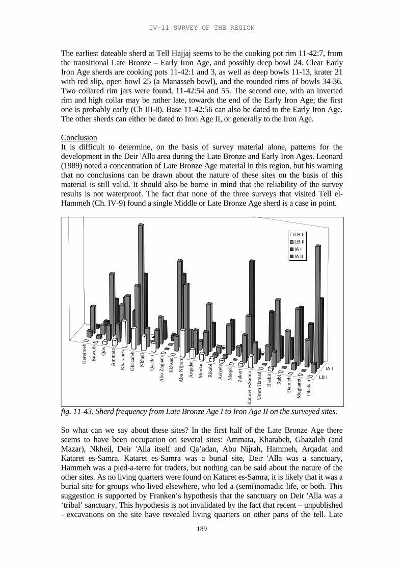
IV-11 SURVEY OF THE REGION
189
The earliest dateable sherd at Tell Hajjaj seems to be the cooking pot rim 11-42:7, fromthe transitional Late Bronze – Early Iron Age, and possibly deep bowl 24. Clear EarlyIron Age sherds are cooking pots 11-42:1 and 3, as well as deep bowls 11-13, krater 21with red slip, open bowl 25 (a Manasseh bowl), and the rounded rims of bowls 34-36.Two collared rim jars were found, 11-42:54 and 55. The second one, with an invertedrim and high collar may be rather late, towards the end of the Early Iron Age; the firstone is probably early (Ch III-8). Base 11-42:56 can also be dated to the Early Iron Age.The other sherds can either be dated to Iron Age II, or generally to the Iron Age.
ConclusionIt is difficult to determine, on the basis of survey material alone, patterns for thedevelopment in the Deir 'Alla area during the Late Bronze and Early Iron Ages. Leonard(1989) noted a concentration of Late Bronze Age material in this region, but his warningthat no conclusions can be drawn about the nature of these sites on the basis of thismaterial is still valid. It should also be borne in mind that the reliability of the surveyresults is not waterproof. The fact that none of the three surveys that visited Tell el-Hammeh (Ch. IV-9) found a single Middle or Late Bronze Age sherd is a case in point.
Ker
eim
eh
Buw
eib
Qos
Am
mat
a
Kha
rabe
h
Gha
zale
h
Nkh
eil
Qaa
dan
Abu
Zag
han
Ekhs
as
Abu
Nijr
ah
Arq
adat
Mei
dan
Rik
abi
Asi
yeh
Maq
al
Zaka
ri
Kat
aret
esS
amra
Um
m H
amad
Bas
hir
Rab
i
Dam
ieh
Mug
hare
t
Dha
hab
LB I
IA I
LB ILB IIIA IIA II
fig. 11-43. Sherd frequency from Late Bronze Age I to Iron Age II on the surveyed sites.
So what can we say about these sites? In the first half of the Late Bronze Age thereseems to have been occupation on several sites: Ammata, Kharabeh, Ghazaleh (andMazar), Nkheil, Deir 'Alla itself and Qa’adan, Abu Nijrah, Hammeh, Arqadat andKataret es-Samra. Kataret es-Samra was a burial site, Deir 'Alla was a sanctuary,Hammeh was a pied-a-terre for traders, but nothing can be said about the nature of theother sites. As no living quarters were found on Kataret es-Samra, it is likely that it was aburial site for groups who lived elsewhere, who led a (semi)nomadic life, or both. Thissuggestion is supported by Franken’s hypothesis that the sanctuary on Deir 'Alla was a‘tribal’ sanctuary. This hypothesis is not invalidated by the fact that recent – unpublished- excavations on the site have revealed living quarters on other parts of the tell. Late
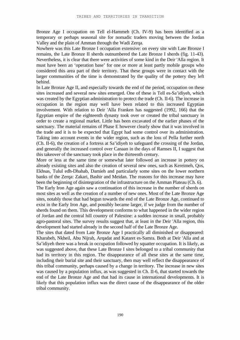
TRIBES AND TERRITORIES IN TRANSITION
190
Bronze Age I occupation on Tell el-Hammeh (Ch. IV-9) has been identified as atemporary or perhaps seasonal site for nomadic traders moving between the JordanValley and the plain of Amman through the Wadi Zerqa.Nowhere was this Late Bronze I occupation extensive: on every site with Late Bronze Iremains, the Late Bronze II sherds outnumbered the Late Bronze I sherds (fig. 11-43).Nevertheless, it is clear that there were activities of some kind in the Deir 'Alla region. Itmust have been an ‘operation base’ for one or more at least partly mobile groups whoconsidered this area part of their territory. That these groups were in contact with thelarger communities of the time is demonstrated by the quality of the pottery they leftbehind.In Late Bronze Age II, and especially towards the end of the period, occupation on thesesites increased and several new sites emerged. One of these is Tell es-Sa’idiyeh, whichwas created by the Egyptian administration to protect the trade (Ch. II-6). The increase inoccupation in the region may well have been related to this increased Egyptianinvolvement. With relation to Deir 'Alla Franken has suggested (1992, 166) that theEgyptian empire of the eighteenth dynasty took over or created the tribal sanctuary inorder to create a regional market. Little has been excavated of the earlier phases of thesanctuary. The material remains of Phase E however clearly show that it was involved inthe trade and it is to be expected that Egypt had some control over its administration.Taking into account events in the wider region, such as the loss of Pella further north(Ch. II-6), the creation of a fortress at Sa’idiyeh to safeguard the crossing of the Jordan,and generally the increased control over Canaan in the days of Ramses II, I suggest thatthis takeover of the sanctuary took place in the thirteenth century.More or less at the same time or somewhat later followed an increase in pottery onalready existing sites and also the creation of several new ones, such as Kereimeh, Qos,Ekhsas, Tulul edh-Dhahab, Damieh and particularly some sites on the lower northernbanks of the Zerqa: Zakari, Bashir and Meidan. The reasons for this increase may havebeen the beginning of disintegration of the infrastructure on the Amman Plateau (Ch. 6).The Early Iron Age again saw a continuation of this increase in the number of sherds onmost sites as well as the creation of a number of new ones. Most of the Late Bronze Agesites, notably those that had begun towards the end of the Late Bronze Age, continued toexist in the Early Iron Age, and possibly became larger, if we judge from the number ofsherds found on them. This development conforms to what happened in the wider regionof Jordan and the central hill country of Palestine: a sudden increase in small, probablyagro-pastoral sites. The survey results suggest that, at least in the Deir 'Alla region, thisdevelopment had started already in the second half of the Late Bronze Age.The sites that dated from Late Bronze Age I practically all diminished or disappeared:Kharabeh, Nkheil, Abu Nijrah, Arqadat and Kataret es-Samra. Both at Deir 'Alla and atSa’idiyeh there was a break in occupation followed by squatter occupation. It is likely, aswas suggested above, that these Late Bronze I sites belonged to a tribal community thathad its territory in this region. The disappearance of all these sites at the same time,including their burial site and their sanctuary, then may well reflect the disappearance ofthis tribal community, perhaps caused by a change in territory. The increase in new siteswas caused by a population influx, as was suggested in Ch. II-6, that started towards theend of the Late Bronze Age and that had its cause in international developments. It islikely that this population influx was the direct cause of the disappearance of the oldertribal community.
191
IV-12. A Walk through the Zerqa
Introduction
The main purpose of this study, as laid out in the first section, is to demonstrate thehypothesis that there was a trade route through the Wadi Zerqa, between Deir 'Alla andthe Amman plain, in the Late Bronze Age. This trade route could have been maintainedby the local population of the area, mainly Canaanites, even though it was an extensionof Egyptian trade routes west and east of the Jordan. The plain of Amman is hereconsidered to have been a city state, possibly with Sahab as its economic centre (see alsoHübner 1992, 158). It was dominated by a Canaanite tribe, or a coalition of tribes, and itseconomy was largely based on the international trade between the west and the north,and possibly the south (Hübner 1992, 162-3). For contacts with the east, the desertregion, there is no evidence so far, although Sahab, because of its location on the edge ofthe desert, may suggest a function as a gateway community (Ibrahim 1987, 76) The findshave made clear that northern groups or representatives of northern communities alsoinhabited the area (Ch. 3, McGovern 1986). According to McGovern (1986, 6) atranshumance route may well have existed between the Baq'ah plain and the Jordanvalley, going through the Zerqa valley. Wandering nomads moved from the plain, wherethey stayed in summer, to the Valley in winter. This practice certainly existed in thenineteenth century AD. If there was an actual trade route in the Late Bronze Age, it is tobe expected that the mobile population of the region was involved in it. Bedouincertainly were involved in trade in the nineteenth century AD, transferring goods fromSalt to Jerusalem and Nablus (Ch. 5).
However, surveys have never produced any pottery from the Late Bronze Age in theZerqa valley. Late Bronze Age material was found in the Baq'ah plain, and at the otherend of the route in the Jordan Valley, but nowhere in between. Excavations in 1996 and1997 on Tell el-Hammeh, on the north bank of the Wadi Zerqa (van der Steen 1997 andCh. 11), have demonstrated that this site, right at the entrance of the Zerqa valley, wasused in the Late Bronze Age as well as in the Middle Bronze Age. The tell lies on anatural hill, and rises about 7 m above its surroundings. It was noticed by Glueck (1951,313), by Gordon and Villiers during their Wadi Zerqa survey (Gordon and Villiers 1983)and also by the East Jordan Valley Survey (Ibrahim et al. 1988). Based on the surveyresults the site was thought to be settled in the Early Bronze Age, and the Early Iron Ageup to the Persian period. The excavations revealed occupation layers from theChalcolithic and Early Bronze Ages, and, after a gap, from the end of the Middle BronzeAge to the end of Iron Age II. No sherds from either period were found during thesurveys, which opens up the possibility that similar material may be found in other partsof the Zerqa valley, even though the surveys never revealed any Late Bronze Ageoccupation.
The very simple and transitory architecture from the Late Bronze Age layers suggests thepresence of a mobile group or groups using the site on a temporary basis, a transhumantpopulation perhaps. At the same time the fine pottery suggests that they were in contactwith main cultural centres and that the pottery they carried may have had anothersignificance than simply that of functional, daily ware. A possible explanation is that theywere involved in trade, moving from one market centre to another, and some of thepottery they carried was related to the trade.
TRIBES AND TERRITORIES IN TRANSITION
192
If we accept this hypothesis, the next question is which road the trade route followed. Thefact that Tell el-Hammeh lies at the mouth of the Zerqa valley suggests that it actuallywent through this valley (fig. 12-1). It has been stated above that the fact that no surveyso far has turned up actual Late Bronze Age pottery in the valley does not automaticallymean that it did not exist. A number of sites have shown the presence of Early Iron Agepottery: (from west to east) Tell el-Hammeh; Sabgha and the Zighan caves (possibly);Tell Mghanni W; Iraq et-Tahuna; Tulul edh-Dhahab (east and west, main period ofoccupation); the gypsum mine on the south side of the Zerqa; Tell Ghreimun (fig. 12-2;Gordon and Villiers, 1983).
After the collapse of the Egyptian empire a number of small Early Iron Age settlementswas created, especially in the highlands east and west of the Jordan as well as in the EastJordan valley. It is to be expected that these settlements were first and foremost foundedon locations that were already known to the new settlers (Oppenheim 1943, 184).Suitable locations, such as those that were already in use as stopovers along existingtranshumance routes, would have been the first to be settled. The newly settled Early IronAge sites along the Zerqa therefore may be an indication of the road these nomads took intheir wanderings between the Amman plain and the Jordan Valley.
A walk through the Zerqa
In April 2000 a group of four people, accompanied by a local guide, set out to walkthrough the Wadi Zerqa, from Deir 'Alla to Khirbet Umm ed-Dananir, in order toinvestigate the possibility of a Late Bronze Age trade route between the market centre ofDeir 'Alla and that of the Baq'ah valley, and the actual road that may have been taken1.On the way the different side wadis to the south were checked, to see where the routemay have diverged from the Wadi Zerqa and turned south. The sites from the Gordon –Villiers survey were not revisited, since that would have required a special permissionfrom the Jordanian Government.
Day 1We set out on 9 April, 8.45 from the Deir 'Alla dig house. The donkey carried 20 litres ofwater and some 20 kilos of luggage, and was therefore not heavily loaded. For the firstnine kilometres we followed the road into the Wadi Zerqa, past Tell el-Hammeh, and thewater pump station. This road, which subsequently turns into a track, runs close to theriver, crossing it several times. The triangle that forms the entrance to the Wadi is heavilycultivated with wheat and vegetables, but mainly with onions. Further east, into thefoothills, there is less cultivation although many relatively flat areas are still cultivated orused as pasture for cows. The reasonably flat hills on both sides of the river form naturalterraces, which have been supplemented by artificial terraces in places. At the sides of theroad there were occasional Bedouin and gypsy tents, usually small campsites occupied byone or two families. These families stay in this area during the winter, cultivating smallpatches of land, and move higher up into the hills during the summer.
1 The expedition team consisted of: Eveline van der Steen, expedition leader, Eva Kapteyn, CarmenHarmsen and Ellis Grootveld (students at Leiden university), Ali el-Khayyat (representative of theDepartment of Antiquities in Salt), who acted as guide, Ibrahim the donkey driver, and the donkey(who acquired several names during the expedition, ranging from Balaam to Mesha, but who ended upas Eeyore).
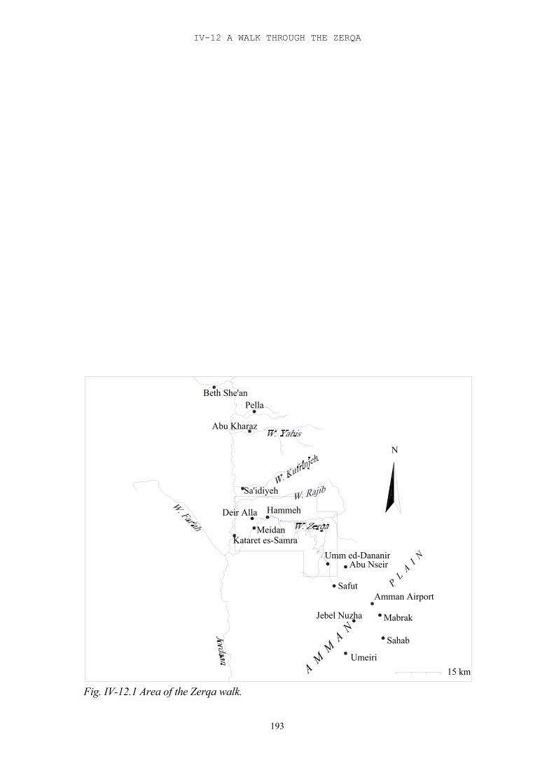
IV-12 A WALK THROUGH THE ZERQA
193
15 km
N
Beth She'anPella
Abu Kharaz
Sa'idiyeh
HammehDeir Alla
Kataret es-SamraMeidan
Umm ed-DananirAbu Nseir
SafutAmman Airport
Jebel Nuzha Mabrak
Sahab
Umeiri
A M M
A N
P L A
I N
Fig. IV-12.1 Area of the Zerqa walk.
TRIBES AND TERRITORIES IN TRANSITION
194
Several of these small camps were found in the area of Tulul edh-Dhahab, on both sidesof the Zerqa. The Bedouin herd sheep and goats, and usually have a few cows as well.They do not cultivate any land. The gypsies are involved in weaving. They own only afew sheep and goats and occasionally a cow.
Just before Tulul edh-Dhahab the road takes a shortcut to cut off a bend in the river; itpasses Tell edh-Dhahab el-Gharbi on the north side. This road is quite new, having beencut into the bedrock, so it cannot have been part of the original route. The original roadmay have followed the river, passing Tell edh-Dhahab on the south side, or else it mayhave passed somewhat north of the present road, where the hills are less steep. At thecrossing of the road and the river, between Tell edh-Dhahab el Gharbi and Tell edh-Dhahab esh-Sharqi, there was a one-family Bedouin camp, belonging to a Jehaleenfamily. According to their own accounts they are originally related to Bedouin tribesfrom around Beersheba, but have become separate subtribes over the years. This processof separation has accelerated because of the closed borders between the Negev andJordan, prohibiting any contact between the Jehaleen and their mother tribes. Most of thetribes that live in this area are originally subtribes from the tribes that lived aroundBeersheba.According to these and other Bedouin it was not possible to pass Tell edh-Dhahab esh-Sharqi on the north side, following the bank of the Zerqa, because this route was blockedby rocks. We were therefore forced to pass Tell edh-Dhahab esh-Sharqi on the south side.
However, leaving the donkey and the luggage behind, we did check the bank of the Zerqaat this spot. We saw that the bank, especially the south bank, was relatively broad and flatover the whole stretch that passed Tell edh-Dhahab esh-Sharqi.
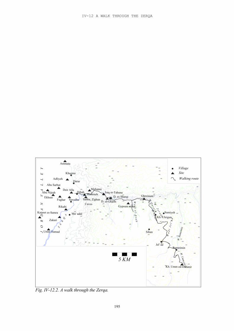
IV-12 A WALK THROUGH THE ZERQA
195
Gypsum mine
D. es-Sharqi
700
Z E
R Q
A
J
O
R
D
A
N
V
A
L
L
E
Y
-200
Umm Hamad
-100 100200
700
600300 400 500
600
Adliyeh
Khazma
Ammata
Kataret es-Samra
Zakari
Rikabi
Ekhsas
Abu Sarbut
Abu Nijrah
Fughar
Hammeh
-100
Mu' addi-200 100
DibabDeir Alla
Sawalha
-200
-100
400
600
300400
500
200
200
300
D. el-Gharbi
-100
100
100
Darar
100
200
400
300
400
200
500
300
600
W a
d i
J e
l ' a
d
700
600
900 800
5 KM
500
600
800700
800
Sihan600
Jel' ad
700
700800
Kh. Umm ed-Dananir
800
Rumeimin
W. U
mm
ed-D.
600
500
600
W. R
umei
min
600
500
500400
700
700
Sumiyeh
200300
400
W a d i e l - A z a b
200
400
400
300
300
100
100
300
100
W . J e r a d a
W Q u s e i bW
. Uleigun
Kh. Uleigun
400
500
200
300
100
300
400
400
100
200
800 900900
500
600
800
700
600
500
300
400
400500
200400
300
500
200
200
Walking routeSiteVillage
Sabha, Zighan Caves
MghanniIraq et-Tahuna
Ghreinum
Fig. IV-12.2. A walk through the Zerqa.
TRIBES AND TERRITORIES IN TRANSITION
196
At one point we did find the way blocked completely by huge boulders, several metres indiameter; and the gaps between them filled up by the results of a landslide. These barriersseemed relatively recent, however, and it is well possible, and even likely, that theoriginal route passed along this way, provided, of course, that the Zerqa followed thiscourse in the Late Bronze Age.About 200 m from the main track the south bank broadened into a small terrace, whererows of boulders were visible just above the soil. This may form part of the site of Telledh-Dhahab esh-Sharqi. A scan of the sherds that were lying around showed that mostwere Hellenistic and Roman, but there were some Iron Age sherds. We found one rimfragment of a Late Bronze Age cooking pot. This was particularly interesting, because sofar no Late Bronze Age sites have been located in the Zerqa. This site was situatedimmediately below Tell edh-Dhahab esh-Sharqi, and it is certainly possible that thesesherds have been washed down from the site above. Still, it would be the first indicationof Late Bronze Age presence in this area. We passed Tell edh-Dhahab esh-Sharqi on the south side, a difficult track, especially forthe donkey, but one that is generally used these days, as we were assured by severalinformants. We also passed several donkeys and mules on the way. East of Tulul edh-Dhahab the bank of the Zerqa is steep on the north side but the southside slopes up gradually, forming several natural terraces. This area was partly cultivated,and partly consisted of rich grass land. The soil here is terra rossa, very fertile, butshallow. We found several tracks on different levels, made for agricultural purposes, andthe going was easy. About 1 km west of the Wadi el-Azab we stopped and set up campfor the night, on the south bank of the river.
Day 2The next day, 10 April, we continued along the river, going east. Inquiries beforehandhad made it clear that the eastern part of the Wadi Zerqa east of the Wadi el-Azab wasimpassable, being too narrow and too steep. The plan therefore was to turn south andfollow the Wadi el-Azab. However, about 500 m before the Wadi el-Azab a smallBedouin camp, consisting of two families, was spotted south of the road. This campbelonged to members of the tribe of the Seb'awiyeh, another subtribe of the Bedouin fromBeersheba who had moved here before 1948. They told us that the Wadi el-Azab wasalso too steep, and the normal route taken by the Bedouin went through the Wadi el-Quseib, some three kilometres further east.
We were still walking on the south side of the Wadi Zerqa, on one of the three or fourterraces, about 50 m above the stream bed. Just before the Wadi el-Azab we passed thegypsum mine where Gordon and Villiers (1983) had found Early Iron Age pottery. Nearthe Wadi el-Azab the landscape begins to change slightly. The stream bed becomes anarrow, deep gully, with natural terraces starting only some 20-30 metres above it. On theother side, the north slope becomes more gradual, and occasionally terraces and orchardsare seen on that side. Leaving the luggage and the donkey behind, we went into the Wadi el-Azab for closerexamination. The first part seemed accessible, with rather gradual slopes, especiallyhigher up, and cultivated with terraces and orchards (mainly olives). However, furthereast it became clear that this was certainly not an easy route to take. The present roadthrough it has been cut out in the slope and in the rocks. The stream bed is a deep andnarrow gully, and the slopes are steep and inaccessible. There are no longer any terraces,and the slopes are uncultivated.
IV-12 A WALK THROUGH THE ZERQA
197
We therefore returned to the Wadi Zerqa and followed it further east. This part of thewadi is more cultivated, with terraces, orchards (mostly on the north side) andgreenhouses. Here there are more Bedouin tents and occasionally houses, mainly on topof the mountains. There is another gypsum mine on the north slope. The raw materialsare transported from here across the Zerqa and through the Wadi el-Azab. We hadnoticed the trucks when we were walking in the Wadi el-Azab. The track we followed slowly descended into the wadi, so that we continued rather closeto the stream bed. We could now see tracks on the north side as well. Still further east,about halfway between the Wadi el-Azab and the Wadi el-Quseib, the track began toclimb again until we were walking about 100 m above the stream bed, which had becomewider, and we could see that further east (upstream that is) it had actually become anarrow lake with small islands. Just before the beginning of the Wadi el-Quseib the landscape changes again: the slopesbecome steep and they rise directly from the stream bed, which at this point has become anarrow lake. We had to pass over a high hill on a path cut into the slope in order to get tothe Wadi Quseib. There is no natural passage here. So far this has been the only point thatmay have provided difficulties in passing by this route. It is a very short distancehowever, probably less than 100 m, before one gets to the Wadi Quseib proper. The Wadi Quseib is a broad valley, a confluence of two other wadis that come from thesouth, which ends in the Wadi Zerqa. We turned south, walking on the west side of it,over the top of the plain. There are some caves in the slopes and in one of them, on theeast slope, a Bedouin family was living. The area is cultivated with vegetables and olivetrees. Flowing down from the Baq'ah plain into the Wadi Zerqa are a number of wadis,intersecting and dividing again, like a maze. Walking through it one has a choice of long,narrow hills, which are sometimes cut off by steep, but often dead-end valleys, aroundwhich one has to find one's way since it is impossible to descend. Many of the wadis donot come from the plain itself. They spring from the layers of rock that form thefoundations of the Plain: the Amman - Wadi es-Sir aquifer system. This aquifer system isone of the largest systems in the region. Its recharge is mainly from rainfall,supplemented by indirect recharge from the basalt aquifer system of Jebel el-Arab to thenortheast (Chapter 2). This water system supplies the higher wadis with water. In recentyears the water supply has been low and some of the springs have dried up completely.These springs are usually easily accessible from the slopes, since they originate in thesides of the hills. Therefore, accessibility to water, even from the higher areas, isgenerally no problem. All this means that, once one has left the Wadi Zerqa, there are a number of possibilitiesfor travelling to Khirbet Umm ed-Dananir. On the whole it seems likely that the routewould follow the higher areas, the hillsides and plains, rather than the wadis. The going iseasier and accessibility to water, as stated above, is no problem. The problem of which ofthe various possible routes was or were followed during different periods can only besolved by an extensive survey which would take into account all the different passableroutes.
As it was, we decided to follow the route that goes past Khirbet Uleigun to Jal'ad. Theroad to Khirbet Uleigun descends into the Wadi Quseib along the west side, crossing itclose to its origin, and then follows the Wadi Uleigun. This is a rather narrow valley,shallow at the bottom where the going was easy but with steep (but not very high) slopeson both sides. Both sides were cultivated with wheat and young olive trees. The soil isbright red. We walked right beside the water, climbing up gradually to Khirbet Uleigun.
TRIBES AND TERRITORIES IN TRANSITION
198
At one point, on the south side of the wadi, where the slope jutted out of the red soil, wenoticed a Roman tomb cut out in the rock.Khirbet Uleigun, where we camped for the night, is a village that is typical for this area:occupying a large rather flat area, slightly sloping, dotted with houses, with cultivationand orchards in between.
Day 3The next day we went on our way to Jal'ad. The route we took again consisted mainly oftracks, and was undulating and gradually sloping up. We were surrounded by houses, setfar apart, terraces with cultivated fields and orchards. Olive and almond trees dominated.
When we reached the main road that goes from Sihan to Sumiya we followed it east for awhile. The valley north of this road is undulating, sloping up towards the south gradually.This is the Wadi Jerada. From the main road one has a wide view over the valley to thewest, and it was clear that there were several other routes we could have taken from theWadi Quseib. Where the main road turned north we left it and started following tracksagain in a generally southern direction. Most of the tracks follow the high slopes and flattops of the hills, avoiding the valleys. Our road went zigzagging around the valleys, in agenerally southern direction. The slopes and tops in this region are cultivated, mainlywith olive trees, but there are terraces, although nothing visible was growing there yet.Low boundary walls made of boulders divide the flat tops of the hills into differentsections. The terra rossa soil is very shallow, with bedrock visible in many places. On theslopes of the valleys, where the soil is not cultivated, oak trees, with grass and flowerswere seen.This area is very popular with the wealthy people of Amman. Some of the houses looklike miniature palaces.
Our final destination for the day was the farm, south of Jal’ad, that belongs to GhaziSaudi, who had offered us hospitality. In order to get there, we had to walk around Jal’ad,over the west slope of the Wadi Rumeimin. Higher up the slope is relatively easy going,but deeper down it is steep, too steep even for terrace cultivation. The village of Rumeimin, consisting of a large area with houses dotted on the slopes, issituated at the beginning of the wadi, where the springs are. Here the slopes are less steep,and the springs are easily accessible from most sides. The bottom of the wadi iscultivated.
Day 4The next day was the last day of our four-day trip. We followed the main road, whichgenerally follows the slopes of the wadis. We first passed through the Wadi Jal’ad, whichis shallow and easy going, and followed the slopes of several wadis, finally reaching theWadi Umm ed-Dananir. We passed through the village of Rumeimin and took the road tothe south, following the slopes. The road rounds the springs of es-Sayiah, the sources ofthe wadi of the same name, and turns northeast, still following the slopes, until it comesto the Wadi Umm ed-Dananir. All the way the main road follows a seemingly naturalcourse, without having been cut out in the rock or the natural soil. The soil here, aseverywhere we have passed so far, is terra rossa, very fertile, but shallow.
In general the wadis are not very deep, and the slopes are not very steep. There is muchwidespread cultivation on the slopes, most of it terraced. At the confluence of the WadiRumeimin and the Wadi Umm ed-Dananir the slopes are rather steep, and it seems
IV-12 A WALK THROUGH THE ZERQA
199
possible to travel only near the tops of the hills. Most of the Wadi Umm ed-Dananir isalso deep and steep, with a narrow flat plain at the bottom which is heavily cultivated.Here it would have been easiest to travel at the bottom. The main road, the one wefollowed, has been cut out in the side of the slopes. Khirbet Umm ed-Dananir itself sits high on the slope, directly above the springs. In therocky hills opposite, on the other side of the wadi, there are a number of caves. Theremust have been regular traffic from the site itself to the bottom of the wadi in order to getto the springs. Moreover, if the caves opposite the site were connected with the site in anyway (perhaps as burial caves), it would have entailed regular climbing up and down thewadi on both sides. This makes it all the more likely that the final part of the road in factwent through the bottom of the wadi.
Conclusions
If the hypothesis is correct that there was a route from the Jordan Valley, the area of Deir'Alla, to the Plains of Amman during the Late Bronze Age, it seems logical to assumethat this route went through the Wadi Zerqa. There are three main arguments for that. First of all there is the presence of Tell el-Hammeh at the mouth of the Zerqa, with itsLate Bronze Age occupation. This occupation is indicative of relatively short stays, whileon the other hand the presence of well made and luxury pottery suggests involvement ininterregional trade. Secondly there is the Late Bronze Age cooking pot sherd found atTell edh-Dhahab esh-Sharqi. Thirdly there is the presence of a number of Early Iron Agesites along the Zerqa, which were created after the Late Bronze Age trade networkcollapsed and which may have been settled by people who had been involved in thistrade, on locations they were familiar with.
McGovern has already suggested that there may have been transhumance along the Zerqafrom the Baq'ah plains to the Jordan Valley. Our expedition has not proved either theexistence of the transhumance or of the trade route, but if they did exist, it has shown themost likely road they followed. For the first part, the route along the Zerqa itself, and themost likely place where this route may have turned south, this was relatively easy. Therewere not many possibilities, also taking into account the fact that people needed water onthe way. The second half, from the Wadi Zerqa up the Baq'ah, is more difficult to assess,because there are a number of possibilities. The route we have taken, from the WadiQuseib via Uleigun and Jal’ad to Khirbet Umm ed-Dananir is only one of probably manypossibilities. Which route was or were taken in different periods can only be solved by athorough survey of the area in connection with the different passable roads.
199
V-13. Existing Theories, Models and Hypotheses
A number of models and hypotheses have been developed for the occupational history ofthe Levant in the transitional period. The older ones are based on, or have beeninfluenced by the three main ‘Schools’ that dealt with the stories of the settlement ofearly or proto- Israel in the Early Iron Age. Each of these Schools proposed areconstruction for the period of the Israelite Settlement, integrating archaeologicalevidence with the historical sources or providing an alternative interpretation for them. Some of the more recent reconstructions have taken the shape of models, and these havebeen influenced to a large extent by the ideas of New Archaeology, using or adaptingsystem models already in existence. But even these recent models draw heavily on thethree traditional Schools, or rather, on two of them. In recent scholarship there has been areturn to more historically oriented theories, following the post-processual wave in NearEastern archaeology.
The three Schools are well-known, and have been paraphrased and analysed bynumerous scholars (Finkelstein 1988, 295-314 with literature, Bloch-Smith and Nakhai1999, 66-70 with literature, and most recently Zwingenberger 2001, 3-10). The MilitaryConquest school, as it is often referred to, was represented by W.F. Albright (1935,1939) and later G.E. Wright (1962). According to them, the archaeological record inIsrael supported the theory of an invasion into Canaan by an aggressive group ofinvaders named ‘Israel’, who conquered the land and destroyed its cities, at thebeginning of the Iron Age. The second School, known as the Peaceful InfiltrationSchool, was first formulated by A. Alt (1925, 1939), and later by M. Noth (1938, 1957,1960; see also M.Weippert 1967, 133-139). The nucleus of their theory was that nomads,coming from the east side of the Jordan, had moved into the western hill country, wherethey made their first efforts at settlement and developed a peaceful relationship with thesettled Canaanites in the valleys. Only at a later stage did this coexistence lead toconflicts, and these are reflected in the biblical record. The third School, represented byG. Mendenhall (1962) and N. Gottwald (1979), is known as the ‘Peasants’ Revolt’School. Mendenhall stressed the equation between the terms ‘Habiru’ and ‘Hebrew’ andstated that the early Israelites, like the Habiru, were outlaws from Canaanite urbansociety. Gottwald stressed the sociological element in this process, modifying it into akind of Marxist revolution. This ‘Marxist’ element was, incidentally, rejected byMendenhall. (e.g. Lemche 1985).The weakest point of all three schools was the fact that they focused exclusively on theorigins of Israel, ignoring the surrounding region and populations (Ahlström 1993). Thelater schools and models, especially the ones that were based on a system approach, hada broader approach and were therefore more convincing. Still, practically every model ortheory that deals with this period draws heavily either on the ideas of Alt and Noth, or onthose of Mendenhall and Gottwald, or even on a synthesis of both. Some of these derivedmodels will be discussed below.
The Late Bronze Age
The collapse of the Late Bronze Age, which was the matrix on which the new Early IronAge society, including proto-Israel, arose, was preceded by a different kind of society.The general picture of the socio-economic structure of Palestine and Transjordan at theend of the Late Bronze Age is that of a network of city-states under Egyptian
TRIBES AND TERRITORIES IN TRANSITION
200
supervision. The Egyptian empire had several administrative centres; in Palestine thesewere Gaza, Jaffa and Beth Shean (probably with Sa’idiyeh as an extension for thepurpose of controlling the region east of the Jordan). The most important city-state to theeast of the Jordan was Pella (Mazar 1990:232-294), although an important role was alsoplayed by the Amman Plateau.
Centre and peripherySeveral scholars have studied the general mechanisms that function in the relationbetween centre and periphery in a world state in order to understand better the relationbetween Egypt and Palestine. Wallerstein (1974) has captured the relation betweencentral states and their peripheries in an economic system model for the post-medievalperiod: sixteenth century capitalism in the western world turned regions rich in rawmaterials, but without a capitalist structure, into underdeveloped satellites. Raw materialswere taken from these satellites, and they became more and more dependent on the richcapitalist states. This vicious circle is caused partly by the early technological advantagesof the western world and partly by the capitalist society with its political diversity andaccent on economic relations.According to Wallerstein this kind of economic interdependency did not exist before thesixteenth century, because before the introduction of capitalism relationships betweenpolitical entities were settled by conquest and tribute. In a number of articles on thesubject, specifically relating to the Near East, Wallerstein's last statement is invalidated,and his model applied to Bronze Age society in the Levant (Rowlands et al. 1987).Kohl (1987, 23-4) concludes that centre-periphery relations with an economic basisexisted in the Bronze Age. But the gap between centre and periphery was smaller,because technology was less concentrated in the centre; furthermore integration was lessbecause means of transport were less efficient than in the sixteenth century. This meantthat these centre-periphery relations were usually unstable and short-lived. Nevertheless,they did exist. Marfoe (1987, 34) accentuates the fluctuating nature of trade relations in the EarlyBronze Age between Egypt and the Levant. These fluctuations followed changes in thedemand for certain goods, and could effectively restructure the peripheral side.Nevertheless he sees these relations as basically centre-periphery relations. Theorganisation of trade relations may fluctuate between private enterprises and centralorganisation (Larsen 1987, 49), within the continuum described by Renfrew (1975). Itseems likely that from the Early Bronze Age onwards different types of relationshipsexisted side by side, but one or the other might prevail depending on the organisation ofthe state. In the Late Bronze Age trade had taken the shape of formal exchange of giftsbetween courts (Zaccagnini 1987, 57 ff). In practice this meant the flow of tribute fromthe periphery to the centre (Liverani 1987, 66 ff). Steele (1991) has applied the system to the relationship between Egypt and the KerakPlateau and southern Ghor in the Early Bronze Age. According to her the relationshipbetween the central core and the peripheral core determines the structure of theinternal relationships within the centre as well as within the periphery. At the top ofthis structure is the link between the central core and the peripheral core. Theperipheral core links the central core with the sources that are being exploited withinthe periphery. This structure may eventually lead to competing local cores within theperiphery. At the same time, crises within the centre can cause shifts in the balance ofthe peripheral cores, and even lead to the collapse of the system (Steele 1991, 27).
V-13 EXISTING THEORIES, MODELS AND HYPOTHESES
201
The relationship between Egypt and Canaan in the Late Bronze Age is generally seenand treated as a centre - periphery relationship and it is assumed to have been largelyeconomic in nature (Redford 1992, 209). Hypotheses about the nature of therelationship, and about the decline of the periphery and the collapse of the structure atthe end of the Late Bronze Age have mostly, consciously or unconsciously, drawn onthis model. Structural changes in the region are the diminishing number of settlements inthe periphery and the decline of the larger ones (like Pella and Shechem). These maycoincide with a shift in the social structure including a growth of the nomadic section ofthe population. Cultural influence was largely one-way, in architecture for example andin burial practices (Gonen 1992). Specialised production, for example to feed thegarrisons stationed in Palestine (Redford 1992, 211) may have led to a restructuring notimmediately visible in the archaeological record. Withdrawal of these garrisons wouldthen have a belated impact on the region. It has been accepted by most scholars that Egypt’s interest in Canaan was basicallyeconomic. Redford (1992, 148) suggests that originally the region may have beensecured as a buffer for the threats from the north: Mitanni, Hatti and Hurri. According tohim, if Egypt’s interests had been purely economic, raids would have sufficed. Thestriving for peace and security by Hatshepsut (Redford 1992, 149ff) and the campaignsinto Asia by Thutmose III served the same purpose. These were both political (forsecurity) and economic (acquiring goods such as grain, myrrh and other unguents,turquoise (and probably copper), wood such as cedar and juniper, ivory (taken from thelist of goods mentioned by Hatshepsut, Redford 1992, 151)). The deportation of largemasses of prisoners, according to Redford, would have been aimed at weakening thecountry, rather than to provide slaves (Redford 1992, 168-9). Eventually this weakeningof Palestine would lead to a vacuum in the highlands, of which not only the Habiru tookadvantage, but also the roaming nomads from Transjordan (Redford 1992, 179), whoused to maraude the trade routes. Ultimately this led to an increased presence ofEgyptian garrisons along this route in the thirteenth and twelfth centuries (Redford 1992,179), and the last show of force of the Empire before its collapse. The attack on BethShean by a Canaanite king, and the ensuing expedition of Seti I were the start. RamsesII, after a short relapse following the battle of Qadesh, continued this policy with anexpedition into Galilee.According to Redford the economic relevance of Palestine for the Egyptian empire laypartly in its natural resources but mainly in its location on the trade route which was athoroughfare to regions that were not under their control. Such a region wasMesopotamia and beyond, with which Egypt had trade relations.
This position is taken by Bienkowski (1986, 1987, 1989), who states that there was adistinct difference in prosperity between the areas which were of actual importance toEgypt, and those that were not. The first were the more densely populated areas, whichlay on the trade routes to the east and south. These seemed to be the more prosperousareas, where the general decline that affected the region, was less visible. These areashad a strong Egyptian presence, as seen from architecture and artefacts. The less denselypopulated areas, mainly the hill country, suffered a gradual decline. According toBienkowski (1989) this was not caused by a conscious ‘milking’ of the country forgoods, but merely by the needs of the Egyptian garrisons in the Egyptian centres. Initself this was a heavy enough tax to rob the countryside of its normal surplus and start agradual decline, perhaps in combination with declining climatic circumstances (but seeCh. 2: Ecology; Climate in the Late Bronze – Early Iron Age). This would lead torebellion and consequently to a stronger Egyptian presence, with heavier taxes,
TRIBES AND TERRITORIES IN TRANSITION
202
provoking a vicious circle of reactions. Bienkowski draws attention to the enigmatic roleof Hazor in this model (1987): Hazor was by far the largest city in the region in theMiddle and also the Late Bronze Age, and it lay on the trade route to the north. Still,even in the Late Bronze Age it seems to have been avoided by Egypt, and its loyalty wasdoubtful, to say the least. This seems to confirm Bienkowski’s model of Palestine as athoroughfare; the actual control of the country itself and of its resources was not the firstaim of Egypt. As long as Hazor did not actually threaten the Egyptian routes it was bestleft in peace. Egypt was successful in this purpose by having taken care that the actualtrade route stayed away from the Hazor sphere of influence. It turned east through BethShean, well south of Hazor, and so avoided the region over which Hazor had control. Ithas been suggested in this study that towards the end of the Late Bronze Age Egyptsimilarly changed its trade route east of the Jordan in order to avoid the region aroundPella which had become a threat to the route (van der Steen 1998; infra Chapter 6). Itseems therefore that Egypt’s policy was rather to avoid trouble than to face and solve it,which would have been costly both in men and materials. They kept nominal control ofthe region and the town, which is confirmed by the sending of envoys, and ‘visited’Hazor on campaigns, In this way they showed that Egypt would accept the status quo aslong as its own interests were not threatened; if that happened, Egypt had the power andthe means to react.
Franken's trade sanctuary hypothesis (1992, 166)Franken’s hypothesis is concerned with an explanation for the Deir 'Alla Late BronzeAge temple. '...Egypt under the eighteenth dynasty restored or secured the import oftrade goods from Gilead by creating a regional market place for collecting the goods, forwhich a trade sanctuary was required. Tribes or clans living in Jordan were persuaded toco-operate in the enterprise, and had in turn to take responsibility for the religiousperformances in the sanctuary as well as for the maintenance of the buildings. For thatpurpose they must have formed some kind of confederation’. This leaves room for twopossible explanations: One possibility is that Egypt could have created a central place forthe purpose of collecting and transporting the trading goods from the Gilead area. Itinitiated a sanctuary for this purpose that could well have been built by the localpopulation. Local tribes were persuaded, either by promise of gain or by force, to getinvolved in the trade and the accompanying maintenance of the temple cult, therebyturning the market area into a mostly locally conducted enterprise under Egyptiansupervision. Common interest in the enterprise could have induced a tribal coalition atthis stage or before. The second possibility would be that this coalition as well as thesanctuary already existed before Egypt was involved and that Egypt turned the area intoa market centre, using the existing tribal ‘infrastructure’, such as intertribal relationships,knowledge of the area and the temple cult. Which of these two alternatives should be preferred is something that cannot be decidedwithout excavating much more of the early sanctuary than has been done so far andpublishing the results.
The transitional period and the emergence of Israel: system models
Cyclic modelsEver since the study of the Mediterranean in the Age of Philip II was published byBraudel (1949, translated into English in 1972) cyclism has played an important role as astructural interpretation of historical studies. What Braudel terms the ‘longue durée’, therecurring pattern that underlies the history of a region, its ‘structure’, has been eagerly
V-13 EXISTING THEORIES, MODELS AND HYPOTHESES
203
picked up by New Archaeology and other processual branches of historical studies.Braudel sees three levels of historical explanation. The first is that which he calls the‘longue durée’, the level of ‘man in his relationship to the environment....a history inwhich all change is slow....[and] of ever-recurring cycles’. (Braudel 1986, 20). Thesecond level investigates how groups and groupings interact with each other and theenvironment, the cycles of war and peace, of economic decline and prosperity. Braudel’sthird level is that of ‘short-term history’, written by contemporaries of the eventsnarrated, in which the cycles that underlie these events are less visible, although everpresent. Even though Braudel warns his readers to see through this ‘short-sighted’history (1986, 21), he also makes it clear that without these sources, without thesesnapshots of history, the long-term cycles would be hidden from us. It is through thisshort-term history that we have to detect the long-term cycles.Many efforts at analysing the cyclic structure of the history of the Levant have beenmade. In fact, the cycles themselves present no problem: the pattern has been describedby a number of scholars (Coote and Whitelam 1987, 32-46; Finkelstein 1995, to nameonly a few): Early Bronze I started with rural settlements, developing into an urbanculture in Early Bronze II, contracting into fortified urban centres in Early Bronze III.Collapse followed in Early Bronze IV – Middle Bronze I. The urban centres weredeserted and small settlements sprang up in the marginal areas. The next cycle started inMiddle Bronze II with small rural settlements growing into unwalled villages and walledtowns, with the greatest expansion in the fertile plains; it included also the stage of theEarly Bronze Age expansion. In Middle Bronze IIB-C towns became contracted andfortified. This was followed by a period of slow decline, starting in the Late Bronze Age,and culminating in collapse at the end of Late Bronze II. This coincided with asettlement surge in the marginal areas. The third cycle started in Iron Age I andcontinued into Iron Age II, with an increase in urban settlement in the fertile plains thatcontinued until its assumed collapse after the destruction of Jerusalem in 587 and theonset of the Persian Period. The next period of prosperity is the Roman-Byzantineperiod, which has shown the greatest expansion in settlement prior to modern times. Thisperiod of prosperity was followed by a period in which the fate of the region was largelylinked to that of the ever-changing Islamic governments. The decline set in in theOttoman period, leading to its nadir in the nineteenth century, after which a new cyclebegan, that continues until the present day.
The differences in opinion among scholars lie largely in the causes for these recurringcycles. In the past several possible explanations have been analysed by scholars andpresented as models. Factors like climate, disease, population pressure, economic declineor its opposite, economic revival, international political circumstances, and geographiclay-out have all been used as possible explanations; but not one of them can claim toprovide the final answer; and which of these, or which combination of them, is valid maydiffer with every event. This does not invalidate the concept of cyclism in the Near Eastbut it demonstrates that although cyclism in itself is a structure, a recurring phenomenon,it does not offer an explanation.
Renfrew's 'dark ages model' This model was developed for the Cretan and Aegean cultures at the end of the BronzeAge. However, Renfrew argues convincingly that the same model applies for Anglo-Saxon England after the collapse of the Roman Empire. Within limitations, aspects of italso apply to the Early Iron Age in the Levant. This model describes the society thatfollows the collapse of an 'Early State' structure (Renfrew 1982, 114). Special attention is
TRIBES AND TERRITORIES IN TRANSITION
204
given to the reaction of a peripheral state, such as England in the time of the RomanEmpire, and which could equally be applied to Palestine at the collapse of the EgyptianEmpire. On an organisational level the first effect of the collapse is the fragmentation of theformerly integrated society into small, isolated units, ‘segmentary societies’, that usuallyshow analogies with societies seen in the same area in earlier ‘formative’ levels. Thisfragmentation does not stop at the breaking up of the population but leads also to ageographic fragmentation, often along the lines of the older boundaries. Shifts ofpopulation groups within and outside the area may lead to destruction of settlements. Insome cases high levels of organisation may survive in the marginal areas (According toRenfrew this is found more in the centre than in the peripheral areas; after the collapseof the Roman Empire remnants of complex societies were found in Rome but not inBritain). On a cultural level some remnants of the former culture find their way into thenew society. Remnants of the old religion survive in popular beliefs and cults. Olderspecialist products and technologies, such as the shaping of pottery and metal workingare imitated in local production.If circumstances are favourable, a quick return to a higher, differentiated level oforganisation is possible under the influence of remnants of the old state, which becomesevident in such things as roads, technology and culture. This model has been used by McGovern (1986, 340-341) in order to describe the eventsafter the collapse of the Late Bronze Age society on the Amman Plateau, and especiallyin the Baq’ah Valley.
Models taken from modern society
Rowton’s dimorphic societyRowton (1973a, 1973b, 1974) has defined what he calls a ‘dimorphic’ society, consistingof a nomadic element and a sedentary element, and he sees them as opposed to eachother. Very often he equates them with ‘tribal’ and ‘non-tribal’, respectively. Themechanisms of interaction and integration of these opposites in a society in which bothare represented, is the subject of his studies. He concentrates on what he calls ‘dimorphicchiefdoms’, functioning within a larger state structure and being autonomous but notindependent. Comparing ethnographic material, mostly from the nineteenth andtwentieth century AD, with written sources from Mesopotamia, and especially (but notexclusively) Mari, he creates a model that he describes as ‘urban autonomy in a nomadicenvironment’. The different elements in this model are described as ‘tribal’ versus ‘non-tribal’ (or ‘feudal’), or nomadic versus sedentary. It applies to regions that includepastoralist areas, surrounded by sedentary, inhabited regions. Rowton formulates it as‘nomadism in Western Asia is based on enclaves within the sedentary zone or on itsfringe’ (1973a, 201). Within these conditions the tribal or nomadic element interacts withthe sedentary population. The hallmark of dimorphic society, according to Rowton(1973a, 202) is an autonomous chiefdom centered on a town in tribal territory. Therelative strength of the nomadic and the sedentary sides together seem to determine thekind of society that ensues. In times in which the state(s) in the sedentary zones areweak, the nomadic, tribal element encroaches and brings the sedentary region within therealm of the nomad. This could even lead to a dimorphic, independent state; butgenerally there seems to have been a balance between the nomadic and sedentaryelements, with a local dynasty belonging to a major tribe ruling or influencing ‘thenomadic and sedentary tribes in the countryside’ as well as the non-tribal element.
V-13 EXISTING THEORIES, MODELS AND HYPOTHESES
205
Rowton continues to give numerous examples of relatively recent dimorphic chiefdomsthroughout western Asia, which he describes as ‘the familiar blend of agriculture andnomadism, the tribesmen in their tents, the chiefs in their castles, and the towns ascenters of tribal commerce’ (1973a, 205). He then gives numerous examples from theMari archives to show that this interaction of nomadism and tribalism, agriculture andtowns existed in Old Babylonian society as well as in other periods.Rowton’s model has much to recommend it, but there are some difficulties. For onething, he never defines what he means exactly by tribalism and nomadism. Sometimesthey seem to be identical but in other cases he distinguishes between the two. In generalhe seems to accept that nomadism is basically a tribal activity, although not all tribes arenomadic and not all pastoral nomads are tribes. The same problem ensues with‘sedentary’, ‘agricultural’ and ‘feudal’. These terms seem to loosely overlap, but there isno clear definition of any of the terms or of the actual nature of the ‘overlap’. A second objection to Rowton’s model is that it is based on a dichotomy that does notexist. He places ‘sedentary’ and ‘nomadic’ opposite each other and as mutually exclusivewhereas in practice it is more viable to see them as two extremes of a continuum.Salzman’s sedentarisation model is based on this view (Salzman 1980, see below).
Salzman's adaptation and response modelSalzman rejects the dichotomy between nomadism and sedentism. In his view both areelements in a set of what he calls ‘institutionalised alternatives’, a phenomenon thatexists in every society for most, if not all major areas of activity. Within any societypeople can choose how to define and divide their economical, political, and socialactivities. This results in fluidity and flexibility within a society, with people movingback and forth between the available options, the ‘institutionalised’ alternatives. As theseactivities on different levels influence each other they become loosely integrated withinsociety, creating a flexible and adaptable society, ‘able to shift from less to moreappropriate alternatives in response to pressures and exigencies’ (Salzman 1980, 4). The crux of this model is the presence of ‘institutionalised’ alternatives, i.e. options thatare present in the society in question in an ongoing fashion; recognised by the membersas part of their society; expected; and accepted as part of the society. This is importantbecause it means that the alternatives are readily available to society when demanded bycircumstances, and members can revert to them quickly and easily. This model implies that change will always be reversible. Every society at any givenmoment is a complex entity supporting a set of many different behavioural,organisational and ideological alternatives, and these are part of and determined by theecological and geographical environment. At a given point in time some of thesealternatives may be dormant, whereas others are more dominantly present, untilcircumstances change and a different set of alternatives becomes viable. This does notfundamentally change the society in question but merely moves it along a continuum ofexisting alternatives. Salzman uses the case of the Sinai Bedouin in the 1960s as an example of this process.On an economic level these groups gained their income mainly by migrant labour, amodern equivalent to caravaneering. At the same time the families kept small flocks ofgoats and sheep and small plots of vegetable garden, neither of which made any profit.However, they were maintained as alternatives in case political or economiccircumstances should change; then they could be activated and provide a source ofincome. The importance of having and holding these alternatives was expressed in asentimental attachment to the land.
TRIBES AND TERRITORIES IN TRANSITION
206
These economic alternatives were integrated with the fact that the Bedouin belonged to atribal structure. A moment may always come when one’s power and influence, one’ssocial status or even one’s life was dependent on one’s position in a tribe. Certaineconomic pursuits, however, would make these tribal relationships dormant and difficultto maintain, for example because of physical separation from the tribal territory or fromother members of the tribe. Therefore certain mechanisms work to keep the kinship tiesfunctioning, such as congregating at certain occasions, or making pilgrimages to theshrines of tribal patriarchs. The relationship of the tribal society to their territory, thespecial significance of the tent as a symbol, which has been described in the introduction,can also be seen as part of this adaptive attitude.Within this model, which Salzman calls the ‘adaptation and response’ model, societytherefore shifts back and forward along different economic, political and ideologicalcontinuums. Nomadism and settlement are only two alternatives within a much larger setof institutionalised alternatives, and shifts from one to the other are frequent.
Derived models
Coote and WhitelamAn important step within the ‘Peasants’ Revolt’ School (also called the SociologicalSchool) was taken by Coote and Whitelam in 1987, with their book ‘The Emergence ofEarly Israel’. They lean heavily on the sociological model; according to them the earlyIsraelites were indigenous in Palestine. They integrate this idea into a cyclic model,which involved a long-term process of recurring settlement expansion followed byregression, starting in the Early Bronze Age and continuing until recent times.International trade played an important role in this cycle. Palestine always had a pivotalrole in international trade, but more as a bridge than as a resource. The collapse orlessening of that trade would have affected Palestinian society immediately. Accordingto Coote and Whitelam (1987, 71-78) a flourishing interregional or international tradewould lead to a dense urban population, especially in the regions in the proximity of thetrade route, the coastal plain and the major valleys. This eventually led to overpopulationand increased exposure to disease, primarily because of drainage problems and mixingwith foreigners. They see disease as a major cause for collapse (Coote and Whitelam1987, 51). During the decline and after the collapse people would tend to move awayfrom the ‘vulnerable’ plains to the highlands and build up a more egalitarian society on asubsistence base. The realisation of the importance of trade as a major cause for prosperity and decline inPalestine is an important step forward in understanding the history of the region. Thereare, however, several problems with this model as well. One of these is that Coote andWhitelam never explain why people would have moved to the highlands after thecollapse of society in the plain. Even after a major urban collapse the plain would still bemore eligible for settlement and agriculture than the highlands unless there werecompelling reasons to avoid it. According to Coote and Whitelam the plain is‘vulnerable’, but they do not explain what causes this ‘vulnerability’ (Coote andWhitelam 1987, 39, 40, 130) . Both the settlement history and the historical sourcessuggest that the coastal plain and the Jezreel valley were generally preferred by theinhabitants of the country (e.g. Oppenheim 1943, 5). Another problem is that they completely ignore one aspect of Near Eastern society, thatof tribalism. Not only do they tend to avoid the word ‘tribe’, but their basic classificationof Near Eastern society is largely a ‘vertical’ one, consisting of classes: the urban elite;peasants; nomadic pastoralists; and ‘bandits’ (Coote and Whitelam 1987, 88-115). They
V-13 EXISTING THEORIES, MODELS AND HYPOTHESES
207
admit that boundaries between these classes are not always clear, and can be crossed onoccasions. They also notice that frictions within the population tend to be ‘horizontal’,between regions rather than between classes (Coote and Whitelam 1987, 60) but they donot draw the conclusion that this implies that tribal ties may have overruled class-ties.
Finkelstein’s synthesis modelFinkelstein’s model (1988, 336-351, 1996) can, in a way, be seen as a synthesis of thePeaceful Infiltration school and the Sociological school. According to Finkelstein theEarly Iron Age population of the hill country cannot possibly have originated in theeastern deserts. The accepted date for the domestication of the camel (generally setsomewhere in the thirteenth century, but see Ripinski 1983, 1985) makes the existence ofBedouin-like groups in the eastern desert unlikely. At the same time, the nature of thesettlement in the highlands suggests to Finkelstein that these people were ‘nomads in theprocess of sedentarisation’. The area in which the earliest settlements were found are theareas that were most suitable for cereal crops and pasturage (Finkelstein 1988, 126 ff).According to Finkelstein the lay-out of the settlements generally conforms to the lay-outof nomadic pastoralist campsites (Finkelstein 1988, 238-254). The typical four-roomhouse developed from the nomadic tent; and silos (ubiquitous on these sites as well as onothers in the Early Iron Age) are seen as characterising groups in the process ofsedentarisation (Finkelstein 1988, 266). At the same time the similarity of their materialculture (especially pottery) with the Canaanite Late Bronze Age material culture leadshim to suggest that this nomadic population already lived in the area in the Late BronzeAge; they descended from a Middle Bronze Age population (Finkelstein 1996, 200). Thefrontier zone of the hill country had been relatively densely settled in the Middle BronzeAge. At the end of the Middle Bronze Age part of the settled population changed to anomadic way of life under the influence of external circumstances. Both Finkelstein andBienkowski (1986) suggest that it was internal strife within the Canaanite socio-politicalsystem or ecological factors that played a role in the abandonment of settlements. Thisprocess of nomadisation was strongest in the marginal areas. The existence of a numberof isolated sanctuaries in the hill country, and the large number of isolated burial sitescan be seen as an indication of a strong nomadic pastoral population in these regions. Atthe end of the Late Bronze Age the region became settled again, possibly because theeconomic balance between nomads and farmers began to collapse and pastoralism as abasic means of living became increasingly difficult. There may also be other reasonsunknown to us. Egyptian exploitation of the region, which reached its zenith in thethirteenth century, may have led to impoverishment within the villages (see alsoBienkowski 1987), disturbing the symbiotic relationship between nomads and farmers,and to the settlement of nomadic groups, a gradual process that continued into the tenthcentury.This model has much to recommend it, even though the material remains within thesettlements may not point as strongly to ‘nomads in the process of sedentarisation’, asFinkelstein would like. The presence of silos seems to point merely to a change inhousehold economy, whereby each household has to make its own provisions and cannotdepend on a central organisation within the village. This type of village economy ishardly limited to starting settlers. The cultural background of these settlers therefore maybe more diverse than the model suggests (Finkelstein 1996, 204).
TRIBES AND TERRITORIES IN TRANSITION
208
McGovern’s model for the Amman PlateauMcGovern’s model also leans on the Sociological school in that it assumes the newsettlements from the Early Iron Age in the region to have been created by the indigenouspopulation and not by newcomers (McGovern 1986:335). According to McGovern theTransjordanian Plateau at the beginning of the Late Bronze Age was a city-statestructure, comparable to those of western Palestine (see also Hübner 1992, 159). Thiscity-state had contacts with the great cultures surrounding it: Egypt, Mycenae andCyprus, as can be seen from the material culture. However, because of its more isolatedlocation these contacts were more restricted than those in western Palestine. Traces ofthe new technologies that were to become a hallmark of the Early Iron Age, have beenfound here: coil-built pottery and iron smelting technology.For his interpretation of the collapse of this city-state and the emergence of the ensuingculture McGovern resorts to Renfrew’s Dark Ages model. He ascribes the collapse itselfto deterioration of the climate (mainly lower precipitation), to the world-wide events thatled to disturbances in the north and the collapse of the Hittite empire, and to themigrations of northern groups, with their consequent impact on economic relations. Thedeteriorating climate forced the people into contacts with the semi-nomads who lived onthe margin of the culture area (whom he identifies as the Šasu), and this led to conflictsituations. This break-up of the formerly integrated society into smaller units can be seenin the small villages that appear in the marginal areas, beginning at the end of the LateBronze Age but especially at the start of the Early Iron Age. The large Late Bronze Agecentres shrunk to small villages and some were abandoned; but there were no destructionlayers - it was a gradual process. Technologies as well as elements of the Late BronzeAge culture were transferred to the marginal societies and they can be found in the IronAge culture, though sometimes modified.One element that is missing from Renfrew's model, because it is specific for the NearEastern cultures, is the nomadic, pastoralist solution to economic decline, that acts as abuffer, absorbing the blows of socio-economic disasters.
LaBianca's food system theoryLaBianca’s food system theory (LaBianca 1990, 10-21) can be seen as a general systemstheory, defining the mechanisms that are generally used to procure food. 'A food systemis a complex unity consisting of all the purposive, patterned (institutionalised) andinterconnected activities carried out by a group of individuals in order to procure,process, distribute, prepare or consume food, and dispose of food remains.' LaBiancadistinguishes two systems: the stable system and the resilient system. The stable systemis characterised by short-term maximisation of benefits by and for urban elites, increasedrates of population growth, increased rates of production, increased rates of energyexpenditure, intensive resource procurement, social stratification, productivespecialisation, elite political organisation, extensive local and regional exchange,political alliances, and urban elites. These characteristics become evident in thearchaeological record as lack of diversity in natural plant and animal life; no seasonalvariation in location and intensity of population; disturbance of the soil by cultivation offertile plains and valleys; technologies for water and soil management; fortifiedfarmsteads, villages and towns, and the use of cattle for ploughing; a diet consisting ofculture crops, provided by gardens and orchards, domesticated animals and importedproducts.The resilient system is characterised by strategies of survival; energy input that equalsenergy output, decrease of population; low energy expenditure; population regulatingmechanisms; the presence of farmers and herdsmen side by side (on which the urban
V-13 EXISTING THEORIES, MODELS AND HYPOTHESES
209
edifice of power, privilege, tradition and ceremony depend); high mobility; militaryprowess; and the maintenance of a spectrum of subsistence options that balance herdingwith limited cultivation. This becomes evident in the archaeological record as anincrease in diversity in natural flora and fauna; large seasonal variation in location andintensity of human population because of migration patterns; 'pastoral pursuits', withlittle disturbance of the soil caused by cultivation; mobile or seasonally abandonedoperational facilities; a diet consisting of animal by-products, seasonal fruits and cereals,and products of hunting and gathering expeditions. Both systems alternate; in periods of intensification there is a movement towards to thestable system; in periods of abatement the movement is towards the resilient system.LaBianca recognises a cyclic pattern of alternating resilient and stable systems in theplains of northern Moab. The socio-economic structure in and around Hesban in theEarly Iron Age comes closest to the resilient system: several agricultural settlements butmainly pastoralism, transhumance (sheep and cattle), and a small-scale textile industry inHesban itself. During the course of the Early Iron Age a shift can be seen in the directionof the stable system through the formation of larger economic units in which thepopulation starts to produce surpluses (according to LaBianca this was due to thepolitical instability of the region), there was an expansion of trade along the King'sHighway and the creation of settlements and farms that are not located directly by awadi or spring but use cisterns to provide water; this points towards intensification ofsettlement. This cyclic process follows the pattern outlined above, of intensification ofsettlement and urbanism followed by a collapse and smaller settlements. According to LaBianca the underlying cause for these cycles is the eternal quest for foodby mankind. The quest for food is a primary human need and therefore one of thestrongest incentives for individuals as well as for groups to act. It is, however not theonly one, and cannot therefore be seen in isolation from, for example, protection andstrife for power.
Miller's relation model The relation model (Miller 1991, 5-8) is based on the balance between three elements ofNear Eastern society: the towns, the villages and the nomadic pastoralists. Betweenvillages and nomads exists a competitive, but at the same time symbiotic relationship. Ina stable society they support each other, forming a network of groups on different pointsalong the continuum, semi-nomads and transhumants, sometimes within one singlefamily. The relation between villages and towns, on the other hand, is based on a one-direction power structure and determined by a balance of exploitation and protection.Effective protection without overexploitation results in a growth of the number ofvillages and vice versa. Miller uses the example of Kerak in a cycle starting in thethirteenth century AD. At that time Kerak was an administrative centre of the Mamlukgovernment. There were garrisons, providing safety as well as prosperity, and the townwas surrounded by villages. The fourteenth century saw an economic decline, resultingin increasing exploitation of the villages, a decline in safety and prosperity and adecreasing number of villages. This situation continued until the Ottoman period, whenonly four villages were left on the plateau and the region was dominated by Bedouin.The twentieth century saw a recovery, with greater safety and prosperity leading to anincrease in the number of villages.Miller sees the transition from Late Bronze to Early Iron Age as a comparable process,where depletion of the sources and exploitation of the settled population led to anincrease in nomadic pastoralism. When this exploitation ended at the end of the LateBronze Age an increase in the number of small settlements would have followed.
TRIBES AND TERRITORIES IN TRANSITION
210
The balance between town, village and pastoral group is implicit in most models thathave been proposed for the period. Miller points to some direct influences that candisturb or restore the balance, thus making it more tangible. He does not, however,explain in his model what was the cause for a return to village agriculture at thebeginning of the Early Iron Age, apart from the end to exploitation.
Kahrstedt's synoikismos model and Worschech’s reconstruction This model has been described as : 'die aus politischen oder militären Grunden (oderbeiden) erfolgte 'Zusammensiedlung' bisher nicht verbundener Orte im eigentlichen(=räumlichen) und übertragenen (=rechtlichen) Sinne’. (Bellen in Ziegler et al. 1979,458); in other words, a coalition of villages and/or towns, for practical, political or safetypurposes. It was a not uncommon phenomenon in the Greek world, which left the townsand villages involved with a great deal of independence, at the same time producing theadvantages that the coalition brought. It could lead to a political and planologicalintegration of the existing settlements involved, but it could also lead to the foundationof a new town as a new political centre in a region that had so far only been settled withvillages and farmsteads. In practice, according to Worschech, it could lead to migrationfrom country to town (resulting in expansion of the town) and eventually to the buildingof a state from existing settlements (with or without founding new cities). Worschech (1990, 99) reconstructs the transitional Late Bronze – Early Iron Age periodin Moab along the lines of this model: Increase of urbanisation because semi-nomadsand farmers flock to the larger centres in search of safety, wealth and possibly politicalinfluence. He sees the archaeological record as a confirmation of the synoikismos model- an increase in settlement and urbanisation at the beginning of the Iron Age, reflected inthe expansion of existing centres and the creation of new ones as well as an increase inagriculture. According to Worschech this development could not have taken place ifthere had not been a central power that regulated it. This central power was Egypt, whichhad a much larger impact on the forming of the Early State than has usually beensuggested or can be deduced from the Old Testament records. In specific support for hisconclusions he cites the Balu'a stele, and more generally Egypt's cultural influence in theLate Bronze culture. Cultural decline in the transitional period he explains by suggestingthat farmers and semi-nomads were forced into a culture they did not know orunderstand and they had to start making pottery and building houses. This led to a mixedculture of new developments and old traits, which was characteristic of the Early IronAge.Although elements of this model may be convincing, there is very little to supportespecially Egypt’s influence in this process. The Balu'a stele may well depict an episodein Egyptian – Moabite politics in which an agreement between the two was reached, butthere are no arguments to interpret it as a sign of full integration of Moabite society intothe Egyptian empire. An interesting option would be to see it as a protection agreementbetween Egypt and a Šasu tribe or confederation, obliging the Šasu to ‘protect’ the traderoute through the Wadi Mujib. Several Egyptian documents have demonstrated thedanger of such routes, and the vulnerability of the traveller.
Younker’s Nomadisation modelYounker’s nomadisation model leans heavily on the Peasants’ Revolt School.According to Younker (1999b, 189-218) in Late Bronze I Transjordan was mainlypopulated by Šasu. The mass deportations of people by Thutmose III and AmenhotepII triggered the local population to flee the settled regions, and ‘nomadise’. Many ofthem went to Transjordan, which was outside the direct sphere of influence of the
V-13 EXISTING THEORIES, MODELS AND HYPOTHESES
211
Egyptian Empire. This increasing nomadisation caused a shortage of labour force, andthus created tension and animosity between the settled and the nomadic population(see also Liverani 1987, 69). Eventually the population of the highlands consisted oflocal kin-based groups with a tradition of anti-urban ideology. Although they had fledthe oppression of Egypt and the Canaanite city-states through nomadisation, theywere basically sedentary groups, and therefore they took the first opportunity toresettle when the state and urban polities were weakened and no longer as oppressive(Younker 1999b, 205). Younker also explains the continuous presence of Šasu in Transjordan with these groups:'Thus, in spite of the massive deportations of Thutmose III and Amenhotep II... laterEgyptian sources indicate that a large population of Šasu and Habiru continued tooccupy the highlands of Palestine and Transjordan during this period...’. (Younker1999b, 201). Merneptah's campaign beat the Šasu and the Habiru, but after him hisfollowers abandoned the region, and it was at the mercy of the Šasu and Habiru this wasthe time when they began to settle again.
The discussion concerning Habiru – Ibri Whether the words ‘Apiru, Habiru and Ibri (Hebrew) are in any way related is still amatter of debate. The analysis of Loretz (1984) shows that there is no demonstrablehistorical or sociological relation between ‘Apiru/Habiru and Hebrews. Habiru lived inthe second millennium, before the beginning of Israel’s history. There may however bean etymological relation, in which case the biblical context has changed as well as themeaning. Na’aman (1986) thinks that the etymological relation is relatively certain.Rainey (1989:571) rejects every connection between the words, etymological,sociological or historical.The Amarna letters often mention the Habiru (SA.GAZ). Rib-Addi, lord of Byblos foundthem a menace. They are depicted as enemies of Egypt, rebels conquering cities andregions, aggressive outcasts. This picture is confirmed by other sources from the period.Habiru was a sociological term, and this is one of the main arguments to reject therelation with ‘Ibri, which is generally seen as an ethnic term. Na’aman, however, pointsout that in the Bible the word is always used with a sociological connotation, one thatcoincides with the meaning found in other sources for Habiru. Donner (1984:71) alsosees the word ‘Ibri in the Bible primarily as a social term. It was a word used byforeigners (Philistines and Egyptians) for Israelites.According to Rainey, who refers to the main theories for the origin of the early Israelites,the description of the Habiru as found in the Amarna letters has no relation whatsoeverwith 'landless peasant farmers fleeing their Canaanite feudal masters nor were theyBedouin from off the desert' (1989:571). His argument is flawed however: his definitionof Habiru is based solely on references from the Amarna letters (the article is a review ofMoran’s translation of the letters) and he ignores other Egyptian or Mesopotamiansources. Secondly he recognises only two mutually exclusive possible origins for thesettlement of the western Highlands, the peasants' revolt or the peaceful infiltrationtheory. However, archaeological as well as recent analyses of literary sources have madeclear that Israelite origins are less straightforward than these hypotheses suggest.Moran (1987) suggests that the term Habiru in the Amarna letters stood for 'enemies ofEgypt' in general. That, however cannot have been the case in the days of Amenhotep II,where a list of prisoners of war (ANET 247) names the Habiru as a separate group,placed between the princes of Retenu and the Šasu (which does not imply that they are tobe seen as an ethnic group). A consensus seems to have been reached over the questionof what the ‘Apiru / Habiru were: a group of social outcasts leading an independent
TRIBES AND TERRITORIES IN TRANSITION
212
existence and making their living in any way that would not threaten their independence;they were robbers as well as mercenaries (EA 195). The conflicts between Egypt and theHabiru may have had more to do with Egypt’s efforts to control them, than with'fundamental' enmity.Lemche (1996, 144-6) assumes that the Habiru were the result as well as the cause of thedecline of Late Bronze Age society, which eventually led to the withdrawal of Egypt andthe restructuring of society in the Early Iron Age. Heavy tribute and periods of famine ledto debt and impoverishment among the class of farmers in Syria/Palestine. He sees theHabiru primarily as refugees who have fled this vicious circle and found a new homelandelsewhere. They were welcomed as a cheap source of labour by their new overlords, whohad been struck hard by the diminishing of their own populations (see Younker 1999b,above). Lemche suggests (1996, 150) that, even though the Habiru cannot be equatedwith the Ibri from Israelite society, they may have represented elements in the formativetribal structure that eventually developed into ‘Israel’, and may have taken the termHabiru with themQuestions about who they were, and what their connection was with the ‘Ibri (who wereto form part of the later Israelite community), still remain, although an etymologicalrelationship between the two terms is now accepted by most scholars.
212
V-14. A new model?
The Early Iron Age in the Levant is sometimes referred to as the ‘Dark Ages’, andwith good reason. This period, that started with the decline of the Egyptian Empire inthe second half of the Late Bronze Age and continued until the first Iron Agekingdoms of Judah, Israel, Ammon and Moab made their appearance, is ‘dark’ in thesense that few of the traditional historical sources (whether archaeological or textual)really throw light on it. And often, it seems, the little light that is thrown is a will o’thewisp, leading every scholar who follows it into a different direction. The less oneactually knows for certain the more room there is for speculation. This study is noexception. Much of what has been said is hypothetical, but it aims to conform to thescholarly axiom that I have always valued highest, that of Occam’s Razor: ”Entia nonsunt multiplicanda praeter necessitatem”. No more things should be presumed toexist than are absolutely necessary. In modern scholarship that means that the bestexplanation (or the best hypothesis) for any phenomenon is that which accommodatesall the available facts and at the same time requires the fewest assumptions. I havetried to accumulate all the available data about the dark ages in my area of research inthe past chapters. In this chapter I shall present an explanation that, in my opinion, fitsall these data, without making any more assumptions about unknown phenomena thanis strictly necessary. The available data can be divided into material remains and what I would call‘expected human behaviour’. What this means for the region under study has beenexplained in the Introduction: behaviour that conforms to a tribal society, in whichsocial relations, economic pursuits and ideologies are governed by tribal ties. Bothcategories of facts will be drawn on below.
The Late Bronze Age
It is often stated that textual (and pictorial) sources and archaeological remains cannotsimply be combined as sources in the search for historical events. Several reasons forthis are given:
- textual sources reflect unique situations and events whereas archaeologicalremains reflect patterns;- texts are usually written either long after the events they mention actuallyoccurred, or they are tendentious, written with specific political, religious ormoral aims; they only reflect the situation of a certain, limited class or group ofpeople, who cannot be seen as representative of the society under scrutiny.
However, both the archaeological remains and the texts or pictures are theprecipitation of a specific society. If the texts are tendentious and do not reflecthistorical events truthfully there was a reason for that, and the reason lies in thesociety that created them. The texts may represent a small group of people, but thesepeople were part of the society and influenced it. Therefore the texts as well as thearchaeological remains are different sides of one coin, different aspects of one society.Our task is to reconcile them, and to reconstruct the society in which they both fit.
The Jordan Valley in the first half of the Late Bronze AgeMost literary sources about the Late Bronze Age are linked with Egypt, in one way oranother. The topographical list of Thutmose III, from around 1450, mentions thenames of several places conquered by the pharaoh. His conquest of Megiddo is ofcourse the most famous one, but several other place names on the list are of particular
V-14 A NEW MODEL
213
interest to our area of research, especially those of P-h-r (Pella) and K-n-n-r-t(Kinnereth). Whether it means that Thutmose III actually controlled the region east ofthe Jordan we do not know. Excavations at Pella have shown a considerable Egyptianinfluence in what remains of its buildings and culture. Another site, slightly south ofPella, Abu Kharaz, was a flourishing settlement in Late Bronze I but no Egyptianremains have been found here. Egypt’s influence seems to have been limited to Pella.Deir 'Alla was a sanctuary already in Late Bronze I, according to the excavator, butonly a very small part of the site dating to this period has been excavated; therefore noconclusions about Egyptian presence or influence can be drawn. Three sites north ofDeir 'Alla (Kharabeh, Tell en-Nkheil and Abu Nijrah) and two sites to the south(Arqadat and Kataret es-Samra) have also revealed pottery from this early period.Kataret es-Samra was a burial site; the other sites have not been excavated so nothingcan be said about the nature of their occupation in the fifteenth century BC, but noEgyptian remains have been found on any of them. Tell el-Hammeh, at the entrance tothe Zerqa valley, close to the foothills, was occupied during all of the Late BronzeAge. The archaeological remains suggest that it was a temporary campsite (Chapter9). The pottery that was found here, on the other hand, was fine and suggestedcontacts with the cultured regions both on the Amman Plateau and the Jordan Valley.In the century following the age of Thutmose III Egypt retained its hold on Pella, asshown by the presence of two inscriptions in Egyptian temples, the Amarna texts, andthe archaeological evidence on the site itself.
During the Late Bronze Age the Egyptian Empire used and maintained control overPalestine to conduct trade with the east and north. Canaan was a peripheral state, asfar as Egypt was concerned, a gateway to transfer goods to and from Egypt and theEmpires to the north. Therefore what was most important to Egypt was that thesetrade routes were safe, and were maintained. After the campaign of Thutmose III allof Canaan and part of Transjordan were nominally subjected to Egypt. The Canaanitecity-state structure does not seem to have been altered however. The city-states werevassals, paying tribute, but they were governed by local families, as long as thesewere loyal to Egypt. East of the Jordan Pella also was an Egyptian vassal city state,the only known one east of the Jordan. Archaeological and survey evidence showsthat settled occupation was largely limited to the town itself. The overall diminishing site density towards the end of the Middle Bronze Age isgenerally seen as a trend towards nomadisation of the population in that period. In theLate Bronze Age there must have been a largely nomadic, at least partly pastoralistpopulation between the few fortified towns that existed, one of which was Pella. We can compare this situation to northern Jordan in the nineteenth century AD. Inthose days Salt was the only inhabited town in the Belqa, governed by a coalition ofBedouin tribes and it functioned as a regional market for the Bedouin and as a transitmarket for goods to and from the other side of the Jordan. In the Jordan Valley itselfall settled population had ceased because of the attacks and exhortations from theBedouin tribes (Ch. 5). This would have been what a city-state looked like in the Late Bronze Age: ruled by alocal leading family, probably with territorial rights outside the town as well. Theywere interacting with the tribes around them and trading with other city-states througha system of tribal traders and middlemen from the trading towns. They werenominally subjected to a remote government but in practice they were largelyindependent.
TRIBES AND TERRITORIES IN TRANSITION
214
Late Bronze Age Pella had become a staging post for the trade to the north and east.Egyptian middlemen were stationed here and it functioned as a safeguard for the fordof the Jordan between Pella and Beth Shean. River crossings were particularlydangerous and vulnerable stages on any trade route. Beth Shean and Pella, on eitherside of the Jordan, had Egyptian agents stationed in the town. So it seems likely thatthe ford across the Jordan between Beth Shean and Pella was guarded by Egypt, butonce they had crossed the Jordan the traders were left to fend for themselves. FromPella a trade route went a little way south, towards Deir 'Alla, where there was asanctuary, a tribal burial ground and some small sites, probably all belonging to alocal tribe. Next the route turned east into the Wadi Zerqa towards the Baq’ah Valleyand the Amman Plateau. The exact role of the Deir 'Alla sanctuary in this tradenetwork is difficult to assess, since so little has been excavated of its early strata. Itsinvolvement in the trade is likely. Tribal involvement also seems inevitable; Egyptianinvolvement in this early stage is unlikely. The trip through the Wadi must have taken roughly two or three days (Chapter 12).The Wadi was probably part of the territory of a local tribe, who may well havedemanded tribute, and served as guides for the traders when passing through the wadi.In that case it is likely that both Deir 'Alla and Khirbet Umm ed-Dananir belonged tothat tribe. Another possibility is that this part of the trade was conducted by themembers of the tribe themselves. It seems inevitable that they played a role in thetrade. The archaeological remains at Tell el-Hammeh show that this site was used bythe traders on their way to the east.
Moab and The Amman Plateau in the first half of the Late Bronze AgeEven though Redford’s suggestion of an itinerary through Moab and Ammon in theLate Bronze Age I is unlikely, evidence of contact with Egypt has turned up on theAmman Plateau. The material remains (including literary sources) show that therewere contacts between Egypt and the Jordan Valley and the Amman Plateau, butmaterial evidence for a trade route comparable to (or even following the route of) themuch later King’s Highway is completely missing. Egyptian scarabs and stone bowls,dated to the eighteenth Dynasty and earlier have been found in the Amman Airportbuilding, even though the building itself has been dated to the thirteenth century. The Amman Plateau was a trade market, the other end of the trade route through theZerqa Valley. We have no written documents concerning this area in the fourteenthcentury BC; however, archaeological remains suggest that Sahab is the most likelytown to have controlled the eastern end of the trade, in spite of its situation on the farend of the Plateau. Sahab was already a walled town in the days of Thutmose III. Aseal impression of the great Pharaoh on a storage jar handle confirms that Egypt haddealings with the town in this early period. Its large public buildings and fortificationsmark it as a central town. It controlled the Plateau, and it had trade relations with thewest and the north; the finds, mainly from the burial caves, demonstrate this. As innineteenth century AD Gaza and Hebron (Ch. 5, 6), its sheikhs controlled theeconomy of the region and organised agriculture and horticulture on the plain,providing both food and trade commodities. Middlemen may have lived in the towncontrolling the trade. At the north-western entrance to the Baq’ah Valley, in Khirbet Umm ed-Dananir, abuilding of a possibly cultic nature was found, dated to the Late Bronze Age IB. Thebuilding’s architecture, as well as the pottery, showed northern influences, suggestingthe presence in the area of a northern population, perhaps traders and middlemen.
V-14 A NEW MODEL
215
Opposite the site a multiple burial cave dated to the Late Bronze I was found, filledwith fine local and imported pottery, as well as some eighteenth dynasty scarabs.Safut may have played an important role as well, but unfortunately we still know verylittle about this site in the Late Bronze Age. No evidence of settlement to the south ofthe Amman Plateau has been found so far. Egyptian historical evidence for thesouthern region, Moab and Edom, refers mostly to Šasu (Ch. 1). According to thesesources Šasu were groups with a largely nomadic, pastoralist lifestyle who were alsoinvolved in trade and occasional warfare. Some towns of the Šasu are mentioned,most likely in the south of the region. What the nature of these towns was is unclear,for none of them have been found so far. What is clear is that they gave the Egyptiansa lot of trouble, and engaged in conflict on several occasions. Together with thecomplete lack of evidence for settlement on the plains of Moab, we can assume thatthese plains were the territory of Šasu tribes. Although their main territory and campsor towns were in Edom, according to some texts they are found west of the Dead Seaas well, and near Dothan in the north there was a ‘well of the Šasu’. There wasnothing unusual in this: tribal movements in the nineteenth century AD show a similardistribution of tribes and of sharing and changing of territories. Egypt kept controlover the region by taking princes from the leading families as hostages. On occasionthe pharaoh carried off large numbers of prisoners, taken from rebellious towns ortribes (Chapter 1).
The world according to the Amarna LettersThe Amarna letters form the most fascinating, as well as the most informative literarycorpus for the Late Bronze Age in Canaan. They consist of accounts of politicalintrigue, played out between the heads of the Canaanite city states, and pleas for helpagainst these conspirators as well as against the Habiru. Unfortunately only one sideof the correspondence has been found, the letters that were sent to the Egyptian court.Without the other half it is impossible to say whether these desperate pleas depict thefirst signs of decline of the Egyptian empire, as stated by some, or whether it wasmore or less the normal state of affairs in a city-state society, as others claim. Theletters attest political strife and conspiracy among factions who fought each other overland and power. The Habiru, who play an important role in the Amarnacorrespondence, are described as warrior bands, roaming the land without a clearterritorial base of their own (although they seem to be the natural allies of the Amurruin the north). Farmers as well as city populations are easily tempted to join them.Their wicked deeds and superior strength are used eloquently in the pleas for help tothe pharaoh. Occasionally however, Habiru are also described as mercenaries ormessengers. The letters from and about Shechem and Pella and probably Gezer makeclear that these city-states, although they were formally subjected to the Empire,frequently conspired against it. Habiru played an important role in these conspiracies. The material remains dating from this period do not show any signs of decline orpolitical unrest of the kind that is suggested by the letters. Pottery from Shiloh showsthat the site was deserted in the first half of the fourteenth century. But nowhere canmajor destruction layers be assigned to this period, nowhere major changes ineconomy or settlement patterns. The Shechem pass was surrounded and possiblyguarded by several small sites, besides Shechem itself. In Pella a public buildingdating to this period has been found with an Egyptian architectural plan. That therewere Egyptians living in Pella is shown by the anthropoid sarcophagi that have beenfound, and perhaps also by the amount of pig bones that were discovered. AbuKharaz, to the south of Pella, was settled in this period and life at Deir 'Alla seems to
TRIBES AND TERRITORIES IN TRANSITION
216
have continued uninterrupted. On the Amman Plateau Sahab was still settled and, itseems, thriving. A public building with much Aegean pottery is dated to this period. The letters throw an intriguing light on the divided loyalties of the vassal city states.The country was populated with a mixed society of settled townsmen, villagers andwandering nomads; they all, however, had their place in a system where loyaltieswere pledged according to tribal ties. Townsmen and nomads could be part of thesame tribe; they could be allied to another town, another tribal group. The easiest wayfor Egypt to control this tangle of loyalties was to ensure the loyalty of the leadingfamilies, by keeping members of these families hostage.Pella was certainly an unruly vassal, for it was accused of delaying a trade caravanand hiding a rebel. Pella was linked to Shechem through their ruling families, and theruling family of Shechem were notorious supporters of the Habiru. The letters suggestthat Gezer was also involved in controversial practices, and the ruler of Jerusalem hasbeen accused of being as bad as Lab’ayu, the ruler of Shechem.In fact, the Habiru mentioned in the Amarna Letters may not have been so differentfrom the warrior tribes that roamed the northern Belqa in the early nineteenth centuryAD. They were paid by the government to protect the Hajj pilgrims, which did notstop them to demand protection money from the villages, to rob and plunder harvests,and occasionally fight (and beat) the Turkish army (Chapter 6).
The Jordan Valley in the thirteenth centuryTwo stelae were found in Beth Shean, both of them dated to the rule of Seti I, abouthalf a century after the time of the Amarna letters. Both stelae speak of rebellion andunrest in the region. The first stele describes a local war or skirmish between theHabiru from the north, and ‘Asiatics’ from the east, with the Jordan valley as theirbattlefield. Skirmishes between opposing tribes or confederations, resulting in raidingexpeditions, sometimes over long distances, may well have been as common in theLate Bronze Age as they were in the nineteenth century AD. The Beni Sakhr wereknown to come down south to rob the Howeitat occasionally, and even at the end ofthe 19th century, in Bell’s days, rumours of these large scale and long distance raidswere common. The second stele describes a conspiracy between Pella and Hamath against BethShean, showing not only that Egypt had lost control over its easternmost city-state,but also that the people of Pella were raiding west of the Jordan. It is significant thatno expedition is sent to Pella. Egypt had lost its only hold on the east side of theJordan, which obviously threatened its trade with the Amman Plateau, but apparentlythe area was considered a dead loss and best left alone. Archaeological evidence fromPella shows that towards the end of the fourteenth century BC some changes tookplace in the town: the ‘Egyptian’ building went out of use, and in the public buildingopposite it flimsy walls and pits were made, suggesting a radical change in function.At the same time, elsewhere on the tell, close to the large Migdol Temple, a massivenew public building was constructed.Around this time a heavy wall, possibly a town wall, was built on Abu Kharaz, and atthe same time, perhaps a little later, the temple area of Abu Kharaz was suddenlyabandoned. Both facts seem to point to a change in political layout in the region in thesecond half of the Late Bronze Age. The Egyptian agents were thrown out of Pellaand the leading families took over again. They regained control over their own region,and even organised occasional raids on the other side of the Jordan. Pella was not onlylost to the trade route, it must have become an actual danger to it.
V-14 A NEW MODEL
217
Egypt, forced to change the trade route, found another fording point across the Jordan,further to the south and closer to the Wadi Zerqa (and further away from Pella), andbuilt Tell es-Sa'idiyeh as a fortress to protect this new crossing. The cemetery ofSa’idiyeh reveals Egyptianised burials, starting at the beginning of the thirteenthcentury, and continuing into the Early Iron Age. Buildings on the tell dating from thesame period show Egyptian building techniques. The same kind of biconical jar thatwas found in Beth Shean, and in the Baq’ah burial caves was found here as well.By moving their crossing point of the Jordan southwards and building the fortress atSa’idiyeh the Egyptians changed the outlook of the East Jordan Valley betweenSa’idiyeh and the Zerqa. It became a central area in the trade route, a gateway to theeast and to the west. The archaeological finds, both in the Deir 'Alla temple and atSa’idiyeh show that Egypt was in control of this gateway. At the same time, thepresence of an Egyptian fortress may have increased feelings of safety. Besidesprotecting the new crossing of the Jordan, it must have served to keep the Pella bandsto the north in check (which may well have come down to the same thing). It may besignificant that during the thirteenth century an increase in settlements can be seen inthe region (Chapter 11).
Moab and the Amman Plateau in the thirteenth centuryThe thirteenth century BC is the era of Ramses II. A number of topographical listsfrom his reign, summing up place names in Canaan, testify to the interest of theEgyptian empire in the region. Two of these lists mention the capture of towns inMoab, the first time the name of this region appears, but the identification of the placenames is doubtful. Those mentioned in the Ramses II inscriptions are unidentified(with the possible exception of Dibon)and there is no way to identify the region moreclosely, or even to know whether it lay north or south of the W. Mujib. The several campaigns conducted by Ramses II and his son Merneptah may point tounrest in the region. They may also have been part of the standard Egyptian pharaonicpropaganda. The reasons for Egypt’s sudden interest in Moab are equally unclear: itmay mean that the traditional route through western Canaan became more dangerousand difficult and the empire was looking for a new route to go to the north. It may alsomean that Egypt was looking for new grain stores, either because of an increase in theEgyptian presence west of the Jordan or as a trade commodity. And in both cases onepossibility does not exclude the other. Obvious is that the Egyptians were makingtheir peace with the Moabite tribes and trying to integrate them in a power structureon the plains of Moab. A stele found in Balu'a, depicting a local ruler who is beinggiven a sceptre by two Egyptian gods, dates from the same period. The ruler is oftenidentified as a Šasu chieftain. Miller’s Kerak Plateau survey shows an increase in thenumber of sites in the region south of the Wadi Mujib in the thirteenth century,coinciding with Egypt’s increased interest. The results of Miller’s survey have beendoubted, and should be treated with care. However, it is not impossible that somepottery traditions from the end of the Late Bronze Age found their way to the KerakPlateau, seeing that the Egyptian Empire also seems to have had an interest in theregion in the thirteenth century. North of the Wadi Mujib some new settlements mayhave been founded, such as Ara'ir and possibly Lehun. Some pottery from thetransitional period has been found on Jalul, Ara'ir, Lehun and Medeinet el-Mu'arradjeh. There are, however, no indications of the nature of this early occupation.Perhaps we can see this in the same light as the land laws devised by the Ottomangovernment in 1858. They were meant both to increase control over the region and toincrease their income from a land that had great potential but had never been
TRIBES AND TERRITORIES IN TRANSITION
218
exploited to the full. This effort could only become a success because the tribesthemselves were involved in, and were stimulated to profit from, the increased controlof the region. This may well be the significance of the Balu'a stele: an implication ofthe integration of the Šasu tribes in an increased control over Moab. They may havecooperated because they profited from the new situation: as protectors and providersof the trade route, and with the possibility of gathering taxes at strategic points such asthe Wadi Mujib. Another possibility is that this stele symbolised the protection rightsof a certain Šasu tribe, for example to ‘protection’ of the crossing of the Wadi Mujib.Certain is that it marked the beginning of increased settlement in the region,characterised by small but often fortified farmsteads; this suggested that the regionwas still far from safe.
Egyptian interest in the region of Moab coincided with an increase in settlement andan increased presence of people from the north on the Plains of Amman. New siteswere founded besides the already existing towns of Sahab and Safut. In 'Umeiri, onthe border of Moab and the Amman Plateau settlement started again in this period ona grand scale. An impressive building was found on the top, and on one of the slopesthe excavators found evidence for ‘extra-urban activities involving heavy burning’.During the course of the thirteenth century the site developed into a fortified villagewith a casemate wall, and a specialised economy. 'Umeiri may have functioned as agateway town for the southern region. No evidence of Egyptian presence was found in'Umeiri, it was a local development, but it strongly suggests an intensification ofcontacts between the Plain of Amman and Moab. These contacts must necessarilyhave involved the tribes of Moab.Further north the Amman Airport building was built as a large cultic centre, possibly acrematorium. The architecture shows northern influences, and there is a possibilitythat the human remains belonged to Indo-Europeans. Most of the imported potterywas Mycenaean, and the local pottery seems to have had links with the JordanValley.. The Amman Airport building has been dated to the thirteenth century.Several other buildings have been found in the region, with a different function, but asimilar northern architecture. Although not with complete certainty, they are usuallydated to this period. The cultic building at Khirbet Umm ed-Dananir, which had asimilar architecture, was deserted around this time, suggesting a shift to the east ofthis northern group. Sahab, the main centre on the eastern edge of the Plateau was not affected by the newsituation, suggesting that there were no serious changes in the power balance in theregion. Apparently the northern group or groups formed an integrated part of themixed society of the Plateau, especially since the Amman Airport building wassituated only 10 km from Sahab, and Mabrak (another building with a northernarchitecture) stood even closer to Sahab. It is evident that both groups, the Canaanitetribes that governed the region, and the northern group that controlled (part of) thetrade, cooperated closely. The burial caves opposite Khirbet Umm ed-Dananir continued to be used. A numberof caves in the area contained thirteenth century material. Most conspicuous was acertain type of decorated open bowl, possibly connected with Syria, which occurredtogether with a specific type of biconical jar. The same combination was found in thenorthern cemetery at Beth Shean, and the biconical jar was also found in Baq’ah Cave3 and in the cemetery at Sa’idiyeh, confirming that there was a network of (trade)relations between the region west of the Jordan and the Amman Plateau. One of theburial caves in Sahab contained double-pithos burials like those found in Sa’idiyeh.
V-14 A NEW MODEL
219
The Early Iron Age
The twelfth century in Moab and on the Amman PlateauThe beginning of the twelfth century saw a sudden increase in settlements (mostlyfortified) in Moab. Some of these sites have been excavated. Medeinet el-Mu'arradjehmay have been a fortified village, practising animal herding and possibly agriculture.There was settlement at Balu'a, since a pit has been found with transitional pottery init, but whether it was fortified or not is unknown. Lehun, north of the W. Mujib was afortified village. Some Early Iron Age sherds have been found in Dhiban. In Madabaa multiple burial cave was found dated to the Early Iron Age. Hesban was settled inthis period and possibly fortified. This increase in the number of fortified settlementssuggests that the economic balance of the region had been disturbed. The cause forthis may be found in the area to the north of Moab, the Amman Plateau.Archaeological remains show that around the turn of the century turmoil had brokenout on the Amman Plateau. 'Umeiri was suddenly and violently destroyed at thebeginning of the twelfth century, by a surprise attack from outside. The AmmanAirport building underwent a change in function and was deserted shortly afterwards.Sahab expanded beyond its walls but was also destroyed soon afterwards and rebuilton a smaller scale. Safut continued to exist but became less prosperous.The infrastructure that supported the market function of the area had collapsed. Whythis happened is not known, but it is likely that it was a result (at least in part) of thecollapse of the trade with the north. As a result the economic balance and populationbalance in the region was turned upside down; traditional resources disappeared andin the struggle to survive old tribal loyalties were remembered and revived. Oldterritorial claims may have become vital again. Different groups reacted differently to the situation. The sudden expansion of Sahabsuggests that many people fled towards the town. Others returned to farming andpastoralism on a subsistence base and established numerous small settlements, whileothers left the area. Some of them may have moved south into Moab, as suggested bythe sudden increase in settlements there. If they disrupted territorial rights in thecourse of their migration, the sudden destruction of 'Umeiri (which seems to havebeen the work of a southern tribal group) may well have been a reaction.
The twelfth century in the Jordan ValleyThe trade between the East Jordan Valley and the Amman Plateau was conducted bylocal, Canaanite traders who were related, by kinship or otherwise, to tribes on bothends of the Zerqa route. This kind of trade was well known in the nineteenth centurybetween Salt, Nablus and Jerusalem, and between Kerak and Hebron (Ch. 5). It wasconducted by tribal traders, either within their own territories, or by arrangement(khawa) when they passed through the territories of neighbouring tribes.When the infrastructure on the Amman Plateau collapsed some of the groups who hadbeen involved in this trade, moved out, looking for a new place to live. They knew theDeir 'Alla region and they had good relations with the population. Therefore it cansafely be assumed that, when the social structure of the Amman Plateau collapsed,and groups of people started to move out, part of the population came towards theDeir 'Alla region taking their families with them. Trade between the Jordan Valleyand the Amman Plateau came to an end as well, but the infrastructure of the regionstill functioned, as the archaeological evidence shows. This did not last long,however.
TRIBES AND TERRITORIES IN TRANSITION
220
The newcomers from the Amman Plateau settled in the Valley, most of them alongthe Zerqa, where numerous new settlements have been found. Here they may haveearlier pitched their temporary camps, and they considered it part of their territory.These people were not simply nomads or pastoralists, but they came from a highlydeveloped society on the Plateau. There must have been both farmers and craftsmenamong them who brought their specific skills and culture with them. This can bedemonstrated by the sudden changes in pottery in Deir 'Alla, with clear influencesfrom the Plateau (Ch. 8), and possibly also by the introduction of bronze working onDeir 'Alla in the same period. On Sa’idiyeh the double pithos burials may have beenbrought by these people from the Plain. However, the Deir 'Alla region was already densely settled and this sudden surge ofpeople must have put considerable strain on the existing society. At the same time thetrade with the east had collapsed, depriving it of a major source of income. TheEgyptian Empire lost interest in the region and left. The fortress at Sa’idiyeh wasabandoned, and the temple at Deir 'Alla, destroyed by a sequence of earthquakes, wasleft to the elements. This new influx of people may be compared to the sudden influx of Palestinians in theJordan Valley in the twentieth century AD. The sudden disturbance of the balance inpopulation and territory led to tension and conflict in the area. This struggle and theensuing restructuring of society have been described in Chapter 6. The fortress andsubsequently the tower on Deir 'Alla may have played a role in this struggle.To the north destruction and conflagration destroyed the town of Pella. It is possiblethat some groups from the Amman Plateau or from the Deir 'Alla region moved upnorth and became involved in a struggle over territory in this region. Struggles overterritory are hard to detect archaeologically, but it is clear, both from thearchaeological record and the ethnographic parallels that they did occur. What had happened on the Amman Plateau now repeated itself in the Jordan Valley.Some groups left the area; a number of new sites were founded that continued into theIron Age, other sites were deserted. These were mostly sites that had been settledfrom the beginning of the Late Bronze Age (Kharabeh, Tell en-Nkheil, Abu Nijrahand Arqadat). The burial site of Kataret es-Samra went out of use at the same time.The sanctuary at Deir 'Alla was left and a sequence of fortifications built on the site.These were the ‘old’ sites, those that belonged to the tribe or tribes that had lived inthe Valley from the beginning of the Late Bronze Age. They must have lost thestruggle for territory, and left the area, perhaps together with some of the other tribesthat had recently arrived. But where did they go? Some may have moved up north, and become involved in a struggle for territoryaround Pella. But it seems that some may well have crossed the Jordan to the west.
The western highlands in the twelfth centuryThe end of the thirteenth century has provided us with the first ever mention of‘Israel’ on a stele from Merneptah: “Israel is laid waste, his seed is not.....”Merneptah had defeated a number of lands and towns, as well as a group of peoplenamed ‘Israel’. It has often been pointed out that this text tells us very little in factabout ‘Israel’, except that Israel was a group of people; it was not a town or a region.However, because it opposed Egyptian overlordship it must have been a militantgroup, and we can assume that it was powerful, at least powerful enough forMerneptah to mention its defeat in his victory stele. The confrontation must haveoccurred somewhere during Merneptah’s reign or in that of his father Ramses II, atthe end of the thirteenth century.
V-14 A NEW MODEL
221
Merneptah’s Israel has often been identified as a Šasu tribe. It is generally assumedthat this Israel was based in the northern hill country, in the region known as Ephraimand Manasseh. This assumption is largely based on the fact that settlement in theEarly Iron Age began in this region and that the oldest sanctuaries, Ebal and Shechem,were based here. The period immediately following the account of Merneptah’s defeat of Israel, thebeginning of the twelfth century, sees a settlement surge all over the region. Thisconsisted of small, unfortified settlements spread through the northern hill country.Pottery consisted of a limited group of functional types which show a continuationfrom Late Bronze Age types, although sometimes with modifications. This earliestsettlement is often associated with Merneptah’s ‘Israel’. But is it? Are these peacefulsettlers the same as the aggressive group that was ‘laid waste’ by Merneptah?
The nineteenth century AD settlement history of the Belqa and Ajlun mountainsshows that when the Beni Sakhr and other powerful tribes ruled the area, settlementwas sparse. The final defeat of the power of the Beni Sakhr by the Ottomangovernment resulted in a power vacuum which was soon followed by a surge of smallsettlements and small-scale agriculture (Chapter 5). Merneptah’s Israel seems morecompatible with an aggressive, menacing tribe or confederation of tribes like thenineteenth century Beni Sakhr than with a group of peaceful settlers. It had beenterrorizing the hill country, preventing settlement and generally presenting a menaceto the Empire. So after Israel had been ‘laid waste’, it left a power vacuum in the hillcountry, in which there was now space, physically as well as in terms of powerbalance, for settlement. In the East Jordan Valley, the region opposite the region of Ephraim and Manasseh,the territorial struggles had caused several groups to move out. Some of these hadcome from the Amman Plateau but others had lived in the East Jordan Valley sincethe beginning of the Late Bronze Age. It is possible that some of them went north orsouth but the settlement pattern in the western highlands strongly suggests that manyof them went westwards, and settled in the western highlands. The discussion about the Mount Ebal site is still continuing (Ch. 3). If it was indeed atribal sanctuary that was abandoned and rebuilt around the beginning of the twelfthcentury, as the excavator thinks, the first phase may well have belonged toMerneptah’s Israel. It was left when Israel was defeated, and when new groups settledin the region, they ritually cleaned the place with sacrifices and built their own tribalsanctuary. The pottery from Mount Ebal is similar to that found east of the Jordan.Israel, although defeated and weakened, probably stayed in the area, and eventuallyregained (part of) its strength. It may have entered into a contact with the newlyarrived tribes, and eventually even given its name to a new coalition.
In the meantime, the territorial struggles in the East Jordan Valley resulted in a newstatus quo, possibly with a coalition between the remaining tribes. None of the newsettlements from the Early Iron Age seem to have been fortified.
A picture has been painted here of a society of over three thousand years old whichseems to have acted to a large extent along the same lines and with the same motivesas the bedouin tribes of the nineteenth century AD. Both the archaeological remainsand the textual sources confirm this picture. Of course there are differences, inreligion, in the weapons used in warfare, in means of transport, and probably in manyother things that we do not know about. But the main attitude and reactions of these
TRIBES AND TERRITORIES IN TRANSITION
222
people towards their land and territory, towards the fluctuations of climate andeconomy, prosperity or decline, their dealings with outside powers and with othertribes have not changed significantly in those three millennia.The reason for this seems clear. It has proved the best way to survive in this particularpart of the world. These are the social rules and mores that have stood the test oftime, not merely for three thousand years, but possibly for much, much longer. Thesame conclusion was expressed, not without a certain tone of wonder, by Burckhardtin 1830:
“....it offers to our contemplation, the rare example of a nation which,notwithstanding its perpetual state of warfare, without and within, and the frequentattempts made for its subjugation, has preserved for a long succession of ages itsprimitive laws in all their vigour, the observance of which has been enforced merelyby the national spirit and uncorrupted manners of its rude but patriotic members”(Burckhardt 1830, 216).

224
Appendix A: Description of soil types(Bender 1968)
Red Mediterranean soil (terra rossa) originates in a mediterranean subhumid to semi-aridclimate: precipitation >300 mm, temperature range +3 - +35, as an erosion product ofcarboniferous rock, but is also found on basalt and sandstone. Jordanian RedMediterranean soil has a calciferous A-horizon, a low humus level and a granularstructure. The B-horizon has a prismatic structure, resulting in vertical cracks in the drysoil, and facilitating the absorption and evaporation of water, and a higher calcium levelthan the A-horizon. The C-horizon sometimes serves as an aquicluse. Tilling of the soil isheavy, but the reward is high. Sometimes the term terra rossa is restricted to the regionimmediately around the Mediterranean, and the term 'Red Mediterranean soil' is preferredfor the Jordanian soils.
Yellow Mediterranean soil exists in the transitional zone between Red Mediterranean soiland Yellow (steppe) soil. It is found on loess soils, calciferous rock and basalt, in a semi-arid climate, with a precipitation of 250-350 mm.Its A-horizon is yellowish-brown, granular, calciferous, but more sandy than terra rossa,its B-horizon is fine and granular. The soil is less fertile than terra rossa, but easier towork. It is suitable for dry farming and pasturage, and with good irrigation intensiveagriculture is possible.
Yellow soil originates on loess soils, carboniferous rock and basalt, and in the W. Arabahon sandstone as well. It has a light, granular, open A-horizon, immediately following theC-horizon. It is mainly used as pasture.
Nari is a calcite crust that forms over calciferous soils under influence of water,especially in a semi-arid climate. It has a laminar top layer, very hard and no thicker than2 cm. Below that is a 50 - 180 cm thick hard layer, and below that a softer layer.Nari is usually found on hilltops, where the softer upper layer has eroded away, and inwadi-cuts. It makes good building material, and caves form easily in the soft lower layers
APPENDICES
225
Appendix B: Pottery of the Baq'ah Valley excavations 1977-1981
In november 1997 I studied pottery that has been excavated in the Baq'ahvalley, from the Late Bronze and Early Iron Ages. This pottery was found inthree burial caves near Khirbet Umm ed Dananir, caves A2, A4 and B3. Thepurpose of the research was to compare this pottery with pottery excavated onTell el-Hammeh on the north bank of the river Zerqa, and with pottery fromTell Deir 'Alla in the Jordan Valley.It has been suggested on the basis of the pottery (Franken 1969:20,Dornemann 1984, van der Steen 1996, 1997) that in the transitional periodbetween the Late Bronze and Early Iron ages there may have been a relationbetween Deir 'Alla and the Baq'ah valley. The Zerqa valley seems the mostlikely route for this contact.A complicating factor in the comparison of the three sites is the fact that thepottery from the caves in the Baq’ah valley came from a burial repertoire,whereas that from Tell el-Hammeh came from a household context (seeAppendix D). The Baq'ah repertoire contained a high number of open bowls,of which relatively few were found in Tell el-Hammeh. Apparently openbowls were often used as (or to contain) burial gifts. A high number of lampsis also common in a burial context On the other hand, only two cooking potrims were found in the Baq'ah repertoire, and these may well have beenintrusive.
The number of sherds of most types was too small for any seriousstatistics to be done. Nevertheless some tendencies could be recognised, andpreliminary conclusions drawn.A significant number of open bowls were of the so-called S-shape type, whichhas also been found in significant numbers at Deir 'Alla, and which turn up onthe other side of the Jordan in the Early Iron Age. Very few have howeverbeen found in Tell el-Hammeh.Table I and II give the numbers of sherds found on both sites, according totype and phase.The typology used has been developed for Tell el-Hammeh, based on theprinciples of the typology for Iron Age Deir 'Alla, as developed by Franken(1969). In general the types from the Baq'ah repertoire fit well into thistypology, although some types are missing (partly due to the difference infunctional repertoire) and some types appear which have not been found inHammeh. Table III is a description of the types, mainly based on the rim sherds, as veryfew complete shapes have been found in Hammeh.
In total 647 sherds have been checked.In addition a sample of 54 sherds, from the three caves, have been studied for ware.
TRIBES AND TERRITORIES IN TRANSITION
226
Analysis
Late Bronze ICave A2 (Locus B77) was dated by the excavator in LB I (loc 1012, 1015, 1018-1020,1022, 1025-1030) and LB I-II (loci 1011, 1013, 1014, 1016, 1017).
The five deep bowls had either an inverted, or a flaring, non-profiled rim, which aremainly found in the 'middle' layers of the Tell el-Hammeh stratigraphy: 2b and d.There were 21 jars. These all had flaring rims, with either rounded or triangular profiles.These three types were the most important in the earliest layers of Tell el-Hammeh,diminishing sharply in the later LB layers. There were two types of eggshell juglet, with a vertical, non-flaring rim, which appearsin Deir 'Alla, and a flaring rim, respectively. These have not, so far, been found inHammeh.Kraters were not found in the LB I layers of the Baq'ah material. On Tell el-Hammehthey occurred in all Late Bronze and Early Iron age layers, most of them with a T-shapedrim profile. There was a total of 101 open bowls. The majority of these were rounded, S-shaped orcarinated. In Tell el-Hammeh open bowls are relatively rare, but the majority haverounded profiles, in the whole period. There seems to be no preference for any of theother typesSix fragments of lamps were found in B77, five of which belonged to the traditional LateBronze Age type. One had a flaring rim, more typical of the Early Iron Age. In Tell el-Hammeh no lamps were found in the LB - EIA layers.
Late Bronze I-IIFour deep bowls were found in this phase, belonging to the same types as those in thepreceding phase.Eleven jars were found in this phase, belonging mainly to the same types as those fromthe previous phase, although other types, which usually occur in later periods, begin toappear. These have short, vertical necks and folded-out rims. On Tell el-Hammeh theseare mostly found in the later Late Bronze age, Phases 2b and d.Three kraters were found in the Baq'ah material: all with a T-shaped rim profile. Thistype is found in the Hammeh material in all phases, but mainly in the later Late Bronzeage phases.The open bowl repertoire in this phase does not change significantly from that of thepreceding phase.A number of lamps was found, mainly belonging to the Late Bronze II - Early Iron Agetype, with a slightly flaring rim.
Late Bronze IITwo small fragments of Middle Bronze Age hole-mouth cooking pots found in thisphase. They must have been intrusive.Practically all deep bowls found in the Baq'ah repertoire had a flaring, unprofiled rim,which, in the Hammeh repertoire is mostly found in Phase 2b.Very few jars were found, with a vertical neck and folded-out rim, sometimes with anextra ridge below the rim. This type is common in the Later Late Bronze and the EarlyIron Ages. In Hammeh they were found in Phase 2b and especially 2d, and the type withan extra ridge below the rim continues into Phase 3.There were a number of juglets,which were not found in Tell el-Hammeh, so no comparison is possible. A number of
APPENDICES
227
biconical jars were found. These have not been found so far in Tell el-Hammeh, but arenot uncommon in Deir 'Alla, mostly in the transitional Late Bronze-Early Iron Agephases (temple Phases E-H).The repertoire of open bowls does not change significantly from that of the previousphases in the Baq'ah material.Four kraters were found in the Baq' ah repertoire, belonging to types that are generallyfound in the Late Bronze II repertoire in this area.
The Early Iron AgeOnly 31 type-able sherds have been analyzed from the Early Iron Age cave. Therepertoire was quite different from that of the earlier caves: many lamps, a strainer, achalice. The lamps all belonged to the Early Iron Age type with a flaring rim. Openbowls were mainly of the S-shaped type, a type that is rather common on Deir 'Alla, butwas hardly found in Tell el-Hammeh.
Analysis of the ware
54 sherds from the Baq'ah caves have been studied for ware. 47 of these sherdscontained red particles, possibly some iron oxide. In addition 143 sherds from Hammehhave been examined. 54 of these also contained red grains. The red particles seem to bean essential ingredient of either the temper or the original clay. As there is much iron orein the area, this is not unusual. It cannot be deduced from the ware, whether the particleswere part of the temper or of the clay itself. With a few exceptions, the Hammeh sherdswith red particles were found in the earlier layers. Whether this means that they wereimported from the Baq'ah, or that some temper was used which came from regions withiron ore in the area, cannot be deduced. The pottery repertoire from the two area's is tooclose in shape and temper to make distinctions on the level of individual sherds.
According to McGovern 1986 the Late Bronze I material from cave A2 was basicallytempered with 5-10% quartz, whereas the later material was tempered with more calcite. The samples checked from cave A2 material contained hardly any calcite, but muchlime.The material from cave B3 contained very little lime or calcite, and the material fromcave A4, Early Iron Age contained much lime again.In general there is an increase in the amount of temper used over time, as already statedby McGovern 1986. McGovern did not give a particular reason for this change in temper, which seems tocoincide with a change in technique: from the use of the (fast) wheel to slow-wheel andcoiling techniques. Franken (1992) and London (1995) have also speculated on this phenomenon, whichseems to be general in Jordan and Palestine.A possible explanation may be found in the economic and social situation of the area. Ithas usually been taken for granted that this 'deterioration' in pottery production was theresult of a general degeneration and deterioration in prosperity. This, however, does notseem to be the case in the Baq'ah and Deir 'Alla regions. I want to suggest another possibility: the economy in the area, which was largelygoverned by trade, induced larger scale production also of pottery, and a demand forincreased production. Pottery production actually consists of three phases: making the pot, drying, and firing.

TRIBES AND TERRITORIES IN TRANSITION
228
Adding temper to the clay considerably shortens two of these phases: drying and firing.Clay with much temper dries quicker, and does not take as much firing als clays withlittle temper. However, it makes the use of the fast wheel impossible and slows down thefirst phase of production (Franken 1992:149). On the whole however, it will speed upproduction considerably while reducing the amount of fuel needed.
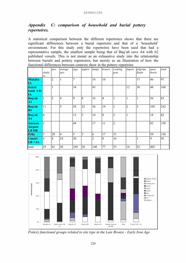
APPENDICES
229
Appendix C: comparison of household and burial potteryrepertoires.
A statistical comparison between the different repertoires shows that there aresignificant differences between a burial repertoire and that of a ‘household’environment. For this study only the repertoires have been used that had arepresentative sample, the smallest sample being that of Baq’ah cave A4 with 62published vessels. This is not meant as an exhaustive study into the relationshipbetween burials and pottery repertoires, but merely as an illustration of how thefunctional differences between contexts show in the pottery repertoire.
chalices
jars storagejars
jugs juglets lamps kraters cookingpots
import pilgrimsflasks
openbowls
total
MadabaIA
_ 2 1 7 14 10 17 46 97
Sahabtomb LB-IA
_ 1 34 43 12 30 48 168
Baq'ahA2
1 2 4 9 8 16 4 1 1 1 36 83
Baq'ahB3
11 5 38 22 36 19 1 2 3 105 242
Baq'ahA4
4 12 3 14 8 2 1 18 62
AmmanAirportLB IIB
2 44 17 11 2 82 158
Pella 3 28 4 5 3 6 17 31 59 156UmeiriLB + IA
4 8 24 20 2 8 16 1 9 92
total 25 41 38 169 36 148 77 53 16 52 403
0%
20%
40%
60%
80%
100%
Madaba IA Sahab tomb LB-IA
Baq'ah A2 Baq'ah B3 Baq'ah A4 Amman AirportLB IIB
Pella Umeiri LB + IA
func
tiona
l gro
ups
pilgrims flasksimportcooking potskraterslampsjugletsjugsstorage jarsjarschalices
Pottery functional groups related to site type in the Late Bronze - Early Iron Age
230
Bibliography
Abbreviations:AASOR - Annual of the American Schools of Oriental ResearchADAJ - Annual of the Department of Antiquities of Jordan AfO – Archiv für OrientforschungANET - J.B. Pritchard. Ancient Near Eastern Texts relating to the Old Testament.
Princeton 1969BA - Biblical Archaeologist BAR - Biblical Archaeology ReviewBASOR - Bulletin of the American Schools of Oriental Research BN - Biblische NotizenEA - Knudtson J.A. Die El-Amarna Tafeln. Leipzig 1915ESI – Excavations and Surveys in IsraelIEJ - Israel Exploration JournalJARCE – Journal of the American Research Center in EgyptJESHO - Journal of the Economic and Social History of the Orient JNES - Journal of Near Eastern StudiesJSOT - Journal for the Study of the Old TestamentJSSEA - Journal of the Society for the Study of the Egyptian Antiquity NEAEH - Stern E. ed. New Encyclopedia of Archaeological Excavations in the Holy
Land. Jerusalem, Israel Exploration Society 1993
PEFA - Palestine Exploration Fund AnnualPEFQS - Palestine Exploration Fund Quarterly StatementPEQ - Palestine Exploration QuarterlyRB - Revue BibliqueSHAJ - Studies in the History and Archaeology of JordanTA - Tel AvivVT - Vetus TestamentumZAW - Zeitschrift für alttestamentische WissenschaftZDPV - Zeitschrift des Deutschen Palästina Vereins
Abu Dayyah A.-S., J.A. Greene, I. Haj Hassan and E. Suleiman, 1991. Archaeological survey of Greater Amman, Phase I: Final report. ADAJ 35:361-396
Abujaber R.S. 1989. Pioneers over Jordan. London: Tauris. Abujaber K.S., Gharaibeh F.A. and Hill A. 1987. The Badia of Jordan. Amman, Jordan
University Press. Aharoni Y. 1979. Land of the Bible. Philadelphia: the Westminster Press
Ahlström G.W. 1990. The bull figurine from Dhahrat et-Tawile. BASOR 280:77-82
---- 1993. The history of Ancient Palestine from the Palaeolithic period to Alexander’sconquest. D. Edelman, ed. JSOT suppl. 146. Sheffield: JSOT Press
BIBLIOGRAPHY
231
Albright W.F. 1935. Archaeology and the Date of the Hebrew Conquest of PalestineBASOR 58:10-17
---- 1939. The Israelite conquest of Canaan in the light of Archaeology. BASOR 74:11-23
---- 1944. A prince of Taanach in the fifteenth century B.C. BASOR 94:12-27
Alt A. 1925. Die Landnahme der Israeliten in Palästina. pp. 89-125 in: A. Alt. KleineSchriften zur Geschichte Israels I. München: Beck
---- 1939. Erwägungen über die Landnahme der Israeliten in Palästina. pp. 126-175 in:A. Alt. Kleine Schriften zur Geschichte Israels I. München
Anbar A.H. 1984. Changing land tenure patterns in the East Jordan Valley. Paperpresented at the workshop 'Some aspects of agricultural modernization and theireconomic aspects'. Amman
Aresvik O. 1976. The agricultural development of Jordan. New York: Praeger. Aydin Z. 1985. Agricultural labour and technological change. Irbed: ICARDA
publication. Barth F. 1961. Nomads of South Persia: the Basseri tribe of the Khamseh Confederacy
Oslo: Oslo University Press. Bartlett J.R. 1973. The Moabites and Edomites. Pp 229-258 in: D.J. Wiseman, ed.
Peoples of Old Testament Times.. Oxford: Clarendon Press
Bell, G.L., 1907. The desert and the sown. London: William Heinemann. Edition 1985:London: Virago Press.
---- 1927. The letters of Gertrude Bell, selected and edited by Lady Bell, D.B.E. New
York: Boni and Liveright.
Ben-Arieh Y. 1979. The rediscovery of the holy land in the Nineteenth century.Jerusalem: Magness Press.
Bender F. 1968. Geologie von Jordanien. Berlin: Gebr. Borntraeger. Bienkowski P. 1986. Jericho in the Late Bronze Age . Warminster: Aris & Phillips
---- 1987. The role of Hazor in the Late Bronze Age. PEQ 119,50-61
---- 1989. Prosperity and decline in LBA Canaan: A Reply to Liebowitz and Knapp. BASOR 275,59-61
---- 1998. Comments on the papers of Kitchen, Whitelam and Finkelstein. pp 163-165 inAhituv S. and E. Oren (eds.). The origin of Early Israel - current Debate.Beersheva. Ben-Gurion Univ. Press
TRIBES AND TERRITORIES IN TRANSITION
232
---- in press. The North-South Divide in Ancient Jordan: Ceramics, Regionalism andRoutes. In: T.F. Potts, M. Roaf and D. Stein. eds. Culture Through Objects:Ancient Near Eastern Studies in Honour of P.R.S. Moorey. Oxford. GriffithInstitute.
Bienkowski P. and E.J. van der Steen. 2001. Tribes, trade and towns: A newframework for the Late Iron Age in southern Jordan and the Negev. BASOR323,21-47.
Bloch-Smith E. and B.A. Nakhai. 1999. A landscape comes to life: The Iron I periodNEA 62.2, 62-127
Boggis R.J.E. 1939. Down the Jordan in a canoe. London.
Boling R.G. 1988. The early biblical community in Transjordan. Sheffield: AlmondPress
---- 1989. Site survey in the el-Umeiri region. Pp 98-188 in: Geraty L. et al 1989.Madaba Plains Project I: the 1987 season at Tell el-Umeiri and vicinity andsubsequent studies. Berrien Springs MI: Andrews University Press
Boraas R.S. 1986. Iron Age IA ceramics at Tell el-Balatah; a preliminary study. Pp 249-263 in Geraty L.T en L.G. Herr, eds. The archaeology of Jordan and otherstudies, presented to S. Horn. Berrien Springs, Andrews University Press.
Boraas R.S. and S.H. Horn 1975. Heshbon 1973: the third campaign at Tell Hesban.Berrien Springs, MI: Andrews Univ. Press
Boraas R.S. and L..T. Geraty 1976. Heshbon 1974: the fourth campaign at Tell Hesban.Berrien Springs, MI: Andrews Univ. Press
---- 1978 Heshbon 1976: the fifth campaign at Tell Hesban. Berrien Springs, MI:
Andrews Univ. Press
Bottéro J. 1972. Habiru. Reallexicon der Assyriologie. Berlin: De Gruyter
Bottéro J. 1981. Les Habiru, les Nomades et les Sédentaires. pp. 89-107 in: J.S. Castillo,ed. Papers of the 30th International Congress of Orientalists. 30th InternationalCongress of Human Sciences in Asia and North Africa. Seminar: Nomads andSedentary people. Mexico City
Bourke, S.J. 1997. Pre-classical Pella in Jordan: a conspectus of ten years' work 1985-1995). PEQ 129, 94-115.
Bourke S.J. and R. Sparks. 1995. The DAJ excavations at Pella in Jordan 1963/64. pp149-167 in S.J. Bourke and J.-P. Descoeudres (eds). Trade, Contact and the Movement of Peoples in the Eastern Mediterranean: Studies in Honour of J.Basil Hennessy. Sydney
Bourke, S.J. et al, 1994. Preliminary report on the University of Sydney's Fourteenth
BIBLIOGRAPHY
233
season of Excavations at Pella (Tabaqat Fahl) in 1992. ADAJ, 38, 81-126.
Bourke, S.J., R.T Sparks, K.N. Sowada, P.b. McLaren and L.D. Mairs, 1998.Excavations at Pella (Tabaqat Fahl) in 1994/5. ADAJ 42,179-211
Braudel, F. 1949. The Mediterranean and the Mediterranean World in the Age of PhilipII. English translation of 1972, edition 1986. Glasgow: Fontana Press
Bull R.J. et al. 1965. The fifth campaign at Tell Balatah. BASOR 180, :7-41
Bunimowitz S. and O. Zimhoni 1993. Lamp-and-bowl foundation deposits in Canaan.IEJ 43,2-3:99-125
Burckhardt J.L. 1822. Travels in Syria and Palestine, Comprehending an Account of those Territories in the Hedhaz which the Mohammedans Regard as Sacred. London: Henry Coburn and Richard Bentley.
Campbell E. 1965. Amarnaletters. In: Wright G.E. Shechem, the biography of a biblicalcity. New York: McGraw-Hill
Campbell E. jr. 1991. Shechem II. ASOR publications.
Chambon A. 1984. Tell el-Far'ah 1: l'Age du fer. Paris
Chesson M.S. 1998. Preliminary results of excavations at Tell el-Handaquq south (1993-1996). PEQ 130:20-34
Clark, D. et al. 2001. Tall al-'Umayri. Pp 439-440 in Savage, S.H., K.A. Zamora, and D.R. Keller. Archaeology in Jordan. AJA 105, 427-61
Coogan M.D. 1987. Of cults and cultures. PEQ 119:1-8
Cooley R.E. and G.D. Pratico. 1994. Tell Dothan: the West-Cemetery with commentson Joseph Free's excavation. AASOR 52:147-190
Coote, R.B. and K.W. Whitelam. 1987. The emergence of Early Israel in historicalperspective. Sheffield: Almond Press
Cribb R. 1991. Nomads in Archaeology. Cambridge: Cambridge University Press. Crowfoot J.W. 1934. An expedition to Balu'a. PEFQS 66:76-84
Crown A.D. 1972. Toward a reconstruction of the climate of Palestine 8000 BC - 0 BC. JNES 31,312-220
Dajani J.S. et al. 1980. An interim evaluation of the Jordan Valley Developmenteffort 1973-1980. Stanfort.
Dajani, R.W. 1966. Jebel Nuzha tomb at Amman. ADAJ 11, 48-52.
TRIBES AND TERRITORIES IN TRANSITION
234
---- 1970 A Late Bronze - Iron Age tomb at Sahab. ADAJ 15:29-34
Daviau P.M. 1992. Preliminary report of the Excavations at Tell Jawa in the Madaba Plains (1991) ADAJ 36,145-162
---- 1997. Moab’s northern border: Khirbet al-Mudayna on the Wadi ath-Thamad. BA 60.4,222-228
Dearman J.A. 1992. Settlement patterns and the beginning of the Iron age in Moab. pp 65-75 in: P. Bienkowski, ed. Early Edom and Moab, the beginning of the Iron Age in
Southern Jordan. Merseyside: Sheffield Archaeological Monographs 7
Dept. of Statistics of Jordan 1973. Social and economic survey of the East JordanValley. Amman.
---- 1980. Statistical Yearbook ---- 1983. Statistical Yearbook ---- 1984. Statistical Yearbook ---- 1989. Statistical Yearbook Dever W.G. 1974. The MB IIC stratification in the Northwest Gate area at Shechem.
BASOR 216, 31-52
---- 1995. Ceramics, Ethnicity, and the question of Israel's origins. BA 58, 200-213.
Donner H. 1984. Geschichte des Volkes Israel und seiner Nachbarn in Grundzügen. Teil1: Von den Anfängen bis zur Staatenbildungszeit. Göttingen: Vandenhoeck andRuprecht
Dornemann R.H. 1983 The archaeology of the Transjordan in the Bronze and Iron Ages.Milwaukee: Milwaukee Public Museum
Dothan T. 1981. The Philistines and their material culture. New Haven: Yale University
Doughty C.M. and E. Garnett. 1908. Wanderings in Arabia, being an abridgement ofTravels in Arabia Deserta. London: Duckworth and Co.
Egan V. and P. Bikai. 1999. Archaeology in Jordan. AJA 103, 485-520
Edzard D.O. 1970. Die Tontafeln von Kamid el-Loz. Kamid el-Loz – Kumidi. Bonn:Saarbücker Beiträge zur Altertumskunde
Finkelstein, I. 1988. The archaeology of the Israelite settlement. Jerusalem: IsraelExploration Society
BIBLIOGRAPHY
235
---- 1993. Shiloh, the archaeology of a biblical site. Tel Aviv University Monographseries
---- 1995. Living on the Fringe. The archaeology and history of the Negevand neighbouring regions in the Bronze and Iron ages. Sheffield Monographs in Mediterranean Archaeology 6.
---- 1998. Two notes on North Samaria: The 'Einun pottery' and the date of the 'Bull site'.PEQ 130:94-98
---- 2002. The expansion of the kingdom of Amurru in light of the petrographicinvestigation of the Amarna Tablets and the textual evidence. Paris, paperpresented at the 3rd ICAANE.
Finkelstein I., Z. Lederman and S. Bunimowitz. 1997. Highlands of many cultures: theSouth Samaria survey, the sites. Tel Aviv: Monograph series of the institute ofArchaeology.
Fischer P.M. 1991. Tell Abu el-Kharaz, the Swedish Jordan expedition 1989, first season
preliminary report from trial soundings. ADAJ 35, 67-101
---- 1993. Tell Abu el-Kharaz, the Swedish Jordan expedition 1991, second season preliminary excavation report. ADAJ 37: 279-304
---- 1994. Tell Abu el-Kharaz, the Swedish Jordan expedition 1992, third season preliminary excavation report. ADAJ 38:127127-145
Franken H.J. 1964. The excavations at Tell Deir 'Alla, Jordan, season 1964.VT 14: 417-422
---- 1969. Excavations at Tell Deir ‘Alla I. Leiden: Brill.
---- 1982. A technological study of IA I pottery from Tell Deir 'Alla . SHAJ I ---- 1992. Excavations at Tell Deir 'Alla: the Late Bronze Age Sanctuary. Leuven:
Peters
Franken H.J. and Steiner M.L., 1990. Excavations in Jerusalem 1961-1967, volume II. Oxford University Press
Free J.P. 1953. The first season of excavation at Dothan. BASOR 131, 16-20
---- 1954. The second season of excavation at Dothan. BASOR 135:14-20
---- 1955. The third season of excavation at Dothan. BASOR 139:3-9
---- 1956 The fourth season of excavation at Dothan. BASOR143:11-17
---- 1958. The fifth season of excavation at Dothan. BASOR 152:10-18
TRIBES AND TERRITORIES IN TRANSITION
236
---- 1959. The sixth season of excavation at Dothan. BASOR 156:22-29
---- 1960. The seventh season of excavation at Dothan. BASOR 160:6-15
Frendo A.J., 1986. The stratigraphic and ceramic changes at Tell Deir 'Alla towards the end of the second millennium B.C. and a possible explanation for them. Unpublished PhD thesis.
Fritz V. 1971 Erwägungen zu dem spätbronzezeitlichen Quadratbau bei Amman. ZDPV 87:140-152.
---- 1990. Ergebnisse der Ausgrabungen auf dem Tell el-'Oreme am See Gennesaret1982-1985. Wiesbaden: Harrassowitz
---- 1996. Die Entstehung Israels im 12. und 11. Jahrhundert v. Chr. Stuttgart:Kohlhammer
Garfinkel Y. 1987 The Early Iron Age strata of Beth Shean reconsidered. IEJ37:224-228
Geraty L. et al. 1989. Madaba Plains Project: the 1987 season at Tell el 'Umeiri and vicinity. ADAJ 33,145-176.
---- 1990. Madaba Plains Project I: the 1987 season at Tell el-'Umeiri and vicinity andsubsequent studies. Berrien Springs MI: Andrews University Press
Ghanimeh Kh.A. 1984. Abu Nseir excavations. ADAJ 28,305-310.
Gibson S., B. Ibbs and A. Kloner. 1985. The Sataf project of Landscape archaeology inthe Judaean hills: a preliminary report of four seasons of survey and excavations(1987-1989). Levant 17:139-155
Giveon R. 1970-71. The Shosou of the Late XXth dynasty. JARCE 8:51-53
---- 1971. Les bedouins Shosu des documents Ægyptiens. Leiden: Brill.
Glanzman W. 1983. Xeroradiographic examination of pottery manufacturingtechniques: a test. Masca journal 2:163-169
Glueck N. 1934. Explorations in Eastern Palestine 1. AASOR 14. New Haven.
---- 1935. Explorations in Eastern Palestine 2. AASOR 15. New Haven.
---- 1939. Explorations in Eastern Palestine 3. AASOR 18-19. New Haven. ---- 1951. Explorations in Eastern Palestine 4. AASOR 25-28. New Haven.
Goetze A. and S. Levy. 1959. Fragment of the Gilgameh Epic from Megiddo. Atiqot2:121-128
BIBLIOGRAPHY
237
Golding, L. 1938. In the steps of Moses the Conqueror. London: Rich & Cowan, Ltd.
Gonen R. 1984. Urban Canaan in the Late Bronze period. BASOR 253,61-73
---- 1992. Burial patterns and cultural diversity in Late Bronze Age Canaan. ASORDiss. series 7
Gordon R.L. and L.E.Villiers. 1983. Tulul edh-Dhahab and its environs. Survey of 1980 and 1982, a preliminary report. ADAJ 27,285-89.
Görg M. 1978. Namenstudien I: Frühe Moabitische Ortsnamen. BN 7:7-14
Gottwald, N.K. 1979. The tribes of Yahweh. New York: Orbis Books
Grava S. 1985. An evaluation of the 1973 and 1975 housing projects: the Jordan Valley. Amman.
Gustavson-Gaube C. and M.M. Ibrahim.1986. Sahab survey 1983. AfO 33:283-286
Hankey V. 1974. A Late Bronze Age temple at Amman. Levant 6,131-178
Harding G.L. 1958. Recent discoveries in Jordan. PEQ 90,7-18.
---- 1967. The antiquities of Jordan. Jordan Distribution Agency, by arrangement with Lutterworth Press
Harding G.L. and B.S.J. Isserlin. 1953. An early Iron Age tomb from Madaba. PEFA6:27-47
Harrison T.P. 1997. Investigations of Urban Life in Madaba, Jordan. BA 60,53-4
---- 2000. Tell Madaba. pp 579-581 in Egan V., P. Bikai and K. ZamoraArchaeologyin Jordan. AJA 104,561-588
Harrison,T.P., B. Hesse, S.H. Savage, D.W. Schnurrenberger 2000. Urban life in thehighlands of Central Jordan: a preliminary report of the 1996 tall Madabaexcavations. ADAJ 44:211-230
Hazleton J.E. 1974. The impact of the East Ghor Canal project on land consolidation, distribution and tenure. Report of the Royal Scientific Society.
---- 1978. Social soundness analysis of the Jordan Valley Farming Association
credit program. Submitted to the Agency for International Development, NE Bureau.
Helck W. 1962. Die Beziehungen Agyptens zu Vorderasien im 3. und 2. Jahrtausend vor
Christ. Wiesbaden: Harrassowitz.
TRIBES AND TERRITORIES IN TRANSITION
238
Hennessy J.B. 1966. Excavation of a Late Bronze Age Temple at Amman. PEQ98,155-162
---- 1985. Thirteenth century BC temple of human sacrifice at Amman. In: Phoenicia and its neighbours. Leiden: Studia Phoenicia III 1.
Herr L.G. ed. 1983a. The Amman airport excavations, 1976. AASOR 48
Herr L.G. 1983b. The Amman airport structure and the geopolitics of ancient Transjordan. BA 46,223-229.
---- 1992. Shifts in settlement patterns of LB and IA Amman. SHAJ IV,175-177
---- 1999. Tall al-Umayri and the Reubenite Hypothesis. pp 64-77 in Eretz Israel, FrankMoore Cross Volume. Jerusalem. Israel Exploration Society
---- 2000. The settlement and fortification of Tell al-Umayri in Jordan during theLB/Iron I transition. Pp. 167-179 in: Stager L.E., J.A. Greene and M.D. Coogan,eds. The archaeology of Jordan and beyond. Essays in honour of James A.Sauer. Winona Lake, Eisenbrauns
Herr L.G. et al., 1991. Madaba Plains Project II. Berrien Springs: Andrews UniversityPress
Herr L.G., L.T. Geraty, O.S. LaBianca, R.W. Younker, eds. 1997. Madaba PlainsProject III: the 1989 season at Tell el-'Umeiri and Vicinity and subsequentstudies . Berrien Springs
Hess R.S. 1993. Early Israel in Canaan: a survey of recent evidence and interpretations. PEQ 125,125-146.
Hirzalla B. 1973. Groundwater resources of the Jordan Valley. Unpublished report ofthe HKJ natural resources authority.
Hitti Ph. K. 1937. History of the Arabs. London: The MacMillan Press Ltd.
Homès-Frédericq D.1992. Late Bronze and Iron Age evidence from Lehun in Moab. pp 187-202 in: P. Bienkowski, ed. Early Edom and Moab, the beginning of the IronAge in Southern Jordan. Merseyside: Sheffield Archaeological Monographs 7
---- 2000. Excavating the First Pillar house at Lehun (Jordan). Pp.180-195 in Stager L.E.,J.A. Greene and M.D. Coogan, eds: The archaeology of Jordan and beyond.Essays in honour of James A. Sauer. Winona Lake, Eisenbrauns
Homès-Frédericq D. and H.J. Franken. 1984. Klei, bron van leven. Zevenduizend jaarpottenbakkerskunst in Jordanie. Brussel, Koninklijke Musea voor Kunst enGeschiedenis.
Homès-Frédericq D. and J.B. Hennessy. 1989. Archaeology of Jordan II: Field reports, surveys and sites. Leuven.
BIBLIOGRAPHY
239
Homès-Frédericq D. et al. 1997. Lehun et la Voie Royale. Brussels: Belgisch Comitevoor Opgravingen in Jordanie.
Horowitz A. 1971. Climate and vegetational developments in Northeastern Israel duringUpper Pleistocene - Holocene times. Pollen et Spores 13:255-278
Horwitz L.K. 1987. Faunal remains from the EIA site on Mount Ebal. TA 13-14:173-189
Hourani A. 1991. A history of the Arab peoples. London: Faber and Faber. Hübner U. 1992. Die Ammoniter. Wiesbaden: Harrassowitz. Ibach R. 1987. Archaeological survey of the Hesban region. Berrien Springs: Andrews
Univ. Press
Ibrahim M.M. 1972. Archaeological excavations at Sahab. ADAJ 17, 23-36. ---- 1974. Second season of excavations at Sahab. ADAJ 19, 55-62
---- 1987. Sahab and its foreign relations, SHAJ III, 83-89.
Ibrahim M.M., J.A. Sauer, and Kh. Yassine. 1976. The East Jordan Valley SurveyI. BASOR 222,159-87.
---- 1988. The East Jordan Valley Survey II. Pp 189-207 in Kh.Yassine. TheArchaeology of Jordan. Amman.
Ibrahim M.M. and G. van der Kooij. 1997. Excavations at Tall Deir 'Alla; seasons 1987and 1994. ADAJ 42:95-114
James W.F 1966. The Iron Age at Beth Shan. Philadelphia: Univ. Museum Monographs
James F.W. and P.E. McGovern 1993. The LBA Egyptian garrison at Beth Shan: a studyof levels VV and VIII. Univ.Mus. Pennsylvania
Ji C.C. 1997. The East Jordan Valley during Iron Age I. PEQ 129,19-37
Joffe A.H. 1993. Settlement and Society in the Early Bronze I & II Southern LevantSheffield: Sheffield Academic Press
Kafafi Z. 1983. The local pottery. In L.G. Herr. The Amman airportstructure and the geopolitics of ancient Transjordan. BA 46,223-229. .
---- 1985. Egyptian topographical lists of the Late Bronze Age in Jordan (East Bank). BN 9:17-21.
Kaiser O. 1984. Einleitung in das Alte Testament. Gütersloh: Gerd Mohn
TRIBES AND TERRITORIES IN TRANSITION
240
Kalsbeek J. and G. London 1978 A late second millennium BC. potting puzzle. BASOR232:47-56
Kamp K.A. and N. Yoffee. 1980. Ethnicity in ancient western Asia during the early second millennium B.C.:archaeological assessments and ethnoarchaeological prospectives. BASOR 237,85-104
Karmon Y. 1983. Israel. Eine geographische Landeskunde. Darmstadt:
Wissenschaftliche Buchgesellschaft.
Kay P.A. and D.L. Johnson. 1981. Estimation of Tigris - Euphrates streamflow fromregional Paleoenvironmental Proxy Data. Climatic Change 3:251-263
Kempinsky A. 1986. Joshua's altar - an Iron Age I watchtower. BAR 12.1:42-49
Kinglake A.W. 1879. Eothen. London: William Blackwood and Sons
Kippenberg E. 1978. Religion und Klassenbildung im antiken Judäa. Göttingen: vanden Hoeck & Ruprecht
Kitchen K.A 1992. The Egyptian evidence on ancient Jordan. Pp 21-34 in: P.Bienkowski, ed. Early Edom and Moab, the beginning of the Iron Age inSouthern Jordan. Merseyside: Sheffield Archaeological Monographs 7.
Kletter, R. 1999. Pots and Polities: Material remains of Late Iron Age Judah in Relationto its Political Borders. BASOR 314:19-54
---- 2002. People without burials? The lack of Iron I burials in the Central Highlands ofPalestine. IEJ 52:28-48
Knapp A.B. 1989. Complexity and collapse in the North Jordan Valley: archaeometry and society in the Middle-Late Bronze ages. IEJ 39,129-148
Knauf E.A. 1984. Abel Keramim. ZDPV 100,119-21.
---- 1985. BWRT and Batora. Gottinger Miszellen 87,45-48
---- 1987 The Deir ‘Alla Tablets. Newsletter of the Institute of Archaeology and Anthropology, Yarmuk University, pp. 14-16
Knudtson J.A. 1915. Die El-Amarna Tafeln. Leipzig.
Kohl, P. 1987. The ancient economy, transferable technologies and the Bronze Ageworld-system: a view from the northeastern frontier of the Ancient Near East.pp.13-24 in M. Rowlands, M. Larsen and K. Kristiansen. Centre and periphery inthe ancient world. Cambridge: Cambridge University Press
Kooij, G. van der and M.M. Ibrahim, eds. 1989. Picking up the threads .... A continuing review of excavations at Deir ‘Alla, Jordan. Leiden.
BIBLIOGRAPHY
241
LaBianca O.S. 1986. Hesban 2: Environmental Foundations. Berrien Springs, MI: Andrews University Press
---- 1990. Sedentarization and nomadization: Food system cycles at Hesban and vicinity in Transjordan. Berrien Springs, MI: Andrews University Press.
---- 1999. Salient features of Iron Age tribal kingdoms. Pp 19-23 in: McDonald B, and
R.W. Younker, eds. Ancient Ammon. Leiden: Brill
LaBianca O.S and P.J. Ray 1999. Madaba Plains Project 1997: Excavations andrestauration work at Tall Hesban and Vicinity. ADAJ 43,115-124
Lancaster W., 1981. The Rwala beduin today Cambridge: Cambridge University Press.
Larsen M.T. 1987. Commercial networks in the Ancient Near East. pp. 47-56 in M.
Rowlands, M. Larsen and K. Kristiansen. Centre and periphery in the ancientworld. Cambridge: Cambridge University Press
---- 1994. Home and Homeland. The dialogics of tribal and national Identities in Jordan.Princeton: Princeton University Press
Lemche N.P. 1985. Early Israel : anthropological and historical studies on the Israelite
society before the monarchy. Leiden: Brill
Lemche N.P. 1988. Ancient Israel. A new history of Israelite society. Sheffield: Sheffield
Academic Press.
---- 1996. Die Vorgeschichte Israels von den Anfängen bis zum Ausgang des 13.Jahrhunderts v. Chr. Biblische Enzyklopädie Band 1. Stuttgart: Kohlhammer.
Leonard A.L. Jr. 1983. The proto-Urban / Early Bronze I Utilization of the Kataret es-Samra plateau. BASOR 251,37-60
---- 1985. Preliminary Report on the excavations in Kataret es-Samra. ADAJ29,289-290.
---- 1989. Late Bronze Age settlement patterns in Transjordan. Paper presented at the
fourth International Conference on the History and Archaeology of Jordan, Lyon.
Lewis N.N. 1987. Nomads and Settlers in Syria and Jordan, 1800-1980. Cambridge: Cambridge University Press.
Lewis, B. 1995. The Middle East. 2000 years of history from the rise of Christianity to
the Present day. London: Phoenix
Lipschitz N. 1987. Paleobotanical remains from Mount Ebal. TA 13-14, 190-191
TRIBES AND TERRITORIES IN TRANSITION
242
Lipschitz N. et al. 1979. Fluctuations in the aridity line in Israel during the Late BronzeAge. Paper given at the International Conference on Climate and History.Norwich: University of East Anglia
Liverani M. 1987. The collapse of the Near Eastern regional system at the end of theBronze Age: the case of Syria. pp. 66-73 in M. Rowlands, M. Larsen and K.Kristiansen. Centre and periphery in the ancient world. Cambridge: CambridgeUniversity Press
London G.A. 1989. A comparison of two contemporaneous lifestyles of the Late SecondMillenium. BASOR 273:37-55
---- 1999. Central Jordan Ceramic traditions. Pp 57-102 in: McDonald B, and R.W.Younker, eds. Ancient Amman. Leiden: Brill
London G. and Franken H.J., 1995. Why painted pottery disappeared at the end of thesecond millennium BCE. BA 58:214-222
Loretz O. 1984. Habiru – Hebräer. Berlin: DeGruyter
Lumsden W.H.R. and J.Yofe. 1950. Anophelism and malaria in Transjordan and inthe neighbouring parts of Palestine and Syria. In H.S. Leeson et al, eds.Anopheles and malaria in the Near East. London : H. K. Lewis
Lynch W.F. 1849. Narrative of the US expedition to the river Jordan and the Dead Sea.
London Maandag F.L.A. and S.W. Macksoud, eds, 1969. Jordan Valley Project: agro- and
socio-economic study, final report. Amman: HKJ Jordan river and tributariesregional corporation).
Mabry J. and G. Palumbo. 1988. The 1987 Wadi el-Yabis Survey. ADAJ 32,275-305.
---- 1992. Environmental, economic and political constraints on ancient settlementpatterns in the Wadi el-Yabis region. SHAJ IV:67-72
MacDonald B. 1992. Evidence from the Wadi el-Hasa and southern Ghors and north-east Arabah archaeological surveys. Pp 113-142 in: P. Bienkowski, ed. EarlyEdom and Moab, the beginning of the Iron Age in Southern Jordan. Merseyside:Sheffield Archaeological Monographs 7.
---- 2000. East of the Jordan. Territories and sites of the Hebrew Scriptures. BostonMA, Asor publications.
Marfoe L. 1987. Cedar forest to silver mountain: social change and the development of
long-distance trade in early Near Eastern societies. pp. 25-35 in M. Rowlands, M.Larsen and K. Kristiansen. Centre and periphery in the ancient world.Cambridge: Cambridge University Press
BIBLIOGRAPHY
243
Mattingly G.L. 1983. The natural environment of Central Moab. ADAJ 27:597-605 ---- 1992. The culture-historical approach and Moabite origins. Pp 55-64 in: P.
Bienkowski, ed. Early Edom and Moab, the beginning of the Iron Age inSouthern Jordan. Merseyside: Sheffield Archaeological Monographs 7.
Mazar A. 1982. The bull site - an IA I open cult place. BASOR 247:27-40
---- 1990. Archaeology of the Land of the Bible. 10.000-586 B.C.E. New York:Doubleday
---- 1997. Four thousand years of history at Tel Beth-Shean: an account of the renewedexcavations. BA 60/2:62-76
---- 1999a. The 1997-1998 excavations at Tel Rehov: Preliminary report. IEJ 49:1-42
---- 1999b. Tel Rehov. ESI 109:42-43
---- 1999c. The 'Bull site' and the 'Einun pottery' reconsidered. PEQ 131:144-48
McGovern P.E. 1985. Late Bronze Palestinian pendants. Sheffield: American Schoolsfor Oriental Research.
---- 1986. The Late Bronze and Early Iron ages of Central Transjordan, the Baq‘ah Valley project 1977-1981 Philadelphia: University of Pennsylvania.
---- 1989. The Baq'ah valley project 1987. Khirbet Umm ad-Dananir and Al-Qesir.
ADAJ 33,123-136.
---- 1992. Settlement patterns of the Late Bronze and Iron Ages in the Greater Ammanarea. SHAJ IV,179-183
McGovern P.E., S.J. Fleming and C.P. Swan. 1993. The LB Egyptian garrisons at BethShan: Glass, Faience and import. BASOR 290-291:1-28
McNicoll A., R.H. Smith, and J.B. Hennessy. 1982. Pella in Jordan 1. Canberra.
Mendenhall G.E. 1962. The Hebrew conquest of Palestine. BA 25:66-78
Menendez M. 1983. The IA I structures in the area surrounding Medeineh al-Ma'arradjeh (Smakieh). ADAJ 27:179-183
Merrill S. 1881. East of the Jordan: a record of travel and observation in the countriesof Moab, Gilead and Bashan. London.
Meyers E.M.,ed. 1997. The Oxford Encyclopedia of Archaeology in the Near East.
Oxford. Oxford University Press
Miller J.M. 1989. Six Khirbet el-Medeinehs in the region east of the Dead sea. BASOR276:25-28
TRIBES AND TERRITORIES IN TRANSITION
244
---- 1991. Archaeological survey of the Kerak plateau. Atlanta: Scholars Press ---- 1992. Early Monarchy in Moab? Pp 77-91 in: P. Bienkowski, ed. Early Edom and
Moab, the beginning of the Iron Age in Southern Jordan. Merseyside: SheffieldArchaeological Monographs 7.
---- 1997. Ancient Moab, still largely unknown. BA 60,194-204
Miller R.D. II. 2000. Survey of overlooked potential Iron I sites in North-CentralPalestine PEQ 132,157-168
Mittmann S. 1970. Beiträge zur Siedlungs- und Territorialgeschichte des nördlichenOstjordanlandes. Wiesbaden.
Moran W.L. 1987. Join the Apiru or become one? Golomb
---- 1992. The Amarna Letters. Baltimore.
Mundy M. and R.S. Smith. 1990. Part-time farming. Agricultural development in the Zarqa river basin, Jordan. Irbed: Yarmuk University.
Na'aman N. 1986. Habiru and Hebrews: the transfer of a social term to the literary
sphere. JNES 45:271-288
---- 1994. The Hurrians and the end of the Middle Bronze Age in Palestine. Levant 26:175-87.
Naser M. el-. 1991. Groundwater resources of the deep aquifer systems in NorthwestJordan. Hydrologie und Umwelt, Heft 3. Würzburg.
Neev D. and K.O. Emery. 1967. The Dead Sea Depositional Processes and
Environments of Evaporites. Jerusalem
Negbi O. 1991. Were there sea peoples in the Central Jordan Valley at the transitionfrom the Bronze Age to the Iron Age? TA 18,205-43
---- 1998. "Were there sea peoples in the central Jordan Valley at the transition from the Bronze Age to the Iron Age?" Once again. TA 25,184-207
Negenman J. 1982. Een geografie van Palestina. Kampen: Kok
Neumann J. and S. Parpola. 1987. Climatic change and the 11th-10th century eclipse of Assyria and Babylon. JNES 46,161-182
Noort E. 1994.Die Seevölker in Palästina. Kampen: Kok
Noth M. 1938. Die Wege der Pharaonenheere in Palastina und Syrien. ZDPV 61:26-65
BIBLIOGRAPHY
245
---- 1957. Hat die Bibel doch recht? pp. 7-22 in W. Schneemelcher, ed. Festschrift für G.Dehn. Neukirchen
---- 1960. Der Beitrag der Archäologie zur Geschichte Israels. pp. 262-282 in:Supplements to Vetus Testamentum VII
Olàvarri E. 1965. Sondages a Aro'er sur l'Arnon. RB 72,77-94
---- 1969. Fouilles à Aro'er sur l'Arnon. RB 76:230-259
---- 1983. La campagne de fouilles 1982 a Khirbet Medinet el-Mu'arradjeh pres deSmakieh (Kerak). ADAJ 27:165-178
Oppenheim, M. Freiherr von. 1943. Die Beduinen II. Berlin
Oren E.D. 1973. The northern cemetery at Beth Shan. Leiden: Brill
---- 1985. 'Governor's Residencies' in Canaan under the New Kingdom: A Case studyof Egyptian Administration. JSSEA 14,37-56.
Ornan, T. 2002. The Bull and its Two Masters: Moon and Storm deities in Relation tothe Bull in Ancient Near Eastern art. IEJ 51,1-26
Orton C., P. Tyers and A. Vince. 1993 Pottery in Archaeology. Cambridge: CambridgeUniversity Press.
Otto E. 1979. Jakob in Sichem. Stuttgart: Kohlhammer.
Palmer E.H. 1871. The desert of the Exodus. Cambridge: Deighton, Bell and co.
Palumbo G. 1992. The 1990 Wadi el-Yabis survey project and soundings at KhirbetUmm el- Hedamus. ADAJ 36:25-42
Palumbo G., J. Mabry en I. Kuijt. 1990. The Wadi el-Yabis survey report on the 1989field season. ADAJ 34:95- 118
Palumbo G. ed. 1994. The Jordan Antiquities Database and Information System. Asummary of the data. (JADIS). Amman.
Piccirillo M. 1975. Una tomba del Ferro I a Madaba (Madaba B, Moab). Liber Annuus25:199- 224
Pollock A. 1983. Social relations of production and reproduction of sharecropping inthe Jordan Valley: a partial framework for analysis. Paper presented at the International Symposium for rural change in the Middle East, Bir ZeitUniversity.
Porter J. L. 1891. The Giant Cities of the Bashan and Syria’s Holy Places. London: T.
Nelson and Sons.
TRIBES AND TERRITORIES IN TRANSITION
246
Portugali Y. 1982. A field methodology for regional archaeology (JezreelValley survey) Tel Aviv 9,170-188
Posener G. 1940. Princes et Pays d'Asie et de Nubie. Bruxelles: FondationEgyptologique Reine Elisabeth
Powell A. 1987. Food resources and food systems in two West Bank villages. Jerusalem. Prag K. 1989. Preliminary on the excavations at Tell Iktanu, Jordan, 1987. Levant 21,33-
45
---- 1991. Preliminary report on the excavations at Tell Iktanu and Tell el-Hammam,Jordan, 1990. Levant 23,55-66
Pritchard J.B. 1968 New evidence on the role of the Sea Peoples in Canaan at thebeginning of the Iron Age. In: W.A.Ward ed. The role of the Phoenicians in theinteraction of Mediterranean civilizations. Beirut :99-112
---- 1969. Ancient Near Eastern Texts relating to the Old Testament. Princeton.
---- 1980. The cemetery at Tell es-Sa'idiyeh, Jordan. Philadelphia: University MuseumMonographs 41
---- 1985. Tell es-Sa'idiyeh. Excavations on the Tell, 1964-1966. Philadelphia: Univ.Mus. Pennsylvania
Rainey A.F. 1989. Review of W.L. Moran: The Amarna letters. Biblica 70:568-572
---- 2001. Israel in Merenptah's inscription and reliefs. IEJ 51:57-75
Rast W. 1990 Review of McGovern 1986. BASOR 280:93-94
Redford D.B.1982. A Bronze Age Itinerary in Transjordan (Nos. 89-101 of ThutmoseIII's list of Asiatic toponyms). JSSEA 12:55-74.
---- 1986. The Ashkelon relief at Karnak and the Israel stela. IEJ 36,188-200
---- 1992. Egypt, Canaan and Israel in Ancient Times. Princeton: University Press.
Reed W.L. 1972. The archaeological history of Elealeh in Moab. Pp. 18-28 in: WeversJ.W. and D.B. Redford. Studies on the ancient Palestinian world. Toronto: Univ.of Toronto Press
Renfrew A.C. 1975. Trade as action at a distance: questions of integration andcommunication. Pp. 3-59 in: J.A. Sabloff and C.C. Lamberg-Karlofsly .Ancient civilization and trade. Albuquerque: University of New Mexico press
---- 1979. Systems collapse as social transformation: catastrophe and anastrophe in Early State Societies. Pp. 481-506 in: A.C.Renfrew and K.L. Cooke, eds. Transformations. Mathematical approaches to culture change. London.
BIBLIOGRAPHY
247
---- 1982. Post-collapse resurgence: culture processes in the Dark Ages. Pp 113-116 in: A.C. Renfrew and S. Shennan,eds. Ranking, resource and exchange. Cambridge:
Cambridge University Press.
Renfrew A.C. and Bahn P. 1991. Archaeology. Theories, Methods and Practice.London: Thames and Hudson
Riis P.J. 1948. Hama: fouilles et recherches, 1931-1938. Tome II,3: Les cimetieres acremation. Copenhagen: Nationalmuseet
Ripinsky M. 1983. Camel Ancestry and domestication in Egypt and the SaharaArchaeology 36:21-27
---- 1985. The camel in Dynastic Egypt. JEA 71:134-141
Ritter-Kaplan H. 1983. The impact of drought on Third Millennium BCE Cultures onthe Basis of Excavations in the Tel Aviv Exhibition Grounds. EI 17,333-338,summary p 14*
Rogers, M.E.1862. Domestic life in Palestine. London: Kegan Paul Int. Ltd.
Rosen S.A. 1988. Finding evidence of ancient nomads. BAR 14:5,46-53
---- 1992. Nomads in Archaeology: a response to Finkelstein and Perevolotsky.BASOR 287,75-85
Routledge B. 1995a. Khirbet Medeinet 'Aliya 1994. AJA 99,516
---- 1995b. Pillared Buildings in Iron Age Moab. BA 58-4:236
Rowe A. 1930. Beth Shan: Topography and history. Philadelphia: University ofPennsylavania University Press
---- 1940. The four Canaanite temples of Beth Shan I: The temples and cult objects.Philadelphia: University of Pennsylavania University Press
Rowlands M, M. Larsen and K. Kristiansen. 1987. Centre and periphery in the ancientworld. Cambridge: Cambridge University Press
Rowton M.B. 1973a. Urban autonomy in a nomadic environment. JNES 32:201-15
---- 1973b. Autonomy and nomadism in Western Asia. Orientalia 42:247-258
---- . 1974. Enclosed nomadism. JESHO 17,1-30
---- 1976. Dimorphic structure and the problem of the Apiru-Ibrim. JNES 35:13-20
---- 1977 Dimorphic structure and the parasocial element. JNES 36,181-98
TRIBES AND TERRITORIES IN TRANSITION
248
Safrai Z. 1998.The missing century. Leuven, Peeters
Salvini M. 1996. The Habiru prism of King Tunip-Teššup of Tikunani. Rome: IstitutiEditoriali e Poligrafici Internazionali
Salzman Ph.C. 1980. Processes of sedentarization as adaptation and response. Pp 1-19in: Salzman Ph.C., ed. When Nomads Settle. New York.
Sauer J.A. 1975. Heshbon 1973: Area B and Square D.4. pp 133-167 in Boraas R.S. and
S.H. Horn. 1975. Heshbon 1973, the third campaign at Tell Hesban. BerrienSprings: Andrews Univ. Press
---- 1986. Transjordan in the Bronze and Iron ages: a critique of Gluecks synthesisBASOR 263,1-26
---- 1994. The pottery at Hesban and its relationships to the history of Jordan: an interimHesban pottery report, 1993. Pp 225-282 in Merling D. and L.T. Geraty, eds.Hesban: after 25 years. Berrien springs, Andrews Univ. Press
Säve-Söderberg, T. 1952. The 'prw as Vintagers in Egypt. Orientalia Suecana I,5-14
Schumacher G. 1886. Across the Jordan: being an exploration and survey of part of Hauran and Jaulan. London: Watt
---- 1888. The Jaulan. London: Richard Bentley and Son
Seetzen U.J. 1854-59. Reisen durch Syrien, Palaestina, Phoenizien, die Trans-Jordanländer, Arabia-Petraea und Unter-Ägypten. Berlin: G. Reimer.
Shedadeh N. 1985. The climate of Jordan in the past and present. SHAJ II,25-37
Simons J. 1937. Handbook for the study of Egyptialn topographical lists relating to W. Asia. Leiden: Brill
Smith G.A. 1896. The Historical Geography of the Holy Land. London: Hodder and Stoughton.
Smith R.H. 1973. Pella of the Decapolis. Wooster OH: The College of Wooster.
Sonnen J. 1952. Die Beduinen am See Gennesareth. Köln: Bachem Sorenson M.V. 1978. A review and evaluation of the Jordan Valley Farming
Association's Agricultural credit plan. Amman. Stager L.E. 1985. The archaeology of the family in ancient Israel. BASOR 260,1-35
Stanley A. P. 1856. Sinai and Palestine in Connection with their History. London:Bradbury
BIBLIOGRAPHY
249
Steele C.S. 1991. Early Bronze Age socio-political organization in South-West Jordan.ZDPV 106:1-33
Steen, van der E.J. 1995. Aspects of Nomadism and Settlement in the Central Jordan Valley, PEQ 127:141-158
---- 1996. The central east Jordan Valley in the Late Bronze and Early Iron Ages.BASOR 302:51-74.
---- 1997 Pots and potters in the Central Jordan Valley, ADAJ 41:81-93
---- 1998. Survival and Adaptation, life east of the Jordan in the Late Bronze and EarlyIron Ages. PEQ 131,176-192
---- 2001. Excavations at Tell el-Hammeh. SHAJ VII,229-232
---- 2002a. Megiddo in the Early Bronze Age. BiOr. 58/3-4,304-312
---- 2002b. From Burckhardt to Bell: what can the nineteenth century tell us about theIron Age? Paper presented at the W.F. Albright Institute of ArchaeologicalResearch, Jerusalem on May 15th, 2002.
---- forthcoming. From Burckhardt to Bell. SHAJ VIII.
Steiner M.L. 1994. Jeruzalem in de Brons- en IJzertijd. De opgravingen van de 'British School of Archaeology in Jerusalem', 1961-1967. Leiden: Unpublished PhDthesis.
Steuernagel D.C. 1925. Der Adschlun. ZDPV 48 Tarawneh M.F. 1989. Aspects of rural transformation on the Jordan Valley: the case of
Deir 'Alla. Irbed: Unpublished MA thesis, Yarmuk university.
Thompson H.O. 1972.The 1972 excavation of Khirbet el-Hajjar. ADAJ 17,47-72
---- 1973. Rujm el-Malfouf South. ADAJ 18,47-50
---- 1977. The Ammonite remains at Khirbet el-Hajjar. BASOR 227,27-34
---- 1986. An Iron Age tomb at Madaba. Pp .... in: Geraty L.T en L.G. Herr, eds. Thearchaeology of Jordan and other studies, presented to S. Horn. Berrien Springs
---- 2000. Some towers in Jordan. Pp 482-89 in Stager L.E., J.A. Greene and M.D.Coogan, eds. The archaeology of Jordan and beyond. Essays in honour of JamesA. Sauer. Winona Lake, Eisenbrauns
Thompson Th.L. 1992. Early history of the Israelite people from the written and archaeological sources. Leiden: Brill
Timm S. 1989. Moab zwischen den Mächten: Studien zu historischen Denkmälern und
TRIBES AND TERRITORIES IN TRANSITION
250
Texten. Ägypten und altes Testament 17.
Toombs L.E. 1972. The stratigraphy of Tell Balatah (Ancient Shechem). ADAJ 17, 99-110
Tristram H.B. 1866. The land of Israel: a journal of travels in Palestine.London:
Tubb J.N. 1988a. Tell es-Sa'idiyeh: Preliminary report on the first three seasons ofrenewed excavations. Levant 20, 23-80
---- 1988b. The role of the Sea Peoples in the bronze industry of Palestine/Transjordan.Pp. 251-270 in: Curtis J.E., ed. Bronze working centres of Western Asia. London
---- 1990. Preliminary report on the 4th season of excavations at Tell es-Sa'idiyeh.Levant 22, 21-42
Tubb J.N. and R.L. Chapman. 1990. Archaeology and the Bible. (London)
Tubb J.N. and P.G. Dorrell P.G. 1991. Tell es-Sa’idiyeh: Interim report on the fifth(1990) season of excavations. Levant 23,67-86
---- 1993. Tell es-Sa'idiyeh: Interim report on the sixth season of excavations. PEQ 125,51-74
Vaux de R. and A.M. Steve 1947. La première campagne de fouilles a Tell el-Far'ah,près Naplouse. RB 54:573-589
Veenhof K.R. 1986. Kanesj en de Assyrische handelskolonien in Klein-Azie. Leiden.
Velde C.W.M. van de. 1854. Reis door Syrie en Palestina in 1851 en 1852. Utrecht: Kemink.
Veldhuijzen H.A. and E.J. van der Steen. 1999. Iron Production center found in theJordan Valley NEA 62:3,195-199
Vilders M.M.E, 1993. Some remarks on the production of cooking pots in the JordanValley. PEQ 125:149-156
Wallerstein, E. 1974. The modern world system. New York: Academic Press
Ward W.A. 1964 Cylinders and scarabs from a Late Bronze Age temple at Amman.ADAJ 8-9:47-55
---- 1972. The Shasu 'bedouin'; notes on a recent publication. JESHO 15:35-60
Ward W.A. and M.F. Martin. 1964. The Balu'a stele: a new transcription with paleographical and historical notes. ADAJ 8-9,5-29
Warmenbol E. 1983. La stele de Rugm el-Abd. Levant 15:63-75 Warmenbol 1983
BIBLIOGRAPHY
251
Watson A.M. 1961. The East Jordan Valley - a social and economic survey. Amman: Publication of the Ministry of National Economy, Dept. of Statistics.
Weinstein J.M. 1981. The Egyptian Empire in Palestine: A Reassessment. BASOR241,1-28
Weippert H. 1988. Palästina in vorhellenistischer Zeit: Handbuch der Archäologie: Vorderasien II,1. Munich: C.H. Beck
Weippert M. 1967. Die Landnahme der Israelitischen Stämme in der neuerenwissenschaftlichen Diskussion. Göttingen: Vandenhoeck and Ruprecht.
---- 1979. The Israelite conquest and the evidence from Transjordan. pp. 15-34 in F.M.Cross, ed. Symposia celebrating the seventy-fifth anniversary of the Foundationof the American Schools of Oriental Research (1900-1975). Cambridge:American Schools of Oriental Research
Wengrow D. 1996. Egyptian taskmasters and heavy burdens: highland exploitation andthe collared-rim pithos of the Bronze/Iron age Levant. Oxford Journal ofArchaeology 15:307-326
Wenning R. and E. Zenger. Ein bauerliches Baal-heiligtum im samarischen Gebirge aus der Zeit der Anfänge Israels. ZDPV 102,75-86.
Wilson, E.O. 1975. Sociobiology. Cambridge, Mass. Belknap Press of Harvard
University Press.
Wimmer D.H. 1987. Tell Safut excavations, 1982-1985. Preliminary report. ADAJ31:159-174
---- 1997. Safut, Tell. pp 448-450 in Meyers E.M.,ed. 1997. The Oxford Encyclopedia of Archaeology in the Near East. Oxford: Oxford University Press
Winnett F.V. and W.L. Reed. 1964. The excavations at Dibon (Dhiban) in Moab. NewHaven:American Schools of Oriental Research
Worschech U. et al 1986. The fourth survey season in the Northwest Ard el-Kerak.ADAJ 30:285-311
---- 1989. Ancient settlement patterns in the NW Ard el-Kerak. SHAJ IV:83-88
---- 1990. Die Beziehungen Moabs zu Israel und Ägypten in der Eisenzeit: Siedlungsarchäologische und siedlungshistorische Untersuchungen im Kernland Moabs (Ard el-Kerak). Wiesbaden:
---- 1997. Egypt and Moab. BA 60,229-236
Worschech U, and F. Ninow. 1999. Preliminary report on the excavation at Al-Balu' anda first sounding at Al-Misna in 1997. ADAJ 43,169-173
TRIBES AND TERRITORIES IN TRANSITION
252
Wright G.E. 1962. Biblical Archaeology. London: Duckworth & Co
---- 1965. Shechem: the biography of a biblical city. New York
Yadin Y. and S. Geva 1986. Investigations at Beth Shan in the Early Iron Age strata.Qedem 23
Yassine K. 1975. Anthropoid coffins from Raghdan Royal Palace tomb in Amman.
ADAJ 20,57-68
---- 1983. El-Mabrak: an architectural analogue of the Amman Airport building.ADAJ 27,491-493
---- 1984. The open court sanctuary of the IA I Tell el-Mazar Mound A. ZDPV 100,108-118
Younker R.W. 1999a. Review of Archaeological research in Ammon. Pp 1-18 inMcDonald B. and R.W.Younker, eds. Ancient Ammon. Leiden: Brill
---- 1999b The emergence of the Ammonites. pp 189-218 in McDonald B, and R.W.Younker, eds. Ancient Ammon. Leiden: Brill
---- 2000. Tell Jalul. Pp 578-79 in Egan V., P. Bikai and K. Zamora: Archaeology inJordan. AJA 104,561-588
Yoyotte J., 1962. Un Souvenir du "Pharaon" Taousert en Jordanie. VT XII:464
Zaccagnini, C. 1987. Aspects of ceremonial exchange in the Near East during the latesecond millennium BC. pp. 57-65 in M. Rowlands, M. Larsen and K.Kristiansen. Centre and periphery in the ancient world. Cambridge: CambridgeUniversity Press
Zayadine F. 1991. Sculpture in ancient Jordan. Pp. 31-61 in: P. Bienkowski ed. The artof Jordan. Alan Sutton Publ. Ltd
Zertal A. 1985. Has Joshua's altar been found on Mt. Ebal? BAR 11/1, 26-43
---- 1987. An Early Iron Age cultic site on Mount Ebal: Excavation seasons 1982-1987.TA 13-14:105-165
---- 1991. Israel enters Canaan. BAR 17:5,28-49
---- 1998. The Iron Age I culture in the Hill-Country of Canaan - a Manassiteperspective. pp238-250 in Gitin S., A.Mazar and E. Stern, eds. Mediterraneanpeoples in transition, studies in honor of Professor Trude Dothan. Jerusalem:Israel Exploration Society
Ziegler, K. and W. Sontheimer. 1979. Der Kleine Pauly. Lexicon der Antike. München:Deutscher Taschenbuch Verlag
BIBLIOGRAPHY
253
Zohary M. 1982. Het plantenrijk van het land van de bijbel : een volledig handboek metalle bijbelse planten. Zwolle: La Riviere & Voorhoeve
Zwickel W. 1990. Eisenzeitliche Ortslagen im Ostjordanland. Wiesbaden: Reichert
---- 1994. Der Tempelkult in Kanaan und Israel. Tübingen: J.C.B. Mohr
Zwingenberger U. 2001. Dorfkultur der Frühen Eisenzeit in Mittelpalästina.Göttingen:Vandenhoek & Ruprecht
253
NEDERLANDSE SAMENVATTING
Inleiding De vroege IJzertijd in de zuidelijke Levant wordt vaak omschreven als de ‘donkereeeuwen’. Deze periode, die loopt vanaf het einde van de Late Bronstijd tot het begin vande koninkrijken van Juda, Israel, Moab en Ammon kent weinig tot geenliterair/historische bronnen, en de bronnen die er zijn, of die betrekking hebben op dezeperiode, lijken de archeologische bronnen te weerspreken. Niettemin zijn beide, de archeologische en de literair/historische bronnen, voortgekomenuit dezelfde maatschappij, zij het mogelijk uit verschillende segmenten van diemaatschappij. Het doel van deze studie is, een model te presenteren dat beide bronnen,de literair/historische en de archeologische, integreert tot één geheel. Dit model gaat uit van de premisse dat de samenleving van de Levant, in elk geval vanafde Vroege Bronstijd, een tribale samenleving geweest is, bestaande uit een conglomeraatvan stammen, en die kan worden gedefinieerd door de volgende eigenschappen: - Loyaliteit aan de eigen groep: de familie, de clan en tenslotte de stam. Deze loyaliteitwas tweezijdig: de stam droeg tegelijkertijd verantwoordelijkheid voor haar leden. Dezewederzijdse loyaliteit werd geformaliseerd door het creeren van genealogischeverbanden, stambomen, die werden aangepast naarmate de omstandigheden dat‘vereisten’. De term khawa, betaling voor het recht om, al dan niet tijdelijk, in hetterritorium van een stam te verblijven, betekent ook letterlijk ‘broederschap’. Ook inperiodes van stabiliteit en een sterke regering hield deze tribale structuur niet op tebestaan. - Flexibiliteit in leefwijze. De manieren waarop leden van een stam in hun onderhoudvoorzagen waren flexibel, en voegden zich naar de economische, ecologische enpolitieke omstandigheden. Jacht, veeteelt (schapen, geiten en kamelen), landbouw, maarook huurlingschap, smokkel, handel en dergelijke behoorden tot de economischeactiviteiten van de stammen. Deze flexibiliteit was een belangrijke factor in deeconomisch onafhankelijke samenleving die kenmerkend was voor de Arabischestammen van de 19e eeuw n.Chr., en die zich in de praktijk onttrok aan de macht van hetOttomaanse rijk. - Mobiliteit. Door de aard van hun economische bezigheden waren stammen mobiel.Tegelijkertijd hadden ze een band met hun territorium, dat een wijd groot gebied konbestrijken. Territoria waren nooit het eigendom van stammen. Deze konden er slechtsrechten op uitoefenen zolang zij zich in het territorium bevonden. Territoria werden danook gedeeld door verschillende stammen. - Onderlinge relaties tussen stammen. Wisselwerking in positieve zin was het gedeeldegebruik van territoria of bronnen, vaak geformaliseerd door middel van khawa, en verderde vorming van coalities en confederaties tussen stammen. Negatieve contacten warenrooftochten (ghazu’s), en in extreme gevallen soms stammenoorlogen. Deze kondenleiden tot veranderingen in de onderlinge machtsverhoudingen en regelmatig totveranderingen in de territoriale verdeling van het land.
De Late Bronstijd
De JordaanvalleiDe meeste historische bronnen uit de Late Bronstijd zijn van Egyptische oorsprong. HetEgyptische Rijk controleerde een groot deel van de zuidelijke Levant, met alsvoornaamste doel het veiligstellen van de handel met Mesopotamie. Dat betekent dat ergeen reden was voor Egypte om de sociale en politieke structuur van het gebied
TRIBES AND TERRITORIES IN TRANSITION
254
ingrijpend te wijzigen. Het autochtone systeem van stadstaten bleef bestaan, waarbij deloyaliteit van de koningen van de stadstaten op verschillende manieren gewaarborgd konworden. De handelsroute naar het zuiden liep vanuit Egypte langs de kust, danlandinwaart en via Beth Shean naar de andere zijde van de Jordaan, langs Pella en Deir'Alla, en via de Wadi Zerqa naar de vlakte van Amman, waar een handelsknooppuntwas. Pella was, zoals blijkt uit de Amarnabrieven en de archeologische resten, eenstadstaat onder supervisie van Egypte. Het was een belangrijk knooppunt omdat het deoostzijde bewaakte van de doorsteek door de Jordaan, een kwetsbare etappe op de route.Een andere nederzetting ten zuiden van Pella, Abu Kharaz, was een welvarendenederzetting in de eerste helft van de Late Bronstijd, maar hier zijn geen Egyptischeresten gevonden.Vanaf het einde van het Midden Brons neemt de gevestigde bewoning af, en als gevolgdaarvan wordt vaak een toename in de nomadische bevolking verondersteld. Het gebiedrond Pella was nauwelijks bewoond. Archeologisch materiaal en surveyresultaten latenzien dat de bewoning zich voornamelijk beperkte tot de stad zelf. Deze situatie kanvergeleken worden met die in Transjordanie in de 19e eeuw n.Chr., toen Salt de enigebewoonde stad was in de Belqa. Deze stad stond onder beheer van een coalitie vanBedoeinenstammen, en had een marktfunctie voor de regio, evenals voor de export vangoederen naar de westzijde van de Jordaan. In de Jordaanvallei zelf was de gevestigdebewoning geheel verdwenen, tengevolge van de rooftochten en de uitbuiting door deBedoeinen. De Ottomaanse regering stond machteloos tegenover deze praktijken. In een vergelijkbare situatie moest Pella als versterkt station op de handelsroute, deoversteek van de Jordaan beschermen. Van Pella ging de route naar het zuiden, in derichting van Deir 'Alla. Deir 'Alla was al in het begin van de Late Bronstijd eenheiligdom, en vermoedelijk was het in die tijd onafhankelijk. Rondom Deir 'Alla zijnverschillende kleine nederzettingen gevonden, en een begraafplaats bij Kataret es-Samra.Tell el-Hammeh, een kleine kampplaats aan de ingang van de W. Zerqa, vertoont allekenmerken van een tijdelijk station, maar het aardewerk dat er gevonden is is van hogekwaliteit. Dit suggereert de mogelijkheid dat Hammeh kampplaats was voor handelaarsdie door de Zerqavallei trokken. Deze constellatie van nederzettingen doet vermoedendat de regio rond Deir 'Alla een tribaal centrum vormde, dat tevens een functie had in deEgyptisch – Transjordaanse handelsroute.
Moab en de hoogvlakte van Amman in de 14e eeuwDoor de Wadi Zerqa werd de hoogvlakte van Amman bereikt. Er zijn geenliterair/historische bronnen van of over de hoogvlakte, maar het archeologisch repertoireduidt op contacten zowel met het westen als met Syrie. Het is daarom waarschijnlijk datook de hoogvlakte van Amman een handelsknooppunt vormde op de Egyptisch –Transjordaanse handelsroute. Aan de oostelijke ingang tot de Wadi Zerqa bevond zicheen heiligdom, Khirbet Umm ed Dananir, met grotten waarin meervoudige begravingplaats vond. Het vermoedelijke administratieve centrum was Sahab, al in het begin vanhet Laat Brons een ommuurde stad met openbare gebouwen. Het archeologischrepertoire laat zien dat dit gebied bewoond werd door een Canaanitische bevolking,terwijl ook Syrische invloeden aanwezig zijn. Aanwijzingen voor controle vanuit Egypteontbreken geheel. Deze situatie is vergelijkbaar met die in Gaza en Hebron in de 19e eeuw n.Chr., beidehandelsknooppunten die onder controle stonden van leidende stammen in de regio, dietevens de land- en tuinbouw in de regio controleerden.
NEDERLANDSE SAMENVATTING
255
In het gebied van Moab zijn uit deze periode geen aanwijzingen voor gevestigdebewoning gevonden. Literair/historische bronnen doen vermoeden dat dit gebiedterritorium van Šasu stammen was. Hoewel het voornaamste territorium van dezestammen in Edom lag, is het waarschijnlijk dat ook Moab een Šasu bevolking had.
De AmarnabrievenDe Amarnabrieven uit het midden van de 14e eeuw zijn een bron van politieke eneconomische informatie over de zuidelijke Levant. Ze zijn geschreven door de hoofdenvan stadstaten, gericht aan de Egyptische Farao, en bevatten verslagen van politiekeintrigues en verzoeken om militaire hulp. Niet duidelijk is of deze brieven duiden op eeneconomische en sociale achteruitgang in de regio, zoals sommige onderzoekers menen,of dat ze deel uitmaken van de normale diplomatieke correspondentie van deze tijd. Demateriele cultuur van deze periode duidt niet op een structurele achteruitgang. Debrieven werpen vooral licht op de verdeelde loyaliteiten van de vazalstaten. Het gebiedwerd bewoond door een gemengde bevolking van stedelingen, dorpelingen enveehoudende nomaden, die samen een maatschappij vormden waarin de socialeverhoudingen werden bepaald door tribale loyaliteiten. De Habiru, een groep socialeoutcasts, maakte deel uit van deze maatschappij. Uit de brieven blijkt onder meer dat Pella niet bepaald een loyale vazal van Egypte was.Het werd beschuldigd van het ophouden van een handelskaravaan. Pella was viafamilierelaties verbonden met Shechem. Shechem werd door de andere stadstatenbeschuldigd van banden met de Habiru.
De Jordaanvallei in de 13e eeuwIn Beth Shean zijn twee stelae gevonden uit de 13e eeuw, uit de regeringsperiode vanSeti I. Beide stelae getuigen van onrust in de regio:- De eerste stele beschrijft een locale oorlog tussen de Habiru uit het noorden en‘Aziaten’ uit het oosten, gevoerd in de Jordaanvallei. Dergelijke rooftochten waren algemeen in de 19e eeuw n.Chr. De Beni Sakhr uit hetnoorden en de Howeitat uit Edom roofden regelmatig elkaars kamelen, enbeschrijvingen van dergelijke ghazus zijn algemeen in 19e eeuwse reisverslagen. - De tweede stele beschrijft een samenzwering tussen Pella en Hamath tegen Beth Shean.Hieruit blijkt niet alleen dat Egypte haar invloed in Pella verloren had, maar ook datPella rooftochten organiseerde ten westen van de Jordaan. Uit het feit dat Egypte geenstrafexpeditie naar Pella stuurde kan geconcludeerd worden dat deze situatiegeaccepteerd werd, en dat Egypte pogingen ondernam om Pella weer onder controle tekrijgen.. Het archeologisch repertoire laat zien dat de stad in deze tijd een aantalveranderingen onderging: een Egyptisch openbaar gebouw kreeg een woonfunctie, en erwerd een nieuw openbaar gebouw neergezet. In dezelfde periode werd de tempel vanAbu Kharaz, ten zuiden van Pella, verlaten.In een poging de handelsroute op veilige afstand langs Pella te leiden, werd de oversteekover de Jordaan naar het zuiden verplaatst, en hier werd een nieuwe versterkinggebouwd, Tell es-Sa’idiyeh, 12 km ten noorden van Deir 'Alla. Zowel de architectuurvan de gebouwen als de bijzettingen op de begraafplaats van Sa’idiyeh vertonen sterkeEgyptische invloeden. Deze wijziging in de handelsroute had ook invloed op de functie van de regio rond Deir'Alla. De archeologische vondsten in het heiligdom laten zien dat Egypte nu dit deel vande handelsroute onder controle had. Dit wordt ook bevestigd door de sterke toename vanhet aantal nederzettingen in de regio, die suggereert dat de veiligheid in het gebiedtoegenomen was.
TRIBES AND TERRITORIES IN TRANSITION
256
Moab en de hoogvlakte van Amman in de 13e eeuwDe 13e eeuw is grotendeels de eeuw van Ramses II. Verschillende topografische lijstenuit zijn regeringsperiode noemen voor het eerst plaatsnamen in Moab, hoewel deidentificatie van die plaatsnamen nog onzeker is. De toegenomen interesse van Egypte inde regio kan duiden op toenemende onrust in het westen, waardoor Egypte op zoek gingnaar nieuwe routes naar het noorden. Duidelijk is in elk geval dat Egypte contact zochtmet de Šasu stammen, en hen probeerde te integreren in een machtsstructuur op dehoogvlakte van Moab. De Balu’a stele, een afbeelding van een plaatselijke heerser dieeen staf overhandigd krijgt van twee Egyptische goden, weerspiegelt deze nieuwesituatie. De resultaten van de survey van Miller, die overigens met enige voorzichtigheidbekeken moeten worden, duiden op een mogelijk toenemende vestiging tegen het eindevan de Late Bronstijd. Zeker is wel dat verschillende nieuwe (versterkte) nederzettingengesticht werden aan weerszijden van de W. Mujib, zoals Ara’ir en mogelijk Lehun. Een mogelijke parallel voor deze situatie kan gevonden worden in de invoering van deLandwetten van 1858 door de Ottomaanse regering. Deze wetten integreerden destammen van de regio in het regeringsapparaat door hen hun territorium in effectiefeigendom te geven, met de verplichting van belastingbetaling. Het resultaat was eentoename in gevestigde bevolking en landbouw in de regio. Deze wetten waren succesvolomdat de plaatselijke bevolking profiteerde van de succesvolle uitvoering ervan.
Ook de hoogvlakte van Amman werd in de 13e eeuw gekenmerkt door een toename innederzettingen, en een toename van noorderlingen in de regio. Umeiri was eenbelangrijke nieuwe Kanaanitische nederzetting, terwijl het in deze tijd gebouwdeAmman Airport Building, dat de functie had van heiligdom en/of crematorium, en eenfort bij Mabrak duidelijk noordelijke invloeden in de architectuur vertonen. Het centrumSahab bleef onveranderd voortbestaan, waaruit blijkt dat de politieke constellatie van hetgebied niet structureel veranderde. Duidelijk is in elk geval dat de plaatselijke bevolkingen de noorderlingen in goed verband samenwerkten.
De 12e eeuw in Moab en op de hoogvlakte van AmmanHet begin van de 12e eeuw wordt in de hele zuidelijke Levant gekenmerkt door eenplotselinge toename van het aantal kleine, veelal agrarische nederzettingen. Hiervoorzijn verschillende verklaringen gezocht, die varieren van een klimaatsverandering totstructurele overbevolking. Een ‘overkoepelende’ oorzaak zal gezocht moeten worden inde internationale politieke ontwikkelingen, die ook de Zeevolken naar de Palestijnse kustbrachten. Hoe deze internationale ontwikkelingen de verschillende bewoningscentrahebben beinvloed zal echter per regio bekeken moeten worden. Ook in Moab is eenplotselinge toename van het aantal nederzettingen geconstateerd, wat duidt op eenverstoring van het economische en sociaal evenwicht in de regio. Een aantal van dezenederzettingen is opgegraven. Ze waren over het algemeen versterkt, een teken dat hetland nog verre van veilig was. De directe oorzaak hiervoor is mogelijk te vinden op dehoogvlakte van Amman. Het archeologisch repertoire op de hoogvlakte getuigt vanplotselinge veranderingen: Umeiri werd onverwacht overvallen en verwoest, het AmmanAirport Building kreeg een nieuwe functie, en raakte korte tijd later buiten gebruik.Sahab werd plotseling veel groter. Duidelijk is dat de infrastructuur van het gebiedinstortte. Mogelijk was dit een gevolg van het instorten van de handel met het noorden,ten gevolge van dezelfde internationale politieke ontwikkelingen die leidden tot dekomst van de Zeevolken in het westen. Resultaat was dat de traditionele bronnen vaninkomsten – handel en gerelateerde bronnen – verdwenen, en in de strijd om het
NEDERLANDSE SAMENVATTING
257
voortbestaan werden de oude tribale structuren opnieuw van belang, evenals oudeterritoriale claims. De verschillende groepen reageerden verschillend op de situatie. Een deel vluchtte naarde stad, zoals de uitbreiding van Sahab suggereert. Anderen begonnen landbouw enveeteelt te bedrijven op kleine schaal. Weer anderen verlieten het gebied. Een deel vande bevolking trok mogelijk naar het zuiden, wat leidde tot nieuwe nederzettingen enmogelijk politieke onrust in Moab. Een deel ging naar het westen.
De 12e eeuw in de Jordaanvallei De handel tussen de regio van Deir 'Alla en de hoogvlakte van Amman werd gedrevendoor locale handelaars, die relaties hadden met het marktcentrum in de Vallei. Eendergelijke vorm van handel is bekend uit de 19e eeuw n.Chr., tussen Salt, Nablus enJeruzalem, of tussen Kerak en Hebron. Toen de infrastructuur op de hoogvlakte instortte zal een aantal van deze handelaars huntoevlucht gezocht hebben in de Deir 'Alla regio. Hier bleef, vermoedelijk dank zij desupervisie van Egypte, de infrastructuur nog functioneren, zij het niet voor lang meer.Een aantal nieuwe nederzettingen werd gesticht langs de benedenloop van de Zerqa. Debewoners van deze nederzettingen waren geen nomaden die leerden zich te vestigen. Zebrachten een ontwikkelde cultuur met zich mee, tradities en vaardigheden, zoals ookblijkt uit het archeologisch repertoire van Deir 'Alla in deze periode. De plotselinge toename in bevolking moet echter een zware druk gelegd hebben op hetreeds dichtbevolkte gebied. Met het instorten van de handelsfunctie verloor Egypte zijnbelangstelling, en verliet de regio, zoals blijkt uit de archeologische overblijfselen opDeir 'Alla en Sa’idiyeh. Pella werd verwoest in deze periode. De gebeurtenissen van de hoogvlakte van Amman herhaalden zich nu in de regio Deir'Alla. Verschillende nederzettingen, evenals de tempel in Deir 'Alla en het fort vanSa’idiyeh, werden verlaten. De nieuw gebouwde verdedigingswerken op Deir 'Alla, enhet feit dat deze vrijwel direct weer verwoest werden, duiden op territoriumstrijd in deregio. De nederzettingen die verlaten werden behoorden tot de oudste in de regio, waterop duidt dat de oorspronkelijke bewoners het gebied verlieten. Blijkbaar hadden zij destrijd om het territorium verloren van de nieuwkomers. De literair/historische bronnen,en de archeologische bronnen suggereren dat deze groep, of in elk geval een deel ervan,de Jordaan overstak en zich ten westen ervan vestigde, wellicht samen met een deel vande bevolking die van de hoogvlakte van Amman was gekomen.
Het westelijk hoogland in de 12e eeuwEen inscriptie van Farao Merneptah uit het einde van de 13e eeuw noemt voor het eerstde naam ‘Israel’: “Israel is verwoest, zijn zaad is niet meer”. De inscriptie suggereert datIsrael een agressieve groep was, en door Egypte als vijand werd beschouwd. Israel wordthier genoemd in een rij van traditionele tegenstanders van Egypte. Deze groep isregelmatig in verband gebracht met de Šasu. Over het algemeen wordt verondersteld datdit ‘Israel’ dezelfde groep was die verantwoordelijk is voor de vroegste Ijzertijdnederzettingen in het westelijk bergland. Een vergelijking tussen het – agressieve -karakter van Merneptah’s Israel, zoals dat door de inscriptie wordt gekarakteriseerd, endat van de – vreedzame – nederzettingen in het bergland maakt deze veronderstellingechter twijfelachtig.
19e eeuwse bronnen laten zien dat in het begin van de 19e eeuw n.Chr. de regio van deBelqa en Ajlun nauwelijks bewoond was. Dit was een gevolg van de agressievepraktijken van de Beni Sakhr en andere stammen. Pas nadat halverwege de 19e eeuw de
TRIBES AND TERRITORIES IN TRANSITION
258
Ottomaanse regering eindelijk kans zag deze macht te beteugelen, ontstond eenmachtsvacuum in het gebied, dat snel werd opgevuld door de vestiging van nieuwegroepen, van zowel kleinere stammen als nieuwkomers in de regio. Het Israel van Merneptah vertoont meer overeenkomst met een agressieve stam zoals de19e eeuwse Beni Sakhr, dan met vreedzame boeren. Het had het bergland geterroriseerd,en vestiging onmogelijk gemaakt. Uiteindelijk maakte Egypte een einde aan deze machtvan Israel, en er ontstond een machtsvacuum in het bergland, waarin zich denieuwkomers van de overzijde van de Jordaan konden vestigen. De vestigingen in hetbergland zijn zelden versterkt, wat duidt op een vreedzaam samenleven van dezegroepen. Het archeologisch repertoire van de vindplaats op de berg Ebal is nog een onderwerp vandiscussie. De opgraver stelt dat hier sprake is van een tribaal heiligdom met twee fasen,waarvan de tweede rond het begin van de 12e eeuw begint. In dat geval zou de eerstefase overeenkomen met de aanwezigheid van Israel in het gebied, en toebehoren aanIsrael. De tweede fase komt dan overeen met de bewoning door de nieuwkomers, die hetheiligdom opnieuw gewijd en in gebruik genomen hebben.
Israel was verslagen, maar niet verdwenen, net zo min als de Beni Sakhr ooit van hettoneel verdwenen zijn. Uiteindelijk hebben ze een deel van hun vroegere machtteruggewonnen, en hun naam gegeven aan een nieuwe coalitie, die uitmondde in hetVerenigd Koninkrijk
Stellingen bij de dissertatie van Eveline J. van der Steen, Tribes andTerritories in Transition. The central east Jordan Valley andsurrounding regions in the Late Bronze and Early Iron Ages: a study ofthe sources, waarvan de verdediging plaats zal vinden op donderdag 19december 13.15 uur in de Senaatszaal van het Academiegebouw teGroningen
1. Binnen de etnoarcheologie van het Midden Oosten worden veenomadennog vaak beschouwd als een bron van potentiele boeren, waaruit naarhartelust geput kan worden als er een plotselinge toename vannederzettingen verklaard moet worden.
2. De gebruikelijke antropologische definities van de woorden ‘stam’ en‘tribaal’, die ook gebruikt worden in de New Archaeology, wijken zo sterkaf van de definitie die deze begrippen in de Levantijnse samenlevinghebben, dat het wenselijk is om in Levantijnse context het woord ‘stam’ tevervangen door ‘qabila’.
3. Veel verwarring over bedoeinensamenlevingen in recente tijden zouvoorkomen kunnen worden als onderzoekers zich beter het verschil tussende termen 'nomadisch', ‘veehouder’ en 'tribaal' realiseerden.
4. Het belang van de 18e, 19e en vroeg 20e eeuwse Europese enAmerikaanse reisverslagen over het Midden Oosten als een bron vaninformatie over het sociaal, politiek en economisch functioneren van deLevantijnse stammenmaatschappij wordt in hoge mate onderschat.
5. Elk theoretisch model dat voor de Levant wordt ontwikkeld, zal moetenuitgaan van de specifieke sociale structuur van de Levantijnsesamenleving, die tegelijk tribaal en complex is. Daarom kunnen demodellen die zijn voortgekomen uit de New Archaeology niet zonder meerworden toegepast op de Levant.
6. Het zoeken naar een overkoepelend model of hypothese voor deontwikkeling aan het einde van de Late Bronstijd in de zuidelijke Levant iszinloos. Het enige dat onveranderlijk en universeel is voor de regio isregionaliteit.
7. Het verdwijnen van de snelle draaischijf in de tweede helft van de LateBronstijd, als gevolg van de toenemende hoeveelheid magering in de kleikan het gevolg zijn van een verhoging van de productie, doordat de droog-en baktijden van het kleimengsel aanzienlijk verkort werden.
8. De manier waarop een tell is opgebouwd impliceert dat de afwezigheidvan bepaalde bewoningsperioden niet zonder meer kan worden vastgesteldop basis van oppervlakte surveys.
9. In de historische wetenschappen worden archeologen te vaakbeschouwd als de bouwvakkers, en historici, linguisten en antropologen alsde architecten.
10. Hoe minder ‘exact’ een wetenschap is en hoe meer afhankelijk van deresultaten van menselijk denken en handelen, hoe belangrijker het‘Scheermes van Occam’ wordt als uitgangspunt voor de betrouwbaarheidvan de uiteindelijke hypothese.
11. De stelling dat ‘absence of evidence’ niet mag worden gelijkgesteldaan ‘evidence of absence’ wordt vaak impliciet misbruikt als ‘evidence ofpresence’: als argument voor de waarschijnlijke aanwezigheid van eenfenomeen (het zogenaamde argumentum ad ignorantiam).
12. Het verschil in acceptatie in bepaalde kringen tussen de Harry Potterboeken van J.K. Rowling, en de Narnia Chronicles van C.S. Lewis in dejaren ’50 kan voor een deel worden toegeschreven aan de tussentijdseopkomst van het neopaganisme als ‘nieuwe’ religie, maar ook aan het feitdat in de boeken van Rowling tovenaars en heksen worden afgeschilderdals superieur aan ‘muggles’, gewone mensen.
13. De tendens in de politiek om het krijgen van meer kinderen testimuleren als maatregel tegen de vergrijzing is een typisch voorbeeld vankorte-termijn politiek.
14. Veel ergernis zou worden voorkomen als omroepbladen bij deprogrammering de exacte tijden van de reclameblokken zouden aangeven.
Related Documents