Triangulating Social Multimedia Content for Event Localization using Flickr and Twitter George Panteras, Sarah Wise, Xu Lu, Arie Croitor, Andrew Crooks and Anthony Stefanidis George Mason University Abstract The analysis of social media content for the extraction of geospatial information and event-related knowl- edge has recently received substantial attention. In this article we present an approach that leverages the complementary nature of social multimedia content by utilizing heterogeneous sources of social media feeds to assess the impact area of a natural disaster. More specifically, we introduce a novel social multi- media triangulation process that uses both Twitter and Flickr content in an integrated two-step process: Twitter content is used to identify toponym references associated with a disaster; this information is then used to provide approximate orientation for the associated Flickr imagery, allowing us to delineate the impact area as the overlap of multiple view footprints. In this approach, we practically crowdsource approximate orientations from Twitter content and use this information to orient Flickr imagery accord- ingly and identify the impact area through viewshed analysis and viewpoint integration. This approach enables us to avoid computationally intensive image analysis tasks associated with traditional image ori- entation, while allowing us to triangulate numerous images by having them pointed towards the crowdsourced toponym location. The article presents our approach and demonstrates its performance using a real-world wildfire event as a representative application case study. 1 Introduction Fostered by Web 2.0, ubiquitous computing, and corresponding technological advancements, social media have become massively popular during the last decade. The term social media refers to a wide spectrum of digital interaction and information exchange platforms, ranging from blogs and micro-blogs (e.g. Twitter, Tumblr, and Weibo), to social networking services (e.g. Facebook), and multimedia content sharing services (e.g. Flickr and YouTube). Regardless of the particularities of each platform, these social media services share the common goal of enabling the general public to contribute, disseminate, and exchange information (Kaplan and Haenlein 2010). Traditional web-accessible information has always been rich in geographic content (Silva et al. 2006), and this of course remains true for social media content. But in addition to geographical references within the data, social media is also becoming increasingly geotagged as a result of the proliferation of location-aware devices (Hurst et al. 2007, Valli and Hannay 2010, MacEachren et al. 2011; Stefanidis et al. 2013b). Accordingly, social media content is emerging as a rich source of geospatial information, presenting our community with many opportunities and challenges (Sui and Goodchild 2011). The opportunities are primarily associated with the potential of these crowdsourced data to complement authoritative datasets by contributing timely information (e.g. Gao et al. 2011). The challenges are reflections of the very nature of these datasets: diverse data structures and formats, and variations in quality and accuracy (Agichtein et al. 2008). Address for correspondence: Dr. Arie Croitor, George Mason University Center for Geospatial Intelligence, 4400 University Drive, MS 6C3 Fairfax, VA 22030, USA. E-mail: [email protected] Research Article Transactions in GIS, 2014, ••(••): ••–•• © 2014 John Wiley & Sons Ltd doi: 10.1111/tgis.12122

Welcome message from author
This document is posted to help you gain knowledge. Please leave a comment to let me know what you think about it! Share it to your friends and learn new things together.
Transcript

Triangulating Social Multimedia Content for EventLocalization using Flickr and Twitter
George Panteras, Sarah Wise, Xu Lu, Arie Croitor, Andrew Crooks andAnthony Stefanidis
George Mason University
AbstractThe analysis of social media content for the extraction of geospatial information and event-related knowl-edge has recently received substantial attention. In this article we present an approach that leverages thecomplementary nature of social multimedia content by utilizing heterogeneous sources of social mediafeeds to assess the impact area of a natural disaster. More specifically, we introduce a novel social multi-media triangulation process that uses both Twitter and Flickr content in an integrated two-step process:Twitter content is used to identify toponym references associated with a disaster; this information is thenused to provide approximate orientation for the associated Flickr imagery, allowing us to delineate theimpact area as the overlap of multiple view footprints. In this approach, we practically crowdsourceapproximate orientations from Twitter content and use this information to orient Flickr imagery accord-ingly and identify the impact area through viewshed analysis and viewpoint integration. This approachenables us to avoid computationally intensive image analysis tasks associated with traditional image ori-entation, while allowing us to triangulate numerous images by having them pointed towards thecrowdsourced toponym location. The article presents our approach and demonstrates its performanceusing a real-world wildfire event as a representative application case study.
1 Introduction
Fostered by Web 2.0, ubiquitous computing, and corresponding technological advancements,social media have become massively popular during the last decade. The term social mediarefers to a wide spectrum of digital interaction and information exchange platforms, rangingfrom blogs and micro-blogs (e.g. Twitter, Tumblr, and Weibo), to social networking services(e.g. Facebook), and multimedia content sharing services (e.g. Flickr and YouTube). Regardlessof the particularities of each platform, these social media services share the common goal ofenabling the general public to contribute, disseminate, and exchange information (Kaplan andHaenlein 2010). Traditional web-accessible information has always been rich in geographiccontent (Silva et al. 2006), and this of course remains true for social media content. But inaddition to geographical references within the data, social media is also becoming increasinglygeotagged as a result of the proliferation of location-aware devices (Hurst et al. 2007, Valliand Hannay 2010, MacEachren et al. 2011; Stefanidis et al. 2013b). Accordingly, social mediacontent is emerging as a rich source of geospatial information, presenting our community withmany opportunities and challenges (Sui and Goodchild 2011). The opportunities are primarilyassociated with the potential of these crowdsourced data to complement authoritative datasetsby contributing timely information (e.g. Gao et al. 2011). The challenges are reflections of thevery nature of these datasets: diverse data structures and formats, and variations in quality andaccuracy (Agichtein et al. 2008).
Address for correspondence: Dr. Arie Croitor, George Mason University Center for Geospatial Intelligence, 4400 University Drive, MS6C3 Fairfax, VA 22030, USA. E-mail: [email protected]
bs_bs_banner
Research Article Transactions in GIS, 2014, ••(••): ••–••
© 2014 John Wiley & Sons Ltd doi: 10.1111/tgis.12122

Driven by the allure of opportunity, the geographical community has been experimentingover the past few years with harvesting geospatial information from social media content. Forexample, studies addressed the use of Twitter reports to gain knowledge regarding the break-ing and progression of natural disasters such as wildfires (De Longueville et al. 2009), earth-quakes (Crooks et al. 2013) and flooding (Fuchs et al. 2013). The spatiotemporal analysis ofTwitter content has also been used to track disease outbreaks (Signorini et al. 2011;Sugumaran and Voss 2012), or to identify the formation of international communities and thecommunication of information during political crises (Stefanidis et al. 2013a). While thesestudies are advancing our ability to understand the geospatial content of social media and themanner in which they are used to communicate various forms of information, they were pri-marily focused on just a portion of social media content: text. However, social media contentinformation is not just textual. Flickr and Instagram offer massive records of imagery, andYouTube videos are rich in visual content, providing an additional dimension through whichinformation is communicated. Some early attempts to exploit the content of these additionalservices have primarily focused on the analysis of point patterns. For instance, Li andGoodchild (2012) studied point patterns of georeferenced Flickr imagery in conjunction withtoponyms in their metadata to identify places through user references to them. Other effortsattempt to recognize activity and behavioral patterns by analyzing these spatiotemporal pointsof geotagged entries, such as identifying attractive destinations (Kisilevich et al. 2010) or con-structing travel itineraries (De Choudhury et al. 2010).
Despite these efforts, the multimedia content of social media remains underexplored. Inthis article we contribute towards bridging this research gap by examining the benefits of thecomplementary use of heterogeneous sources of social multimedia feeds to assess the impact ofa natural disaster. More specifically, we are introducing a novel social multimedia triangulationprocess that uses collaboratively Twitter and Flickr content in a two-step integrated process:Twitter content is used to identify toponym references associated with a disaster; this informa-tion is then used to provide approximate orientation for the associated Flickr imagery, allow-ing us to delineate the impact area as the overlap of multiple view footprints. In this approach,we practically crowdsource approximate orientations from Twitter content and use this infor-mation to orient Flickr imagery and identify the impact area through viewshed analysis andviewpoint integration. This approach allows us to triangulate numerous images by havingthem pointed towards the crowdsourced toponym location while avoiding computationallyintensive image analysis tasks associated with image orientation (e.g. the identification of con-jugate features). In this article we present our approach and demonstrate its performance usinga wildfire event as a representative application. The remainder of the article is structured asfollows. In Section 2 we discuss the use of social media content in crises. In Section 3 wedescribe the proposed integrated methodology. In Section 4 we present the results of the pro-posed methodology using as a test case a wildfire in the central US, and in Section 5 we con-clude with an outlook.
2 Social Media and Crowdsourced Crisis Information
With the general public nowadays having at its fingertips technology that a few years ago wasavailable only to advanced computing laboratories, it is only natural that the amount ofcrowdsourced information of computational merit is rapidly growing, with volunteered geo-graphical information (VGI) being a large portion of this content (Goodchild 2007). Bothdomain experts and amateurs alike can now generate and disseminate geospatial content
2 G Panteras, S Wise, X Lu, A Croitoru, A Crooks and A Stefanidis
© 2014 John Wiley & Sons Ltd Transactions in GIS, 2014, ••(••)

through collaborative web mapping services such as Google Map Maker, OpenStreetMap, orWikiMapia (Rouse et al. 2007, Haklay et al. 2008), or pursue novel visual exploration prac-tices through map mashups (Wood et al. 2007). Furthermore, enhanced open-source solutions(e.g. QGIS and R) support more complicated data analysis tasks, with capabilities often com-parable to dedicated geographical information software. These capabilities have been put touse in crisis situations, with ad-hoc communities of neocartographers emerging to providetimely updates of geospatial datasets (Liu and Palen 2010). The post-earthquake mapping ofHaiti in 2010 is a representative example of a very successful use of the crowd to capture anddisseminate information that outperformed authoritative alternatives (e.g. Norheim-Hagtunand Meier 2010, Zook et al. 2010).
While such efforts represent explicit contributions of geospatial content, the same Web 2.0technological advances have also led to the substantial growth of implicit geospatial contentthat is contributed by the crowd, especially through social media outlets (Stefanidis et al.2013b). As public participation in social media is rapidly increasing, the information publishedthrough such sites is becoming a new type of big geospatial data (Croitoru et al. 2014). Forexample, in 2012 Twitter users were posting nearly 400 million tweets daily, or over 275,000tweets per minute (Forbes 2012), doubling the corresponding rates of 2011 (Twitter 2011). Atthe same time, 100 million active users are uploading daily an estimated 40 million images inInstagram (2014). Furthermore, every minute, Flickr users upload in excess of 3,000 images(Sapiro 2011), and YouTube (2013) users upload approximately 72 hours of video. Due totheir nature, social media are well-suited to communicate information about rapidly evolvingsituations, ranging from civil unrest in the streets of Cairo during the Arab Spring events(Christensen 2011) or New York during Occupy Wall Street (Wayant et al. 2012), to reportingnatural or anthropogenic disasters like wildfires (De Longueville et al. 2009), earthquakes(Crooks et al. 2013), flooding (Vieweg et al. 2010, Triglav-Cekada and Radovan 2013, Fuchset al. 2013), or nuclear accidents (Fontugne et al. 2011, Utz et al. 2013).
Social media content is often geotagged, either in the form of precise coordinates of thelocation from where these feeds were contributed, or as toponyms of these locations. Studieshave highlighted how the percentage of precisely geolocated (i.e. GPS-derived coordinates)tweets may vary depending on the event and location, ranging approximately from 0.5% to5.0% of the total data corpus (Mahmud et al. 2012, Stefanidis et al. 2013a). This rate may behigher depending on the area of study, the thematic content, and the underlying conditions.For example, a dataset collected from Japan following the Fukushima disaster reflected a datacorpus where 16% of the tweets were precisely geolocated (Stefanidis et al. 2013b). This spikeis attributed to the fact that the dataset from Japan reflected a technologically-advanced com-munity that was on the move (following the tsunami and subsequent nuclear accident), so thatusers were tweeting using primarily their mobile devices. Both of these situations, namely theproliferation of technology in a society and an increased use of mobile (and other location-aware) devices to post tweets, are conditions that tend to produce higher rates of geotaggedcontent in social media. In addition to precisely geotagged tweets, we have observed thatapproximately 40% to 70% of tweets come with a descriptive toponym related to the locationof the user. Regarding imagery and video contributed as part of social media, a recent studyhas indicated that approximately 4.5% of Flickr and 3% of YouTube content is geotagged(Friedland and Sommer 2010).
The geographic content of social media feeds represents a new type of geographic infor-mation. It does not fall under the established geospatial community definitions ofcrowdsourcing (Fritz et al. 2009) or VGI, as it is not the product of a process through whichcitizens explicitly and purposefully contribute geographic information to update or expand
Triangulating Social Multimedia Content for Event Localization 3
© 2014 John Wiley & Sons Ltd Transactions in GIS, 2014, ••(••)
geographic databases. Instead, the type of geographic information that can be harvestedfrom social media feeds can be referred to as Ambient Geographic Information (AGI)(Stefanidis et al. 2013b); it is embedded in the content of these feeds, often across the contentof numerous entries rather than within a single one, and has to be somehow extracted.Nevertheless, it is of great importance as it communicates instantaneously information aboutemerging issues.
Recognizing the potential of this emerging trend, the term crisis informatics has beenintroduced to describe the analysis of the responses of the crowd during disasters as they arecaptured through Web 2.0 enabled applications (Hagar and Haythornthwaite 2005, Palenet al. 2007). This has empowered our community to advance from early endeavours, whichwere focusing mainly on visualizing diverse datasets through map mashups (e.g.Hudson-Smith et al. 2009), to more advanced analytical approaches. Several studies haveaddressed particular applications that relate to crisis informatics using social media content.For example, Sakaki et al. (2010) presented a probabilistic spatiotemporal model that usesTwitter responses to detect the epicenter and trajectory of earthquake waves. Crooks et al.(2013) extended this line of work, arguing that Twitter feeds resemble a hybrid form of asensor system that enables the identification and localization of the impact area of the event.They showcased the use of this approach to quickly locate the epicentre of a large earthquakeat an accuracy that is comparable to authoritative systems (such as the US Geological Survey“Did You Feel It” website). Moving from earthquakes to forest fires, De Longueville et al.(2009) examined the use of location-based social networks as a source of information duringcrises. Starbird and Palen (2011) highlighted the self-organizing nature of the emergencyresponse from Twitter users during the Haiti earthquake. They showed that digital volunteersare inclined to contribute valuable information during the occurrence of sudden and tragicevents. These studies have primarily addressed text and accompanying geospatial information,using primarily geotagged tweets as the information source. These studies are prototypicalhighlights of the value of harvesting social media content to gain situational awareness andunderstand how such events unfold and impact the population.
Other efforts have also explored patterns of contributions of imagery in social media, toextract meaningful geospatial information from it. For example, Liu et al. (2008) conducted acorrelational qualitative study to examine if and how disaster-related Flickr activity evolvedfor six major disasters between December 2004 and October 2007. This study provided anextensive discussion about the formulation of norms and practices around the contribution ofphotographic content during disaster response and recovery efforts. The behaviour of Flickrusers has also been examined by Fontugne et al. (2011) as an indicator of major event occur-rences (e.g. in the form of contribution bursts at specific locations), using as case studies theTuscaloosa tornado and Tohoku earthquake. Pohl et al. (2012) also utilized the visual contentof both Flickr and YouTube to extract crisis sub-events based on images, metadata and videos.However, these efforts have focused primarily on the location of the contributions, rather thanattempting to delineate the spatial footprint of the affected area.
While some efforts have addressed the geographical analysis of Twitter content, and otherefforts have addressed the analysis of contribution patterns in Flickr (e.g. Senaratne et al.2013), the challenge of combining these diverse sources of social multimedia information inorder to derive event knowledge still remains. This is the challenge that this article addresses.More specifically, we introduce in Section 3 a novel approach that mines Twitter content forextracting toponym references associated with crisis events, and subsequently uses this infor-mation to guide a hybrid triangulation of Flickr imagery in order to delineate the event foot-print. The aggregate use of these two different social media sources outperforms the potential
4 G Panteras, S Wise, X Lu, A Croitoru, A Crooks and A Stefanidis
© 2014 John Wiley & Sons Ltd Transactions in GIS, 2014, ••(••)
provided by each one individually, thus rendering such cross-source analysis particularly valu-able for the better exploitation of the wealth of information conveyed through various socialmedia platforms.
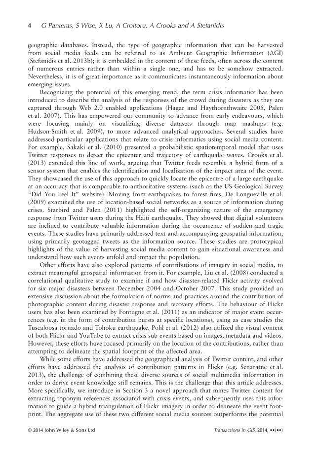
3 A Cross-Source Triangulation Framework
As discussed above, our main objective is to integrate social media content referring to anevent (e.g. a natural or anthropogenic disaster) across sources in order to advance our capabil-ity to geolocate this event and delineate its footprint. In order to meet this objective we intro-duce a novel multimedia triangulation framework. Through this framework, contributionpatterns are extended from simple point clouds (indicating the location of the contributors) tobecome the equivalent of views of a particular event (which involve an understanding of therelationship between the contributor and the event). These views can then be synthesized todelineate the event footprint via viewshed analysis. We accomplish this goal through the two-step process that is summarized in Figure 1. The first component of our approach entailsTwitter content analysis for the identification of toponym references associated with the eventof interest (presented in Section 3.1). Using this information we then harvest Flickr imageryusing geolocation and tag constraints: we query the Flickr Application Programing Interface(API) to retrieve images from the broader vicinity of the toponym, and with tags that arerelated to it as well. These images are then oriented using the toponym information as a refer-ence point, and their viewable area footprints are integrated via viewshed analysis in order toderive an estimate of the event footprint (as a probability map), as presented in Section 3.2.
Figure 1 The cross-source triangulation framework
Triangulating Social Multimedia Content for Event Localization 5
© 2014 John Wiley & Sons Ltd Transactions in GIS, 2014, ••(••)
The underlying assumption in our approach is that tweets contain references to the location ofthe event, whereas Flickr contributions provide views of it. This methodology represents across-platform social multimedia analysis approach for event triangulation.
While Twitter is utilized in this framework to derive the approximate location of a givenevent (which can then be further refined using Flickr), it should be noted that other sourcesmay also be exploited for the extraction of such information. For example, a toponym refer-ence can be extracted from other communication avenues, such as news media feeds or blogs,which could substitute the Twitter reference point extraction process in Figure 1. Anothersource of such information may very well be Flickr itself, as image annotations may containtoponym references. However, such annotations in Flickr tend to vary in terms of their fre-quency (Ames and Naaman 2007, Nitta et al. 2014), thus potentially limiting the suitability ofFlickr annotations alone for this purpose. This is further attenuated if we consider the datavolume differences between Twitter and Flickr. For example in this particular study, thenumber of Flickr contributions is roughly 0.5% of the number of tweets reporting the sameevent. This is consistent with the reports of overall data traffic associated with these two socialmedia services (Croitoru et al. 2013).
3.1 Event Localization using Toponym References in Twitter
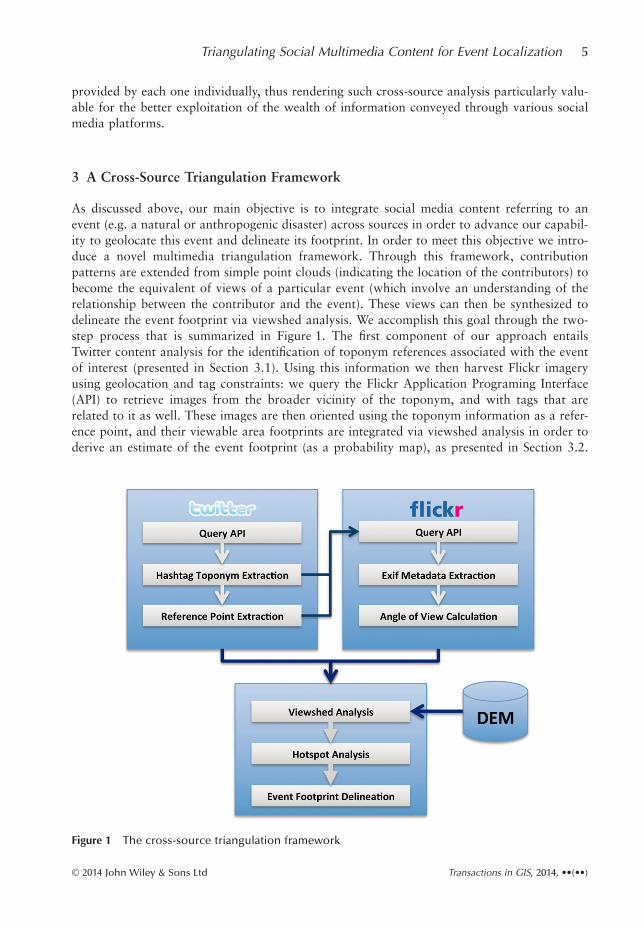
In order to best communicate how the various components of our framework are operatingand integrated, we use the 2012 wildfire of Waldo Canyon in Colorado Springs (Colorado,USA) as a case study. The wildfire started in June 23, 2012 and was not fully contained untilJuly 12, 2012 (the study period), which is used as the study period in this article. During thattime, the wildfire consumed a total area of 74 km2, and was considered the most destructivewildfire in Colorado’s history at the time, based on the extent of damage to property (McGhee2013). Figure 2 provides an overview of study area, showing Waldo Canyon to the northwestof Colorado Springs, with the actual wildfire area overlaid along with the location ofgeolocated Flickr images during the event.
We collected relevant Twitter data from the Twitter API using the keyword “Fire” over thestudy period, resulting in a corpus of 97,866 tweets among which 41.4% are retweets. It isworth noting that as we analyze the content of tweets rather than their spatial distribution, thepresence of relatively high retweet levels is likely to contribute to the emergence of toponymsin our data corpus, thus further facilitating the detection of the relevant toponyms. We there-fore view retweeting as a crowd-sourced curation process, whereby the general public weighsupon twitter content and assigns gravity to it in a variety of ways, with retweeting being themost prominent (e.g. Boyd et al. 2010).
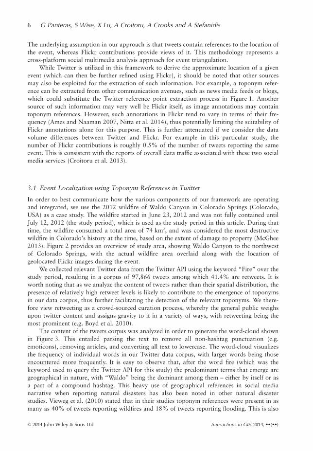
The content of the tweets corpus was analyzed in order to generate the word-cloud shownin Figure 3. This entailed parsing the text to remove all non-hashtag punctuation (e.g.emoticons), removing articles, and converting all text to lowercase. The word-cloud visualizesthe frequency of individual words in our Twitter data corpus, with larger words being thoseencountered more frequently. It is easy to observe that, after the word fire (which was thekeyword used to query the Twitter API for this study) the predominant terms that emerge aregeographical in nature, with “Waldo” being the dominant among them – either by itself or asa part of a compound hashtag. This heavy use of geographical references in social medianarrative when reporting natural disasters has also been noted in other natural disasterstudies. Vieweg et al. (2010) stated that in their studies toponym references were present in asmany as 40% of tweets reporting wildfires and 18% of tweets reporting flooding. This is also
6 G Panteras, S Wise, X Lu, A Croitoru, A Crooks and A Stefanidis
© 2014 John Wiley & Sons Ltd Transactions in GIS, 2014, ••(••)
consistent with studies addressing the broad presence of toponyms in reporting various typesof breaking news (Lieberman and Samet 2011, Stefanidis et al. 2013a).
The Twitter data corpus was then converted to lowercase and filtered to extract allhashtags. Figure 4 shows the frequency over time of the 10 most popular hashtags for theduration of the wildfire event. As can be seen from it, “#waldocanyonfire” has emerged as thetop hashtag associated with this event, a term which encompasses both the nature of the eventand the location of it. The emergence of hashtags like this through a bottom-up process, from
Figure 2 Overview of the study area
Figure 3 Word-cloud of Tweeter most frequent terms and hashtags during the wildfire
Triangulating Social Multimedia Content for Event Localization 7
© 2014 John Wiley & Sons Ltd Transactions in GIS, 2014, ••(••)
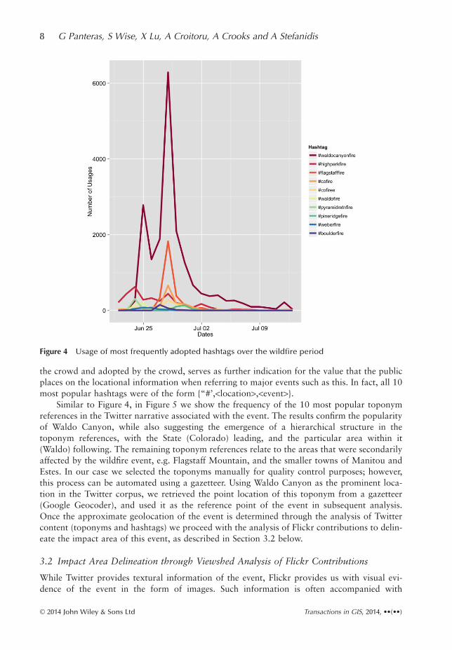
the crowd and adopted by the crowd, serves as further indication for the value that the publicplaces on the locational information when referring to major events such as this. In fact, all 10most popular hashtags were of the form {“#’,<location>,<event>}.
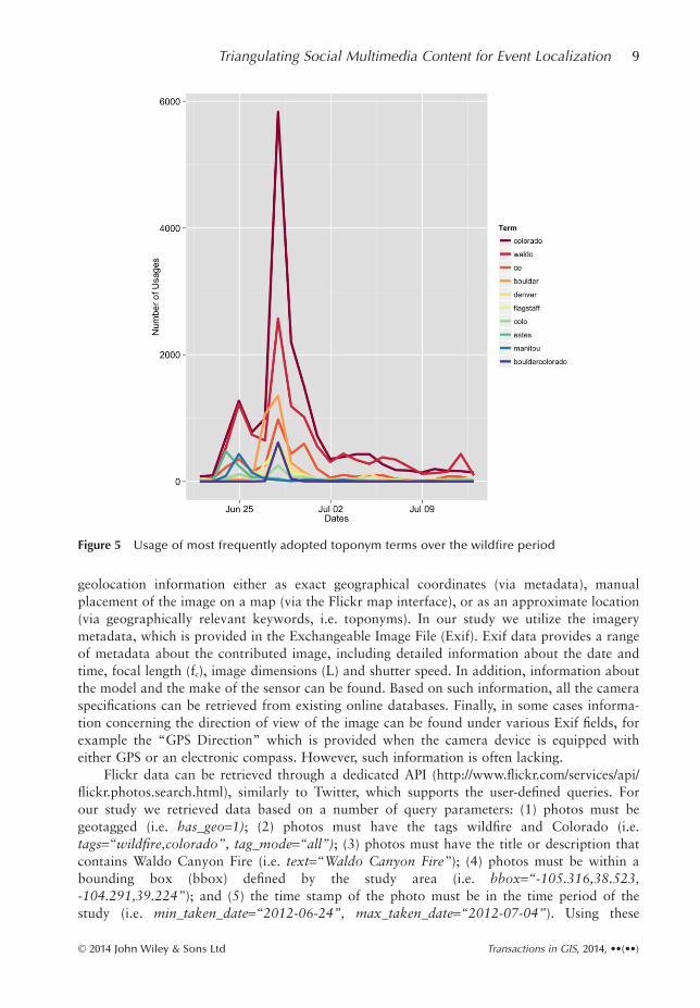
Similar to Figure 4, in Figure 5 we show the frequency of the 10 most popular toponymreferences in the Twitter narrative associated with the event. The results confirm the popularityof Waldo Canyon, while also suggesting the emergence of a hierarchical structure in thetoponym references, with the State (Colorado) leading, and the particular area within it(Waldo) following. The remaining toponym references relate to the areas that were secondarilyaffected by the wildfire event, e.g. Flagstaff Mountain, and the smaller towns of Manitou andEstes. In our case we selected the toponyms manually for quality control purposes; however,this process can be automated using a gazetteer. Using Waldo Canyon as the prominent loca-tion in the Twitter corpus, we retrieved the point location of this toponym from a gazetteer(Google Geocoder), and used it as the reference point of the event in subsequent analysis.Once the approximate geolocation of the event is determined through the analysis of Twittercontent (toponyms and hashtags) we proceed with the analysis of Flickr contributions to delin-eate the impact area of this event, as described in Section 3.2 below.
3.2 Impact Area Delineation through Viewshed Analysis of Flickr Contributions
While Twitter provides textural information of the event, Flickr provides us with visual evi-dence of the event in the form of images. Such information is often accompanied with
Figure 4 Usage of most frequently adopted hashtags over the wildfire period
8 G Panteras, S Wise, X Lu, A Croitoru, A Crooks and A Stefanidis
© 2014 John Wiley & Sons Ltd Transactions in GIS, 2014, ••(••)
geolocation information either as exact geographical coordinates (via metadata), manualplacement of the image on a map (via the Flickr map interface), or as an approximate location(via geographically relevant keywords, i.e. toponyms). In our study we utilize the imagerymetadata, which is provided in the Exchangeable Image File (Exif). Exif data provides a rangeof metadata about the contributed image, including detailed information about the date andtime, focal length (fc), image dimensions (L) and shutter speed. In addition, information aboutthe model and the make of the sensor can be found. Based on such information, all the cameraspecifications can be retrieved from existing online databases. Finally, in some cases informa-tion concerning the direction of view of the image can be found under various Exif fields, forexample the “GPS Direction” which is provided when the camera device is equipped witheither GPS or an electronic compass. However, such information is often lacking.
Flickr data can be retrieved through a dedicated API (http://www.flickr.com/services/api/flickr.photos.search.html), similarly to Twitter, which supports the user-defined queries. Forour study we retrieved data based on a number of query parameters: (1) photos must begeotagged (i.e. has_geo=1); (2) photos must have the tags wildfire and Colorado (i.e.tags=“wildfire,colorado”, tag_mode=“all”); (3) photos must have the title or description thatcontains Waldo Canyon Fire (i.e. text=“Waldo Canyon Fire”); (4) photos must be within abounding box (bbox) defined by the study area (i.e. bbox=“-105.316,38.523,-104.291,39.224”); and (5) the time stamp of the photo must be in the time period of thestudy (i.e. min_taken_date=“2012-06-24”, max_taken_date=“2012-07-04”). Using these
Figure 5 Usage of most frequently adopted toponym terms over the wildfire period
Triangulating Social Multimedia Content for Event Localization 9
© 2014 John Wiley & Sons Ltd Transactions in GIS, 2014, ••(••)
parameters a total of 427 images were retrieved of which only 191 (less than 50%) had Exifinformation. However, while for some of these images the angle of view (AOV) can be derivedfrom Exif information, none of these images included the observer’s orientation (i.e. azimuth).This fact, which appears to be frequent in Flickr data (Wueller and Fageth 2008), serves as oneof the primary motivations for developing our viewshed analysis methodology. As a result, weuse the coordinates of the toponyms and the Exif information to derive both the direction ofview (as estimated by the azimuth) and the AOV (as estimated from the focal length and theimage size), which we turn to next.
As expected, the contributions in this case are consistent with observed social media andblogosphere patterns (e.g. Stefanidis et al. (2013b) and Shi et al. (2007) respectively):approaching a power law distribution, with few users contributing large portions of the data,and a majority of users making minimal contributions. In our case study the 427 Flickr imagesthat were retrieved were contributed by 38 distinct users, with the median contribution peruser being one photo (compared to the average of 11). This deviation between the median andthe average values is indicative of the degree of skewness of the contributions among users.
3.2.1 Azimuth and angle of view calculation
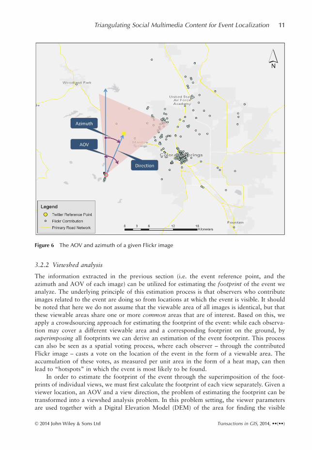
The purpose of estimating the azimuth and the AOV is to orient and constrain the extentof the view from each image location as shown in Figure 6. For this purpose, we first establishthe AOV using the sensor parameters (i.e. focal length and image dimensions as provided bythe image Exif file), and then orient the AOV by calculating the azimuth between the observerlocation and the event reference point. Generally, three AOVs can be calculated for a givenimage: the horizontal, the vertical, and the diagonal. As our objective is to establish the extentof the footprint of the event (i.e. wildfire), we utilize the horizontal AOV, which is calculatedas:
ϕAOVc
tanLf
= ⎛⎝⎜
⎞⎠⎟
−22
1 (1)
where L is the image width and fc is the sensor focal length. Using Equation (1), the AOV hasbeen calculated for the 191 images for which an Exif file was available. For the remaining 236images that did not include Exif metadata, the average of the 191 AOVs that were calculatedusing the Exif data was used as an approximation. Considering that Flickr imagery is increas-ingly contributed by mobile devices with relatively similar camera characteristics (https://www.flickr.com/cameras), the use of an average value for imagery lacking AOV information isa reasonable approximation (Singla and Weber 2011).
In order to orient the AOVs, we calculated the azimuth between each image location andthe event reference point (as described in Section 3.1). More specifically, the calculation of theazimuth for every image was based on the geodetic azimuth using the following formula (Yanget al. 1999):
θ λ λ ϕϕ ϕ ϕ ϕ λ
= −( ) ( )( ) ( ) − ( ) ( )
−tan 1 2 1 2
1 2 1 2 2
sin coscos sin sin cos cos −−( )
⎛⎝⎜
⎞⎠⎟λ1
(2)
where φ1, λ1 and φ2, λ2 are the geographical coordinates of the Flickr image location (or theobserver) and the event reference point, respectively. As a result of this calculation, each Flickrimage is now associated with a geographic location and an oriented AOV from which aviewshed analysis can be carried out in order to delineate the footprint of the event.
10 G Panteras, S Wise, X Lu, A Croitoru, A Crooks and A Stefanidis
© 2014 John Wiley & Sons Ltd Transactions in GIS, 2014, ••(••)
3.2.2 Viewshed analysis
The information extracted in the previous section (i.e. the event reference point, and theazimuth and AOV of each image) can be utilized for estimating the footprint of the event weanalyze. The underlying principle of this estimation process is that observers who contributeimages related to the event are doing so from locations at which the event is visible. It shouldbe noted that here we do not assume that the viewable area of all images is identical, but thatthese viewable areas share one or more common areas that are of interest. Based on this, weapply a crowdsourcing approach for estimating the footprint of the event: while each observa-tion may cover a different viewable area and a corresponding footprint on the ground, bysuperimposing all footprints we can derive an estimation of the event footprint. This processcan also be seen as a spatial voting process, where each observer – through the contributedFlickr image – casts a vote on the location of the event in the form of a viewable area. Theaccumulation of these votes, as measured per unit area in the form of a heat map, can thenlead to “hotspots” in which the event is most likely to be found.
In order to estimate the footprint of the event through the superimposition of the foot-prints of individual views, we must first calculate the footprint of each view separately. Given aviewer location, an AOV and a view direction, the problem of estimating the footprint can betransformed into a viewshed analysis problem. In this problem setting, the viewer parametersare used together with a Digital Elevation Model (DEM) of the area for finding the visible
Figure 6 The AOV and azimuth of a given Flickr image
Triangulating Social Multimedia Content for Event Localization 11
© 2014 John Wiley & Sons Ltd Transactions in GIS, 2014, ••(••)
areas of a surface from a given observer location. Viewshed analysis is a well-established tech-nique, which spans across various application areas, from navigation and site selection tolandscape planning and telecommunication systems (e.g. Nagy 1994, Fisher 1995, De Florianiand Magillo 2003, Sander and Manson 2007). In our framework, viewshed analysis is utilizedto calculate the viewable areas (or cells in the case of a raster grid) between observer andpoints in the study area, given the reference point of interest (i.e. the event reference point)based on the elevation difference between these points. By systematically applying this calcula-tion to all cells in the study area, we generate a binary map showing the viewable area for eachobserver. The superimposition of all binary maps for all observers then results in a heat map,where each cell in the map accumulates the number of times the cell was flagged as viewable.It should be noted that while here we assign the same weight to each binary viewshed mapduring the superimposition process, other weighting schemes could be applied in order toenhance the heat map fidelity for a specific purpose. For example, given a time interval,viewshed maps may be weighted according to their timestamp in order to generate a heat mapthat highlights the extent of the wildfire during that time interval. However, as in this casestudy we aim to explore the full extent of the fire, this option was not pursued.
The implementation of the viewshed analysis was carried out in the ArcGIS environmentthrough a workflow consisting of a set of python scripts. This workflow, which systematicallyapplies the viewshed calculation for each image in our data set, provides the ability to controlthe calculation parameters used. In particular, for each image we set the angular limits of theviewshed calculation as the left and right azimuths of the AOV of the image (which canbe derived from the AOV and the azimuth of each image), and set a minimum and amaximum range parameter (measured from the viewer’s location) to limit the distances fromthe viewer for which the viewshed calculation is carried out. The values of these range param-eters are set as a function of the average distance between the event reference point andthe location of each Flickr image. It is worth noting that in our experiments we utilizedthe National Elevation Data (NED) data, a 10 m resolution DEM that is available through theUS Geological Survey (USGS). The final step of our viewshed analysis includes thesuperimposition of all viewshed raster grids, resulting in a heat map. Cells having high valuesin this heat map indicate locations that have been visible more in Flickr imagery in relation tothe event, while cells having low or zero values indicate locations that have not been visible insuch imagery. Based on these values, we can then analyze hotspots the heat map in order toidentify highly visible locations, i.e. locations that were of interest to many viewers on theground.
3.2.3 Hotspot detection
In the final step of our framework we utilize the heat map that was generated in order to iden-tify hotspots and delineate their extent as an approximation for the footprint of the wildfireevent. Here, we refer to a hotspot as a spatial cluster of cells for which high heat map valuesexist, i.e. clusters that are highly visible to observers in the viewshed analysis. Several well-studied spatial analysis methods exist for the detection of hotspots, among which are KernelDensity Estimation (KDE), Moran’s I, and Getis-Ord (Gi*) (Kuo et al. 2012). KDE, which isbased on a spatial filtering process, produces a smooth density surface by estimating thesurface density (Silverman 1986, Xie and Yan 2008). However, a key difficulty in implement-ing KDE is the filter bandwidth as well as the ability to test the statistical significance of theresults.
12 G Panteras, S Wise, X Lu, A Croitoru, A Crooks and A Stefanidis
© 2014 John Wiley & Sons Ltd Transactions in GIS, 2014, ••(••)
Another possible measure is Moran’s I, which estimates spatial autocorrelation amongsimilar (low or high) values. While Moran’s I could be used for detecting hotspots, its inabilityto automatically distinguish between high or low hotspots (Griffith 1987) limits its usabilityfor our purpose. In view of these limitations, we utilize the Getis-Ord Gi* statistic (Ord andGetis 1995; De Smith et al. 2007), which enables one to identify statistically significant spatialclusters of both high cell values (“hotspots”) and low cell values (“cold spots”) in the heatmap. A key advantage of the Gi* statistic is that it allows testing the results for statistical sig-nificance using easily calculated z-scores (Burt et al. 2009). In order to identify hotspots in theviewshed heat map we applied the Gi* statistic to the heat map, calculated the correspondingz-scores, and used them to generate four classes according to the following p-value thresholds:90% significant (z-score ≥1.645), 95% significant (z-score ≥1.960), 99% significant (z-score≥2.576), 99.9% significant (z-score ≥3.291). All non-significant cells were grouped in a fifthclass. It should be noted that by overlaying two or more significant level heat maps, it is pos-sible to generate a heat map of significance level ranges. For example, overlaying the 95% sig-nificance heat map on top of the 90% significance level would result in three types of pixels,namely pixels below 90%, between 90% and 95%, and above 95%.
4 Case Study: The Waldo Canyon Wildfire
In order to showcase the utility of our approach in a real-world crisis setting, we applied it tothe 2012 Waldo Canyon wildfire. For this purpose we collected both Twitter and Flickr data,as discussed in Section 3.1, and applied the proposed analysis framework in order to delineatethe impact area of the fire using our cross-sourced triangulation approach. To demonstrate thebenefit of using cross-sourced social media in the triangulation process we applied three modesof the analysis:
• Mode 1: the impact area was estimated as the overlap of all viewsheds that were generatedfrom all Flickr contribution locations without calculating a reference point or evaluatingthe AOV for each image. Accordingly, in this mode, we use only Flickr data, without con-straining the viewshed analysis with any AOV information.
• Mode 2: the impact area was estimated by using the centroid of the locations of all Flickrcontributions as the reference point for the AOV calculation, followed by a viewshedanalysis of each image. Accordingly, in this mode we use only Flickr data, ignoring anytoponym information from Twitter.
• Mode 3: the impact area was estimated by using the toponym reference, as derived fromTwitter, as the reference point for the AOV calculation, followed by a viewshed analysis ofeach image. Accordingly, in this mode we use Twitter content to orient Flickr data andguide the viewshed analysis.
The results of analysis modes 1, 2, and 3 are shown in Figures 7, 8, and 9, respectively. Ineach of these figures we present for each significance level range (as discussed in Section 3.2.3)the resulting impact area of the wildfire as an overlaid raster heat-map as well as the knownwildfire impact area as provided by the US National Oceanic and Atmospheric Administration(NOAA 2013) following the event. In order to estimate the accuracy of the analysis resultswith respect to the known wildfire impact area and examine the benefit of using social multi-media for our analysis approach we calculated a confusion matrix for each analysis mode. Forthis purpose every heat map cell p at location (x,y) was labeled as belonging to one of four
Triangulating Social Multimedia Content for Event Localization 13
© 2014 John Wiley & Sons Ltd Transactions in GIS, 2014, ••(••)

classes according to a statistical significance condition and a spatial condition as shown inTable 1.
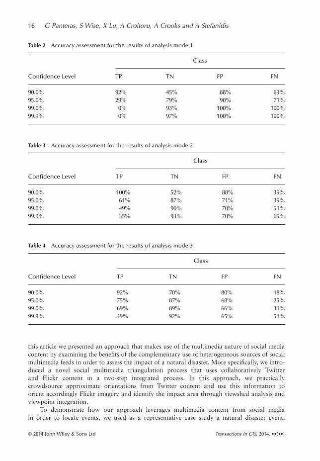
In this table, C is the user-defined confidence levels, S() is the significance level operatorwhich assigns a significance level for a given cell p, and Afire is the known wildfire impact area.Based on these results we then calculated the rate of each class (e.g. True Positive rate) bydividing the area covered by each class by the corresponding reference area. For example, theTP rate was calculated as the ratio between the total area that was detected as fire through ouranalysis method and the known wildfire area. The results of this labeling process for analysismodes 1, 2, and 3 are summarized in Tables 2, 3, and 4, respectively.
Comparing the accuracy analysis results of the three analysis modes highlights the benefitof using our cross-source viewshed analysis: while the TP rate is only 29% at 95% confidencelevel when no reference point is used (analysis mode 1), this rate increases to 61% when a ref-erence point is derived using only Flickr data (analysis mode 2), and reaches 75% when bothTwitter and Flickr data are used (analysis mode 3). It is worth noting that in our accuracyanalysis the TN rate for all three analysis modes remained approximately the same (between79% and 87%), the false detection rates were reduced from 79% for FP and 90% for FN inanalysis mode 1 to 68% and 25% for FP and FN, respectively in analysis mode 3. Theseresults demonstrate that by combining crowdsourced data from both Flickr and Twitter in theviewshed analysis we are able to improve not only the detection accuracy but also the falsedetection accuracy. A three-dimensional rendering of the results obtained from the analysis in
Figure 7 Wildfire location assessment as derived by analysis mode 1
14 G Panteras, S Wise, X Lu, A Croitoru, A Crooks and A Stefanidis
© 2014 John Wiley & Sons Ltd Transactions in GIS, 2014, ••(••)

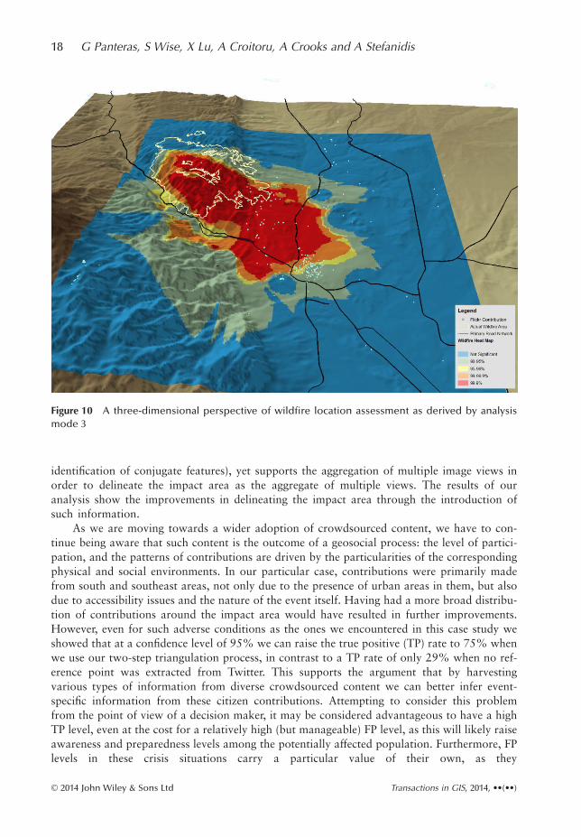
mode 3 is given in Figure 10, showing the topography of the case study area as well as theknown extent of the wildfire. As can be seen, the pattern of contributions is driven by theterrain conditions and population distribution: while we have numerous contributions fromthe semi-urban area southeast of the wildfire, we have practically no contributions from themountainous rural areas to the northwest of the event.
5 Conclusions and Outlook
The analysis of social media content to extract geospatial information and event knowledgefrom such crowd-contributed data has become the subject of substantial research activities. In
Figure 8 Wildfire location assessment as derived by analysis mode 2
Table 1 Heat map cell labeling according to significance and spatial conditions
Class Confidence Level Condition Spatial Condition
True Positive (TP) S(p) ≥ C p ∈ Afire
True Negative (TN) S(p) < C p ∉ Afire
False Positive (FP) S(p) ≥ C p ∉ Afire
False Negative (FP) S(p) < C p ∈ Afire
Triangulating Social Multimedia Content for Event Localization 15
© 2014 John Wiley & Sons Ltd Transactions in GIS, 2014, ••(••)
this article we presented an approach that makes use of the multimedia nature of social mediacontent by examining the benefits of the complementary use of heterogeneous sources of socialmultimedia feeds in order to assess the impact of a natural disaster. More specifically, we intro-duced a novel social multimedia triangulation process that uses collaboratively Twitterand Flickr content in a two-step integrated process. In this approach, we practicallycrowdsource approximate orientations from Twitter content and use this information toorient accordingly Flickr imagery and identify the impact area through viewshed analysis andviewpoint integration.
To demonstrate how our approach leverages multimedia content from social mediain order to locate events, we used as a representative case study a natural disaster event,
Table 2 Accuracy assessment for the results of analysis mode 1
Confidence Level
Class
TP TN FP FN
90.0% 92% 45% 88% 63%95.0% 29% 79% 90% 71%99.0% 0% 93% 100% 100%99.9% 0% 97% 100% 100%
Table 3 Accuracy assessment for the results of analysis mode 2
Confidence Level
Class
TP TN FP FN
90.0% 100% 52% 88% 39%95.0% 61% 87% 71% 39%99.0% 49% 90% 70% 51%99.9% 35% 93% 70% 65%
Table 4 Accuracy assessment for the results of analysis mode 3
Confidence Level
Class
TP TN FP FN
90.0% 92% 70% 80% 18%95.0% 75% 87% 68% 25%99.0% 69% 89% 66% 31%99.9% 49% 92% 65% 51%
16 G Panteras, S Wise, X Lu, A Croitoru, A Crooks and A Stefanidis
© 2014 John Wiley & Sons Ltd Transactions in GIS, 2014, ••(••)
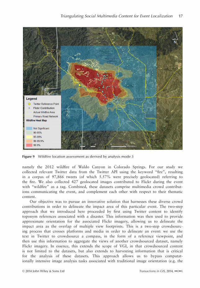
namely the 2012 wildfire of Waldo Canyon in Colorado Springs. For our study wecollected relevant Twitter data from the Twitter API using the keyword “fire”, resultingin a corpus of 97,866 tweets (of which 5.57% were precisely geolocated) referring tothe fire. We also collected 427 geolocated images contributed to Flickr during the eventwith “wildfire” as a tag. Combined, these datasets comprise multimedia crowd contribut-ions communicating the event, and complement each other with respect to their thematiccontent.
Our objective was to pursue an innovative solution that harnesses these diverse crowdcontributions in order to delineate the impact area of this particular event. The two-stepapproach that we introduced here proceeded by first using Twitter content to identifytoponym references associated with a disaster. This information was then used to provideapproximate orientation for the associated Flickr imagery, allowing us to delineate theimpact area as the overlap of multiple view footprints. This is a two-step crowdsourc-ing process that crosses platforms and media in order to delineate an event: we use thetext in Twitter to crowdsource a compass, in the form of a reference viewpoint, andthen use this information to aggregate the views of another crowdsourced dataset, namelyFlickr imagery. In essence, this extends the scope of VGI, in that crowdsourced contentis not limited to the datasets, but also extends to harvesting information that is criticalfor the analysis of these datasets. This approach allows us to bypass computat-ionally intensive image analysis tasks associated with traditional image orientation (e.g. the
Figure 9 Wildfire location assessment as derived by analysis mode 3
Triangulating Social Multimedia Content for Event Localization 17
© 2014 John Wiley & Sons Ltd Transactions in GIS, 2014, ••(••)
identification of conjugate features), yet supports the aggregation of multiple image views inorder to delineate the impact area as the aggregate of multiple views. The results of ouranalysis show the improvements in delineating the impact area through the introduction ofsuch information.
As we are moving towards a wider adoption of crowdsourced content, we have to con-tinue being aware that such content is the outcome of a geosocial process: the level of partici-pation, and the patterns of contributions are driven by the particularities of the correspondingphysical and social environments. In our particular case, contributions were primarily madefrom south and southeast areas, not only due to the presence of urban areas in them, but alsodue to accessibility issues and the nature of the event itself. Having had a more broad distribu-tion of contributions around the impact area would have resulted in further improvements.However, even for such adverse conditions as the ones we encountered in this case study weshowed that at a confidence level of 95% we can raise the true positive (TP) rate to 75% whenwe use our two-step triangulation process, in contrast to a TP rate of only 29% when no ref-erence point was extracted from Twitter. This supports the argument that by harvestingvarious types of information from diverse crowdsourced content we can better infer event-specific information from these citizen contributions. Attempting to consider this problemfrom the point of view of a decision maker, it may be considered advantageous to have a highTP level, even at the cost for a relatively high (but manageable) FP level, as this will likely raiseawareness and preparedness levels among the potentially affected population. Furthermore, FPlevels in these crisis situations carry a particular value of their own, as they
Figure 10 A three-dimensional perspective of wildfire location assessment as derived by analysismode 3
18 G Panteras, S Wise, X Lu, A Croitoru, A Crooks and A Stefanidis
© 2014 John Wiley & Sons Ltd Transactions in GIS, 2014, ••(••)

can be viewed as capturing the public’s perception of the potential threat from their respectivelocations.
One thing to consider in conjunction with the abovementioned levels of accuracyis that they would be affected by the granularity of the reference point. For example, ifpeople were referring to the “Colorado wildfires”, our approach would not be able to gen-erate meaningful results. Generally, one would reasonably expect a link between the granu-larity level of event references, as they emerge through public discourse, and the type of thecorresponding event. While some events have a rather localized footprint (e.g. wildfires),others have a broader impact (e.g. hurricanes). This can be viewed as an extension ofthe problem of geo-parsing text at global- and local-scales (Leidner and Lieberman2011). Furthermore, the dynamicity of an event may impact the analysis: a fire is a verydynamic event, but was (in this case) still spatially contained. If it were to be spreadingacross large areas our analysis would have to be segmented across temporal intervals, withinwhich the event would be mapped at distinct instances, and its evolution tracked accord-ingly. Presumably, this could also lead to the emergence of sequences of toponyms for thesame event.
It is worth noting that rather than focusing on fine-tuning the accuracy of the outcomeof the analysis, our main objective in this article was to demonstrate the feasibility of ourapproach in the context of a rapid assessment of the impact area of an event, given non-curated data corpus such as the one presented here. As we have shown above, even withcertain approximations, e.g. using average camera model values for images without Exifinformation, we are able to assess the impact area quite well. Such approximations could befurther improved and refined by using techniques for estimating missing camera parameters,e.g. Bujnak et al. (2010) or De Oliveira Costa et al. (2014). Similarly, the viewshed analysiscan be refined to account for the combined effects of the accuracy of the DEM, e.g.Oksanen and Sarjakoski (2006), as well as the accuracy of the technique used to calculate it,e.g. Fisher (1993).
Nevertheless, we need to remain aware that the particular nature of social media contribu-tions may result in biases in their patterns of contribution. For example, Li et al. (2013)focused on social media usage in Twitter and Flickr, finding a relationship between Twitterusage and well-educated high-income people, particularly white and Asian populations. Morerelevant to this work, Kent and Capello (2013) studied the use of social media during a crisissituation (a wildfire). Their analysis showed that demographic characteristics of the areaimpacted by the emergency situation could be used to reveal the propensity of its populationto contribute information in social media during such a crisis. These works reveal some of theintrinsic nature of social media contributions as they relate to geospatial information, warrant-ing the further study of such activities in order to gain a better understanding of the value andquality of this crowdsourced content.
In order to overcome the demographics-related limitations (and the resulting biases) it ispossible to consider active social media approaches, whereby requests for contributions areissued for locations that are underrepresented in the harvested data. This nevertheless wouldnot address the limitations of population gaps, where low population density results in lack ofdata (thus limiting the accuracy of the analysis). Towards that end, one could consider theintegration of social media feeds with traditional geosensor networks, in order to collect fromthe latter focused information in response to the breaking events that are detected in theformer. While such integration still remains largely unexplored, it clearly emerges as a promis-ing future direction due to the substantial advancements in social media harvesting andprocessing.
Triangulating Social Multimedia Content for Event Localization 19
© 2014 John Wiley & Sons Ltd Transactions in GIS, 2014, ••(••)
References
Agichtein E, Castillo C, Donato D, Gionis A, and Mishne G 2008 Finding high quality content in social media.In Proceedings of the International Conference on Web Search and Web Data Mining, Stanford, California:183–94
Ames M and Naaman M 2007 Why we tag: Motivations for annotation in mobile and online media. In Pro-ceedings of the SIGCHI Conference on Human factors in Computing Systems, San Jose, California:971–80
Boyd D, Golder S, and Lotan G 2010 Tweet, tweet, retweet: conversational aspects of retweeting on Twitter. InProceedings of the Forty-third IEEE Hawaii International Conference on System Sciences, Kauai, Hawaii:1–10
Bujnak M, Kukelova Z, and Pajdla T 2010 Robust focal length estimation by voting in multi-view scene recon-struction. In Zha H, Taniguchi R, and Maybank S (eds) Computer Vision: ACCV 2009. Berlin, Springer:13–24
Burt J, Barber G, and Rigby R 2009 Elementary Statistics for Geographers (Third edition). New York, GuilfordChristensen C 2011 Twitter revolutions? Addressing social media and dissent. Communication Review 14:
155–57Croitoru A, Crooks A T, Radzikowski J, and Stefanidis A 2013 GeoSocial gauge: A system prototype for knowl-
edge discovery from geosocial media. International Journal of Geographical Information Science 27: 2483–508
Croitoru A, Crooks A T, Radzikowski J, Stefanidis A, Vatsavai R R, and Wayant N 2014 Geoinformatics andsocial media: A new big data challenge. In Karimi H A (ed) Big Data Techniques and Technologies inGeoinformatics. Boca Raton, FL, CRC Press: 207–32
Crooks A T, Croitoru A, Stefanidis A, and Radzikowski J 2013 #Earthquake: Twitter as a distributed sensorsystem. Transactions in GIS 17: 124–47
De Choudhury M, Feldman M, Amer-Yahia S, Golbandi N, Lempel R, and Yu C 2010 Constructing travel itin-eraries from tagged geo-temporal breadcrumbs. In Proceedings of the Nineteenth International Conferenceon World Wide Web, Raleigh, North Carolina: 1083–84
De Floriani L and Magillo P 2003 Algorithms for visibility computation on terrains: A survey. Environment andPlanning B 30: 709–28
De Longueville B, Smith R S, and Luraschi G 2009 OMG, from here, I can see the flames!: A use case of mininglocation-based social networks to acquire spatiotemporal data on forest fires. In Proceedings of the Inter-national Workshop on Location Based Social Networks, Seattle, Washington: 73–80
De Oliveira Costa F, Silva E, Eckmann M, Scheirer W J, and Rocha A 2014 Open set source camera attributionand device linking. Pattern Recognition Letters 39: 92–101
De Smith M J, Goodchild M F, and Longley P A 2007 Geospatial Analysis: A Comprehensive Guide to Princi-ples, Techniques and Software Tools (Second edition), The Winchelsea Press, Winchelsea, UK
Fisher P F 1993 Algorithm and implementation uncertainty in viewshed analysis. International Journal of Geo-graphical Information Systems 7: 331–47
Fisher P F 1995 An exploration of probable viewsheds in landscape planning. Environment and Planning B 22:527–46
Fontugne R, Cho K, Won Y, and Fukuda K 2011 Disasters seen through Flickr cameras. In Proceedings of theSpecial Workshop on Internet and Disasters, Tokyo, Japan
Forbes 2012 Twitter’s Dick Costolo: Twitter Mobile Ad Revenue Beats Desktop on Some Days. WWW docu-ment, http://onforb.es/KgTWYP
Friedland G and Sommer R 2010 Cybercasing the joint: On the privacy implications of geotagging.In Proceedings of the Fifth USENIX Workshop on Hot Topics in Security (HotSec 10), Washington, DC
Fritz S, MacCallum I, Schill C, Perger C, Grillmayer R, Achard F, Kraxner F, and Obersteiner M2009 Geo-Wiki.Org: The use of crowdsourcing to improve global land cover. Remote Sensing 1:345–54
Fuchs G, Andrienko N, Andrienko G, Bothe S, and Stange H 2013 Tracing the German centennial flood in thestream of tweets: First lessons learned. In Proceedings of the Second ACM SIGSPATIAL InternationalWorkshop on Crowdsourced and Volunteered Geographic Information, Orlando, Florida: 31–38
Gao H, Barbier G, and Goolsby R 2011 Harnessing the crowdsourcing power of social media for disaster relief.IEEE Intelligent Systems 26(3): 10–14
Goodchild M F 2007 Citizens as sensors: The world of volunteered geography. GeoJournal 69: 211–21Griffith D A 1987 Spatial Autocorrelation: A Primer. Washington, DC, Association of American GeographersHagar C and Haythornthwaite C 2005 Crisis, farming and community. Journal of Community Informatics 1:
41–52
20 G Panteras, S Wise, X Lu, A Croitoru, A Crooks and A Stefanidis
© 2014 John Wiley & Sons Ltd Transactions in GIS, 2014, ••(••)

Haklay M, Singleton A, and Parker C 2008 Web Mapping 2.0: The neogeography of the GeoWeb. GeographyCompass 2: 2011–39
Hudson-Smith A, Crooks A T, Gibin M, Milton R, and Batty M 2009 Neogeography and Web 2.0: Concepts,tools and applications. Journal of Location Based Services 3: 118–45
Hurst M, Siegler M, and Glance N S 2007 On estimating the geographic distribution of social media. In Pro-ceedings AAAI International Conference on Weblogs and Social Media, Boulder, Colorado
Instagram 2014, Available at http://instagram.com/press/ [Accessed 3rd April 2014].Kaplan A M and Haenlein M 2010 Users of the world unite!: The challenges and opportunities of social media.
Business Horizons 53: 59–68Kent J D and Capello H T 2013 Spatial patterns and demographic indicators of effective social media content
during the Horsethief Canyon fire of 2012. Cartography and Geographic Information Science 40(2): 78–89Kisilevich S, Krstajic M, Keim D, Andrienko N, and Andrienko G 2010 Event-based analysis of people’s activ-
ities and behavior using Flickr and Panoramio geotagged photo collections. In Proceedings of the Four-teenth International Conference of Information Visualisation, London, UK: 289–96
Kuo P F, Zeng X, and Lord D 2012 Guidelines for choosing hot-spot analysis tools based on data characteris-tics, network restrictions, and time distributions. In Proceedings of the Ninety-first Annual Meeting of theTransportation Research Board, Washington, DC: 22–26
Leidner J L and Lieberman M D 2011 Detecting geographical references in the form of place names and associ-ated spatial natural language. SIGSPATIAL Special 3(2): 5–11
Li L and Goodchild M F 2012 Constructing places from spatial footprints. In Proceedings of the First ACMSIGSPATIAL International Workshop on Crowdsourced and Volunteered Geographic Information,Redondo Beach, California: 15–21
Li L, Goodchild M F, and Xu B 2013 Spatial, temporal, and socioeconomic patterns in the use of Twitter andFlickr. Cartography and Geographic Information Science 40: 61–77
Lieberman M D and Samet H 2011 Multifaceted toponym recognition for streaming news. In Proceedings of theThirty-fourth International ACM SIGIR Conference on Research and Development in InformationRetrieval, Beijing, China: 843–52
Liu S B and Palen L 2010 The new cartographers: Crisis map mashups and the emergence of neogeographicpractice. Cartography and Geographic Information Science 37: 69–90
Liu S B, Palen L, Sutton J, Hughes A L, and Vieweg S 2008 In search of the bigger picture: The emergent role ofonline photo sharing in times of disaster. In Proceedings of the Information Systems for Crisis Responseand Management Conference, Washington, DC
MacEachren A M, Jaiswal A, Robinson A C, Pezanowski S, Savelyev A, Mitra P, and Blanford J 2011Senseplace2: Geotwitter analytics support for situational awareness. In Proceedings of the IEEE Confer-ence in Visual Analytics Science and Technology (VAST), Providence, Rhode Island: 181–90
Mahmud J, Nichols J, and Drews C 2012 Where is this tweet from?: Inferring home locations of Twitter users.In Proceedings of the Sixth International AAAI Conference on Weblogs and Social Media, Dublin, Ireland
McGhee T 2013 4,167 Colorado Wildfires Caused Record Losses of $538 Million in 2012. Denver Post (1/17)(available at http://www.denverpost.com/ci_22396611/4–167-colorado-wildfires-caused-record-losses-538)
Nagy G 1994 Terrain visibility. Computers and Graphics 18: 763–73Nitta N, Kumihashi Y, Kato T, and Babaguchi N 2014 Real-world event detection using Flickr images. In
Gurrin C, Hopfgartner F, Hurst W, Johansen H, Lee H, and O’Connor N (eds) Multimedia Modeling.New York, Springer: 307–14
NOAA 2013 National Weather Service Weather Forecast Office (Waldo Canyon Wildfire dss). WWW docu-ment, http://www.crh.noaa.gov/pub/?n=waldocanyonwildfiredss
Norheim-Hagtun I and Meier P 2010 Crowdsourcing for crisis mapping in Haiti. Innovations: Technology,Governance 5(4): 81–9
Oksanen J and Sarjakoski T 2006 Uncovering the statistical and spatial characteristics of fine toposcale DEMerror. International Journal of Geographical Information Science 20: 345–69
Ord J K and Getis A 1995 Local spatial autocorrelation statistics: Distributional issues and an application. Geo-graphical Analysis 27: 286–306
Palen L, Vieweg S, Sutton J, Liu S B, and Hughes A L 2007 Crisis informatics: Studying crisis in a networkedworld. In Proceedings of the Third International Conference on E-Social Science, Ann Arbor, Michigan
Pohl D, Bouchachia A, and Hellwagner H 2012 Automatic sub-event detection in emergency management usingsocial media. In Proceedings of the Twenty-first International Conference Companion on World Wide Web,Lyon, France: 683–86
Rouse L J, Bergeron S J, and Harris T M 2007 Participating in the Geospatial Web: Collaborative mapping,social networks and participatory GIS. In Scharl A and Tochtermann K (eds) The Geospatial Web: HowGeobrowsers, Social Software and the Web 2.0 are Shaping the Network Society. London, Springer:153–58
Triangulating Social Multimedia Content for Event Localization 21
© 2014 John Wiley & Sons Ltd Transactions in GIS, 2014, ••(••)

Sakaki T, Okazaki M, and Matsuo Y 2010 Earthquake shakes Twitter users: Real-time event detection by socialsensors. In Proceedings of the Nineteenth International Conference on World Wide Web, Raleigh, NorthCarolina: 851–60
Sander H A and Manson S M 2007 Heights and locations of artificial structures in viewshed calculation: Howclose is close enough? Landscape and Urban Planning 82: 257–70
Sapiro G 2011 Images everywhere: looking for models: technical perspective. Communications of the ACM54(5): 108–18
Senaratne H, Bröring A, and Schreck T 2013 Using reverse viewshed analysis to assess the location correctnessof visually generated VGI. Transactions in GIS 17: 369–86
Shi X, Tseng B, and Adamic L A 2007 Looking at the blogosphere topology through different lenses. In Proceed-ings of the International Conference on Weblogs and Social Media (ICWSM 2007), Boulder, Colorado
Signorini A, Segre A M, and Polgreen P M 2011 The use of Twitter to track levels of disease activity and publicconcern in the US during the influenza A H1N1 pandemic. PloS One 6(5): e19467
Silva M J, Martins B, Chaves M, Afonso A P, and Cardoso N 2006 Adding geographic scopes to Web resources.Computers, Environment and Urban Systems 30: 378–99
Silverman B W 1986 Density Estimation for Statistics and Data Analysis. Boca Raton, FL, CRC PressSingla A and Weber I 2011 Camera brand congruence and camera model propagation in the Flickr social graph.
ACM Transactions on the Web 5(4): 20Starbird K and Palen L 2011 Voluntweeters: Self-organizing by digital volunteers in times of crisis. In Proceed-
ings of the SIGCHI Conference on Human Factors in Computing Systems, Vancouver, British Columbia:1071–80
Stefanidis A, Cotnoir A, Croitoru A, Crooks A T, Radzikowski J, and Rice M 2013a Statehood 2.0: Mappingnation-states and their satellite communities through social media content. Cartography and GeographicInformation Science 40: 116–29
Stefanidis T, Crooks A T, and Radzikowski J 2013b Harvesting ambient geospatial information from socialmedia feeds. GeoJournal 78: 319–38
Sugumaran R and Voss J 2012 Real-time spatio-temporal analysis of West Nile virus using Twitter data. In Pro-ceedings of the Third International Conference on Computing for Geospatial Research and Applications,Washington, DC
Sui D and Goodchild M F 2011 The convergence of GIS and social media: Challenges for GIScience. Interna-tional Journal of Geographical Information Science 25: 1737–48
Triglav-Cekada M and Radovan D 2013 Using volunteered geographical information to map the November2012 floods in Slovenia. Natural Hazards and Earth System Science 13(11): 2753–62
Twitter 2011 200 Million Tweets per Day. WWW document, http://bit.ly/laY1JxUtz S, Schultz F, and Glocka S 2013 Crisis communication online: How medium, crisis type and
emotions affected public reactions in the Fukushima Daiichi nuclear disaster. Public Relations Review 39:40–6
Valli C and Hannay P 2010 Geotagging where cyberspace comes to your place. In Proceedings of the 2010International Conference on Security and Management, Las Vegas, Nevada: 627–32
Vieweg S, Hughes A L, Starbird K, and Palen L 2010 Microblogging during two natural hazards events: WhatTwitter may contribute to situational awareness. In Proceedings of the Twenty-eighth International Confer-ence on Human Factors in Computing Systems, Atlanta, Georgia: 1079–88
Wayant N, Crooks A T, Stefanidis A, Croitoru A, Radzikowski J, Stahl J, and Shine J 2012 Spatiotemporal clus-tering of social media feeds for activity summarization. In Proceedings of the Seventh International Confer-ence for Geographical Information Science, Columbus, Ohios
Wood J, Dykes J, Slingsby A, and Clarke K 2007 Interactive visual exploration of a large spatio-temporaldataset: Reflections on a geovisualization mashup. IEEE Transactions on Visualization and ComputerGraphics 13: 1176–83
Wueller D and Fageth R 2008 Statistic analysis of millions of digital photos. In Proceedings of the InternationalSociety for Optics and Photonics on Electronic Imaging, San Jose, California
Xie Z and Yan J 2008 Kernel density estimation of traffic accidents in a network space. Computers, Environ-ment and Urban Systems 32: 396–406
Yang Q, Snyder J, and Tobler W 1999 Map Projection Transformation: Principles and Applications. BocaRaton, FL, CRC Press
YouTube 2013 YouTube Pressroom Statistics. WWW document, http://bit.ly/gzYBVxZook M, Graham M, Shelton T, and Gorman S 2010 Volunteered geographic information and crowdsourcing
disaster relief: A case study of the Haitian earthquake. World Medical and Health Policy 2: 2
22 G Panteras, S Wise, X Lu, A Croitoru, A Crooks and A Stefanidis
© 2014 John Wiley & Sons Ltd Transactions in GIS, 2014, ••(••)
Related Documents