TRAVIS AUDUBON SOCIETY BLAIR WOODS SANCTUARY PRELIMINARY MASTER PLAN September 2013 Core Team Paul Fushille Nancy Manning Terri Siegenthaler Judy Walther 1

Welcome message from author
This document is posted to help you gain knowledge. Please leave a comment to let me know what you think about it! Share it to your friends and learn new things together.
Transcript

TRAVIS AUDUBON SOCIETY
BLAIR WOODS SANCTUARY
PRELIMINARY MASTER PLAN
September 2013
Core Team Paul Fushille
Nancy Manning Terri Siegenthaler
Judy Walther
1

2

TABLE OF CONTENTS 1. INTRODUCTION
1.1. About Travis Audubon Society 1.1.1. Baker Sanctuary
1.1.2. Chaetura Canyon 1.2. Land Use History of Blair Woods
2. BACKGROUND
2.1. Physical Features of the Sanctuary 2.1.1. Soils 2.1.2. Geology 2.1.3. Topography and Hydrology 2.1.4. Biology
2.1.4.1. Vegetation 2.1.4.2. Wildlife
2.2. Land Management and Education Program History 3. CURRENT LAND USE
3.1. General Description of Current Land Uses by Travis Audubon 3.2. Lease Agreement with Wildlife Rescue 3.3. Easements 3.4. Description of Infrastructure 3.5. Surrounding Land Use and Neighborhoods
4. MANAGEMENT PLAN
4.1. Create a Core Team 4.2. Define Scope 4.3. Define Project Vision 4.4. Identify Conservation Targets
4.4.1. Target 1: Savanna 4.4.2. Target 2: Riparian Corridor 4.4.3. Target 3: Woodland
4.5. Identify Key Ecological Attributes (KEA’s) and Indicators 4.6. Conduct a Viability Assessment 4.7. Develop Goals
4.7.1. Savanna 4.7.2. Riparian Corridor
4.7.2.1. Upper Creek 4.7.2.2. Pond 4.7.2.3. Lower Creek
4.7.3. Woodland 4.8. Identify Direct and Indirect Threats
3

4.9. Determine Strategies to Eliminate or Lessen Threats 4.9.1. Strategies for Invasive Native / Non-native Species Control
4.9.1.1. Update 1980’s Management Plan 4.9.1.2. Exotic Species Control
4.9.1.2.1. Cutting/Treating Large Trees 4.9.1.2.2. Cutting/Treating Smaller Trees and Vines 4.9.1.2.3. Removal of Seedlings
4.9.1.3. Invasive Natives Control 4.9.1.3.1. Savanna Area 4.9.1.3.2. Future Hummingbird Garden Area 4.9.1.3.3. Trail Zones
4.9.1.4. Planting / Seeding 4.9.1.4.1. Visual Buffer Zone 4.9.1.4.2. Buffer Zone around WRI 4.9.1.4.3. Riparian Zones 4.9.1.4.4. Establishing Native Vegetation
4.9.1.5. Outreach and Education 4.9.1.5.1. Increase Awareness 4.9.1.5.2. Work Days
4.9.2. Strategies for Point and Non-Point Source Pollution 4.9.2.1. Adopt-A-Street Program 4.9.2.2. Trash 4.9.2.3. Outreach and Education
4.9.3. Strategies for Dealing with the Drought 4.9.3.1. Irrigation 4.9.3.2. Funds 4.9.3.3. Adapt
4.9.4. Strategies for Erosion 4.9.4.1. Trails 4.9.4.2. Open area 4.9.4.3. Matting
4.10. Set Objectives 4.10.1. Timeline for Completing Strategies
4.10.1.1. Plant Removal, Planting, Seeding 4.10.1.2. Point and Non-Point Source Pollution 4.10.1.2.1. Partner with City of Austin 4.10.1.2.2. Trash 4.10.1.3. Drought 4.10.1.3.1. Irrigation Pipes 4.10.1.3.2. Expand Irrigation 4.10.1.3.3. Adapt 4.10.1.4. Erosion 4.10.1.4.1. Trails 4.10.1.4.2. Plant/Seed 4.10.1.4.3. Matting
5. MONITORING 4

6. OUTREACH AND EDUCATION
6.1. Neighborhood Program 6.2. Volunteer Program 6.3. School Program
6.3.1. Goals of “Explore, Restore and More Program” 7. FUNDING
7.1. Restoration 7.2. Special Projects 7.3. Education
7.3.1. Explore and Restore and More 7.3.2. Outreach
APPENDICES: A. Fort Colorado: A Texas Ranger Frontier Outpost in Travis County, Texas B. Notes on the Vegetation and Flora of Blair Woods C. Plants of Terrace Deposits D. Bird List, Blair Woods Sanctuary E. Trail Map of Blair Woods LIST OF FIGURES 1-1. Approximate Location of Blair Woods 1-2. Map of TAS Sanctuaries 2-1. Soil Map of Blair Woods Area 2-2. Geology of the Austin Area 2-3. Fort Branch Drainage Basin Map 2-4. Drainage Area North of Blair Woods 2-5. Dr. Blair’s 1960 Tree and Plant Community Map 4-1. Master Plan Schematic Map 4-2. List of KEAs and Indicators by Targets 4-3. Viability Assessment as of September 2010 4-4. Direct and Indirect Threats 4-5. Outline of Estimated Timeline 5-1. Monitoring Tasks
5

6

1. INTRODUCTION
Blair Woods, a 10-acre urban sanctuary owned by Travis Audubon Society, is located northeast of downtown Austin, near the intersection of Highway 183 and Martin Luther King Boulevard (MLK Blvd). Blair Woods consists of native cedar elm and oak woodlands, including a riparian zone with a constructed dam creating a pond. The tract is located in the Blackland Prairie ecoregion with pockets of Pleistocene deposits and remnant prairie.
Figure 1-1. Approximate Location of Blair Woods
Base map: Austin East 7.5’Quadrangle (USGS, 1986). This management plan ensures that Blair Woods will be restored and protected for birds and other wildlife at an optimal level. To reach this level will take many more years. The opportunity an on-going restoration effort provides is years more of community involvement in this project. 7

1.1. About Travis Audubon Society Travis Audubon Society (TAS) was founded in 1952 as a chapter of National Audubon Society. The mission of TAS is to promote the enjoyment, understanding and conservation of native birds and their habitats by inspiring conservation through birding. TAS is governed by a 12-person board and employs a full-time Executive Director, full-time Membership Director/Volunteer Manager/Office Administrator, a full-time sanctuary steward at Baker Sanctuary and a part-time Media Producer. TAS was an all-volunteer organization until 2001 and still relies today on hundreds of committed volunteers to carry out its mission. TAS owns Blair Woods and two other wildlife sanctuaries.
Figure 1-2. Map of TAS Sanctuaries
1.1.1. Baker Sanctuary This 690-acre wildlife sanctuary, located on the outskirts of northwest Austin, is dedicated to protecting the habitat for the federally listed endangered Golden-cheeked Warbler and is part of the Balcones Canyonlands Preserve. The landscape is dominated by mature oak-juniper woodland that the warblers require to thrive and reproduce. Baker Sanctuary has a full-time resident steward who is responsible for land management, monitoring sanctuary access by TAS members and the public, and developing and implementing the outdoor youth education programs. 8

1.1.2. Chaetura Canyon Chaetura Canyon is home to an internationally recognized Chimney Swift observatory. Located in Apache Shores, west of Austin, its 10.5 acres consist of a small canyon of fractured limestone ledges and an ephemeral creek shaded by an impressive diversity of native trees and shrubs. The long-time resident stewards have been at the forefront of Chimney Swift conservation and research worldwide since the 1970’s. Chaetura Canyon is unique in that it is the only place in the world where Chimney Swifts are so carefully protected and closely observed in such an intimate setting. As their numbers dwindle elsewhere, Chimney Swifts thrive at Chaetura Canyon thanks to innovative conservation practices by the stewards. To ensure conservation for future generations of swifts and more than 30 other species of birds that nest in Chaetura Canyon, in 2006, the stewards donated their beautiful property and home to Travis Audubon to be protected in perpetuity. 1.2. Blair Woods: Land Use History There is an historical marker located at Blair Woods along MLK Blvd claiming the property to have been the site of Ft. Colorado. Ft. Colorado, also known as Fort Coleman, was established in 1836 as part of the defensive measures against the “destructive harassment” of Comanche and other Native American groups on immigrant settlers. Research indicates that Blair Woods was not the actual site of this Fort. From descriptions, measurements, and a footnote at the bottom of page one of the Southwest Historical Quarterly article entitled: Fort Colorado: A Texas Ranger Frontier Outpost in Travis County (See Appendix A) Fort Colorado was approximately 900’ due north of the northeast corner of Blair Woods. This places it across MLK Blvd. The fort appears to have been located about halfway up Oldfort Hill Drive and centers on the address at 4807 Oldfort Hill Drive. The “knoll that was the highest spot in the region” can be seen on an old 1955’s topographic map. Currently the entire former fort site has been leveled and obliterated by the houses in the subdivision. A decision was made to relocate the marker and place it in an “historically friendly” place as Frank and Fern Blair were keen on the history of the fort. The article indicates Texas Rangers used the springs at Blair Woods for drinking water, and activities at the fort would have had direct and indirect impacts on what is now Blair Woods. There is some evidence that Blair Woods was used as a dairy farm though the dates are not clear. The large barn still located on the property was an old dairy barn but no other anecdotal or other evidence of dairy farming has been located to date. A smaller barn close to the large barn appears to be from the same era. The land was bequeathed to TAS in 1985 through the Last Will and Testament of Dr. Frank Blair, a noted zoologist and University of Texas professor. Dr. Blair used this land as an outdoor living laboratory for his graduate research students. Neighbors fondly recall Dr. Blair inviting children to play and learn on his land. Betty Hendrix served as the TAS board president from approximately 1984 – 1988. Sally Strong became president immediately thereafter. During these two presidencies, there were efforts made to clean up and restore the Blair home, including major restoration to the roof and foundation. A couple then lived in the home as caretakers for a short while, followed by another couple with children. During the late 1980’s and early 1990’s, the TAS sanctuary committee scheduled several work days, family picnics and at least one open house to engage TAS 9

members, volunteers and neighbors. Eventually, though, the resident caretaker position was left vacant and the interest in keeping up the property waned. People moved out of relationship with the property and exotic vegetation quickly expanded through much of the tract. Copies of all leases are filed at the TAS office. Blair Woods had been unattended for about a decade when in 2003, a 25-year lease agreement was established with Wildlife Rescue, Inc. (WRI) that allowed them (at $1 a year) exclusive use of the Blair Woods facilities for their wildlife intake and rehabilitation programs. Through various funding sources, and with oversight by TAS, WRI managed some major restoration projects for the former Blair house and moved their operation in shortly thereafter. They brought in a storage building, occupied both barns as storage and classroom areas, and built numerous cages in the house yard and on the other side of the barns to accommodate rehabilitation of the many injured animals they received. Their 7-day per week operation focused nearly exclusively on the area of the property where the buildings and cages are, except for occasional animal releases down by the pond. Their use of the facilities continues today with TAS now occupying the small barn; releases of animals are no longer allowed at Blair Woods. In the spring of 2006, on a small tour of the TAS sanctuaries for new board members, those present expressed alarm at the condition of the habitat with exotics taking over the property. This inspired renewed attention by TAS to re-form the Sanctuary Committee and have an active presence in managing Blair Woods once again as a natural area in an urban setting. The management plan printed in TAS’ newsletter – the Signal Smoke – back in 1988 applies to our revived vision for Blair Woods: manage the property as a natural area, enhance the native flora and fauna, conduct ecological research appropriate to the site, and serve as an educational platform for TAS members, community volunteers, school children and neighbors.
2. BACKGROUND 2.1. Physical Features of Blair Woods Sanctuary 2.1.1. Soils Soils of the site include ephemeral riparian Travis and Ferris soils, permanent wet Ferris soils and upland dry Travis and Ferris soils. Travis soils are underrepresented in protected areas, occurring as a sparse patchwork of gravelly loam alluvium of Pleistocene origin. Ferris soils are moderately sloped, calcareous, clayey soils about 36 inches thick. Soils are mapped on sheet 54 of the soil survey of Travis County (Werchan, Lowther & Ramsey, 1974). Two mapping units are recognized. Higher parts of the property, those mantled by terrace deposits, are mapped as Travis soils and Urban land. Travis soils are deep, well drained acidic soils that developed in old alluvium. They have a surface layer of fine sandy loam. Lower parts of the landscape are mapped as Urban land and Ferris soils, 10 to 15 percent slopes. Ferris soils are deep, calcareous, moderately alkaline clayey soils that developed in calcareous marls; they have a surface layer of clay. A third mapping unit, Altoga soils and Urban land, is mapped at what might be the southern tip of the track, but its areal coverage is insignificant. 10

Figure 2-1. Soil Map of Blair Woods Area
11

2.1.2. Geology Four types of Pleistocene terrace deposits are located on the upper elevation areas of Blair Woods, including Lower Colorado River, Upper Colorado River, tributary, and high terrace deposits. These deposits, containing varying amounts of gravel and sand, are responsible for some the differences in vegetation types at Blair Woods. According to the Austin Sheet of the Geologic Atlas of Texas, this tract is underlain by Pleistocene high gravel (terrace) deposits over Cretaceous clays and marls of the Lower Taylor Marl (Ozan Formation). In the field, those terrace deposits are conspicuous on higher parts of the tract, while the clayey nature of material under that mantle is evident toward the bottom of the landscape. The Blair Woods Restoration Project is a great opportunity to not only restore a tiny piece of a vegetation type that has been ignored within Travis County, but also to raise awareness about the contribution of terrace deposits environments to local biodiversity.
12

Figure 2-2. Geology of the Austin Area
13

2.1.3. Topography and Hydrology Topography in this part of Travis County is gently undulating. At Blair Woods, the terrain is nearly level in the northeastern part of the tract (where the house and outbuildings are located). Fingers of three minor drainages cut into that high spot, one to the east of the houses and the two others to the west. The central drainage way is dammed to create a small stock tank. Surface water is only intermittently available elsewhere. Somewhere between 20 and 30 feet of relief is present on the tract, with elevation ranging from a little above 550 feet above mean sea level in the northeast to a little below 530 feet along the southern fence line. There is a spring west of the former Blair house that was referenced in the Fort Colorado article mentioned in Appendix A. Currently the spring is enclosed by a small pump house. The Blair Woods property is located within the Fort Branch drainage basin, which drains into Boggy Creek before entering the Colorado River.
Figure 2-3. Fort Branch Drainage Basin Map
U.S.G.S. Austin East Quadrangle, 1973 14

A small tributary draining storm runoff from a nearby neighborhood runs across the property from north to south on the eastern third of the tract. This tributary feeds a small pond (<1/2 acre) near the southeast corner of the property, which is supported by an earthen dam. The southern quarter of the property is a fairly reliable slough. It will dry up in the driest part of the year or during an extended drought, but soils in this area will have much higher moisture levels than the mesic slopes of the northern half of the property. The creek that runs into the pond joins the property from a culvert that runs under MLK Blvd. The culvert appears to be more than half full with a dark, clayey soil. Between 100’ to 250’ from the MLK Blvd fence line, the creek has a shallow clay bottom over a large layer of aggregate which prevents the creek from creating a distinct low area. The aggregate is almost completely covered with soil and vegetation, and at approximately 250’ from the fence line there is a ledge where the aggregate ends. Upstream from this ledge and closer to MLK Blvd, the creek meanders slightly where debris such as rock and fallen branches create minor blockages, but these are not significant enough to contribute to any structural or hydrological problem. Downstream from the aggregate ledge, the creek bottom widens significantly and the riparian zone is contained by sloped banks. These banks are less pronounced as the creek reaches the pond. Where the creek meets the recently established trail, the creek has become braided and appears to flow over the path in several locations during extreme rain events. The pond at Blair Woods is supported by a constructed berm on the downstream side of the pond. The berm is directly adjacent to the ephemeral creek that flows out of the pond. This downstream riparian zone consists of erosive, steep banks of exposed clay soil. According to Dr. Frank Blair, “A dam …has created a dirt tank which remained permanent through a long period of years. This pond became dry in September, 1954, and remained so until February, 1955. It again dried up in September, 1955, and remained dry until February, 1956. It again became dry in mid-July, 1956, and remained so until December 18.” (The Rusty Lizard, W. Frank Blair, University of Texas Press, Austin, 1960) Between 2009 and 2013, the pond has continued to contain water for months after rain events and dries up almost completely during the summer months. In November 2011, the City of Austin Watershed Protection Department created the following “new map giving an approximate delineation of the area contributing drainage to the pipes that discharge onto the Audubon Property.” The map includes houses north of MLK Blvd but does not include the properties east of Blair Woods, which are within the Blair Woods drainage basin.
15

Figure 2-4. Drainage Area North of Blair Woods
John Beachy, Watershed Protection Department, City of Austin
2.1.4. Biology 2.1.4.1. Vegetation As described in Dr. Frank Blair’s 1960 book The Rusty Lizard, the property contained seven vegetational communities, including (1) cedar elm community, (2) ravine forest community, (3) bumelia community, (4) mesquite community, (5) willow community, (6) landscaped community around the house and outbuildings, and (7) grassland community. The largest community was the mesquite savannah community, which covered as much as all the other types combined. This savannah, combined with the grassland community demonstrates that Blair Woods was dominated by grassland/savannah while Dr. Blair lived on the property. In the ensuing years, woody encroachment has dramatically changed the property.
16

Figure 2-5. Dr. Blair’s 1960 Tree and Plant Community Map
The Rusty Lizard: A Population Study, by W. Frank Blair, Univ. of Texas Press, Austin, 1960 By the time Bill Carr completed his 2008 survey of Blair Woods, noxious exotic weeds bearing no relationship to pre-settlement types dominated the site. The dominant exotic species were Japanese ligustrum (Ligustrum japonicum), Chinese ligustrum (Ligustrum sinense), Chinese tallow (Triadeca sebifera), Chinaberry (Melia azedarach) and Japanese honeysuckle (Lonicera japonica). The upland area at the north end, contained post oak (Quercus stellata), pricklypear (Opuntia engelmannii var. lindheimeri) and eastern red cedar (Juniperus virginiana) that typify the woody vegetation of sandy high terrace deposits elsewhere in eastern Travis and western Bastrop counties. Some of the herbaceous species of that natural community were also present, such as juniperleaf (Polypremum procumbens), gummy lovegrass (Eragrostis curtipedicellata) and flatsedges (Cyperus retroflexus and C. retrorsus). Downslope, on clayier soils, vegetation was mostly a closed-canopy forest with youngish cedar elm (Ulmus crassifolia) and elbowbush (Forestiera pubescens). The dense shading provided by the canopy, accompanied perhaps by allelopathic efforts of ligustrums, have suppressed virtually all of the ground layer, although one native woodland forb, white avens (Geum avens), has moved in to colonize the bare soil in noteworthy numbers. The stock tank was bordered by the exotics-dominated forest that covered most of the tract. However, the native black willow (Salix nigra) was also present and common. A few native forbs and graminoids occupied the moist clayey soils of the shoreline, and duckweed (Lemna sp.) was abundant on the pond’s surface. (See Appendix B) More than 116 vascular plant taxa were reported from Blair Woods during a couple surveys in 2007-2009 by Bill Carr et al. Of the naturally-occurring plant species reported from Blair 17

Woods, an astonishing 19 percent are not native to Texas. (For comparison, according to Bill Carr, the percentage of exotic plant species in the flora of ranches in various parts of Texas is typically five to ten percent exotic.) A few exotic species occupy an enormous amount of the landscape at Blair Woods. That was in 2009. As exotics are cleared out of the way and ongoing inventorying efforts cover more times of the year, the total number of native plant species increases. No species of conservation interest were noted at Blair Woods during Bill Carr’s visits. However, the abundant presence of pink thoroughwort (Eupatorium incarnatum) is uncommon. Regarding the vegetation in the riparian area, the 20 foot wide riparian corridor leading from MLK Blvd to the pond, the vegetation in 2009 was dominated by exotic, invasive woody and vine species including Japanese ligustrum (Ligustrum japonicum), catalpa (Catalpa speciosa), English ivy (Hedera helix), photinia (Photinia serrulata), wisteria (Wisteria senensis), Chinese tallow , deciduous privet (Ligustrum sinense), Chinaberry and Japanese honeysuckle Towards the pond, the canopy lets in more light and there was an abundance of Chinese tallow saplings. Poison ivy (Toxicodendron radicans), a native invasive in this setting, was also found in great amounts in this area. Native woodland species that were observed along the riparian corridor include netleaf hackberry (Celtis laevigata var reticulata), American elm (Ulmus americana), greenbriar vine (Smilax bona-nox), mustang grapevine (Vitis mustangensis), Texas ash (Fraxinus texensis), Peppervine (Ampelopsis arborea), pecan (Carya illinoiensis), and Virginia creeper (Parthenocissus quinquifolia). Near the ledge where the concrete structure ends at section 4 and the riparian zone is distinctly bordered by sloped banks, there was a large, fallen pecan tree suspended above the creek. At the pond edge between the inflow and outflow, there was goldenrod (Oligoneuron rigitum), black willow (Salix nigra), peppervine, Chinese tallow, Chinaberry, cedar elm (Ulmus crassifolia), poison ivy, and hackberry and the pond surface was covered by two species of native duckweed (Lemna minor and Lemna sp.) and one species of native mosquitofern (Azolla sp.). There was not a completed vegetation survey of the entire pond. Some of the vegetative communities which may be appropriate and are currently unexpressed on the site include the following. Upland ferris vertisol tall grasslands, which are dominated by little bluestem (Schizachyrium scoparium) and yellow Indiangrass (Sorghastrum nutans) and also include tall dropseed (Sporobolus asper), heath aster (Symphyotrichum ericoides), maximillian sunflower (Helianthus maximiliani), prairie phlox (Phlox pilosa), firewheel (Gaillardia pulchella), and many other species. Fluviatile terrace deposits support a unique plant community of curly mesquite, sideoats grama, texas toadflax and many others. Gamagrass wet-mesic grasslands include eastern gamagrass (Tripsacum dactyloides), emory sedge (Carex emoryi), bushy bluestem (Andropogon glomeratus), witchgrass (Panicum virgatum), and short spikerush (Eleocharis sp.). Deciduous dry-mesic slope forests include American elm (Ulmus Americana), post oak (Quercus stellata), caric sedge (Carex sp.), roughleaf dogwood (Cornus drummondii).
18

Pecan bottomland forests include Illinois pecan (Carya illinoinensis), Virginia creeper (Parthenocissus quinquifolia), peppervine, creek wood oats (Chasmanthium latifolium), and Virginia wildrye (Elymus virginicus). 2.1.4.2. Wildlife Since Dr. Blair conducted research on site, no formal scientific monitoring of the fauna has been conducted at Blair Woods Sanctuary. Casual observations are being documented by school children and volunteers. The first recorded bird survey of the Blair Woods area occurred in 1963. Quarterly avian censuses have been taking place since May, 2011. (See Appendix C). Actual sightings or signs of mammals, birds, reptiles, amphibians and invertebrates typical of urban Travis County, dense stands of mixed woody species, and associated riparian areas might be readily observed upon superficial inspection. These include Eastern Fox Squirrel (Sciurus niger) , Northern Cardinal (Cardinalis cardinalis), Great-tailed Grackle (Quiscalus mexicanus), Carolina Wren (Thryothorus ludovicianus), Blue Jay (Cyanocitta cristata), damselflies, dragonflies, and butterflies among others. Turtles, including Red-eared Sliders (Trachemys scripta elegans) have been observed in the pond which also produced the remains of a Common Snapping Turtle (Chelydra serpentine). Signs of Raccoon (Procyon lotor) and Virginia Opossum (Didelphis virginiana) are regularly noted. Skinks and lizards have also been observed. In the future, a list of vertebrates will be created and updated with new sightings, and an insect list will be compiled and amended over time. Specialized avian, butterfly and dragonfly/damselfly checklists will be compiled for educational purposes. More wildlife inventorying should be conducted. • Birds Over 375 bird species have been documented in the greater Austin area. This includes several well-established, resident non-native species. An additional 36 introduced, exotic species and 42 accidental species have also been documented. (See Appendix D) Birds can be good indicators of environmental health and overall health of a system. They are relatively easy to observe and identify, well studied and thus a good tool for measuring an area’s relative health. Although the number of resident or breeding birds observed at Blair Woods may be small, the utilization of the preserve for scores of migratory birds (both local and distant) underscores the importance of this natural island within the urban setting. These species use the sanctuary as a source for food, drink water and to seek shelter during their migration. 2.2. Land Management and Education Program History Blair Woods was actively managed by the previous owner, Dr. Frank Blair, a UT zoology professor, who used the property as a living laboratory for his own research and that of his zoology students. Friends of the Blairs reported that Frank and his wife Fern enjoyed the wildness of their property and they tended the land and had walking trails and landscaped areas near the house. In their later years, active land management declined. After TAS was gifted with the deed upon Dr. Blair’s death in 1985 (Fern Blair predeceased him), TAS’ involvement with the tract fluctuated, as noted earlier, and once the TAS caretaker position was vacated for the second time, the house and other facilities became run-down, and the land became degraded with the overwhelming spread of invasive exotic woody plants. A lot of trash also accumulated over time, including a trash ravine from years gone by and new trash washing
19

in as urban runoff from adjoining roads and properties. Lack of active management throughout the property during this period (mid 1990’s until 2006) compounded the problems. In 2003, TAS leased the property to Wildlife Rescue, Inc. (WRI). They renovated the former Blair house and kept up the immediate landscaped areas. They did not manage the other nine+ acres of Blair Woods. From 2003 – 2006, Blair Woods was still largely ignored by Travis Audubon, partly out of disinterest and also out of respect for the lease agreement with WRI. In fact, in a 2003 Amendment to the Lease with Wildlife Rescue, Travis Audubon agreed “that TAS does not intend to use any of the property or facilities at Blair Woods…” In 2006, after the aforementioned fateful visit by new TAS board members who were appalled at the condition of the vegetation at Blair Woods, a team of passionate and energetic ecologists was formed to study Blair Woods and come up with a plan to remove exotics and enhance the native flora and fauna on the sanctuary. Many visits were spent crawling under privet bushes and squeezing through thick stands of ligustrum to survey the plants, animals, hydrology and general condition of the property. During a two-year period, various botanists, water quality specialists, hydrologists, habitat restorationists, and TAS leaders/members were consulted to bring together baseline data of current conditions. We determined to turn the conditions around and make dramatic changes that many thought impossible. In order to make the kind of difference in this landscape that TAS believed was necessary, we needed to consider the needs of our lessee. It took some hard work and relationship building to renegotiate the lease with WRI that recognized TAS’ need and intent, as property owner, to address the tract condition in an active and concerted manner. A new 15-year lease was executed with Wildlife Rescue in December of 2009. The size of the leased premises is restricted now to less than two acres of the 10-acre property and includes the house and the large barn. Their leased area is marked by a standing fence along the entry drive and t-posts along the wooded side. Since early 2008 and through the first half of 2013, TAS has received a number of grants from TogetherGreen (an organization formed by National Audubon and Toyota) for the restoration of Blair Woods. With this and other funding from the Shield-Ayres Foundation and Applied Materials, TAS has been able to purchase needed tools, supplies and materials, secure the small barn for storage, support volunteer stewardship days, contract with experts in riparian restoration and slash management, hire conservation corps crew days, and reach into the upstream community to work with neighbors on improving their awareness about the impacts of landscaping practices on downstream property and the community at large. TAS also built a separate parking lot for our use, covered the cost of new fencing to protect WRI’s interests, and added signage, a chimney swift tower and an irrigation system. In addition to the volunteer support that contributed to our new familiarity with the ecological baseline of Blair Woods, and as of August 2013, with funds of $108,090, we have engaged more than 1,224 volunteers in removing over 17,470 invasive plants, clearing over 1,100 cubic yards of other invasive plant material, planting 842 native plants, broadcasting 15.5 pounds of native seeds and building two loop trails and various spur trails. Once we opened up the pond area and built the trails, we started working with local elementary schools funded by grants from TogetherGreen. (See Section 6.3)
20

3. CURRENT LAND USES 3.1. General Description of Current Land Uses by Travis Audubon Blair Woods is used by TAS for two primary purposes: (1) to restore and manage a natural area through ecological study and volunteer engagement and work sessions, and (2) to demonstrate and share this urban, East Austin natural area through hands-on educational programs that inspire participants toward conservation. We periodically have walk-abouts to check the status of the land and waterway and to plan for the volunteer work days in which we attend to management activities including vegetation management, trail improvements and maintenance, facility upkeep, irrigation if needed, and ecological inventorying and monitoring. In recent years, we have hosted local school children, youth groups, university student groups, upstream neighbors, and Urban Habitat Stewards for guided nature hikes, educational programs, and hands-on restoration activities. We plan to develop a maintenance schedule that will have Blair Woods at the ready to host other groups and TAS members at various times throughout the year. 3.2. Lease Agreement with Wildlife Rescue The lease agreement between TAS and Wildlife Rescue, Inc. includes their full use of the former Blair house, large barn and main parking lot, plus use of the surrounding 1.2 acres to distribute animal cages and keep as a wooded buffer to their operation. We have discussed the possibility of sharing some classroom space in the house and barn but to date, there has been no need. We occasionally share parking lot space back and forth, depending on event activity level. We rent portable toilets for our grant funded work days but have, on occasion, needed to use their facilities at other times. We have tapped into their water meter to run our irrigation system and will reimburse WRI for that water use as needed. WRI staffs their operation at Blair Woods every day of the year, lending significant presence and security to the sanctuary. The site is used primarily as an in-take facility for people to drop off injured or abandoned wildlife. WRI staff then contact rehabilitators to care for most of the animals off-site while some especially young or injured animals stay for treatment and care until they are strong enough to go off-site. WRI’s use of the property is primarily limited to the parking lot and front door interface, inside the house, and the “back yard” within the compound of animal cages. They clean the cages and indoor spaces regularly. Additionally, the barn and other outdoor areas are used for equipment, tool storage, and workshop space. There had been discussion during the lease renegotiation period of their interest in moving the cages from the south side of the barns to the north side of the house, to which we offered our help, though no action has been taken yet. There had been a suggestion to add a flight cage for raptors, but we agreed that this is not compatible with our plan to eradicate the property of non-native vegetation and manage a mosaic of habitats, including savannah and demonstration prairie. . WRI staff has also mentioned the desire to move to a larger space that’s more remote, to get away from road noise and have enough room to rehabilitate large animals, which is not possible at the Blair Woods site. At some point, they may reduce their activity at Blair Woods to
21

function only as an in-take facility. Should that occur, TAS might be interested in sharing occupancy of the building with WRI in some capacity. 3.3. Easements Austin Water Utility has an easement across the back end of the property. More details about this and a possible electric easement are pending further research. 3.4. Description of Infrastructure Built improvements along the north half of the tract’s eastern side includes the following.
• Former Blair house, now used by WRI with associated storage and cage facilities in close proximity
• Large former dairy barn, used by WRI • Small barn, used by TAS (some security measures added like door and hinged window
covers with locks) • Several WRI permanent cages south of barns • Caliche entry road along the east boundary fence, with a parking area for TAS on the east
side of the road and a parking area for WRI on the west side. A dirt road then continues in between the two barns, through a 10’ gate and down to the pond area.
• “Dam Of Words” built by Dr. Blair, an earthen dam (reportedly made with piles of student manuscripts, dissertations, and reports) and containing an approximately 4-5’ deep pond that, most years, holds water year round.
• Fencing surrounds the tract and, as of April 2013, is in varying conditions. New welded wire fencing marks about half the perimeter of the area leased to WRI. The other half of the perimeter is marked with t-posts. TAS purchased the fence supplies and WRI is responsible for installation.
• Trail system includes a trail that runs from the TAS parking lot to a loop trail around the pond, and from the far end of the pond loop trail, another loop trail bisects the savannah. Several spur trails run along sections of the upper and lower creek, and to the edge of the pond. (See Appendix D)
• Two staging areas at the pond: one used primarily for setting up volunteer sign-in and refreshments/hospitality tables, and the other has for the past five years been used as the stockpiling area for cut trees that were then either hauled off site, chipped on site to fine mulch, or ground to coarse mulch with a roller chopper. The last of the huge piles was recently chipped and in the spring of 2013 – in the shade of the Elm Grove – volunteers set up flexible open space that can accommodate hospitality tables for work days or other public events, or collapsible picnic tables or other set-ups for educational activities.
• Two metal benches strategically placed along the trail for viewing of the pond and future home of the hummingbird garden.
• Chimney swift tower, installed by Paul Kyle’s crew, is situated in between the trail coming down from the TAS parking lot and the Elm Grove.
• Gate added to the boundary fence along MLK Blvd to access the savannah management area and slash piles.
• Irrigation system that extends from the COA main meter at the main entry on MLK Blvd to across the upper creek/ravine, terminating at two standup spigots at the edge of the savannah and future hummingbird garden.
22

3.5. Surrounding Land Use and Neighborhoods Blair Woods is situated in an urban area with a variety of adjacent land uses along its five sides. The north side of the property is bounded by the MLK right-of-way, with a several decades old neighborhood directly on the other side. MLK Blvd is a major east-west, four-lane arterial connecting more rural areas with central Austin. The northwest side of Blair Woods is wooded and entirely undeveloped except one residence set well off our common boundary within the 5-acre tract. On the east side, a vacant lot was sold in 2013 to a church that plans to develop the property after their fundraising campaign. The southeast side runs adjacent to Tannehill Apartments, and the southwest side backs up to a well-established neighborhood with nine lots along our boundary. We have seen evidence of trespass and dogs are occasionally seen on Blair Woods, however, due to the nearly constant presence of WRI seven days a week, the sanctuary is well guarded with a perimeter fence, thick woods on most of our boundaries, and some friendly neighbors. It would be good to consider expanding Blair Woods if either or both of the northwest and east properties become available. Blair Woods is part of the Stonegate/Oaklawn Neighborhood Association and is across the street from the Pecan Springs / Springdale Neighborhood Association. Blair Woods is also within the East MLK Combined Neighborhood Planning Area. The East MLK Combined Neighborhood Planning Area is bounded by Airport Boulevard, Anchor Lane and Manor Road on the west, Loyola Lane, Ed Bluestein Boulevard, and Little Walnut Creek on the north, the former Missouri-Kansas Railroad right-of-way on the east, and the Austin & NW Railroad on the south. The Combined Planning Area includes three individual planning areas – MLK, MLK-183, and Pecan Springs/Springdale. The neighborhood demographics are primarily African American and Latino. Engagement with the neighborhoods upstream and downstream of Blair Woods indicates these two predominantly African American neighborhoods are made up of older populations. Many neighbors have lived in the neighborhood since the 1950’s and have raised children there. According to the 2010 census, the population of the East MLK Combined Neighborhood Planning Area is 17,065. The racial makeup is 53% black, 40% Hispanic, and 7% non-Hispanic white. Travis Audubon gave a presentation to the Stonegate/Oaklawn Neighborhood Association in 2009. Larry McKee was the President of the Association and also taught Fire Science at LBJ High School. Mr. McKee brought his Fire Science students to Blair Woods for MLK workdays two years in a row. They built the trail from the parking lot to the pond. This neighborhood, which is directly south of Blair Woods, is made up of mostly older African Americans, many of whom remember Dr. Blair. They remember their kids playing on his property and learning about nature from him. Presentations have been made to the Pecan Springs/Springdale Neighborhood Association on a few occasions between 2011 and 2012. It is this neighborhood association with which we have had the most connection. As part of the Fellows Grant received in 2011, we identified 39 homes in the inflow drainage basin of Blair Woods and contacted each home to invite them to our September 2012 Open House. During that process we were able to determine that most homeowners in the drainage basin were older residents, many having lived there since the 1950’s or earlier. 23

There are 6 elementary schools within a four mile radius of Blair Woods: Norman, Pecan Springs, Sims, Ortega, Govalle and Oak Springs. Within the same radius, there are two middle schools (Pearce and Garcia) and three high schools (LASA, Eastside Memorial and Garza). 4. MANAGEMENT PLAN The Open Standards for the Practice of Conservation (“Open Standards” www.conservationmeasures.org) was used to draft this Management Plan. The Open Standards is an adaptive management approach for the design, management and monitoring of conservation projects which aims to improve the practice of conservation. Adaptive Management provides a method for making more informed decisions about strategies, testing the effectiveness of strategies used, and learning and adapting to improve strategies. The primary steps followed in drafting this plan, pursuant to the Open Standards, are listed below. 4.1. Create a Core Team The Blair Woods Core Team was formed in 2010. As of June 2013, the team consists of the following:
• Paul Fushille, Travis County biologist • Nancy Manning, Executive Director of Travis Audubon • Terri Siegenthaler, land manager • Judy Walther, science educator, ecologist
4.2. Define Scope The Core Team drafted the project scope, which is a geographic scope. The scope is a 10-acre urban preserve located near 183 and Martin Luther King Boulevard and consists of oak/cedar elm woodland, including a riparian zone with human-made pond. The tract is located on the east side of Austin in the Blackland Prairie ecoregion with pockets of Pleistocene deposits and remnant prairie. 4.3. Define Project Vision The vision of this project is to inspire stewardship of native biodiversity in east Austin through community engagement. 4.4. Identify Conservation Targets The project seeks to protect or conserve the following three conservation targets.
24

Figure 4-1. Master Plan Schematic Map
4.4.1. Target 1: Savanna Savanna is a grassland interspersed with clumps of woody vegetation. Historically this was prairie / savanna.
25

4.4.2. Target 2: Riparian Corridor Riparian corridor consists of an ephemeral creek that runs into and out of a constructed pond. The upper creek is 450 linear feet in length. The downstream creek is 85 linear feet in length. The creek is approximately 40 foot wide. The pond is approximately ½ acre. 4.4.3. Target 3: Woodland Woodland is a closed canopy forest. Native trees and understory species include cedar elm, oaks, persimmon, elbowbush, American beautyberry, coralberry, among others. 4.5. Identify Key Ecological Attributes (KEA’s) and Indicators KEA’s “are aspects of a target’s biology or ecology that if present, define a healthy target and if missing or altered, would lead to the outright loss or extreme degradation of that target over time.” A unit of information measured over time that documents changes in a specific KEA is called an “Indicator.”
Chart 4-2. List of KEAs and Indicators by Targets SAVANNAH RIPARIAN CORRIDOR WOODLAND
KEA Condition Size Condition Size Condition Size Indicator Native v.
Non-Native; Soil
Composition
% Vegetation Water Quality & Native v. Non-Native
% Vegetation (canopy,
ground, mid-story
Native v. Non-Native
% Vegetation
4.6. Conduct a Viability Assessment The purpose of a Viability Assessment is to determine how we will measure the health of our conservation targets over time.
Chart 4-3. Viability Assessment as of September 2010 SAVANNAH Condition (native v. non native); Soil Composition
Size (% vegetation coverage)
70% native woody vegetation / 80-90% native grasses ; Soil comp: TBD
70-80% woody vegetation / < 10% grassland
WOODLAND Condition (native v. non-native) Size (% vegetation coverage) Tall Canopy = 85% native; Mid-story = 65% native; Understory = 70% native
Tall Canopy = 80 – 90% coverage; Mid Story = 60 – 80% coverage; Understory = 35 – 55% coverage
26

RIPARIAN - Upper Creek Condition (native v. non native)
Condition (Water Quality) Size (% vegetation coverage)
Tall Canopy = 80% native; Mid story = 70% native; 70% native
No water tests performed in the Upper Creek area.
Tall Canopy = 60-80% coverage; Mid Story = 20 – 40% coverage; Ground cover = 60 – 80% coverage
RIPARIAN - Pond Condition (native v. non native)
Condition (Water Quality) Size (% vegetation coverage)
Tall Canopy = 80% native; Marsh Zone = 60% native; Pond Margin = 40% native; Open Surface = 100% native
DO = average 0.83 mg/L Conductivity = 700 µS/cm pH = 7.0 SU Transparency = average 0.41 Nitrate/Nitrogen = <1.0 mg/L
Tall Canopy = 40% coverage; Marsh Zone = 80-90% coverage; Pond Margin = 20-40% coverage; Open Surface = 80-90% coverage.
RIPARIAN – Lower Creek Condition (native v. non native)
Condition (Water Quality) Size (% vegetation)
Tall Canopy = 80% native; Mid Story = 50% native; Ground Cover = 70% native.
No water tests performed in the Lower Creek area.
Tall Canopy = 80 – 90% coverage; Mid Story = 10-20% coverage; Ground Cover = 20-40% coverage
Viability Assessments will be conducted every 5 years using data collected each year through monitoring procedures outlined below. 4.7. Develop Goals The primary goal of the Blair Woods restoration program is to re-establish a native and bio-diverse woodland, prairie and riparian corridor. A long term (5-10 year) restoration project at Blair Woods will be necessary to restore these conservation targets. The restoration design will express the particular geologic, topographic, and hydrologic conditions of the site via native vegetation. Goals for each of the three targets were developed. 4.7.1. Savanna By 2022, the condition of the Savannah will be 98% native, with 70-90% Grassland and 10-30% Woody Vegetation. By 2014 we will create a soil map that delineates the soil types. Upon inspection, a portion of Blair Woods was determined to have specific soil type and remnant plant species similar to areas of far eastern Travis County and western Bastrop County. With this in mind, an approximate 2-acre area was delineated for restoration into a savannah, where the >70% woodland component will be converted into a >70% grass/forb dominated community. Along with attempting full eradication of non-native species, a substantial amount of native woody species will have to be removed. These include cedar elm, Texas persimmon, hackberry, bumelia and cherry laurel. Planting and seeding for native plant establishment will also occur.
27

4.7.2. Riparian Corridor 4.7.2.1. Upper Creek By 2017, size will be 40-50% tall canopy, 30-40% mid story vegetation and 79-80% ground vegetation; and condition of the water quality will meet acceptable LCRA standards 4.7.2.2. Pond By 2016, size will be 30-40%% tall canopy, 90% marsh zone, 50-60% pond margin and 60-80% open surface, condition of the water quality will meet 70% acceptable LCRA standards if drought conditions remain, and 95% acceptable LCRA standards if there are no longer drought conditions. 4.7.2.3. Lower Creek By 2020, size will be 80-90% tall canopy, 30-40% mid story vegetation and 40-50% ground vegetation, and condition of the water quality will meet acceptable LCRA standards. The improvement and planting of native vegetation in the riparian areas and the wetlands around the pond will alleviate soil erosion and should assist in improving water quality. 4.7.3. Woodland By 2030, size will be 80% tall canopy, 40-60% mid story and 50-80% understory vegetation. Condition will be 98% native. Forest management at Blair Woods will focus primarily on establishing or planting desirable woody species that maintains several age-classes of trees as well as selectively removing or suppressing unwanted woody species. Allowing for the growth of desirable trees, shrubs, and other vegetation for overall plant diversity as well as forage and nesting or cover for a variety of wildlife species is the overall goal. The complete removal of non-native plants, especially those that can lead to habitat degradation, is a primary goal. Management activities should focus on maintaining the desired kind, amount, and distribution of woody cover for a variety of wildlife species as well as retaining and when possible, creating snags for cavity nesters. 4.8. Identify Direct and Indirect Threats Direct threats are primarily human activities that immediately affect a conservation target but they can also be natural phenomena altered by human activities or natural phenomena whose impact is increased by other human activities. Identifying threats helps the team to determine where to act or intervene. Direct Threats to each of the targets were identified as native and non-native plant species, point and non-point pollution, drought and erosion. Indirect threats are the factors driving or leading to the direct threat.
28

Chart 4-4. Direct and Indirect Threats DIRECT THREATS
Invasive native / non native species
Point & non point pollution, such as oil and trash from roads and driveways
Drought Erosion
INDIRECT THREATS • No land
management since 1980’s
• Lack of awareness about importance of native plants
• Lack of awareness about importance of native plants
• Seed dispersal by birds
• Upstream landscaping
• Nurseries selling non natives / lack of availability of native plants
• Limited awareness of impact of oil
• No focused road clean up
• Climate change • Natural climate
cycles
• Trail building and maintenance
• Creating open areas caused by removal of exotic plant material.
4.9. Determine Strategies to Eliminate or Lessen Threats 4.9.1. Strategies for Invasive Native / Non-native Species Control Invasive plant species are often aggressive and easily established. These species can expand and out-compete native species often leading to a reduction of natural plant communities. Upon initial inspection in 2007, nearly 20% of the plant species reported on the sanctuary were non-native. These species were deliberately planted, inadvertently introduced or dispersed by wildlife. Although some species may provide some benefits to native wildlife (food, shelter/cover), they present management problems and usually are of limited value to birds and other wildlife. The primary method of control for non-native plants on the sanctuary is manually cutting then treating the stumps (cut-stump method) with specific herbicide. (See Operations Manual). Cut material is usually mulched on site with the mulch used for trail maintenance or plantings. The following species are the most abundant plants having to be removed from the property.
• Chinaberry (Meliaazedarach) • Chinese Tallow (Triadicasebifera) • Privet (Ligustrum sp.) [2 species] • Chinese Elm (Ulmusparvifolia) • Heavenly Bamboo (Nandinadomestica) • Wisteria (Wisteria sp.) • Parasol tree (Firmiana simplex) • Japanese Honeysuckle(Lonicera japonica)
29

4.9.1.1. Update 1980’s Management Plan 4.9.1.2. Exotic Species Control
Continue a phased approach to eradicating exotic woody species from the sanctuary with constant pressure on seedlings and saplings to prevent them from getting too big for hand pulling or weed wrenches. Targeted species include: wax-leaf ligustrum; privet; Chinese tallow; Chinaberry; umbrella tree; nandina; red-tipped photinia; wisteria; Japanese honeysuckle; non-native lantana. 4.9.1.2.1 Cutting/Treating Large Trees: Cut with chainsaws and treat cut
stumps immediately. 4.9.1.2.2. Cutting/Treating Smaller Trees and Vines: Cut with saws or
loppers and treat, or pull with weed wrenches. 4.9.1.2.3. Removal of Seedlings: Pull by hand if soil is in suitable condition.
Removal by the roots or treat with herbicide. 4.9.1.3. Invasive Natives Control
Continue selective control of invasive natives – without intent to eradicate from the property – per the following techniques. 4.9.1.3.1. In the savanna area, maintain open grasslands dotted with woody
islands. Target species may include: hackberry, cedar elm, bumelia, persimmon, juniper.
4.9.1.3.2. In the future hummingbird garden, discourage competition by species not on the accepted woody plant list for this area.
4.9.1.3.3. In the trail zones, maintain clearance for trail use. In trail and other public access areas, minimize contact with such species as: poison ivy, greenbriar, cactus, stickleaf (Mentzelia sp.).
4.9.1.4. Planting / Seeding
As we clear areas of exotic woody vegetation, we will continue to plant and/or seed locally appropriate natives to take their place as needed/desired. We will also target certain areas for enhanced botanical diversity or erosion control. 4.9.1.4.1. Visual Buffer Zone: Within the 50’ visual buffer zone just inside
the property boundary 4.9.1.4.2. Buffer Zone around WRI: Within the wooded buffer zone around
the WRI program area 4.9.1.4.3. Riparian Zone: In riparian and wetland zones to enhance water
quality, increase diversity, and/or to control erosion 4.9.1.4.4. Establishing Native Vegetation: A diversity of trees, shrubs, and
herbaceous vegetation will be planted to provide benefits for wildlife such as a food source or cover. Plantings are also used for erosion control.
4.9.1.5. Outreach and Education 4.9.1.5.1. Increase awareness of issues with exotic and invasive species
through focused and consistent communication efforts designed by the Board Marketing Committee.
4.9.1.5.2. Work Days: Engage neighbors in work days. 4.9.2. Strategies for Controlling Point and Non-Point Source Pollution
Strategies include pollution such as oil and trash from roads and driveways. 30

4.9.2.1. Adopt-A-Street Program Partner with the City of Austin, neighborhoods and others to create an Adopt-A-Street program along MLK.
4.9.2.2. Trash Control trash at fence lines. 4.9.2.3. Outreach and Education
Coordinate with the City of Austin to provide information and services to neighborhood residents regarding point and non-point source pollution.
4.9.3. Strategies for Dealing with the Drought 4.9.3.1. Irrigation
Irrigate as needed. 4.9.3.2. Funds
Secure funds for irrigation needs 4.9.3.3. Adapt
Adapt planting and removal based on drought conditions 4.9.4. Strategies for Dealing with Erosion 4.9.4.1. Trails Stabilize trails when needed. 4.9.4.2. Open Area
Plant and seed open areas. 4.9.4.3. Matting
Use erosion matting where needed. 4.10. Set Objectives The overall objectives for the Blair Woods restoration project include the following.
• Invasive native / non native species • Finish management plan by end of 2013 • Removal/planting/seeding
31

4.10.1. Timeline for Completing Strategies 4.10.1.1. Plant Removal, Planting, Seeding
Chart 4-5. Outline of Estimated Timeline Savannah Selectively clear and seed:
25% by 12/2016 25% by 12/2018 25% by 12/2020 25% by 12/2022
Riparian – Upper Creek Riparian – Pond Riparian – Lower Creek Selectively clear / plant 90% of 75 linear feet to pump house 90% of 45 linear feet to fence line by 12/2017.
Clear all non-native vegetation & plant native plants in tall canopy, marsh zone, pond margin, & pond surface by 12/2018
Clear all non-native vegetation by 2022
Woodland This objective will be determined by summer of 2016 4.10.1.2. Point and Non-Point Source Pollution
4.10.1.2.1. By 2016, partner with the City of Austin, neighborhoods and others to create an Adopt-A-Street program along MLK.
4.10.1.2.2. On an on-going basis, control trash at fence lines 4.10.1.3. Drought
4.10.1.3.1. Bury Phase I irrigation pipes by 2015 4.10.1.3.2. Expand irrigation system by 2020 4.10.1.3.3. On an on-going basis, adapt planting and removal based on
drought conditions 4.10.1.4. Erosion
4.10.1.4.1. On an on-going basis, stabilize trails 4.10.1.4.2. Plant and seed open areas as areas are cleared 4.10.1.4.3. Use erosion matting when needed.
32

5. MONITORING A walk-about to check status should be performed twice a year, preferably with the entire Core Team, in order to discuss observations and any management adjustments needed. The targeted months are during the leaf-off month of January and at the end of summer to prepare for fall activities/events.
Chart 5-1. Monitoring Tasks WHAT HOW WHEN WHO ANALYSI
S AUDIENCE
Savannah & Woodland
Population Census (plant surveys) for condition and size
1 time per year
Core Team Core Team BOD, TAS members, Donors, Partners,
Bird Surveys Quarterly Conservation Committee
Core Team Same
Photo Documentation
leaf-on and leaf-off seasons 2 times per year
Core Team Core Team Same
• Measure amount of material removed.
• Measured by cubic yards or # hand pulled or weed wrenched
Every Volunteer Work Day
Volunteers TAS Office Staff
Same
Boundary Monitoring
Annually in January
Core Team Core Team Same
Riparian Same as above, adding Water Quality Testing
Every Volunteer Work Day
Core Team / School kids
Core Team Same Neighbors, Schools
Entire Site Research Proposals will be reviewed as presented.
Core Team Core Team Same
33

6. OUTREACH AND EDUCATION 6.1. Neighborhood Program To build a sense of community around Blair Woods, we are reaching out to the neighbors to involve them in this project. Travis Audubon has a strategic plan that includes engaging a more diverse audience in conservation. The demographics of the surrounding neighborhoods are primarily African American and Hispanic. We have participated in several neighborhood association meetings and held an Open House at Blair Woods for our neighbors. Neighbors now participate in Volunteer Work days at Blair Woods. We would like them to share in creating a vision for the future of Blair Woods that is passionate about preserving this special space for future generations. 6.2. Volunteer Program Beginning in 2008, Travis Audubon began receiving grants from TogetherGreen (an organization formed by National Audubon and Toyota) for the restoration of Blair Woods. Grants received every year were from a grant termed “TogetherGreen Volunteer Work Days.” Volunteer Work Day grants were received each year from 2008 – 2013. Funds were also received in 2009 from the TogetherGreen Innovation Grant and in 2011 from the TogetherGreen Fellows Grant Funds have also been received for conservation and education at Blair Woods from Shield Ayres and Applied Materials. In addition to the volunteer support that contributed to our new familiarity with the ecological baseline of Blair Woods, and as of March 2013, with funds of $108,090, we have engaged more than 1,224 volunteers in removing over 17,470 invasive plants, clearing over 1,100 cubic yards of other invasive plant material, planting 842 native plants, broadcasting 15.5 pounds of native seeds and building two loop trails and various spur trails. A short educational component was added to the Volunteer work days in the fall of 2008 and spring of 2009 programs. One activity required the volunteers to wear masking tape around one leg with the sticky side on the outside. At the end of the day the volunteers could see how many seeds were attached to their legs and learn about seed dispersal. Another activity was added that asked volunteers to use math to determine how fast invasive plants spread versus native plants. In November 2009 and January 2010, a new educational component was included in the Volunteer Work Days. After volunteers completed their work, participants were divided into three groups, each of which visited three locations o the site. At each location, questions/answer handouts were discussed regarding pond restoration and the problems with exotic species. Pond restoration topics included pond bank stabilization, erosion control at the outflow and the stabilization value of deep-rooted native plants. Exotic species topics included why invasive exotic species are harmful to the environment, how invasive species spread, why they are successful, and what citizens can do to help. They were given handouts to take home and asked to fill out a Tally Sheet to determine their understanding of their work at the sanctuary. It was decided after January 2010 to omit the education component of volunteer work days because volunteers needed to be spending as much as time as possible on restoration and were too tired after working to engage in an education program. At this point the educational component was included in the orientation at the beginning of the workday and a “contest” added at the end of each workday. 34

6.3. School Program An outdoor youth education program called “Explore and Restore” was developed in 2009 by Judy Walther of Environmental Survey Consulting. The program serves children at two Title 1 schools: Norman Elementary and Pecan Springs Elementary. Explore and Restore empowers students by engaging them as scientists participating in real scientific study of the site, including botany, zoology, soil science and hydrology. These skills are combined with participation in the habitat restoration efforts being carried out by ecologists and volunteers. Fourth and fifth grade children are teamed with ecology and wildlife experts to learn to perform as scientists in a natural setting. Many of these urban students have had very limited access to nature, and the program gives them the opportunity to experience and appreciate the outdoors through focused learning. By conducting science activities, students have the chance to consider science as an option in their future. Participating in restoring the preserve builds on knowledge students acquire and increases their interest in the process. For example, monitoring pond water quality has more meaning to them when they have worked to improve it by removing exotic and invasive species. Helping to restore Blair Woods to its native habitat gives students a sense of accomplishment and pride to be contributing to the betterment of this special preserve. The Explore and Restore program has recently been expanded at Norman Elementary into the school day, including training teachers to participate and potentially implement the program in the future. The program is now called Explore, Restore and More. 6.3.1. Goals of “Explore, Restore and More Program”
6.3.1.1. Offer opportunities to elementary children to connect with nature in a manner that enhances science education and observation skills
6.3.1.2. Educate underserved elementary students about land stewardship, conservation and the environment
6.3.1.3. Integrate the Explore and Restore program into the Fourth and Fifth grade curriculum at selected schools
35

7. FUNDING 7.1. Restoration It is anticipated that we will continue having 6 workdays per year for at least five more years. Costs per year:
Staff time: $ 3,500.00 Snacks, team leader lunches: $ 825.00 Porta Potty rental: $ 510.00 Supplies, gloves, Ivy block $ 250.00 Chain saw maintenance & tools $ 1,000,00 Trail maintenance (bushwhacking, treat poison ivy) – 3 times / yr $ 900.00 Equipment rental/ AYW $ 3,000.00 Planting / Seeding $ 1,000.00 Water Quality Testing $ 350.00 Total $11,335.00
7.2. Special Projects
• Humming Bird Garden: This garden will be funded in part by Kelly Logan has a memorial to his grandmother. He has already paid $1000 for irrigation up to the garden. Plans include a water catchment bench, drip fountain and planting. Estimate remaining cost is: $5,000
• Kiosk: The kiosks will be 9’ tall by 8’ wide with a galvanized V-lap steel roof. Supports will be cedar posts set 2.5’ – 3’ into concrete. All other lumber will be Eastern Red Cedar. The kiosk will have a 4’ x 3’ marine plywood interpretive panel covered by a Lexan window. The Lexan window will have a hidden hinge and locking mechanism, which will allow for changing the display when desired. Cost is $3,000
• Bridge (where inflow meets pond): $1,000.00. • Dock: Includes permit application process - $3,500. Pier design / construction: We
would like to have a pier along one edge of the pond so education program participants can study the water from above without getting muddy. This would also make use of row boats easier to manage. We will need to develop a design and identify funding sources and builders, all hopefully within five years.
• Fencing and fencing repairs: $3,000. • Small Barn Repair / Renovation: $7,500 • Large Barn Repair / Renovation: Unknown • Irrigation: Bury phase one irrigation pipes: $6,000 • Expand irrigation system: $10,000 • Signage: Research, text, layout, artwork, and fabrication: $2,000 per sign • Benches: $750 • 3 metal folding picnic tables: $2,000
36

7.3. Education 7.3.1. Explore and Restore and More (cost is per year for two years)
2 semesters: TAS staff $ 6,000.00 ESC $15,000.00 Snacks, materials, porta potty $ 500.00 TOTAL $21,500.00
7.3.2. Outreach (Communications in Surrounding Neighborhoods - per year) TAS staff $ 900.00 Materials $ 125.00 TOTAL $ 1,025.00
37

38

APPENDICES 39

40

Appendix A Source: The Southwestern Historical Quarterly, Vol. 72. No. 2 (Oct., 1968). Pp. 183-199 Published by: Texas State Historical Association
41

42

43

44

45

46

47

48

49

50

51

52

53

54

55

56

57

58

APPENDIX B GMF:3009736 SC:F07CAR88;F08CAR43 Notes on the Vegetation and Flora of Blair Woods, Travis County, Texas William R. Carr, Botanist The Nature Conservancy of Texas June 2008 Introduction Blair Woods is located at 5401 East Martin Luther King Boulevard, on the south side of the street about halfway between Springdale Road and U. S. Route 183 on the east side of Austin in Travis County, Texas. It is a small tract (25 acres??) surrounded by urban residential neighborhoods. Part of the tract, including an old farm house and outbuildings, are currently used by an animal rescue organization. The balance of the tract is in feral vegetation that has not been managed in some time. At the request of Terri Siegenthaler, member of Travis County Audubon, the organization that owns the property, I visited Blair woods on 30 November 2007 and again on 8 June 2008 in order to get a sense of the nature of that vegetation. This is a report on those observations. Setting According to the Austin Sheet of the Geologic Atlas of Texas, this tract is underlain by Pleistocene high gravel (terrace) deposits over Cretaceous clays and marls of the Lower Taylor Marl (Ozan Formation). In the field, those terrace deposits are conspicuous on higher parts of the tract, while the clayey nature of material under that mantle is evident toward the bottom of the landscape. Soils are mapped on sheet 54 of the soil survey of Travis County (Werchan, Lowther & Ramsey, 1974). Two mapping units are recognized. Higher parts of the property, those mantled by terrace deposits, are mapped as Travis soils and Urban land. Travis soils are deep, well drained acidic soils that developed in old alluvium; they have a surface layer of fine sandy loam. Lower parts of the landscape are mapped as Urban land and Ferris soils, 10 to 15 percent slopes. Ferris soils are deep, calcareous, moderately alkaline clayey soils that developed in calcareous marls; they have a surface layer of clay. A third mapping unit, Altoga soils and Urban land, is mapped at what might be the southern tip of the track, but its areal coverage is insignificant. Topography in this part of the county is gently undulating. At Blair Woods, the terrain is nearly level in the northeastern part of the tract (where the house and outbuildings are located). Fingers of three minor drainages cut into that high spot, one to the east of the houses and the two others to the west. The central drainageway is dammed to create a small stock tank. Surface water is only intermittently available elsewhere. Somewhere between 20 and 30 feet of relief is present on the tract, with elevation ranging from a little above 550 feet above mean sea level in the northeast to a little below 530 feet along the southern fenceline.
59

Vegetation It is hard to be diplomatic when describing the vegetation of Blair Woods. Perhaps the most gracious adjective for vegetation dominated by noxious exotic weeds and bearing no relationship to presettlement types would be “urban,” in imitation of the use of the term by soil scientists when describing dirt that is no longer a living ecosystem. “Asian” would also be a useful adjective, since most of Blair Woods is dominated by species from the Far East: Japanese ligustrum (Ligustrum japonicum), Chinese ligustrum (Ligustrum sinense), Chinese tallow (Triadeca sebifera), chinaberry (Melia azedarach) and Japanese honeysuckle (Lonicera japonica), to name a few. Among nouns, nightmare comes first to mind. However, it might be more constructive to describe some of other aspects of the vegetation of Blair Woods. One interesting part of the tract is the upland at the north end, the part underlain by high terrace deposits. Once one looks beyond the ligustrums that crowd the woodlands and the Japanese honeysuckle that covers the openings, it is possible to pick out the post oak (Quercus stellata), pricklypear (Opuntia engelmannii var. lindheimeri) and eastern red cedar (Juniperus virginiana) that typify the woody vegetation of sandy high terrace deposits elsewhere in eastern Travis and western Bastrop counties. Some of the herbaceous species of that natural community are also present, such as juniperleaf (Polypremum procumbens), gummy lovegrass (Eragrostis curtipedicellata) and flatsedges (Cyperus retroflexus and C. retrorsus). Downslope, on clayier soils, vegetation is mostly a closed-canopy forest that probably bears no resemblance to the site’s original vegetation, even if the Asian species were magically removed. In some places, such as toward the southwestern corner of the tract, youngish cedar elm (Ulmus crassifolia) form a closed canopy without much help from aliens. The shrub layer in that area is also composed largely of native species, particularly elbowbush (Forestiera pubescens). The dense shading provided by the canopy, accompanied perhaps by allelopathic efforts of ligustrums, have suppressed virtually all of the ground layer, although one native woodland forb, white avens (Geum avens), has moved in to colonize the bare soil in noteworthy numbers. When one considers that these parts of Blair Woods (the clayey lower slopes) may have once supported diverse blackland prairie grassland, it’s hard to appreciate a replacement forest that consists of about three species, even if those species are native. Lastly, it might be useful to mention the vegetation of the stock tank. It is small and closely bordered by the exotics-dominated forest that covers most of the tract. However, the native black willow (Salix nigra) is also present and common. A few native forbs and graminoids occupy the moist clayey soils of the shoreline, and duckweed (Lemna sp.) is abundant on the pond’s surface. Flora About 116 vascular plant taxa have been reported from Blair Woods during recent surveys (Table 2). Because of gaps in survey effort, spring-blooming ephemerals are seriously under-reported here. Nonetheless, a limited amount of analysis will be undertaken, but with more than the usual trepidation. Of the naturally-occurring plant species recently reported from Blair Woods, an astonishing 19 percent are not native to Texas. (For comparison, the percentage of exotic plant species in the flora of ranches I’ve visited in various parts of Texas is typically five to ten.) Granted, observer bias is surely at play here, since none of the Blair observers were terribly motivated to push aside 60

dense cover of Japanese honeysuckle to see what suppressed native species might be present in vegetative condition, and which of those might be identified to species after hours and hours of effort. However, I’d guess that serious survey effort would reveal the presence of many more native species but only a few more exotics. While such information might change the ratio of non-native to native species in the mix, it won’t change the fact that a few exotic species occupy an enormous amount of the landscape at Blair Woods. Plant Species of Conservation Interest For the purposes of conservation planning, The Nature Conservancy of Texas keeps track of all plant species thought to be represented world-wide by 100 or fewer populations. About 400 such species are known to occur in Texas, and 32 of those have been reported from Travis County (Table 1). However, almost all of those species occur primarily on the Edwards Plateau (western) side of the county, and only a handful occur in the Blackland Prairie (eastern) portion. No species of conservation interest were noted at Blair Woods during these visits, and none should be expected. Recommendations Blair Woods presents special problems for the natural resource manager. It is very small and surrounded by urban development. A considerable amount of its acreage is devoted to uses that don’t directly involve natural resources. And it is has serious problems with many exotic species. Perhaps the resource management situation would seem less overwhelming if it were approached with the understanding that the conservation value of the tract is minimal. Blair Woods may once have supported a bit of post oak woodland and a bit of Blackland prairie, but those communities are essentially gone and can’t be meaningfully restored or recreated in the tract’s isolating urban setting. It is equally obvious that Blair Woods has great value from other perspectives, and perhaps future management could be directed toward enhancement of those values. One is for outdoor education or nature enjoyment. Little effort would be required to establish a short loop trail winding through a bit of the upland woodland, then down through the slope woodland, and finally around the pond. That trail could be used by bird-watchers or even small groups of students, assuming such use wouldn’t interfere with the site’s current animal rescue operation. Another value of Blair Woods is as urban forest. Patches of trees are bound to increase in importance as Austin becomes an ever denser city. I assume the current vegetation of Blair Woods is serving in some role, no matter how small, in cooling the neighborhood (or at least not contributing to urban heating) and sequestering carbon. No matter how the tract is valued, the question will remain regarding what to do about exotic plant species. Purists would say that every individual of every exotic species must be removed immediately, that Travis Audubon can’t claim to be involved in conservation if it allows one of its own properties to be a haven for Plants from Hell. Pragmatists would point out that removing every exotic—and preventing their return—would be extremely expensive either in actual dollars or in volunteer time, both of which might better be funneled to Travis Audubon properties that are known to have tangible conservation value. But perhaps Travis Audubon could locate a volunteer or two who would love to adopt Blair Woods as a project. Some people get a lot of pleasure out of wielding loppers for a few hours every weekend, and someone like that could have a serious impact on the exotics at Blair Woods, but only if he or she continued to work on the stump sprouts and seedlings that would appear after the removal of the mature plants. Such work could begin along 61

the route of a nature trail and expand outward from there, perhaps leaving evergreen exotics around the animal rescue facilities for the purposes of screening. Someone else could even argue that the current dense forest of exotics is a fine counter to urban heating and ought to be left alone. My own view would be that decisions about the exotics problem at Blair Woods needn’t be weighed down by concerns about botanical conservation but should focus more on Travis Audubon’s goals and its relationship with the neighborhood. Literature Cited Proctor, C. V., Jr., T. E. Brown, J. H. McGowen, and N. B. Waechter. 1981. Geologic atlas of
Texas, Austin sheet. Bureau of Economic Geology, The University of Texas at Austin. United States Geological Survey. 1986. Austin East Quadrangle, Texas, 7.5 minute series
(topographic). United States Geological Survey, Denver, Colorado. TNC code: 3009736. Werchan, L. E., A. C. Lowther, and R. N. Ramsey. 1974. Soil survey of Travis County, Texas.
United States Department of Agriculture, Soil Conservation Service. 123 pp. + maps.
62

Figure 1. Approximate location and boundaries of Blair Woods, Travis County, Texas. Base map: Austin East 7.5’Quadrangle (USGS, 1986).
63

Table 1. Plant species of conservation interest known from Travis County, Texas as of June 2008. Texas endemics are marked with asterisks. Family Scientific Name Common Name Global
Rank Asclepiadaceae *Matelea edwardsensis plateau milkvine G3 or G4 Asclepiadaceae *Matelea sagittifolia arrowleaf milkvine G3 Asteraceae *Brickellia dentata gravelbar brickellbush G3 or G4 Asteraceae *Brickellia eupatorioides var.
gracillima narrowleaf brickellbush G4T3
Asteraceae *Chaetopappa effusa spreading leastdaisy G3 or G4 Berberidaceae *Berberis swaseyi Texas barberry G3 Boraginaceae *Onosmodium helleri Heller’s marbleseed G3 Brassicaceae *Lesquerella engelmannii subsp.
engelmannii Engelmann’s bladderpod G4T3
Brassicaceae *Streptanthus bracteatus bracted twistflower G2 Campanulaceae
*Campanula reverchonii Basin bellflower G2
Cuscutaceae Cuscuta exaltata oak dodder G3 Euphorbiaceae *Croton alabamensis var. texensis Texabama croton G2T2 Euphorbiaceae *Euphorbia peplidion low spurge G3 Fabaceae *Amorpha roemerana Texas amorpha G3 Fabaceae *Astragalus reflexus Texas milkvetch G3 Fabaceae *Desmanthus reticulatus netleaf bundleflower G3 Fabaceae *Pediomelum cyphocalyx turnip-root scurfpea G3 or G4 Hydrangeaceae *Philadelphus ernestii canyon mock-orange G2 Lamiaceae *Monarda punctata var. stanfieldii Stanfield's horsemint G5T3 Lamiaceae Physostegia correllii Correll’s false-dragonhead G2 Lythraceae Lythrum ovalifolium plateau loosestrife G3 or G4 Orchidaceae Epipactis gigantea chatterbox orchid G3 or G4 Orchidaceae Hexalectris nitida shining coral-root G3 Orchidaceae Hexalectris warnockii Warnock’s coral-root G3 Poaceae Festuca versuta Texas fescue G3 or G4 Poaceae *Tridens buckleyanus Buckley tridens G3 or G4 Ranunculaceae *Clematis texensis scarlet leatherflower G3 or G4 Rosaceae Prunus minutiflora Texas almond G3 or G4 Scrophulariaceae
*Seymeria texana Texas seymeria G3
Styracaceae *Styrax platanifolius subsp. platanifolius
sycamore-leaf snowbell G3T3
Valerianaceae *Valerianella stenocarpa Guadalupe cornsalad G3 Vitaceae Vitis rupestris sand grape G3 or G4
Explanation of Global Ranks G1 = less than 6 occurrences known globally; critically imperiled, especially vulnerable to
extinction G2 = 6-20 occurrences known globally; imperiled and very vulnerable to extinction throughout its
range
64

G3 = 21-100 occurrences known globally; either very rare and local throughout its range or found locally (even abundantly at some of its locations) in a restricted range (e.g., a single state or physiographic region), or because of other factors making it vulnerable to extinction throughout its range
G4 = more than 100 occurrences known; apparently secure globally, though it may be quite rare in parts of its range, especially at the periphery
G5 = demonstrably secure globally, though it may be quite rare in parts of its range A "T" subrank following a global rank denotes the rank for subspecific taxa; i.e., the G rank is the rank for the species as a whole, while the T rank is the rank for the individual variety or subspecies.
65

Table 2. Plant species observed at Blair Woods, Travis County, Texas, 29-30 November 2007 and/or 8 June 2008. Observers included Terri Siegenthaler, 29 November 2007 (superscript 1) and Bill Carr, 30 November 2007 and/or 8 June 2008 (superscript 2). Nomenclature generally follows Diggs, Lipscomb & O’Kennon (1999), while common names follow one or more of the field guides that cover the Pedernales River watershed (see selected references at end of list). Trees, Shrubs and Woody Vines box-elder maple2 Acer negundo peppervine1,2 Ampelopsis arborea agarito1,2 Berberis trifoliolata crossvine2 Bignonia capreolata chilipiquin1,2 Capsicum annuum pecan2 Carya illinoinensis sugar hackberry1,2 Celtis laevigata netleaf hackberry1,2 Celtis reticulata eastern redbud1 Cercis canadensis var. canadensis roughleaf dogwood1,2 Cornus drummondii Texas persimmon1,2 Diospyros texana -loquat1,2 Eriobotyra japonica -Texas kidneywood1 Eysenhardtia texana hedgehog cactus1,2 Ferocactus setispinus -common fig2 Ficus carica -Chinese parasol-tree2 Firmiana simplex ash1 Fraxinus sp. elbowbush1,2 Forestiera pubescens -English ivy1 Hedera helix -holly2 Ilex cornuta -evergreen yaupon1 Ilex vomitoria eastern red cedar1,2 Juniperus virginiana Texas lantana1,2 Lantana urticoides (L. horrida) -Japanese ligustrum1,2 Ligustrum japonicum -narrowleaf ligustrum,2 Ligustrum quihoui -Japanese honeysuckle1,2 Lonicera japonica -Chinaberry1,2 Melia azedarach -white mulberry1,2 Morus alba -nandina, heavenly bamboo1,2 Nandina domestica Texas pricklypear1,2 Opuntia engelmannii var. lindheimeri (O.
lindheimeri) tasajillo, pencil cactus1,2 Opuntia leptocaulis retama1 Parkinsonia aculeata Virginia creeper1,2 Parthenocissus quinquefolia -redtip photinia1 Photinia sp. honey mesquite1,2 Prosopis glandulosa laurel cherry2 Prunus caroliniana live oak1,2 Quercus fusiformis post oak1,2 Quercus stellata red oak1,2 Quercus sp. (Q. shumardii?) black willow1,2 Salix nigra
66

gum bumelia1,2 Sideroxylon lanuginosum (Bumelia lanuginosa) common greenbriar1,2 Smilax bona-nox poison ivy1,2 Toxicodendron sp. -Chinese tallow1,2 Triadeca sebifera (Sapium sebiferum) American elm1,2 Ulmus americana cedar elm1,2 Ulmus crassifolia -wisteria1,2 Wisteria sp. Mustang grape2 Vitis mustangensis grape1 Vitis sp. -yucca2 Yucca sp. Grasses and Graminoids bushy bluestem1,2 Andropogon glomeratus purple three-awn Aristida purpurea amphibious sedge2 Carex amphibola cedar sedge1,2 Carex planostachys -Bermudagrass2 Cynodon dactylon upland flatsedge1,2 Cyperus retroflexus (C. uniflorus) globe flatsedge2 Cyperus retrorsus (C. globulosus) rosettegrass Dichanthelium sp. (Panicum sp.) spikesedge2 Eleocharis montividensis Virginia wildrye2 Elymus virginicus gummy lovegrass1 Eragrostis curtipedicellata Ozarkgrass2 Limnodea arkansana rustyseed paspalum1,2 Paspalum langei little bluestem1 Schizachyrium scoparium southwestern bristlegrass1,2 Setaria scheelei -Johnsongrass2 Sorghum halepense Forbs Texas Indian-mallow1,2 Abutilon incanum (A fruticosum) -yarrow1,2 Achillea millefolium giant ragweed1,2 Ambrosia trifida straggler daisy1,2 Calyptocarpus vialis barba de chivato2 Clematis drummondii Texas bull-nettle2 Cnidoscolus texanus Carolina snailseed1,2 Cocculus carolinus Wright’s coreopsis2 Coreopsis wrightii oneseed croton, prairie tea1,2 Croton monanthogynus other croton1 Croton sp. tayalote2 Cynanchum racemosum var. unifarium (C.
unifarium) Carolina ponyfoot1,2 Dichondra carolinensis broadleaf rainlily2 Cooperia pedunculata Engelmann’s daisy1 Engelmannia persistenia (E. pinnatifida) pink thoroughwort1,2 Eupatorium incarnatum (Fleischmannia
incarnata) 67

toothed spurge2 Euphorbia dentata (Poinsettia dentata) slender snake-cotton2 Froelichia gracilis white avens1,2 Geum canadense scarlet pea2 Indigofera miniata var. leptosepala morning-glory1 Ipomoea sp. eggleaf sumpweed2 Iva annua Louisiana wild-lettuce2 Lactuca ludoviciana tall water-primrose2 Ludwigia octovalvis creeping water-pirmrose2 Ludwigia palustris Turk’s cap1,2 Malvaviscus arboreus var. drummondii pearl milkvine2 Matelea reticulata melonette, meloncito2 Melothria pendula stickleaf2 Mentzelia oligosperma yellow sour-clover1,2 Oxalis stricta (O. dillenii) -pink wood-sorrel1 Oxalis sp. knotweed leaf-flower2 Phyllanthus polygonoides marsh-elder2 Pluchea odorata smartweed2 Polygonum sp. (Persicaria sp.) juniperleaf1,2 Polypremum procumbens pigeonberry1,2 Rivina humilis wild-petunia2 Ruellia nudiflora tropical sage1,2 Salvia coccinea smallflower brook-primrose Samolus valerandi ssp. parviflorus (S. parviflorus) nightshade1 Solanum sp. (S. elaeagnifolium?) goldenrod1,2 Solidago sp. (S. altissima?) Texas aster1,2 Symphyotrichum drummondii var. texanum
(Aster texanus) white woodland aster1,2 Symphyotrichum sp. (Aster sp.) American germander2 Teucrium canadense ballmoss1,2 Tillandsia recurvata widow’s tears2 Tinantia anomala (Commelinantia anomala) -tall sockbane2 Torilis arvensis spiderwort1,2 Tradescantia sp. climbing noseburn2 Tragia brevispica frostweed1,2 Verbesina virginica Aquatics duckweed1,2 Lemna sp. Summary Trees, shrubs and woody vines 50 species Grasses and grass-like plants 16 species Forbs 49 species Ferns 0 species Aquatics 1 species Total 116 species 68

+ = endemic to (found only in) Texas 0 species (0% of detected florula) - = exotic (non native to Texas) 22 species (19% of detected florula) Garden / Landscape Plants -crepe myrtle1 Lagerstroemia indica -firethorn1 Pyracantha sp. -bush rose1 Rosa sp. -autumn sage1 Salvia greggii mountain laurel1 Sophora secundiflora Selected References Correll, D. S. and M. C. Johnston. 1970. Manual of the vascular plants of Texas. Texas Research
Foundation, Renner. 1881 pp. Cox, P. W. and P. Leslie. 1988. Texas trees: a friendly guide. Corona Publishing Co., San
Antonio. 374 pp. Diggs, G. M., Jr., B. L. Lipscomb and R. J. O'Kennon. 1999. Shinners and Mahler's illustrated
flora of North-central Texas. Botanical Research Institute of Texas, Ft. Worth. 1626 pp. Enquist, M. 1987. Wildflowers of the Texas Hill Country. Lone Star Botanical, Austin. 275 pp. Gould, F. W. 1975. The grasses of Texas. Texas A & M University Press, College Station. 653
pp. Hatch, S. L., K. N. Gandhi, and L. E. Brown. 1990. Checklist of the vascular plants of Texas.
Texas Agricultural Experiment Station, Texas A & M University, College Station. 158 pp. Jones, S. D., J. K. Wipff and P. M. Montgomery. 1997. Vascular plants of Texas: a comprehensive
checklist including synonymy, bibliography, and index. University of Texas Press, Austin. 404 pp.
Loflin, B. and S. Loflin. 2006. Grasses of the Texas Hill Country. Texas A & M University Press, College Station. 195 pp.
Lynch, D. L. 1981. Native and naturalized woody plants of Austin and the Hill Country. Acorn Press, Austin. 165 pp.
Vines, R. A. 1960. Trees, shrubs and woody vines of the southwest. The University of Texas Press, Austin. 1104 pp.
Weniger, D. 1984. Cacti of Texas and neighboring states: a field guide. University of Texas Press, Austin. 356 pp.
Wrede, J. 2005. Trees, shrubs and vines of the Texas Hill Country. Texas A & M University Press, College Station. 246 pp.
69

70

Appendix C Email Subject: Blair Woods: Attachment: Plants of Terrace Deposits, Bill Carr, March 22 2010 From: William Carr [[email protected]] Sent: Monday, March 22, 2010 10:15 AM To: Terri Siegenthaler; [email protected] Subject: Blair Attachments: plants of terrace deposits.docx Hey gang, The best map I’ve of the surface geology of Travis County that I can find is one entitled “Geologic Map of the Austin Area, Texas.” I’m not sure when it was originally published, but it was reprinted in 1976 in a Bureau of Economic Geology publication (Garner & Young, 1976). On that map, four types of Pleistocene terrace deposits are recognized: Lower Colorado River terrace deposits, Upper Colorado River terrace deposits, tributary terrace deposits, and high terrace deposits. I don’t have a sufficient understanding of geology to articulate the differences among the four, although I would love to learn more about their composition and the topographic settings of their deposition, and how all that relates to the erosional history of the region. We should ask Dr. Caran for a brief lecture! What I do know about these terrace deposits is that they contain varying amounts of gravel and sand that are more or less absent from the majority of the local landscape (those underlain by Cretaceous limestones and other rocks west of the Balcones fault zone and by Cretaceous chalks and clays east of it). The soils that developed on these terrace deposits not only have a significant amount of sand but also tend to be neutral or slightly acidic in reaction rather than moderately alkaline as in the clayey soils that developed over Cretaceous strata. I assume this soil difference is responsible for the differences in natural vegetation that can still be detected in central Austin. The Cretaceous limestones west of the fault zone support a mix of juniper–oak woodlands and bluestem-grama grasslands that are familiar to all of us, and the Cretaceous clays east of the fault zone support a bunch of weeds that at one time was tallgrass Blackland prairie. Right in the middle of all that (but mostly east of the escarpment, where the Colorado River leaves the plateau and empties onto the coastal plain) are completely different vegetation types on completely different substrates. In steeply rolling dissected topography on gravel and sand of Upper Colorado River terrace deposits in Clarksville, one can still see remnants of a blackjack oak – post oak woodland; on flatter topography at some distance from the modern river, as in Hyde Park and around old Mueller Airport, the same mapping unit supports post oak woodland. Close to the modern river there are still a few spots, mostly now used as soccer fields, where sandy Lower Colorado River terrace deposits support assemblages of areniphiles that hint at what must once have been an interesting disturbance-dependent herbaceous community. Most of the conservation efforts in the Austin area have focused on juniper-oak woodlands and associated grasslands on Cretaceous limestone west of the fault zone. These efforts are obviously appropriate, since it is those areas that harbor the vast majority of the region’s rare and endemic plant species as well as many animals of conservation concern. Some attention has been paid to conservation or restoration of Blackland prairie grasslands, a region of very low plant species endemism and a vegetation type that was locally obliterated decades before any of us became aware of nature. But there’s been relatively little discussion of conservation of post oak woodlands and other plant assemblages on Pleistocene terrace deposits, which are home to dozens of species that, within Travis County, occur nowhere else (i.e., that are essentially absent from alkaline clay soils that developed over Cretaceous strata) (see attached table). Even though no one talks about them, these communities contribute greatly to the botanical diversity of the Austin area. The Blair Woods Project is a great opportunity to not only restore a tiny piece of a vegetation type that has been ignored within Travis County, but also to raise awareness about the contribution of terrace deposits environments to local biodiversity. If you decide to develop educational materials for Blair Woods, I’ll be happy to contribute as appropriate. But we’ll definitely need the assistance of a geologist who can explain the story of Pleistocene terrace deposits with authority. Hopefully we can twist Dr. Caran’s arm! And thanks, Terri for passing along Mary Parker's plant list for BW. I'll look it over and add anything new to the list I have, which I'll then forward to you. Feel free to pass it along to Mary and anyone else. Bill
71

P.S.: the attachment is in that new docx format that older machines can't process. (As a Luddite Wannabe, I know!) Holler if you'd like it in something legible. Table 1. A few plant species that, within Travis County, are more common in post oak woodlands on Pleistocene terrace deposits than in other communities on other substrates. Family Family Common Name Scientific Name Common Name Amaranthaceae Amaranth Family Froelichia floridana Florida snake-cotton Amaranthaceae Amaranth Family Froelichia gracilis slender snake-cotton Amaranthaceae Amaranth Family Gomphrena nealleyi Nealley globe-amaranth Amaranthaceae Amaranth Family Gossypianthus lanuginosus cotton-flower Amaranthaceae Amaranth Family Tidestroemia lanuginosa espanta vaqueros Asclepiadaceae Milkweed Family Asclepias verticillata whorled milkweed Asteraceae Sunflower Family Chaetopappa asteroides sand least-daisy Asteraceae Sunflower Family Gamochaeta falcata falcate cudweed Asteraceae Sunflower Family Helianthus debilis weak sunflower Asteraceae Sunflower Family Krigia occidentalis western dwarf-dandelion Caryophyllaceae Pink Family Loeflingia squarrosa spreading loeflingia Caryophyllaceae Pink Family Sagina decumbens pearlwort Chenopodiaceae Goosefoot Family Chenopodium ambrosioides epazote Cistaceae Rock-rose Family Lechea san-sabeana San Saba pinweed Cistaceae Rock-rose Family Lechea tenuifolia narrowleaf pinweed Clusiaceae St. John’s Wort Family Hypericum drummondii nits-and-lice Clusiaceae St. John’s Wort Family Hypericum hypericoides St. Andrew's cross Convolvulaceae Morning-glory Family Dichondra recurvata Tharp ponyfoot Cyperaceae Sedge Family Carex complanata flat-fruit woodsedge Cyperaceae Sedge Family Cyperus lupulinus slender flatsedge Euphorbiaceae Spurge Family Acalypha monococca oneseed mercury Euphorbiaceae Spurge Family Croton capitatus hog croton Euphorbiaceae Spurge Family Croton glandulosus toothed croton Euphorbiaceae Spurge Family Croton texensis Texas croton Euphorbiaceae Spurge Family Euphorbia hexagona six-angle spurge Euphorbiaceae Spurge Family Phyllanthus abnormis sand leaf-flower Fabaceae Pea Family Baptisia bracteata common wild-indigo Fabaceae Pea Family Baptisia sphaerocarpon green wild-indigo Fabaceae Pea Family Dalea emarginata white prairie-clover Fabaceae Pea Family Galactia marginalis oneleaf milkpea Fabaceae Pea Family Galactia volubilis hoary milkpea Fabaceae Pea Family Lespedeza virginica Virginia bush-clover Fabaceae Pea Family Mimosa nuttallii sand sensitive-briar Fabaceae Pea Family Trifolium bejariense Bexar clover Fabaceae Pea Family Zornia bracteata bracted zornia Fagaceae Beech Family Quercus marilandica blackjack oak Fagaceae Beech Family Quercus stellata post oak Juglandaceae Walnut Family Carya texana Texas black hickory Lamiaceae Mint Family Monarda punctata dotted beebalm Loganiaceae Logania Family Polypremum procumbens juniperleaf Malvaceae Mallow Family Sida lindheimeri Lindheimer’s sida Onagraceae Evening-Primrose
Family Oenothera laciniata cutleaf evening-primrose
Poaceae Grass Family Aristida longespica slimspike threeawn Poaceae Grass Family Bouteloua aristidoides needle grama Poaceae Grass Family Bouteloua hirsuta hairy grama Poaceae Grass Family Coelorachis cylindrica Carolina joint-tail Poaceae Grass Family Dichanthelium
sphaerocarpon roundseed panicgrass
Poaceae Grass Family Eragrostis curtipedicellata gummy lovegrass
72

Family Family Common Name Scientific Name Common Name Poaceae Grass Family Eragrostis spectabilis purple lovegrass Poaceae Grass Family Sporobolus cryptandrus sand dropseed Poaceae Grass Family Tripogon spicatus American tripogon Poaceae Grass Family Vulpia octoflora sixweeksgrass Polemoniaceae Jacob’s Ladder Family Phlox drummondii Drummond phlox Polygonaceae Knotweed Family Eriogonum multiflorum wild-buckwheat Polygonaceae Knotweed Family Rumex hastatulus sheep sorrel Portulacaceae Portulaca Family Portulaca umbraticola wingpod purslane Portulacaceae Portulaca Family Talinum parviflorum small fameflower Rubiaceae Madder Family Diodia teres poor Joe Rubiaceae Madder Family Richardia tricocca prairie buttonweed. Scrophulariaceae Figwort Family Linaria texana Texas toadflax Selaginellaceae Spikemoss Family Selaginella riddellii sand spike-moss Violaceae Violet Family Hybanthus verticillatus whorled green-violet
73

74

APPENDIX D BIRD LIST OF BLAIR WOODS SANCTUARY Birds of Blair Woods Sanctuary Great blue heron Downy woodpecker European starling Green heron Ladder-backed woodpecker Cedar waxwing *Yellow-crowned night-heron Yellow-billed cuckoo Orange-crowned warbler Black vulture Least flycatcher Yellow warbler Turkey vulture Eastern phoebe Magnolia warbler Black-bellied whistling duck Great-crested flycatcher Yellow-rumped warbler Snow goose *Western kingbird Black-and-white warbler Wood duck Scissor-tailed flycatcher American redstart *Gadwall White-eyed vireo Wilson’s warbler Blue-winged teal Red-eyed vireo Yellow-breasted chat Northern harrier *Warbling vireo Spotted towhee Cooper’s hawk Blue jay Chipping sparrow Red-shouldered hawk American crow Lincoln’s sparrow Red-tailed hawk Purple martin White-throated sparrow Killdeer Cliff swallow Dark-eyed junco **Solitary sandpiper *Barn swallow Northern cardinal Upland sandpiper Carolina chickadee Indigo Bunting Wilson’s snipe Tufted x black-crested
titmouse Painted bunting
*Ring-billed gull Carolina wren Red-winged blackbird Rock dove Bewick’s wren Common grackle White-winged dove House wren Great-tailed grackle Mourning dove *Winter wren Brown-headed cowbird Inca dove Brown creeper Baltimore oriole Owl sp. Golden-crowned kinglet House finch Common nighthawk Ruby-crowned kinglet Lesser goldfinch Chimney swift Blue-gray gnatcatcher American goldfinch *Ruby-throated hummingbird Hermit thrush House sparrow Hummingbird sp. American robin Monk parakeet Red-bellied woodpecker Northern mockingbird European starling Yellow-bellied sapsucker Downy woodpecker Cedar waxwing * Added by Adrian Johnson: May 2012, Dec 2012, June 2013 ** Added by Nancy Manning: May 2013 85 species Order listed follows TPWD’s The Birds of Texas: Occurrence and Seasonal Movements by Clifford E. Shackelford and Mark W. Lockwood. NOTE: highlighted entries may be out of order at this printing.
75
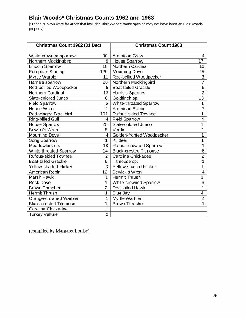
Blair Woods* Christmas Counts 1962 and 1963 [*These surveys were for areas that included Blair Woods; some species may not have been on Blair Woods property]
Christmas Count 1962 (31 Dec) Christmas Count 1963 White-crowned sparrow 30 American Crow 4 Northern Mockingbird 9 House Sparrow 17 Lincoln Sparrow 18 Northern Cardinal 16 European Starling 129 Mourning Dove 45 Myrtle Warbler 11 Red-bellied Woodpecker 3 Harris’s sparrow 28 Northern Mockingbird 7 Red-bellied Woodpecker 5 Boat-tailed Grackle 5 Northern Cardinal 13 Harris’s Sparrow 2 Slate-colored Junco 8 Goldfinch sp. 13 Field Sparrow 5 White-throated Sparrow 1 House Wren 2 American Robin 7 Red-winged Blackbird 191 Rufous-sided Towhee 1 Ring-billed Gull 4 Field Sparrow 4 House Sparrow 25 Slate-colored Junco 1 Bewick’s Wren 8 Verdin 1 Mourning Dove 4 Golden-fronted Woodpecker 1 Song Sparrow 1 Killdeer 1 Meadowlark sp. 18 Rufous-crowned Sparrow 1 White-throated Sparrow 14 Black-crested Titmouse 6 Rufous-sided Towhee 2 Carolina Chickadee 2 Boat-tailed Grackle 6 Titmouse sp. 1 Yellow-shafted Flicker 3 Yellow-shafted Flicker 1 American Robin 12 Bewick’s Wren 4 Marsh Hawk 1 Hermit Thrush 1 Rock Dove 1 White-crowned Sparrow 6 Brown Thrasher 2 Red-tailed Hawk 1 Hermit Thrush 1 Blue Jay 4 Orange-crowned Warbler 1 Myrtle Warbler 2 Black-crested Titmouse 1 Brown Thrasher 1 Carolina Chickadee 1 Turkey Vulture 2 (compiled by Margaret Louise)
76
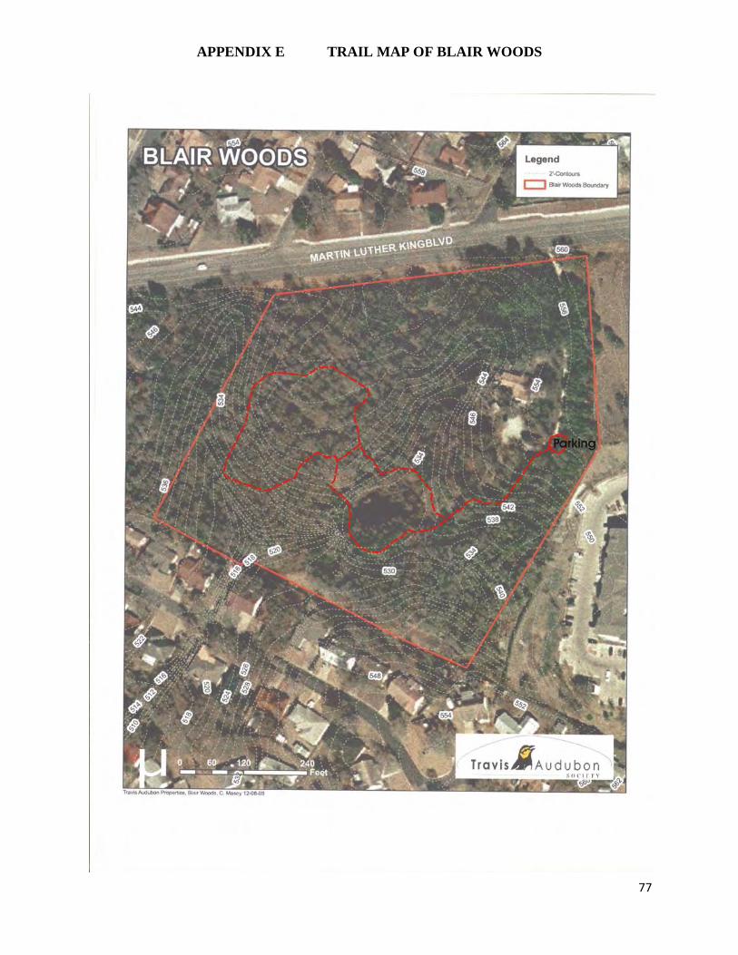
APPENDIX E TRAIL MAP OF BLAIR WOODS
77
Related Documents