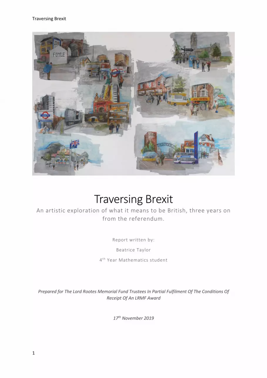
Traversing Brexit 1 Traversing Brexit An artistic exploration of what it means to be British, three years on from the referendum. Report written by: Beatrice Taylor 4 th Year Mathematics student Prepared for The Lord Rootes Memorial Fund Trustees In Partial Fulfilment Of The Conditions Of Receipt Of An LRMF Award 17 th November 2019

Welcome message from author
This document is posted to help you gain knowledge. Please leave a comment to let me know what you think about it! Share it to your friends and learn new things together.
Transcript
Traversing Brexit
1
Traversing Brexit An artistic exploration of what it means to be British, three years on
from the referendum.
Report written by:
Beatrice Taylor
4 th Year Mathematics student
Prepared for The Lord Rootes Memorial Fund Trustees In Partial Fulfilment Of The Conditions Of Receipt Of An LRMF Award
17th November 2019

Traversing Brexit
2

Traversing Brexit
3
Table of Contents Table of Illustrations ............................................................................................................................... 3
Synopsis .................................................................................................................................................. 6
Acknowledgements ................................................................................................................................. 6
Introduction ............................................................................................................................................ 7
Travel Diary ............................................................................................................................................. 9
Before the Journey Began ................................................................................................................... 9
Traversing the Districts ..................................................................................................................... 10
Haringey (75.6% Remain) .............................................................................................................. 10
Lambeth (78.6% Remain) .............................................................................................................. 15
Castle Point (72.7% Leave) ............................................................................................................ 19
Thurrock (72.3% Leave) ................................................................................................................ 23
Hackney (78.5% Remain) .............................................................................................................. 28
Great Yarmouth (71.5% Leave) ..................................................................................................... 33
Foyle (78.3% Remain) ................................................................................................................... 40
South Holland (73.6% Leave) ........................................................................................................ 46
Boston (75.6% Leave) .................................................................................................................... 52
Gibraltar (95.9% Remain) .............................................................................................................. 57
Conclusion ......................................................................................................................................... 63
After the Physical Journey - A Piece of Artwork in Conclusion ......................................................... 64
Limitations ............................................................................................................................................ 69
Analysis ................................................................................................................................................. 69
Personal Reflection ............................................................................................................................... 70
Summary ............................................................................................................................................... 70
Recommendations ................................................................................................................................ 71
Accounting Statement .......................................................................................................................... 71
Summary of Costs ............................................................................................................................. 72
Breakdown of Travel Costs ............................................................................................................... 72
Breakdown of Accommodation Costs ............................................................................................... 73
Breakdown of Art Supplies Costs ...................................................................................................... 73
Table of Illustrations Figure 1: Drawing of pawn shop in Muswell Hill, Haringey. ................................................................. 12 Figure 2: ‘Golden Meat’. A shop front which made me laugh (as I wondered if there was a missing word) in South Tottenham, Haringey. .................................................................................................. 13 Figure 3: Photograph of a street in South Tottenham, Haringey. ........................................................ 13

Traversing Brexit
4
Figure 4: Pawn shop in Muswell Hill, Haringey. .................................................................................... 13 Figure 5: Shop front in Muswell Hill, Haringey. .................................................................................... 13 Figure 6: Sketch of Turnpike Lane, Haringey. ....................................................................................... 14 Figure 7: Drawing of the street outside Turnpike Lane Station, Haringey. .......................................... 14 Figure 8: Sketch of London, drawn whilst stood in a nook in the exterior of Alexandra Palace, Haringey. ............................................................................................................................................... 14 Figure 9: A sketch of the flower garden I sat in, Kennington Park, Lambeth. ...................................... 16 Figure 10: A street in Vauxhall, in the distance The Shard disappears into cloud, Lambeth. .............. 17 Figure 11: Photograph of a lush green park in Lambeth. ..................................................................... 17 Figure 12: Photograph of a housing block in Vauxhall, Lambeth. ........................................................ 17 Figure 13: An unusual mosaic on a building in Vauxhall, Lambeth. ..................................................... 17 Figure 14: Drawing of Brixton Underground Station, drawn from a cafe in the 2nd floor of the building opposite, Lambeth. ................................................................................................................. 18 Figure 15: Photograph of the path alongside the sea wall around Canvey Island, Castle Point. ......... 19 Figure 16: Sketch of the Bingo hall on Canvey Island, Castle Point. ..................................................... 21 Figure 17: Drawing of colourful signage found on Canvey Island, Castle Point. .................................. 21 Figure 18: Rough scrubland where the easterly point of Canvey Island meets the estuary, Castle Point. ..................................................................................................................................................... 22 Figure 19: Photograph of cars, boats and flags on Canvey island, Castle Point. .................................. 22 Figure 20: Sketch of the market outside the cafe I was sat in, Grays, Thurrock. ................................. 23 Figure 21: Shop signage in Grays, Thurrock. ......................................................................................... 24 Figure 22: View from Grays wharf across the Thames Estuary, Thurrock. ........................................... 26 Figure 23: Wharf at Grays, Thurrock. .................................................................................................... 26 Figure 24: Church of His Presence, down a side street in Grays, Thurrock. ......................................... 27 Figure 25: New housing development by the wharf at Grays, Thurrock. ............................................ 27 Figure 26: Housing blocks near to the wharf in Grays, Thurrock. ......................................................... 27 Figure 27: Shop front in Grays, Thurrock. ............................................................................................. 27 Figure 28: Drawing of Hackney Emipre at rush hour, Hackney. ........................................................... 30 Figure 32: Towering housing block near London Fields, Hackney. ....................................................... 31 Figure 29: Photograph of a dilapidated block of social housing, Hackney. .......................................... 31 Figure 31: Tombstones in Abney Park, Hackney. ................................................................................. 31 Figure 30: Photograph of Hackney Empire, Hackney. .......................................................................... 31 Figure 33: 'Boris Limited', political statement or abandoned building? Hackney. ............................... 32 Figure 34: Social Housing near London Fields, Hackney. ...................................................................... 32 Figure 35: More crumbling tombstones in Abney park, Hackney. ....................................................... 32 Figure 36: Drawing of holidaymakers on Hemsby beach, with Sandy Banks windfarm on the horizon, Great Yarmouth. ................................................................................................................................... 34 Figure 37: Drawing of holidaymakers perusing stalls on Regent Road, Great Yarmouth..................... 35 Figure 38: The Winter Gardens on Great Yarmouth's seafront. Currently Listed as one of Britain’s most endangered listed buildings. ........................................................................................................ 37 Figure 39: Gateway to the rugged beach at Caister-on-Sea, Great Yarmouth. .................................... 37 Figure 40: Regent Road, Great Yarmouth. ............................................................................................ 37 Figure 41: Tourists making their way towards the beach, Regent Road, Great Yarmouth. ................. 37 Figure 42: Drawing of Regent Road, Great Yarmouth. ......................................................................... 38 Figure 43: Holidaymakers bask in the sun on Great Yarmouth beach. ................................................ 39 Figure 44: Deckchairs for rent on Great Yarmouth beach. ................................................................... 39 Figure 45: A street in the historic south quay area of Great Yarmouth. .............................................. 39 Figure 46: Drawing of Ferryquay gate, one of the many gates into the historic walled city, Foyle. .... 40

Traversing Brexit
5
Figure 47: View across the River Foyle towards the peace bridge, Foyle............................................. 41 Figure 48: Visiting Bogside with our tour guide who grew up on this street during the Troubles, Foyle. .............................................................................................................................................................. 43 Figure 49: Drawing of tourists at Free Derry Corner, Foyle. ................................................................. 44 Figure 50: Drawing of the Derry wall where it borders Bogside, Foyle. ............................................... 44 Figure 51: Sculpture by Anthony Gormley on the city wall, Foyle. ....................................................... 45 Figure 52: Graffiti reading 'IRA' on a gate outside social housing in Bogside, Foyle. ........................... 45 Figure 53: Photograph through a crack in the Peace Wall towards the Protestant part of town. The flags are the Union Jack and the Ulster Banner. ................................................................................... 45 Figure 54: View from the churchyard of St Columb’s Protestant Cathedral, Foyle. ............................. 45 Figure 55: Drawing of the inside of a cosy cafe in the grounds of Ayscoughfee Hall, South Holland. . 47 Figure 56: Sketch of street scene in Spalding, South Holland. ............................................................. 48 Figure 57: The Friar's Oven in Spalding, purveyors of 'Brexit IPA'. ....................................................... 50 Figure 58: Next door to Ayscoughfee Hall, South Holland. .................................................................. 50 Figure 59: Derelict building in Spalding, South Holland. ....................................................................... 50 Figure 60: Locals go about their business in Spalding, South Holland. ................................................. 50 Figure 61: Shop front with old fashioned yellow plastic covering the windows in Holbeach, South Holland. ................................................................................................................................................. 51 Figure 62: Street in Holbeach, South Holland. ...................................................................................... 51 Figure 63: The placard advertising Brexit beer which caught our eye, South Holland. ........................ 51 Figure 64: Inside a church in Holbeach, South Holland. ....................................................................... 51 Figure 65: Sketch of Boston lock. .......................................................................................................... 53 Figure 66: Inside St Botolph's Church Laura peruses the books. .......................................................... 54 Figure 67: The Brexit Party canvassing in the streets of Boston. .......................................................... 54 Figure 68: St Botolph's Church, Bosotn. ............................................................................................... 54 Figure 69: View across The Wash to the sea. ....................................................................................... 54 Figure 70: Drawing of a European supermarket, Boston. ..................................................................... 55 Figure 71: Photograph of the Highstreet in Boston. ............................................................................. 56 Figure 72: A dilapidated house near the church prompts Laura to ask me how I am choosing to frame each area, Boston. ................................................................................................................................ 56 Figure 73: Drawing of Casemates square, Gibraltar. ............................................................................ 58 Figure 74: The Spanish influence is evident in many of the buildings. ................................................. 60 Figure 75: Union Jacks as far as the eye can see, Gibraltar. ................................................................. 60 Figure 76: 'Warning, slow Brexit', Gibraltar. ......................................................................................... 60 Figure 77: A military parade passes along the highstreet, Gibraltar. ................................................... 60 Figure 78: Drawing of Casemates square by night, Gibraltar. .............................................................. 61 Figure 79: The Union Jack, and the EU flag fly high. ............................................................................. 62 Figure 80: Tourists and locals in casemates square. ............................................................................. 62 Figure 81: A mosque at the southern tip of the island, Gibraltar. ........................................................ 62 Figure 82: The rock looms over a residential area. ............................................................................... 62 Figure 83: Sample embroidery I did based on a street scene in Great Yarmouth. ............................... 64 Figure 84: My set up for the large scale embroidery. I had to set it up on a full embroidery stand, so that I could support the weight of the fabric, and keep the canvas taut whilst I worked. . ................. 65 Figure 85: Progress I made on the large scale embroidery before deciding that a different medium would be more appropriate. ................................................................................................................. 65 Figure 86: Finished piece of artwork depicting the 'Remain' districts. ................................................. 67 Figure 87: Finished piece of artwork depicting the 'Leave' districts. .................................................... 68
Traversing Brexit
6
Synopsis This project presents an illustrated diptych, and accompanying multimedia diary exploring modern Britain through the districts which voted most decisively in the EU referendum. The project was undertaken over the summer of 2019, which marked three years on from the initial referendum.
The main body of the project involved travelling to the five districts which had the highest Remain voting percentage and the five districts with the highest Leave voting percentage. During this time I made numerous sketches, took photographs and recorded my thoughts. This body of work then informed my final, larger piece of artwork. The aim of the project was not to consider the politics, or the political ramifications of the vote, but rather to use Brexit as a starting point to explore modern British identity. I hoped that by travelling to the districts I visited I would be able to get an idea of a society which has never been so split.
Acknowledgements I would like to thank the Lord Rootes Memorial Fund for their support, without which I would never have been able to embark on this project.
I would also like to thank Mary Griffin of Lacuna Magazine (and Warwick Law Department), for her encouragement of my application to the fund, her ongoing support with the project, and facilitation of the accompanying published article.
I would also like to thank my friend Laura, who travelled through Lincolnshire with me, and was a fantastic companion. She happily waited whilst I sketched, or took photographs and asked many thoughtful questions about the direction of my project .
Also thanks to my friend Nisha for supporting me as I applied to the fund, and listening patiently to my ideas.
Finally, a thank you to my Mum, for encouraging my ideas, and providing a sounding board for what I wanted to do. Her companionship in Gibraltar was lovely, and I am very grateful for her positive affirmations as well as the constructive criticism.

Traversing Brexit
7
Introduction When I initially outlined this project back in January of 2019, I didn’t know exactly what to expect. I wondered at the time if perhaps a project about Brexit would no longer be relevant by the time I came to complete it. I couldn’t have been more wrong, as somewhat unbelievably, Brexit now seems to command even more attention of the media, the public and the decision makers.
The period during which the project was undertaken marked a turbulent time for British politics. On July 23rd Boris Johnson was elected as Prime Minister after Theresa May’s resignation, following the third unsuccessful vote in the commons on her Brexit deal. On September 3rd the Conservatives lost a working majority in the House of Commons. On September 6th the Benn Bill was passed, demanding that we wouldn’t Leave the EU at the end of October without parliaments assent. On September 11th the Edinburgh Court of Session ruled that Boris’s Johnsons proroguing of parliament was unlawful, on the same day the ‘Operation Yellowhammer’ papers were leaked detailing the potential impacts of a no deal Brexit. Since I finished the travelling a general election has been called for December 12th, which many hope will settle the Brexit stalemate.
The aim of the project was not to explore the political ramifications of Brexit, or to blame people for what happened, but rather to use the referendum as a starting point to explore the condition of modern Britain. I hoped that by visiting the five Leave and Remain districts I would see a cross-section of the polarisation of the UK, which would help to inform me of Britain’s current social and economic landscape.
The districts that I visited were, in order of voting percentages, as follows,
- Boston, Lincolnshire. 75.6% Leave. - South Holland, Lincolnshire. 73.6% Leave. - Castle Point, Essex. 72.7% Leave. - Thurrock, Essex. 72.3% Leave. - Great Yarmouth, Norfolk. 71.5% Leave.
- Gibraltar, Overseas Territory, Spanish Coast. 95.9% Remain - Lambeth, London. 78.6% Remain. - Hackney, London. 78.5% Remain. - Foyle, Northern Ireland. 78.3% Remain. - Haringey, London. 75.6% Remain.
As the project developed, it became clear that in order to explore the current condition of Britain I also needed to consider the condition of Britain in the past century, and what recent history might have influenced different communities views on the EU.
I never wanted the project to sermonise, however as I travelled around the districts the desire to comment on the best and worst aspects seemed increasingly necessary. The following diary, of travelling around the ten districts records my personal impressions of each area, alongside some of the local politics and history that I felt compelled to learn

Traversing Brexit
8
about. Alongside a written discussion of each district are photographs that I took, as well as the illustrations I made.
I physically journeyed to each of the districts, and in each district I spent anywhere between a couple of days and an afternoon exploring and making observations of the area. Initially I had intended to make a large scale embroidery to summarise my experiences, however after realising the practical difficulty of this I ended up creating a pair of large scale drawings. At the end of my travel diary I have discussed the process of making the artwork. I also wrote an article for Lacuna Magazine, about my trip and the outcomes, which will be illustrated by my artwork, and is due to be published in the coming months.
Traversing Brexit
9
Travel Diary Before the Journey Began In term three of the 2018/19 academic year I came across the term ‘allokataplixis‘1. The word is the conjugation of ‘allo’, Greek for other, and ‘katapliktiko’ meaning wonder. It was term invented by an ecologist, Liam Heneghan, to describe the wonder of visiting a new place for the first time. This is one of the main ideas I had in my head prior to starting travelling. I wanted to experience allokataplixis everywhere that I visited. As such I decided I wanted my exploration of each area to be quite organic, I didn’t want to have a strict timetable. However as every district I intended to visit (apart from Hackney and Lambeth) was new to me, I did do some light research into each area. I read a few Wikipedia pages, and for each area I found a local, online, newspaper which might give me an idea of any recent regional politics. Most of my prior research consisted of scrolling through Trip Advisor for each area. Whilst I wanted to make sure I was doing relevant activities, I was also excited to visit some museums that I had read about in each area, such as the Moorish Castle in Gibraltar, Victoria Miro art gallery in Hackney and the Gordon Boswell Romany Museum in South Holland. Whilst these were primarily motivated by a personal interest, I also hoped that in visiting them I would learn about the history of the local area, or at the least get an impression of the community.
Before setting out to travel to the districts I went on an embroidery course in Birmingham, to try and learn some new skills, which I hoped would be useful in the completion of my final piece of artwork. I took the most relevant course I could find, however the techniques I learnt were mostly to do with working metallic threads and decals. This was somewhat disappointing, as I had been hoping to learn some ‘silk-shading’ techniques.
As I set out to travel to these districts, I was expecting to prefer the areas which voted Remain, as I assumed they would largely coincide with an idealised view of how I would like to see Britain today. Across the ten districts I found a Britain that was both compact in the urban areas, and isolated in the areas which were remote due to geography and infrastructure. Everywhere I found communities struggling under the cutbacks of austerity and the crisis in the lack of council housing. Some districts like Gibraltar and Castle Point were incredibly patriotic, whilst in other areas a lack of integration had led to racial tensions. In Lambeth, Haringey and Hackney I found a Britain which was financially rich, but also a Britain where over 1 in 5 people are living in poverty.2 Meanwhile in Foyle I found a Britain only just facing up to responsibility for its actions in the Troubles.3
1 Walker, Rob. (2019) The art of noticing: five ways to experience a city differently. [Online] Available from: https://www.theguardian.com/cities/2019/may/09/the-art-of-noticing-five-ways-to-experience-a-city-differently (Accessed: 15 November 2019). 2 Barnard, H. (2018) UK Poverty 2018. UK: Joseph Rowntree Foundation. 3 McClements, F. (2019) Bloody Sunday: Case against Soldier F to begin in Derry. [Online] Available from: https://www.irishtimes.com/news/ireland/irish-news/bloody-sunday-case-against-soldier-f-to-begin-in-derry-1.4021393 (Accessed: 26 October 2019) .
Traversing Brexit
10
Traversing the Districts Haringey (75.6% Remain) Haringey is a district in North London. It is home to Alexandra Palace, as well as the neighbourhoods of Muswell Hill, Crouch End, Highgate and Wood Green amongst others.
I arrived in Haringey on a grey June day. Whilst I was on the tube the heavens had opened and rain was pelting down. The sky was grey and clouded but Wood Green was full of people bustling past hundreds of brightly coloured shop fronts that stood out from the gloom. Puddles were forming on the roads as cars sped past, I walked along the high street, dipping in and out of shops for shelter. The street was full of fast food outlets intermingled with charity shops. At the end of the road there was a large shopping mall, teenagers caroused around the shops whilst women, weighed down by bags trudged up elevators. Behind the streets of shops blocks of council houses were visible.
In Haringey 29.3% of housing4 is council owned. In the district 25 in 1000 households5 are in temporary accommodation, which makes Haringey the London borough with the 3rd highest percent of temporary accommodation after Kensington/Chelsea and Newham. The average in England is just 3.4 households in temporary accommodation in every 1000 households.
Gradually as I walked further from Wood Green the wet, teeming pavements merged to the parkland surrounding Alexandra palace. The Palace is located on a hill, and as I climbed a panorama of misty London appeared between shrubs and trees.
The Palace itself was imposing but not in the way I had expected. I was expecting to find a building that reflected the drawings I’d seen of the 1851 exhibition but what I found was a humungous but largely deserted structure perched on a hill top. The palace promised attractions like ice skating and theatre but all doors were locked. A few mothers with prams roamed the grounds and a couple of teenagers smoked in a sheltered picnic area. A nook, near to the entrance to the BBC broadcasting tower, offered me respite from the rain. The location also offered a culmination to the misty views of London I glimpsed on route up the hill. Stood there alone at the top of the hill felt exhilarating, with the foggy landscape of Central London strewn at my feet.
I descended Alexandra Palace to the west and headed to Muswell Hill. The contrast to Wood Green was massive. Muswell Hill was the image of gentrified suburbia, new pubs claimed heritage and homeliness, whilst little cafes proffered artisan food. Many of the buildings were Georgian and Victorian, out of which passed stylish young men and women, slipping into the organic supermarket nearby. The average price of a property in Muswell Hill is
4 Office for National Statistics. (2017) Housing Tenure by Borough. [Online] Available from: https://data.london.gov.uk/dataset/housing-tenure-borough (Accessed: 26 October 2019). 5 Ministry of Housing, Communities and Local Government. (2018) Households in temporary accommodation per 1000 households, England, District. [Online] Available from: https://opendatacommunities.org/slice?dataset=http%3A%2F%2Fopendatacommunities.org%2Fdata%2Fhomelessness%2Fhouseholds-accommodated-per-1000%2Ftemporary-housing-types&http%3A%2F%2Fopendatacommunities.org%2Fdef%2Fontology%2Ftime%2FrefPeriod=http%3A%2F%2Freference.data.gov.uk%2Fid%2Fquarter%2F2018-Q1 (Accessed: 26 October 2019).
Traversing Brexit
11
£739,144, 34.1% above the London average.6 The average salary in Muswell Hill is in 2016 was in excess of £1,340 a week7. In comparison, in Tottenham Hale, which is the most easterly part of Haringey district, the average weekly salary is less than half of this.
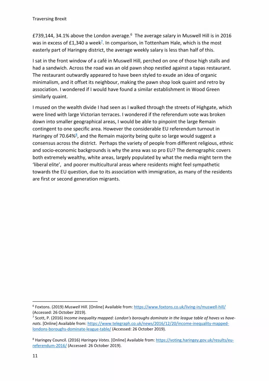
I sat in the front window of a café in Muswell Hill, perched on one of those high stalls and had a sandwich. Across the road was an old pawn shop nestled against a tapas restaurant. The restaurant outwardly appeared to have been styled to exude an idea of organic minimalism, and it offset its neighbour, making the pawn shop look quaint and retro by association. I wondered if I would have found a similar establishment in Wood Green similarly quaint.
I mused on the wealth divide I had seen as I walked through the streets of Highgate, which were lined with large Victorian terraces. I wondered if the referendum vote was broken down into smaller geographical areas, I would be able to pinpoint the large Remain contingent to one specific area. However the considerable EU referendum turnout in Haringey of 70.64%8, and the Remain majority being quite so large would suggest a consensus across the district. Perhaps the variety of people from different religious, ethnic and socio-economic backgrounds is why the area was so pro EU? The demographic covers both extremely wealthy, white areas, largely populated by what the media might term the ‘liberal elite’, and poorer multicultural areas where residents might feel sympathetic towards the EU question, due to its association with immigration, as many of the residents are first or second generation migrants.
6 Foxtons. (2019) Muswell Hill. [Online] Available from: https://www.foxtons.co.uk/living-in/muswell-hill/ (Accessed: 26 October 2019). 7 Scott, P. (2016) Income inequality mapped: London's boroughs dominate in the league table of haves vs have-nots. [Online] Available from: https://www.telegraph.co.uk/news/2016/12/20/income-inequality-mapped-londons-boroughs-dominate-league-table/ (Accessed: 26 October 2019). 8 Haringey Council. (2016) Haringey Votes. [Online] Available from: https://voting.haringey.gov.uk/results/eu-referendum-2016/ (Accessed: 26 October 2019).
Traversing Brexit
12
Figure 1: Drawing of pawn shop in Muswell Hill, Haringey.
Traversing Brexit
13
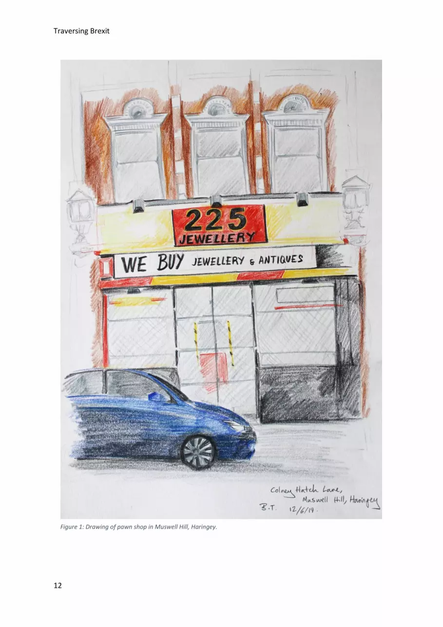
Figure 5: Shop front in Muswell Hill, Haringey. Figure 4: Pawn shop in Muswell Hill, Haringey.
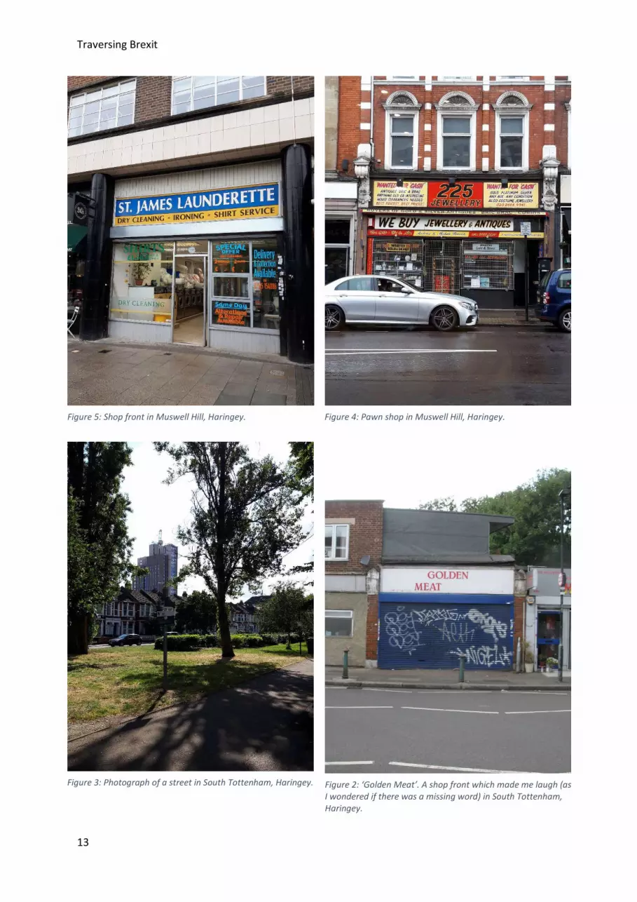
Figure 3: Photograph of a street in South Tottenham, Haringey. Figure 2: ‘Golden Meat’. A shop front which made me laugh (as I wondered if there was a missing word) in South Tottenham, Haringey.

Traversing Brexit
14
Figure 7: Drawing of the street outside Turnpike Lane Station, Haringey.
Figure 6: Sketch of Turnpike Lane, Haringey.
Figure 8: Sketch of London, drawn whilst stood in a nook in the exterior of Alexandra Palace, Haringey.
Traversing Brexit
15
Lambeth (78.6% Remain) Lambeth is a district in London south of the river Thames. The district encompasses Lambeth and Vauxhall in the north of the district, as well as the areas of Brixton, Clapham and Streatham.
The next day I woke early and started my visit to Lambeth, by crossing Lambeth bridge across the Thames. The area of Lambeth on the Thames is dominated by large monolithic buildings, their glass facades towering above you. However as you walk further south Lambeth quickly sprawls into residential areas, with small rows of shops. I wondered through Kennington Park near to Vauxhall. It had been raining in the night and there was a fresh but damp smell in the air. In a corner of the park I came across a beautiful rose garden, the flowers were just coming in to full bloom and swaying climbers bursting with buds framed a snapshot vista of city dwellings. Just as I settled into the view, rain started to fall and I decided to head back to the museum dominated area along the bank of the Thames in order to wait out the downpour.
I wondered around Vauxhall and ate lunch at an artsy subterranean vegetarian restaurant. At the table nearby sat a young woman, definitely no older than thirty wearing an incredibly elegant camel coloured trousers, cream top and boots, enjoying a glass of water and a bowl of salad as she watched a video on her phone. I breathed a sigh of relief that I was not the only solo diner. The restaurant proffered a selection of salads for lunch, alongside a daily special, which I chose, which was a flaky, pastry tart.
The rain eased off and I headed to Brixton. Stepping out of Brixton underground was like stepping into an explosion of colour. Brixton was teeming with life and energy, a seeming antithesis to the chic but quiet Vauxhall I had just left. There were people everywhere, all different ethnicities, ages and religions, going about their business, cycling to work, kids coming home from school, elderly ladies out grocery shopping. I aimlessly meandered around Brixton, noticing a mural of Bowie, who famously grew up in the neighbourhood. Afterwards I headed west to Clapham, on the edge of Lambeth district. Clapham struck me as not dissimilar to Muswell Hill, gentrified whilst still retaining aspects of its past, visible in the store fronts which appeared to have never been renovated since the 1990s.
In Haringey I was struck by the wealth divide, and this was something I noticed in Lambeth too. Lambeth has one of the highest rates of infant and premature mortalities of any London borough.9 Lambeth is also one of the London boroughs with the highest amount of referrals to the London Mayors new county lines prevention strategy, which looks to engage with people, largely male teenagers, who are involved in the cross-county drug smuggling. Its estimated that in Lambeth between 200-300 young people are involved in the county lines epidemic.10
9 Trust for London. (2019) Lambeth: Poverty and inequality data for Lambeth. [Online] Available from: https://www.trustforlondon.org.uk/data/boroughs/lambeth-poverty-and-inequality-indicators/ (Accessed: 27 October 2019). 10 London Government. (2019) Rescue and Response county Lines Project. [Online] Available from: https://www.london.gov.uk/sites/default/files/rescue_and_response_county_lines_project_strategic_assessment_2019.pdf (Accessed: 27 October 2019).
Traversing Brexit
16
By contrast in 2016, Vauxhall was voted one of the most up and coming places to live in London.11 The house prices in Vauxhall have increased by almost 15% over the last 4 years, with the average property now costing in excess of £790,000. 12
In Lambeth 14% of residents are EU nationals, and the council is currently preparing for a skill shortage across the job market in the wake of Brexit.13 Much like some of the Leave areas I visited Lambeth is home to a large amount of EU migrants, however given the districts long standing history of being a diverse multicultural community there is much more sympathy towards migration. Given the poor living conditions in part of Lambeth its surprising the residents didn’t share some of the apathy felt by the Leave areas, however presumably for them such apathy is not directed at the EU.
11 Mann, S. (2016) Best places to live in London: Vauxhall, Bermondsey and Crystal Palace make prestigious list. [Online] Available from: https://www.standard.co.uk/news/london/best-places-to-live-in-london-vauxhall-bermondsey-and-crystal-palace-make-prestigious-list-a3207686.html (Accessed: 26 October 2019). 12 Foxtons. (2019) [Online] Vauxhall. Available from: https://www.foxtons.co.uk/living-in/vauxhall/ (Accessed: 26 October 2019). 13 Lambeth Council. (2018) Brexit: risks and issues for Lambeth. [Online] Available from: https://moderngov.lambeth.gov.uk/documents/s100000/App_A_Brexit_December_Cab18.pdf (Accessed: 27 October 2019).
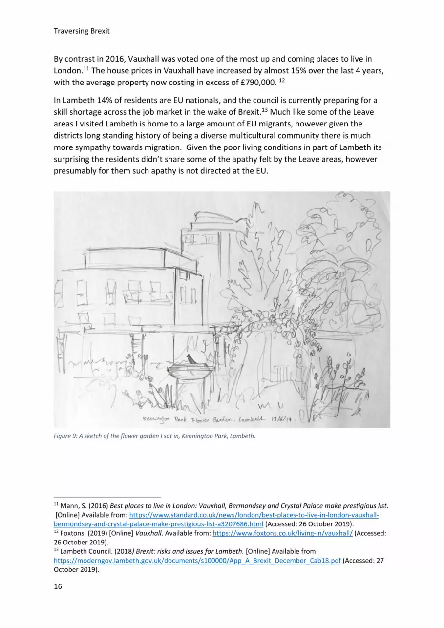
Figure 9: A sketch of the flower garden I sat in, Kennington Park, Lambeth.

Traversing Brexit
17
Figure 13: An unusual mosaic on a building in Vauxhall, Lambeth.
Figure 12: Photograph of a housing block in Vauxhall, Lambeth.
Figure 10: A street in Vauxhall, in the distance The Shard disappears into cloud, Lambeth.
Figure 11: Photograph of a lush green park in Lambeth.

Traversing Brexit
18
Figure 14: Drawing of Brixton Underground Station, drawn from a cafe in the 2nd floor of the building opposite, Lambeth.
Traversing Brexit
19
Castle Point (72.7% Leave) Castle point is a district in south Essex, dominated by Canvey island. The district encompasses the towns of South Benfleet, Hadleigh, Thundersley and Canvey as well as some smaller villages.
I arrived in a beautifully sunny Castle Point by way of a wet London. Knowing of its former life as a tourist honey trap I was keen to visit Canvey island, so at Benfleet I hopped on the local bus service which took me onto Canvey island. Apart from me and a couple of secondary school kids in crumpled shirts and ties, the bus was wholly populated by frail looking white pensioners. When I got on the bus and requested a ticket to Canvey island the driver looked at me perplexed. He seemed genuinely surprised by my intended destination.
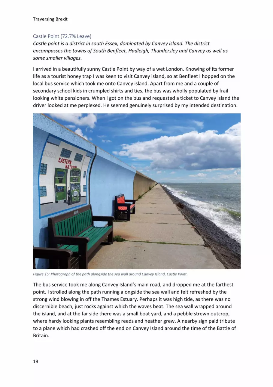
The bus service took me along Canvey Island’s main road, and dropped me at the farthest point. I strolled along the path running alongside the sea wall and felt refreshed by the strong wind blowing in off the Thames Estuary. Perhaps it was high tide, as there was no discernible beach, just rocks against which the waves beat. The sea wall wrapped around the island, and at the far side there was a small boat yard, and a pebble strewn outcrop, where hardy looking plants resembling reeds and heather grew. A nearby sign paid tribute to a plane which had crashed off the end on Canvey Island around the time of the Battle of Britain.
Figure 15: Photograph of the path alongside the sea wall around Canvey Island, Castle Point.

Traversing Brexit
20
Canvey Island seemed like a time capsule of Britain of yester-year. The island itself is surrounded by a large sea wall protecting it from the Thames Estuary and North Sea, it can only be accessed by two roads which attach it to the rest of Essex. At low tide, beaches are revealed which were once popular with day trippers in the 1950s. Most of the buildings on the island are residential, with a small high street clustered in the centre of the island. There’s occasionally the odd building which hints at the glory days of Canvey Island, like an art deco café or an 1930s cinema turned bingo hall, which sits out of place, nestled amongst bungalows. Most of the homes are of an inter-war and post-war architectural style, with the occasional dwelling capturing Miami modernism on a much smaller scale.
The people there were charming, everyone I passed in the streets, whether teenagers, pensioners or young mums greeted me with a cheery hello. This friendly attitude and the surprisingly glorious weather made my visit to Canvey island feel like a reviving tonic compared to the London I had just left. A residential road led down to a green common, which had a few scattered flower beds and a dormant fun fair. A middle aged man cycled round on a small bike as he clutched a boombox to his shoulder, his dyed black hair slicked back like a 1950’s greaser.
My impression during my time there was that the residents of Castle Point were all white British, and quite old. Of course I was visiting on a weekday, and visiting any rural town on a weekday in Britain you are likely to notice the pavements are largely populated by pensioners. However based on the curious expressions some of the residents greeted me with I got the impression that day trippers and holiday makers, like me, were seldom seen.
I surprised myself liking this area as much as I did, given my expectation before I visited that it would be a right-wing bastion of Britain’s glory days. However the profusion of homely bungalows with the little front yards, the sea views, and the small town attitude of the residents endeared me to this place, despite its residents politics and voting record. I did get the impression however that Castle Point had seen better days. I was reminded of an article I read recently in The Guardian chronicling the evolution of modern Essex.14 The article discussed how for centuries Essex has been home to Londoners moving East in the hope of more space and greater opportunities. This is still happening today, the orthodox Jewish community of Stamford Hill are currently looking to resettle on Canvey Island, due to rising property prices in London.15 The culture of Londoners moving out to the suburbs seems to have bred a culture of aspirational Toryism, reflected in the politics and opinions of the region. However, even within this model, Castle Point seems like an extreme, perhaps due to its geography of being a bit detached from the rest of Essex.
14 Burrows, T. (2019) The invention of Essex: how a county became a caricature. [Online] Available from: https://www.theguardian.com/news/2019/jun/27/the-invention-of-essex-how-a-county-became-a-caricature (Accessed: 27 October 2019). 15 Romain, J. (2018) Stamford Hill's ultra-Orthodox Jewish community is moving to Canvey Island – as a rabbi, I'm cautiously optimistic. [Online] Available from: https://www.independent.co.uk/voices/orthodox-judaism-canvey-island-bbc-stamford-hill-integration-prejudice-a8149546.html (Accessed: 27 October 2019).

Traversing Brexit
21
In 2011 nearly 80% of the people of South Point considered themselves to be ‘purely English’.16 With the recent influx of members of the Hasidic Jewish community, and an increasing number of Londoners looking to move to the suburbs, I wonder who will be living in Castle Point in 20 years’ time? By then many of the older generation who voted for Brexit won’t be alive to see the outcome, but the area may well be full of young families of a variety of different religions and ethnicities. I wonder how the older generation would have voted if they’re known about that?
16 Erlanger, S. (2016) European? British? These ‘Brexit’ Voters Identify as English. [Online] Available from: https://www.nytimes.com/2016/06/17/world/europe/european-union-britain-brexit-voters-english.html (Accessed: 27 October 2019).
Figure 16: Sketch of the Bingo hall on Canvey Island, Castle Point.
Figure 17: Drawing of colourful signage found on Canvey Island, Castle Point.
Traversing Brexit
22
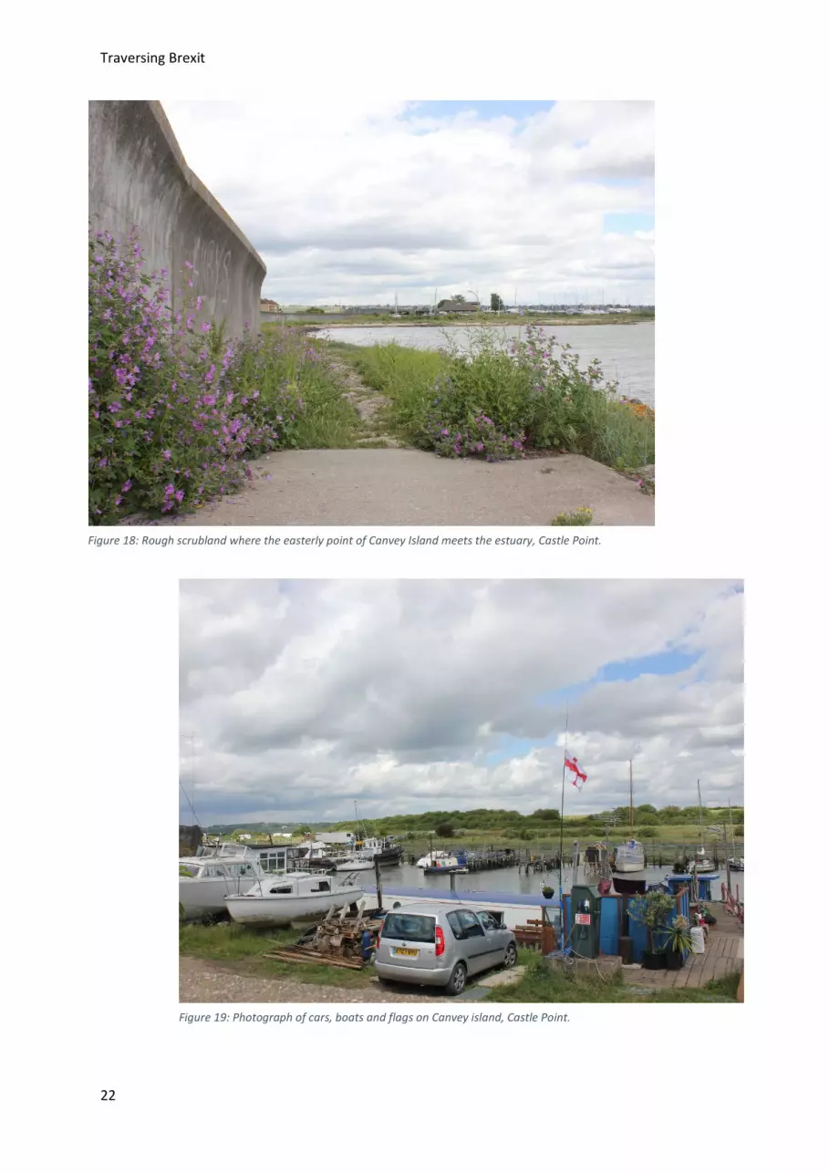
Figure 18: Rough scrubland where the easterly point of Canvey Island meets the estuary, Castle Point.
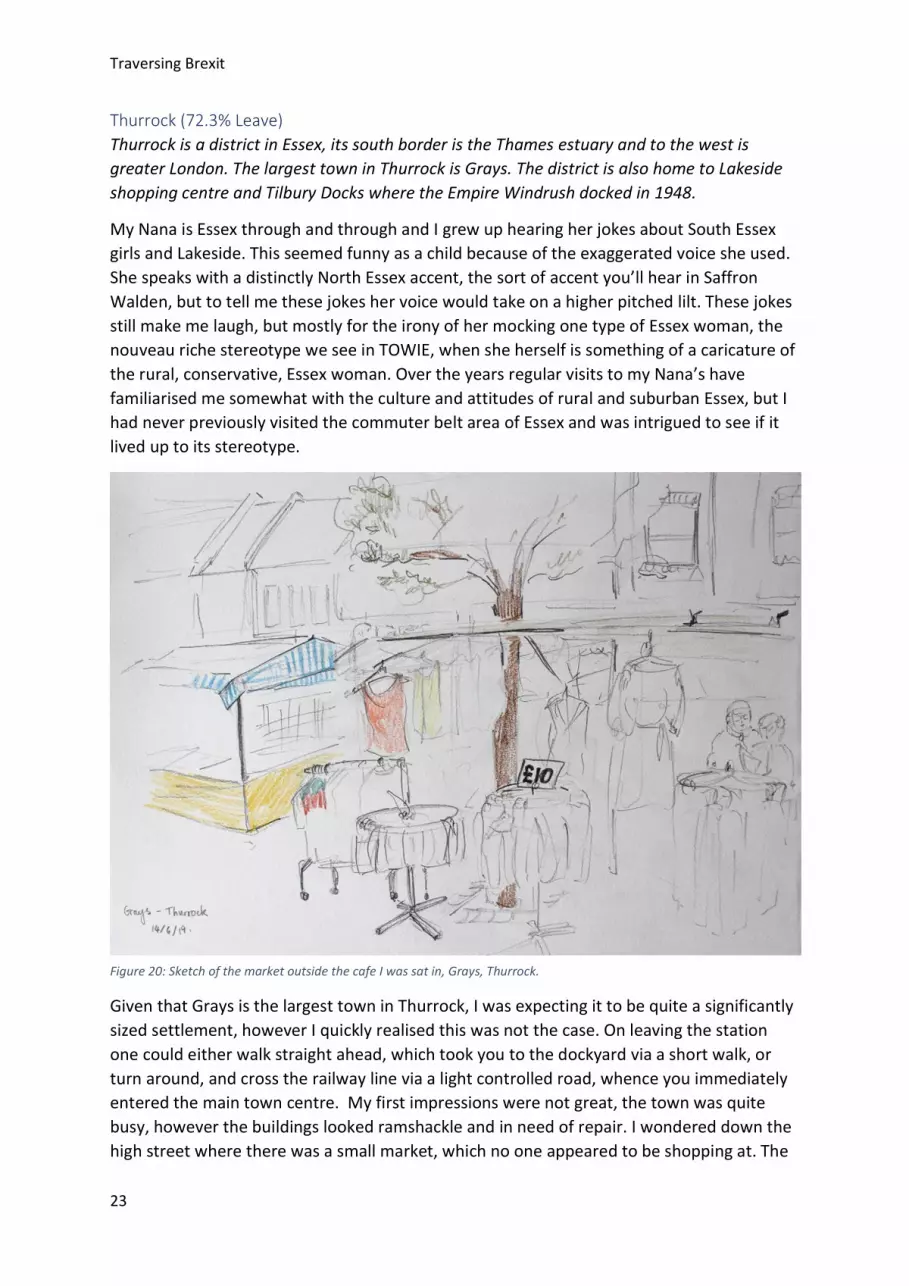
Figure 19: Photograph of cars, boats and flags on Canvey island, Castle Point.
Traversing Brexit
23
Thurrock (72.3% Leave) Thurrock is a district in Essex, its south border is the Thames estuary and to the west is greater London. The largest town in Thurrock is Grays. The district is also home to Lakeside shopping centre and Tilbury Docks where the Empire Windrush docked in 1948.
My Nana is Essex through and through and I grew up hearing her jokes about South Essex girls and Lakeside. This seemed funny as a child because of the exaggerated voice she used. She speaks with a distinctly North Essex accent, the sort of accent you’ll hear in Saffron Walden, but to tell me these jokes her voice would take on a higher pitched lilt. These jokes still make me laugh, but mostly for the irony of her mocking one type of Essex woman, the nouveau riche stereotype we see in TOWIE, when she herself is something of a caricature of the rural, conservative, Essex woman. Over the years regular visits to my Nana’s have familiarised me somewhat with the culture and attitudes of rural and suburban Essex, but I had never previously visited the commuter belt area of Essex and was intrigued to see if it lived up to its stereotype.
Given that Grays is the largest town in Thurrock, I was expecting it to be quite a significantly sized settlement, however I quickly realised this was not the case. On leaving the station one could either walk straight ahead, which took you to the dockyard via a short walk, or turn around, and cross the railway line via a light controlled road, whence you immediately entered the main town centre. My first impressions were not great, the town was quite busy, however the buildings looked ramshackle and in need of repair. I wondered down the high street where there was a small market, which no one appeared to be shopping at. The
Figure 20: Sketch of the market outside the cafe I was sat in, Grays, Thurrock.
Traversing Brexit
24
street was littered with charity shops, and off to one side was an arcade that housed a few independent beauty salons. There was a traditional café, outside of which sat a huddle of sickly looking old men, sipping coffees at tables covered with vinyl fabric. The air smelt of bacon and tobacco.
Since 2010, the councils funding for youth offending has halved.17 This summer it was announced that secondary schools across Thurrock district would have funding cut by an average of over £170,000 a year.18 Across Thurrock 1 in 5 children live in poverty which is around the national average, however in Tilbury which is just along the coast from Grays, it is estimated that the figure is over 40%.19
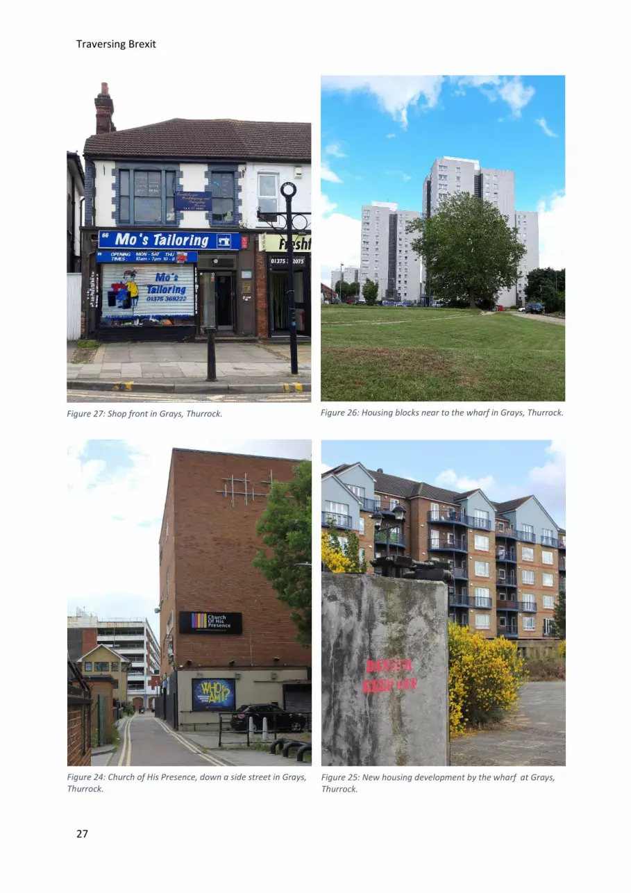
Grays was certainly living up to its name. I walked down some side streets, which were pervaded with the smell of weed. A massive concrete church dominated one of these side streets. It was a large brown building, made of concrete and some five stories high. It had no windows, merely a placard informing me that it was ‘The Church of His Presence’. Nearby there were multiple betting shops, pawnbrokers and an army surplus. I was dismayed by my impression of the town so I walked back the way I had come and toward the docks.
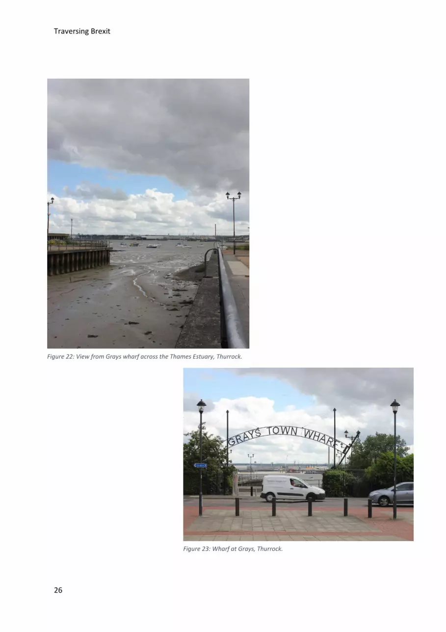
Above the docks, sat a large wrought iron sign with letters spelling ‘Grays Town Wharf’ suspended between two parabolic supports. Below the sign two large concrete walls opened out onto the sea. I stood on the concrete wharf, replete with shrubby looking grasses growing between the cracks, and gazed out at the sea. A local man sat to one side with his dog, carefully watching me. I only found out later that it was just a couple of miles along the coast from here where the Empire Windrush docked. In 2009, this area of coast
17 Kent, J. (2019) Candidate’s anger at reported cuts of 50 per cent to youth offending team in borough. [Online] Available from: http://www.thurrockindependent.com/2019/08/09/candidates-anger-at-reported-cuts-of-50-per-cent-to-youth-offending-team-in-borough/ (Accessed: 27 October 2019). 18 Your Thurrock. (2019) Figures reveal massive cuts to school funding in Thurrock. [Online] Available from: https://www.yourthurrock.com/2019/03/08/figures-reveal-massive-cuts-school-funding-thurrock/ (Accessed: 27 October 2019). 19 Thurrock Council. (2013) Thurrock Ward Profiles. [Online] Available from: https://www.thurrockccg.nhs.uk/about-us/ccg-board-meetings/gb-board-papers/2014-archive/april-2014/295-item-04aaaaa-appendix-4-thurrock-ward-profile-summary-300414/file (Accessed: 27 October 2019).
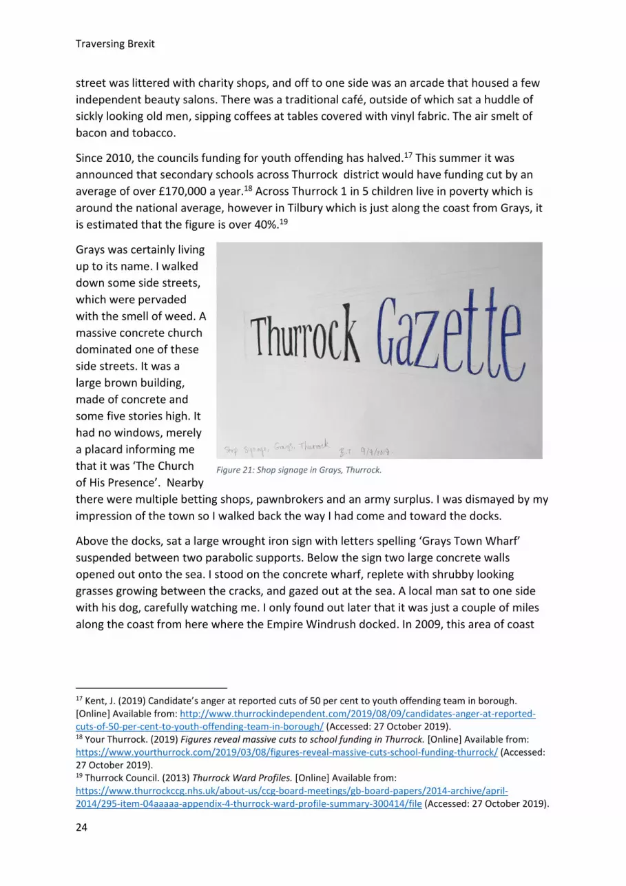
Figure 21: Shop signage in Grays, Thurrock.

Traversing Brexit
25
received over €14,000,000 from the EU for dredging and reclamation of the Thames Estuary.20
I naively expected Grays to reflect the nouveau riche TOWIE stereotype, but in actuality the town was just unassuming and neglected. I recently read about plans to turn Lakeside into a town.21 To me the idea of turning a shopping mall into a town seems incredibly depressing, how can you build a community around a beacon of late stage capitalism? Clearly Thurrock has suffered greatly from austerity, and for the residents this must feel more prevalent than any of the benefits resulting from EU funding poured into the wider region.
20 East of England. (2017) EU Investment in New Anglia. [Online] Available from: https://newanglia.co.uk/wp-content/uploads/2018/04/FINAL_EU_funding_in_New-Anglia_2017.pdf (Accessed: 27 October 2019). 21 Thurrock Government. (2019) Lakeside and West Thurrock growth. [Online] Available from: https://www.thurrock.gov.uk/lakeside-and-west-thurrock-growth/lakeside (Accessed: 27 October 2019).
Traversing Brexit
26
Figure 22: View from Grays wharf across the Thames Estuary, Thurrock.
Figure 23: Wharf at Grays, Thurrock.
Traversing Brexit
27
Figure 27: Shop front in Grays, Thurrock. Figure 26: Housing blocks near to the wharf in Grays, Thurrock.
Figure 24: Church of His Presence, down a side street in Grays, Thurrock.
Figure 25: New housing development by the wharf at Grays, Thurrock.

Traversing Brexit
28
Hackney (78.5% Remain) Hackney is a district in the historic East End of London. The district includes Shoreditch to the south and Stanford Hill to the north. The district takes its name from Hackney town It takes its name from Hackney, one of the largest and most well-known areas within the district.
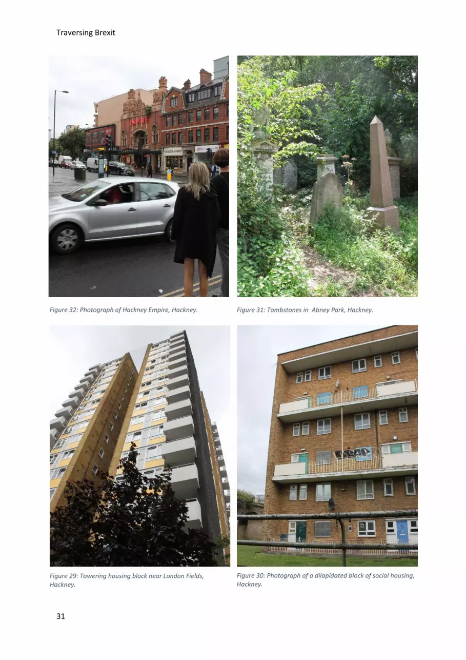
I started my exploration of Hackney district at its most southern point in Shoreditch. I visited the Victoria Miro, a large modern art gallery accessed by a discrete and poorly signposted door. I had to ask a young woman who was leaving if I had the right location. As she manoeuvred her pram out of the door she assured me I was at the right place and recommend the upstairs exhibition. The exhibition was fantastic, it was a dramatic film and photographs by Isaac Julien exploring the work of the Brazilian architect Lina Bo Bardi. The gallery building itself was starkly modern, and one of the upstairs windows framed a view across the city of The Shard.
I left the gallery and meandered along the canal which runs through Shoreditch, barges sat docked next to the towpath. Joggers and cyclists passed by me. Tourists and locals strolled along, hazy from a long weekend lunch. I walked alongside London Fields, and headed north towards the museum of Hackney which sits across the square from the famous former music hall, the Hackney Empire. The museum was busy hosting an event for local teenagers, I didn’t catch the title of the event but from what I overheard they were trying to increase teenage community involvement in the area, which has high rates of crime and poverty. They were asking teenagers about what they would like to see the council do, and how the council could help them.
A temporary exhibition at the museum chronicled the work of a women’s workshop situated nearby on Lenthall Road from the 1970s to 1990s where a variety of art skills were taught such as screen printing and photographic development. Another display was of a selection of photo’s taken in the latter half of the 20th century at a Hackney photography studio. These were the photographs which had never been collected by the subjects after development, the images of weddings, baptisms and engagements offered a snapshot of Hackney’s multicultural population.
Hackney is an area that has very recently gentrified. Historically Hackney formed part of the East End and at the end of the nineteenth century it was part of the slum area described by Jack London in his polemic on poverty, ‘People of the Abyss’22. Many of these Victorian slums existed into the 20th century until massive demolition and construction work was undertaken post war. This resulted in new blocks of social housing, some of which were later destroyed in the 1990s, as photographed by Rachel Whiteread.23 Hackney is still full of social housing, in fact 43.7% of housing in the district is owned by the council or housing association.24
22 London, J. (1992) The People of the Abyss. Great Britain: Journeyman Press. 23 Tate. (2019) Rachel Whiteread: Demolished. [Online] Available from: https://www.tate.org.uk/art/artworks/whiteread-demolished-66016/3 (Accessed: 27 October 2019). 24 London Government. (2017) Housing Tenure by Borough. [Online] Available from: https://data.london.gov.uk/dataset/housing-tenure-borough (Accessed: 28 October 2019).

Traversing Brexit
29
Today, 36% of people living in Hackney live in poverty.25 That is the highest percent of poverty stricken inhabitants in any London borough after Tower Hamlets and Newham. A recent article by the Observer revealed the condition of some privately owned housing in the district, in one block of hostel accommodation, families are living in bug-infested single rooms, where all the furniture is broken, and they are scared to let their children even play in the corridors.26 Its sounds like something out of the East End Jack London encountered over a century ago.
The council, and the government, have a responsibility to improve housing, as not only are the conditions horrifying, but rent prices are pushing locals out of the area. The Hasidic Jewish community at Stamford Hill is moving out to Canvey Island in rural Essex out of a need for more space at affordable prices. Why is this such a big deal? Well, I think it is the districts responsibility to look after everyone in society, especially those on lower incomes, and to improve their standard of living, not just to encourage their relocation to cheaper areas. These areas of London are so interesting because they have a diverse mix of people, a diverse history. If Hackney was purely populated by posh Caucasian thirty somethings it would be a considerably less interesting place.
I was expecting Hackney to be gentrified, and it was, in part, vegan fast food restaurants and vintage stores sat cheek by jowl with pound stores and community outreach centres. The beautifully maintained private Georgian blocks of flats contrasted sharply with the large, many-storied, blocks of social housing. The inequality felt uncomfortable, as a visitor you were visibly confronted with it. I think it is too easy to dismiss the London districts as financially prosperous, liberal bubbles. The reality is that there is a shocking wealth divide in these districts. There has been a lot of focus on the discontent and malaise in Leave areas, but perhaps if as a country we were more aware of the shocking conditions some British citizens live in we would all be feeling similar discontent.
25 Trust for London. (2019) Hackney. [Online] Available from: https://www.trustforlondon.org.uk/data/boroughs/hackney-poverty-and-inequality-indicators/ (Accessed: 28 October 2019). 26 Wall, T. (2019). Private profit, public squalor: Britain’s housing scandal. [Online] Available from: https://www.theguardian.com/world/2019/oct/13/profits-from-poverty-britains-housing-scandal-providers-make-millions (Accessed: 28 October 2019).

Traversing Brexit
30
Figure 28: Drawing of Hackney Emipre at rush hour, Hackney.
Traversing Brexit
31
Figure 32: Photograph of Hackney Empire, Hackney.
Figure 29: Towering housing block near London Fields, Hackney.
Figure 30: Photograph of a dilapidated block of social housing, Hackney.
Figure 31: Tombstones in Abney Park, Hackney.

Traversing Brexit
32
Figure 33: 'Boris Limited', political statement or abandoned building? Hackney.
Figure 34: Social Housing near London Fields, Hackney.
Figure 35: More crumbling tombstones in Abney park, Hackney.
Traversing Brexit
33
Great Yarmouth (71.5% Leave) Great Yarmouth is a district in Norfolk, located on the coastal edge of East Anglia. The district is named after its largest town, the seaside resort of Great Yarmouth, but also encompasses the neighbouring coastal towns of Hemsby, Caister-on-Sea, Winterton-on-Sea and Gorleston-on-Sea.
The Norfolk coast is surprisingly hard to reach by public transport. I took a circuitous route, going first to London, then north to Cambridge where I bunked at my brothers for the night before getting a train early the next day to Great Yarmouth by way of Norwich.
It was a hot and sunny morning when I arrived in the town of Great Yarmouth, the train from Norwich was busy with families lugging buckets, spades and brightly coloured overnight bags packed with towels and sandwiches. Great Yarmouth feels like a very happy district. That sounds juvenile, however tourism is one of its main sources of income, 34% of the local workforce work in tourism related industries.27 From Winterton-on-Sea to Gorleston-on-Sea the beaches are a popular destination for British holidaymakers. When I visited in early August the golden mile in Great Yarmouth was packed with day trippers happily spending their coins in the arcades and basking in the sunshine. Whilst the seafront of Great Yarmouth was loud and bright, on closer inspection many of the buildings were dilapidated and a walk towards the south quay revealed run down streets, boarded up shops, blocks of council flats and empty brownfield sites. Since 2010, Great Yarmouth district has faced 60% cuts to its core funding.28
The district of Great Yarmouth was an extremely popular destination for holiday makers in the 1940s to 1970s. This was a trend which started after WW2, when blue collar workers started to get paid holidays, and ended with the rise in cheap airline flights in the late 1970s. Prior to this Great Yarmouth was a large fishing port for the herring trawlers in the North Sea, and many of the locals worked in the related industry which stopped being profitable some years ago.
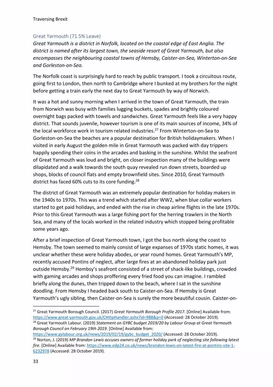
After a brief inspection of Great Yarmouth town, I got the bus north along the coast to Hemsby. The town seemed to mainly consist of large expanses of 1970s static homes, it was unclear whether these were holiday abodes, or year round homes. Great Yarmouth’s MP, recently accused Pontins of neglect, after large fires at an abandoned holiday park just outside Hemsby.29 Hembsy’s seafront consisted of a street of shack-like buildings, crowded with gaming arcades and shops proffering every fried food you can imagine. I rambled briefly along the dunes, then tripped down to the beach, where I sat in the sunshine doodling. From Hemsby I headed back south to Caister-on-Sea. If Hemsby is Great Yarmouth’s ugly sibling, then Caister-on-Sea is surely the more beautiful cousin. Caister-on-
27 Great Yarmouth Borough Council. (2017) Great Yarmouth Borough Profile 2017. [Online] Available from: https://www.great-yarmouth.gov.uk/CHttpHandler.ashx?id=988&p=0 (Accessed: 28 October 2019). 28 Great Yarmouth Labour. (2019) Statement on GYBC budget 2019/20 by Labour Group at Great Yarmouth Borough Council on February 19th 2019. [Online] Available from: https://www.gylabour.org.uk/news/2019/02/19/gybc_budget_2020/ (Accessed: 28 October 2019). 29 Norton, J. (2019) MP Brandon Lewis accuses owners of former holiday park of neglecting site following latest fire. [Online] Available from: https://www.edp24.co.uk/news/brandon-lewis-on-latest-fire-at-pontins-site-1-6232978 (Accessed: 28 October 2019).
Traversing Brexit
34
Sea was barely a town, rather a cluster of post-war houses. Following the main road through the town brought you to a pair of sandstone pillars which formed the entrance way to the beach. The beach was rugged, and offered spectacular views of the North Sea, broken only by the newly installed Sandy Banks windfarm.
Visiting the coast of Norfolk, I was reminded of one of my favourite books, ‘Threads; The Delicate Life of John Craske’, by Julia Blackburn. The book is a travel log of Blackburn’s explorations around Norfolk, as she investigates the life of a little known English embroiderer from the early 20th century called John Craske. He was an incapacitated fisherman, who spent his convalescences embroidering detailed scenes of fishermen’s boats out at sea. His largest embroidery was of the Battle of Dunkirk. The book was actually an inspiration for me in my own travelling, and accompanying journey. I revisited the book recently and realised that in the book Blackburn details her own travels around Great Yarmouth and Hemsby. I loved re-visiting these chapters, as I found myself recognising the locations she discusses, I found her description of Hemsby particularly fitting:
‘Almost at once I felt as if I was entering the set from a 1970s Carry On movie. There was no one about and the road was lined with flimsy concrete constructions painted in bright shabby colours and emblazoned neon lights and names like Happy Hut, Treasure Trove and Pleasure Dome. There was an adventure park called Stonehenge, much smaller than the original, the imitation granite slabs painted a soupy brown.’ 30
30 Blackburn, J. (2015) Threads: The Delicate Life of John Craske. London: Jonathan Cape. (PAGE 170)
Figure 36: Drawing of holidaymakers on Hemsby beach, with Sandy Banks windfarm on the horizon, Great Yarmouth.

Traversing Brexit
35
In the evening I went back to my B&B. My B&B, the Sea Princess, was in a row of similarly named and sized establishments. I had chosen this one for its favourable reviews. The B&B was very quiet, with nobody to be seen, until I was forced to summon a member of staff using the bell on the desk. The Bed and Breakfast seemed to be almost exclusively run by one man, who handed out keys, lugged bed linen across floors, greeted each guest at breakfast whilst making sure that the kitchen was running smoothly. I was reminded somewhat of Fawlty Towers. I intended to crash in the room after a long walk back from Caister-on-Sea but finding the room dank and grimly furnished I got the bus to the neighbouring town of Gorleston-on-Sea. The route went via a bridge spanning the river Yare, and I got a close up view of Great Yarmouth’s industrial dockyards and factories. Gorleston-on-Sea was much like Great Yarmouth, but without quite so many games arcades or tourist shops.
Until the early 20th century the town of Great Yarmouth had a large swathe of medieval housing. In the south quay area of town, ‘The Rows’ were long and narrow streets packed with tiny dwellings. The destruction of these streets started during slum clearances in the 1930s, a job which was finished by the Luftwaffe as they disposed of their leftover bombs after air raids across England. Before it was demolished this medieval area of back to back alleyways was rife with disease and poor sanitation. Seventy five years on, as I roamed around this now historic area of the town, I couldn’t help but wonder if the crumbling
Figure 37: Drawing of holidaymakers perusing stalls on Regent Road, Great Yarmouth.

Traversing Brexit
36
council housing, static homes and the makeshift bungalows I had seen nestled in the dunes across the district were much better.
A mere 3.2% of residents in Great Yarmouth district came from an ethnic minority background in 2011.31 That’s less than a third of the average in England, but it doesn’t surprise me, as I’m not sure I saw a single person who wasn’t Caucasian during my stay in the district. In 2014, both male and female life expectancy were at least one year behind the average in the UK. In fact, Great Yarmouth doesn’t do very well when it comes down to statistics, It has an above UK average for smoking, mental health problems and obesity.
Much like Castle Point, Great Yarmouth experienced popularity and prosperity in the mid 20th century, but in recent years has become home to an ageing white population. Funding cuts to the local council and general neglect have seen properties and communities falling into disrepair. I can understand why people living in these rural former seaside resorts might feel disenfranchised, as who wouldn’t find themselves comparing what these towns are like today with the comparative vibrancy and wealth they experienced in the 1950s and 1960s.
31 Great Yarmouth Borough Council. (2017) Great Yarmouth Borough Profile 2017. [Online] Available from: https://www.great-yarmouth.gov.uk/CHttpHandler.ashx?id=988&p=0 (Accessed: 28 October 2019).

Traversing Brexit
37
Figure 41: Tourists making their way towards the beach, Regent Road, Great Yarmouth.
Figure 40: Regent Road, Great Yarmouth.
Figure 39: Gateway to the rugged beach at Caister-on-Sea, Great Yarmouth.
Figure 38: The Winter Gardens on Great Yarmouth's seafront. Currently Listed as one of Britain’s most endangered listed buildings.

Traversing Brexit
38
Figure 42: Drawing of Regent Road, Great Yarmouth.

Traversing Brexit
39
Figure 43: Holidaymakers bask in the sun on Great Yarmouth beach.
Figure 44: Deckchairs for rent on Great Yarmouth beach.
Figure 45: A street in the historic south quay area of Great Yarmouth.
Traversing Brexit
40
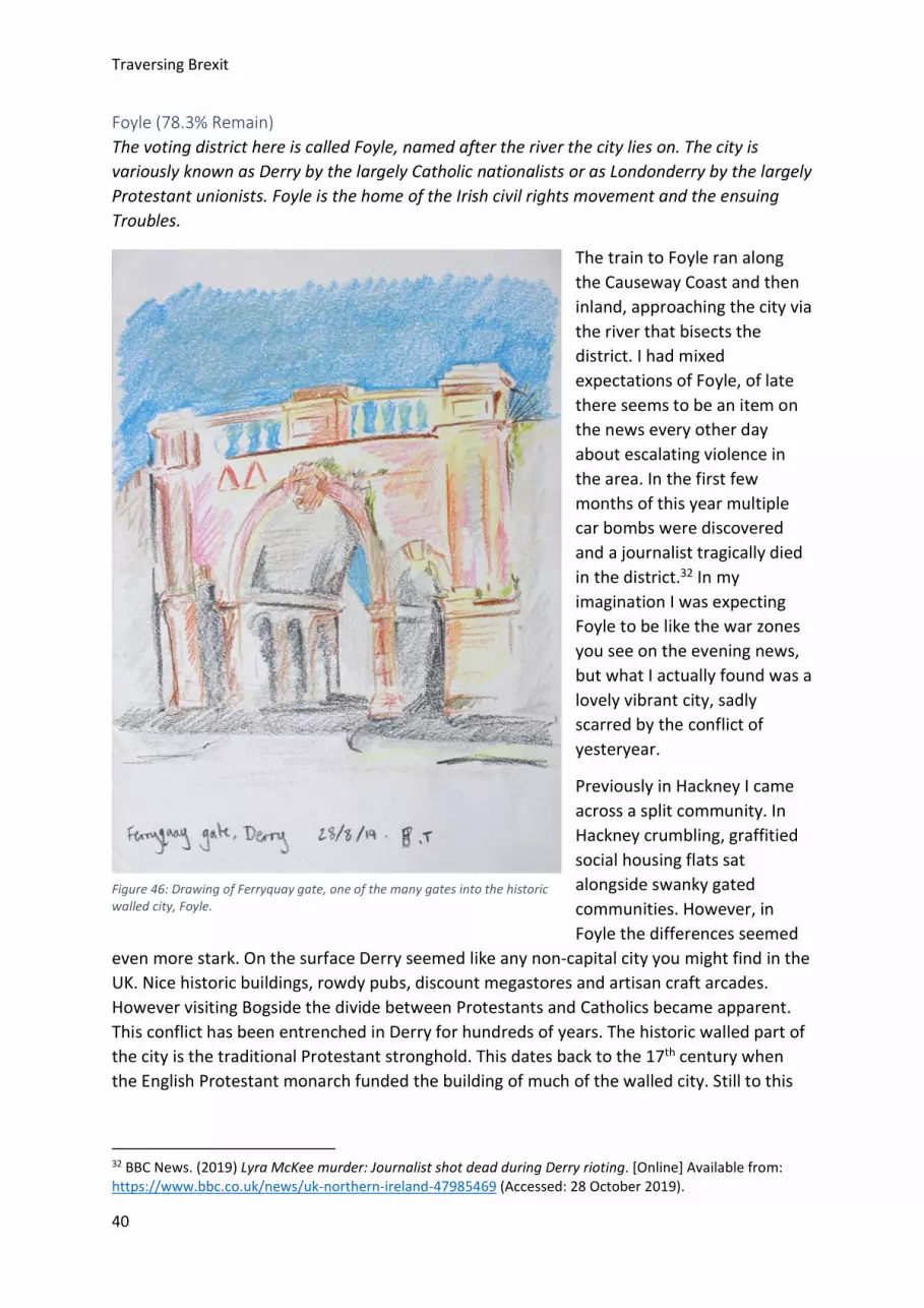
Foyle (78.3% Remain) The voting district here is called Foyle, named after the river the city lies on. The city is variously known as Derry by the largely Catholic nationalists or as Londonderry by the largely Protestant unionists. Foyle is the home of the Irish civil rights movement and the ensuing Troubles.
The train to Foyle ran along the Causeway Coast and then inland, approaching the city via the river that bisects the district. I had mixed expectations of Foyle, of late there seems to be an item on the news every other day about escalating violence in the area. In the first few months of this year multiple car bombs were discovered and a journalist tragically died in the district.32 In my imagination I was expecting Foyle to be like the war zones you see on the evening news, but what I actually found was a lovely vibrant city, sadly scarred by the conflict of yesteryear.
Previously in Hackney I came across a split community. In Hackney crumbling, graffitied social housing flats sat alongside swanky gated communities. However, in Foyle the differences seemed
even more stark. On the surface Derry seemed like any non-capital city you might find in the UK. Nice historic buildings, rowdy pubs, discount megastores and artisan craft arcades. However visiting Bogside the divide between Protestants and Catholics became apparent. This conflict has been entrenched in Derry for hundreds of years. The historic walled part of the city is the traditional Protestant stronghold. This dates back to the 17th century when the English Protestant monarch funded the building of much of the walled city. Still to this
32 BBC News. (2019) Lyra McKee murder: Journalist shot dead during Derry rioting. [Online] Available from: https://www.bbc.co.uk/news/uk-northern-ireland-47985469 (Accessed: 28 October 2019).
Figure 46: Drawing of Ferryquay gate, one of the many gates into the historic walled city, Foyle.

Traversing Brexit
41
day there are no Catholic places of worship within the walls, only Protestant and Presbyterian.
The part of the city known as ‘Bogside’ is the traditional Catholic stronghold. The Bogside was once underwater and as the city drained it left a marshy strip of land to the west of the city. Catholics initially settled there as they were less welcome in the Protestant settlement within the walled city. To you and me Bogside is known for the part it played in the Troubles.
In the 1960s Bogside was made up of terraced Victorian housing. It was massively overpopulated due to the fact that the local council was largely Protestant (despite the local population being largely Catholic). The local council controlled the appointment of council properties and massively favoured Protestant tenants over Catholic. A tour guide to the Bogside told a group of us that in one case a young, single Protestant woman was given a multi-bedroomed home over 2 large destitute Catholic families also on the housing list. At the time the residents of Northern Ireland only got a vote in elections if they were either home owners or business owners. It’s not hard to imagine what provoked the civil rights movement in Ireland. And that’s what it was, primarily a civil rights movement. The IRA was merely the actively violent offshoot.
I’m ashamed to say that prior to visiting Bogside I was fearful of what to expect. I was expecting to experience hostility and maybe even violence in the streets. In reality what I was confronted with was just a poor community. The Victorian terraces have been destroyed and, in their place, stands social housing. Exquisitely painted murals adorn the gable end of many of the buildings, many depicting scenes from the Troubles, one such wall was painted with portraits of heroes including Mother Theresa and Martin Luther King. Nearby information boards tell the harrowing, personal backstories to the painted pastiches.
Before I visited Bogside I knew a little of its history, I knew we, the British had committed atrocities across Ireland. However, learning the extent and detail of our actions made me
Figure 47: View across the River Foyle towards the peace bridge, Foyle.
Traversing Brexit
42
feel ashamed to be British. For me nothing encapsulated this as well as an object I came across in the Museum of Free Derry. In the museum there was a tweed jacket, not unlike one you might see hanging from a rail of a vintage store. The jacket was a bit worn. It had a tear across the shoulder and a hole in the back, near the right armpit, that looked like a large cigarette burn. This jacket was worn by a young man. I say man but really, he was a child, just 17. He was at a peaceful protest in Bogside, they were protesting the institutionalised racism towards Foyles Catholic population. That was until the British military opened fire on the protestors. The young man was going to the aid of a friend when he was shot at point blank range. The year was 1972, the day was Bloody Sunday, his name was Michael McDaid.
Whilst I was in Foyle I read a poem by the Foyle born poet, Seamus Heaney. It was my last day in Foyle, and to kill some time before I got the train I went into a large bookstore in a shopping mall, in the town centre. I had heard mention of Seamus Heaney in a museum the day before, as he was active in the Northern Irish civil rights movement. I sought out his name amongst the books in the ‘local authors’ section. In one of the volumes of poetry I came across the poem ‘Casualty’. I sat in a chair at the end of an aisle of books, children ran screaming past me, as families roamed the store. It was loud and there was that general background noise of chattering ever present in shopping centres. Despite my surroundings, as I read the poem I was moved by Heaney’s rendition of melancholy. He movingly captures the loss and disenfranchisement the Catholic community must have felt after Bloody Sunday. The general nostalgia and sorrow of the poem was very poignant, after what I had learnt of the British atrocities in Foyle. I’ve included an excerpt here:
‘He was blown to bits,
Out drinking in a curfew,
Others obeyed, three nights
After they shot dead,
The thirteen men in Derry.
PARAS THIRTEEN, the walls said,
BOGSIDE NIL. That Wednesday
Everybody held
His Breath and trembled.’ 33
Recently one of the regular new bulletins about Foyle focused not on recent outbreaks of violence but on the court case that is still ongoing to charge the unidentified ‘Soldier F’, a member of the British Army, for his actions in Derry in the 1970s.34 It horrifies me, that as a
33 Heaney, S. (1990) New Selected Poems 1966-1987. London: Faber and Faber Limited (PAGES 100-103) 34 McClements, F. (2019) Bloody Sunday: Case against Soldier F to begin in Derry. [Online] Available from: https://www.irishtimes.com/news/ireland/irish-news/bloody-sunday-case-against-soldier-f-to-begin-in-derry-1.4021393 (Accessed: 28 October 2019).

Traversing Brexit
43
country we are only just facing up to taking responsibility for what happened in Northern Ireland. As the trial kicked off in Derry protests took place in London defending the actions of Solider F35.
One of the largest topics of debate between the EU and Britain over Brexit has been what will happen to the Irish border, and whether there would potentially be a backstop. A hard border would not only jeopardise jobs, and the import and export of goods, but could also lead to renewed violence between Nationalists and Unionists. Many people believe that if Britain leaves the EU, then the peace in Northern Ireland that has held since the Good Friday Agreement will be threatened.36 Its clear why the people of Foyle voted to remain, as who would want to go back to that?
35 Read, C. (2019) Soldier F protests: Hundreds swarm London in demonstration against Bloody Sunday trial. [Online] Available from: https://www.express.co.uk/news/uk/1183936/soldier-F-protests-london-bloody-sunday-massacre-londonderry-Saville-Report (Accessed: 28 October 2019). 36 Guardian. (2019) Irish peace under threat from reckless Brexit plan. [Online] Available from: https://www.theguardian.com/politics/2019/oct/08/irish-peace-under-threat-from-reckless-brexit-plan (Accessed: 28 October 2019).
Figure 48: Visiting Bogside with our tour guide who grew up on this street during the Troubles, Foyle.
Traversing Brexit
44
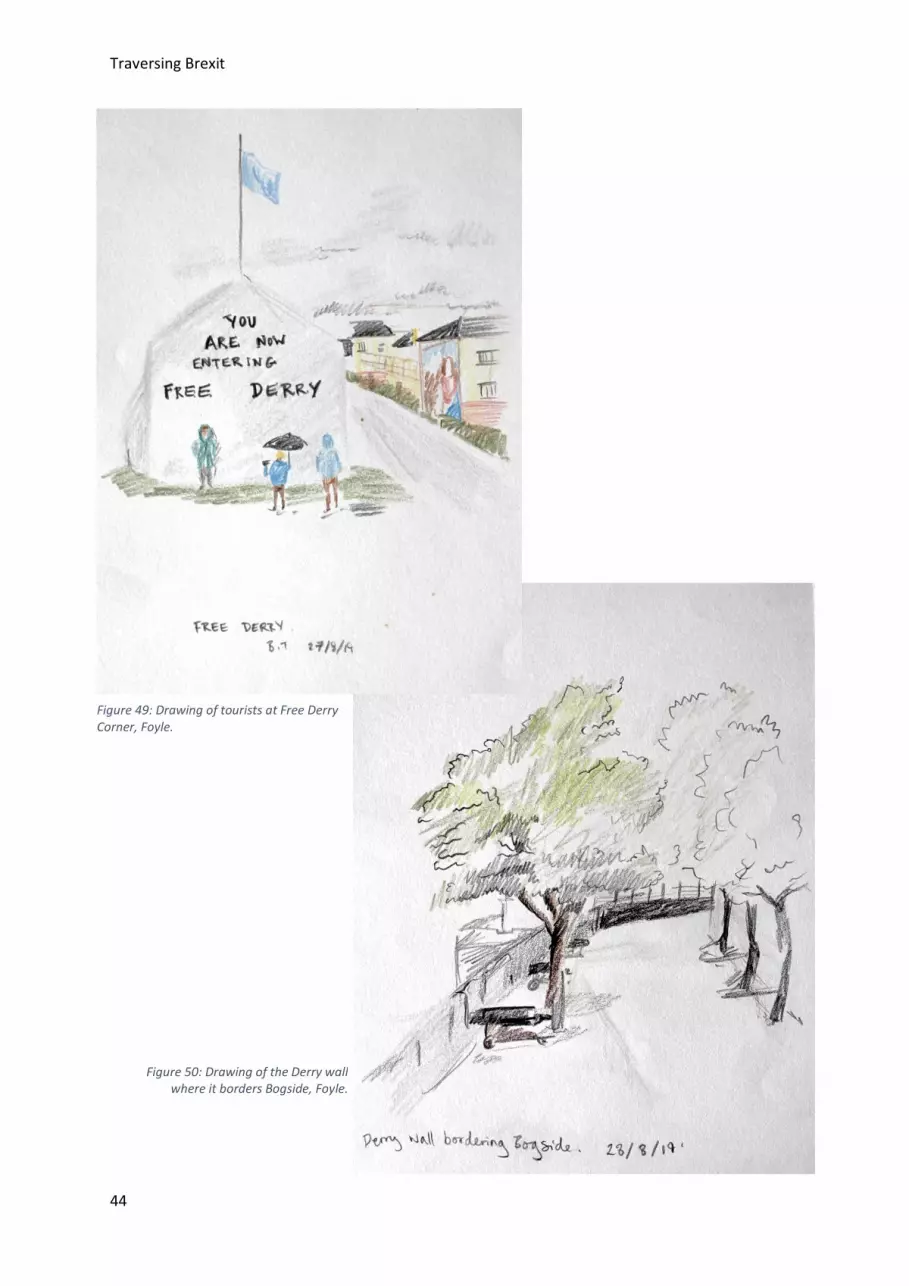
Figure 49: Drawing of tourists at Free Derry Corner, Foyle.
Figure 50: Drawing of the Derry wall where it borders Bogside, Foyle.
Traversing Brexit
45
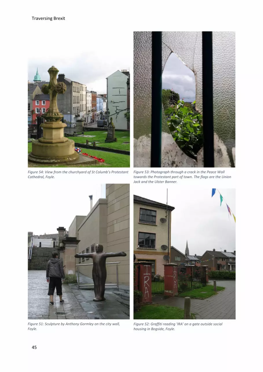
Figure 54: View from the churchyard of St Columb’s Protestant Cathedral, Foyle.
Figure 53: Photograph through a crack in the Peace Wall towards the Protestant part of town. The flags are the Union Jack and the Ulster Banner.
Figure 51: Sculpture by Anthony Gormley on the city wall, Foyle.
Figure 52: Graffiti reading 'IRA' on a gate outside social housing in Bogside, Foyle.

Traversing Brexit
46
South Holland (73.6% Leave) South Holland is a district in Lincolnshire. The district is largely made of fenland, water-logged land which was drained by Dutch engines in the 19th century, hence giving the district its name. South Holland is home to, amongst other towns, Spalding, Holbeach and Long Sutton.
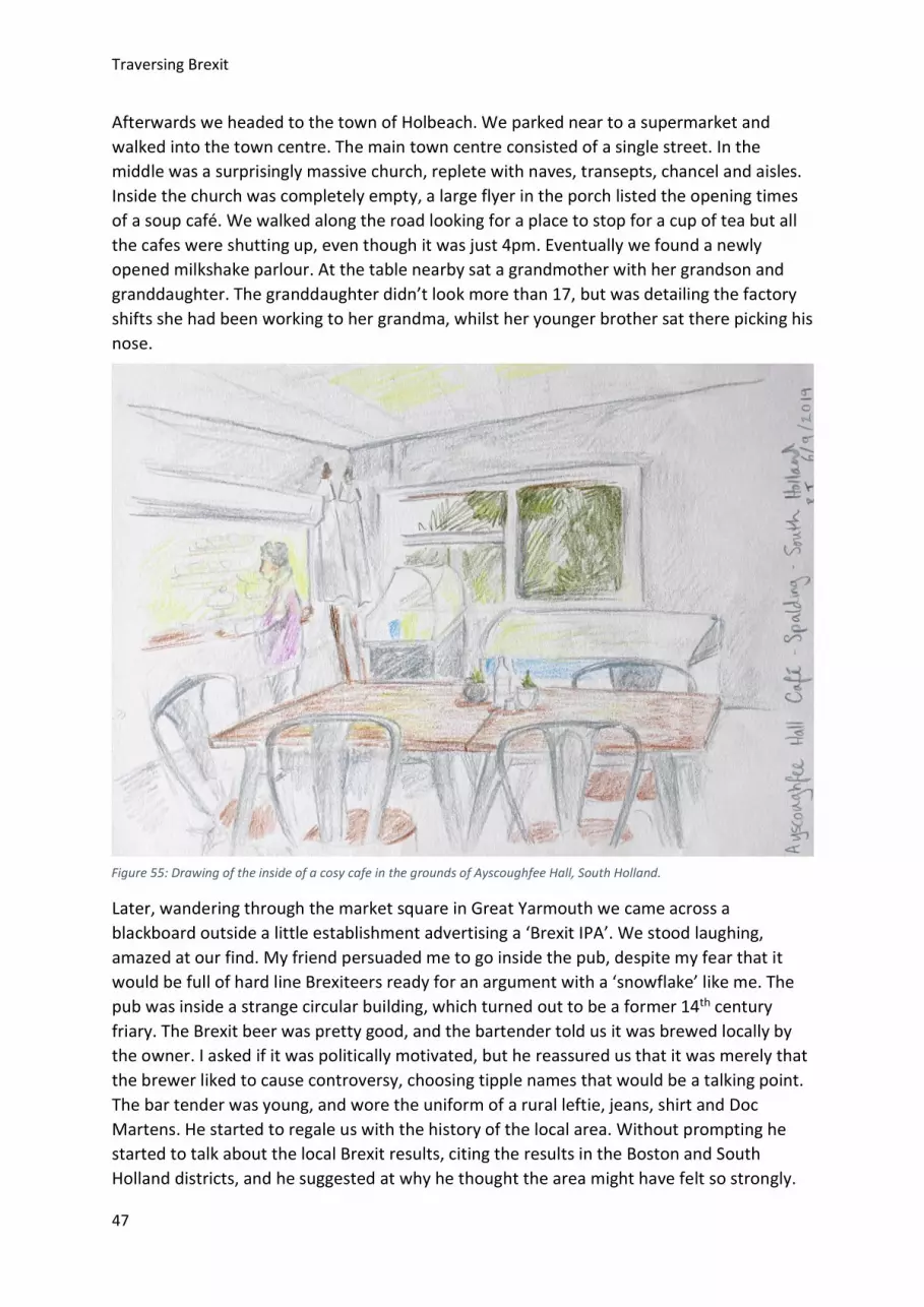
I arrived in the Lincolnshire market town of Spalding on a breezy day in late summer, accompanied by my friend, Laura. It was mid-afternoon and locals sat outside pubs smoking and drinking. The first impressions of the town was that it was much like any rural town in England, some historic buildings, some discount supermarkets and some rush hour traffic.
The area of Lincolnshire we were in is home to a large Traveller community. In 2016 there were 81 Gypsy and Traveller pitches in the South Holland district.37 One night as I tucked into a curry, at the pub attached to the B&B I heard the sound of horses outside. Peering through the natty lace curtains, I could see a horse drawn cart in the market square with a handful of teenage boys running around. A group of men came into the pub who it shortly became apparent were with the horse and gig outside. They sat laughing and joking about one another’s wives. The atmosphere of the pub turned. Some wary pensioners sat nearby watched the group of travellers over their pints. Some of the men were accompanied by their young sons, the oldest can’t have been much more than thirteen, who joined in on the bawdy jokes as their dads sat drinking.
Whilst in the district we visited the Gordon Boswell Romany museum. The Museum was housed in a couple of barns, next to a plot of land hosting a large 1970s bungalow and a few static homes. Inside the barns we were greeted by the widowed Mrs Gordon Boswell. She was a kindly faced older lady, wearing a long skirt and wrapped in a cardigan, she looked like she must be near to seeing her 90th Birthday. The barns were full of wagons, that were used by the Romany and Traveller communities between 1890 and around 1950. Apparently the community started to phase out the use of waggons during the 1930s, but due to fuel shortages in WW2 continued using them. The wagons were richly adorned with painted decorations, beautiful italic writing and enamel paintings of horses and flowers. In the second barn, there were two later Romany wagons from the 1970s. These really took my breath away, they were both magnificent and strangely hideous, they felt like an actors trailer Elizabeth Taylor might have used. The exterior of these wagons were entirely chrome painted, whilst the interiors were covered in stainless steel and mirrored surfaces. The settees were covered with floral fabric and clear, wipeable vinyl covers. Mrs Gordon Boswell told us that one of these caravans had belonged to her daughters family in the 1970s, and at the time it was the height of luxury within the community.
37 Opinion Research Services. (2016) Boston and South Holland Gypsy and Traveller Accommodation Assessment. [Online] Available from: http://www.southeastlincslocalplan.org/wp-content/uploads/2017/01/Boston-South-Holland-Gypsy-Traveller-Accommodation-Assessment-November-2016.pdf (Accessed: 28 October 2019).
Traversing Brexit
47
Afterwards we headed to the town of Holbeach. We parked near to a supermarket and walked into the town centre. The main town centre consisted of a single street. In the middle was a surprisingly massive church, replete with naves, transepts, chancel and aisles. Inside the church was completely empty, a large flyer in the porch listed the opening times of a soup café. We walked along the road looking for a place to stop for a cup of tea but all the cafes were shutting up, even though it was just 4pm. Eventually we found a newly opened milkshake parlour. At the table nearby sat a grandmother with her grandson and granddaughter. The granddaughter didn’t look more than 17, but was detailing the factory shifts she had been working to her grandma, whilst her younger brother sat there picking his nose.
Later, wandering through the market square in Great Yarmouth we came across a blackboard outside a little establishment advertising a ‘Brexit IPA’. We stood laughing, amazed at our find. My friend persuaded me to go inside the pub, despite my fear that it would be full of hard line Brexiteers ready for an argument with a ‘snowflake’ like me. The pub was inside a strange circular building, which turned out to be a former 14th century friary. The Brexit beer was pretty good, and the bartender told us it was brewed locally by the owner. I asked if it was politically motivated, but he reassured us that it was merely that the brewer liked to cause controversy, choosing tipple names that would be a talking point. The bar tender was young, and wore the uniform of a rural leftie, jeans, shirt and Doc Martens. He started to regale us with the history of the local area. Without prompting he started to talk about the local Brexit results, citing the results in the Boston and South Holland districts, and he suggested at why he thought the area might have felt so strongly.
Figure 55: Drawing of the inside of a cosy cafe in the grounds of Ayscoughfee Hall, South Holland.
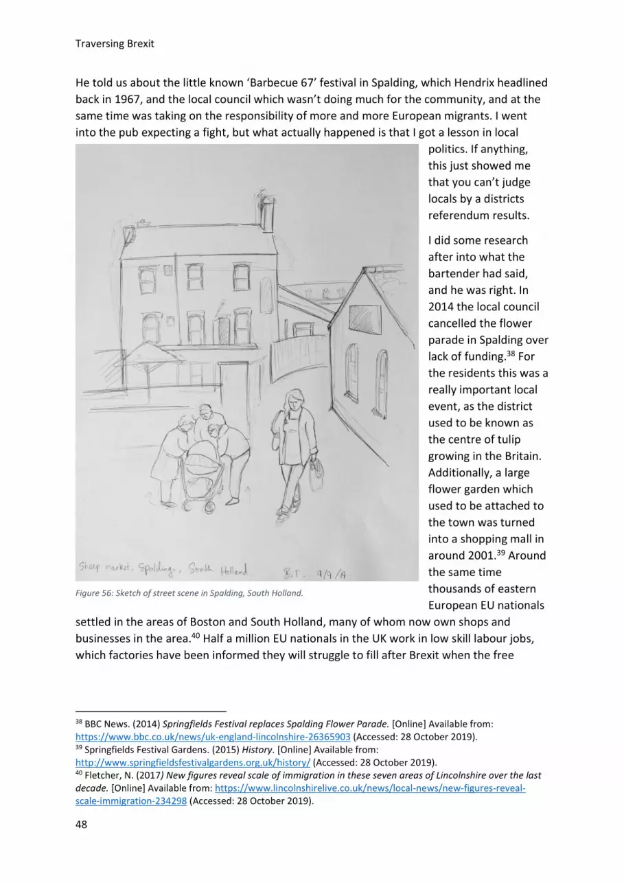
Traversing Brexit
48
He told us about the little known ‘Barbecue 67’ festival in Spalding, which Hendrix headlined back in 1967, and the local council which wasn’t doing much for the community, and at the same time was taking on the responsibility of more and more European migrants. I went into the pub expecting a fight, but what actually happened is that I got a lesson in local
politics. If anything, this just showed me that you can’t judge locals by a districts referendum results.
I did some research after into what the bartender had said, and he was right. In 2014 the local council cancelled the flower parade in Spalding over lack of funding.38 For the residents this was a really important local event, as the district used to be known as the centre of tulip growing in the Britain. Additionally, a large flower garden which used to be attached to the town was turned into a shopping mall in around 2001.39 Around the same time thousands of eastern European EU nationals
settled in the areas of Boston and South Holland, many of whom now own shops and businesses in the area.40 Half a million EU nationals in the UK work in low skill labour jobs, which factories have been informed they will struggle to fill after Brexit when the free
38 BBC News. (2014) Springfields Festival replaces Spalding Flower Parade. [Online] Available from: https://www.bbc.co.uk/news/uk-england-lincolnshire-26365903 (Accessed: 28 October 2019). 39 Springfields Festival Gardens. (2015) History. [Online] Available from: http://www.springfieldsfestivalgardens.org.uk/history/ (Accessed: 28 October 2019). 40 Fletcher, N. (2017) New figures reveal scale of immigration in these seven areas of Lincolnshire over the last decade. [Online] Available from: https://www.lincolnshirelive.co.uk/news/local-news/new-figures-reveal-scale-immigration-234298 (Accessed: 28 October 2019).
Figure 56: Sketch of street scene in Spalding, South Holland.
Traversing Brexit
49
movement of people will be restricted.41 A factory in Spalding has warned that this might force them to automate their processes, leading to further job cuts in the local area.42
The people living in these communities experienced extensive council cuts and a loss of local culture at the very same time that large groups of migrants arrived. Whilst these events were unconnected, its not difficult to see the connection some locals might have made, and how this might have reflected on their views of the EU. The blame for this resentment lies with South Hollands district council, alongside the national government. With more funding and greater social engagement perhaps these feelings of disengagement, that the locals felt and continue to feel, might have been allayed.
41 O’Carroll, L. (2018) Study estimates 500,000 EU workers are in low-skilled UK jobs. [Online] Available from: https://www.theguardian.com/politics/2018/aug/30/employers-will-struggle-to-fill-low-skilled-job-vacancies-after-brexit-study (Accessed: 28 October 2019). 42 Independent. (2019) Britain has the fewest robots in manufacturing, but Brexit might change that. [Online] Available from: https://www.independent.co.uk/news/science/brexit-robots-uk-manufacturing-immigration-job-cuts-losses-eu-a8929001.html (Accessed: 28 October 2019).

Traversing Brexit
50
Figure 60: Locals go about their business in Spalding, South Holland.
Figure 59: Derelict building in Spalding, South Holland.
Figure 58: Next door to Ayscoughfee Hall, South Holland. Figure 57: The Friar's Oven in Spalding, purveyors of 'Brexit IPA'.

Traversing Brexit
51
Figure 63: The placard advertising Brexit beer which caught our eye, South Holland.
Figure 64: Inside a church in Holbeach, South Holland.
Figure 62: Street in Holbeach, South Holland. Figure 61: Shop front with old fashioned yellow plastic covering the windows in Holbeach, South Holland.
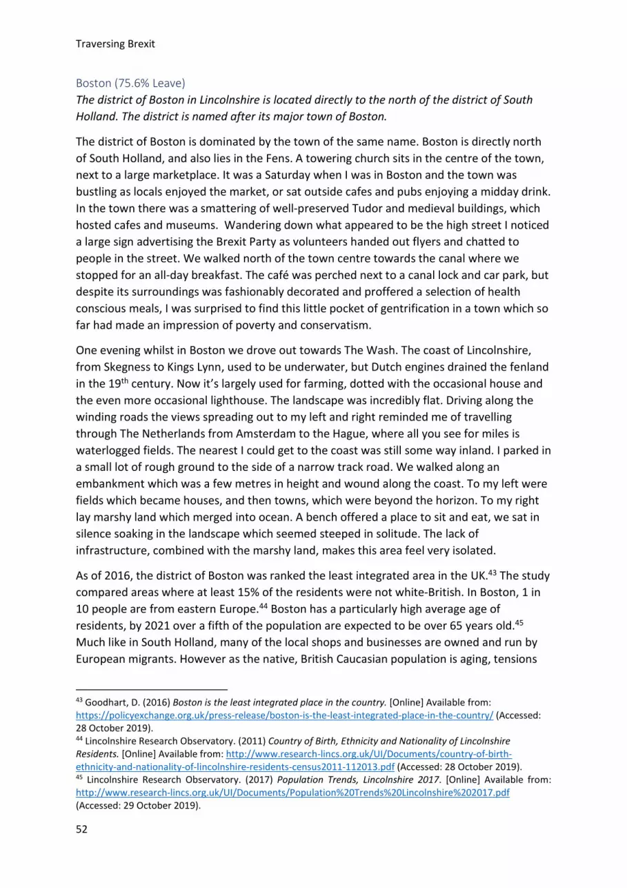
Traversing Brexit
52
Boston (75.6% Leave) The district of Boston in Lincolnshire is located directly to the north of the district of South Holland. The district is named after its major town of Boston.
The district of Boston is dominated by the town of the same name. Boston is directly north of South Holland, and also lies in the Fens. A towering church sits in the centre of the town, next to a large marketplace. It was a Saturday when I was in Boston and the town was bustling as locals enjoyed the market, or sat outside cafes and pubs enjoying a midday drink. In the town there was a smattering of well-preserved Tudor and medieval buildings, which hosted cafes and museums. Wandering down what appeared to be the high street I noticed a large sign advertising the Brexit Party as volunteers handed out flyers and chatted to people in the street. We walked north of the town centre towards the canal where we stopped for an all-day breakfast. The café was perched next to a canal lock and car park, but despite its surroundings was fashionably decorated and proffered a selection of health conscious meals, I was surprised to find this little pocket of gentrification in a town which so far had made an impression of poverty and conservatism.
One evening whilst in Boston we drove out towards The Wash. The coast of Lincolnshire, from Skegness to Kings Lynn, used to be underwater, but Dutch engines drained the fenland in the 19th century. Now it’s largely used for farming, dotted with the occasional house and the even more occasional lighthouse. The landscape was incredibly flat. Driving along the winding roads the views spreading out to my left and right reminded me of travelling through The Netherlands from Amsterdam to the Hague, where all you see for miles is waterlogged fields. The nearest I could get to the coast was still some way inland. I parked in a small lot of rough ground to the side of a narrow track road. We walked along an embankment which was a few metres in height and wound along the coast. To my left were fields which became houses, and then towns, which were beyond the horizon. To my right lay marshy land which merged into ocean. A bench offered a place to sit and eat, we sat in silence soaking in the landscape which seemed steeped in solitude. The lack of infrastructure, combined with the marshy land, makes this area feel very isolated.
As of 2016, the district of Boston was ranked the least integrated area in the UK.43 The study compared areas where at least 15% of the residents were not white-British. In Boston, 1 in 10 people are from eastern Europe.44 Boston has a particularly high average age of residents, by 2021 over a fifth of the population are expected to be over 65 years old.45 Much like in South Holland, many of the local shops and businesses are owned and run by European migrants. However as the native, British Caucasian population is aging, tensions
43 Goodhart, D. (2016) Boston is the least integrated place in the country. [Online] Available from: https://policyexchange.org.uk/press-release/boston-is-the-least-integrated-place-in-the-country/ (Accessed: 28 October 2019). 44 Lincolnshire Research Observatory. (2011) Country of Birth, Ethnicity and Nationality of Lincolnshire Residents. [Online] Available from: http://www.research-lincs.org.uk/UI/Documents/country-of-birth-ethnicity-and-nationality-of-lincolnshire-residents-census2011-112013.pdf (Accessed: 28 October 2019). 45 Lincolnshire Research Observatory. (2017) Population Trends, Lincolnshire 2017. [Online] Available from: http://www.research-lincs.org.uk/UI/Documents/Population%20Trends%20Lincolnshire%202017.pdf (Accessed: 29 October 2019).
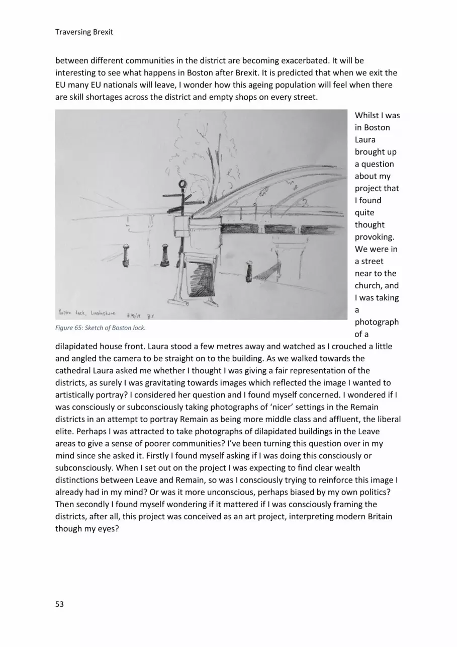
Traversing Brexit
53
between different communities in the district are becoming exacerbated. It will be interesting to see what happens in Boston after Brexit. It is predicted that when we exit the EU many EU nationals will leave, I wonder how this ageing population will feel when there are skill shortages across the district and empty shops on every street.
Whilst I was in Boston Laura brought up a question about my project that I found quite thought provoking. We were in a street near to the church, and I was taking a photograph of a
dilapidated house front. Laura stood a few metres away and watched as I crouched a little and angled the camera to be straight on to the building. As we walked towards the cathedral Laura asked me whether I thought I was giving a fair representation of the districts, as surely I was gravitating towards images which reflected the image I wanted to artistically portray? I considered her question and I found myself concerned. I wondered if I was consciously or subconsciously taking photographs of ‘nicer’ settings in the Remain districts in an attempt to portray Remain as being more middle class and affluent, the liberal elite. Perhaps I was attracted to take photographs of dilapidated buildings in the Leave areas to give a sense of poorer communities? I’ve been turning this question over in my mind since she asked it. Firstly I found myself asking if I was doing this consciously or subconsciously. When I set out on the project I was expecting to find clear wealth distinctions between Leave and Remain, so was I consciously trying to reinforce this image I already had in my mind? Or was it more unconscious, perhaps biased by my own politics? Then secondly I found myself wondering if it mattered if I was consciously framing the districts, after all, this project was conceived as an art project, interpreting modern Britain though my eyes?
Figure 65: Sketch of Boston lock.

Traversing Brexit
54
Figure 69: View across The Wash to the sea. Figure 68: St Botolph's Church, Bosotn.
Figure 66: Inside St Botolph's Church Laura peruses the books. Figure 67: The Brexit Party canvassing in the streets of Boston.

Traversing Brexit
55
Figure 70: Drawing of a European supermarket, Boston.
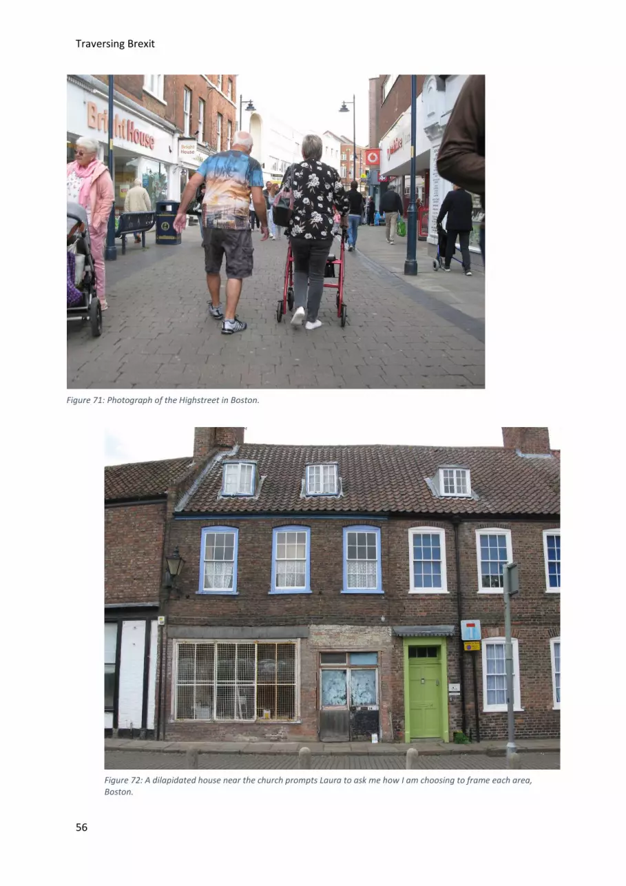
Traversing Brexit
56
Figure 71: Photograph of the Highstreet in Boston.
Figure 72: A dilapidated house near the church prompts Laura to ask me how I am choosing to frame each area, Boston.
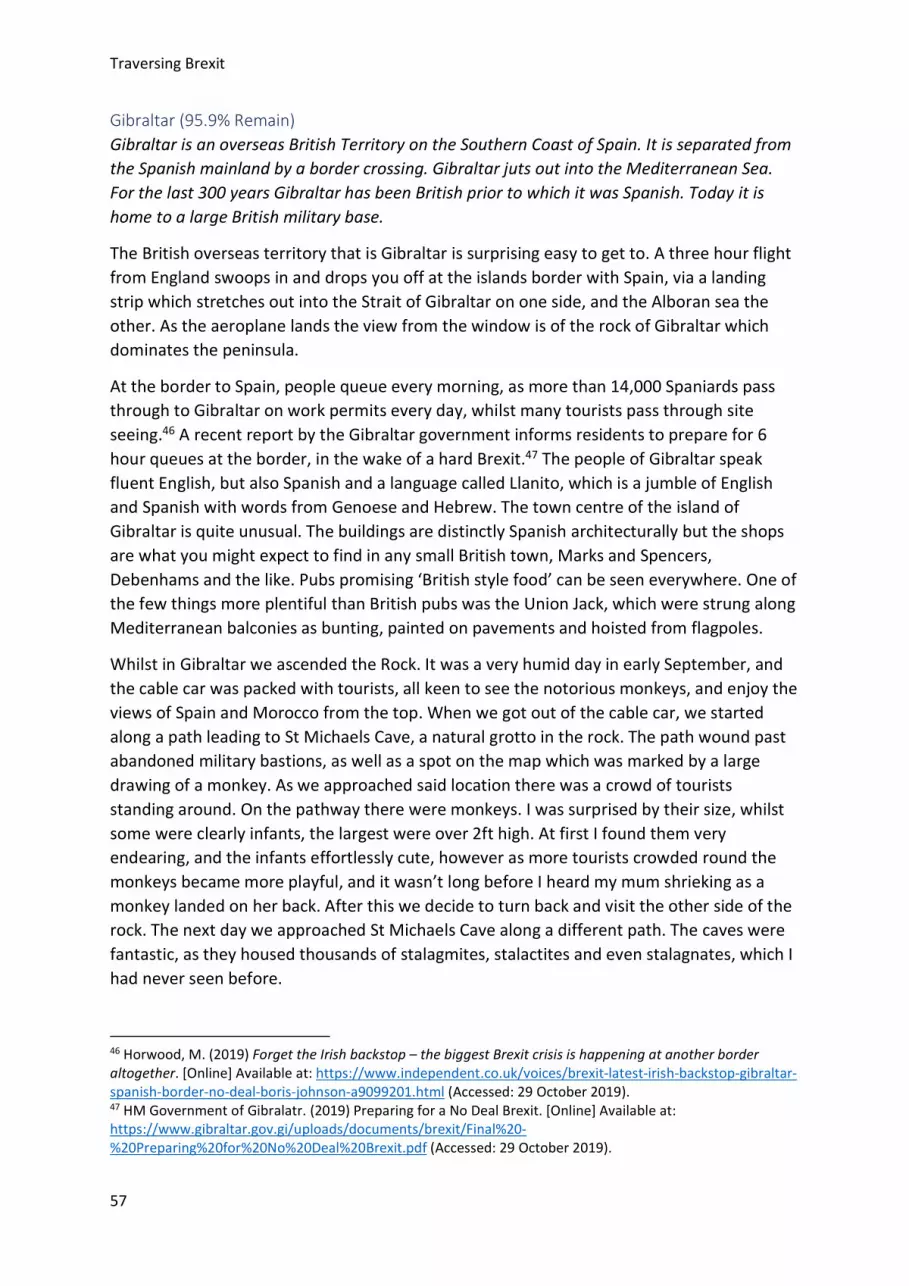
Traversing Brexit
57
Gibraltar (95.9% Remain) Gibraltar is an overseas British Territory on the Southern Coast of Spain. It is separated from the Spanish mainland by a border crossing. Gibraltar juts out into the Mediterranean Sea. For the last 300 years Gibraltar has been British prior to which it was Spanish. Today it is home to a large British military base.
The British overseas territory that is Gibraltar is surprising easy to get to. A three hour flight from England swoops in and drops you off at the islands border with Spain, via a landing strip which stretches out into the Strait of Gibraltar on one side, and the Alboran sea the other. As the aeroplane lands the view from the window is of the rock of Gibraltar which dominates the peninsula.
At the border to Spain, people queue every morning, as more than 14,000 Spaniards pass through to Gibraltar on work permits every day, whilst many tourists pass through site seeing.46 A recent report by the Gibraltar government informs residents to prepare for 6 hour queues at the border, in the wake of a hard Brexit.47 The people of Gibraltar speak fluent English, but also Spanish and a language called Llanito, which is a jumble of English and Spanish with words from Genoese and Hebrew. The town centre of the island of Gibraltar is quite unusual. The buildings are distinctly Spanish architecturally but the shops are what you might expect to find in any small British town, Marks and Spencers, Debenhams and the like. Pubs promising ‘British style food’ can be seen everywhere. One of the few things more plentiful than British pubs was the Union Jack, which were strung along Mediterranean balconies as bunting, painted on pavements and hoisted from flagpoles.
Whilst in Gibraltar we ascended the Rock. It was a very humid day in early September, and the cable car was packed with tourists, all keen to see the notorious monkeys, and enjoy the views of Spain and Morocco from the top. When we got out of the cable car, we started along a path leading to St Michaels Cave, a natural grotto in the rock. The path wound past abandoned military bastions, as well as a spot on the map which was marked by a large drawing of a monkey. As we approached said location there was a crowd of tourists standing around. On the pathway there were monkeys. I was surprised by their size, whilst some were clearly infants, the largest were over 2ft high. At first I found them very endearing, and the infants effortlessly cute, however as more tourists crowded round the monkeys became more playful, and it wasn’t long before I heard my mum shrieking as a monkey landed on her back. After this we decide to turn back and visit the other side of the rock. The next day we approached St Michaels Cave along a different path. The caves were fantastic, as they housed thousands of stalagmites, stalactites and even stalagnates, which I had never seen before.
46 Horwood, M. (2019) Forget the Irish backstop – the biggest Brexit crisis is happening at another border altogether. [Online] Available at: https://www.independent.co.uk/voices/brexit-latest-irish-backstop-gibraltar-spanish-border-no-deal-boris-johnson-a9099201.html (Accessed: 29 October 2019). 47 HM Government of Gibralatr. (2019) Preparing for a No Deal Brexit. [Online] Available at: https://www.gibraltar.gov.gi/uploads/documents/brexit/Final%20-%20Preparing%20for%20No%20Deal%20Brexit.pdf (Accessed: 29 October 2019).
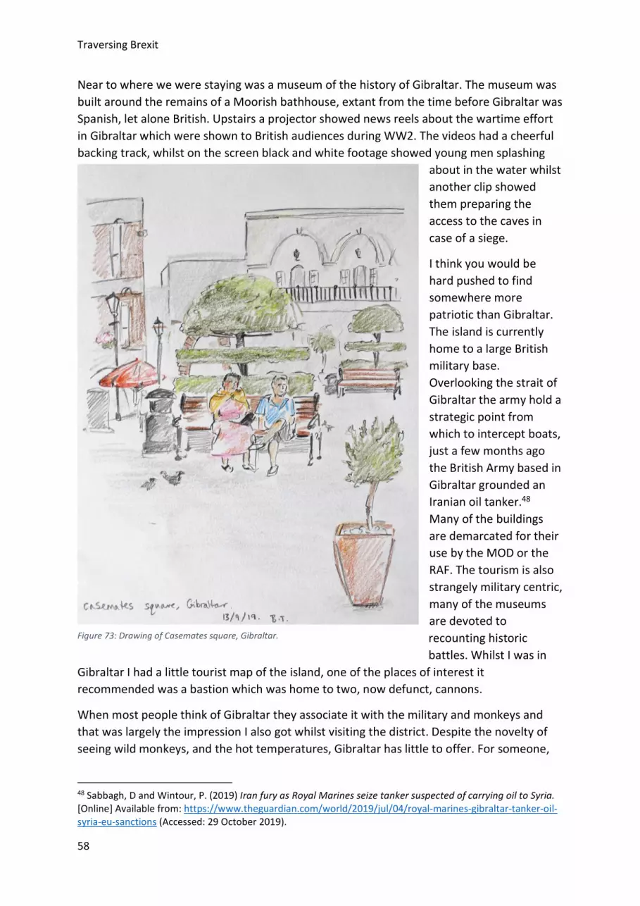
Traversing Brexit
58
Near to where we were staying was a museum of the history of Gibraltar. The museum was built around the remains of a Moorish bathhouse, extant from the time before Gibraltar was Spanish, let alone British. Upstairs a projector showed news reels about the wartime effort in Gibraltar which were shown to British audiences during WW2. The videos had a cheerful backing track, whilst on the screen black and white footage showed young men splashing
about in the water whilst another clip showed them preparing the access to the caves in case of a siege.
I think you would be hard pushed to find somewhere more patriotic than Gibraltar. The island is currently home to a large British military base. Overlooking the strait of Gibraltar the army hold a strategic point from which to intercept boats, just a few months ago the British Army based in Gibraltar grounded an Iranian oil tanker.48 Many of the buildings are demarcated for their use by the MOD or the RAF. The tourism is also strangely military centric, many of the museums are devoted to recounting historic battles. Whilst I was in
Gibraltar I had a little tourist map of the island, one of the places of interest it recommended was a bastion which was home to two, now defunct, cannons.
When most people think of Gibraltar they associate it with the military and monkeys and that was largely the impression I also got whilst visiting the district. Despite the novelty of seeing wild monkeys, and the hot temperatures, Gibraltar has little to offer. For someone,
48 Sabbagh, D and Wintour, P. (2019) Iran fury as Royal Marines seize tanker suspected of carrying oil to Syria. [Online] Available from: https://www.theguardian.com/world/2019/jul/04/royal-marines-gibraltar-tanker-oil-syria-eu-sanctions (Accessed: 29 October 2019).
Figure 73: Drawing of Casemates square, Gibraltar.

Traversing Brexit
59
like myself, who takes a critical view of the British Army, it’s quite hard to acclimatise to the military dominance of the district. Even walking around, you get the impression that many of the other people are military personnel in their civvies. With its military heritage Gibraltar is incredibly proud to be British, they last had a referendum on sovereignty in 2002, in which 99% voted against joint rule by Britain and Spain.49 For them leaving the EU would potentially create drastic problems when it comes to local industry, as not only much of the civilian workforce, but also supplies such as food and medicine come through the border with Spain.
49 Wintour, P and Tremlett, G. (2002) Gibraltar votes out joint rule with Spain. [Online] Available from: https://www.theguardian.com/politics/2002/nov/08/uk.gibraltar (Accessed: 29 October 2019).
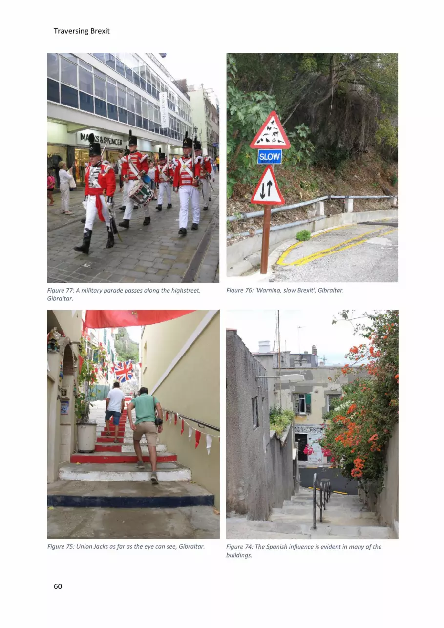
Traversing Brexit
60
Figure 77: A military parade passes along the highstreet, Gibraltar.
Figure 76: 'Warning, slow Brexit', Gibraltar.
Figure 75: Union Jacks as far as the eye can see, Gibraltar. Figure 74: The Spanish influence is evident in many of the buildings.

Traversing Brexit
61
Figure 78: Drawing of Casemates square by night, Gibraltar.
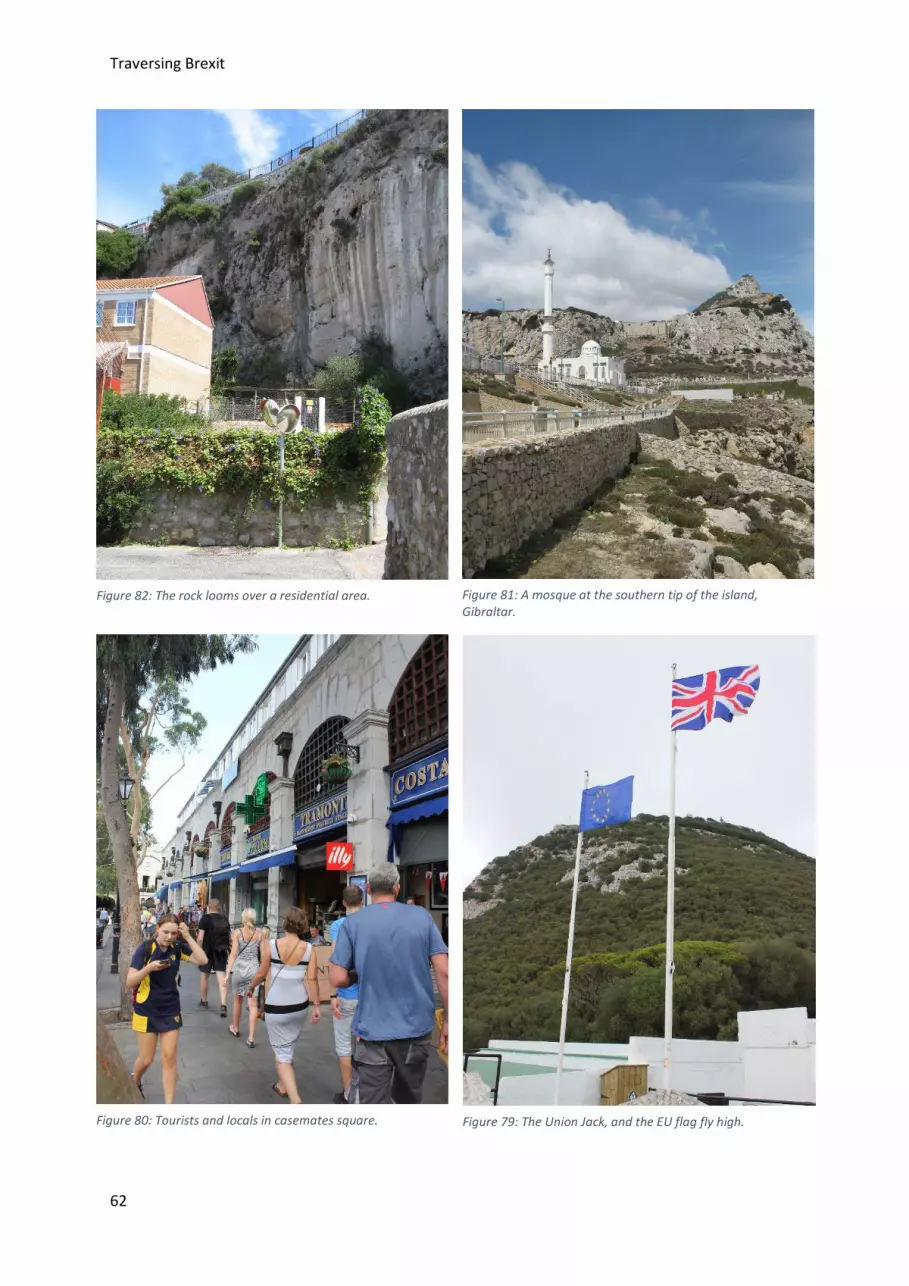
Traversing Brexit
62
Figure 82: The rock looms over a residential area. Figure 81: A mosque at the southern tip of the island, Gibraltar.
Figure 80: Tourists and locals in casemates square. Figure 79: The Union Jack, and the EU flag fly high.

Traversing Brexit
63
Conclusion After visiting the districts I felt like I had a more complete picture of the cultural divisions which led to the outcome of the EU referendum. Generally the Leave districts that I visited were rural areas which had previously experienced prosperity in the 20th century. For example Castle Point, South Holland and Great Yarmouth were once popular holiday destinations for British families. However all three of these districts are now less affluent and suffering from council cut backs relating to austerity. These areas also have a predominantly white British population, and a larger proportion of over 65 year olds than Britain as a whole. In Boston, South Holland and Thurrock, large amounts of European migrants had recently moved into these traditionally conservative areas. In the case of Boston, in 2016 (the year of the EU referendum) it was branded the least integrated place in the UK.
By comparison the Remain areas were more urban, and more multicultural. The three London districts of Hackney, Haringey and Lambeth have experienced quite rapid gentrification over the last couple of decades, and similarly Foyle has started to economically prosper since the Good Friday agreement in 1998. The Remain areas were relatively newly affluent, they also tended to have more longstanding diverse populations. Hackney has been home to a sizeable Jewish population since the 1920s,50 whilst all the London districts I visited became home to large black communities in the 20th century. Similarly Foyle has a mixed population of Catholics and Protestants, whilst Gibraltar has a diverse population of Brits, Spaniards and Moroccans. Overall Gibraltar and Foyle seemed to be outliers to the pattern, as whilst they had similarities to the other Remain districts, there was an overwhelming amount of geographical motivation for them to remain.
A report by the Joseph Rowntree Foundation, titled ‘Brexit Explained’ gives some insights into why communities may have voted for Brexit.51 One line which really stood out for me, was the following:
‘Groups in Britain who have been ‘left behind’ by rapid economic change and feel cut adrift from the mainstream consensus were the most likely to support Brexit.’
I thought the two words, ‘left behind’ aptly summarised the Leave districts I visited. But I’m not sure the ‘left behind’ concept starts and ends in the Leave areas. Major issues of poverty and inequality were apparent across all the districts, both Leave and Remain. Regardless of what happens now with Brexit, I think as a country we need to learn from the disparity and divides the referendum highlighted, and work at creating a more equal whole. Leave shouldn’t be synonymous with rural poverty, or a lack of jobs. But equally when we think of Remain we need to look beyond the ‘liberal elite’ and see the real inequality in these districts.
50 Hackney Council. (2019) The history of Hackney’s diverse communities. [Online] Available from: https://hackney.gov.uk/hackney-diversity (Accessed 29 October 2019). 51 Goodwin, M and Heath, O. (2016) Brexit vote explained: poverty, low skills and lack of opportunities. [Online] Available from: https://www.jrf.org.uk/report/brexit-vote-explained-poverty-low-skills-and-lack-opportunities?gclid=Cj0KCQjwi7DtBRCLARIsAGCJWBpJYYseo8du1N-u2x6oEZnvLnxYB3ektbxmJuVnokLxPCqQClnshi8aAophEALw_wcB (Accessed: 29 October 2019).

Traversing Brexit
64
After the Physical Journey - A Piece of Artwork in Conclusion Throughout much of the project I was focused on the traveling aspect, and it was only after having visited all of the intended districts that I came to think more carefully what form my final piece of artwork should take. The original intention was to complete two largescale embroideries of the districts that I visited. One embroidery would be of the Remain areas, whilst the other would depict the Leave areas. Each district would be artistically summarised by a montage of images based on what I saw, and what I drew there.
I started the embroideries after much working sourcing materials, completing preparatory samples, and planning the layout. I first painted the linen which I had ordered for my embroideries, so that the background had a high density of colour. I hoped this would make the embroideries faster, as I wouldn’t have to worry about making sure the stitches were dense.
Shortly after starting on the act of embroidery I realised that this style wasn’t satisfying me, and also that I wasn’t sure it reflected the travel. For me the summer travelling was fantastic, I got to experience so many new places, place I wouldn’t otherwise have visited. I spent hours sketching on the beach and reading in poorly lit B&Bs. I sat in cafes and drew detailed drawings. I visited museums and learnt about local history. I meandered through
residential streets for hours in the rain. The travel felt exciting and new to me, I was constantly asking myself questions and reframing my ideas and project in my mind. However an embroidery is a very slow, meticulous process. It’s the opposite of a quick artistic response. It is carefully planned out, and executed. As I started doing it I was dissatisfied with the pace, it didn’t allow me to be creative as I went. Yes, you can use stitches creatively, but you lose the artistic freedom to add a quick a line here, or a quick dash of colour there, as every image and shape is minutes, if not hours, of labour. Additionally the form that I find embroidery takes can be old fashioned, its hard to convince yourself that what you’re making is contemporary or relevant. At the outset I thought that was the beauty of the idea of doing an embroidery, that the traditional aspect of the skill would add more depth to the project. However as I reflected on the artwork I was creating I
Figure 83: Sample embroidery I did based on a street scene in Great Yarmouth.
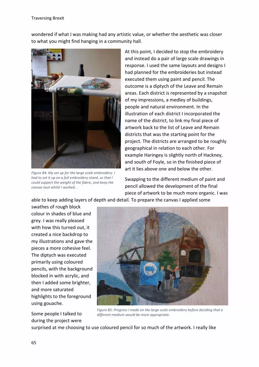
Traversing Brexit
65
wondered if what I was making had any artistic value, or whether the aesthetic was closer to what you might find hanging in a community hall.
At this point, I decided to stop the embroidery and instead do a pair of large scale drawings in response. I used the same layouts and designs I had planned for the embroideries but instead executed them using paint and pencil. The outcome is a diptych of the Leave and Remain areas. Each district is represented by a snapshot of my impressions, a medley of buildings, people and natural environment. In the illustration of each district I incorporated the name of the district, to link my final piece of artwork back to the list of Leave and Remain districts that was the starting point for the project. The districts are arranged to be roughly geographical in relation to each other. For example Haringey is slightly north of Hackney, and south of Foyle, so in the finished piece of art it lies above one and below the other.
Swapping to the different medium of paint and pencil allowed the development of the final piece of artwork to be much more organic. I was
able to keep adding layers of depth and detail. To prepare the canvas I applied some swathes of rough block colour in shades of blue and grey. I was really pleased with how this turned out, it created a nice backdrop to my illustrations and gave the pieces a more cohesive feel. The diptych was executed primarily using coloured pencils, with the background blocked in with acrylic, and then I added some brighter, and more saturated highlights to the foreground using gouache.
Some people I talked to during the project were surprised at me choosing to use coloured pencil for so much of the artwork. I really like
Figure 84: My set up for the large scale embroidery. I had to set it up on a full embroidery stand, so that I could support the weight of the fabric, and keep the canvas taut whilst I worked. .
Figure 85: Progress I made on the large scale embroidery before deciding that a different medium would be more appropriate.
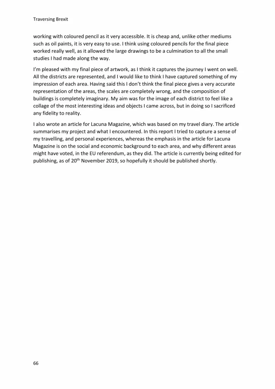
Traversing Brexit
66
working with coloured pencil as it very accessible. It is cheap and, unlike other mediums such as oil paints, it is very easy to use. I think using coloured pencils for the final piece worked really well, as it allowed the large drawings to be a culmination to all the small studies I had made along the way.
I’m pleased with my final piece of artwork, as I think it captures the journey I went on well. All the districts are represented, and I would like to think I have captured something of my impression of each area. Having said this I don’t think the final piece gives a very accurate representation of the areas, the scales are completely wrong, and the composition of buildings is completely imaginary. My aim was for the image of each district to feel like a collage of the most interesting ideas and objects I came across, but in doing so I sacrificed any fidelity to reality.
I also wrote an article for Lacuna Magazine, which was based on my travel diary. The article summarises my project and what I encountered. In this report I tried to capture a sense of my travelling, and personal experiences, whereas the emphasis in the article for Lacuna Magazine is on the social and economic background to each area, and why different areas might have voted, in the EU referendum, as they did. The article is currently being edited for publishing, as of 20th November 2019, so hopefully it should be published shortly.
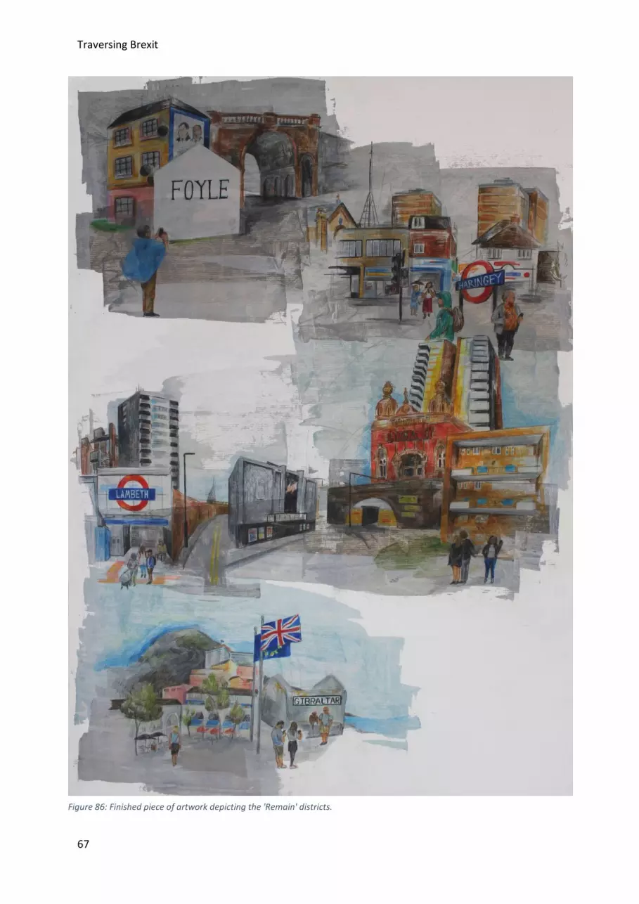
Traversing Brexit
67
Figure 86: Finished piece of artwork depicting the 'Remain' districts.
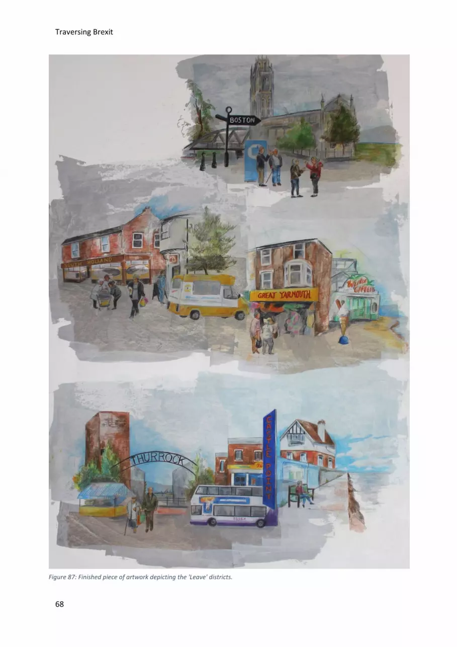
Traversing Brexit
68
Figure 87: Finished piece of artwork depicting the 'Leave' districts.
Traversing Brexit
69
Limitations In the original brief for the project I had intended it mostly to be about the drawings I made at each location. My intention was that I would make a couple of drawings in each district, which, accompanied by photographs and a few sentences written summary, would form a diary. However, as the project developed, and I learnt more about the districts, I felt that my original project would be enhanced by a more complete written account. This is partly as I personally felt a desire to discuss some of the most pressing issues I had come across in the districts, which I didn’t feel could be adequately expressed though illustrations alone.
Whilst I was in South Holland, I engaged with locals in a way that I don’t think I did in any of the other areas. As a result I think my summary of South Holland is one of the most interesting, as that personal interaction is conveyed. I think with hindsight the project could have had a lot more depth if I had connected with locals to talk to in each of the areas.
Probably the most significant limitation to the project was my own health. A few days after I had started to travel around the districts I realised that I had an eye infection. Suspecting that it was quite serious I paused my travelling to get medical care. The eye infection turned out to be really serious, and for two weeks I was in and out of eye A&E. The treatment involved me having to administer medication a regular intervals, night and day. As a result I had to put my travelling on hold. I had hoped to have visited at least eight of the districts in June and July, however I had to shift my timetable and I ended up doing most of my travelling in late August and September. The impact of this on my project is that I didn’t spend a consistent amount of time in each location, as I had to wrangle the travel around other commitments and hospital appointments.
Analysis If I would like people to take anything away from this project it would be that we need a change in perspective. By this I don’t just mean that we need a political change in perspective, but also a change in how we go about the world.
The project has certainly altered my political perspective. After travelling to these diverse areas I think I have more empathy for political opinions I previously couldn’t fully comprehend. Seeing the variety of environments, and conditions, people live in has given me more of an understanding of the motivations of British citizens from a range of different backgrounds. I think it’s very easy to get trapped in your own personal echo chamber. I certainly have been. I have certain politics, which I share with many of my friends and family, who repeat the same opinions back at me. Visiting communities like Thurrock or Boston where they are clearly not getting enough government funding or support helped me to better understand this alternative viewpoints, as I could see the hardships which had influenced these areas first-hand.
Arguably more importantly the project has altered my perspective on how I view things. I hope that maybe people who read it might feel the same way. Much of this project was me slowly travelling places by public transport, and then walking around, or sitting down, drawing or reading, carefully looking at buildings, or landscapes, or words. It forced me to

Traversing Brexit
70
take things slowly and really look at everything I saw and question everything I did. I hope this comes across to the reader, and I also hope this is something the reader might take away. I think we could all do sometimes with slowing down and just looking at things, and having new experiences. It forces us to think, but also, depending on what you’re looking at or thinking about can breed empathy. I previously mentioned this word, ‘allokataplixis’, about how tourists tend to see places with fresh eyes. I think that’s something we could all learn form, taking time to do things slowly, think things through, and just appreciate the ordinary.
Personal Reflection Going into the project I was most looking forward to having so much time purposefully set aside to draw. This was really good, but what I enjoyed even more was the travelling. Every part, from planning, to the long train journeys, to writing up all impressions, I found really enjoyable. The challenge of travelling alone was new to me, but I found it to be surprisingly great, and am already planning to travel alone next summer as well.
The project has also given me more of an appreciation for the viewpoint of Leave voters, specifically those within my family. My Nana, is a very passionate Brexiteer. This is something which I found hard to comprehend in the wake of the EU referendum. In a sense her views are typical of what you might expect a Leave voter to think, she has a poor view of Europe, doesn’t like migrants and wishes Britain was more like it used to be, whatever that means. After this project I think I can understand where her views are coming from. The area she lives in isn’t so different from Castle Point or South Holland, its relatively poor, rural, very white and populated by ageing residents. Rightly or wrongly I can understand how in her eyes, when she compares the Britain of today with that of yesteryear, the present comes up short.
Setting out on the project I was expecting to come across aspects of the British identity that I disliked in the Leave areas, as I suspected they might reflect racist, nostalgic patriotism. But, whilst I did come across this during my travelling, I realised that maybe this view is at least in part a product of circumstance and community. One of the strongest personal reactions I had during this project was when I learnt more about what happened in Northern Ireland. The fact that Soldier F is only just facing trial for his actions horrifies me, all the more so because the violence carried out in Ireland, that he was involved in, was at a state institutional level.
Summary I set out on this project hoping to make a compilation of drawings, but quickly the drawings became only a part of the information and ideas I wanted to share about what I encountered. The project became about so much more than my original premise.
I hope I’ve managed to convey the need for change in Britain. We shouldn’t be bickering amongst ourselves about how people voted, but rather ask what were the conditions which made them vote in such a way. Austerity has hit Britain hard, we are currently facing a crisis in terms of the wage gap, childhood poverty and a lack of suitable council housing. Britain is
Traversing Brexit
71
big, we may be small physically but we are one of the most densely occupied areas in the world. We are very diverse, and not just the people but the communities, even the natural environment varies greatly between districts. We need to build a Britain which works for everyone, not just those living in affluent areas with good infrastructure.
The main body of the project was the multi-media travel journal embedded within this report. The finished drawings of the Remain and Leave areas are large A1 panels, and I intend in the coming months to reach out to local art galleries about the possibility of displaying them. As part of the project I have also written an article for Lacuna Magazine, which is currently in the process of being editing, but should hopefully be released soon. The article is a summary of my travel journal, with a focus on the political aspects of what I discovered, as opposed to the more personal journey. I hope the article I have written for Lacuna Magazine, will propagate the message of both political and perspective change.
Recommendations I would advise someone doing a similar project to start with a more specific idea. My original premise was quite broad, then as the project developed the number of things I wanted to include grew. A side-effect of this was that the project took a lot longer than I expected it to.
If someone else were to undertake a similar artistic project I would recommend that they more carefully plan the artistic style they intend to adopt, and how they intend to execute each image. If I was to do the project again, I would try to develop and settle on a more distinctive drawing style prior to travel, so that I had an overarching style to inform the sketches I did at each location. The reality is I think some of the sketches ended up looking slightly disparate, and didn’t necessarily form a cohesive whole. I also realised that it wasn’t always possible to make the drawings I wanted to in situ. Often I struggled to find somewhere suitable to stand, or sit, in order to draw the object of my attention. Overtimes adverse weather conditions drove me inside. As a result some of the studies I made were done at a later date, and as such I think lack the spontaneity of the drawings done at the time.
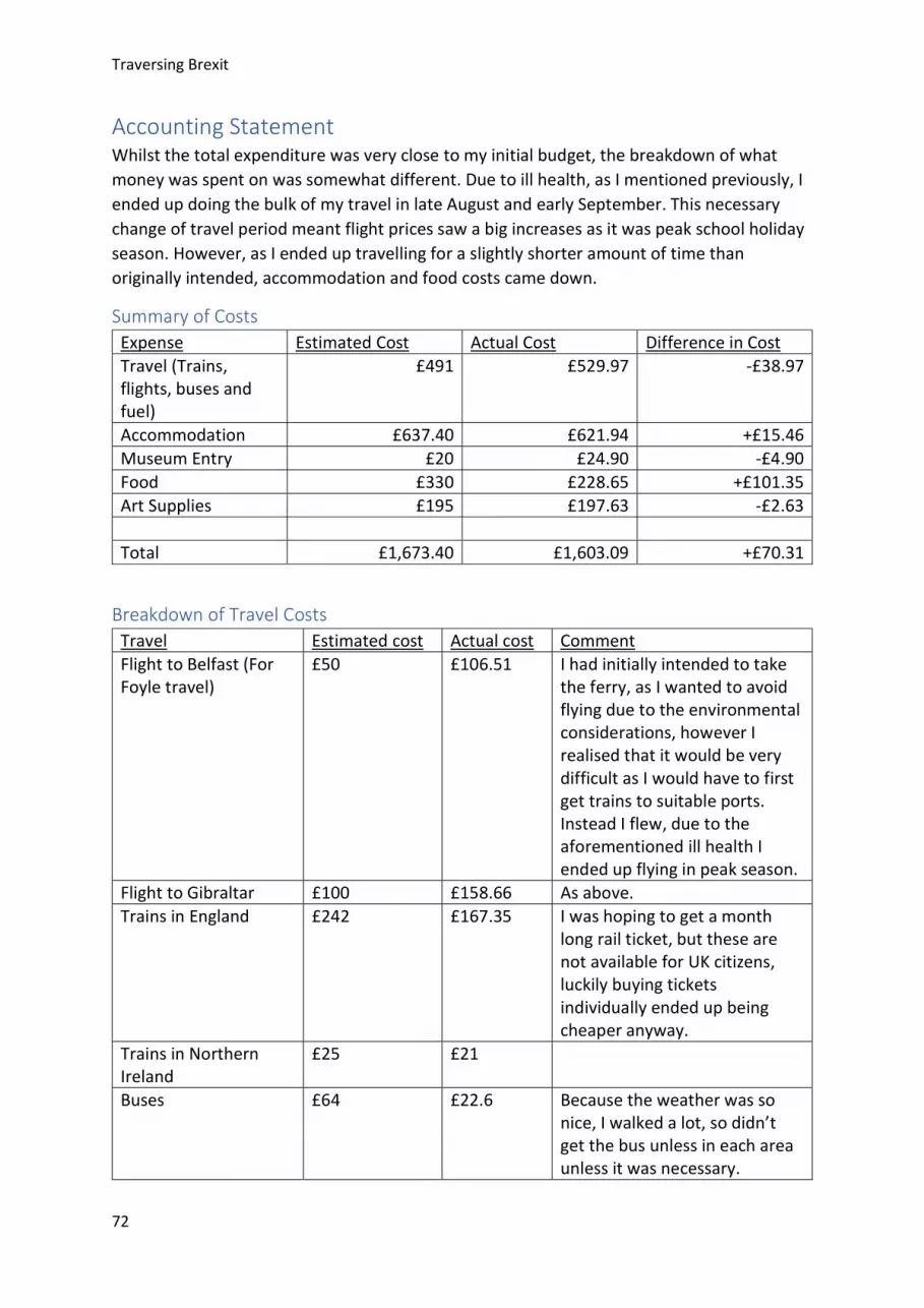
Traversing Brexit
72
Accounting Statement Whilst the total expenditure was very close to my initial budget, the breakdown of what money was spent on was somewhat different. Due to ill health, as I mentioned previously, I ended up doing the bulk of my travel in late August and early September. This necessary change of travel period meant flight prices saw a big increases as it was peak school holiday season. However, as I ended up travelling for a slightly shorter amount of time than originally intended, accommodation and food costs came down.
Summary of Costs Expense Estimated Cost Actual Cost Difference in Cost Travel (Trains, flights, buses and fuel)
£491 £529.97 -£38.97
Accommodation £637.40 £621.94 +£15.46 Museum Entry £20 £24.90 -£4.90 Food £330 £228.65 +£101.35 Art Supplies £195 £197.63 -£2.63 Total £1,673.40 £1,603.09 +£70.31
Breakdown of Travel Costs Travel Estimated cost Actual cost Comment Flight to Belfast (For Foyle travel)
£50 £106.51 I had initially intended to take the ferry, as I wanted to avoid flying due to the environmental considerations, however I realised that it would be very difficult as I would have to first get trains to suitable ports. Instead I flew, due to the aforementioned ill health I ended up flying in peak season.
Flight to Gibraltar £100 £158.66 As above. Trains in England £242 £167.35 I was hoping to get a month
long rail ticket, but these are not available for UK citizens, luckily buying tickets individually ended up being cheaper anyway.
Trains in Northern Ireland
£25 £21
Buses £64 £22.6 Because the weather was so nice, I walked a lot, so didn’t get the bus unless in each area unless it was necessary.

Traversing Brexit
73
London Underground 0 £20 Fuel costs (For driving to Lincolnshire and back).
0 £31.35 I was originally intending to get the train to South Holland and Boston, however after realising how difficult it would be to get there by public transport I took my Mums car instead.
Parking Ticket 0 £2.5
Breakdown of Accommodation Costs Accommodation Estimated cost Actual Cost Comment London Hostel (stayed in for visiting Haringey, Lambeth, Castle Point and Thurrock)
£256 £127.4 This is the first part of my trip which was cut short due to ill health, so I ended up staying much fewer nights than originally intended.
Hackney 0 0 I initially intended to stay with a friend when visiting Hackney, but in the end I just went there for two separate day trips.
Great Yarmouth B&B £52 £45 Foyle B&B £68.4 £174 After reading some horrifying
reviews of the Hostel I was intending to stay at I booked a well-reviewed B&B instead.
South Holland and Boston
£156 £85 I split the cost of a room with my friend who accompanied me in Lincolnshire which brought the cost down.
Gibraltar £105 £190.54 I split the cost of an Airbnb with my Mum, which ended up being more expensive than expected.
Breakdown of Art Supplies Costs Art Supply Estimated cost Actual Cost Comment Embroidery Course £125 £114.5 Linen, Embroidery threads and Paint
£50 £65.39 I bought all the supplies I needed for my embroidery, only to then realise that it wasn’t going to be my final piece of artwork.
Paper £20 £17.74
Related Documents