Travel across Canada PREVIEW

Welcome message from author
This document is posted to help you gain knowledge. Please leave a comment to let me know what you think about it! Share it to your friends and learn new things together.
Transcript

ROAD BOOK TO TRAVEL ACROSS CANADA
Travel across Canada PREVIEW

Road Book to Travel across Canada
By Tourguide Canada © 2017 Page 2
About this road book
This road book contains
maps, including links to the online maps
driving directions
sights of interest
web links to related Provincial Parks & Parks Canada brochures or maps (inserted in the online
map)
relevant additional information
Use the itinerary as a guideline for your Canadian Road Trip.
Use the road book on your mobile device. The latter allows you to open added links and interactive
maps.
Regarding interactive links
Clicking on a link will open its specific web address. If you encounter any problems to open a link, first
check if you have internet access.
In the rare occasion that clicking on a link does not open the specific page, please copy and paste the
link directly into your browser
Cellphone reach and internet
Although the majority of accommodations offer WIFI, cell phone coverage is poor along the route. Check
each night, next day’s programme.
Road conditions
Check each night, next day’s road conditions. Included is a listing to websites providing road conditions
per province
Travel times
Be aware that the times mentioned in the proposed travel schedule are net travel times. Times
mentioned do not include any stops.
About the route
The designed route is the most scenic and interesting route for your Canadian road trip. If I’d be in the
position to join you on your trip, I would guide you exactly the same way as presented in this itinerary.
About the sights
It is not my intention to include every single activity along the route. Presented sights are carefully
selected, quality and feasibility within the proposed day schedule.
Logistics
Book a rental car one-way Vancouver to Halifax.
Road Book to Travel across Canada
By Tourguide Canada © 2017 Page 3
Table of Contents
About this road book .................................................................................................................................... 2
Accommodation schedule ............................................................................................................................ 4
Websites to help plan your accommodation ................................................................................................ 5
Road conditions ............................................................................................................................................ 6
How to Use the Road Trip Maps ................................................................................................................... 7
Day 6 Rockies: here we come! Destination Jasper, AB ................................................................................. 8 Clearwater, BC to Jasper, AB 320 km, 3hr 45 min ................................................................................................................ 8
Day 14 The Great Lakes: Lake Superior’s north shore ................................................................................ 11 Nipigon to Sault Ste Marie 587 km, 6hr 45min .................................................................................................................. 11

Road Book to Travel across Canada
By Tourguide Canada © 2017 Page 4
Accommodation schedule According to this road book you’ll stay at specific destinations (already filled out).
To complete the schedule, just fill out the dates and use the schedule to plan and book your
accommodation.
Day # in road book
Destination check in date check out date # nights
1 + 2 Vancouver, BC
3
4 + 5
6 WILL BE COMPLETED
7
8
9
10
11
12
13
14
15
16 + 17
18
19 + 20
21 + 22
23
24 + 25
26 Halifax, NS
27
Abbreviations for the Canadian Provinces
BC British Columbia
AB Alberta
SK Saskatchewan
MB Manitoba
ON Ontario
QC Quebec
NB New Brunswick
NS Nova Scotia
Sign Trans Canada Highway
Road Book to Travel across Canada
By Tourguide Canada © 2017 Page 5
Websites to help plan your accommodation
Tourism Vancouver https://www.tourismvancouver.com/places-to-stay/
WILL BE FILLED OUT
Tourism Halifax http://www.destinationhalifax.com/where-to-stay
Road Book to Travel across Canada
By Tourguide Canada © 2017 Page 6
Road conditions
British Columbia road conditions
http://www.drivebc.ca/#mapView&ll=54.004539%2C-123.75&z=6&xtg=Map%20Badge
WILL BE FILLED OUT
Road Book to Travel across Canada
By Tourguide Canada © 2017 Page 7
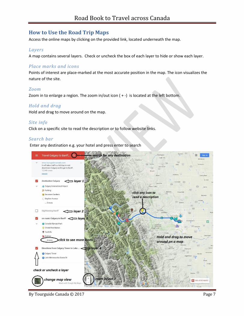
How to Use the Road Trip Maps Access the online maps by clicking on the provided link, located underneath the map.
Layers
A map contains several layers. Check or uncheck the box of each layer to hide or show each layer.
Place marks and icons
Points of interest are place-marked at the most accurate position in the map. The icon visualizes the
nature of the site.
Zoom
Zoom in to enlarge a region. The zoom in/out icon ( + -) is located at the left bottom.
Hold and drag
Hold and drag to move around on the map.
Site info
Click on a specific site to read the description or to follow website links.
Search bar
Enter any destination e.g. your hotel and press enter to search
Road Book to Travel across Canada
By Tourguide Canada © 2017 Page 8
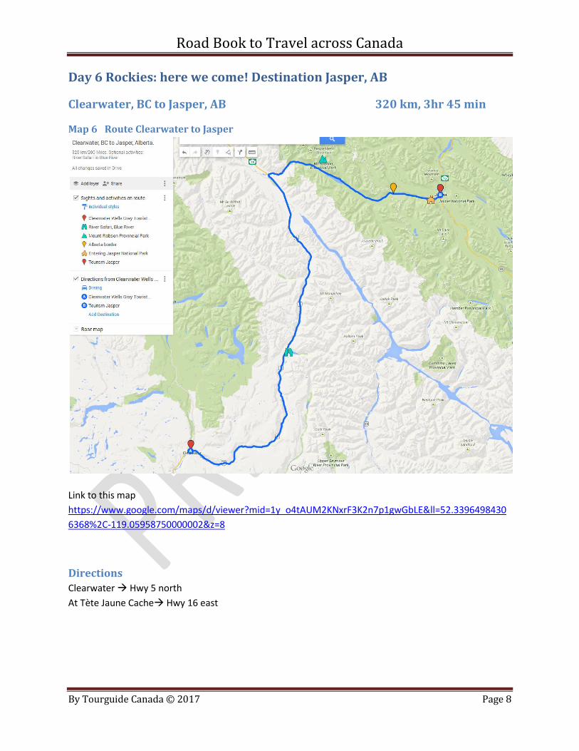
Day 6 Rockies: here we come! Destination Jasper, AB
Clearwater, BC to Jasper, AB 320 km, 3hr 45 min
Map 6 Route Clearwater to Jasper
Link to this map
https://www.google.com/maps/d/viewer?mid=1y_o4tAUM2KNxrF3K2n7p1gwGbLE&ll=52.3396498430
6368%2C-119.05958750000002&z=8
Directions
Clearwater Hwy 5 north
At Tète Jaune Cache Hwy 16 east
Road Book to Travel across Canada
By Tourguide Canada © 2017 Page 9
Sights of interest
Blue River: River Safari
A 1 hour River Safari per eco friendly boat.
Good chances to spot wildlife such as black bears, grizzlies, bold eagles and moose.
Departure: Every 30 minutes.
Phone: 1-877-4.WILD.BC (494.5322)
Web: www.riversafari.com
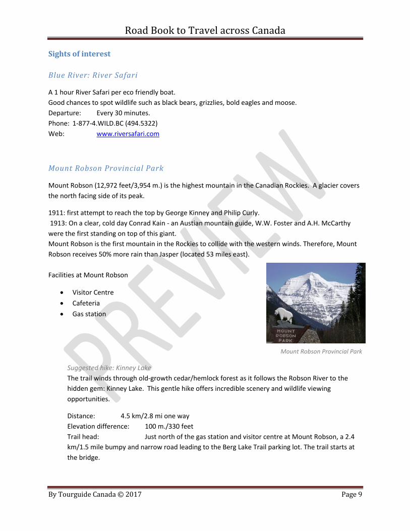
Mount Robson Provincial Park
Mount Robson (12,972 feet/3,954 m.) is the highest mountain in the Canadian Rockies. A glacier covers
the north facing side of its peak.
1911: first attempt to reach the top by George Kinney and Philip Curly.
1913: On a clear, cold day Conrad Kain - an Austian mountain guide, W.W. Foster and A.H. McCarthy
were the first standing on top of this giant.
Mount Robson is the first mountain in the Rockies to collide with the western winds. Therefore, Mount
Robson receives 50% more rain than Jasper (located 53 miles east).
Facilities at Mount Robson
Visitor Centre
Cafeteria
Gas station
Mount Robson Provincial Park
Suggested hike: Kinney Lake
The trail winds through old-growth cedar/hemlock forest as it follows the Robson River to the
hidden gem: Kinney Lake. This gentle hike offers incredible scenery and wildlife viewing
opportunities.
Distance: 4.5 km/2.8 mi one way
Elevation difference: 100 m./330 feet
Trail head: Just north of the gas station and visitor centre at Mount Robson, a 2.4
km/1.5 mile bumpy and narrow road leading to the Berg Lake Trail parking lot. The trail starts at
the bridge.
Road Book to Travel across Canada
By Tourguide Canada © 2017 Page 10
Located directly after the second bridge that crosses the Robson River (4.3 km/2.7 mi) are picnic
tables (left turn) and an outhouse (right turn).
Return the same way.
Suggested late summer walk: Rearguard Falls and Chinook salmon
Distance: 0.6 km/0.4 mi one-way. Return the same route.
Elevation difference: 30 metre/100 feet
Trail head: 4 km / 2.5 mi east of junction Hwy 5 to Hwy 16.
Watch for a signpost and car park.
Reach the Rearguard Falls by the clearly marked short (15 min) descending trail.
The Rearguard Falls viewpoint provides an excellent opportunity to witness the end of a long
journey by the Chinook, largest of the Pacific salmon. These fish have survived several years at sea
to return to the river of their birth, the mighty Fraser River. From its estuary in British Columbia’s
lower mainland to this point, the Chinook have traveled upstream over 1200 km. Some may be
successful battling over these falls to reach the gravel above, but for most, Rearguard Falls marks
the end of their journey. Your best chances to see the salmon are late summer.
Good to know
When entering Jasper National Park, you have to purchase a Parks Canada pass.
This park pas is a permit that allows visitors to visit any national park in Canada during the time period in
which it is valid. Anyone visiting, stopping for picnics and viewpoints, or visiting lakes and villages must
purchase the pass. The correlating fee contributes to maintenance of scenic parkways, day use areas,
updating information and public safety, trails and interpretation sites.
Free admission in 2017
Parks Canada is inviting Canadians and visitors from around the world to celebrate Canada’s 150th
anniversary. To mark this special year, Parks Canada is offering free admission to all Parks Canada
locations! The park pass is available in-person at Parks Canada's park gates and information centres. Or
you can order your pass here (arrival per slow mail) http://www.commandesparcs-
parksorders.ca/webapp/wcs/stores/servlet/en/ProductDisplay?storeId=22953&categoryId=216870&cat
alogId=53407&productId=524527&errorViewName=ProductDisplayErrorView&top_category=216870&p
arent_category_rn=216870&langId=-1
Move your watch + 1 hour when entering Alberta
The province of Alberta charges 5 % GST (instead of 5% GST + 7% PST = 12% taxes in BC)
Road Book to Travel across Canada
By Tourguide Canada © 2017 Page 11
Day 14 The Great Lakes: Lake Superior’s north shore
Nipigon to Sault Ste Marie 587 km, 6hr 45min
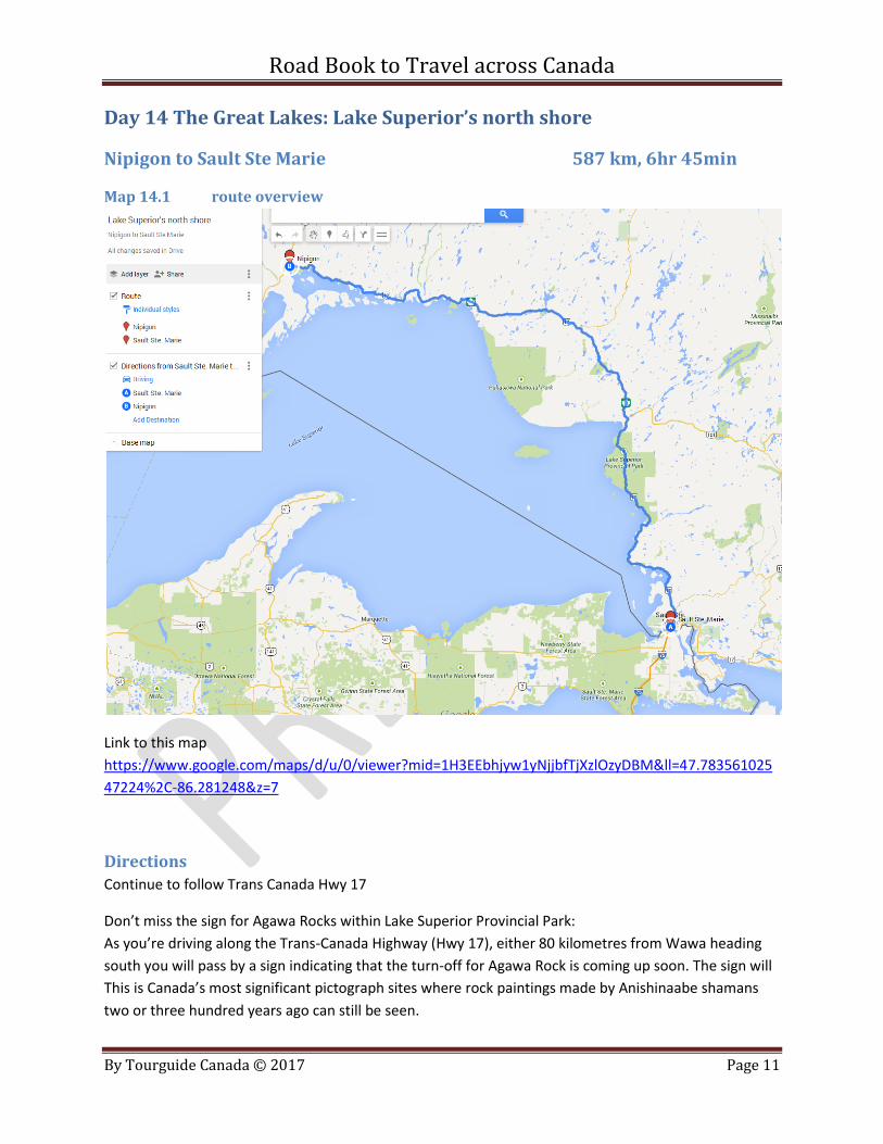
Map 14.1 route overview
Link to this map
https://www.google.com/maps/d/u/0/viewer?mid=1H3EEbhjyw1yNjjbfTjXzlOzyDBM&ll=47.783561025
47224%2C-86.281248&z=7
Directions
Continue to follow Trans Canada Hwy 17
Don’t miss the sign for Agawa Rocks within Lake Superior Provincial Park:
As you’re driving along the Trans-Canada Highway (Hwy 17), either 80 kilometres from Wawa heading
south you will pass by a sign indicating that the turn-off for Agawa Rock is coming up soon. The sign will
This is Canada’s most significant pictograph sites where rock paintings made by Anishinaabe shamans
two or three hundred years ago can still be seen.

Road Book to Travel across Canada
By Tourguide Canada © 2017 Page 12
Sights of interest
Rainbow Fall provincial Park
A great stop to stretch your legs and have a picnic
http://www.ontarioparks.com/park/rainbowfalls
Neys Provincial Park and Visitor Centre
View a model of a former prisoner-of-war (POW) camp at the Visitor Centre and the actual remains of
POW Camp 100
Enjoy viewing sub-Arctic plants and a chance to see an elusive Woodland Caribou.
Hike one of the trails
Web: http://www.ontarioparks.com/park/neys
White Lake Provincial Park
Great place to swim, with warm waters and sandy beaches
Clearwater Lake Trail: 2 km return, linear trail, easy
This trail leads through a pine forest to the spring-fed Clearwater Lake. Go for a swim, sit back and relax .
Lake Superior Provincial Park
Agawa Rock Pictographs – 35 red ochre images are visible; one of the few pictograph sites in Ontario
accessible by foot. Moderate; 0.5 km (0.3 mi) loop; .1/2 - 1 hour
Generations of Ojibwe recorded their dreams and spirits in red ochre paintings at this sacred site. The
trail is short, but rugged, descending through rock chasms and broken boulders.
The Pictographs are accessed from a rock ledge at the edge of Lake Superior and can only be viewed
when the lake is calm. The site is open from mid-May to mid-September. Caution is advised when
venturing onto this rock ledge due to its slope and the unpredictable nature of Lake Superior and its
wave action.
Web: http://www.lakesuperiorpark.ca/index.php/activities/23-pictographs
Sault Ste. Marie Canal National Historic Site
Completed in 1895, this canal formed the last link in an all-Canadian navigation system stretching from
the St. Lawrence River to Lake Superior.
Web: http://www.pc.gc.ca/en/lhn-nhs/on/ssmarie
Road Book to Travel across Canada
By Tourguide Canada © 2017 Page 13
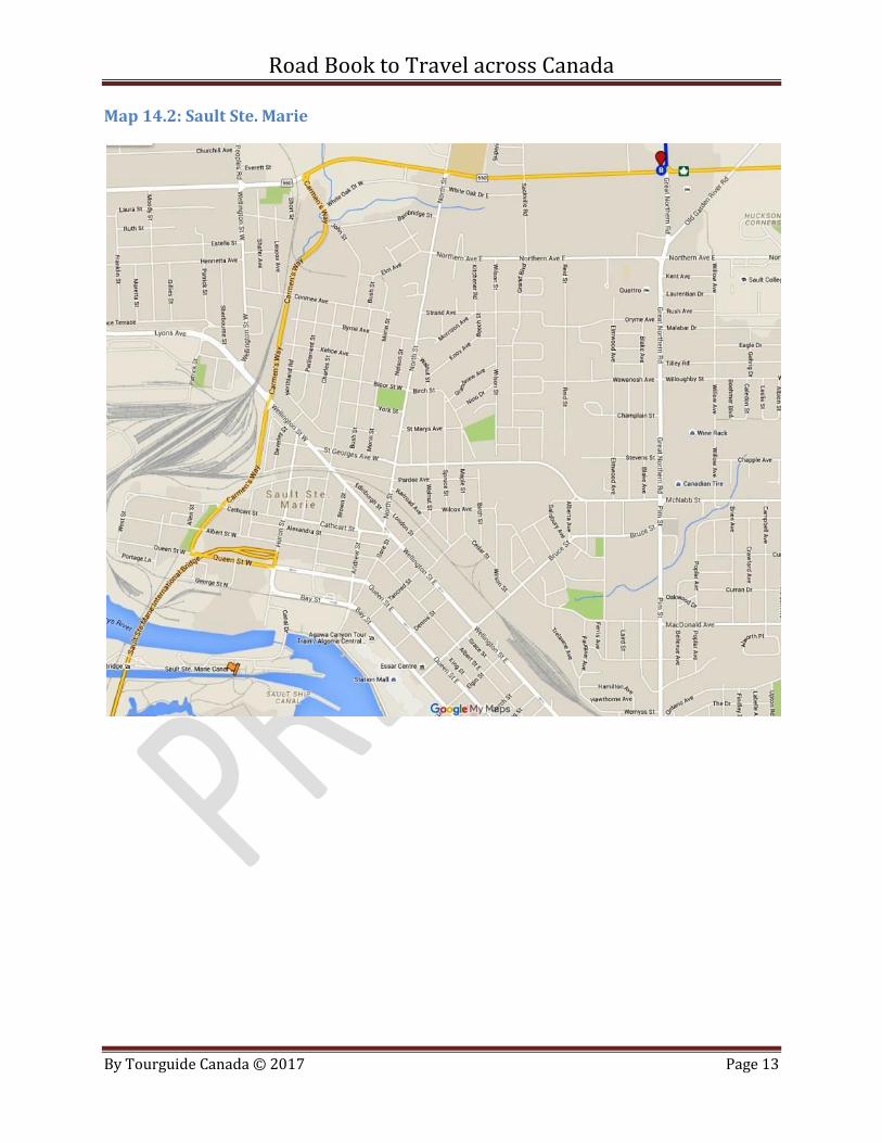
Map 14.2: Sault Ste. Marie
Related Documents