Transient fluvial incision in the headwaters of the Yellow River, northeastern Tibet, China Nathan Harkins, 1 Eric Kirby, 1 Arjun Heimsath, 2 Ruth Robinson, 3 and Uwe Reiser 4 Received 9 May 2006; revised 13 April 2007; accepted 29 June 2007; published 22 September 2007. [1] We utilize topographic analysis of channel profiles combined with field measurements of erosion rates to explore the distribution of channel incision in the Anyemaqen Shan, a broad mountainous region in the northeastern Tibetan plateau. Tributary channels to the Yellow River display systematic downstream increases in channel gradient associated with convex upward longitudinal profiles. Steep lower reaches of channels are associated with rapid (>1 m/ka) incision rates along the Yellow River, while upstream reaches are associated with relatively slow (0.05–0.1 m/ka) erosion of soil-mantled uplands. Covariance between erosion rates and channel steepness indices suggest that channels are adjusted to match long-wavelength differential rock uplift across the range. Geologic constraints indicate that rapid incision downstream of the range is associated with excavation of basin fill driven by changes in relative base level farther downstream. The upstream limit of this wave of transient incision is marked by a series of knickpoints that are found at nearly the same elevation throughout the watershed, consistent with knickpoint migration as a kinematic, rather than diffusional, wave. Tributary channel gradients downstream of knickpoints, however, display a progressive adjustment to increased incision rates that may reflect the influence of increased sediment flux. Comparison of observed channel profiles to a stream power model of fluvial behavior reveals that the rate of knickpoint propagation can only be explained if the erosional efficiency coefficient (K) increases during incision. Our results thus highlight the utility of channel profile analysis to reconstruct the fluvial response to both active tectonism and external changes in base level. Citation: Harkins, N., E. Kirby, A. Heimsath, R. Robinson, and U. Reiser (2007), Transient fluvial incision in the headwaters of the Yellow River, northeastern Tibet, China, J. Geophys. Res., 112, F03S04, doi:10.1029/2006JF000570. 1. Introduction [2] Recognition of feedbacks among climate, surface processes and tectonics [e.g., Beaumont et al., 1992; Koons, 1989] has motivated intensive investigation into the response of landscape form to external forcing. Most of these studies have focused on steady state formulations of fluvial incision rules and their implications for equilibrium river profiles [Hack, 1957; Howard, 1994; Mackin, 1948; Whipple, 2004; Whipple and Tucker, 1999]. Although application of these rules has met with varying degrees of success in landscapes where a balance between erosion and rock uplift appears to have been achieved [Kirby and Whipple, 2001; Lague and Davy , 2003; Snyder et al., 2000], such landscapes appear to be the exception, rather than the rule. Many landscapes are argued to be in a transient state, adjusting to changes in tectonic forcing [cf. Safran et al., 2005; Stock et al., 2005], drainage reorganization [Clark et al., 2004], base-level fall [Anderson et al., 2006; Berlin and Anderson, 2007], or climate change [Zhang et al., 2001]. Moreover, the form of equilibrium river profiles may be nondiagnostic of the dominant incision process [Howard et al., 1994; Whipple et al., 2000; Whipple and Tucker, 2002], whereas the transient response of channel systems to changes in bound- ary conditions offers an opportunity to refine and test incision rules [Howard and Kerby , 1983; Rosenbloom and Anderson, 1994; Whipple, 2004]. Relatively few tests of this kind have been performed, however [Bishop et al., 2005; Loget et al., 2006; van der Beek and Bishop, 2003], largely reflecting the difficulty in characterizing initial conditions, the timing and magnitude of perturbations, and the rates and patterns of channel response. Continued progress in our understanding of the linkages between climate, erosion and tectonics requires additional field sites where the transient response of fluvial systems to a known external forcing can be quantitatively evaluated. [3] In this paper, we examine the rates and patterns of fluvial incision across the Anyemaqen Shan, a broad mountainous region within the northeastern Tibetan Plateau (Figure 1). Topography in this region is somewhat anomalous JOURNAL OF GEOPHYSICAL RESEARCH, VOL. 112, F03S04, doi:10.1029/2006JF000570, 2007 Click Here for Full Articl e 1 Department of Geosciences, Pennsylvania State University, University Park, Pennsylvania, USA. 2 Department of Earth Sciences, Dartmouth College, Hanover, New Hampshire, USA. 3 School of Geography and Geosciences, University of St. Andrews, St. Andrews, UK. 4 School of Earth Sciences, Victoria University of Wellington, Wellington, New Zealand. Copyright 2007 by the American Geophysical Union. 0148-0227/07/2006JF000570$09.00 F03S04 1 of 21

Welcome message from author
This document is posted to help you gain knowledge. Please leave a comment to let me know what you think about it! Share it to your friends and learn new things together.
Transcript

Transient fluvial incision in the headwaters of the Yellow River,
northeastern Tibet, China
Nathan Harkins,1 Eric Kirby,1 Arjun Heimsath,2 Ruth Robinson,3 and Uwe Reiser4
Received 9 May 2006; revised 13 April 2007; accepted 29 June 2007; published 22 September 2007.
[1] We utilize topographic analysis of channel profiles combined with field measurementsof erosion rates to explore the distribution of channel incision in the Anyemaqen Shan, abroad mountainous region in the northeastern Tibetan plateau. Tributary channels tothe Yellow River display systematic downstream increases in channel gradient associatedwith convex upward longitudinal profiles. Steep lower reaches of channels are associatedwith rapid (>1 m/ka) incision rates along the Yellow River, while upstream reaches areassociated with relatively slow (0.05–0.1 m/ka) erosion of soil-mantled uplands.Covariance between erosion rates and channel steepness indices suggest that channels areadjusted to match long-wavelength differential rock uplift across the range. Geologicconstraints indicate that rapid incision downstream of the range is associated withexcavation of basin fill driven by changes in relative base level farther downstream. Theupstream limit of this wave of transient incision is marked by a series of knickpoints thatare found at nearly the same elevation throughout the watershed, consistent withknickpoint migration as a kinematic, rather than diffusional, wave. Tributary channelgradients downstream of knickpoints, however, display a progressive adjustment toincreased incision rates that may reflect the influence of increased sediment flux.Comparison of observed channel profiles to a stream power model of fluvial behaviorreveals that the rate of knickpoint propagation can only be explained if the erosionalefficiency coefficient (K) increases during incision. Our results thus highlight the utility ofchannel profile analysis to reconstruct the fluvial response to both active tectonism andexternal changes in base level.
Citation: Harkins, N., E. Kirby, A. Heimsath, R. Robinson, and U. Reiser (2007), Transient fluvial incision in the headwaters of the
Yellow River, northeastern Tibet, China, J. Geophys. Res., 112, F03S04, doi:10.1029/2006JF000570.
1. Introduction
[2] Recognition of feedbacks among climate, surfaceprocesses and tectonics [e.g., Beaumont et al., 1992; Koons,1989] has motivated intensive investigation into the responseof landscape form to external forcing. Most of these studieshave focused on steady state formulations of fluvial incisionrules and their implications for equilibrium river profiles[Hack, 1957; Howard, 1994; Mackin, 1948; Whipple, 2004;Whipple and Tucker, 1999]. Although application of theserules has met with varying degrees of success in landscapeswhere a balance between erosion and rock uplift appears tohave been achieved [Kirby and Whipple, 2001; Lague andDavy, 2003; Snyder et al., 2000], such landscapes appear tobe the exception, rather than the rule. Many landscapes are
argued to be in a transient state, adjusting to changes intectonic forcing [cf. Safran et al., 2005; Stock et al., 2005],drainage reorganization [Clark et al., 2004], base-level fall[Anderson et al., 2006; Berlin and Anderson, 2007], orclimate change [Zhang et al., 2001]. Moreover, the form ofequilibrium river profiles may be nondiagnostic of thedominant incision process [Howard et al., 1994; Whippleet al., 2000; Whipple and Tucker, 2002], whereas thetransient response of channel systems to changes in bound-ary conditions offers an opportunity to refine and testincision rules [Howard and Kerby, 1983; Rosenbloom andAnderson, 1994;Whipple, 2004]. Relatively few tests of thiskind have been performed, however [Bishop et al., 2005;Loget et al., 2006; van der Beek and Bishop, 2003], largelyreflecting the difficulty in characterizing initial conditions,the timing and magnitude of perturbations, and the rates andpatterns of channel response. Continued progress in ourunderstanding of the linkages between climate, erosion andtectonics requires additional field sites where the transientresponse of fluvial systems to a known external forcing canbe quantitatively evaluated.[3] In this paper, we examine the rates and patterns of
fluvial incision across the Anyemaqen Shan, a broadmountainous region within the northeastern Tibetan Plateau(Figure 1). Topography in this region is somewhat anomalous
JOURNAL OF GEOPHYSICAL RESEARCH, VOL. 112, F03S04, doi:10.1029/2006JF000570, 2007ClickHere
for
FullArticle
1Department of Geosciences, Pennsylvania State University, UniversityPark, Pennsylvania, USA.
2Department of Earth Sciences, Dartmouth College, Hanover, NewHampshire, USA.
3School of Geography and Geosciences, University of St. Andrews,St. Andrews, UK.
4School of Earth Sciences, Victoria University of Wellington, Wellington,New Zealand.
Copyright 2007 by the American Geophysical Union.0148-0227/07/2006JF000570$09.00
F03S04 1 of 21

Figure 1. Shaded relief map and topographic swath profiles of a portion of the northeastern TibetanPlateau. Inset map displays shaded relief map extent relative to the rest of the plateau; areas above 3 kmelevation are shaded. The larger map displays the Yellow River (blue line), the approximate boundarybetween the Yellow River and Yangze watersheds (white line), and identified major active structures(black). The names of terrestrial sedimentary basins along the rivers course are displayed with white text,and locations are outlined in white; the names of several large towns along the Yellow River are displayedin italics. The 30 km wide swath profile extents are delineated by red and white boxes; numbers are keyedto the plots below. On the swath plots, the maximum, mean, and minimum elevations over the 30 kmswath window (oriented perpendicular to swath transect) are displayed along with the extents of majortopographic features.
F03S04 HARKINS ET AL.: TRANSIENT INCISION ON THE YELLOW RIVER
2 of 21
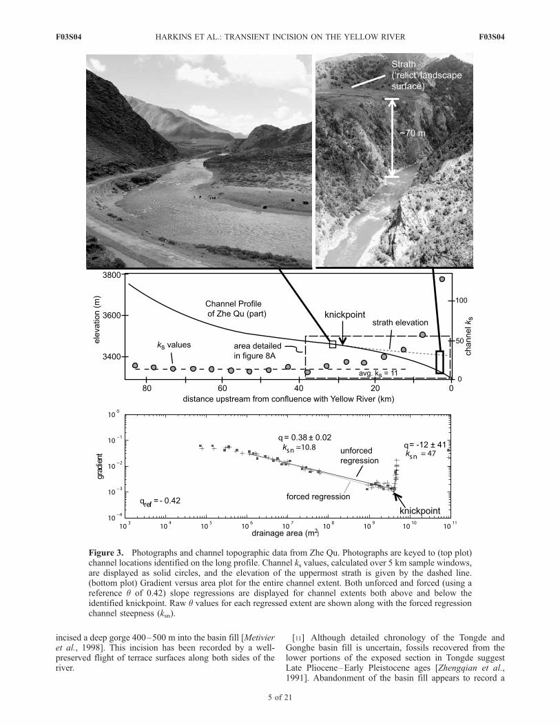
F03S04

relative to the surrounding plateau and is characterized byhigh relief (>2 km) associated with a deep gorge along theYellow River. One of the major Eurasian strike-slip faults,the Kunlun fault, transects the range [Van der Woerd et al.,2000], and recent studies of slip along the fault suggest thatthe fault terminates near the eastern margin of high topogra-phy associated with the Anyemaqen Shan [Kirby et al.,2007]. Thus one hypothesis for the association betweentopography in the range and incision along the YellowRiver holds that both are a consequence of differential rockuplift associated with deformation surrounding the tip of theKunlun fault. However, geologic evidence from exhumedTertiary-Quaternary basins suggests that recent incision hasoccurred along the entire course of the Yellow River down-stream of the range [Li et al., 1997;Metivier et al., 1998]. Therates and timing of fluvial incision in the Anyemaqen Shanare not well known, but may represent the upstream extentof a transient wave of incision that initiated near thetopographic margin of the plateau.[4] In this study, we evaluate these two hypotheses via a
combination of analysis of fluvial channel profiles, deter-mination of fluvial incision rates from dated strath terraces,and estimates of basin-wide erosion rates from cosmogenicisotope concentrations in modern sediment. We begin with areview of geologic observations from sedimentary basinsboth upstream and downstream of the Anyemaqen Shan thatplace constraints on the extent of fluvial incision above andbelow the range. We then explore the distribution of channelgradients throughout the range; this analysis builds onrecent work characterizing both equilibrium relationsbetween channel profile steepness and erosion rate [e.g.,Wobus et al., 2006c] and the response of channel networksto transient changes in base level [Crosby and Whipple,2006] and tectonic forcing [Wobus et al., 2006a]. Fieldobservations along selected channels complement the topo-graphic analyses and provide quantitative constraints onincision rates. Our results reveal a transient wave ofincision, characterized by steep channel gradients and highincision rates (>1 mm/yr) that is associated with basinexcavation downstream of the range. Transient fluvialincision, however, is superimposed atop a channel networkthat exhibits systematic spatial variations in channel steep-ness and incision rate that we attribute to reflect differentialrock uplift across the range. Finally, comparison of thedegree of knickpoint propagation, incision rates, and theform of channel profiles to the results of simple models ofchannel evolution lends insight into the transient behaviorof this fluvial network.
2. Fluvial Incision Along the Yellow River
2.1. Topography and Geology in the Anyemaqen Shan
[5] The Anyemaqen Shan is a broad, elliptical region ofmoderately high elevation and high relief that stands abovethe Tibetan Plateau between longitudes �99�E and �102�E(Figure 1). The range marks a pronounced step from theTibetan Plateau to the south and west with mean elevations�4500 m to somewhat lower-elevation regions of theplateau (�3500 m) to the north and east (Figure 1, inset).In contrast to the subdued relief of the plateau, meanelevations within the range exceed 5000 m and local reliefapproaches 2 km.
[6] The origin of the high topography in the AnyemaqenShan is somewhat enigmatic. The range is underlain byfine-grained, low-grade metasedimentary rocks of the Song-pan Garze complex, an extensive terrane of turbiditic flyschthat accumulated during the Middle and Late Triassic[Bruguier et al., 1997; Weislogel et al., 2006; Zhou andGraham, 1996] (Figure 2). Although local variations inlithology (primarily Paleozoic limestone and Mesozoic plu-tons [Zhengqian et al., 1991]) appear to be more resistant toerosion and locally hold up high peaks, there is no significantlithologic difference between bedrock within the AnyemaqenShan and regions of the plateau that surround it. Thusbedrock susceptibility to erosion and weathering does notappear to be an adequate explanation for the higher relief inthe range relative to the surrounding plateau.[7] The range is bisected from west to east by the Kunlun
fault, a active left-lateral strike-slip fault [e.g., Van derWoerd et al., 2000] (Figure 1). A restraining bend in thefault appears to be responsible for the highest peaks withinthe range, the Anyemaqen massif (�6280 m). This narrowmassif is restricted to the fault zone, however, and therelationship of the broader region of high topography tothe fault is uncertain. Kirby et al. [2007] present evidencethat active displacement on the Kunlun fault dies out nearthe eastern end of the range, implying that displacementmust somehow be absorbed by deformation of the crustsurrounding the fault tip. One goal of our study is todetermine whether incision of the Yellow River and itstributaries across the range may be a consequence of activedifferential rock uplift between the range and the surround-ing plateau.
2.2. Character of the Yellow River Through theAnyemaqen Shan
[8] The Yellow River heads on the plateau to the northand west of the Anyemaqen Shan, transects the range southof the Kunlun fault, makes a broad turn around the easternend of the fault, and transects the range again on its northernside (Figures 1 and 2). Where the river crosses the rangesouth of the Kunlun fault, it is inset into a series of incisedmeanders and deep canyons. The river and its tributariesoccupy steep walled valleys with few preserved terraces,and intermittently expose bedrock on the channel bed.However, in the Roergai (Zoige) basin, east of the range,the river is a low-gradient, highly sinuous alluvial (sand-bedded) channel. Reconnaissance observations suggest thatthe river is actively aggrading. Numerous tributaries of theYellow River do not drain into the trunk stream but arerather ponded behind levees of the trunk channel; during thewet season these valleys form shallow lakes and swamps.As the river exits the northwest corner of the basin andagain approaches the higher topography of the AnyemaqenShan, it transitions from depositional to actively incising.Flights of Holocene fluvial terraces preserved along theriver change downstream from fill terraces to bedrockstraths [Kirby et al., 2007]. These terraces progressivelydiverge from the profile of the river, and in the center of theAnyemaqen (near Jinguum, Figure 2), flights of extraordi-narily well-preserved strath terraces range up to �300 mabove the river and are capped by �5–10 m of fluvialgravels and highly variable thickness of loess. Bedrock isfrequently exposed along the channel bed in this reach of
F03S04 HARKINS ET AL.: TRANSIENT INCISION ON THE YELLOW RIVER
3 of 21
F03S04

the river, and channel gradients steepen downstreamthroughout the northern part of the range forming a broadlyconvex longitudinal profile (Figure 2). Tributaries to theYellow River in the northern Anyemaqen Shan exhibitsimilar profiles, with relatively low-gradient headwaterreaches that become dramatically steeper and more incisedapproaching their junction with the Yellow River (Figure 3).The morphology of the Zhe Qu displayed in Figure 3 istypical of tributaries in the northern Anyemaqen Shan, withchannels that transition from gravel bedded channels withwide floodplains to steep bedrock rivers inset in narrowgorges. The tops of the gorges are marked by broad strathsurfaces with gravel treads that are continuous with flood-plains upstream of the gorges. These observations qualita-tively suggest that the Yellow River has experienced a pulseof recent incision in the northern Anyemaqen, to which thelandscape has not yet fully responded.
2.3. Recent Terrestrial Basin Formation andExhumation
[9] The history of sediment accumulation and excavationin basins immediately upstream (Roergai) and downstream(Tongde) of the Anyemaqen Shan provide additional obser-vations that bear on the evolution of the Yellow River and
its tributaries along this reach. Sediment accumulation in theRoergai basin appears to be spatially variable, but a coreretrieved from near the Yellow River records >300 m oflacustrine and fluvial silt that accumulated in the past�1 Ma[Wang and Xue, 1996], suggesting that aggradation hasbeen relatively long lived in the basin. Moreover, theabsence of thick sedimentary fills within the AnyemaqenShan coupled with deposition in the Roergai basin mightreflect differential rock uplift between the range and theplateau, as the Yellow River attempts to maintain its courseover an actively uplifting bedrock sill by aggradingupstream of the sill and incising downstream [e.g.,Humphreyand Heller, 1995].[10] In contrast, downstream of the range, the Yellow
River passes through two large Tertiary-Quaternary basins,the Gonghe and Tongde basins (Figures 1 and 2), separatedfrom one another by a bedrock range (He Ke Nan Shan).Basin fill consists of primarily undeformed, unconsolidatedto poorly lithified fluvial sand and gravel. The tops ofsedimentary fill in these basins are extensive low-reliefsurfaces that gently grade toward the present-day positionof the Yellow River, and facies variations suggest that basinfilling was driven largely by aggradation along the river andtributaries. In both basins, however, the Yellow River has
Figure 2. Simplified geologic map of the Yellow River watershed between the Roergai and Gonghebasins (area extent delineated in Figure 1) and channel long profile from the same extent. Major terrestrialsedimentary basins are labeled. Large tributaries to the Yellow River discussed in the text are named initalics. Observations of river incisional character are shown by white dotted areas and are keyed to theprofile below. On the long profile, the elevations of the tops of the Gonghe and Tongde (shaded regionslabeled G and T) are shown.
F03S04 HARKINS ET AL.: TRANSIENT INCISION ON THE YELLOW RIVER
4 of 21
F03S04
incised a deep gorge 400–500 m into the basin fill [Metivieret al., 1998]. This incision has been recorded by a well-preserved flight of terrace surfaces along both sides of theriver.
[11] Although detailed chronology of the Tongde andGonghe basin fill is uncertain, fossils recovered from thelower portions of the exposed section in Tongde suggestLate Pliocene–Early Pleistocene ages [Zhengqian et al.,1991]. Abandonment of the basin fill appears to record a
Figure 3. Photographs and channel topographic data from Zhe Qu. Photographs are keyed to (top plot)channel locations identified on the long profile. Channel ks values, calculated over 5 km sample windows,are displayed as solid circles, and the elevation of the uppermost strath is given by the dashed line.(bottom plot) Gradient versus area plot for the entire channel extent. Both unforced and forced (using areference q of 0.42) slope regressions are displayed for channel extents both above and below theidentified knickpoint. Raw q values for each regressed extent are shown along with the forced regressionchannel steepness (ksn).
F03S04 HARKINS ET AL.: TRANSIENT INCISION ON THE YELLOW RIVER
5 of 21
F03S04

significant shift from deposition to incision that must haveoccurred during the Middle or Late Pleistocene. A similarchange from deposition to incision is recorded in LateTertiary basins further downstream along the Yellow Riverat ca. 1.7 Ma [Li et al., 1997]. Although the mechanismresponsible for driving incision remains uncertain, itappears that fluvial excavation of these basins is a responseto progressive headward erosion along the Yellow River.Regardless of ultimate cause, the excavation of >500 m ofsediment from the Tongde basin represents a direct changein local base level for the Yellow River upstream [e.g.,Anderson et al., 2006]. The second goal of our study is tocharacterize the extent to which the Yellow River and itstributaries have responded to this relative drop in base level.
3. Approach and Background
[12] We seek to deconvolve the influence of differentialrock uplift across the Anyemaqen Shan from transientincision driven by downstream changes in local base levelduring excavation of the Tongde Basin. Our approach istwofold; first, we examine the topographic characteristics offluvial networks throughout the Anyemaqen Shan. We focusspecifically on the identification and characterization ofdownstream increases in channel gradient (herein referredto as ‘‘knickpoints’’) and their distribution throughout thenetwork. We also characterize channel profile steepness (ameasure of channel gradient normalized for differences incontributing drainage basin area, see below) upstream anddownstream of knickpoints. Second, we utilize measure-ments of the timing and rate of fluvial incision reconstructedfrom terrace sequences in conjunction with cosmogenicisotope inventories in modern sediment to reconstruct thepace of transient landscape evolution.
3.1. Topographic Scaling in Fluvial Systems
[13] Longitudinal profiles of channels in widely variedtectonic and climatic settings typically exhibit a power lawscaling between local channel gradient (S) and contributingdrainage area (A) [e.g., Flint, 1974; Hack, 1973; Howardand Kerby, 1983],
S ¼ ksA�q ð1Þ
where ks is the channel steepness index (a measure ofchannel gradient normalized for contributing drainage area),and q is the concavity index (a measure of the rate of changeof channel gradient with drainage area). Empirical studiessuggest that the concavity index q commonly falls in arestricted range of values between 0.3 and 0.6 and appearsto be independent of rock uplift/erosion rate [Kirby andWhipple, 2001; Tucker and Whipple, 2002; Whipple andMeade, 2004; Wobus et al., 2006a]. Moreover, numeroussimple models for fluvial incision into bedrock predictpower law relations between channel gradient and drainagearea of the form of equation (1) [Howard et al., 1994;Whipple, 2001; Whipple and Tucker, 1999; Willgoose et al.,1991]. At steady state, the steepness index, ks, is expected todepend on rock uplift rate [Lague and Davy, 2003; Snyder etal., 2003; Wobus et al., 2006a], but the functional relation-ship between channel steepness and rock uplift may beinfluenced by a range of factors including, substrateerodibility, channel hydraulic geometry [Duvall et al.,
2004; Finnegan et al., 2005], thresholds for erosion [Snyderet al., 2003], a potential role for debris flows [Stock andDietrich, 2003], and thresholds in sediment flux andtransport stage [Sklar and Dietrich, 1998, 2001, 2004]. It isimportant to note that the scaling expressed in equation (1)strictly describes the fluvial portion of the channel system. Asa result, this relationship holds only above a certain criticaldrainage area [Montgomery and Foufoula-Georgiou, 1993;Stock and Dietrich, 2003; Tarboton et al., 1989].[14] As has been often noted [e.g., Howard et al., 1994;
Stock and Montgomery, 1999; Whipple, 2004], simplemodels of fluvial incision that assume that erosion ratescales with local bed shear stress and/or unit stream powerallow the steady state channel gradient in equation (1) to bewritten in terms of the rock uplift rate (U) and drainage area[Whipple and Tucker, 1999],
Se ¼ U=K� �1=n
A�m=n ð2Þ
where K is a coefficient that describes channel erodibilityand m and n represent exponents on the erosion rule (streampower or shear stress, see Whipple [2004]).
3.2. Transient Channel Response
[15] Equation (2) predicts that equilibrium channels expe-riencing spatially uniform rock uplift should exhibit a linearrelationship between channel gradient and drainage area ona logarithmic plot (Figure 3). Sharp breaks in this scaling,such as a shift of a linear array to greater or lesser gradient,are expected to occur across spatial gradients in uplift rate[Kirby and Whipple, 2001] and at contrasts in rock erod-ibility [Moglen and Bras, 1995]. Breaks in these data mayalso represent transient adjustment of channel gradients toas a wave of incision sweeps through the channel profilefollowing a change in uplift rate and/or change in base level[Whipple and Tucker, 1999, 2002]. In such cases, channelprofiles are often characterized by an upstream migratingconvexity (herein defined as a knickpoint) that separateschannel reaches with different channel steepness [e.g.,Crosby and Whipple, 2006].[16] The upstream migration of knickpoints has been
suggested as the primary mechanism of landscape adjust-ment to a change in base level or rock uplift rates [e.g., Nottet al., 1996], and it has been recognized that simpledetachment-limited models of fluvial incision predict thatknickpoints should migrate as a kinematic wave [e.g.,Rosenbloom and Anderson, 1994]. In the case of a stepfunction increase in uplift rates or drop in base level,channel response to the increased incision rates associatedwith these events will be characterized by progressivereplacement of the channel profile with gradients adjustedto the new forcing [e.g., Niemann et al., 2001; Whipple,2001]. Provided that profile concavity is independent of therock uplift rate, knickpoint propagation throughout a fluvialnetwork previously at equilibrium will proceed in rathersimple fashion. The horizontal component of the knickpointvelocity will depend on upstream drainage area, with everdecreasing velocity as knickpoints move toward smallerdrainage area [Berlin and Anderson, 2007; Crosby andWhipple, 2006; Whipple and Tucker, 1999], but thevertical component will be uniform throughout a watershed
F03S04 HARKINS ET AL.: TRANSIENT INCISION ON THE YELLOW RIVER
6 of 21
F03S04

[Niemann et al., 2001]. This behavior makes a readilytestable prediction; if knickpoints migrate at uniform rateup the channel network, at any point in time they should beat the same elevation [Wobus et al., 2006a]. Note that thisresult makes no assumption regarding the form of theerosion law, but rather follows from geometric constraints[Niemann et al., 2001; Wobus et al., 2006a].[17] By way of comparison, models of fluvial incision
that explicitly consider the role of sediment flux, eitherpurely transport-limited models [e.g., Whipple and Tucker,2002; Willgoose et al., 1991], or those that incorporate adual role for sediment in both channel bed erosion andarmoring [e.g., Sklar and Dietrich, 2004] suggest that thetransient fluvial response may be more complex. Theresponse of hillslope and sediment delivery to a change inincision rate along the channel may drive a diffusiveadjustment in channel gradient [e.g., Sklar and Dietrich,1998, 2001; Tucker and Slingerland, 1997; Whipple andTucker, 2002]. Under certain conditions, thresholds intransport state and/or sediment flux may lead to knickpointstagnation at threshold drainage areas [e.g., Crosby andWhipple, 2006], or even generate ‘‘hanging’’ fluvial valleysas a consequence of the inability of tributaries to maintainpace with trunk streams [Wobus et al., 2006a]. In addition,the response of channel gradients downstream of knick-points may exhibit nonlinear responses characterized by initial‘‘overshooting’’ of equilibrium gradients [Gasparini et al.,2006]. In principle, at least, the first means of discriminatingbetween such models is to examine the response of a widerange of tributaries across a watershed experiencing atransient increase in incision rate [Berlin and Anderson,2007; Bishop et al., 2005; Crosby and Whipple, 2006].
4. Methods
4.1. Channel Profile Analysis
[18] To test competing hypotheses for apparent differ-ences in incision along the Yellow River, we examinedtopographic characteristics of tributary channel profilesbetween the Roergai and Tongde basins (Figure 1). Channelprofiles of 168 tributaries to the Yellow River in theAnyemaqen Shan were extracted from digital topographicdata from the SRTM (Shuttle Radar Topography Mission)archive. The relatively coarse resolution of the DEM (3 arcsec) restricted our analysis to watersheds greater than 1 km2
in total area. Channel profiles were extracted and analyzedfollowing Snyder et al. [2000] and Kirby et al. [2003]. Weremoved spikes along the channel profile and smoothed thedata using a moving average of 20 pixels. This window sizewas determined to adequately maintain the overall form ofthe channel profile, while removing high-frequency noiseassociated with the topographic data. Channel gradientswere determined over a fixed vertical interval of 10 m[cf. Wobus et al., 2006c].[19] Regression of linear arrays of channel gradient
versus drainage area yielded estimates of steepness andconcavity indices for each of the tributary profiles (e.g.,Figure 3, bottom plot). The upstream limit of regressionswas chosen by visual inspection of a break in scalingbetween channel gradient and drainage area. This point isinterpreted to represent the transition from hillslope and/orcolluvial channels to the fluvial portion of the network and
was generally found to occur at a contributing drainage areaof �106 m2. In addition, regression of the same data wasconducted with a fixed, reference concavity to yield esti-mates of a normalized steepness index (ksn). This value isobserved to scale with erosion rate in a variety of tectonicsettings [e.g., Kirby and Whipple, 2001; Lague and Davy,2003; Safran et al., 2005; Wobus et al., 2006c]. We chose avalue of 0.42 for the reference concavity (qref) on the basisof the mean concavity of channel profiles above knickpoints(see supplemental data1). Uncertainties in ksn values aredetermined from the regression parameters (see Appendix Afor a discussion of uncertainty analysis).[20] If tributary channels exhibited smooth profiles,
regressions were truncated at the tributary junction with theYellow River, and channels are well characterized by a singlevalue of ksn. However, where channels exhibited downstreamincreases in gradient associated with convex knickpoints (seeexample in Figure 3), channel reaches above and belowknickpoints were regressed separately. Knickpoints wereidentified by a step in linear arrays of gradient drainage areadata toward higher gradients (Figure 3). In many tributaries,downstream increases in channel occur over several kilo-meters of channel length and are associated with a progres-sive downstream increase in ksn values (Figure 3). As aconsequence, we identified the top of the zone of increasedgradient as the position of the knickpoint. This definition waschosen to provide a consistent measure of the upstreamextent of influence of recent fluvial incision.[21] Processing of channel topographic data imparts a
degree of uncertainty to determination of the position ofknickpoints in the landscape. We take the width of thesmoothing window as a conservative estimate of uncertaintyon the horizontal position along the channel profile, rea-soning that the knickpoint must be located within thisdistance of its actual location on the profile. Uncertaintieson the elevation of knickpoints were calculated as theproduct of channel slope tangent to the identified pointand the probability distribution of point horizontal locationsbased on the smoothing window size.
4.2. Measures of Erosion Rate
[22] In order to relate differences in channel profile formto erosion rate, we utilize two measures of erosion rates inthe landscape. Abandoned fluvial strath terraces provide ameasure of average incision rates in the fluvial networkdownstream of knickpoints. Terrace surfaces above theYellow River and tributaries were surveyed with a laserrangefinder. Samples of fluvial sediment from terrace treadsplace bounds on the timing of fluvial occupation of thesurface. All samples in this study were dated by either 14Cof detrital organic material (charcoal or snail shells) oroptically stimulated luminescence (OSL) of floodplain silt.Neither method directly dates abandonment of the terrace,and therefore our incision rates are minimum estimates.Locations of terrace surveys are shown on Figure 4. Detailsof the OSL determinations are provided in the supplemen-tary material.[23] To complement fluvial terrace records of incision
rate, we analyzed the concentration of 10Be in modern
1Auxiliary material data sets are available at ftp://ftp.agu.org/apend/jf/2006jf000570. Other auxiliary material files are in the HTML.
F03S04 HARKINS ET AL.: TRANSIENT INCISION ON THE YELLOW RIVER
7 of 21
F03S04
sediment from second- and third-order catchments through-out the study area. Provided that stream sediment is wellmixed and that target minerals are equally distributedthroughout a watershed, the concentration of cosmogenic10Be in modern stream sediment can provide an estimate ofthe spatially averaged erosion rate in the watershed [e.g.,Balco and Stone, 2005; Brown et al., 1996; Gosse andPhillips, 2001; Granger et al., 1996; Lal, 1991]. Suchmethods have been recently shown to provide an importantguide to the distribution of erosion rate across tectonicallyactive landscapes [Wobus et al., 2005].[24] Sediment samples composed of course sand and
gravel were extracted from active channel beds of 7 tributariesto the Yellow River. Samples were extracted exclusivelyfrom fine gravel bars that were partially or fully submergedin the active channel. Tributary catchments with obviousevidence of landslides or large amounts of headwatersediment storage were avoided. All samples were collectedat or above knickpoints and thus provide a measure oferosion rates in the ‘‘relict’’ portion of the landscape. Toavoid contamination by sediment stored in terraces, allsamples were collected upstream of channel reaches thatcut across alluvial fan or terrace surfaces. We extracted purequartz from sediment samples by physical and chemicalseparation at the Terrestrial Cosmogenic Nuclide Lab atDartmouth College. Beryllium was isolated via acid diges-
tion of quartz and anion column chemistry. After precipita-tion as beryllium oxide, sample material was packed ontotargets and sent for isotopic concentration measurement atthe accelerator mass spectrometry facility at Purdue Uni-versity (PRIME lab).[25] We account for topographic shielding, elevation, and
latitude variation in 10Be production in quartz withinsampled basins were determined using SRTM DEM data.This topographic data was processed using MATLAB andARCGIS codes to determine an adjusted 10Be productionrate of Lal [1991] for each grid cell based on the Stone[2000] model of elevation and latitudinal variations incosmogenic radiation influx. The resultant, combined 10Beproduction rates for each DEM grid cell within a sampledcatchment are then spatially averaged to provide a bulkcatchment production rate. Reported errors on these samplesare strictly those associated with the AMS analysis of 10Becontent and ICP-MS measurement of stable Be content.
5. Results
5.1. Channel Profiles
[26] Analysis of �300 tributary channel profiles through-out the Anyemaqen Shan reveal a first-order differenceabove and below the Roergai basin (Figure 4). Tributariesentering the Yellow River above the basin exhibit smooth,
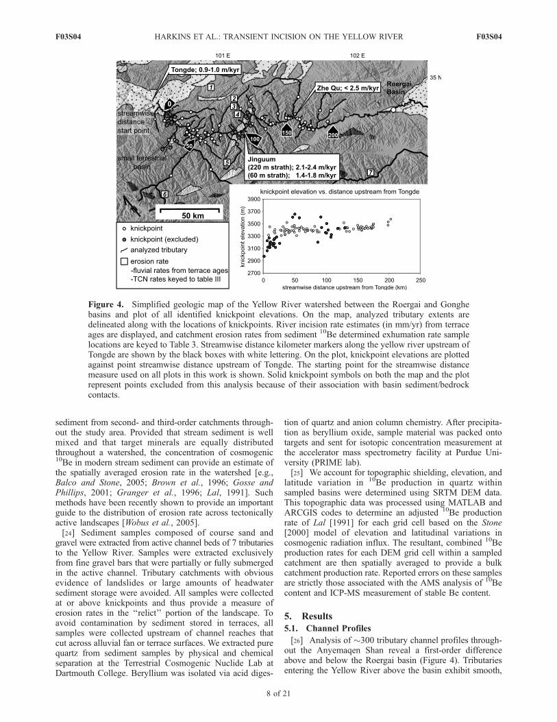
Figure 4. Simplified geologic map of the Yellow River watershed between the Roergai and Gonghebasins and plot of all identified knickpoint elevations. On the map, analyzed tributary extents aredelineated along with the locations of knickpoints. River incision rate estimates (in mm/yr) from terraceages are displayed, and catchment erosion rates from sediment 10Be determined exhumation rate samplelocations are keyed to Table 3. Streamwise distance kilometer markers along the yellow river upstream ofTongde are shown by the black boxes with white lettering. On the plot, knickpoint elevations are plottedagainst point streamwise distance upstream of Tongde. The starting point for the streamwise distancemeasure used on all plots in this work is shown. Solid knickpoint symbols on both the map and the plotrepresent points excluded from this analysis because of their association with basin sediment/bedrockcontacts.
F03S04 HARKINS ET AL.: TRANSIENT INCISION ON THE YELLOW RIVER
8 of 21
F03S04
concave-up profiles with no obvious knickpoints along theirreaches. Downstream of the basin, however, nearly alltributaries join the Yellow River through oversteepenedreaches. This dichotomy is central to our goal of deconvolv-ing transient incision across the range and guides thediscussion of our results. We first consider the distributionof knickpoints within the watershed, and then turn topatterns of channel steepness (ksn).5.1.1. Knickpoint Form and Distribution[27] Downstream of the Roergai basin we analyzed
116 tributaries to the Yellow River, all of which exhibiteda knickpoint near or above their junction with the YellowRiver (Figure 4). Comparison of knickpoint locations withbedrock geology revealed that 34 of these knickpoints arecoincident with lithologic boundaries (primarily contactsbetween Tertiary basin fill and the Triassic flysch); theseknickpoints are excluded from further analysis. The remain-ing 82 knickpoints are developed along channels withinuniform lithology and exhibiting a single downstreamincrease in ksn.[28] Nearly all of the channel profiles downstream of
knickpoints exhibit a progressive increase in channel gra-dient that corresponds to a broad convex channel reach. Inmany of the larger tributaries, this reach is many timeslonger than the smoothing window size, indicating that thisobserved morphology is not simply an artifact of thesmoothing we impose on channel profile data. The mor-phology of the Zhe Qu is typical of observed channel andknickpoint form (Figure 3). Importantly, increases in chan-nel gradient extend the entire distance to the Yellow River;we do not observe the development of a concave down-stream reach as would be expected from simple models ofknickpoint retreat [e.g., Gardner, 1983; Gilbert, 1896;Holland and Pickup, 1976; Miller, 1991; Nott et al.,1996; Rosenbloom and Anderson, 1994].[29] The upstream extent of tributary steepening is con-
fined to a relatively narrow elevation band throughout thenorthern Anyemaqen (Figure 4, inset). Knickpoints arefound between 3200 and 3600 m elevation, but the majority(>70%) occur within a narrow range of elevations between3350 to 3550 m (mean of 3430 m) (Figures 5a and 6). Inorder to evaluate whether elevations systematically increaseupstream, we take a bootstrap approach to incorporatinguncertainties in knickpoint elevations. Each knickpoint wasassigned an array of 21 elevation values, distributed uni-formly over a range of values corresponding to the 90%confidence interval of knickpoint location. Elevations areweighted by a double-tapered, linear probability distributionfunction, such that each knickpoint elevation is associatedwith a range of most likely values. The best fit linearregression of knickpoint elevation versus distance to theentire suite of data indicates that knickpoints occur atslightly higher elevations upstream (Figure 6). Confidenceintervals on the slope of the regression, however, reveal thatthe slope of the regression is not statistically significant at the95% confidence level (slope of 0.0005 ± 0.0005). Thus,although it appears likely that knickpoints farther upstreamfrom the Tongde basin have migrated higher into the land-scape, the uncertainties on knickpoint elevations also allowthe possibility that knickpoints sit at a uniform elevation.[30] Knickpoint elevation also appears to be independent
of the drainage area upstream of knickpoints (Figure 5b).
Likewise, the difference in elevation between a givenknickpoint and the elevation at the tributary junctions withthe Yellow River does not depend on upstream drainagearea (Figure 5d). The elevation difference, however,decreases with distance upstream of the Tongde basin(Figure 5c), consistent with the observed increase in channelgradient along the Yellow river and its tributaries. Thus thevertical distribution of knickpoints in the landscape is, tofirst order, uniform and not strongly dependent on water-shed topology.[31] The horizontal positions of knickpoints in the land-
scape appear to depend on watershed size. Knickpointsshow a power law relationship between upstream drainagearea and streamwise distance, which reflects the fact thathost channels follow Hack’s law [Hack, 1957] and confirmsthat knickpoints are positioned within fluvial channels(Figure 5e). Importantly, the horizontal positions of knick-points are distributed throughout the Yellow River water-shed, and do not appear to have stalled at small drainageareas [e.g., Crosby and Whipple, 2006]. This suggests thatcurrent distribution reflects, to some degree, the rate ofmigration. The distances of knickpoints upstream of theYellow River exhibits a power law dependence on contrib-uting drainage area (Figure 5f ), consistent with models ofknickpoint retreat as a kinematic wave [Rosenbloom andAnderson, 1994]. The exact form of this relationship iscomplicated by scatter imposed by the fact that incisioninitiated at each tributary junction at different times as thewave of incision migrated up the Yellow River. Overall, thedata are consistent with knickpoints as mobile elements ofthis landscape with a horizontal celerity that depends oncontributing drainage area.5.1.2. Tributary Channel ksn Patterns[32] As the knickpoints discussed above are likely to be
transient features that separate regions of the fluvial networkexperiencing different rates of forcing [Wobus et al., 2006c],we characterize channel ks both above and below knick-points. As noted above, we observe distinct differences inthe presence or absence of knickpoints below and abovethe Roergai basin, respectively. We discuss each regionseparately.[33] Above the Roergai basin, we examined 184 tributar-
ies, none of which exhibits marked deviations from aconcave upward facing profile. Steepness indices, however,appear to vary systematically across the range (Figures 7and 8b). These values vary from �10 to 20 at the edges ofthe range and increase to a maximum of �55 in the centralextents of the range. We exempted from this analysischannels that exhibited valley morphologies indicative ofoccupation and erosion by glaciers (Figure 7).[34] In the northern Anyemaqen Shan, downstream of the
Roergai basin, we examined 82 channels. Steepness indices(ksn) of channel reaches upstream of knickpoints range invalue from 10 to 60. Lower values are spatially associatedwith the flanks of the range, with progressively increasingvalues near the center (Figures 7 and 8a). Tributary ksnvalues downstream of knickpoints are significantly higher(ksn � 100–200) and exhibit a large degree of scatter butappear to show a similar overall pattern to the upstream ksnvalues. Steepness index values range from �90 near theTongde basin, increase to �190 along the transect, anddecrease back down to �70 near the Roergai basin. Impor-
F03S04 HARKINS ET AL.: TRANSIENT INCISION ON THE YELLOW RIVER
9 of 21
F03S04

tantly, ksn values observed above knickpoints in the northernAnyemaqen Shan show a similar distribution of values tothose observed along entire tributaries in the southernAnyemaqen Shan, upstream of the Roergai basin. Throughboth regions, ksn values are low at the edges of the rangeand increase toward the core of the range.
5.2. Field Determinations of Fluvial Incision andLandscape Erosion
5.2.1. Terrace Ages and Fluvial Incision Rates[35] Surveyed and dated terrace sequences in the Tongde
basin, the Jinguum Basin, and at the outlet of the Zhe Quprovide estimates of incision rate along the steep reach of
the Yellow River downstream of the Roergai Basin (Tables 1and 2 and Figure 4). In the first of these sites, at the southernedge of the Tongde basin, we collected fluvial sand from astrath terrace developed in Quaternary basin fill for OSLdating. Terrace deposits consist of �10 m of fine to coarsefluvial sand overlying a bedrock strath �140 ± 1 m abovethe modern river. Material within the alluvial cap is muchfiner grained and less consolidated than the underlyingcobble to boulder conglomerates of the Tongde basin fill.We interpret the burial age of this sample to record amaximum allowable age for abandonment of the underlyingstrath; inferred incision rate are thus a minimum. The OSLsample yielded a mean age range of 140.7 ± 8.7 ka (Table 1),
Figure 5. Plots of knickpoint topographic data. Points related to lithologic contacts are excluded.(a) Knickpoint elevation versus streamwise distance above Tongde; 90% confidence interval error barsare shown for knick elevations. See text for error determination. (b) Knickpoint elevation (asl) plottedagainst catchment area at points. (c) Knickpoint elevation above host tributary mouth elevation plottedagainst tributary mouth streamwise distance along the Yellow River upstream of Tongde. (d) Knickpointelevation above host tributary mouth elevation (tributary mouths located at their intersection with theYellow River) plotted against catchment area upstream of points. (e) Catchment area at knickpointsplotted against point distance from tributary divide. (f) Knickpoint distance from host tributary mouth(intersection with the Yellow River) plotted against catchment area at points.
F03S04 HARKINS ET AL.: TRANSIENT INCISION ON THE YELLOW RIVER
10 of 21
F03S04

yielding an incision rate between 0.9 to 1.0 m/ka over thattime period.[36] Our second site is located approximately 70 km
upstream, near the monastery town of Jinguum (Figure 4).Here, the Yellow River has carved a wide valley intorelatively weak Tertiary sediments; flights of strath terracesare present for �250 m above the river gorge. We obtainedsamples from three terrace levels that together provide anestimate of how incision rates vary with time. From thehighest terrace (240 m above the river), we obtained twoOSL samples from a �10 m thick package overbank siltsand fine sands. These two samples yielded overlapping OSLburial ages of 95.6 ± 10.7 ka and 106.1 ± 6.5 ka (Table 1).These data indicate average incision rates since Late Pleis-tocene of �2.1–2.8 m/ka since �100 ka. From the lowerterraces, we sampled charcoal and terrestrial shell materialfor radiocarbon dating. The second terrace (T2) strathsits 60 ± 1 m above the river, and the first terrace (T1) is6 ± 0.5 m above the river. Terrestrial snail shells wereextracted from the upper 2 meters of unconsolidated fluvialgravel capping the T2 bedrock strath surface. Shell materialyielded an calibrated 14C age of 38–39 ka (Table 2). Also
Figure 7. Map of ksn values of all tributaries analyzed and the Yellow River in the Anyemaqen Shan,displayed against a background of elevations within the Yellow River watershed. Approximately200 tributaries in the northern and southern Anyemaqen were analyzed to produce this figure in additionto those discussed in the text. Knickpoint locations are delineated by the white dots, and areas less than3450 m elevation are shaded to approximate the limited spatial extent of the incisional wave in thenorthern Anyemaqen Shan. 10Be determined catchment exhumation rate sample locations are shown inthe boxes and are keyed to Table 3. A large region of low ksn values located in the central region of themap is attributed to extensive glaciation at elevations over �4 km in this area.
Figure 6. Knickpoint elevations plotted against pointstreamwise distance upstream of Tongde. Point symbolsdelineate catchment area at knickpoints, and 90% con-fidence interval error bars are shown. The modern andreconstructed Yellow River profiles (see section 6 in thetext) along this extent are shown along with the location ofthe Jinguum basin. The trend and equation for a weightedleast squares regression through point elevations are shown;minimum and maximum slope error bounds are dashed.
F03S04 HARKINS ET AL.: TRANSIENT INCISION ON THE YELLOW RIVER
11 of 21
F03S04

from the same terrace tread, an OSL sample extracted froma sand lens within the T2 terrace gravel cap corroboratesthis range with a burial age of 37.2 ± 2.1 ka (Table 2).Assuming that the river abandoned this surface shortly aftersample deposition, incision rates appear to have rangedfrom 1.5 and 1.7 m/ka. Finally, charcoal extracted nearthe base of fluvial sand and gravel of the lower (T1) strathyielded a calibrated 14C age of 8.6–9.0 ka BP (Table 2).This represents a minimum incision rate of �0.7 m/ka.[37] Our third site is located near the upstream extent of
the steep and convex reach of the Yellow River in thenorthern Anyemaqen Shan. At the junction with the Zhe Quan extensive strath surface is preserved �65 m above the
river (Figure 4); several lower strath terraces are inset intothe steep, bedrock walls that line the Yellow River. Theuppermost strath is capped by �2 m of fluvial gravels,which are in turn overlain by �2 m of loess. Snail shellfragments extracted from the base of the loess yielded acalibrated 14C age of 30.6–31.3 ka (Table 2). Loessaccumulation likely began shortly after abandonment ofthe terrace tread, although the amount of time elapsed isunknown. As a result, incision rates are somewhat uncertainbut appear to exceed �2.5 m/ka at this site.[38] Taken together, our results are consistent with the
upstream migration of a wave of incision. Although theonset of incision at the downstream extent of our study area,in the Tongde Basin, is somewhat uncertain, extrapolationof the Late Pleistocene rate of �1 m/yr would yield theobserved depth of incision (400–500 m) in 400–500 ka.Altogether we recognize the uncertainty associated withextrapolation of a single age, the broad timing is entirelyconsistent with the biostratigraphic ages near the base of thesection [Zhengqian et al., 1991]. The onset of fluvialincision upstream of the basin appears to be even younger,as suggested by the broad relict floodplains atop the terracesequence at Jinguum and along the Zhe Qu. In theselocations, our chronology suggests that incision did notbegin at these locations until subsequent to �100 ka and�26 ka, respectively. Moreover, incision rates determinedfrom multiple terrace levels at Jinguum seem to indicate thatincision rates have slowed with time (Figure 4), consistentwith the passage of an incisional wave generated by base-level fall.5.2.2. Basin-Wide Exhumation Rates From Sediment10Be Inventories[39] Rates of exhumation determined from sediment 10Be
inventories extend our estimates of landscape erosion ratesabove knickpoints [Granger et al., 1996] (Table 3). Sevensamples extracted from six different catchments yieldedbasin-wide erosion rates between �0.05 and �0.11 m/ka(Figure 7 and Table 3). These samples were all collectedupstream of, or directly adjacent to, the locations of knick-points in the larger tributaries that join the Yellow River.Sample site 1, located along the approximate northernboundary of the Anyemaqen, yielded the lowest rate of0.056 ± 0.004 m/ka. Sample sites 2–4 are distributed alonga large tributary that joins the Yellow River near Jinguum,the Sai Qe (Figure 7). These samples record increasingerosion rates (from �0.05 to 0.08 m/ka) in small catchmentsthat intersect the trunk tributary progressively farther down-stream and deeper into the Anyemaqen Shan. The sampletributary mouth at site 3 is located �1 km downstream ofthe knickpoint identified in Sai Qe. Erosion rates from
Figure 8. (a) Channel ksn values of tributaries in thenorthern Anyemaqen Shan, plotted according to their hosttributary mouth distance upstream of Tongde. Channel ksnvalues from both upstream and downstream of identifiedknickpoints are displayed along with ksn values calculatedover �30 km intervals along the reconstructed, pretransientincision profile of the Yellow River shown in Figure 8e.(b) Channel ksn values of tributaries in the southernAnyemaqen Shan, plotted according to their host tributarymouth distance upstream of the Roergai basin.
Table 1. Optically Stimulated Luminescence Sample Age Control and Contexta
Location, kmUpstream Sample U,b ppm Th,b ppm K,b %
Cosmic DoseRate,c Gy/ka
Total DoseRate, mGy/ka
MeanDe, Gy Age, ka
Incision Rate,m/ka
Tongde (0) NHKOSL-2S 1.35 ± 0.014 0.357.04± 1.46 ± 0.07 0.172 2.25 ± 0.11 322.1 140.7 ± 8.7 0.9–1.0Jinguum (95) NHKOSL-05-2 3.03 ± 0.18 10.05 ± 0.11 1.81 ± 0.04 0.188 3.99 ± 0.17 148.6 37.2 ± 2.1 1.5–1.7Jinguum (95) NHKOSL-05-3 2.79 ± 0.30 11.83 ± 0.15 2.58 ± 0.06 0.119 4.47 ± 0.30 427.2 95.6 ± 10.7 2.2–2.8Jinguum (95) NHKOSL-05-4 2.84 ± 0.28 9.68 ± 0.13 1.87 ± 0.04 0.148 3.50 ± 0.17 370.8 106.1 ± 6.5 2.1–2.4
aSamples were analyzed at the Victoria University of Wellington except for sample NHKOSL-2S, which was analyzed at the University of St. Andrews.bU, Th, and K were calculated using ICP-MS.cCosmic dose rate was calculated assuming constant burial depth using method described by Prescott and Hutton [1994]. Uncertainty was taken as 10%.
F03S04 HARKINS ET AL.: TRANSIENT INCISION ON THE YELLOW RIVER
12 of 21
F03S04

samples 4A and 4B may therefore contain some compo-nent of transient incision. Site 5, located to the southwestof Jinguum, records an erosion rate similar to site 4(�0.08 m/ka). Site 6, located in the highest-relief area ofthe Anyemaqen Shan, records the highest 10Be determinederosion rate (�0.11 m/ka). Site 7, which is a catchment thatdrains directly into the Yellow River upstream of theRoergai basin, records a lower rate of �0.07 m/ka. Overall,the results of the 10Be analysis indicate that most parts ofthe landscape upstream of knickpoints are experiencingrelatively slow rates of erosion (<0.11 m/ka).
6. Relict Landscape Reconstruction
[40] The presence of a low-relief landscape, gentle chan-nel gradients and slow erosion rates upstream of knickpointsin the northern Anyemaqen Shan suggests that this land-scape is ‘‘relict’’ in the sense that topography reflectsconditions prior to onset of rapid incision along the YellowRiver [e.g., Crosby and Whipple, 2006]. In this section wepresent arguments that channel gradients in this landscapewere likely adjusted to spatial variations in erosion rate.Moreover, we utilize both field surveys and DEM-generatedchannel profiles to reconstruct the relief on the relictchannel network and to place bounds on the preincisionshape of the Yellow River longitudinal profile.
6.1. Evidence for Adjusted Channel Profiles
[41] A number of topographic characteristics point to thepresence of a landscape at or near a steady state in thenorthern Anyemaqen Shan prior transient fluvial incisionalong the Yellow River. First, the concavities of channelprofiles (q) above knickpoints and in the southern Any-emaqen Shan (upstream of the Roergai basin) both exhibitmean values �0.4–0.45, consistent with theoretical andempirical determinations of profile concavity in regions ofsteady state [e.g., Kirby and Whipple, 2001; Whipple andTucker, 1999; Wobus et al., 2006c]. Although a uniformconcavity is not a sufficient condition to prove steady state
conditions, as transient profiles of transport-limited chan-nels may remain smooth and free of convexities [Whippleand Tucker, 2002], it is consistent with streams in a‘‘graded’’ state. Second, field observations reveal that chan-nels above knickpoints are gravel bedded and reside inbroad, alluvium-filled valleys (Figure 3); terraces indicativeof recent incision are typically low (<5–10 m) or absent.These observations are again consistent with a landscape inwhich the channels are transport-limited and simply con-veying sediment downstream. Finally, systematic spatialvariations in channel steepness (ksn) above knickpoints inthe northern Anyemaqen Shan (Figures 7 and 8) arematched by spatial variations in the southern part of therange (upstream of the Roergai basin). This correspondenceis striking, and seems to indicate that both sets of tributariesare responding to a spatial forcing, likely variations in rockuplift rate. The fact that the position, wavelength, andmagnitude of the variations in ksn are similar argues thatchannels upstream of knickpoints are adjusted to thisforcing.
6.2. Covariation of Incision/Erosion Rate and ChannelSteepness
[42] Observations of channel gradients paired with fluvialincision and landscape erosion rates determined in thisstudy provide an opportunity to empirically determine thefunctional relationship between ksn and incision/erosionrate. Measured river incision and 10Be determined basinerosion rates are compared to the ksn value of adjacentchannels (Figure 9). Adjacent channel ksn values weredetermined as the mean of trunk tributary values and valuesof smaller catchments within 2–3 km of sample sites.Typically, the variance within each collection of ksn valuesis low (<10) and supports the use of these mean values todescribe channel slopes near each sample site.[43] Our results reveal a positive relationship between
channel steepness (ksn) and catchment erosion rate acrossthe range of our data (Figure 9). Although the data present a
Table 2. 14C Sample Age Control and Contexta
Location, kmUpstream Sample Material
Strath Height,m d13C
14C Age,years BP
Age Range,years BP
Rate Range,m/ka
Jinguum (95) EK-K-3 charcoal 6 ± 1 �23.7 7,945 ± 62 8,610–9,000 0.6–0.7Jinguum (95) NH-KC-05-1 snail shells 60 ± 2 �7.0 33,550 ± 550 38,375–39,493b 1.5–1.6Zhe Qu (153) NH-KC-05-4 shell fragments 65 ± 3 �6.7 25,740 ± 280 30,617–31,279b 2.0–2.2Avonton 1 (540) NH-KC-05-12 shell fragments 9 ± 1 �6.1 16,580 ± 460 18,610–21,049 <0.5Avonton 2 (520) NH-KC-05-13 snail shells 10 ± 1 �6.8 14,538 ± 80 16,955–18,016 <0.64
aAll younger samples calibrated using Calib 4.3 [Stuiver et al., 1998]. Strath height refers to elevation above modern channel.bBecause of advanced sample age, calibration was based on constraints from Fairbanks et al. [1990].
Table 3. Basin-Wide Erosion Rates Determined From Terrestrial Cosmogenic Nuclide Accumulations
Site Sample ID LocationElevation Range,
mBasin
Size, km2Production Rate,atoms/g quartz/yr
10Be, atoms/gquartz
e(10Be), atoms/gquartz
Erosion Rate,m/ka
1 NH-KE-04-2 N 34.10�, E 100.761� 3500–3700 1.43 57 125,766 2,845 0.056 ± 0.0042 NH-KE-04-3 N 34.898�, E 100.885� 3590–3850 0.84 67 634,156 3,135 0.059 ± 0.0053 NH-KE-04-4A N 34.799�, E 100.811� 3420–3810 0.91 57 707,902 4,107 0.083 ± 0.0063 NH-KE-04-4B N 34.797�, E 100.811� 3395–3810 1.03 57 426,520 2,237 0.081 ± 0.0064 NH-KCB-05-1 N 34.777�, E 100.813� 3580–4010 2.31 58 439,792 13,786 0.084 ± 0.0075 NH-KCB-05-3 N 34.526�, E 100.394� 3792–4320 5.01 75 545,990 80,426 0.085 ± 0.0176 NH-KCB-05-2 N 34.752�, E 99.693� 3900–4900 4.12 77 448,257 16,764 0.107 ± 0.0097 NH-KCB-05-6 N 33.693�, E 101.388� 3520–3610 2.24 64 567,528 21,790 0.070 ± 0.006
F03S04 HARKINS ET AL.: TRANSIENT INCISION ON THE YELLOW RIVER
13 of 21
F03S04

limited range of catchment erosion rates (0.05–0.1 m/ka),this result is consistent with previous studies suggestingpositive correlation between erosion rate and channel gra-dient in an adjusted landscape [e.g., Kirby and Whipple,2001; Snyder et al., 2000; Wobus et al., 2006c]. Moreover,the systematic relationship between channel steepness anderosion rate bolsters the argument that channel gradientsupstream of knickpoints are likely adjusted to spatialvariations in erosion rate. The range of observed fluvialincision rates also show a positive correlation to channel ksnvalues, but do not overlap with the range of catchmenterosion rates.[44] The positive correlation between ksn and fluvial
incision/catchment erosion rates allows for a brief discus-sion of the controls on the distribution of fluvial incisionrates above channel knickpoints. The spatial variations oftributary ksn across the Anyemaqen Shan occur all withinflysch of the Songpan-Garze terrane, and do not corresponddirectly to mapped plutons. Potential causes for the increasein ksn values toward the core of the range include differen-tial uplift in the Anyemaqen Shan, broad-scale spatialvariations in bedrock erodibility, and orographically drivenprecipitation per unit area. Of these, bedrock variability isunlikely because, with the exception of the restricted out-crops of intrusive bodies and Tertiary sedimentary basins,no regional-scale variation is outwardly apparent in bedrockcharacter across the Anyemaqen Shan. Orographically drivendifferences in precipitation appear unlikely because thiseffect would be expected to decrease channel slopes towardthe higher-relief portions of the range under a stream powercondition, as greater precipitation would increase dischargeper unit catchment area.[45] As a result, we suggest that the landscape above
knickpoints in the Anyemaqen Shan approximates a steadystate condition, balanced against relatively slow rates ofdifferential rock uplift (probably <0.1 mm/yr), and thatchannel gradients are balanced with more rapid rock upliftat the center of the range. This result agrees with previous
work that associates high topography and steep rivers withhigh erosion and uplift rates [e.g., Kirby et al., 2003; Koons,1989; Pazzaglia and Brandon, 2001]. Larger channels thatflow across the interpreted gradient in uplift rate could beexpected to show correlative changes in profile form. Theapparent steady state form of the above knickpoint land-scape implies that these uplift conditions, although slow,have been active for a significant time prior to the intro-duction of the wave of increased fluvial incision observed inthe northern Anyemaqen Shan.[46] Although the relationship between channel steepness
(ksn) and erosion rate appears to be linear over the limitedrange of erosion rates we sampled (Figure 9), comparison toincision rates and channel gradients from below knickpointsreveals a highly nonlinear relation (Figure 9). Although werecognize the difficulties inherent in comparing two differ-ent measures of erosion in a landscape, we think that thisrelation may be explained in one of two ways. First, thenonlinearity may arise as a consequence of incompleteadjustment of channel profiles to base-level fall. This wouldimply a relatively long timescale (>100 ka) for gradientadjustment, perhaps more consistent with transport-limitedmodels of incision [Whipple and Tucker, 2002]. On theother hand, similar nonlinear relationships between channelsteepness and erosion rate have been observed in easternTibet [Ouimet et al., 2006] and in coastal California [Duvallet al., 2004; Snyder et al., 2003], and may reflect thresholdsin erosion process and/or adjustments in channel hydraulicgeometry.
6.3. Reconstructing Channel Profiles
[47] We utilize the assumption of steady state channelgradients to reconstruct the relief on channel profiles priorto the onset of rapid incision along the Yellow River. Weproject the slope-area array of the channel upstream of theknickpoint to its junction with the Yellow River and predictthe elevation drop between the knickpoint and the tributaryjunction (Figure 10). Reconstructed channel profiles arecalculated on the basis of the ksn values of tributary reachesabove knickpoints, a reference concavity of 0.42, and thecumulative upstream drainage area along a channel. Chan-nel gradients were calculated at 0.5 km intervals alongchannel reaches below knickpoints and integrated alongthe length of the channel to reconstruct paleochannelelevations downstream of the modern knickpoint elevation.To determine minimum and maximum elevation bounds onthe reconstructed junction elevation, we combine the uncer-tainties on ksn values upstream of knickpoints with theuncertainties on knickpoint elevation to derive maximumand minimum estimates of junction elevation.[48] Comparison of reconstructed elevations of the tribu-
tary junctions with field-based estimates derived from thepresence of strath terraces in two tributaries allow a limitedtest of the validity of this method of reconstructing formerchannel profiles. As described above, modern floodplainsalong two major tributaries, the Zhe Qu and Sai Qe, gradeinto continuous strath terraces that extend to the junctionwith the Yellow River (Figures 10a and 10b). This relation-ship suggests that the terrace reflects the progressive aban-donment of a previous channel floor during knickpointmigration. Along Zhe Qu, strath terraces first appear alongthe channel just downstream of the knickpoint identified via
Figure 9. River incision rates measured from strath terraceposition (black boxes) and 10Be determined catchmenterosion rates (white boxes) plotted against measured ksnvalues of proximal channels; ksn values were determined asthe average value of sample host channels and channelswithin 5 km of the sample site.
F03S04 HARKINS ET AL.: TRANSIENT INCISION ON THE YELLOW RIVER
14 of 21
F03S04

DEM analysis (Figure 10a). The height of the uppermoststrath along Zhe Qu above the modern channel continues togrow until attaining an elevation of �65 m at the YellowRiver junction (corresponding to �3365 m asl). Along SaiQe, a broad, uppermost strath surface is present �3–4 mabove the modern channel upstream of the identifiedknickpoint (Figure 10b). Downstream of the knickpoint,however, the elevation of this uppermost strath graduallyclimbs above the channel to attain a height of �220 m at theYellow River junction (�3340 m asl). The uppermostterrace elevations along both tributaries roughly definechannel profile with a ksn value that is similar to thatobserved in the modern channel above the knickpoints.On the basis of these observations, we consider uppermoststrath terraces elevations along Zhe Qu and Sai Qe torepresent the quasi–steady state channel form of thosetributaries prior to onset of rapid incision rates associatedwith base-level fall.[49] Comparison of the elevation of strath terraces at or
near the junction of these tributaries and the Yellow Riverwith reconstructed profiles using the method described
above provides an internal test of consistency of themethod. At the mouth of Zhe Qu, the measured strathelevation of �3365 is within error of the projected paleo-channel mouth elevation of 3368 ± 10 m (Figure 10a).Similarly, a strath at the mouth of Sai Qe of �3340 is justoutside of the error bounds of the projected paleochannelelevation mouth of 3331 ± 7 m. Although the elevations ofterraces may have been influenced by differential rock upliftsince abandonment, our estimates of the timing of incisionand background rock uplift suggest that this is probably aminor addition to the uncertainty (<8 m). Moreover, theconsistency between strath elevations and the projectedinitial channel profile appears to validate our use of tributaryprofiles to reconstruct former positions of tributary junc-tions along the Yellow River.[50] Overall, we utilized 30 tributaries along the Yellow
River between the Roergai and Tongde basins to reconstructthe shape of the former Yellow River profile (Figure 10c).These reconstructed elevations are similar to the higheststrath surfaces we observed along this reach of the river.Moreover, elevations define a trend that intersects the tops
Figure 10. (a and b) Longitudinal profiles along the lower reaches of Zhe Qu and Sai Qe, respectively,displaying the locations of the knickpoint identified via DEM analysis; surveyed uppermost strath terraceelevations; and the projected, preincisional wave elevation of the tributary mouth based on channel q andksn values upstream of the knickpoint. The limits of tertiary sedimentary basin bedrock associated withthe Jinguum basin are shaded along Sai Qe. The change in channel gradient across the basin is related tolithologic contrast and is not interpreted as a knickpoint in this analysis. (c) Modern and reconstructedpreincisional wave longitudinal profiles of the Yellow River between the Roergai and Tongde basins.Profile reconstruction is based on consideration of strath elevations, projected tributary mouth elevations,and the top of fill in the Tongde and Gonghe basins; see text for further discussion.
F03S04 HARKINS ET AL.: TRANSIENT INCISION ON THE YELLOW RIVER
15 of 21
F03S04

of fill in both the Tongde and Gonghe basins. This recon-structed profile reveals a relatively low-gradient channelthat was apparently graded to the sedimentary fill within thebasins downstream of the northern Anyemaqen Shan priorto the onset of rapid incision. Interestingly, former channelgradients appear to be somewhat steeper within the Any-emaqen Shan relative to gradients within the basins bothupstream and downstream (Figure 10c). To test this, wecalculated ksn values as a function of position along thereconstructed profile and find that they are similar inmagnitude and distribution to the modern ksn values observedupstream of knickpoints in adjacent tributaries (Figure 8).This result is internally consistent, in that it implies that boththe Yellow River and its tributaries were graded to aspatially variable forcing across the Anyemaqen Shan.Moreover, the fact that the paleo–Yellow River profileappears to have been graded to thick fluvial deposits inthe Tongde basin implies that this basin acted as a local baselevel for the northern Anyemaqen Shan.
7. Discussion and Implications
[51] Channel profiles of the Yellow River and its tributar-ies downstream of the Roergai Basin all exhibit a down-stream increase in channel gradient consistent with modelsof transient profile adjustment to an increase in rock upliftrate (or base level fall) [e.g., Whipple, 2001]. Our incisionrate data confirms this interpretation and indicates that thelower reaches of the Yellow River are characterized byincision rates on the order of 1–2 mm/yr, while tributaryreaches upstream of knickpoints are incising at much slowerrates (0.05–0.1 mm/yr). In this field site, we interpret theobserved knickpoints to mark a transient boundary betweenchannels extents adjusted to an older, lower incision rate,and those adjusted or adjusting to a newer, higher incisionrate. The upstream migration of this boundary is apparentalong large tributaries, where it is possible to trace acontinuous strath surface upstream to its junction with theactive channel floor (Figures 3 and 10). Here we considerthe implications of these rates and patterns of transientincision and river profile evolution in the Anyemaqen Shanfrom both a process-based perspective of the controls on therate and form of transient channel response and a regionalperspective of the driving mechanisms for channel incision.
7.1. Exhumation of the Tongde Basin and the Onset ofTransient Incision
[52] The marked increase in fluvial incision rate associ-ated with the observed knickpoints in the northern Any-emaqen Shan could be in response to either 1.) a largemagnitude step change in rock uplift rates across the entireAnyemaqen Shan or 2.) a drop in relative base level alongthe Yellow River downstream of the range. Our reconstruc-tion of the former profile of the Yellow River suggests that itwas graded to the top of fill in the Gonghe and Tongdebasins. This implies that the onset of rapid incision alongthe Yellow River in the northern Anyemaqen Shan is part ofthe same event that led to the abandonment and exhumationof these basins. Given that basins downstream of Gonghehave also been recently incised by the Yellow River [e.g., Liet al., 1997; Metivier et al., 1998], it seems unlikely that theentire northeastern corner of the Tibetan Plateau experi-
enced a uniform pulse of rock uplift. Rather, it seems likelythat a wave of incision was initiated from some locationdownstream of these basins and has subsequently propagatedup the Yellow River. A full exploration of the causes of thisincision is beyond the scope of this paper, and will requireextensive investigation of the timing of both basin fill andexcavation along the course of the Yellow River.
7.2. Tributary Response to Transient Incision
[53] The distribution of knickpoints within the YellowRiver catchment provide an opportunity to characterize theevolution of this transient fluvial system. The presence ofknickpoints at uniform elevations throughout the watershedis, to first order, consistent with simple models of knick-point migration [e.g., Niemann et al., 2001]. However,channel profiles downstream of knickpoints exhibit convexprofiles that may be indicative of a somewhat more com-plicated response. These observations motivate an analysisof whether simple models of fluvial incision can captureboth aspects of channel response.7.2.1. Knickpoint Vertical Celerity[54] One of the most remarkable results of our analysis is
the relative uniformity of knickpoint elevations throughoutthe northern Anyemaqen Shan (Figure 6). Accounting forthe allowable errors in determined knickpoint elevations,81% of knickpoints fall within 25m of the population meanof 3430 m. If the subtle upstream increasing trend inknickpoint elevations is considered along with the rangeof allowable errors, then 85% of knickpoints fall within25 m of the trend. Interestingly, the top of the steep portionof the Yellow River (�3410 m) falls within this range ofobserved knickpoint elevations, suggesting that both trunkstream and tributaries are responding at similar rates.Moreover, we observe no dependence of knickpoint eleva-tion on drainage area despite a wide range of tributary sizesanalyzed (Figure 5). As noted above, the horizontal positionof knickpoints does show a power law dependence ondrainage area. These observations lead us to infer that theuniform elevation distribution of knickpoints reflects, atleast to first order, a constant vertical celerity of knickpointsthroughout the channel network, consistent with the migra-tion of knickpoints as a kinematic wave.7.2.2. Modeling of Channel Response[55] To test whether a simple model of fluvial incision
can capture the response of tributaries in this landscape tobase-level fall, we utilize numerical solutions to a streampower type incision rule [Whipple and Tucker, 1999] tomodel transient channel profile evolution. Details of themodel are provided in the supplementary data. We focusonly on the tributaries Zhe Qu and Sai Qe, as our field workon strath terraces along these drainages provides constraintson initial profile form and the timing and rate of incision.Our approach is to vary model parameters and ask whatcombinations can match profiles and erosion rates bothupstream and downstream of knickpoints. We emphasizethat our analysis is illustrative only; we do not perform acomprehensive search of parameter space [e.g., Tomkin etal., 2003]. Rather, we focus on representative models oferosion by boundary shear stress (n � 0.6 in equation (2);see also the supplementary data), unit stream power (n � 1),and a somewhat more nonlinear rule (n � 1.2, perhapsrepresentative of incision dominated by abrasion, [Whipple
F03S04 HARKINS ET AL.: TRANSIENT INCISION ON THE YELLOW RIVER
16 of 21
F03S04
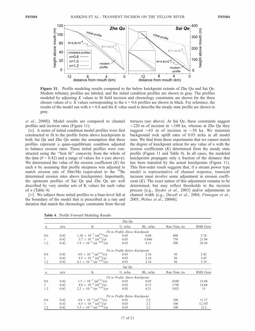
et al., 2000]). Model results are compared to channelprofiles and incision rates (Figure 11).[56] A series of initial condition model profiles were first
constructed to fit to the profile forms above knickpoints inboth Sai Qe and Zhe Qu under the assumption that theseprofiles represent a quasi-equilibrium condition adjustedto balance erosion rates. These initial profiles were con-structed using the ‘‘best fit’’ concavity from the whole ofthe data (q = 0.42) and a range of values for n (see above).We determined the value of the erosion coefficient (K) foreach n by assuming that profile steepness was adjusted tomatch erosion rate of 30m/Ma (equivalent to the 10Bedetermined erosion rates above knickpoints). Importantly,the upstream profiles of Sai Qe and Zhe Qu are welldescribed by very similar sets of K values for each valueof n (Table 4).[57] We subject these initial profiles to a base-level fall at
the boundary of the model that is prescribed at a rate andduration that match the chronologic constraints from fluvial
terraces (see above). At Sai Qe, these constraints suggest�220 m of incision in �100 ka, whereas at Zhe Qu theysuggest �65 m of incision in �30 ka. We maintainbackground rock uplift rates of 0.03 m/ka in all modelruns. We find from these experiments that we cannot matchthe degree of knickpoint retreat for any value of n with theerosion coefficients (K) determined from the steady stateprofile (Figure 11 and Table 4). In all cases, the modeledknickpoints propagate only a fraction of the distance thathas been transited by the actual knickpoints (Figure 11).This first-order result suggests that, if a stream power typemodel is representative of channel response, transientincision must involve some adjustment in erosion coeffi-cient (K). The exact nature of this adjustment remains to bedetermined, but may reflect thresholds in the incisionprocess [e.g., Snyder et al., 2003] and/or adjustments inchannel width [e.g., Duvall et al., 2004; Finnegan et al.,2005; Wobus et al., 2006b].
Table 4. Profile Forward Modeling Results
Zhe Qu
n m/n K U, m/ka BL, m/ka Run Time, ka RMS Error
Fit to Profile Above Knickpoint0.6 0.42 1.38 � 10�5 (m0.16)/yr 0.03 0.08 800 5.761 0.42 3.7 � 10�6 (m0.5)/yr 0.03 0.086 750 21.941.2 0.42 1.9 � 10�6 (m�0.01)/yr 0.03 0.13 500 26.56
Fit to Profile Below Knickpoint0.6 0.42 4.8 � 10�4 (m0.16)/yr 0.03 2.16 30 2.421 0.42 9.5 � 10�5 (m0.5)/yr 0.03 2.16 30 5.431.2 0.42 4.1 � 10�6 (m�0.01)/yr 0.03 2.16 30 5.19
Sai Qe
n m/n K U, m/ka BL, m/ka Run Time, ka RMS Error
Fit to Profile Above Knickpoint0.6 0.42 1.5 � 10�5 (m0.16)/yr 0.03 0.05 4100 13.041 0.42 4.0 � 10�6 (m0.5)/yr 0.03 0.13 1750 14.681.2 0.42 2.2 � 10�6 (m�0.01)/yr 0.03 0.21 1025 15
Fit to Profile Below Knickpoint0.6 0.42 4.8 � 10�4 (m0.16)/yr 0.03 2.2 100 11.371 0.42 6.5 � 10�5 (m0.5)/yr 0.03 2.2 100 12.1071.2 0.42 3.5 � 10�6 (m�0.01)/yr 0.03 2.2 100 12.2
Figure 11. Profile modeling results compared to the below knickpoint extents of Zhe Qu and Sai Qe.Modern tributary profiles are labeled, and the initial condition profiles are shown in gray. The profilesmodeled by adjusting K values to fit field incision and chronology constraints are shown for the threechosen values of n. K values corresponding to the n = 0.6 profiles are shown in black. For reference, theresults of the model run with n = 0.6 and the K value used to describe the steady state profile are shown ingray.
F03S04 HARKINS ET AL.: TRANSIENT INCISION ON THE YELLOW RIVER
17 of 21
F03S04

[58] In a second series of models, we adjust the erosioncoefficient (K) to generate profiles that match the degree ofknickpoint retreat during incision. In these simulations, bestfit K values were chosen for each n value that allowed thelocation of the modeled knickpoints to correspond to thelocation of the actual knickpoints in Sai Qe and Zhe Qu(�12.5 and 10.5 km upstream, respectively (Figure 11)).One interesting result of this analysis is that the resultant‘‘best fit’’ values for K (for a given value of n) are verysimilar between the two tributaries (Table 4), suggesting asimilar response between the two systems.[59] From these results, we can evaluate whether the
profile is best fit by a given dependence of erosion rateon channel gradient. Previous work has demonstrated thatthe shape of the profile immediately downstream of knick-points should depend on the relationship between incisionrate and channel gradient (n in equation (2)) [Tucker andWhipple, 2002]. For each value of n, a total RMS errorbetween the modeled and observed profile form was con-structed to evaluate goodness of fit along the length of thechannel between the knickpoint and the Yellow River. Inboth of the modeled tributaries, the broad convex form ofthe observed knickpoints result in the lowest RMS errorvalues for profiles modeled using an n = 0.6. The variousmodel profiles are only subtly different from one another,however, resulting in relatively small differences in RMSerror values. In Sai Qe, a mapped lithologic variation over2–5 km upstream of the tributary mouth results in a poormodel fit to this lower portion of the profile and high RMSerrors for all values of n (Figure 11). Thus, although wecannot definitively assess which of these incision modelsbest capture transient channel profile evolution, it appearsthat the broad convex profiles downstream of knickpointsrequire a value of n < 1 in a stream power type rule.7.2.3. Complex Transient Channel Response[60] The spatial pattern of channel steepness indices
below knickpoints in the northern Anyemaqen Shan lendsfurther insight into the manner of channel response toincreased incision rates. Three aspects of our results suggestthat channel gradients downstream of knickpoints may beincompletely adjusted to relative changes in base levelduring excavation of the Tongde basin: First, most profilesare similar to those of the Zhe Qu (Figure 3) in that theydisplay a broad convex reach downstream of knickpointscharacterized by systematically increasing ksn values as theyapproach the Yellow River. We do not observe a transitionback to a concave-up profile that one might attribute to anew steady state condition. Rather, it seems likely that thesechannels have not yet completely adjusted to the increase inincision rates. Second, a comparison of ksn values fromchannels downstream of knickpoints with those determinedupstream (Figure 9, inset) reveals a strongly nonlinearrelationship between steepness indices and erosion rates.As discussed above, such a relation can arise in steady statechannels, as a consequence of thresholds in incision oradjustments in channel width, we find it likely that thisrelationship reflects, in part, an incomplete adjustment ofchannel gradients downstream of knickpoints. Third, thespatial pattern of ksn values below knickpoints (Figure 8a)also implies either a significant variation in incision rates,reaching a maximum �50 km upstream from Tongde, orincomplete adjustment of channel profiles to the wave of
incision. Given the profile shapes, we consider the latterexplanation more likely and suggest that gradients down-stream of the knickpoints may be responding to the transientincrease in sediment flux engendered by the wave ofincision [Sklar and Dietrich, 1998].7.2.4. Implications for Channel Incision Models[61] Our results are intriguing in that they suggest that
some aspects of simple models for fluvial incision andknickpoint migration are consistent with channel responsein this landscape while others are not. In particular, thedependence of knickpoint position on drainage area, andthe independence of knickpoint elevation, suggests that thecelerity of knickpoints may adequately captured by a powerlaw relationship between S and A. Our results thus implythat the migration of the upstream limit of transient channelsteepening in the Anyemaqen Shan migrates as a kinematicwave [cf. Stock et al., 2005].[62] In contrast, the response of channel gradients down-
stream of knickpoints does not appear consistent with asimple detachment-limited model of transient channel ad-justment. Although the broad increase in channel gradientscan be reproduced by a detachment-limited model with n < 1,this result requires that the erosion coefficient, K, must adjustbetween the relict and transient parts of the channel. Thisimplies a difference in the processes that control the erosionalefficiency described byK between the low- and high-gradientchannel reaches that is not adequately captured in the streampower type models. The fact that the same sets of K valuescan describe the Sai Qe and Zhe Qu profiles suggests that thisdependence of erosional process on gradient is consistentbetween the two tributaries, and may be across the rest of thechannel network.[63] Channel convexities observed below knickpoints are
also qualitatively similar to the predictions of incisionmodels that explicitly consider a role for sediment flux inmodulating channel incision [e.g., Sklar and Dietrich, 1998;Whipple and Tucker, 2002]. Although we cannot fullyevaluate these models in this landscape, it is possible thatthey may capture both the apparent propagation of knick-points as a kinematic wave and the apparent incompleteadjustment of channel gradients downstream of knickpoints.Additionally, the spatial pattern of steepness indices down-stream of knickpoints (Figure 8a) could be interpreted toreflect the temporal evolution of channel gradients followingknickpoint passage. We caution that the spatial variations inerosion rate upstream of knickpoints makes this assumptiontentative. Nonetheless, it is possible that the maximum in ksnvalues observed�50 km upstream of the Tongde basin mightreflect ‘‘oversteepening’’ of channel gradients in response toincreased sediment delivery in the wake of knickpointpassage. Similar behavior is observed in numerical imple-mentation of a sediment flux–dependent model of fluvialincision [Gasparini et al., 2006] although we acknowledgethe need for improved characterization of channel steep-nesses below knickpoints and information on sediment grainsize and caliber in order to test this hypothesis.
7.3. Implications for Active Tectonism in theNortheastern Tibetan Plateau
[64] Our results also carry implications for active defor-mation of the lithosphere in northeastern Tibet. As arguedabove, channel profiles and erosion rates upstream of
F03S04 HARKINS ET AL.: TRANSIENT INCISION ON THE YELLOW RIVER
18 of 21
F03S04

knickpoints reveal a landscape of subdued relief and slowerosion rates that we interpret to be adjusted to balance rockuplift rates across the Anyemaqen Shan. Covariations inerosion rate and channel steepness suggest that differentialrock uplift is occurring in a broad, domal pattern across therange. Erosion rates appear to be approximately 2 timesfaster in the central part of the range relative to the northernand eastern peripheries, although the overall rates appear tobe quite slow relative to subsequent incision along theYellow River. The fact that reconstructed gradients alongthe Yellow River trunk stream appear to increase toward thecenter of the range, matching variations in tributary ksnpatterns, is consistent with our inference of a landscapeadjusted to the prevailing pattern of tectonic forcing.Attainment of a steady state condition suggests that thisdeformation field has been relatively stable for a significantperiod of time, probably >500 ka (the inferred onset ofincision in the Tongde basin). Thus our results support thehypothesis that high topography in the Anyemaqen Shanreflects, in some part, deformation associated with the tip ofthe Kunlun fault [Kirby et al., 2007]. The broad wavelengthof this deformation implies that the high topography of theAnyemaqen Shan is either supported elastically by a strongupper crust or maintained by distributed shortening above aweak crustal layer. Evaluation of these competing mecha-nisms, however, will require a more comprehensive inves-tigation of the active deformation field and crustal rheology.[65] As noted above, the driving mechanisms for regional
fluvial incision along the Yellow River are also not wellunderstood. Our results characterize the upstream extent oftransient incision along the course of the river, and, togetherwith constraints on the onset of incision at the margin of theplateau (ca. 1.7 Ma [Li et al., 1997]), suggest that the waveof incision has migrated �500 km upstream (Figure 1) sincethis time. Whether incision propagated at a constant rate orwhether it was modulated by active faults and/or lithologi-cally resistant sills in the Gonghe and Guide basins (Figure 1)remains unknown. Moreover, whether the ultimate cause ofincision was a drainage capture across the plateau margin orwhether incision reflects long-term elevation changes of theplateau surface remains an outstanding question that willrequire additional records of the time-space patterns ofincision along the river course.
8. Conclusions
[66] Topographic analysis of channel profiles in the Any-emaqen Shan reveals a distinct transient wave of fluvialincision in the headwater regions of the Yellow River.Tributary channels characterized by broad downstreamincreases in channel gradient, resulting in convex-up pro-files, are present throughout the range upstream of a deeplyincised Tertiary basin. Upstream of knickpoints, erosionrates determined from 10Be inventories in modern sedimentare slow (0.05–0.1 m/ka), but vary systematically withchannel steepness. Reconstruction of the former profile ofthe Yellow River from tributary profiles and field observa-tions of strath terraces reveals similar variations in channelsteepness along the profile that we interpret to reflectvariations in rock uplift rate across the range. Transientincision associated with basin excavation is superimposedupon these variations in channel steepness at significantly
higher rates (�1–2 m/ka). The upstream limit of steepreaches associated with this incision occurs at nearly uni-form elevations throughout the watershed, consistent withbehavior expected from a detachment-limited model offluvial incision. However, the rate of knickpoint migration,and the shape of channel profiles can only be explained by asimple, stream power type model if the erosional efficiencyof the channel increases with incision rate and if theexponent on slope (n) is less than unity. Moreover, spatialvariations in channel steepness downstream of knickpointssuggest that gradient adjustment following the wave ofincision may be modulated by increases in sediment load.Our results thus identify a significant incisional event alongone of the major Tibetan drainages, delineate a broad regionof differential rock uplift in the northeast Tibetan plateau,and highlight the utility of channel profile analysis toexplore the range of transient channel response to changesin external forcing.
Appendix A: Integral Method and Uncertaintieson Channel Steepness (ks)
[67] As described in the text, the development of the datahandling methods employed here were driven by the need toreduce scatter in raw pixel-to-pixel slope estimates fromdigital elevation models [Wobus et al., 2006c]. The largedegree of scatter present in pixel-to-pixel estimates ofchannel gradient stems from relatively minor noise in thelongitudinal profiles extracted from DEMs; taking thespatial derivative exaggerates this noise. Efforts to smooththe gradient data usually involve a combination of thefollowing: subsampling the long profile, fitting piecewiselinear regressions to the long profile to estimate local slope,applying a moving-average filter to profile elevations, andtaking binned averages of logS � logA [cf. Wobus et al.,2006c]. A viable alternative to these methods was proposedby Royden et al. [2000]. Instead of differentiating the longprofile to derive an estimate of S, one can integrate bothsides of equation (1) to write
z xð Þ ¼ ks
Z x
0
A x0ð Þ�qdx0 � ksc xð Þ
[68] The transformed variable c(x) can be determineddirectly from drainage area data by simple numericalintegration. That is, the method requires no assumptionsabout Hack’s law. Herein we refer to this method as theintegral method of determining channel steepness.[69] Segments of the channel profile that are well
described by a concavity index equal in value to q will belinear on plots of z versus c (Figure 3, bottom plot). Theslope of the line is ks. Segments of the channel profile thatare either (1) not well described by a power law relationbetween local slope and upstream drainage area, or (2) exhibita concavity index different from q, will be curved. Thusstandard linear regression of z versus c can be used to(1) evaluate the degree of linearity by evaluating correlatedresiduals, and (2) estimate ks (K. Whipple, personal com-munication, 2006). We exploit the latter to derive estimatesof the uncertainty on values of ks, simply from the uncertaintyin the slope of the regression [Bevington and Robinson,1992], implemented in MATLAB. This constitutes the
F03S04 HARKINS ET AL.: TRANSIENT INCISION ON THE YELLOW RIVER
19 of 21
F03S04
primary advantage of the integral method. However, as thebest fit value of q is not known a priori; in practice one musteither use standard logS � logA relations to find q, orcompute c(x) for a range of q values and test for linearityover the channel segment of interest. In our experience thismethod, and the slope-area methods (as described by Wobuset al. [2006c]) yield identical results.
[70] Acknowledgments. The authors would like to thank Xuhua Shi,Fan Chun, Erchie Wang, Charlie Angerman, Kym Klein, and Jean Dixonfor help in the field and laboratory. Reviews by Itai Haviv, Frank Pazzaglia,and Associate Editor Josh Roering significantly improved the analysis andpresentation of data in the manuscript. Interpretation of the cosmogenic datawas facilitated by codes developed by Greg Balco. This research waspartially supported by NSF grant EAR-0229955 and a NASA GSRPfellowship to Harkins.
ReferencesAnderson, R. S., et al. (2006), Facing reality: Late Cenozoic evolution ofsmooth peaks, glacially ornamented valleys, and deep river gorges ofColorado’s Front Range, in Tectonics, Climate, and Landscape Evolution,edited by S. D. Willett, et al., Spec. Pap. Geol. Soc. Am., 398, 397–418.
Balco, G., and J. O. H. Stone (2005), Measuring middle Pleistocene erosionrates with cosmic-ray-produced nuclides in buried alluvial sediment,Fisher Valley, southeastern Utah, Earth Surf. Processes Landforms, 30,1051–1067.
Beaumont, C., et al. (1992), Erosional control of active compressionalorogens, in Thrust Tectonics, edited by K. R. McClay, pp. 1–18,Chapman and Hall, London.
Berlin, M. M., and R. Anderson (2007), Modeling of knickpoint retreat onthe Roan Plateau, western Colorado, J. Geophys. Res., 112, F03S06,doi:10.1029/2006JF000553.
Bevington, P. R., and D. K. Robinson (1992), Data Reduction and ErrorAnalysis for the Physical Sciences, 2nd ed., 328 pp., McGraw-Hill, NewYork.
Bishop, P., T. B. Hoey, J. D. Janson, and I. Lexartza Artza (2005), Knick-point recession rate and catchment area: The case for uplifted rivers ineastern Scotland, Earth Surf. Processes Landforms, 30, 767–778.
Brown, E. T., et al. (1996), Denudation rates determined from accumulationof in-situ produced 10Be in the Luquillo Experimental Forest, PuertoRico, Earth Planet. Sci. Lett., 129, 193–202.
Bruguier, O., et al. (1997), U-Pb dating on single detrital zircon grains fromthe Triassic Songpan-Ganze flysch (central China): Provenance and tec-tonic correlations, Earth Planet. Sci. Lett., 152, 217–231.
Clark, M. K., et al. (2004), Surface uplift, tectonics, and erosion of easternTibet from large-scale drainage patterns, Tectonics, 23, TC1006,doi:10.1029/2002TC001402.
Crosby, B. T., and K. X. Whipple (2006), Knickpoint initiation and dis-tribution within fluvial networks: 236 waterfalls in the Waipaoa River,North Island, New Zealand, Geomorphology, 82, 16–38.
Duvall, A., et al. (2004), Tectonic and lithologic controls on bedrock chan-nel profiles in coastal California, J. Geophys. Res., 109, F03002,doi:10.1029/2003JF000086.
Fairbanks, R. G., P. deMenocal, D. Oppo, and W. Prell (1990), A 1.2 Myrrecord of mid-depth delta 13C variability in the North Atlantic; implica-tions for ocean circulation and atmospheric CO2, Eos Trans. AGU,71(43), Fall Meet. Suppl., Abstract O22E-8.
Finnegan, N. J., et al. (2005), Controls on the channel width of rivers:Implications for modeling of fluvial incision of bedrock, Geology, 33,229–232.
Flint, J. J. (1974), Stream gradient as a function of order, magnitude, anddischarge, Water Resour. Res., 10, 969–973.
Gardner, T. W. (1983), Experimental study of knickpoint and longitudinalprofile evolution in cohesive, homogeneous material, Geol. Soc. Am.Bull., 94, 664–672.
Gasparini, N. M., G. E. Tucker, and R. L. Bras (2006), Network-scaledynamics of grain-size sorting: Implications for downstream fining,stream-profile concavity, and drainage basin morphology, Earth Surf.Processes Landforms, 29, 401–421.
Gilbert, G. K. (1896), Niagara Falls and their history, in National Geo-graphic Society: The Physiography of the United States, pp. 203–236,Am. Book, New York.
Gosse, J. C., and F. M. Phillips (2001), Terrestrial in-situ cosmogenicnuclides: Theory and application, Quat. Sci. Rev., 20, 1475–1560.
Granger, D. E., et al. (1996), Spatially averaged long-term erosion ratesmeasured from in situ-produced cosmogenic nuclides in alluvial sedi-ment, J. Geol., 104, 249–257.
Hack, J. T. (1957), Studies of longitudinal stream profiles in Virginia andMaryland, U.S. Geol. Surv. Prof. Pap., 294-B, 45–97.
Hack, J. T. (1973), Stream profile analysis and stream-gradient index,J. Res. U. S. Geol. Surv., 1, 421–429.
Holland, W., and G. Pickup (1976), Flume study of knickpoint develop-ment in stratified sediment, Geol. Soc. Am. Bull., 87, 76–82.
Howard, A. D. (1994), A detachment-limited model of drainage basinevolution, Water Resour. Res., 30, 2261–2285.
Howard, A. D., and G. Kerby (1983), Channel changes in badlands, Geol.Soc. Am. Bull., 94, 739–752.
Howard, A. D., et al. (1994), Modeling fluvial erosion on regional tocontinental scales, J. Geophys. Res., 99, 13,971–13,986.
Humphrey, N. F., and P. L. Heller (1995), Natural oscillations in coupledgeomorphic systems: An alternative origin for cyclic sedimentation,Geology, 23, 499–502.
Kirby, E., and K. Whipple (2001), Quantifying differential rock-uplift ratesvia stream profile analysis, Geology, 29, 415–418.
Kirby, E., K. X. Whipple, W. Tang, and Z. Chen (2003), Distribution ofactive rock uplift along the eastern margin of the Tibetan Plateau: Infer-ences from bedrock channel longitudinal profiles, J. Geophys. Res.,108(B4), 2217, doi:10.1029/2001JB000861.
Kirby, E., N. Harkins, E. Wang, X. Shi, C. Fan, and D. Burbank (2007),Slip rate gradients along the eastern Kunlun fault, Tectonics, 26, TC2010,doi:10.1029/2006TC002033.
Koons, P. O. (1989), The topographic evolution of collisional mountainbelts: A numerical look at the Southern Alps, New Zealand, Am. J. Sci.,289, 1041–1069.
Lague, D., and P. Davy (2003), Constraints on the long-term colluvialerosion law by analyzing slope-area relationships at various tectonic up-lift rates in the Siwalik Hills (Nepal), J. Geophys. Res., 108(B2), 2129,doi:10.1029/2002JB001893.
Lal, D. (1991), Cosmic ray labeling of erosion surfaces: In-situ nuclideproduction rates and erosion models, Earth Planet. Sci. Lett., 104,424–439.
Li, J.-J., et al. (1997), Magnetostratigraphic dating of river terraces: Rapidand intermittent incision by the Yellow River of the northeastern marginof the Tibetan Plateau during the Quaternary, J. Geophys. Res., 102,10,121–10,132.
Loget, N., P. Davy, and J. Van Den Driessche (2006), Mesoscale fluvialerosion parameters deduced from modeling the Mediterranean sea leveldrop during the Messinian (late Miocene), J. Geophys. Res., 111, F03005,doi:10.1029/2005JF000387.
Mackin, J. H. (1948), Concept of the graded river, Geol. Soc. Am. Bull.,101, 1373–1388.
Metivier, F., Y. Gaudemer, P. Tapponnier, and B. Meyer (1998), North-eastward growth of the Tibet Plateau deduced from balanced reconstruc-tion of two depositional areas: The Qaidam and Hexi Corridor basins,China, Tectonics, 17, 823–842.
Miller, J. R. (1991), The influence of bedrock geology on knickpoint de-velopment and channel-bed degradation along downcutting streams insouth-central Indiana, J. Geol., 99, 591–605.
Moglen, G. E., and R. L. Bras (1995), The effect of spatial heterogeneitieson geomorphic expression in a model of basin evolution, Water Resour.Res., 31, 2613–2623.
Montgomery, D. R., and E. Foufoula-Georgiou (1993), Channel networksource representation using digital elevation models, Water Resour. Res.,29, 1178–1191.
Niemann, J. D., et al. (2001), A quantitative evaluation of Playfair’s lawand its use in testing long-term stream erosion models, Earth Surf. Pro-cesses Landforms, 26, 1317–1332.
Nott, J., et al. (1996), Wearing down, wearing back, and gorge extension inthe long-term denudation of a highland mass: Quantitative evidence fromthe Schoalhaven catchment, southeast Australia, J. Geol., 104, 224–232.
Ouimet, W., K. Whipple, and D. Granger (2006), Rates and patterns ofshort-term erosion on the eastern margin of the Tibetan Plateau, a tran-sient landscape, Eos Trans. AGU, 87(52), Fall Meet. Suppl., AbstractH21H-01.
Pazzaglia, F. J., and M. T. Brandon (2001), A fluvial record of long-termsteady-state uplift and erosion across the Cascadia Forearc High, westernWashington State, Am. J. Sci., 301, 385–431.
Prescott, J. R., and J. T. Hutton (1994), Cosmic ray contributions to doserates for luminescence and ESR dating: Large depths and long-term timevariations, Radiat. Measure., 23, 497–500.
Rosenbloom, N. A., and R. S. Anderson (1994), Evolution of the marineterraced landscape, Santa Cruz, California, J. Geophys. Res., 99, 14,013–14,030.
Royden, L. H., et al. (2000), Evolution of river elevation profiles by bed-rock incision: Analytical solutions for transient river profiles related tochanging uplift and precipitation rates, Eos Trans. AGU, 82(48), FallMeet. Suppl., Abstract T62F-09.
F03S04 HARKINS ET AL.: TRANSIENT INCISION ON THE YELLOW RIVER
20 of 21
F03S04
Safran, E. B., K. X. Whipple, M. Caffee, P. R. Bierman, R. Aalta, andT. Dunne (2005), Erosion rates driven by channel network incision in theBolivian Andes, Earth Surf. Processes Landforms, 30, 1007–1024.
Sklar, L., and W. E. Dietrich (1998), River longitudinal profiles and bed-rock incision models: Stream power and the influence of sediment supply,in Rivers Over Rock: Fluvial Processes in Bedrock Channels, Geophys.Monogr. Ser., vol. 107, edited by K. J. Tinkler and E. E. Wohl, pp. 237–260, AGU, Washington, D. C.
Sklar, L. S., and W. E. Dietrich (2001), Sediment and rock strength controlon river incision into bedrock, Geology, 29, 1087–1090.
Sklar, L. S., and W. E. Dietrich (2004), A mechanistic model for riverincision into bedrock by saltating bed load, Water Resour. Res., 40,W06301, doi:10.1029/2003WR002496.
Snyder, N. P., et al. (2000), Landscape response to tectonic forcing: Digitalelevation model analysis of stream profiles in the Mendocino triple junc-tion region, northern California, Geol. Soc. Am. Bull., 112, 1250–1263.
Snyder, N. P., K. X. Whipple, G. E. Tucker, and D. J. Merritts (2003),Importance of a stochastic distribution of floods and erosion thresholds inthe bedrock river incision problem, J. Geophys. Res., 108(B2), 2117,doi:10.1029/2001JB001655.
Stock, J., and W. E. Dietrich (2003), Valley incision by debris flows:Evidence of a topographic signature, Water Resour. Res., 39(4), 1089,doi:10.1029/2001WR001057.
Stock, J. D., and D. R. Montgomery (1999), Geologic constraints on bed-rock river incision using the stream power law, J. Geophys. Res., 104,4983–4993.
Stock, J. D., R. S. Anderson, and R. C. Finkel (2005), Field measurementsof incision rates following bedrock exposure: Implications for processcontrols on the long profiles of valleys cut by rivers and debris flow, Bull.Geol. Soc. Am., 117, 174–194.
Stone, J. O. (2000), Air pressure and cosmogenic isotope production,J. Geophys. Res., 105, 23,753–23,759.
Stuiver, M., P. J. Reimer, and T. F. Braziunas (1998), High-precision radio-carbon age calibration for terrestrial and marine samples, Radiocarbon,40(3), 1127–1151.
Tarboton, D. G., R. L. Bras, and I. Rodriguez-Iturbe (1989), Scaling andelevation in river networks, Water Resour. Res., 25, 2037–2051.
Tomkin, J. H., et al. (2003), Quantitative testing of bedrock incision modelsfor the Clearwater River, NW Washington State, J. Geophys. Res.,108(B6), 2308, doi:10.1029/2001JB000862.
Tucker, G. E., and R. Slingerland (1997), Drainage basin responses toclimate change, Water Resour. Res., 33, 2031–2047.
Tucker, G. E., and K. X. Whipple (2002), Topographic outcomes predictedby stream erosion models: Sensitivity analysis and intermodel compar-ison, J. Geophys. Res., 107(B9), 2179, doi:10.1029/2001JB000162.
van der Beek, P., and P. Bishop (2003), Cenozoic river profile developmentin the Upper Lachlan catchment (SE Australia) as a test of quantitativefluvial incision models, J. Geophys. Res., 108(B6), 2309, doi:10.1029/2002JB002125.
Van der Woerd, J., F. J. Ryerson, P. Tapponnier, A.-S. Meriaux,Y. Gaudemer, B. Meyer, R. C. Finkel, M. W. Caffee, Z. Guoguang, andX. Zhiquin (2000), Uniform slip-rate along the Kunlun Fault: Implica-tions for seismic behavior and large-scale tectonics, Geophys. Res. Lett.,27, 2353–2356.
Wang, S., and B. Xue (1996), The environmental history of the RuoergaiBasin since the middle Pleistocene and the comparative study with that ofthe Loess Plateau, Sci. China, Ser. D, 26, 323–328.
Weislogel, A. L., G. E. Gehrels, H. Yang, S. A. Graham, E. Z. Chang, andJ. L. Wooden (2006), Detrital zircon provenance of the late TriassicSongpan-Ganzi complex: Sedimentary record of collision of the Northand South China blocks, Geology, 34, 97–100.
Whipple, K. X. (2001), Fluvial landscape response time: How plausible issteady-state denudation?, Am. J. Sci., 301, 313–325.
Whipple, K. X. (2004), Bedrock rivers and the geomorphology of activeorogens, Annu. Rev. Earth Planet. Sci., 32, 151–185.
Whipple, K. X., and B. J. Meade (2004), Controls on the strength ofcoupling among climate, erosion, and deformation in two-sided, frictionalorogenic wedges at steady state, J. Geophys. Res., 109, F01011,doi:10.1029/2003JF000019.
Whipple, K. X., and G. E. Tucker (1999), Dynamics of the stream-powerriver incision model: Implications for height limits of mountain ranges,landscape response timescales, and research needs, J. Geophys. Res., 104,17,661–17,674.
Whipple, K. X., and G. E. Tucker (2002), Implications of sediment-flux-dependent river incision models for landscape evolution, J. Geophys.Res., 107(B2), 2039, doi:10.1029/2000JB000044.
Whipple, K. X., et al. (2000), River incision into bedrock: Mechanics andrelative efficacy of plucking, abrasion, and cavitation, Geol. Soc. Am.Bull., 112, 490–503.
Willgoose, G., R. L. Bras, and I. Rodriguez-Iturbe (1991), A coupledchannel network growth and hillslope evolution model: 1. Theory, WaterResour. Res., 27, 1671–1684.
Wobus, C. W., et al. (2005), Active out-of-sequence thrust faulting inthe central Nepalese Himalaya, Nature, 434, 1008–1011, doi:10.1038/nature03499.
Wobus, C. W., et al. (2006a), Hanging valleys in fluvial systems: Controlson occurrence and implications for landscape evolution, J. Geophys. Res.,111, F02017, doi:10.1029/2005JF000406.
Wobus, C. W., et al. (2006b), Self-formed bedrock channels, Geophys. Res.Lett., 33, L18408, doi:10.1029/2006GL027182.
Wobus, C. W., et al. (2006c), Tectonics from topography: Procedures,promise, and pitfalls, in Tectonics, Climate, and Landscape Evolution,edited by S. D. Willett, et al., Spec. Pap. Geol. Soc. Am., 398, 55–74.
Zhang, X., et al. (2001), Trends in Canadian streamflow, Water Resour.Res., 37, 987–998.
Zhengqian, L., et al. (1991), Geological map of Qinghai-Xizang (Tibet)Plateau and adjacent areas, 86 pp., Chin. Acad. of Geol. Sci., Beijing.
Zhou, D., and S. A. Graham (1996), Songpan-Ganzi complex of the westQilian Shan as a Triassic remnant ocean basin, in The Tectonic Evolutionof Asia, edited by A. Yin and T. M. Harrison, pp. 281–299, CambridgeUniv. Press, Cambridge, U. K.
�����������������������N. Harkins and E. Kirby, Department of Geosciences, Pennsylvania State
University, University Park, PA 16802, USA. ([email protected])A. Heimsath, Department of Earth Sciences, Dartmouth College,
Hanover, NH 03755, USA.U. Reiser, School of Earth Sciences, Victoria University of Wellington,
PO Box 600, Wellington, New Zealand.R. Robinson, School of Geography and Geosciences, University of
St. Andrews, St. Andrews KY16 9AL, UK.
F03S04 HARKINS ET AL.: TRANSIENT INCISION ON THE YELLOW RIVER
21 of 21
F03S04
Related Documents