University of New Hampshire University of New Hampshire University of New Hampshire Scholars' University of New Hampshire Scholars' Repository Repository PREP Reports & Publications Institute for the Study of Earth, Oceans, and Space (EOS) 12-31-2006 Town of Strafford NROC Projects Town of Strafford NROC Projects Carolyn Page Land Protection Group Al Pratt Water Quality Group Jeff Schloss Water Quality Group Harmony Anderson Managed Growth Group Follow this and additional works at: https://scholars.unh.edu/prep Part of the Marine Biology Commons Recommended Citation Recommended Citation Page, Carolyn; Pratt, Al; Schloss, Jeff; and Anderson, Harmony, "Town of Strafford NROC Projects" (2006). PREP Reports & Publications. 175. https://scholars.unh.edu/prep/175 This Report is brought to you for free and open access by the Institute for the Study of Earth, Oceans, and Space (EOS) at University of New Hampshire Scholars' Repository. It has been accepted for inclusion in PREP Reports & Publications by an authorized administrator of University of New Hampshire Scholars' Repository. For more information, please contact [email protected].

Welcome message from author
This document is posted to help you gain knowledge. Please leave a comment to let me know what you think about it! Share it to your friends and learn new things together.
Transcript
University of New Hampshire University of New Hampshire
University of New Hampshire Scholars' University of New Hampshire Scholars'
Repository Repository
PREP Reports & Publications Institute for the Study of Earth, Oceans, and Space (EOS)
12-31-2006
Town of Strafford NROC Projects Town of Strafford NROC Projects
Carolyn Page Land Protection Group
Al Pratt Water Quality Group
Jeff Schloss Water Quality Group
Harmony Anderson Managed Growth Group
Follow this and additional works at: https://scholars.unh.edu/prep
Part of the Marine Biology Commons
Recommended Citation Recommended Citation Page, Carolyn; Pratt, Al; Schloss, Jeff; and Anderson, Harmony, "Town of Strafford NROC Projects" (2006). PREP Reports & Publications. 175. https://scholars.unh.edu/prep/175
This Report is brought to you for free and open access by the Institute for the Study of Earth, Oceans, and Space (EOS) at University of New Hampshire Scholars' Repository. It has been accepted for inclusion in PREP Reports & Publications by an authorized administrator of University of New Hampshire Scholars' Repository. For more information, please contact [email protected].
Town of Strafford NROC Committees
A Final Report to
The New Hampshire Estuaies Project
Submitted by
Carolyn Page – Land Protection Group 162 JoAlCo Road, Strafford, NH 03884
Al Pratt/Jeff Schloss – Water Quality Group
Harmony Anderson – Managed Growth Group
December 31, 2006
This report was funded in part by a grant from the New Hampshire Estuaries Project, as authorized by the U.S. Environmental Protection Agency persuant to Section 320 of the Clean Water Act.
1
Table of Contents
Executive Summary............................................................ 3 Land Protection Group ............................................... LP 1
Introduction .................................................LP 1 Goals and Objectives .................................. LP 1 Activities ..................................................... LP 2 Results and Discussion ............................... LP 3 Conclusions ................................................. LP 4 Recommendations ..................................... LP 5
Water Quality Group................................................. WQ 1
Objectives .................................................. WQ 1 Activities .................................................... WQ 1 Results ........................................................ WQ 2 Table 2-1 Tributary Total Phosphorus ... WQ 5 Conclusions ................................................ WQ 6 Recommendations ..................................... WQ 6
Managed Growth ....................................................... MG 1
Introduction ................................................ MG 1 Goals and Objectives .................................. MG 1 Activities ....................................................... MG 2 Results and Discussion ................................ MG 3 Conclusions .................................................. MG 4 Recommendations ....................................... MG 4
Appendix A ......................Land Protection Group Appendix B ..........................Water Quality Group Appendix C ..................... Managed Group Group Appendix D ............. Applying to the three groups
2
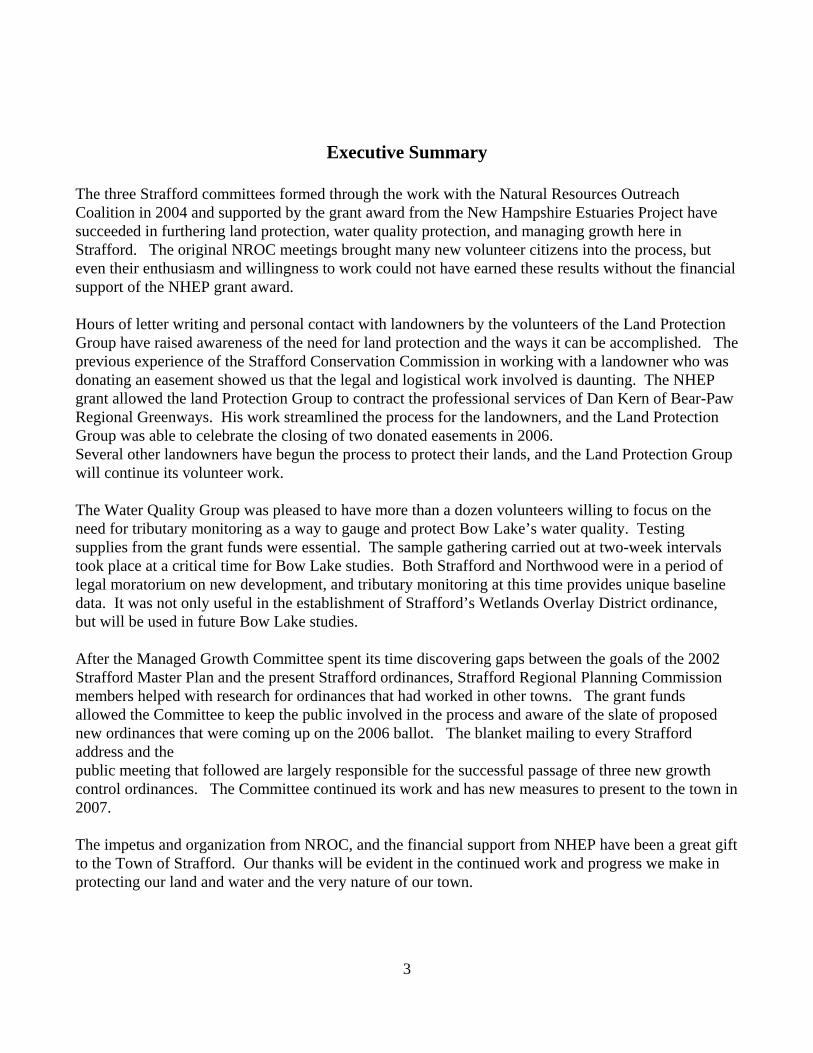
Executive Summary
The three Strafford committees formed through the work with the Natural Resources Outreach Coalition in 2004 and supported by the grant award from the New Hampshire Estuaries Project have succeeded in furthering land protection, water quality protection, and managing growth here in Strafford. The original NROC meetings brought many new volunteer citizens into the process, but even their enthusiasm and willingness to work could not have earned these results without the financial support of the NHEP grant award. Hours of letter writing and personal contact with landowners by the volunteers of the Land Protection Group have raised awareness of the need for land protection and the ways it can be accomplished. The previous experience of the Strafford Conservation Commission in working with a landowner who was donating an easement showed us that the legal and logistical work involved is daunting. The NHEP grant allowed the land Protection Group to contract the professional services of Dan Kern of Bear-Paw Regional Greenways. His work streamlined the process for the landowners, and the Land Protection Group was able to celebrate the closing of two donated easements in 2006. Several other landowners have begun the process to protect their lands, and the Land Protection Group will continue its volunteer work. The Water Quality Group was pleased to have more than a dozen volunteers willing to focus on the need for tributary monitoring as a way to gauge and protect Bow Lake’s water quality. Testing supplies from the grant funds were essential. The sample gathering carried out at two-week intervals took place at a critical time for Bow Lake studies. Both Strafford and Northwood were in a period of legal moratorium on new development, and tributary monitoring at this time provides unique baseline data. It was not only useful in the establishment of Strafford’s Wetlands Overlay District ordinance, but will be used in future Bow Lake studies. After the Managed Growth Committee spent its time discovering gaps between the goals of the 2002 Strafford Master Plan and the present Strafford ordinances, Strafford Regional Planning Commission members helped with research for ordinances that had worked in other towns. The grant funds allowed the Committee to keep the public involved in the process and aware of the slate of proposed new ordinances that were coming up on the 2006 ballot. The blanket mailing to every Strafford address and the public meeting that followed are largely responsible for the successful passage of three new growth control ordinances. The Committee continued its work and has new measures to present to the town in 2007. The impetus and organization from NROC, and the financial support from NHEP have been a great gift to the Town of Strafford. Our thanks will be evident in the continued work and progress we make in protecting our land and water and the very nature of our town.
3
Land Protection Group
Introduction
The Land Protection Group (LPG) was formed as a result of the guidance of NROC (Natural Resource Outreach Coalition) to help Strafford achieve some of the Town's master plan goals. The LPG also had in mind the goal set by the Society for the Protection of New Hampshire Forests to protect 25% of a town's undeveloped land. To help the LPG achieve its goal, a group member prepared a natural resource map using the Bear-Paw co-occurrence map as the base to show prioritized properties. He used the natural resources to be protected as criteria to prioritize the properties. These criteria included the saving of ground water, surface water, farmland, and unfragmented parcels. From this color coded map, we chose to contact the highest priority property owners. Some abutted land that was already in conservation easements, some owned prime farm land and some owned land on aquifers. We sent 24 letters (appendix) and followed those up with phone calls to make sure the letters were received, if they were read, and if the recipients had any questions or wanted follow-up information. Our next step was to hold a workshop for interested people on conservation easements in the school cafeteria . The 24 letter recipients got personal invitations to the workshop and the greater town population was reached through ads in the local paper and signs in public areas. The workshop was well attended. The Land Protection Group soon realized that it had reached its limit of expertise. We had found interested land owners, but did not know how to proceed from there. We needed to know about the legal issues, where to find grant money, and the steps involved in bringing a piece of property to a completed conservation easement. At that point, we applied for the grant from the New Hampshire Estuaries Program so we could pay the salary of someone to lead us through the process and cover the other costs of outreach. The person we hired was Dan Kern, Executive Director of Bear-Paw Regional Greenways. Goals and Objectives
Goal one: To help the town achieve its goal of maintaining “rural character', and saving natural resources and open agricultural land as stated in the Master Plan.
Work with the Conservation Commission and other town boards on land preservation Goal two: To raise the awareness of the citizens of Strafford of the desirability of conserved land.
Print articles regularly to keep the topic of conservation easements in the public mind Present information on the costs to the town for conserved land vs. developed land
Goal three: To encourage land owners to put their land into an easement.
1
Land Protection Group
Make information on conservation easements readily available Emphasize tax incentives for donated easements Personally contact the owners of high priority land Make the process of putting land into an easement as easy as possible
Goal four: To conserve at least 25% of the undeveloped areas of the Town of Strafford
Identify the land having the most value for conservation Help land owners through the process of putting their land into a conservation easement
Activities
Work with town Three of the Land Protection Group (LPG) members are also members of the Conservation Commission. We use part of the Commission meetings to keep the commissioners up to date on what the LPG is doing and gaining their official approval for projects we are working on. We also learn of other land transactions from the Planning Board and Zoning Board of Adjustment. Raise awareness We are trying to keep the idea of conservation easements in the public eye by writing about the topic almost every month in the Strafford Community Calendar (appendix), a bulletin put out by a volunteer group and read by everyone in town. We have sponsored two workshops for interested parties so far. The first was an introduction to land easements and featured Phil Auger and Frank Mitchell from Bear-Paw and Thomas Masland considered one of the foremost land conservation attorneys in New Hampshire to give insight into some of the legal issues. The second workshop was to instruct on how to take the next steps with examples of some obstacles that have been overcome. Phil and Frank did this presentation. The LPG will continue to present more workshops as the need arises. Encourage Landowners After several LPG meetings refining our map, we drew up a list of land owners to contact. We researched the addresses and other needed information at the Strafford Town Hall.
In further meetings, we drafted the letters (appendix) to be sent and phone call scripts. We divided the list among us choosing the names of people we knew or lived close to for making the phone calls.
Our other activities were to meet with prospective land donors/sellers along with Dan Kern to answer all questions and to insure that this is the path the owner wants to take. Conserve undeveloped land
2
Land Protection Group
When a landowner decides that their land will go into a conservation easement, a site walk is arranged for members of the Land Protection Group and Conservation Commissioners. After the walk and conversation with the owner, we fill out an Easement Evaluation Form (appendix) to determine if the property is desirable and how much money the Conservation Commission will be willing to spend on it. The members of the group are then available to do whatever leg work needs to be done to help Dan. We have helped with research on deeds at the Strafford County Court House, done further delving into the tax maps and acted as liaisons with the Conservation Commission.
Dan has shown us the additional steps that we need to carry on: Make sure appraisals and surveys are done in a timely manner, have Purchase and Sales Agreement drawn up, reviewed by attorney, and signed and have deed written, reviewed by attorney, and signed.
The best part is attending the signing of the conservation easement. This is the perfect public relations moment for taking photos and writing articles for newspapers. Results and Discussion
The hiring of Dan Kern with the NHEP grant money is starting to show success. At present, we have conservation easements on two parcels of donated property. The first property has a total area of almost 33 acres and includes 1250 feet of wooded road frontage on a state highway. This agreement was signed on November 30, 2006. The second has a total area of almost 29 acres on the Northwood – Strafford line that includes beautiful stone walls and vernal pools. This agreement was signed on December 15, 2006. There are a number of other properties on the verge of being conserved. The LPG has a purchase and sales agreement signed for 40 acres that abut the Strafford Town Forest. This is being sold to us at a “fire sale” rate. A public hearing was held and the Conservation Commission has voted to provide the funds. We hope to have the deed signed and conclude this deal shortly. We are working with a landowner who wants to put her five contiguous lots, about 60 acres, into an easement. These lots would connect the already preserved land of The Blue Hills Foundation in Strafford with the Blue Job Mountain and NH Fish and Game preserved land in Farmington. There are some other land owners who are in contact with us and others still who are thinking about it. Two pieces of property have been discussed with the Conservation Commission, but are not a priority right now. One piece abuts a newly conserved piece of property, but has a mortgage. The other is an uninhabited island in Bow Lake, but the price is more than we can afford at this time. We are keeping the doors open on both of these projects. The Land Protection Group and the Conservation Commission are working with Bear-Paw and the
3
Land Protection Group
Trust for Public Lands to conserve a 300 acre tract of land in the eastern part of town that abuts the Isinglass River and a 1,000 acre tract that tops two mountains and abuts the town forest. Projects that large take a few years to finalize. Over all, it takes much more time than expected for any of these transactions to be finalized. Some people that we first contacted over a year ago are just now starting to get in touch with us. Almost all of them feel they have to speak with their heirs before making a decision and we have found that the heirs are scattered all over the country and are not seen very often. Using the experiences of one resident who put land into an easement, we adjusted the procedures to make the process easier. He was very candid about what the frustrations were in the steps he had to take for donating his land. For example, in the beginning we would have the land owner contact three appraisers and surveyors to get a quote from them. Then the land owner would have to make the decision and then have the job done. All this was time consuming and annoying to the owner. Now we no longer ask for three quotes, in fact, we can suggest approved providers. The other major change was in the Easement Evaluation Form (appendix). The intent of the form was to have a concrete method for making decisions about what properties to fund and for what amount. Our trial run participant was very vocal about the pettiness of donating land worth a lot of money then being only reimbursed eighty percent of the costs of putting it into an easement. That was rectified by adding a sentence in the Conservation Commission's “System for Evaluating Applications”(appendix): at the discretion of the Conservation Commission if the development rights to a conservation easement are donated, the commission may grant up to 100% of the transaction costs including a summary appraisal (only) but not including full cost of an IRS appraisal. Conclusions
The method that we chose: setting priorities, contacting by letter, following up by phone, and by keeping the topic alive though our local newspaper (the Strafford Community Calendar) seems to have worked. “Conservation easement” is a concept that most people in town now know about. Hiring Dan Kern was a very wise decision. It is important to have someone who is available by phone during working hours, knows the legal procedures for buying, or accepting property, and knows the different avenues for obtaining grants. As volunteers, we certainly have devoted a lot of time to this project, but to do all of the paperwork and know all of the legal aspects to bring one of these contracts to happy conclusion would have been beyond our reach. We found it very important to be part of the Conservation Commission so that the official and legal backing of the town was with us. Recommendations
In the Land Protection Group's last meeting we recommended that we continue to meet in the new year
4
Land Protection Group
at least every three months. We will start the cycle again by reprioritizing properties and recontacting those from the initial mailing who we feel are still interested in preserving their land. Having the Co-occurrence map to work from took the guess work out of which properties should be targeted. Once our priorities were established, it became apparent from the map which properties were important to preserve. Most of all, having a professional to work with was the biggest help in accomplishing what we have done so far. Having the NHEP made that possible. A general recommendation for other towns who want to become active is to have the NROC presenters come to them. Their help in getting like minded people together and getting them organized was absolutely invaluable. Appendices Letters Strafford Community Calendar articles Easement Evaluation System of Evaluation Volunteer hours Map
5
Water Quality Group
Objectives The quality of the water resources in Strafford is a concern of the citizens that attended the initial meetings conducted by the NROC representatives in 2004. Through discussions between the Water Quality Group members and Jeff Schloss from the University of New Hampshire (UNH) Center for Freshwater Biology, the following project objectives were established.
Bow Lake, being the largest and most publicly utilized surface-water body in Strafford, was identified as the most important feature to address with this project. There is a record of Bow Lake water quality based on samples collected by the Bow Lake Camp Owners Association and compiled by the New Hampshire Lakes Lay Monitoring Program. The Water Quality Group that was established through the NROC assistance in 2006 chose to expand the existing water quality sampling efforts by collecting samples from all of the Bow Lake tributaries in order to develop a baseline dataset of the nutrient loading to the lake from its contributing watersheds. This baseline data will help identify the influences that surrounding land use changes have on the water quality of Bow Lake in the future.
In order to successfully collect enough samples to adequately evaluate the nutrient loading to Bow Lake, a number of citizen volunteers were required. The recruitment of volunteers that would be interested in this project and potentially other water-related studies in Strafford was the second objective of this project. The formation of the Water Quality Group and the engagement of citizen volunteers were essential to the success of this project, and the continuation of their activities will be vital to meeting the objectives of the Strafford Master Plan regarding its goal to “protect the community’s water resources through careful study and monitoring of the water quality…”.
The third objective of the Water Quality Group was to establish a new wetlands ordinance through the development of a Wetlands Conservation Overlay District. The prior wetlands ordinance needed to be updated with clarified definitions, references, and buffer restrictions.
Activities The Water Quality Group conducted a series of meetings to identify the initial objectives of the group and discuss other water-resource related issues in Strafford that should be addressed by this group, such as large groundwater withdrawals, groundwater contamination, shoreline protection enforcement, development impacts, and watershed monitoring.
At the initial meetings the group derived a plan to publicly advertise in the local newsletter and with signs around town for citizens that would be interested in monitoring Bow Lake and other water resources in Strafford. Seventeen people responded to the advertisement. On March 29, 2005 Jeff Schloss presented the Bow Lake tributary
1
Water Quality Group
monitoring plan to 15 interested volunteers. Al Pratt worked with the volunteers to assign tributary monitoring site responsibilities. Specific meeting notes are included as Appendix____.
On May 14, 2005, 21 volunteers were trained by Jeff Schloss to collect water samples, characterize the stream-bed conditions and water appearance, read a staff gage, and complete the data forms. The volunteer monitors performed their sample collection procedures bi-weekly from May 17, 2005 through September 2006, in the spring, summer and fall. Winter collection was deemed unnecessary due to the inherent dangers associated with work near water in freezing conditions.
On October 5, 2005, the Water Quality Group met with the volunteers to debrief the season’s data collection issues and present the available data. The sampling season ended in November 2005 and began for a second year with a kick-off meeting that was conducted on March 15, 2006.
On July 22, 2006, a presentation of the sampling program was given at the annual Bow Lake Camp Owners Summer Meeting. The Camp Owners in attendance (approximately 28) were excited to hear about the project and voice some concerns regarding new development that was occurring throughout the watershed.
Work on the wetlands ordinance began with a Water Quality Group meeting on October 19, 2005. By the end of December 2005, a draft of a Wetlands Conservation Overlay District zoning section had be written and reviewed by members of the Strafford Conservation Commission. The draft was reviewed, modified and accepted by the Strafford Planning Board in January 2006 for inclusion in the 2006 Warrant Article with issues related to zoning changes. A public meeting was held on February 19, 2006, prior to the Town meeting, to discuss the proposed zoning changes. At the 2006 Town Meeting the Wetlands Conservation Overlay District was accepted by the citizens of Strafford (Appendix___).
Results
Bow Lake Tributary Monitoring Program The goal of the monitoring program was to collect a sufficient amount of nutrient and stream-flow data of the Bow Lake tributaries to establish a baseline understanding of the nutrient loading to Bow Lake. During 2005 and 2006 there was a moratorium on development in Northwood and Strafford. This provided a good opportunity to collect samples before the significant development occurs in the watershed.
Samples were collected by 14 volunteers biweekly from May 15, 2005 through September 2006. A total of 13 tributary monitoring sites were established (Figure 2-1). A primary and secondary volunteer were assigned to each station so each site could be sufficiently covered and the volunteers would have someone to work with as needed.
The water samples were frozen by the volunteers and transported to UNH by Jeff Schloss. All of the samples were analyzed for total phosphorus (TP) by the UNH Center
2
Water Quality Group
for Freshwater Biology laboratory. The sample collection data sheets completed by the volunteers were compiled into spreadsheet by UNH staff.
In order to derive phosphorus loading to Bow Lake, the phosphorus measured phosphorus concentrations need to be multiplied by the flow from their associated tributary. UNH staff routinely measured the flow in each of the tributaries using a stream-velocity meter and depth gage. The rate of flow is correlated with the relative depth of water measured on the site staff gages. This correlation is represented with a rating curve for each of the monitoring sites. Flow rates are derived from the gage readings that the volunteers made during their sample collection procedure. All of this data was not available at the time this report was prepared. The total phosphorus data for 195 samples and some of the information from the field data forms are included in Appendix___. While a full water quality data analysis was not within the scope of this project, even without calculating the water / nutrient budget the sampling results have increased our knowledge of watershed nutrient loadings. Figure 2-1 is a map of the sampling site locations for the project. GPS locations for each site are available from the UNH Center for Freshwater Biology. Sites 1 and 5 (historical locations from previous studies) were not sampled for the project as flow was very minimal at site 1 and site 5 was no longer accessible due to private property postings put in place recently for a Northwood subdivision development. The sampled sites started below the southeast area of the lake at the tributaries that drain Tasker Hill and cross under Brown’s Pasture Road (sites 2 through 4) then proceed counter clockwise around the lake. The exceptions are site 14 that was added to measure the shallow area at Piper Cove that receives ponded wetland drainage and site 13 which is the outlet (headwaters to the Isinglass River that is also monitored through the NH DES VRAP program). Figure 2-2 displays all of the Total Phosphorus (TP) concentration data collected through the project (raw data). Care must be taken when interpreting stream nutrient concentrations in the context of lake nutrient loading as the loading is the product of both the concentration and the volume of water flowing into the lake. Thus, a high number for concentration may not necessarily indicate a high loading if the flow of the tributary is relatively small compared to other flows. However, we can see that the two years of sampling indicate some differences have occurred: 1) we can see the sampling effort in 2006 ranged over more months staring earlier during the spring runoff events, 2) 2006 data displays higher concentrations for many of the sites monitored 3) there are more low and high results compared to low, high and moderate results in 2005 and 4) spring concentrations are not necessarily significantly greater as might be expected, however, higher concentrations for some sites seem to correspond more to heavy storm events. As we experienced a greater number of significant precipitation events in 2006 compared to 2005 the observations above are not surprising. For a given tributary we can look at the relative flow as indicated by the staff gauge reading (but we cannot compare between tributaries until the flow equations are developed for these data). While many high flows had corresponding high concentrations there were occasions
3
Water Quality Group
when maxima occurred during medium or low flows. Analysis of the flow volumes (when funded) will allow for us to see how significant the nutrient loading was during the storm events compared to the spring runoff when lake typically receive their largest nutrient loadings. Table 2-1 lists the preliminary statistical analysis of the TP concentration data. As the occasional very high reading may skew the statistical average for the site the median statistic is also included. The lowest average and mean TP concentrations occurred at site 11 (JoAlCo Road and Province Road stream) the highest concentrations (but not necessarily the highest loading) occurred at site 8 (the stream that flows under Bow Lake Road just below Bennett Bridge Road). It is expected that the major water inputs to the lake occur at Sherburne Brook (site 7) and the Tasker Hill streams (site 2 into site 3) and those concentrations ran from low to high but had moderate median values. Sites 2 and 3, the Tasker Hill Road sites displayed the greatest difference between years with 2006 concentrations higher than 2005. It is interesting to note that 2006 saw land clearing occurring up watershed to these sites (Tasker Hill Road and Ridge Road activity) and the culvert at the bottom of Tasker Hill Road failed and had to be replaced after an intense storm event. Site 3A had only a small increase as did site 4 which is just after the confluence of 3A and 3 indicating the source of increase was restricted to the upper area. Site 10 (at the intersection of Province Road with Bow Lake Road) was the only other site to show a (small) increase in concentration. On the other hand, Site 7 (Sherburne Brook inlet) and Site 9 (nearby wetland drainage that crosses Bow Lake Road between McLarren and Corson Drive) had lower median concentrations in 2006 suggesting a possible “dilution effect). Most of the other sites showed no major changes (sites 4 as already mentioned, 8-Bennett Road, 11- JoALCo Road, 12-Caswell Road and 14 Piper Cove). Site 6 (southern inlet stream to Bennett Cove) was not monitored sufficiently in 2005 to make a comparison.
4
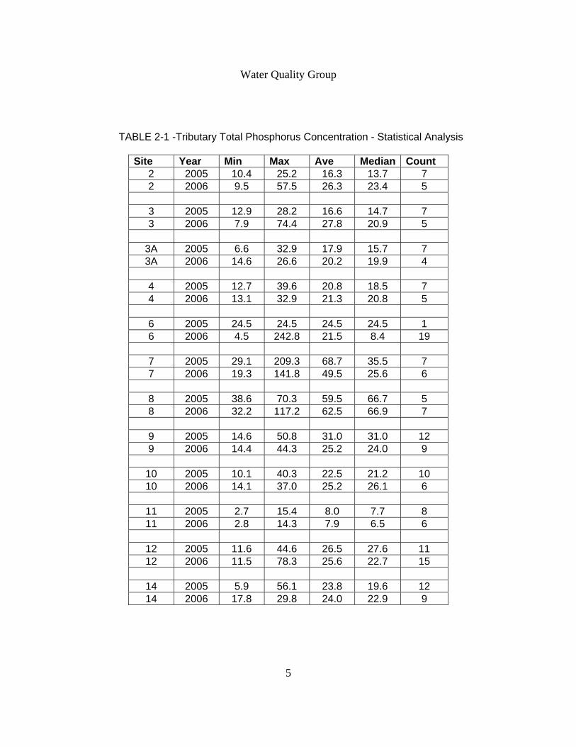
Water Quality Group
TABLE 2-1 -Tributary Total Phosphorus Concentration - Statistical Analysis
Site Year Min Max Ave Median Count 2 2005 10.4 25.2 16.3 13.7 7 2 2006 9.5 57.5 26.3 23.4 5
3 2005 12.9 28.2 16.6 14.7 7 3 2006 7.9 74.4 27.8 20.9 5
3A 2005 6.6 32.9 17.9 15.7 7 3A 2006 14.6 26.6 20.2 19.9 4
4 2005 12.7 39.6 20.8 18.5 7 4 2006 13.1 32.9 21.3 20.8 5
6 2005 24.5 24.5 24.5 24.5 1 6 2006 4.5 242.8 21.5 8.4 19
7 2005 29.1 209.3 68.7 35.5 7 7 2006 19.3 141.8 49.5 25.6 6
8 2005 38.6 70.3 59.5 66.7 5 8 2006 32.2 117.2 62.5 66.9 7
9 2005 14.6 50.8 31.0 31.0 12 9 2006 14.4 44.3 25.2 24.0 9
10 2005 10.1 40.3 22.5 21.2 10 10 2006 14.1 37.0 25.2 26.1 6
11 2005 2.7 15.4 8.0 7.7 8 11 2006 2.8 14.3 7.9 6.5 6
12 2005 11.6 44.6 26.5 27.6 11 12 2006 11.5 78.3 25.6 22.7 15
14 2005 5.9 56.1 23.8 19.6 12 14 2006 17.8 29.8 24.0 22.9 9
5
Water Quality Group
Wetlands Overlay District A Wetland Overlay District was established to better protect the surface waters and wetlands in Strafford. The District was voted into the Strafford Zoning Ordinances at the 2006 Town Meeting. See Appendix ____ for the final accepted Wetland Overlay District.
Conclusions The formation of the Water Quality Group was critical for the coordination and execution of the Bow Lake tributary sampling program and the development of a Wetlands Overlay District in Strafford. The recruitment of volunteer monitors was overwhelmingly successful and has proven that by providing citizens with a focused opportunity to help protect their town’s water resources, considerable achievements can be made. The project would not have been possible without the guidance and support given by Jeff Schloss and the staff at the UNH Center for Freshwater Biology. Also the original inspiration and organizational guidance provided by Amanda Stone from UNH Cooperative Extension was essential to the success of this project.
Recommendations The work conducted through this grant will continue through routine meetings conducted to address the many other water-resource related issues that were outlined in our original organizational meetings.
The Water Quality Group identified many additional projects that may help to protect the water resources in Strafford. Some of these include the establishment of a shoreline survey of Bow Lake, water-quality monitoring of shallow areas in Bow Lake that may be prone to impacts from surface run-off and septic systems, the development of watershed protection guidance materials, and the development of additional water protection ordinances.
Specifically, the data collected through this baseline nutrient data collection project will be compiled and used to characterize the nutrient loading that has occurred over the sampling period. This will be accomplished either with additional grant money and/or through additional volunteer time.
6
Managed Growth
Introduction The Managed Growth Committee asked for grant assistance from the New Hampshire Estuaries project to keep all Strafford citizens aware of the Committee’s work, and through public meeting allow citizens to continue to be partners in the development of new ordinances that will more fully support the goals of the 2002 Strafford Master Plan. The Committee also asked for grant aid in the production of new maps that would support any zoning changes in the town and others that would clearly delineate natural resources that new ordinances were designed to protect. The Committee included members from the Strafford Planning Board, the Strafford Conservation Commission, and others interested in the project through the Natural Resource Outreach Coalition work with the town. The Managed Growth Committee had great assistance from the Strafford Regional Planning team, and relied heavily on the maps prepared by Bear-Paw Regional Greenways through a 2003 NHEP grant. NHEP’s funding has been used to further the Committee’s work in the last eighteen month in these ways:
1. An informational document was created to inform citizens of proposed changes in present town ordinances and the creation of new ordinances.
2. The document was mailed to each of the 1600 addresses in Strafford with the
invitation to a public meeting to discuss the proposed changes.
3. Once the changes were approved at the 2006 balloting, NHEP funding covered the cost of printing copies of the revised Town Ordinance Book.
The Managed Growth Committee’s work has come at less than the proposed budget because of additional “in kind” help. The Strafford School District allowed the Committee to use its bulk mail permit for the mailing to 1600 addresses, and Strafford Regional Planning prepared maps at no cost. Project Goal and Objectives Goal:
To bring proposals for new zoning ordinances that will support the Town Master Plan goals before the voters in March 2006.
1
Managed Growth
Objectives:
To develop modified or new town ordinances that will better support the Strafford Master Plan adopted in 2002. To keep the public informed and involved in the process of formulating new ordinances in order to build support for approval of proposed new ordinances. Activities
1. Develop Ordinances Committee work through twice monthly two-hour meetings focused on a line-by-line examination of the present Town Ordinance book with comparison to each section of the Strafford Master Plan adopted in 2002. Focus for the work was supported by results from a survey prepared by the Committee, distributed and collected at the March 2005 election and town meeting days. Survey results from 242 respondents showed close to 100% support for preserving Strafford’s rural character, its natural and scenic resources including agricultural lands. As the Committee discovered disconnects between ordinances on the books and the goals of the Master Plan, members did research into other towns’ ordinances for guidance. Cynthia Copeland of Strafford Regional Planning was a valuable partner; she attended meetings and provided examples of ordinances that had been effective in other areas of New Hampshire and the USA. The Committee goal was to propose ordinances that had been shown to work without legal challenge in other towns. The Committee also envisioned the establishment of a variable zoning plan for Strafford and requested grant support to produce maps detailing that plan. As indicated in the grant application, the survey of town voters prepared by the Committee mentioned above had returned a 64% support for a variable zoning plan, and 68% support for enhancing town centers. As work in the Committee proceeded, however, it became clear that these goals conflicted with other areas of the survey, which showed the nearly total support for protecting Strafford’s rural character, natural resources, and open agricultural lands. Strafford’s principal “town center” in Center Strafford has large areas of open agricultural lands with
2
Managed Growth
prime soils which help define the historic and rural character of the town. It became clear that developing a denser zoning plan for that area would be inappropriate. Consequently, the Committee chose to present to the town for approval in 2006, several ordinance changes and new ordinances that dealt with the most immediate threats to natural and scenic resources and rural character. They focused on the phasing in of any build-out of new subdivisions and protective guidelines for any development on our undeveloped mountainsides. The texts of the proposed ordinances are presented in Appendix C. 2. Public Information and Involvement
The work of the Committee was reported monthly in the Strafford Calendar newspaper. The public was informed of meeting times and place and repeatedly invited to join the Committee. When the Committee had decided upon the proposals that would be presented to voters on the March 2006 ballot, members prepared and had printed an informational document that would be mailed to each address in Strafford. The mailing also included an invitation to a public meeting for discussion of the proposed ordinances. The text of the mailing and texts of the proposed new ordinances are reported in Appendix C. The meeting was held at the Strafford School cafeteria in February of 2006. Nine committee members and about 40 members of the public attended for the discussion.
Results and Discussion The New Hampshire Estuaries Project grant support led to success at the March 2006 balloting. All three zoning ordinance changes proposed by the Managed Growth Committee were passed. This did not signal the end of the Committee’s work. Members have continued to meet twice monthly through 2006 to assess other goals of the Master Plan that need better support from ordinances. New Hampshire State Soil Specialist, Steve Hundley, was a guest speaker in October of 2006 speaking about the value of farm soils and financial resources to protect them. Julie LaBranche of Strafford Regional Planning Commission spoke to the Committee in December of 2006 about buffer zone ordinances to preserve natural vegetation around new development and guidelines for architectural regulations for commercial development. During August of 2006, members drove throughout the Strafford roads to make a photographic record of scenic areas and agricultural lands as part of a natural resource inventory. Strafford Planning Commission created new maps detailing prime soils and other natural resource features. As a result of this continuing work, the Committee intends to present new ordinance proposals to the town on the 2007 ballot related to buffer zones around new construction, financial incentives for protecting agricultural lands, and architectural regulations for new
3
Managed Growth
commercial development. Articles in the Strafford Calendar monthly newsletter will continue to inform the public and invite citizen involvement. Conclusions The initial work begun with the Natural Resource Outreach Coalition followed by financial support from the New Hampshire Estuaries Project has created an ongoing Committee that will continue to work throughout the coming years. Planning Board members of the Managed Growth Committee have noted that Planning Board work is so often reaction to proposals for development that little time is left for actual town planning. The Managed Growth Committee with its volunteers provides just that planning opportunity. It is the natural connection between the Strafford Master Plan and the town ordinances. The Committee members are grateful to the NROC team and the NHEP for helping the town establish that bridge. Recommendations Though the Strafford voters have been made aware of the work of the Managed Growth Committee through the work detailed above, it may be necessary in the future to again send out a blanket mailing to residents for public meetings for discussion of proposed changes. Many citizens have become accustomed to reading of Committee activities and proposals through the Strafford Calendar which the Committee may use at no cost. However not all citizens are regular readers of the Calendar. In the future the Committee may wish to apply for financial support from funding sources for town-wide mailings and public meetings. Appendix March 2005 Survey of Voters Tabulation of Survey Results Informational Mailing to all Strafford Addresses Texts of Proposed Ordinances for March 2006 Ballot Volunteer Time Records Financial Data
4

Appendix A
Land Protection Group
Strafford Conservation Commission P.O. Box 23
Center Strafford, NH 03815 Date
Address Dear __________________________ The Strafford Conservation Commission is pleased to announce that your Strafford neighbors, ___________________________, have recently protected their land with a conservation easement. The land continues in their private ownership and they may sell it or pass it to heirs, but the land will remain undeveloped in its natural state of beauty forever. Establishing a conservation easement can provide federal tax advantages for the present owners and estate tax relief for heirs. There is also a tax advantage to all residents of the Town of Strafford because undeveloped land needs fewer town services than developed land. The Strafford Conservation Commission and the _________________ land trust worked with the _________________ to cover the surveying, appraisal, and legal costs of setting up the easement. The Strafford Conservation Fund was established in 1999 by voters for this work as a way to meet the Town of Strafford Master Plan goal of maintaining the Town’s rural character by the preservation of undeveloped land. As an abutter to this newly protected _____________ land, you may be interested in adding your parcel to form an even larger undeveloped tract that would be of great benefit to wildlife and contribute to more biological diversity. One of our members will try to reach you by phone within a week to discuss your feelings about land protection. If, in the meantime, you would like more information about conservation easements and the process here in Strafford or if you have any other questions, please call our Chairperson, Liz Evans at 664-2192 ex. 13. Yours truly, Members of the Conservation Commission Land Protection Group Conservation Commission Members: Land Protection Group : Liz Evans Harmony Anderson Jack Bronnenberg Carolyn Page Cal Schroeder Bruce Smith
Sarah Ward Joann Brown Al Pratt Cal Schroeder Carolyn Page
Jim Cyr Bob Brownell Bill Vance Carol Mulligan JB Cullen Bob Perry
Joyce Creighton
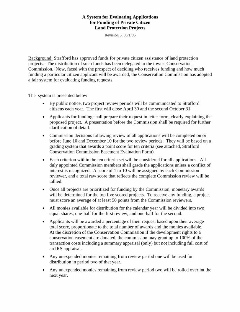
A System for Evaluating Applications for Funding of Private Citizen
Land Protection Projects Revision 3. 05/1/06
Background: Strafford has approved funds for private citizen assistance of land protection projects. The distribution of such funds has been delegated to the town's Conservation Commission. Now, faced with the prospect of deciding who receives funding and how much funding a particular citizen applicant will be awarded, the Conservation Commission has adopted a fair system for evaluating funding requests.
The system is presented below:
● By public notice, two project review periods will be communicated to Strafford citizens each year. The first will close April 30 and the second October 31.
● Applicants for funding shall prepare their request in letter form, clearly explaining the proposed project. A presentation before the Commission shall be required for further clarification of detail.
● Commission decisions following review of all applications will be completed on or before June 10 and December 10 for the two review periods. They will be based on a grading system that awards a point score for ten criteria (see attached, Strafford Conservation Commission Easement Evaluation Form).
● Each criterion within the ten criteria set will be considered for all applications. All duly appointed Commission members shall grade the applications unless a conflict of interest is recognized. A score of 1 to 10 will be assigned by each Commission reviewer, and a total raw score that reflects the complete Commission review will be tallied.
● Once all projects are prioritized for funding by the Commission, monetary awards will be determined for the top five scored projects. To receive any funding, a project must score an average of at least 50 points from the Commission reviewers.
● All monies available for distribution for the calendar year will be divided into two equal shares; one-half for the first review, and one-half for the second.
● Applicants will be awarded a percentage of their request based upon their average total score, proportionate to the total number of awards and the monies available. At the discretion of the Conservation Commission if the development rights to a conservation easement are donated, the commission may grant up to 100% of the transaction costs including a summary appraisal (only) but not including full cost of an IRS appraisal.
● Any unexpended monies remaining from review period one will be used for distribution in period two of that year.
● Any unexpended monies remaining from review period two will be rolled over int the next year.
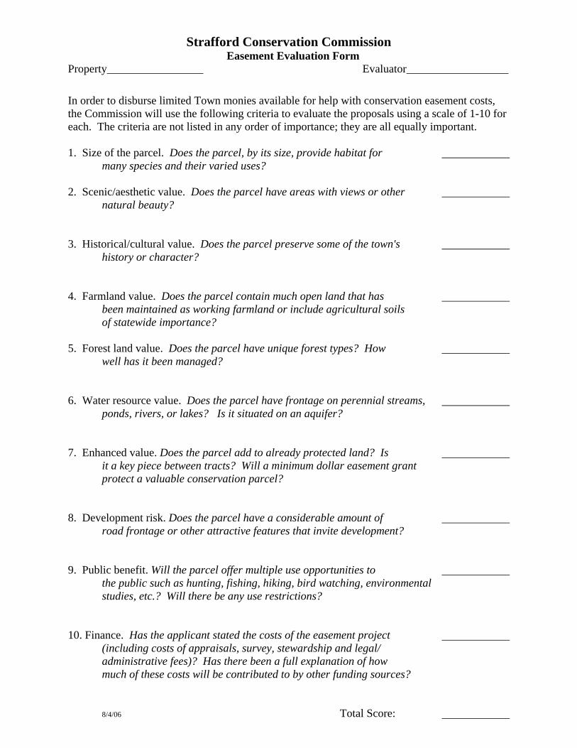
Strafford Conservation Commission Easement Evaluation Form
Property_________________ Evaluator__________________
In order to disburse limited Town monies available for help with conservation easement costs, the Commission will use the following criteria to evaluate the proposals using a scale of 1-10 for each. The criteria are not listed in any order of importance; they are all equally important. 1. Size of the parcel. Does the parcel, by its size, provide habitat for many species and their varied uses? 2. Scenic/aesthetic value. Does the parcel have areas with views or other natural beauty? 3. Historical/cultural value. Does the parcel preserve some of the town's history or character? 4. Farmland value. Does the parcel contain much open land that has been maintained as working farmland or include agricultural soils of statewide importance? 5. Forest land value. Does the parcel have unique forest types? How well has it been managed? 6. Water resource value. Does the parcel have frontage on perennial streams, ponds, rivers, or lakes? Is it situated on an aquifer? 7. Enhanced value. Does the parcel add to already protected land? Is it a key piece between tracts? Will a minimum dollar easement grant protect a valuable conservation parcel? 8. Development risk. Does the parcel have a considerable amount of road frontage or other attractive features that invite development? 9. Public benefit. Will the parcel offer multiple use opportunities to the public such as hunting, fishing, hiking, bird watching, environmental studies, etc.? Will there be any use restrictions? 10. Finance. Has the applicant stated the costs of the easement project (including costs of appraisals, survey, stewardship and legal/ administrative fees)? Has there been a full explanation of how much of these costs will be contributed to by other funding sources? 8/4/06 Total Score:
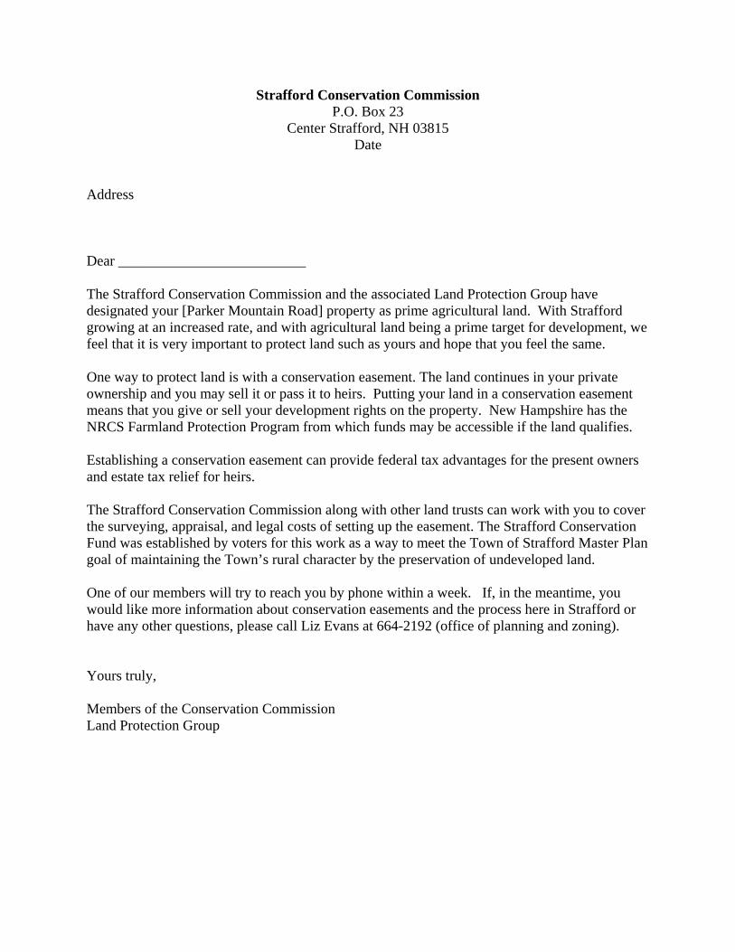
Strafford Conservation Commission P.O. Box 23
Center Strafford, NH 03815 Date
Address Dear __________________________ The Strafford Conservation Commission and the associated Land Protection Group have designated your [Parker Mountain Road] property as prime agricultural land. With Strafford growing at an increased rate, and with agricultural land being a prime target for development, we feel that it is very important to protect land such as yours and hope that you feel the same. One way to protect land is with a conservation easement. The land continues in your private ownership and you may sell it or pass it to heirs. Putting your land in a conservation easement means that you give or sell your development rights on the property. New Hampshire has the NRCS Farmland Protection Program from which funds may be accessible if the land qualifies. Establishing a conservation easement can provide federal tax advantages for the present owners and estate tax relief for heirs. The Strafford Conservation Commission along with other land trusts can work with you to cover the surveying, appraisal, and legal costs of setting up the easement. The Strafford Conservation Fund was established by voters for this work as a way to meet the Town of Strafford Master Plan goal of maintaining the Town’s rural character by the preservation of undeveloped land. One of our members will try to reach you by phone within a week. If, in the meantime, you would like more information about conservation easements and the process here in Strafford or have any other questions, please call Liz Evans at 664-2192 (office of planning and zoning). Yours truly, Members of the Conservation Commission Land Protection Group
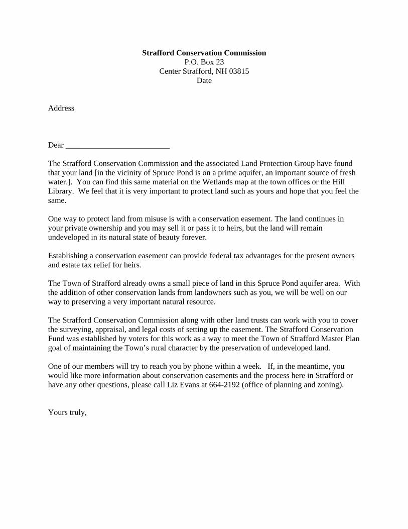
Strafford Conservation Commission P.O. Box 23
Center Strafford, NH 03815 Date
Address Dear __________________________ The Strafford Conservation Commission and the associated Land Protection Group have found that your land [in the vicinity of Spruce Pond is on a prime aquifer, an important source of fresh water.]. You can find this same material on the Wetlands map at the town offices or the Hill Library. We feel that it is very important to protect land such as yours and hope that you feel the same. One way to protect land from misuse is with a conservation easement. The land continues in your private ownership and you may sell it or pass it to heirs, but the land will remain undeveloped in its natural state of beauty forever. Establishing a conservation easement can provide federal tax advantages for the present owners and estate tax relief for heirs. The Town of Strafford already owns a small piece of land in this Spruce Pond aquifer area. With the addition of other conservation lands from landowners such as you, we will be well on our way to preserving a very important natural resource. The Strafford Conservation Commission along with other land trusts can work with you to cover the surveying, appraisal, and legal costs of setting up the easement. The Strafford Conservation Fund was established by voters for this work as a way to meet the Town of Strafford Master Plan goal of maintaining the Town’s rural character by the preservation of undeveloped land. One of our members will try to reach you by phone within a week. If, in the meantime, you would like more information about conservation easements and the process here in Strafford or have any other questions, please call Liz Evans at 664-2192 (office of planning and zoning). Yours truly,
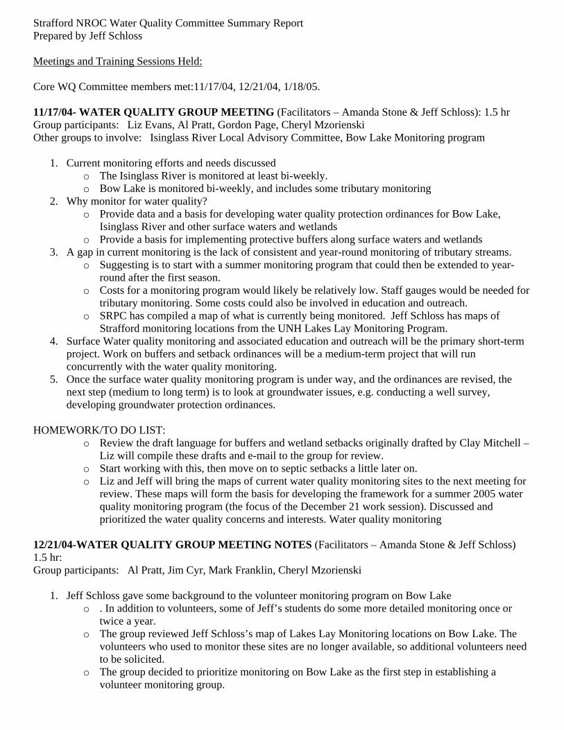
Strafford NROC Water Quality Committee Summary Report Prepared by Jeff Schloss Meetings and Training Sessions Held: Core WQ Committee members met:11/17/04, 12/21/04, 1/18/05. 11/17/04- WATER QUALITY GROUP MEETING (Facilitators – Amanda Stone & Jeff Schloss): 1.5 hr Group participants: Liz Evans, Al Pratt, Gordon Page, Cheryl Mzorienski Other groups to involve: Isinglass River Local Advisory Committee, Bow Lake Monitoring program
1. Current monitoring efforts and needs discussed o The Isinglass River is monitored at least bi-weekly. o Bow Lake is monitored bi-weekly, and includes some tributary monitoring
2. Why monitor for water quality? o Provide data and a basis for developing water quality protection ordinances for Bow Lake,
Isinglass River and other surface waters and wetlands o Provide a basis for implementing protective buffers along surface waters and wetlands
3. A gap in current monitoring is the lack of consistent and year-round monitoring of tributary streams. o Suggesting is to start with a summer monitoring program that could then be extended to year-
round after the first season. o Costs for a monitoring program would likely be relatively low. Staff gauges would be needed for
tributary monitoring. Some costs could also be involved in education and outreach. o SRPC has compiled a map of what is currently being monitored. Jeff Schloss has maps of
Strafford monitoring locations from the UNH Lakes Lay Monitoring Program. 4. Surface Water quality monitoring and associated education and outreach will be the primary short-term
project. Work on buffers and setback ordinances will be a medium-term project that will run concurrently with the water quality monitoring.
5. Once the surface water quality monitoring program is under way, and the ordinances are revised, the next step (medium to long term) is to look at groundwater issues, e.g. conducting a well survey, developing groundwater protection ordinances.
HOMEWORK/TO DO LIST:
o Review the draft language for buffers and wetland setbacks originally drafted by Clay Mitchell – Liz will compile these drafts and e-mail to the group for review.
o Start working with this, then move on to septic setbacks a little later on. o Liz and Jeff will bring the maps of current water quality monitoring sites to the next meeting for
review. These maps will form the basis for developing the framework for a summer 2005 water quality monitoring program (the focus of the December 21 work session). Discussed and prioritized the water quality concerns and interests. Water quality monitoring
12/21/04-WATER QUALITY GROUP MEETING NOTES (Facilitators – Amanda Stone & Jeff Schloss) 1.5 hr: Group participants: Al Pratt, Jim Cyr, Mark Franklin, Cheryl Mzorienski
1. Jeff Schloss gave some background to the volunteer monitoring program on Bow Lake o . In addition to volunteers, some of Jeff’s students do some more detailed monitoring once or
twice a year. o The group reviewed Jeff Schloss’s map of Lakes Lay Monitoring locations on Bow Lake. The
volunteers who used to monitor these sites are no longer available, so additional volunteers need to be solicited.
o The group decided to prioritize monitoring on Bow Lake as the first step in establishing a volunteer monitoring group.
o The group also considered monitoring needs in other parts of town, including the upper portion of the Isinglass River. Jeff showed maps obtained from the NH DES VRAP monitoring program on the Isinglass.
2. After getting the Bow Lake program re-established, the group will look at expanding monitoring to include other areas. If the upper Isinglass area is included in monitoring, the group will need to keep the Isinglass group informed of activities. This can probably be done via Liz who is on the Isinglass River Watershed Local Advisory Committee.
3. Suggestion was made to schedule a canoe/kayak trip on the lake to set up sections and additional monitoring locations in the summer.
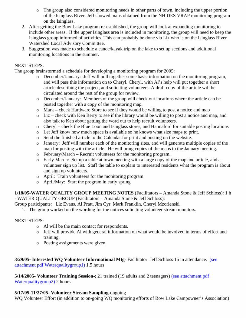
NEXT STEPS: The group brainstormed a schedule for developing a monitoring program for 2005:
o December/January: Jeff will pull together some basic information on the monitoring program, and will pass this information on to Cheryl. Cheryl, with Al’s help will put together a short article describing the project, and soliciting volunteers. A draft copy of the article will be circulated around the rest of the group for review.
o December/January: Members of the group will check out locations where the article can be posted together with a copy of the monitoring map.
o Mark – check Hardware Store to see if they would be willing to post a notice and map o Liz – check with Ken Berry to see if the library would be willing to post a notice and map, and
also talk to Ken about getting the word out to help recruit volunteers. o Cheryl – check the Blue Loon and Isinglass stores, and Hannaford for suitable posting locations o Let Jeff know how much space is available so he knows what size maps to print. o Send the finished article to the Calendar for print and posting on the website. o January: Jeff will number each of the monitoring sites, and will generate multiple copies of the
map for posting with the article. He will bring copies of the maps to the January meeting. o February/March – Recruit volunteers for the monitoring program. o Early March: Set up a table at town meeting with a large copy of the map and article, and a
volunteer sign up list. Staff the table to explain to interested residents what the program is about and sign up volunteers.
o April: Train volunteers for the monitoring program. o April/May: Start the program in early spring
1/18/05-WATER QUALITY GROUP MEETING NOTES (Facilitators – Amanda Stone & Jeff Schloss): 1 h - WATER QUALITY GROUP (Facilitators – Amanda Stone & Jeff Schloss): Group participants: Liz Evans, Al Pratt, Jim Cyr, Mark Franklin, Cheryl Mzorienski
1. The group worked on the wording for the notices soliciting volunteer stream monitors. NEXT STEPS:
o Al will be the main contact for respondents. o Jeff will provide Al with general information on what would be involved in terms of effort and
training. o Posting assignments were given.
3/29/05- Interested WQ Volunteer Informational Mtg- Facilitator: Jeff Schloss 15 in attendance. (see attachment pdf Waterqualitygroup1) 1.5 hours 5/14/2005- Volunteer Training Session-; 21 trained (19 adults and 2 teenagers) (see attachment pdf Waterqualitygroup2) 2 hours 5/17/05-11/27/05- Volunteer Stream Sampling-ongoing WQ Volunteer Effort (in addition to on-going WQ monitoring efforts of Bow Lake Campowner’s Association)
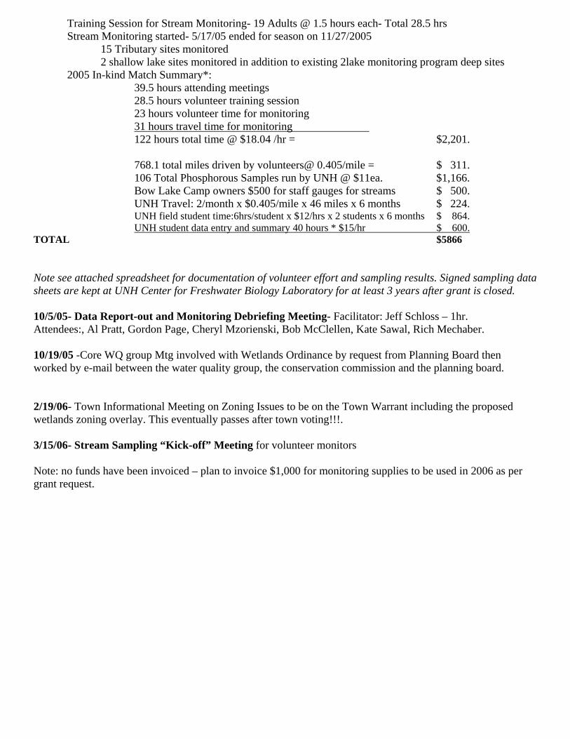
Training Session for Stream Monitoring- 19 Adults @ 1.5 hours each- Total 28.5 hrs Stream Monitoring started- 5/17/05 ended for season on 11/27/2005 15 Tributary sites monitored 2 shallow lake sites monitored in addition to existing 2lake monitoring program deep sites 2005 In-kind Match Summary*: 39.5 hours attending meetings 28.5 hours volunteer training session 23 hours volunteer time for monitoring 31 hours travel time for monitoring 122 hours total time @ $18.04 /hr = $2,201. 768.1 total miles driven by volunteers@ 0.405/mile = $ 311. 106 Total Phosphorous Samples run by UNH @ $11ea. $1,166. Bow Lake Camp owners $500 for staff gauges for streams $ 500. UNH Travel: 2/month x $0.405/mile x 46 miles x 6 months $ 224. UNH field student time:6hrs/student x $12/hrs x 2 students x 6 months $ 864. UNH student data entry and summary 40 hours * $15/hr $ 600. TOTAL $5866 Note see attached spreadsheet for documentation of volunteer effort and sampling results. Signed sampling data sheets are kept at UNH Center for Freshwater Biology Laboratory for at least 3 years after grant is closed. 10/5/05- Data Report-out and Monitoring Debriefing Meeting- Facilitator: Jeff Schloss – 1hr. Attendees:, Al Pratt, Gordon Page, Cheryl Mzorienski, Bob McClellen, Kate Sawal, Rich Mechaber. 10/19/05 -Core WQ group Mtg involved with Wetlands Ordinance by request from Planning Board then worked by e-mail between the water quality group, the conservation commission and the planning board. 2/19/06- Town Informational Meeting on Zoning Issues to be on the Town Warrant including the proposed wetlands zoning overlay. This eventually passes after town voting!!!. 3/15/06- Stream Sampling “Kick-off” Meeting for volunteer monitors Note: no funds have been invoiced – plan to invoice $1,000 for monitoring supplies to be used in 2006 as per grant request.
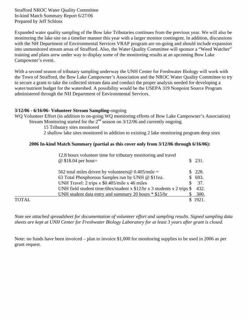
Strafford NROC Water Quality Committee In-kind Match Summary Report 6/27/06 Prepared by Jeff Schloss Expanded water quality sampling of the Bow lake Tributaries continues from the previous year. We will also be monitoring the lake site on a timelier manner this year with a larger monitor contingent. In addition, discussions with the NH Department of Environmental Services VRAP program are on-going and should include expansion into unmonitored stream areas of Strafford. Also, the Water Quality Committee will sponsor a “Weed Watcher” training and plans arew under way to display some of the monitoring results at an upcoming Bow Lake Campowner’s event. With a second season of tributary sampling underway the UNH Center for Freshwater Biology will work with the Town of Strafford, the Bow Lake Campowner’s Association and the NROC Water Quality Committee to try to secure a grant to take the collected stream data and conduct the proper analysis needed for developing a water/nutrient budget for the watershed. A possibility would be the USEPA 319 Nonpoint Source Program administered through the NH Department of Environmental Services. 3/12/06 - 6/16/06- Volunteer Stream Sampling-ongoing WQ Volunteer Effort (in addition to on-going WQ monitoring efforts of Bow Lake Campowner’s Association) Stream Monitoring started for the 2nd season on 3/12/06 and currently ongoing. 15 Tributary sites monitored 2 shallow lake sites monitored in addition to existing 2 lake monitoring program deep sites 2006 In-kind Match Summary (partial as this cover only from 3/12/06 through 6/16/06): 12.8 hours volunteer time for tributary monitoring and travel @ $18.04 per hour= $ 231. 562 total miles driven by volunteers@ 0.405/mile = $ 228. 63 Total Phosphorous Samples run by UNH @ $11ea. $ 693. UNH Travel: 2 trips x $0.405/mile x 46 miles $ 37. UNH field student time:6hrs/student x $12/hr x 3 students x 2 trips $ 432. UNH student data entry and summary 20 hours * $15/hr $ 300. TOTAL $ 1921. Note see attached spreadsheet for documentation of volunteer effort and sampling results. Signed sampling data sheets are kept at UNH Center for Freshwater Biology Laboratory for at least 3 years after grant is closed. Note: no funds have been invoiced – plan to invoice $1,000 for monitoring supplies to be used in 2006 as per grant request.
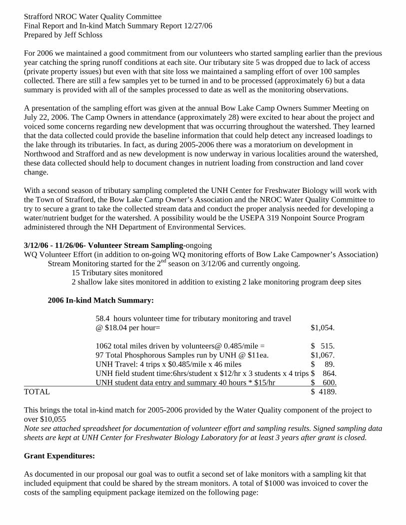
Strafford NROC Water Quality Committee Final Report and In-kind Match Summary Report 12/27/06 Prepared by Jeff Schloss For 2006 we maintained a good commitment from our volunteers who started sampling earlier than the previous year catching the spring runoff conditions at each site. Our tributary site 5 was dropped due to lack of access (private property issues) but even with that site loss we maintained a sampling effort of over 100 samples collected. There are still a few samples yet to be turned in and to be processed (approximately 6) but a data summary is provided with all of the samples processed to date as well as the monitoring observations. A presentation of the sampling effort was given at the annual Bow Lake Camp Owners Summer Meeting on July 22, 2006. The Camp Owners in attendance (approximately 28) were excited to hear about the project and voiced some concerns regarding new development that was occurring throughout the watershed. They learned that the data collected could provide the baseline information that could help detect any increased loadings to the lake through its tributaries. In fact, as during 2005-2006 there was a moratorium on development in Northwood and Strafford and as new development is now underway in various localities around the watershed, these data collected should help to document changes in nutrient loading from construction and land cover change. With a second season of tributary sampling completed the UNH Center for Freshwater Biology will work with the Town of Strafford, the Bow Lake Camp Owner’s Association and the NROC Water Quality Committee to try to secure a grant to take the collected stream data and conduct the proper analysis needed for developing a water/nutrient budget for the watershed. A possibility would be the USEPA 319 Nonpoint Source Program administered through the NH Department of Environmental Services. 3/12/06 - 11/26/06- Volunteer Stream Sampling-ongoing WQ Volunteer Effort (in addition to on-going WQ monitoring efforts of Bow Lake Campowner’s Association) Stream Monitoring started for the 2nd season on 3/12/06 and currently ongoing. 15 Tributary sites monitored 2 shallow lake sites monitored in addition to existing 2 lake monitoring program deep sites 2006 In-kind Match Summary: 58.4 hours volunteer time for tributary monitoring and travel @ $18.04 per hour= $1,054. 1062 total miles driven by volunteers@ 0.485/mile = $ 515. 97 Total Phosphorous Samples run by UNH @ $11ea. $1,067. UNH Travel: 4 trips x $0.485/mile x 46 miles $ 89. UNH field student time:6hrs/student x $12/hr x 3 students x 4 trips $ 864. UNH student data entry and summary 40 hours * $15/hr $ 600. TOTAL $ 4189. This brings the total in-kind match for 2005-2006 provided by the Water Quality component of the project to over $10,055 Note see attached spreadsheet for documentation of volunteer effort and sampling results. Signed sampling data sheets are kept at UNH Center for Freshwater Biology Laboratory for at least 3 years after grant is closed. Grant Expenditures: As documented in our proposal our goal was to outfit a second set of lake monitors with a sampling kit that included equipment that could be shared by the stream monitors. A total of $1000 was invoiced to cover the costs of the sampling equipment package itemized on the following page:
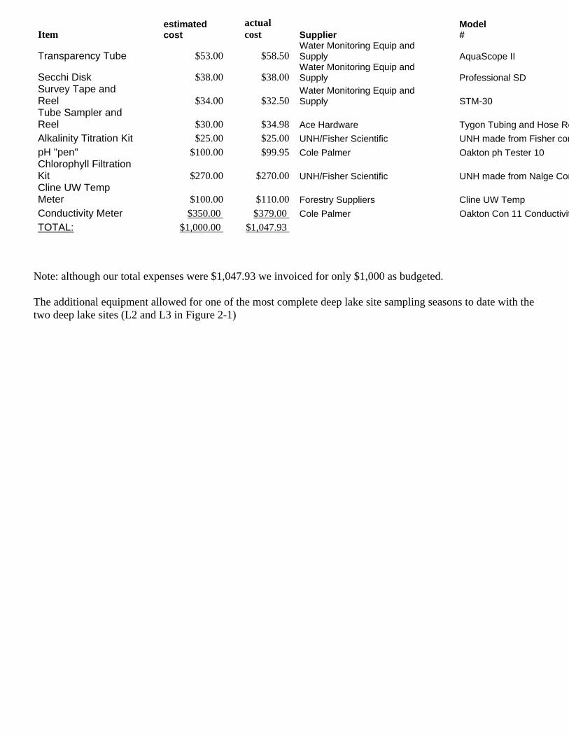
Item estimated cost
actual cost Supplier
Model #
Transparency Tube $53.00 $58.50 Water Monitoring Equip and Supply AquaScope II
Secchi Disk $38.00 $38.00 Water Monitoring Equip and Supply Professional SD
Survey Tape and Reel $34.00 $32.50
Water Monitoring Equip and Supply STM-30
Tube Sampler and Reel $30.00 $34.98 Ace Hardware Tygon Tubing and Hose ReAlkalinity Titration Kit $25.00 $25.00 UNH/Fisher Scientific UNH made from Fisher compH "pen" $100.00 $99.95 Cole Palmer Oakton ph Tester 10 Chlorophyll Filtration Kit $270.00 $270.00 UNH/Fisher Scientific UNH made from Nalge ComCline UW Temp Meter $100.00 $110.00 Forestry Suppliers Cline UW Temp Conductivity Meter $350.00 $379.00 Cole Palmer Oakton Con 11 ConductivitTOTAL: $1,000.00 $1,047.93
Note: although our total expenses were $1,047.93 we invoiced for only $1,000 as budgeted. The additional equipment allowed for one of the most complete deep lake site sampling seasons to date with the two deep lake sites (L2 and L3 in Figure 2-1)
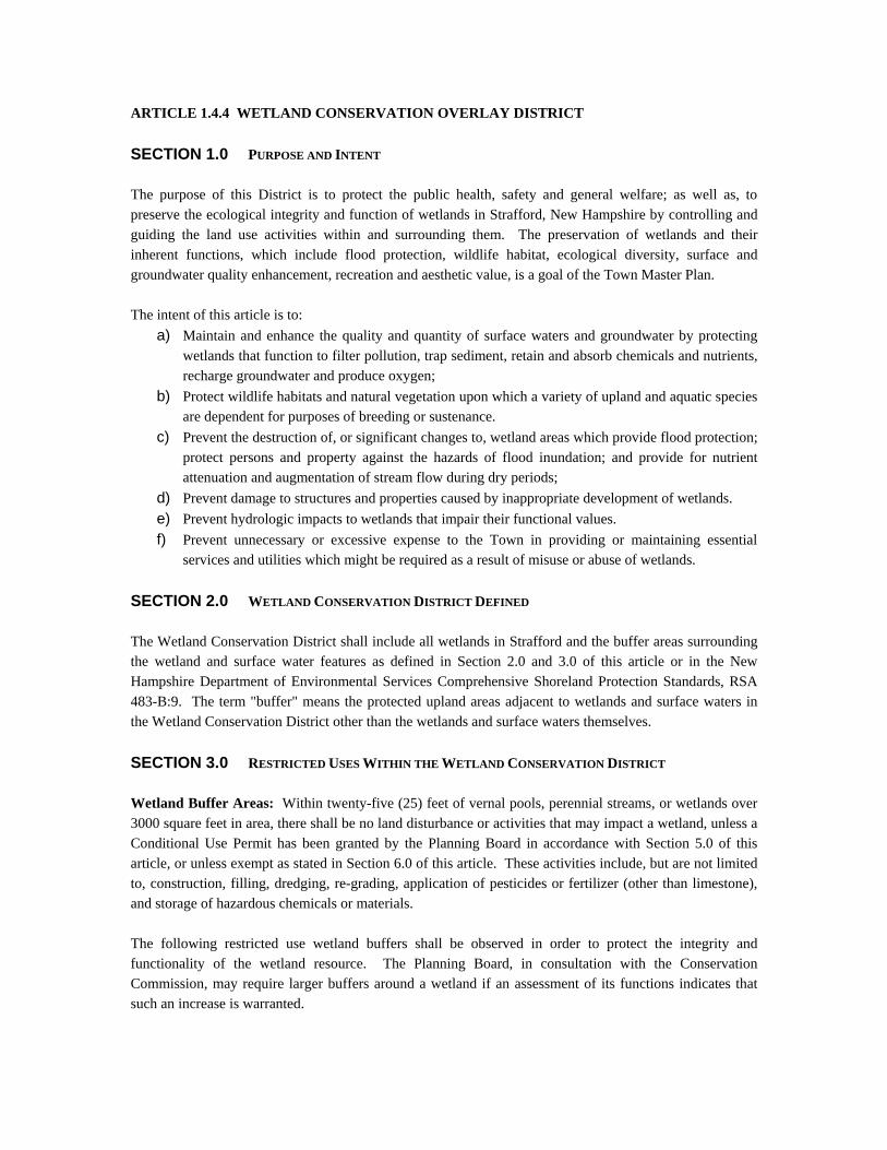
ARTICLE 1.4.4 WETLAND CONSERVATION OVERLAY DISTRICT SECTION 1.0 PURPOSE AND INTENT The purpose of this District is to protect the public health, safety and general welfare; as well as, to preserve the ecological integrity and function of wetlands in Strafford, New Hampshire by controlling and guiding the land use activities within and surrounding them. The preservation of wetlands and their inherent functions, which include flood protection, wildlife habitat, ecological diversity, surface and groundwater quality enhancement, recreation and aesthetic value, is a goal of the Town Master Plan. The intent of this article is to:
a) Maintain and enhance the quality and quantity of surface waters and groundwater by protecting wetlands that function to filter pollution, trap sediment, retain and absorb chemicals and nutrients, recharge groundwater and produce oxygen;
b) Protect wildlife habitats and natural vegetation upon which a variety of upland and aquatic species are dependent for purposes of breeding or sustenance.
c) Prevent the destruction of, or significant changes to, wetland areas which provide flood protection; protect persons and property against the hazards of flood inundation; and provide for nutrient attenuation and augmentation of stream flow during dry periods;
d) Prevent damage to structures and properties caused by inappropriate development of wetlands. e) Prevent hydrologic impacts to wetlands that impair their functional values. f) Prevent unnecessary or excessive expense to the Town in providing or maintaining essential
services and utilities which might be required as a result of misuse or abuse of wetlands. SECTION 2.0 WETLAND CONSERVATION DISTRICT DEFINED The Wetland Conservation District shall include all wetlands in Strafford and the buffer areas surrounding the wetland and surface water features as defined in Section 2.0 and 3.0 of this article or in the New Hampshire Department of Environmental Services Comprehensive Shoreland Protection Standards, RSA 483-B:9. The term "buffer" means the protected upland areas adjacent to wetlands and surface waters in the Wetland Conservation District other than the wetlands and surface waters themselves. SECTION 3.0 RESTRICTED USES WITHIN THE WETLAND CONSERVATION DISTRICT Wetland Buffer Areas: Within twenty-five (25) feet of vernal pools, perennial streams, or wetlands over 3000 square feet in area, there shall be no land disturbance or activities that may impact a wetland, unless a Conditional Use Permit has been granted by the Planning Board in accordance with Section 5.0 of this article, or unless exempt as stated in Section 6.0 of this article. These activities include, but are not limited to, construction, filling, dredging, re-grading, application of pesticides or fertilizer (other than limestone), and storage of hazardous chemicals or materials. The following restricted use wetland buffers shall be observed in order to protect the integrity and functionality of the wetland resource. The Planning Board, in consultation with the Conservation Commission, may require larger buffers around a wetland if an assessment of its functions indicates that such an increase is warranted.
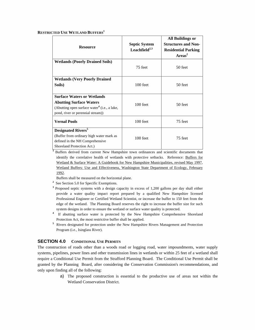
RESTRICTED USE WETLAND BUFFERS1
Resource Septic System Leachfield2,3
All Buildings or Structures and Non-Residential Parking
Areas2 Wetlands (Poorly Drained Soils)
75 feet 50 feet
Wetlands (Very Poorly Drained Soils)
100 feet 50 feet
Surface Waters or Wetlands Abutting Surface Waters (Abutting open surface water4 (i.e., a lake, pond, river or perennial stream))
100 feet 50 feet
Vernal Pools 100 feet 75 feet
Designated Rivers5 (Buffer from ordinary high water mark as defined in the NH Comprehensive Shoreland Protection Act.)
100 feet 75 feet
1 Buffers derived from current New Hampshire town ordinances and scientific documents that identify the correlative health of wetlands with protective setbacks. Reference: Buffers for Wetland & Surface Water: A Guidebook for New Hampshire Municipalities, revised May 1997, Wetland Buffers: Use and Effectiveness, Washington State Department of Ecology, February 1992.
Buffers shall be measured on the horizontal plane. 2 See Section 5.0 for Specific Exemptions. 3 Proposed septic systems with a design capacity in excess of 1,200 gallons per day shall either
provide a water quality impact report prepared by a qualified New Hampshire licensed Professional Engineer or Certified Wetland Scientist, or increase the buffer to 150 feet from the edge of the wetland. The Planning Board reserves the right to increase the buffer size for such system designs in order to ensure the wetland or surface water quality is protected.
4 If abutting surface water is protected by the New Hampshire Comprehensive Shoreland Protection Act, the most restrictive buffer shall be applied.
5 Rivers designated for protection under the New Hampshire Rivers Management and Protection Program (i.e., Isinglass River).
SECTION 4.0 CONDITIONAL USE PERMITS The construction of roads other than a woods road or logging road, water impoundments, water supply systems, pipelines, power lines and other transmission lines in wetlands or within 25 feet of a wetland shall require a Conditional Use Permit from the Strafford Planning Board. The Conditional Use Permit shall be granted by the Planning Board, after considering the Conservation Commission's recommendations, and only upon finding all of the following:
a) The proposed construction is essential to the productive use of areas not within the Wetland Conservation District.
b) Design, construction and maintenance methods will minimize any detrimental impact upon the wetlands and buffer areas, and will include restoration of the site as nearly as possible to its original grade and condition.
c) No alternative route is feasible and reasonable. d) Economic advantage is not the sole reason for the proposed location of the activity, and e) Issuance of permits (if applicable) from the New Hampshire Wetlands Bureau and the
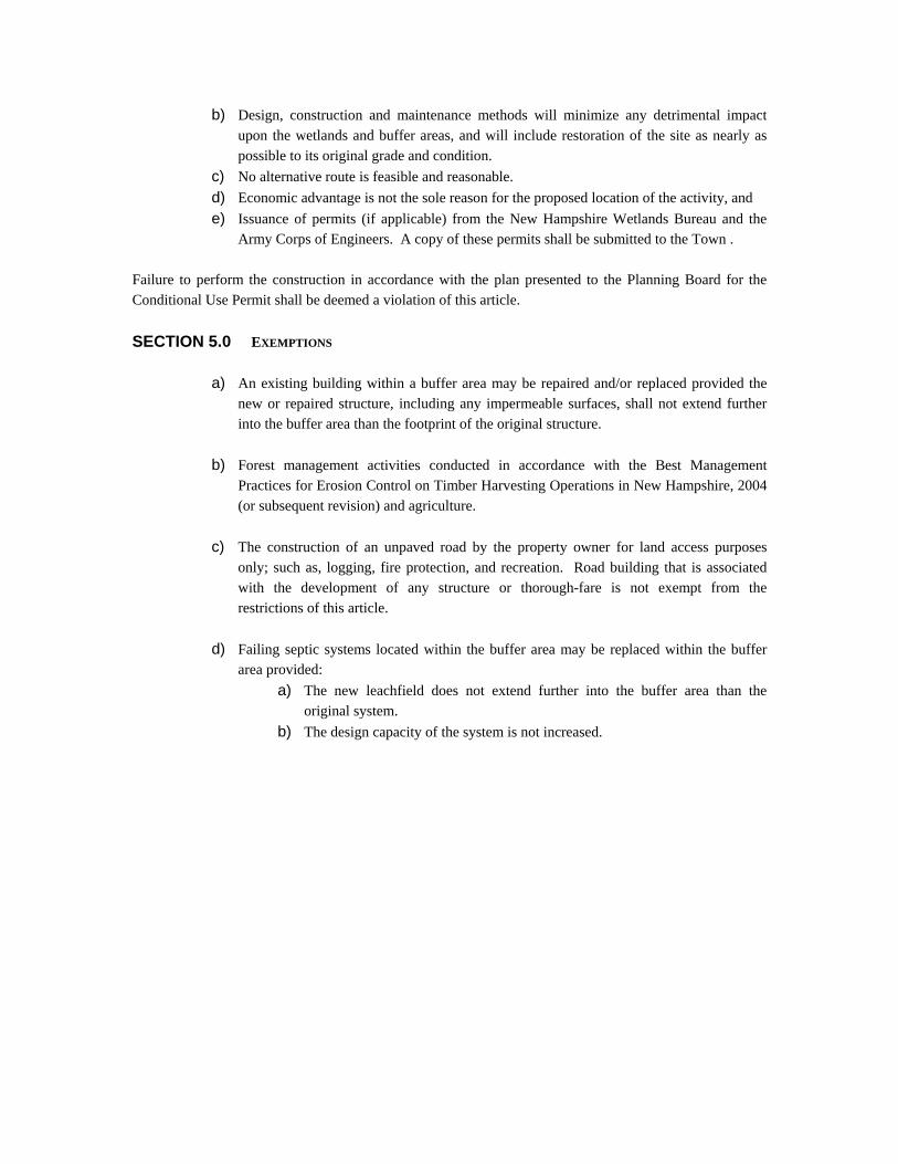
Army Corps of Engineers. A copy of these permits shall be submitted to the Town . Failure to perform the construction in accordance with the plan presented to the Planning Board for the Conditional Use Permit shall be deemed a violation of this article. SECTION 5.0 EXEMPTIONS
a) An existing building within a buffer area may be repaired and/or replaced provided the
new or repaired structure, including any impermeable surfaces, shall not extend further into the buffer area than the footprint of the original structure.
b) Forest management activities conducted in accordance with the Best Management
Practices for Erosion Control on Timber Harvesting Operations in New Hampshire, 2004 (or subsequent revision) and agriculture.
c) The construction of an unpaved road by the property owner for land access purposes
only; such as, logging, fire protection, and recreation. Road building that is associated with the development of any structure or thorough-fare is not exempt from the restrictions of this article.
d) Failing septic systems located within the buffer area may be replaced within the buffer
area provided: a) The new leachfield does not extend further into the buffer area than the
original system. b) The design capacity of the system is not increased.
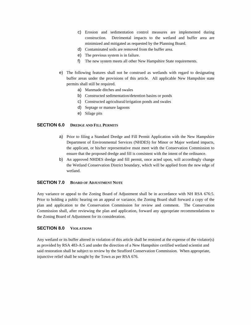
c) Erosion and sedimentation control measures are implemented during construction. Detrimental impacts to the wetland and buffer area are minimized and mitigated as requested by the Planning Board.
d) Contaminated soils are removed from the buffer area. e) The previous system is in failure. f) The new system meets all other New Hampshire State requirements.
e) The following features shall not be construed as wetlands with regard to designating
buffer areas under the provisions of this article. All applicable New Hampshire state permits shall still be required.
a) Manmade ditches and swales b) Constructed sedimentation/detention basins or ponds c) Constructed agricultural/irrigation ponds and swales d) Septage or manure lagoons e) Silage pits
SECTION 6.0 DREDGE AND FILL PERMITS
a) Prior to filing a Standard Dredge and Fill Permit Application with the New Hampshire Department of Environmental Services (NHDES) for Minor or Major wetland impacts, the applicant, or his/her representative must meet with the Conservation Commission to ensure that the proposed dredge and fill is consistent with the intent of the ordinance.
b) An approved NHDES dredge and fill permit, once acted upon, will accordingly change the Wetland Conservation District boundary, which will be applied from the new edge of wetland.
SECTION 7.0 BOARD OF ADJUSTMENT NOTE Any variance or appeal to the Zoning Board of Adjustment shall be in accordance with NH RSA 676:5. Prior to holding a public hearing on an appeal or variance, the Zoning Board shall forward a copy of the plan and application to the Conservation Commission for review and comment. The Conservation Commission shall, after reviewing the plan and application, forward any appropriate recommendations to the Zoning Board of Adjustment for its consideration. SECTION 8.0 VIOLATIONS Any wetland or its buffer altered in violation of this article shall be restored at the expense of the violator(s) as provided by RSA 483-A:5 and under the direction of a New Hampshire certified wetland scientist and said restoration shall be subject to review by the Strafford Conservation Commission. When appropriate, injunctive relief shall be sought by the Town as per RSA 676.
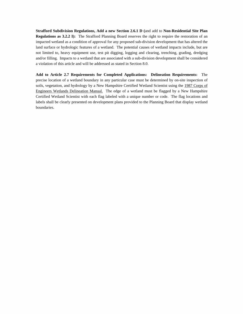
Strafford Subdivision Regulations, Add a new Section 2.6.1 D (and add to Non-Residential Site Plan Regulations as 3.2.2 I): The Strafford Planning Board reserves the right to require the restoration of an impacted wetland as a condition of approval for any proposed sub-division development that has altered the land surface or hydrologic features of a wetland. The potential causes of wetland impacts include, but are not limited to, heavy equipment use, test pit digging, logging and clearing, trenching, grading, dredging and/or filling. Impacts to a wetland that are associated with a sub-division development shall be considered a violation of this article and will be addressed as stated in Section 8.0. Add to Article 2.7 Requirements for Completed Applications: Delineation Requirements: The precise location of a wetland boundary in any particular case must be determined by on-site inspection of soils, vegetation, and hydrology by a New Hampshire Certified Wetland Scientist using the 1987 Corps of Engineers Wetlands Delineation Manual. The edge of a wetland must be flagged by a New Hampshire Certified Wetland Scientist with each flag labeled with a unique number or code. The flag locations and labels shall be clearly presented on development plans provided to the Planning Board that display wetland boundaries.
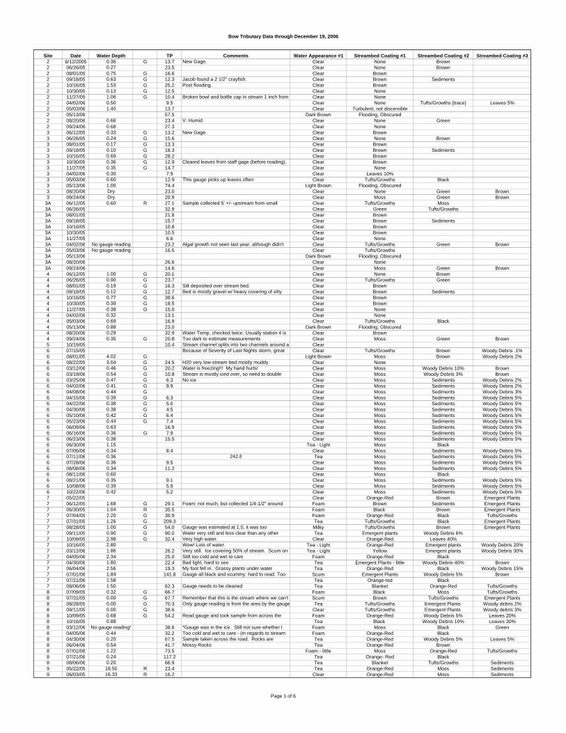
Bow Tributary Data through December 19, 2006
Site Date Water Depth TP Comments Water Appearance #1 Streambed Coating #1 Streambed Coating #2 Streambed Coating #32 6/12/2005 0.36 G 13.7 New Gage. Clear None Brown2 06/26/05 0.27 23.5 Clear None Brown2 08/01/05 0.75 G 16.6 Clear Brown2 09/18/05 0.63 G 12.3 Jacob found a 2 1/2" crayfish. Clear Brown Sediments2 10/16/05 1.53 G 25.2 Post flooding. Clear Brown2 10/30/05 0.13 G 12.5 Clear None2 11/27/05 1.06 G 10.4 Broken bowl and bottle cap in stream 1 inch from Clear None2 04/02/06 0.50 9.5 Clear None Tufts/Growths (trace) Leaves 5%2 05/03/06 1.40 13.7 Clear Turbulent, not discernible2 05/13/06 57.5 Dark Brown Flooding, Obscured2 08/20/06 0.66 23.4 V. Humid Clear None Green2 09/24/06 0.68 27.3 Clear None3 06/12/05 0.33 G 13.2 New Gage. Clear Brown3 06/26/05 0.24 G 15.6 Clear None Brown3 08/01/05 0.17 G 13.3 Clear Brown3 09/18/05 0.10 G 18.3 Clear Brown Sediments3 10/16/05 0.69 G 28.2 Clear Brown3 10/30/05 0.36 G 12.9 Cleared leaves from staff gage (before reading). Clear Brown3 11/27/05 0.35 G 14.7 Clear None3 04/02/06 0.30 7.9 Clear Leaves 10%3 05/03/06 0.60 12.9 This gauge picks up leaves often Clear Tufts/Growths Black3 05/13/06 1.00 74.4 Light Brown Flooding, Obscured3 08/20/06 Dry 23.0 Clear None Green Brown3 09/24/06 Dry 20.9 Clear Moss Green Brown
3A 06/12/05 0.60 R 27.1 Sample collected 5' +/- upstream from small Clear Tufts/Growths Moss3A 06/26/05 32.9 Clear Green Tufts/Growths3A 08/01/05 21.8 Clear Brown3A 09/18/05 15.7 Clear Brown Sediments3A 10/16/05 10.8 Clear Brown3A 10/30/05 10.5 Clear Brown3A 11/27/05 6.6 Clear None3A 04/02/06 No gauge reading 23.2 Algal growth not seen last year, although didn't Clear Tufts/Growths Green Brown3A 05/03/06 No gauge reading 16.5 Clear Tufts/Growths3A 05/13/06 Dark Brown Flooding, Obscured3A 08/20/06 26.6 Clear None3A 09/24/06 14.6 Clear Moss Green Brown4 06/12/05 1.00 G 20.1 Clear None Brown4 06/26/05 0.90 G 23.7 Clear Tufts/Growths Green4 08/01/05 0.19 G 16.3 Silt deposited over stream bed. Clear Brown4 09/18/05 0.12 G 12.7 Bed is mostly gravel w/ heavy covering of silty Clear Brown Sediments4 10/16/05 0.77 G 39.6 Clear Brown4 10/30/05 0.39 G 18.5 Clear Brown4 11/27/05 0.38 G 15.0 Clear None4 04/02/06 0.32 13.1 Clear None4 05/03/06 0.69 16.9 Clear Tufts/Growths Black4 05/13/06 0.88 23.0 Dark Brown Flooding, Obscured4 08/20/06 0.29 32.9 Water Temp. checked twice. Usually station 4 is Clear Brown4 09/24/06 0.35 G 20.8 Too dark to estimate measurements Clear Moss Green Brown5 10/19/05 10.4 Stream channel splits into two channels around a Clear6 07/15/05 Because of Severity of Last Nights storm, great Clear Tufts/Growths Brown Woody Debris .1%6 08/01/05 4.02 G Light Brown Moss Brown Woody Debris 2%6 08/22/05 3.04 G 24.5 H20 very low-stream bed mostly muddy Clear None6 03/12/06 0.46 G 20.2 Water is freezing!!! My hand hurts! Clear Moss Woody Debris 10% Brown6 03/19/06 0.54 G 10.8 Stream is mostly iced over, so need to double Clear Moss Woody Debris 3% Brown6 03/25/06 0.47 G 6.3 No ice Clear Moss Sediments Woody Debris 2%6 04/02/06 0.41 G 9.9 Clear Moss Sediments Woody Debris 2%6 04/08/06 0.44 G Clear Moss Sediments Woody Debris 3%6 04/15/06 0.39 G 6.3 Clear Moss Sediments Woody Debris 5%6 04/22/06 0.38 G 5.0 Clear Moss Sediments Woody Debris 5%6 04/30/06 0.38 G 4.5 Clear Moss Sediments Woody Debris 5%6 05/10/06 0.42 G 6.4 Clear Moss Sediments Woody Debris 5%6 05/23/06 0.44 G 7.4 Clear Moss Sediments Woody Debris 5%6 06/09/06 0.63 16.9 Clear Moss Sediments Woody Debris 5%6 06/16/06 0.36 G 7.9 Clear Moss Sediments Woody Debris 5%6 06/23/06 0.38 15.5 Clear Moss Sediments Woody Debris 5%6 06/30/06 1.15 Tea - Light Moss Black6 07/05/06 0.34 8.4 Clear Moss Sediments Woody Debris 5%6 07/11/06 0.36 242.8 Tea Moss Sediments Woods Debris 5%6 07/28/06 0.36 9.5 Clear Moss Sediments Woody Debris 5%6 08/08/06 0.34 11.2 Clear Moss Sediments Woody Debris 5%6 08/11/06 0.60 Clear Moss Black6 08/21/06 0.35 9.1 Clear Moss Sediments Woody Debris 5%6 10/08/06 0.39 5.9 Clear Moss Sediments Woody Debris 5%6 10/22/06 0.42 5.2 Clear Moss Sediments Woody Debris 5%7 05/22/05 Clear Orange-Red Brown Emergent Plants7 06/12/05 1.68 G 29.1 Foam: not much, but collected 1/4-1/2" around Foam Brown Sediments Emergent Plants7 06/30/05 1.04 R 35.5 Foam Black Brown Emergent Plants7 07/04/05 2.20 G 30.9 Foam Orange-Red Black Tufts/Growths7 07/31/05 1.26 G 209.3 Tea Tufts/Growths Black Emergent Plants7 08/28/05 1.00 G 54.0 Gauge was estimated at 1.0, it was too Milky Tufts/Growths Brown Emergent Plants7 09/11/05 0.90 G 90.0 Water very still and less clear than any other Tea Emergent plants Woody Debris 6%7 10/09/05 2.98 G 32.4 Very high water. Clear Orange-Red Leaves 40%7 10/16/05 2.80 Wow! Lots of water. Tea - Light Orange-Red Emergent plants Woody Debris 20%7 03/12/06 1.86 26.2 Very still. Ice covering 50% of stream. Scum on Tea - Light Yellow Emergent plants Woody Debris 30%7 04/05/06 2.34 25.0 Still too cold and wet to care Foam Orange-Red Black7 04/30/06 1.80 22.4 Bad light, hard to see Tea Emergent Plants - little Woody Debris 40% Brown7 06/04/06 2.56 19.3 My foot fell in. Grassy plants under water. Tea Orange-Red Black Woody Debris 15%7 07/01/06 1.84 141.8 Gauge all black and scummy: hard to read. Too Scum Emergent Plants Woody Debris 5% Brown7 07/21/06 1.58 Tea Orange-red Black7 08/06/06 1.50 62.3 Gauge needs to be cleaned. Tea Blanket Orange-Red Tufts/Growths8 07/09/05 0.32 G 66.7 Foam Black Moss Tufts/Growths8 07/31/05 0.00 G 67.7 Remember that this is the stream where we can't Scum Brown Tufts/Growths Emergent Plants8 08/28/05 0.00 G 70.3 Only gauge reading is from the area by the gauge Tea Tufts/Growths Emergent Plants Woody debris 2%8 09/11/05 0.00 G 38.6 Clear Tufts/Growths Emergent Plants Woody debris 3%8 10/09/05 0.68 G 54.2 Read gauge and took sample from across the Foam Orange-Red Woody Debris 5% Leaves 20%8 10/16/05 0.88 Tea Black Woody Debris 10% Leaves 30%8 03/12/06 No gauge reading* 38.6 *Gauge was in the ice. Still not sure whether I Foam Moss Black Green8 04/05/06 0.44 32.2 Too cold and wet to care - (in regards to stream Foam Orange-Red Black8 04/30/06 0.20 67.5 Sample taken across the road. Rocks are Tea Orange-Red Woody Debris 5% Leaves 5%8 06/04/06 0.54 41.7 Mossy Rocks Tea Orange-Red Brown8 07/01/06 1.22 73.5 Foam - little Moss Orange-Red Tufts/Growths8 07/21/06 0.24 117.2 Tea Orange- Red Black8 08/06/06 0.20 66.9 Tea Blanket Tufts/Growths Sediments9 05/22/05 18.50 R 23.4 Tea Orange-Red Moss Sediments9 06/03/05 16.33 R 16.2 Clear Orange-Red Moss Sediments
Page 1 of 6
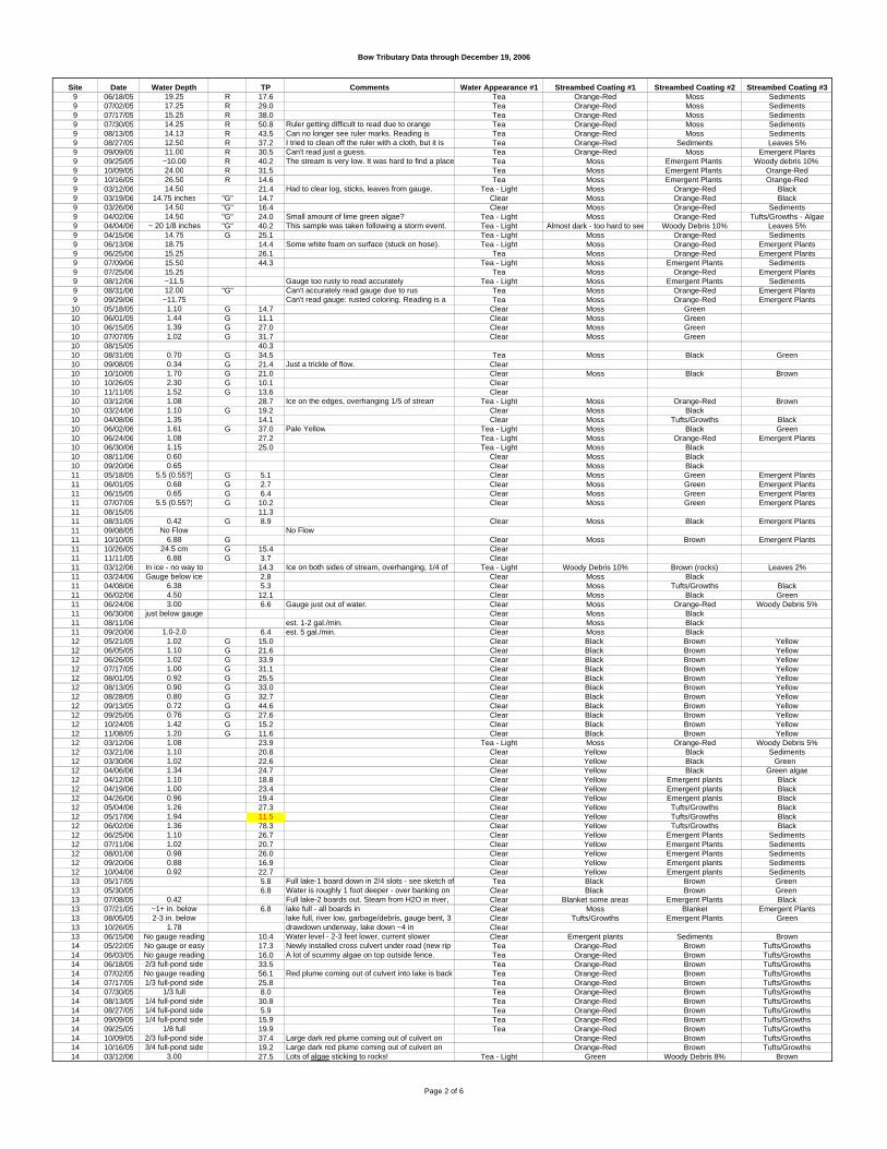
Bow Tributary Data through December 19, 2006
Site Date Water Depth TP Comments Water Appearance #1 Streambed Coating #1 Streambed Coating #2 Streambed Coating #39 06/18/05 19.25 R 17.6 Tea Orange-Red Moss Sediments9 07/02/05 17.25 R 29.0 Tea Orange-Red Moss Sediments9 07/17/05 15.25 R 38.0 Tea Orange-Red Moss Sediments9 07/30/05 14.25 R 50.8 Ruler getting difficult to read due to orange Tea Orange-Red Moss Sediments9 08/13/05 14.13 R 43.5 Can no longer see ruler marks. Reading is Tea Orange-Red Moss Sediments9 08/27/05 12.50 R 37.2 I tried to clean off the ruler with a cloth, but it is Tea Orange-Red Sediments Leaves 5%9 09/09/05 11.00 R 30.5 Can't read just a guess. Tea Orange-Red Moss Emergent Plants9 09/25/05 ~10.00 R 40.2 The stream is very low. It was hard to find a place Tea Moss Emergent Plants Woody debris 10% 9 10/09/05 24.00 R 31.5 Tea Moss Emergent Plants Orange-Red9 10/16/05 26.50 R 14.6 Tea Moss Emergent Plants Orange-Red9 03/12/06 14.50 21.4 Had to clear log, sticks, leaves from gauge. Tea - Light Moss Orange-Red Black9 03/19/06 14.75 inches "G" 14.7 Clear Moss Orange-Red Black9 03/26/06 14.50 "G" 16.4 Clear Moss Orange-Red Sediments9 04/02/06 14.50 "G" 24.0 Small amount of lime green algae? Tea - Light Moss Orange-Red Tufts/Growths - Algae9 04/04/06 ~ 20 1/8 inches "G" 40.2 This sample was taken following a storm event. Tea - Light Almost dark - too hard to see Woody Debris 10% Leaves 5%9 04/15/06 14.75 G 25.1 Tea - Light Moss Orange-Red Sediments9 06/13/06 18.75 14.4 Some white foam on surface (stuck on hose). Tea - Light Moss Orange-Red Emergent Plants9 06/25/06 15.25 26.1 Tea Moss Orange-Red Emergent Plants9 07/09/06 15.50 44.3 Tea - Light Moss Emergent Plants Sediments9 07/25/06 15.25 Tea Moss Orange-Red Emergent Plants9 08/12/06 ~11.5 Gauge too rusty to read accurately Tea - Light Moss Emergent Plants Sediments9 08/31/06 12.00 "G" Can't accurately read gauge due to rust Tea Moss Orange-Red Emergent Plants9 09/29/06 ~11.75 Can't read gauge: rusted coloring. Reading is a Tea Moss Orange-Red Emergent Plants10 05/18/05 1.10 G 14.7 Clear Moss Green10 06/01/05 1.44 G 11.1 Clear Moss Green10 06/15/05 1.39 G 27.0 Clear Moss Green10 07/07/05 1.02 G 31.7 Clear Moss Green10 08/15/05 40.310 08/31/05 0.70 G 34.5 Tea Moss Black Green10 09/08/05 0.34 G 21.4 Just a trickle of flow. Clear10 10/10/05 1.70 G 21.0 Clear Moss Black Brown10 10/26/05 2.30 G 10.1 Clear10 11/11/05 1.52 G 13.6 Clear10 03/12/06 1.08 28.7 Ice on the edges, overhanging 1/5 of stream Tea - Light Moss Orange-Red Brown10 03/24/06 1.10 G 19.2 Clear Moss Black10 04/08/06 1.35 14.1 Clear Moss Tufts/Growths Black10 06/02/06 1.61 G 37.0 Pale Yellow Tea - Light Moss Black Green10 06/24/06 1.08 27.2 Tea - Light Moss Orange-Red Emergent Plants10 06/30/06 1.15 25.0 Tea - Light Moss Black10 08/11/06 0.60 Clear Moss Black10 09/20/06 0.65 Clear Moss Black11 05/18/05 5.5 (0.55?) G 5.1 Clear Moss Green Emergent Plants11 06/01/05 0.68 G 2.7 Clear Moss Green Emergent Plants11 06/15/05 0.65 G 6.4 Clear Moss Green Emergent Plants11 07/07/05 5.5 (0.55?) G 10.2 Clear Moss Green Emergent Plants11 08/15/05 11.311 08/31/05 0.42 G 8.9 Clear Moss Black Emergent Plants11 09/08/05 No Flow No Flow11 10/10/05 6.88 G Clear Moss Brown Emergent Plants11 10/26/05 24.5 cm G 15.4 Clear11 11/11/05 6.88 G 3.7 Clear11 03/12/06 In ice - no way to 14.3 Ice on both sides of stream, overhanging, 1/4 of Tea - Light Woody Debris 10% Brown (rocks) Leaves 2%11 03/24/06 Gauge below ice 2.8 Clear Moss Black11 04/08/06 6.38 5.3 Clear Moss Tufts/Growths Black11 06/02/06 4.50 12.1 Clear Moss Black Green11 06/24/06 3.00 6.6 Gauge just out of water. Clear Moss Orange-Red Woody Debris 5%11 06/30/06 just below gauge Clear Moss Black11 08/11/06 est. 1-2 gal./min. Clear Moss Black11 09/20/06 1.0-2.0 6.4 est. 5 gal./min. Clear Moss Black12 05/21/05 1.02 G 15.0 Clear Black Brown Yellow12 06/05/05 1.10 G 21.6 Clear Black Brown Yellow12 06/26/05 1.02 G 33.9 Clear Black Brown Yellow12 07/17/05 1.00 G 31.1 Clear Black Brown Yellow12 08/01/05 0.92 G 25.5 Clear Black Brown Yellow12 08/13/05 0.90 G 33.0 Clear Black Brown Yellow12 08/28/05 0.80 G 32.7 Clear Black Brown Yellow12 09/13/05 0.72 G 44.6 Clear Black Brown Yellow12 09/25/05 0.76 G 27.6 Clear Black Brown Yellow12 10/24/05 1.42 G 15.2 Clear Black Brown Yellow12 11/08/05 1.20 G 11.6 Clear Black Brown Yellow12 03/12/06 1.08 23.9 Tea - Light Moss Orange-Red Woody Debris 5%12 03/21/06 1.10 20.8 Clear Yellow Black Sediments12 03/30/06 1.02 22.6 Clear Yellow Black Green 12 04/06/06 1.34 24.7 Clear Yellow Black Green algae12 04/12/06 1.10 18.8 Clear Yellow Emergent plants Black12 04/19/06 1.00 23.4 Clear Yellow Emergent plants Black12 04/26/06 0.96 19.4 Clear Yellow Emergent plants Black12 05/04/06 1.26 27.3 Clear Yellow Tufts/Growths Black12 05/17/06 1.94 11.5 Clear Yellow Tufts/Growths Black12 06/02/06 1.36 78.3 Clear Yellow Tufts/Growths Black12 06/25/06 1.10 26.7 Clear Yellow Emergent Plants Sediments12 07/11/06 1.02 20.7 Clear Yellow Emergent Plants Sediments12 08/01/06 0.98 26.0 Clear Yellow Emergent Plants Sediments12 09/20/06 0.88 16.9 Clear Yellow Emergent plants Sediments12 10/04/06 0.92 22.7 Clear Yellow Emergent plants Sediments13 05/17/05 5.8 Full lake-1 board down in 2/4 slots - see sketch of Tea Black Brown Green 13 05/30/05 6.8 Water is roughly 1 foot deeper - over banking on Clear Black Brown Green 13 07/08/05 0.42 Full lake-2 boards out. Steam from H2O in river, Clear Blanket some areas Emergent Plants Black13 07/21/05 ~1+ in. below 6.8 lake full - all boards in Clear Moss Blanket Emergent Plants13 08/05/05 2-3 in. below lake full, river low, garbage/debris, gauge bent, 3 Clear Tufts/Growths Emergent Plants Green13 10/26/05 1.78 drawdown underway, lake down ~4 in. Clear13 06/15/06 No gauge reading 10.4 Water level - 2-3 feet lower, current slower Clear Emergent plants Sediments Brown14 05/22/05 No gauge or easy 17.3 Newly installed cross culvert under road (new rip Tea Orange-Red Brown Tufts/Growths14 06/03/05 No gauge reading 16.0 A lot of scummy algae on top outside fence. Tea Orange-Red Brown Tufts/Growths14 06/18/05 2/3 full-pond side 33.5 Tea Orange-Red Brown Tufts/Growths14 07/02/05 No gauge reading 56.1 Red plume coming out of culvert into lake is back Tea Orange-Red Brown Tufts/Growths14 07/17/05 1/3 full-pond side 25.8 Tea Orange-Red Brown Tufts/Growths14 07/30/05 1/3 full 8.0 Tea Orange-Red Brown Tufts/Growths14 08/13/05 1/4 full-pond side 30.8 Tea Orange-Red Brown Tufts/Growths14 08/27/05 1/4 full-pond side 5.9 Tea Orange-Red Brown Tufts/Growths14 09/09/05 1/4 full-pond side 15.9 Tea Orange-Red Brown Tufts/Growths14 09/25/05 1/8 full 19.9 Tea Orange-Red Brown Tufts/Growths14 10/09/05 2/3 full-pond side 37.4 Large dark red plume coming out of culvert on Orange-Red Brown Tufts/Growths14 10/16/05 3/4 full-pond side 19.2 Large dark red plume coming out of culvert on Orange-Red Brown Tufts/Growths14 03/12/06 3.00 27.5 Lots of algae sticking to rocks! Tea - Light Green Woody Debris 8% Brown
Page 2 of 6

Bow Tributary Data through December 19, 2006
Site Date Water Depth TP Comments Water Appearance #1 Streambed Coating #1 Streambed Coating #2 Streambed Coating #314 03/19/06 3.00 G 24.2 Lots of algae on top of rip rap, and fencing, and Clear Orange-Red rip rap Tufts/Growths Green algae14 03/26/06 3 inches 19.7 Lots of algae attached to rocks + fencing + Tea - Light Moss Orange-Red rip rap Tufts/Growths - Algae14 04/02/06 ~3 inches 22.9 Still algae on pond side, but the lake side has Tea - Light Orange-Red rip rap Tufts/Growths Woody Debris 10%14 04/04/06 Culvert 1/4 full. ~8 22.6 This sample was taken following a storm event. Tea - Light Almost dark - too hard to see Woody Debris 10% Leaves 2%14 04/15/06 2 inches R 22.6 Algae on rocks still. Also a fair amount of floating Tea - Light Orange-Red Tufts/Growths Woody Debris 2%14 06/13/06 culvert ~1/2 full 17.8 lots of pond scum floating on surface (algae?), Tea - Light Orange-Red Tufts/Growths Emergent Plants14 06/25/06 29.8 Tea - Light Orange-Red Tufts/Growths Emergent Plants14 07/09/06 culvert 1/3 full 28.9 algae on rocks. Not as much pond scum as last Tea - Light Orange-red Tufts/Growths Emergent Plants14 07/25/06 culvert just under Tea - Light Orange-red Tufts/Growths Emergent Plants14 08/12/06 Culvert 1/4 full. ~8 algae is growing more on rocks now tea Orange-red Tufts/Growths Emergent Plants14 08/31/06 culvert 1/3 full algae attached to rocks looks stringy now tea Orange-red Tufts/Growths Emergent Plants14 09/29/06 1/4 full-pond side Tea Orange-red Tufts/Growths Emergent Plants15 10/19/05 No Gauge 6.3 This is not a site that has been monitored before. Clear None
Page 3 of 6
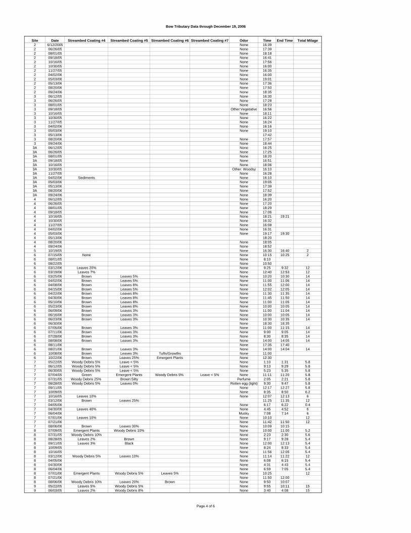
Bow Tributary Data through December 19, 2006
Site Date2 6/12/20052 06/26/052 08/01/052 09/18/052 10/16/052 10/30/052 11/27/052 04/02/062 05/03/062 05/13/062 08/20/062 09/24/063 06/12/053 06/26/053 08/01/053 09/18/053 10/16/053 10/30/053 11/27/053 04/02/063 05/03/063 05/13/063 08/20/063 09/24/06
3A 06/12/053A 06/26/053A 08/01/053A 09/18/053A 10/16/053A 10/30/053A 11/27/053A 04/02/063A 05/03/063A 05/13/063A 08/20/063A 09/24/064 06/12/054 06/26/054 08/01/054 09/18/054 10/16/054 10/30/054 11/27/054 04/02/064 05/03/064 05/13/064 08/20/064 09/24/065 10/19/056 07/15/056 08/01/056 08/22/056 03/12/066 03/19/066 03/25/066 04/02/066 04/08/066 04/15/066 04/22/066 04/30/066 05/10/066 05/23/066 06/09/066 06/16/066 06/23/066 06/30/066 07/05/066 07/11/066 07/28/066 08/08/066 08/11/066 08/21/066 10/08/066 10/22/067 05/22/057 06/12/057 06/30/057 07/04/057 07/31/057 08/28/057 09/11/057 10/09/057 10/16/057 03/12/067 04/05/067 04/30/067 06/04/067 07/01/067 07/21/067 08/06/068 07/09/058 07/31/058 08/28/058 09/11/058 10/09/058 10/16/058 03/12/068 04/05/068 04/30/068 06/04/068 07/01/068 07/21/068 08/06/069 05/22/059 06/03/05
Streambed Coating #4 Streambed Coating #5 Streambed Coating #6 Streambed Coating #7 Odor Time End Time Total MilageNone 16:39None 17:39None 18:18None 16:41None 17:56None 16:00None 16:35None 16:00None 19:01None 17:36None 17:50None 18:35None 16:30None 17:28None 18:23
Other:Vegetative 16:56None 18:11None 16:22None 16:24None 16:16None 19:10
17:42None 17:57None 18:44None 16:25None 17:25None 18:20None 16:51None 18:06
Other: Woodsy 16:10None 16:28
Sediments None 16:10None 19:05None 17:39None 17:52None 18:39None 16:20None 17:20None 18:29None 17:06None 18:21 19:21None 16:32None 16:08None 16:31None 19:17 19:30
18:20None 18:05None 18:52None 16:30 16:40 2
None None 10:15 10:25 2None 8:10None 10:50
Leaves 20% None 9:25 9:32 12Leaves 7% None 12:40 12:53 12
Brown Leaves 5% None 10:20 10:30 14Brown Leaves 5% None 11:00 11:06 14Brown Leaves 8% None 11:55 12:00 14Brown Leaves 5% None 12:02 12:05 14Brown Leaves 8% None 11:30 11:35 14Brown Leaves 8% None 11:45 11:50 14Brown Leaves 8% None 11:00 11:05 14Brown Leaves 8% None 10:00 10:05 14Brown Leaves 3% None 11:00 11:04 14Brown Leaves 3% None 10:00 10:05 14Brown Leaves 3% None 10:30 10:35 14
None 18:30 18:35Brown Leaves 3% None 11:00 11:15 14Brown Leaves 3% None 9:00 9:05 14Brown Leaves 3% None 8:30 8:35 14Brown Leaves 3% None 14:00 14:05 14
None 17:35 17:40Brown Leaves 3% None 14:00 14:04 14Brown Leaves 3% Tufts/Growths None 11:00Brown Leaves 25% Emergent Plants None 12:30
Woody Debris 5% Leave < 5% None 1:10 1:31 5.8Woody Debris 5% Leave < 5% None 9:13 9:29 5.8Woody Debris 5% Leave < 5% None 5:23 5:35 5.8
Green Emergent Plants Woody Debris 5% Leave < 5% None 11:11 11:20 5.8Woody Debris 25% Brown:Silty Perfume 2:05 2:21 5.8Woody Debris 5% Leaves 0% Rotten egg (light) 9:30 9:47 5.8
None 12:17 12:27 5.8None 8:35 8:50 6.2
Leaves 10% None 12:07 12:13 6Brown Leaves 25% 11:25 11:35 12
None 6:17 6:22 0.4Leaves 40% None 4:45 4:52 6
Musky 7:08 7:14 6Leaves 10% None 10:10 12
None 11:42 11:50 12Brown Leaves 30% None 10:09 10:15
Emergent Plants Woody Debris 10% None 10:00 11:00 5.2Woody Debris 10% None 2:23 2:30 5.6
Leaves 2% Brown None 9:17 9:28 5.4Leaves 3% Black None 12:00 12:13 5.4
None 8:24 8:33 5.4None 11:56 12:05 5.4
Woody Debris 5% Leaves 10% None 11:14 11:22 12None 6:08 6:15 5.4None 4:31 4:43 5.4None 6:59 7:05 5.4
Emergent Plants Woody Debris 5% Leaves 5% None 10:25 12None 11:50 12:00
Woody Debris 10% Leaves 20% Brown None 9:50 10:07Leaves 5% Woody Debris 5% None 9:55 10:11 15Leaves 2% Woody Debris 8% None 3:40 4:08 15
Page 4 of 6
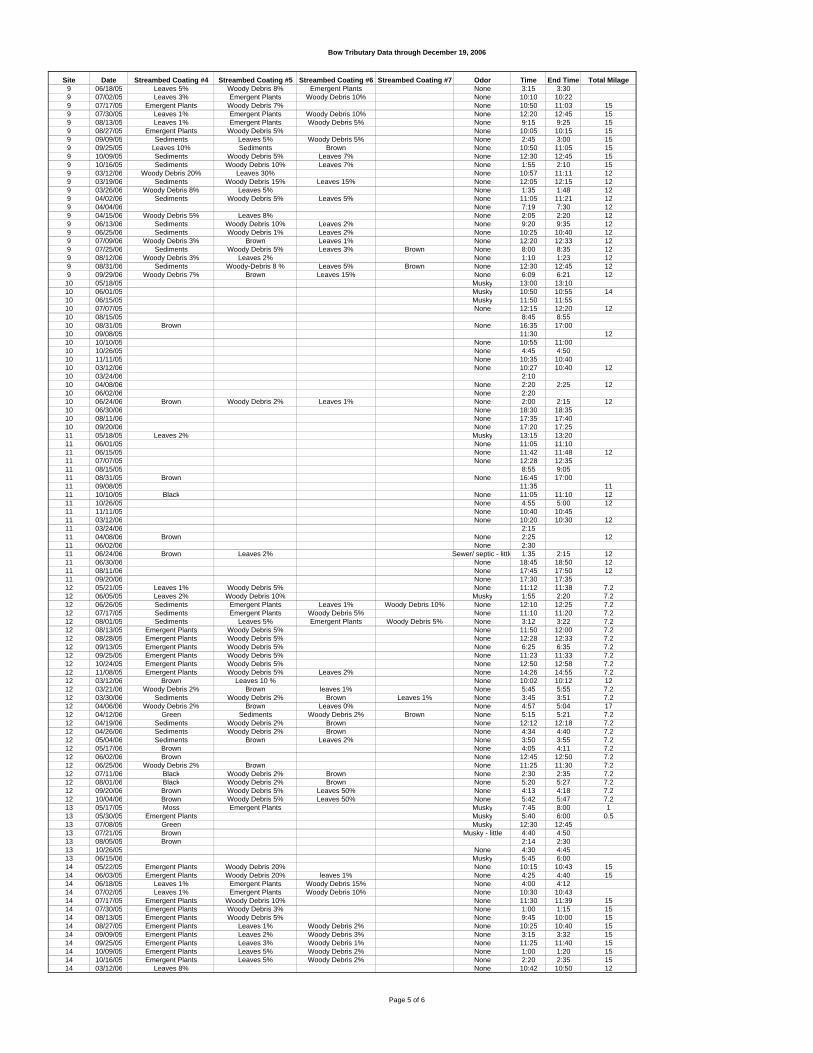
Bow Tributary Data through December 19, 2006
Site Date9 06/18/059 07/02/059 07/17/059 07/30/059 08/13/059 08/27/059 09/09/059 09/25/059 10/09/059 10/16/059 03/12/069 03/19/069 03/26/069 04/02/069 04/04/069 04/15/069 06/13/069 06/25/069 07/09/069 07/25/069 08/12/069 08/31/069 09/29/0610 05/18/0510 06/01/0510 06/15/0510 07/07/0510 08/15/0510 08/31/0510 09/08/0510 10/10/0510 10/26/0510 11/11/0510 03/12/0610 03/24/0610 04/08/0610 06/02/0610 06/24/0610 06/30/0610 08/11/0610 09/20/0611 05/18/0511 06/01/0511 06/15/0511 07/07/0511 08/15/0511 08/31/0511 09/08/0511 10/10/0511 10/26/0511 11/11/0511 03/12/0611 03/24/0611 04/08/0611 06/02/0611 06/24/0611 06/30/0611 08/11/0611 09/20/0612 05/21/0512 06/05/0512 06/26/0512 07/17/0512 08/01/0512 08/13/0512 08/28/0512 09/13/0512 09/25/0512 10/24/0512 11/08/0512 03/12/0612 03/21/0612 03/30/0612 04/06/0612 04/12/0612 04/19/0612 04/26/0612 05/04/0612 05/17/0612 06/02/0612 06/25/0612 07/11/0612 08/01/0612 09/20/0612 10/04/0613 05/17/0513 05/30/0513 07/08/0513 07/21/0513 08/05/0513 10/26/0513 06/15/0614 05/22/0514 06/03/0514 06/18/0514 07/02/0514 07/17/0514 07/30/0514 08/13/0514 08/27/0514 09/09/0514 09/25/0514 10/09/0514 10/16/0514 03/12/06
Streambed Coating #4 Streambed Coating #5 Streambed Coating #6 Streambed Coating #7 Odor Time End Time Total MilageLeaves 5% Woody Debris 8% Emergent Plants None 3:15 3:30Leaves 3% Emergent Plants Woody Debris 10% None 10:10 10:22
Emergent Plants Woody Debris 7% None 10:50 11:03 15Leaves 1% Emergent Plants Woody Debris 10% None 12:20 12:45 15Leaves 1% Emergent Plants Woody Debris 5% None 9:15 9:25 15
Emergent Plants Woody Debris 5% None 10:05 10:15 15Sediments Leaves 5% Woody Debris 5% None 2:45 3:00 15
Leaves 10% Sediments Brown None 10:50 11:05 15Sediments Woody Debris 5% Leaves 7% None 12:30 12:45 15Sediments Woody Debris 10% Leaves 7% None 1:55 2:10 15
Woody Debris 20% Leaves 30% None 10:57 11:11 12Sediments Woody Debris 15% Leaves 15% None 12:05 12:15 12
Woody Debris 8% Leaves 5% None 1:35 1:48 12Sediments Woody Debris 5% Leaves 5% None 11:05 11:21 12
None 7:19 7:30 12Woody Debris 5% Leaves 8% None 2:05 2:20 12
Sediments Woody Debris 10% Leaves 2% None 9:20 9:35 12Sediments Woody Debris 1% Leaves 2% None 10:25 10:40 12
Woody Debris 3% Brown Leaves 1% None 12:20 12:33 12Sediments Woody Debris 5% Leaves 3% Brown None 8:00 8:35 12
Woody Debris 3% Leaves 2% None 1:10 1:23 12Sediments Woody-Debris 8 % Leaves 5% Brown None 12:30 12:45 12
Woody Debris 7% Brown Leaves 15% None 6:09 6:21 12Musky 13:00 13:10Musky 10:50 10:55 14Musky 11:50 11:55None 12:15 12:20 12
8:45 8:55Brown None 16:35 17:00
11:30 12None 10:55 11:00None 4:45 4:50None 10:35 10:40None 10:27 10:40 12
2:10None 2:20 2:25 12None 2:20
Brown Woody Debris 2% Leaves 1% None 2:00 2:15 12None 18:30 18:35None 17:35 17:40None 17:20 17:25
Leaves 2% Musky 13:15 13:20None 11:05 11:10None 11:42 11:48 12None 12:28 12:35
8:55 9:05Brown None 16:45 17:00
11:35 11Black None 11:05 11:10 12
None 4:55 5:00 12None 10:40 10:45None 10:20 10:30 12
2:15Brown None 2:25 12
None 2:30Brown Leaves 2% Sewer/ septic - little 1:35 2:15 12
None 18:45 18:50 12None 17:45 17:50 12None 17:30 17:35
Leaves 1% Woody Debris 5% None 11:12 11:38 7.2Leaves 2% Woody Debris 10% Musky 1:55 2:20 7.2Sediments Emergent Plants Leaves 1% Woody Debris 10% None 12:10 12:25 7.2Sediments Emergent Plants Woody Debris 5% None 11:10 11:20 7.2Sediments Leaves 5% Emergent Plants Woody Debris 5% None 3:12 3:22 7.2
Emergent Plants Woody Debris 5% None 11:50 12:00 7.2Emergent Plants Woody Debris 5% None 12:28 12:33 7.2Emergent Plants Woody Debris 5% None 6:25 6:35 7.2Emergent Plants Woody Debris 5% None 11:23 11:33 7.2Emergent Plants Woody Debris 5% None 12:50 12:58 7.2Emergent Plants Woody Debris 5% Leaves 2% None 14:26 14:55 7.2
Brown Leaves 10 % None 10:02 10:12 12Woody Debris 2% Brown leaves 1% None 5:45 5:55 7.2
Sediments Woody Debris 2% Brown Leaves 1% None 3:45 3:51 7.2Woody Debris 2% Brown Leaves 0% None 4:57 5:04 17
Green Sediments Woody Debris 2% Brown None 5:15 5:21 7.2Sediments Woody Debris 2% Brown None 12:12 12:18 7.2Sediments Woody Debris 2% Brown None 4:34 4:40 7.2Sediments Brown Leaves 2% None 3:50 3:55 7.2
Brown None 4:05 4:11 7.2Brown None 12:45 12:50 7.2
Woody Debris 2% Brown None 11:25 11:30 7.2Black Woody Debris 2% Brown None 2:30 2:35 7.2Black Woody Debris 2% Brown None 5:20 5:27 7.2Brown Woody Debris 5% Leaves 50% None 4:13 4:18 7.2Brown Woody Debris 5% Leaves 50% None 5:42 5:47 7.2Moss Emergent Plants Musky 7:45 8:00 1
Emergent Plants Musky 5:40 6:00 0.5Green Musky 12:30 12:45Brown Musky - little 4:40 4:50Brown 2:14 2:30
None 4:30 4:45Musky 5:45 6:00
Emergent Plants Woody Debris 20% None 10:15 10:43 15Emergent Plants Woody Debris 20% leaves 1% None 4:25 4:40 15
Leaves 1% Emergent Plants Woody Debris 15% None 4:00 4:12Leaves 1% Emergent Plants Woody Debris 10% None 10:30 10:43
Emergent Plants Woody Debris 10% None 11:30 11:39 15Emergent Plants Woody Debris 3% None 1:00 1:15 15Emergent Plants Woody Debris 5% None 9:45 10:00 15Emergent Plants Leaves 1% Woody Debris 2% None 10:25 10:40 15Emergent Plants Leaves 2% Woody Debris 3% None 3:15 3:32 15Emergent Plants Leaves 3% Woody Debris 1% None 11:25 11:40 15Emergent Plants Leaves 5% Woody Debris 2% None 1:00 1:20 15Emergent Plants Leaves 5% Woody Debris 2% None 2:20 2:35 15
Leaves 8% None 10:42 10:50 12
Page 5 of 6

Bow Tributary Data through December 19, 2006
Site Date14 03/19/0614 03/26/0614 04/02/0614 04/04/0614 04/15/0614 06/13/0614 06/25/0614 07/09/0614 07/25/0614 08/12/0614 08/31/0614 09/29/0615 10/19/05
Streambed Coating #4 Streambed Coating #5 Streambed Coating #6 Streambed Coating #7 Odor Time End Time Total MilageWoody Debris 3% Brown Leaves 2% None 1:11 1:25 12Woody Debris 2% Brown Leaves 2% None 2:35 2:45 12
Brown Leaves 2% None 11:36 11:53 12None 7:35 7:45 12
Brown Leaves 2% None 2:35 2:55 12Woody-Debris 15% Brown leaves 1% None 9:45 10:00 12Woody-Debris 1% Leaves 1% None 10:50 11:05 12
Brown None 12:35 1:00 12Woody-Debris 2% Leaves 1% Brown None 8:20 8:45 12Woody-Debris 3% Leaves 1% None 1:35 1:50 12Woody-Debris 3% Leaves 1% Brown None 12:50 1:03 12
Brown Woody Debris 5% Leaves 15% None 6:30 6:48 12None 16:20 16:30 2
Page 6 of 6
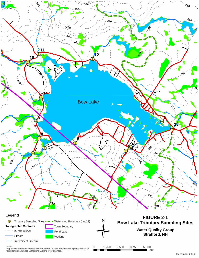
!>!>
!>
!>
!>
!>!>
!>!>!>
!>
!>
!>
!>Bow Lake
160
180
200
220
240
260
280
280
180
260
240
180
260
180
160
220
160
160
160
200
200
220
220
180
24018
0
180
220
200
160
180
240
260
1
2 34
56
7
8
9
14
13
10
1112
!>!>
!>
!>
!>
!>!>
!>!>!>
!>
!>
!>
!>Bow Lake
160
180
200
220
240
260
280
280
180
260
240
180
260
180
160
220
160
160
160
200
200
220
220
180
24018
0
180
220
200
160
180
240
260
1
2 34
56
7
8
9
14
13
10
1112
December 2006
Notes:Map prepared with data obtained from NHGRANIT. Surface water features digitized from USGStopographic quadrangles and National Wetland Inventory maps.
FIGURE 2-1Bow Lake Tributary Sampling Sites
Water Quality GroupStrafford, NH
Legend!> Tributary Sampling Sites
Topographic Contours20 foot interval
Stream
Intermittent Stream
Watershed Boundary (huc12)
Town Boundary
Pond/Lake
Wetland
0 1,250 2,500 3,750 5,000Feet
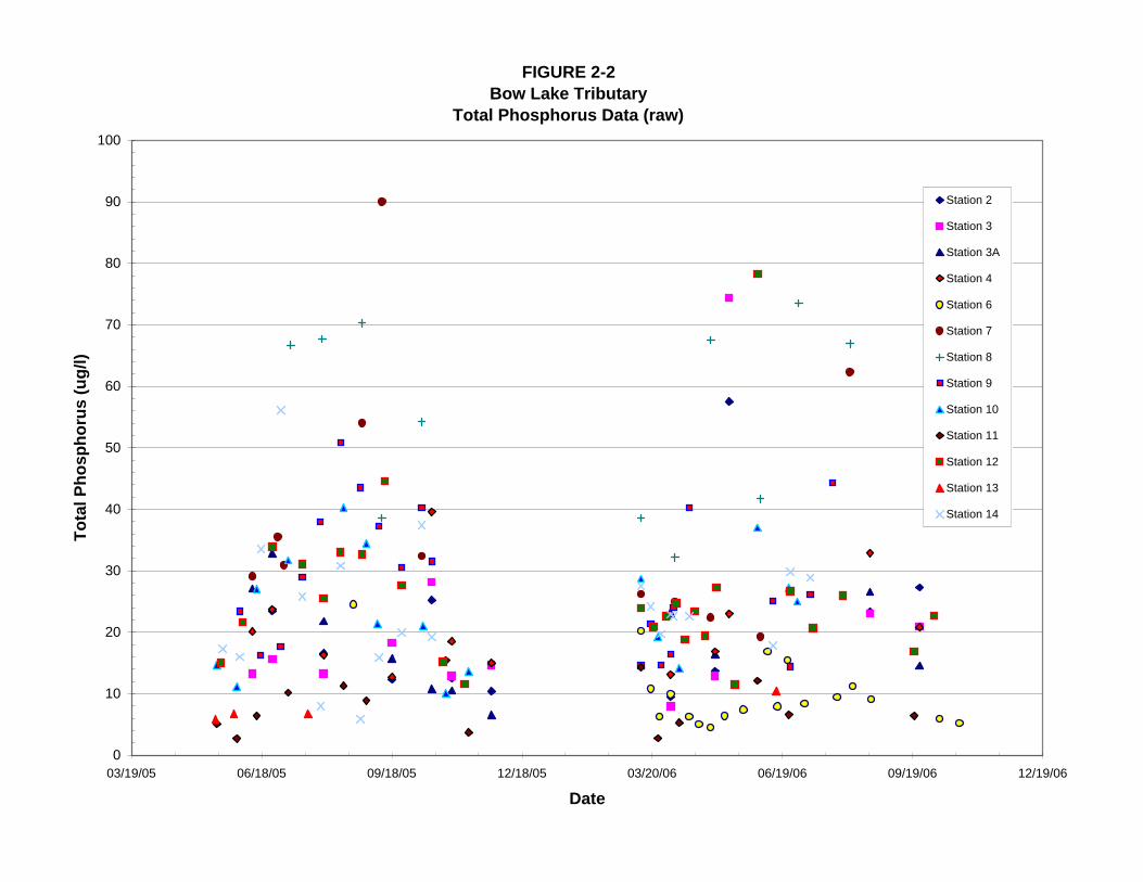
FIGURE 2-2Bow Lake Tributary
Total Phosphorus Data (raw)
0
10
20
30
40
50
60
70
80
90
100
03/19/05 06/18/05 09/18/05 12/18/05 03/20/06 06/19/06 09/19/06 12/19/06
Date
Tota
l Pho
spho
rus
(ug/
l)
Station 2
Station 3
Station 3A
Station 4
Station 6
Station 7
Station 8
Station 9
Station 10
Station 11
Station 12
Station 13
Station 14

Appendix C
Managed Growth
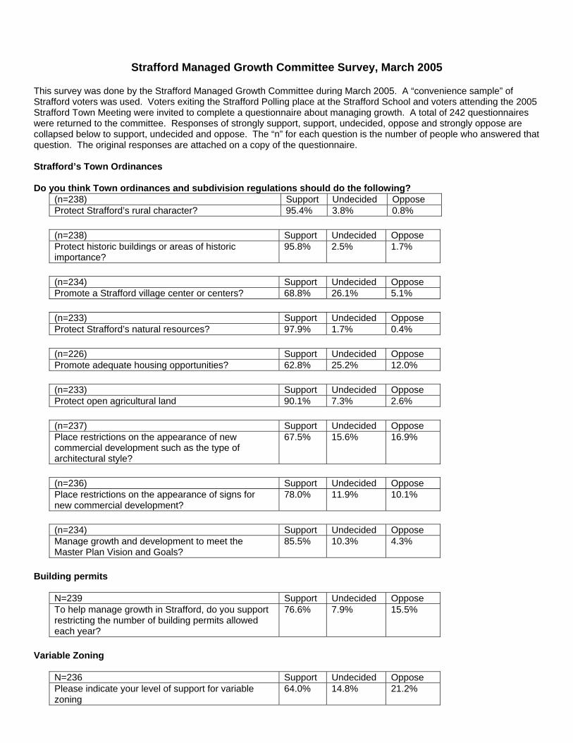
Strafford Managed Growth Committee Survey, March 2005 This survey was done by the Strafford Managed Growth Committee during March 2005. A “convenience sample” of Strafford voters was used. Voters exiting the Strafford Polling place at the Strafford School and voters attending the 2005 Strafford Town Meeting were invited to complete a questionnaire about managing growth. A total of 242 questionnaires were returned to the committee. Responses of strongly support, support, undecided, oppose and strongly oppose are collapsed below to support, undecided and oppose. The “n” for each question is the number of people who answered that question. The original responses are attached on a copy of the questionnaire. Strafford’s Town Ordinances Do you think Town ordinances and subdivision regulations should do the following?
(n=238) Support Undecided Oppose Protect Strafford’s rural character? 95.4% 3.8% 0.8%
(n=238) Support Undecided Oppose Protect historic buildings or areas of historic importance?
95.8% 2.5% 1.7%
(n=234) Support Undecided Oppose Promote a Strafford village center or centers? 68.8% 26.1% 5.1%
(n=233) Support Undecided Oppose Protect Strafford’s natural resources? 97.9% 1.7% 0.4%
(n=226) Support Undecided Oppose Promote adequate housing opportunities? 62.8% 25.2% 12.0%
(n=233) Support Undecided Oppose Protect open agricultural land 90.1% 7.3% 2.6%
(n=237) Support Undecided Oppose Place restrictions on the appearance of new commercial development such as the type of architectural style?
67.5% 15.6% 16.9%
(n=236) Support Undecided Oppose Place restrictions on the appearance of signs for new commercial development?
78.0% 11.9% 10.1%
(n=234) Support Undecided Oppose Manage growth and development to meet the Master Plan Vision and Goals?
85.5% 10.3% 4.3%
Building permits
N=239 Support Undecided Oppose To help manage growth in Strafford, do you support restricting the number of building permits allowed each year?
76.6% 7.9% 15.5%
Variable Zoning
N=236 Support Undecided Oppose Please indicate your level of support for variable zoning
64.0% 14.8% 21.2%
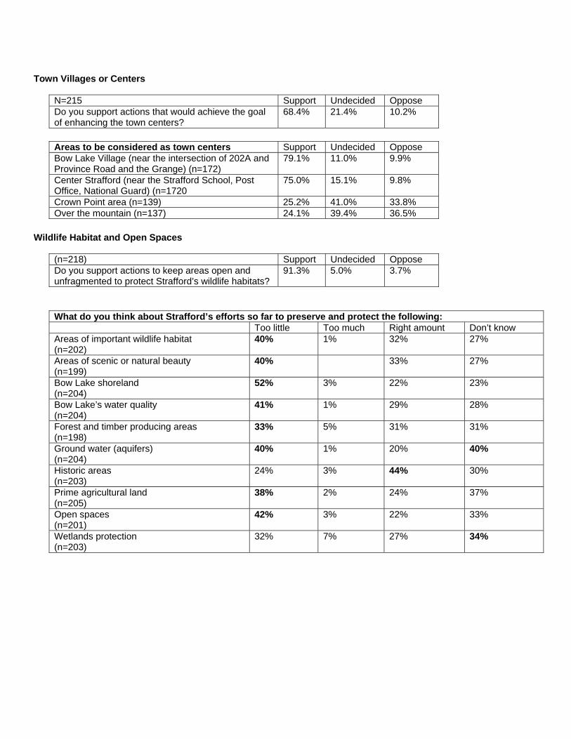
Town Villages or Centers
N=215 Support Undecided Oppose Do you support actions that would achieve the goal of enhancing the town centers?
68.4% 21.4% 10.2%
Areas to be considered as town centers Support Undecided Oppose Bow Lake Village (near the intersection of 202A and Province Road and the Grange) (n=172)
79.1% 11.0% 9.9%
Center Strafford (near the Strafford School, Post Office, National Guard) (n=1720
75.0% 15.1% 9.8%
Crown Point area (n=139) 25.2% 41.0% 33.8% Over the mountain (n=137) 24.1% 39.4% 36.5%
Wildlife Habitat and Open Spaces
(n=218) Support Undecided Oppose Do you support actions to keep areas open and unfragmented to protect Strafford’s wildlife habitats?
91.3% 5.0% 3.7%
What do you think about Strafford’s efforts so far to preserve and protect the following: Too little Too much Right amount Don’t know Areas of important wildlife habitat (n=202)
40% 1% 32% 27%
Areas of scenic or natural beauty (n=199)
40% 33% 27%
Bow Lake shoreland (n=204)
52% 3% 22% 23%
Bow Lake’s water quality (n=204)
41% 1% 29% 28%
Forest and timber producing areas (n=198)
33% 5% 31% 31%
Ground water (aquifers) (n=204)
40% 1% 20% 40%
Historic areas (n=203)
24% 3% 44% 30%
Prime agricultural land (n=205)
38% 2% 24% 37%
Open spaces (n=201)
42% 3% 22% 33%
Wetlands protection (n=203)
32% 7% 27% 34%
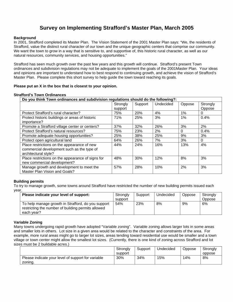
Survey on Implementing Strafford’s Master Plan, March 2005
Background In 2001, Strafford completed its Master Plan. The Vision Statement of the 2001 Master Plan says: “We, the residents of Strafford, value the distinct rural character of our town and the unique geographic centers that comprise our community. We want the town to grow in a way that is sensitive to, and supportive of, this historic rural character, as well as our natural resources, community services, and housing opportunities.” Strafford has seen much growth over the past few years and this growth will continue. Strafford’s present Town ordinances and subdivision regulations may not be adequate to implement the goals of the 2001Master Plan. Your ideas and opinions are important to understand how to best respond to continuing growth, and achieve the vision of Strafford’s Master Plan. Please complete this short survey to help guide the town toward reaching its goals. Please put an X in the box that is closest to your opinion. Strafford’s Town Ordinances
Do you think Town ordinances and subdivision regulations should do the following?: Strongly
support Support Undecided Oppose Strongly
Oppose Protect Strafford’s rural character? 75% 20% 4% 1% 0 Protect historic buildings or areas of historic importance?
71% 25% 3% 1% 0.4%
Promote a Strafford village center or centers? 37% 32% 26% 3% 2% Protect Strafford’s natural resources? 75% 23% 2% 0 0.4% Promote adequate housing opportunities? 25% 38% 25% 9% 3% Protect open agricultural land 64% 26% 7% 3% 0 Place restrictions on the appearance of new commercial development such as the type of architectural style?
44% 24% 16% 13% 4%
Place restrictions on the appearance of signs for new commercial development?
48% 30% 12% 8% 3%
Manage growth and development to meet the Master Plan Vision and Goals?
57% 28% 10% 2% 3%
Building permits To try to manage growth, some towns around Strafford have restricted the number of new building permits issued each year.
Please indicate your level of support: Strongly support
Support Undecided Oppose Strongly Oppose
To help manage growth in Strafford, do you support restricting the number of building permits allowed each year?
54% 23% 8% 9% 6%
Variable Zoning Many towns undergoing rapid growth have adopted “Variable zoning”. Variable zoning allows larger lots in some areas and smaller lots in others. Lot size in a given area would be related to the character and constraints of the area. For example, more rural areas might go to larger lot sizes, areas tending toward residential use would be smaller and a town village or town center might allow the smallest lot sizes. (Currently, there is one kind of zoning across Strafford and lot sizes must be 2 buildable acres.)
Strongly support
Support Undecided Oppose Strongly oppose
Please indicate your level of support for variable zoning.
30% 34% 15% 14% 8%
Town Villages or Centers One of the Master Plan goals is to “Enhance the distinct identity of each of the town’s four geographic centers, and investigate creating a new town center for community wide services, cultural and recreational events and activities.”
Please indicate your support for the following: Strongly
support Support Undecided Oppose Strongly
Oppose Do you support actions that would achieve the goal of enhancing the town centers?
27% 41% 21% 9% 1%
If you support the idea of enhancing town centers, what areas should be considered as town centers?: Strongly
support Support Undecided Oppose Strongly
Oppose Bow Lake Village (near the intersection of 202A and Province Road and the Grange)
40% 40% 11% 8% 2%
Center Strafford (near the Strafford School, Post Office, National Guard)
37% 38% 15% 8% 2%
Crown Point area 10% 15% 41% 25% 9% Over the Mountain (Northwest Strafford) 10% 15% 39% 23% 13% Any Others?
Wildlife Habitat and Open Spaces Strafford still has large, connected tracts of land that support wildlife and are used for recreation. Many types of wildlife need these long pathways, unbroken by roads to survive. Town residents also use these areas as hiking and snowmobile trails and for hunting.
Please indicate your support for the following: Strongly
support Support Undecided Oppose Strongly
Oppose Do you support actions to keep areas open and unfragmented to protect Strafford’s wildlife habitats?
69% 22% 5% 3% 1%
How has Strafford done so far?
What do you think about Strafford’s efforts so far to preserve and protect the following: Too little Too much Right amount Don’t know Areas of important wildlife habitat 40% 1% 32% 27% Areas of scenic or natural beauty 40% 33% 27% Bow Lake shoreland 52% 3% 22% 23% Bow Lake’s water quality 41% 1% 29% 28% Forest and timber producing areas 33% 5% 31% 31% Ground water (aquifers) 40% 1% 20% 40% Historic areas 24% 3% 44% 30% Prime agricultural land 38% 2% 24% 37% Open spaces 42% 3% 22% 33% Wetlands protection 32% 7% 27% 34%

The Year-Long Moratorium on New Subdivisions is ending.
Your citizen committees and the Planning Board have developed new ordinances that will appear on the ballot on March 14, 2006.
The Managed Growth and Water Quality Committees have studied ordinances and regulations that will protect our rural environment while avoiding unnecessary restrictions on Strafford landowners and residents.
The Planning Board has developed these ordinances which you will be asked to approve on Election Day 2006:
The Growth Management Ordinance phases in development of future subdivisions at a gradual rate compatible with orderly expansion of community services (Schools, Police and Fire, Roads, Recreation and Waste Disposal)
The Viewshed Protection Overlay District provides that new structures within the District meet requirements for lighting, retaining natural vegetation, and maintaining natural sightlines.
The Wetlands Overlay District establishes a new district to control and guide new construction activities near the town’s wetland areas.
Other minor changes
Come to the Informational Meeting to learn more about the proposed ordinances and to get answers to questions you may have.
Where: Strafford School Cafeteria

When: February 28, 2006 at 7:00 pm
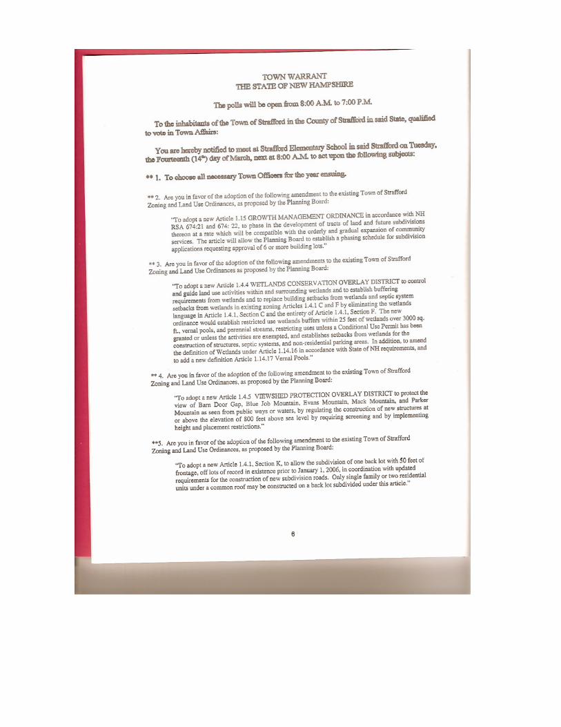
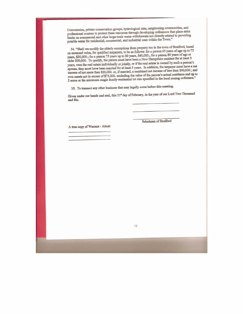
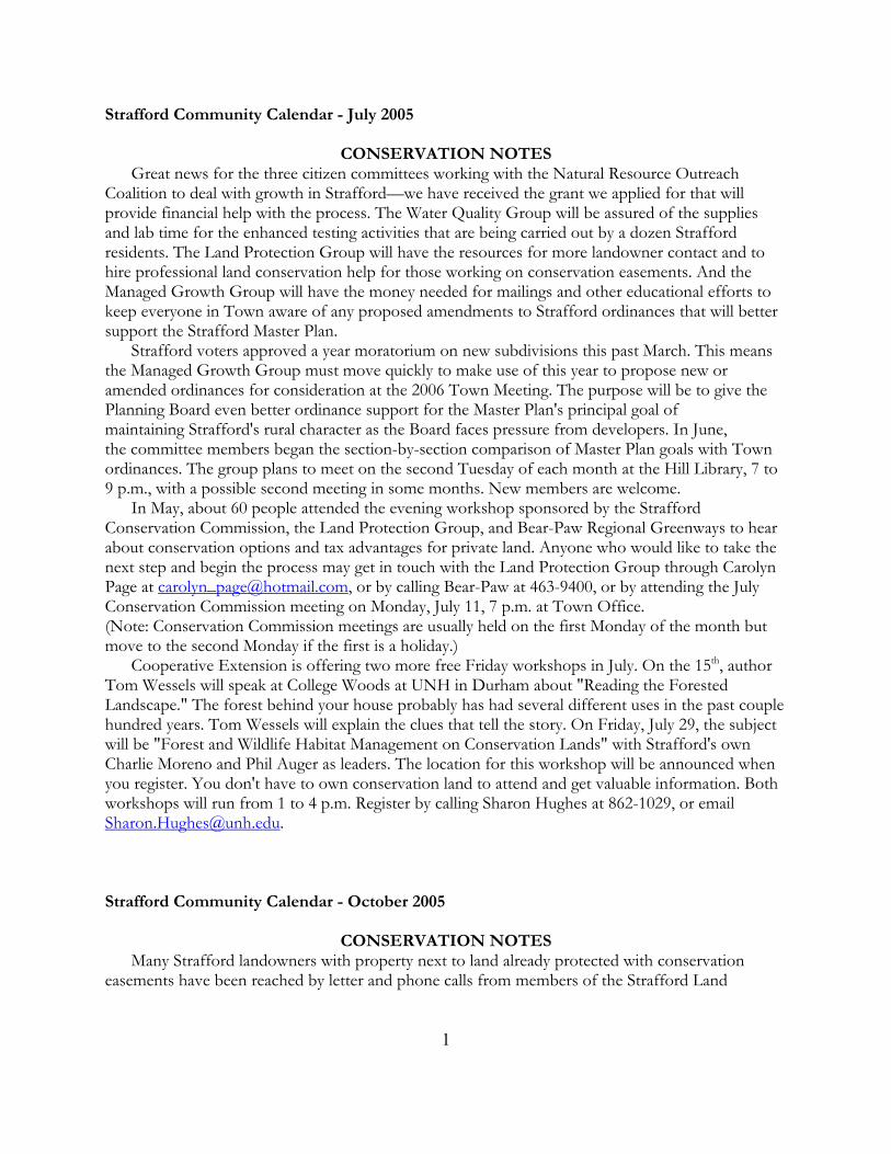
Strafford Community Calendar - July 2005
CONSERVATION NOTES Great news for the three citizen committees working with the Natural Resource Outreach Coalition to deal with growth in Strafford—we have received the grant we applied for that will provide financial help with the process. The Water Quality Group will be assured of the supplies and lab time for the enhanced testing activities that are being carried out by a dozen Strafford residents. The Land Protection Group will have the resources for more landowner contact and to hire professional land conservation help for those working on conservation easements. And the Managed Growth Group will have the money needed for mailings and other educational efforts to keep everyone in Town aware of any proposed amendments to Strafford ordinances that will better support the Strafford Master Plan. Strafford voters approved a year moratorium on new subdivisions this past March. This means the Managed Growth Group must move quickly to make use of this year to propose new or amended ordinances for consideration at the 2006 Town Meeting. The purpose will be to give the Planning Board even better ordinance support for the Master Plan's principal goal of maintaining Strafford's rural character as the Board faces pressure from developers. In June, the committee members began the section-by-section comparison of Master Plan goals with Town ordinances. The group plans to meet on the second Tuesday of each month at the Hill Library, 7 to 9 p.m., with a possible second meeting in some months. New members are welcome. In May, about 60 people attended the evening workshop sponsored by the Strafford Conservation Commission, the Land Protection Group, and Bear-Paw Regional Greenways to hear about conservation options and tax advantages for private land. Anyone who would like to take the next step and begin the process may get in touch with the Land Protection Group through Carolyn Page at [email protected], or by calling Bear-Paw at 463-9400, or by attending the July Conservation Commission meeting on Monday, July 11, 7 p.m. at Town Office. (Note: Conservation Commission meetings are usually held on the first Monday of the month but move to the second Monday if the first is a holiday.) Cooperative Extension is offering two more free Friday workshops in July. On the 15th, author Tom Wessels will speak at College Woods at UNH in Durham about "Reading the Forested Landscape." The forest behind your house probably has had several different uses in the past couple hundred years. Tom Wessels will explain the clues that tell the story. On Friday, July 29, the subject will be "Forest and Wildlife Habitat Management on Conservation Lands" with Strafford's own Charlie Moreno and Phil Auger as leaders. The location for this workshop will be announced when you register. You don't have to own conservation land to attend and get valuable information. Both workshops will run from 1 to 4 p.m. Register by calling Sharon Hughes at 862-1029, or email [email protected]. Strafford Community Calendar - October 2005
CONSERVATION NOTES
Many Strafford landowners with property next to land already protected with conservation easements have been reached by letter and phone calls from members of the Strafford Land
1
Protection Committee. These calls and letters simply offered information about the process and benefits of establishing land protection agreements for one's property. About 60 people attended the estate planning and land protection workshop offered in May by the Conservation Commission and Bear-Paw Regional Greenways for even more specific information. The good new is that for anyone who is now ready to follow up and go through with a conservation easement, additional professional help through the process is now in place. Thanks to the grant from the New Hampshire Estuaries Project—secured by your friends and neighbors working with the three committees that grew out of the Natural Resource Outreach Coalition work last year—the Land Protection Group has Dan Kern, Executive Director of Bear-Paw Regional Greenways, on board to work with landowners ready to proceed with protecting their property. Bear-Paw, and our own Phil Auger and others at Bear-Paw, are always there to work with landowners; but the grant, and Dan's additional time earned through the grant, ensure even more time available specifically for Strafford residents. If this has been on your mind, now is the time to get the best and fastest attention. Take advantage of it by calling Bear-Paw at 463-9400, or emailing [email protected] or call the Chairman of the Land Protection Committee Carolyn Page 664-2934. The other two NROC generated committees, Water Quality, and Managed Growth, continue to work as well. You may have seen the 14 Water Quality members dipping out water samples from the lake and the streams that enter the lake. They work every other week, and some of Jeff Schloss's UNH young people do the alternate weeks. Their report will be written after the year of testing and will be available next summer. The Managed Growth Group has completed its line-by-line comparison of the current Town Ordinances and the Strafford Master Plan to discover what changes in the ordinances will bring us closer to the goals of the Master Plan. This group's grant money will allow us to make a mailing to every household in Strafford with an explanation of what changes will be proposed at the March 2006 Town Meeting. The mailing will also ask for feedback from the public. The mailing will come to you just about the time you're getting that flood of Christmas cards, so watch for it! The Managed Growth Group will need your input in the process. Here's another reminder that Town Forester Charlie Moreno's book-sized, colorful Town Forest Report is available at the Hill Library for use in the reference room. Thanks to Jim and Marjorie Stiles for being the first to come and spend half an hour studying the Report and appreciating Charlie's hard work! Strafford Community Calendar – November 2005
CONSERVATION NOTES
Calling all Strafford Boy Scouts, Cub Scouts, Strafford School students, Coe-Brown students, home-schooled students, and teachers! Here's a reminder that we started this column a few years ago, not only to give news from the Strafford Conservation Commission and our local land trust, Bear-Paw Regional Greenways, but to report on conservation projects carried on by anyone in town. If your troop or pack or class would like to let others know about a conservation activity you have done or are planning, please call Harmony Anderson at 332-0709 so we can include your news in the column. As you have read in the column in past months, Charlie Moreno's Town Forest Report is completed and available for study at the Hill Library. The next step is to carry out some of the plans
2
detailed in the report. These include well-managed and limited forestry practices for timber stand improvement, wildlife habitat enhancement, and recreation and fire safety access. Charlie will be coming to the November Conservation Commission meeting on November 7 at the Town Office to discuss the scope and scheduling of the work. There will be different kinds of operations necessary for the different goals, and fortunately, Strafford has good loggers with different kinds of equipment. As particular operations become defined, this column and other publicity will let loggers know when to apply for the work. Very possibly, the first time folks see a skidder heading into the Town Forest, it might cause some alarm. To give everyone a chance to see the way the Town Forest silviculture activities are planned to be good for animals, for people, and for trees, the Conservation Commission and Charlie will host an evening with a power point presentation and discussion early this winter at Hill Library where it can be shown on the library's big screen. Watch the Calendar for the exact date and time. As we reported last month, thanks to the grant from the New Hampshire Estuaries Project, we have extra hours of professional time from Bear-Paw Regional Greenways dedicated specifically to Strafford residents interested in establishing conservation easements for their land. In just this last month, two Strafford residents have jumped on this opportunity and begun work with Bear-Paw to create land protection agreements for their properties. If you would like to talk to someone about conservation options for your own land, you may call Dan Kern at Bear-Paw at 463-9400, or email him at [email protected]. You may also attend a Conservation Commission meeting on the first Monday of the month at 7:00 p.m. at Town Office, or call Chairman Liz Evans at Town Office, 664-2192. Everyone is invited to a "Deerfield Coffeehouse" for an evening of folk and bluegrass music to benefit Bear-Paw on Saturday, November 19, from 7:30 to 11:00 p.m. at Deerfield Town Hall. Admission is $12 for adults and $6 for children, which covers the entertainment and lots of homemade treats. Strafford Community Calendar – December 2005
CONSERVATION NOTES
"Hey, wait a minute! What's going on here?" For anyone who hasn't been following our reporting in this column of the plans for the Strafford Town Forest, this could well be the reaction upon seeing skidders hauling out the first logs from the Weidman lot this winter. Even those who have followed the news of Town Forester Charlie Moreno's two years of work creating detailed maps, statistics, and a stewardship plan for the 600 acres of the Town Forest will be wondering just exactly what operations are planned. And so, Charlie and the Conservation Commission invite everyone to a full color, wide screen, Power-Point presentation at the Hill Library on Monday, December 12, at 7:00 p.m. to explain the silviculture goals for the forest and how they will be carried out. The presentation will show characteristics of the different sections of the forest and describe different kinds of carefully planned operations. These will have the goals of timber stand improvement, protection of rare species, improved wildlife habitat, and better access for recreation and fire protection. The program will also show the areas that will be left untouched and allowed to develop old-growth characteristics. There will be plenty of time for questions, so come join us on December 12th.
3
Now how will we decide who is to do this work? Charlie will be hosting a meeting of the certified Strafford loggers to explain the scope and variety of the work needed through the coming years. If they wish, there should be an opportunity for each of these loggers to get some of the Town Forest work. The Conservation Commission has asked Charlie Moreno to continue his work as Town Forester with work such as the marking of trees, planning access roads, and acquiring permits. The Land Protection Committee has seen its grant money begin to work as Dan Kern from Bear-Paw Regional Greenways has responded to several more landowners in November who have expressed an interest in conservation options for their land. Any landowners who would like to investigate possibilities for their own property should call Dan at Bear-Paw, 463-9400, or by email at [email protected]. The Managed Growth Committee is continuing work with the Planning Board to be ready to propose several new or revised ordinances for consideration on the 2006 March ballot. They are refining language to tighten up the conservation development ordinance, working on a new ordinance about phasing the granting of building permits in any new subdivisions, and planning a number of measures to protect "viewsheds" or the scenic value of our undeveloped mountainsides. As soon as the Committee and Planning Board have the exact language for each of these proposals, we will begin public information mailings and meetings. Conservation Commission meets on the first Monday of each month at 7:00 p.m. in the Town Office meeting room. The public is welcome to attend. Strafford Community Calendar - January 2006
CONSERVATION NOTES
Meeting Change Alert!! Strafford Conservation Commission usually meets on the first Monday of each month at Town Office, but the office will still be closed on January's first Monday, the 2nd, so the Conservation Commission will meet on the next Monday, January 9, at the Hill Library at 6:30 to join the Garden Club for their program by Arlene Allen from the Department of Environmental Services. Ms. Allen will speak about the regulations and benefits of the Shoreline Protection Act which Strafford voters extended two years ago to include our named ponds and streams. She will have information about keeping or restoring natural vegetative borders using native plants along our shorelines for both aesthetic landscaping and protection of our waterways. The Garden Club will provide refreshments. If necessary, Conservation Commission members will convene at Town Office at about 7:30 following the program. The three sub-committees generated by the NROC meetings of last year have met regularly and have also been working with the Planning Board and Conservation Commission to bring to the voters several additions or modifications to Strafford Town Ordinances. These are designed to give the Planning board tools to manage the growth we know is inevitable here in Town and to direct it in ways that preserve the rural character of the Town. Among the articles that will appear on the ballot will be a measure to protect water quality by more closely defining activities involved in new construction. A new managed growth ordinance will require any developer to work with Planning Board on a slowly phased build-out of any subdivision to reduce sudden impact on Town services. And a third ordinance proposed will work to protect our "viewsheds" of the undeveloped
4
mountainsides, with several measures designed to keep any new construction on our mountains as well screened from public view as possible. At Calendar deadline the committees were still working on the exact wording of each of these proposed changes, but the final versions will be available to the voters well before the March voting time. There will be mailings with information and public meetings to answer any questions. Many hours of volunteer work have gone into designing new measures that work to protect the character of the Strafford we know by directing new growth in smart and careful ways, without being unduly restrictive on Strafford residents. Thanks to the voters in March 2005 we have had a year moratorium on new subdivisions. Let's hope that the voters in March 2006 will approve of the work done in this year and endorse it with their votes. Watch for your mailings and notice of public meetings! Strafford Community Calendar – February 2006
CONSERVATION NOTES
Perhaps some of you noted or even attended the Planning Board's public hearing on January 19th about proposed changes and additions to Town ordinances. This WAS NOT the public information meeting we have mentioned in this column in the past months. The January 19th meeting satisfied a legal obligation with its notification in the newspaper, but the citizens of the Managed Growth Committee who have been working with the Planning Board are aware that it is easy to miss those small-print newspaper announcements. We will mail a flyer to every address in Strafford with an invitation to attend another informational meeting in late February to answer any questions about the proposed new ordinances. At Calendar deadline time we had not secured the School cafeteria for a specific date, so watch for your invitation with the time and place details. In brief, the new proposals aim at giving the Planning Board tools to slow growth in Strafford and direct it in smarter ways without being unduly restrictive on Strafford residents and landowners. These items will appear on the Tuesday ballot when one is alone in the voting booth, so we all need to have any questions we have answered ahead of time. Bear-Paw Regional Greenways, your local land trust, has been very pleased to have excellent local support for filling its aluminum can trailer at the Northwood Hannaford supermarket. We emptied it over three times at Harding Metals and earned about $600 toward land conservation last year. Hannaford needs to have its lot clear for snowplowing over the winter and asked us to remove it until spring. If anyone wants to unload a bag of cans before spring and doesn't mind driving to Deerfield, the trailer is spending the winter at the Bear-Paw office at the P.K. Lindsey buildings in Deerfield Parade. Bear-Paw members and non-members are invited to the Bear-Paw annual meeting for land protection updates and a talk by NH Audubon's Director of its six centers, Ian McLeod, about area raptors. The meeting will be held at Coe-Brown Northwood Academy Saturday, February 11, 2006, with registration beginning at 9:00 a.m. The $10 registration fee also covers morning snacks and a hearty lunch which should set everyone up for an optional snowshoe trek on the Fernald property in Nottingham, which is in the process of becoming conservation land. For more information and to pre-register, call Bear-Paw at 463-9400 or at [email protected].
5
It was exciting to see the Hill Library filled to standing room only for the Garden Club's program with Arlene Allen from the NH Department of Environmental Services. Ms. Allen's speech and power point program outlined the provisions of the Shoreline Protection Act which here in Strafford has been applied to all our named ponds and rivers. The Conservation Commission is pleased to have such active partners in conservation work and information like the Garden Clubs of Strafford! Strafford Community Calendar – March 2006
CONSERVATION NOTES
At last! It's time to stop talking and vote! All year we've been reporting that groups of your fellow citizens in the Managed Growth Group and the Water Quality Group have been working with the Planning Board to tweak some of our old zoning ordinances as well as coming up with some new ones to help slow down growth in Town, and direct what growth does occur in ways that meet the goals of the Master Plan. The proposed ordinances that will appear on the ballot on March 14 are designed to do this without being unduly restrictive on Strafford residents and landowners. Everyone in Town received an invitation in the mail to a meeting on February 28 to discuss each of the proposals and have any questions about them answered. Planning Board members are looking forward to working with these new ordinances after our our year-long moratorium on new subdivisions expires this month! Conservation Commission members are planning a late winter family fun day at the Town Forest, but with the strange weather we've had this year, we aren't sure exactly what kind of event to plan. March is usually pretty muddy even without a big snowpack melting, so an activity up on the high Parker Mountain slopes may be the best bet. Watch for notification by posters around town. The Isinglass River Advisory Council needs a new Strafford member. This committee includes members from Rochester, Barrington and Strafford, and they meet once a month to discuss issues affecting the River and also to plan fun and educational activities on or near the river. Please call Liz Evans at Town Office, 664-2192, to volunteer. Strafford Community Calendar – April 2006
CONSERVATION NOTES
There is very good conservation news from our March election results! Of course, we first need to go back to the good news of last year's election in which we voted ourselves a year moratorium on new subdivisions. And then we should also go back even further to the Natural Resource Outreach Coalition (NROC) work that started in 2004 and set dozens of people in town working toward the goal of dealing effectively and fairly with growth in Strafford. After hours of research and much work in meetings, these groups presented several new ordinances on the 2006 ballot. Thanks to approval by the Strafford voters, we now have these new protections:
• The slow phasing in of the buildup of subdivisions. • The protection of the views of our undeveloped mountainsides.
6
• Further protection of our wetlands from new construction activities. The work of the NROC committees with the Planning Board and Conservation Commission does not end with this year's election. The Water Quality Group will begin testing again soon. Anyone wishing to join the team should call Al Pratt at 664-6039 for information. The Land Protection Group is working with several landowners who are establishing conservation easements and welcomes new inquiries. Call Carolyn Page at 664-2934. The Managed Growth Group will continue to address issues that came out of last year's questionnaire. Call Harmony Anderson at 332-0709 for meeting times. And now that we've done a good job taking care of business, let's have some fun. The Strafford Conservation Commission, with help from Bear-Paw Regional Greenways, will sponsor a walk in the Strafford Town Forest on Saturday morning, April 15, from 9 am to noon. We will be exploring the high section of the forest along the Spencer-Smith Trail, in the portion Charlie Moreno's forest stewardship plan has designated the Parker Mountain Wild Land Reserve. Charlie will be along to point out particular features of interest and notable trees. We will also talk about the kinds of wildlife that will be attracted to this section of the forest. We'll have Phil Auger's forestry and wildlife expertise on hand for the hike as well. April 15th will be before the trees leaf out, and it will be a good opportunity for us to learn leafless tree and shrub identification from both Charlie and Phil. A reminder—the Spencer-Smith trail has some good steep sections that will give us a fair workout, but the views from up high make it all worthwhile. Please refer to our map insert for more detail. We are inviting folks from other towns to join us, so if parking near the trailhead on Rt. 126 becomes a problem, we can arrange a sort of carpooling "shuttle service" from the lower parking area. Let's hope for neither rain nor snow on that date and look forward to a great hike. Bear-Paw also invites us all to a Spring Migration Bird Walk on Saturday, May 6, at 7:00 a.m. Call Bear-Paw at 463-9400 for details and final decision about the location for the walk. Strafford Community Calendar – October 2006
CONSERVATION NOTES
Congress Increases Tax Incentives for Conservation Easements! The President recently signed into law a bill that includes new income tax incentives for landowners who are conserving their land for future generations. The new law raised the deductions landowners can take for donating all or a portion of a conservation easement from 30% of their adjusted gross income in any year to 50%. The law now extends the period for the donor to take that deduction from 5 to 15 years. As an example, a landowner earning $50,000 a year who donated an easement on a property with development rights valued at half a million dollars by a qualified appraiser, in the past could take a $15,000 deduction that year and for 5 additional years—a total of $90,000. Under the new law, that landowner may deduct $25,000 the first year and for an additional 15 years—that’s $400,000 of tax deductions! Even greater advantages are allowed for those who make more than half their annual income from their land. Check the Land Trust Alliance Website for further details at www.lta.org. At present the law is only in effect for 2006 and 2007. Congress may renew it, but for anyone who has been considering a conservation easement, now is the time to take advantage of these new incentives!
Big Trees As reported last month, the Conservation Commission is looking for big or “significant” trees. Remember that the circumference measurements are taken at four and a half feet off the ground. We had two reports of really big White Ash trees. One is unofficially two inches (222 inches or 18' 6”) larger than the
7
current County champ (220 inches or 18' 4”), but it needs to be checked out. The other is a bit smaller but is still impressive at 157 inches! We also heard of two large Sugar Maples growing in Town. One in the Crown Point area measures 13' 3” (159 inches), and the other on Province Road measures 14' 9” (177 inches). This last one will become the County champ unless someone calls with a larger one. Our County champion White Birch, which was 62 inches, is lost. Not even the original nominators could find it or its stump. We do have a runner-up which measures 52 inches. Do you have a larger one that could take over for the lost one? The tree that the New Hampshire Big Tree Program is searching for in October is the Northern Red Oak. The current Strafford County champ is in Dover and measures 231 (19' 3”) inches at breast height. We do not have one listed for the Town of Strafford, so the largest Red Oak that you let us know about will be the Town champ! Call Carolyn Page 664-2934 with information on any large trees. Call Cal Schroeder with information on trees that may be of some historical interest. Cal can be reached at 269-5461. Strafford Community Calendar – November 2006
CONSERVATION NOTES
Conservation Easement Workshop - November 1 On Wednesday, November 1, at 7 p.m. at the Waldron Store in Bow Lake Village, there will be a workshop on the nuts and bolts of conservation easements. This gathering is to take people involved in easements to the next step—how to get from the landowner's wishes to the final signing of the documents. So, if you are someone who may come in contact with landowners interested in easements or are a landowner who has been to the introductory workshop already, this workshop is for you. Representatives from the UNH Cooperative Extension and Bear-Paw Regional Greenway, Phil Auger and Frank Mitchell, will lead us through the latest procedures. The host, the Strafford Land Protection Group, would like to see members of the Planning Board, Selectmen, Conservation Commissioners, and interested landowners at this meeting. Refreshments will be served.
Carbon Coalition We are looking for someone to help put a resolution calling for national and local action on climate change on the Town Meeting ballot. It isn't a huge time commitment, only requiring 25 signatures; but we do need someone who is willing to shepherd the issue through to March by raising awareness in town and encouraging people to turn out to vote. As a precedent for this initiative, a similar resolution calling for sulfur dioxide emission reductions to help mitigate acid rain appeared on 199 NH ballots and helped make acid rain a national issue. We want to do that again with climate change. This initiative is encouraged by the Society for the Protection of NH Forests, the Appalachian Mountain Club, and the Sierra Club among others. You will be mentored by a colleague in Nottingham. If you are interested, please call Liz Evans at Town Office, 664-2192 ext. 13.
Big Trees Good news! The Province Road Sugar Maple is a County Champ. We've had a white pine (140″) and a hemlock (134″) reported. Do you know of a larger one? Call Carolyn at 664-2934 or Cal at 269-5461. No Red Oaks were reported. Do we have none in Strafford?? November's tree to look for is Witch-Hazel. They will start flowering about now so look for little yellow flowers along the stem. This is not a very big tree; in fact, you may call it a large bush. The State Champ is only 12 inches in circumference at breast height. The New Hampshire Big Tree Program has a new, easy to remember Web address. Try looking these trees up on www.nhbigtrees.org.
8
Strafford Community Calendar – December 2006
CONSERVATION NOTES
Very interesting news! There is a big conservation plan afoot here in Strafford with the Trust for Public Land, the Town of Strafford, and Bear-Paw Regional Greenways all working together to secure and conserve for the Town a beautiful 315-acre parcel we've been concerned about for years. As you probably know, several years back a developer bought that big property which lies along the Isinglass River and Pig Lane. The subdivision planned would have 60 or more houses! But recently the developer and the groups above have put together a deal that would allow the Town to buy back the property. The Trust for Public land has submitted a grant proposal for $1.3 million in Federal funding toward the project. The Town's proposed cash contribution would be $100,000 from the Conservation Fund. The other portion of the Town's required "in kind" contribution would be to show that Strafford private citizens or organizations have donated significant development rights through conservation easements. If the project is awarded, the grant and the other parts of the project fall into place, the Town will acquire a beautiful piece of property with 7800 feet of frontage on the Isinglass River. It provides significant wildlife habitat with forested uplands and 22 vernal pools, as well as the river frontage. A conservation easement to be held by Bear-Paw will have terms ensuring that the public will have access for low-impact recreation, including hiking, wildlife viewing, fishing, hunting, snowmobiling, and boating. There will be a public hearing to discuss the use of $100,000 from the Conservation Fund for this project at the next Conservation Commission meeting on December 4 at 7:00 p.m. at Town Office. The public is also welcome at all Conservation Commission meetings held on the first Monday of each month. At the November Conservation Commission meeting, Eric Orff, wildlife biologist with the New Hampshire Fish and Game Department, came to talk about the New Hampshire Wildlife Action Plan. He gave us copies of the latest natural resource maps of Strafford and adjoining towns. He pointed out on Statewide maps the high biodiversity in our area, as compared with other parts of the State, and showed how this is related to our fortunate position between the more northern ecosystems and the coastal habitats. Strafford's combination of higher altitude rocky areas, many remaining open fields, and ample waterfront ecosystems provides habitat for a wide variety of species. We are also fortunate to have remaining large, unfragmented areas of natural land that support even the largest species. Eric is on the Board of The Friends of the Suncook River. The group is looking for a board member from Strafford and welcomes anyone to meetings and the events on the river they sponsor each year. Look for more information at the website www.friendsofsuncookriver.org or email the group at [email protected]. Strafford Community Calendar - January 2007
CONSERVATION NOTES
Those of you who read last month's column know that the Conservation Commission held a public hearing on December 4 to discuss using $100,000 of the conservation fund as the Town of Strafford's cash contribution toward buying the 315 acres along the Isinglass River from the developer. The town meeting room was filled with interested people; and following the discussion, the Conservation Commission members voted to dedicate that money to the project. A grant for the remaining $1.3 million has been submitted to the Coastal and Estuarine Land Conservation Program which is administered in Washington. It will be some months before we know whether it is approved; watch this column for news. Meanwhile, back in Strafford, the other part of our "match"
9
for the grant money is the development value of donated conservation easements. By the time you read this, two more easements will have been signed here in Town making good progress toward that goal. This project which we know here in Strafford as the "Pig Lane Project" but in Washington is being considered under the name "The Isinglass River Corridor Project" provides a very good example of how our own conservation fund can be used to leverage serious money into Town from outside funding sources. That vote several years ago in which citizens elected to turn 100% of the Land Use Change Tax into the conservation fund has made possible our ability to apply for grants like the one above which require the Town to commit cash to the projects. The fund is also used to cover costs for landowners who are donating conservation easements. When a landowner is giving up several hundred thousand dollars of development rights to protect land, it is a worthwhile use of conservation fund money to cover the surveying and legal costs the landowner incurs. Furthermore, for landowners who need to realize some cash for their development rights in return for an easement, conservation fund money can be used as a match to bring in other grant dollars. One such grant source is the Farm and Ranchland Protection Program (FRPP). The Managed Growth Group heard a talk by Steve Hundley, a State Soil Scientist, about the importance of preserving our agricultural lands and prime soils. The FRPP was developed in the wake of the oil shortages of the mid-70's and the clear need for the USA to preserve good farmland. As transportation costs rise, growing food closer to home may not only be nice but could become necessary. Here in New Hampshire, prime soils are not abundant, but Strafford does have good sections of them. Along with our water resources, our undeveloped mountainsides, and our leafy woodlands, we must work toward protecting our valuable farm land fields. For more information about protecting your land, call Carolyn Page of the Land Protection Group at 664-2934 or Bear-Paw Regional Greenways at 463-9400. Strafford Community Calendar – January 2007
“RURAL CHARACTER” PROTECTED
A dream came true for Harmony Anderson on November 30, 2006, as she signed the documents that put her 30 acres of woodlands into a conservation easement. The best part of this donation of land for the Town is that 1250 feet of road frontage along 202A on the way to Rochester will never be subdivided and will have that woodsy look forever. This is a small start in working to save what the Town's people have said to be a major goal of the Master Plan, saving the rural aspects of Strafford. Members of the Land Protection Group (LPG), Strafford Conservation Commission (SCC), and Bear-Paw Regional Greenway (BPRG) met at Harmony's home on that Thursday morning to witness the signing. Three members of the Town's Land Protection Group were present: Carol Mulligan, Cal Schroeder, and Carolyn Page. Al Yaeger, Phil Auger, and Dan Kern were there from the Bear-Paw Regional Greenways which will hold the conservation easement. Liz Evans was one of the representatives of the Conservation Commission; and JoAnn Brown, a Selectman and Commission member, was there to notarize the paperwork.
10
While the land is protected in its natural state forever, Harmony maintains her other rights of ownership. She may harvest the timber in accordance with her forest management plan, and she may sell the land as a whole or pass it on to her heirs. Harmony will be taking advantage of the newly enacted Federal tax legislation that will allow her to deduct part of the value of her contribution from her income tax for this year and for the next 15 years. The Land Protection Group started as a result of the meetings with NROC (Natural Resources Outreach Coalition). The group, with funds from a grant, hired Dan Kern to help with the legal and fund raising steps involved in actualizing land easements. Though the grant runs out at the end of the year, the LPG will continue meeting and making contact with other residents who may be interested in preserving their land. The group will especially focus on abutters to the Anderson land and other preserved lands to make even larger, unbroken areas for wildlife. Join us in thanking Harmony for this most generous donation to the Town. But wait! Harmony has another dream – that of winning the lottery so she can purchase more land to save. Buy those tickets, Harmony! Front page article ($130.00) accompanied by photo of signing.
11
Related Documents