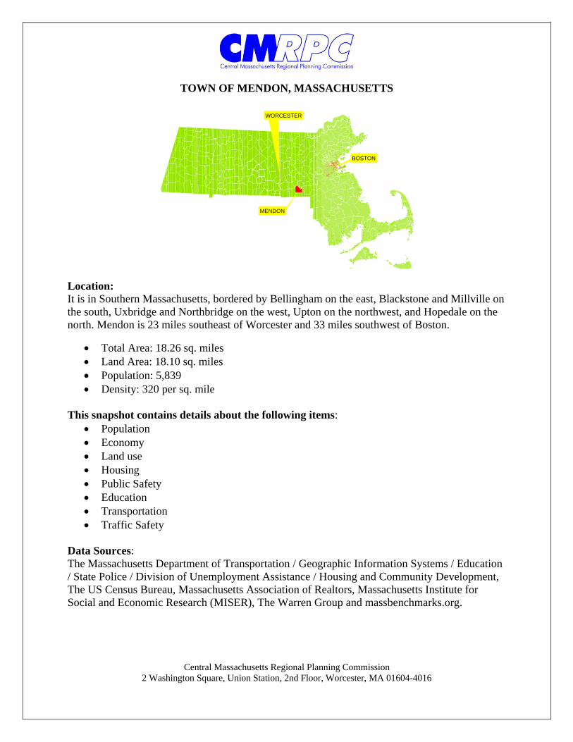
Central Massachusetts Regional Planning Commission 2 Washington Square, Union Station, 2nd Floor, Worcester, MA 01604-4016 TOWN OF MENDON, MASSACHUSETTS Location: It is in Southern Massachusetts, bordered by Bellingham on the east, Blackstone and Millville on the south, Uxbridge and Northbridge on the west, Upton on the northwest, and Hopedale on the north. Mendon is 23 miles southeast of Worcester and 33 miles southwest of Boston. Total Area: 18.26 sq. miles Land Area: 18.10 sq. miles Population: 5,839 Density: 320 per sq. mile This snapshot contains details about the following items: Population Economy Land use Housing Public Safety Education Transportation Traffic Safety Data Sources: The Massachusetts Department of Transportation / Geographic Information Systems / Education / State Police / Division of Unemployment Assistance / Housing and Community Development, The US Census Bureau, Massachusetts Association of Realtors, Massachusetts Institute for Social and Economic Research (MISER), The Warren Group and massbenchmarks.org. MENDON BOSTON WORCESTER

Welcome message from author
This document is posted to help you gain knowledge. Please leave a comment to let me know what you think about it! Share it to your friends and learn new things together.
Transcript
Central Massachusetts Regional Planning Commission 2 Washington Square, Union Station, 2nd Floor, Worcester, MA 01604-4016
TOWN OF MENDON, MASSACHUSETTS
Location: It is in Southern Massachusetts, bordered by Bellingham on the east, Blackstone and Millville on the south, Uxbridge and Northbridge on the west, Upton on the northwest, and Hopedale on the north. Mendon is 23 miles southeast of Worcester and 33 miles southwest of Boston.
Total Area: 18.26 sq. miles Land Area: 18.10 sq. miles Population: 5,839 Density: 320 per sq. mile
This snapshot contains details about the following items:
Population Economy Land use Housing Public Safety Education Transportation Traffic Safety
Data Sources: The Massachusetts Department of Transportation / Geographic Information Systems / Education / State Police / Division of Unemployment Assistance / Housing and Community Development, The US Census Bureau, Massachusetts Association of Realtors, Massachusetts Institute for Social and Economic Research (MISER), The Warren Group and massbenchmarks.org.
MENDON
BOSTON
WORCESTER
Community Snapshot MendonThis snapshot contains data on:
Population-Economy-Housing-Education-Transportation-Public Safety
Central Massachusetts Regional Planning Commission www.cmrpc.org
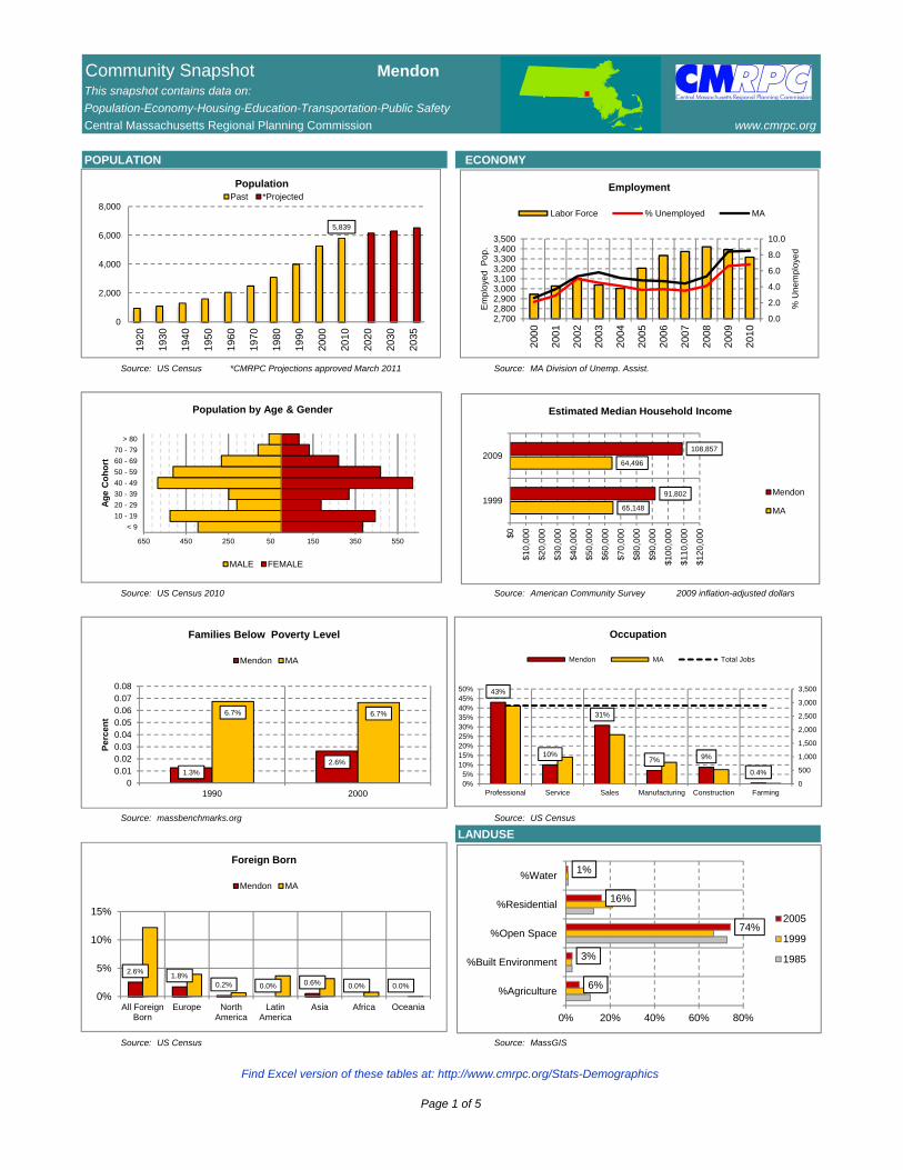
POPULATION ECONOMY
Source: US Census *CMRPC Projections approved March 2011 Source: MA Division of Unemp. Assist.
Source: US Census 2010 Source: American Community Survey 2009 inflation-adjusted dollars
Source: massbenchmarks.org Source: US Census
LANDUSE
Source: US Census Source: MassGIS
5,839
0
2,000
4,000
6,000
8,000
1920
1930
1940
1950
1960
1970
1980
1990
2000
2010
2020
2030
2035
PopulationPast *Projected
0.0
2.0
4.0
6.0
8.0
10.0
2,7002,8002,9003,0003,1003,2003,3003,4003,500
2000
2001
2002
2003
2004
2005
2006
2007
2008
2009
2010
% U
ne
mp
loye
d
Em
plo
yed
Po
p.
Employment
Labor Force % Unemployed MA
65,148
64,496
91,802
108,857
$0
$10
,00
0
$20
,00
0
$30
,00
0
$40
,00
0
$50
,00
0
$60
,00
0
$70
,00
0
$80
,00
0
$90
,00
0
$10
0,0
00
$11
0,0
00
$12
0,0
00
1999
2009
Estimated Median Household Income
Mendon
MA
1.3%2.6%
6.7% 6.7%
00.010.020.030.040.050.060.070.08
1990 2000
Pe
rce
nt
Families Below Poverty Level
Mendon MA
2.6%1.8%
0.2% 0.0% 0.6% 0.0% 0.0%
0%
5%
10%
15%
All ForeignBorn
Europe NorthAmerica
LatinAmerica
Asia Africa Oceania
Foreign Born
Mendon MA
43%
10%
31%
7% 9%
0.4%
0
500
1,000
1,500
2,000
2,500
3,000
3,500
0%5%
10%15%20%25%30%35%40%45%50%
Professional Service Sales Manufacturing Construction Farming
Occupation
Mendon MA Total Jobs
< 9
10 - 19
20 - 29
30 - 39
40 - 49
50 - 59
60 - 69
70 - 79
> 80
650 450 250 50 150 350 550
Ag
e C
oh
ort
Population by Age & Gender
MALE FEMALE
6%
3%
74%
16%
1%
0% 20% 40% 60% 80%
%Agriculture
%Built Environment
%Open Space
%Residential
%Water
2005
1999
1985
Find Excel version of these tables at: http://www.cmrpc.org/Stats-Demographics
Page 1 of 5

Community Snapshot MendonThis snapshot contains data on:
Population-Economy-Housing-Education-Transportation-Public Safety
Central Massachusetts Regional Planning Commission www.cmrpc.org
HOUSING PUBLIC SAFETY
Source: CMRPC / MISER / US Census Source: MA State Police
Source: The Warren Group/Mass. Assoc. of Realtors Source: Mass DOT Highway State & Local Police Jurisdiction
TRANSPORTATION
Source: US Census Source: US Census
PUBLIC SCHOOLS
Source: MA Dept of Education Source: US Census 2000
47
37
42
33
11
2327
10
5 6 5
05
101520253035404550
200
0
200
1
200
2
200
3
200
4
200
5
200
6
200
7
200
8
200
9
201
0
Building Permits
$0$100,000$200,000$300,000$400,000$500,000$600,000
200
0
200
1
200
2
200
3
200
4
200
5
200
6
200
7
200
8
200
9
201
0Median Sales Price
Single Family Condo
MA -SF MA - Condo
4398.4
2933.92418.9
182.5
1437.8
405.5
01000200030004000500060007000
198
0
198
5
199
0
199
5
200
0
200
5
Crimes per 100,000 Residents
Mendon MA
231207 198
227196
155 153
0.00%
0.50%
1.00%
1.50%
2.00%
0
50
100
150
200
250
2004 2005 2006 2007 2008 2009 2010
Traffic Accidents
MENDON % of Region
25.4 26.929.2
21.6 22.727
0
5
10
15
20
25
30
35
1980 1990 2000
Min
ute
s
Mean Commute Time
Mendon MA
461
424
497
0.33357453
0.306801737
0.359623734
28%
29%
30%
31%
32%
33%
34%
35%
36%
37%
380
400
420
440
460
480
500
520
Within Community Outside to Community Community to Outside
Commute Pattern
1,805
21769 49
0
500
1000
1500
2000
OwnerOccupied
RenterOccupied
Vacant Chapter 40B
Housing
2000 2010
3.2 3.1
5.1
12.4 12.712
2.6 2.2 2.3
0
5
10
15
FY2008 FY2009 FY2010
Per
cen
t
K-12 Selected PopulationLow-Income Special Education
Free Lunch Reduced Lunch
Limited English Proficiency Drop Out Rate
Find Excel version of these tables at: http://www.cmrpc.org/Stats-Demographics
Page 2 of 5

Community Snapshot MendonThis snapshot contains data on:
Population-Economy-Housing-Education-Transportation-Public Safety
Central Massachusetts Regional Planning Commission www.cmrpc.org
POPULATION 1990 2000 % Change
Total Population 4,010 5,286 31.8%
In households 4,010 5,270 31.4%
In group quarters 0 16 NA
PERSONS PER HOUSEHOLD
Total Households 1,365 1,817 33.1%
1 216 289 33.8%
2 403 559 38.7%
3 264 328 24.2%
4 312 399 27.9%
> 5 170 242 42.4%
Mean persons / household 3 3 -1.4%
VEHICLES AVAILABLE
Total Households 1,365 1,817 33.1%
0 60 47 -21.7%
1 267 379 41.9%
2 708 957 35.2%
3 236 296 25.4%
4 52 106 103.8%
> 5 42 32 -23.8%
Mean vehicles / household 2 2 0.5%
WORKERS BY GENDER
Workers 16 years and over 2,090 2,820 34.9%
Male 1,146 1,545 34.8%
Female 944 1,270 34.5%
COMMUTE MODE
Workers 16 years and over 2,090 2,818 34.8%
Drive Alone 1,685 2,565 52.2%
Carpool 257 100 -61.1%
Transit / Taxi 12 21 75.0%
Bike / Ped 58 29 -50.0%
Motorbike 35 5 -85.7%
Work at home 43 98 127.9%
COMMUTE TIME
Workers not working at home 2,047 2,720 32.9%
< 5 mins 55 141 156.4%
5 - 9 mins 219 237 8.2%
10 - 14 mins 218 347 59.2%
15 - 19 mins 321 370 15.3%
20 - 29 mins 304 446 46.7%
30 - 44 mins 512 472 -7.8%
> 45 mins 418 707 69.1%
Mean travel time to work (mins) 27 29 8.6%
TIME LEAVING FOR WORK
Workers not working at home 2,047 2,720 32.9%
5 to 6:59 a.m. 453 811 79.0%
7 to 7:59 a.m. 777 801 3.1%
8 to 8:59 a.m 387 512 32.3%
9 to 9:59 a.m. 94 141 50.0%
10 to 11:59 a.m. 33 89 169.7%
12 to 11:59 p.m. 254 337 32.7%
12 to 4:59 a.m. 49 29 -40.8% Source: Census Transportation Planning Package (CTPP 2000)
0
100
200
300
400
500
600
1 2 3 4 > 5
Ho
use
ho
lds
Persons
Persons per Household1990 2000
0
200
400
600
800
1,000
1,200
1 2 3 4 > 5
Ho
use
ho
lds
Vehicles
Vehicles Available1990 2000
0
100
200
300
400
500
600
700
800
Wo
rke
rs
Commute Time1990 2000
0100200300400500600700800900
Wo
rke
rs
Time Leaving For Work 1990 2000
Find Excel version of these tables at: http://www.cmrpc.org/Stats-Demographics
Page 3 of 5

MENDON
NORTH AVENUE
MILFORD ROAD
MAIN STREET
HASTINGS S
TREET
ELM STREET
MAPLE STREET
£¤16
¬«16
ELM HILL FARM
HENRY P CLOUGH SCHOOL
INHOLDING
FOUNDERS PARK
£¤140
£¤16
£¤109£¤85
MENDON
¬«16
MILL
VILL
E ST
REET
PROVIDENCE STREET
NORTH AVENUE
BLAC
KSTO
NE S
TREE
T
UXBRIDGE ROAD
BATE
S STR
EET
PARK STREET
CAPE ROAD
MOWRY STREET
HARTFORD AVENUE EAST
NORTHBRIDGE ROAD
BELL INGHAM STREET
ASYLUM STREET
COLONIAL DRIVE
VINCENT ROAD
QUIS
SET R
OAD
HARTFORD AVENUE WEST GEOR
GE ST
REET
THAYER ROAD
WASHINGTON STREETNECK HILL ROAD
MISCOE ROAD
ASHKINS DRIVE
LOVELL STREET
TAFT AVENUE
CADMAN ROAD
KELLY ROAD
CEMETERY STREET
DUMP
ROA
D
DUDLEY ROAD
PUDDINGSTONE LANE
BUTLER ROAD
LEONARD ROAD
DANIELS ROAD
PARK
ER R
OAD
KING PH ILIP PATH
MILFORD
HOPEDALE
UPTON
BELLINGHAM
BLACKSTONEMILLVILLE
UXBRIDGE
NORTHBRIDGE
Traffic Safety 0 0.0750.0375
Miles
MENDON
MILFORDUPTON
BELLINGHAMUXBRIDGE
HOPEDALENORTHBRIDGE
BLACKSTONEMILLVILLE
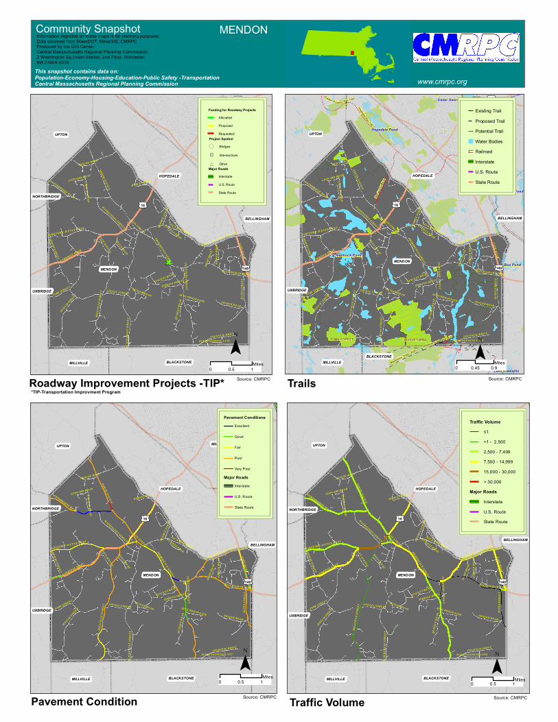
Community Snapshot MENDON
www.cmrpc.orgThis snapshot contains data on:Population-Economy-Housing-Education-Public Safety -TransportationCentral Massachusetts Regional Planning Commission
Information depicted on these mapsis for planning purposes.Data obtained from MassDOT, MassGIS, CMRPCProduced by the GIS Center :Central Massachusetts Regional Planning Commission.2 Washington Sq,Union Station, 2nd Floor, Worcester, MA 01604-4016
¯0 10.5
Miles¯
Statewide Top 200 Crash Clusters06_08AutoCrashClusters06_08Water BodiesOpen SpaceInterstateU.S. RouteState Route
# Statewide Top 200 Crash Clusters06_08AutoCrashClusters06_08
Water BodiesOpen SpaceRailroad
TrailsInterstateU.S. RouteState Route
NB : Color Coded # is Regional RankSource: MassDOT
† TRAFFIC SAFETY HIGHLIGHTSSum Fatal Injury ¹ PDO ³ HSIP
Auto Crash Clusters 2006-2008 Community Crash Crash Crash Crash ² EPDO EligibleMILFORD RD / MAIN ST / HASTINGS ST MENDON 56 0 18 38 128 YesUXBRIDGE RD / HARTFORD AV WEST MENDON 17 0 5 12 37 YesBATES ST / BELLINGHAM ST MENDON 10 0 6 4 34 YesHARTFORD AV EAST / CAPE RD / SOUTH MAIN ST MENDON 30 0 6 24 54 Yes
Pedestrian Crash Clusters 2006-2008NONE MENDON 0 0 0 0 0 0
Bike Crash Clusters 2006-2008NONE MENDON 0 0 0 0 0 0
Total Auto Crashes 2006-2008 MENDON 599 2 159 438 1,253Total Pedestrian Crashes 2006-2008 MENDON 3 0 3 0 15Total Bike Crashes 2006-2008 MENDON 1 0 1 0 5¹ PDO - Property Damage Only² EPDO - Equivalent Property Damage Only weighted by fatal crashes = 10, injury crashes = 5, PDO =1³ HSIP- Highway Safety Improvement Program (MA)† Excluding Interstate HighwaysSource : Mass DOT Highway
£¤140
£¤16
£¤109£¤85
MENDON
MILL
VILL
E ST
REET
PROVIDENCE STREET
NORTH AVENUE
BLAC
KSTO
NE S
TREE
T
UXBRIDGE ROAD
BATE
S STR
EET
PARK STREET
CAPE ROAD
MOWRY STREET
HARTFORD AVENUE EAST
NORTHBRIDGE ROAD
BELL INGHAM STREET
ASYLUM STREET
COLONIAL DRIVE
VINCENT ROAD
QUIS
SET R
OAD
HARTFORD AVENUE WEST GEOR
GE ST
REET
THAYER ROAD
WASHINGTON STREETNECK HILL ROAD
MISCOE ROAD
ASHKINS DRIVE
LOVELL STREET
TAFT AVENUE
CADMAN ROAD
KELLY ROAD
MAIN STREET
CEMETERY STREET
DUMP
ROA
D
DUDLEY ROAD
PUDDINGSTONE LANE
BUTLER ROAD
LEONARD ROAD
DANIELS ROAD
PARK
ER R
OAD
KING PH ILIP PATH
MILFORD
HOPEDALE
UPTON
BELLINGHAM
BLACKSTONEMILLVILLE
UXBRIDGE
NORTHBRIDGE
£¤140
£¤16
£¤109£¤85
MENDONNipmuck Pond
Hopedale Pond
Box Pond
Lake Hiawatha
Beaver Pond
Cedar Swamp Pond
Hopedale Rail Trail
Mend
on R
ail Tra
il
Blackstone Trails - Alt3
G rafton & U p ton Rail Trail
Blackstone Trails - Alt3
MILL
VILL
E ST
REET
PROVIDENCE STREET
NORTH AVENUE
BLAC
KSTO
NE S
TREE
T
UXBRIDGE ROAD
BATE
S STR
EET
PARK STREET
CAPE ROAD
MOWRY STREET
HARTFORD AVENUE EAST
NORTHBRIDGE ROAD
BELL INGHAM STREET
ASYLUM STREET
COLONIAL DRIVE
VINCENT ROAD
QUIS
SET R
OAD
HARTFORD AVENUE WEST GEOR
GE ST
REET
THAYER ROAD
WASHINGTON STREETNECK HILL ROAD
MISCOE ROAD
ASHKINS DRIVE
LOVELL STREET
TAFT AVENUE
CADMAN ROAD
KELLY ROAD
MAIN STREET
CEMETERY STREET
DUMP
ROA
D
PUDDINGSTONE LANE
BUTLER ROAD
LEONARD ROAD
DANIELS ROAD
PARK
ER R
OAD
KING PH ILIP PATH
MILFORD
HOPEDALE
UPTON
BELLINGHAM
BLACKSTONEMILLVILLE
UXBRIDGE
QUISSET WMATOWN FOREST
£¤140
£¤16
£¤109£¤85
MENDON
MILL
VILL
E ST
REET
PROVIDENCE STREET
NORTH AVENUE
BLAC
KSTO
NE S
TREE
T
UXBRIDGE ROAD
BATE
S STR
EET
PARK STREET
CAPE ROAD
MOWRY STREET
HARTFORD AVENUE EAST
NORTHBRIDGE ROAD
BELL INGHAM STREET
ASYLUM STREET
COLONIAL DRIVE
VINCENT ROAD
QUIS
SET R
OAD
HARTFORD AVENUE WEST GEOR
GE ST
REET
THAYER ROAD
WASHINGTON STREETNECK HILL ROAD
MISCOE ROAD
ASHKINS DRIVE
LOVELL STREET
TAFT AVENUE
CADMAN ROAD
KELLY ROAD
MAIN STREET
CEMETERY STREET
DUMP
ROA
D
DUDLEY ROAD
PUDDINGSTONE LANE
BUTLER ROAD
LEONARD ROAD
DANIELS ROAD
PARK
ER R
OAD
KING PH ILIP PATH
MILFORD
HOPEDALE
UPTON
BELLINGHAM
BLACKSTONEMILLVILLE
UXBRIDGE
NORTHBRIDGE
£¤140
£¤16
£¤109£¤85MI
LLVI
LLE
STRE
ET
PROVIDENCE STREET
NORTH AVENUE
BLAC
KSTO
NE S
TREE
T
UXBRIDGE ROAD
BATE
S STR
EET
PARK STREET
CAPE ROAD
MOWRY STREET
HARTFORD AVENUE EAST
NORTHBRIDGE ROAD
BELL INGHAM STREET
ASYLUM STREET
COLONIAL DRIVE
VINCENT ROAD
QUIS
SET R
OAD
HARTFORD AVENUE WEST GEOR
GE ST
REET
THAYER ROAD
WASHINGTON STREETNECK HILL ROAD
MISCOE ROAD
ASHKINS DRIVE
LOVELL STREET
TAFT AVENUE
CADMAN ROAD
KELLY ROAD
MAIN STREET
CEMETERY STREET
DUMP
ROA
D
DUDLEY ROAD
PUDDINGSTONE LANE
BUTLER ROAD
LEONARD ROAD
DANIELS ROAD
PARK
ER R
OAD
KING PH ILIP PATH
MILFORD
HOPEDALE
UPTON
BELLINGHAM
BLACKSTONEMILLVILLE
UXBRIDGE
NORTHBRIDGE
MENDON
0 10.5Miles
Traffic VolumePavement Condition
Trails
Pavement ConditionsExcellent
Good
Fair
Poor
Very Poor
Major RoadsInterstate
U.S. Route
State Route
Traffic Volume≤1>1 - 2,5002,500 - 7,4997,500 - 14,99915,000 - 30,000> 30,000
Major RoadsInterstateU.S. RouteState Route
Existing TrailProposed TrailPotential TrailWater BodiesRailroadInterstateU.S. RouteState Route
Funding for Roadway ProjectsAllocated
Proposed
RequestedProject Symbol
) Bridges
F Intersections
* OtherMajor Roads
Interstate
U.S. Route
State Route
0 10.5 Miles
0 0.90.45Miles
0 10.5Miles
Community Snapshot MENDON
www.cmrpc.orgThis snapshot contains data on:Population-Economy-Housing-Education-Public Safety -TransportationCentral Massachusetts Regional Planning Commission
Information depicted on these maps is for planning purposes.Data obtained from MassDOT, MassGIS, CMRPCProduced by the GIS Center :Central Massachusetts Regional Planning Commission.2 Washington Sq,Union Station, 2nd Floor, Worcester, MA 01604-4016
¯ ¯
¯¯Source: CMRPC Source: CMRPC
Source: CMRPC Source: CMRPC
Roadway Improvement Projects -TIP* *TIP-Transportation Improvment Program
Related Documents


