Town of Dorset VT-Raptor Lane Project review Progress Draft June 14, 2019 1 | Page Kepler Consulting LLC PROJECT UNDERSTANDING AND BACKGROUND Town of Dorset recently purchased 307 acre parcel from Dworkin & Shalan Partners, LLC (DSP) that is accessed via Raptor Lane off of RT 30 DSP had invested significant time and money into the planning and permitting of proposed development of the Raptor Lane Lands (RLL) as an 8 lot subdivision DSP pursued and acquired Major Subdivision permit from Town of Dorset Planning Commission and several State permits The site is accessed via Raptor Lane on RT 30 as a private roadway Site improvements include internal roads (~1/2mile) built to class 3 standards, Stormwater management infrastructure, buried electrical conduit, and transformer boxes The Town of Dorset is interested in assessing site limitations and regulatory constraints for other possible development options or scenarios associated with the ~141 acres (proposed lots 1-7) that has received Potable Water Supply and Wastewater Disposal permit from the State The Town of Dorset has expressed interest in a number possible development options that include housing (work force and/or senior), new municipal complex, emergency services and an education center Primary Goals of Initial Investigation Primary focus of the services outlined below is to provide desk top conceptual level feasibility assessment(s) of the site’s opportunities and constraints for water supply and wastewater disposal with primary focus on the portion of lands associated with lots 1-7 of the proposed 8 lot subdivision WORK TASKS PERFORMED I. Work Performed- Kepler Consulting with assistance from VHB and Engineering Ventures performed the following tasks 1. Reviewed and conducted desktop review of documents provided by Town of Dorset , which are listed in the References Cited section of this document 2. Analyzed publicly-available Geographic Information Systems (“GIS”) information to assess site conditions that may affect the feasibility of obtaining permits and developing the site, including geology and soils; protected natural resources such as wetlands, streams, and wildlife habitat; hazardous sites; public water supplies; known springs; and Steep slopes. 3. Researched status and site implications of various permits obtained, site planning conducted (e.g. wetlands assessment; deer yards; wild life habitat etc.) and/or finding of studies

Welcome message from author
This document is posted to help you gain knowledge. Please leave a comment to let me know what you think about it! Share it to your friends and learn new things together.
Transcript
Town of Dorset VT-Raptor Lane Project review Progress Draft June 14, 2019
1 | P a g e
Kepler Consulting LLC
PROJECT UNDERSTANDING AND BACKGROUND
Town of Dorset recently purchased 307 acre parcel from Dworkin & Shalan Partners, LLC (DSP) that is accessed via Raptor Lane off of RT 30
DSP had invested significant time and money into the planning and permitting of proposed development of the Raptor Lane Lands (RLL) as an 8 lot subdivision
DSP pursued and acquired Major Subdivision permit from Town of Dorset Planning Commission and several State permits
The site is accessed via Raptor Lane on RT 30 as a private roadway
Site improvements include internal roads (~1/2mile) built to class 3 standards,
Stormwater management infrastructure, buried electrical conduit, and transformer
boxes
The Town of Dorset is interested in assessing site limitations and regulatory constraints for other possible development options or scenarios associated with the ~141 acres (proposed lots 1-7) that has received Potable Water Supply and Wastewater Disposal permit from the State
The Town of Dorset has expressed interest in a number possible development options that include housing (work force and/or senior), new municipal complex, emergency services and an education center
Primary Goals of Initial Investigation
Primary focus of the services outlined below is to provide desk top conceptual level feasibility assessment(s) of the site’s opportunities and constraints for water supply and wastewater disposal with primary focus on the portion of lands associated with lots 1-7 of the proposed 8 lot subdivision
WORK TASKS PERFORMED I. Work Performed- Kepler Consulting with assistance from VHB and Engineering Ventures
performed the following tasks
1. Reviewed and conducted desktop review of documents provided by Town of Dorset , which are listed in the References Cited section of this document
2. Analyzed publicly-available Geographic Information Systems (“GIS”) information to assess site conditions that may affect the feasibility of obtaining permits and developing the site, including geology and soils; protected natural resources such as wetlands, streams, and wildlife habitat; hazardous sites; public water supplies; known springs; and Steep slopes.
3. Researched status and site implications of various permits obtained, site planning conducted (e.g. wetlands assessment; deer yards; wild life habitat etc.) and/or finding of studies
Town of Dorset VT-Raptor Lane Project review Progress Draft June 14, 2019
2 | P a g e
Kepler Consulting LLC
4. Contacted 3rd party surveyor/ consultant previously involved with the Planning and permitting of the RLL lands to garner information pertinent to assessing site opportunities and limitations for development concepts of interest to Town of Dorset
5. Performed site inspections 6. Reviewed local Zoning regulations and assessed potential allowable housing density
with assumption that wastewater disposal will be on-site and Water supply could be provided by on-site drilled well, on-site springs, and/or water line extension from the Dorset Fire District #1
II. Environmental Constraints
Desktop conceptual-level assessment of environmental constraints that may affect permitting is
as follows. Refer to the Preliminary Environmental Constraints Map (Attachment #1) for the
locations of the protected natural resources described below.
A. Protected Natural Resources
1. Deer Wintering Area & Bear Habitat: Deer wintering area, as mapped by the
Vermont Fish & Wildlife Department, covers much of the site from
approximately the 1,100-foot elevation contour and below. Tree-cutting and
development within deer wintering areas and black bear habitat is regulated via
Act 250, and development within these areas, plus a buffer, may be limited.
On-site delineations had been undertaken by Jeff Wallin (Wildlife biologist) in
behalf of DSP as a requirement of the Dorset Planning Commission subdivision
permitting process, which is depicted on the Gary Rapanaotti survey
(Attachment #2). Noteworthy is that there are differences between the State’s
delineation (GIS data) and Jeff Wallin’s on-site delineation of the deer wintering
areas. Noteworthy- It appears a significant portion of the lands associated with
lots 1,2,3 & 7 may be impacted by Deer wintering and/or Bear habitat. It may
be possible to refine the currently-mapped (State GIS) and/or Jeff Wallin’s on-
site delineations of the deer wintering area boundaries and to assess potential
black bear habitat, which may be present.

Town of Dorset VT-Raptor Lane Project review Progress Draft June 14, 2019
3 | P a g e
Kepler Consulting LLC
2. Bat Habitat: Since the Dworkin & Shalam Partners project was permitted,
protected habitat for endangered species of bats (northern long-eared bat and
Indiana bat) has become significant in its implications for Act 250 permitting of
projects involving tree clearing. Desktop research and a site reconnaissance to
identify potential bat habitat and roost-trees may be needed to support
permitting. If tree clearing is required, time of year restrictions may apply in
order to avoid impacts to habitat for endangered bats. The level of effort
involved in permitting for bat habitat impacts will be greater if federal permits
are required for the project (i.e., if an Army Corps permit is needed for stream or
wetland impacts), or if federal or certain state funding is used.
3. Wetlands: Some localized areas within the deer wintering area are mapped as
significant (Class 2) wetlands by the Vermont Significant Wetlands Inventory
(“VSWI”), which would require permitting for any activities within a wetlands or
a 50-foot buffer.
The prior wetlands Conditional Use Determination (# 2004-024, issued Sept 7,
2004) has expired (Attachment #3). The road crossing which this CUD approved
has been constructed, but it is not known whether the construction complied
with the CUD conditions because the required certification of construction was
not provided by Client. Assuming it has was built in conformance with the CUD,
the existing road crossing may remain as-is. The CUD also required a five year
monitoring period for nuisance plant species, but it is not known whether this
condition was met.
For any new development on site, under the current Vermont Wetland Rules,
delineations expire after 5 years, hence new on-site delineations would be
required to verify the mapped wetland boundaries and to determine whether
additional non-mapped wetlands or vernal pools are present elsewhere on the
site, and to determine classifications, functions, and values of any wetlands on
site. The regulatory definition of a wetland has changed since the CUD was
issued, thus jurisdictional wetlands may be present on site in locations where
they were not previously identified.
4. Rare, threatened, or endangered species: Aside from bats, no known rare,
threatened, or endangered species communities are documented within the site
boundaries. However, Act 250 and Army Corps permitting will likely require
on-site determinations of the presence or absence of rare plants or animals
that have not been previously documented.
Town of Dorset VT-Raptor Lane Project review Progress Draft June 14, 2019
4 | P a g e
Kepler Consulting LLC
5. Surface Waters: Streams are mapped running near the northern and southern
site boundaries, extending only slightly onto the site property. In Act 250
permitting, a 50-foot stream buffer is required to be maintained, except where
encroachment is necessary. On-site delineations would likely be required to
verify the mapped stream locations, to determine whether additional non-
mapped jurisdictional streams are present elsewhere on the site, and to
determine the flow regime and regulatory classification of any streams on-site.
B. Cultural Resources
Historic sites are regulated by Act 250 (criterion 8). More rigorous cultural resources analysis
would be involved if federal permits are required for the project (i.e., if an Army Corps permit is
needed for stream or wetland impacts), or if federal or certain state funding is used. On-site
and desktop assessments of historic structures and archaeology would likely be needed to
determine if sensitive features are present (e.g., old cellar holes, cemeteries, archaeological
remains). Design of a development project would need to avoid impacting any cultural
resources, or mitigation would be needed for unavoidable impacts.
III. Permitting: Water Infrastructure
Desktop conceptual-level assessment of construction feasibility and permitting for potable
water supply, stormwater, and domestic wastewater disposal is as follows. Refer to the
Bedrock Geology & Water Supply Map, and the Surficial Geology & Soils Map (Attachments #4
) for the locations of the features described below.
A. Potable Water Supply
1. On-site wells: Site geology appears favorable for drilling on-site wells. Bedrock
geologic mapping by the Vermont Geological Survey (Ratcliffe et al, 2011)
indicates that the site is underlain by the Shelburne Marble formation, which is
described as calcite marble and massive calcite marble that locally contains
Town of Dorset VT-Raptor Lane Project review Progress Draft June 14, 2019
5 | P a g e
Kepler Consulting LLC
intermediate dolostone beds; this rock type typically supports high-yielding
drilled wells. The site is located on the lower slopes of Owl’s Head Mountain,
where the higher-elevation terrain likely provides ample recharge area to sustain
use of water from wells.
No potential sources of contamination such as hazardous sites, RCRA hazardous
waste generators, or underground storage tanks are known to exist at or up
gradient of the project site; therefore on-site wells are not likely to be at risk of
manmade contamination.
The adjacent JK Adams property has a permitted Non-Transient, Non-Community
water system and an on-site well. The Wellhead Protection Area (“WHPA”) for
this well extends very slightly onto the site, but not to such an extent that it
would significantly limit site development.
Wells for each single family home, or shared wells for two units, would be
permitted under the Wastewater System and Potable Water Supply Rules
(2019). Wells regularly serving more than 25 year-round residents (typically, 10
homes based on 2.5 residents each) are classified as public community water
system sources, and would require additional testing and permitting.
2. Springs: The Owl’s Foot spring has been identified by the Vermont Geological
Survey (De Simone and Gale, 2009) as being located within the project site, and
having a potential “moderate” yield in the range of 10 to 100 gallons per
minute. This report describes the spring as follows:
“at an elevation of 1320 +/- 40 ft within the proposed Owl’s Foot development.
The spring flows from beneath a large boulder in thick lodgement till at the base
of a steep 10-16 ft high slope in the till… The outflow has formed thin limy
concretions atop the lodgement till and suggests a carbonate bedrock source for
the groundwater.”
Further study and testing would be needed to determine the approvable safe
yield of the spring as a community water source and to determine whether
water quality is acceptable.
3. DFD #1 connection: If a connection to the existing Dorset Fire District #1
distribution system were desired, a water line extension 6,500 feet in length
would need to be constructed to reach the base of the project road at Route 30.
Currently, the DFD #1 system cannot support new connections, however

Town of Dorset VT-Raptor Lane Project review Progress Draft June 14, 2019
6 | P a g e
Kepler Consulting LLC
development and permitting of a new water source and investigation of leaky
water lines are underway to resolve this situation.
The existing DFD#1 water main is only 4 inches in diameter and cannot support
fire protection because mains must be at least 8 inches in diameter for fire flows.
The DFD #1 system is pressurized by gravity from the existing storage tank
located at elevation 1,210’; booster pumping may be needed to provide
adequate pressure (not less than 35 psi normally and not less than 20 psi under
fire flow conditions) to connections on the project site depending on the
elevation and height of buildings to be built.
B. Stormwater
1. General permit: The Dworkin & Shalam Partners, LLC development had received
permit authorization (#3639-9015 issued January 26, 2005) under a statewide
general permit to discharge stormwater runoff from impervious surfaces from
the proposed development (Attachment #6). Approved infrastructure included
grass channels, two dry detention ponds, and two outfalls discharging to the
West Branch of the Battenkill River. This permit authorization has expired. If
existing stormwater infrastructure was built to substantial completion in
accordance with this permit authorization, it may be allowed to remain as-is, at
the discretion of the VT DEC. However it is not clear (i.e. - has not been
determined) how much of the approved stormwater infrastructure has already
been built in conjunction with the internal roads that have been constructed.
Review of the State’s database indicates those Annual inspections and reports,
and the Re-statement of compliance certifications (Required every 3 yrs.) that
are conditions of the original permit have not been done since 2005. It is not
clear from the review of the State’s database if the original certification of
construction was completed or not. Recommend field review of constructed
Stormwater infrastructure to determine if completed in accordance with the
issued permit and contact State to discuss status of project and inquire about
potential for renewal of existing permit. Copy of existing permit status in the
State’s database is included in attachment #6.
New or substantially reconfigured site development with impervious surfaces
(roads, driveways, rooftops, etc.) exceeding regulatory thresholds (currently 1
acre of total site impervious, which will change to 0.5 acres in 2022; or 5,000 sq.
Town of Dorset VT-Raptor Lane Project review Progress Draft June 14, 2019
7 | P a g e
Kepler Consulting LLC
ft. additional impervious) would require new stormwater infrastructure designed
and permitted in accordance with the 2017 Vermont Stormwater Management
Manual and the current Stormwater Permitting Rule (2019), which encourages
stormwater runoff to be infiltrated into the soil rather than discharged at surface
outfalls.
2. Construction General Permit: Regarding construction-phase stormwater
management and erosion control, the Dworkin & Shalam Partners, LLC
development had received permit authorization (#3639-9001, issued October 14,
2004) under a statewide general permit. This general permit authorization has
expired, and any new site construction that disturbs an acre or more of earth
surface would need to be covered under a new permit (VT DEC Construction
General Permit 3-9020, or an Individual Permit, “INDC”), which may require site-
specific erosion prevention and sediment control measures to be designed and
implemented during construction.
C. Wastewater Disposal- Existing Water Supply and Wastewater System permits: Permits
issued in 2004 (WW-8-0762 and WW-8-0762-1) approved 4 & 5 -bedroom homes on
lots 1 through 7 with on-site wells and septic systems (Attachment #7). The approved
plans (Bruno Associates, 2004 and Jeremy M. Brodney, 2004) designed a mix of in-
ground and mound disposal systems.
Lots 1,2, 4-7, 4 Bdrms with Design flow of 490gpd
Lot 3- 5 Bdrms with Design flow of 560gpd
Private well on each lot
Lots 4-6 – with in-ground disposal systems
Lots 1,2,3, &7 –with Mound disposal systems
Replacement areas required for Lots 1-7
Lot 3 includes an Ecoflo bio filter allowing higher loading rate to the mound
Lot 8 was permitted with a waiver of development rights
Total disposal design flow for lots 1-7 is 3010gpd
Wastewater System and Water Supply Rules (WW Rules) permitting implications and
potential opportunities:
WW Rules were revised in April 2019

Town of Dorset VT-Raptor Lane Project review Progress Draft June 14, 2019
8 | P a g e
Kepler Consulting LLC
Replacement areas are not required for Mound designed systems, thus Lots
1,2,3,& 7 potentially have double the permitted disposal capacity
Table 8-1 (Attachment #8) of the 2019 WW Rules allows for reduced design
flows for Residential use of buildings or structures with 5 or more living units
(Residents). Potential example: If the primary and replacement mound systems
were combined into one disposal system for Lot 1 &lot 2, the disposal capacity
would be large enough to serve 6 residential living units according to Table 8-1.
Tables 8-2 &8-3 (Attachment #8) provide design flows for most typical land uses
that would be associated with the various redevelopment scenarios envisioned
for this property
Indirect Discharge Rules:
Regulatory Threshold: For a potential larger development than what the existing WW
permits have approved, the regulatory threshold for needing an Indirect Discharge Permit is
6,500 gallons per day of design wastewater flow, equivalent to approximately 26, 3-
bedroom homes (per Table 8-1 of the 2019 WW Rules).
Thresholds for treatment requirements: Design requirements under the Indirect Discharge
Rules become progressively more complex as design flows increase. The current (2019)
Indirect Discharge Rules set the following requirements:
Leach fields, 6,500 to 30,000 gpd: at a minimum, septic tank treatment is required
(higher treatment may be needed to meet other permitting requirements).
Leach fields, 30,001 to 50,000 gpd: at a minimum, “secondary plus” treatment
(recirculating sand or textile filter, max 15 mg/L BOD and TSS) is required -higher
treatment may be needed to meet other permitting requirements).
Leach fields, 50,001 gpd and up: tertiary treatment (max 10 mg/L BOD and TSS) is
required (higher treatment may be needed to meet other permitting requirements).
Spray disposal, 6,500 gpd and up: at a minimum, secondary treatment (max 30 mg/L
BOD and TSS) is required (higher treatment may be needed to meet other
permitting requirements).
Thresholds for permitting requirements: Permitting requirements under the Indirect
Discharge Rules become progressively more complex as design flows increase. The current
(2019) Indirect Discharge Rules set the following requirements:
Town of Dorset VT-Raptor Lane Project review Progress Draft June 14, 2019
9 | P a g e
Kepler Consulting LLC
6,500 to 20,000 gpd: simplified desktop methods (Dilution and Treatment Index
methods) may be used to demonstrate compliance with the aquatic permitting
criteria (in-stream water quality requirements for the surface water receiving the
indirect discharge) for subsurface disposal (not spray) systems with septic tank
treatment. Permitting time line is estimated at 6-12 months for the simplified
desktop methods (6,500 – 20,000 gpd)
6,500 to 30,000 gpd: a simplified site-specific method (Modified Site Specific
Method) may be used to demonstrate compliance with the aquatic permitting
criteria for leach field disposal systems with septic tank treatment. The method
requires site-specific testing of water quality in the receiving stream, but allows a
desktop assessment of default effluent chemistry. Permitting time line is estimated
at 6-12 months for the simplified site-specific methods (6,500 – 30,000 gpd) with the
caveat that the water quality testing needs to happen from June through October,
so the timeline depends on what month work starts. If biomonitoring is needed
(>20,000 gpd), add 4-8 months depending on when the work starts (fieldwork
needed in August-September, reporting done around March).
6,500 gpd and up: the Site Specific Method of demonstrating compliance with the
aquatic permitting criteria is required for systems of any capacity that use spray
disposal, and for leach field systems over 30,000 gpd. This method entails site-
specific testing and characterization of the effluent as it flows through the soil, as
well as site-specific testing of water quality in the receiving stream. Permitting time
line for is estimated at 12-24 months for the Site Specific methods (6,500 and up,
any size spray system)
Over 20,000 gpd: regardless of the treatment and disposal technologies, or the
method of demonstrating compliance with the aquatic permitting criteria, biological
monitoring of the receiving stream must be conducted for discharges over 20,000
gpd prior to applying for a permit.
Timelines often get extended when an applicant starts with a simplified method, and then
has to change to a more rigorous Site Specific method. This can happen because the
simplified methods have built-in safety factors and are more conservative, so sometimes it
becomes necessary to change to the more time-consuming and expensive methods in order
to get more accurate results to qualify for a permit.
Site Conditions: soils and percolation test data from the permitted septic system design
plans (Bruno Associates, 2004 and Jeremy M. Brodney, 2004) indicate fine sandy loam
soils with no ledge encountered in most test pits, seasonal high water tables generally in
the range of 1.5 to more than 4 feet below grade, and percolation rates generally

Town of Dorset VT-Raptor Lane Project review Progress Draft June 14, 2019
10 | P a g e
Kepler Consulting LLC
between 4 and 22 min/inch. These results suggest that in-ground or mound leach field
systems and spray disposal systems meeting the Indirect Discharge Rules’ design
requirements may be feasible on the site. Further soil and site characterization would be
needed to assess the siting requirements of the Indirect Discharge Rules fully. Spray
disposal systems are allowed on slopes up to 30%. The slope analysis included assessment
of slopes > 30%. In general there appears to be significant amount of area in the upper
elevations of Lot #8 which may be suitable for spray disposal and/or centralized in-ground
disposal systems.
Zoning Bylaws and related implications –Excerpts of the Town of Dorset Zoning Bylaws that
are likely applicable to development of the property are included as Attachment #9
a. Zoning District- primarily Agricultural and Rural Residential zoning
district(A&RR) with upper portion of property located in Forest II, which
has not been considered in the review of this project
i. A&RR min developable lot area for single family or two family
dwelling is 120,000SF (~3 acre)
ii. A&RR Planned Residential development (PRD) cluster
development minimum developable lot area is 10 Acres and
allows for 60,000SF per dwelling unit density (~1.5 acre)
iii. Developable lot area exclusions include Wetlands and slopes
greater than 20%
b. Lands above elevation 1,100 feet mean sea level are subject to the
Ridgeline and Mountainside Overlay zone bylaws, which indicates that
new land subdivisions in this overlay zone can be reviewed to Protect
Dorset’s scenic resources while allowing for carefully planned
development. Careful consideration to scenic impacts is implied.
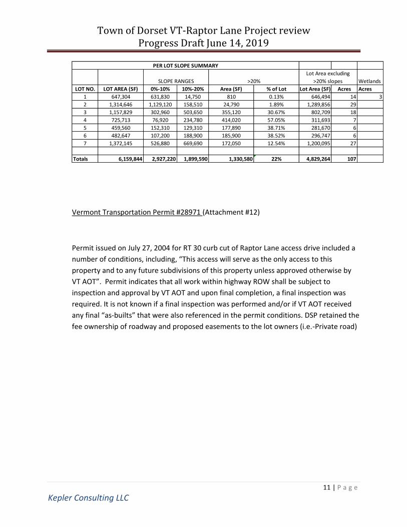
c. Slope Analysis: A slope analysis was performed (Attachment #10) to
assess what portions of each lot are above 20% slope and cannot be
used in density calculations and/or determining minimum lot size if
further subdivision was pursued . The table below provides a summary
of this preliminary analysis.
d. A slope analysis (>20%) was performed as part of the local permitting
process by Gary Rapanotti L.S. (Attachment #11)
Town of Dorset VT-Raptor Lane Project review Progress Draft June 14, 2019
11 | P a g e
Kepler Consulting LLC
Vermont Transportation Permit #28971 (Attachment #12)
Permit issued on July 27, 2004 for RT 30 curb cut of Raptor Lane access drive included a
number of conditions, including, “This access will serve as the only access to this
property and to any future subdivisions of this property unless approved otherwise by
VT AOT”. Permit indicates that all work within highway ROW shall be subject to
inspection and approval by VT AOT and upon final completion, a final inspection was
required. It is not known if a final inspection was performed and/or if VT AOT received
any final “as-builts” that were also referenced in the permit conditions. DSP retained the
fee ownership of roadway and proposed easements to the lot owners (i.e.-Private road)
Wetlands
LOT NO. LOT AREA (SF) 0%-10% 10%-20% Area (SF) % of Lot Lot Area (SF) Acres Acres
1 647,304 631,830 14,750 810 0.13% 646,494 14 3
2 1,314,646 1,129,120 158,510 24,790 1.89% 1,289,856 29
3 1,157,829 302,960 503,650 355,120 30.67% 802,709 18
4 725,713 76,920 234,780 414,020 57.05% 311,693 7
5 459,560 152,310 129,310 177,890 38.71% 281,670 6
6 482,647 107,200 188,900 185,900 38.52% 296,747 6
7 1,372,145 526,880 669,690 172,050 12.54% 1,200,095 27
Totals 6,159,844 2,927,220 1,899,590 1,330,580 22% 4,829,264 107
PER LOT SLOPE SUMMARY
>20%SLOPE RANGES
Lot Area excluding
>20% slopes

Town of Dorset VT-Raptor Lane Project review Progress Draft June 14, 2019
12 | P a g e
Kepler Consulting LLC
IV. Conclusions ,Recommendations, and Comments
i) The permitted 8 lot subdivision was not subject to Vermont’s ACT250 Land Use and
Development laws. ACT250 jurisdiction is likely to be triggered for many of the
Development options that may be considered by the Town of Dorset
ii) Development of the site is affected by protected natural resources including deer
wintering area, potential black bear habitat, wetlands, and streams. As an initial
next step in assessing the site’s development potential, on-site delineations are
recommended for these resources and for bat habitat
iii) It appears a significant portion of the lands associated with lots 1,2,3 & 7 may be
impacted by deer wintering and/o Bear habitat.
iv) As a second step in the process, developing concept sketches and/or conducting a
planning charrette is recommended to better establish the Town’s desired
development program (and priorities) for the property. Sketches would be based
upon input from the Town and/or other stakeholders and consider the usable land
after the protected natural resources have been delineated and mapped.
v) The site appears favorable for on-site water supply wells or use of Owl’s Foot Spring
as a potable source. Further study is needed to determine approvable long-term
yield of spring or to site productive drilled wells.
vi) On-Site wastewater disposal designs have been approved for 7 in-ground and
mound leach fields for 4-bedroom homes with a total disposal capacity of 3010gpd.
Based on some of the Rule changes since this project was permitted, it may be
possible to combine two or more mound disposal areas (primary and/or
replacement areas) and increase the number permitted residential dwelling units. It
may also be possible to permit 2 residential units on a number of the lots by modify
the septic designs from standard septic tanks to effluent filters and double the
hydraulic loading rate to the permitted disposal areas.
vii) Additional wastewater disposal capacity may be feasible to develop via additional
small-scale systems. If approximately 26 (or more) 3-bedroom homes are desired
(i.e. - greater than 6500gpd capacity), an Indirect Discharge Permit would likely be
needed. Review of existing WW permit information suggests that in-ground or
mound leach field systems and spray disposal systems meeting the Indirect
Discharge Rules’ design requirements may be feasible on the site. In general, there
appears to be significant amount of area in the upper elevations of Lot #8 which
may be suitable for spray disposal and/or centralized in-ground disposal systems.
Additional site characterization would be needed to determine if, and where, soil,
groundwater, and receiving stream conditions would support additional
Town of Dorset VT-Raptor Lane Project review Progress Draft June 14, 2019
13 | P a g e
Kepler Consulting LLC
wastewater disposal capacity. If wastewater disposal capacity above 6500gpd is
desired, conducting a wastewater site characterization study is recommended. A
portion of this work could be done in conjunction with the natural resources
reconnaissance, so that the areas of environmental constraints can be ruled out to
narrow-down the study area.
viii) If existing storm water infrastructure was built per the now-expired general permit
authorization, it may be possible to re-permit such infrastructure without
significant modifications, to manage storm water from previously-approved roads
and development. New development beyond what was previously permitted will
likely need new storm water infrastructure designed and permitted in accordance
with current rules, which favor infiltrating into soil rather than detention ponds and
surface outfalls.
ix) The construction general permit authorizing storm water discharges has expired,
and any new site construction that disturbs an acre or more of earth surface would
need to be covered under a new permit
References Cited
Bruno Associates Inc., 2003. Stream Crossing Plan for Jeremy Dworkin & John Shalam in
Dorset, Vermont (sheet C1). April 26, 2003.
Bruno Associates Inc., 2004. Dworkin & Shalam: WS/WWD Design (sheets 1-11). April 20,
2004.
Bruno Associates Inc., 2004. Dworkin & Shalam: Erosion Control Plan (sheets ECP-1 and C-
7). July 21, 2004 and January 5, 2004.
De Simone, D.J. and Gale, M.H., 2009. Geology of Dorset Springs. Vermont Geological
Survey, June 2009.
Gary Rapanotti L.S., 2004. Boundary Plan: Owl’s Foot Subdivision, Jeremy Dworkin Esq.
John Shalam. March 17, 2004.

Town of Dorset VT-Raptor Lane Project review Progress Draft June 14, 2019
14 | P a g e
Kepler Consulting LLC
Jeremy M. Brodney, 2004. Septic System Design, Property of Dworkin Shalam Partnership-
Lot 3 (sheets 2 and 3). December 10, 2004.
Ratcliffe, N.M., Stanley, R.S., Gale, M.H., Thompson, P.J., and Walsh, G.J., 2011. Bedrock
geologic map of Vermont: U.S. Geological Survey Scientific Investigations Map 3184, 3
sheets, scale 1:100,000, http://pubs.usgs.gov/sim/3184/
Vermont DEC, 2004. Water Supply and Wastewater Permit WW-8-0762. Dworkin-Shalam
Partnership [lots 1, 2, 4-7]. July 23, 2004.
Vermont DEC, 2004. Conditional Use Determination – Section 8 – Vermont Wetland Rules.
Dworkin-Shalam Partnership. September 7, 2004.
Vermont DEC, 2005. Water Supply and Wastewater Permit WW-8-0762-1. Dworkin-
Shalam Partnership [lot 3]. July 23, 2004.
Vermont DEC, 2005. Authorization to Discharge Under General Permit 3-9015. Permit No.
3639-9015. January 26, 2005.
Vermont DEC, 2019. Environmental Protection Rule Chapter 22: Stormwater Permitting
Rule. Effective Date: March 15, 2019
Vermont DEC, 2019. Environmental Protection Rules Chapter 1: Wastewater System and
Potable Water Supply Rules, Effective: April 12, 2019.
Vermont DEC, 2019. Environmental Protection Rules Chapter 14: Indirect Discharge Rules,
Effective: April 12, 2019.
Related Documents