Town of Chester Road Erosion Inventory 2015 Completed by Southern Windsor County Regional Planning Commission and the Town of Chester Fieldwork completed October 2015 Report last revised January 19, 2016 Funded by Vermont Better Backroads Program, Vermont Transportation Planning Initiative (TPI) and Town of Chester

Welcome message from author
This document is posted to help you gain knowledge. Please leave a comment to let me know what you think about it! Share it to your friends and learn new things together.
Transcript

Town of Chester Road Erosion Inventory 2015
Completed by Southern Windsor County Regional Planning Commission and the Town of Chester
Fieldwork completed October 2015 Report last revised January 19, 2016
Funded by Vermont Better Backroads Program, Vermont Transportation Planning Initiative (TPI) and Town of
Chester
Town of Chester Road Erosion Inventory 2015 Report – Last revised 01/19/2016 Page 1
ABOUT THIS INVENTORY AND REPORT
Chester is a small town of 3,154 people in Windsor County, Vermont, generally located between the Green Mountains to the west and the Connecticut River Valley to the east. The eight man road crew maintains 90 miles of town roads (class 1, 2 and 3), 66 bridges, and 704 culverts. The town has a mixture of valley flat river valleys alongside very steep hills. The town also has a variety of materials under the roads which affect how they function, including glacial till, sandy soils, and clay. The town has had several major flooding events recently which affected many roadways in town – particularly Tropical Storm Irene in 2011 and the July 2014 storm (4 inches of rain in one hour). Other historical storms with major road impacts include 1973 and 1996. In addition to the typical fluvial and inundation flooding events, the town also experiences road damage following ice jams, beaver dam failure and landslides. Efforts are made to mitigate for all these events where possible. The road inventory identifies places which are particularly prone to these issues. This report was completed in conjunction with a Road Inventory Update for the Town of Chester. The inventory fieldwork was completed in October 2015 by Katharine Otto (Southern Windsor County Regional Planning Commission) and Graham Kennedy (Town Public Works Director). The inventory and report was funded by the Vermont Better Backroads Program, Vermont Transportation Planning Initiative (TPI) and Town of Chester. An update to the Town Bridge and Culvert Inventory was also completed in 2015 and corresponds with this road inventory. This report focuses on the 12 major road erosion sites that were identified in these inventories. For further information about other sites:
2015 Town of Chester Road Inventory – Available from Town Garage, Town office and Southern Windsor County Regional Planning Commission. See Appendices A and B for summary maps
2015 Town of Chester Bridge and Culvert Inventory – Available online at www.vtculverts.org. Also available from Town Garage, Town office and Southern Windsor County Regional Planning Commission. See Appendix C for summary map.
SUMMARY OF MAJOR ROAD EROSION SITES
The process for choosing the “major erosion sites” included:
1. Town Road Inventory ‐ Assessing conditions of all roadways in town through fieldwork (see Appendix C summary map) 2. Compare results of Road Inventory to the ANR’s Road Erosion Risk data released in 2014 (see Appendix D for summary
map) and Town Bridge and Culvert Inventory (see Appendix C for summary map). 3. Revisit any sites where one of the following was identified:
a. High or medium erosion issue was identified in Town Road Inventory; or b. High or medium road erosion risk identified in ANR data
4. Write up summary for any major erosion sites identified through the fieldwork. Note: Not all sites identified in stage 3 were considered major. “Non‐major” sites include those where relatively simple grading and ditching could make significant strides in addressing the issues.
5. Revise the road inventory as needed following the additional fieldwork to reflect some of the comments about future work needed to address roadway needs of non‐major erosion sites.
Town of Chester Road Erosion Inventory 2015 Report – Last revised 01/19/2016 Page 2
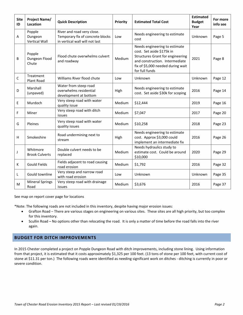
Site ID
Project Name/ Location
Quick Description Priority Estimated Total Cost Estimated Budget Year
For more info see
A Popple Dungeon Vertical Wall
River and road very close. Temporary fix of concrete blocks in vertical wall will not last
Low Needs engineering to estimate cost
Unknown Page 5
B Popple Dungeon Flood Chute
Flood chute overwhelms culvert and roadway
Medium
Needs engineering to estimate cost. Set aside $175k in Structures Grant for engineering and construction. Intermediate fix of $5,000 needed during wait for full funds
2021 Page 8
C Treatment Plant Road
Williams River flood chute Low Unknown Unknown Page 12
D Marshall (unpaved)
Water from steep road overwhelms residential development at bottom
High Needs engineering to estimate cost. Set aside $30k for scoping
2016 Page 14
E Murdoch Very steep road with water quality issue
Medium $12,444 2019 Page 16
F Miner Very steep road with ditch issues
Medium $7,047 2017 Page 20
G Pleines Very steep road with water quality issues
Medium $10,258 2018 Page 23
H Smokeshire Road undermining next to stream
High Needs engineering to estimate cost. Approx $3,000 could implement an intermediate fix
2016 Page 26
J Whitmore Brook Culverts
Double culvert needs to be replaced
Medium Needs hydraulics study to estimate cost. Could be around $10,000
2020 Page 29
K Gould Fields Fields adjacent to road causing road erosion
Medium $1,792 2016 Page 32
L Gould townline Very steep and narrow road with road erosion
Low Unknown Unknown Page 35
M Mineral Springs Road
Very steep road with drainage issues
Medium $3,676 2016 Page 37
See map on report cover page for locations *Note: The following roads are not included in this inventory, despite having major erosion issues:
Grafton Road – There are various stages on engineering on various sites. These sites are all high priority, but too complex for this inventory.
Scullin Road – No options other than relocating the road. It is only a matter of time before the road falls into the river again.
BUDGET FOR DITCH IMPROVEMENTS
In 2015 Chester completed a project on Popple Dungeon Road with ditch improvements, including stone lining. Using information from that project, it is estimated that it costs approximately $1,325 per 100 feet. (13 tons of stone per 100 feet, with current cost of stone at $11.31 per ton.) The following roads were identified as needing significant work on ditches ‐ ditching is currently in poor or severe condition.
Town of Chester Road Erosion Inventory 2015 Report – Last revised 01/19/2016 Page 3
Road Type Mileage Total Estimated Cost for Ditch Improvements
Brooks Road Paved 0.25 $17,490
Davidson Hill Road Paved 0.89 $62,264
Farrar Road Paved 1.01 $70,660
Gould Road Paved 0.75 $52,470
Marshall Road* Paved 0.20 $14,207
Bargfrede Road Unpaved 0.04 $2,798
High Street* Unpaved 0.49 $34,080
Popple Dungeon Road* Unpaved 3.32 $231,957
Total 6.95 $485,926
* Because these sections are not for the entire road, these locations use estimated mileage (using GIS) rather than official VTrans mileage
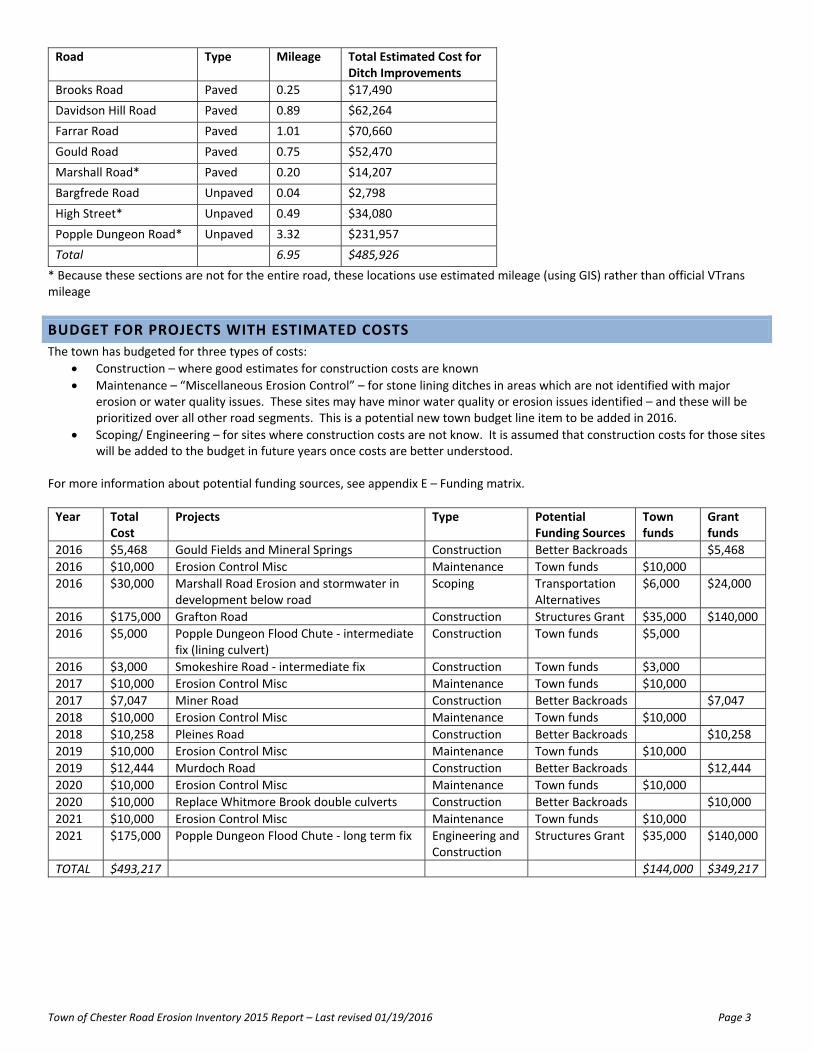
BUDGET FOR PROJECTS WITH ESTIMATED COSTS
The town has budgeted for three types of costs:
Construction – where good estimates for construction costs are known
Maintenance – “Miscellaneous Erosion Control” – for stone lining ditches in areas which are not identified with major erosion or water quality issues. These sites may have minor water quality or erosion issues identified – and these will be prioritized over all other road segments. This is a potential new town budget line item to be added in 2016.
Scoping/ Engineering – for sites where construction costs are not know. It is assumed that construction costs for those sites will be added to the budget in future years once costs are better understood.
For more information about potential funding sources, see appendix E – Funding matrix.
Year Total Cost
Projects Type Potential Funding Sources
Town funds
Grant funds
2016 $5,468 Gould Fields and Mineral Springs Construction Better Backroads $5,468
2016 $10,000 Erosion Control Misc Maintenance Town funds $10,000
2016 $30,000 Marshall Road Erosion and stormwater in development below road
Scoping Transportation Alternatives
$6,000 $24,000
2016 $175,000 Grafton Road Construction Structures Grant $35,000 $140,000
2016 $5,000 Popple Dungeon Flood Chute ‐ intermediate fix (lining culvert)
Construction Town funds $5,000
2016 $3,000 Smokeshire Road ‐ intermediate fix Construction Town funds $3,000
2017 $10,000 Erosion Control Misc Maintenance Town funds $10,000
2017 $7,047 Miner Road Construction Better Backroads $7,047
2018 $10,000 Erosion Control Misc Maintenance Town funds $10,000
2018 $10,258 Pleines Road Construction Better Backroads $10,258
2019 $10,000 Erosion Control Misc Maintenance Town funds $10,000
2019 $12,444 Murdoch Road Construction Better Backroads $12,444
2020 $10,000 Erosion Control Misc Maintenance Town funds $10,000
2020 $10,000 Replace Whitmore Brook double culverts Construction Better Backroads $10,000
2021 $10,000 Erosion Control Misc Maintenance Town funds $10,000
2021 $175,000 Popple Dungeon Flood Chute ‐ long term fix Engineering and Construction
Structures Grant $35,000 $140,000
TOTAL $493,217 $144,000 $349,217
Town of Chester Road Erosion Inventory 2015 Report – Last revised 01/19/2016 Page 4
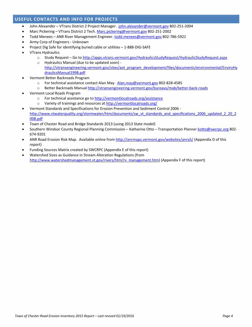
USEFUL CONTACTS AND INFO FOR PROJECTS
John Alexander – VTrans District 2 Project Manager. [email protected] 802‐251‐2004
Marc Pickering – VTrans District 2 Tech. [email protected] 802‐251‐2002
Todd Menees – ANR River Management Engineer. [email protected] 802‐786‐5921
Army Corp of Engineers ‐ Unknown
Project Dig Safe for identifying buried cable or utilities – 1‐888‐DIG‐SAFE
VTrans Hydraulics o Study Request – Go to http://apps.vtrans.vermont.gov/HydraulicsStudyRequest/HydraulicStudyRequest.aspx o Hydraulics Manual (due to be updated soon) ‐
http://vtransengineering.vermont.gov/sites/aot_program_development/files/documents/environmental/EnviroHydraulicsManual1998.pdf
Vermont Better Backroads Program o For technical assistance contact Alan May. [email protected] 802‐828‐4585 o Better Backroads Manual http://vtransengineering.vermont.gov/bureaus/mab/better‐back‐roads
Vermont Local Roads Program o For technical assistance go to http://vermontlocalroads.org/assistance o Variety of trainings and resources at http://vermontlocalroads.org/
Vermont Standards and Specifications for Erosion Prevention and Sediment Control 2006 ‐ http://www.vtwaterquality.org/stormwater/htm/documents/sw_vt_standards_and_specifications_2006_updated_2_20_2008.pdf
Town of Chester Road and Bridge Standards 2013 (using 2013 State model)
Southern Windsor County Regional Planning Commission – Katharine Otto – Transportation Planner [email protected] 802‐674‐9201
ANR Road Erosion Risk Map. Available online from http://anrmaps.vermont.gov/websites/anra5/ (Appendix D of this report)
Funding Sources Matrix created by SWCRPC (Appendix E of this report)
Watershed Sizes as Guidance in Stream Alteration Regulations (from http://www.watershedmanagement.vt.gov/rivers/htm/rv_management.htm) (Appendix F of this report)

Town of Chester Road Erosion Inventory 2015 Report – Last revised 01/19/2016 Page 5
SITE A – POPPLE DUNGEON VERTICAL WALL
Road Name: Popple Dungeon Road TH Number: TH‐10 TH Class: 3 unpaved Priority Rank: Low (Five or more years out) GPS Coordinates: Northern boundary – N 43.22613 W 72.68206 Southern boundary – N 43.22583 W 72.68219 Site Map
Description of problem
Stream right next to the road on a river bend.
Road has issues with flash flooding (most recently 2011 and 2014) and beaver dams (every few years).
Currently has 6ft concrete blocks to keep the bank vertical (160ft long, 14ft high), but that is not good hydrologically and not a permanent fix.
Road washes out regularly and the existing concrete blocks will eventually fail.
Site also needs guard rails, but there currently is not sufficient space. While there are several other similar sites on Popple Dungeon Road, this one is taller and closer to the road than the others. This site also already has a temporary fix that will not last through another big rain event.
Water quality problem? X Yes No
Waterbody affected? X Yes No
Proposed solution Unknown solution because:
Road and river right next to each other with a vertical wall that is not good hydrologically.
Cannot move the road much laterally – not much space in existing ROW, would need to raise the road and move utilities
Further Engineering needed? X Yes No
VTrans Hydraulics Study needed? X Yes No

Town of Chester Road Erosion Inventory 2015 Report – Last revised 01/19/2016 Page 6
Site Photos
Top left: Looking west (upstream) across the site Top right: Looking west (upstream) from the site Bottom Left: Looking east (downstream) across the site

Town of Chester Road Erosion Inventory 2015 Report – Last revised 01/19/2016 Page 7
Top: Looking west up road Bottom: Looking east down road.

Town of Chester Road Erosion Inventory 2015 Report – Last revised 01/19/2016 Page 8
SITE B – POPPLE DUNGEON FLOOD CHUTE
Road Name: Popple Dungeon Road TH Number: TH‐10 TH Class: 3 unpaved Priority Rank: Medium (Within 5 years) GPS Coordinates: Western boundary – N 43.23868 W 72.65886 Eastern boundary – N 43.23912 W 72.65842 Site Map
Description of problem
During major rain events and the resulting fluvial erosion, an approximately 100ft section of road repeatedly washes away as it becomes the flood chute (most recently in 1996, 2011 and 2014).
The river approaches the current large elliptical multi‐plated culvert at an angle.
Each time the river creates the flood chute fill is needed for a section of roadway 120ft long, 20ft high and 60ft in width.
It is currently a squashed 11ft corrugated culvert. It has a rusted out base, so water is now undermining underneath and to the sides of the culvert. It is also perched – which causes a barrier for aquatic organism passage.
Water quality problem? X Yes No
Waterbody affected? X Yes No
Proposed solution A 80‐100ft long bridge or very large box culvert might alleviate the issue. Would probably cost $500,000 ‐ $750,000.
Further Engineering needed? X Yes No
VTrans Hydraulics Study needed? X Yes No

Town of Chester Road Erosion Inventory 2015 Report – Last revised 01/19/2016 Page 9
Site Photos Top: Looking west across the site. Treeline marks edge of flood chute. Bottom: Looking east across the site. Flood chute extends from where to the photographer is standing to the treeline/ just beyond the truck.
Town of Chester Road Erosion Inventory 2015 Report – Last revised 01/19/2016 Page 10
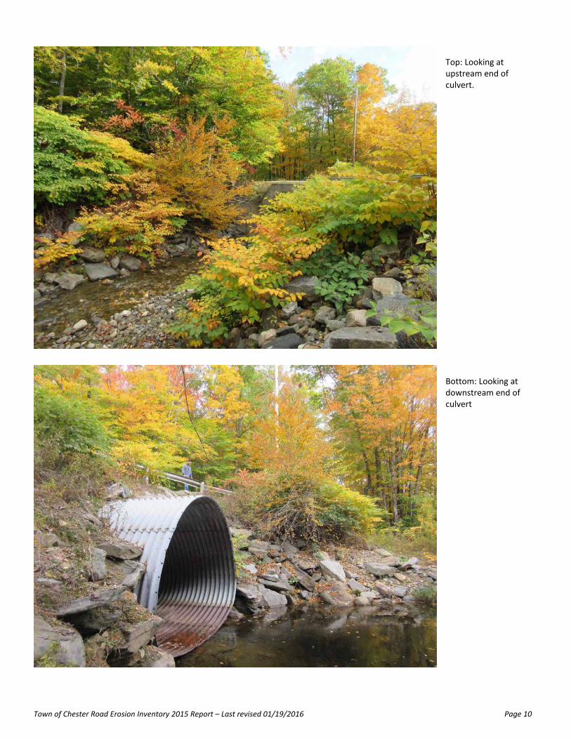
Top: Looking at upstream end of culvert.
Bottom: Looking at downstream end of culvert

Town of Chester Road Erosion Inventory 2015 Report – Last revised 01/19/2016 Page 11
Top: Looking downstream from site

Town of Chester Road Erosion Inventory 2015 Report – Last revised 01/19/2016 Page 12
SITE C – TREATMENT PLANT ROAD
Road Name: Treatment Plant Road TH Number: TH‐123 TH Class: 3 paved Priority Rank: Low (Five or more years out) GPS Coordinates: Northern boundary – N 43.25586 W 72.57761 Southern boundary – N 43.25577 W 72.57784 Site Map
Description of problem
Williams River creates a flood chute in extreme rain events that cuts across the Ball Field and Sewer Plant Road. This happened in both 2011 and 2014.
The river would overwhelm anything you put in – culverts, bridges, etc – so instead the highway department has used a temporary fix. The temporary fix is an unpaved section within the paved road, just filled with crushed gravel after each event to restore the roadway.
This road is important as it serves the town sewer plant.
Water quality problem? X* Yes No
Waterbody affected? X* Yes No
*Water quality and waterbodies affected – but only in major storms where there are far larger issues. Proposed solution No solution proposed
Further Engineering needed? Yes X No
VTrans Hydraulics Study needed? Yes X No
Town of Chester Road Erosion Inventory 2015 Report – Last revised 01/19/2016 Page 13
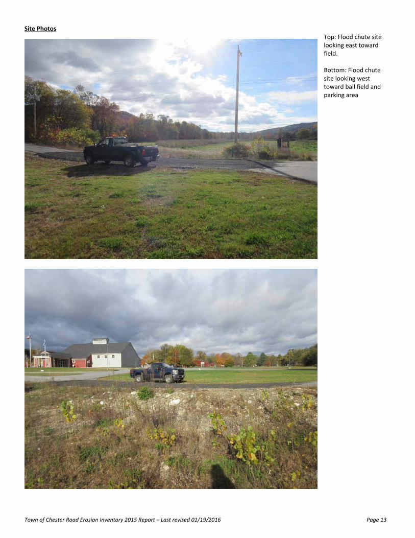
Site Photos Top: Flood chute site looking east toward field. Bottom: Flood chute site looking west toward ball field and parking area

Town of Chester Road Erosion Inventory 2015 Report – Last revised 01/19/2016 Page 14
SITE D – MARSHALL (UNPAVED)
Road Name: Marshall Road TH Number: TH‐100 TH Class: 3 unpaved Priority Rank: High (within next few years) GPS Coordinates: Western boundary – N 43.25443 W 72.58888 Eastern boundary – N 43.25466 W 72.58630 Site Map
Description of problem
Water runs down a steep hill onto the residential development below (Marshall Road and Kevadus Circle).
From about halfway down the hill the unpaved roadway has been graded with a cross‐slope so that:
90% of the water drains into the ditch on the south side which then runs into a chute which flows into a stream. This chute has a good amount of distance and grass between the roadway and the stream to prevent water quality issues.
10% of the water drains into the ditch on the north side which then runs through a short amount of very steep woodland into the residential development below. This development does not have any storm water capacity and the water table is very close to the surface there.
Water quality problem? Yes X No
Waterbody affected? Yes X No
Proposed solution The relatively small 10% of water than ends on the residential development would not be an issue if there was adequate stormwater drainage. Therefore installing storm drains and improving drainage on Kevadus Circle and the paved section of Marshall Road is the proposed solution. Costs are unknown as further engineering is needed.
Further Engineering needed? X Yes No
VTrans Hydraulics Study needed? Yes X No

Town of Chester Road Erosion Inventory 2015 Report – Last revised 01/19/2016 Page 15
Site Photos
Top left: Chute that connects base of unpaved road to the nearby stream. Top right: Ditch on south side of Marshall Road that carries approx. 90% of road runoff Bottom: Looking down unpaved Marshall Road toward paved Marshall Road (just before red truck)

Town of Chester Road Erosion Inventory 2015 Report – Last revised 01/19/2016 Page 16
SITE E – MURDOCH
Road Name: Murdoch Road TH Number: TH‐14 TH Class: 3 unpaved Priority Rank: Medium (within next 5 years) GPS Coordinates: Northern boundary – N 43.34247 W 72.64256 Southern boundary – N 43.34112 W 72.64066 Site Map
Description of problem
Very steep roadway where ditches are easily overwhelmed.
Small berm (half a foot) on the downslope side keeps the road together, but cannot last forever.
Sheets of water go over the road and the side of the road straight into the stream causing a water quality issue
Water quality problem? X Yes No
Waterbody affected? X Yes No
Proposed solution Reinforce the downslope side of the road with riprap. Need to keep the trees in place, but the trees would cause issues for large rock. Repair cost estimate It would be approximately 3 days of work for a 4 man crew.
Labor Rate # Hours Total (Rate x Hours)
3 days of a 4 man crew $42.00 96 $4,032.00
Labor Total $4,032.00
Equipment Rate # Hours Total (Rate x Hours)
1 Small Truck $40.00 24 $960.00
1 Loader $40.00 24 $960.00
1 Excavator $18.00 24 $432.00
1 Grader $60.00 1 $60.00

Town of Chester Road Erosion Inventory 2015 Report – Last revised 01/19/2016 Page 17
Equipment Total $2,412.00
Materials Rate Amount Total (Rate x Amount)
Rip‐rap $6,000.00
Materials Total $6,000.00
Miscellaneous Rate Mileage Total (Rate x Amount)
None $0.00
Miscellaneous Total $0.00
Grand Total $11,484.00
Further Engineering needed? Yes X No
VTrans Hydraulics Study needed? Yes X No

Town of Chester Road Erosion Inventory 2015 Report – Last revised 01/19/2016 Page 18
Site Photos Top: Looking down Murdoch Road Bottom Left: Looking up along the upslope side of the road. Bottom Right: Looking up the downslope side of the road which includes a small berm.

Town of Chester Road Erosion Inventory 2015 Report – Last revised 01/19/2016 Page 19
Steep cross‐slope of roadway. Roadway cuts through the hillside around where the red arrow is

Town of Chester Road Erosion Inventory 2015 Report – Last revised 01/19/2016 Page 20
SITE F ‐ MINER
Road Name: Miner Road TH Number: TH‐11 TH Class: 3 unpaved Priority Rank: Medium (within next 5 years) GPS Coordinates: Western boundary – N 43.33561 W 72.65615 Eastern boundary – N 43.33499 W 72.65197 Site Map
Description of problem
Very steep roadway.
Ditches need improvement.
Area does not have a water quality issue as the water leeches into the woods before it reaches the closest stream.
Water quality problem? Yes X No
Waterbody affected? Yes X No
Proposed solution Install stone lined ditches. Culverts should already be adequately sized Repair cost estimate It would be approximately 2 days of work for a 4 man crew.
Labor Rate # Hours Total (Rate x Hours)
2 days of a 4 man crew $42.00 64 $2,688.00
Labor Total $2,688.00
Equipment Rate Amount Total (Rate x Hours)
3 Big trucks $60.00 48 $2,880.00
1 Excavator $18.00 16 $288.00
1 Grader $60.00 1 $60.00
Equipment Total $3,228.00
Materials Rate Amount Total (Rate x Amount)
7 inch stone $11.31 100 $1,131.00

Town of Chester Road Erosion Inventory 2015 Report – Last revised 01/19/2016 Page 21
Materials Total $1,131.00
Miscellaneous Rate Mileage Total (Rate x Amount)
None $0.00
Miscellaneous Total $0.00
Grand Total $7,047.00
Further Engineering needed? Yes X No
VTrans Hydraulics Study needed? Yes X No

Town of Chester Road Erosion Inventory 2015 Report – Last revised 01/19/2016 Page 22
Site Photos
Top: Looking down Miner Road. Bottom: Looking up Miner Road

Town of Chester Road Erosion Inventory 2015 Report – Last revised 01/19/2016 Page 23
SITE G ‐ PLEINES
Road Name: Pleines Road TH Number: TH‐13 TH Class: 3 unpaved Priority Rank: Medium (within next 5 years) GPS Coordinates: Western boundary – N 43.32885 W 72.65945 Eastern boundary – N 43.32807 W 72.65717 Site Map
Description of problem
Very steep roadway.
Ditches need improvement.
Area has water quality issue because the water flows straight from the road into the adjacent stream.
Water quality problem? X Yes No
Waterbody affected? X Yes No
Proposed solution Stone lined ditches with turnouts. Existing culverts should be okay. Repair cost estimate This needs approximately 3 days of work for a 4 man crew. Note: this site is further out of town as well as longer than Site F – hence more time and materials.
Labor Rate # Hours Total (Rate x Hours)
3 days of a 4 man crew $42.00 96 $4,032.00
Labor Total $4,032.00
Equipment Rate Amount Total (Rate x Hours)
3 Big Trucks $60.00 72 $4,320.00
1 Excavator $18.00 24 $432.00
1 Grader $60.00 1 $60.00
Equipment Total $4,812.00
Materials Rate Amount Total (Rate x Amount)
7 inch stone $11.31 125 $1,413.75

Town of Chester Road Erosion Inventory 2015 Report – Last revised 01/19/2016 Page 24
Materials Total $1,413.75
Miscellaneous Rate Mileage Total (Rate x Amount)
None $0.00
Miscellaneous Total $0.00
Grand Total $10,257.75
Further Engineering needed? Yes X No
VTrans Hydraulics Study needed? Yes X No

Town of Chester Road Erosion Inventory 2015 Report – Last revised 01/19/2016 Page 25
Site Photos Top: Looking down Pleines Road.
Bottom: Stream just beyond edge of roadway.

Town of Chester Road Erosion Inventory 2015 Report – Last revised 01/19/2016 Page 26
SITE H – SMOKESHIRE
Road Name: Smokeshire Road TH Number: TH‐9 TH Class: 3 unpaved Priority Rank: High (within next few years) GPS Coordinates: Western boundary – N 43.34689 W 72.63503 Eastern boundary – N 43.34676 W 72.63469 Site Map
Description of problem
Road edge starting to collapse and undermine right next to the stream. One very small section currently has issues, but problem will occur along far longer section of roadway before too long – only a few trees left holding the bank together.
Steep (vertical) slope of approximately 15‐20ft between road and river.
Road cannot move very far away from the river as ledge is very close to the road edge, and there is another steep road paralleling the road just above it (Suursoo Road) which would have to be relocated if Smokeshire Road was relocated.
Water quality problem? X Yes No
Waterbody affected? X Yes No
Proposed solution Unknown solution. Todd Menees (ANR River Engineer) and Naomi Johnson (engineer) have both done preliminary site visits, but no conclusions for solutions.
Further Engineering needed? X Yes No
VTrans Hydraulics Study needed? Yes X No

Town of Chester Road Erosion Inventory 2015 Report – Last revised 01/19/2016 Page 27
Site Photos
Top: Road edge starting to collapse into river. Bottom left: Looking downstream (east) from existing collapse site. Bottom right: Looking upstream (west) from existing collapse site.

Town of Chester Road Erosion Inventory 2015 Report – Last revised 01/19/2016 Page 28
Top: North side of road, looking east towards Suursoo Road intersection (at crest of road)
Town of Chester Road Erosion Inventory 2015 Report – Last revised 01/19/2016 Page 29
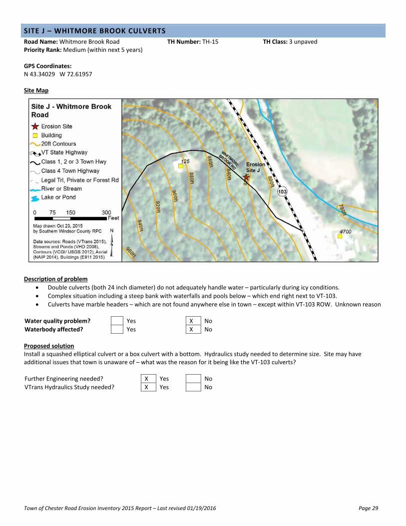
SITE J – WHITMORE BROOK CULVERTS
Road Name: Whitmore Brook Road TH Number: TH‐15 TH Class: 3 unpaved Priority Rank: Medium (within next 5 years) GPS Coordinates: N 43.34029 W 72.61957 Site Map
Description of problem
Double culverts (both 24 inch diameter) do not adequately handle water – particularly during icy conditions.
Complex situation including a steep bank with waterfalls and pools below – which end right next to VT‐103.
Culverts have marble headers – which are not found anywhere else in town – except within VT‐103 ROW. Unknown reason
Water quality problem? Yes X No
Waterbody affected? Yes X No
Proposed solution Install a squashed elliptical culvert or a box culvert with a bottom. Hydraulics study needed to determine size. Site may have additional issues that town is unaware of – what was the reason for it being like the VT‐103 culverts?
Further Engineering needed? X Yes No
VTrans Hydraulics Study needed? X Yes No

Town of Chester Road Erosion Inventory 2015 Report – Last revised 01/19/2016 Page 30
Site Photos Top: Double culvert inlet with marble headers
Bottom: Narrow gully with stream that feeds the double culvert.
Town of Chester Road Erosion Inventory 2015 Report – Last revised 01/19/2016 Page 31
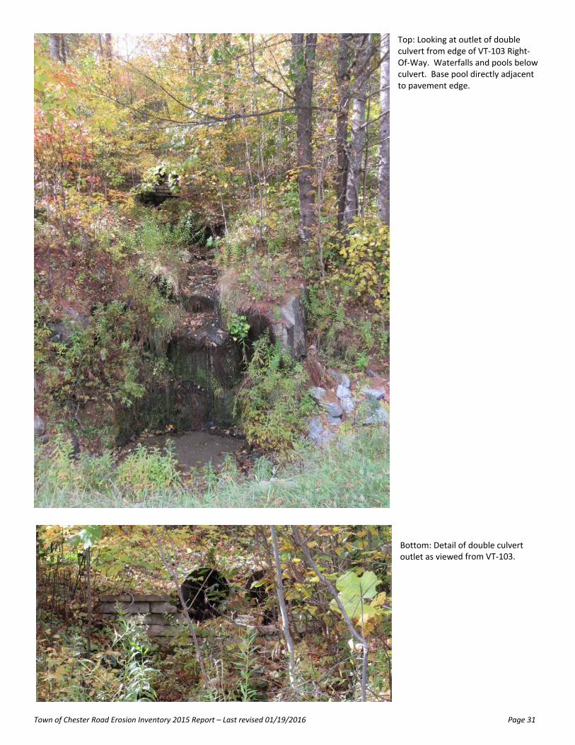
Top: Looking at outlet of double culvert from edge of VT‐103 Right‐Of‐Way. Waterfalls and pools below culvert. Base pool directly adjacent to pavement edge. Bottom: Detail of double culvert outlet as viewed from VT‐103.

Town of Chester Road Erosion Inventory 2015 Report – Last revised 01/19/2016 Page 32
SITE K – GOULD FIELDS
Road Name: Gould Road TH Number: TH‐27 TH Class: 3 unpaved Priority Rank: Medium (within next 5 years) GPS Coordinates: N 43.34076 W 72.55495 Site Map
Description of problem
Water runs off adjacent fields into the roadway, causing erosion.
Water quality problem? Yes X No
Waterbody affected? Yes X No
Proposed solution Create ditch on the field side of the road (south). Ledge is close to the surface in this area so probably don’t have space for a stone lined ditch which the road grade would require. Repair cost estimate This needs approximately 1 day of work for a 3 man crew. Would use grass seed and mulch since don’t have space for stone‐lined.
Labor Rate # Hours Total (Rate x Hours)
1 day for a 3 man crew $42.00 24 $1,008.00
Labor Total $1,008.00
Equipment Rate Amount Total (Rate x Hours)
1 Dump Truck $60.00 8 $480.00
1 Excavator $18.00 8 $144.00
1 Grader $60.00 1 $60.00
Equipment Total $684.00
Materials Rate Amount Total (Rate x Amount)
Grass seed and mulch $100.00
Materials Total $100.00
Miscellaneous Rate Mileage Total (Rate x Amount)
Town of Chester Road Erosion Inventory 2015 Report – Last revised 01/19/2016 Page 33
None $0.00
Miscellaneous Total $0.00
Grand Total $1,792.00
Further Engineering needed? Yes X No
VTrans Hydraulics Study needed? Yes X No

Town of Chester Road Erosion Inventory 2015 Report – Last revised 01/19/2016 Page 34
Site Photos Top: Fields above Gould Road that have lots of runoff into the road. Bottom: Gould Road with fields on the left.

Town of Chester Road Erosion Inventory 2015 Report – Last revised 01/19/2016 Page 35
SITE L – GOULD TOWNLINE
Road Name: Gould Road TH Number: TH‐27 TH Class: 3 unpaved Priority Rank: Low (Five or more years out) GPS Coordinates: Northern boundary – N 43.34570 W 72.55501 Southern boundary – N 43.34445 W 72.55504 Site Map
Description of problem
Very steep road which is very narrow (trees and walls on either side) and has trouble with road erosion.
Water quality problem? Yes X No
Waterbody affected? Yes X No
Proposed solution Remove trees and install ditches. Unlikely to happen since all trees on roadside are maple trees and outside the ROW.
Further Engineering needed? Yes X No
VTrans Hydraulics Study needed? Yes X No

Town of Chester Road Erosion Inventory 2015 Report – Last revised 01/19/2016 Page 36
Site Photos Top: Looking down Gould Road from near the top of the hill (and the townline with Baltimore). Trees close on both sides. Stone wall on right side. Bottom: Looking down Gould Road from near the top of the hill with drainage issues. Open area next to road in the background are the fields of Site K (Gould Fields).
Town of Chester Road Erosion Inventory 2015 Report – Last revised 01/19/2016 Page 37
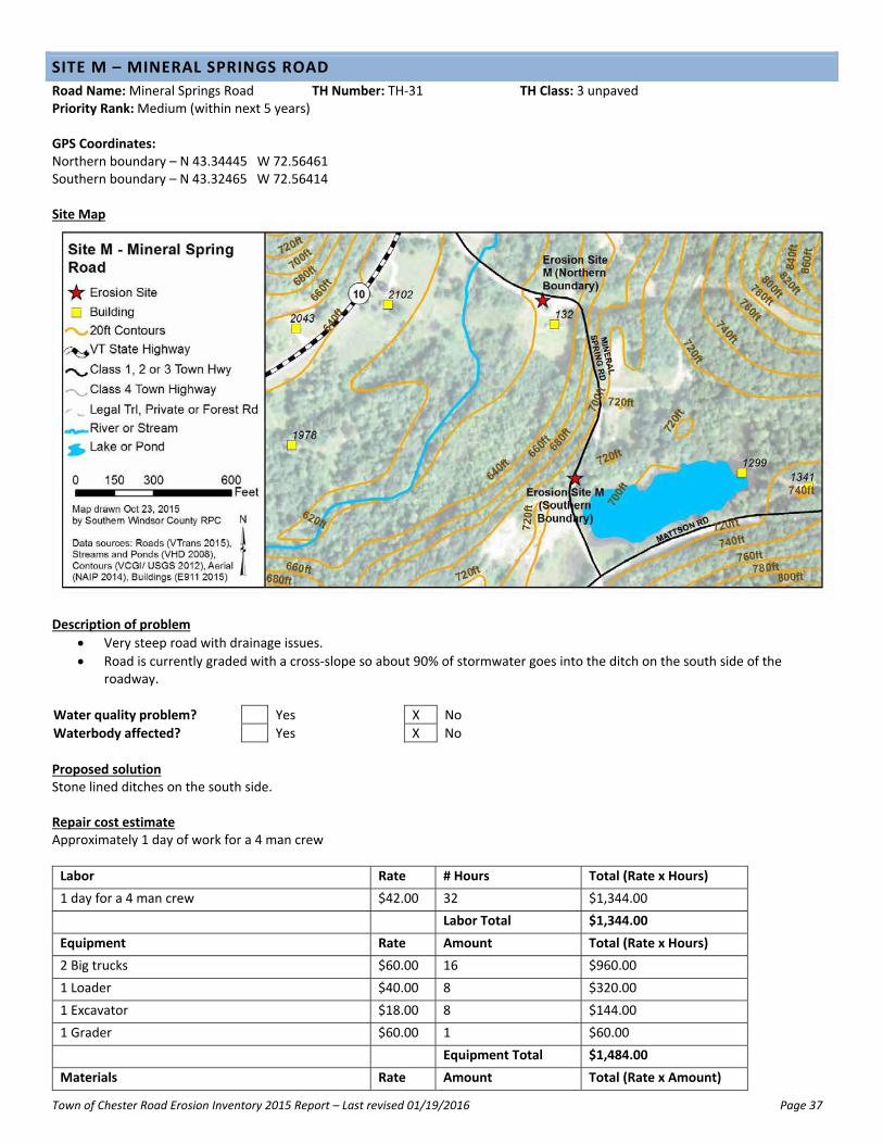
SITE M – MINERAL SPRINGS ROAD
Road Name: Mineral Springs Road TH Number: TH‐31 TH Class: 3 unpaved Priority Rank: Medium (within next 5 years) GPS Coordinates: Northern boundary – N 43.34445 W 72.56461 Southern boundary – N 43.32465 W 72.56414 Site Map
Description of problem
Very steep road with drainage issues.
Road is currently graded with a cross‐slope so about 90% of stormwater goes into the ditch on the south side of the roadway.
Water quality problem? Yes X No
Waterbody affected? Yes X No
Proposed solution Stone lined ditches on the south side. Repair cost estimate Approximately 1 day of work for a 4 man crew
Labor Rate # Hours Total (Rate x Hours)
1 day for a 4 man crew $42.00 32 $1,344.00
Labor Total $1,344.00
Equipment Rate Amount Total (Rate x Hours)
2 Big trucks $60.00 16 $960.00
1 Loader $40.00 8 $320.00
1 Excavator $18.00 8 $144.00
1 Grader $60.00 1 $60.00
Equipment Total $1,484.00
Materials Rate Amount Total (Rate x Amount)

Town of Chester Road Erosion Inventory 2015 Report – Last revised 01/19/2016 Page 38
7 inch stone $11.31 75 $848.25
Materials Total $848.25
Miscellaneous Rate Mileage Total (Rate x Amount)
None $0.00
Miscellaneous Total $0.00
Grand Total $3,676.25
Further Engineering needed? Yes X No
VTrans Hydraulics Study needed? Yes X No

Town of Chester Road Erosion Inventory 2015 Report – Last revised 01/19/2016 Page 39
Site Photos Top: Bottom of big hill on Mineral Springs Road. Hill starts near the corner.
Bottom: Near bottom of big hill on Mineral Springs Road
Town of Chester Road Erosion Inventory 2015 Report – Last revised 01/19/2016 Page 40
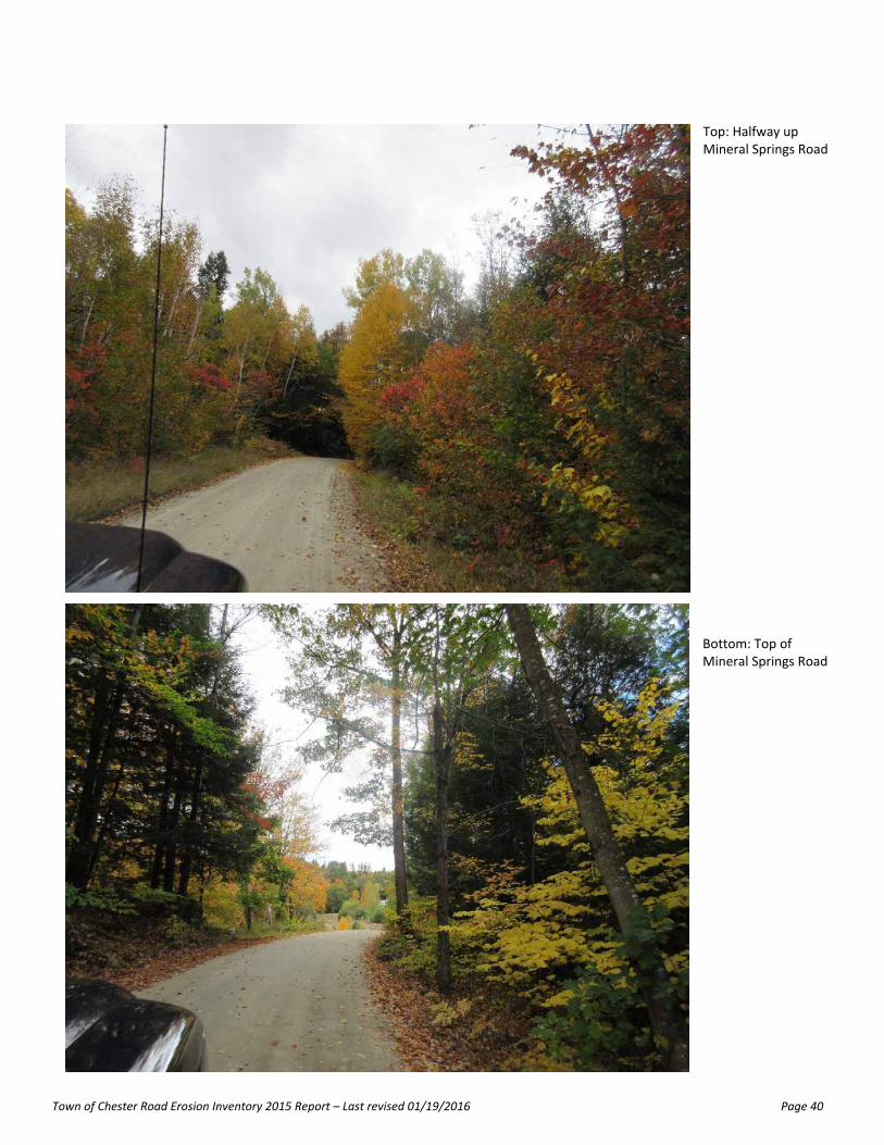
Top: Halfway up Mineral Springs Road Bottom: Top of Mineral Springs Road

Town of Chester Road Erosion Inventory 2015 Report – Last revised 01/19/2016 Page 41
APPENDICES
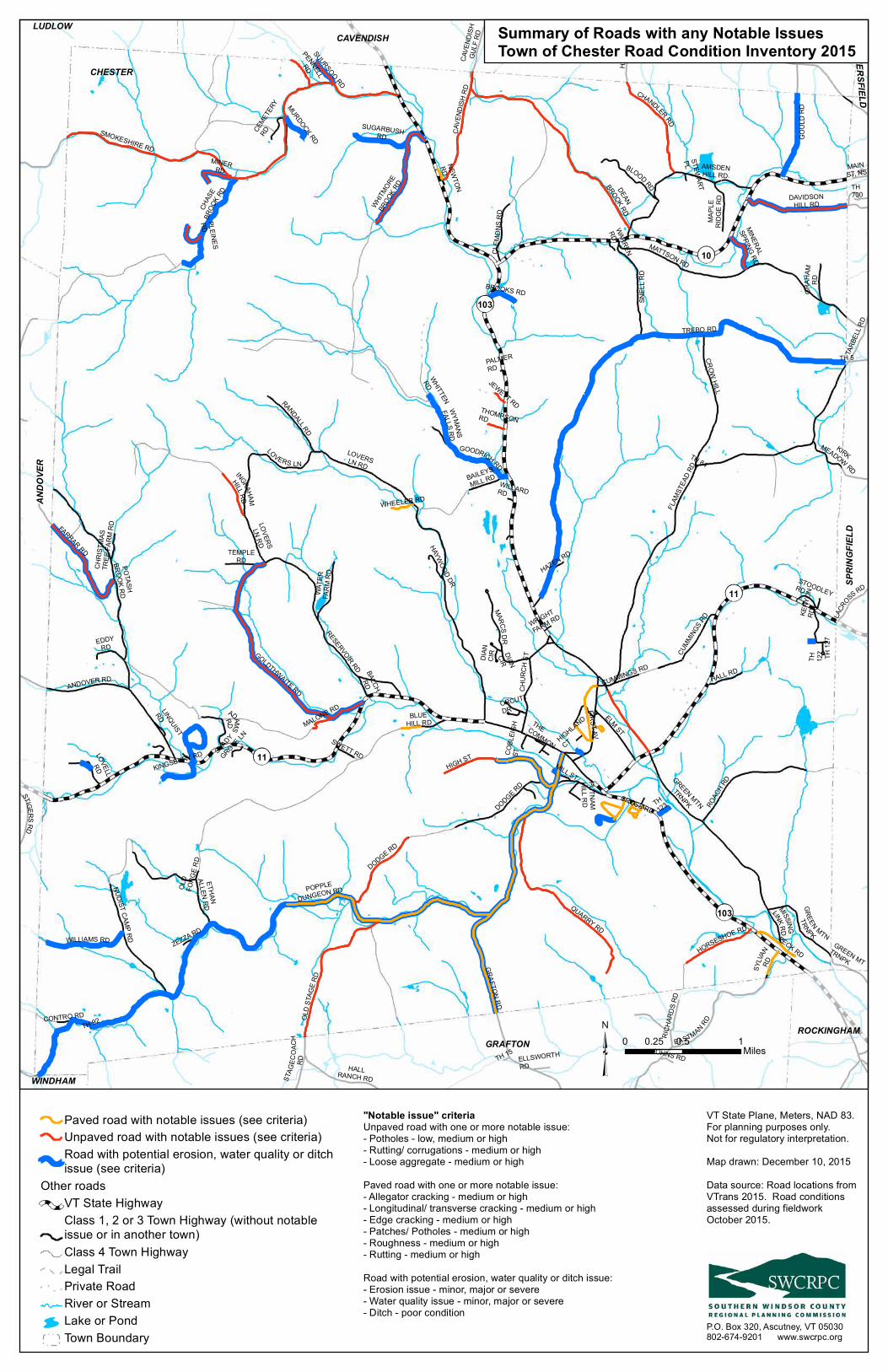
Appendix A 2015 Chester Road Inventory Map – Summary of roads with any notable issues Appendix B 2015 Chester Road Inventory Map – Roads with particular issues (clay, ice jams, etc) Appendix C 2015 Chester Bridge and Culvert Inventory Map Appendix D ANR Road Erosion Risk Map for Chester Appendix E Funding Sources Matrix Appendix F Watershed Sizes as Guidance in Stream Alteration Regulations (from
http://www.watershedmanagement.vt.gov/rivers/htm/rv_management.htm)
11
11
103
10
103
GREEN MTN
TRNPK
FLAM
STEA
D RD
C HUR
CHST
MAINST, NS
GRAFTON RD
TARB
ELL R
D
BALTIMORE RD
ANDOVER RD
MISSINGLINKRD
PENNELLRD
DAVIDSONHILL RD
KENY
ONRD
GOLDTHWAITE RD
TH 84
TH 5PALMERRD
LOVERSLN RD
ELM ST
CROWHILL
STOODLEYRD
TH 92
DODGE RD
NEWTONRD
GOODRICH RD
WHITTEN
RD
SUGARBUSHRD
DIANCIR
AMSDENHILL RD
FARRAR RD
MURDOCK RD
TH700
TH 15
WRIGHT
FARM RD
STEWARTPL
TH 127
WILLARDRD
CROSS RD
CEMET
ERY
RD
HIGHLAND
CT
OLD
FORG
E RD
TH 12
7
DIAN
CIR
OLD S
TAGE
RD
LOVELLRD
WARREN
RD
ORCUTTDR
THECOMMON
CHAS
EBR
OOK RD
HAZEN RD
HIGH ST
PUTNAMHILL RD
ZEZZA RD
MATTSON RD
MILL ST
ETHANALLEN
RD
TH123
JOHNS RD
JEWETT RD
CONTRO RD
COBL
EIGH
ST
CAVE
NDISH
RD
ADAMSRD
ELLSWORTHRD
PECK RD
SHADYGROVE LN
GOUL
DRD
THOMPSONRD
LINQUIST
RD
STAG
ECO A
CHRD
SWETT RD
DODGE RD
HARR
ISRD
FIRST AV
WHEELER RD
BALCHRD
MALONE RD
SMOKESHIRE RD
WHITMORE
BROOK R
D
STIGERSRD
CHRI
STMA
STR
EE FA
RM RD
BEMISRD
CUMMINGS RD
LOVERSLN RD
RESERVOIR RD
GREEN MTTRNPK
SUURSOO RD
POTASHBROOKRD
SYLVA
NRD
BROOKS RD
ROAC
H RD
KIRKMEADOW RD
HAYWOOD DR
PLEINESRD
TEMPLERD
RICH
ARDS
RD
GREEN MTN
TRNPK
EDDYRD
HORSESHOE RD
BAILEYSMILL RD
HALL RD
GRAH
AMRD
MINERRD
MINERAL
SPRING RD
TREBO RD
LACR
OSS RD
KINGSBURY RD
INGRAHAM
HILL RD
BLUEHILL RD
WYMANSFALLSRD
NUDIST CAMP RD
MAPL
ERI
DGE R
D
CAVE
NDISH
GULF
RD
CUMMING
S RD
MARCSD R
CLEM
ONS R
D
WATE
RFA
RM RD
RANDALLRD
BLOOD RD
HALLRANCH RD
WILLIAMS RD
DEAN
BROOK RD
SNEL
L RD
CHANDLER RD
POPPLEDUNGEON RD
EASTMAN RD
LOVERS LN
QUARRY RD
LUDLOWAN
DOVE
R
SPRI
NGFIE
LD
GRAFTON
WINDHAM
CHESTER
CAVENDISHBALTIMORE
WEATHERSFIELD
ROCKINGHAM
Paved road with notable issues (see criteria)Unpaved road with notable issues (see criteria)Road with potential erosion, water quality or ditchissue (see criteria)
Other roadsVT State HighwayClass 1, 2 or 3 Town Highway (without notableissue or in another town)Class 4 Town HighwayLegal TrailPrivate RoadRiver or StreamLake or PondTown Boundary
VT State Plane, Meters, NAD 83.For planning purposes only. Not for regulatory interpretation.Map drawn: December 10, 2015Data source: Road locations fromVTrans 2015. Road conditionsassessed during fieldworkOctober 2015.
P.O. Box 320, Ascutney, VT 05030802-674-9201 www.swcrpc.org
0 0.5 10.25Miles
Summary of Roads with any Notable IssuesTown of Chester Road Condition Inventory 2015
"Notable issue" criteriaUnpaved road with one or more notable issue:- Potholes - low, medium or high- Rutting/ corrugations - medium or high- Loose aggregate - medium or highPaved road with one or more notable issue:- Allegator cracking - medium or high- Longitudinal/ transverse cracking - medium or high- Edge cracking - medium or high- Patches/ Potholes - medium or high- Roughness - medium or high- Rutting - medium or highRoad with potential erosion, water quality or ditch issue:- Erosion issue - minor, major or severe- Water quality issue - minor, major or severe- Ditch - poor condition

11
11
103
103
10 VT State HighwayClass 1, 2 or 3 TownHighway (paved surface orin another town)Class 4 Town HighwayLegal TrailPrivate Road
River or StreamLake or PondTown Boundary
VT State Plane, Meters, NAD 83.For planning purposes only. Not for regulatory interpretation.Map drawn: December 10, 2015Data source: Road inventory bySWCRPC and Town October 2015.Road centerline - VTrans 2015
P.O. Box 320, Ascutney, VT 05030802-674-9201 www.swcrpc.org
0 1 20.5 Miles
Roads with Particular Issues (Clay, Ice Jams, etc)Town of Chester Road Condition Inventory 2015
11
11
103
103
10
11
11
103
103
10
11
11
103
103
10
11
11
103
103
10
Steep (red)/ Flat (green)
Water Quality or Erosion Issue Ice Jam Issue
Beaver IssueClay Base

11
11
103
103
10
LUDLOWAN
DOVE
R
SPRI
NGFIE
LD
GRAFTON
WINDHAM
CAVENDISHBALTIMORE
WEATHERSFIELD
ROCKINGHAM
6
1
3
1
13
1
2
2
4
3
354
3
1
1
16
3
1
4039
2
37
5
36
4
12
2
6
23
B9
B6 B7
B2
B11
B5B12
B73
B70
B66
B67
B57
B47
B58
B52 B24
B54
B46
B43B50
B56
B75B44
B34
B62
B51
B25B36B48
B38
B60B64
B45
B42
B65
B79
B55
B78
B76
B77
B41
B68
B61
B28
B72
B59
B53
B49
B35
B3B69
B13
B63
B74
B32
B29B14B39
B40
B11
B12
B10
BridgeCulvert in good or excellent conditionCulvert in fair conditionCulvert in critical, poor or unknown conditionVT State HighwayClass 1, 2 or 3 Town Highway (without notableissue or in another town)Class 4 Town HighwayLegal TrailPrivate RoadRiver or StreamLake or PondTown Boundary
VT State Plane, Meters, NAD 83.For planning purposes only. Not for regulatory interpretation.Map drawn: December 14, 2015Data source: Road locations fromVTrans 2015. Culvert and bridgedata updated Fall 2015 and is available from www.vtculverts.org
P.O. Box 320, Ascutney, VT 05030802-674-9201 www.swcrpc.org
0 0.5 10.25Miles
Bridge and Culvert Inventory Update 2015Town of Chester

11
11
103
103
10
LUDLOWAN
DOVE
R
SPRI
NGFIE
LD
GRAFTON
WINDHAM
CHESTER
CAVENDISHBALTIMORE
WEATHERSFIELD
ROCKINGHAM
Road Erosion Risk (ANR)(Unpaved roads only)
High riskModerate riskLow riskNo data or no risk
Other roadsVT State HighwayClass 1, 2 or 3 TownHighway (paved surface orin another town)Class 4 Town HighwayLegal TrailPrivate Road
River or StreamLake or PondTown Boundary
VT State Plane, Meters, NAD 83.For planning purposes only. Not for regulatory interpretation.DRAFT Map drawn: October 21, 2015Data source: Road locations fromVTrans 2014. Road erosion riskcalculated by ANR in 2014.
P.O. Box 320, Ascutney, VT 05030802-674-9201 www.swcrpc.org
0 0.5 10.25 Miles
Town of ChesterRoad Erosion Risk as calculated by ANR 2014
Road erosion risk was calculated for the VT Agencyof Natural Resources in 2014. Risk was calculatedfor unpaved roads and some long driveways. Pavedroads are not included in the assessment. Longdriveway assessment is not shown on this map.Locations were identified based on a variety of site factors including but not limited to slope, water features, and soils. Site factors were linked to constraint values and totaled to determine priority ranking from low to high. For more information about the methodology seehttp://anrmaps.vermont.gov/websites/vgisdata/layers_anr/metadata/TransRoad_EROSIONRISK.txt

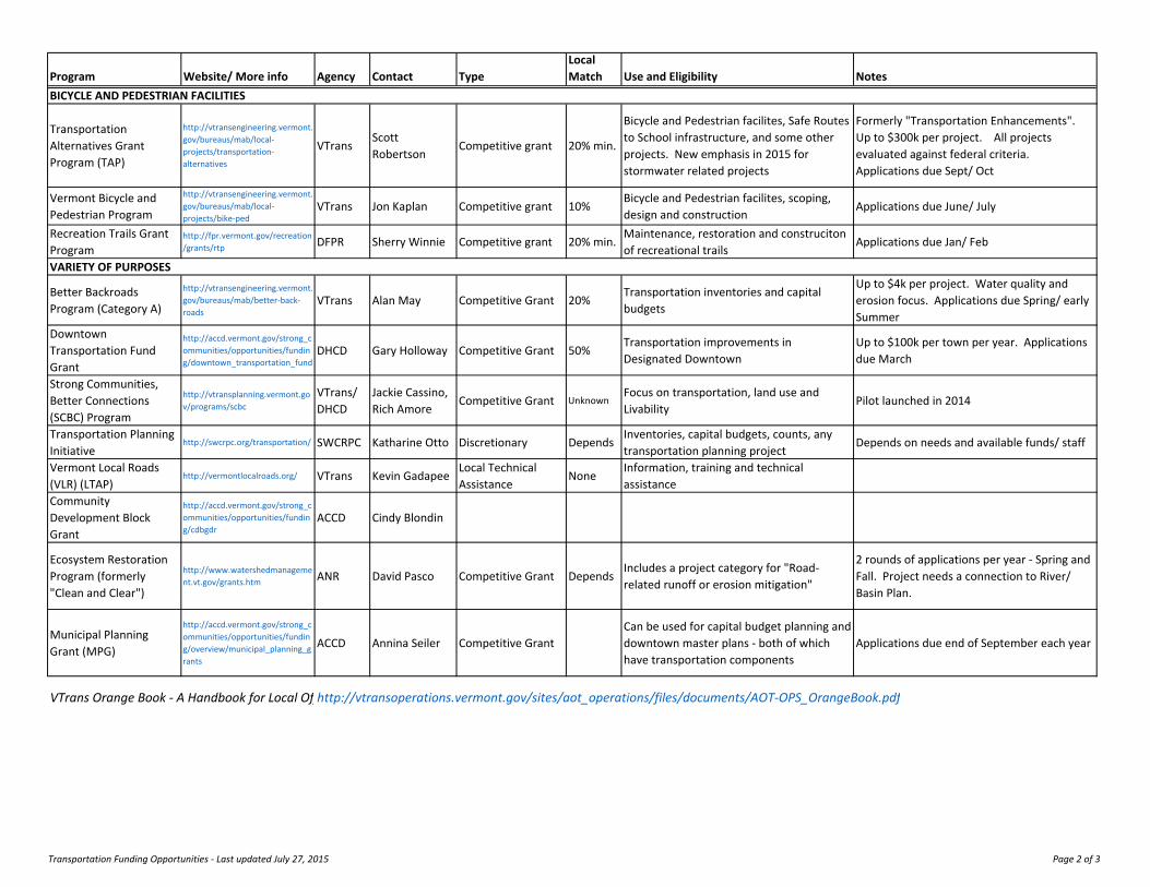
Quick Guide to Funding Sources for Transportation ProjectsSouthern Windsor County, Vermont
Last Updated July 2015
Program Website/ More info Agency Contact TypeLocal Match Use and Eligibility Notes
HIGHWAY, BRIDGES OR CULVERTS
Town Highway Grants Orange Book VTrans DTAAnnual allocation (mileage based)
NoneTH & bridge maintenance for Class 1, 2 & 3 TH
TH Class 2 Roadway Program
Orange Book VTrans DTA Grant from DTA30% or less
Resurfacing and reconstruction for Class 2 TH
Up to $150k per project
TH Bridge Program Orange Book VTransMike Hedges, Katharine Otto
Managed by VTrans10% or less
Major rehabilitation or reconstruction of any structure over 6ft on Class 1, 2 & 3 TH
Pre‐Candidate regional ranking in Jan/Feb each year. Project choice is initiated by VTrans
TH Structures Program Orange Book VTrans DTA Grant from DTA20% or less
Bridge maintenace, preservation or repair of any structure over 6ft on Class 1, 2 & 3 TH
Up to $175k per project
Adaptive Use Bridge Program
http://historicbridges.vermont.gov/program‐documents VTrans Sue Scribner Unknown 20%
Rehabilitation of historic metal trus bridge for adaptive re‐use (Bike‐ped)
Better Backroads Program (Category B)
http://vtransengineering.vermont.gov/bureaus/mab/better‐back‐roads
VTrans Alan May Competitive Grant 20%Correction of road and culvert related erosion problems
Up to $10k per project. Water quality and erosion focus. Applications due Spring/ early summer
Hazard Mitigation Grant Program (HMGP)
http://vem.vermont.gov/mitigation FEMA Ray Doherty Competitive Grant 25%
Any project that prevents future loss due to natural disaster
Deadlines happen at a variety of times depending on the "round" of funding.
Flood Mitigation Assistance program (FMA)
www.fema.gov/flood‐mitigation‐assistance‐program FEMA Ray Doherty Competitive Grant Depends
Reduce or eliminate risk of flood damaged to buildings under National Flood Insurance Program (NFIP)
Pre Disaster Mitigation Program
www.fema.gov/pre‐disaster‐mitigation‐grant‐program FEMA Ray Doherty Competitive Grant Depends Reduce risk to people and structures
Emergency Watershed Protection Program
http://www.nrcs.usda.gov/wps/portal/nrcs/main/vt/programs/planning/ewpp/
NRCS Jennifer Varin Unknown25% or more
Undertake emergency measures to safeguard lives and property from flood and erosion after a watershed is suddenly changed by natural disaster
State Infrastructure Brank
http://www.veda.org/financing‐options/other‐financing‐option/state‐infrastructure‐bank‐program/
VTrans & VEDA
Karen Songhurst
Loan N/AAny transpotration project that is eligible for federal funds
Can apply for funds at any time
PARK AND RIDE LOTS
Muncipal Park and Ride Program
http://vtransengineering.vermont.gov/bureaus/mab/local‐projects/parkandride
VTrans Wayne Davis Competitive grant NoneSmall municipally owned and maintained P&R facilities near state highway
Applications due July/ August
Transportation Funding Opportunities ‐ Last updated July 27, 2015 Page 1 of 3
Program Website/ More info Agency Contact TypeLocal Match Use and Eligibility Notes
BICYCLE AND PEDESTRIAN FACILITIES
Transportation Alternatives Grant Program (TAP)
http://vtransengineering.vermont.gov/bureaus/mab/local‐projects/transportation‐alternatives
VTransScott Robertson
Competitive grant 20% min.
Bicycle and Pedestrian facilites, Safe Routes to School infrastructure, and some other projects. New emphasis in 2015 for stormwater related projects
Formerly "Transportation Enhancements". Up to $300k per project. All projects evaluated against federal criteria. Applications due Sept/ Oct
Vermont Bicycle and Pedestrian Program
http://vtransengineering.vermont.gov/bureaus/mab/local‐projects/bike‐ped
VTrans Jon Kaplan Competitive grant 10%Bicycle and Pedestrian facilites, scoping, design and construction
Applications due June/ July
Recreation Trails Grant Program
http://fpr.vermont.gov/recreation/grants/rtp DFPR Sherry Winnie Competitive grant 20% min.
Maintenance, restoration and construciton of recreational trails
Applications due Jan/ Feb
VARIETY OF PURPOSES
Better Backroads Program (Category A)
http://vtransengineering.vermont.gov/bureaus/mab/better‐back‐roads
VTrans Alan May Competitive Grant 20%Transportation inventories and capital budgets
Up to $4k per project. Water quality and erosion focus. Applications due Spring/ early Summer
Downtown Transportation Fund Grant
http://accd.vermont.gov/strong_communities/opportunities/funding/downtown_transportation_fund
DHCD Gary Holloway Competitive Grant 50%Transportation improvements in Designated Downtown
Up to $100k per town per year. Applications due March
Strong Communities, Better Connections (SCBC) Program
http://vtransplanning.vermont.gov/programs/scbc
VTrans/ DHCD
Jackie Cassino, Rich Amore
Competitive Grant UnknownFocus on transportation, land use and Livability
Pilot launched in 2014
Transportation Planning Initiative
http://swcrpc.org/transportation/ SWCRPC Katharine Otto Discretionary DependsInventories, capital budgets, counts, any transportation planning project
Depends on needs and available funds/ staff
Vermont Local Roads (VLR) (LTAP)
http://vermontlocalroads.org/ VTrans Kevin GadapeeLocal Technical Assistance
NoneInformation, training and technical assistance
Community Development Block Grant
http://accd.vermont.gov/strong_communities/opportunities/funding/cdbgdr
ACCD Cindy Blondin
Ecosystem Restoration Program (formerly "Clean and Clear")
http://www.watershedmanagement.vt.gov/grants.htm ANR David Pasco Competitive Grant Depends
Includes a project category for "Road‐related runoff or erosion mitigation"
2 rounds of applications per year ‐ Spring and Fall. Project needs a connection to River/ Basin Plan.
Municipal Planning Grant (MPG)
http://accd.vermont.gov/strong_communities/opportunities/funding/overview/municipal_planning_grants
ACCD Annina Seiler Competitive GrantCan be used for capital budget planning and downtown master plans ‐ both of which have transportation components
Applications due end of September each year
VTrans Orange Book ‐ A Handbook for Local Offhttp://vtransoperations.vermont.gov/sites/aot_operations/files/documents/AOT‐OPS_OrangeBook.pdf
Transportation Funding Opportunities ‐ Last updated July 27, 2015 Page 2 of 3

Abbreviations Contact InfoFEMA Federal Emergency Management Agency Name EmailDEMHS Dept of Emergency Management and Homeland Security Wayne Davis (VTrans MAB) [email protected] VT Economic Development Authority Ray Doherty (DEMHS) [email protected] VT Dept of Forests, Parks and Recreation Alan May (VTrans MAB) [email protected] VT Dept of Housing and Community Development Mike Hedges (VTrans Structures) [email protected] VTrans District Transportation Administrator Sue Scribner (VTrans MAB) [email protected] Environmental Protection Agency Katharine Otto (SWCRPC) [email protected] Hazard Mitigation Grant Program Jon Kaplan (VTrans) [email protected] Highway Kevin Gadapee (VTrans VLR) [email protected] Local Technical Assistance Program Sherrie Winnie (DFPR) [email protected] VTrans Municipal Assistance Bureau Scott Robertson (VTrans MAB) [email protected] US Dept of Agriculture Natural Resources Conservation Service Tammy Ellis (VTrans District 2 & 4) [email protected] Strong Communtiies, Better Connections Program Robert Faley [email protected] Southern Windsor County Regional Planning Commission Karen Songhurst [email protected] Transportation Alternatives Program Gary Holloway [email protected] Town Highway Jennifer Varin (NRCS Windsor County) 802‐775‐8969 x 14VLR Vermont Local Roads David Pasco (ANR) [email protected] Vermont Agency of Transportation Cindy Blondin (ACCD) [email protected] Vermont Agency of Natural Resources Annina Seiler [email protected]
District Transportation Administrator (DTA)
District 2 ‐ Tammy EllisAndover, Baltimore, Cavendish, Chester, Springfield, Weathersfield
District 3 ‐ Robert Faley LudlowDistrict 4 ‐ Tammy Ellis Reading, West Windsor, Windsor
Transportation Funding Opportunities ‐ Last updated July 27, 2015 Page 3 of 3

Æ·103
Æ·11
Æ·10
Æ·103
Æ·11
TREBO RD
FLA
MS
TEA
D R
D
SM OKESH IRE R D
LOVER S LN
POPPLE DUNGEON RD
EASTMAN RD
DODGE RD
MATTSON R D
GREEN M
TN TRNPK
GR
AF
TO
N R
D
HIGH ST
TH 24
ROAC H RD
OTIS RD
DEA
N B
RO
OK R
D
WYM
ANS FALLS
RD
QU AR RY R D
BALT IM ORE R D
CHEST ER R D
RESERVOIR R D
TH 15
ANDO
VER RD
AND ER SON RD
HA
RR
IS R
D
MAIN ST
HALL R AN CH RD
CR
OW
HIL
L
POTASH BR
OOK RD
CLEMONS RD
FARRAR RD
CUMM INGS RD
CHANDLER RD
GOLDTHW AITE RD
GO
UL
D R
D
OL
D S
TA
GE
RD
ST
AG
EC
OA
CH
RD
ELM S
T
HA
KE
Y R
D
SN
EL
L R
D
SW ETT R D
DE
PO
T S
T
WILLIAM S R D
CHUR CH ST
ETH AN ALLEN RD
NUDIST CAMP RD
MARCS DR
BLOOD RD
GOODRICH RD
CA
VE
ND
ISH
GU
LF
RD
DAVIDSON HILL RD
NORTH ST
RIVER ST
CA
VE
ND
ISH
RD
BAILEYS M ILL R D
HORSESHOE R D
PECK RD
RANDALL RD
CAM
BR
IDG
EPO
RT R
D
AM SD EN H ILL R D
EA
ST
HIL
L R
D
HALL R D
FIR
ST
AV
S MAIN ST
BAILEY HILL TRL
LOVELL R D
SUGARBUSH RD
BLUE HILL RD
BO
BS
LE
D T
RL
EDD Y RD
ADAM S RD
OL
D F
OR
GE
RD
TEM PLE R D
WA
TE
R F
AR
M R
D
SUURSOO
RD
OL
D P
IPE
R R
D
DE
NS
MO
RE
RD
BEMIS RD
COAC
H RD
WA
TK
INS
RD
INGR
AHAM
HILL RD
RIC
HA
RD
S R
D
BROOKS R D
MINER RD
GR
AH
AM
RD
MA
RS
HALL R
D
MA
PL
E R
IDG
E R
D
WH
ITT
EN
RD
PEN
NE
LL RD
SY
LVA
N R
D
KINGSBU RY R D
BUR GESS C EM ET ER Y RD
MISS
ING
LINK
RD
BALC
H R
D
LAC
RO
SS R
D
WHEELER RD
MURD OC K RD
MEAD OW RD
TH 13
TH 2
JOH NS R D
MALONE RD
ZEZZ A RD
CONTRO RD
HAZ EN R D
THOMPSON R D
PLEIN ES RD
JEWETT RD
PUT NAM RD
FEN TON RD
MT
VIE
W
BEAVER BRO
OK R
D
COOK HILL RD
WOLF R D
TH 92
DIA
N C
IR
SCHO
OL ST
KE
NY
ON
RD
BRE
EZY
LN
SCU LLIN ST
TH 5
BALT IMO
RE RD
Chester Reservoir
Williams River
Hall B
rook
Great Brook
South Branch Williams River
Middle Branch Williams River
Trebo Brook
Chase Brook
Whitmore Brook
Potash Brook
Andover Branch
Chandler Meadow Brook
Beaver Meadow Brook
Bear Brook
CHESTER
GRAFTON
CAVENDISH BALTIMORELUDLOW
72°33'0"W72°33'30"W72°34'0"W72°34'30"W72°35'0"W72°35'30"W72°36'0"W72°36'30"W72°37'0"W72°37'30"W72°38'0"W72°38'30"W72°39'0"W72°39'30"W72°40'0"W72°40'30"W72°41'0"W
43°2
2'0
"N43
°21
'30"
N43
°21
'0"N
43°2
0'3
0"N
43°2
0'0
"N43
°19
'30"
N43
°19
'0"N
43°1
8'3
0"N
43°1
8'0
"N43
°17
'30"
N43
°17
'0"N
43°1
6'3
0"N
43°1
6'0
"N43
°15
'30"
N43
°15
'0"N
43°1
4'3
0"N
43°1
4'0
"N43
°13
'30"
N43
°13
'0"N
43°1
2'3
0"N
CHESTERWatershed Sizes Used as Guidance in Stream Alteration Regulations
0 0.4 0.8 1.2 1.60.2Miles
Map Created by, Erik Engstrom. ANR GIS. April 1st, 2011.$Roads
Principal Arterial
Minor Arterial
Urban
Rural
Local
Drainage Area>10 Square Miles
1 - 10 Square Miles
.5 - 1 Square Mile
<.5 Square Mile
Lake/Pond
VT Town Boundaries
VT County Boundary
LEGENDThis map product indicates the reaches of stream and river in a
given town that would be at or below the 0.5, 1.0, and 10.0 square mile watershed thresholds used for jurisdictional determinations under the
Vermont ANR Stream Alteration Regulatory Program.
Map Description
RMP contacts and information about the Stream Alteration GP may be obtained at: http://www.anr.state.vt.us/dec/waterq/rivers/htm/rv_management.htm
Map DisclaimerThis map represents guidance on watershed sizes using data and methods that have a certain amountof error associated with them. The accuracy of watershed sizing maps using the Vermont HydrographyData Set and produced with computer automated methods may be exceeded by other methods usingmore accurate data. The regulated public may request River Management Program (RMP) approval, orthe RMP may decide, to use watershed sizes based on more accurate methods and data.
Related Documents


![Chester Borough ERI Draft BAI update 10-16-09 · 2016. 4. 15. · Highlands Environmental Resource Inventory for the [insert municipality name]Borough of Chester 2009 Highlands Council](https://static.cupdf.com/doc/110x72/60260d6214219a5187280d1c/chester-borough-eri-draft-bai-update-10-16-09-2016-4-15-highlands-environmental.jpg)