Ashby Open Space & Recreation Plan Dec. 2009 (edited Aug. 2010, June 2012, July 2013) Town of Ashby Massachusetts Open Space & Recreation Plan (for review by Division of Conservation Services) January 2010 – January 2017

Welcome message from author
This document is posted to help you gain knowledge. Please leave a comment to let me know what you think about it! Share it to your friends and learn new things together.
Transcript

Ashby Open Space & Recreation Plan Dec. 2009 (edited Aug. 2010, June 2012, July 2013)
Town of AshbyMassachusetts
Open Space & Recreation Plan
(for review by Division of Conservation Services)
January 2010 – January 2017

Ashby Open Space & Recreation Plan Dec. 2009 (edited Aug. 2010, June 2012, July 2013)

Ashby Open Space & Recreation Plan Dec. 2009 (edited Aug. 2010, June 2012, July 2013)
Town of AshbyMassachusetts
Open Space & Recreation Plan
January 2010 – January 2017
TABLE OF CONTENTS
SECTION 1 – PLAN SUMMARY
Plan Summary ………………………………………………………………………………………….. 1
SECTION 2 - INTRODUCTION
Statement of Purpose ………………………………………………………………………………….. 2
Planning Process and Public Participation ………………………………………………………….. 3
SECTION 3 – COMMUNITY SETTING
Context ………………………………………………………………………………………………..... 4
Regional Context Map ……………………………………………………………………………….. 7
History of Ashby ……………………………………………………………………………………… 9
Population Characteristics …………………………………………………………………………… 10
Environmental Justice Map …………………………………………………………………………. 15
Economic Overview ………………………………………………………………………………….. 17
Growth and Development Patterns ………………………………………………………………… 18
Future ………………………………………………………………………………………………….. 20
Zoning Map …………………………………………………………………………………………… 23
Current Land Use Map ……………………………………………………………………………… 25

Ashby Open Space & Recreation Plan Dec. 2009 (edited Aug. 2010, June 2012, July 2013)
SECTION 4 – ENVIRONMENTAL INVENTORY AND ANALYSIS
Geology, Soils and Topography ……………………………………………………………………. 27
Soils and Geologic Features Map ………………………………………………………………….. 29
Landscape Character …………………………………………………………………………………. 31
Landscape Character & Unique Features Map …………………………………………………… 35
Water Resources ………………………………………………………………………………………. 37
Water Resources Map ………………………………………………………………………………… 39
Vegetation ……………………………………………………………………………………………… 41
Fisheries and Wildlife ……………………………………………………………………………….... 43
Vegetation, Fish & Wildlife Map …………………………………………………………………… 47
Scenic Resources and Unique Environments ……………………………………………………… 49
Environmental Challenges ………………………………………………………………………….. 50
SECTION 5 - INVENTORY OF LANDS
Introduction ………………………………………………………………………………………….. 54
Protected Parcels …………………………………………………………………………………….. 55
Municipal Conservation & Recreation Parcels …………………………………………………… 56
Public Parcels ………………………………………………………………………………………….. 58
Private Parcels – Chapter 61 ………………………………………………………………………….. 59
Non-profit/Charitable Parcels ………………………………………………………………………... 60
Private Parcels - Unprotected …………………………………………………………………………... 60
Inventory of Recreation Interests …………………………………………………………………….. 61
General Organized Activities and Organizations ………………………………………………….. 62
Inventory of Lands Map ……………………………………………………………………………… 65
Ashby Open Space & Recreation Plan Dec. 2009 (edited Aug. 2010, June 2012, July 2013)
SECTION 6 – COMMUNITY GOALS
Description of Process ………………………………………………………………………………… 67
Statement of Open Space and Recreation Goals …………………………………………………… 67
SECTION 7 – ANALYSIS OF NEEDS
Relation to Statewide Comprehensive Outdoor Recreation Plan ..……………………………… 69
Summary of Resource Protection Needs …………………………………………………………… 70
Summary of Community's Needs …………………………………………………………………… 71
Summary of Management Needs ……………………………………………………………………. 72
SECTION 8 – GOALS AND OBJECTIVES
Objective 1: Unite the Western Spine & Connection Ashburnham & the Midstate Trail ……….. 73
Objective 2: Preserve Contiguous Farms and Forests………………………………………………… 73
Objective 3: Protect Critical Natural Water Systems and Habitats…………………………………. 74
Objective 4: Protect the Priority Heritage Landscapes……………………………………………….. 74
Objective 5: Maintain and Enhance Active & Passive Recreation Opportunities………………….. 75
Objective 6: Educate Citizens on the Financial, Ecological, and Personal Value of Open Space 75
Objective 7: Promote Renewable Energy Resources…………………………………………………. 75
SECTION 9 – SEVEN-YEAR ACTION PLAN
Objective 1: Unite the Western Spine & Connection Ashburnham & the Midstate Trail ………. 76
Objective 2: Preserve Contiguous Farms and Forests………………………………………………… 77
Objective 3: Protect Critical Natural Water Systems and Habitats…………………………………. 79

Ashby Open Space & Recreation Plan Dec. 2009 (edited Aug. 2010, June 2012, July 2013)
Objective 4: Protect the Priority Heritage Landscapes………………………………………………. 81
Objective 5: Maintain and Enhance Active & Passive Recreation Opportunities…………………. 82
Objective 6: Educate Citizens on the Financial, Ecological, and Personal Value of Open Space… 84
Objective 7: Promote Renewable Energy Resources…………………………………………………… 85
Seven Year Action Plan Map …………………………………………………………………………… 87
SECTION 10 – PUBLIC COMMENTS
Public Comments………………………………..……………………………………………………….. 89
SECTION 11 - REFERENCES
References …………………………………………………………………………………………………. 90
Appendix
Mammals …………………………………………………………………………………………………. 91
Birds ……………………………………………………………………………………………………….. 93
Open Space and Recreation Survey Results ……………………………………………………………. 101
Transition Plan for ADA Compliance …………………………………………………………………. 104

1
SECTION 1 – PLAN SUMMARY
Overview
Ashby is located in the far northwest corner of Middlesex County, 49 miles west ofBoston and 32 miles north of Worcester. Once an outpost of Lunenburg, Ashby wasincorporated on March 5, 1767. The town is characterized by rugged, hilly terraininterspersed with gently rolling open fields, woodlands, stream corridors, andwetlands. Most of the town is in the Nashua River watershed with a small portion ofthe northwest corner in the Souhegan River watershed. The town was originallyagrarian, but in the mid-19th century began to harness its fast flowing streams for waterpowered manufacturing. Although agriculture has declined over the years as it hasthroughout New England, the residents of Ashby still look to their agricultural roots aspart of the definition of the town.
This Open Space and Recreation Plan seeks to lay out a comprehensive description ofthe town as it stands today, still securely attached to its rural past and wanting toprotect itself from drowning in sprawl and suburbanization. The Open Space andRecreation Committee hopes this plan, developed with input from town boards andresidents, will serve as a guide to the direction and pace of development as Ashbycontinues into the 21st century.
Sections 3 & 4 of the Open Space and Recreation Plan provide background informationon the physical, biotic, and cultural aspects of the Town of Ashby. Section 3 describesthe community in its regional and historical context; demographics, population,population density, and historic and modern development patterns. Section 4 providesan environmental analysis of the characteristics of the town, including its geology,topography, landscape character and scenic resources, water resources, vegetation, fishand wildlife.
Section 5 of the Open Space and Recreation Plan includes a very detailed inventory oflands of conservation and recreation interest. The inventory documents lands underpublic control (including the approximately 720 acres preserved over the last 10 years),lands whether private or public protected in perpetuity (including the approximately1055.5 acres preserved over the last 10 years), lands under non-profit organizationownership, and lands under special taxation programs (Chapter 61 and the like).
Section 6 of the Open Space and Recreation Plan summarizes the broad goals of thePlan as they have been defined based on community input and the committee'sresearch. The overall open space vision for Ashby is to improve and enhance theTown’s open space system in order to preserve rural character, protect naturalresources, and expand recreational opportunities.

2
Preserve rural character – Ashby is fortunate to have large tracts of as yetundeveloped fields and forests. Along with the historic Town center and otherheritage landscapes, these large fields and forests give Ashby the quaint, ruralfeeling and scenic views desired by its citizens.
Protect natural resources – Ashby has tremendous natural resources includinghills, mountains, rivers, water bodies, wetlands, wildlife corridors, and wind.These resources are important to the community and the region.
Expand recreational opportunities – As desired by its citizens, Ashby has greatpotential to expand, locally and regionally, its passive recreational system whilemaintaining safe active recreational opportunities.
Sections 7 through 9 of the Open Space and Recreation Plan describe in detail theresource protection, community and management needs, the specific objectives in orderto achieve the broad goals, and a five year action plan. These sections form the specificsthat will serve as the active portion of the Plan over the next five years and as areference for communication on open space and recreation between town officials,board members, and citizens.
We would like to note that this plan was done in the way things are done in Ashby - bya group of mostly volunteers who decided that putting the open space and recreationneeds of the community into a Plan was important to them and to their town. We areproud of our effort and its result, and offer it to our community in hopes that it willserve us all well.
SECTION 2 - INTRODUCTION
Statement of Purpose
This document is to serve as a guide to the future direction, conservation, andexpansion of the Open Space and Recreational assets of Ashby. The Plan, an update tothe first plan created in 1999, provides a set of tangible goals and objectives as well asan action plan for the next five years.
Ashby citizens set great store by the qualities of small town living. We value openspaces, privacy, stargazing in the center of town, the moose walking down South Road,informality, socializing at the Post Office, quirky town politics, clean air and water,band concerts on the Common, the July 3rd bonfire, and the terrible tennis courts.Ashby wishes to protect our rural character, our natural resources, and expand ourrecreational opportunities.

3
Since the first formal Open Space and Recreation Plan in 1999, Ashby has beenextremely active in the preservation of land, enacting bylaws and policies that preserverural character & protect farmers and forests, and educating and encouraging citizens tobe involved in the open space efforts. In the past ten years, suburban sprawl hascontinued to impact Ashby and despite the current housing market, we expect thedevelopment pressure to continue. Therefore, we set forth a new Open Space andRecreation Plan that address the needs of the community in order to preserve the senseof place we value.
Planning Process and Public Participation
Ashby’s town officials and landowners have been made great strides in the actions laid
out by the 1999 Plan and wanted to update the Plan to establish new goals andobjectives and hear if the community wished to change direction with the open spaceand recreational planning efforts. In the fall of 2007, the Planning Board met withmembers of the Conservation Commission, Board of Health, and Ashby Land Trust toform a working group committed to producing an update to the Open Space andRecreation Plan. The original members of the Open Space and Recreation workingcommittee were Andrew Leonard, Alan Pease, Roberta Flashman, and CathyKristofferson. Interested citizens include Alan Ewald, Chuck Pernaa, Sue Chapman,Cedwyn Morgan, Al Futterman, Jeanie Lindquist, Michel McCallum, Wayne Stacy,Lillian Whitney, and Paula Packard.
Over the next 18 months, this core group began work on updating the database of theTown, researching, communicating with interested citizens, and planning. The processconsisted of mostly volunteer efforts, planning charrettes, and a significantimprovement to the database of information for planning purposes.
We held our first public meeting on June 15, 2009 to reach as many townspeople as wecould and garner input on the planning effort. We presented a draft update to theSelectmen in a televised meeting on October 28, 2009. We also posted a draft Plan onthe Town Website for two months starting in late October and held a second publichearing on December 3, 2009 to hear additional comments form the community.
A final draft was prepared and submitted to the Selectmen, municipal boards, and theregional planning agency for review. The Committee intends to submit a final plan toAshby’s Annual Town Meeting and to the Division of Conservation Services forapproval.

4
SECTION 3 – COMMUNITY SETTING
Context
Ashby is located in the extreme northwestern part of Middlesex County, 49 miles westof Boston and 32 miles north of Worcester. Ashby covers 23.66 square miles of landalong the border between Massachusetts and New Hampshire. Our immediateneighbors in Massachusetts are the towns of Townsend, Ashburnham, Lunenburg, andthe city of Fitchburg. Ashby is bounded on the north by the towns of New Ipswich andMason, New Hampshire.
The topography is hilly with rock outcroppings on some of the steeper slopes andrelatively little flat land. The soils are primarily glacial tills with pockets of sand &gravel and small amounts of floodplain alluvium. Mount Watatic rises to a height of1600 feet along the western border of town; its summit of 1832 feet is in Ashburnham.Most of the land in the town is flourishing with second growth forest of mixeddeciduous and coniferous species. A number of hay fields and miles of stone wallsprovide a pastoral landscape reminiscent of our agricultural past.
Most of Ashby is in the Nashua River watershed. A small portion of the northwestcorner is in the Souhegan River watershed. A number of brooks and streams originatein Ashby. There are two bodies of water classified as Great Ponds: Upper Wright’sPond and Lower Wright’s Ponds. A third large body of water, Little Watatic Pond, isshared with Ashburnham. Ashby contains a number of wetland and vernal pools,including the important habitat, Great Meadow along Trap Fall Brook.
Townspeople in Ashby rely on private wells for their water needs. The forests on ourundeveloped land maintain our clean water. The Nashua River Watershed Associationproduced a guide in December 1995 called the 2020 Vision for the Nashua RiverWatershed. The authors describe it this way. "Runoff and infiltration from forested landproduce the best quality water. A watershed whose open spaces become less than itsdeveloped lands can no longer supply itself with drinking water."
We also provide water for two neighboring towns, Fitchburg and Townsend. Fitchburgcontrols two reservoirs on the southern side of Ashby, one of which provides potablewater to the city. Townsend’s municipal water wells in West Townsend are supplied inpart by the aquifer under eastern Ashby. To date, no research has been done to locateother potential aquifers within the borders of Ashby.
Two state highways carrying commuter and commercial traffic traverse the town.Route 31 runs north-south providing access to Route 2, 30 minutes to the south. Route119 runs east-west giving access to Route 495, 40 minutes to the east. The heaviestgrowth in Ashby occurs near the intersection of these two routes in the southeast part of

5
town and just off Route 31 in the northeast part of Ashby. There is no publictransportation. Rail service to metro-Boston is accessible in Fitchburg about ten milesaway. Ashby is a member of the Montachusett Regional Transit Authority (MRTA).
Ashby saw a large increase in population in the late 1940’s and 1950’s as the automobileprovided access to employment outside of town. Most new residents at that time wereemployed in the mills of Fitchburg or the plastic industry of Leominster. In the 1970s,industry declined in the region and the population growth began to slow. The town isnow primarily a residential community with a very small commercial base ofapproximately 150 home based businesses. A series of family farms still operate butserve as mostly secondary income to the farmers. At this time, Ashby has one of thelowest population densities in Massachusetts at 140 residents per square mile.

6

7
Regional Context Map
(Map 1)
Replace Page

8
Regional Context Map
(Map 1) Back
Replace Page

9
History of Ashby
Prior to European contact, Ashby was an upland hunting and gathering area for NativeAmericans. It is believed that there were no permanent native settlements in the town.However, at least one location, Indian Caves, is believed to have been a seasonalhunting camp. Indian Caves is a natural rock shelter overlooking the surroundingforest in the area of Caton Hill and Jones Hill. Pre-contact occupation of the site isindicated by soot deposits on the roof of the shelter and by an occasional arrowheadfound in the area. Fort Hill and Rattlesnake Hill have also produced native artifacts butno shelters are known. Native Americans inhabited this area until they were pushedout in the late-eighteenth century.
Originally part of Lunenburg, Ashby was incorporated on March 5, 1767. In 1768, forty-three families were listed on the town’s roster. The first place of worship was started in1769 and was ready to occupy in 1774. Moneys were set aside for four district schoolsin the 1780’s. Ashby’s first town moderator, John Fitch, occupied one of three garrisonsin town. He and his family were captured by Indians, taken on foot to Canada, andlater ransomed by friends.
Ashby was originally agrarian like most New England towns. By the mid-eighteenthcentury the town began to harness its fast flowing streams for water-poweredmanufacturing. There were twenty-three water powered mill sites here in Ashby. Thefirst gristmill was built in 1750. Other manufacturing included sawmills, a woodturning mill, wool carding, and several food-processing mills. In 1831, the Lawrencebrothers and Martin Allen made the first wooden tubs and pails in Massachusettswhich were turned on a lathe driven by a water wheel. In the early 20th century,waterpower brought electricity to parts of town. Three noted clock makers, AbrahamEdwards and the Willard brothers, Alexander and Philander, worked in Ashby. Theymade the large-standing, eight-day clocks. Jonas Prescott Whitney, a former carpenter,became very adept at fashioning church organs. He made every part from the bellowsto the keys with power from a windmill mounted on the roof of his house. A uniquecottage industry was the braided palm-leaf hats made by women in Ashby.Approximately 60,000 of these hats were made in 1837 and sold south of the Mason-Dixon Line. Milk and butter were first retailed in Fitchburg and later in Boston. Appleswere a cash crop. Fruit not fit for market was turned into cider.
But by the turn of the twentieth century, most of the mills were gone. Ashbydiscouraged industrialization by voting against having a railroad in town. Althoughagriculture has declined over the years, Ashby maintained two large dairy farms until

10
the federal dairy herd buy-out of the last decade ended full-time farming in the town.The residents of Ashby see farming as part of the definition of the town.Suburbanization is encroaching on this definition.
An historic district was voted by Town Meeting in 1997. The district, centered aroundAshby’s Town Common, includes the Wyman Tavern built in 1780 (now reconstructedas offices and the Town post office), the First Parish Church, built on the site of the firstmeeting house, the Grange Hall, the Congregational Church, the Ashby Free PublicLibrary, Engine House #1 (currently home to the Ashby Historical Society), AshbyMarket, the First Parish Cemetery, and several private residences. Much of the turn-of-the-century look remains today in the Ashby Historic District.
Another area of historical significance is South Village. The ruins of the water-poweredmills are still to be found along the banks of Willard Brook. South Village has nohistoric protection at this time but is somewhat isolated and in a zoning district thatdoes not allow commercial use. South Village may be an area for a future extension ofthe Ashby Historic District.
Population Characteristics
Population Trends
Ashby’s population was 2311 in 1980, 2717 in 1990, 2964 in 1998, and 3275 in 2008. Thepopulation grew at a rate of 8% between 1970 and 1980, 11% from 1980 to 1990, 8% from1990 to 1999, and 11% from 2000 to 2009. Projections by Massachusetts Institute forSocial and Economic Research (MISER) indicate a growth rate of 11% through 2020. TheMontachusett Regional Planning Commission noted that between 1995 and 2009 Ashbywas the seventh fastest growing town in the fifteen towns covered in the Montachusettarea. MRPC also projected the Ashby population to 3350 by 2020.
Ashby’s population is 98% white with small number of persons identifying themselvesas of other races or mixed-race.

11
The last 20 years have seen a reduction in the number of young families and childrenper household. This reflects national figures showing a reduced birth rate. In 1990, 26%of Ashby’s population was under 15 years of age while 41% was between the ages of 20and 44. By 2000, 23% of the population was under age 15 and 35% was between theages of 20 and 44. During the same period the number of people age 45-55 increasedfrom 9% to 17% of the population. Although we do not have more recent census data,we expect the population composition to be more similar to 2000.
Ashby Population Chart
0
500
1,000
1,500
2,000
2,500
3,000
3,500
1900 1910 1920 1930 1940 1950 1960 1970 1980 1990 1998 2008 2009
Series1

12
Population Density
From 1970 to 1980 housing units grew at a rate of 22%, between 1980 and 1990 housingunits grew at a rate of 20%, and from 1998 to 2008 housing units grew at a rate of 11%.Between 1998 and 2008, the growth rate was comprised of two distinct periods. From2000 – 2006, Ashby had continued on the approximately 20% growth rate per decade.From 2007 – current, like most of the state and country, the new housing unit markethas virtually disappeared.
While the trend of housing growth is 20% growth per decade, the population densitygrowth trend has been between 8% and 11% per decade. Until 2007, a major cause ofthis disparity between housing growth and population growth appears to be thereduction in the number of persons per household. In 1970, Ashby averaged 3.5persons per household. In 1990 the average was 2.8 persons per household. However,the average per household is rising to 2.9 persons.
This information indicates that population density is not parallel to the impact ofdevelopment on open space particularly in a town with large lot zoning and fewmultifamily dwellings. The information also shows that persons per household and thequantity of new housing units closely follow the economic cycle. Thus, Ashby should
Ashby % Growth in Population
-10.00%
0.00%
10.00%
20.00%
30.00%
40.00%
50.00%
1900 1910 1920 1930 1940 1950 1960 1970 1980 1990 1998 2008 2009
Series1

13
expect development and population density pressures to increase during the nexteconomic upturn.
The 1987 Future Growth Study Committee’s report noted that there were about 7,600acres of developable land in the town. Current assessor’s data indicates this number islower at 7,000 acres. This amounts to just under one half the land in the Town. If allthis acreage were completely developed under current zoning regulations, anadditional 4,500 dwellings would be constructed. This would be more than four timesthe number of houses that exist today. Such a build-out would result in population of15,400 if the number of persons per household remains the same. Increased commercialdevelopment can be expected to accompany such a build-out but will continue to belimited by highway access – making the majority of the development residential.Ashby would become a suburban bedroom community. The majority of respondents tothe Future Growth Committee survey considered below 4,000 (a density of 169 personsper square mile) to be the "ideal" population for Ashby.
Ashby Population Density
0
20
40
60
80
100
120
140
160
1900 1910 1920 1930 1940 1950 1960 1970 1980 1990 1998 2008 2009
Po
pu
lati
on
per
Sq
uare
Mile
Series1

14

15
Environmental Justice Map
(Map 2)
Replace Page

16
Environmental Justice Map
(Map 2) Back
Replace Page

17
Economic Overview
Employment Trends
There are about 150 businesses in Ashby. All the businesses are small and most arebased in homes. Approximately 50 of them have one or more employees. With theclosing of the only large manufacturing facility in town in 1998, the town became thelargest employer. The town of Ashby employs about 27 persons; the largest privateemployer has six employees. The top categories of employment are government, trade,and service. The 2008 Department of Employment Training (DET) figures show that,out of a total labor force of 1,581, only 188 people are employed within the town itself.Most people travel to jobs out of town. The 2000 census showed that all commuting isdone via automobile. Ashby is one of the few communities in the state that has noresident using public transportation.
Economic development has lagged behind population growth. DET data shows noincrease in workforce size or number of employed individuals between 2000 and 2008.This reflects the lack of public transportation, limited availability of commercial sites, asoft jobs market, and the increasing age of the population of Ashby. The lack ofhighway access, a public water supply, or wastewater treatment adds to thedisincentive for businesses to locate in Ashby. Fitchburg, Leominster, and Gardner willprobably continue to be the main commercial centers while businesses in Ashby cater tolocal or niche markets.
A major component of the business community is the home based business thatconstitutes 69% of the businesses in the town. At this time there are no known plans toimprove the transportation system in the area. One area of commercial activity thatcould be increased without additional building development is tourism. For this to besuccessful some forms of passive public recreation would have to be promoted. To dateneither the town nor the business community has chosen to do so.
An area of economic activity that could impact Ashby is telecommunications. Theprospect is that "telecommuting" will become a reality in Ashby. If this is the case, therewill be no transportation barrier to residential and commercial development. Althoughno hard numbers are available, this trend bears watching as both business and residentsmake increasing use of advances in communications technology.
18
Family Income
Ashby has traditionally been considered the poorest of the towns in this area.According to the City Data in 2007, Ashby has a median household income of $ 74,920versus the state average of $ 62,365. However, according to the City Data in 2007,Ashby has a median home value of $ 266,393 versus the state average of $ 366,400. Thereduction in persons per household, the aging of the population, and the relatively highincome for the area indicate a hard working community with comparatively lowproperty value, long commutes to work, and a desire to live in a rural community.
Increasing emphasis is being placed on recreation and open space with group sports forchildren and individual recreation among adults on the increase. Anecdotalinformation indicates that there are more walkers, joggers and bicyclists on the roads.Equestrian trail riding, hiking, cross-country skiing and snowmobiling are the morepopular off-road activities.
Growth and Development Patterns
Patterns and Trends
The patterns and trends of growth and development in Ashby follow two distinct lines:the village center with outlying farms (resource based) and the suburban zoning model.From its incorporation until the 1960’s, Ashby followed a resource based form ofdevelopment. The growth and development occurred where the appropriate natural orcultural resource was available, i.e. mills along rivers, town center near the church,market and main roads, farm on best agricultural soils, etc. The result of this model isstill visible today with the historic town center, village-like clusters of higher densityhousing, and outlying larger parcels around the villages. The cultural significance ofthe feel created by this form of growth can not be underestimated.
The second type of growth and development in Ashby is the suburban zoning model.In the 1960’s, Ashby adopted the zoning in place today and as shown on the zoningmap. The zoning created an arbitrary, non-resource based definition of a parcel basedalong the two main vehicular routes. The impact of the zoning model has been a simpleprocess for subdivision (ANR) and a “chopped-up” suburban appearance of newhouses.
Ashby is trending toward a desire to preserve and restore the historic model ofdevelopment and growth while trying to maintain personal property values andmitigate the impacts of the ANR, suburban zoning model.
19
Infrastructure
Ashby has limited public infrastructure beyond the roads. All water and sewer systemsare private per property systems. All utilities are provided by private companies.Ashby has no public transportation opportunities.
The road infrastructure is based off three levels of traffic: the main route (Route 119 andRoute 31), the collector roads (i.e. New Ipswich Road, West Road, and South Road), andcountry road (all other tertiary roads). The main routes as maintained by theCommonwealth are in good shape and provide important access for Ashby’s dailycommuters. The collector roads are in varying levels of condition from good topassable and will require proper paving and drainage work within the next five years.The tertiary, country roads are generally in poor condition with poor drainage. Ashbydoes not have enough funds to pave more than 1 mile of road per year - anunsustainable policy.
With its off the beaten path location and residential level infrastructure, Ashby isunlikely to provide commercial or industrial opportunities beyond the home-basedbusiness, small retail / service, or small office level.
Long Term Development Patterns
All of Ashby, with the exception of one small industrial zone, is zoned for residentialuse. Most of the town is zoned for two-acre lots. However, two smallresidential/commercial zones, one in the town center and one on Route 31 leading toFitchburg, allow one-acre lots. The only provision for multi-family housing is to allowone accessory apartment per dwelling. Since accessory apartments have been approvedthere has been an average of two permits per year granted for them. Single family, two-acre lot development is the way the town has developed. Until the current zoning orstate ANR legislation are altered, it will continue that way.
Most development in Ashby has taken place along existing roads through the ApprovalNot Required (ANR) process because this is the least expensive and quickest approachfor developers. Since 1988, when the first subdivision was approved, there have beenfive subdivisions developed. Only one is larger than ten units. Whether throughsubdivision control or ANR, developers are limited by frontage, not acreage. Thisusually means that dwellings are spaced 200 feet apart along the road. Eventually,houses will use up frontage until Ashby has a suburban look. The existing zoning by-laws give both the town and developers little choice in the matter. Ashby has passed anOpen Space Residential Development bylaw to provide an avenue for developers tocreate subdivisions with open space and proper land use in mind. Also, Ashby has
20
incorporated a 20 acre minimum reduced frontage lot bylaw to reduce the impact ofANR and conventional subdivisions. However, with the ANR process being far lessexpensive, the Planning Board has seen no subdivision control plans in the past sevenyears. A further review of zoning bylaws would give the residents an opportunity toimpact the suburbanization of Ashby.
Until now Ashby’s active, more visible agricultural lands have avoided development.Development has taken place on farms that have ceased operation raising concerns forthe future of farms across the Town. Ashby’s primary crop is hay. The hay fields add tothe scenic beauty as well as to the bio-diversity of the town. Hay does not require largeamounts of fertilizer or pesticides and does not have the adverse impact on theenvironment that more intensive farming does. The increasing resources of some of theresidents have brought more horse back riding to the town. Horses plus Department ofEnvironmental Protection (DEP) requirements for silt barriers at construction sites havecreated a ready market for the hay crop.
Farmers indicate that hay would not support a farm if the land had to be purchased attoday’s prices. The decline in farming in the area indicates that this is in fact the case.Developers are the only other parties in the market for large pieces of land. Developerswill look to farms more and more as a source of buildable land as existing road frontagebecomes increasingly scarce. With some forethought, like the Open Space ResidentialDevelopment bylaw, and support for farming, Ashby might be able to allow somedevelopment on land owned by farmers while encouraging continued agricultural useof the prime farmland.
With 50% of the land area available for residential use, residential development willhave the largest impact on the town and available open space for the foreseeable future.If, as has been seen in the past, the economy recovers, Ashby will see a reneweddevelopment pattern in the suburban sprawl model. If allowed to continue under thecurrent ANR zoning, the model will have a negative impact on agricultural lands, openspace, and the rural character of the community. If we assume an average lot size ofthree acres and a return to an average housing market, then the town can expect to loseabout 500 acres of open space over the next ten years.
Future
There appears to be a 15-year shrinking window of opportunity for Ashby to addressopen space needs. A two-part approach in the coming years must be taken to preservethe quality of life and the rural character of the town for the next generation.
21
First, Ashby must commit itself to encouraging local economic uses of open space. Forthe foreseeable future, most available open space will remain in private hands.Encouraging and supporting activities such as farming, forestry, and open spacerecreation will reduce the amount of land released for development while providingincome or tax relief for landowners. This approach requires a long-term commitmentand does not produce quantifiable results. However, it can produce the strongestcooperation between the community and the private landowners.
Second, Ashby must strengthen its public and private commitment to preserving openspace through purchase, donation, conservation easements, agricultural protectionrestrictions, and deed restrictions. Commitments like these have the advantage ofinsuring open space protection in perpetuity. Results are measurable as seen with themore than 1100 acres preserved or protected over the past ten years. The financialburden can be shared by having town agencies work with state organizations and landtrusts. Joint efforts have the benefit of allowing large projects to be considered as wellas increasing coordination and cooperation between various groups.
Encouraging and preserving local economic use while pursuing the public or privateconservation of land will produce the greatest results. In the process, residents willbecome more aware of and educated about open space issues. A combined approach isthe most likely to succeed as the basis for an open space plan that can work well into thefuture.

22
Blank Page

23
Zoning Map
(Map 3)
Replace Page

24
Zoning Map
(Map 3) Back
Replace Page

25
Current Land Use Map
(Map C)
Replace Page

26
Current Land Use Map
(Map C) Back
Replace Page

27
SECTION 4 – ENVIRONMENTAL INVENTORY & ANALYSIS
Geology, Soils and Topography
Ashby is characterized by rugged, hilly terrain interspersed with gently rolling openfields, woodlands, stream corridors, and wetlands. The topography and resultinglandscape of the town is controlled by the underlying bedrock and surficial(unconsolidated) geologic units.
Bedrock geology
The bedrock in Ashby is comprised of members of three major geologic units, themetamorphic Littleton and Paxton Formations, and the Fitchburg Plutonic (igneous)Complex. The metamorphic bedrock types are gray-weathering feldspathic and sulfidicschists. The sulfidic schist is responsible for the "rotten egg" sulfur smell emanatingfrom the water from many bedrock wells in town. The metamorphic bedrock wasintruded by granites and tonalite, which was also deformed somewhat by latermetamorphism. The more resistant of these rock types are responsible for the bedrockhills and outcrops in the town.
Steep slopes, shallow water tables and hilly terrain used to be impediments to building.However, with the introduction of Title 5 septic regulations, many parcels that wereconsidered undevelopable in the past are now being developed by the introduction ofnew technologies and/or large amounts of fill to provide offset to groundwater. Septicoutbreaks on these slopes may become more prevalent as building continues. Thesepreviously undevelopable areas are becoming increasingly threatened as the demandfor undeveloped land increases and the desire for breathtaking views from Ashby’shillsides override the increase in costs of this development.
Surficial Geology
The last glacial episode in this region, the Wisconsin Ice Age, ended approximately15,000 years ago. The resulting glacial deposits determine in large part whether land iswell drained and easily developable or is poorly drained, wet, and not as suitable fordevelopment.
There are three main classes of unconsolidated deposits in Ashby: glacial till, stratifieddrift and alluvium. Most of the town is covered by glacial till. Stratified drift deposits,where present in pockets, are abundant and have been considerably exploited.
Glacial till is a dense, heterogeneous, poorly sorted mixture of sand, silt, clay andangular rocks and boulders that was plastered down beneath the glacier in a thinveneer over the bedrock. Glacial till transmits water very slowly (technically, has a low

28
hydraulic conductivity or permeability) and tends to be poorly drained. Seasonal highwater tables and wetland areas are common in soils formed over till.
Stratified drift deposits are sorted, layered material deposited by glacial meltwaterstreams. Fine-grained deposits are deposited by low energy, slower-moving streams,and are generally carried farther from the glacier. Coarse gravels and sands aredeposited by higher energy, fast-flowing water. Most of the gravel pits in town wereformed as kames or kame terraces or plains, having been deposited between themelting glacier and a stagnant ice lobe or ice-dammed stream.
Sand and gravel deposits have great aquifer-bearing and aquifer-recharge potential.Typically, bedrock valleys covered by large deposits of sand and gravel (known asburied valleys) provide the greatest potential drinking water resource. No studies havebeen completed to determine if such a resource exists. A need for this kind of studywould arise if Ashby’s growth or if widespread ground water contaminationnecessitated a municipal drinking water supply. Development of potentially preciousaquifer-bearing land prior to such a study would be a great loss of the town’s resources.It is evident from the surficial geology map that sand-and-gravel areas are limited intown.
Soils
Soils reflect the underlying unconsolidated deposits. The most common soil type inAshby is probably the Woodbridge Sandy Loam, consisting of deep soils formed oncompact glacial till with a seasonal high water table at 18 to 24 inches. Other commonsoil types that share these characteristics (wetness, low permeability) are the Scituatefine sand loam, the Ridgebury fine sandy loam, the Whitman loams, and the Birchwoodfine sandy loam. Poorly-drained till soils are also found intermingled with bedrockoutcrops.
Low-permeability till-based soils without characteristic high water tables are also foundin town, although less frequently. These include the Paxton and Montauk fine sandyloams. Sandier, more permeably till soils without high water tables are much lessprevalent, and include Canton and Charleton fine sandy loams.
River valleys often contain muck soils or sandy, permeable soils with characteristic highwater tables. Well-drained soils formed on sand and gravel outwash are limited to theareas of sand and gravel shown on the soils and geologic features map.

29
Soils & Geology
(Map 4)
Replace Page

30
Soils & Geology
(Map 4) Back
Replace Page

31
Landscape Character
Ashby retains many features of its geologic and cultural history. As residents of thetown, we are proud and protective of the natural beauty and heritage passed down tous.
The rural character of the town is characterized by such features as the well hidden butexquisite two-mile drive along Route 119 in the Willard Brook State Forest. In thespring, Willard Brook rushes snakelike through boulder-sided mini-chasms and undermanmade arched bridges. Along the two-mile journey, it drops 500 feet, forms DamonPond, the popular swimming pond with its own waterfall, and then merges withTrapfall Brook. The sides of the hills bloom with flowering rhododendron andmountain laurel.
Many of our public ways still have long stretches of woods and fields outlined by handbuilt stone walls. It is this rural view from the roadway that helps to distinguish Ashbyfrom its more developed neighbors. Maintaining this look is one of the priorities of thetownspeople as demonstrated by the passage of a Scenic Roads Bylaw. The ruralcharacter that is so important to residents in generally defined by the followingelements:
The Nine Hills
Ashby is a hill town, abutting the New Hampshire border at an average elevation of1000 feet above sea level. The bold features of the town derive from its distinctivelynamed hills.
Mount Watatic Blood Hill
Jones Hill Spring Hill
Juniper Hill Rattlesnake Hill
Jewell Hill Fort Hill
Caton Hill
Granite topped, historic Mount Watatic with its trails and Indian traditions is a regionaltreasure, hiked regularly by hundreds of people. The Wapack Trail starts inAshburnham and passes through Ashby at the foot of Mount Watatic and runs over anumber of ridges to the summit of North Pack Monadnock in Peterborough, NewHampshire. Until the mid-1980s, Mount Watatic supported a popular local ski area

32
with two T-bar lifts and two rope tows. The State Department of Fisheries and Wildlifehas acquired significant portions of the Mountain in both Ashby and Ashburnham, andAshby supports their continued efforts to protect this resource. Ashby, in partnershipwith the Commonwealth and the Land Trust, has protected or gain ownership of fourof the nine hilltops: Mt Watatic, Blood Hill, Jewell Hill, and Fort Hill.
The Fields and Farms
Although agriculture as an occupation has declined in Ashby as in many towns inMassachusetts, the fields, farms, and orchards that remain speak eloquently about ourrural way of life. Ashby still has two farms that provide the primary income to theirowners. The major crop is hay. The South Road fields (24 acres just south of the centerof town) are still hayed and contribute to the unique openness in the center of town.The Ashby Stock Farm includes 238 acres of forest and field to the northwest of thecenter. The Stock Farm and the Crocker farm are the two largest farms to remain intact.Six orchards, owned by the Fitzgeralds, the Saaris, the Quatralles, the Zwicker /Bogues,and the Town of Ashby (formerly the Gullivers), encompass over 200 acres. There arethree active Christmas tree farms owned by the Pernaas, the Hansons, and the Arnolds.And every spring, when the sap rises, Dave’s Sugarhouse on Jones Hill Road tap thesugar maples and fire up their sugarhouse to make syrup. Town residents appreciateand wish to support the farms so they remain viable and open as shown through thepassage of a Right to Farm bylaw and an active summer farmers’ market at the weeklyband concerts.
The Brooks
In the valleys formed between the flanks of the hillsides are the fast flowing streamsthat are so closely linked to Ashby’s history of water powered mills. With the exceptionof Locke Brook, all these brooks have their headwaters in Ashby.
Trapfall Brook Willard Brook
South Branch of the Souhegan Locke Brook
Pearl Hill Brook Fallulah Brook

33
The Ponds and Reservoirs
The major bodies of water in Ashby are the Fitchburg Reservoir (owned by the city ofFitchburg), the Ashby Compensating Reservoir, Upper Wright’s Pond, Lower Wright’sPonds, and Little Watatic Pond.
Heritage Landscapes
Recently, with the assistance of the Department of Conservation and Recreation, Ashbyhas identified 52 heritage landscapes and 9 priority landscapes as part of the HeritageLandscape Inventory Program. The nine Priority Landscapes (as described below andshown on the Landscape Character Map) are critical to the landscape character of
Ashby. These unique features should be protected and preserved as the base of thecultural fabric of the community.
Ashby Stock Farm – a large (200 acre), active farm located along Route119 provides a visual, agricultural anchor to the community.
Cemeteries (First Parish Burial Ground, Glenwood, West) – these historiccemeteries capture the history of the townspeople
Gazebo on the Common – the gazebo serves as a cultural hub for events,tourists, and a landmark
Jewett Hill Caves – Indian caves on traditional hunting grounds Loveland Grist and Saw Mills – a mill building structure and series of
foundations expressing the only industrial phase in the history of Ashby Route 119 – the scenic highway through Willard Brook State Forest, the
historic Town Center, and the Watatic Mountain area Trapfall Stone Arch Bridge – a historic and attractive stone arch bridge
over Trap Falls Brook.

34
Blank Page

35
Landscape Character
(Map 5)
Replace This Page

36
Landscape Character
(Map 5) Back
Replace This Page
37
Water Resources
Water resources in Ashby consist of various forms of surface and subsurface water:ponds, rivers, brooks, wetlands, aquifers, and other groundwater sources. Ashby’swater drains through two watersheds, the Nashua River watershed and the SouheganRiver watershed, into the Merrimack River.
Watersheds
The Nashua River watershed covers an area of 538 square miles within 31 communitiesin Massachusetts and New Hampshire. Locke Brook, one of the New Hampshiresources of the Nashua River passes through Ashby. Willard Brook and Trapfall Brookbegin in Ashby and feed into the Squannacook River watershed, then into the mainstem of the Nashua River. Falulah Brook is its own small watershed that feeds into theNorth Nashua River.
The South Branch of the Souhegan starts in the northwest corner of Ashby and thenortheastern parts of Ashburnham and then flows north into New Ipswich, NewHampshire on its way towards the Merrimack River.
Surface Water & Wetlands
All of Ashby’s water is listed as outstanding resource water. Ashby provides water notonly to its own residents through private wells, but also to Fitchburg, through theFitchburg Reservoir, and Townsend, through its streams and aquifers which feed wellfields in West Townsend.
Because of Ashby’s relatively high altitude in relation to its neighboring towns, most ofits streams are fast flowing and well-oxygenated traveling along stony riverbeds withsteep banks and little flood plain. Ashby’s streams are home to many species of fish,the most notable being native brook trout. This is a direct result of the highlyoxygenated waters and the cool temperature of the water. Ashby’s waters maintaintheir cooler temperatures due to the heavily forested areas. Ashby itself has a coolerclimate than surrounding towns due, in part, to the higher altitude of the town. Mostponds in Ashby have been artificially created either by beavers or people.
The scattered wetland areas that intersect the slower sections of many of Ashby’sstreams have become home to many beavers. These wetland areas act as baffles duringperiods of high water run-off, spring melts, and 25-, 50-, and 100-year storm events.These areas provide the potential for aquifer recharge. They protect downstreamproperties and streambeds from water damage and flooding.

38
A significant number of Ashby’s 3rd and 4th order streams are home for two to fivefamilies of beavers, with one pond per family. The beavers have dammed the streamsand created numerous ponds and wetlands throughout town. Although a greatnumber of these ponds are located away from direct contact with people, they havecreated havoc where they have been near homes. Septic systems have been flooded,Giardia counts have to be monitored closely at swimming ponds, and people havewatched their trees and shrubs disappear in the water.
Another unique pond feature in Ashby is the fire pond. Damming streams has createdsome of these ponds. Others have been created through the capture of ground waters.The town has no public water system and relies on these ponds for fire protection.These very same ponds also provide recreational opportunities: fishing, swimming, iceskating, and wild life attraction.
Ashby’s high water quality has been taken for granted. Relatively little testing ormonitoring has taken place on the streams. However, with the cooperation and supportof the Nashua River Watershed Association, some water testing and discussion of lowimpact development best management practices have begun.
Ashby has protected two properties with surface water and wetlands: a 3 acre parcelwith surface water (Morrison Property) and a 23 acre parcel with border vegetatedwetlands and access to Locke Brook.
Aquifer Recharge AreasNo official studies have been performed on the breadth of aquifers under Ashby or theextent or ability of Ashby’s soils to recharge aquifers. The only noted aquifer rechargelocations are along the eastern border with Townsend serving the wells in WestTownsend. Ashby has some pockets of sand and gravel deposits within its generallyglacial till soils. It is suspected that these areas would provide the highest qualityaquifer recharge within Ashby.
Flood Hazard AreasBy viewing the recently updated Flood Hazard Boundary maps for Ashby, it is evidentthat not many areas in town are subject to flooding. For the most part, this is due to thehigh slopes of the town. Wherever there is level land along a stream, there is a floodhazard zone. Two of the more notable areas prone to flooding are the Great Meadow,between Mason Road, Foster Road and Main Street, and a large wet meadow situateddownstream from Lower Wright’s Pond. Other flood hazard areas have, in the past,been filled in and had homes built upon them. This is most obvious along the southernstretch of Route 31 heading into Fitchburg.

39
Water Resources(Map 6)
Replace This Page

40
Water Resources(Map 6) Back
Replace This Page
41
Vegetation
General Inventory
Ashby was reputedly named for the abundance and quality of white ash (Fraxinusamericana) found in the area by early settlers. Numerous fine specimens of white ashare still found along roadsides in town.
There is a wide range of natural vegetative communities in Ashby, including hardwoodand pine forest, red maple swamps, cattail marshes, wet meadows, and quaking(sphagnum) bogs. Lady slippers are common in some pine and oak forest areas. Thetown contains fertile farmland, tree farms, orchards, and hay fields. Many of the largeforest tracts in town are managed for cordwood and lumber.
Forest Land
Ashby is generally located in the white pine-hemlock-northern hardwood forest. Whitepine (Pinus strobus) is the dominant conifer, growing especially in (but not limited to)areas with fast-draining sandy soils. Large white pines are common. Hemlock (Thujacanadensis) groves grow in valleys and wet areas. Hillside forests tend to be stands ofmixed hardwoods, including beech (Fagus grandifolia), white or paper birch (betulapapyrifera), sugar maples and red maples (Acer saccharum and Acer rubrum), oaks(Quercus), white & green ash, and hickories (Carya). Old growth oaks have been notedon private lands.
Common forest understory plants include mountain laurel (Kalmia latifolia), green orstriped maple (A. pennsylvanicum), and hobblebush viburnum (V. alnifolium). "Laurelhells," almost impenetrable thickets of laurel, are occasionally found. The summit ofMount Watatic has a relatively large expanse of low bush blueberry, providing apopular hiking destination for families.
In December 2008, Ashby was hit with a devastating ice storm causing significantdamage and stress to the upland, deciduous forest including topping a majority ofmaple and ash trees and uprooting oak trees. Although the extent of damage has notbeen quantified, the impact of the storm to the forests will be felt for years to come interms of forest management, wildlife habitat, and threat of fire from the downed treesand limbs.
Since 1900, a variety of diseases have limited the diversity of our woodlands. Chestnutblight eliminated the American chestnut; American elms have succumbed to Dutch Elmdisease; white ash trees are now dying of Ash Decline. This lack of diversity hasimplications for replanting efforts on the Town Common and elsewhere. To addressthis problem the Parks Department is investigating disease resistant trees for

42
replanting. Other current concerns include the wooly adelgid and the Asian Long HornBeetle. Ashby is hoping that its colder climate and higher elevation protect the forestsfrom these threats.
Agricultural Land
Ashby is fortunate that there are still a number of large tracts maintained as open fields,generally for hay production and some grazing. Notable examples are the Ashby StockFarm on Main Street, the Crocker Farm on Jewell Hill, and the Pernaa property onSouth Road.
Despite the large tracts still maintained as fields, the general decline in agriculture inAshby has led to vegetative succession on once open land. Recently overgrown fieldscommonly contain sumac, poplars (Populus tremuloides), and white birch.
Wetland Vegetation
Ashby has a variety of wetland types and wetland vegetation including stream banks,beaver ponds, wet meadows, border vegetated wetlands, and open water. The GreatMeadow is a significant wet meadow habitat along Trap Falls Brook. Speckled alder(Alnus rugosa) and highbush blueberry (Vaccinium corymbosum) are common in wetareas.
Public Shade Trees
Ashby has 53 miles of accepted Town roads and 11 mile of State highway. In 2006 theadopted a scenic rods bylaw and designated all town ways as scenic roads. The bylawrequires a permit for the removal of trees over 12” in diameter within the right of way.Public shade trees are primarily mixed hardwoods. During the ice storm of 2008enforcement of the bylaw was suspended to allow emergency crews to clear the roads.The storm, though it did tremendous damage, did in effect remove most weak ordiseased trees from the right of way. The remaining trees are in good health and aregenerating new branches to replace those lost.
Rare, Threatened, and Endangered Vegetative Species
Ashby is home to Rhodea (dogbane), a rare flowering plant that lives off dead anddecaying matter. The locations of these plants have been noted by the ConservationCommission but are not publicized to protect their fragile habitat. Steps are being takento ensure that these locations and species are registered with the National Heritage andEndangered Species Program so that they receive the protection they deserve.
43
Fisheries and Wildlife
General Inventory
Wetlands, forest, mountainous areas, and open fields are unique habitat supportingdiverse populations of organisms. Wetlands are by far the most important of all thehabitats due to the large number of vertebrates, invertebrates, and plants that live there.Vernal pools are equally as important for similar reasons and should be protectedwhere possible. The generally small, non-game species found in wetland habitats veryoften cannot migrate to other more suitable areas as a response to habitat destruction.Therefore, it is imperative that these types of habitat be carefully monitored.
Wooded and mountainous areas should be considered the second most importanthabitats when considering which land to preserve. A few of the organisms found hereinclude both large and small mammals, countless varieties of trees, shrubs, mosses, andlichen, insects, birds, salamanders, toads, and frogs. Larger animals like fisher, deer,bobcats, and bears can easily move as forests are disturbed, however, nesting birds,small organisms (both vertebrate, invertebrate), and less mobile animals have littlechoice as to where they can go.
Fields and open spaces, while providing habitat for fewer species, are also veryimportant. Boblinks, Ermine, voles, moles, and some shrews depend on open areas asdo numerous birds, insects, and grazing or browsing animals. Small mammals nativeto the fields provide a ready food source for migrating and resident raptors. Fields leftto grow to wildflowers encourage birds, butterfly, and bee populations. Deer feed ongrasses and shrubs. Dense underbrush at the edge of a field is important cover forrabbits, mice and birds. Fields should be strategically managed so as not to create amonoculture (one or a few species of grasses) but to encourage a great diversity of plantspecies that are attractive to many organisms. Mowing should be carefully timed todecrease disruption of nesting birds and feeding insects.
White-tailed deer, fisher cats, porcupines, red and gray squirrels, coyote, and foxinhabit wooded areas in Ashby. Black bears travel through our woods although thereare no resident populations. Meadow voles, ermine, rabbits, and many birds live andreproduce in meadows and where dense underbrush is found. Beaver, moose,muskrats, otters, mink, and waterfowl use our marshes, streams, and ponds.
Ideally, wetland, forest, mountain, and fields should remain contiguous so organismsmay seek food, solitude, shelter, and the safety they desire in the particular habitatsuitable for them. This would be aesthetically pleasing to most people who enjoy wildlife viewing. This would also supply recreational areas to those who chose to use them.It is also important for these areas to be contiguous because the largest numbers ofwildlife are found where one habitat borders another.

44
Ashby is fortunate to have within its boundaries numerous tracts of land where manyspecies of birds, mammals, amphibians, reptiles, fish, and insects flourish. Diversehabitats are necessary to sustain these various species since most animals have specificrequirements and are therefore restricted by their dependence on the surroundingvegetation, shelter, territory requirements, and nutrient availability. By protecting ourfields, meadows, forests, wetlands, brooks and ponds through conservation efforts, weencourage wildlife habitation as we enrich the quality of our own lives.
Residential developments threaten these relationships by fragmenting and destroyingvaluable habitat. To ensure the survival of each species, efforts, like smart growthprinciples and conservation, must be made to reduce the human impact on our existingwildlife. Two examples accomplished since 1999 are the inclusion of the eastern portionof Ashby in an Area of Critical Concern and the certification of 28 vernal pools.
The townspeople will gain recreational and rural character preservation benefits fromsuch conservation efforts. Those who enjoy hunting, fishing, and bird watching willstill have an opportunity to do so. Open spaces impart a feeling of well being andrelaxation to many of us. Foresight and proper management of open spaces will ensurean abundance of native wildlife for Ashby residents to enjoy for many years to come.
Vernal Pools
Fortunately, the Ashby Conservation Commission has been active in identifying andcataloging the vernal pools in Ashby. We currently have 28 certified vernal pools. Withcooperation from private property owners, Ashby has been able to identify vernal poolson private lands, not just on public or conserved land. The Town will continue toidentify and protect these valuable habitats.
Corridors of Migration
The Mount Watatic area is home to numerous species of birds such a blue birds, hawks,warblers, and sparrows. Large numbers of raptors can be observed passing over themountain as they follow their yearly migration cycles. The rocky outcroppings arepreferred as den sites by gray fox, fisher, porcupine, and bobcat. Smaller mammals,especially bats, seek shelter in caves or under overhangs.
Rare Species
With its diverse habitats, Ashby has four NHES Priority Habitat Designations andenvironmental important Mount Watatic area.
The Great Meadow is a wet meadow habitat unique to Ashby is its size and diversity ofspecies. The Fitchburg Reservoir is home to loon nesting sites. The South Branch of theSouhegan in the northwest corner of Ashby has a rare species along its river banks.
45
Some of these species include Wood Turtles, Blandings Turtles, Musk Turtles, PaintedTurtles, Water Shrews, and Northern Water Snakes.
Mount Watatic possibly has endangered dragonfly species and an extremely rarespecies of shrew which prefers rocky recesses or talus slopes. This shrew, known as thelong-tailed or rock shrew (Sorex dispar), has rarely been seen.
It is questionable as to whether or not we are in mountain lion range. If we are, thechances are good that they would inhabit the areas such as those found on or aroundWatatic Mountain.

46
Blank Page

47
Vegetation & Wildlife Map
(Map F)
Replace This Page

48
Vegetation & Wildlife Map
(Map F) Back
Replace This Page
49
Scenic Resources and Unique Environments
The town of Ashby is replete with scenic beauty. Sawtelle’s History of Ashby,Massachusetts, written in 1890, speaks of Ashby in glowing terms, "The surface is hillyand diversified. The outlines of the landscape are majestic and grand. Many of theelevations are bold and rough, while others are gracefully rounded and some of theelevated swells of land are fertile to the summit." For those fortunate enough to live inAshby in 2009, it is a joy that Ashby has retained the scenic beauty that Sawtelle spokeabout over 100 years ago.
Ashby enjoys abundant wooded areas including Willard Brook State Forest, a treasureof thickly forested woodlands with clear flowing streams. Damon Pond, nestled in theState Park, provides a lovely, tranquil setting for a refreshing swim on a hot summerday. The hike along Valley Road is easily accessible for young children because it isrelatively flat and is a wonderful place to go cross-country skiing, snowmobiling, orhorseback riding. The hand-built arched bridge is beautiful. The Trap Falls stonebridge on Route 31 is a fine example of the particular historic building style. It has beenrescued from demolition once already when Route 31 was widened and repaved in the1970s. Keeping the bridges repaired and maintained as scenic/historic sites would be aspecial gift to future generations.
Our many hills afford unparalleled views of Ashby’s surroundings. From atop BloodHill, located in the western part of town, or Caton Hill located near the center of town,one can look eastward and see the skyscrapers of Boston. Pine Hill and Battery Hillalong Ashby’s eastern border overlook the valley around the Squannacook River.Mount Watatic views are lovely and tranquil in all directions. Jones Hill, a little west ofthe center of town, Jewell Hill in the southwest part of town and Caton Hill areprimarily open and agricultural. All provide grand views of Mount Watatic and theMonadnock Range that stretches north into New Hampshire.
The Indian Caves, found in the West Road and Jewett Hill area adjacent to the AshbyStock Farm are an important remnant of Ashby’s past and should be preserved forfuture generations. Rattlesnake Hill and Fort Hill are two more areas where NativeAmerican artifacts, such as arrowheads, have been found.
Throughout town you can find large parcels of land that provide corridors for wildlifemigration. Beavers have been busy in several locations creating larger wetland areaswhere wildlife is abundant. Great Meadow, located off Foster Road, is a beautifulbeaver-flooded field that is home for a variety of plants and animals as well as a placefor migrating waterfowl to feed. These wetland areas help to recharge our water supplyand serve as a holding area that moderates the effects of high and low water seasonsdownstream.
50
Ashby’s natural beauty provides the perfect backdrop for her picturesque village green.The Town Common was recently named among a list of "perfect village greens" by awriter for the Sentinel & Enterprise newspaper. "The Common has a fine greensurrounded by two churches, a burial ground and a weathered old Grange Hall. On thegreen itself is a gazebo, an old hand pump, monuments to the early settlers and Ashby’swar veterans, and a couple of ancient gnarled maples." The town pump is still availableto folks when their wells run dry. Band concerts have been held on the Common onWednesday nights in the summer since 1897. The town of Ashby flows in all directionsfrom the Town Common and has many beautiful historic homes set against thebackdrop of her rural landscape.
Ashby has an active Historical Society. There is a collection of local artifacts housed inthe refurbished Fire Station located in the Ashby Historic District. Among otherhistorically significant buildings in Ashby, there are still many large barns, bothattached and detached, which help maintain the rural feel of the town.
Environmental Problems
Although Ashby is both rural and sparsely populated, it has not escaped the scourges ofmodern life. The points of vulnerability are groundwater contamination, erosion, andloss of open space.
Ground Water Contamination
Ashby is served entirely by private water supply wells and private septic systems. Inmany areas of Ashby the overburden deposits are thin and contaminants can easilyenter the bedrock aquifer. Gradual deterioration of water quality from long-term septicassociated with development poses the most serious town-wide threat to Ashby’s watersupply. Zoning build-out analyses typically demonstrate that septic inputs onnumerous contiguous lots of 1.5 acres to 2 acres will, over time, result in nitrateconcentrations approaching or exceeding the drinking water standard. There is noremedy, other than point-of-use treatment, for degraded water quality.
To reduce the potential groundwater contamination of large farm animals, the AshbyBoard of Health issued a series of regulations regarding the waste of housed andpastured large farm animals.
Hazardous Materials
Ashby has little industrial and commercial property use which helps limit the potentialfor hazardous materials contamination. The worst known incidence of ground water

51
contamination by hazardous materials is at the Mr. Mike’s gasoline filling station at thecorner of Erickson Road and Route 119. At that site there was a gasoline release whichcontaminated a number of private drinking water wells along Main Street. Point-of-usetreatment systems were placed on the contaminated wells in the 1980s. Due to a failureof the regulatory system and intransigence on the part of the party responsible for thespill, no additional progress was made until 1994, when the Board of Health andcitizens petitioned the Department of Environmental Protection (DEP) to designate thecontamination site a Public Involvement Site. Although progress has continued to beslow, the point-of-use systems have been upgraded. Remediation of ground water inthe source area has begun.
The other threat is home-based disposal of hazardous waste. In the past ten years, therehave been only a couple of hazardous waste disposal days for residents to safelydiscard of paints, turpentine, antifreeze, and other harmful household chemicals. Toooften the septic system, backyard, or nearby wetland has been used for disposal. Thetown needs to be far more proactive in this area.
Erosion
Erosion can be defined as the wearing away of the ground surface as a result of themovement of wind, water, ice and/or land disturbing activities. As most developmententails at least some clearing of vegetation, development is one of the primary causes ofsoil erosion.
Ashby’s steep terrain makes it susceptible to erosion resulting from land clearing anddevelopment. The annual rainfall of approximately 40 inches, more or less evenlydistributed through the year, can provide opportunities for erosion and sedimentationof cleared soils into Ashby’s wetlands and water bodies. Over the last decade, there hasalso been an increase in major flooding events, which makes the risk of serious erosionall the more likely.
Over the past two decades, government and planning agencies have developed modelordinances, bylaws and regulations that can assist towns in better regulatingdevelopment on steep slopes, thereby reducing the incidence of serious erosion andother environmental problems.
The Ashby Planning Board anticipates writing an erosion and sedimentation controlbylaw (or section of the site plan and subdivision regulations) in the near future inorder to better prevent erosion from occurring and to be able to respond effectivelywhen it does occur.

52
Road Salt & Sedimentation
Due to cold, snowy winters and its hilly roads, Ashby uses large amounts of road sand/ salt mix. With tight budgets and low funding of the Highway Department, much ofthe sand / salt mix remains on the roads in the spring. Over the spring and summer,stormwater runoff pulls the sediment into the nearby wetlands, forests, and fields. Thissedimentation is gradually filling in swales and wet areas while increasing the saltcontent of the soil, negatively impacting vegetation. With development occurringincreasingly on steeper slopes, erosion and sedimentation of lower elevations willbecome a issue of great concern for the future.
Surface Water
Several ponds in town have various residences on their shores. Many of the houses
were built as camps but are increasingly being used as full-time residences. Groundwater near these residences may become enriched in nutrients and then discharge to theponds, resulting in eutrophication. In addition, sedimentation of surface waters fromroad runoff is a constant threat to surface waters.
Solid Waste
Ashby has been forced to close our landfill to comply with the DEP’s solid waste masterplan, which makes little sense for small rural towns. To pay for the DEP-mandatedclosure, the town decided to sell available airspace in the landfill for construction anddemolition debris. The town continues to grapple with how to maintain its recyclingprograms in the face of the increased disposal costs resulting from the use of a transferstation for disposal of trash out of town.
The landfill is also surrounded on two sides by wetlands. The great weight of trashbeing dumped is squeezing the wastewater out of the landfill, potentially into abuttingwetlands. One of these areas feeds into Trapfall Brook that supplies water toTownsend.
Subdivision and Loss of Open Space
Over the past several years, a large percentage of available lots with road frontage havebeen built out, and developers have started to purchase and subdivide larger parcels.This trend will have a marked impact on wildlife. It will impact human perception ofthe environmental quality of the town as the large, interconnected parcels of woods andfields start to disappear.

53
Poor Quality Logging
Numerous large parcels have been logged over the past several years. Theenvironmental impact of logging varies from minimal to extensive. The worst of theseoperations have had severe impacts on wetlands, with skidder roads cutperpendicularly up and down slopes and through wetlands in muddy conditions.These operations have often preceded sale, and in some cases subdivision, of the land.Supervision of the logging operations by the state forestry office could be improvedwith more state funding instead of the trend towards less funding. The foresters couldalso be helped by the active participation of town residents as additional eyes and ears.
Off-Road Vehicle Impacts
Many trails, logging roads, and old byways experience moderate to heavy use by dirt
bikes, 4-wheelers and other off-road vehicles. The erosion from this use is occasionallysevere. Notable examples include Mount Watatic and the road up Blood Hill.

54
SECTION 5 – INVENTORY OF LANDS OF CONSERVATION AND
RECREATION INTEREST
Introduction
The term open space as used in this Plan denotes any large parcel, or cluster of parcels,of undeveloped land; and all land, whether developed or not, that primarily used forconservation or recreation purposes. Although Ashby has large amounts of open space,very little of the open space is truly protected. Ashby has open space under five levelsof classification.
Protected - open space protected whether private or public in perpetuity by adeed restriction for the purpose of conservation, watershed protection, orrecreation.
Government Owned – government owned land, whether it be a local, state orfederal offices, with the intended and operating use as conservation orrecreation. Since these lands are not restricted, the use however unlikely couldchange
Chapter 61 – private land with a temporary restriction against use changes inexchange for special tax considerations. Towns gain first right of refusal for theacquisition of the land when land removed from Chapter 61 designation. A usechange could occur at any time.
Non-Profit Organizations – private land, held by non-profit groups with theintended purposes of conservation and recreation
Private land – no restrictions
Open space makes a significant impact on the rural character and quality of life inAshby. Large forest and farm lands provide a bucolic setting for the citizens and theirfamilies, places for wildlife, protection of our water and air, and recreationalopportunities. Open space is the key to future economic development within thecommunity as a draw for tourists and hikers.
Traditionally, Ashby has been, for the most part, considered too remote for vastdevelopment allowing residents to falsely assume that the open space they enjoy todaywill always be available. Ashby is now on the border of the danger zone for suburbansprawl. The aim of this section is to inventory the lands to gain a true understanding ofAshby’s open space and as a first step in the planning for protection and/or acquisitionof open space over the next seven years.

55
Protected Parcels
Owner Acreage
Private Land 329.00
City of Fitchburg 541.00
Town of Ashby 185.5
1055.5
Ashby contains a relatively small portion of the Town as protected open space. Theprotected land is comprised of three groups: private land owner, the City of Fitchburg,and the Town of Ashby. These parcels are protected by conservation restriction placedon the deed preventing development from occurring on the land in perpetuity andinclude the recent conservation reservation to preserve 147 acres of farm and forest and112 acres of forested watershed.
The City of Fitchburg has placed their properties surrounding the Fitchburg Reservoirunder a conservation restriction for the purpose of watershed protection. The City ofFitchburg holds 541 acres around the Fitchburg Reservoir. This land helps protect thewater quality in the reservoir. The Fitchburg Reservoir will remain open to the publicexcluding two areas: the two water supply control points at Fallulah Brook inlet andWillard Brook outlet. The Fitchburg land, while contributing to open space and waterprotection, has no recognized trails and does not contribute to the recreation needs ofAshby. However, it is home to an endangered species and provides stunning viewsacross its waters.
The Town of Ashby has three protected parcels totaling 185.5 acres: Blood Hill – theWiita Conservation Area – 170 acres protected in 2001, 12.5 acres of hay fields on SouthRoad protected in 1999, and a 3 acre wetland along Route 119 protected in 1999. TheWiita Conservation Area is a popular short hike with beautiful view atop Blood Hill.The field on South Road is actively maintained as a hay field and carefully managed asa bird habitat.

56
Town Conservation & Recreation Parcels
Parcel Id Name ofProperty
ManagementAgency
Current Use Condition RecreationPotential
Type of Grant PublicAccess
Zoning Degree ofProtection
007.0-0010-0002.0
Allen Field Parks Dept baseball field, soccer field,Town celebrations (3rd ofJuly)
fair already in use none yes res/agr none
007.0-0011-0000.0
Allen Field Parks Dept baseball field, soccer field,Town celebrations (3rd ofJuly)
fair already in use none yes res/agr none
009.0-0010-0000.0
TownCommon
Parks Dept Town Common: BandConcerts, Weddings, Towncelebrations (3rd of July)
fair already in use none yes res none
008.0-0007-0001.0
Maya Hall PrivateOrganization
Meetings, Events good already in use none
003.0-0045-0000.0
DamonProperty
ConservationCommission
forest good trails andwildlifeviewing
Forest Legacy yes res/agr CR
002.0-0020-0014.0
Adams Grant ConservationCommission
wildlife habitat good trails andwildlifeviewing
gift yes res/agr none
003.0-0006-0000.0
Un-named potential wildlife habitat excellent trails andwildlifeviewing
tax title taking no res/agr none
008.0-0031-0002.0
WiitaConservationArea
Blood HillManagementCommittee
trails and wildlife habitat andviewing
good one or twomore trails
private donationand Mass Self-HelpGrant
yes res/agr CR
008.0-0031-0003.0
WiitaConservationArea
Blood HillManagementCommittee
trails and wildlife habitat andviewing
good one or twomore trails
private donationand Mass Self-HelpGrant
yes res/agr CR
008.0-0031-0004.0
WiitaConservation
Blood HillManagement
trails and wildlife habitat andviewing
good one or twomore trails
private donationand Mass Self-Help
yes res/agr CR

57
Area Committee Grant
008.0-0031-0005.0
WiitaConservationArea
Blood HillManagementCommittee
trails and wildlife habitat andviewing
good one or twomore trails
private donationand Mass Self-HelpGrant
yes res/agr CR
006.0-0046-0000.0
LymanProperty
ConservationCommission
trails and wildlife habitat andviewing
excellent one or twotrails
private donation yes res/agr none
010.0-0024-0003.0
South RdFields
ConservationCommission
wildlife habitat & scenic vistas excellent
011.0-0114-0000.0
Un-named ConservationCommission
wildlife habitat & wetlandsprotection
good none tax title taking yes agr none
015.0-0073-0026.0
Un-named ConservationCommission
wildlife habitat & wetlandsprotection
good none tax title taking yes agr none
015.0-0073-0023.0
Un-named ConservationCommission
wildlife habitat & wetlandsprotection
good none tax title taking yes agr none
001.0-0004-0000.0
Un-named ConservationCommission
wildlife good wildlife tax title taking no res/agr none
007.0-0033-0001.0
MorrisonProperty
ConservationCommission
wildlife habitat & wetlandsprotection
good wildlifeviewing andeducation
donation yes agr CR
005.0-0034-0009.0
Un-named ConservationCommission
wildlife habitat & wetlandsprotection
good wildlifeviewing andeducation
tax title taking yes agr none
005.0-0030-0000.0
Un-named potential wildlife habitat & wetlandsprotection
unknown potential tax title taking no res/agr none

58
Public Parcels
Commonwealth of Massachusetts owns 2,326.5 acres in Ashby (see attached list)
The Town of Ashby owns 325.5 acres with no deed restrictions (see attached list)
The Commonwealth of Massachusetts owns land throughout Ashby but 75% of theirholdings are in Willard Brook State Forest. The 1,880 acres listed in the 1999 plan as thesize of Ashby’s portion of Willard Brook State Forest was listed in error. The actualWillard Brook State Forest acreage in 1999 was 836.5. The park, shared by Ashby andTownsend, currently has 1,164.5 acres in Ashby, with approximately 328 acres addedsince 1999 with the assistance of the Ashby Land Trust.
Willard Brook State Forest provides protection for the lower portion of Willard Brook,Trapfall Brook and the surrounding upland area. The park provides swimming,picnicking, and fishing. About two miles of trail in Ashby and several abandoned roadsprovide hiking opportunities. Over 15 miles of less charted trails exist and are used byhorseback riders and more adventurous hikers. The park is popular with residents ofthe region and can be quite crowded in the summer.
The Commonwealth’s remaining 1,162 acres are in two major areas with several parcelsscattered throughout the town. The State owns 517.4 acres around and includingMount Watatic, 280 acres acquired in partnership with the Town of Ashby and theAshby Land Trust in 2002 with a combination of federal, state, municipal and privatedollars. This land is accessible from the road but is undeveloped for recreation on theAshby side of Mount Watatic. Close by another 566.6-acre cluster of parcel, whichincludes Jewett Hill, fronts West Road and Pillsbury Road just north of Route 119. Thereare two other parcels owned by the Commonwealth. One, approximately 30 acresacquired in the past 10 years, is located along the western bank of Upper Wright’sPond. This parcel abuts city of Fitchburg land and a 53-acre parcel owned by theFitchburg Rod and Gun Club. Together these three parcels surround 80% of theshoreline of the pond. The State land has no frontage on the road. The last state parcelstraddles Harris Road. This parcel is also unmarked and abuts a 200-acre farm that is inChapter 61.
The Town of Ashby owns 325.50 acres with no deed restrictions. The majority of thisland is developed for various municipal needs. Allen Field, the Town’s primary activerecreation area, is located on 16 acres on West Road. The Town owns a parcel withaccess to Locke Brook and an orchard both recently received through tax title. There isone 13-acre undeveloped parcel on the east boundary of Ashby. It has no access from aroad.
59
On first glance Ashby appears to have adequate open space. However, while theacreage is substantial, nearly all the public land in the town is allocated to state or watersupply protection needs rather than the needs of the residents of Ashby. In fact, severalimportant town recreation and open space needs identified in succeeding sections arenot being met.
Private Parcels – Chapter 61
Chapter 61 Land
Ashby has 3,123.40 acres with a total assessed value of $ 21,672,200 under Chapter 61,Chapter 61A, and Chapter 61B tax status – see following list.
Chapter 61, Chapter 61A and Chapter 61B tax status provides an important taxincentive for an owner to keep land in large pieces. Selling large parcels fordevelopment is often seen as the highest economic use of the land. Under the Chapterprogram, landowners are offered significant local tax benefits as long as they are willingto make a long-term commitment to forestry, agriculture, or recreation. This hasallowed landowners reduce their tax burden and thus relieve the pressure on them tosell all or part of their land. Because part of the purpose of the Chapter 61 program is topreserve large tracts of land, there are penalties assessed when land is taken out of theprogram.
Chapter 61 provides a reduced assessment for forestlands. The program requires a ten-year plan for the harvesting of trees for timber or firewood. Timber sales are animportant source of income from large parcels and help offset the costs of maintainingthe land. Ashby has large forested areas and this program helps preserve them.
Chapter 61A provides protection from development and relief from taxes foragricultural land. Under 61A the assessment is reduced depending on what crops aregrown rather than on the fair market value of the land. The qualifications requireagricultural land to earn at least $500.00 annually for the preceding two years. Chapter61A encourages farmers to stay in the business thereby helping preserve primefarmland at least for the present. Ashby could augment this program with agriculturalpreservation zoning and education about agricultural preservation restrictions thatprotect farmland in perpetuity.
Chapter 61B reduces the assessment for property classified for recreational use. In thisprogram the parcel must be maintained in a substantially natural state and be open tothe public or members of a non-profit organization.
While beneficial in its own right, Chapter status does not provide permanent protectionfor land. Owners may leave the program at will as long as they pay the tax penalties

60
incurred. Ashby can strengthen the Chapter 61 program by allowing uses through anoverlay district that would not require the owner to remove the entire parcel from theprogram in order to gain economic benefit from the land.
Non-profit/Charitable Parcels
Organization Acreage
CampMiddlesex
75.20
Camp Lapham 88.61
All Others 23.61
TOTAL 187.42 acres
There are a number of small parcels held by non-profit or charitable organizations suchas the Boy Scouts or churches. There are two significant parcels in this category ownedby private camps. Middlesex County 4-H Camp holds 75 acres of rolling hills andriverside environment along Willard Brook. The eastern boundary of this land abutsWillard Brook State Forest. Camp Lapham is a fifth of a mile west of Camp Middlesexand is comprised of 90 acres of varied upland, wetland, and shore property along theAshby Reservoir. Camp Lapham abuts 4,000 feet (45%) of the shoreline creating asignificant barrier to development around the reservoir. Camp Lapham land also frontson 4,300 feet of town road reducing development in that area as well. These two camps,along with the Fitchburg water supply area and Willard Brook State Forest, provide asignificant amount of protection for Willard Brook and its associated bodies of water.However, both the camps and the school are owned privately and could be sold or putto other uses as their organizations see fit. Again, there is no formal protection for theland. The town is fortunate that the parcels have remained in the hands oforganizations that continue to protect them. However, the Town of Ashby and theseorganizations should continue to discuss ways to permanently protect their land.
Private Parcels – Unprotected
15% of Ashby, 2,242 acres, is completely undeveloped and a significant portion ofdeveloped parcels are large enough to subdivide. These parcels, especially ones withsignificant acreage and frontage, are prime candidates for development. Ashby officials

61
should maintain a log of parcels of 50 acres or more, note the relationship to the OpenSpace Plan goals, and discuss with the landowners conservation options.
A parcel of significance is currently for sale, the former Shackleton School property. Itis a 70-acre parcel about three fifths of a mile west of Camp Lapham and adjacent to theWiita Conservation Area, on the summit of Spring Hill, known for its views of thesurrounding countryside. The property occurs along and adjacent to a desired trail line,has significant infrastructure in place, and has elevation consistent with wind energy.As part of the Open Space and Recreation Plan, Ashby should consider the acquisitionof the parcel.
Inventory of Recreation Interests
Ashby has several active recreation facilities. Allen Field, operated by the Town, has a
playground, three little league baseball fields, and a softball field that are used regularlyin the summer. Soccer has been a recent addition, currently being played in the outfieldof one of the baseball fields. It also has a bandstand that is used occasionally and ahorseback riding rink that has fallen into disrepair. Allen Field is home to the July 3rd
bonfire celebration, a traditional community event.
The Town Common is used as a picnic and tourist spot and hosts the very popularweekly band concerts in the summer. Nearby at the elementary school in the center oftown, there are tennis courts and a basketball court. Both suffer from lack ofmaintenance. The school playground is available for use after school and during thesummer.
Unfortunately, Ashby is more heavily populated on the east requiring most residents totravel some distance to use the available facilities. Our survey results and on-goingconversations show a strong interest in children’s playgrounds. These should be locatedclose to the growing areas of Ashby and could be part of future subdivisions.
Another area of strong recreational interest was public access to lakes or ponds forboating or swimming. Swimming areas, in particular, require safety and maintenanceissues be addressed. The Parks Department will have to have greater support tosuccessfully manage a swimming area. Ashby’s lakes are fairly shallow and are notsuitable for powerboats or sailboats. This fact has actually kept most of Ashby’s pondsrelatively free of invasive aquatic plants. Only Little Watatic Pond has become chokedwith millfoil and other exotic water plants to the point of becoming disturbing enoughto residents for them to fund chemical weed control. The main use of a boat rampwould be for fishing. The primary costs would be in acquiring land access and parking.
Willard Brook State Forest has a swimming area, Damon Pond, but it becomes quitecrowded on summer weekends. Most Ashby residents do not use Damon Pond except

62
on weekdays. A town swimming area would relieve some of the pressure on the StatePark and be accessible all day.
Increased popularity of soccer has generated interest in having a soccer field in town.Currently there are none. Other than that, the existing playing fields appear to beadequate for the current needs of residents. There was some interest expressed in tenniscourts. The town currently has two tennis courts, but they are in such poor conditionthat they are rarely used. The courts could be put to use if they were resurfaced andmaintained regularly. The little league fields are enough for now, but maintenance ofthe ball fields is done voluntarily by the Little League Association. The ParksDepartment must develop a plan to upgrade and maintain sports fields, or they will fallinto such disrepair be that they will be unusable.
Passive recreation continues to receive the most support from residents. Interest istypically in more informal, individual recreation opportunities such as hiking, cross-country skiing, snowmobiling, snow shoeing, horseback riding, hunting, and fishing.These all call for trail systems. Lands owned by the State are managed with wildlifeconservation in mind and no formal trails system has been developed on theseholdings. The town owns no land devoted to passive recreation. Most informal trailsuse old cart roads over public or private land. On private land there is no public rightto use the trails, and they may be closed at the discretion of the landowner. Given thehistory of maintenance of the existing active recreation facilities, a firm plan would haveto be in place to ensure that trails are adequately maintained. It is worth noting that afair number of residents felt that some trails should be handicapped accessible.
Residents also give strong support to conservation areas. When the elementary schoolwas asked what the town could provide in the way of recreation, the top priority givenwas nature trails accessible to students. At this time, there is no group or agency withinthe town that addresses this issue in a systematic way. If the need for passive recreationis to be fulfilled, the town will have to work with the State and with private landownersto initiate and maintain trail systems.
General Organized Activities and Organizations in Ashby
Organizations for youth include Boy Scouts, Girl Scouts, Townsend-Ashby YouthSoccer Association, Little League and T-ball, Children’s Story Hour at the library,private horseback riding instruction, Camp Lapham, and Camp Middlesex.
Activities for adults include coed volleyball, basketball, and badminton, The FitchburgRod and Gun Club, Church communities, Ashby Local, Historic Society, SeniorCitizens, the Grange, and Ashby Land Trust.

63
Residents of all ages enjoy Ashby’s Memorial Day ceremonies, July 3rd celebration andbonfire, Wednesday night band concerts in July and August, Pumpkin Festival inOctober, Halloween on Main Street, Congregational church flea market, First ParishChurch summer sales, Cultural activities sponsored by the Public Library, The Friendsof the Ashby Library Book Sale, sugar supper, pizza nights, pancake breakfasts, cornedbeef and turkey suppers, auctions, and more!
The town will have to take a proactive approach towards addressing recreation needs.This will require a strong Parks Department and some new ways of approachingpassive recreation issues.

64
Blank Page

65
Inventory of Lands
(Map 7)
Replace This Page
66
Inventory of Lands
(Map 7) Back
Replace This Page

67
SECTION 6 – COMMUNITY GOALS
Description of Process
In 2007, the Planning Board, Conservation Commission, and Selectmen agreed thatbased on the achievements made since the 1999 Open Space and Recreation, it was timeto create this Open Space and Recreation Plan with updated goals, objectives, andcommunity input. Consequently, a small group of people (approximately 20),including town officials and citizens, met to determine how to proceed.
We reviewed our actions since the 1999 Open Space and Recreation Plan, assessed ourupdated technology, and worked diligently for a couple of years to improve ourplanning database. Advertised widely through local press and word of mouth, we heldan initial public hearing in order to gather interested people, discuss an updatedmeaning of open space to the community, new goals, and the goals may tie-in withother planning and zoning efforts while meeting the open space needs of thecommunity.
Based on the results of the public hearing, a draft update to the Open Space andRecreation Plan was created, including updates to our community setting, theenvironmental analysis, new goals and objectives, and new maps expressing theunderstanding and plans for Ashby’s open space.
The draft of the Open Space and Recreation Plan was posted on the official Town ofAshby Web Site for 1 month to gather comments. A second public hearing wasadvertised and held to discuss the draft, propose edits, and address omissions. Basedon the results of the second public hearing, a final document was produced anddistributed for the review and approval of the Selectmen, the Planning Board, theConservation Commission, the Board of Health, the Montachusett Regional PlanningCommission, and the Commonwealth. We have been fortunate to have a number ofknowledgeable and technically skilled people working on the committee. We are proudthat our Open Space and Recreation Plan has been created entirely ‘at home.’
Statement of Open Space and Recreation Goals
The overall open space vision for Ashby is to improve and enhance the Town’s openspace system in order to preserve rural character, protect natural resources, and expandrecreational opportunities.
Preserve rural character – Ashby is fortunate to have large tracts of as yetundeveloped fields and forests. Along with the historic Town center and other

68
heritage landscapes, these large fields and forests give Ashby the quaint, ruralfeeling and scenic views desired by its citizens.
Protect natural resources – Ashby has tremendous natural resources includinghills, mountains, rivers, water bodies, wetlands, wildlife corridors, and wind.These resources are important to the community and the region.
Expand recreational opportunities – As desired by its citizens, Ashby has greatpotential to expand, locally and regionally, its passive recreational system whilemaintaining safe active recreational opportunities.
Survey results and anecdotal information continue to strongly show that townspeoplewish to retain the small town character of Ashby and to preserve our natural resources.The 1999 Survey Results continue to be relevant to the open space and recreationdesires of the Town of Ashby.
In order to accomplish these goals, the town must continue the multifaceted approachto preserving open space enacted over the past 10 years. This strategy includes “smartgrowth” changes to zoning and land development regulations, providing informationabout the advantages of various land preservation strategies to landowners, supportinglocal agriculture, supporting the acquisition of land by the town and by state agencies,and supporting the conservation efforts of private land trusts and landowners tomaximize the open space benefits for the community. This approach will requiremembers of the local government and the residents of Ashby to work together, educatethemselves about open space, and appreciate the wonderful natural and culturalcharacteristics of the community.
We envision a sustainable, rural community with an historic Town center, clusteredvillages, large tracts of functioning agriculture, large corridors of conserved forest, cleanair, clean water, and recreational opportunities while maintaining our strong sense ofcommunity. As a rural community threatened by the spread of suburban development,we believe our open space and recreation aspirations are a reflection and reiteration ofthe smart growth practices the Town has been and continues to encourage.

69
SECTION 7 – ANALYSIS OF NEEDS
Relation to Statewide Comprehensive Outdoor Recreation Plan
The 2006 Statewide Comprehensive Outdoor Recreation Plan (SCORP) provides data
that is designed to influence and shape local planning and policy efforts. It is an integral
part of a town’s Open Space and Recreation Plan. The data in the SCORP comes from
public survey results and inventories of recreation sites. The report lists five general
categories of recreational activities enjoyed by survey respondents: field-based (which
includes a range of activities from baseball to playgrounds, golf, and ice skating),
passive, trail-based, water-based, and wilderness. Because Ashby is in Middlesex
County it is considered part of the Northeastern Region for the purposes of the SCORP.
The six other planning regions are: Berkshires, Connecticut Valley, Central,
Metropolitan Boston, Southeastern, and Cape Cod & Islands.
The Northeastern Region ranks fifth out of seven in open space acreage and percent of
land area in open space but has the second highest population density in the
Commonwealth. And, residents of the Northeastern Region use their recreational sites a
lot. This region has the highest ranking density of activity per site as well as the highest
utilization and visitation rates, especially for passive and trail-based activities. The
Northeastern Region is 90% urban. While Ashby is in Middlesex County and therefore
in the Northeastern Region of the SCORP, this rural town is more characteristic of the
Central Region because of its relatively low population and amount of undeveloped
land.
Second to Metro Boston, residents of the Northeastern Region have the least amount of
recreation and conservation land per capita, at .11 acres per person. Residents of the
Berkshire Region have 1.35 acres per capita and residents of the Central Region have .26
acres per capita.
A particularly helpful component of the SCORP is the Needs Assessment. The Needs
Assessment is meant to help local and regional stakeholders target areas of critical need
of improvement. In the Northeastern Region road biking (bicycling) and playground
activity were the highest ranked needs. While ice skating was ranked low across the
state, it had the highest ranking in the Northeastern Region. The following recreational
activities were reported in survey results more frequently than in other regions:
baseball, sunbathing, and horseback riding, off-road vehicle driving (including
snowmobiling), motorized boating, surfing, pond hockey, and soccer. Sail boating,
sailing, fishing and hunting, and football were reported the least of other regions.

70
Water-based activities were reported more than wilderness activities. As there is
considerable difference between a small town like Ashby in the far western portion of
Middlesex County and a more densely populated MetroWest or North Shore city, the
popularity rankings could very well be different if Ashby was part of another planning
region.
SCORP survey respondents for the Northeastern Region saw the greatest facility needs
for: playgrounds, biking, fishing, golfing, and basketball (not in rank order). People
were most satisfied with historic and cultural sites, wildlife conservation areas,
mountains, and agricultural lands. Resident support for funding to improve access for
people with disabilities was the highest in the state. Support for maintaining existing
facilities and for new recreation areas was also high. When asked what new facilities
would most benefit them, people responded: biking, playground activity, swimming,
walking, golfing, and basketball, in this order.
Summary of Resource Protection Needs
Despite the progress made by the town of Ashby since its first Open Space andRecreation Plan, we continue to have needs in the area of protecting our natural andcultural resources. These resource protection needs focus on achieving our communitygoals of preservation of our rural character and our natural resources.
With the conservation of the Watatic Mountain area, Blood Hill, Jewell Hill, and theFitchburg Reservoir area, Ashby has an opportunity to create a green corridor, a“western spine,” from Watatic Mountain to the Fitchburg Reservoir including potentialconnections in Ashburnham, the Ashburnham State Forest, and the Midstate Trail. Toaccomplish this, we would need some private land owners’parcels to place conservationrestrictions or easements and cooperation from the Department of Conservation andRecreation and the Department of Fish and Wildlife.
A second need involves obtaining conservation and/or agricultural restrictions alongan existing agricultural corridor from the New Hampshire border to the Ashby StockFarm along Route 119 and a significant farm in the south west corner of Ashby. Thispublic / private partnership effort would accomplish three goals - protection of forests,wildlife corridors, and active farms. When completed, Ashby would have a significantanchor to the agricultural network protected from development.
Ashby has an important series of wetlands and waterways contributing to drinkingwater, healthy ecosystems, and rare species habitats. Two of these surface waterfeatures are of particular interest - The South Branch of the Souhegan and the Great
71
Meadow. The protection of these wetlands and buffer zones would preventdevelopment on these water resources.
Ashby is proud of its cultural heritage and is looking to preserve this heritage for futuregenerations. In particular, Ashby has nine priority heritage landscapes in need ofprotection from development or deterioration including the Ashby Stock Farm, thethree Town cemeteries, the Gazebo on the Common, the Jewett Hill Caves, theLoveland Grist and Saw mills, the scenic Route 119, and the Trapfall Stone Arch Bridge.
Summary of Community’s Needs
An area of focus for Ashby’s Open Space and Recreation Plan is on community drivenneeds for active recreation, passive recreation, access to water bodies, and energyindependence.
The recreation needs most often cited in the survey and the anecdotal conversations arethe desires for more passive recreation options, specifically hiking and cross-countryskiing trails, and public access to lakes for boating/fishing. Ashby has cleared trails onthe Wiita Conservation Land for public use to access Blood Hill. Moving forward, thepassive recreational opportunities would continue to be focused on the western spinepublic lands including improved trails, expanded trails, and connections toAshburnham. Recreational opportunities for senior citizens are becoming increasinglyimportant; creating a need for accessible facilities and lends weight to the desire for auniversal accessible nature trail.
Ashby is a small community and our active recreation facilities are limited. Theprimary need at this time is to better maintain and enhance what we have in the fieldsat the school and Allen Field including playgrounds, baseball & softball fields, tenniscourts, basketball courts, and open fields for multi-use of soccer, lacrosse, or informalactive recreation. Volunteers recently raised funds and rebuilt the playground at AllenField. Citizens have indicated that there is a need for more sports fields or tenniscourts.
Townspeople clearly value the open space our town affords and wish to retain as muchof it as possible. Ashby citizens are protective of their land ownership and do not likepeople telling them what to do with their land. We will be more effective inaccomplishing the Ashby Open Space and Recreation Plan goals and objectives if wealso implement an active public education program about the financial value of openspace. There is much information available to help inform residents about their landpreservation options; the need for such information is clear.
In these times of energy uncertainty, with the impact of greenhouse gas emissions onthe environment, and with recent failure of the power grid during the December ice
72
storm, Ashby has tremendous natural resource – wind. Ashby is interested in theallocation of lands for future capitalization on the wind power resources of Ashby whileminimizing disturbance to forests, wildlife corridors, and scenic views.
Summary of Management Needs
We have a need to expand our base of people willing and able to help do the work ofdeveloping and managing open space and recreation areas. We currently have theHighway Department staff providing maintenance when available and local interestedgroups of volunteers organizing clean-ups on their own. We need a Parks and TrailsManager to provide on-going maintenance and better organize volunteer/privateefforts in clean-ups, grant writing, signage and blazing, and capital improvements tothe active recreation facilities.
Our town boards enjoy cordial working relationships with each other but would dowell to coordinate more effectively in the areas of development policy. Improving thedistribution of information between boards will provide a better ability to mitigate theimpacts of development on the vision of the community. We also need more policiesand regulations promoting the type of development that is in keeping with the ruralcharacter and precious natural resources of the Town.
73
SECTION 8 - GOALS AND OBJECTIVES
The following list provides concrete objectives to meet the general goals identified inSection 6 of this Plan – preserve rural character, protect natural resources, and expandrecreational opportunities. Most of the objectives are applicable to multiple goals.
1: Unite a Western Spine and Connect to Ashburnham, the Midstate Trail, & WillardBrook State Forest
Starting with the lands of public ownership Watatic Mountain, Department of Fishand Wildlife Land, Blood Hill, and the Fitchburg Reservoir, create a wildlife andrecreational corridor, “a western spine,” from north to south with futureconsideration of connecting the corridor east to Willard Brook State Forest and westto Ashburnham.
Communicate and coordinate with regional communities Analyze and plan the best route and greenway access Consider acquisition of anchor parcels currently for sale Work with private landowners and funding sources to create easements or
restrictions as needed to create the greenway Potential Funding Sources: LAND grant, formerly ‘Self-Help’; Landscape
Partnership grant; Community Forest grant from USFS; the “MerrimackInitiative;” Extension of the Quabbin to Cardigan (Q2C) corridor into Ashbyand same with the Open Space Institute (OSI); Western MA project fundingextended similarly.
2: Preserve Contiguous Farms and Forests
Starting with the lands in the northern agricultural corridor and significant farms inthe southwest corner of Ashby, promote and actively protect, through restrictions oracquisition, contiguous sections of farms and forest lands. Where possible, prioritizethe preservation of the lands actively forested and farmed; thus protecting both landuses with one effort.
Communicate and coordinate with the Ashby Land Trust about potentialfunding sources
A number of residents have approached members of the Open Space andRecreation Committee and the Ashby Land Trust about placing a ForestLegacy conservation restriction on their land at no cost to the Ashby citizens.

74
Potential Funding Sources: Agricultural Preservation Restrictions, ForestLegacy Program, local Land Trusts.
3: Protect the Critical Natural Water Systems & Habitats
Ashby’s natural water systems are vital to the environmental health of the localecosystem and regional water supply. Some of these natural water systems are alsoimportant habitats for a variety of wildlife including rare species. Ashby is lookingto increase the protection of areas that are both important water systems andhabitats.
Protect the Great Meadow – a wet meadow along Trap Falls Brook in theeastern part of Town
Protect the headwaters of the South Branch of the Souhegan River located inthe northwest corner of Ashby
Work with private landowners and funding sources to create easements orrestrictions to protect other water systems & habitats
Potential Funding Sources: MA DEP Drinking Water Supply Protection Grants;Fitchburg Water Dept.; MA Fish & Wild Life.
4: Protect the Priority Heritage Landscapes
In 2007, Ashby, with assistance from the Department of Conservation andRecreation, identified heritage landscapes with cultural or historical importanceincluding nine priorities determined to be critical to the fabric of the community.These priorities landscapes are: Ashby Stock Farm, the three Town cemeteries, theGazebo on the Common, the Jewett Hill Caves, the Loveland Grist and Saw mills,the scenic Route 119, and the Trapfall Stone Arch Bridge.
Consider policies to protect these resources Work with town officials, private landowners, and funding sources to
maintain and preserve the landscapes Potential Funding Sources: Massachusetts Historical Commission Preservation
Projects Fund (MPPF) Potential Funding Sources: Massachusetts Historical Commission Preservation
Projects Fund (MPPF); State Highway; Heritage Landscape people; HistoricPreservation Grants; National Register

75
5: Maintain and Enhance Active and Passive Recreation Opportunities
Ashby has limited active recreational opportunities and public passive recreationalopportunities. Citizens are interested in expanding opportunities while maintainingthe existing facilities.
Maintain and enhance the existing school and Allen Field fields and courts Re-establish and expand public access trails Create access points to water bodies for non-motorized craft Potential Funding Sources: Parkland Acquisitions and Renovations for
Communities (PARC) Program (EOEEA), Recreational Trails Grants Program(DCR)
6: Educate Citizens on the Financial, Ecological, and Personal Value of Open Space
Townspeople clearly value the open space our town affords and wish to retain as muchof it as possible. Understanding the supportive nature of the citizens and theimportance of private property to the landowners, implement an active publiceducation program about the financial value of open space in order to create a strongpublic / private partnership in the open space and recreation efforts.
Provide information to the community on the value of open space Provide information on programs and funding sources for private
landowners to conserve their own land Keep Open Space and Recreation Plan active and available on-line Potential Training Sources: Workshops offered by the Nashua River Watershed
Association (NRWA); other Workshops; Online Information; Research by theLand Use Agent; Massachusetts Cultural Council
7: Promote Renewable Energy Resources: Wind & Solar
Based on recent power issues during the December 2008 ice storm, lack of powerredundancy, the dependence on greenhouse gas producing fossil fuels and thevolatility of fossil fuel costs, study the renewable energy opportunities with Ashby’swind resources.
Communicate and coordinate with Ashburham regarding wind power andenergy independence
Consider acquisition of parcels currently for sale

76
Work with private landowners and funding sources to purchase windturbines as needed to provide wind energy opportunities
Potential Funding Sources: Massachusetts Clean Energy Center, Department ofAgricultural Resources (MDAR) Agricultural Energy Grant Program (AgEnergy)

77
Section 9
Seven Year Action Plan
Replace This Page

78
Place Holder for Section 9

87
Seven Year Action Plan Map
(Map 8)
Page 83
Replace This Page

88
Seven Year Action Plan Map
(Map 8) Back
Page 88
Replace This Page

89
SECTION 10 – Public Comments
The section includes letters of review from the following:
- Town of Ashby Board of Selectmen
- Town of Ashby Planning Board
- Town of Ashby Conservation Commission
- Montachusett Regional Planning Commission
- Division of Conservation Services (upcoming)
The drafts were posted on the Ashby Town Website in October 2009, a televisedpresentation of a draft was delivered on October 28, 2009, and public meetings wereheld on June 15, 2009 and December 3, 2009. Comments were welcomed and receivedby phone, email, and in person.

90
SECTION 11 - ReferencesChinitz, Benjamin & Horan ,Thomas. September 1996. CommunicationsTechnology and Settlement Patterns, Vol. 8, Number 5, Land Lines.
Commonwealth of Massachusetts, Division of Research, 1957, 1968, 1972,1974. City & Town Monographs.
Commonwealth of Massachusetts, 2009. MASS GIS website and data.
Executive Office of Energy and Environmental Affairs. Smart GrowthHandbook.
Executive Office of Energy and Environmental Affairs. The Open SpacePlanner’s Handbook.
Executive Office of Energy and Environmental Affairs. Websites of theDepartment of Conservation and Recreation, Department of Fish and Game,Department of Environmental Protection, and Department of AgriculturalResources.
Fausold, Charles J. & Liliehom, Robert J. 1996. Economic Value of OpenSpace: A Review and Synthesis, Lincoln Institute of Land Policy.
Google Maps – mapping of parcel and open space data of abutting
communities; 2009
Montachusett Regional Planning Commission. 1998. Nashua RiverWatershed Growth Plan.
Nashua River Watershed Association. 2009. Website. Groton,Massachusetts.
New Guide Group. A Guide to Nashaway, North Central Massachusetts,Harvard, Massachusetts.
Official Journal – Ashby Bicentennial.
Sawtelle, Ithamar E. 1890. History of Ashby Massachusetts. Ashby
Historical Society (Reprinted 1997).
Town of Ashby. 2008. Ashby Annual Report.
Town of Ashby. 2007. Historic Landscape Inventory.
Town of Ashby. 2004. Community Development Plan.
Town of Ashby. 2009. Assessor Department Data.
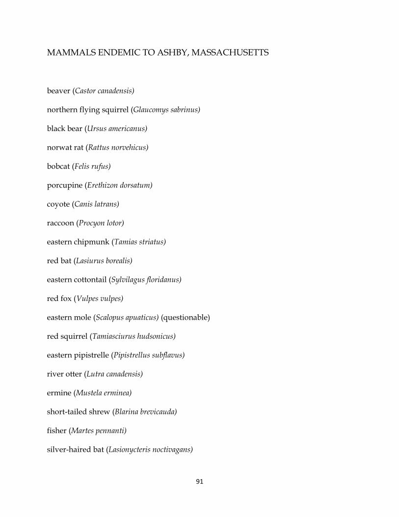
91
MAMMALS ENDEMIC TO ASHBY, MASSACHUSETTS
beaver (Castor canadensis)
northern flying squirrel (Glaucomys sabrinus)
black bear (Ursus americanus)
norwat rat (Rattus norvehicus)
bobcat (Felis rufus)
porcupine (Erethizon dorsatum)
coyote (Canis latrans)
raccoon (Procyon lotor)
eastern chipmunk (Tamias striatus)
red bat (Lasiurus borealis)
eastern cottontail (Sylvilagus floridanus)
red fox (Vulpes vulpes)
eastern mole (Scalopus apuaticus) (questionable)
red squirrel (Tamiasciurus hudsonicus)
eastern pipistrelle (Pipistrellus subflavus)
river otter (Lutra canadensis)
ermine (Mustela erminea)
short-tailed shrew (Blarina brevicauda)
fisher (Martes pennanti)
silver-haired bat (Lasionycteris noctivagans)

92
gray fox (Urocyon cinereoargenteus)
smoky shrew (Sorex fumeus)
gray squirrel (Sciurus carolinensis)
snowshoe hare (Leprs americanus)
hairy-tailed mole (Parascalops breweri)
southern bog lemming (Synaptomys cooperi)
hoary bat (Lasiurus cinereus)
southern flying squirrel (Glaucomys volans)
house mouse (Musculus)
southern red-backed vole (Clethrionomys gapperi)
Indiana myotis (Myotis sodalis)
star-nosed mole (Condylura cuestata)
Keen’s myotis (Myotis keenii)
striped skunk (Mephitis mephitis)
little brown myotis (Myotis lucifugus)
Virginia opossum (Didelphis virginiana)
long-tailed weasel (Mustela frenata)
water shrew (Sorex pallustris)
masked shrew (Sorex cinereus)
white-footed mouse (Peromyscus leucopus)
meadow jumping mouse (Microtus)
white-tailed deer (Odocoileus virginianus)

93
meadow vole (Microtus pennsylvanicus)
woodchuck (Marmota monax)
mink (Mustela vision)
woodland (Pine) vole (Microtus pinetorum)
moose (Alces alces)
woodland jumping mouse (Zapus hudsonius)
muskrat (Ondatra zibethicus)
BIRDS ENDEMIC TO ASHBY, MASSACHUSETTS
alder flycatcher
merlin
American black duck
morning dove
American crow
northern rough-winged swallow
American goldfinch
Nashville warbler
American kestrel
northern bobwhite
American redstart
northern cardinal
American robin

94
northern flicker
American tree sparrow
northern goshawk
American woodcock
northern harrier
bald eagle
northern mockingbird
bank swallow
northern oriole
barn swallow
northern parula
barred owl
northern saw-whet owl
bay-breasted warbler
northern shrike
bellied kingfisher
northern waterthrush
bellied kingfisher
olive-sided flycatcher
black-and-white warbler
osprey
black-billed cuckoo

95
oven bird
black-throated green warbler
palm warbler
black-throated blue warbler
pileated woodpecker
blackburnian warbler
pine grosbeak
blacked-capped chickadee
blackpoll warbler
pine warbler
blue jay
prairie warbler
blue-crowned gnat catcher
purple finch
blue-winged warbler
purple martin
bobolink
red crossbill
broad-winged hawk
red shouldered hawk
brown creeper
red-breasted nuthatch

96
brown thrasher
red-tailed hawk
brown-headed blackbird
red-winged blackbird
Canada goose
ring-billed gull
Canada warbler
ringed-neck pheasant
Cape May warbler
rock dove
cedar waxwing
rose-breasted grosbeak
chestnut-sided warbler
ruby-crowned kinglet
chimney swift
ruby-throated hummingbird
chipping sparrow
ruffed grouse
cliff swallow
rufous-sided towhee
common grackle
rusty blackbird

97
common night hawk
Savannah sparrow
common raven
scarlet tanager
common redpoll
sharp shinned hawk
common snipe
snow bunting
common yellowthroat
snow goose
Coopers hawk
solitary sandpiper
dark-eyed junco
solitary vireo
downy woodpecker
solitary vireo
eastern bluebird
song sparrow
eastern kingbird
spotted sandpiper
eastern meadowlark
Swainson’s thrush

98
eastern phoebe
swamp sparrow
eastern screech owl
Tennessee warbler
European starling
tree swallow
evening grosbeak
tufted titmouse
field sparrow
turkey vulture
fox sparrow
veery
golden-crowned kinglet
warbling vireo
gray catbird
wax thrush
great blue heron
whip-poor-will
great crested flycatcher
white-breasted nuthatch
great horned owl
white-crowned sparrow

99
green-backed heron
white-throated sparrow
hairy woodpecker
wide-winged crossbill
hermit thrush
wild turkey
hooded merganser
willow flycatcher
house finch
Wilson’s warbler
house sparrow
winter wren
house wren
wood duck
indigo bunting
yellow-throated vireo
killdeer
yellow warbler
least flycatcher
yellow-bellied flycatcher
Lincoln sparrow
yellow-bellied sapsucker

100
Louisiana waterthrush
yellow-billed cuckoo
magnolia warbler
yellow-rumped warbler
mallard
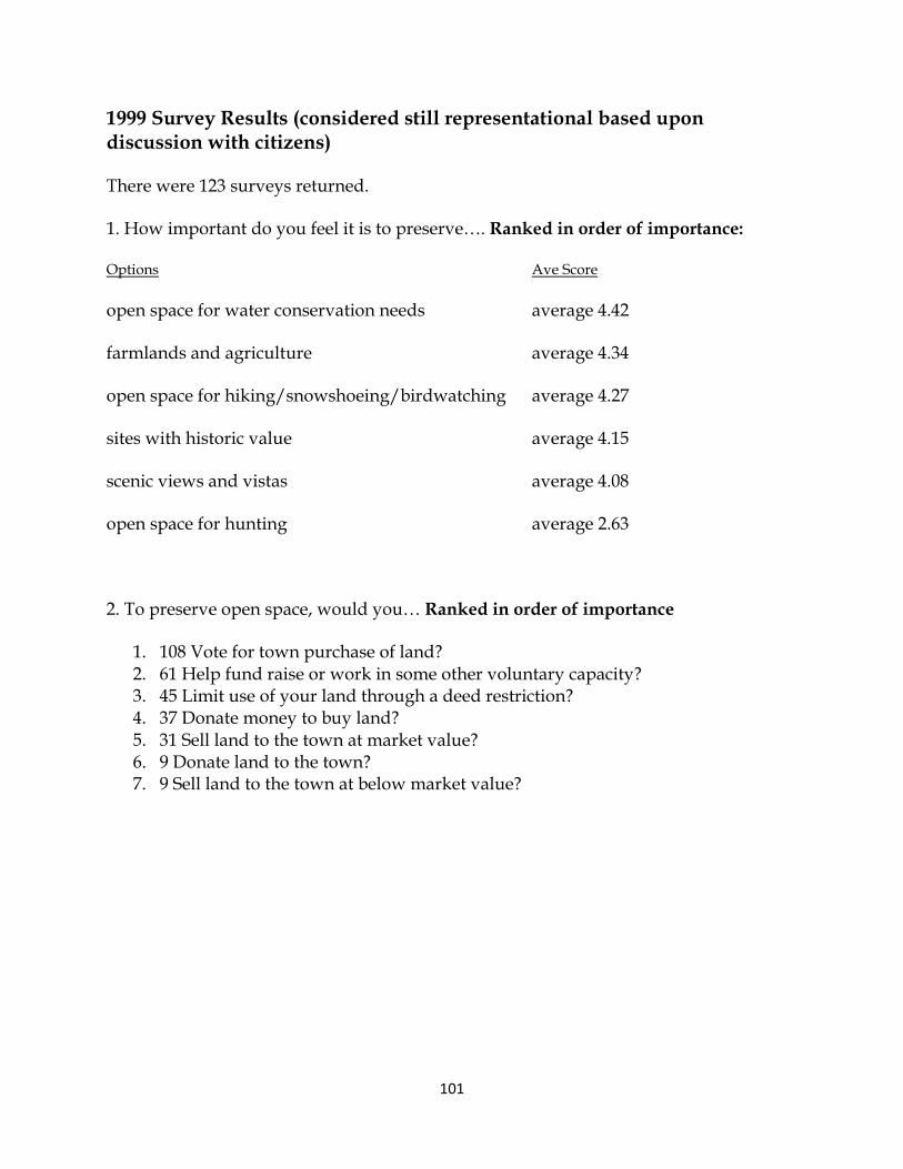
101
1999 Survey Results (considered still representational based upondiscussion with citizens)
There were 123 surveys returned.
1. How important do you feel it is to preserve…. Ranked in order of importance:
Options Ave Score
open space for water conservation needs average 4.42
farmlands and agriculture average 4.34
open space for hiking/snowshoeing/birdwatching average 4.27
sites with historic value average 4.15
scenic views and vistas average 4.08
open space for hunting average 2.63
2. To preserve open space, would you… Ranked in order of importance
1. 108 Vote for town purchase of land?2. 61 Help fund raise or work in some other voluntary capacity?3. 45 Limit use of your land through a deed restriction?4. 37 Donate money to buy land?5. 31 Sell land to the town at market value?6. 9 Donate land to the town?7. 9 Sell land to the town at below market value?

102
3. Which of the following recreational facilities do you feel Ashby needs more of?(each survey check five facility types)
45 bike trails
46 children's play areas
11 golf course
25 sports fields (soccer, baseball, football)
76 hiking and cross-country ski trails
66 public access to lakes for boating/ fishing
29 bridle paths
22 jogging/running track
10 riding ring
74 conservation areas
36 family picnic areas
35 public swimming areas
21 tennis courts
27 neighborhood park areas
16 ATV accessible trails
22 wheelchair accessible nature trail
other (specify) dog exercise area indoor basketball
indoor track skateboard course
snowmobile trails hunting areas
downhill skiing
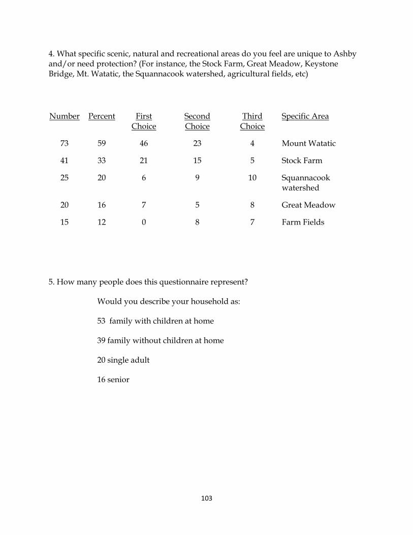
103
4. What specific scenic, natural and recreational areas do you feel are unique to Ashbyand/or need protection? (For instance, the Stock Farm, Great Meadow, KeystoneBridge, Mt. Watatic, the Squannacook watershed, agricultural fields, etc)
Number Percent FirstChoice
SecondChoice
ThirdChoice
Specific Area
73 59 46 23 4 Mount Watatic
41 33 21 15 5 Stock Farm
25 20 6 9 10 Squannacookwatershed
20 16 7 5 8 Great Meadow
15 12 0 8 7 Farm Fields
5. How many people does this questionnaire represent?
Would you describe your household as:
53 family with children at home
39 family without children at home
20 single adult
16 senior

104
Transition Plan for ADA Compliance
Name of Property: Ashby Town Hall – Basketball and Tennis Courts on northern side of
building
Parcel ID Number(s): NA
Uses: Informal and formal (classes / games) use of basketball and tennis courts
Management Agency: Ashby Parks Department; Stephanie Lammi, Director
Acreage / Other: N/A
Description of Facility: There are two tennis courts and one basketball court on the north side of
the Ashby Town Hall. These courts are in fair condition. The Ashby Recreation Department is
responsible for the operation and maintenance of these courts. The Ashby Recreation
Department runs tennis classes as part of its programming. Both courts are enclosed by a chain
link fence.
There are two designated handicapped parking spaces within 100 feet of the courts, one space for
cars and one space for vans.
Physical Obstacles: The entrance to the tennis courts is 44 inches wide, and can be accessed by
people in wheelchairs. The entrance to the basketball court is less wide at 36 inches, but most
wheelchairs should be able to fit through the entrance. However, the ground at the entrance
consists of broken pieces of asphalt and uneven ground, which may make access by handicapped
persons difficult.
Necessary Changes: In order to be fully accessible to handicapped persons, the entrance to the
basketball court should be cleared of asphalt debris and leveled off. This should be a fairly easy
undertaking, which one or two persons can complete with hand tools and a wheelbarrow.
Schedule of Changes: The improvements noted above can be completed in Fiscal Year 2014
(July 1, 2013 – June 30, 2014).
Responsible Individual / Agency: The Ashby Parks Department will be responsible for the
necessary changes noted above.
Name of Property: Ashby Town Common
Parcel ID Number(s): 009-0010-0000, 009-0011-0000, 009-0011.1-0000

105
Uses: Informal relaxation, summer band concerts, town celebrations
Management Agency: Ashby Parks Department; Stephanie Lammi, Director
Acreage / Other: 4.5 acres
Description of Facility: The Ashby Town Common is a quintessential New England Town
Common, complete with a white steepled church, gazebo, benches, and a large, grassy area for
relaxing and sitting while enjoying town band concerts, public events and good weather during
the warmer months of the year.
There is space for approximately 25 cars to park in the immediate area of the Common, adjacent
to the church and the Wyman Tavern building. Though there are no official, signed handicapped
spaces at present, there is ample space for such on the left (western) side of the church and also
adjacent to a 48 inch wide paved accessible path which is suitable for wheelchairs. From this
paved path, someone in a wheelchair is able to access the grassy area of the common, which is
relatively flat. Someone in a wheelchair could therefore choose to sit at the base of the gazebo
and obtain a good, close location from which to enjoy band concerts and other public events held
on the Common. Several of the benches located on the Common have arm rests / handrails and
are accessible to handicapped persons, though these are situated near the bandstand / gazebo and
not next to the path.
There are no public restrooms at the Common, though during large events portable toilets are
provided.
Physical Obstacles: There are no physical obstacles to handicapped persons enjoying use of the
Town Common, though the lack of designated handicapped parking should be addressed.
Necessary Changes: The Town should designate one handicapped parking space and one van
accessible handicapped space at the Town Common, ideally in close proximity to the paved path
that winds from the access road / parking area through the grassy area of the Common. Potential
locations for such handicapped parking spaces were identified by Mr. David Ogala, representing
the handicapped community, a Planning Board member and the Land-Use Agent during a site
assessment held on June 5, 2013. In addition, one park bench should be provided adjacent to the
paved path.
Schedule of Changes: The Town of Ashby will place two handicapped parking space signs, with
one designated for vans, during Fiscal Year 2014 (July 1, 2013 – June 30, 2014). The Town will
also relocate one of the existing benches so as to be directly accessible to the paved path.
Responsible Individual / Agency: The Ashby Parks Department is responsible for maintenance
and improvements at the Town Common.
106
Name of Property: Allen Field
Parcel ID Number(s): 007-0011-0000
Uses: 3 baseball fields, softball field, soccer field, concession stands, bandstand. The town’s 4th
of July celebration, summer and fall bonfires, and other large public events are held at the Allen
Field complex.
Management Agency: Ashby Parks Department; Stephanie Lammi, Director
Acreage / Other: 22.5 acres
Description of Facility: Allen Field is Ashby’s official active recreation complex, with 3 baseball
fields, a softball field, a soccer field, concession stands and a bandstand. The town’s 4th of July
celebration, summer and fall bonfires, and other large public events are held at the Allen Field
complex.
The property is located on a flat piece of land in west-central Ashby on West Road. The property
and facilities are in fair condition. There is space for approximately 150 cars on the property.
There are currently no designated and signed handicapped parking spaces. As the property is
level, people in wheelchairs are able to access the edge of all the sports fields for the purpose of
watching games or practices. Some of the sports fields have associated grandstands (bleachers),
but these are not handicapped accessible. Mr. Ogala notes that the floor height of the bandstand
and grandstands would require an extensive ramp system if they were to be made accessible.
However, since handicapped individuals are able to watch games and events from wide open
spaces on the sidelines, such a system is not necessary for enjoyment of games, etc. There is a
rest room building, with one side for women and the other side for men, but neither of these is
currently handicapped accessible (see details below).
Physical Obstacles:
Rest Rooms: The main obstacle for full enjoyment of the Allen Field complex by handicapped
persons is the lack of accessible rest rooms. There are no handicapped accessible ramps for
either rest room. The width of the door block for both restrooms is 36 inches, but the actual
functional entrance is presently only 32 inches.
Because of a privacy divider, there isn’t a five (5) foot turning space measured 12 inches from
the door. The distance from the floor to the rim of the sink is 32 inches, not the recommended 34
inches. The toilet paper dispenser is 36 inches from the floor, higher than the recommended 24
inches. The toilet does not have a 42 inch clear space from its center to the farthest wall or
fixture. The toilet also lacks a hand rail.
Picnic Tables: There are a group of picnic tables located under a tarp near the concession stands
and the rest rooms at Allen Field. One of the picnic tables does meet ADA requirements.

107
Necessary Changes:
Rest Rooms: The Ashby Parks Department and the Town of Ashby will need to evaluate what
will be necessary to fully renovate the rest room building to ADA standards. The likely cost to
fully renovate the building is several thousand dollars. This may require a warrant article and
vote of Town Meeting to enable and fund the improvements. In the interim, the Parks
Department and the Town will investigate renting or purchasing a handicapped accessible
portable toilet which could be placed adjacent to the existing rest room building during the
spring, summer and fall months when Allen Field is used.
Picnic Tables: The Parks Department will investigate how best to undertake and schedule the
minor repairs to the picnic tables to bring them into ADA compliance.
Schedule of Changes: The Town of Ashby will designate five (5) handicapped parking spaces,
with signage, as well as one space designated for vans, during Fiscal Year 2014 (July 1, 2013 –
June 30, 2014).
The Town of Ashby will develop a plan to renovate the Allen Field rest rooms for handicapped
accessibility during FY 2014; and in the interim will seek to obtain one handicapped accessible
portable toilet for use during large events, which will be placed near the existing rest room
building. The Parks Department will also undertake repairs to the picnic tables during FY 2014.
Any renovation to the rest room building is subject to funding and would likely occur in FY
2015 or later.
Responsible Individual / Agency: The Ashby Parks Department is responsible for maintenance
and improvements at the Allen Field and will be the primary agency in charge of the rest room
renovations described above.
Name of Property: Conservation Commission properties (as a group)
Parcel ID Number(s): See Summary Table and individual facility inventory sheets for the
properties under the management of the Conservation Commission.
Uses: Wildlife habitat, passive recreation, hiking trails, opens space linkages
Management Agency: Conservation Commission
Acreage / Other: Approximately 287 acres in 12 properties
Description of Facility: The Ashby Conservation Commission is responsible for monitoring and
maintaining approximately 287 acres of land within 12 properties in Ashby (see enclosed
Summary Table). Several of these are small un-named parcels which were acquired by the Town

108
due to the non-payment of property taxes. Most of these small parcels function ‘only’ as wildlife
habitat, and do not have any formal access or trails.
The larger parcels which do contain trails or provide public access are the Witta Conservation
Area, at 171.55 acres, managed by the Blood Hill Management Committee; the Lyman
property, at 31 acres, and the South Road fields, at 12.5 acres. The Witta Conservation Area
has trailhead parking for approximately 4 cars, but the unimproved dirt parking lot can become
muddy and unusable for periods in the late-winter and early-spring. The hiking trail itself is very
steep and not suitable for persons with physical handicaps that limit mobility. The same is true
for the Lyman property.
The large hayfields on South Road, however, are capable of being enjoyed by handicapped
persons, who can bird watch just by pulling their vehicles to the side of the road. There are no
trails entering the property, which was acquired for the purpose of preserving habitat for
grassland birds like the Bobolink and the Eastern Meadowlark.
Physical Obstacles: As seen above, all of the conservation properties, with the exception of the
South Road Fields, provide obstacles to handicapped persons. However, the amount of work and
cost of making improvements so that these areas would be handicapped accessible would be
excessive. At the present time and for the foreseeable future, these conservation areas can be
enjoyed from the road side or parking areas where they are available.
Necessary Changes: No changes are anticipated at this time.
Schedule of Changes: No changes are anticipated at this time.
Responsible Individual / Agency: The Ashby Conservation Commission is responsible for most
of the conservation land holdings, with the exception of the Wiita Conservation Area, which is
managed by the Blood Hill Management Committee.

OBJECTIVE 1: UNITE THE WESTERN SPINE & CONNECT TO ASHBURHAM & THE MIDSTATE TRAIL
TASK TASK LEAD YEAR 1 YEAR 2 YEAR 3 YEAR 4 YEAR 5 YEAR 6 YEAR 7
Explore land acquisition alternatives of parcels for saleincluding discussions with potential funding sources Ashby Land Trust
Communicate with Ashburnham and develop aworking planning relationship Planning Board
Communicate with Fitchburg Water Department anddevelop a working planning relationship Planning Board
Communicate with Commonwealth and develop aworking planning relationship Planning Board
Communicate with citizens / abutters regardingeconomic, recreational, and cultural value of thegreenway Planning Board
Educate abutters on the programs and optionsavailable for conservation Ashby Land Trust
Discuss Deed Restrictions and Easements withinterested abutters Ashby Land Trust
Coordinate Grant Writing & Planning withAshburnham & Fitchburg Planning Board
Discuss and enact the creation of a stewardship fundfor lands under Town control or supervision
Selectmen & Cons.Commission
Prepare documentation for restrictions or easementsbeing enacted
A.L.T. & Cons.Commission
Page 77

Create trails within acquired or lands withconservation restrictions including signage and/orblazing
ConservationCommission
OBJECTIVE 2: PRESERVE CONTIGUOUS FARMS AND FORESTS
TASK TASK LEAD YEAR 1 YEAR 2 YEAR 3 YEAR 4 YEAR 5 YEAR 6 YEAR 7
Support the protection of open fields and managedforests All Parties
Support the current Forest Legacy conservationactivities on a series of forests & farm parcels
Selectman & Cons.Commission
Maintain a working relationship with theCommonwealth regarding agricultural & open spacepreservation programs
A.L.T. & Cons.Commission
Prepare agricultural and recreational overlay districtto assist farmers and large property owners maintain
their properties without selling for development Planning Board
Communicate with citizens / abutters regardingeconomic, recreational, and cultural value of thegreenway Ashby Land Trust
Maintain a log and accurate mapping of all landsunder Chaper 61, 61a, & 61B Planning Board
Analyze and rate parcels for potential united publiclands trail system Planning Board
Page 78
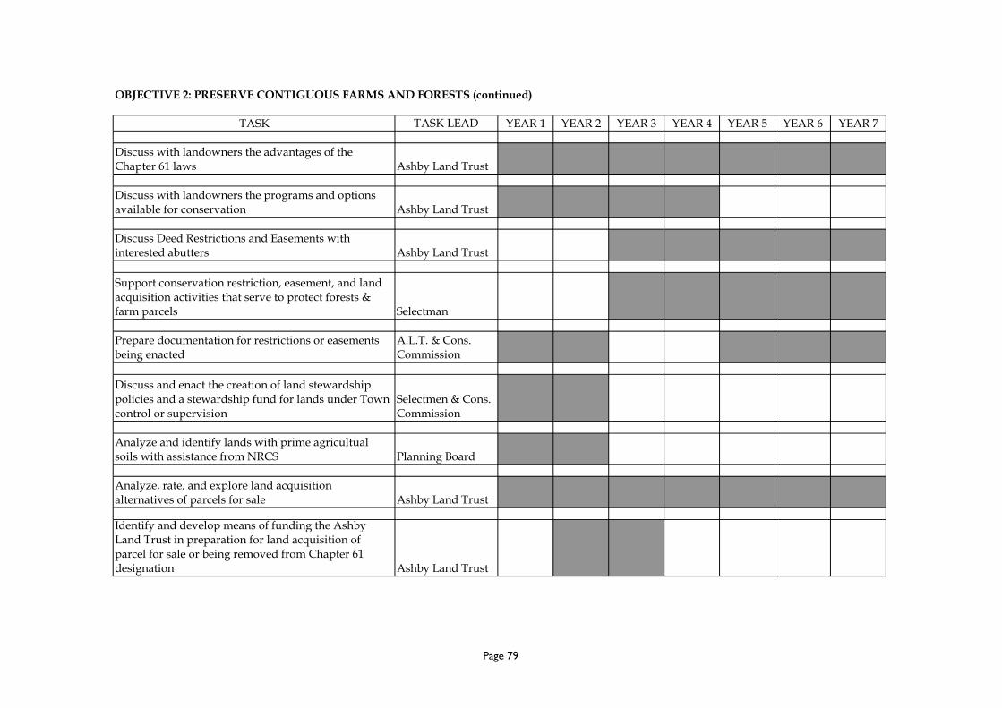
OBJECTIVE 2: PRESERVE CONTIGUOUS FARMS AND FORESTS (continued)
TASK TASK LEAD YEAR 1 YEAR 2 YEAR 3 YEAR 4 YEAR 5 YEAR 6 YEAR 7
Discuss with landowners the advantages of theChapter 61 laws Ashby Land Trust
Discuss with landowners the programs and optionsavailable for conservation Ashby Land Trust
Discuss Deed Restrictions and Easements withinterested abutters Ashby Land Trust
Support conservation restriction, easement, and landacquisition activities that serve to protect forests &farm parcels Selectman
Prepare documentation for restrictions or easementsbeing enacted
A.L.T. & Cons.Commission
Discuss and enact the creation of land stewardshippolicies and a stewardship fund for lands under Towncontrol or supervision
Selectmen & Cons.Commission
Analyze and identify lands with prime agricultualsoils with assistance from NRCS Planning Board
Analyze, rate, and explore land acquisitionalternatives of parcels for sale Ashby Land Trust
Identify and develop means of funding the AshbyLand Trust in preparation for land acquisition ofparcel for sale or being removed from Chapter 61designation Ashby Land Trust
Page 79

OBJECTIVE 3: PROTECT CRITICAL NATURAL WATER SYSTEMS AND HABITATS
TASK TASK LEAD YEAR 1 YEAR 2 YEAR 3 YEAR 4 YEAR 5 YEAR 6 YEAR 7
Work with the City of Fitchburg to protect the loonnesting sites on Fitchburg Reservoir
ConservationCommission
Develop and maintain a working relationship with theCommonwealth regarding wetland and waterprotection programs
ConservationCommission
Develop and maintain a working relationship with theNashua River & Souhegan River WatershedAssociations regarding watershed protectionprograms
ConservationCommission
Educate abutters on the programs and optionsavailable for conservation
ConservationCommission
Discuss Deed Restrictions and Easements withinterested abutters
ConservationCommission
Continue to protect these water systems as allowedthrough the Wetlands Protection Act and RiversProtection Act
ConservationCommission
Work with local and regional agencies to indentifypotential aquifer sites
ConservationCommission
Continue efforts to identify and certify vernal poolsConservationCommission 1 pool 1 pool 1 pool 1 pool 1 pool 1 pool 1 pool
Page 80

OBJECTIVE 3: PROTECT CRITICAL NATURAL WATER SYSTEMS AND HABITATS (continued)
TASK TASK LEAD YEAR 1 YEAR 2 YEAR 3 YEAR 4 YEAR 5 YEAR 6 YEAR 7
Continue efforts to inventory and water test allstreams in Ashby - obtain assistance and training fromthe Nashua River Watershed Association as necessary
ConservationCommission 1 stream 1 stream 1 stream 1 stream 1 stream 1 stream 1 stream
Prepare and present a low impact development orresource protection bylaw to mitigate developmentimpacts on natural resources Planning Board
Page 81

OBJECTIVE 4: PROTECT THE PRIORITY HERITAGE LANDSCAPES
TASK TASK LEAD YEAR 1 YEAR 2 YEAR 3 YEAR 4 YEAR 5 YEAR 6 YEAR 7
Post the Heritage Landscape Inventory PriorityLandscapes on-line Planning Board
Educate landowners on the value of these heritagelandscapes to the community and options available forprotection Planning Board
Adopt rules and regulations to promote the protectionof the priority landscapes Planning Board
Develop and maintain a working planningrelationship with Commonwealth Planning Board
Coordinate grant writing for preservation of FirstParish Cemetery Planning Board
Restoration of First Parish Cemetery Selectmen
Analyze and rate scenic views along Route 119 Planning Board
Coordinate with the Commonwealth on the creation ofpreservation plans for the priority heritage landscapes Planning Board
Coordinate grant writing for preservation activities Planning Board
Page 82

OBJECTIVE 5: MAINTAIN AND ENHANCE ACTIVE & PASSIVE RECREATION OPPORTUNITIES
TASK TASK LEAD YEAR 1 YEAR 2 YEAR 3 YEAR 4 YEAR 5 YEAR 6 YEAR 7
Work with the North Middlesex school system todevelop a survey for the prioritization of activerecreation repairs, improvements, and expansion
Selectmen &Planning Board
Develop and maintain a working relationship with theCommonwealth regarding maintenance of the passiverecreation opportunities on state land (WataticMountain, Willard Brook State Park, Fish & Wildlifeland) Selectmen
Develop and maintain a working relationship with theTown of Ashburnham regarding the passive recreationconnection opportunities
Selectmen &Planning Board
Establish trails committee under the direction of theConservation Commission to cut and maintain trailson public land- make accessible where feasible
ConservationCommission 1 trail 1 trail 1 trail 1 trail 1 trail 1 trail
Identfy and rate water bodies for public access of non-motorized craft
ConservationCommission
Improve public access to water bodies includingpotentially obtaining an easement or acquiring land
ConservationCommission
1 accesspt
1 accesspt
Clean-up & improve active recreation facilities basedon the priorities established by the survey
Selectmen &Planning Board 1 project 1 project 1 project 1 project 1 project
Analysis and rate potential sites for the expansion ofactive recreational facilities Planning Board
Page 83
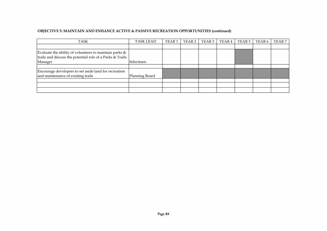
OBJECTIVE 5: MAINTAIN AND ENHANCE ACTIVE & PASSIVE RECREATION OPPORTUNITIES (continued)
TASK TASK LEAD YEAR 1 YEAR 2 YEAR 3 YEAR 4 YEAR 5 YEAR 6 YEAR 7
Evaluate the ability of volunteers to maintain parks &trails and discuss the potential role of a Parks & TrailsManager Selectmen
Encourage developers to set aside land for recreationand maintenance of existing trails Planning Board
Page 84

OBJECTIVE 6: EDUCATE CITIZENS ON THE FINANCIAL, ECOLOGICAL, AND PERSONAL VALUE OF OPEN SPACE
TASK TASK LEAD YEAR 1 YEAR 2 YEAR 3 YEAR 4 YEAR 5 YEAR 6 YEAR 7
Assemble & create literature about the advantages ofthe Chapter 61 laws and their tax advantages Planning Board
Assemble & create litrerature about the financialvalues of open space
ConservationCommission
Assemble & create literature explaining conservationrestriction, trail easements, and the tax advantages ofdeed restrictions
ConservationCommission
Assemble & create literature explaining the functionand importantance of wetlands and surface waters
ConservationCommission
Assemble & create literature explaining the functionand maintenance of wells and septic systems & theirpotential impact on the environment Board of Health
Assemble & create literature about the impacts of thecurrent zoning on the rural character and resources ofthe Town in order to begin the discussion of potentialzoning changes Planning Board
Post all literature on the Town web site and at theTown Library Planning Board
Continue the educate of the boards by attendingseminars and conferences
Cons. Commission& Planning Board
Page 85

OBJECTIVE 7: PROMOTE RENEWABLE ENERGY RESOURCES
TASK TASK LEAD YEAR 1 YEAR 2 YEAR 3 YEAR 4 YEAR 5 YEAR 6 YEAR 7
Establish rules and regulations for the wind energybylaws Planning Board
Research and create map showing the renewableenergy resource areas within Ashby Planning Board
Post renewable energy map on Town web site Planning Board
Explore the potential of municipal energy production Selectmen
Analyze and rate potential locations for municipalwind power with limited impact to the environmentand scenic views
Selectmen &Planning Board
Page 86

REGIONAL CONTEXT MAP
OPEN SPACE AND RECREATION PLAN
TOWN OF ASHBY895 MAIN STREET
ASHBY, MA 01431
SCALE: not to scale
December 2009
N
Map Based on Data From:
Map Prepared By:
A. T. Leonard & Associates
REGIONAL CONTEXT MAP- RELATIONSHIP TO MASSACHUSETTS CITIES
REGIONAL CONTEXT MAP- RELATIONSHIP TO NEIGHBORING COMMUNITIES
BOSTON
WORCESTER
SPRINGFIELD
PITTSFIELD
ASHBY
FITCHBURGRESERVIOR
MTWATATIC
ASHBY
TOWNSEND
FITCHBURG
GARDNER
ASHBURNHAM
NEW IPSWICH, NHMASON, NH

ENVIRONMENTAL JUSTICE MAP
OPEN SPACE AND RECREATION PLAN
TOWN OF ASHBY895 MAIN STREET
ASHBY, MA 01431
ENVIRONMENTAL JUSTICE AREASASHBY HAS NO AREAS WITHIN THE TOWN THATMEET THE DEFINITION OF AN ENVIRONMENTALJUSTICE AREA.
NEW HAMPSHIRE
TO
WN
SE
ND
ASH
BUR
NH
AM
FITCHBURG
MT. WATATIC
FITCHBURGRESERVIOR
WILLARD BROOKSTATE PARK
TOWNCENTER
SCALE:
0
December 2009
N
Map Based on Data From:
Town of Ashby and Mass GIS
Map Prepared By:
A. T. Leonard & Associates
2750'
ROUTE 119
RO
UTE 1
19
RO
UT
E 3
1
RO
UT
E 3
1
MAJOR ROADS
ROADS
LEGEND
TOPOGRAPHY (30' INTERVALS)

ZONING MAP
OPEN SPACE AND RECREATION PLAN
TOWN OF ASHBY895 MAIN STREET
ASHBY, MA 01431
INDUSTRIAL
NEW HAMPSHIRE
TO
WN
SE
ND
FITCHBURG
MT. WATATIC
FITCHBURGRESERVIOR
WILLARD BROOKSTATE PARK
TOWNCENTER
RESIDENTIAL / COMMERCIAL
RESIDENTIAL
RESIDENTIAL / AGRICULTURAL
PARCEL BOUNDARIES
LEGEND
NOTE:THIS MAP IS INTENDED AS A GENERAL GUIDE TO THEZONING DISTRICTS IN ASHBY. PLEASE CONTACT THEBUILDING INSPECTOR FOR MORE SPECIFIC INFORMATION.
SOUTHVILLAGE
ROUTE 119
RO
UTE 1
19
RO
UT
E 3
1
RO
UT
E 3
1
ASH
BUR
NH
AM
SCALE:
0
December 2009
N
Map Based on Data From:
Town of Ashby, Google, and
Mass GIS
Map Prepared By:
A. T. Leonard & Associates
2750'

SOILS AND GEOLOGIC FEATURES MAP
OPEN SPACE AND RECREATION PLAN
TOWN OF ASHBY895 MAIN STREET
ASHBY, MA 01431
SOILS AND GEOLOGIC FEATURESASHBY IS MOSTLY COMPRISED OF THREE SOILSTYPES: SAND & GRAVEL, FLOODPLAIN ALLUVIUM,AND TILL & BEDROCK. ASHBY HAS A SERIES OFLOCATIONS LISTED BY THE NRCS AS PRIMEFARMLAND SOILS.
SURFACE WATER
NEW HAMPSHIRE
TO
WN
SE
ND
ASH
BUR
NH
AM
FITCHBURG
VALLEY ROAD
MT. WATATIC
FITCHBURGRESERVIOR
WILLARD BROOKSTATE PARK
TOWNCENTER
SCALE:
0
December 2009
N
Map Based on Data From:
Town of Ashby and Mass GIS
Map Prepared By:
A. T. Leonard & Associates
2750'
SAND & GRAVEL
FLOODPLAIN ALLUVIUM
TILL & BEDROCK
WATERSHED BOUNDARY
MAJOR ROADS
ROADS
LEGEND
ROUTE 119
RO
UTE 1
19
RO
UT
E 3
1
RO
UT
E 3
1

VEGETATION, FISH, & WILDLIFE MAP
OPEN SPACE AND RECREATION PLAN
TOWN OF ASHBY895 MAIN STREET
ASHBY, MA 01431
NEW HAMPSHIRE
TO
WN
SE
NDA
SHBU
RN
HAM
FITCHBURG
RO
UT
E 3
1
SCALE:
0
December 2009
N
Map Based on Data From:
Town of Ashby and Mass GIS
Map Prepared By:
A. T. Leonard & Associates
MT. WATATIC
FITCHBURGRESERVIOR
WILLARD BROOKSTATE PARK
TOWNCENTER
2750'
SURFACE WATER
NHESP PRIORITY HABITAT
FIELD OR DEVELOPED
FOREST
WATERSHED BOUNDARIES
MAJOR ROADS
ROADS
LEGEND
MIGRATORY BIRD HABITAT
EXTENT OF AREA OF CRITICAL CONCERN
MIGRATORY.BIRD HABITAT
MIGRATORY.BIRD HABITAT
SOUTH BRANCHOF THE
SOHEGAN RIVER
TRAP FALLSBROOK
WILLARDBROOK
LOCKEBROOK
LITTLEWATATIC
POND
ASHBYRESERVIOR
FITCHBURGRESERVIOR
FALULAHBROOK
WRIGHTPONDS
PEARL HILLBROOK
DAMONPOND
AREA OFCRITICALCONCERN
AREA OFCRITICALCONCERN
AREA OFCRITICALCONCERN
AREA OFCRITICALCONCERN
CERTIFIED VERNAL POOLS
WETLANDS
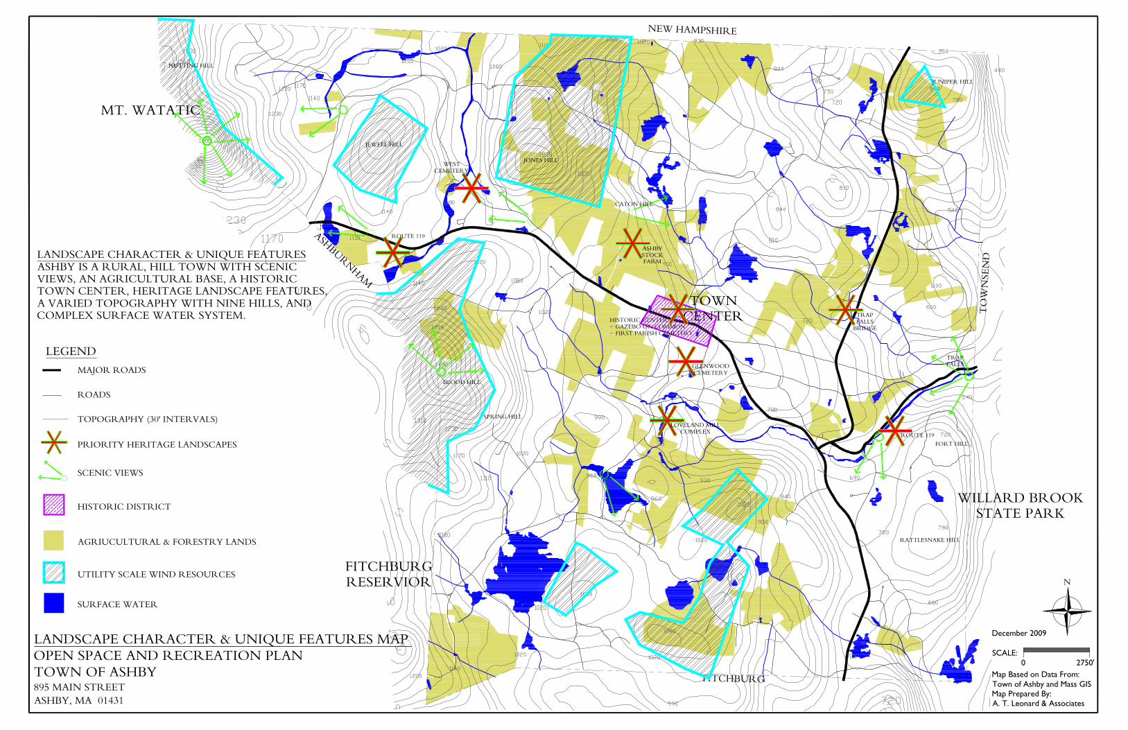
LANDSCAPE CHARACTER & UNIQUE FEATURES MAP
OPEN SPACE AND RECREATION PLAN
TOWN OF ASHBY895 MAIN STREET
ASHBY, MA 01431
LANDSCAPE CHARACTER & UNIQUE FEATURESASHBY IS A RURAL, HILL TOWN WITH SCENICVIEWS, AN AGRICULTURAL BASE, A HISTORICTOWN CENTER, HERITAGE LANDSCAPE FEATURES,A VARIED TOPOGRAPHY WITH NINE HILLS, ANDCOMPLEX SURFACE WATER SYSTEM.
NEW HAMPSHIRE
TO
WN
SE
ND
ASH
BUR
NH
AM
FITCHBURG
MT. WATATIC
FITCHBURGRESERVIOR
WILLARD BROOKSTATE PARK
TOWNCENTER
SCALE:
0
December 2009
N
Map Based on Data From:
Town of Ashby and Mass GIS
Map Prepared By:
A. T. Leonard & Associates
2750'
SURFACE WATER
UTILITY SCALE WIND RESOURCES
AGRIUCULTURAL & FORESTRY LANDS
TOPOGRAPHY (30' INTERVALS)
MAJOR ROADS
ROADS
LEGEND
SCENIC VIEWS
PRIORITY HERITAGE LANDSCAPES
HISTORIC DISTRICT
NUTTING HILL
BLOOD HILL
SPRING HILL
JONES HILL
JUNIPER HILL
FORT HILL
RATTLESNAKE HILL
JEWELL HILL
CATON HILL
ROUTE 119
ROUTE 119
TRAPFALLS
TRAPFALLS
BRIDGE
GLENWOODCEMETERY
LOVELAND MILLCOMPLEX
HISTORIC CENTER- GAZEBO ON COMMON- FIRST PARISH CEMETERY
ASHBYSTOCKFARM
WESTCEMETERY

WATER RESOURCES MAP
OPEN SPACE AND RECREATION PLAN
TOWN OF ASHBY895 MAIN STREET
ASHBY, MA 01431
MT. WATATIC
TOWNCENTER
WATER RESOURCESASHBY CONTRIBUTES TO TWO WATERSHEDS:THE NASHUA RIVER AND THE SOUHEGANRIVER. THE SURFACE WATER MOVESTHROUGH A SERIES OF PONDS, STREAMS,BROOKS, AND WETLAND. TWO RESERVIORSARE LOCATED IN THE SOUTHWEST CORNEROF THE TOWN.
NEW HAMPSHIRE
TO
WN
SE
ND
ASH
BUR
NH
AM
FITCHBURG
RO
UT
E 3
1
FITCHBURGRESERVIOR
WILLARD BROOKSTATE PARK
SOUHEGANWATERSHED
NASHUA RIVERWATERSHED
SCALE:
0
December 2009
N
Map Based on Data From:
Town of Ashby and Mass GIS
Map Prepared By:
A. T. Leonard & Associates
2750'
SOUTH BRANCHOF THE
SOHEGAN RIVER
TRAP FALLSBROOK
WILLARDBROOK
LOCKEBROOK
LITTLEWATATIC
POND
ASHBYRESERVIOR
FITCHBURGRESERVIOR
FALULAHBROOK
WRIGHTPONDS
PEARL HILLBROOK
DAMONPOND
SURFACE WATER
WETLANDS
AQUIFER RECHARGE AREAS
WATERSHED BOUNDARIES
MAJOR ROADS
ROADS
PUBLIC LANDS
LEGEND
INVENTORY OF LANDS
OPEN SPACE AND RECREATION PLAN
TOWN OF ASHBY895 MAIN STREET
ASHBY, MA 01431
PARCELS IN ACTIVE RECREATION
NEW HAMPSHIRE
TO
WN
SE
ND
FITCHBURG
RO
UT
E 3
1
FARM& FOREST
PARCELS UNDER A DEED RESTRICTION
PARCELS UNDER CHAPTER 61
PARCELS UNDER PUBLIC OWNERSHIP -MUNICIPAL, STATE, & FEDERAL
PARCELS UNDER NON-PROFIT OWNERSHIP
FISH & WILLDLIFELANDS
BLOOD HILLWIITA CONSERVATION AREA
F & WLANDS
F & WLANDS
F & WLANDS
FARM
FARM &FOREST
FARM
FARM
FARM & FORESTFARMFARM
FARM
FARM
FARM
FARM
FARM& FOREST
FARM
FARM
FARM
FARM& FOREST
FOREST
FOREST
FOREST
FOREST
FOREST
WILLARD BROOKSTATE PARK
ASHBYRESERVIOR
FITCHBURGRESERVIOR
FARM
4-HCAMP
CAMPLAPHAM
BOYSCOUTS
SCALE:
0
December 2009
N
Map Based on Data From:
Town of Ashby, Google, and
Mass GIS
Map Prepared By:
A. T. Leonard & Associates
2750'
PARCELS BOUNDARIES
MAJOR ROADS
LEGEND
FOREST
FOREST
FOREST
FOREST
FOREST
FOREST
FOREST
FARM &FOREST
FARM
LANDFILL
TOWNCENTER
MT. WATATIC
FITCHBURGRESERVIOR
ASH
BUR
NH
AM
INVENTORY OF LANDSASHBY HAS THREE MAIN CLUSTERS OF PUBLICLANDS: THE MT WATATIC AREA, THE FITCHBURGRESORVIOR AREA, AND WILLARD BROOK STATEPARK.
ASHBY'S SIGNIFICANT CHAPTER 61 LANDS FORM ASTRONG NORTH TO SOUTH CENTRALAGRICULTURAL CORRIDOR AND A SERIES OFMANAGED FORERST LANDS.
THE NON-PROFIT LANDS ARE A SOURCE OFPRIVATELY ORGANIZED CAMP STYLE RECREATION.

SEVEN YEAR ACTION PLAN MAP
OPEN SPACE AND RECREATION PLAN
TOWN OF ASHBY895 MAIN STREET
ASHBY, MA 01431
1: UNITE THE WESTERN SPINE& CONNECT TO ASHBURHAM& THE MIDSTATE TRAIL
NEW HAMPSHIRE
TO
WN
SE
ND
ASH
BUR
NH
AM
FITCHBURG
MT. WATATIC
FITCHBURGRESERVIOR
WILLARD BROOKSTATE PARK
ROUTE 119
RO
UTE 1
19
RO
UT
E 3
1
RO
UT
E 3
1
TRAPFALLS
BRIDGE
GLENWOODCEMETERY
LOVELAND MILLCOMPLEX
ASHBYSTOCKFARM
WESTCEMETERY
FLFL
FL
FL
FL
FL
FL
PARCELS UNDER A DEED RESTRICTION
PARCELS - GOAL FOR DEED RESTRICTION FORCONSERVATION OR TRAIL EASEMENT
PARCELS UNDER PUBLIC OWNERSHIP -MUNICIPAL, STATE, & FEDERAL
PARCELS BOUNDARIES
MAJOR ROADS
LEGEND
PARCELS - GOAL TO ACQUIRE FOR CONSERVATION ANDPOTENTIAL RENEWABLE RESOURCES
PARCELS - GOAL FOR DEED RESTRICTION FORAGRICULTURE AND FOREST PRESERVATION
POTENTIAL RECREATION CORRIDOR WITH CONECTIONSTO ASHBURNHAM, AND THE MIDSTATE TRAIL
PRIORITY HERITAGE LANDSCAPES - GOAL TO PRESERVE
6: EDUCATE CITIZENSON THE FINANCIAL,ECOLOGICAL, &PERSONAL VALUE OFOPEN SPACE
7: PROMOTERENEWABLE ENERGYRESOURCES
5: MAINTAIN & ENHANCEACTIVE & PASSIVERECREATION OPPORTUNITIES(Ashby Elementary School, Allen
Field, & Trail Systems)
3: PROTECT CRITICALNATURAL WATERSYSTEMS & HABITATSINCLUDING GREATMEADOW & SOUTHBRANCH OF THESOUHEGAN
2: PRESERVECONTIGUOUS FARMS& FORESTSINCLUDING THENORTHAGRICULTURALCORRIDOR
4: PROTECT THEPRIORITY HERITAGELANDSCAPES
HISTORIC CENTER- GAZEBO ON COMMON- FIRST PARISH CEMETERY
SCALE:
0
December 2009
N
Map Based on Data From:
Town of Ashby, Google, and
Mass GIS
Map Prepared By:
A. T. Leonard & Associates
2750'

CURRENT LAND USE MAP
OPEN SPACE AND RECREATION PLAN
TOWN OF ASHBY895 MAIN STREET
ASHBY, MA 01431
CURRENT LAND USETHE TOTAL ACREAGE PER LAND USETYPE IS AS FOLLOWS:
RESIDENTIAL 5,916 acres 38%RESIDENTIAL UNDEV. 2,242 acres 15%CHAPTER 61 3,452 acres 22%GOVERNMENT 3,380 acres 22%CAMP / CHARITY 187 acres 1%COMM. / INDUST. 240 acres 2%
TOTAL 15,417 acres
RESIDENTIAL
NEW HAMPSHIRE
TO
WN
SE
ND
ASH
BUR
NH
AM
FITCHBURG
RO
UT
E 3
1
MT. WATATIC
FITCHBURGRESERVIOR
WILLARD BROOKSTATE PARK
TOWNCENTER
LEGEND
PARCEL BOUNDARIES
RESIDENTIAL UNDEV.
CHAPTER 61
GOVERNMENT
CAMP / CHARITY
COMMERCIAL / INDUSTRIAL
SCALE:
0
December 2009
N
Map Based on Data From:
Town of Ashby, Google, and
Mass GIS
Map Prepared By:
A. T. Leonard & Associates
2750'

PREFACE TO THE ADA COMPLIANCE SECTION OF THE
ASHBY OPEN SPACE PLAN APPENDICES
To insert as a new appendix at the very end of the Open Space and Recreation Plan
Written by Mark Archambault, Ashby Land-Use Agent
July 16, 2013
American with Disabilities Act Compliance section
As a requirement of the American with Disabilities Act (ADA), municipalities in the
Commonwealth of Massachusetts must evaluate their recreational programs, public
access to recreational facilities and conservation land; and handicapped parking
availability for all parcels under the jurisdiction of the Recreation Department and/or
Conservation Commission. Municipalities are provided guidance on performing such
an ADA Access Self-Evaluation.
During the early summer of 2013, Alan Pease, Planning Board and ZBA member; David
Ojala, builder / designer representing the handicapped community; and Mark
Archambault, Land-Use Agent, conducted field assessments of Ashby’s recreational and
larger conservation properties. For each of the properties, they filled out ADA checklists
and later developed a course of action, termed “Transition Plans”, which detail the
actions or repairs needed to bring the property into ADA compliance. The ADA
checklists are in a publicly accessible file in the Planning Office at Ashby Town Hall, and
the Transition Plans and a Summary Table are included below in this appendix.

Erosion
Erosion can be defined as the wearing away of the ground surface as a result of the
movement of wind, water, ice and/or land disturbing activities. As most development
entails at least some clearing of vegetation, development is one of the primary causes of
soil erosion.
Ashby’s steep terrain makes it susceptible to erosion resulting from land clearing and
development. The annual rainfall of approximately 40 inches, more or less evenly
distributed through the year, can provide opportunities for erosion and sedimentation
of cleared soils into Ashby’s wetlands and water bodies. Over the last decade, there has
also been an increase in major flooding events, which makes the risk of serious erosion
all the more likely.
Over the past two decades, government and planning agencies have developed model
ordinances, bylaws and regulations that can assist towns in better regulating
development on steep slopes, thereby reducing the incidence of serious erosion and
other environmental problems.
The Ashby Planning Board anticipates writing an erosion and sedimentation control
bylaw (or section of the site plan and subdivision regulations) in the near future in order
to better prevent erosion from occurring and to be able to respond effectively when it
does occur.
American with Disabilities Act Compliance section
Start here…

Summary Table: ADA Assessment of Ashby’s Conservation and Recreation Parcels
Note: This table is a summary of the information found in the Transition Plans for ADA compliance.
Name of Property
and
Parcel ID number(s)
Management
Agency
Uses
Acreage / Other
ADA Assessment and/or Actions Needed
Tennis and Basketball
Courts at Town Hall
Parks Dept.
Tennis (and Classes)
Basketball Courts
Directly adjacent to
Town Hall (north
side)
• ADA parking spaces located within 100 feet
of court entrances
• Meets most checklist items
• Entrance to basketball court needs to be
cleared and leveled to ease access
Town Common
009-0010-0000
009-0011-0000
009-0011.1-000
Parks Dept.
Town Common,
Summer Band
Concerts, Town
Celebrations
4.5 acres
• No designated handicapped parking spaces
• Lawn area for viewing concerts is accessible,
but some benches should be relocated closer
to paved path
• No permanent public restrooms
Allen Field Complex
007-0011-0000
Parks Dept.
3 Baseball fields,
Softball field,
Soccer field,
Concessions stands
Bandstand
22.5 acres
• No designated handicapped parking spaces
• Spectators in wheelchairs can watch games
from grass or gravel areas, however…
• Rest Rooms are not handicapped accessible /
need ramps and interior space renovations
• Handicapped accessible portable toilet can be
provided in the interim
• Some picnic tables need minor modifications
Wiita Conservation Area
008-0031-0002 > 0005
Blood Hill
Management
Committee
Wildlife habitat,
wildlife viewing,
hiking trails
171.55 acres
• Trailhead parking for approx. 4 cars
• Dirt parking lot, rough surface
• Piece of wood at trail head for blocking
motorized vehicles (ATVs…)
• Entrance to trail system not accessible for
wheelchairs
• Trails are very steep – definitely not
handicapped accessible and unlikely to ever
become so

Lyman Property
006-0046-0000
Conservation
Commission
Wildlife habitat,
wildlife viewing,
hiking trail
31 acres
• Parking available across Route 119 at the
Glenwood Cemetery
• Informal rough trail, not handicapped
accessible or possible to be made so
South Road Fields
010-0024-0003
Conservation
Commission
Wildlife habitat,
scenic vistas
12.5 acres
• Hayfields managed for grassland nesting
birds such as bobolinks and meadowlarks
• No parking lot or trails, though short term
parking is available on the side of the road
• No improvements needed
Damon Property
003-0045-0000
Conservation
Commission
Wildlife habitat
30 acres
• A woodlot recently acquired by the Town
• No trails at the present time, or plans to
create any
• No improvements needed
Morrison Property
007-0033-0001
Conservation
Commission
Wildlife habitat,
Wetlands protection
2.01 acres
• There is a hiking trail, but no parking or hopes
of any in the future since access is blocked by
a guardrail along Route 119
Adams Grant
002-0020-0014
Conservation
Commission
Wildlife habitat
1.11 acres
• Adams Grant is a thin strip of land behind the
West Cemetery with no parking or trails
Un-named # 1
011-0114-0000
Conservation
Commission
Wildlife habitat
8.7 acres
• No access or trails. Adjacent to Trap Falls
Area at Willard Brook.
Un-named # 2
015-0073-0026
Conservation
Commission
Wildlife habitat
• No trails at the present time, or plans to
create any
Un-named # 3
015-0073-0023
Conservation
Commission
Wildlife habitat
Un-named 2 & 3 are
1.33 acres in total
• No trails at the present time, or plans to
create any
Un-named # 4
001-0004-0000
Conservation
Commission
Wildlife habitat
.56 acres
• A small parcel on the side of Mt. Watatic
• Not accessible
Un-named # 5
005-0034-0009
Conservation
Commission
Wildlife habitat
• Not accessible – only off-road parking
available
Un-named # 6
005-0030-0000
Conservation
Commission
Wildlife habitat
Un-named 5 & 6 are
28.1 acres in total
• Not accessible – only off-road parking
available

Transition Plan for ADA Compliance (Master Sheet)
Name of Property:
Parcel ID Number(s):
Uses:
Management Agency:
Acreage / Other:
Description of Facility:
Physical Obstacles:
Necessary Changes:
Schedule of Changes:
Responsible Individual / Agency:

Transition Plan for ADA Compliance
Name of Property: Ashby Town Hall – Basketball and Tennis Courts on northern side of building
Parcel ID Number(s): NA
Uses: Informal and formal (classes / games) use of basketball and tennis courts
Management Agency: Ashby Parks Department; Stepanie Lammi, Director
Acreage / Other: N/A
Description of Facility: There are two tennis courts and one basketball court on the north side of the
Ashby Town Hall. These courts are in fair condition. The Ashby Recreation Department is responsible
for the operation and maintenance of these courts. The Ashby Recreation Department runs tennis classes
as part of its programming. Both courts are enclosed by a chain link fence.
There are two designated handicapped parking spaces within 100 feet of the courts, one space for cars
and one space for vans.
Physical Obstacles: The entrance to the tennis courts is 44 inches wide, and can be accessed by people
in wheelchairs. The entrance to the basketball court is less wide at 36 inches, but most wheelchairs
should be able to fit through the entrance. However, the ground at the entrance consists of broken pieces
of asphalt and uneven ground, which may make access by handicapped persons difficult.
Necessary Changes: In order to be fully accessible to handicapped persons, the entrance to the basketball
court should be cleared of asphalt debris and leveled off. This should be a fairly easy undertaking, which
one or two persons can complete with hand tools and a wheelbarrow.
Schedule of Changes: The improvements noted above can be completed in Fiscal Year 2014 (July 1,
2013 – June 30, 2014).
Responsible Individual / Agency: The Ashby Parks Department will be responsible for the necessary
changes noted above.

Transition Plan for ADA Compliance
Name of Property: Ashby Town Common
Parcel ID Number(s): 009-0010-0000, 009-0011-0000, 009-0011.1-0000
Uses: Informal relaxation, summer band concerts, town celebrations
Management Agency: Ashby Parks Department; Stephanie Lammi, Director
Acreage / Other: 4.5 acres
Description of Facility: The Ashby Town Common is a quintessential New England Town Common,
complete with a white steepled church, gazebo, benches, and a large, grassy area for relaxing and sitting
while enjoying town band concerts, public events and good weather during the warmer months of the
year.
There is space for approximately 25 cars to park in the immediate area of the Common, adjacent to the
church and the Wyman Tavern building. Though there are no official, signed handicapped spaces at
present, there is ample space for such on the left (western) side of the church and also adjacent to a 48
inch wide paved accessible path which is suitable for wheelchairs. From this paved path, someone in a
wheelchair is able to access the grassy area of the common, which is relatively flat. Someone in a
wheelchair could therefore choose to sit at the base of the gazebo and obtain a good, close location from
which to enjoy band concerts and other public events held on the Common. Several of the benches
located on the Common have arm rests / handrails and are accessible to handicapped persons, though
these are situated near the bandstand / gazebo and not next to the path.
There are no public restrooms at the Common, though during large events portable toilets are provided.
Physical Obstacles: There are no physical obstacles to handicapped persons enjoying use of the Town
Common, though the lack of designated handicapped parking should be addressed.
Necessary Changes: The Town should designate one handicapped parking space and one van accessible
handicapped space at the Town Common, ideally in close proximity to the paved path that winds from
the access road / parking area through the grassy area of the Common. Potential locations for such
handicapped parking spaces were identified by Mr. David Ogala, representing the handicapped
community, a Planning Board member and the Land-Use Agent during a site assessment held on June 5,
2013. In addition, one park bench should be provided adjacent to the paved path.

Schedule of Changes: The Town of Ashby will place two handicapped parking space signs, with one
designated for vans, during Fiscal Year 2014 (July 1, 2013 – June 30, 2014). The Town will also
relocate one of the existing benches so as to be directly accessible to the paved path.
Responsible Individual / Agency: The Ashby Parks Department is responsible for maintenance and
improvements at the Town Common.

Transition Plan for ADA Compliance
Name of Property: Allen Field
Parcel ID Number(s): 007-0011-0000
Uses: 3 baseball fields, softball field, soccer field, concession stands, bandstand. The town’s 4th
of July
celebration, summer and fall bonfires, and other large public events are held at the Allen Field complex.
Management Agency: Ashby Parks Department; Stephanie Lammi, Director
Acreage / Other: 22.5 acres
Description of Facility: Allen Field is Ashby’s official active recreation complex, with 3 baseball fields,
a softball field, a soccer field, concession stands and a bandstand. The town’s 4th
of July celebration,
summer and fall bonfires, and other large public events are held at the Allen Field complex.
The property is located on a flat piece of land in west-central Ashby on West Road. The property and
facilities are in fair condition. There is space for approximately 150 cars on the property. There are
currently no designated and signed handicapped parking spaces. As the property is level, people in
wheelchairs are able to access the edge of all the sports fields for the purpose of watching games or
practices. Some of the sports fields have associated grandstands (bleachers), but these are not
handicapped accessible. Mr. Ogala notes that the floor height of the bandstand and grandstands would
require an extensive ramp system if they were to be made accessible. However, since handicapped
individuals are able to watch games and events from wide open spaces on the sidelines, such a system is
not necessary for enjoyment of games, etc. There is a rest room building, with one side for women and
the other side for men, but neither of these is currently handicapped accessible (see details below).
Physical Obstacles:
Rest Rooms: The main obstacle for full enjoyment of the Allen Field complex by handicapped persons
is the lack of accessible rest rooms. There are no handicapped accessible ramps for either rest room.
The width of the door block for both restrooms is 36 inches, but the actual functional entrance is
presently only 32 inches.
Because of a privacy divider, there isn’t a five (5) foot turning space measured 12 inches from the door.
The distance from the floor to the rim of the sink is 32 inches, not the recommended 34 inches. The
toilet paper dispenser is 36 inches from the floor, higher than the recommended 24 inches. The toilet
does not have a 42 inch clear space from its center to the farthest wall or fixture. The toilet also lacks a
hand rail.

Picnic Tables: There are a group of picnic tables located under a tarp near the concession stands and the
rest rooms at Allen Field. One of the picnic tables does meet ADA requirements.
Necessary Changes:
Rest Rooms: The Ashby Parks Department and the Town of Ashby will need to evaluate what will be
necessary to fully renovate the rest room building to ADA standards. The likely cost to fully renovate
the building is several thousand dollars. This may require a warrant article and vote of Town Meeting to
enable and fund the improvements. In the interim, the Parks Department and the Town will investigate
renting or purchasing a handicapped accessible portable toilet which could be placed adjacent to the
existing rest room building during the spring, summer and fall months when Allen Field is used.
Picnic Tables: The Parks Department will investigate how best to undertake and schedule the minor
repairs to the picnic tables to bring them into ADA compliance.
Schedule of Changes: The Town of Ashby will designate five (5) handicapped parking spaces, with
signage, as well as one space designated for vans, during Fiscal Year 2014 (July 1, 2013 – June 30,
2014).
The Town of Ashby will develop a plan to renovate the Allen Field rest rooms for handicapped
accessibility during FY 2014; and in the interim will seek to obtain one handicapped accessible portable
toilet for use during the active season, which will be placed near the existing rest room building. The
Parks Department will also undertake repairs to the picnic tables during FY 2014. Any renovations to
the rest room building would likely occur in FY 2015 after funding is allocated in FY 2014.
Responsible Individual / Agency: The Ashby Parks Department is responsible for maintenance and
improvements at the Allen Field and will be the primary agency in charge of the rest room renovations
described above.

Transition Plan for ADA Compliance
Name of Property: Conservation Commission properties (as a group)
Parcel ID Number(s): See Summary Table and individual facility inventory sheets for the properties
under the management of the Conservation Commission.
Uses: Wildlife habitat, passive recreation, hiking trails, opens space linkages
Management Agency: Conservation Commission
Acreage / Other: Approximately 287 acres in 12 properties
Description of Facility: The Ashby Conservation Commission is responsible for monitoring and
maintaining approximately 287 acres of land within 12 properties in Ashby (see enclosed Summary
Table). Several of these are small un-named parcels which were acquired by the Town due to the non-
payment of property taxes. Most of these small parcels function ‘only’ as wildlife habitat, and do not
have any formal access or trails.
The larger parcels which do contain trails or provide public access are the Witta Conservation Area, at
171.55 acres, managed by the Blood Hill Management Committee; the Lyman property, at 31 acres,
and the South Road fields, at 12.5 acres. The Witta Conservation Area has trailhead parking for
approximately 4 cars, but the unimproved dirt parking lot can become muddy and unusable for periods
in the late-winter and early-spring. The hiking trail itself is very steep and not suitable for persons with
physical handicaps that limit mobility. The same is true for the Lyman property.
The large hayfields on South Road, however, are capable of being enjoyed by handicapped persons,
who can bird watch just by pulling their vehicles to the side of the road. There are no trails entering the
property, which was acquired for the purpose of preserving habitat for grassland birds like the Bobolink
and the Eastern Meadowlark.
Physical Obstacles: As seen above, all of the conservation properties, with the exception of the South
Road Fields, provide obstacles to handicapped persons. However, the amount of work and cost of
making improvements so that these areas would be handicapped accessible would be excessive. At the
present time and for the foreseeable future, these conservation areas can be enjoyed from the road side
or parking areas where they are available.
Necessary Changes: No changes are anticipated at this time.
Schedule of Changes: No changes are anticipated at this time.
Responsible Individual / Agency: The Ashby Conservation Commission is responsible for most of the
conservation land holdings, with the exception of the Wiita Conservation Area, which is managed by the
Blood Hill Management Committee.


Transition Plan for ADA Compliance
Name of Property: Ashby Town Hall – Basketball and Tennis Courts on northern side of
building
Parcel ID Number(s): NA
Uses: Informal and formal (classes / games) use of basketball and tennis courts
Management Agency: Ashby Parks Department; Stephanie Lammi, Director
Acreage / Other: N/A
Description of Facility: There are two tennis courts and one basketball court on the north side of
the Ashby Town Hall. These courts are in fair condition. The Ashby Recreation Department is
responsible for the operation and maintenance of these courts. The Ashby Recreation
Department runs tennis classes as part of its programming. Both courts are enclosed by a chain
link fence.
There are two designated handicapped parking spaces within 100 feet of the courts, one space for
cars and one space for vans.
Physical Obstacles: The entrance to the tennis courts is 44 inches wide, and can be accessed by
people in wheelchairs. The entrance to the basketball court is less wide at 36 inches, but most
wheelchairs should be able to fit through the entrance. However, the ground at the entrance
consists of broken pieces of asphalt and uneven ground, which may make access by handicapped
persons difficult.
Necessary Changes: In order to be fully accessible to handicapped persons, the entrance to the
basketball court should be cleared of asphalt debris and leveled off. This should be a fairly easy
undertaking, which one or two persons can complete with hand tools and a wheelbarrow.
Schedule of Changes: The improvements noted above can be completed in Fiscal Year 2014
(July 1, 2013 – June 30, 2014).
Responsible Individual / Agency: The Ashby Parks Department will be responsible for the
necessary changes noted above.
Name of Property: Ashby Town Common
Parcel ID Number(s): 009-0010-0000, 009-0011-0000, 009-0011.1-0000
Uses: Informal relaxation, summer band concerts, town celebrations
Management Agency: Ashby Parks Department; Stephanie Lammi, Director
Acreage / Other: 4.5 acres
Description of Facility: The Ashby Town Common is a quintessential New England Town
Common, complete with a white steepled church, gazebo, benches, and a large, grassy area for
relaxing and sitting while enjoying town band concerts, public events and good weather during
the warmer months of the year.
There is space for approximately 25 cars to park in the immediate area of the Common, adjacent
to the church and the Wyman Tavern building. Though there are no official, signed handicapped
spaces at present, there is ample space for such on the left (western) side of the church and also
adjacent to a 48 inch wide paved accessible path which is suitable for wheelchairs. From this
paved path, someone in a wheelchair is able to access the grassy area of the common, which is
relatively flat. Someone in a wheelchair could therefore choose to sit at the base of the gazebo
and obtain a good, close location from which to enjoy band concerts and other public events held
on the Common. Several of the benches located on the Common have arm rests / handrails and
are accessible to handicapped persons, though these are situated near the bandstand / gazebo and
not next to the path.
There are no public restrooms at the Common, though during large events portable toilets are
provided.
Physical Obstacles: There are no physical obstacles to handicapped persons enjoying use of the
Town Common, though the lack of designated handicapped parking should be addressed.
Necessary Changes: The Town should designate one handicapped parking space and one van
accessible handicapped space at the Town Common, ideally in close proximity to the paved path
that winds from the access road / parking area through the grassy area of the Common. Potential
locations for such handicapped parking spaces were identified by Mr. David Ogala, representing
the handicapped community, a Planning Board member and the Land-Use Agent during a site
assessment held on June 5, 2013. In addition, one park bench should be provided adjacent to the
paved path.
Schedule of Changes: The Town of Ashby will place two handicapped parking space signs, with
one designated for vans, during Fiscal Year 2014 (July 1, 2013 – June 30, 2014). The Town will
also relocate one of the existing benches so as to be directly accessible to the paved path.
Responsible Individual / Agency: The Ashby Parks Department is responsible for maintenance
and improvements at the Town Common.
Name of Property: Allen Field
Parcel ID Number(s): 007-0011-0000
Uses: 3 baseball fields, softball field, soccer field, concession stands, bandstand. The town’s 4th
of July celebration, summer and fall bonfires, and other large public events are held at the Allen
Field complex.
Management Agency: Ashby Parks Department; Stephanie Lammi, Director
Acreage / Other: 22.5 acres
Description of Facility: Allen Field is Ashby’s official active recreation complex, with 3 baseball
fields, a softball field, a soccer field, concession stands and a bandstand. The town’s 4th
of July
celebration, summer and fall bonfires, and other large public events are held at the Allen Field
complex.
The property is located on a flat piece of land in west-central Ashby on West Road. The property
and facilities are in fair condition. There is space for approximately 150 cars on the property.
There are currently no designated and signed handicapped parking spaces. As the property is
level, people in wheelchairs are able to access the edge of all the sports fields for the purpose of
watching games or practices. Some of the sports fields have associated grandstands (bleachers),
but these are not handicapped accessible. Mr. Ogala notes that the floor height of the bandstand
and grandstands would require an extensive ramp system if they were to be made accessible.
However, since handicapped individuals are able to watch games and events from wide open
spaces on the sidelines, such a system is not necessary for enjoyment of games, etc. There is a
rest room building, with one side for women and the other side for men, but neither of these is
currently handicapped accessible (see details below).
Physical Obstacles:
Rest Rooms: The main obstacle for full enjoyment of the Allen Field complex by handicapped
persons is the lack of accessible rest rooms. There are no handicapped accessible ramps for
either rest room. The width of the door block for both restrooms is 36 inches, but the actual
functional entrance is presently only 32 inches.
Because of a privacy divider, there isn’t a five (5) foot turning space measured 12 inches from
the door. The distance from the floor to the rim of the sink is 32 inches, not the recommended 34
inches. The toilet paper dispenser is 36 inches from the floor, higher than the recommended 24
inches. The toilet does not have a 42 inch clear space from its center to the farthest wall or
fixture. The toilet also lacks a hand rail.
Picnic Tables: There are a group of picnic tables located under a tarp near the concession stands
and the rest rooms at Allen Field. One of the picnic tables does meet ADA requirements.
Necessary Changes:
Rest Rooms: The Ashby Parks Department and the Town of Ashby will need to evaluate what
will be necessary to fully renovate the rest room building to ADA standards. The likely cost to
fully renovate the building is several thousand dollars. This may require a warrant article and
vote of Town Meeting to enable and fund the improvements. In the interim, the Parks
Department and the Town will investigate renting or purchasing a handicapped accessible
portable toilet which could be placed adjacent to the existing rest room building during the
spring, summer and fall months when Allen Field is used.
Picnic Tables: The Parks Department will investigate how best to undertake and schedule the
minor repairs to the picnic tables to bring them into ADA compliance.
Schedule of Changes: The Town of Ashby will designate five (5) handicapped parking spaces,
with signage, as well as one space designated for vans, during Fiscal Year 2014 (July 1, 2013 –
June 30, 2014).
The Town of Ashby will develop a plan to renovate the Allen Field rest rooms for handicapped
accessibility during FY 2014; and in the interim will seek to obtain one handicapped accessible
portable toilet for use during large events, which will be placed near the existing rest room
building. The Parks Department will also undertake repairs to the picnic tables during FY 2014.
Any renovation to the rest room building is subject to funding and would likely occur in FY
2015 or later.
Responsible Individual / Agency: The Ashby Parks Department is responsible for maintenance
and improvements at the Allen Field and will be the primary agency in charge of the rest room
renovations described above.
Name of Property: Conservation Commission properties (as a group)
Parcel ID Number(s): See Summary Table and individual facility inventory sheets for the
properties under the management of the Conservation Commission.
Uses: Wildlife habitat, passive recreation, hiking trails, opens space linkages
Management Agency: Conservation Commission
Acreage / Other: Approximately 287 acres in 12 properties
Description of Facility: The Ashby Conservation Commission is responsible for monitoring and
maintaining approximately 287 acres of land within 12 properties in Ashby (see enclosed
Summary Table). Several of these are small un-named parcels which were acquired by the Town

due to the non-payment of property taxes. Most of these small parcels function ‘only’ as wildlife
habitat, and do not have any formal access or trails.
The larger parcels which do contain trails or provide public access are the Witta Conservation
Area, at 171.55 acres, managed by the Blood Hill Management Committee; the Lyman
property, at 31 acres, and the South Road fields, at 12.5 acres. The Witta Conservation Area
has trailhead parking for approximately 4 cars, but the unimproved dirt parking lot can become
muddy and unusable for periods in the late-winter and early-spring. The hiking trail itself is very
steep and not suitable for persons with physical handicaps that limit mobility. The same is true
for the Lyman property.
The large hayfields on South Road, however, are capable of being enjoyed by handicapped
persons, who can bird watch just by pulling their vehicles to the side of the road. There are no
trails entering the property, which was acquired for the purpose of preserving habitat for
grassland birds like the Bobolink and the Eastern Meadowlark.
Physical Obstacles: As seen above, all of the conservation properties, with the exception of the
South Road Fields, provide obstacles to handicapped persons. However, the amount of work and
cost of making improvements so that these areas would be handicapped accessible would be
excessive. At the present time and for the foreseeable future, these conservation areas can be
enjoyed from the road side or parking areas where they are available.
Necessary Changes: No changes are anticipated at this time.
Schedule of Changes: No changes are anticipated at this time.
Responsible Individual / Agency: The Ashby Conservation Commission is responsible for most
of the conservation land holdings, with the exception of the Wiita Conservation Area, which is
managed by the Blood Hill Management Committee.
Related Documents