Coasts and Communities Town and Far Beach Beach Plan 2013

Welcome message from author
This document is posted to help you gain knowledge. Please leave a comment to let me know what you think about it! Share it to your friends and learn new things together.
Transcript

Coasts and Communities
Town and Far Beach Beach Plan
2013

2
Contents
1. Introduction 3
2. Beach unit description 4
3. Conservation and management issues 8
3.1 Vegetation 8
3.1.1 Native vegetation 8
3.1.2 Non-native vegetation 11
3.2 Waste dumping 11
3.3 Public access and facilities 12
3.4 Wildlife 18
3.5 Cultural heritage 20
3.6 Erosion 20
3.7 Climate change 21
4. Recommended activities 24
5. References 27
Appendix 1: Coastal weed control principles 29
Appendix 2: Coastal revegetation principles 30
Appendix 3: Coastal fencing specifications 34
Prepared by: Mackay Regional Council and Reef Catchments (2013)
Acknowledgements: The project is supported by Reef Catchments and Mackay Regional Council, through
funding from the Australian Government’s Caring for our Country and Mackay Regional Council’s Natural
Environment Levy. Beach Plans are based on Mackay Regional Council’s Coastal Management Guidelines
(May 2009).
Disclaimer: All maps within Town and Far Beach Plan © Reef Catchments. While every care is taken to
ensure the accuracy of the maps included in this document, Reef Catchments make no representation or
warranties about their accuracy, reliability, completeness or suitability for any particular purpose and
disclaims all responsibility and all liability for all expenses, losses, damages which are incurred as a result of
these products being inaccurate.
Cover image: Central Queensland southern mosaic 0.5 metre supplied by Queensland Government.

3
1. Introduction
Mackay Regional Council has a major role to play in the management of public coastal lands. Council is
responsible for the public area (esplanade) along all beaches, in addition to many other coastal reserves and
open space areas. The Coastal Protection and Management Act 1995 and associated Queensland Coastal
Plan (2012) underpin coastal management in Queensland and, along with multiple other pieces of state and
national legislation and Council’s own Local Laws and Coastal Management Guidelines (2009), direct the
management of these public coastal lands.
Mackay Regional Council manages their coastal areas through an integrated program of: planning (Beach
Plans), on-ground works, monitoring, and community engagement known as the Coasts and Communities
Program. The Coasts and Communities Program is a joint initiative of Mackay Regional Council and Reef
Catchments, funded through Mackay Regional Council’s Natural Environment Levy and Australian
Government’s Caring for Our Country Program. The aim of the Coasts and Communities Program is to
protect coastal ecosystems in the Mackay region and, where opportunities exist, restore these areas to
enhance their natural values, whilst allowing for appropriate recreational access and use. Visit
http://mackay.qld.gov.au/environment/coastal_management for more information on the program.
Town and Far Beach is one of 26 recognized residential beach/ reserve planning units in the Mackay Regional
Council jurisdiction. The objective of the Town and Far Beach Plan is to:
Identify the values and pressures in the Town and Far Beach coastal planning unit
Develop strategies to guide the long-term protection of the natural coastal environment of Town and
Far Beach.

4
2. Beach unit description
The Town and Far Beach unit stretches for approximately 4.5 kilometres south from the Pioneer River mouth
to Shellgrit Creek (Figure 1). The east-facing coastline is characterised by a narrow strip of low beaches and
dunes, fronted by a few hundred metres of mangroves in the north and extensive intertidal flats along the
length of the beach. Rock walls have been constructed seaward along Binnington Esplanade, and the
Illawong Park recreation Reserve.
This beach unit lies adjacent to the Mackay city centre and has extensive areas of residential and tourism
development. Since the 1960s this stretch of coastline has been developed primarily for urban land use, and
a great deal of mangrove areas have been infilled (Short, 2000). As part of the historic reclamation and sand
extraction that occurred in the area, a creek at the southern end of Town Beach (Pothole Creek) has
subsequently closed, resulting in a continuous stretch of beach (Queensland Government, 2004).
The public land along Town and Far Beach are either Reserve or State Land tenured (Figure 2). These lands
are all under management of Mackay Regional Council, with the exception of the three parcels of land that
are tenured State Land (1AP14147, 420CI3277, 2SP145076). Mackay Regional Council is working in
partnership with the Queensland Government to deliver coastal management outcomes on these parcels of
land as per this Beach Plan. All of the public coastal land is zoned as open space (Figure 3). The open space
zone code provides for informal recreation where the built form is not essential to the enjoyment of the
space, and includes undeveloped natural coastal areas (6.2.14 Open space zone code; Mackay Region
Planning scheme).
The Sandfly Creek Environmental Reserve lies immediately adjacent to Town Beach in the north and has its
own detailed management plan (Reef Catchments, 2009). This area is therefore not discussed in this Beach
Plan.

5
Acknowledgements: 2012 Central Queensland southern mosaic 0.5m and 2012 Digital Cadastral Data supplied by Queensland Government.
Figure 1: Extent of Town and Far Beach unit

6
ACKNOWLEDGMENTS: 2012 Digital Cadastral Data supplied by Queensland Government.
Figure 2: Land tenure Town and Far Beach

7
ACKNOWLEDGMENTS: 2009 Planning Scheme Zone Data supplied by Mackay Regional Council.
Figure 3: Planning scheme zonation Town and Far Beach
Note: Mackay Regional Council is in the process of developing a new Planning Scheme for the region, due for adoption June 2014. Some changes in the zones are proposed, view www.mackay.qld.gov.au for more information.

8
3. Conservation and management issues
3.1 Vegetation
3.1.1 Native vegetation
The Town and Far Beach unit has been extensively modified with only 33 hectares of mangrove and
associated salt marsh remnant vegetation mapped as remaining on public coastal land, located at the
northern end of Town Beach (Table 1, Figure 8). Remnant vegetation is defined as an area of naturally
occurring vegetation that has survived clearing since European settlement, and is mapped by the Queensland
Government for legislative and management purposes (Queensland Government, 2013).
Although not mapped as remnant, owing to historical clearing and disturbance, there is natural vegetation
present on the dune and estuarine system along the length of Town and Far Beach. This vegetation plays a
critical role in shoreline stabilisation, natural erosion and accretion processes, and buffering the terrestrial
environment from storm tides and wind. Vegetation along the length of the beach is predominantly Coastal
She-oak (Casuarina equisetifolia) open forest, with coastal grasses and vines as a ground layer, on foredunes
(Regional Ecosystem 8.2.1, Figure 4). Approximately 2 hectares of microphyll vine forest on coastal dunes
(Regional Ecosystem 8.2.2, ‘beach scrub’) has been identified in Queensland Government mapping (1:12,000,
2009) on Reserve tenure and is listed as ‘Critically Endangered’ by federal legislation (Environment Protection
and Biodiversity Conservation Act, 1999) (Figure 5). There are also some areas of mangrove, saltmarsh,
coastal wetlands (Figure 6), and open forest with beach scrub understory remaining along the length of the
beach.
Natural vegetation zonation, which is indicative of a functioning coastal ecosystem, is variable along the
length of Town and Far Beach. There are localised areas which retain natural dune zonation from
herbaceous stabilising plants on foredunes, through to open forest and beach scrub communities on the hind
dune, particularly at the southern end of Far Beach. Rock walls and associated mown recreational parklands
along Binnington Esplanade and Illawong Park preclude natural vegetation zonation in these areas. The
section of coast immediately to the south of the Pioneer River entrance (Town Beach) has shown a trend of
accretion over recent history, likely influenced by the southern training wall structure in the river entrance
which has essentially anchored the beach in place (Queensland Government, 2004). This has allowed dune
vegetation to recolonise unassisted in front of the constructed rock wall (Figure 7).
Current pressures on coastal vegetation at Town and Far Beach include weed invasion, unrestricted vehicle
access, and inappropriate fire regimes. These pressures will be considered in further detail throughout this
management plan. The buffer zone of open space along the length of the beach provides some opportunities
to reinstate dune vegetation zonation within the Town and Far Beach unit.

9
Table 1: Vegetation communities at Town and Far Beach
Regional Ecosystem (RE)
Short description (Queensland Herbarium, 2009)
Approximate area (ha) remnant
vegetation *
Vegetation Management Act status 2005
Biodiversity status
EPBC Status
8.1.1 Mangrove vegetation of marine clay plains and estuaries. Estuarine wetland.
33 ha (remnant)
Not of concern
No concern at present
n/a
8.1.2 Samphire open forbland to isolated clumps of forbs on saltpans and plains adjacent to mangroves.
0.2 ha (remnant)
Not of concern
Of concern n/a
8.2.1 Casuarina equisetifolia open forest to woodland with Ipomoea pes-caprae and Spinifex sericeus dominated ground layer on foredunes.
Disturbed Of concern Of concern n/a
8.2.2 Microphyll vine forest on coastal dunes. Disturbed Of concern Endangered Critically endangered
8.2.6 Corymbia tessellaris + Acacia leptocarpa + Banksia integrifolia + Melaleuca dealbata + beach scrub species open forest on coastal parallel dunes.
Disturbed Of concern Of concern n/a
*Figures do not include Sandfly Creek Environmental Reserve.
Figure 4: Colonising grasses on to open woodlands on foredunes common along Town and Far Beach.
Figure 5: Small areas of critically endangered ‘beach scrub’ vegetation are located at Far Beach.
Figure 6: Coastal wetlands at Far Beach. Figure 7: Coastal vegetation recolonising in front
of the rock wall along Binnington Esplanade.

10
Acknowledgements: 2009 Central Queensland southern mosaic 0.5m, 2012 Digital Cadastral Data, and 2008 Central Queensland remnant beach scrub mapping 1:12,000 supplied by Queensland Government. 2009 Regional Ecosystem V7 1:100,000 supplied by Queensland Herbarium.
Figure 8: Remnant vegetation Town and Far Beach and surrounds

11
3.1.2 Non-native vegetation
Many non-native species are present along Town and Far Beach, reflecting the high levels of past
disturbance, current vehicle access, and proximity to urban residence.
Declared weeds recorded at Town and Far Beach such as Lantana (Lantana camara), Prickly Pear (Opuntia
spp.) and Mother of Millions (Bryophyllum delagoense) require action for removal under the Land
Protection (Pest and Stock Route Management) Act, 2002.
Environmental weeds are described as those that can cause major modifications to natural ecosystem
function. These species are capable of outcompeting native vegetation and potentially increasing fuel
loads in coastal ecosystems which are largely sensitive to fire. Environmental weeds for removal at Town
and Far Beach include Lantana (Lantana camara), Guinea Grass (Megathyrsus maximus) and Para Grass
(Urochloa mutica).
Locally significant weeds such as Leucaena (Leucaena leucocephala) and a variety of other garden
escapees have also been recorded present in this beach unit.
The progressive removal of non-native vegetation will improve the condition and resilience of the Town and
Far Beach coastal ecosystems. Excluding vehicle access from public coastal land will prevent the re-
introduction of non-native species through vegetative waste dumping and vehicle spread.
Figure 9: Dense stands of Lantana and Guinea grass are present along Town and Far Beach, outcompeting native vegetation and changing natural ecosystem function.
Figure 10: Leucaena is a locally significant weed which has invaded coastal ecosystems at Town and Far Beach.
12
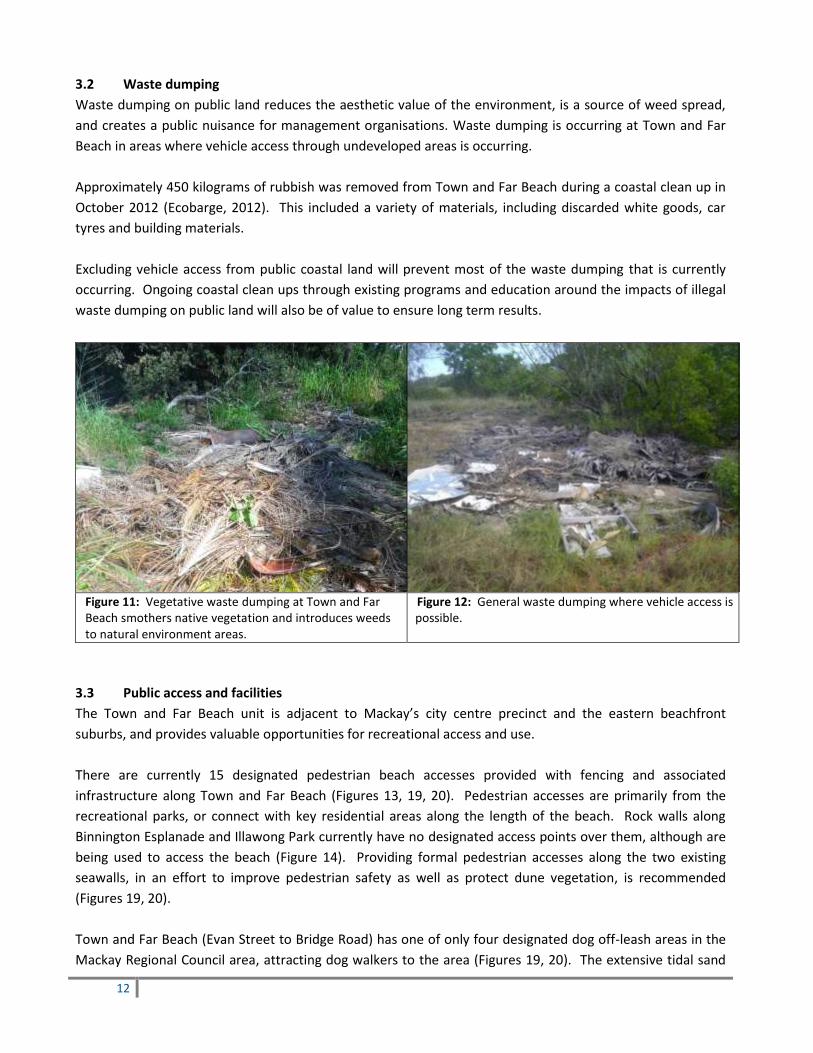
3.2 Waste dumping
Waste dumping on public land reduces the aesthetic value of the environment, is a source of weed spread,
and creates a public nuisance for management organisations. Waste dumping is occurring at Town and Far
Beach in areas where vehicle access through undeveloped areas is occurring.
Approximately 450 kilograms of rubbish was removed from Town and Far Beach during a coastal clean up in
October 2012 (Ecobarge, 2012). This included a variety of materials, including discarded white goods, car
tyres and building materials.
Excluding vehicle access from public coastal land will prevent most of the waste dumping that is currently
occurring. Ongoing coastal clean ups through existing programs and education around the impacts of illegal
waste dumping on public land will also be of value to ensure long term results.
Figure 11: Vegetative waste dumping at Town and Far Beach smothers native vegetation and introduces weeds to natural environment areas.
Figure 12: General waste dumping where vehicle access is possible.
3.3 Public access and facilities
The Town and Far Beach unit is adjacent to Mackay’s city centre precinct and the eastern beachfront
suburbs, and provides valuable opportunities for recreational access and use.
There are currently 15 designated pedestrian beach accesses provided with fencing and associated
infrastructure along Town and Far Beach (Figures 13, 19, 20). Pedestrian accesses are primarily from the
recreational parks, or connect with key residential areas along the length of the beach. Rock walls along
Binnington Esplanade and Illawong Park currently have no designated access points over them, although are
being used to access the beach (Figure 14). Providing formal pedestrian accesses along the two existing
seawalls, in an effort to improve pedestrian safety as well as protect dune vegetation, is recommended
(Figures 19, 20).
Town and Far Beach (Evan Street to Bridge Road) has one of only four designated dog off-leash areas in the
Mackay Regional Council area, attracting dog walkers to the area (Figures 19, 20). The extensive tidal sand

13
flats and exposed nature of this stretch of beach also make it a popular location for water sports such as kite
surfing.
Historically, vehicle access was permitted to this beach and there remain multiple vehicle access points,
particularly from the end of Evan Street and along Illawong Drive, which are still being regularly accessed
(Figures 15, 16). Vehicles destroy coastal vegetation which is essential for stabilising dunes (Brooke, 2013),
and conflicts with other recreational use, such as dog off leash areas. The Queensland Government no
longer supports driving on or adjacent to beaches (“unless required for access and being actively managed to
prevent significant impacts on ecological values and ensure a safe environment for other beach users”, page
16) (Queensland Government, 2011a). Mackay Regional Council’s Local Law 4 prohibits motorised vehicles
from Council-controlled land. In line with this Local Law, installing signage and fencing in relevant areas along
Town and Far Beach to exclude vehicle access from public coastal land is recommended.
There are three named parks in the Town and Far Beach unit:
Iluka Park (Reserve for Park) (Figure 17)
Quota Park (Reserve for buffer zone and open space)
Illawong Park (Reserve for recreation and road purposes)
These parks provide facilities such as barbeques, tables, shelters, various multi-use playgrounds, and public
toilets. A section of the Bluewater Trail also runs through Iluka Park, connecting up with the Sandfly Creek
Environmental Reserve. Together, these parks provide large expanses of open space which add to the
intrinsic value of the Town and Far Beach unit.
There are some opportunities to rationalise the amount of coastal land being mown along Town and Far
Beach in an effort to reduce maintenance costs in the long term and add to the natural environment
infrastructure, where not in conflict with the Mackay Open Space Sport and Recreation Strategy 2010-2016.
For example, the mown extent of Quota Park is currently nearly 6 hectares (60,000m2), and estimated to cost
Council approximately $79,800 annually in mowing expenses alone (personal communication, Mackay
Regional Council, 2013). Recreational facilities are centered at the southern end of Quota Park, lending the
northern end (north of Prudhoe Street) to the potential for revegetation activities, without impeding
pedestrian access to the beach (Figure 18, 20). Revegetating the mown area north of Prudhoe Street to the
east of Binnington Esplanade would reinstate nearly 3 hectares of natural coastal vegetation, eventually
become a self-sustaining ecosystem requiring minimal maintenance and providing the additional benefits of
shoreline stabilisation, and buffering the terrestrial environment from storm tides and wind. Although there
would be an estimated initial cost of $36,000 (includes 120 metres of fencing to direct pedestrian access and
2.9 hectares revegetation) and annually decreasing maintenance costs for watering and weed control, this
would reduce Council’s annual mowing costs by at least $38,000 every year from that point.

14
Figure 13: 15 pedestrian access points are present along Town and Far Beach with fencing and associated infrastructure.
Figure 14: Multiple unofficial tracks are used to access Town and Far Beach over existing rock walls.
Figure 15: Vehicle access through public coastal land (hind dunes) destroys coastal vegetation which is essential for dune stabilisation and health.
Figure 16: Vehicle tracks on Town and Far Beach.
Figure 17: Iluka Park, one of three parks in the Town and Far Beach unit, provides beach front recreational facilities for residents and visitors.
Figure 18: Quota Park is nearly 6 hectares in area.

15
Acknowledgements: 2012 Mackay Urban mosaic 0.1m and 2012 Dog Off Leash Areas supplied by Mackay Regional Council; 2012 Digital
Cadastral Data supplied by Queensland Government.
Figure 19: Town Beach access points and recreational areas

16
Acknowledgements: 2012 Mackay Urban mosaic 0.1m and 2012 Dog Off Leash Areas supplied by Mackay Regional Council; 2012 Digital
Cadastral Data supplied by Queensland Government.
Figure 20: Far Beach access points and recreational areas

17
Acknowledgements: 2012 Central Queensland southern mosaic 0.1m supplied by Mackay Regional Council, 2012 Digital Cadastral Data
supplied by Queensland Government.
Figure 21: Far Beach south access points and recreational areas

18
3.4 Wildlife
There are multiple shorebird roost sites identified in the Town and Far Beach unit, primarily focused around
the Pioneer River mouth banks, northern Town Beach, and Shellgrit Creek (Figure 22). Two of these roosts
are considered significant for the region (300-1000 birds recorded for Pioneer River mouth banks and
Shellgrit Creek entrance; over 1000 birds recorded for Shellgrit Creek), and are threatened by disturbance by
pedestrians, fishers, vehicles, and domestic animals (Harding and Milton, 2003; Milton, 2009). Shorebirds
feed on the tidal flats at low tide, and rest at high tide at available roost sites. Undisturbed time spent
feeding and resting is particularly critical for migratory shorebirds to ensure that they have enough energy
reserves to survive the flight back to their northern hemisphere breeding grounds. Interpretive signs
highlighting the value of Town and Far Beach as shorebird habitat are installed in Iluka Park and Illawong
Park, informing beach users of how they can help to protect these birds (Figures 19, 20). The dog off-leash
area has been located in the centre of the beach unit, away from the main shorebird roosting sites at either
end of the beach. However, ongoing community education and compliance of dogs on leashes to reduce
disturbance to shorebirds, outside of the dog off-leash area, is recommended. Vehicles on Town and Far
Beach additionally cause disturbance, direct mortality to the eggs of beach-nesting resident shorebirds, and
compaction of sand which is destructive for sand-dwelling invertebrates (Queensland Government, 2011).
Town and Far Beach provides four kilometres in length of potential habitat for nesting marine turtles (Figure
22). Monitoring of nesting turtles has occurred in the region since 1993, including on Town and Far Beach
which has had a maximum five nests recorded in one year (Mackay and District Turtle Watch Association,
2012). Adult marine turtles lay their eggs on sandy beaches from approximately October to March each year.
Hatchlings emerge from the nest at night some 50 days later and use the natural light horizon of the moon
on the ocean to navigate their way to the ocean. Threats for nesting and hatchling marine turtles on Town
and Far Beach include light pollution from adjacent residential areas (which disorientates nesting females
and emerging hatchlings), vehicles on beaches, and domestic animals. Rehabilitating a buffer zone of dune
vegetation along the beach to reduce light pollution where possible, and excluding vehicles from the beach,
will improve the habitat for marine turtles.
The vulnerable Mangrove Mouse (Xeromys myoides) Essential Habitat covers the mangrove communities on
the south bank of the Pioneer River, saltmarsh communities remaining at the southern end of Town Beach,
and around Shellgrit Creek (listed Vulnerable by Queensland Nature Conservation Act, 1992) (Figure 22).
In the absence of detailed fauna surveys, beach scrub ecosystems are considered to provide habitat for the
listed Northern Quoll (Dasyurus hallucatus), Rusty Monitor (Varanus semiremex), and Coastal Sheathtail Bat
(Taphozous australis). Approximately two hectares of beach scrub vegetation is mapped on Council Reserve
at the southern end of the beach unit (Queensland Government, 2008). The condition of this vegetation
community is threatened by weed invasion, vehicle access and illegal waste dumping.

19
ACKNOWLEDGMENTS: 2009 Central Queensland southern mosaic 0.5 metre; 2012 Digital Cadastral Data; 2008 Central Queensland remnant beach scrub mapping 1:12,000; and 2006 False Water Rat Essential Habitat mapping supplied by Queensland Government. 2011 Mackay Whitsunday shorebird roosts supplied by Queensland Wader Study Group and Reef Catchments.
Figure 22: Wildlife values Town and Far Beach

20
3.5 Cultural heritage
The Town and Far Beach areas were previously occupied by Traditional Owners and the retention and
rehabilitation of natural areas remains of significance to the Yuibera people. Middens, fish traps or other
items of cultural significance may be present in the area.
A memorial in Illawong Park exists to commemorate the lives of 29 people lost in a plane crash off Far Beach
on June 10, 1960. The TAA Fokker Friendship Abel Tasman flight is reported to have flown into the ocean off
Dudgeon Point, 10km off Far Beach, while on final approach to land at night in foggy conditions, becoming
the worst civil air disaster in Australian aviation history (Mackay Regional Council, 2010).
3.6 Erosion
Sandy shorelines are subject to natural erosion and accretion cycles caused by the impacts of wave, wind and
currents on an open coastline. Ensuring that erosion prone areas remain free of constructed infrastructure
allows natural processes to occur unhindered. This provides the best opportunity for managing shoreline
erosion and retaining environmental values (Queensland Government, 2006).
Rock walls have been constructed seaward of Binnington Esplanade and Illawong Park to protect existing
infrastructure and counter the erosion trend at Far Beach (Short, 2000) (Figure 23). As previously
mentioned, Town Beach has experienced an accretion trend in recent years, which is attributed to the effect
of the southern river training wall trapping sediment moving north (Queensland Government, 2004).
The protection and rehabilitation of the natural dune system that does remain along Town and Far Beach is
important to provide a protective buffer against wind and storm tide inundation. Some sections of the dune
along Town and Far Beach are lacking native vegetation, leaving them vulnerable to erosion processes
(Figure 24). Where inappropriate vehicle or pedestrian access has occurred, bare sand areas have opened up
or been invaded by non-native species and would benefit from rehabilitation activities (Figure 25).
Figure 23: A rock wall was built seaward of Illawong Park to counter erosion at Far Beach.
Figure 24: Some sections of Town and Far Beach currently lack a well-vegetated dune system to provide a natural buffer from wind and storm tide inundation.

21
Figure 25: Dune erosion can occur where sand is exposed from excessive vehicle access.
Figure 26: King tide at Far Beach in front of Illawong Park, 2013.
3.7 Climate change
The response of Australian coastal ecosystems and landforms to climate change will vary but are expected to
involve shoreline recession, vertical accretion, increased saline inundation of wetlands, and the modification
and southward shift of habitat (Australian Government, 2013).
Town and Far Beach are vulnerable to erosion from storm tide inundation and permanent inundation as a
result of expected sea level rise (Figure 27). This map uses the prescribed estimation of 0.8 metre rise in sea
level by the year 2100 to model what the coastline will look like, and currently predicts that much of the
dune system will be inundated by this time (Queensland Government, 2011b). Current king tides reach the
base of the rock wall at Illawong Park (Figure 26). Maintaining and improving the condition of a buffer zone
of coastal vegetation, where possible, will provide the best opportunity to build resilience into these
ecosystems to cope with changes into the future.
As sea levels rise, vegetation communities in the intertidal zone, such as saltmarsh ecosystems, will be forced
to migrate inland. Saltmarsh areas are important for estuarine food chains, provide habitat for marine and
terrestrial organisms, balance nutrients and organic matter, and provide hydrologic support (Dale, Knight,
Breitfuss, Radke, Rogers, 2013). Where possible, land adjacent to tidal flats should remain free of
infrastructure to allow for potential migration of these communities as sea level changes occur. As Figure 28
shows, there are no opportunities in the Town and Far Beach unit for tidal flat communities to migrate inland
owing to existing infrastructure developments, including the Pioneer River levee wall in the north, and the
multi-storey residential dwelling under development at the southern end of Town Beach.

22
ACKNOWLEDGMENTS: 2012 Digital Cadastral Data 2012 and 2011 Queensland Coastal Hazard Areas mapping supplied by Queensland Government.
Figure 27: Coastal Hazard Areas Map Erosion Prone Area Town and Far Beach

23
ACKNOWLEDGMENTS: 2009 Central Queensland 0.5metre mosaic and 2012 Digital Cadastral Data supplied by Queensland Government. Tidal Flat communities from 2009 Regional Ecosystems Version 7 supplied by Queensland Herbarium.
Figure 28: Current extent of tidal flat communities Town and Far Beach

24
4. Recommended activities Town and Far Beach unit is divided into four zones (Figure 29) based on common management values and
issues. The activities recommended seek to protect and enhance the natural environment values of the
coast that have been described, whilst providing for appropriate recreational access and use. Activities will
be implemented on a prioritised basis as resources become available.
Coastal weed control and revegetation principles are provided in Appendices 1 and 2. Coastal fencing
specifications are provided in Appendix 3.
# On-ground activity details
Zone A – Town Beach north (Pioneer River to Evan Street)
1 Weed control and revegetation as required to the east of existing fence line and in undeveloped
natural areas north of the Iluka Park area. Target weed species include Lantana (Lantana camara),
Guinea Grass (Megathyrsus maximus), Para Grass (Urochloa mutica) and declared species. Weed
control on coastal vegetation seaward of the Binnington Esplanade rock wall, with a focus on
protecting the native vegetation that is recolonising naturally.
2 Standardise fencing. Wire fencing to be replaced with standard post and rail fencing at the southern
end of Iluka Park (approximately 70 metres).
3 Formalise two beach accesses along Binnington Esplanade as per Figure 19 where no designated
pedestrian access points currently exist. Providing formal pedestrian accesses will improve
pedestrian safety as well as minimise disturbance to dune vegetation.
4 Upgrade beach access at the end of Evan Street to improve pedestrian safety and minimise
disturbance to dune vegetation.
Zone B – Town Beach south (Evan Street to Kippen Street)
5 Fencing from the car park (corner of Evan Street and Binnington Esplanade) to the adjacent Freehold
land to restrict public vehicle access to State Land. Excluding public vehicle access will prevent waste
dumping, introduction of additional weed species, and the further degradation of coastal vegetation.
A gate to allow emergency vehicle access should be incorporated into the fencing (approximately 35
metres total), and signage erected to inform of the exclusion of vehicles from the area.
6 Weed control to improve the condition and resilience of coastal ecosystems between Evan and
Kippen Street. Key target species in this zone include Lantana (Lantana camara), Guinea Grass
(Megathyrsus maximus), Para Grass (Urochloa mutica) and Prickly Pear (Oputia spp.). Removal of
existing waste dumped may be required. Some revegetation may be required in the future once the
full impacts of the adjacent, multi-storey development are apparent, and the pedestrian access points
associated with this development have been installed.
Zone C – Far Beach north (Kippen Street to Illawong Park southern car park)
7 Weed control and revegetation to improve the condition and resilience of coastal vegetation to the
east of the existing fence lines. Key target weed species include Lantana (Lantana camara), Guinea
Grass (Megathyrsus maximus), Prickly Pear (Oputia spp.), Leucaena (Leucaena leucocephala).
Revegetation may be required where light pollution is identified as an issue, or large areas of non-
native species require replacement.

25
8 Formalise one beach access from Illawong Park as per Figure 20 where no designated pedestrian
access points currently exist. Providing formal pedestrian access at a central point will improve
pedestrian safety as well as minimise disturbance to dune vegetation. Fencing and/or signage may be
required to direct pedestrians to the formal access point.
9 Upgrade beach access from Kippen Street to improve pedestrian safety and minimise disturbance to
dune vegetation.
10 Revegetation of northern end of Quota Park. The opportunity exists to consider rationalisation of
mown parklands, where not in conflict with the Mackay Open Space Sport and Recreation Strategy
2010-2016. Revegetation of the northern end of Quota Park (north of Prudhoe Street, approximately
29,000m2) would reduce mowing costs by approximately $38,000 annually. Revegetating this area
would reinstate nearly 3 hectares of natural coastal vegetation, eventually become a self-sustaining
ecosystem requiring minimal maintenance and providing the additional benefits of shoreline
stabilisation, and buffering the terrestrial environment from storm tides and wind. A fence
(approximately 120 metres) will be required to define southern boundary of revegetation area and
direct pedestrian access to the beach.
Zone D – Far Beach south (Illawong Park southern car park to Shellgrit Creek)
11 Fencing along Illawong Drive to exclude public vehicle access from the Reserve (approximately 1,300
metres). Fencing alignment will allow private access to the pre-existing Lease Land tenured
properties only (Figure 21). Excluding public vehicle access will prevent waste dumping, introduction
of additional weed species, and the further degradation of coastal vegetation. A gate to allow
emergency vehicle access should be incorporated into the fencing as required, and signage erected to
inform of the exclusion of vehicles from the area.
12 Weed control to improve the condition and resilience of coastal vegetation in this 22 hectare
Reserve. Key target species in this zone include Lantana (Lantana camara), Guinea Grass
(Megathyrsus maximus), and declared species. Removal of existing waste dumped may be required.
13 Revegetation of undeveloped natural areas currently being mown to the east of existing fence lines,
particularly adjacent to Illawong Drive in localised areas at both the northern and southern ends of
this zone (approximately 1.8 hectares). Some additional revegetation may also be required if large
areas of non-native species require treatment and/or if the recovery of dunes following the exclusion
of vehicle access requires additional support.
Other activities across multiple zones
14 Continue implementation of the beach signage project. This includes updating and rationalising
regulatory signage advice regarding dogs on leads, pedestrian and vehicle access points, waste
dumping, camping, and illegal fires. Compliance activities to support signage and education campaigns.
15 Educate coastal community on local weed species and promote the use of local native species in
residential gardens.
16 Education and compliance activities on the disposal of garden waste and other debris at designated
Council refuse sites.
17 Education and compliance activities on the prohibition of public vehicle access on Council-controlled
Reserves. Education to include the impacts of vehicles on coastal ecosystems, and include advice on
alternative locations for motorised vehicle access.

26
ACKNOWLEDGEMENTS: Central Queensland 0.5metre mosaic 2009 and Digital Cadastral Data 2012 supplied by Queensland Government.
Figure 29: Zones for recommended activities Town and Far Beach

27
5. References
Australian Government (2013) Understanding the risks of climate change to coastal natural environments. Department of Industry, Innovation, Climate Change, Science, Research and Tertiary Education. Viewed at http://www.climatechange.gov.au/climate-change/adapting-climate-change/australias-coasts-and-climate-change/coastal-risks/natural
Brooke, B. (2013) Beach Erosion. Geoscience Australia. Viewed at
http://www.ozcoasts.gov.au/indicators/beach_erosion.jsp Dale, P., Knight, J., Bretifuss, M., Radke, L., Rogers, K. (2013) Saltmarsh and saltflat areas, OzCoasts
Australian Online Coastal Information. Geoscience Australia. Viewed at http://www.ozcoasts.gov.au/indicators/changes_saltmarsh_area.jsp
Ecobarge Clean Seas Inc. (2012) After clean up report, 13-14 October 2012. Internal report. Harding, S., Milton, D. (2003) Mackay Shorebird Project Final Report, Queensland Wader Study Group. Mackay and District Turtle Watch Association (2012) Marine Turtle Nesting 1993-2012. Internal data. Mackay Regional Council (2009) Mackay Regional Council Coastal Management Guidelines. Available at
http://www.mackay.qld.gov.au/environment/coastal_management Mackay Regional Council (2010) Tragic Crash Remembered, Mackay Regional Council News in Focus. Issue
11, May 2010. Viewed at http://www.mackay.qld.gov.au/__data/assets/pdf_file/0008/83366/May_In_Focus_2010.pdf
Milton, D. (2009) Internal Data Provided on Shorebird Roost Sites within Mackay Whitsunday Region (1993-
2008), Queensland Wader Study Group. Reef Catchments (2009) Sandfly Creek Environmental Reserve Management Plan. Available at
http://www.mackay.qld.gov.au/environment/reports_and_plans Queensland Government (2004) Mackay Coast Study, State of Queensland Environmental Protection Agency. Queensland Government (2006) Draft Mackay-Whitsunday Regional Coastal Management Plan, State of
Queensland Environmental Protection Agency. Queensland Government (2008) Central Queensland Remnant Beach Scrub Mapping. State of Queensland
Environmental Protection Agency, shapefile. Queensland Government (2011a) Queensland Coastal Plan. Department of Environment and Resource
Management. Queensland Government (2011b) Queensland Coastal Hazard Areas Map. State of Queensland, Department
of Environment and Heritage Protection, shapefile. Viewed at http://www.ehp.qld.gov.au/coastal/management/coastal_plan_maps.php

28
Queensland Government (2013) Remnant Vegetation in Queensland. Department of Environment and
Heritage Protection. Viewed at http://www.ehp.qld.gov.au/ecosystems/remnant-vegetation/ Queensland Herbarium (2009) Regional Ecosystem Description Database (REDD). Version 6.0b. Queensland
Department of Science, Information Technology, Innovation and the Arts: Brisbane. Short, A. (2000) Beaches of the Queensland Coast: Cooktown to Coolangatta, Sydney University Press, Sydney.

29
Appendix 1: Coastal weed control principles
Principles Comments
Staged weed
removal
Weed removal should be carried out in a staged approach.
Work outwards from intact remnants of coastal vegetation as a priority.
Particularly important in removal of non-native vegetation along the dune scarp.
Large woody weeds should be removed slowly to ensure the replaced native
vegetation provides sufficient habitat value and protection against erosion before
more removal of woody species.
Physical
weed
removal
Physical weed removal, including hand pulling, chipping or cutting weeds is effective in
small infestations in environmentally sensitive areas.
Mechanical
weed
removal
Mowing or brush cutting will suppress weed growth, discourage seeding and spread.
This method should be used particularly in areas bordering large infestations.
Care should be taken to reduce potential disturbance as excessive mowing and brush
cutting can facilitate further weed growth and reduce regeneration of native
vegetation.
Herbicide
weed
removal
The application of herbicides includes foliage or basal spraying, cut/ paste and stem
injection where applicable.
Spraying may be carried out on large or robust weed infestation, particularly to gain
initial control of an infestation. However the majority of spraying is likely to be small
scale ‘spot spray’ applications to minimise non-target impacts.
Roundup Bi-active ® is recommended due to its low toxicity to wildlife and humans.
Timing Weed control on foredunes to occur between April and October only, to avoid turtle
nesting season (November to March).
Weed control on hind dunes can occur at any time of the year depending on local
weather conditions. Herbicide application is ineffective if carried out during rain
periods, or once the plants have entered their non-active period during extended dry
periods.
Consideration
of fire risk
Once treated, remaining dead woody weeds (such as Lantana) should be pulled away
from native trees to reduce the fire risk to fire-sensitive coastal vegetation should
‘accidental’ fires occur. This woody, dry biomass serves as fuel for fires and by pulling
it away from native trees it reduces the chances of fire reaching the canopy.
Mulching down of large, dense areas of dead woody weeds using brush cutters or
hand tools, would similarly reduce fire risk and allow native plants a better chance at
regeneration.
Preventing
re-
infestations
Keep maintenance vehicles on the existing tracks where possible to reduce disturbance.
Clean maintenance vehicles before and after access to the site to prevent weed spread
or introduction.
Monitor the success of weed control techniques and native regeneration following
several wet seasons to assess whether revegetation might be needed in large areas of
infestation.

30
Appendix 2: Coastal revegetation principles
Encouraging the natural regeneration of native species is the best method for restoration of an area. For
this to occur a viable seed bank must be present, and re-growth must include all native plant species from
each stratum level. In areas where natural regeneration is to occur, the area should be clearly marked to
exclude public access. In these areas, ongoing maintenance is required to minimise re-growth of weed
species. However, the planting of local native vegetation (revegetation) is sometimes required due to
insufficient cover or re-growth of native species.
Revegetation techniques
Revegetation in natural areas aims to reinstate Regional Ecosystems communities as described by
Queensland Herbarium (Regional Ecosystem Description Database). In disturbed areas, pre-clearing
mapping is available to inform what Regional Ecosystems were present prior to vegetation clearing.
Suggested techniques for coastal revegetation in the Mackay Regional Council area include:
Local native species for planting should be sourced from within the Sarina Proserpine lowlands
Subregion of the Central Queensland Coast Bioregion.
Site preparation, such as weed control, should be carried out prior to planting.
Depending on the site-specific circumstances coastal plantings may benefit from the use of mulch,
weed mats, stakes, and/or tree guards.
Tubestock planted in sandy soils will benefit from the addition of a wetting agent and fertiliser at the
time of planting (eg. Terracottem).
Ongoing maintenance of the site is required.
Figure 1: Coastal dune planting guide

31
Consideration of fire risk
State Planning Policy 1/03 under the Sustainable Planning Act 2009 deals with the mitigation of adverse
impacts of bushfire, and includes a natural hazard assessment for bushfires and the subsequent provision
of safety buffers. According to this policy, a low hazard score and no prescribed safety buffer width is
allocated to “narrow strips of coastal vegetation with a linear shape, less than 50 hectares in area and more
than one kilometre from the nearest extensive vegetation, on 0-5% slope, with an eastern aspect”
(Queensland Government, 2003).
All revegetation activities undertaken as part of coastal projects will be done so with consideration of this
State Planning Policy. Designated space for fire breaks and emergency vehicle access will be provided
between freehold properties and natural environment areas being revegetated, as per Mackay Regional
Council Coastal Management Guidelines (2009).
Selecting plants for revegetation
The table below provides a generic list of recommended species for dune revegetation in the Mackay
region, compiled from characteristic species of relevant Regional Ecosystems (8.2.1, 8.2.2, 8.2.6 and 8.2.9),
various coastal species lists from Subregion 2, revegetation recommendations, and field observations.
The species selected for revegetation at any particular location will ultimately depend on current and pre-
clearing Regional Ecosystem mapping, and site-specific conditions (such as aspect, topography, existing
vegetation, soil condition, availability of appropriate plants, etc).
Regional Ecosystem
number
General Description Occurs
8.2.1 Casuarina equisetifolia open forest to woodland with Ipomoea
pes-caprae and Spinifex sericeus dominated ground layer on
foredunes.
Foredune, includes
strand
8.2.2 Microphyll vine forest (beach scrub) on coastal dunes. Dune swales and
protected hind
dunes
8.2.6 Corymbia tessellaris + Acacia leptocarpa + Banksia integrifolia +
Melaleuca dealbata + beach scrub species open forest on coastal
parallel dunes.
Coastal parallel
dunes
8.2.9 Grassland on coastal dunes Coastal dunes

32
Species name Common name Habit Regional
Ecosystem
Acacia leptocarpa Northern Wattle, Slender-
fruited Wattle
Tree 8.2.6
Acacia oraria Coastal Wattle Tree 8.2.2; 8.2.6
Acronychia laevis Yellow Wood, Hard Aspen,
Glossy acronychia
Tree 8.2.2
Alphitonia excelsa Red Ash, Soapy ash Tree 8.2.1; 8.2.6
Argusia argentea Octopus bush Tree 8.2.1
Banksia integrifolia Coastal banksia Tree 8.2.6
Calophyllum inophyllum Beauty Leaf, Beach
Calophyllum, Ball nut
Tree 8.2.1
Canavalia rosea Beach bean Groundcover 8.2.1
Capparis lucida Coastal caper Tree 8.2.1; 8.2.2
Casuarina equisetifolia Coastal she oak Tree 8.2.1
Chionanthus ramiflora Native olive Tree 8.2.2; 8.2.6
Clerodendrum floribundum Lolly bush Tree 8.2.2; 8.2.6
Clerodendrum inerme Coastal lollybush Shrub 8.2.1
Corymbia tessellaris Moreton Bay ash Tree 8.2.6
Crinum pedunculatum River Lily, Swamp lily Tufty 8.2.1
Crotalaria mitchellii Sand rattlepod Herb 8.2.9
Cupaniopsis anacardioides Tuckeroo Tree 8.2.1; 8.2.2; 8.2.6
Cymbopogon refractus Barbed Wire Grass Grass 8.2.9
Cyperus pedunculatus Pineapple sedge Sedge 8.2.1; 8.2.9
Dianella caerulea Blue flax lily Tufty 8.2.6; 8.2.9
Dianella longifolia Smooth flax lily Tufty 8.2.6a; 8.2.9
Diospyros geminata Scaly ebony Tree 8.2.2; 8.2.6
Dodonaea viscosa subsp.
viscosa
Sticky hop bush Shrub 8.2.1
Drypetes deplanchei Yellow tulip Tree 8.2.2
Eragrostis interrupta Coastal love grass Grass 8.2.6; 8.2.9
Eriachne triodioides Wanderrie grass Grass 8.2.6; 8.2.9
Eugenia reinwardtiana Beach cherry Shrub 8.2.2
Euroschinus falcatus Ribbonwood Tree 8.2.2; 8.2.6
Eustrephus latifolius Wombat berry Climber 8.2.2; 8.2.6
Ganophyllum falcatum Scaly Ash Tree 8.2.2; 8.2.6
Geitonoplesium cymosum Scrambling lily Climber 8.2.2; 8.2.6
Heteropogon triticeus Giant spear grass Grass 8.2.6; 8.2.9
Hibbertia scandens Golden Guinea Flower, Snake
Vine
Climber/ground cover 8.2.1
Hibiscus heterophyllus Native hibiscus Shrub 8.2.6

33
Hibiscus tiliaceus Cottonwood, Cotton Tree,
Cowtucker
Tree 8.2.1
Imperata cylindrica Blady Grass Grass 8.2.6; 8.2.9
Ipomoea pes-caprae Goats foot convolvulus Groundcover 8.2.1
Jagera pseudorhus Foam bark Tree 8.2.6
Jasminum didymium Native jasmine Climber/Shrub 8.2.2; 8.2.6
Lomandra longifolia Spiny-headed Mat-rush Tufty 8.2.6
Macaranga tanarius Macaranga Tree 8.2.2; 8.2.6
Mallotus philippensis Red kamala Tree 8.2.2; 8.2.6
Melia azedarach White cedar Tree 8.2.6
Mimusops elengi Red coondoo Tree 8.2.2
Morinda citrifolia Giant Morinda, Cheese Fruit,
Smelly cheese tree
Tree 8.2.1
Pandanus tectorius Beach Pandan, Coastal Screw
Pine Pandanus
Tree 8.2.1; 8.2.6
Pittosporum ferrugineum Rusty pittosporum Tree 8.2.2; 8.2.6
Planchonia careya Cocky apple Tree 8.2.6
Pleiogynium timorense Burdekin plum Tree 8.2.2; 8.2.6
Scaevola taccada Sea lettuce Shrub 8.2.1
Sophora tomentosa Silver bean Shrub 8.2.1
Spinifex sericeus Beach spinifex Grass 8.2.1
Sporobolus virginicus Marine couch Groundcover 8.2.1
Stephania japonica Tape vine Climber/ground cover 8.2.1; 8.2.2; 8.2.6
Sterculia quadrifida Peanut tree Tree 8.2.2; 8.2.6
Terminalia muelleri Coast Damson Tree 8.2.1; 8.2.2; 8.2.6
Themeda triandra Kangaroo grass grass 8.2.6; 8.2.9
Thespesia populnea Tulip tree Tree 8.2.1
Thuarea involuta Birds beak grass Grass 8.2.1
Vigna marina Vigna Groundcover 8.2.1
Vitex rotundifolia Creeping Vitex, Beach Vitex Groundcover 8.2.1
Vitex trifolia Coastal vitex, Common blue
vitex
Shrub 8.2.1
Xerochrysum bracteatum Golden Everlasting Daisy Annual herb 8.2.9

34
Appendix 3: Coastal fencing specifications
Related Documents


