Town and Country Planning Mohd. Zameeruddin Mohd. Saleemuddin Assistant professor, Department of Civil Engineering, MGM’s College of Engineering, Nanded (m.s) © mzsengineeringtechnologies email@ [email protected]; [email protected] Lecture No. 1: Introduction

Welcome message from author
This document is posted to help you gain knowledge. Please leave a comment to let me know what you think about it! Share it to your friends and learn new things together.
Transcript

Town and Country Planning
Mohd. Zameeruddin Mohd. SaleemuddinAssistant professor,
Department of Civil Engineering,MGM’s College of Engineering, Nanded (m.s)
© mzsengineeringtechnologiesemail@ [email protected];
Lecture No. 1: Introduction

2
SyllabusTheory paper- 80 Term work- No Test-20
Section A (40)Unit 1: Evaluation of Town PlanningUnit 2: Fundamental of Town PlanningUnit 3: Urban Transports
Section B (40)Unit 4:Town Planning and IndustriesUnit 5:Urban Renewal and RedevelopmentUnit 6:Building Byelaws.
Recommended books:1. Town Planning – S. C. Rangwala2. Town and Country Planning – M. K. Gandhi3. Town and Country Planning – Modak and Ambedkar
© mzsengineeringtechnologies
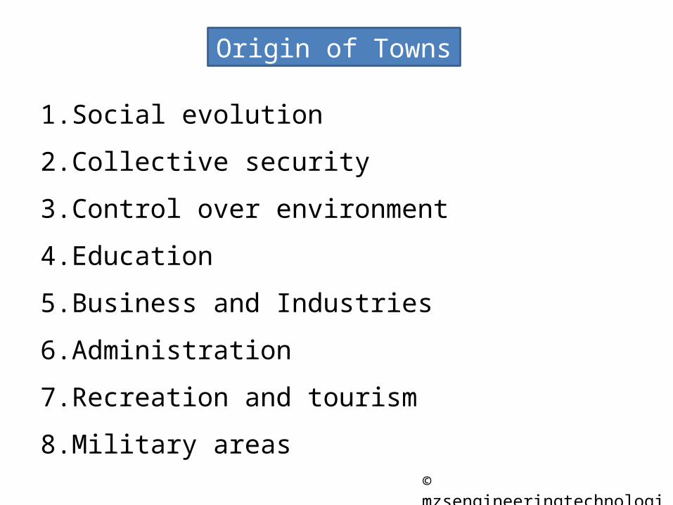
Origin of Towns
1. Social evolution
2. Collective security
3. Control over environment
4. Education
5. Business and Industries
6. Administration
7. Recreation and tourism
8. Military areas© mzsengineeringtechnologies

Ancient Towns
1. Memphis2. Thebes3. Urs4. Babylon5. Persepolis6. Mohanjo – Daro7. Perking8. Patliputra9. Takshasila10. Nalanda
© mzsengineeringtechnologies

Town Planning
It is the term used to indicate the arrangement of various components or units of a town in such a way that the town as such attains the significance of a living organism
- S. C. Rangwala
The town planning is a science as well as an art too ……•Collecting•Correlating•Analysis
•Beautiful•Convenient•Economical•Efficient unit
© mzsengineeringtechnologies

Objects of Town Planning
1. Beauty2. Convenience3. Environment4. Health
Principles of Town Planning
1. Green belt – Limitation of town size2. Housing – Accommodation to various categories of people3. Public buildings – well balanced grouping and distribution4. Recreation centers – Social binding5. Road systems – Layout of its road6. Transport facilities – Minimum loss of time 7. Zoning – Commercial zone, Industrial zone, residential zone,etc.
© mzsengineeringtechnologies

Necessity of Town Planning
1. Defective road system
2. Development of slums and squatter settlements
3. Haphazard location of industries
4. Traffic congestion
5. Inadequate open spaces
6. Lack of essential amenities
7. Noisy atmosphere
8. Uncontrolled development
9. Unhealthy living
© mzsengineeringtechnologies

Growth of Town Town or Cities
OriginNatural
Concentric Spread
Ribbon Development
Satellite Growth
Scattered growth
Planned
DirectionHorizontal growth
Vertical growth
© mzsengineeringtechnologies

Natural Growth
1. Growth of town has been taken place without any future planning.
2. On spot decisions has been made for immediate comfort and convenience of residents.
3. Provisions of various essential amenities such as road system, parks, play grounds, schools, industrial units, commercial centers, hospitals, cinemas are made in an irregular way without any consideration for future expansion of the town
Natural Growth
Concentric Spread
Ribbon developme
nt
Satellite growth
Scattered growth
© mzsengineeringtechnologies

Concentric Spread
This type of development takes place due to tendency of people to near to town centre. Town develops in the form of concentric rings with nucleus as a town.
The idea of concentric spread is based on the fact that similar or functionally related activities will be located at the same distance from centre of an urban area.First zone embodies the central business district and focal point of commercial, social and civic life of town area.
Disadvantages:•Improper housing•Concentration of people•More transportation time and charges•Congestion of the traffic and accidents•Inner zone extends its area by invading the adjoining zone
© mzsengineeringtechnologies

Ribbon Development
Ribbon development is building houses along the routes of communications radiating from a human settlement.
Such development results long fingers or ribbons of houses, factories, shops, etc as shown in image
The development involves usage of land along the frontage of highway or service roads, the interior is left undeveloped causing of wastage of valuable land
© mzsengineeringtechnologies

Disadvantages of Ribbon Development1. As a result of linear expansion of housing along the length of highway or
service roads, there is increase in cost of basic utility services like water supply, electricity, telephone, etc resulting in wastage of available resources.
2. Future improvements becomes costlier, difficult and some times not possible.
3. The housing face heavy traffic associated with noise and polluted air.
4. Traffic congestions and traffic delays becomes common feature of town.
5. Loss of traffic capacity and efficiency due to local traffic, pedestrians, minor and major accidents, advertisement and obstruction to view.
6. There is lack of social life.
7. Needs creation of a competent authority to enforce the various legislative measures.
8. Removal of encroachments from the road right-of-way, etc.
© mzsengineeringtechnologies

Satellite Town
Expansive development of town reaching certain size, results in development of near by town known as satellite town
Term satellite is used to indicate a body under the influence of a more powerful body but possessing it own identity
© mzsengineeringtechnologies

Satellite TownFeatures:1. Possess its own local government and
corporate life.
2. Connected with parent city by local trains, buses etc.
3. Own capabilities to decide economic, social and cultural activities.
4. Located beyond the green belt of parent city.
5. No industrial development is allowed, only reserved for residential area having local shops, small scale industries like dairy, cereal mills etc.
6. The residents may be workers serving to industry or offices of parent city
Disadvantages:•Over stated or over-estimated journey to work.
•Depends on efficiency of transport systems
•Deprived of entertainment and cultural activity
© mzsengineeringtechnologies

Scattered Growth
Towns shows erratic growth.
Develops in a very irregular way.
Results into traffic congestion, encroachment of industries on residential areas, slums, lack of parks , wastage of funds and valuable lands.
© mzsengineeringtechnologies

Planned Growth © mzsengineeringtechnologies
•Town develops in a predetermined line as conceived by town planner and building officials.
•Enforcement of suitable rule and regulations.
•Proper land uses is assured by strictly following zonation.
•Assurance of public utilities such as water supply, electricity, drainage, gas service, telephone, etc.
•Assurance of educational facilities like schools, library, colleges, etc.
•Assurance of recreational facilities like, park, garden, play ground, stadium, etc.

Growth according to direction : Horizontal© mzsengineeringtechnologies
Town expands and develops horizontally in all directionsSuch growth is possible at places where plenty land is available in nominal cost
Advantages:1. Saving in construction cost.
2. Doest not require high technical personnel's.
3. Maximum possible use of natural light.
4. Density of population is restricted.
5. Marginal space surrounding can be used for gardening

© mzsengineeringtechnologiesGrowth according to direction : Vertical
City grows vertically which is achieved by adding more floors in existing buildings or by constructing high rise structures
Such growth is suitable where there is high land values
Advantages:1. Sense of social life.2. Cost per unit area will be in the
reasonable limit.3. Considerable saving in land.4. Maximum use of modern construction
techniques.Disadvantages:5. Density of population is more.6. Provisions for life safety arrangements
for natural calamities.7. Deprived of natural living near the
ground.

Stages of Town development
Town
Primary
Secondary
Tertiary
Sir Patrick Geddes (1854-1932)
Produces mainly human necessities e.g. Agriculture Village
Acts as centre of exchange e.g. Marketing town
Provides residential, recreational and educational facilities
© mzsengineeringtechnologies

Stages of Town development
Lewis Mumford
Necropolis: The town is in the worst stage. The inhabitants prefer to shift to the near by villages for various reasons
such as disease, famine, war, economic breakdown, etc. the
town may recover or re-establish after an interval of
time
Tyrannopolis: the town further deteriorates and situation such as trade
depression, military power, exploration of colonies , etc
occur.Megalopolis: It indicates first sign of decline. The originality of town shows sign of declineMetropolis: It indicates the town serving as capital of state
or regionPolis : It indicates an association of population with some sort of specialization and
mechanizationEopolis : it indicates the village community having
economy based on agriculture
© mzsengineeringtechnologies

Stages of Town development
TownInfantile
Juvenile
Mature
Senile
Griffith Taylor
The town is divided into separate distinct zones.
In this shops are separated from houses and there are few factories
In this stage, the town is distinctly divided into residential zone and industrial zone.
This stage indicates the physical decay of most of the portions of the town
© mzsengineeringtechnologies

Stages of Town development (Indian) Town
Basic Village
Service Town
Rural town Town
Population 400 -500 soulsPrimary occupationAgricultureStabilityPrimary school, open well, Murom roads, mobile dispensary, etc.
Population 2000-3000 soulsPrimary occupationCultural, commercial and administrativeStabilitySecondary school, tube well, Murom roads, mobile dispensary, community hall, etc.Groups 10-15 basic villages
Population 5000-7000 soulsPrimary occupationSmall scale industries over and above the agricultural employmentStabilitycolleges, pipe water supply, Macadam roads, health center, community hall, etc.Groups 25-30 basic villages
Last level of settlementPopulationCity50,000 – 1,00,000Great – City1,00,000 – overSuper – CityMore than 3 Lacs.Metropolis 1 cr and aboveMegalopolis5 cr and above
© mzsengineeringtechnologies

Forms of planning
To maintain the continuity in the planning process, following forms of planning are considered;1. Local planning
2. Country planning
3. Regional planning
4. National planning
5. International planning
© mzsengineeringtechnologies

Local planning
Planning is based on creation of healthful living and working environment for the majority of the inhabitants of the town with due consideration to the physical background, economic limitations, public administration, finance and change in technology, etc.
The development plan for city or town aims at proper distribution of population densities, regulation of green belts, suitable division of the area in various zone of the area in various zone, etc.
© mzsengineeringtechnologies

Country planning
1. The planning aims at controlled development of area surrounding a town.
2. A town is surrounded by villages and rural planning becomes necessary for the proper functioning of town.
3. For this surrounding villages should be linked up with suitable transport facilities.
4. Encouragement should be given for the growth of small scale industries such as dairy , poultry forming, basket and rope making, hand looms etc.
5. Planning aims to achieve proper balance between agriculture and industries.
© mzsengineeringtechnologies

Regional planning
Regional planning helps in controlling and reshaping major towns in the region.
Term region is used to define as an area separated not merely or exclusively by natural boundaries but equally by political or administrative boundaries.
Four methods of determining a region is advocated;1. Geographic boundaries,2. Economic considerations,3. Administrative convenience, and4. Metropolitan influence.
© mzsengineeringtechnologies

Country planning cannot be divorced from town and regional planning, because the town and country are not two separate entities but are complementary to each other
Regional planningIt avoids the wasteful duplication of facilities.
It ensures the most profitable utilization of the resources at minimum expense for the maximum benefit.
Provides information regarding the economic functions.It grants mutual control over the areas in the region.It grants planned and harmonious development.It involves planning in terms of regional dimensions.It reveals new town-planning and building principles.It serves as a link of co-operation and co-ordination
between the areas of the region.
© mzsengineeringtechnologies

National planning
National planning involves careful study of the social, education, economic, industrial and other problems facing a country and suggests measures to be adopted to obtain realistic solution thereto.
It accounts for country’s existing and potential resources in men, materials, power, manufacturing industry, etc and draw out a phased programme of action for achieving the targets set in the various spheres of activity.
whole country is considered as a single unit and an overall picture of development is kept in view, while striving to strike a balance between the various states
In India, the various five year plans are an example of National Planning.
© mzsengineeringtechnologies

National planning
Vision:A. Development of nation in terms of its administrative or
political system.
B. Development of various economic sectors such as agriculture, fishing, mining, quarrying, etc.
C. Developments in terms of social sector such as clothing, housing, food, education, health, employment, recreation, etc.
D. Development at various level i.e. international level to local level or vice versa.
© mzsengineeringtechnologies

International planning
International planning came in to picture with the formation of United Nation Organization (UNO).
It involves numerous study and surveys in the fields such as health, education, housing, food and agriculture.
The studies helps in finding out remedies and solutions of complicated problems at an international level.
UNESCO, WHO, LIC, GROUP 8 SUMMIT, SAARC, UNISEF
© mzsengineeringtechnologies

Memphis Townships
1. Euphrates River2. Surrounding wall3. Moats4. Ishtar gate5. Temple6. Hangout gardens
Ancient planning (Pre- Mediaeval)
© mzsengineeringtechnologies

1. Walled city2. Narrow roads3. Cramped dwellings4. Emperor palace at
centre
Peking Townships
Ancient planning (Pre- Mediaeval)
© mzsengineeringtechnologies

1. Walled city2. Narrow roads3. Cramped dwellings4. Emperor palace at
centre
ElburgTownships
Ancient planning (Pre- Mediaeval)
© mzsengineeringtechnologies

Noerdlingen Townships
1. Walled city2. Cramped
dwellings3. Emperor palace at
centre4. Irregular pattern
roads
Ancient planning (Pre- Mediaeval)
© mzsengineeringtechnologies

Ancient planning (Mediaeval town)
1. Square form2. temple3. shops4. Public building
grouped arround
© mzsengineeringtechnologies

1. Regular layout of street
2. Perfect system of water supply and drainage
3. Tow mounds4. Monastery5. Bath
Mohenjo -Daro
Ancient planning (Mediaeval town)
© mzsengineeringtechnologies

Ancient planning (Mediaeval town)
1. Grid iron pattern2. Perfect system of
water supply and drainage
3. Lakes
© mzsengineeringtechnologies

Ancient planning (Renaissance town)
Vienna, Capital of Austria© mzsengineeringtechnologies

First Sanitary And Public Health Act of Great Britain (1840)
This was an first attempt to control the quality of construction from private housing.
The act controls only the construction of individual building by laying down standards for structural stability, their fire-proof construction, provision of sanitary appliances, water supply, adequate ventilation, pedestrian and vehicular traffic
Disadvantages:The act did not contain any provision in regard to the relationship of the individual building with neighbouring buildings and amenities such as primary and secondary schools, shopping facilities, open spaces or other essential needs, by earmarking land for these purpose.
© mzsengineeringtechnologies

The major change in present act was made with an amendment in the act to enable local authorities to acquire and clear insanitary dwelling and to construct new houses on the sites occupied by them, the Act was renamed as;
Housing Act (1980)
First Sanitary And Public Health Act of Great Britain (1840)
© mzsengineeringtechnologies

First Sanitary And Public Health Act of Great Britain (1840)
To provide remedy to first to deal with town planning and housing was passed in Great Britain in 1909.
Its main objective was to achieve the basic concept of town planning viz. ensuring the use of land in the best interests of the nation as a whole and preventing further mischief.
As some of the suburban developments of cities were sterilizing the country's most valuable resources
© mzsengineeringtechnologies

Garden City The concept of garden city was put forth by a shorthand writer in the house of common, Ebenezer Howard in 1898.
In his book titled “ To-morrow” later published under title “garden cities of To-morrow”.
The idea of city called by him a garden city, to reconcile country life and town life and to grant various other advantages to population of this city.
This concept find his way in formulation by Garden Cities and Town planning Association, 1919
© mzsengineeringtechnologies

“Garden cities allowed a genuine celebration and renewal of nature, even within an essentially urban industrial economy.”
Garden cities have been the richest source of planning over the last century. Within the principles of garden cities many key principles of planning practice in the 20th century can be found.
Land use segregation Master planning Residential site planning Neighborhood units Road hierarchies
Garden City
Shopping malls Industrial parks Regional planning Planned decentralization Greenbelts
© mzsengineeringtechnologies

Garden City
Definition:-“A garden city is a town designed for healthy living and industry; of a size that makes possible a full measure of social life, but no larger; surrounded by a rural belt; the whole of land being in public ownership or held in trust for the community”
Principles of garden city;1. Co-operative holding of a land to insure that the advantage of
appreciation of land values goes to the community and not to the private individual;
2. Economic and social advantages of the large scale planning;3. Establishment of cities limited in size, but at the same time,
possessing a balanced agricultural and industrial economy;4. Urban decentralization; and5. Use of a surrounding green belt to serve as an agricultural,
recreational area and to assist the extension of limit.
© mzsengineeringtechnologies

Garden City

Garden City
Outcome of study of Three Magnets;1. It contains open spaces and gardens around all the dwelling
houses and also factory buildings.
2. Population which is neither too small nor too large. Howard advocated the limit of population between 30,000 to 40,000
3. City is owned by all citizens on a co-operative basis. Ownership extends up to green belt or agricultural zone.
4. Independent entity having its own civic life and affording all the daily needs with adequate space for schools and other functional purposes and pleasant parks and parkways
© mzsengineeringtechnologies
© mzsengineeringtechnologies

Garden City
5. Self sustain unit having its own industries.
6. Town area is surrounded on its periphery by a green belt i.e. a larger area is reserved permanently for agriculture ensuring the country’s benefits.
7. No need to have rapid transit arrangements
8. Principle of zoning is followed
9. Surplus fund is utilized for the development of the community itself.
© mzsengineeringtechnologies
© mzsengineeringtechnologies

Garden City
Letchworth (1903)48 km from London
Total area 1851 hectaresGreen belt 1200 hectares
Houses 8500Factories 95
Population 28000Planned as a home of all kinds of industries with facilities of cheap light, power, fuel and water.
Designed to meet the requirement of workers and labourers
Welwyn (1920)Midway of London and Cambridge
Classification of garden Cities1. Garden city or self-
contained industrial community.
2. Garden suburb for residential accommodation.
3. garden or factory village built around a large manufacturing concern by its employers.
© mzsengineeringtechnologies

Comparison of Garden Cities and Satellite Town
Sr. No
Feature Garden cities Satellite towns
1 Dependence Self-sufficient and self-contained units
Dependent on the parent city except having local shops, primary schools, etc
2 Gardens Around all houses and factories
Not compulsory
3 Green belts Surrounded by green belt
Situated outside green belt of the parent city
4 Industries Permitted Not permitted5 Rapid transit
arrangementNot necessary Necessary in the form of
local train and buses
6 Roads and communication
Arterial and streets Only one arterial road to the parent city
7 Zoning Essential May or may not have
© mzsengineeringtechnologies

SURVEYS
1. THE PEOPLE, THEIR INTERESTS AND OCCUPATIONS AND HOW THEY FOLLOW THEM; AND
2. THE LAND AND BUILDINGS AND HOW THEY SERVE THEIR INTERESTS
Chief Subject of surveys
MapsChartsSchedulesmodels
StatisticsCollectionTabulation
Presentation
CollectedProcessedArranged
IntegrityHonestly
objectively
© mzsengineeringtechnologies

SURVEYS
Necessity
1) The surveys draws attention to the inter-relation between various complicated activities of a town life.
2) The survey stresses the local requirements and appropriate treatment to be given socially, conveniently and artistically
Role
1) To evaluate the effects of development;2) To present detailed reasoned reports;3) To provide the necessary understanding before decision for
development are made; and4) To study the situation objectively and factually

Collection of data
1. Functional survey2. Social survey3. Territorial survey4. Vital survey
Functional survey
Means of communication, condition of industries and commerce, implementation of plan and financial aspects
Social survey
Community structure, history, architecture, health conditions, housing and public services
© mzsengineeringtechnologies

Collection of data
Territorial survey
Physical features, agricultural soil, forests, climatic conditions and type of soils
Vital survey
Actual population, future population, growth of town, density of population, and occupation of people
© mzsengineeringtechnologies

Types of survey
1. Preliminary survey2. National survey3. Regional survey4. Civic survey
Preliminary survey
•Electric power•General amenities•Highways•Housings•Industries•Land use•Railways•Water supply and sewerage
National survey
•Administration•Agriculture•Communication facilities•Economic development•Geography•Natural resources•Urban settlement
Civic surveyCommunication amenitiesContourExisting land uses and land valuesHistorical backgroundHousingPopulationPreservation of natural resourcesPublic buildingsPublic healthPublic services topography
Regional surveys
© mzsengineeringtechnologies

Methods adopted to collect data
1. Questionnaires2. Interviews3. Specialists4. Records and reports5. Town planner himself
Questionnaires
House to houseLocal newspaperJournalReturn by post
Interviews
SpecialistOrganizationOpen forum Telephonic
Specialists
Experts of fieldsExperts from Organization
Records / reports
Government officesPolice departmentsMunicipal officesRevenue departments© mzsengineeringtechnologies

Drawings
1. Maps2. Drawings3. Charts4. Diagrams
Category 1 Category 2 Category 3 Category 40
1
2
3
4
5
6
Series 1Series 2Series 3
Sales
1st Qtr2nd Qtr3rd Qtr4th Qtr
© mzsengineeringtechnologies

ZONING
Term zoning in planning Sense include two aspects;
1. Allocation of land for specific purpose, and2. Control of use, height and construction of buildings
It is defined as the regulation by law of the use of land and (or) buildings and of the height and density of buildings in specific areas for the purpose of securing convenience, health, safety and general welfare of the community.
© mzsengineeringtechnologies

Zoning
Applied for certain type of general use
Reservation
Confined to the uses of specific nature such as;Gardens, schools, markets, police station, playground, etc.
ZONING
Zoning regulations
Meant for the use of character, height and density and they prescribe how parcel of land in a community may be put to use
Structural regulations
Impose restrictions on the building materials and workmanship in the form of specification.
© mzsengineeringtechnologies

ZONING
Uses of land
Profit-making uses of land Non-profit making land
1. Offices2. Residences3. Industries
1. Roads2. Parks3. Play grounds4. Educational buildings5. Government offices
They work hand to
hand
© mzsengineeringtechnologies

ZONINGObjects
1. The town planner gets ample opportunities for designing the future growth and development of the town.
2. The zoning affords proper co-ordination of various public amenities.
3. Effective tool for making town planning scheme effective and successful.
© mzsengineeringtechnologies

ZONING
1. Arrangement of zones
2. Boundaries
3. Existing towns
4. Flexibility
5. New towns
Principles of Zoning
1. Danger from fires
2. Future developments
3. General amenities
4. Health of community
5. Population distribution
6. Public utility services
Advantages
© mzsengineeringtechnologies

ZONING
Aspects of Zoning
1. Density zoning
2. Height zoning
3. Use zoning
© mzsengineeringtechnologies

ZONING
Density Zoning
1. The front, side and rear margins from the boundaries are specified.
2. The maximum height of the building is specified.3. The minimum size of allotment for each house is specified.4. The number of houses per unit area is specified.5. The ration of total site area to the total built-up floor area is
specified
Gross density
The average density of population per unit area of the whole residential zone
Net density
The average density of population per unit of housing area including local roads and excluding open spaces
© mzsengineeringtechnologies

Density Zoning
In a broad sense, it is measure of the intensity of land use.
It is expressed as the number of persons living on an acre or any other unit of land which indicates the concentration of people living thereon.
Large number of people living per acre (overcrowding) is termed as higher density, and treated as evil.
Lower densities are desirable
© mzsengineeringtechnologies

Types of densities
Densities are of three types;
1. Net density
2. Gross density
3. Overall density
Yet another kind of density is;
- Town density
Density Zoning
© mzsengineeringtechnologies

Net density
The number of people per acre of the residential area including small gardens patches, open spaces between buildings, internal roads and plus half width of surrounding roads up to 20 feet.
Gross density
The number of people per acre over the whole defined area which includes public buildings, industrial buildings, and large open areas plus half width of surrounding roads up to 20 feet.
Density Zoning
© mzsengineeringtechnologies

Overall density
The number of people per acre over a large area of the town affecting its general economy
Town densityThe number of people per acre over the entire area of town, embracing residential, industrial, commercial, educational, recreational, transport and other functions. Unusable areas occupied by large quarry pits, river beds, streams, lakes, airfield, military area within town limits is also accounted
Density Zoning
© mzsengineeringtechnologies

Factors governing density;
1. The desire for ample light and sunshine prevails in cold
climate.
2. The desire for shade and protection from glare prevails in hot
climate.
3. In humid tropical countries, the cool breeze is most welcome
and host, dust laden winds are to be guarded against.
4. Where heat and light from sun is enjoyable, the development
can be open and of lower density
5. Where protection from heat glare and burning winds is desired,
higher density is preferred.
Density Zoning
© mzsengineeringtechnologies

Set-Back
Is defined as frontage margin or open space in front of the abutting street or road
The land contained in set-back belongs to the owner of the property but he is prohibited from putting any structure in set-back portion
A set-back is also referred to as a building line
The width of set-back varies from 1.00 m to 1.50 m for congested area and 4.50 m to 6.00 m for new undeveloped area.
Density Zoning
© mzsengineeringtechnologies

Following are the advantages of set-backs;1. If necessary, part of the set-backs may be acquired for the purpose
of widening the road.2. If set-back is uniform, the buildings are constructed in one line
parallel to axis of road, resulting in improvements of road.3. It results in better condition of air, light and ventilation of the
buildings.4. The set-backs at street corners improve visibility and impart
safety to traffic.5. the space of set-backs can be used for parking places and
developing garden patches.6. Forms isolation from street nuisance and dust.7. Reduces danger of fire by increasing the distance between
opposite buildings
Density Zoning
© mzsengineeringtechnologies

HEIGHT ZONINGLight plane
Its is an check applied to the height of one building does not obstruct ventilation of the property on the other side of the road.
A light plane is marked at a suitable angle from the edge of road on other side and the height of building is suitably curtailed of to allow the light plane to pass.
The angle of light plane is 450
or 63.500
© mzsengineeringtechnologies

HEIGHT ZONINGFloor Space Index (FSI) or Floor Area Ratio (FAR)
The ratio of the total built-up area inclusive of walls of all the floors to the area of the land on which the building stands is known as floor space index (FSI) or floor area ratio (FAR)
It may different for different areas and for different buildings of the townThe Floor Area Ratio is the total building square footage (building area) divided by the site size square footage (site area).
plot theof Areaplotcertain aon
buildings all of floors allon area covered Total
Ratio AreaFloor
© mzsengineeringtechnologies

HEIGHT ZONINGFloor Space Index (FSI) or Floor Area Ratio (FAR)
The illustration above shows a Floor Area Ratio (FAR) of 1.0. This simply means that, if the area of the plot is 100 square meters, then 100 square meters of gross floor area has been built on the plot. The illustration above shows a 4-story building covering 1/4 of the site, giving a FAR of 1.0. Four floors of 25 square meters each are built on a site of 100 square meters. The reference design for carefree cities is based on a FAR of 1.5. Here are some ways to get to a FAR of 1.5 © mzsengineeringtechnologies

Example : Calculate no of story if FAR is 150% ground coverage is 25%
HEIGHT ZONINGFloor Space Index (FSI) or Floor Area Ratio (FAR)
plot theof Area100 x Nplot x certain aon
buildings all of floors allon area covered Total
Ratio AreaFloor
150 = N x 25 X 100 / 100
N = 150 / 25
N = 6 Stories
© mzsengineeringtechnologies

HEIGHT ZONING
The zones are usually classified into following four categories;1. Residential zone ………………40% to 50%2. Commercial zone ……………..2% to 5%3. Industrial zone………………… 2% to 25%4. Recreational zone …………….. remaining
Advantages:
Best use of land for which it is reserved.
Stabilization of land values.
Unnecessary intrusion of factories and industries in residential
area is avoided.

Housing
A house is defined by the National Building Organization (NBO) as a Pucca or Semi-pucca unit of dwelling that can accommodate an average household.
© mzsengineeringtechnologies

Kuctha
Pucca
Housing Semi-Pucca
© mzsengineeringtechnologies
A house in a general sense represents the smallest unit from where the town planning scheme emerges
The success or failure of all the town planning scheme rest on effective provision of housing for the population to be served by the town planning schemes

Demand for House
1. Immobility
2. Initial investment
3. Other problemsRequirements of residential buildings
1. Height2. Location3. Orientation4. Parks5. Privacy6. Security7. Space8. Utility services9. Ventilation
Housing
constraints
© mzsengineeringtechnologies

HousingIdeal building site
1. Cost of land2. Distance from place of work3. Nature of use of adjacent areas4. Availability of public amenities5. Location in respect to schools, public building and parks and
play grounds6. Transport facilities7. Contour of land in relation to the building costs8. Agriculture potentiality of the land9. Ease of drainage
© mzsengineeringtechnologies

Housing
Classification of residential buildings;
1. Detached houses
2. Semi-detached houses
3. Row of houses
4. Apartments or Flats
5. Skyscrapers
Detached houses© mzsengineeringtechnologies

HousingDetached housesIt reflects high profile form of residence and adopted where land prices are comparatively low.The requirement of individual family to be accommodated is provided.Sufficient margins are left on sides, front and rear.It may also include amenities such as private garden, swimming pool, etc.
© mzsengineeringtechnologies

Semi-detached houses
A common boundary wall in the form of structural barrier divides an independent plot into two units.
sharing expenses of common amenities such as water lines, drainage lines, electric cables, etc.
© mzsengineeringtechnologies
Housing

Row houses
These represents accommodation for lower income group such as labuorers and workers.
Provides minimum requirements such as living room and kitchen (RK)
© mzsengineeringtechnologies
Housing

Apartments or flats
An apartment consists of three to seven storey's and each floor or storey may accommodate two or four tenements.
There is considerable rise in the price of city land
© mzsengineeringtechnologies
Housing

Skyscrapers
© mzsengineeringtechnologies
The growing need of land and consequently sudden shooting rise in price of land in big cities further led to the conception of multi-storeyed buildings or they are popularly known as skyscrapers
Housing

Housing
Design of residential areas
1. Aesthetics
2. Basic materials
3. Housing unit
4. Layout
5. Size and shape
6. Street system
© mzsengineeringtechnologies

Housing
Agencies for housing
1. Government2. Co-operative housing societies3. Individuals
© mzsengineeringtechnologies

HousingGovernment agencies
•State government•Central government•Postal department•Income tax department•Railways•Local authorities
Rent Restriction ActStandard Rent ActLand Ceiling and Regulation Act
© mzsengineeringtechnologies

Housing
Co-operative housing societies
Bombay was the first to take initiative of co-operative housing society, known as Saraswat Co-operative housing society (1915)
A group of house-seeking persons combine and form a legal body, known as housing society
Acquisition of land at reasonable price; andFinancial help in the form of loans to be paid in installments at low rates of interest,

Housing
Individuals
The houses and flats are constructed by the individual with his own investment.
Big employers can provide housing accommodation to their employees and workers
© mzsengineeringtechnologies

Rural Housing
According to the census of India, 1971 a settlement is defined as an urban settlement only if the following conditions are satisfied;1. The estimated
population of 1971 is at least 5000 persons;
2. The density of population per km2 is below 400;
3. 75% of the male working population is non-agriculture pursuits; and
4. Any other place where urban characteristics were found which may be defined by the Director of Census Operation
© mzsengineeringtechnologies

Rural Housing
Important aspects of the rural housing;
1. Accommodation
2. Drainage
3. Drinking water
4. Housing activity
5. Institutional activity
6. Other amenities
© mzsengineeringtechnologies

Rural Housing
Typical Rural House
1. Court yard
2. Rooms
3. verandah
© mzsengineeringtechnologies

Rural Housing
1. Economic development2. Improvement3. Self-help
Gujarat Rural Housing Finance Corporation Limited (GRUH)
Housing Development Finance Corporation (HDFC)
Aga Khan Fund for Economic Development (AKFED)
© mzsengineeringtechnologies

Slums
Substandard Housing Conditions
Slum Areas Improvement and Clearance Act, 1956
Reason of dilapidationOver crowdingFaulty arrangement of designLack of ventilationLight or sanitary facilities or any combination
Detrimental to safety, health and morals © mzsengineeringtechnologies

Slums
Ahatas in Uttar Pradesh
Bustees in Bengal
Cherries in Madras
Chawls or Jhopadis in Mumbai
© mzsengineeringtechnologies

Causes of Slums
1. Decentralization2. Economic conditions3. Education4. Improper used of land5. Industrialization6. Lack of zoning7. Migrants8. Powers of local authority9. Repair and maintenance
Education
Economic conditions
© mzsengineeringtechnologies

Characteristics of Slums
1. Appearance
2. Fire hazards
3. Health and sanitation
4. Income criteria
5. Morals
6. Overcrowding
7. Population
8. Social isolation
9. Way of life
© mzsengineeringtechnologies

Effects of slums
1. Absence of amenities2. Health3. Surrounding locality4. Undesirable spots5. Working conditions
Slum Clearance
1. Complete removal method2. Improvement method
Prevention of slum formation
1. Cheap housing2. Compulsion to employers3. Construction of buildings4. Maintenance and repairs5. Rent restrictions6. Social education7. Unauthorized construction
© mzsengineeringtechnologies

UNIT III
Traffic Engineering ---Traffic study, improvement of traffic facilities, road intersections and its optimum use, congestion and parking traffic control device, refuge islands, raped transit systems
© mzsengineeringtechnologies

Traffic Engineering
It is the branch of engineering which deals with the improvements of traffic performance of road networks and terminals.The study includes regulations for traffic, characteristics, controlling and guiding measures for traffic, flow of traffic at junctions, parking areas, traffic survey, engineering elements of road system effecting traffic operation, improvements of traffic facilities in existing towns and cities etc.
© mzsengineeringtechnologies
Ensure safe and free use of the road

Objectives of traffic engineering
1. To achieve ease and smooth flow of traffic
2. To have safe, convenient, rapid and economic transport of
men and goods
3. To improve capacity and speed of vehicle
4. To reduce delays in road journeys
5. To reduce road accidents
6. To reduce traffic congestion
7. To provide sufficient parking area for vehicles
© mzsengineeringtechnologies

© mzsengineeringtechnologies
Traffic characteristicsRoad user
Physical
Mental
Psychological (PIEV)
Environmental
Vehicular
Vehicle dimensions
Weight of loaded vehicle
Power of vehicle
Speed of vehicle
Braking characteristics

Traffic Studies
Aims of traffic studies are as follows;
1. To determine the facilities provided on road and to suggest the measures to improve the traffic bearing capacity of the road.
2. To analyze the road accidents and to find out road elements contributing to their occurrence.
3. To get data for suitable geometric design of various components of road.
4. To obtain the knowledge of the nature of traffic at present and to forecast its future trend.
5. To provide suitable parking facilities.6. To suggest controlling measures for speed etc.
© mzsengineeringtechnologies

Traffic Studies are also called as Traffic Surveys
1. Origin and destination survey
2. Parking survey
3. Spot speed study
4. Speed and delay survey
5. Traffic volume survey
6. Accident survey
© mzsengineeringtechnologies

Origin‐destination (O‐D) surveys provide a detailed picture of the trip patterns and travel choices of a city’s or region’s residents. These surveys collect valuable data related to households, individuals and trips.
Origin and destination survey
© mzsengineeringtechnologies

This information allows stakeholders to understand;
1. travel patterns and characteristics;
2. Measure trends; 3. Provide input to travel demand model development,
forecasting, and planning for area‐wide transportation infrastructure needs and services; and,
4. Monitor progress in implementing transportation policies.
Origin and destination survey
© mzsengineeringtechnologies

Origin and destination survey
Methods adopted for collection of data are;
1. House interview method;
2. License plate method;
3. Postal questionnaire method;
4. Route interview method; and,
5. Tag-on-car method.
© mzsengineeringtechnologies

Presentation of Origin and destination data1. Origin and destination tables are
prepared
2. Desire lines are plotted by
connecting the origin points with
destinations
3. The relative magnitude of the
generated traffic and geometric
relationship of the zones is
represented by pie charts
4. Contour lines are plotted to define
area needed by traffic © mzsengineeringtechnologies

© mzsengineeringtechnologies
Parking Surveys
Parking is one of the major problems that is created by the increasing road traffic.
The availability of less space in urban areas has increased the demand for parking space especially in areas like Central business district.
This affects the mode choice also. This has a great economical impact.

Parking Surveys
Parking accumulationIt is defined as the number of vehicles parked at a given instant of time. Normally this is expressed by accumulation curve. Accumulation curve is the graph obtained by plotting the number of bays occupied with respect to time.
Parking volume is the total number of vehicles parked at a given duration of time. This does not account for repetition of vehicles.
Parking volume
Parking loadParking load gives the area under the accumulation curve. It can also be obtained by simply multiplying the number of vehicles occupying the parking area at each time interval with the time interval. It is expressed as vehicle hours
© mzsengineeringtechnologies

Parking Surveys
Average parking durationIt is the ratio of total vehicle hours to the number of vehicles parked.
Parking turnover
It is the ratio of number of vehicles parked in a duration to the number of parking bays available. This can be expressed as number of vehicles per bay per time duration.Parking indexParking index is also called occupancy or efficiency. It is defined as the ratio of number of bays occupied in a time duration to the total space available. It gives an aggregate measure of how effectively the parking space is utilized.
100acityParkingCapdParkingLoaexParkingInd
© mzsengineeringtechnologies

Methods of Parking
On Street Parking
Parallel Parking
300 Parking
450 Parking
600 Parking
900 Parking © mzsengineeringtechnologies

Methods of Parking
Off Street Parking
© mzsengineeringtechnologies

© mzsengineeringtechnologies
Speed is an important transportation consideration because it relates to safety, time, comfort, convenience, and economics.
Spot speed studies are used to determine the speed distribution of a traffic stream at a specific location

The data gathered in spot speed studies are used to determine vehicle speed percentiles, which are useful in making many speed-related decisions. Spot speed data have a number of safety applications, including the following
Spot Speed Survey
1. Determining existing traffic operations and evaluation of traffic control devices.
2. Establishing roadway design elements. Assessing roadway safety questions.
3. Monitoring traffic speed trends by systematic ongoing speed studies.
4. Measuring effectiveness of traffic control devices or traffic programs, including signs and
5. Markings, traffic operational changes, and speed enforcement programs
© mzsengineeringtechnologies

Spot speed data are gathered using one of three methods: (1) Stopwatch method,(2) Radar meter method, or(3) Pneumatic road tube method.
Spot Speed Survey
The stopwatch method can be used to successfully complete a spot speed study using a small sample size taken over a relatively short period of time. The stopwatch method is a quick and inexpensive method for collecting speed data.
© mzsengineeringtechnologies

RADAR METER METHODA radar meter is a commonly used device for directly measuring speeds in spot speed studies. This device may be hand-held, mounted in a vehicle, or mounted on a tripod. The effective measuring distance for radar meters ranges from 200 feet up to 2 miles. A radar meter requires line-of-sight to accurately measure speed and is easily operated by one person. If traffic is heavy or the sampling strategy is complex, two radar units may be needed.
Spot Speed Survey
© mzsengineeringtechnologies

PNEUMATIC ROAD TUBE METHODThe pneumatic road tube method is normally used for longer data collection time periods than those of either the stopwatch or radar meter method. Using this method, pneumatic tubes are placed in the travel lanes and are connected to recorders located at the side of the Road . The automatic recorders are capable of storing large amounts of individual vehicle data or even larger amounts of vehicle classification data. The collected data are downloaded from the recorder to a laptop computer or portable floppy disk drive in the field, or via telephone modem to a centrally located computer
Spot Speed Survey
© mzsengineeringtechnologies

© mzsengineeringtechnologies
Speed and Delay Survey
The speed and delay survey gives the running speeds, overall speeds, fluctuation in speeds and delay between two stations of a road spaced apart.Information such as the amount, location, duration frequency and causes of the delay in traffic stream.The delay or time lost by traffic during the travel period can be attributed to the following two reasons;1. Fixed delays2. Operation delays

© mzsengineeringtechnologies
Traffic Volume Survey
The survey is carried out in urban areas for mechanical and other vehicles and pedestrian either independently or combined
Objectives:1. To know the number and weight of
heavily loaded vehicle.2. To know the number of vehicles
going in up or down direction on straight roads
3. To know the number of vehicles going straight, turning left, and turning right and road intersections
4. To know the types of vehicles using the road.
Automatic recorders
Manual Counting Methods

© mzsengineeringtechnologies
Traffic Volume Survey
All of sudden and without any intention, events known as accidents, occur in the traffic stream which may result in minor or major injuries, details or damage to properties etc.
The investigations to be carried out during an accident survey includes;1. Details of vehicle such as registration
number, type of vehicle, loading details etc.
2. Estimate of cost of accident.3. General data such as time, date, place,
persons involved etc.4. Primary causes of accident.5. Road and traffic conditions at site of
accident.

Traffic Congestion
Traffic congestion is a condition on road networks that occurs as use increases, and is characterized by slower speeds, longer trip times, and increased vehicular queuing. The most common example is the physical use of roads by vehicles.
© mzsengineeringtechnologies

Reasons for Traffic Congestion
1. The factors such as faulty intersections, narrowness of roads,
steep curves and gradient, poor conditions of vehicle using the
road etc.
2. Haphazard parking of vehicles and physical encroachments on
the road are not handled severely.
3. Absence of civic sense and strict enforcement of traffic rules
and regulation are not carried out.
4. Unplanned use of roads.
© mzsengineeringtechnologies

Responsible for Traffic Congestion
1. General Public – Passive Element
2. Road users – Vehicular traffic and trips
3. Transport personnel – expert knowledge on the subject
© mzsengineeringtechnologies

Disadvantages of Traffic Congestion
1. Makes the surrounded area polluted with undesirable gases, vapours and odours.
2. Chances of road accident increased.3. The driving through traffic congested are becomes tedious 4. More wear and tear of vehicle resulting in economic loss.5. Wastage of fuel.
© mzsengineeringtechnologies

To avoid Traffic Congestion
1. Providing bus-stops of public vehicles at suitable places along the road.
2. Adopting means to segregate the traffic of various categories.3. Controlling the movements of vehicles by making one way
streets.4. Prohibiting parking on both sides of road.5. Restricting loading and unloading of goods.6. Restricting pedestrians to cross major streets.
© mzsengineeringtechnologies

Traffic Control
1. Constructive measures – junctions, number of traffic lanes, layout of curves, etc.
2. Restrictive measure – signs, signals, and markings. Imposing heavy penalties
© mzsengineeringtechnologies

Traffic Capacity and Density
Traffic Volume:It is the number of vehicles moving in a specified direction on a given lane and roadway that pass a given point or cross-section during specified unit of time. Expressed as vehicle per hour, etc
Traffic Density:It is the number of vehicles occupying a unit length of lane of roadway at a given instant. Expressed as vehicle per kilometers.
Traffic Capacity:It is the ability of a roadway to accommodate traffic volume. Expressed as the maximum number of vehicle in a lane or road that can pass a given point in unit time.
© mzsengineeringtechnologies

Traffic Capacity and Density
Practical CapacityIt is the maximum number of vehicle that can pass a given point on a lane or roadway during one hour, without traffic density being so great as to cause unreasonable delay, hazard or restriction to the drivers freedom to manoeurve under the prevailing roadway and traffic conditions.
Determination of theoretical maximum capacity
SVC 1000
C = Capacity of a single lane vehicle per hourV= Speed, kmphS = Average centre to centre spacing of vehicles, when they follow one behind the other as the queue or space headway, m
© mzsengineeringtechnologies

Passenger Car Unit (PCU) PCU
Different Classes of VehiclesCars, Vans, Buses, Trucks,
Auto-rickshaws, motor cycles, bullock carts etc
Different Vehicle CharacteristicsLength, width, speed,
acceleration, etc
Expressed as PCU/Lane/hour- Capacity, PUC/KM lane - Density
© mzsengineeringtechnologies

Road Junctions or Intersection
The term Junction or Intersection is used to indicate the location where two or more roads meet or cross one another at the same or different elevation.The factors to be considered while making selection for a particular type of road junction are;1. Availability of means of
traffic control.2. Degree of traffic congestion.3. Funds available.4. Number of intersecting
streets or roads.5. Volume and nature of traffic.
© mzsengineeringtechnologies

Factors considered in design and operation1. Angle of crossing
2. Camber
3. Channelizing
4. Entry speeds
5. Gradient
6. Importance of roads
7. Kerbs
8. Pedestrian traffic
9. Simplicity
10. visibility
Types of Intersections
1. At –grade intersections- All paved or unchannelized intersections- Channelized intersections- Roundabout or rotaries
2. Grade separated intersections- Direct ramp- Semi-direct ramp- Indirect ramp
© mzsengineeringtechnologies

At-grade Intersections
It indicates the road junction at same elevation.
The traffic movements like merging, diverging crossing, and weaving are carried out at the same level
Unchannelized Intersections
The unchannelized intersection are paved for the whole area and there is no restriction to vehicles to use any part of the intersection area.
© mzsengineeringtechnologies

Channelized Intersections
To handle large volume of traffic and to channelize the turning traffic introduction of traffic island is done.The space at a road junction over which traffic is allowed to move is known as traffic island
Channelized intersections for four streets
© mzsengineeringtechnologies

Channelized Intersections
Channelized intersections for four streets
© mzsengineeringtechnologies

Roundabouts or rotaries
A Roundabout or rotary is a specialized form of at-grade intersection and it consists of a central island surrounded by the roads forming the junction
Unidirectional circular movement at the intersection
1. Elliptical2. Tangent type3. Turbine top
© mzsengineeringtechnologies

Elliptical Roundabouts or rotaries
© mzsengineeringtechnologies

Tangent Type Roundabouts or rotaries
© mzsengineeringtechnologies

Turbine Type Roundabouts or rotaries
Design of rotary
1. Design speed2. Radius at entry3. Radius at exit4. Radius of the central
island5. Weaving length6. Width of carriage
way at entry and exit7. Entry and exit
angles8. External curb line
© mzsengineeringtechnologies

Grade Separated Intersection
A grade Separated intersection is the arrangement of taking one road over and under by means of bridge. It is also known as a flyover junction.
The direct interchange ramp involves diverging to right side and merging from right side
The Semi-direct interchange ramp involves diverging to left side and merging from right side
The indirect interchange ramp involves diverging to left side and merging from left side
© mzsengineeringtechnologies

Clover Leaf Interchange
It avoids all the right hand movements which are the major source of accidents.
© mzsengineeringtechnologies

Diamond Interchange
The diamond interchange has a wider range of applicability than any other type of interchange.
Used for minor roads carrying low volume of traffic.
It may be used to accommodate intermediate traffic volumes
© mzsengineeringtechnologies

Rotatory Interchange
The rotary in such case functions like the collector and distributor of traffic as shown in arrows.
© mzsengineeringtechnologies

Three-way interchange or T-intersection or Trumpet
The three way intersection is utilized where there are only three approaches to the interchange.
With single bridge
© mzsengineeringtechnologies

Three-way interchange or T-intersection or Trumpet
Delta or Y-intersectionwith three bridges
Limitation of grade separated Intersections
-Costly to construct- Requires considerable land area
© mzsengineeringtechnologies

Traffic Control Devices
In order to control, regulate, and guide traffic it is necessary to have suitable traffic aids or devices known as traffic control devices
Following are the basic requirements for use of traffic control device;1. It must convey clear and simple meaning.2. It must command attention.3. It must command respect of road users.4. It must give adequate time for response.5. It must justify necessity.
Road markingsRoad signs
Traffic signalsSpeed brakers
© mzsengineeringtechnologies

Road Markings Certain links, patterns, words, symbols or reflectors on the pavement, kerbs, side of island
© mzsengineeringtechnologies

Road Signs
As per provisions of the Indian Motor Vehicle Act and IRC Code, the road signs can be classified in following three categories1. Guide or informatory signs2. Regulatory or mandatory signs3. Warning or cautionary signs
Guide or informatory
signs
© mzsengineeringtechnologies

Road Signs
Regulatory or mandatory
signsWarning or cautionary
signs
© mzsengineeringtechnologies

© mzsengineeringtechnologies

Speed Breakers
-A speed breaker is a hump surface across the roadways.
-It has a rounded shape with width greater than the base of most of the vehicles where there is decreased variation in sensory stimuli and at location speed control are desired
© mzsengineeringtechnologies

Industrial surveys
Factors such as;Cheap and adequate supply of water, power, raw materials and good communications,
Combined with supply of labour supply, act as powerful determinants for location of various industries in the town.
Industries fall in three categories1. Heavy industries2. Light industries, and3. Service industries
© mzsengineeringtechnologies

Classification of Industries
According to nature of dependence on circumstances;1. Fixed industries2. Linked industries3. Foot-loose industries
According to nature of industry;4. Manufacturing industries – heavy, intermediate, light and minor5. Miscellaneous industries6. Special industries – primary, secondary, tertiary and quaternary
© mzsengineeringtechnologies

Town Planning in Relation to Industry
Planning for industry is an integral part of town planning, because it involves consideration of many factors such as location of industrial zone, railways sidings, layout, sitting and establishment of factories, skilled labours, transport facilities for movements of raw materials and finished product, plentiful supply of water, cheap power, etc.
Majority of industries are dynamic character
Technological advances
Changes in land use pattern
© mzsengineeringtechnologies

Town Planning in Relation to Industry
Industries Major Industries Auxiliary Industries
1. Imparts diversified character to the industrial development of town,
2. Employment opportunities to workmen of different trades3. Social and housing needs
Thus its needed industrialist and the
planner must pay due attention to this fact while working out
the schemes
© mzsengineeringtechnologies

Location Industry
© mzsengineeringtechnologies
Identically industry should be located near the source of raw materials and market for its finished products; but this is only partly true.Facts;1. Steel rolling mills are
often to be found in towns far removed from iron and steel producing centers.
2. Many cotton spinning and weaving mills are located in the regions they do not produce cotton at all.
The deciding factors for such seemingly unsuitable location are represented in figure

Conurbations and Industry
In general heavy industries are established near the source of raw materials and occasionally have towns of their own. For example: Jamshedpur, Bhilai and Rourkela.In contrast other industries prefer to remain in or near existing towns where suitable sites, power, water and good communications are available.
This creates conurbation which have to be kept within a reasonable size to prevent heavy concentration of industry and employment in one place at the expense of employment in other places
© mzsengineeringtechnologies

Conurbations and Industry
MythsBig conurbation were not considered desirable on the strategic ground, because large concentration of industry and population were vulnerable to enemy air attacks in the event of wars
But this argument is no longer valid in view of development of the hydrogen bomb and guided missile employing atomic warheads
© mzsengineeringtechnologies

Conurbations and Industry
Disadvantages1. They are rarely planned entities2. People are forced to live in insanitary high density
developments without any open spaces.3. Congestion cause by heavy traffic .4. Depends on administrative efficiency of local authority.
Consideration in respect of government owned industriesGovernment of Maharashtra – Regional planning boards Bombay and Poona
Problems of industry in a existing town
© mzsengineeringtechnologies

Sitting of an Industry
The sitting of a particular industry should be carefully decided by taking into account the various requirements of that industry.
1. Where zoning is adopted, the industrial zone in the town plan should be located at suitable places.
2. The sitting of industries in residential localities is not desirable. But at the same time, no rigid rule should be framed .
3. If the process of manufacture involves noises, dour, or smoke, the site should be far removed from the residential areas.
4. It should preferably be on that side of town where prevailing wind blows away from the main town or city.
5. It should be well connected by road or railway with the homes of workers
© mzsengineeringtechnologies

Measures to control location of industries
1. By developing industrial townships (economic, social and political needs)
2. By granting concessions, (nominal lease rent, attractive loan terms, nominal local taxes, etc), and
3. By imposing restrictions
Industrialist profit Public Interest
© mzsengineeringtechnologies

The problem of noise, air pollution and sitting of industries
© mzsengineeringtechnologies

Services and Transport facilities
© mzsengineeringtechnologies

Town Forms, Physical Planning and Layouts
Various factors which influence town plan are;
Situation of the site
Nature of terrain
Period of development
Economic structure
Nature of industries
Trade practicedVarious form of town are;1. Circular towns2. Star shaped towns3. Superblock towns (Grid iron pattern)4. Linear towns
© mzsengineeringtechnologies
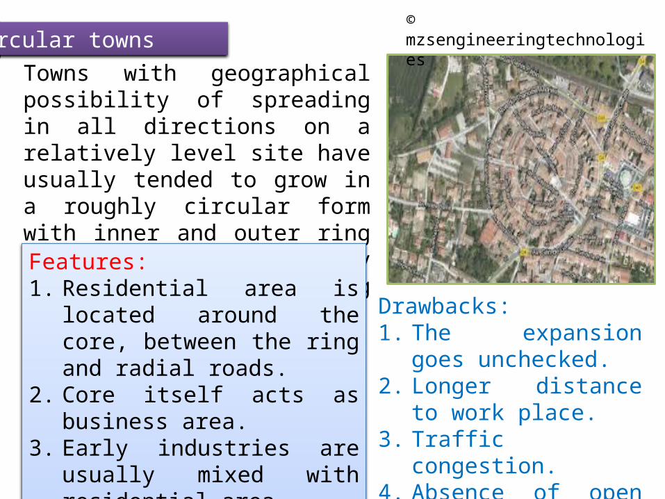
Circular townsTowns with geographical possibility of spreading in all directions on a relatively level site have usually tended to grow in a roughly circular form with inner and outer ring roads, linked together by radiating roads emanating from center.Features:1. Residential area is located
around the core, between the ring and radial roads.
2. Core itself acts as business area.3. Early industries are usually
mixed with residential area4. Towns represent peripheral
growth.
Drawbacks:1. The expansion goes
unchecked.2. Longer distance to work
place.3. Traffic congestion.4. Absence of open spaces.
© mzsengineeringtechnologies

Star-Shaped Towns
As a remedy towards the concept of the circular town plan with the surrounding green belt star shaped plan emerged out.
Star shaped plan having green wedges of agriculture fields, fruit orchids, forest and parks, radiating from the centre of town.
At the outer edges, the green wedges merge into countryside serving as green belt.
© mzsengineeringtechnologies

Superblock Towns (Grid-Iron Pattern)
Based on principle of superblock, which consists of number of blocks, or sectors.Each block or sector tracts of land, approximately three-forth of a mile long and half a mile.Each block or sector accommodate populations ranging from 15000 to 25000 souls.There are usually three to four neighbourhood units in each blocks.Example: Chandigarh
© mzsengineeringtechnologies

Linear Towns
These type of town form results from geographical features .
These type of development is not convenient to live.
It requires proper balance of amenities to achieve good living style.
It requires construction of additional sub-centers in different locations.
© mzsengineeringtechnologies

Re-planning exiting towns
Two important factors contributing to population increase are;1. Natural growth2. Tendency of villagers ( Migration for various
reasons, such as education, employment, glamour, etc)
Results in over crowding and serious problems such as;Residential areas well planned and spacious get converted into slums.Parks and playgrounds becomes inadequate.Industries have invaded into residential area.Communication system has been completely failed.The road system has become obsolete.Recreation and amusement centers are haphazardly located.
© mzsengineeringtechnologies

Objectives of Re-planning exiting towns
1. To add further to the civic aesthetic of the town.
2. To attempt for an orderly, appropriate and balanced agreement of the land use.
3. To correct the post error as far as possible.
4. To develop healthy, attractive and efficient environment with the finance available.
5. To suggest short-term and long-term measures for the future growth of town
© mzsengineeringtechnologies

Data to be collected
1. Condition of social and community life.
2. Economic basis of town
3. Existing density of population in various parts of town
4. Existing land use and land values
5. History and causes of growth
6. Housing conditions
7. Existing parks and playgrounds
8. Physical features of town
9. Public utility services
© mzsengineeringtechnologies

Urban renewal projects
Pulling down of detoriated structures, carrying out extensive renovation of building to be retained, redesigning of road system, changing the pattern of land use.
ConservationCooperationDevelopment planFinanceLegislationPeriod of projectRedevelopmentrehabilitation
© mzsengineeringtechnologies

1. What is town planning? Explain its purpose and scope.
2. Write down the significance of the subject town planning.
3. What is the role of a civil engineer and a town planner in a city?

The European-American city of Memphis was founded on May 22, 1819. They named it after the ancient capital of Egypton the Nile River. Memphis developed as a transportation center in the 19th century because of its flood-free location high above the Mississippi River. Located in the low-lying delta region along the river, its outlying areas were developed as cotton plantations, and the city became a major cotton market and brokerage center.
Memphis

•What are the objects of town planning?
•Discuss the growth of towns according to origin?
•Discuss the stages in town development as suggested by;
1. Sir Patrick Geddes
2. Lewis Mumford
3. Griffith Taylor
Related Documents