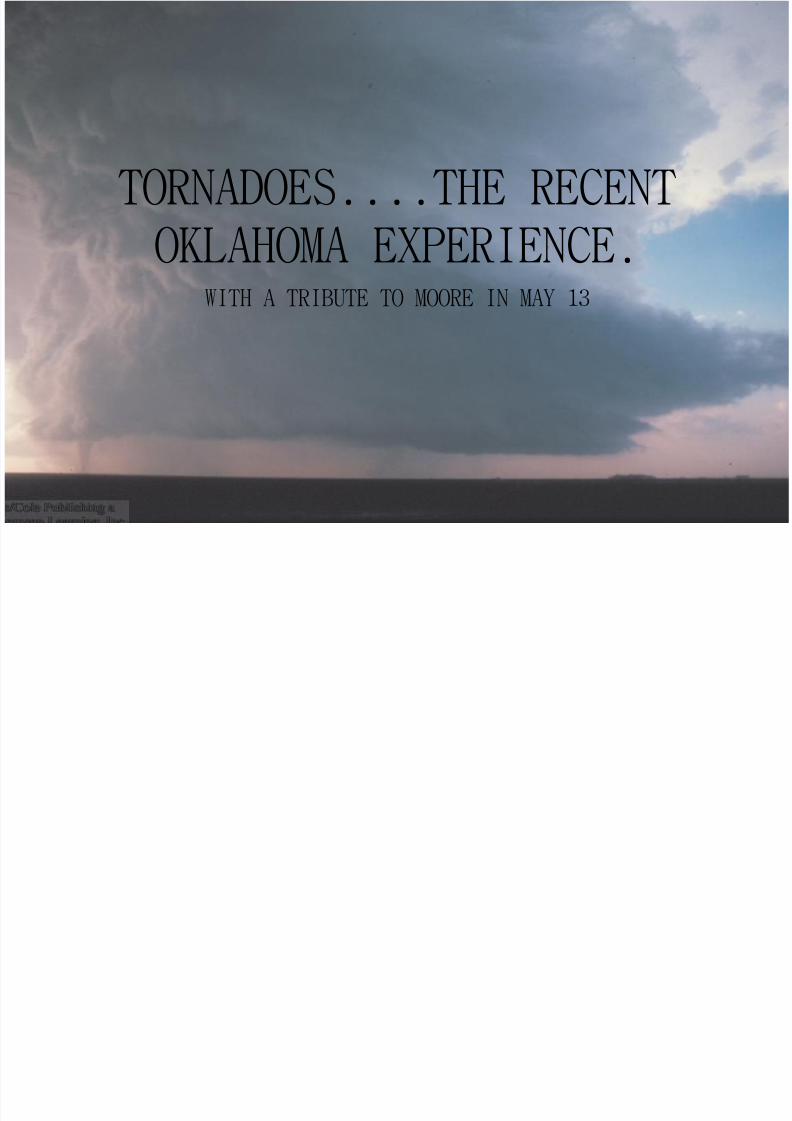
WITH A TRIBUTE TO MOORE IN MAY 13 TORNADOES....THE RECENT OKLAHOMA EXPERIENCE.

Welcome message from author
This document is posted to help you gain knowledge. Please leave a comment to let me know what you think about it! Share it to your friends and learn new things together.
Transcript
8/12/2019 Tornado May2010
http://slidepdf.com/reader/full/tornado-may2010 1/107
WITH A TRIBUTE TO MOORE IN MAY 13
TORNADOES....THE RECENT
OKLAHOMA EXPERIENCE.

8/12/2019 Tornado May2010
http://slidepdf.com/reader/full/tornado-may2010 2/107
EVOLUTION OF THETORNADO...
8/12/2019 Tornado May2010
http://slidepdf.com/reader/full/tornado-may2010 3/107
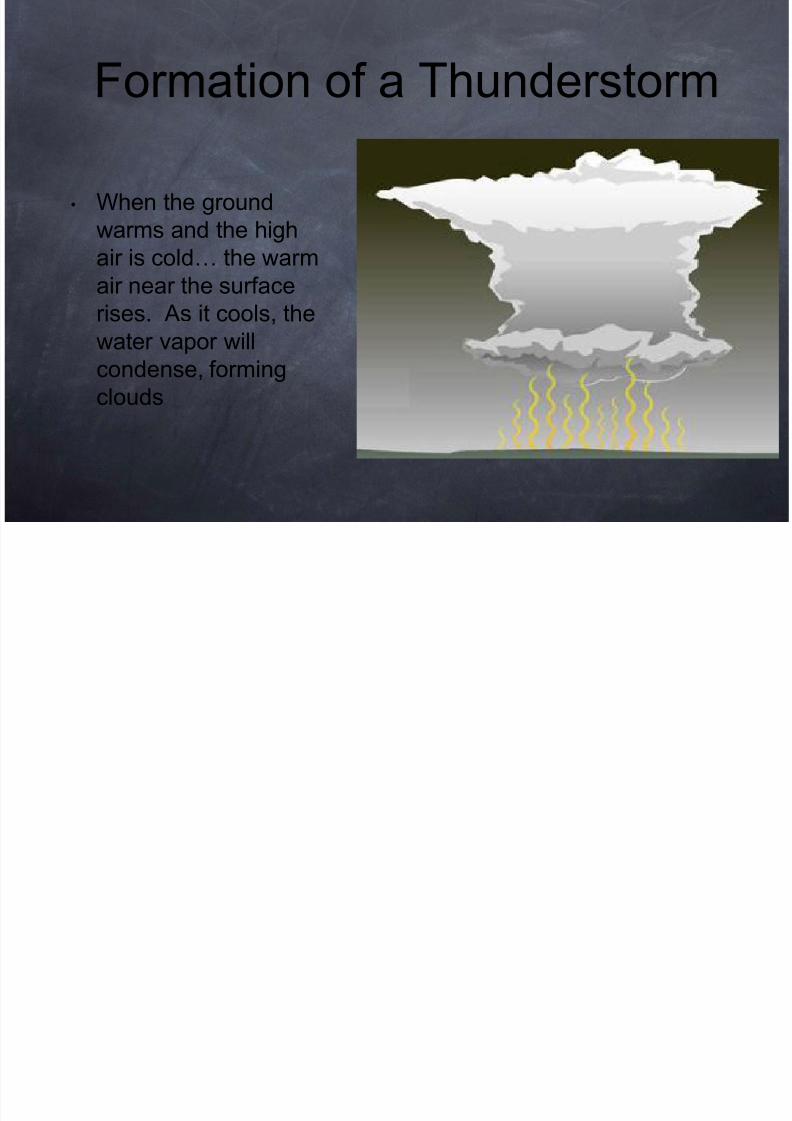
• When the ground
warms and the high
air is cold… the warm
air near the surface
rises. As it cools, the
water vapor will
condense, forming
clouds
Formation of a Thunderstorm
8/12/2019 Tornado May2010
http://slidepdf.com/reader/full/tornado-may2010 4/107
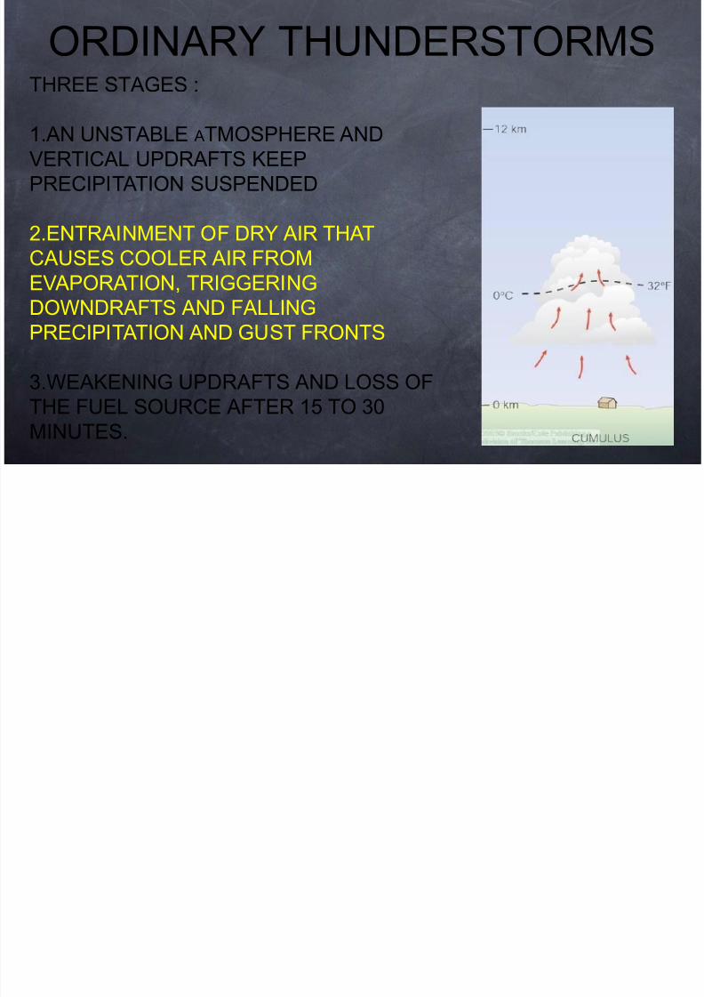
THREE STAGES :
1.AN UNSTABLE ATMOSPHERE AND
VERTICAL UPDRAFTS KEEP
PRECIPITATION SUSPENDED
2.ENTRAINMENT OF DRY AIR THAT
CAUSES COOLER AIR FROM
EVAPORATION, TRIGGERING
DOWNDRAFTS AND FALLING
PRECIPITATION AND GUST FRONTS
3.WEAKENING UPDRAFTS AND LOSS OF
THE FUEL SOURCE AFTER 15 TO 30
MINUTES.
ORDINARY THUNDERSTORMS
8/12/2019 Tornado May2010
http://slidepdf.com/reader/full/tornado-may2010 5/107
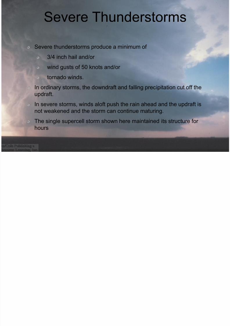
Severe Thunderstorms
Severe thunderstorms produce a minimum of
3/4 inch hail and/or
wind gusts of 50 knots and/or
tornado winds.In ordinary storms, the downdraft and falling precipitation cut off the
updraft.
In severe storms, winds aloft push the rain ahead and the updraft is
not weakened and the storm can continue maturing.
The single supercell storm shown here maintained its structure forhours
8/12/2019 Tornado May2010
http://slidepdf.com/reader/full/tornado-may2010 6/107
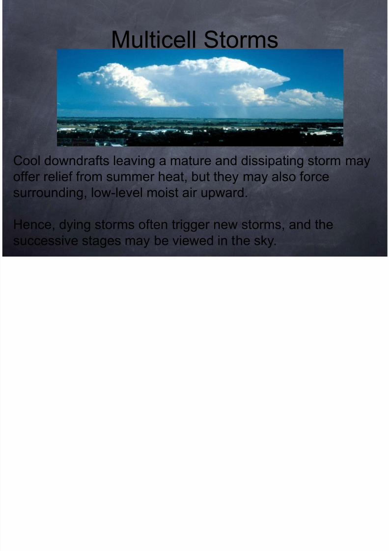
Cool downdrafts leaving a mature and dissipating storm may
offer relief from summer heat, but they may also force
surrounding, low-level moist air upward.
Hence, dying storms often trigger new storms, and the
successive stages may be viewed in the sky.
Multicell Storms
8/12/2019 Tornado May2010
http://slidepdf.com/reader/full/tornado-may2010 7/107
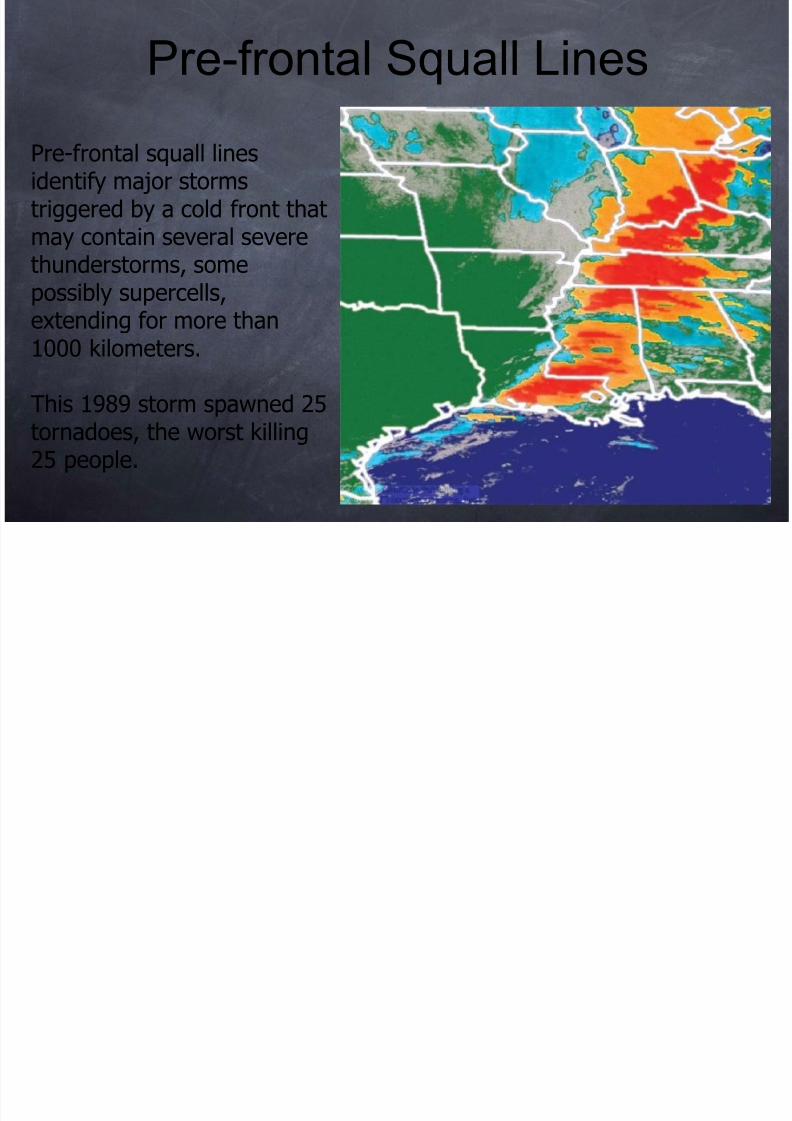
Pre-frontal squall linesidentify major stormstriggered by a cold front thatmay contain several severe
thunderstorms, somepossibly supercells,extending for more than1000 kilometers.
This 1989 storm spawned 25tornadoes, the worst killing25 people.
Pre-frontal Squall Lines
8/12/2019 Tornado May2010
http://slidepdf.com/reader/full/tornado-may2010 8/107
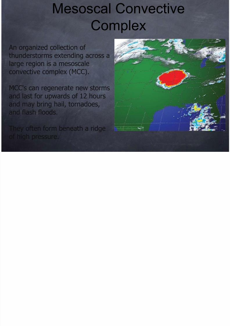
An organized collection ofthunderstorms extending across alarge region is a mesoscaleconvective complex (MCC).
MCC's can regenerate new stormsand last for upwards of 12 hoursand may bring hail, tornadoes,and flash floods.
They often form beneath a ridgeof high pressure.
Mesoscal Convective
Complex
8/12/2019 Tornado May2010
http://slidepdf.com/reader/full/tornado-may2010 9/107
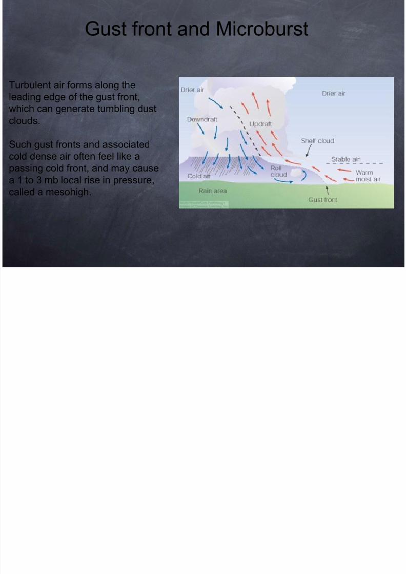
Gust front and Microburst
Turbulent air forms along the
leading edge of the gust front,
which can generate tumbling dust
clouds.
Such gust fronts and associatedcold dense air often feel like a
passing cold front, and may cause
a 1 to 3 mb local rise in pressure,
called a mesohigh.
8/12/2019 Tornado May2010
http://slidepdf.com/reader/full/tornado-may2010 10/107
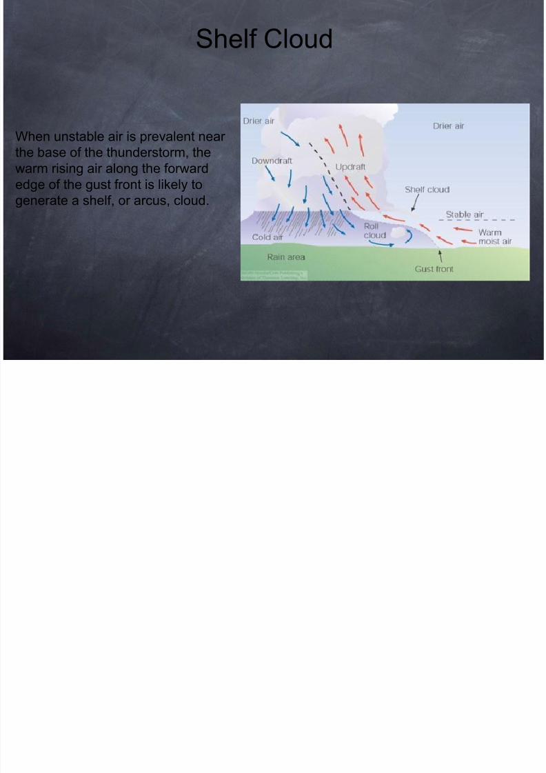
Shelf Cloud
When unstable air is prevalent near
the base of the thunderstorm, the
warm rising air along the forward
edge of the gust front is likely togenerate a shelf, or arcus, cloud.
8/12/2019 Tornado May2010
http://slidepdf.com/reader/full/tornado-may2010 11/107
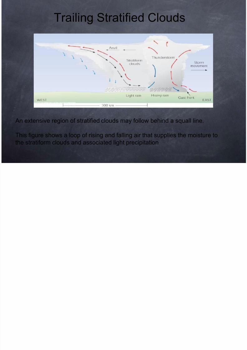
Trailing Stratified Clouds
An extensive region of stratified clouds may follow behind a squall line.
This figure shows a loop of rising and falling air that supplies the moisture to
the stratiform clouds and associated light precipitation
8/12/2019 Tornado May2010
http://slidepdf.com/reader/full/tornado-may2010 12/107
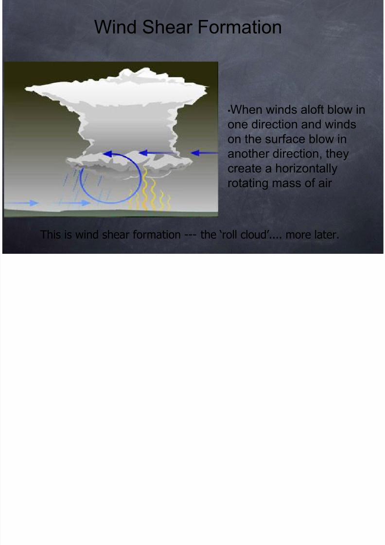
This is wind shear formation --- the ‘roll cloud’.... more later.
•When winds aloft blow in
one direction and winds
on the surface blow inanother direction, they
create a horizontally
rotating mass of air
Wind Shear Formation
8/12/2019 Tornado May2010
http://slidepdf.com/reader/full/tornado-may2010 13/107
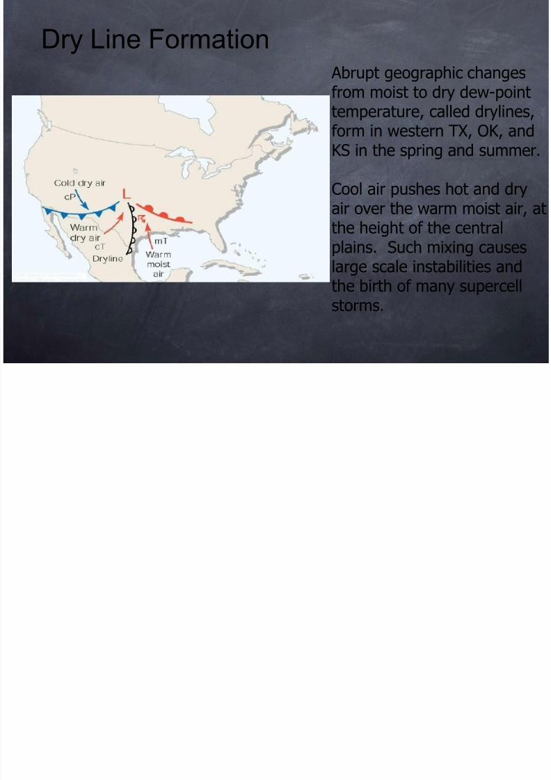
Abrupt geographic change
from moist to dry dew-pointemperature, called drylineform in western TX, OK, aKS in the spring and summ
Cool air pushes hot and drair over the warm moist airthe height of the centralplains. Such mixing causelarge scale instabilities and
the birth of many supercelstorms.
Dry Line Formation
8/12/2019 Tornado May2010
http://slidepdf.com/reader/full/tornado-may2010 14/107
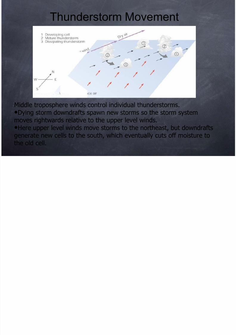
Middle troposphere winds control individual thunderstorms.•Dying storm downdrafts spawn new storms so the storm systemmoves rightwards relative to the upper level winds.
•Here upper level winds move storms to the northeast, but downdraftsgenerate new cells to the south, which eventually cuts off moisture tothe old cell.
Thunderstorm Movement
8/12/2019 Tornado May2010
http://slidepdf.com/reader/full/tornado-may2010 15/107
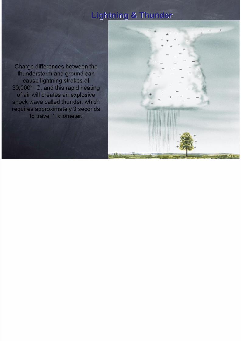
Lightning & Thunder
Charge differences between the
thunderstorm and ground can
cause lightning strokes of
30,000°C, and this rapid heating
of air will creates an explosive
shock wave called thunder, which
requires approximately 3 seconds
to travel 1 kilometer.
8/12/2019 Tornado May2010
http://slidepdf.com/reader/full/tornado-may2010 16/107
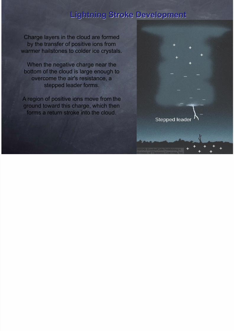
Lightning Stroke Development
Charge layers in the cloud are formed
by the transfer of positive ions fromwarmer hailstones to colder ice crystals.
When the negative charge near the
bottom of the cloud is large enough to
overcome the air's resistance, a
stepped leader forms.
A region of positive ions move from the
ground toward this charge, which then
forms a return stroke into the cloud.
8/12/2019 Tornado May2010
http://slidepdf.com/reader/full/tornado-may2010 17/107
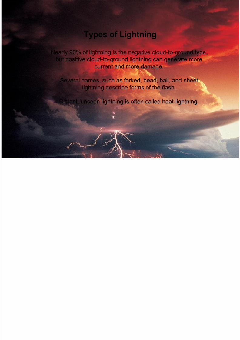
Nearly 90% of lightning is the negative cloud-to-ground type,
but positive cloud-to-ground lightning can generate more
current and more damage.
Several names, such as forked, bead, ball, and sheet
lightning describe forms of the flash.
Distant, unseen lightning is often called heat lightning.
Types of Lightning

8/12/2019 Tornado May2010
http://slidepdf.com/reader/full/tornado-may2010 18/107
Lightning Rods & Fulgurite
Metal rods that are grounded by wires
provide a low resistance path for
lightning into the earth, which is a poor
conductor.
The fusion of sand particles into root like tu
called fulgurite, may result.
8/12/2019 Tornado May2010
http://slidepdf.com/reader/full/tornado-may2010 19/107
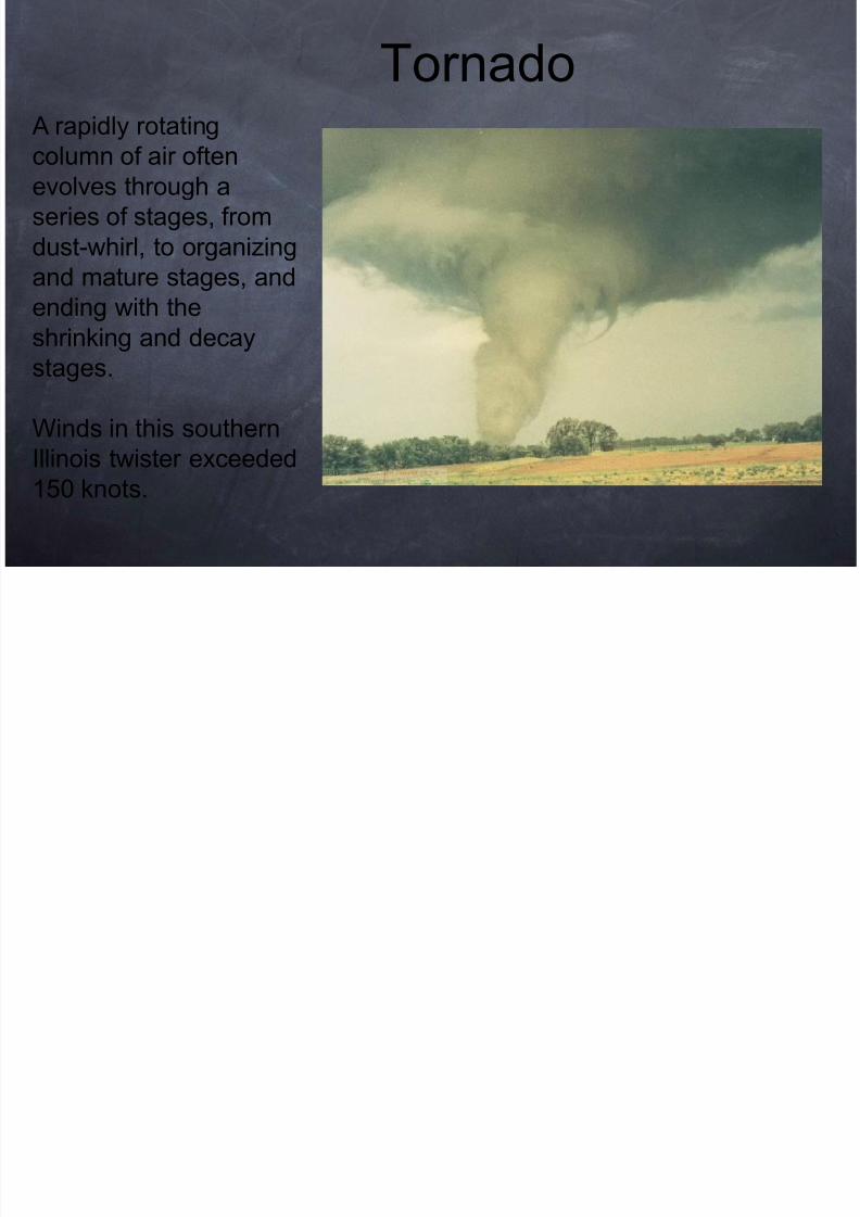
A rapidly rotating
column of air oftenevolves through a
series of stages, from
dust-whirl, to organizing
and mature stages, and
ending with theshrinking and decay
stages.
Winds in this southern
Illinois twister exceeded150 knots.
Tornado
8/12/2019 Tornado May2010
http://slidepdf.com/reader/full/tornado-may2010 20/107
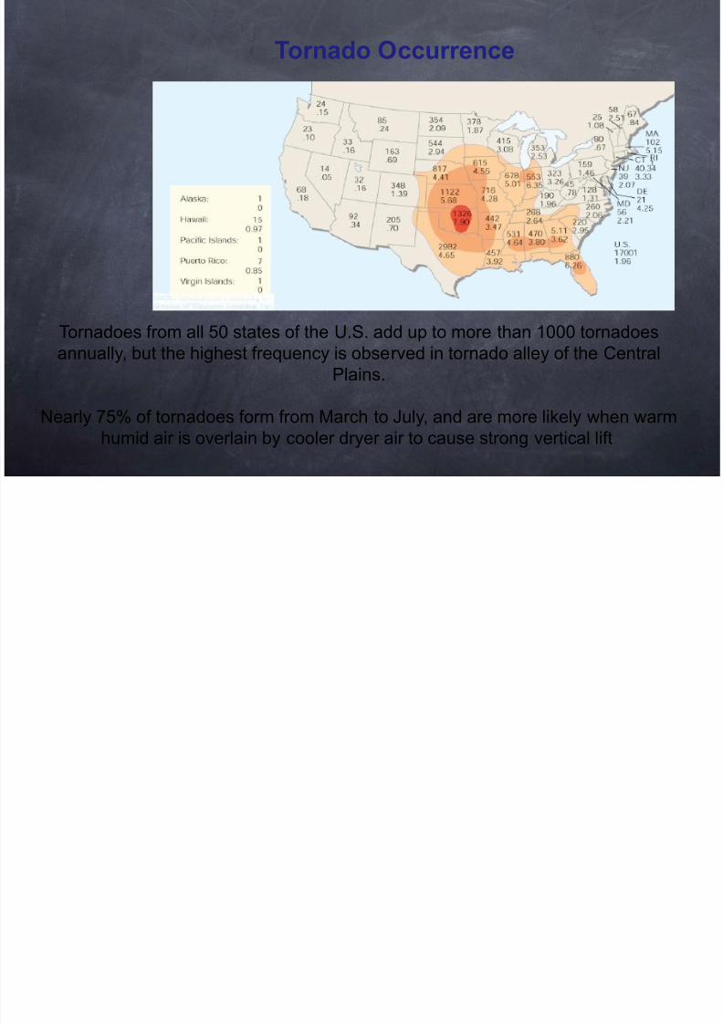
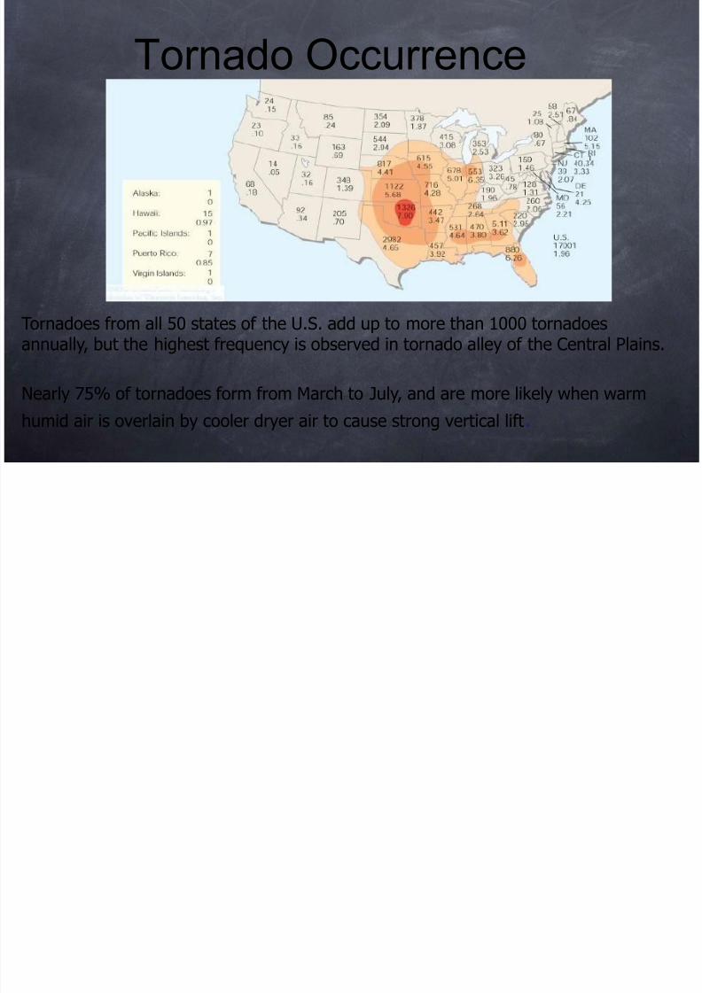
Tornado Occurrence
Tornadoes from all 50 states of the U.S. add up to more than 1000 tornadoes
annually, but the highest frequency is observed in tornado alley of the Central
Plains.
Nearly 75% of tornadoes form from March to July, and are more likely when warm
humid air is overlain by cooler dryer air to cause strong vertical lift.
8/12/2019 Tornado May2010
http://slidepdf.com/reader/full/tornado-may2010 21/107
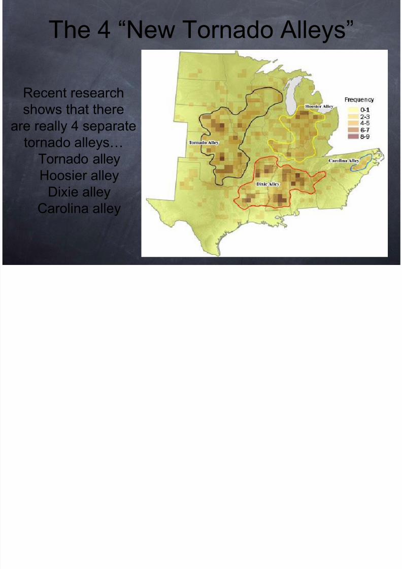
The 4 “New Tornado Alleys”
Recent research
shows that there
are really 4 separate
tornado alleys… Tornado alley
Hoosier alley
Dixie alley
Carolina alley
8/12/2019 Tornado May2010
http://slidepdf.com/reader/full/tornado-may2010 22/107
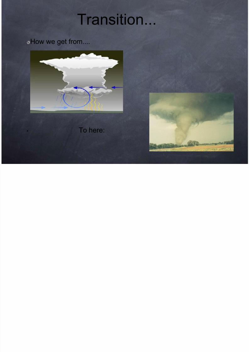
How we get from....
• To here:
Transition...
8/12/2019 Tornado May2010
http://slidepdf.com/reader/full/tornado-may2010 23/107
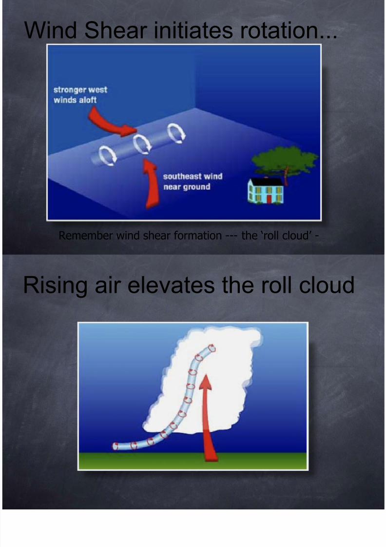
Remember wind shear formation --- the ‘roll cloud’ -
Wind Shear initiates rotation...
8/12/2019 Tornado May2010
http://slidepdf.com/reader/full/tornado-may2010 24/107
Rising air elevates the roll cloud
8/12/2019 Tornado May2010
http://slidepdf.com/reader/full/tornado-may2010 25/107
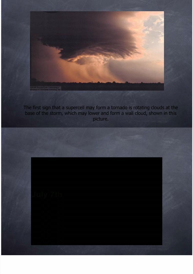
The first sign that a supercell may form a tornado is rotating clouds at thebase of the storm, which may lower and form a wall cloud, shown in this
picture.
8/12/2019 Tornado May2010
http://slidepdf.com/reader/full/tornado-may2010 26/107
8/12/2019 Tornado May2010
http://slidepdf.com/reader/full/tornado-may2010 27/107
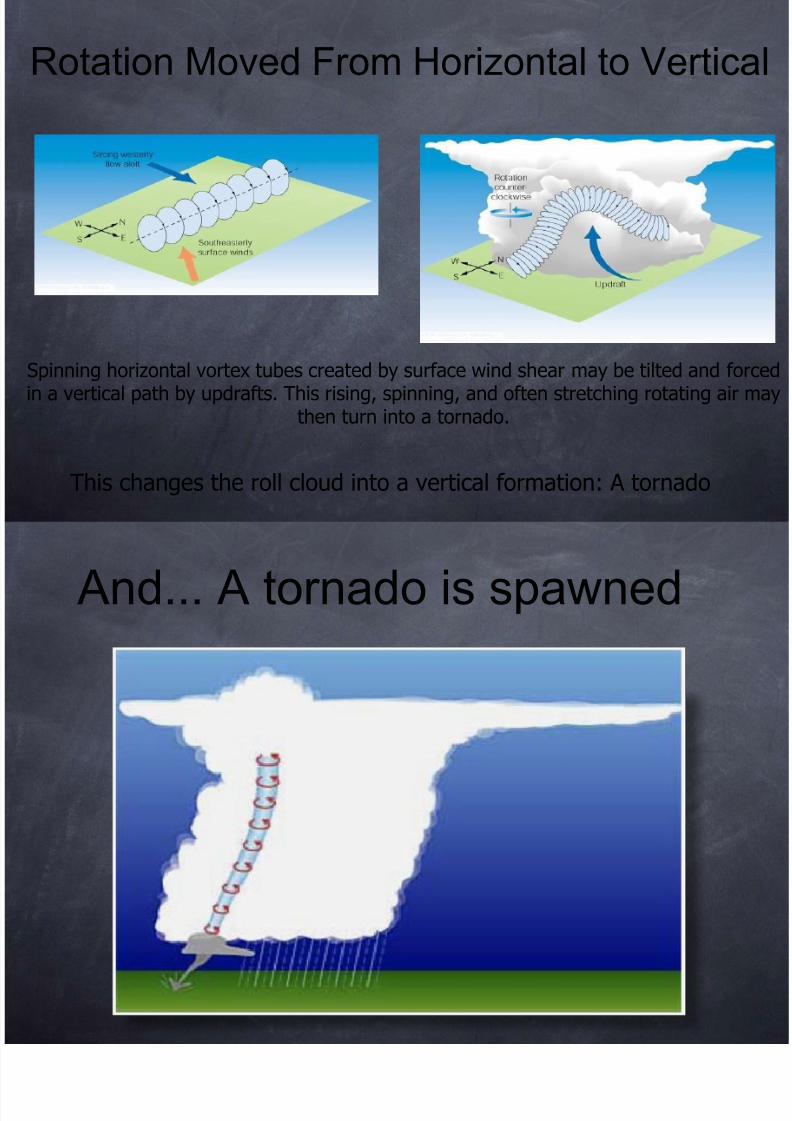
Spinning horizontal vortex tubes created by surface wind shear may be tilted and forin a vertical path by updrafts. This rising, spinning, and often stretching rotating air m
then turn into a tornado.
This changes the roll cloud into a vertical formation: A tornado
Rotation Moved From Horizontal to Vertica
8/12/2019 Tornado May2010
http://slidepdf.com/reader/full/tornado-may2010 28/107
And... A tornado is spawned
8/12/2019 Tornado May2010
http://slidepdf.com/reader/full/tornado-may2010 29/107
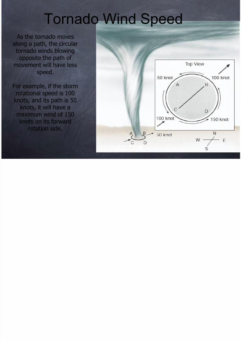
As the tornado moves
along a path, the circulartornado winds blowingopposite the path of
movement will have lessspeed.
For example, if the stormrotational speed is 100knots, and its path is 50
knots, it will have amaximum wind of 150knots on its forward
rotation side.
Tornado Wind Speed
8/12/2019 Tornado May2010
http://slidepdf.com/reader/full/tornado-may2010 30/107
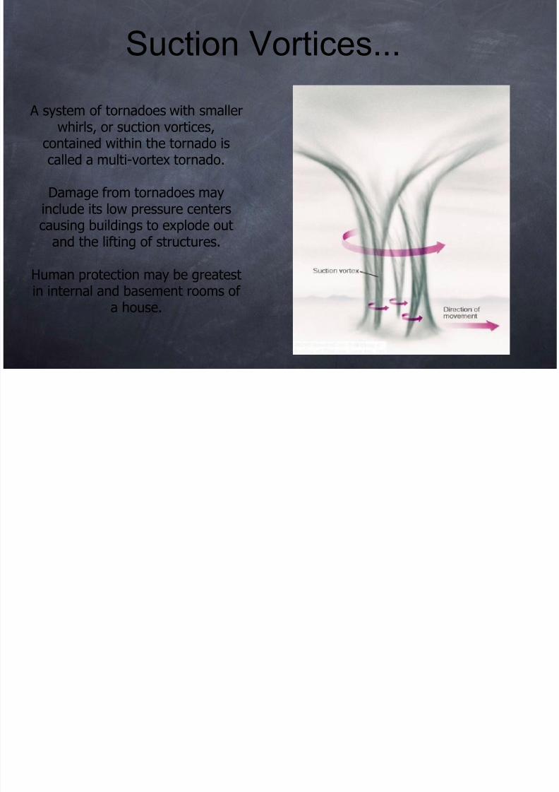
A system of tornadoes with smallerwhirls, or suction vortices,
contained within the tornado iscalled a multi-vortex tornado.
Damage from tornadoes mayinclude its low pressure centerscausing buildings to explode out
and the lifting of structures.
Human protection may be greatest
in internal and basement rooms ofa house.
Suction Vortices...

8/12/2019 Tornado May2010
http://slidepdf.com/reader/full/tornado-may2010 31/107
Tornadoes from all 50 states of the U.S. add up to more than 1000 tornadoesannually, but the highest frequency is observed in tornado alley of the Central Plains
Nearly 75% of tornadoes form from March to July, and are more likely when warm
humid air is overlain by cooler dryer air to cause strong vertical lift.
Tornado Occurrence

8/12/2019 Tornado May2010
http://slidepdf.com/reader/full/tornado-may2010 32/107
8/12/2019 Tornado May2010
http://slidepdf.com/reader/full/tornado-may2010 33/107
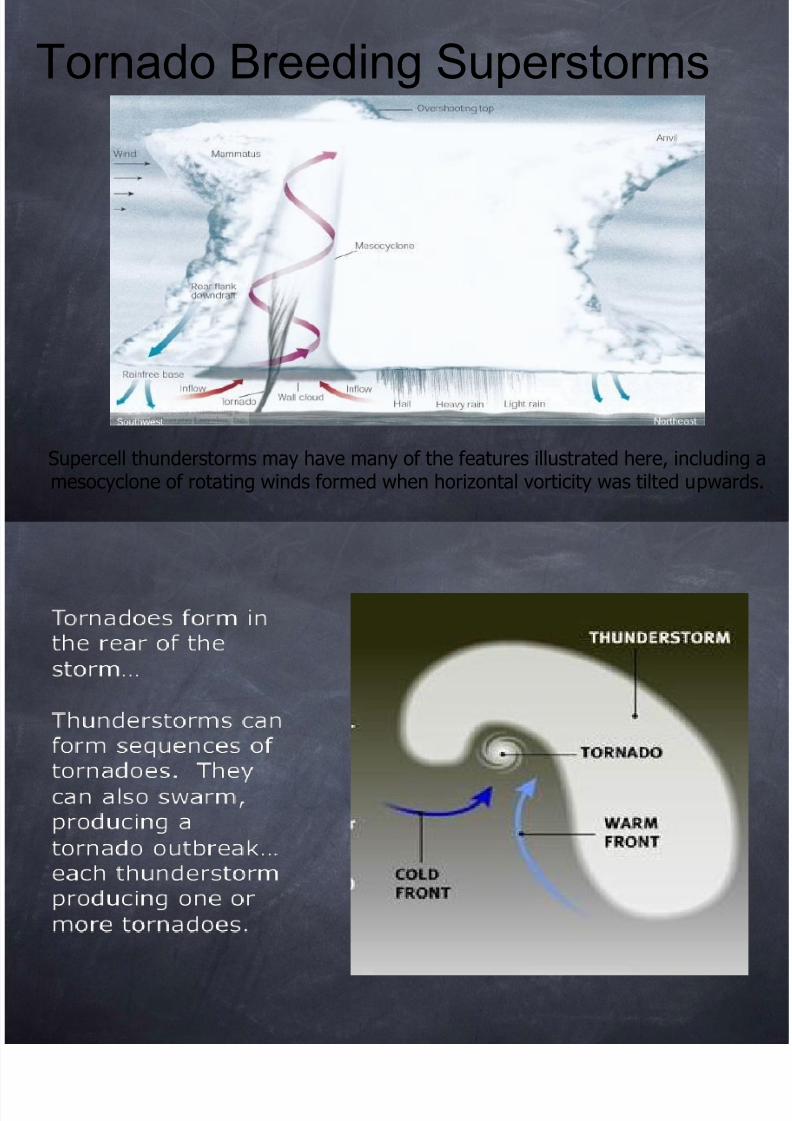
Supercell thunderstorms may have many of the features illustrated here, includingmesocyclone of rotating winds formed when horizontal vorticity was tilted upward
Tornado Breeding Superstorms
8/12/2019 Tornado May2010
http://slidepdf.com/reader/full/tornado-may2010 34/107
f

8/12/2019 Tornado May2010
http://slidepdf.com/reader/full/tornado-may2010 35/107
Supercell thunderstormdevelopment may create anarea where the updraft andcounterclockwise swirl of
upper winds converge into arear flank downdraft.
This downdraft can theninteract with lower level
inflow winds and spawn atornado.
Rear Flank Downdraft
N S ll T d
8/12/2019 Tornado May2010
http://slidepdf.com/reader/full/tornado-may2010 36/107
If a pre-existingwall cloud was notpresent, than anytornado formed isnot from asupercell storm.
These tornadoesare often not asstrong as thoseformed bysupercells.
Non-Supercell Tornadoes
8/12/2019 Tornado May2010
http://slidepdf.com/reader/full/tornado-may2010 37/107
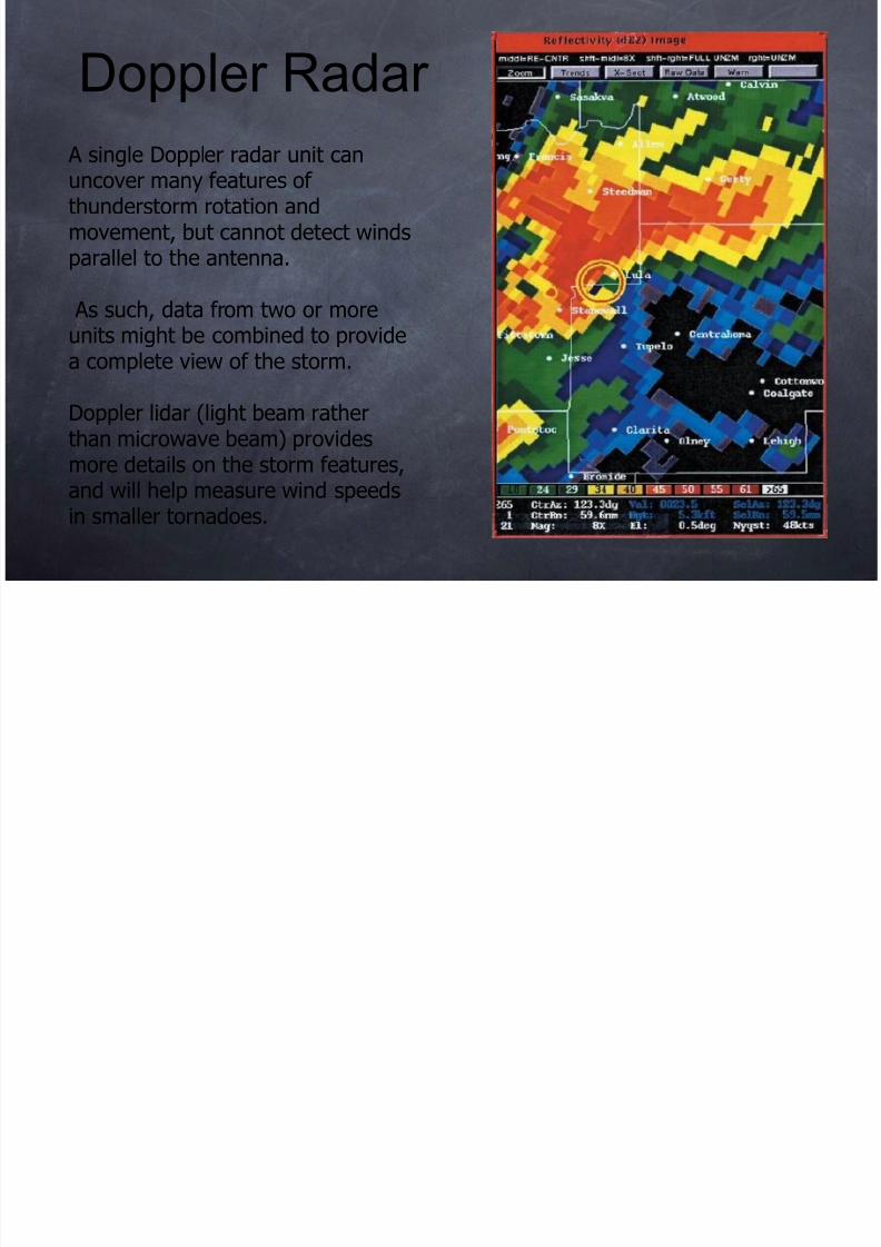
A single Doppler radar unit canuncover many features ofthunderstorm rotation andmovement, but cannot detect windsparallel to the antenna.
As such, data from two or moreunits might be combined to providea complete view of the storm.
Doppler lidar (light beam ratherthan microwave beam) provides
more details on the storm features,and will help measure wind speedsin smaller tornadoes.
Doppler Radar
NEXRAD Wi d A l i
8/12/2019 Tornado May2010
http://slidepdf.com/reader/full/tornado-may2010 38/107
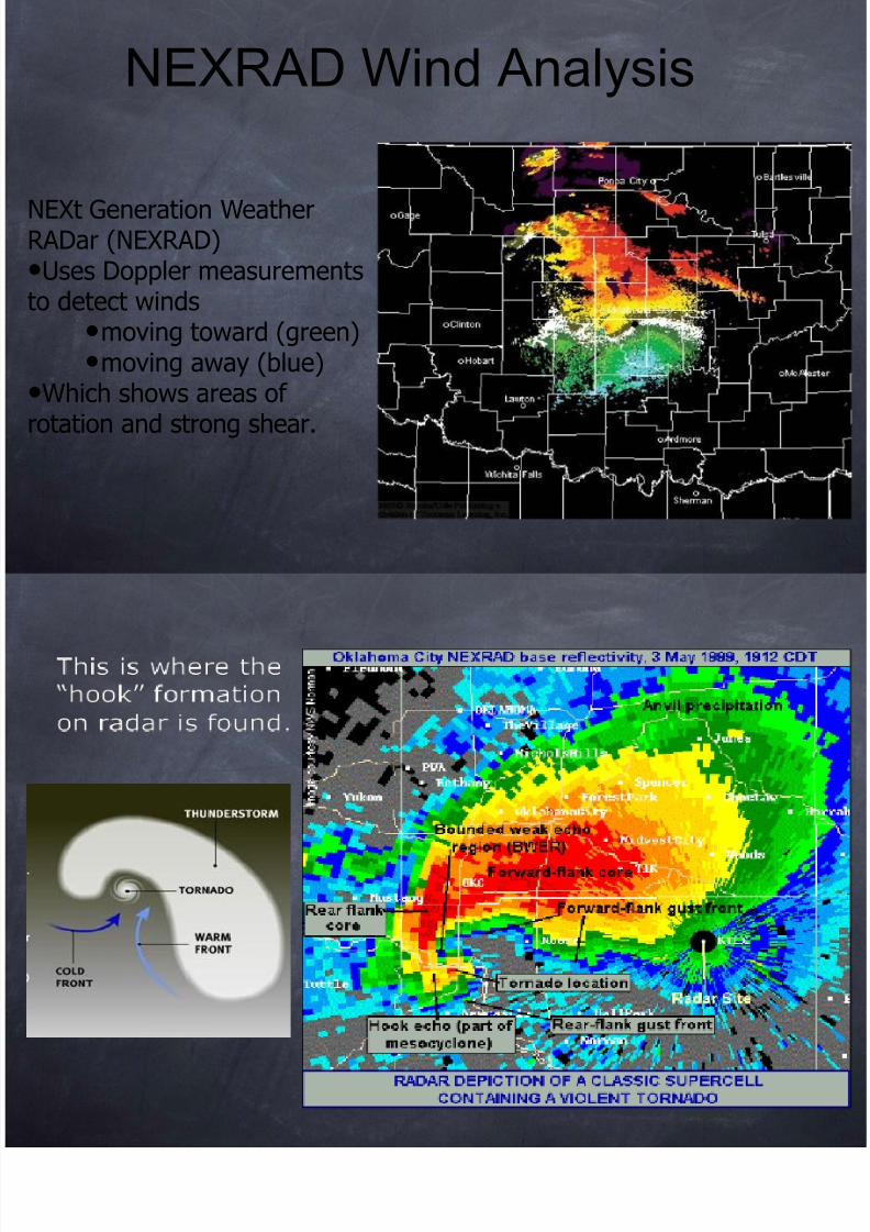
NEXt Generation WeatherRADar (NEXRAD)•Uses Doppler measurementsto detect winds
•moving toward (green)•moving away (blue)
•Which shows areas ofrotation and strong shear.
NEXRAD Wind Analysis
8/12/2019 Tornado May2010
http://slidepdf.com/reader/full/tornado-may2010 39/107
Fast Scan of Radar 3May99
8/12/2019 Tornado May2010
http://slidepdf.com/reader/full/tornado-may2010 40/107
Fast Scan of Radar 3May99
Moore 1999 (from space)
8/12/2019 Tornado May2010
http://slidepdf.com/reader/full/tornado-may2010 41/107
Moore 1999 (from space)
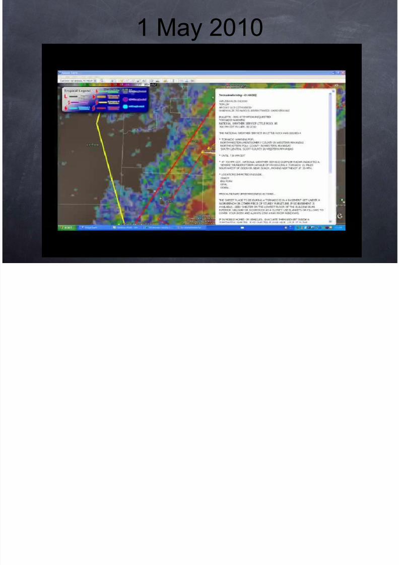
1 May 2010

8/12/2019 Tornado May2010
http://slidepdf.com/reader/full/tornado-may2010 42/107
1 May 2010
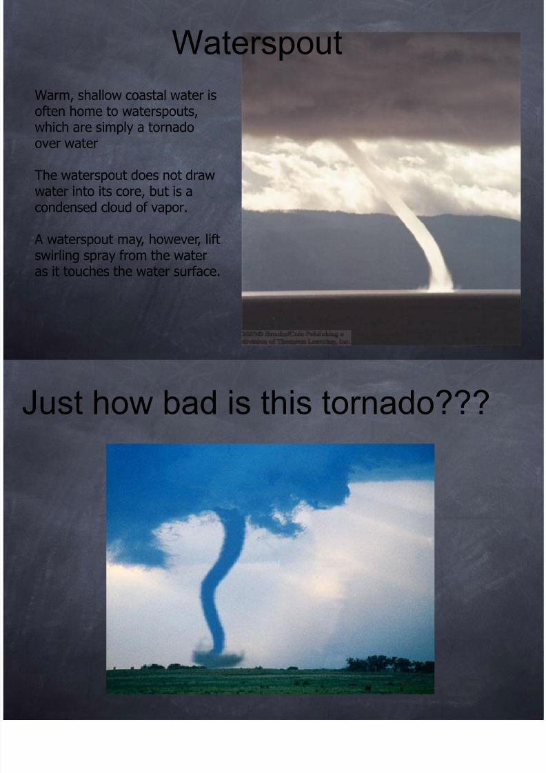
Waterspout
8/12/2019 Tornado May2010
http://slidepdf.com/reader/full/tornado-may2010 43/107
Warm, shallow coastal water isoften home to waterspouts,which are simply a tornadoover water
The waterspout does not drawwater into its core, but is acondensed cloud of vapor.
A waterspout may, however, liftswirling spray from the wateras it touches the water surface.
Waterspout
Just how bad is this tornado???
8/12/2019 Tornado May2010
http://slidepdf.com/reader/full/tornado-may2010 44/107
Just how bad is this tornado???
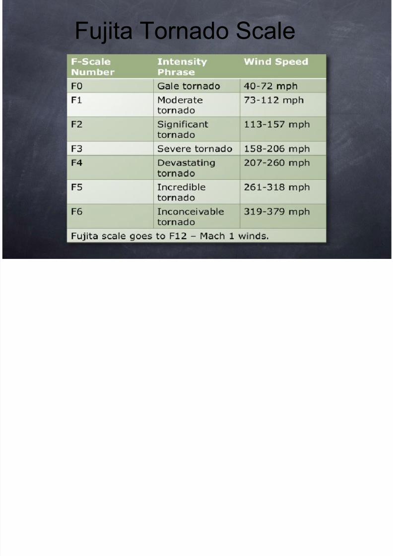
Fujita Tornado Scale
8/12/2019 Tornado May2010
http://slidepdf.com/reader/full/tornado-may2010 45/107
Fujita Tornado Scale
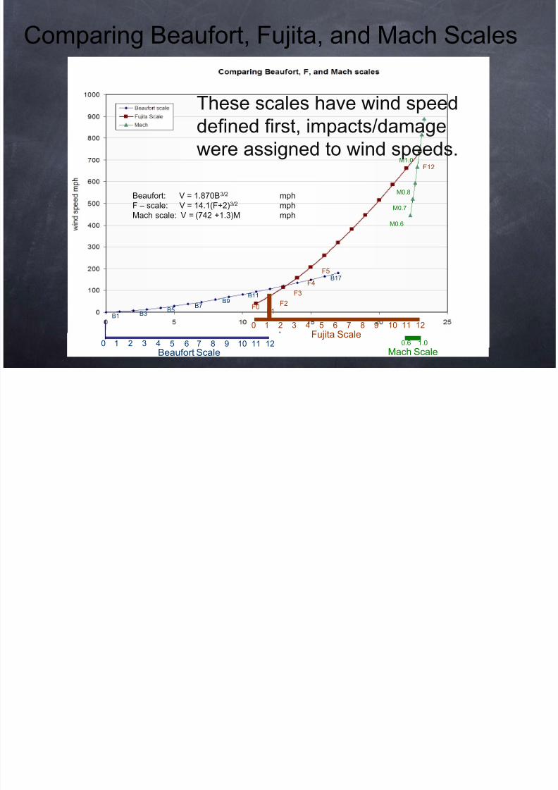
Comparing Beaufort Fujita and Mach Scales
8/12/2019 Tornado May2010
http://slidepdf.com/reader/full/tornado-may2010 46/107
1 2 3 4 5 6 7 8 9 10 11 120Beaufort Scale
1 2 3 4 5 6 7 8 90 10 11 12Fujita Scale
0.6 1.0
Mach Scale
B1 B3B5
B7 B9
B11
F0F1
F2
F3
F4
F5
F12M1.0
M0.6
M0.7
M0.8
B17
Beaufort: V = 1.870B3/2 mph
F – scale: V = 14.1(F+2)3/2 mphMach scale: V = (742 +1.3)M mph
These scales have wind speeddefined first, impacts/damage
were assigned to wind speeds.
Comparing Beaufort, Fujita, and Mach Scales
Fujita Tornado Scale
8/12/2019 Tornado May2010
http://slidepdf.com/reader/full/tornado-may2010 47/107
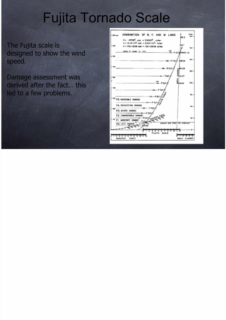
The Fujita scale isdesigned to show the windspeed.
Damage assessment was
derived after the fact… thisled to a few problems.
Fujita Tornado Scale
The Enhanced Fujita Scale
8/12/2019 Tornado May2010
http://slidepdf.com/reader/full/tornado-may2010 48/107
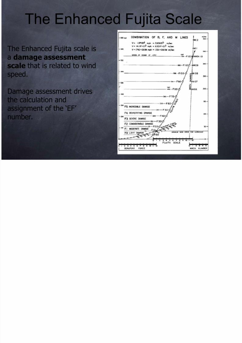
The Enhanced Fujita scale isa damage assessmentscale that is related to windspeed.
Damage assessment drivesthe calculation andassignment of the ‘EF’number.
The Enhanced Fujita Scale
EF has 28 Damage Indicators
8/12/2019 Tornado May2010
http://slidepdf.com/reader/full/tornado-may2010 49/107
Residences
Commercial/reta
structures
Schools
Professional build
Metal
buildings/canopie
Towers/poles
Vegetation
g
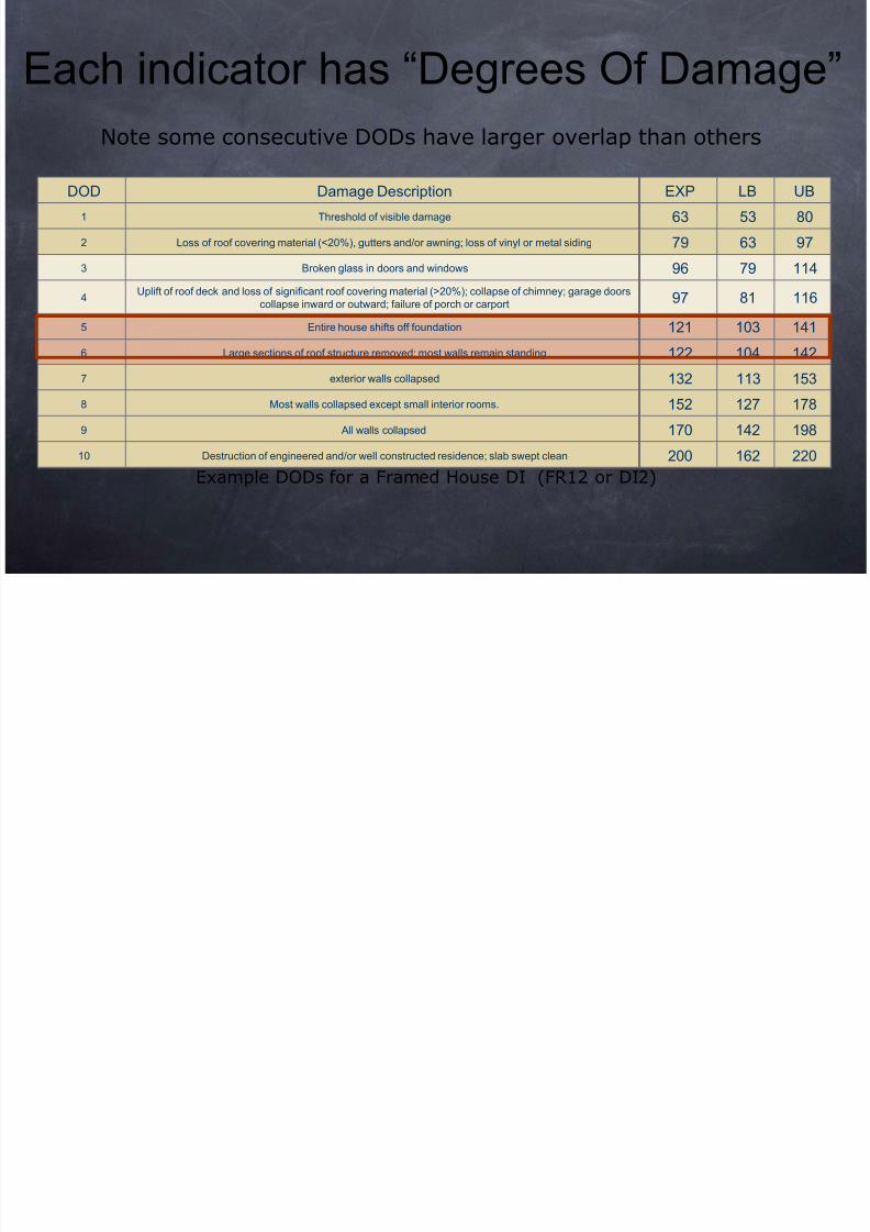
Each indicator has “Degrees Of Damage
8/12/2019 Tornado May2010
http://slidepdf.com/reader/full/tornado-may2010 50/107
DOD Damage Description EXP LB UB
1 Threshold of visible damage 63 53 80
2 Loss of roof covering material (<20%), gutters and/or awning; loss of vinyl or metal siding 79 63 97
3 Broken glass in doors and windows 96 79 114
4Uplift of roof deck and loss of significant roof covering material (>20%); collapse of chimney; garage doors
collapse inward or outward; failure of porch or carport 97 81 116
5 Entire house shifts off foundation 121 103 141
6 Large sections of roof structure removed; most walls remain standing 122 104 142
7 exterior walls collapsed 132 113 153
8 Most walls collapsed except small interior rooms. 152 127 178
9 All walls collapsed 170 142 198
10 Destruction of engineered and/or well constructed residence; slab swept clean 200 162 220
Example DODs for a Framed House DI (FR12 or DI2)
Note some consecutive DODs have larger overlap than others
DOD Damage Description EXP LB UB
1 Threshold of visible damage 63 53 80
2 Loss of roof covering material (<20%), gutters and/or awning; loss of vinyl or metal siding 79 63 97
3 Broken glass in doors and windows 96 79 114
4Uplift of roof deck and loss of significant roof covering material (>20%); collapse of chimney; garage doors
collapse inward or outward; failure of porch or carport 97 81 116
5 Entire house shifts off foundation 121 103 141
6 Large sections of roof structure removed; most walls remain standing 122 104 142
7 exterior walls collapsed 132 113 153
8 Most walls collapsed except small interior rooms. 152 127 178
9 All walls collapsed 170 142 198
10 Destruction of engineered and/or well constructed residence; slab swept clean 200 162 220
Each indicator has Degrees Of Damage
DOD Damage Description Framed House EXP LB UB
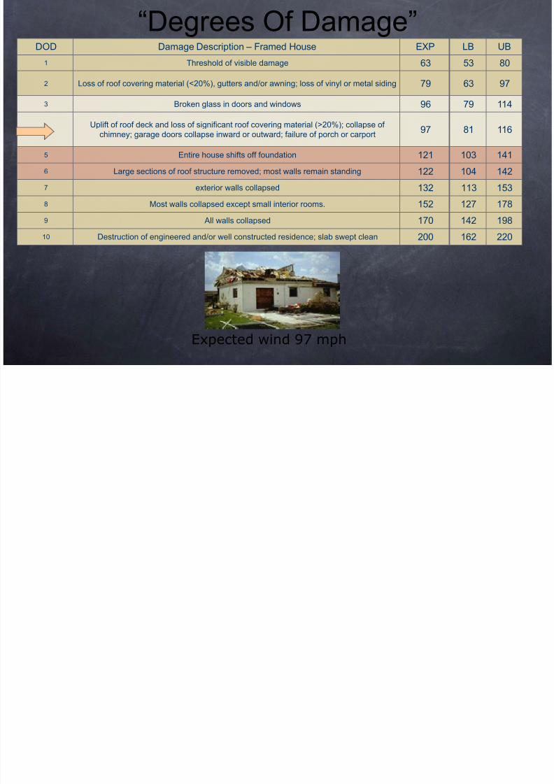
“Degrees Of Damage”
8/12/2019 Tornado May2010
http://slidepdf.com/reader/full/tornado-may2010 51/107
DOD Damage Description – Framed House EXP LB UB
1 Threshold of visible damage 63 53 80
2 Loss of roof covering material (<20%), gutters and/or awning; loss of vinyl or metal siding 79 63 97
3Broken glass in doors and windows 96 79 114
4Uplift of roof deck and loss of significant roof covering material (>20%); collapse of
chimney; garage doors collapse inward or outward; failure of porch or carport97 81 116
5 Entire house shifts off foundation 121 103 141
6 Large sections of roof structure removed; most walls remain standing 122 104 142
7 exterior walls collapsed 132 113 153
8 Most walls collapsed except small interior rooms. 152 127 178
9 All walls collapsed 170 142 198
10 Destruction of engineered and/or well constructed residence; slab swept clean 200 162 220
Expected wind 97 mph
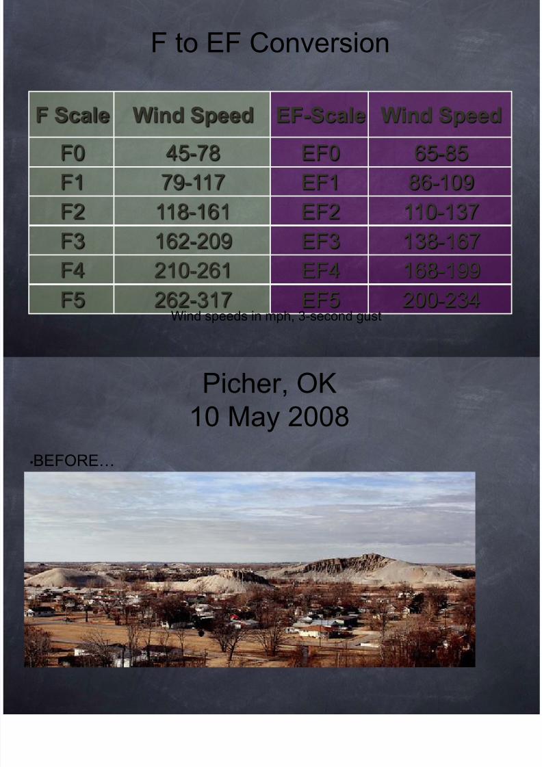
F to EF Conversion
8/12/2019 Tornado May2010
http://slidepdf.com/reader/full/tornado-may2010 52/107
F Scale Wind Speed EF-Scale Wind Speed
F0 45-78 EF0 65-85
F1 79-117 EF1 86-109
F2 118-161 EF2 110-137
F3 162-209 EF3 138-167
F4 210-261 EF4 168-199
F5 262-317 EF5 200-234Wind speeds in mph, 3-second gust
F to EF Conversion
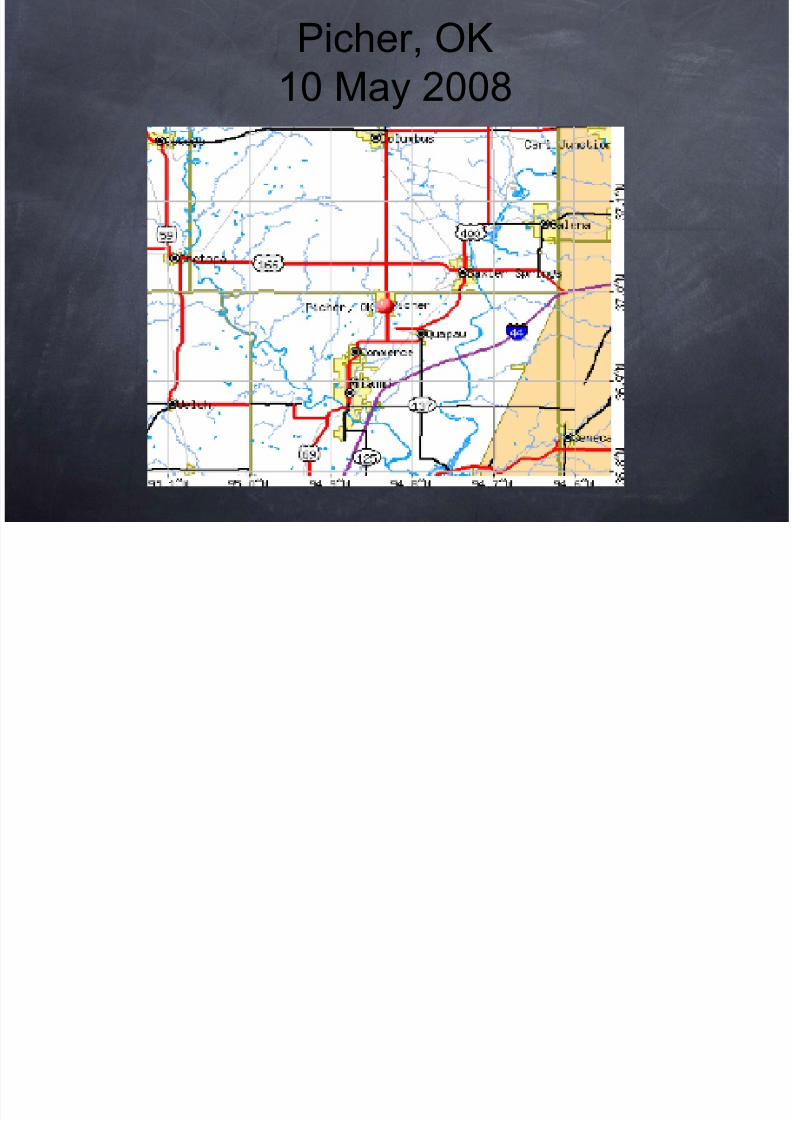
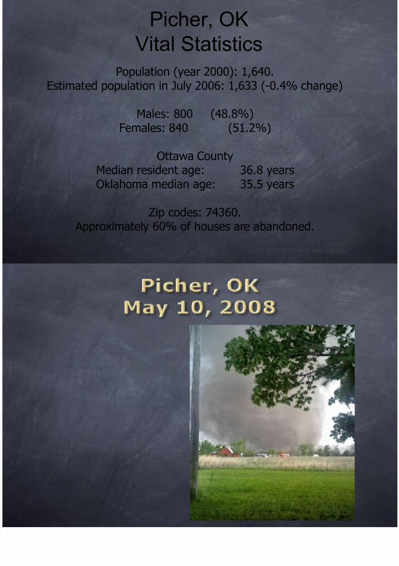
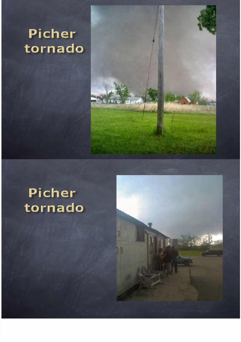
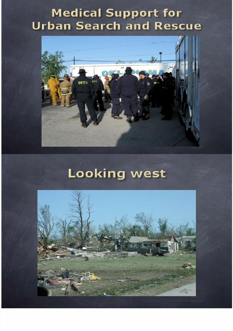
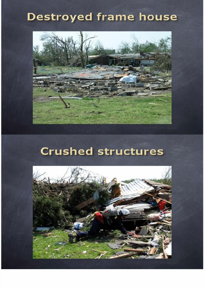
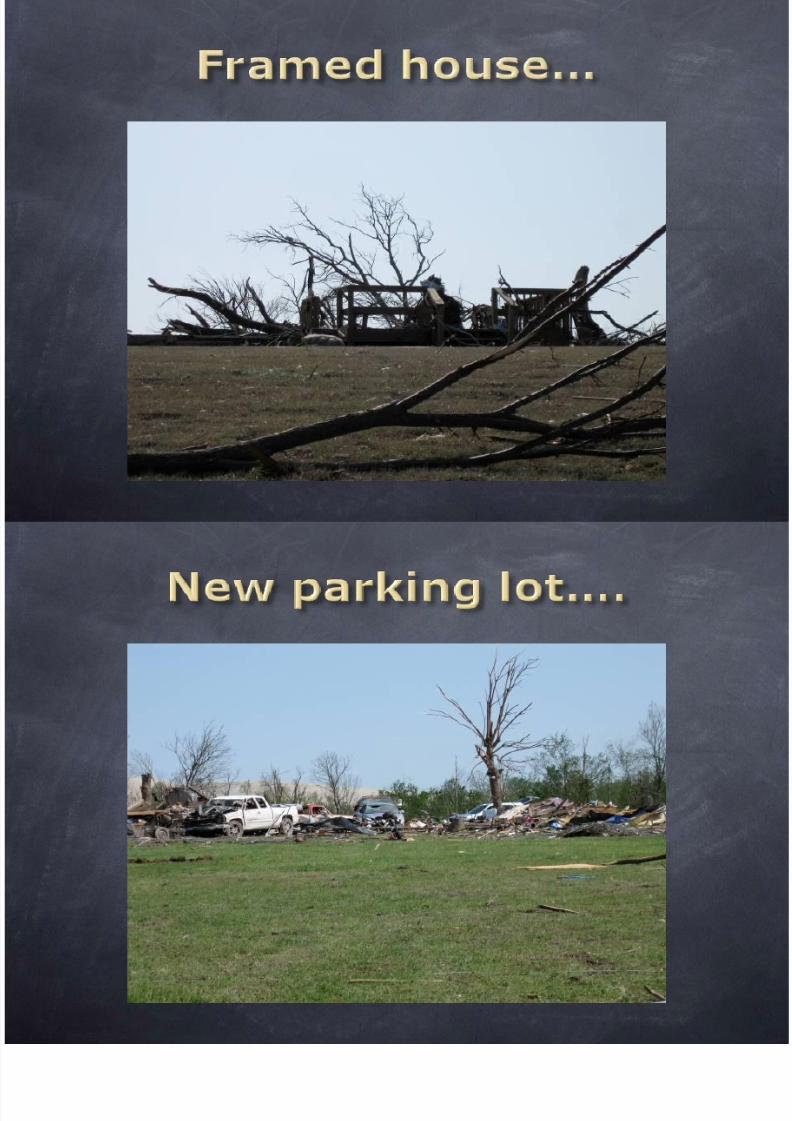
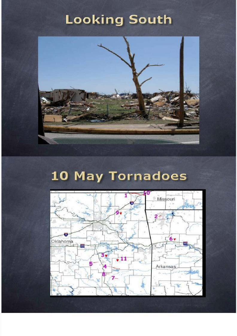
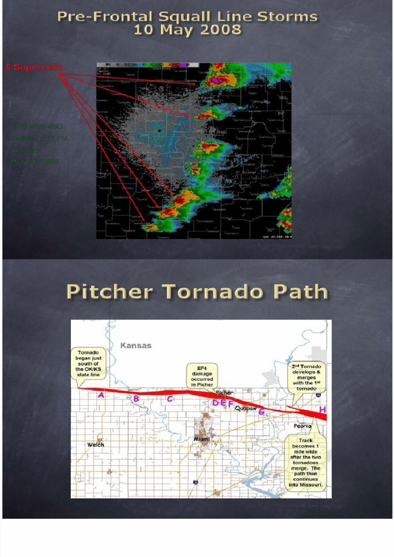
Picher, OK
8/12/2019 Tornado May2010
http://slidepdf.com/reader/full/tornado-may2010 53/107
•BEFORE…
10 May 2008
Picher, OK
8/12/2019 Tornado May2010
http://slidepdf.com/reader/full/tornado-may2010 54/107
10 May 2008
Picher, OK
8/12/2019 Tornado May2010
http://slidepdf.com/reader/full/tornado-may2010 55/107
Population (year 2000): 1,640.Estimated population in July 2006: 1,633 (-0.4% change)
Males: 800 (48.8%)Females: 840 (51.2%)
Ottawa CountyMedian resident age: 36.8 yearsOklahoma median age: 35.5 years
Zip codes: 74360. Approximately 60% of houses are abandoned.
Vital Statistics

8/12/2019 Tornado May2010
http://slidepdf.com/reader/full/tornado-may2010 56/107
8/12/2019 Tornado May2010
http://slidepdf.com/reader/full/tornado-may2010 57/107
8/12/2019 Tornado May2010
http://slidepdf.com/reader/full/tornado-may2010 58/107
8/12/2019 Tornado May2010
http://slidepdf.com/reader/full/tornado-may2010 59/107
8/12/2019 Tornado May2010
http://slidepdf.com/reader/full/tornado-may2010 60/107
8/12/2019 Tornado May2010
http://slidepdf.com/reader/full/tornado-may2010 61/107
8/12/2019 Tornado May2010
http://slidepdf.com/reader/full/tornado-may2010 62/107
8/12/2019 Tornado May2010
http://slidepdf.com/reader/full/tornado-may2010 63/107
8/12/2019 Tornado May2010
http://slidepdf.com/reader/full/tornado-may2010 64/107
8/12/2019 Tornado May2010
http://slidepdf.com/reader/full/tornado-may2010 65/107
8/12/2019 Tornado May2010
http://slidepdf.com/reader/full/tornado-may2010 66/107
8/12/2019 Tornado May2010
http://slidepdf.com/reader/full/tornado-may2010 67/107
8/12/2019 Tornado May2010
http://slidepdf.com/reader/full/tornado-may2010 68/107
8/12/2019 Tornado May2010
http://slidepdf.com/reader/full/tornado-may2010 69/107
8/12/2019 Tornado May2010
http://slidepdf.com/reader/full/tornado-may2010 70/107

8/12/2019 Tornado May2010
http://slidepdf.com/reader/full/tornado-may2010 71/107
8/12/2019 Tornado May2010
http://slidepdf.com/reader/full/tornado-may2010 72/107

8/12/2019 Tornado May2010
http://slidepdf.com/reader/full/tornado-may2010 73/107
8/12/2019 Tornado May2010
http://slidepdf.com/reader/full/tornado-may2010 74/107
8/12/2019 Tornado May2010
http://slidepdf.com/reader/full/tornado-may2010 75/107

8/12/2019 Tornado May2010
http://slidepdf.com/reader/full/tornado-may2010 76/107

8/12/2019 Tornado May2010
http://slidepdf.com/reader/full/tornado-may2010 77/107

8/12/2019 Tornado May2010
http://slidepdf.com/reader/full/tornado-may2010 78/107

8/12/2019 Tornado May2010
http://slidepdf.com/reader/full/tornado-may2010 79/107

8/12/2019 Tornado May2010
http://slidepdf.com/reader/full/tornado-may2010 80/107

8/12/2019 Tornado May2010
http://slidepdf.com/reader/full/tornado-may2010 81/107
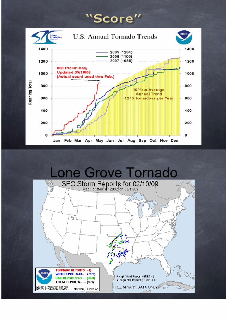
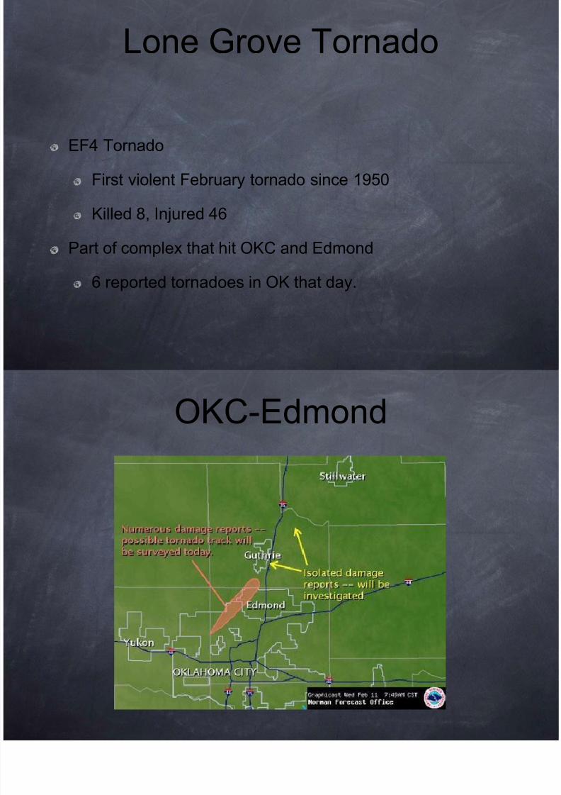
Lone Grove Tornado

8/12/2019 Tornado May2010
http://slidepdf.com/reader/full/tornado-may2010 82/107
Lone Grove Tornado

8/12/2019 Tornado May2010
http://slidepdf.com/reader/full/tornado-may2010 83/107
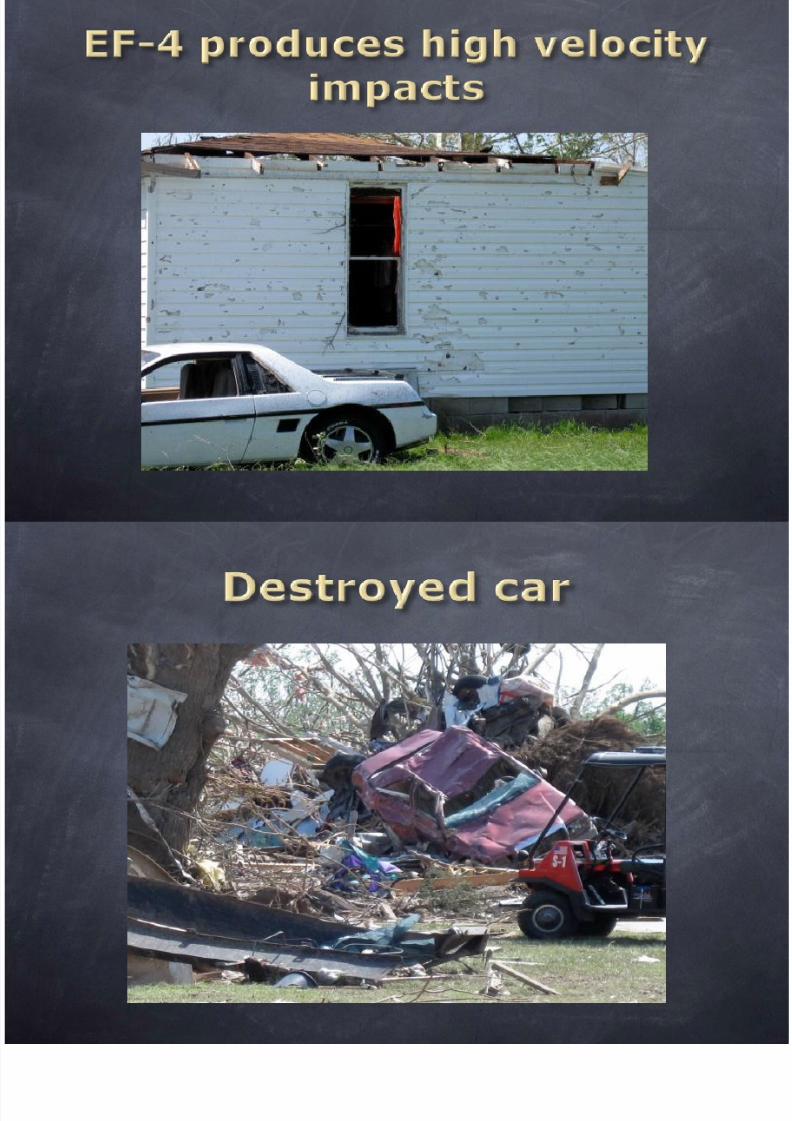
EF4 Tornado
First violent February tornado since 1950
Killed 8, Injured 46
Part of complex that hit OKC and Edmond
6 reported tornadoes in OK that day.

8/12/2019 Tornado May2010
http://slidepdf.com/reader/full/tornado-may2010 84/107
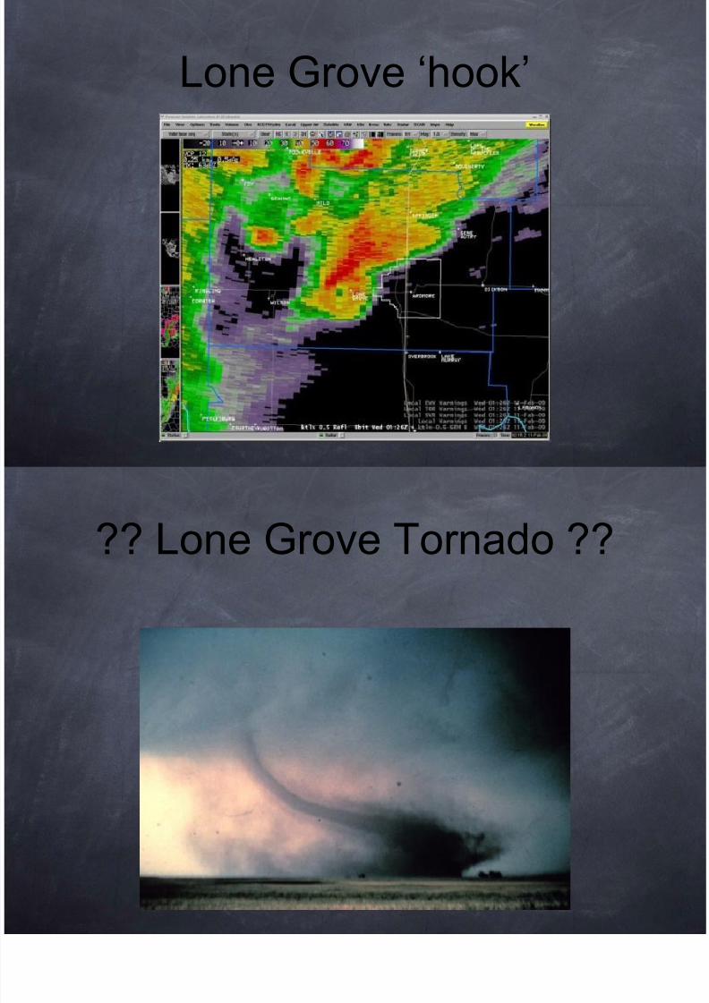
Lone Grove „hook‟

8/12/2019 Tornado May2010
http://slidepdf.com/reader/full/tornado-may2010 85/107
?? Lone Grove Tornado ??

8/12/2019 Tornado May2010
http://slidepdf.com/reader/full/tornado-may2010 86/107
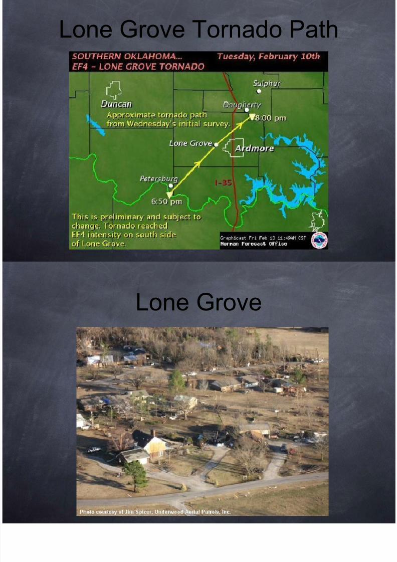
Lone Grove Tornado Path

8/12/2019 Tornado May2010
http://slidepdf.com/reader/full/tornado-may2010 87/107
Lone Grove

8/12/2019 Tornado May2010
http://slidepdf.com/reader/full/tornado-may2010 88/107
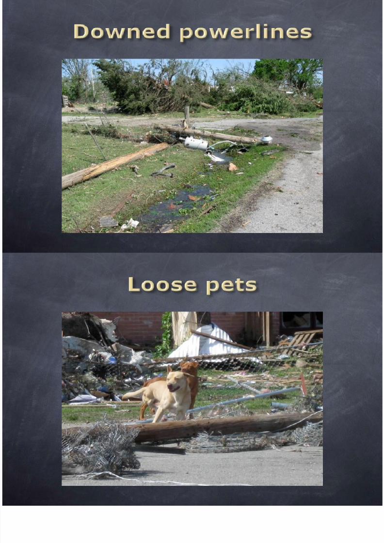
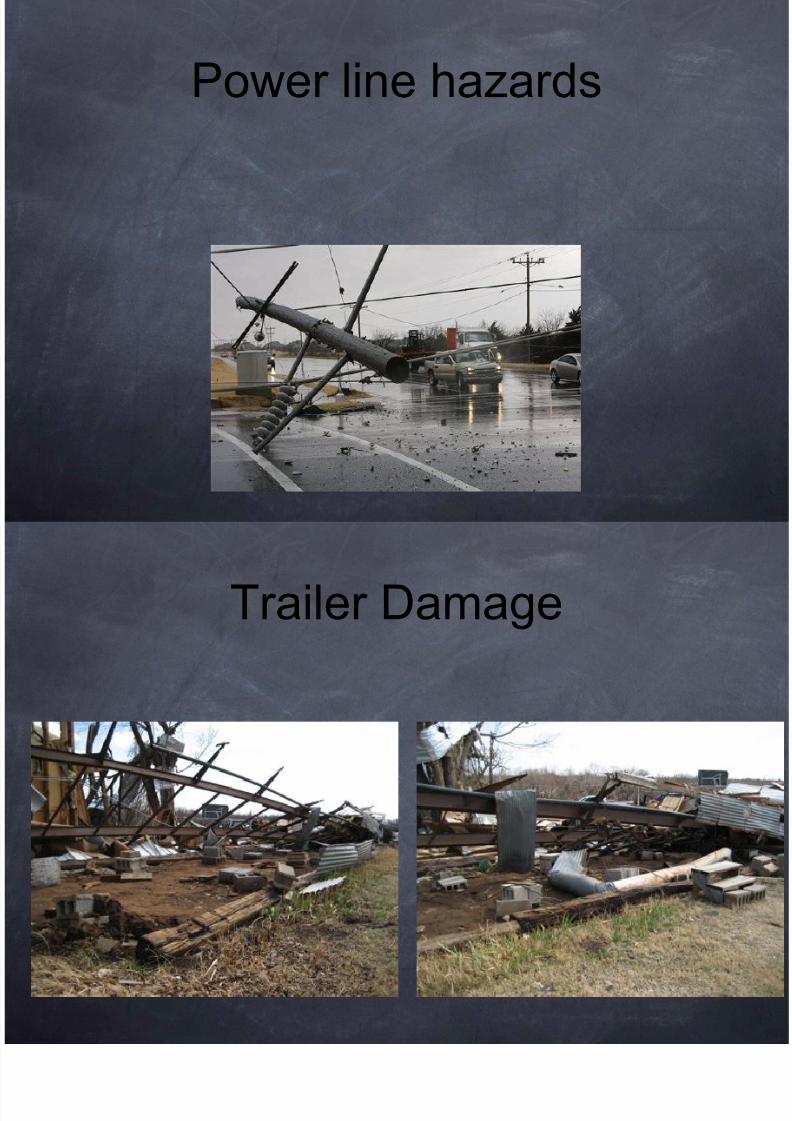
Power line hazards

8/12/2019 Tornado May2010
http://slidepdf.com/reader/full/tornado-may2010 89/107
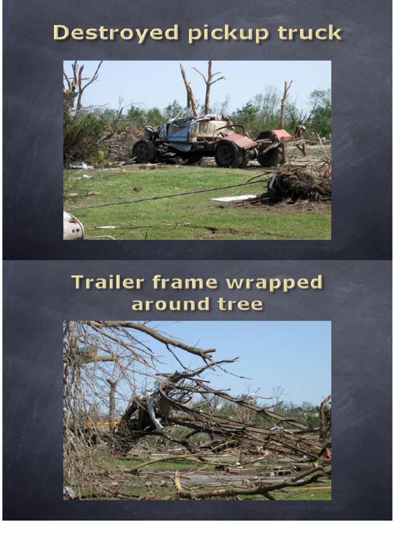
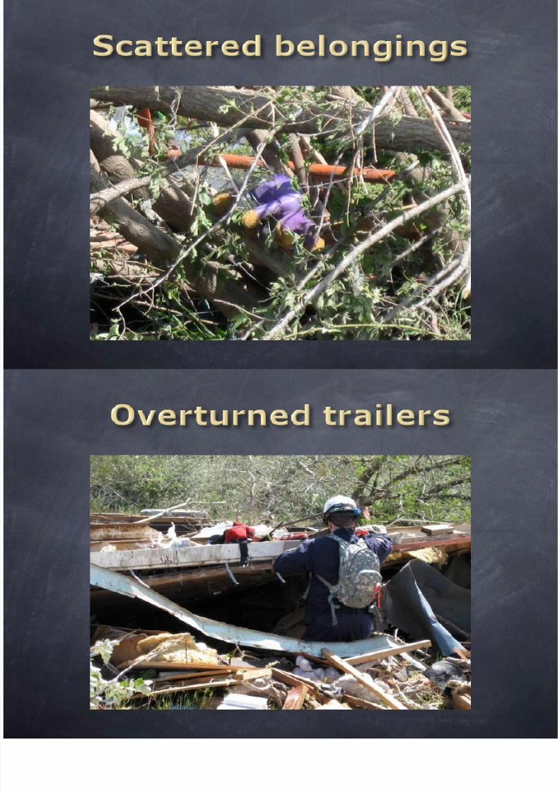
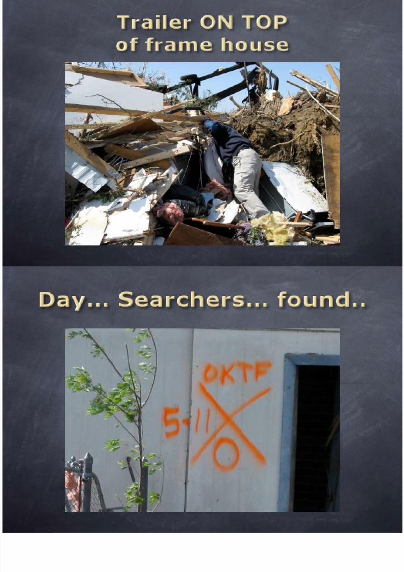
Trailer Damage

8/12/2019 Tornado May2010
http://slidepdf.com/reader/full/tornado-may2010 90/107
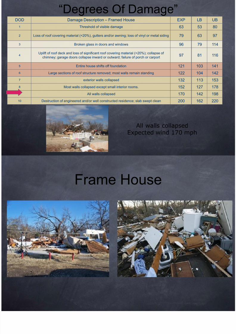
DOD Damage Description – Framed House EXP LB UB
1 Threshold of visible damage 63 53 80
2 Loss of roof covering material (<20%) gutters and/or awning; loss of vinyl or metal siding 79 63 97
“Degrees Of Damage”

8/12/2019 Tornado May2010
http://slidepdf.com/reader/full/tornado-may2010 91/107
2 Loss of roof covering material (<20%), gutters and/or awning; loss of vinyl or metal siding 79 63 97
3 Broken glass in doors and windows 96 79 114
4Uplift of roof deck and loss of significant roof covering material (>20%); collapse of
chimney; garage doors collapse inward or outward; failure of porch or carport97 81 116
5 Entire house shifts off foundation 121 103 141
6 Large sections of roof structure removed; most walls remain standing 122 104 142
7 exterior walls collapsed 132 113 153
8 Most walls collapsed except small interior rooms. 152 127 178
9 All walls collapsed 170 142 198
10 Destruction of engineered and/or well constructed residence; slab swept clean 200 162 220
All walls collapsed
Expected wind 170 mph
Frame House

8/12/2019 Tornado May2010
http://slidepdf.com/reader/full/tornado-may2010 92/107
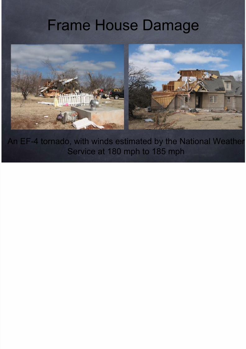
Frame House Damage

8/12/2019 Tornado May2010
http://slidepdf.com/reader/full/tornado-may2010 93/107
An EF-4 tornado, with winds estimated by the National WeatService at 180 mph to 185 mph
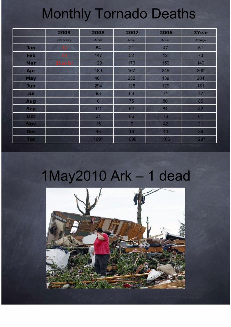
2009 2008 2007 2006 3Year
Monthly Tornado Deaths

8/12/2019 Tornado May2010
http://slidepdf.com/reader/full/tornado-may2010 94/107
preliminary Actual Actual Actual Average
Jan 10 84 21 47 51Feb 44 147 52 12 70
Mar 33 so far 129 170 150 149
Apr 189 167 245 200
May 461 252 139 284
Jun 294 128 120 181
Jul 93 69 71 77
Aug 101 75 80 85
Sep 111 52 84 82
Oct 21 86 76 61
Nov 15 7 42 21
Dec 46 19 40 36
Tot 1691 1098 1106 1297
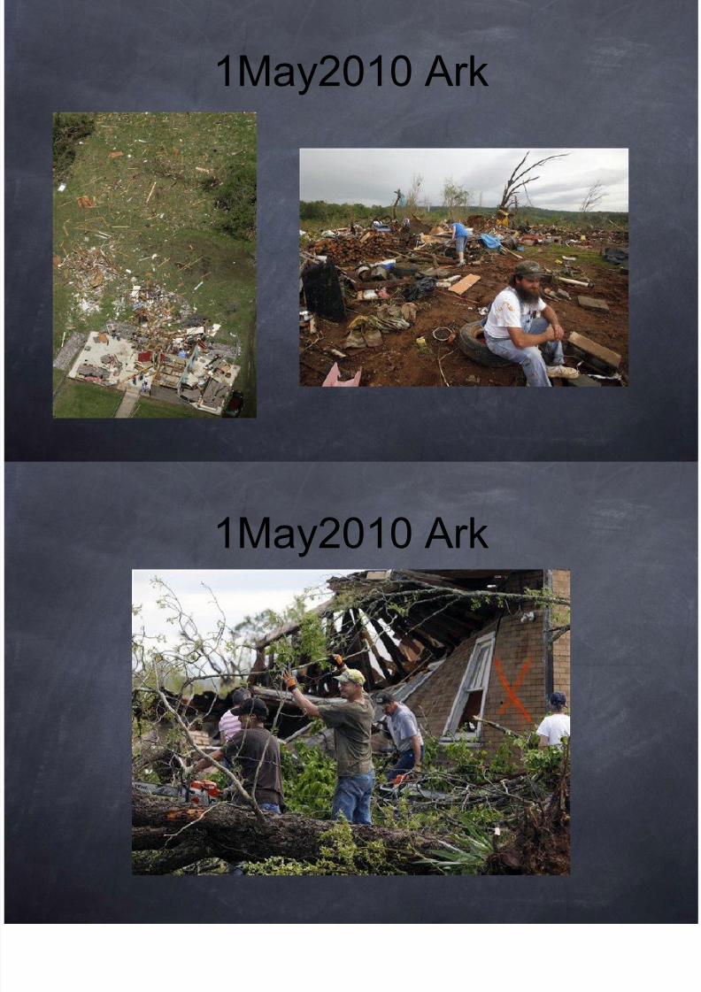
1May2010 Ark – 1 dead

8/12/2019 Tornado May2010
http://slidepdf.com/reader/full/tornado-may2010 95/107
1May2010 Ark

8/12/2019 Tornado May2010
http://slidepdf.com/reader/full/tornado-may2010 96/107
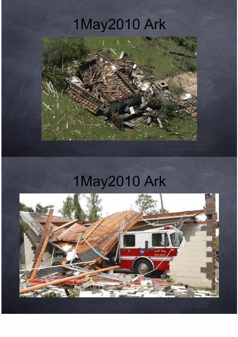
1May2010 Ark

8/12/2019 Tornado May2010
http://slidepdf.com/reader/full/tornado-may2010 97/107
1May2010 Ark

8/12/2019 Tornado May2010
http://slidepdf.com/reader/full/tornado-may2010 98/107
1May2010 Ark

8/12/2019 Tornado May2010
http://slidepdf.com/reader/full/tornado-may2010 99/107
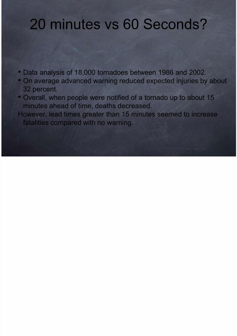
20 minutes vs 60 Seconds?

8/12/2019 Tornado May2010
http://slidepdf.com/reader/full/tornado-may2010 100/107
• Data analysis of 18,000 tornadoes between 1986 and 2002.
• On average advanced warning reduced expected injuries by abou
32 percent.• Overall, when people were notified of a tornado up to about 15
minutes ahead of time, deaths decreased.
However, lead times greater than 15 minutes seemed to increase
fatalities compared with no warning.
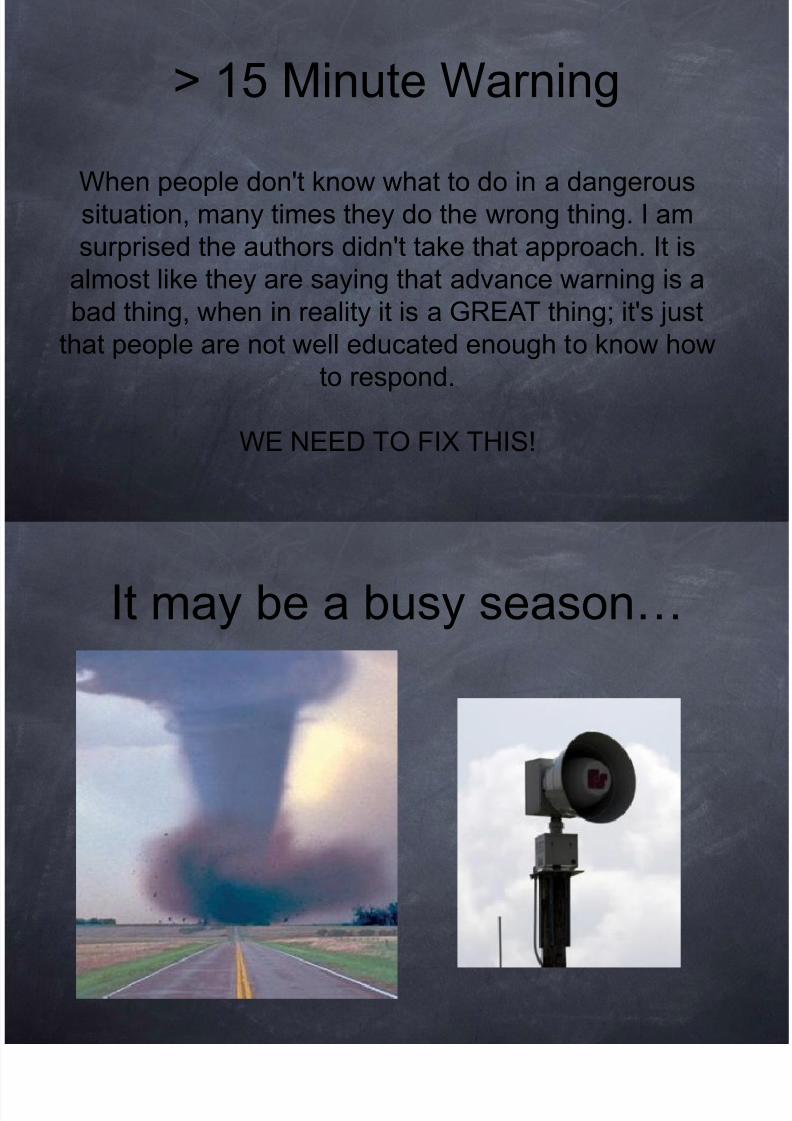
> 15 Minute Warning

8/12/2019 Tornado May2010
http://slidepdf.com/reader/full/tornado-may2010 101/107
"There is anecdotal evidence that came out of the
tornadoes in Oklahoma and Missouri in February. Out
of the 23 fatalities, eight were people in cars. I don't
know if those people were trying to outrun the storm,
or if they just happened to be in their cars."
> 15 Minute Warning

8/12/2019 Tornado May2010
http://slidepdf.com/reader/full/tornado-may2010 102/107
When people don't know what to do in a dangeroussituation, many times they do the wrong thing. I am
surprised the authors didn't take that approach. It is
almost like they are saying that advance warning is a
bad thing, when in reality it is a GREAT thing; it's justthat people are not well educated enough to know how
to respond.
WE NEED TO FIX THIS!
It may be a busy season…

8/12/2019 Tornado May2010
http://slidepdf.com/reader/full/tornado-may2010 103/107
In the event our luck does run out please put me

8/12/2019 Tornado May2010
http://slidepdf.com/reader/full/tornado-may2010 104/107
In the event our luck does run out, please put me
down for as much warning as possible.
I have things to do...
Thank You...

8/12/2019 Tornado May2010
http://slidepdf.com/reader/full/tornado-may2010 105/107
Thank You...
Chuck Stewart MD EMDM
Professor of Emergency Medicine,
University of Oklahoma
email [email protected]
Cell - 918-344-4557
Work - 918-660-3828
2E24 Schusterman Center4502 E. 41st Street
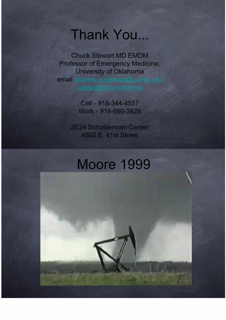
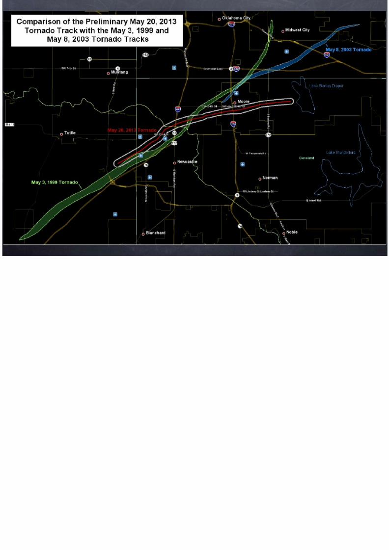
Moore 1999

8/12/2019 Tornado May2010
http://slidepdf.com/reader/full/tornado-may2010 106/107

8/12/2019 Tornado May2010
http://slidepdf.com/reader/full/tornado-may2010 107/107
Related Documents