Bellevue Meydenbauer Lake Cozy Loc h Lake Lake Lake Lake Lak e Washington Larsen Phantom Bay Swan Lak e Clyde Boren Bay Fairweather Yarrow Bay Sammamish Washington Cove Lake W i l k i n s C rk . U n k S t u r t e v a n t C r k . K e l s e y C r k . W e s t Tr i b u t a r y Me r c e r S l o u gh W e s t Y ar r o w C r k . K e l s e y C r k . Ri c h a r ds C r k . S u n se t C rk . G o f f C r k . P h a n t o m C r k . K e ls e y C rk . T r ibut ary E a s t C r k . N e w p o r t C r k . L e wis C r k . Co al Cr k . Me yd e n b a u e r C r k . K e l s e y C r k . S e a r s C rk . C o a l C r k . V a ll e y C r k . K e l s e y C r k . V a s a Crk. C o a l C r k . L e w i s C r k . T r i b ut a r y W e s t T r i b u t a r y E T r i b u t a r y V a s a C r k. Val le y C r k . M e r c e r S l o u g h E a s t I d y l w o o d C r k . V a sa C r k . L e w i s C r k . POINT CITIES SEARS CREEK KELSEY CREEK SUNSET CREEK SOUTH SAMMAMISH SPIRIT RIDGE PHANTOM CREEK BEAUX ARTS MERCER SLOUGH NORTH SAMMAMISH ROSEMONT WILKINS CREEK CLYDE BEACH MEYDENBAUER CREEK STURTEVANT CREEK WEST TRIBUTARY GOFF CREEK YARROW CREEK RICHARDS CREEK EAST CREEK VASA CREEK COAL CREEK LAKEHURST LEWIS CREEK NEWPORT SUNSET CR ISLAND VALLEY CREEK ARDMORE Legend Stream Types Shore: S Type Fish Bearing: F Type Non-Fish Bearing: Ns and Nf Types Not Typed Storm Drainage Basins Lakes City Limits V:\utpl\ArcGIS\Storm\BasinFactSheets2008\Maps_pdfs\Lidar.mxd Updated: 2/26/2009 0 1.1 Miles Topography This data is a geographic representation derived from the City of Bellevue Geographic Information System. The City of Bellevue does not guarantee that the information provided herein is accurate or complete. This information is provided on an "as is" basis and disclaims all warranties, express or implied, including but not limited to warranties of merchantability, fitness for a particular purpose and non-infringement. Any commercial use or sale of the information and data provided herein, or portions thereof, is prohibited without express written authorization by the City of Bellevue. The City of Bellevue is not responsible for any damages arising from the use of this data. Users should verify the information before making project commitments. City of Bellevue

Welcome message from author
This document is posted to help you gain knowledge. Please leave a comment to let me know what you think about it! Share it to your friends and learn new things together.
Transcript
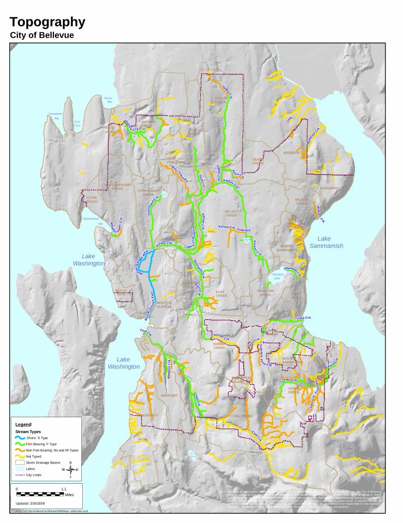
Bellevue
Meydenbauer
Lake
Cozy
Loch
Lake Lake
Lake
Lake
Lake
Washington
Larsen
Phantom
Bay
SwanLake
Clyde
Boren
Bay
Fairweather
Yarrow
Bay
Sammamish
Washington
Cove
Lake
Wilki ns Crk.
Unk
Sturt
evant
Cr k.
Kelsey Crk.
We st Trib
u tary
Mercer S
lou
gh We
st
Yarro w Crk.
Kelsey Crk.
Richards Cr k.
Sunset Crk.
Go ff C rk.
Phantom Cr k.
Kelsey Crk. Tributary
East Crk.
New p
o rt C
rk.
Lewis Crk .
Coal Crk.
Meyd e n b auer
Crk .
Kelse y C rk.
Se a rs Crk.
Coal Crk .
Valle y C rk. Kelsey Cr k.
Vasa Crk.
Coal Crk.
Lewi
s Crk.
Tribu
tary
West Tribu tary
E Tr ibutary Va sa Crk.
Valley Crk .
Me rce
r Slo u
gh Ea
st
Id ylwo
od Crk.
Vasa Crk.
Lewis Cr k.
POINTCITIES
SEARSCREEK
KELSEYCREEK
SUNSETCREEK
SOUTHSAMMAMISH
SPIRITRIDGE
PHANTOMCREEK
BEAUXARTS
MERCERSLOUGH
NORTHSAMMAMISH
ROSEMONT
WILKINSCREEK
CLYDEBEACH
MEYDENBAUERCREEK STURTEVANT
CREEK
WESTTRIBUTARY
GOFFCREEK
YARROWCREEK
RICHARDSCREEK
EASTCREEK
VASACREEK
COAL CREEKLAKEHURST
LEWISCREEK
NEWPORT
SUNSET CRISLAND
VALLEYCREEK
ARDMORE
LegendStream Types
Shore: S TypeFish Bearing: F TypeNon-Fish Bearing: Ns and Nf TypesNot TypedStorm Drainage BasinsLakesCity Limits
V:\utpl\ArcGIS\Storm\BasinFactSheets2008\Maps_pdfs\Lidar.mxd
Updated: 2/26/2009
0 1.1Miles
Topography
This data is a geographic representation derived from the City of Bellevue Geographic Information System. The City of Bellevuedoes not guarantee that the information provided herein is accurate or complete. This information is provided on an "as is" basisand disclaims all warranties, express or implied, including but not limited to warranties of merchantability, fitness for a particularpurpose and non-infringement. Any commercial use or sale of the information and data provided herein, or portions thereof, isprohibited without express written authorization by the City of Bellevue. The City of Bellevue is not responsible for any damagesarising from the use of this data. Users should verify the information before making project commitments.
City of Bellevue
Related Documents