Topo-bathymetric lidar to support enhanced coastal mapping for shellfish Aquaculture & Eelgrass mapping Department of Fisheries and Oceans Gulf Region – Kevin McGuigan - Research Associate AGRG, NSCC Copyright NSCC please acknowledge the source

Welcome message from author
This document is posted to help you gain knowledge. Please leave a comment to let me know what you think about it! Share it to your friends and learn new things together.
Transcript

Topo-bathymetric lidar to support enhanced coastal mapping for shellfish
Aquaculture & Eelgrass mappingDepartment of Fisheries and Oceans Gulf Region –
Kevin McGuigan - Research Associate AGRG, NSCC
Copyright NSCC please acknowledge the source

Geology
Antarctica Siberia
West Africa
North America
3 Billion years ago…
Colombia Super ContinentCO2
Copyright NSCC please acknowledge the source

Biology
Geology
Cyanobacteria
ucmp.berkeley.edu
O2
CO2
1.5 Billion years ago…
Copyright NSCC please acknowledge the source

Biology
Geology
Great Extinction
Proliferation of Respiratory Life
britannica.com
Banded Iron Formations
O2
O2O2
Fe2O3
500 Million years ago…
Copyright NSCC please acknowledge the source

Now..
Biology
Geology
Copyright NSCC please acknowledge the source
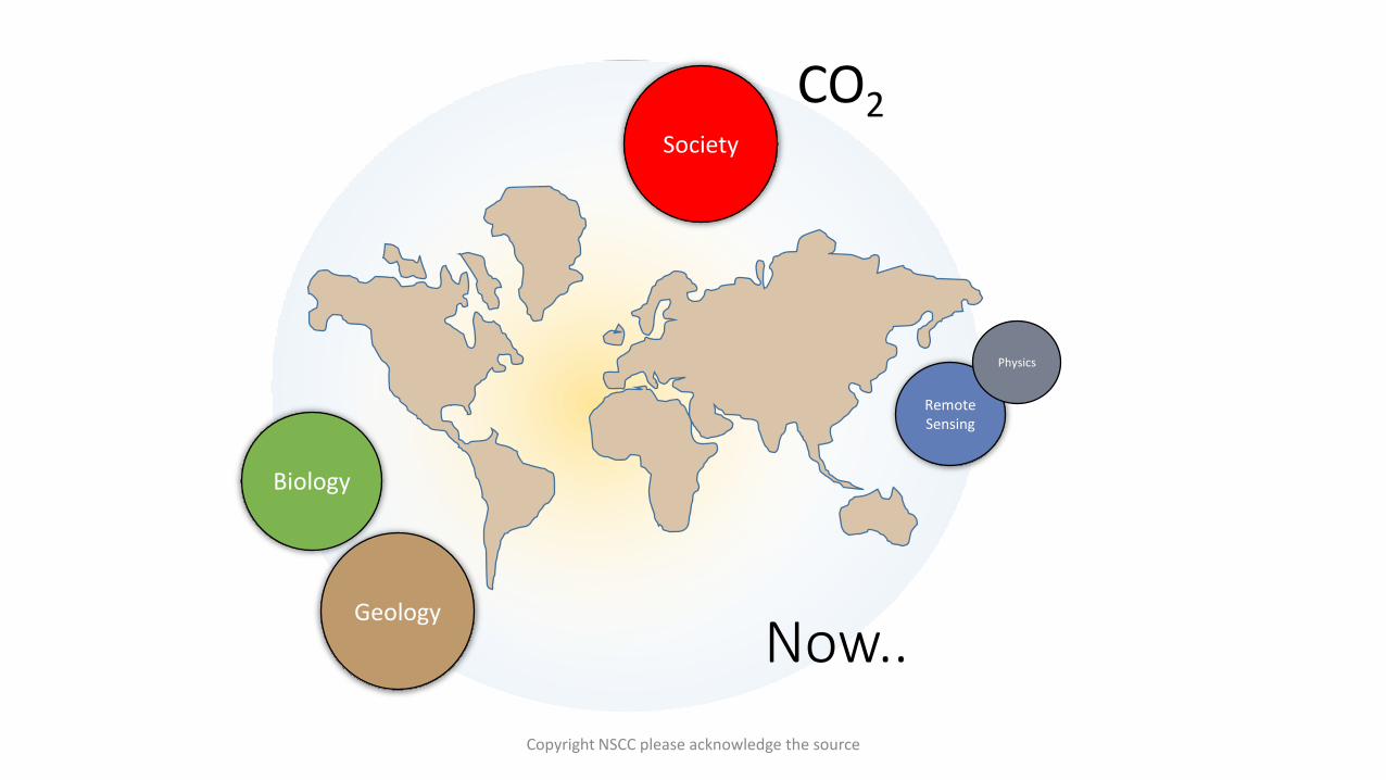
Now..
Biology
Geology
Society
Remote Sensing
Physics
CO2
Copyright NSCC please acknowledge the source

Nova Scotia
You Are Here
Copyright NSCC please acknowledge the source

NWATL, CHS, NRCAN, Boulder, NOAA, UNB, UNH, OPTECH, USGS, UofMaine
PEI Eutrophication
gov.pe.ca
Aquaculture
thechronicleherald.ca
Aquaculture Meteghanthechronicleherald.ca
AGRG
Shoreline Armoring
Society
• CoastalStewards
• Challenges /Opportunities
Nova Scotia Brant Decoy
forsythesauctions.com
European green crabcbc.ca
Copyright NSCC please acknowledge the source

NWATL, CHS, NRCAN, Boulder, NOAA, UNB, UNH, OPTECH, USGS, UofMaine
Biology
Algaed Eelgrass, Tabusintac Bay
AGRG
Port Mouton Eelgrass Monitoring
cbc.ca
Eelgrass Fish Habitatccesuffolk.org
Eelgrass Shellfish Habitat
southernfriedscience.com
• EELGRASS• Zosteraarina
• Coastal ‘Canary in the coal mine’
TD Sherman
Labyrinthula
‘Wasting Disease’
Copyright NSCC please acknowledge the source

We need to detect and communicate changes in regional eelgrass systematically…
Biology
Society
Copyright NSCC please acknowledge the source

https://earthenginepartners.appspot.com/science-2013-global-forest
Biology
Remote Sensing
Society
You Are Here
Turkey
Finland
Russia
Global Forest Cover Change
Copyright NSCC please acknowledge the source

How do we map eelgrass?
Copyright NSCC please acknowledge the source
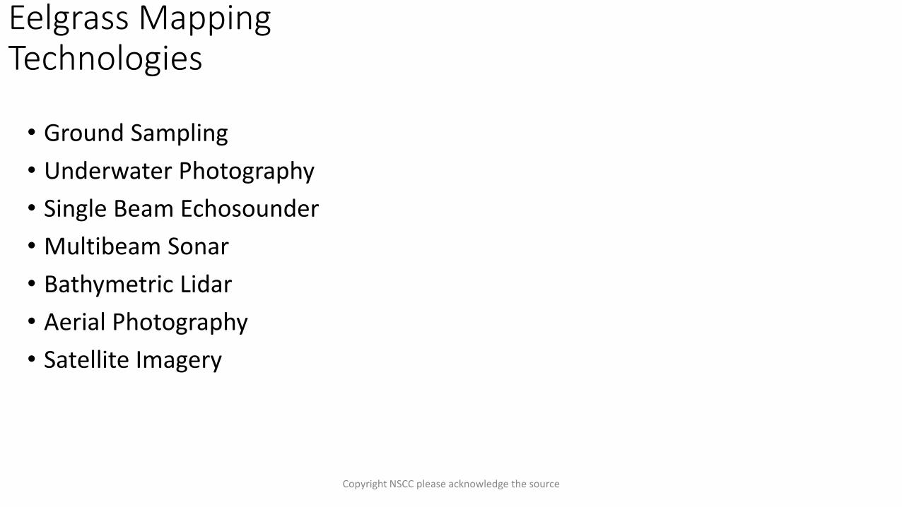
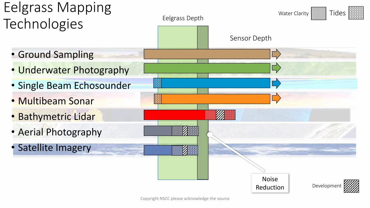
• Ground Sampling
• Underwater Photography
• Single Beam Echosounder
• Multibeam Sonar
• Bathymetric Lidar
• Aerial Photography
• Satellite Imagery
Eelgrass Mapping Technologies
Copyright NSCC please acknowledge the source

• Ground Sampling
• Underwater Photography
• Single Beam Echosounder
• Multibeam Sonar
• Bathymetric Lidar
• Aerial Photography
• Satellite Imagery
Eelgrass Mapping Technologies
Shag Harbor, NS. AGRG
Shag Harbor, NS. AGRG
Cocagne River. AGRG
Cocagne River. AGRG
Bucket
BootsDGPS
Copyright NSCC please acknowledge the source

• Ground Sampling
• Underwater Photography
• Single Beam Echosounder
• Multibeam Sonar
• Bathymetric Lidar
• Aerial Photography
• Satellite Imagery
Eelgrass Mapping Technologies
Eelgrass, Shag Harbor, NS. AGRG
Kelp, Shag Harbor, NS. AGRG
Cocagne River. AGRG
Cocagne River, October 18 2015. AGRG
Photo Quadrat
Copyright NSCC please acknowledge the source

• Ground Sampling
• Underwater Photography
• Single Beam Echosounder
• Multibeam Sonar
• Bathymetric Lidar
• Aerial Photography
• Satellite Imagery
Eelgrass Mapping Technologies
biosonicsinc.com
biosonicsinc.com
Transect
BioSonics DT-X
Copyright NSCC please acknowledge the source
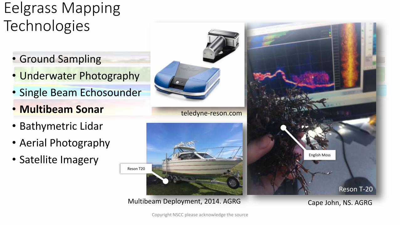
• Ground Sampling
• Underwater Photography
• Single Beam Echosounder
• Multibeam Sonar
• Bathymetric Lidar
• Aerial Photography
• Satellite Imagery
Eelgrass Mapping Technologies
Cape John, NS. AGRG
Reson T-20
teledyne-reson.com
Multibeam Deployment, 2014. AGRG
English Moss
Reson T20
Copyright NSCC please acknowledge the source

• Ground Sampling
• Underwater Photography
• Single Beam Echosounder
• Multibeam Sonar
• Bathymetric Lidar
• Aerial Photography
• Satellite Imagery
Eelgrass Mapping Technologies
LEICA-AHAB CHIROPTERA II
Cross Section
Waveform
3d-View
Copyright NSCC please acknowledge the source

• Ground Sampling
• Underwater Photography
• Single Beam Echosounder
• Multibeam Sonar
• Bathymetric Lidar
• Aerial Photography
• Satellite Imagery
Eelgrass Mapping Technologies
Cocagne River NB, 2015. AGRG
NDPI
Copyright NSCC please acknowledge the source

• Ground Sampling
• Underwater Photography
• Single Beam Echosounder
• Multibeam Sonar
• Bathymetric Lidar
• Aerial Photography
• Satellite Imagery
Eelgrass Mapping Technologies
Abasolo, J (2015); DOI: 10.1109/TGRS.2014.2377300
Image Copyright © DigitalGlobe
WorldView 2
Copyright NSCC please acknowledge the source
Eelgrass Mapping Technologies
• Ground Sampling
• Underwater Photography
• Single Beam Echosounder
• Multibeam Sonar
• Bathymetric Lidar
• Aerial Photography
• Satellite Imagery
Copyright NSCC please acknowledge the source

• Ground Sampling
• Underwater Photography
• Single Beam Echosounder
• Multibeam Sonar
• Bathymetric Lidar
• Aerial Photography
• Satellite Imagery
Eelgrass Mapping Technologies
ConfidenceCoverageEquipment
ExpenseOperational
ExpenseAdditional
BenefitOperational
Window
* More Expensive than Aerial Photography
Labour Intensive
Seamless Bathymetry for Hydrodynamic ModellingSun, Low
Clouds
Water Clarity
Direct Density MeasurementsWater Quality
Measurements
Copyright NSCC please acknowledge the source

• Ground Sampling
• Underwater Photography
• Single Beam Echosounder
• Multibeam Sonar
• Bathymetric Lidar
• Aerial Photography
• Satellite Imagery
Eelgrass Mapping Technologies
ConfidenceCoverageEquipment
ExpenseOperational
ExpenseAdditional
BenefitOperational
Window
Development
NSERC LEG/AGRG
Citizen Science
STANTEC/AGRG
SPACEX? Machine Learning
Copyright NSCC please acknowledge the source

• Ground Sampling
• Underwater Photography
• Single Beam Echosounder
• Multibeam Sonar
• Bathymetric Lidar
• Aerial Photography
• Satellite Imagery
Eelgrass Mapping Technologies
Sensor Depth
Eelgrass DepthTides
Too Shallow
Signal Loss
Water Clarity
Copyright NSCC please acknowledge the source
• Ground Sampling
• Underwater Photography
• Single Beam Echosounder
• Multibeam Sonar
• Bathymetric Lidar
• Aerial Photography
• Satellite Imagery
Eelgrass Mapping Technologies
Sensor Depth
Eelgrass DepthTidesWater Clarity
DevelopmentNoise
Reduction
Copyright NSCC please acknowledge the source
With lidar.… (and other technologies)
Copyright NSCC please acknowledge the source
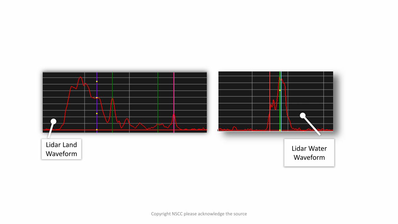
Lidar Land Waveform
Lidar Water Waveform
Copyright NSCC please acknowledge the source
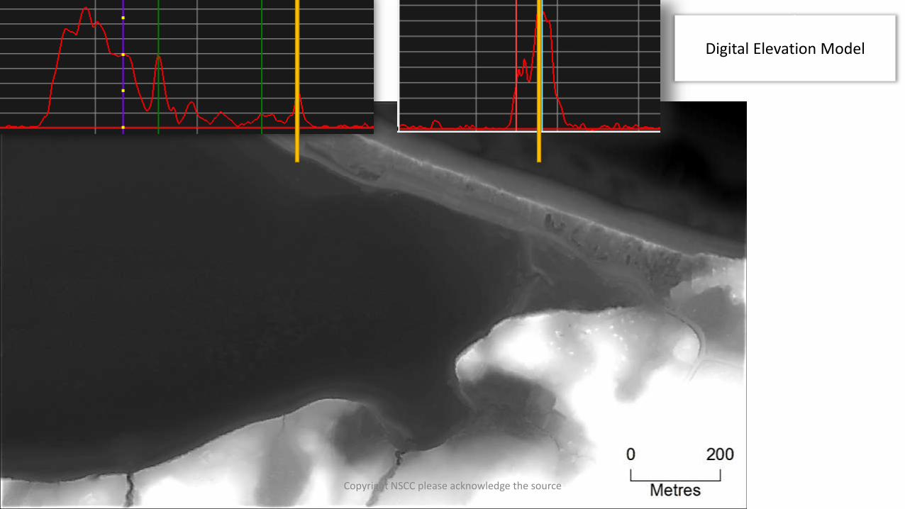
Digital Elevation Model
Copyright NSCC please acknowledge the source

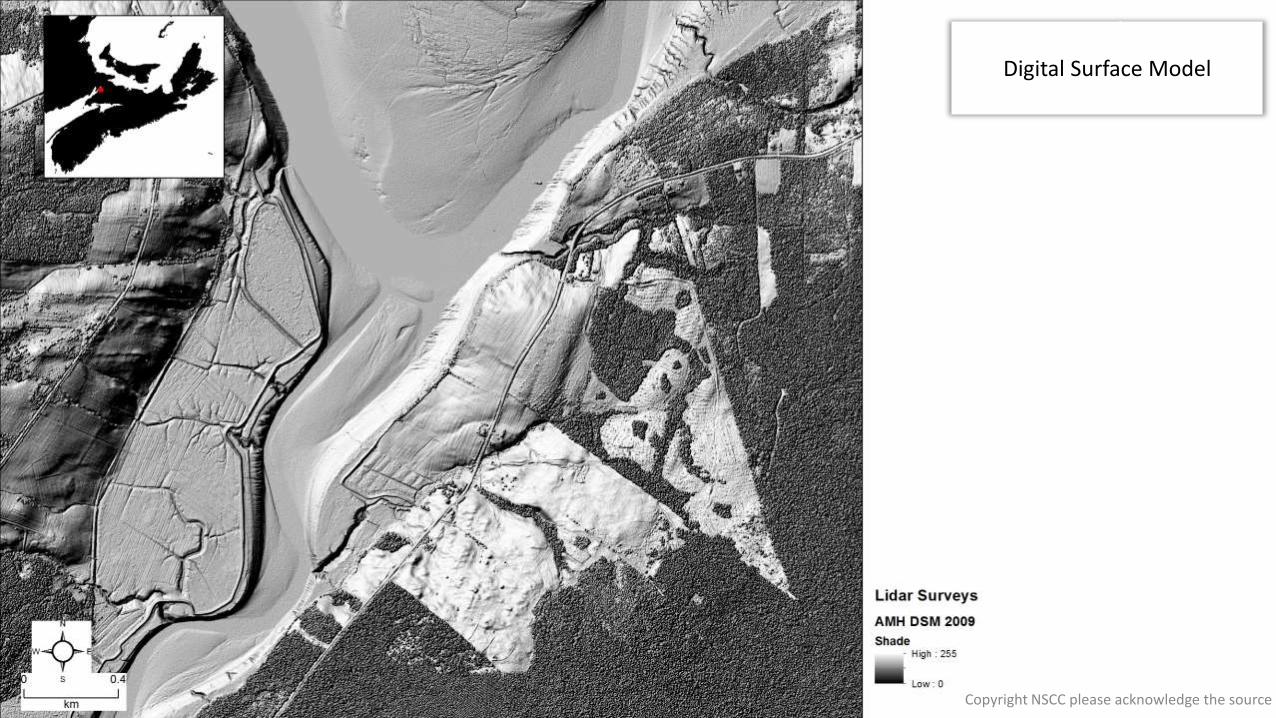
Digital Surface Model
Copyright NSCC please acknowledge the source

Digital Elevation Model
Copyright NSCC please acknowledge the source

Digital Surface Model
Copyright NSCC please acknowledge the source

Digital Depth Model
Copyright NSCC please acknowledge the source

Reflectance/Intensity Model
Copyright NSCC please acknowledge the source

Digital Elevation Model
Copyright NSCC please acknowledge the source
Digital Surface Model
Copyright NSCC please acknowledge the source

Vegetation Height Model
Copyright NSCC please acknowledge the source

• ClearlyDefinedVegetation
Copyright NSCC please acknowledge the source

• What if there were a water surface?
• Unequal Water Column Noise?
BATHYMETRIC SIMULATION
Copyright NSCC please acknowledge the source

• What if noise reduction removed many valid vegetation returns?
Lidar Land Waveform
Lidar Water Waveform
BATHYMETRIC SIMULATION
Copyright NSCC please acknowledge the source

• Photosynthesis
• Radiometric Absorption
• Diffuse attenuation coefficient
• Substrate dependence
• Carrying capacity
• Ecosystem health
• Sustainable aquaculture
• Height, density, presence
Optical Physics of Bathymetric Lidar
http://www.oceanopticsbook.info/
Biology
Physics
Remote Sensing
Society
Copyright NSCC please acknowledge the source
NWATL, CHS, NRCAN, Boulder, NOAA, UNB, UNH, OPTECH, USGS, UofMaine
Copyright NSCC please acknowledge the source
NWATL, CHS, NRCAN, Boulder, NOAA, UNB, UNH, OPTECH, USGS, UofMaine
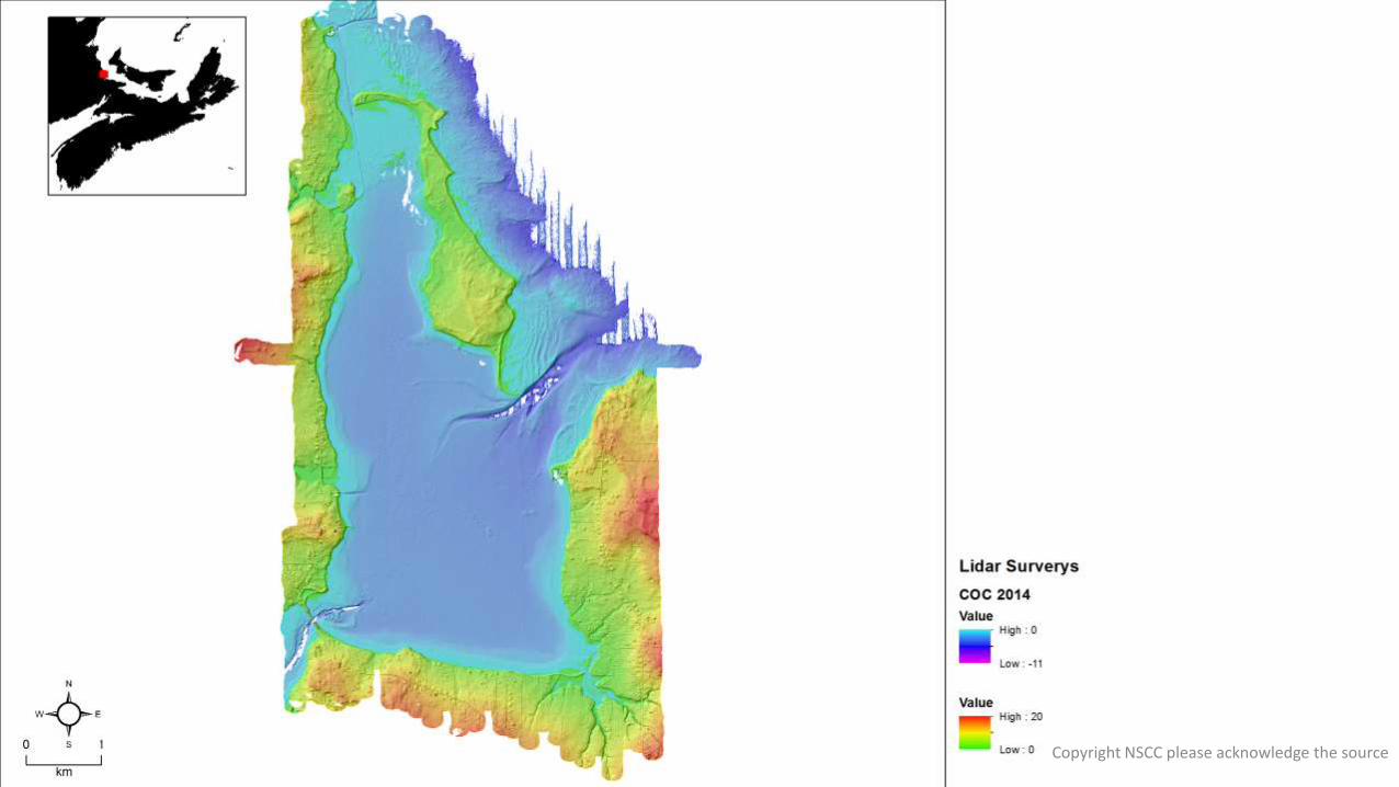
Country Harbour, NS
Banook Lake, NS
TabusintacBay, NB
Saint Simone, NB
CocagneRiver, NB
Copyright NSCC please acknowledge the source

TabusintacBay, NB
Copyright NSCC please acknowledge the source

35.0 Km2
23.7 Km2
Copyright NSCC please acknowledge the source

Copyright NSCC please acknowledge the source
Copyright NSCC please acknowledge the source

• Bottom Slope
Small Sample
Med Sample
Coarse Sample
Copyright NSCC please acknowledge the source
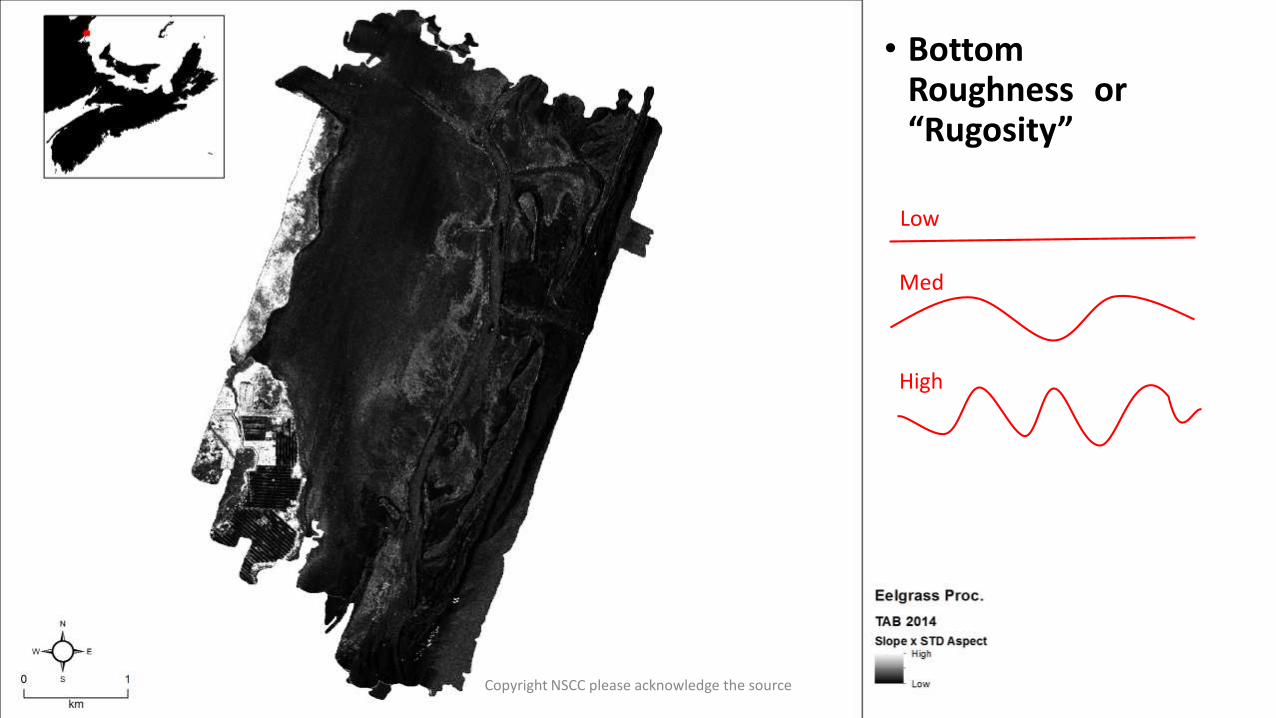
• BottomRoughness or“Rugosity”
Low
Med
High
Copyright NSCC please acknowledge the source

• LidarReflectanceIntensity
Signal Loss
Depth
Copyright NSCC please acknowledge the source
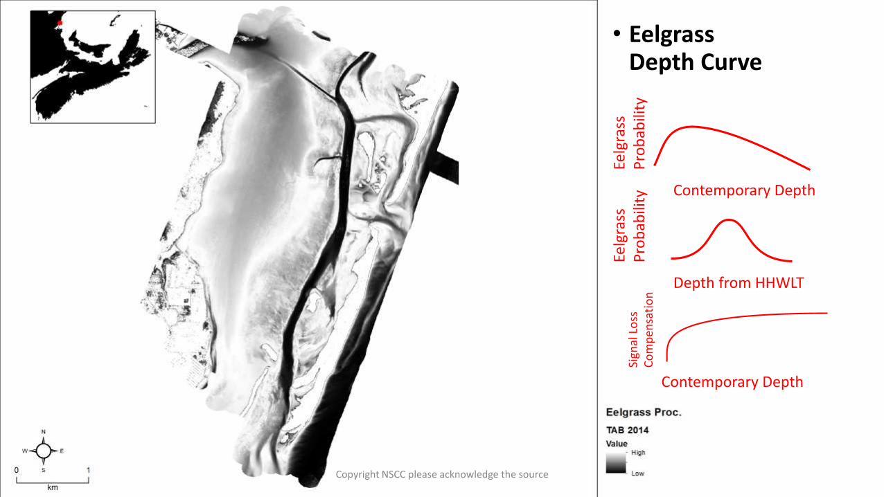
• EelgrassDepth Curve
Contemporary Depth
Eelg
rass
P
rob
abili
ty
Contemporary Depth
Sign
al L
oss
C
om
pen
sati
on
Depth from HHWLT
Eelg
rass
P
rob
abili
ty
Copyright NSCC please acknowledge the source
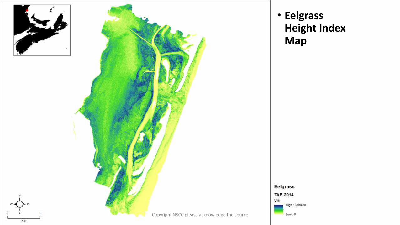
• Eelgrass Height Index Map
Copyright NSCC please acknowledge the source
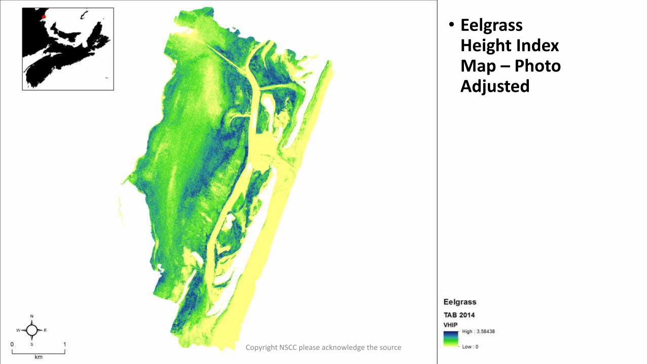
• Eelgrass Height Index Map – Photo Adjusted
Copyright NSCC please acknowledge the source
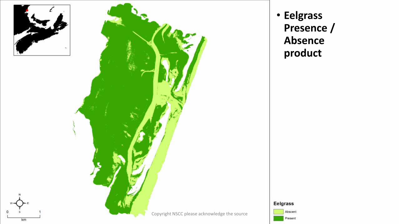
• Eelgrass Presence / Absence product
Copyright NSCC please acknowledge the source

• Eelgrass Height Index
• BiosonicsValidation Provided by Stantec
Copyright NSCC please acknowledge the source

Height Index
Mea
sure
d
Copyright NSCC please acknowledge the source

• Eelgrass Presence / Absence product
• Eelgrass Presence Validation Provided by AGRG/DFO
Mas Much As 86% Agreement?
Copyright NSCC please acknowledge the source

• Eelgrass Presence / Absence product
• Biosonics % cover Provided by Stantec
Mas Much As 92% Agreement?
Copyright NSCC please acknowledge the source
With lidar.… (and some air photos, and some ground truth, and some singlebeam)
Copyright NSCC please acknowledge the source

NWATL, CHS, NRCAN, Boulder, NOAA, UNB, UNH, OPTECH, USGS, UofMaine
CocagneRiver, NB
Copyright NSCC please acknowledge the source

26.9 Km2
14.2 Km2
Copyright NSCC please acknowledge the source

Copyright NSCC please acknowledge the source
Copyright NSCC please acknowledge the source

Copyright NSCC please acknowledge the source

See, Aquaculture!
Copyright NSCC please acknowledge the source

Copyright NSCC please acknowledge the source
Copyright NSCC please acknowledge the source

Copyright NSCC please acknowledge the source

NWATL, CHS, NRCAN, Boulder, NOAA, UNB, UNH, OPTECH, USGS, UofMaine
Country Harbour, NS
Copyright NSCC please acknowledge the source

29.0 Km2
Copyright NSCC please acknowledge the source

Copyright NSCC please acknowledge the source

Copyright NSCC please acknowledge the source

Copyright NSCC please acknowledge the source

Copyright NSCC please acknowledge the source

Saint Simone, NB
Copyright NSCC please acknowledge the source

68.2 Km2
Shippagan, NB
Copyright NSCC please acknowledge the source

Copyright NSCC please acknowledge the source

NWATL, CHS, NRCAN, Boulder, NOAA, UNB, UNH, OPTECH, USGS, UofMaine
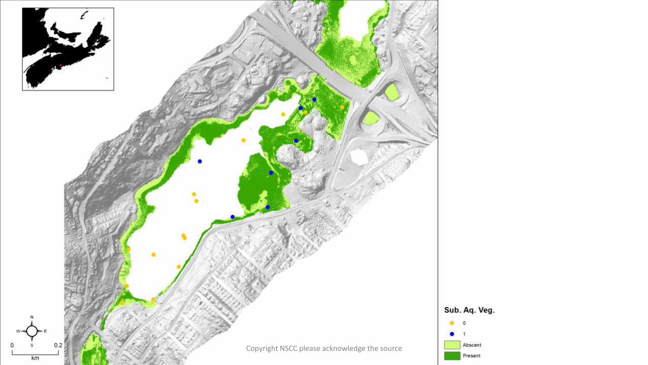
Banook Lake, NS
Copyright NSCC please acknowledge the source

2.0 Km2
Copyright NSCC please acknowledge the source

Copyright NSCC please acknowledge the source
Copyright NSCC please acknowledge the source

Copyright NSCC please acknowledge the source

Copyright NSCC please acknowledge the source

Copyright NSCC please acknowledge the source

Copyright NSCC please acknowledge the source

Things to work onMAKE IT WORK MORE CONSISTENTLY • Noise Reduction in water column
• Depth Attenuation Compensation
• Airphoto Air/Water Correction
• Glint/Sun Angle Removal
• Wave Form Metric Extraction
• Extracting Additional points from lidar
• Many more …
Copyright NSCC please acknowledge the source

Equipment Support provided by CFI, NSRIT
Mark Skinner, StantecMarc Ouellette, DFOMonique Niles, DFOAnders Ekelund, Leica AHAB
Thanks too..
Copyright NSCC please acknowledge the source
Related Documents

![New Topographic-Bathymetric Lidar Technology for Post ... · Microsoft PowerPoint - 28 Alaksen - Topo-Bathy lidar (PPT file) [Compatibility Mode] Author: User Created Date: 11/14/2014](https://static.cupdf.com/doc/110x72/5f672933dc10a36c3c604154/new-topographic-bathymetric-lidar-technology-for-post-microsoft-powerpoint-.jpg)