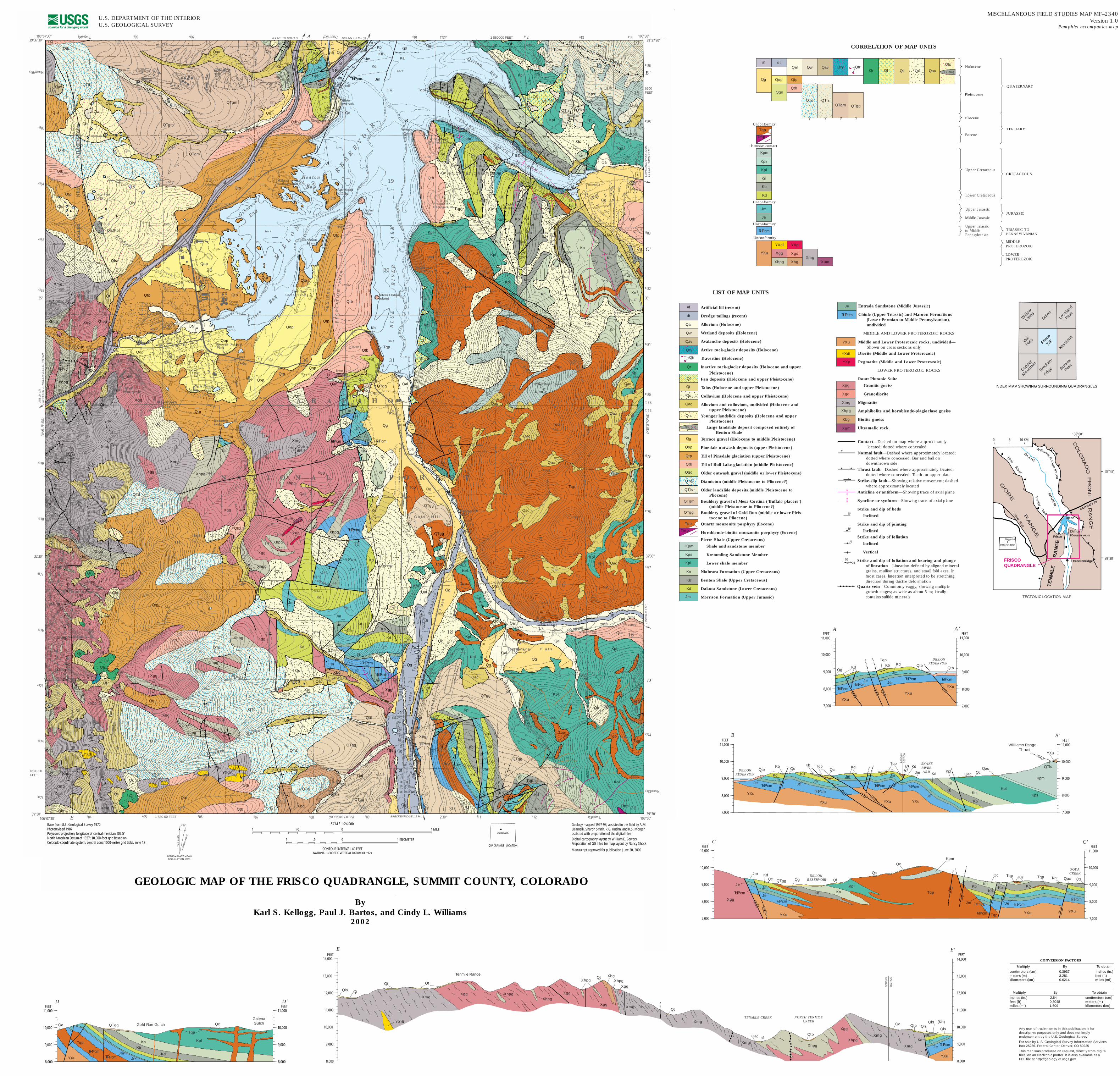
Tqp Tqp Tqp Kpl Kpl Kpl cm cm Qg Qc Qc Qgo Qac Qf Je ? Tqp ° 68 65 15 53 12 17 16 50 27 29 12 22 39 16 18 20 32 10 15 22 24 18 8 20 20 16 32 56 38 23 45 44 42 24 27 20 27 24 29 17 9 23 20 55 68 39 18 12 10 8 13 12 20 18 15 18 25 23 73 14 30 15 40 12 23 43 7 10 10 2 17 19 12 21 15 30 20 23 23 30 78 58 27 30 77 22 32 23 39 32 26 40 25 37 21 27 80 20 20 34 20 27 24 40 14 29 31 20 28 24 18 20 25 22 34 26 20 27 20 37 24 41 25 35 30 40 13 35 30 28 28 31 19 26 33 21 23 15 23 39 63 15 12 34 41 40 42 52 60 54 72 33 35 43 42 42 40 80 64 42 50 45 33 30 45 55 57 62 65 64 50 53 59 44 53 35 45 10 22 55 23 47 55 62 59 76 41 80 72 75 7 66 7 7 63 80 65 60 65 60 7 61 78 62 70 72 69 87 61 72 80 87 78 33 70 52 78 77 72 60 85 50 85 65 60 54 79 72 60 75 88 75 69 82 74 80 67 20 66 37 75 69 75 65 88 48 67 76 33 50 28 25 45 33 26 38 72 32 25 22 45 48 20 30 20 7 23 56 31 15 5 42 34 22 34 38 25 81 44 LIST OF MAP UNITS af dt Qal Qw Qav Qry Qr Qf Qt Qc Qac Qls Qls (Kb) Qg Qop Qtp Qtb Qgo QTd QTgm SCALE 1:24 000 1/ 2 1 0 1 MILE 1 KILOMETER 1 .5 0 CONTOUR INTERVAL 40 FEET NATIONAL GEODETIC VERTICAL DATUM OF 1929 QTgg QTls Kpm Kps Kpl Kn Jm Kb Kd Je cm YXu YXdi YXp Xgg Xgd Xmg Xhpg Xbg Xum Artificial fill (recent) Dredge tailings (recent) Alluvium (Holocene) Wetland deposits (Holocene) Avalanche deposits (Holocene) Active rock-glacier deposits (Holocene) Travertine (Holocene) Inactive rock-glacier deposits (Holocene and upper Pleistocene) Fan deposits (Holocene and upper Pleistocene) Talus (Holocene and upper Pleistocene) Colluvium (Holocene and upper Pleistocene) Alluvium and colluvium, undivided (Holocene and upper Pleistocene) Younger landslide deposits (Holocene and upper Pleistocene) Large landslide deposit composed entirely of Benton Shale Terrace gravel (Holocene to middle Pleistocene) Pinedale outwash deposits (upper Pleistocene) Till of Pinedale glaciation (upper Pleistocene) Till of Bull Lake glaciation (middle Pleistocene) Older outwash gravel (middle or lower Pleistocene) Diamicton (middle Pleistocene to Pliocene?) Older landslide deposits (middle Pleistocene to Pliocene) Bouldery gravel of Mesa Cortina ("Buffalo placers") (middle Pleistocene to Pliocene?) Bouldery gravel of Gold Run (middle or lower Pleis- tocene to Pliocene) Quartz monzonite porphyry (Eocene) Hornblende-biotite monzonite porphyry (Eocene) Pierre Shale (Upper Cretaceous) Shale and sandstone member Kremmling Sandstone Member Lower shale member Niobrara Formation (Upper Cretaceous) Benton Shale (Upper Cretaceous) Dakota Sandstone (Lower Cretaceous) Morrison Formation (Upper Jurassic) Entrada Sandstone (Middle Jurassic) Chinle (Upper Triassic) and Maroon Formations (Lower Permian to Middle Pennsylvanian), undivided MIDDLE AND LOWER PROTEROZOIC ROCKS Middle and Lower Proterozoic rocks, undivided— Shown on cross sections only Diorite (Middle and Lower Proterozoic) Pegmatite (Middle and Lower Proterozoic) LOWER PROTEROZOIC ROCKS Routt Plutonic Suite Granitic gneiss Granodiorite Migmatite Amphibolite and hornblende-plagioclase gneiss Biotite gneiss Ultramafic rock Contact—Dashed on map where approximately located; dotted where concealed Normal fault—Dashed where approximately located; dotted where concealed. Bar and ball on downthrown side Thrust fault—Dashed where approximately located; dotted where concealed. Teeth on upper plate Strike-slip fault—Showing relative movement; dashed where approximately located Anticline or antiform—Showing trace of axial plane Syncline or synform—Showing trace of axial plane Strike and dip of beds Inclined Strike and dip of jointing Inclined Strike and dip of foliation Inclined Vertical Strike and dip of foliation and bearing and plunge of lineation—Lineation defined by aligned mineral grains, mullion structures, and small fold axes. In most cases, lineation interpreted to be stretching direction during ductile deformation Quartz vein—Commonly vuggy, showing multiple growth stages; as wide as about 5 m; locally contains sulfide minerals 60 56 31 cm 50 70 GEOLOGIC MAP OF THE FRISCO QUADRANGLE, SUMMIT COUNTY, COLORADO By Karl S. Kellogg, Paul J. Bartos, and Cindy L. Williams 2002 Qls Qt Qt Qt YXdi Xhpg Xbg Xhpg Qt Qac Xhpg Qc Qls YXu cm Je Kd Xmg Xmg Xmg Xmg Xmg Xmg Xgg Xgg Xgg Xgg Qt Qtp Jm Xhpg Xhpg Qls Kb Qtp Xgg af (Kb) Qls 8,000 9,000 10,000 11,000 12,000 13,000 FEET Tenmile Range SECTION BEND IN 14,000 8,000 9,000 10,000 11,000 12,000 13,000 FEET 14,000 E E' E E' TENMILE CREEK NORTH TENMILE CREEK Xhpg B' B 10,000 9,000 8,000 7,000 Thrust Williams Range SECTION BEND IN B' B 7,000 8,000 9,000 10,000 11,000 11,000 cm Kd Kd Jm Jm Qtb Je Je Kb cm cm cm Je Jm Jm Kb Qc Tqp Kd Kd Tqp Kb Kn Kpl Jm Kd Kpl Kps Qac Kpm Kn Kb YXu YXu YXu YXu YXu QTls Qac Qc Qc FEET FEET SNAKE RIVER ARM DILLON RESERVOIR Qtb Kd Kb YXu YXu cm cm cm cm Qtb Tqp Kd Jm Jm Je Je Qg 7,000 8,000 9,000 FEET RESERVOIR DILLON 10,000 11,000 A A' 7,000 8,000 9,000 FEET 10,000 11,000 YXu A A' C C' 7,000 7,000 8,000 8,000 9,000 9,000 10,000 10,000 11,000 11,000 C C' YXu Xgg Kd Jm cm Je Je Jm Qg Kb Kn Kpl Qc Kpm Kb Kn Kb cm Kd Jm Je Kb Kn Kd Jm cm cm YXu Qg Qac Kn Tqp Tqp Je Tqp YXu Tqp Qc cm Qc Qf QTgg Qc FEET FEET DILLON RESERVOIR SODA CREEK 8,000 9,000 FEET 10,000 11,000 8,000 9,000 FEET 10,000 11,000 ? ? ? Je Jm Kb Kd Kn Kpl YXu TR Pcm TR Pcm QTgg Tqp Tqp Qc Qc D D' Gold Run Gulch Galena Gulch D D' U.S. DEPARTMENT OF THE INTERIOR U.S. GEOLOGICAL SURVEY 106°07'30" 39°30' 106°07'30" 39°37'30" Base from U.S. Geological Survey 1970 Photorevised 1987 Polyconic projection; longitude of central meridian 105.5° North American Datum of 1927; 10,000-foot grid based on Colorado coordinate system, central zone;1000-meter grid ticks, zone 13 13 / 1 2 APPROXIMATE MEAN DECLINATION, 2001 TRUE NORTH MAGNETIC NORTH Any use of trade names in this publication is for descriptive purposes only and does not imply endorsement by the U.S. Geological Survey For sale by U.S. Geological Survey Information Services Box 25286, Federal Center, Denver, CO 80225 This map was produced on request, directly from digital files, on an electronic plotter. It is also available as a PDF file at http://geology.cr.usgs.gov Geology mapped 1997-98; assisted in the field by A.M. Licamelli. Sharon Smith, R.G. Kuehn, and K.S. Morgan assisted with preparation of the digital files Digital cartography layout by William E. Sowers Preparation of GIS files for map layout by Nancy Shock Manuscript approved for publication June 20, 2000 106°00' 39°30' 39°37'30" 106°30' Unconformity Intrusive contact Unconformity Unconformity Unconformity YXu YXdi Xgg Xhpg YXp Xgd Xbg Xmg Xum cm Jm Je Tmp Kpm Kps Kpl Kn Kb Kd af dt Qal Qtp Qtb Qg Qop Qgo Qw Qav Qry QTd QTls Qtr Qr Qf Qt Qc Qac Qls Holocene Pleistocene Pliocene Eocene Upper Cretaceous Upper Jurassic Middle Jurassic MIDDLE PROTEROZOIC Lower Cretaceous Upper Triassic to Middle Pennsylvanian QUATERNARY TERTIARY CRETACEOUS JURASSIC TRIASSIC TO PENNSYLVANIAN LOWER PROTEROZOIC CORRELATION OF MAP UNITS ? ? ? ? Qls (Kb) QTgm QTgg MISCELLANEOUS FIELD STUDIES MAP MF–2340 Version 1.0 Pamphlet accompanies map COLORADO Map Area 0 5 10 KM COLORA DO FRO NT RAN GE B L U E RI VE R Dillon Interstate 70 W illia m s R a n ge th ru st Blu e R iv er fr onta l f ault G or e fa ult TECTONIC LOCATION MAP Frisco Breckenridge Dillon Reservoir GORE RANGE TENMIL E R ANGE FRISCO QUADRANGLE 39°30' 39°45' 106°00' Tqp Tqp Tqp Tqp Tqp Tqp Tqp Tqp Tqp Tqp Tqp Tqp Kpl Kpl Kpl Kpl Kpl Kpl Kpl Kpl Kpl Kpl Kpl Kpl Kpl Kpl Kn Kn Kn Kn Jm Kb Kb Kd Kd Kd Kd Kd Kd Kd Kd QTgg QTgg QTgg QTgg Tqp Tqp Tqp Tqp Tqp Kb Jm Jm Tqp Tqp Kn Qal Qal dt dt dt Xgg Qg Qg Je Qac Qac Qc Tqp QTd Qc QTd QTd Qc Xbg Qac YXdi Qtb Qtb Qtp YXdi Xgg Xgg Qtp Xhpg Xgg Xhpg Qt Qt YXdi Xmg Xmg Xhpg Qt Xhpg Qls Xhpg Xmg Qt Qr Qls Qr Xgg Qt Qr Qt Qt Xbg Xhpg Xgg Xhpg Qtp QTd QTd Qtb Qc Xgg Xgg Qtb Qls Qt Kd Xhpg Jm Qac Jm Jm Jm Qc Qc Xhpg Qac Qtb Xum YXp Qc Xgg Je Xbg Xhpg Jm cm cm Xhpg Qc Qac Je Qc Qls Kpl Qal Kn Jm Kb dt Qc Qc QTgg Qac Qg Qc Qal Tqp Qg Qg Qg Qal QTgg Qac Qac Qac dt Qal Qtb Kpm Kpm Qc Qc Qac Qac Qac Kn Kn Qg Jm Je Je cm Qc Qc Qc Kn Kn Kd Qw Qal QTgg Qtb Qtp Kd Xmg Xhpg Qac Xhpg Qls Xmg Qc Xgg Xmg Xgg Qf Qt Xgg Qc Qtp Qop Qop Xgg Qtp Qop Qop Qt Xmg Qal Qls Qc af af af Xhpg Xhpg Qtp Xhpg Qop Qtp Qtb Qtp Qtp Qtp Qop Qc Qc Kpl Kn Kb Kb Kb Kn Kn Qac Kb Kb Kd Kd Kd Qc Qc Kb Kpl Qc Qg Qtb Kb Kb Kb Qc Qc Qc Kd Kd Qtb Qac Jm Kn Qc Jm Qtp Qtp Qtp Qtb QTgm QTgm Qac Qg Kd Qls Qls(Kb) Qtp Qls Qtb QTb Qac Qw Qls QTd Qtp Qav Qac QTgm Qtb Qls Kn Kn Kb Kb Jm Kd Qg af Qc Kb Kb Kd Qac Kpm Kpm Kps QTls Qf Qc Williams Range thrust Qal QTls QTls Kps Qac Qc Qc Qc Qs Kn QTls Qg Jm Qac Qac Qls Qc Qal Qg Xgg Qc Qal QTd Qac QTd Jm Kd Qf Qf Qal Qg Qc Qc Qls Qal Qal cm Qac QTls Kps Kpm Qac cm Qc Xgg Tqp Qr Qls Qr Qry Qt Qls Kn Kn Kpl Kpl Kpl Tqp Frisco Willow Lakes Dillon Vail Pass Copper Mountain 7.5' Keystone Brecken- ridge Boreas Pass Loveland Pass INDEX MAP SHOWING SURROUNDING QUADRANGLES Je Tmp Kd Jm Jm Je Kb Kpl Ka Jm Kn Kb cm cm Kd Jm Qt Kd (BOREAS PASS) (DILLON) (VAIL PASS) (KEYSTONE) 32'30" 32'30" 43 79 43 78 43 77 43 74 43 73 000m. N. 43 80 43 81` 43 82 43 83 43 85 43 86 6500 FEET 35' T. 5 S. T. 6 S. 4 14 4 13 4 12 2'30" 1 850000 FEET 4 10 4 06 4 05 4 04 000m. E. 43 77 43 76 43 75 43 74 43 73 610 000 FEET 4 04 4 05 1 830 00 FEET 4 06 4 07 4 08 4 09 2'30" 4 11 4 12 4 13 000m. E. LOVELAND PASS 12MI. GEORGETOWN 27 MI. LINCOLN 7 MI. 0.4 Mi. TO COLO. 9 DILLON 1.1 MI. 43 79 43 78 VAIL 24 MI. WHEELER JUNCTION (COLO. 91) 5MI. 43 86 000m N. 43 85 43 84 43 83 43 83 35" BRECKENRIDGE 1.2 MI. Qtr Xhpg Xhpg Xhpg Xhpg Qtr Kn af cm Qw Kb Jm Jm CONVERSION FACTORS Multiply By To obtain centimeters (cm) 0.3937 inches (in.) meters (m) 3.281 feet (ft) kilometers (km) 0.6214 miles (mi) Multiply By To obtain inches (in.) 2.54 centimeters (cm) feet (ft) 0.3048 meters (m) miles (mi) 1.609 kilometers (km) Xbg Xgd Jm COLORADO QUADRANGLE LOCATION Tqp Tqp Tmp

Welcome message from author
This document is posted to help you gain knowledge. Please leave a comment to let me know what you think about it! Share it to your friends and learn new things together.
Transcript
Tqp
Tqp
Tqp
Tqp
Kpl
Kpl
Kpl
��cm
��cm
Qg
Qc
Qc
Qgo
Qac
Qf
Je
?
Tqp
DILLON 1.3 MI.R. 77 W.
°
68
65
15
53
12
17
16
50
27
29
12
22
39
16
18
20
32
10 15
22
24
18
820
20
16
32
56
38
23
4544
42
24 27
20
27
24
29 17
9
23
20
55
68
39
18
1210
813
12 20
18
15
1825
23
73
14
30
15 40
12
23
43
7
10
10
2
17
19
12
21
15
30
20
23
23
3078
58
27
30
77
22
32
2339
32
26
40
25
37
21
27
80
20
20
34
20
27
2440
14
29
31
20
28
24 18 20
25
2234
26
20
27
20
3724
41
25
3530
40
13
35
30
28
28
31
1926
33
21
23
15
23
39
63
15
12
34
41
40
42
52
60
5472
33
35
43
42
42
40
80
64
42
50
45
33
30
45
55
57
62
65
64
50
53
59
44
53
35
45
10
22
55
23
47
5562
59
76
41
8072
75
7
66
7
7
63
80
65
6065
60
7
61
78
62
70 72
69
87
61
72
80
87
78
33
70
5278
77
7260
85
50
85
65 60
54
79
7260
75
88 75
69
82
74
80
67
20
66
37
75
69
75 65
88
48
67
76
33 50
28
254533
26
38
72
32
25
22
45
48
20
30
20
7
23
5631
15
5
42
34
22
3438
25
81
44
LIST OF MAP UNITS
af
dt
Qal
Qw
Qav
Qry
Qr
Qf
Qt
Qc
Qac
Qls
Qls (Kb)
Qg
Qop
Qtp
Qtb
Qgo
QTd
QTgm
SCALE 1:24 0001/ 21 0 1 MILE
1 KILOMETER1 .5 0
CONTOUR INTERVAL 40 FEETNATIONAL GEODETIC VERTICAL DATUM OF 1929
QTgg
QTls
Kpm
Kps
Kpl
Kn
Jm
Kb
Kd
Je
��cm
YXu
YXdi
YXp
Xgg
Xgd
Xmg
Xhpg
Xbg
Xum
Artificial fill (recent)
Dredge tailings (recent)
Alluvium (Holocene)
Wetland deposits (Holocene)
Avalanche deposits (Holocene)
Active rock-glacier deposits (Holocene)
Travertine (Holocene)
Inactive rock-glacier deposits (Holocene and upper Pleistocene)
Fan deposits (Holocene and upper Pleistocene)
Talus (Holocene and upper Pleistocene)
Colluvium (Holocene and upper Pleistocene)
Alluvium and colluvium, undivided (Holocene and upper Pleistocene)
Younger landslide deposits (Holocene and upper Pleistocene)
Large landslide deposit composed entirely of Benton Shale
Terrace gravel (Holocene to middle Pleistocene)
Pinedale outwash deposits (upper Pleistocene)
Till of Pinedale glaciation (upper Pleistocene)
Till of Bull Lake glaciation (middle Pleistocene)
Older outwash gravel (middle or lower Pleistocene)
Diamicton (middle Pleistocene to Pliocene?)
Older landslide deposits (middle Pleistocene to Pliocene)
Bouldery gravel of Mesa Cortina ("Buffalo placers") (middle Pleistocene to Pliocene?)
Bouldery gravel of Gold Run (middle or lower Pleis-tocene to Pliocene)
Quartz monzonite porphyry (Eocene)
Hornblende-biotite monzonite porphyry (Eocene)
Pierre Shale (Upper Cretaceous)
Shale and sandstone member
Kremmling Sandstone Member
Lower shale member
Niobrara Formation (Upper Cretaceous)
Benton Shale (Upper Cretaceous)
Dakota Sandstone (Lower Cretaceous)
Morrison Formation (Upper Jurassic)
Entrada Sandstone (Middle Jurassic)
Chinle (Upper Triassic) and Maroon Formations (Lower Permian to Middle Pennsylvanian), undivided
MIDDLE AND LOWER PROTEROZOIC ROCKS
Middle and Lower Proterozoic rocks, undivided— Shown on cross sections only
Diorite (Middle and Lower Proterozoic)
Pegmatite (Middle and Lower Proterozoic)
LOWER PROTEROZOIC ROCKS
Routt Plutonic Suite
Granitic gneiss
Granodiorite
Migmatite
Amphibolite and hornblende-plagioclase gneiss
Biotite gneiss
Ultramafic rock
Contact—Dashed on map where approximately located; dotted where concealed
Normal fault—Dashed where approximately located; dotted where concealed. Bar and ball ondownthrown side
Thrust fault—Dashed where approximately located;dotted where concealed. Teeth on upper plate
Strike-slip fault—Showing relative movement; dashedwhere approximately located
Anticline or antiform—Showing trace of axial plane
Syncline or synform—Showing trace of axial plane
Strike and dip of beds
Inclined
Strike and dip of jointing
InclinedStrike and dip of foliation
Inclined
Vertical
Strike and dip of foliation and bearing and plunge of lineation—Lineation defined by aligned mineral grains, mullion structures, and small fold axes. Inmost cases, lineation interpreted to be stretchingdirection during ductile deformation
Quartz vein—Commonly vuggy, showing multiple growth stages; as wide as about 5 m; locally contains sulfide minerals
60
5631
��cm
50
70
GEOLOGIC MAP OF THE FRISCO QUADRANGLE, SUMMIT COUNTY, COLORADO
By Karl S. Kellogg, Paul J. Bartos, and Cindy L. Williams
2002
Qls Qt
Qt Qt
YXdi
Xhpg
XbgXhpg
Qt
QacXhpg
QcQls
YXu
��cmJe
Kd
Xmg
Xmg
Xmg
Xmg
Xmg
Xmg
Xgg
Xgg
XggXgg
Qt
Qtp
JmXhpg
Xhpg
Qls
Kb
Qtp
Xgg
af
(Kb)
Qls
8,000
9,000
10,000
11,000
12,000
13,000
FEET
Tenmile Range
SE
CT
ION
BE
ND
IN
14,000
8,000
9,000
10,000
11,000
12,000
13,000
FEET14,000
E E'
E
E'
TENMILE CREEK NORTH TENMILECREEK
Xhpg
B'
B
10,000
9,000
8,000
7,000
ThrustWilliams Range
SE
CT
ION
BE
ND
IN
B'B
7,000
8,000
9,000
10,000
11,000 11,000
��cm
Kd Kd
JmJm
Qtb
JeJe
Kb
��cm
��cm ��cm
Je
Jm Jm
KbQc
Tqp Kd KdTqp
Kb
Kn
KplJm Kd
Kpl
Kps
Qac
Kpm
Kn
Kb
YXu
YXu YXu YXu
YXu
QTls
Qac QcQc
FEETFEET
SNAKERIVERARMDILLON
RESERVOIR
QtbKd Kb
YXu
YXu
��cm��cm
��cm��cm
Qtb
TqpKd
JmJm
JeJe
Qg
7,000
8,000
9,000
FEET
RESERVOIRDILLON
10,000
11,000
A A'
7,000
8,000
9,000
FEET
10,000
11,000
YXu
A
A'
C
C'
7,000 7,000
8,0008,000
9,000 9,000
10,00010,000
11,000 11,000
C C'
YXu
Xgg
KdJm
��cm
Je
Je
Jm
Qg
Kb Kn
Kpl
QcKpm
KbKn
Kb
��cm
Kd
Jm Je
Kb
Kn
Kd
Jm
��cm��cm
YXu
QgQacKnTqpTqp
Je
Tqp YXu
Tqp
Qc
��cm
Qc
QfQTggQc
FEETFEET
DILLON RESERVOIR
SODACREEK
8,000
9,000
FEET
10,000
11,000
8,000
9,000
FEET
10,000
11,000
?
?
?
JeJm
Kb
Kd
Kn Kpl
YXu
TRPcm
TRPcm
QTgg
Tqp
Tqp
Qc Qc
D D'
Gold Run Gulch
Galena Gulch
D
D'
U.S. DEPARTMENT OF THE INTERIORU.S. GEOLOGICAL SURVEY
106°07'30"39°30'
106°07'30"39°37'30"
Base from U.S. Geological Survey 1970Photorevised 1987 Polyconic projection; longitude of central meridian 105.5°North American Datum of 1927; 10,000-foot grid based on Colorado coordinate system, central zone;1000-meter grid ticks, zone 13
13 / 12
APPROXIMATE MEANDECLINATION, 2001
TRU
E N
OR
TH
MA
GN
ETIC
NO
RTH
Any use of trade names in this publication is fordescriptive purposes only and does not imply endorsement by the U.S. Geological Survey
For sale by U.S. Geological Survey Information Services Box 25286, Federal Center, Denver, CO 80225
This map was produced on request, directly from digital files, on an electronic plotter. It is also available as a PDF file at http://geology.cr.usgs.gov
Geology mapped 1997-98; assisted in the field by A.M. Licamelli. Sharon Smith, R.G. Kuehn, and K.S. Morgan assisted with preparation of the digital filesDigital cartography layout by William E. SowersPreparation of GIS files for map layout by Nancy Shock
Manuscript approved for publication June 20, 2000
106°00'39°30'
39°37'30"106°30'
Unconformity
Intrusive contact
Unconformity
Unconformity
Unconformity
YXu
YXdi
Xgg
Xhpg
YXp
Xgd
XbgXmg
Xum
��cm
Jm
Je
Tmp
Kpm
Kps
Kpl
Kn
Kb
Kd
af dtQal
Qtp
Qtb
Qg Qop
Qgo
Qw Qav Qry
QTd QTls
QtrQr Qf Qt Qc Qac
Qls Holocene
Pleistocene
Pliocene
Eocene
Upper Cretaceous
Upper Jurassic
Middle Jurassic
MIDDLE PROTEROZOIC
Lower Cretaceous
Upper Triassic to MiddlePennsylvanian
QUATERNARY
TERTIARY
CRETACEOUS
JURASSIC
TRIASSIC TO PENNSYLVANIAN
LOWER PROTEROZOIC
CORRELATION OF MAP UNITS
????
Qls (Kb)
QTgm QTgg
MISCELLANEOUS FIELD STUDIES MAP MF–2340 Version 1.0
Pamphlet accompanies map
COLORADO
Map Area
0 5 10 KM CO
LO
RAD
OF
RO
NT
RA
NG
E
BLU
E
RIV
ER
Dillon
Interstate 70
William
sR
an
ge
thru
st
BlueR
iv
er
fronta
l
faultGorefault
TECTONIC LOCATION MAP
Frisco
Breckenridge
DillonReservoir
GO
RE
RA
NG
E
TE
NM
ILE
RA
NG
E
FRISCOQUADRANGLE
39°30'
39°45'
106°00'
Tqp
Tqp
Tqp
Tqp
Tqp
Tqp
Tqp
Tqp
Tqp
Tqp
Tqp
Tqp
Kpl
Kpl
Kpl
Kpl
Kpl
Kpl
Kpl
Kpl
Kpl
Kpl
Kpl
Kpl
Kpl
Kpl
Kn
Kn
Kn
Kn
JmKb
Kb
Kd
Kd
Kd
Kd
Kd
Kd
Kd
Kd
QTgg
QTgg
QTgg
QTgg
TqpTqp
Tqp
Tqp
Tqp
Kb
JmJm
Tqp
Tqp
KnQal
Qal
dt
dt
dt
Xgg
Qg
Qg
JeQacQac
Qc
Tqp
QTd
Qc
QTd
QTd
Qc
Xbg
QacYXdi
Qtb
Qtb
Qtp
YXdi
Xgg
Xgg
Qtp
Xhpg
Xgg
Xhpg
Qt
Qt
YXdi
Xmg
Xmg
Xhpg
QtXhpg
Qls
Xhpg
Xmg
Qt
Qr
Qls
Qr Xgg
Qt
Qr
Qt
Qt
XbgXhpg
Xgg
Xhpg
Qtp
QTd
QTd
Qtb
Qc
Xgg
Xgg
Qtb
Qls
Qt
Kd
Xhpg
Jm
Qac
Jm
Jm
Jm
Qc
Qc
Xhpg
Qac
Qtb
Xum
YXp
Qc
Xgg
Je
Xbg
XhpgJm
��cm
��cmXhpg
Qc
Qac
Je
Qc
Qls
Kpl
Qal
Kn
Jm
Kb
dt
Qc
Qc
QTgg
Qac
Qg
Qc
QalTqp
Qg
Qg
Qg
Qal
QTgg
Qac
Qac
Qac
dtQal
Qtb
Kpm
Kpm Qc
Qc
Qac
Qac
Qac
Kn
Kn
QgJm
Je
Je��cm
Qc
Qc
Qc
Kn
Kn
Kd
Qw QalQTgg
Qtb
Qtp
Kd
Xmg
Xhpg
Qac
Xhpg
Qls
Xmg
Qc
Xgg
Xmg
XggQf Qt
Xgg
Qc
Qtp
Qop
Qop
Xgg
Qtp
Qop
Qop
Qt
Xmg
Qal
Qls
Qc
af
af
af
Xhpg
Xhpg
Qtp
Xhpg
Qop
Qtp
Qtb
Qtp
QtpQtp
Qop
Qc
Qc
Kpl
Kn
Kb
Kb Kb
Kn
Kn
Qac
KbKb
Kd
Kd
Kd
Qc
Qc
KbKpl
Qc
Qg
Qtb
Kb
Kb
Kb
Qc
Qc
Qc
Kd
Kd
Qtb
Qac
Jm
Kn
QcJm
Qtp
Qtp
Qtp
Qtb
QTgm
QTgm
Qac
Qg
Kd
Qls
Qls(Kb)
Qtp
Qls
Qtb
QTb
Qac
Qw
Qls
QTd
Qtp
Qav
Qac
QTgm
QtbQls
Kn
Kn
Kb
Kb
Jm
Kd Qg
af
Qc
Kb
KbKd
Qac
Kpm
Kpm
Kps
QTls
Qf
Qc
Williams Range thrust
Qal
QTls
QTls
Kps
Qac
Qc
Qc
Qc
Qs
Kn
QTls
Qg
Jm
Qac
Qac
Qls
Qc
Qal
QgXgg
Qc
Qal
QTd
Qac
QTd
Jm
Kd
Qf
Qf
Qal
QgQc
Qc
Qls
Qal
Qal
��cm
Qac
QTls
Kps
Kpm
Qac
��cm
Qc
Xgg
Tqp
Qr
Qls
Qr
Qry
Qt
Qls
Kn
Kn
Kpl
Kpl Kpl
Tqp
Frisco
Willo
w
Lake
sDillo
n
Vail
Pass
Copper
Mounta
in
7.5'
Keysto
ne
Breck
en-
ridge Bore
as
Pass
Love
land
Pass
INDEX MAP SHOWING SURROUNDING QUADRANGLES
Je
Tmp
Kd
Jm
Jm
Je
Kb
Kpl
Ka
Jm
KnKb
��cm
��cm
KdJm
Qt Kd
(BOREAS PASS)
(DILLON)
(VA
IL P
AS
S)
(KEY
STO
NE)
32'30"32'30"
4379
4378
4377
4374
4373000m.N.
4380
4381`
4382
4383
4385
4386
6500FEET
35'
T. 5 S.
T. 6 S.
4144134122'30" 1 850000 FEET410406405404000m.E.
4377
4376
4375
4374
4373
610 000FEET
404 405 1 830 00 FEET 406 407 408 409 2'30" 411 412 413000m.E.
LOV
ELA
ND
PA
SS
12M
I.G
EOR
GET
OW
N 2
7 M
I.LI
NC
OLN
7 M
I.
0.4 Mi. TO COLO. 9 DILLON 1.1 MI.
4379
4378
VAIL
24
MI.
WH
EELE
R J
UN
CTI
ON
(CO
LO. 9
1) 5
MI.
4386000m N.
4385
4384
4383
4383
35"
BRECKENRIDGE 1.2 MI.
Qtr
Xhpg
Xhpg
Xhpg
Xhpg
Qtr
Kn
af
��cm
Qw
Kb
Jm
Jm
CONVERSION FACTORS
Multiply By To obtain
centimeters (cm) 0.3937 inches (in.)meters (m) 3.281 feet (ft)kilometers (km) 0.6214 miles (mi)
Multiply By To obtain
inches (in.) 2.54 centimeters (cm)feet (ft) 0.3048 meters (m)miles (mi) 1.609 kilometers (km)
Xbg
Xgd
Jm
COLORADO
QUADRANGLE LOCATION
Tqp
Tqp
Tmp
Related Documents


![[4379] – 102 - Savitribai Phule Pune Universityunipune.ac.in/university_files/pdf/old_papers/april2013/Management/... · [4379] – 102 M.M.S. / M.B.S. (Semester – I) ... HUL](https://static.cupdf.com/doc/110x72/5a735c8f7f8b9ab1538e6f66/4379-102-savitribai-phule-pune-universityunipuneacinuniversityfilespdfoldpapersapril2013management.jpg)