243 The Geological Society of America Special Paper 471 2010 Timing of earthquake ruptures at the Al Harif Roman aqueduct (Dead Sea fault, Syria) from archaeoseismology and paleoseismology Mohamed Reda Sbeinati Department of Geology, Atomic Energy Commission, Qasr El Khair, Damascus, Syria, and Laboratory of Global Geodynamics, Institut de Physique du Globe, UMR 7516, 5 rue René Descartes, 67084 Strasbourg, France Mustapha Meghraoui* Laboratory of Global Geodynamics, Institut de Physique du Globe, UMR 7516, 5 rue René Descartes, 67084 Strasbourg, France Ghada Suleyman Directorate General of Antiquities and Museums, Department of Archeology and Archeoseismology, Damascus, Syria Francisco Gomez Department of Geological Sciences, University of Missouri, Columbia, Missouri 65211, USA Pieter Grootes Marie-Josée Nadeau Leibniz-Labor für Altersbestimmung und Isotopenforschung, Christian-Albrechts Universität, Max-Eyth Str. 11-13, D-24118 Kiel, Germany Haithem Al Najjar Department of Geology, Atomic Energy Commission, Qasr El Khair, Damascus, Syria Riad Al-Ghazzi † Higher Institute for Applied Sciences and Technology, PO Box 31983, Damascus, Syria ABSTRACT We studied the faulted Al Harif Roman aqueduct, located on the north–trending, ~90-km-long Missyaf segment of the Dead Sea fault, using four archaeological exca- vations, three paleoseismic trenches, and the analysis of six tufa cores. Damage to the aqueduct wall exhibits successive left-lateral fault offsets that amount to 13.6 ± 0.2 m since the aqueduct construction, which is dated younger than 65 B.C. Radiocarbon dating of sedimentary units in trenches, building cement of the aqueduct wall, and tufa cores constrain the late Holocene aqueduct history. The building stone types, *Corresponding author: [email protected]. † Current address: Syrian Virtual University, Ministry of Higher Education Building, Damascus, Syria. Sbeinati, M.R., Meghraoui, M., Suleyman, G., Gomez, F., Grootes, P., Nadeau, M.-J., Al Najjar, H., and Al-Ghazzi, R., 2010, Timing of earthquake ruptures at the Al Harif Roman aqueduct (Dead Sea fault, Syria) from archaeoseismology and paleoseismology, in Sintubin, M., Stewart, I.S., Niemi, T.M., and Altunel, E., eds., Ancient Earthquakes: Geological Society of America Special Paper 471, p. 243–267, doi: 10.1130/2010.2471(20). For permission to copy, contact editing@ geosociety.org. © 2010 The Geological Society of America. All rights reserved.

Welcome message from author
This document is posted to help you gain knowledge. Please leave a comment to let me know what you think about it! Share it to your friends and learn new things together.
Transcript

243
The Geological Society of AmericaSpecial Paper 471
2010
Timing of earthquake ruptures at the Al Harif Roman aqueduct (Dead Sea fault, Syria) from archaeoseismology and paleoseismology
Mohamed Reda Sbeinati Department of Geology, Atomic Energy Commission, Qasr El Khair, Damascus, Syria, and Laboratory of Global Geodynamics,
Institut de Physique du Globe, UMR 7516, 5 rue René Descartes, 67084 Strasbourg, France
Mustapha Meghraoui*Laboratory of Global Geodynamics, Institut de Physique du Globe, UMR 7516, 5 rue René Descartes, 67084 Strasbourg, France
Ghada SuleymanDirectorate General of Antiquities and Museums, Department of Archeology and Archeoseismology, Damascus, Syria
Francisco GomezDepartment of Geological Sciences, University of Missouri, Columbia, Missouri 65211, USA
Pieter GrootesMarie-Josée Nadeau
Leibniz-Labor für Altersbestimmung und Isotopenforschung, Christian-Albrechts Universität, Max-Eyth Str. 11-13, D-24118 Kiel, Germany
Haithem Al NajjarDepartment of Geology, Atomic Energy Commission, Qasr El Khair, Damascus, Syria
Riad Al-Ghazzi†
Higher Institute for Applied Sciences and Technology, PO Box 31983, Damascus, Syria
ABSTRACT
We studied the faulted Al Harif Roman aqueduct, located on the north–trending, ~90-km-long Missyaf segment of the Dead Sea fault, using four archaeological exca-vations, three paleoseismic trenches, and the analysis of six tufa cores. Damage to the aqueduct wall exhibits successive left-lateral fault offsets that amount to 13.6 ± 0.2 m since the aqueduct construction, which is dated younger than 65 B.C. Radiocarbon dating of sedimentary units in trenches, building cement of the aqueduct wall, and tufa cores constrain the late Holocene aqueduct history. The building stone types,
*Corresponding author: [email protected].†Current address: Syrian Virtual University, Ministry of Higher Education Building, Damascus, Syria.
Sbeinati, M.R., Meghraoui, M., Suleyman, G., Gomez, F., Grootes, P., Nadeau, M.-J., Al Najjar, H., and Al-Ghazzi, R., 2010, Timing of earthquake ruptures at the Al Harif Roman aqueduct (Dead Sea fault, Syria) from archaeoseismology and paleoseismology, in Sintubin, M., Stewart, I.S., Niemi, T.M., and Altunel, E., eds., Ancient Earthquakes: Geological Society of America Special Paper 471, p. 243–267, doi: 10.1130/2010.2471(20). For permission to copy, contact [email protected]. © 2010 The Geological Society of America. All rights reserved.

244 Sbeinati et al.
INTRODUCTION
Large strike-slip faults are continental tectonic structures and sources of seismic strain release during recurrent large earth-quakes. The ~850-km-long Dead Sea fault constitutes a north-south–trending plate boundary that accommodates most of the left-lateral active deformation between the African (Sinai sub-plate) and Arabia plates (Garfunkel et al., 1981; Barazangi et al., 1993; Figs. 1A and 1B). The total left-lateral offset along the fault reaches 105 km, of which ~45 km come from post-Miocene slip as a result of seafl oor spreading in the Red Sea (Quennell, 1984). However, the northern Dead Sea fault shows less than 25 km left-lateral post-Miocene offset (Trifonov et al., 1991), the ~20 km missing slip being possibly absorbed by shortening along the Pal-myrides fold belt (Chaimov et al., 1990). Kinematic models of the northern Dead Sea fault imply a transpressional fault system that suggests an oblique relative plate motion and relative rota-tion at ~31.1°N, 26.7°E at 0.40° ± 0.028 m.y.–1 (Westaway, 2004; Gomez et al., 2006). The northern section of the Dead Sea fault (i.e., in Lebanon and Syria) can be considered among the main seismogenic zones in the region, since it has a long (since 1365 B.C.), rich, and well-documented history of large destructive earthquakes that severely damaged many ancient cities (Fig. 1A; Ambraseys and Melville, 1988a; Guidoboni et al., 1994; Sbeinati et al., 2005). In contrast, the instrumental seismicity during the last century along the plate boundary is of low level and does not refl ect the hazardous nature of the fault (Salamon et al., 2003). The long-term faulting behavior needs to be investigated, and a better constraint on the rate of active faulting is required for seis-mic hazard assessment.
The Dead Sea fault has been the source of numerous large earthquakes with surface faulting in historical time (Ambraseys and Jackson, 1998). Although no recent surface ruptures have been observed, combined analyses of historical seismology, paleo-seismology, and archaeoseismology contributes to a better under-standing of the relationship between large historical earthquakes (Mw >7) and fault segments. The most recent large earthquake reached Mw 7.2 and took place on 22 November 1995 offshore in the Gulf of Aqaba at the southern end of the Dead Sea fault. His-
torical earthquake-faulting–related studies include, from north to south (Fig. 1A), the 1408 earthquake and Jisr-Al-Shuggur fault (Ambraseys and Melville, 1988a), the 1157 and 1170 earthquakes and Apame and Missyaf fault segments, respectively (Meghraoui et al., 2003; Sbeinati et al., 2005), the 1202 earthquake and the Yammouneh fault (Ambraseys and Melville, 1988b; Ellenblum et al., 1998; Daeron et al., 2005, 2007), the 1759 earthquake sequence and the Serghaya-Rachaya fault branches (Gomez et al., 2003; Nemer et al., 2008), the 1837 earthquake and the Roum fault branch of the Lebanese restraining band (Nemer and Meghraoui, 2006), the A.D. 749 earthquake and the Jordan Val-ley fault (Marco et al., 2003; Ferry et al., 2007), and the 1068 earthquake and south Araba Valley fault (Zilberman et al., 2005).
The study of historical seismic events of the Dead Sea fault and related area of maximum damage is associated with inves-tigations into the possible extent of surface ruptures and related major geometrical barriers. Earthquake parameters that include individual or cumulative left-lateral offsets and rate of slip can be obtained from paleoearthquake studies along the Dead Sea fault. Numerous fault slip rates have been inferred from offset geologi-cal units and geomorphologic features along the Dead Sea fault, and the more recent investigations including stream offsets and paleoseismic studies yield 4–7 mm/yr measured at time scales of ~10–100 k.y. (Garfunkel et al., 1981; Ginat et al., 1998; Klinger et al., 2000; Niemi et al., 2001; Daeron et al., 2004; Gomez et al., 2007; Ferry et al., 2007; Karabacak et al., 2010) and younger than 10 ka (Marco et al., 2005; Meghraoui et al., 2003; Gomez et al., 2003; Akyuz et al., 2006). Although an accurate measure-ment of the present-day active deformation across the Dead Sea fault requires a dense geodetic network combined with consis-tent block models, the 3–6 mm/yr global positioning system (GPS) velocities appear to be comparable to the geologic rate of slip (McClusky et al., 2003; Wdowinski et al., 2004; Reilinger et al., 2006; Gomez et al., 2007; Le Beon et al., 2008; Alchalbi et al., 2009).
The Dead Sea fault crosses regions with abundant archaeo-logical sites that evidence records of direct (fault offsets) or indi-rect (damage to building) coseismic features. Previous studies of archaeological sites from fi eld investigations or textual documents
related cement dating, and tufa deposits of the aqueduct indicate two reconstruction-repair episodes in A.D. 340 ± 20 and A.D. 720 ± 20. The combined analysis of trench results; successive building and repair of aqueduct wall; and tufa onsets, growths, and interruptions suggests the occurrence of four faulting events in the last ~3500 yr, with a cluster of three events in A.D. 160–510, A.D. 625–690, and A.D. 1010–1210, the latter being correlated with the 29 June 1170 large earthquake. Our study pro-vides the timing of late Holocene earthquakes and infers a lower and upper bound of 4.9–6.3 mm/yr slip rate along the Missyaf segment of the Dead Sea fault in Syria. The inferred successive faulting events, fault segment length, and related amount of coseismic slip yield Mw = 7.3–7.5 for individual earthquakes. The identifi cation of the temporal cluster of large seismic events suggests periods of seismic quiescence reach-ing 1700 yr along the Missyaf fault segment.

Timing of earthquake ruptures at the Al Harif Roman aqueduct (Dead Sea fault, Syria) 245
have revealed the occurrence of “earthquake storms” probably associated with the Dead Sea fault (Nur and Cline, 2000). Indi-rect earthquake features are, however, very often problematic, and, unless dedicated to the specifi c study of known historical earthquake damage (Stiros and Jones, 1996; Marco, 2008), most of archaeological reports can hardly provide usable earthquake parameters (Ambraseys, 2006). Recent studies that combine archaeoseismic excavations and paleoseismic trenching provide some constraints of the left-lateral strike-slip movements and related past earthquake events. The Jordan fault segment and related past earthquake ruptures offset the Vadum Jacob Crusader
Castle and Holocene deposits visible in trenches at Beyt Zayda near the Sea of Galilee, yielding 3–4 mm/yr slip rate (Ellenblum et al., 1998; Marco et al., 2005). North of our study area, archaeo-logical sites are widespread in the Amik Basin, where the fault crosses the ~5000 B.C. Tell Sicantarla and reveals 42.4 ± 1.5 m cumulative left-lateral movement, thus yielding 6.0 ± 0.2 mm/yr slip rate (Altunel et al., 2009).
Previous archaeo-paleoseismic work on the faulted Al Harif Roman aqueduct revealed 13.6 m left-lateral offset and 6.9 ± 0.1 mm/yr slip rate that result from at least three earthquakes (Meghraoui et al., 2003). The early aqueduct study and trench
Figure 1. (on this and following page). (A) Seismic-ity (historical before 1900 and instrumental until 2004) along the Dead Sea fault (data from merged ISC [International Seismological Centre], EMSC [Euro-Mediterranean Seismological Centre], and the APAME [Archeo-PAleoseismology in the Middle East] Project catalogues). Focal mechanism solutions are from Harvard centroid moment tensor (CMT) catalogue.

246 Sbeinati et al.
A shed light on the relationships between the Roman building and repeated faulting events but left open questions on (1) the earthquake events scenarios and related reconstruction and repair of the aqueduct after each coseismic slip; (2) the estimated long-term averaged slip rate versus a temporal cluster of seismic events over the past 2000 yr and its comparison to the present-day geo-detic rate; (3) the constraint of the ~800-yr-long temporal and spatial seismic gap on the Missyaf segment and the recurrence interval of large earthquakes along the northern Dead Sea fault. In addition to the paleoseismic trenching and archaeoseismic excavations, tufa accumulation since the aqueduct construction may constitute a real archive of the aqueduct history that records the successive earthquake damages. Our study infers that the
aqueduct remains, the related tufa deposits, and faulted Holocene sedimentary units contain comparable records of the most recent surface rupturing events along the Missyaf fault segment.
In this paper, we present the study of the faulted Al Harif Aqueduct site using archaeological excavations and paleoseismic trenching across the fault zone coupled with total station surveys and the coring of tufa accumulation on the aqueduct walls. We fi rst describe the geomorphologic features and clear late Qua-ternary active tectonics of the fault zone that belong to the Mis-syaf segment of the Dead Sea fault. Archaeological excavations of the aqueduct walls and bridge combined with three trenches dug across the nearby fault zone and related radiocarbon dating illustrate the timing of successive faulting episodes. The dated
Figure 1. (continued). (B) Fault zone (black line; Meghraoui et al., 2003; Gomez et al., 2003; Elias, 2006; Nemer et al., 2008) and global positioning system (GPS) velocities (Eurasia fi xed; Reilinger et al., 2006; Gomez et al., 2007; Le Beon et al., 2008; Alchalbi et al., 2009) emphasizing the left-lateral movements between the Sinai block and Arabia plate. Thick line is strike-slip fault; thin line is thrust fault. DSF—Dead Sea Fault, EAF—East Anatolian Fault, KF—Karasu Fault.
Timing of earthquake ruptures at the Al Harif Roman aqueduct (Dead Sea fault, Syria) 247
onset, major discontinuities, and interruptions of tufa cores are correlated to the faulting events. The analysis and interpretations of earthquake damage with probable rebuilding phase of aque-duct wall and coseismic ruptures constrain the timing of succes-sive faulting events. The Holocene faulting activity and related seismic cycle of the Missyaf fault segment reveal the long-term seismic strain release and hence determine the potential for a future large earthquake along the Dead Sea fault.
ACTIVE FAULTING AND SEISMOTECTONIC SETTING OF THE MISSYAF SEGMENT
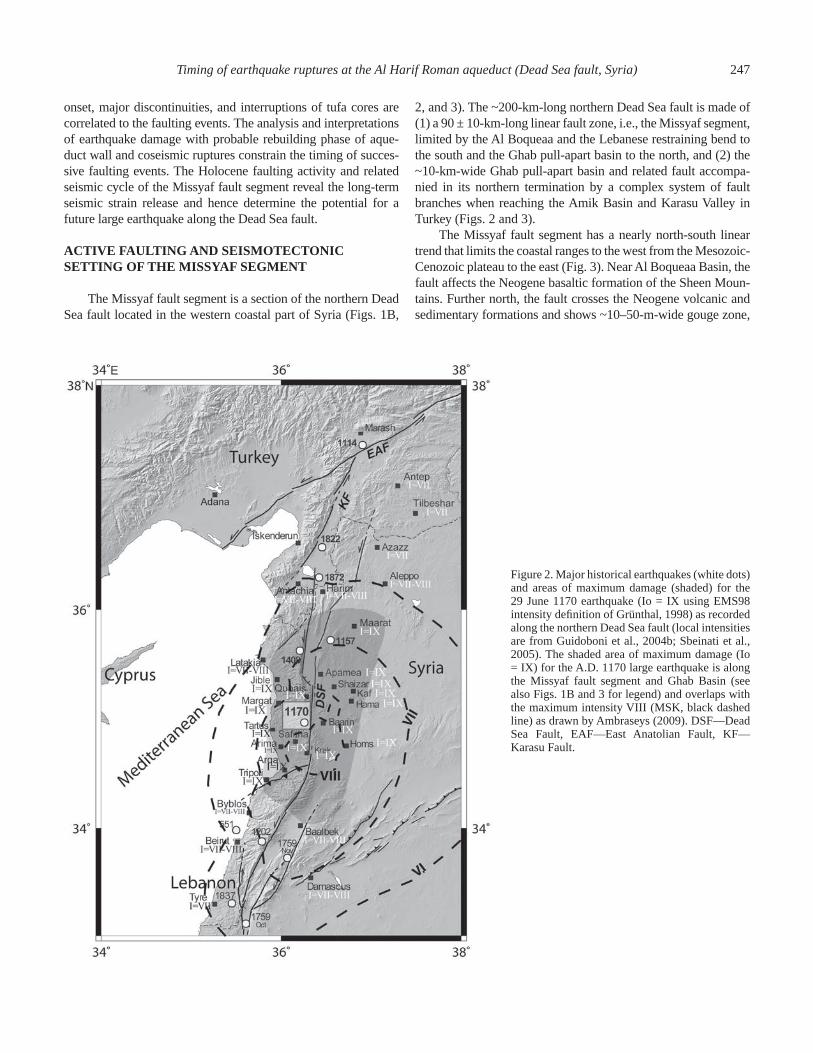
The Missyaf fault segment is a section of the northern Dead Sea fault located in the western coastal part of Syria (Figs. 1B,
2, and 3). The ~200-km-long northern Dead Sea fault is made of (1) a 90 ± 10-km-long linear fault zone, i.e., the Missyaf segment, limited by the Al Boqueaa and the Lebanese restraining bend to the south and the Ghab pull-apart basin to the north, and (2) the ~10-km-wide Ghab pull-apart basin and related fault accompa-nied in its northern termination by a complex system of fault branches when reaching the Amik Basin and Karasu Valley in Turkey (Figs. 2 and 3).
The Missyaf fault segment has a nearly north-south linear trend that limits the coastal ranges to the west from the Mesozoic-Cenozoic plateau to the east (Fig. 3). Near Al Boqueaa Basin, the fault affects the Neogene basaltic formation of the Sheen Moun-tains. Further north, the fault crosses the Neogene volcanic and sedimentary formations and shows ~10–50-m-wide gouge zone,
Figure 2. Major historical earthquakes (white dots) and areas of maximum damage (shaded) for the 29 June 1170 earthquake (Io = IX using EMS98 intensity defi nition of Grünthal, 1998) as recorded along the northern Dead Sea fault (local intensities are from Guidoboni et al., 2004b; Sbeinati et al., 2005). The shaded area of maximum damage (Io = IX) for the A.D. 1170 large earthquake is along the Missyaf fault segment and Ghab Basin (see also Figs. 1B and 3 for legend) and overlaps with the maximum intensity VIII (MSK, black dashed line) as drawn by Ambraseys (2009). DSF—Dead Sea Fault, EAF—East Anatolian Fault, KF—Karasu Fault.

248 Sbeinati et al.
breccias, and rupture planes that affect the Mesozoic limestone of the coastal ranges. From Missyaf city to the Ghab Basin area, the fault bounds the Mesozoic limestone mountain range to the west from the Quaternary basins and Mesozoic-Cenozoic Aleppo plateau to the east (Dubertret, 1955).
The left-lateral fault exhibits a clear geomorphologic expression along strike and neotectonic features consistent with the structural characteristics of the Al Boqueaa and Ghab pull-apart basins (Fig. 3). The left-lateral movements are indicated by the en-echelon right stepping fault strands, faulted alluvial fans, defl ected large and small streams that fl ow from the west-ern mountain range, and shutter ridges made of either volcanic or limestone units (Figs. 3 and 4). The left-lateral slip is also expressed in outcrops where fault breccias in limestones also display en-echelon structures. Estimated from main channel defl ections, observed in aerial photographs or satellite images, or measured using total station, systematic left-lateral offsets visible at different scales range from as low as 9 ± 1 m along strike to a few hundred meters (Figs. 3 and 4).
The instrumental seismicity along the Missyaf fault segment is scarce in comparison with that of the Lebanese restraining bend to the south or the Karasu Valley and junction with the East
Anatolian fault to the north (Figs. 1A and 1B). Although the fault zone corresponds to the Africa-Arabia plate boundary, the instru-mental seismicity is low level, and magnitudes (M
l) are less than
4.5. Focal mechanisms (CMT Harvard) of the few events with Mw > 4.5 in the northern Dead Sea fault show strike-slip faulting with predominant north-south–trending left-lateral fault plane mixed with normal faulting solutions near the pull-apart basins.
The historical seismicity along the northern Dead Sea fault reports the occurrence of large and destructive earthquakes in 1365 B.C., A.D. 115, 526, 859, 1063, 1139, 1156, 1170, and 1408 (Ambraseys and Melville, 1988a; Guidoboni et al., 2004a, 2004b; Sbeinati et al., 2005). Only a few historical contempora-neous manuscripts, however, account for accurate damage distri-bution and sometimes for coseismic surface breaks with enough details that allow the correlation with fault segments (Ambra-seys and Melville, 1988b). Most contemporaneous manuscripts and inscriptions from Byzantine, Crusader, and Arabic sources provide accurate damage descriptions of castles, churches and mosques, villages, and cities, often accompanied with an esti-mate of casualties. Based on our work on the catalogue of historical earthquakes of Syria and paleo-archaeoseismic inves-tigations (Mouty and Sbeinati, 1988; Meghraoui et al., 2003;
Figure 3. The 90-km-long Missyaf fault segment and the Al Harif Roman aqueduct site. The back-ground topography (SRTM 30 arc posting digital elevation model; Farr and Kobrick, 2000) clearly delineates the fault segment (arrowheads) in be-tween the Ghab and Al Boqueaa pull-apart basins. The Roman aqueduct at Al Harif (see also Fig. 4) was designed to bring freshwater from western ranges to Apamea and Shaizar. LRB—Lebanese restraining bend.

Timing of earthquake ruptures at the Al Harif Roman aqueduct (Dead Sea fault, Syria) 249
Sbeinati et al., 2005), we have shown that the damage distri-bution associated with the 29 June 1170 earthquake suggests a correlation with the Missyaf fault segment. Using numerous historical documents that report the 1170 earthquake damage, Guidoboni et al. (2004b) provided a comparable damage dis-tribution and suggested an epicentral location on the Missyaf fault. However, overestimated damages at Aleppo (from misin-terpretations of the Arabic chronicler Ibn Al Athir [1160–1233]) and poorly constrained seismotectonics inferences brought the authors to the erroneous conclusion that the 90 ± 10-km-long Missyaf fault segment alone could not have generated the Mw 1170 > 7 for the seismic event (Guidoboni et al., 2004b). Zones of maximum damage should be identifi ed primarily from con-temporary eyewitness accounts in manuscripts, corroborated by present-day fi eld investigations on the active fault and damage of ancient buildings. Furthermore, the geometrical structures (i.e., the Al Boqueaa pull-apart basin and Lebanese restraining bend to the south and the Ghab pull-apart basin to the north) that limit the fault segment are major obstacles to a coseismic rupture propa-gation and, hence, constrain the earthquake fault dimension.
ARCHAEOSEISMOLOGY AND PALEOSEISMOLOGY
Site Description
The Al-Harif aqueduct is located ~4 km north of the city of Missyaf, immediately west of a limestone shutter ridge and related ~200 m left-lateral stream defl ection (Figs. 3 and 4). According to the remaining aqueduct walls and related mills
in the region, the aqueduct was built during the Roman time (younger than 65 B.C. in the Middle East) to drain freshwater collected from springs of the western mountain range to the east-ern semiarid plains. The remaining ruins of the aqueduct sug-gest an ~40-km-long construction that may have included several bridges over streams and landscape gorges.
The aqueduct building description and related age have not been reported so far in any archive, manuscript, or in the litera-ture. There is, however, an interesting anecdotal story from the local tradition that it was built by a local prince to supply potable water to Apamea and/or Sheizar cities, located northeast of the aqueduct (Fig. 3). Apamea during that time was the most famous and strategic city during the Hellenistic and Roman period, whereas Sheizar is known to have been an important political and military fortress during the Middle Ages (Ibn Al Athir, 1982).
In their description of the Dead Sea fault in Syria, Trifonov et al. (1991) mentioned the existence of a faulted aqueduct near the city of Missyaf, but neither the precise location nor the accu-rate amount of offset walls was given. However, this early tec-tonic observation was helpful and allowed us to discover the site and consider a detailed study (Meghraoui et al., 2003), which is extended here using combined methods in archaeoseismology, paleoseismology, and tufa investigations. In addition, a micro-topographic survey of measurements accompanied all fi eld stud-ies (Fig. 5).
Previous investigations on the aqueduct (Meghraoui et al., 2003) established: (1) an evaluation of its age based on an account of the large size blocks, the dating of sedimentary units below the aqueduct wall foundation, and dating of early tufa deposits on
Figure 4. (A) Satellite view from Google Earth showing offset Al Harif aqueduct (black arrow) along the Dead Sea fault (white arrows); and (B) local geomor-phologic framework of the aqueduct site as interpreted from part A, indicating a shutter ridge (Mesozoic limestone east of the fault) and ~200 m of left-lateral offset. Blue arrow is for stream fl ow. See Figure 5 for the detailed aqueduct map and location of excavations and trenches.

250 Sbeinati et al.
the aqueduct wall, and (2) the identifi cation of the seismic fault-ing origin of damage in nearby trench A. The building style, with typical bridge arch and large stone size disposition (Opus cae-mentum), suggested a Roman age, which was confi rmed by the radiocarbon dating of sedimentary layers below the walls and the early tufa deposits on the walls. The faulted aqueduct revealed 13.6 ± 0.20 m of total left-lateral offset and called for detailed investigations on the characteristics and history of successive fault movements.
The aqueduct design, with an open canal on top of the 4-m-high wall, allowed freshwater and carbonate-saturated water to overfl ow and induce signifi cant tufa accumulation from 0.30 m to 0.83 m in section (Figs. 6A, 6B, and 7). The carbonate-rich and cool water collected from the nearby western range is associ-ated with a semiarid and karstic area of the Mesozoic limestone (Fig. 4) that favors rapid carbonate precipitation and tufa accumu-lation. The tufa deposits show successive growths of lamination carbonate with high porosity, banded texture, and rich organic
encrustations (Ford and Pedley, 1996). Field observations show that tufa accumulation developed on both eastern and western sections (from the fault line), but only on the north-facing wall, likely due to a slight tilt of the damaged aqueduct wall, probably after the two fi rst earthquakes (Fig. 7).
The following paragraphs present the fi eld investigations, which consisted of: (1) four archaeoseismic excavations near the aqueduct walls and remains, (2) four paleoseismic trenches across the fault zone and the alluvial sediments, and (3) four cores (two cores were previously studied in Meghraoui et al., 2003) of tufa deposits collected from different sections of the aqueduct. More than 200 samples of organic matter, charcoal fragments, and tufa core pieces were taken for radiocarbon analysis in order to char-acterize the timing of successive faulting and related damage of the aqueduct construction. All radiocarbon dating were calibrated (2σ range, 95.4% probability density) using Oxcal v4.0 (Bronk Ramsey, 2001) and INTCAL04 calibration curve of Reimer et al. (2004).
Figure 5. Microtopographic survey (0.05 m contour lines) of the Al-Harif aqueduct and related fl at alluvial terrace. The aqueduct (thin blue crosses) shows a total of 13.6 ± 0.20 m left-lateral slip along the fault zone (Meghraoui et al., 2003). Roman numbers indicate archaeoseismic excavations (in red-dish and orange, labeled I to IV) and letters indicate paleoseismic trenches (in gray and black, labeled A, B, C, and E). The dragged wall fragment is located between excavation IV and trench E and is marked by a dense cluster of survey points.

Timing of earthquake ruptures at the Al Harif Roman aqueduct (Dead Sea fault, Syria) 251
Archaeoseismic Excavations
The remaining aqueduct construction forms an ~50-m-long, ~5-m-high, and 0.60-m-thick wall that includes an ~15-m-high arch bridge in its eastern section (Figs. 5 and 6A). The outer part is coated by a thick layer of tufa deposits, probably due to a long period of freshwater fl ow. The construction material that may vary
with the successive building and repair ages is made of: (1) large-size limestone blocks (Opus quadratum, 1.0 m × 0.5 m × 0.5 m; see also http://www.romanaqueducst.info/aquasite/), similar to the typical Roman archaeological constructions and visible at the lower bridge (pier section) and wall sections, (2) medium-size limestone blocks (Opus incertum; 0.50 m × 0.30 m × 0.30 m), which form the foundation or the upper half wall section and show visible small portions of cement, and (3) small sizes of mixed stones of irregular shape with signifi cant portions of mor-tar (cement), mostly visible in the apparently rebuilt part of the wall. Figures 5 and 6A also show a detached small piece of the aqueduct wall made of small-size stones and related cement ~3.5 m away from the eastern wall. Therefore, four areas (noted I to IV in Fig. 5) were excavated near the aqueduct using proper archaeological methods.
The large excavation I was dug on the fault zone near the dragged wall fragment, in the area between the eastern and west-ern aqueduct walls (Figs. 5, 8A, and 8B). The purpose of exca-vation is here to study the relationships between the fault zone and aqueduct. The excavation that has ~4.5 × 4.5 m surface and ~0.6 m depth exposed missed parts of the aqueduct. A buried and fallen wall piece rotated and dragged parallel to the fault and a remaining wall piece in an oblique position between two shear zones were discovered. The buried wall fragments are not
Figure 6. (A) Schematic sketch of the aqueduct and loca-tions of the selected cores BR-3, BR-5, and BR-6; BR-4 core sample consists of tufa accumulations at the location of the missing (broken) piece of the aqueduct wall near the fault. Mosaic of the archaeological excavation I is de-tailed in Figure 8B (see also location in Fig. 5). (B) Core section BR-4 showing the limit between the stone wall and tufa deposits.

252 Sbeinati et al.
comparable to the Opus caementum (quadratum) of the original construction and suggest a rebuilding phase. The excavation fl oor displays oriented gravels and pebbles that mark the shear zones and related fault branches also visible in the inner trench sec-tion E (Figs. 8B and 8C).
We collected four samples in the fallen wall sections labeled A, B, and C of excavation I (Fig. 8B): Two cement samples (AQ-CS-1 and AQ-CS-4) found in between building stones are made of typical medieval rubble mortars (mainly mud, gypsum, and lime); the two other samples (AQ-CS-3-2 and AQ-CS-3-3) are tufa deposits preserved on building stones. All four samples contained enough organic matter to allow radiocarbon dating (Table 1). Two dates of cement yield A.D. 532–641 (section A, AQ-CS-4) for the large fallen wall in excavation I and A.D. 650–780 (section C, AQ-CS-1) for the wall fragment piece in between the walls (Fig. 8B). In addition, two tufa deposits on wall stones provide consistent ages A.D. 560–690 (section B, AQ-CS-3-2) and A.D. 639–883 (section C, AQ-CS-3-3) with cement ages. The two different cement dates of the fallen wall and dragged
Figure 7. Schematic sections of the aqueduct western wall and related tufa deposits (B, C, D, and E indicate earlier core sections of tufa deposits (Meghraoui et al., 2003). Tufa samples AQ-Tr-B13 and AQ-Tr-D5 (Table 1) are from cores B and D, respectively. The right and left vertical sections show the relative tufa thickness of the originally built part (with Opus caementum and quadratum stones) and the rebuilt part, respectively. The plan view indicates the variation of tufa deposition and shows the core distribution and related thick-ness along the western wall of the aqueduct.
Figure 8. (on this and following page). (A) View from the western aqueduct wall, the dragged wall piece, buried wall, and eastern wall (string grid is 1 m × 1 m). Log of trench-excavation E is in Figure 7C.

Figure 8. (continued). (B) Mosaic of excavation I exhibits the main fallen wall (A and B) and dragged wall piece (C), scattered wall pieces and the fault zone; note also location of cement sample CS-1-4 (see text for explana-tion). (C) Trench E (excavation I, north wall) exposes faulted sedimentary units below the archaeological remains and wall fragment C visible in bottom of Figure 8B; fz—fault zone; sedimentary units are similar to those of trenches A, B, and C (see also Fig. 10); and dat-ing characteristics are in Table 1. a—present-day soil and alluvial terrace (plough zone), d—reddish alluvial fi ne gravel, e—dark-brown silty clay (with rich organic matter), f—gravels and pebbles in silty-clay matrix, g—massive gey clay with scattered gravels.

TA
BLE
1. S
AM
PLE
LIS
T A
ND
RA
DIO
CA
RB
ON
DA
TIN
G (
AC
CE
LER
OM
ET
ER
MA
SS
SP
EC
TR
OM
ET
RY
) A
T T
HE
AL
HA
RIF
AQ
UE
DU
CT
SIT
E
Sam
ple
ID
Sam
ple
nam
e F
ract
ion
Tre
nch-
exca
v. u
nit &
co
re le
vel
Ana
lyze
d ca
rbon
(m
g)
Car
bon
(con
tent
%)
14C
dat
e (y
r B
.P.)
14C
age
C
alib
rate
d B
.C./A
.D. (
95.4
%)
Al H
arif
—T
ren
ches
K
IA 1
4261
B
AL-
TA
-N23
C
harc
oal,
alka
li re
sidu
e b
& c
(A
) 5.
87
71.9
%
1015
± 3
5 A
.D. 9
60–1
060
KIA
142
63
BA
L-T
A-N
27
Cha
rcoa
l, al
kali
resi
due
f (A
)4.
09
67.4
%23
35 ±
30
B.C
.520
–350
KIA
142
62
BA
L-T
A-N
25
Cha
rcoa
l, al
kali
resi
due
e (A
) 0.
42
24.9
%
2090
± 5
0 B
.C. 3
50–3
0 A
.D.
AA
439
95
EH
-I-S
7 C
harc
oal,
alka
li re
sidu
e e
(A)
– –
2195
± 4
0 B
.C. 3
90–1
60
AA
439
93
EH
-I-T
A-S
33
Cha
rcoa
l, al
kali
resi
due
d (A
) 4.
33
– 12
87 ±
36
A.D
. 650
–810
KIA
142
64
BA
-TA
-N31
C
harc
oal,
alka
li re
sidu
e a
(A)
1.95
63
.3%
87
5 ±
35
A.D
. 103
0–12
50
KIA
142
68
BA
L-T
N-6
1 C
harc
oal,
alka
li re
sidu
ea
(A)
1.02
1.
0%45
55 ±
40
B.C
.349
0–30
90
KIA
142
65
BA
L-T
A-N
47
Cha
rcoa
l, al
kali
resi
due
g (A
)1.
71
3.6%
7410
± 4
5B
.C.6
400–
6100
KIA
238
56
AQ
-TA
-3
Cha
rcoa
l, al
kali
resi
due
e (I
I)
1.83
22
.6%
22
95 ±
30
B.C
. 410
–210
KIA
238
55
AQ
-TA
-4
Cha
rcoa
l, al
kali
resi
due
e (I
I)
0.24
4.
7%
2050
± 7
0 B
.C. 3
50–1
30 A
.D.
KIA
238
61
AQ
-TB
-1
Cha
rcoa
l, al
kali
resi
due
e (I
II)
1.77
22
.4%
22
50 ±
30
B.C
. 400
–200
KIA
238
62
AQ
-TB
-2
Cha
rcoa
l, al
kali
resi
due
e (I
II)
1.64
25
.9%
22
00 ±
40
B.C
. 390
–160
KIA
238
63
AQ
-TB
-3
Cha
rcoa
l, al
kali
resi
due
e (I
II)4.
23
49.8
%22
35 ±
30
B.C
.390
–200
KIA
238
57
AQ
-TB
-4
Cha
rcoa
l, al
kali
resi
due
e (I
II)0.
38
4.0%
2460
± 6
0B
.C.7
70–4
00
KIA
238
58
AQ
-TC
-S1
Cha
rcoa
l, al
kali
resi
due
e (I
–E)
0.17
2.
1%
1930
± 1
10
B.C
. 200
–400
A.D
.
KIA
238
59
AQ
-TC
-S2
Cha
rcoa
l, al
kali
resi
due
f (I–
E)
0.13
1.
6%
2450
± 1
40
B.C
. 900
–200
KIA
238
60
AQ
-TC
-S3
Cha
rcoa
l, al
kali
resi
due
f (I–
E)
0.28
9.
5%
2280
± 7
0 B
.C. 5
50–1
00
KIA
239
03
EH
II-7
S
Cha
rcoa
l, ac
id r
esid
uea
(C)
0.49
12
8.9%
290
± 4
0A
.D.1
480 –
1800
KIA
238
80
EH
II-2
N
Cha
rcoa
l, al
kali
resi
due
a (C
)4.
16
50.7
%28
0 ±
25
A.D
.151
0–1
670
KIA
239
17
EH
II-1
6S
Cha
rcoa
l, al
kali
resi
due
b1 (
C)
5.62
69
.0%
14
65 ±
30
A.D
. 540
–650
KIA
239
11
EH
II-1
1S
Cha
rcoa
l, ac
id r
esid
ue
f (C
) 2.
11
51.7
%
2135
± 3
0 B
.C. 3
60–5
0
KIA
239
15
EH
II-1
0S
Cha
rcoa
l, al
kali
resi
due
f (C
) 1.
54
57.5
%
2150
± 3
0 B
.C. 3
60–6
0
KIA
239
10
EH
II-1
2S
Cha
rcoa
l, al
kali
resi
due
f (C
) 4.
66
62.3
%
2160
± 3
0 B
.C. 3
60–9
0
KIA
239
20
EH
II-1
8S
Cha
rcoa
l, ac
id r
esid
uef (
C)
0.97
9.
3%25
25 ±
40
B.C
.800
–510
KIA
239
09
EH
II-5
S
See
d, a
lkal
i res
idue
f (C
)0.
03
4.5%
3420
±57
0B
.C.3
400–
300
KIA
238
95
EH
III-
8S
Cha
rcoa
l, ac
id r
esid
ue
e (B
) 2.
40
38.4
%
2110
± 3
5 B
.C. 3
50–4
0
KIA
238
96
EH
III-
7S
Cha
rcoa
l, ac
id r
esid
ue
e (B
) 1.
19
45.2
%
2215
± 3
5 B
.C. 4
10–9
0
KIA
238
97
EH
III-
6S
Cha
rcoa
l, ac
id r
esid
ue
Fau
lt zo
ne (
B)
0.24
6.
3%
2390
± 8
0 B
.C. 8
00–2
00
KIA
239
00
EH
III-
3S
Cha
rcoa
l, ac
id r
esid
ueF
ault
zone
(B
)1.
05
64.0
%43
75 ±
40
B.C
.310
0 –29
80
KIA
238
93
EH
III-
10S
C
harc
oal,
alka
li re
sidu
ed?
(B
)0.
12
5.5%
2680
± 1
70B
.C.1
300
–350
Al H
arif
—C
ore
s &
cem
ent
KIA
166
27
AQ
-Tr-
D5
Tuf
a, a
cid
resi
due
D, 0
–5 c
m1.
13
80.1
%18
63 ±
29
A.D
.80 –
240
KIA
166
28
AQ
-Tr-
B13
T
ufa,
aci
d re
sidu
eB
, 0–5
cm
2.39
2.
7%20
30 ±
25
B.C
.110
–60
A.D
.
KIA
166
28
AQ
-Tr-
B13
T
ufa,
hum
ic a
cids
B
, 0–5
cm
3.
72
41.3
%
1880
± 2
5 A
.D. 7
0–23
0
KIA
221
89
AQ
-CS
-1
Cem
ent,
alka
li re
sidu
e I –
Wal
l pie
ce
0.50
0.
4%
1314
± 3
7 A
.D. 6
50–7
80
KIA
221
91
AQ
-CS
-3-2
T
ufa,
alk
ali r
esid
ue
I – F
alle
n w
all
0.99
2.
9%
1400
± 3
5 A
.D. 5
60–6
90
(Con
tinue
d )
Timing of earthquake ruptures at the Al Harif Roman aqueduct (Dead Sea fault, Syria) 255
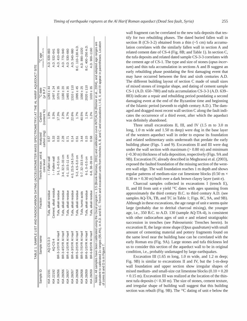
wall fragment can be correlated to the new tufa deposits that tes-tify for two rebuilding phases. The dated buried fallen wall in section B (CS-3-2) obtained from a thin (~5 cm) tufa accumu-lation correlates with the similarly fallen wall in section A and related cement date of CS-4 (Fig. 8B; and Table 1). In section C, the tufa deposits and related dated sample CS-3-3 correlates with the cement age of CS-1. The type and size of stones (opus incer-tum) and thin tufa accumulation in sections A and B suggest an early rebuilding phase postdating the fi rst damaging event that may have occurred between the fi rst and sixth centuries A.D. The different building layout of section C made of small sizes of mixed stones of irregular shape, and dating of cement sample CS-1 (A.D. 650–780) and tufa accumulation CS-3-3 (A.D. 639–883) indicate a repair and rebuilding period postdating a second damaging event at the end of the Byzantine time and beginning of the Islamic period (seventh to eighth century A.D.). The dam-aged and dragged most recent wall section C along the fault indi-cates the occurrence of a third event, after which the aqueduct was defi nitely abandoned.
Three small excavations II, III, and IV (1.5 m to 3.0 m long, 1.0 m wide and 1.50 m deep) were dug in the base layer of the western aqueduct wall in order to expose its foundation and related sedimentary units underneath that predate the early building phase (Figs. 5 and 9). Excavations II and III were dug under the wall section with maximum (> 0.80 m) and minimum (~0.30 m) thickness of tufa deposition, respectively (Figs. 9A and 9B). Excavation IV, already described in Meghraoui et al. (2003), exposed the faulted foundation of the missing section of the west-ern wall edge. The wall foundation reaches 1 m depth and shows regular patterns of medium-size cut limestone blocks (0.50 m × 0.30 m × 0.30 m) built over a dark brown clayey layer (unit e).
Charcoal samples collected in excavations I (trench E), II, and III from unit e yield 14C dates with ages spanning from approximately the third century B.C. to third century A.D. (see samples AQ-TA, TB, and TC in Table 1; Figs. 8C, 9A, and 9B). Although in these excavations, the age range of unit e seems quite large (probably due to detrital charcoal mixing), the younger age, i.e., 350 B.C. to A.D. 130 (sample AQ-TA-4), is consistent with other radiocarbon ages of unit e and related stratigraphic succession in trenches (see Paleoseismic Trenches herein). In excavation II, the large stone shape (Opus quadratum) with small amount of cementing material and pottery fragments found on the same level near the building base can be correlated with the early Roman era (Fig. 9A). Large stones and tufa thickness led us to consider this section of the aqueduct wall to be in original condition, i.e., probably undamaged by large earthquakes.
Excavation III (1.65 m long, 1.0 m wide, and 1.2 m deep; Fig. 9B) is similar to excavations II and IV, but the 1-m-deep wall foundation and upper section show irregular shapes of mixed medium- and small-size cut limestone blocks (0.10 × 0.20 × 0.15 m). Excavation III was realized at the location of the thin-nest tufa deposits (< 0.30 m). The size of stones, cement texture, and irregular shape of building wall suggest that this building section was rebuilt (Fig. 9B). The 14C dating of unit e below the
TA
BLE
1. S
AM
PLE
LIS
T A
ND
RA
DIO
CA
RB
ON
DA
TIN
G (
AC
CE
LER
OM
ET
ER
MA
SS
SP
EC
TR
OM
ET
RY
) A
T T
HE
AL
HA
RIF
AQ
UE
DU
CT
SIT
E
Sam
ple
ID
Sam
ple
nam
e F
ract
ion
Tre
nch-
exca
v. u
nit &
co
re le
vel
Ana
lyze
d ca
rbon
(m
g)
Car
bon
(con
tent
%)
14C
dat
e (y
r B
.P.)
14C
age
C
alib
rate
d B
.C./A
.D. (
95.4
%)
KIA
221
91
AQ
-CS
-3-3
T
ufa,
alk
ali r
esid
ue
I – F
alle
n w
all
0.57
1.
9%
1283
± 4
4 A
.D. 6
39–8
83
KIA
221
92
AQ
-CS
-4
Cem
ent,
alka
li re
sidu
eI–
Fal
len
wal
l5.
33
0.3%
1497
± 2
4A
.D.5
32–6
41
KIA
260
56
BR
-3-1
/SY
R A
l Har
if T
ufa,
alk
ali r
esid
ue3-
1, 0
– 0.5
cm
0.53
17
.3%
1570
± 3
5A
.D.4
10–6
00
KIA
260
56
BR
-3-4
/SY
R A
l Har
if T
ufa,
alk
ali r
esid
ue
3-4,
32.
5–33
cm
2.
28
2.3%
11
80 ±
20
A.D
. 770
–940
KIA
260
57
BR
-4-1
/SY
R A
l Har
if T
ufa,
alk
ali r
esid
ue
4-1,
10.
5–11
cm
0.
71
6.7%
14
65 ±
35
A.D
. 530
–660
KIA
260
57
BR
-4-3
/SY
R A
l Har
if T
ufa,
alk
ali r
esid
ue
4-3,
23.
5–24
.5 c
m
0.14
22
.6%
13
10 ±
110
A
.D. 5
40–9
80
KIA
260
58
BR
-5-2
/SY
R A
l Har
if T
ufa,
alk
ali r
esid
ue
5-2,
4.5
–5.0
cm
0.
51
1.7%
19
95 ±
45
B.C
. 110
–130
A.D
.
KIA
260
58
BR
-5-7
/SY
R A
l Har
if T
ufa,
hum
ic a
cids
5-7,
32 –
33.5
cm
3.44
40
.5%
1090
± 2
5A
.D.8
90–1
020
KIA
260
59
BR
-6-1
/SY
R A
l Har
if T
ufa,
alk
ali r
esid
ue6-
1, 0
–0.5
cm
0.15
1.
1%20
20 ±
110
B.C
.400
–250
A.D
.
KIA
260
59
BR
-6-8
/SY
R A
l Har
if T
ufa,
alk
ali r
esid
ue
6-8,
38–
39 c
m
0.58
1.
2%
1020
± 3
5 A
.D. 9
00–1
160
N
otes
: All
sam
ples
hav
e be
en c
alib
rate
d us
ing
the
Oxc
al p
rogr
am v
. 3.5
(B
ronk
-Ram
sey,
200
1) a
nd c
alib
ratio
n cu
rve
INT
CA
L04
(Rei
mer
et
al.,
2004
), a
nd a
dopt
ed a
ge r
ange
s ar
e eq
uiva
lent
to c
alib
rate
d 2σ
ran
ges
(95.
4%),
in A
.D. a
nd B
.C. T
renc
h an
d ex
cava
tion
units
from
tren
ches
A, B
, and
C a
nd e
xcav
atio
ns I,
I–E
, II,
and
III a
ppea
r in
par
enth
eses
. Loc
atio
n of
cor
es B
and
D is
in F
igur
e 7.

256 Sbeinati et al.
wall yielded a comparable age range to that obtained in excava-tions II (see AQ-TA, TB, and TC in Table 1).
Trench section E (4.30 m long, 0.70 m wide, and 1.30 m deep; Figs. 5, 8A, 8B, and 8C) was dug within excavation I in order to see in section the fault zone that affects the archaeologi-cal fl oor units. The trench wall exposes similar sedimentary units to those visible in excavations II, III, and IV that are affected by two main fault branches of the shear zone visible in the fl oor layer of excavation I. The 14C dating of samples AQ-TC-S1, S2, and S3 of units f and e indicates 900 B.C. to A.D. 400 maximum and minimum age range, respectively (Fig. 8C; Table 1), which is comparable to the age range obtained in excavations II and III for unit e (Figs. 8B and 9A; Table 1). However, as here again the large age range can be due to charcoal mixing, the dating of unit e is obtained by comparison to the dated stratigraphic succession of units in trenches (see section Paleoseismic Trenches).
Paleoseismic Trenches
Two trenches, B and C (Figs. 5 and 10, trenches B and C), were dug across the Dead Sea fault north of the aqueduct in addi-tion to the previously studied trench, A (Fig. 10A; Meghraoui et al., 2003). The two trenches exposed an ~1.5-m-wide fault zone that affects a succession of 2–3-m-thick fi ne and coarse allu-vial sedimentary layers similar to the alluvial deposits of trench A. Alluvial units visible in all trenches exhibit here similar tex-tures, structures, and color, and correspond to the same layers that belong to the same alluvial terrace. Although the three trenches A, B, and C may not expose a completed stratigraphic section, the comparisons among sedimentary units, faulting events, archaeo-seismic observations, and tufa accumulation limit the possibility of a missing earthquake event that affected the aqueduct.
In trench B (south wall), the fault zone shows three main fault branches that affect sedimentary units g to d and form a negative fl ower structure. The central and western main branches are truncated by unit a, which forms a stratifi ed 0.3–0.4-m-thick deposit of coarse gravels in a sandy matrix. The eastern fault branch is buried below unit d, made of well-sorted reddish fi ne gravels. Unit e, a 0.2–0.5-m-thick dark-brown silt-clay, thickens toward east. Units f and g are made of scattered clasts in a massive clay matrix of dark-brown and light-brown color, respectively. Although intense warping and faulting are marked by contrasting color and texture of unit e, faulted sedi-mentary layers of this trench do not allow the identifi cation of all faulting events. However, buried fault branches indicate a faulting event postdated by unit d (event Y), while the other fault branches show at least another faulting event (event Z) overlain by unit a. While clearly visible in other trench walls, event Y is here likely concealed by the complex fault branches truncated by unit a.
Trench C (Fig. 10C) exposes a stratigraphic succession affected by at least fi ve main fault branches (labeled I to V in Fig. 10C). From trench bottom, fault branch I, which affects unit g, is overlain by unit f. A similar observation can be made for fault branch II, which also affects all units below unit d. Further-more, the trench wall exposes an ~0.60-m-thick well-stratifi ed, coarse and fi ne gravel layer above unit e and across the fault zone. Unit d thins signifi cantly west of fault branch III and is overlapped by relatively thick coarse gravel units, which dis-play a mix of fi ne and coarse gravels between fault branches III and IV, and unit d shows a succession of well-stratifi ed alluvial units west of fault branch IV (Fig. 10C). Taking into account its alluvial origin made of well-stratifi ed fi ne and coarse grav-els, west of fault branch IV, unit d is subdivided into d1, d2, d3,
Figure 9. Excavations II (A) and III (B) that expose the aqueduct wall foun-dation (see also Fig. 5) and related sedimentary unit e underneath. The dif-ference in the size of stones between excavation II (A) and excavation III (B) implies a rebuilding phase of the latter wall.
A B

Figure 10. Trench logs A, B, and C north of the aqueduct site (see location in Fig. 5). All trenches display the Dead Sea fault zone as a negative fl ower structure affecting all alluvial units below unit a. Calibrated 14C dates are in Table 1. Fault branches in trench C are labeled I to V (see text for explanation). The sedimen-tary units are very comparable and show three to four faulting events denoted W to Z (see text for explanation). Trench log A is in meters.

258 Sbeinati et al.
and d4. Faulting movements at this site allows truncation of unit d1 (equivalent to d east of fault branch III) and sedimentation of units d2 to d4 (in a likely small pull-apart basin). Unit d3 consists of an ~0.20-m-thick dark-brown silt-sand overlain by unit d4, which is made of light-brown fi ne silt-sand. Below the plough zone a2, the well-stratifi ed unit a1 shows fl at-laying pebbles and gravels and intercalated fi ne gravels covering previous units and the fault zone.
Fault branches I to V in trench C indicate a negative fl ower structure that intersects a sedimentary sequence and reveal at least four faulting events (Fig. 10C): (1) Event W, identifi ed on fault branch I, is older than 800–510 B.C. (EH II-18S) in the low-ermost layers of unit f and is younger than unit g, which was dated with sample EH II-5S (3400–300 B.C.). (2) Next to fault branch II, buried below unit d, the vertical offsets between unit e and units d and d1 across fault branch III, and the absence of unit e between fault branches III and IV, determine the faulting event X between unit e and unit d. Since unit d overlies an erosional surface of unit e, faulting event X may have formed a depression (i.e., a small pull-apart basin) that allowed the deposition of d1 to d4 next to a thick unit d east of fault branch III. The faulting event X is here predated by 360–90 BC (EH II-12S), 360–50 BC (EH II-11S), and 360–60 BC (EH II-10S) of the uppermost layers of unit f (event X is postdated by sample EH I-TA-S33 of trench A). (3) Faulting event Y can be identifi ed at the westernmost fault branch V between unit d2 and unit d3. The dating of sample EH II-16S in d3 postdates event X to younger than A.D. 540–650, which we consider as a reliable age, taking into account its high carbon content (event Y is predated by sample EH I-TA-S33 of trench A). (4) Faulting event Z corresponds to the main fault branches III and IV, which are overlain by the stratifi ed unit a2 below the plough zone. Fault rupture IV affects unit d4 and indi-cates that the faulting event Z is older than radiocarbon age A.D. 1480–1800 (EH II-7S) and A.D. 1510–1670 (EH II-2N) of unit a2 and younger than unit d4.
Summary of Faulting Events from Archaeoseismology and Paleoseismology
The analysis of faulting events from the aqueduct (damage and reconstruction) and from trenches A, B, and C can be pre-sented as following:
1. Event W is older than unit f (i.e., 800–510 B.C.) and younger than unit g (i.e., 3400–300 B.C.) of trench C. The bracket of event W is here diffi cult to assess since the detrital charcoal sample in unit f was not taken from the base of unit f. According to 14C dates, the faulting event can be estimated as younger than 3400 B.C. and older than 510 B.C. However, taking into account the rate of sedimentation in unit f, we may estimate a minimum age of 962 B.C. for event W.
2. Event X, the fi rst faulting event that affected the aque-duct, is bracketed between the fi rst and sixth centuries A.D. In trenches, a large bracket of this event is between
350 B.C. and A.D. 30 and A.D. 650–810 (as obtained from dated units of trench A).
3. Event Y, characterized from paleoseismology, appears to be older than A.D. 650–810 (unit d, trench A) and younger than A.D. 540–650 (unit d3 in trench C). The results of archaeoseismic investigations indicate that ages of CS-1 (A.D. 650–780) and tufa accumulation CS-3-3 (A.D. 639–883) postdate event Y.
4. Event Z is the last faulting event that affected the aque-duct, after which it was defi nitely abandoned. In trenches A and C, event Z is older than A.D. 1480–1800, A.D. 1510–1670, and A.D. 1030–1260 and younger than A.D. 960–1060.
TUFA OF THE AL-HARIF AQUEDUCT
The tufa thickness accumulated on the northern face of aqueduct wall suggests a continuous water fl ow during a rela-tively long period of time and may include the record of large earthquakes that affected the aqueduct. Hence, the relationships between tufa accumulation and earthquake events are established through the simultaneous major tufa interruptions and restarts observed in different cores. Except during major changes in the water-fl ow conditions, the permanent water fl ow coming from the nearby spring was responsible for the tufa accumulation that, in principle, is not interrupted on the western wall section (with regard to the fault). On the eastern wall section (and bridge) and broken pieces of western wall, however, the tufa accumulation was likely episodic due to the earthquake damage and related faulting events; new tufa accumulation appears in subsequent building-repair. Previous radiocarbon dating of early tufa depos-its (A.D. 70–230 and A.D. 80–240; Table 1) postdated the initial construction of the aqueduct and revealed a Roman age consis-tent with the dates obtained from the archaeological and paleo-seismic investigations (Meghraoui et al., 2003).
Six tufa cores (named Tr-B13, Tr-D5, and BR-3, BR-4, BR-5, and BR-6) reaching the stone construction were collected from the aqueduct wall in order to date major catastrophic events and infer the relationship with large earthquakes (Fig. 11). Tr-B13 and Tr-D5 were previously collected and analyzed mainly to date the early tufa deposits, which provide the maximum age of the aqueduct construction (Meghraoui et al., 2003). A subsequent selection of core locations on both eastern and western sections of the aqueduct wall was performed to study the completed tufa accumulation and successive growth. Figures 6 and 7 show the drilled wall location with the early cores Tr-B13 and Tr-D5 and three cores (BR-4, BR-5, and BR-6) on the western wall and one core (BR-3) on the eastern wall next to the bridge. Cores BR-5 and BR-6 correspond to the thickest tufa section. BR-4 is on the eastern edge of the west aqueduct wall, a section prob-ably exposed after earthquake damage that induced the collapse of a 2.5-m-long wall section next to the fault zone. Each core is described to illustrate fabric (structure, texture, and color) and lamination changes, which provide evidence of tufa precipitation

Timing of earthquake ruptures at the Al Harif Roman aqueduct (Dead Sea fault, Syria) 259
and successive growths (Fig. 11). Although marked by a high porosity, the cores were carefully drilled in order to preserve their structure and length continuity. An analysis in progress of cores using computer tomography (CT) and climatic-stratigraphy correlation details the physico-chemical and biochemical pro-cesses of tufa growth (Grootes et al., 2006). The cores show a variety of porous, dense, and biogenic tufa with growth laminae and stromatolitic markers of different colors. The end of tufa growth (i.e., very porous tufa in Fig. 11) and onset of biogenic tufa (indicating only a seasonal growth) can be interpreted as epi-sodes of decreased accumulation, or a signifi cant decrease in the chemical precipitation due a major change in the environmental conditions (Fig. 11). Discontinuities of tufa deposits marked by the interruption of core growths and initiation of biogenic tufa are interpreted as major changes in environment with a possible correlation with large earthquakes. The early tufa deposits on the aqueduct wall provide A.D. 70–230 and A.D. 80–240 (samples Tr-B13 and Tr-D5 in Table 1) ages, which postdate the aque-duct building and early function (Meghraoui et al., 2003). The tufa accumulation in BR-3 (core in eastern wall near the bridge, Fig. 6) started sometimes before A.D. 410–600 (sample Br 3-1, Table 1) and may have resulted from a repair of the aqueduct with water overfl owing the eastern wall (and bridge) after a major damaging event. Similarly, the location of a growth inter-ruption (very porous tufa, Fig. 11) in BR-5 at ~6 cm after Br-5-2 (110 B.C.–A.D. 130) and onset of biogenic tufa in BR-6 after Br-6-1 (400 B.C.–A.D. 250) coincide with the occurrence of the fi rst damaging event X. In parallel, the beginning of BR-4 and tufa accumulation at the damaged eastern edge of the western wall (Fig. 6) and sample Br-4-1, dated A.D. 530–660 (Fig. 11;
Table 1), postdates the occurrence of a major damaging event. Both Br-3-1 and Br-4-1 postdate here the record of a major dam-aging event that affected the aqueduct. However, while BR-4 may have accumulated only after a major damage, BR-3 deposits could only have accumulated after the repair of the aqueduct. It implies that the fi rst major damaging event on the aqueduct took place between A.D. 70–230 and A.D. 410–600.
The interruption of tufa growth in BR-3 a few centimeters before sample Br-3-4, dated A.D. 770–940, probably resulted from a second damaging event. This observation coincides with the restart of BR-4 after a major interruption 3–4 cm after Br-4-3, dated at A.D. 540–980 (Fig. 11;Table 1). Furthermore, the sharp change (second interruption) from dense tufa to biogenic tufa in BR-5 and BR-6 may also have been contemporaneous with the damaging event. The age of this second damaging event can be bracketed between Br-4-3 (A.D. 540–980) and Br-3-4 (A.D. 770–940). Unless simply broken, the defi nite interruption of BR-3 (~10 cm after sample Br-3-4) marks the end of water over-fl ow on the eastern aqueduct wall (and bridge) after the second damaging event.
The growth of dense tufa in BR-4 and biogenic tufa in BR-5 and BR-6 in the fi nal sections of cores indicates a con-tinuous water fl ow on the western aqueduct wall after the second damaging event. The almost simultaneous arrest of tufa growth ~2 cm after Br-5-7 (A.D. 890–1020), ~1 cm after Br-6-8 (A.D. 900–1160), and ~7 cm after Br-4-3 (A.D. 540–980) suggests the occurrence of a major damaging event. Indeed, the arrest of tufa accumulation (in core samples Br-3-4, Br-5-7, and Br-6-8) prob-ably occurred after A.D. 900–1160 (Br-6-8, Table 1) and indi-cates the fi nal stoppage of water fl ow over the aqueduct.
Figure 11. Synthetic description of cores with lithologic content and sample number for radiocarbon dating (see Table 1 and Fig. 6 for core locations); I stands for major interruption. The very porous tufa indicates major interruptions in tufa growth (e.g., a major inter-ruption of core growth in BR-3 is visible at ~22 cm (Br-3-4 sample; see text for explanation). The correlation between major interrup-tions of tufa growth and faulting events in trenches and archaeoseismic building constrains the timing of repeated earthquakes along the Missyaf segment of the Dead Sea fault.

260 Sbeinati et al.
TIMING OF EARTHQUAKE FAULTING AND CORRELATION AMONG ARCHAEOSEISMIC EXCAVATIONS, PALEOSEISMIC TRENCHES, AND CORES
The analysis of fi eld data in archaeoseismology, paleoseis-mology, and tufa coring provides some constraints on the suc-cessive past earthquakes along the Dead Sea fault at the Al Harif Roman aqueduct site (Figs. 12 and 13). The damage and repair of the aqueduct are here related to the total 13.6 m of left-lateral fault offset since construction of the aqueduct (Fig. 5). In addition, the tufa successive growth and interruptions visible in cores provide a direct relation between the water fl ow and the aqueduct function east and west of the fault zone. The correlation and timing coin-cidence between the faulting events visible in trenches, aqueduct construction damage and repair (see also Summary of Faulting Events from Archaeoseismology and Paleoseismology section), combined with tufa growth and interruptions, provide a better constraint on the timing of the successive large earthquakes:
Event W, observed in trench C, occurred before 800–510 B.C. (unit f) and after 3400–300 B.C. (unit g). This faulting event can be determined only in trench C and hence cannot be cor-related with damaging events in the aqueduct archaeoseismic excavations and tufa cores. However, we suggest two possible ages for this event: (1) according to the textual inscriptions found in different archaeological sites in Syria, a damaging earthquake sequence around 1365 B.C. affected Ugharit near Latakia in Syria, and Tyre further south in Lebanon and east of the Dead Sea fault (Sbeinati et al., 2005) may be correlated to event W; or (2) the rate of sedimentation in unit f of trench C implies a minimum age of 962 B.C. for event W.
Event X, identifi ed in trenches A and C between 350 B.C.–A.D. 30 and A.D. 532–641, postdates the construction of the aqueduct (younger than 65 B.C., i.e., the onset of Roman time in the Middle East and older than A.D. 70–230 of early tufa depos-its). Event X also predates the onset of BR-3 tufa growth (see Br-3-1 dated A.D. 410–600). Similarly, the tufa growth interrup-tion in BR-5 (after Br-5-2 dated 110 B.C.–A.D. 130) and onset of tufa in BR-6 (after Br-6-1 dated 400 B.C.–A.D. 250) coincide with the occurrence of the fi rst damaging event X. The fi rst earth-quake faulting that damaged the aqueduct took place between A.D. 70–230 and A.D. 410–600.
Event Y is younger than A.D. 650–810 (unit d in trench A) and older than A.D. 540–650 (unit d3 in trench C). This event postdates the fi rst rebuilding phase of the aqueduct recognized from the fallen wall in excavation I and related cement sample AQ-CS-4 (A.D. 532–641) and tufa sample AQ-CS-3-2 (A.D. 560–690). Event Y predates the dragged wall fragment and related cement sample AQ-CS-1 (A.D. 650–780) and tufa sam-ple AQ-CS-3-3 (A.D. 639–883; Table 1). Core samples of tufa deposits provide a bracket of the second damaging earthquake faulting between Br-4-3 (A.D. 540–980) and Br-3-4 (A.D. 770–940). The second interruption in both BR-5 and BR-6 may also have been contemporaneous with the damaging event. Taking
into account only the archaeoseismic results, we can conclude that event Y likely occurred between A.D. 560–690 and A.D. 650–780; however, the consistency between all dates of paleo-seismic, archaeoseismic, and tufa analysis suggest an earthquake event close to A.D. 650. Cement samples CS-1 and tufa sample CS-3-3 also indicate a rebuilding period after event Y, at the end of the Byzantine time and beginning of the Islamic period (fi fth to sixth century A.D.).
Event Z, observed in trenches A, B, and C, is identifi ed as younger than A.D. 960–1060, and older than A.D. 1030–1260. The defi nite interruption of tufa growth in all cores and mainly BR-5 and BR-6 indicates the fi nal stoppage of water fl ow over the bridge section. The interruption postdates sample Br-6-8 (A.D. 900–1160) and can be correlated with the 29 June 1170 large earthquake that affected the Missyaf region (Mouty and Sbeinati, 1988; Sbeinati et al., 2005).
The Missyaf segment of the Dead Sea fault experienced four large earthquakes: event W in 3400–510 B.C., event X in A.D. 70–600, event Y in A.D. 560–780 (probably close to A.D. 650), and event Z in A.D. 960–1260 (probably in A.D. 1170). Using the Oxcal program (Bronk Ramsey, 2001), an attempt of sequential ordering of dates and events, presented in Figure 12, provides a time probability density function for events W (2300–500 B.C.), X (A.D. 160–510), Y (A.D. 625–690), and Z (A.D. 1010–1210). The timing of events obtained from the correlation and sequential distribution clearly indicate a temporal clustering of three large seismic events X, Y, and Z (Fig. 12) after event W, which may indicate a relatively long period of quiescence. Although our data and observations cannot precisely constrain event W, it may be correlated with the 1365 B.C. large earthquake that affected sev-eral sites between Lattakia and Tyre, as reported in the historical seismicity catalogue of Syria (Sbeinati et al., 2005). The Missyaf fault behavior is comparable to the temporal cluster of large seis-mic events that have occurred on other comparable major strike-slip faults (e.g., San Andreas fault—Weldon et al., 2004; Jordan Valley fault segment of the Dead Sea fault—Ferry et al., 2007).
DISCUSSION AND CONCLUSION
We conducted four archaeoseismic excavations, three pale-oseismic trenches, and obtained the radiocarbon dating of six cores at the Al Harif Aqueduct site along the Missyaf segment of the Dead Sea fault. The combined study allows us to obtain a better constraint on the timing of past earthquakes, with four large seismic events during the last ~3400 yr. The occurrence of three seismic events X, Y, and Z (A.D. 70–600, ca. A.D. 650, and A.D. 1170, respectively) since the construction of the aqueduct is attested by faulting events in trenches, the damage and repair of the aqueduct wall, and the tufa growth and interruptions since Roman time (Fig. 13). These results point out a temporal cluster-ing of three large earthquakes between A.D. 70 and A.D. 1170 along the Missyaf fault segment (Fig. 14).
The 90 ± 10-km-long and linear Missyaf segment experi-enced the A.D. 1170 earthquake recorded in trenches, aqueduct

Timing of earthquake ruptures at the Al Harif Roman aqueduct (Dead Sea fault, Syria) 261
construction, and tufa deposits. In this tectonic framework, the large (10-km-wide) Ghab pull-apart basin to the north and the Al Bouqueaa pull-apart and onset of the restraining bend to the south (Fig. 3) may constitute endpoints for earthquake rupture propagation, as observed for other large continental strike-slip faults (Klinger et al., 2003; Wesnousky, 2006). The size of the Ghab Basin and the sharp bend of the Lebanese fault system may act as structural control of fault-rupture initiation and propa-gation. Furthermore, the damage distribution of the A.D. 1170 earthquake, well located on the Missyaf segment, is limited to the north by the A.D. 1156 large earthquake and to the south by the A.D. 1063 and A.D. 1202 earthquakes (Fig. 2; Sbeinati et al.,
2005). The 20-km-thick seismogenic layer (Brew et al., 2001) correlates with the ~90 km fault length estimated from fi eld map-ping (Fig. 3). Fault dimensions are consistent with the ~4.3 m maximum characteristic slip inferred from the warping of the aqueduct wall east of the fault (and west of the bridge). Here, we assume that successive faulting episodes maintained the early ~4.3 m warping of an already ruptured strong building. Taking an average 2.0 m coseismic slip along the fault, the obtained seismic moment is Mo = 1.05 × 10²⁰ N m (Mw 7.3; Wells and Coppersmith, 1994), which is comparable, for instance, with the seismic moment of the 1999 Izmit large earthquake (Mw 7.4) of the North Anatolian fault.
Figure 12. (A) Calibrated dating of sam-ples (with calibration curve INTCAL04 from Reimer et al. [2004] with 2σ age range and 95.4% probability) and se-quential distribution from Oxcal pro-gram (see also Table 1; Bronk Ramsey, 2001). The Bayesian distribution com-putes the time range of large earth-quakes (events W, X, Y, and Z) at the Al Harif aqueduct according to fault-ing events, construction and repair of walls, and starts and interruptions of the tufa deposits (see text for explanation). Number in brackets (in %) indicates how much the sample is in sequence; the number in % indicates an agreement index of overlap with prior distribution.

262 Sbeinati et al.
The Faulted Aqueduct: Earthquake Damage and Successive Offsets
The consistency among the timing of faulted sedimentary units in trenches, the age of building and repair of the aqueduct wall, and the dating of tufa interruptions and restart episodes determines the completeness of a sequence of earthquake events. The dating of three episodes of fault slip X, Y, and Z is consis-tent with the two phases of aqueduct wall repair, and the two interruptions of the longest tufa deposits BR-5 and BR-6, and interruptions and restart in BR-3 and BR-4. Our observations indicate that the aqueduct was repaired after the large seismic events X and Y but abandoned after the most recent faulting event Z. Building repair after a damaging earthquake is very often nec-essary because it is a vital remedial measure of water supply in order to avoid a decline of the local economy (Ambraseys, 2006). The repair has the benefi t of leaving critical indicators of previ-ous damage and, in some cases, of the fault slip characteristics.
For instance, the eastern wall of the Al Harif aqueduct shows a clear warping that confi rms the left-lateral movement near the fault zone. As observed for coseismic surface ruptures crossing buildings, fences, and walls during large strike-slip earthquakes (Yeats et al., 1997), warped walls that may record a coseismic slip are often observed along strike-slip faulting. Warping that amounts to 4.3 m can be interpreted as the individual coseismic slip during event X. The warping can be due to the opposite lat-eral movements across the fault constrained by the bridge cohe-sion to the east and wall solidity to the west. While the western aqueduct wall section was built straight on the fl at alluvial terrace and ends abruptly against the fault, only the section between the bridge and the fault zone (which is partly built on loose sediments and bridge ballast) presents some warping and dragging (possibly separated from the alluvial substratum; Fig. 14). The warped sec-tion near the bridge displays one generation of cracks fi lled with tufa that attests to the early bridge damage and possible correla-tion with event X (Meghraoui et al., 2003). Similar warped walls
Figure 13. Correlation of results among paleoseismic trenching, archaeoseismic excavations, and tufa analysis. In paleo-seismic trenching, the youngest age for event X is not constrained, but it is, however, limited by event Y. In archaeo-seismic excavations, the period of fi rst damage overlaps with that of the second damage due to poor age control. In tufa analysis, the onset and restart of Br-3 and Br-4 mark the damage episodes to the aqueduct; the growth of Br-5 and Br-6 shows interruptions (I) indicating the occurrence of major events. Except for the 29 June 1170 event, previous events have been unknown in the historical seismicity catalogue. The synthesis of large earthquake events results from the timing cor-relation among the faulting events, building repair, and tufa interruptions (also summarized in Fig. 12 and text). Although visible in trenches (faulting event X), archaeoseismic excavations (fi rst damage), and fi rst interruption of tufa growth (in Br-5 and Br-6 cores), the A.D. 160–510 age of event X has a large bracket. In contrast, event Y is relatively well bracketed between A.D. 625 and 690, with the overlapped dating from trench results, the second damage of the aqueduct, and the interruption and restart of Br-3 and onset of Br-4. The occurrence of the A.D. 1170 earthquake correlates well with event Z from the trenches, the age of third damage to the aqueduct, and the age of interruption of Br-4, Br-5, and Br-6.
Date (AD)
Archaeologicalexcavations
Paleoseismictrenching
Tufaanalysis
Historicalseismicity
Civilizations
Synthesisof EQ events(see Fig. 12)

Timing of earthquake ruptures at the Al Harif Roman aqueduct (Dead Sea fault, Syria) 263
and fences were observed after the 17 August 1999 earthquake and along the North Anatolia fault in Turkey (Barka et al., 2002). Subsequent faulting movements Y and Z would have affected an already broken aqueduct wall (even if rebuilt) with less strength at the fault zone than for the initial building conditions (Fig. 14). Furthermore, the 4.3 m can be considered as a characteristic slip at the aqueduct site; such characteristic behavior with repeated same amounts of coseismic slip has already been observed and inferred from paleoseismic trenches along major strike-slip faults (Klinger et al., 2003; Rockwell et al., 2009). If the warped aque-duct wall is random and not representative of a coseismic slip, the alternative solution is quite similar if we consider a 4.5 m average individual slip from the cumulative 13.6 m left-lateral offset and the X, Y, and Z large seismic events at the aqueduct site.
Earthquake Records in Cores
Another key issue is the relationship between the aqueduct damage and the start and interruption of tufa accumulation with past earthquakes (Figs. 11 and 13). Indeed, the water fl ow may be interrupted anytime due to, for instance, the actions of man (warfare) or the onset of a drought period and climatic fl uctua-
tions that may infl uence the water fl ow. These possibilities seem here unlikely because the only two interruptions in cores BR-5 and BR-6 coincide with earthquake events X and Y, and no other additional interruptions were here recorded. This is also attested by the two interruptions in cores BR-3 and BR-4 that correlate with earthquake events X and Y. The difference between the tufa accumulation in BR-4, BR-5, and BR-6 located on the wall sec-tion west of the fault, and BR-3 located on the wall section next to the bridge, east of the fault, provides a consistent aqueduct damage history (Fig. 13). The onset of BR-3 after event X is the sign of an extensive damage that tilted the bridge and allowed overfl ow with tufa accumulation on the aqueduct northern side. The subsequent interruption (repair) and restart of BR-3 that coincides with event Y illustrate the successive aqueduct damage. Located on the broken western wall section (Fig. 6), the onset of BR-4 after event X and restart after event Y are consistent with BR-3 tufa growth and accumulation. As illustrated in Figure 13, the coincidence among faulting events X, Y, and Z from paleo-seismic trenches, the three building damage and repair episodes from archaeoseismic investigations, and tufa growth and inter-ruption constrains the earthquake-induced damage and faulting episodes across the aqueduct.
Figure 14. Schematic reconstruction (with fi nal stage from Fig. 5) of the A.D. 160–510, A.D. 625–690, and A.D. 1170 large earthquakes and related faulting of the Al Harif aqueduct. Except for the A.D. 1170 earthquake (see historical cata-logue of Sbeinati et al., 2005), the dating of earthquake events are from Figure 12. The white small section is the rebuilt wall after event X (see buried wall A and B in Fig. 8B); the subsequent gray piece corresponds to the rebuilt wall after event Y (see wall section C in Fig. 8B), which was damaged and dragged after event Z. The earlier aqueduct deformation (warping of the eastern wall near the fault rupture) may have recorded ~4.3 m of coseismic left-lateral slip that remained relatively well preserved during the subsequent fault movements.

264 Sbeinati et al.
Missyaf Segment Seismic Gap and Fault-Rupture Behavior
The Al Harif aqueduct, located at the mid-distance of the Missyaf fault segment, documents the size and rate of fault slip associated with large earthquakes. The numerous stream defl ec-tions observed along the fault segment imply cumulative left-lateral coseismic offsets consistent with the total aqueduct wall displacement. Stream defl ections and wall offset result from the succession of large earthquakes and illustrate the long-term and short-term fault behavior, respectively. The previous 6.9 mm/yr slip rate obtained from the temporal cluster of large earthquakes X, Y, and Z (Meghraoui et al., 2003) clearly overestimates the long-term fault behavior because it was limited to the past 2000 yr time window. The occurrence of earthquake events W, X, Y, and Z in the past 3500 yr or so and related inferred 4.3 m characteristic left-lateral fault slip lead to a slip rate of 4.9–6.3 mm/yr (Fig. 15). Although the inferred age of event W from trench C is not well constrained, the correlation with the 1365 B.C. seismic sequence and related extension of damage from Latakia (in Syria) to Tyre (in Lebanon) reported in the histori-
cal catalogue (Sbeinati et al., 2005) suggests 1700–1300 yr of seismic quiescence in the sequence. The fault activity is here comparable to the Wallace-type behavior that describes the suc-cession of temporal clusters of large earthquakes separated by periods of seismic quiescence (Shimazaki and Nakata, 1980). The mean recurrence time of large seismic events on the Missyaf fault segment can be estimated between 550 and 850 yr during the temporal cluster. This recurrence time increases to ~1077 if we take into account the maximum estimated age of event W obtained from the whole earthquake sequence of Figure 12. A comparable ~1100 yr mean return period is obtained from an ~6000 yr paleo-earthquake record on the juxtaposed southern Yammouneh fault segment (Daeron et al., 2007). With a limited number of radiocarbon ages and a possible overlap of the 1408 and 1872 earthquake ruptures, Akyuz et al. (2006) suggested a minimum 464–549 yr recurrence interval of surface faulting in the past 1000 yr on the northern end of the Dead Sea fault. However, the inferred large range in estimates of 500–1100 yr for recurrence intervals of earthquake faulting confi rms the vari-ability of earthquake occurrence and slip rates determined by the
Figure 15. Estimated fault-slip behavior and related slip rates (obtained from regression lines) from two scenarios of possible earthquake occurrence taking into account timing for paleo-earthquakes as in Figure 12 (with average X [A.D. 160–510] 375 ± 175, average Y [A.D. 625–690] 640 ± 32, Z [A.D. 1170], and two different time frames for W [historical event of 1365 B.C. and 962 B.C.). In both cases, the two regression lines indicate a minimum and maximum slip-rate estimate. In parallel, we assume an average 4.3 m characteristic individual slip consistent with the cumulative 13.6 m measured on the aqueduct (Fig. 5). If we assume a minimum age A.D. 962 for W (according to the dating in unit f, related rate of sedimentation, and the interface between unit f and unit g in trench C), the slip rate ranges between 6.1 mm/yr and 6.3 mm/yr (dark regression line with 80% correlation coeffi cient), implying that a large seismic event is overdue. If we consider the historical catalogue and the 1365 B.C. earthquake sequence along the Dead Sea fault for W (gray regression line with 78% correlation coeffi cient), the slip rate reduces to 4.9–5.5 mm/yr. The question mark indicates that for both scenarios, a large earthquake is overdue along the Missyaf fault segment (according to the seismic gap and the 4.0 m slip defi cit). The temporal cluster of three large earthquakes in less than 1000 yr suggests a Wallace model of fault behavior with periods of seismic quiescence reaching ~1700 yr.

Timing of earthquake ruptures at the Al Harif Roman aqueduct (Dead Sea fault, Syria) 265
relatively long periods of quiescence along the Dead Sea fault (Ferry et al., 2007).
The instrumental seismicity in Figure 1A shows a seismic gap in Syria that also corresponds to more than 800 yr quiescence since the A.D. 1170 earthquake along the Missyaf segment. The seismic strain distribution is time predictable if we assume a constant characteristic slip at the aqueduct location. Taking into account a minimum 962 B.C. age of event W (Fig. 15), the 6.1–6.3 mm/yr slip rate along the fault (Fig. 15) is comparable to other slip rates along the northern Dead Sea fault obtained from geol-ogy or GPS (McClusky et al., 2003; Altunel et al., 2009; Karaba-cak et al., 2010). If the 1365 B.C. large earthquake involved the Missyaf fault segment, it implies a 4.9–5.5 mm/yr slip rate, in agreement with other long-term slip rates of the southern Dead Sea fault (Klinger et al., 2000; Niemi et al., 2001; Daeron et al., 2004; Marco et al., 2005; Reilinger et al., 2006; Ferry et al., 2007; Gomez et al., 2007; Le Beon et al., 2008). The estimated 5.5 mm/yr slip rate and seismic quiescence since A.D. 1170 advocate ~4.0 m slip defi cit and indicate that more seismic stress accumulation (which may correspond to one to two centuries to reach a 4.3 m characteristic slip) is needed for a rupture initiation. Our study shows that the integration of results from archaeoseis-mology, paleoseismology, tufa deposits, and historical seismicity is helpful to constrain the timing and characteristics of past earth-quakes. However, the Dead Sea fault and related Wallace-type behavior require further paleoearthquake investigations that span several temporal clusters of seismic events.
ACKNOWLEDGMENTS
This research was funded by the European Commission–funded APAME Project (contract ICA3-CT-2002-10024) and by the UMR 7516 of Centre National de la Recherche Scientifi que in Strasbourg. This research benefi ted from fi eld support from the Syrian Atomic Energy Commission (SAEC), the Directorate General of Antiquities and Museums (DGAM), and the Higher Institute of Applied Sciences and Technology (HIAST) in Damascus. We are grateful to Ibrahim Osman (director general of the Atomic Energy Commission of Syria), Muawia Baraz-angi (Cornell University), Abdal Razzaq Moaz and Tammam Fakoush (DGAM), and Mikhail Mouty and Khaled Al-Maleh (Damascus University) for their constant support during the 5 yr study of the Al Harif archaeo-paleoseismology site. We are indebted to Tony Nemer, Ihsan Layous, Ryad Darawcheh, Youssef Radwan, and Abdul Nasser Darkal for fi eld assistance and to Matthieu Ferry and Ersen Aksoy for critically reading an earlier version of this manuscript. We thank the two anonymous reviewers who signifi cantly helped to improve our manuscript. Some fi gures were prepared using the public domain GMT soft-ware (Wessel and Smith, 1998). This article is a contribution to the United Nations Educational, Scientifi c and Cultural Orga-nization–funded International Geoscience Programme IGCP 567, “Earthquake Archaeology: Archaeoseismology along the Alpine-Himalayan Seismic Zone.”
REFERENCES CITED
Akyuz, S., Altunel, E., Karabacak, V., and Yalciner, C., 2006, Historical earth-quake activity of the northern part of the Dead Sea fault zone, south-ern Turkey: Tectonophysics, v. 426, p. 281–293, doi: 10.1016/j.tecto.2006.08.005.
Alchalbi, A., Daoud, M., Gomez, F., McClusky, S., Reilinger, R., Abu Romeyeh, M., Alsouod, A., Yassminh, R., Ballani, B., Darawcheh, R., Sbeinati, R., Radwan, Y., Al Masri, R., Bayerly, M., Al Ghazzi, R., and Barazangi, M., 2009, Crustal deformation in northwestern Arabia from GPS measure-ments in Syria: Slow slip rate along the northern Dead Sea fault: Geo-physical Journal International, doi: 10.1111/j.1365-246X.2009.04431.x.
Altunel, E., Meghraoui, M., Karabacak, V., Akyüz, S.H., Ferry, M., Yalçıner, C., and Munschy, M., 2009, Archeological sites (Tell and Road) offset by the Dead Sea fault in the Amik Basin, southern Turkey: Geophysical Journal International, v. 179, p. 1313–1329, doi: 10.1111/j.1365-246X.2009.04388.x.
Ambraseys, N.N., 2006, Earthquakes and archeology: Journal of Archaeologi-cal Science, v. 33, p. 1008–1016, doi: 10.1016/j.jas.2005.11.006.
Ambraseys, N.N., 2009, Earthquakes in the Mediterranean and Middle East: A Multidisciplinary Study of Seismicity up to 1900: Cambridge, UK, Cam-bridge University Press, 947 p.
Ambraseys, N.N., and Jackson, J.A., 1998, Faulting associated with historical and recent earthquakes in the Eastern Mediterranean region: Geophysi-cal Journal International, v. 133, p. 390–406, doi: 10.1046/j.1365-246X.1998.00508.x.
Ambraseys, N., and Melville, C.P., 1988a, Historical evidence of fault-ing in Eastern Anatolia and northern Syria: Annali di Geofi sica, v. 28, p. 337–343.
Ambraseys, N., and Melville, C.P., 1988b, An analysis of the Eastern Medi-terranean earthquake of 20 May 1202, in Lee, W.H.K., Meyers, H., and Shimazaki, K., eds., Historical Seismograms and Earthquakes of the World: San Diego, Academic Press, p. 181–200.
Barazangi, M., Seber, D., Chaimov, T., Best, J., Litak, R., Al-Saad, D., and Sawaf, T., 1993, Tectonic evolution of the northern Arabian plate in west-ern Syria, in Boschi, E., et al., eds., Recent Evolution and Seismicity of the Mediterranean Region: Dordercht, the Netherlands, Kluwer Aca-demic, p. 117–140.
Barka, A., Akyüz, H.S., Altunel, E., Sunal, G., Çakir, Z., Dikbas, A., Yerli, B., Armijo, R., Meyer, B., de Chabalier, J.B., Rockwell, T., Dolan, J.R., Har-tleb, R., Dawson, T., Christofferson, S., Tucker, A., Fumal, T., Langridge, R., Stenner, H., Lettis, W., Bachhuber, J., and Page, W., 2002, The sur-face rupture and slip distribution of the 17 August 1999 Izmit earthquake (M 7.4), North Anatolian fault: Bulletin of the Seismological Society of America, v. 92, p. 43–60, doi: 10.1785/0120000841.
Brew, G., Lupa, J., Barazangi, M., Sawaf, T., Al-Imam, A., and Zaza, T., 2001, Structure and tectonic development of the Ghab Basin and the Dead Sea fault system, Syria: Journal of the Geological Society of London, v. 158, p. 665–674, doi: 10.1144/jgs.158.4.665.
Bronk Ramsey, C., 2001, Development of the radiocarbon program OxCal: Radiocarbon, v. 43, p. 355–363.
Chaimov, T.A., Barazangi, M., Al-Saad, D., Sawaf, T., and Gebran, A., 1990, Crustal shortening in the Palmyride fold belt, Syria, and implications for movement along the Dead Sea fault system: Tectonics, v. 9, p. 1369–1386, doi: 10.1029/TC009i006p01369.
Daeron, M., Benedetti, L., Tapponnier, P., Sursock, A., and Finkel, R., 2004, Constraints on the post–25-ka slip rate of the Yammouneh fault (Leba-non) using in situ cosmogenic 36Cl dating of offset limestone-clast fans: Earth and Planetary Science Letters, v. 227, p. 105–119, doi: 10.1016/j.epsl.2004.07.014.
Daeron, M., Klinger, Y., Tapponnier, P., Elias, A., Jacques, E., and Sursock, A., 2005, Sources of the large A.D. 1202 and 1759 Near East earthquakes: Geology, v. 33, p. 529–532, doi: 10.1130/G21352.1.
Daeron, M., Klinger, Y., Tapponnier, P., Elias, A., Jacques, E., and Sursock, A., 2007, 12,000-year long record of 10 to 13 paleo-earthquakes on the Yam-mouneh fault (Levant fault system, Lebanon): Bulletin of the Seismologi-cal Society of America, v. 97, p. 749–771, doi: 10.1785/0120060106.
Dubertret, L., 1955, Carte Géologique de Syrie avec Notice Explicative: Damascus, République Syrienne, Ministère des Travaux Publics, scale 1:200,000.

266 Sbeinati et al.
Elias, A., 2006, Le Chevauchement de Tripoli-Saïda: Croissance du Mont Liban et Risque Sismique [Ph.D. thesis]: Paris, Institut de Physique du Globe de Paris, 230 p.
Ellenblum, R., Marco, S., Agnon, A., Rockwell, T., and Boas, A., 1998, Cru-sader castle torn apart by earthquake at dawn, 20 May 1202: Geology, v. 26, p. 303–306, doi: 10.1130/0091-7613(1998)026<0303:CCTABE>2.3.CO;2.
Farr, T., and Kobrick, M., 2000, Shuttle Radar Topography Mission produces a wealth of data: Eos (Transactions, American Geophysical Union), v. 81, p. 583–585.
Ferry, M., Meghraoui, M., Abou Karaki, N., Al-Taj, M., Amoush, H., Al-Dha-isat, S., and Barjous, M., 2007, A 48-kyr-long slip rate history for the Jordan Valley segment of the Dead Sea fault: Earth and Planetary Science Letters, v. 260, p. 394–406, doi: 10.1016/j.epsl.2007.05.049.
Ford, T.D., and Pedley, H.M., 1996, A review of tufa and travertine deposits of the world: Earth-Science Reviews, v. 41, p. 117–175, doi: 10.1016/S0012-8252(96)00030-X.
Garfunkel, Z., Zak, I., and Freund, R., 1981, Active faulting in the Dead Sea rift: Tectonophysics, v. 80, p. 1–26, doi: 10.1016/0040-1951(81)90139-6.
Ginat, H., Enzel, Y., and Avni, Y., 1998, Translocated Plio-Pleistocene drainage systems along the Arava fault of the Dead Sea transform: Tectonophysics, v. 284, p. 151–160, doi: 10.1016/S0040-1951(97)00165-0.
Gomez, F., Meghraoui, M., Darkal, A., Hijazi, F., Mouty, M., Sulaiman, Y., Sbeinati, R., Darawcheh, R., Al-Ghazzi, R., and Barazangi, M., 2003, Holocene faulting and earthquake recurrence along the Serghaya branch of the Dead Sea fault system in Syria and Lebanon: Geophysi-cal Journal International, v. 153, p. 658–674, doi: 10.1046/j.1365-246X.2003.01933.x.
Gomez, F., Khawlie, M., Tabet, C., Darkal, A.N., Khair, K., and Barazangi, M., 2006, Late Cenozoic uplift along the northern Dead Sea transform in Leb-anon and Syria: Earth and Planetary Science Letters, v. 241, p. 913–931, doi: 10.1016/j.epsl.2005.10.029.
Gomez, F., Karam, G., Khawlie, M., McClusky, S., Vernant, P., Reilinger, R., Jaafar, R., Tabet, C., Khair, K., and Barazangi, M.,, 2007a, Global positioning system measurements of strain accumulation and slip trans-fer through the restraining bend along the Dead Sea fault system in Lebanon: Geophysical Journal International, v. 168, p. 1021–1028, doi: 10.1111/j.1365-246X.2006.03328.x.
Gomez, F., Nemer, T., Tabet, C., Khawlie, M., Meghraoui, M., and Barazangi, M., 2007b, Strain partitioning of active transpression within the Leba-nese restraining bend of the Dead Sea fault (Lebanon and SW Syria): Geological Society of London Special Publication 290, p. 285–303, doi: 10.1144/290.10.
Grootes, P.M., Nadeau, M.J., and Rieck, A., 2004, 14C-AMS at the Leibniz-Labor: Radiometric dating and isotope research: Nuclear Instruments and Methods in Physics Research, ser. B, v. 223–224, p. 55–61.
Grootes, P.M., Nadeau, M.J., Roth, S., Andersen, N., Huels, M., Meghraoui, M., and Sbeinati, R., 2006, 1000 years of usage: The life story of a Roman Aqueduct provides tectonic information: Eos (Transactions, American Geophysical Union), v. 87, no. 52, Fall Meeting Suppl., abstract T13B-0500.
Grünthal, G., 1998, European Macroseismic Scale, 1998: Cahiers du Centre Européen de Géodynamique et de Seismologie: Luxembourg, Conseil de l’Europe, 230 p.
Guidoboni, E., Comastri, A., and Traina, G., 1994, Catalogue of Ancient Earth-quakes in the Mediterranean Area up to the 10th Century: Bologna, ING-SGA (Istituto Nazionale di Geofi sica–Storia Geofi sica Ambiente), 504 p.
Guidoboni, E., Bernardini, F., and Comastri, A., 2004a, The 1138–1139 and 1156–1159 destructive seismic crisis in Syria, south-eastern Turkey and northern Lebanon: Journal of Seismology, v. 8, p. 105–127, doi: 10.1023/B:JOSE.0000009502.58351.06.
Guidoboni, E., Bernardini, F., Comastri, A., and Boschi, E., 2004b, The large earthquake on 29 June 1170 (Syria, Lebanon, and central south-ern Turkey): Journal of Geophysical Research, v. 109, p. B07304, doi: 10.1029/2003JB002523.
Ibn Al-Athir, Ezz Ad-Din (AH 491–541, A.D. 1097–1146), 1982, Al-Kamil fi Al-Tarikh (The Complete History), v. 8, 9, 10, 11, 12: Beirut, Dar Sader.
Karabacak, V., Altunel, E., Meghraoui, M., and Akyüz, S., 2010, Field evi-dences from northern Dead Sea fault zone (south Turkey): New fi ndings for the initiation age and slip rate: Tectonophysics, v. 480, p. 172–182, doi: 10.1016/j.tecto.2009.10.001.
Klinger, Y., Avouac, J.P., Abou Karaki, N., Dorbath, L., Bourles, D., and Reyss, J.L., 2000, Slip rate on the Dead Sea transform in northern Araba Val-ley (Jordan): Geophysical Journal International, v. 142, p. 755–768, doi: 10.1046/j.1365-246x.2000.00165.x.
Klinger, Y., Sieh, K., Altunel, E., Akoglu, A., Barka, A., Dawson, T., Gonza-lez, T., Meltzner, A., and Rockwell, T., 2003, Paleoseismic evidence of characteristic slip on the western segment of the North Anatolian fault, Turkey: Bulletin of the Seismological Society of America, v. 93, p. 2317–2332, doi: 10.1785/0120010270.
Le Beon, M., Klinger, Y., Qader Amrat, A., Agnon, A., Dorbath, L., Baer, G., Ruegg, J.-C., Charade, O., and Mayyas, O., 2008, Slip rate and locking depth from GPS profi les across the southern Dead Sea transform: Journal of Geophysical Research, v. 113, p. B11403, doi: 10.1029/2007JB005280.
Marco, S., 2008, Recognition of earthquake-related damage in archaeological sites—3 examples from the Dead Sea fault zone: Tectonophysics, v. 453, p. 148–156, doi: 10.1016/j.tecto.2007.04.011.
Marco, S., Hartal, M., Hazan, N., Lev, L., and Stein, M., 2003, Archaeology, history, and geology of the A.D. 749 earthquake, Dead Sea Transform: Geology, v. 31, p. 665–668, doi: doi:10.1130/G19516.1.
Marco, S., Rockwell, T.K., Heimann, A., Frieslander, U., and Agnon, A., 2005, Late Holocene activity of the Dead Sea transform revealed in 3D paleo-seismic trenches on the Jordan Gorge segment: Earth and Planetary Sci-ence Letters, v. 234, p. 189–205, doi: 10.1016/j.epsl.2005.01.017.
McClusky, S., Reilinger, R., Mahmoud, S., Ben, D., and Tealeb, A., 2003, GPS constraints on Africa (Nubia) and Arabia plate motions: Geophysi-cal Journal International, v. 155, p. 126–138, doi: 10.1046/j.1365-246X.2003.02023.x.
Meghraoui, M., Gomez, F., Sbeinati, R., Van der Woerd, J., Mouty, M., Darkal, A., Radwan, Y., Layyous, I., Najjar, H., Darawcheh, R., Hijazi, F., Al-Ghazzi, R., and Barazangi, M., 2003, Evidence for 830 years of seismic quiescence from paleoseismology, archeoseismology and historical seis-micity along the Dead Sea fault in Syria: Earth and Planetary Science Letters, v. 210, p. 35–52, doi: 10.1016/S0012-821X(03)00144-4.
Mouty, M., and Sbeinati, R., 1988, Historical Earthquake Catalogue for Syria and Adjacent Areas: Damascus, Atomic Energy Commission of Syria, Internal Report, 70 p.
Nemer, T., and Meghraoui, M., 2006, Evidence of coseismic ruptures along the Roum fault (Lebanon): A possible source for the A.D. 1837 earth-quake: Journal of Structural Geology, v. 28, p. 1483–1495, doi: 10.1016/j.jsg.2006.03.038.
Nemer, T., Meghraoui, M., and Khair, K., 2008, The Rachaya-Serghaya fault system (Lebanon): Evidence of coseismic ruptures, and the A.D. 1759 earthquake sequence: Journal of Geophysical Research, v. 113, B05312, doi: 10.1029/2007JB005090.
Niemi, T., Zhang, H., Atallah, M., and Harrison, J.B.J., 2001, Late Pleisto-cene and Holocene slip rate of the northern Wadi Araba fault, Dead Sea transform, Jordan: Journal of Seismology, v. 5, p. 449–474, doi: 10.1023/A:1011487912054.
Nur, A., and Cline, E.H., 2000, Poseidon’s Horses: Plate tectonics and earth-quake storms in the late Bronze Age Aegean and Eastern Mediterra-nean: Journal of Archaeological Science, v. 27, p. 43–63, doi: 10.1006/jasc.1999.0431.
Quennell, A.M., 1984, The western Arabia rift system, in Dixon, J.E., and Rob-ertson, A.H.F., eds., The Geological Evolution of the Eastern Mediterra-nean: Geological Society of London Special Publication 17, p. 775–788.
Reilinger, R., McClusky, S., Vernant, P., Lawrence, S., Ergintav, S., Cakmak, R., Ozener, H., Kadirov, F., Guliev, I., Stepanyan, R., Nadariya, M., Hahubia, G., Mahmoud, S., Sakr, K., ArRajehi, A., Paradissis, D., Al-Aydrus, A., Prilepin, M., Guseva, T., Evren, E., Dmitrotsa, A., Filikov, S.V., Gomez, F., Al-Ghazzi, R., and Karam, G., 2006, GPS constraints on continental deformation in the Africa–Arabia–Eurasia continental collision zone and implications for dynamics of plate interactions: Journal of Geophysical Research, v. 111, doi: 10.1029/ 2005JB004051.
Reimer, P.J., Baillie, M.G.L., Bard, E., Bayliss, A., Beck, J.W., Bertrand, C.J.H., Blackwell, P.G., Buck, C.E., Burr, G.E., Cutler, K.B., Damon, P.E., Edwards, R.L., Fairbanks, R.G., Friedrich, M., Guilderson, T.P., Hogg, A.G., Hughen, K.A., Kromer, B., McCormac, G., Manning, S., Bronk Ramsey, C., Reimer, R.W., Remmele, S., Southon, J.R., Stuiver, M., Talamo, S., Taylor, F.W., van der Plicht, J., and Weyhenmeyer, C.E., 2004, IntCal04 Terrestrial radiocarbon age calibration, 26–0 ka BP: Radiocarbon, v. 46, p. 1029–1058.

Timing of earthquake ruptures at the Al Harif Roman aqueduct (Dead Sea fault, Syria) 267
Rockwell, T., Ragona, D., Seitz, G., Langridge, R., Aksoy, M.E., Ucarkus, G., Ferry, M., Meltzner, A.J., Klinger, Y., Meghraoui, M., Satir, D., Barka, A., and Akbalik, B., 2009, Paleoseismology of the North Anatolian fault near the Marmara Sea: Implications for fault segmentation and seismic hazard, in Reicherter, K., Michetti, A.M., and Silva, P.G., eds., Palaeoseismol-ogy: Historical and Prehistorical Records of Earthquake Ground Effects for Seismic Hazard Assessment: Geological Society of London Special Publication 316, p. 31–54, doi: 10.1144/SP316.3.
Salamon, A., Hofstetter, A., Garfunkel, Z., and Ron, H., 2003, Seismotec-tonics of the Sinai subplate—The Eastern Mediterranean region: Geo-physical Journal International, v. 155, p. 149–173, doi: 10.1046/j.1365-246X.2003.02017.x.
Sbeinati, M.R., Darawcheh, R., and Mouty, M., 2005, The historical earth-quakes of Syria: An analysis of large and moderate earthquakes from 1365 B.C. to 1900 A.D.: Annals of Geophysics, v. 48, p. 347–435.
Shimazaki, K., and Nakata, T., 1980, Time-predictable recurrence model for large earthquakes: Geophysical Research Letters, v. 7, p. 279–282, doi: 10.1029/GL007i004p00279.
Stiros, S., and Jones, R.E., eds., 1996, Archaeoseismology: British School of Athens, Greece, Fitch Laboratory Occasional Paper 7, 268 p.
Trifonov, V.G., Tribukhin, V.M., Adzhamyan, Z., Dshallad, S., El-Khair, Y., and Ayed, K., 1991, Levant fault zone in northwest Syria: Geotectonics, v. 25, p. 145–154.
Wdowinski, S., Bock, Y., Baer, G., Prawirodirdjo, L., Bechor, N., Naaman, S., Knafo, R., Forrai, Y., and Melzer, Y., 2004, GPS measurements of cur-rent crustal movements along the Dead Sea fault: Journal of Geophysical Research, v. 109, B05403, doi: 10.1029/2003JB002640.
Weldon, R., Scharer, K., Fumal, T., and Biasi, G., 2004, Wrightwood and the earthquake cycle: What a long recurrence record tells us about how faults work: GSA Today, v. 14, no. 9, p. 4–10, doi: 10.1130/1052-5173(2004)014<4:WATECW>2.0.CO;2.
Wells, D.L., and Coppersmith, K.J., 1994, New empirical relationships among magnitude, rupture length, rupture width, rupture area, and surface dis-placement: Bulletin of the Seismological Society of America, v. 84, p. 974–1002.
Wesnousky, S.G., 2006, Predicting the endpoints of earthquake ruptures: Nature, v. 444, p. 358–360, doi: 10.1038/nature05275.
Wessel, P., and Smith, H.F., 1998, New, improved version of the Generic Map-ping Tools released: Eos (Transactions, American Geophysical Union), v. 79, p. 579.
Westaway, R., 2004, Kinematic consistency between the Dead Sea fault zone and the Neogene and Quaternary left-lateral faulting in SE Turkey: Tecto-nophysics, v. 391, p. 203–237, doi: 10.1016/j.tecto.2004.07.014.
Yeats, R., Sieh, K., and Allen, C., 1997, The Geology of Earthquakes: Oxford, UK, Oxford University Press, 568 p.
Zilberman, E., Amit, R., Porat, N., Enzel, Y., and Avner, U., 2005, Surface rup-tures induced by the devastating 1068 A.D. earthquake in the southern Arava valley, Dead Sea Rift, Israel: Tectonophysics, v. 408, p. 79–99, doi: 10.1016/j.tecto.2005.05.030.
MANUSCRIPT ACCEPTED BY THE SOCIETY 19 MAY 2010
Printed in the USA

Related Documents