THURSTON COUNTY COMPREHENSIVE PLAN UPDATE PLANNING COMMISSION – DECEMBER 06, 2017 Land Use Natural Resources Housing Transportation Utilities Economic Development Environment Capital Facilities Health Mineral Resource Lands: Supply and Demand

Welcome message from author
This document is posted to help you gain knowledge. Please leave a comment to let me know what you think about it! Share it to your friends and learn new things together.
Transcript
THURSTON COUNTY COMPREHENSIVE PLAN UPDATEPLANNING COMMISSION – DECEMBER 06, 2017
Land
Use
Nat
ural
Res
ourc
es
Hou
sing
Tra
nspo
rtat
ion
Util
ities
Econ
omic
Dev
elop
men
t
Envi
ronm
ent
Cap
ital F
acili
ties
Hea
lth
Mineral Resource Lands:Supply and Demand
OVERVIEW
Supply and Demand Considerations
Planning Commissioners Feedback on Draft Map Options (11/15/2017 materials)
Staff have requested a recommendation from the Planning Commission on the scope of the Mineral Lands Designation Criteria and Map.
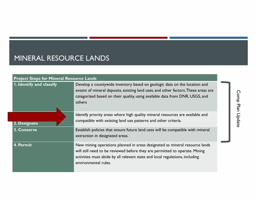
MINERAL RESOURCE LANDS
Project Steps for Mineral Resource Lands1. Identify and classify Develop a countywide inventory based on geologic data on the location and
extent of mineral deposits, existing land uses, and other factors. These areas are categorized based on their quality, using available data from DNR, USGS, and others
2. Designate
Identify priority areas where high quality mineral resources are available and compatible with existing land use patterns and other criteria.
3. Conserve Establish policies that ensure future land uses will be compatible with mineral extraction in designated areas.
4. Permit New mining operations planned in areas designated as mineral resource lands will still need to be reviewed before they are permitted to operate. Mining activities must abide by all relevant state and local regulations, including environmental rules.
Com
p Plan Update

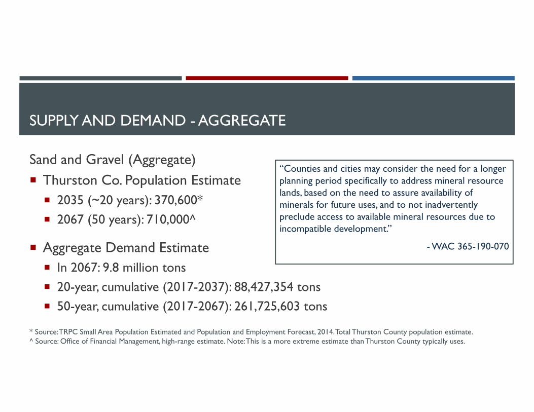
SUPPLY AND DEMAND - AGGREGATE
Sand and Gravel (Aggregate)
Supply
Inventory Total = 6.1 billion tons^
Demand
3,782,100 tons per year^
13.5 tons per person/per year*
“In designating mineral resource lands, counties and cities should determine if adequate mineral resources are available for projected needs from currently designated mineral resource lands.”
- WAC 365-190-070
^ Source: AESI (2017), “Thurston County Mineral Lands – Geologic Inventory and Classification Study.”* Source: Pacific Lutheran University (2003), “The aggregates industry in Washington.”
SUPPLY AND DEMAND - AGGREGATE
Sand and Gravel (Aggregate) Thurston Co. Population Estimate 2035 (~20 years): 370,600* 2067 (50 years): 710,000^
Aggregate Demand Estimate In 2067: 9.8 million tons 20-year, cumulative (2017-2037): 88,427,354 tons 50-year, cumulative (2017-2067): 261,725,603 tons
“Counties and cities may consider the need for a longer planning period specifically to address mineral resource lands, based on the need to assure availability of minerals for future uses, and to not inadvertently preclude access to available mineral resources due to incompatible development.”
- WAC 365-190-070
* Source: TRPC Small Area Population Estimated and Population and Employment Forecast, 2014. Total Thurston County population estimate.^ Source: Office of Financial Management, high-range estimate. Note: This is a more extreme estimate than Thurston County typically uses.
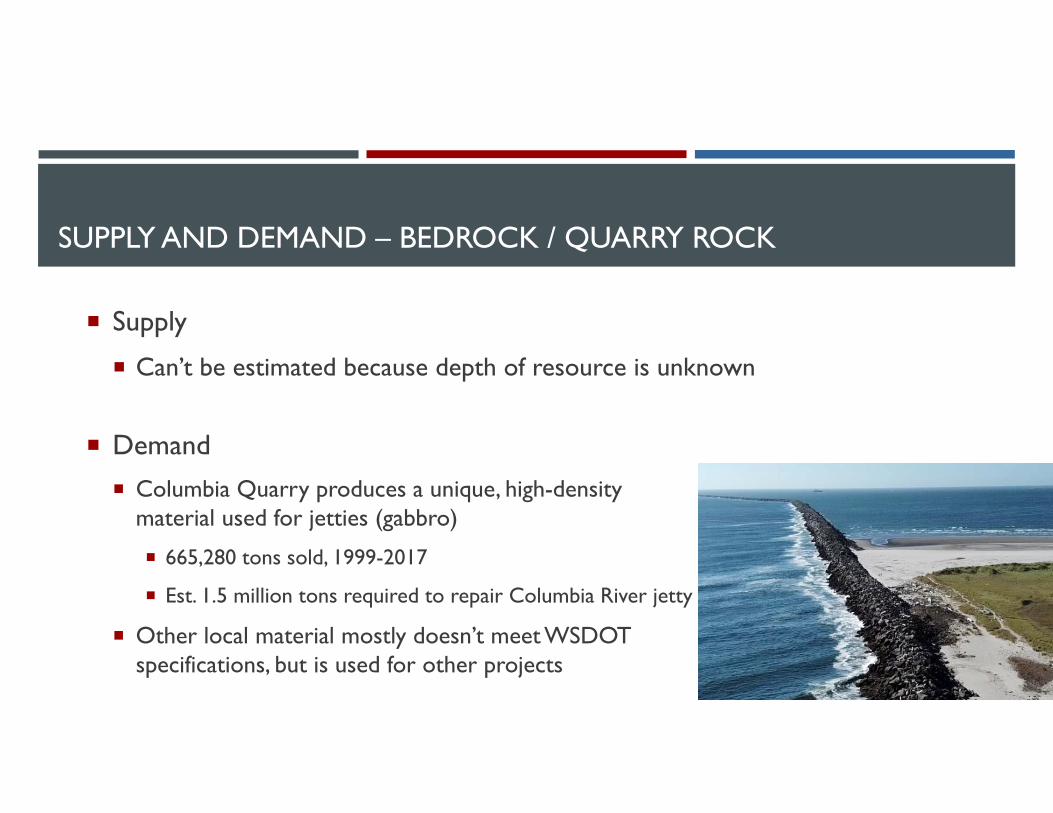
SUPPLY AND DEMAND – BEDROCK / QUARRY ROCK
Supply
Can’t be estimated because depth of resource is unknown
Demand Columbia Quarry produces a unique, high-density
material used for jetties (gabbro)
665,280 tons sold, 1999-2017
Est. 1.5 million tons required to repair Columbia River jetty
Other local material mostly doesn’t meet WSDOT specifications, but is used for other projects
SUPPLY AND DEMAND
Is Thurston County a net importer or exporter of mineral resources?
Hard to say – information not readily available, and often proprietary
Likely a net exporter of aggregate; net importer of quarry rock
December 20th speakers to address regional market considerations
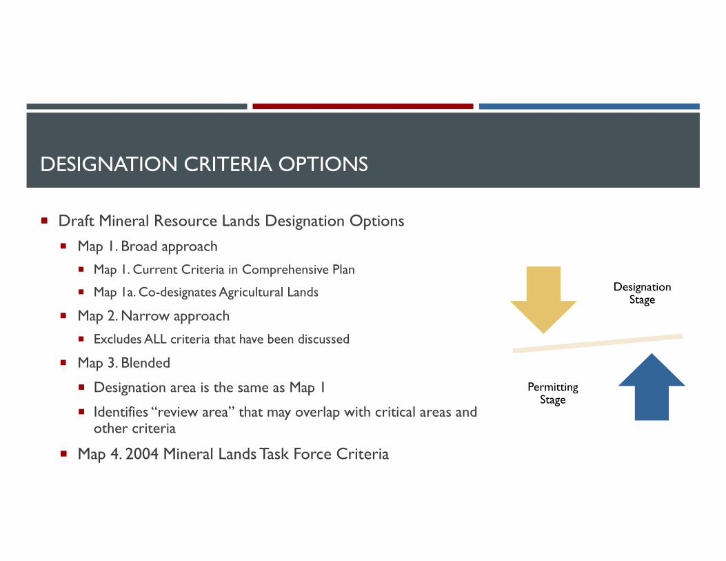
DESIGNATION CRITERIA OPTIONS
Draft Mineral Resource Lands Designation Options Map 1. Broad approach
Map 1. Current Criteria in Comprehensive Plan
Map 1a. Co-designates Agricultural Lands
Map 2. Narrow approach
Excludes ALL criteria that have been discussed
Map 3. Blended
Designation area is the same as Map 1
Identifies “review area” that may overlap with critical areas and other criteria
Map 4. 2004 Mineral Lands Task Force Criteria
Designation Stage
Permitting Stage
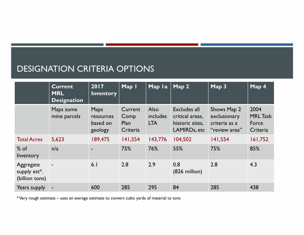
DESIGNATION CRITERIA OPTIONS
Current MRL Designation
2017 Inventory
Map 1 Map 1a Map 2 Map 3 Map 4
Maps somemine parcels
Maps resources based on geology
Current Comp Plan Criteria
Also includes LTA
Excludes all critical areas, historic sites, LAMIRDs, etc
Shows Map 2 exclusionary criteria as a “review area”
2004 MRL Task Force Criteria
Total Acres 5,623 189,475 141,554 143,776 104,502 141,554 161,752
% of Inventory
n/a - 75% 76% 55% 75% 85%
Aggregate supply est*. (billion tons)
- 6.1 2.8 2.9 0.8 (826 million)
2.8 4.3
Years supply - 600 285 295 84 285 438
* Very rough estimate – uses an average estimate to convert cubic yards of material to tons
NEXT STEPS
Refine MRL Map Options based on Planning Commission feedback
December 20th speakers DNR – John Bromley
County Current Planning – Tony Kantas
Washington Aggregate and Concrete Association – Bruce Chattin
Set a public hearing
Land
Use
Nat
ural
Res
ourc
es
Hou
sing
Tra
nspo
rtat
ion
Util
ities
Econ
omic
Dev
elop
men
t
Envi
ronm
ent
Cap
ital F
acili
ties
Hea
lth
Questions?
Staff Contact:
Allison Osterberg, Senior [email protected] x7011After December 15: 360-867-2102
Maya Bühler, Associate [email protected]

EXISTING DESIGNATION CRITERIA: TC COMPREHENSIVE PLANMinimum Designation Criteria: Chapter 3
1. Mineral Deposits Should contain deposits based on USGS maps, DNR permits, or site specific geologic information
This information is being provided/updated in the inventory
2. Location Not adversely impact nearby land uses, public health or safety
1,000 ft from • public preserves, • urban growth areas (UGAs)• residential areas with existing densities > 1/5
60% of area within 1,000 ft of a proposed site must have parcels of 5 acres or larger (excludes applicant)
3. Minimum Site Size 5 acres
4. Marketability Mineable, recoverable, marketable
5. LTA and Historic Long-term agriculture lands and historic/cultural sites are excluded
6. LTF Long-term forestry lands may be co-designated
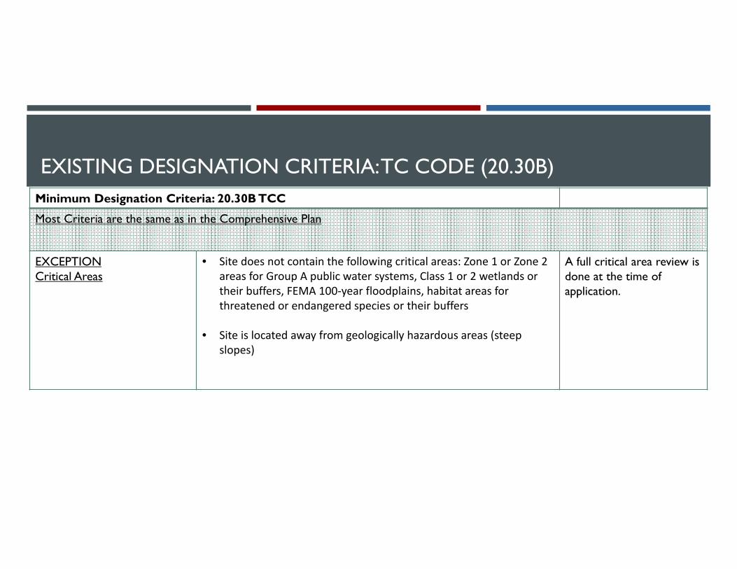
EXISTING DESIGNATION CRITERIA: TC CODE (20.30B)Minimum Designation Criteria: 20.30B TCC
Most Criteria are the same as in the Comprehensive Plan
EXCEPTIONCritical Areas
• Site does not contain the following critical areas: Zone 1 or Zone 2 areas for Group A public water systems, Class 1 or 2 wetlands or their buffers, FEMA 100‐year floodplains, habitat areas for threatened or endangered species or their buffers
• Site is located away from geologically hazardous areas (steep slopes)
A full critical area review is done at the time of application.
Related Documents