THRUST FAULT DISPLACEMENT DISTRIBUTIONS AT THE PHLEGRA MONTES LOBATE SCARP SYSTEM, MARS. Corbin L. Kling 1 and Christian Klimczak 1 , 1 Department of Geology, University of Georgia, Athens, GA 30602, USA, [email protected] Summary: Lobate scarps are interpreted as the surface expressions of thrust faults at depth on planetary bodies. Detailed mapping and topographic analysis of the lobate scarp system bounding Phlegra Montes (Fig. 1), a prominent landmark in the northern plains of Mars, give insight into the manner with which the thrust faults underlying these lobate scarps developed. Preliminary results show that there are 13 major lobate scarps in the Phlegra Montes system that dip both east and west. The total length of the system is >1400 km and lobate scarp segments range from 10s to 100s km in length. Introduction: Thrust faults on planets with low rates of erosion are manifest as ridges with distinct geomorphologies, referred to as lobate scarps [e.g., 1]. The morphologies of the ridges are characterized by broad asymmetric anticlines close to the surface breaks of the faults, followed by smaller trailing synclines farther from the surface breaks of their underlying faults (see profile in Fig. 1). The geometry of the ridges depend on fault size, fault dip angle, depth extent of the fault, as well as displacement along the fault [1−3]. This allows for the topographic expressions produced by the thrust faults to be analyzed as the vertical fault displacements (fault throws, Fig. 1) [1]. Variations of the displacements along the faults provide insight into the fault growth behavior and have implications for lithospheric properties and fault architecture [4,5]. On Mars, lobate scarps are found to be 10s to 100s km long with escarpments that have up to 3 km in relief [3]. Study Area: Phlegra Montes, an area of elevated terrain is located in the northern plains northwest of Elysium Mons centered at 40.4°N and 163.1°E (Fig. 1). The elevated terrain is bounded by a series of landforms that we interpret as lobate scarps. Approach: Our lobate scarp analysis was carried out mainly using Mars Express High Resolution Stereo Camera (HRSC) data. In areas with poor HRSC coverage, mapping was supplemented with Context Camera (CTX) images and Mars Oribiter Laser Altimeter (MOLA) hillshade maps. Colorized digital terrain models overlaid on image or hillshade datasets were used to map major lobate scarps (Fig. 1). Topographic profiles were drawn across the faults perpendicular to the mapped scarp trace (e.g., Fig. 1). These profiles were taken based on equidistant points computed in ESRI’s ArcMap®. Using the “Tools for Graphics and Shapes” [6] in ArcMap, the spheroidal length between points was calculated. A total of 235 topographic profiles with an average profile spacing of 10 km were drawn across the lobate scarps. Topographic data was extracted from the PDS-released global MOLA DEM and was plotted with the open source statistical computing software “R” [7]. R was also used to calculate the throw of the thrust fault. Each profile was carefully examined to ensure knobs and craters were excluded from the throw measurements. If the profile crossed a knob or crater near the scarp, the measurement was not used for the topographic analysis. The measured throws and profile spacing were then used to create individual throw profiles for each scarp Figure 1 Major thrust faults mapped at Phlegra Montes. The map is a colorized HRSC DEM overlaid on a hillshade model generated from this data. A representative topographic profile is shown across fault #4. 1557.pdf 46th Lunar and Planetary Science Conference (2015)

Welcome message from author
This document is posted to help you gain knowledge. Please leave a comment to let me know what you think about it! Share it to your friends and learn new things together.
Transcript
THRUST FAULT DISPLACEMENT DISTRIBUTIONS AT THE PHLEGRA MONTES LOBATE SCARP SYSTEM, MARS. Corbin L. Kling1 and Christian Klimczak1, 1Department of Geology, University of Georgia, Athens, GA 30602, USA, [email protected]
Summary: Lobate scarps are interpreted as the
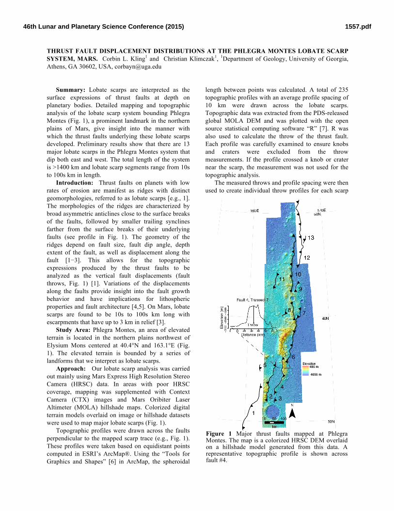
surface expressions of thrust faults at depth on planetary bodies. Detailed mapping and topographic analysis of the lobate scarp system bounding Phlegra Montes (Fig. 1), a prominent landmark in the northern plains of Mars, give insight into the manner with which the thrust faults underlying these lobate scarps developed. Preliminary results show that there are 13 major lobate scarps in the Phlegra Montes system that dip both east and west. The total length of the system is >1400 km and lobate scarp segments range from 10s to 100s km in length.
Introduction: Thrust faults on planets with low rates of erosion are manifest as ridges with distinct geomorphologies, referred to as lobate scarps [e.g., 1]. The morphologies of the ridges are characterized by broad asymmetric anticlines close to the surface breaks of the faults, followed by smaller trailing synclines farther from the surface breaks of their underlying faults (see profile in Fig. 1). The geometry of the ridges depend on fault size, fault dip angle, depth extent of the fault, as well as displacement along the fault [1−3]. This allows for the topographic expressions produced by the thrust faults to be analyzed as the vertical fault displacements (fault throws, Fig. 1) [1]. Variations of the displacements along the faults provide insight into the fault growth behavior and have implications for lithospheric properties and fault architecture [4,5]. On Mars, lobate scarps are found to be 10s to 100s km long with escarpments that have up to 3 km in relief [3].
Study Area: Phlegra Montes, an area of elevated terrain is located in the northern plains northwest of Elysium Mons centered at 40.4°N and 163.1°E (Fig. 1). The elevated terrain is bounded by a series of landforms that we interpret as lobate scarps.
Approach: Our lobate scarp analysis was carried out mainly using Mars Express High Resolution Stereo Camera (HRSC) data. In areas with poor HRSC coverage, mapping was supplemented with Context Camera (CTX) images and Mars Oribiter Laser Altimeter (MOLA) hillshade maps. Colorized digital terrain models overlaid on image or hillshade datasets were used to map major lobate scarps (Fig. 1).
Topographic profiles were drawn across the faults perpendicular to the mapped scarp trace (e.g., Fig. 1). These profiles were taken based on equidistant points computed in ESRI’s ArcMap®. Using the “Tools for Graphics and Shapes” [6] in ArcMap, the spheroidal
length between points was calculated. A total of 235 topographic profiles with an average profile spacing of 10 km were drawn across the lobate scarps. Topographic data was extracted from the PDS-released global MOLA DEM and was plotted with the open source statistical computing software “R” [7]. R was also used to calculate the throw of the thrust fault. Each profile was carefully examined to ensure knobs and craters were excluded from the throw measurements. If the profile crossed a knob or crater near the scarp, the measurement was not used for the topographic analysis.
The measured throws and profile spacing were then used to create individual throw profiles for each scarp
Figure 1 Major thrust faults mapped at Phlegra Montes. The map is a colorized HRSC DEM overlaid on a hillshade model generated from this data. A representative topographic profile is shown across fault #4.
1557.pdf46th Lunar and Planetary Science Conference (2015)
(Fig. 2). The overlap between thrust faults, defined as the length along strike that the faults overlapped each other, was also calculated. The information obtained from mapping as well as overlap and throw measurements was then combined to create a throw distribution profile for the entire thrust fault system at the study area (Fig. 2).
Results: Our mapping shows that there are 13 major thrust faults in the lobate scarp system bounding Phlegra Montes (Fig. 1). They have a consistent strike of NNE-SSW. Six faults dip toward the west and seven dip to the east. Lengths of the faults range from 53 km (Fault #3) to up to 440 km (Fault #13). Maximum throws along individual faults range from 155 to 2711 m, and the overlaps between faults range from 17 to 143 km.
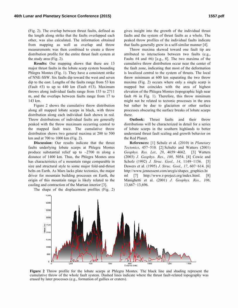
Figure 2 shows the cumulative throw distribution along all mapped lobate scarps in black, with throw distribution along each individual fault shown in red. Throw distributions of individual faults are generally peaked with the throw maximum occurring central to the mapped fault trace. The cumulative throw distribution shows two general maxima at 200 to 500 km and at 700 to 1000 km (Fig. 2).
Discussion: Our results indicate that the thrust faults underlying lobate scarps at Phlegra Montes produce substantial relief up to ~2700 m along a distance of 1400 km. Thus, the Phlegra Montes area has characteristics of a mountain range comparable in size and structural style to some major fold-and-thrust belts on Earth. As Mars lacks plate tectonics, the major driver for mountain building processes on Earth, the origin of this mountain range is likely related to the cooling and contraction of the Martian interior [3].
The shape of the displacement profiles (Fig. 2)
gives insight into the growth of the individual thrust faults and the system of thrust faults as a whole. The peaked throw profiles of the individual faults indicate that faults generally grew in a self-similar manner [4].
Throw maxima skewed toward one fault tip are attributed to interactions between two faults (e.g., Faults #4 and #6) [e.g., 8]. The two maxima of the cumulative throw distribution occur near the center of the fault zone, indicating that most of the deformation is localized central to the system of thrusts. The local throw minimum at 600 km separating the two throw maxima (Fig. 2) occurs where only a single scarp is mapped but coincides with the area of highest elevation of the Phlegra Montes (topographic high near fault #6 in Fig. 1). Therefore, this throw minimum might not be related to tectonic processes in the area but rather be due to glaciation or other surface processes obscuring the surface breaks of lobate scarps there.
Outlook: Thrust faults and their throw distributions will be characterized in detail for a series of lobate scarps in the southern highlands to better understand thrust fault scaling and growth behavior on the Red Planet.
References: [1] Schulz et al. (2010) in Planetary Tectonics, 457−510. [2] Schultz and Watters (2001) Geophys. Res. Let., 28, 4659−4662. [3] Watters (2003) J. Geophys. Res., 108, 5054. [4] Cowie and Scholz (1992) J. Struc. Geol., 14, 1149−1156. [5] Dawers et al. (1995) J. Struc. Geol., 17, 607−614. [6] http://www.jennessent.com/arcgis/shapes_graphics.html [7] http://www.r-project.org/index.html. [8] Manighetti et al. (2001) J. Geophys. Res., 106, 13,667−13,696.
Figure 2 Throw profile for the lobate scarps at Phlegra Montes. The black line and shading represent the cumulative throw of the whole fault system. Dashed lines indicate where the thrust fault-related topography was erased by later processes (e.g., formation of gullies or craters).
1557.pdf46th Lunar and Planetary Science Conference (2015)
Related Documents