308875/ENL/ENL/03/07/D May 2014 P:\Hong Kong\ENL\PROJECTS\308875 3rd runway\03 Deliverables\07 Final EIA Report\Ch 15 - LVIA.doc 15-1 Expansion of Hong Kong International Airport into a Three-Runway System Environmental Impact Assessment Report 15.1 Introduction 15.1.1.1 This chapter of the report presents an assessment of the potential landscape and visual impacts associated with the three-runway system (3RS) in accordance with the Environmental Impact Assessment Ordinance (EIAO) and the requirements of the EIA Study Brief (No. ESB-250/2012). Both construction and operation impacts are assessed. The project boundary is illustrated in Drawing MCL/P132/EIA/15-001.1 and MCL/P132/EIA/15-001.2. 15.1.1.2 The assessment includes: A listing of the relevant environmental legislation and guidelines; A definition of the scope and contents of the study, including a description of the assessment methodology; A review of the relevant planning and development control framework; A baseline study providing a comprehensive and accurate description of the baseline landscape resources, landscape character areas, zone of visual influence and key groups of existing and planned visually sensitive receivers (VSRs). Identification of the source of landscape and visual impacts; Recommendation of appropriate mitigation measures and associated implementation programmes; Assessment of the potential landscape and visual impacts, by taking into account the sensitivity of receivers, prediction of the magnitude of change experienced by the receivers and resulting potential impact significance, before and after the mitigation measures; and Clear evaluations and explanation with supportive arguments of all relevant factors considered in arriving at the significance thresholds of the landscape and visual impacts. 15.1.1.3 Colour photographs showing baseline conditions (photographs are augmented to show all approved planned / committed projects), and photomontages and illustrative materials supporting conclusions are provided and the locations of all viewpoints are clearly mapped. Photomontages at representative locations provide comparison between existing views (augmented to show all approved planned / committed projects); proposals on Day 1 after completion without mitigation; on Day 1 after mitigation, and in Year 10 after mitigation. 15.2 Landscape and Visual Legislation, Standards and Guidelines 15.2.1.1 The following environmental legislation, standards and guidelines are applicable to the evaluation of landscape and visual impacts associated with the construction and operation of the project: Environmental Impact Assessment Ordinance (Cap 499) and the Technical Memorandum on EIA Process (EIAO-TM), particularly Annexes 3, 10, 11, 18, 20 and 21; 15. Landscape and Visual Impact

Welcome message from author
This document is posted to help you gain knowledge. Please leave a comment to let me know what you think about it! Share it to your friends and learn new things together.
Transcript

308875/ENL/ENL/03/07/D May 2014 P:\Hong Kong\ENL\PROJECTS\308875 3rd runway\03 Deliverables\07 Final EIA Report\Ch 15 - LVIA.doc
15-1
Expansion of Hong Kong International Airport into a Three-Runway System Environmental Impact Assessment Report
15.1 Introduction
15.1.1.1 This chapter of the report presents an assessment of the potential landscape and visual impacts
associated with the three-runway system (3RS) in accordance with the Environmental Impact
Assessment Ordinance (EIAO) and the requirements of the EIA Study Brief (No. ESB-250/2012).
Both construction and operation impacts are assessed. The project boundary is illustrated in
Drawing MCL/P132/EIA/15-001.1 and MCL/P132/EIA/15-001.2.
15.1.1.2 The assessment includes:
� A listing of the relevant environmental legislation and guidelines;
� A definition of the scope and contents of the study, including a description of the assessment
methodology;
� A review of the relevant planning and development control framework;
� A baseline study providing a comprehensive and accurate description of the baseline
landscape resources, landscape character areas, zone of visual influence and key groups of
existing and planned visually sensitive receivers (VSRs).
� Identification of the source of landscape and visual impacts;
� Recommendation of appropriate mitigation measures and associated implementation
programmes;
� Assessment of the potential landscape and visual impacts, by taking into account the
sensitivity of receivers, prediction of the magnitude of change experienced by the receivers
and resulting potential impact significance, before and after the mitigation measures; and
� Clear evaluations and explanation with supportive arguments of all relevant factors considered
in arriving at the significance thresholds of the landscape and visual impacts.
15.1.1.3 Colour photographs showing baseline conditions (photographs are augmented to show all
approved planned / committed projects), and photomontages and illustrative materials supporting
conclusions are provided and the locations of all viewpoints are clearly mapped. Photomontages
at representative locations provide comparison between existing views (augmented to show all
approved planned / committed projects); proposals on Day 1 after completion without mitigation;
on Day 1 after mitigation, and in Year 10 after mitigation.
15.2 Landscape and Visual Legislation, Standards and Guidelines
15.2.1.1 The following environmental legislation, standards and guidelines are applicable to the evaluation
of landscape and visual impacts associated with the construction and operation of the project:
� Environmental Impact Assessment Ordinance (Cap 499) and the Technical Memorandum on
EIA Process (EIAO-TM), particularly Annexes 3, 10, 11, 18, 20 and 21;
15. Landscape and Visual Impact

308875/ENL/ENL/03/07/D May 2014 P:\Hong Kong\ENL\PROJECTS\308875 3rd runway\03 Deliverables\07 Final EIA Report\Ch 15 - LVIA.doc
15-2
Expansion of Hong Kong International Airport into a Three-Runway System Environmental Impact Assessment Report
− An Ordinance to provide for assessing the impact on the environment of certain projects and
proposals, for protecting the environment and for incidental matters.
− The Technical Memorandum sets out the principles, procedures, guidelines, requirements and
criteria for the technical content of an environmental impact assessment study brief or
environmental impact assessment report.
� Hong Kong Planning Standards and Guidelines;
− The Hong Kong Planning Standards and Guidelines (HKPSG) is a Government manual of criteria
for determining the scale, location and site requirements of various land uses and facilities.
� Hong Kong 2030 Planning Vision and Strategy Final Report;
− Is a long-term planning strategy to guide future development and provision of strategic
infrastructure and to help implement government policy targets in a spatial form.
� Landscape Value Mapping of Hong Kong;
− Essential landscape baseline information to provide a systematic reference framework to facilitate
landscape assessment and broad environmental assessment of major projects at territorial level.
� EIAO Guidance Note No. 8/2010;
− The Environmental Impact Assessment Ordinance, (Cap 499) Guidance Note advises on the
requirements in vetting Landscape and Visual Impact Assessment of designated projects under
the Technical Memorandum on EIA Process for the Environmental Impact Assessment
Ordinance.
� Town Planning Ordinance (Cap 131);
− To promote the health, safety, convenience and general welfare of the community by making
provision for the systematic preparation and approval of plans for the lay-out of areas of Hong
Kong as well as for the types of building suitable for erection therein and for the preparation and
approval of plans for areas within which permission is required for development.
� Foreshore and Sea-bed (reclamations) Ordinance (Cap 127);
− To provide for the publication of proposals in respect of reclamations over and upon any
foreshore and sea-bed; to make provision in respect of objections to the proposals, the payment
of compensation and connected matters; and to repeal the Public Reclamations and Works
Ordinance (Cap 113, 1984 Ed.) and the Foreshores and Sea Bed Ordinance (Cap 127, 1984
Ed.).
� Forests and Countryside Ordinance (Cap 96) and its subsidiary legislation the Forestry
Regulations;
− To consolidate and amend the law relating to forests and plants, and to provide for the protection
of the countryside.

308875/ENL/ENL/03/07/D May 2014 P:\Hong Kong\ENL\PROJECTS\308875 3rd runway\03 Deliverables\07 Final EIA Report\Ch 15 - LVIA.doc
15-3
Expansion of Hong Kong International Airport into a Three-Runway System Environmental Impact Assessment Report
� Country Parks Ordinance (Cap 208);
− To provide for the designation, control and management of country parks and special areas.
� Marine Parks Ordinance (Cap 476) and associated subsidiary legislation;
− To provide for the designation, control and management of Marine Parks and Marine Reserves.
� Protection of Endangered Species of Animals And Plants Ordinance (Cap. 586);
− To regulate the import, introduction from the sea, export, re-export, and possession or control of
certain endangered species of animals and plants and parts and derivatives of those species; and
to provide for incidental and connected matters.
� Approved Chek Lap Kok Outline Zoning Plan (OZP) No. S/I-CLK/12;
� Approved Tung Chung Town Centre Area Outline Zoning Plan (OZP) No. S/I-TCTC/18;
� SILTech Publication (1991) – Tree Planting and Maintenance in Hong Kong (Standing
Interdepartmental Landscape Technical Group) [11-23];
� GEO publication (1/2009) – Prescriptive Measures for Man-made Slopes and Retaining Walls;
� GEO 1/2011 – Technical Guidelines on Landscape Treatment for Slopes;
− This publication presents guidance on good practice of landscape treatments for man-made
slopes and engineering works on natural terrain in Hong Kong.
� Land Administration Office Instruction (LAOI) Section D-12 – Tree Preservation;
− It is policy to ensure that no tree is felled unnecessarily nor, where control exists, without the prior
consent of Government and that whenever possible, and appropriate, approval to the felling of
any tree is made subject to a compensatory landscaping/replanting scheme.
� Land Administration Office, Lands Department Practice Note 7/2007 - Tree Preservation and
Tree Removal Application for Building Development in Private Projects;
− This practice note ensures trees are not unnecessarily felled on private lots.
� DEVB TC (W) No.2/2012 Allocation of Space for Quality Greening on Roads;
− This circular aims to introduce improvements in greenery, to develop existing greened areas and
allow opportunities for greening and landscape during the planning and development of public
works projects.
� DEVB TC (W) No.3/2012 Site Coverage of Greenery for Government Building Projects;
− This circular sets out the standards and requirements on site coverage of greenery for new
government building projects and the methodology of measurement and calculation for the
purpose of the required site coverage of greenery

308875/ENL/ENL/03/07/D May 2014 P:\Hong Kong\ENL\PROJECTS\308875 3rd runway\03 Deliverables\07 Final EIA Report\Ch 15 - LVIA.doc
15-4
Expansion of Hong Kong International Airport into a Three-Runway System Environmental Impact Assessment Report
� DEVB TC (W) No.2/2013 Greening on Footbridges and Flyovers;
− This circular updates the policy and requirements for greening on new footbridges and flyovers in
built-up areas
� ETWB TCW No. 2/2004 – Maintenance of Vegetation and Hard Landscape Features;
− This circular sets out the departmental responsibilities for maintenance of vegetation and hard
landscape features.
� ETWB TCW No. 29/2004 – Registration of Old and Valuable Trees, and Guidelines for their
Preservation;
− This circular sets out the procedures for registration of old and valuable trees on unleased
Government land within built-up areas and tourist attraction spots in village areas.
� ETWB TCW No. 36/2004 The Advisory Committee on the Appearance of Bridges and
Associated Structures (ACABAS);
− This circular updates the membership of the Advisory Committee on the Appearance of Bridges
and Associated Structures (ACABAS). Revised guidelines for ACABAS submissions are also
included to promote better understanding of the submission requirements.
� ETWB TCW No. 5/2005 – Protection of Natural Streams/Rivers from Adverse Impacts Arising
from Construction Works;
− This circular provides an administrative framework to better protect all natural streams/rivers from
the impacts of construction works. The procedures promulgated under this Circular aim to clarify
and strengthen existing measures for protection of natural streams/rivers from government
projects and private developments.
� ETWB TCW No. 10/2013 - Tree Preservation;
− This circular sets out the policy on tree preservation, and the procedures for control of tree felling,
transplanting and pruning in Government projects.
� WBTC No. 25/93 – Control of Visual Impact of Slopes;
− This circular outlines the design principles recommended to be used in designing manmade
slopes for Public Works projects in order to reduce their adverse visual impact.
� WBTC No. 17/2000 – Improvement to the Appearance of slopes in connection with WBTC
25/93;
− This circular outlines the principles and procedures recommended for all departments involved in
new slope formation and in upgrading and maintenance of existing slopes for improving the
aesthetic and environmental impact of slope works.
� WBTC No. 7/2002 – Tree Planting in Public Works;

308875/ENL/ENL/03/07/D May 2014 P:\Hong Kong\ENL\PROJECTS\308875 3rd runway\03 Deliverables\07 Final EIA Report\Ch 15 - LVIA.doc
15-5
Expansion of Hong Kong International Airport into a Three-Runway System Environmental Impact Assessment Report
− This circular affirms the advocated policy on tree planting which adopts a flexible and balanced
approach in the planning and design of public works.
� Latest Proper Planting Practices and other relevant guidelines issued by Development Bureau
(Greening, Landscape and Tree Management Section).
� Latest Hong Kong International Airport (HKIA) Approved Plant Species List.
15.2.2 Review of Relevant Planning and Development Control Framework
15.2.2.1 A review will be undertaken of the relevant planning and development control framework for the
landscape study area (500 m beyond the limit of the works). The relevant OZPs for the project
works are the Chek Lap Kok Outline Zoning Plan No. S/I-CLK/12 and Tung Chung Town Centre
Area Outline Zoning Plan No. S/I-TCTC/18. Extracts of which are shown in Drawing
MCL/P132/EIA/15-002 and described in Section 15.5.3.
15.3 Scope and Content of Study
15.3.1 Project Site Boundary
15.3.1.1 Land is required to be formed to the north of the existing HKIA by land formation to provide a
platform for the development of the third runway and all associated airport infrastructure and
facilities. The tentative project site boundary comprises the proposed land formation footprint,
boundary of existing airport island, and potential daylighting point for the submarine fuel pipelines
on Sheung Sha Chau Island, and is shown in Drawing MCL/P132/EIA/15-001 and
MCL/P132/EIA/15-010.
15.3.2 Major Work Components
15.3.2.1 Construction of proposed land formation area: The project covers mainly an area of land
formation of approximately 650 ha to the north of the existing HKIA and other relevant
modifications on the existing airport island due to this future development. The land formation
activities comprise mainly ground treatment, seawall construction and filling.
15.3.2.2 Construction of airport related infrastructure and superstructures: Upon completion of the
land formation, various construction activities relating to infrastructure and superstructures will
commence. The layouts and designs for individual components are subject to the ongoing
infrastructure scheme design for the project.
15.3.2.3 Diversion of submarine fuel pipelines: The preferred method for diversion of the submarine
fuel pipelines involves horizontal directional drilling (HDD), which is a trenchless installation
technique commonly used in drilling oil and gas wells. The HDD method will be deployed to
install the pipelines directly from the existing HKIA to Sheung Sha Chau Island by underground
drilling. The pipelines will land on Sheung Sha Chau Island where the existing aviation fuel
receiving facility (AFRF) is located. A temporary floating work platform may be required.
15.3.2.4 Diversion of 11 kV submarine cable: The preferred method for diversion of the 11 kV
submarine cable involves diversion via water jetting method with field joint (to connect the new
cable to the existing cable) to the south of the Sha Chau and Lung Kwu Chau (SCLKC) Marine

308875/ENL/ENL/03/07/D May 2014 P:\Hong Kong\ENL\PROJECTS\308875 3rd runway\03 Deliverables\07 Final EIA Report\Ch 15 - LVIA.doc
15-6
Expansion of Hong Kong International Airport into a Three-Runway System Environmental Impact Assessment Report
Park. The cable will be buried about 5 m below seabed. At the field joint area, a small area of
excavation will be needed to expose the existing cable, which will then be lifted up to a barge for
forming the field joint. Upon completion of the field joint, the remaining cable will be buried below
seabed level. During construction, marine vessels carrying out the cable diversion and field joint
connection works will produce landscape and visual impacts. The minor impacts produced from
these works are included in the LVIA, however, they are not the focus of the assessment.
15.3.2.5 Please refer to Chapter 4 for a detailed list of the project components.
15.3.3 Consideration of Alternative Options
15.3.3.1 The alternative options and opportunities available for provision of a third runway in Hong Kong,
in terms of its alignment, the associated airport layout and construction methods have been
considered and elaborated in Chapter 3 of the EIA. Consideration of the landscape and visual
implications of the alternative options is included as one of the key differentiators in the
comparison of the different options leading to the selection of the preferred option. Further details
can be referred to Section 3.4.4. This Chapter 15 details the landscape and visual impacts of the
preferred option.
15.3.4 Limits of Study Area
15.3.4.1 The limit of the landscape impact study is 500 m beyond the boundary of the works (as stated in
the EIA study brief), which is shown in Drawing MCL/P132/EIA/15-001.1). The limit of the visual
impact study is the Zone of Visual Influence (ZVI) of the works during the construction and
operation phases (as stated in the EIA study brief, which is illustrated in Drawing
MCL/P132/EIA/15-010).
15.3.4.2 As the cable and fuel line have different construction methods they will have different landscape
and visual outcomes. The diversion of the 11 kV submarine cable would result in some increased
vessel activity, resulting in a potential impact upon the Landscape Character Area (LCA) (and
VSRs), and therefore the alignment is included in the landscape study area. Diversion of the
11 kV submarine cable will produce minor landscape and visual impacts. The minor impacts
produced from these works are included in the LVIA, however, they are not the focus of the
assessment. On the other hand, the submarine fuel pipelines would be constructed by HDD,
which is a trenchless installation technique that involves the installation of pipes, conduits, and
cables in a shallow arc using a surface-launched drilling rig. Consequently the 500 m landscape
study area and ZVI include the surface-launched drilling rig on airport island and daylighting point
on Sheung Sha Chau Island. There will be no landscape or visual impact on the sea area above
the undersea alignment of the fuel pipelines and consequently the sea area above the undersea
alignment is not included in the landscape study area. The daylighting point on Sheung Sha Chau
Island will produce minor landscape and visual impacts. The minor impacts produced from these
works are included in the LVIA, however, they are not the focus of the assessment.
15.4 Landscape and Visual Impact Assessment Methodology
15.4.1 General Approach
15.4.1.1 Landscape and visual impacts shall be assessed separately for the construction and operation
phases. The assessment of landscape impacts shall involve the following procedures.

308875/ENL/ENL/03/07/D May 2014 P:\Hong Kong\ENL\PROJECTS\308875 3rd runway\03 Deliverables\07 Final EIA Report\Ch 15 - LVIA.doc
15-7
Expansion of Hong Kong International Airport into a Three-Runway System Environmental Impact Assessment Report
15.4.2 Landscape Impact Methodology
15.4.2.1 Identification of the baseline Landscape Resources (LRs) and Landscape Character Areas
(LCAs) found within the study area. This is achieved by site visits and desk-top studies of
topographical maps, information databases, approved EIAs of the committed projects and
photographs. Reference is also made to the ‘Landscape Value Mapping of Hong Kong’ study.
15.4.2.2 Assessment of the degree of sensitivity to change of the LRs and LCAs. This is influenced
by a number of factors including whether the resource/character is common or rare, whether it is
considered to be of local, regional, national or global importance, whether there are any statutory
or regulatory limitations / requirements relating to the resource, the quality of the resource /
character, the maturity of the resource, and the ability of the resource/character to accommodate
change. The sensitivity of each landscape feature and character area is classified as follows:
High: Important landscape or landscape resource of particularly
distinctive character or high importance, sensitive to relatively small
changes
Medium: Landscape or landscape resource of moderately valued landscape
characteristics reasonably tolerant to change
Low: Landscape or landscape resource, the nature of which is largely
tolerant to change
15.4.2.3 Identification of potential sources of landscape change. These are the various elements of
the construction works and operational procedures that would generate landscape change.
15.4.2.4 Identification of the magnitude of landscape change. The magnitude of the change depends
on a number of factors including the physical extent of the change, the landscape and visual
context of the change – i.e. a set circumstance/facts surrounding the change, the compatibility of
the project with the surrounding landscape; and the time-scale of the change - i.e. whether it is
temporary (short, medium or long term), permanent but potentially reversible, or permanent and
irreversible. Landscape changes have been quantified wherever possible. The magnitude of
landscape change is classified as follows:
Large: The landscape or landscape resource would suffer a major
change
Intermediate: The landscape or landscape resource would suffer a moderate
change
Small: The landscape or landscape resource would suffer slight or
barely perceptible changes
Negligible: The landscape or landscape resource would suffer no discernible
change
None: The landscape or landscape resource would suffer absolutely no
impact
308875/ENL/ENL/03/07/D May 2014 P:\Hong Kong\ENL\PROJECTS\308875 3rd runway\03 Deliverables\07 Final EIA Report\Ch 15 - LVIA.doc
15-8
Expansion of Hong Kong International Airport into a Three-Runway System Environmental Impact Assessment Report
15.4.2.5 Identification of potential landscape mitigation measures. These may take the form of
adopting alternative designs or revisions to the basic engineering and architectural design to
prevent and/or minimise adverse impacts; remedial measures such as colour and textural
treatment of building features; and compensatory measures such as the implementation of
landscape design measures (e.g. tree planting, creation of new open space etc.) to compensate
for unavoidable adverse impacts and to attempt to generate potentially beneficial long term
impacts. A programme for the mitigation measures is provided. The agencies responsible for the
funding, implementation, management and maintenance of the mitigation measures are identified
and their approvals-in-principle are being sought.
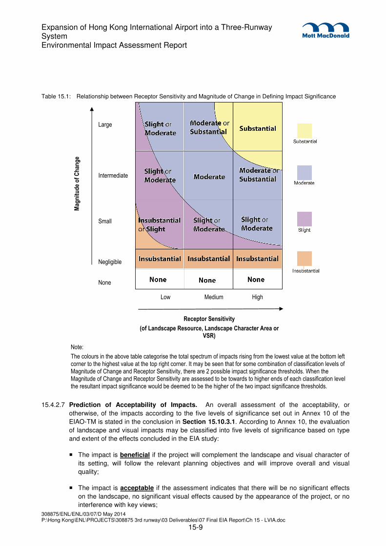
15.4.2.6 Prediction of the significance of landscape impacts before and after the implementation of
the mitigation measures. By synthesising the magnitude of the various changes and the
sensitivity of the various landscape resources it is possible to categorise impacts in a logical, well-
reasoned and consistent fashion. Table 15.1 shows the rationale for dividing the degree of
significance into four thresholds, namely insubstantial, slight, moderate, and substantial,
depending on the combination of a negligible-small-intermediate-large magnitude of change and
a low-medium-high degree of sensitivity of the LRs / LCAs. The significance thresholds are
defined as follows:
Substantial: Adverse / beneficial impact where the proposal would cause
significant deterioration or improvement in existing landscape
quality
Moderate: Adverse / beneficial impact where the proposal would cause a
noticeable deterioration or improvement in existing landscape
quality
Slight: Adverse / beneficial impact where the proposal would cause a
barely perceptible deterioration or improvement in existing
landscape quality
Insubstantial: No discernible change in the existing landscape quality
None Absolutely no change in the existing landscape quality
308875/ENL/ENL/03/07/D May 2014 P:\Hong Kong\ENL\PROJECTS\308875 3rd runway\03 Deliverables\07 Final EIA Report\Ch 15 - LVIA.doc
15-9
Expansion of Hong Kong International Airport into a Three-Runway System Environmental Impact Assessment Report
Table 15.1: Relationship between Receptor Sensitivity and Magnitude of Change in Defining Impact Significance
Mag
nit
ud
e o
f C
han
ge
Large
Intermediate
Small
Negligible
None
Low Medium High
Receptor Sensitivity
(of Landscape Resource, Landscape Character Area or VSR)
Note:
The colours in the above table categorise the total spectrum of impacts rising from the lowest value at the bottom left corner to the highest value at the top right corner. It may be seen that for some combination of classification levels of Magnitude of Change and Receptor Sensitivity, there are 2 possible impact significance thresholds. When the Magnitude of Change and Receptor Sensitivity are assessed to be towards to higher ends of each classification level the resultant impact significance would be deemed to be the higher of the two impact significance thresholds.
15.4.2.7 Prediction of Acceptability of Impacts. An overall assessment of the acceptability, or
otherwise, of the impacts according to the five levels of significance set out in Annex 10 of the
EIAO-TM is stated in the conclusion in Section 15.10.3.1. According to Annex 10, the evaluation
of landscape and visual impacts may be classified into five levels of significance based on type
and extent of the effects concluded in the EIA study:
� The impact is beneficial if the project will complement the landscape and visual character of
its setting, will follow the relevant planning objectives and will improve overall and visual
quality;
� The impact is acceptable if the assessment indicates that there will be no significant effects
on the landscape, no significant visual effects caused by the appearance of the project, or no
interference with key views;

308875/ENL/ENL/03/07/D May 2014 P:\Hong Kong\ENL\PROJECTS\308875 3rd runway\03 Deliverables\07 Final EIA Report\Ch 15 - LVIA.doc
15-10
Expansion of Hong Kong International Airport into a Three-Runway System Environmental Impact Assessment Report
� The impact is acceptable with mitigation measures if there will be some adverse effects, but
these can be eliminated, reduced or offset to a large extent by specific measures;
� The impact is unacceptable if the adverse effects are considered too excessive and are
unable to mitigate practically;
� The impact is undetermined if significant adverse effects are likely, but the extent to which
they may occur or may be mitigated cannot be determined from the study. Further detailed
study will be required for the specific effects in question.
15.4.3 Broad Brush Tree Survey Methodology
15.4.3.1 A broad brush tree survey in accordance with the EIA Study Brief is described in Section 15.5.6
and illustrated in Drawings MCL/P132/EIA/15-027.1, MCL/P132/EIA/15-027.2,
MCL/P132/EIA/15-027.3, MCL/P132/EIA/15-027.4, MCL/P132/EIA/15-027.5 and
MCL/P132/EIA/15-027.6. The survey provides baseline information on the existing trees within
the project site boundary and identifies dominant tree species, maturity, rarity and any plant
species of conservation interest.
15.4.3.2 Existing trees within the project boundary were surveyed in groups according to the location, in
which the following information was identified for each tree group:
� Tree group number;
� Botanical name and Chinese name of the main species found in the group;
� Approximate number of trees in the group;
� An assessment of average tree form (good / fair / poor) for each species found in each group;
� An assessment of average tree health (good / fair / poor) for each species found in each
group;
� An assessment of average amenity value (high / medium / low) for each species found in each
group; and
� Additional remarks are provided on the estimated approximate age range of the trees.
15.4.3.3 No rare or protected trees species were identified in the broad brush tree survey, however the
absence of such species cannot be absolutely confirmed in a broad brush survey.
15.4.4 Visual Impact Methodology
15.4.4.1 Landscape and visual impacts are assessed separately for the construction and operation
phases. The assessment of visual impacts has involved the following procedures.
15.4.4.2 Identification of the Visual Envelope and Zones of Visual Influence (ZVI) during the
construction and operation phases of the 3RS. The visual envelope is the area from which
any part of the proposed project can be seen and may contain areas, which are fully visible, partly
visible and non-visible from the project. The ZVI is the portion of the visual envelope that is within
308875/ENL/ENL/03/07/D May 2014 P:\Hong Kong\ENL\PROJECTS\308875 3rd runway\03 Deliverables\07 Final EIA Report\Ch 15 - LVIA.doc
15-11
Expansion of Hong Kong International Airport into a Three-Runway System Environmental Impact Assessment Report
10 km from the proposed project. Identification of the visual envelope and ZVI is achieved by site
visits and desk-top studies of topographic maps and photographs to determine the visibility of the
3RS from various locations. Given the effects of distance and the panoramic qualities of many
views, VSRs beyond 10 km from the project will scarcely notice (and will find it very difficult to
distinguish) the 3RS in their wider views. At these distances, the proposed 3RS will not form a
feature of any significance in the VSRs frame of view and consequently will not influence the
visual experience of the VSR. Hence 10 km is considered the limit of the Zone of Visual
Influence.
15.4.4.3 Identification of the Visually Sensitive Receivers (VSRs) within the ZVI at construction and
operation phases. These are the people who would reside within, work within, play within, or
travel through, the ZVI. VSRs at both existing and committed developments will be considered in
this assessment.
15.4.4.4 Assessment of the degree of sensitivity to change of the VSRs. Factors considered
include:
� The type of VSRs, classified according to whether the person is at home, at work, at play, or
travelling. Those who view the impact from their homes are considered to be highly sensitive
as the attractiveness or otherwise of the outlook from their home will have a substantial effect
on their perception of the quality and acceptability of their home environment and their general
quality of life. Those who view the impact from their workplace are considered to be only
moderately sensitive as the attractiveness or otherwise of the outlook will have a less
important, although still material, effect on their perception of their quality of life. The degree
to which this applies depends on whether the workplace is industrial, retail or commercial.
Those who view the impact while taking part in an outdoor leisure activity may display varying
sensitivity depending on the type of leisure activity. Those who view the impact while travelling
on a public thoroughfare will also display varying sensitivity depending on the speed of travel.
� Other factors which are considered (as required by EIAO GN 8/2010) include the value and
quality of existing views and views from planned developments, the availability and amenity of
alternative views, the duration or frequency of view, and the degree of visibility.
15.4.4.5 The sensitivity of VSRs is classified as follows:
High: The VSR is highly sensitive to any change in their viewing
experience
Medium: The VSR is moderately sensitive to any change in their viewing
experience
Low: The VSR is only slightly sensitive to any change in their viewing
experience
15.4.4.6 Identification of the relative numbers of VSRs. This is expressed in terms of whether there
are very few, few, many or very many VSRs in any one category of VSR.
15.4.4.7 Identification of potential sources of visual impacts. These are the various elements of the
construction works and operational procedures that would generate visual impacts.

308875/ENL/ENL/03/07/D May 2014 P:\Hong Kong\ENL\PROJECTS\308875 3rd runway\03 Deliverables\07 Final EIA Report\Ch 15 - LVIA.doc
15-12
Expansion of Hong Kong International Airport into a Three-Runway System Environmental Impact Assessment Report
15.4.4.8 Assessment of the potential magnitude of visual change. Factors considered include:
Duration and Frequency of
the impact:
Temporary / Permanent: This refers to the long term
presence of the visual change – whether it is experienced
by the VSR for the whole duration of the construction
phase or operation phase, or only part thereof.
Intermittent / Continuous: This refers to short term
frequency of the visual change - is it always visible
(continuous) or only at certain times (intermittent). For
example, travelling VSRs may only see the source
intermittently as they travel along their journey, whereas
residential VSRs may have continuous views from their
living room.
Reversibility of the impact: Reversible / Irreversible
Compatibility of the project
with the Visual Backdrop:
High / Medium / Low
Distance of the source of
impact from the viewer:
Shortest distance measured in metres (m) between the
VSR and the source.
Degree of visibility of
Source(s) of Visual Impact:
Full: virtually full uninterrupted view of the source of
impact
Partial: partial view of the source of impact which is
slightly hidden by intervening elements such as buildings,
vegetation etc.
Obscured: partial view of the source of impact which is
largely hidden by intervening elements such as buildings,
vegetation etc.
Scale of the development Small / Medium / Large
Potential Blockage of
Existing Views
Full / Partial / Slight / Negligible: The degree to which the
source of the impact blocks existing open views currently
experienced by the VSR.
15.4.4.9 The magnitude of visual change is classified as follows:
Large: The VSRs would suffer a major change in their viewing experience;
Intermediate: The VSRs would suffer a moderate change in their viewing experience;
Small: The VSRs would suffer a small change in their viewing experience;
Negligible: The VSRs would suffer no discernible change in their viewing

308875/ENL/ENL/03/07/D May 2014 P:\Hong Kong\ENL\PROJECTS\308875 3rd runway\03 Deliverables\07 Final EIA Report\Ch 15 - LVIA.doc
15-13
Expansion of Hong Kong International Airport into a Three-Runway System Environmental Impact Assessment Report
experience;
None The VSRs would suffer absolutely no change in their viewing
experience.
15.4.4.10 Identification of potential visual mitigation measures. These may take the form of adopting
alternative designs or revisions to the basic engineering and architectural design to prevent
and/or minimise adverse impacts; remedial measures such as colour and finishing treatment of
building features; and compensatory measures such as the implementation of landscape design
measures (e.g. tree planting, creation of new open space etc.) to compensate for unavoidable
adverse impacts and to attempt to generate potentially beneficial long term impacts. A
programme for the mitigation measures shall be provided. The agencies responsible for the
funding, implementation, management and maintenance of the mitigation measures shall be
identified and their approval-in-principle shall be sought.
15.4.4.11 Prediction of the significance of visual impacts before and after the implementation of the
mitigation measures. By synthesising the magnitude of the various visual changes and the
sensitivity of the VSR, and the number of individuals in the VSR that are affected, it is possible to
categorise the degree of significance of the impacts in a logical, well-reasoned and consistent
fashion. Table 15.1 shows the rationale for dividing the degree of significance into four
thresholds, namely, insubstantial, slight, moderate and substantial, depending on the combination
of a negligible / small / intermediate / large magnitude of change and a low / medium / high
degree of sensitivity of VSRs. Consideration is also given to the relative numbers of individuals in
the VSRs in predicting the final impact significance - exceptionally low or high numbers of
individuals in a VSR may change the result that might otherwise be concluded from Table 15.1.
The significance of the visual impacts is categorised as follows:
Substantial: Adverse / beneficial impact where the proposal would cause
significant deterioration or improvement in existing visual quality
perceived by the general population;
Moderate: Adverse / beneficial impact where the proposal would cause a
noticeable deterioration or improvement in existing visual
quality perceived by the general population;
Slight: Adverse / beneficial impact where the proposal would cause a
barely perceptible deterioration or improvement in existing
visual quality perceived by the general population;
Insubstantial: No discernible change in the existing visual quality perceived by
the general population;
None Absolutely no change in the existing visual quality perceived by
the general population.
15.4.4.12 Prediction of Acceptability of Residual Impacts. An overall assessment of the acceptability or
otherwise of the residual impacts 10 to 15 years after implementation of visual mitigation
measures, according to the five criteria set out in Annex 10 of the EIAO-TM.

308875/ENL/ENL/03/07/D May 2014 P:\Hong Kong\ENL\PROJECTS\308875 3rd runway\03 Deliverables\07 Final EIA Report\Ch 15 - LVIA.doc
15-14
Expansion of Hong Kong International Airport into a Three-Runway System Environmental Impact Assessment Report
15.4.5 Assumptions and Limitations
15.4.5.1 In accordance with EIAO Guidance Note 8/2010 (paragraph 3.7(a)) approved projects should
form part of the baseline conditions. Therefore, the landscape and visual outcomes (including
proposed landscape and visual mitigation measures) of approved projects currently under
construction, including the Hong Kong Boundary Crossing Facility (HKBCF), associated Hong
Kong Link Road (HKLR), the Southern Connection of Tuen Mun – Chek Lap Kok Link (TM-
CLKL), Residential / Commercial Development at Tung Chung (Area 55a), Residential
Development at Tung Chung (Area 55b) and the Public Rental Housing Development at Tung
Chung (Area 56) will be included as part of the baseline conditions for the 3RS. The predicted
completion date for the aforementioned projects is 2015 / 16 which is before commencement of
the 3RS.
15.4.5.2 The aforementioned projects are discussed below and are indicated on Drawing
MCL/P132/EIA/15-011.
� HKBCF and HKLR - HKBCF will serve as a transportation hub and provide clearance facilities
for goods and passengers using the Hong Kong – Zhuhai – Macao Bridge (HZMB). The
proposed HKBCF will be located on an artificial island of about 130 ha reclaimed from the
open waters off the northeast of HKIA. It is next to HKIA and Tung Chung New Town
Extension Study which are at convenient locations with good transportation connectivity. With
a variety of transport modes available in the proximity, HKBCF will become a multi-modal
transportation hub with HKIA, SkyPier, Airport Express Line and Tung Chung Line in the area.
HKLR will comprise sea viaducts in the western waters of Hong Kong, tunnels through Scenic
Hill and underneath the Airport Road and Airport Express Line, and at-grade roads on
reclamation along the east coast of airport island. The project consists of a dual three-lane
carriageway in the form of viaduct from the HK SAR boundary to Scenic Hill of approximately
9.4 km in length. The projects are due for completion in 2016.
� Southern Connection of TM-CLKL - TM-CLKL will be a dual two-lane carriageway connecting
the Tuen Mun Western Bypass (TMWB) at Tuen Mun Area 40 in the north with the proposed
HZMB HKBCF, the airport and North Lantau in the south. The northern connection between
Tuen Mun and HKBCF will be a sub-sea tunnel while the southern connection between
HKBCF and North Lantau will be on viaducts. The Southern Connection of TM-CLKL is due for
completion in 2016.
� Residential Development at Tung Chung (Area 56) - Tung Chung Area 56 covers a site area
of about 32,500 m2 and is located to the east of Ying Hei Road. According to the Tung Chung
Town Centre Area Outline Zoning Plan No. S/I-TCTC/18, the site is zoned “Residential (A)”
and has a plot ratio of five. The residential development is in line with the planning intention.
The development will consist of four domestic blocks of 41 storeys high. Completion of the
proposed development at Tung Chung (Area 56) is expected in 2016.
� Residential / Commercial Development at Tung Chung (Area 55a) – Tung Chung Area 55a
covers an area of about 25,400 m2 and is located north of Ying Hei Road. According to the
Tung Chung Town Centre Area Outline Zoning Plan No. S/I-TCTC/18, the site is zoned
“Residential (A)” and has a plot ratio of five. Completion of the residential / commercial
development at Tung Chung (Area 55a) is expected in 2016.

308875/ENL/ENL/03/07/D May 2014 P:\Hong Kong\ENL\PROJECTS\308875 3rd runway\03 Deliverables\07 Final EIA Report\Ch 15 - LVIA.doc
15-15
Expansion of Hong Kong International Airport into a Three-Runway System Environmental Impact Assessment Report
� Residential Development at Tung Chung (Area 55b) - Tung Chung Area 55b covers as area of
about 26,400 m2 and is located north of Ying Hei Road. According to the Tung Chung Town
Centre Area Outline Zoning Plan No. S/I-TCTC/18, the site is zoned “Residential (A)” and has
a plot ratio of five. Completion of the residential development at Tung Chung (Area 55b) is
expected in 2015.
15.4.5.3 In addition, the following assumptions are made in the assessment:
� It is assumed that funding, implementation, management and maintenance of the landscape
and visual mitigation proposals can be satisfactorily resolved according to the principles in
ETWB TCW No. 2/2004. All mitigation proposals in the EIA report shall be practical and
achievable within the known parameters of funding, implementation, management and
maintenance. The suggested agents for the funding and implementation (and subsequent
management and maintenance, if applicable) are indicated in the EIA report. Approvals-in-
principle to the implementation, management and maintenance of the proposed mitigation
measures are being sought from the appropriate authorities.
15.4.6 Concurrent Projects
15.4.6.1 The concurrent projects that fall within the ZVI, therefore relating to the visual impact assessment,
have been identified below and are indicated on Drawing MCL/P132/EIA/15-011. The visual
impacts of these concurrent projects are taken into account in the cumulative assessment.
� Northern Connection of TM-CLKL - The proposed TM-CLKL, together with the proposed
TMWB, is a proposed strategic road link between North West New Territories (NWNT), North
Lantau, the proposed HZMB HKBCF and HKIA. The Northern Connection of TM-CLKL is
located just east of the Tuen Mun River Trade Terminal and is due for completion in 2018.
� Tung Chung New Town Extension Study – According to the Stage 2 Public Engagement
exercise in May 2013, the Tung Chung East Extension will comprise of a 120 ha landscape
formation, primarily for residential and recreational use. It is estimated to accommodate a
population of 110,000. The Tung Chung West Extension will comprise of a 14 ha land
formation, primarily for residential and recreational use, the proposed Tung Chung West
Station, high density developments close to the existing Tung Chung Road, medium density
developments in areas adjacent to Yat Tung Estate and village clusters near the Tung Chung
River Estuary to provide a stepped building height profile towards Tung Chung Bay. The Tung
Chung West Extension is estimated to accommodate a population of 43,000. The Tung Chung
New Town Extension Study would generate primarily residential and recreational VSRs in
large numbers. According to communications with the project proponent in December 2013,
this project is currently undergoing engineering and environmental assessment, and no
detailed construction programme is confirmed at this stage, though construction is currently
targeted to commence in 2018 and it is anticipated that the first population intake would occur
in 2023/24.
� Proposed Public Housing Development at Tung Chung West (Area 39) – The Public Rental
Housing (PRH) development at Tung Chung Area 39 is located on the south west of Yat Tung
Estate. To the east are villages including Ha Ling Pei, Wong Ka Wai and Lung Tseng Tau; to
the west is agricultural land; and to the south are YMC of Hong Kong Christian College and
Caritas Charles Vath College. The site area of the proposed development is approximately
3.23 ha. The proposed development will consist of four domestic blocks ranging from 94 - 130

308875/ENL/ENL/03/07/D May 2014 P:\Hong Kong\ENL\PROJECTS\308875 3rd runway\03 Deliverables\07 Final EIA Report\Ch 15 - LVIA.doc
15-16
Expansion of Hong Kong International Airport into a Three-Runway System Environmental Impact Assessment Report
m high providing around 3,800 PRH flats. Construction of the PRH development at Tung
Chung West (Area 39) will commence in 2014 with completion in 2018.
� Proposed Residential Development at Tung Chung (Area 54) - Tung Chung Area 54 covers an
area of about 32,400 m2 and is located north of Ying Hei Road. According to the Tung Chung
Town Centre Area Outline Zoning Plan No. S/I-TCTC/18, the site is zoned “Residential (A)”
and has a plot ratio of five. Completion of the proposed development at Tung Chung (Area 54)
is anticipated to be in 2019/20.
� Lantau Logistics Park (LLP) - The LLP will be developed on the 72 ha out of a total
reclamation area of 112 ha off the north shore of Lantau Island immediately to the north of,
and encompassing, the existing Siu Ho Wan railway depot with proposals for possible
Logistics Park extension or other compatible uses for the remaining 40 ha of reclamation area.
The new reclamation will be an extension of the existing reclamation carried out for the North
Lantau Highway and the Siu Ho Wan depot. The exact layout of the proposed LLP reclamation
is subject to further study and will be confirmed after detailed investigation. Construction work
will involve reclamation, construction of surcharge, handling and stockpiling of excavated
materials for roadworks, drainage, waterworks, concreting works and construction traffic
movements on unpaved roads. According to communications with the project proponent in
September 2013, the development programme for the LLP is yet to be confirmed, and the land
uses for the proposed reclamation are subject to the outcomes of Agreement No. CE
9/2011(CE).
� Leisure and Entertainment Node at Sunny Bay - The Sunny Bay Reclamation, at the gateway
to the north east Lantau tourism hub and near the Sunny Bay MTR Station, was
recommended as a tourism node in the ‘Northshore Lantau Development Feasibility Study’. It
is suitable for a leisure and entertainment node, particularly for youths, which may comprise
such components as entertainment, dining, fashionable stores, performance venues, theme
attractions and indoor leisure and sports facilities like indoor man made beach. The proposal
could create synergy with Hong Kong Disneyland and other tourism proposals on Lantau.
Based on discussions with Planning Department in August 2013, it was identified that this
proposal does not yet have an implementation programme, and the land uses for this
proposed reclamation is also subject to the outcomes of Agreement No. CE 9/2011(CE) –
Increasing Land Supply by Reclamation and Rock Cavern Development cum Public
Engagement – Feasibility Study.
� New Contaminated Mud Marine Disposal Facility at Airport East/East Sha Chau - The project
involves the sequential disposal of contaminated mud into a series of dredged pits. The new
CMP to the south of The Brothers will operate between 2013 and 2016. Disposal of
contaminated sediment will begin at CMP Pit Vb at East Sha Chau upon completion of
disposal at the CMP south of The Brothers and this is expected to be ongoing throughout
2016 and 2017. Thereafter, disposal will begin at CMP Pit Vc at East Sha Chau, followed by
Pit Vd at East Sha Chau.
� Intermodal Transfer Terminus (ITT) – A planned development on HKIA to meet the additional
demand from an increase of transfer passengers at HKIA following the opening of the
aforementioned HZMB project. The works will include the expansion and modification of the
existing SkyPier facilities (located at the north-eastern extent of HKIA) to provide an ITT, a
bonded road linking ITT to HKBCF (the portion within HKIA), other associated road works and

308875/ENL/ENL/03/07/D May 2014 P:\Hong Kong\ENL\PROJECTS\308875 3rd runway\03 Deliverables\07 Final EIA Report\Ch 15 - LVIA.doc
15-17
Expansion of Hong Kong International Airport into a Three-Runway System Environmental Impact Assessment Report
an underground APM maintenance facility. Construction is tentatively scheduled to commence
in 2014 for completion in 2017.
� North Commercial District (NCD) – A planned development of a new commercial centre with
basement car parking in the location of the existing SkyCity Nine Eagles Golf Course. NCD
will accommodate various commercial facilities include offices, hotels, and retail. Construction
is tentatively scheduled to commence in 2015 for completion in 2019
� Organic Waste Treatment Facilities at Siu Ho Wan - A planned development at Siu Ho Wan
which aims to recycle source-separated organic waste generated from the C&I sectors (mostly
food waste) to useful products, thereby minimising requirement for landfill disposal.. The
facilities will adopt anaerobic digestion and composting technologies to recycle organic waste
into biogas and compost products. According to communications with the project proponent in
August 2013, it is estimated that the DBO contract will be awarded in early 2014 and the plant
will be commissioned in mid-2016.
� Potential Sites for Columbarium Developments – Group B – Feasibility Study - Two sites in the
Tsuen Wan District located at the eastern and western end of Sham Shui Kok Drive in Siu Ho
Wan, North Lantau are shortlisted potential sites for columbarium development. Based on
communication with the works agent in January 2014, the study is still in the feasibility stage
and there is no implementation programme available yet, though it is initially proposed that this
development may be operational by 2020. Given that insufficient information is available at
this stage, this project cannot be considered as a concurrent project for cumulative impact
assessment, however, it will be considered as a potential future sensitive receiver in relevant
technical assessments.
� Planning and Engineering Study for Tuen Mun Areas 40 and 46 and the Adjoining Areas –
This is a planning and engineering study on the future land use options for Tuen Mun Areas
40 and 46 and the adjoining areas. Area 40 is currently zoned as “Industrial” use while parts of
Area 46 is zoned as “Other Specified Uses” annotated “Crematorium, Columbarium, Funeral
Services Centre and Open Space”. The study aims to investigate the potential for re-planning
these areas for alternative uses such as commercial, office and hotel uses, logistics uses, high
technology industry uses, residential use, etc. According to the latest information from the
project website, the feasibility study commenced in May 2013 and is anticipated for completion
in 2015, however the future development proposal is yet to be determined. Given that
insufficient information is available at this stage, this project cannot be considered as a
concurrent project and cumulative impacts will not be assessed.
� Cycle Track between Tsuen Wan and Tuen Mun - This project aims to provide a cycle track
between Tsuen Wan and Tuen Mun together with associated supporting and recreational
facilities. According to latest information published by the project proponent on this project, the
project is currently undergoing detailed design, which is estimated to be completed in phases
from mid-2014 to 2015, and the programme of construction works could only be finalised upon
completion of the detailed design work. Given that the construction programme is
unconfirmed, this project cannot be assessed for cumulative construction phase impacts.
15.4.6.2 The concurrent projects which fall within the 500 m landscape study area, therefore relating to the
landscape impact assessment, have been identified below. These projects, identified below, are
discussed in detail in Section 15.4.6.1 above, and are indicated on Drawing MCL/P132/EIA/15-
308875/ENL/ENL/03/07/D May 2014 P:\Hong Kong\ENL\PROJECTS\308875 3rd runway\03 Deliverables\07 Final EIA Report\Ch 15 - LVIA.doc
15-18
Expansion of Hong Kong International Airport into a Three-Runway System Environmental Impact Assessment Report
011. The landscape impacts of these concurrent projects are taken into account in the cumulative
assessment.
� Tung Chung New Town Extension Study (partial);
� New Contaminated Mud Marine Disposal Facility at East Sha Chau (partial);
� Intermodal Transfer Terminus;
� The North Commercial District.
15.4.7 Photomontages
15.4.7.1 Representative views from various locations have been selected to illustrate the effectiveness of
the proposed impact mitigation proposal and residual impacts of the development in both short
and long terms. Photomontages illustrating the proposed works and the recommended mitigation
measures as well as the confirmed projects and mitigation measures are listed in Section 15.7.4.
The locations of the selected viewpoints are indicated in Drawing MCL/P132/EIA/15-010 with the
viewpoints illustrated in Drawings MCL/P132/EIA/15-017.1 to MCL/P132/EIA/15-026.2. The
photomontages illustrate the proposed development under the following scenarios:
� Existing Baseline Conditions in June 2013;
� Planned Baseline Conditions in 2016 before commencement of the 3RS (with committed and
approved projects: HKBCF, HKLR, Southern Connection of the TM-CLKL,
Residential/Commercial Development at Tung Chung (Area 55a), Residential Development at
Tung Chung (Area 55b) and Public Rental Housing (PRH) Development at Tung Chung (Area
56));
� Day 1 of completed works without mitigation measures;
� Day 1 of the completed works with mitigation measures; and
� The completed works with mitigation after 10 years.
15.5 Baseline Conditions
15.5.1 Landscape and Visual Study Area
15.5.1.1 Chek Lap Kok was an island in the western waters of Hong Kong. Together with the smaller Lam
Chau, it was levelled and merged via land formation into the 12.48 km2 platform for the current
HKIA, which opened for commercial operations in 1998. The island is located north of Lantau
Island off Ma Wan Chung and Tung Chung. The southern end of the Chek Lap Kok forms a small
peninsula, which has been left largely undeveloped. This area is facing Tung Chung and is now
named "Scenic Hill". It is the site of the Ancient Kiln Park and the Chek Lap Kok Angle Station of
the Ngong Ping 360 cable car.
15.5.1.2 Chek Lap Kok is located north of Tung Chung, which is an area situated on the north-western
coast of Lantau Island. Tung Chung was formerly a rural village around Tung Chung Wan, and

308875/ENL/ENL/03/07/D May 2014 P:\Hong Kong\ENL\PROJECTS\308875 3rd runway\03 Deliverables\07 Final EIA Report\Ch 15 - LVIA.doc
15-19
Expansion of Hong Kong International Airport into a Three-Runway System Environmental Impact Assessment Report
along the delta and lower courses of Tung Chung River and Ma Wan Chung in the north-western
coast of Lantau Island developed as part of the Airport Core Programme.
15.5.1.3 Located south of Chek Lap Kok is Lantau Island which encompasses a land mass of 147 km², it
is the largest island in Hong Kong, almost twice the size of Hong Kong Island. Lantau Island
primarily consists of mountainous terrain. Lantau Peak (934 m) is the highest point of the island. It
is the second highest in Hong Kong, after Tai Mo Shan, and is almost twice the height of Victoria
Peak. Other mountains include Sunset Peak (869 m), Lin Fa Shan (766 m), Nei Lak Shan (751
m) and Yi Tung Shan (747 m). The largest country park of Hong Kong, Lantau South Country
Park is located on the island, which hosts two other parks, namely Lantau North Country Park
and its extension. These parks cover slightly more than half of the area of Lantau Island.
15.5.1.4 Located across Urmston Road is Castle Peak, Tai Lam Country Park and the town of Tuen Mun.
Castle Peak is a 583 m high peak in the western New Territories of Hong Kong. The area to the
west of the hill was also named Castle Peak. It is an industrial area with several power plants
owned by CLP. Tai Lam Country Park, is a country park located in the Tai Lam, at the south of
Yuen Long and east of Tuen Mun, in the western New Territories of Hong Kong. This country
park has an area of 54 km². Tuen Mun is a town near the mouth of Tuen Mun River and Castle
Peak Bay in the New Territories. It was one of the earliest settlements in Hong Kong which can
be dated back to the Neolithic period. Tuen Mun is now a modern mainly residential area in north-
west New Territories.
15.5.2 Committed and Approved Projects under Construction
15.5.2.1 In accordance with EIAO Guidance Note 8/2010 (paragraph 3.7(a)) approved projects to be
completed before commencement of the 3RS, should form part of the baseline conditions.
Therefore, the landscape and visual outcomes of approved projects currently under construction,
including HKBCF, HKLR Southern Connection of TM-CLKL, Residential / Commercial
Development at Tung Chung (Area 55a), Residential Development at Tung Chung (Area 55b)
and Public Rental Housing (PRH) Development at Tung Chung (Area 56) are included as part of
the baseline conditions for the 3RS as the aforementioned projects would be completed before
commencement of construction for the 3RS in 2016.
15.5.2.2 For ease of understanding, the baseline study describes what will be in existence once the
current approved and committed projects already under construction are completed. It is upon
that baseline that the impacts of future construction and operation of the 3RS will be felt, and it is
the 3RS’s impact on that baseline that are assessed, quantitatively and qualitatively, in this LVIA.
15.5.2.3 A review of the current land-uses within the study area is outlined below in Section 15.5.3. The
existing LRs and LCAs within the study area have been identified and described in Sections
15.5.4 and 15.5.5. The sensitivities of the LRs and LCAs have been summarised in Table 15.2
and Table 15.3.
15.5.3 Review of Current Land-Uses within the Assessment Area
15.5.3.1 A review has been undertaken of the current land-use and marine park designations within the
landscape study area. The relevant OZPs for the project works are the Chek Lap Kok Outline
Zoning Plan No. S/I-CLK/12 and Tung Chung Town Centre Area Outline Zoning Plan No. S/I-
TCTC/18 extracts of which is shown in Drawing MCL/P132/EIA/15-002.

308875/ENL/ENL/03/07/D May 2014 P:\Hong Kong\ENL\PROJECTS\308875 3rd runway\03 Deliverables\07 Final EIA Report\Ch 15 - LVIA.doc
15-20
Expansion of Hong Kong International Airport into a Three-Runway System Environmental Impact Assessment Report
Chek Lap Kok Outline Zoning Plan No. S/I-CLK/12
15.5.3.2 The object of the plan is to specify the broad land use zonings and major transport network for
Chek Lap Kok and the HZMB and HKBCF so any development will be under statutory planning
control.
15.5.3.3 The following describes the land use zonings on land falling within the boundaries of the plan
which are always permitted and which may be permitted by the Town Planning Board, with or
without conditions on application.
� Other Specified Uses (“OU”): This zoning covers land for a number of specified uses. These
fall under the following specific areas as outlined below;
− Airport; intended for the development of airport operational facilities;
− Airport Service Area; indented for the development of airport support facilities to facilitate the
operation of the airport;
− Boundary Crossing Facilities; intended for the development of boundary crossing facilities and
related activities for the HZMB;
− Business Park; intended for the business activities relating to the airport;
− Highways Maintenance Area; intended to designate areas for the provisions of backup area for
operations and maintenance of HKLR;
− Pier; intended to designate land for piers to facilitate marine access to Chek Lap Kok;
− Satellite Control Building; intended to reserve land for the development of a satellite control
building;
− Sea Rescue Station; intended primarily to reserve land for the reprovisioning of the existing Fire
Services Department East Sea Rescue Facilities. The existing facilities will be affected by the
proposed automated people mover associated with HKBCF;
− Ventilation Building; to reserve land for the development of a ventilation building associated
with the TM-CLKL;
− Amenity Area; designated land for major roadside amenity areas and landscape buffers. This
includes the areas between the Dragonair Tower and China National Aviation Corporation
(CNAC) Tower and the proposed carriageway from HKBCF and HKLR.
� Commercial (“C”): Intended for airport related activities as well as other commercial
developments and business activities. This area is primarily focused in the north eastern
portion of Chek Lap Kok where the aim is to provide an aesthetically pleasant environment for
airport related enterprises and other business activities. Other supporting facilities in this zone
include hotels, offices, retail, exhibition centre, and recreational. A large portion of this area is
taken up by transport infrastructure including public car parks, terminal buildings and the
Airport Express Line Station. This zoning currently occupies 118.8 ha within the current OZP.
308875/ENL/ENL/03/07/D May 2014 P:\Hong Kong\ENL\PROJECTS\308875 3rd runway\03 Deliverables\07 Final EIA Report\Ch 15 - LVIA.doc
15-21
Expansion of Hong Kong International Airport into a Three-Runway System Environmental Impact Assessment Report
� Government, Institutional or Community (“G/IC”): Intended for the provision of
Government, institution, or community facilities to support any airport operations and serve the
needs of other developments on Chek Lap Kok. Existing facilities within this zone include the
Government flying services centre, fire station, police complex and airmail centre. This zone
currently occupies 12.30 ha within the current OZP.
� Green Belt (“GB”): The planning intention for this zone is to preserve the existing natural
landscape at the knoll at the south eastern point of the Chek Lap Kok to provide a visual and
environmental buffer for the adjacent new town development of Tung Chung. The zone also
holds the purpose of providing a passive recreational outlet.
� Cultural Heritage Site: A cultural heritage site (Ha Law Wan Site of Archaeological Interest)
is located north of Scenic Hill with ancient kilns dated back to Yuan Dynasty. It is noted that
the site has been deemed worthy of preservation.
Tung Chung Town Centre Area Outline Zoning Plan No. S/I-TCTC/18
15.5.3.4 The object of the plan is to specify the broad land use zonings and major transport networks so
that development within the area can be put under statutory planning control.
15.5.3.5 The following describes the land use zonings on land falling within the boundaries of the plan
which are always permitted and which may be permitted by the Town Planning Board, with or
without conditions on application.
� Open space (“O”): Intended primarily for the provision of open-air public space for active
and/or passive recreational uses serving the need of local residents as well as the general
public. In addition to other areas, the zone also covers the waterfront open spaces in Areas 52
and 59 including a prestigious waterfront promenade which will be extended to the east to Tai
Ho and to the west, Tung Chung West in the future. It also covers the open space links and
other open spaces at Areas 7, 16, and 18 which serve as environmental buffers for the North
Lantau Highway (NLH) and other major roads. This zone currently occupies 55.70 ha within
the current OZP.
� Comprehensive Development Area (“CDA”): Intended for comprehensive development /
redevelopment of the area for residential and commercial uses with the provision of open
space and other supporting facilities which may include offices, shop and services, places of
entertainment, eating places and hotels, functioning as the economic centre in the town
centre. This zoning currently occupies 2.14 ha within the current OZP.
� Government, Institutional or Community (“G/IC”): Intended for the provision of
Government, institution, or community facilities to support the needs of the local residents
and/or wider district region or the territory. It is also intended to provide land for uses directly
related to Government, organisation providing social services to meet community needs and
other institutional establishments. This zone currently occupies 22.32 ha within the current
OZP.
� Other Specified Uses (“OU”): This zoning denotes land allocated or reserved for specified
uses including railway ventilation and other associated plants to the north east of the Tung
Chung MTR Station, sewage pumping station in Area 12, proposed ferry pier in Area 50, two
proposed petrol filling stations in Area 58, a traction substation in Area 58, and a cable car

308875/ENL/ENL/03/07/D May 2014 P:\Hong Kong\ENL\PROJECTS\308875 3rd runway\03 Deliverables\07 Final EIA Report\Ch 15 - LVIA.doc
15-22
Expansion of Hong Kong International Airport into a Three-Runway System Environmental Impact Assessment Report
portal and its related commercial development in Area 2. This zone currently occupies 2.86 ha
within the current OZP.
� Commercial (“C”): Intended for commercial oriented developments which may include land
uses such as offices, shop and services, places of entertainment, eating places and hotels,
functioning as the economic centre in the town centre. This zoning currently occupies 2.14 ha
within the current OZP.
� Green Belt (“GB”): The planning intention for this zone is to primarily define the limits of the
urban and suburban development areas by natural features and to preserve existing
topography and natural vegetation at the fringe of the new town as well as to provide passive
recreational outlets. This zone does not feature within the proposed 500 m landscape study
area of this project.
Designated Marine Parks and Marine Reserves
15.5.3.6 The Sha Chau and Lung Kwu Chau Marine Park is situated in the open water on the western side
of Hong Kong. This marine park was designated on 22 November 1996. It covers a total sea area
of about 1,200 ha. The boundary is demarcated by yellow light buoys deployed at the corners of
the marine park. The landward boundary largely follows the high water mark along the coastline
of the islands.
� Section 21, Clause (1) of the Marine Parks Ordinance (Cap 476) states: the Authority may
approve in writing the carrying out of any work for the purposes of inspecting or repairing any
existing structure or facility within any marine park or marine reserve and may, after seeking
the advice of the Board, approve the carrying out of any new development within any marine
park or marine reserve, where he considers it to be in the public interest to do so, and may
impose any conditions on granting the approval.
� Section 21, Clause (2) states: Sections 10 and 11 shall, with necessary modifications, apply in
respect of an application for approval to carry out any work or new development referred to in
subsection (1) within a marine park or marine reserve.
Hong Kong 2030 Planning Vision and Strategy Final Report
15.5.3.7 The necessity for the 3RS is described in the Hong Kong 2030 Planning Vision and Strategy Final
Report which concludes that it recognises the importance of the continual development of HKIA
as key in sustaining Hong Kong’s economic growth and priority needs to be given in
strengthening this sector of development.
Other Relevant Studies, Guidelines and Manuals
− Urban Design Guidelines and Standards Manual for New Airport at Chek Lap Kok;
− SkyCity Masterplan Urban Design Guidelines;
− SkyCity landscape Masterplan;
− Tung Chung New Town Development Study;

308875/ENL/ENL/03/07/D May 2014 P:\Hong Kong\ENL\PROJECTS\308875 3rd runway\03 Deliverables\07 Final EIA Report\Ch 15 - LVIA.doc
15-23
Expansion of Hong Kong International Airport into a Three-Runway System Environmental Impact Assessment Report
− Revised Concept Plan for Lantau;
− Tuen Mun – Chek Lap Kok Link (TM-CLKL);
− Hong Kong – Zhuhai – Macao Bridge, Hong Kong Boundary Crossing Facilities – Investigation;
− Tung Chung New Town Development Extension Study;
− Planning and Engineering Study on the Remaining Development in Tung Chung - Feasibility
Study; and
− Dredging, Management and Capping of Contaminated Sediment Disposal Facility to the South of
The Brothers
Conclusion
15.5.3.8 It is concluded that there is no conflict between the proposed 3RS and the current relevant
planning and development control framework for existing land, as the proposed development is
consistent with the current designated land uses on existing land. There is also no conflict with
existing land zoned Green Belt and Open Space as the predicted extent of area of works does
not encroach into the aforementioned land zonings. However, Town Planning Ordinance
approvals and Foreshore and Sea-bed (reclamations) Ordinance approvals will be required for
the proposed land formation within the major works components of the 3RS. Furthermore, under
section 10 of the Marine Parks Ordinance, approval has to be sought for any development within
a marine park. Section 10 of the Marine Parks Ordinance States “An application for approval by
the Authority under Section 9 to carry out new development shall be made to the Authority in
writing which application shall include details of the proposal for the new development.”.
15.5.4 Landscape Resources
15.5.4.1 The baseline LRs that will be affected during the construction phase and operation phase,
together with their sensitivity to change, are described below. The locations of the LRs are
mapped in Drawings MCL/P132/EIA/15-003.1, MCL/P132/EIA/15-003.2, MCL/P132/EIA/15-
003.3, MCL/P132/EIA/15-003.4 and MCL/P132/EIA/15-007. Photo-views illustrating the LRs of
the study area are illustrated in Drawings MCL/P132/EIA/15-005.1, MCL/P132/EIA/15-005.2
and MCL/P132/EIA/15-009. For ease of reference and co-ordination between text, tables and
drawings, each LR is given an identity number. The below listed LRs represent the baseline
condition after completion of the approved committed projects. This includes new landscape
elements such as compensatory planting which is planned to be implemented as part of the
approved committed projects and will in fact exist during commencement of the 3RS so will
therefore form part of the baseline condition for the 3RS, except for minor advanced works that
are targeted to commence in 2015.
CLK/LR1 - Coastal Waters of North Lantau
15.5.4.2 The seawater body forms part of the coastal waters of North Lantau and is a valuable resource
contributing to the unique waterfront setting of Tung Chung. These Coastal Waters surrounding
Chek Lap Kok are an important recreational resource as they are frequented by commercial and
pleasure craft marine traffic. Given the regional importance and physical characteristics of this
landscape the sensitivity given is High.

308875/ENL/ENL/03/07/D May 2014 P:\Hong Kong\ENL\PROJECTS\308875 3rd runway\03 Deliverables\07 Final EIA Report\Ch 15 - LVIA.doc
15-24
Expansion of Hong Kong International Airport into a Three-Runway System Environmental Impact Assessment Report
15.5.4.3 After implementation of the approved committed projects, a loss of approximately 60 ha of coastal
waters will occur resulting in an area of approximately 12,000 ha for this resource.
CLK/LR2 – Grass / Turf Areas around Runways and Verges
15.5.4.4 These are the large, flat, low-lying grass areas which have been established around the primary
airport infrastructure, runway network and roadside areas on Chek Lap Kok. A continuous band
of grass approximately 100 m wide abuts the northern land formation edge and continues around
a portion of both the eastern and western extents of the North Runway. Given the nature of the
LR its subsequent high tolerance to change, the sensitivity given is Low.
15.5.4.5 This resource is not anticipated to be impacted by the implementation of the approved committed
projects.
CLK/LR3 – Landscaped Areas Around Existing Airport Buildings
15.5.4.6 These areas include the water features and soft landscape areas around the existing buildings on
airport island. These areas are primarily situated along vehicle / pedestrian access ways, along
private roads and around the perimeter of the buildings. Landscaped areas consist of amenity
water features, ground covers, low shrub planting, small size semi mature trees and broad leaf
vegetation. Species assessed include Alpinia zerumbet 'Variegata', Ixora stricta, Callistemon
viminalis, Cassia surattensis, Bauhinia spp., Roystonea regia, Casuarina equisetifolia, Calliandra
haematocephala, Lagerstroemia indica, Lantana montevidensis, Agave americana, and Hibiscus
spp. Much of the planting is relatively young and can be relatively easily replaced to a similar
state; however semi-mature tree species do exist throughout the area. Given the quality of the
LR, relative maturity of particular species and ability to accommodate some change, the
sensitivity is considered Low.
15.5.4.7 This resource is not anticipated to be impacted by the implementation of the approved committed
projects.
CLK/LR4a - Roadside Vegetation – Amenity Planting
15.5.4.8 A planting theme has been implemented for amenity planting throughout the commercial areas
and associated airport facilities alongside major roads and access routes of Chek Lap Kok.
Amenity areas consist of low hedges defining planting areas with large grassed areas,
groundcovers, small shrubs, ornamental palms and small semi mature trees. Species identified
include Ixora stricta, Albizia lebbeck, Casuarina equisetifolia, Acacia confusa, Acacia mangium,
Cassia siamea, Dalbergia odorifera, Grevillea robusta, Leucaena leucocephala, Delonix regia,
Lagerstroemia speciosa, Litsea glutinosa, Macaranga tanarius, Melia azedarach, Phoenix
roebelenii, Plumeria rubra, Roystonea regia, Calliandra haematocephala, Duranta repens 'Golden
Leaves', Bougainvillea spp., Cycas revoluta, Chrysalidocarpus lutescens, Ravenala
madagascariensis, Archontophoenix alexandrae, Acacia auriculiformis, Hibiscus tiliaceus, Ficus
microcarpa 'Golden Yellow', Ficus benjamina, Bauhinia spp., Cocos nucifera, and Nerium spp.
Planting arrangements are featured on roundabouts, traffic islands, median strips and along
pedestrian footways. Much of the planting is relatively young and can be relatively easily replaced
to a similar state; however semi-mature tree species do exist throughout the area. Given the
quality of the LR, relative maturity of particular species and ability to accommodate some change,
the sensitivity is considered Medium.

308875/ENL/ENL/03/07/D May 2014 P:\Hong Kong\ENL\PROJECTS\308875 3rd runway\03 Deliverables\07 Final EIA Report\Ch 15 - LVIA.doc
15-25
Expansion of Hong Kong International Airport into a Three-Runway System Environmental Impact Assessment Report
15.5.4.9 It is anticipated that the construction of infrastructure associated with HKBCF, located adjacent to
Airport Road, would result in loss of approximately 2 ha of existing roadside vegetation. The
existing landscape resource is approximately 57 ha. Similarly construction of HKLR along the
Chek Lap Kok South Road would result in loss of approximately 2 ha of existing roadside
vegetation. After the implementation of the approved committed projects, the area of this
landscape resource would be reduced to approximately 53 ha for this resource. However,
landscape and visual mitigation measures, including amenity roadside planting and screen
planting will be implemented under those projects.
CLK/LR4b - Roadside Vegetation on Modified Slopes
15.5.4.10 Vegetation is predominantly located on slopes at the Airport North Interchange. Both self-seeded
and planted native and exotic woodland species such as Hibiscus tiliaceus, Pinus elliottii,
Leucaena leucocephala, Thevetia peruviana, Bauhinia spp., Acacia confusa, Acacia mangium,
Nerium spp., and Agave americana occupy the engineered slopes around the highway
infrastructure. The sensitivity of this vegetation is considered Low as it is predominantly
incidental, of common species and of low quality.
15.5.4.11 This resource is not anticipated to be impacted by the implementation of the approved committed
projects.
CLK/LR5 - Natural Coastline
15.5.4.12 The natural coastline features at a variety of locations on both the south eastern point of Chek
Lap Kok and Lantau Island accommodating a varying degree of human disturbance. An almost
continuous band of natural coastline exists to the west of Tung Chung Bay to Sha Lo Wan
interrupted briefly by piers and jetties. The Southern coastline of Scenic Hill adjoins the
designated Green Belt under the current OZP (No. S/I-CLK/12). Natural coastline also features
along the eastern edge of Tung Chung Bay and the north eastern tip of Chek Lap Kok. Due to the
quality and natural status, its regional importance, and low tolerance to change, the sensitivity
given is High.
15.5.4.13 The existing landscape resource is approximately 9,950 linear metres. After the implementation
of the approved committed projects, a loss of approximately 1,650 linear metres of coastal waters
will occur resulting in 8,300 linear metres for this resource.
CLK/LR6 – Amenity / Compensatory Planting on HKBCF/HKLR
15.5.4.14 Following the completion of HKLR and HKBCF programmed for 2016 (ref. Government Contract
Nos. HY/2011/03 and HY/2011/09) this resource will comprise of amenity roadside planting and
landscaped areas / environmental buffers including hydroseeding and peripheral planting. Given
the recent instalment of the landscape treatment and relative ease of replacement there is a high
ability for this landscape resource to accommodate change. Sensitivity: Low.
15.5.4.15 After the implementation of the committed and approved projects the entire existing resource
grassland / scrub on coastal edge, encompassing 6 ha, would be lost.

308875/ENL/ENL/03/07/D May 2014 P:\Hong Kong\ENL\PROJECTS\308875 3rd runway\03 Deliverables\07 Final EIA Report\Ch 15 - LVIA.doc
15-26
Expansion of Hong Kong International Airport into a Three-Runway System Environmental Impact Assessment Report
CLK/LR7 - Streams
15.5.4.16 A number of small streams have been identified within and around the villages of Tin Sam, Kau
Liu and San Tau. The streams originate and fall within the vegetated hillsides of Lantau North
Country Park. The streams are seasonal or of very low base flow. Given the natural landscape
status and local importance the sensitivity given is Medium.
15.5.4.17 This resource is not anticipated to be impacted by the implementation of the approved committed
projects.
CLK/LR8 - Agricultural Land
15.5.4.18 Agricultural land within the villages of San Tau is comprised of various areas of active and
inactive agricultural land with farms and fish ponds. Though this LR accommodates a degree of
human disturbance, semi-mature tree species do exist throughout the area, the sensitivity is
considered Medium.
15.5.4.19 This resource is not anticipated to be impacted by the implementation of the approved committed
projects.
CLK/LR9 - Natural Rocky and Sandy Shore with Mangrove/Mudflat
15.5.4.20 This is a stretch of natural shoreline containing natural rocks, mudflats, mangroves and dense
coastal vegetation. The LR includes the San Tau Beach which holds Site of Special Scientific
Interest (SSSI) status largely due to the ecological value with rare seagrass species. Mangrove
species include Aegiceras corniculatum, and Avicennia marina. Given the natural landscape
status, rarity, regional importance and quality of the LR, the sensitivity to change is considered
High.
15.5.4.21 This resource is not anticipated to be impacted by the implementation of the approved committed
projects.
CLK/LR10a - Coastal Woodland and Scrubland on North Lantau
15.5.4.22 This is woodland and scrubland that covers the coastal hillsides on Lantau Island facing towards
Chek Lap Kok. This LR falls within the designated Lantau North Country Park. Dominant species
comprise Mallotus paniculatus, Thevetia peruviana, Acacia confusa, Macaranga tanarius,
Bauhinia spp., Celtis sinensis, Acacia mangium, Calliandra haematocephala, Dicranopteris
linearis, Rhodomyrtus tomentosa, and Pinus elliottii. Given the relatively natural landscape status,
regional importance, and low tolerance to change, the sensitivity is considered High.
15.5.4.23 This resource is not anticipated to be impacted by the implementation of the approved committed
projects.
CLK/LR10b - Coastal Woodland and Scrubland on Scenic Hill
15.5.4.24 This is the various forms of vegetation that cover the slopes of Scenic Hill. This area is
designated Green Belt under the current OZP (No. S/I-CLK/12). Dominant species comprise
Mallotus paniculatus, Thevetia peruviana, Acacia confusa, Macaranga tanarius, Bauhinia spp.,

308875/ENL/ENL/03/07/D May 2014 P:\Hong Kong\ENL\PROJECTS\308875 3rd runway\03 Deliverables\07 Final EIA Report\Ch 15 - LVIA.doc
15-27
Expansion of Hong Kong International Airport into a Three-Runway System Environmental Impact Assessment Report
Celtis sinensis, Acacia mangium, Calliandra haematocephala, Dicranopteris linearis,
Rhodomyrtus tomentosa, and Pinus elliottii. Given the relatively natural landscape status,
regional importance and low tolerance to change, the sensitivity is considered High.
15.5.4.25 The existing landscape resource is approximately 21 ha. After the implementation of the
approved committed projects, a loss of approximately 2 ha of coastal woodland and scrubland of
Scenic hill will occur resulting in an area of 19 ha for this resource.
CLK/LR11 - Amenity Planting in Urban Park
15.5.4.26 Amenity planting within the public parks of Tung Chung features a selection of species such as
Hibiscus tiliaceus, Livistona chinensis, Bauhinia spp., Calliandra haematocephala, Melaleuca
cajuputi subsp. Cumingiana, Lagerstroemia speciosa, Pongamia pinnata, Acacia auriculiformis,
Ixora spp., Schefflera arboricola, Asparagus densiflorus 'Sprengeri', Ficus microcarpa 'Golden
Yellow', and Rhododendron spp. Much of the planting is relatively young and can be relatively
easily replaced to a similar state; however semi-mature tree species do exist throughout the area.
Given the quality of the LR, relative maturity of particular species and ability to accommodate
some change, the sensitivity is considered Medium.
15.5.4.27 This resource is not anticipated to be impacted by the implementation of the approved committed
projects.
CLK/LR12 – Grassland / Scrub on Vacant Land
15.5.4.28 Vacant lots are currently in existence on Chek Lap Kok and in Tung Chung. These areas are
generally devoid of LRs and accommodate temporary land use including open storage and car
parking. These spaces are generally covered in self-seeded vegetation comprising of low
growing opportunistic scrub and grass species, with occasional residual ornamental plants from
previous uses. Species include Lantana camara, Leucaena leucocephala, Roystonea regia,
Chrysalidocarpus lutescens, Wedelia trilobata, Chloris spp., Melinis spp., and Cerbera manghas.
The sensitivity of this vegetation is considered Low as it is predominantly of common species and
low quality.
15.5.4.29 This resource is not anticipated to be impacted by the implementation of the approved committed
projects.
CLK/LR13 – Artificial / Man–made Coastline
15.5.4.30 An artificial coastline of approximately 17,000 m surrounds the majority of Chek Lap Kok and
Tung Chung. This engineered coastline consists of loose quarried armour rock which forms the
edge of the land formation where it meets the North Lantau coastal waters. Given this resource
has no natural landscape status or regional importance and accommodates a high tolerance to
change, the sensitivity is Low.
15.5.4.31 The existing landscape resource is approximately 17,000 linear metres. After the implementation
of the approved committed projects, artificial / man–made coastline will increase to 24,000 linear
metres for this resource.
308875/ENL/ENL/03/07/D May 2014 P:\Hong Kong\ENL\PROJECTS\308875 3rd runway\03 Deliverables\07 Final EIA Report\Ch 15 - LVIA.doc
15-28
Expansion of Hong Kong International Airport into a Three-Runway System Environmental Impact Assessment Report
SC/LR1 - Natural Rocky Coastline of Sha Chau Islands
15.5.4.32 The remote Sha Chau islands both present natural rocky coastlines of approximately 1,250 m.
Sheung Sha Chau Island (north of Sha Chau Island) features a continuous rocky coastline
around the circumference of the island, totalling approximately 900 m, which is briefly interrupted
by the existing Sha Chau jetty to the east. The rocky coastline of Sheung Sha Chau Island is
peppered with large boulders with occasional rocky outcrops appearing just off the coastal edge.
Sha Chau Island is located approximately 250 m south of Sheung Sha Chau Island. The
landscape study area captures the northern most portion of the island where rocky coastlines are
present around the small knolls and rocky outcrops. The sensitivity given is High.
15.5.4.33 This resource is not anticipated to be impacted by the implementation of the approved committed
projects.
SC/LR2 - Natural Vegetation on Sha Chau Islands
15.5.4.34 Both islands are heavily covered with naturally established and opportunistic vegetation. Sheung
Sha Chau Island topography stems from a singular landform consisting of two distinguished hills
rising steadily from the coastline to approximately +50 mPD. The entire island is heavily covered
with vegetation. The northern portion of Sha Chau Island features two vegetated knolls less than
+20 mPD separated by a low elevated area vegetated to the shoreline. The northern portion of
the island is separated from the main landform by a large sandbar which becomes submerged at
high tide. Vegetation on the Sha Chau islands includes Hibiscus tiliaceus, Phoenix hanceana,
Scaevola taccada, Pandanus tectorius, Ficus superba var. japonica, Wedelia chinensis, Gordonia
axillaris, Schefflera heptaphylla, Dicranopteris linearis, Litsea glutinosa, Lantana camara,
Casuarina equisetifolia, Bridelia tomentosa, Terminalia catappa, Cerbera manghas, Rhaphiolepis
indica, Cassytha filiformis, and Alpinia zerumbet. The sensitivity given is High.
15.5.4.35 This resource is not anticipated to be impacted by the implementation of the approved committed
projects.
SC/LR3 - Coastal Waters of Sha Chau Islands
15.5.4.36 This resource comprises the coastal waters surrounding Sha Chau islands. These waters were
designated as the SCLKC Marine Park in 1996 by the Agriculture, Fisheries and Conservation
Department (AFCD). The Marine Park covers a total sea area of about 1,200 ha. The boundary is
demarcated by yellow light buoys deployed at the corners of the Marine Park. The sensitivity
given is High.
15.5.4.37 This resource is not anticipated to be impacted by the implementation of the approved committed
projects.
SC/LR4 – Natural Sandy Coastline of Sha Chau Island
15.5.4.38 Approximately 600 m of sandy coastline feature around the northern portion of Sha Chau Island.
These areas are particularly present on the east and western shorelines between the two knolls
featuring on this area of the island. In addition, a large sandbar (approximately 140 linear metres)
also connects the northern portion to the main landform of the island which becomes submerged

308875/ENL/ENL/03/07/D May 2014 P:\Hong Kong\ENL\PROJECTS\308875 3rd runway\03 Deliverables\07 Final EIA Report\Ch 15 - LVIA.doc
15-29
Expansion of Hong Kong International Airport into a Three-Runway System Environmental Impact Assessment Report
for a short period of time at high tide. Any changes to this LR would likely be irreversible therefore
the sensitivity given is High.
15.5.4.39 This resource is not anticipated to be impacted by the implementation of the approved committed
projects.
15.5.4.40 The sensitivities for the LRs identified for Chek Lap Kok and Sha Chau islands are summarised in
Table 15.2 below.
Table 15.2: Landscape Resources
Ref.
ID. Description
Sensitivity to Change (Low, Medium, High)
CLK/LR1 Coastal waters of North Lantau
Baseline: approx. 12,000 ha High
CLK/LR2 Grass / turf areas around runways and verges
Baseline: 260 ha Low
CLK/LR3 Landscaped areas around existing airport buildings
Baseline: 4.5 ha Low
CLK/LR4a Roadside vegetation – Amenity Planting
Baseline: 53 ha Medium
CLK/LR4b Roadside vegetation on modified slopes
Baseline : 5 ha Low
CLK/LR5 Natural coastline
Baseline: 8,300 lm High
CLK/LR6 Amenity / compensatory planting on HKBCF / HKLR
Baseline: 40 ha Low
CLK/LR7 Stream
Baseline: 1,100 lm Medium
CLK/LR8 Agricultural land
Baseline: 1 ha Medium
CLK/LR9 Natural rocky and sandy shore with mangrove / mudflat
Baseline: 3 ha High
CLK/LR10a Coastal woodland and scrubland on North Lantau
Baseline: 50 ha High
CLK/LR10b Coastal woodland and scrubland on Scenic Hill
Baseline: 19 ha High
CLK/LR11 Amenity planting in urban park
Baseline: 4 ha Medium
CLK/LR12 Grassland / scrub on vacant land
Baseline: 114 ha Low
CLK/LR13 Artificial / man-made coastline
Baseline: 17,000 m Low
SC/LR1 Natural rocky coastline of Sha Chau islands
Baseline: 1,250 lm High
SC/LR2 Natural vegetation on Sha Chau islands
Baseline: 10 ha High
SC/LR3 Coastal waters of Sha Chau islands High

308875/ENL/ENL/03/07/D May 2014 P:\Hong Kong\ENL\PROJECTS\308875 3rd runway\03 Deliverables\07 Final EIA Report\Ch 15 - LVIA.doc
15-30
Expansion of Hong Kong International Airport into a Three-Runway System Environmental Impact Assessment Report
Ref.
ID. Description
Sensitivity to Change (Low, Medium, High)
Baseline: 165 ha
SC/LR4 Natural sandy coastline of Sha Chau Island
Baseline: 600 m High
15.5.5 Landscape Character Areas
15.5.5.1 Several LCAs have been identified within the study area based on the ‘Landscape Value Map of
Hong Kong’ study. These areas, and their sensitivity to change, are described below. The
locations of the LCAs are indicated on Drawings MCL/P132/EIA/15-004 and MCL/P132/EIA/15-
008. Photo-views illustrating the LCAs within the study area are illustrated in Drawings
MCL/P132/EIA/15-006 and MCL/P132/EIA/15-009. For ease of reference and co-ordination
between text, tables and drawings each LCA is given an identity number. The below listed LCA’s
represent the baseline condition after completion of the approved committed projects.
CLK/LCA1 - Airport Landscape
15.5.5.2 This extensive LCA consists of a flat, open and an expansive reclaimed landscape comprising
airport runways, taxiways, grass verges, and the terminal complex. The landscape also contains
a significant number of associated low and medium-rise out-buildings, offices and related facilities
surrounding the airport and its complex, all connected by roads and highways. Other than grass,
vegetation is limited to ornamental tree and shrub planting along access roads and areas around
buildings. The result is a landscape characterised by its visual openness and expansive large
scale, airport activity and artificial character. Sensitivity: Low.
15.5.5.3 After the implementation of the approved committed projects, a loss of approximately 3 ha of
airport landscape will occur resulting in an area of 1,100 ha for this character area.
CLK/LCA2- Inshore Water Landscape
15.5.5.4 These are areas of coastal water to the north, east and west of Chek Lap Kok. The character
area is partially enclosed by surrounding landmasses including Lantau Island and the south west
coast of the New Territories, as well as Lung Kwu Chau and the Sha Chau islands which create a
limited sense of enclosure or containment. While the landscape is characterised predominantly by
the horizontality and muted hues of the coastal waters, the landscape also includes ferry traffic as
well as other waterborne recreational and commercial activity. The result is a largely open and
natural landscape which is interspersed human features and activities. Sensitivity: High.
15.5.5.5 After the implementation of the approved committed projects, a loss of approximately 60 ha of
inshore water landscape will occur resulting in an area of approximately 12,000 ha for this
character area.
CLK/LCA3 - Strait Landscape
15.5.5.6 This area of inshore coastal waters is framed by artificial seawall of Chek Lap Kok to the north
and the natural coastline of Sha Lo Wan and Tung Chung to the south. The landscape is
characterised predominantly by the surrounding landforms and the neutral tones of the sheltered
coastal waters. These features produce a natural marine landscape with a distinct sense of

308875/ENL/ENL/03/07/D May 2014 P:\Hong Kong\ENL\PROJECTS\308875 3rd runway\03 Deliverables\07 Final EIA Report\Ch 15 - LVIA.doc
15-31
Expansion of Hong Kong International Airport into a Three-Runway System Environmental Impact Assessment Report
enclosure, characterised by the coastal edge and features of marine activities. The natural rocky
and sandy shore with mangrove / mudflat of San Tau (CLK/LR9) holds SSSI status largely due to
the ecological value with rare seagrass species. As a consequence of the artificial northern edge
of the landscape, the planned presence of the HKLR within the LCA and narrow linear shape, the
character area has some ability to accommodate change without compromising its existing
nature. Sensitivity: Medium.
15.5.5.7 After the implementation of the approved committed projects, a loss of approximately 3 ha of
strait landscape will occur resulting in an area of 170 ha for this character area.
CLK/LCA4a - Coastal Upland and Hillside Landscape – Sha Lo Wan
15.5.5.8 This landscape area is located on the northern slopes of Sha Lo Wan, east of Tung Chung. The
upland landscape of Sha Lo Wan consists of hillsides, knolls, ridges and spurs and is covered in
scrub and grassy vegetation with occasional rocky outcrops. Woodland is found on the lower
slopes where seasonal rocky streams travel down the hillsides. This portion of the LR falls within
the Lantau North Country Park boundary and abuts the SSSI of San Tau beach. Due to the
location, the landscape contains few human features other than footpaths and power lines, and
possesses a remote character. The hillside landscape offers significant views from Lantau Island.
At the base, the hillsides accommodate rocky coasts, sandy bays or cliffs. Given the regional
importance, the quality of the LCA and low tolerance to accommodate change the sensitivity
given is High.
15.5.5.9 After the implementation of the approved committed projects, a loss of approximately 1 ha of
coastal upland and hillside landscape – Sha Lo Wan will occur resulting in an area of 35 ha for
this character area.
CLK/LCA4b - Coastal Upland and Hillside Landscape – Scenic Hill
15.5.5.10 This landscape area encompasses the last remaining area of natural hillside of the original Chek
Lap Kok. The upland landscape of Scenic Hill consists of hillsides, knolls, ridges and spurs and is
covered in scrub and grassy vegetation with occasional rocky outcrops. Scrubland is found on the
lower slopes to the south where natural rocky coastline can be found whereas to the north coastal
woodland exists. At the peak of Scenic Hill a viewing pavilion allows for distant sightlines and
panoramic views of Chek Lap Kok and Tung Chung. This area is designated Green Belt under
the current OZP (No. S/I-CLK/12). Sensitivity: High.
15.5.5.11 After the implementation of the approved committed projects, a loss of approximately 2 ha of
coastal upland and hillside landscape – Scenic Hill will occur resulting in an area of 24 ha for this
character area.
CLK/LCA5 - Mixed Modern Comprehensive Development Landscape
15.5.5.12 The built area of Tung Chung supports an urban landscape developed systematically in recent
years. Located primarily on reclaimed land, the landscape is defined by its combination of land
uses including open spaces, an assembly of commercial, retail and residential towers linked by
roads and highway infrastructure also serving Chek Lap Kok. The landscape is characterised by
the predominance of man-made resources and by its varied character of man-made and natural

308875/ENL/ENL/03/07/D May 2014 P:\Hong Kong\ENL\PROJECTS\308875 3rd runway\03 Deliverables\07 Final EIA Report\Ch 15 - LVIA.doc
15-32
Expansion of Hong Kong International Airport into a Three-Runway System Environmental Impact Assessment Report
features of often differing forms, scales and colours. The result is a somewhat incoherent
landscape in various stages of development and establishment. Sensitivity: Low.
15.5.5.13 This LCA is not anticipated to be impacted by the implementation of the approved committed
projects.
CLK/LCA6 - Rural Coastal Plain Landscape
15.5.5.14 This flat lowland vegetated landscape sits between the predominant hillsides of Lantau Island and
the inshore waters around Tung Chung Bay. Descending towards the bay, the landscape shows
signs of land formation from the sea over time as a result of various degrees of human
occupation. The natural rocky and sandy shore with mangrove / mudflat of San Tau (CLK/LR9)
holds SSSI status largely due to the ecological value with rare seagrass species. Small villages
are scattered within the fabric of the landscape set back from the coastal edge, connected by
winding lanes sided by thickets of vegetation. A handful of rock bedded streams flow from the
higher ground within shallow valleys, before entering the sea primarily via fabricated outlets.
Sensitivity: High.
15.5.5.15 This LCA is not anticipated to be impacted by the implementation of the approved committed
projects.
CLK/LCA7 - Transportation Corridor Landscape
15.5.5.16 The landscape extends along the transportation corridor on the eastern edge of Chek Lap Kok
and includes the infrastructure associated with HKBCF which extends along the south coast of
Chek Lap Kok. The primary features are the railway, highway and local roads. This linear
landscape includes flyovers, roundabouts, signage gantries, traffic islands, and footbridges as
well as miscellaneous roadside land uses. Between the roads and railway are landscaped
embankments with semi-mature vegetation including trees and shrubs. Sensitivity: Low.
15.5.5.17 After the implementation of the approved committed projects, an increase of approximately 60 ha
of transportation corridor landscape will occur resulting in an area of 225 ha for this character
area.
CLK/LCA8 - On-going Major Development Landscape
15.5.5.18 Located to the east of Terminal 2 (T2), on the site of the temporary golf course planned to be
decommissioned due to the future NCD development, this LCA is surrounded by various airport
facilities and infrastructure. At the time of the 3RS construction, this will be a transitional
landscape awaiting or undergoing construction and redevelopment. The land will be
characterised by flat, low-lying topography, stripped of significant vegetation or significant built
structures and will include major construction activity such as cranes or other construction
machinery involved in the construction of the NCD development . As this landscape has an
indeterminate status with on-going disturbance, the landscape will have a desolate and transient
character and a Low sensitivity to change.
15.5.5.19 This LCA is not anticipated to be impacted by the implementation of the approved committed
projects.

308875/ENL/ENL/03/07/D May 2014 P:\Hong Kong\ENL\PROJECTS\308875 3rd runway\03 Deliverables\07 Final EIA Report\Ch 15 - LVIA.doc
15-33
Expansion of Hong Kong International Airport into a Three-Runway System Environmental Impact Assessment Report
SC/LCA1 - Island Landscape
15.5.5.20 Lying offshore from the main landmass of Hong Kong, the Sha Chau islands are located in the
north Lantau waters within the SCLKC Marine Park, and forms part of the Lung Kwu Chau, Tree
Island and Sha Chau SSSI. The islands are rocky and steep in nature and are entirely covered in
shrub and grass vegetation. Sheung Sha Chau Island contains no human features or access
apart from the connection to the Sha Chau jetty. Sha Chau Island, located 250 m south of
Sheung Sha Chau Island, contains a handful of human features. These include a Tin Hau
Temple, an Approach Surveillance Radar and a Secondary Surveillance Radar for air traffic
control. Isolated and exposed, the island landscape is particularly notable for its remote
character. Sensitivity: High.
15.5.5.21 This LCA is not anticipated to be impacted by the implementation of the approved committed
projects.
SC/LCA2 - Sha Chau Islands Inshore Water Landscape
15.5.5.22 These are areas of coastal waters surrounding the Sha Chau islands. The Sha Chau jetty (on
Sheung Sha Chau Island) may be visited by fuel tankers servicing the airport. The character area
of the landscape is sheltered by the adjacent islands and rocky outcrops. The landscape is
characterized by its isolated location and muted hues of the coastal waters. Due to its Marine
Park status, the limited number of marine vessels visiting the area (due to restrictions on marine
traffic) heightens the impression of an isolated setting with few human interruptions. Sensitivity:
High.
15.5.5.23 This LCA is not anticipated to be impacted by the implementation of the approved committed
projects.
15.5.5.24 The sensitivities for the LCAs identified for Chek Lap Kok and Sha Chau islands are summarised
in Table 15.3 below.
Table 15.3: Landscape Character Areas
Ref.
ID. Description
Sensitivity to Change (Low, Medium, High)
CLK/LCA1 Airport landscape
Baseline: 1,100 ha Low
CLK/LCA2 Inshore water landscape
Baseline: Coastal waters of North Lantau (Approx. 12,000 ha) High
CLK/LCA3 Strait landscape
Baseline: 170 ha Medium
CLK/LCA4A Coastal upland and hillside landscape – Sha Lo Wan
Baseline: 35 ha High
CLK/LCA4B Coastal upland and hillside landscape – Scenic Hill
Baseline: 24 ha High
CLK/LCA5 Mixed modern comprehensive development landscape
Baseline: 30 ha Low
CLK/LCA6 Rural coastal plain landscape
Baseline: 15 ha High

308875/ENL/ENL/03/07/D May 2014 P:\Hong Kong\ENL\PROJECTS\308875 3rd runway\03 Deliverables\07 Final EIA Report\Ch 15 - LVIA.doc
15-34
Expansion of Hong Kong International Airport into a Three-Runway System Environmental Impact Assessment Report
Ref.
ID. Description
Sensitivity to Change (Low, Medium, High)
CLK/LCA7 Transportation corridor landscape
Baseline: 225 ha Low
CLK/LCA8 On-going major development landscape
Baseline: 13 ha Low
SC/LCA1 Island landscape
Baseline: 10 ha High
SC/LCA2 Sha Chau islands inshore water landscape
Baseline: 160 ha High
15.5.6 Broad Brush Tree Survey
15.5.6.1 A broad tree survey was undertaken within the project site boundary of the 3RS. The survey
includes tree group survey data and tree group plans recording approximate numbers of trees
(with estimated stem diameter over 95 mm diameter at 1.3 m above ground) and is illustrated on
Drawings MCL/P132/EIA/15-027.1, MCL/P132/EIA/15-027.2, MCL/P132/EIA/15-027.3,
MCL/P132/EIA/15-027.4, MCL/P132/EIA/15-027.5 and MCL/P132/EIA/15-027.6. As certain
details of the project are yet to be confirmed, a broad assessment has been made on the
potential impacts on the trees.
15.5.6.2 The tree group survey was primarily focused to the southern and eastern regions of Chek Lap
Kok due to the absence of trees within the airside zones of HKIA. No rare or endangered species
and no “Old and Valuable Trees” (OVTs) as defined under ETWB TC(W) 29/2004 or listed in the
LCSD OVT Register were identified within the survey area, although the absence of such species
cannot be absolutely confirmed in a broad brush survey. Due to the broad nature of this survey
potential OVTs or “Important Trees” as defined by ETWB TC(W) 10/2013 have not been
identified. The dominant species surveyed were Acacia auriculiformis, Acacia confusa, Albizia
lebbeck, Bauhinia purpurea, Casuarina equisetifolia, Cerbera manghas, Erythrina variegata, and
Hibiscus tiliaceus. It is noted that some areas of trees may be affected due to the evolving site
conditions associated with HKLR and HKBCF and may not exist at the commencement of the
construction phase of the 3RS.
15.5.6.3 There are no trees occupying Sheung Sha Chau Island which is the only island in the Sha Chau
islands that would be affected by the works associated with the 3RS, namely the submarine fuel
pipeline daylighting point. None of the existing trees on the other island in the Sha Chau islands
are anticipated to be affected by the works associated with the 3RS.
15.5.7 Summary of Tree Impacts
15.5.7.1 The tree groups anticipated to be affected by the 3RS are TG002, TG003, TG004, TG005
TG006, TG006A, TG006C, TG006D, TG007, TG010A, TG011, TG016, TG017, TG018, TG019,
TG019A, TG020 TG022, TG023, TG024, TG025, TG030 and TG033.
15.5.7.2 The design of the 3RS has been considered to minimise the number of trees affected. It is
estimated that approximately 2,000 trees would be affected by the 3RS. This is a preliminary
estimate. The accurate number of trees affected by the works (number of trees felled or
transplanted) and the number of compensatory trees required will be determined by a detailed

308875/ENL/ENL/03/07/D May 2014 P:\Hong Kong\ENL\PROJECTS\308875 3rd runway\03 Deliverables\07 Final EIA Report\Ch 15 - LVIA.doc
15-35
Expansion of Hong Kong International Airport into a Three-Runway System Environmental Impact Assessment Report
tree survey at detail design stage. Tree preservation and compensatory tree planting will be
carried out in accordance with ETWB TC(W) No. 10/2013 Tree Preservation.
15.5.8 Zone of Visual Influence (ZVI)
15.5.8.1 The visual envelope is the area from which any part of the proposed project can be seen and may
contain areas, which are fully visible, partly visible and non-visible from the project. The ZVI is the
portion of the visual envelope that is within 10 km from the proposed project, since any potential
VSRs beyond this would suffer negligible impacts due to their distant location. Given the effects
of distance and the panoramic qualities of many views, VSRs beyond 10 km from the project will
scarcely notice (and will find it very difficult to distinguish) the 3RS in their wider views. At these
distances, the proposed 3RS will not form a feature of any significance in the VSRs frame of view
and consequently will not influence the visual experience of the VSR. Hence 10 km is considered
the limit of the Zone of Visual Influence.
15.5.8.2 Given the predominant waterfront location and the medium to low rise of the proposed
development, the ZVI has been mapped based on the exposure of the proposed development on
surrounding environment and is shown in Drawing MCL/P132/EIA/15-010. In accordance with
GN 8/2010 the ZVI may contain areas which are fully visible, partly visible, and non-visible from
the project. Areas of visual shadow may occur within the ZVI due to intervening topography,
dense vegetation and man-made structures.
15.5.8.3 The extensive scale of the development in an open location allows for a wide visual envelope and
ZVI within the region generally bound by the mountainous topography of Lantau and the New
Territories. The visual envelope extends south across Tung Chung and through areas of North
and South Lantau Country Parks where it is defined by the predominant ridgelines of Lantau
Island to the south and east. To the southwest the visual envelope includes the coastal
settlement of Tai O and extends west as far as the maritime boundary of HKSAR. To the east the
visual envelope extends along Urmston Road sea channel past the north-east tip of Lantau Island
as far as Tsuen Wan (which is more than 10 km from the project boundary). To the north the
visual envelope is defined by the ridgelines of Tai Lam Country Park, the coastal areas of Tuen
Mun, Castle Peak and Lung Kwu Tau.
15.5.8.4 The ZVI includes almost all of the areas described above, but does not include the eastern
portion of Urmston Road sea channel that is beyond 10 km from the project site, as illustrated in
Drawing MCL/P132/EIA/15-010.
15.5.9 Visually Sensitive Receivers (VSRs)
15.5.9.1 Within the ZVI for the 3RS, a number of key VSRs have been identified. These VSRs are
mapped in Drawing MCL/P132/EIA/15-010 and listed in Table 15.4.
15.5.9.2 For ease of reference, each VSR is given an identity number, which is used in the text tables and
drawings.

308875/ENL/ENL/03/07/D May 2014 P:\Hong Kong\ENL\PROJECTS\308875 3rd runway\03 Deliverables\07 Final EIA Report\Ch 15 - LVIA.doc
15-36
Expansion of Hong Kong International Airport into a Three-Runway System Environmental Impact Assessment Report
Table 15.4: Key Visually Sensitive Receivers (VSRs)
VSR ID. Key VSR Value and Quality of Existing View (Poor, Fair , Good)
Availability of Alternative Views (Yes, No)
Number of Individuals (Very Few, Few, Many, Very Many)
Sensitivity to Change (Low, Medium, High)
Construction Operation Construction Operation
Residential VSRs
RES-1 Residents of Villages of Tai O Good Yes Many Many High High
RES-2 Residents of Villages of Sha Lo Wan Fair No Few Few High High
RES-3 Residents of Tung Chung including, Tung Chung Crescent, Seaview Crescent, Caribbean Coast, Area 53 to Area 56.
Good Yes Very Many Very Many High High
RES-4 Residents along south coast of Tuen Mun Good Yes Very Many Very Many High High
RES-5 Residents of Hong Kong Gold Coast Good Yes Many Many High High
RES-6 Residents of Siu Lam Good Yes Many Many High High
RES-7 Proposed residents of Tung Chung East Good Yes N/A Very Many N/A High
RES-8 Residents of Lung Kwu Tan Good Yes Many Many High High
RES-9 Residents of planned Tung Chung West future development including Area 39
Good Yes N/A Very Many N/A High
RES-10 Residents of Sham Shek Tsuen Good No Few Few High High
RES-11 Residents of Sai Tso Wan Village Good No Very Few Very Few High High
RES-12 Residents of San Tau, Kau Liu and Tin Sam Villages
Fair No Few Few High High
RES-13 Residents of Shek Lau Po and Mok Ka Village Good No Few Few High High
RES-14 Residents of Tung Hing Village Good No Very Few Very Few High High
RES-15 Residents of Sheung Ling Pei Village Fair No Many Many High High
RES-16 Residents of Ma Wan New Village Fair No Many Many High High
RES-17 Residents of Pak Mong Village Good No Few Few High High
RES-18 Residents of Ngau Kwu Long Village Good No Few Few High High
RES-19 Residents of San Shek Wan Village Good No Few Few High High
RES-20 Residents of Yat Tung Estate Good Yes Very Many Very Many High High
RES-21 Residents of Tai Ho San Tsuen Good No Few Few High High
Recreational VSRs
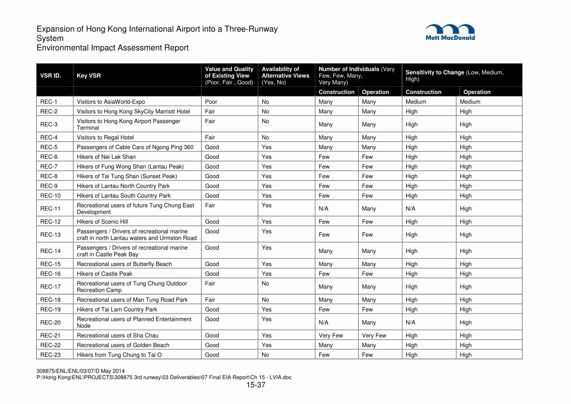
308875/ENL/ENL/03/07/D May 2014 P:\Hong Kong\ENL\PROJECTS\308875 3rd runway\03 Deliverables\07 Final EIA Report\Ch 15 - LVIA.doc
15-37
Expansion of Hong Kong International Airport into a Three-Runway System Environmental Impact Assessment Report
VSR ID. Key VSR Value and Quality of Existing View (Poor, Fair , Good)
Availability of Alternative Views (Yes, No)
Number of Individuals (Very Few, Few, Many, Very Many)
Sensitivity to Change (Low, Medium, High)
Construction Operation Construction Operation
REC-1 Visitors to AsiaWorld-Expo Poor No Many Many Medium Medium
REC-2 Visitors to Hong Kong SkyCity Marriott Hotel Fair No Many Many High High
REC-3 Visitors to Hong Kong Airport Passenger Terminal
Fair No Many Many High High
REC-4 Visitors to Regal Hotel Fair No Many Many High High
REC-5 Passengers of Cable Cars of Ngong Ping 360 Good Yes Many Many High High
REC-6 Hikers of Nei Lak Shan Good Yes Few Few High High
REC-7 Hikers of Fung Wong Shan (Lantau Peak) Good Yes Few Few High High
REC-8 Hikers of Tai Tung Shan (Sunset Peak) Good Yes Few Few High High
REC-9 Hikers of Lantau North Country Park Good Yes Few Few High High
REC-10 Hikers of Lantau South Country Park Good Yes Few Few High High
REC-11 Recreational users of future Tung Chung East Development
Fair Yes N/A Many N/A High
REC-12 Hikers of Scenic Hill Good Yes Few Few High High
REC-13 Passengers / Drivers of recreational marine craft in north Lantau waters and Urmston Road
Good Yes Few Few High High
REC-14 Passengers / Drivers of recreational marine craft in Castle Peak Bay
Good Yes Many Many High High
REC-15 Recreational users of Butterfly Beach Good Yes Many Many High High
REC-16 Hikers of Castle Peak Good Yes Few Few High High
REC-17 Recreational users of Tung Chung Outdoor Recreation Camp
Fair No Many Many High High
REC-18 Recreational users of Man Tung Road Park Fair No Many Many High High
REC-19 Hikers of Tai Lam Country Park Good Yes Few Few High High
REC-20 Recreational users of Planned Entertainment Node
Good Yes N/A Many N/A High
REC-21 Recreational users of Sha Chau Good Yes Very Few Very Few High High
REC-22 Recreational users of Golden Beach Good Yes Many Many High High
REC-23 Hikers from Tung Chung to Tai O Good No Few Few High High

308875/ENL/ENL/03/07/D May 2014 P:\Hong Kong\ENL\PROJECTS\308875 3rd runway\03 Deliverables\07 Final EIA Report\Ch 15 - LVIA.doc
15-38
Expansion of Hong Kong International Airport into a Three-Runway System Environmental Impact Assessment Report
VSR ID. Key VSR Value and Quality of Existing View (Poor, Fair , Good)
Availability of Alternative Views (Yes, No)
Number of Individuals (Very Few, Few, Many, Very Many)
Sensitivity to Change (Low, Medium, High)
Construction Operation Construction Operation
REC-24 Visitors to Tai Ho Good No Few Few High High
REC-25 Visitors to proposed NCD hotels and commercial facilities
Fair Yes N/A Many N/A High
REC-26 Recreational users of future Tung Chung West Development
Fair Yes N/A Many N/A High
REC-27 Users of Proposed Columbarium Developments for Tsuen Wan
Good Yes Very Few Very Few Low Low
Travelling VSRs
T-1 Passengers / Drivers of Vehicles and MTR along North Lantau Highway
Good No Very Many Very Many Medium Medium
T-2 Passengers / Drivers of Vehicles and MTR along Cheong Wing Road
Good Yes Very Many Very Many Medium Medium
T-3 Passengers of commercial aircraft Good Yes Very Many Very Many Medium Medium
T-4 Passengers / Drivers of the proposed Tuen Mun-Chek Lap Kok Link (TMCLKL)
Good Yes Very Many Very Many Medium Medium
T-5 Passengers / Drivers of the proposed Hong Kong Link Road HKLR
Good Yes Very Many Very Many Medium Medium
T-6 Passengers of Ferry’s in north Lantau waters and Urmston Road
Good Yes Many Many Medium Medium
T-7 Passengers / Drivers of Vehicles along castle peak road and Tuen Mun Road
Good Yes Very Many Very Many Medium Medium
T-8 Passengers / Drivers of Vehicles along Lung Mun Road
Good Yes Many Many Medium Medium
T-9 Passengers / Drivers of Vehicles at planned Hong Kong Boundary Crossing Facilities
Good No Very Many Very Many Medium Medium
T-10 Passengers / Drivers of vehicles along Tung Chung road
Good Yes Many Many Medium Medium
T-11 Ferry Passengers from Tung Chung to Tai O Good Yes Few Few Medium Medium
T-12 Ferry Passengers at Public Pier in Tung Chung Fair No Many Many Medium Medium
T-13 Ferry Passengers at Public Pier in Tuen Mun Good Yes Many Many Medium Medium
Occupational VSRs
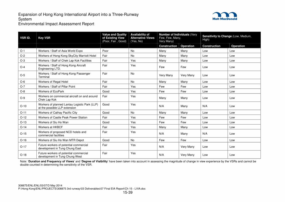
308875/ENL/ENL/03/07/D May 2014 P:\Hong Kong\ENL\PROJECTS\308875 3rd runway\03 Deliverables\07 Final EIA Report\Ch 15 - LVIA.doc
15-39
Expansion of Hong Kong International Airport into a Three-Runway System Environmental Impact Assessment Report
VSR ID. Key VSR Value and Quality of Existing View (Poor, Fair , Good)
Availability of Alternative Views (Yes, No)
Number of Individuals (Very Few, Few, Many, Very Many)
Sensitivity to Change (Low, Medium, High)
Construction Operation Construction Operation
O-1 Workers / Staff of Asia World Expo Poor No Many Many Low Low
O-2 Workers of Hong Kong SkyCity Marriott Hotel Fair No Many Many Low Low
O-3 Workers / Staff of Chek Lap Kok Facilities Fair Yes Many Many Low Low
O-4 Workers / Staff of Hong Kong Aircraft Engineering LTD.
Fair Yes Few Few Low Low
O-5 Workers / Staff of Hong Kong Passenger Terminal
Fair No Very Many Very Many Low Low
O-6 Workers of Regal Hotel Fair No Many Many Low Low
O-7 Workers / Staff of Pillar Point Fair Yes Few Few Low Low
O-8 Workers of EcoPark Good Yes Few Few Low Low
O-9 Workers on commercial aircraft on and around Chek Lap Kok
Fair Yes Many Many Low Low
O-10 Workers of planned Lantau Logistic Park (LLP) at the possible LLP extension
Good Yes N/A Many N/A Low
O-11 Workers of Cathay Pacific City Good No Many Many Low Low
O-12 Workers of Castle Peak Power Station Fair Yes Few Few Low Low
O-13 Workers of Siu Ho Wan Good Yes Few Few Low Low
O-14 Workers at HKBCF Fair Yes Many Many Low Low
O-15 Workers of proposed NCD hotels and commercial facilities
Fair Yes N/A Many N/A Low
O-16 Workers of Siu Ho Wan MTR Depot Good No Few Few Low Low
O-17 Future workers of potential commercial development in Tung Chung East
Fair Yes N/A Very Many Low Low
O-18 Future workers of potential commercial development in Tung Chung West
Fair Yes N/A Very Many Low Low
Note: ‘Duration and Frequency of Views’ and ‘Degree of Visibility’ have been taken into account in assessing the magnitude of change in view experience by the VSRs and cannot be double counted in determining the sensitivity of the VSR.

308875/ENL/ENL/03/07/D May 2014 P:\Hong Kong\ENL\PROJECTS\308875 3rd runway\03 Deliverables\07 Final EIA Report\Ch 15 - LVIA.doc
15-40
Expansion of Hong Kong International Airport into a Three-Runway System Environmental Impact Assessment Report
15.6 Landscape Impact Assessment
15.6.1 Potential Sources of Impacts
15.6.1.1 The nature and scope of the works has been described in Section 15.3 and indicated in Drawing
MCL/P132/EIA/15-001.1 and MCL/P132/EIA/15-001.2.
15.6.1.2 The 3RS would create varying levels of landscape and visual impacts on the surrounding areas
during the construction phase. Potential impacts would result from the following sources:
� Construction of proposed land formation and exposed fill and sediment;
� Site clearance works involving the removal of existing vegetation;
� Construction of temporary site access;
� Haulage off-site of excavated materials;
� Storage of existing topsoil for reinstatement works;
� Materials stockpiling;
� Dust and construction debris;
� Laying of 11 kV submarine cable;
� Daylighting point of submarine fuel pipeline;
� Construction of on-site offices and working areas;
� Construction of T2 expansion;
� Construction of airport infrastructure (landside roads, airside perimeter roads, airside tunnels
and APM / BHS and associated tunnel ventilation buildings);
� Construction of associated airport buildings;
� Construction of new passenger concourse;
� Construction of temporary parking areas;
� Expansion of the Midfield freighter apron on the existing airport island;
� Loss of vegetation;
� Temporary road works and traffic management;
� Construction night lighting;
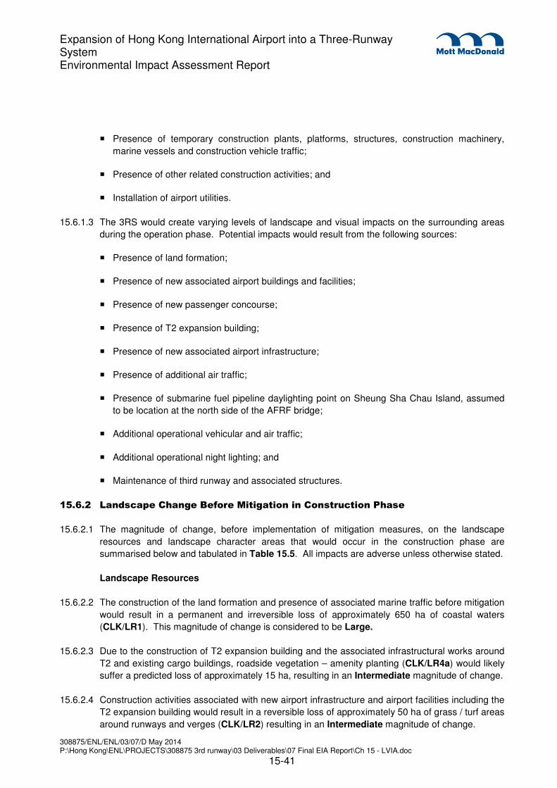
308875/ENL/ENL/03/07/D May 2014 P:\Hong Kong\ENL\PROJECTS\308875 3rd runway\03 Deliverables\07 Final EIA Report\Ch 15 - LVIA.doc
15-41
Expansion of Hong Kong International Airport into a Three-Runway System Environmental Impact Assessment Report
� Presence of temporary construction plants, platforms, structures, construction machinery,
marine vessels and construction vehicle traffic;
� Presence of other related construction activities; and
� Installation of airport utilities.
15.6.1.3 The 3RS would create varying levels of landscape and visual impacts on the surrounding areas
during the operation phase. Potential impacts would result from the following sources:
� Presence of land formation;
� Presence of new associated airport buildings and facilities;
� Presence of new passenger concourse;
� Presence of T2 expansion building;
� Presence of new associated airport infrastructure;
� Presence of additional air traffic;
� Presence of submarine fuel pipeline daylighting point on Sheung Sha Chau Island, assumed
to be location at the north side of the AFRF bridge;
� Additional operational vehicular and air traffic;
� Additional operational night lighting; and
� Maintenance of third runway and associated structures.
15.6.2 Landscape Change Before Mitigation in Construction Phase
15.6.2.1 The magnitude of change, before implementation of mitigation measures, on the landscape
resources and landscape character areas that would occur in the construction phase are
summarised below and tabulated in Table 15.5. All impacts are adverse unless otherwise stated.
Landscape Resources
15.6.2.2 The construction of the land formation and presence of associated marine traffic before mitigation
would result in a permanent and irreversible loss of approximately 650 ha of coastal waters
(CLK/LR1). This magnitude of change is considered to be Large.
15.6.2.3 Due to the construction of T2 expansion building and the associated infrastructural works around
T2 and existing cargo buildings, roadside vegetation – amenity planting (CLK/LR4a) would likely
suffer a predicted loss of approximately 15 ha, resulting in an Intermediate magnitude of change.
15.6.2.4 Construction activities associated with new airport infrastructure and airport facilities including the
T2 expansion building would result in a reversible loss of approximately 50 ha of grass / turf areas
around runways and verges (CLK/LR2) resulting in an Intermediate magnitude of change.

308875/ENL/ENL/03/07/D May 2014 P:\Hong Kong\ENL\PROJECTS\308875 3rd runway\03 Deliverables\07 Final EIA Report\Ch 15 - LVIA.doc
15-42
Expansion of Hong Kong International Airport into a Three-Runway System Environmental Impact Assessment Report
15.6.2.5 Site clearance and temporary site access to the land formation would result in a reversible loss of
roadside vegetation on modified slopes (CLK/LR4b) of approximately 0.2 ha resulting in a
magnitude of change considered Small.
15.6.2.6 Grassland / scrub on vacant land (CLK/LR12), would suffer a permanent loss of approximately
6 ha of its resource due to expansion of T2 and construction of the associated infrastructure
resulting in a magnitude of change considered to be Small.
15.6.2.7 Artificial / Man-made Coastline (CLK/LR13), would suffer a permanent loss of approximately
6,000 linear meters of its resource due to the construction of the proposed land formation for the
proposed third runway resulting in a magnitude of change considered to be Small.
15.6.2.8 The construction activities associated with the submarine fuel pipelines would impact both natural
rocky coastline of Sha Chau islands (SC/LR1) and natural vegetation on Sha Chau islands
(SC/LR2). The daylighting point of the submarine fuel pipelines would result in a permanent and
irreversible loss of approximately 30 m of natural rocky coastline and a reversible loss of
approximately 0.05 ha of natural vegetation resulting in a magnitude of change considered to be
Small.
15.6.2.9 Site clearance and temporary site access to the land formation would result in a reversible loss of
landscape areas around buildings (CLK/LR3) of approximately 0.1 ha resulting in a magnitude of
change considered Negligible.
15.6.2.10 It is anticipated that the LRs that have not been described above will experience a magnitude of
change considered as None as they will not be affected by the 3RS and the associated sources
of impact and thus will experience no change.
Landscape Character Areas
15.6.2.11 The construction of the land formation and presence of associated marine traffic before mitigation
would result in a permanent and irreversible loss of approximately 650 ha of inshore water
landscape (CLK/LCA2), with wide visibility of associated marine construction vessels. The
magnitude of change is considered to be Large.
15.6.2.12 The On-going Major Development Landscape (CLK/LCA8) would experience a magnitude of
change of Small due to the expansion of T2 and construction of the associated airport
infrastructure.
15.6.2.13 Construction activities associated with the new airport infrastructure and airport facilities including
the T2 expansion building would impact the existing airport landscape (CLK/LCA1) with a
magnitude of change considered to be Small.
15.6.2.14 The construction activities associated with the submarine fuel pipelines would impact both island
landscape (SC/LCA1) and Sha Chau islands inshore water landscape (SC/LCA2). The
daylighting point of the submarine fuel pipelines in the area of the Sha Chau islands would result
in an irreversible loss of approximately 30 m of natural rocky coastline affecting the island
landscape. An increase in marine traffic within the Sha Chau islands inshore water landscape
during construction would also impact the inshore water landscape (SC/LCA2). Both LCA’s would
suffer a magnitude of change considered Small.
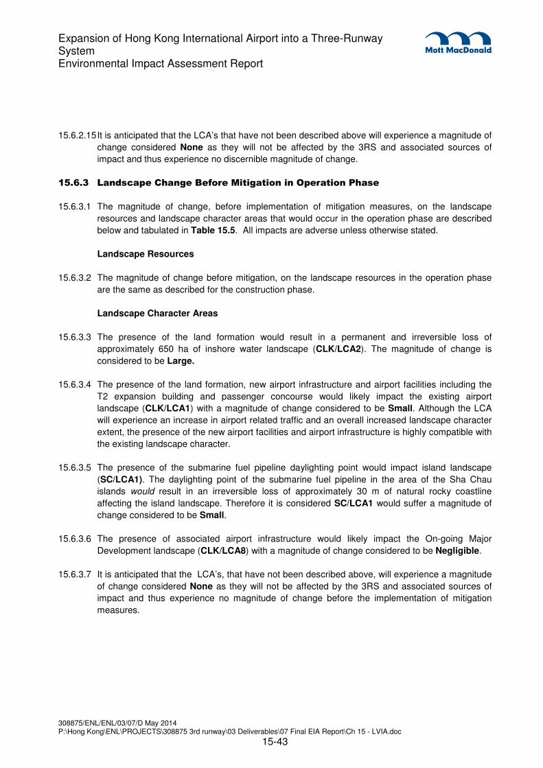
308875/ENL/ENL/03/07/D May 2014 P:\Hong Kong\ENL\PROJECTS\308875 3rd runway\03 Deliverables\07 Final EIA Report\Ch 15 - LVIA.doc
15-43
Expansion of Hong Kong International Airport into a Three-Runway System Environmental Impact Assessment Report
15.6.2.15 It is anticipated that the LCA’s that have not been described above will experience a magnitude of
change considered None as they will not be affected by the 3RS and associated sources of
impact and thus experience no discernible magnitude of change.
15.6.3 Landscape Change Before Mitigation in Operation Phase
15.6.3.1 The magnitude of change, before implementation of mitigation measures, on the landscape
resources and landscape character areas that would occur in the operation phase are described
below and tabulated in Table 15.5. All impacts are adverse unless otherwise stated.
Landscape Resources
15.6.3.2 The magnitude of change before mitigation, on the landscape resources in the operation phase
are the same as described for the construction phase.
Landscape Character Areas
15.6.3.3 The presence of the land formation would result in a permanent and irreversible loss of
approximately 650 ha of inshore water landscape (CLK/LCA2). The magnitude of change is
considered to be Large.
15.6.3.4 The presence of the land formation, new airport infrastructure and airport facilities including the
T2 expansion building and passenger concourse would likely impact the existing airport
landscape (CLK/LCA1) with a magnitude of change considered to be Small. Although the LCA
will experience an increase in airport related traffic and an overall increased landscape character
extent, the presence of the new airport facilities and airport infrastructure is highly compatible with
the existing landscape character.
15.6.3.5 The presence of the submarine fuel pipeline daylighting point would impact island landscape
(SC/LCA1). The daylighting point of the submarine fuel pipeline in the area of the Sha Chau
islands would result in an irreversible loss of approximately 30 m of natural rocky coastline
affecting the island landscape. Therefore it is considered SC/LCA1 would suffer a magnitude of
change considered to be Small.
15.6.3.6 The presence of associated airport infrastructure would likely impact the On-going Major
Development landscape (CLK/LCA8) with a magnitude of change considered to be Negligible.
15.6.3.7 It is anticipated that the LCA’s, that have not been described above, will experience a magnitude
of change considered None as they will not be affected by the 3RS and associated sources of
impact and thus experience no magnitude of change before the implementation of mitigation
measures.

308875/ENL/ENL/03/07/D May 2014 P:\Hong Kong\ENL\PROJECTS\308875 3rd runway\03 Deliverables\07 Final EIA Report\Ch 15 - LVIA.doc
15-44
Expansion of Hong Kong International Airport into a Three-Runway System Environmental Impact Assessment Report
Table 15.5: Magnitude of Landscape Change during the Construction and Operation Phases before Mitigation
ID No. Landscape Resources/ Landscape Character Areas
Source of Impact Description of Impacts Magnitude of Change before Mitigation
CLK/LR1
Coastal waters of North Lantau
Construction
- Construction of proposed land formation and exposed fill and sediment
- Presence of temporary construction plants, platforms, structures, construction machinery, marine vessels and construction vehicle traffic
- Laying of 11 kV submarine cable
- Daylighting point of submarine fuel pipeline
- Dust and construction debris
Construction
- Loss of approximately 650 ha of coastal waters
- Baseline area is entire north Lantau waters
- Increased marine traffic
Large
Operation
- Presence of land formation
Operation
- Same as described for construction phase
Large
CLK/LR2
Grass/turf areas around runways and verges
Construction
- Construction of proposed land formation and exposed fill and sediment
- Storage of existing topsoil for reinstatement works
- Materials stockpiling
- Daylighting point of submarine fuel pipeline
- Presence of temporary construction plants, platforms, structures, construction machinery, marine vessels and construction vehicle traffic
- Site clearance works involving the removal of existing vegetation
- Construction of temporary site access
- Dust and construction debris
- Construction of on-site offices and working areas
- Construction of airport infrastructure (landside roads, airside perimeter roads and airside tunnels)
- Construction of associated airport buildings
Construction
- Loss of approximately 50 ha of Grass / turf areas around runways and verges
- Baseline vegetation coverage is 260 ha
Intermediate
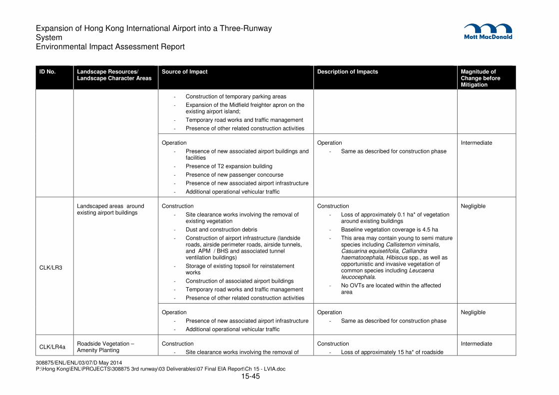
308875/ENL/ENL/03/07/D May 2014 P:\Hong Kong\ENL\PROJECTS\308875 3rd runway\03 Deliverables\07 Final EIA Report\Ch 15 - LVIA.doc
15-45
Expansion of Hong Kong International Airport into a Three-Runway System Environmental Impact Assessment Report
ID No. Landscape Resources/ Landscape Character Areas
Source of Impact Description of Impacts Magnitude of Change before Mitigation
- Construction of temporary parking areas
- Expansion of the Midfield freighter apron on the existing airport island;
- Temporary road works and traffic management
- Presence of other related construction activities
Operation
- Presence of new associated airport buildings and facilities
- Presence of T2 expansion building
- Presence of new passenger concourse
- Presence of new associated airport infrastructure
- Additional operational vehicular traffic
Operation
- Same as described for construction phase
Intermediate
CLK/LR3
Landscaped areas around existing airport buildings
Construction
- Site clearance works involving the removal of existing vegetation
- Dust and construction debris
- Construction of airport infrastructure (landside roads, airside perimeter roads, airside tunnels, and APM / BHS and associated tunnel ventilation buildings)
- Storage of existing topsoil for reinstatement works
- Construction of associated airport buildings
- Temporary road works and traffic management
- Presence of other related construction activities
Construction
- Loss of approximately 0.1 ha* of vegetation around existing buildings
- Baseline vegetation coverage is 4.5 ha
- This area may contain young to semi mature species including Callistemon viminalis, Casuarina equisetifolia, Calliandra haematocephala, Hibiscus spp., as well as opportunistic and invasive vegetation of common species including Leucaena leucocephala.
- No OVTs are located within the affected area
Negligible
Operation
- Presence of new associated airport infrastructure
- Additional operational vehicular traffic
Operation
- Same as described for construction phase
Negligible
CLK/LR4a Roadside Vegetation – Amenity Planting
Construction
- Site clearance works involving the removal of
Construction
- Loss of approximately 15 ha* of roadside
Intermediate

308875/ENL/ENL/03/07/D May 2014 P:\Hong Kong\ENL\PROJECTS\308875 3rd runway\03 Deliverables\07 Final EIA Report\Ch 15 - LVIA.doc
15-46
Expansion of Hong Kong International Airport into a Three-Runway System Environmental Impact Assessment Report
ID No. Landscape Resources/ Landscape Character Areas
Source of Impact Description of Impacts Magnitude of Change before Mitigation
existing vegetation
- Construction of temporary site access
- Dust and construction debris
- Construction of on-site office and working areas
- Construction of airport infrastructure (landside roads, airside perimeter roads, airside tunnels, and APM / BHS and associated tunnel ventilation buildings)
- Construction of associated airport buildings
- Construction of temporary parking areas
- Storage of existing topsoil for reinstatement works
- Temporary road works and traffic management
- Presence of other related construction activities
vegetation
- Baseline vegetation coverage is 53 ha
- Species anticipated to be affected include semi mature to mature Acacia auriculiformis Albizia lebbeck, Casuarina equisetifolia
- Young to mature: Acacia confusa, Acacia mangium, and Hibiscus tiliaceus
- Young to semi mature: Bauhinia purpurea, Cassia siamea, Dalbergia odorifera, Ficus benjamina, Ficus microcarpa, Grevillea robusta,and the invasive species Leucaena leucocephala
- Young: Delonix regia, Lagerstroemia speciosa, and Litsea glutinosa
- Semi mature: Macaranga tanarius, Melia azedarach, Phoenix roebelenii, Plumeria rubra, and Roystonea regia
- No OVTs are located within the affected area
Operation
- Presence of new associated airport buildings and facilities
- Presence of T2 expansion building
- Presence of new associated airport infrastructure
- Additional operational vehicular traffic
Operation
- Same as described for construction phase
Intermediate
CLK/LR4b
Roadside vegetation on modified slopes
Construction
- Site clearance works involving the removal of existing vegetation
- Construction of temporary site access
- Dust and construction debris
- Construction of airport infrastructure (landside roads, airside perimeter roads, airside tunnels, and APM / BHS and associated tunnel
Construction
- Loss of approximately 0.2 ha* of roadside vegetation on modified slopes
- Baseline vegetation coverage is 5 ha
- Vegetation anticipated to be affected predominantly includes a stand of semi mature Pinus elliottii trees and Leucaena leucocephala which occurs extensively along
Small

308875/ENL/ENL/03/07/D May 2014 P:\Hong Kong\ENL\PROJECTS\308875 3rd runway\03 Deliverables\07 Final EIA Report\Ch 15 - LVIA.doc
15-47
Expansion of Hong Kong International Airport into a Three-Runway System Environmental Impact Assessment Report
ID No. Landscape Resources/ Landscape Character Areas
Source of Impact Description of Impacts Magnitude of Change before Mitigation
ventilation buildings)
- Construction of associated airport buildings
- Storage of existing topsoil for reinstatement works
- Temporary road works and traffic management
- Presence of other related construction activities
this edge and is an invasive introduced species.
- No OVTs are located within the affected area
Operation
- Presence of new associated airport infrastructure
- Additional operational vehicular traffic
Operation
- Same as described for construction phase
Small
CLK/LR5 Natural coastline None None None
CLK/LR6 Amenity / Compensatory planting on HKBCF / HKLR
None None None
CLK/LR7 Streams None None None
CLK/LR8 Agricultural land None None None
CLK/LR9 Natural rocky and sandy shore with mangrove / mudflat
None None None
CLK/LR10a Coastal woodland and scrubland on North Lantau
None None None
CLK/LR10b Coastal woodland and scrubland on Scenic Hill
None None None
CLK/LR11 Amenity planting in urban park None None None
CLK/LR12 Grassland / scrub on vacant land
Construction
- Site clearance works involving the removal of existing vegetation
- Construction of temporary site access
- Dust and construction debris
Construction
- Loss of approximately 6 ha* of grassland / scrub on vacant land
- Baseline vegetation coverage is 130 ha
- Anticipated species of various stages of maturity to be impacted include Lantana
Small

308875/ENL/ENL/03/07/D May 2014 P:\Hong Kong\ENL\PROJECTS\308875 3rd runway\03 Deliverables\07 Final EIA Report\Ch 15 - LVIA.doc
15-48
Expansion of Hong Kong International Airport into a Three-Runway System Environmental Impact Assessment Report
ID No. Landscape Resources/ Landscape Character Areas
Source of Impact Description of Impacts Magnitude of Change before Mitigation
- Construction of airport infrastructure (landside roads, airside perimeter roads, airside tunnels, and APM / BHS and associated tunnel ventilation buildings)
- Temporary road works and traffic management
- Presence of other related construction activities
camara, Leucaena leucocephala, Roystonea regia, Chrysalidocarpus lutescens, Wedelia trilobata, Chloris spp., Melinis spp., and Cerbera manghas.
- These are areas supporting opportunistic and self-seeded vegetation comprising of common or invasive species
- No OVTs are located within the affected area
Operation
- Presence of new associated airport infrastructure
- Additional operational vehicular traffic
Operation
- Same as described for construction phase
Small
CLK/LR13
Artificial / man-made coastline
Construction
- Construction of proposed land formation and exposed fill and sediment
- Site clearance works involving the removal of existing vegetation
- Construction of temporary site access
- Haulage off-site of excavated materials
- Laying of 11 kV submarine cable
- Construction of airport infrastructure (landside roads, airside perimeter roads, airside tunnels, and APM / BHS and associated tunnel ventilation buildings)
- Presence of temporary construction plants, structures, construction machinery, marine vessels and construction vehicle traffic
- Presence of other related construction activities
- Installation of airport utilities
Construction
- Loss of approximately 6,000 m of artificial / man-made coastline
- Baseline artificial / man-made coastline is 17,000 m
Small
Operation
- Presence of land formation
- Presence of new associated airport infrastructure
Operation
Same as described for construction phase
Small

308875/ENL/ENL/03/07/D May 2014 P:\Hong Kong\ENL\PROJECTS\308875 3rd runway\03 Deliverables\07 Final EIA Report\Ch 15 - LVIA.doc
15-49
Expansion of Hong Kong International Airport into a Three-Runway System Environmental Impact Assessment Report
ID No. Landscape Resources/ Landscape Character Areas
Source of Impact Description of Impacts Magnitude of Change before Mitigation
SC/LR1
Natural rocky coastline of Sha Chau islands
Construction
- Daylighting point of submarine fuel pipeline
- Dust and construction debris
- Construction of temporary site access
- Presence of other related construction activities
Construction
- Loss of approximately 30 m* of natural rocky coastline
- Baseline natural rocky coastline is 1,250 linear metres
Small
Operation
- Presence of submarine fuel pipeline daylighting point
Operation
- Same as described for construction phase
Small
SC/LR2
Natural vegetation on Sha Chau islands
Construction
- Site clearance works involving the removal of existing vegetation
- Daylighting point of submarine fuel pipeline
- Dust and construction debris
- Presence of other related construction activities
Construction
- Loss of approximately 0.05 ha* of natural vegetation
- Baseline vegetation coverage is 10 ha
- Anticipated species of various stages of maturity to be impacted include Hibiscus tiliaceus, Phoenix hanceana, Scaevola taccada, Pandanus tectorius, Ficus superba var. japonica, Wedelia chinensis, Gordonia axillaris, Schefflera heptaphylla, Dicranopteris linearis, Litsea glutinosa, Lantana camara, Casuarina equisetifolia, Bridelia tomentosa, Terminalia catappa, Cerbera manghas, Rhaphiolepis indica, Cassytha filiformis, and Alpinia zerumbet. These are of common species found on Hong Kong’s existing island habitats
- No OVTs are located within the affected area
Small
Operation
- Presence of submarine fuel pipeline daylighting point;
- Loss of vegetation
Operation
- Same as described for construction phase
Small

308875/ENL/ENL/03/07/D May 2014 P:\Hong Kong\ENL\PROJECTS\308875 3rd runway\03 Deliverables\07 Final EIA Report\Ch 15 - LVIA.doc
15-50
Expansion of Hong Kong International Airport into a Three-Runway System Environmental Impact Assessment Report
ID No. Landscape Resources/ Landscape Character Areas
Source of Impact Description of Impacts Magnitude of Change before Mitigation
SC/LR3 Coastal waters of Sha Chau islands
None None None
SC/LR4 Natural sandy coastline of Sha Chau Island
None None None
CLK/LCA1 Airport landscape
Construction
- Site clearance works involving the removal of existing vegetation
- Construction of temporary site access
- Haulage off-site of excavated materials
- Storage of existing topsoil for reinstatement works
- Materials stockpiling
- Dust and construction debris
- Construction of on site office and working areas
- Construction of T2 expansion
- Construction of new passenger concourse
- Construction of airport infrastructure (landside roads, airside perimeter roads, airside tunnels, and APM / BHS and associated tunnel ventilation buildings)
- Construction of associated airport buildings
- Construction of temporary parking areas
- Expansion of the Midfield freighter apron on the existing airport island;
- Temporary road works and traffic management
- Construction night lighting
- Presence of temporary construction plants, structures, construction machinery, marine vessels and construction vehicle traffic
- Presence of other related construction activities
- Installation of airport utilities
Construction
- Presence of construction works and associated machinery and equipment will change visual amenity
Small

308875/ENL/ENL/03/07/D May 2014 P:\Hong Kong\ENL\PROJECTS\308875 3rd runway\03 Deliverables\07 Final EIA Report\Ch 15 - LVIA.doc
15-51
Expansion of Hong Kong International Airport into a Three-Runway System Environmental Impact Assessment Report
ID No. Landscape Resources/ Landscape Character Areas
Source of Impact Description of Impacts Magnitude of Change before Mitigation
Operation
- Presence of land formation
- Presence of new associated airport buildings and facilities
- Presence of new passenger concourse
- Presence of T2 expansion building
- Additional operational night lighting
- Maintenance of third runway and associated structures
- Presence of new associated airport infrastructure
Operation
- Increase area of landscape character
- Increase in airport related traffic
Small
CLK/LCA2 Inshore water landscape
Construction
- Construction of proposed land formation and exposed fill and sediment
- Presence of marine traffic, including but not limited to construction vessels, barges, plants
- Dust and construction debris
- Laying of 11 kV submarine cable
- Construction night lighting
- Presence of other related construction activities
Construction
- Loss of approximately 650 ha of coastal water
- Baseline coastal waters is approximately 2,080 ha of the entire north Lantau coastal waters
- Increased marine traffic
- Presence of marine construction machinery
Large
Operation
- Presence of land formation
Operation
- Loss of 650 ha of coastal waters
- Even without construction activity, presence of large land formation will change landscape character
Large
CLK/LCA3 Strait landscape None None None
CLK/LCA4A Coastal upland and hillside landscape – Sha Lo Wan
None None None
CLK/LCA4B Coastal upland and hillside landscape – Scenic Hill
None None None

308875/ENL/ENL/03/07/D May 2014 P:\Hong Kong\ENL\PROJECTS\308875 3rd runway\03 Deliverables\07 Final EIA Report\Ch 15 - LVIA.doc
15-52
Expansion of Hong Kong International Airport into a Three-Runway System Environmental Impact Assessment Report
ID No. Landscape Resources/ Landscape Character Areas
Source of Impact Description of Impacts Magnitude of Change before Mitigation
CLK/LCA5 Mixed modern comprehensive development landscape
None None None
CLK/LCA6 Rural coastal plain landscape None None None
CLK/LCA7 Transportation corridor landscape
None None None
CLK/LCA8 On-going Major Development Landscape
Construction
- Construction of temporary site access
- Dust and construction debris
- Construction of airport infrastructure (landside roads, airside perimeter roads, airside tunnels, and APM / BHS and associated tunnel ventilation buildings)
- Construction of on-site office and working areas
- Temporary road works and traffic management
- Presence of other related construction activities
Construction
- Presence of construction equipment and machinery
Small
Operation
- Presence of new associated airport infrastructure
- Additional operational vehicular traffic
Operation
- Presence of new associated airport infrastructure
Negligible
SC/LCA1 Island landscape
Construction
- Daylighting point of submarine fuel pipeline
- Construction of temporary site access
- Presence of temporary construction plants, platforms, structures, construction machinery, marine vessels and construction vehicle traffic
- Site clearance works involving the removal of existing vegetation
Construction
- Loss of approximately 0.05 ha* of natural vegetation
- Baseline vegetation coverage is 10 ha
- Loss of approximately 30 m* of natural coastline
- Baseline natural rocky coastline is 1,250 linear metres
Small
Operation
- Presence of submarine fuel pipeline daylighting point
Operation
- Loss of vegetation and natural coastline
- Presence of submarine fuel pipeline
Small

308875/ENL/ENL/03/07/D May 2014 P:\Hong Kong\ENL\PROJECTS\308875 3rd runway\03 Deliverables\07 Final EIA Report\Ch 15 - LVIA.doc
15-53
Expansion of Hong Kong International Airport into a Three-Runway System Environmental Impact Assessment Report
ID No. Landscape Resources/ Landscape Character Areas
Source of Impact Description of Impacts Magnitude of Change before Mitigation
- Loss of vegetation daylighting point
SC/LCA2
Sha Chau islands inshore water landscape
Construction
- Presence of marine traffic, including but not limited to construction vessels, barges.
- Presence of temporary construction plants, platforms, structures, construction machinery, marine vessels and construction vehicle traffic
- Dust and construction debris
Construction
- Presence of marine traffic, including but not limited to construction vessels, barges, plant will change landscape character
Small
Operation
- None
Operation
None
None
* Assumptions have been made due to lack of detailed design information at this stage

308875/ENL/ENL/03/07/D May 2014 P:\Hong Kong\ENL\PROJECTS\308875 3rd runway\03 Deliverables\07 Final EIA Report\Ch 15 - LVIA.doc
15-54
Expansion of Hong Kong International Airport into a Three-Runway System Environmental Impact Assessment Report
15.6.4 Landscape & Visual Mitigation Measures
Review of Planning Principles and Architectural Design
15.6.4.1 The development of the 3RS reflects the need for a third runway as outlined in the Hong Kong
International Airport Master Plan 2030 (MP2030). The master plan states that in terms of the
alignment of the third runway, the National Air Traffic Services (NATS) has investigated a total of
15 alignment options with regard to operational safety, obstacle clearances, environmental
issues, Pearl River Delta airspace issues, air traffic control procedures, runway usability and
capacity. NATS concluded that the best alignment for a third runway would be parallel to and
north of the existing two runways. Eighteen airport layout options were evaluated against the
following five major criteria (a) airfield efficiency; (b) passenger convenience; (c) cargo operations
efficiency;(d) surface access; and (e) environmental impact. The final recommended airport
layout featured in the MP2030 is a northward expansion of the airport facility.
15.6.4.2 The third runway concourse (TRC) is based upon the aspects of the design and planning of the
existing T1. The TRC responds to the MP2030 studies and traffic forecasts. The TRC objectives
also include the enhancement of passenger experience and their expectations of a world class
airport, maximisation of commercial opportunities for revenue generation and safeguards future
growth potentials, has a terminal-like facility that is safe, secure, user-friendly, energy efficient,
easy to maintain and cost, creates a unique sense of place and is iconic for Hong Kong and a
building which is architecturally outstanding. Architecturally, the geometry of the roof is based on
a sphere which creates an “undulating” effect inside the TRC concourse from the east to the west
with a constant curvature visually in all directions. There are two types of façade under
consideration that correspond to functional, architectural and performance needs. The first type
includes the glazed façade areas which are mostly seen on arrivals, departures and mezzanine
levels. Glazed areas in these levels can enhance passenger’s experience and improve daylight
performance. The second type includes the solid areas which are mostly seen on apron level
where functions such as ramp accommodation and plant rooms are developed.
15.6.4.3 The objectives of the T2 expansion are to respond to the MP2030 studies and traffic forecasts by
providing an airport terminal that facilitates a simple, direct and efficient flow for air passengers
and baggage. The architectural theme for the expanded T2 building is based on a feather
concept with a design to provide not only an elegant reference point, but also provides a way of
unitising the roof into east / west orientated strips that breaks down both the sale of the roof plane
and provides a strong directional orientation. The intended effect will create a series of light
‘feathers’ gently resting on a series of supports.
15.6.4.4 The architectural design measures described above are intended to enhance the visual quality of
the new development. These shall be adopted during the detailed design, and will be built as part
of the construction works so that they are in place at the date of commissioning of the 3RS.
15.6.4.5 Minimisation of the land formation footprint has been adopted during the planning and design
stage of the 3RS.
15.6.4.6 Although stripping and storing of topsoil during the construction phase is not listed as a mitigation
measure, it is considered good site practice and should be implemented where practical.
15.6.4.7 In addition, a number of landscape and visual mitigation measures are identified below to further
mitigate adverse impacts and enhance beneficial impacts.
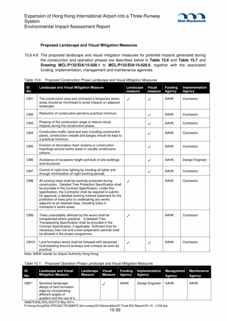
308875/ENL/ENL/03/07/D May 2014 P:\Hong Kong\ENL\PROJECTS\308875 3rd runway\03 Deliverables\07 Final EIA Report\Ch 15 - LVIA.doc
15-55
Expansion of Hong Kong International Airport into a Three-Runway System Environmental Impact Assessment Report
Proposed Landscape and Visual Mitigation Measures
15.6.4.8 The proposed landscape and visual mitigation measures for potential impacts generated during
the construction and operation phases are described below in Table 15.6 and Table 15.7 and
Drawing MCL/P132/EIA/15-028.1 to MCL/P132/EIA/15-028.6, together with the associated
funding, implementation, management and maintenance agencies.
Table 15.6: Proposed Construction Phase Landscape and Visual Mitigation Measures
Note: AAHK stands for Airport Authority Hong Kong
Table 15.7: Proposed Operation Phase Landscape and Visual Mitigation Measures
ID
No.
Landscape and Visual Mitigation Measure
Landscape Measure
Visual Measure
Funding Agency
Implementation Agency
Management
Agency
Maintenance
Agency
OM1* Sensitive landscape design of land formation edge by incorporating different angles of gradient and the use of a
✓ AAHK Design Engineer AAHK AAHK
ID No.
Landscape and Visual Mitigation Measure Landscape measure
Visual measure
Funding Agency
Implementation Agency
CM1 The construction area and contractor’s temporary works areas should be minimised to avoid impacts on adjacent landscape.
✓ ✓ AAHK Contractor
CM2 Reduction of construction period to practical minimum. ✓ AAHK Contractor
CM3 Phasing of the construction stage to reduce visual impacts during the construction phase.
✓ AAHK Contractor
CM4 Construction traffic (land and sea) including construction plants, construction vessels and barges should be kept to a practical minimum.
✓ AAHK Contractor
CM5 Erection of decorative mesh screens or construction hoardings around works areas in visually unobtrusive colours.
✓ AAHK Contractor
CM6 Avoidance of excessive height and bulk of site buildings and structures.
✓ AAHK Design Engineer
CM7 Control of night-time lighting by hooding all lights and through minimisation of night working periods.
✓ AAHK Contractor
CM8 All existing trees shall be carefully protected during construction. Detailed Tree Protection Specification shall be provided in the Contract Specification. Under this specification, the Contractor shall be required to submit, for approval, a detailed working method statement for the protection of trees prior to undertaking any works adjacent to all retained trees, including trees in contractor’s works areas.
✓ AAHK Contractor
CM9 Trees unavoidably affected by the works shall be transplanted where practical. A detailed Tree Transplanting Specification shall be provided in the Contract Specification, if applicable. Sufficient time for necessary tree root and crown preparation periods shall be allowed in the project programme.
✓ AAHK Contractor
CM10 Land formation works shall be followed with advanced hydroseeding around taxiways and runways as soon as practical.
✓ ✓ AAHK Contractor
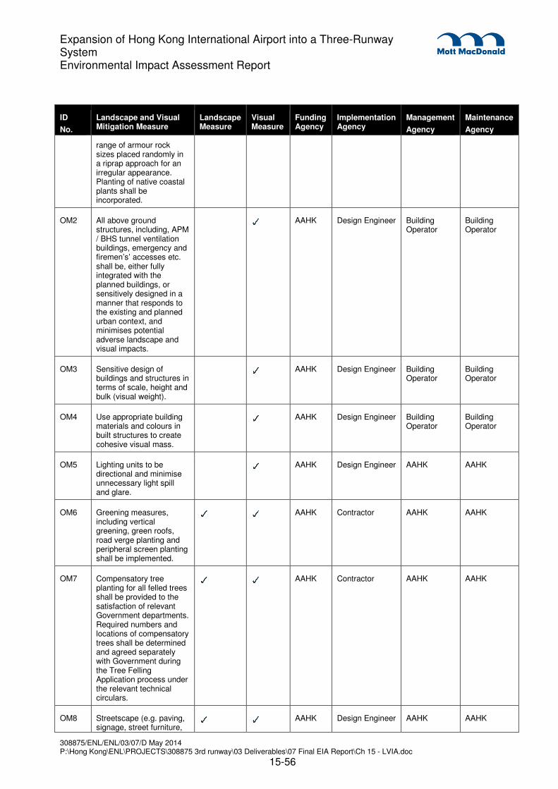
308875/ENL/ENL/03/07/D May 2014 P:\Hong Kong\ENL\PROJECTS\308875 3rd runway\03 Deliverables\07 Final EIA Report\Ch 15 - LVIA.doc
15-56
Expansion of Hong Kong International Airport into a Three-Runway System Environmental Impact Assessment Report
ID
No.
Landscape and Visual Mitigation Measure
Landscape Measure
Visual Measure
Funding Agency
Implementation Agency
Management
Agency
Maintenance
Agency
range of armour rock sizes placed randomly in a riprap approach for an irregular appearance. Planting of native coastal plants shall be incorporated.
OM2 All above ground structures, including, APM / BHS tunnel ventilation buildings, emergency and firemen’s’ accesses etc. shall be, either fully integrated with the planned buildings, or sensitively designed in a manner that responds to the existing and planned urban context, and minimises potential adverse landscape and visual impacts.
✓ AAHK Design Engineer Building
Operator Building Operator
OM3 Sensitive design of buildings and structures in terms of scale, height and bulk (visual weight).
✓ AAHK Design Engineer Building
Operator Building Operator
OM4 Use appropriate building materials and colours in built structures to create cohesive visual mass.
✓ AAHK Design Engineer Building
Operator Building Operator
OM5 Lighting units to be directional and minimise unnecessary light spill and glare.
✓ AAHK Design Engineer AAHK AAHK
OM6 Greening measures, including vertical greening, green roofs, road verge planting and peripheral screen planting shall be implemented.
✓ ✓ AAHK Contractor AAHK AAHK
OM7 Compensatory tree planting for all felled trees shall be provided to the satisfaction of relevant Government departments. Required numbers and locations of compensatory trees shall be determined and agreed separately with Government during the Tree Felling Application process under the relevant technical circulars.
✓ ✓ AAHK Contractor AAHK AAHK
OM8 Streetscape (e.g. paving, signage, street furniture,
✓ ✓ AAHK Design Engineer AAHK AAHK

308875/ENL/ENL/03/07/D May 2014 P:\Hong Kong\ENL\PROJECTS\308875 3rd runway\03 Deliverables\07 Final EIA Report\Ch 15 - LVIA.doc
15-57
Expansion of Hong Kong International Airport into a Three-Runway System Environmental Impact Assessment Report
ID
No.
Landscape and Visual Mitigation Measure
Landscape Measure
Visual Measure
Funding Agency
Implementation Agency
Management
Agency
Maintenance
Agency
lighting etc.) shall be sensitively designed in a manner that responds to the existing and planned urban context, and minimises potential adverse landscape and visual impacts.
OM9 All streetscape areas and hard and soft landscape areas disturbed during construction shall be reinstated to equal or better quality (due to implementation of screen planting, road verge planting etc.), to the satisfaction of the relevant Government departments.
✓ ✓ AAHK Contractor AAHK AAHK
OM10 Aesthetic improvement planting of viaduct structure through greening of structure to mitigate visual impact of viaduct form.
✓ AAHK Design Engineer AAHK AAHK
OM11 Sensitive design of footbridges, noise barriers and enclosures with greening (screen planting/climbers/planters) and chromatic measures.
✓ AAHK Design Engineer AAHK AAHK
*A conceptual section illustrating the mitigation measure OM1 is presented in Drawing MCL/P132/EIA/15-029
Note: AAHK stands for Airport Authority Hong Kong
Programme of Implementation of Landscape and Visual Mitigation Measures
15.6.4.9 The construction phase measures listed above shall be adopted from the commencement of
construction and shall be in place throughout the entire construction period. The operation phase
measures listed above shall be adopted during the detailed design, and be built as part of the
construction works so that they are in place at the date of commissioning of the 3RS. However, it
should be noted that the full effect of the soft landscape mitigation measures would not be
appreciated for several years.
15.6.5 Prediction of Significance of Landscape Impacts
15.6.5.1 The potential significance of the landscape impacts during the construction and operation phases,
before and after mitigation, are provided below in Table 15.8 and mapped in Drawings
MCL/P132/EIA/15-012.1 to MCL/P132/EIA/15-015. This assessment follows the methodology
outlined in Section 15.4 above and assumes that the appropriate mitigation measures identified
in Table 15.6 and Table 15.7 above will be implemented, and that the full effect of the soft
landscape mitigation measures will be realised after 10 years. Photomontages of the proposed
development before and after mitigation are illustrated in MCL/P132/EIA/15-017.1 to
MCL/P132/EIA/15-026.2 inclusive.

308875/ENL/ENL/03/07/D May 2014 P:\Hong Kong\ENL\PROJECTS\308875 3rd runway\03 Deliverables\07 Final EIA Report\Ch 15 - LVIA.doc
15-58
Expansion of Hong Kong International Airport into a Three-Runway System Environmental Impact Assessment Report
Construction Phase before Mitigation
15.6.5.2 In the construction phase, before the implementation of the proposed mitigation measures, there
will be some adverse landscape impacts as summarised below and identified in Table 15.8.
Landscape Resources
15.6.5.3 Coastal waters of North Lantau (CLK/LR1) would experience impacts of Substantial significance
due to a loss of 650 ha of coastal waters due to construction of the new land formation.
15.6.5.4 Roadside vegetation – amenity planting (CLK/LR4a) located along the existing roadside verges
and landscape buffers would experience reversible impacts of Moderate significance before the
implementation of mitigation measures during the construction phase.
15.6.5.5 Grass / Turf areas around runways and verges (CLK/LR2), Roadside Vegetation on Modified
Slopes (CLK/LR4b), Natural Rocky Coastline of Sha Chau islands (SC/LR1) , Artificial / man-
made coastline (CLK/LR13) and Natural Vegetation on Sha Chau islands (SC/LR2) would
experience impacts of Slight significance during the construction phase of the 3RS before the
implementation of mitigation measures.
Landscape Character Areas
15.6.5.6 Inshore Water Landscape (CLK/LCA2) would experience an impact significance of Substantial
significance due to highly visible marine construction activity and the loss of 650 ha of the
character area.
15.6.5.7 Due to the construction of the daylighting point for the fuel pipelines, Island Landscape
(SC/LCA1) would suffer a loss of approximately 30 m of natural coastline and 0.5 ha of natural
vegetation, resulting in an impact of Slight significance. Due to the presence of marine
construction traffic in the surrounding waters, Sha Chau islands Inshore Water Landscape
(SC/LCA2) would suffer an impact of Slight significance.
15.6.5.8 During construction and before implementation of mitigation measures, On-going Major
Development Landscape (CLK/LCA8) would experience impacts of Slight significance due to the
construction of airport infrastructure (landside roads and APM / BHS and associated tunnel
ventilation buildings)
15.6.5.9 It is predicted that all other LRs and LCAs that are not described above will experience impacts of
insubstantial significance or are not anticipated to be affected by the 3RS.
Operation Phase before Mitigation
15.6.5.10 In the operation phase, before the implementation of the proposed mitigation measures, there will
be some adverse landscape impacts as summarised below and identified in Table 15.8.
Landscape Resources
15.6.5.11 The prediction of the significance of landscape impacts before mitigation on landscape resources
during the operation phase are the same as described for the construction phase.
Landscape Character Areas

308875/ENL/ENL/03/07/D May 2014 P:\Hong Kong\ENL\PROJECTS\308875 3rd runway\03 Deliverables\07 Final EIA Report\Ch 15 - LVIA.doc
15-59
Expansion of Hong Kong International Airport into a Three-Runway System Environmental Impact Assessment Report
15.6.5.12 During operation and before implementation of mitigation measures, Inshore Water Landscape
(CLK/LCA2) would continue to experience an impact significance of Substantial after the loss of
650ha of inshore water landscape.
15.6.5.13 During operation and before implementation of mitigation measures, Island Landscape
(SC/LCA1) would continue to experience an impact significance of Slight after the loss of natural
coastline and vegetation and the presence of the submarine fuel pipeline daylighting point.
15.6.5.14 It is predicted that all other LRs and LCAs that are not described above will experience impacts of
insubstantial significance or are not anticipated to be affected by the 3RS.
Construction Phase after Mitigation
15.6.5.15 In the construction phase, after the implementation of the proposed mitigation measures, there
will be adverse residual landscape impacts as summarised below and identified in Table 15.8.
15.6.5.16 Although implementation of the recommended mitigation measures should slightly reduce the
magnitude of the residual landscape impacts during the construction phase, this will not be
sufficient to reduce the overall significance thresholds described above for the before mitigation
scenario.
Landscape Resources
15.6.5.17 Coastal waters of North Lantau (CLK/LR1) would experience impacts of Substantial significance
due to a loss of 650 ha of coastal waters due to construction of the new land formation.
15.6.5.18 Roadside vegetation – amenity planting (CLK/LR4a) located along the existing roadside verges
and landscape buffers would experience impacts of Moderate significance after the
implementation of mitigation measures during the construction phase.
15.6.5.19 Grass / Turf areas around runways and verges (CLK/LR2), Roadside Vegetation on Modified
Slopes (CLK/LR4b), Natural Rocky Coastline of Sha Chau islands (SC/LR1) and Natural
Vegetation on Sha Chau islands (SC/LR2) would experience residual impacts of Slight
significance during the construction phase of the 3RS.
Landscape Character Areas
15.6.5.20 Inshore Water Landscape (CLK/LCA2) would experience a residual impact significance of
Substantial significance due to highly visible marine construction activity and the loss of 650 ha
of the character area.
15.6.5.21 After mitigation measures have been implemented the construction of the daylighting point for the
fuel pipeline, Island Landscape (SC/LCA1) would continue to suffer a loss of approximately 30 m
of natural coastline and 0.5 ha of natural vegetation, resulting in an impact of Slight significance.
Due to the presence of marine construction traffic in the surrounding waters, Sha Chau islands
Inshore Water Landscape (SC/LCA2) would suffer an impact of Slight significance.
15.6.5.22 After mitigation measures, On-going Major Development Landscape (CLK/LCA8) would continue
to experience impacts of Slight significance due to the construction of airport infrastructure
(landside roads and APM / BHS and associated tunnel ventilation buildings).

308875/ENL/ENL/03/07/D May 2014 P:\Hong Kong\ENL\PROJECTS\308875 3rd runway\03 Deliverables\07 Final EIA Report\Ch 15 - LVIA.doc
15-60
Expansion of Hong Kong International Airport into a Three-Runway System Environmental Impact Assessment Report
15.6.5.23 It is predicted that all other LRs and LCAs that are not described above will experience residual
impacts of insubstantial significance or are not anticipated to be affected by the 3RS.
Operation Phase after Mitigation
15.6.5.24 In the operation phase, after the implementation of the proposed mitigation measures, there will
be some adverse residual landscape impacts as summarised below and identified in Table 15.8.
15.6.5.25 Implementation of the recommended mitigation measures will reduce the magnitude of the
residual landscape impacts during the operation phase, and in some cases this will be sufficient
to reduce the overall significance thresholds described above for the before mitigation scenario.
Landscape Resources
15.6.5.26 For the Coastal waters of North Lantau (CLK/LR1) the substantial residual impacts experienced
during the construction phase after the implementation of mitigation measures due to the loss of
650 ha of the resource would remain Substantial at Day 1 and Year 10 of the operation phase,
as loss of 650 ha of coastal waters cannot be mitigated.
15.6.5.27 The residual impacts on Natural Rocky Coastline of Sha Chau islands (SC/LR1) after mitigation
are predicted to remain as Slight at Day 1 and Year 10 of the operation phase due to the
irreversible change to the resource.
15.6.5.28 The residual impacts on Roadside Vegetation – Amenity Planting (CLK/LR4a) located along the
existing roadside verges and landscape buffers would be reduced due to the implementation of
mitigation measures such as compensatory planting. Residual impacts after mitigation at Day 1
are predicted to be Slight and would reduce further to Insubstantial at Year 10 after the
establishment and maturity of the compensatory planting.
Landscape Character Areas
15.6.5.29 The Inshore Water Landscape (CLK/LCA2) would experience a residual impact of Substantial
significance at Day 1 and Year 10 due to the loss of 650 ha of inshore water, which cannot be
effectively mitigated.
15.6.5.30 It is predicted that all other LRs and LCAs that are not described above will experience residual
impacts of insubstantial significance or are not anticipated to be affected by the 3RS.

308875/ENL/ENL/03/07/D May 2014 P:\Hong Kong\ENL\PROJECTS\308875 3rd runway\03 Deliverables\07 Final EIA Report\Ch 15 - LVIA.doc
15-61
Expansion of Hong Kong International Airport into a Three-Runway System Environmental Impact Assessment Report
Table 15.8: Significance of Landscape Impacts in Construction and Operation Phases (Adverse Impacts unless otherwise stated)
Id. No. Landscape Resource /
Landscape Character
Sensitivity to Change during Construction and Operation Phases (Low, Medium, High)
Magnitude of Change before Mitigation (None, Negligible, Small, Intermediate, Large)
Impact Significance Threshold BEFORE Mitigation
(None, Insubstantial, Slight, Moderate, Substantial)
Recommended Mitigation Measures
Residual Impact Significance Threshold AFTER Mitigation
(None, Insubstantial, Slight, Moderate, Substantial)
Construction Operation
Construction Operation Construction Operation DAY 1 YEAR 10
Landscape Resources
CLK/LR1 Coastal waters of North Lantau
High Large Large Substantial Substantial CM1 Substantial Substantial Substantial
CLK/LR2
Grass / turf areas around runways and verges
Low Intermediate Intermediate Slight Slight CM1
Slight Insubstantial Insubstantial
CLK/LR3
Landscaped areas around existing airport buildings
Low Negligible Negligible Insubstantial Insubstantial CM1, CM8 -9, OM6-9
Insubstantial Insubstantial Insubstantial
CLK/LR4a
Roadside Vegetation – Amenity Planting
Medium Intermediate Intermediate Moderate Moderate CM1, CM8 -9, OM6-9
Moderate Slight Insubstantial
CLK/LR4b Roadside vegetation on modified slopes
Low Small Small Slight Slight CM1, CM8 -9, OM6-9
Slight Insubstantial Insubstantial
CLK/LR5 Natural coastline
High None None None None N/A None None None
CLK/LR6
Amenity / compensatory planting on HKBCF/HKLR
Low None None None None N/A None None None
CLK/LR7 Streams Medium None None None None N/A None None None
CLK/LR8 Agricultural land
Medium None None None None N/A None None None

308875/ENL/ENL/03/07/D May 2014 P:\Hong Kong\ENL\PROJECTS\308875 3rd runway\03 Deliverables\07 Final EIA Report\Ch 15 - LVIA.doc
15-62
Expansion of Hong Kong International Airport into a Three-Runway System Environmental Impact Assessment Report
Id. No. Landscape Resource /
Landscape Character
Sensitivity to Change during Construction and Operation Phases (Low, Medium, High)
Magnitude of Change before Mitigation (None, Negligible, Small, Intermediate, Large)
Impact Significance Threshold BEFORE Mitigation
(None, Insubstantial, Slight, Moderate, Substantial)
Recommended Mitigation Measures
Residual Impact Significance Threshold AFTER Mitigation
(None, Insubstantial, Slight, Moderate, Substantial)
Construction Operation
Construction Operation Construction Operation DAY 1 YEAR 10
CLK/LR9
Natural rocky and sandy shore with mangrove / mudflat
High None None None None N/A None None None
CLK/LR10a
Coastal woodland and scrubland on North Lantau
High None None None None N/A None None None
CLK/LR10b
Coastal woodland and scrubland on Scenic Hill
High None None None None N/A None None None
CLK/LR11 Amenity planting in urban park
Medium None None None None N/A None None None
CLK/LR12 Grassland/scrub on vacant land
Low Small Small Insubstantial Insubstantial CM1, OM6 Insubstantial Insubstantial Insubstantial
CLK/LR13 Artificial / man-made coastline
Low Small Small Insubstantial Insubstantial CM1,OM6 Insubstantial Insubstantial Insubstantial
SC/LR1
Natural rocky coastline of Sha Chau islands
High Small Small Slight Slight CM1 Slight Slight Slight
SC/LR2
Natural vegetation on Sha Chau islands
High Small Small Slight Slight CM1, CM8-9, OM7
Slight Insubstantial Insubstantial
SC/LR3 Coastal waters of Sha Chau islands
High None None None None N/A None None None

308875/ENL/ENL/03/07/D May 2014 P:\Hong Kong\ENL\PROJECTS\308875 3rd runway\03 Deliverables\07 Final EIA Report\Ch 15 - LVIA.doc
15-63
Expansion of Hong Kong International Airport into a Three-Runway System Environmental Impact Assessment Report
Id. No. Landscape Resource /
Landscape Character
Sensitivity to Change during Construction and Operation Phases (Low, Medium, High)
Magnitude of Change before Mitigation (None, Negligible, Small, Intermediate, Large)
Impact Significance Threshold BEFORE Mitigation
(None, Insubstantial, Slight, Moderate, Substantial)
Recommended Mitigation Measures
Residual Impact Significance Threshold AFTER Mitigation
(None, Insubstantial, Slight, Moderate, Substantial)
Construction Operation
Construction Operation Construction Operation DAY 1 YEAR 10
SC/LR4
Natural sandy coastline of Sha Chau Island
High None None None None N/A None None None
Landscape Character Areas
CLK/LCA1 Airport landscape
Low Small Small Insubstantial Insubstantial CM1, OM6, OM8-9
Insubstantial Insubstantial Insubstantial
CLK/LCA2 Inshore water landscape
High Large Large Substantial Substantial CM1 Substantial Substantial Substantial
CLK/LCA3 Strait landscape
Medium None None None None N/A None None None
CLK/LCA4A
Coastal upland and hillside landscape – Sha Lo Wan
High None None None None N/A None None None
CLK/LCA4B
Coastal upland and hillside landscape – Scenic Hill
High None None None None N/A None None None
CLK/LCA5
Mixed modern comprehensive development landscape
Low None None None None N/A None None None
CLK/LCA6 Rural coastal plain landscape
High None None None None N/A None None None
CLK/LCA7 Transportation corridor landscape
Low None None None None N/A None None None
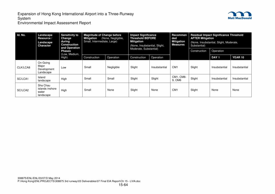
308875/ENL/ENL/03/07/D May 2014 P:\Hong Kong\ENL\PROJECTS\308875 3rd runway\03 Deliverables\07 Final EIA Report\Ch 15 - LVIA.doc
15-64
Expansion of Hong Kong International Airport into a Three-Runway System Environmental Impact Assessment Report
Id. No. Landscape Resource /
Landscape Character
Sensitivity to Change during Construction and Operation Phases (Low, Medium, High)
Magnitude of Change before Mitigation (None, Negligible, Small, Intermediate, Large)
Impact Significance Threshold BEFORE Mitigation
(None, Insubstantial, Slight, Moderate, Substantial)
Recommended Mitigation Measures
Residual Impact Significance Threshold AFTER Mitigation
(None, Insubstantial, Slight, Moderate, Substantial)
Construction Operation
Construction Operation Construction Operation DAY 1 YEAR 10
CLK/LCA8
On-Going Major Development Landscape
Low Small Negligible Slight Insubstantial CM1 Slight Insubstantial Insubstantial
SC/LCA1 Island landscape
High Small Small Slight Slight CM1, CM8-9, OM6
Slight Insubstantial Insubstantial
SC/LCA2
Sha Chau islands inshore water landscape
High Small None Slight None CM1 Slight None None
308875/ENL/ENL/03/07/D May 2014 P:\Hong Kong\ENL\PROJECTS\308875 3rd runway\03 Deliverables\07 Final EIA Report\Ch 15 - LVIA.doc
15-65
Expansion of Hong Kong International Airport into a Three-Runway System Environmental Impact Assessment Report
15.7 Visual Impacts Assessment
15.7.1 Potential Sources of Visual Impacts
15.7.1.1 The sources of visual impacts of the project during construction and operation phases have been
described in Section 15.6.1.
15.7.2 Visual Change Before Mitigation in the Construction and Operation Phase
15.7.2.1 The magnitude of visual change resulting from the construction and operation phases of the 3RS
is presented in Table 15.9.
15.7.3 Proposed Landscape and Visual Mitigation Measures
15.7.3.1 The proposed landscape and visual mitigation measures for impacts from the construction and
operation phases are described previously in Table 15.6 and Table 15.7, together with the
associated funding, implementation, management and maintenance agencies and the proposed
implementation programme. Please refer to Drawings MCL/P132/EIA/15-028.1 to
MCL/P132/EIA/15-028.6 for the landscape and visual mitigation arrangement plan.
15.7.4 Viewpoints
15.7.4.1 The viewpoints were selected as representative examples of the visual impacts of the project.
Viewpoints have been selected to provide close, medium and long range views of the project.
The locations of the viewpoint locations are indicated in Drawing MCL/P132/EIA/15-010. The
photomontages showing the proposed development at ‘Existing Baseline Conditions’ in June
2013, ‘Planned Baseline Conditions in 2016 before commencement of the 3RS’ (with committed
and approved projects: HKBCF, HKLR, the Southern Connection of the TM-CLKL CLKL,
Residential / Commercial Development at Tung Chung (Area 55a), Residential Development at
Tung Chung (Area 55b) and the Public Rental Housing Development at Tung Chung (Area 56)),
‘Day 1 of completed works without mitigation measures’, ‘Day 1 of the completed works with
mitigation measures’ and ‘Year 10 of the completed works with mitigation measures’ are
illustrated in Drawings MCL/P132/EIA/15-017.1 to MCL/P132/EIA/15-026.2.
� VP1 - Viewpoint from Castle Peak. This viewpoint was selected as representative of views
from potential recreational VSRs (Hikers along Castle Peak, REC-16) as it provides direct and
panoramic views of the development site and represents a highly sensitive VSR group. The
viewpoint is located at a viewing pavilion along one of the hiking trails around Castle Peak and
provides an elevation of approximately +580 mPD.
� VP2 - Viewpoint from Miami Beach Towers. This viewpoint was selected as representative
of views from potential residential VSRs (Residents along south coast of Tuen Mun, RES-4)
as it represents a large group of highly sensitive receivers who have direct and panoramic
views of the development. The viewpoint is located at the residential development of Miami
Beach Towers.
� VP3 - Viewpoint from Marriott Hotel. This viewpoint was selected as representative of views
from potential recreational VSRs (Visitors to Marriott Hotel, REC-2) as it represents a large

308875/ENL/ENL/03/07/D May 2014 P:\Hong Kong\ENL\PROJECTS\308875 3rd runway\03 Deliverables\07 Final EIA Report\Ch 15 - LVIA.doc
15-66
Expansion of Hong Kong International Airport into a Three-Runway System Environmental Impact Assessment Report
group of highly sensitive receivers who have direct and panoramic close range views of the
development. The viewpoint is located from a northeast facing vantage point within the
Marriott Hotel.
� VP4 - Viewpoint from Caribbean Coast. This viewpoint was selected as representative of
views from potential residential VSRs (Residents of Tung Chung, RES-3) as it represents a
large group of highly sensitive receivers who are closest to the development. The viewpoint is
located at the residential development of Caribbean Coast.
� VP5 - Viewpoint from Ngong Ping 360. This viewpoint was selected as representative of
views from potential recreational VSRs (Passengers of Cable Car of Ngong Ping 360, REC-5)
as it represents a large group of highly sensitive receivers who have elevated and panoramic
views of the development. The viewpoint is located within one of the Ngong Ping 360 Cable
Cars and provides a transient view at an elevation ranging from approximately +60 mPD to
+580 mPD.
� VP6 - Viewpoint from Lantau Hiking Trail. This viewpoint was selected as representative of
views from potential recreational VSRs (Hikers of Lantau North Country Park, REC-9) as it
provides direct and panoramic views of the development and represents a highly sensitive
VSR group. The viewpoint is located along Wong Lung Hang Country Trails in Lantau North
Country Park and provides an elevation of approximately +500 mPD.
� VP7 - Viewpoint from Golden Beach. This viewpoint was selected as representative of views
from potential recreational VSRs (Recreational Users of Golden Beach, REC-22) as it
provides direct and panoramic views of the development and represents a highly sensitive
VSR group. Golden Beach is the largest public beach in Tuen Mun with a total area of
78,500 m² and a length of 545 m. The viewpoint is located on Golden Beach.
� VP8 - Viewpoint from St. Stephens Tai O Family Buildings. This viewpoint was selected as
representative of views from potential residential VSRs (Residents of Villages of Tai O, RES-
1), as it provides partial views of the development and represents a highly sensitive VSR
group. Tai O is a fishing town, partly located on an island of the same name, on the western
side of Lantau Island in Hong Kong. The viewpoint is located at a viewing pavilion in Kau Shan
Tei within Tai O.
� VP9 - Viewpoint from potential recreational users of future Tung Chung East
Development. This viewpoint was selected as representative of views from future potential
recreational VSRs (Recreational users of future of Tung Chung East REC-11), as it provides
partial views of the development and represents a highly sensitive VSR group.
� VP10 – Viewpoint from Fu Shan in Tai O. This viewpoint was selected as representative of
views from potential recreational VSRs (Hikers from Tung Chung to Tai O, REC-23) as it
provides direct and panoramic views of the development and represents a highly sensitive
VSR group. Fu Shan Country Trail starts from the access next to Hung Shing Temple in Shek
Tsai Po Street and passes the peak of Fu Shan before reaching Kau San Tei, rising to a
height of 105 mPD.
15.7.4.2 Viewpoints from VSRs (RES10 Residents of Sham Shek Tsuen, RES17 Residents of Pak Mong
Village, RES19 Residents of San Shek Wan Village and REC24 Visitors to Tai Ho) located in
recognised villages along Lantau’s north coast are not included in the photomontages because

308875/ENL/ENL/03/07/D May 2014 P:\Hong Kong\ENL\PROJECTS\308875 3rd runway\03 Deliverables\07 Final EIA Report\Ch 15 - LVIA.doc
15-67
Expansion of Hong Kong International Airport into a Three-Runway System Environmental Impact Assessment Report
views of the project site from these locations are partially to completely obscured by the
surrounding topography and existing vegetation, as is demonstrated in Drawings
MCL/P132/EIA/15-030.1 to MCL/P132/EIA/15-030.4.
15.7.4.3 The MTR Siu Ho Wan Depot, O-16 Workers at Siu Ho Wan MTR Depot, is not accessible to the
public and the view would be obstructed by the HKBCF development, therefore it is an
insignificant viewpoint and is not included as such.
15.7.4.4 The view from Sunny Bay MTR Station has not been included as a viewpoint as it entirely
obstructed by intervening topography and is therefore not suitable as a viewpoint.

308875/ENL/ENL/03/07/D March 2014 P:\Hong Kong\ENL\PROJECTS\308875 3rd runway\03 Deliverables\07 Final EIA Report\Ch 15 - LVIA.doc
15-68
Expansion of Hong Kong International Airport into a Three-Runway System Environmental Impact Assessment Report
Table 15.9: Magnitude of Visual Change during the Construction and Operation Phases before Mitigation
VSR ID
Key VSR
Compatibility of the Project with the Visual Backdrop
(High/Medium/Low)
Duration and Frequency of Impacts
(Temporary/Permanent & Intermittent/Continuous)
Scale of Development (Large/Medium/Small) & Reversibility of Change (Yes/No)
Degree of Visibility of Source(s) of Visual Impact (Full, Partial, Obscured) & Distance Between VSR & Nearest Source(s) of Impact
Potential Blockage of Existing View (Full/Partial/Slight/Negligible)
Magnitude of Visual Change BEFORE Mitigation
Construction Operation Construction Operation Construction Operation Construction Operation
Residential VSRs
RES-1 Residents of Villages of Tai O
Low Permanent, Continuous
Permanent, Continuous
Large, No Obscured, ~6,600m
Obscured, ~6,600m
Negligible Negligible Small Negligible
RES-2 Residents of Villages of Sha Lo Wan
Low Permanent, Continuous
Permanent, Continuous
Large, No Obscured, ~2,500m
Obscured, ~2,500m
Negligible Negligible Small Negligible
RES-3
Residents of Tung Chung including, Tung Chung Crescent, Seaview Crescent, Caribbean Coast, Area 53 to Area 56
Low Permanent, Continuous
Permanent, Continuous
Large, No Full, ~900m Full, ~900m Negligible Negligible Intermediate Small
RES-4 Residents along south coast of Tuen Mun
Medium Permanent, Continuous
Permanent, Continuous
Large, No Full, ~6,200m Full, ~6,200m Negligible Negligible Intermediate Small
RES-5 Residents of Hong Kong Gold Coast
Medium Permanent, Continuous
Permanent, Continuous
Large, No Full, ~7,500m Full, ~7,500m Negligible Negligible Intermediate Small
RES-6 Residents of Siu Lam Medium Permanent, Continuous
Permanent, Continuous
Large, No Full, ~8,700m Full, ~8,700m Negligible Negligible Intermediate Small
RES-7 Proposed residents of Tung Chung East
Low N/A Permanent, Continuous
Large, No N/A Full, ~2,500m N/A Negligible N/A Small
RES-8 Residents of Lung Kwu Tan
High Permanent, Continuous
Permanent, Continuous
Large, No Partial, ~6,500m Partial, ~6,500m Negligible Negligible Negligible Negligible
RES-9
Residents of planned Tung Chung West future development
including Area 39
Low N/A Permanent, Continuous
Large, No N/A Full, ~1,500m N/A Negligible N/A Small
RES-10 Residents of Sham Shek Tsuen
Low Permanent, Continuous
Permanent, Continuous
Large, No Obscured, ~2,000m
Obscured, ~2,000m
Negligible Negligible Small Negligible
RES-11 Residents of Sai Tso Wan Village
Low Permanent, Continuous
Permanent, Continuous
Large, No Obscured, ~3,500m
Obscured, ~3,500m
Negligible Negligible Small Negligible

308875/ENL/ENL/03/07/D March 2014 P:\Hong Kong\ENL\PROJECTS\308875 3rd runway\03 Deliverables\07 Final EIA Report\Ch 15 - LVIA.doc
15-69
Expansion of Hong Kong International Airport into a Three-Runway System Environmental Impact Assessment Report
VSR ID
Key VSR
Compatibility of the Project with the Visual Backdrop
(High/Medium/Low)
Duration and Frequency of Impacts
(Temporary/Permanent & Intermittent/Continuous)
Scale of Development (Large/Medium/Small) & Reversibility of Change (Yes/No)
Degree of Visibility of Source(s) of Visual Impact (Full, Partial, Obscured) & Distance Between VSR & Nearest Source(s) of Impact
Potential Blockage of Existing View (Full/Partial/Slight/Negligible)
Magnitude of Visual Change BEFORE Mitigation
Construction Operation Construction Operation Construction Operation Construction Operation
RES-12 Residents of San Tau, Kau Liu and Tin Sam Villages
Low Permanent, Continuous
Permanent, Continuous
Large, No Obscured, ~400m Obscured, ~400m Negligible Negligible Negligible Negligible
RES-13 Residents of Shek Lau Po and Mok Ka Village
Low Permanent, Continuous
Permanent, Continuous
Large, No Obscured, ~1,900m
Obscured, ~1,900m
Negligible Negligible Negligible Negligible
RES-14 Residents of Tung Hing Village
Low Permanent, Continuous
Permanent, Continuous
Large, No Obscured, ~1,700m
Obscured, ~1,700m
Negligible Negligible Negligible Negligible
RES-15 Residents of Sheung Ling Pei Village
Low Permanent, Continuous
Permanent, Continuous
Large, No Obscured, ~1,500m
Obscured, ~1,500m
Negligible Negligible Negligible Negligible
RES-16 Residents of Ma Wan New Village
Low Permanent, Continuous
Permanent, Continuous
Large, No Obscured, ~1,400m
Obscured, ~1,400m
Negligible Negligible Negligible Negligible
RES-17 Residents of Pak Mong Village
Low Permanent, Continuous
Permanent, Continuous
Large, No Obscured, ~3,200m
Obscured, ~3,200m
Negligible Negligible Negligible Negligible
RES-18 Residents of Ngau Kwu Long Village
Low Permanent, Continuous
Permanent, Continuous
Large, No Obscured, ~4,000m
Obscured, ~4,000m
Negligible Negligible Negligible Negligible
RES-19 Residents of San Shek Wan Village
Low Permanent, Continuous
Permanent, Continuous
Large, No Obscured, ~1,900m
Obscured, ~1,900m
Negligible Negligible Small Negligible
RES-20 Residents of Yat Tung Estate
Low Permanent, Continuous
Permanent, Continuous
Large, No Partial, ~900m Partial, ~900m Negligible Negligible Small Small
RES-21 Residents of Tai Ho San Tsuen
Low Permanent, Continuous
Permanent, Continuous
Large, No Obscured, ~5,500m
Obscured, ~5,500m
Negligible Negligible Negligible Negligible
Recreational VSRs
REC-1 Visitors to AsiaWorld-Expo
Low Permanent,
Intermittent
Permanent,
Intermittent Large, No Partial, 0m* Partial, 0m* Negligible Negligible Intermediate Small
REC-2 Visitors to Hong Kong SkyCity Marriott Hotel
Low Permanent, Continuous
Permanent, Continuous
Large, No Partial, 0m* Partial, 0m* Negligible Negligible Intermediate Small
REC-3 Visitors to Hong Kong Airport Passenger Terminal
Low Permanent,
Intermittent
Permanent,
Intermittent Large, No Partial , 0m* Partial , 0m* Negligible Negligible Intermediate Small

308875/ENL/ENL/03/07/D March 2014 P:\Hong Kong\ENL\PROJECTS\308875 3rd runway\03 Deliverables\07 Final EIA Report\Ch 15 - LVIA.doc
15-70
Expansion of Hong Kong International Airport into a Three-Runway System Environmental Impact Assessment Report
VSR ID
Key VSR
Compatibility of the Project with the Visual Backdrop
(High/Medium/Low)
Duration and Frequency of Impacts
(Temporary/Permanent & Intermittent/Continuous)
Scale of Development (Large/Medium/Small) & Reversibility of Change (Yes/No)
Degree of Visibility of Source(s) of Visual Impact (Full, Partial, Obscured) & Distance Between VSR & Nearest Source(s) of Impact
Potential Blockage of Existing View (Full/Partial/Slight/Negligible)
Magnitude of Visual Change BEFORE Mitigation
Construction Operation Construction Operation Construction Operation Construction Operation
REC-4 Visitors to Regal Hotel Low Permanent, Continuous
Permanent, Continuous
Large, No Partial, 0m* Partial, 0m* Negligible Negligible Intermediate Small
REC-5 Passengers of Cable Cars of Ngong Ping 360
Low Permanent, Continuous
Permanent, Continuous
Large, No Full, ~ 0-3,600m Full, ~ 0-3,600m Negligible Negligible Intermediate Small
REC-6 Hikers of Nei Lak Shan
Low Permanent,
Intermittent
Permanent,
Intermittent Large, No Full, ~3,000m Full,~3,000m Negligible Negligible Intermediate Small
REC-7 Hikers of Fung Wong Shan (Lantau Peak)
Low Permanent,
Intermittent
Permanent,
Intermittent Large, No Full, ~4,500m Full, ~4,500m Negligible Negligible Intermediate Small
REC-8 Hikers of Tai Tung Shan (Sunset Peak)
Low Permanent,
Intermittent
Permanent,
Intermittent Large, No Full, ~4,200m Full, ~4,200m Negligible Negligible Intermediate Small
REC-9 Hikers of Lantau North Country Park
Low Permanent,
Intermittent
Permanent,
Intermittent Large, No Full, ~2,800m Full, ~2,800m Negligible Negligible Intermediate Small
REC-10 Hikers of Lantau South Country Park
Low Permanent,
Intermittent
Permanent,
Intermittent Large, No
Full, ~600-10,000m
Full, ~600-10,000m
Negligible Negligible Intermediate Small
REC-11 Recreational users of future Tung Chung East Development
Low N/A Permanent,
Intermittent Large, No N/A Partial, ~600m N/A Negligible N/A Small
REC-12 Hikers of Scenic Hill Low Permanent,
Intermittent
Permanent,
Intermittent Large, No Full, 0m* Full, 0m* Negligible Negligible Intermediate Small
REC-13
Passengers / Drivers of recreational marine craft in north Lantau waters and Urmston Road
Medium Permanent, Continuous
Permanent, Continuous
Large, No Full, ~0-10,000m Full, ~0-10,000m Partial Partial Large Inter-mediate
REC-14
Passengers / Drivers of recreational marine craft in Castle Peak Bay
Medium Permanent, Continuous
Permanent, Continuous
Large, No Full, ~6,200m Full, ~6,200m Negligible Negligible Negligible Negligible

308875/ENL/ENL/03/07/D March 2014 P:\Hong Kong\ENL\PROJECTS\308875 3rd runway\03 Deliverables\07 Final EIA Report\Ch 15 - LVIA.doc
15-71
Expansion of Hong Kong International Airport into a Three-Runway System Environmental Impact Assessment Report
VSR ID
Key VSR
Compatibility of the Project with the Visual Backdrop
(High/Medium/Low)
Duration and Frequency of Impacts
(Temporary/Permanent & Intermittent/Continuous)
Scale of Development (Large/Medium/Small) & Reversibility of Change (Yes/No)
Degree of Visibility of Source(s) of Visual Impact (Full, Partial, Obscured) & Distance Between VSR & Nearest Source(s) of Impact
Potential Blockage of Existing View (Full/Partial/Slight/Negligible)
Magnitude of Visual Change BEFORE Mitigation
Construction Operation Construction Operation Construction Operation Construction Operation
REC-15 Recreational users of Butterfly Beach
Medium Permanent, Continuous
Permanent, Continuous
Large, No Full, ~5,500m Full, ~5,500m Negligible Negligible Negligible Negligible
REC-16 Hikers of Castle Peak High Permanent,
Intermittent
Permanent,
Intermittent Large, No Full, ~6,500m Full, ~6,500m Negligible Negligible Small Small
REC-17 Recreational users of Tung Chung Outdoor Recreation Camp
Low Permanent, Continuous
Permanent, Continuous
Large, No Obscured, ~1,200m
Obscured, ~1,200m
Negligible Negligible Negligible Negligible
REC-18 Recreational users of Man Tung Road Park
Low Permanent, Continuous
Permanent, Continuous
Large, No Obscured, ~200m Obscured, ~200m Negligible Negligible Negligible Negligible
REC-19 Hikers of Tai Lam Country Park
Medium Permanent,
Intermittent
Permanent,
Intermittent Large, No Full, ~8,000m Full, ~8,000m Negligible Negligible Small Small
REC-20 Recreational users of Planned Entertainment Node
Low Permanent,
Continuous
Permanent,
Continuous Large, No N/A Partial, ~7,500m N/A Negligible N/A Negligible
REC-21 Recreational users of Sha Chau
High Permanent,
Continuous
Permanent,
Continuous t Large, No Full, ~1,300m Full, ~1,300m Slight Slight Large
Intermediate
REC-22 Recreational users of Golden Beach
Medium Permanent, Continuous
Permanent, Continuous
Large, No Full, ~8,000m Full, ~8,000m Negligible Negligible Negligible Negligible
REC-23 Hikers from Tung Chung to Tai O
Low Permanent,
Intermittent
Permanent,
Intermittent Large, No
Partial, ~200 – 5,200m
Partial,~200 – 5,200m
Negligible Negligible Small Negligible
REC-24 Visitors to Tai Ho Low Permanent,
Intermittent
Permanent,
Intermittent Large, No
Obscured, ~4,200m
Obscured, ~4,200m
Negligible Negligible Negligible Negligible
REC-25 Visitors to proposed NCD hotels and commercial facilities
Low Permanent,
Continuous
Permanent,
Continuous Large, No N/A Partial, 0m* N/A Negligible N/A Negligible
REC-26 Recreational users of future Tung Chung West Development
Low N/A Permanent, Intermittent
Large, No N/A Partial, ~400m N/A Negligible N/A Negligible
REC-27 Users of Proposed Low Permanent, Permanent, Large, No Partial, ~5,500m Partial, ~5,500m Slight Slight Negligible Negligible

308875/ENL/ENL/03/07/D March 2014 P:\Hong Kong\ENL\PROJECTS\308875 3rd runway\03 Deliverables\07 Final EIA Report\Ch 15 - LVIA.doc
15-72
Expansion of Hong Kong International Airport into a Three-Runway System Environmental Impact Assessment Report
VSR ID
Key VSR
Compatibility of the Project with the Visual Backdrop
(High/Medium/Low)
Duration and Frequency of Impacts
(Temporary/Permanent & Intermittent/Continuous)
Scale of Development (Large/Medium/Small) & Reversibility of Change (Yes/No)
Degree of Visibility of Source(s) of Visual Impact (Full, Partial, Obscured) & Distance Between VSR & Nearest Source(s) of Impact
Potential Blockage of Existing View (Full/Partial/Slight/Negligible)
Magnitude of Visual Change BEFORE Mitigation
Construction Operation Construction Operation Construction Operation Construction Operation
Columbarium Developments for Tsuen Wan
Intermittent Intermittent
Travelling VSRs
T-1
Passengers / Drivers of Vehicles and MTR along North Lantau Highway
Low Permanent,
Intermittent
Permanent,
Intermittent Large, No Full, ~0-10,000m Full, ~0-10,000m Negligible Negligible Small Negligible
T-2
Passengers / Drivers of Vehicles and MTR along Cheong Wing Road
Low Permanent,
Intermittent
Permanent,
Intermittent Large, No Full, ~10m Full, ~10m Negligible Negligible Intermediate Small
T-3 Passengers of commercial aircraft
Low Permanent,
Intermittent
Permanent,
Intermittent Large, No Full, ~0-10,000m Full, ~0-10,000m Negligible Negligible Intermediate Small
T-4
Passengers / Drivers of the proposed Tuen Mun-Chek Lap Kok Link (TMCLKL)
Medium Permanent,
Intermittent
Permanent,
Intermittent Large, No Full, ~2,000m Full, ~2,000m Negligible Negligible Small Negligible
T-5 Passengers / Drivers of the proposed Hong Kong Link Road HKLR
Low Permanent, Continuous
Permanent, Continuous
Large, No Full, ~0-10,000m Full, ~0-10,000m Negligible Negligible Intermediate Small
T-6 Passengers of Ferry’s in north Lantau waters and Urmston Road
Medium Permanent, Continuous
Permanent, Continuous
Large, No Full, ~0-10,000m Full, ~0-10,000m Slight Slight Intermediate Small
T-7
Passengers / Drivers of Vehicles along castle peak road and Tuen Mun Road
Medium Permanent,
Intermittent
Permanent,
Intermittent Large, No
Obscured, ~7,900m
Obscured, ~7,900m
Negligible Negligible Negligible Negligible
T-8 Passengers / Drivers of Vehicles along Lung Mun Road
High Permanent,
Intermittent
Permanent,
Intermittent Large, No
Obscured, ~4,000m
Obscured, ~4,000m
Negligible Negligible Negligible Negligible
T-9 Passengers / Drivers Medium Permanent, Permanent, Large, No Obscured, ~700m Obscured, ~700m Negligible Negligible Small Negligible
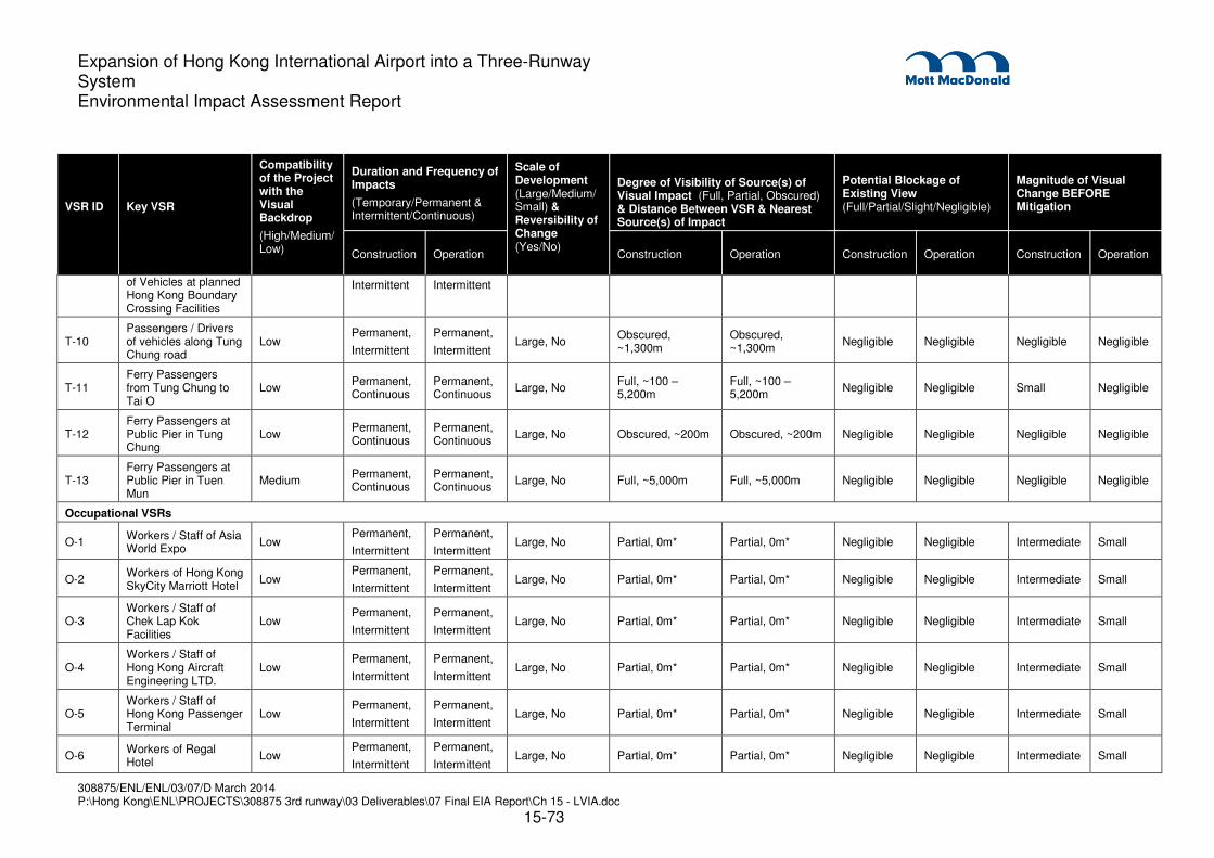
308875/ENL/ENL/03/07/D March 2014 P:\Hong Kong\ENL\PROJECTS\308875 3rd runway\03 Deliverables\07 Final EIA Report\Ch 15 - LVIA.doc
15-73
Expansion of Hong Kong International Airport into a Three-Runway System Environmental Impact Assessment Report
VSR ID
Key VSR
Compatibility of the Project with the Visual Backdrop
(High/Medium/Low)
Duration and Frequency of Impacts
(Temporary/Permanent & Intermittent/Continuous)
Scale of Development (Large/Medium/Small) & Reversibility of Change (Yes/No)
Degree of Visibility of Source(s) of Visual Impact (Full, Partial, Obscured) & Distance Between VSR & Nearest Source(s) of Impact
Potential Blockage of Existing View (Full/Partial/Slight/Negligible)
Magnitude of Visual Change BEFORE Mitigation
Construction Operation Construction Operation Construction Operation Construction Operation
of Vehicles at planned Hong Kong Boundary Crossing Facilities
Intermittent Intermittent
T-10 Passengers / Drivers of vehicles along Tung Chung road
Low Permanent,
Intermittent
Permanent,
Intermittent Large, No
Obscured, ~1,300m
Obscured, ~1,300m
Negligible Negligible Negligible Negligible
T-11 Ferry Passengers from Tung Chung to Tai O
Low Permanent, Continuous
Permanent, Continuous
Large, No Full, ~100 – 5,200m
Full, ~100 – 5,200m
Negligible Negligible Small Negligible
T-12 Ferry Passengers at Public Pier in Tung Chung
Low Permanent, Continuous
Permanent, Continuous
Large, No Obscured, ~200m Obscured, ~200m Negligible Negligible Negligible Negligible
T-13 Ferry Passengers at Public Pier in Tuen Mun
Medium Permanent, Continuous
Permanent, Continuous
Large, No Full, ~5,000m Full, ~5,000m Negligible Negligible Negligible Negligible
Occupational VSRs
O-1 Workers / Staff of Asia World Expo
Low Permanent,
Intermittent
Permanent,
Intermittent Large, No Partial, 0m* Partial, 0m* Negligible Negligible Intermediate Small
O-2 Workers of Hong Kong SkyCity Marriott Hotel
Low Permanent,
Intermittent
Permanent,
Intermittent Large, No Partial, 0m* Partial, 0m* Negligible Negligible Intermediate Small
O-3 Workers / Staff of Chek Lap Kok Facilities
Low Permanent,
Intermittent
Permanent,
Intermittent Large, No Partial, 0m* Partial, 0m* Negligible Negligible Intermediate Small
O-4 Workers / Staff of Hong Kong Aircraft Engineering LTD.
Low Permanent,
Intermittent
Permanent,
Intermittent Large, No Partial, 0m* Partial, 0m* Negligible Negligible Intermediate Small
O-5 Workers / Staff of Hong Kong Passenger Terminal
Low Permanent,
Intermittent
Permanent,
Intermittent Large, No Partial, 0m* Partial, 0m* Negligible Negligible Intermediate Small
O-6 Workers of Regal Hotel
Low Permanent,
Intermittent
Permanent,
Intermittent Large, No Partial, 0m* Partial, 0m* Negligible Negligible Intermediate Small

308875/ENL/ENL/03/07/D March 2014 P:\Hong Kong\ENL\PROJECTS\308875 3rd runway\03 Deliverables\07 Final EIA Report\Ch 15 - LVIA.doc
15-74
Expansion of Hong Kong International Airport into a Three-Runway System Environmental Impact Assessment Report
VSR ID
Key VSR
Compatibility of the Project with the Visual Backdrop
(High/Medium/Low)
Duration and Frequency of Impacts
(Temporary/Permanent & Intermittent/Continuous)
Scale of Development (Large/Medium/Small) & Reversibility of Change (Yes/No)
Degree of Visibility of Source(s) of Visual Impact (Full, Partial, Obscured) & Distance Between VSR & Nearest Source(s) of Impact
Potential Blockage of Existing View (Full/Partial/Slight/Negligible)
Magnitude of Visual Change BEFORE Mitigation
Construction Operation Construction Operation Construction Operation Construction Operation
O-7 Workers / Staff of Pillar Point
High Permanent,
Intermittent
Permanent,
Intermittent Large, No Partial, ~3,500m Partial , ~3,500m Negligible Negligible Small Negligible
O-8 Workers of EcoPark High Permanent,
Intermittent
Permanent,
Intermittent Large, No Partial, ~3,500m Partial, ~3,500m Negligible Negligible Small Negligible
O-9
Workers on commercial aircraft on and around Chek Lap Kok
Low Permanent,
Intermittent
Permanent,
Intermittent Large, No Full, 0 -10,000m* Full, 0 -10,000m* Slight Slight Intermediate Small
O-10
Workers of planned Lantau Logistic Park (LLP) at the possible LLP extension
Low N/A Permanent,
Intermittent Large, No N/A
Obscured, ~3,200m
N/A Negligible N/A Negligible
O-11 Workers of Cathay Pacific City
Low Permanent,
Intermittent
Permanent,
Intermittent Large, No Partial, 0m* Partial, 0m* Negligible Negligible Small Negligible
O-12 Workers of Castle Peak Power Station
High Permanent,
Intermittent
Permanent,
Intermittent Large, No Partial, ~4,000m Partial, ~4,000m Negligible Negligible Small Negligible
O-13 Workers of Siu Ho Wan
Low Permanent,
Intermittent
Permanent,
Intermittent Large, No
Obscured, ~5,400m
Obscured, ~5,400m
Negligible Negligible Negligible Negligible
O-14 Workers at HKBCF Medium Permanent,
Intermittent
Permanent,
Intermittent Large, No Obscured, ~300m Obscured, ~300m Negligible Negligible Small Negligible
O-15 Workers of proposed NCD hotels and commercial facilities
Low N/A Permanent,
Continuous Large, No N/A Obscured, 0m* N/A Slight N/A Small
O-16 Workers of Siu Ho Wan MTR Depot
Low Permanent, Intermittent
Permanent, Intermittent
Large, No Obscured, ~4,000m
Obscured, ~4,000m
Negligible Negligible Negligible Negligible
O-17
Future workers of potential commercial development in Tung Chung East
Low N/A Permanent, Continuous
Large, No N/A Obscured, ~2,500m
N/A Negligible N/A Small

308875/ENL/ENL/03/07/D March 2014 P:\Hong Kong\ENL\PROJECTS\308875 3rd runway\03 Deliverables\07 Final EIA Report\Ch 15 - LVIA.doc
15-75
Expansion of Hong Kong International Airport into a Three-Runway System Environmental Impact Assessment Report
VSR ID
Key VSR
Compatibility of the Project with the Visual Backdrop
(High/Medium/Low)
Duration and Frequency of Impacts
(Temporary/Permanent & Intermittent/Continuous)
Scale of Development (Large/Medium/Small) & Reversibility of Change (Yes/No)
Degree of Visibility of Source(s) of Visual Impact (Full, Partial, Obscured) & Distance Between VSR & Nearest Source(s) of Impact
Potential Blockage of Existing View (Full/Partial/Slight/Negligible)
Magnitude of Visual Change BEFORE Mitigation
Construction Operation Construction Operation Construction Operation Construction Operation
O-18
Future workers of potential commercial development in Tung Chung West
Low N/A Permanent, Continuous
Large, No N/A Obscured, ~1,500m
N/A Negligible N/A Small
Note: (1) 0* denotes VSR within project site boundary (refer to Section 15.3.1)
(2) The closet viewing distance has been used to rate the worst case scenario
(3) ‘Permanent’ duration measurement refers to entire construction/operation phase

308875/ENL/ENL/03/07/D May 2014 P:\Hong Kong\ENL\PROJECTS\308875 3rd runway\03 Deliverables\07 Final EIA Report\Ch 15 - LVIA.doc
15-76
Expansion of Hong Kong International Airport into a Three-Runway System Environmental Impact Assessment Report
15.7.5 Prediction of Significance of Visual Impacts
15.7.5.1 An assessment of the significance of the potential visual impacts during the construction and
operation phases, before and after mitigation, is briefly described, and listed in detail in Table
15.10 (All impacts are adverse unless otherwise stated). This follows the methodology outlined in
Section 15.4 above and assumes that the appropriate mitigation measures identified in Table
15.6 and Table 15.7 would be implemented, and that the full effect of the soft landscape
mitigation measures would be realised after 10 years.
15.7.6 Impacts during the Construction and Operation Phase before Mitigation
15.7.6.1 Due to the low rise nature of the 3RS the magnitude of visual change to the majority of the VSRs
is perceived to be ‘Small’ or ‘Negligible’ before mitigation measures. Many of the VSRs are a long
distance away and enjoy good quality views of the sea, mountains and offshore islands and
alternative views are available. The impact upon each VSR is described in greater detail below.
The magnitude of impacts experienced by VSRs is generally greater in the construction phase
than in the operation phase for most VSRs due to the presence of the construction activities and
temporary disturbance to the landscape.
15.7.6.2 Photomontages illustrating the existing views (including approved committed projects) and
operation phase impacts before and after (Day 1 and Year 10) the implementation of mitigation
measure are provided in Drawings MCL/P132/EIA/15-017.1 to MCL/P132/EIA/15-026.2 and
locations are illustrated on Drawing MCL/P132/EIA/15-010. Mitigation measures are described in
more detail in Table 15.6 and Table 15.7.
Residential VSRs
15.7.6.3 RES3: These VSRs will have permanent and continuous full views towards the source of visual
impact at distances of at least 900 m. In the construction phase, the resultant magnitude of visual
change is ‘Intermediate’, and this combined with their ‘High’ sensitivity results in an impact
considered to be of Moderate significance. In the operation phase, the predicted magnitude of
visual change is predicted to reduce from ‘Intermediate’ to ‘Small’ resulting in an impact
considered to be of Slight significance. A photomontage illustrating the impacts during the
operation phase before mitigation for RES3 is provided in Drawing MCL/P132/EIA/15-020.1.
15.7.6.4 RES4, RES5, & RES6: These VSRs will have permanent and continuous full views towards the
source of visual impact at distances ranging from 6,200 m to 8,700 m. In the construction phase,
the resultant magnitude of visual change is ‘Intermediate’, and this combined with their ‘High’
sensitivity results in an impact considered to be of Moderate significance. In the operation
phase, the predicted magnitude of visual change is predicted to reduce from ‘Intermediate’ to
‘Small’ resulting in an impact considered to be of Slight significance. A photomontage illustrating
the impacts during the operation phase before mitigation for RES4 is provided in Drawing
MCL/P132/EIA/15-018.1.
15.7.6.5 RES7 & RES9: These VSRs will have permanent and continuous full views towards the source of
visual impact at distances ranging from 1,500 m to 2,500 m. In the construction phase, the VSRs
will not yet exist and therefore there will be no subsequent impacts. In the operation phase, due
to visual obstruction by intervening topographical and vegetation features and/or existing

308875/ENL/ENL/03/07/D May 2014 P:\Hong Kong\ENL\PROJECTS\308875 3rd runway\03 Deliverables\07 Final EIA Report\Ch 15 - LVIA.doc
15-77
Expansion of Hong Kong International Airport into a Three-Runway System Environmental Impact Assessment Report
buildings / structures and other such factors as stated in Table 15.9, the predicted magnitude of
visual change is predicted to be ‘Small’, and this combined with their ‘High’ sensitivity results in
an impact considered to be of Slight significance. A photomontage illustrating the impacts during
the operation phase before mitigation for RES7 is provided in Drawing MCL/P132/EIA/15-025.1.
15.7.6.6 RES20: These VSRs will have permanent and continuous partial views towards the source of
visual impact at distances of at least 900 m. In the construction phase, due to visual obstruction
by intervening topographical and vegetation features and/or existing buildings / structures and
other such factors as stated in Table 15.9, the resultant magnitude of visual change is ‘Small’,
and this combined with their ‘High’ sensitivity results in an impact considered to be of Slight
significance. In the operation phase, the predicted magnitude of visual change is predicted to
remain as ‘Small’ resulting in an impact considered to be of Slight significance.
15.7.6.7 RES1, RES2, RES10, RES11, & RES-19: These VSRs will have permanent and continuous
obscured views towards the source of visual impact at distances of at least 1,900 m. In the
construction phase, due to visual obstruction by intervening topographical and vegetation
features and/or existing buildings / structures and other such factors as stated in Table 15.9, the
resultant magnitude of visual change is ‘Small’, and this combined with their ‘High’ sensitivity
results in an impact considered to be of Slight significance. In the operation phase, the predicted
magnitude of visual change is predicted to reduce from ‘Small’ to ‘Negligible’ resulting in an
impact considered to be of Insubstantial significance. A photomontage illustrating the impacts
during the operation phase before mitigation for RES1 is provided in Drawing MCL/P132/EIA/15-
024.1.
15.7.6.8 RES12, RES13, RES14, RES15, RES16, RES17, RES18, RES21: These VSRs will have
permanent and continuous views towards the source of visual impact at distances between
400 m to 5,500 m. Residents would largely experience obscure degrees of visibility due to visual
obstruction by topographical and vegetation features and/or existing buildings / structures. In the
construction phase, the resultant magnitude of visual change is ‘Negligible’, and this combined
with their ‘High’ sensitivity results in an impact considered to be of Insubstantial significance. In
the operation phase, the predicted magnitude of visual change is predicted to remain as
‘Negligible’ resulting in an impact considered to be of Insubstantial significance.
15.7.6.9 RES8: These VSRs will have permanent and continuous partial views towards the source of
visual impact at distances of at least 6,500 m. Land formation within the north Lantau waters will
be more compatible against the existing visual backdrop of Tung Chung and Chek Lap Kok from
this position and therefore the compatibility of the project when compared to this visual backdrop
is high. In the construction phase, the resultant magnitude of visual change is ‘Negligible’, and
this combined with their ‘High’ sensitivity results in an impact considered to be of Insubstantial
significance. In the operation phase, the predicted magnitude of visual change is predicted to
remain as ‘Negligible’ resulting in an impact considered to be of Insubstantial significance. Recreational VSRs
15.7.6.10 REC13: These VSRs will have permanent and continuous full views towards the source of visual
impact at distances from immediately beside the source of impact (0 m) to the extent of the north
Lantau coastal waters (10,000 m). Land formation within the north Lantau waters will generally be
seen against the existing visual backdrop of Tung Chung and Chek Lap Kok and therefore the
compatibility of the project when compared to this visual backdrop is medium. In the construction

308875/ENL/ENL/03/07/D May 2014 P:\Hong Kong\ENL\PROJECTS\308875 3rd runway\03 Deliverables\07 Final EIA Report\Ch 15 - LVIA.doc
15-78
Expansion of Hong Kong International Airport into a Three-Runway System Environmental Impact Assessment Report
phase, the resultant magnitude of visual change is ‘Large’, and this combined with their ‘High’
sensitivity results in an impact considered to be of Substantial significance. In the operation
phase, the predicted magnitude of visual change is predicted to reduce to ‘Intermediate’ resulting
in an impact considered to be of Moderate significance.
15.7.6.11 REC21: These VSRs will have permanent and continuous full views towards the source of visual
impact at distances of at least 1,300 m. Land formation within the north Lantau waters will be
more compatible against the existing visual backdrop of Tung Chung and Chek Lap Kok from this
position and therefore the compatibility of the project when compared to this visual backdrop is
high. In the construction phase, the resultant magnitude of visual change is ‘Large’, and this
combined with their ‘High’ sensitivity and ‘Very Few’ numbers results in an impact considered to
be of Substantial significance. In the operation phase, the predicted magnitude of visual change
is predicted to reduce from ‘Large’ to ‘Intermediate’ resulting in an impact considered to be of
Moderate significance.
15.7.6.12 REC12: These VSRs will have permanent and intermittent full views towards the source of visual
impact at distances from immediately beside the source of impact (0 m). In the construction
phase, the resultant magnitude of visual change is ‘Intermediate’, and this combined with their
‘High’ sensitivity results in an impact considered to be of Moderate significance. In the operation
phase, the predicted magnitude of visual change is predicted to reduce from ‘Intermediate’ to
‘Small’ resulting in an impact considered to be of Slight significance.
15.7.6.13 REC6, REC7, REC8, REC9 & REC10: These VSRs will have permanent and intermittent full
views towards the source of visual impacts at distances from immediately beside the source of
impact (0 m) to the extent of the Lantau South Country Park (10,000 m). In the construction
phase, the resultant magnitude of visual change is ‘Intermediate’, and this combined with their
‘High’ sensitivity results in an impact considered to be of Moderate significance. In the operation
phase, the predicted magnitude of visual change is predicted to reduce from ‘Intermediate’ to
‘Small’ resulting in an impact considered to be of Slight significance. Photomontages illustrating
the impacts during the operation phase before mitigation for REC6, REC7, REC8 & REC10 is
provided in Drawing MCL/P132/EIA/15-021.1
15.7.6.14 REC1: These VSRs will have permanent and intermittent partial views towards the source of
visual impact at distances immediately beside the source of impact (0 m). In the construction
phase, the resultant magnitude of visual change is ‘Intermediate’, and this combined with their
‘Medium’ sensitivity results in an impact considered to be of Moderate significance. In the
operation phase, the predicted magnitude of visual change is predicted to reduce from
‘Intermediate’ to ‘Small’ resulting in an impact considered to be of Slight significance.
15.7.6.15 REC3: These VSRs will have permanent and intermittent partial views towards the source of
visual impact at distances immediately beside the source of impact (0 m). In the construction
phase, the resultant magnitude of visual change is ‘Intermediate’, and this combined with their
‘High’ sensitivity results in an impact considered to be of Moderate significance. In the operation
phase, the predicted magnitude of visual change is predicted to reduce from ‘Intermediate’ to
‘Small’ resulting in an impact considered to be of Slight significance.
15.7.6.16 REC2 & REC4: These VSRs will have permanent and continuous partial views towards the
source of visual impact at distances immediately beside the source of impact (0 m). In the
construction phase, the resultant magnitude of visual change is ‘Intermediate’, and this combined
308875/ENL/ENL/03/07/D May 2014 P:\Hong Kong\ENL\PROJECTS\308875 3rd runway\03 Deliverables\07 Final EIA Report\Ch 15 - LVIA.doc
15-79
Expansion of Hong Kong International Airport into a Three-Runway System Environmental Impact Assessment Report
with their ‘High’ sensitivity results in an impact considered to be of Moderate significance. In the
operation phase, the predicted magnitude of visual change is predicted to reduce from
‘Intermediate’ to ‘Small’ resulting in an impact considered to be of Slight significance. A
photomontage illustrating the impacts during the operation phase before mitigation for REC2 is
provided in Drawing MCL/P132/EIA/15-019.1
15.7.6.17 REC5: These VSRs will have permanent and continuous full views towards the source of visual
impact at distances immediately beside the source of impact (0 m to 3,600 m). In the construction
phase, the resultant magnitude of visual change is ‘Intermediate’, and this combined with their
‘High’ sensitivity results in an impact considered to be of Moderate significance. In the operation
phase, the predicted magnitude of visual change is predicted to reduce from ‘Intermediate’ to
‘Small’ resulting in an impact considered to be of Slight significance. A photomontage illustrating
the impacts during the operation phase before mitigation for REC5 is provided in Drawing
MCL/P132/EIA/15-021.1
15.7.6.18 REC11: These VSRs will have permanent and intermittent partial views towards the source of
visual impact at distances of at least 600 m. In the construction phase, the VSRs will not yet exist
and therefore there will be no subsequent impacts. In the operation phase, due to visual
obstruction by intervening topographical and vegetation features and/or existing buildings /
structures and other such factors as stated in Table 15.9, the predicted magnitude of visual
change is predicted to be ‘Small’, and this combined with their ‘High’ sensitivity results in an
impact considered to be of Slight significance.
15.7.6.19 REC16 & REC19: These VSRs will have permanent and intermittent full views towards the
source of visual impact at distances ranging from 6,500 m to 8,000 m. In the construction phase,
the resultant magnitude of visual change is ‘Small’, and this combined with their ‘High’ sensitivity
results in an impact considered to be of Slight significance. In the operation phase, the predicted
magnitude of visual change is predicted to remain as ‘Small’ resulting in an impact considered to
be of Slight significance. A photomontage illustrating the impacts during the operation phase
before mitigation for REC16 is provided in Drawing MCL/P132/EIA/15-017.2.
15.7.6.20 REC25: These VSRs will have permanent and continuous partial views towards the source of
visual impact at distances immediately beside the source of impact (0 m). In the construction
phase, the VSRs will not yet exist and therefore there will be no subsequent impacts. In the
operation phase, due to visual obstruction by intervening existing buildings / structures and other
such factors as stated in Table 15.9, the predicted magnitude of visual change is predicted to be
‘Negligible’ and this with their ‘High’ sensitivity results in an impact considered to be of
Insubstantial significance.
15.7.6.21 REC23: These VSRs will have permanent and intermittent partial views towards the source of
visual impact at distances between 200 m to 5,200 m. In the construction phase, due to visual
obstruction by intervening topographical and vegetation features and/or existing buildings /
structures and other such factors as stated in Table 15.9, the resultant magnitude of visual
change is ‘Small’, and this combined with their ‘High’ sensitivity and ‘Few’ numbers results in an
impact considered to be of Slight significance. In the operation phase, the predicted magnitude
of visual change is predicted to reduce from ‘Small’ to ‘Negligible’ resulting in an impact
considered to be of Insubstantial significance. A photomontage illustrating the impacts during
the operation phase before mitigation for REC23 is provided in Drawing MCL/P132/EIA/15-
026.1.

308875/ENL/ENL/03/07/D May 2014 P:\Hong Kong\ENL\PROJECTS\308875 3rd runway\03 Deliverables\07 Final EIA Report\Ch 15 - LVIA.doc
15-80
Expansion of Hong Kong International Airport into a Three-Runway System Environmental Impact Assessment Report
15.7.6.22 REC17 & REC18: These VSRs will have permanent and continuous obscured views towards the
source of visual impact. In the construction phase, due to visual obstruction by intervening
topographical and vegetation features and/or existing buildings / structures and other such factors
as stated in Table 15.9, the resultant magnitude of visual change is ‘Negligible’, and this
combined with their ‘High’ sensitivity results in an impact considered to be of Insubstantial
significance. In the operation phase, the predicted magnitude of visual change is predicted to be
‘Negligible’ resulting in an impact considered to be of Insubstantial significance.
15.7.6.23 REC20: These VSRs will have permanent and continuous partial views towards the source of
visual impact at distances of at least 7,500 m. In the construction phase, the VSRs will not yet
exist and therefore there will be no subsequent impacts. In the operation phase, due to visual
obstruction by intervening topographical and vegetation features and/or existing buildings /
structures and other such factors as stated in Table 15.9, the predicted magnitude of visual
change is predicted to be ‘Negligible’ and this with their ‘High’ sensitivity results in an impact
considered to be of Insubstantial significance.
15.7.6.24 REC14, REC15 & REC22: These VSRs will have permanent and continuous full views towards
the source of visual impact at distances ranging from 5,500 m to 8,000 m. In the construction
phase, the resultant magnitude of visual change is ‘Negligible’, and this combined with their ‘High’
sensitivity results in an impact considered to be of Insubstantial significance. In the operation
phase, the predicted magnitude of visual change is predicted to remain as ‘Negligible’ resulting in
an impact considered to be of Insubstantial significance. A photomontage illustrating the impacts
during the operation phase before mitigation for REC22 is provided in Drawing
MCL/P132/EIA/15-023.1.
15.7.6.25 REC24: These VSRs will have permanent and intermittent obscure views towards the source of
visual impact at distances of at least 4,200 m. VSRs would experience obscure degrees of
visibility due to visual obstruction by topographical and vegetation features and/or existing
buildings / structures. In the construction phase, the resultant magnitude of visual change is
‘Negligible’, and this combined with their ‘High’ sensitivity results in an impact considered to be of
Insubstantial significance. In the operation phase, the predicted magnitude of visual change is
predicted to remain as ‘Negligible’ resulting in an impact considered to be of Insubstantial
significance.
15.7.6.26 REC27: These VSRs will have permanent and intermittent partial views towards the source of
visual impact at distances of at least 5,500 m. VSRs would experience slight degrees of visibility
due to visual obstruction by topographical and vegetation features and/or existing buildings /
structures. In the construction phase, the resultant magnitude of visual change is ‘Negligible’, and
this combined with their ‘Low’ sensitivity results in an impact considered to be of Insubstantial
significance. In the operation phase, the predicted magnitude of visual change is predicted to
remain as ‘Negligible’ resulting in an impact considered to be of Insubstantial significance.
15.7.6.27 REC26: These VSRs will have permanent and intermittent partial views towards the source of
visual impact at distances of at least 400 m. In the construction phase, the VSRs will not yet exist
and therefore there will be no subsequent impacts. In the operation phase, due to visual
obstruction by intervening topographical and vegetation features and/or existing buildings /
structures and other such factors as stated in Table 15.9, the predicted magnitude of visual
change is predicted to be ‘Negligible’ and this with their ‘High’ sensitivity results in an impact
considered to be of Insubstantial significance.

308875/ENL/ENL/03/07/D May 2014 P:\Hong Kong\ENL\PROJECTS\308875 3rd runway\03 Deliverables\07 Final EIA Report\Ch 15 - LVIA.doc
15-81
Expansion of Hong Kong International Airport into a Three-Runway System Environmental Impact Assessment Report
Travelling VSRs
15.7.6.28 T2: These VSRs will have permanent and intermittent full views towards the source of visual
impact at distances of at least 10 m. In the construction phase, the resultant magnitude of visual
change is ‘Intermediate’, and this combined with their ‘Medium’ sensitivity results in an impact
considered to be of Moderate significance. In the operation phase, the predicted magnitude of
visual change is predicted to reduce from ‘Intermediate’ to ‘Small’ resulting in an impact
considered to be of Slight significance.
15.7.6.29 T3, T5 & T6: These VSRs will have permanent and continuous / intermittent views towards the
source of visual impact at distances from immediately beside the source of impact (0 m) to the
extent of the north Lantau coastal waters (10,000 m). In the construction phase, the resultant
magnitude of visual change is ‘Intermediate’, and this combined with their ‘Medium’ sensitivity
results in an impact considered to be of Moderate significance. In the operation phase, the
predicted magnitude of visual change is predicted to reduce from ‘Intermediate’ to ‘Small’
resulting in an impact considered to be of Slight significance.
15.7.6.30 T9: These VSRs will have permanent and intermittent obscured views towards the source of
visual impact at distances of at least 700 m. In the construction phase, due to visual obstruction
by intervening topographical and vegetation features and/or existing buildings / structures and
other such factors as stated in Table 15.9, the resultant magnitude of visual change is ‘Small’,
and this combined with their ‘Medium’ sensitivity results in an impact considered to be of Slight
significance. In the operation phase, the predicted magnitude of visual change is predicted to
reduce from ‘Small’ to ‘Negligible’ resulting in an impact considered to be of Insubstantial
significance.
15.7.6.31 T11: These VSRs will have permanent and continuous full views towards the source of visual
impact at distances of at least 100 m. In the construction phase, due to visual obstruction by
intervening topographical and vegetation features and/or existing buildings / structures and other
such factors as stated in Table 15.9, the resultant magnitude of visual change is ‘Small’, and this
combined with their ‘Medium’ sensitivity results in an impact considered to be of Slight
significance. In the operation phase, the predicted magnitude of visual change is predicted to
reduce from ‘Small’ to ‘Negligible’ resulting in an impact considered to be of Insubstantial
significance.
15.7.6.32 T1 & T4: These VSRs will have permanent and intermittent full views towards the source of visual
impact at distances from immediately beside the source of impact (0 m) to the extent of the ZVI
(10,000 m). In the construction phase, due to visual obstruction by intervening topographical and
vegetation features and/or existing buildings / structures and other such factors as stated in Table
15.9, the resultant magnitude of visual change is ‘Small’, and this combined with their ‘Medium’
sensitivity results in an impact considered to be of Slight significance. In the operation phase, the
predicted magnitude of visual change is predicted to reduce to ‘Negligible’ resulting in an impact
considered to be of Insubstantial significance.
15.7.6.33 T7, T8 & T10: These VSRs will have permanent and intermittent views towards the source of
visual impact at distances of at least 1,300 m. VSRs would experience obscure degrees of
visibility due to visual obstruction by topographical and vegetation features and/or existing
buildings / structures. In the construction phase, due to visual obstruction by intervening
topographical and vegetation features and/or existing buildings / structures and other such factors

308875/ENL/ENL/03/07/D May 2014 P:\Hong Kong\ENL\PROJECTS\308875 3rd runway\03 Deliverables\07 Final EIA Report\Ch 15 - LVIA.doc
15-82
Expansion of Hong Kong International Airport into a Three-Runway System Environmental Impact Assessment Report
as stated in Table 15.9, the resultant magnitude of visual change is ‘Negligible’, and this
combined with their ‘Medium’ sensitivity results in an impact considered to be of Insubstantial
significance. In the operation phase, the predicted magnitude of visual change is predicted to
remain as ‘Negligible’ resulting in an impact considered to be of Insubstantial significance.
15.7.6.34 T12: These VSRs will have permanent and continuous views towards the source of visual impact
at distances of at least 200 m. VSRs would experience obscure degrees of visibility due to visual
obstruction by topographical and vegetation features and/or existing buildings / structures. In the
construction phase, the resultant magnitude of visual change is ‘Negligible’, and this combined
with their ‘Medium’ sensitivity results in an impact considered to be of Insubstantial significance.
In the operation phase, the predicted magnitude of visual change is predicted to remain as
‘Negligible’ resulting in a reduced impact considered to be of Insubstantial significance.
15.7.6.35 T13: These VSRs will have permanent and continuous full views towards the source of visual
impact at distances of at least 5,000 m. Land formation within the north Lantau waters will be
seen against the existing visual backdrop of Tung Chung and Chek Lap Kok and therefore the
compatibility of the project when compared to this visual backdrop is medium. In the construction
phase, the resultant magnitude of visual change is ‘Negligible’, and this combined with their
‘Medium’ sensitivity results in an impact considered to be of Insubstantial significance. In the
operation phase, the predicted magnitude of visual change is predicted to remain as ‘Negligible’
resulting in an impact considered to be of Insubstantial significance.
Occupational VSRs
15.7.6.36 O1, O2, O3, O4, O5 & O6: These VSRs will have permanent and intermittent partial views
towards the source of visual impact at distances at distances from immediately beside the source
of impact (0 m). In the construction phase, the resultant magnitude of visual change is
‘Intermediate’, and this combined with their ‘Low’ sensitivity results in an impact considered to be
of Slight significance. In the operation phase, the predicted magnitude of visual change is
predicted to reduce from ‘Intermediate’ to ‘Small’ resulting in an impact considered to be of
Insubstantial significance.
15.7.6.37 O9: This VSR will have permanent and intermittent full views towards the source of visual impact
at distances from immediately beside the source of impact (0 m). In the construction phase, the
resultant magnitude of visual change is ‘Intermediate’, and this combined with their ‘Low’
sensitivity results in an impact considered to be of Slight significance. In the operation phase,
the predicted magnitude of visual change is predicted to reduce from ‘Intermediate’ to ‘Small’
resulting in an impact considered to be of Insubstantial significance.
15.7.6.38 O15: This VSR will have permanent and continuous obscured views towards the source of visual
impact at distances from immediately beside the source of impact (0 m). In the construction
phase, the VSRs will not yet exist and therefore there will be no subsequent impacts. In the
operation phase, due to visual obstruction by intervening existing buildings / structures and other
such factors as stated in Table 15.9, the resultant magnitude of visual change is ‘Small’, and this
combined with their ‘Low’ sensitivity results in an impact considered to be of Insubstantial
significance.
15.7.6.39 O11: This VSR will have permanent and intermittent partial views towards the source of visual
impact at distances from immediately beside the source of impact (0 m). In the construction
308875/ENL/ENL/03/07/D May 2014 P:\Hong Kong\ENL\PROJECTS\308875 3rd runway\03 Deliverables\07 Final EIA Report\Ch 15 - LVIA.doc
15-83
Expansion of Hong Kong International Airport into a Three-Runway System Environmental Impact Assessment Report
phase, the resultant magnitude of visual change is ‘Small’, and this combined with their ‘Low’
sensitivity results in an impact considered to be of Slight significance. In the operation phase,
the predicted magnitude of visual change is predicted to reduce from ‘Small’ to ‘Negligible’
resulting in an impact considered to be of Insubstantial significance.
15.7.6.40 O14: This VSR will have permanent and intermittent obscured views towards the source of visual
impact at distances of at least 300 m. In the construction phase, due to visual obstruction by
intervening topographical and vegetation features and/or existing buildings / structures and other
such factors as stated in Table 15.9, the resultant magnitude of visual change is ‘Small’, and this
combined with their ‘Low’ sensitivity results in an impact considered to be of Slight
significance. In the operation phase, the predicted magnitude of visual change is predicted to
reduce from ‘Small’ to ‘Negligible’ resulting in an impact considered to be of Insubstantial
significance.
15.7.6.41 O10: This VSR will have permanent and intermittent obscured views towards the source of visual
impact at distances of at least 3,200 m. In the construction phase, the VSRs will not yet exist and
therefore there will be no subsequent impacts. During operation, due to visual obstruction by
intervening topographical and vegetation features and/or existing buildings / structures and other
such factors as stated in Table 15.9, the resultant magnitude of visual change is ‘Negligible’, and
this combined with their ‘Low’ sensitivity results in an impact considered to be of Insubstantial
significance.
15.7.6.42 O13: This VSR will have permanent and intermittent obscured views towards the source of visual
impact at distances of at least 5,400 m. In the construction phase, due to visual obstruction by
intervening topographical and vegetation features and/or existing buildings / structures and other
such factors as stated in Table 15.9, the resultant magnitude of visual change is ‘Negligible’, and
this combined with their ‘Low’ sensitivity results in an impact considered to be of Insubstantial
significance. In the operation phase, the predicted magnitude of visual change is predicted to
remain as ‘Negligible’ resulting in an impact considered to be of Insubstantial significance.
15.7.6.43 O12: This VSR will have permanent and intermittent partial views towards the source of visual
impact at distances of at least 4,000 m. In the construction phase, the resultant magnitude of
visual change is ‘Small’, and this combined with their ‘Low’ sensitivity results in an impact
considered to be of Insubstantial significance. In the operation phase, the predicted magnitude
of visual change is predicted to reduce from ‘Small’ to ‘Negligible’ resulting in an impact
considered to be of Insubstantial significance.
15.7.6.44 O7 & O8: These VSRs will have permanent and intermittent partial views towards the source of
visual impact at distances of at least 3,500 m. In the construction phase, the resultant magnitude
of visual change is ‘Small’, and this combined with their ‘Low’ sensitivity results in an impact
considered to be of Slight significance. In the operation phase, the predicted magnitude of visual
change is predicted to reduce from ‘Small’ to ‘Negligible’ resulting in an impact considered to be
of Insubstantial significance.
15.7.6.45 O16: These VSRs will have permanent and intermittent obscured views towards the source of
visual impact at distances of at least 3,800 m. In the construction phase, due to visual obstruction
by intervening topographical and vegetation features and/or existing buildings / structures and
other such factors as stated in Table 15.9, the resultant magnitude of visual change is
‘Negligible’, and this combined with their ‘Low’ sensitivity results in an impact considered to be of
308875/ENL/ENL/03/07/D May 2014 P:\Hong Kong\ENL\PROJECTS\308875 3rd runway\03 Deliverables\07 Final EIA Report\Ch 15 - LVIA.doc
15-84
Expansion of Hong Kong International Airport into a Three-Runway System Environmental Impact Assessment Report
Insubstantial significance. In the operation phase, the predicted magnitude of visual change is
predicted to remain as ‘Negligible’ resulting in an impact considered to be of Insubstantial
significance.
15.7.6.46 O17 & O18: These VSRs will have permanent and continuous obscured views towards the
source of visual impact at distances of at least 1,500 m. In the construction phase, the VSRs will
not yet exist and therefore there will be no subsequent impacts. In the operation phase, due to
visual obstruction by intervening topographical and vegetation features and/or existing buildings /
structures and other such factors as stated in Table 15.9, the predicted magnitude of visual
change is ‘Small’ resulting in an impact considered to be of Slight significance.
15.7.7 Residual Impacts during the Construction Phase after Mitigation
15.7.7.1 Although implementation of the recommended mitigation measures should slightly reduce the
magnitude of the residual visual impacts during the construction phase, this will not be sufficient
to reduce the overall significance thresholds described above for the before mitigation scenario.
15.7.8 Residual Impacts during the Operation Phase after Mitigation
15.7.8.1 Although implementation of the recommended mitigation measures should slightly reduce the
residual impacts in the operation phase between Day 1 and Year 10, this will not be sufficient to
reduce the overall significance thresholds.
15.7.8.2 The most predominant visual impact of the 3RS is from new land formation accommodating the
third runway. Expansion of T2 and new associated infrastructure is unlikely to significantly alter
the existing views towards the site due to its isolated locations and high compatibility to
surrounding airport activities and structures. The proposed architectural theme for the expanded
T2 building is based on a feather concept with a design to provide not only an elegant reference
point, but also provides a way of unitizing the roof into east / west orientated strips that breaks
down both the sale of the roof plain and provides a strong directional orientation. The intended
effect will create a series of light ‘feathers’ gently resting on a series of supports. VSRs located
within Tung Chung and Lantau Island would generally experience residual visual impacts of
Slight or Insubstantial significance during the operation phase after mitigation. VSRs located
north of the project will view the site at large distances against an existing visual backdrop
featuring Tung Chung and existing airport facilities, therefore it is anticipated that these VSRs
would also generally experience residual visual impacts of Slight or Insubstantial significance
after the implementation of mitigation measures during the operation phase.
15.7.8.3 The greatest visual impact in the operation phase will be experienced by REC13, Passengers /
Drivers of recreational marine craft in north Lantau waters and Urmston Road and REC21,
Recreational users of Sha Chau. REC13 will have permanent and intermittent full views towards
the source of visual impact at distances from immediately beside the source of impact (0m) to the
extent of the Lantau Country Parks (10,000 m). In the operation phase, the predicted magnitude
of visual change is predicted to be ‘Intermediate’ resulting in an impact considered to be of
Moderate significance. REC21 will have permanent and continuous full views towards the source
of impact at distances of at least 1,300 m. In the operation phase, the predicated magnitude of
visual change is anticipated to be ‘Intermediate’ resulting in an impact considered to be of
Moderate significance.

308875/ENL/ENL/03/07/D May 2014 P:\Hong Kong\ENL\PROJECTS\308875 3rd runway\03 Deliverables\07 Final EIA Report\Ch 15 - LVIA.doc
15-85
Expansion of Hong Kong International Airport into a Three-Runway System Environmental Impact Assessment Report
Table 15.10: Significance of Visual Impacts in the Construction and Operation Phases
VSR Type
Key Visually Sensitive Receiver (VSR)
Magnitude of Visual Change before Mitigation
(None, Negligible, Small, Intermediate, Large)
Receptor Sensitivity & Number
(Low, Medium, High) (Very Few, Few, Many, Very Many)
Impact Significance Threshold BEFORE Mitigation
(None, Insubstantial, Slight, Moderate, Substantial)
Recommended Mitigation Measures
Residual Impact Significance Threshold AFTER Mitigation
(None, Insubstantial, Slight, Moderate, Substantial)
Construction Operation
& ID. Construction Operation Construction Operation Construction Operation DAY 1 YEAR 10
Residential VSRs
RES-1 Residents of Villages of Tai O
Small Negligible High, Many High, Many Slight Insubstantial CM1-7, CM10 OM1-11
Slight Insubstantial Insubstantial
RES-2 Residents of Villages of Sha Lo Wan
Small Negligible High, Few High, Few Slight Insubstantial CM1-7, CM10 OM1-11
Slight Insubstantial Insubstantial
RES-3
Residents of Tung Chung including, Tung Chung Crescent, Seaview Crescent, Caribbean Coast, Area 53 to Area 56
Intermediate Small High, Very Many
High, Very Many
Moderate Slight CM1-7, CM10, OM1-11
Moderate Slight Slight
RES-4 Residents along south coast of Tuen Mun
Intermediate Small High, Very Many
High, Very Many
Moderate Slight CM1-7, CM10, OM1-11
Moderate Slight Slight
RES-5 Residents of Hong Kong Gold Coast
Intermediate Small High, Many High, Many Moderate Slight CM1-7, CM10, OM1-11
Moderate Slight Slight
RES-6 Residents of Siu Lam Intermediate Small High, Many High, Many Moderate Slight CM1-7, CM10, OM1-11
Moderate Slight Slight
RES-7 Proposed residents of Tung Chung East
N/A Small N/A High, Very Many
N/A Slight OM1-11 N/A Slight Slight
RES-8 Residents of Lung Kwu Tan
Negligible Negligible High, Many High, Many Insubstantial Insubstantial CM1-7, CM10, OM1-11
Insubstantial Insubstantial Insubstantial

308875/ENL/ENL/03/07/D May 2014 P:\Hong Kong\ENL\PROJECTS\308875 3rd runway\03 Deliverables\07 Final EIA Report\Ch 15 - LVIA.doc
15-86
Expansion of Hong Kong International Airport into a Three-Runway System Environmental Impact Assessment Report
VSR Type
Key Visually Sensitive Receiver (VSR)
Magnitude of Visual Change before Mitigation
(None, Negligible, Small, Intermediate, Large)
Receptor Sensitivity & Number
(Low, Medium, High) (Very Few, Few, Many, Very Many)
Impact Significance Threshold BEFORE Mitigation
(None, Insubstantial, Slight, Moderate, Substantial)
Recommended Mitigation Measures
Residual Impact Significance Threshold AFTER Mitigation
(None, Insubstantial, Slight, Moderate, Substantial)
Construction Operation
& ID. Construction Operation Construction Operation Construction Operation DAY 1 YEAR 10
RES-9
Residents of planned Tung Chung West future development including Area 39
N/A Small N/A High, Very Many
N/A Slight OM1-11 N/A Slight Slight
RES-10 Residents of Sham Shek Tsuen
Small Negligible High, Few High, Few Slight Insubstantial CM1-7, CM10, OM1-11
Slight Insubstantial Insubstantial
RES-11 Residents of Sai Tso Wan Village
Small Negligible High, Very Few
High, Very Few
Slight Insubstantial CM1-7, CM10, OM1-11
Slight Insubstantial Insubstantial
RES-12 Residents of San Tau, Kau Liu and Tin Sam Villages
Negligible Negligible High, Few High, Few Insubstantial Insubstantial CM1-7, CM10, OM1-11
Insubstantial Insubstantial Insubstantial
RES-13 Residents of Shek Lau Po and Mok Ka Village
Negligible Negligible High, Few High, Few Insubstantial Insubstantial CM1-7, CM10, OM1-11
Insubstantial Insubstantial Insubstantial
RES-14 Residents of Tung Hing Village
Negligible Negligible High, Very Few
High, Very Few
Insubstantial Insubstantial CM1-7, CM10, OM1-11
Insubstantial Insubstantial Insubstantial
RES-15 Residents of Sheung Ling Pei Village
Negligible Negligible High, Many High, Many Insubstantial Insubstantial CM1-7, CM10, OM1-11
Insubstantial Insubstantial Insubstantial
RES-16 Residents of Ma Wan New Village
Negligible Negligible High, Many High, Many Insubstantial Insubstantial CM1-7, CM10, OM1-11
Insubstantial Insubstantial Insubstantial
RES-17 Residents of Pak Mong Village
Negligible Negligible High, Few High, Few Insubstantial Insubstantial CM1-7, CM10, OM1-11
Insubstantial Insubstantial Insubstantial

308875/ENL/ENL/03/07/D May 2014 P:\Hong Kong\ENL\PROJECTS\308875 3rd runway\03 Deliverables\07 Final EIA Report\Ch 15 - LVIA.doc
15-87
Expansion of Hong Kong International Airport into a Three-Runway System Environmental Impact Assessment Report
VSR Type
Key Visually Sensitive Receiver (VSR)
Magnitude of Visual Change before Mitigation
(None, Negligible, Small, Intermediate, Large)
Receptor Sensitivity & Number
(Low, Medium, High) (Very Few, Few, Many, Very Many)
Impact Significance Threshold BEFORE Mitigation
(None, Insubstantial, Slight, Moderate, Substantial)
Recommended Mitigation Measures
Residual Impact Significance Threshold AFTER Mitigation
(None, Insubstantial, Slight, Moderate, Substantial)
Construction Operation
& ID. Construction Operation Construction Operation Construction Operation DAY 1 YEAR 10
RES-18 Residents of Ngau Kwu Long Village
Negligible Negligible High, Few High, Few Insubstantial Insubstantial CM1-7, CM10, OM1-11
Insubstantial Insubstantial Insubstantial
RES-19 Residents of San Shek Wan Village
Small Negligible High, Few High, Few Slight Insubstantial CM1-7, CM10, OM1-11
Slight Insubstantial Insubstantial
RES-20 Residents of Yat Tung Estate
Small Small High, Very Many
High, Very Many
Slight Slight CM1-7, CM10 OM1-11
Slight Slight Slight
RES-21 Residents in Tai Ho San Tsuen
Negligible Negligible High, Few High, Few Insubstantial Insubstantial CM1-7, CM10, OM1-11
Insubstantial Insubstantial Insubstantial
Recreational VSRs
REC-1 Visitors to AsiaWorld-Expo Intermediate Small Medium, Many
Medium, Many
Moderate Slight CM1-7, CM10 OM1-11
Moderate Slight Slight
REC-2 Visitors to Hong Kong SkyCity Marriott Hotel
Intermediate Small High, Many High, Many Moderate Slight CM1-7, CM10 OM1-11
Moderate Slight Slight
REC-3 Visitors to Hong Kong Airport Passenger Terminal
Intermediate Small High, Many High, Many Moderate Slight CM1-7, CM10 OM1-11
Moderate Slight Slight
REC-4 Visitors to Regal Hotel Intermediate Small High, Many High, Many Moderate Slight CM1-7, CM10 OM1-11
Moderate Slight Slight
REC-5 Passengers of Cable Cars of Ngong Ping 360
Intermediate Small High, Many High, Many Moderate Slight CM1-7, CM10 OM1-11
Moderate Slight Slight

308875/ENL/ENL/03/07/D May 2014 P:\Hong Kong\ENL\PROJECTS\308875 3rd runway\03 Deliverables\07 Final EIA Report\Ch 15 - LVIA.doc
15-88
Expansion of Hong Kong International Airport into a Three-Runway System Environmental Impact Assessment Report
VSR Type
Key Visually Sensitive Receiver (VSR)
Magnitude of Visual Change before Mitigation
(None, Negligible, Small, Intermediate, Large)
Receptor Sensitivity & Number
(Low, Medium, High) (Very Few, Few, Many, Very Many)
Impact Significance Threshold BEFORE Mitigation
(None, Insubstantial, Slight, Moderate, Substantial)
Recommended Mitigation Measures
Residual Impact Significance Threshold AFTER Mitigation
(None, Insubstantial, Slight, Moderate, Substantial)
Construction Operation
& ID. Construction Operation Construction Operation Construction Operation DAY 1 YEAR 10
REC-6 Hikers of Nei Lak Shan Intermediate Small High, Few High, Few Moderate Slight CM1-7, CM10 OM1-11
Moderate Slight Slight
REC-7 Hikers of Fung Wong Shan (Lantau Peak)
Intermediate Small High, Few High, Few Moderate Slight CM1-7, CM10 OM1-11
Moderate Slight Slight
REC-8 Hikers of Tai Tung Shan (Sunset Peak)
Intermediate Small High, Few High, Few Moderate Slight CM1-7, CM10 OM1-11
Moderate Slight Slight
REC-9 Hikers of Lantau North Country Park
Intermediate Small High, Few High, Few Moderate Slight CM1-7, CM10 OM1-11
Moderate Slight Slight
REC-10 Hikers of Lantau South Country Park
Intermediate Small High, Few High, Few Moderate Slight CM1-7, CM10 OM1-11
Moderate Slight Slight
REC-11 Recreational users of future Tung Chung East Development
N/A Small N/A High, Many N/A Slight OM1-11 N/A Slight Slight
REC-12 Hikers of Scenic Hill Intermediate Small High, Few High, Few Moderate Slight CM1-7, CM10 OM1-11
Moderate Slight Slight
REC-13
Passengers/Drivers of recreational marine craft in north Lantau waters and Urmston Road
Large Inter-mediate
High, Few High, Few Substantial Moderate CM1-7, CM10 OM1-11
Substantial Moderate Moderate
REC-14 Passengers/Drivers of recreational marine craft in Castle Peak Bay
Negligible Negligible High, Many High, Many Insubstantial Insubstantial CM1-7, CM10 OM1-11
Insubstantial Insubstantial Insubstantial

308875/ENL/ENL/03/07/D May 2014 P:\Hong Kong\ENL\PROJECTS\308875 3rd runway\03 Deliverables\07 Final EIA Report\Ch 15 - LVIA.doc
15-89
Expansion of Hong Kong International Airport into a Three-Runway System Environmental Impact Assessment Report
VSR Type
Key Visually Sensitive Receiver (VSR)
Magnitude of Visual Change before Mitigation
(None, Negligible, Small, Intermediate, Large)
Receptor Sensitivity & Number
(Low, Medium, High) (Very Few, Few, Many, Very Many)
Impact Significance Threshold BEFORE Mitigation
(None, Insubstantial, Slight, Moderate, Substantial)
Recommended Mitigation Measures
Residual Impact Significance Threshold AFTER Mitigation
(None, Insubstantial, Slight, Moderate, Substantial)
Construction Operation
& ID. Construction Operation Construction Operation Construction Operation DAY 1 YEAR 10
REC-15 Recreational users of Butterfly Beach
Negligible Negligible High, Many High, Many Insubstantial Insubstantial CM1-7, CM10 OM1-11
Insubstantial Insubstantial Insubstantial
REC-16 Hikers of Castle Peak Small Small High, Few High, Few Slight Slight CM1-7, CM10, OM1-11
Slight Slight Slight
REC-17 Recreational users of Tung Chung Outdoor Recreation Camp
Negligible Negligible High, Many High, Many Insubstantial Insubstantial CM1-7, CM10, OM1-11
Insubstantial Insubstantial Insubstantial
REC-18 Recreational users of Man Tung Road Park
Negligible Negligible High, Many High, Many Insubstantial Insubstantial CM1-7, CM10 OM1-11
Insubstantial Insubstantial Insubstantial
REC-19 Hikers of Tai Lam Country Park
Small Small High, Few High, Few Slight Slight CM1-7, CM10, OM1-11
Slight Slight Slight
REC-20 Recreational users of Planned Entertainment Node
N/A Negligible N/A High, Many N/A Insubstantial CM10 OM1-11
N/A Insubstantial Insubstantial
REC-21 Recreational users of Sha Chau islands
Large Intermediate
High, Very Few
High, Very Few
Substantial Moderate CM1-7, CM10 OM1-11
Substantial Moderate Moderate
REC-22 Recreational users of Golden Beach
Negligible Negligible High, Many High, Many Insubstantial Insubstantial CM1-7, CM10 OM1-11
Insubstantial Insubstantial Insubstantial
REC-23 Hikers from Tung Chung to Tai O
Small Negligible High, Few High, Few Slight Insubstantial CM1-7, CM10, OM1-11
Slight Insubstantial Insubstantial

308875/ENL/ENL/03/07/D May 2014 P:\Hong Kong\ENL\PROJECTS\308875 3rd runway\03 Deliverables\07 Final EIA Report\Ch 15 - LVIA.doc
15-90
Expansion of Hong Kong International Airport into a Three-Runway System Environmental Impact Assessment Report
VSR Type
Key Visually Sensitive Receiver (VSR)
Magnitude of Visual Change before Mitigation
(None, Negligible, Small, Intermediate, Large)
Receptor Sensitivity & Number
(Low, Medium, High) (Very Few, Few, Many, Very Many)
Impact Significance Threshold BEFORE Mitigation
(None, Insubstantial, Slight, Moderate, Substantial)
Recommended Mitigation Measures
Residual Impact Significance Threshold AFTER Mitigation
(None, Insubstantial, Slight, Moderate, Substantial)
Construction Operation
& ID. Construction Operation Construction Operation Construction Operation DAY 1 YEAR 10
REC-24 Visitors to Tai Ho Negligible Negligible High, Few High, Few Insubstantial Insubstantial CM1-7, CM10, OM1-11
Insubstantial Insubstantial Insubstantial
REC-25 Visitors to proposed NCD hotels and commercial facilities
N/A Negligible N/A High, Many N/A Insubstantial CM1-7, CM10 OM1-11
N/A Insubstantial Insubstantial
REC-26 Recreational users of future Tung Chung West Development
N/A Negligible N/A High, Many N/A Insubstantial OM1-11 N/A Insubstantial Insubstantial
REC-27
Users of Proposed Columbarium Developments for Tsuen Wan
Negligible Negligible Low, Very Few
Low, Very Few
Insubstantial Insubstantial CM1-7, CM10 OM1-11
Insubstantial Insubstantial Insubstantial
Travelling VSRs
T-1 Passengers / Drivers of Vehicles and MTR along North Lantau Highway
Small Negligible Medium, Very Many
Medium, Very Many
Slight Insubstantial CM1-7, CM10, OM1-11
Slight Insubstantial Insubstantial
T-2 Passengers / Drivers of Vehicles and MTR along Cheong Wing Road
Intermediate Small Medium, Very Many
Medium, Very Many
Moderate Slight CM1-7, CM10 OM1-11
Moderate Slight Slight
T-3 Passengers of commercial aircraft
Intermediate Small Medium, Very Many
Medium, Very Many
Moderate Slight CM1-7, CM10 OM1-11
Moderate Slight Slight
T-4
Passengers / Drivers of the proposed Tuen Mun-Chek Lap Kok Link (TMCLKL)
Small Negligible Medium, Very Many
Medium, Very Many
Slight Insubstantial CM1-7, CM10, OM1-11
Slight Insubstantial Insubstantial

308875/ENL/ENL/03/07/D May 2014 P:\Hong Kong\ENL\PROJECTS\308875 3rd runway\03 Deliverables\07 Final EIA Report\Ch 15 - LVIA.doc
15-91
Expansion of Hong Kong International Airport into a Three-Runway System Environmental Impact Assessment Report
VSR Type
Key Visually Sensitive Receiver (VSR)
Magnitude of Visual Change before Mitigation
(None, Negligible, Small, Intermediate, Large)
Receptor Sensitivity & Number
(Low, Medium, High) (Very Few, Few, Many, Very Many)
Impact Significance Threshold BEFORE Mitigation
(None, Insubstantial, Slight, Moderate, Substantial)
Recommended Mitigation Measures
Residual Impact Significance Threshold AFTER Mitigation
(None, Insubstantial, Slight, Moderate, Substantial)
Construction Operation
& ID. Construction Operation Construction Operation Construction Operation DAY 1 YEAR 10
T-5 Passengers / Drivers of the proposed Hong Kong Link Road (HKLR)
Intermediate Small Medium, Very Many
Medium, Very Many
Moderate Slight CM1-7, CM10 OM1-11
Moderate Slight Slight
T-6 Passengers of Ferry’s in north Lantau waters and Urmston Road
Intermediate Small Medium, Many
Medium, Many
Moderate Slight CM1-7, CM10 OM1-11
Moderate Slight Slight
T-7 Passengers / Drivers of Vehicles along castle peak road and Tuen Mun Road
Negligible Negligible Medium, Very Many
Medium, Very Many
Insubstantial Insubstantial CM1-7, CM10 OM1-11
Insubstantial Insubstantial Insubstantial
T-8 Passengers / Drivers of Vehicles along Lung Mun Road
Negligible Negligible Medium, Many
Medium, Many
Insubstantial Insubstantial CM1-7, CM10 OM1-11
Insubstantial Insubstantial Insubstantial
T-9 Passengers / Drivers of Vehicles at planned HKBCF
Small Negligible Medium, Very Many
Medium, Very Many
Slight Insubstantial CM1-7, CM10, OM1-11
Slight Insubstantial Insubstantial
T-10 Passengers / Drivers of vehicles along Tung Chung road
Negligible Negligible Medium, Many
Medium, Many
Insubstantial Insubstantial CM1-7, CM10 OM1-11
Insubstantial Insubstantial Insubstantial
T-11 Ferry Passengers from Tung Chung to Tai O
Small Negligible Medium, Few Medium, Few
Slight Insubstantial CM1-7, CM10, OM1-11
Slight Insubstantial Insubstantial
T-12 Ferry Passengers at Public Pier in Tung Chung
Negligible Negligible Medium, Many
Medium, Many
Insubstantial Insubstantial CM1-7, CM10 OM1-11
Insubstantial Insubstantial Insubstantial
T-13 Ferry Passengers at Public Pier in Tuen Mun
Negligible Negligible Medium, Many
Medium, Many
Insubstantial Insubstantial CM1-7, CM10 OM1-11
Insubstantial Insubstantial Insubstantial
Occupational VSRs
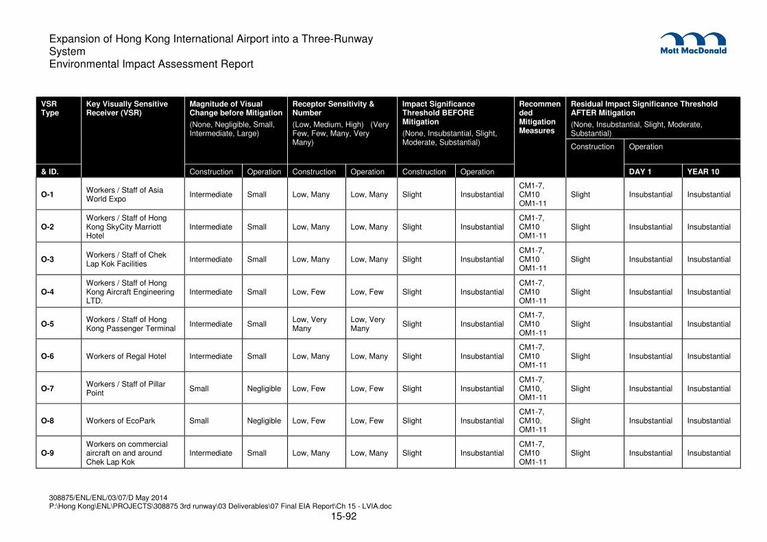
308875/ENL/ENL/03/07/D May 2014 P:\Hong Kong\ENL\PROJECTS\308875 3rd runway\03 Deliverables\07 Final EIA Report\Ch 15 - LVIA.doc
15-92
Expansion of Hong Kong International Airport into a Three-Runway System Environmental Impact Assessment Report
VSR Type
Key Visually Sensitive Receiver (VSR)
Magnitude of Visual Change before Mitigation
(None, Negligible, Small, Intermediate, Large)
Receptor Sensitivity & Number
(Low, Medium, High) (Very Few, Few, Many, Very Many)
Impact Significance Threshold BEFORE Mitigation
(None, Insubstantial, Slight, Moderate, Substantial)
Recommended Mitigation Measures
Residual Impact Significance Threshold AFTER Mitigation
(None, Insubstantial, Slight, Moderate, Substantial)
Construction Operation
& ID. Construction Operation Construction Operation Construction Operation DAY 1 YEAR 10
O-1 Workers / Staff of Asia World Expo
Intermediate Small Low, Many Low, Many Slight Insubstantial CM1-7, CM10 OM1-11
Slight Insubstantial Insubstantial
O-2 Workers / Staff of Hong Kong SkyCity Marriott Hotel
Intermediate Small Low, Many Low, Many Slight Insubstantial CM1-7, CM10 OM1-11
Slight Insubstantial Insubstantial
O-3 Workers / Staff of Chek Lap Kok Facilities
Intermediate Small Low, Many Low, Many Slight Insubstantial CM1-7, CM10 OM1-11
Slight Insubstantial Insubstantial
O-4 Workers / Staff of Hong Kong Aircraft Engineering LTD.
Intermediate Small Low, Few Low, Few Slight Insubstantial CM1-7, CM10 OM1-11
Slight Insubstantial Insubstantial
O-5 Workers / Staff of Hong Kong Passenger Terminal
Intermediate Small Low, Very Many
Low, Very Many
Slight Insubstantial CM1-7, CM10 OM1-11
Slight Insubstantial Insubstantial
O-6 Workers of Regal Hotel Intermediate Small Low, Many Low, Many Slight Insubstantial CM1-7, CM10 OM1-11
Slight Insubstantial Insubstantial
O-7 Workers / Staff of Pillar Point
Small Negligible Low, Few Low, Few Slight Insubstantial CM1-7, CM10, OM1-11
Slight Insubstantial Insubstantial
O-8 Workers of EcoPark Small Negligible Low, Few Low, Few Slight Insubstantial CM1-7, CM10, OM1-11
Slight Insubstantial Insubstantial
O-9 Workers on commercial aircraft on and around Chek Lap Kok
Intermediate Small Low, Many Low, Many Slight Insubstantial CM1-7, CM10 OM1-11
Slight Insubstantial Insubstantial
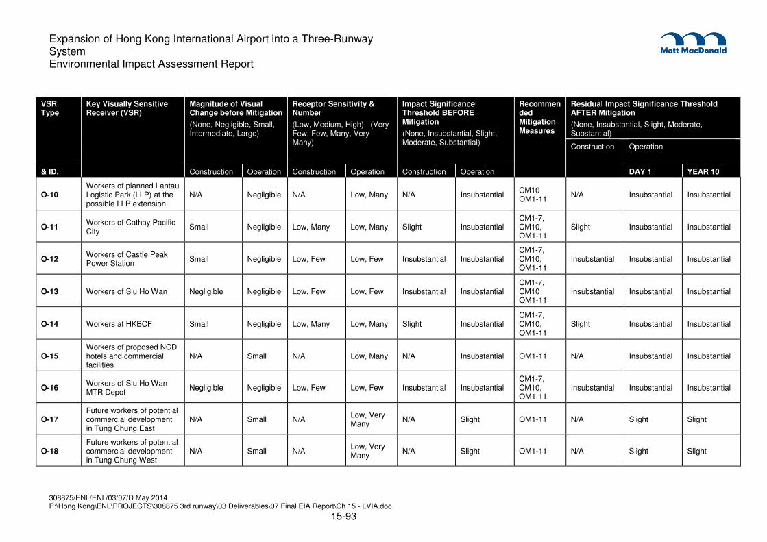
308875/ENL/ENL/03/07/D May 2014 P:\Hong Kong\ENL\PROJECTS\308875 3rd runway\03 Deliverables\07 Final EIA Report\Ch 15 - LVIA.doc
15-93
Expansion of Hong Kong International Airport into a Three-Runway System Environmental Impact Assessment Report
VSR Type
Key Visually Sensitive Receiver (VSR)
Magnitude of Visual Change before Mitigation
(None, Negligible, Small, Intermediate, Large)
Receptor Sensitivity & Number
(Low, Medium, High) (Very Few, Few, Many, Very Many)
Impact Significance Threshold BEFORE Mitigation
(None, Insubstantial, Slight, Moderate, Substantial)
Recommended Mitigation Measures
Residual Impact Significance Threshold AFTER Mitigation
(None, Insubstantial, Slight, Moderate, Substantial)
Construction Operation
& ID. Construction Operation Construction Operation Construction Operation DAY 1 YEAR 10
O-10 Workers of planned Lantau Logistic Park (LLP) at the possible LLP extension
N/A Negligible N/A Low, Many N/A Insubstantial CM10 OM1-11
N/A Insubstantial Insubstantial
O-11 Workers of Cathay Pacific City
Small Negligible Low, Many Low, Many Slight Insubstantial CM1-7, CM10, OM1-11
Slight Insubstantial Insubstantial
O-12 Workers of Castle Peak Power Station
Small Negligible Low, Few Low, Few Insubstantial Insubstantial CM1-7, CM10, OM1-11
Insubstantial Insubstantial Insubstantial
O-13 Workers of Siu Ho Wan Negligible Negligible Low, Few Low, Few Insubstantial Insubstantial CM1-7, CM10 OM1-11
Insubstantial Insubstantial Insubstantial
O-14 Workers at HKBCF Small Negligible Low, Many Low, Many Slight Insubstantial CM1-7, CM10, OM1-11
Slight Insubstantial Insubstantial
O-15 Workers of proposed NCD hotels and commercial facilities
N/A Small N/A Low, Many N/A Insubstantial OM1-11 N/A Insubstantial Insubstantial
O-16 Workers of Siu Ho Wan MTR Depot
Negligible Negligible Low, Few Low, Few Insubstantial Insubstantial CM1-7, CM10, OM1-11
Insubstantial Insubstantial Insubstantial
O-17 Future workers of potential commercial development in Tung Chung East
N/A Small N/A Low, Very Many
N/A Slight OM1-11 N/A Slight Slight
O-18 Future workers of potential commercial development in Tung Chung West
N/A Small N/A Low, Very Many
N/A Slight OM1-11 N/A Slight Slight
308875/ENL/ENL/03/07/D May 2014 P:\Hong Kong\ENL\PROJECTS\308875 3rd runway\03 Deliverables\07 Final EIA Report\Ch 15 - LVIA.doc
15-94
Expansion of Hong Kong International Airport into a Three-Runway System Environmental Impact Assessment Report
15.8 Cumulative Impacts
15.8.1 General
15.8.1.1 The landscape and visual impacts generated by the 3RS are also assessed in the context of the
impacts associated with the concurrent projects as described in Section 15.4.6 and illustrated on
Drawing MCL/P132/EIA/15-011. (Note that cumulative impacts of already committed projects
that will be completed by 2016 form part of the landscape and visual baseline are not included in
the cumulative assessment, namely HKLR, HKBCF, Southern Connection of the TM-CLKL and
public rental housing development at Tung Chung (Area 56))
15.8.1.2 The major projects which are concurrent with the 3RS include Northern Connection of TM-CLKL,
Tung Chung New Town Extension Study, Lantau Logistics Park (LLP), Leisure and Entertainment
Node at Sunny Bay, Intermodal Transfer Terminus (ITT) (on HKIA), North Commercial District
(NCD) (on HKIA), the New Contaminated Mud Marine Disposal Facility at East Sha Chau and
Airport East, the proposed public housing development at Tung Chung West (Area 39), Organic
Waste Treatment Facilities at Siu Ho Wan, and the proposed residential development at Tung
Chung (Area 54).
15.8.2 Cumulative Landscape Impacts
15.8.2.1 The only concurrent projects that fall within the landscape study area of the 3RS are NCD and
ITT. NCD would occupy the vacant site of the decommissioned SkyCity Nine Eagles Golf Course
(CLK/LCA8 On-Going Major Development Landscape), and thus there would be no additional
adverse impacts from the NCD. ITT would occupy the current site of the SkyPier which has no
landscape resources, so there would be no additional impact on landscape resources or
landscape character resulting from ITT.
15.8.3 Cumulative Visual Impacts
15.8.3.1 Within the ZVI of the 3RS, the listed concurrent projects would create additional visual impacts on
the VSRs identified in this LVIA.
15.8.3.2 The projects involving land formation along the coastline would cause visual impacts to adjacent
VSRs including those VSRs identified in this LVIA. The degree of visual impact will vary greatly
between VSRs, based primarily on the relative proximity of the VSR to the source of the impact,
however it may be concluded in general terms that the cumulative visual impacts resulting from
the concurrent reclamation projects would be greater than the impacts resulting from the 3RS
alone. This is because the reclamation projects will generally be closer to the VSRs than the 3RS,
and thus the visual impacts from those reclamation projects will tend to be greater than those
resulting from the 3RS. The overall effect of the reclamations will be to change the landscape and
visual character of the north Lantau coastline from one of rural fringe and transportation corridor
to a more urbanized character.
15.8.3.3 Within the airport island, NCD and ITT will create some visual change. ITT will modify existing
SkyPier facilities with little visual change in character. NCD would have a maximum building
height of approx. 53 mPD and would be designed to sit comfortably within the airport landscape.
There would be no significant adverse visual impact caused by NCD greater than what has

308875/ENL/ENL/03/07/D May 2014 P:\Hong Kong\ENL\PROJECTS\308875 3rd runway\03 Deliverables\07 Final EIA Report\Ch 15 - LVIA.doc
15-95
Expansion of Hong Kong International Airport into a Three-Runway System Environmental Impact Assessment Report
already been identified for the construction of the 3RS. In fact, the presence of a well-designed
and landscaped NCD may provide a net positive visual impact to the Landscape Character
(CLK/LCA8, Ongoing Major Development Landscape).
15.8.3.4 The New Contaminated Mud Marine Disposal Facility at East Sha Chau and Airport East would
have no long term impact on the visual context of the area as the facility would result in no
physical presence other than sea traffic during the disposal period.
15.9 Environmental Monitoring and Audit
15.9.1 Construction Phase
Monitoring of Design, Construction and Establishment Works
15.9.1.1 The design, implementation and maintenance of landscape and visual mitigation measures (refer
to Table 15.6 and Table 15.7) shall be checked to ensure that they are fully realised and that any
potential conflicts between the proposed landscape measures and any other project works and
operational requirements are resolved at the earliest possible date and without compromise to the
intention of the mitigation measures.
Design of Landscape and Visual Mitigation Measures
15.9.1.2 The detailed design of the landscape and visual mitigation measures shall be undertaken so as to
ensure compliance with the measures described in Section 15.6.4.
Site Supervision of Landscape Works
15.9.1.3 The implementation of the landscape works during the construction phase and establishment
works shall be inspected through the site audit program.
15.9.2 Operation Phase
Monitoring of Landscape Establishment
15.9.2.1 All landscape and visual mitigation measures shall be monitored during the landscape
establishment period to check that intended mitigation effects are realised.
15.10 Conclusion
15.10.1 Landscape Impacts
15.10.1.1 The principle landscape impacts will be on the Coastal waters of North Lantau. The physical
impact upon the Coastal waters of North Lantau is ‘Substantial’ in relation to the entire resource
as a whole; however the impact upon the Coastal waters of North Lantau would remain
Substantial during the operation phase as the loss of 650 ha of coastal waters cannot be
mitigated.
15.10.1.2 It is anticipated all other LRs and LCAs that have not been described above after the construction
phase would largely be restored to their pre-construction state. Mitigation measures including

308875/ENL/ENL/03/07/D May 2014 P:\Hong Kong\ENL\PROJECTS\308875 3rd runway\03 Deliverables\07 Final EIA Report\Ch 15 - LVIA.doc
15-96
Expansion of Hong Kong International Airport into a Three-Runway System Environmental Impact Assessment Report
compensatory tree, shrub and groundcover planting would minimise the residual impacts on the
airport landscape. The reduction of construction period to a practical minimum and the immediate
grassing and treatment of disturbed areas would help restore the landscape to its pre-
construction quality. With the implementation of mitigation measures, the residual impact has
been assessed as Slight and Insubstantial.
15.10.1.3 It is anticipated that the majority of trees affected by the 3RS will be young to semi-mature trees
of common species and will either be felled or transplanted if suitable. No OVTs are located
within the project site boundary. To mitigate the loss of the existing trees and to restore the
landscape to its existing condition, compensatory tree planting is proposed according to the
relevant Technical Circulars.
15.10.2 Visual Impacts
15.10.2.1 The primary visual impacts of the 3RS would result from the construction of a 650 ha land
formation north of HKIA. The 3RS would likely have minimal residual visual impacts as the major
geomorphic features of the North Lantau and Tuen Mun Region, such as the ridge lines of Castle
Peak, Lantau Island and Tai Lam Country Park would remain intact thus preserving the overall
landscape character of area. The implementation of operation phase mitigation measures such
as the sensitive design of the airport buildings and facilities in terms of scale, height, visual
weight, lighting, materials and colours as well as greening measures such as screening, green
walls and green roofs will help reduce the residual impacts of the new T2 expansion and
associated facilities.
15.10.2.2 The presence of the 3RS would have Slight and Insubstantial residual visual impacts on the
surrounding VSRs as the form and character will be consistent with that of the existing HKIA. The
greatest visual impacts will be experienced by REC13 (Passengers / Drivers of recreational
marine craft users in north Lantau waters and Urmston Road) who are transient in nature, and
REC21 (Recreational users of Sha Chau islands) who are very few in number, and are predicted
to experience a Moderate impact significance.
15.10.3 Overall Conclusion
15.10.3.1 It is unavoidable that a development of this scale will have impacts on the environment, which are
identified and addressed in this EIA with the aim of avoiding (where practicable) and at the very
least, minimising such impacts to within acceptable levels. Nevertheless, there are opportunities,
at the project’s design, construction and operation stages, for incorporating positive
environmental aspects into the project. Among others, these include providing flexibility for
avoiding night time use of the southern runway and enabling further environmental efficiencies to
be incorporated into the new airport buildings and facilities.
15.10.3.2 As described above, there is one landscape impact caused by the 3RS that is considered to be of
substantial significance, namely that experienced by CLK/LR1 Coastal Waters of North Lantau,
and two visual impacts, considered to be of moderate significance, namely that experienced by
REC13 Passengers / Drivers of recreational marine craft users in north Lantau waters and
Urmston Road and REC21 Recreational users of Sha Chau islands.
15.10.3.3 Furthermore, although CLK/LR1 Coastal Waters of North Lantau is considered to suffer
substantial impact, the loss is the absolute minimum necessary for the creation of the 3RS and

308875/ENL/ENL/03/07/D May 2014 P:\Hong Kong\ENL\PROJECTS\308875 3rd runway\03 Deliverables\07 Final EIA Report\Ch 15 - LVIA.doc
15-97
Expansion of Hong Kong International Airport into a Three-Runway System Environmental Impact Assessment Report
there will remain, even after the impact, a significant large area (much larger than the impacted
area) of CLK/LR1 Coastal Waters of North Lantau that will be unaffected by 3RS and that will be
available in the operation phase as an ongoing landscape resource.
15.10.3.4 Taking this into account and since despite the very large scale of the development, only one
sensitive receiver suffers substantial impact and only two suffer moderate impacts and all other
sensitive receivers identified in this chapter suffer slight, insubstantial or no impacts, it is therefore
considered that in accordance to the criteria and guidelines for evaluating and assessing impacts
as stated in Annex 10 and 18 of the EIAO-TM, the overall residual landscape and visual impacts
of the proposed 3RS are marginally acceptable with mitigation during the construction and
operation phases.
Related Documents