Tasmanian Heritage Register Datasheet 134 Macquarie Street (GPO Box 618) Hobart Tasmania 7001 Phone: 1300 850 332 (local call cost) Email: [email protected] Web: www.heritage.tas.gov.au Name: Woodbury THR ID Number: 12007 Status: Provisionally Registered Municipality: Southern Midlands Council Tier: Location Addresses Title References Property Id 162120/1 3345573 7489 MIDLAND HWY, WOODBURY 7120 TAS 168928/1 3345565 7487 MIDLAND HWY, WOODBURY 7120 TAS Main house Austral Archaeology Main House c1870s additions to rear Austral Archaeology c.1830s stable Austral Archaeology Shearing shed, east elevation Austral Archaeology c.1830 barrack building Austral Archaeology c.1820s stable and coach house, ruin Austral Archaeology Timber machinery shed Austral Archaeology c.1870s Woodbury Cottage Austral Archaeology Worker's Cottage (early 20th century) Austral Archaeology c.1930s garage buildings Austral Archaeology Setting: Woodbury is located in the rural district which is also named Woodbury , and is almost exactly halfway between Launceston to the north and Hobart to the south. Woodbury is situated between undulating hills and open fields in the broad plains of the Southern Midlands, with distant views to Currajong Hills in the west. The property abuts the western side of the Midland Highway and TasRail’s South Line railway. The Wednesday, July 7, 2021 Page 1 of 8

Welcome message from author
This document is posted to help you gain knowledge. Please leave a comment to let me know what you think about it! Share it to your friends and learn new things together.
Transcript

Tasmanian Heritage Register Datasheet
134 Macquarie Street (GPO Box 618) Hobart Tasmania 7001
Phone: 1300 850 332 (local call cost) Email: [email protected]
Web: www.heritage.tas.gov.au Name: Woodbury THR ID Number: 12007
Status: Provisionally Registered Municipality: Southern Midlands Council
Tier:
Location Addresses Title References Property Id162120/1 33455737489 MIDLAND HWY, WOODBURY 7120 TAS
168928/1 33455657487 MIDLAND HWY, WOODBURY 7120 TAS
Main house
Austral Archaeology
Main House c1870s
additions to rear
Austral Archaeology
c.1830s stable
Austral Archaeology
Shearing shed, east
elevation
Austral Archaeology
c.1830 barrack
building
Austral Archaeology
c.1820s stable and
coach house, ruin
Austral Archaeology
Timber machinery
shed
Austral Archaeology
c.1870s Woodbury
Cottage
Austral Archaeology
Worker's Cottage
(early 20th century)
Austral Archaeology
c.1930s garage
buildings
Austral Archaeology
Setting: Woodbury is located in the rural district which is also named Woodbury , and is almost exactly halfway
between Launceston to the north and Hobart to the south. Woodbury is situated between undulating hills
and open fields in the broad plains of the Southern Midlands, with distant views to Currajong Hills in the
west. The property abuts the western side of the Midland Highway and TasRail’s South Line railway . The
Wednesday, July 7, 2021 Page 1 of 8
construction of the railway in 1876 and realignment of the highway to its current position during the 1970s
both cut through the front gardens of Woodbury, each time bringing elements of the place into greater visual
prominence.
Description: Woodbury contains a complex of buildings, historic garden and landscape elements, and areas of
archaeological potential. The main house is located within a large ornamental garden, and a number of rural
outbuildings, including staff accommodation, are located to the south of the main house.
Garden and broader landscape
The main house’s large mature garden is enclosed on the northern and southern sides by
recently-constructed timber picket fences with decorative posts and gates. The eastern portion of the
garden is mostly screened from the highway by elms (mature and suckered specimens) which have been
formed into a hedge. The alignment of the original carriage entrance to the property can still be discerned
on the southern side of the main house, and is flanked by a short avenue of mature elms. The garden
contains numerous historic plants and trees, including a very old mulberry tree likely to have been planted at
the same time as the early orchard to the east of the house. These trees’ alignments mark early internal
road or path formations, possibly remnants of the orchard layout. The largest group of trees is a plantation
of approximately 20 elms located on the northern side of the house. They are already evident as large trees
in ‘a post-1876 photograph’ (privately held by A&L Cooper). Two connected timber-framed and clad c.1930s
garage buildings are located at the southern edge of the main house’s garden . Mature macrocarpa trees are
located along the south side of the timber picket fence between the garages and the highway.
An experimental plantation of casuarinas, acacias and eucalypts of 3 700 m2 – with a timber sculpture
spelling out ‘TREE’ in giant red-painted letters on its eastern boundary, along the west side of the highway –
are located to the north of the house. The sculpture is in poor condition, and is of contributory significance
in the wider context of Woodbury.
1. Main house
The main house at Woodbury is a building of mostly single-storey configuration, constructed in a series of
stages.
The first stage was built following the issuing of Woodbury’s original land grant to Robert Harrison in 1823, a
single room constructed from rubble stone. A series of rooms were later added to the southern elevation of
the c1823 structure around 1828, these rooms were utilised as a service area, including kitchen, store room
and bakers oven; the c1823 hipped roof clad with timber shingles remains intact under the c1828 roof
structure. Located at the southern end of the present-day house, this single-storey rubble sandstone wing
has a double-hipped roof clad with corrugated galvanised steel, three rendered masonry chimneys,
timber-framed external doors as well as casement and double-hung sash windows. The southern portion of
its western elevation incorporates a massive stone twinned-buttress structure, containing an alcove within
which a small three-by-three casement window is located. The northern edge of this wing abuts the house’s
next stage.
The main house’s central portion was constructed c1825. It is a single storey building with an attic and
cellar, with external walls of rendered and paint-finished stone, and a hipped roof clad with short sheets of
corrugated galvanised steel of bell-cast configuration that is continuous over an east and a west-facing pair
of verandahs. Its eastern elevation (facing the highway) features a timber-framed verandah with white-painted
decorative timber fretwork in a Gothic Revival style, and sandstone flags. The eastern edge of this verandah’
s floor is supported by a sandstone rubble wall, with a seven-riser flight of steps descending from its
mid-point to the garden. The eastern elevation’s central panelled timber door has side lights and an arched
timber fanlight over. It is flanked on each side by two pairs of timber French windows accessing the
verandah, with each pair containing twenty-four panes. The southern portion of the west- facing verandah’s
outer edge is open and also features Gothic Revival-style painted timber fretwork. The remainder of the
west-facing verandah is enclosed along its perimeter by a mid-twentieth century wall with a low rendered
masonry base supporting panes of timber-framed glass. The elements of this wall are not of heritage
significance. The west-facing roof plane contains two small timber-framed dormer windows which provide
light and ventilation to the attic storey. Two large rendered masonry chimneys are located in the north - and
south-facing roof planes, each situated close to the ridge.
In the 1870s, a wing abutting the c.1825 portion’s northern elevation was added to the main house. The roof
of the 1870s wing is a simple gable with decorative carved timber barge boards, and features two rendered
masonry chimneys. This wing’s eastern elevation has a centrally-positioned one-over-one Victorian
timber-framed sash window. During the construction of the 1870s works, the house’s five earlier chimneys
were upgraded with render and projecting string courses to match the appearance of its two new chimneys.
Recently-completed building works at the main house are not of heritage significance, including: a
northwards extension in early 2017 of the c.1825 wing’s verandah roof across part of the 1870s wing’s
western elevation, and construction of masonry-walled rooms beneath that roof; and a large new room at the
house’s southeast – abutting the east-facing wall of the original wing completed c.2017–18. The room
features parapets to its external stone walls, an east-facing wall containing timber-framed windows and a
pair of French doors, and a roof with a central timber-framed rectangular lantern. These works also included
construction of a new verandah, supported by timber twinned-posts set on stone bases, along the southern
end of the c1823 wing’s east-facing wall, replacing a mid-twentieth century concrete block structure.
The broader farm complex includes a group of outbuildings situated to the south of the main house, in an
area of largely cleared pasture.
Wednesday, July 7, 2021 Page 2 of 8

2. Stable and coach house (c.1820s)
Presently in a ruinous condition, this was the first stable building on the property, and it was built with walls
of rubble field stones and a cobbled floor. The end gable walls remain in place; the eastern end has a
central doorway flanked by small openings and a loft opening above. Following the completion of Woodbury’
s second (c.1830s) stables, this original stable and coach house building was converted to a heavy horse
stable.
3. Timber shearing shed (c.1820s, c.1870s)
The shearing shed is located at the far southern end of the group of outbuildings on the adjacent parcel at
7487 Midland Highway. Its original portion, at the eastern end of the building, is thought to date to the
1820s, however, Chapman dates it c.1870s (2011, p.23). It has a traditional ‘Georgian’ form with a central
doorway, flanking twelve-pane timber windows and a hipped roof clad with corrugated iron. Adjoining the
original shed are later nineteenth and twentieth century additions – the first a gabled pavilion to the original
shed’s western elevation, which was then in turn further extended to its north and south. The shed’s
interiors contain wall-mounted machine-shearing electric motors, and extensive intact timber stalls, gates,
doors, partition walls and timber flooring, some sections with narrow gaps between the boards. Painted
stencilled lettering is evident on areas of some of the internal walls’ timber lining boards .
4. Stables (c.1830s)
Located approximately 90 metres south-east of the main house, the stables were constructed c1.830s from
ashlar and rubble sandstone. The northern elevation has a central doorway with double timber doors, and
flanking windows each with moulded arched openings and timber fanlights. The eastern elevation has a loft
door with timber lintel above and external timber frame and platform, and the western elevation has an
off-centre window and loft door in the timbered gable end. The building has a gabled corrugated iron roof.
5. Barracks (c.1830)
Located approximately 120 metres south-east of the main house, this building is thought to have been
constructed by c.1830 as a barracks to house convicts assigned to a road gang ( A Cooper, pers. comm. 14
June 2018). Built principally of field stone, with dressed sandstone at the corners and windows, the low
building is seven bays long with doors at either end. Its shingled roof was installed in the 1980s. Substantial
stone and brick external fireplaces sit at each end of the building.
Internally the building is mostly an open space with timber floors and walls and ceilings surfaced with
sheeting with timber strip detail. A brick fireplace with timber mantelpiece sits at the western end of the
building. A section of the eastern end of the building is partitioned and has a brick hearth with cast iron
range installed in the end of the building.
6. Timber machinery shed (early twentieth century)
The shed abuts the western end of the 1820s-constructed stable and coach house / heavy horse stable
building. The building is clad in unpainted vertical timber boards with a corrugated iron roof, the southern
elevation is open and roof is supported by large timber posts - one has collapsed causing the roof to sag.
7. Shearers’ quarters (c.1930s)
The shearer’s quarters sits adjacent to the southern elevation of the former barracks building , running
north-south. Clad in vertical timber board the building has small multi-paned windows, gabled roof clad in
corrugated iron and a central low brick chimney.
8. Woodbury Cottage (c.1870s)
One of two weatherboard worker’s houses located within the farm complex , it is located approximately 160
metres south of the main house. It is a single-storey timber structure clad in weatherboards with a hipped
and gabled corrugated iron and brick chimneys. The northern elevation has an enclosed verandah with
skillion roof, the sides of the house are obscured by plantings and the southern elevation has an enclosed
yard.
9. Worker’s Cottage (early twentieth century)
One of two weatherboard worker’s houses it is located at the western edge of the group of outbuildings ,
approximately 150 metres south-west of the main house. Clad in weatherboards the cottage has timber
sash windows, a hipped roof form with gable to the northern elevation clad in corrugated iron with low painted
brick chimney. An enclosed verandah wraps around the northern and western elevations, there is a skillion
addition and outbuildings on the southern side. The cottage sits within a fenced yard.
Archaeological Potential
Woodbury has the potential to yield information which would contribute to an understanding of the
functioning and evolution of colonial-era and later period agricultural properties. This potential may be
associated with buildings (their structure, materials, construction methods), structures (e.g. fencing/walling,
possible sawpits, lime kilns, brick pits, sheep washes/dips, water distribution infrastructure etc.), gardens,
Wednesday, July 7, 2021 Page 3 of 8
activity areas (eg. yards, stockyards), as well as subsurface remains and deposits including those
associated with buildings and structures that are no longer extant, ceiling, wall and floor cavities of extant
buildings, cesspits, privies and refuse piles. These resources have the potential to provide information as to
the form, functions and spatial layout of the place along with aspects of Tasmanian rural culture including
class and gender differences, economic fluctuations, and changing rural landscape, practices and
technologies.
An extensive complex of archaeological features is located around the existing house and outbuildings of
Woodbury. Archaeological deposits are likely to occur in all standing buildings; in the immediate vicinity of
all standing buildings; and archaeological footprints of former buildings. Archaeological evidence of formal
plantings and gardens is likely to be present to the east of the main house. The archaeological potential of
Woodbury includes but is not limited to the following features (recorded in 2018):
10. Archaeological feature - Drystone wall remains: The wall to the north of the main house trends for
approximately 90 m in a north-easterly direction, and is approximately a maximum 0.5 m in height in
places.
11. Archaeological feature - Building site: Possibly relating to staff housing, approximately 13m x 8m,
located to the northeast of the main house, and now within the eastern Midland Highway reservation.
12. Archaeological feature - Shepherd’s cottage: The site of a small single-roomed cottage,
approximately 10m x 10m, north of the main house and marked by a mound of field stones.
13. Archaeological feature - Brick-lined well: Approximately 1.2m in diameter, located beneath the
macrocarpas.
14. Archaeological feature - Sandstone trough remnants: The remnants are approximately 1.2m long,
located near the macrocarpas.
15. Archaeological feature - Building footings: Surface evidence of the stone footings of a building
approximately 12m x 10m located to the south of the main house. The function of this former building is not
known.
16. Archaeological feature - Building footings: Surface evidence of the stone footings of a building on
the southern side of the ruined 1820s stable, approximately 17m x 8m. These footings may relate to the
dairy.
17. Archaeological feature - Building footings: Surface evidence of the stone footings of a building, to
the west of the machinery shed, approximately 15m x 15m. These footings may relate to the granary.
18. Archaeological feature - Building footings: Surface evidence of the stone footings of a building on
the southern side of the barracks building, approximately 8m x 6m. These footings may relate to the
blacksmith’s shop.
Moveable Heritage
A large number of deliberately concealed items were discovered at Woodbury during restoration works
carried out by the current owners in the early 2000s. The items included hats, parasols, leather leggings,
documents, and a total of 39 boots and shoes – all of which had been hidden in cavities within the house.
These items have been identified as part of the traditional European practice of burying items to ward off evil
spirits, a practice transferred to the Australian colonies during the nineteenth century (Evans 2010, pp.8, 9).
In 2019/2020 when this entry was developed these items formed the largest collection of ritually concealed
objects found in Australia. The items remain at Woodbury (Pers. Comm., A Cooper, 6 November 2015;
Daily Mail Australia, 17 October 2015). Apotropaic practices are known to have occurred throughout
Australia and Tasmania in the nineteenth century, and are an emerging area of interest and research.
History: Woodbury is located near what is understood to have been the tribal boundaries of three Aboriginal nations –
the Big River nation of central Tasmania, the Oyster Bay nation of the East Coast, and the North Midlands
nation (Ryan 2012, p.13). Prior to European occupation, the region had been managed by Tasmanian
Aborigines using traditional land management practices including regular low-intensity burning. Europeans in
the early colonial era viewed the resulting landscapes as well suited to stock raising and cropping.
European settlement and early ownership
The European history of Woodbury and the broader Antill Ponds area began during the early 1820s.
Woodbury originated as a 2000 acre grant issued to Robert Harrison (1769-1860) in 1823. Harrison and wife
Elizabeth arrived from England that year with their seven children and servants. His grant came with the
services of assigned convicts. Robert, along with his four sons, Hezekiah, George, William and Thomas,
went on to become the major early landowners in the Antill Ponds area , including the nearby property of
Rockwood (THR#5593) (TAHO LSD405/3/23).
Woodbury evolved to become a large self-sufficient agricultural estate with main house and numerous
service and staff housing buildings. The construction of the house occurred in several phases: the first being
the small rubble stone section located at the present-day southern end of the main house, and constructed
after Robert Harrison took up his grant. It was later expanded by c1825 with the addition to the northern
side of the original house of what now forms the central wing. This section of the house incorporated
window sashes, shutters, doors and surrounds of Blackwood sourced from the property ( A Cooper, pers.
comm. 14 June 2018; TAHO, CSO1/1/371/8470; Mercury 19 November 1884, p.1 Supplement). It had been
completed by 1830 when author Augustus Prinsep noted the ‘pretty house and garden’ during his journey
through the midlands (Prinsep 1833, p.89). By c1828 additional rooms, including kitchen, store rooms and
bread oven, were constructed on the southern side of the original one room structure ( pers comm A & L
Wednesday, July 7, 2021 Page 4 of 8
Cooper 15 July 2020).
Other early buildings constructed on the property included the now ruined 1820s former stable and coach
house, and a barracks building to the south which was completed by c.1830 and was likely to have been
constructed as housing for convicts assigned to construct roads in the area ( A Cooper, pers. comm. 14
June 2018).
Strategically located on the “main” road between population centres in the north and south, two soldiers
were stationed at the property during its early years of European occupation to offer protection from attack .
By 1842, 22 people normally resided at Woodbury, of whom only eight were free, the remainder being
assigned convicts (Von Stieglitz 1976, p15; TAHO, CEN1/1/34).
Garden and grounds
Woodbury was noted for its gardens from an early date. A painting from the c1830s shows the house with
productive gardens planted at the front, which later evolved to include extensive ornamental plantings ( TAHO
PH30/1/1993). A post-1876 photograph shows a similar view to the earlier painting, but with the greater
emergence of ornamental plantings around the house (private collection, A& L Cooper). A detailed article
from 1884 noted ornamental flowers of lilacs, alba, violets and laburnums and a row of symmetrical elder
trees. The orchard had apple, pear, cherry, apricot and almond trees ( Mercury, 19 November 1884, p.1S).
Family tragedy
1860 proved to be a tragic year for the Harrison family, following the death of four members of the family
within two months; Robert Harrison passed away at the age of 91 (Mercury 18 July 1860, p.3), Elizabeth
Harrison, wife of Robert Harrison, died at Woodbury at the age of 88 (Launceston Examiner 24 July 1860,
p.2); Hezekiah Harrison Esq of Merton Vale, Campbell Town son of Robert Harrison died at the age of 63 on
board the steamer Tasmania off the Sydney Heads (The Cornwall Chronicle 21 July 1860, p.4) and his wife
Caroline Matilda Harrison died weeks later (Launceston Examiner 7 August 1860, p.2). Ownership of
Woodbury, and adjacent Edinthorpe, passed to William Harrison (Mercury 15 June 1870, p.4). It is
speculated that the number of concealed objects found at Woodbury is linked to the number of deaths in the
Harrison family within a short time during 1860.
Headlam family
Financial difficulty led to the sale of Woodbury in 1870, by this time, the estate covered thousands of acres
as three separate concerns: Woodbury, Edinthorpe and the Big Plains properties (TAHO, NS162/1/12). The
sale notice stated ‘Important notice to capitalists and other of the sale of a most valuable and beautiful
estate of 7224 acres of land…The well-known and much admired estate of Woodbury…a spacious
dwelling-house, fronting the main road, with productive garden and orchard adjoining, large substantial barn,
2 stables, coach-house and granary, all of stone, servants’ cottages, and every description of buildings
requisite for a complete extensive establishment, sheep dip and hot-water wash, stock yards, & c…’
(Mercury 15 June 1870, p.4).
In 1871 Mr Charles Headlam of Egleston purchased the property (LTO Mem 5/7527). However the property
transferred over to his son John shortly after, and Charles continued to reside at Egleston until his death in
1898 (Mercury 1 Jan 1875, p.1; Launceston Examiner 17 Oct 1898, p.5). Charles Headlam’s other five sons
owned substantial rural properties across Tasmania, Mr Anthony Headlam of Lamont, Robert Headlam of
Vaucluse, Charles Headlam of Charlton, T Headlam of Nant and Alfred Headlam of Beverley (Launceston
Examiner 17 Oct 1898 p.5). The main house was extended with a new wing at its northern end during this
period (A Cooper, pers. comm. 14 June 2018). The Headlams continued to graze sheep on the property
and the wool was sent to the London market (Mercury 29 July 1903, p.6). Upon John Headlam’s death in
1920 (TAHO Wills 12940 p.315) Woodbury was purchased at auction by his son Malcom Headlam (Mercury
18 Nov 1920, p.4; 6 Feb 1923, p.2). The adjacent properties Rockwood and Allan Vale also owned by the
Headlam family were sold at a later date (Mercury 18 Nov 1920, p.4).
Christopher Salmon
In 1921 Christopher Salmon purchased the Woodbury Estate from the Headlam family (Mercury 25 Oct
1921, p.4; LTO Con 15/5640), the son of Samuel Salmon of Woodstock, Triabunna (THR#1579) (Examiner
26 Feb 1942, p.4). It was during this period that the Midland Hunt Club started meeting on the property
(Examiner 10 July 1929, p.2). Christopher Salmon passed away at Woodbury in 1942 and his son Samuel
James Salmon took over the property (Mercury 28 Feb 1942, p.4).
LH Lawrence
In 1950 ownership of Woodbury transferred to Lawrence Howard Lawrence following the death of Samuel
James Salmon (LTO Con 25/4164). Originally from Euroa in Victoria, Lawrence died in 1970 (The Geelong
College). The Midland Hunt Club continued to meet at Woodbury (Mercury 20 July 1954, p.21).
During the mid-twentieth century a concrete block structure was constructed on the eastern elevation of the
southern wing, which incorporated a dairy, bathroom, toilet and cool store; the addition was demolished
c2000s (pers. comm. A & L Cooper 15 July 2020).
Midland Highway & TREE
The Midland Highway was realigned during the 1970s, cutting through the front garden of the property,
adjacent to where the Tasmanian Main Line Railway (TMLR) opened its Hobart to Evandale Road (Western
Wednesday, July 7, 2021 Page 5 of 8

Junction) line in 1876.
In 1996 a collaborative project was undertaken between the artist Elizabeth Smith, Landcare and school
children to draw attention to tree decline. A large dead tree to the north of Woodbury and close to the
highway was painted red and gained national attention as a symbol of ecological degradation. Vandals
burned down the tree later in 1996. In response, in 1997 artist Ray Norman created a timber sculpture
spelling out ‘TREE’ in giant letters, again painted red and located in a nearby paddock. In 2002 the
Cooperative Research Centre for Sustainable Production Forestry established a large trial plantation to the
north of Woodbury. Working in collaboration with a range of groups, the plantation consisting of a range of
Casuarina, Acacias and Eucalypts, aims to demonstrate the successful reforestation of the midlands
landscape. The ‘TREE’ installation was moved to a position between the plantation and highway , and is
currently in a semi-vertical position propped against a post-and-rail fence ( Red Tree Tasmania Press).
In 2000 Woodbury was purchased by Linda and Allen Cooper who soon commenced restoration of the
house, outbuildings and gardens.
Comparative Analysis
The size of the properties, access to assigned convict labour and the wealth generated by wool allowed for
the establishment of estates on a considerable scale. Typically, these would include a large house
constructed from permanent materials and a range of service buildings to support the business, along with
staff housing to accommodate farm workers. Many such elements (e.g., stables, barns and so forth) can be
found across most agricultural properties, along with landscape elements such as cleared pastures, field
enclosure (wire or hedgerows), and outlying huts. Elements such as shearing sheds and yards, wool sheds
and sheep dips or washes are distinct to pastoralism. Shearing sheds are probably the most prominent of
such pastoral buildings, typically being the largest of rural buildings. Shearing sheds are commonly long
and low structures, often constructed from timber allowing for easy extensions. Many have their floors
elevated above the ground to allow waste to fall through (Ratcliff Vol.3 2015, p.1464).
Woodbury is located in one of Tasmania’s key pastoral districts and was granted at a period consistent with
the emergence of pastoralism in the colony. It demonstrates a number of key attributes common to large
pastoral properties. These include the large main house, separate staff housing, former coach house and
stables buildings, shearing shed, machinery shed and shearer’s quarters.
There are a number of other pastoral properties entered in the Tasmanian Heritage Register where the
cultural heritage values can be easily read in the extant fabric. Woolmers (THR#5077) at Longford has a
complex which includes a large main house, stables and coach house, various staff houses, cart shed,
former chapel, farm stables, timber woolshed (constructed in 1819 and possibly the oldest of its type in
Australia), cider press, blacksmith’s shop, bakehouse, store, pump house, windmills, sheep dip and site of
convict barracks. Similarly Cranbrook House (THR#1512) at Cranbrook has a large complex of building
including a large stone house, stone shed, wooden stable and wooden shearing shed. Quamby (THR#4832)
at Hagley has a large house, brick barns, stores, coach houses, staff housing, stables and shearing shed,
and Kelvedon (THR#1562) at Swansea includes a large house, stone stables, barn, shearing shed and
cottage.
Ritual objects, concealed in buildings as protection against witches and evil spirits, including mummified
cats, shoes, witch bottles, and apotropaic markings, such as hexafoils and burn marks, have been found in
the United Kingdom, Europe, North America and Australia. Markings and concealments occurred throughout
Australia and Tasmania in the nineteenth and early twentieth centuries . Known examples in Australia
include, Sydney’s Hyde Park Barracks, (which housed hundreds of convicts transported from England)
where shoes, rosary beads and clothing were found; cat remains were found concealed in conjoined
cottages at Miller’s Point, Sydney, and beneath Her Majesty’s Theatre in Ballarat. While no apotropaic
markings were found at Woodbury, markings have been found at both Shene at Pontville (THR#55554) and
Redlands (TH#1276) (Sutton). Ritual concealments and markings are an emerging area of interest and
research.
REFERENCES
Austral Tasmania Pty Ltd, 11 March 2016, Midland Highway, St Peters Pass to south of Tunbridge. Volume
2: Historic Heritage Assessment, Final Report prepared for Transport Infrastructure Services, Department of
State Growth, AT0198.
Chapman, A, 2011, Woolsheds: A Visual Journey of the Australian Woolshed, Scoresby, Vic:
Five Mile Press
Clements, G. ‘Railways’ in A Alexander (ed) Companion to Tasmanian History, University of Tasmania,
Hobart.
A Cooper (owner of Woodbury) pers. comm. 6 November 2015, 14 June 2018.
Evans, GW, 1822, A geographical, historical, and topographical description of Van Diemen’s Land: with
important hints to emigrants and useful information respecting the application for grants of land: together
with a list of the most necessary articles for persons to take out: embellished by a correct view of Hobart
Town, also, a large chart of the island., London: Printed for John Souter by J. and C. Adlard
Evans, Ian, 2018, Tasmanian Magic Research Project: Report of the Second Field Season
January 6 – 27, 2018.
Evans, Ian Joseph, 2010, Touching Magic: Deliberately Concealed Objects In Old Australian Houses And
Buildings, PhD thesis: School of Humanities & Social Science, University of Newcastle, NSW.
The Examiner, ‘Tasmanian Magic Research Project final report complete after second field trip of
Wednesday, July 7, 2021 Page 6 of 8

Tasmania’, 13 July 2018.
The Geelong College, ‘Lawrence, Laurence Howard (1891-1970’,
http://gnet.geelongcollege.vic.edu.au:8080/wiki/LAWRENCE-Lawrence-Howard-1891-1970.ashx, viewed
12/6/2019.
The Mercury: 15 June 1870, p.4; 19 November 1884, p.1S
Prinsep, A, The journal of a voyage from Calcutta to Van Diemen’s Land: comprising a description of that
colony during a six months’ residence, from original letters selected by Mrs. A. Prinsep , London: Smith,
Elder, 1833
Post-1876 photograph of Woodbury, looking west (L&A Cooper, Private Collection)
QVM 1987_P_0755, View of Woodbury House, Woodbury, Tasmania
QVM 1987_P_0866, View of buildings at Woodbury House, Tasmania
Rand, Anne, 2005, ‘The Land Commissioners’, pp.205-206, in Alexander, A, (ed.), The Companion to
Tasmanian History, Centre for Tasmanian Historical Studies, University of Tasmania: Hobart.
Ratcliff, E, 2015, A far microcosm: building and architecture in Van Diemen's Land and Tasmania
1803-1914. Volume 3, Hobart, Tasmania: Fullers Bookshop.
Red Tree Tasmania Press website: blog post ‘T-R-E-E read RED’ on 5 March 2012,
via http://redtreetasmaniapress.blogspot.com.au/
Ryan, Lyndall, 2012, Tasmanian Aborigines: A history since 1803, Allen & Unwin: Crows Nest, NSW.
Sheridan, G, February 2007: Woolmers Estate. Volume 1. Executive Summary of Volumes 2 and 3,
unpublished report prepared for the Woolmers Estate Inc .
Sutton, C. ‘Mummified cats, children’s shoes and EMBRYO in a purse’ Daily Mail Australia, 17 October
2015
via
https://www.dailymail.co.uk/news/article-3260075/Mummified-cats-children-s-shoes- EMBRYO-purse-hauntin
g-objects-hidden-walls-floorboards-Australian-homes-secret-19th-century-trend-ward-black-magic.html,
accessed 1 April 2020.
TAHO, CEN1/1/34, Harrison, Robert, 1842
TAHO, CSO1/1/371/8470, Robert Harrison Correspondence
TAHO, LSD405/3/23, Land Grant Register
TAHO, NS162/1/12, Plan of Woodbury and Edinthorpe and of Big Plains, at Antill Ponds and Tunbridge,
properties of William Harrison Esq. To be sold by Messrs Brent and Westbrook at their mart Hobart Town
Thursday 14 July 1870. A Randall del & Lith
TAHO, PH30/1/1993, Photograph - Side view of photograph of a painting, Woodbury Antill Ponds, by
Atkinson, John, with partial view of bottom of gilt frame
Von Stieglitz, KR, 1976: A Short History of Ross with some tales of the pioneers ,
Launceston: Telegraph Printery.
Statement of
Significance:
(non-statutory
summary)
Woodbury is of historic cultural heritage significance because it demonstrates early land settlement
practices and the development of pastoralism. Its extensive complex of standing buildings and
subsurface material has high research potential to provide important information related to the
development of a substantial rural estate. In 2020 when this entry was developed the main house at
Woodbury contains the largest collection of ritually concealed items in Australia . The place is a
particularly fine example of a pastoral estate on a considerable scale.
The Heritage Council may enter a place in the Heritage Register if it meets one or more of the following criteria from the
Historic Cultural Heritage Act 1995:
Significance:
Woodbury is of historic significance for its demonstration of patterns of early land settlement and use in Van Diemen’
s Land, with particular reference to the development of pastoralism supported by a convict workforce. Agricultural use
and development of the property commenced in 1823, an early period in the European settlement of Tasmania. The
scale of Woodbury’s main house, its gardens, and service buildings assist in demonstrating the wealth generated by
agriculture during the nineteenth century which in turn allowed the creation of impressive estates. The mature trees
and other garden elements at the place demonstrate the application of nineteenth-century northern hemisphere
garden design in the Tasmanian environment.
The place is important to the course or pattern of Tasmania’s history.a)
b)
Woodbury contains the largest collection of ritually concealed items found to date in Australia . The scale of the
collection is unusual and distinctive; the collection remains at Woodbury. The early nineteenth century section of
Woodbury’s timber shearing shed, thought to have been constructed in the 1820s, is likely to be a particularly early
surviving example of its type, and is of comparable age to the 1819 shearing shed at Woolmers (THR#5077).
The place possesses uncommon or rare aspects of Tasmania’s history.
Wednesday, July 7, 2021 Page 7 of 8

c)
Woodbury has the potential to yield information which would contribute to an understanding of the functioning and
pattern of evolution of Tasmania’s agricultural and pastoral properties developed during the earlier part of the
nineteenth century throughout the midlands. Investigation of standing structures, subsurface remains, underfloor
deposits, materials and roof spaces and cavities have the potential to yield information about the form, functions and
spatial layout of the place along with a range of aspects of nineteenth century Tasmanian rural culture , including class
and gender differences, economic fluctuations, and changing rural practices and technologies. Historic plantings and
landscaping elements could provide new information regarding garden design and fashions, plant availability and
acclimatisation of exotic species at that point in Tasmania’s history .
The collection of ritually concealed objects has possibly unparalleled potential for its ability to provide information
related to the transfer of British superstitions and folk customs to the Australian colonies .
The place has the potential to yield information that will contribute to an understanding of Tasmania’s
history.
d)
Woodbury is of architectural and historic significance as a representative example of rural properties associated with
the early development of Tasmania’s pastoral industry . Its layout, extant main house and farm outbuildings, gardens,
landscape and archaeological features constitute a particularly fine example of this class of place in the State-wide
context, and demonstrate the evolution of agricultural practices in Tasmania from the 1820s through to the twentieth
century.
The place is important in demonstrating the principal characteristics of a class of place in Tasmania’s
history.
e)
No Data Recorded
The place is important in demonstrating a high degree of creative or technical achievement.
f)
No Data Recorded
The place has a strong or special association with a particular community or cultural group for social or
spiritual reasons.
g) The place has a special association with the life or works of a person, or group of persons, of importance in
Tasmania’s history.
No Data Recorded
h) The place is important in exhibiting particular aesthetic characteristics.
Woodbury is highly visible from the Midlands Highway, the combination of historic buildings in various conditions with
mature plantings is of considerable visual appeal and distinctive within its setting. The house is located within a large
garden with numerous exotic trees which are distinctive in their number, height, form and seasonal variations. A
collection of farm buildings are located to the south, constructed at different periods, in different conditions and from
different materials – fieldstones, ashlar sandstone and weatherboard. Collectively, the buildings are cohesive as a
group of vernacular farm buildings that sit adjacent to the Midlands Highway.
PLEASE NOTE This data sheet is intended to provide sufficient information and justification for listing the place on the
Heritage Register. Under the legislation, only one of the criteria needs to be met. The data sheet is not
intended to be a comprehensive inventory of the heritage values of the place, there may be other heritage
values of interest to the Heritage Council not currently acknowledged.
Wednesday, July 7, 2021 Page 8 of 8
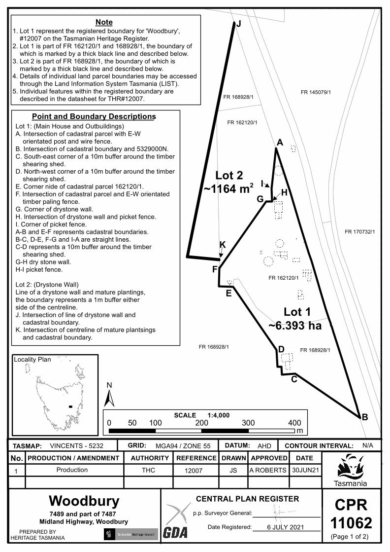
CPR11062
CENTRAL PLAN REGISTERp.p. Surveyor General:
Date Registered:PREPARED BYHERITAGE TASMANIA
No. PRODUCTION / AMENDMENT AUTHORITY REFERENCE DRAWN APPROVED DATETASMAP: GRID: DATUM: CONTOUR INTERVAL:
1:4,000SCALE
Note
7489 and part of 7487 Midland Highway, Woodbury
1. Lot 1 represent the registered boundary for 'Woodbury', #12007 on the Tasmanian Heritage Register.2. Lot 1 is part of FR 162120/1 and 168928/1, the boundary of which is marked by a thick black line and described below. 3. Lot 2 is part of FR 168928/1, the boundary of which is marked by a thick black line and described below. 4. Details of individual land parcel boundaries may be accessed through the Land Information System Tasmania (LIST). 5. Individual features within the registered boundary are described in the datasheet for THR#12007.
Lot 1~6.393 ha
VINCENTS - 5232 MGA94 / ZONE 55 AHD N/A
1 Production THC 12007 JS
Locality Plan
Woodbury
±
AFR 162120/1
Point and Boundary Descriptions
0 100 200 300 40050 m
Lot 2~1164 m2
FR 168928/1
FR 168928/1 FR 145079/1
FR 170732/1
Lot 1: (Main House and Outbuildings)A. Intersection of cadastral parcel with E-W orientated post and wire fence.B. Intersection of cadastral boundary and 5329000N.C. South-east corner of a 10m buffer around the timber shearing shed.D. North-west corner of a 10m buffer around the timber shearing shed.E. Corner nide of cadastral parcel 162120/1.F. Intersection of cadastral parcel and E-W orientated timber paling fence. G. Corner of drystone wall.H. Intersection of drystone wall and picket fence.I. Corner of picket fence.A-B and E-F represents cadastral boundaries.B-C, D-E, F-G and I-A are straight lines.C-D represents a 10m buffer around the timber shearing shed.G-H dry stone wall.H-I picket fence.Lot 2: (Drystone Wall)Line of a drystone wall and mature plantings, the boundary represents a 1m buffer either side of the centreline.J. Intersection of line of drystone wall and cadastral boundary.K. Intersection of centreline of mature plantsings and cadastral boundary.
B
C
D
E
F
G HI
J
FR 168928/1
FR 162120/1
K
(Page 1 of 2)
A ROBERTS 30JUN21
6 JULY 2021
CPR11062
CENTRAL PLAN REGISTERp.p. Surveyor General:
Date Registered:PREPARED BYHERITAGE TASMANIA
No. PRODUCTION / AMENDMENT AUTHORITY REFERENCE DRAWN APPROVED DATETASMAP: GRID: DATUM: CONTOUR INTERVAL:
1:4,000SCALE
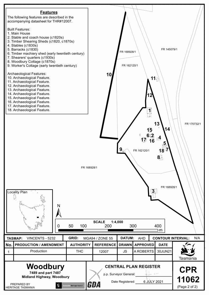
Features
7489 and part 7487 Midland Highway, Woodbury
The following features are described in the accompanying datasheet for THR#12007.Built Features:1. Main House2. Stable and coach house (c1820s)3. Timber Shearing Sheds (c1820, c1870s)4. Stables (c1830s)5. Barracks (c1830)6. Timber machiery shed (early twentieth century)7. Shearers' quarters (c1930s)8. Woodbury Cottage (c1870s)9. Worker's Cottage (early twentieth century)Archaeological Features:10. Archaeological Feature.11. Archaeological Feature.12. Archaeological Feature.13. Archaeological Feature.14. Archaeological Feature.15. Archaeological Feature.16. Archaeological Feature.17. Archaeological Feature.18. Archaeological Feature.
VINCENTS - 5232 MGA94 / ZONE 55 AHD N/A
1 Production THC 12007 JS
Locality Plan
Woodbury
10
±
FR 162120/1
0 100 200 300 40050 m
FR 168928/1
FR 168928/1 FR 145079/1
FR 170732/1
FR 168928/1
FR 162120/1
(Page 2 of 2)
11
12
131415
161718
1
3
45
6 2
879
A ROBERTS 30JUN21
6 JULY 2021
Related Documents