Thornthwaite-Mather water balance analysis in Tambakbayan watershed, Yogyakarta, Indonesia Adam Rus Nugroho 1,* , Ichiro Tamagawa 1 , Almaika Riandraswari 2 , and Titin Febrianti 2 1 Environmental and Renewable Energy Systems, Graduate School of Engineering, Gifu University, Japan 2 Environmental Engineering, Faculty of Civil Engineering and Planning, Universitas Islam Indonesia, Indonesia Abstract. Depok sub-district in Yogyakarta is one of the most populous areas, which also develops rapidly. The Tambakbayan watershed, which includes Depok sub-district, has been seen as one crucial watershed in Yogyakarta. This study conducted a Thornthwaite-Mather water balance analysis in the watershed in order to understand its hydrology capability. The result of the study on three stream areas of the watershed (upstream, midstream and downstream) shows that the dry months begins in May- June and ends in September-October. August tends to be the driest month in the year with total deficit value reaches 179.2 mm. Still, the annual rainfall is higher than the annual evapotranspiration. The results also show that the lower area of the watershed has a lower capability to preserve water. However, the watershed still sufficient in providing the domestic water demand in the current state. Comprehensive water management plans suggested to be applied to protect the watershed from overstressing the water resources, especially in the downstream area. Keywords: Thornthwaite-Mather, water balance, watershed, Yogyakarta 1 Introduction Daerah Istimewa Yogyakarta (Yogyakarta Special Region, DIY) is one of Indonesia rapidly growing provinces. The province capital, Yogyakarta City, has been full of building and there is a little room left for building new housing settlements. Therefore, housing development currently is emerging in the city outskirt. One of the significant outskirt areas in northern DIY is Depok, a sub-district of Sleman Regency. Depok hosts many universities including three major ones. Yogyakarta is indeed nationally well-known as “the city of student” for its high quality and quantity of universities. Depok sub-district and areas north of it are currently seen as some prospective areas to build new housing settlement and small home industries. * Corresponding author: [email protected] , 0 (2019) https://doi.org/10.1051/matecconf /201928005007 MATEC Web of Conferences 280 ICSBE 2018 5007 © The Authors, published by EDP Sciences. This is an open access article distributed under the terms of the Creative Commons Attribution License 4.0 (http://creativecommons.org/licenses/by/4.0/).

Welcome message from author
This document is posted to help you gain knowledge. Please leave a comment to let me know what you think about it! Share it to your friends and learn new things together.
Transcript

Thornthwaite-Mather water balance analysis in Tambakbayan watershed, Yogyakarta, Indonesia
Adam Rus Nugroho1,*
, Ichiro Tamagawa1, Almaika Riandraswari
2, and Titin Febrianti
2
1Environmental and Renewable Energy Systems, Graduate School of Engineering, Gifu University,
Japan 2Environmental Engineering, Faculty of Civil Engineering and Planning, Universitas Islam Indonesia,
Indonesia
Abstract. Depok sub-district in Yogyakarta is one of the most populous
areas, which also develops rapidly. The Tambakbayan watershed, which
includes Depok sub-district, has been seen as one crucial watershed in
Yogyakarta. This study conducted a Thornthwaite-Mather water balance
analysis in the watershed in order to understand its hydrology capability.
The result of the study on three stream areas of the watershed (upstream,
midstream and downstream) shows that the dry months begins in May-
June and ends in September-October. August tends to be the driest month
in the year with total deficit value reaches 179.2 mm. Still, the annual
rainfall is higher than the annual evapotranspiration. The results also show
that the lower area of the watershed has a lower capability to preserve
water. However, the watershed still sufficient in providing the domestic
water demand in the current state. Comprehensive water management
plans suggested to be applied to protect the watershed from overstressing
the water resources, especially in the downstream area.
Keywords: Thornthwaite-Mather, water balance, watershed, Yogyakarta
1 Introduction
Daerah Istimewa Yogyakarta (Yogyakarta Special Region, DIY) is one of Indonesia rapidly
growing provinces. The province capital, Yogyakarta City, has been full of building and
there is a little room left for building new housing settlements. Therefore, housing
development currently is emerging in the city outskirt. One of the significant outskirt areas
in northern DIY is Depok, a sub-district of Sleman Regency. Depok hosts many universities
including three major ones. Yogyakarta is indeed nationally well-known as “the city of
student” for its high quality and quantity of universities. Depok sub-district and areas north
of it are currently seen as some prospective areas to build new housing settlement and small
home industries.
* Corresponding author: [email protected]
, 0 (2019) https://doi.org/10.1051/matecconf /201928005007MATEC Web of Conferences 280ICSBE 2018
5007
© The Authors, published by EDP Sciences. This is an open access article distributed under the terms of the CreativeCommons Attribution License 4.0 (http://creativecommons.org/licenses/by/4.0/).
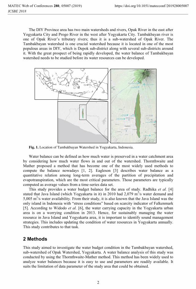
The DIY Province area has two main watersheds and rivers, Opak River in the east after
Yogyakarta City and Progo River in the west after Yogyakarta City. Tambakbayan river is
one of Opak River’s tributary rivers; thus it is a sub-watershed of Opak River. The
Tambakbayan watershed is one crucial watershed because it is located in one of the most
populous areas in DIY, which is Depok sub-district along with several sub-districts around
it. With the great prospect of being rapidly developed, the water balance of Tambakbayan
watershed needs to be studied before its water resources can be developed.
Fig. 1. Location of Tambakbayan Watershed in Yogyakarta, Indonesia.
Water balance can be defined as how much water is preserved in a water catchment area
by considering how much water flows in and out of the watershed. Thornthwaite and
Mather proposed a method that has become one of the most widely used methods to
compute the balance nowadays [1, 2]. Eagleson [3] describes water balance as a
quantitative relation among long-term averages of the partition of precipitation and
evapotranspiration, which are the most critical parameters. Those parameters are typically
computed as average values from a time-series data set.
This study provides a water budget balance for the area of study. Radhika et al. [4]
stated that Java Island (which Yogyakarta in it) in 2010 had 2,079 m3/s water demand and
5,005 m3/s water availability. From their study, it is also known that the Java Island was the
only island in Indonesia with “stress conditions” based on scarcity indicator of Falkenmark
[5]. According to Widodo et al. [6], the water carrying capacity in the Yogyakarta urban
area is on a worrying condition in 2013. Hence, for sustainably managing the water
resource in Java Island and Yogyakarta area, it is important to identify sound management
strategies. This includes updating the condition of water resources in Yogyakarta annually.
This study contributes to that task.
2 Methods
This study aimed to investigate the water budget condition in the Tambakbayan watershed,
sub-watershed of Opak Watershed, Yogyakarta. A water balance analysis of this study was
conducted by using the Thornthwaite-Mather method. This method has been widely used to
analyze water balances because it is easy to use and parameters are readily available. It
suits the limitation of data parameter of the study area that could be obtained.
, 0 (2019) https://doi.org/10.1051/matecconf /201928005007MATEC Web of Conferences 280ICSBE 2018
5007
2

2.1 Study Area
The Tambakbayan watershed covers 47.67 km2 area, and there are six rain gauges in the
immediate area surrounding the watershed (Fig. 2). Based upon the investigation of
Tambakbayan river streamflow data, there are three monitoring points represent the
upstream area, midstream area and downstream area of the watershed. The watershed area
shapefile was obtained from Balai Besar Wilayah Sungai Serayu Opak (Central River
Region Serayu Opak). In order to compare the water budget and the streamflow discharge
among the three areas, the shapefile of the watershed area then was cropped into three parts,
representing upper stream (22.1 km2), middle stream (14 km
2) and lower stream (11.5 km
2)
area (Fig. 2).
The upper stream area was linked to precipitation data from three rain gauges
(Prumpung, Kemput and Bronggang station in Sleman District), the middle stream area
linked to precipitation data from two rain gauges (Santan and Gemawang station in Sleman
District) and the lower stream area linked to precipitation data from one rain gauge (Karang
Ploso station in Bantul District).
Temperature data was not from the same station with the rain gauges. There are only
three stations available that represent temperature data in the three regions, Plunyon,
Geofisika Yogyakarta and Barongan station. Due to distance and elevation of the stations
with the watershed regions, the representation of data divided as follows. Upstream region
temperature data represented by Plunyon station's data. Midstream region temperature data
represented by averaging Plunyon station's data and Geofisika Yogyakarta station's data.
Last, downstream region temperature data represented by averaging Geofisika Yogyakarta's
data and Barongan station's data.
Fig. 2. Watershed cropping and location of rain gauges (grey circles) and stream gauges (red circles).
, 0 (2019) https://doi.org/10.1051/matecconf /201928005007MATEC Web of Conferences 280ICSBE 2018
5007
3

2.2 Thornthwaite-Mather Water Balance
Thornthwaite-Mather water balance equation uses the soil moisture capacity to estimate
water budgets. The parameters needed for using this method include:
1. difference between precipitation and potential evapotranspiration (P-PE)
2. accumulated potential water loss (APWL)
3. available water capacity (AWC)
4. difference between soil moisture storage (ΔST) between monthi and monthi+1.
5. actual evapotranspiration (AE)
6. deficit and surplus of the water budget
7. runoff estimation
Precipitation (P)
Precipitation data on a monthly basis is required. Missing rainfall data can be estimated first
by the arithmetic method or the normal ratio method. If a study area has many rain gauge
stations, the mean areal precipitation value shall be determined first. Mean areal
precipitation in this study determined by averaging the rainfall data from every region
representative rain gauge.
Potential Evapotranspiration (PE)
Potential evapotranspiration means the atmosphere potential that can take out water from
the land surface. In the Thornthwaite method, the potential evapotranspiration (PE) is
computed according to [7]:
1. Calculate the annual value of the heat index (I) based on the monthly heat index (i)
and summing all the twelve-month heat indices.
i = (Ta/5)1.51
(1)
I = i1 + i2 + …. + i12 (2)
Ta is the mean monthly temperature.
2. With a = 67.5×10⁻⁸
I3 – 77.1×10
-6I
2 + 0.0179I + 0.492, calculate the unadjusted PE’
(mm) using the following equation (3).
PE’ = 16(10. Ta/I) a (3)
3. Adjusting the unadjusted PE’ by using the average monthly daylight duration (in
hour) which is a function of season and latitude. If the daylight duration data is
known, the following equation can be used to calculate the adjusted PE. Note that N is
the number of days in a month and d is daylight duration (in hour).
PE = PE’ (d/12) (N/30) (4)
P-PE
The difference value of potential evapotranspiration and precipitation (P-PE) is negative
when there is a potential water deficit, while positive P-PE value represents a potential
water surplus. If the P-PE value is less than zero, the month called as "dry month" and it is
subjected to APWL value. While the P-PE value is more than zero, the month called as
"wet month" and it is subjected to surplus value.
Accumulated Potential Water Loss (APWL)
The accumulated potential water loss is calculated as the cumulative sum of P-PE values
during months when P-PE is negative. Accumulated potential water loss increases during
dry seasons. It is reduced during wet seasons because of soil moisture recharge. The value
would be zero when soil moisture equals the soil’s available water holding capacity [8].
, 0 (2019) https://doi.org/10.1051/matecconf /201928005007MATEC Web of Conferences 280ICSBE 2018
5007
4

Available Water Capacity (AWC)
Thornthwaite and Mather have suggested the determination method of AWC values by
considering land use, soil texture types and rooting depth by providing a water holding
capacity (WHC) table [2]. In this study, the AWC typical value of each land use assumed to
be 150 mm/m, same with the WHC table. The land use types in this study were divided
based on the vegetation cover division as in the table: shallow-rooted, moderately rooted,
deep-rooted, orchards, and mature forest. The land use areas of each stream region
determined by Google Earth and QGIS help. Area of settlement land use is also added
assuming that settlements have a small area of vegetation. The rooting depth values for
each land use type were following the values in the WHC table, except for the settlements
land use. The rooting depth value of settlements land use is assumed 0.1 m, lower than
shallow-rooted land use. The AWC value was then calculated for upstream, midstream and
downstream areas by multiplying the AWC typical value with rooting depth and percentage
area of land use as shown in Table 1.
Table 1. Available Water Capacity Estimated
Vegetation % Area AWC[2]
(mm/m)
Rooting Depth[2]
(m) AWC (mm)
Upstream
Settlements 40.6% 150 0.1 6.09
Shallow-rooted 25.0% 150 0.5 18.75
Moderately rooted 21.6% 150 1 32.40
Deep-rooted 2.0% 150 1 3.00
Orchards 5.0% 150 1.67 12.53
Mature forest 5.8% 150 2 17.40
Total 100% Σ AWC upstream: 90.20
Midstream
Settlements 65.2% 150 0.1 9.79
Shallow-rooted 10.0% 150 0.5 7.50
Moderately rooted 13.7% 150 1 20.55
Deep-rooted 2.0% 150 1 3.00
Orchards 4.6% 150 1.67 11.61
Mature forest 4.5% 150 2 13.39
Total 100% Σ AWC midstream: 65.80
Downstream
Settlements 42.4% 150 0.1 6.35
Shallow-rooted 20.0% 150 0.5 15.00
Moderately rooted 23.9% 150 1 35.85
Deep-rooted 9.0% 150 1 13.50
Orchards 1.4% 150 1.67 3.51
Mature forest 3.4% 150 2 10.10
Total 100% Σ AWC downstream: 84.30
Monthly Soil Moisture Storage Difference (ΔST)
The soil-moisture term represents the amount of water held in soil storage. If the value of
P-PE is positive, then soil moisture storage value is the same as the AWC. On the other
hand, if the value of P-PE is negative, then soil moisture storage is calculated by equation
(5). The difference in soil moisture between months (ΔST) then can be calculated by
equation (6). A positive value of ΔST means there is enough water to add to the soil
moisture storage, while negative value implies that water is removed from the storage
because of evapotranspiration [8].
ST = AWC.eAPWL/AWC
(5)
ΔSTi = STi – STi-1 (6)
Actual Evapotranspiration (AE)
The difference between actual evapotranspiration (AE) and potential evapotranspiration
(PE) is in their relationship with soil moisture storage. The PE accounts water removal
from land surfaces only by atmospheric potential (heat), while the AE accounts changes on
soil moisture storage in land surfaces. When the precipitation (P) is higher than the PE, it
means that soil moisture storage still saturated from the excess precipitation. Hence, the AE
equals the PE because there are no changes to the soil moisture storage. When the P is
, 0 (2019) https://doi.org/10.1051/matecconf /201928005007MATEC Web of Conferences 280ICSBE 2018
5007
5

lower than the PE, it means there are changes in the soil moisture storage. Thus, the AE
equals the P subtracted by the changes in soil moisture storage.
P > PE AE = PE (7)
P < PE AE = P - ΔST (8)
Deficit (D) and Surplus (S)
Soil-moisture deficit expressed as the difference between actual evapotranspiration and
potential evapotranspiration [2]. When soil moisture reaches the maximum soil-moisture
capacity, which is AWC, any excess precipitation become the surplus value, thus makes
surplus value equals to P-PE [8].
D = PE - AE (9)
S = P - PE (10)
Runoff (R)
Thornthwaite and Mather suggest that there is only 50 percent of the surplus water in the
large watersheds which will become runoff in any month. The remaining 50% is assumed
to be detained and will become runoff during the next month [2].
Ri = 50% Ri + 50% Ri-1 (11)
3 Result and Discussion
Rainfall data over the last ten years (2007-2017) show that the watershed tends to have a
dry season in the middle of the year, starting in May. The months of July and August
especially become the driest months with monthly precipitation below 50 mm in each
stream region. Big rain events tend to occur around the end and beginning of the year,
which can reach 300 mm in one month. These conditions are reflecting the typical tropical
season in Indonesia.
The temperature data covering the last ten years (2007-2017) also reflect the typical
tropical season in Indonesia. The average temperature at Tambakbayan watershed is in
between 24℃ and 25℃ for over a year. It makes no significant fluctuated series of data.
However, there is about a 1℃ difference in temperature between the stream regions which
adjacent to each other. The average temperature of the three regions are 23.6℃, 24.9℃ and 25.9℃; upstream, midstream, downstream respectively. The temperature difference
suggested is due to the elevation differences of the three stream regions: 200-500 meter
above sea mean level (masml) for upstream regions, 120-200 masml for midstream regions,
and 65-120 masml for downstream regions.
Fig. 3. Monthly precipitation P and potential evapotranspiration PE.
, 0 (2019) https://doi.org/10.1051/matecconf /201928005007MATEC Web of Conferences 280ICSBE 2018
5007
6

In many tropical areas with distinct dry seasons, the annual precipitation frequently
found to be lower than the annual potential evapotranspiration [9]. However, Tambakbayan
watershed has average annual precipitation of 490.8 mm, about 200 mm higher than its
average annual potential evapotranspiration, 297.4 mm. On the other side, the average
annual actual evapotranspiration in the whole watershed is 253.2 mm, only a bit lower than
the average annual potential evapotranspiration.
The difference of the hydrology condition in the upstream and the lower streams can be
seen from the calculated accumulated potential water loss (APWL) value. The final APWL
values of the three stream regions are 137.7 mm (September), 204.3 mm (October) and
406.1 mm (October) for upstream, midstream and downstream region, respectively. The
values indicate that the upstream area potential for losing water is much lower than in the
midstream and downstream area. It means that the northern part of the watershed
(upstream), where Plosokuning village up till Pakem village situated, have good water
preservation potential, whereas downstream areas, such as Banguntapan village in Bantul,
need to manage their water resource more carefully. With the total APWL of 748.1 mm,
Tambakbayan watershed would potentially lose about 10,572,595 m3 water each year, with
44% of it occurs in the downstream area.
The estimated available water capacity (AWC) value was assumed the same for all
months in each of the regions. The analysis shows that the water holding capacity of the
soil is higher in the upstream area. This finding is possible, related to the fact that there are
more trees and small forests scattered in the upstream region than the lower region. It is
also found that the upstream region still has similarly high soil moisture storage (ST) value
of than the midstream region, even though it is in the middle of the year where the water
loss potential should be at its highest. The water utilization by plants represented by ∆ST.
The highest changes in soil moisture storage are in July, reaching 70.1 mm for all regions.
The surplus water in Thornthwaite-Mather method was assumed as water that becomes
runoff. In this study, the upstream region has the most surplus month with only four months
(June, July, August, September) of deficit, compared to five (June, July, August,
September, October) and six months (May, June, July, August, September, October) in the
midstream and downstream, respectively. The water balance analysis shows that the highest
surplus value achieved by midstream region, with the peak value of 218.4 mm in
December. While the highest deficit value achieved by downstream region with the value
of 74 mm in August. The August month noticed as the driest month of the year, with the
total of soil moisture deficit reaches 179.2 mm or 1,860,715 m3. Since September-October
is the end of dry months, the soil moisture recharge begins in October-November.
Fig. 4. Water budget in upstream, midstream and downstream region.
, 0 (2019) https://doi.org/10.1051/matecconf /201928005007MATEC Web of Conferences 280ICSBE 2018
5007
7

Table 2. Water balance in the upstream region. Param. Unit Jan Feb Mar Apr May Jun Jul Aug Sep Oct Nov Dec Total
P mm 288 284 275 225 119 73 36 9 54 92 304 274 2,035
PE mm 51.2 91.2 68.6 94.4 94.4 81.1 72.4 75.2 81.6 64.4 62.3 64.5 901
P-PE mm 236.8 193.1 206.1 130.9 24.9 -7.8 -36.8 -65.9 -27.3 27.6 242.0 209.5
APWL mm
-7.8 -44.5 -110.4 -137.7
-137.7
AWC mm 90.2 90.2 90.2 90.2 90.2 90.2 90.2 90.2 90.2 90.2 90.2 90.2
ST mm 90.2 90.2 90.2 90.2 90.2 82.7 55.0 26.5 19.6 90.2 90.2 90.2
ΔST mm 0.00 0.00 0.00 0.00 0.00 -7.44 -27.70 -28.52 -6.92 70.57 0.00 0.00
AE mm 51.2 91.2 68.6 94.4 94.4 80.8 63.4 37.9 61.3 64.4 62.3 64.5 834
D / S mm 236.8 193.1 206.1 130.9 24.9 -0.3 -9.1 -37.3 -20.4 27.6 242.0 209.5
Table 3. Water balance in midstream region.
Param. Unit Jan Feb Mar Apr May Jun Jul Aug Sep Oct Nov Dec Total
P mm 306 319 267 245 127 61 40 4 55 102 325 330 2,178
PE mm 131.6 102.0 118.5 112.2 110.0 98.0 82.9 85.6 91.2 107.1 108.1 111.1 1,258
P-PE mm 173.9 216.5 148.5 132.3 17.0 -37.5 -43.4 -81.6 -36.7 -5.1 216.9 218.4
APWL mm -37.5 -80.9 -162.5 -199.2 -204.3 -204.3
AWC mm 65.8 65.8 65.8 65.8 65.8 65.8 65.8 65.8 65.8 65.8 65.8 65.8
ST mm 65.8 65.8 65.8 65.8 65.8 37.3 19.3 5.6 3.2 3.0 65.8 65.8
ΔST mm 0.00 0.00 0.00 0.00 0.00 -28.57 -18.00 -13.69 -2.39 -0.24 62.88 0.00
AE mm 131.6 102.0 118.5 112.2 110.0 89.1 57.5 -17.7 56.9 102.2 108.1 111.1 1,117
D / S mm 173.9 216.5 148.5 132.3 17.0 -8.9 -25.4 -67.9 -34.4 -4.8 216.9 218.4
Table 4. Water balance in the downstream region.
Param. Unit Jan Feb Mar Apr May Jun Jul Aug Sep Oct Nov Dec Total
P mm 229 276 209 180 89 38 15 17 33 48 232 312 1,678
PE mm 146.3 109.4 133.6 128.3 123.3 116.8 93.5 96.3 99.0 117.2 120.7 124.7 1,409
P-PE mm 82.7 166.6 75.4 51.7 -34.3 -78.8 -78.5 -79.3 -66.0 -69.2 111.3 187.3
APWL mm
-34.3 -113.1 -191.7 -270.9 -337.0 -406.1
-406.1
AWC mm 84.3 84.3 84.3 84.3 84.3 84.3 84.3 84.3 84.3 84.3 84.3 84.3
ST mm 84.3 84.3 84.3 84.3 56.1 22.0 8.7 3.4 1.6 0.7 84.3 84.3
ΔST mm 0.00 0.00 0.00 0.00 -28.17 -34.10 -13.36 -5.29 -1.84 -0.87 83.63 0.00
AE mm 146.3 109.4 133.6 128.3 117.2 72.1 28.4 22.3 34.8 48.9 120.7 124.7 1,087
D / S mm 82.7 166.6 75.4 51.7 -6.1 -44.7 -65.2 -74.0 -64.2 -68.3 111.3 187.3
Table 5. Runoff and streamflow estimation.
Parameter unit Jan Feb Mar Apr May Jun Jul Aug Sep Oct Nov Dec Total
R ups. mm 223.2 208.1 207.1 169.0 97.0 48.5 24.2 12.1 6.1 16.8 129.4 169.5 1,311
R mids. mm 96.1 206.3 177.4 154.8 85.9 43.0 21.5 10.7 5.4 2.7 109.8 164.1 1,178
R downs. mm 135.0 150.8 113.1 82.4 41.2 20.6 10.3 5.1 2.6 1.3 56.3 121.8 740.4
Total R mm 554.3 565.2 497.6 406.2 224.1 112.0 56.0 28.0 14.0 20.8 295.5 455.4 3,229
Q ups. m3/day 159,090 164,285 147,651 124,509 69,134 35,719 17,284 8,642 4,465 12,009 95,348 120,821 958,958
Q mids. m3/day 139,829 162,847 126,466 114,064 61,254 31,648 15,313 7,657 3,956 1,914 80,892 116,999 862,838
Q downs. m3/day 96,229 119,001 80,606 60,672 29,358 15,168 7,339 3,670 1,896 917 41,478 86,832 543,167
Total Q m3/day 395,148 446,133 354,724 299,245 159,746 82,535 39,936 19,968 10,317 14,840 217,718 324,652 2,364,962
Fig. 5. Monthly runoff R estimation compared to the precipitation P.
, 0 (2019) https://doi.org/10.1051/matecconf /201928005007MATEC Web of Conferences 280ICSBE 2018
5007
8

The runoff (R) parameter is not a real-time runoff. The R in TMWB system is the excess
water that not only becomes direct runoff but also indirect runoff (baseflow). The analysis
results suggest that the runoff (excess rainfall after subtracted by evapotranspiration and
soil moisture change) to the downstream area is less. It happens because of the less water
holding capacity and more evapotranspiration in the lower region. The less water holding
capacity also suggests that the runoff coefficient in the lower regions is higher than the
upper regions. It is reflected by the availability of plants or trees which causes the changes
in soil moisture storage. The lower stream area has a fewer green area, thus the water
holding capacity lesser than the upper stream area.
The water discharge (Q) value which calculated by multiplying R with watershed
region area can be used to estimate water availability in the watershed. The highest total
discharge value estimated in the Tambakbayan watershed is 446,133 m3/day, which is in
February. The lowest total discharge value estimated is 10,317 m3/day, which is in
September. The highest discharge value was achieved by upstream area with the value of
164,285 m3/day in February, while the lowest discharge value estimated is 917 m
3/day, in
October within the downstream area. With the total population of 329,979 in the year 2018,
Tambakbayan watershed demands 24,135 m3/day (with water demand per capita as 100
L/person.day). It can be concluded that the current condition of Tambakbayan watershed is still
sufficient to provide water for domestic purpose only. Nevertheless, the demands of other
variables, such as agricultural demand, livestock demand, industrial demand, public
facilities demand and ecological demand, have to be accounted to justify the real water
carrying capacity in this watershed.
4 Conclusion
The current condition of water availability in Tambakbayan watershed reflects the typical
seasons and monsoon in Indonesia. The annual rainfall is 1.7 and 1.9 times higher than the
potential evapotranspiration and actual evapotranspiration, respectively. It makes the
potential water availability in the watershed is in a good state.
The analysis of the accumulated potential water loss (APWL) showed that the dry
months occur around May-June and ends around September-October. The driest month of
the year in Tambakbayan watershed is August, with deficit value 179.2 mm. The average
annual water loss in Tambakbayan watershed is 249.4 mm with the highest point in the
downstream region. The runoff to the downstream area is less due to the higher
evapotranspiration and lower water holding capacity.
This study suggests that concern about the hydrologic capacity of the watershed is
justified when looking towards more development in the future. The hydrologic capacity of
the study area is good, especially the water availability. However, the downstream area
needs more attention, since it has six dry months and the lowest water preservation
capability. Comprehensive water management and city development plan have to be
implemented to protect the watershed from overstressing its water resources.
References
1. C.W. Thornthwaite, J.R. Mather, The Water Balance, Publication in Climatology, 8, 1
(1955).
2. C.W. Thornthwaite, J.R. Mather, Instructions and Tables for Computing Potential
Evapotranspiration and The Water Balance, Publication in Climatology, 10, 3, 183-
243 (1957).
, 0 (2019) https://doi.org/10.1051/matecconf /201928005007MATEC Web of Conferences 280ICSBE 2018
5007
9

3. P. S. Eagleson, Ecohydrology – Darwinian expression of vegetation form and function
(Cambridge University Press, Cambridge, 2002).
4. Nk. Radhika, M. Fauzi, S. Rahmawati, F. Rendy, F. Anthon, H. Waluyo, Neraca
Ketersediaan Air Permukaan dan Kebutuhan Air pada Wilayah Sungai di Indonesia,
Kolokium Hasil Penelitian dan Pengembangan Sumber Daya Air (Pusat Litbang
Sumber Daya Air, 2013).
5. A. Brown, M. D. Matlock, A Review of Water Scarcity Indices and Methodologies, The
Sustainability Consortium (University of Arkansas, 2011).
6. W. Brontowiyono, R. Lupyanto, B. Sulistiono, D. A. Harjito, J. Hamidin, E. Hapsari,
Yasin M., Ellinda C. Analysis of Environmental Carrying Capacity for the
Development of Sustainable Settlement in Yogyakarta Urban Area. Proc. Enviro. Sci.,
28, 519-527 (2015).
7. C. Xu, Hydrologic Models (Uppsala University Department of Earth Sciences
Hydrology, Uppsala, Sweden, 2002).
8. S. Roy, D. Ophori, Assessment of Water Balance of the Semi-Arid Region in Southern
San Joaquin Valley California using Thornthwaite and Mather’s Model, J. Env.
Hydro., 20 (2012).
9. C. Santhi de Silva, Ken R. Rushton. Groundwater Recharge Estimation using
Improved Soil Moisture Balance Methodology for a Tropical Climate with Distinct Dry
Seasons, Hydr. Sci. J., 52, 5, 1051-1067 (2007).
, 0 (2019) https://doi.org/10.1051/matecconf /201928005007MATEC Web of Conferences 280ICSBE 2018
5007
10
Related Documents