The Tsunami Society THIRD TSUNAMI SYMPOSIUM May 26-29, 2006 Honolulu, Hawaii PROGRAM ABSTRACTS WWW.STHJOURNAL.ORG

Welcome message from author
This document is posted to help you gain knowledge. Please leave a comment to let me know what you think about it! Share it to your friends and learn new things together.
Transcript

The Tsunami Society
THIRD TSUNAMI SYMPOSIUM
May 26-29, 2006
Honolulu, Hawaii
PROGRAM
ABSTRACTS
WWW.STHJOURNAL.ORG


.PROGRAM
THIRD TSUNAMI SYMPOSIUMMay 23-26, 2006, Honolulu, HawaiiSponsored by The Tsunami Society
8:20 - ALOHA WELCOME - G. Ostrander, UH VCUS GOVERNMENT RESPONSE TO TSUNAMI - 5/23/06 - C. Mader, Chairman
8:30 - Response to Sumatra Tsunami: - Fryer for Bernard8:50 -US Military Response to Sumatra Tsunami: - K. Nicholls, PACCOM9:00 - Strike Slip Tsunami Sources - B. Knight, WCATWC9:15 - Model Predictions for Gulf and Atlantic Coasts- B. Knight, WCATWC9:45 - DART/BRP Data Base - K. Stoker, P. Dunbar, NGDC10:00 - Refreshment Break10:30 - NOAA Tsunami Database - P. Dunbar, L. Dengler, K. Stoker10:45 - Near Field Warning - G. Fryer, B. Hirshorn, PTWC11:15 - Upgrade of Tide Gauges - B. Kilonsky, M. Merrifield, UH11:45 - International Monitoring System - V. Hsu, PTWC
INDIAN OCEAN TSUNAMI I - D. Dominey Howes, Chairman1:00 - Impacts on Maldive Islands - C. Helsley etc.1:30 - Modes Around Andaman and Nicobar Islands - T. Murty etc.2:00 - Field Survey in Indonesia - B. Jaffe etc.2:30 - Ocean Circulation Model for Tsunami Warning - T. Song2:45 - Refreshment Break
TSUNAMI RISK MANAGEMENT- R. Sewell, Chairman3:00 - Probabilistic Risk Management - R. Sewell3:30 - Los Angeles Tsunami Plan - L. Collins and A. Alexander
NUMERICAL MODELING - 5/24/06 - Z. Kowalik, Chairman8:30 - Tide-Tsunami Interactions- Z. Kowalik, UA9:00 - Wave Dispersion Study - J. Horrillo etc.9:30 - Augustine Volcano Tsunami - J. Beget, UA9:45 - Finite Volume Methods - D. George and R. LeVeque, UW10:00 - Refreshment Break10:30 - Krakatoa Hydrovolcanic Explosion - C. Mader and M. Gittings11:00 - SAGE Calculations of La Palma Threat -R. Weaver etc. - LANL11:30 - Modeling of New Zealand Region Tsunamis - R. Walters
TSUNAMI STUDIES - G. Pararas Carayannis, Chairman1:00 - November 28, 1945 -Arabian Sea Event - G. Pararas-Carayannis1:30 - Finite Volume Long Wave Runup - Y. Wei, F. Cheung2:00 - Tsunami Deposits Database - B. Keating, UH2:15 - Tsunamis in Lisbon, Portugal - M. Baptista etc.2:45 - Refreshment Break
GENERAL SESSION - G. Curtis, Chairman3:00 - Tsunami Deposits - F. McCoy and B. Heil, UH3:15 - Unrecognized Threats to Hawaii - D. Walker3:45 - UH Disaster Risk Reduction Consortium - J. Egan4:00 - Maui Paleo-Tsunami Record - B. Keating etc, UH4:15 - Paleotsunamis Come of Age? - J. Goff and R. Walters6:00 - Treetops LUAU- Society Awards - Z. Kowalik- Speaker
INDIAN OCEAN TSUNAMI II - 5/25/06 - D. Walker, Chairman8:30 - Run-up and Inundation in Tamil, Nadu India - V. Mohan etc.9:00 - Grand Banks, Arctic, Lisbon Tsunami Effects - A. Ruffman10:00 - Refreshment Break10:30 - Tsunami in Southern Thailand - C. Thanawood etc.11:00 - Phi Phi Island Edge Waves - K. Chau etc.11:30 - Momentum and Probability Function for Large Tsunamis - H. Loomis
EXPERIMENTAL TSUNAMI MODELING - H. Fritz, Chairman1:00 - Modeling Impact Generated Tsunamis - H. Fritz1:30 - Modeling Landslide Generated Tsunamis - L. Sue etc.2:00 - Indian Ocean Tsunami Survey - H. Fritz etc.2:30 - A Natural Disaster Curriculum - K. Gupta2:45 - Refreshment Break3:00 - TSUNAMI SOCIETY MEETING - B. Keating, President


file:///C|/tsunami.soc/tscdrom/cdprogram.html
THE THIRD TSUNAMI SYMPOSIUM
PROGRAM AND ABSTRACTS
8:20 - Aloha Welcome - Dr. Gary Ostrander, UH Vice Chancellor for Research
Tuesday Morning, May 23, 2006
US GOVERNMENT RESPONSE TO 12/26/2004 TSUNAMI Dr. Charles Mader, Chairman 8:30 US Response to the Sumatra Tsunami Gerard Fryer Presents Eddie Bernard PowerPoint 8:50 US Military Response to the Sumatra Tsunami Lt. Col. Kerry Nicholls POWERPOINT on CD at /TSPPT/UAB 9:00 Strike-Slip Tsunami Sources Bill Knight 9:15 Model Predictions of Gulf and Atlantic Coast Tsunami Impacts from a Distribution of Sources Bill Knight Science of Tsunami Hazards, Vol. 24, No. 5, pages 304-312 (2006) 9:45 Access to Historical DART/BRP Data at NOAA's National Geophysical Data Center (NGDC) Kelly J. Stroker and Paula K. Dunbar
file:///C|/tsunami.soc/tscdrom/cdprogram.html (1 of 7)5/25/2006 10:26:56 PM

file:///C|/tsunami.soc/tscdrom/cdprogram.html
10:00 - 10:30 - Refreshment Break 10:30 NOAA's Historical Tsunami Database Paula K. Dunbar, Lori Dengler and Kelly J. Stoker 10:45 Tsunami Warning in the Near Field: The Approach in Hawaii Gerard J. Fryer and Barry Hirshorn 11:15 Upgrade of Tide Gauges for Tsunami Warnings Bernard J. Kilonsky and Mark Merrifield 11:45 Monitoring Earthquakes and Tsunamis using the International Monitoring System Vindell Hsu 12:00 - 1:00 LUNCH
Tuesday Afternoon, May 23, 2006
THE INDIAN OCEAN TSUNAMI - I Dr. Dale Dominey-Howes , Chairman 1:00 The Impacts of the 2004 Indian Ocean Tsunami Within the Maldive Islands Charles E. Helsley, Barbara Keating, Dale Dominey-Howes, Zaha Weheed Science of Tsunami Hazards, Vol. 23, No. 2, pages 18-70 (2005) POWERPOINT PRESENTATION 1:30 Role of Trapped and Leaky Modes Around Andaman and Nicobar Islands Tsunami of 26 December 2004 T. S. Murty, N. Nirupama, I. Nistor, A. D. Rao Science of Tsunami Hazards, Vol. 24, No. 3, pages 183-193 (2006) POWERPOINT PRESENTATION 2:00 Field Survey of Tsunami Deposits, Erosion and Flow During the 26 December 2004 Tsunami in Indonesia Bruce E. Jaffe, Jose C. Borrero, Gegar S. Prasetya, Lori Dengler, Guy Gelfenbaum, Rahman Hidayat, Brentwood Higman, Ettiene Kingsley, Lukiyanjto, Brian McAdoo, Andrew Moore, Robert Morton, Robert Peters, Peter Ruggiero, Vasily Titov, Widjo Kongko and Eko Yulianto 2:30 A Coupled Teleseismic Ocean General Circulation Model for Global Tsunami Warning, Y. Tony Song 2:45 - 3:00 - Refreshment Break TSUNAMI RISK MANAGEMENT
file:///C|/tsunami.soc/tscdrom/cdprogram.html (2 of 7)5/25/2006 10:26:56 PM

file:///C|/tsunami.soc/tscdrom/cdprogram.html
Dr. Robert Sewell, Chairman 3:00 Probabilistic Tsunami Risk Management Framework, Safety Policy and Applications Robert T. Sewell 3:30 Implementation of a Tsunami Plan: The Los Angeles County Fire Department and Lessons Learned from the Sumatra Tsunami and Hurricane Katrina Larry Collins and Angus Alexander 5:00 - Adjourn
Wednesday Morning, May 24, 2006
NUMERICAL MODELING OF TSUNAMIS Dr. Zygmunt Kowalik, Chairman 8:30 Tide-Tsunami Interactions Zygmunt Kowalik, Tatiana Proshutinsky and Andrey Proshutinsky Science of Tsunami Hazards, Vol. 24, No. 4, pages 242-256 (2006) 9:00 Wave Dispersion Study in the Indian Ocean Tsunami, December 26, 2004 Juan J. Horrillo, Zygmunt Kowalik, Yoshinori Shigihara Science of Tsunami Hazards, Vol. 25, No. 1, pages 42-62 (2006) 9:30 Confirmation and Calibration of Computer Models of the 1883 Tsunami Produced by Augustine Volcano, Alaska James E. Beget Science of Tsunami Hazards, Vol. 24, No. 4, pages 257-266 (2006) 9:45 Finite Volume Methods and Adaptive Refinement for Global Propagation and Local Inundation David L. George and Randall J. LeVeque Science of Tsunami Hazards, Vol. 24, No. 5, pages 319-328 (2006) 10:00 - 10:30 - Refreshment Break 10:30 Numerical Model for the Krakatoa Hydrovolcanic Explosion and Tsunami Charles L. Mader and Michael L. Gittings Science of Tsunami Hazards, Vol. 24, No. 3, pages 174-182 (2006) POWERPOINT PRESENTATION 11:00 SAGE Calculations of the Tsunami Threat from La Palma Galen Gisler, Robert Weaver and Michael L. Gittings Science of Tsunami Hazards, Vol. 24, No. 4, pages 288-301 (2006) POWERPOINT PRESENTATION 11:30 Modeling Tsunami Generation, Propagation and Run-up in the New Zealand Region
file:///C|/tsunami.soc/tscdrom/cdprogram.html (3 of 7)5/25/2006 10:26:56 PM
file:///C|/tsunami.soc/tscdrom/cdprogram.html
Roy A. Walters Science of Tsunami Hazards, Vol. 24, No. 5, pages 339-357 (2006) 12:00 - 1:00 LUNCH
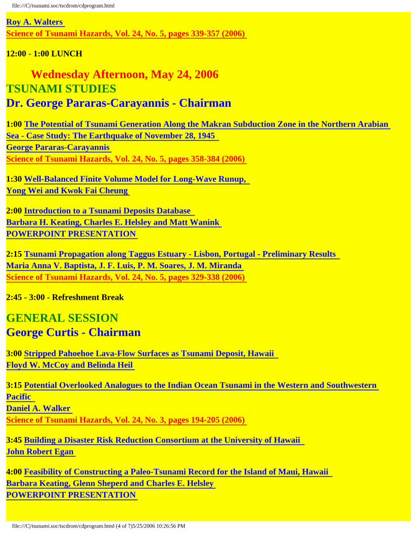
Wednesday Afternoon, May 24, 2006
TSUNAMI STUDIES Dr. George Pararas-Carayannis - Chairman 1:00 The Potential of Tsunami Generation Along the Makran Subduction Zone in the Northern Arabian Sea - Case Study: The Earthquake of November 28, 1945 George Pararas-Carayannis Science of Tsunami Hazards, Vol. 24, No. 5, pages 358-384 (2006) 1:30 Well-Balanced Finite Volume Model for Long-Wave Runup, Yong Wei and Kwok Fai Cheung 2:00 Introduction to a Tsunami Deposits Database Barbara H. Keating, Charles E. Helsley and Matt Wanink POWERPOINT PRESENTATION 2:15 Tsunami Propagation along Taggus Estuary - Lisbon, Portugal - Preliminary Results Maria Anna V. Baptista, J. F. Luis, P. M. Soares, J. M. Miranda Science of Tsunami Hazards, Vol. 24, No. 5, pages 329-338 (2006) 2:45 - 3:00 - Refreshment Break GENERAL SESSION George Curtis - Chairman 3:00 Stripped Pahoehoe Lava-Flow Surfaces as Tsunami Deposit, Hawaii Floyd W. McCoy and Belinda Heil 3:15 Potential Overlooked Analogues to the Indian Ocean Tsunami in the Western and Southwestern Pacific Daniel A. Walker Science of Tsunami Hazards, Vol. 24, No. 3, pages 194-205 (2006) 3:45 Building a Disaster Risk Reduction Consortium at the University of Hawaii John Robert Egan 4:00 Feasibility of Constructing a Paleo-Tsunami Record for the Island of Maui, Hawaii Barbara Keating, Glenn Sheperd and Charles E. Helsley POWERPOINT PRESENTATION
file:///C|/tsunami.soc/tscdrom/cdprogram.html (4 of 7)5/25/2006 10:26:56 PM

file:///C|/tsunami.soc/tscdrom/cdprogram.html
4:15 Paleotsunamis Come of Age? James Goff and Roy A. Walters POWERPOINT PRESENTATION 4:45 - Adjourn 6:00 - Treetops LUAU - Tsunami Society Awards, AROUND THE WORLD IN 200 MILLION CELLS Dr. Zygmunt Kowalik, After Dinner Speaker
Thursday Morning, May 25, 2006
INDIAN OCEAN TSUNAMI - II Dr. Dan Walker, Chairman 8:30 The 26th December, 2004 Tsunami - Run-up and Inundation and Their Relationship with Geomorphology in Tamil, Nadu, India V. Ram Mohan, D. Gnanavel, J. Sriganesh, J. Kulasekaran, S. Srinivasalu 9:00 Science and Fokelore Teaching from the November 18, 1929 "Grand Banks" Earthquake and Tsunami: "Like a River Returning" Alan Ruffman Tsunami Hazards in the Arctic Regions of North America, Greenland and the Norwegian Sea Alan Ruffman and Tad Murty Documentation of the Farfield Parameters of the November 1, 1755, "Lisbon" Tsunami along the Shores of the Western Atlantic Ocean Allan Ruffman Science of Tsunami Hazards, Vol. 23, No. 3, pages 52-59 (2005) 10:00 - 10:30 - Refreshment Break 10:30 Effects of the December 2004 Tsunami and Disaster Management in Southern Thailand Chanchai Thanawood, Chao Yongchalermchai and Omthip Densrisereekul Science of Tsunami Hazards, Vol. 24, No. 3, pages 206-217 (2006) 11:00 Edge Waves at Phi-Phi Island During the December 26, 2004 South Asian Tsunami K. T. Chau, O. W. H. Wai, R. H. C. Wong and H. Y. Lin 11:30 What is the Probability Function for Large Tsunami Waves? Harold G. Loomis Science of Tsunami Hazards, Vol. 24, No. 3, pages 218-224 (2006) Momentum as a Useful Tsunami Descriptor
file:///C|/tsunami.soc/tscdrom/cdprogram.html (5 of 7)5/25/2006 10:26:56 PM

file:///C|/tsunami.soc/tscdrom/cdprogram.html
Harold G. Loomis Science of Tsunami Hazards, Vol. 24, No. 5, pages 313-318 (2006) 12:00 - 1:00 LUNCH Thursday Afternoon, May 25, 2006 EXPERIMENTAL TSUNAMI MODELING Dr. Herman Fritz, Chairman 1:00 Physical Modeling of Landslide Tsunamis - A Novel Generator Hermann M. Fritz 1:30 Modeling of Tsunami Generation from Underwater Landslides Langford P. Sue, Roger I. Nokes, and Roy A. Walters Science of Tsunami Hazards, Vol. 24, No. 3, pages 267-287 (2006) POWERPOINT PRESENTATION 2:00 Field Surveys of 2004 Indian Ocean Tsunami from Sumatra to East Africa Hermann M. Fritz, Jose C. Borrero, Costas E. Synolakis and Emile A. Okal 2:30 Natural Disasters: Need for an Academic Curriculum Kamlesh Gupta Report POWERPOINT PRESENTATION 2:45 - 3:00 - Refreshment Break 3:00 - TSUNAMI SOCIETY MEETING 1. Election of Officers 2. Treasurers Report 3. Tsunami Society Field Trip Tsunami Society Field Trip - Friday, May 26 Field Trip Leaders - Dr. Charles Helsley, Dr. Barbara Keating, Dr. Dan Walker 4. 2006 Status of Tsunami Science Research and Future Directions Science of Tsunami Hazards, Vol. 24, No. 5, pages 385-395 (2006) POWERPOINT PRESENTATION POSTER PRESENTATIONS - May 23-25, 2006 Tsunami Public Awareness and Its Role in Risk Education, Dale Dominey-Howes and Deanne Bird A Fully Validated Tsunami Vulnerability Assessment Model (the "PTVAM" Model), Dale Dominey-Howes and Maria Papthoma
file:///C|/tsunami.soc/tscdrom/cdprogram.html (6 of 7)5/25/2006 10:26:56 PM

file:///C|/tsunami.soc/tscdrom/cdprogram.html
Tsunami and Paleotsunami Depositional Signatures and their Potential Value in Understanding the Late-Holocene Tsunami Record, Dale Dominey-Howes
Last updated: May 25, 2006 www.sthjournal.org
file:///C|/tsunami.soc/tscdrom/cdprogram.html (7 of 7)5/25/2006 10:26:56 PM

US RESPONSE TO THE SUMATRA TSUNAMI Eddie Bernard PMEL Seattle, WA USA ABSTRACT The United States Government provided, through the National Science Foundation and the Departments of Commerce, Defense, Interior, and State, substantial immediate rescue and relief support, immediate and ongoing scientific and technical expertise, and created programs to provide long term aid for the nations affected by the Sumatra tsunami. An overview of these contributions will be presented, along with agencies plans for the future to support the construction of a Tsunami Warning System for the Indian Ocean through the United Nations framework.

STRIKE-SLIP TSUNAMI SOURCES Bill Knight NOAA / NWS / West Coast and Alaska Tsunami Warning Center Palmer, AK
ABSTRACT A recent tsunami warning issued for the US West coast catalyzed discussions on the possibility of strike slip earthquakes as tsunami sources. The June 15, 2005 earthquake off the Northern California coast (Mw 7.2) was a pure-slip event, yet it produced a small (~10 cm) tsunami at Crescent City, CA. A search was conducted of both the West Coast and Alaska Tsunami Warning Center historical data (based largely on records from NOAA’s National Geophysical Data Center) and the Harvard CMT catalog for correlations between earthquake mechanism and tsunami genesis. From 1977 to the present, 109 earthquakes have produced a tsunami – 14 of which were strike-slip. Focusing on just the subset of those events which produced 1 m runups or greater, 6 of 42 were strike-slip. From the perspective of tsunami science, understanding how purely horizontal motion of the sea-floor can produce a tsunami is valuable. Several plausible tsunami source dynamics are explored. .

MODEL PREDICTIONS OF GULF AND ATLANTIC COAST TSUNAMI . IMPACTS FROM A DISTRIBUTION OF SOURCES Bill Knight NOAA / NWS / West Coast and Alaska Tsunami Warning Center Palmer, AK
ABSTRACT The West Coast and Alaska Tsunami Warning Center now issues tsunami warnings for the Gulf and Atlantic coasts. Because there is less historical data for these regions than for the Pacific, numerical models have been used to make predictions of wave amplitudes, travel time, and “reach”. Hypothetical wave sources have been placed in the Atlantic, the Gulf of Mexico and in the Caribbean; with the resulting waves modeled twelve to twenty-four hours forward in time Model results will be discussed with regard to development of tsunami warning procedures. A natural separation of tsunami warnings into Gulf and US/Canadian Atlantic coast procedures is described.

ACCESS TO HISTORICAL DART/BRP DATA AT NOAA'S NATIONAL GEOPHYSICAL DATA CENTER (NGDC)
Kelly J. Stroker
Cooperative Institute for Research in Environmental Sciences (CIRES), University of Colorado Campus Box 216, Boulder, CO 80309 United States
Paula K. Dunbar
National Geophysical Data Center, NOAA, E/GC1 325 Broadway, Boulder, CO 80305 United States
NOAA's National Geophysical Data Center (NGDC) operates the World Data Center (WDC) for Solid Earth Geophysics (including tsunamis). NGDC is one of three environmental data centers within NOAA’s Environmental Satellite Service. The WDC/NGDC provides the long-term archive, data management, and access to national and global tsunami data for research and mitigation of tsunami hazards. Archive responsibilities include the global historic tsunami event and runup database, the bottom pressure recorder data, and access to event-specific tide-gauge data, as well as other related hazards and bathymetric data and information. In the 1980s, NOAA's Pacific Marine Environmental Laboratory (PMEL) developed deep ocean tsunameters for the early detection, measurement, and real-time reporting of tsunamis in the open ocean. The tsunameters were developed by PMEL's Project DART (Deep-ocean Assessment and Reporting of Tsunamis). A DART system consists of a seafloor bottom pressure recording (BPR) system capable of detecting tsunamis as small as 1 cm, and a moored surface buoy for real-time communications. An acoustic link is used to transmit data from the BPR on the seafloor to the surface buoy. The data are then relayed via a GOES satellite link to ground stations for immediate dissemination to NOAA's Tsunami Warning Centers and PMEL. These systems were deployed near regions with a history of tsunami generation, to ensure measurement of the waves as they propagate towards threatened U.S. coastal communities and to acquire data critical to real-time forecasts. Currently, there are ten BPRs located near Alaska, Hawaii, Chile, and in the northeast and equatorial Pacific. The WDC/NGDC is now providing access to retrospective bottom pressure recorder (BPR) data from 1986 to the present (real-time data are available from NOAA’s National Data Buoy Center). The BPR database includes pressure and temperature data from the ocean floor. All of the WDC/NGDC tsunami and significant earthquake databases are stored in a relational database management system. These data are accessible over the Web as tables, reports, interactive maps, and custom CD-ROMs.
ABSTRACT

NOAA’s HISTORICAL TSUNAMI DATABASE
Paula K. Dunbar
National Oceanic and Atmospheric Administration (NOAA), National Geophysical Data Center, Boulder, CO USA
Lori Dengler
Geology Department, Humboldt State University, Arcata, CA USA
Kelly J. Stroker Cooperative Institute for Research in Environmental Sciences,
University of Colorado, Boulder, CO USA
ABSTRACT The NOAA/National Geophysical Data Center (NGDC) and co-located World Data Center tsunami database is a listing of historical tsunami source events and runup locations throughout the world that range in date from 2000 B.C. to the present. The events were gathered from scientific and scholarly sources, regional and worldwide catalogs, tide gauge reports, individual event reports, and unpublished works. There are currently over 1,900 source events in the database with event validities >0 (0=erroneous entry). The global distribution of these events is 72% Pacific Ocean, 11% Atlantic Ocean and Caribbean Sea, 10% Mediterranean Sea, 4% Indian Ocean, and 3% Black Sea. There are over 7,400 runup locations where tsunami effects occurred. The global distribution of these locations is 82% Pacific Ocean, 6% Atlantic Ocean and Caribbean Sea, 3% Mediterranean, 9% Indian Ocean, and <1% in the Red and Black Seas. NGDC is currently involved in an intensive collaborative effort with Humboldt State University to improve the database. This process involves verifying the existing entries in the database using the original source material and expanding the database with new sources. The data records are also being expanded to include more information on the tsunami effects (e.g. number of injuries and buildings destroyed), addition of Papadopolous-Imamura Intensities to the events and runups, and a comments section that includes additional details about the events and runups. The NGDC event damage photo archive, significant earthquake, and significant volcano events databases are also being improved and expanded. These databases are stored in a relational database management system, which facilitates the integration and access to all of these related databases.

TSUNAMI WARNING IN THE NEAR FIELD: THE APPROACH IN HAWAI’I Gerard J. Fryer, Barry Hirshorn, Charles S. McCreery, Robert K. Cessaro, and Stuart A. Weinstein RHH Pacific Tsunami Warning Center Honolulu, Hawaii, USA ABSTRACT Tsunami warnings must always be made from imperfect and limited data, but uncertainties become especially acute in the near field, where a tsunami reaches its target coastline in a half-hour or less. In the absence of a warning (either because there is no warning system or because the system responds too slowly) the usual advice is “When the ground shakes so severely that it's difficult to stand, move away from the ocean.” The severe shaking criterion reduces the chance of unnecessary evacuation (rapid evacuation has its own considerable perils, and must be avoided unless absolutely necessary), but what if shaking is not severe? There is no guarantee that tsunami hazard will be restricted to the meizoseismal region. Worse, if the earthquake has slow rupture (large displacement but mild shaking) the “severe” criterion will be tragically misleading: in Nicaragua, 1992, for example, hundreds were injured and 179 killed by a tsunami from an offshore earthquake that few onshore even felt. Where such potential failures of the usual near-field advice are suspected, we must attempt to issue useful (i.e. rapid) warnings. Local warning systems, however, must be tailored to the local conditions. The difficulties of local warning are well demonstrated by the Hawaiian Islands, where deep water close offshore means rapid tsunami propagation out of the region of extreme shaking. An earthquake on the Kona (west) coast of the Island of Hawai’i should warn residents there that a damaging tsunami is likely within ten minutes, but the gentler shaking at Kihei on Maui (the next island to the west) would provide little clue of the tsunami to come 18 minutes later. In Honolulu, almost 300 km from the source, many would not even be aware of the earthquake, but the tsunami would arrive 30 minutes later. Even more troubling is the possibility of a tsunami earthquake: the slow rupture of the Kalapana Earthquake of 1975, together with “silent” earthquakes detected by GPS, suggest that Hawai‘i could suffer an earthquake so slow that, like Nicaragua 1992, not even residents on the immediate coast near the epicenter would be alarmed. With so little time for warning, we cannot wait for water-level confirmation of a tsunami. All shallow (<20 km) Hawaiian earthquakes larger than MW=6.5 are thrust events on or near a volcano's basal decollement. These will be tsunamigenic if close to the shoreline. If we assume a thrust mechanism, tsunami warning will require only epicenter and magnitude information and a crude depth determination (is the hypocenter shallower or deeper than 20 km?). By far the most reliable rapid magnitude measurement is MWP, made from the initial few tens of seconds of the P-arrival on broadband seismographs. For a large Kona earthquake, however, the sole broadband station on Hawai‘i will be clipped, forcing us to measure MWP from the severely restricted range

perspective provided by the only other broadband stations: on ‘Oahu. To rectify this situation, broadband seismometers are being installed on all the major islands. With the new network, warnings (initially made assuming shallow depth) will be possible within two minutes of earthquake origin time. By combining information from co-located accelerometers and an expanding short-period network, our goal is to reduce the time-to-warning to 90 seconds for any earthquake within the Hawaiian Islands. With Mauna Loa slowly awakening and the possibility that volcano inflation might drive a great basal-slip earthquake, our target is to achieve 90-second warning within two years.

UPGRADE OF TIDE GAUGES FOR TSUNAMI WARNINGS Bernard J. Kilonsky and Mark Merrifield University of Hawaii Sea Level Center Honolulu, HI ABSTRACT The University of Hawaii Sea Level Center is engaged in the upgrade and installation of approximately 30 tide gauges in the Indian Ocean for tsunami warning. The intent is to provide multi-purpose station configurations suitable for measuring short-term tsunami and surge events as well as long-term sea level rise and variability. This is being pursued using the Intergovernmental Oceanographic Commission’s Global Sea Level Observing System (GLOSS) as a backbone network. The status of these improvements will be presented.

MONITORING EARTHQUAKES AND TSUNAMIS USING THE INTERNATIONAL MONITORING SYSTEM
Pacific Tsunami Warning Center 91-270 Ft. Weaver Rd. Ewa Beach, HI 96706
ABSTRACT
The network of sensors for monitoring nuclear weapon tests include seismic, infrasound, hydro-acoustic and radionuclide monitoring stations. This network, called the International Monitoring System (IMS), might be able to help tsunami warning. The IMS recorded the 26 December 2004 Sumatra earthquake and tsunami and registered signals on the seismic, infrasound and hydro-acoustic channels. This study will show that the IMS seismic arrays (short period and long period) are capable of tracking the rupture process of large earthquakes. In the case of the Sumatra earthquake, the 1,200 km source region was clearly outlined by the first 500 seconds of the P wave train. The T phase signal recorded by a hydro-acoustic array showed the same capability. The very broad band nature of the hydro acoustic sensors also recorded the passing of the tsunami itself, in a sense acted as a DART buoy.
Vindell Hsu

THE IMPACTS OF THE 2004 INDIAN OCEAN TSUNAMI WITHIN THE MALDIVE
Charles E. Helsley Sea Grant Program, University of Hawaii
Honolulu, HI 96822, USA Dr. Barbara Keating University of Hawaii, 2525 Correa Rd., Honolulu, HI 96822, USA Dr. Dale Dominey-Howes Risk Frontiers, Macquarie University, Australia Zaha Weheed Marine Research Center, Fisheries Division Male, Maldives Islands ABSTRACT
A post-tsunami field survey was carried out in seven islands within the Central Maldives Island Chain, approximately 6 weeks after the 2004 Indian Ocean Tsunami. The area studied had damage ranging from extreme to light, dependent upon proximity to the atoll barrier reef. We examined the island in order to document damage to structures as well as changes in the geomorphology and geology of the islands. We found that record of pervasive erosion that stripped corals and sands from the littoral zone and beach. The coral blocks were left in the vicinity of the back beach. The sand was washed over the islands (particularly on the islands closest to the barrier reef) and left a sand sheet, which generally did not bury the grass on the island, but did fill harbors...The drainback from the tsumani flooding and currents associated with the tsunami passage deeply eroded beaches on the lagoon side of islands. There was a net transport of sand from the islands, offshore into deep waters of the lagoon during the tsunami. There was heavy damage to vegetation adjacent to the beach, due to undermining and stripping of the vegetation and due to salt-water damage to vegetation.
Tsunami inundation reached 1-3 m on these islands and the islanders reported that the wave came first from the east and then from the west and met near the center of the island. The water was reported to have retreated first, resulting in turbulent waters prior to the tsunami flooding. While a strong erosional event occurred in the Maldives Islands, it would be difficult to differentiate the traces of the tsunami from a storm deposits and it is likely that the traces of the tsunami will be entirely removed by normal coastal processes in a few years time, leaving little geologic evidence of this major tsunami event.
ISLANDS

Role of Trapped and Leaky Modes Around Andaman & Nicobar Islands: Tsunami of 26 December 2004
T.S. Murty1, N. Nirupama2, I. Nistor1, A.D. Rao3
1 Department of Civil Engineering, University of Ottawa, Ottawa, Canada
[email protected]; [email protected] 2 Emergency Management, School of Administrative Studies Atkinson, York University,
Toronto, Canada ([email protected]) 3 Centre for Atmospheric Sciences, Indian Institute of Technology, Delhi, India
ABSTRACT
It has been known in the studies of tides in the global oceans, that there are two distinct types of oscillations, separated in their frequencies by the period of the pendulum day. One species are the gravity waves, and the others are the rotational waves, associated with earth's rotation. Both these species can be found in tidal records around islands as well as near coastlines. Essentially these are either trapped or partly leaky modes, partly trapped on the continental shelves. These two types of modes are usually found in the tsunami records on tide gauges. The tide gauge records as well as visual descriptions of the water levels during and after the occurrence of a tsunami clearly show the presence of these oscillations. During the tsunami of 26th December 2004 in the Indian Ocean, media reports suggested that high water levels persisted around the Andaman & Nicobar Islands for several days. These persistent high water levels can be explained by invoking the existence of trapped and partially leaky modes on the shelves surrounding these islands.

FIELD SURVEY OF TSUNAMI DEPOSITS, EROSION AND FLOW DURING THE 26 DECEMBER 2004 TSUNAMI IN INDONESIA Bruce E. Jaffe1, Jose C. Borrero2, Gegar S. Prasetya3, Lori Dengler4, Guy Gelfenbaum5, Rahman Hidayat3, Bretwood Higman6, Ettiene Kingsley5, Lukiyanto3, Brian McAdoo7, Andrew Moore8, Robert Morton9, Robert Peters1, Peter Ruggiero5, Vasily Titov10, Widjo Kongko3, and Eko Yulianto11 1 US Geological Survey Pacific Science Center, Santa Cruz, CA 2 University of Southern California 3 P3TISDA- BPPT, Indonesian Tsunami Research Center/ Coastal Dynamic Research Institute 4 Humboldt State University 5 US Geological Survey, Menlo Park, CA 6 University of Washington 7 Vassar College 8 Kent State University 9 US Geological Survey, St. Petersburg, FL 10 NOAA Pacific Marine Environmental Laboratory 11 Indonesian Institute of Science (GEOTEK LIPI) ABSTRACT The 26 December 2004 Indian Ocean Tsunami caused widespread devastation and loss of life throughout the Indian Ocean basin. Fatalities in Indonesia alone totaled more than 125,000 with over 35,000 missing and 500,000 displaced. From March 30 to April 26, 2005, a team of 17 U.S. and Indonesian scientists conducted a tsunami field survey to collect data to improve the ability to mitigate tsunami hazard in Indonesia and worldwide. Study sites spanned 800 km of coast from Breuh Island north of Banda Aceh to the Batu Islands, and included 22 sites in Aceh Province in Sumatra and on Simeulue Island, Nias Island, and the Banyak Islands. Tsunami runup, elevation, flow depth, inundation distance, erosion, sedimentary characteristics of deposits, nearshore bathymetry, and vertical land movement (subsidence, uplift) were studied. Maximum tsunami elevations and flow depths were greater than 16 m and 13 m, respectively, along a 135 km stretch of coast in northwestern Sumatra. Tsunami flow depths were 10 m at 1500 m inland. Extensive tsunami deposits, primarily composed of sand and typically 5 to 20 cm thick, were observed in northwestern Sumatra. These data are being used to improve the understanding of tsunamis and will be used to improve tsunami inundation and sedimentation models. For example, models that utilize the observed relations between tsunami characteristics and sediment deposits are being developed to increase the ability to interpret paleotsunami deposits, which will aid in determining tsunami risk, evacuation planning, and help mitigate loss of life and property in future tsunami.

BUILDING SUSTAINABLE RECOVERY AND DEVELOPMENT INITIATIVES: A CRITICAL OVERVIEW OF INDIA AND
Havidán Rodríguez*
Abbiah Subramanian** Tricia Wachtendorf*
James Kendra** Joseph Trainor*
*Disaster Research Center, University of Delaware
**Madras Christian College, India **Emergency Administration and Planning Program, University of North
Texas ABSTRACT The December 26, 2004 earthquake and the tsunami that it generated across the Indian Ocean have been described as one of the “worst disasters” in recent history. Very few natural hazards in recent history have had such widespread, catastrophic consequences. One month after the Indian Ocean Tsunami, a group of social science researchers from the Disaster Research Center (DRC), University of Delaware, and the Emergency Administration and Planning Program (EADP), University of North Texas, participated in an Earthquake Engineering Research Institute (EERI) reconnaissance team, which traveled to some of the most affected areas in India and Sri Lanka. The team engaged in a two-week field research expedition that yielded important data and information on disaster preparedness, response, and recovery from this devastating tsunami. Through extensive field research and observations, the team identified a number of emerging issues, including: education and awareness regarding tsunamis; the devastation and the loss; the economic impact; health and mental health issues; irregularities and inequities in community based response and recovery efforts and in the distribution of disaster relief aid; gender and inequality; and relocation and housing issues, among others. In this presentation, we will focus on our observations, critical issues, and preliminary outcomes in India, particularly focusing on issues related to recovery efforts following the tsunami and the role of the government and NGOs in the recovery planning process; we will also emphasize the need and importance of sustainable recovery and development initiatives.
THE 2004 INDIAN OCEAN TSUNAMI

PROBABILISTIC TSUNAMI RISK MANAGEMENT FRAMEWORK,SAFETY POLICY, AND APPLICATIONS
Robert T. SewellLouisville, CO [email protected]
High human casualties and economic losses from the 26 December 2004 Indian Ocean tsunami have resulted in heightened awareness, on global scale, of the potential extraordinary destructiveness of tsunamis, and of the vital need to better understand and manage the risks that they pose. However, thoughts and methods developed or proposed with the aim of making the most effective decisions concerning tsunami risk management vary dramatically, often on ad hoc basis, and this situation itself can present a problem, or risk, for effective tsunami risk reduction. There thus exists a need to have a common foundation and framework of scientific and systematic means for thinking about, and implementing, tsunami risk management. This framework should not be prepared in isolation considering tsunamis alone, since risks from many types of threats (both natural and man-caused) exist and must be balanced based on their relative severities and likelihoods – as available resources are limited for mitigating the composite of all such threats. Tsunami risk management should thus occur within a standard framework and associated methodology for risk management. Over the past few decades, probabilistic methods of risk assessment and associated decision science/analysis have been implemented effectively in safety policy and have established dominance in this area, in large part due to the fact that related phenomena are stochastic in nature, and so probability and supporting fields of statistics and decision theory thus comprise the most appropriate “language” to apply when characterizing, communicating, and otherwise addressing risk.
This paper discusses and explains a standard framework for probabilistic risk management, and introduces its relevance to safety policy and its applications to tsunami risk management.
Risk management is a complex process that consists of: risk identification, risk evaluation, risk quantification, risk screening and prioritization, risk communication, risk mitigation, and risk acceptance. An overview of these concepts is provided, and since risk quantification is central to scientific and systematic risk management, it is discussed in particular detail. Risk quantification involves a complex probabilistic development and synthesis of hazard and vulnerability scenarios. Methods for probabilistic tsunami hazard analysis (PTHA) have been previously presented and documented by the author and others. Hence, approaches for probabilistic tsunami vulnerability analysis (PTVA), and their combination with PTHA results to obtain applicable risk measures – probabilities of failure, probabilities versus damage, probabilities versus loss, and so on – are explain and illustrated
ABSTRACT

with examples. These methods are particularly useful for: (1) engineers, in allowing a formal, consistent and explicit basis for designing to achieve specified (and uniform) safety from structure to structure and facility to facility; and (2) scientists, in allowing them to conduct assessments and prepare hazard analyses that support effective engineering and risk management.
Probabilistic risk management is also important to the emergency services professions. Risk management encompasses disaster management, which includes relevant activities in: disaster identification, planning, mitigation, preparedness, response, and recovery – all of which involve uncertainties and are most adequately described through probabilistic methods. This paper thus also describes probabilistic risk-based aspects of implementing tsunami disaster management. Facilitation of these aspects through geographic information system (GIS) technology and associated tools (such as FEMA's HAZUS-MH software and extensive databases), as well as computing systems and mobile technologies, are also discussed.
Related issues and recommendations are presented to clarify key needs (in engineering, physical sciences, social sciences, policy making, etc.) for facilitating, and obtaining greatest benefit from, effective tsunami risk management.

IMPLEMENTATION OF A TSUNAMI PLAN: THE LOS ANGELES COUNTY FIRE DEPARTMENT EXPERIENCE AND LESSONS LEARNED FROM SUMATRA AND HURRICANE KATRINA
Captain Larry Collins Los Angeles County Fire Department Urban Search and Rescue Captain Angus Alexander Los Angeles County Fire Department Lifeguard Division ABSTRACT
December 26, 2004, will go down as one of the most deadly single dates in modern human history. Members of the L.A. County Fire Department and the Fairfax County (VA) Fire/Rescue Department international USAR Task Forces were dispatched to Sri Lanka and Sumatra by the U.S. Agency for International Development (Office of Foreign Disaster Assistance), and returned with important lessons to be integrated into the newly developed tsunami response plan in Los Angeles County.
The Sumatra quake and tsunami disaster should serve as a giant red flag, a wakeup call for fire and rescue agencies and other government agencies in places where tsunamis are possible from sources both near and far. Today there are vulnerable coastal counties and cities whose fire, police, and lifeguard agencies still have not implemented formal protocols for translating tsunami warnings into effective evacuation plans, resource deployment plans, and post-tsunami search and rescue plans. Fortunately, many state, regional, and local officials and responder have taken the tsunami threat seriously. Japan, Hawaii, and the Pacific Northwest coast of the U.S. are particularly notable for the extensive tsunami planning and preparation.
Hurricane Katrina was the fourth major hurricane to which many firefighters and
other rescuers in the National Urban Search and Rescue (US&R) Response System were deployed in 2005, and the seventh hurricane response in two years. All 28 FEMA US&R Task Forces and two of the three FEMA US&R Incident Support (command) Teams were deployed to Mississippi and Louisiana.
Having been deployed to Mississippi on one of those teams, my first impression
was that the Gulf coast looked very much like parts of Asia that had been devastated by the Indian Ocean tsunami. The trains tossed around like toys (and, in some cases, protruding from multi-story buildings) in Gulfport were a reminder of the Asia tsunami, where the force of moving water also had tossed around trains, and had killed more than 200,000 people in 11 nations, erasing some towns and cities from the face of the earth.
Having been extensively involved with research, development, and planning on
earthquakes and tsunamis since the mid-1980’s--and having been involved with developing the County of Los Angeles (and LACoFD) Tsunami Evacuation and
1

Response Plans, it struck me that the devastation caused by Hurricane Katrina was similar to the situation we had been warning about for years: Much of the West Coast would look like post-Katrina Mississippi Gulf Coast if a large tsunami were to strike there.
It’s possible for earthquakes and tsunamis to cause coastal devastation on the
scale of Katrina, which would require search, rescue, recovery, medical, and humanitarian operations similar to those that occurred in Indonesia, Thailand, India, and Sri Lanka. That’s why fire and rescue agencies must also apply the lessons learned from disastrous hurricanes to their Tsunami Response Plans.
When large earthquakes strike, it’s standard practice for fire department units to
respond through their jurisdictional areas to conduct “windshield surveys”. These are rapid visual and physical assessments of damage levels and major problems (or lack thereof) conducted while rolling “Code R” through the streets on pre-determined routes to check the status of the most obvious life-loss hazards. The results of these damage surveys are reported and used by commanders and dispatchers to begin moving resources into the places with the worst impact.
In the case of windshield surveys being conducted along the coast in potential
tsunami inundation zones, and when resources being dispatched into these areas in response to reports of collapsed buildings, fires, trauma and medical emergencies, and haz mat releases, fire fighters, lifeguards, and other public safety personnel are in danger from near-source tsunamis. Entire fire and lifeguard departments might be wiped out by surprise tsunamis. The normal approach to post-earthquake response and damage assessment must be reconsidered in regions subject to near-source tsunamis.
Tsunami plans should include appropriate cautions for personnel who must be committed to potential inundation areas. There is the potential for conflict where fires have broken out, people are trapped in collapsed buildings, and mass casualty situations occur within potential tsunami impact zones. Tsunami Plans should take these factors into account and provide reasonable guidelines for personnel faced with such a dilemma, including the principle of L.C.E.S. (Lookout, Communications, Escape Route, Safe Zone) that are used in other situations deemed immediately dangerous to life and health..
Tsunami Response Plans should recognize the advantage of using helicopters,
inflatable rescue boats, and other special resources to conduct search and rescue in the wake of a tsunami event. It might also include provisions for pre-deploying resources in anticipation of predicted tsunamis from distant sources. And equally important is the need for fire/rescue personnel and their commanders to collaborate with the scientists and researchers who can help them by better defining the hazards that may confront them, and remaining acquainted with the latest information and findings.
2

SCIENCE AND FOLKLORE TEACHING FROM THE
NOVEMBER 18, 1929 'GRAND BANKS' EARTHQUAKE AND TSUNAMI: "LIKE A RIVER RETURNING"
Alan Ruffman
Geomarine Associates Ltd. P.O. Box 41, Station M
Halifax, Nova Scotia, Canada B3J 2L4
ABSTRACT The 'Grand Banks' event was Canada's most tragic, known, historic earthquake. It was an event quite unknown in the lives of most who felt it in Atlantic Canada. The Ms (surface wave magnitude) 7.2 earthquake of Monday, November 18, 1929 struck at 1702 NST (1632 AST; 2032 UTC). The hypocentre was some 18 km below the seafloor at the mouth of the Laurentian Channel in 2 km of water depth on the continental slope south of the Burin Peninsula on the south coast of what was then the British Colony of Newfoundland. It was felt as far away as Montréal, in the New England states as far south as New York City, and there is even a serendipitous felt report in Bermuda of a probable seismic 'surface wave'; it registered on seismographs around the world. It is still remembered by older residents of the Atlantic Provinces as the only felt earthquake experienced in their lives. Onshore the damage from the earthquake's shaking was restricted to some slumping and minor building damage in Cape Breton Island; some chimneys were dislocated resulting in subsequent chimney fires in the next few days. Newfoundland, despite its proximity to the epicentre, experienced virtually no physical damage onshore. Two-and-a-half hours after the event, on a dead calm, bright, moonlit night, on a rising high tide, three main pulses of a tsunami arrived, quite unexpectedly, along the coast of the Burin Peninsula, with amplitudes of 6 to perhaps 14 m. There was an initial slow withdrawal of the sea to expose ocean floor in places never before seen by local inhabitants, then the water returned in three positive pulses over a half-hour period that rose 3 to 7 m above sealevel in St. Lawrence harbour and Taylor's Bay respectively. The height and forward momentum of the arriving tsunami caused the runup to rise to as much as 10 to 13 m above sealevel at the ends of the long narrow harbours such as Port au Bras, St. Lawrence, Little Lawn Harbour, Lawn, Lord's Cove, Taylor's Bay, and Lamaline. Twenty-eight persons lost their lives, and the fishing capability of the coastal communities was devastated. There was as yet no road to connect the communities to each other or to link the Burin Peninsula to the rest of Newfoundland to the north. Landline telegraph communications with the rest of the Island had been broken by a storm two days earlier, and the tsunami took out the land lines between the coastal communities. In St. Lawrence the telegraph station ended up floating in the harbour. The Burin had to cope on its own for two-and-a-half days before a coastal ferry named the PORTIA, which had a working wireless radio, arrived on the scene. Despite the success of wireless 17 years earlier during the TITANIC disaster, the local communities had no radio sets, and while a wireless was available on the DAISY situated in Burin harbour, no-one knew how to operate it to get a message out!
The tsunami was seen in Cape Breton Island, Nova Scotia, at about 2000 AST on November 18th, where it did minor damage. The one possible death in Nova Scotia has been shown to be false and was based on incomplete information. The tsunami refracted counterclockwise around the Avalon Peninsula to arrive in the Bonavista area about 0130 NST the next morning. The tsunami was physically seen along the coast of Nova Scotia as far southwest as Lunenburg, and in Bermuda at about 2000 local time in the evening. It rose in Halifax Harbour, where it flowed over the gates of the commercial drydock at Halifax Shipyards for five minutes and is recorded on the tide gauge record. The only tide gauge operating in Atlantic Canada to record the tsunami was in Halifax; the British had not yet installed a tide gauge anywhere in their colony of Newfoundland (or in Bermuda). The tsunami travelled at about 615 km/hr south and eastwards in the deep ocean; the tsunami travelled at about 105 km/hr over the shallower continental shelf of Canada north and westwards. The tsunami was recorded on tide gauges as far south as Charleston, South Carolina, in the United States, in the Azores, and on the west coast of Portugal; it was not seen on the gauge in France. The tide gauge records for the United Kingdom were destroyed during WW II bombings. The rather high water recalled by many Newfoundlanders as the "tidal wave" on the next morning of Tuesday, November 19, 1929 was not the tsunami. It was a significant storm surge of an early winter storm that had tracked up the Atlantic coast from New England and the Maritimes over the past day. It snowed that day on the Burin and turned bitterly cold, making life even more miserable for people affected by the tsunami. At the instant of the earthquake, five transAtlantic telegraph cables broke in numerous places near the top of the continental slope as the underwater landslides began to move down into deeper water. Over the next thirteen hours, seven more cables parted progressively in deeper and deeper water, and more and more distant from the initial breaks. The repairs to the twenty-eight breaks in the twelve transAtlantic telegraph cables required all available cable ships, and repairs stretched well into 1930. At the time, the mechanism of the seafloor disruption was not understood, and was not successfully worked out for some 23 years. It is now known that the earthquake's strong vibrations shook loose and mobilized up to 200 cubic kilometres of ocean floor sediments on the continental slope. The underwater slump, or landslide, travelled downslope, initially at speeds of up to 50 to 70 km/hr (≈19 m/s), as a slurry of water and sediment, now called a "turbidity current". The turbidity current has been documented to be 300 m thick on the continental slope. The turbidity current laid down a graded deposit in its distal areas; this has been cored up to 1200 km from its source out across the Sohm Abyssal Plain. The onshore geological signature of the 1929 tsunami has been found in many of the harbours along the south coast of the Burin. At Taylor's Bay the tsunami's signature clearly shows as a band of white sand about 10 cm down in the brown peat (see photograph at the Dalhousie University Department of Earth Sciences website http://earthsciences.dal.ca/people/hap/ruffman/ruffman.html). A case study at St. Lawrence and a careful mapping survey around "the bottom" of Taylor's Bay have allowed the zone of tsunami runup and the tsunami deposit to be mapped. In St. Lawrence community growth has gone forward without regard to the 1929 runup zone, or a possible recurrence. In contrast, the village of Taylor's Bay has never recovered from its losses on that fateful November 18th evening. Documenting of community folklore has allowed a rich oral history of the event, songs, stories, poems, photographs and myths surrounding the event, to be documented throughout the Burin Peninsula.

TSUNAMI HAZARD IN THE ARCTIC REGIONS OF NORTH AMERICA, GREENLAND AND THE NORWEGIAN SEA Alan Ruffman1 and Tad Murty2 1Geomarine Associates Ltd., P.O. Box 41, Station M, Halifax, Nova Scotia, Canada B3J 2L4, phone/fax (902) 477-5415 2Department of Civil Engineering, University of Ottawa, Ottawa, Ontario, Canada K1N 6N5, email [email protected] ABSTRACT There are very few known possible tectonic tsunamis in these Arctic regions. One was a 1 to 2 m event observed by a heavy mineral exploration team checking a beach deposit on the north end of Ubekendlt Island of northwestern Greenland on July 24, 1985. One of the parties searching for the Franklin Expedition overwintered on the Loksland (the land that shakes) Peninsula of Baffin Island in the early 1860s. They recorded local oral history of a large wintertime Inuit hunting party that never returned after a major felt earthquake, suggesting that the loss of the hunting party may have been related to a coastal catastrophe -- a tsunami? A seismic source zone is known near the shelf break in the Canadian Beaufort Sea, and at least one submarine slump scar has been mapped on the continental slope in the area as early as 1970 using sidescan sonar and remapped in mid-2004 using multichannel seabeam data. A large magnitude (Ms = 7.3) earthquake occurred deep below the continental slope of northern Baffin Bay on November 20, 1933, which could well have triggered underwater slumps in the recent postglacial marine deposits but no known tsunami is known or reported. Other active seismic source zones are known in the coastal region of Baffin Island centred on Buchan Gulf and Home Bay. The Loksland area of Baffin Island and the Lichtenfels area of west Greenland (in 1759) have experienced felt earthquakes, suggesting that tsunamigenic marine slumps could be triggered in the offshore areas. No seabeam data are known in these areas to document the possible scars of possible submarine slumps. In rapidly deglaciated areas, postglacial faults (pgfs) can occur at the surface of the bedrock over distances of tens of kilometres with throws of several metres to violently release the crustal strain imposed by glacial loading with estimated magnitudes up to Ms 9. A probable pgf is known to have occurred onshore in the Ungava area of Québec at Lac Turquoise on December 25, 1989. The Holy Grail Fault in north-central Manitoba is a 70-km-long prehistoric pgf with throws at the surface of at least 3 to 5 m. The seismic hazard, hence any tsunami hazard, from pgfs tends to be greatest shortly after deglaciation. The Atlantic Geoscience Centre in Dartmouth, Nova Scotia, has mapped apparent pgfs in the offshore Labrador Trough which is a 'marginal channel'. Marginal marine channels are known in most glaciated areas, and are glacially excavated, coast-parallel, linear topographic lows eroded by seaward flowing ice sheets along the contact between the onshore crystalline cratonic rocks and the offshore Tertiary-aged fringing sedimentary rocks. Onshore pgfs are known in northern Sweden and glacial marginal troughs are found around the Norwegian coast.
The recorded amplitudes of certain Beaufort Sea storm surges documented since 1969 fall well above the modelled surge heights, and the events may reflect the arrivals of previously-unrecognised meteorological tsunamis (or rissagas). A remote coastal weather observation station in southeast Greenland suffered a major loss of infrastructure and equipment in WW II that may too have been a rissaga. A major cause of local tsunamis in parts of the Arctic regions are landslides directly into the sea; we include calving glaciers, or icebergs, as a lesser sub-class in this category. Tsunami-like waves from calving ice have been recorded since Arctic exploration began off Greenland and in Baffin Bay. Landslide tsunamis have been recognised in the area of Disko Island of Western Greenland. One of these in the 1970s would have caused human deaths but for the fact that a former, near-sealevel, mining community was no longer occupied. The prehistoric signature of a minor landslide tsunami appears to have been recorded in the sediments of a small coastal pond in the southern part of Disko Bygt. Norway has suffered several major landslide tsunamis in its fjords on the western coast; some of these events have cost human lives. The fact that very few tsunamis have been observed in the Arctic may only reflect the very low population densities, the very short written history available, the poorly-studied and recorded oral history of the area's first peoples, the near-total lack of tide gauges, a short 50- to 60-year-long instrumental seismicity record, and a total lack of coastal geological work to look for the onshore sedimentary record of palaeotsunamis' signatures. While there are few tsunamis recorded, the tectonic tsunami hazard is by no means minimal, especially in Baffin Bay and in the Beaufort Sea where marine landslides may be a threat in light of large loads of glacially-transported sediment parked on the continental shelf and upper continental slope.

DOCUMENTATION OF THE FARFIELD PARAMETERS OF THE NOVEMBER 1, 1755 "LISBON" TSUNAMI ALONG THE
SHORES OF THE WESTERN ATLANTIC OCEAN
Alan Ruffman Geomarine Associates Ltd.
P.O. Box 41, Station M Halifax, Nova Scotia, Canada B3J 2L4
ABSTRACT
The tsunami from the 0930 LT (1006 UTC) Saturday, November 1, 1755 "Lisbon" Earthquake which occurred offshore, west of the Iberian Peninsula, is as well-known as a mid-eighteenth century tsunami can be. There are written records from England and Ireland southward through Portugal, Spain and Morocco where the tsunami was a major contributor to the death toll from this estimated ≈8.7 MI (Intensity Magnitude) earthquake. On the other hand, the farfield observations of the teletsunami in the western North Atlantic are much more difficult to locate. Many authors note the arrival of the "Lisbon" Tsunami in the mid-afternoon of November 1st in the Windward Islands of the eastern Caribbean, but few cite references and even fewer cite primary, or near-primary, references. Some authors note the tsunami as far west as Santiago de Cuba in what can be best described as a most ambiguous reference. The author was prompted to search for original sources of the "Lisbon" Tsunami by the realisation, as the December 26, 2004 Indian Ocean Tsunami that broke upon our TV screens in North America, that the Atlantic Ocean is no better protected than was the Indian Ocean when it comes to a tsunami warning system. The "Lisbon" Tsunami, as the largest and most tragic historic tsunami in the Atlantic, is not documented in the western Atlantic to the degree that the records can assist in the design of any proposed Atlantic tsunami warning system. Locating primary, or echoes of primary, references to the tsunami is not an easy task and results are not achieved quickly. The internet is not of a great deal of help. The real resources in such a search are the memories and knowledge of archivists, historians and reference librarians who know their collections and the intricacies of their finding aids. Modern historians too often pay little attention to the weather or the "unusual agitation of the sea" in deference to generals, armies, armadas and forts. This was not the case in the mid-1700s when humans were much more dependent on the vagaries of Nature for survival, food and communication. In many cases it was more than two months (and in la Martinique three months, one week) before word of the "Lisbon" Earthquake arrived to provide an explanation for the unusual rise and fall of a harbour, or surging currents in an estuary seen in the mid-afternoon of November 1, 1755. This study has found good reports of the "Lisbon" Tsunami from Bonavista, Newfoundland, from a vessel in an Antiguan port, from Sint Maarten in an arriving vessel report in a Boston Colonial newspaper and in an 1817 Dutch history, from Barbados in a tropical disease medical text's extensive footnote, from la Martinique in an éphémérides written in French, transcribed and printed in 1850 and a single copy of which has survived the 1900 explosion of Mont Pelée, a report in Spanish from Santiago de Cuba, and in Portuguese from Lisbon archival records relevant to the South Atlantic where the tsunami struck Brazil at 4°S with a small number of deaths noted. Bermuda can also be added to the list via a Charles-Town, South Carolina rice merchant's secondary

account in a letter to a fellow merchant. Reported arrivals in Saba, St. Lucia, Dominica and la Guadeloupe cannot yet be verified. No reports for Nova Scotia or eastern United States have yet been found even though a numerical model strongly suggests that the "Lisbon" Tsunami would have had an amplitude of 5.5 m at the eastern edge of the U.S. continental shelf. The assessment has confirmed that the reported tsunami from the November 18, 1755 "Cape Ann" Earthquake at 0412 LT (0856 UTC) can be removed from the record. John Winthrop IInd in his published "Lecture on Earthquakes" is mistakenly referring to the "Lisbon" Tsunami of November 1st as it arrived in Saint-Martin/Sint Maarten of the eastern Caribbean. If the farfield parameters of the "Lisbon" Tsunami can be determined, then these data may allow one to assist in the assessment of the location, orientation, amplitude, length and area of the ocean floor rupture which occurred on the morning of November 1, 1755 off Portugal -- parameters that as yet are not well understood or agreed upon.

TIDE-TSUNAMI INTERACTIONS Zygmunt Kowalik and Tatiana Proshutinsky Institute of Marine Science, University of Alaska, Fairbanks, Alaska Andrey Proshutinsky Woods Hole Oceanographic Institution, Woods Hole, Massachusetts ABSTRACT
Observations and computations of the Indian Ocean Tsunami have shown significant amplifications of tsunami magnitudes in the near-shore regions due to water shoaling. Also, numerous observations have depicted a quite long ringing of tsunami oscillations in the coastal areas, suggesting either local resonances or local trapping of tsunami energy. In reality, the short-period tsunami wave rides on the longer-period tide and tsunami-tide interaction in these regions contaminates observational data. This effect has not been accurately taken into account in the previous studies. The question is whether these two waves can be superposed linearly for the purpose of determining the resulting sea surface height (SSH) or rather in the shallow water they interact nonlinearly, enhancing the total SSH and currents. Since the near–shore bathymetry is important for the run-up computation, the previous tsunami investigations demonstrated that the change of depth caused by tide should not be neglected in tsunami run-up considerations. On the other hand, we hypothesize that much more significant effect of the tsunami-tide interaction should be observed in the interactions of currents generated by tides and tsunami. This is important especially for simulations of and assessing the coastal erosion associated with tsunami events. In order to test this hypothesis, we apply a simple set of 1-D equations of motion and continuity to investigate dynamics of tsunami and tide interaction in the vicinity of an idealized shelf breaks. Afterwards, to elucidate the role of bathymetry in the tide-tsunami interactions in real conditions we apply 2-D models for two coastal domains located in the Gulf of Alaska and investigate this phenomenon in the shallow waters of Cook Inlet and deep waters of Prince William Sound.

WAVE DISPERSION STUDY IN THE INDIAN OCEAN -TSUNAMI, DECEMBER 26, 2004-
Juan J. Horrillo and Zygmunt Kowalik
Institute of Marine Science, University of Alaska Fairbanks, Fairbanks, Alaska Yoshinori Shigihara
National Defense Academy of Japan, Japan
ABSTRACT A numerical study which takes into account wave dispersion effects has been carried out in the Indian Ocean to reproduce the initial stage of wave propagation of the tsunami event occurred in December 26, 2004. Three different numerical models have been used: the nonlinear shallow water (nondispersive), the nonlinear Boussinesq and the full Navier-Stokes aided by the volume of fluid method to track the free surface. Numerical model results are compared against each other. General features of the wave propagation agreed very well in all approaches, however some important differences are observed in the wave pattern when dispersion is not considered, i.e., the development in time of the wave front is shown to be strongly connected to the dispersion effects. Discussions and conclusions are made about the spatial and temporal distribution of the free surface reaffirming that dispersion mechanism is important for tsunami hazard mitigation.

CONFIRMATION AND CALIBRATION OF COMPUTER MODELS OF THE 1883 TSUNAMI PRODUCED BY AUGUSTINE VOLCANO, ALASKA James E. Beget Geophysical Institute and Alaska Volcano Observatory University of Alaska Fairbanks, Alaska ABSTRACT On the morning of October 6, 1883, a huge landslide traveled down the north side of Augustine Volcano and flowed into the waters of Cook Inlet, generating a tsunami. A contemporary eyewitness account from English Bay describes multiple waves up to 7 m high at distances of 80 km from the volcano. Oral history accounts, collected from Alaskan native people affected by the tsunami, tell of flooded coastal dwellings and kayaks washed away by the tsunami wave in the southern part of Cook Inlet. Computer models of the 1883 volcanic debris avalanche and tsunami done by Prof. Kowalik’s group at the University of Alaska in the 1980s suggested that tsunami waves ca. 15-20 m high were generated near Augustine Island (Kienle et al., 1987). Additional, higher resolution models of waves in more distal areas retrodicted wave heights similar to the observations of wave heights in historic accounts. In contrast to the historic record and the computer modeling, Waythomas (2000) suggested that the 1883 Augustine tsunami was significantly smaller than the historic record and the computer modeling indicated, and may not have occurred at all. Recent discoveries of tsunami deposits correlated with the 1883 tsunami from Augustine Volcano and from sites around Cook Inlet resolve this controversy, and provide key calibrations for new computer modeling of being developed to evaluate hazards related to landslide-generated tsunamis from Augustine Volcano, which started erupting in December 2005. The 1883 debris avalanche traveled more than 4 kilometers into the sea, displacing huge amounts of water. Collapse of a large impulse wave displaced by the landslide may have generated the regional 1883 tsunami waves. In several locations around the current coastline of Augustine Island, paleo-tsunami deposits as much as 230 cm thick consisting of mud, shells, beach sand and rounded pumice, occur on hummocks around the margins of the 1883 debris avalanche. The 1883 tsunami deposits are found at elevations ranging from 12-15 m above the high tide line, in good agreement with initial wave heights determined by computer modeling. Distal 1883 tsunami deposits occur at several localities around Cook Inlet. At English Bay the 1883 tsunami deposits occur at elevations virtually identical to the wave heights reported by eyewitnesses in 1883 and to waves modeled to determine the effects of local wave run up. At Cannery Creek, 1883 tsunami deposits from a wave ca. 9 m high are found just where computers show the greatest wave heights anywhere on the west side of Cook Inlet. And at Homer, the largest town in southern Cook Inlet, located ca. 100 km from Augustine Volcano, 1883 tsunami deposits occur in tidal lagoons near areas of extensive coastal development.

FINITE VOLUME METHODS AND ADAPTIVE REFINEMENT FOR GLOBALTSUNAMI PROPAGATION AND LOCAL INUNDATION.
David L. George and Randall J. LeVequeDepartment of Applied Mathematics
University of WashingtonSeattle, WA 98195 U.S.A.
ABSTRACT
The shallow water equations are a commonly accepted approximation governing tsunamipropagation. Numerically capturing certain features of local tsunami inundation requiressolving these equations in their physically relevant conservative form, as integral con-servation laws for depth and momentum. This form of the equations presents challengeswhen trying to numerically model global tsunami propagation, so often the best numericalmethods for the local inundation regime are not suitable for the global propagation regime.The different regimes of tsunami flow belong to different spatial scales as well, and re-quire correspondingly different grid resolutions. The long wavelength of deep oceantsunamis requires a large global scale computing domain, yet near the shore the propa-gating energy is compressed and focused by bathymetry in unpredictable ways. This canlead to large variations in energy and run-up even over small localized regions.
We have developed a finite volume method to deal with the diverse flow regimes oftsunamis. These methods are well suited for the inundation regime—they are robust in thepresence of bores and steep gradients, or drying regions, and can capture the inundatingshoreline and run-up features. Additionally, these methods are well-balanced, meaningthat they can appropriately model global propagation.
To deal with the disparate spatial scales, we have used adaptive refinement algorithmsoriginally developed for gas dynamics, where often steep variation is highly localized at agiven time, but moves throughout the domain. These algorithms allow evolving Cartesiansub-grids that can move with the propagating waves and highly resolve local inundationof impacted areas in a single global scale computation. Because the dry regions are part ofthe computing domain, simple rectangular cartesian grids eliminate the need for complexshoreline-fitted mesh generation.
Science of Tsunami Hazards, Vol. 24, No. 5, page 319 (2006)
.
NUMERICAL MODEL FOR THE KRAKATOAHYDROVOLCANIC EXPLOSION AND TSUNAMI
Charles L. Mader
Mader Consulting Co.
Honolulu, HI 96825 U.S.A.
Michael L. GittingsScience Applications International Corporation
Los Alamos, NM 87545 U.S.A.
ABSTRACT
Krakatoa exploded August 27, 1883 obliterating 5 square miles of land and leaving acrater 3.5 miles across and 200-300 meters deep. Thirty three feet high tsunami waves hitAnjer and Merak demolishing the towns and killing over 10,000 people. In Merak the waverose to 135 feet above sea level and moved 100 ton coral blocks up on the shore.
Tsunami waves swept over 300 coastal towns and villages killing 40,000 people. The seawithdrew at Bombay, India and killed one person in Sri Lanka.
The tsunami was produced by a hydrovolcanic explosion and the associated shock waveand pyroclastic flows.
A hydrovolcanic explosion is generated by the interaction of hot magma with groundwater. It is called Surtseyan after the 1963 explosive eruption off Iceland. The waterflashes to steam and expands explosively. Liquid water becoming water gas at constantvolume generates a pressure of 30,000 atmospheres.
The Krakatoa hydrovolcanic explosion was modeled using the full Navier-Stokes AMREulerian compressible hydrodynamic code called SAGE with includes the high pressurephysics of explosions.
The water in the hydrovolcanic explosion was described as liquid water heated by themagma to 1100 degree Kelvin or 19 kcal/mole. The high temperature water is an explosivewith the hot liquid water going to a water gas. The BKW steady state detonation statehas a peak pressure of 89 kilobars, a propagation velocity of 5900 meters/second and thewater is compressed to 1.33 grams/cc.
The resulting Krakatoa tsunami had a period of less than 5 minutes and wavelength ofless than 7 kilometers and thus rapidly decayed. The far field tsunami wave was negligible.The air shock generated by the hydrovolcanic explosion propagated around the world andcoupled to the ocean resulting in the explosion being recorded on tide gauges around theworld.

.
SAGE CALCULATIONS OF THE TSUNAMITHREAT FROM LA PALMA
Galen Gisler and Robert WeaverLos Alamos National LaboratoryLos Alamos, NM 87545 U.S.A.
Michael L. GittingsScience Applications International Corporation
Los Alamos, NM 87545 U.S.A.
ABSTRACT
With the LANL multiphysics hydrocode SAGE, we have performed several two-dimensional calculations and one three-dimensional calculation using the full Navier-Stokesequations, of a hypothetical landslide resembling the event posited by Ward and Day(2001), a lateral flank collapse of the Cumbre Vieja Volcano on La Palma that wouldproduce a tsunami. The SAGE code has previously been used to model (quite successfully)the Lituya Bay landslided generated tsunami (Mader and Gittings, 2002), and has alsobeen used to examine tsunami eneration by asteroid impacts (Gisler, Weaver, Mader andGittings, 2003). This code uses continuous adaptive mesh refinement to focus computingresources where they are needed most, and accurate equations of state for water, airand rock. We find that while high-amplitude waves are produced that would be highlydangerous to nearby communities (in the Canary Islands, and the shores of Morocco, Spainand Portugal), the wavelengths and periods of these waves are relatively short, so that theywill not propagate over long distances.

MODELING TSUNAMI GENERATION, PROPAGATION, AND RUNUP IN THE NEW ZEALAND REGION
Roy A. Walters National Institute for Water and Atmospheric Research
PO Box 8602 Christchurch, New Zealand
[email protected] ABSTRACT In a geophysical sense, New Zealand sits in a precarious position astride the boundary between the Pacific and Australian Plates. A wide range of tsunamigenic sources are present, including fault ruptures, submarine landslides, seabed movements due to volcanic activity, and perhaps the odd bolide impact among other mechanisms. A semi-implicit, unstructured grid, finite element hydrodynamic model was developed in order to assess the effects of these events. The model solves the depth-averaged RANS equations and retains dynamic (non-hydrostatic) pressure for a proper description of dispersive waves. The model includes a dynamic model for submarine landslides to account for the time-dependent generation of surface waves. The numerical discretization provides a straightforward method to simulate runup and inundation. The model was used to simulate a number of tsunami generated by different sources on and adjacent to the New Zealand continental shelf. Some results have been used for hazard assessment and others have been used in conjunction with historical and paleotsunami data to evaluate the importance of different source locations and mechanisms. This work is ongoing.

.THE POTENTIAL OF TSUNAMI GENERATION ALONG THE
MAKRAN SUBDUCTION ZONE IN THE NORTHERNARABIAN SEA - CASE STUDY: THE EARTHQUAKE AND
TSUNAMI OF NOVEMBER 28, 1945
George Pararas-Carayannis
Honolulu, HI U.S.A.
ABSTRACT
Although large earthquakes along the Makran Subduction Zone are infrequent, thepotential for the generation of destructive tsunamis in the Northern Arabian Sea cannotbe overlooked. It is quite possible that historical tsunamis in this region have not beenproperly reported or documented. Such past tsunamis must have affected SouthernPakistan, India, Iran, Oman, the Maldives and other countries bordering the Indian Ocean.
The best known of the historical tsunamis in the region is the one generated by thegreat earthquake of November 28, 1945 off Pakistan’s Makran Coast (Balochistan) in theNorthern Arabian Sea. The destructive tsunami killed more than 4,000 people in SouthernPakistan but also caused great loss of life and devastation along the coasts of Western India,Iran, Oman and possibly elsewhere.
The seismotectonics of the Makran subduction zone, historical earthquakes in the region,the recent earthquake of October 8, 2005 in Northern Pakistan, and the great tsunamigenicearthquakes of December 26, 2004 and March 28, 2005, are indicative of the active tectoniccollision process that is taking place along the entire southern and southeastern boundaryof the Eurasian plate as it collides with the Indian plate and adjacent microplates. Tectonicstress transference to other, stress loaded tectonic regions could trigger tsunamigenicearthquakes in the Northern Arabian Sea in the future.
The northward movement and subduction of the Oman oceanic lithosphere beneath theIranian micro-plate at a very shallow angle and at the high rate is responsible for activeorogenesis and uplift that has created a belt of highly folded and densely faulted coastalmountain ridges along the coastal region of Makran, in both the Balochistan and Sindhprovinces. The same tectonic collision process has created offshore thrust faults. As in thepast, large destructive tsunamigenic earthquakes can occur along major faults in the eastMakran region, near Karachi, as well as along the western end of the subduction zone. Infact, recent seismic activity indicates that a large earthquake is possible in the region westof the 1945 event. Such an earthquake can be expected to generate a destructive tsunami.
Additionally, the on-going subduction of the two micro-plates has dragged tertiarymarine sediments into an accretionary prism - thus forming the Makran coastal region,Thick sediments, that have accumulated along the deltaic coastlines from the erosion ofthe Himalayas, particularly along the eastern Sindh region near the Indus River delta,have the potential to fail and cause large underwater tsunamigenic slides. Even smallermagnitude earthquakes could trigger such underwater landslides. Finally, an earthquakesimilar to that of 1945 in the Makran zone of subduction, has the potential of generatinga bookshelf type of failure within the compacted sediments - as that associated with the”silent” and slow 1992 Nicaragua earthquake - thus contributing to a more destructivetsunami. In conclusion, the Makran subduction zone has a relatively high potential forlarge tsunamigenic earthquakes.

A COUPLED TELESEISMIC OCEAN-GENERAL-CIRCULATION- MODEL SYSTEM FOR GLOBAL TSUNAMI WARNING
Y. Tony Song
California Institute of Technology
Pasadena, CA, USA
The ke y to a successful tsunami warning for saving lives and propert y during a tsunami
emergency is the early detection of the potential tsunami and the accurate prediction of
the tsunami’s strength and propagation pattern. Seismometers can detect only earthquake
information - but not the tsunami itself, which can be dangerous to many coastal
communities, like the December 2004 tsunami that killed about a quarter million of
people in countries around the Indian Ocean. Recently, we have successfully
demonstrated a prototype tsunami prediction system [Song et al., The 26 December 2004
tsunami source estimated from satellite radar altimetry and seismic waves, Geophys. Res.
Lett.,Vol (32), doi:10.1029/2005GL023683, 2005] by coupling an earthquake slip-
inversion model with an ocean-general-circulation-model that operates in near real-time
at many institutions around the world.
Here we propose a global tsunami warning s ystem, based on the protot ype system, with
state-of-the-art remote-sensing technology. The warning system uses the earliest
seismographic information on an earthquake, which is usually available online only a few
minutes after the earthquake from the Global Seismographic Network. The ocean
circulation model, operating in near real-time at many institutions around the world and
with increased resolution in regions of interest to those institutions, will be able to couple
the seismically-inverted data for those coastal regions at risk. Furthermore, information
from ground-based ocean-bottom-pressure and space-based GPS-reflections and wide-
swap altimeters will be used to constrain the model prediction. The model-predicted
tsunami’s potential will be automatically issued to tsunami warning centers for risk level
assessment and early warnings will be issued to regions at risk for hazard mitigation.
ABSTRACT

WELL-BALANCED FINITE VOLUME MODEL FOR LONG-WAVE RUNUP
Yong Wei and Kwok Fai Cheung University of Hawaii, Honolulu, HI, USA ABSTRACT The presentation discusses the formulation, verification, and validation of a two-dimensional finite-volume model for long-wave run-up calculations. The model uses a conservative form of the nonlinear shallow-water equations with source terms and an explicit Godunov-type scheme along with the exact Riemann solver for the flux and moving waterline. A second-order scheme splits the two-dimensional problem into two sequential one-dimensional problems for time integration. The surface-gradient method leads to a well-balanced formulation of the flux and source terms and a piecewise linear interpolation reconstructs numerical data at cell interfaces to achieve second-order accuracy in space. This provides accurate descriptions of the conserved variables for shock capturing and small flow-depth perturbations near the moving waterline. The model is shown to satisfy the well-balanced criteria through comparison with the asymptotic solution of a frictionless flow over varying bathymetry. The computed surface elevation and flow velocity are verified with analytical solutions for periodic wave reflection from a plane beach and wave resonance in a circular parabolic basin under nonbreaking conditions. Previous laboratory data for solitary wave runup on a plane beach and a conical island validate the finite volume model. The results show good approximation of a breaking wave as a propagating bore or a stationary hydraulic jump and shows remarkable capability in conserving volume during the entire runup and rundown process. The present model, despite the shallow-water and wave breaking approximations, provides accurate predictions of nonbreaking and breaking wave runup and has potential applications in flood hazards mitigation.

INTRODUCTION TO A TSUNAMI DEPOSITS DATABASE
BARBARA H. KEATING, CHARLES E. HELSLEY, and MATT WANINK University of Hawaii, HIGP/SOEST, 2525 Correa Rd, Honolulu, HI 96822
ABSTRACT
The nature, distribution and recurrence rate of tsunami remains rather poorly documented. In order to better understand the impact of tsunami on coastal zones around the world, studies are needed to identify geologic records of sedimentary event horizons generated by tsunami and to date the events radiometrically in order to establish recurrence rates on a regional or even local level. In order to achieve a better understanding of the nature of tsunami deposits we have initiated a Tsunami Deposits Database, which currently consists of lithologic characteristics of 278 tsunami deposit publications (of roughly 800 identified sources). The data compilation shows an uneven distribution of publications with only thirteen percent describing historic tsunami, and the remainder describing paleo-tsunami events. The most common type of tsunami deposit is a sand sheet. Common occurrences include:
• Beach sediments that are transported inland leaving a sand sheet in wetlands and other coastal settings.
• Sands that have been carried inland and buried grasses and other vegetation. The bent vegetation can be used to document flow direction.
• The backwash deposits frequently contain sand and mud (particularly rip-up clasts of mud) transported from land to the sea and carrying charcoal and organic debris as well.
• The tsunami waves can overtop or “blow-out” coastal sand dunes and leave a catastrophic inundation record within marshes.
• A 'Tsunami Stratigraphy' (of lithologic couplets) is present and has been associated with inundation and drain-back.
• In many cases, tsunami run-up leaves one or more sand sheets, reflecting multiple waves.
• The deposits left onshore often contain marine shells/fossils transported into a non-marine setting, and vice-versa.
• Tsunami deposits are ephemeral in nature and are easily removed by subsequent erosion by normal coastal processes and modification of the environment by humans.
TSUNAMI PROPAGATION ALONG TAGGUS ESTUARY – LISBON, PORTUGAL – PRELIMINARY RESULTS
Maria Ana V Baptista ISEL, CGUL, IDL - [email protected] J. F. Luis, CIMA, UA P. M. Soares, ISEL, CGUL, IDL J. M. Miranda, CGUL, IDL ISEL – Instituto Superior de Engenharia de Lisboa, Portugal CGUL – Centro de Geofisica da Universidade de Lisboa , Portugal IDL – Instituto D Luiz, Portugal ABSTRACT Large tsunami events are quite well described in Portuguese historical reports. The city of Lisbon, one of the main harbors in Europe, during the XVII and XVIII centuries was severely damaged by two tsunami events generated by strong magnitude earthquakes: 1531.01.26 and 1755.11.01. Although the location of the source area of both tsunamis may be quite different, the effects along Tagus estuary are well known and described in coeval sources. Tsunami propagation inside estuaries and coastal bays is a subject of major importance for tsunami risk evaluation. Strong non linear effects are present and focusing, reflection and amplification of the waves may occur in different points of the estuary. The effects of a tsunami event similar to the one that occurred in 1755 are not yet understood, due to the dense occupation along Tagus banks. Also the comparison with the 1755 impact, along the estuary, can not be extrapolated directly due to the heavy changes in the morphology and depth inside the estuary. The concrete buildings located along the banks should act as energy absorbers. In this study, we present the preliminary results of flood calculations. SWAN model (Mader 1988,2001) was used to model tsunami propagation, in the open ocean, from the source area towards the entrance of Tagus river. During propagation, in open ocean the bathymetric grid resolution was 2km and the time step used in calculations was 5 seconds. The seismic source was computed with Mansinha and Smiley (1971) equations for elastic half space homogenous approach. These results were used as input for the flood model used, TSUN2 Imamura (1997). This step used a very detailed bathymetric grid of 50 m resolution and a time step of 1 second. Both models need calibration; for that we use instrumental data from the 1969.02.28 and 1975.05.26 events. Previous results of SWAN propagation along the Portuguse coast with instrumental data can be found in Heinrich et al., (1994) and Gjevik et al (1997). Research undertaken on tsunamigenic impacts in Portugal heavily relies on the historical record, which corresponds to a short time series in comparison with the long recurrence interval that may characterize events of extreme tsunami flooding.

Research undertaken on tsunamigenic impacts in Portugal heavily relies on the historical records, which corresponds to a short time series in comparison with the long recurrence intervals that may characterize events of extreme tsunami flooding. In the recent past, geological signatures of flooding associated with the 1st November AD 1755 tsunami have been tracked in the sedimentological record of several Portuguese low-energy sedimentary environments, such as lagoons and small estuaries, in intermediate morphodynamic coastal contexts (cf. Andrade, 1990; 1992) The preliminary results obtained show good agreement between the flooded zones inside estuary and correspond to those where there is sedimentogical evidence of two events; 1531 and 1755.

STRIPPED PAHOEHOE LAVA-FLOW SURFACES AS TSUNAMI DEPOSITS, HAWAII
Floyd W. McCoy and Belinda Heil Department of Natural Sciences, University of Hawaii – Windward, Kaneohe, HI USA
ABSTRACT Glassy surfaces of pahoehoe lava-flows along the coastline at Apua Point, Hawaii, were stripped off and redeposited into depressions by large waves. Individual fragments of these flow surfaces are platy, polygonal with four to six sides, angular, average between a few centimeters to 15 centimeters in width, and are approximately 3 – 6 cm thick. Accumulations are poorly-sorted with respect to size, imbricated with flat sides parallel to the ground, in mixed orientations with surfaces lying both up and down. Upper surfaces of slabs are distinctively glassy and smooth showing the characteristic ropy texture of pahoehoe flows. Lower surfaces are irregular and jagged, marking a subsurface zone of high vesicularity commonly seen in pahoehoe flows where these slabs can be easily detached (such as with a swift kick of a boot). Polygonal shapes are inherited from textures formed during cooling of the flow. Deposit thicknesses vary from a single slab to six or more slabs. At Apua Point and nearby Keauhou Landing, additional deposits are of stripped pahoehoe surfaces mixed with angular boulders derived from erosion of the lower more-massive portions of the pahoehoe flow, and with rounded lava boulders from the coastline. Maximum elevation of both types of deposits is about 200 feet inland roughly along the +20 foot contour line just west of Apua Point. At Keauhou Landing the mixed-boulder deposit extends further inland, perhaps as far as 400 feet (estimated from photographs); orientation of boulder trains at both sites are parallel to the coastline. It seems clear that these deposits represent the inland wash of large waves. Stripped pahoehoe surfaces are from the 1973 lava flow. Thus this high-energy event is presumed to be the 1975 Kalapana/Halape tsunami. We identify a special type of tsunami deposit not reported before that may be important for discerning and interpreting high-energy events on volcanic landscapes.

POTENTIAL OVERLOOKED ANALOGUES TO THE INDIAN OCEAN TSUNAMI IN THE WESTERN AND SOUTHWESTERN PACIFIC Daniel A. Walker Tsunami Memorial Institute 59530 Pupukea Road Haleiwa, Hawaii 96712 ABSTRACT In a more detailed examination of subducting margins of the Western and Southwestern Pacific, segments are found that are similar to the segment along the Indian Ocean that ruptured on 26 December 2004. Similarities are found in terms of hypocenter distributions and historical seismicity. The largest reported moment magnitudes in the Western and Southwestern Pacific since 1900 were an 8.5, an 8.4, and an 8.3. Should any substantially larger earthquakes occur along these segments or elsewhere in the Western or Southwestern Pacific, Civil Defense agencies in the Hawaiian Islands should be aware of any possible inadequacies in existing evacuation procedures for western and southern shores.

.
BUILDING A DISASTER RISK REDUCTIONCONSORTIUM AT THE UNIVERSITY OF HAWAII
John Robert Egan
University of Hawaii
Honolulu, HI 96822 U.S.A.
ABSTRACT
The University of Hawaii at Manoa provides a logical focal point for the developmentof an Asia Pacific disaster risk reduction research and capacity-building consortium. Thechoice of Hawaii as venue for a research, education and training consortium is appropriatefor a number of reasons. There is a growing recognition that at-risk communities themselvesoffer valuable lessons in disaster mitigation and preparedness. Hawaii’s experience withextreme events, including tsunamis, hurricanes/cyclones, storm surges, volcanic eruptionsand drought has much in common with the Asian Pacific region’s exposure to naturaldisasters. A tropical island environment, Hawaii’s weather, soils and marine/coastalprocesses and influences are unique in the United States, and are similar to those in theregion’s most vulnerable countries.
However, Hawaii is far advanced in terms of existing emergency infrastructure, hasan active professional disaster mitigation community, and hosts a research and doctoralprogram intensive university with an extraordinarily broad disciplinary skill-set which hasinfluenced the local adaptation of standard disaster management modalities to the tropicalenvironment. This combination of risk factors and advanced preparedness infrastructurecreate a living case study which readily illustrates the indispensable linkages between thescientific analysis and monitoring of hazards, a ubiquitous public warning system, thepublic administration of emergency infrastructure and broad-based community disasterawareness. In the months following the Indian Ocean tsunami, a number of internationallyactive organizations, including UN/ISDR, UNESCO/IOC, APEC, NOAA, USAID andothers have sponsored short tours and meetings in Hawaii in order to take advantage ofits disaster management experience, technical best practices, accessible case studies, andrelevant subject matter expertise.
A working group of faculty focused on hazards and disaster is developing a consensus-based framework for promoting a Disaster Risk Reduction Consortium at the Universityof Hawaii. This paper discusses that process, and illustrates an approach to realizing thesynergy available to further the goal of disaster risk reduction through research, educationand service, the University’s primary roles.

FEASIBILITY OF CONSTRUCTING A PALEO-TSUNAMI RECORD FOR THE ISLAND OF MAUI, HAWAII
Barbara Keating and Charles E. Helsley
University of Hawaii, SOEST, Rm 314, 2525 Correa Rd. Honolulu, HI Glenn Sheperd
Speaker: University of Hawaii (Maui Community College, Retired) University of Hawaii (Department of Geology and Geophysics, Emeritus)
ABSTRACT Eighteen sedimentary cores were collected on the island of Maui, within the Hawaiian Island Chain. The sample cores were collected using a Dutch Corer (push core) with maximum penetration up to 5 m (18 ft). The cores were collected from ponds/marshes roughly 0.5 km from the coasts. The lithologic records from the sites differed substantially. The core from Kealia Lagoon (on the south side of the Maui isthmus) was characterized by red clays and evaporates to depths of 2.5- 3 m (8-12 ft). At greater depth, five sand layers, two charcoal layers, and two shell-fragment layers were found in the core on the south side of the pond. On the north side of the pond numerous thin sand layers were observed. These sediments are interpreted as representing sedimentation associated with a hypersaline pond and the sand layers may indicate storm or tsunami events. The core sites from Kato Nursery are situated on the east side of Kealia pond and were composed of dark brown soil, and gray mud, with 3 sand layers. The lower two sand layers contained shell fragments and rock fragments, respectively. On the north side of the Maui Isthmus, the core sites at Kanaha Pond contained brown and gray sands as well as sand layers of black and yellow colors. A layer of sand at 1.25 m contains shell fragments, and a layer of gravels was recovered at 2.1 m. On the north coast of West Maui, on Maui Conservation Trust land, a series of cores were collected. The stratigraphy involved mud and organic rich soils (in the upper half meter) that overlay yellow and then gray sand, and the lowest meter of sediments contained a mixture of black and white sand grains. Shells were found at 1 m depth in the black and white sand unit and gravel was found between 1 and 2 m depth. Potentially each of the sand layers, especially those associated with shell or rock fragments, could be interpreted as a paleo-tsunami record although a tsunami origin cannot be proven at this time. The coring indicates that layers containing shells fragments overlay layers containing rock fragments at each of the sites. The shell-fragment layers range from 88 cm to 125cm depth at the disparate sites, while the layer containing rock fragments occurs at depth of 138, 212.5, and 200 cm (except at South Kealia pond where a layer consists of black sand and shells at 305 cm depth). These reconnaissance-coring efforts indicate that there is a potential for establishing a paleo-tsunami record in the Hawaii Islands.

PALEOTSUNAMIS COME OF AGE? James Goff and Roy A. Walters
National Institute for Water and Atmospheric Research PO Box 8602
Christchurch, New Zealand
ABSTRACT
“In the wake of the Indian Ocean tsunami residents will be glad to know that we do not have a tsunami hazard on our coast”. Local government and media statements such as this have done little to promote tsunami awareness in New Zealand. Based primarily on historical data and a limited number of events, these statements have completely ignored published geological evidence for past tsunamis. However, we have developed a geological database of palaeotsunami sites with an aim to identifying possible tsunami sources. The recent inclusion of important coastal archaeological sites has added significantly to the record of events over the past 700 years or so. In particular, it has highlighted the devastating effects of events that occurred in 15th century New Zealand. From the initial observations of sites around central New Zealand, the talk focuses on the Bay of Plenty where a detailed analysis of palaeotsunami deposits gives an indication of the magnitude and frequency of events over the last few thousand years. The results from this analysis also serve to groundtruth numerical models developed for tsunami generation, propagation, and inundation in the region.
THE 25th DECEMBER, 2004 TSUNAMI RUN-UP AND INUNDATION AND THEIR RELATIONSHIP WITH
GEOMORPHOLOGY IN TAMIL NADU, INDIA
Ram Mohan, V., Gnanavel, D., Sriganesh, J. and Kulasekaran, J. Department of Geology, University of Madras, Guindy Campus, Chennai – 600 025
E-mail: [email protected]
Srinivasalu, S. Department of Geology, Anna University, Chaennai – 600 025
ABSTRACT
The Asian tsunami that devastated the southeast coast of India originated consequent to a massive earthquake off the west coast of northern Sumatra (3.267° N; 95.821° E) with a magnitude of 9.0 at 00:58:53 (UTC) (06:28:53 IST) on 26th December, 2004. The earthquake the fourth largest since 1900 and largest since the Alaskan Earthquake in 1964, produced a destructive tsunami that caused colossal damage to the countries in the region. In India, Andaman and Nicobar Islands were not only affected by the tsunami but also by the eventful earthquake and over hundred aftershocks that rocked the region. The tsunami reached the southeast coast of Indian mainland in about two hours (03:10 UTC; 08:45: IST). The run-up and inundation of the tsunami are determined in the coastal belt of Tamil Nadu coast. The run-up ranges from 1 to 10 m and inundation varies between 50 to 2000 m. Higher run-up and inundation are recorded in the southern part and in the areas peneplained by riverine action. The intensity of the tsunami is more in areas with shallow near-shore bathymetry and flat onshore topography. The presence of offshore shoals, deeper near-shore bathymetry and elevated onshore topography with dune ridges lead to less tsunami inundation. The data collected shows high variation in the run-up and inundation within short distances and is related to the geomorphology of the coast particularly the presence of well developed dune ridge system with two sets of longitudinal dune ridges in the northern part of the area. The fore dune ridge rises to a height of 2 to 3 m and the back dune ridge located 300 to 500 m from the shoreline rise upto 12 m. The presence of the back dune ridge prevented the inundation of the villages located to the west but the fishing hamlets located on fore dune ridge did not escape the fury of the tsunami and inflicted damage to the hamlets. In terms of deposition and erosion of tsunami sediments, deposition is more in the southern part and erosion appears to be dominant in the northern part. The study shows that the geomorphology of the coast has been smoothened by the tsunami making it more vulnerable to future tsunami and storm surge events.
6

CLASSIFICATION OF TSUNAMI HAZARD ALONG THE SOUTHERN COAST OF INDIA: AN INITIATIVE TO SAFEGUARD THE
COASTAL ENVIRONMENT FROM A SIMILAR DEBACLE
N. Chandrasekar, S. Saravanan, J. Loveson Immanuel, M. Rajamanickam Centre for GeoTechnology, School of Technology,
Manonmaniam Sundaranar University, Tirunelveli – INDIA
G.V. Rajamanickam Department of Disaster Management, School of Civil Engineering,
SASTRA Deemed University, Thanjavur – INDIA
ABSTRACT
Prevention of natural disasters is not feasible but the destruction it conveys could be minimized at least to some extent by the postulation of reliable hazard management system and consistent implementation of it. With that motive, the beaches along the study area have been classified into various zones of liability based upon their response to the tsunami surge of 26 December 2004. Thereby, the beaches which are brutally affected has been identified and the beaches which are least. Based on the seawater inundation with relative to their coastal geomorphic features, we have classified the tsunami impact along the coast and the probability of the behaviour of the beaches in case of similar havoc in future. The maximum seawater inundation recorded in the study area is 750 m as in the case of Colachel and the minimum is 100 m as in the case of Kadiapatanam, Mandakadu and Vaniakudy. Beaches like Chinnamuttom, Kanyakumari, Manakudy, Pallam and Colachel are under high risk in case of similar disaster in future and the beaches like Ovari, Perumanal, Navaladi, Rajakkamangalam, Kadiapatanam, Mandakadu, Vaniakudy, Inayam and Taingapatnam are under least viability.

TSUNAMI ON 26 DECEMBER 2004: SPATIAL DISTRIBUTION OF TSUNAMI HEIGHT AND THE EXTENT OF INUNDATION
IN SRI LANKA
Janaka J. Wijetunge Department of Civil Engineering, University of Peradeniya,
Peradeniya 20400, Sri Lanka (e-mail: [email protected])
ABSTRACT
The coastal belt of Sri Lanka suffered massive loss of life and damage to property due to the tsunami unleashed by the great earthquake of 26 December 2004 in the Andaman–Sumatran subduction zone. However, it was clear in the immediate aftermath of the tsunami, that the extent of inundation and consequent damage along the affected coastline of Sri Lanka was not uniform: some areas suffered more damage, some less, and in certain other areas there was no damage at all. This means that the level of vulnerability of coastal communities for future events of tsunami exhibits considerable variation even along a short stretch of the shoreline. Such non-uniform distribution of potential tsunami threat could be due to many factors such as the local topography and the type of land use as well as the variations in the tsunami height owing to the travel path of the tsunami waves, the width of the continental shelf, the energy focusing effects, the shape of the coastline and the nearshore bathymetry. In this context, it is vital that we trace the evidence of maximum water levels left behind by the tsunami on 26 December 2004 as such data are invaluable to improve our understanding and predictive capability of tsunami threat for a given locality.
Accordingly, the present paper utilizes the results of an extensive field survey
carried out by the author at 300 – 400 metre intervals in the north, east, south and west coasts of Sri Lanka as well as available data from other surveys to examine the spatial distribution of the extent of inundation and the tsunami heights around the affected parts of the country due to the tsunami of 26 December 2004.
The measurements suggest maximum tsunami heights of 3 m – 7 m along the north and east coasts, 3 m – 11 m on the south and south-west coasts, and 1.5 m – 6 m on the west coast. On the other hand, tsunami inundation had been significantly greater for most parts of the east and the south-east coastal areas than the south, south-west and the west coasts. This was partly owing to the fact that the east coast of Sri Lanka generally consists of low-lying, wide stretches of flat coastal lands compared to the rest of the country’s coastal belt. Moreover, as the tsunami waves crashed almost head-on onto the east and south-east coasts, the velocity and hence the momentum of the tsunami induced surge flow could have been higher resulting in greater penetration along the east and south-east coasts than the south-west and the west coasts.
The paper examines in detail the effect of the topography, the type of land use
and other factors on the extent of inundation.

EFFECTS OF THE DECEMBER 2004 TSUNAMI AND DISASTER MANAGEMENT IN SOUTHERN THAILAND
Chanchai Thanawood, Chao Yongchalermchai and Omthip Densrisereekul
Faculty of Natural Resources Prince of Songkla University
Hat Yai, Songkhla. 90110. Thailand.
ABSTRACT
A quake-triggered tsunami lashed the Andaman coast of southern Thailand on
December 26, 2004 at around 9.30 am local time. It was the first to strike the shorelines of southern Thailand in living memory. Coastal provinces along the Andaman coast suffered a total of 5,395 deaths – more than half of whom were foreign tourists, with another 2,822 reported missing. Of the 6 affected coastal provinces, Phang Nga was the worst-hit province with some 4,224 lives lost and 7,003 ha of land area devastated. Takua Pa District, which was a prime tourist area with numerous beach resorts, was the most severely affected area in Phang Nga Province.
Through the use of the aerial photographs and Ikonos images, it was found that 4,738 ha of Takua Pa District’s coastal area were affected by the tsunami. The tsunami run-up heights of 7-8, 5-7 and 10-12 metres, were observed at, respectively, Ban Namkhem, Pakarang Cape and Ban Bangnieng in Takua Pa District. The tsunami caused heavy damage to houses, tourist resorts, fishing boats and gear, culture ponds and crops, and consequently affected the livelihood of large numbers of the coastal communities. The destructive wave impacted not only soil and water resources, but also damaged healthy coral reefs, sea grass beds and beach forests. The surviving victims faced psychosocial stresses resulting from the loss of their loved ones, being rendered homeless and fears of another tsunami. The tsunami effects on human settlements, livelihoods, coastal resources, natural environment together with the psychosocial well being of the coastal communities have contributed to the degradation of the coastal ecosystems.
Following the 2004 event, it has become apparent that the country’s disaster management strategies need to be strengthened through the implementation of mitigation and preparedness options to enhance the community’s resilience to natural events such as tsunami. The improved strategies are discussed in this paper.
EDGE WAVES AT PHI-PHI ISLAND DURING THE DECEMBER 26, 2004 SOUTH ASIAN TSUNAMI
K.T. Chau, O.W. H. Wai, R.H.C. Wong, and H.Y. Lin
Department of Civil and Structural Engineering, The Hong Kong Polytechnic University,
Kowloon, Hong Kong, CHINA
ABSTRACT
On December 26, 2004, a 9.0 magnitude earthquake hit the northern coastline off Sumatra Island of Indonesia. The massive tsunami induced by the earthquake swept across many countries in the Indian Ocean, and the death toll is believed to exceed 190,000 since there are still many people missing. More than 5 millions people had been displaced. Tsunami hazard for south Asia countries has evidently been underrated in the past. A research team on tsunami was formed at the Hong Kong Polytechnic University after the event to investigate the potential tsunami hazard for Hong Kong and China coastline. Among many key issues of tsunami hazard, it was identified that “edge wave phenomenon” associated with tsunami is of great importance to the irregular coastline of Hong Kong and China. “Edge wave” are waves that travel along the coastline and may concentrate as high run-up if the bathymetry and shape of coastline favor such focusing effect. This edge wave effect has been well-known for the 1960 Chile tsunami on Hilo Harbour, 1992 Flores tsunami on Babi Island, the 1993 Okushiri Tsunami in Japan. Therefore, a reconnaissance team from the Hong Kong Polytechnic University visited the disaster sites at Thailand to investigate whether this is evidence of edge wave. As expected, the tsunami run-up along irregular coastline is highly localized, and this is a strong evidence of the existence of edge wave. In particular, we have mapped the run-up heights around the Phi-Phi Island, at where more than 400 foreign tourists died. The hardest hit part of Phi-Phi Island is the Ton Sai Bay which is facing south. According to accounts of local people, the biggest tsunami surge came from the north via the Loh Dalam Bay. There are plenty of field evidences at Ton Sai Bay supporting this observation. The original tsunami was mainly coming from the west and somehow managed to go around the dumbbell shaped headland on the west of the Ton Sai Bay (probably due to the edge wave focusing effect), the highest tsunami run-up there is about 14 m estimated from markings left on the top of coconut trees. Along the northern coast of Phi-Phi Island, tsunami surge over-flown the land led to very high local flow velocity near Laem Tong. Boulders of up to 60 tons originally rest under the sea (it is evidenced from the one-side coverage of shells) were carried on land. Similar boulders field has been observed in other historical tsunami, including the 1960 tsunami at Hilo Harbor. Houses along the path of the flow in Laem Tong were all destroyed. The field observations are further investigated by conducting physical hydraulic model tests at our laboratory.
1

WHAT IS THE PROBABILITY FUNCTION FOR LARGE TSUNAMI WAVES?
Harold G. Loomis
Honolulu, HI
ABSTRACT
Most coastal locations have few if any records of tsunami wave heights obtained over various time periods. Still one sees reference to the 100-year and 500-year tsunamis. In fact, in the USA, FEMA requires that at all coastal regions those wave heights due to tsunamis and hurricanes be specified. The same is required for stream flooding at any location where stream flooding is possible. How are the 100 and 500-year tsunami wave and stream flooding heights predicted, and how defensible are they? This paper discusses these questions.

MOMENTUM AS A USEFUL TSUNAMI DESCRIPTOR
Harold G. Loomis
Honolulu, HI
ABSTRACT
In looking at the videos of the Indonesian tsunami coming ashore at various locations it, occurred to me that the momentum of the entire first wave would be worthwhile to focus on. This momentum is ultimately dissipated by the external horizontal forces on the entire body of water from objects, bottom friction and from the slope of the land. The advantage of momentum is that only external forces on a large, defined body of water enter the calculations. Turbulence and laminar flow involve only internal forces and are not relevant.
This could be particularly useful in the generating area. In the case of a landslide or of pyroclastic flows there are external forces on the body of water and the horizontal component of those forces results in horizontal momentum which can be converted to wave height. The horizontal momentum contribution to the directionality of the wave would be narrower than that due only to the vertical displacement.
In an earlier paper in the Science of Tsunami Hazards I calculated momentum formulas for long waves. Focusing on the momentum description of the tsunami introduces many new kinds of physical problems that may be worth thinking about.

PHYSICAL MODELING OF LANDSLIDE TSUNAMIS – A NOVEL GENERATOR
Hermann M. Fritz
Civil & Environmental Engineering, Georgia Institute of Technology,
Savannah, GA, USA
ABSTRACT
Landslides may pose perceptible tsunami hazards to areas commonly regarded as
immune. A large number of historic and prehistoric slope failures have been reported covering a broad range of landslide volumes and resulting tsunamis. Landslide generated tsunamis were investigated in a two-dimensional physical laboratory model based on the generalized Froude similarity. The slide impact characteristics were controlled by means of a novel pneumatic landslide generator. State-of-the-art laser measurement techniques such as digital particle image velocimetry (PIV) were applied to the decisive initial phase. The wave generation was characterized by an extremely unsteady three phase flow. PIV provided instantaneous velocity vector fields in a large area of interest and gave insight into the kinematics of the wave generation process. The main wave characteristics were related to the landslide parameters driving the whole wave generation process. The physical model results were compared to the giant rockslide generated tsunami which struck the shores of the Lituya Bay, Alaska, in 1958. Further the experimental results were used as a benchmark for numerical flow simulations. A full Navier-Stokes Eulerian compressible hydrodynamic (SAGE) has been applied by Dr. Charles Mader (LANL). A novel pneumatic landslide apparatus enables the generation of three dimensional landslide tsunamis as well as direct control of the coupling between landslide motion and tsunami generation. The most advanced landslide tsunami generator will run a first experimental series in the NEES-tsunami wave basin at OSU in the summer of 2006. Acknowledgement: The presented research work from a decade of landslide tsunami experiments was supported by the National Science Foundations (NSF) in the USA (2004-2007) and Switzerland (1997-2002). The author is a recipient of an Individual Investigator NEESR-award. References Fritz, H.M. (2006). Physical modeling of landslide generated tsunami. In: A. Mercado-Irizarry and P.L.-
F. Liu (eds) Caribbean Tsunami Hazard. World Scientific, Singapore, 308-324. Fritz, H.M., Hager, W.H., Minor, H.-E. (2004). Near field characteristics of landslide generated impulse
waves. J. Waterway, Port, Coastal, and Ocean Engrg., ASCE, 130:287-302. Fritz, H.M., Hager, W.H., Minor, H.-E. (2003a). Landslide generated impulse waves: part 1:
instantaneous flow fields. Exp. Fluids 35:505-519. Fritz, H.M., Hager, W.H., Minor, H.-E. (2003b). Landslide generated impulse waves: part 2:
hydrodynamic impact craters. Exp. Fluids 35:520-532. Fritz, H.M., Moser, P. (2003). Pneumatic landslide generator. Int. J. Fluid Power 4(1):49-57. Fritz, H.M. (2002). PIV applied to landslide generated impulse waves. In: R.J. Adrian et al. (eds) Laser
techniques for fluid mechanics. Springer, New York, 305-320. Fritz, H.M., Hager, W.H., Minor, H.-E. (2001). Lituya Bay case: rockslide impact and wave run-up.
Science of Tsunami Hazards 19(1):3-22.
MODELLING OF TSUNAMI GENERATION FROM UNDERWATER
LANDSLIDES
Langford P. Sue and Roger I. Nokes
Department of Civil Engineering, University of Canterbury
Christchurch, New Zealand
Roy A. Walters
National Institute for Water and Atmospheric Research
Christchurch, New Zealand
ABSTRACT
In an effort to initialise and test numerical models of submarine mass failures, a
number of benchmark experiments have been undertaken and published in the scientific
literature. These benchmarks include two-dimensional (vertical plane) and three-dimensional
experiments with solid objects sliding down a submerged surface. The solid bodies are
usually elliptical in cross-section or have a flat top and vertical faces. Typically water level is
measured at a few points with electrical gauges. From a range of accelerations and initial
submergences, an analysis provides an estimate of the predicted wave height as a function of
the important physical variables.
Following this general procedure, the results from a set of laboratory experiments
undertaken at the University of Canterbury are presented here. A unique feature of these
experiments is that a method was developed to measure water surface variation continuously
in both space and time rather than at discrete points. Water levels were obtained using an
optical technique based on laser induced fluorescence, which is shown to be comparable in
accuracy and resolution to traditional electrical point wave gauges. The ability to capture the
spatial variations of the water surface along with the temporal changes has proven to be a
powerful tool with which to study the wave generation process.
In the experiments, the solid slider density and initial submergence were varied and
detailed information of wave heights, shapes, propagation speeds, and shore run-up was
measured. The experiments highlight the interaction between slider kinematics and initial
submergence, and the wave dynamics for waves that span the range of shallow water and
deep water waves. The characteristics of the landslide motions are important and can vary
widely. The experiments show that the wave generation process is very dynamic and is not
amenable to being approximated as a static initial displacement.

FIELD SURVEYS OF 2004 INDIAN OCEAN TSUNAMI FROM SUMATRA TO EAST AFRICA
Hermann M. Fritz1, Jose C. Borrero2, Costas E. Synolakis2 and Emile A. Okal3,
1 Civil & Environmental Engineering, Georgia Institute of Technology, Savannah, GA, USA
2 Civil & Environmental Engineering, University of Southern California, Los Angeles, CA, USA
3 Geological Sciences, Northwestern University, Evanston, IL, USA ABSTRACT
On Sunday December 26th at 00:58:53 UTC, a great earthquake with a moment magnitude of 9.0 – or possibly greater (Stein and Okal, 2005) – occurred 250 km southwest of the North tip of Sumatra, Indonesia. Large tsunamis were generated and severely damaged coastal communities in countries along the Indian Ocean, including Indonesia, Thailand, Sri Lanka, India, Maldives and Somalia (Titov et al., 2005). The tsunami death toll is estimated at 300,000. The authors covered most diverse coastlines impacted by the mega tsunami from the near to the far field encompassing Sumatra (Indonesia), Sri Lanka, The Maldives, Somalia, The Sultanate of Oman (Okal et al., 2006), Madagascar (Okal et al., 2006), Reunion Island, Mauritius and Rodriguez Islands (Okal et al., 2006). A variety of standard tsunami field survey techniques (Okal et al., 2002) were used. The survey teams measured local flow depths based on the location of debris in trees and watermarks on buildings. The maximum tsunami height on flat terrain and the maximum run-up on steep shores were determined relative to the sea level at tsunami impact. Each watermark was localized by means of global positioning systems (GPS) and photographed. Further inundation distances and areas of inundation were documented. Numerous eyewitness interviews were recorded on video to estimate the number of waves, their height and period as well as the tsunami arrival time. In addition overland flow velocities were determined from eyewitness video recordings based on rectified Particle Image Velocimetry (PIV). In the near field of the epicenter, Sumatra was hardest hit by the tsunami (Borrero 2005). The tsunami severely affected Sri Lanka across the Bay of Bengal at a distance of 1600 km from the epicenter or at a third of the distance between Sumatra and Somalia along the westward path of the tsunami. The authors surveyed both the south and southwest coasts of Sri Lanka as a sub-team of an International Tsunami Survey Team (ITST) during the period January 10 through January 14, 2005 covering some 250 km of coastline between the capital Colombo and Hambantota (Liu et al., 2005). An hour after Sri Lanka the Maldives were hit by the tsunami at a distance of 2500 km from the epicenter or at half way point between Sumatra and Somalia along the path of the tsunami. Subsequent to the Sri Lanka survey the team surveyed a total of 6 heavily damaged islands on 5 different atolls spread over 400 km – including the Islands Vilufushi and Madifushi (Thaa-atoll), Kolhufushi (Meemu-atoll), Kandholhudhoo (Raa-atoll), Eydhafushi (Baa-atoll) and Hinnavaru (Lhaviyani-atoll). Most islands were completely flooded by the tsunami due to their low lying land. At first glance the archipelago with a maximum elevation of 2 m above sea level appears extremely vulnerable. However reports indicate a relatively small number of 82 casualties (Fritz et al., 2006). In East Africa the tsunami impact focused on Somalia some 5000 kilometers

from the epicenter in the main westward tsunami propagation direction. Hardest hit was a 650 kilometers stretch of the Somali coastline between Garacad (Mudung region) and Xaafuun (Bari region), which forms part of the Puntland Province near the Horn of Africa. The tsunami resulted in the death of some 300 people and extensive destruction of shelters, houses and water sources as well as boats. The team surveyed the tsunami impact and wave run-up in the coastal towns of Eyl, Bandarbeyla, Foar, Xaafuun and Bargaal (Fritz and Borrero, 2006). Acknowledgement: This post tsunami reconnaissance was primarily supported by the National Science Foundation (NSF), the Earthquake Engineering Research Institute (EERI) and the United Nations Educational, Scientific and Cultural Organization (UNESCO). References Borrero, J.C., 2005a. Field data and satellite imagery of tsunami effects in Banda Aceh, Science 308
(5728),1596. Borrero, J.C., 2005b. Field survey of Northern Sumatra and Banda Aceh, Indonesia after the tsunami and
earthquake of 26 December 2004, Seismol. Res. Lett.76, 312–320. Fritz, H.M., and Borrero, J.C., 2006. Somalia field survey of the 2004 Indian Ocean tsunami, 2004 Great
Sumatra Earthquakes and Indian Ocean Tsunamis of December 26, 2004 and March 28, 2005, Earthquake Spectra 22 (S4), June 2006.
Fritz, H.M., Synolakis, C.E., and McAdoo, B.G., 2006. Maldives field survey of the 2004 Indian Ocean tsunami, 2004 Great Sumatra Earthquakes and Indian Ocean Tsunamis of December 26, 2004 and March 28, 2005, Earthquake Spectra 22 (S4), June 2006.
Liu, P.L.-F., Lynett, P., Fernando, J., Jaffe, B.E., Fritz, H.M., Higman, B., Morton, R., Goff, J., and Synolakis, C.E., 2005. Observations by the International Tsunami Survey Team in Sri Lanka, Science 308 (5728), 1595.
Okal, E.A., L. Dengler, S. Araya, J.C. Borrero, B. Gomer, S. Koshimura, G. Laos, D. Olcese, M. Ortiz, M. Swensson, V.V. Titov, and F. Vegas (2002). A field survey of the Camana, Peru tsunami of June 23, 2001, Seismol. Res. Letts., 73:904-917.
Okal, E.A., Fritz, H.M., Raveloson, R., Joelson, G., Pančošková, P., and Rambolamanana, G., 2006a. Field survey of the 2004 Indian Ocean tsunami in Madagascar, 2004 Great Sumatra Earthquakes and Indian Ocean Tsunamis of December 26, 2004 and March 28, 2005, Earthquake Spectra 22 (S4), June 2006.
Okal, E.A., Fritz, H.M., Synolakis, C.E., Raad, P.E., Al-Shijbi, Y., and Al-Saifi, M., 2006b. Field survey of the 2004 Indian Ocean tsunami in Oman, 2004 Great Sumatra Earthquakes and Indian Ocean Tsunamis of December 26, 2004 and March 28, 2005, Earthquake Spectra 22 (S4), June 2006.
Stein, S., and E.A. Okal (2005). Size and speed of the Sumatra earthquake, Nature, 434:580-582. Titov, V.V., Rabinovich, A.B., Mofjeld, H.O., Thomson, R.E., González, F.I. (2005). The Global Reach
of the 26 December 2004 Sumatra Tsunami, Science 309 (5743), 2045–2048.

NATURAL DISASTERS : NEED FOR AN ACADEMIC CURRICULUM Kamlesh Gupta
Physics Department, Miranda House, Delhi University, Delhi, India. E- mail < [email protected] >
ABSTRACT
The catastrophe caused by natural disaster is evident. Before the scars of an event fade from memory, another happens suddenly. Their occurrence can not be avoided. However, the loss of life, health, wealth and infrastructure can certainly be reduced substantially through forecasting a coming event.
Worldwide concern to find an effective and rapid warning system is not limited to technical solutions only but also educate masses for taking preventive measures besides following the alert signals. If education is an index of maturity of a society or individual, and for gauging the maturity of a subject. Unless the subject becomes a part of curriculum, it is limited to investigative phase only. Therefore, the information dissemination through formal education on the subject of disasters is the need of the day, especially for developing economies where the awareness is very meager. The author proposes here a syllabus / scheme for academic pursuit at different levels of study, from elective to certificate of specialty. Keeping in view the Indian system of education, various options and methodologies have been proposed. Nonetheless, the contents can be tailored by other developing economies according to their specific requirement /regulations.

TSUNAMI PUBLIC AWARENESS AND ITS ROLE IN RISK EDUCATION Dale Dominey-Howes and Deanne Bird Department of Physical Geography Macquarie University Sydney, NSW, AUSTRALIA ABSTRACT The 2004 Indian Ocean tsunami has demonstrated that large magnitude, destructive tsunami occur in areas close to Australia. The commitment by the Australian Federal Government to the development and installation of an Australian Tsunami Warning System is a vital element in helping to keep Australian coastal communities and public and private infrastructure and assets safe from tsunami. However, the physical components of the warning system are only one element of making Australia safe. The other, perhaps more important element, is preparedness and response. Emergency Management Australia and the State Emergency Services are the agencies tasked with the responsibility of evacuating coastal communities if required. The success or otherwise of public response to tsunami warnings will be dependent on their understanding of tsunami hazard and risk. We provide selected results from a pilot investigation into public awareness of tsunami risk in the Sydney region – a fundamental necessity for developing appropriate risk mitigation strategies. Our questionnaire survey of members of the general public and coastal council professional officers indicates that little has been learned since the December 2004 Indian Ocean tsunami disaster. This presentation provides a summary of what the public knows and importantly, does not know with respect to tsunami. We make a series of recommendations to assist responsible organisations in thinking about risk mitigation.

A FULLY VALIDATED TSUNAMI VULNERABILITY ASSESSMENT MODEL (THE “PTVAM” MODEL)
Dale Dominey-Howes
Department of Physical Geography, Macquarie University,
Sydney, NSW, AUSTRALIA
Maria Papthoma Department of Photogrammetry and Remote Sensing,
University of Technology, Vienna, AUSTRIA
ABSTRACT
The “PTVAM” tsunami vulnerability assessment model (Papathoma and Dominey-Howes, 2003; Papathoma et al., 2003), like all models, requires validation. We use the results from post-tsunami surveys in the Maldives following the December 26, 2004 Indian Ocean tsunami to ‘evaluate’ the appropriateness of the PTVAM attributes to understanding spatial and temporal vulnerability to tsunami damage and loss. We find that some of the PTVAM attributes are significantly important and others moderately important to understanding and assessing vulnerability. Some attributes require further investigation. Based upon the ground-truth data, we make several modifications to the model framework and propose a revised version (a fully validated) of the PTVAM (PTVAM 2).
TSUNAMI AND PALEOTSUNAMI DEPOSITIONAL SIGNATURES AND THEIR POTENTIAL VALUE IN
UNDERSTANDING THE LATE-HOLOCENE TSUNAMI RECORD
Dale Dominey-Howes
Department of Physical Geography Macquarie University,
Sydney, NSW, AUSTRALIA
ABSTRACT
In recent years, much research on modern and palaeotsunami deposits has been published. From these studies, a range of signature types have been identified. Identifying and dating such deposits is an important element in understanding late-Holocene tsunami hazard and risk. However, important questions such as, ‘do modern and palaeotsunami leave similar or dissimilar traces’; ‘do tsunami leave the same signatures all around the world or are there significant variations’ and, ‘what is the actual record of tsunami in different parts of the world’ still remain. Answering these questions is not an easy task but examining megatsunami flood deposits ought to shed some light on these questions because such high magnitude events should leave very clear and detailed traces within the coastal landscape. The coast of SE Australia is reported to have been affected by numerous palaeo-megatsunami in the late-Holocene. As such, the coast of New South Wales offers an important natural laboratory to examine in detail deposits associated with such events. I summarise the published characteristics of modern and palaeotsunami deposits globally and within Australia and briefly outline the tsunami risk to Australia before examining a site called Minnamurra Point on the coastline of SE Australia (south of Sydney) that has previously been described as containing evidence for a palaeo-megatsunami of an unknown age. Results of a detailed coastal survey, field stratigraphic investigation and various standard laboratory analyses are presented. Surprisingly, it is not possible to replicate the previously reported findings of tsunami deposits. Whilst I prefer the interpretation that the sequence is an in situ soil (the sediment sequence examined contains none of the usually reported lines of evidence to demonstrate tsunami provenance), I recognise and discuss the significance and difficulty of identifying tsunami deposits in the field and consider the implications of my findings to the wider debate about the preservation of tsunami deposited sediments.
2006 STATUS OF TSUNAMI SCIENCE RESEARCH ACTIVITIES AND FUTURE DIRECTIONS OF RESEARCH Barbara H. Keating University of Hawaii Honolulu, HI USA
ABSTRACT In 2005, Dr. Robert Wiegel compiled “Tsunami Information Sources.” The compilation has been made available in the Science of Tsunami Hazards, Volume 24, Number 2 (2006). The compilation references have been assigned keyword descriptions, and compiled in order to review the breath and depth of Tsunami Science publications. The review indicates that tsunami research involves eight major scientific disciplines: Geology, Seismology, Tsunami Science, Engineering, Disaster Management, Meteorology and Communications. These disciplines were subdivided into many topical subjects and the results were tabulated. The most frequent, and therefore popular publications occur within the topics of: tsunamigenic earthquakes, numerical modeling, field surveys, engineering models, harbor, bay, and canal modeling and observations, energy of tsunamis, workshops, tsunami warning centers, instrumentation, tsunami catalogs, tsunami disaster mitigation, evaluation of hazards, the aftermath of tsunamis on humans, and aid provided to tsunami damaged communities.. Several areas of research were identified as likely directions for future research, including, paleotsunami studies, risk assessments, instrumentation, numerical modeling of earthquakes and tsunami, particularly the 2004 Indian Ocean event. There is a dearth of publications available on tsunami hazards education for the general public.

Tsunami Society Field Trip- Friday May 26 Field Trip Leaders- Dr. Charles Helsley, Dr. Barbara Keating, Dr. Dan Walker Pickup: UH East-West Center at 8:15. Transportation by bus. Stop 1: View from outside of Diamond Head Crater View the line of Honolulu Series volcanic cones
Stop 2 (above): Base of Diamond Head Crater This photograph was taken at the bottom of the Diamond Head Lighthouse trail, here we will view the products of explosive volcanism, examine the modern weathering and erosion of the Diamond Head Crater, and observe caliche formation. In the surf zone you can find clasts of coral and basalt within gullies eroding in the Diamond Head cone.

Stop 3: Molokai Lookout and Mystery Outcrop From this lookout on the south side of the island of Oahu, visitors can see the nearby islands of Molokai and Lanai. On a very clear day Maui and the Big Island can also be seen.

Stop 4. Sandy Beach (Above) RESTROOM STOP
This shore break shown in the picture above is notorious for the number of people who have suffered from broken necks over the years. The sand on the beach is only inches thick on top of a lava flow. Thus, injuries at this bodysurfing beach park are often very serious. Note the large blowhole at the left in this picture. This photo was taken on a rough day, the red flag on the beach indicates that the surf is too rough and the beach is closed. After the 1946-tsunami coral cobbles were left on the inland side of the highway, in the vicinity of the bus in the photo above.

Stop 5. Queens Beach Tsunami Deposits (above). Several outcrops show a series of coarse cobble layers covered by coarse sand. These are the deposits of the 1946 tsunami. A total of 22 waves were recorded on a tide gauge in Honolulu.
The 1946 Tsunami inundated the Queen’s Beach coastal zone. The image above is a photograph of the remnant of the old “Round the island Highway” that was destroyed by the tsunami. We can compare this modern day photograph to that taken in 1946 and see

that the tsunami deposit is still visible. This area is a state wildlife preserve (turtles and birds) with limited access, and thus has seen limited use.
Stop 6. Makapu’u Lookout.(German geology students on Hawaii Field Trip)
The survivors of the 1946 tsunami, reported that the tsunami wrapped around Makapu’u Pt. headland and the run up in the valley behind Makapu’u Lookout. Evidence suggests that the tsunami reached in the vicinity of 80 ft elevation. Photographs taken after the 1946 tsunami indicate that the tsunami stripped away the vegetation and left sand and gravel above the road shown in the picture above (near the telephone pole in the photograph.) A close up of that area is shown below.
The photograph above is taken from the parking lane adjacent to the highway. On
the Cliffside above Makapu’u Beach, we find sand, coral cobbles and crab shells in the deposit roughly 28m above sea level. Preliminary modeling of the tsunami wave height here indicates at least 18m run up should have occurred. Chuck Helsley can be seen perched on the Cliffside, examining the deposits.
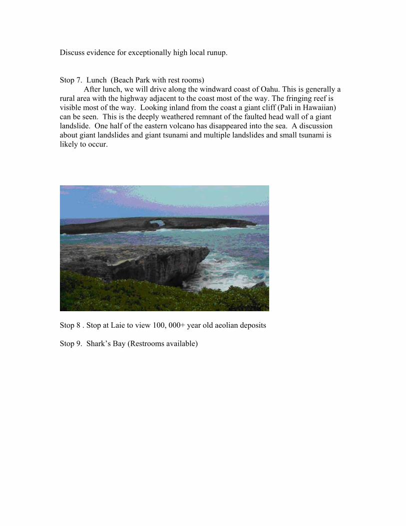
Discuss evidence for exceptionally high local runup. Stop 7. Lunch (Beach Park with rest rooms)
After lunch, we will drive along the windward coast of Oahu. This is generally a rural area with the highway adjacent to the coast most of the way. The fringing reef is visible most of the way. Looking inland from the coast a giant cliff (Pali in Hawaiian) can be seen. This is the deeply weathered remnant of the faulted head wall of a giant landslide. One half of the eastern volcano has disappeared into the sea. A discussion about giant landslides and giant tsunami and multiple landslides and small tsunami is likely to occur.
Stop 8 . Stop at Laie to view 100, 000+ year old aeolian deposits Stop 9. Shark’s Bay (Restrooms available)

Boulders and Mega boulders are found along the north shore of Oahu (see example above). This area receives extremely strong winter storms each year. Waves up to 50 ft occur. In the photo above scientists check their watches – waiting for the next tsunami.
The photo below shows slabs of reef rocks on the beach in a cove along the Kahuku coast.
At Sharks Cove (on the North Shore) and at Kahe Point (on the southwest side of Oahu), large boulders of limestone can be seen broken from the sea cliff but still sitting in place. At Shark’s Cove, boulders and Mega-boulders can be found on top of the reef flat. We will stop at the site and debate whether the boulders are moved during storms or perhaps tsunami events. Decades of aerial photographs show that some of the boulders

have been moved by major winter storms but the records do not go far enough back in time to say if the boulders are emplaced by storms or tsunami. (In the South Pacific, the oral tradition is that the boulders on top of the reefs were emplaced by hurricanes.)
Limestone blocks in place at Kahe Beach, Oahu. Depart North Shore at 3:30. Transit through the central portion of Oahu Pacific Tsunami Warning Center visit on return to Honolulu. Return to EW-Center. Prepared, April 4, 2006
THE TSUNAMI SOCIETY
THIRD TSUNAMI SYMPOSIUM
BANQUET
THE TREETOPS
Paradise ParkMay 24, 2006
OFFICERS
Dr. Barbara Keating, PresidentDr. Tad Murty, Vice-PresidentDr. Barbara Keating, Treasurer
SYMPOSIUM STAFF
Dr. Barbara Keating, ChairmanDr. Charles Mader, Program ChairmanDr. T. S. Murty, Awards ChairmanDr. Charles Helsley, Tour ChairmanMrs. Emma Jean Mader, Registration

.
PROGRAM
6:00 - RECEPTION
6:15 - DINNER
7:30 - TSUNAMI SOCIETY AWARDSDr. T. S. Murty, Awards Chairman
IN RECOGNITION OF OUTSTANDING
AND
ORIGINAL CONTRIBUTIONS
TO THE
SCIENCE OF TSUNAMI HAZARDS
7:45 - INTRODUCTION OF SPEAKERDr. Charles Mader, Program Chairman
AROUND THE WORLD IN 200 MILLION CELLS
DR. ZYGMUNT KOWALIK

Doak Cox January 16, 1917 - April 21, 2003
Dr. Doak Cox was a charter member of the Tsunami Society and published in the Science of Tsunami Hazards journal. He was awarded the Tsunami Society Award in 1999. He created the first Hawaii evacuation map and dedicated himself to collecting the historical data on the effects of Hawaii tsunamis. His work provides the data base for evaluating tsunami hazards and testing tsunami models.


THE TSUNAMI SOCIETY2525 Correa Rd., UH/SOEST, Rm 215 HIG
Honolulu, HI 96822, USA
WWW.STHJOURNAL.ORG
Related Documents