126 California Coastal Voices, by the California Coastal Commission Making Sense of Images Images can be much more than a snapshot—they are often evidence of choices made, of a culture’s impact on the land, and of the natural systems acting upon a place. Images can dramatically document changes over time: coastal weather hazards can be predicted, slow-moving geological processes can become visible, connections between biological communities can be seen. In a fast changing world of many environmental problems, image analysts provide insight into past choices, current conditions, and possible future scenarios that may be used to make sensible choices. Images do more than document problems—they often point the way to solutions. Thinking Tools for Image Analysis Coastal image analysts look for evidence relevant to specific questions they are seeking to answer or for a phenomenon they are seeking to explain. Analysts may start by looking for evidence of the following big ideas: • Paerns • Cause and effect mechanisms • Scale • Natural systems and boundaries/ intersections with other systems • Structure and function • Stability and change • Energy flows and cycles Observed paerns are the foundation of many scientific questions. Consider, for example, the paerns inscribed in beach sand by human activity or on water by wind. Cause and effect relationships are often the focus of an image analysis. Once a paern is noticed, the hunt for an explanation can begin. For example, you may have noticed the impact of a holiday on a beach or park. Overflowing garbage cans, plastic bags pinned in the bushes by wind, and footprints covering the beaches are all evidence of heavy human traffic the day before. Scale and placement within natural systems is vital to image analysis. Before interpreting an image, it’s helpful to know the general location and a reference for the size of the objects in the image. Considerations of scale, place, and their conceptual boundaries inform how an analyst will model a system. For example, the small beach shown above is on Lake Tahoe, a relatively closed system with an alpine climate. This makes the dynamics different from a beach on the temperate and energetic Pacific shore. Earth Observatory, NASA

Welcome message from author
This document is posted to help you gain knowledge. Please leave a comment to let me know what you think about it! Share it to your friends and learn new things together.
Transcript

126 California Coastal Voices, by the California Coastal Commission
Making Sense of Images
Images can be much more than a snapshot—they are often evidence of choices made, of a culture’s impact on the land, and of the natural systems acting upon a place. Images can dramatically document changes over time: coastal weather hazards can be predicted, slow-moving geological processes can become visible, connections between biological communities can be seen. In a fast changing world of many environmental problems, image analysts provide insight into past choices, current conditions, and possible future scenarios that may be used to make sensible choices. Images do more than document problems—they often point the way to solutions.
Thinking Tools for Image AnalysisCoastal image analysts look for evidence relevant to specific questions they are seeking to answer or for a phenomenon they are seeking to explain. Analysts may start by looking for evidence of the following big ideas:• Patterns• Cause and effect mechanisms• Scale• Natural systems and boundaries/
intersections with other systems• Structure and function• Stability and change• Energy flows and cycles
Observed patterns are the foundation of many scientific questions. Consider, for example, the patterns inscribed in beach sand by human activity or on water by wind.
Cause and effect relationships are often the focus of an image analysis. Once a pattern is noticed, the hunt for an explanation can begin. For example, you may have noticed the impact of a holiday on a beach or park. Overflowing garbage cans, plastic bags pinned in the bushes by wind, and footprints covering the beaches are all evidence of heavy human traffic the day before.
Scale and placement within natural systems is vital to image analysis. Before interpreting an image, it’s helpful to know the general location and a reference for the size of the objects in the image. Considerations of scale, place, and their conceptual boundaries inform how an analyst will model a system. For example, the small beach shown above is on Lake Tahoe, a relatively closed system with an alpine climate. This makes the dynamics different from a beach on the temperate and energetic Pacific shore.
Earth Observatory, NASA
127California Coastal Voices, by the California Coastal Commission
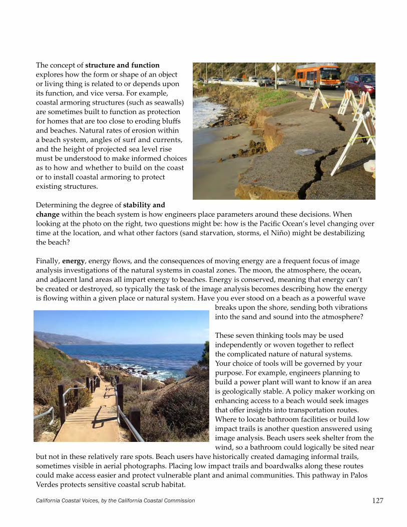
The concept of structure and function explores how the form or shape of an object or living thing is related to or depends upon its function, and vice versa. For example, coastal armoring structures (such as seawalls) are sometimes built to function as protection for homes that are too close to eroding bluffs and beaches. Natural rates of erosion within a beach system, angles of surf and currents, and the height of projected sea level rise must be understood to make informed choices as to how and whether to build on the coast or to install coastal armoring to protect existing structures.
Determining the degree of stability and change within the beach system is how engineers place parameters around these decisions. When looking at the photo on the right, two questions might be: how is the Pacific Ocean’s level changing over time at the location, and what other factors (sand starvation, storms, el Niño) might be destabilizing the beach?
Finally, energy, energy flows, and the consequences of moving energy are a frequent focus of image analysis investigations of the natural systems in coastal zones. The moon, the atmosphere, the ocean, and adjacent land areas all impart energy to beaches. Energy is conserved, meaning that energy can’t be created or destroyed, so typically the task of the image analysis becomes describing how the energy is flowing within a given place or natural system. Have you ever stood on a beach as a powerful wave
breaks upon the shore, sending both vibrations into the sand and sound into the atmosphere?
These seven thinking tools may be used independently or woven together to reflect the complicated nature of natural systems. Your choice of tools will be governed by your purpose. For example, engineers planning to build a power plant will want to know if an area is geologically stable. A policy maker working on enhancing access to a beach would seek images that offer insights into transportation routes. Where to locate bathroom facilities or build low impact trails is another question answered using image analysis. Beach users seek shelter from the wind, so a bathroom could logically be sited near
but not in these relatively rare spots. Beach users have historically created damaging informal trails, sometimes visible in aerial photographs. Placing low impact trails and boardwalks along these routes could make access easier and protect vulnerable plant and animal communities. This pathway in Palos Verdes protects sensitive coastal scrub habitat.

128 California Coastal Voices, by the California Coastal Commission
The following elaborates on the Guiding Questions for Image Analysis worksheet.
Absolute Location: In what coastal region was this image created?
Use clues like plant communities or size of rivers to place the image in either the North, Central, or South Coast regions. Recognizable human-built landmarks can help. Distinctive types of trees (redwoods for example), or distinctively contoured points of land are the most common starting point for an analysis. For example, if the coast has large, impressive trees on both sides of a coastal point, the location is likely in a northern region; by contrast, if only low scrubby plants are visible then a location further south in the coastal scrub biome may be inferred initially. Be careful in your conclusions, as a location completely exposed to the North Coast’s incessant winds will also have only low, ground-hugging plants. Piles of large logs on the beach will, however, be a reasonably definitive clue to North Coast beaches.
Place: What would a person in this place see, hear, and feel?
Determine what direction is north. Subsequently, think about the prevailing wind, direction that hills and cliffs face, evidence of precipitation, and plant community.
Normally, you should begin by looking for a reference object to give you a sense of scale. If buildings are present, find a home, school, or road. This will help you develop a good picture of things combined with your prior knowledge.
Human/Environment Interaction: How do humans depend upon and/or influence (positive or negative) the coastal environment in this place? What ecosystem services can you identify? Examples of some of the many ecosystem services include natural shoreline protection, water filtration, food production, carbon sequestration, and recreation.
Movement and Access: How are people accessing this place and how could access be improved? This may be considered from perspectives inside or outside of the study site but keep your purpose in mind. Increasing and enhancing access is one purpose, protecting and enhancing habitat is another. They might or might not be mutually exclusive.
Bio-Region: How and why is one area in this place similar to another? Can you identify any natural geographic boundaries?
Photos courtesy of the California Coastal Records Project.
Interpretation of Aerial Photographs

129California Coastal Voices, by the California Coastal Commission
Guiding Questions for Image AnalysisPlace this handout in your project notebook for repeated reference.
Absolute Location: In what coastal region was this image created? What is your evidence?
Place: What would a person in this place see, hear, and/or feel? What is your evidence?
Human/Environment Interaction: Howdohumansdependuponand/orinfluence (positive or negative) the coastal environment in this place? What ecosystem services can you identify? What is your evidence?
Movement and Access: How are people accessing this place and how could access be improved? This should be considered from perspectives inside or outside of the study site, but be sure to use remote sensing tools to build your perspective.
Bio-Region:Whatnaturalfactorsinfluencethebiologicalcommunityfoundinthisplace? Be sure to consider climate, geology, geography, and vegetation distribution.

Concrete Questions: Engineering Solutions for a Changing Coast — A Teacher-Guided Project 39
In this activity you will take on one of four stakeholder roles in a fictional situation, consider a range of viewpoints, and debate the merits of coastal protection structures. Improvise where appropriate, but please no messing with the facts or evidence as they are presented to you.
Scenario: Al Jordan is worried about his home, and for good reason. The single family home he owns is on a bluff facing the ocean, and the bluff is eroding. The house was constructed during the last century and his family has lived there for the last five years. Jordan’s house is currently 30 feet from the bluff face, but when he bought the property it was 50 feet back. Then strong storms and waves during the previous winter eroded the base of the bluff and 20 feet fell from the top in a sudden collapse.
The Jordan property is 0.2 acres in a small, well-to-do neighborhood, bordered by the bluff and beach to the west, a road to the east, and county parkland on north and south. The house is set 100 feet back from the road and the house itself is one story and 2,400 square feet. The bluff it sits on is 20 feet above the beach below. Jordan’s hired expert has determined that the average retreat rate for this bluff is nine inches per year since the house was constructed. However with an El Niño predicted for the following year, and more extreme storms expected due to climate change, Jordan is worried that the bluff retreat could happen faster. The beach below the house is well-used by the public, particularly in the summer months. There is public access from the parks to both the north and south of the Jordan property. In the summer there is a sandy beach about 200
feet wide, which sometimes disappears during large, winter storms as the waves crash against the bluff. With sea levels in the area predicted to rise by as much as two feet by 2050, there is concern for the future of this beach.
Jordan invited interested and informed members of the community to his home for an informal gathering to discuss what to do about his property.
Coastal Zone Stakeholder: I am Danielle Garamond, a coastal engineer with Protective Engineering, LLC. My interest lies in protecting the rights of property owners to preserve their assets by building coastal protection structures. I especially value the cherished oceanfront homes that define the good life in California. With respect to arguments about public beaches, it is clear to me that legal property rights are of higher value. Besides, there are many beaches in California.
Claim: Coastal armoring preserves homes, increases the tax base in coastal communities, and rewards hard working citizens who have earned the right to live on the coast. There is a relationship between coastal armoring and loss of sandy beaches, but the higher value is the protection of homes and other coastal structures. No precedent should be set limiting coastal armoring activities.
Evidence: Seawalls and other coastal protection structures have been shown to preserve oceanfront property values. In addition, the US Army Corps of Engineers has spent decades building such structures, investing billions. Would they do this if it did not make sense? At least 10% of California’s coastline is protected by armoring. Why should a homeowner in need of a sea wall today be denied protection?
A Home on the Edge Student Reading pg. 1

California Coastal Voices, by the California Coastal Commission40
Reasoning: My evidence supports a goal of retaining the right to build any type of coastal protection that will serve a property owner’s needs.
Coastal Zone Stakeholder: I am Bob Larkin, a coastal engineer with Tomorrow’s Engineering, LLC. My interest lies in protecting the rights of property owners by using soft engineering solutions that increase biodiversity and the quality of a beach, even as property rights are respected. Nature provides value to our society through ecosystem services.
Claim: By mimicking natural processes we can protect structures while enhancing the coastal environment and increasing recreational opportunities. Beach nourishment (bringing more sand to the beach), dune building, and planting vegetative cover are my preferred methods. It will be necessary to repeat the beach nourishment as the sand is naturally washed away over the years, but it preserves the beach where hard solutions do not.
Evidence: Experts in the field (like me) can design soft engineering solutions that protect the shoreline. Even when sand that has been deposited is moved offshore by the current, it can still protect the shore by causing waves to break farther out. FEMA has recognized the value of soft engineering by reducing flood insurance premiums in some instances, and the US Army Corps of Engineers has undertaken beach nourishment projects on the eastern US coast for decades.
Reasoning: While soft engineering solutions take expertise, time to implement, and maintenance commitment, they protect the beach and private property so my belief is that they are worth the investment.
Coastal Zone Stakeholder: I am Mary Chang and I represent the local surfers’ group. Our interest is in protecting the beach for public enjoyment and as a thriving habitat. We understand that private property owners care about and enjoy their homes, and that they’ve invested significantly in them. However, when someone chooses to purchase a structure on an eroding bluff, they are choosing to take significant risks. Oceanfront property owners enjoy the benefits of dramatic ocean views, waves, and easy access to the water; they should not then be allowed to destroy these pleasures for the public when natural forces do what they have always done. We place more value on the rights of a community of beach-goers than on those of a property owner who knew what he was getting into.
Claim: Coastal bluff collapse and retreat are natural processes. Sea walls fix in place the back of the beach instead of allowing it to move as it would otherwise. As sea level rises, it is particularly important that beaches be able to move landward. Sea walls also prevent a naturally eroding bluff from contributing sand to the beach.
Evidence: California Sea Grant as well as other coastal experts has made it clear that coastal armoring can increase erosion on the beach itself, which not only has recreation impacts but can reduce or eliminate habitat on the beach for shorebirds and other animals.
Reasoning: My evidence supports the goal of allowing the shoreline to retreat, even at the expense of private property owners. Local governments should act now to plan for the necessary removal of at-risk structures and where possible, existing coastal armoring in light of sea level rise forecasts due to global warming.
Student Reading pg. 2

Concrete Questions: Engineering Solutions for a Changing Coast — A Teacher-Guided Project 41
is a messy and emotional issue involving expensive and difficult questions, and it’s not going to get any easier. Historically there have been three basic options for dealing with coastal retreat: 1. retreat or relocation of development; 2. armor or protection; or 3. beach nourishment. These are not simple decisions. Nobody with an oceanfront location is excited about moving back from the edge, but it has happened and will likely happen more often in the future. On Depot Hill in Capitola, six cliff top apartments were taken down after the Loma Prieta earthquake when concrete caissons were undercut, and foundations cracked and partially failed. Twenty years earlier, a house next to the apartments was picked up and moved back several blocks and put on a new foundation. In other cases, failure to relocate houses led to cliff collapse and homes ending up on the beach below, which is what happened along the Esplanade in Pacifica in 1998. Sea level rise and a more severe storm climate claimed 28 villages along the southeast coast of England during the Middle Ages.
What Causes Shoreline Retreat?
Large waves arriving at high tide are the major force behind most coastal erosion and storm damage. Shoreline retreat may take different forms, however. The change from low-energy summer waves to high-energy winter waves leads to beach erosion every winter. Sand is scoured off the beach in December and January and stored offshore, only to return again the next spring and summer when winter storms have abated and calmer waves return. This is an expected and normal process we can all observe.
The beach at Santa Cruz was a 10-mile hike to the west 18,000 years ago at the end of the last Ice Age. As glaciers retreated and ice sheets melted over the following centuries, sea level rose about 400 feet and gradually flooded the edge of California, moving the beach inland. The coast retreated about 300 feet per century during that era of warming and melting. Throughout this 18,000-year period, the sea cliffs marching back three feet every year didn’t matter much. Although the Ohlone used the coast, harvesting fish and shellfish and hanging out on the beach, they didn’t have permanent dwellings so the precise location of the beach and sea cliff didn’t greatly impact their lives. Things are different today. The shoreline and sea cliff from San Diego to Santa Barbara is almost completely urbanized. In Santa Cruz County, homes, businesses, roads, parks and parking lots cover the coastline from Manresa to Natural Bridges. It’s probably fair to say that California’s most valuable real estate is right on the edge. But that edge is never in the same place for more than a few decades. The shoreline moves back and forth over millennia as sea level rises and falls in response to climate change. Around the Mediterranean Sea, civilizations have dealt with this phenomenon for thousands of years. In California, however, our coastal development and construction history is much more recent. Photographs of coastal bluffs in Santa Cruz County from the late 1800s reveal that people didn’t build right at the edge. But today, it’s pretty much continuous development of one sort or another. The closer to that ocean view, the more valuable the house and land. So how have we dealt with the erosion and retreat over the past 50-100 years and what are we going to do in the future? This
Dealing with a Retreating CoastlineStudent Reading pg. 1Student Reading pg. 2

California Coastal Voices, by the California Coastal Commission42
The coastal erosion that concerns cliff top residents as well as coastal communities isn’t the seasonal beach erosion, however, but the erosion and permanent retreat of the cliff or bluff. This is not recoverable, at least within our lifetimes or by natural processes. The rate at which cliffs or bluffs have historically eroded along the California coast varies from a surprising ten feet per year at some unfortunate locations, to a few inches or less in others. The former is obviously a cause for concern, especially if it’s your front yard or patio. Several different factors affect how rapidly a given cliff will retreat. The cliff’s strength or resistance to wave attack is usually the most important. Rock strength varies widely,
depending on the type of rock, the hardness or degree of consolidation or cementation, and the presence of weaknesses such as fractures or joints. The amount of wave energy reaching any particular area of coastline is also a key factor, and while the waves approaching the central coast on any given day come from the same storms, nearshore bottom conditions or bathymetry will increase or decrease wave heights at specific locations along the shoreline. A final factor is the regional rate of sea level rise, a natural phenomena that is accelerated by human influence via global warming from the accumulation of greenhouse gases in the atmosphere.
“Dealing with a Retreating Coastline” and “What Causes Shoreline Retreat” excerpted from Our Ocean Backyard, Collected Essays, by Gary Griggs
Stilwell Hall, Fort Ord. Facing bluff erosion, this World War II era building was demolished in 2003. Copyright (C) 2003 Kenneth & Gabrielle Adelman, California Coastal Records Project
Student Reading pg. 2
Concrete Questions: Engineering Solutions for a Changing Coast — A Teacher-Guided Project 45
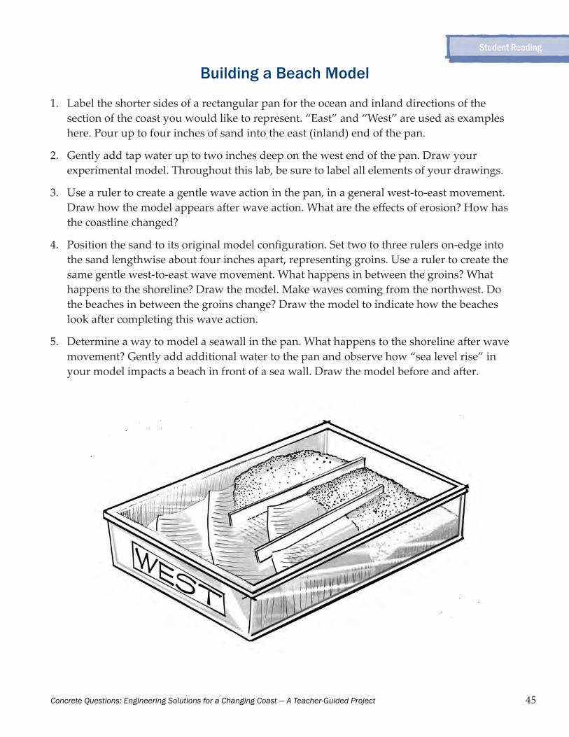
Building a Beach Model
1. Label the shorter sides of a rectangular pan for the ocean and inland directions of the section of the coast you would like to represent. “East” and “West” are used as examples here. Pour up to four inches of sand into the east (inland) end of the pan.
2. Gently add tap water up to two inches deep on the west end of the pan. Draw your experimental model. Throughout this lab, be sure to label all elements of your drawings.
3. Use a ruler to create a gentle wave action in the pan, in a general west-to-east movement. Draw how the model appears after wave action. What are the effects of erosion? How has the coastline changed?
4. Position the sand to its original model configuration. Set two to three rulers on-edge into the sand lengthwise about four inches apart, representing groins. Use a ruler to create the same gentle west-to-east wave movement. What happens in between the groins? What happens to the shoreline? Draw the model. Make waves coming from the northwest. Do the beaches in between the groins change? Draw the model to indicate how the beaches look after completing this wave action.
5. Determine a way to model a seawall in the pan. What happens to the shoreline after wave movement? Gently add additional water to the pan and observe how “sea level rise” in your model impacts a beach in front of a sea wall. Draw the model before and after.
Student Reading

131
An Introduction to the California Coastal ActAlarmed that private development was cutting off public access to the shore, and catalyzed by a huge oil spill off the coast of Santa Barbara, Californians in 1972 rallied to “Save Our Coast” and passed a voter initiative called the Coastal Conservation Initiative (Prop 20). Prop 20 created the California Coastal Commission to make land use decisions in the Coastal Zone, while additional planning occurred. Then in 1976 the State Legislature passed the Coastal Act, which made the Coastal Commission a permanent agency with broad authority to regulate coastal development. The Coastal Act guides how the land along the coast of California is developed, or protected from development. It emphasizes the importance of the public being able to access the coast, and the preservation of sensitive coastal and marine habitat and biodiversity. It dictates that development be clustered in areas to preserve open space, and that coastal agricultural lands be preserved. It prioritizes coastal recreation as well as commercial and industrial uses that need a waterfront location. It calls for orderly, balanced development, consistent with these priorities and taking into account the constitutionally protected rights of property owners. The Coastal Act defines the area of the coast that comes under the jurisdiction of the California Coastal Commission, which is called the “coastal zone.” The Coastal Zone extends seaward to the state’s outer limit of jurisdiction (three miles), including offshore islands. The inland boundary varies according to land uses and habitat values. In general, it extends inland 1,000 yards from the mean high tide line of the sea, but is wider in areas with significant estuarine, habitat, and recreational values, and narrower in developed urban areas. Coastal Zone boundary maps are available on the Coastal Commission website. The Coastal Zone does not include San Francisco Bay, which is under the jurisdiction of a separate state agency, the San Francisco Bay Conservation and Development Commission.
Annotated Reading of Selected Coastal Act Sections The following is a selection of excerpts from the Coastal Act, which contains many additional policies and procedures not addressed here. To read the entire Coastal Act, visit www.coastal.ca.gov/coastact.pdf. The quoted sections below are each referenced with their identifying section number in the Coastal Act. The Coastal Act begins with a section (30001) on the importance of the California coast and its ecological balance:
The Legislature hereby finds and declares:(a) That the California coastal zone is a distinct and valuable natural resource of vital and enduring interest to all the people and exists as a delicately
Group 1
California Coastal Voices, by the California Coastal Commission
132
balanced ecosystem.(b) That the permanent protection of the state’s natural and scenic resources is a paramount concern to present and future residents of the state and nation.(c) That to promote the public safety, health, and welfare, and to protect public and private property, wildlife, marine fisheries, and other ocean resources, and the natural environment, it is necessary to protect the ecological balance of the coastal zone and prevent its deterioration and destruction.(d) That existing developed uses, and future developments that are carefully planned and developed consistent with the policies of this division, are essential to the economic and social well-being of the people of this state and especially to working persons employed within the coastal zone.
Thus, the law recognizes the importance of both the natural environment and economic development that is dependent upon the resources of the coast. The Coastal Act (30001.5) declares that the basic goals of the state for the coastal zone are to:
(a) Protect, maintain, and where feasible, enhance and restore the overall quality of the coastal zone environment and its natural and artificial resources.(b) Assure orderly, balanced utilization and conservation of coastal zone resources taking into account the social and economic needs of the people of the state.(c) Maximize public access to and along the coast and maximize public recreational opportunities in the coastal zone consistent with sound resources conservation principles and constitutionally protected rights of private property owners.(d) Assure priority for coastal-dependent and coastal-related development over other development on the coast.(e) Encourage state and local initiatives and cooperation in preparing procedures to implement coordinated planning and development for mutually beneficial uses, including educational uses, in the coastal zone.
Chapter 3 of the Coastal Act contains the policies that are to guide coastal resource planning and decisions on individual development proposals. The Coastal Act recognizes that at times there will be conflicts between these policies, and states that “such conflicts be resolved in a manner which on balance is the most protective of significant coastal resources.” (30007.5) The Coastal Act prioritizes the public’s right to access the shoreline (30210 to 30214):
[M]aximum access, which shall be conspicuously posted, and recreational opportunities shall be provided for all the people consistent with public safety needs and the need to protect public rights, rights of private property owners, and natural resource areas from overuse.
Group 2
Introduction to the California Coastal Act, continued
California Coastal Voices, by the California Coastal Commission

133
Coastal development should not impede existing rights of access:
Development shall not interfere with the public’s right of access to the sea where acquired through use or legislative authorization...
The previous statement makes reference to different ways public access rights are established. The government may establish these rights (such as by purchasing land to create a public path to the beach) or they are sometimes established through historic public use.
New public access is encouraged in the Coastal Act:
Public access from the nearest public roadway to the shoreline and along the coast shall be provided in new development projects except where: (1) it is inconsistent with public safety, military security needs, or the protection of fragile coastal resources, (2) adequate access exists nearby, or, (3) agriculture would be adversely affected.
In practice, most new accessways require that an organization (public or private) first accept responsibility for maintenance and liability before being opened to the public. The Coastal Act (30252) recognizes that it is not sufficient to provide access to the coast; sensible planning for encouraging coastal recreation includes addressing transportation needs and other considerations, such as preventing overcrowding of recreation areas:
The location and amount of new development should maintain and enhance public access to the coast by (1) facilitating the provision or extension of transit service, (2) providing commercial facilities within or adjoining residential development or in other areas that will minimize the use of coastal access roads, (3) providing non automobile circulation within the development, (4) providing adequate parking facilities or providing substitute means of serving the development with public transportation, (5) assuring the potential for public transit for high intensity uses such as
Introduction to the California Coastal Act, continued
Acquisition through historic use is explained in the California Coastal Access Guide, published by UC Press:
According to court decisions, in order for the public to obtain an easement by way of implied dedication, the essential elements that must be established are that the public has used the land 1) for a continuous period of five years as if it were public land, 2) with the actual or presumed knowledge of the owner, and 3) without significant objection or significant attempts by the owner to prevent or halt such use.The ultimate determination of prescriptive rights, if they are challenged, takes place in court. However, Section 30211 of the Coastal Act requires the Coastal Commission to make determinations as to the existence of these rights where there is evidence of historic use of a given area.
California Coastal Voices, by the California Coastal Commission

134
high-rise office buildings, and by (6) assuring that the recreational needs of new residents will not overload nearby coastal recreation areas by correlating the amount of development with local park acquisition and development plans with the provision of onsite recreational facilities to serve the new development.
The Coastal Act (30221) calls for lower cost visitor and recreational facilities, addressing the concern that coastal recreational opportunities be available to all Californians regardless of income level. In addition, “Developments providing public recreational opportunities are preferred.” Also:
Oceanfront land suitable for recreational use shall be protected for recreational use and development unless present and foreseeable future demand for public or commercial recreational activities that could be accommodated on the property is already adequately provided for in the area.
The Coastal Act (30230) also prioritizes ecological resources. Marine resources, such as wetlands, rocky intertidal areas, and the open ocean are addressed as follows:
Marine resources shall be maintained, enhanced, and where feasible, restored. Special protection shall be given to areas and species of special biological or economic significance. Uses of the marine environment shall be carried out in a manner that will sustain the biological productivity of coastal waters and that will maintain healthy populations of all species of marine organisms adequate for long-term commercial, recreational, scientific, and educational purposes.
The Coastal Act (30240) includes special protection for Environmentally Sensitive Habitat Areas, often referred to as ESHA:
(a) Environmentally sensitive habitat areas shall be protected against any significant disruption of habitat values, and only uses dependent on those resources shall be allowed within those areas.(b) Development in areas adjacent to environmentally sensitive habitat areas and parks and recreation areas shall be sited and designed to prevent impacts which would significantly degrade those areas, and shall be compatible with the continuance of those habitat and recreation areas.
The law recognizes the importance of maintaining adequate water quality for coastal zone organisms and human health (30231):
The biological productivity and the quality of coastal waters, streams, wetlands, estuaries, and lakes appropriate to maintain optimum populations of marine organisms and for the protection of human health shall be maintained and, where feasible, restored through, among other means, minimizing adverse effects of waste water discharges and entrainment,
Group 3
Introduction to the California Coastal Act, continued
California Coastal Voices, by the California Coastal Commission

135
controlling runoff, preventing depletion of ground water supplies and substantial interference with surface waterflow, encouraging waste water reclamation, maintaining natural vegetation buffer areas that protect riparian habitats, and minimizing alteration of natural streams.
The Coastal Act prioritizes certain types of activities and development over other types in the coastal zone. For instance, visitor-serving commercial recreational facilities designed to enhance public opportunities for coastal recreation are prioritized over private residential, general industrial, or general commercial development, but not over agriculture or coastal-dependent industry (30222). Recreational boating and its related facilities are encouraged in the Coastal Act (30224). The Coastal Act (30253) dictates that new development be designed and sited to minimize adverse impacts to coastal resources, both natural and visitor-serving, as follows:
New development shall do all of the following: (a) Minimize risks to life and property in areas of high geologic, flood, and fire hazard. (b) Assure stability and structural integrity, and neither create nor contribute significantly to erosion, geologic instability, or destruction of the site or surrounding area or in any way require the construction of protective devices that would substantially alter natural landforms along bluffs and cliffs. (c) Be consistent with requirements imposed by an air pollution control district or the State Air Resources Board as to each particular development. (d) Minimize energy consumption and vehicle miles traveled. (e) Where appropriate, protect special communities and neighborhoods that, because of their unique characteristics, are popular visitor destination points for recreational uses.
Views and local character are protected by the Coastal Act (30251):
The scenic and visual qualities of coastal areas shall be considered and protected as a resource of public importance. Permitted development shall be sited and designed to protect views to and along the ocean and scenic coastal areas, to minimize the alteration of natural land forms, to be visually compatible with the character of surrounding areas, and, where feasible, to restore and enhance visual quality in visually degraded areas.
The Coastal Act (30235) calls for limits on the use of shoreline armoring:
Revetments, breakwaters, groins, harbor channels, seawalls, cliff retaining walls, and other such construction that alters natural shoreline processes shall be permitted when required to serve coastal-dependent uses or to protect existing structures or public beaches in danger from erosion, and when designed to eliminate or mitigate adverse impacts on local shoreline sand supply.
Group 4
Introduction to the California Coastal Act, continued
California Coastal Voices, by the California Coastal Commission

136
The issue of whether new shoreline armoring should be allowed will arise with increasing frequency as global warming causes sea level rise. In applying the Coastal Act, the Commission tries to avoid shoreline armoring by locating new development away from hazard areas if feasible. The Coastal Act (30006) includes a statement on the importance of public participation in its implementation...
The Legislature further finds and declares that the public has a right to fully participate in decisions affecting coastal planning, conservation and development; that achievement of sound coastal conservation and development is dependent upon public understanding and support; and that the continuing planning and implementation of programs for coastal conservation and development should include the widest opportunity for public participation.
...as well as public education (30012):
The Legislature finds that an educated and informed citizenry is essential to the well-being of a participatory democracy and is necessary to protect California’s finite natural resources, including the quality of its environment. The Legislature further finds that through education, individuals can be made aware of and encouraged to accept their share of the responsibility for protecting and improving the natural environment.
The Coastal Commission
There are 15 California Coastal Commissioners. Twelve are voting members and three are non-voting members. The voting members are appointed by the Governor, the Speaker of the Assembly, and the Senate Rules Committee; each appoint four Commissioners, of which two are selected from the public at large and two are locally elected officials. The local officials on the Commission represent six coastal regions in California. The Governor’s appointments must include at least one representative who resides in and works directly with communities with diverse racial and ethnic populations and communities with low-income populations burdened disproportionately by high levels of pollution and issues of environmental justice. The non-voting Commissioners are the Secretary of the Resources Agency, the Secretary of the Business and Transportation Agency, and the Chairperson of the State Lands Commission. The Coastal Commission meets each month to hear from the public and make decisions. The meetings are held in different coastal locations and generally last three days. You can find out about these meetings on the Coastal Commission website at www.coastal.ca.gov. Meetings are open to the public as well as streamed live online, and previous meetings can be viewed in a video archive.
Introduction to the California Coastal Act, continued
California Coastal Voices, by the California Coastal Commission
Related Documents


