U.S. DEPARTMENT OF THE INTERIOR U.S. GEOLOGICAL SURVEY Thermal maturity patterns (CAI and %R o ) in the Ordovician and Devonian rocks of the Appalachian basin in West Virginia By John E. Repetski 1 Robert T. Ryder 1 Katharine Lee Avary 2 And Michael H. Trippi 1 Open-File Report 2005-1078 1 U.S. Geological Survey, Reston, Virginia 20192 2 West Virginia Geological Survey, Morgantown, West Virginia 26507

Welcome message from author
This document is posted to help you gain knowledge. Please leave a comment to let me know what you think about it! Share it to your friends and learn new things together.
Transcript
U.S. DEPARTMENT OF THE INTERIOR U.S. GEOLOGICAL SURVEY
Thermal maturity patterns (CAI and %Ro) in the Ordovician and Devonian rocks of the Appalachian basin in West Virginia
By
John E. Repetski1
Robert T. Ryder1
Katharine Lee Avary2
AndMichael H. Trippi1
Open-File Report 2005-1078
1 U.S. Geological Survey, Reston, Virginia 20192 2 West Virginia Geological Survey, Morgantown, West Virginia 26507
i
CONTENTS
PageIntroduction…………………………………………………………………. 1 Methods……………………………………………………………….……. 3 Stratigraphy of sampled intervals…………………………………………… 7 Thermal maturity of Ordovician strata……………………………………… 11 Thermal maturity of Devonian strata……………………………………….. 20 Discussion…………………………………………………………………… 31 References cited…………………………………………………………….. 37
ILLUSTRATIONS
Figure 1. Location of wells and surface localities sampled for conodonts and (or) vitrinite in this study. 5
Figure 2. Stratigraphic relations of Ordovician rocks (part) in West Virginia with location of conodont sample collections recovered in this study. 9
Figure 3. Stratigraphic relations of Devonian rocks (part) in West Virginia withlocation of conodont sample collections recovered in this study. 10
Figure 4. Ordovician maximum conodont alteration index (CAImax) isograds forWest Virginia based largely on data collected in this study. 12
Figure 5. Ordovician CAImax isograds superimposed on major structural features in West Virginia. 13
Figure 6. Ordovician CAImax isograds superimposed on Cambrian, Ordovician and Silurian gas fields in West Virginia. 17
Figure 7. Correlation of vitrinite reflectance and CAI values. 19
Figure 8. Devonian maximum conodont alteration index (CAImax) isograds forWest Virginia based largely on data collected in this study. 21
Figure 9. Devonian CAImax isograds superimposed on major structural features in West Virginia. 22
Figure 10. Devonian mean vitrinite reflectance values (%Romean) based on newdata collected in study. The vitrinite reflectance values are superimposed on major structural features in West Virginia. 25
ii
Figure 11. Devonian CAImax isograds superimposed on Lower Devonian gas fields and Upper Devonian-Lower Mississippian oil and gas fields in West Virginia. 28
Figure 12. Devonian CAImax isograds superimposed on Upper Devonian oil and gas fields and Upper/Middle Devonian gas fields in West Virginia. 29
TABLES
Table 1. Data for conodonts recovered from Ordovician samples in the subsurfaceof West Virginia. 49
Table 2. Data for conodonts recovered from Devonian samples in the subsurface of West Virginia. 52
Table 3. Thermal maturity (CAI, %Ro) and RockEval/TOC data from Ordovician and Devonian samples from the subsurface of West Virginia. 60
1
Introduction
This report presents a series of new thermal maturation maps for West Virginia,
based on conodont color alteration index (CAI) and vitrinite reflectance (%Ro). Also,
RockEval and total organic carbon (TOC) data are included in the report. Three Paleozoic
intervals were studied: Middle Ordovician carbonate rocks, Lower and Middle Devonian
carbonate rocks, and Middle and Upper Devonian black shale. These intervals were
chosen for several reasons: A) they represent target reservoir zones for most of the oil
and gas exploration and drilling in West Virginia; B) they are stratigraphically near
probable source rocks for the oil and gas; C) they include contiguous geologic formations
that extend across most of West Virginia; D) they contain carbonate grainstone/packstone
which give a reasonable to good probability of recovery of conodont elements from small
samples of drill cuttings; and E) the Middle and Upper Devonian black shale contains
large amounts of organic matter for geochemical analysis.
The maps presented herein complement, and in some areas replace, the West
Virginia part of the CAI-based thermal maturation maps for the Appalachian basin of
Harris and others (1978). The maps of Harris and others (1978) were pioneering efforts in
applying the concepts and techniques of CAI analysis developed by Epstein and others
(1977). Our maps differ in that the CAI data used are derived almost entirely from
subsurface samples whereas the CAI data used by Harris and others (1978) are almost
entirely from outcrop samples. Because of the sampling methods, there is little
geographic overlap in the two data sets, with the new data presented herein mostly from

2
the Appalachian Plateau province and most of the data of Harris and others (1978) being
from the Valley and Ridge province.
Several vitrinite reflectance (%Ro) maps are available for evaluating thermal
maturity patterns in the Appalachian basin but they are limited to smaller areas than the
CAI-based maps. Examples of vitrinite reflectance maps that apply to West Virginia are
those for Upper Devonian black shale by Streib (1981), Hamilton-Smith (1996), and
Curtis and Faure (1997) and for Pennsylvanian coal beds by Trinkle and others (1978),
Cole and others (1979), Chyi and others (1987), and Hower and Rimmer (1991).
RockEval/TOC-derived maps for Appalachian Ordovician black shale are available in
Wallace and Roen (1989).
Thermal maturity patterns of the Middle Ordovician Trenton Limestone are
evaluated here because they are expected to closely approximate those of the overlying
Ordovician Utica (Antes) Shale that is the probable source rock for oil and gas in Upper
Cambrian sandstone, Lower Ordovician carbonate rocks, and Lower Silurian sandstone
(Ryder and others, 1998) and possibly for new gas discoveries in the Trenton and Black
River Limestones (Schwochow, 2000; Avary, 2001). Thus, improved CAI-based thermal
maturity maps are important to identify areas of optimum gas generation from the Utica
(Antes) Shale and to constrain the origin, distribution, and quality of natural gas in the
Lower Silurian regional oil and gas accumulation (Ryder and Zagorski, 2003). Also,
thermal maturity maps of the Ordovician may contribute to understanding the origin and
distribution of gas in Trenton and Black River carbonate reservoirs. Moreover, thermal
maturity maps of selected Devonian carbonate rock and black shale intervals will
constrain burial history - petroleum generation models of the Ordovician Utica (Antes)
3
Shale, as well as provide a better understanding of the origin and distribution of regional
oil and gas accumulations in Upper Devonian sandstone, self-sourced gas in Middle to
Upper Devonian black shale, and conventional gas in Lower Devonian sandstone.
New CAI and %Ro maps presented in this report also contain information that
relates to the thermal and tectonic evolution of the Appalachian basin. Important in this
regard are the character of thermal maturity patterns across specific tectonic features,
comparison of thermal maturity and overburden patterns, changes in paleogeothermal
gradient with time for a given area, and proposed geological/geophysical causes of
regional thermal maturity anomalies.
New York State and Pennsylvania were the first areas in the Appalachian basin
where the collection, processing, and analysis of subsurface drill-hole cuttings and core
samples have resulted in new CAI and %Ro maps (Weary and others, 2000, 2001;
Repetski and others, 2002). The present study is a cooperative effort between the U.S.
Geological Survey (USGS) and the West Virginia Geological and Economic Survey.
Additional investigations in Ohio (USGS-Ohio Division of Geological Survey),
Kentucky (USGS-Kentucky Geological Survey), and Virginia (USGS-Virginia Division
of Mineral Resources) are at various stages of completion.
Methods
Seventy-one drill-hole samples were collected, processed, and analyzed for
conodont color alteration index (CAI) specifically for this study. Of these, 55 were
Devonian and 16 were Ordovician. The Devonian samples used herein were from 46

4
drill holes and all of them consisted of cuttings. Two of these drill holes were sampled
previously (A.G. Harris, unpub. USGS data; 5 samples, 3 having conodonts). These
samples yielded 53 new Devonian CAI points for West Virginia. The Ordovician samples
were obtained from 17 drill holes; 14 samples were cuttings, 5 were cores. Fourteen of
these drill holes were sampled specifically for this study; 3 were sampled previously, for
other USGS studies (A.G. Harris, unpub. USGS data; Ryder and others, 1996)(Table 1)
In all, these resulted in 16 new Ordovician CAI points.
An additional 40 samples were collected from Devonian black shales. These black
shales were sent to Humble Geochemical Services,1 Humble, Texas, for processing and
analysis for total organic carbon (TOC), RockEval parameters, and vitrinite reflectance.
Additional vitrinite reflectance values (n = 22) from Devonian black shale in 3 West
Virginia core holes (Streib, 1981) supplement our data set (Table 3).
Samples for this study were collected by one of us (KLA) and Melissa Packer
from drill core and cuttings in the repository holdings of the West Virginia Geological
and Economic Survey, at Morgantown, Monongalia County, West Virginia. Conodonts
from 7 additional wells and 2 outcrops (8 Devonian and 4 Ordovician samples), already
on file at the USGS (A. G. Harris, unpublished data; Ryder and others, 1996), were re-
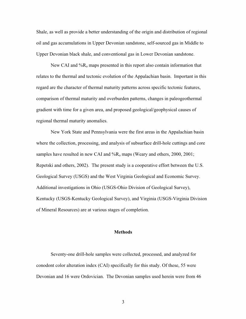
analyzed for this study. In all, 58 drill holes and 2 outcrops in 36 counties were sampled
(Fig. 1; Table 3).
Where possible (n=41 holes), we sampled the different target intervals from the
same drill hole (well). In most of these cases, the sampled pair was the Devonian black
shale and Devonian carbonate rocks. The total collection consists of: 1) carbonate
1 Any use of trade, product, or firm names is for descriptive purposes only and does not imply endorsement by the U.S. Government.
5
6
(limestone) samples from the Upper Cambrian-Lower Ordovician Beekmantown Group
(or Formation, as used by the West Virginia Geological Survey), Middle-Upper
Ordovician Black River and Trenton Limestones, and Middle Ordovician Chazy
Limestone (n=19, including 3 barren samples and 3 from Harris, unpub. USGS data, and
Ryder and others, 1996) (Fig. 2; Table 1); 2) carbonate (chiefly limestone, with minor
dolostone) samples from selected Devonian formations (n=60, including 7 barren
samples and 3 from A.G. Harris, unpub. USGS data) (Fig. 3; Table 2); and 3) black shale
samples from the Middle Devonian Marcellus Shale or Upper Devonian Rhinestreet and
Huron Shales (n=62, including 22 from Streib, 1981) (Table 3). The samples averaged
about 120 g, with a range from 2.1 to several hundred g, and consisted of rock fragments
>20-mesh. Most samples were composites representing from about 100 to several
hundred feet of stratigraphic section. The carbonate samples were shipped to the USGS in
Reston, Virginia, where they were processed for conodonts using standard chemical and
physical extraction procedures (Harris and Sweet, 1989).
Conodonts recovered were visually compared with a set of conodont color
standards of approximately the same age (to Period), provided by A.G. Harris (USGS-
Emeritus), and assigned a conodont alteration index (CAI) value. Samples exhibiting a
range in CAI values and samples with very few individual conodont elements or only a
few element fragments were assigned a minimum and maximum value. We chose to use
the maximum CAI value for plotting the isograds on the accompanying maps (Figs. 4-6,
8-10) to maintain consistency with the procedures used by Harris and others (1978), for
their Appalachian CAI maps. In effect, if a host rock experienced at least the magnitude
and duration of heating to raise any of the contained conodont elements to the higher CAI
7
value in an observed range of values, then any associated hydrocarbons also would have
experienced those temperatures as well. The conodonts used in this study are reposited in
the collections of the U.S. Geological Survey in Reston, Virginia, and are curated using
the USGS Cambrian-Ordovician (CO) and Silurian-Devonian (SD) fossil
collection/locality numbers. (Tables 1 and 2). Tables 1 and 2 also provide faunal lists,
biostratigraphic ages or age ranges for the recovered conodonts from each productive
sample, and details of the processed residues for the Ordovician and Devonian carbonate
sample sets, respectively. Summaries of the location, age, and depth of the samples, as
well as their measured TOC, RockEval, vitrinite reflectance, and CAI values are given in
Table 3. Also given in Table 3 are notable minerals and fossils seen in the heavy fraction
(sp. gr. >2.87) of the picked insoluble residues.
All of the maps were constructed by plotting points in ARC/VIEW over a digital
base map, using latitude/longitude coordinates from the West Virginia Geological and
Economic Survey oil and gas well database. The points were then attributed with
American Petroleum Institute (API) numbers, minimum and maximum CAI values,
RockEval parameter values, and %Ro values. Data points and CAI isograd contours from
Harris and others (1978) were captured and replotted by tracing and attributing the points
and lines in ARC/INFO. The coverages were exported to ARC/VIEW version 3.1 for
ease of manipulation and graphic display.
Stratigraphy of Sampled Intervals
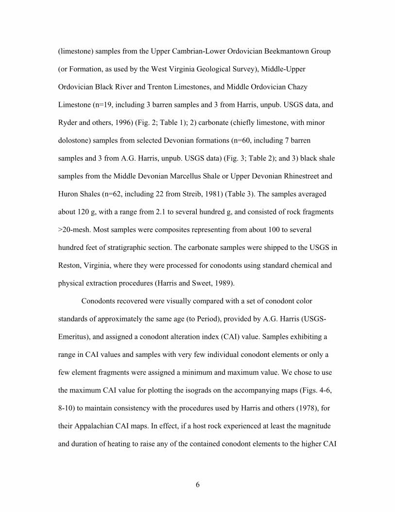
All Ordovician samples used in this study were identified from well logs as the
Chazy Limestone, Trenton Limestone, Black River Limestone, or Beekmantown
8
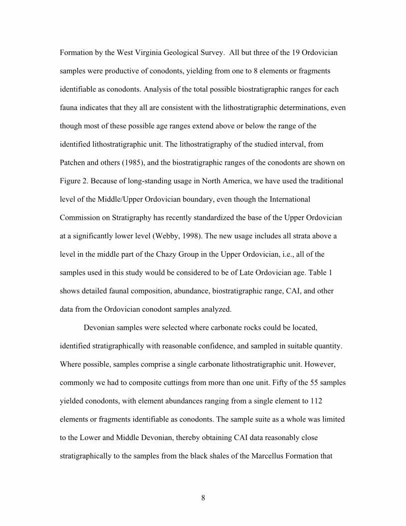
Formation by the West Virginia Geological Survey. All but three of the 19 Ordovician
samples were productive of conodonts, yielding from one to 8 elements or fragments
identifiable as conodonts. Analysis of the total possible biostratigraphic ranges for each
fauna indicates that they all are consistent with the lithostratigraphic determinations, even
though most of these possible age ranges extend above or below the range of the
identified lithostratigraphic unit. The lithostratigraphy of the studied interval, from
Patchen and others (1985), and the biostratigraphic ranges of the conodonts are shown on
Figure 2. Because of long-standing usage in North America, we have used the traditional
level of the Middle/Upper Ordovician boundary, even though the International
Commission on Stratigraphy has recently standardized the base of the Upper Ordovician
at a significantly lower level (Webby, 1998). The new usage includes all strata above a
level in the middle part of the Chazy Group in the Upper Ordovician, i.e., all of the
samples used in this study would be considered to be of Late Ordovician age. Table 1
shows detailed faunal composition, abundance, biostratigraphic range, CAI, and other
data from the Ordovician conodont samples analyzed.
Devonian samples were selected where carbonate rocks could be located,
identified stratigraphically with reasonable confidence, and sampled in suitable quantity.
Where possible, samples comprise a single carbonate lithostratigraphic unit. However,
commonly we had to composite cuttings from more than one unit. Fifty of the 55 samples
yielded conodonts, with element abundances ranging from a single element to 112
elements or fragments identifiable as conodonts. The sample suite as a whole was limited
to the Lower and Middle Devonian, thereby obtaining CAI data reasonably close
stratigraphically to the samples from the black shales of the Marcellus Formation that
Eggleston-Oranda Fms.
Moccasin Fm.
?
North American
Syst
emO
rdov
icia
n
Mid
dle
(par
t)
Mo
haw
kian
Seri
es
Stag
e
Up
per
(par
t)
Cin
cin
n.
(par
t)
Ri
M
E
S
K
R
BR
WR C
Southern CoalBasin
SoutheasternValley & Ridge
NortheasternValley & Ridge
Bergstrom1971
Conodont Zones
Sweet1984
Recoveredconodonts
instudy
Basin Center Dunkard Basin High Plateau
Martinsburg Formation
Trenton Limestone
Black River Limestone
Wells Creek Formation Wells Creek Limestone St. Paul Limestone Wells Creek Formation Chazy Limestone
Lincolnshire Limestone
St.P
aul
Gro
up
New MarketLimestone
Black River Limestone Black River Limestone Black River Limestone Black River Limestone Black River Limestone
Ch
amb
ersb
urg
Gro
up
Trenton Limestone
Trenton Limestone
Trenton Limestone Trenton Limestone TrentonGroup
NealmontLimestone
Martinsburg Formation
Martinsburg Formation
Martinsburg Formation Martinsburg Formation ReedsvilleFormation
Oswego SandstoneOswego Ss.
Martins-burg Fm.
DollyRidge Fm.
?
A. superbus
Pl. tenuis
Beladinacompressa
E. quadri-dactylus
Pl. aculeata
A. tvaerensis
Phragmodusundatus
O. velicuspus
B. confluens
2 (2)
2 (1)
14 (13)
West Virginia Ordovican (part)Stratigraphic Nomenclature
Figure 2. Stratigraphic relations of Ordovician rocks (part) in West Virginia (after Patchenand others, 1985) with conodont sample collections indexed for this study.Number of conodont samples from each unit in plain numerals. Samplesyielding conodonts in parentheses. Total-Ordovician samples with recoveredconodonts: 16. Ri - Richmondian; M - Maysvillian; E - Edenian; S- Shermanian;K - Kirkfieldian; R - Rocklandian; BR - Blackriveran; C - Chazyan; I - Ibexian;Ca - Canadian; WR - Whiterockian; KG - Knox Group; BG - Beekmantown Group
Beekmantown Fm. Beekmantown Fm. Beekmantown Fm. Beekmantown Fm. Beekmantown Fm.Pinesburg
Station Dolo.BGKGKGLower I (Ca) 1 (0)
9
OnondagaLs.
OnondagaLs.
Basin CenterDunkard Basin High Plateau
Hampshire Fm.Hampshire Fm.
HampshireFm.
HampshireFm.
"Chagrin" Shale
HuronSh. Mbr.
"Chemung"Fm.
"Chemung" Fm.
"Chagrin" Sh.
HuronSh. Mbr. "Chemung" Fm.
ForeknobsFm.
Java Fm. Java Fm.JavaFm.
Java Fm.
Ohi
oS
hale
Upp
erD
evon
ian
undi
ffere
ntia
ted
LowerHuronSh.
ClevelandSh. Mbr.
? ?
?
Gre
enla
ndG
apG
p.
ClevelandSh. Mbr.
Scherr Fm.
Brallier Fm.
?
Brallier Fm.
Middlesex Sh.
Angola Mbr.
RhinestreetMbr.
WestFallsFm.
Cashaqua Mbr.
Middlesex Mbr.
SonyeaFm.
SonyeaFm.
WestFallsFm.
Brallier Fm.
"Bra
llier
"F
m.
?
Angola Sh.Mbr.West
FallsFm.
WestFallsFm.
Angola Sh.Mbr.
SonyeaFm.
RhinestreetMbr.
RhinestreetMbr.
Cashaqua Sh. Mbr. CashaquaSh. Mbr.Sonyea
Fm.Middlesex Sh. Mbr.
Middlesex Sh.Mbr.
GeneseeFm.
West RiverSh. Mbr.
Geneseo Sh.Mbr.
GeneseeFm.
West River Sh. Mbr.
Geneseo Sh.Mbr.
HarrellFm.
GeneseoFm. Harrell Fm.
GeneseeFm.
West River Mbr.
GeneseoMbr.
GeneseoSh. Mbr.
Genesee Fm.
?
Harrell Fm.
Burket Sh.Mbr.
HarrellSh. Burket Mbr.
upper mbr.
"Tully Ls."(locally absent)Tully Ls.Tully Ls.Tully Ls.
MahantangoFm.Mahantango
Fm.
MahantangoFm.
MahantangoFm.
MarcellusSh.
MarcellusSh.
Marcellus Sh.Marcellus
Sh.Marcellus
Sh.MarcellusSh.
MahantangoFm.
Ham
ilton
Gp.
Ham
ilton
Gp.
Purcell Mbr.
Tioga bentonite.Tioga bentonite.
HuntersvilleChert
NeedmoreShale
NeedmoreShale
Beaver DamMember
HuntersvilleChert
NeedmoreShale
Onondaga Ls./HuntersvilleChert
Onondaga Ls./HuntersvilleChert
HuntersvilleChert
GlobalChronostratigraphic
Units
North AmericanChronostratigraphic
Units
Series/StageCommonly Used
Series/Stage Southern CoalBasin
SoutheasternValley & Ridge
NortheasternValley & Ridge
FAMENNIAN
CONEWANGAN(BRADFORDIAN)
CASSADAGAN
CHEMUNGIAN(COHOCTON)
CH
AU
TAU
QU
AN
FRASNIAN
UP
PE
R
FINGER-LAKESIAN
SE
NE
CA
N
GIVETIAN
(TAGHANIC)
(TIOUGHNIOGAN)
EIFELIAN
(CAZENOVIAN)
(SOUTH-WOODIAN)
ER
IAN
MID
DL
EL
OW
ER
EMSIAN
SIEGENIAN
GEDINNIAN
ESOPUSIAN
(SAWKILLIAN)
DEERPARKIAN
HELDER-BERGIAN
UL
ST
ER
IAN
West Virginia Devonian Stratigraphic Nomenclature
"Ohi
oS
hale
"
"Ohi
oS
hale
"
W
W
W W
SW SW
E
E
E E
NE NE
Mandata Sh.
Licking Creek Ls.
"upper Keyser" Ls.
NewCreek Ls.
Healing Springs Ss.
Hel
derb
erg
Gp.
Hel
derb
erg
Gp.
Salina"H"
Mandata Sh.Mandata Sh.
"Licking Creek" Ls.
"upper Keyser" Ls. "upper Keyser" Ls.
Oriskany Ss. Oriskany Ss. Oriskany Ss. Oriskany Ss. Oriskany Ss. Oriskany Ss.
Mandata Sh.Mandata Sh.Mandata Sh.
"Licking Creek" Ls. Licking Creek Ls.Shriver Chert"Shriver" Chert Fm.
"upper Keyser" Ls. "upper Keyser" Ls.
"upper Keyser" Ls.
New Creek Ls.
New Scotland Ls.
Hel
derb
erg
Gp."Shriver" Chert Fm.
Keyser Ls.
Rockwell Fm. Pocono Fm.
Figure 3. Stratigraphic relations of Lower, Middle, and Upper Devonian rocks in West Virginia (after Patchen and others, 1985) with conodontsample collections used in this study (Table 3). Number of conodont samples from each unit in plain numerals. Samples yielding conodonts inparentheses. Total Devonian samples with recovered conodonts: 53.
34(3
1)15
(13)
4(3
)
1(0
)
6(6
)
10
11
were selected and analyzed for vitrinite reflectance and RockEval/TOC data. Figure 3
shows the stratigraphic framework for the studied part of the Devonian in selected
structural provinces of West Virginia (from Patchen and others, 1985), as well as the
positions of the conodont samples, both productive and barren. Details of the faunal
compositions, element counts, biostratigraphic positions, CAI, and other data, for each of
the Devonian conodont samples used in this study are shown in Table 2.
Thermal Maturity of Ordovician Strata
Distribution of Isograds: The Ordovician CAI data for the new subsurface samples, for
one sample reported by Ryder and others (1996), and for several unpublished subsurface
samples reported by A. G. Harris (Tables 1 and 3) are plotted in Figures 4 and 5 and
contoured as isograds. All Ordovician isograds are based on maximum CAI values for a
given control point. The majority of the samples with recoverable conodont elements are
located in autochthonous rocks of the Plateau province (11 of 17) with the remainder
located in allochthonous rocks of the Valley and Ridge province (Fig. 4). CAImax values
in our collection range between 1.5 and 5. The CAI 5 isograd defines a narrow,
northeast-trending region of high thermal maturity, approximately 75 mi long, located in
northern West Virginia between Lewis and Preston Counties (Fig. 4; see Fig. 1 for county
locations). Successively lower CAI isograds, between 4.5 and 3.5, flank both sides of the
CAI 5 isograd and close around its southwest end (Fig. 4). The western and southwestern
parts of West Virginia are marked by lower isograds that range from CAI 1.5 to CAI 3
and maintain the same dominant northeast trend as the higher isograds (Figs. 4). The
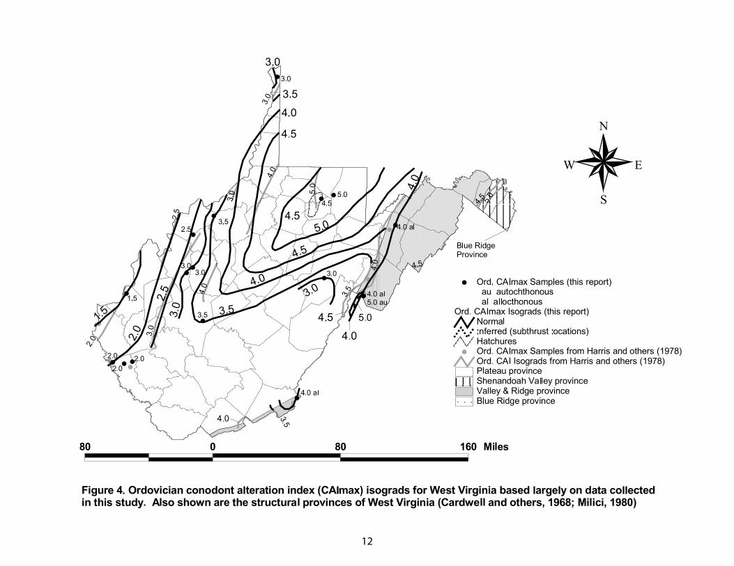
12
13
14
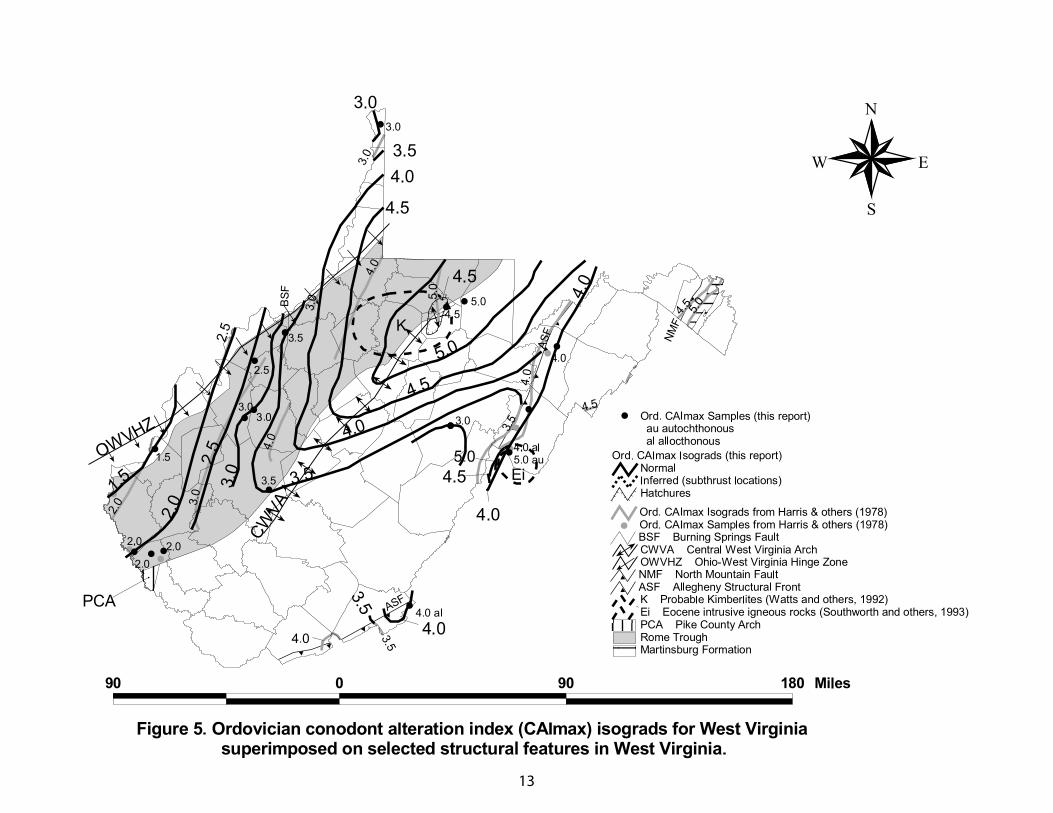
region of highest thermal maturity defined by the CAI 5 through CAI 3.5 isograds
coincides with a broad region of extended Proterozoic crust that includes the Rome
trough and the adjoining central West Virginia arch (Cardwell, 1977; Kulander and Dean,
1986; Shumaker, 1996; Beardsley and others, 1999) (Fig. 5). Also, CAI 4 - 5 values are
recorded along the Allegheny structural front in Pendleton and Monroe Counties (Fig. 5).
The CAI 5 isograd extends northeastward along the Rome trough trend an additional 175
mi into southwestern and central Pennsylvania before achieving closure (Repetski and
others, 2002).
The configuration of the CAI 2 to 3 isograds in the plateau province of southern
West Virginia is largely unknown because Ordovician rocks have not been drilled in this
region. However, judging from the CAI 3 value in autochthonous Middle Ordovician
rocks in a central Randolph County well [see Gwinn (1964) for structural interpretation]
a narrow reentrant of lower maturity rocks (CAI 2.5-3.5) may exist between the east side
of the Rome trough and the Allegheny structural front (Fig. 5; Table 3). The Pendleton
County well, drilled several miles east of the Allegheny structural front [see Perry (1964)
and Shumaker (1985) for structural interpretation], shows that autochthonous Middle
Ordovician rocks with CAI 4.5-5 values are overlain by allochthonous Middle
Ordovician rocks with CAI 4 values (Figs. 4, 5; Table 3). The CAI 4 values recorded in
the Pendleton County well are comparable to values in other subsurface Middle
Ordovician rocks in the western part of the Valley and Ridge province as shown in
Monroe and Grant Counties (Figs. 4, 5) and in central Pennsylvania (Harris and others,
1978; Repetski and others, 2002). Moreover, these allochthonous rocks commonly have
thermal maturity values that are lower than autochthonous rocks of similar age in the
15
adjoining Plateau province as shown in the Pendleton county well (Figs. 4, 5). As yet,
CAI control points are insufficient to determine whether Ordovician isograds are
discontinuous across the Allegheny structural front, having been offset by Alleghenian-
age thrust faults, or whether they are continuous as a result of post-thrusting Alleghenian
burial.
Our Ordovician CAI isograd trends, were compared with those from Harris and
others (1978) on Figures 4 and 5. Ordovician CAI isograds defined here are consistent
with those of Harris and others (1978) who based their isograd map on 6 subsurface and 1
outcrop collections from West Virginia and on numerous outcrop collections from the
adjoining states of Maryland, Pennsylvania, and Virginia. Although Harris and others
(1978) recognized the strong influence of the Rome trough on regional thermal maturity
patterns in West Virginia their map differs slightly from ours. First, the map of Harris
and others (1978) shows the Ordovician CAI 3, 4, and 5 isograds to be offset by
basement faults in the Rome trough whereas the map in this report shows these isograds
to be continuous across the Rome trough (Figs. 4 and 5). Thus, our interpretation
suggests that major extensional faulting had largely ceased before the deposition of the
Middle Ordovician carbonates. Secondly, the CAI isograds along the western flank of
the Rome trough as shown by Harris and others (1978) are about a 0.5 CAI value higher
than those shown in this report. The CAI 3.5 value in west-central Pendleton County by
Harris and others (1978) is consistent with the reentrant of lower maturity rocks between
the Rome trough and the Valley and Ridge province described in the previous paragraph.
The CAI 4.5 and 5 isograds interpreted by Harris and others (1978) in the vicinity of the
North Mountain fault and in southern Hardy County are consistent with the expected
16
eastward-increasing thermal maturity of Valley and Ridge province rocks and, thus, are
adopted in this report (Figs. 4 and 5).
Isograd trends shown in Figures 4 and 5 broadly match the isopach trends in
overlying Silurian strata (de Witt and others, 1975) and Devonian through Permian strata
(Harris and others, 1978). Silurian isopach patterns shown by de Witt and others (1975)
compare most closely with the Ordovician isograds presented here.
Location of Cambrian, Ordovician, and Silurian Oil and Gas Fields with respect to
Isograds: In southern Jackson County, a major gas show was reported from the Upper
and Middle Cambrian Conasauga Group at a depth of about 14,350 ft (Harris and
Baranoski, 1996). Very likely this gas was derived from nearby black shale in the
Conasauga Group, whose CAI values are in the 4 to 5 range (%Ro= 3.5 to 4.5) (Ryder and
others, 2003). The high methane content of this gas (Harris and Baranoski, 1996) is
compatible with these suggested high thermal maturity values.
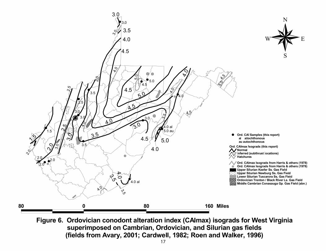
Recently discovered gas in fractured Middle Ordovician Black River and Trenton
carbonate reservoirs (Avary, 2001) is located in Roane County between the CAI 3.5 to 4
isograds and in Putnam/Lincoln Counties between the CAI 2 to 2.5 isograds (Fig. 6). The
thermal maturity of each of these Black River-Trenton gas fields is consistent with the
produced hydrocarbon phases: 1) the Roane County field produces nonassociated dry gas
and 2) the Putnam/Lincoln County field produces dry gas and local condensate. The
close proximity of the Ordovician black shale to the Black River-Trenton reservoirs
suggest that it is the most likely source of the gas.
17
18
Central and northern West Virginia gas fields in the Lower Silurian Tuscarora
Sandstone (Avary, 1996) are located between the CAI 3 and 5 isograds (%Ro 2 and 4.5)
(fig. 6). These high thermal maturity values indicate that the Tuscarora gas is located in
the “window” of dry gas generation and preservation. High concentrations of nitrogen
and carbon dioxide in the Tuscarora gas (Avary, 1996) are consistent with this high level
of thermal maturity. Furthermore, stable isotope distributions reported by Jenden and
others (1993) indicate that Tuscarora gas in Kanawha and Raleigh Counties was derived
from a source rock having a %Ro= 2 to 2.5. The similarity in thermal maturity of the gas
and underlying Ordovician strata is compatible with local derivation of Tuscarora gas
from Ordovician black shale (Ryder and others, 1998; Ryder and Zagorski, 2003).
Upper Silurian Newburg sandstone gas fields (Patchen, 1996) in west-central
West Virginia, with condensate and local associated oil, are located between the CAI 2
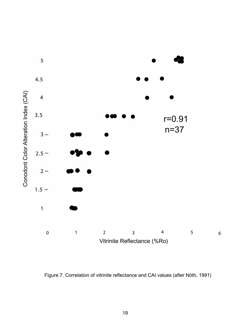
and 3 isograds (fig. 6). These CAI values and their corresponding %Ro values of 1 to 2
(Fig. 7) represent thermal maturity values that are indicative of the “window” of wet gas,
late oil, and early dry gas generation and preservation (Dow, 1977; Harris and others,
1978; Tissot and Welte, 1984; Hunt, 1996). Thus, the CAI isograds are consistent with
the nonassociated gas produced in the Newburg fields. Small Lower Silurian Keefer
Sandstone gas fields (Patchen, 1968) in western West Virginia are located near the CAI
1.5 isograd (%Ro values of <1) (Fig. 6). These thermal maturity values are indicative of
the oil and wet gas “window” and thus appear to be inconsistent with the nonassociated
and local high nitrogen character (Moore, 1982) of the Keefer gas. Of the three possible
0 1 2 3 4 5 6
Vitrinite Reflectance (%Ro)
5
4.5
4
3.5
3
2.5
2
1.5
1
r=0.91n=37
Con
odon
tCol
orA
ltera
tion
Inde
x(C
AI)
Figure 7. Correlation of vitrinite reflectance and CAI values (after Nöth, 1991)
19
20
sources suggested by Ryder (1995) for the Newburg and Keefer gas, an Ordovician black
shale source is most consistent with the nonassociated character of the gas.
Thermal Maturity of Devonian Strata
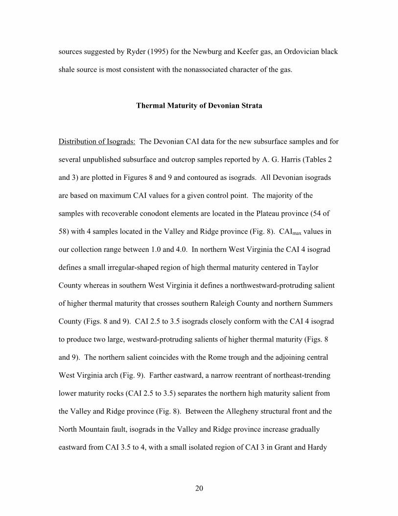
Distribution of Isograds: The Devonian CAI data for the new subsurface samples and for
several unpublished subsurface and outcrop samples reported by A. G. Harris (Tables 2
and 3) are plotted in Figures 8 and 9 and contoured as isograds. All Devonian isograds
are based on maximum CAI values for a given control point. The majority of the
samples with recoverable conodont elements are located in the Plateau province (54 of
58) with 4 samples located in the Valley and Ridge province (Fig. 8). CAImax values in
our collection range between 1.0 and 4.0. In northern West Virginia the CAI 4 isograd
defines a small irregular-shaped region of high thermal maturity centered in Taylor
County whereas in southern West Virginia it defines a northwestward-protruding salient
of higher thermal maturity that crosses southern Raleigh County and northern Summers
County (Figs. 8 and 9). CAI 2.5 to 3.5 isograds closely conform with the CAI 4 isograd
to produce two large, westward-protruding salients of higher thermal maturity (Figs. 8
and 9). The northern salient coincides with the Rome trough and the adjoining central
West Virginia arch (Fig. 9). Farther eastward, a narrow reentrant of northeast-trending
lower maturity rocks (CAI 2.5 to 3.5) separates the northern high maturity salient from
the Valley and Ridge province (Fig. 8). Between the Allegheny structural front and the
North Mountain fault, isograds in the Valley and Ridge province increase gradually
eastward from CAI 3.5 to 4, with a small isolated region of CAI 3 in Grant and Hardy
21

22
23
Counties (Figs. 8, 9). These CAI 3.5 to 4 values recorded in the Valley and Ridge
province of West Virginia are comparable to values in other Lower and Middle Devonian
rocks in the Valley and Ridge province of south-central and central Pennsylvania (Harris
and others, 1978; Repetski and others, 2002). The Devonian CAI isograds appear to
continue across the Allegheny structural front without apparent offset due to Alleghanian
deformation (Fig. 9).
CAI 2.5 isograds reappear west of the high thermal maturity salients where they
define a 50-mi-long, northeast-trending oval-shaped area of closure centered on Roane
County and a smaller unclosed area located in Wayne County (Figs. 8, 9). Both of these
areas coincide with the center of the Rome trough (Fig. 9). CAI 1.5 to 2 isograds in
western West Virginia show the same dominant northeast trend as the CAI 2.5 isograds
(Figs. 8, 9) and they generally coincide with the northwest flank of the Rome trough and
the adjoining Ohio-West Virginia hinge zone (Ryder and others, 1996).
Our Devonian CAI isograd trends were compared with the Silurian through
Middle Devonian CAI isograd trends from Harris and others (1978) on Figures 8 and 9.
The Silurian through Middle Devonian isograd map of Harris and others (1978) was used
for a comparison, rather than their Upper Devonian through Mississippian map, because
it most closely represents the Devonian intervals that we sampled. Harris and others
(1978) based their Silurian through Middle Devonian isograd map on 5 subsurface and 13
outcrop collections from West Virginia (Fig. 8) and on numerous outcrop collections
from the adjoining states of Maryland, Pennsylvania, and Virginia; however, they were
unable to interpret CAI isograds for the majority of the state because of the absence of
subsurface data points. Along the western and eastern margins of West Virginia, where
24
Devonian conodont assemblages were reported both in this study and in Harris and others
(1978), the isograds are compatible.
Although isograd trends shown in Figures 8 and 9 broadly match the isopach
trends in the Devonian through Permian overburden (Harris and others, 1978) they
correlate best with system-specific isopach maps (Heck, 1943; de Witt, 1975; de Witt and
others, 1975). For example, the isotherms that define the southern thermal maturity
salient coincide with the 3,000-5,000 ft Mississippian isopachs (de Witt, 1975) and the
2,200 ft Pennsylvanian Pottsville Group isopach (Heck, 1943). A stratigraphic section
through the New River Gorge area (Fayette, Raleigh, and Summers Counties, West
Virginia)(Englund and others, 1977) further documents thick Mississippian and
Pennsylvanian (inferred) strata associated with the southern thermal maturity salient.
Moreover, the isograds that define the westward-protruding shape of the northern high
thermal maturity salient closely resemble the shape of the Devonian isopachs (de Witt
and others, 1975) except that the CAI 4 isograd in the salient is located 50 mi or more
west of the maximum (10,000 ft) isopachs. The distribution of Devonian isograd patterns
in the Valley and Ridge province (Harris and others, 1978) are generally consistent with
eastward thickening Devonian overburden (de Witt and others, 1975).
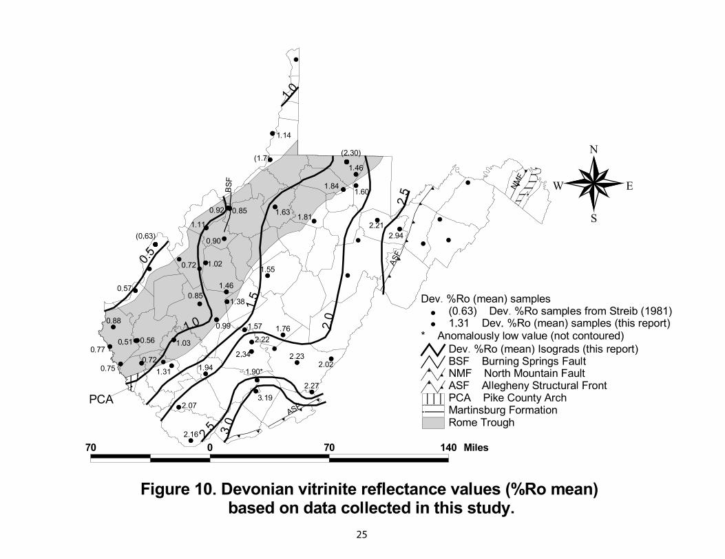
Distribution of Isoreflectance Lines: Mean vitrinite reflectance values of Devonian black
shale samples are listed in Table 3 and plotted in Figure 10. The black shale samples are
about evenly divided between the Marcellus Shale and the Rhinestreet and Huron Shales.
All 40 Devonian shale samples contained sufficient dispersed organic matter for analysis
and 39 of them were suitable for identifying regionally consistent isoreflectance lines
25
26
(Fig. 10). One vitrinite reflectance value (1.90) from the Rhinestreet Shale in Raleigh
County was not contoured because it was considered anomalously low when compared to
the regional pattern. The effects of vitrinite suppression in rocks with abnormally high
total organic carbon (TOC>5) were not evaluated.
The trends of the isoreflectance lines are compatible with the eastward increasing
Devonian CAI isograds including the westward-bulging salient of higher thermal
maturity in southern West Virginia (Figs. 9 and 10). Also, for a given area, the %Ro
values indicate approximately the same level of thermal maturity as the CAI values. An
obvious discrepancy between the Devonian CAI and %Ro maps is the absence of the
northern high thermal maturity salient on the %Ro map (Fig. 10). For reasons unknown,
mean vitrinite values in 4 localities in northern West Virginia (%Ro = 1.60 to 1.84) are
much lower than the expected (%Ro 2.5 to 3.5) based on the accompanying CAI 3 to 4
isograds that define the northern salient (Fig. 9). The %Ro = 2.30 value reported by
Streib (1981) for Marcellus Shale samples in northern Monongalia County, however,
does corroborate the high CAI isograds shown in northern West Virginia (Fig. 10). Also,
two additional %Ro values reported by Streib (1981) in West Virginia, the %Ro =1.7 in
western Wetzel County and the %Ro = 0.63 in northern Mason County are consistent
with their respective adjoining CAI isograds (Figs. 9 and 10). These consistently higher
%Ro values reported by Streib (1981) have resulted in isoreflectance lines on his vitrinite
map that are higher for a given area than lines on our map (Fig. 10). At this time, our only
explanation for these differences in %Ro values is variability in laboratory and (or)
operator procedures. Our map is broadly similar to the vitrinite reflectance maps by
Hamilton-Smith (1996) and Curtis and Faure (1997), when comparing the 0.5 to 1
27
reflectance lines, but the maps differ markedly when comparing the 1.5 to 2
isoreflectance lines.
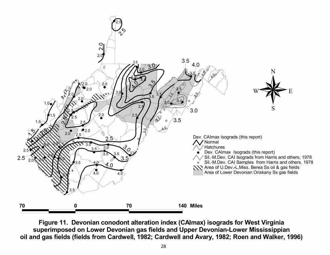
Location of Devonian Oil and Gas Fields with respect to Isograds: Natural gas fields in
the Lower Devonian Oriskany Sandstone of West Virginia occupy two regions: 1) a
large region in northeastern West Virginia that coincides with the northern part of the
Plateau province and the adjoining Valley and Ridge province (Flaherty, 1996; Harper
and Patchen, 1996) and 2) a smaller region in north-central West Virginia that coincides
with the west-central part of the Plateau province (Patchen and Harper, 1996) (Fig. 11).
CAI values in the northeastern region range from 2.5 to 4 (%Ro 1.5 to 3.5) (Fig. 11) and
are compatible with the high methane content of the Oriskany gas produced here
(Claypool and others, 1978; Moore, 1982). In contrast, CAI values in the smaller north-
central region range from 2 to 2.5 (%Ro 1 to 1.5) (Fig. 11) and are compatible with the
wet gas, condensate, and local oil produced from the Oriskany Sandstone in this region
(Patchen and others, 1992; Patchen and Harper, 1996). Probably minimal migration was
required for the Oriskany gas before entrapment because of its close proximity to
overlying Middle Devonian Marcellus Shale and Rhinestreet and lower Huron Shale
source rocks (Patchen and others, 1992; Harper and Patchen, 1996).
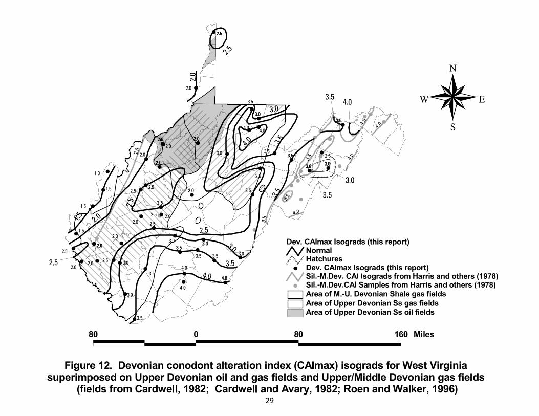
Oil and gas fields in Upper Devonian sandstones and associated CAI isograds in
northern West Virginia are plotted in Figure 12. The oil fields are largely confined to a
region marked by CAI 2 to 2.5 isograds whereas the gas fields, generally located farther
eastward, are largely confined to a region marked by CAI 2.5 to 4 isograds. A 30- to 40-
mi-wide zone of overlap occurs between the dominant regions of oil and gas (Fig. 12).
28
29
30
The CAI 2 to 2.5 values and their respective %Ro 1 to 1.5 values (Fig. 7) for the
oil fields represent thermal maturity indices that are indicative of the “window” of oil and
wet gas preservation (Dow, 1977; Harris and others, 1978; Tissot and Welte, 1984; Hunt,
1996). In comparison, the CAI 2.5 to 4 values and their equivalent %Ro1.5 to 3.5 for gas
fields represent thermal maturity values in the “window” of wet and dry gas generation
and preservation. Middle and Upper Devonian black shales are the source rocks for the
oil and gas described in these fields (Boswell, 1996; Donaldson and others, 1996; Milici,
1996) and their level of thermal maturity is characterized by the CAI and %Ro values
measured in Devonian limestone and shale for this study. The compatibility between the
CAI isograds shown on Figure 12 and the produced petroleum phases in the Upper
Devonian sandstone reservoirs imply that the oil and gas was generated near their
respective regions of entrapment.
Natural gas accumulation in self-sourced Middle and Upper Devonian black shale
in western West Virginia is associated with CAI 1.5 to 3.5 isograds (Fig. 12). These CAI
values are equivalent to %Ro <1 to 3 values (Fig. 7) which, in turn, indicate the “window”
of oil/wet gas through dry gas generation and preservation. The presence of oil in the
shale gas in Pleasants and Ritchie Counties (Patchen and Hohn, 1993) and the general
southward increase in the methane composition (dryness) of the shale gas (Claypool and
others, 1978; Moore, 1982) are consistent with the isograd patterns shown on Figure 12.
The stable isotope compositions of Devonian/Mississippian (?) shale gas in Lincoln,
Mason and Upshur Counties (Claypool and others, 1978) support a thermogenic origin of
the shale gas.
31
Oil and gas fields of the Upper Devonian-Lower Mississippian Berea Sandstone
are distributed across western and northwestern West Virginia (Pepper and others, 1954;
Tomastik, 1996) where Lower and Middle Devonian CAI values range from 1.5 to 3.5
(%Ro <1 to 3) (Fig. 11). These thermal maturity values are generally consistent with the
range of petroleum phases that are produced from the Berea Sandstone, however, the
widespread occurrence of oil in the Berea is inconsistent with the CAI 2.5 to 3.5 values
(%Ro 1.7 to 3) (Fig. 11). This minor discrepancy suggests that the thermal maturity of the
source rocks for the Berea petroleum is overestimated by Lower and Middle Devonian
CAI isograds on Figure 11. That is, had the CAI values been measured from beds that
were stratigraphically closer to the Upper Devonian (Ohio Shale on Fig. 3) and Lower
Mississippian (Sunbury Shale not shown on Fig. 3) black shale source rocks (Tomastik,
1996) — which are located 1,000 to 1,500 ft above the Lower and Middle Devonian
carbonates used in this study — they should be more compatible with the common
occurrence of oil in the Berea Sandstone.
Discussion
Harris and others (1978) concluded that the CAI isograd patterns in the
Appalachians reflect regional structural trends and accompanying overburden
thicknesses. Moreover, they recognized that many of the isograds, particularly near the
outcrop edges of the basin, suggest that paleotemperatures are too high to have been
produced by the present-day thickness of overburden. Harris and others (1978) further
32
suggested that by assuming a representative geothermal gradient, the overburden
thicknesses of the basin can be restored from the isograd values.
Likewise, Ordovician CAI isograds and Devonian CAI isograds/%Ro
isoreflectance lines identified in this investigation indicate much greater
paleotemperatures than can be explained by the existing overburden. Other thermal
maturity investigations in West Virginia have led to similar conclusions, such as those
based on burial history curves (Evans, 1995; Nuccio and others, 1997), fluid inclusions
(Evans, 1995), %Ro/coal rank (Trinkle and others, 1978; Evans, 1995; Curtis and Faure,
1997; Hulver, 1997), and apatite fission tracks (Roden, 1991; Hulver, 1997).
Most Appalachian investigators have accounted for the mismatch between
thermal maturity indices values and accompanying present-day overburden by post-
orogenic uplift and erosion of Late Carboniferous, Permian, and early Mesozoic
overburden. For example, based on CAI and coal rank data and a typical foreland basin
geothermal gradient of 25˚C/km, Hulver (1995; 1997) estimated that post-Alleghanian
denudation of the Appalachian area, including the West Virginia part, ranged from 2 to 6
km with increasing amounts of erosion from west to east. In comparison, Beaumont and
others (1987), using coal moisture data, predicted that 2.5 to 4.5 km of post-Alleghanian
erosion occurred in West Virginia. Moreover, burial history curves generated by Evans
(1995) for several wells in northern West Virginia, constrained by fluid inclusion data
and a geothermal gradient of 28˚C/km, predict the removal of 2 to 3 km of Late
Pennsylvanian to Permian overburden. Based on a 2-D burial/thermal history model,
Rowan and others (2004) concluded that Ordovician and Devonian CAI isograds in this
report and Pennsylvanian vitrinite reflection values (L.F. Ruppert, USGS, unpubl data)

33
are best explained by an eastward-thickening wedge of Pennsylvanian/Permian/Triassic
overburden rocks up to 7,200 ft (2.2 km) thick. These estimates of post-Alleghanian
erosion by Evans (1995), Hulver (1995, 1997), Beaumont and others (1987), and Rowan
and others (2004) are consistent with an overburden of at least 3.4 km calculated by
Roden (1991) from an apatite closing temperature of 100˚C ± 20˚C and a geothermal
gradient of 25˚C/km.
Apatite fission-track ages of Middle Devonian to Carboniferous rocks in West
Virginia are younger than the depositional age of the rocks and vary between ~240 Ma
and ~33 Ma (Roden, 1991; Hulver, 1997). The older of these dates are concentrated in
northern West Virginia suggesting that erosion was initiated there in Triassic to Early
Jurassic time and corresponds broadly with the age of rifting along the Atlantic
continental margin. The younger fission-track ages that are reported in south-central
West Virginia by Hulver (1997) (~90-100 Ma) and Roden (1991) (~33-48 Ma) suggest
that this area cooled more recently than north-central and eastern West Virginia.
Although overburden thickness is a very important control on the distribution of
thermal maturity values identified in this study there are several parts of West Virginia
where the CAI isograds appear to be too high to be explained by overburden thickness
alone. For example, the Ordovician CAI 4.5 to 5 isograds (Fig. 5) and the Devonian CAI
3.5 to 4 isograds in northern West Virginia (Fig. 9) may in part have resulted from an
elevated geothermal flux caused by crustal thinning and the emplacement of mantle-
derived rocks in the Rome trough and adjoining central West Virginia arch. Heat flow
probably was greatest during the initial phases of rifting in the Middle Cambrian and
tapered off gradually into the Late Ordovician. Early Mesozoic reactivation of the Rome
34
trough and central West Virginia arch may have introduced a second phase of high heat
flow caused by the intrusion of Mesozoic kimberlite igneous bodies whose presence is
suggested in Harrison, Doddridge, and Taylor Counties by stream sediment samples
(Watts and others, 1992) and by high-intensity aeromagnetic anomalies (Zeitz and others,
1980). These probable kimberlite bodies are on trend with known Mesozoic kimberlite
intrusions exposed above the Rome trough in southwestern Pennsylvania (Parrish and
Lavin, 1982; Phipps, 1988; Shultz, 1999). In outcrop, the kimberlites are small and have
a minor alteration halo but at depth they may merge with larger igneous bodies that had
greater thermal influence on the overlying sedimentary rocks of the basin. The impact of
Eocene magmatic intrusions in Pendleton County, West Virginia and adjoining Virginia
(Southworth and others, 1993)(Figs. 5, 9) on the thermal maturity of Ordovician and
Devonian strata cannot be evaluated with the available data.
Westward-bulging salients in the Devonian CAI 2.5 to 4 isograds (Fig. 9) may
represent migration routes of hot, basin-derived fluids. The northern salient is
particularly convincing because it is not associated with an obvious overlying depocenter.
Moreover, had burial been the chief cause of the salient, it should have left a similar
imprint on Ordovician isograds (Fig. 5). Dorobek (1989) suggested that hot, basin-
derived fluids left a fluid-inclusion imprint on Devonian rocks in the Valley and Ridge
province of northern West Virginia, about 120 km (75 mi.) east of the northern salient.
However, he considered the flow rate of the migrating fluids to be too high to leave an
anomalously high CAI imprint. The northwest-trending Parsons lineament of Wheeler
(1980), between Pendleton and Taylor counties, may have partly influenced the westward
flow of hot fluids through Devonian strata in northern West Virginia.
35
The southern salient was primarily caused by burial beneath a thick overburden of
Mississippian and Pennsylvanian rocks, as shown by isopach maps (Heck, 1943; de Witt,
1975). Isoreflectance lines (%Ro = 1.4 to 1.8) derived from Pennsylvanian coal beds
show a similar northwestward-bulging salient in southern West Virginia that coincides
with a region of thick Pottsville Group rocks (Cole and others, 1979). Heck (1943)
proposed that the high thermal maturity of the coal beds was caused by deeper burial,
whereas Cole and others (1979) proposed that the high maturity was caused by igneous
activity along the 38th parallel lineament of Heyl (1972). We favor the explanation by
Heck (1943).
Cercone and others (1996) suggested that low conductivity coal- and
carbonaceous shale-bearing Carboniferous strata had an important effect on the
temperature history of the Appalachian basin by acting as an insulator. Consequently,
strata that contain large quantities of organic matter may increase the temperature of
underlying rocks to such a degree that it may account for anomalous thermal maturity
values in the basin. Also, Devonian black shale beds may contribute significantly as an
insulator. Although plausible, the validity of this mechanism must be tested with burial
history models.
In several Valley and Ridge province localities, the Ordovician isograds of Harris
and others (1978) show that rocks of higher thermal maturity have been thrust over rocks
of lower thermal maturity. This structural dislocation of isograds implies that isograd
values in the allochtonous rocks do not necessarily charactize those values in underlying
autochthonous rocks. In this study, for example, thrust-faulted Ordovician rocks in the
No. 1 Sponaugle well contain rocks with CAI 3.5-4 values resting in thrust contact on
36
rocks with CAI 5 values (Figs. 5, 6; Table 3). A similar pattern of lower maturity
hanging wall rocks in contact with higher maturity footwall rocks was defined by vitrinite
reflectance data in Pennsylvanian rocks of the Pine Mountain thrust fault system of
southeastern Kentucky (O’Hara and others, 1990). Both types of the above-described
thermal maturity reversals have been measured across repeated sections in the subsurface
of the disturbed belt of the southeastern Canadian Cordillera (England and Bustin, 1986).
They interpret higher maturity in successively deeper thrust sheets to be the result of
postorogenic maturation whereby the temperature of the footwall rocks is increased by
heat transfer from “hot” hanging wall rocks (also see Furlong and Edman, 1984). In
contrast, a decrease in thermal maturity beneath a thrust sheet led England and Bustin
(1986) to suggest that the hanging wall was too thin and (or) cool to overprint the pre-
orogenic level of thermal maturity. The same range of conditions described by England
and Bustin (1986) probably are applicable to the Appalachian Valley and Ridge thrust
faults.
The Valley and Ridge province seemed to be thermally isolated from the
adjoining provinces based on its slightly lower CAI values in comparison to CAI values
in the adjoining Plateau and Shenandoah Valley provinces (Figs. 4, 8). For example, the
Valley and Ridge province is characterized by Devonian CAI 3 – 3.5 values, whereas the
adjoining Plateau and Shenandoah Valley provinces are characterized by Devonian CAI
3.5 – 4 values (Fig. 8). In comparison, Ordovician CAI 4 values in the Valley and Ridge
province are flanked by Ordovician 4.5 to 5 values in the Plateau and Shenandoah Valley
provinces (Fig. 4). Perhaps the central Valley and Ridge province was a more stable
37
tectonic block that escaped crustal extension or magmatic intrusion, or, possibly, the
overburden was thinner in this region because it was located east of the basin depocenter.
References Cited
Avary, K. L., 1996, Play Sts: the Lower Silurian Tuscarora Sandstone fracture anticlinal
play, in Roen, J. B. and Walker, B. J., eds., The atlas of major Appalachian gas
plays: West Virginia Geological and Economic Survey Publication V-25, p. 151-
155.
Avary, K. L., 2001, Recent gas discoveries and activity in the Ordovician Trenton/Black
River in West Virginia (abs.): American Association of Petroleum Geologists
Bulletin, v. 85, no. 8, p. 1530.
Beardsley, R. E., Campbell, R. C., and Shaw, M. A., 1999, Appalachian Plateaus, in
Shultz, C. H., ed., Geology of Pennsylvania: Pennsylvania Geological Survey
and Pittsburgh Geological Society Special Publication 1, p. 286-297.
Beaumont, C., Quinlan, G. M., and Hamilton, J., 1987, The Alleghanian orogeny and its
relationship to the evolution of the Eastern Interior, North America, in Beaumont,
C. and Tankard, A. J., eds., Sedimentary basins and basin-forming mechanisms:
Canadian Society of Petroleum Geologists Memoir 12, p. 425-445.
38
Boswell, R., 1996, Play Uds: Upper Devonian black shales, in Roen, J. B. and Walker,
B. J, eds., The atlas of major Appalachian gas plays: West Virginia Geological
and Economic Survey Publication V-25, p. 93-99.
Cardwell, D. H., 1977, West Virginia gas development in Tuscarora and deeper
formations (with structural maps contoured on top of Ordovician and
Precambrian): West Virginia Geological and Economic Survey Mineral
Resources Series MRS-8, 34 p., 1 plate.
Cardwell, D. H., 1982, Oriskany and Huntersville gas fields of West Virginia with deep
well and structural geologic map: West Virginia Geological and Economic
Survey Mineral Resources Series MRS-5A, 180 p., 2 plates.
Cardwell, D. H. and Avary, K. L., 1982, Oil and gas fields of West Virginia including
completely revised 1982 oil and gas fields map: West Virginia Geological and
Economic Survey Mineral Resources Series MRS-7B, 119 p., 2 plates.
Cardwell, D. H., Erwin, R. B., and Woodward, H. P., 1968, Geologic map of West
Virginia: Morgantown, West Virginia Geological and Economic Survey, 2
sheets, scale 1:250,000.
Cercone, K.R., Deming, David, and Pollack, H.N., 1996, Insulating effect of coals and
black shales in the Appalachian Basin, western Pennsylvania: Organic
Geochemistry, v. 24, no. 2, p. 243-249.
Chyi, L.L., Barnett, R.G., Burford, A.E., Quick, T.J., and Gray, R.J., 1987, Coalification
patterns of the Pittsburgh coal: Their origin and bearing on hydrocarbon
maturation: International Journal of Coal Geology, v. 7, p. 69-83.
39
Claypool, G. E., Threlkeld, C. N., and Bostick, N. H., 1978, natural gas occurrence
related to regional thermal rank of organic matter (maturity) in Devonian rocks of
the Appalachian basin in Eastern Shales Symposium, 2nd, Morgantown, W. Va.,
1978, Preprints: U.S. Department of Energy, Morgantown Energy Technology
Center, Report METC/SP-78-6, v. 1, p. 54-65.
Cole, G. A., Williams, D.A., and Smith, C. J., 1979, Regional coalification patterns for
the coals of eastern Kentucky, Virginia, West Virginia, Ohio, Maryland, and
southern Pennsylvania: West Virginia Geological and Economic Survey Open-
File Report OF 57, 10 p.
Curtis, J. B. and Faure, G., 1997, Accumulation of organic matter in the Rome trough of
the Appalachian basin and its subsequent thermal history: American Association
of Petroleum Geologists Bulletin, v. 81, no. 3, p. 424-437.
de Witt, W., Jr., 1975, Oil and gas data from the upper Paleozoic rocks in the
Appalachian Basin: U. S. Geological Survey Miscellaneous Investigations Series
Map I-917-A, 4 sheets.
de Witt, W., Jr., Perry, W. J., and Wallace, L. G., 1975, Oil and gas data from Devonian
and Silurian rocks in the Appalachian Basin: U. S. Geological Survey
Miscellaneous Investigations Series Map I-917-B, 4 sheets.
Donaldson, A., Boswell, R., Zou, X., Cavallo, L., Heim, L. R., and Canich, M.,1996, Play
Des: Upper Devonian Elk sandstones and siltstones, in Roen, J. B. and Walker,
B. J, eds., The atlas of major Appalachian gas plays: West Virginia Geological
and Economic Survey Publication V-25, p. 77-85.
40
Dorobek, S., 1989, Migration of orogenic fluids through the Siluro-Devonian Helderberg
Group during late Paleozoic deformation: constraints on fluid sources and
implications for thermal histories of sedimentary basins: Tectonophysics, v. 159,
p. 25-45.
Dow, W. G., 1977, Kerogen studies and geological interpretations: Journal of
Geochemical Exploration, v. 7, p. 79-99.
England, T. D. J., and Bustin, R. M., 1986, Effect of thrust faulting on organic maturation
in the southern Canadian Cordillera: Organic Geochemistry, v. 10, p. 609-616.
Englund, K.J., Windolph, J.F., Jr., Warlow, R.C., Henry, T.W., Meissner, C.R., and
Arndt, H.H., 1977, Stratigraphic section of the New River Gorge area, Fayette,
Raleigh, and Summers Counties, West Virginia, in Mineral resource, geological,
and geophysical maps of the New River Gorge Area, Fayette, Raleigh, and
Summer Counties, West Virginia: U.S. Geological Survey Open-File Report 77-
76, 1 sheet.
Epstein, A.G., Epstein, J.B., and Harris, L.D., 1977, Conodont color alteration - an index
to organic metamorphism: U.S. Geological Survey Professional Paper 995, 27 p.
Evans, M. A., 1995, Fluid inclusions in veins from the Middle Devonian shales: A
record of deformation conditions and fluid evolution in the Appalachian Plateau:
Geological Society of America Bulletin, v. 107, no. 3, p. 327-339.
Flaherty, K. J., 1996, Play Dho: Fractured Middle Devonian Huntersville Chert and
Lower Devonian Oriskany Sandstone, in Roen, J. B. and Walker, B. J, eds., The
atlas of major Appalachian gas plays: West Virginia Geological and Economic
Survey Publication V-25, p. 103-108.
41
Furlong, K. P., and Edman, J. D., 1984, Graphic approach to determination of
hydrocarbon maturation in overthrust terrains: American Association of
Petroleum Geologists Bulletin, v. 68, p. 1818-1824.
Gwinn, V. E., 1964, Thin-skinned tectonics in the Plateau and northwestern Valley and
Ridge provinces of the central Appalachians: Geological Society of America
Bulletin, v. 75, p. 863-900.
Hamilton-Smith, T., compiler, 1996, Vitrinite reflectance data from the Huron Member
of the Ohio Shale, in Boswell, R., 1996, Play Uds: Upper Devonian black shales,
in Roen, J. B. and Walker, B. J, eds., The atlas of major Appalachian gas plays:
West Virginia Geological and Economic Survey Publication V-25, p. 93-99.
Harper, J. A. and Patchen, D. G., 1996, Play Dos: Lower Devonian Oriskany Sandstone
structural play, in Roen, J. B. and Walker, B. J, eds., The atlas of major
Appalachian gas plays: West Virginia Geological and Economic Survey
Publication V-25, p. 109-117.
Harris, A. G., Harris, L. D., and Epstein, J. B., 1978, Oil and gas data from Paleozoic
rocks in the Appalachian basin: Maps for assessing hydrocarbon potential and
thermal maturity (conodont color alteration isograds and overburden isopachs):
U. S. Geological Survey Miscellaneous Investigations Series map I-917-E, 4
sheets with text.
Harris, A.G., and Sweet, W.C., 1989, Mechanical and chemical techniques for separating
microfossils from rock, sediment and residue matrix, p. 70-86, In, Feldmann,
R.M., Chapman, R.E., and Hannibal, J.T., (eds.), Paleotechniques: The
Paleontological Society, Special Publication No. 4, p. 70-86.
42
Harris, D. C. and Baranoski, M. T., 1996, Play Cpk: Cambrian play, in Roen, J. B. and
Walker, B. J., eds., The atlas of major Appalachian gas plays: West Virginia
Geological and Economic Survey Publication V-25, p. 188-192.
Hower, J. C. and Rimmer, S. M., 1991, Coal rank trends in the central Appalachian
coalfield: Virginia, West Virginia, and Kentucky: Organic Geochemistry, v. 17,
p. 161-173.
Hulver, M. L., 1995, Post-Alleghanian thermal and denudational history of the
Appalachian region from maturation indicators and apatite fission-track analysis
(abs.): Geological Society of America Abstracts with Programs, v. 27, no. 6, p.
A-390.
Hulver, M. L., 1997, Post-orogenic evolution of the Appalachian mountain system and its
foreland: Ph.D. dissertation, University of Chicago, 1055 p.
Hunt, J.M.,1996, Petroleum geochemistry and geology, second edition: W.H. Freeman
and Company, New York, 743 p.
Jenden, P. D., Drazan, D. J., and Kaplan, I. R., 1993, Mixing of thermogenic natural
gases in northern Appalachian Basin: American Association of Petroleum
Geologists Bulletin, v. 77, no. 6, p. 980-998.
Kulander, B. R. and Dean, S. L., 1986, Structure and tectonics of central and southern
Appalachian Valley and Ridge and Plateau provinces, West Virginia and Virginia,
American Association of Petroleum Geologists Bulletin, v. 70, no. 11, p. 1674-
1684.
43
Milici, R. C., 1980, Relationship of regional structure to oil and gas producing areas in
the Appalachian basin: U. S. Geological Survey Miscellaneous Investigations
Series Map I-917-F, 5 sheets.
Milici, R. C., 1996, Play Dgb: Upper Devonian fractured black and gray shales and
siltstones, in Roen, J. B. and Walker, B. J, eds., The atlas of major Appalachian
gas plays: West Virginia Geological and Economic Survey Publication V-25, p.
86-92.
Moore, B. J., 1982, Analyses of natural gases, 1917-80: U. S. Bureau of Mines
Information Circular 8870, 1055 p.
Nöth, S., 1991, Die Conodontendiagenese als Inkohlungsparameter und ien Vergleich
unterschiedlich sensitiver Diagenese-indicatoren am Beispiel von
Triassedimenten Nord- und Mitteldeutschlands: Bochumer geol. U. geotech. Arb.
37, 169 p., 3 Pls., 46 figs., 14 tables, Bochum.
Nuccio, V. F., Wandrey, C. J., Ryder, R. T., and Harris, A. G., 1997, Thermal maturity
and petroleum generation of Middle Ordovician black shale source rocks, central
Appalachian basin — Controls on oil and gas in Lower Silurian low-permeability
sandstone reservoirs (abs.): American Association of Petroleum Geologists
Bulletin, v. 81, no. 9, p. 1560.
O’Hara, K., Hower, J. C., and Rimmer, S. M., 1990, Constraints on the emplacement and
uplift history of the Pine Mountain thrust sheet, eastern Kentucky: Evidence from
coal rank trends: Journal of Geology, v. 98, p. 43-51.
Parrish, J.B., and Lavin, P.M., 1982, Tectonic model for kimberlite emplacement in the
Appalachian Plateau of Pennsylvania: Geology, v. 10, no. 7, p. 344-347.
44
Patchen, D. G., 1968, Keefer Sandstone gas development and potential in West Virginia:
West Virginia Geological and Economic Survey Circular Series 7, 19 p.
Patchen, D. G., 1996, Play Sns: the Upper Silurian Newburg sandstone play, in Roen, J.
B. and Walker, B. J., eds., The atlas of major Appalachian gas plays: West
Virginia Geological and Economic Survey Publication V-25, p. 139-144.
Patchen, D. G., Avary, K. L., and Erwin, R. B., coordinators, 1985, Correlation of
stratigraphic units in North America, northern Appalachian region correlation
chart: Tulsa, Okla., American Association of Petroleum Geologists, 1 sheet.
Patchen, D. G., Bruner, K. R., and Heald, M. T., 1992, Elk-Poca field — USA,
Appalachian Basin, West Virginia, in Foster, N. H. and Beaumont, E. A., eds.,
Stratigraphic Traps III: American Association of Petroleum Geologists treatise of
petroleum geology, atlas of oil and gas fields, Tulsa, p. 197-230.
Patchen, D. G. and Harper, J. A., 1996, Play Doc: the Lower Devonian Oriskany
Sandstone combination traps play, in Roen, J. B. and Walker, B. J., eds., The atlas
of major Appalachian gas plays: West Virginia Geological and Economic Survey
Publication V-25, p. 118-125.
Patchen, D. G., and Hohn, M. E., 1993, Production and production controls in Devonian
shales, West Virginia, in Roen, J. B. and Kepferle, R. C., eds., Petroleum geology
of the Devonian and Mississippian black shale of eastern north America: U. S.
Geological Survey Bulletin 1909, p. L1-L28.
Pepper, J. F., de Witt, W., Jr., and Demarest, D. F., 1954, Geology of the Bedford Shale
and Berea Sandstone in the Appalachian basin: U. S. Geological Survey
Professional Paper 259, 109 p.
45
Perry, W. J., Jr., 1964, Geology of the Ray Sponaugle well, Pendleton County, West
Virginia: American Association of Petroleum Geologists Bulletin, v. 48, no. 5, p.
659-669.
Phipps, S. P., 1988, Deep rifts as sources of alkaline intraplate magmatism in eastern
North America: Nature, v. 334, p. 27-31.
Repetski, J. E., Ryder, R. T., Harper, J. A., and Trippi, M. H., 2002, Thermal maturity
patterns (CAI and %Ro) in the Ordovician and Devonian rocks of the Appalachian
basin in Pennsylvania: U. S. Geological Survey Open-File Report 02-302, 57 p.
Roden, M. K., 1991, Apatite fission-track thermochronolog y of the southern
Appalachian Basin: Maryland, West Virginia, and Virginia: Journal of Geology,
v. 99, p. 41-53.
Roen, J. B. and Walker, B. J, eds., 1996, The atlas of major Appalachian gas plays: West
Virginia Geological and Economic Survey Publication V-25, 200 p.
Ryder, R.T., 1995, Appalachian Basin Province (067), in Gautier, D. L., Dolton, G. L.,
Takahashi, K. I., and Varnes, K. L., eds., 1995 National assessment of United
States oil and gas resources—Results, methodology, and supporting data: U.S.
Geological Survey Digital Data Series 30, 133 p., 26 maps.
Ryder, R. T., Repetski, J. E., and Harris, A. G., 1996, Stratigraphic framework of
Cambrian and Ordovician rocks in the central Appalachian basin from Fayette
County, Ohio, to Botetourt County, Virginia: U. S. Geological Survey
Miscellaneous Investigations Series Map I-2495, 1 sheet.
46
Ryder, R. T., Burruss, R. C., and Hatch, J. R., 1998, Black shale source rocks and oil
generation in the Cambrian and Ordovician of the central Appalachian basin,
USA: American Association of Petroleum Geologists Bulletin, v. 82, p. 412-441.
Ryder, R. T. and Zagorski, W. A., 2003, Nature, origin, and production characteristics of
the Lower Silurian regional oil and gas accumulation, central Appalachian Basin,
United States: American Association of Petroleum Geologists Bulletin, v. 87, p.
847-872.
Ryder, R. T., Harris, D. C., Gerome, P., Hainsworth, T. J., Burruss, R. C., Lillis, P. G.,
and Jarvie, D. M., 2003, Cambrian petroleum source rocks in the Rome trough in
West Virginia and Kentucky (abs.): Final Program and Abstracts, American
Association of Petroleum Geologists – Society of Petroleum Engineers Eastern
Meeting Conference and Exhibition (Pittsburgh, 6-10 September 2003), p. 29
(http://www.searchanddiscovery.com/documents/abstracts/eapt
2003/index.htm/ryder.pdf).
Schwochow, S., 2000, New gas prospects in Ordovician Black River and Trenton Group
carbonates of the Appalachian Basin: Petroleum Frontiers, v. 17, 108 p.
Shultz, C. H., 1999, Jurassic kimberlite dikes, in Shultz, C. H., ed., Geology of
Pennsylvania: Pennsylvania Geological Survey and Pittsburgh Geological
Society Special Publication 1, p. 210-217.
Shumaker, R. C., 1985, Section 12, in Woodward, N. B., ed., Valley and Ridge thrust
belt: balanced structural sections, Pennsylvania to Alabama: University of
Tennessee Department of Geological Sciences Studies in Geology 12, p. 29, 32-
33.
47
Shumaker, R. C., 1996, Structural history of the Appalachian Basin, in Roen, J. B. and
Walker, B. J, eds., The atlas of major Appalachian gas plays: West Virginia
Geological and Economic Survey Publication V-25, p. 8-22.
Southworth, C. S., Gray, K. J., and Sutter, J. F., 1993, Middle Eocene intrusive igneous
rocks of the central Appalachian Valley and Ridge province — setting, chemistry,
and implications for crustal structure: U. S. Geological Survey Bulletin 1839-J, p.
J1-J24.
Streib, D. L., 1981, Distribution of gas, organic carbon, and vitrinite reflectance in the
eastern Devonian gas shales and their relationship to the geologic framework: U.
S. Department of Energy, Morgantown Energy Technology Center, Report
METC/08216-1276, 262 p. [same as Science Applications, Inc., 1981].
Tissot, B. P. and Welte, D. H., 1984, Petroleum formation and occurrence: Springer-
Verlag, New York, 699 p.
Tomastik, T. E., 1996, Play MDe: Lower Mississippian-Upper Devonian Berea and
equivalent sandstones, in Roen, J. B. and Walker, B. J., eds., The atlas of major
Appalachian gas plays: West Virginia Geological and Economic Survey
Publication V-25, p. 56-62.
Trinkle, E. J., Sitler, J. A., Sasso, J. A., Kardosh, W. F., and Ting, F. T. C., 1978,
Coalification pattern of West Virginia coals (abs.): Geological Society of
America abstracts with programs, v. 10, no. 7, p. 506.
Wallace, L.G., and Roen, J.B., 1989, Petroleum source rock potential of the Upper
Ordovician black shale sequence, northern Appalachian basin: U.S. Geological
Survey Open-File Report 89-488, 66 p.
48
Watts, K. C., Jr., Hinkle, M. E., and Griffitts, W. R., 1992, Evidence for a titaniferous
diatreme or alkalic igneous rock in the subsurface, Harrison, Taylor, and
Doddridge Counties, West Virginia: U. S. Geological Survey Open-File Report
92-366, 40 p., 1 plate.
Weary, D. J., Ryder, R. T., and Nyahay, R., 2000, Thermal maturity patterns (CAI and
%Ro) in the Ordovician and Devonian of the Appalachian Basin in New York
State: U. S. Geological Survey Open-File Report 00-496, 39 p.
Weary, D. J., Ryder, R. T., and Nyahay, R. E., 2001, Thermal maturity patterns in New
York State using CAI and %Ro: Northeastern Geology and Environmental
Sciences, v. 23, no. 6, p. 356-376.
Webby, B.D., 1998, Steps toward a global standard for Ordovician stratigraphy:
Newsletters on Stratigraphy, v. 36, no. 1, p. 1-33.
Zietz, I., Gilbert, F. P., and Kirby, J. R., Jr.,1980, Aeromagnetic map of Delaware,
Maryland, Pennsylvania, West Virginia, and parts of New Jersey and New York:
U. S. Geological Survey Geophysical Investigations Map GP-927, scale
1:1,000,000, 1 sheet.
49
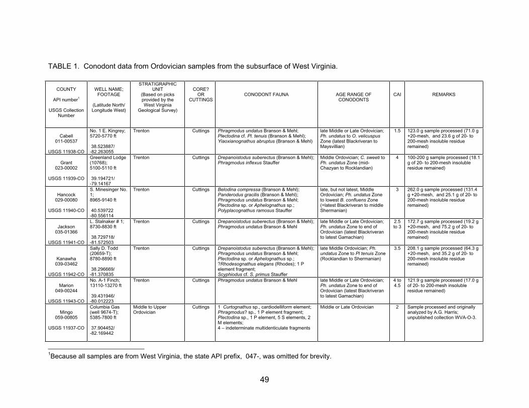
TABLE 1. Conodont data from Ordovician samples from the subsurface of West Virginia.
COUNTY
API number1
USGS Collection Number
WELL NAME; FOOTAGE
(Latitude North/ Longitude West)
STRATIGRAPHICUNIT
(Based on picksprovided by the West Virginia
Geological Survey)
CORE?OR
CUTTINGSCONODONT FAUNA AGE RANGE OF
CONODONTSCAI REMARKS
Cabell011-00537
USGS 11938-CO
No. 1 E. Kingrey; 5720-5770 ft
38.523887/ -82.263055
Trenton Cuttings Phragmodus undatus Branson & Mehl; Plectodina cf. Pl. tenuis (Branson & Mehl); Yiaoxianognathus abruptus (Branson & Mehl)
late Middle or Late Ordovician; Ph. undatus to O. velicuspusZone (latest Blackriveran to Maysvillian)
1.5 123.0 g sample processed (71.0 g +20-mesh, and 23.6 g of 20- to 200-mesh insoluble residue remained)
Grant023-00002
USGS 11939-CO
Greenland Lodge (10768);5100-5110 ft
39.194721/ -79.14167
Trenton Cuttings Drepanoistodus suberectus (Branson & Mehl); Phragmodus inflexus Stauffer
Middle Ordovician; C. sweeti to Ph. undatus Zone (mid-Chazyan to Rocklandian)
4 100-200 g sample processed (18.1 g of 20- to 200-mesh insoluble residue remained)
Hancock029-00080
USGS 11940-CO
S. Minesinger No. 1;8965-9140 ft
40.539722 -80.556114
Trenton Cuttings Belodina compressa (Branson & Mehl); Panderodus gracilis (Branson & Mehl); Phragmodus undatus Branson & Mehl; Plectodina sp. or Aphelognathus sp.; Polyplacognathus ramosus Stauffer
late, but not latest, Middle Ordovician; Ph. undatus Zone to lowest B. confluens Zone (=latest Blackriveran to middle Shermanian)
3 262.0 g sample processed (131.4 g +20-mesh, and 25.1 g of 20- to 200-mesh insoluble residue remained)
Jackson035-01366
USGS 11941-CO
L. Stalnaker # 1; 8730-8830 ft
38.729718/ -81.572503
Trenton Cuttings Drepanoistodus suberectus (Branson & Mehl); Phragmodus undatus Branson & Mehl
late Middle or Late Ordovician; Ph. undatus Zone to end of Ordovician (latest Blackriveran to latest Gamachian)
2.5to 3
172.7 g sample processed (19.2 g +20-mesh, and 75.2 g of 20- to 200-mesh insoluble residue remained)
Kanawha 039-03462
USGS 11942-CO
Sally D. Todd (20659-T);8780-8890 ft
38.296669/ -81.370835
Trenton Cuttings Drepanoistodus suberectus (Branson & Mehl); Phragmodus undatus Branson & Mehl; Plectodina sp. or Aphelognathus sp.; ?Rhodesognathus elegans (Rhodes); 1 P element fragment; Scyphiodus cf. S. primus Stauffer
late Middle Ordovician; Ph.undatus Zone to Pl tenuis Zone (Rocklandian to Shermanian)
3.5 208.1 g sample processed (64.3 g +20-mesh, and 35.2 g of 20- to 200-mesh insoluble residue remained)
Marion049-00244
USGS 11943-CO
No. A-1 Finch; 13110-13270 ft
39.431946/ -80.012223
Trenton Cuttings Phragmodus undatus Branson & Mehl late Middle or Late Ordovician; Ph. undatus Zone to end of Ordovician (latest Blackriveran to latest Gamachian)
4 to 4.5
121.9 g sample processed (17.0 g of 20- to 200-mesh insoluble residue remained)
Mingo059-00805
USGS 11937-CO
Columbia Gas (well 9674-T); 5385-7800 ft
37.904452/ -82.169442
Middle to Upper Ordovician
Cuttings 1 Curtognathus sp., cardiodelliform element; Phragmodus? sp., 1 P element fragment; Plectodina sp., 1 P element, 5 S elements, 2 M elements; 4 – indeterminate multidenticulate fragments
Middle or Late Ordovician 2 Sample processed and originally analyzed by A.G. Harris; unpublished collection WVA-O-3.
1Because all samples are from West Virginia, the state API prefix, 047-, was omitted for brevity.
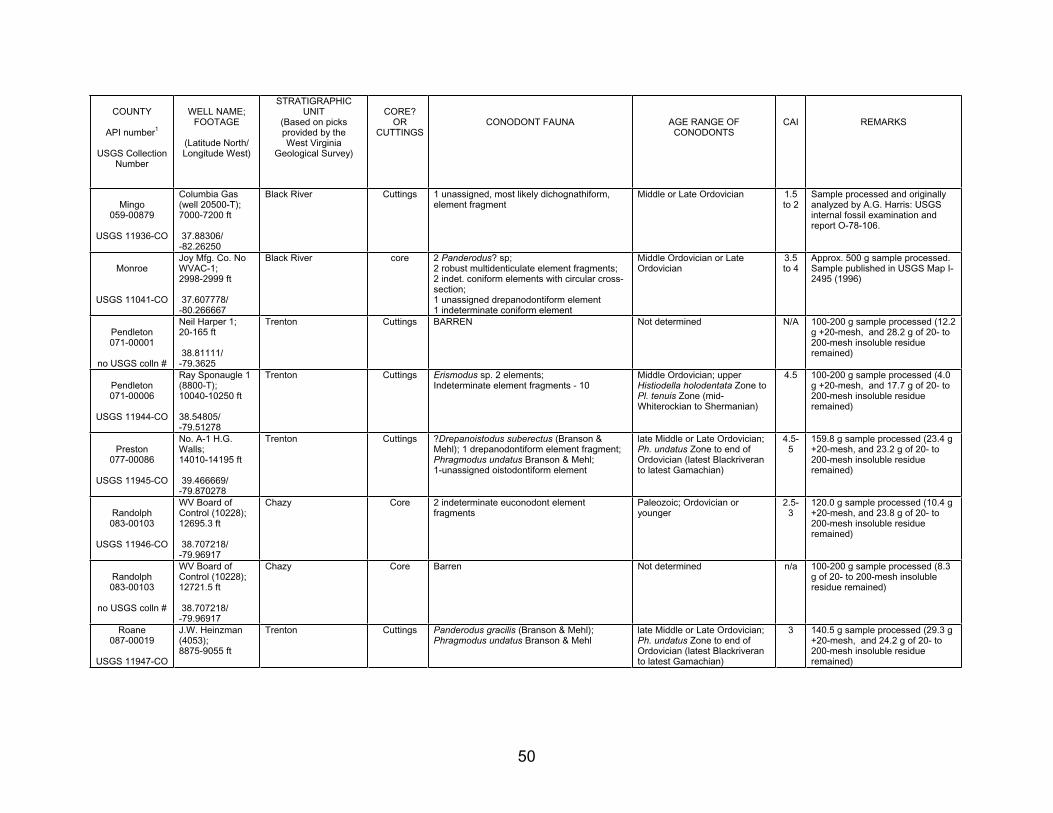
50
COUNTY
API number1
USGS Collection Number
WELL NAME; FOOTAGE
(Latitude North/ Longitude West)
STRATIGRAPHICUNIT
(Based on picksprovided by the West Virginia
Geological Survey)
CORE?OR
CUTTINGSCONODONT FAUNA AGE RANGE OF
CONODONTSCAI REMARKS
Mingo059-00879
USGS 11936-CO
Columbia Gas (well 20500-T); 7000-7200 ft
37.88306/ -82.26250
Black River Cuttings 1 unassigned, most likely dichognathiform, element fragment
Middle or Late Ordovician 1.5 to 2
Sample processed and originally analyzed by A.G. Harris: USGS internal fossil examination and report O-78-106.
Monroe
USGS 11041-CO
Joy Mfg. Co. No WVAC-1; 2998-2999 ft
37.607778/ -80.266667
Black River core 2 Panderodus? sp; 2 robust multidenticulate element fragments; 2 indet. coniform elements with circular cross-section;1 unassigned drepanodontiform element 1 indeterminate coniform element
Middle Ordovician or Late Ordovician
3.5to 4
Approx. 500 g sample processed. Sample published in USGS Map I-2495 (1996)
Pendleton071-00001
no USGS colln #
Neil Harper 1; 20-165 ft
38.81111/ -79.3625
Trenton Cuttings BARREN Not determined N/A 100-200 g sample processed (12.2 g +20-mesh, and 28.2 g of 20- to 200-mesh insoluble residue remained)
Pendleton071-00006
USGS 11944-CO
Ray Sponaugle 1 (8800-T);10040-10250 ft
38.54805/-79.51278
Trenton Cuttings Erismodus sp. 2 elements; Indeterminate element fragments - 10
Middle Ordovician; upper Histiodella holodentata Zone to Pl. tenuis Zone (mid-Whiterockian to Shermanian)
4.5 100-200 g sample processed (4.0 g +20-mesh, and 17.7 g of 20- to 200-mesh insoluble residue remained)
Preston077-00086
USGS 11945-CO
No. A-1 H.G. Walls; 14010-14195 ft
39.466669/ -79.870278
Trenton Cuttings ?Drepanoistodus suberectus (Branson & Mehl); 1 drepanodontiform element fragment; Phragmodus undatus Branson & Mehl; 1-unassigned oistodontiform element
late Middle or Late Ordovician; Ph. undatus Zone to end of Ordovician (latest Blackriveran to latest Gamachian)
4.5-5
159.8 g sample processed (23.4 g +20-mesh, and 23.2 g of 20- to 200-mesh insoluble residue remained)
Randolph083-00103
USGS 11946-CO
WV Board of Control (10228); 12695.3 ft
38.707218/ -79.96917
Chazy Core 2 indeterminate euconodont element fragments
Paleozoic; Ordovician or younger
2.5-3
120.0 g sample processed (10.4 g +20-mesh, and 23.8 g of 20- to 200-mesh insoluble residue remained)
Randolph083-00103
no USGS colln #
WV Board of Control (10228); 12721.5 ft
38.707218/ -79.96917
Chazy Core Barren Not determined n/a 100-200 g sample processed (8.3 g of 20- to 200-mesh insoluble residue remained)
Roane087-00019
USGS 11947-CO
J.W. Heinzman (4053);8875-9055 ft
Trenton Cuttings Panderodus gracilis (Branson & Mehl); Phragmodus undatus Branson & Mehl
late Middle or Late Ordovician; Ph. undatus Zone to end of Ordovician (latest Blackriveran to latest Gamachian)
3 140.5 g sample processed (29.3 g +20-mesh, and 24.2 g of 20- to 200-mesh insoluble residue remained)
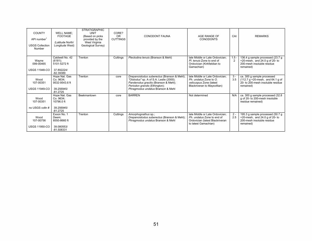
51
COUNTY
API number1
USGS Collection Number
WELL NAME; FOOTAGE
(Latitude North/ Longitude West)
STRATIGRAPHICUNIT
(Based on picksprovided by the West Virginia
Geological Survey)
CORE?OR
CUTTINGSCONODONT FAUNA AGE RANGE OF
CONODONTSCAI REMARKS
Wayne 099-00465
USGS 11948-CO
Caldwell No. 42 (6181);5101-5272 ft
37.892224/ -82.39389
Trenton Cuttings Plectodina tenuis (Branson & Mehl) late Middle or Late Ordovician; Pl. tenuis Zone to end of Ordovician (Kirkfieldian to Gamachian)
1.5 - 2
136.4 g sample processed (23.7 g +20-mesh, and 24.0 g of 20- to 200-mesh insoluble residue remained)
Wood 107-00351
USGS 11949-CO
Hope Nat. Gas Co. 9634; 9532-9543.6 ft
39.256945/ -81.2725
Trenton core Drepanoistodus suberectus (Branson & Mehl); "Oistodus" sp. A of S.A. Leslie (2000); Panderodus gracilis (Branson & Mehl); Periodon grandis (Ethington); Phragmodus undatus Branson & Mehl
late Middle or Late Ordovician; Ph. undatus Zone to O.velicuspus Zone (latest Blackriveran to Maysvillian)
3 - 3.5
ca. 300 g sample processed (112.7 g +20-mesh, and 64.1 g of 20- to 200-mesh insoluble residue remained)
Wood 107-00351
no USGS colln #
Hope Nat. Gas Co. 9634; 10796.0 ft
39.256945/ -81.2725
Beekmantown core BARREN Not determined N/A ca. 300 g sample processed (32.8 g of 20- to 200-mesh insoluble residue remained)
Wood 107-00756
USGS 11950-CO
Exxon No. 1 Deem;8550-8660 ft
39.080553/ -81.508331
Trenton Cuttings Amorphognathus sp.; Drepanoistodus suberectus (Branson & Mehl); Phragmodus undatus Branson & Mehl
late Middle or Late Ordovician; Ph. undatus Zone to end of Ordovician (latest Blackriveran to latest Gamachian)
2 - 2.5
195.3 g sample processed (50.7 g +20-mesh, and 24.0 g of 20- to 200-mesh insoluble residue remained)
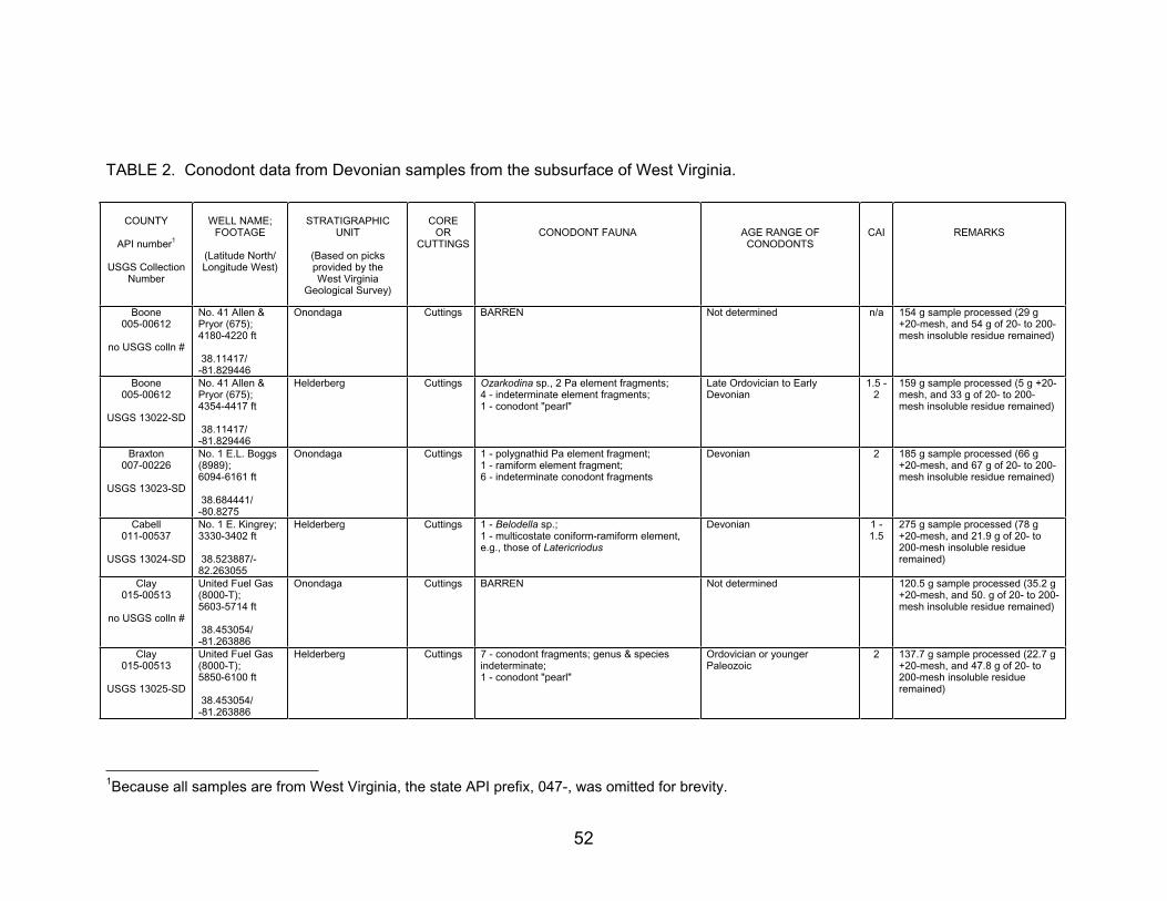
52
TABLE 2. Conodont data from Devonian samples from the subsurface of West Virginia.
COUNTY
API number1
USGS Collection Number
WELL NAME; FOOTAGE
(Latitude North/ Longitude West)
STRATIGRAPHICUNIT
(Based on picksprovided by the West Virginia
Geological Survey)
COREOR
CUTTINGSCONODONT FAUNA AGE RANGE OF
CONODONTSCAI REMARKS
Boone005-00612
no USGS colln #
No. 41 Allen & Pryor (675); 4180-4220 ft
38.11417/ -81.829446
Onondaga Cuttings BARREN Not determined n/a 154 g sample processed (29 g +20-mesh, and 54 g of 20- to 200-mesh insoluble residue remained)
Boone005-00612
USGS 13022-SD
No. 41 Allen & Pryor (675); 4354-4417 ft
38.11417/ -81.829446
Helderberg Cuttings Ozarkodina sp., 2 Pa element fragments; 4 - indeterminate element fragments; 1 - conodont "pearl"
Late Ordovician to Early Devonian
1.5 - 2
159 g sample processed (5 g +20-mesh, and 33 g of 20- to 200-mesh insoluble residue remained)
Braxton 007-00226
USGS 13023-SD
No. 1 E.L. Boggs (8989);6094-6161 ft
38.684441/ -80.8275
Onondaga Cuttings 1 - polygnathid Pa element fragment; 1 - ramiform element fragment; 6 - indeterminate conodont fragments
Devonian 2 185 g sample processed (66 g +20-mesh, and 67 g of 20- to 200-mesh insoluble residue remained)
Cabell011-00537
USGS 13024-SD
No. 1 E. Kingrey; 3330-3402 ft
38.523887/-82.263055
Helderberg Cuttings 1 - Belodella sp.; 1 - multicostate coniform-ramiform element, e.g., those of Latericriodus
Devonian 1 - 1.5
275 g sample processed (78 g +20-mesh, and 21.9 g of 20- to 200-mesh insoluble residue remained)
Clay 015-00513
no USGS colln #
United Fuel Gas (8000-T);5603-5714 ft
38.453054/ -81.263886
Onondaga Cuttings BARREN Not determined 120.5 g sample processed (35.2 g +20-mesh, and 50. g of 20- to 200-mesh insoluble residue remained)
Clay 015-00513
USGS 13025-SD
United Fuel Gas (8000-T);5850-6100 ft
38.453054/ -81.263886
Helderberg Cuttings 7 - conodont fragments; genus & species indeterminate;1 - conodont "pearl"
Ordovician or younger Paleozoic
2 137.7 g sample processed (22.7 g +20-mesh, and 47.8 g of 20- to 200-mesh insoluble residue remained)
1Because all samples are from West Virginia, the state API prefix, 047-, was omitted for brevity.
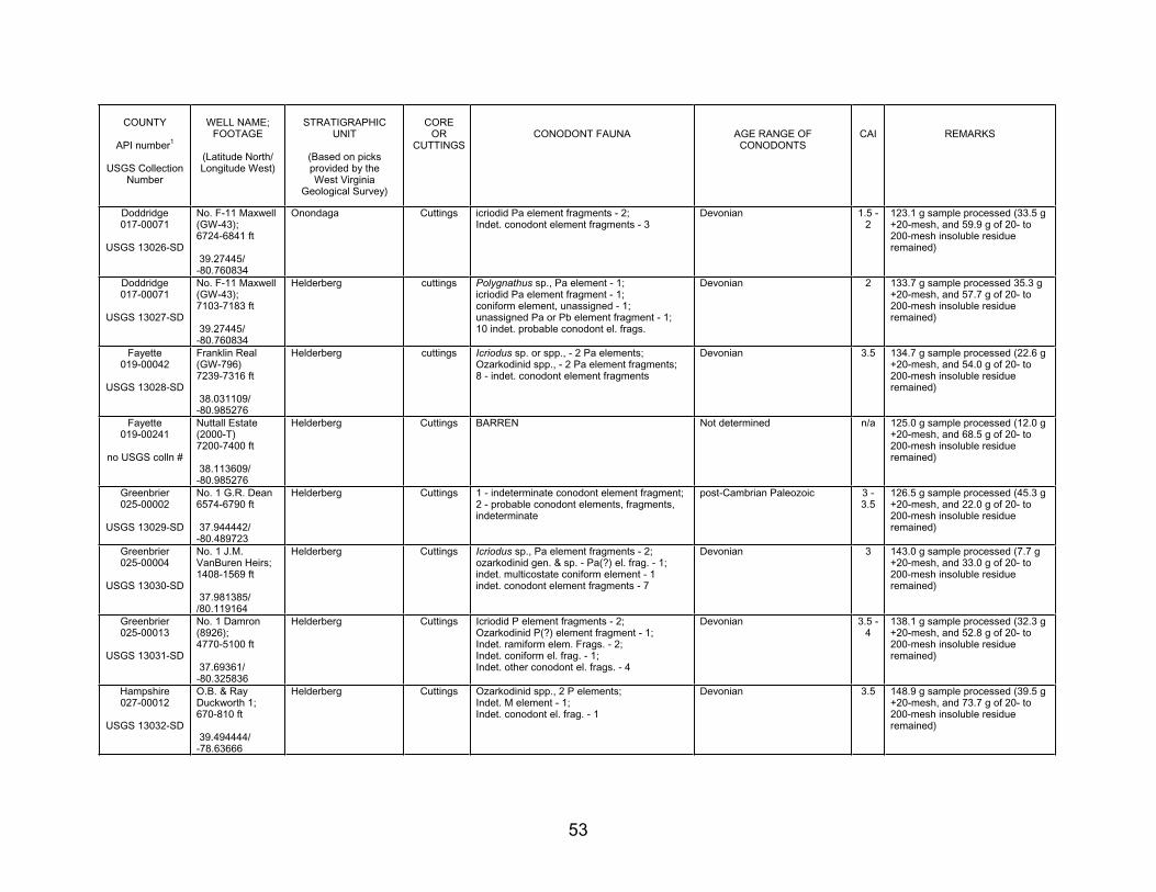
53
COUNTY
API number1
USGS Collection Number
WELL NAME; FOOTAGE
(Latitude North/ Longitude West)
STRATIGRAPHICUNIT
(Based on picksprovided by the West Virginia
Geological Survey)
COREOR
CUTTINGSCONODONT FAUNA AGE RANGE OF
CONODONTSCAI REMARKS
Doddridge017-00071
USGS 13026-SD
No. F-11 Maxwell (GW-43); 6724-6841 ft
39.27445/ -80.760834
Onondaga Cuttings icriodid Pa element fragments - 2; Indet. conodont element fragments - 3
Devonian 1.5 - 2
123.1 g sample processed (33.5 g +20-mesh, and 59.9 g of 20- to 200-mesh insoluble residue remained)
Doddridge017-00071
USGS 13027-SD
No. F-11 Maxwell (GW-43); 7103-7183 ft
39.27445/ -80.760834
Helderberg cuttings Polygnathus sp., Pa element - 1; icriodid Pa element fragment - 1; coniform element, unassigned - 1; unassigned Pa or Pb element fragment - 1; 10 indet. probable conodont el. frags.
Devonian 2 133.7 g sample processed 35.3 g +20-mesh, and 57.7 g of 20- to 200-mesh insoluble residue remained)
Fayette 019-00042
USGS 13028-SD
Franklin Real (GW-796) 7239-7316 ft
38.031109/ -80.985276
Helderberg cuttings Icriodus sp. or spp., - 2 Pa elements; Ozarkodinid spp., - 2 Pa element fragments; 8 - indet. conodont element fragments
Devonian 3.5 134.7 g sample processed (22.6 g +20-mesh, and 54.0 g of 20- to 200-mesh insoluble residue remained)
Fayette 019-00241
no USGS colln #
Nuttall Estate (2000-T)7200-7400 ft
38.113609/ -80.985276
Helderberg Cuttings BARREN Not determined n/a 125.0 g sample processed (12.0 g +20-mesh, and 68.5 g of 20- to 200-mesh insoluble residue remained)
Greenbrier025-00002
USGS 13029-SD
No. 1 G.R. Dean 6574-6790 ft
37.944442/ -80.489723
Helderberg Cuttings 1 - indeterminate conodont element fragment; 2 - probable conodont elements, fragments, indeterminate
post-Cambrian Paleozoic 3 - 3.5
126.5 g sample processed (45.3 g +20-mesh, and 22.0 g of 20- to 200-mesh insoluble residue remained)
Greenbrier025-00004
USGS 13030-SD
No. 1 J.M. VanBuren Heirs; 1408-1569 ft
37.981385/ /80.119164
Helderberg Cuttings Icriodus sp., Pa element fragments - 2; ozarkodinid gen. & sp. - Pa(?) el. frag. - 1; indet. multicostate coniform element - 1 indet. conodont element fragments - 7
Devonian 3 143.0 g sample processed (7.7 g +20-mesh, and 33.0 g of 20- to 200-mesh insoluble residue remained)
Greenbrier025-00013
USGS 13031-SD
No. 1 Damron (8926);4770-5100 ft
37.69361/ -80.325836
Helderberg Cuttings Icriodid P element fragments - 2; Ozarkodinid P(?) element fragment - 1; Indet. ramiform elem. Frags. - 2; Indet. coniform el. frag. - 1; Indet. other conodont el. frags. - 4
Devonian 3.5 - 4
138.1 g sample processed (32.3 g +20-mesh, and 52.8 g of 20- to 200-mesh insoluble residue remained)
Hampshire 027-00012
USGS 13032-SD
O.B. & Ray Duckworth 1; 670-810 ft
39.494444/ -78.63666
Helderberg Cuttings Ozarkodinid spp., 2 P elements; Indet. M element - 1; Indet. conodont el. frag. - 1
Devonian 3.5 148.9 g sample processed (39.5 g +20-mesh, and 73.7 g of 20- to 200-mesh insoluble residue remained)
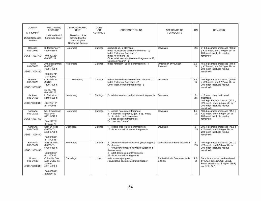
54
COUNTY
API number1
USGS Collection Number
WELL NAME; FOOTAGE
(Latitude North/ Longitude West)
STRATIGRAPHICUNIT
(Based on picksprovided by the West Virginia
Geological Survey)
COREOR
CUTTINGSCONODONT FAUNA AGE RANGE OF
CONODONTSCAI REMARKS
Hancock029-00080
USGS 13033-SD
S. Minesinger 1; 4920-5280 ft
40.539722/ -80.556114
Helderberg Cuttings Belodella sp., 2 elements; Indet. multicostate coniform elements - 2; Indet. P element fragment - 1 Indet. M element - 1; Other indet. conodont element fragments - 16; Conodont "pearls" - 2
Devonian 2.5 313.0 g sample processed (186.2 g +20-mesh, and 23.0 g of 20- to 200-mesh insoluble residue remained)
Hardy 031-00003
USGS 13034-SD
Anna Baughman (9058-T);7000-7190 ft
39.002774/ -78.849999
Helderberg Cuttings Indet. ramiform (S) element fragment - 1 Ordovician or younger Paleozoic
2.5 - 3
155.3 g sample processed (116.5 g +20-mesh, and 24.2 g of 20- to 200-mesh insoluble residue remained)
Harrison033-00079
USGS 13035-SD
C.S. Gribble (8517);7400-7505 ft
39.157775/-80.327225
Helderberg Cuttings Indeterminate bicostate coniform element - 1 Indet. P element fragments - 2 Other indet. conodont fragments - 6
Devonian 2.5 - 3
192.9 g sample processed (110.9 g +20-mesh, and 37.7 g of 20- to 200-mesh insoluble residue remained)
Jackson035-01366
USGS 13036-SD
L. Stalnaker 1; 5440-5580 ft
38.729718/ -81.572503
Helderberg Cuttings 2 - indeterminate conodont element fragments Devonian 2 - 2.5
~10 misc. phosphatic fossil fragments105.9 g sample processed (16.8 g +20-mesh, and 45.4 g of 20- to 200-mesh insoluble residue remained)
Kanawha 039-00205
USGS 13037-SD
No. 1 Robertson (GW-346); 5101-5242 ft
38.427776/ -81.557778
Helderberg Cuttings 1 - icriodid Pa element fragment; 2 - P element fragments, gen. & sp. indet.; 1 - bicostate coniform element; 10 indet. conodont fragments; 7 - conodont "pearls"
Devonian 1.5 - 2
186.4 g sample processed (31.6 g +20-mesh, and 43.9 g of 20- to 200-mesh insoluble residue remained)
Kanawha 039-03462
USGS 13038-SD
Sally D. Todd (20659-T);5600-5700 ft
38.296669/ -81.370835
Onondaga Cuttings 1 - icriodid-type Pa element fragment; 15 - indet. conodont element fragments
Devonian 2 - 2.5
205.1 g sample processed (75.5 g +20-mesh, and 50.0 g of 20- to 200-mesh insoluble residue remained)
Kanawha 039-03462
USGS 13039-SD
Sally D. Todd (20659-T);5730-5830 ft
38.296669/ -81.370835
Helderberg Cuttings 3 - Ozarkodina remscheidensis (Ziegler)-group Pa elements; 1 - Pseudooneotodus beckmanni (Bischoff & Sannemann);4 - indet. blade element fragments; 29 - indet. conodont fragments
Late Silurian to Early Devonian 2 - 2.5
190.0 g sample processed (56.0 g +20-mesh, and 82.6 g of 20- to 200-mesh insoluble residue remained)
Lincoln043-01637
USGS 13040-SD
Columbia Gas (well CGSC no. 20403);4031-4032 ft
38.098889/ -82.224442
Onondaga core Icriodus corniger group;Polygnathus costatus costatus Klapper
Earliest Middle Devonian; early Eifelian
1.5 - 2
Sample processed and analyzed by A.G. Harris (USGS, unpub. Fossil examination & report (E&R) no. DOE-77-1
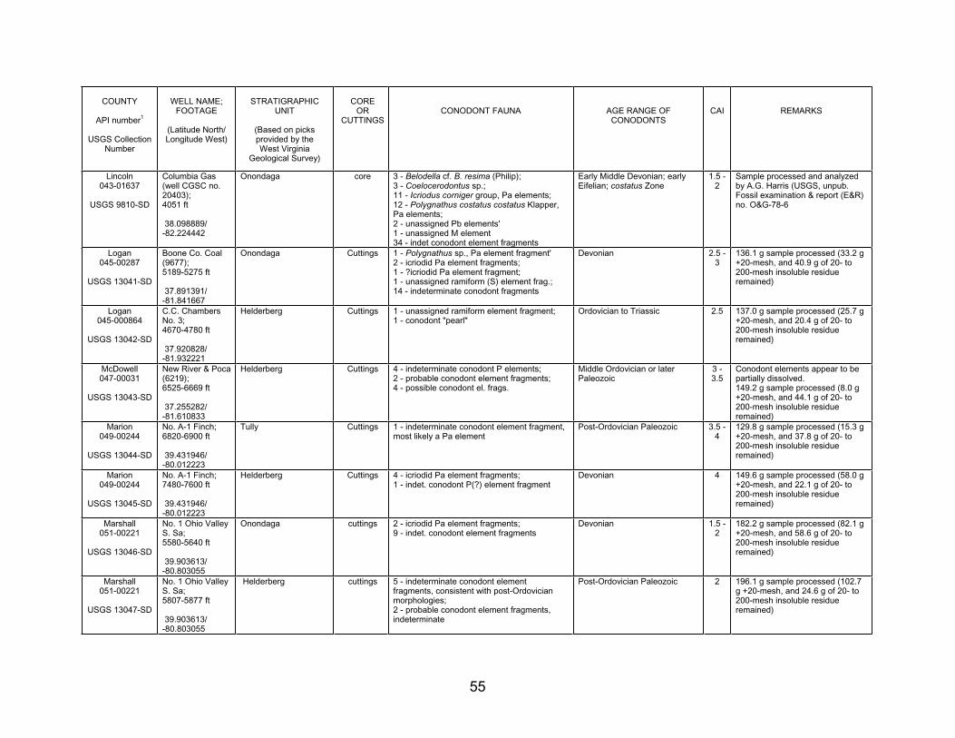
55
COUNTY
API number1
USGS Collection Number
WELL NAME; FOOTAGE
(Latitude North/ Longitude West)
STRATIGRAPHICUNIT
(Based on picksprovided by the West Virginia
Geological Survey)
COREOR
CUTTINGSCONODONT FAUNA AGE RANGE OF
CONODONTSCAI REMARKS
Lincoln043-01637
USGS 9810-SD
Columbia Gas (well CGSC no. 20403);4051 ft
38.098889/ -82.224442
Onondaga core 3 - Belodella cf. B. resima (Philip); 3 - Coelocerodontus sp.; 11 - Icriodus corniger group, Pa elements; 12 - Polygnathus costatus costatus Klapper, Pa elements; 2 - unassigned Pb elements' 1 - unassigned M element 34 - indet conodont element fragments
Early Middle Devonian; early Eifelian; costatus Zone
1.5 - 2
Sample processed and analyzed by A.G. Harris (USGS, unpub. Fossil examination & report (E&R) no. O&G-78-6
Logan045-00287
USGS 13041-SD
Boone Co. Coal (9677);5189-5275 ft
37.891391/ -81.841667
Onondaga Cuttings 1 - Polygnathus sp., Pa element fragment' 2 - icriodid Pa element fragments; 1 - ?icriodid Pa element fragment; 1 - unassigned ramiform (S) element frag.; 14 - indeterminate conodont fragments
Devonian 2.5 - 3
136.1 g sample processed (33.2 g +20-mesh, and 40.9 g of 20- to 200-mesh insoluble residue remained)
Logan045-000864
USGS 13042-SD
C.C. Chambers No. 3; 4670-4780 ft
37.920828/ -81.932221
Helderberg Cuttings 1 - unassigned ramiform element fragment; 1 - conodont "pearl"
Ordovician to Triassic 2.5 137.0 g sample processed (25.7 g +20-mesh, and 20.4 g of 20- to 200-mesh insoluble residue remained)
McDowell 047-00031
USGS 13043-SD
New River & Poca (6219);6525-6669 ft
37.255282/ -81.610833
Helderberg Cuttings 4 - indeterminate conodont P elements; 2 - probable conodont element fragments; 4 - possible conodont el. frags.
Middle Ordovician or later Paleozoic
3 - 3.5
Conodont elements appear to be partially dissolved. 149.2 g sample processed (8.0 g +20-mesh, and 44.1 g of 20- to 200-mesh insoluble residue remained)
Marion049-00244
USGS 13044-SD
No. A-1 Finch; 6820-6900 ft
39.431946/ -80.012223
Tully Cuttings 1 - indeterminate conodont element fragment, most likely a Pa element
Post-Ordovician Paleozoic 3.5 - 4
129.8 g sample processed (15.3 g +20-mesh, and 37.8 g of 20- to 200-mesh insoluble residue remained)
Marion049-00244
USGS 13045-SD
No. A-1 Finch; 7480-7600 ft
39.431946/ -80.012223
Helderberg Cuttings 4 - icriodid Pa element fragments; 1 - indet. conodont P(?) element fragment
Devonian 4 149.6 g sample processed (58.0 g +20-mesh, and 22.1 g of 20- to 200-mesh insoluble residue remained)
Marshall051-00221
USGS 13046-SD
No. 1 Ohio Valley S. Sa; 5580-5640 ft
39.903613/ -80.803055
Onondaga cuttings 2 - icriodid Pa element fragments; 9 - indet. conodont element fragments
Devonian 1.5 - 2
182.2 g sample processed (82.1 g +20-mesh, and 58.6 g of 20- to 200-mesh insoluble residue remained)
Marshall051-00221
USGS 13047-SD
No. 1 Ohio Valley S. Sa; 5807-5877 ft
39.903613/ -80.803055
Helderberg cuttings 5 - indeterminate conodont element fragments, consistent with post-Ordovician morphologies;2 - probable conodont element fragments, indeterminate
Post-Ordovician Paleozoic 2 196.1 g sample processed (102.7 g +20-mesh, and 24.6 g of 20- to 200-mesh insoluble residue remained)
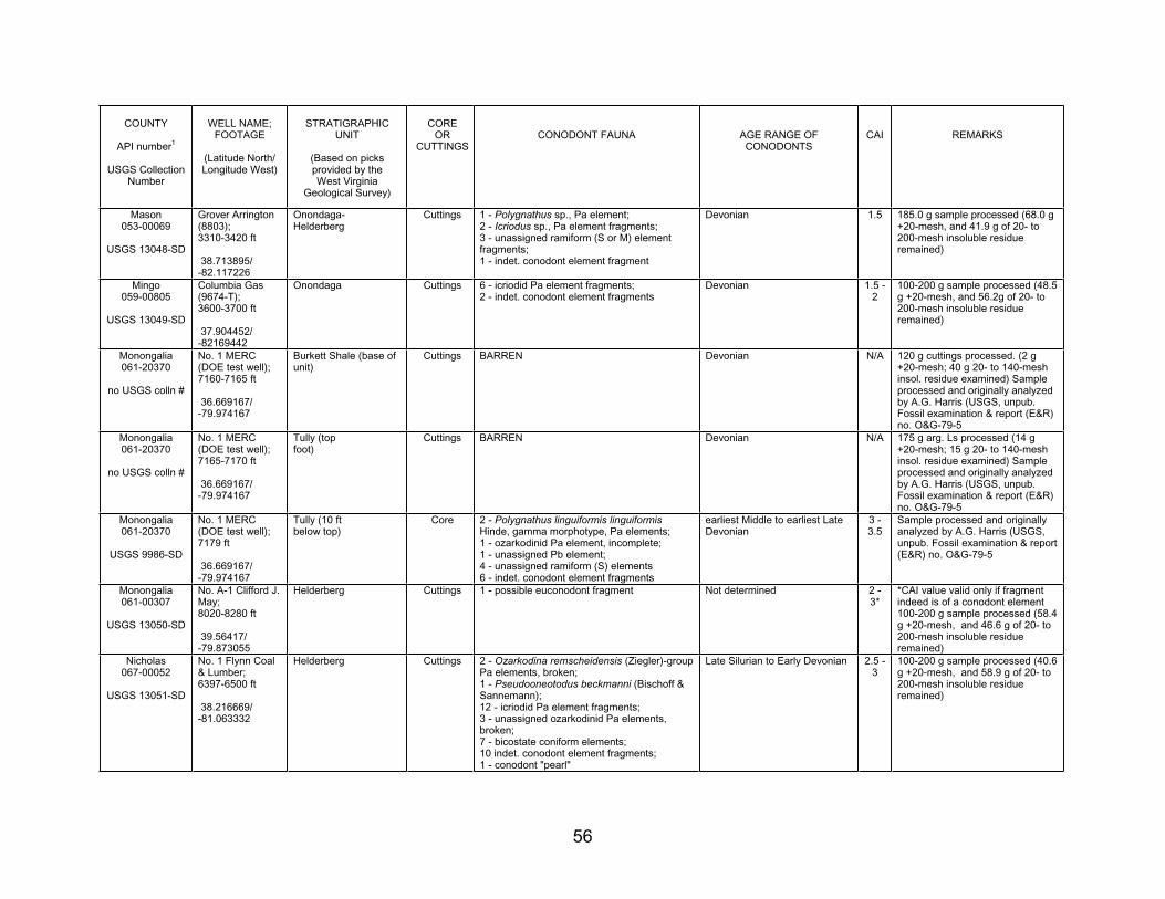
56
COUNTY
API number1
USGS Collection Number
WELL NAME; FOOTAGE
(Latitude North/ Longitude West)
STRATIGRAPHICUNIT
(Based on picksprovided by the West Virginia
Geological Survey)
COREOR
CUTTINGSCONODONT FAUNA AGE RANGE OF
CONODONTSCAI REMARKS
Mason053-00069
USGS 13048-SD
Grover Arrington (8803);3310-3420 ft
38.713895/ -82.117226
Onondaga-Helderberg
Cuttings 1 - Polygnathus sp., Pa element; 2 - Icriodus sp., Pa element fragments; 3 - unassigned ramiform (S or M) element fragments;1 - indet. conodont element fragment
Devonian 1.5 185.0 g sample processed (68.0 g +20-mesh, and 41.9 g of 20- to 200-mesh insoluble residue remained)
Mingo059-00805
USGS 13049-SD
Columbia Gas (9674-T);3600-3700 ft
37.904452/ -82169442
Onondaga Cuttings 6 - icriodid Pa element fragments; 2 - indet. conodont element fragments
Devonian 1.5 - 2
100-200 g sample processed (48.5 g +20-mesh, and 56.2g of 20- to 200-mesh insoluble residue remained)
Monongalia061-20370
no USGS colln #
No. 1 MERC (DOE test well); 7160-7165 ft
36.669167/ -79.974167
Burkett Shale (base of unit)
Cuttings BARREN Devonian N/A 120 g cuttings processed. (2 g +20-mesh; 40 g 20- to 140-mesh insol. residue examined) Sample processed and originally analyzed by A.G. Harris (USGS, unpub. Fossil examination & report (E&R) no. O&G-79-5
Monongalia061-20370
no USGS colln #
No. 1 MERC (DOE test well); 7165-7170 ft
36.669167/ -79.974167
Tully (top foot)
Cuttings BARREN Devonian N/A 175 g arg. Ls processed (14 g +20-mesh; 15 g 20- to 140-mesh insol. residue examined) Sample processed and originally analyzed by A.G. Harris (USGS, unpub. Fossil examination & report (E&R) no. O&G-79-5
Monongalia061-20370
USGS 9986-SD
No. 1 MERC (DOE test well); 7179 ft
36.669167/ -79.974167
Tully (10 ft below top)
Core 2 - Polygnathus linguiformis linguiformisHinde, gamma morphotype, Pa elements; 1 - ozarkodinid Pa element, incomplete; 1 - unassigned Pb element; 4 - unassigned ramiform (S) elements 6 - indet. conodont element fragments
earliest Middle to earliest Late Devonian
3 - 3.5
Sample processed and originally analyzed by A.G. Harris (USGS, unpub. Fossil examination & report (E&R) no. O&G-79-5
Monongalia061-00307
USGS 13050-SD
No. A-1 Clifford J. May; 8020-8280 ft
39.56417/ -79.873055
Helderberg Cuttings 1 - possible euconodont fragment Not determined 2 - 3*
*CAI value valid only if fragment indeed is of a conodont element 100-200 g sample processed (58.4 g +20-mesh, and 46.6 g of 20- to 200-mesh insoluble residue remained)
Nicholas067-00052
USGS 13051-SD
No. 1 Flynn Coal & Lumber; 6397-6500 ft
38.216669/ -81.063332
Helderberg Cuttings 2 - Ozarkodina remscheidensis (Ziegler)-group Pa elements, broken; 1 - Pseudooneotodus beckmanni (Bischoff & Sannemann);12 - icriodid Pa element fragments; 3 - unassigned ozarkodinid Pa elements, broken;7 - bicostate coniform elements; 10 indet. conodont element fragments; 1 - conodont "pearl"
Late Silurian to Early Devonian 2.5 - 3
100-200 g sample processed (40.6 g +20-mesh, and 58.9 g of 20- to 200-mesh insoluble residue remained)
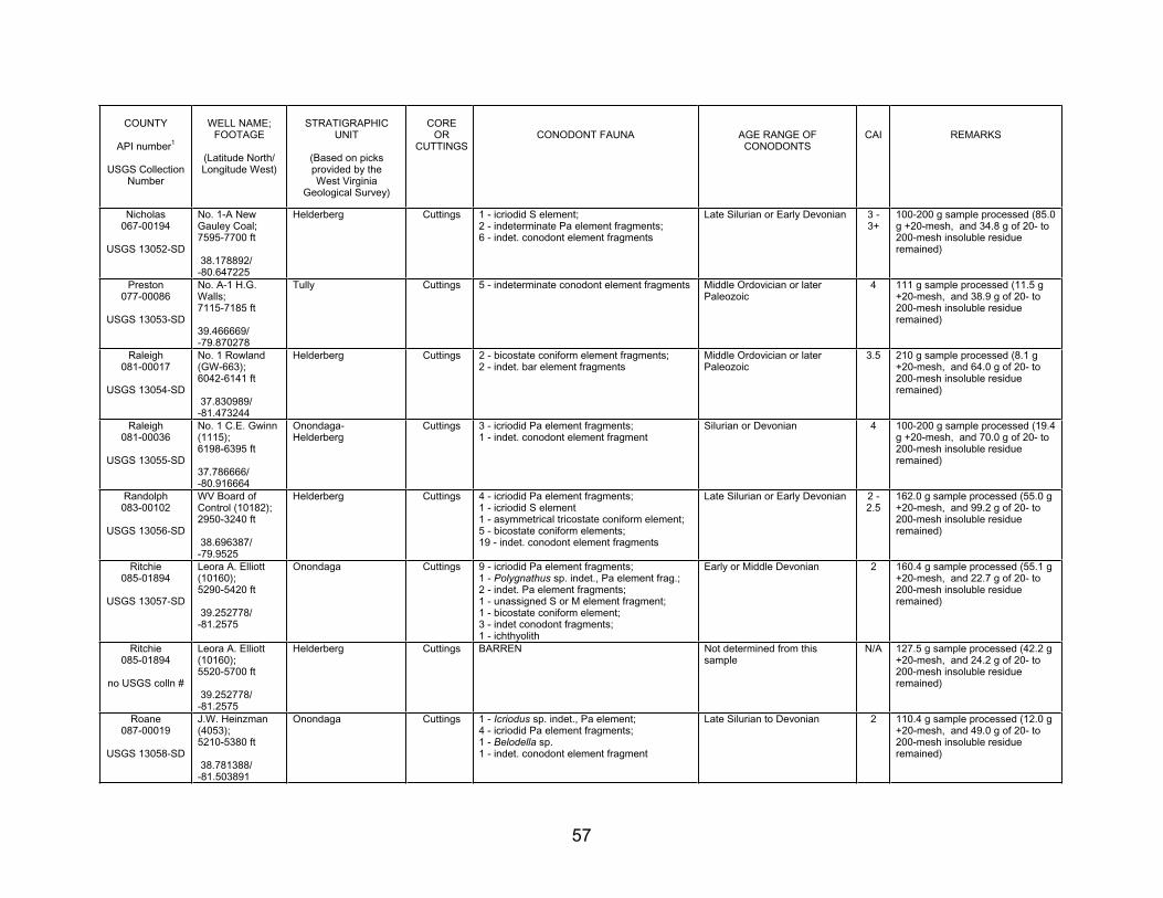
57
COUNTY
API number1
USGS Collection Number
WELL NAME; FOOTAGE
(Latitude North/ Longitude West)
STRATIGRAPHICUNIT
(Based on picksprovided by the West Virginia
Geological Survey)
COREOR
CUTTINGSCONODONT FAUNA AGE RANGE OF
CONODONTSCAI REMARKS
Nicholas067-00194
USGS 13052-SD
No. 1-A New Gauley Coal; 7595-7700 ft
38.178892/ -80.647225
Helderberg Cuttings 1 - icriodid S element; 2 - indeterminate Pa element fragments; 6 - indet. conodont element fragments
Late Silurian or Early Devonian 3 - 3+
100-200 g sample processed (85.0 g +20-mesh, and 34.8 g of 20- to 200-mesh insoluble residue remained)
Preston077-00086
USGS 13053-SD
No. A-1 H.G. Walls; 7115-7185 ft
39.466669/-79.870278
Tully Cuttings 5 - indeterminate conodont element fragments Middle Ordovician or later Paleozoic
4 111 g sample processed (11.5 g +20-mesh, and 38.9 g of 20- to 200-mesh insoluble residue remained)
Raleigh081-00017
USGS 13054-SD
No. 1 Rowland (GW-663); 6042-6141 ft
37.830989/ -81.473244
Helderberg Cuttings 2 - bicostate coniform element fragments; 2 - indet. bar element fragments
Middle Ordovician or later Paleozoic
3.5 210 g sample processed (8.1 g +20-mesh, and 64.0 g of 20- to 200-mesh insoluble residue remained)
Raleigh081-00036
USGS 13055-SD
No. 1 C.E. Gwinn (1115);6198-6395 ft
37.786666/-80.916664
Onondaga-Helderberg
Cuttings 3 - icriodid Pa element fragments; 1 - indet. conodont element fragment
Silurian or Devonian 4 100-200 g sample processed (19.4 g +20-mesh, and 70.0 g of 20- to 200-mesh insoluble residue remained)
Randolph083-00102
USGS 13056-SD
WV Board of Control (10182); 2950-3240 ft
38.696387/ -79.9525
Helderberg Cuttings 4 - icriodid Pa element fragments; 1 - icriodid S element 1 - asymmetrical tricostate coniform element; 5 - bicostate coniform elements; 19 - indet. conodont element fragments
Late Silurian or Early Devonian 2 - 2.5
162.0 g sample processed (55.0 g +20-mesh, and 99.2 g of 20- to 200-mesh insoluble residue remained)
Ritchie085-01894
USGS 13057-SD
Leora A. Elliott (10160);5290-5420 ft
39.252778/ -81.2575
Onondaga Cuttings 9 - icriodid Pa element fragments; 1 - Polygnathus sp. indet., Pa element frag.; 2 - indet. Pa element fragments; 1 - unassigned S or M element fragment; 1 - bicostate coniform element; 3 - indet conodont fragments; 1 - ichthyolith
Early or Middle Devonian 2 160.4 g sample processed (55.1 g +20-mesh, and 22.7 g of 20- to 200-mesh insoluble residue remained)
Ritchie085-01894
no USGS colln #
Leora A. Elliott (10160);5520-5700 ft
39.252778/ -81.2575
Helderberg Cuttings BARREN Not determined from this sample
N/A 127.5 g sample processed (42.2 g +20-mesh, and 24.2 g of 20- to 200-mesh insoluble residue remained)
Roane087-00019
USGS 13058-SD
J.W. Heinzman (4053);5210-5380 ft
38.781388/ -81.503891
Onondaga Cuttings 1 - Icriodus sp. indet., Pa element; 4 - icriodid Pa element fragments; 1 - Belodella sp. 1 - indet. conodont element fragment
Late Silurian to Devonian 2 110.4 g sample processed (12.0 g +20-mesh, and 49.0 g of 20- to 200-mesh insoluble residue remained)
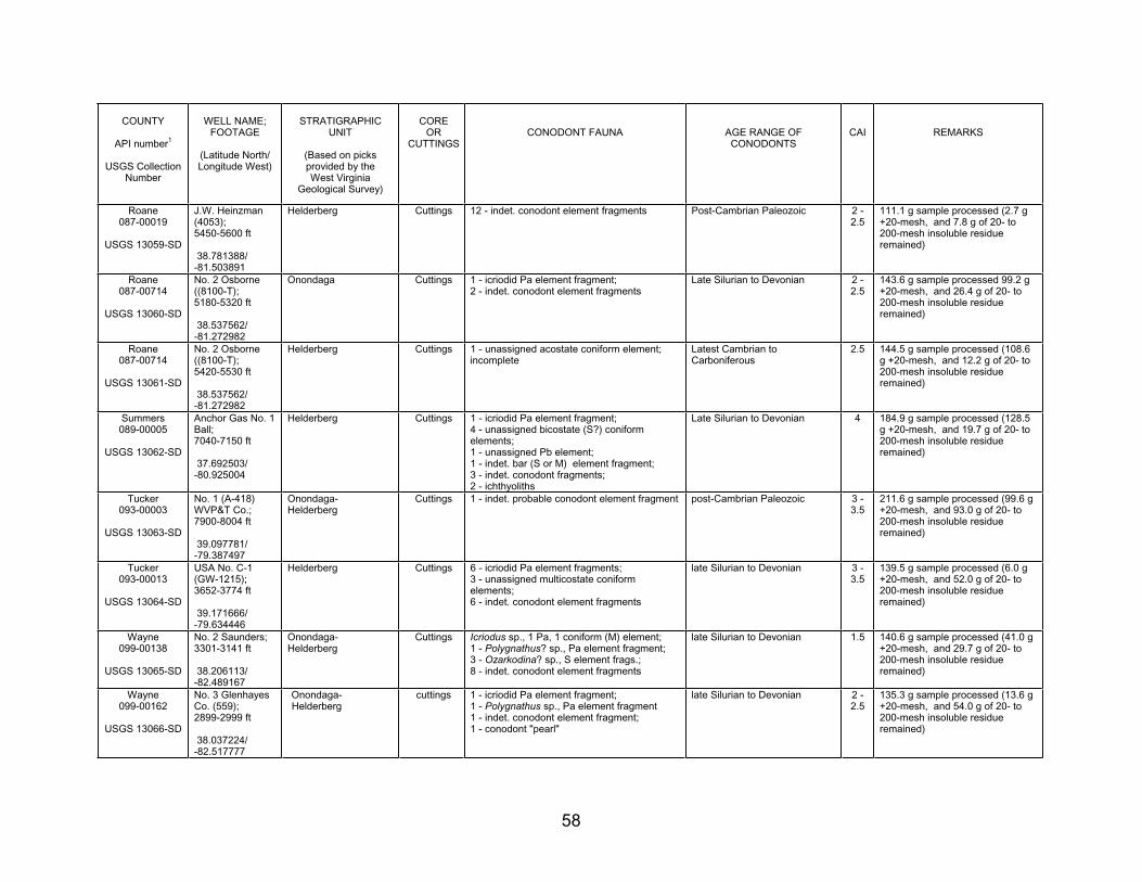
58
COUNTY
API number1
USGS Collection Number
WELL NAME; FOOTAGE
(Latitude North/ Longitude West)
STRATIGRAPHICUNIT
(Based on picksprovided by the West Virginia
Geological Survey)
COREOR
CUTTINGSCONODONT FAUNA AGE RANGE OF
CONODONTSCAI REMARKS
Roane087-00019
USGS 13059-SD
J.W. Heinzman (4053);5450-5600 ft
38.781388/ -81.503891
Helderberg Cuttings 12 - indet. conodont element fragments Post-Cambrian Paleozoic 2 - 2.5
111.1 g sample processed (2.7 g +20-mesh, and 7.8 g of 20- to 200-mesh insoluble residue remained)
Roane087-00714
USGS 13060-SD
No. 2 Osborne ((8100-T);5180-5320 ft
38.537562/ -81.272982
Onondaga Cuttings 1 - icriodid Pa element fragment; 2 - indet. conodont element fragments
Late Silurian to Devonian 2 - 2.5
143.6 g sample processed 99.2 g +20-mesh, and 26.4 g of 20- to 200-mesh insoluble residue remained)
Roane087-00714
USGS 13061-SD
No. 2 Osborne ((8100-T);5420-5530 ft
38.537562/ -81.272982
Helderberg Cuttings 1 - unassigned acostate coniform element; incomplete
Latest Cambrian to Carboniferous
2.5 144.5 g sample processed (108.6 g +20-mesh, and 12.2 g of 20- to 200-mesh insoluble residue remained)
Summers 089-00005
USGS 13062-SD
Anchor Gas No. 1 Ball;7040-7150 ft
37.692503/ -80.925004
Helderberg Cuttings 1 - icriodid Pa element fragment; 4 - unassigned bicostate (S?) coniform elements;1 - unassigned Pb element; 1 - indet. bar (S or M) element fragment; 3 - indet. conodont fragments; 2 - ichthyoliths
Late Silurian to Devonian 4 184.9 g sample processed (128.5 g +20-mesh, and 19.7 g of 20- to 200-mesh insoluble residue remained)
Tucker 093-00003
USGS 13063-SD
No. 1 (A-418) WVP&T Co.; 7900-8004 ft
39.097781/ -79.387497
Onondaga-Helderberg
Cuttings 1 - indet. probable conodont element fragment post-Cambrian Paleozoic 3 - 3.5
211.6 g sample processed (99.6 g +20-mesh, and 93.0 g of 20- to 200-mesh insoluble residue remained)
Tucker 093-00013
USGS 13064-SD
USA No. C-1 (GW-1215); 3652-3774 ft
39.171666/ -79.634446
Helderberg Cuttings 6 - icriodid Pa element fragments; 3 - unassigned multicostate coniform elements;6 - indet. conodont element fragments
late Silurian to Devonian 3 - 3.5
139.5 g sample processed (6.0 g +20-mesh, and 52.0 g of 20- to 200-mesh insoluble residue remained)
Wayne 099-00138
USGS 13065-SD
No. 2 Saunders; 3301-3141 ft
38.206113/ -82.489167
Onondaga-Helderberg
Cuttings Icriodus sp., 1 Pa, 1 coniform (M) element; 1 - Polygnathus? sp., Pa element fragment; 3 - Ozarkodina? sp., S element frags.; 8 - indet. conodont element fragments
late Silurian to Devonian 1.5 140.6 g sample processed (41.0 g +20-mesh, and 29.7 g of 20- to 200-mesh insoluble residue remained)
Wayne 099-00162
USGS 13066-SD
No. 3 Glenhayes Co. (559); 2899-2999 ft
38.037224/ -82.517777
Onondaga-Helderberg
cuttings 1 - icriodid Pa element fragment; 1 - Polygnathus sp., Pa element fragment 1 - indet. conodont element fragment; 1 - conodont "pearl"
late Silurian to Devonian 2 - 2.5
135.3 g sample processed (13.6 g +20-mesh, and 54.0 g of 20- to 200-mesh insoluble residue remained)
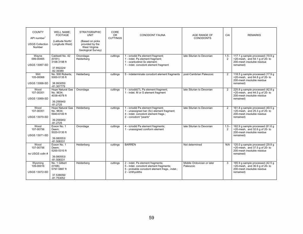
59
COUNTY
API number1
USGS Collection Number
WELL NAME; FOOTAGE
(Latitude North/ Longitude West)
STRATIGRAPHICUNIT
(Based on picksprovided by the West Virginia
Geological Survey)
COREOR
CUTTINGSCONODONT FAUNA AGE RANGE OF
CONODONTSCAI REMARKS
Wayne 099-00465
USGS 13067-SD
Caldwell No. 42 (6181);3108-3198 ft
37.892224/ -82.39389
Onondaga-Helderberg
cuttings 1 - icriodid Pa element fragment; 1 - indet. Pa element fragment; 1 - ozarkodinid Sc element; 1 - indet. conodont element fragment
late Silurian to Devonian 1.5 - 2
117.1 g sample processed (19.9 g +20-mesh, and 54.1 g of 20- to 200-mesh insoluble residue remained)
Wirt 105-00068
USGS 13068-SD
No. 500 Roberts; 5000-5135 ft
38.993055/ -81.307779
Helderberg cuttings 5 - indeterminate conodont element fragments post-Cambrian Paleozoic 2 118.5 g sample processed (17.9 g +20-mesh, and 64.8 g of 20- to 200-mesh insoluble residue remained)
Wood 107-00351
USGS 13069-SD
Hope Natural Gas No. 9634; 4038-4078 ft
39.256945/ -81.2725
Onondaga cuttings 1 - icriodid(?), Pa element fragment; 1 - indet. M or S element fragment
late Silurian to Devonian 2 225.8 g sample processed (42.8 g +20-mesh, and 44.5 g of 20- to 200-mesh insoluble residue remained)
Wood 107-00351
USGS 13070-SD
Hope Natural Gas No. 9634; 5940-6100 ft
39.256945/ -81.2725
Helderberg cuttings 1 - icriodid Pa element fragment; 1 - unassigned bar (Sc) element fragment; 4 - indet. conodont element frags.; 2 - conodont "pearls"
late Silurian to Devonian 2 161.8 g sample processed (49.5 g +20-mesh, and 25.3 g of 20- to 200-mesh insoluble residue remained)
Wood 107-00756
USGS 13071-SD
Exxon No. 1 Deem;5020-5130 ft
39.080553/ -81.508331
Onondaga cuttings 4 - icriodid Pa element fragments; 1 - unassigned coniform element
late Silurian to Devonian 1.5 - 2
162.9 g sample processed (61.6 g +20-mesh, and 32.6 g of 20- to 200-mesh insoluble residue remained)
Wood 107-00756
no USGS colln #
Exxon No. 1 Deem;5200-5310 ft
39.080553/ -81.508331
Helderberg cuttings BARREN Not determined N/A 120.0 g sample processed (29.8 g +20-mesh, and 37.5 g of 20- to 200-mesh insoluble residue remained)
Wyoming 109-00016
USGS 13072-SD
No. 1 Gilbert (0168);5797-5887 ft
37.538056/ -81.753052
Helderberg cuttings 2 - indet. Pa element fragments; 5 - indet. conodont element fragments; 5 - probable conodont element frags., indet.; 2 - ichthyoliths
Middle Ordovician or later Paleozoic
3 165.9 g sample processed (42.5 g +20-mesh, and 36.9 g of 20- to 200-mesh insoluble residue remained)
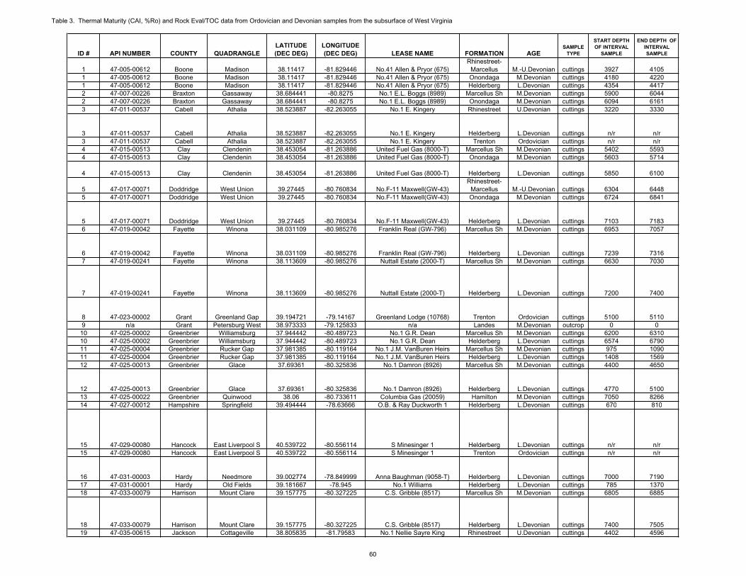
Table 3. Thermal Maturity (CAI, %Ro) and Rock Eval/TOC data from Ordovician and Devonian samples from the subsurface of West Virginia
ID # API NUMBER COUNTY QUADRANGLELATITUDE(DEC DEG)
LONGITUDE(DEC DEG) LEASE NAME FORMATION AGE
SAMPLETYPE
START DEPTHOF INTERVAL
SAMPLE
END DEPTH OF INTERVALSAMPLE
1 47-005-00612 Boone Madison 38.11417 -81.829446 No.41 Allen & Pryor (675)Rhinestreet-
Marcellus M.-U.Devonian cuttings 3927 41051 47-005-00612 Boone Madison 38.11417 -81.829446 No.41 Allen & Pryor (675) Onondaga M.Devonian cuttings 4180 42201 47-005-00612 Boone Madison 38.11417 -81.829446 No.41 Allen & Pryor (675) Helderberg L.Devonian cuttings 4354 44172 47-007-00226 Braxton Gassaway 38.684441 -80.8275 No.1 E.L. Boggs (8989) Marcellus Sh M.Devonian cuttings 5900 60442 47-007-00226 Braxton Gassaway 38.684441 -80.8275 No.1 E.L. Boggs (8989) Onondaga M.Devonian cuttings 6094 61613 47-011-00537 Cabell Athalia 38.523887 -82.263055 No.1 E. Kingery Rhinestreet U.Devonian cuttings 3220 3330
3 47-011-00537 Cabell Athalia 38.523887 -82.263055 No.1 E. Kingery Helderberg L.Devonian cuttings n/r n/r3 47-011-00537 Cabell Athalia 38.523887 -82.263055 No.1 E. Kingery Trenton Ordovician cuttings n/r n/r4 47-015-00513 Clay Clendenin 38.453054 -81.263886 United Fuel Gas (8000-T) Marcellus Sh M.Devonian cuttings 5402 55934 47-015-00513 Clay Clendenin 38.453054 -81.263886 United Fuel Gas (8000-T) Onondaga M.Devonian cuttings 5603 5714
4 47-015-00513 Clay Clendenin 38.453054 -81.263886 United Fuel Gas (8000-T) Helderberg L.Devonian cuttings 5850 6100
5 47-017-00071 Doddridge West Union 39.27445 -80.760834 No.F-11 Maxwell(GW-43)Rhinestreet-
Marcellus M.-U.Devonian cuttings 6304 64485 47-017-00071 Doddridge West Union 39.27445 -80.760834 No.F-11 Maxwell(GW-43) Onondaga M.Devonian cuttings 6724 6841
5 47-017-00071 Doddridge West Union 39.27445 -80.760834 No.F-11 Maxwell(GW-43) Helderberg L.Devonian cuttings 7103 71836 47-019-00042 Fayette Winona 38.031109 -80.985276 Franklin Real (GW-796) Marcellus Sh M.Devonian cuttings 6953 7057
6 47-019-00042 Fayette Winona 38.031109 -80.985276 Franklin Real (GW-796) Helderberg L.Devonian cuttings 7239 73167 47-019-00241 Fayette Winona 38.113609 -80.985276 Nuttall Estate (2000-T) Marcellus Sh M.Devonian cuttings 6630 7030
7 47-019-00241 Fayette Winona 38.113609 -80.985276 Nuttall Estate (2000-T) Helderberg L.Devonian cuttings 7200 7400
8 47-023-00002 Grant Greenland Gap 39.194721 -79.14167 Greenland Lodge (10768) Trenton Ordovician cuttings 5100 51109 n/a Grant Petersburg West 38.973333 -79.125833 n/a Landes M.Devonian outcrop 0 010 47-025-00002 Greenbrier Williamsburg 37.944442 -80.489723 No.1 G.R. Dean Marcellus Sh M.Devonian cuttings 6200 631010 47-025-00002 Greenbrier Williamsburg 37.944442 -80.489723 No.1 G.R. Dean Helderberg L.Devonian cuttings 6574 679011 47-025-00004 Greenbrier Rucker Gap 37.981385 -80.119164 No.1 J.M. VanBuren Heirs Marcellus Sh M.Devonian cuttings 975 109011 47-025-00004 Greenbrier Rucker Gap 37.981385 -80.119164 No.1 J.M. VanBuren Heirs Helderberg L.Devonian cuttings 1408 156912 47-025-00013 Greenbrier Glace 37.69361 -80.325836 No.1 Damron (8926) Marcellus Sh M.Devonian cuttings 4400 4650
12 47-025-00013 Greenbrier Glace 37.69361 -80.325836 No.1 Damron (8926) Helderberg L.Devonian cuttings 4770 510013 47-025-00022 Greenbrier Quinwood 38.06 -80.733611 Columbia Gas (20059) Hamilton M.Devonian cuttings 7050 826614 47-027-00012 Hampshire Springfield 39.494444 -78.63666 O.B. & Ray Duckworth 1 Helderberg L.Devonian cuttings 670 810
15 47-029-00080 Hancock East Liverpool S 40.539722 -80.556114 S Minesinger 1 Helderberg L.Devonian cuttings n/r n/r15 47-029-00080 Hancock East Liverpool S 40.539722 -80.556114 S Minesinger 1 Trenton Ordovician cuttings n/r n/r
16 47-031-00003 Hardy Needmore 39.002774 -78.849999 Anna Baughman (9058-T) Helderberg L.Devonian cuttings 7000 719017 47-031-00001 Hardy Old Fields 39.181667 -78.945 No.1 Williams Helderberg L.Devonian cuttings 785 137018 47-033-00079 Harrison Mount Clare 39.157775 -80.327225 C.S. Gribble (8517) Marcellus Sh M.Devonian cuttings 6805 6885
18 47-033-00079 Harrison Mount Clare 39.157775 -80.327225 C.S. Gribble (8517) Helderberg L.Devonian cuttings 7400 750519 47-035-00615 Jackson Cottageville 38.805835 -81.79583 No.1 Nellie Sayre King Rhinestreet U.Devonian cuttings 4402 4596
60
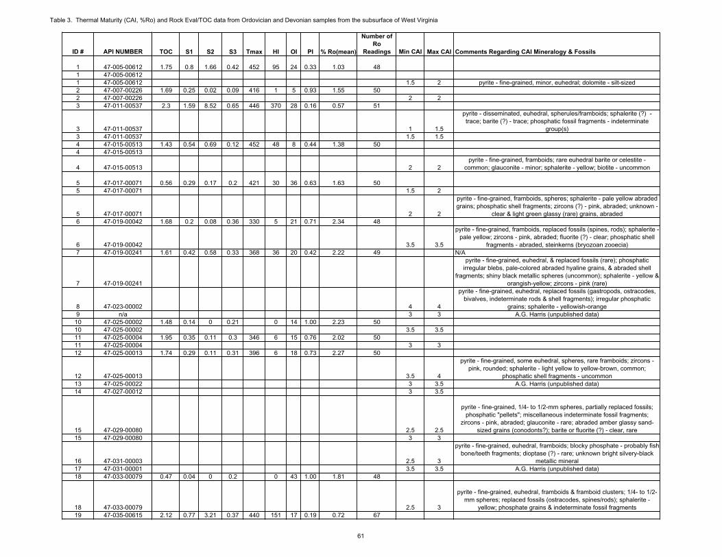
Table 3. Thermal Maturity (CAI, %Ro) and Rock Eval/TOC data from Ordovician and Devonian samples from the subsurface of West Virginia
ID # API NUMBER
1 47-005-006121 47-005-006121 47-005-006122 47-007-002262 47-007-002263 47-011-00537
3 47-011-005373 47-011-005374 47-015-005134 47-015-00513
4 47-015-00513
5 47-017-000715 47-017-00071
5 47-017-000716 47-019-00042
6 47-019-000427 47-019-00241
7 47-019-00241
8 47-023-000029 n/a10 47-025-0000210 47-025-0000211 47-025-0000411 47-025-0000412 47-025-00013
12 47-025-0001313 47-025-0002214 47-027-00012
15 47-029-0008015 47-029-00080
16 47-031-0000317 47-031-0000118 47-033-00079
18 47-033-0007919 47-035-00615
TOC S1 S2 S3 Tmax HI OI PI % Ro(mean)
Number of Ro
Readings Min CAI Max CAI Comments Regarding CAI Mineralogy & Fossils
1.75 0.8 1.66 0.42 452 95 24 0.33 1.03 48
1.5 2 pyrite - fine-grained, minor, euhedral; dolomite - silt-sized 1.69 0.25 0.02 0.09 416 1 5 0.93 1.55 50
2 22.3 1.59 8.52 0.65 446 370 28 0.16 0.57 51
1 1.5
pyrite - disseminated, euhedral, spherules/framboids; sphalerite (?) - trace; barite (?) - trace; phosphatic fossil fragments - indeterminate
group(s)1.5 1.5
1.43 0.54 0.69 0.12 452 48 8 0.44 1.38 50
2 2pyrite - fine-grained, framboids; rare euhedral barite or celestite -
common; glauconite - minor; sphalerite - yellow; biotite - uncommon
0.56 0.29 0.17 0.2 421 30 36 0.63 1.63 501.5 2
2 2
pyrite - fine-grained, framboids, spheres; sphalerite - pale yellow abraded grains; phosphatic shell fragments; zircons (?) - pink, abraded; unknown -
clear & light green glassy (rare) grains, abraded1.68 0.2 0.08 0.36 330 5 21 0.71 2.34 48
3.5 3.5
pyrite - fine-grained, framboids, replaced fossils (spines, rods); sphalerite -pale yellow; zircons - pink, abraded; fluorite (?) - clear; phosphatic shell
fragments - abraded, steinkerns (bryozoan zooecia)1.61 0.42 0.58 0.33 368 36 20 0.42 2.22 49 N/A
pyrite - fine-grained, euhedral, & replaced fossils (rare); phosphatic irregular blebs, pale-colored abraded hyaline grains, & abraded shell
fragments; shiny black metallic spheres (uncommon); sphalerite - yellow &orangish-yellow; zircons - pink (rare)
4 4
pyrite - fine-grained, euhedral, replaced fossils (gastropods, ostracodes, bivalves, indeterminate rods & shell fragments); irregular phosphatic
grains; sphalerite - yellowish-orange3 3 A.G. Harris (unpublished data)
1.48 0.14 0 0.21 0 14 1.00 2.23 503.5 3.5
1.95 0.35 0.11 0.3 346 6 15 0.76 2.02 503 3
1.74 0.29 0.11 0.31 396 6 18 0.73 2.27 50
3.5 4
pyrite - fine-grained, some euhedral, spheres, rare framboids; zircons - pink, rounded; sphalerite - light yellow to yellow-brown, common;
phosphatic shell fragments - uncommon3 3.5 A.G. Harris (unpublished data)3 3.5
2.5 2.5
pyrite - fine-grained, 1/4- to 1/2-mm spheres, partially replaced fossils; phosphatic "pellets"; miscellaneous indeterminate fossil fragments;
zircons - pink, abraded; glauconite - rare; abraded amber glassy sand-sized grains (conodonts?); barite or fluorite (?) - clear, rare
3 3
2.5 3
pyrite - fine-grained, euhedral, framboids; blocky phosphate - probably fishbone/teeth fragments; dioptase (?) - rare; unknown bright silvery-black
metallic mineral3.5 3.5 A.G. Harris (unpublished data)
0.47 0.04 0 0.2 0 43 1.00 1.81 48
2.5 3
pyrite - fine-grained, euhedral, framboids & framboid clusters; 1/4- to 1/2-mm spheres; replaced fossils (ostracodes, spines/rods); sphalerite -
yellow; phosphate grains & indeterminate fossil fragments2.12 0.77 3.21 0.37 440 151 17 0.19 0.72 67
61
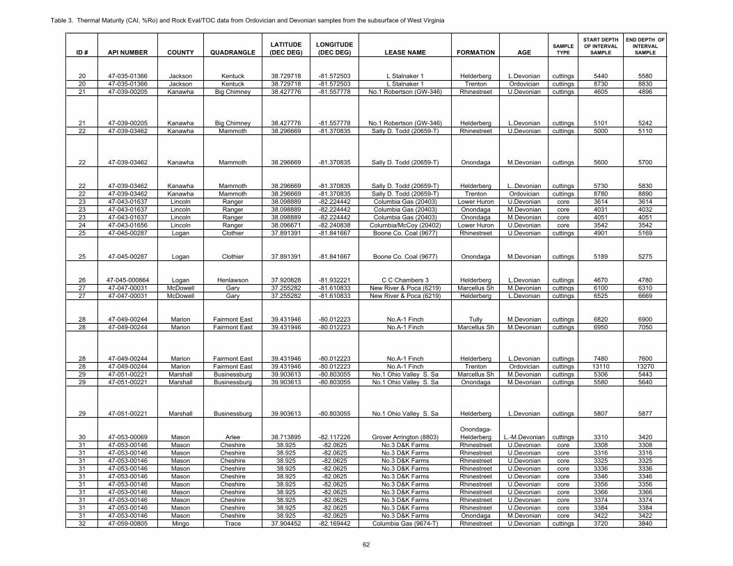
Table 3. Thermal Maturity (CAI, %Ro) and Rock Eval/TOC data from Ordovician and Devonian samples from the subsurface of West Virginia
ID # API NUMBER COUNTY QUADRANGLELATITUDE(DEC DEG)
LONGITUDE(DEC DEG) LEASE NAME FORMATION AGE
SAMPLETYPE
START DEPTHOF INTERVAL
SAMPLE
END DEPTH OF INTERVALSAMPLE
20 47-035-01366 Jackson Kentuck 38.729718 -81.572503 L Stalnaker 1 Helderberg L.Devonian cuttings 5440 558020 47-035-01366 Jackson Kentuck 38.729718 -81.572503 L Stalnaker 1 Trenton Ordovician cuttings 8730 883021 47-039-00205 Kanawha Big Chimney 38.427776 -81.557778 No.1 Robertson (GW-346) Rhinestreet U.Devonian cuttings 4605 4896
21 47-039-00205 Kanawha Big Chimney 38.427776 -81.557778 No.1 Robertson (GW-346) Helderberg L.Devonian cuttings 5101 524222 47-039-03462 Kanawha Mammoth 38.296669 -81.370835 Sally D. Todd (20659-T) Rhinestreet U.Devonian cuttings 5000 5110
22 47-039-03462 Kanawha Mammoth 38.296669 -81.370835 Sally D. Todd (20659-T) Onondaga M.Devonian cuttings 5600 5700
22 47-039-03462 Kanawha Mammoth 38.296669 -81.370835 Sally D. Todd (20659-T) Helderberg L..Devonian cuttings 5730 583022 47-039-03462 Kanawha Mammoth 38.296669 -81.370835 Sally D. Todd (20659-T) Trenton Ordovician cuttings 8780 889023 47-043-01637 Lincoln Ranger 38.098889 -82.224442 Columbia Gas (20403) Lower Huron U.Devonian core 3614 361423 47-043-01637 Lincoln Ranger 38.098889 -82.224442 Columbia Gas (20403) Onondaga M.Devonian core 4031 403223 47-043-01637 Lincoln Ranger 38.098889 -82.224442 Columbia Gas (20403) Onondaga M.Devonian core 4051 405124 47-043-01656 Lincoln Ranger 38.096671 -82.240838 Columbia/McCoy (20402) Lower Huron U.Devonian core 3542 354225 47-045-00287 Logan Clothier 37.891391 -81.841667 Boone Co. Coal (9677) Rhinestreet U.Devonian cuttings 4901 5169
25 47-045-00287 Logan Clothier 37.891391 -81.841667 Boone Co. Coal (9677) Onondaga M.Devonian cuttings 5189 5275
26 47-045-000864 Logan Henlawson 37.920828 -81.932221 C C Chambers 3 Helderberg L.Devonian cuttings 4670 478027 47-047-00031 McDowell Gary 37.255282 -81.610833 New River & Poca (6219) Marcellus Sh M.Devonian cuttings 6100 631027 47-047-00031 McDowell Gary 37.255282 -81.610833 New River & Poca (6219) Helderberg L.Devonian cuttings 6525 6669
28 47-049-00244 Marion Fairmont East 39.431946 -80.012223 No.A-1 Finch Tully M.Devonian cuttings 6820 690028 47-049-00244 Marion Fairmont East 39.431946 -80.012223 No.A-1 Finch Marcellus Sh M.Devonian cuttings 6950 7050
28 47-049-00244 Marion Fairmont East 39.431946 -80.012223 No.A-1 Finch Helderberg L.Devonian cuttings 7480 760028 47-049-00244 Marion Fairmont East 39.431946 -80.012223 No.A-1 Finch Trenton Ordovician cuttings 13110 1327029 47-051-00221 Marshall Businessburg 39.903613 -80.803055 No.1 Ohio Valley S. Sa Marcellus Sh M.Devonian cuttings 5306 544329 47-051-00221 Marshall Businessburg 39.903613 -80.803055 No.1 Ohio Valley S. Sa Onondaga M.Devonian cuttings 5580 5640
29 47-051-00221 Marshall Businessburg 39.903613 -80.803055 No.1 Ohio Valley S. Sa Helderberg L.Devonian cuttings 5807 5877
30 47-053-00069 Mason Arlee 38.713895 -82.117226 Grover Arrington (8803)Onondaga-Helderberg L.-M.Devonian cuttings 3310 3420
31 47-053-00146 Mason Cheshire 38.925 -82.0625 No.3 D&K Farms Rhinestreet U.Devonian core 3308 330831 47-053-00146 Mason Cheshire 38.925 -82.0625 No.3 D&K Farms Rhinestreet U.Devonian core 3316 331631 47-053-00146 Mason Cheshire 38.925 -82.0625 No.3 D&K Farms Rhinestreet U.Devonian core 3325 332531 47-053-00146 Mason Cheshire 38.925 -82.0625 No.3 D&K Farms Rhinestreet U.Devonian core 3336 333631 47-053-00146 Mason Cheshire 38.925 -82.0625 No.3 D&K Farms Rhinestreet U.Devonian core 3346 334631 47-053-00146 Mason Cheshire 38.925 -82.0625 No.3 D&K Farms Rhinestreet U.Devonian core 3356 335631 47-053-00146 Mason Cheshire 38.925 -82.0625 No.3 D&K Farms Rhinestreet U.Devonian core 3366 336631 47-053-00146 Mason Cheshire 38.925 -82.0625 No.3 D&K Farms Rhinestreet U.Devonian core 3374 337431 47-053-00146 Mason Cheshire 38.925 -82.0625 No.3 D&K Farms Rhinestreet U.Devonian core 3384 338431 47-053-00146 Mason Cheshire 38.925 -82.0625 No.3 D&K Farms Onondaga M.Devonian core 3422 342232 47-059-00805 Mingo Trace 37.904452 -82.169442 Columbia Gas (9674-T) Rhinestreet U.Devonian cuttings 3720 3840
62
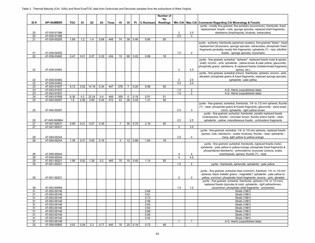
Table 3. Thermal Maturity (CAI, %Ro) and Rock Eval/TOC data from Ordovician and Devonian samples from the subsurface of West Virginia
ID # API NUMBER
20 47-035-0136620 47-035-0136621 47-039-00205
21 47-039-0020522 47-039-03462
22 47-039-03462
22 47-039-0346222 47-039-0346223 47-043-0163723 47-043-0163723 47-043-0163724 47-043-0165625 47-045-00287
25 47-045-00287
26 47-045-00086427 47-047-0003127 47-047-00031
28 47-049-0024428 47-049-00244
28 47-049-0024428 47-049-0024429 47-051-0022129 47-051-00221
29 47-051-00221
30 47-053-0006931 47-053-0014631 47-053-0014631 47-053-0014631 47-053-0014631 47-053-0014631 47-053-0014631 47-053-0014631 47-053-0014631 47-053-0014631 47-053-0014632 47-059-00805
TOC S1 S2 S3 Tmax HI OI PI % Ro(mean)
Number of Ro
Readings Min CAI Max CAI Comments Regarding CAI Mineralogy & Fossils
2 2.5
pyrite - mostly fine-grained, fine euhedra (uncommon), framboids, fossil replacement; fossils - rods, sponge spicules, replaced shell fragments,
steinkerns (brachiopods, bivalves, ostracodes)2.5 3
1.89 1.2 1.4 0.68 448 74 36 0.46 0.85 50
1.5 2
pyrite - euhedra, framboids (spherical clusters), fine-grained "blebs", fossilreplacement (bryozoans, sponge spicules, ostracodes); phosphatic fossil fragments (probably mostly fish fragments); sphalerite (?) - rare; silicified
fossils - sponge spicules, bryozoans0.47 0.01 0.07 0.32 454 15 68 0.22 0.99 16
2 2.5
pyrite - fine-grained, euhedral, "spheres", replaced fossils (rods & spines; snail); zircons - pink; sphalerite - yellow-brown & pale yellow; glauconite;
phosphate grains, steinkerns, & replaced fossils (indeterminate fragments,spines, etc.)
2 2.5
pyrite - fine-grained, euhedral (minor), framboids, spheres; zircons - pink, abraded; phosphate grains & fossil fragments, replaced sponge spicules;
sphalerite - pale yellow3.5 3.5
5.13 3.52 14.18 0.34 447 276 7 0.20 0.56 501.5 2 A.G. Harris (unpublished data)1.5 2 A.G. Harris (unpublished data)
6.36 4.2 22.24 0.4 448 350 6 0.16 0.51 511.6 0.56 0.69 0.45 472 43 28 0.45 1.31 50
2.5 3
pyrite - fine-grained, euhedral, framboids, 1/4- to 1/2-mm spheres; fluorite (?) - clear; phosphate grains & fossils fragments; glauconite - sand-sized,
minor; sphalerite - light yellow-brown
2.5 2.5
pyrite - fine-grained, euhedral, framboids, parially replaced fossils (rods/spines); fluorite - root-beer brown; fluorite and/or barite - clear;
sphalerite - yellow; miscellaneous fossils - echinoderm fragments0.99 0.21 0.07 0.39 7 39 0.75 2.16 50
3 3.5
3.5 4
pyrite - fine-grained, euhedral, 1/4- to 1/2-mm spheres, replaced fossils (spines, rods, steinkerns - snails, bivalves); fluorite - clear; sphalerite -
trace, light yellow to yellow-orange1.38 0.31 0.05 0.16 4 12 0.86 1.84 18
4 4
pyrite - fine-grained, euhedral, framboids, replaced fossils (rods); sphalerite - pale yellow to yellow-orange; phosphate fossil fragments &
phosphatized steinkerns - echinoderms, bryozoan zooecia, snails, brachiopods, spines), fluorite (?) - clear
4 4.51.98 0.92 1.38 0.2 445 70 10 0.40 1.14 50
1.5 2 pyrite - framboids, spheroids; sphalerite - pale yellow
2 2
pyrite - fine grained, euhedral (less common), framboid, 1/4- to 1/2-mm spheres; black metallic grains - magnetite?; sphalerite - pale yellow to yellow, common; phosphatic fossil fragments; zircons - pink, abraded
1.5 1.5
pyrite - fine-grained, euhedral, framboids, spheres (1/4- to 1/2-mm), replaced fossils (spicules & rods); sphalerite - light yellow/brown,
uncommon; phosphatic shell fragments - uncommon0.64 Streib (1981)0.61 Streib (1981)0.73 Streib (1981)0.58 Streib (1981)0.63 Streib (1981)0.63 Streib (1981)0.69 Streib (1981)0.65 Streib (1981)0.54 Streib (1981)
1 1 A.G. Harris (unpublished data)3.03 0.26 2.3 0.77 440 76 25 0.10 0.72 48
63
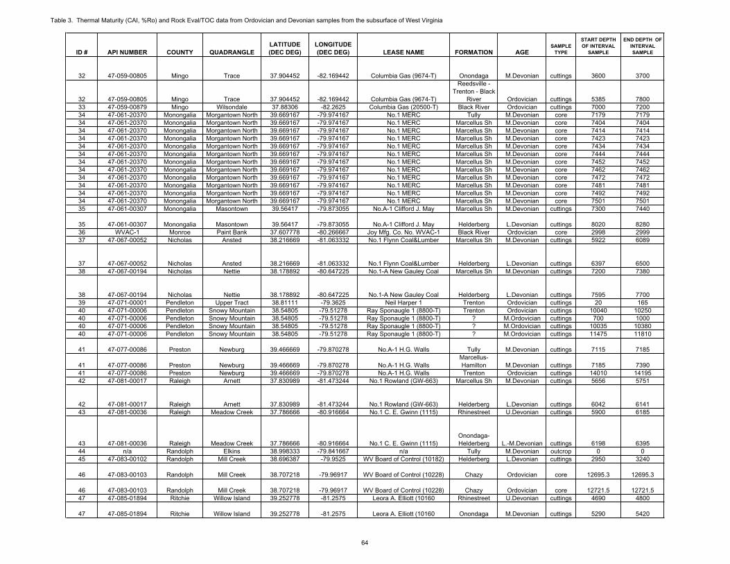
Table 3. Thermal Maturity (CAI, %Ro) and Rock Eval/TOC data from Ordovician and Devonian samples from the subsurface of West Virginia
ID # API NUMBER COUNTY QUADRANGLELATITUDE(DEC DEG)
LONGITUDE(DEC DEG) LEASE NAME FORMATION AGE
SAMPLETYPE
START DEPTHOF INTERVAL
SAMPLE
END DEPTH OF INTERVALSAMPLE
32 47-059-00805 Mingo Trace 37.904452 -82.169442 Columbia Gas (9674-T) Onondaga M.Devonian cuttings 3600 3700
32 47-059-00805 Mingo Trace 37.904452 -82.169442 Columbia Gas (9674-T)
Reedsville - Trenton - Black
River Ordovician cuttings 5385 780033 47-059-00879 Mingo Wilsondale 37.88306 -82.2625 Columbia Gas (20500-T) Black River Ordovician cuttings 7000 720034 47-061-20370 Monongalia Morgantown North 39.669167 -79.974167 No.1 MERC Tully M.Devonian core 7179 717934 47-061-20370 Monongalia Morgantown North 39.669167 -79.974167 No.1 MERC Marcellus Sh M.Devonian core 7404 740434 47-061-20370 Monongalia Morgantown North 39.669167 -79.974167 No.1 MERC Marcellus Sh M.Devonian core 7414 741434 47-061-20370 Monongalia Morgantown North 39.669167 -79.974167 No.1 MERC Marcellus Sh M.Devonian core 7423 742334 47-061-20370 Monongalia Morgantown North 39.669167 -79.974167 No.1 MERC Marcellus Sh M.Devonian core 7434 743434 47-061-20370 Monongalia Morgantown North 39.669167 -79.974167 No.1 MERC Marcellus Sh M.Devonian core 7444 744434 47-061-20370 Monongalia Morgantown North 39.669167 -79.974167 No.1 MERC Marcellus Sh M.Devonian core 7452 745234 47-061-20370 Monongalia Morgantown North 39.669167 -79.974167 No.1 MERC Marcellus Sh M.Devonian core 7462 746234 47-061-20370 Monongalia Morgantown North 39.669167 -79.974167 No.1 MERC Marcellus Sh M.Devonian core 7472 747234 47-061-20370 Monongalia Morgantown North 39.669167 -79.974167 No.1 MERC Marcellus Sh M.Devonian core 7481 748134 47-061-20370 Monongalia Morgantown North 39.669167 -79.974167 No.1 MERC Marcellus Sh M.Devonian core 7492 749234 47-061-20370 Monongalia Morgantown North 39.669167 -79.974167 No.1 MERC Marcellus Sh M.Devonian core 7501 750135 47-061-00307 Monongalia Masontown 39.56417 -79.873055 No.A-1 Clifford J. May Marcellus Sh M.Devonian cuttings 7300 7440
35 47-061-00307 Monongalia Masontown 39.56417 -79.873055 No.A-1 Clifford J. May Helderberg L.Devonian cuttings 8020 828036 WVAC-1 Monroe Paint Bank 37.607778 -80.266667 Joy Mfg. Co. No. WVAC-1 Black River Ordovician core 2998 299937 47-067-00052 Nicholas Ansted 38.216669 -81.063332 No.1 Flynn Coal&Lumber Marcellus Sh M.Devonian cuttings 5922 6089
37 47-067-00052 Nicholas Ansted 38.216669 -81.063332 No.1 Flynn Coal&Lumber Helderberg L.Devonian cuttings 6397 650038 47-067-00194 Nicholas Nettie 38.178892 -80.647225 No.1-A New Gauley Coal Marcellus Sh M.Devonian cuttings 7200 7380
38 47-067-00194 Nicholas Nettie 38.178892 -80.647225 No.1-A New Gauley Coal Helderberg L.Devonian cuttings 7595 770039 47-071-00001 Pendleton Upper Tract 38.81111 -79.3625 Neil Harper 1 Trenton Ordovician cuttings 20 16540 47-071-00006 Pendleton Snowy Mountain 38.54805 -79.51278 Ray Sponaugle 1 (8800-T) Trenton Ordovician cuttings 10040 1025040 47-071-00006 Pendleton Snowy Mountain 38.54805 -79.51278 Ray Sponaugle 1 (8800-T) ? M.Ordovician cuttings 700 100040 47-071-00006 Pendleton Snowy Mountain 38.54805 -79.51278 Ray Sponaugle 1 (8800-T) ? M.Ordovician cuttings 10035 1038040 47-071-00006 Pendleton Snowy Mountain 38.54805 -79.51278 Ray Sponaugle 1 (8800-T) ? M.Ordovician cuttings 11475 11810
41 47-077-00086 Preston Newburg 39.466669 -79.870278 No.A-1 H.G. Walls Tully M.Devonian cuttings 7115 7185
41 47-077-00086 Preston Newburg 39.466669 -79.870278 No.A-1 H.G. WallsMarcellus-Hamilton M.Devonian cuttings 7185 7390
41 47-077-00086 Preston Newburg 39.466669 -79.870278 No.A-1 H.G. Walls Trenton Ordovician cuttings 14010 1419542 47-081-00017 Raleigh Arnett 37.830989 -81.473244 No.1 Rowland (GW-663) Marcellus Sh M.Devonian cuttings 5656 5751
42 47-081-00017 Raleigh Arnett 37.830989 -81.473244 No.1 Rowland (GW-663) Helderberg L.Devonian cuttings 6042 614143 47-081-00036 Raleigh Meadow Creek 37.786666 -80.916664 No.1 C. E. Gwinn (1115) Rhinestreet U.Devonian cuttings 5900 6185
43 47-081-00036 Raleigh Meadow Creek 37.786666 -80.916664 No.1 C. E. Gwinn (1115)Onondaga-Helderberg L.-M.Devonian cuttings 6198 6395
44 n/a Randolph Elkins 38.998333 -79.841667 n/a Tully M.Devonian outcrop 0 045 47-083-00102 Randolph Mill Creek 38.696387 -79.9525 WV Board of Control (10182) Helderberg L.Devonian cuttings 2950 3240
46 47-083-00103 Randolph Mill Creek 38.707218 -79.96917 WV Board of Control (10228) Chazy Ordovician core 12695.3 12695.3
46 47-083-00103 Randolph Mill Creek 38.707218 -79.96917 WV Board of Control (10228) Chazy Ordovician core 12721.5 12721.547 47-085-01894 Ritchie Willow Island 39.252778 -81.2575 Leora A. Elliott (10160 Rhinestreet U.Devonian cuttings 4690 4800
47 47-085-01894 Ritchie Willow Island 39.252778 -81.2575 Leora A. Elliott (10160 Onondaga M.Devonian cuttings 5290 5420
64
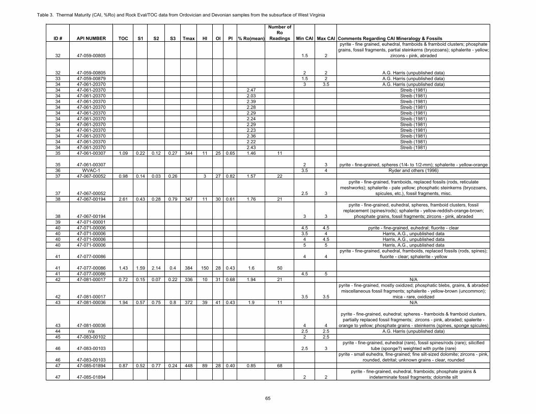
Table 3. Thermal Maturity (CAI, %Ro) and Rock Eval/TOC data from Ordovician and Devonian samples from the subsurface of West Virginia
ID # API NUMBER
32 47-059-00805
32 47-059-0080533 47-059-0087934 47-061-2037034 47-061-2037034 47-061-2037034 47-061-2037034 47-061-2037034 47-061-2037034 47-061-2037034 47-061-2037034 47-061-2037034 47-061-2037034 47-061-2037034 47-061-2037035 47-061-00307
35 47-061-0030736 WVAC-137 47-067-00052
37 47-067-0005238 47-067-00194
38 47-067-0019439 47-071-0000140 47-071-0000640 47-071-0000640 47-071-0000640 47-071-00006
41 47-077-00086
41 47-077-0008641 47-077-0008642 47-081-00017
42 47-081-0001743 47-081-00036
43 47-081-0003644 n/a45 47-083-00102
46 47-083-00103
46 47-083-0010347 47-085-01894
47 47-085-01894
TOC S1 S2 S3 Tmax HI OI PI % Ro(mean)
Number of Ro
Readings Min CAI Max CAI Comments Regarding CAI Mineralogy & Fossils
1.5 2
pyrite - fine grained, euhedral, framboids & framboid clusters; phosphate grains, fossil fragments, partial steinkerns (bryozoans); sphalerite - yellow;
zircons - pink, abraded
2 2 A.G. Harris (unpublished data)1.5 2 A.G. Harris (unpublished data)3 3.5 A.G. Harris (unpublished data)
2.47 Streib (1981)2.03 Streib (1981)2.39 Streib (1981)2.28 Streib (1981)2.29 Streib (1981)2.24 Streib (1981)2.29 Streib (1981)2.23 Streib (1981)2.36 Streib (1981)2.22 Streib (1981)2.43 Streib (1981)
1.09 0.22 0.12 0.27 344 11 25 0.65 1.46 11
2 3 pyrite - fine-grained, spheres (1/4- to 1/2-mm); sphalerite - yellow-orange3.5 4 Ryder and others (1996)
0.98 0.14 0.03 0.26 3 27 0.82 1.57 22
2.5 3
pyrite - fine-grained, framboids, replaced fossils (rods, reticulate meshworks); sphalerite - pale yellow; phosphatic steinkerns (bryozoans,
spicules, etc.), fossil fragments, misc.2.61 0.43 0.28 0.79 347 11 30 0.61 1.76 21
3 3
pyrite - fine-grained, euhedral, spheres, framboid clusters, fossil replacement (spines/rods); sphalerite - yellow-reddish-orange-brown;
phosphate grains, fossil fragments; zircons - pink, abraded
4.5 4.5 pyrite - fine-grained, euhedral; fluorite - clear3.5 4 Harris, A.G., unpublished data4 4.5 Harris, A.G., unpublished data5 5 Harris, A.G., unpublished data
4 4pyrite - fine-grained, euhedral, framboids, replaced fossils (rods, spines);
fluorite - clear; sphalerite - yellow
1.43 1.59 2.14 0.4 384 150 28 0.43 1.6 504.5 5
0.72 0.15 0.07 0.22 336 10 31 0.68 1.94 21 N/A
3.5 3.5
pyrite - fine-grained, mostly oxidized; phosphatic blebs, grains, & abraded miscellaneous fossil fragments; sphalerite - yellow-brown (uncommon);
mica - rare, oxidized1.94 0.57 0.75 0.8 372 39 41 0.43 1.9 11 N/A
4 4
pyrite - fine-grained, euhedral; spheres - framboids & framboid clusters, partially replaced fossil fragments; zircons - pink, abraded; spalerite -
orange to yellow; phosphate grains - steinkerns (spines, sponge spicules)2.5 2.5 A.G. Harris (unpublished data)2 2.5
2.5 3pyrite - fine-grained, euhedral (rare), fossil spines/rods (rare); silicified
tube (sponge?) weighted with pyrite (rare)pyrite - small euhedra, fine-grained; fine silt-sized dolomite; zircons - pink,
rounded, detrital; unknown grains - clear, rounded0.87 0.52 0.77 0.24 448 89 28 0.40 0.85 68
2 2pyrite - fine-grained, euhedral, framboids; phosphate grains &
indeterminate fossil fragments; dolomite silt
65
Table 3. Thermal Maturity (CAI, %Ro) and Rock Eval/TOC data from Ordovician and Devonian samples from the subsurface of West Virginia
ID # API NUMBER COUNTY QUADRANGLELATITUDE(DEC DEG)
LONGITUDE(DEC DEG) LEASE NAME FORMATION AGE
SAMPLETYPE
START DEPTHOF INTERVAL
SAMPLE
END DEPTH OF INTERVALSAMPLE
47 47-085-01894 Ritchie Willow Island 39.252778 -81.2575 Leora A. Elliott (10160 Helderberg L.Devonian cuttings 5520 570048 47-087-00019 Roane Gay 38.781388 -81.503891 J.W. Heinzman (4053) Rhinestreet U.Devonian cuttings 4840 520048 47-087-00019 Roane Gay 38.781388 -81.503891 J.W. Heinzman (4053) Onondaga M.Devonian cuttings 5210 538048 47-087-00019 Roane Gay 38.781388 -81.503891 J.W. Heinzman (4053) Helderberg L.Devonian cuttings 5450 560048 47-087-00019 Roane Gay 38.781388 -81.503891 J.W. Heinzman (4053) Trenton Ordovician cuttings 8875 905549 47-087-00714 Roane Clio 38.537562 -81.272982 No.2 Osborne (8100-T) Rhinestreet U.Devonian cuttings 4440 4580
49 47-087-00714 Roane Clio 38.537562 -81.272982 No.2 Osborne (8100-T) Onondaga M.Devonian cuttings 5180 5320
49 47-087-00714 Roane Clio 38.537562 -81.272982 No.2 Osborne (8100-T) Helderberg L.Devonian cuttings 5420 553050 47-089-00005 Summers Hinton 37.692503 -80.925004 Anchor Gas No.1 Ball Marcellus Sh M.Devonian cuttings 6600 6710
50 47-089-00005 Summers Hinton 37.692503 -80.925004 Anchor Gas No.1 Ball Helderberg L.Devonian cuttings 7040 715051 47-093-00003 Tucker Blackwater Falls 39.097781 -79.387497 No.1 (A-418) WVP&T Co. Marcellus Sh M.Devonian cuttings 7701 782051 47-093-00003 Tucker Blackwater Falls 39.097781 -79.387497 No.1 (A-418) WVP&T Co. Helderberg L.Devonian cuttings 7900 800452 47-093-00013 Tucker St. George 39.171666 -79.634446 USA No.C-1(GW-1215) Marcellus Sh M.Devonian cuttings 2934 328752 47-093-00013 Tucker St. George 39.171666 -79.634446 USA No.C-1(GW-1215) Helderberg L.Devonian cuttings 3652 3774
53 47-099-00138 Wayne Wayne 38.206113 -82.489167 No.2 SaundersHuron-
Rhinestreet U.Devonian cuttings 2285 3000
53 47-099-00138 Wayne Wayne 38.206113 -82.489167 No.2 SaundersOnondaga-Helderberg L.-M.Devonian cuttings 3301 3141
54 47-099-00162 Wayne Louisa 38.037224 -82.517777 No.3 Glenhayes Co.(559)Huron-
Rhinestreet U.Devonian cuttings 2205 2897
54 47-099-00162 Wayne Louisa 38.037224 -82.517777 No.3 Glenhayes Co.(559)Onondaga-Helderberg L.-M.Devonian cuttings 2899 2999
55 47-099-00465 Wayne Webb 37.892224 -82.39389 Caldwell No.42 (6181) Rhinestreet U.Devonian cuttings 2956 3096.3
55 47-099-00465 Wayne Webb 37.892224 -82.39389 Caldwell No.42 (6181)Onondaga-Helderberg L.-M.Devonian cuttings 3108 3198
55 47-099-00465 Wayne Webb 37.892224 -82.39389 Caldwell No.42 (6181) Trenton Ordovician cuttings 5101 527256 47-103-20645 Wetzel New Martinsville 39.67694 -80.82389 Emch and Pyles No.1 Marcellus Sh M.Devonian core 6599 659956 47-103-20645 Wetzel New Martinsville 39.67694 -80.82389 Emch and Pyles No.1 Marcellus Sh M.Devonian core 6618 661857 47-105-00068 Wirt Burning Springs 38.993055 -81.307779 No.500 Roberts Rhinestreet U.Devonian cuttings 4400 450757 47-105-00068 Wirt Burning Springs 38.993055 -81.307779 No.500 Roberts Helderberg L.Devonian cuttings 5000 513558 47-107-00351 Wood Willow Island 39.256945 -81.2725 Hope Nat Gas No.9634 Rhinestreet U.Devonian cuttings 3617 371458 47-107-00351 Wood Willow Island 39.256945 -81.2725 Hope Nat Gas No.9634 Onondaga M.Devonian cuttings 4038 4078
58 47-107-00351 Wood Willow Island 39.256945 -81.2725 Hope Nat Gas No.9634 Helderberg L.Devonian cuttings 5940 6100
58 47-107-00351 Wood Willow Island 39.256945 -81.2725 Hope Nat Gas No.9634 Trenton Ordovician core 9532 9543.5
58 47-107-00351 Wood Willow Island 39.256945 -81.2725 Hope Nat Gas No.9634 Beekmantown Ordovician core 10796 1079659 47-107-00756 Wood Rockport 39.080553 -81.508331 Exxon No.1 Deem Rhinestreet U.Devonian cuttings 4650 4760
66

Table 3. Thermal Maturity (CAI, %Ro) and Rock Eval/TOC data from Ordovician and Devonian samples from the subsurface of West Virginia
ID # API NUMBER
47 47-085-0189448 47-087-0001948 47-087-0001948 47-087-0001948 47-087-0001949 47-087-00714
49 47-087-00714
49 47-087-0071450 47-089-00005
50 47-089-0000551 47-093-0000351 47-093-0000352 47-093-0001352 47-093-00013
53 47-099-00138
53 47-099-00138
54 47-099-00162
54 47-099-0016255 47-099-00465
55 47-099-0046555 47-099-0046556 47-103-2064556 47-103-2064557 47-105-0006857 47-105-0006858 47-107-0035158 47-107-00351
58 47-107-00351
58 47-107-00351
58 47-107-0035159 47-107-00756
TOC S1 S2 S3 Tmax HI OI PI % Ro(mean)
Number of Ro
Readings Min CAI Max CAI Comments Regarding CAI Mineralogy & Fossilspyrite - fine-grained; phosphatic grains & indeterminate fossil fragments; zircons - pink, abraded; indeterminate brownish-amber & clear abraded
grains1.22 1.23 2 0.38 396 164 31 0.38 1.02 43
2 22 2.53 3
0.27 0.17 0.26 0.33 443 96 122 0.40 1.46 53
2 2.5
pyrite - fine-grained, euhedral, spheres, replaced fossils (spines & rods); phosphatic fossil fragments (types indeterminate); fluorite? - clear,
uncommon; sphalerite - yellow & reddish-brown, uncommon
2.5 2.5
pyrite - fine-grained, 1/4- to 1/2-mm spheres, framboids (individuals & clusters), replaced fossils (rods/tubes), minor euhedral; sphalerite - pale
yellow to pale orange-yellow; unknown clear mineral grains0.34 0.09 0.12 0.22 354 35 65 0.43 3.19 44
4 4
pyrite - fine-grained, euhedral; phosphatic grains & fossil fragments & replaced fossils (echinoderm fragments); zircons - pink, abraded, fluorite? -
clear1.85 0.38 0.3 0.35 345 16 19 0.56 2.94 40
3 3.51.28 0.43 0.38 0.35 403 30 27 0.53 2.21 48
3 3.5
2.14 0.95 4.96 0.49 432 232 23 0.16 0.88 48
1.5 1.5
pyrite - fine-grained, euhedral, framboids, sand-sized spheroids, spherical framboid clusters, replaced fossils (spines, rods); phosphate grains &
occasional fossil fragments; sphalerite - yellow to yellow-orange; zircons - pink, abraded, uncommon; unknown clear minerals
2.62 1.66 7.47 0.74 434 285 28 0.18 0.77 58
2 2.5
pyrite - fine-grained, euhedral, framboids (minor), replaced fossils (rods, spines, partially replaced ostracodes or mollusks), spheres; glauconite -
uncommon; sphalerite - yellow; unknown black silvery metallic grains (rare); phosphatic partial steinkerns of bryozoan, etc.; zircons - pink,
abraded1.51 0.59 2.71 0.34 438 179 23 0.18 0.75 58
1.5 21.5 2
1.62 Streib (1981)1.79 Streib (1981)
1.09 0.35 0.96 0.23 446 88 21 0.27 0.9 372 2
1.85 0.69 2.57 0.48 448 139 26 0.21 0.92 502 2.5
2 2
pyrite - fine-grained, euhedral, occasional replaced fossils (spines, bryozoan zooecia, ostracode (?)); clear brown mineral - ankerite?, fluorite?; fluorite - clear; phosphatic shell fragments (uncommon);
phosphatized echinoderm fragments (rare)
3 3.5
phosphate fossil shell bits, vertebrate scale fragments; pyrite - fossil fragments, fine-grained; phosphate, pyrite & clay matrix bryozoans, brachiopods, sponges, ostracodes, gatropods (?); acicular barite (?)
clumpspyrite - fine-grained, framboids; clear blocky mineral - possibly barite; fine dolomite rhombs, pyrite - framboids, fine-euhedral, fine-grained clumps;
unknown clear grains including barite (?)0.61 0.03 0.29 0.42 443 48 69 0.09 1.11 17
67
Table 3. Thermal Maturity (CAI, %Ro) and Rock Eval/TOC data from Ordovician and Devonian samples from the subsurface of West Virginia
ID # API NUMBER COUNTY QUADRANGLELATITUDE(DEC DEG)
LONGITUDE(DEC DEG) LEASE NAME FORMATION AGE
SAMPLETYPE
START DEPTHOF INTERVAL
SAMPLE
END DEPTH OF INTERVALSAMPLE
59 47-107-00756 Wood Rockport 39.080553 -81.508331 Exxon No.1 Deem Onondaga M.Devonian cuttings 5020 5130
59 47-107-00756 Wood Rockport 39.080553 -81.508331 Exxon No.1 Deem Helderberg L.Devonian cuttings 5200 531059 47-107-00756 Wood Rockport 39.080553 -81.508331 Exxon No.1 Deem Trenton Ordovician cuttings 8550 866060 47-109-00016 Wyoming Gilbert 37.538056 -81.753052 No.1 Gilbert (0168) Marcellus Sh M.Devonian cuttings 5468 555460 47-109-00016 Wyoming Gilbert 37.538056 -81.753052 No.1 Gilbert (0168) Helderberg L.Devonian cuttings 5797 5887
68
Table 3. Thermal Maturity (CAI, %Ro) and Rock Eval/TOC data from Ordovician and Devonian samples from the subsurface of West Virginia
ID # API NUMBER
59 47-107-00756
59 47-107-0075659 47-107-0075660 47-109-0001660 47-109-00016
TOC S1 S2 S3 Tmax HI OI PI % Ro(mean)
Number of Ro
Readings Min CAI Max CAI Comments Regarding CAI Mineralogy & Fossils
1.5 2pyrite - fine-grained, euhedral, 1/4- to 1/2-mm spheres, replaced fossils
(bivalves, sponge spicules?); sphalerite - yellow to yellow-orangepyrite - fine-grained, spheres, framboids, rare euhedral dodecahedral;
sphalerite - pale yellow to light orange; fossil coral (?), steinkerns (rare); rare phosphatic shell fragments, phosphatic (?) glassy sand-sized beads -
brown2 2.5
1.8 0.6 0.57 0.45 340 32 25 0.51 2.07 383 3
69
Related Documents


