The Woodland Period Cultural Landscape of the Leake Site Complex SCOT KEITH Although it was occupied for approximately one millennium, from circa 300 BC to AD 650, the Leake site developed over ashort period oftime from alo- cal domestic occupation early in its history into a large Hopewellian ceremo- nial and interaction center, which concomitantlyserved as a gateway commu- nity that geographicallyand culturally linked the Southeast and the Midwest during the Middle Woodland period. The Leake site complex (figure 9.1) comprises a local cultural landscape with residential areas, earthen mounds, a semicircular ditch enclosure, a large cave, a hilltop stone enclosure, and the stone-coveredtomb of an important leader (Keith 2010). A broad spectrum of human activities accounts for these archaeological residues, including residential occupation, interaction, communalism, earthwork construction, feasting, and specialized item production. In an effort to examine the nature of domestic and ritual aspects of the local landscape at alarge Middle Wood- land center, I examine some of the archaeological contexts of the Leake site. Leake Complex Overview Several state-recordedsites (9Br2,9Br663,9Bi664,9Br665,9Br666,9Br667, and 9Bc668) collectivelymakeup the Leake site proper, which is situated in a large bend ofthe Etowah River approximately 3.5 miles downstream from the well-known Etowah Mounds (figure 9.2). The Leake site comprises the remains of three earthen mounds, a semicircular ditch enclosure, extensive midden deposits, and thousands of features such as postmolds, hearths, and cooking pits attributable to Cartersville and Swift Creek phase occupations of the site. Rising 350 feet above the.EtowahValleyone-half mile to thenorth and on the opposite side of the river, Ladd Mountain is a prominent feature of the Leake siteviewshed. There were three archaeologicalsiteson this ridge that I Figure 9.1. Map of the Leake site environs, including Shaw Mound, Ladd Cave, and Indian Fort in Bartow County, Georgia. Map prepared by Scot Keith. Figure 92. Map ofthe Leake site, Including ditch and Mounds A, band C. Map prepared by Scot Keith.

Welcome message from author
This document is posted to help you gain knowledge. Please leave a comment to let me know what you think about it! Share it to your friends and learn new things together.
Transcript

The Woodland Period Cultural Landscape of the Leake Site Complex
S C O T KEITH
Although it was occupied for approximately one millennium, from circa 300 BC to AD 650, the Leake site developed over ashort period oftime from alo- cal domestic occupation early in its history into a large Hopewellian ceremo- nial and interaction center, which concomitantly served as a gateway commu- nity that geographically and culturally linked the Southeast and the Midwest during the Middle Woodland period. The Leake site complex (figure 9.1) comprises a local cultural landscape with residential areas, earthen mounds, a semicircular ditch enclosure, a large cave, a hilltop stone enclosure, and the stone-covered tomb of an important leader (Keith 2010). A broad spectrum of human activities accounts for these archaeological residues, including residential occupation, interaction, communalism, earthwork construction, feasting, and specialized item production. In an effort to examine the nature of domestic and ritual aspects of the local landscape at alarge Middle Wood- land center, I examine some of the archaeological contexts of the Leake site.
Leake Complex Overview
Several state-recorded sites (9Br2,9Br663,9Bi664,9Br665,9Br666,9Br667, and 9Bc668) collectively makeup the Leake site proper, which is situated in a large bend ofthe Etowah River approximately 3.5 miles downstream from the well-known Etowah Mounds (figure 9.2). The Leake site comprises the remains of three earthen mounds, a semicircular ditch enclosure, extensive midden deposits, and thousands of features such as postmolds, hearths, and cooking pits attributable to Cartersville and Swift Creek phase occupations of the site. Rising 350 feet above the.EtowahValley one-half mile to thenorth and on
the opposite side of the river, Ladd Mountain is a prominent feature of the Leake siteviewshed. There were three archaeologicalsites on this ridge that I
Figure 9.1. Map of the Leake site environs, including Shaw Mound, Ladd Cave, and Indian Fort in Bartow County, Georgia. Map prepared by Scot Keith.
Figure 92. Map ofthe Leake site, Including ditch and Mounds A, band C. Map prepared by Scot Keith.
Scot Keith
fig1
Scot Keith
fig2

140 Scot Keith The Woodland Period Cultural LandscapeoftheLeakeSiteComplex 141
contendwere constructed and used by Middle Woodland peoples associated with the Leake site. Although all of these sites were largely destroyed as a re- sult of mining and rock quarrying activities in the nineteenth and twentieth centuries, historic documentation provides significant clues as to their na- ture and association with the Leake site proper. All of these sites collectively make up the Leake Complex, encompassing an area of approximately 700 acres. These sites provide aview into the interconnected elements of a Middle Woodland Hopewellian ceremonial landscape situated at the geographic in- terface of the Southeast and the Midwest, a sacred place that was actively created and maintained by local and nonlocal peoples.
Indian Fort (9Brl7) was a stone wall enclosure atop the summit of Ladd Mountain (P. E. Smith 1962; R. W. Smith 1936; Whittlesey 1883). With an approximate length of 400 m and a width of 3 m, the wall would have en- closed approximately 3.6 acres. Smithsonian researcher Charles Whittlesey - (1883) documented six openings in the wall ranging in width from 3 m to 18 m, while alater description (Smith 1962: 18) stated that three "pits or circles" were built into the wall. Unfortunately the wall no longer exists, because its stone was quarried for road building material, and there are no known mate- rials that might provide a construction date for the site. However, the wall's configuration and placement strongly suggest that it was built during the Leake occupation.
Ladd Cave (9Brl94) was a large cavern with a vertical extent of 150 feet (Sneed 1998, 2007) located on the mountain's southern face, roughly be- tween Indian Fort and Shaw Mound. In the 1880s. Smithsonian research- ers documented and collected Pleistocene fossils and human bones from the cave (Anonymous 1885a, 1885b; Thomas 1894). Cave burials affiliated with the Middle Woodland period are known from other sites in the county, such as Pine Log Cave (Adams 2007; Harris 1950; Kelly 1950,1951,1952), prompting Arthur Kelly (1951, 1952) to conclude that such sites were part of the Copena tradition of the Tennessee River valley area. Because of the lack of diagnostic artifacts from the cave, its usage during the Leake occupa- tion is speculative, yet one might reasonably assume that it figured into the Leake ceremonial landscape given the documented use of caves during the Woodland period (e.g., Crothers et al. 2002; Harris 1950; Kelly 1951, 1952; Walthall1974; Walthall and DeJarnette 1974).
At the foot of Ladd Mountain on a ridge spur, the Shaw Mound (9Br24) was a stone burial facility. Also documented by Whittlesey (1883: 628), it was described as being a "regular cone, with small heaps attached around its base" approximately 49 m in length and 5.5 m in height. A later description states that the mound was 9 m in diameter and 3.6 m in height (Smith 1936).
Both descriptions mention a collapsed or sunken center. Shaw Mound was dismantled by the landowner in 1940, while local amateur archaeologist J. H. Wofford Jr. was present (Waring 1945). According to Antonio Waring Jr., who described the site in a 1945 American Antiquity article (1945: 119-20),
At the base of the mound . . . directly in the center of the depression, were found the remains of an extended burial. . . . As Mr. Shaw, who knows nothing about archaeology, expressed it (without prompting), "The top of the pile was sunk in and looked as if the stone had been piled up on top of a log room that have [sic] caved in." . . . Covering its face and chest were several large sheets of mica. Lying on its chest was a plain, trapezoidal copper breastplate with double holes. . . . On each side of the head lay a tapered-based celt. Over the pelvis were sev- eral fragments of sheet copper which seem to have been parts of a large cut-design ornament. The expanded-bitted copper Celt lay somewhere loose in the rock and hence went through the crusher and was slightly damaged.
Although we do not know precisely when the Shaw Mound personage lived, the nature of the burial facility and the grave goods are clearly Hopewellian. The burial treatment, including interment in what appears to have been a stone-covered log tomb, suggests that the individual was a ceremonial prac- titioner and communal religious leader of the Leake complex (sensu Carr and Case 2OO5a; Jefferies 1976; and Milanich et al. 1997). It may be that the person buried in the Shaw Mound was instrumental in the growth of Leake, perhaps acting as an intermediary between the Southeast and the Midwest.
Several archaeologists have previously touched on Leake's regional and interregional importance during the Middle Woodland period. Antonio Waring Jr. wrote a brief American Antiquity article in 1945 regarding the "Hopewellian" nature of the Shaw Mound. In his research on Tunacunnhee and the distribution of raw materials common at Hopewell sites, Jefferies (1976: 49) noted that Shaw Mound was located on top of a hematite and limonite deposit (specifically Ladd Mountain). Pluckhahn (1998) directed testing excavations at Leake and recognized it as a population hub. Most re- cently Anderson (1998: 279) suggested that Shaw Mound was likely a node within the Southeast-Midwest network of Middle Woodland centers. He points out that the distribution of major Swift Creek centers reflects in part a geographically strategic positioning designed to facilitate the movement of commodities. Further, Anderson (1998: 280) suggests that the Mann site- a contemporaneous Hopewellian center on the Ohio River in southwestern Indiana characterized by mounds and geometric earthworks and having a

142 Scot Keith
considerable quantity of Swift Creek complicated-stamped sherds-might have been a gateway community or way station" linking the Midwest with the Southeast.
The prescience of Anderson's statement is underscored by the recent identification of a direct artifactual connection between Leake and Mann: a Swift Creek notched rim sherd found at Leake petrographically matches Swift Creek wares that were produced at the Mann site. Specifically, a Swift Creek sherd recovered at the Leake site (Keith 2010) is made of a grog-tem- pered paste that is petrographically similar to that used for the production of Swift Creekwares found at the Mann site (Ruby and Shriner 2005; Stoltman 2007). (Southeastern Swift Creek ceramics were typically made using sand or sand/grit temper.) Further, many of the fine-line simple-stamped wares found at Mann are petrographically and macroscopically similar to sand/grit- tempered Cartersville Simple Stamped wares common at Leake (Keith 2010; Stoltman 2007). My recent examination of the Mann Site collection held by the Indiana State Museum resulted in the identification of several sand-tem- pered Swift Creeksherds, providing additional evidence of direct interaction between these two sites. Taking Anderson's statement to its logical conclu- - - sion using this evidence, I posit that both Leake and Mann were geographical and cultural gateways into their respective regions and to each other, with a back and forth of people, materials, and ideas. Located at the edge of the Cartersville and Swift Creek cultural areas near the interface of the Tennes- see River valley with several Gulf and Atlantic rivers systems, Leake became a large Middle Woodland ceremonial center and a gateway community at which both northward- and southward-bound travelers stayed and passed through. People came to sites such as Leake to interact with others and to participate in cooperative and public ceremonial and religious events, such as earthwork construction, feasting, purification, singing and dancing, and mortuary rituals.
Domestic and Ritual Contexts at the Leake Site
Earthworks
The earthworks at the Leake site are now for the most part found only be- low the modern ground surface, because of historic disturbances and river alluviation. The mounds-A, B, and C-were razed and used for road fill circa 1940 when the Dallas Roclcmart Highway was relocated to its present position. Archaeologists working for the Smithsonian Division of Mound Ex- ploration of the Bureau ofEthnology under the supervision of Cyrus Thomas provided the k s t known documentation of the Leake site in the late 1800s
The Woodland Period Cultural Landscape of the Leake Site Complex 143
f~ iddle ton 1883; Rogan 1883; Thomas 1891, 1894). The site was later&- ited and described by Robert Wauchope (1966: 238) and Charles Fairbanks, Arthur Kelly, Gordon Willey, and Pat Wofford Jr. (Fairbanks et al. 1946) dur-
?
ing the 1930s and 1940s. These early descriptions provide the only known
I descriptions of the mounds. These descriptions indicate that Mound A was flat-topped (i.e., a platform) and "loaf shaped" and approximately 7 feet in height; Mound B was conical and 5-18 feet in height; andMound C was flat- topped and 8 feet in height (Fairbanks et al. 1946; Middleton 1883; Rogan 1883; Thomas 1894; Wauchope 1966).
Thesemicircular ditch enclosure at Leake was neither noted nor described by these early researchers, and there is very little surficial evidence for it. Por- tions ofthis feature were encountered by several excavations at the site (Hally, pers. comm. 2007,2008; Pluckhahn 1998; Southerliin 2002; Southerlin et al. 2003) but were not recognized as an earthwork until a large-scale excava- tion of the site was conducted (Keith 2010). Portions of the ditch exposed and investigated during this investigation measured approximately 14 m wide and at least 1.7 m deep, although the bottom was not reached during excava- tions, because of safety issues (Keith 2010). Portions of the ditch enclosure are visible on 1938 aerial photographs, showing it beginning at the railroad and highway bridges that cross the river, arcing around the western sides of Mounds A and B, and ending at the southwestern edge ofMound A. A gap in the ditch is visible in the 1938 aerial photograph between Mounds A and B, yet excavations revealed that the ditch is now buried beneath historic fill, at least in the area excavated. Further, a recent ground-penetrating radar survey over a portion of the Swift Creekmidden area and the area south and east of Mound Ais providing additional evidence of this earthwork, including a pos- sible embankment adjoining the interior of the ditch (Keith and Baughman 2011).
Geometric earthwork enclosures that form rectangles, squares, octagons, and circles have been documented at midwestern Hopewell area centers (Squier and Davis 184.8) but are generally absent at southeastern centers (Anderson 1998: 286). While semicircular mounded embankment enclo- sures are present at a few major centers in the Southeast, including Piuson, Savannah, Marksville, and Kolomoki, semicircular ditch features are found at contemporaneous Fort Center in Florida (Pluckhahn and Thompson, chapter 12, this volume; Sears et al. 1982) and the nearby Mississippian pe- riod Etowah Mounds. Recently, ditch features have been identified at two Middle Woodland sites in the Appalachian Summit area, both with evidence of Hopewellian activities: Garden Creek (Wright 2012) and Biltmore Mound (Kimhall et al., chapter 8, this volume). At Fort Center, Sears and colleagues

144 Scot Keith The Woodland Period Cultural Landscapeofthe LeakeSiteComplex 145
(1982) recorded a series ofmounds and earthworks, including a semicircular ditch measuring 365 m in diameter and with each end connected to the river. At Etowah, Rogan (1883) felt that at least the western end of the ditch was originally open to the river but had been filled in by the landowner to prevent it from filling with water. Both Jones (1861) and Rogan (1883) argued that the Etowah ditch placed the mounds on an island. The shape and path of the ditch at Leake suggest that it may have extended continuously to join the river on both ends, a distance of 730 m. If this is the case, then the ditch would have enclosed Mounds A and B on a human-made "island."
If the ditch was a prominent earthwork at Leake, an immediate question that arises is why it was not noted or depicted by the early investigators of the site. The feature may have been filled in from centuries of floodplain al- luviation. This possibility is supported by the mixed artifact stratigraphy that was documented during excavations within the ditch fill. Future geophysical work at the site will be designed to investigate this feature more fully.
Cartersville Early Middle Woodland Deposits
Evidence for domestic occupation at Leake comes from deposits found in the northeastern portion of the site, adjacent to the river, in the area of 9Br662 and 668. Dating circa 300-100 BC, these remains include pottery and stone tools of local slate and chert. Slate tool production and usage is evidenced by debitage and ground and worn bifaces. Several of the slate tools have use-wear patterns indicative of digging. While a few postholes and pits are present, no structural patterns are readily discernible. Local sand- and grit-tempered
, Cartersville check-stamped and Dunlap fabric-impressed wares dominate the ceramic assemblage. Limestone-tempered wares recovered from excavations may reflect interaction with peoples from the Tennessee River valley. Very low frequencies of artifacts and materials more commonly related to ceremo- nial contexts-a soapstone pipe bowl fragment, mica, ochre, hematite, lime- stone, mica schist, and siltstone-reveal that production of items from these
., materials was minimal in this area of the site during this time. , :. Communal Group Area
Other excavated areas of the site have yielded more equivocal evidence of domestic occupations. Specifically, artifacts traditionally considered domes- ticlutilitarian in nature are commonly found in association with items that are considered ceremonial. In the area immediately southwest of Mound B, numerous pit and post features are present (figure 9.3); radiocarbon dates (Beta-207560 and UGAMS* 02182) from features in this area place these remains between circa 100 BC and AD 125. While no structural patterns
are readily discernible in the post features, nonpost features include shallow hasin-shaped hearths, a deep circular cooking pit/earth oven. a mica cut-out
- A
storage pit, ceramic vessel busts, and pits of unknown function. While local Cartersville check- and simple-stamped wares predominate, nonlocal ceram- ics such as punctated/incised and red-filmed wares in the Weeden Island style, limestone-tempered types, and Cormorant Cord Impressed (variety Cormorant) point to interaction with peoples from the Gulf Coastal Plain, the Tennessee Valley, and the Tombigbee and Yazoo watersheds.
The low frequencies of typical domestic debris, such as chipped-stone tools and debitage, and the abundance of specialized items like gorgets, large chopping/digging tools, a small tubularpiece of copper, and a mica sheet cut into a rectangular form indicate that this was not a domestic area. Rather, the remains suggest that this area was the scene of cooperative communal activi-
Figure 9.3. Pit and post features south of Mound 0. Figure prepared by Scot Keith.
Scot Keith
fig3

146 Scot Keith
ties, possibly related to the construction ofMoundB and the ditch enclosure. Interestingly, the dense concentration of features in this excavation area ends at the edge of the ditch enclosure. While the precise construction history of the ditch enclosure has notbeenworked out, the Cartersville period occupa- tion inside the area of this enclosure appears to have ended as the intensive Swift Creek period occupation began in the area outside of it.
Swift CreekMidden
Outside of and adjacent to the ditch enclosure is a very dark and extensive midden with an extremely high artifact density. Referred to as the Swift Creek midden because of the predominance of this complicated-stamped pottery type, radiocarbon dates (Beta-109498, Beta-109499, Beta-207558, Beta- 207556, UGAMS* 02181) situate this feature between circa AD 125 and 650. In addition to the dense features within and underneath it, the midden con- tains a mixture of utilitarian and ceremonial artifacts. Everyday items such as fire-cracked rock (FCR) and points and debitage made from local Ridge and Valley chert are found in association with ceremonial items and materials such as cut mica; sheet copper; ceramic human and animal figurines; pris- matic blades of Ohio Flint Ridge chert, local chert, clear/crystal quartz, and - possibly Wyandotte chert; modified quartz crystals and clear/crystal quartz debitage; graphite; hematite; greenstone; and phyllite. The majority of these - - - ceremonial materials occur as debris, most likely remaining from the produc- tion of specialized items by participants in Hopewellian systems.
Ahigh diversity of local and nonlocal ceramics was also present within this midden. The bulkof the identified ceramic assemblage comprises Swift Creek Complicated Stamped and plain pottery, while Cartersville Simple Stamped accounts for much of the remainder. Check-stamped, incised, punctated, red- filmed, rocker-stamped, cord-marked, fabric-marked, the rare diamond-dot Hopewellian type, and various other decorated ceramics are present at low frequencies, attesting to interaction with peoples from the Gulf and Atlan- tic coastal plains, the lower Mississippi Valley, the Tennessee Valley, and the Midwest. In addition, dozens of sherds of a previously unrecognized ceramic type are present. Named Ladds Stamped after the ridge across the river, this sand/@-tempered ware was produced in the Swift Creek and CartersviHe pottery tradition and appears to have been restricted to the Leake site.
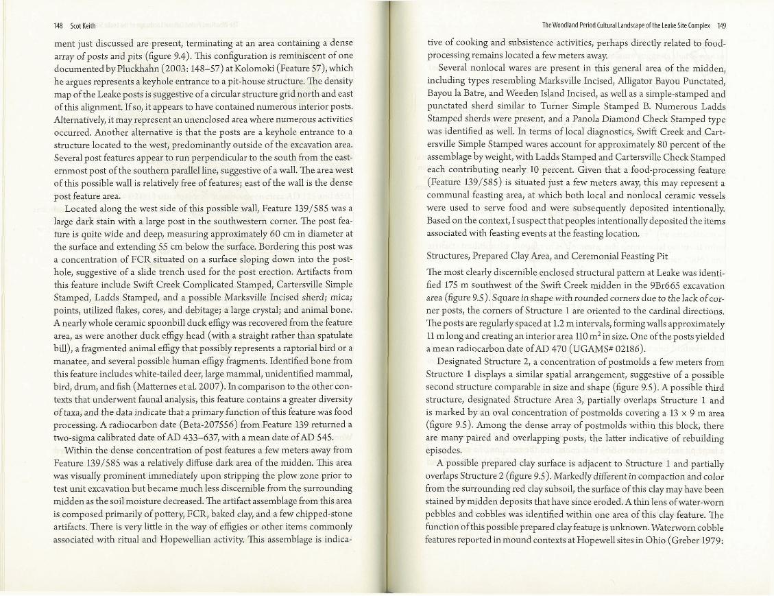
The most obvious post alignment in the Swift Creekmidden is a single liin- ear arrangement ofposts spanning a distance of 45 m (figure 9.4) (Southerlin 2002). The posts are similar in size and soil fill and are spaced at a regular in- terval of 1.7 m. If the azimuth of this post rowwas extended to the northeast, it would bisect Mound B (figure 9.4 inset). Coincidentally or not, this angle
HieWoodland Period Cultural Landscapeofthe Leake Site Complex 147
Excavation Area
Midden
Post
Pit, hearth, or other feature
Dark area in midden
Figure 9.4. Post alignments in Leake site's Swift Creek midden. Figure prepared by Scot Keith.
set (63"/243¡ is very close to those for the summer solstice sunrise (-61') and the winter solstice sunset (-241'). Southerlin (2002) interpreted this row of posts as a possible palisade. However, this line ofposts runs through the heart of the site, and palisade walls are not typically found at Middle Woodland mound centers. Rather than representing the remains of a palisade wall, this post row may represent evidence of a solar observatory associated with Mound B, which was historically described as conical (Fairbanks et al. 1946; Middleton 1883; Rogan 1883; Thomas 1894). Rigorous archaeo-astro- nomical analysis will be needed to test this hypothesis.
While there is a very dense concentration of posts within and under the midden, there are no clearly defined complete structural patterns, circular or oval, that are commonly interpreted as domestic houses in southeastern Woodland contexts. However, two parallel lines of posts mirroring the align-
Scot Keith
fig4
148 Scot Keith
ment just discussed are present, terminating at an area containing a dense array of posts and pits (figure 9.4). This configuration is reminiscent of one docnmentedby Pluckhahn (2003: 148-57) at Kolomoki (Feature 57), which he argues represents a keyhole entrance to a pit-house structure. The density map of the Leake posts is suggestive of a circular structure gridnorth and east of this alignment. If so, it appears to have contained numerous interior posts. Alternatively, it may represent an unenclosed area where numerous activities occurred. Another alternative is that the posts are a keyhole entrance to a structure located to the west, predominantly outside of the excavation area. Several post features appear to run perpendicular to the south from the east- ernmost post of the southern parallel line, suggestive of a wall. The areawest of this possible wall is relatively free of features; east of the wall is the dense post feature area.
Located along the west side of this possible wall, Feature 1391585 was a large dark stain with a large post in the southwestern comer. The post fea- ture is quite wide and deep, measuring approximately 60 cm in diameter at the surface and extending 55 cm below the surface. Bordering this post was a concentration of PCR situated on a surface sloping down into the post- hole, suggestive of a slide trench used for the post erection. Artifacts from this feature include Swift Creek Complicated Stamped, Cartersville Simple Stamped, Ladds Stamped, and a possible Marksville Incised sherd; mica; points, utilized flakes, cores, and debitage; a large crystal; and animal bone. A nearlywhole ceramic spoonbill duck effigy was recovered from the feature - -. area, as were another duck effigy head (with a straight rather than spatulate bill), a fragmented animal effigy that possibly represents a raptorial bird or a . - manatee, and several possible human effigy fragments. Identified bone from this feature includes white-tailed deer, large mammal, unidentified mammal, bird, drum, and fish (Matternes et al. 2007). In comparison to the other con- texts that underwent faunal analysis, this feature contains a greater diversity of taxa, and the dataindicate that aprimaryfunction of this feature was food processing. A radiocarbon date (Beta-207556) from Feature 139 returned a two-sigma calibrated date ofAD 433-637, with a mean date of AD 545.
Within the dense concentration of post features a few meters away from Feature 1391585 was a relatively diffuse dark area of the midden. This area was visually prominent immediately upon stripping the plow zone prior to test unit excavation but became much less discernible from the surrounding midden as the soilmoisture decreased. The artifact assemblage from this area is composed primarily of pottery, FCR, baked clay, and a few chipped-stone artifacts. There is very little in the way of effigies or other items commonly
TheWoodland Period Cultural Landscape ofthe Leake Site Complex 149
tive of cooking and subsistence activities, perhaps directly related to food- processing remains located a few meters away.
Several nonlocal wares are present in this general area of the midden, including types resembling Marksville Incised, Alligator Bayou Punctated, Bayou la Batre, and Weeden Island Incised, as well as a simple-stamped and punctated sherd similar to Turner Simple Stamped B. Numerous Ladds Stamped sherds were present, and a Panola Diamond Check Stamped type was identified as well. In terms of local diagnostics, Swift Creek and Cart- - ersville Simple Stamped wares account for approximately 80 percent of the assemblage by weight, with Ladds Stamped and Cartersville Check Stamped . .
each contributing nearly 10 percent. Given that a food-processing feature (Feature 139/585) is situated just a few meters away, this may represent a communal feasting area, at which both local and nonlocal ceramic vessels were used to serve food and were subsequently deposited intentionally. Based on the context, Isuspect that peoples intentionally deposited the items associated with feasting events at the feasting location.
Structures, Prepared Clay Area, and Ceremonial Feasting Pit
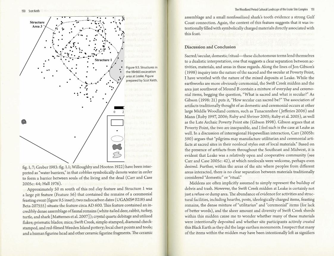
The most clearly discernible enclosed structural pattern at Leake was identi- fied 175 m southwest of the Swift Creek midden in the 9Br665 excavation area (figure 9.5). Square in shape with rounded corners due to the lack of cor- ner posts, the comers of Structure 1 are oriented to the cardinal directions. The posts are regularly spaced at 1.2 m intervals, forming walls approximately 11 mlongand creating aninterior area 110 m2insize. One ofthe posts yielded a mean radiocarbon date ofAD 470 (UGAMS* 02186).
Designated Structure 2, a concentration of postmolds a few meters from Structure 1 displays a similar spatial arrangement, suggestive of a possible second structure comparable in size and shape (figure 9.5). A possible third structure, designated Structure Area 3, partially overlaps Structure 1 and is marked by an oval concentration of postmolds covering a 13 x 9 m area " (figure 9.5). Among the dense array of postmolds within this block, there are many paired and overlapping posts, the latter indicative of rebuilding episodes.
A possible prepared clay surface is adjacent to Structure 1 and partially overlaps Structure 2 (figure 9.5). Markedly different in compaction and color from the surrounding red clay subsoil, the surface of this clay may have been stained by midden deposits that have since eroded. A thin lens ofwater-worn pebbles and cobbles was identified within one area of this clay feature. The function of this possible prepared day feature is unknown. Waterworn cobble features reported in mound contexts at HopeweU sites in Ohio (Greber 1979:
150 Scot Keith The Woodland Penodtultural Landscape ofthe Leake SiteComplex 151
assemblage and a small nonfossilized sharks tooth evidence a strong Gulf
Sacredlsecular, domestic/ritual-these dichotomous terms lend themselves
Figure 9.5. Structures in the 9Br665 excavation area at Leake. Figure prepared by Scot Keith.
fig. 1,7; Greber 1983: fig. l.l;WilloughbyandHooton 1922) havebeeninter- preted as "water barriers," in that cobbles symbolically denote water in order to form a barrier between souls of the living and the dead (Carr and Case 200%: 44; Hall 1976).
Approximately 50 m south of this red clay feature and Structure 1 was a large pit feature (Feature 56) that contained the remains of a ceremonial feasting event (figure 9.5 inset); two radiocarbon dates (UGAMS* 02185 and Beta-207555) situate the feature circa AD 600. This feature contained an in- credibly dense assemblage offaunal remains (white-tailed deer, rabbit, turkey, turtle, and shark [Matternes etal. 20071); crystal quartz debitage andutilized flakes; prismatic blades; mica; Swift Creek, simple-stamped, diamond check- stamped, and red-filmed WeedenIslandpottery; local chert points and tools; and a human figurine head and other ceramic figurine fragments. The ceramic
to a dualistic interpretation, one that suggests a clear separation between ac- tivities, materials, and areas in these regards. Along the lines of Jon Gibson's (1998) inquiry into the nature ofthe sacred and the secular at Poverty Point, I have wrestled with the nature of the mixed deposits at Leake. While the earthworks are more obviously ceremonial, the Swift Creekmidden and the area just southwest of Mound B contain a mixture of everyday and ceremo- nial items, begging the question, "What is sacred and what is secular?" As Gibson (1998: 21) puts it, "Howsecular can sacred be?" The association of artifacts traditionally thought of as domestic and ceremonial occurs at other large Middle Woodland centers, such as Tunacunnhee (Jefferies 2006) and Mann (Ruby 1997,2006; Ruby and Shriner 2005; Ruby et al. ZOOS), aswell as the Late Archaic Poverty Point site (Gibson 1998). Gibson argues that at Poverty Point, the two are inseparable, and I feel such is the case at Leake as well. In a discussion of interregional Hopewellian interaction, Carr (2005b: 590) argues that "pilgrims may manufacture utilitarian and ceremonial arti- facts at sacred sites in their nonlocal styles out of local materials." Based on the presence of artifacts from throughout the Southeast and Midwest, it is evident that Leake was a relatively open and cooperative community (see Carr and Case 2005c: 42), at which nonlocals were welcome, perhaps even desired. Further, within the areas of the site where peoples from different areas interacted, there is no clear separation between materials traditionally considered "domestic" or "ritual."
Middens are often implicitly assumed to simply represent the buildup of debris and trash. However, the Swift Creek midden at Leake is certainly not just a refuse or dump area. The abundance of evidence for activities and struc- tural facilities, including hearths, posts, ideologically charged items, feasting remains, the dense mixture of "utilitarian" and "ceremonial" items (for lack of better words), and the sheer amount and diversity of Swift Creek sherds within this midden cause me to wonder whether many of these materials were intentionally deposited and whether site participants actively created this BlackEarth as they did the large earthenmonuments. I suspect that many of the items within the midden may have been intentionally left as signifiers
Scot Keith
fig5

152 Scot Keith
of the participants and memorials of religious and ceremonial events, in an active creation of this sacred cultural landscape.
Material debris found at Leake, particularly within the Swift Creek mid- den, suggests that some of the activities were likely related to mortuary cer- emonies. Specifically, some of the debris of materials important within this system-mica, copper, graphite, hematite, and galena-may remain from the production of items to accompany those who were interred in local and regional caves. Discussions among Walthall, DeJarnette, and Kelly led them to posit a regional Hopewellian Copena-Cartersville mortuary tradition in the Tennessee River and Etowah/Coosa River drainages (Walthall 1980; Walthall and DeJarnette 1974). Downstream from Leake along the Coosa River in eastern Alabama, Walthall and DeJarnette (1974) argued that a vil- lage site (lTa9) and a nearby burial cave (Kymulga Cave) represent a site complex in which the village occupants were buried in the cave. Such may have been the case with Leake and surrounding burial caves in northwestern Georgia (Harris 1950; Kelly 1950, 1951, 1952). To date, no Middle Wood- land burials have been identified at the Leake site proper despite extensive excavations.
While this chapter is focused primarily on ceremonial contexts at the site, future investigation of the areas surrounding and outside the heart of the site-where the bulk of excavations have been conducted-may lead to insights regarding the nature of residential occupation and habitation at large centers. Are there deposits more similar to traditional "domestic" residential villages, remaining from peoples who lived at and near the site during the time it functioned as a large interregional center? Did groups establish hous- ing that they abandoned and reoccupied according to scheduled ceremonial events at the site? Did nonlocal peoples from different areas live together at the site? Might there have been group housing? Hopefully, the rapidly ex- panding modem cultural landscape will not erase this prehistoric landscape before such questions can be addressed.
Related Documents