ICARUS 119, 385–404 (1996) ARTICLE NO. 0026 The Volcanic and Tectonic History of Enceladus JEFFREY S. KARGEL U.S. Geological Survey, Flagstaff, Arizona 86001 E-mail: jkargel@iflag2.wr.usgs.gov AND STEFANIA POZIO Reparto di Planetologia, Viale dell’ Universita ` 11, 00185 Rome, Italy Received April 17, 1995; revised September 28, 1995 concentration of cracks or grabens and flattened, flooded, and rifted craters. Pit chains and cratered domes suggest explosive Enceladus has a protracted history of impact cratering, cryo- volcanism. Smooth plains may have formed by cryovolcanic volcanism, and extensional, compressional, and probable equivalents of flood-basalt volcanism. Pure H 2 O would be diffi- strike–slip faulting. It is unique in having some of the outer cult to extrude through an icy crust and is cosmochemically Solar System’s least and most heavily cratered surfaces. Encela- improbable as a cryovolcanic agent. Density relations rule out dus’ cratering record, tectonic features, and relief elements have eutectic brine lavas on Enceladus, but NH 3 –H 2 O volcanism been analyzed more comprehensively than done previously. is possible. Current steady-state tidal dissipation may cause Like few other icy satellites, Enceladus seems to have experi- melting of ammonia hydrate at a depth of p25 km if the crust enced major lateral lithospheric motions; it may be the only is made of ammonia hydrate or p100 km if it is made of water icy satellite with global features indicating probable lithospheric ice. 1996 Academic Press, Inc. convergence and folding. Ridged plains, 500 km across, consist of a central labyrinthine ridge complex atop a broad dome surrounded by smooth plains and peripheral sinuous ridge belts. 1. INTRODUCTION The ridged plains have few if any signs of extension, almost no craters, and an average age of just 10 7 to 10 8 years. Ridge Enceladus has a complex surface (Figs. 1–4) and a dy- belts have local relief ranging from 500 to 2000 m and tend to namic history despite its diminutive stature among icy sat- occur near the bottoms of broad regional troughs between swells. Our reanalysis of Peter Thomas’ (Dermott, S. F., and ellites (its disk, diameter 499 km, could fit within Arizona). P. C. Thomas, 1994, The determination of the mass and mean Pre-Voyager models suggested that large icy satellites density of Enceladus from its observed shape, Icarus, 109, 241– should be geologically evolved but Enceladus should not 257) limb profiles indicates that high peaks, probably ridge be (Consolmagno and Lewis 1978, Peale et al. 1980). Hints belts, also occur in unmapped areas. Sinuous ridges appear to the contrary came in 1980 from (1) Earth-based observa- foldlike and are similar to terrestrial fold belts such as the tions, which showed that Saturn’s tenuous E-ring may have Appalachians. If they are indeed folds, it may require that the been ejected from Enceladus (Baum et al. 1981), and (2) ridged plains are mechanically (perhaps volcanically) layered. low-resolution Voyager 1 images of Enceladus, which Regional topography suggests that folding may have occurred showed a high albedo and no large craters. Enceladus’ along zones of convective downwelling. The cratered plains, in extraordinary nature was recognized in Voyager 2’s high- contrast to the ridged plains, are heavily cratered and exhibit resolution (1–3 km/pixel) images of p43% of the satellite, extensional structures but no obvious signs of compression. Cratered plains contain a possible strike–slip fault (Isbanir which showed evidence of a protracted geologic history Fossa), along which two pairs of fractures seem to have 15 km with episodes of volcanism and tectonism (Smith et al. of right-lateral offset. The oldest cratered plains might date 1982) (Figs. 1–3). Many publications have contributed from shortly after the formation of the saturnian system or the knowledge of Enceladus’ shape, mean density, surface fea- impact disruption and reaccretion of Enceladus. Another area tures, and composition, photometry, geologic history, ther- of cratered plains has modified craters (e.g., Ali Baba and mal history, resurfacing mechanisms, and associations with Aladdin), which some workers have explained by anomalous Saturn’s E-ring. There has been no previous complete tec- heat flow and viscous relaxation; lateral shear and shield-build- tonic mapping of Enceladus in areas covered by Voyager ing volcanism also may have been important. A young rift-like structure (northern Samarkand Sulci) has few craters and a 2 images, no tectonic mapping at all in conventional projec- 385 0019-1035/96 $18.00 Copyright 1996 by Academic Press, Inc. All rights of reproduction in any form reserved.

Welcome message from author
This document is posted to help you gain knowledge. Please leave a comment to let me know what you think about it! Share it to your friends and learn new things together.
Transcript
ICARUS 119, 385–404 (1996)ARTICLE NO. 0026
The Volcanic and Tectonic History of Enceladus
JEFFREY S. KARGEL
U.S. Geological Survey, Flagstaff, Arizona 86001E-mail: [email protected]
AND
STEFANIA POZIO
Reparto di Planetologia, Viale dell’ Universita 11, 00185 Rome, Italy
Received April 17, 1995; revised September 28, 1995
concentration of cracks or grabens and flattened, flooded, andrifted craters. Pit chains and cratered domes suggest explosiveEnceladus has a protracted history of impact cratering, cryo-volcanism. Smooth plains may have formed by cryovolcanicvolcanism, and extensional, compressional, and probableequivalents of flood-basalt volcanism. Pure H2O would be diffi-strike–slip faulting. It is unique in having some of the outercult to extrude through an icy crust and is cosmochemicallySolar System’s least and most heavily cratered surfaces. Encela-improbable as a cryovolcanic agent. Density relations rule outdus’ cratering record, tectonic features, and relief elements haveeutectic brine lavas on Enceladus, but NH3–H2O volcanismbeen analyzed more comprehensively than done previously.is possible. Current steady-state tidal dissipation may causeLike few other icy satellites, Enceladus seems to have experi-melting of ammonia hydrate at a depth of p25 km if the crustenced major lateral lithospheric motions; it may be the onlyis made of ammonia hydrate or p100 km if it is made of watericy satellite with global features indicating probable lithosphericice. 1996 Academic Press, Inc.convergence and folding. Ridged plains, 500 km across, consist
of a central labyrinthine ridge complex atop a broad domesurrounded by smooth plains and peripheral sinuous ridge belts.
1. INTRODUCTIONThe ridged plains have few if any signs of extension, almostno craters, and an average age of just 107 to 108 years. Ridge
Enceladus has a complex surface (Figs. 1–4) and a dy-belts have local relief ranging from 500 to 2000 m and tend tonamic history despite its diminutive stature among icy sat-occur near the bottoms of broad regional troughs between
swells. Our reanalysis of Peter Thomas’ (Dermott, S. F., and ellites (its disk, diameter 499 km, could fit within Arizona).P. C. Thomas, 1994, The determination of the mass and mean Pre-Voyager models suggested that large icy satellitesdensity of Enceladus from its observed shape, Icarus, 109, 241– should be geologically evolved but Enceladus should not257) limb profiles indicates that high peaks, probably ridge be (Consolmagno and Lewis 1978, Peale et al. 1980). Hintsbelts, also occur in unmapped areas. Sinuous ridges appear to the contrary came in 1980 from (1) Earth-based observa-foldlike and are similar to terrestrial fold belts such as the tions, which showed that Saturn’s tenuous E-ring may haveAppalachians. If they are indeed folds, it may require that the
been ejected from Enceladus (Baum et al. 1981), and (2)ridged plains are mechanically (perhaps volcanically) layered.low-resolution Voyager 1 images of Enceladus, whichRegional topography suggests that folding may have occurredshowed a high albedo and no large craters. Enceladus’along zones of convective downwelling. The cratered plains, inextraordinary nature was recognized in Voyager 2’s high-contrast to the ridged plains, are heavily cratered and exhibitresolution (1–3 km/pixel) images of p43% of the satellite,extensional structures but no obvious signs of compression.
Cratered plains contain a possible strike–slip fault (Isbanir which showed evidence of a protracted geologic historyFossa), along which two pairs of fractures seem to have 15 km with episodes of volcanism and tectonism (Smith et al.of right-lateral offset. The oldest cratered plains might date 1982) (Figs. 1–3). Many publications have contributedfrom shortly after the formation of the saturnian system or the knowledge of Enceladus’ shape, mean density, surface fea-impact disruption and reaccretion of Enceladus. Another area tures, and composition, photometry, geologic history, ther-of cratered plains has modified craters (e.g., Ali Baba and
mal history, resurfacing mechanisms, and associations withAladdin), which some workers have explained by anomalousSaturn’s E-ring. There has been no previous complete tec-heat flow and viscous relaxation; lateral shear and shield-build-tonic mapping of Enceladus in areas covered by Voyagering volcanism also may have been important. A young rift-like
structure (northern Samarkand Sulci) has few craters and a 2 images, no tectonic mapping at all in conventional projec-
3850019-1035/96 $18.00
Copyright 1996 by Academic Press, Inc.All rights of reproduction in any form reserved.
386 KARGEL AND POZIO
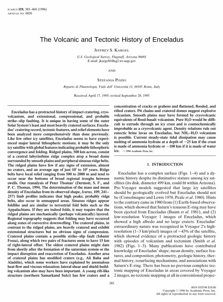
FIG. 1. Image of Enceladus (diameter 499.4 km). White lines show locations of photoclinometric profile a across Isbanir Fossa, profile b acrossa trough, and profiles c and d across Samarkand Sulci. Resolution 1.07 km per pixel. Voyager image 44004.32.
tions, and no comprehensive analysis of Enceladus’ crater- brush map (Fig. 4) as a controlled base, processed imagesfor interpretation and measurement of selected features,ing record as observed by Voyager 2. In this paper, we
examine Enceladus’ tectonic and cratering histories and and limb and photoclinometric profiles for validation oftectonic mapping and measurement of relief. A tectonicsurface landforms more completely than ever before. Digi-
tal limb profiles (originally reported by Dermott and map was prepared by each author, first independently andthen collaboratively (Pozio and Kargel 1989). TopographicThomas (1994) and generously provided by Peter Thomas)
and photoclinometric profiles have been used in a detailed profiles produced by limb fitting and photoclinometry(Figs. 6 and 7) were used for confirmation or revision ofanalysis and modeling of Enceladus’ regional topography
and local relief. Enceladus’ cratering record is used to our interpretations and production of the final tectonic andgeologic terrain maps of Enceladus (Fig. 5).deduce a relative history of cryovolcanism and tectonism.
Crater counts. Abrupt changes in the density of craters2. OBSERVATIONS on Enceladus occur along major tectonic contacts, a fact
recognized during early studies of Voyager data (Smith et2.1. Methods
al. 1982). The most extensive previous study of Enceladus’cratering record was by Plescia and Boyce (1983), whoTectonic mapping. Tectonic features on Enceladus
were mapped using the U.S. Geological Survey (1992) air- determined crater densities for four sample regions totaling

THE VOLCANIC AND TECTONIC HISTORY OF ENCELADUS 387
36,000 km2 (p5% of the surface) and containing 112 craterslarger than 5 km. Extending this type of data to the wholesurface of Enceladus visible at high resolutions, we at-tempted to count and measure every observable craterlarger than 2.83 (2Ï2) km in diameter (Pozio and Kargel1990). This lower limit is too small for complete counts,but it ensures that counts at some larger diameter are ascomplete as possible. Rim-to-rim diameters were mea-sured and grouped by terrain (Fig. 5b) into Ï2 diameterbins. A summary of results for craters larger than 5.66 km(p6 pixels in the best images) is given in Table I and Fig.8. Counts for craters $5.66 km in diameter (453 in all)appear to be virtually complete for almost all of the 43%(337,000 km2) of Enceladus’ surface covered by high-reso-lution images (counts near the subsolar point or too nearthe limb were not attempted). Counts for craters smallerthan 5.66 km in diameter generally are incomplete due toresolution limits.
Limb profiles. Limb measurements taken from Voy-ager 2 images of Enceladus were originally made and math-ematically fitted by Dermott and Thomas (1994), who ana-lyzed their data extensively in terms of the shape ofEnceladus but gave little attention to geology. Those au-thors gave graphical presentations of 5 of their 11 profiles,but these were published at too small a scale to be veryuseful for geological analysis. Peter Thomas generouslyprovided all 11 digital profiles to aid this study (Fig. 6).Figure 4 shows the locations of the profile lines, numberedin order of decreasing distance of Voyager 2 to Enceladus(increasing spatial resolution).
The limb profiles are residuals after subtraction fromthe limb figures of best-fit triaxial ellipsoids, which accountfor .90% of variance from sphericity. Dermott andThomas (1994) analyzed their fits with the assumption thatEnceladus is in hydrostatic equilibrium; their analysisyielded a precise calculation of Enceladus’ mean density(either 1.00 6 0.03 g cm23 or 1.12 6 0.05 g cm23, dependingon assumptions). The residuals are interpreted as local andregional topography. Vertical precision of nearby pixels isestimated as better than 2s p 0.2 pixels (200–700 m, imagedependent). Uncertainties in positioning of reseau marksused in limb fitting is 60.1 pixels, which may have intro-duced low-frequency errors with amplitudes up to 0.2 pix-els (200–700 m) and wavelengths of 80 pixels (85–285 km).The total error of residuals (elevation accuracy) is esti-mated as 300–1000 m (image dependent), which includesa high-frequency error component due to imprecision inlimb locations and a low-frequency error due to reseau-mark positioning. Locations of sharp features in the air-
FIG. 2. Image showing terrain near terminator of Enceladus. Whitebrush map (Fig. 4) and in limb profiles are mostly consistentlines show locations of photoclinometric profiles across three craters withto 62 km.central domes (Ali Baba, profile f; Aladdin, profile g; and a smaller crater
west of Aladdin, profile h). Arrows identify a pit chain discussed in text. Minor limb features can be identified in each of a set ofResolution 0.99 km per pixel. Voyager image 44004.36. closely spaced profiles. Major limb features commonly
have corresponding markings in the shaded-relief map.
388 KARGEL AND POZIO
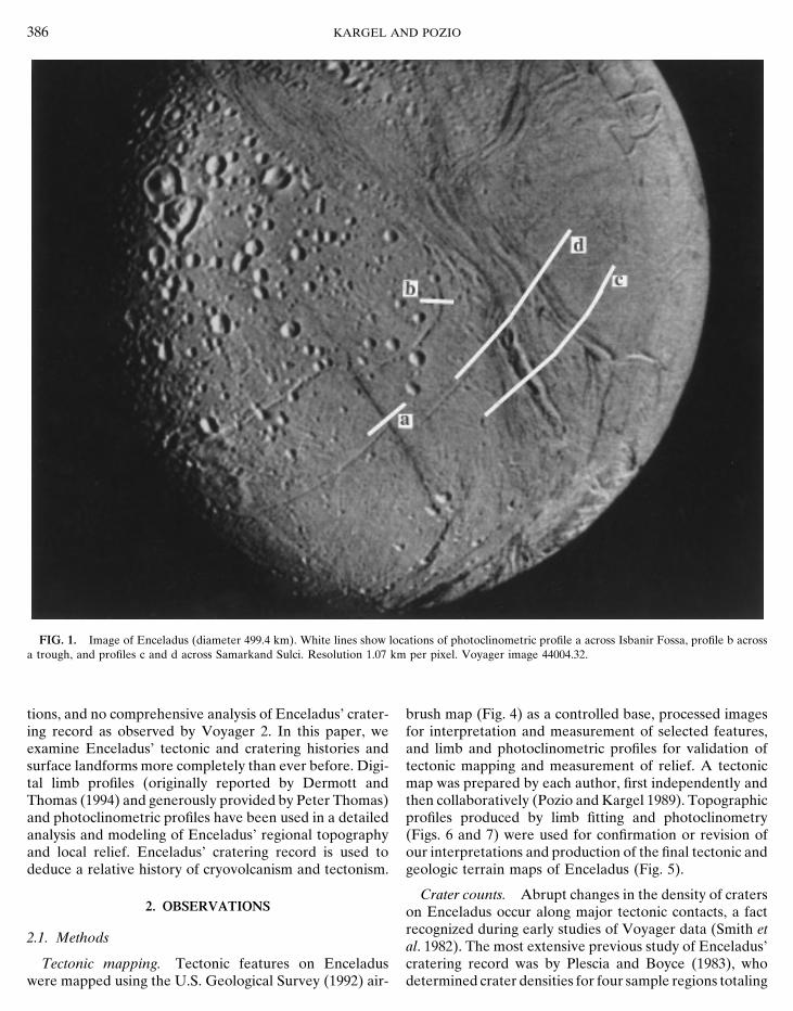
FIG. 3. Image centered on ridged plains. Arrows identify a cratered dome discussed in text. Resolution 1.8 km per pixel. Voyager image 44000.48.
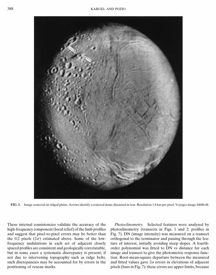
These internal consistencies validate the accuracy of the Photoclinometry. Selected features were analyzed byphotoclinometry (transects in Figs. 1 and 2; profiles inhigh-frequency component (local relief) of the limb profiles
and suggest that pixel-to-pixel errors may be better than Fig. 7). DN (image intensity) was measured on a transectorthogonal to the terminator and passing through the fea-the 0.2 pixels (2s) estimated above. Some of the low-
frequency undulations in each set of adjacent closely ture of interest, initially avoiding steep slopes. A fourth-order polynomial was fitted to DN vs distance for eachspaced profiles are consistent and geologically correlatable,
but in some cases a systematic discrepancy is present; if image and transect to give the photometric response func-tion. Root-mean-square departure between the measurednot due to intervening topography such as ridge belts,
such discrepancies may be accounted for by errors in the and fitted values gave 2s errors in elevations of adjacentpixels (bars in Fig. 7); these errors are upper limits, becausepositioning of reseau marks.
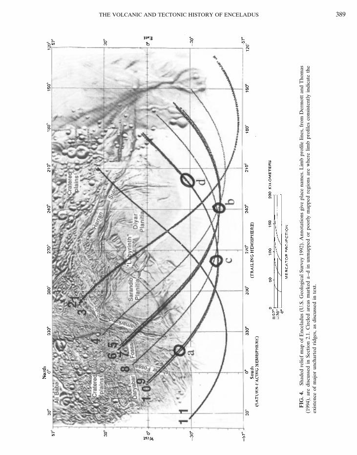
THE VOLCANIC AND TECTONIC HISTORY OF ENCELADUS 389
FIG
.4.
Shad
edre
lief
map
ofE
ncel
adus
(U.S
.Geo
logi
calS
urve
y19
92).
Ann
otat
ions
give
plac
ena
mes
.Lim
bpr
ofile
lines
,fro
mD
erm
ott
and
Tho
mas
(199
4),
are
disc
usse
din
Sect
ion
2.1.
Cir
cled
area
sm
arke
da–
din
unm
appe
dor
poor
lym
appe
dre
gion
sar
ew
here
limb
profi
les
cons
iste
ntly
indi
cate
the
exis
tenc
eof
maj
orun
char
ted
ridg
es,
asdi
scus
sed
inte
xt.
390 KARGEL AND POZIO
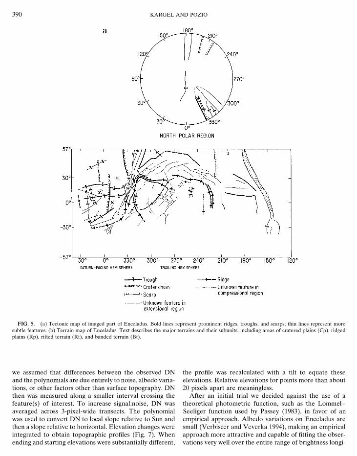
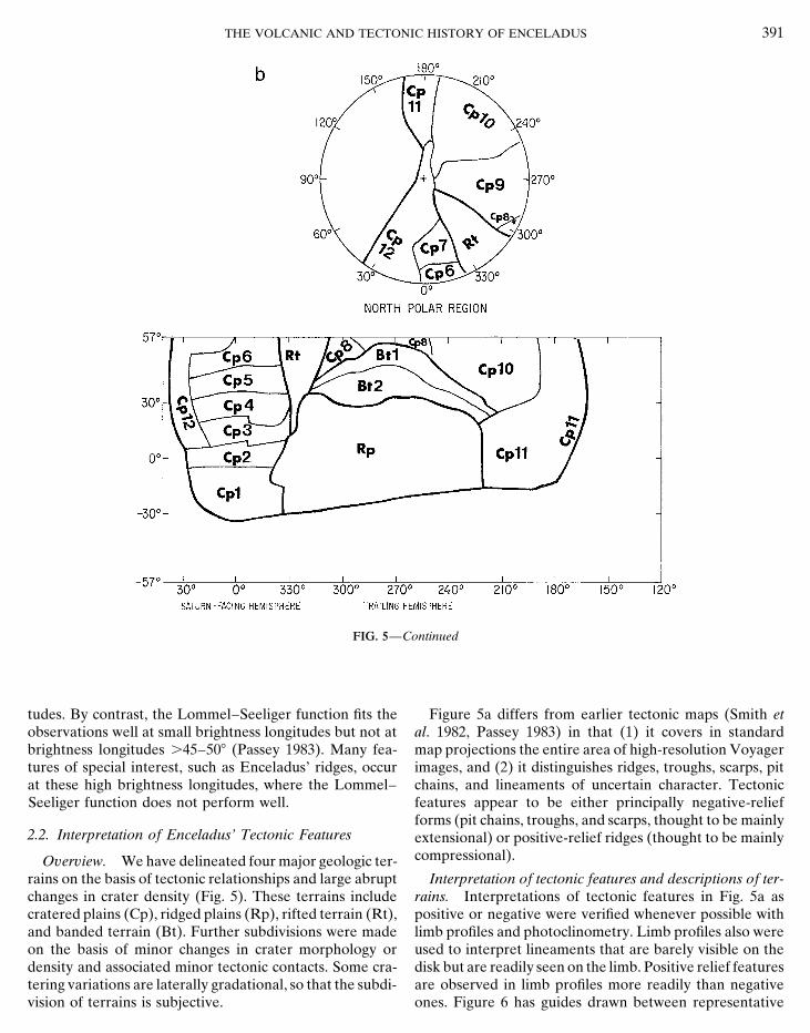
FIG. 5. (a) Tectonic map of imaged part of Enceladus. Bold lines represent prominent ridges, troughs, and scarps; thin lines represent moresubtle features. (b) Terrain map of Enceladus. Text describes the major terrains and their subunits, including areas of cratered plains (Cp), ridgedplains (Rp), rifted terrain (Rt), and banded terrain (Bt).
we assumed that differences between the observed DN the profile was recalculated with a tilt to equate theseelevations. Relative elevations for points more than aboutand the polynomials are due entirely to noise, albedo varia-
tions, or other factors other than surface topography. DN 20 pixels apart are meaningless.After an initial trial we decided against the use of athen was measured along a smaller interval crossing the
feature(s) of interest. To increase signal:noise, DN was theoretical photometric function, such as the Lommel–Seeliger function used by Passey (1983), in favor of anaveraged across 3-pixel-wide transects. The polynomial
was used to convert DN to local slope relative to Sun and empirical approach. Albedo variations on Enceladus aresmall (Verbiscer and Veverka 1994), making an empiricalthen a slope relative to horizontal. Elevation changes were
integrated to obtain topographic profiles (Fig. 7). When approach more attractive and capable of fitting the obser-vations very well over the entire range of brightness longi-ending and starting elevations were substantially different,
THE VOLCANIC AND TECTONIC HISTORY OF ENCELADUS 391
FIG. 5—Continued
tudes. By contrast, the Lommel–Seeliger function fits the Figure 5a differs from earlier tectonic maps (Smith etal. 1982, Passey 1983) in that (1) it covers in standardobservations well at small brightness longitudes but not at
brightness longitudes .45–508 (Passey 1983). Many fea- map projections the entire area of high-resolution Voyagerimages, and (2) it distinguishes ridges, troughs, scarps, pittures of special interest, such as Enceladus’ ridges, occur
at these high brightness longitudes, where the Lommel– chains, and lineaments of uncertain character. Tectonicfeatures appear to be either principally negative-reliefSeeliger function does not perform well.forms (pit chains, troughs, and scarps, thought to be mainly
2.2. Interpretation of Enceladus’ Tectonic Features extensional) or positive-relief ridges (thought to be mainlycompressional).Overview. We have delineated four major geologic ter-
rains on the basis of tectonic relationships and large abrupt Interpretation of tectonic features and descriptions of ter-rains. Interpretations of tectonic features in Fig. 5a aschanges in crater density (Fig. 5). These terrains include
cratered plains (Cp), ridged plains (Rp), rifted terrain (Rt), positive or negative were verified whenever possible withlimb profiles and photoclinometry. Limb profiles also wereand banded terrain (Bt). Further subdivisions were made
on the basis of minor changes in crater morphology or used to interpret lineaments that are barely visible on thedisk but are readily seen on the limb. Positive relief featuresdensity and associated minor tectonic contacts. Some cra-
tering variations are laterally gradational, so that the subdi- are observed in limb profiles more readily than negativeones. Figure 6 has guides drawn between representativevision of terrains is subjective.
392 KARGEL AND POZIO
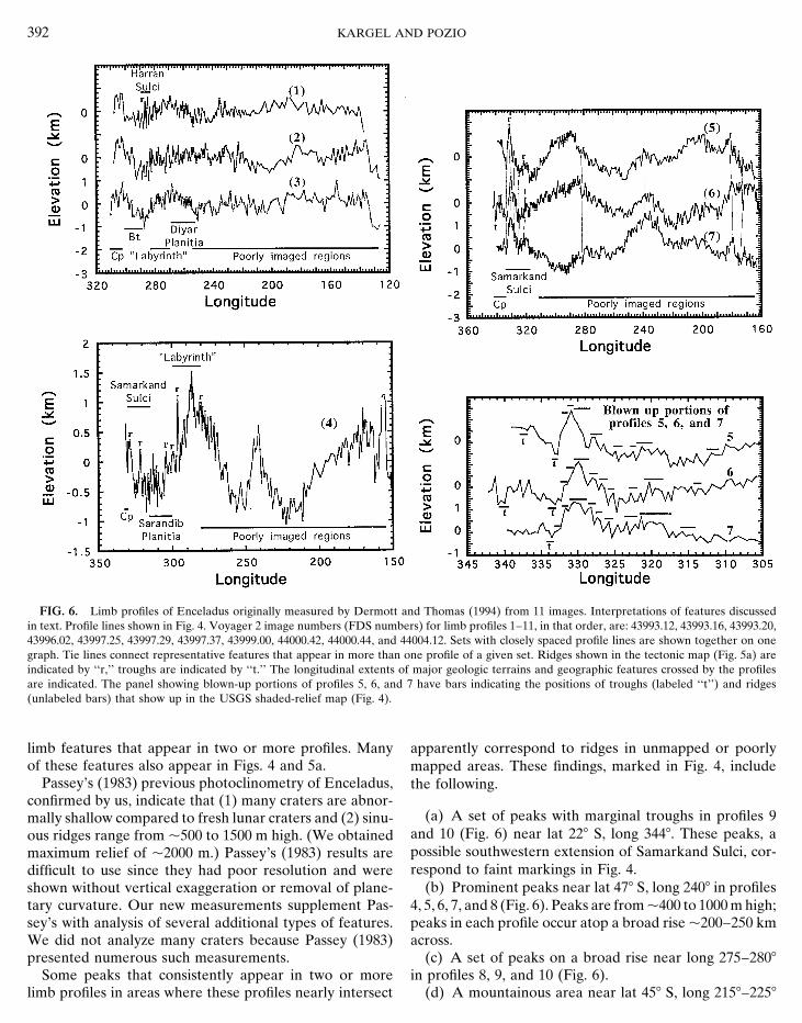
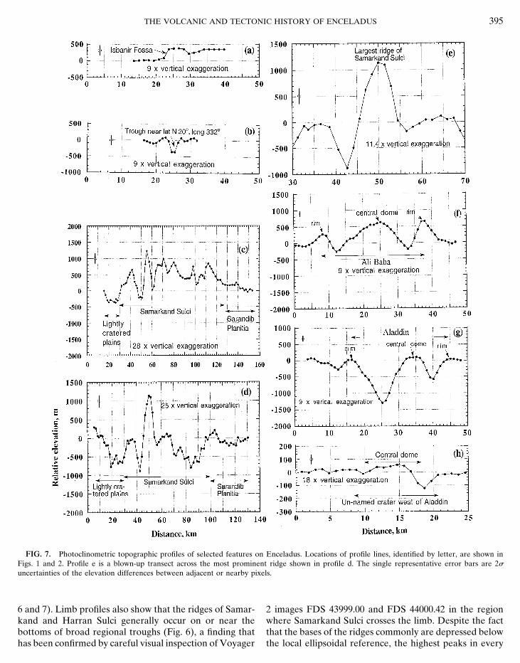
FIG. 6. Limb profiles of Enceladus originally measured by Dermott and Thomas (1994) from 11 images. Interpretations of features discussedin text. Profile lines shown in Fig. 4. Voyager 2 image numbers (FDS numbers) for limb profiles 1–11, in that order, are: 43993.12, 43993.16, 43993.20,43996.02, 43997.25, 43997.29, 43997.37, 43999.00, 44000.42, 44000.44, and 44004.12. Sets with closely spaced profile lines are shown together on onegraph. Tie lines connect representative features that appear in more than one profile of a given set. Ridges shown in the tectonic map (Fig. 5a) areindicated by ‘‘r,’’ troughs are indicated by ‘‘t.’’ The longitudinal extents of major geologic terrains and geographic features crossed by the profilesare indicated. The panel showing blown-up portions of profiles 5, 6, and 7 have bars indicating the positions of troughs (labeled ‘‘t’’) and ridges(unlabeled bars) that show up in the USGS shaded-relief map (Fig. 4).
limb features that appear in two or more profiles. Many apparently correspond to ridges in unmapped or poorlymapped areas. These findings, marked in Fig. 4, includeof these features also appear in Figs. 4 and 5a.
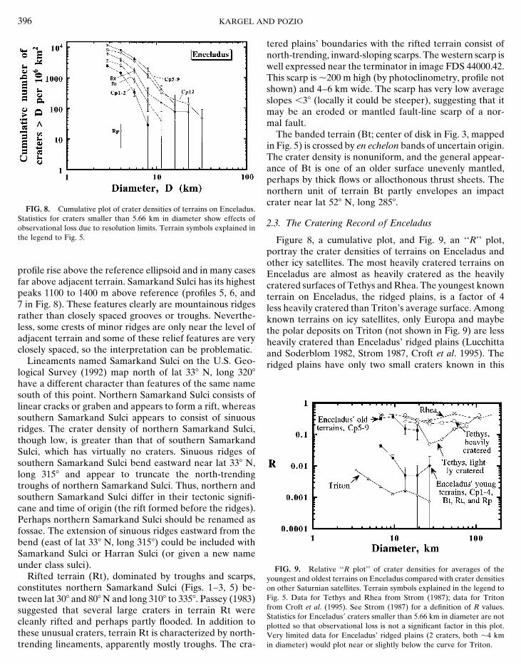
Passey’s (1983) previous photoclinometry of Enceladus, the following.confirmed by us, indicate that (1) many craters are abnor-
(a) A set of peaks with marginal troughs in profiles 9mally shallow compared to fresh lunar craters and (2) sinu-and 10 (Fig. 6) near lat 228 S, long 3448. These peaks, aous ridges range from p500 to 1500 m high. (We obtainedpossible southwestern extension of Samarkand Sulci, cor-maximum relief of p2000 m.) Passey’s (1983) results arerespond to faint markings in Fig. 4.difficult to use since they had poor resolution and were
(b) Prominent peaks near lat 478 S, long 2408 in profilesshown without vertical exaggeration or removal of plane-4, 5, 6, 7, and 8 (Fig. 6). Peaks are from p400 to 1000 m high;tary curvature. Our new measurements supplement Pas-
sey’s with analysis of several additional types of features. peaks in each profile occur atop a broad rise p200–250 kmacross.We did not analyze many craters because Passey (1983)
presented numerous such measurements. (c) A set of peaks on a broad rise near long 275–2808in profiles 8, 9, and 10 (Fig. 6).Some peaks that consistently appear in two or more
limb profiles in areas where these profiles nearly intersect (d) A mountainous area near lat 458 S, long 2158–2258
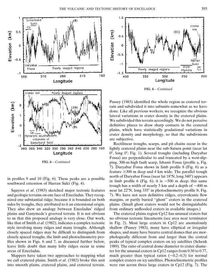
THE VOLCANIC AND TECTONIC HISTORY OF ENCELADUS 393
FIG. 6—Continued
Passey (1983) identified the whole region as cratered ter-rain and subdivided it into subunits somewhat as we havedone. Like all previous workers, we recognize the obviouslateral variations in crater density in the cratered plains.We subdivided this terrain accordingly. We do not perceivedefinitive places to draw sharp contacts in the crateredplains, which have statistically gradational variations incrater density and morphology, so that the subdivisionsare subjective.
Rectilinear troughs, scarps, and pit chains occur in thelightly cratered plains near the sub-Saturn point (near lat08, long 08; Fig. 1). Several troughs (including DaryabarFossa) are perpendicular to and truncated by a west-dip-
FIG. 6—Continued ping, 300-m-high fault scarp, Isbanir Fossa (profile a, Fig.7). Daryabar Fossa shows in limb profile 8 (Fig. 6) as afeature $300 m deep and 4 km wide. The parallel troughnorth of Daryabar Fossa (near lat 188N, long 3408) appears
in profiles 9 and 10 (Fig. 6). These peaks are a possiblein limb profile 6 (Fig. 6); it is p500 m deep; this same
southward extension of Harran Sulci (Fig. 4).trough has a width of nearly 5 km and a depth of p400 mnear lat 228N, long 3358 in photoclinometry profile b, Fig.Squyres et al. (1983) sketched major tectonic features
and geologic terrains on one face of Enceladus. They recog- 7). We have not seen definitive ridges, cryovolcanic flowmargins, or partly buried ‘‘ghost’’ craters in the craterednized one substantial ridge; because it is bounded on both
sides by troughs, they attributed to it an extensional origin. plains. (Small ghost craters would not be distinguishablefrom ordinary unflooded craters in available images.)They also drew an analogy between Enceladus’ ridged
plains and Ganymede’s grooved terrain. It is not obvious The cratered plains region Cp12 has unusual craters butno obvious tectonic lineaments (see area near terminatorto us that this proposed analogy is very close. Our work,
like that of Smith et al. (1982), indicates a complex tectonic in Fig. 2). Most large craters in Cp12 are anomalouslyshallow (Passey 1983), many have elliptical or irregularstyle involving many ridges and many troughs. Although
closely spaced ridges may be difficult to distinguish from shapes, and many have bizarre central domes that are mor-phologically different from and larger than the centralclosely spaced troughs, the limb and photoclinometry pro-
files shown in Figs. 6 and 7, as discussed further below, peaks of typical complex craters on icy satellites (Schenk1989). The ratio of central dome diameter to crater diame-leave little doubt that many lofty ridges occur in some
areas of Enceladus. ter for the unusual craters in Cp12 ranges from 0.50 to 0.77,much greater than typical ratios (p0.2–0.3) for normalMappers have taken two approaches to mapping what
we call cratered plains. Smith et al. (1982) broke this unit complex craters on icy satellites. Photoclinometric profileswere run across three large craters in Cp12 (Fig. 7). Theinto smooth plains, cratered plains, and cratered terrain.
394 KARGEL AND POZIO
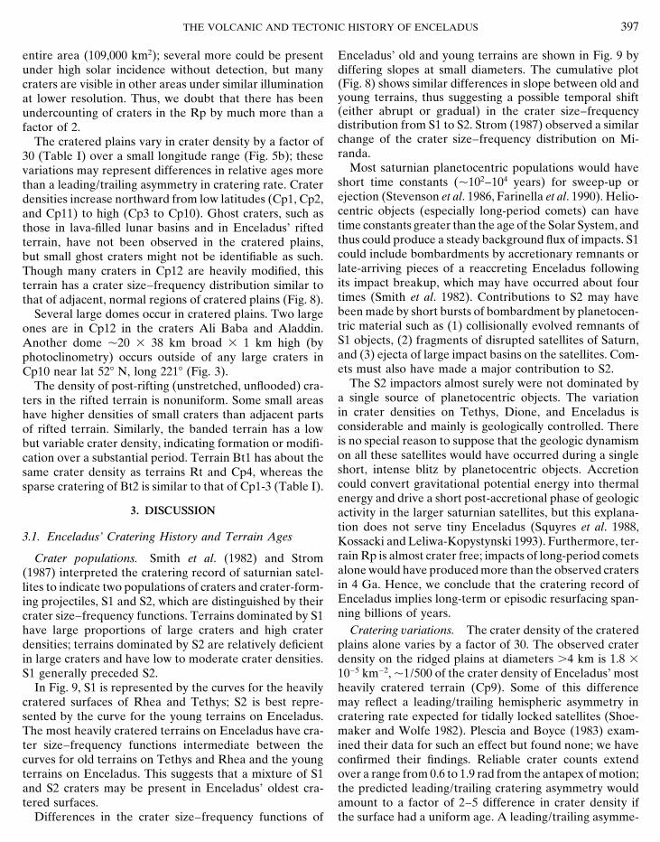
TABLE ICrater Counts of Terrains on Enceladus
Cumulative crater statisticsa
Area countedTerrainb (km2) N5.66 N8.0 N11.31 N16 N22.63 N32
Cp1 22,400 446 6 141 45 6 45 0 0 0 0Cp2 13,000 154 6 109 0 0 0 0 0Cp3 11,400 789 6 263 351 6 175 0 0 0 0Cp4 12,000 2083 6 417 417 6 186 83 6 83 0 0 0Cp5 7,940 4156 6 723 1637 6 454 379 6 218 0 0 0
Cp6 6,340 3785 6 773 2050 6 569 473 6 273 158 6 158 0 0Cp7 2,850 4211 6 1215 2105 6 859 351 6 351 351 6 351 0 0Cp8 2,440 3687 6 1229 2458 6 1003 409 6 409 0 0 0Cp9 11,080 5054 6 675 1715 6 393 451 6 202 181 6 128 0 0Cp10 28,900 3218 6 334 1626 6 237 692 6 155 277 6 98 69 6 49 0
Cp11 53,000 1189 6 150 340 6 80 38 6 27 0 0 0Cp12 21,400 3505 6 405 1215 6 238 327 6 124 187 6 93 140 6 81 47 6 47Bt1 9,370 1601 6 413 213 6 151 107 6 107 107 6 107 0 0Bt2 15,900 377 6 154 126 6 89 0 0 0 0Rt 12,900 1783 6 372 310 6 155 155 6 110 78 6 78 78 6 78 0Rpc 109,000 0 0 0 0 0 0
Cp1-2 35,400 339 6 98 28 6 28 0 0 0 0Cp5-9 30,650 4372 6 378 1860 6 246 424 6 118 131 6 66 0 0Bt1-2 25,270 831 6 413 213 6 151 107 6 107 107 6 107 0 0Avg. Enceladus 339,920 1341 6 63 491 6 38 138 6 20 56 6 13 17.7 6 7 2.9 6 2.9
a N values are the cumulative numbers of craters larger than or equal to the given diameter (in km) per 106 km2. Counts for craterssmaller than 5.66 km are observationally incomplete due to resolution limits of the imagery. Uncertainties are tabulated at the 1slevel (approximated as N 3 (Ïn/n), where n is the actual number of craters counted. The interested reader may recalculate n foreach measurement by multiplying N 3 (area counted/106 km2).
b Cp is the cratered plains, Bt is the banded terrain, Rt is the rifted terrain, and Rp is the ridged plains. The locations of these unitsand their subdivisions are shown in Fig. 5b.
c Only two small craters were counted in Rp, giving it a crater density of N4 5 18 6 13.
summits of the central domes of these craters are as high plains and their bounding curvilinear ridges is intriguingbut of uncertain geotectonic significance (Fig. 5a). Mostas if not higher than the crater rims, a feature not normally
seen in ordinary complex impact craters. In the case of Ali lineaments in the labyrinth lack shadows or other clearlyinterpretable signs of relief because they are near the sub-Baba, the central dome extends 600 m above the level of
adjoining plains. Consistent with Passey’s (1983) findings, solar point in the best images (Fig. 3). Only one featurein the labyrinth is clearly expressed as a ridge when viewedwe observe that the depth to diameter ratios of these cra-
ters range from 0.010 to 0.045, shallower than normal com- against the disk of Enceladus. Limb profile 4 (Fig. 6) cutsdirectly across the labyrinth and shows that at least twoplex craters of this size on small icy satellites.
The ridged plains (Rp), 500 km across, consist of a cen- lineaments in the airbrush map are in fact ridges, in onecase over 1000 m high locally. Other lineaments crossedtral labyrinthine lineament complex 100 km across, a sur-
rounding set of smooth plains (Sarandib and Diyar Plani- in the labyrinth by profiles 1–4 are too closely spaced tobe certain of their character, although we suspect that mosttiae), and a peripheral system of sinuous ridge belts totaling
at least 750 km in length (Harran Sulci and southern Sa- if not all of them are ridges. The labyrinth occurs on abroad regional high (profiles 4, Fig. 6); this and the linearmarkand Sulci with its eastern extension). Possible south-
ern extensions of the sinuous ridges were seen in limb character of the labyrinth’s ridges distinguish them fromthe sinuous ridges at the margins of the Rp.profiles 9, 10, and 11 (Fig. 6) but were poorly imaged
against the disk. The major ridges of southern Samarkand Sulci and Har-ran Sulci characteristically have rounded or sharply crestedThe Rp appears to be centered on the trailing point or
antapex of Enceladus’ orbital motion, where the tectonic tops (Fig. 7). Photoclinometry and limb profiling show thatthe major ridges are 500 to 2000 m high and have marginal‘‘labyrinth’’ occurs (Fig. 4; Fig. 3, right). The nearly sym-
metric tectonic relation of this rectilinear grid to the ridged troughs (Passey 1983, Dermott and Thomas 1994) (Figs.
THE VOLCANIC AND TECTONIC HISTORY OF ENCELADUS 395
FIG. 7. Photoclinometric topographic profiles of selected features on Enceladus. Locations of profile lines, identified by letter, are shown inFigs. 1 and 2. Profile e is a blown-up transect across the most prominent ridge shown in profile d. The single representative error bars are 2suncertainties of the elevation differences between adjacent or nearby pixels.
6 and 7). Limb profiles also show that the ridges of Samar- 2 images FDS 43999.00 and FDS 44000.42 in the regionwhere Samarkand Sulci crosses the limb. Despite the factkand and Harran Sulci generally occur on or near the
bottoms of broad regional troughs (Fig. 6), a finding that that the bases of the ridges commonly are depressed belowthe local ellipsoidal reference, the highest peaks in everyhas been confirmed by careful visual inspection of Voyager
396 KARGEL AND POZIO
tered plains’ boundaries with the rifted terrain consist ofnorth-trending, inward-sloping scarps. The western scarp iswell expressed near the terminator in image FDS 44000.42.This scarp is p200 m high (by photoclinometry, profile notshown) and 4–6 km wide. The scarp has very low averageslopes ,38 (locally it could be steeper), suggesting that itmay be an eroded or mantled fault-line scarp of a nor-mal fault.
The banded terrain (Bt; center of disk in Fig. 3, mappedin Fig. 5) is crossed by en echelon bands of uncertain origin.The crater density is nonuniform, and the general appear-ance of Bt is one of an older surface unevenly mantled,perhaps by thick flows or allocthonous thrust sheets. Thenorthern unit of terrain Bt partly envelopes an impactcrater near lat 528 N, long 2858.
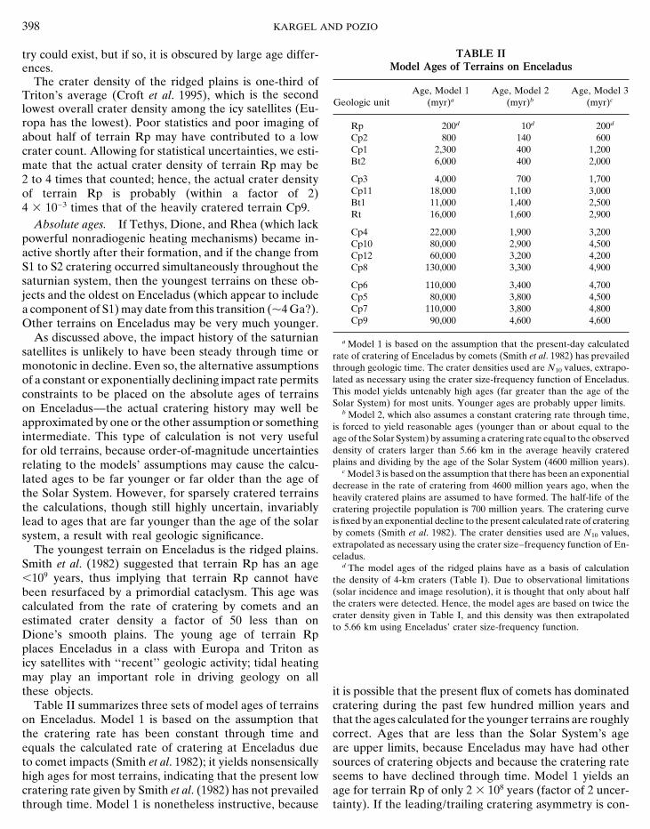
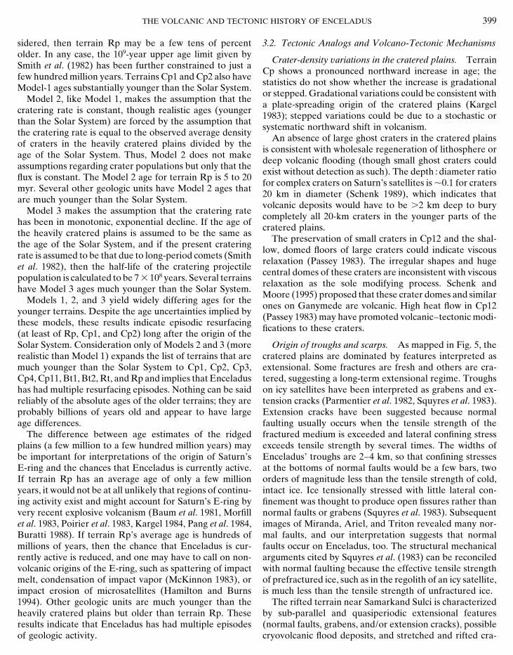
FIG. 8. Cumulative plot of crater densities of terrains on Enceladus.Statistics for craters smaller than 5.66 km in diameter show effects of 2.3. The Cratering Record of Enceladusobservational loss due to resolution limits. Terrain symbols explained inthe legend to Fig. 5. Figure 8, a cumulative plot, and Fig. 9, an ‘‘R’’ plot,
portray the crater densities of terrains on Enceladus andother icy satellites. The most heavily cratered terrains on
profile rise above the reference ellipsoid and in many cases Enceladus are almost as heavily cratered as the heavilyfar above adjacent terrain. Samarkand Sulci has its highest cratered surfaces of Tethys and Rhea. The youngest knownpeaks 1100 to 1400 m above reference (profiles 5, 6, and terrain on Enceladus, the ridged plains, is a factor of 47 in Fig. 8). These features clearly are mountainous ridges less heavily cratered than Triton’s average surface. Amongrather than closely spaced grooves or troughs. Neverthe- known terrains on icy satellites, only Europa and maybeless, some crests of minor ridges are only near the level of the polar deposits on Triton (not shown in Fig. 9) are lessadjacent terrain and some of these relief features are very heavily cratered than Enceladus’ ridged plains (Lucchittaclosely spaced, so the interpretation can be problematic. and Soderblom 1982, Strom 1987, Croft et al. 1995). The
Lineaments named Samarkand Sulci on the U.S. Geo- ridged plains have only two small craters known in thislogical Survey (1992) map north of lat 338 N, long 3208have a different character than features of the same namesouth of this point. Northern Samarkand Sulci consists oflinear cracks or graben and appears to form a rift, whereassouthern Samarkand Sulci appears to consist of sinuousridges. The crater density of northern Samarkand Sulci,though low, is greater than that of southern SamarkandSulci, which has virtually no craters. Sinuous ridges ofsouthern Samarkand Sulci bend eastward near lat 338 N,long 3158 and appear to truncate the north-trendingtroughs of northern Samarkand Sulci. Thus, northern andsouthern Samarkand Sulci differ in their tectonic signifi-cane and time of origin (the rift formed before the ridges).Perhaps northern Samarkand Sulci should be renamed asfossae. The extension of sinuous ridges eastward from thebend (east of lat 338 N, long 3158) could be included withSamarkand Sulci or Harran Sulci (or given a new nameunder class sulci). FIG. 9. Relative ‘‘R plot’’ of crater densities for averages of the
Rifted terrain (Rt), dominated by troughs and scarps, youngest and oldest terrains on Enceladus compared with crater densitieson other Saturnian satellites. Terrain symbols explained in the legend toconstitutes northern Samarkand Sulci (Figs. 1–3, 5) be-Fig. 5. Data for Tethys and Rhea from Strom (1987); data for Tritontween lat 308 and 808 N and long 3108 to 3358. Passey (1983)from Croft et al. (1995). See Strom (1987) for a definition of R values.suggested that several large craters in terrain Rt wereStatistics for Enceladus9 craters smaller than 5.66 km in diameter are not
cleanly rifted and perhaps partly flooded. In addition to plotted so that observational loss is not a significant factor in this plot.these unusual craters, terrain Rt is characterized by north- Very limited data for Enceladus’ ridged plains (2 craters, both p4 km
in diameter) would plot near or slightly below the curve for Triton.trending lineaments, apparently mostly troughs. The cra-
THE VOLCANIC AND TECTONIC HISTORY OF ENCELADUS 397
entire area (109,000 km2); several more could be present Enceladus’ old and young terrains are shown in Fig. 9 bydiffering slopes at small diameters. The cumulative plotunder high solar incidence without detection, but many
craters are visible in other areas under similar illumination (Fig. 8) shows similar differences in slope between old andyoung terrains, thus suggesting a possible temporal shiftat lower resolution. Thus, we doubt that there has been(either abrupt or gradual) in the crater size–frequencyundercounting of craters in the Rp by much more than adistribution from S1 to S2. Strom (1987) observed a similarfactor of 2.change of the crater size–frequency distribution on Mi-The cratered plains vary in crater density by a factor ofranda.30 (Table I) over a small longitude range (Fig. 5b); these
Most saturnian planetocentric populations would havevariations may represent differences in relative ages moreshort time constants (p102–104 years) for sweep-up orthan a leading/trailing asymmetry in cratering rate. Craterejection (Stevenson et al. 1986, Farinella et al. 1990). Helio-densities increase northward from low latitudes (Cp1, Cp2,centric objects (especially long-period comets) can haveand Cp11) to high (Cp3 to Cp10). Ghost craters, such astime constants greater than the age of the Solar System, andthose in lava-filled lunar basins and in Enceladus’ riftedthus could produce a steady background flux of impacts. S1terrain, have not been observed in the cratered plains,could include bombardments by accretionary remnants orbut small ghost craters might not be identifiable as such.late-arriving pieces of a reaccreting Enceladus followingThough many craters in Cp12 are heavily modified, thisits impact breakup, which may have occurred about fourterrain has a crater size–frequency distribution similar totimes (Smith et al. 1982). Contributions to S2 may havethat of adjacent, normal regions of cratered plains (Fig. 8).been made by short bursts of bombardment by planetocen-Several large domes occur in cratered plains. Two largetric material such as (1) collisionally evolved remnants ofones are in Cp12 in the craters Ali Baba and Aladdin.S1 objects, (2) fragments of disrupted satellites of Saturn,Another dome p20 3 38 km broad 3 1 km high (byand (3) ejecta of large impact basins on the satellites. Com-photoclinometry) occurs outside of any large craters inets must also have made a major contribution to S2.Cp10 near lat 528 N, long 2218 (Fig. 3).
The S2 impactors almost surely were not dominated byThe density of post-rifting (unstretched, unflooded) cra-a single source of planetocentric objects. The variationters in the rifted terrain is nonuniform. Some small areasin crater densities on Tethys, Dione, and Enceladus ishave higher densities of small craters than adjacent partsconsiderable and mainly is geologically controlled. Thereof rifted terrain. Similarly, the banded terrain has a lowis no special reason to suppose that the geologic dynamismbut variable crater density, indicating formation or modifi-on all these satellites would have occurred during a singlecation over a substantial period. Terrain Bt1 has about theshort, intense blitz by planetocentric objects. Accretionsame crater density as terrains Rt and Cp4, whereas thecould convert gravitational potential energy into thermalsparse cratering of Bt2 is similar to that of Cp1-3 (Table I).energy and drive a short post-accretional phase of geologic
3. DISCUSSION activity in the larger saturnian satellites, but this explana-tion does not serve tiny Enceladus (Squyres et al. 1988,
3.1. Enceladus’ Cratering History and Terrain Ages Kossacki and Leliwa-Kopystynski 1993). Furthermore, ter-rain Rp is almost crater free; impacts of long-period cometsCrater populations. Smith et al. (1982) and Stromalone would have produced more than the observed craters(1987) interpreted the cratering record of saturnian satel-in 4 Ga. Hence, we conclude that the cratering record oflites to indicate two populations of craters and crater-form-Enceladus implies long-term or episodic resurfacing span-ing projectiles, S1 and S2, which are distinguished by theirning billions of years.crater size–frequency functions. Terrains dominated by S1
have large proportions of large craters and high crater Cratering variations. The crater density of the crateredplains alone varies by a factor of 30. The observed craterdensities; terrains dominated by S2 are relatively deficient
in large craters and have low to moderate crater densities. density on the ridged plains at diameters .4 km is 1.8 31025 km22, p1/500 of the crater density of Enceladus’ mostS1 generally preceded S2.
In Fig. 9, S1 is represented by the curves for the heavily heavily cratered terrain (Cp9). Some of this differencemay reflect a leading/trailing hemispheric asymmetry incratered surfaces of Rhea and Tethys; S2 is best repre-
sented by the curve for the young terrains on Enceladus. cratering rate expected for tidally locked satellites (Shoe-maker and Wolfe 1982). Plescia and Boyce (1983) exam-The most heavily cratered terrains on Enceladus have cra-
ter size–frequency functions intermediate between the ined their data for such an effect but found none; we haveconfirmed their findings. Reliable crater counts extendcurves for old terrains on Tethys and Rhea and the young
terrains on Enceladus. This suggests that a mixture of S1 over a range from 0.6 to 1.9 rad from the antapex of motion;the predicted leading/trailing cratering asymmetry wouldand S2 craters may be present in Enceladus’ oldest cra-
tered surfaces. amount to a factor of 2–5 difference in crater density ifthe surface had a uniform age. A leading/trailing asymme-Differences in the crater size–frequency functions of
398 KARGEL AND POZIO
TABLE IItry could exist, but if so, it is obscured by large age differ-Model Ages of Terrains on Enceladusences.
The crater density of the ridged plains is one-third ofAge, Model 1 Age, Model 2 Age, Model 3Triton’s average (Croft et al. 1995), which is the second
Geologic unit (myr)a (myr)b (myr)c
lowest overall crater density among the icy satellites (Eu-ropa has the lowest). Poor statistics and poor imaging of Rp 200d 10d 200d
about half of terrain Rp may have contributed to a low Cp2 800 140 600Cp1 2,300 400 1,200crater count. Allowing for statistical uncertainties, we esti-Bt2 6,000 400 2,000mate that the actual crater density of terrain Rp may beCp3 4,000 700 1,7002 to 4 times that counted; hence, the actual crater densityCp11 18,000 1,100 3,000of terrain Rp is probably (within a factor of 2)Bt1 11,000 1,400 2,5004 3 1023 times that of the heavily cratered terrain Cp9.Rt 16,000 1,600 2,900
Absolute ages. If Tethys, Dione, and Rhea (which lackCp4 22,000 1,900 3,200
powerful nonradiogenic heating mechanisms) became in- Cp10 80,000 2,900 4,500active shortly after their formation, and if the change from Cp12 60,000 3,200 4,200
Cp8 130,000 3,300 4,900S1 to S2 cratering occurred simultaneously throughout thesaturnian system, then the youngest terrains on these ob- Cp6 110,000 3,400 4,700jects and the oldest on Enceladus (which appear to include Cp5 80,000 3,800 4,500
Cp7 110,000 3,800 4,800a component of S1) may date from this transition (p4 Ga?).Cp9 90,000 4,600 4,600Other terrains on Enceladus may be very much younger.
As discussed above, the impact history of the saturnian a Model 1 is based on the assumption that the present-day calculatedsatellites is unlikely to have been steady through time or rate of cratering of Enceladus by comets (Smith et al. 1982) has prevailedmonotonic in decline. Even so, the alternative assumptions through geologic time. The crater densities used are N10 values, extrapo-
lated as necessary using the crater size-frequency function of Enceladus.of a constant or exponentially declining impact rate permitsThis model yields untenably high ages (far greater than the age of theconstraints to be placed on the absolute ages of terrainsSolar System) for most units. Younger ages are probably upper limits.on Enceladus—the actual cratering history may well be b Model 2, which also assumes a constant cratering rate through time,
approximated by one or the other assumption or something is forced to yield reasonable ages (younger than or about equal to theintermediate. This type of calculation is not very useful age of the Solar System) by assuming a cratering rate equal to the observed
density of craters larger than 5.66 km in the average heavily crateredfor old terrains, because order-of-magnitude uncertaintiesplains and dividing by the age of the Solar System (4600 million years).relating to the models’ assumptions may cause the calcu-
c Model 3 is based on the assumption that there has been an exponentiallated ages to be far younger or far older than the age ofdecrease in the rate of cratering from 4600 million years ago, when the
the Solar System. However, for sparsely cratered terrains heavily cratered plains are assumed to have formed. The half-life of thethe calculations, though still highly uncertain, invariably cratering projectile population is 700 million years. The cratering curve
is fixed by an exponential decline to the present calculated rate of crateringlead to ages that are far younger than the age of the solarby comets (Smith et al. 1982). The crater densities used are N10 values,system, a result with real geologic significance.extrapolated as necessary using the crater size–frequency function of En-The youngest terrain on Enceladus is the ridged plains.celadus.
Smith et al. (1982) suggested that terrain Rp has an age d The model ages of the ridged plains have as a basis of calculation,109 years, thus implying that terrain Rp cannot have the density of 4-km craters (Table I). Due to observational limitations
(solar incidence and image resolution), it is thought that only about halfbeen resurfaced by a primordial cataclysm. This age wasthe craters were detected. Hence, the model ages are based on twice thecalculated from the rate of cratering by comets and ancrater density given in Table I, and this density was then extrapolatedestimated crater density a factor of 50 less than onto 5.66 km using Enceladus’ crater size-frequency function.
Dione’s smooth plains. The young age of terrain Rpplaces Enceladus in a class with Europa and Triton asicy satellites with ‘‘recent’’ geologic activity; tidal heatingmay play an important role in driving geology on allthese objects. it is possible that the present flux of comets has dominated
cratering during the past few hundred million years andTable II summarizes three sets of model ages of terrainson Enceladus. Model 1 is based on the assumption that that the ages calculated for the younger terrains are roughly
correct. Ages that are less than the Solar System’s agethe cratering rate has been constant through time andequals the calculated rate of cratering at Enceladus due are upper limits, because Enceladus may have had other
sources of cratering objects and because the cratering rateto comet impacts (Smith et al. 1982); it yields nonsensicallyhigh ages for most terrains, indicating that the present low seems to have declined through time. Model 1 yields an
age for terrain Rp of only 2 3 108 years (factor of 2 uncer-cratering rate given by Smith et al. (1982) has not prevailedthrough time. Model 1 is nonetheless instructive, because tainty). If the leading/trailing cratering asymmetry is con-
THE VOLCANIC AND TECTONIC HISTORY OF ENCELADUS 399
sidered, then terrain Rp may be a few tens of percent 3.2. Tectonic Analogs and Volcano-Tectonic Mechanismsolder. In any case, the 109-year upper age limit given by
Crater-density variations in the cratered plains. TerrainSmith et al. (1982) has been further constrained to just a
Cp shows a pronounced northward increase in age; thefew hundred million years. Terrains Cp1 and Cp2 also have
statistics do not show whether the increase is gradationalModel-1 ages substantially younger than the Solar System.
or stepped. Gradational variations could be consistent withModel 2, like Model 1, makes the assumption that the
a plate-spreading origin of the cratered plains (Kargelcratering rate is constant, though realistic ages (younger
1983); stepped variations could be due to a stochastic orthan the Solar System) are forced by the assumption that
systematic northward shift in volcanism.the cratering rate is equal to the observed average density
An absence of large ghost craters in the cratered plainsof craters in the heavily cratered plains divided by the
is consistent with wholesale regeneration of lithosphere orage of the Solar System. Thus, Model 2 does not make
deep volcanic flooding (though small ghost craters couldassumptions regarding crater populations but only that the
exist without detection as such). The depth : diameter ratioflux is constant. The Model 2 age for terrain Rp is 5 to 20
for complex craters on Saturn’s satellites is p0.1 for cratersmyr. Several other geologic units have Model 2 ages that
20 km in diameter (Schenk 1989), which indicates thatare much younger than the Solar System.
volcanic deposits would have to be .2 km deep to buryModel 3 makes the assumption that the cratering rate
completely all 20-km craters in the younger parts of thehas been in monotonic, exponential decline. If the age of
cratered plains.the heavily cratered plains is assumed to be the same as
The preservation of small craters in Cp12 and the shal-the age of the Solar System, and if the present cratering
low, domed floors of large craters could indicate viscousrate is assumed to be that due to long-period comets (Smith
relaxation (Passey 1983). The irregular shapes and hugeet al. 1982), then the half-life of the cratering projectile
central domes of these craters are inconsistent with viscouspopulation is calculated to be 7 3 108 years. Several terrains
relaxation as the sole modifying process. Schenk andhave Model 3 ages much younger than the Solar System.
Moore (1995) proposed that these crater domes and similarModels 1, 2, and 3 yield widely differing ages for the
ones on Ganymede are volcanic. High heat flow in Cp12younger terrains. Despite the age uncertainties implied by
(Passey 1983) may have promoted volcanic–tectonic modi-these models, these results indicate episodic resurfacing
fications to these craters.(at least of Rp, Cp1, and Cp2) long after the origin of theSolar System. Consideration only of Models 2 and 3 (more Origin of troughs and scarps. As mapped in Fig. 5, the
cratered plains are dominated by features interpreted asrealistic than Model 1) expands the list of terrains that aremuch younger than the Solar System to Cp1, Cp2, Cp3, extensional. Some fractures are fresh and others are cra-
tered, suggesting a long-term extensional regime. TroughsCp4, Cp11, Bt1, Bt2, Rt, and Rp and implies that Enceladushas had multiple resurfacing episodes. Nothing can be said on icy satellites have been interpreted as grabens and ex-
tension cracks (Parmentier et al. 1982, Squyres et al. 1983).reliably of the absolute ages of the older terrains; they areprobably billions of years old and appear to have large Extension cracks have been suggested because normal
faulting usually occurs when the tensile strength of theage differences.The difference between age estimates of the ridged fractured medium is exceeded and lateral confining stress
exceeds tensile strength by several times. The widths ofplains (a few million to a few hundred million years) maybe important for interpretations of the origin of Saturn’s Enceladus’ troughs are 2–4 km, so that confining stresses
at the bottoms of normal faults would be a few bars, twoE-ring and the chances that Enceladus is currently active.If terrain Rp has an average age of only a few million orders of magnitude less than the tensile strength of cold,
intact ice. Ice tensionally stressed with little lateral con-years, it would not be at all unlikely that regions of continu-ing activity exist and might account for Saturn’s E-ring by finement was thought to produce open fissures rather than
normal faults or grabens (Squyres et al. 1983). Subsequentvery recent explosive volcanism (Baum et al. 1981, Morfillet al. 1983, Poirier et al. 1983, Kargel 1984, Pang et al. 1984, images of Miranda, Ariel, and Triton revealed many nor-
mal faults, and our interpretation suggests that normalBuratti 1988). If terrain Rp’s average age is hundreds ofmillions of years, then the chance that Enceladus is cur- faults occur on Enceladus, too. The structural mechanical
arguments cited by Squyres et al. (1983) can be reconciledrently active is reduced, and one may have to call on non-volcanic origins of the E-ring, such as spattering of impact with normal faulting because the effective tensile strength
of prefractured ice, such as in the regolith of an icy satellite,melt, condensation of impact vapor (McKinnon 1983), orimpact erosion of microsatellites (Hamilton and Burns is much less than the tensile strength of unfractured ice.
The rifted terrain near Samarkand Sulci is characterized1994). Other geologic units are much younger than theheavily cratered plains but older than terrain Rp. These by sub-parallel and quasiperiodic extensional features
(normal faults, grabens, and/or extension cracks), possibleresults indicate that Enceladus has had multiple episodesof geologic activity. cryovolcanic flood deposits, and stretched and rifted cra-
400 KARGEL AND POZIO
ters. Terrain Rt may have dropped down along inward- canism (e.g., Parmentier et al. 1982). The apparent pres-ence of flooded, rifted craters in Enceladus’ rifted terrainsloping scarps, probably expressions of normal faults,
which appear to be heavily eroded or mantled. Cratered (Passey 1983) further supports the Ganymede model forthe rifted terrain but not Enceladus’ ridged plains.plains adjoin terrain Rt to the east and west along scarps.
The large modified craters in terrain Rt suggest that heavily The tectonic features on the 43% of Enceladus that wasmapped suggests a global tectonic pattern. According tocratered plains formerly extended across here. The rift
may have replaced cratered plains by (1) modest tectonic our interpretation, extensional features and cratered plainsdominate the anti-Saturn region, the north polar region,extension, down-dropping, and volcanic flooding, or (2)
complete rifting and generation of new lithosphere. and the Saturn-facing region; compressional features andthe youngest plains on Enceladus dominate the regionHerrick and Stevenson (1990) suggest that periodic
grooves or ridges (such as in the rifted terrain and ridge near the orbital trailing point. Compressional deformationformed fold-like belts of sinuous ridges p608 from thebelts) could form on Enceladus by necking instabilities
given high enough heat flow. They suggested a model in trailing point. The prograde region was poorly imaged,but its low crater density may be consistent with globalwhich necking may occur when intrusion of warm material
occurs at shallow levels (one to a few kilometers) along geologic–tectonic symmetry. Variations in crater densitiescomplicate the tectonic interpretation; the tectonic devel-with a brief episode of extension (lasting p105 years) or
compression (lasting p103 years). Cratering evidence opment of Enceladus may have occurred continuously orepisodically over a long period. For instance, the sinuouswould require either a more extended period or multiple
episodes of tectonic development. and rectilinear ridges in terrain Rp must themselves beextremely young, whereas some cratered fractures in ter-A west-dipping scarp, Isbanir Fossa, truncates and ap-
pears to translate several orthogonal troughs (Fig. 4; bot- rain Cp must be much older. The global tectonic patternmay reflect (1) a constant, purely spatial stress pattern,tom of Fig. 1). Isbanir Fossa may be a strike–slip fault
along which two pairs of troughs (Daryabar Fossa and (2) a moving locus and evolving sign (e.g., extension tocompression) of tectonic stress and deformation, or (3)unnamed troughs parallel to and north of Daryabar Fossa)
have p15 km right-lateral and p300 m vertical displace- temporal and spatial stress variations. In accordance withPassey (1983), we suspect that the last possibility is thement (Kargel 1983). The unnamed troughs involve an east-
ern branch that curves, so the strike–slip interpretation is most probable.Dione and Europa also have global tectonic patterns, butnot positive, though the sense of curvature (concave north)
is consistent with deformation that could occur within a incomplete and nonuniform imaging makes intersatellitecomparisons problematic. Europa’s and Dione’s tectonicright-lateral strike–slip fault zone. This rectilinear fracture
system also includes a pit chain parallel to Isbanir Fossa patterns (and by analogy, maybe Enceladus’) may havebeen caused by tidal stresses or despinning (Lucchitta et(near lat 258–458 N, along 88; Figs. 1, 2, and 5a); Kargel
(1984) speculated that these pits may have formed by tec- al. 1982, Moore 1984), though none of the patterns matchidealized predictions (Melosh 1977, 1980).tonically controlled explosive cryovolcanism.
Some possible tectonic analogs of Enceladus’ sinuous Heating mechanisms. Radiogenic heating should beridges on other icy satellites include trough-bounded ridges less in Enceladus than in other icy satellites of comparableon Ariel near lat 508 S, long 3008, the ridged plains of size because of its lower density (hence, its lower contentElsinore Corona on Miranda, and cratered ridged plains of K-, U-, and Th-bearing rock). Tidal dissipation in aon Dione near lat 458 S, long 558. Ariel’s and Miranda’s layered Enceladus probably drives Enceladus’ activityridges were attributed to (1) viscous cryovolcanic effusions (Poirier et al. 1983, Squyres et al. 1983, Ross and Schu-of possible NH3–H2O-rich liquids or slurries) by Croft and bert 1989). Enceladus’ tidal heat flow may be as great asSoderblom (1991), Kargel et al. (1991), and Schenk (1991), 5 mW m22 (Ross and Schubert 1989). For a crust with theor (2) possible solid-state effusions of warm ice (Jankowski thermal conductivity of water ice, this heat flow wouldand Squyres 1988). Either interpretation could be applied drive a thermal gradient of p0.9 K km21, enough to allowto Enceladus’ ridges; a third possible explanation for En- NH3–H2O melting p100 km below the surface. For a crustceladus involves folding. of ammonia hydrate, which is less thermally conductive
An extensional tectonic analog between Enceladus’ than water ice (Ross and Kargel 1995), the thermal gradi-ridges and Ganymede’s grooves was proposed by Squyres ent could be as much as 4 K km21, enough to allow meltinget al. (1983) on what we believe was their mistaken belief 25 km beneath the surface.that the sinuous ridges of Enceladus are negative-reliefgrooves. A better analog for Ganymede’s grooved terrain
3.3. Enceladus’ Ridges Interpreted as Foldswould be Enceladus’ rifted terrain. Ganymede’s groovedterrain is believed to have developed as rifts with cycles Extrusion of ridges on Ariel, Miranda, and Triton has
been proposed (Croft et al. 1995) and could be applied toof extensional tectonism (groove formation) and cryovol-
THE VOLCANIC AND TECTONIC HISTORY OF ENCELADUS 401
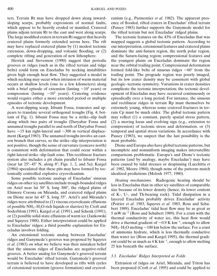
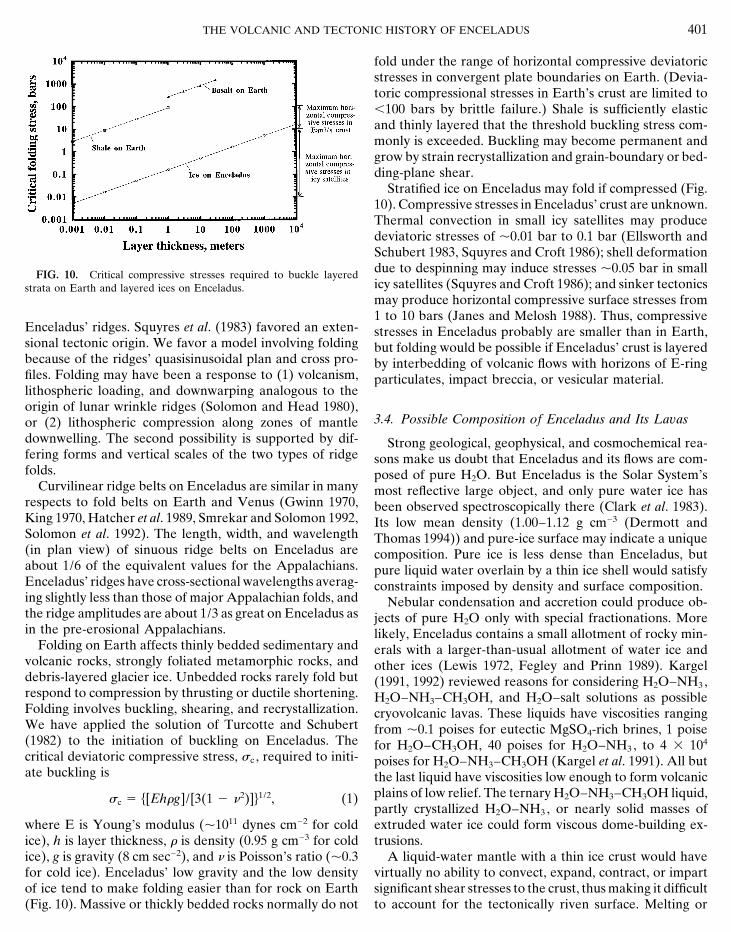
fold under the range of horizontal compressive deviatoricstresses in convergent plate boundaries on Earth. (Devia-toric compressional stresses in Earth’s crust are limited to,100 bars by brittle failure.) Shale is sufficiently elasticand thinly layered that the threshold buckling stress com-monly is exceeded. Buckling may become permanent andgrow by strain recrystallization and grain-boundary or bed-ding-plane shear.
Stratified ice on Enceladus may fold if compressed (Fig.10). Compressive stresses in Enceladus’ crust are unknown.Thermal convection in small icy satellites may producedeviatoric stresses of p0.01 bar to 0.1 bar (Ellsworth andSchubert 1983, Squyres and Croft 1986); shell deformationdue to despinning may induce stresses p0.05 bar in smallFIG. 10. Critical compressive stresses required to buckle layeredicy satellites (Squyres and Croft 1986); and sinker tectonicsstrata on Earth and layered ices on Enceladus.may produce horizontal compressive surface stresses from1 to 10 bars (Janes and Melosh 1988). Thus, compressive
Enceladus’ ridges. Squyres et al. (1983) favored an exten- stresses in Enceladus probably are smaller than in Earth,sional tectonic origin. We favor a model involving folding but folding would be possible if Enceladus’ crust is layeredbecause of the ridges’ quasisinusoidal plan and cross pro- by interbedding of volcanic flows with horizons of E-ringfiles. Folding may have been a response to (1) volcanism, particulates, impact breccia, or vesicular material.lithospheric loading, and downwarping analogous to theorigin of lunar wrinkle ridges (Solomon and Head 1980),
3.4. Possible Composition of Enceladus and Its Lavasor (2) lithospheric compression along zones of mantledownwelling. The second possibility is supported by dif- Strong geological, geophysical, and cosmochemical rea-fering forms and vertical scales of the two types of ridge sons make us doubt that Enceladus and its flows are com-folds. posed of pure H2O. But Enceladus is the Solar System’s
Curvilinear ridge belts on Enceladus are similar in many most reflective large object, and only pure water ice hasrespects to fold belts on Earth and Venus (Gwinn 1970, been observed spectroscopically there (Clark et al. 1983).King 1970, Hatcher et al. 1989, Smrekar and Solomon 1992, Its low mean density (1.00–1.12 g cm23 (Dermott andSolomon et al. 1992). The length, width, and wavelength Thomas 1994)) and pure-ice surface may indicate a unique(in plan view) of sinuous ridge belts on Enceladus are composition. Pure ice is less dense than Enceladus, butabout 1/6 of the equivalent values for the Appalachians. pure liquid water overlain by a thin ice shell would satisfyEnceladus’ ridges have cross-sectional wavelengths averag- constraints imposed by density and surface composition.ing slightly less than those of major Appalachian folds, and Nebular condensation and accretion could produce ob-the ridge amplitudes are about 1/3 as great on Enceladus as jects of pure H2O only with special fractionations. Morein the pre-erosional Appalachians. likely, Enceladus contains a small allotment of rocky min-
Folding on Earth affects thinly bedded sedimentary and erals with a larger-than-usual allotment of water ice andvolcanic rocks, strongly foliated metamorphic rocks, and other ices (Lewis 1972, Fegley and Prinn 1989). Kargeldebris-layered glacier ice. Unbedded rocks rarely fold but (1991, 1992) reviewed reasons for considering H2O–NH3 ,respond to compression by thrusting or ductile shortening. H2O–NH3–CH3OH, and H2O–salt solutions as possibleFolding involves buckling, shearing, and recrystallization. cryovolcanic lavas. These liquids have viscosities rangingWe have applied the solution of Turcotte and Schubert from p0.1 poises for eutectic MgSO4-rich brines, 1 poise(1982) to the initiation of buckling on Enceladus. The for H2O–CH3OH, 40 poises for H2O–NH3 , to 4 3 104
critical deviatoric compressive stress, sc , required to initi- poises for H2O–NH3–CH3OH (Kargel et al. 1991). All butate buckling is the last liquid have viscosities low enough to form volcanic
plains of low relief. The ternary H2O–NH3–CH3OH liquid,sc 5 h[Ehrg]/[3(1 2 n2)]j1/2, (1)partly crystallized H2O–NH3 , or nearly solid masses ofextruded water ice could form viscous dome-building ex-where E is Young’s modulus (p1011 dynes cm22 for cold
ice), h is layer thickness, r is density (0.95 g cm23 for cold trusions.A liquid-water mantle with a thin ice crust would haveice), g is gravity (8 cm sec22), and n is Poisson’s ratio (p0.3
for cold ice). Enceladus’ low gravity and the low density virtually no ability to convect, expand, contract, or impartsignificant shear stresses to the crust, thus making it difficultof ice tend to make folding easier than for rock on Earth
(Fig. 10). Massive or thickly bedded rocks normally do not to account for the tectonically riven surface. Melting or
402 KARGEL AND POZIO
freezing of pure H2O (29% volume change on melting) position and the possible chemical nature of volcanismthere. If additional concerted efforts to detect even tracescould produce intense shell deformation, but it might result
in a nearly isotropic stress field unlike that inferred from of impurities fail, we may be forced to review argumentsand assumptions regarding the improbability of water vol-observations of Enceladus. The H2O–NH3 peritectic melt-
ing reaction causes a 11% change in volume (Croft et al. canism and pure-water satellites, especially in light of arecent downward revision in the mean density of Enceladus1988]), so that melting or freezing of ammonia–water
would be even less capable of explaining Enceladus’ tec- nearly to that of pure water (Dermott and Thomas 1994).Following a quarter century of speculation that H2O–tonics. Salt-water eutectic brines generally freeze to mix-
tures of water ice and hydrated salts; volume changes dur- NH3 volcanism may be important on small icy satellites(Lewis 1971, Consolmagno and Lewis 1978, Stevensoning melting or freezing are commonly of the same sign but
half the magnitude that of pure water. Thus, we doubt that 1982, Squyres et al. 1983, Croft et al. 1988, Kargel et al.1991, Schenk 1991, Kargel 1992), we also conclude thatvolume changes attending melting and refreezing is the
sole explanation for Enceladus’ complex tectonic pattern. H2O–NH3 , with or without other substances, is a likelyresurfacing agent on Enceladus.Extrusion of pure liquid water onto the surface of a less
dense crust of pure ice would be difficult but not impossi-ble. More likely, volcanism occurred because partial melts
4. CONCLUSIONS AND GEOCHRONOLOGYwere buoyant relative to crust and mantle. H2O–NH3 peri-OF ENCELADUStectic (32.6% NH3) and eutectic (35.4% NH3) liquids are
less dense than their frozen ices (Croft et al. 1988) and are The geologic history of Enceladus may be divided intoless dense than Enceladus; hence, H2O–NH3 volcanism is four partly overlapping stages.more likely than H2O volcanism. Enceladus’ potential forextrusion of high-density eutectic salt-water brines (denser (1) Early global resurfacing late during population S1than Enceladus) is reduced on the same basis. H2O– cratering removed most S1 craters. The last stage of S1CH3OH or H2O–NH3–CH3OH would be plentiful in a again cratered Enceladus, but not to saturation. The oldestsatellite containing comet-like volatiles; density relations surviving remnants of the ancient surface, overprinted byfavor extrusion of these liquids (Hoban et al. 1991, 1993, S2 craters, is at high northern latitudes in Cp5-9. ModelKargel 1992). ages of these ancient terrains (Models 2 and 3 in Table II)
Saturn’s E-ring (Baum et al. 1981, Stevenson 1982, Mor- have no reliability because the ages are based partly onfill et al. 1983, Pang et al. 1984, Showalter et al. 1991) and the assumption that these terrains date from close to thea crater chain on Enceladus (Kargel 1984) (Figs. 2 and 5a) origin of the Solar System.may have formed by explosive volcanism. (Note alternative (2) Rifting resulted in fracturing, downdropping, cryo-models for the origin of the E-ring; McKinnon 1983, Hamil- volcanic flooding, and viscous relaxation and stretching ofton and Burns 1994). Phreatomagmatic explosions caused impact craters in the rifted terrain. This event was roughlyby interactions of liquid H2O–NH3 with liquid H2O, or of coeval with plains formation in Cp4 and emplacement ofliquid CH4–CO–N2 with H2O or H2O–NH3 , could produce Bt1. Models 2 and 3 (Table II) suggest absolute ages datingboth features, although phreatomagmatic interactions are from the middle of Enceladus’ geologic history p1400 tonot needed for explosive volcanism. Kargel and Strom 2900 myr.(1990) modeled exsolution of CH4 from saturated high- (3) The youngest subunits of cratered plains (Cp1-3)pressure H2O–NH3 on Triton and found that it could cause were formed by continued cryovolcanism and extensionalexplosive volcanism; the same process could work on En- fracturing. The younger subunit of banded terrain (Bt2)celadus. formed at about the same time. Models 2 and 3 (Table
The improbability of pure H2O magmatism is high- II) suggest a protracted or episodic development of theselighted by the chemical complexity of condensate assem- terrains from 140 to 2900 myr.blages in the Solar System and the high chemical activity of (4) Ridged plains were formed by compressional tecton-water. So why is the visible surface of Enceladus apparently ics and widespread cryovolcanism involving a lava of rela-made of nothing but ice? Flotation of water ice in flows or tively low viscosity. Models 2 and 3 (Table II) indicate anplutons, sinking of dense phases such as salts and ammonia average age between 10 and 200 myr. Continuing explosivedihydrate, diapiric solid-state ascent of segregated ice bod- volcanism may be renewing Saturn’s E-ring.ies, surface coatings by icy E-ring particles, or spectroscopicmasking of impurities by water ice may have contributed In sum, Enceladus has a complex history with multiple
episodes of activity spread over billions of years. Long-to make a true ice-dominated surface or to make it appearthat way (Croft et al. 1988, Buratti 1988, Hogenboom et term or episodic geologic activity has occurred and requires
high levels of tidal heating. Current steady-state tidal dissi-al. 1994, 1995]. Despite these caveats, the seemingly pure-ice surface of Enceladus is a rare, hard constraint on com- pation may cause melting of ammonia hydrate at a depth
THE VOLCANIC AND TECTONIC HISTORY OF ENCELADUS 403
tor of the 3.52-em emission feature in several comets. Icarus 93,of just 25 km if the crust is made of ammonia hydrate or122–134.p100 km if it is made of water ice.
HOBAN, S., D. C. REUTER, M. A. DISANTI, M. J. MUMMA, AND R. ELSTON
1993. Infrared observations of methanol in comet P/Swift-Tittle. IcarusACKNOWLEDGMENTS 105, 548–556.
HOGENBOOM, D. L., J. S. KARGEL, T. C. HOLDEN, AND J. GANASAN 1994.We thank Guy Consolmagno, Doris Weir, Derek Hirsch, and three The ammonia–water phase diagram and phase volumes to 4 kbars.
anonymous reviewers for scientific and editorial reviews. We are indebted Proc. Lunar Planet Sci. 25th, 555–556.to Peter Thomas, who generously made available a digital database of
HOGENBOOM, D. L., J. S. KARGEL, J. P. GANASAN, AND L. LEE 1995.limb residuals (Dermott and Thomas 1994) and engaged us in fruitful
Magnesium sulfate–water to 400 MPa using a novel piezometer: Densi-discussions concerning limb profile data. J.S.K. acknowledges logistical
ties, phase equilibria, and planetological implications. Icarus 115,support from CNR (Italy), which made the early stages of this work pos-258–277.sible.
JANES, D. M., AND H. J. MELOSH 1988. Sinker tectonics: An approachto the surface of Miranda. J. Geophys. Res. 93, 3127–3143.
REFERENCES JANKOWSKI, D. G., AND S. W. SQUYRES 1988. Solid-state volcanism onthe satellites of Uranus. Science 241, 1322.
BAUM, W. A., T. KREIDL, J. A. WESTPHAL, G. E. DANIELSON, P. K. KARGEL, J. S. 1983. Enceladus: An analog of terrestrial plate tectonism?SEIDELMANN, D. PASCU, AND D. G. CURRIE 1981. Saturn’s E ring. I. Proc. Lunar Planet. Sci. 14th, 363–364.CCD observations of March 1980. Icarus 47, 84–96.
KARGEL, J. S. 1984. A crater chain on Enceladus: Evidence for explosiveBURATTI, B. 1988. Enceladus: Implications of its unusual photometric water volcanism. Proc. Lunar Planet. Sci. 25th, 427–428.
properties. Icarus 75, 113–126.KARGEL, J. S. 1991. Brine volcanism and the interior structures of aster-
CLARK, R. N., R. H. BROWN, M. L. NELSON, AND J. N. HAYASHI 1983. oids and icy satellites. Icarus 94, 368–390.Surface Composition of Enceladus, Abstract 853, 15th Annual DPS
KARGEL, J. S. 1992. Ammonia–water volcanism on icy satellites: PhaseMeeting.relations at 1 atmosphere. Icarus 100, 556–574.
CONSOLMAGNO, G. J., AND J. S. LEWIS 1978. The evolution of icy satelliteKARGEL, J. S., AND R. G. STROM 1990. Cryovolcanism on Triton (abstract),interiors and surfaces. Icarus 34, 280–293.
Proc. Lunar Planet. Sci. 21st, 599–600.CROFT, S. K., AND L. A. SODERBLOM 1991. Geology of the uranian satel-
KARGEL, J. S., S. K. CROFT, J. I. LUNINE, AND J. S. LEWIS 1991. Rheologicallites. In Uranus (J. T. Bergstralh, E. D. Miner, and M. S. Matthews,properties of ammonia–water liquids and crystal-liquid slurries:Eds.), pp. 561–628. Univ. of Arizona Press, Tucson.Planetological applications. Icarus 89, 93–112.
CROFT, S. K., J. I. LUNINE, AND J. S. KARGEL 1988. Equation of stateKING, P. B. 1970. Epilogue. In Studies of Appalachian Geology: Centralof ammonia–water liquid: Derivation and planetological application.
and Southern (G. W. Fisher, F. J. Pettijohn, J. C. Reed Jr., and K. N.Icarus 73, 279–293.Weaver, Eds.), pp. 437–439. Interscience, New York.
CROFT, S. K., J. S. KARGEL, R. L. KIRK, J. M. MOORE, P. M. SCHENK,KOSSACKI, K. J., AND J. LELIWA-KOPYSTYNSKI 1993. Medium-sized icy
AND R. G. STROM 1995. The geology of Triton. In Neptune and Tritonsatellites: Thermal and structural evolution during accretion. Planet.(D. P. Cruikshank, Ed.), Univ. of Arizona Press, Tucson.Space Sci. 41, 729–741.
DERMOTT, S. F., AND P. C. THOMAS 1994. The determination of theLEWIS, J. S. 1971. Satellites of the outer planets: Their chemical andmass and mean density of Enceladus from its observed shape. Icarus
physical nature. Icarus 16, 241–252.109, 241–257.LEWIS, J. S. 1972. Low temperature condensation from the solar nebula.ELLSWORTH, K., AND G. SCHUBERT 1983. Saturn’s icy satellites: Thermal
Icarus 16, 241–252.and structural models. Icarus 54, 490–510.LUCCHITTA, B. K., AND L. A. SODERBLOM 1982. The geology of Europa.FARINELLA, P., P. PAOLICCHI, R. G. STROM, J. S. KARGEL, AND V.
In Satellites of Jupiter (D. Morrison, Ed.), pp. 521–555. Univ. of ArizonaZAPPALA 1990. The fate of Hyperion’s fragments. Icarus 83, 186–204.Press, Tucson.
FEGLEY, B., JR., AND R. G. PRINN 1989. Solar nebula chemistry: Implica-LUCCHITTA, B. K., L. A. SODERBLOM, AND H. M. FERGUSON 1982. Struc-tions for volatiles in the solar system. In The Formation and Evolution
tures on Europa. Proc. Lunar Planet. Sci. Conf. 12th, 1555–1567.of Planetary Systems, (H. Weaver, F. Paresce, and L. Danly, Eds.), pp.MCKINNON, W. B. 1983. Origin of the E-ring: Condensation of impact171–211. Cambridge Univ. Press, Cambridge.
vapor. . . or boiling of impact melt? Proc. Lunar Planet. Sci. 14th,GWINN, V. E. 1970. Kinematic patterns and estimates of lateral shortening,487–488.valley and ridge and great valley provinces, central Appalachians,
MELOSH, H. J. 1977. Global tectonics of a despun planet. Icarus 31,south-central Pennsylvania. In Studies of Appalachian Geology: Central221–243.and Southern, (G. W. Fisher, F. J. Pettijohn, J. C. Reed Jr., and K. N.
Weaver, Eds.), pp. 127–146. Interscience, New York. MELOSH, H. J. 1980. Tectonic patterns on a tidally distorted planet. Icarus43, 334–337.HAMILTON, D. P., AND J. A. BURNS 1994. Origin of Saturn’s E ring: Self-
sustained, naturally. Science 264, 550–553. MOORE, J. M. 1984. The tectonic and volcanic history of Dione. Icarus59, 205–220.HATCHER, R. D., W. A. THOMAS, AND G. W. VIELE, Eds. 1989. The
Appalachian–Ouachita Orogen in the United States, The Geology of MORFILL, G. E., E. GRUN, AND T. V. JOHNSON 1983. Saturn’s E, G, andF rings: Modulated by the plasma sheet? J. Geophys. Res. 88, 5573–5579.North America, Vol. F-2. Geol. Soc. Am., Boulder, CO.
HERRICK, D. L., AND D. J. STEVENSON 1990. Extensional and compres- PANG, K. D., C. C. VOGE, J. W. RHOADS, AND J. M. AJELLO 1984. TheE ring of Saturn and satellite Enceladus. J. Geophys. Res. 89, 9459–9470.sional instabilities in icy satellite lithospheres. Icarus 85, 191–204.
HOBAN, S., M. MUMMA, D. C. REUTER, M. DISANTI, R. R. JOYCE, AND PARMENTIER, E. M., S. W. SQUYRES, J. W. HEAD, AND M. L. ALLISON
1982. The tectonics of Ganymede. Nature 295, 290–293.A. STORRS 1991. A tentative identification of methanol and the progeni-
404 KARGEL AND POZIO
PASSEY, Q. R. 1983. Viscosity of the lithosphere of Enceladus. Icarus SMREKAR, S. E., AND S. C. SOLOMON 1992. Gravitational spreading ofhigh terrain in Ishtar Terra. Venus, J. Geophys. Res. 97, 16,121–53, 105–120.16,148.PEALE, S. J., P. CASSEN, AND R. T. REYNOLDS 1980. Tidal dissipation,
orbital evolution, and the nature of Saturn’s inner satellites. Icarus SOLOMON, S. C., AND J. W. HEAD 1980. Lunar mascon basins: Lava43, 65–72. flooding, tectonics, and evolution of the lithosphere. Rev. Geophys.
Space Phys. 18, 107–141.PLESCIA, J. B., AND J. M. BOYCE 1983. Crater numbers and geologicalhistories of Iapetus, Enceladus, Tethys, and Hyperion. Nature 301, SOLOMON, S. C., et al. 1992. Venus tectonics: An overview of Magellan666–670. observations. J. Geophys. Res. 97, 13,199–13,256.
POIRIER, J. P., L. BOLOH, AND P. CHAMBON 1983. Tidal dissipation in SQUYRES, S. W., AND S. K. CROFT 1986. The tectonics of icy satellites.small viscoelastic ice moons: The case of Enceladus. Icarus 55, 218–230. In Satellites (J. A. Burns and M. S. Matthews, Eds.), pp. 293–341. Univ.
POZIO, S., AND J. S. KARGEL 1989. The tectonic and igneous evolution of Arizona Press, Tucson.of Enceladus. Proc. Lunar Planet. Sci. 20th, 864–865. SQUYRES, S., R. T. REYNOLDS, P. M. CASSEN, AND S. J. PEALE, 1983. The
POZIO, S., AND J. S. KARGEL 1990. The cratering record and geological evolution of Enceladus. Icarus 53, 319–331.history of Enceladus. Proc. Lunar Planet. Sci. 21st, 975–976.
SQUYRES, S. W., R. T. REYNOLDS, A. L. SUMMERS, AND F. SHUNG 1988.ROSS, M. N., AND G. SCHUBERT 1989. Viscoelastic models of tidal heating Accretional heating of the satellites of Saturn and Uranus. J. Geophys.
in Enceladus. Icarus 78, 90–101. Res. 93, 8779–8794.ROSS, R. G., AND J. S. KARGEL 1996. Thermal conductivity of solar system STEVENSON, D. J. 1982. Volcanism and igneous processes in small icy
ices, with special reference to martian polar caps. In Solar System Ices, satellites. Nature 298, 142–144.(C. de Bergh, B. Schmitt, and M. Festou, Eds.), Kluwer Academic,
STEVENSON, D. J., A. W. HARRIS, AND J. I. LUNINE 1986. Origins ofin press.satellites. In Satellites (J. A. Burns and M. S. Matthews, Eds.), pp.SCHENK, P. M. 1989. Crater formation and modification on the icy satellites39–88. Univ. of Arizona Press, Tucson.of Saturn and Uranus: Depth/diameter and central peak occurrence.
STROM, R. G., 1987. Mercury, In The Geology of the Terrestrial Planets,J. Geophys. Res. 94, 3813–3832.NASA SP-469, 13–55.SCHENK, P. M. 1991. Fluid volcanism on Miranda and Ariel: Flow mor-
STROM, R. G. 1987. The solar system cratering record: Voyager 2 resultsphology and composition. J. Geophys. Res. 96, 1887–1906.at Uranus and implications for the origin of impacting objects. IcarusSCHENK, P. M., AND J. M. MOORE 1995. Volcanic constructs on Ganymede.70, 517–535.J. Geophys. Res. submitted.
TURCOTTE, D. L., AND G. SCHUBERT 1982. Geodynamics: ApplicationsSHOEMAKER, E. M., AND R. F. WOLFE 1982. Cratering time scales forof Continuum Physics to Geological Problems. Wiley, New York.the Galilean satellites. In Satellites of Jupiter (D. Morrison, Ed.), pp.
277–339. Univ. of Arizona Press, Tucson. U.S. GEOLOGICAL SURVEY 1992. Pictorial map and controlled photomo-saic of Enceladus. U.S. Geol. Surv. Misc. Invest. Ser. Map I-2156, scaleSHOWALTER, M. R., J. N. CUZZI, AND S. M. LARSON 1991. Structure and1:2,000,000, 2 sheets.properties of Saturn’s E ring. Icarus 94, 451–473.
VERBISCER, A. J., AND J. VEVERKA 1994. A photometric study of Encela-SMITH, B., et al. 1982. A new look at the Saturn system: The Voyager 2dus. Icarus 110, 155–164.images. Science 215, 504–537.
Related Documents