Ian MacRae, Tim Baker, & Robert Koch Dept of Entomology Univ. of Minnesota The View From Up Here is Great! Remote Sensing and Drones in Pest Management Manitoba Agronomists Conference Winnipeg, Manitoba, Dec 14-15, 2016.

Welcome message from author
This document is posted to help you gain knowledge. Please leave a comment to let me know what you think about it! Share it to your friends and learn new things together.
Transcript

Ian MacRae, Tim Baker, & Robert Koch
Dept of Entomology
Univ. of Minnesota
The View From Up
Here is Great!Remote Sensing and Drones in
Pest Management
Manitoba Agronomists Conference
Winnipeg, Manitoba, Dec 14-15, 2016.

Plant Light
InteractionDifferent wavelengths
reflected by pigment,
internal leaf structure &
H2O content.
Plant
geometry
- Orientation,
density &
distribution

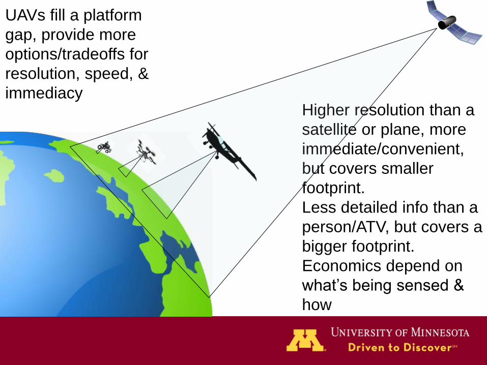
UAVs fill a platform
gap, provide more
options/tradeoffs for
resolution, speed, &
immediacyHigher resolution than a
satellite or plane, more
immediate/convenient,
but covers smaller
footprint.
Less detailed info than a
person/ATV, but covers a
bigger footprint.
Economics depend on
what’s being sensed &
how

Hyperspectral Sensors – measure many bands at
narrow intervals (e.g. 1-3 nm / interval)
Can get hyperspectral sensors / imagers, BUT $$$$
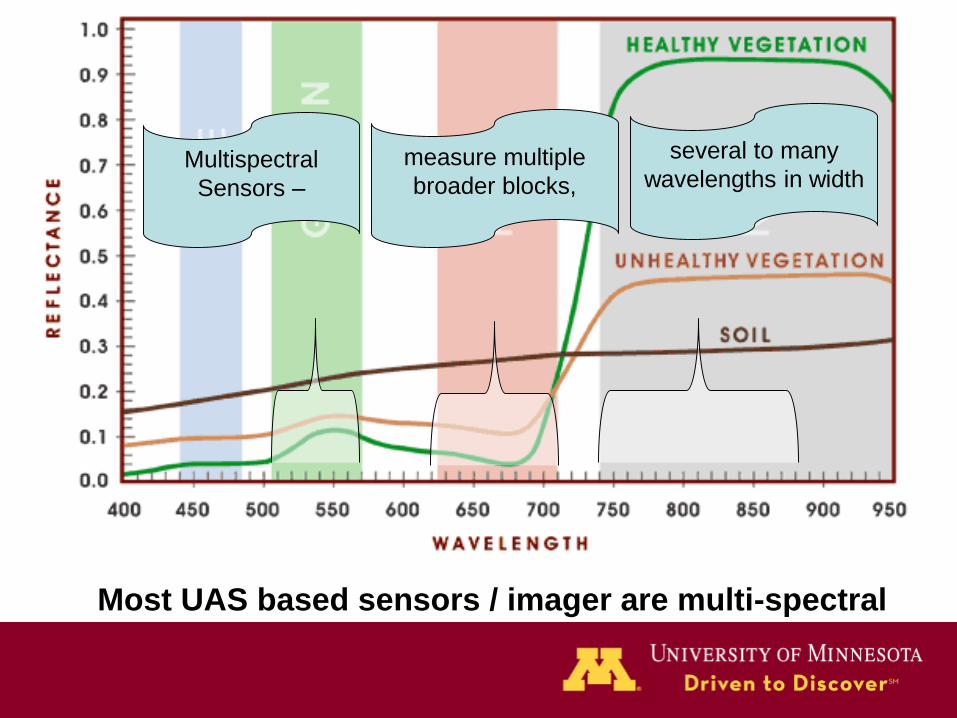
Multispectral
Sensors –
measure multiple
broader blocks,
several to many
wavelengths in width
Most UAS based sensors / imager are multi-spectral

GoPro Hero3
ADC TetraCam
Sentera
NIR imagers
Imaging sensors
Tend to be multi-spectral but
hyperspectral available (costly)

3-D Robotics Iris

Flight planning
200’
5 run
lengths
= 40%
image
overlap

Stitching the mosaic
Individual images of
plots ‘stitched’ into
mosaic representing
entire field using
AGISoft PhotoScan
(AGISoft LLC St
Petersburg RU)

Stitching imagery

Basically 3 tools• Hyperspectral
– Usually reflectance = spectral curves
– Often non-image (spectroradiometers =
actually numerically measure the amount
of incident energy being reflected from the
target)
• Multispectral
– Most imaging sensors in the cost window
for scouting will tend to be multi-spectral
• Visible

Visible data• Currently collaborating
on stand counts in
experiment plots
• Think hail damage,
herbicide drift, planter
skips, flooding, heavy
defoliation….
• Any problem you can easily see from the
ground, you can probably see from the air.
http://www.prairieagri.com/cvaphoto.html
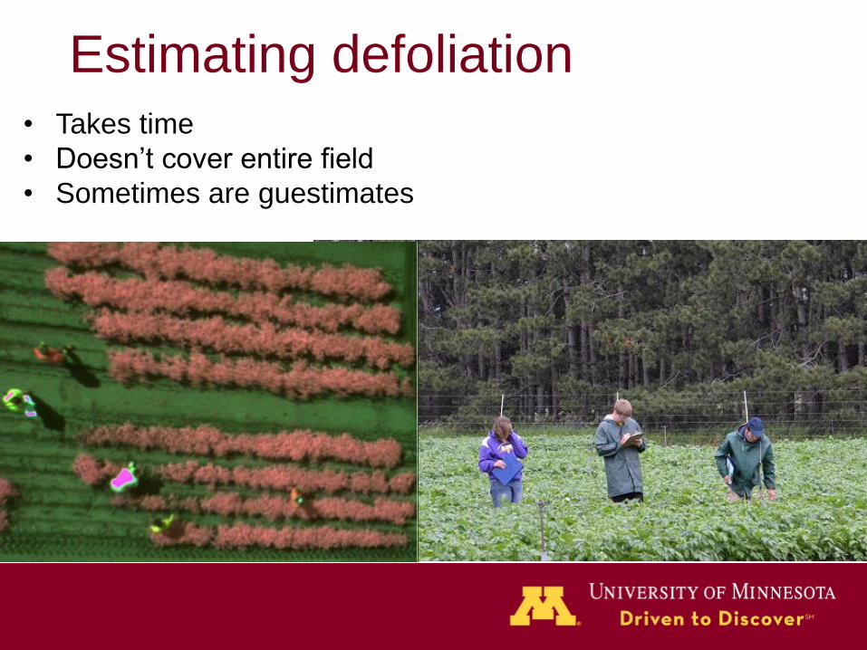
Estimating defoliation• Takes time
• Doesn’t cover entire field
• Sometimes are guestimates

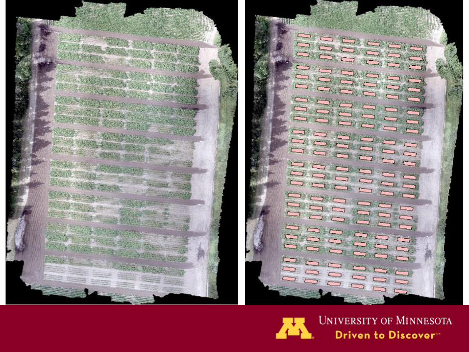
Canopy segmentation• Process - Identify
spectral reflections of
representative non-
plant areas to create
selection sieve values
for selection decisions
• Delineate the area of
interest and perform
analysis.
• % canopy coverage
then calculated,
geocoded images, so
actual area can be
determined
• Most image analysis software have “supervised
classification” – you ‘train’ the software to
differentiate between vegetative and non-
vegetative pixels (e.g. soil)
• based on min & max red & NIR values (e.g.
red<6, NIR <20), non-vegetative pixels rendered
to a user-specified solid color while leaving
pixels representing vegetative material
unchanged.
P<0.001, R2=0.587

With VIS dataR2 = 0.893, p < 0.001

Non-visible pest damage
• Disease, aphids, whitefly (sap feeders)
• Require spectral remote sensing
– Looking at other factors indicative of the
problem
– We can’t see/count aphids but can detect
changes they cause in plant physiology /
structure
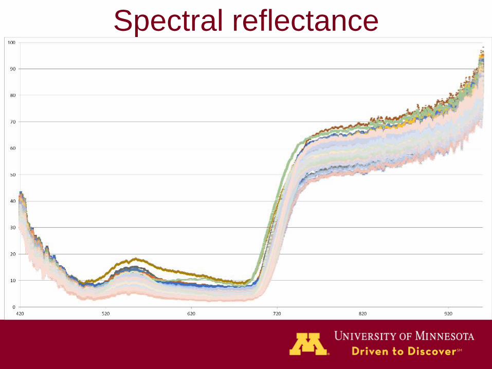
Spectral reflectance

Cell
structure Water content
Dominant factors controlling leaf reflectance
Lowest AIC is better
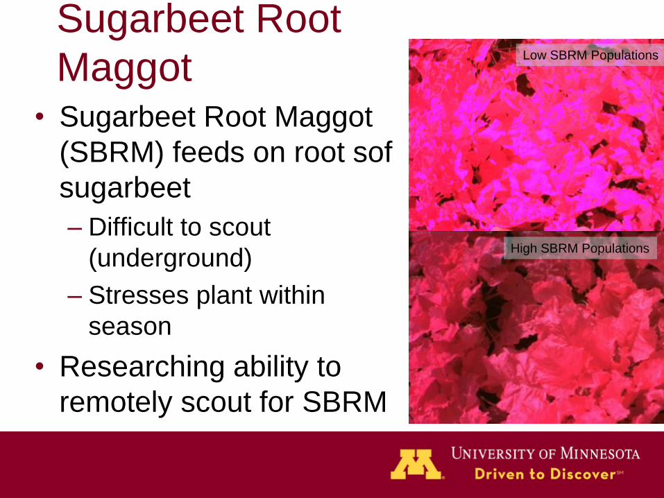
Sugarbeet Root
Maggot• Sugarbeet Root Maggot
(SBRM) feeds on root sof
sugarbeet
– Difficult to scout
(underground)
– Stresses plant within
season
• Researching ability to
remotely scout for SBRM
Low SBRM Populations
High SBRM Populations
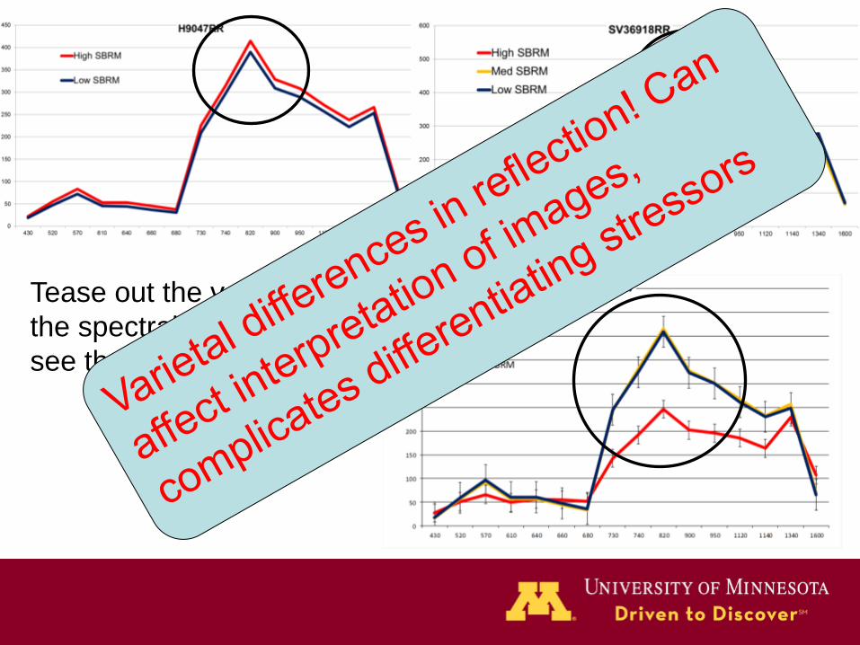
Tease out the varieties in
the spectral data and you
see the difference

Disease reflectance• Also in that 700-900 range
• BUT – disease affects stomatal opening
and diseases, like Downy Mildew, have
been demonstrated as lowering leaf
surface temperature (already used to
remotely sense DM)

Thermal IR
cameras small
enough to be
mounted on small
UAS
Chaerle, Laury, and Dominique Van Der
Straeten. 2000. ‘Imaging Techniques And
The Early Detection Of Plant
Stress’. Trends In Plant Science 5 (11):
495-501. doi:10.1016/s1360-
1385(00)01781-7.

Symptom models• Symptoms leading to probability
diagnoses
– Climate (temp & rH)
– Time of year
– condition / variety of crop
– Reflectance & other remotely
sensed data (temp by FLIR)

GoPro Hero3
Sony NEX-T5
ADC TetraCam
Sentera
NIR imagers
Imaging sensors
Imagers tend to be multi-
spectral but hyperspectral
available (costly)
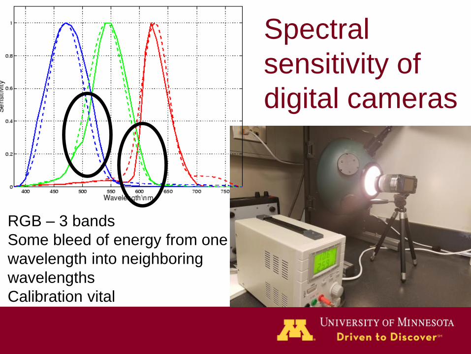
Spectral
sensitivity of
digital cameras
RGB – 3 bands
Some bleed of energy from one
wavelength into neighboring
wavelengths
Calibration vital

Imaging sensor issues
• Lens distortion
– Higher the altitude, wider the footprint BUT >>
barrel distortion
– Fixed focal length lenses
• Quantum efficiency of sensor
(CCD/CMOS) at various wavelengths
– Take caution at the edges of sensitivity
• Format of saved RAW data

Data acquisition issues• Canopy structure
– Wind, plant architecture, etc. all influence reflectance
of plant
• Shadow– position of sun (data acquisition best @ solar zenith)
• Incident light– Cloud cover and reflection can influence reflectance
(70%+ clear skies, incident light sensor)
Some e.g... Many factors can introduce variation into reflectance
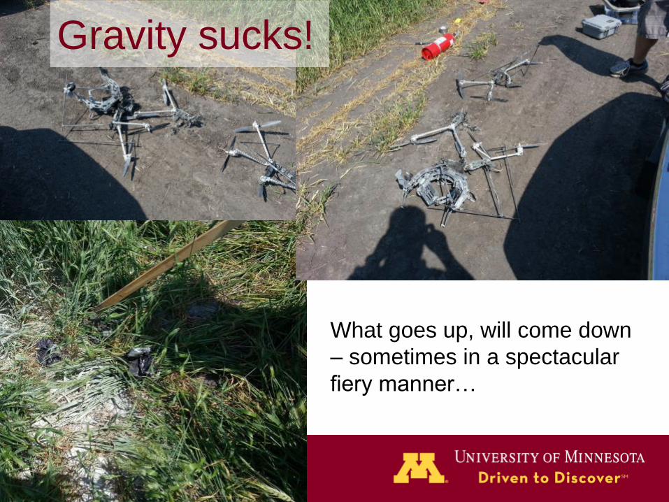
Gravity sucks!
What goes up, will come down
– sometimes in a spectacular
fiery manner…
Acknowledgements -
Field, Lab & UAS Staff – Christian Halos, Guthrie Dingman,
Abbie Anderson, Alex McGregor, Camila Inacia Costa,
Nicole Dudycha, Joe Wodarek
The staff at the UMN Sand Plains Research Farm (Becker)
and the Northwest Research & Outreach Center (Crookston)
This research was supported by funding from the Minnesota
Department of Agriculture Crop Research Program, MDA
Specialty Crop Research Block Grant Program, the Northern
Plains Potato Growers Assoc. and MN Area II Potato
Growers Assoc., Univ. of Minnesota MNDrive, MDA Rapid
Agricultural Response Fund,
Related Documents