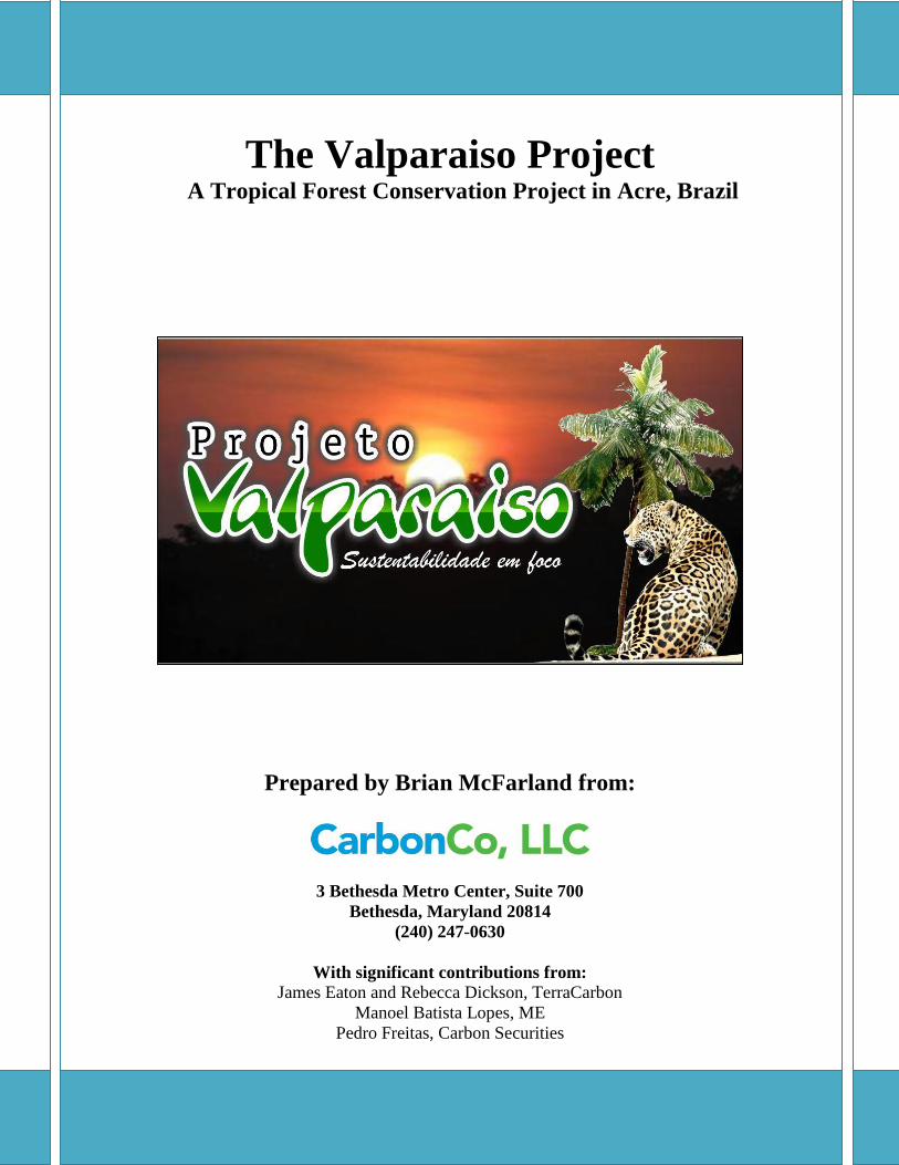
The Valparaiso Project A Tropical Forest Conservation Project in Acre, Brazil Prepared by Brian McFarland from: 3 Bethesda Metro Center, Suite 700 Bethesda, Maryland 20814 (240) 247-0630 With significant contributions from: James Eaton and Rebecca Dickson, TerraCarbon Manoel Batista Lopes, ME Pedro Freitas, Carbon Securities

Welcome message from author
This document is posted to help you gain knowledge. Please leave a comment to let me know what you think about it! Share it to your friends and learn new things together.
Transcript
0
The Valparaiso Project A Tropical Forest Conservation Project in Acre, Brazil
Prepared by Brian McFarland from:
3 Bethesda Metro Center, Suite 700
Bethesda, Maryland 20814
(240) 247-0630
With significant contributions from:
James Eaton and Rebecca Dickson, TerraCarbon
Manoel Batista Lopes, ME
Pedro Freitas, Carbon Securities
1
TABLE OF CONTENTS
I. Table of Contents …………………………………….………………………………… Page 1
II. Cover Page ……………………………………….……………………………………. Page 1
III. Summary …………………………………………..…………………………………. Page 2
IV. Overview of Project Design Document ……………………….…………………….. Page 3
V. Overview of Monitoring Plans …………………….…………….………………….. Page 42
VI. Results and Benefits of March 2011 to December 2013 Implementation ……...... Page 48
VII. Contact Information for Auditors and Grievance Procedures …………….…… Page 57
VIII. Contact Information for Project Proponents ………………………………...…. Page 59
IX. Stakeholders ………………………………………….……………………………... Page 59
X. Monitoring Template ………………..……………………………..……..…….…… Page 63
COVER PAGE
I. Project Name: The Valparaiso Project
II. Project Location: Near city of Cruzeiro do Sul, State of Acre, Brazil
III. Project Proponent: The three main Project Proponents are CarbonCo, LLC (“CarbonCo”),
Freitas International Group, LLC (“Freitas International Group or Carbon Securities”), and
Manoel Batista Lopes, ME. CarbonCo’s contact and address is:
Brian McFarland, Director
CarbonCo, LLC
3 Bethesda Metro Center, Suite 700
Bethesda, Maryland, United States of America
Phone: +1-(240) 595-6883 Email: [email protected]
IV. Auditor: Environmental, Services Inc. (ESI) is the auditor. ESI’s contact and address is:
Shawn McMahon, Forestry, Carbon, and GHG Services - Senior Manager
Environmental Services, Inc.
7220 Financial Way, Suite 100, Jacksonville, Florida, 32256
Phone: +1 (330) 833-9941 Email: [email protected]
2
V. Project State Date, GHG Accounting Period, and Project Lifetime: The Valparaiso
Project’s Start Date is March 19, 2011. The initial GHG Accounting Period is 10 years and the
Project Lifetime is 60 years.
VI. Project Implementation Period Covered by the PIR: March 19, 2011 to December 31,
2013.
VII. History of CCB Status: The Valparaiso Project’s CCBS Project Design Document is
projected to be validated in July 2014.
VIII. Edition of CCB Standard Being Used for Verification: Second Edition.
IX. Brief Summary of Climate, Community and Biodiversity Benefits Generated by the
Project Since the Start Date and During Current Implementation Period Covered by the
PIR: Net climate, community and biodiversity benefits between March 19, 2011 and December
31, 2013 include, but are not limited to: a reduction in the Project Area’s deforestation;
preservation of biologically diverse habitats; community engagement; local hires and transfer of
technical knowledge; offering agricultural extension courses; starting patrols for deforestation;
and the overall development of the third-ever, VCS-CCBS validated REDD+ project in the State
of Acre, Brazil.
X. Gold Level Criteria Being Used and Brief Summary of Exceptional Benefits: The
Valparaiso Project has exceptional community benefits. The Project Proponents will assist all
communities in and around the Valparaiso Project, and specifically the most vulnerable
communities within the Project.
XI. Date of Completion of this Version and Version Number: This version 1.0 was completed
on July 10, 2014.
SUMMARY
The Valparaiso Project (“Project”) is a payment for ecosystem services forest conservation
project, otherwise known as a Reduced Emissions from Deforestation and Degradation (REDD+)
project, on 28,096 hectares or approximately 69,397.1 acres (total property is 29,033.1 hectares
but Project will focus on the 28,096 hectares of forest) of privately-owned land in Acre, Brazil.1
The Valparaiso Project was successfully validated by Environmental Services, Inc. in July 2014
to the Verified Carbon Standard (VCS, Version 3.3) and to the Climate, Community and
Biodiversity Standard (CCBS, Second Edition) with Gold Distinction.
The CCBS Project Design Document with supporting documentation can be accessed here and
the VCS Project Description with supporting documentation can be accessed here.
1 The Term REDD and REDD+ will be used interchangeably. REDD+ includes REDD along with forest
conservation, sustainable forest management and the enhancement of carbon stocks. Thus, the Valparaiso Project
includes elements of forest conservation, sustainable forest management and reforestation.

3
The three main Project Proponents are CarbonCo, LLC (“CarbonCo”), Freitas International
Group, LLC (“Freitas International Group or Carbon Securities”), and Manoel Batista Lopes,
ME. CarbonCo, the wholly-owned subsidiary of Carbonfund.org, is responsible for getting the
Project certified and for early-stage Project finance. Carbon Securities acts as a liaison between
CarbonCo and Manoel Batista Lopes, ME, along with acting as a translator and assisting with
logistics for site visits. Manoel Batista Lopes, ME is an Acre, Brazil-based organization created
by the Landowner Mr. Manoel Batista Lopes (“Landowner”) is primarily responsible for day-to-
day management of the Project and the implementation of activities to mitigate deforestation.
The ultimate project activities are to undertake a forest carbon inventory, model regional
deforestation and land-use patterns, and mitigate deforestation pressures by utilizing payments
for the Project’s ecosystem services, along with ongoing monitoring of the climate, community
and biodiversity impacts of the Project. Social projects and activities to mitigate deforestation
pressures range from partnering with Ilderlei Souza Rodrigues Cordeiro from the adjacent
Russas Project, engaging S.O.S. Amazônia and the Secretary of Environmental Affairs for the
Municipality of Cruzeiro do Sul for agricultural extension training, to beginning patrols of
potential deforestation sites in the early stages of the Project, to eventually establishing an
association to assist with the local production of açaí and manioc flour.
This Valparaiso Project Summary Document is a summary of the Valparaiso Project’s CCBS
Project Design Document (PDD), the VCS Project Description (PD), the CCBS Full Monitoring
Plans, along with the CCB Project Implementation Report and the VCS Monitoring Report
which cover the initial monitoring and reporting period from March 19, 2011 to December 31,
2013.
Please contact Brian McFarland of CarbonCo, LLC with any questions, comments or concerns
regarding the Valparaiso Project at 1-240-595-6883 or via email at
OVERVIEW OF PROJECT DESIGN DOCUMENT
The Climate, Community and Biodiversity Standard (CCBS) Project Design Document (PDD)
with supporting documentation can be accessed here. The Verified Carbon Standard Project
Description (PD) with supporting documentation can be accessed here. Below is a shortened
overview of both the CCBS PDD and the VCS PD.
The Valparaiso Project is located in the State of Acre, Brazil alongside the Valparaiso River and
the Juruá River. The Valparaiso Project is approximately 40 kilometers (i.e., approximately 25
miles) south from the city of Cruzeiro do Sul and north from the city of Porto Walter.
The following political map is the State of Acre which borders the Brazilian state of Amazonas
along with the countries of Peru and Bolivia.2
2 V-Brazil.com, “Map of Acre, Brazil,” Available: http://www.v-brazil.com/tourism/acre/map-acre.html

4
The following map depicts the Valparaiso Project vis-à-vis the Jurua and Valparaiso Rivers.
Map 1: Location of Valparaiso Project (Credit: TerraCarbon)
Highway
BR-364
Ramal 3
Valparaiso River
Valparaiso Project
Juruá River

5
Document that Project Benefits would not have Occurred in the Absence of the Project
As previously mentioned the predominant land-use among medium-to-large landowners along
the BR-364 and BR-317 highways and the Ramal 3 road is the conversion of primary forests to
cattle pastures. The pressure on the Valparaiso Project is increasing with each passing year as
BR-364 and Ramal 3 are nearing the completion of their paving schedules. Upon being fully
paved, BR-364 and Ramal 3 will allow for year-round transportation and most likely increase
property values and market access for landowners’ cattle. Although this is a possible land-use
scenario in the ‘without project’ scenario, this is not the most likely scenario for the Valparaiso
Project.
Manoel Batista Lopes (“Manoel”) bought the larger parcel of the Valparaiso Project (the parcel
which is adjacent to the Valparaiso River and on the opposite bank of the Russas Project) in
1985. Manoel then bought the other, smaller parcel of the Valparaiso Project in 1986. Manoel
always worked in rubber tapping, but historically leased the land until he purchased the two
parcels of the Valparaiso Project as the sole owner for the purpose of rubber tapping.
From 1985 to 2005, Manoel lived on the property where he raised lamb, had approximately 30
head of cattle, and grew crops such as rice, manioc and corn. Manoel also had a little market,
which still exists today, that sold goods to local families.
In 1988, Manoel received a large loan from the Bank of Amazonia to finance rubber plantations
on the property. With such financing, Manoel planted approximately 18,000 rubber trees in
1988. These rubber trees were an experiment by EMBRAPA and INCRA (Instituto Nacional de
Colonização e Reforma Agrária or National Institute of Colonization and Agrarian Reform), but
the trees never produced rubber. The Bank of Amazonia forgave the loan and shortly thereafter,
the price of rubber crashed.
There was a wood management study conducted from 2002-2003 and this study was taken to the
Brazilian Institute of Environment and Renewable Natural Resources (Instituto Brasileiro do
Meio Ambiente e dos Recursos Naturais Renováveis or IBAMA in Portuguese) for approval.
Manoel then moved to Cruzeiro do Sul in 2005, where he currently resides now that he is
retired.
Without a payment for ecosystem services forest conservation project, Manoel would continue to
pay taxes on his property without generating any economic returns unless planned forest
conversion took place or if he sold the property. If forest conversion took place, the Valparaiso
Project’s biodiversity would surely be reduced and the communities’ might be forced to relocate.
Even if planned forest conversion by the Landowner did not take place, there would still be
increasing pressure on the Valparaiso Project’s forests via unplanned, frontier deforestation from
the community and neighboring landowners. This is the most likely ‘without-project’ scenario.
Thus, the communities within the Project Area would continue unsustainable subsistence
agriculture, while surrounding communities encroached on the Project Area and in-migration
continued.
Another possible, but unlikely, ‘without project’ land-use scenario would be for the Landowner
to provide project activities to the communities without developing and registering the Project as

6
a validated and verified REDD+ Project. The lack of economic returns in the ‘without project’
scenario would result in the Landowner’s inability to provide a range of social projects (e.g.,
establish health clinic) for the communities along with an inability to research the Valparaiso
Project’s biodiversity. This is because there are significant financial and institutional resources
required to develop a validated and verified REDD+ project.
Furthermore without a REDD+ project, the communities would not receive agricultural
extension trainings (i.e., which shall assist with increasing and diversifying incomes) nor a share
of the Project’s carbon offset revenue.
Carbon Stock Exchanges without Project Calculate the Estimated Carbon Stock Changes Associated with the ‘Without Project’ Reference Scenario
For the estimated carbon stock changes associated with the ‘without project’ reference scenario
and specifically the estimation of carbon stocks and the specific carbon pools included in the
forest carbon inventory, please see the VCS Project Description. A discussion of the net change
in the emissions of non-CO2 GHG emissions is also included. In addition, the VCS Project
Description will also include an analysis of the relevant drivers and rates of deforestation and
justification of the approaches, assumptions, and data used to perform this carbon stock analysis.
The following is a map of the predicted deforestation in the Baseline Period, 2012-2021, for the
Valparaiso Project:
7
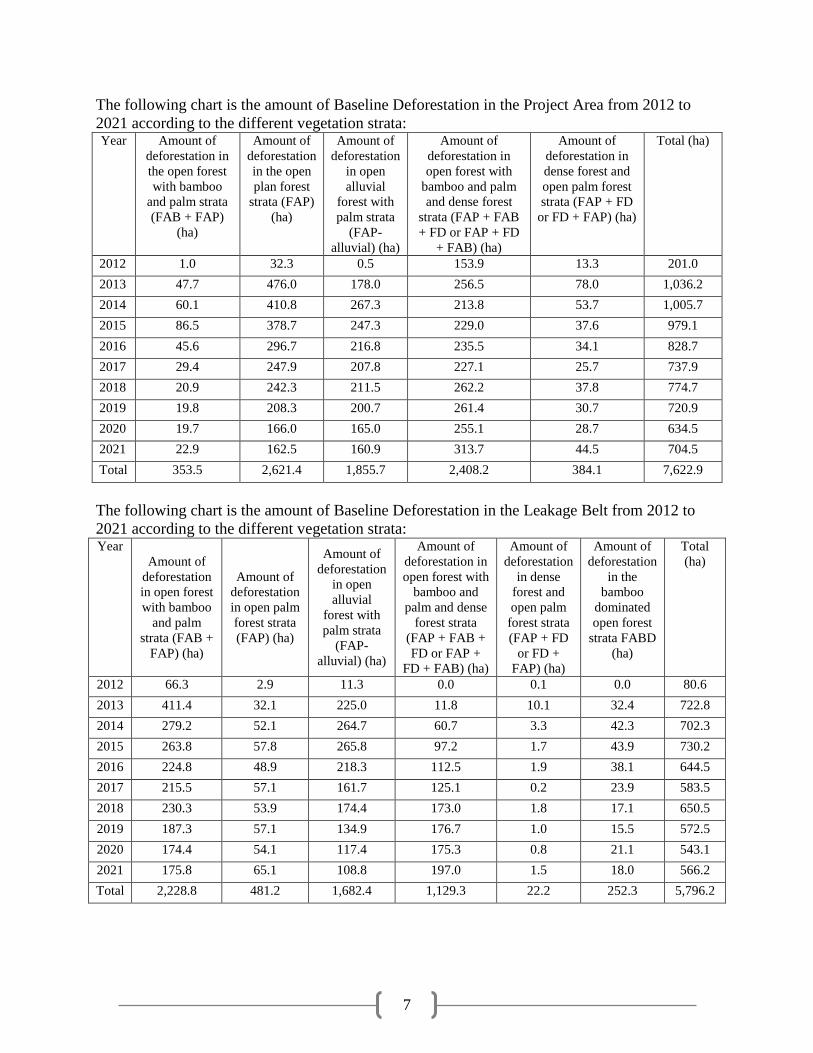
The following chart is the amount of Baseline Deforestation in the Project Area from 2012 to
2021 according to the different vegetation strata: Year Amount of
deforestation in
the open forest
with bamboo
and palm strata
(FAB + FAP)
(ha)
Amount of
deforestation
in the open
plan forest
strata (FAP)
(ha)
Amount of
deforestation
in open
alluvial
forest with
palm strata
(FAP-
alluvial) (ha)
Amount of
deforestation in
open forest with
bamboo and palm
and dense forest
strata (FAP + FAB
+ FD or FAP + FD
+ FAB) (ha)
Amount of
deforestation in
dense forest and
open palm forest
strata (FAP + FD
or FD + FAP) (ha)
Total (ha)
2012 1.0 32.3 0.5 153.9 13.3 201.0
2013 47.7 476.0 178.0 256.5 78.0 1,036.2
2014 60.1 410.8 267.3 213.8 53.7 1,005.7
2015 86.5 378.7 247.3 229.0 37.6 979.1
2016 45.6 296.7 216.8 235.5 34.1 828.7
2017 29.4 247.9 207.8 227.1 25.7 737.9
2018 20.9 242.3 211.5 262.2 37.8 774.7
2019 19.8 208.3 200.7 261.4 30.7 720.9
2020 19.7 166.0 165.0 255.1 28.7 634.5
2021 22.9 162.5 160.9 313.7 44.5 704.5
Total 353.5 2,621.4 1,855.7 2,408.2 384.1 7,622.9
The following chart is the amount of Baseline Deforestation in the Leakage Belt from 2012 to
2021 according to the different vegetation strata: Year
Amount of
deforestation
in open forest
with bamboo
and palm
strata (FAB +
FAP) (ha)
Amount of
deforestation
in open palm
forest strata
(FAP) (ha)
Amount of
deforestation
in open
alluvial
forest with
palm strata
(FAP-
alluvial) (ha)
Amount of
deforestation in
open forest with
bamboo and
palm and dense
forest strata
(FAP + FAB +
FD or FAP +
FD + FAB) (ha)
Amount of
deforestation
in dense
forest and
open palm
forest strata
(FAP + FD
or FD +
FAP) (ha)
Amount of
deforestation
in the
bamboo
dominated
open forest
strata FABD
(ha)
Total
(ha)
2012 66.3 2.9 11.3 0.0 0.1 0.0 80.6
2013 411.4 32.1 225.0 11.8 10.1 32.4 722.8
2014 279.2 52.1 264.7 60.7 3.3 42.3 702.3
2015 263.8 57.8 265.8 97.2 1.7 43.9 730.2
2016 224.8 48.9 218.3 112.5 1.9 38.1 644.5
2017 215.5 57.1 161.7 125.1 0.2 23.9 583.5
2018 230.3 53.9 174.4 173.0 1.8 17.1 650.5
2019 187.3 57.1 134.9 176.7 1.0 15.5 572.5
2020 174.4 54.1 117.4 175.3 0.8 21.1 543.1
2021 175.8 65.1 108.8 197.0 1.5 18.0 566.2
Total 2,228.8 481.2 1,682.4 1,129.3 22.2 252.3 5,796.2
8
The estimate of greenhouse gas emission (GHG) credits eligible for issuance as Verified Carbon
Units (VCUs) were calculated in the Verified Carbon Standard Project Description as follows:
Estimated GHG emission reduction credits =
Baseline emissions, fixed for 10 years at validation minus
Project emissions minus
Leakage minus
Non-permanence Risk Buffer withholding (calculated as a percent of net change in
carbon stocks prior to deduction of leakage)
Years Estimated
baseline
emissions or
removals
(tCO2e)
Estimated
project
emissions or
removals
(tCO2e)
Estimated
leakage
emissions
(tCO2e)
Risk buffer
(%)
Deductions
for AFOLU
pooled buffer
account
(tCO2e)
GHG credits
eligible for
issuance as
VCUs
(tCO2e)
2012 71,396 17,828 9,430 10% 5,357 38,780
2013 345,663 91,871 44,953 10% 25,379 183,460
2014 337,529 89,158 43,965 10% 24,837 179,569
2015 338,960 86,796 44,499 10% 25,216 182,449
2016 298,566 73,462 39,575 10% 22,510 163,018
2017 275,482 65,417 36,816 10% 21,007 152,243
2018 294,167 68,684 39,461 10% 22,548 163,474
2019 283,327 63,912 38,291 10% 21,942 159,182
2020 262,204 56,242 35,805 10% 20,596 149,560
2021 292,151 62,465 39,920 10% 22,969 166,798
Over the first 10 year baseline period, the project area is expected to results in 2,123,610 tons
tCO2e reductions with a buffer pool contribution of 212,361 tCO2e and a total expected emission
reduction of 1,538,533 tCO2e after account for leakage (372,716 t CO2e).
Local Communities without Project Describe how the ‘Without Project’ Reference Scenario would affect Communities in the Project Zone
As documented in section G1. Original Conditions in the Project Area, the local communities
obtain a variety of benefits from the Valparaiso Project and as explained in section G3. Project
Design and Goals, subsection 2. Major Activities, there are numerous social projects being
planned as result of payments for ecosystem services.
The ‘without project’ scenario would be the continued unplanned, frontier deforestation activities
of subsistence agriculture and cattle pastures by the local communities. The communities
undoubtedly receive benefits from these activities such as locally-produced food and income
generation through the sale of their crops and cattle to Cruzeiro do Sul.
However in the ‘without project’ scenario the communities, without a secure and legal title to
land, are marginalized and vulnerable. Thus, the communities could legally be removed from
the Valparaiso Project and the communities would either need to relocate to a new patch of forest
(i.e., most likely alongside the Juruá River or Valparaiso River) or move to a city such as
Cruzeiro do Sul or possibly Porto Walter.
9
Water and Soil
If the Landowner, instead of undertaking a forest conservation project, allowed unplanned
deforestation to continue from communities, there would be significant impacts on the local
water cycle and soil quality – both of which would have negative impacts on the community.
Such impacts include, but are not limited to:
Less trees to store water, resulting in potential localized flooding
Without water absorption by trees, pools of water left behind in open pastures could
increase mosquito population and insect-borne diseases such as yellow fever and malaria
Increased water runoff, due to less roots, could increase topsoil runoff and contribute to
the further erosion of river banks
Increased runoff could damage local fishing grounds (i.e., soil settles on eggs, disrupts
photosynthesis process of water plants and algae which are sources of fish food)
Additional debris from clear-cut could be swept into the river causing increased
challenges of boat transportation
Less agriculturally productive soils due to the loss of nutrients embedded in the tropical
rainforest ecosystem along with the loss of soil microbes
Other Locally Important Ecosystem Services
In addition to an impact on water and soil, other locally important ecosystem services that could
be impacted without the Valparaiso Project include a loss of wildlife habitat. This wildlife
habitat loss, which would also reduce the availability of game for the local community, will be
discussed in greater detail in the next section.
Biodiversity without Project Describe how the ‘Without Project’ Reference Scenario would affect Biodiversity in the Project Zone
As documented in section G1. Original Conditions in the Project Area, there is a high-level of
biodiversity in and around the Valparaiso Project. If unplanned deforestation by the
communities was allowed to continue, there would be reduced availability of habitat, a
fragmented landscape, and potentially more threatened species.
Habitat Availability
If the Landowner allowed for the continuation of unplanned, frontier deforestation, the resulting
open cattle pastures and cropland would provide a poor habitat for the region’s biodiversity
except for domesticated animals and wild species that exist in transitional forests and open
grasslands. Thus, forest dependent species and especially flora would have less available habitat.
Landscape Connectivity
If the ‘without project,” unplanned frontier deforestation scenario continued, there would be a
negative impact on landscape connectivity due to increased pressure on surrounding intact
forests of the Valparaiso Project.
Threatened Species
There potentially are several threatened flora and fauna species in the Project Area. If the
Valparaiso Project were converted to cattle pasture and cropland via unplanned frontier
deforestation, these particular threatened species would likely disappear from the Valparaiso
Project due to a reduction in habitat. These threatened species could move to a higher level of

10
extinction risk according to the International Union for Conservation of Nature (IUCN). In
addition, species currently considered to be at a low level of risk could move into a threatened
category if the additional deforestation pressures were placed on the surrounding landscape.
Project Activities and Project Goals
The Valparaiso Project will be described in sufficient detail for independent validation and
ongoing verification to the CCBS and VCS, as well as for all stakeholders to adequately evaluate
and participate in the Valparaiso Project. The Valparaiso Project has been designed to minimize
risks, engage local participation, and promote the highest level of transparency.
Summary of the Project’s Major Climate, Community and Biodiversity Objectives
The overarching objective of the Valparaiso Project is to generate sustainable economic
opportunities for the local communities and to implement social projects, while mitigating
deforestation (i.e., which results in less greenhouse gas emissions) and preserving the Project’s
rich biodiversity.
Figure 1: Model of Relationships between Major Climate, Community and Biodiversity Objectives
By mitigating deforestation, payments for ecosystem services will be generated which will
enable the implementation of local social projects and the creation of economic opportunities for
the communities. Similarly by improving local livelihoods and creating alternative economic
opportunities, there will be less pressure on the forests and a reduction in deforestation.
Improving local livelihoods and reducing deforestation are key mechanisms to preserve the
Project’s biodiversity.
To achieve these overarching objectives, the following climate, community and biodiversity
project activities have been identified by the Project Proponents.
Major Climate Objective
To mitigate deforestation and reduce the amount of greenhouse gas (GHG) emissions, the Project
Proponents have undertaken, or will undertake in the future, the following project activities:
Forest Carbon Inventory
Regional Land-use and Deforestation Modeling
Generate Sustainable Economic Opportunities for Local Communities and Implement Local Social Projects
and Programs
Preserve Project's Biodiversity
Mitigate Deforestation and Release of GHGs
11
Address Underlying Deforestation Drivers to Mitigate Release of GHGs
Develop Climate Monitoring Plan
Monitor Deforestation
Major Community Objective
To generate sustainable economic opportunities for the local communities living in and around
the Valparaiso Project and to implement local social projects, the Project Proponents have
undertaken, or began to plan for, the following project activities:
Project Awareness, Meet Community, and Discuss Project
Design Social Projects and Programs for Community
Implement Social Projects and Programs for Community
Develop Community Monitoring Plan
Monitor Community Impacts
Major Biodiversity Objective
To preserve the Valparaiso Project’s rich biodiversity, the Project Proponents will generate
sustainable economic opportunities for the local communities, implement social projects, and
mitigate the release of GHGs from deforestation. Furthermore, to achieve this biodiversity
objective, the Project Proponents have undertaken, or will undertake in the future, the following
project activities:
Rapidly Assess Biodiversity on Project
Develop Biodiversity Monitoring Plan
Monitor Biodiversity Impacts
Major Activities Describe Each Project Activity and its Relevance to Achieving the Project’s Objectives
The following section will further describe each major climate, community and biodiversity
project activity and how it is relevant to achieving the overarching climate, community and
biodiversity objectives.
Major Climate Objective
To achieve the major climate objective of mitigating deforestation and the subsequent release of
GHG emissions, the Project Proponents undertook a forest carbon inventory, developed a
regional land-use and deforestation model, and are addressing the underlying deforestation
drivers to mitigate the release of GHGs with a plan for ongoing monitoring.
Forest Carbon Inventory
A forest carbon inventory was an important project activity to undertake because it is difficult to
manage an objective that is not measured. The forest carbon inventory generated a scientifically
robust and statistically accurate representation of the carbon stocks on the Valparaiso Project.
Furthermore, the forest carbon inventory was conducted by the renowned local forestry company
TECMAN and was overseen by both CarbonCo and the international experts at TerraCarbon.
For a more detailed discussion, please see the VCS Project Description.

12
Regional Land-use and Deforestation Modeling
Similar to the need for a measurement of carbon stocks, there was a need to develop a regional
land-use and deforestation model to determine a performance baseline for the Project
Proponents. Such models now allow the Project Proponents to predict where (i.e., location),
when, from what (i.e., drivers and agents) and how much deforestation is expected, along with
where to assist with leakage mitigation and primarily where to monitor. This regional land-use
and deforestation modeling was conducted by TerraCarbon and reviewed by Professor Antonio
Flores from the Federal University of Acre. Again for a more detailed discussion, please see the
VCS Project Description.
Address Underlying Deforestation Drivers to Mitigate Release of GHGs
While understanding the Valparaiso Project’s carbon stocks and deforestation scenario, the
Project Proponents are now beginning to address the underlying deforestation drivers to mitigate
the release of GHGs (See Social Projects and Programs within this section).
Addressing the underlying deforestation drivers - for example, providing agricultural extension
trainings – is relevant to achieving the climate objective of reducing net GHG reductions by
reducing the communities’ dependence on forest resources through intensification of agricultural
and livestock practices, by providing alternative income, along with providing education about
the effects of deforestation and benefits of protecting forest resources.
Develop Climate Monitoring Plan and Monitor Deforestation
The Project Proponents will constantly monitor deforestation by boat as well as from the State of
Acre’s satellite imagery (See Social Projects and Programs within this section).
Developing a climate monitoring plan and monitoring deforestation will assist the Project
Proponents with achieving the climate objective. Thus, the climate monitoring plan and
monitoring of deforestation will result in net GHG emission reductions because such activities
will provide an early detection of deforestation, while enabling the Project Proponents to identify
the specific drivers and agents of deforestation and to implement the appropriate actions to
mitigate such deforestation and subsequent release of GHG emissions.
Major Community Objective
To generate sustainable economic opportunities and to implement local social projects for
communities living in and around the Valparaiso Project, the Project Proponents have
undertaken, or began to plan for, the following project activities: Project Awareness, Meet
Community, and Discuss Project; Design Social Projects and Programs for Community;
Implement Social Projects and Programs for Community; Develop Community Monitoring Plan
and Monitor Community Impacts.
Project Awareness, Meet Community and Discuss Project
The communities are an essential component of the Valparaiso Project and likewise, it has been
absolutely necessary to openly and frequently discuss the Project with the communities. This
includes discussions around:
The Project Proponents roles (i.e., especially Manoel Batista Lopes, ME and Ilderlei
Souza Rodrigues Cordeiro) and responsibilities

13
What exactly is the Valparaiso Project and how long the Project will last
Why deforestation is a problem and alternatives to slash-and-burn agriculture
Financial benefits to practicing more sustainable and permanent forms for agriculture
What type of social projects and programs (e.g., preventative medicine and health care
services) are most relevant and useful
What are the desired agricultural trainings that could be offered
Grievance procedure for addressing any and all unresolved issues
Land tenure
Through meeting with the communities, the Project Proponents have been able to gain the
communities’ insights about project design and to better incorporate the communities into the
Project. As a result, the community objective of generating sustainable economic opportunities
and implementing social projects and programs will be best achieved with active, on-going
participation and input from the local communities.
Throughout 2011, 2012 and 2013, the Valparaiso Project was discussed in greater detail with the
communities to ensure the communities were fully aware of the Valparaiso Project, were able to
contribute to the Project design, able to openly express desired outcomes and concerns,
understood the third-party grievance procedure, and were able to voluntarily give free, prior and
informed consent.
The initial community members who wanted to join the Valparaiso Project signed an “ata” on
March 19, 2011 and most community members signed a follow-up “ata” from May 11-15, 2013.
As of June 2013, the majority of community members residing within the Valparaiso Project
have either signed the “ata” or verbally agreed to join the project, with the first community
members signing an initial “ata” on March 19, 2011, the Project State Date.
Design and Implementation of Social Projects and Programs for Community
Social projects and programs for the local communities, which not only generate sustainable
economic opportunities, will also result in: less pressure on the local forests; a reduction in
deforestation; mitigation of greenhouse gas emissions; and the preservation of biodiversity.
Over the Project Lifetime, Manoel Batista Lopes, ME would like to further design and
implement the following project activities:
Hire Project Manager
Initiate Patrols of Deforestation by Boat
Initiate Training and Agricultural Extension Courses for Communities
Create Association to Process Açaí and Manioc Flour
Help Communities Obtain Land Tenure
Profit-Sharing of Carbon Credits
Establish a Headquarters
Improve Health Center and Dental Clinic

14
Hire Project Manager
In the earlier stages of the Project, Jose Getulio Silva (“Getulio”) was the initial, informal project
manager whereas Getulio was responsible for talking to the local communities and informally
patrolling for deforestation.
Manoel Batista Lopes, ME then partnered with Ilderlei Souza Rodrigues Cordeiro (i.e.,
landowner of the Russas Project located directly across from the Valparaiso Project) in April
2013 to work on the social projects and programs of the Valparaiso Project in conjunction with
Ilderlei’s Russas Project which is located adjacent to the Valparaiso Project.
Ilderlei will receive a share of Manoel Batista Lopes, ME’s VERs in exchange for assuming the
responsibility for all the social projects and programs at the Valparaiso Project. For example,
this includes facilitating the agricultural extension courses, overseeing the monitoring of
deforestation and local project manager, and improving the health center and dental clinic.
Ilderlei Souza Rodrigues Cordeiro will work as a partner in the Project, facilitating
communication and transparency in community decisions. Ilderlei Souza Rodrigues Cordeiro
lives in nearby Cruzeiro do Sul and is able to visit the Valparaiso Project communities with
relative ease. Furthermore, Ilderlei Souza Rodrigues Cordeiro will be responsible for ensuring
social projects are implemented, assist with the community and biodiversity monitoring plans,
collaborate on the deforestation monitoring, and will communicate directly with Manoel Batista
Lopes, ME.
Initiate Patrols of Deforestation
The initial patrols of deforestation at the Valparaiso Project started on January 8, 2012 when
Manoel Batista Lopes partnered with Jose Getulio Silva (“Getulio”) to act as the initial project
manager and to initiate patrols of deforestation.
Although Getulio is still the informal project manager and informal patroller of deforestation,
Manoel Batista Lopes, ME partnered with Ilderlei Souza Rodrigues Cordeiro in April 2013 to
take over the main responsibility of patrolling for deforestation.
In the future, Manoel Batista Lopes, ME would like to hire the local community member
Francisco dos Santos Silva from the Valparaiso Project to also monitor for deforestation.
If and when deforestation is identified, Ilderlei Souza Rodrigues Cordeiro and Manoel Batista
Lopes, ME will immediately document and transfer this information to Carbon Securities and
CarbonCo. Collectively, CarbonCo, Ilderlei Souza Rodrigues Cordeiro and Manoel Batista
Lopes, ME will discuss the appropriate actions to undertake to counteract any reported
deforestation.
The monitors will write down observations in a notebook, document the community meetings,
input this data into the monitoring template, and upload the document onto a shared DropBox
account among the Project Proponents. The monitoring template includes:
Name of Monitor
Date of Monitor
15
Communities Visited
Meeting Notes with Community
Grievances and Concerns of Community
Location and Date of Deforestation
Responsible Actor for Deforestation
Observations Pertaining to Deforestation
Biodiversity Observed
Other Notes Related to the Project
The monitoring of deforestation will help the Project Proponents achieve both the climate and
community objective. Thus monitoring will result in net GHG emission reductions because such
activities will provide an early detection of deforestation, while enabling the Project Proponents
to identify the specific drivers and agents of deforestation and to implement the appropriate
actions to mitigate such deforestation and the subsequent release of GHG emissions.
Furthermore, the reduction in deforestation will provide diversified and alternative incomes to
local communities via sharing of carbon credit revenue, and enable Manoel Batista Lopes, ME
and I.S.R.C to implement a variety of social projects and programs.
Initiate Training and Agricultural Extension Courses for Communities
The communities in and around the Valparaiso Project were surveyed from March to May, 2013
to better understand which agricultural extension training courses would be of the most interest.
A total of 33 courses, ranging from rotational pasture management to organic coconuts, were
offered. The following are the results, which the top ten courses highlighted in yellow:

16
Overall Rank Order of Agricultural Training Courses for Russas-Valparaiso Projects (March and May 2013)
*Total of 54 Communities Surveyed (46 Inside Projects and 8 Inside Projects' Leakage Belt)
*Courses Highlighted in Yellow are the Courses with Overall Top-10 Interest
NOME DO CURSO (Name of Course)
Quero este
(I Want This)
Total Percentage
(Overall)
1
Brigada de Incêndio Florestal - Formação e Treinamento de…
(Forest Fire Brigade - Education and Training…) 54 100.00%
2 Educação Ambiental Infantil (Children's Environmental Education) 54 100.00%
3 Mandioca - Cultivo de Mandioca (Cassava - Cultivation of Cassava) 52 96.30%
4 Floresta - Reposição Florestal (Forestry - Forestry Replacement) 52 96.30%
5
Peixes - Processamento Artesanal de Peixes
(Fish - Artisanal Processing of Fish) 52 96.30%
6 Graviola - Produção de Graviola (Soursop - Production of Soursop) 51 94.44%
7
Milho - Produção em Pequenas Propriedades
(Corn - Production on Small Areas) 51 94.44%
8
Sítio - Como Tornar sua Colônia Lucrativa
(Site - How to Make Your Community Profitable) 51 94.44%
9
Banana - Produção de Bananas - Do Plantio a Pós-Venda
(Banana - Production of Bananas - From Planting to After Sales) 49 90.74%
10
Frutas - Produção Comercial em Pequenas Áreas
(Fruits - Commercial Production in Small Areas) 49 90.74%
11
Horta Caseira - Implantação e Cultivo
(Household Garden - Deployment and Cultivation) 48 88.89%
12
Farmácia Viva - Utilização de Plantas Medicinais
(Living Pharmacy - Use of Medicinal Plants) 47 87.04%
13
Nascentes - Recuperação e Conservação de Nascentes
(Headwaters - Headwaters Conservation and Recovery) 47 87.04%
14
Galinha Caipira - Como Produzir Galinha e Frango Caipira
(Redneck Chicken - How to Produce Chicken and Chicken Caipira 46 85.19%
15
Plantas Medicinais - Cultivo Orgânico de Plantas Medicinais
(Medicinal Plants - Cultivating Organic Medicinal Plants) 45 83.33%
16 Banana - Receitas com Bananas (Bananas - Recipes with Bananas) 45 83.33%
17 Limão - Produção de Limão Taiti (Production of Limes) 42 77.78%
18
Apiário - Planejamento e Implantação de Apiário (criação de abelhas)
(Apiary - Apiary Planning and Implementation (Beekeeping)) 41 75.93%
19
Coco - Produção Orgânica de Coco
(Coconut - Organic Production of Coconut) 39 72.22%
20
Rapadura, Melado e Açucar Mascavo - Como Produzir…
(Brown Sugar and Molasses - How to Produce…) 39 72.22%
21 Manga - Produção de Manga (Mango - Production of Mangoes) 35 64.81%
22
Pimenta do Reino - Produção e Processamento
(Pepper - Production and Processing) 35 64.81%
23 Suinos - Criação Orgânica de Suínos (Swine - Creation of Organic Pigs) 30 55.56%
24
Pimenta - Produção e Processamento de Pimenta (malagueta, etc.)
(Pepper - Pepper Production and Processing (chili, etc.)) 21 38.89%
25
Peixes - Técnicas de Processamento de Peixes
(Fish - Fish Processing Techniques) 9 16.67%
26
Mandioca - Como Produzir Polvilho Azedo, Fécula, Farinha e Raspa
(Cassava - How to Produce Sour, Starch, Flour and Zest) 8 14.81%
27 Floresta - Restauração Florestal (Forestry - Forestry Restoration) 7 12.96%
28
Pinhão Manso - Como Cultivar Pinhão Manso (biodiesel)
(Jatropha - How To Grow Jatropha (biodiesel)) 4 7.41%
29 Curso Produção de Palmito de Açaí (Production of Palmito of Açaí) 4 7.41%
30 Produção de Embutidos (Production of Embedded) 4 7.41%
31 Pastejo Rotacionado (Rotational Cattle Pastures) 3 5.56%
32 Produção de Defumados (Smoked / Cured Production) 3 5.56%
33 Serpentes - Criação de Serpentes (Snakes - Creation of Snakes (for venom)) 0 0.00%

17
Ilderlei Souza Rodrigues Cordeiro will facilitate the teaching of these top-ten courses starting in
June 2013. I.S.R.C engaged the State of Acre’s CEFLORA (Centro de Formação e Tecnologia
da Floresta or Center for Training and Forest Technology), the Secretary of Environmental
Affairs for the Municipality of Cruzeiro do Sul and S.O.S. Amazônia to assist with onsite
trainings to the communities in and near the Valparaiso Project.
Manoel Batista Lopes, ME also plan on buying three boats. One boat will be a fast boat to
provide better access to the Valparaiso Project, one boat will be to provide transportation for the
communities around the Project, and the third boat will be to increase market access of the
communities’ crops by providing transportation for the crops to Cruzeiro do Sul.
Agricultural extension trainings and increased market access will assist the Project Proponents
achieve both the climate and community objectives of the Valparaiso Project. These activities
will result in both net GHG emission reductions by reducing the communities’ dependence on
forest resources through intensifying agriculture and livestock, while also providing the
communities with alternative incomes.
Create Association to Process Açaí and Manioc Flour
Ilderlei Souza Rodrigues Cordeiro will create an association to give support to the communities’
manioc houses based off local research of the individual manioc houses’ needs. For example,
the association could provide financial support if a manic house’s motor breaks down, the
association could assist improving production by mechanization of the land, and by increasing
market access. The association will also do a one-time update to modernize the communities’
manioc houses.
With respect to açaí, a local processing plant will be built to industrialize the açaí berries grown
inside the Valparaiso Project. This industrialization process will involve purchasing the açaí
berries from local communities, transporting the raw berries to the local processing plant,
process the açaí berries into açaí juice, and then transport the açaí juice to Cruzeiro do Sul for
final sale to end consumers.
Açaí Processing Equipment (Photo Credit: Brian McFarland)
18
Help Communities Obtain Land Tenure
Community members that have been living on the land and who made the land productive (e.g.,
by growing agriculture or raising animals) for ten years have the right to be titled to land.
Manoel Batista Lopes, ME will voluntarily recognize whatever area is currently deforested and
under productive use by each family and up to the recommended size that a family in the State of
Acre needs for a sustainable livelihood according to State and Federal laws. All communities,
whether they join the Valparaiso Project or not, will be titled the land they have put under
productive use.
Helping communities obtain land tenure will assist the Project Proponents with facilitating the
communities’ sustainable economic opportunities. This formal recognition of the community’s
land tenure and the ability of communities to access credit (i.e., due to their property collateral)
will reduce GHG emissions as communities will have greater responsibility and ownership over
their land.
Profit-Sharing of Carbon Credits
Carbon revenue will be primarily used by Manoel Batista Lopes, ME to partner with Ilderlei
Souza Rodrigues Cordeiro to develop social projects and programs. Within the first five years,
the community will start to receive from Manoel Batista Lopes, ME a small share of the
payments for ecosystem services (i.e., carbon revenue) as a result of their assistance in achieving
the social and environmental goals of the Valparaiso. This revenue will be shared with the
communities each time Manoel Batista Lopes, ME receives payment for their share of the
verified emission reductions.
The total proportion of carbon revenues to be given to the communities will be tied to the
preservation of forests within the communities’ area. Take for example, if a particular
community successfully preserves 5 hectares of land in a given year (i.e., and this 5 hectares was
projected to be deforested in that given year). If a total of 100 hectares were predicted to be
deforested throughout the Valparaiso Project (i.e., and the deforestation of this 100 hectares was
successfully avoided), then the particular community would be granted 5% (i.e., 5 hectares / 100
hectares = 5%) of Manoel Batista Lopes, ME’s gross carbon revenue.
The total number of hectares predicted to be deforested each year for the baseline period of 2011
to 2021 will be determined via spatial modeling. To learn more about this spatial modeling,
please see the VCS Project Description, which includes detailed analysis of historical
deforestation, preparation of risk maps for deforestation, and mapping the locations of future
deforestation. In addition, the successful avoidance of deforestation will be demonstrated during
verification and a review of satellite imagery.
With respect to exactly which communities will be eligible for a share of carbon revenue, only
communities living within the Valparaiso Project are eligible (i.e., communities outside the
Project Area and in the leakage belt will not be eligible to receive a share of Manoel Batista
Lopes, ME’s carbon revenue).
Regarding the criteria for allocating carbon revenue among communities, only communities that
voluntarily join the Valparaiso Project and successfully avoid deforestation will be eligible for
carbon revenue.

19
Carbon revenue will primarily enable Manoel Batista Lopes, ME and Ilderlei Souza Rodrigues
Cordeiro to implement social projects and programs, while the small portion of revenue shared
with the communities will contribute both to slightly increased and diversified income for
communities.
Establish a Headquarters
Manoel Lopes Batista Lopes, ME has a dedicated headquarters near the local church on the
Valparaiso Project. This dedicated headquarters will provide: a place for visitors to sleep and
eat; a repository for Project documents; and provide a base for local employees of the Project.
Building a local headquarters contributes to the community objective because the office will
serve as a centralized headquarters and provides an administrative base for the Project.
Improve Health Center and Dental Clinic
Ilderlei Souza Rodrigues Cordeiro plans to improve the Health Center in order to provide
residents and their families on both the Russas and Valparaiso Projects with preventive and
curative medicine, including dental.
For example, the local community member Sebastião Melo de Corvalhoa is studying to become
a nurse and will be hired by Ilderlei Souza Rodrigues Cordeiro to practice as an onsite nurse.
Ilderlei Souza Rodrigues Cordeiro will also facilitate the increased frequency of visits the doctor
from Cruzeiro do Sul makes to the clinic. Usually the doctor only stays one or two days, but
Ilderlei Souza Rodrigues Cordeiro will pay the doctor to stay longer and visit more families
throughout the Russas and Valparaiso Projects.
The health center and dental clinic is also relevant to the community objective because this is
another main social project that Manoel Batista Lopes, ME and Ilderlei Souza Rodrigues
Cordeiro would like to facilitate. The clinics will ultimately improve health, life quality, and
increase life expectancies which will result in more productive community members.
Develop Community Monitoring Plan and Monitor Community Impacts
The community monitoring plan will essentially help the Project Proponents better understand if
the social projects and programs for the communities were able to generate sustainable economic
opportunities and overall positive outputs, outcomes and impacts. To learn more about the
Valparaiso Project’s community monitoring plan, please see section, CM3. Community Impact
Monitoring.
Major Biodiversity Objective
To preserve the Project’s rich biodiversity, the Project Proponents will generate sustainable
economic opportunities for the local communities and implement local social projects with the
goal of addressing the underlying causes of deforestation and reducing the release of GHGs. In
addition, the Project Proponents will rapidly assess biodiversity on the Project and develop a
biodiversity monitoring plan.
20
Rapidly Assess Biodiversity on Project
A rapid assessment of the Project Zone’s biodiversity was conducted in March and April 2013.
This included background research along with meeting local organizations such as S.O.S.
Amazônia and the Secretariat of Environmental Affairs for the Municipality of Cruzeiro do Sul
about biodiversity in the Jurua and Valparaiso River Basins. This rapid assessment of
biodiversity will contribute to the objective of preserving the Project’s rich biodiversity by
providing an understanding of what flora and fauna potentially exist within the Project Zone.
Develop Biodiversity Monitoring Plan and Monitor Biodiversity Impacts
The biodiversity monitoring plan will essentially help the Project Proponents better understand if
the climate and community objectives are aligned with preserving the Project’s rich biodiversity.
To learn more about the Valparaiso Project’s biodiversity monitoring plan, please see section,
B3., Biodiversity Impact Monitoring.
Project Lifetime and GHG Accounting Period
The Project State Date, which can be demonstrated via a signed “ata,” is March 19, 2011. An
“ata” is a signed record for public meetings. On March 19, 2011 Ilderlei (landowner of the
Russas Project) spoke with the Valparaiso Project community at length about REDD+, forest
conservation, community benefits, etc. and the community signed an "ata.”
The GHG Accounting Period – otherwise known as the Project Crediting Period – also began on
March 19, 2011. The Tri-Party Agreement between CarbonCo, Carbon Securities and Manoel
Batista Lopes stipulates a 60-year Project Lifetime, followed by two renewable terms of 25-years
each. Thus, the Project Lifetime is 60 years but the Project Proponents may decide in the future
to extend the Project Lifetime to 110 years.
The initial Project Crediting Period – otherwise known as the GHG Accounting Period - will be
for 30 years which started on March 19, 2011 and ends on March 18, 2041. This Project
Crediting Period is also in conformance with the Verified Carbon Standard.
The reason for a difference between the Project Crediting Period and the Project Lifetime is
because the Project Proponents are committed to maintaining forest cover within the Valparaiso
Project beyond the Project Crediting Period.
Implementation Schedule
The approximate implementation schedule for the Valparaiso Project is as follows:
Pre- and Post-Validation: Years 1 and 2 (2012-2013)
Signing of Tri-Party Agreement between Project Proponents
Stakeholder Consultations and Community Visits
Forest Carbon Inventory
Land-use and Deforestation Modeling
Project Design Documents Written
Hire Project Manager
Initiate Patrols of Deforestation
Initiate Training and Agricultural Extension Courses for Communities
21
Biodiversity and Community Impact Monitoring Plans Developed
Project Validated to CCBS and VCS Standards
Renovate Headquarters
Post-Validation: Years 3 to 5 (2014-2016)
Help Communities Obtain Land Tenure
Create Association to Process Açaí and Manioc Flour
Improve Health Center and Dental Clinic
Post-Validation: Years 6 to 10 (2017-2021)
Profit Sharing of Carbon Credits
Reassessment of Land-use and Deforestation Modeling Baseline
Ongoing Activities
Monitoring of Climate, Community and Biodiversity Impacts
o Basic Necessities Survey to take place every 2 years
o Participatory Rural Appraisal to take place every 2 years
o Illegal Logging Assessment to take place every 2 years
o Deforestation Monitoring, Periodic Review of Satellite Imagery
o Biodiversity Monitoring every 4 years
Engaging Stakeholders and Community Consultations
Risks to Climate, Community and Biodiversity Benefits
There are potential natural, anthropogenic and project risks to the climate, community and
biodiversity benefits of the Valparaiso Project. The overall risks associated with the Valparaiso
Project are considered low and justify a low Verified Carbon Standard buffer reserve established
for any verified emission reductions (i.e., carbon offsets or carbon credits).
Natural Risks
The following are some potential natural risks that could impact forest conservation projects and
particularly the Valparaiso Project:
Seedling, sapling and tree survival
Drought and flooding
Severe weather
Forest fire
Disease, invasive species, and pest infestations
Due to the fact that the Valparaiso Project is primarily a conservation project, there is limited
risk of seedling, sapling and tree survival because reforestation is not the major climate
objective. While there will be some reforestation activities, the carbon sequestration of these
activities will not be counted towards the generation of verified emission reductions.
With respect to drought and flooding, the Juruá River basin is a wetland ecosystem where the
native habitat thrives under periodically flooded conditions. Drought does not have a direct
effect on existing forest carbon stocks, but instead can increase the severity of forest fires and
22
hence is covered below in the section on fire risk. Being a tropical climate, the Valparaiso
Project is not prone to snowstorms and there are no volcanoes in the general vicinity.
Furthermore, the State of Acre historically has not experienced hurricanes, monsoons, or
tornadoes with only minimal effects from Chilean earthquakes.3
Another risk to the Valparaiso Project is a forest fire. Forest fire historically has not been a
problem in the Project Area. Most of the Project Area is un-fragmented forest, with few areas of
bordering pasture/non-forest. Most forest fires that occur in the region are anthropogenic, and
thus sources of fire outbreaks in the Project Area are limited.
It is also important to note that the State of Acre has some of the highest precipitation levels in
the world with annual rainfall ranges from 1,600 – 2,750 millimeters (i.e., approximately 63 –
108 inches).4
With regard to disease, invasive species and insect infestation, Brazil’s Department of the
Environment has approved a permanent technical committee known as the National Biodiversity
Commission (CONABIO) which carefully monitors these developments.5 The Project
Proponents are aware that the Global Invasive Species Database, which is managed by the
Invasive Species Specialist Group of the International Union for Conservation of Nature’s
Species Survival Commission, has identified 62 natural forest species which are either native to
Brazil and act as an invasive species elsewhere or are native species elsewhere and are
considered invasive species within Brazil.6 Furthermore, three species native to Brazil (i.e., and
which are considered invasive species elsewhere) are on the Global Invasive Species Database’s
100 of the World's Worst Invasive Alien Species List.7 The Project Proponents will carefully
monitor any invasive species known to exist in Acre and will not extract any known species from
the Project that are considered native species but which are invasive species elsewhere. For
more information on the risk of invasive species, please see the VCS Non-Permanence Risk
Assessment.
Anthropogenic Risks
The following are some potential anthropogenic risks that could impact forest conservation
projects and particularly the Valparaiso Project:
Illegal logging
Illegal hunting of endangered fauna
Illegal collection of endangered flora
Human-induced fires
3 Center for Weather Prediction and Climate Studies, “Home,” Available: http://www1.cptec.inpe.br/
National Observatory, “Seismic Data,” mhttp://www.on.br/conteudo/modelo.php?endereco=servicos/servicos.html 4 State Government of Acre Portal, “Geographic Data,” 5 National Biodiversity Commission, “Technical Committee,” Available:
http://www.mma.gov.br/sitio/index.php?ido=conteudo.monta&idEstrutura=15&idConteudo=7474&idMenu=368 6 Global Invasive Species Database, “Alien Species,” Available: http://www.issg.org/database/species/search.asp?
sts=sss&st=sss&fr=1&sn=&rn=brazil&hci=1&ei=-1&lang=EN&Image1.x=30&Image1.y=10 7 Global Invasive Species Database, “100 of the World’s Worst Invasive Alien Species List,” Available:
http://www.issg.org/database/species/search.asp?st=100ss&fr=1&str=&lang=EN

23
The Project Proponents will regularly monitor the climate, community and biodiversity
objectives of the Project and thus, will be able to identify early on if there are illegal logging or
hunting activities taking place.
Project Risks
A few of the potential project risks identified by the Project Proponents include:
A fixed plot of land per family is given, but an increasing family population results in
less land per capita
As incomes increase, the use of illicit drugs, alcoholism and violence might increase
“An influx of relatively large cash sums in areas with weak governance or where local
organizations lack appropriate systems runs the risks of mismanagement, corruption, and
‘elite capture’.”8
“Increased land speculation or in-migration, thus creating conditions for increased
competition and social conflict within and between communities.”9
State of Acre’s CEFLORA (Centro de Formação e Tecnologia da Floresta or Center for
Training and Forest Technology), the Secretary of Environmental Affairs for the
Municipality of Cruzeiro do Sul and/or S.O.S. Amazônia might not be effective at
providing agricultural extension to communities
If many communities throughout the Project Area start producing the same crop, the price
might fall due to supply-demand mismatch; similarly, the price of carbon could fall
Ilderlei Souza Rodrigues Cordeiro unable to deliver local social projects and programs
The institutions IBAMA (Instituto Brasileiro do Meio Ambiente e dos Recursos Naturais
Renováveis), IMAC (Instituto de Meio Ambiente do Acre) and/or the police department
are unable to stop deforestation if their services are requested
To address these aforementioned risks, the Project Proponents met in June 2013 to develop
mitigation plans.
As previously discussed, community members that have been living on the land and who made
the land productive (e.g., by growing agriculture or raising animals) for ten years, have the right
to be titled. Manoel Batista Lopes, ME will voluntarily recognize whatever area is currently
deforested and under productive use by each family.
In addition, the parcel granted to the community will be combined with improved agricultural
techniques. Furthermore, job creation should allow for less dependency on the land.
The communities are religious and regularly attend church. The church educates the
communities about the social problems surrounding illicit drugs, alcoholism and family violence.
8 Richards, M. 2011. Social and Biodiversity Impact Assessment (SBIA) Manual for REDD+ Projects: Part 2 –
Social Impact Assessment Toolbox. Climate, Community & Biodiversity Alliance and Forest Trends with
Rainforest Alliance and Fauna & Flora International. Washington, DC. Page 6. 9 Richards, M. 2011. Social and Biodiversity Impact Assessment (SBIA) Manual for REDD+ Projects: Part 2 –
Social Impact Assessment Toolbox. Climate, Community & Biodiversity Alliance and Forest Trends with
Rainforest Alliance and Fauna & Flora International. Washington, DC. Page 6.
24
If worse comes to worse, there are federal and civil police who will take care of illicit drug use
and violence.
To minimize the chances of corruption and ‘elite capture,’ Manoel Batista Lopes, ME and
Ilderlei Souza Rodrigues Cordeiro have a few policies in place. First, the Project Proponents
will encourage community-wide participation and will try to always include all the communities.
For example, everyone will be given an equal opportunity to attend agricultural classes and all
benefits (e.g., access to health clinic and access to manioc flour house) will be offered to
everyone. Second, the Project will specifically target poorer communities to further reduce the
chances of elite capture. Third, the Basic Necessities Survey will be regularly administered to
enable the rapid detection of elite capture by monitoring the distribution of assets, inequality and
poverty. Lastly, if increased inequality is identified and attributed to the Project, the Project
Proponents will conduct a root cause analysis to determine the underlying cause and using
adaptive management, the Project Proponents will modify the Project accordingly. Thus as an
overall principle, the Valparaiso Project will not allow corruption or elite capture.
Agricultural training courses will be offered to surrounding communities as one method to
counteract potential in-migration. Some of the Project’s benefits (for example, access to health
clinic) will be offered to surrounding communities. Ultimately, the Valparaiso Project is
privately-owned land and in-migration will not be allowed. The deforestation monitoring plan
will ensure the rapid identification and resolution of in-migration. The census conducted by
Ilderlei Souza Rodrigues Cordeiro has documented everyone currently living in the Valparaiso
Project and the titling of land to the communities will incentivize the communities to not allow
in-migration.
State of Acre’s CEFLORA (Centro de Formação e Tecnologia da Floresta or Center for Training
and Forest Technology), the Secretary of Environmental Affairs for the Municipality of Cruzeiro
do Sul and S.O.S. Amazônia are leading institutions and are experts at providing agricultural
extension trainings and thus, the risk of their efforts failing is minimal.
The overall crop production among communities is relatively small and should not create a
downward pressure on prices of a given crop throughout the Project Zone. Diversity of crop
production should act as an insurance mechanism against the price drop of a given crop. If
carbon prices fall, the Project Proponents will seek alternative sources of funding to continue the
Project and compliment the then-reduced funding from carbon finance.
If Ilderlei Souza Rodrigues Cordeiro is unable to deliver local social projects and programs, then
Manoel Batista Lopes, ME will reassume the responsibilities of implementing the social projects
and programs and would hire a local company, such as S.O.S. Amazônia, if necessary.
With respect to the institutions IBAMA, IMAC, and police department being unable to stop
deforestation if their services are requested, Ilderlei Souza Rodrigues Cordeiro and Manoel
Batista Lopes, ME have already spoken with these institutions, the municipality of Cruzeiro do
Sul and the State of Acre support REDD+ projects, and the institutions’ missions are in part to
stop deforestation.

25
For a more extensive identification of risks and mitigation strategies (i.e., measures to address
these climate, community and biodiversity risks), please see the VCS Non-Permanence Risk
Assessment.
Stakeholder Identification and Involvement Document and Defend how Communities and other Stakeholders Potentially Affected by the Project
Activities have been Identified and have been Involved in Project Design
The Project Proponents have conducted an extensive stakeholder identification and stakeholder
engagement or involvement process. For a comprehensive list of the Valparaiso Project’s
stakeholders, please refer to Appendix A, Stakeholder Identification.
Stakeholders were primarily analyzed based off their influence and importance.
Influence of
Stakeholder
Importance of Stakeholder to Project Achievement
Unknown Low Moderate Significant Critical
Low Other Other Other Secondary Secondary
Moderate Other Other Other Secondary Secondary
Significant Secondary Secondary Secondary Secondary Secondary
Highly
Influential
Secondary Secondary Secondary Secondary Primary
Figure 2, Stakeholder Analysis (Credit: CARE 2002)10
Stakeholders were then categorized according to: Project Proponents, Community and Primary
Stakeholders; Secondary Stakeholders; and Other Stakeholders.
Figure 3: Stakeholder Map
These following stakeholders, considered primary and secondary stakeholders, were involved in
project design to optimize climate, community and biodiversity benefits while ensuring the
10 CARE (2002), Annex XIV contains guidance on stakeholder analysis in project design:
http://www.proventionconsortium.org/themes/default/pdfs/CRA/HLSA2002_meth.pdf
Other Stakeholders
Secondary Stakeholders
Project Proponents, Community and Primary
Stakeholders
Valparaiso Project
26
Valparaiso Project was properly aligned with the State of Acre. Consultations with all
stakeholders, but especially these following stakeholders, shall continue throughout the Project
Lifetime:
Manoel Batista Lopes ME, specifically Manoel Batista Lopes
Communities living within the Valparaiso Project
Carbonfund.org Foundation, Inc. and CarbonCo, LLC
Freitas Group International LLC and Carbon Securities
I.S.R.C. Investimentos e Acessória LTDA, specifically Ilderlei Souza Rodrigues Cordeiro
TerraCarbon
TECMAN LTDA
Professor Antonio Willian Flores de Melo of UFAC
Landowner and Communities living around Valparaiso Project
State of Acre, particularly the:
o Climate Change Institute of Acre (IMC)
o State of Acre’s CEFLORA (Centro de Formação e Tecnologia da Floresta or
Center for Training and Forest Technology)
o The Secretary of Small Business
o The Secretary of Environmental Affairs for the Municipality of Cruzeiro do Sul
S.O.S. Amazônia
State of California
o California Air Resources Board (ARB)
o REDD Offset Working Group (ROW)
o Governors’ Climate and Forest Task Force
Environmental Services, Inc. (ESI), the Project Auditor
Verified Carbon Standard Association
Climate, Community and Biodiversity Alliance
It is important to note that the Project Proponents used socially and culturally appropriate
methods for stakeholder consultations and these stakeholder consultations were inclusive of
gender, inter-generations, and language. High conservation values were also respected, along
with local customs and values. In addition, meetings often took place at the most convenient
locations (for example, at the communities instead of in Rio Branco) for stakeholders.
Specific Processes to Address Particular Conflicts
There are a few specific processes being developed in order to address particular conflicts that
may arise at the Valparaiso Project.
Upon learning of any deforestation within the Project Area, the Project Manager shall:
1. Contact the agent of deforestation to explain that deforestation is not part of the Project
2. If the deforestation continues, the Project Manager will immediately notify the fact to
Ilderlei Souza Rodrigues Cordeiro

27
3. Ilderlei Souza Rodrigues Cordeiro will then contact Manoel Batista Lopes, ME and
will contact the police department, IMAC, IBAMA, and other institutions to assist
Upon learning of any fire within the Project Area, the Project Manager would take the following
steps:
1. The Project Manager will ask for support from the Fire Department of the State of
Acre in Cruzeiro do Sul
2. The Project Manager will immediately notify the fact to Ilderlei Souza Rodrigues
Cordeiro and Ilderlei will contact Manoel Batista Lopes, ME
3. If the fire results in a large-scale fire started by a community member, Ilderlei and
Manoel Batista Lopes, ME will contact the State of Acre government and the fire
department in Cruzeiro do Sul to assist with putting out the fire and to take actions
against the community member
Upon learning of any in-migration of Project Area, the Project Manager should adopt the
following procedures:
1. Contact the in-migrant to explain the property is a forest conservation project and in-
migration is not allowed
2. If the in-migrant is established, the Project Manager will immediately notify the fact to
Ilderlei Souza Rodrigues Cordeiro and Ilderlei will contact the police department and
Manoel Batista Lopes, ME
3. The police department would remove the in-migrant
Upon learning of the occurrence of illegal logging or poaching in the Russas Project, the Project
Manager should adopt the following procedures:
1. The Project Manager will immediately notify the fact to Ilderlei Souza Rodrigues
Cordeiro and Ilderlei will contact Manoel Batista Lopes, ME, the police department and
IMAC
2. The police department and IMAC would investigate
Project Transparency
The Valparaiso Project will seek to promote the highest level of transparency, while protecting
proprietary information and respecting intellectual property rights. To achieve this goal, these
actions are being taken to promote the Project’s transparency:
The Valparaiso Project was independently audited by Environmental Services, Inc. to the
CCBS and VCS, two leading certification standards.
The CCBS PDD must be publicly posted for 30 days.
28
Carbonfund.org and CarbonCo LLC’s financial statements are annually audited by an
independent, certified public accountant.
The Project Proponents have presented the Project to a wide-range of officials, including
but not limited to: the President of the Cruzeiro do Sul Municipal Legislature, the
Secretary of Environmental Affairs for the Cruzeiro do Sul municipality, staff members
of the Secretary of Agriculture for the Cruzeiro do Sul, and the Climate Change Institute
of the State of Acre.
The Project will be publicly displayed on Ecosystem Marketplace’s Forest Carbon Portal.
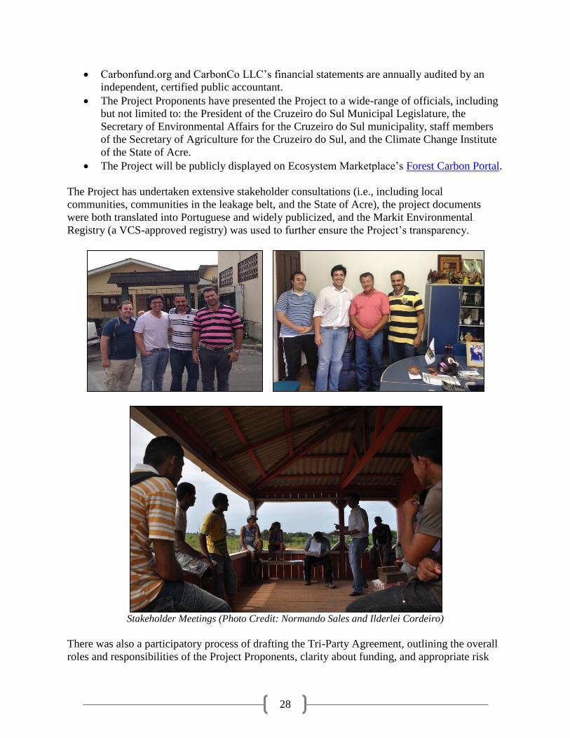
The Project has undertaken extensive stakeholder consultations (i.e., including local
communities, communities in the leakage belt, and the State of Acre), the project documents
were both translated into Portuguese and widely publicized, and the Markit Environmental
Registry (a VCS-approved registry) was used to further ensure the Project’s transparency.
Stakeholder Meetings (Photo Credit: Normando Sales and Ilderlei Cordeiro)
There was also a participatory process of drafting the Tri-Party Agreement, outlining the overall
roles and responsibilities of the Project Proponents, clarity about funding, and appropriate risk

29
sharing of costs and benefits. Furthermore, the transparency of benefit sharing will be enhanced
through verification and VCS-registry distribution of VERs.
Describe Methods to Publicize CCBA Public Comment Period and to Facilitate Submission of Comments
A variety of communication methods were utilized to publicize the CCBA Public Comment
Period to stakeholders of the Valparaiso Project, including the local communities. In addition,
the Project Proponents will play an active role in distributing the Valparaiso Project’s CCBS
Project Design Documents. Such specific steps include:
First and foremost, the CCBS Project Design Documents are available in both English
and Portuguese. This allows for a wider-range of stakeholder participation including
local communities and government officials in Acre, Brazil.
Secondly, the Project Documents will be communicated to community members in an
appropriate manner to overcome the fact that some community members might be
illiterate. For example, the Project Proponents are committed to visiting the communities
during the CCBA Public Comment Period to explain the Project’s Public Comment
Period and solicit their comments. A copy of the Portuguese CCBS PDD was also left at
the Russas Project.
The CCBS Project Design Document were publicly posted for a minimum of 30 days on
the CCBA website and comments will be solicited from the CCBS.
In addition, CarbonCo’s parent company Carbonfund.org Foundation, Inc. publicized the
Project Documents on its website and solicited comments on the Project via a newsletter
announcement to Carbonfund.org’s 20,000+ members.
Furthermore, the Project Documents were sent to a variety of specific stakeholders
including Acre State Government officials, TECMAN and Professor Flores to ensure
accuracy of statements and encourage their submission of comments to the CCBS.
During the CCBS Public Comment Period, the Project Proponents visited as many communities
as possible living within the Project Zone. To facilitate comments from the communities, the
Project Proponents individually met with communities and offered to transcribe their comments.
After ensuring the accuracy of the comment, the Project Proponents will submit the comments
on behalf of the communities directly to the CCBS.
With respect to other stakeholders, Manoel Batista Lopes, ME announced the public comment
period on the Rádio Juruá FM and Rádio Verdes Florestas. These radio stations are widely
listened to throughout the State of Acre, including the municipalities of Cruzeiro do Sul and
Porto Walter. Such an announcement informed listeners about the Valparaiso Project and about
the CCBS, encouraged listeners to review the CCBS PDD, and asked for comments to be
submitted. In addition, Ilderlei Souza Rodrigues Cordeiro attended the Sunday community-wide
meeting to inform the communities first-hand about the CCBS Public Comment Period and also
went house-to-house in case someone was unable to attend the Sunday community-wide
meeting.
Roles and Responsibilities of Project Proponents
The three primary Project Proponents responsible for the Valparaiso Project’s design and
implementation are Manoel Batista Lopes, ME, CarbonCo and Freitas International Group. The
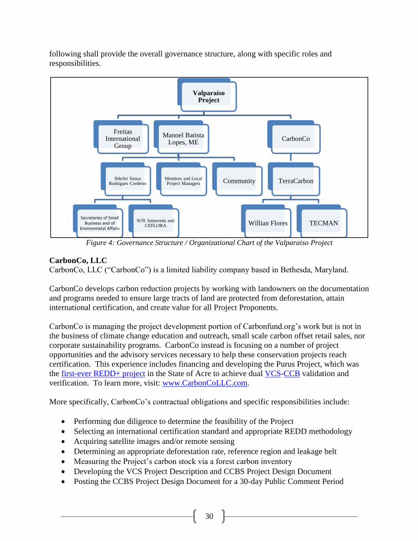
30
following shall provide the overall governance structure, along with specific roles and
responsibilities.
Figure 4: Governance Structure / Organizational Chart of the Valparaiso Project
CarbonCo, LLC
CarbonCo, LLC (“CarbonCo”) is a limited liability company based in Bethesda, Maryland.
CarbonCo develops carbon reduction projects by working with landowners on the documentation
and programs needed to ensure large tracts of land are protected from deforestation, attain
international certification, and create value for all Project Proponents.
CarbonCo is managing the project development portion of Carbonfund.org’s work but is not in
the business of climate change education and outreach, small scale carbon offset retail sales, nor
corporate sustainability programs. CarbonCo instead is focusing on a number of project
opportunities and the advisory services necessary to help these conservation projects reach
certification. This experience includes financing and developing the Purus Project, which was
the first-ever REDD+ project in the State of Acre to achieve dual VCS-CCB validation and
verification. To learn more, visit: www.CarbonCoLLC.com.
More specifically, CarbonCo’s contractual obligations and specific responsibilities include:
Performing due diligence to determine the feasibility of the Project
Selecting an international certification standard and appropriate REDD methodology
Acquiring satellite images and/or remote sensing
Determining an appropriate deforestation rate, reference region and leakage belt
Measuring the Project’s carbon stock via a forest carbon inventory
Developing the VCS Project Description and CCBS Project Design Document
Posting the CCBS Project Design Document for a 30-day Public Comment Period
Valparaiso Project
CarbonCo
TerraCarbon
TECMANWillian Flores
Manoel Batista Lopes, ME
CommunityMonitors and Local Project Managers
Ilderlei Souza Rodrigues Cordeiro
SOS Amazonia and CEFLORA
Secretaries of Small Business and of
Environmetal Affairs
Freitas International
Group
31
Contracting an independent and approved auditor to validate and verify the Project
Addressing all Corrective Action Requests raised by the audit team
Registering the verified emission reductions (VERs) on a VCS-approved registry
Providing advice on the marketing, sale and transfer of VERs
Furthermore, CarbonCo’s entire financial portfolio is audited by an independent, certified public
accountant and CarbonCo shall also keep all documents and records (i.e., including contracts) in
a secure manner for at least two years (i.e., seven years for the CCBS PDD) after the end of the
Project Crediting Period. This includes publicly displaying the completed VCS Project
Description, as well as keeping hard copies of documents in easily accessible file cabinets and
electronic copies on a backed-up share drive.
Freitas International Group, LLC and Carbon Securities
Freitas International Group, LLC is a Florida limited liability company, doing business as
Carbon Securities, with a main office located in Miami, Florida and associates in the Brazilian
cities of Goiânia, Brasília, Rio Branco, Belém, and São Paulo.
Carbon Securities works with CarbonCo, LLC to identify and develop high quality carbon
reduction projects in the Amazon Basin. This experience includes the Purus Project, which was
the first-ever REDD+ project in the State of Acre to achieve dual VCS-CCB validation and
verification. To learn more about Carbon Securities, please see the validated CCBS PDD and
visit: http://www.carbonsecurities.org.
More specifically, Carbon Securities’ contractual obligations and specific responsibilities
include:
Promoting, encouraging and facilitating the participation and cooperation of Landowner
Facilitating due diligence on the Project
Serving as a liaison and translator for the Landowner and CarbonCo
Assisting CarbonCo which includes establishing meetings with Landowner and relevant
stakeholders, arranging site visits, providing information and documentation such as
previous studies, photographs, and satellite images related to the Project
Manoel Batista Lopes, ME
Manoel Batista Lopes, ME was originally created in 1988 by the Valparaiso Project Landowner
Manoel Batista Lopes.
The company is headquartered here:
Manoel Batista Lopes, ME
Endereço: 176 R. Newton Prado, Suite 1
Barrio: Joao Alves, Cidade: Cruzeiro do Sul, Acre, Pais: Brasil - CEP: 69.980-000
CNPJ: 04.004.313/0001-75, CPF: 00580139204
Contractual obligations and specific responsibilities of the Manoel Batista Lopes, ME include:

32
Providing all evidence of ownership of the Property such as deeds, titles and maps which
clearly define the Property’s boundaries and registered with government authorities
Eliminating the drivers and causes of deforestation
Acknowledging and agreeing to not execute any activity that otherwise might interfere
with the implementation during the term of the Project and with the VER generation and
certification at the Property, including, but not limited to (i) clearing the forest for
livestock; (ii) clearing the forest for agriculture; (iii) expanding old roads or constructing
new roads; (iv) expansion into new forests on Property for community use or
infrastructure facilities (i.e., bridges, housing, electricity, etc.); (v) expanding logging
operations; and (vi) deforestation for new mining or mineral extraction.
Taking all actions necessary to avoid any risks associated with the Project, notably the
spread of invasive species, forest fires and pests
Demonstrating legal ownership of any and all pre-existing carbon credit rights
Paying any and all pending liens, taxes, fines and/or any other debts against the Property
Cooperating with CarbonCo and Carbon Securities in any manner and whenever required
in order to obtain the VERs which includes interviews aiming to gather additional
information on the Project, verifying information written in the project documents,
granting access to the Project site, attending meetings with the authorities and community
to explain the Project
Elaborating a community impact monitoring plan
Meeting with community to inform and explain the proposed Project along with
providing a means for the community to express, and be available to address, reasonable
grievances
Incorporating community comments into the development of the Project and resolve any
reasonable grievances with the Project
Landowner acknowledges and agrees that all conservation/preservation measures to be
taken in connection with the Project will be carried out by Landowner voluntarily
Making the project documentation publicly available at the Landowner’s office and at the
Property
TerraCarbon LLC
Neither Carbonfund.org nor CarbonCo directly employ staff with the technical skills to perform
and execute some of the requisite activities and hired TerraCarbon.
TerraCarbon LLC is an advisory firm specialized in the forestry and land-use sector of the
carbon markets. TerraCarbon provides a range of technical, transaction, and strategic services to
clients that implement market oriented programs or projects to restore and protect the world’s
forests. To learn more, visit: http://terracarbon.com/
TECMAN LTDA
CarbonCo, with the guidance of TerraCarbon, hired TECMAN LTDA (“TECMAN”) to perform
the Project’s forest carbon inventory. TECMAN is a Rio Branco-based environmental
consulting and forest management firm founded in 2000 to meet a growing demand for forestry
and environmental projects in the state of Acre, Brazil. Acquired by Fabio Thaines and Igor
Agapejev de Andrade in 2007, TECMAN’s recent accomplishments include over 50,000
hectares of sustainable forestry management work including within the Antimary State Forest of
33
Acre, Brazil. TECMAN also successfully completed the forest carbon inventory for the Purus
Project. To learn more, visit: http://tecman.eng.br/.
Antonio Willian Flores de Melo
CarbonCo, with the guidance of TerraCarbon, hired Professor Antonio Willian Flores de Melo
(“Professor Willian Flores”) to review the Project’s regional deforestation and land-use
modeling. Willian Flores is a Professor at the Federal University of Acre (UFAC) within
UFAC’s Center for Biological Science and Nature. Professor Willian Flores received a degree in
Agronomy from the Federal University of Acre and a Masters’ of Science from the University of
Sao Paulo in Ecological Studies and Agronomy. Professor Willian Flores is currently working
towards a PhD and assisted CarbonCo and TerraCarbon with the deforestation baseline
modelling of the Purus Project.
Local Communities
The local communities on the banks of the Valparaiso River and Juruá River and within the
Valparaiso Project Property consist of approximately 35 families with fifty houses (i.e., adult
children often live adjacent to parents’ house) and approximately 260 individuals.
As of June 2013, the local families of the Valparaiso Project who participated in the Basic
Necessity Survey (BNS), the Participatory Rural Assessment (PRA), and the Agricultural Survey
included:
1. Jose Getulio Silva
2. Antonio Gomes Maciel
3. Francisco Gomes Lima
4. Francisco Souza Silva (Chico Branco)
5. Desdete da Silva Maciel
6. Francisco Edualdo Souza da Silva
7. Francisco Assis Lima
8. Antonio Cruz da Silva
9. Joze Wilmar Xavier dos Santos and Maria Irani Silva dos Santos
10. Maria Cleidianis de Souza Silva Costa
11. Jose Wilson Souza da Silva
12. Raimundo Nonato Souza Lima (Marcondes)
13. Jose Helio da Silva Pinho
14. Maria das Dores Carneiro da Silva, Raimundo Souza Bezerra
15. Jose Nilson Souza Bezerra
16. Jose Maria Araujo da Silva
17. Edilson Bezerra da Silva
18. Josie Goncolves da Silva
19. Augusto Bezerra da Silva
20. Edilson Alves do Rocha
21. Alaiton Silva da Rocha
22. Marmude da Silva do Nascimento
23. Jose Eduardo da Conclicao

34
24. Maria Eglonti do Santo Silva
25. Antonio Homerito Bezerra da Silva
26. Genival Silva da Oliveira
27. Francisco dos Santos Lima
28. Geneane Silva de Oliveira
29. Alderlei Souza da Silva
30. Francisco dos Santos Silva
I.S.R.C. Investimentos e Acessória LTDA
Ilderlei Souza Rodrigues Cordeiro operates the company I.S.R.C. Investimentos e Acessória
LTDA (“I.S.R.C.”) which has partnered with Manoel Batista Lopes, ME to assume the
responsibility of implementing the local social projects and programs at the Valparaiso Project.
The company is headquartered here:
I.S.R.C. INVESTIMENTOS E ACESSÓRIA LTDA
CNPJ: 06.200.153/0001-69, INSCRIÇÃO ESTADUAL: 01.015.482/001-35
Endereço: ESTRADA DO AEROPORTO Km 04
Bairro: Zona Rural, Cidade: Cruzeiro do Sul - Acre - Brasil, Cep: 69.980-000
Orientation and Training Plan to Provide Orientation and Training for Project’s Employees and Relevant Community Members
The Valparaiso Project Proponents will provide orientation and training for the Project’s
employees and relevant community members. This includes building capacity among the local
communities and the plan will also target underrepresented groups in the communities. To date,
orientation and trainings have included:
Meeting with Jose Getulio Silva (i.e., “Getulio,” the initial Project Manager), Francisco
dos Santos Silva and the minister Valdecir of the local church to discuss the Project
Ilderlei Souza Rodrigues Cordeiro has also met with the local communities at the
Valparaiso Project for over three years to provide orientation to the Valparaiso Project,
the adjacent Russas Project and conservation activities
CarbonCo, Carbon Securities and TerraCarbon had a kick-off meeting and orientation in
August 2011 with TECMAN and Professor Flores prior to initiating the forest carbon
inventory and regional deforestation modelling.
TerraCarbon provided both classroom and field training, along with a standard operating
procedure (i.e., in Portuguese and English) for TECMAN’s forest carbon inventory and
provided a online, refresher training for TECMAN in January 2013.
In the near term, the Project Proponents would like to have:
State of Acre’s CEFLORA (Centro de Formação e Tecnologia da Floresta or Center for
Training and Forest Technology), the Secretary of Environmental Affairs for the
Municipality of Cruzeiro do Sul and/or S.O.S. Amazônia to continue assisting with
agricultural extension trainings based off the top-ten agricultural extension courses

35
Assistance from an organization or individual such as André Luis Botelho de Moura to
train the Project Proponents and local communities on proper techniques for wildlife
cameras and biodiversity monitoring.
Hire agronomists, such as Edigane Maciel, and forest engineers to provide additional
courses and training for the local communities
Furthermore, Manoel Batista Lopes, ME and Ilderlei Souza Rodrigues Cordeiro will utilize
S.O.S. Amazônia to assist with training new workers when there is staff turnover.
Community Involvement Show Communities will be given an Equal Opportunity to fill all Employment Positions
The Valparaiso Project Proponents recognize the communities are a central element to the
Valparaiso Project’s success and to achieve the Project’s objective, the communities will be
given an equal opportunity to fill all employment positions.
To date, the communities have been involved in the Valparaiso Project by:
Acting as guides
Providing lodging, food and transportation services
Local project manager and initiate monitoring for deforestation
Choosing the particular crops and techniques they would like to learn more about
Discussing the Project design, benefits of the project, how they would like to participate
As the Valparaiso Project proceeds, the communities will eventually be considered for a variety
of roles and employment opportunities such as:
Additional local, on-the-ground monitors for deforestation
Retrieval of biodiversity monitoring data
Participation in cooperative agricultural projects
Working internal jobs at the Project site (for example: hiring additional deforestation
monitor, working at the açaí processing plant, maintain the Project’s headquarters, and to
provide transportation services)
Nurse for health and dental clinic
Economic opportunities and participation in social projects will be offered regardless of race,
religion, sexual orientation, or gender.
To help ensure equal opportunities, all employment positions will be announced at the monthly
community meetings and such employment opportunities will also be communicated via word-
of-mouth to each community from the local, onsite Project Manager.
All community members interested in being considered for the employment opportunity will be
asked to either directly contact Ilderlei Souza Rodrigues Cordeiro, Manoel Batista Lopes, ME or
to express their interest to the local, onsite Project Manager who will then contact Ilderlei Souza
Rodrigues Cordeiro on their behalf.

36
Manoel Batista Lopes, ME or Ilderlei Souza Rodrigues Cordeiro will interview all applicants,
including women and underrepresented groups, and hire the best applicant(s) based on their
previous experience vis-à-vis the job requirements. If all eligible applicants have similar
experience, then Manoel Batista Lopes, ME and Ilderlei Souza Rodrigues Cordeiro will choose
and help train the applicant who is underrepresented including women applicants and applicants
with less financial stability.
Relevant Laws and Regulations Submit List of all Relevant Laws and Regulations Covering Worker’s Rights in the Host Country
The Valparaiso Project shall meet, or exceed, all applicable laws and regulations covering
worker rights in Brazil and the Project Proponents will inform all workers about their rights.
The following is a list of Brazil’s relevant laws and regulations covering worker’s rights:
The Brazilian Constitution, Chapter II-Social Rights, Articles 7- 11 which addressed:
o Minimum wage
o Normal working hours
o Guidance on vacation and weekly leave
o Guidance on maternity and paternity leave
o Recognition of collective bargaining
o Prohibition of discrimination11
In addition to the Constitution, there are two additional decrees related to Brazilian labor laws.
Consolidação das Leis do Trabalho (CLT): DECRETO-LEI N.º 5.452, DE 1º DE MAIO
DE 1943 (Consolidate of Working Laws).12 This decree gives more clarification on:
o Hourly, daily, weekly and monthly work hours
o Employment of minors and women
o Establishes a minimum wage
o Worker safety and safe working environments
o Defines penalties for non-compliance by employers
o Establishes a judicial work-related process for addressing all worker related issues
Estatui normas reguladoras do trabalho rural: LEI Nº 5.889, DE 8 DE JUNHO DE 1973
(Establishes Regular Norms for Rural Workers).13 This is a complimentary law to the
aforementioned 1943 decree because prior to 1973, rural workers did not have the same
rights as urban workers. In 1973, this law was established to specify the equality
between urban and rural workers, along with compensation for overtime.
11 Massachusetts Institute of Technology, “Brazilian Constitution,” Available:
http://web.mit.edu/12.000/www/m2006/teams/willr3/const.htm 12 Presidency of the Republic, “DECRETO-LEI N.º 5.452, DE 1º DE MAIO DE 1943, Available:
http://www.planalto.gov.br/ccivil_03/decreto-lei/Del5452.htm 13 Presidency of the Republic. “LEI Nº 5.889, DE 8 DE JUNHO DE 1973,” Available:
http://www.planalto.gov.br/ccivil_03/leis/L5889.htm
37
Compliance with Law
Agreements between the Project Proponents as well as Agreements between CarbonCo and its
contractors stipulate firms to abide by labor laws (for example, wages above Brazil’s federal
minimum wage) and an assurance that all Brazilian employment taxes and insurance are paid.
In addition, CarbonCo has an employee handbook to ensure proper guidelines are followed by its
employees. Ilderlei Souza Rodrigues Cordeiro has an explanatory letter on labor rights that will
be presented to all employees to ensure workers are informed about their rights.
CarbonCo undergoes a financial audit by an independent accountant to ensure all taxes,
including employment, social and corporate, are paid. Furthermore, Manoel Batista Lopes, ME
have provided “Receita Federal” which certify that all taxes (including employee and business)
and insurance (including social) are paid.
The Project Proponents will forever continue to work with the well-being of the communities in
mind. This shall differ from historical employment arrangements where there were indentured
servant arrangements at extractive reserves. In contrast, the communities will be offered
meaningful employment, have the ability to directly shape the Project, and an ability to express
any and all grievances.
Worker Safety Assurance Comprehensively Assess Situations and Occupations that Pose a Substantial Risk to Worker Safety
The Valparaiso Project Proponents comprehensively assessed the situations and particular
occupations that could pose risks to worker safety. The Project Proponents will inform workers
of such risks, explain how to minimize such risks, and the Project Proponents will use best work
practices.
The main potential risks to workers identified by the Project Proponents include:
Drowning
Heat Exhaustion and Dehydration
Getting lost in Remote Forest
Venomous Snake Bites
Tropical Diseases
Drowning
It is important to note, that all boats travel relatively slow on the Valparaiso and Juruá River,
many participants know how to swim, and life preservers are always onboard in case a boat does
happen to capsize.
Heat Exhaustion and Dehydration
Workers and Project Proponents are familiar with tropical rainforests (for example, high levels of
humidity and tropical temperatures) and prepare for each trip with sufficient food and water.

38
Getting Lost
Global positioning systems (GPS) are used during trips into the deep forest to minimize the risk
of getting lost. Local guides from the community and the Valparaiso Project Landowner’s
familiarity with the area also helps to minimize the chances of getting lost.
Venomous Snake Bites
The most substantial risk to workers, particularly TECMAN’s employees during the forest
carbon inventory, was the potential encounter with venomous snake bites. Snake bites are
relatively common in South America14 and specifically within the State of Acre.15 The snake
species of greatest concern are the fer-de-lance (Bothrops atrox) and the South American
bushmaster (Lachesis muta).16 To mitigate such risk, all TECMAN’s employees were equipped
with and required to wear protective snake chaps. There are also many poisonous spiders and
scorpions in tropical rainforests.
Worker safety is of the highest importance. For TECMAN’s forest carbon inventory work, there
was a discussion of safety procedures and TECMAN has a safety manual entitled,
Procedimentos de Segurança em Campo (Field Safety Procedures).
Tropical Diseases
There are many tropical diseases in Acre, Brazil such as malaria, yellow fever and chagas
disease. The Project Proponents are encouraged to get yellow fever vaccinations, malaria pills
are available, and mosquito nets are frequently used.
Approval from Appropriate Authorities Document that the Project has Approval from the Appropriate Authorities
The Valparaiso Project has approval from Manoel Batista Lopes who privately owns the
Valparaiso Project property and the Project Proponents have received approval from the local
communities. Such approvals are evidenced by the Tri-Party Agreement between the Project
Proponents, along with the “ata” signed by the local communities.
The Project Proponents are also in active communication with the State of Acre and the Project
Proponents also have letters of support from several institutions including:
The President of ITERACRE
The President of the Legislature for the Municipality of Cruzeiro do Sul
The State Secretary of Environmental Affairs for the Municipality of Cruzeiro do Sul
Upon validation of the Valparaiso Project, the Project Proponents will officially register the
Valparaiso Project with the State of Acre (i.e., receive an official seal and number) and will also
upload the Project to the State of Acre’s Climate Change Institute.
14 J.-P. Chippaux. “Reviews/Analyses,” Available:
http://www.ncbi.nlm.nih.gov/pmc/articles/PMC2305789/pdf/bullwho00388-0084.pdf 15 Pierini SV et al., “High incidence of bites and stings by snakes and other animals among rubber tappers and
Amazonian Indians of the Juruá Valley, Acre State, Brazil,” 16 Fabiano Waldez and Richard C. Vogt, “Ecological and epidemiological aspects of snakebites in riverside
communities of the lower Juruá River, Amazonas, Brazil,” Available: http://piagacu.org.br/?attachment_id=416

39
Potential Negative Offsite Stakeholder Impacts
The Project Proponents have identified the following potential negative offsite stakeholder
impacts:
Increased cost of land; for example, if forest carbon projects increase property values for
future land purchases
Decreased value of land; for example, if Valparaiso Project prevents adjacent properties
from accessing markets
In-migration to areas adjacent to the Project Zone
If communities migrate out of the Project Zone (i.e., due to forced relocation or lack of
Project success) and into primary forests adjacent to the Project Zone
If the Project Proponents are unable to eliminate deforestation and the community
continues to expand into the forest, including forests outside the Project Zone
Wealth in Project Zone creates conflict in surrounding areas due to jealousy, a rise in
illicit activities, alcoholism, elite capture, etc.
Mitigation Plans Describe how Project Plans to Mitigate these Negative Offsite Social and Economic Impacts
It is important to note that the communities in and near the Valparaiso Project have good
relationships and no conflicts with main stakeholders living outside the Project Zone have been
identified through stakeholder consultations.
Regarding the increased cost of land, the Valparaiso Project will have less an impact on rising
costs of land than the completion of BR-364 and Ramal 3’s paving. In contrast, the Valparaiso
Project might decrease the value of surrounding land. The Valparaiso Project is a conservation
project and might prevent surrounding properties from having access to markets because the
Project will not allow road construction through the property. Nevertheless, Manoel Batista
Lopes, ME will discuss the Valparaiso Project with adjacent landowners to offer expanding
forest conservation projects beyond the boundaries of the Valparaiso Project. Maintaining forest
cover, at the expense of road construction or the establishment of large-scale cattle-ranches, has
positive climate, community and biodiversity benefits.
In-migration to areas adjacent to the Project Zone could occur. However, Acre’s State System of
Incentive for Environmental Services (SISA) seeks to improve rural livelihoods which should
reduce in-migration into the both the Project Zone and areas adjacent to the Project Zone.
Furthermore, the Project Proponents will monitor deforestation throughout the Project Zone and
will seek to minimize deforestation within the Project Zone. Similarly, there is a possibility of
out-migration from the Valparaiso Project and into the surrounding non-Valparaiso Project
property forests. To mitigate out-migration, the Project Proponents have held numerous
community meetings and seek to implement a variety of social projects and programs.
With respect to increased conflict, illicit activities, alcoholism, and elite capture, the Project
Proponents will monitor community benefits throughout the Project Zone. Children from
surrounding communities will be allowed to attend the local school and surrounding
communities will be allowed to visit the dental and health clinic.

40
Exceptional Community Benefits The Project Proponents will assist all communities in and around the Valparaiso Project,
including the more vulnerable communities within the Project.
Project Zone and Socio-Economic Status
According to the United Nations Development Programme’s International Human Development
Index (HDI), Brazil is considered a high human development country.17 However, it can be
demonstrated that at least 50% of the population in the Project Zone are below the national
poverty line. According to a World Bank study18, the national poverty line per capita per month
in Brazil is 180.14 (2005 PPP$) while the nominal median monthly income per capita of a rural,
permanent private household in the municipality of Cruzeiro do Sul is R$130.75.19
Involvement of Poorest Community Members
Project Proponents will not practice selective enrollment – all community members, regardless
of background, longevity on project, size of holding, etc. will be allowed to participate.
All social projects and programs (e.g., health and dental clinic, agricultural extension trainings,
etc.) will be offered to all communities. Furthermore, the Project Proponents are aware of the
potential for elite capture and will seek to prevent this risk.
In addition to partnering with Ilderlei Souza Rodrigues Cordeiro, Manoel Batista Lopes, ME
plan to involve the local church to hold after-church meetings to specifically assist women and
children with alternative socioeconomic activities.
The Basic Necessity Survey (BNS) allows the Project Proponents to identify the 50% of
households within the lowest category of well-being. As of June 2013, the lowest quartile
included communities with:
Owned assets less than: R$34,839.00
Owned assets per capita less than: R$5,320.63
Poverty score less than: 13.833
Poverty index less than: 52.20%
Benefit distribution will be very equal. Land titling will take into account per capita, so larger
families will get larger parcels of land.
Furthermore, the Project Proponents have identified the particular needs of the eight households
within the lowest quartile of the 32 communities surveyed via the Basic Necessity Survey. Thus,
the assets and services deemed by 100% of these four households in the lowest quartile as Basic
Necessities, but are the least owned among this lowest quartile, are as follows:
Telephone (12.5% owned by lowest quartile)
17 UNDP, “International Human Development Index,” Available:
http://hdrstats.undp.org/images/explanations/BRA.pdf 18 Martin Ravallion et al., “Dollar a Day Revisited,” Available: http://www-wds.worldbank.org/servlet/
WDSContentServer/WDSP/IB/2008/09/02/000158349_20080902095754/Rendered/PDF/wps4620.pdf 19 IBGE, “Cruzeiro do Sul,” Available: http://www.ibge.gov.br/cidadesat/link.php?codigo=120020&idtema=16
41
Planting Tool (12.5% owned)
Boat or Canoe and Diesel (12.5% owned)
Weedwacker (12.5% owned)
The Project Proponents then designed the Project in order for at least 50% of these households to
benefit substantially from the Project. This includes addressing some of their particular needs
(such as increasing access to transportation and focusing on agricultural extension courses) and
by also seeking to increase their incomes in order for them to eventually purchase assets (such as
a telephone or television) to satisfy their other needs.
The Project Proponents have identified scenarios which might prevent the poorest quartile of
communities to benefit substantially from the Project and this includes:
Poorer families might live further away from the project headquarters.
Fewer tools to produce agriculture.
Might not have boat, motor or diesel to travel
Communities might have poorer soil quality where they live.
Poorer health and less nutrition.
Poorer Families might live further away from the Project Headquarters
I.S.R.C will pay for the diesel, assuming these families have working boats and motors, to allow
further communities to participate in the Project and attend meetings and agricultural courses.
Fewer Tools to Produce Agriculture
The Project will give free agricultural extension courses for the communities to learn new
techniques. The association will help with the mechanization of the land. The association will
prioritize the improvement of the poorer communities’ manic flour houses.
Might not have Boat, Motor or Diesel to Travel
The boat being purchased by the Valparaiso Project will allow those communities without a boat
to participate in the Project and specifically to participate in the commercialization and market
access of their crops.
Might Have Poorer Soil Quality Where They Live
Teaching fishing courses will allow those communities with poorer soil quality an alternative
means to generate income. The agricultural courses will teach new techniques to take into
account poorer soil. For example, the soil might be bad for bananas but might be good for
manioc and this is something the agricultural courses will help to teach.
Poorer Health and Less Nutrition
The agricultural courses will seek to increase the productivity and hence, improve the nutrition
of local communities. The health clinic will be improved and the doctor visits to the community
will increase. The doctor will visit all communities including poorer communities. The doctor
visits are free, which will most benefit the poorer communities who would otherwise be less able
to pay for such doctor visits.
42
Basic Necessity Survey was utilized to identify any poorer and more vulnerable households and
individuals whose well-being or poverty may be negatively affected by the project. All
communities have been consulted and there should be no negative impacts.
Community Impact Monitoring
The Basic Necessities Survey and Poverty Index have enabled the Project Proponents to identify
positive and negative impacts on the poorest communities and more vulnerable groups within the
Project, including women. This being said, the Project Proponents will continue to monitor
community impact variables such as: value of owned assets; value of owned assets per capita;
poverty score and poverty index; inequality of owned assets and inequality of owned assets per
capita.
OVERVIEW OF MONITORING PLANS
Climate Impact Monitoring
The Valparaiso Project Proponents have a climate impact monitoring plan in place which
identifies the types of measurements, sampling method, and frequency of measurements.
Initial Monitoring Plan
The Valparaiso Project has a complete and detailed climate impact monitoring plan which
accounts for leakage and the required carbon pools.
Full Monitoring Plan
For the Valparaiso Project’s full climate impact monitoring plan, which also addressed the initial
monitoring plan requirements, please see the VCS Project Description.
Community Impact Monitoring
The Project Proponents have designed an initial community impact monitoring plan and a full
community impact monitoring plan. The Project Proponents will disseminate this full
community impact monitoring plan and the results of the monitoring plan specifically to the local
communities and other stakeholders, along with making the plan and results publicly available
via the internet to the general public.
Initial Community Monitoring Plan
The initial community monitoring plan involved regular communication between Manoel Batista
Lopes, ME, Ilderlei Souza Rodrigues Cordeiro and the communities. With respect to outside
stakeholders, the initial monitoring plan involved informal conversations with outside
stakeholders and reviewing the Brazilian Census’ socio-economic variables for the
municipalities of Cruzeiro do Sul and Porto Walter.
From these conversations and based off Carbon Securities and CarbonCo’s experience at the
Purus Project, it was determined that a Basic Necessity Survey (BNS), Participatory Rural
Assessment (PRA) and the Theory of Change would be the three best tools to monitor
community net benefits and the communities’ High Conservation Values. The BNS and PRA
shall be administered every two years, with the initial surveys conducted from March to May

43
2013. The specific variables to be annually monitored are the indicators of the Theory of
Change (activities, outputs, outcomes, and impacts), while the access to Basic Necessities, along
with the value of owned assets, value of owned assets per capita, poverty score and poverty
index, inequality of owned assets and inequality of owned assets per capita will be monitored
every two years. Please see the full monitoring plan below for additional details.
Initial High Conservation Values Plan
The PRA and BNS were designed to measure the communities’ high conservation values
(HCVs) and the Project Proponents will continue to monitor these HCVs.
The PRA inquired about HCVs such as the communities’ hunting, fishing, building materials,
and the collection of medicinal plants. The PRA will be regularly administered and additional
questions to identify trends in the availability of medicinal plants, building materials, and food
(i.e., from both the forests and rivers) will be added to the next PRA. As an example of the
PRA’s ability to monitor HCVs, it was discovered via community meetings and the initial PRA
that local fishing stocks in the Valparaiso River are being depleted because commercial
fishermen from outside the Project Zone are now entering into the Project Zone to fish. This
situation will be monitored and the Project signs now specify no commercial fishing is allowed.
The BNS will also be regularly administered and will identify trends in the overall availability of
basic needs and HCVs including access to housing, health clinic, food, and clean drinking water.
This said, the specific HCVs related to hydrological services that provide benefits to the local
communities are the provision of fish, using the rivers as a mode of transportation, and as a
source of clean drinking water. Thus, the BNS will track the access to clean drinking water,
transportation (i.e., access to boat or canoe), and the PRA inquired about fishing.
Full Monitoring Plan
The Valparaiso Project’s full community monitoring plan is to monitor the indicators derived
from the PRA, BNS and Theory of Change’s outputs, outcomes and community impacts. The
frequency of monitoring and reporting to ensure that these indicators are directly linked to the
Valparaiso Project’s major community objectives and are leading to the anticipated net positive
impacts will take place every two years for the PRA and BNS and annually for the Theory of
Change.
The specific indicators of the Theory of Change which will be annually monitored and reported
are as follows:
Indicators of Activities
Signed Tri-Party Agreement between Project Proponents
Completion of Forest Carbon Inventory
Completion of Regional Deforestation and Land-Use Modeling
Completion of VCS Project Description and CCBS Project Design Document
Completion of the Agricultural Survey, Basic Necessities Survey and Participatory Rural
Appraisal

44
Indicators of Outputs
Validation Statement for VCS Project Description and CCBS Project Design Document
Spreadsheet with Top-10 Agricultural Courses Identified
Agricultural Extension Trainings / Courses Conducted
Spreadsheet Compiling Data on Basic Necessities including: What are Considered Basic
Necessities; Total Value of Owned Assets and Total Value of Owned Assets per Capita;
Price of Assets; Poverty Score and Poverty Index
Summary Statistics on: Income/Asset Inequality; Most Disadvantaged Communities;
Most Under-Owned Assets; Most Desired Basic Necessities
Qualitative Surveys and Spreadsheet Compiling Data on: Land-Use; Patterns of
Deforestation and Yearly Cycle of Deforestation; Why and Where Deforestation Occurs;
Deforestation from Residents vs. Recent Migrants
Indicators of Outcomes
Value of Carbon Finance Generated
Communities Gain New Knowledge, Practices and Skills About Sustainable Agricultural
Prioritization and Implementation Plan for Social Projects and Programs to Reduce
Deforestation and Improve Community Benefits
Baseline for Monitoring Community Benefits
Formulation of Plan to Mitigate Leakage
Formulation of Plan to Monitor Deforestation
Indicators of Impacts
Community Income Diversified
Increased Income Generation
Reduced Deforestation
Intensified Agricultural Practices
Diversified Crops
Increasing Communities' Owned Assets and Owned Assets per Capita
Improved Poverty Figures and Poverty Scores
Increased Access to Basic Necessities
Improved Health and Dental Clinic
The specific variables that will be monitored and reported every two years with the BNS and
PRA are as follows:
Communities’ access to Basic Necessities
Value of Owned Assets
Value of Owned Assets per Capita
Poverty Score
Poverty Index
Inequality of Owned Assets
Inequality of Owned Assets per Capita
This community monitoring plan is ultimately designed to ensure equitable benefits distribution.
To this end, the plan shall:

45
Document receipt of benefits
Ensure attention is paid to gender and generational distribution of benefits
Adaptive management to address shortcomings associated with improper distribution of
benefits
Monitoring plan will be shared with stakeholders
Avoid elite capture
The Project Proponents will seek to increase the number of households participating in the
Valparaiso Project.
Although very limited leakage is predicted outside of the Project Zone due to the project
activities of the Valparaiso Project, the other stakeholders who might be negatively impacted due
to the Valparaiso Project are the communities and landowners living adjacent to the Project Zone
and within the municipalities of Cruzeiro do Sul and Porto Walter.
To quantify and document changes in the social and economic well-being of these outside
stakeholders which result from the project activities, the Project Proponents will first review the
Brazilian Census every four years to document the socio-economic variables in the
municipalities of Cruzeiro do Sul and Porto Walter. These specific socio-economic variables to
be monitored include:
Total employed personnel
Resident population
Gross Domestic Product (GDP) per capita at current prices
Value of average nominal monthly income of permanent private households with
household income, by status of the housing unit – Rural
Value of average nominal monthly income of permanent private households with
household income, by status of the housing unit – Urban
Resident population – literate
Enrollment - Elementary school
Enrollment - High school
Number of Health institutions
Percentage of Permanent private housing units, by existence of piped water and type of
water supply - With water supply
Percentage of Permanent private housing units - with energy supply20
The Project Proponents will then interview the outside stakeholders adjacent to the Project Zone
every four years to quantify their socio-economic variables (i.e., the same socio-economic
variables described above). Next, the Project Proponents will conduct a statistical analysis to
determine whether the outside stakeholders’ socio-economic variables are significantly worse off
than the residents throughout the municipalities of Cruzeiro do Sul and Porto Walter due the
project activities of the Valparaiso Project.
20 IBGE, “Click here to get information about municipalities at Cities@,” Available:
http://www.ibge.gov.br/estadosat/perfil.php?sigla=ac#
46
Biodiversity Impact Monitoring
The Project Proponents have an initial biodiversity monitoring plan and a full biodiversity
impact monitoring plan. The Project Proponents will disseminate this full biodiversity impact
monitoring plan and the results of the monitoring plan specifically to the local communities and
other stakeholders, along with making the plan and results publicly available via the internet to
the general public.
Initial Biodiversity Monitoring Plan Develop an Initial Plan for Selecting Biodiversity Variables and Frequency of Monitoring and Reporting
The Project Proponents initial plan is to monitor forest loss (i.e., habitat availability) in the
Project Area and Project Zone on a yearly basis using the State of Acre’s remote sensing data.
Initial High Conservation Values Plan Develop Initial Plan for Effectiveness of Measures to Maintain or Enhance High Conservation Values
The Project Proponents recognize the particular importance of the Project’s high conservation
values and will assess the effectiveness of the Project’s conservation activities vis-à-vis the
Project’s high conservation values.
The measures to maintain or enhance the significant concentrations of biodiversity – particularly
threatened species, endemic species and threatened ecosystems - within the Valparaiso Project
are the various deforestation mitigation activities (e.g., agricultural extension training,
deforestation monitoring, etc.) as outlined in section G3. Project Design and Goal, subsection 2.
Major Activities.
The initial plan to assess the effectiveness of these various deforestation mitigation activities will
include:
Review satellite imagery for deforestation to ensure effective conservation of forest cover
(i.e., a threatened or rare ecosystem)
Incorporate analysis of the population and distribution of threatened and endemic species
identified with wildlife camera traps into full biodiversity monitoring plan
Review ongoing Participatory Rural Assessments and Basic Necessity Surveys to ensure
effectiveness of maintaining or enhancing community HCVs
Additional mechanisms to ensure effective maintenance or enhancement of HCVs will be
developed utilizing adaptive management, stakeholder consultation, and eventually be
incorporated into the full monitoring plan. For example, if small-sized, threatened or endangered
species such as amphibians, reptiles, or insects are identified in the Project Area (i.e., an example
of an HCV), then the Project Proponents will incorporate the monitoring of these species, if
necessary, into the full biodiversity impact monitoring plan.
Full Monitoring Plan
The Project Proponents’ full monitoring plan will continue with monitoring forest cover and
habitat availability, along with monitoring the diversity, distribution, and populations of
medium-to-large mammals with wildlife camera traps. Furthermore, a Theory of Change shall
be used to link the Projects activities to outputs and outcomes, and to the overall biodiversity
impacts.
47
Monitoring forest cover and using wildlife cameras will be sufficient to monitor all wildlife
species of interest – particularly medium-to-large mammals – throughout the Project Zone’s
rainforests. This has been demonstrated via local studies conducted near the Project Zone
indicating the type of biodiversity likely present, along with CarbonCo and Carbon Securities’
successful use of wildlife cameras at the Purus Project (another REDD+ project near Manoel
Urbano, Acre) which has identified numerous mammals such as:
Black agouti (Dasyprocta fuliginosa)
Giant Anteater (Myrmecophaga tridactyla)
Jaguar (Panthera onca)
Lowland tapir (Tapirus terrestris)
Ocelot (Leopardus pardalis)
Paca (Cuniculus paca)
Short-Eared Dog (Atelocynus microtis)
The basic process of developing the biodiversity monitoring plan was:
1. Conducted background research
2. Identify local partners and community members to assist with monitoring plan
Background research included: Reviewing the wildlife camera trap techniques deployed by other
REDD project developers;21 How to position cameras, sampling designs, and field crews;22,23
Technical elements of mammalian diversity and populations using wildlife camera traps,24,25
along with reviewing wildlife camera trap models.26
Brian McFarland also spoke to Dan Bisaccio, a Lecturer in Education and Director of Science
Education at Brown University who has frequently used wildlife camera traps in a variety of
tropical ecosystems.
Within one year of project validation, the Project Proponents shall:
Review vegetation maps of the Valparaiso Project to identify general areas within the
Project to set up wildlife camera traps
Consult local communities, S.O.S. Amazônia, and/or André Luis Botelho de Moura to
identify the specific locations to set up wildlife camera traps
21 Waldon, Jeff, Bruce W. Miller and Carolyn M. Miller, “A model biodiversity monitoring protocol for REDD
projects,” September 2011, Tropical Conservation Science Vol. 4(3):254-260. 22 Grant Harris et. al, “Automatic Storage and Analysis of Camera Trap Data,” Available:
http://dx.doi.org/10.1890/0012-9623-91.3.352 23 TEAM Network. 2011. Terrestrial Vertebrate Protocol Implementation Manual, v. 3.1. Tropical Ecology,
Assessment and Monitoring Network, Center for Applied Biodiversity Science, Conservation International,
Arlington, VA, USA. 24 C. Carbone et. al, “The use of photographic rates to estimate densities of tigers and other cryptic animals,”
Available: nationalzoo.si.edu/.../024ebe33-5a96-49f6-9080-33bbdb0c92c0.pdf 25 Tim O’Brien, “Wildlife Picture Index: Implementation Manual Version 1.0,” Available: static.zsl.org/files/wcs-
wpno39-wildlifepictureindex-928.pdf 26 TrailCamPro, “Trail Camera Selection Guide,” Available:
http://www.trailcampro.com/trailcameraselectionguide.aspx

48
Purchase and placement of wildlife cameras throughout the Project Area, rotating the
cameras to different vegetation strata as necessary
Train community on wildlife cameras such as preventative maintenance, periodic
movement of cameras between different locations, along with regular retrieval and
replacement of camera memory and batteries.
Photographic images will be then be organized, identified and analyzed by specialists
Disseminate the full biodiversity impact monitoring plan and the results of the monitoring
plan specifically to the local communities and other stakeholders, along with making the
plan and results publicly available to the general public.
Adaptive management will be incorporated into the biodiversity monitoring plan in order to
allow for a change in the camera locations and camera models based off results.
Activities:
The main activities were identified above.
Outputs
The main outputs of the biodiversity monitoring plan will be photographs from the wildlife
camera traps and deforestation monitoring reports to document forest cover and habitat
availability. In addition, an analysis of the population and distribution of threatened and endemic
species will be conducted.
Outcomes
The outcomes based off the outputs will be an analysis of medium-to-large mammal populations
and a better understanding of their distribution throughout the Valparaiso Project.
Impacts
The ultimate impact will be the preservation of biodiversity and particularly, the preservation of
the Project’s high conservation values such as threatened species.
The Valparaiso Project shall monitor biodiversity impacts both spatially throughout the
Valparaiso Project as well as temporally over the Valparaiso Project Lifetime. The goal is to
conduct a biodiversity monitoring project every four years.
RESULTS AND BENEFITS OF MARCH 2011 - DECEMBER 2013 IMPLEMENTATION
Net climate, community and biodiversity benefits between March 19, 2011 and December 31,
2013 include, but are not limited to: a reduction in the Project Area’s deforestation; preservation
of biologically diverse habitats; local hires and transfer of technical knowledge; offering
agricultural extension courses; starting patrols for deforestation; and the overall development of
the third-ever, VCS-CCBS validated REDD+ project in the State of Acre, Brazil.
The following will further describe each major climate, community and biodiversity project
activity between March 19, 2011 and December 31, 2013 and how it is relevant to achieving the
overarching climate, community and biodiversity objectives.

49
Major Climate Objective
To achieve the major climate objective of mitigating deforestation and the subsequent release of
GHG emissions, the Project Proponents undertook a forest carbon inventory, developed a
regional land-use and deforestation model, and are addressing the underlying deforestation
drivers to mitigate the release of GHGs with a plan for ongoing monitoring.
Forest Carbon Inventory
A forest carbon inventory was an important project activity to undertake because it is difficult to
manage an objective that is not measured. The forest carbon inventory generated a scientifically
robust and statistically accurate representation of the carbon stocks on the Valparaiso Project.
The forest carbon inventory was conducted by the renowned local forestry company TECMAN
and was overseen by both CarbonCo and the international experts at TerraCarbon. TECMAN
was contracted by CarbonCo in January 2013, participated in a web-based training from
TerraCarbon in January 2013, and then TECMAN conducted the Russas Project’s forest carbon
inventory from February to March 2013.
TECMAN is an example of a local hire; TECMAN received a transfer of technical knowledge
and know-how from TerraCarbon and TECMAN received certificates of completion to
demonstrate their knowledge of conducting a forest carbon inventory.
Regional Land-use and Deforestation Modeling
Similar to the need for a measurement of carbon stocks, there was a need to develop a regional
land-use and deforestation model to determine a performance baseline for the Project
Proponents. Such models now allow the Project Proponents to predict where (i.e., location),
when, from what (i.e., drivers and agents) and how much deforestation is expected, along with
where to assist with leakage mitigation and primarily where to monitor.
The Valparaiso Project’s regional land-use and deforestation modeling was conducted by
TerraCarbon and reviewed by Professor Antonio Flores from the Federal University of Acre.
Professor Flores was contracted by CarbonCo in April 2013 and assisted with the review of the
Russas Project’s modeling from approximately March to July 2013.
Professor Flores is another example of a local hire; Professor Flores received a transfer of
technical knowledge and know-how from TerraCarbon.
Address Underlying Deforestation Drivers to Mitigate Release of GHGs
While understanding the Valparaiso Project’s carbon stocks and deforestation scenario, the
Project Proponents began to address the underlying deforestation drivers to mitigate the release
of GHGs (See Social Projects and Programs within this section).
Addressing the underlying deforestation drivers - for example, providing agricultural extension
trainings – is relevant to achieving the climate objective of reducing net GHG reductions by
reducing the communities’ dependence on forest resources through intensification of agricultural
and livestock practices, by providing alternative income, along with providing education about
the effects of deforestation and benefits of protecting forest resources.
50
Develop Climate Monitoring Plan and Monitor Deforestation
The Project Proponents will constantly monitor deforestation by boat as well as from the State of
Acre’s satellite imagery (See Social Projects and Programs within this section). This climate
monitoring plan was devised between March 19, 2011 and December 31, 2013.
Major Community Objective
To generate sustainable economic opportunities and to implement local social projects for
communities living in and around the Valparaiso Project, the Project Proponents have
undertaken, or began to plan for, the following project activities: Project Awareness, Meet
Community, and Discuss Project; Design Social Projects and Programs for Community;
Implement Social Projects and Programs for Community; Develop Community Monitoring Plan
and Monitor Community Impacts.
Project Awareness, Meet Community and Discuss Project
Between March 19, 2011 and December 31, 2013 the Project Proponents visited the Valparaiso
Project together and met with the local communities in June 2012, March-April 2013, June 2013
and August 2013.
The communities are an essential component of the Valparaiso Project and likewise, it has been
absolutely necessary to openly and frequently discuss the Project with the communities.
Through meeting with the communities, the Project Proponents have been able to gain the
communities’ insights about project design and to better incorporate the communities into the
Project. As a result, the community objective of generating sustainable economic opportunities
and implementing social projects and programs will be best achieved with active, on-going
participation and input from the local communities.
Throughout 2011, 2012 and 2013, the Valparaiso Project was discussed in greater detail with the
communities to ensure the communities were fully aware of the Valparaiso Project, were able to
contribute to the Project design, able to openly express desired outcomes and concerns,
understood the third-party grievance procedure, and were able to voluntarily give free, prior and
informed consent.
The initial community members who wanted to join the Valparaiso Project signed an “ata” on
March 19, 2011 and most community members signed a follow-up “ata” from May 11-15, 2013.
As of December 2013, the majority of community members residing within the Valparaiso
Project have either signed the “ata” or verbally agreed to join the project, with the first
community members signing an initial “ata” on March 19, 2011, the Project State Date.
In addition, community members joining the Project were given a sign of recognition.
Design and Implementation of Social Projects and Programs for Community
Social projects and programs for the local communities, which not only generate sustainable
economic opportunities, will also result in: less pressure on the local forests; a reduction in
deforestation; mitigation of greenhouse gas emissions; and the preservation of biodiversity.

51
Over the Project Lifetime, Manoel Batista Lopes, ME would like to further design and
implement the following project activities:
Hire Project Manager
Initiate Patrols of Deforestation by Boat
Initiate Training and Agricultural Extension Courses for Communities
Create Association to Process Açaí and Manioc Flour
Help Communities Obtain Land Tenure
Profit-Sharing of Carbon Credits
Establish a Headquarters
Improve Health Center and Dental Clinic
Hire Project Manager
In the earlier stages of the Project, Jose Getulio Silva (“Getulio”) was the initial, informal project
manager whereas Getulio was responsible for talking to the local communities and informally
patrolling for deforestation.
Manoel Batista Lopes, ME then partnered with Ilderlei Souza Rodrigues Cordeiro (i.e.,
landowner of the Russas Project) in April 2013 to work on the social projects and programs of
the Valparaiso Project in conjunction with Ilderlei’s Russas Project which is located adjacent to
the Valparaiso Project.
Ilderlei will receive a share of Manoel Batista Lopes, ME’s VERs in exchange for assuming the
responsibility for all the social projects and programs at the Valparaiso Project. For example,
this includes facilitating the agricultural extension courses, overseeing the monitoring of
deforestation and local project manager named Marmude Dene de Carvalho (“Marmude”), and
improving the health center and dental clinic.
Ilderlei Souza Rodrigues Cordeiro will work as a partner in the Project, facilitating
communication and transparency in community decisions. Ilderlei Souza Rodrigues Cordeiro
lives in nearby Cruzeiro do Sul and is able to visit the Valparaiso Project communities with
relative ease. Furthermore, Ilderlei Souza Rodrigues Cordeiro will be responsible for ensuring
social projects are implemented, assist with the community and biodiversity monitoring plans,
collaborate on the deforestation monitoring, and will communicate directly with Manoel Batista
Lopes, ME.
Project uniforms for both the Russas and Valparaiso Projects were purchased in July 2013. Also
in July 2013, Marmude coordinated the placement of Russas and Valparaiso Project signs
throughout the Project Zone.
Initiate Patrols of Deforestation
The initial patrols of deforestation at the Valparaiso Project started on January 8, 2012 when
Manoel Batista Lopes partnered with Jose Getulio Silva (“Getulio”) to act as the initial project
manager and to initiate patrols of deforestation.

52
Although Getulio is still the informal project manager and informal patroller of deforestation,
Manoel Batista Lopes, ME partnered with Ilderlei Souza Rodrigues Cordeiro in April 2013 to
take over the main responsibility of patrolling for deforestation.
In the future, Manoel Batista Lopes, ME would like to hire the local community member
Francisco dos Santos Silva from the Valparaiso Project to also monitor for deforestation.
If and when deforestation is identified, Ilderlei Souza Rodrigues Cordeiro and Manoel Batista
Lopes, ME will immediately document and transfer this information to Carbon Securities and
CarbonCo. Collectively, CarbonCo, Ilderlei Souza Rodrigues Cordeiro and Manoel Batista
Lopes, ME will discuss the appropriate actions to undertake to counteract any reported
deforestation.
The monitors will write down observations in a notebook, document the community meetings,
input this data into the monitoring template, and upload the document onto a shared DropBox
account among the Project Proponents.
Initiate Training and Agricultural Extension Courses for Communities
The communities in and around the Valparaiso Project were surveyed from March to May, 2013
to better understand which agricultural extension training courses would be of the most interest.
A total of 33 courses, ranging from rotational pasture management to organic coconuts, were
offered.
Ilderlei Souza Rodrigues Cordeiro will facilitate the teaching of these top-ten courses. I.S.R.C
engaged the State of Acre’s CEFLORA (Centro de Formação e Tecnologia da Floresta or Center
for Training and Forest Technology), the Secretary of Environmental Affairs for the
Municipality of Cruzeiro do Sul and S.O.S. Amazônia to assist with onsite trainings to the
communities in and near the Valparaiso Project.
In July 2013, five courses were taught to the families living in the Russas Project and the
Valparaiso Project along with families living in the leakage belt. A total of 27 people
participated from the Russas Project, 34 people participated from the Valparaiso Project, and 40
people from the leakage belts participated. These five courses were the production of soursop
(i.e., also known as graviola), passion fruit, banana, maize, and cassava. The courses also
incorporate lessons on the control of pests and diseases through agro-ecological practices, the
production of seedlings, and the use of traditional seeds. The courses were taught by the
consultant Adair Pereira Duarte of S.O.S Amazonia, who is an environmental manager and
specialist in agro-ecology.
Manoel Batista Lopes, ME also plan on buying three boats. One boat will be a fast boat to
provide better access to the Valparaiso Project, one boat will be to provide transportation for the
communities around the Project, and the third boat will be to increase market access of the
communities’ crops by providing transportation for the crops to Cruzeiro do Sul. From March
2011 to December 2013, Manoel Batista Lopes, ME preliminarily reviewed boat models and
reviewed the costs to acquire such boats.
53
Create Association to Process Açaí and Manioc Flour
Ilderlei Souza Rodrigues Cordeiro will create an association to give support to the communities’
manioc houses based off local research of the individual manioc houses’ needs. For example,
the association could provide financial support if a manic house’s motor breaks down, the
association could assist improving production by mechanization of the land, and by increasing
market access. The association will also do a one-time update to modernize the communities’
manioc houses.
With respect to açaí, a local processing plant will be built to industrialize the açaí berries grown
inside the Valparaiso Project. This industrialization process will involve purchasing the açaí
berries from local communities, transporting the raw berries to the local processing plant,
process the açaí berries into açaí juice, and then transport the açaí juice to Cruzeiro do Sul for
final sale to end consumers.
From March 2011 to December 2013, several initial steps were taken to eventually create this
association to assist with the processing of acai and manioc flour. In March 2011, during the
very early stages of designing the Project, many communities spoke of the large amount of acai
which can be found in the region and that income from selling manioc flour was very important
but more support was needed. In 2012, I.S.R.C. agreed to make the necessary investments to
create an association to assist with the processing of acai and manioc flour when there is
eventually revenue from the sale of carbon offset credits. From 2012 to 2013, the Project
Proponents looked into the approximate costs to help process acai and manioc flour and the
Project Proponents also looked at a model of processing acai in Cruzeiro do Sul. Furthermore,
the Basic Necessity Surveys (BNSs) and the Participatory Rural Assessment (PRAs), which were
conducted in March and April 2013, further confirmed the importance of acai and manioc flour.
Help Communities Obtain Land Tenure
Community members that have been living on the land and who made the land productive (e.g.,
by growing agriculture or raising animals) for ten years have the right to be titled to land.
Manoel Batista Lopes, ME will voluntarily recognize whatever area is currently deforested and
under productive use by each family and up to the recommended size that a family in the State of
Acre needs for a sustainable livelihood according to State and Federal laws. All communities,
whether they join the Valparaiso Project or not, will be titled the land they have put under
productive use.
Between March 2011 and December 2013, Ilderlei spoke to the local families about the local
families receiving land title. In addition, Ilderlei spoke with the director of ITERACRE, which is
the State of Acre’s Institute of Land, about land regulations of the residents. ITERACRE offered
their services to be partners and the Project Proponents received a letter of support from
ITERACRE for the Valparaiso Project.
Profit-Sharing of Carbon Credits
Carbon revenue will be primarily used by Manoel Batista Lopes, ME to partner with Ilderlei
Souza Rodrigues Cordeiro to develop social projects and programs. Within the first five years,
the community will start to receive from Manoel Batista Lopes, ME a small share of the
payments for ecosystem services (i.e., carbon revenue) as a result of their assistance in achieving
the social and environmental goals of the Valparaiso. This revenue will be shared with the

54
communities each time Manoel Batista Lopes, ME receives payment for their share of the
verified emission reductions.
Although sharing carbon revenue with the local communities is a longer term activity, the
Project Proponents – particularly Ilderlei – discussed with the communities that they would be
eligible for a share of the carbon revenue in the future. In addition, the Project was designed and
implemented throughout March 2011 to December 2013 which are necessary actions to
eventually having a verified REDD+ project with issued carbon offset credits.
Establish a Headquarters
Manoel Lopes Batista Lopes, ME has a dedicated headquarters near the local church on the
Valparaiso Project. This dedicated headquarters will provide: a place for visitors to sleep and
eat; a repository for Project documents; and provide a base for local employees of the Project.
Building a local headquarters contributes to the community objective because the office will
serve as a centralized headquarters and provides an administrative base for the Project.
Improve Health Center and Dental Clinic
Ilderlei Souza Rodrigues Cordeiro plans to improve the Health Center in order to provide
residents and their families on both the Russas and Valparaiso Projects with preventive and
curative medicine, including dental.
For example, the local community member Sebastião Melo de Carvalho is studying to become a
nurse and will be hired by Ilderlei Souza Rodrigues Cordeiro to practice as an onsite nurse.
Ilderlei Souza Rodrigues Cordeiro will also facilitate the increased frequency of visits the doctor
from Cruzeiro do Sul makes to the clinic. Usually the doctor only stays one or two days, but
Ilderlei Souza Rodrigues Cordeiro will pay the doctor to stay longer and visit more families
throughout the Russas and Valparaiso Projects.
Although improving the health clinic and dental clinic are longer term activities, there were a
few concrete steps taken from March 2011 to December 2013. In 2013, as Mr. Sebastião Melo
de Carvalho was completing his nursing program and expressed his desire to provide health
services in the Valparaiso River Basin. Sebastião spoke of the need to implement a program of
oral prevention in the Russas and Valparaiso Projects by donation toothbrushes and toothpaste to
the schools. Ilderlei realized the importance of these initiatives and talked to local families about
incorporating this into the Project design. Furthermore, Ilderlei and Sebastião distributed
mosquito nets throughout the Russas-Valparaiso Projects to help combat malaria in the Juruá
River Basin.
Develop Community Monitoring Plan and Monitor Community Impacts
The community monitoring plan will essentially help the Project Proponents better understand if
the social projects and programs for the communities were able to generate sustainable economic
opportunities and overall positive outputs, outcomes and impacts. The initial and full
community impact monitoring plans were designed between March 17, 2011 and December 31,
2013 and the community monitoring plans were made publicly available in July 2013.
55
Major Biodiversity Objective
To preserve the Project’s rich biodiversity, the Project Proponents will generate sustainable
economic opportunities for the local communities and implement local social projects with the
goal of addressing the underlying causes of deforestation and reducing the release of GHGs. In
addition, the Project Proponents will rapidly assess biodiversity on the Project and develop a
biodiversity monitoring plan.
Rapidly Assess Biodiversity on Project
A rapid assessment of the Project Zone’s biodiversity was conducted in March and April 2013.
This included background research along with meeting local organizations such as S.O.S.
Amazônia and the Secretariat of Environmental Affairs for the Municipality of Cruzeiro do Sul
about biodiversity in the Jurua and Valparaiso River Basins. This rapid assessment of
biodiversity will contribute to the objective of preserving the Project’s rich biodiversity by
providing an understanding of what flora and fauna potentially exist within the Project Zone.
Develop Biodiversity Monitoring Plan and Monitor Biodiversity Impacts
The biodiversity monitoring plan will essentially help the Project Proponents better understand if
the climate and community objectives are aligned with preserving the Project’s rich biodiversity.
The initial and full biodiversity monitoring plans were designed between March 19, 2011 and
December 31, 2013 and the biodiversity monitoring plans were made publicly available in July
2013.
Wildlife cameras were deployed to the Purus Project, which is another REDD+ project in the
State of Acre, Brazil being implemented by CarbonCo and Carbon Securities, and this provided
many lessons learned for CarbonCo and Carbon Securities. This includes identifying local
partners, proper placement of wildlife cameras, the quality of photographs to be expected, and
the type of preventative maintenance to be conducted. These wildlife cameras will be deployed
to the Russas-Valparaiso Projects in 2014.
Implementation Schedule
The approximate implementation schedule for the Valparaiso Project, with key accomplishments
between March 19, 2011 and December 31, 2013, is as follows:
Pre- and Post-Validation: Years 1 and 2 (2012-2013)
Signing of Tri-Party Agreement between Project Proponents
o The Valparaiso Project’s Tri-Party Agreement was signed in May 2012
Stakeholder Consultations and Community Visits
o Stakeholder consultations and community visits occurred through March 2011 to
December 2013, with the Project Proponents visiting the Valparaiso Project
together in June 2012, March-April 2013, June 2013 and August 2013.
Forest Carbon Inventory
o TECMAN was contracted by CarbonCo in January 2013 for the forest carbon
inventory, TECMAN participated in a web-based training from TerraCarbon in
January 2013, and then TECMAN conducted the forest carbon inventory from
February to March 2013.
56
Land-use and Deforestation Modeling
o Professor Flores was contracted by CarbonCo in April 2013 and assisted with the
review of the Valparaiso Project’s modelling from approximately March to July
2013.
Project Design Documents Written
o The Valparaiso Project’s Climate, Community and Biodiversity Standard (CCBS)
Project Design Document and Verified Carbon Standard (VCS) Project
Description (both English and Portuguese versions) were written between
November 2012 and July 2013.
Hire Project Manager
o In the earlier stages of the Project, Jose Getulio Silva (“Getulio”) was the initial,
informal project manager. Manoel Batista Lopes, ME then partnered with Ilderlei
Souza Rodrigues Cordeiro in April 2013 to work on the social projects and
programs of the Valparaiso Project in conjunction with Ilderlei’s Russas Project
Initiate Patrols of Deforestation
o The initial patrols of deforestation at the Valparaiso Project started on January 8,
2012 when Manoel Batista Lopes partnered with Jose Getulio Silva (“Getulio”) to
act as the initial project manager and to initiate patrols of deforestation. Although
Getulio is still the informal project manager and informal patroller of
deforestation, Manoel Batista Lopes, ME partnered with Ilderlei Souza Rodrigues
Cordeiro in April 2013 to take over the main responsibility of patrolling for
deforestation. Ilderlei hired Marmude Dene de Carvalho in March 2011 to patrol
for deforestation and such patrols continued through December 2013.
Initiate Training and Agricultural Extension Courses for Communities
o Communities throughout the Valparaiso Project Zone were surveyed on their
most desired agricultural extension courses from March to May 2013. The five
agricultural training courses on the production of soursop (i.e., also known as
graviola), passion fruit, banana, maize, and cassava took place in July 2013.
Biodiversity and Community Impact Monitoring Plans Developed
o The Valparaiso Project’s biodiversity and community impact monitoring plans
were developed between March 2011 and July 2013, the Participatory Rural
Assessment (PRA) and the Basic Necessity Survey (BNS) which were used to
develop the community impact monitoring plan were administered in March and
April 2013, and both monitoring plans were publicly posted in July 2013.
Project Validated to CCBS and VCS Standards
o The validation site visit of the Valparaiso Project took place in August 2013 and
the Project is projected to be validated to the CCBS and VCS Standards in July
2014.
Renovate Headquarters
o The initial renovation of the Valparaiso Project’s headquarters took place in 2013.
Post-Validation: Years 3 to 5 (2014-2016)
Help Communities Obtain Land Tenure
o Ilderlei began to discuss with the communities the process of them receiving
official land tenure. Ilderlei spoke with ITERACRE and the Project Proponents
also received a letter of support from ITERACRE.
57
Create Association to Process Açaí and Manioc Flour
o Ilderlei discussed importance of manioc flour and the availability of acai with the
local communities. In addition, the Project Proponents looked into the
approximate costs to help process acai and manioc flour and the Project
Proponents also looked at a model of processing acai in Cruzeiro do Sul.
Improve Health Center and Dental Clinic
o In 2013, as Mr. Sebastião Melo de Carvalho was completing his nursing program
and expressed his desire to provide health services in the Valparaiso River Basin.
Sebastião spoke of the need to implement a program of oral prevention in the
Russas and Valparaiso Projects by donation toothbrushes and toothpaste to the
schools. Ilderlei realized the importance of these initiatives and talked to local
families about incorporating this into the Project design. Furthermore, Ilderlei
and Sebastião distributed mosquito nets throughout the Russas-Valparaiso
Projects to help combat malaria in the Juruá River Basin.
Post-Validation: Years 6 to 10 (2017-2022)
Profit Sharing of Carbon Credits
o Although a long-term activity, the Russas Project was designed and implemented
from March 2011 to December 2013 which are very important steps to eventually
having a verified REDD+ project with issued carbon offset credits.
Reassessment of Land-use and Deforestation Modeling Baseline
o This is a long-term activity.
CONTACT INFORMATION FOR AUDITORS AND GRIEVANCE PROCEDURES
The following is contact information for the Project’s auditors and for the grievance procedures.
Contact Information for Auditors
Below is the validation and verification firm, Environmental Services, Inc., (ESI) contact
information:
Environmental Services, Inc. Corporate Office
7220 Financial Way, Suite 100
Jacksonville, Florida, 32256
United States of America
Website: http://www.esinc.cc/
Email: [email protected] Telephone: +1 (904) 470-2200
The names of the ESI auditors, who visited the Valparaiso Project in August 2013, were Stewart
McMorrow and Shawn McMahon. The names of the ESI auditors, who will visit the Valparaiso
Project in August 2014, are Shawn McMahon and Guy Pinjuv.
Contact Information for the Grievance Procedure
Below is the contact information for the Climate Change Institute which is the independent firm
identified by the Russas Project to handle unresolved conflicts and grievances:

58
Instituto de Mudanças Climáticas e Regulação de Serviços Ambientais
(Climate Change Institute)
Address: Rua Floriano Peixoto, nº 460, Primeiro Andar, Centro, Acre, Brazil
Telephone: +55 (68) 3223-1933 / +55 (68) 3223 9962 / +55 (68) 3223 1903
Email Address: [email protected]
Formalize Clear Process for Handling Unresolved Conflicts and Grievances
The Project Proponents have frequently engaged stakeholders and the Project Proponents have
formalized a clear process for handling unresolved conflicts and grievances throughout Project
planning and implementation.
Essentially, if conflicts or grievances are unable to be resolved by the Project Proponents
(particularly Manoel Batista Lopes, ME and Ilderlei Souza Rodrigues Cordeiro), the State of
Acre’s Climate Change Institute – acting as a third party to prevent any conflict of interest - will
hear, respond to, and help resolve all reasonable grievances with the Valparaiso Project through
an impartial and accessible process.
More specifically, the State of Acre’s Climate Change Institute is in the process of establishing
an Ombudsman who will be the specific person to receive and refer any grievances about the
Valparaiso Project. Before such an Ombudsman is officially hired, any stakeholder is free to
contact or visit the Climate Change Institute with any unresolved conflicts or grievances.
The Climate Change Institute’s process for hearing, responding to, and resolving reasonable
grievances is as follows:
Receiving: Any person may visit or contact the Climate Change Institute. Any person
who makes contact with the Ombudsman over the internet will receive a notification of
receipt by email.
Verification and Acceptance: The Ombudsman will decide whether a complaint is
considered reasonable and whether the complaint should be accepted by the Climate
Change Institute.
Referral to Internal Areas: When deciding to accept a demand, the Ombudsman records
the compliant and informs the person raising the complaint of the protocol number and
the deadline for a response. If the demand is accepted, the demand will be internally
referred to the appropriate specialist. If the demand is rejected, the Ombudsman will
inform the person of the reason for the rejection.
Monitoring: The Ombudsman will monitor the protocol and will monitor the internal
areas responsible for collecting the answers to the compliant.
Resolution: When the settlement is decided, the Ombudsman will make contact with the
person who raised the complaint and the Ombudsman will close the protocol. All
complaints received by the Ombudsman are usually answered within five working days
and the person can call to know the progress of their protocol.
Each month the Ombudsman shall prepare a report and forward it to Board and President of the
Climate Change Institute. In this report, the Ombudsman will: summarize actions taken to
address complaints; quantify complaints and provide graphics to compare number of complaints

59
against previous months; report amount of open and closed protocols; and provide relevant
suggestions for process improvements and final considerations of the Ombudsman.
Furthermore, all conflicts or grievances will be addressed within a reasonable timeframe, the
resolutions will be documented, and this process has been publicized to all stakeholders and
especially to the local communities.
CONTACT INFORMATION FOR PROJECT PROPONENTS
CarbonCo, LLC
Brian McFarland - [email protected] or (240) 595-6883
Eric Carlson – [email protected] or (240) 247-0630
Carbon Securities
Pedro Freitas - [email protected] or (813) 468-1955 or +55 (62) 9999-2113
Marco Aurélio Freitas - [email protected] or +55 (62) 9969-2022
Elizabeth Guimarães - ElizabethGuimarã[email protected] or +55 (62) 3642-6837
Manoel Batista Lopes, ME
Manoel Batista Lopes - +55 (68) 8120 8107
Manoel Batista Lopes Filho – [email protected] - +55 (68) 9945-7854
I.S.R.C. Investimentos e Acessória LTDA
Ilderlei Souza Rodrigues Cordeiro- [email protected] – +55 (68) 9933 5711
STAKEHOLDERS
Project Proponents, Communities, and Primary Stakeholders of Valparaiso Project
Manoel Batista Lopes ME, specifically Manoel Batista Lopes
Communities living within the Valparaiso Project
Carbonfund.org Foundation, Inc. and CarbonCo, LLC
Freitas Group International LLC and Carbon Securities
I.S.R.C. Investimentos e Acessória LTDA, specifically Ilderlei Souza Rodrigues Cordeiro
Secondary Stakeholders of Valparaiso Project
TerraCarbon
TECMAN LTDA
Professor Antonio Willian Flores de Melo of UFAC
Landowners and Communities living around Project
State of Acre, particularly:
o Climate Change Institute of Acre (IMC)
Mônica Julissa, Diretora do IMC-Acre (Director)
60
o CEFLORA (Centro de Formação e Tecnologia da Floresta or Center for Training
and Forest Technology)
o The Secretary of Small Business
o Edgar de Deus, the State Secretary of Environmental Affairs
o Instituto de Terra do Acre (ITERACRE)
o Secretary of Tourism for the State of Acre
o Secretary of Agriculture
o Secretary of Commerce
Municipality of Cruzeiro do Sul, particularly:
o Vagner Sales, Mayor of Cruzeiro do Sul
o The Legislature for the Municipality of Cruzeiro do Sul
o Maria Francisca R. Nascimento, the Secretary of Environmental Affairs for the
Municipality of Cruzeiro do Sul
o Professor Paulo Bernarde from the Federal University of Acre in Cruzeiro do Sul
State of California
o California Air Resources Board (ARB)
o REDD Offset Working Group (ROW)
o Governors’ Climate and Forest Task Force
Environmental Services, Inc. (ESI), the Project Auditor
Verified Carbon Standard Association
Climate, Community and Biodiversity Alliance
Moura e Rosa Empreendimentos Imobiliários LTDA (i.e., owners of the Purus Project) –
specifically Normando Sales, Felipe Moura Sales, Paulo Silva Cesário Rosa, and
Wanderley Rosa
José Augusto Rocha, the Secretary of Environment for the city of Guajará
André Luis Botelho de Moura, wildlife camera specialist
Fernando Lima, the President of Instituto de Meio Ambiente do Acre (IMAC,
“Environmental Institute of Acre” in English)
Hamilton Casara, Former President of IBAMA (Instituto Brasileiro do Meio Ambiente e
dos Recursos Naturais Renováveis or Brazilian Institute of Environment and Renewable
Natural Resources)
Diogo Alexandre de Souza, a biologist at the Associação Amigos do Peixe-Boi (Friends
of the Manatee Association) in the State of Amazonas
Miguel Scarcello from S.O.S Amazônia
Sarney Filho, the Federal Minister of Environment Affairs
President of the Commission of Environmental Affairs of the Federal Congress
President Jerônimo Goergen of the Amazon Commission of the House of Representatives
Natalie Unterstell, Brazil’s Federal Ministry of Environment
Ludovino Lopes, Partner at Ludovino Lopes Advogados
EMBRAPA, particularly Judson Valentim, Diretor Regional da EMBRAPA-Acre
(Regional Director)
Other (Tertiary) Stakeholders of Valparaiso Project
Nongovernmental Organizations (NGOs), Unions and Associations
Conservation and environmental organizations active in and around Acre such as
61
o IPAM (Instituto de Pesquisa Ambiental da Amazônia)
o Worldwide Fund for Nature (WWF)
o Conservation International
o The Nature Conservancy
o Wildlife Conservation Society
o PESACRE (Grupo de Pesquisa e Extensão em Sistemas Agroflorestais do Acre)
Western Climate Initiative
FETACRE, na pessoa da Senhora Liziane Pedrosa (Federation of Rural Workers of Acre)
Global Canopy Programme and particilarly Luis Meneses Filho
Private Sector
Carbon Market participants and especially REDD+ project developers
California’s Capped Entities and participants of California’s Cap-and-Trade System
Other Private Landowners Throughout State of Acre
Government Agencies and Government Officials
Vice President of Brazil, Michel Temer
Cesar Messias, Vice-Governador do Estado do Acre (Vice-Governor of the State of Acre)
Ronald Polanco, Presidente do Tribunal de Contas do Estado do Acre (President of the
Court of Auditors of the State of Acre)
Valmir Gomes Ribeiro, Conselheiro do Tribunal de Contas do Estado do Acre e maior
criador de Quelônios do Brasil (Advisor to the Court of the State of Acre and owner of
the largest turtles farm of Brazil)
Fábio Vaz, Assessor do Governo do Estado do Acre e coordenador da Comissão que
criou o projeto de lei aprovado pela Assembléia Legislativa do Acre sobre Crédito de
Carbono, Serviços Ambientais e que deu origem ao IMC – Lei n°2.308/2010 (Advisor to
the Government of the State of Acre and coordinator of the Committee that created the
bill passed by the Legislative Assembly of Acre on Carbon Credit, Environmental
Services which gave rise to the Climate Change Institute - Law No. 2.308/2010)
Patrícia Rego, Procuradora Geral de Justiça do Estado do Acre, ex-Procuradora
responsável pela Coordenadoria do Meio Ambiente (Attorney General of the State of
Acre, a former prosecutor responsible for Coordination of Environment)
Lúcio Flávio, ex-Coordenador Geral da UCEGEO-Acre (former General Coordinator of
UCEGEO-Acre)
Assuero Doca Veronez, Presidente da Federação da Agricultura do Estado do Acre e
Vice-Presidente da Confederação Nacional de Agricultura (President of the Federation of
Agriculture of the State of Acre and Vice-President of the National Confederation of
Agriculture)
Leila Medeiros, ex-Secretaria de Meio Ambiente do Município de Rio Branco e atual
Assessora do Ministério Publico Estadual (Former Secretary of Environment of the
Municipality of Rio Branco and current Advisor to the State Prosecutor)
Embaixador Figueiredo, Representante do Brasil na Conferência das Partes, da ONU
(Representative of Brazil to the Conference of the Parties to the UN)
Izaias Faria de Abreu, Técnico do Senado Federal e Chefe de Gabinete do Senador
Walter Pinheiro – PT/BA (Chief of Staff to Senator Walter Pinheiro – PT/BA)
62
Luiz Afonso Zaire, Chefe de Gabinete do Ministro Felix Fischer - atual Vice-Presidente
do Superior Tribunal de Justiça - STJ (Office of the Chief Minister Felix Fischer - now
Vice-President of the Superior Court of Justice – STJ)
Gilcely Evangelista, Procuradora de Justiça do Estado do Acre (Judicial Prosecutor for
the State of Acre)
Ministério Publico Estadual
INCRA (Instituto Nacional de Colonização e Reforma Agrária or the National Institute
for Colonization and Agrarian Reform)
Câmara dos Deputados Federal, através do Presidente Dep. Gladson Cameli
Rui Moreira – Diretor Geral do Tribunal Superior Eleitoral e Doutor em Fotografia
General Public
Scientific Community such as Biologists, Foresters and Ecologists
Birding Community and Wildlife Conservationists
Ecotourism Participants
Academia
Dr. Irving Foster Brown, Pesquisador da UFAC sobre mudanças climáticas (Senior
Scientist at Woods Hole Research Center and Professor in Graduate Program of Ecology
and Natural Resource Management at the Federal University of Acre)
Cleber Salimon, Professor at Centro de Ciências Biológicas e da Natureza (Universidade
Federal do Acre)
Gregory P. Asner, Department of Global Ecology, Carnegie Institution for Science, at
Stanford University
Ewerson Duarte da Costa, especialista em Direito Ambiental e Recursos Hídricos pela
Universidade Gama Filho do Rio
Media
Alan Rick, Apresentador do Programa Gazeta Entrevista da TV Gazeta-Rio Branco
(Anchorman on TV Gazeta Entrevista, Rio Branco)
Jairo Carioca, Jornalista
Chico Araujo, Diretor da Agência de Notícias Amazônia (Director of News Agency
Amazon)
Mário Nelson Duarte, Jornalista (trabalhou muitos anos na Rádio Jovem Pan de São
Paulo) e Consultor aposentado do Senado Federal (Journalist who worked many years for
Jovem Pan Radio Station and retired as a Senate Consultant)
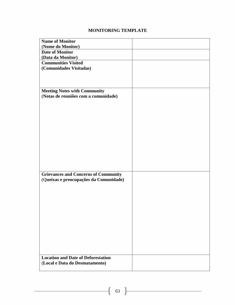
63
MONITORING TEMPLATE
Name of Monitor
(Nome do Monitor)
Date of Monitor
(Data da Monitor)
Communities Visited
(Comunidades Visitadas)
Meeting Notes with Community
(Notas de reuniões com a comunidade)
Grievances and Concerns of Community
(Queixas e preocupações da Comunidade)
Location and Date of Deforestation
(Local e Data do Desmatamento)
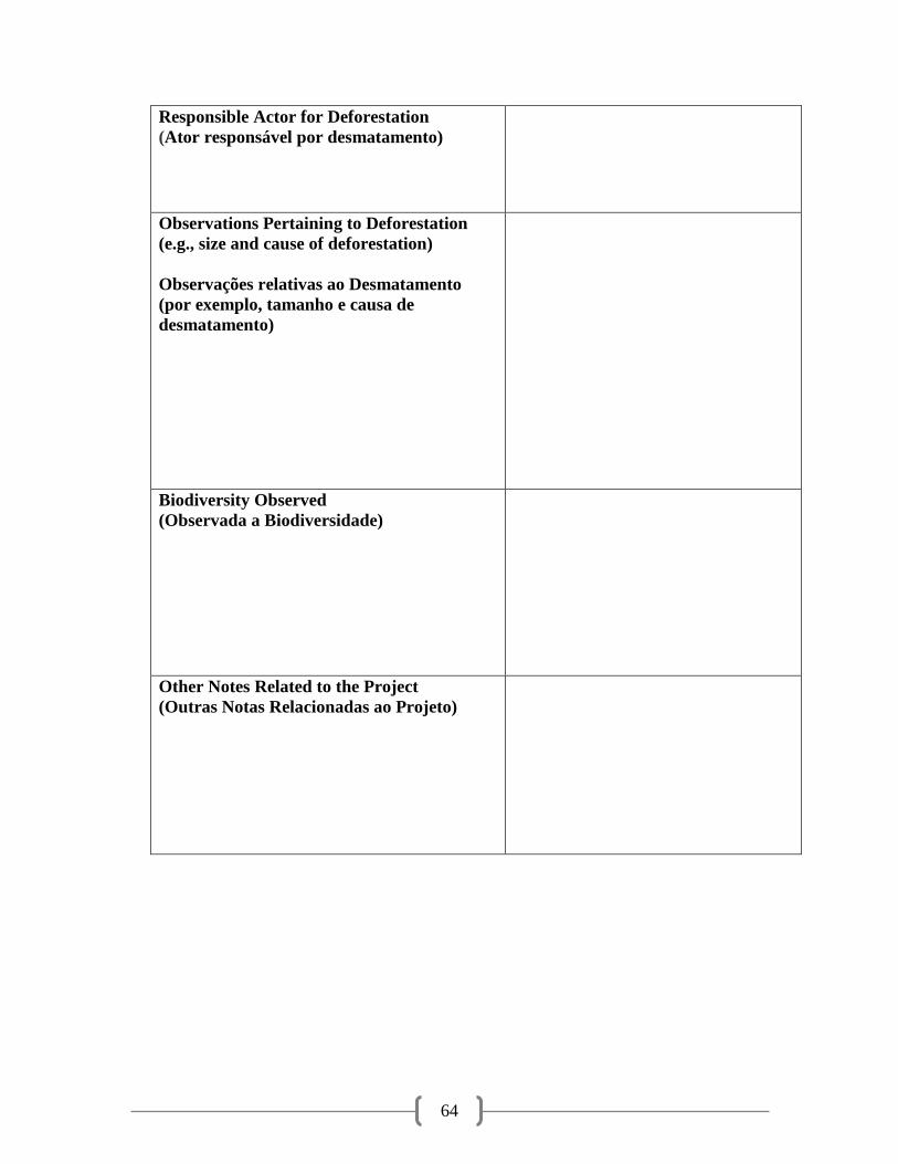
64
Responsible Actor for Deforestation
(Ator responsável por desmatamento)
Observations Pertaining to Deforestation
(e.g., size and cause of deforestation)
Observações relativas ao Desmatamento
(por exemplo, tamanho e causa de
desmatamento)
Biodiversity Observed
(Observada a Biodiversidade)
Other Notes Related to the Project
(Outras Notas Relacionadas ao Projeto)
Related Documents