The Use of Spatial Data Infrastructure in Environmental Management:an Example from the Spatial Planning Practice in Poland Agnieszka Zwirowicz-Rutkowska 1 • Anna Michalik 2 Received: 23 April 2015 / Accepted: 17 June 2016 / Published online: 29 June 2016 Ó The Author(s) 2016. This article is published with open access at Springerlink.com Abstract Today’s technology plays a crucial role in the effective use of environmental information. This includes geographic information systems and infrastructures. The purpose of this research is to identify the way in which the Polish spatial data infrastructure (PSDI) supports policies and activities that may have an impact on the environment in relation to one group of users, namely urban planners, and their tasks concerning environmental management. The study is based on a survey conducted in July and August, 2014. Moreover, the authors’ expert knowledge gained through urban development practice and the analysis of the environmental conservation regulations and spatial planning in Poland has been used to define the scope of environmental management in both spatial planning studies and spatial data sources. The research included assessment of data avail- ability, infrastructure usability, and its impact on decision- making process. The results showed that the PSDI is valuable because it allows for the acquisition of data on environmental monitoring, agricultural and aquaculture facilities. It also has a positive impact on decision-making processes and improves numerous planners’ activities concerning both the inclusion of environmental indicators in spatial plans and the support of nature conservation and environmental manage- ment in the process of working on future land use. However, even though the infrastructure solves certain problems with data accessibility, further improvements might be proposed. The importance of the SDI in environmental management is noticeable and could be considered from many standpoints: Data, communities engaged in policy or decision-making concerning environmental issues, and data providers. Keywords Spatial data infrastructure (SDI) usability Á Urban planner Á Spatial plan Á Decision making Á Environmental indicator Á Nature conservation Introduction One of the factors influencing the task and process flows related to environmental management and the quality of services in the area of environmental management is the wide range of resources involving data and technological solutions. The International Telecommunication Union (ITU) (2008) summarizes the role of information and com- munication technologies (ICTs) in the e-environment, which includes, among other things, the collection and manage- ment of environmental information as well as understanding the impact that humans exert on the environment. The issue of facilitating access to biodiversity information in relation to users’ needs in the area of managing the environment is raised by Davis et al. (2014). Many other authors (e.g., Wilcox 1990; Longley et al. 2005; Masser 2007; Craglia and Campagna 2010) emphasize the benefits of spatially oriented ICT, i.e., the geographic information system (GIS) and the spatial data infrastructure (SDI), in many sectors and various applications. A review of the literature on environmental management shows numerous successful applications of the GIS (Gonzalez et al. 2011; Gonzalez Del Campo 2012; Emili and Greene 2013; Gebbert and Pebesma 2014; Inanloo and Tansel 2015). Tuchyna (2006) shares his experiences involving the process of SDI development within the & Agnieszka Zwirowicz-Rutkowska [email protected] 1 Faculty of Geodesy, Geospatial and Civil Engineering, University of Warmia and Mazury, ul. Oczapowskiego 2, 10-719 Olsztyn, Poland 2 Urbaneo, Urban Design Studio, ul. Te ˛czowy Las 4/48, 10-687 Barta ˛g, Olsztyn, Poland 123 Environmental Management (2016) 58:619–635 DOI 10.1007/s00267-016-0732-0

Welcome message from author
This document is posted to help you gain knowledge. Please leave a comment to let me know what you think about it! Share it to your friends and learn new things together.
Transcript

The Use of Spatial Data Infrastructure in EnvironmentalManagement:an Example from the Spatial Planning Practicein Poland
Agnieszka Zwirowicz-Rutkowska1 • Anna Michalik2
Received: 23 April 2015 / Accepted: 17 June 2016 / Published online: 29 June 2016
� The Author(s) 2016. This article is published with open access at Springerlink.com
Abstract Today’s technology plays a crucial role in the
effective use of environmental information. This includes
geographic information systems and infrastructures. The
purpose of this research is to identify the way in which the
Polish spatial data infrastructure (PSDI) supports policies
and activities that may have an impact on the environment in
relation to one group of users, namely urban planners, and
their tasks concerning environmental management. The
study is based on a survey conducted in July and August,
2014. Moreover, the authors’ expert knowledge gained
through urban development practice and the analysis of the
environmental conservation regulations and spatial planning
in Poland has been used to define the scope of environmental
management in both spatial planning studies and spatial data
sources. The research included assessment of data avail-
ability, infrastructure usability, and its impact on decision-
making process. The results showed that the PSDI is valuable
because it allows for the acquisition of data on environmental
monitoring, agricultural and aquaculture facilities. It also has
a positive impact on decision-making processes and
improves numerous planners’ activities concerning both the
inclusion of environmental indicators in spatial plans and the
support of nature conservation and environmental manage-
ment in the process of working on future land use. However,
even though the infrastructure solves certain problems with
data accessibility, further improvements might be proposed.
The importance of the SDI in environmental management is
noticeable and could be considered from many standpoints:
Data, communities engaged in policy or decision-making
concerning environmental issues, and data providers.
Keywords Spatial data infrastructure (SDI) usability �Urban planner � Spatial plan � Decision making �Environmental indicator � Nature conservation
Introduction
One of the factors influencing the task and process flows
related to environmental management and the quality of
services in the area of environmental management is the
wide range of resources involving data and technological
solutions. The International Telecommunication Union
(ITU) (2008) summarizes the role of information and com-
munication technologies (ICTs) in the e-environment, which
includes, among other things, the collection and manage-
ment of environmental information as well as understanding
the impact that humans exert on the environment. The issue
of facilitating access to biodiversity information in relation
to users’ needs in the area of managing the environment is
raised by Davis et al. (2014). Many other authors (e.g.,
Wilcox 1990; Longley et al. 2005; Masser 2007; Craglia and
Campagna 2010) emphasize the benefits of spatially oriented
ICT, i.e., the geographic information system (GIS) and the
spatial data infrastructure (SDI), in many sectors and various
applications. A review of the literature on environmental
management shows numerous successful applications of the
GIS (Gonzalez et al. 2011; Gonzalez Del Campo 2012; Emili
and Greene 2013; Gebbert and Pebesma 2014; Inanloo and
Tansel 2015). Tuchyna (2006) shares his experiences
involving the process of SDI development within the
& Agnieszka Zwirowicz-Rutkowska
1 Faculty of Geodesy, Geospatial and Civil Engineering,
University of Warmia and Mazury, ul. Oczapowskiego 2,
10-719 Olsztyn, Poland
2 Urbaneo, Urban Design Studio, ul. Teczowy Las 4/48,
10-687 Bartag, Olsztyn, Poland
123
Environmental Management (2016) 58:619–635
DOI 10.1007/s00267-016-0732-0

environmental sector, and Latre et al. (2013) present SDI
support for environmental e-government services.
SDI on different levels of government may become a
powerful tool in various applications, including environ-
mental management. On the European level, the role of
Infrastructure for Spatial Information in the European
Community (INSPIRE) in assisting policy-making in
relation to policies and activities that may have a direct or
indirect impact on the environment is well articulated
(European Parliament and the Council 2007). Still, the
successful application and use of SDI products and services
(Nedovic-Budic et al. 2008) relies on the fulfillment of the
needs and expectations of the users. An overview of liter-
ature shows that SDI assessment from the viewpoint of the
users in general and among different thematic groups of
beneficiaries has not been yet thoroughly investigated,
although the results of research on the case studies of SDI
use have been demonstrated (e.g., Askew et al. 2005;
Vandenbrucke et al. 2013).
The aim of the paper is to identify and describe the
Polish spatial data infrastructure support for policies and
activities that may have an impact on the environment in
relation to one group of users, i.e., urban planners, and their
activities concerning environmental management. A fur-
ther objective is to analyze and discuss the inclusion of
environmental issues in the process of preparing local
plans, i.e., institutions, data sources, and planner decisions
about future land use.
The contribution of the paper is an ex-post evaluation
from the users’ standpoint as well as the presentation of
certain initial findings regarding the usefulness and
usability of selected components of the Polish Spatial Data
Infrastructure (i.e., the main access point and its applica-
tions, spatial data and services) in realization of tasks
related to the environmental impact assessment performed
by urban planning professionals. Moreover, the paper
includes an analysis and discussion of the role and
importance of national, regional, and thematic access
points to metadata and spatial data services in the area of
environmental management, as well as an assessment of
the coordination of the data contributing and providing
processes used by institutions within the infrastructure
from the perspective of the SDI users. The results may
serve as the basis for defining improvements to SDI
development in order to better suit the needs of the users in
terms of both data access and analysis.
The Polish Spatial Data Infrastructure
In Poland, the spatial information infrastructure was
established by the Act on Spatial Information Infrastructure
(Polish Parliament 2010). The Act specifies the principles
of operation of the SDI and introduces mechanisms which
enable interoperability of spatial data, metadata, and net-
work services. The national access point called Geoportal 2
offers applications, such as a national geoportal, a geo-
portal for INSPIRE, a metadata editor and validator,
mobile applications, and a statistics module. Table 1
illustrates the main features and functions of the map
viewer in the national geoportal (Fig. 1).
The possibility of incorporating third party services into
the Polish spatial data infrastructure is undoubtedly one of
the factors ensuring the usefulness of the national access
point. The Polish spatial data infrastructure (Zwirowicz-
Rutkowska 2016) is also developed on national, regional,
and local levels through different initiatives and by many
institutions and government departments. The national
geoportal integrates certain thematic, regional, and local
geoportals (Fig. 2). Nonetheless, there are no formal obli-
gations to include the outputs of these initiatives (i.e.,
geoportals) in the national access point. Figs. 3, 4 show
example geoportals which are not included in the national
access point.
Methods
The study is based on a survey conducted among urban
planners in July and August, 2014. The survey instrument
consisted of closed-ended questions referring to some data
on the professional activities of the urban planners (the
firm’s size, the scope of the activities, number of
Table 1 Map viewer functions (Zwirowicz-Rutkowska 2016)
No. Function
1. Set map-scale command
2. Pan command
3. Zoom-in/out command
4. Info about feature command
5a. File menu—link to map composition
5b. File menu—user’s maps
6a. View menu—map content
6b. View menu—add maps
6c. View menu—center map
6d. View menu—set coordinate system
6e. View menu—set toolbar visibility
6f. View menu—set data layer and service visibility
6g. View menu—generate HTML code
7a. Measurement menu—measure area
7b. Measurement menu—measure distance
8a. Search menu—search for addresses and features
8b. Search menu—search for cadastral parcels
8c. Search menu—metadata
620 Environmental Management (2016) 58:619–635
123

employees using the PSDI and different geoinformation
web sites) and the usefulness of the national access point (a
geoportal called Geoportal 2 and its data content) and PSDI
support for decision making. For quantitative research, a
0–10 scale was proposed. A total of 63 questionnaires were
mailed to companies specializing in local level planning.
Data about spatial planners were obtained from the web
service of the National Chamber of Urban Planners. A list
of spatial planners included all four district societies. For
survey purpose, 15 firms were selected from the Western
District Urban Planners Society with its seat in Wrocław,
18 firms from the Central District Urban Planners Society
with its seat in Warszawa, 20 firms from the North District
Urban Planners Society with its seat in Gdansk, and 10
firms from the South District Urban Planners Society with
its seat in Katowice. The achieved completion rate was
44.4 %. The respondents were mainly the representatives
of the small or midsize firms specializing in factor and land
use trends analyses, production of a comparative study of
variants and local spatial plans, and field studies. The
reported user group of the PSDI Geoportal 2 and other
geoinformation web sites in their organizations was
‘‘some’’ or ‘‘one or none.’’
Furthermore, the expert knowledge gained through
urban development practice and the analysis of the regu-
lations on environmental conservation and spatial planning
Fig. 1 Map viewer in the Polish geoportal
Fig. 2 The Polish access point
as the broker
Environmental Management (2016) 58:619–635 621
123

in Poland has been used to define the scope of environ-
mental management in both spatial planning studies and
spatial data sources. To assess the degree of usage of the
Polish Spatial Data Infrastructure in the area of urban tasks
concerning environmental issues, quantitative and qualita-
tive studies were conducted.
The Structure of Spatial Planning Documentsin Poland
The scope of urban tasks depends on the type of spatial
planning documentation. According to the Act on Spatial
Planning and Land Development (Polish Parliament 2015),
the national spatial strategy, which defines determinants as
well as the objectives and goals of sustainable development
along with actions aimed at supporting their realization is
the predominant document. Lower-order studies include
regional spatial development plans. Spatial policy on the
province level is defined through the studies of the condi-
tions and directions of spatial management. The studies
indicate rules governing the local spatial management and
are binding for local authorities in the process of preparing
local plans. Local plans depict the planned land use as well
as the conditions of spatial management and building
development. Public investments are allocated on the basis
of either local plans or, if there are no legal plans, decisions
on location conditions for public investments. Any change
Fig. 3 The environmental geoportal with conservation areas (http://mapa.ekoportal.pl/. Accessed January 2015)
Fig. 4 The environmental geoportal with underground bodies of water (http://epsh.pgi.gov.pl/epsh/. Accessed January 2015)
622 Environmental Management (2016) 58:619–635
123

in the land use in the aforementioned case requires issuing
a decision on building conditions. Hierarchy and depen-
dence of the spatial planning documents are the key feature
of the spatial planning system in Poland.
A Case Study of Local Plans
The process of preparing a spatial plan is rather complex and
depends on the collaboration between many different insti-
tutions and authorities. An overview of such a process and its
participants is presented in Sect. 5.1. Particular emphasis is
placed on the role of the planner and their tasks as well as
different institutions connected with environmental man-
agement involved in the urban studies. ‘‘Local plans and
environmental resource management’’ section portrays the
results of the qualitative analysis of the relations between
local plans and environmental resource management. Urban
planners are required to include many different environ-
mental indicators in the process of planning future land use.
Moreover, the planned land use may also have an impact on
the environment. In ‘‘Data sources in the National Spatial
Data Infrastructure’’ Sect, certain quantitative assessment
results concerning the data available in the Polish SDI are
reported. ‘‘SDI usefulness for environmental resource man-
agement’’ section describes the findings about SDI useful-
ness from the perspective of the planners in terms of
preparing spatial plans and tasks concerning environmental
conservation and sustainable development.
The Business Process of the Preparation
and Endorsement of a Local Spatial Plan
A business process is a set of one or more linked proce-
dures or activities which collectively realize a business
objective or policy goal, normally within the context of an
organizational structure defining functional roles and rela-
tionships (Workflow Management Coalition 1999). Auto-
mated activities are capable of computer automation using
a workflow management system to manage the activity
during execution of the business process of which it forms
a part. Figure 5 illustrates the business process of the
preparation and endorsement of a local spatial plan. For
automated activities, which are supported by the SDI, the
stereotype SupportedBySDI is used.
There are six major participants involved in the prepa-
ration and endorsement of a plan and six phases of the
process. The participants are tasked with submitting
motions, sharing data, giving opinions and agreements,
verifying documentation, passing resolutions, preparing the
final versions of plans, and endorsing spatial plans.
Taking environmental issues into account, the activities
listed below (Fig. 5, dark gray) are subject to a more
detailed analysis. Three activities are carried out by insti-
tutions, one by mayors, and five by urban planners.
Providing data are the task of the institutions which
have been made responsible by law for datasets and reg-
isters and which establish rules and information technology
for data access and use. Information systems and infras-
tructures are maintained and developed in accordance with
the Regulation on the National Interoperability Framework,
the Minimum Requirements for Public Registries and
Electronic Information Exchange as well as the Minimum
Requirements for IT Systems (Polish Parliament 2012b).
Spatial data in the SDI are in the electronic format and are
required to conform to the implementation rules and reg-
ulations. However, in the case of information systems
implemented by certain authorities and data providers,
considerable effort is to be put into coordinating the
management of the system, capturing data in the electronic
format and defining data models.
Strategic environmental impact assessment is defined in
the Act On Environmental Information Sharing and Its Pro-
tection, Public Participation In Environmental Protection and
the Environmental Impact Assessment (Polish Parliament
2013a), and it refers to the procedure for the assessment of the
impact of local plans on the environment. The procedure
consists of four stages as follows: agreement on the scope of
information included in the environmental impact assessment
documentation, environmental impact assessment, approval
of the documentation, and public participation.
Permission for land-use change for nonagricultural and
nonforest purpose is issued solely in local plans pursuant to
the Act on Protection of Agricultural and Forest Land (Polish
Parliament 2013c). Arable lands in class I–III and state-
owned forest areas require the permission of the Minister of
Agriculture and Rural Development and the opinion of the
province marshal. In the case of other forest areas, the pro-
vince marshal is the authority giving permission after
receiving the opinion of the Chamber of Agriculture. In the
case of state-owned forest areas, the opinion of the Director
of the Regional State Forest Directorate is mandatory. If a
given forest area constitutes the property of a national park,
the director of that park is to give their permission.
The activity of Considerations for land-use change for
nonagricultural and nonforest purpose applies to mayors
and is followed by the assessment of the land-use change
necessity made by the urban planner.
In the Assessment of land-use change necessity, the
assumption is that the land-use change concerns only
badlands, yet a detailed analysis of the social, economic,
and environmental conditions is recommended.
Collecting data is often the most time-consuming
activity, yet of great importance to the task of Preparation
of the project of a spatial plan, and it includes not only data
acquisition but also gathering information about data sources
Environmental Management (2016) 58:619–635 623
123

Fig. 5 UML activity diagram of the business process of a local plan preparation and endorsement
624 Environmental Management (2016) 58:619–635
123

and providers. A parallel activity is the submission of
motions regarding data acquisition. After obtaining access to
data, they are verified against the needs of the planner.
The scope of the Financial and environmental impact
assessment is defined in the Regulation on the Required
Scope of the Project of a Local Development Plan (Polish
Parliament 2003). The assessment includes the impact of a
local plan on the earnings and expenses within the com-
mune and also on the expenses related to the execution of
technical infrastructure investments. Supplementary parts
of the documentation comprise motions and recommen-
dations on the planned land use. The activity is preceded by
the agreement on the scope of information included in the
documentation of environmental impact assessment.
The motions on land-use change submission are pre-
pared when the decision on the change of land use is made
by the urban planner. The mandatory part of the motion
includes a justification for the decision, a list of areas, and
an economic justification for the planned land use. A map
of the commune or city with build-up areas constitutes an
attachment to the motion.
A further study of spatial planning activities performed
by urban planners as well as environmental resource
management issues is presented in Sect. 5.2.
Table 2 demonstrates a list of twenty-three institutions
involved in environmental management, which take part in
the preparation of local plans and the process of providing
opinions and reaching agreements. The Act on Spatial
Planning and Land Development (Polish Parliament 2015)
indicates nine participants in the procedure. Apart from the
aforementioned Act, on the basis of four additional regu-
lations, the group of the involved institutions and authori-
ties is increased by fourteen.
Local Plans and Environmental Resource
Management
Spatial planning in the context of environmental manage-
ment signifies the inclusion of environmental indicators in
the process of future land-use planning as well as the
measurement of the possible environmental impact exerted
by the planned land use depicted in local plans. The
decisions of the urban planner about the possible utilization
of the land in the future need to support nature conservation
and sustainable development.
Inclusion of Environmental Indicators in Spatial Plans
Planning future land use depends on the environmental
conditions in the location covered by the local plan, which
determine the course of the process. First, the identification
of the environmental elements, e.g., energy and natural
resources, water, land use, population and housing, agri-
cultural crops, and transportation is performed.
Furthermore, the following boundary lines and land-use
zoning elements of the biological diversity or environ-
mental protection are included in the local plan:
• Mining regions and areas,
• Documented underground bodies of water with planned
water intake conservation areas and areas of conserva-
tion of underground bodies of water,
• Areas of conservation of water intakes and inland
bodies of water,
• Maps of flooded areas and risk maps,
• Areas particularly exposed to flood risk,
• Areas facing landslide risk,
• Boundary lines of conservation areas,
• Air, noise, water and soil, vibration, and electromag-
netic field protection areas,
• Forest management plans,
• Zones of land-use change for nonagricultural and
nonforest purpose,
• Health resort conservation areas,
• Documented carbon dioxide underground storages.
The next step is spatial design, which relies on the
results of the environmental analysis, for the purpose of
defining the following five indicators:
• Minimal and maximal density of buildings,
• Minimal percentage of vegetation areas and bodies of
water,
• Maximal height of buildings,
• Building lines,
• Size of buildings.
Supporting Nature Conservation and Environmental
Management
After evaluating environmental elements identified for the
area defined by the boundaries of a local plan, the planner
begins working on future land use, a task of great impor-
tance and responsibility, which has an impact on the
quality of space and environmental management. Among
other things, the local plan establishes the following:
• Rules for water management, sewage disposal, waste
management, and transportation infrastructure,
• Management restriction zones, industrial, and manu-
facturing areas,
• Noise protection zones surrounding urban areas and
within urban areas,
• Rules for conserving bodies of water and flood
protection,
Environmental Management (2016) 58:619–635 625
123

• Rules for managing bodies of water, developing conser-
vation areas for water intakes and inland bodies of water,
• Bans on enclosing properties adjacent to public inland
bodies of water,
• Directions for utility network development.
The tasks of urban planners involve preventing envi-
ronmental devastation. For this purpose, the definition of
special conditions of land development and restrictions on
land use are applied. The tightest restrictions affect areas
with a ban on building-up. Ecological restoration is
Table 2 Institutions involved in environmental management which participate in the procedure of preparation of local plans in Poland
No. Legal basis Institution Type of participation Environmental issues subject to
opinion/agreement
1. Act on spatial planning and land
development (Polish Parliament,
2015) (total number of participating
institutions: 9)
Regional director for
environmental
protection
Opinion (mandatory) The whole project of a plan
Province geologist,
district geologist
Opinion (optional) Underground bodies of water,
mineral deposits
Fire service Opinion (optional) Locations for new factories facing
failure riskProvince Inspector
of Environmental
Protection
Opinion (optional)
Province sanitary
inspector
Opinion (optional) The whole project of a plan
District governor Opinion (optional) Areas facing landslide risk
Mining authority Agreement (optional) Development of mining areas
Minister of health Agreement (optional) Development of health resort
conservation areas
2. Act on water management (Polish
Parliament, 2012a) (total number of
participating institutions: 1)
Regional Water
Management
Authority
Agreement (optional) Development of conservation areas
for water intakes, conservation
areas for inland bodies of water
and areas facing flood risk
3. Act on environmental information
sharing and its protection, public
participation in environmental
protection, and the environmental
impact assessment (Polish Parliament,
2013a) (total number of participating
institutions: 2)
Regional director for
environmental
protection
Opinion (mandatory) Assessment of environmental
impact
District Sanitary
Inspector
Opinion (mandatory)
4. Act on nature protection (Polish
parliament, 2013b) (total number of
participating institutions: 1)
Regional director for
environmental
Protection
Agreement (optional) National park, nature reserve,
landscape park, protected area,
existing and planned Natura 2000
sites
5. Act on protection of agricultural and
Forest Land (Polish Parliament,
2013c) (total number of participating
institutions: 5)
Minister of
Agriculture and
Rural
Development
Agreement on land-use change
for nonagricultural and
nonforest purpose (optional)
Arable lands in class I-III
Minister of the
environment
State-owned forest lands
province marshal other forest lands
Director of the
regional state
forest directorate
Opinion in the course of gaining
approval for land-use change
for nonagricultural and
nonforest purpose (optional)
State-owned forest lands
director of a national
park
Lands of national parks
6. Good practice (total number of
participating institutions: 5)
Utility network
management unit
Information (optional) Existing and planned utility
networks
Forest Inspectorate Information (optional) Forest lands
626 Environmental Management (2016) 58:619–635
123
achieved by including areas which require environmental
rehabilitation in local plans.
Pro-ecological activities relate to planning built-up areas
for renewable energy sources. This shows that pro-eco-
logical policy has a significant impact on the natural
landscape. Notably, the challenging part in this case is the
lack of an objective assessment of landscape values.
Local plans define the conditions for executing invest-
ments and thereby support pro-effective activities to the
benefit of nature conservation.
Data Sources in the National Spatial Data
Infrastructure
This section focuses on data availability for the purpose of
preparing spatial plans and managing environmental sour-
ces from the viewpoint of urban planners.
Data Available Through the Polish Access Point
Data availability depends upon the content and completeness
of datasets on a variety of spatial themes (Nedovic-Budic
et al. 2004). The data characteristics for the measurement of
data availability in this study are (Zwirowicz-Rutkowska
2015): (1) thematic accuracy; (2) completeness; (3) spatial
resolution; (4) temporal validity; (5) positional accuracy; (6)
distribution format; and (7) lineage.
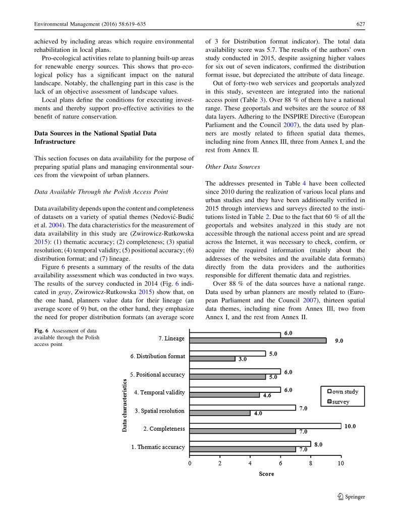
Figure 6 presents a summary of the results of the data
availability assessment which was conducted in two ways.
The results of the survey conducted in 2014 (Fig. 6 indi-
cated in gray, Zwirowicz-Rutkowska 2015) show that, on
the one hand, planners value data for their lineage (an
average score of 9) but, on the other hand, they emphasize
the need for proper distribution formats (an average score
of 3 for Distribution format indicator). The total data
availability score was 5.7. The results of the authors’ own
study conducted in 2015, despite assigning higher values
for six out of seven indicators, confirmed the distribution
format issue, but depreciated the attribute of data lineage.
Out of forty-two web services and geoportals analyzed
in this study, seventeen are integrated into the national
access point (Table 3). Over 88 % of them have a national
range. These geoportals and websites are the source of 88
data layers. Adhering to the INSPIRE Directive (European
Parliament and the Council 2007), the data used by plan-
ners are mostly related to fifteen spatial data themes,
including nine from Annex III, three from Annex I, and the
rest from Annex II.
Other Data Sources
The addresses presented in Table 4 have been collected
since 2010 during the realization of various local plans and
urban studies and they have been additionally verified in
2015 through interviews and surveys directed to the insti-
tutions listed in Table 2. Due to the fact that 60 % of all the
geoportals and websites analyzed in this study are not
accessible through the national access point and are spread
across the Internet, it was necessary to check, confirm, or
acquire the required information (mainly about the
addresses of the websites and the available data formats)
directly from the data providers and the authorities
responsible for different thematic data and registries.
Over 88 % of the data sources have a national range.
Data used by urban planners are mostly related to (Euro-
pean Parliament and the Council 2007), thirteen spatial
data themes, including nine from Annex III, two from
Annex I, and the rest from Annex II.
Fig. 6 Assessment of data
available through the Polish
access point
Environmental Management (2016) 58:619–635 627
123

Figure 7 presents average scores of data availability.
On comparison of the results of the assessment with the
scores for data sources available through the national
access point, it can be noted that the latter is better-
rated. Data sources integrated into the national access
point are more complete.
SDI Usefulness for Environmental ResourceManagement
As mentioned in Sect. 5.1, the preparation of local plans is
supported by the SDI, especially in such activities as
(Fig. 5) Providing data by institutions, Collecting data,
Table 3 The most important data sources are websites and geoportals accessed through the national access point (Accessed December 2014)
No. Addresses of websites and geoportals No.
of
layers
National
range
Local/
regional
range
INSPIRE spatial data theme
1. http://www.gismazowsza.pl/ 5 0 1 3.4. Land use
2. http://mapy.geoportal.gov.pl/imap 2 1 0 1.6. Cadastral parcels
3.2. Buildings
3. BDOT—http://mapy.geoportal.gov.pl/wss/service/WMTS/guest/
wmts/TBD
BDO - http://mapy.geoportal.gov.pl/wss/service/WMTS/guest/wmts/
BDO
VMAP—http://mapy.geoportal.gov.pl/wss/service/WMTS/guest/
wmts/VMAP
27 1 0 3.2. Buildings
4. http://mapy.geoportal.gov.pl/wss/service/wmspub/guest/AK_7_
Mapa_proponowanych_kierunkow_zagospodarowania/MapServer/
WMSServer
1 1 0 2.2. Land cover
2.4. Geology
5. http://mapy.geoportal.gov.pl/wss/service/pub/guest/G2_
TRANSPORT_WMS/MapServer/WMSServer http://mapy.geo
portal.gov.pl/wss/service/INSPIRE_TN_TBD/guest
1 1 0 3.6. Utility and governmental
services
6. http://mapy.geoportal.gov.pl/wss/service/img/guest/Krajobrazowa/
MapServer/WMSServer
1 1 0 2.1. Elevation
7. http://mapy.geoportal.gov.pl/wss/service/img/guest/CIEN/MapServer/
WMSServer
1 1 0
8. http://mapy.geoportal.gov.pl/wss/service/img/guest/HIPSO/
MapServer/WMSServer
1 1 0
9. http://mapy.geoportal.gov.pl/wss/service/wmsimg/guest/ISOK_
HipsoDyn/ImageServer/WMSServer
1 1 0
10. http://geoserwis.gdos.gov.pl/mapy/ 15 1 0 1.9. Protected sites
3.18. Habitats and biotopes
3.19. Species distribution
11. http://www.bdl.lasy.gov.pl/portal/mapy 15 1 0 2.2. Land cover (partly)
12. http://geoportal.pgi.gov.pl/portal/page/portal/SOPO/Wyszukaj3 2 1 0 2.4.Geology
3.12. Natural risk zones
3.20. Energy resources
3.21. Mineral resources
13. http://mapy.geoportal.gov.pl/wss/service/img/guest/HYDRO/
MapServer/WMSServer
1 1 0 1.8. Hydrography
3.11. Area management/restriction/
regulation zones and reporting
units
14. http://spdpsh.pgi.gov.pl/GeoPSHv7/ObszZagrPodt/wms 1 1 0
15. http://wezelsdi.geoportal.gov.pl/gornawisla/wmservice.aspx 2 0 1
16. http://mapy.geoportal.gov.pl/wss/service/wmspub/guest/AK_4b_
Mapa_ter_zagr_halasem_Ldwn/MapServer/WMSServer
6 1 0 outside the scope of the INSPIRE
17. http://mapy.geoportal.gov.pl/wss/service/wmspub/guest/AK_5a_
Mapa_rozm_ludnosci_eksponowanej_na_halas_Ldwn/MapServer/
WMSServer
6 1 0
TOTAL 88 15 2
628 Environmental Management (2016) 58:619–635
123

and also Financial and environmental impact assessment
performed by planners. This section describes the results of
the assessment of the National Spatial Data Infrastructure
usefulness and the Geoportal 2 map viewer usability for the
tasks of urban designers with regard to the inclusion of
environmental indicators in spatial plans and decision-
making processes that create environmental impact.
Usability of the Polish Access Point
In this study, usability is described by (Zwirowicz-Rut-
kowska 2015) the level of functions intuitiveness, clarity,
and content presentation of the map viewer.
The average score of the Geoportal 2 map viewer
usability was 6.0. Figure 8 shows detailed information
about eighteen features and functions of the map viewer
presented in Table 1. Only two commands, i.e., Info about
feature and Zoom in/out received a score above 7. The
other nine functions, which are connected with measures,
panning, setting the map scale, and also partly view com-
mands, seemed to be sufficiently usable (scores between 6
and 6.8) for urban planners who have declared their use of
this map viewer’s functionality. The commands of the
search menu, three functions of the view menu as well as
the operation of the file menu, i.e., User’s maps, are per-
ceived to be less user-friendly.
Table 4 Other most significant data sources are thematic websites and geoportals (Accessed May 2010-December 2014)
No. Addresses of websites and geoportals No.
of
layers
National
range
Local/
regional
range
INSPIRE spatial data theme
1 http://powietrze.gios.gov.pl/gios/ 3 1 0 3.7. Environmental monitoring
facilities2 http://mjwp.gios.gov.pl/mapa/ 1 1 0
3 http://inspire.gios.gov.pl/portal/ 21 1 0
4 http://mapy.gios.gov.pl/prtr/ 4 1 0
5 http://www.gis-mokradla.info/ 1 1 0 2.2. Land cover
6 http://crfop.gdos.gov.pl 1 1 0 1.9. Hydrography
3.18. Habitats and biotopes
3.19. Species distribution
7 http://mapa.ekoportal.pl/ 14 1 0
8 http://www.ibs.bialowieza.pl/ 1 1 0
9 np. http://rdlpol.gis-net.pl/ http://mapa.poznan.lasy.gov.pl/ http://
mapa.radom.lasy.gov.pl/ http://mapa.katowice.lasy.gov.pl/
33 0 1 2.2. Land cover (partly)
10 https://www.ibles.pl/mapa/index.html 13 1 0
11 http://epsh.pgi.gov.pl/epsh/ 11 1 0 2.4.Geology
3.12. Natural risk zones
3.20. Energy resources
3.21. Mineral resources
12 [email protected] 20 1 0
13 http://geoportal.pgi.gov.pl/portal/page/portal/MIDASGIS/
TabZloza:search
1 1 0
14 http://web3.pgi.gov.pl/website/cbdg/viewer.htm 24 1 0
15 http://geozagrozenia.pgi.gov.pl/ 1 1 0
16 http://mapy.isok.gov.pl/imap 3 1 0
17 http://www.smorp.pl/imap/ 18 0 1 1.8. Hydrography
3.11. Area management/restriction/
regulation zones and reporting units
18 http://geoportal.kzgw.gov.pl/imap/ 16 1 0
19 http://geoportal.kzgw.gov.pl/services/KZGW_2012/13Obiekty_
Pietrzace_WMS/MapServer/WMSServer
1 1 0
20 http://geoportal.kzgw.gov.pl/services/KZGW_2012/5MPHP2010/
MapServer/WMSServer
1 1 0
21 http://geoportal.kzgw.gov.pl/services/KZGW_2012/3JCWP/
MapServer/WMSServer
1 1 0
22 http://geoportal.kzgw.gov.pl/services/KZGW_2012/4JCWPd/
MapServer/WMSServer
1 1 0
23 http://geoportal.kzgw.gov.pl/services/KZGW_2012/
1ObszaryDorzeczy/MapServer/WMSServer
1 1 0
24 http://mapy.geomelioportal.pl/ 82 0 1 3.9 Agricultural and aquaculture
facilities
25 http://modulsdi.geoportal.gov.pl/sdiportalprg/ 12 1 0 3.16. Sea regions
TOTAL 285 22 3
Environmental Management (2016) 58:619–635 629
123

The same survey results also show that out of eighteen
features and functions of the map viewer, nine (i.e., 5a–6g,
Table 1) are either unknown or known but have not yet
been used in spatial planning tasks for almost 48 % of the
respondents.
Usefulness of the Polish Access Point
Usefulness means that a system’s functionality actually
makes sense and adds value in relation to a particular work
setting (Blomberg et al. 1994). The list of the potential SDI
use categories in the area of spatial planning practice
includes (Zwirowicz-Rutkowska, 2015) as follows: (1)
agreements; (2) factors and land-use trend analysis; (3)
production of a comparative variant study; (4) field studies;
and (5) other. Considering the functions for reading,
visualizing, and analyzing spatial data, the following five
levels of use can be distinguished: (1) use of the geoportal
map viewer; (2) connecting to web servers in the GIS/CAD
software; (3) viewing maps; (4) displaying data from
Fig. 7 Assessment of data
available through other websites
and geoportals
Fig. 8 Assessment of the
Geoportal 2 map viewer
functions
630 Environmental Management (2016) 58:619–635
123
different sources (the geoportal map viewer and/or GIS/
CAD software); and (5) data manipulation and
transformation.
The study revealed that the use of the SDI in the area of
spatial planning practice mainly includes field studies,
analyses of factors, and analyses of land-use trends.
Reading, visualizing, and analysis of spatial data chiefly
focus on viewing maps in the map viewer and displaying
data from different sources, thus not on the use of the GIS/
CAD software.
Taking into account the usefulness of the applications of
the main access point, the national geoportal and the
statistics module are considered the most valuable for
urban planners.
Impact of the SDI on Decision-Making Processes
in the Area of Environmental Management
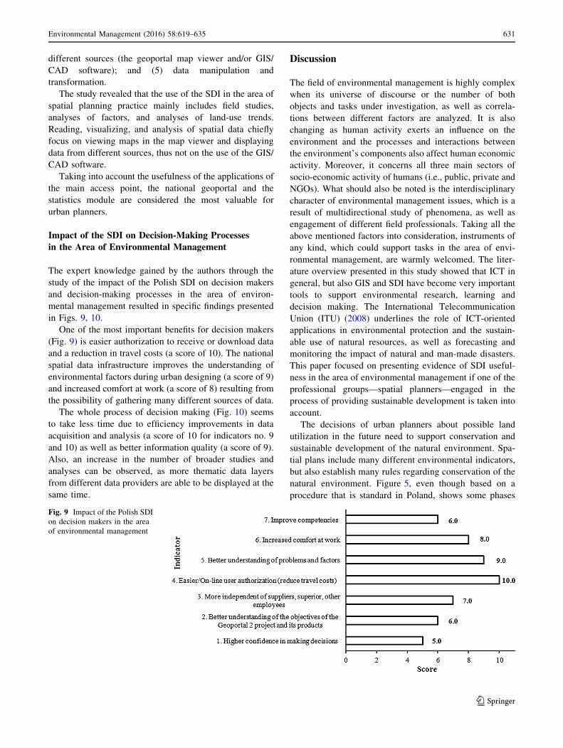
The expert knowledge gained by the authors through the
study of the impact of the Polish SDI on decision makers
and decision-making processes in the area of environ-
mental management resulted in specific findings presented
in Figs. 9, 10.
One of the most important benefits for decision makers
(Fig. 9) is easier authorization to receive or download data
and a reduction in travel costs (a score of 10). The national
spatial data infrastructure improves the understanding of
environmental factors during urban designing (a score of 9)
and increased comfort at work (a score of 8) resulting from
the possibility of gathering many different sources of data.
The whole process of decision making (Fig. 10) seems
to take less time due to efficiency improvements in data
acquisition and analysis (a score of 10 for indicators no. 9
and 10) as well as better information quality (a score of 9).
Also, an increase in the number of broader studies and
analyses can be observed, as more thematic data layers
from different data providers are able to be displayed at the
same time.
Discussion
The field of environmental management is highly complex
when its universe of discourse or the number of both
objects and tasks under investigation, as well as correla-
tions between different factors are analyzed. It is also
changing as human activity exerts an influence on the
environment and the processes and interactions between
the environment’s components also affect human economic
activity. Moreover, it concerns all three main sectors of
socio-economic activity of humans (i.e., public, private and
NGOs). What should also be noted is the interdisciplinary
character of environmental management issues, which is a
result of multidirectional study of phenomena, as well as
engagement of different field professionals. Taking all the
above mentioned factors into consideration, instruments of
any kind, which could support tasks in the area of envi-
ronmental management, are warmly welcomed. The liter-
ature overview presented in this study showed that ICT in
general, but also GIS and SDI have become very important
tools to support environmental research, learning and
decision making. The International Telecommunication
Union (ITU) (2008) underlines the role of ICT-oriented
applications in environmental protection and the sustain-
able use of natural resources, as well as forecasting and
monitoring the impact of natural and man-made disasters.
This paper focused on presenting evidence of SDI useful-
ness in the area of environmental management if one of the
professional groups—spatial planners—engaged in the
process of providing sustainable development is taken into
account.
The decisions of urban planners about possible land
utilization in the future need to support conservation and
sustainable development of the natural environment. Spa-
tial plans include many different environmental indicators,
but also establish many rules regarding conservation of the
natural environment. Figure 5, even though based on a
procedure that is standard in Poland, shows some phases
Fig. 9 Impact of the Polish SDI
on decision makers in the area
of environmental management
Environmental Management (2016) 58:619–635 631
123

(initial activities, analysis, opinion and agreement, public
presentation, enactment) which are applicable for many
countries (cf. Lotfi 2012; Dutt and Costa 1985). The
activities performed with support of the Spatial Data
Infrastructure (Fig. 5) by many Polish planners, i.e., col-
lecting data, financial, and environmental impact assess-
ment, as well as by institutions involved in environmental
management which participate in local planning (i.e.,
providing data), could suggest an approach to be taken in
order to realize goals concerning environmental issues and
spatial planning practices.
However, in order to implement this approach into any
SDI, some conditions must be fulfilled. First of all, the
objective of the SDI’s assistance in the area of environ-
mental management and spatial planning should be artic-
ulated by the organization responsible for the SDI.
Consideration of potential and appropriate data sources and
sets for this purpose is also essential. Another important
issue is agreements and procedures of cooperation between
data suppliers, the organization managing the SDI and the
users. The suppliers should be responsible for assuring data
interoperability with SDI components, e.g., the main data
access point and network services (geoportal). Function-
alities covering urban planners’ expectations are also an
issue of great importance.
Generally, the Polish SDI is valuable because it allows
for the acquisition of data on environmental monitoring
facilities, agricultural and aquaculture facilities as well as
sea regions. Both the main access point and other data
sources presented in Tables 3, 4 are useful, although
selected websites and geoportals maintained by different
data providers but coordinated by the same institution
duplicate certain datasets which are of different com-
pleteness and temporal validity. In many cases, the
authorities of a given level undertake objectives which do
not seem to be consulted with the appropriate authorities of
other levels, even though the Act on Spatial Information
Infrastructure (Polish Parliament 2010) and other regula-
tions define specific coordination procedures and duties.
Unfortunately, as the study and the interview results
demonstrated, there are cases in which regulations do not
translate well into practice.
Only 20 % of data suppliers provide information about
the possibility of obtaining data directly from the respon-
sible party. Links to web services and map viewers as well
as information about datasets and web-based map services
are rarely included on home pages but instead presented on
lower-level pages on the websites of certain institutions.
The problem with proper data formats suitable for spatial
planning analysis, including the lack of download services,
is the same as in the case of the national access point.
The listing shown in Table 4 is based on the authors’
own expert knowledge and shows that every urban planner
has their own ways of searching for data sources and
acquiring information. There exists no official or trade
website integrating addresses of thematic websites and
geoportals useful for urban design.
The case study presented in this paper demonstrated the
positive impact of PSDI on decision-making processes and
numerous activities. Unfortunately, there are also certain
time-consuming inconveniences resulting from using geo-
portals, especially with regard to ones not available through
Fig. 10 Impact of the Polish
SDI decision-making processes
in the area of environmental
management
632 Environmental Management (2016) 58:619–635
123

the national access point. For download services, proper
applications on data acquisition must be submitted. How-
ever, the lack of metadata, including information about the
responsible party and conditions for applying for access
and use is a common problem. It is worth noting that the
Open Data paradigm is making inroads into institutions
(the Surveying and Cartographic Documentation Center,
the Regional Directorate for Environmental Protection).
Practice shows that Open Data reduces the amount of time
needed for initial activities which are a part of the decision-
making process and make it possible to focus on per-
forming analyses and data manipulation. The Open Data
Catalogue of the Regional Directorate for Environmental
Protection provides data on conservation categories and
areas as well as Ramsar sites. It is also worth emphasizing
that these are vector data and thus more advanced data
manipulation and transformation can be performed.
There are several conclusions that can be drawn from
the Polish case study. The kinds of applications and func-
tionality that could be offered by the SDI were presented.
The case study also demonstrated the importance of
effective cooperation between data providers and organi-
zations responsible for the SDI. Many procedures, includ-
ing data acquisition and payment should not follow the
traditional bureaucratic route, but should be adjusted to
solutions offered by e-government systems, since the SDI
should be perceived as their integral component. The SDI
potential lies not only in the main access point but also in
other integrated thematic infrastructures, although the main
access point should be an efficient resource broker and
information point for the entire SDI. Usability monitoring,
as well as constant thematic and technical development of
the SDI is critical for maintaining its usefulness as well as
the good image of public authorities and their information
infrastructure.
SDI design and implementation requires establishing
principles and making decisions regarding datasets, stan-
dards, software and hardware, procedures, networking,
financial resources, and many more. Another key aspect is
the definition of SDI objectives and communities interested
in the development of such infrastructure. As the datasets
could be made available through network services, the
challenge for SDI administrators is to ensure that server
performance and scale will be maintained at appropriate
levels in order to keep up with users’ computing demands.
Maintaining the technical integration of nodes in the main
access point as well as data interoperability and updating are
also a part of the challenge. It should also be noted that data
accessibility (i.e., discovery and viewing services) depends
on, among others, the data providers’ server status and, in the
event some of them are disabled, some data sources would
become unavailable to users. Other factors which influence
the quality of SDI use include Internet connection quality on
both sides, as well as user hardware and software. Since
environmental management includes many fields of concern,
including biological conservation, natural resource man-
agement, environmental economics, and sustainable devel-
opment (cf. e.g., Dolny and Harabis 2012; Tear et al. 2014;
Nungesser et al. 2015; Alberdi et al. 2016), as well as orga-
nizations, groups and professions engaged in the process (cf.
e.g., Hosseini and Rezaei 2013; de Nooy 2013; Qu et al.
2014; Henckens et al. 2016; Romanach et al. 2016), it is very
difficult to develop one application or access point which
would satisfy needs and expectations of all applicable groups
of users, taking into account functionality, available datasets
or conditions of data use. Taking network services required
for operation and maintenance of the SDI into account, the
map viewer functionalities presented in this study (Table 1)
and suggestions of spatial planners concerning data formats
allow for a type of universal solution to be suggested. At the
same time, it is also possible to consider the development of
more dedicated applications or subthematic infrastructures.
Nevertheless, the importance of the SDI in environ-
mental management is noticeable and could be considered
on several levels. On the data level, the SDI offers cohesive
datasets which could be viewed directly via the SDI
interfaces, e.g., through a geoportal and also using different
software solutions that provide connection to WMS/WFS/
WCS servers, making possible a wide range of operations
and data analyses. The SDI ensures better information
quality and provides an advantage of operating on more
thematic data layers based on information from different
data providers which could be displayed at the same time.
From the perspective of the communities involved in
enacting policies and making decisions pertaining to
environmental issues, the SDI improves the understanding
of environmental factors, supplements knowledge with
additional conditions, factors and restrictions as well as
provides support for environmental studies and analyses
with a greater scope, which in turn could lead to more
intersectional planning, conflict identification and resolu-
tion, sustainable development, monitoring and preservation
of biodiversity, as well as environmental resource man-
agement. On the data providers’ level, the SDI contributes
to the organization of datasets and their popularization
among users as well as organizations interested in or par-
ticipating in environmental monitoring activities. On this
level, the SDI also ensures identification of incoherent and
duplicated data.
Conclusions
The paper presents some initial findings on usefulness of
the SDI in Poland. The work adds to a growing body of
literature on the SDI in the field of environmental
Environmental Management (2016) 58:619–635 633
123

management by presenting the results of an ex-post eval-
uation of the use of the Polish SDI by urban planners in
their tasks related to management of environmental sour-
ces, as well as discussion on the significance of spatial data
infrastructure in environmental management from a user
standpoint.
In Poland, the use of SDI in urban studies is connected
with the popularization of geographical information systems
among planners. Popularization of GIS software in spatial
planning, as well as the development of the infrastructure by
data suppliers, inclusion of new datasets and the provision of
appropriate data formats, might result in a more in-depth use
of the SDI and more effective urban design.
The study showed that not all thematic websites and
geoportals important to the planners’ tasks can be accessed
through the national access point. Still, it should not be
overlooked that SDI implementation is, at the time of
writing, still a work in progress. However, the results of the
investigation presented in this paper prove that there is a
noticeable growing trend in using the SDI in preparation of
local plans and tasks concerning environmental conserva-
tion and sustainable development. The SDI is valuable
because it allows for gathering data on environmental
monitoring facilities, agricultural and aquaculture facilities
as well as sea regions. It also has a positive impact on
decision-making processes and improves multiple plan-
ners’ activities concerning both inclusion of environmental
indicators in spatial plans and support for nature conser-
vation and environmental management in tasks related to
future land use.
The results presented in this study have shown that the
INSPIRE-mandated national geoportal, which is integrated
into the European Community geoportal operated by the
European Commission, is not the main web application
used for tasks related to urban design. Urban planners
would rather use the national access point, the statistics
module, as well as over 20 different thematic websites and
geoportals instead.
Although the Polish SDI solves certain problems caused
by the incompatibility of data formats, low accessibility as
well as gaps and inconsistencies in the data, based on the
results of the study presented in Sects. 5 and 6, specific
improvements to SDI development might be proposed in
order to benefit environmental management and spatial
planning. First of all, developing an intuitive national
geoportal and adding new functionality to the SDI appli-
cations would certainly improve the effectiveness of the
urban design process. Additionally, the inclusion of meta-
data in the national geoportal concerning data providers
and their geoportals, coordinated by public authorities,
whether or not accessed through the national access point,
may be suggested, for example on a separate lower level
web page. In the case of the latter, a data supplier would
provide information about their websites to the adminis-
trator of the national geoportal and after verification, the
administrator would make the metadata available on the
Geoportal 2 website. Moreover, integration of certain
e-services and the e-government paradigm (e.g., web ser-
vices for handling orders and payments) with geoportals
and websites of data providers would undoubtedly reduce
the time needed for the preliminary activities connected
with applications regarding data acquisition, preparation
and submission. From the standpoint of urban planners’
needs, the usability of an access point depends on the
availability of certain functions, i.e., comprehensive search
menus or adding custom maps, necessary for carrying out
spatial planning tasks.
Better coordination of operations between different
departments of the same institution, as well as enhanced
cooperation between different data providers coordinated
by one institution, is recommended in order to facilitate the
exchange of information and improve the quality of ser-
vices provided. In addition, it is essential to promote the
SDI and to encourage its use by both urban planners and
new groups of potential users. Various tutorials, videos, or
user guides would provide support for users with little or
no experience in the area of IT, the GIS solution, SDI and
outputs of the Geoportal 2 project in particular, in order to
help them learn the basics and maximize the added value of
the solutions.
The sample size and the number of professional groups
considered in this study allowed only for a preliminary
assessment of the PSDI usability in the area of managing
environmental issues. As environmental management is
within the range of interest of different professional groups,
further studies are recommended in order to broaden
knowledge about the usefulness and role of the SDI,
especially when considered from different perspectives.
Acknowledgments The research reported in this paper is supported
by the grant No. 528–0309–0882 of the Faculty of Geodesy and Land
Management, University of Warmia and Mazury in Olsztyn, Poland.
The authors are grateful to the professional English speaker, Mr
Marcin Hałas for editing the manuscript.
Open Access This article is distributed under the terms of the
Creative Commons Attribution 4.0 International License (http://crea
tivecommons.org/licenses/by/4.0/), which permits unrestricted use,
distribution, and reproduction in any medium, provided you give
appropriate credit to the original author(s) and the source, provide a
link to the Creative Commons license, and indicate if changes were
made.
References
Alberdi I, Michalak R, Fischer C et al (2016) Towards harmonized
assessment of European forest availability for wood supply in
Europe. Forest Policy Econ 70:20–29
634 Environmental Management (2016) 58:619–635
123

Askew D, Evans S, Matthews R, Swanton P (2005) MAGIC: a
geoportal for the english countryside. Comp Environ Urban Syst
29(1):71–85
Blomberg J, Suchman L, Trigg R (1994) Reflections an a work-
oriented design project. In: Proceeding participatory design
conference (PDC’94). Chapel Hill, North Carolina
Craglia M, Campagna M (2010) Advanced regional SDIs in Europe:
comparative cost-benefit evaluation and impact assessment
perspectives. Int J Spat Data Infrastruct Res 5:145–167
Davis MLES, Tenopir C, Allard S, Frame MT (2014) Facilitating
access to biodiversity information: a survey of users’ needs and
practices. Environ Manag 53:90–701
de Nooy W (2013) Communication in natural resource management:
agreement between and disagreement within stakeholder groups.
Ecol Soc 18(2):44
Dolny A, Harabis F (2012) Underground mining can contribute to
freshwater biodiversity conservation: allogenic succession forms
suitable habitats for dragonflies. Biol Conserv 145(1):109–117
Dutt AK, Costa FJ (1985) Public planning in Netherland. Oxford
University Press, Oxford
Emili LA, Greene RP (2013) Modeling agricultural nonpoint source
pollution using a geographic information system approach.
Environ Manag 51:70–95
European Parliament and the Council (2007) Directive 2007/2/EC of
the European Parliament and of the Council of 14 March 2007
establishing an Infrastructure for Spatial Information in the
European Community (INSPIRE). Official Journal of the
European Union L108(50). Luxembourg, Luxembourg: Publica-
tions Office of the European Union
Gebbert S, Pebesma E (2014) A temporal GIS for field based
environmental modeling. Environ Modell Softw 53:1–12
Gonzalez Del Campo A (2012) GIS in environmental assessment: a
review of current issues and future needs. J Environ Assess
Policy Manag 14(1):1–23
Gonzalez A, Gilmer A, Foley R et al (2011) Applying geographic
information systems to support strategic environmental assess-
ment: opportunities and limitations in the context of Irish land-
use plans. Environ Impact Assess Rev 31(3):368–381
Henckens MLCM, Driessen PPJ, Ryngaert C, Worrell E (2016) The
set-up of an international agreement on the conservation and
sustainable use of geologically scarce mineral resources.
Resources Policy 49:92–101
Hosseini SM, Rezaei A (2013) Developing an information system for
sustainable natural resource management in alborz watershed.
Northern Iran. Syst Pract Act Res 26(2):131–152
Inanloo B, Tansel B (2015) Explosion impacts during transport of
hazardous cargo: GIS-based characterization of overpressure
impacts and delineation of flammable zones for ammonia.
J Environ Manag 156:1–9
International Telecommunication Union (ITU) (2008) ICTs for
e-Environment Guidelines for Developing Countries with a
Focus on Climate Change. Final Report, Switzerland
Latre MA, Lopez-Pellicer FJ, Nogueras-Iso J, Bejar R, Zarazaga-
Soria FJ, Muro-Medrano PR (2013) Spatial data infrastructures
for environmental e-government services: the case of water
abstractions authorisations. Environ Modell Softw 48:81–92
Longley PA, Goodchild MF, Maguire DJ, Rhind DW (2005)
Geographic information systems and science. Wiley, Hoboken
Lotfi S (2012) Study and analysis of spatial planning system in
France. T ctry plan 3(5):111–143
Masser I (2007) Building european spatial data infrastuctures. ESRI
Press, California
Nedovic-Budic Z, Feeney M-EF, Rajabifard A, Williamson I (2004)
Are SDIs serving the needs of local planning ? Case study of
Victoria, Australia and Illinois. USA. Comp Environ Urban Syst
28(4):329–351
Nedovic-Budic Z, Pinto JK, Budhathoki NR (2008) SDI Effectiveness
from the User Perspective. In: Crompvoets J, Rajabifard A, van
Loenen B, Delgado Fernandez T (eds) A multi-view framework
to assess spatial data infrastructures. Melbourne University
Press, Melbourne, pp 273–303
Nungesser M, Saunders C, Coronado-Molina C, Obeysekera J, Johnson
J, McVoy C, Benscoter B (2015) Potential Effects of Climate
Change on Florida’s Everglades. Environ Manage 55(4):824–835
Polish Parliament (2003) Regulation on the required scope of the
project of a local development plan. J Law 1587, Government
Legislation Centre
Polish Parliament (2010) Act on spatial information infrastructure.
J Law 469, Government Legislation Centre
Polish Parliament (2012a) Act on water management. J Law 145,
Government Legislation Centre
Polish Parliament (2012b) Regulation on the national interoperability
framework, the minimum requirements for public registries and
electronic information exchange as well as the minimum
requirements for IT systems. J Law 526, Government Legislation
Centre
Polish Parliament (2013a) Act on environmental information sharing
and its protection, public participation in environmental protec-
tion and the environmental impact assessment. J Law 1235,
Government Legislation Centre
Polish Parliament (2013b) Act on nature protection. J Law 627,
Government Legislation Centre
Polish Parliament (2013c) Act on protection of agricultural and forest
land. J law 1205, Government Legislation Centre
Polish Parliament (2015) Act on spatial planning and land develop-
ment. j law 22, Government Legislation Centre
Qu Y, Li M, Qin L (2014) Environmental practice and its effect on the
sustainable development of eco-industrial parks in China. Int J
Sust Dev Plann 10(5):685–700
Romanach SS, Benscoter AM, Brandt LA (2016) Value-focused
framework for defining landscape-scale conservation targets.
J Nat Conserv 32:53–61
Tear TH, Stratton BN, Game ET, Brown MA, Apse CD, Shirer RR
(2014) A return-on-investment framework to identify conserva-
tion priorities in Africa. Biol Conserv 173:42–52
Tuchyna M (2006) Establishment of spatial data infrastructure within
the environmental sector in Slovak Republic. Environ Modell
Softw 21(11):1572–1578
Vandenbrucke D, Dessers E, Crompvoets J, Bregt AK, van Orshoven
J (2013) A methodology to assess the performance of spatial data
infrastructures in the context of work process. Comp Environ
Urban Syst 38:58–66
Wilcox DL (1990) Concerning ‘The economic evaluation of imple-
menting a GIS’. Int J Geogr Inf Syst 4(2):203–210
Workflow Management Coalition (1999) The workflow management
coalition specification. terminology & glossary, No. WFMC-TC-
1011, ver.3.0. UK
Zwirowicz-Rutkowska A (2015) The use of the spatial data infras-
tructure in spatial planning: case studies in Poland. Proc., 5th
Cent. Eur. Conf. Reg. Sci-CERS 2014:1216–1226
Zwirowicz-Rutkowska A (2016) Evaluating spatial data infrastructure
as a data source for land surveying. J Surv Eng-ASCE. doi:10.
1061/(ASCE)SU.1943-5428.0000185
Environmental Management (2016) 58:619–635 635
123
Related Documents