THE TRANSPORT SYSTEM OF MEDIEVAL ENGLAND AND WALES - A GEOGRAPHICAL SYNTHESIS by James Frederick Edwards M.Sc., Dip.Eng.,C.Eng.,M.I.Mech.E., LRCATS A Thesis presented for the Degree of Doctor of Philosophy University of Salford Department of Geography 1987

Welcome message from author
This document is posted to help you gain knowledge. Please leave a comment to let me know what you think about it! Share it to your friends and learn new things together.
Transcript
THE TRANSPORT SYSTEM OF MEDIEVAL ENGLAND
AND WALES - A GEOGRAPHICAL SYNTHESIS
by
James Frederick EdwardsM.Sc., Dip.Eng.,C.Eng.,M.I.Mech.E., LRCATS
A Thesis presented for the
Degree of Doctor of Philosophy
University of Salford
Department of Geography
1987
1.
CONTENTS
Page,
List of Tables iv
List of Figures
A Note on References
Acknowledgements ix
Abstract xi
PART ONE INTRODUCTION 1
Chapter One: Setting Out 2
Chapter Two: Previous Research 11
PART TWO THE MEDIEVAL ROAD NETWORK 28
Introduction 29
Chapter Three: Cartographic Evidence 31
Chapter Four: The Evidence of Royal Itineraries 47
Chapter Five: Premonstratensian Itineraries from 62
Titchfield Abbey
Chapter Six: The Significance of the Titchfield 74
Abbey Itineraries
Chapter Seven: Some Further Evidence 89
Chapter Eight: The Basic Medieval Road Network 99
Conclusions 11?
PART THREE
Introduction
Chapter Hine:
Chapter Ten:
Chapter Eleven:
Page
THr NAVIGABLE MEDIEVAL WATERWAYS
115
116
The Rivers of Horth-Fastern England 122
The Rivers of Yorkshire 142
The Trent and the other Rivers of 180
Central Eastern England
Chapter Twelve: The Rivers of the Fens 212
Chapter Thirteen: The Rivers of the Coast of East Anglia 238
Chapter Fourteen: The River Thames and Its Tributaries 265
Chapter Fifteen: The Rivers of the South Coast of England 298
Chapter Sixteen: The Rivers of South-Western England 315
Chapter Seventeen: The River Severn and Its Tributaries 330
Chapter Eighteen: The Rivers of Wales 348
Chapter Nineteen: The Rivers of North-Western England 362
Chapter Twenty: The Navigable Rivers of Medieval 375
England and Wales
Chapter Twenty One: The Medieval Coasting Trade, Coastal 397Ports, and Vessels
Chapter Twenty Two: Cartographic Evidence 420
Conclusions 426
PART FOUR THE COMBINED MEDIEVAL ROAD AND WATERWAY 429
NET
Chapter Twenty Three: Combining the Road and Waterway Networks 430
Page
Chapter Twenty Four:
Chapter Twenty Five:
APPENDICES
Appendix I:
Appendix II:
The Combined Transport System: 454
Some Further Examples of Its Use
Journey's Fnd 472
The Medieval Unit of Distance 479
The Gough Map: The Complexities 488
Associated with the Welsh CoastalRoute between Cardigan and Chester
Appendix III:
The Date of the Gough Map
505
Appendix IV:
Bibliography 516

iv.
LIST OF TABLES Table Page
3:1 Gough Map : Roads and Distances 33
3:2 The Route Towns of the Matthew Paris Maps 41
4:1 Routes Travelled by Henry III more than Twenty Times 55
5:1 Premonstratensian Itineraries from Titchfield Abbey 63
6:1 Titchfield Itineraries Similar to the Gough Map 76Routes
6:2 Mileage Tolerances for Increments of Standard 84Deviation for the Titchfield Abbey Iters andGough Map Data
7:1 Journeys from Oxford 1315-1461 90
7:2 Routes Recorded in Contemporary Medieval Records 94
8:1 Probable Trade Routes for the Transport of Wine 105
8:2 Routes associated with the Transport of Agricultural 106Produce between 1298 and 1339
10:1 The Fifteenth from Seaport Merchants of 1204 144
20:1 The Navigable Rivers of Medieval England and Wales 375and their Heads of Navigation
20:2 Regional Distribution of Specifically Identified 389River Cargoes
22:1 Rivers of England and Wales shown on the Gough Map 423
but not considered as Navigations
23:1 The Ranked Medieval Boroughs 432
23:2 The Prominent Medieval Boroughs 435
23:3 Additional Routes to the Basic Road Network 437
23:4 The Changing Fortunes of the Prominent Medieval Boroughs 444
I:I The Itinerary of Robert of Nottingham 1324-5 480
II:I The Gough Map Route between Cardigan and Chester 488
11:2 Interplace Distances on the Inferred Gough Map 498
Route between Cardigan and Chester
11:3 Interplace Distances on the Gough Map Route between 500Cardigan and Chester (after Parsons)
11:4 Comparison of Computed Gough Mileages and Modern
501Mileages for the New Inferred Route and that ofF.J.S. Parsons Between Cardigan and Chester
v.
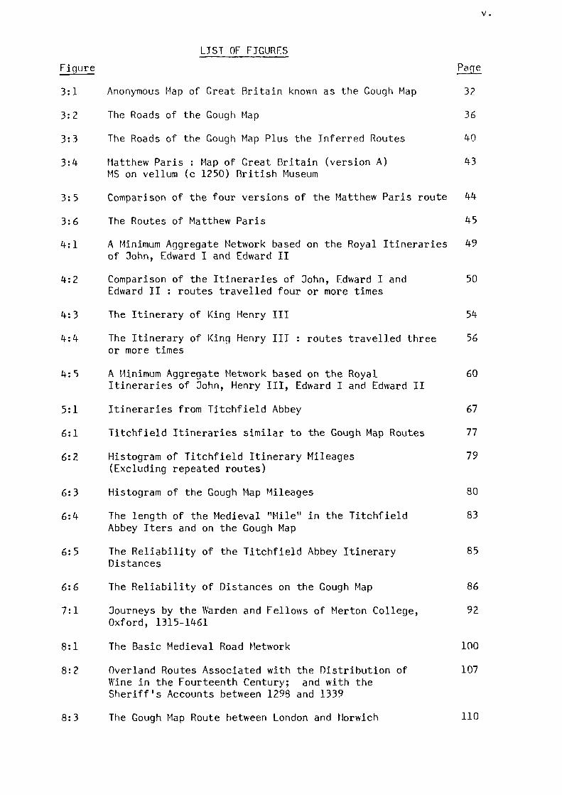
LIST OF FIGURES
Figure Page
3:1 Anonymous Map of Great Britain known as the Gough Map 32
3:2 The Roads of the Gough Map 36
3:3 The Roads of the Gough Map Plus the Inferred Routes 40
3:4 Matthew Paris : Map of Great Britain (version A)
43MS on vellum (c 1250) British Museum
3:5 Comparison of the four versions of the Matthew Paris route 44
3:6 The Routes of Matthew Paris
45
4:1 A Minimum Aggregate Network based on the Royal Itineraries 49
of John, Edward I and Edward II
4:2 Comparison of the Itineraries of John, Edward I and
50Edward II : routes travelled four or more times
4:3 The Itinerary of King Henry III 54
4:4 The Itinerary of King Henry III : routes travelled three 56or more times
4:5 A Minimum Aggregate Network based on the Royal 60Itineraries of John, Henry III, Edward I and Edward II
5:1 Itineraries from Titchfield Abbey 67
6:1 Titchfield Itineraries similar to the Gough Map Routes 77
6:2 Histogram of Titchfield Itinerary Mileages 79(Excluding repeated routes)
6:3 Histogram of the Gough Map Mileages 80
6:4 The length of the Medieval "Mile" in the Titchfield 83
Abbey Iters and on the Gough Map
6:5 The Reliability of the Titchfield Abbey Itinerary 85
Distances
6:6 The Reliability of Distances on the Gough Map 86
7:1 Journeys by the Warden and Fellows of Merton College, 92Oxford, 1315-1461
8:1 The Basic Medieval Road Network 100
8:2 Overland Routes Associated with the Distribution of 107
Wine in the Fourteenth Century; and with theSheriff's Accounts between 1298 and 1339
8:3 The Gough Map Route between London and Norwich 110
vi.
Page
9:1 The Rivers of North-Eastern England 135
10:1 The Rivers of Yorkshire 168
11:1 The Rivers of Central Eastern England 203
12:1 The Rivers of the Fens 230
12:2 The Island of Ely 232
13:1 The Rivers of the Coast of East Englia 259
14:1 The River Thames and Its Tributaries 286
15:1 The Rivers of the South Coast of England 310
16:1 The Rivers of South-Western England 326
17:1 The River Severn and Its Tributaries 343
18:1 The Rivers of Wales 358
19:1 The Rivers of North-Western England 372
20:1 The Navigable Rivers of Medieval England and Wales 381
20:2 Specifically Identified River Cargoes 383
20:3 Time-scale of Major Sources 384
20:4 Recorded Cargoes and Obstructions for the Period 386
1220 to 1400
21:1 The Coastal Ports and Navigable Rivers of Medieval 403
England and Wales
21:2 A Model of the River Rother Barge 407
21:3 Scene from the Bayeux Tapestry 407
21:4 The Second Seal of Winchelsea (1274) 411
21:5 The Seal of Kiel (c 1365) 411
21:6 The Seal of Elbing (c 1360) 413
21:7 Drawing of the Hulk on the font of Winchester 413
Cathedral (c 1180)
23:1 The Combined Road and Navigable Waterway 439
Networks of Medieval England and Wales
23:2 The Parts of England and Wales more than 15 miles 440
from Navigable Water
24:1 Routes Associated with the Transport of Wine in 1258 456
24:2 Route Associated with the Transport of Grain and 458
Flour in 1309
vii.
page
24:3 Routes Associated with the Transport of Grain in 1309 460
24:4 Routes Associated with the Transport of Produce 461to Scotland in 1298 and 1301
24:5 Route Associated with the Transport of Produce in 1340 461
24:6 Route Associated with the Transport of Grain in 1339 461
24:7 A Christmas Journey - 1319 464
24:8 Routes Travelled by the Goods of the Bursar 466of Durham between 1299 and 1336
24:9 Route Associated with the Transport of Fagots in 1326 467
24:10 Route Associated with the Transport of Lead in 1371 467
24:11 Route Associated with the Transport of Lead in 1374 467
I:1 The Itinerary of Robert of Nottingham 1324-5 481
II:1 The Chester-Cardigan Route on the Gough Map 489
11:2 Inferred Gough Map Route Between Cardigan and Chester 499
III:1 Ship Shown on the Gough Map 507
A MOTE ON REFERENCES
References are generally given in the following forms:
Books:
AUTHOR, Title (Place, Date)
Volume numbers where necessary are given in lower case Romannumerals.
Articles in Periodicals:
AUTHOR, 'Title' Name of Journal Volume Number (Year)
Either type of reference may be followed by page numbers (in
arabic numerals) or, where specifically indicated, by chapter or other
reference numbers.
Abbreviations
All names of Journals are given in full with the following
abbreviations:
Ann. Annals Bull. Bulletin ed. editor Ed. Editionesp. especially Journ. Journal Proc. ProceedingsRev. Review Ser. Series Soc. Society Trans. Transactions
ix.
ACKNOWLEDGEMENTS
Firstly I must thank my supervisor, Dr. B.P. Hindle for his
guidance, helpful advice and continuous encouragement in directing
someone steeped in engineering matters to the ways of historical
geography.
The University Library dealt most capably and helpfully with
requests for references, many of which were of an obscure nature.
The staff at the Manchester Central Library Department of Social Sciences
were particularly friendly and helpful, and I am also most grateful to
the Librarian of the John Rylands University Library of Manchester for
granting me special status as an outside user.
During the initial stages of the research, the author spent many
hours at the Record Office, Chester, where the staff were most generous
in allowing access to many valuable records.
The staff at the National Maritime Museum, Greenwich, were most
helpful, as was Professor S. McGrail of the Institute of Archaeology,
Oxford.
During the course of the research the author had a number of
interesting and helpful discussions regarding certain aspects of the
Gough Map with Mr. E.J.S. Parsons, late of the Bodleian Library, Oxford.
The author's hand-written final draft was ably deciphered and typed
by Mrs. J. Bateson.

x.
Finally I must thank my mother for her sustained encouragement
and support; it is to her that this thesis is dedicated.
Notwithstanding all the assistance given to the author, the
errors and shortcomings of this work are his alone.
xi.
ABSTRACT
This thesis is concerned with attempting to reconstruct the
transport system of medieval England and Wales.
The thesis is divided into four parts. The first is an intro-
duction which seeks to justify the research and to place it in the
context of recent work in historical geography. This section also
examines the previous research on medieval transport.
The second part expands the previously established medieval road
network and attempts to clarify certain aspects relating to it.
Cartographic evidence is examined together with a critical examination
of various itineraries which have not been previously discussed in any
great detail. An attempt is also made to clarify the vexed question
relating to the significance of the medieval unit of distance. Some
further evidence, including direct documentary evidence, is examined
and then added to all the previous evidence to produce the basic frame-
work of a national medieval road network. Direct documentary evidence
is also used in an attempt to establish the most likely routes taken
for the overland movement of goods and produce where only the starting
point and destination are recorded.
The third part attempts to determine, using direct historical
evidence, the extent of navigable water used during the medieval
period. The initial chapters deal with the navigable rivers on a
regional basis, and an attempt is made to establish their navigational
limits. All this regional evidence is then brought together to produce
a national picture of inland navigable waterways. An analysis of the
of the movement of goods along the rivers is carried out, and the link
between inland and coastal navigation is also considered, together
with an appraisal of medieval vessels. This section also examines
the cartographic representation of waterways.
The fourth, and final part of the thesis is concerned with
combining the road and waterway networks and also examines their
affinity with the more prominent medieval trading centres to produce
the basic structure of the whole national medieval transport system.
Trends in the changing fortunes of the prominent medieval boroughs
are analysed which puts into perspective temporal fluctuations and
hence highlights the changing importance of the routes leading to them.
Finally, further direct historical evidence is called upon to confirm
utilisation of the system.
1
PART OrIE
INTRODUCTIM1
"When you have a tale to tellalways start at the beginning"
Old Saying
2
CHAPTER ONE SETTING OUT
It may seem strange that someone who has spent the previous
thirty years in an engineering discipline should suddenly become
involved in the attempted reconstruction of the medieval transport
system. However, as the author spends much of his leisure time walking
in the country, he has developed a keen interest in the landscape. (1)
Although this, combined with his interest in history, does not give
him the academic background that a formal training in historical
geography would produce, it can sometimes be benficial for someone to
look at a particular problem with a 'fresh eye' .
Setting the Scene
The original area of research was confined to a local study of the
county of Cheshire, but as work progressed at this local level it became
clear that virtually all the previously published material pertaining to
internal medieval transport, although not extensive, tends to concentrate
on overland routes, vdth very little mention of waterborne movements.
Further investigations revealed a similar gap at the national level,
together ‘Nith a surprising lack of research on medieval transport in
general, much ofthe published material talking glibly about "growth of
trade and towns" without considering ho % goods were mmed from A to B.
However, although tlso studies in particular do culminate in a fairly
comprehensive reconstruction of the national medieval road network,(2)
there is only scant appreciation of the part played by the navigable
waterways and the links they had with the more established overland
routes. These observations were instrumental in changing the direction
which the research was to take; instead of a local study at the county
level, the research was diverted to an attempt to reconstruct the whole
medieval transport system at a national level.
3
The physical area covered by the study is limited to England and
Wales. Scotland is excluded because during the medieval period it was a
separate kingdom; whereas England and Wales, although involved in much
conflict, could, in many respects, be considered as a single administration.
There is some debate regarding the time band covered by the term
'medieval period'. The medieval period in England conventionally begins
with the advent of Norman rule in 1066, and, as far as this thesis is
concerned, ends with the close of the fourteenth century. Occasionally,
some later evidence is called upon in order to clarify certain points,
albeit only in a very limited way. Direct documentary evidence is also used
in an attempt to establish the most likely routes taken for the overland
movement of goods and produce where only the starting point and destination
are recorded.
Although a reconstruction of the medieval road network has already
been established, the second part of the thesis expands this network and
attempts to clarify certain aspects relating to it. Cartographic
evidence is also examined together with a critical examination of various
itineraries which have not been previously discussed in any great detail.
An attempt is also made to clarify the vexed question relating to the
significance of the medieval unit of distance. Some further evidence,
including direct documentary evidence, is examined, and then added to all
the previous evidence to produce the basic framework of a national
medieval road network.
The third part of the thesis attempts to determine the extent of
navigable water used during the medieval period. The main core of
evidence used for this part of the research is that contained in the
various State Rolls, supplemented by other forms of direct historical
evidence. The initial chapters deal with the navigable rivers on a
4
regional basis, and an attempt is made to establish their navigational
limits. All this regional evidence is then brought together to produce
a national picture of inland navigable waterways. An analysis of the
movement of goods along the rivers is carried out and the link between
inland and coastal navigation is also considered, together with an
appraisal of medieval vessels. The cartographic representation of
waterways is also examined.
The fourth, and final, part of the thesis is concerned with
combining the road and waterway networks and also examines their affinity
with the more prominent medieval trading centres to produce the basic
structure of the whole national medieval transport system, which, it is
hoped, will be useful to geographers and historians alike. Trends in the
changing fortunes of the prominent medieval boroughs are analysed which
puts into perspective temporal fluctuations and hence highlights the
changing importance of the routes leading to them. Finally, further direct
historical evidence is called upon to confirm utilisation of the system.
To attempt to place this research within the context of current
developments in historical geographical research is not a straightforward
exercise. It does not break, or attempt to break, any new ground in the
methodology which it employs: it is simply the procurement of geographical
information that can be derived from historical records. This involves
the manipulation of a mix of cartographic evidence and historical evidence
(direct and indirect), supplemented in some instances by actual observation.
The reliance on surviving historical evidence is obviously of paramount
importance.
"The most typical feature of historical geographicalresearch is that it has to rely upon historicalevidence, either directly or indirectly, man-madefeatures in the landscape, maps or written sources,more or less randomly preserved and inherited frompast generations" (3)
5
However, this random preservation of historical material can often lead
to a distorted view of the past by attributing an undue weight to the
surviving data. For example, overseas trade during the medieval period
has been given an exhaustive treatment and is extensively documented, due
no doubt to the copious records generated by it. In contrast, because
inland trade usually went unrecorded, it did not generate a similar
amount of data upon which scholars could draw. Consequently, this has
resulted in a curious neglect of the study of medieval inland trade with
the result that historians, economic historians, and historical geographers
alike, being susceptible to this error, have presented an imbalanced
picture with the scales tipped far too heavily in the direction of
external trade. It is only by searching out the scattered and disparate
references to inland trade that this imbalance can be rectified. It is
hoped, therefore, that the transport system described in this thesis at
least goes someway to redressing this imbalance and will act as a
stimulus for further research, especially at the local level. Only by
building up a more detailed description of inland trade, and the transport
system which made it possible, can internal trade expect to take its
rightful place in the studies of the medieval economy as a whole. The
remainder of this chapter will therefore gi%e a brief sketch of the
economic growth of medieval England and ales.
Internal Trade and Urban Growth
The internal trade of medieval England and Wales was operating
against an ever-changing backcloth of social and economic change. A key
component of this change was urban growth. In order to analyse urban
growth we must first of all consider the circumstances and conditions
prevailing before the commencement of the medieval period.
6
Britain had retained little of its Roman urban legacy. Early
Anglo-Saxon society appears to have had little use for the kind of towns
that had once flourished, and only a few continued to function;
effectively urban life ceased to exist. Many medieval towns had their
origins in the fortified places or burhs, created by the rring Anglo-
Saxon and Danish leaders in the niell and fenth centuries. Although
records from this period are scarce, a charter from the time of King Alfred
shows that when Worcester was fortified, the rulers of Mercia granted part
of the dues and tolls payable there to the cathedral - thus confirming
(4)that trade was being undertaken. It is understandable that trade would
be attracted to these 'safe' fortified places for, apart from being used
for defensive purposes, the fortifications could also protect a market and
its traders. Apart from reasons of defence and trade, these early urban
cores also acted as political control centres, administrative centres
and, as at Worcester, centres of the Church. During the period betv,een
the times of King Alfred and the Norman Conquest, and even alloviing for
a possible exaggeration caused by an increase in surviving sources, there
was an undoubted growth in urban development. This growth appears to
have been stimulated by a simultaneous increase in economic growth
throughout Europe, thus boosting both international and domestic trade.
Fortification also boosted trade in the first uncertain century
follovn ing the Norman Conquest. For example, in Nottingham - Mhere there
had been an Anglo-Danish fort, the Normans established a borough and castle
alongside it. They laid out a market close by the castle; this pattern
of a castle in close conjunction with a market is very common (5) . Although
the early burhs were, in effect, 'new' towns, the majority of new towns
were created in the twelfth and thirteenth centuries. From the advent of
Norman rule to the end of the thirteenth century no less than 233 'new'
towns were established in England and Wales(6)
. The rate of creation
7
gradually slowed down in England after about 1250 and after 1300 in ales
- where the campaigns of the first King Edward had led to the establishment
of a number of new towns largely for military purposes. This levelling off
in the creation of new towns reflects a similar trend in population growth.
The medieval population probably peaked during the early years of the
fourteenth centry and seems to have remained almost static until 1348-9,
when the ravages of the Plague caused a drop approaching forty per-cent;
during the second half of the fourteenth century the records show the
creation of only one 'new' town. (7)
Until the time of the Plague, the society of medieval England and
(ales was fundamentally 'feudal in character. (8) The majority of the
population consisted of the peasantry who sere, in effect, 'tied', being
forced to work on the land as tenants of their feudal masters. The
towns of the medieval period were not large and although urban expansion
had approximately mirrored the trends in population growth, perhaps as
much as ninety per-cent of the population lived and worked in rural areas.
Outside the feudal system there were individuals who were not tied to
any master and it was these 'free men' who formed the basis of the urban
population. Their class structure could be complex, but in simple terms
they belonged to one of three classes: merchants, craftsmen, and servants
or employees. In short the townspeople were mainly concerned with trade.
Although there was intermittent civil war throughout the medieval period,
once the old need for defence had diminished it is safe to conclude that
the level of urban growth is a clear reflection of the level of trade -
because trade could only be carried on by the 'free men' who here outside
the feudal system. Hence, towns have been described as ' non-feudal
islands in a feudal sea'. The majority of the new towns were created
specifically to fill out the hieracrchy of existing trading centres.
8
The new towns were founded on the initiative of the King or feudal lords
- who formed markets and often encouraged traders by offering reasonable
terms of settlement. Equally, many towns were founded or enlarged by
ecclesiastical lords with the prime objective of capturing trade. For
example, at St. Ives in Cambridgeshire, the abbots of Ramsey built a
bridge over the River Ouse together with an adjoining quay and market
place in the hope that they could draw traders there by both road and
river.(9)The choice of site was extremely important; there were
obvious economic advantages to be gained by siting a new town or developing
an existing one where good communications were available. Sites where a
combination of both roads and navigable water were at hand were at a
considerable advantage. Coastal sites had this advantage and many inland
places had access to both overland routes and navigable water. Ferries,
fords, and bridges were focal points which drew travellers to them and
were logical places for development. The importance of river crossings in
the creation of towns can be shown when the building of a new bridge
sometimes caused the diversion of an old road to a new route, with the
subsequent development of a town at the new crossing place. For example,
during the twelfth century, when the bridge which carried the Great North
Road over the River Ure at Aldborough was replaced by a new bridge
further to the west, the new town of Boroughbridge flourished, whilst
Aldborough declined. (10)
Whilst certain towns held a position of eminence throughout the
medieval period, the fortunes of others waxed or waned. An idea of the
relative importance of the more prominent places can be obtained by
comparing certain published lists giving estimates of population or
assessed wealth at particular dates. There are many complexities
associated with the interpretation of such data (which are more fully
discussed in Chapter Twenty-three). however, places like London, York,
9
Norwich, Bristol and Lincoln were consistently prominent. On the other
hand, Winchester, the former capital and the centre at which the Domesday
Survey was compiled, clearly gave way to London as the political and
administrative capital. Towards the end of the twelfth century Winchester
was ranked eighth, but had slipped to thirtyfirst by 1377.(11)
Thetford, ranked sixth at the time of Domesday, also declined - whilst the
fortunes of Bury St. Edmunds, 12 miles to the south, and a centre of
pilgrimage, grew. Some towns were totally unsuccessful and disappeared,
some were ravaged by the elements, and others were relocated at more
suitable adjacent sites. At Bere (in Wales), failure was probably due to
a poor selection of site; it was in a sparsely populated area, it was
not served by a river, and the road which connected it with the outside
world came to a dead end at the head of the valley in which it was
situated. The sea washed away Dunwich and Ravenserodd; whilst Old Sarum,
on its exposed hill-top site, was abandoned in favour of the more
accessible riverside site of New Sarum (Salisbury).
Towns, as centres of trade, relied on effective communications to
sustain them; thus, the very fact that urban growth continued, directly
as a result of trade, is testimony that medieval towns were the nerve-
centres in a communications network on which the whole body of the
medieval economy relied. Yet this network of roads, rivers and coastal
navigations has hitherto not received the attention which it deserves,
and the main aim of this present piece of work is to attempt to produce
a synthesis of the whole network of communications in medieval England and
Wales, on which the very growth of towns and trade depended.
10
Notes and References
(1) J.F. EUARDS,
J.F. EDWARDS,
Cheshire Walks for Motorists (London, 1975).
Further Cheshire Walks for Motorists (London,1981).
J.F. EDWARDS, Shropshire and the North Welsh Borders -Walks for Motorists (London, 1983).
(2) F.M. STENTON, 'The Road System of Medieval England',Economic History Review Vol. vii, No. 1(1936) 1-21.
B.P. HINDLE, 'A Geographical Synthesis of the Road Networkof Medieval England and Wales', UnpublishedPh.D. Thesis, University of Salford (1973)
(3) S. HELMFRID, 'Historical Geography in Scandinavia', inA.R.H. Baker (ed.) Progress in HistoricalGeography, (Newton Abbot, 1972) 63.
(4) D.C. DOUGLAS (ed.), English Historical Documents, 101. I,c500 - 1042 (London, 1955) 498.
(5) J.M. STERNE, The Archaeology of Medieval England and Wales,(London, 1984) 122.
(6) M. BERESFORD, New Towns of the Middle Ages (London, 1967)637-644.
(7) ibid, 641.
( 3 ) G.W.S. BARRN,
L.M. SMITH (ed.),
Feudal Britain (London, 1971).
The Making of Britain - The Middle Ages(London, 1985) 119-134.
J.L. BOLTON, The Medieval English Economy 1150-1500(London, 1980) 37-38.
(9) J.M. STEANE, (op. cit.), 123.
(10) M. BERESFORD, (op. cit.), 118-19.
(11) C. STEPHENSON,
J.C. RUSSELL,
Borough and Town (Cambridge, Mass, 1933) 225.
British Medieval Population (Albuquerque, 1948)140-3.
'11
CHAPTER TWO PREVIOUS RESEARCH
Our knowledge of transport and communications in England and Wales
during the medieval period is meagre. This becomes apparent when perusing
the many books and articles which deal with general history, where it is
the exception rather than the rule to find the topic discussed at any
length - if at all! Even in the literature dealing exclusively with the
medieval period it is unusual to discover more than a few passing comments
relating to the topic.
Studies which do relate directly to transport during the medieval
period rarely deal with a national system and hence tend to paint a
rather scattered and fragmented picture. The majority deal with the
condition of the roads and give accounts of such aspects as safety and
road maintenance. Only a few of these writers concern themselves with
the overall transport system which must have existed and been an integral
and vital part of the nation's economic activity, which is surprising
considering that many of the articles have been written by economists.
As mentioned in the previous chapter, the studies by F.M. Stenton and
B.P. Hindle are pre-eminent in the attempted reconstruction of the
medieval road network. Both these studies specifically relate to road
networks rather than an integrated road and water transport system
although the importance of water transport is often acknowledged.
(1)F.M. Stenton's article published in 1936 is the first
comprehensive study of the road network of medieval England. One of the
main sources of evidence used by Stenton is the medieval Gough Map which
shows apparent lines of travel together with associated distances;
indeed, part of his original article was reprinted when a facsimile of
the Gough Map was made in 1958.(2)
He also uses other sources and
12
acknowledges the importance of medieval itineraries in reconstructing the
road network.
"The first direct evidence as to the course of theEnglish roads along which long-distance travel waspossible comes from the reconstructed itinerariesof twelfth and thirteenth-century sovereigns." (3)
He notes the distinct lack of road-making during the medieval period and
opines that the basic road network must have been in existence long
before the medieval period.
"It is probable that with few exceptions the roadswhich supported this traffic were already ancientwhen the Middle Ages began. They included stretchesof prehistoric ridgeway, such as the medieval roadbetween Salisbury and Shaftesbury, cart-ways whichhad originally formed the boundary of Saxon furlongs,like the first stage of the road from Wallingford toGloucester, Roman roads which survived the collapseof Roman administration, and track-ways, generallyof indeterminable date, which had once led throughwoodlands or across wastes". (4)
Although Stenton's article is primarily concerned with the road system, he
does recognise the importance of the navigable waterways:-
"There is abundant evidence that whenever possiblethe heaviest goods were sent by water rather thanby road...." (5)
However, because his writings are concerned almost exclusively with the
movement of individuals rather than the movement of goods and produce,
this gives the impression that the role played by the navigable waterways
was very much a secondary one.
"All the evidence suggests, infact, that for theordinary medieval traveller, the waterways ofEngland were never more than an occasionalsupplement to a road-system which on the wholewas sufficient to his needs." (6)
13
This criticism apart, and the fact that he does not present any maps to
supplement his writings, Stenton's article is a pioneering and scholarly
work which points the way to further research:
"It is only by collecting medieval itineraries, byfollowing the clues supplied by medieval charters,above all, by that study on the actual ground,without which the investigation of ancient roadssoon loses touch with reality, that it will everbe possible to trace the detailed course ofmedieval lines of travel." (7)
B.P. Hindle's doctoral thesis, written almost four decades after
the work of Stenton, is concerned with the reconstruction of the road
network of medieval England and Wales, and in particular its extent and
geographical distribution. (8) Apart from using a theoretical approach
based on borough population figures, Hindle relies on cartographic
evidence including that of the Gough Map, and follows the advice of
Stenton by carrying out an analysis of the published itineraries of
King John, Eckard I and Edward II. He constructs maps of their movements
and concludes that if certain routes were used frequently then some
reasonable track or road must have existed between the places visited,
because the Kings took their households with them, and this required up
to twenty carts and ‘Naggons. (9) He condenses these maps into one which
shows all the routes travelled four times or more by more than one of the
three Kings to produce a minimum aggregate route network, from which it is
clear that the majority of their journeys were in central and southern
England.(10)
A criticism of this minimum aggregate network is that it
is very subjective, and a comparison of all the routes travelled four or
more times by all three Kings reveals a much broader route network. A
further criticism is that the period of time covered by the three royal
itineraries scrutinised by Hindle is not a continuous one. The period
commences in1199with the accession of King John, and ends in 1327 with
14
the demise of Edward II. However, almost half of this period is
occupied by the fiftysix year reign of Henry III, who ascended to the
throne in 1216 and died in 1272. Although Hindle analyses Henry's
journeys in terms of the number of moves per month,(11)
and records his
journeys in Cheshire as part of a local study,(12)
he does not plot Vis
complete itinerary in map form as he had for the other three Kings.
He acknowledges the influence of the Roman road system on various
medieval routes and notes that many of the individual royal itineraries
follow the line of Roman roads. However, his minimum aggregate route
network shows that the only major lengths of Roman road in common with
these extensively used routes were: Doter - London- Towcester; Doncaster
- York; Horthallerton - Newcastle; and Salisbury - l‘inchester.(13)
Apart from his survey of the Roman road system, he goes on to etaluate
ecclesiastical itineraries, travels to Parliament, and the etidence of
place-names. He then uses a gravity model based on the borough population
data of 1086 and 1348 to estimate traffic flow between pairs of boroughs.
He uses this method not to prove the direct existence of roads but to
give some idea of where the most likely routes should hate been.
"It must be stressed again that this method canonly be used to supplement our knowledge of theactual roads rather than to supplant it." (14)
He produces maps showing the road networks of medietal England and ‘‘ales
for both 1056 and 1348, and goes on to cam out two local studies of
(15)the counties of Cheshire and Carlisle. The merit of Hindle's work is
that it is the first to carry out a geographical study of the attempted
reconstruction of the medieval road network that must have existed.
Hindle also includes in his thesis a comprehensive retiew of previous
work relating to medieval roads and other aspects of medietal transport,
15
including some references to water transport.(16)
He cites, amongst
many others, the valuable collection of references to legal cases brought
before the King and translated and assembled by C.T. Flower under the
title 'Public Works in Medieval Law, .(l7)
These two volumes represent an
extremely useful source and provide an insight into many aspects of
medieval transport. Nearly all the 'public works' fall under one of the
following headings: roads, causeys and bridges, used for travel and
transport by land, rivers, partly for travel but more extensively for
transport by water, dykes, partly for travel and transport, but more
extensively for drainage, and sewers, which were essentially constructed
for drainage.(18)
Unfortunately, the bulk of the material deals with
six counties only - Essex, Gloucestershire, Lincolnshire, Middlesex,
Surrey and Yorkshire. Flower puts this down to two possible reasons,
the first being the peripatetic nature of the Court of King's Bench
at this time.(19)
It sat usually at Westminster, but was for long periods
at York, Lincoln and Gloucester; the large number of entries for the
other three counties due to its headquarters at Westminster. His second
explanation is that processes of this nature would be most familiar in
those counties where important waterways existed.
"It would be in those parts of England wherecommissions of sewers most frequently ran thatappeals to the Crown for a remedy to localnegligence would be most likely to be found." (20)
He stresses the waterways as a means of communication.
"There was in the Middle Ages little provision forcommunication by road where water transit wasavailable, and rivers played a far more importantand useful part in this direction than they do now." (21)
"...rivers.. .are both highways of communicationand integral parts of the drainage system ofthe country. But...it is chiefly in the formercapacity that their use was recognised in theMiddle Ages." (22)
16
Another study which toictes on island transportatior as a whole is
that by J.F. Mllard.(23)
Altfouqh his studs is corfired to tfe
fourteenth century fe cites a rumber of examples of the trarsportatior
of goods by both land and water. He notes that examples of water
transport are rare:
"notices of the employment of boats for localjourneys would seldom find tfeir way into tUerecords of the time." (24)
However, from the esidence which he does scrutinise, he concludes that
although;
"The cart was ubiquitous. Men, howeser, risersand large streams were near, the boat disputedand probably oserthrew the supremacy of its rival". (25)
He goes on to say that
"Ikagons, which were four-wheeled s,ehicles, andpack-horses supplemented, rather than competedwith, the work done by the cart and boat". (26)
Although he does not mention the road network he does outline the
nasigabilits of certain risers.
"There were, so it was stated in the fourteenthcentury, four great risers, the Thames, theSesern, the Ouse, and the Trent. Each of thesehad from ancient times been "open for the passageof ships and boats for the common profit of thepeople". ....In addition to the four great riversnamed, there were many of lesser fame that playedan important part in the transportation of goods." (27)
He goes on to cite examples of navigation on various rivers, including
those of Yorkshire and Lincolnshire, and concludes that there was a
"large amount of movement along the roads andstreams, and with it, the lack of isolation ofmedieval towns and villages. " (28)
17
Another article which deals with medieval river navigation, and
(29)the rivers of Lincolnshire in particular, is that by MA. Barley.
He points to the paucity of evidence relating to use of the rivers,
"That Lincolnshire rivers were used for commercialpurposes may be concluded from known arrangementsfor collecting tolls in various places, but evidencewith which to implement that conclusion isdisappointingly scarce". (30)
He briefly outlines the roads, bridges and ferries, and goes on to
discuss the problems associated with keeping the rivers free from
obstructions, both for navigation and drainage.(31)
He notes that the
Trent was navigable to Torksey, and possibly Nottingham, the Witham to
Lincoln, the Yorkshire Ouse to Boroughbridge, and the Ancholme to
Bishopbridge. He also notes that the Foss Dyke, originally constructed
by the Romans to link the Witham at Lincoln with the Trent at Torksey
was reopened in 1121 though there were problems with obstructions in
1335, 1365, 1376 and 1384.(32)
Unfortunately, there are a number of
mistakes in Barley's article, It was King Edward II who was on the
throne in 1319, not Edward III (33); and Wansford is on the River Nene,
(34)not the Welland. On the sketch-map which accompanies his article
Barley shows Bawtry as being on the Riser Tome instead of the Idle, and
he shows the Dutch River, which is an artificial cut made in the
seventeenth century, as being in existence during the Middle Ages.(35)
However, these mistakes apart, his article does indicate that the rivers
of central eastern England did present an alternative to transportation
by road.
18
Further examples of inland navigation together with an associated
coasting trade are given by J.B. Blake.(36)
He shows that coal was
shipped along the waters of the Tyne and Tees,(37)
and that coastal
voyages carrying this same commodity were made from the ports of the
north-east to such places as Dundee, Berwick, Sandwich, Great Yarmouth,
Southampton, King's Lynn and London.(38)
Blake also mentions a problem
common to the research on inland trade; the paucity of recorded movements.
"Unfortunately it is not possible to estimate accuratelythe value or volume of the considerable coastal trade incoal ... because, unlike foreign-going vessels, no customspayments were required for a voyage to another English port,and consequently no accounts were rendered at theExchequer." (39)
(40)H.C. Darby, in The Medieval Fenland, deals with the navigability
of the Fenland rivers.(41)
He notes that
"Upon the larger of these waterways sailed the merchantcraft of medieval times, with produce from many countries." (42)
Darby also notes the situation of certain tons in relation to
the Fenland rivers; Lincoln vdth the estuary town of Boston on the Witham,
Stamford with the estuary town of Spalding on the Welland, Peterborough
with the estuary town of Wisbech on the Nene, St. Ives and Cambridge nNith
the estuary town of King's Lynn on the Great Ouse and Cam.(43)
Darby
goes on to discuss the "complicated physical history" of the Fenland rivers,
(44)and shoves that they were often used for personal transport as well as
for the conveyance of a variety of commodities. He notes especially that
the Fenland rivers were used for the transport of building stone and that
the wide distribution of stone from the Barnack quarries (near Stamford),
(45)"serves as an index of the %atemay traffic of the Fenland".
19
Some useful data pertaining to medieval road and water transport
were gathered by 3.E.T. Rogers in his mammoth work relating to agriculture
and prices in England between the years 1259 and 1400. (46) Although
primarily concerned with produce and transport costs, he relates examples
of both land and water carriage. He notes that
"Whenever there was opportunity for water-carriage,produce was freely, and ... cheaply transported." (47)
He concludes that
"while there were far greater facilities for land-carriagethan has been ordinarily supposed, and that therefore thetransmission of corn and other commodities to market waseasy and obvious, there were still larger facilities forthose who, living on or near the banks of navigable rivers,might seek a better market than their immediate neighbourhood".
(48)
A prime source relating to the national route network of medieval
England, and probably the earliest known English road-book, survives in the
form of a manuscript which once belonged to the Premonstratensian Abbey of
Titchfield in Hampshire. The manuscript, glich dates from the first decade
of the fifteenth century, contains thirty itineraries from Titchfield which
cover a fair proportion of the country.(49)
Its importance appears to have
been previously overlooked, and although Hindle includes it in his
Bibliography, he does not discuss its merits in his text.
During the fifteen years since Hindle's review of the literature
relating to medieval transport, the publication of research material
relating directly to the topic has been very limited. G.H. Martin, in his
article 'Road Travel in the Middle Ages' (1975-6), relates the details of
a group of seven accounts held at Oxford University, which date from the
20
fourteenth and fifteenth centuries.(50)
The primary objective of these
records was to give an account of the expenses incurred by the Warden and
Fellows of Merton College during their travels to and from Oxford. Places
where meals were purchased en-route are given in many instances and this
results in a fairly comprehensive record of the routes taken. The journeys
involve visits to London, the north-east of England, and Canterbury. The
journeys were undertaken on horseback and occasionally use as made of the
navigable River Thames.(51)
Martin concludes that
"although travel by road in the Middle Ages was comparativelyslow, it could be systematic and regular, and it as undertakenas a matter of course." (52)
In 1977, S. Uhler presented a well-documented account of the
transportation of produce in Lincolnshire, Yorkshire, Hampshire, and
Norfolk during the fourteenth century, as revealed by the Sheriffs'
Accounts.(53)
She notes that the conveyance of goods in all four counties
showed a similar pattern and that
"Carriage involved the utilisation of rivers and roadsat hand, with heavy reliance upon the former."(54)
For example, the evidence for Yorkshire shows that in 1298, 1301
and 1309 grain, corn, oats, malt, flour, barley and peas were shipped to
Scotland from Hull, Selby and Yarm. The produce completed the first leg
of the journey by cart from a small inland centre to a larger one, from
where the journey continued to the leading collection centres in the
county, which were closely linked by river with the customs ports. The
River Ouse was used time and again to take produce to Hull, and both
the Don and Idle were utilised to take produce to Hull from Doncaster and
Bawtry.
21
"In all cases, small boats conveyed the victuals to Hullwhere transport was continued to Scotland".(55)
The rivers of Lincolnshire were well utilised, the Aitham between
Lincoln and Boston together with the Welland and the Glen.(56)
Uhler notes
that there was a lack of use of the River Trent, but that this is due to the
nature of the evidence. In Norfolk use was made of the Yare, Aaveney, Nar
and Wissey,(57)
whilst in Hampshire the evidence indicates utilisation of
the Itchen, Test and Avon.(58)
Uhler concludes that the evidence
"highlights the importance of the cart in providingcarriage to the commercial and administrative centresof the counties and the supremacy of the boat inconveying goods to the leading entrepots of the time -the customs ports".(59)
B. Aaites in his article 'The Medieval Ports and Trade of North-
East lorkshire',(60)
which was written in 1977, gi\es examples of navigation
on the River Tees, (61)
the Hull, (62)
the Hidd and Yorkshire Ouse.(63)
Pe outlines foreign and coastal trade and notes the origins of merchants
trading with Whitby and Scarborough.
"Although there were merchants from Chester and Wales engaged in tradewith Scarborough and Whitb .s, the greatest proportion of Englishmerchants came from the east and south-east coast ... three areaswere predominant; the East Anglian coast, especially around theOrwell estuary; the north and east coast of Kent; and the Humber-Ouse district. The latter is most surprising since Pontefract,Snaith, Bawtry and York are so far inland. But riser nasigation wasan extremely important means of transport in medie\al times."(64)
S. Moorhouse, writing on 'The rural medieval landscape' in Aest
Yorkshire : an Archaeological Survey to AD 1500 (1981) devotes two chapters
to communications and their associated features.(65)
He uses local charter
evidence in an attempt to reconstruct the former road network, and mentions
22
the commercial value of the roads, particular mention being made of salt
which was brought from Cheshire and Lancashire along a series of well-
defined routes over the Pennines, prior to its distribution throughout
the county.(66)
Apart from secular and commercial influences on medieval
routes he notes that monastic influences were an important factor.
"Frequent and rapid access was required between the motherhouse and its numerous local and more distant possessionsand farm complexes."(67)
He relates the development of the medieval road system to a variety
of influences, the most important being, access to the various components
of the farming landscape, and, the numerous obligations imposed on the
tenant by the manorial system - which often required frequent travel many
miles beyond the township.(68)
He goes on to stress the importance of the
evidence of place-names and discusses bridges, fords, ferries, stiles, gates,
hospitals, hermitages and chapels as features which can be used to establish
lines of travel. A most surprising omission in such oktailedchapters is
the lack of reference to any form of river na\igation system.
Conclusions
Although the studies of F.M. Stenton and B.P. Hindle, in particular,
have given us a fairly comprehensive reconstruction of the national medieval
road network, it is clear that more needs to be done in order to come still
closer to the actual network of roads which must have existed during
medieval times. Furthermore, it is evident that there is no available
national representation of the extent of inland navigable waterways exist-
ing during the medieval period, and the links they must have had with the
road network and with the coastal shipping trade.
23
This thesis is therefore concerned with expanding our know]edge
of the road network, but its principal aim is to determine the extent
of the navigable waterways, in order to describe and analyse the whole
transportation system in medieval England and Wales.
24
Notes and References
(1) F.M. STEN-FON, 'The Road System of Medieval England',Economic History Review vol. vii, No. 1
(1936) 1-21.
(2) E.J.S. PARSONS, The Map of Great Britain, c A.D. 1360, known as the Gough Map, Memoir with amended reprintof part of paper by F.M. Stenton (1936) and acolour facsimile (Oxford, Bodleian Library, 1958).
(3) F.M. STENTON(op. cit.)
5
(4) ibid,
(5) ibid,
(6) ibid,
(7) ibid,
(8) B.P. HINDLE,
6
19
20
15
'A Geographical Synthesis of the Road Network ofMedieval England and Wales', Unpublished Ph.D. Thesis, University of Salford (1973).
(9) ibid,
(10) ibid,
(11) ibid,
(12) ibid,
(13) ibid,
(14) ibid,
(15) ibid,
(16) ibid,
70
91
74
166
144
123
160-184
9-23, and 214-24
25
(17) C.T. FLOWER, 'Public Works in Medieval Law' Seldon soc.,32 and 40 (1915 and 1923)
(18) ibid,
(19) ibid,
(20) ibid
(21) ibid,
(22) ibid
(23) J.F. WILLARD,
(24) ibid,
(25) ibid
(26) ibid
(27) ibid,
(28) ibid,
(29) M.W. BARLEY,
xxvi
'Inland Transportation in England during theFourteenth Century' Speculum, 1 (1926) 361-74.
363
369-70
374
'Lincolnshire Rivers in the Middle Ages'Linconshire Architectural and Archaeological Soc.Reports and Papers, New Ser. 1 (1938) 1-22.
(30) ibid, 17
(31) ibid, 8-11
(32) ibid, 10
(33) ibid, 15
(34) ibid, 19
(35) ibid, 22
26
(36)
(37)
J.B. BLAKE,
Ibid,
'The Medieval Coal Trade of North-EastEngland: Some Fourteenth Century Evidence'Northern History, vol.II (1967), 1-26.
10
(38) ibid, 4, and 10-11
09) ibid, 9
(40) H.C. DARBY, The Medieval Fenland (Cambridge, 1940).
(41) ibid, 93-106
(42)
(43)
ibid,
ibid
94
(44) ibid
(45) ibid, 106
(46) J.E.T. ROGERS, A History of Agriculture and Prices in EnglandVol.I, (Oxford, 1866)
Vol.II, (Oxford, 1866)
Vol.III, (Oxford, 1582)
Vol. IV, (Oxford, 1882)
(47) ibid, Vol. I, 140
(48) ibid, 663
(49) B. DICKINS, Premonstratension Itineraries from a TitchfieldAbbey 115. at Welbeck, Proc. Leeds PhilosophicalSoc. 4 (1938) 349-61.
(50) G.H. MARTIN, 'Road Travel in the Middle Ages - SomeJourneys by the Warden and Fellows of MertonCollege, Oxford, 1315-1470, Journ. TransportHistory Vol. III (1975-6) 159-178.
27
(51) ibid, 166
(52) ibid, 172
(53) S. UHLER, 'The Transportation of Produce in Lincolnshire,Yorkshire, Hampshire and Norfolk during theFourteenth Century, as revealed by the Sheriff's
Accounts', unpublished B.Phil. Dissertation,
University of St. Andrews (1977).
(54) ibid, 44
(55) ibid, 45
(56) ibid, 5
(57) ibid, 40-3
(58) ibid, 34
(59) ibid, 46
(60) B. WAITES, 'The Medieval Ports and Trade of North-EastYorkshire', Mariners Mirror, Vol. LXIII (1977)
137-149.
(61) ibid, 139
(62) ibid, 140
(63)
(64)
ibid,
ibid
147
(65) S. MOORHOUSE, 'Communications', and 'Features associated withCommunications', being chapters 23 and 24 ofM.L. FAULL and S. HOORHOUSE (eds.), WestYorkshire: an Archaeological Survey to A.D.1500
(Wakefield, 1981) 614-55.
(66) ibid, 620
(67) ibid, 621
(68) ibid, 633
28
PART TWO
THE MEDIEVAL ROAD NETWORK
"The road-system of medieval England providedalternative routes between many pairs of distanttowns, united port and inland market, perMittedregular if not always easy communication betweenthe villages of a shire and the county townwhich was its head, and brought every part ofthe country within a fortnight's ride of London".
Sir Frank Stenton,Economic History Review, 1936.
29
INTRODUCTION
The object of Part Two of this thesis is to outline and expand
the postulated framework of the national medieval road network established
by the various writers mentioned in Part One; in particular Stenton,(1)
and Hindle,(2)
and to attempt to clarify certain aspects relating to it.
The main source of evidence used by Stenton was the Gough Map,
the importance of which was also recognised by Hindle, who also evaluated
other types of evidence 4- in particular the interpretation of various
royal itineraries together with a theoretical approach based on borough
population figures.
The Gough Map, other extant cartographic evidence, and the
evidence of royal itineraries is also discussed in this section of the
current work. This evidence is then expanded by a critical examination
of various itineraries which have not previously been discussed in any
great detail. This was in order to establish additional lines of travel,
and to confirm the contemporary use of some of the postulated routes.
The routes and stage distances as set don upon the Gough Map are then
compared against this other evidence and an attempt is made to clarify the
vexed question relating to the significance of the medieval unit of
distance. Some further evidence, including direct documentary evidence,
is then examined in order to provide additional route data and to
substantiate previously discussed lines of travel.
Finally, all the evidence is brought together to produce the
basic framework of a national medieval road network which is used as a
means of establishing the most likely routes taken for the overland
movement of goods and produce where only the starting point and destination
are recorded in the documentary evidence.
30
Notes and References
(1) F.M. STENTOH, 'The Road System of Medieval England'Economic History Review, Vol.VII, No. 1(1936) 1-21
(2) B.P. HINDLE, 'A Geographical Synthesis of the Road Networkof Medieval England and Wales', Unpublished Ph.D. Thesis, University of Salford (1973).
31
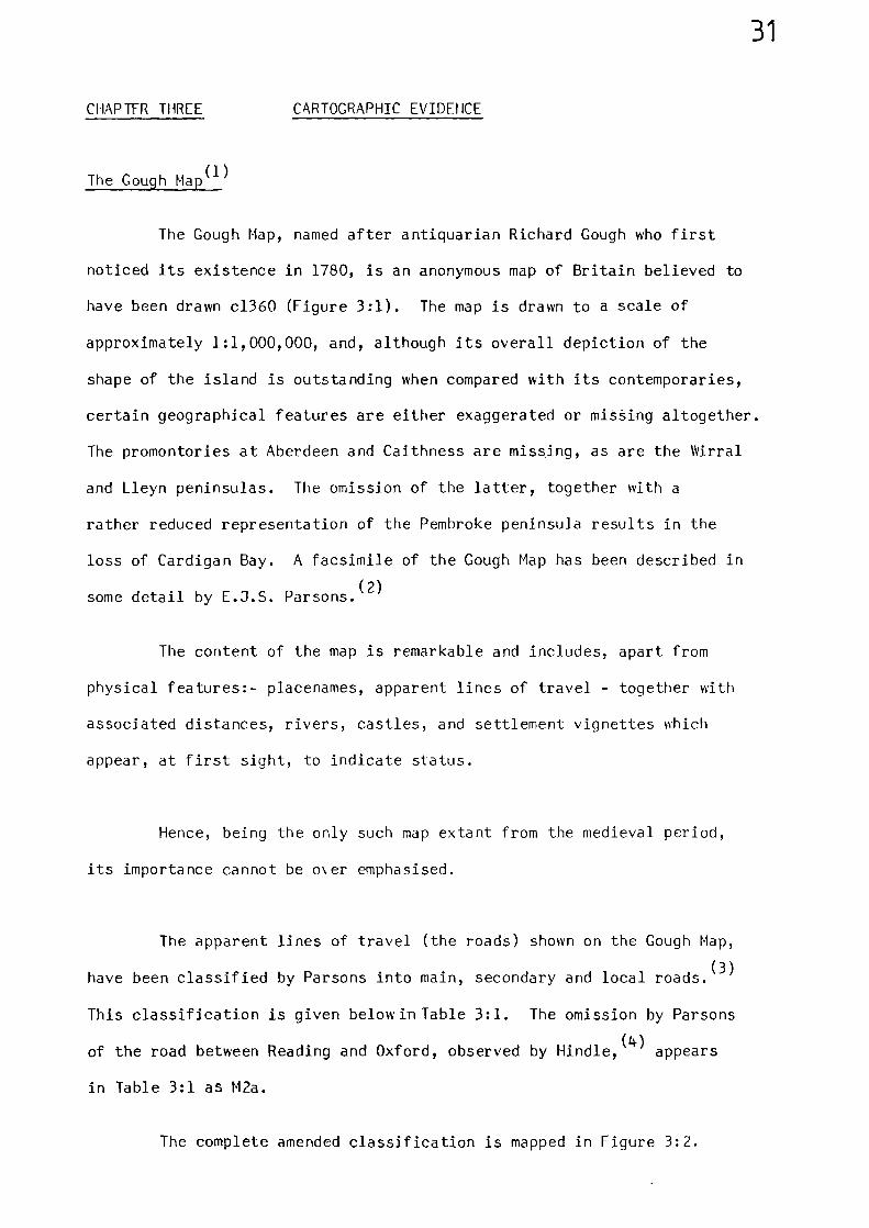
CHAPTER THREE CARTOGRAPHIC EVIDEHCE
The Gough Map(1)
The Gough Map, named after antiquarian Richard Gough who first
noticed its existence in 1780, is an anonymous map of Britain believed to
have been drawn c1360 (Figure 3:1). The map is drawn to a scale of
approximately 1:1,000,000, and, although its overall depiction of the
shape of the island is outstanding when compared with its contemporaries,
certain geographical features are either exaggerated or mising altogether.
The promontories at Aberdeen and Caithness are missing, as are the Mrral
and Lleyn peninsulas. The omission of the latter, together with a
rather reduced representation of the Pembroke peninsula results in the
loss of Cardigan Bay. A facsimile of the Gough Map has been described in
some detail by E.J.S. Parsons.(2)
The content of the map is remarkable and includes, apart from
physical features:- placenames, apparent lines of travel - together with
associated distances, rivers, castles, and settlement vignettes which
appear, at first sight, to indicate status.
Hence, being the only such map extant from the medieval period,
its importance cannot be o\er emphasised.
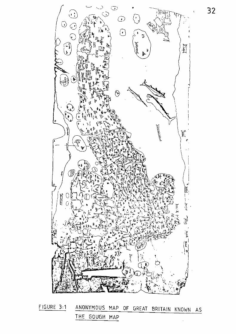
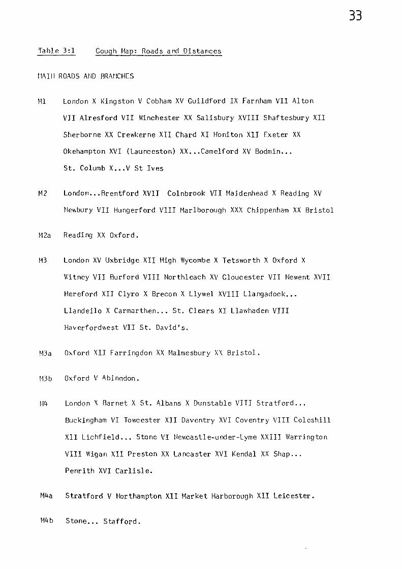
The apparent lines of travel (the roads) shown on the Gough Map,
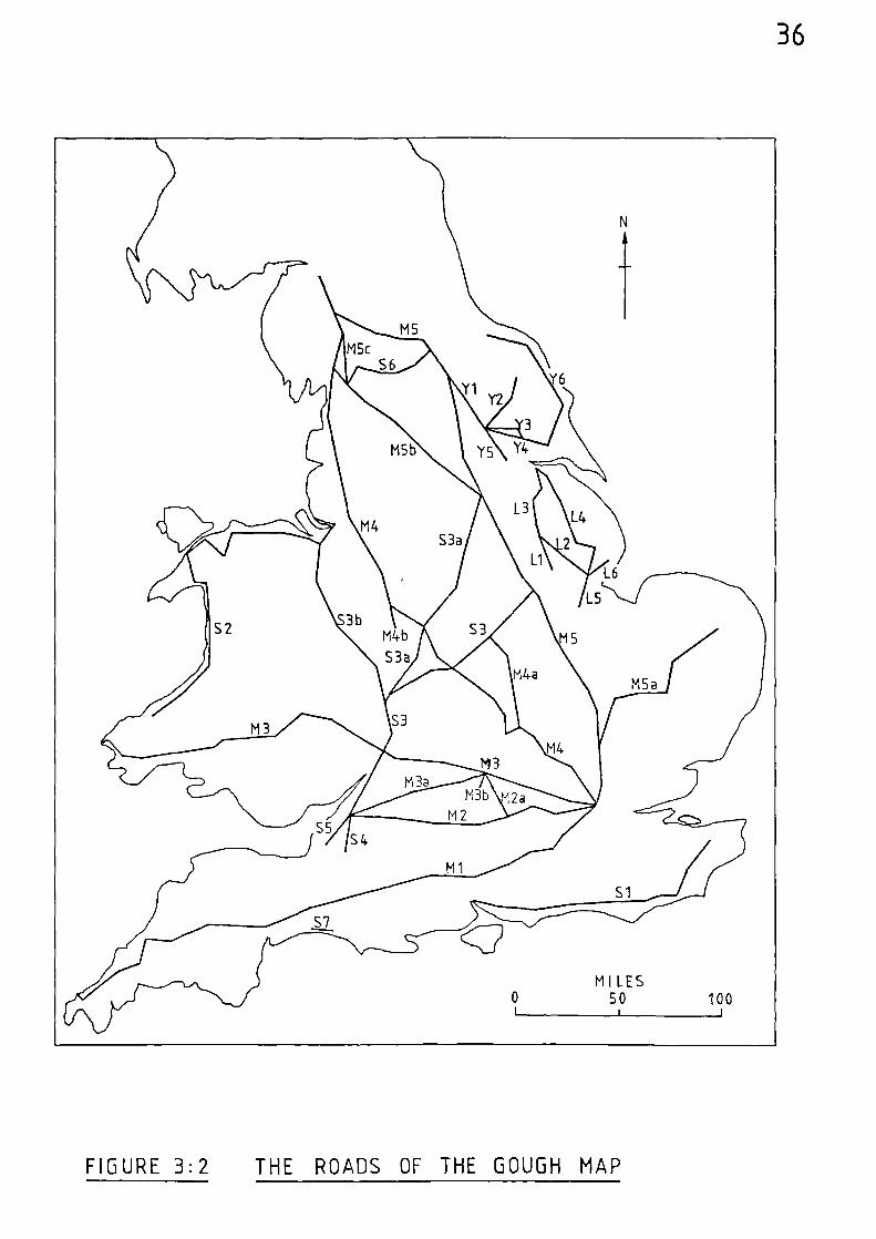
(3)have been classified by Parsons into main, secondary and local roads.
This classification is given below in Table 3:1. The omission by Parsons
of the road between Reading and Oxford, observed by Hind1e,(4)
appears
in Table 3:1 as M2a.
The complete amended classification is mapped in Figure 3:2.
32
ta'
9 A
"
f, •I r
C.N
4AZ-6-0.3 \\,, \411:43' :414
t'1 \ Jr 1 v A0i----
Vn-ilr,\‘'N. 0 r/4
or,.5(1)'14
ri.:-,
1:' 1„,t 4 h 1 0--). j''i F e>(•itg-0,. '•-•-c
- l'. P.--c1Z:t ;-'t11‘‘7 Ylki 1 414- .4 ii;'`i
Pr t s., I •.A1 ,•,-, Y..- -11--61 4,7';N , 1. , wn ,
„ky ,,,, 34.: ,,,',E. 4 4 , n ' i n d, ,t, , r -1 711)
• • L,_-__.1.-,£_ r b c''1.:\ '., li,,:_nCi ' , ic•- . .. ‘5,2
l‘k .. >•'•-• 6 trp- '-‘-.'...n....-' •.‘1.,,, II, ' 7 c N_ '1 13.11:" .i 1 i 4 ,,_.,
q:
VI,',-- 0 C. I' \ -,,, i •
‘ *-- b K --.-.--,r__.._:.\,:!'...". ..-41, ''( q _ Ari-,-‘ ,.'-'1'... '`'... ' n . k''.4 T .f.\ : r.- .,\ k , L.4.vti , 7:T•r, !: 4' • . 1 ' t 1-t? i -- -t.
:1=7', 16- i 1 ::. liq ' '''IA /rs ), v4 n . V;,-, )•.: - - • - tv - • . g...--
,:f...• .1 7.7. ,,,, 1,4 r. .1 -.AT • gfg n - ift IF 1
46-... 65j: N ° g & i4-4/Y,- . P 'e' ' rJ Sr;kt ‘ 11z41'' IiIli!‘'"`vk..,
,./. • 6-\,..b.-1,----,--..„ . ,,,tgz 5, ,‘i--4-1,,P
a k 4 ti,. k ..A ik;-X ',- '-"'' 1'
_ g\ €:-- ti-- --Li_ rA4
..*..•,
•
FIGURE 3:1 ANONYMOUS MAP OF GREAT BRITAIN KNOWN AS
THE GOUGH MAP
'I
33
Table 3:1 Gough Map: Roads and Distances
MAIM ROADS AND BRANCHES
M1 London X Kingston V Cobham XV Guildford IX Farnham VII Alton
VII Alresford VII Winchester XX Salisbury XVIII Shaftesbury XII
Sherborne XX Crewkerne XII Chard XI Honiton XII Exeter XX
Okehampton XVI (Launceston) XX...Camelford XV Bodmin...
St. Columb X.. .V St Ives
M2 London...Brentford XVII Colnbrook VII Maidenhead X Reading XV
Newbury VII Hungerford VIII Marlborough XXX Chippenham XX Bristol
M2a Reading XX Oxford.
M3 London XV Uxbridge XII High Wycombe X Tetsworth X Oxford X
Witney VII Burford VIII Northleach XV Gloucester VII Newent XVII
Hereford XII Clyro X Brecon X Llywel XVIII Llangadock...
Llandeilo X Carmarthen... St. Clears XI Llawhaden VIII
Haverfordwest VII St. David's.
M3a Oxford XII Farringdon XX Malmesbury XX Bristol.
M3b Oxford V Abingdon.
M4 London X Barnet X St. Albans X Dunstable VIII Stratford...
Buckingham VI Towcester XII Daventry XVI Coventry VIII Coleshill
XII Lichfield... Stone VI Newcastle-under-Lyme XXIII Warrington
VIII Wigan XII Preston XX Lancaster XVI Kendal XX Shap...
Penrith XVI Carlisle.
M4a Stratford V Northampton XII Market Harborough XII Leicester.
M4b Stone... Stafford.
34
M5 London XII Waltham Abbey VIII Ware XIII Royston IX Caxton VIII
Huntingdon XIII' Ogerston V Wansford V Stamford XVI Grantham X
Newark X Tuxford X Blyth VIII Doncaster X Pontefract XX Wetherby
VIII Boroughbridge XIIII Leeming X Gilling X Bowes XIII Brough XI
Appleby X Pehrith XVI Carlisle.
ML5a Ware XII Barkway XII Cambridge X Newmarket X Bury St. Edmunds
X Thetford XXXII Norwich.
M5b Doncaster XIII Wakefield...Bradford...Skipton X Settle XII
Kirkby Lonsdale VIII Kendal.
M5c Kirkby Lonsdale Shap
SECONDARY ROADS AND BRANCHES
S1 Southampton...Havant XXII Chichester X Arundel X Bramber X
Lewes XVIII Boreham Street.. .Battle VII Winchelsea VIII Rye...
Appledore XVII Canterbury.
S2 Cardigan XXIIII Aberystwyth XII Aberdovey XII Barmouth XI
Llanenddwyn...Harlech XII Criccieth XXIIII Caernarvon VIII
Bangor XV (Capel Curig) VIII Cormay...Abergele 1111 Rhuddlan X
Flint X Chester.
S3 Bristol XV Newport XV Gloucester VIII TeW:esbury XIII Worcester X
Droitwich XIIII Solihull VIII Coventry XVI Leicester X Melton Mowbray
X Grantham.
S3a Droitwich X Birmingham X Lichfield XVI Derby XV Chesterfield
XVI Doncaster
S3b Worcester XII Kidderminster XII Bridgnorth XV Shrewsbury XII
Ellesmere VII Overton XII Chester X Liverpool.
35
S4 Bristol X (V?)...
S5 Bristol XIII Axbridge
S6 Richmond X Bolton X Hawes X Sedbergh X Kirkby Lonsdale
S7 Bridport X Lyme.
LOCAL ROADS - LINCOLNSHIRE
Li Lincoln XIIII Sleaford
L2 Lincoln XXVI Boston
L3 Lincoln X Spital-in-the-Street X Kirton...Brig VIII Barton
L4 Barton XII Caistor XVI Horncastle V Bolingbroke IX Boston
L5 Boston XII Spalding
L6 Boston XII Wainfleet.
LOCAL ROADS - YORKSHIRE
Yl Leeming XII Helperby X York
Y2 York XIIII Malton V Pickering
Y3 York X Pocklington VII Market Weighton
Y4 York XVI Market Weighton VIII Beverley
Y5 York XVI Howden
Y6 Beverley XVI Bridlington XI1 Scarborough XII Whitby XVII Guisborough.
MI LES0 SO 100
1 1 1
36
FIGURE 3:2 THE ROADS OF THE GOUGH MAP
37
The five main roads given in the above classification all radiate
from London. The first, which terminates at St. Ives, goes via Guildford,
Winchester, Shaftesbury, and Exeter. The second main road goes from
London to Bristol through Brentford, Reading and Marlborough. The third
main road runs from London to St. David's by way of Uxbridge, Oxford
Gloucester, Hereford, Brecon, Carmarthen and Haverfordwest. Beyond
Brecon, a section of this road differs from its modern equivalent where
it makes a short cut avoiding Llandovery. The fourth main road connects
the capital with Carlisle. The initial section goes through St. Albans
and Dunstable to Stony Stratford - where there is a branch to Leicester.
Between Stony Stratford and Towcester the route is shown passing through
Buckingham, instead of continuing directly along Watling Street to
Towcester. The route continues through Coventry, Lichfield, Newcastle-
under-Lyme, Warrington, Preston, Lancaster, and Penrith. The final main
road is the Great North Road through Waltham Cross to Ware, at which point
there is a branch to Norwich - via Cambkidge, Newmarket and Thetford.
From Ware, the main medieval route keeps to the west of the modern road to
Wansford, from where it follows the modern line through Stamford,
Grantham and Newark to Tuxford. It continues, again to the west of the
modern line, and goes by way of Blyth to Doncaster. At Doncaster there
is a branch road which cuts across the Pennines and goes through Wakefield,
Skipton, and Settle to Kirkby Lonsdale where it divides further with
routes to Kendal, Shap, and Richmond. Beyond Doncaster, the main road is
shown passing through Pontefract, Wetherby, and Boroughbridge to Leeming
Bar, from where it turns westwards across the hills to Penrith.
Of the secondary roads, the first is completely independent of
London and is, for the most part, a coastal route connecting Southampton
with Canterbury via Chichester, Lewes, Winchelsea and Appledore. Another
coastal route is that which initially hugs the shore of Cardigan Bay and
38
then skirts the North Welsh coast connecting Cardigan with Chester via
Caernarvon. Chester is linked directly with Worcester, and hence Bristol,
by a route which passes through Shrewsbury and then follows the course of
the River Severn via Bridgnorth and Kidderminster.
There are two cross-country routes, both of which are linked to
Worcester through Droitwich. One goes through Solihull, then cuts across
the London-Carlisle road at Coventry before passing through Leicester and
Melton Mowbray to join the Great North Road at Grantham. The other goes
by way of Birmingham, then crosses the London-Carlisle road at Lichfield,
and on through Derby and Chesterfield to join the Great North Road at
Doncaster.
The local roads depicted in the vicinity of York and Lincoln
appear to be rather isolated from the main network of roads shown in
other areas of the map. However, there is other evidence, which will
shortly be mentioned, to suggest that these localised areas were linked
into the main road network in a more positive manner.
Sir Frank Stenton, in his account of the Gough Map roads, states:-
"The series omits many important highways whichwere obviously familiar to the compiler of themap, for it seems clear that he only drew theline by which he represented a road when he knewor believed himself to know the distance frompoint to point along it. He does not, forexample, venture to represent a road from Londonto Dover, from London to Ipswich or from York toNewcastle, but he sets down in their properorder Gravesend, Rochester, Sittingborne,Faversham, Canterbury and Dover in the first case;Brentford, Chelmsford, Witham, Colchester,Cattawade Bridge and Ipswich in the second; andThirsk, Northallerton, Croft, Darlington, Durham,Chester-le-Street and Newcastle in the third." (5)
Stenton also infers two routes to the channel ports:- via Dorking,
39
Horsham and Shoreham in the first instance; and via Chiddingfold, Petworth
and Arundel in the second. (6)
He goes on to say that
"it is clear from other evidence"
that a route existed between Leicester and Doncaster, via Nottingham;(7)
and hetween Stone and Chester, via Nantwich. (8)He also describes a
medieval road between Shrewsbury and Hereford, via Ludlow.(9)
Hindle
shows inferred Gough Map roads between Grantham and Lincoln and between
(10)Towcester and Fenny Stratford.
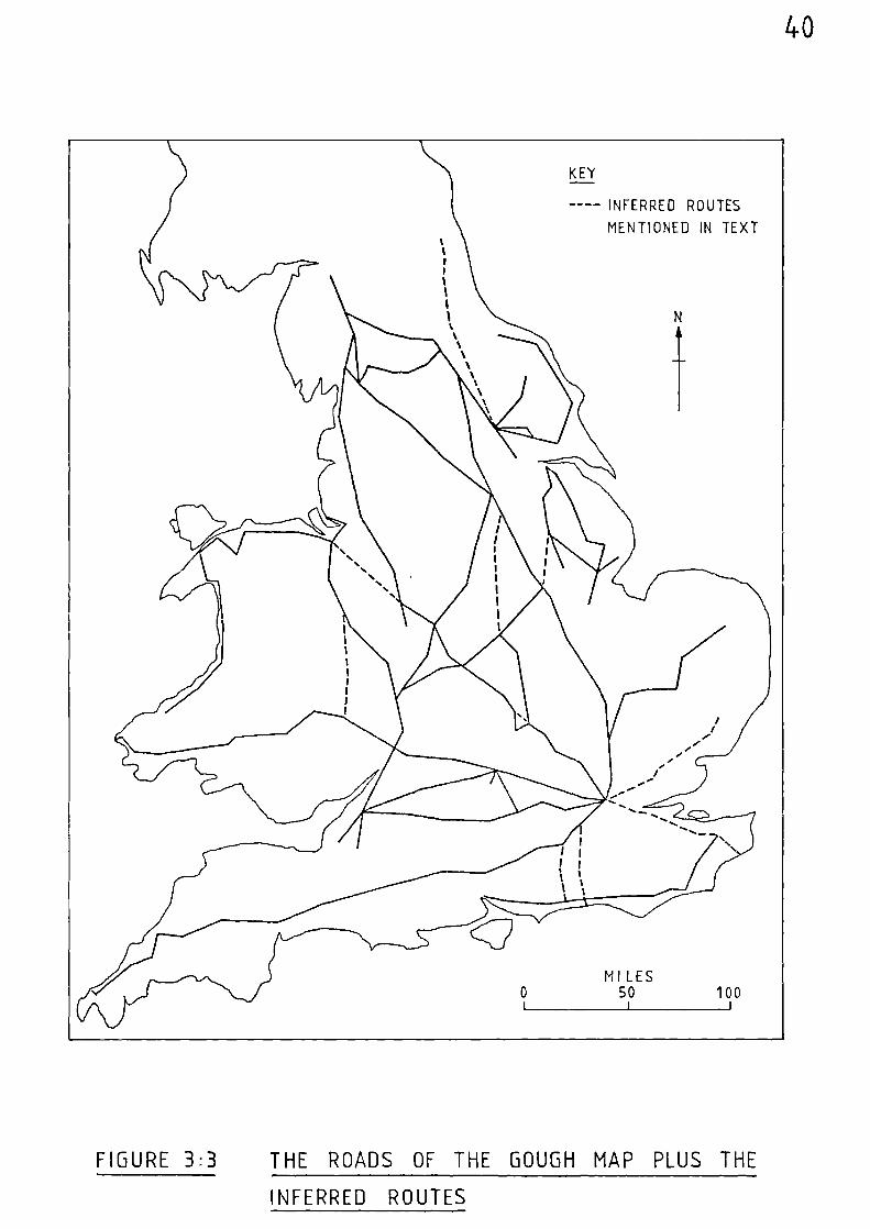
Because all the intervening towns on these inferred routes are
correctly shown in relation to each other, the absence of a line and
distance does not render a particular area of the map useless, and a
traveller would have little difficulty in following these routes.
Therefore, the aforementioned inferred routes have been added to the
Gough Map roads shown in Figure 3:2, and the resultant layout is mapped
in Figure 3:3.
The Maps of Matthew Paris
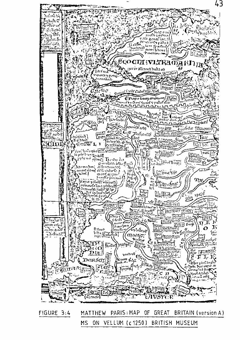
Although responsible for a number of medieval maps, this thirteenth
century monk of St. Albans produced a series of four detailed maps of
Britain c1250. These four maps, which have been discussed in some detail
(11)by J.B. Mitchell, are itemised as follows:-
Map A : Cotton MS Claudius. D. VI
Map B : Corpus Christi College, Cambridge, MS. 16
Map C : Cotton MS. Claudius. D.VII
Map D : Royal MS. 14.C7
KEY
---- INFERRED ROUTES
MENTIONED IN TEXTt
%1
MILES0 50 100I I 1
40
FIGURE 3:3 THE ROADS OF THE GOUGH MAP PLUS THE
INFERRED ROUTES
41
Two of these maps (A and B), appear to be constructed around an
itinerary between Newcastle and Dover, whilst the other two, although both
leading to Dover, commence in Berwick and Durham respectively.
The routes from all four maps are given below in Table 3:2.
Table 3:2 The Route Towns of the Matthew Paris Maps.(12)
A B C
Berwick - - Bere/wic
Bamburgh - - Bamburc
Newcastle Houu Cast'-'m NouG/CastrG NouG Casti.'•
Durham DunelmG DunelmG Dune l5 Dunelhi
Northallerton Alu'tona Aluertona Alu'ton
Boroughbridge Pons Burgi Pas Burgi Pas Burgi Monasi d'f6tib*
Pontefract Pons fact POs fract POs fact POs fact
Doncaster Denecaste
Danecaste Danec/astre Danecaste
Blyth Blie Blie Blie Bile
Newark Neuwerc Heuwerc Heuwerc Neuwerc
Belvoir Bealwar Bealwair Bealwer
**Leicester Legrecest' Legrecestria Stanford
Northampton Horthamt' Horthamtona NorWaton
Dunstable Dunes tap Dunes/stapl' Dunes/stapi
St. Albans CenobiG/sel Albani
Cuiutas -S-Albi Cenob'
Seit Alban
London London LO don LondOn
Rochester Rofa Rofa Rofa
Canterbury Cantuai. Cantuar' Cantual-
Dover Dou'a Castum/...
uer'Dou'a
Footnotes
Fountains Abbey. Boroughbridge is not shown**
'Leicestr'is on a branch route.
42
Apart from slight deviations, the route between Newcastle and London
follows the roads set down upon the Gough Map. Although the itinerary
between Berwick and Newcastle only records one intermediate stage it
does extend the inferred Gough Map route between York and Newcastle up
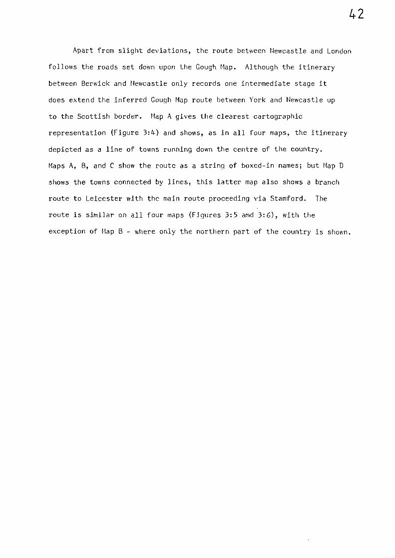
to the Scottish border. Map A gives the clearest cartographic
representation (Figure 3:4) and shows, as in all four maps, the itinerary
depicted as a line of towns running down the centre of the country.
Maps A, B, and C show the route as a string of boxed-in names; but Map D
shows the towns connected by lines, this latter map also shows a branch
route to Leicester with the main route proceeding via Stamford. The
route is similar on all four maps (Figures 3:5 amd 3:6), with the
exception of Map B - where only the northern part of the country is shown.
-a 4.: 7 • •, vnrt, I
• - --‘n •
5.,)en• - re4-17
%.4k• /It' ,t - Ar"V• • , ?1,:se"•• -, .'s ;If erZtpS ".e . ' c-r• a •
. • . typ., • f•rir'''t$ •
‘.t .4. •
14 L•f •
)•,.____,44%•-,-,.., . . • .....1!fl.ocVff•N t,r` --
"iinA--f.,
4 p
N‘! • •'1.
z
• 'rior
alritticiv vs+
••••-•
FIGURE 3:4
II4
1.
C(;
vraon].
Cmcl.ti ff
Crt.41111ri-)4
I I 1 cyn'tv
„ Viire I 41)-Cs r
MATTHEW PARIS: MAP OF GREAT BRITAIN (version A)
MS ON VELLUM (C 1250 ) BRITISH MUSEUM
•/ CI rt, eft. 1 •
•
A
•rti.t
nn•'•
11
Nra".04-ciZNE-; :•\-ts- .
43)t. f tri
,."tt.4.1. IA •t
-
A:.
unit. I itt1.1.:L .7,:rsitsnO
•\l 4
rt,t. v. :‘;-i;N,• Is ;),-0,::1:,1 --,• — — - . 1
->
.%\
1:.•.1-..1 sit:zifafA
:IV %es .vsctcairns
vYit
• , fis ?„.3,4.5
•
11.11.11)).1t• In 0:01,5._..
11C%ys,
• .
4 . 4sirf .24;fvf:N1-. se..1,4-,
(°1Lt tfl ;11-:
cflh Coot ir anzA Sta-.1
to,
re.Luvn.
4fir-isecl°_144-111-14 tilt mi fct,re,1
• P
LC JCL` In
,41
-,.., 4.•1.
. •s'-2'. t :. -•
, 4 ,'-; ..4ts' n-.t.,-'. J ., • ..)-- - ' <,/,
a ,---, ?Jr.' .,;•.• •,;.,• .. '' ••''' • 1
a• . r..1-c::,.i 1
- - o • . -
' 0k.0..'
-, 4..-.• e. .--.. ..r.. -6
, ).) !,:-• - ,— • ••.fti. -1611.,
fl'i .7;114;.,...Z;..:.,.;.:(.3.t,
-,. • .. , e , ...e, •4...›•:"..!, 4 PC.';,_••:t
. 4;•-'1 tl! ,.:Tf' ' .niat ,:',/ : 1 i:: — 17'':'.: 2, a .1"
.. 1; ' :1‘.'n7,•',
I' o/r1-4 ;;;t:f
_ _ i
A
?set)111.c
t'Inu Al:nz
- • n
1et
ffTj T evrcnitcarn.
ile (" •
}-1.• I 1:C ill:1;1'i( 11;11%-mcItnn j Pf
clittreire+11 , 4141 s.i .o:r;;Iti,7 '
•vl, 4 • -
"nryic,27-1
ft4..act •to v,1 rniomiz... I ' 1
•
a •
t.
11111
*.•
s7i
71 PM- mord a pa flrad.i)crornogra•Tcottreig,
1•1
cf i'ca/ r 1'7 1limfor.L7.t,r1
• -11•
rg-TWT- n c-
"-rt.4 0- •
i170.-tL1
)r) ,§:11:11
, I-if-T(31f
)
tu
I $
1' 1.ft-or alsin. ri)i •‘.seallf
1.11111,):
)
mite A.IV•
14:;7f:n 101. 1 Sit
U4.-",1 •
xx. 7 J, • ,
: cr. (;, ITI
(
n•n' iv(LIT rt
4 -• • Ikon
07fri -.0
• ---‘• • ,/ r
/11.:13 isrFc
Fic-71.335ilf-})
B•Cir f?1.F.1171
. I
.1.4er
-:"Tr
1 —Iii\Vri;l4A 11,c;
Jt: •1n1-
tft cr vArtargli,S-ust- vane' . ciu
jo-r-snul:-3 iV"'441
,,r et47c 01
•i1y.'n7S 41"1±1"
C
, • ••\̀\.t.c* 1,1j1./.7
Ur. l'IVC•- A
:. n .e t irCYFofnir.1 1 Pl!'qS:41:
yivat-st rzy
glgril l" 41 7%.,'
•
"r n: 1`.7.1•0-1i,
(.41 i.
; •
•
•
•
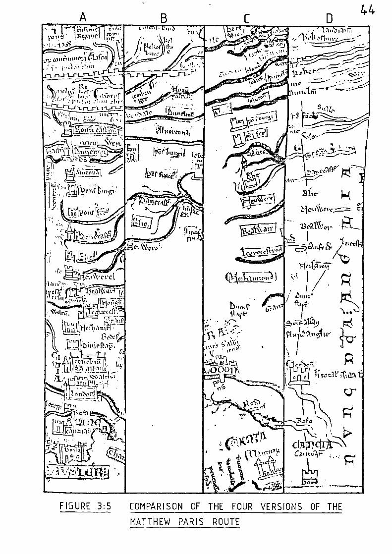
ofig
Izir.111
sc&f)fD;iti,11.1f,
II —,.
C C11 0 t, 4,3... _ ,,,
I ,Ii. 5....A..111.:1!A .....,
1 .
1 1 6 il"z‘fA. ,..r .,._ ..... ,
J;i0111v-1,0-00)L
• iAllt na.;
-
rAct.
FIGURE 3:5 COMPARISON OF THE FOUR VERSIONS OF THE
MATTHEW PARIS ROUTE
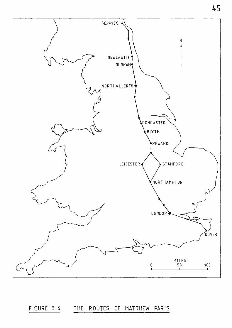
45
DONCASTER
BLYTH
NEWARK
STAMFORD
NORTHAMPTON
DOVER
MILES0 50 100
I I 1
LEICESTER
BERWICK
NEWCASTLE
DURHAM
NORTHALLERTO
LONDON
FIGURE 3:6 THE ROUTES OF MATTHEW PARIS
46
Notes and References
(1)
(2)
R. COUGH,
E.J.S. PARSONS,
British Topography, 2 vols (1780)
The Map of Great Britain, c A.D. 1360,known as the Gough Map, 'Memoir with amendedreprint of part of paper by F.M. Stenton(1936) and a colour facsimile (Oxford,Bodleian Library, 1958).
(3) ibid, 36
(4) B.P. HINDLE, 'The Towns and Roads of the Gough Map (c.1360)'Manchester Geographer. 1/1 (1980) 36.
(5) F.M. STENTON, 'The Road System of Medieval England'Economic History Review vol. VII, No. 1,(1936) 7-8.
(6) ibid, 8
(7) ibid, 9
(8) ibid, 10
(9) ibid, 5
(10) B.P. HINDLE,(op. cit.)
38
(11) J.B. MITCHELL, 'The Matthew Paris Maps' Geographical Journ.81 (1933) 27-34.
(12) H. POOLE and Four Maps of Great Britain designed byJ.P. GIBSON, Matthew Paris about A.D. 1250. (British
Museum, 1928).
47
CHAPTER FOUR THF EVIDEHCE OF ROYAL ITIHERARIES
Although evidence relating to journeys at the local level can
be gathered from many sources, systematic accounts of longer journeys -
which cover a fair proportion of the country and as such are extremely
important at the national level - are far less common. However, various
itineraries relating to long journeys do survive from the medieval period,
and these provide data from which it is possible to derive some common
lines of travel.
Although itineraries do not prove the physical existence of roads,
(or river routes), they do provide direct evidence of the movement of
individuals, which is of great significance. These individuals obviously
journeyed from place to place by some means or other and the options
available to them would be:- to walk; to ride; to travel by carriage
Or cart, or to travel by boat - if navigable mater as to hand.
Many ecclesiastical itineraries, generally relating to the travels
of bishops and archbishops, survive from the medieval period, usually in
the form of registers. A drawback of this type of record is that the
bishops, visiting religious centres, tended to journey only within the
confines of their diocese, with the result that their itineraries are
rather limited when considering a national route network; also they are
not detailed enough.
These problems do not apply to the movement of the royal household.
Medieval Kings were very mobile and journeyed ceaselessly between manors,
abbeys, castles and towns. Their itineraries, although not written down
by contemporary writers, have been re-constructed using a number of
different sources. Perhaps the most detailed of these is H. Cough's
48
Itinerary of King Edward the First, which is based on information from
over thirty sources including the Wardrobe Accounts, Writs of Inquisitions
Post Mortem, and various State Rolls.(1)
B.P. Hindle used the published
itineraries of King John, Edward I and Edward II to construct maps of
their movements.(2)
He concludes, quite logically, that if certain routes
were used frequently, then some reasonable track or road must have existed
between the places visited, because the Kings took their households with
them, and this required up to twenty carts and waggons. (3) He condenses
these maps into one which shows all the routes travelled four times or
more by more than one of the three Kings to produce a minimum aggregate
route network (Figure 4:1) from which it is clear that the majority of
their journeys were in central and southern England.
As mentioned in Chapter Two, a criticism of this minimum aggregate
network is that it is very subjective, and a comparison of all the
routes travelled four or more times by John, Edward I and Edward II
reveals a much broader network of routes (Figure 4:?). Many of these
journeys were concerned with military and ecclesiastical business or were
indicative of visits to royal hunting lodges. However, as Hindle suggests,
the minimum aggregate network covers a network which would have been most
useful to the movement of the three Kings and their court during their
reigns, although there is no objective way of fixing the number of routes
needed, or indeed the level at which the routes become important.(4)
A further criticism, also mentioned in Chapter Two, is that the
three royal itineraries scrutinised by Hindle do not cover a continuous
period of time. Hindle did not put into map form the movements of King
Henry III during his fifty six year reign (1216 to 1271); he only
analysed Henry's journeys in terms of the number of moves per month,(5)
BERWICK
LEICESTER
KEY
OX = OXFORD
KL = KING'S LANGLEY
WA L = WALL I NGFOR D
W=WINDSOR
0= ODIHAM
F = FARNHAM
WORCESTER
49
NEWCASTLE
DARL I NGTO
NO PT HA L LER T ON
BEVERLEY
PONTEFRACT
DONCASTER
NOTTINGHAM
ORTHAMPTON
OWCESTER
TEWKESBURY AGLOUCESTER
\ WOODSTOCK
LREADING1111111" °NUN ROC
R HESTER
A
ORD LEEDS
S S URYvPAN TER BURY
4I 8 ill
2INCH STER'SOUTHAMPTON
RINGWOOD
MILES
0 50 100
KL
FIGURE 4:1 MINIMUMUM AGGREGATE NETWORK BASED ON THE
ROYAL ITINERARIES OF JOHN, EDWARD I AND
EDWARD II
BRILL
EIGHTON BUZZARD
T. AL • ANSARE
BRISTOL MABORO
DOVER
DORCHESTER
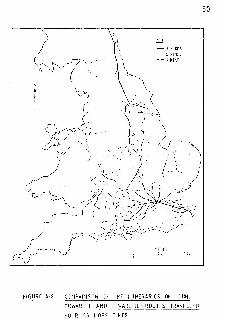
- 3 KINGS
- 2 KINGS
1 KING
MILES0 50 100
1 1 i
50
FIGURE 4:2 COMPARISON OF THE ITINERARIES OF JOHN,
EDWARD I AND EDWARD II: ROUTES TRAVELLED
FOUR OR MORE TIMES
51
together with a cartographic description of some local journeys in
the county of Cheshire(6).
Therefore, it was decided to carry out a plot of King Henry's
movements to see if his routes were different in any way from the route
network ascribed to the other three monarchs.
The Historical Setting
The son of King John and Isabel of Angoultme, Henry was born at
Winchester in 1207 and succeeded to the crown in 1216 on the death of
his father. At the time of his accession the Dauphin of France, Louis,
at the head of a foreign army supported by a faction of English nobles,
had assumed the reigns of government; but was compelled to quit the country
by the Earl of Pembroke, who was guardian of the young King. On reaching
his maturity Henry assumed responsibility for running the country and
immediately began to bestow his chief favours upon foreigners. This made
him unpopular, as did his marriage in 1236 to Eleanor of Provence. The
Queen, not unnaturally, tended to favour members of her own family and
this, coupled with Henry's reluctance to promote his English subjects,
caused further discontent. The King received frequent grants of
money from Parliament, on condition of confirming the rireat Charter,
yet his conduct after each ratification was as arbitrary as before.
The barons having lost their foreign possessions, were English in
outlook and although of Norman descent they disliked the introduction of
foreigners into the chief positions of Church and State. Eventually, in
1258, the nobles rose in rebellion under Simon de Montfort, Earl of
Leicester, and obliged the King to si gn the body of resolutions known as
52
the Provisions of Oxford.(7)
Foreigners were to be removed; a council
of bishops and nobles was set up to bring about reforms and to control
the King; and all appointments were placed in the hands of this council.
A feud arose, however, between Leicester and Gloucester, and Henry
regained some of his power. War again broke out, and Louis was called
in as arbitrator, but as his award was favourable to the King, Leicester
refused to submit to it. A battle was fought near Lewes in 1264, in
which Henry was taken prisoner. There followed a convention called the
'Mise of Lewes', which provided for the future settlement of the Kingdom
and, in 1265, a Parliament consisting mostly of Knights and barons was
summoned. Later the same year, Leicester was defeated and killed at the
battle of Evesham and Henry was replaced upon the throne. He died in
November, 1272, and was succeeded by his son, Edward I - who did not return
to England until August 1274 after years of crusading and travelling.
Evidently, the political situation had, by then, become much more stable.
The Itinerary of King Henry III
A typescript itinerary exists in the Public Record Office for the
whole of King Henry's reign; commencing in October 1216, and continuing
to his death in November, 1272.(8)
Hindle has already discussed the problems involved in interpreting
this type of evidence.(9)
There is the basic problem of locating some
of the various placenames given in the itinerary. Many places contain
the same name elements, and sometimes places of the same name are
frequently not very far apart. Different forms of spelling can also cause
confusion and the utmost care has to be exercised in order to assign many
places correctly. The publications of the English Place-Name Society and
53
old c unty naps wer extrerely useful aids in this direction. Although
tte itinerary becomes prouressively fuller as King Herry's reign progresses,
there are, as with most itineraries of this type1 periods when gaps
appear in the data. These gaps can sometimes be filled by studying
previous and subsequent journeys along similar lines of travel, but
there are occasions when it is impossible to say where the king ma) have
been. Also, the itinerary does not necessarily give the places at which
the King stayed overnight - only the fact that he was at a particular
place at sone time during the day, and, as the compiler of the itinerary
d s not list the sources used for its c nstruction, it is impossible
to be sure of the exact periods when his court moved with him. Furthermore,
the itinerary gives no indication of the King's mode of transport, and
hence it is irpossible to ascertain to what extent use was made of
navigable stretches of water. Difficulties also arise when attempting to
determine the precise route taken between various places.
In spite of these problems it is possible to derive the King's
general direction of pro\ement bn the sirple method of connecting
together by a straight line the places elven in his itinerary in
chronological order; and the resultant rap produced by this method is
elven in Figure 4:3.
This figure reveals a number of areas of dense coverage. The
large triangle between London, Salisbury and Aorcester, the area to the
south and nest of Lincoln, East Anglia; and the area to the immediate
south-east of London. The figure also reveals a number of gaps. The
extreme south-west; vast areas of the north-west; and the Lincolnshire
and Yorkshire coasts. Also, apart from some coverage along the western
borders, and the coastal route between Chester and Deganwy, there appears
to have been very little movement into Aales.
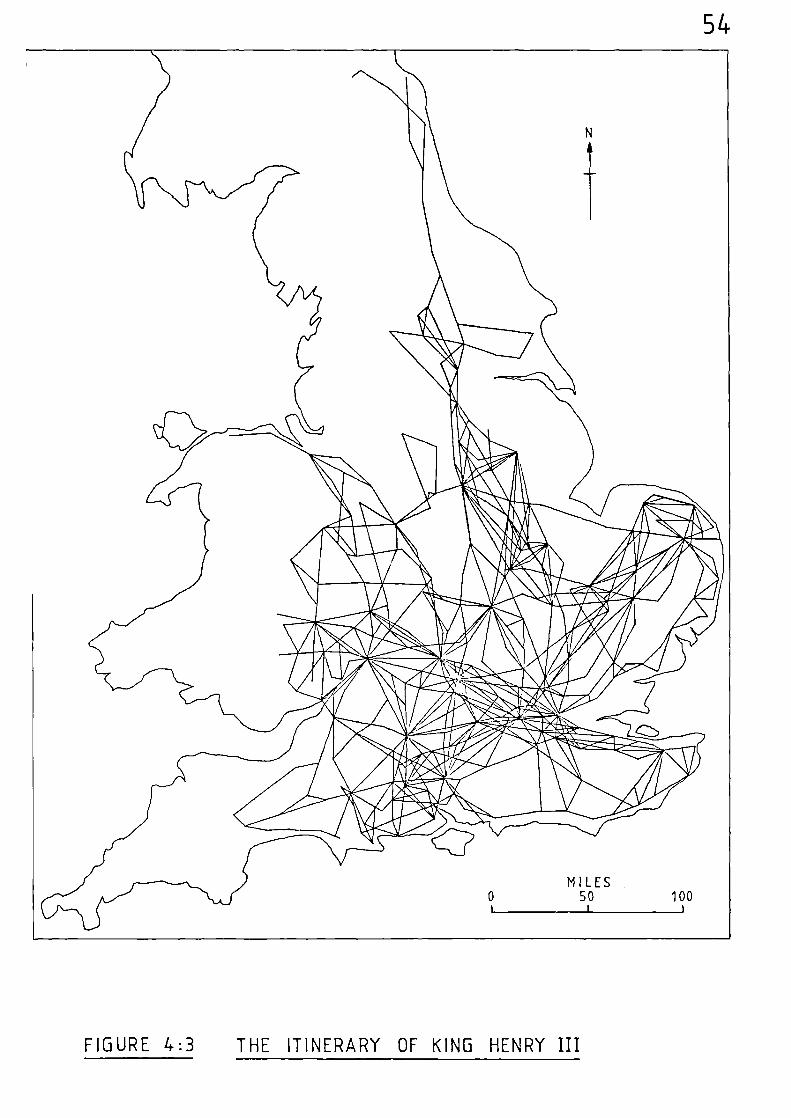
54
FIGURE 4:3 THE ITINERARY OF KING HENRY III
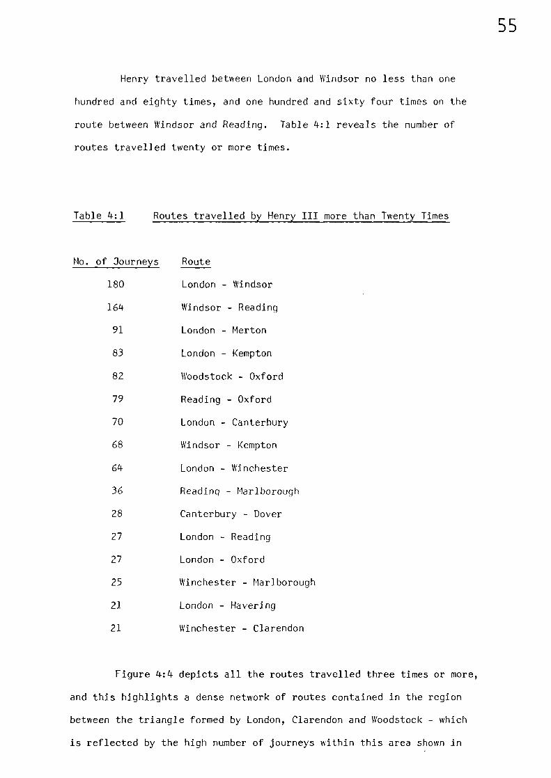
55
Henry travelled between London and Windsor no less than one
hundred and eighty times, and one hundred and sixty four times on the
route between Windsor and Reading. Table 4:1 reveals the number of
routes travelled twenty or more times.
Table 4:1 Routes travelled by Henry III more than Twenty Times
No. of Journeys Route
180 London - Windsor
164 Windsor - Reading
91 London - Merton
83 London - Kempton
82 Woodstock - Oxford
79 Reading - Oxford
70 London - Canterbury
68 Windsor - Kempton
64 London - Winchester
36 Reading - Marlborough
28 Canterbury - Dover
27 London - Reading
27 London - Oxford
25 Winchester - Marlborough
21 London - Havering
21 Winchester - Clarendon
Figure 4:4 depicts all the routes travelled three times or more,
and this highlights a dense network of routes contained in the region
between the triangle formed by London, Clarendon and Woodstock - which
is reflected by the high number of journeys within this area shown in
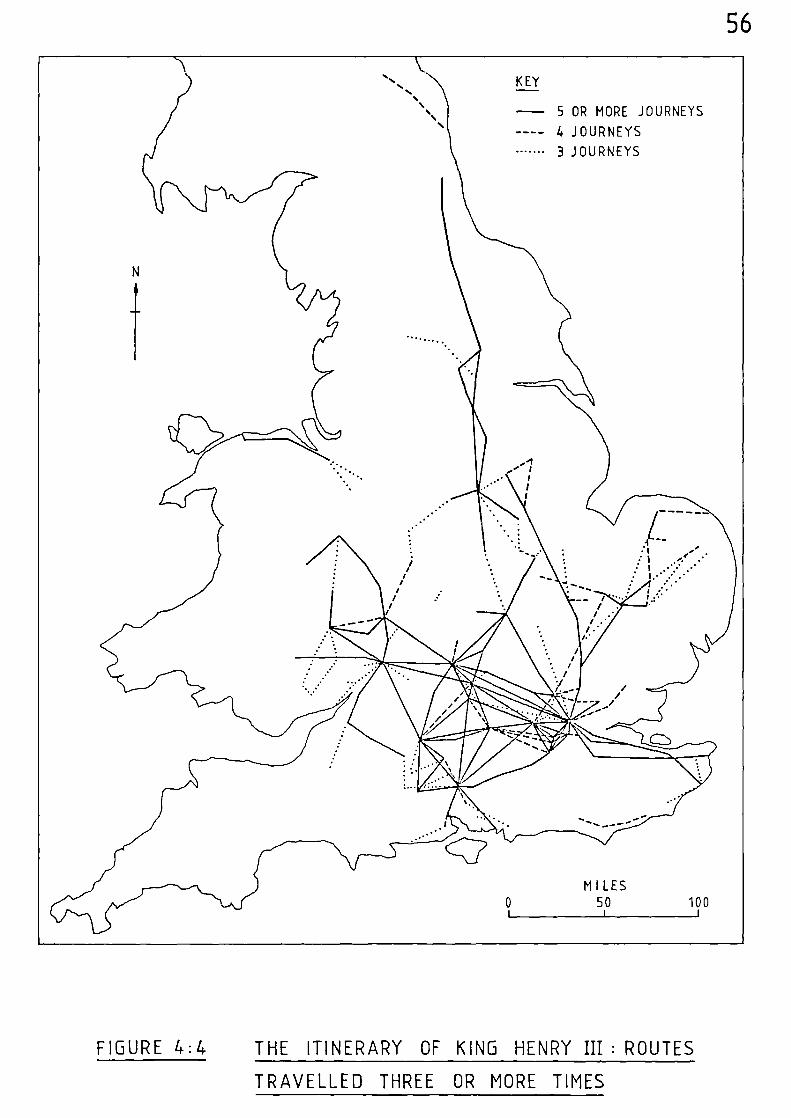
- 5 OR MORE JOURNEYS
---- 4 JOURNEYS
3 JOURNEYS
56
FIGURE 4:4 THE ITINERARY OF KING HENRY III : ROUTES
TRAVELLED THREE OR MORE TIMES
57
Table 4:1.
There are three variations of the route between London and
Canterbury; 1) via Dartford, Rochester, Sittingbourne and Faversham,
2) via Sutton at Hone, Rochester, Sittingbourne and Faversham; 3)
via Otford, Maidstone, Leeds and Faversham.
There is the positive indication of a route into Norfolk via
Newmarket and Thetford towards Norwich, with an alternative way via
Bury St. Edmunds. Ely is strongly linked with Newmarket and Bur y St.
Edmunds with Walsingham - via Thetford and Castle Acre.
The Great North Road is well utilised between London and Newark,
and beyond between Blyth, Doncaster and Pontefract. Between York and
Newcastle-upon-Tyne the route is very clearly defined as passing through
Northallerton, Darlington and Durham.
The figure highlights the route to York, the initial stage of
INhich was along Watling Street, then on through Horthampton, Leicester,
Nottingham and Doncaster; from where alternative routes passed through
either Pontefract and Tadcaster, or via Sherburn in Elmet.
The route between Bristol and Shrewsbury follows the course of
the River Severn - through Gloucester, Tewkesbury, Worcester, Kidderminster
and Bridgnorth; and Gloucester and Worcester both emerge as being
positively linked with Hereford, Woodstock, and Oxford. Hereford is
also linked with Ludlow and Shrev‘sbury.
The Welsh coast route, the south coast route in the vicinity of
Lewes, and the route in the north-east between Warkworth and Carham, have
all become isolated. However, the majority of the other routes are
58
reasonably well interconnected.
Figure 4:4 also highlights a number of nodal points where six
or more route junctions occur, these being;- London, Windsor, Winchester,
Marlborough, Woodstock, Gloucester, Nottingham, Northampton, Reading,
St. Albans, Wallingford, Abingdon, Oxford, Worcester, Hereford and
Guildford.
During his reign, Henry made several journeys to France, and the
outline of his travels during these times is given in his itinerary.
His usual port of embarkation was Dover, although for his first journey
abroad, in August 1253, he apnears tO have embarked from Portsmouth. He
spent a total of two years and four months abroad s pread over five separate
visits, the longest duration of which was sixteen months, and the shortest
ten days.
The Influence of Henry's Travels on the Minimum Aggregate Network based on the Royal Itineraries
In comparing the generalised picture portrayed by Figure 4:1
of the most frequently utilised routes of John, Edward I and Edward II
with the more frequently used routes of Henry III (Figure 4:4), many
common routes are apparent.
The Great North Road, running southward from Newcastle-Upon-Tyne
via Durham, Darlington, and Northallerton to York is a clear example;
and Henry's journeys directly to the north were usually along the common
route through Northampton, Nottingham, and Doncaster. However, the
southern section of the Great North Road via Ware, Royston, Huntingdon,
Stamford, Grantham, and Newark, was utilised more by Henry than the other
three Kings; and the section of this route between London and Stamford
59
and the adjacent links between Nottingham and King's Cliffe and between
Northampton, Geddington, and King's Cliffe are significant.
As with the other three Kings, Henry did not enter the county
of Cornwall, travelling no further west than Crediton, but he visited
many more places in East Anglia and his route into Norfolk via Newmarket
and Thetford, and on towards Norwich (a route also used by Edward I),
is a prominent feature. Also prominent in this area are the routes
between Ely and Newmarket, and Bury St. Edmunds and Walsingham.
Henry frequently journeyed between Gloucester and Marlborough,
and Worcester and Shrewsbury. Abingdon and Oxford emerge as more
prominent route centres from Henry's travels, and both are more strongly
linked with Winchester and Northampton as Hereford is with both Worcester
and Gloucester, and Woodstock with Brackley and Northampton.
All the aforementioned shared routes, plus the majority of
the other routes shown in Figure 4:1, would suffice as the basis of a
minimum network for Henry's travels. If these additional shared routes
are added to the minimum aggregate nebsork of Figre 4:1 an extended
nebNork is produced which, it is suggested, would have been most useful
to the movement of the King and his court spanning the years 1199 to
1327 (Figure 4:5).
The lines on the maps relating to the royal itineraries do not
necessarily represent roads; but, as has previously been stated, if
these routes were used frequently, it is logical to expect that a reason-
able track or road must have existed between the places visited.
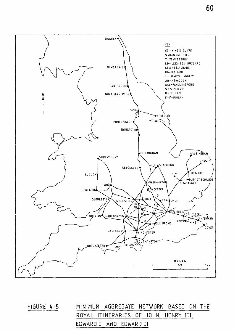
BERWICK
NEWCASTLE
DARL INGTOI
HO RI HA LLERTON
LEICESTER
R) S TOL
60
KEY
KC = KING'S CLIFFE
WOR=WORCESTER
T= TEWKESBURY
LB= LEIGHTON BUZZARD
ST A = ST. ALBANS
OX= OXFORD
KL= KING'S LANGLEY
AB= ABINGDON
WAL=WALLINGFORD
W= WINDSOR
0= OCIIHAM
F= FARNHAM
YOR
BEVERLEY
PONTEFRACT
DONCASTER
SHREWSBURY
OTT INGHAM WALSINGHAM
NORWICH
KC STAMFORD
BURY ST. EDMUNDSNEWMARKETNORTHAMPTON
WOR
I . 414 ‘,40AIX iekvotKoLMARLBOR
WOODSTOCK WARE
HEREFOR OWCESTER
LB
GLOUCESTER BRILL ST. A
(UG43°
GUI
ttWT
LDFORD LEEDS
SALISBURYWINCH STER
WOOD
MILES
0 50 100
0 ND ON----.0 CHF_ ---ISTER
NTERBURY
DOVER
DORCHESTER
THETFORDLUDLOW
FIGURE 4:5 MINIMUM AGGREGATE NETWORK BASED ON THE
ROYAL ITINERARIES OF JOHN, HENRY III,
EDWARD I AND EDWARD II
61
Notes and References
(1) H. COUCH, Itinerary of King Edward the First 2 vols. (Paisley 1900)
(2) B.P. HINDLE, 'A Geographical Synthesis of the Road Network of
Medieval England and Wales'. Unpublished Ph.D.
Thesis, University of Salford (1973) 59-93.
(3) ibid, 70
(4) ibid, 90
(5) ibid, 74
(6) ibid, 166
(7) D.C. DOUGLAS (ed.), English Historical Documents, Vol. III,
1189 - 1327 (London 1975) 361-67
(8) T. CRAIB, Itinerary of Henry III, 1215 - 1272 (Typescript)
Public Record Office, Roundroom Press 22/44 (1923)
(9) B.P. HINDLE (op.cit.), 62-70.
62
CHAPTER FIVE PREMONSTRATENSION ITINERARIES FROM TITCHFIELD ABBEY
Probably the earliest known English road-book is that which
survives in the form of a manuscript which once belonged to the
Premonstratension Abbey of Titchfield in Hampshire. It contains
itineraries from Titchfield to each of the other houses of Premonstrat-
ension Canons.
The itineraries cover a fair proportion of the country, fanning
out in all directions from Titchfield. Hence, they are an extremely
useful contribution towards the attempted reconstruction of a medieval
national route network as they do not suffer from a typical fault
associated with the more usual ecclesiastical itineraries - that of only
staying within the precincts of a particular diocese.
Some thirty itineraries are recorded giving stage placenames
and inter-stage mileages together with total mileages for each separate
route. The manuscript has been printed by B. Dickins (1) , %ho suggests
that the itineraries may have been dram up for the use of an abbot of
Titchfield Olo %as visitor of the Order. The date of the manuscript,
which also contains the catalogue of the Titchfield Abbey library, is
1400 - 1405. However, it is probable, as has been suggested by J.H.
Harvey(2)
, that the itineraries were copied from some earlier source.
Many of the itineraries share part of the same route. Therefore,
it is easier to present them by route association rather than in
alphabetical order, and this is the basis for the following table:-
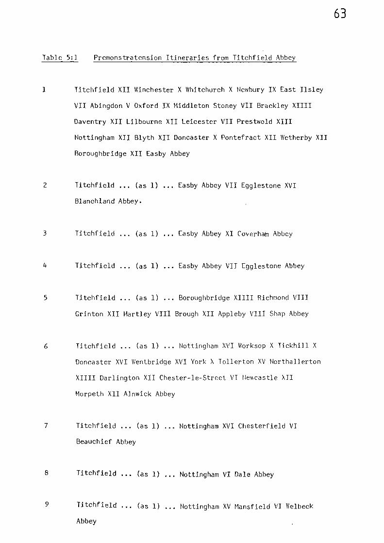
63
Table 5:1 Premonstratension Itineraries from Titchfield Abbey
1 Titchfield XII Winchester X Whitchurch X Newbury IX East Ilsley
VII Abingdon V Oxford IX Middleton Stoney VII Brackley XIIII
Daventry XII Lilbourne XII Leicester VII Prestwold XIII
Nottingham XII Blyth XII Doncaster X Pontefract XII Wetherby XII
Boroughbridge XII Easby Abbey
2 Titchfield ... (as 1) Easby Abbey VII Egglestone XVI
Blanchland Abbey.
3 Titchfield ... (as 1) Easby Abbey XI Coverham Abbey
4 Titchfield ... (as 1) Easby Abbey VII Egglestone Abbey
5 Titchfield ... (as 1) Boroughbridge XIIII Richmond VIII
Grinton XII Hartley VIII Brough XII Appleby VIII Shap Abbey
6 Titchfield ... (as 1) ... Nottingham XVI Worksop X Tickhill X
Doncaster XVI Wentbridge XVI York X Tollerton XV Northallerton
XIIII Darlington XII Chester-le-Street VI Newcastle XII
Morpeth XII Alnwick Abbey
7 Titchfield ... (as 1) ... Nottingham XVI Chesterfield VI
Beauchief Abbey
8 Titchfield ... (as 1) ... Nottingham VI Dale Abbey
9 Titchfield ... (as 1) ... Nottingham XV Mansfield VI Welbeck
Abbey
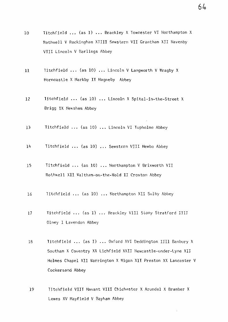
64
10 Titchfield ... (as 1) ... Brackley X Towcester VI Northampton X
Rothwell V Rockingham XIIII Sewstern VII Grantham XII Navenby
VIII Lincoln V Barlings Abbey
11 Titchfield ... (as 10) ... Lincoln V Langworth V Wragby X
Horncastle X Markby II Hagneby Abbey
12 Titchfield ... (as 10) ... Lincoln X Spital-in-the-Street X
Brigg IX Ne nnsham Abbey
13 Titchfield ... (as 10) ... Lincoln VI Tupholme Abbey
14 Titchfield ... (as 10) ... Sewstern VIII Newbo Abbey
15 Titchfield ... (as 10) ... Northampton V Brixworth VII
Rothrsell XII Waltham-on-the-Wold II Croxton Abbey
16 Titchfield ... (as 10) ... Northampton XII Sulby Abbey
17 Titchfield ... (as I) ... Brackley VIII Stony Stratford IIII
Olney I Lavendon Abbey
18 Titchfield ... (as I) ... Oxford XVI Deddington IIII Banbury X
Southam X Coventry XX Lichfield XXII Newcastle-under-Lyne XII
Holmes Chapel XII Warrington X Wigan XII Preston XX Lancaster V
Cockersand Abbey
19 Titchfield VIII Havant VIII Chichester X Arundel X Bramber X
Lewes XV Mayfield V Bayham Abbey
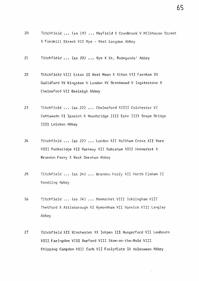
65
20 Titchfield ... (as 19) ... Mayfield X Cranbrook V Milkhouse Street
X Fordmill Street VII Wye - West Langdon Abbey
21 Titchfièld ... (as 20) ... Wye X St. Radegunds' Abbey
22 Titchfield VIII Exton II West Meon X Alton VII Farnham IX
Guildford XV Kingston X London XV Brentwood V Ingatestone X
Chelmsford VII Beeleigh Abbey
23 Titchfield ... (as 22) ... Chelmsford XIIII Colchester VI
Cattawade VI Ipswich V Woodbridge IIII Eyke 1111 Snape Bridge
Leiston Abbey
24 Titchfield ... (as 22) ... London XII Waltham Cross XII Ware
VIII Puckeridge XII Barkway XII Babraham XIII Newmarket X
Brandon Ferry X West Dereham Abbey
25 Titchfield ... (as 24) ... Brandon Fer'ry XII North Elmham II
Wendling Abbey
26 Titchfield ... (as 24) ... Newmarket VIII Icklingham VIII
Thetford X Attleborough VI Wymondham VII Norwich VIII Langley
Abbey
27 Titchfield XII Winchester XX Inkpen III Hungerford VII Lambourn
VIII Faringdon VIII Burford VIII Stow-on-the-Wold VIII
Chipping Campden VIII Cank VII Foxlydiate IX Halesowen Abbey
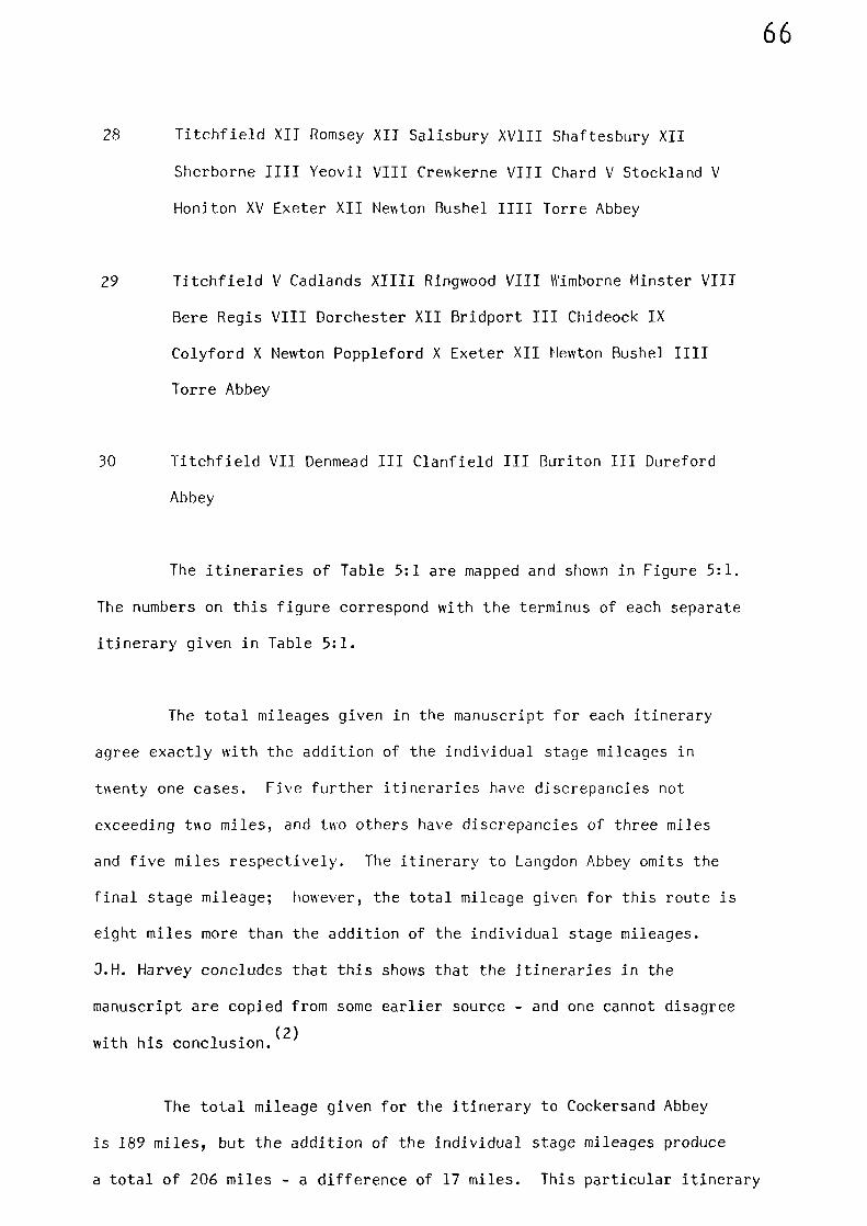
66
28 Titchfield XII Romsey XII Salisbury XVIII Shaftesbury XII
Sherborne IIII Yeovil VIII Crewkerne VIII Chard V Stockland V
Honiton XV Exeter XII Newton Bushel IIII Torre Abbey
29 Titchfield V Cadlands XIIII Ringwood VIII Wimborne Minster VIII
Bere Regis VIII Dorchester XII Bridport III Chideock IX
Colyford X Newton Poppleford X Exeter XII Newton Bushel IIII
Torre Abbey
30 Titchfield VII Denmead III Clanfield III Buriton III Dureford
Abbey
The itineraries of Table 5:1 are mapped and shown in Figure 5:1.
The numbers on this figure correspond with the terminus of each separate
itinerary given in Table 5:1.
The total mileages given in the manuscript for each itinerary
agree exactly with the addition of the individual stage mileages in
bsenty one cases. Five further itineraries have discrepancies not
exceeding to miles, and two others have discrepancies of three miles
and five miles respectively. The itinerary to Langdon Abbey omits the
final stage mileage; however, the total mileage given for this route is
eight miles more than the addition of the individual stage mileages.
3.H. Harvey concludes that this shows that the itineraries in the
manuscript are copied from some earlier source - and one cannot disagree
with his conclusion. 2)
The total mileage given for the itinerary to Cockersand Abbey
is 189 miles, but the addition of the individual stage mileages produce
a total of 206 miles - a difference of 17 miles. This particular itinerary
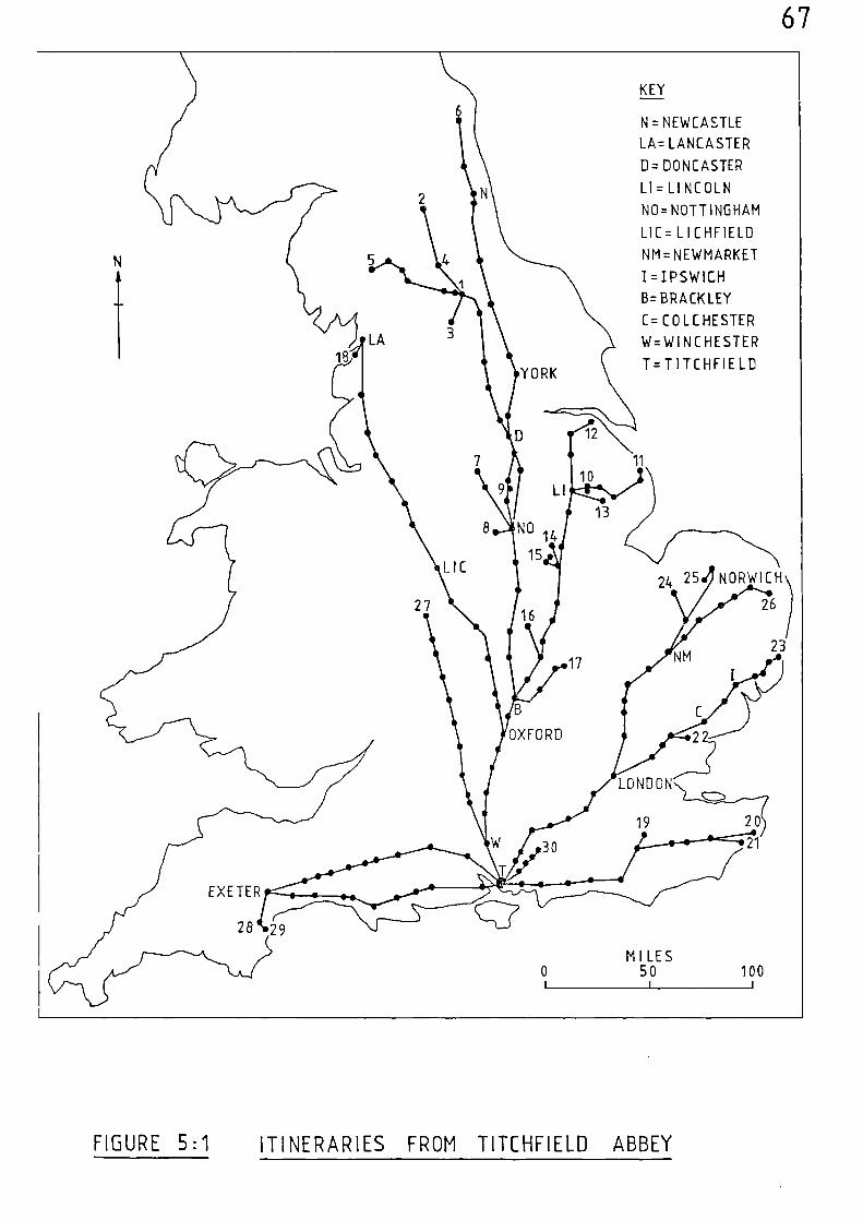
KEY
N = NEWCASTLE
LA= LANCASTER
ID= DONCASTER
Liz LINCOLN
NO= NOTTINGHAM
LIC= LICHFIELD
NM= NEWMARKET
I =IPSWICH
B= BRACKLEY
C= COLCHESTER
W=WI N C HE STEP
T=TITCHFIELDYORK
12
13NO 1
15
24 25
16
NORWICH
26
LONDON
19 20
2130
28 *29
M I LES0 50 100
LA18
17
NM 23
OXFORD
22
IC
27
EXETER
LI10
11
67
FIGURE 5:1 ITINERARIES FROM TITCHFIELO ABBEY
68
has been partly erased and altered in the latter stages and different
placenames inserted in a later hand. (3) Perhaps the original itinerary
made directly for Cockersand Abbey rather than proceeding to Lancaster and
then back-tracking, and this would account for the mileage difference.
If this were the case it is probable that whoever carried out the
erasures and alterations omitted to adjust the total mileage figure given
at the end.
The longest route is that between Titchfield and Alnwick. From
Winchester the route goes via Newbury to Abingdon and Oxford then
through Middleton Stoney to Brackley, and then via Daventry and Leicester
to Nottingham. This latter stage by-passes Loughborough in favour of
Prestwold. The route to Brackley is shared by seventeen itineraries
whilst that to Nottingham is shared by nine. The route to Alnwick
continues via ‘Aorksop to join the Great North Road at Tickhill which it
follows as far as Doncaster before diverting to York. From York the
route is via Northallerton, Darlington, Newcastle-upon-Tyne and on to
Alnwick. This latter section confirms the inferred Gough Map route
between York and Newcastle and also the routes of Mathew Paris. This
route links York with the Great North Road at Doncaster; whilst the
intermediate section confirms the existence of the inferred Gough Map
route between Leicester, Nottingham and Doncaster. The complete
itinerary between Titchfield and Alnwick follows the course of modern
roads - except that the section between Brackley and Daventry follows
what are today little more than country lanes.
The itinerary to Easby Abbey records another route between
Nottingham and Doncaster via Blyth; and this section of the route
probably went via 011erton. It seems very likely that a stage has been
69
omitted in this area of the itinerary because the distance between Blyth
and Nottingham is recorded as being XII miles, whereas the minimum
distance between these two places is 33 statute miles. The distance
between 011erton and Blyth is 14 statute miles - which equates with
the manuscript distance set down between Blyth and Nottingham. From
Blyth, the route to Easby Abbey follows the Great North Road via
Doncaster, Pontefract, Wetherby and Boroughbridge.
From Easby there are routes to the abbeys of Egglestone, Blanch-
land and Coverham, whilst a route to Shap Abbey frOm Boroughbridge
goes via Richmond, Brough and Appleby.
Dale Abbey is reached via an extension of the route leading to
Nottingham, as are the abbeys of Beauchief and Welbeck, the former via
Chesterfield and the latter via Mansfield.
Beyond Brackley, itineraries to Lincoln continued through
Towcester and Northampton to cross the Great North Road at Grantham;
this final section confirming the inferred Gough Map route between
Grantham and Lincoln. The majority of these itineraries can be traced
quite clearly along the course of modern roads, the only uncertainty
being the exact course in the vicinity of Sewstern - where numerous
country lanes provide a number of differing route options. Branches fron
the route between Brackley and Grantham lead to the abbeys of Newbo,
Croxton and Sulby. This route, between Northampton and Sulby, would
no doubt have followed the line of the modern road which passes to the
west of Market Harborough and thence to Leicester.
70
From Lincoln there are itineraries to the abbeys of Barlings, Hagneby,
Newsham and Tupholme. Barlings would have been reached by the initial
stage of the route which goes on to Hagneby through Wragby and Horncastle;
whilst the route to Newsham follows Ermine Street - through Spital-in-
the-Street and then to (Glanford) Brigg. Both these routes follow
well established modern roads. The route to Tupholme would presumably
proceed due east from Lincoln and pass through Fiskerton and Bardney.
From Brackley, the itinerary to Lavendon Abbey would possibly
follow the line of the modern road through Buckingham before proceeding
via Stony Stratford and Olney.
The itinerary to Cockersand Abbey goes due north from Oxford
by %say of Deddington, Banbury and Southam to Coventry, and continues via
Lichfield, Nev%castle-under-Lyme, Warrington, Preston and Lancaster;
all of which can be traced along well-defined modern roads; %%hilst the
latter section follo%%s a Gough Map route.
Along the south-east coast the itineraries to the abbeys of
Bayham, West Langdon and St. Radegunds' initially follov% a coastal route
through Havant, Chichester, Arundel, Bramber and Lees before cutting
inland to Mayfield and Wye.
The initial portion of the itineraries to the abbeys of Beeleigh,
Leiston, West Dereham, Wendling and Langley all follow the same route
to London; via Alton, Farnham, Guildford and Kingston. From the capital,
the way to Beeleigh goes via Brentwood and Chelmsford, fromv4here it would
no doubt have turned due east along the road to Maldon. The %%ay to
71
Leiston continues from Chelmsford and passes through Colchester,
Cattawade, Ipswich and Snape Bridge. This latter section confirms
the existence of the inferred Gough Map route between London and
Ipswich. The initial stages of the itineraries from London to the
abbeys of West Dereham, Wendling and Langley follow the Great North
Road through Ware, and then proceed to Newmarket via Barkway and
Babraham. The route to Langley then continues via Thetford, Attleborough
and Norwich, whilst those to West Dereham and Wendling pass through
Brandon Ferry. The route to West Dereham would probably f011ow the
course of the modern road through Stoke Ferry, whilst that to Wendling
would presumably pass through Watton.
The itinerary to Halesowen Abbey follows a course to the west
of the Winchester-Oxford-Banbury-Coventry route. From Winchester
it passes through Hungerford, Lambourn, Faringdon, Burford and Stow-on-
the-Wold to Chipping Campden; from whence it may havecfollowed a
section of Icknield Street to Alcester, before turning slightly west
through Foxlydiate and on to Halesowen. Much of this itinerary is
traceable via modern roads although a fair proportion of the route is by
way of minor roads and country lanes.
There are two separate itineraries to Torre Abbey. The first
follows a route through Salisbury, Shaftesbury, Yeovil, Chard, Honiton
and Exeter. The second takes a more southerly route to Exeter via
Cadlands, Ringwood, Bere Regis, Dorchester, Bridport and Colyford. The
initial stage of this itinerary, that between Titchfield and Cadlands,
must have involved the crossing of Southampton Water by boat. The
distance recorded for this stage is given as 5 miles which equates with
72
the journey by water - whereas the same stage is about 22 statute miles
by the shortest route over terra firma. The last section of both
itineraries to Torre follow a common route from Exeter via Hesston
Bushel.
The final itinerary is a very local one which goes to Dureford
Abbey via Denmead, Clanfield and Buriton.
73
Notes and References
(1) B. DICKINS, Premonstratension Itineraries from a Titchfield
Abbey MS. at Welbeck Proc. Leeds Philosophical Soc.
L. (1938) 349-61
(2) J.H. HARVEY (ed.)., William Worcestre - Itineraries (Oxford 1969)xv
(3) B. DICKINS (op. cit.), 355
74
CHAPTER SIX THE SIGNIFICANCE OF THE TITCHFIFLD ABBEY ITINERARIES
The Titchfield Abbey Itineraries are extremely useful for
indicating some new lines of travel, for confirming part of the routes
set down upon the Gough Map; and for confirming some of the inferred
routes associated with the Gough Map.
It is a fortunate coincidence that Titchfield is situated close to
several important channel ports and hence can provide valuable evidence
for routes leading to them. Southampton, which throughout the Middle Ages
carried out considerable international trade; situated nine miles
to the north-west; Chichester, Sussex's custom port, lies to the east;
as do Havant, Arundel, Bramber and Lewes; all of which are included in
the itineraries. The significance of these ports inevitably increased the
importance of the roads which led to them. Such a road is that which came
down from the Midlands via Northampton, Brackley, Oxford and Newbury to
Winchester, and hence to Southampton. This particular route forms the
backbone of the repeated Titchfield Itineraries to the Midlands and the
North, and its repeated usage can only confirm what must have been an
important route.
The itineraries also link York and Lincoln into the national route
network in a more positive manner than is shown on the Gough Map and the
link with London to the east, and Exeter to the west, confirms the
majority of the Gough Map route between these two places.
Many of the other itineraries have sections which are similar to
routes set down upon the Gough Map. The initial stages of the Great North
Road as it heads away from London are similar, as is a section further to
the north between Blyth and Boroughbridge. The Gough Map route between
75
Coventry and Lancaster via Lichfield, Newcastle-under-Lyme, Warrington,
Wigan and Preston is set down in the itineraries in its entirety. Other
similar routes are those between Lincoln and Brigg; Thetford and Norwich;
Brough and Appleby; and Oxford and Abingdon.
The stages associated with the similar routes of the Gough Map,
together with their inter-stage mileages, are given as follows in Table
6:1. These similar routes are mapped in Figure 6:1.
Note: It should be stressed at this point that the term "mileage"
applies to the distance set down in the medieval evidence. It is
used at this stage of the m:Irk only as a convenient way of
expressing distance and should not therefore be confused with
the modern statute mile. The medieval unit of distance is more
fully discussed in Appendix I.
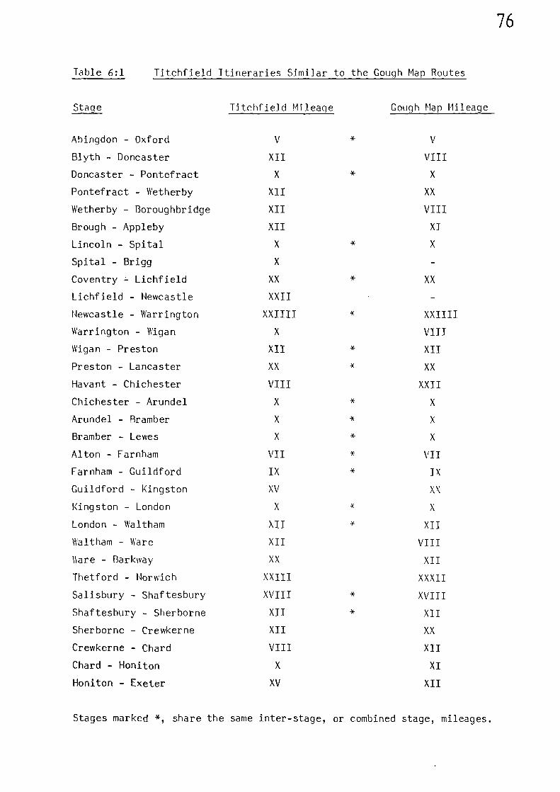
76
Table 6:1 Titchfield Itineraries Similar to the Gough Map Routes
Stage
Titchfield Mileage Gough Map Mileage
Abingdon - Oxford V * V
Blyth - Doncaster XII VIII
Doncaster - Pontefract X * X
Pontefract - Wetherby XII XX
Wetherby - Boroughbridge XII VIII
Brough - Appleby XII XI
Lincoln - Spital X * X
Spital - Brigg X
Coventry - Lichfield XX * XX
Lichfield - Newcastle XXII
Newcastle - Warrington XXIIII * XXIIII
Warrington - Wigan X VIII
Wigan - Preston XII * XII
Preston - Lancaster XX * XX
Havant - Chichester VIII XXII
Chichester - Arundel X * X
Arundel - Bramber X * X
Bramber - Lewes X * X
Alton - Farnham VII * VII
Farnham - Guildford IX * IX
Guildford - Kingston XV XX
Kingston - London X * X
London - Waltham XII * XII
Waltham - Ware XII VIII
\kare - Barkway XX XII
Thetford - Norwich XXIII XXXII
Salisbury - Shaftesbury XVIII * XVIII
Shaftesbury - Sherborne XII * XII
Sherborne - Crewkerne XII XX
Crewkerne - Chard VIII XII
Chard - Honiton X XI
Honiton - Exeter XV XII
Stages marked *, share the same inter-stage, or combined stage, mileages.
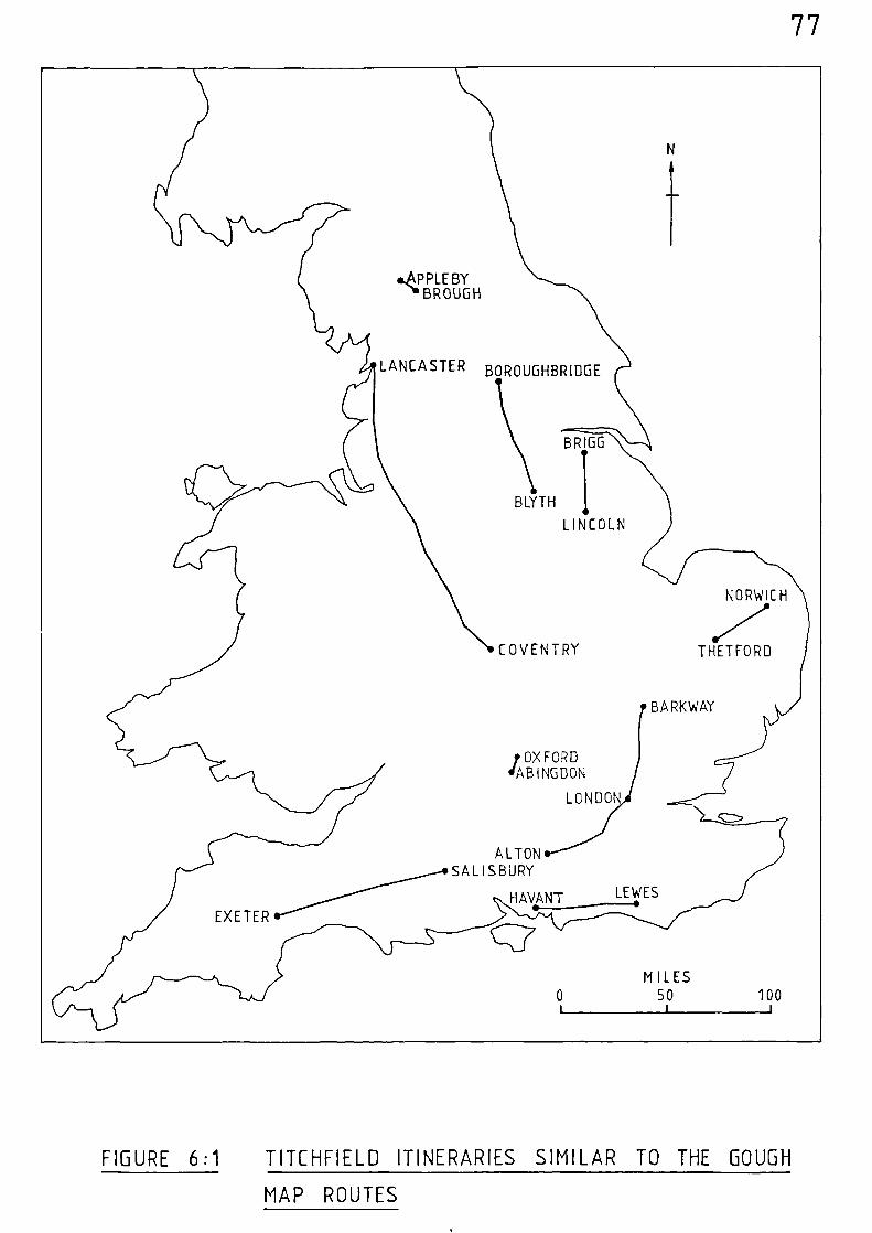
...6PPLEBYI'BROUGH
LANCASTER BOROUGHBRIDGE
BRIGG
BLYTH
LINCOLN
NORWICH
.7COVENTRY
THETFORD
BARKWAY
?OXFORDdABINGDON
LONDON
ALTONSALISBURY
HAVANT0.----•
LEWES
EXETER
MILES0 50 100
1 I i
77
FIGURE 6:1 TITCHFIELD ITINERARIES SIMILAR TO THE GOUGH
MAP ROUTES
78
From the mileage comparisons given in Table 6:1 it is evident that
the two sets of distances have been derived from different sources. There
are thirtytwo similar stages and only half of these share the same inter-
stage, or combined stage, mileages. Most mileages would have been in
agreement if a derivative of the Gough Map had been used during the
preparation of the itineraries. One must therefore discount the possibility
that the compiler of the Titchfield Itineraries used a source similar to
the Gough Map as a basis for their construction. However, considering
that one source is based on Titchfield, and the other apparently on
London, the number of similar stages given in both sources is perhaps
more than we would expect, and their geographical distribution is quite
widespread, being indicative of the contemporary use of the routes
depicted on the Gough Map.
Excluding all therepeatedroutes, the Titchfield Abbey Itineraries
cover a total distance of 2009 statute miles spread over one hundred and
sixtyseven stages; whilst the Gough Map routes show 2786 statute miles of
route spread over one hundred and ninetvtwo stages.A difference between
the t nso sources of evidence is that the Titchfield Itineraries have a
number of very short final stages. These reflect the rather isolated
location of many abbeys which were built away from the main through-routes,
no doubt in an attempt to obtain peace and solitude. (Eg. Harkby to
Hagneby 2 miles, Olney to Lavendon 1 mile, Buriton to Dureford 3 miles).
The number of stage lengths for differing increments of itinerary
mileage, together with associated terminal digit data, are given in
Figure 6:2, and the corresponding data for the Gough Map in Figure 6:3.
Although the highest number of stages in both sets of data are those of
10 miles, it can be observed that those of the Gough Map are far more
prominent in relation to those of the other recorded distances. There is
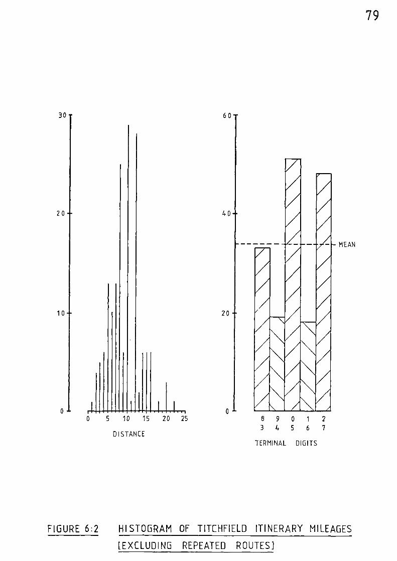
MEAN
—10 15 20 25
DISTANCE
20
10
40
20
79
30- 60
3
8901
4 5 6
2
7
TERMINAL DIGITS
FIGURE 6:2 HISTOGRAM OF TITCHFIELD ITINERARY MILEAGES
[EXCLUDING REPEATED ROUTES]
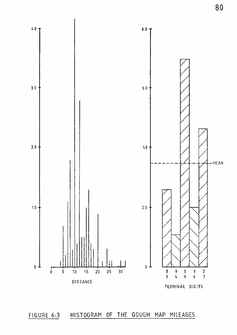
80
TERMINAL DIGITS
4 0 80
603 0
2 0 40
-MEAN
10 20
...0 ,890
3456
1 2
70 5 10 15 20 25 30
DISTANCE
FIGURE 6:3 HISTOGRAM OF THE GOUGH MAP MILEAGES
81
alsoa much greater tendency on the part of the compiler of the Gough Map
to round off distances to the nearest five or ten. The terminal digit
data far the Gough Map show that units of five and ten account for twice
the expected mean value, whereas for the Titchfield Abbey Itineraries
this excess is halved and the values are more evenly spread about the
mean value.
In virtually every case, the distances recorded in the Titchfield
Abbey Itineraries and those set down upon the Gough Map are less than the
equivalent distances in statute miles following direct modern routes
between the same places. In order to attempt to quantify the relationship
between these distances, and to compare their reliability, it was
decided to carry out a statistical analysis of all the available data.
Before proceeding with such an analysis it is obviously advisable to
reject any data which may appear unsound. Five stages from the Titchfield
Abbey Itineraries were rejected because it was considered probable that
additional intermediate stages associated with them had been omitted
from the manuscript, leaving a total of one hundred and sixtytwo stage
distances for analysis. Although the placenames in the Titchfield Abbey
Itineraries have been recorded with clarity, the same cannot be said for
all the placenames written upon the Gough Hap. Many of the Welsh placenames
are difficult to read and there is some confusion relating to the inter-
pretation of placenames in that section of the Welsh coastal route between
Cardigan and Abergele. (An analysis of this route is carried out in
Appendix II). The stages associated with this section of the route have
therefore been rejected, leaving a total of one hundred and sixtythree
Gough Map stage distances for analysis. (Some further general observations
relating to the date of the Gough Map are discussed in Appendix III).
82
A similar process of analysis was carried out for both sets of
data. For each stage the modern distance in statue miles was determined
between each placename using the most direct route available. This was
then numerically divided by the corresponding stage distance given in the
medieval evidence - resulting in an average statute mileage for each
unit of distance of each particular stage. By adding up all these
averages and dividing by the total number of stages, an overall average
figure in statute miles for each medieval unit of distance was obtained
for each set of data. The total addition of these averages for the
Titchfield Abbey Itineraries was 207.76 statute miles over the one
hundred and sixty-No stages:- producing an average of 1.28 statute miles
per unit of itinerary distance. The one hundred and sixtythree stages of
the Gough Map totalled 207.33 statute miles:- producing an average of
1.27 statute miles per unit of map distance.
For each set of data a frequency distribution histogram was
constructed using a class interval of 0.10 statute miles over the full
range of recorded distance (Figure 6:4). In both sets of data the
distributions are spread on either side of the mean, vdth the majority
of values falling within the range 1.0 to 1.6 statute miles. The
distributions are both of the normal type and are only moderately skewed,
enabling the Standard Deviation from the average unit of distance to be
calculated in each case. The Standard Deviation (6) for the Titchfield
Abbey Itinerary data was calculated at 0.278, and that for the Gough
Map date was very similar, working out at 0.273. These Standard
Deviations can be used to assess the reliability of the distances recorded
in the medieval evidence. By taking arbitrary tolerances of to.50,
-1.06, and -2.06 about the average unit of distance in statute miles, the
reliability of the recorded distances can be mapped. The resultant
mileage tolerances for each set of data is given as follows in Table 6:2.
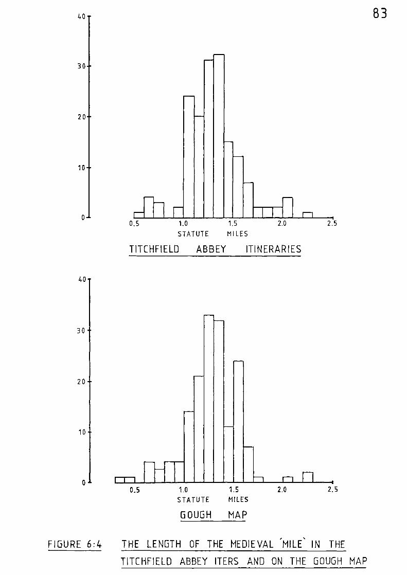
-
-
40
30
20
10
o0.5
40
-
30
-20
-
10
--
r-r-i0.5 1.0 15
STATUTE MILES
GOUGH MAP
-I rl n i2.0 2.5
-
^
-
-
83
-
1.nn•••n
-
-
1n1111
-
-T
1.0
STATUTE
1.5
MILES
-TT-2.0 21.5
I-1
TITCHFIELD ABBEY ITINERARIES
FIGURE 6:4 THE LENGTH OF THE MEDIEVAL 'MILE % IN THE
TITCHFIELD ABBEY ITERS AND ON THE GOUGH MAP
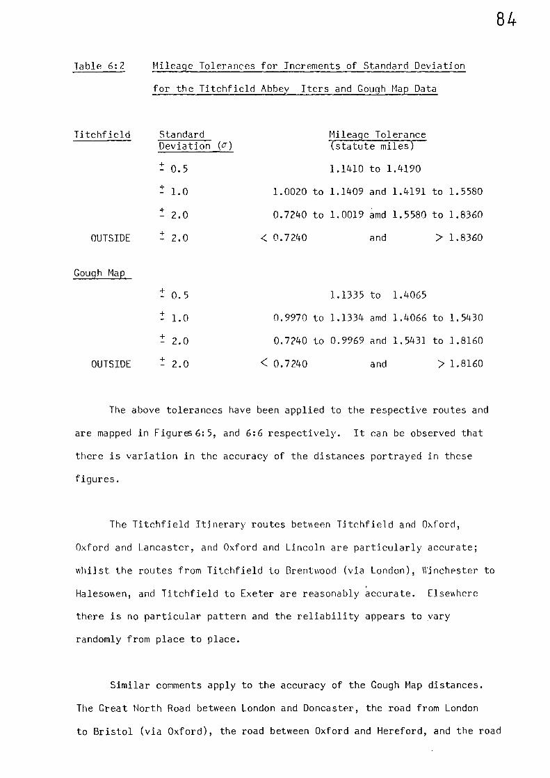
Titchfield Standard Mileage Tolerance (statute miles)Deviation (J)
t 0.5
t 1.0
t 2.0
OUTSIDE t 2.0
1.1410 to 1.4190
1.0020 to 1.1409 and 1.4191 to 1.5580
0.7240 to 1.0019 amd 1.5580 to 1.8360
and > 1.8360< 0.7240
84
Table 6:2 Mileage Tolerances for Increments of Standard Deviation
for the Titchfield Abbey Iters and Gough Map Data
Gough Map
t 0.5
t 1.0
t 2.0
OUTSIDE t 2.0
1.1335 to 1.4065
0.9970 to 1.1334 amd 1.4066 to 1.5430
0.7240 to 0.9969 and 1.5431 to 1.8160
< 0.7240
and > 1.8160
The above tolerances have been applied to the respective routes and
are mapped in Figures6:5, and 6:6 respectively. It can be observed that
there is variation in the accuracy of the distances portrayed in these
figures.
The Titchfield Itinerary routes between Titchfield and Oxford,
Oxford and Lancaster, and Oxford and Lincoln are particularly accurate;
whilst the routes from Titchfield to Brentwood (via London), Winchester to
Halesowen, and Titchfield to Exeter are reasonably accurate. Elsewhere
there is no particular pattern and the reliability appears to vary
randomly from place to place.
Similar comments apply to the accuracy of the Gough Map distances.
The Great North Road between London and Doncaster, the road from London
to Bristol (via Oxford), the road between Oxford and Hereford, and the road
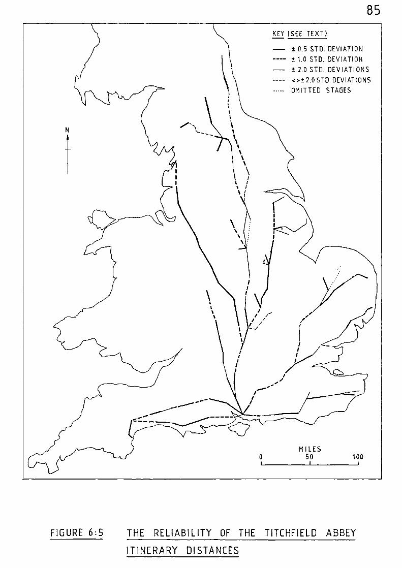
85
KEY (SEE TEXT)
- ± 0.5 STD. DEVIATION
---- ±1.0 STD. DEVIATION
- ± 2.0 STD. DEVIATIONS
---- <>±. 2,0 STD. DEVIATIONS
OMITTED STAGES
MILES0 50 100i 1 i
FIGURE 6:5 THE RELIABILITY OF THE T1TCHFIELD ABBEY
ITINERARY DISTANCES
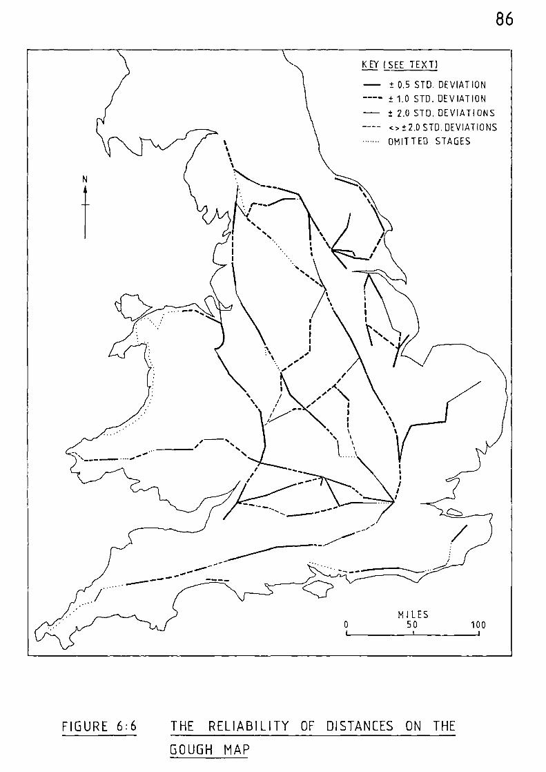
- ± 0.5 STD. DEVIATIONn ••••=1 ± 1.0 STD. DEVIATION
± 7.0 STD. DEVIATIONS
<> ± 2.0 STD. DEVIATIONS
OMITTED STAGES
MILES0 50 100
1 1 t
86
KEY ( SEE TEXT)
FIGURE 6:6 THE RELIABILITY OF DISTANCES ON THE
GOUGH MAP
87
between Ware and Thetford are accurate. That section of road between
Coventry and Lancaster which is similar to that in the Titchfield
Itineraries is more accurate in the latter case; ho nNever, the similar
route between London and Barkway is more accurately depicted on the
Gough Map. The remaining routes share a similar degree of accuracy but
there is no general tendency for accuracy to decrease from either
Titchfield or London.
The information derived from both sets of data, both of which are
of similar size and values, produced similar results. The overall
average figure in statute miles for each medieval unit of distance;
the Standard Deviation from the average figure; and the reliability of
the distances recorded in the medieval evidence )Aere all of the same order.
BB
Notes and References
(1) C. PLATT, Medieval Southampton (London 1973).
89
CHAPTER SFVFM cow FURTHER EMI1ff
Before attempting to establish the basic road network which must
have existed to cater for the movement of travellers such as those
already discussed, it is worth considering two further areas of evidence:-
The first involves some journeys which were undertaken from
Oxford by the Warden and Fellows of Merton College. These journeys,
which span a period approaching one hundred and fifty years, provide some
useful route data.
The second concerns the irrefutable direct references to roads as
set down in contemporary medieval documentation.
Some Journeys by the Warden and Fellows of Merton College, Oxford,
1315 - 1461
The primary objective of the records which relate to these journeys
was not route detail, but to give an account of the expenses incurred
during them. However, apart from listing expenses, the records also state,
in chronological sequence, where the expenses were incurred.(1)
Places
where meals were purchased en-route are given in many instances and this
results in a fairly comprehensive record of the routes taken. The
places passed through during each particular journey from Oxford are
given as follows in Table 7:1.
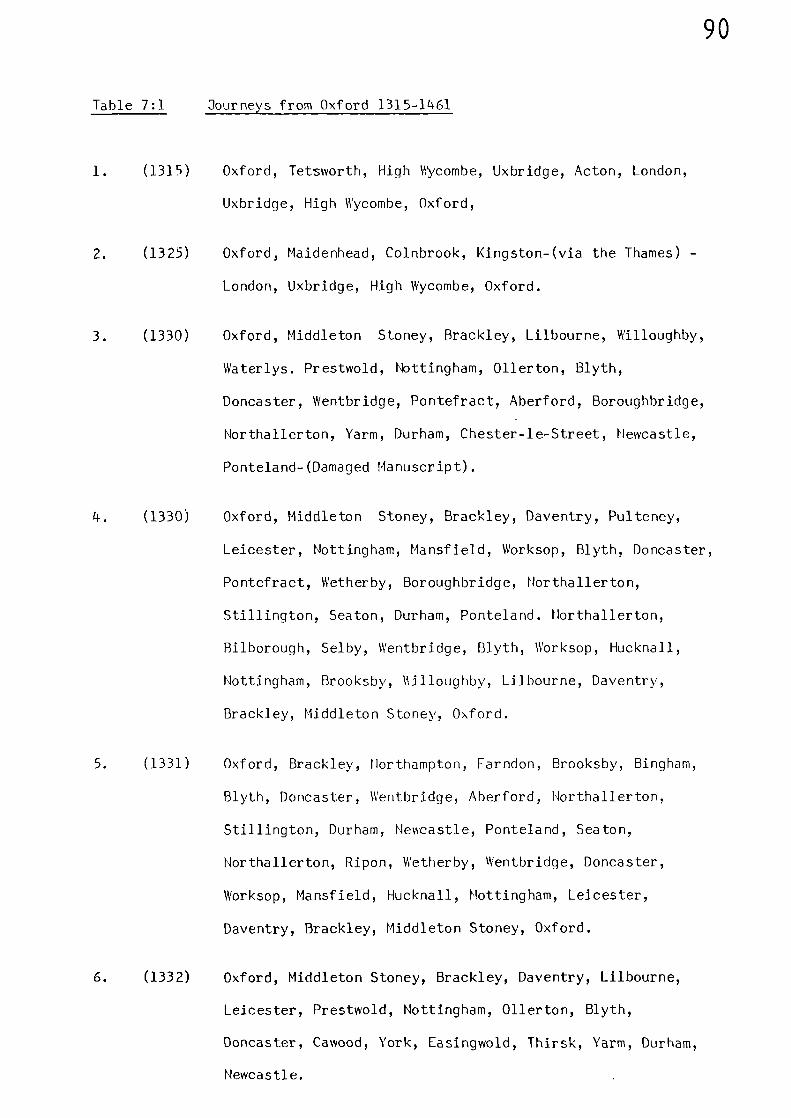
90
Table 7:1 Journeys from Oxford 1315-1461
1. (1315) Oxford, Tetsworth, High Wycombe, Uxbridge, Acton, London,
Uxbridge, High Wycombe, Oxford,
2. (1325) Oxford, Maidenhead, Colnbrook, Kingston-(via the Thames) -
London, Uxbridge, High Wycombe, Oxford.
3. (1330) Oxford, Middleton Stoney, Brackley, Lilbourne, Willoughby,
Waterlys. Prestwold, Nottingham, 011erton, Blyth,
Doncaster, Wentbridge, Pontefract, Aberford, Boroughbridge,
Northallerton, Yarm, Durham, Chester-le-Street, Newcastle,
Ponteland-(Damaged Manuscript).
4. (1330)
Oxford, Middleton Stoney, Brackley, Daventry, Pulteney,
Leicester, Nottingham, Mansfield, Worksop, Blyth, Doncaster,
Pontefract, Wetherby, Boroughbridge, Northallerton,
Stillington, Seaton, Durham, Ponteland. Horthallerton,
Bilborough, Selby, Wentbridge, Blyth, Worksop, Hucknall,
Nottingham, Brooksby, Lilbourne, Daventry,
Brackley, Middleton Stoney, Oxford.
5. (1331) Oxford, Brackley, Northampton, Farndon, Brooksby, Bingham,
Blyth, Doncaster, Wentbridge, Aberford, Northallerton,
Stillington, Durham, Newcastle, Ponteland, Seaton,
Northallerton, Ripon, Wetherby, Wentbridge, Doncaster,
Worksop, Mansfield, Hucknall, Nottingham, Leicester,
Daventry, Brackley, Middleton Stoney, Oxford.
6. (1332) Oxford, Middleton Stoney, Brackley, Daventry, Lilbourne,
Leicester, Prestwold, Nottingham, 011erton, Blyth,
Doncaster, Cawood, York, Easingwold, Thirsk, Yarm, Durham,
Newcastle.
91
7. (1461) Oxford, Tetsworth, High Wycombe, Uxbridge, London, Dartford,
Faversham, Canterbury, Faversham, Sittingbourre,
Rochester, London, Uxbridge, High Vycombe, Tetsssorth,
Oxford.
The main route structure of the above journeys is mapped in Figure 7:1.
The first journey, that between Oxford and London and back,
faithfully follows the route set down upon the Gough Map - where all
the places mentioned en-route are given as inter-stage placenames - with
the addition of Acton, which is situated mid-way between Uxbridge and
London. The route coincides with the modern road between Oxford and
London in its entirety.
The second journey shares much of the route of the first, but
deviates to Maidenhead and then Colnbrook - both of which are represented
as stages on the Gough Map road between London and Bristol. From
Colnbrook the route w3s to Kingston, from where the ensuing journey to
London was by boat along the River Thames.
The series of journeys to the north-east, the backbone of which is
the route through Middleton Stoney, Brackley, Daventry, Lilbourne,
Leicester, Prestwold and Nottingham, is the same as that given in the
Titchfield Abbey Itineraries. The routes to the north of Nottingham are
also similar, and there are two different routes to Blyth; one through
011erton and the other via Mansfield and Worksop. York is linked into
the Great North Road at Doncaster, via Cawood; and to Yarm through
Thirsk and Easingwold. To the north of Doncaster the route passes through
Pontefract and Wetherby, then on to Northallerton and Yarm, from where
the way to Newcastle-upon-Tyne is via Durham and Chester-le-Street. The
92
\NEWCASTLE
1DURHAM
NORTHAL LERTON
RI PON
WETHERBY
PONTEFRACT
YARM
THIRSK
YORK
DONCASTER
BLYTH
NOTTINGHAM
LEI C ESTER
DAV EN TRY
BRA CKLEY
CANTERBURY
M I LES
0 50 100I I 1
OXFORD
LONDON
FIGURE 7:1 JOURNEYS BY THE WARDEN AND FELLOWS OF
MERTON COLLEGE, OXFORD, 1315-1461
93
entire section of this latter route - between Helvcastle-upon-Tyne and
Doncaster - follows the route shown on the maps of Matthew Paris,
although, in the absence of a stage between Durham and Northallerton, it
is impossible to say whether the route depicted by Matthew passed
through Darlington or Yarm.
The mid-stages of the final journey in the series confirms the
inferred Gough Map and Matthew Paris routes between London and Dover - at
least as far as Canterbury. (The final stage between Canterbury and
Dover, as mentioned by Higden in his Polychronicon of 1344, is discussed
in Appendix I). The route follows the course of the modern road through
Dartford, Rochester, Sittingbourne and Faversham.
Direct Documentary Evidence
Direct references to roads during the medieval period are often to
be found in legal presentments before justices of the peace, sheriffs, or
the judges of the King's Bench. Many of these references deal with
roads only in a very localised way, often failing to record any adjoining
placenames, thus making it impossible to construct a route. Howe\er,
adjoining places are sometimes mentioned, and Table 7:2 lists, in
chronological date sequence, some of those particular routes which are
important in a national sense.
94
Table 7:2 Routes Recorded in Contemporary Medieval Records
Date Description Reference
1240 Road, from MERTON to CARSHALTON (2)
1248 Road; from WANSFORD to STAMFORD (3)
1274 Highway; between STOKE FERRY and BRANDON FERRY (4)
1278 Roads and Passes; between CARMARTHEN and BRECON (5)
1282 Public Highway; between NORTHWICH and CHESTER (6)
1289 Way; from KENILWORTH to COVENTRY (7)
1293 Road; from PENRITH to LAZONBY (8)
1301 High Road; between WORKSOP and WARSOP (9)
1314 Road, from EXETER to TEIGNMOUTH (10)
1315 Highway; between LONDON-EDGWARE-BUSHEY-WATFORD-
RICKMANSWORTH (11)
1318 Highway; between CAMBRIDGE and SAWSTON (12)
1335 Way; bet‘seen OGERSTON and WESTON (13)
1343 King's Highways; from HOWDEM to YORK, and from
SELBY to YORK (14)
1351 Road; between COGGESHALL and COLCHESTER (15)
1352 Street; from HADDENHAM to AYLESBURY (16)
1368 Highway; between CHARING CROSS and BRAYHFORD (17)
1368 High Road; from EGHAM to STAINES (15)
1368 Road; from FARNHAM to riADING (19)
1375 King's Highway; between WHATTOM and BINGHAM (20)
1378 Road; from LITTLE YARMOUTH to NORWICH (21)
1384 King's Road; between MARLBOROUGH and SHAFTESBURY (22)
1387 Causey; from FARINGDON to RADCOT BRIDGE (23)
1389 Road; from NEWPORT PAGNELL to FENNY STRATFORD (24)
1391 High Road; between OXFORD and WOODSTOCK (25)
1392 King's Highway; from TOWCESTER to SILVERSTONE (26)
1397 King's Road; between ATHERSTONE and TAMWORTH (27)
1398 King's Road; from BASINGSTOKE to ABINGDON and fromBASINGSTOKE to READING (28)
95
it must be stressed that the list given in Table 7:2 is only
representative of many such routes mentioned in contemporary records.
Also, the terms used to describe such routes, Eg:- King's Highway;
King's Road; (Royal Road); (via regis); etc., were used indiscriminately.(29)
However, the routes given in Table 7:2 are obviously positive evidence
for the existence of roads between the places mentioned. Various
sections of these roads were traversed by the royal household. Henry III,
for example, journeyed between Reading and Basingstoke; Oxford and
Woodstock; Towcester and Silverstone; Marlborough and Shaftesbury; and
Egham and Staines. He also passed along a section of the road between
Northwich and Chester, and made frequent use of the roads in the immediate
vicinity of London. The road between Wansford and Stamford, which was
used by Robert of Nottingham (See Appendix I), is also shown as a stage
on the Gough Map roads - as is that between Howden and York; and the
road between Carmarthen and Brecon covers four stages. The road between
Worksop and Warsop would be utilised by the visitors from Titchfield
Abbey, and by the Warden and Fellows of Oxford University. The highway
between London and Rickmansworth via Edgware, Bushey and Watford, was
described in 1315 as being
"wearisome to travellers and very deep"
and tolls were permitted to be taken for its repair.(11)
Sometimes, surveys were carried out involving quite long stretches
of road. In 1339, certain persons were commissioned
"to survey the King's highway called 'Watlingstretewhich is reported to have many great breaches inthe roadway and in the bridges in it as it runsthrough the counties of Northampton, Leycestre,Warwick and Stafford..." (30)
96
Watling Street ran from Dover via London to the West Midlands and possibly
on to Chester.
Bridges are also mentioned in many references to legal cases, and
these form a large part of C.T. Flower's collection of medieval court
cases concerning public works.(31)
Grants of pontage, either in money
or in kind, are also referred to in the various Court Rolls. The
location of bridges can be used as supportive evidence for the existence
of a road, although it is perhaps unsafe to use them in isolation in
this respect as they only indicate one particular point on a route (or
routes).
97
Notes and References
(1) G.H. MARTIN,
'Road Travel in the Middle Ages - Some Journeysby the Warden and Fellows of Merton College,Oxford, 1315-1470'. Journ. Transport History.Vol. III (1975-76) 159-78.
(2) Calendar of Liberate Rolls. 1226-40, 474
(3) Calendar of Inquisitions Miscellaneous 1219-1307. 23.
(4) Calendar of Patent Rolls, 1272-81, 66.
(5) Calendar of Various Chancery Rolls, 1277-1326, 171.
(6) Calendar of Patent Rolls, 1281-92, 49.
(7) ibid, 320
(8) Calendar of Inquisitions Miscellaneous, 1219-1307, 623.
(9) Calendar of Patent Rolls, 1292-1301, 597.
(10) Calendar of Inquisitions Miscellaneous, 1307-49, 41.
(11) Calendar of Patent Rolls, 1313-17, 220.
(12) Calendar of Patent Rolls, 1317-21, 169.
(13) Calendar of Patent Rolls, 1334-38, 207.
(14) Calendar of Inquisitions Miscellaneous, 1307-49. 454.
(15) C.T. FLOWER, . 'Public Works in Medieval Law'. Vol. I.Seldon Soc. 32(1915) 66.
(16) Calendar of Close Rolls, 1349-54, 378.
(17) Calendar of Fine Rolls, 1356-68. 380.
98
(18) C.T. FLOWER, 'Public Works in Medieval Law' Vol. II,Seldon Soc. 40(1923) 207.
(19) Calendar of Close Rolls, 1364-68, 503.
(20) Calendar of Inquisitions Miscellaneous, 1348-77. 360.
(21) Calendar of Inquisitions Miscellaneous, 1377-88, 32-33.
(22) C.T. FLOWER, Vol. II, 236(op. cit.,)
(23) C.T. FLOWER, Vol. I, 4.(op. cit.),
(24) ibid, 28
(25) Calendar of Close Rolls, 1389-92. 332-33.
(26) Calendar of Patent Rolls, 1391-96, 233.
(27) C.T. FLOWER Vol. II, 230.(op. cit.),
(28) C.T. FLOWER Vol. I, 9.(op. cit.)
(29) B.P. HIHDLE, Roads and Trach\as of the Lake District,(Ashbourne 1984) 59.
(30) Calendar of Patent Rolls, 1338-40. 362.
(31) C.T. FLOWER Vols. I and II.(op. cit.),
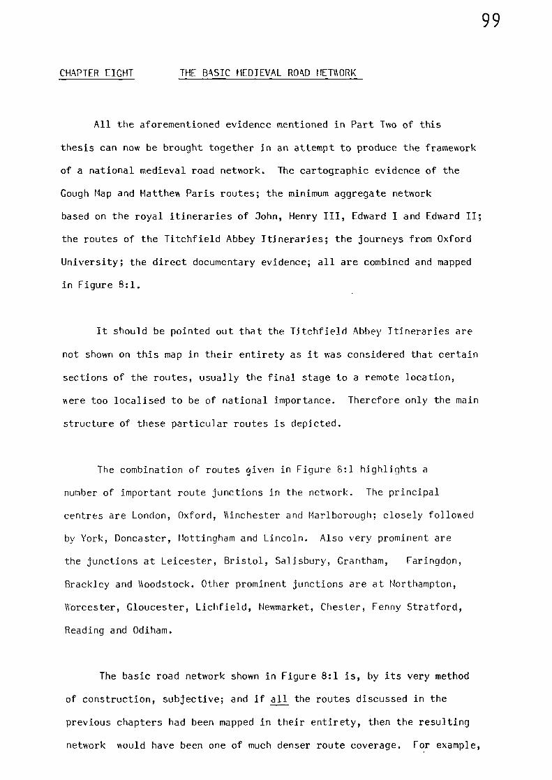
99
CHAPTER EIGHT THE BASIC MEDJEVAL ROAD NETAORK
All the aforementioned evidence mentioned in Part Two of this
thesis can now be brought together in an attempt to produce the framework
of a national medieval road network. The cartographic evidence of the
Gough Map and Matthew Paris routes; the minimum aggregate network
based on the royal itineraries of John, Henry III, Edward I and Edward II;
the routes of the Titchfield Abbey Itineraries; the journeys from Oxford
University; the direct documentary evidence; all are combined and mapped
in Figure 8:1.
It should be pointed out that the Titchfield Abbey Itineraries are
not shown on this map in their entirety as it was considered that certain
sections of the routes, usually the final stage to a remote location,
were too localised to be of national importance. Therefore only the main
structure of these particular routes is depicted.
The combination of routes given in Figure 8:1 highlights a
number of important route junctions in the network. The principal
centres are London, Oxford, Ainchester and Marlborough; closely followed
by York, Doncaster, Nottingham and Lincoln. Also very prominent are
the junctions at Leicester, Bristol, Salisbury, Grantham, Faringdon,
Brackley and Aoodstock. Other prominent junctions are at Northampton,
Worcester, Gloucester, Lichfield, Newmarket, Chester, Fenny Stratford,
Reading and Odiham.
The basic road network shown in Figure 8:1 is, by its very method
of construction, subjective; and if all the routes discussed in the
previous chapters had been mapped in their entirety, then the resulting
network would have been one of much denser route coverage. For example,
MILES
0 SO
1 1
100
1
100
FIGURE 8:1 THE BASIC MEDIEVAL ROAD NETWORK
101
Key to Figure 8:1
BT = Berwick-upon-Tweed HO = Northampton
CL = Carlisle WOR = Worcester
LA = Lazonby H ,_ Hereford
YA = Yarm B = Brackley
S = Shap FS = Fenny Stratford
KL = Kirkby Lonsdale SD = St. David's
Y = York G = Gloucester
D = Doncaster WO = Woodstock
LIV = Liverpool 0 = Oxford
WA = Warrington F = Faringdon
L = Lincoln LO = London
C = Chester BR = Bristol
N = Nottingham W = Windsor
GR = Grantham R = Reading
SH = Shrewsbury M = Marlborough
WAL = Walsingham CA = Canterbury
LF = Lichfield OD = Odiham
YM = Yarmouth DO = Dover
NW = Norwich U. = Winchester
LE = Leicester SA = Salisbury
T = Thetford SO = Southampton
CO = Coventry EX = Exeter
LU = Ludlow TM = Teignmouth
NM = Newmarket SI = St. Ives
102
the routes of the royal itineraries when mapped in their entirety
produce a dense cover; but only those routes known to have been used
repeatedly have been included in the basic network. This was because it
is impossible to conclude, especially from the evidence of itineraries,
whether a traveller journeyed directly from one place to another;
therefore it is only when repeated use of a particular route is observed
that a degree of confidence can be applied to its specific course.
These limitations do not apply to the same extent when considering
itineraries where the inter-place distances are recorded, as in the
Titchfield Abbey Itineraries, because these can be used to establish the
directness, or otherwise, of a particular route. Bearing this in mind, it
is suggested that the basic national road network shown in Figure 8:1
would have been most useful to cater for the general movement of travellers
during the medieval period.
Due to the fact that they indicate intermediate stopping places,
the recorded itineraries of royalty, ecclesiastics, and scholars, are
extremely useful sources for indicating lines of travel. However,
individuals apart ) the roads of medie\al England and Wales were used
mainly for the purposes of trade. Because the recorded movements of
goods and produce usually state that mmement took place only between A
and B, they are of little use when attempting to reconstruct the road
network - especially in the case of long journeys. However, having
defined the road network by other means, it is now possible to establish
the most likely routes taken for such journeys when both the starting
point and destination are given.
A useful number of references relating to the overland transport
of wine during the fourteenth century has been assembled by H.K. James.(1)
103
Although the transport of this commodity was usually effected by water
(as we shall see later on), it is certain that large quantities were also
sent overland.(2) Wine is a bulky commodity to transport overland and
although there are records of small casks being carried by pack horse,
large barrels, containing up to one tun (252 gallons), could only be moved
overland by horse-drawn carts or waggons. Hence reasonable roads or
tracks must have existed to ensure that it reached its destination in
good condition.
Wine was imported at many different places; however, it was London
which undertook the major task of distribution, not only to its local
markets but also to distant markets throughout the Kingdom. Wine was
sent overland north-westwards from the capital to Oxford and Wallingford;
westwards to Marlborough and then on to Swindon and Cricklade; and south-
westwards to Farnham and Portsmouth. In the Midlands, Northampton,
Leicester, Lichfield and Stamford all received consignments of wine brought
overland from Westminster; whilst in Vent, Canterbury also received supplies.
Southampton imported a great deal of Wine and distributed it by overland
routes to London, 11indsor, Worcester, Woodstock, Marlborough, Salisbury
and Havant; and wine imported at Bristol was sent overland to London,
Hereford and Coventry. Hull imported wine and sent it overland to York
and Scarborough; whilst wine imported at Boston was sent to Northampton
and York. Yarmouth sent wine overland to Norwich; and wine imported at
Newcastle-upon-Tyne was sent by road to Durham. The inland ports of
Nottingham, Newark, York and Worcester despatched wine by overland routes
to Coventry, Woodstock, Newcastle-upon-Tyne (Barnard Castle), (3) and
Pontefract, respectively.
104
The starting point and destination for each of these overland
journeys, together with the probable places passed through en-route,
are given in Table 8:1; and the corresponding routes are mapped in Figure
8:2.
The transport of produce in Yorkshire, Lincolnshire, Horfolk and
Hampshire between 1298 and 1339 - as revealed by the Sheriffs' Accounts
gives examples of overland journeys.(4)
The transport pattern in all
four counties was similar; a mixed assortment of agricultural produce
was taken by cart to a local collection centre from where the journey
continued to the leading collection centres in the county. Hence, none
of these journeys was over any great distance, hut nevertheless, some of
the movements would be along the routes shown in the basic road network.
These particular routes are given in Table 8:2, and are also mapped in
Figure 8:2.
Other scattered references refer to overland transport. In 1334,
lead was taken overland from Banbury to Oxford (5) ; whilst during the
last decade of the fourteenth century, Oxford recei\ed overland consign-
ments of cloth from both London and Winchester. (6) During 1?79, millstones
were taken overland from Southampton to Harlborough(7)
; whilst early in the
fourteenth century there are records of millstones being transported
overland between Ipswich and Oxford, and between Stony Stratford and
Cheddington (near Leighton Buzzard). (8) Dyestuffs, imported at Southampton
were, amonst other places, taken overland to Exeter via Salisbury and
Honiton.(9) The roads were used for the transport of wool; in 1338, when
a large amount of wool was gathered for export, it was brought overland to
the main collection points in the various counties. Although the route
105
Table 8:1 Probable Trade Routes for the Transport of Wine
Starting Point Places en-route Destination
London High Wycombe, Tetsworth OxfordWindsor WallingfordWindsor, Reading, Marlborough CrickladeGuildford FarnhamGuildford, Petersfield, Havant PortsmouthFenny Stratford NorthamptonFenny Stratford, Northampton LeicesterFenny Stratford, Coventry LichfieldWare, Huntingdon StamfordDartford, Faversham Canterbury
Southampton Farnham, Guildford LondonWinchester, Odiham WindsorWinchester, Faringdon, Stow WorcesterWinchester, Newbury, Oxford WoodstockWinchester MarlboroughRomsey SalisburyFareham Havant
Bristol Marlborough, Reading, Windsor LondonGloucester HerefordGloucester, Worcester Coventry
Hull Beverley YorkBeverley Scarborough
Boston Spalding, Stamford NorthamptonLincoln, Doncaster York
Yarmouth Acle Norwich
Newcastle Chester-le-Street Durham
Nottingham Leicester Coventry
Newark Nottingham, Leicester, Brill Woodstock
York Yarm (or Darlington), Durham Newcastle
Worcester Lichfield, Derby, Doncaster Pontefract
106
Table 8:7
Routes Associated with the Transport of
Agricultural Produce between 1298 and 1339
County
Yorkshire
Lincolnshire
Norfolk
Hampshire
Route
Guisborough - YarmNorthallerton - YarmPickering - ScarboroughSherburn-in-Elmet - York
Barton-upon-Humber - LincolnWainfleet - LincolnSleaford - LincolnGrantham - LincolnBarlings - LincolnHorncastle - Boston
Foxley - NorwichNorwich - YarmouthThetford - Norwich
Vernham Dean - WinchesterOdiham - WinchesterAlton - WinchesterWinchester - SouthamptonRomsey - SouthamptonHavant - Southampton

0 PLACE OF IMPORT OF WINE
- ROAD (WINE)
---- ROAD (SHERIFFS' ACCOUNTS)
MILES0 50 100
I I 1
107
FIGURE 8:2 OVERLAND ROUTES ASSOCIATED WITH THE DISTRIBUTION
OF WINE IN THE FOURTEENTH CENTURY; AND WITH THE
SHERIFFS' ACCOUNTS BETWEEN 12 98 AND 1339
108
detail is lacking, it is known that the counties involved were Warwickshire,
Westmorland, Oxfordshire, Wiltshire, Herefordshire, the forth Riding of
Yorkshire, Shropshire and forthamptonshire.(10)
Although, as we have already seen, the records usually only give
the starting point and destination of most journeys, there is an interesting
record of a journey undertaken during 1294 which gives a clue to the
intermediate places en-route. During that year, a consignment described
as 'treasure', was taken from Westminster to Norwich.(11)
The journey
took nine days, required twenty-one carts and involved an escort of twenty
mounted soldiers and eighteen foot soldiers. Although perusal of the
original document gives no details of the places through which the treasure
was transported, certain interesting aspects are revealed. First, because
the journey as undertaken in haste, the drivers hiring assistance on
several occasions, it is likely that no rest days were taken by the convoy.
Second, the route between Westminster and Horwich as depicted on the Gough
Map shows eight stages as follows:-
London XII Waltham Abbey VIII Ware XII Barkway XIICambridge X Hewmarket X Bury St. Edmunds X Thetford XXXII Horwich.
The final stage between Thetford and forsdch is approximately
double the a‘erage distance of any previous stage. However, close
scrutiny of the Gough Hap shows that mid-way between Thetford and forwich,
and positioned virtually on the line joining the two towns, is Attleborough.
The distance between Thetford and Norwich via the modern and direct All
road is twenty-eight statute miles, with Attleborough situated mid-way,
splitting this distance almost exactly in half. Taking Attleborough as an
intermediate stage, these nine stages could possibly represent the distance
109
travelled during each day of the journey taken by the convoy transporting
the treasure; for such a convoy, consisting of at least sixty men and a
similar number of horses, would require substantial victualling and safe
overnight accommodation, which could only be obtained in the towns en-
route. The Gough Map depicts such places and the symbols shown upon it
would indicate to medieval travellers where food and overnight accomm-
odation could be secured during a particular journey. An outline represent-
ation of the Gough Map route between London and Norwich, with the inter-
stage distances given in statute miles, is given in Figure 8:3.
All the evidence makes it clear that the medieval roads were well
utilised and that movements along them, sometimes over considerable
distances and at all times of the year, were undertaken by a variety of
traffic.
Whether for reasons of trade or administration, the travellers in
medieval England and Wales had at their disposal a network of roads which
allowed, and indeed was an integral part of, a continuing social and
commercial expansion.
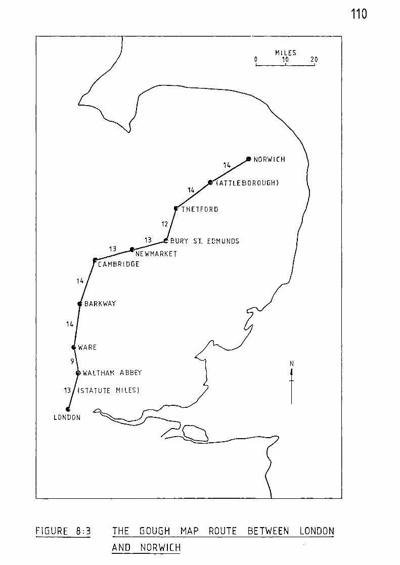
14
BARKWAY
WARE
WALTHAM ABBEY
110
NEWMARKET
CAMBRIDGE
14
AT TL EBOR 0 UGH)
THETFORD
12
13
BURY ST_ EDMUNDS
13 (STATUTE MILES)
14
FIGURE 8:3 THE GOUGH MAP ROUTE BETWEEN LONDON
AND NORWICH
111
Notes and References
(1) M.M. JAMES, Studies in the Medieval Wine Trade (Oxford, 1971)esp. Appendix 21, 157-59
(2) ibid, 149
(3) J.F.T. ROGERS, A History of Agriculture and Prices in England,Vol. II (Oxford, 1866) 602
(4) S. UHLER, 'The Transportation of Produce in Lincolnshire, Yorkshire,Hampshire and Norfolk during the FourteenthCentury, as revealed by the Sheriffs'Accounts', unpublished B. Phil, Dissert-ation, University of St. Andrews (1977)
(5) J.E.T ROGERS, (op. cit.), 603
(6) J.E.T ROGERS (op. cit.), 604-5
(7) J.E.T. ROGERS (op. cit.), 600
(S) J.E.T. ROGERS (op. cit.), 602
(9) C. PLATT, The English Medieval Ton (London, 1976) 78
(10) Public Record Office, E 372/163
(11) Public Record Office, E101/30/1S
112
THE MEDIEVAL ROAD NETWORK - CONCLUSIONS
Although various types of historical evidence have been investigated
in Part Two of this thesis, the direct cartographic record of the Gough
Map, and to a lesser extent that of Matthew Paris, were pre-eminent.
Being the only two such examples of their type known to have survived
from themedieval period they were, in effect, used as a base onto which
the building-blocks of other types of evidence were placed.
The maps resulting from the plotting of the itinerary of King
Henry III had a significant influence on the minimum aggregate network
based on the royal itineraries of John, Edward I and Edward II, postulated
by Hindle. (1) The southern section of the Great North Road and its
adjacent links; the routes into East Anglia, the routes on the western
borders of Wales, and additional links in the southern counties, all had
a significant influence on the netiwrk.
The Premonstratensian Itineraries from Titchfield Abbey INere a rich
and valuable source, and proved extremely useful for indicating some new
lines of travel and for confirming routes established in other forms of
evidence. The fact that inter-place distances %sere recorded in these
itineraries meant that a comparison with the evidence of the Gough Map
could be undertaken which shoved that both sets of evidence must have been
derived from different sources. A subsequent statistical analysis
carried out for both sets of data, both of which are of similar size and
values, produced extremely close correlation in terms of the average
figure in statute miles for each medieval unit of distance. This medieval
unit of distance was shown to be approximately 11 miles, or 10 furlongs.
113
The perusal of additional itineraries relating to the movement of
other medieval travellers also provided some useful route data.
The mapping of the various itineraries confirmed many of the
common lines of travel set down upon the Gough and Matthew Paris maps.
Additional lines of travel were also identified, whichothen added to the
cartographic evidence, expanded the network shown on those maps. A
significant addition to the network is the route which connects the Channel
ports with the Midlands; via Northampton, Brackley, Oxford and Newbury,
through Winchesturand Southampton. The itineraries also support the
existence of the inferred Gough Map routes, and positively link York
and Lincoln into the network as well as high-lighting the link between
Leicester and Doncaster, via Nottingham.
Finally,although direct documentary evidence for the existence of
medieval roads is rather limited, certain references were located and
built into the final map to complete a basic road network ‘Nhich, it is
suggested, would have been most useful to cater for the general movement of
travellers during the medieval period. The basic road network also
provided a means of establishing the most likely routes taken for the
overland movement of goods and produce shere only the starting point
and destination are recorded in the documentary evidence.
Having established a basic medieval road netvsork, Part Three
attempts to move towards a view of the whole transport system by attempting
to establish the extent of navigable water utilised by travellers and
merchants during the medieval period.
114
Notes and References
(1) B.P. HINDLE,
'A Geographical Synthesis of the Road Network ofMedieval Egnland and Wales'. Unpublished Ph.D Thesis, University of Salford (1973) 91.
115
PART THREE
THE NAVIGABLE MEDIEVAL WATERMYS
"There is not any Town or City, which hatha Navigable River at it, that is poore; norscarce ahy that are rich, which want a Riverwith the benefit of Boats."
John TaylorA Discovery by Sea, 1623
116
Introduction
The object of Part Three of this thesis is to attempt to
determine the extent of navigable water used by travellers and merchants
during the medieval period.
Waterborne trade was of three types; overseas, coastal, and
inland; and all three types were often interdependent. There is an
abundance of surviving evidence in support of overseas trade, and the
number of places given in the surviving medieval port-lists show that
coast-wise traffic must also have been extensive. However, there is a
distinct paucity of published material relating to inland waterborne
movements. With the exception of some local tolls, traffic of this
kind was not subject to any duties and so went unrecorded in medieval
customs accounts. Even in the surviving port toll-books, inland
vessels are rarely identified as such, making it virtually impossible
to separate the ships on inland, coastal, or overseas voyages; hence
medieval inland navigation has not been the subject of very much research.
It is this paucity of systematic ‘Nork on earl, inland vnatervnays ‘Ihich is
the justification for Part Three of this thesis.
In Part Two the basic framework of a national medieval road
network was established and as a logical progression it is the primary
objective of this section of the thesis to establish the extent of
navigable water utilised by travellers and merchants during the medieval
period. The initial chapters deal, on a regional basis, with waterways
for which there is documentary historical evidence, and an attempt is
made to establish their navigational limits. All this regional evidence
is then brought together to produce a national picture of inland
navigable waterways existing during the medieval period. An analysis of
the movement of goods along the navigable rivers is carried out, and the link
between inland and coastal navigation is also considered, together with
an appraisal of medieval vessels. Finally, cartographic evidence is
discussed, including that of the Gough Hap which proved so useful in
the previous section dealing with roads.
Sources
Frequent reference is made in this thesis, but more especially in
Part Three, to the various state calendars which have been published by
(1)the Public Record Office. These were chosen as a primary source of
reference because of their value on a national basis. They contain a
precis, usually in English, which is full enough for most purposes.
Individual volumes can be quite substantial, often exceeding seven-
hundred pages of text, and although normally indexed, the author
discovered, after a number of random checks, that the index alone could
not be relied upon to render all the relevant information contained
within each calendar. Therefore, the author set about the rather
laborious task of reading through every individual page of text in each
volume in order to ensure that any relevant detail was not overlooked.
The sources consulted in this wa were as follows:-
Calendar of Charter Rol1s(2)
The royal charter was the solemn instrument whereby the Sovereign
made original and confirmatory grants in perpetuity of lands, liberties,
privileges, etc., to both corporations and invididuals.
11 Henry III to 5 Henry V, 1226-1417, 5 vols.
118
Calendar of Patent Rolls(3)
Letters patent, so called from being issued 'open', with the
Great Seal pendent, announce royal acts of the most diverse kinds,
including grants and leases of land, appointments to office, licences
and pardons, denization of aliens, and presentations to ecclesiastical
benifices.
17 Henry III to 2 Henry IV, 1232-1401, 37 vols.
Calendar of Close Rolls(4)
Writs and orders under the Great Seal addressed by the Sovereign
to individuals were folded or closed up and are hence known as Letters
Close. The Close Rolls contain royal instructions for the performance
of multifarious acts: the observance of treaties, the levying of
subsidies, the repair of buildings, the payment of salaries, the
provision of Household requirements, the delivery of their landed
inheritances to heirs, and the assignment of dower to widows, and so forth.
1 Edward I to 20 Henry VI, 1271-1441, 3S \ols.
Calendar of Fine Rolls(5)
The 'fines' from which the Fine Rolls take their name were paments made
for writs, grants, licences, pardons, etc., of various kinds, most of
them under the Great Seal, relating to matters in which the Crown had
a financial interest.
1 Edward I to 6 Henry IV, 1272-1405, 12 vols.
119
Calendar of Liberate Rolls(6)
On these rolls were entered the writs of liberate (Latin
'deliver ye') whereby the officers of the Exchequer were ordered to
make payments on behalf of the Crown and they deal with expenditure and
accounting on an almost infinite variety of matters.
1 Henry III to 56 Henry III, 1226-1272, 6 vols.
Calendar of Chancery Rolls, Various (7)
These contain; Supplementary Close Rolls - which include licenses
to export wool, orders for resumption of crown lands, orders to suspend
process in pleas of right where tenants had put themselves on the Grand
Assize; Welsh Rolls - which include letters relating to Wales, Scutage
Rolls - which refer to grants of scutage.
6 Edward I to 20 Edward II, 1277-1326, 1 vol.
Calendar of Chancery Warrants(8)
These are \arrants unrepresented, or incompletely represented,
by calendared Enrolments.
29 Henry III to 20 Edward II, 1244-1326, 1 vol.
Calendar of Inquisitions Miscellaneous (9)
In this series are a number of Inquisitions returned in the
Chancery, of too varied a nature to allow further classification.
4 Henry III to 10 Henry V, 1219-1422, 7 vols.
120
Calendar of Memoranda Rolls(10)
The Memoranda Rolls maintained by the clerks of the King's
Remembrancer and the Lord Treasurer's Remembrancer contain entries of
notes of matters arising either during the viewing or auditing of
accounts or in the course of routine Exchequer business, and especially
that of recovering payments owing to the Crown.
20 Edward II, 1326-1327, 1 vol.
Coastal Changes
There have been many changes to the coastline, both during, and
since the medieval period, especially in the vicinity of Holderness
and the Humber Estuary, the Lincolnshire coast and the Wash, the coast
of East Anglia, the Thames Estuary, the south-east coast, the Somerset
Levels, the Dee Estuary and the Lancashire coast. Exce p t where otherwise
indicated, the maps presented in the following chapters show the present
day shorelines; however, coastal changes are discussed in the text,
especially where they affect the navigational courses of rivers.
121
Notes and References
(1) British National Archives - Sectional List 24 (Revised Jan. 1984,
HMSO)
(2) ibid, 6
(3) ibid, 6
(4) ibid, 9
(5) ibid, 11
(6) ibid, 11
(7) ibid, 12
(8) ibid, 13
(9) ibid, 14
(10) ibid, 14
122
CHAPTER NINE THE RIVERS OF NORTH-EASTERN ENGLAND
The rivers considered in this chapter are those contained within,
or bordering, the counties of Northumberland and Durham. The area
covered stretches from the Scottish border to the borders of Yorkshire,
and from the watershed formed by the Cheviots and Pennines to the North
Sea.
River Tweed
For the most part a river of Scotland, the Tweed rises in the
south part of Peebleshire and passes by or near to Peebles, Melrose,
Kelso and Coldstream, from near which place it forms the boundary between
England and Scotland for 16 miles, runs through England for a short
distance, and then enters the North Sea at Berwick-upon-Tweed; a total
length of 97 miles.
At the beginning of the twelfth century, during the reign of King
Alexander I of Scotland, Berwick was a part of Scotland, but in 1216 the
town and castle were taken by King John. During the period which
followed, Berwick found itself constantly alternating between English
and Scottish rule, and it was not until 1482, after undergoing various
sieges and vicissitudes, that it finally became an English town.
Throughout this long period of conflict, Berwick, when in English
hands was a port to which provisions from all over England were
frequently shipped. For example, in 1298 Yorkshire produce %as shipped
(1)to Berwick in order to sustain the troops of King Edward I who,
between 1291 and 1307, conducted no less than four expeditions and five
major campaigns against the Scots.(2) His initial expeditions were
123
only of a diplomatic nature, but the third, extending from May to August,
1296, was hostile - during which he beseiged and took Berwick.(3) To
cater for this type of activity landing stages and buildings were
constructed as is revealed in a grant of 1299 to Henry le Galeys, maor
of the city of London:-
of these houses with a quay and otherappurtenances in Briggestrete adjoining theTweed". (4)
Yorkshire produce was again shipped to the town in 1301, (5) and again in
1309(6)
; whilst produce from Lincolnshire was shipped to Bervdck in
1311,(7)
and 1336.(8)
Apart from this type of utilisation at the port at the mouth of
the Tweed, there iAas also activity along the course of the river.
In July, 1244, the sheriff of Northumberland received a consignment
of wine from the keepers of the King's %%isle in ships at Ne‘Ncastle-upon-
Tyne. Ten tuns of this consignment nNere then taken by ship to Norham
Castle, 9 miles up river from BerN%ick.(9)
In February, 1367, certain persons were:-
..instructed to make inquisition in theton of Berwick-upon-T‘Need and the countyof Northumberland touching on informationon behalf of Thomas, bishop of Durham, thatwhereas the water of -Nede is the boundarybetween the realms of England and Scotland,and the bishop is lord of the soil of theriver as far as the thread in the middle ofthe said water wherever it adjoins his demesne,and he and his predecessors were ever seisedof the same where the said water adjoins theland of their lordship of Horham and Tweedmouth,and took all profits arising from the same, asfisheries, fixing of $Aeirs, and mills, andpassage tolls of ships and boats, as of the
124
right of their church of St. Cuthbert, Durham,Master John de Bolton, late chamberlain ofBerwick-upon-Tweed, had taken all the profitof the passage of ships and boats in thebishop's lordship and seized it into theKing's hand without reasonable cause." (10)
Berwick, Norham and Roxburgh are amongst places listed in
Commissions dated March 24th 1401, relating to a subsidy of 2s. on
each tun of wine and 8d. in the pound to be collected in "ports and
(11)(12)places adjacent".
In June 1412, the captain of Roxburgh Castle . successfully
petitioned to have a vessel of his 'de-arrested'. The vessel, a
balinger of 30 tuns burden called 'la Katerine', had been on a oage
"to be loaded with victuals and other thingsneedful for the castle",
but had been driven by a storm into the port of Sandwich (Kent) and
)arrested.
(13Roxburgh Castle stands on a narrow strip of land between
the rivers Tweed and Teviot, one mile to the west of their confluence at
Kelso, and some 35 miles up river from Berwick.
River Amn
From its source near Alnham on the eastern slopes of the Che\iots,
the River Aln flows in an easterly direction through Ithittingham to
Alnwick, from where, after a further 5 miles, it enters the North Sea at
Alnmouth; a total length of 18 miles.
Although direct documentary evidence is lacking it is likely that
the River Aln was navigable at least as far as Alnwick during the medieval
period.
125
River Coquet
Rising in the Cheviots on the border between Northumberland and
Roxburgh, the Coquet flows past Alwinton, Rothbury, Felton and 1\arkworth,
to enter the North Sea after a course of almost 40 miles.
The lower reaches of the Coquet were navigable during the medieval
period as is substantiated by the mention of Warkworth in a list of
ports and maritime places compiled during the year 1326.(14) The river
forms a loop almost enclosing the town, which must have acted as a
natural moat, fortifying the town and protecting its castle.
It is likely that the river was also navigable for a further 6
miles, to Felton, during the medieval period.
River ‘1ansbeck
From its source to the east of Bellingham, the River \ansbeck
flows in an easterly direction to Horpeth, from where, after a further
7 miles, it enters the North Sea; a total course of 27 miles.
It is likely that the River Wansbeck was navigable to Horpeth
during the medieval period.
River Tyne
The North Tyne rises in the Cheviots on the borders of Roxburgh,
and flows for 26 miles passing Bellingham and Wark, to be joined by the
South Tyne near Hexham. The South Tyne rises at Tynehead Fell in the
extreme east of Cumberland and flows for 34 miles past Alston,
Haltwhistle and Haydon Bridge to its confluence with the North Tyne
126
near Hexham. The combined rivers form the River Tyne which flows past
Corbridge, Prudhoe, Newcastle, Gateshead, and North and South Shields,
and enters the sea at Tynemouth after a course from Hexham of nearly
30 miles.
Soon after North Shields was first established in 1225, there seem
to have been twenty-seven houses, a quay, mills, and a small port. The
fishermen who came to settle on the demesne provided the local monks with
(15)fish in return for the privilege of having houses and their on boats.
The first distinct reference to the coal trade on the Tyne is in
a charter of King Henry III dated 1239, which allowed the freemen of
Newcastle to dig coals in the Castle Field and the Forth, and about this
time coal is referred to, from its passage to London by sea, as sea
(16)coal.
documented and reveals an increasing use of the River Tyne as a means of
)transporting this bulky commodity.
(17The prior of Tynemouth was
shipping coal from his wharf at North Shields, certainly by 1269, for in
that year the burgesses of Newcastle, led b their mayor, carried off a
(18)ship from that place which was laden with coal and other goods.
This obvious rivalry between North Shields and Newcastle shows itself
again in 1290, when the prior was charged with obtaining money through
taking tolls and prizes of wine, herring, and other goods, brought into
Tynemouth which ought to have been collected at Newcastle. Following
this, the prior was ordered by the King to remove all those wharves which
had extended below high-water mark, and vessels were forbidden to unload
(1at North Shields. 19)
The conveyance to Newcastle during 1244 of wine in ships has already
been alluded to, (9) and, as general trade progressively increased
The medieval coal trade of north-eastern England has been fully
127
during the thirteenth century, we find reference to the existence of a
custom house at Newcastle. During 1281, duties charged include 6s. 8d.
(20)upon 300 woollen skins and the same sum upon a sack of wool.
Apart from trade, the river was also utilised for more serious affairs.
In March 1301, officers were appointed to expedite the sending of two
ships from Newcastle-upon-Tyne to Berwick-upon-Tweed, whidh the King had
(21)specifically ordered to be used against the Scots, and it is
possible that they were specially constructed in the port. Ships were
certainly being built in Newcastle at this time as is shown by an order
of 1304 to the mayor and bailiffs for
"a barge suitable for twenty-four oars to be builtas speedily as possible, and cause it to be sentwith suitable armament and tackle for twenty-sixmen to the port of St. John, Perth, paying to themen bringing the barge their expenses and costsin this matter to be allowed to them in theirferm at the exchequer." (22)
The Crown also commandeered the vessels of merchants to purvey corn,
victuals and other goods from the south to be brought to Newcastle.
These merchants were specifically ordered not to take their cargoes
(23)(24)(25)elsewhere, or to communicate with the Scots or Flemings.
In 1323, a ship of Flanders, carrying a cargo of wine, cloth, wax
and other wares, was forcibly entered and seized whilst proceeding
between Tynemouth and Newcastle. The King subsequently ordered that the
ship be released and its cargo returned to its owners in line with a
truce which had been made between the King's subjects and the men of the
(26)Court of Flanders.
The river was also instrumental in generating an income to provide
for the walling and defence of Newcastle town and the parts adjacent
128
to it. A Murage Grant of 1327 allowed the mayor, bailiffs and men of
(27)Newcastle to levy customs on goods brought for sale into the town.
An extract from this grant is as follows:-
On every ship laden with merchandise other than wine - 4d.
On every boat laden with merchandise - id.
*On every last of herrings - 2d.
On every thousand herrings - *d.
*A modern last consists of 13200 fresh herrings. It is used in certain
ports on the east coast of Great Britain as an alternative to the cran
which is used in other ports.
(Note - The Murage Grant of 1327 quoted above is important in that it
is very comprehensive and lists many of the diverse commodities
brought for sale to an early fourteenth century town; therefore it
is presented in its entirety at the end of the chapter).
The navigation of the riser was impeded by obstructions during 1344,
when various persons, including the mayor of Newcastle, were commissioned
by the King to
survey weirs and kiddies across the water ofTyne, which are said to be now made beyond thenumber ordained and longer than they ought tobe so as to obstruct the passage of boats andships to the said town, to remove all thatthey find to exceed the number ordained or tobe longer, broader or higher than they oughtto be, and to punish by amercements orotherwise as shall be expedient all thosewhom they shall find making such weirs andkiddies." (28)
In carrying out their commission the persons appointed met with resistance
from the bishop of Durham who maintained that he had jurisdiction over
129
that part of the river flowing through his bishopric. On hearing of this,
the King ordered the bishop to desist. (29) Apart from acting in the
public interest, it was in the King's own interest to keep the river
open, for he mentions, in his order to the bishop, that obstructions
(30)to navigation result in a loss of profit from his fisheries.
Records of the attempted evasion of customs duty reveal considerable
activity along the river by a varied assortment of vessels. In 1362
it was stated that
merchants and others cause wools andwoolfells and other merchandise liable tocustom, not customed or cocketed, to behidden under coals and stones in ships,barges and other craft, in the port ofNewcastle-upon-Tyne, " (31)
Gateshead, on the south bank of the river opposite Newcastle, was
active in shipping coal from the bishop of Durham's mines there, (32)
(33)and considerable trade with the port of Newcastle was taking place.
Just how far the ri\er was navigable up-stream of Newcastle during
the medieval period is difficult to assess. It was certainly navigable
()to Wickham,
34 and Winlaton
(35) four miles up-stream from Newcastle;
and a commission of 1371, again relating to obstructions, reveals that
ships and boats reached Prudhoe, mid-way between Newcastle and Hexham.
This latter commission refers to work carried out by a previous
inquisition(36)
and says:-
"whereas the King lately appointed the (commissioners)to remove all weirs, mills, stanks, piles andkiddles in the water of Tyne between Prudhowe andNewcastle-upon-Tyne, and thence to the sea, whichwere put there in the time of Edward I orafterwards, he has now learned from the complaintof men of the county of Northumberland and othercounties that although the said weirs were removed
130
by the said commissioners, nevertheless diversmen of those parts have raised them and othersanew so as to totally obstruct the river forthe passage of ships and boats;...." (37)
Although the River Tyne was probably navigable up-stream of
Prudhoe, possibly to Corbridge and Hexham, this cannot be confirmed by
any surviving documentary evidence. However, there is a wealth of
surviving material relating to activity along the river between the
customs port of Newcastle and the sea, especially during the second half
of the fourteenth century. Therefore, as this section of the thesis is
directed only towards the extent of navigable water utlised during the
medieval period, and in order to avoid repitition, this material is
given as reference (38) at the end of the chapter.
River Wear
The joint waters of a number of streams on the remote moors close
by the borders of Durham and Cumberland form the beginnings of the
infant River Wear. From Weardale Head, the river flows by Stanhope,
Bishop Auckland, Durham and Chester-le-Street to enter the sea at
ikearmouth; a total distance of 60 miles.
As with the Tyne the \\ear was utilised for the transport of coal
during the medieval period. Its medie\al navigability certainly
extended 12 miles from the sea to Biddick (near Chester-le-Street), for
it was at this point that staithes were made and coal taken out.(39)
Documentary evidence indicative of any navigational activity up-
stream of Chester-le-Street is lacking, although it is worth mentioning
that at a date later than the medieval period (1533), it appears that
(40)ten barrels of herrings were taken from Berwick to Durham by water.
131
River Tees
Less than 10 miles separate the origin of the Tees from that of
the Wear (and the South Tyne). Indeed, initially they follow parallel
courses as they descend from the high fells on the borders of
Cumberland and Durham. From Tees Head, the river flows by Middleton-in-
Teesdale to Barnard Castle, then meanders past Darlington, Yarm,
Thornaby, and Middlesbrough to emerge into the estuary of Tees Mouth;
a total distance of 70 miles.
Historically, the River Tees formed the county boundary between
Durham and Yorkshire, and as early as 11S2, the port of Yarm, 17 miles
(41)up the river, was shipping lead from the Richmondshire mines. Yarm
is also mentioned in 1301 as being the only other port of shipment,
(42)besides Hull, shipping grain to Newcastle and Berwick. Certain
deputies were appointed in 1347 to collect 2s. on each tun and 12d. on
each pipe, due to the King on wine imported by merchant strangers in
(43)the port of Yarm.
During 1358, a complaint was made
"by the commonalty of the ports of the county ofYork adjoining the water Of Tese that, whereasthere ought to be in the said water and hathbeen from time whereof there is not memory fromthe sea as far as the town of Thormotby (Thornaby)in Clyveland a common passage of ships andboats and a common fishery for all, somedisturbers of the peace claiming the lordshipin the water between the said bounds andappropriating to themselves several fisheriesin the same water, by force prevent the passageof such ships and boats and lie in wait day andnight for the said men wishing to fish in thewater, follow those whom they find fishing thereand destroy their nets and other instruments, andhave assaulted many of them when fishing." (44)
Problems were again encountered in 1361-62, when three men of Middlesbrough
132
were accused of forestalling a cargo of 24 chaldrons of coal in the
River Tees.(45)
That there was navigational access along the Tees between Yarm and
the sea is therefore well established; however, there are indications
that the river was navigable much further up-stream during the medieval
period.
In 1361, the King was carrying out building works at his castles
of Hadleigh (Essex), and on the Isle of Sheppey (Kent). Some of the
stone for these works was quarried at Stapleton, near Darlington, and
(46)thence transported to the building sites by water. Although not
specifically mentioned by name in the record, it must be concluded that
the River Tees was utilised for this purpose. Stapleton is some 17 miles
up-stream from Yarm.
Before completing this account of the rivers of north-eastern
England it is worth considering the views of R. Selkirk who, in a
book dealing with the Roman period, claims that virtually every river
and stream in the area was made navigable, in manN cases almost to their
(47)sources.
One is tempted, at first sight, to summarily dismiss his
conclusions; however, although most of his conclusions are based on
supposition, his theories are not totally unconvincing. He uses as
a 'model' for other Roman sites in the area the remains at Piercebridge,(48)
where he concludes that the Romans built a dam across the River Tees
and to one side an access channel for vessels, together with an integrated
pound-lock. The dam would provide the necessary depth of water to
enable navigation to be carried on up-stream of it, whilst utilisation
of the adjacent channel and pound-lock would enable vessels to negotiate
133
the change in water level. He goes on to record numerous examples of
'Piercebridge type' sites all over the north-east and concludes that
they must have been constructed by the Romans because masonry found
in their construction is Roman in origin.
He postulates that the Tweed was navigable to Hewstead; the Aln
to Whittingham; the Coquet to Sherperton;the l'ansbeck and Font to
Pigdon; the North Tyne and Rede to Rochester; the South Tyne to
Whitley Castle; the Tyne and Derwent to Ebchester; the Wear at least
as far as Binchester; the Wear and Browney to Lanchester; the Tees to
Barnard Castle; and the Tees and Greta to Bowes.(49)
On the western side of the country he postulates that the Romans
ascended the Eden and Swindale to Brough; the Eden and Eamont to
Brougham; the Eden and Petteril to Old Penrith; the Eden and Irthing to
Birdoswald; and the Leven to Ambleside, at the head of Lake Windermere.(50)
Although many of Selkirk's theories seem appealling, his whole
case is nullified unless it can be shown that the Romans had knmdedge
of, and used, the pound-lock.
Unfortunately, there is no evidence to show that they did; for
as far as is known, the invention of the pound-lock is attributed to
Chhiao Wei-Yo, assistant commisioner for transport on a section of the
()Grand Canal of China in AD.983.51
Selkirk's assumption, that the use of Roman masonry in the
various river constructions proves that they were built by the Romans,
is pure conjecture. These river works could, and possibly were,
constructed during later times using the readily available building
materials from the adjacent Roman sites. Indeed, there are records
which show that medieval man constructed and repaired many dams, as at
134
Knottingley and Castleford, for example, between 1322 and 1324.(52)
Consequently, the technique of building up a navigable depth of water
by constructing dams, or weirs, may well have been pursued during
medieval times. However, the majority of these medieval works were
probably associated with the sites of adjacent water mills.
Therefore, one has to conclude that Selkirk does not provide
enough supportive evidence in order to substantiate his theories, and
the present author prefers to rely on the direct documentary evidence
relating to medieval navigations as recorded, for example, in the
various state rolls of the period.
The rivers of north-eastern England are mapped in Figure 91, and
their navigational limits, in medieval times, indicated. This figure
also shows the possible limit of Roman navigation according to R.
Selkirk.
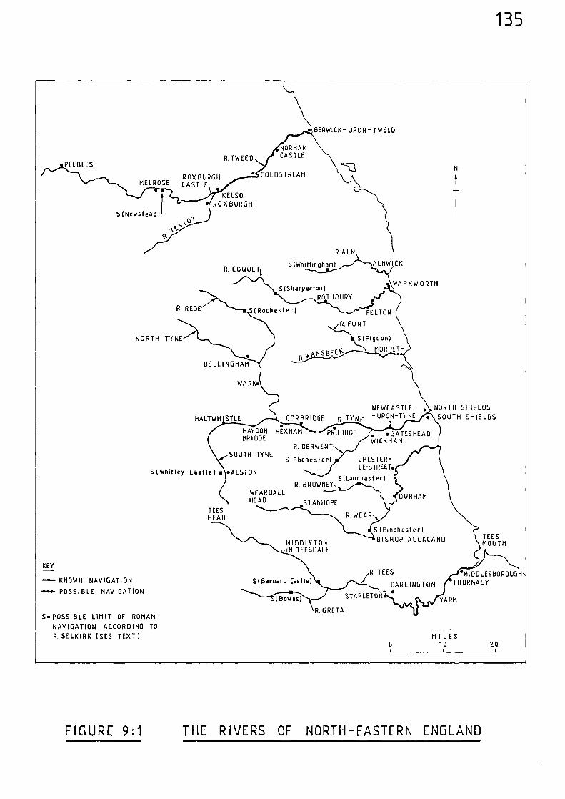
FELTON
R.ALN
S (Whittingham)
S (Sharperton)ROTHBURY
ALNWICK
WARKW ORTH
R. COQUETt
R. REDE SI Rochester)
PDX BURGHMELROSE CASTLE
SINewstead
NOR HAM
R.TWEED
CASTLE
• COLD STREAM
PEEBLES
KELSO• ROXBURGH
SOUTH TYNES(Ebchester) C HEST ER -
LE-STREET.
S(Lanchester)S (Whitley Castle) • •ALSTON
R. BROWNEY
DURHAMWEARDALEHEAD STANHOPE
TEESHEAD R. WEAR
S (Binchester)
BISHOP AUCKLAND TEESMOUTHMIDDLETON
IN TEESDALE
MIDDLESBOROUGHTHORNABY5( Barnard Castle)
R TEES
DARLINGTON
KEY
KNOWN NAVIGATION
-n•••- POSSIBLE NAVIGATION •(Bowes) YARM
STAPLETON
R. GRETAS= POSSIBLE LIMIT OF ROMAN
NAVIGATION ACCORDING TO
R. SE LK IRK (SEE TEXT) MILES10 20
NORTH TYNE
RpNSBECY
S(Pigdon)
MORPETH
BELLINGHAM
WARK•
HALTWH STLE
NEWCASTLE • NORTH SHIELDS
CORBRIDGE p TY NE - UPON-TINE
SOUTH SHIELDS
HAYDON HNHAM PR.UDHOEBRIDGE
R. DERWENT
•GATESHEADWICKHAM
135
• BERWICK- UPON- TWEED
R FONT
FIGURE 9:1 THE RIVERS OF NORTH-EASTERN ENGLAND
136
Motes and References
(1) Public Recor4 Office, E101/597/3
(2) H. COUCH, Itinerary of King Edward the First Throughout His Reign A.D. 1271-1307 2 vols (Paisley 1900).
(3) ibid, vi
(4) Calendar of Patent Rolls, 1292-1301, 408.
(5) Public Record Office, E101/597/5
(6) Public Record Office, [101/597/17
(7) Public Record Office, E101/568/30
(8) Public Record Office
[101/569/3
(9) Calendar of Liberate Rolls, 1240-45, 255
(10) Calendar of Patent Rolls, 1364-67, 427
(11) Calendar of Fine Rolls, 1399-1405, 122
(12) Calendar of Patent Rolls, 1399-1401, 465
(13) Calendar of Close Rolls. 1409-13, 278
(14) Calendar of Patent Rolls, 1324-27, 311
(15) M. BERESFORD, Hew Towns of the Middle Ages (London 1967) 475
(16) J. GUTHRIE, The River Tyne - Its History and Resources (London,1880) 17-18
(17) J.B. BLAKE, 'The Medieval Coal Trade of North-East England; SomeFourteenth Century Evidence' Northern History,Vol. II (1967), 1-26.
(18) ibid, 24
137
(19) ibid, 24-25
(20) 1 GUTHRIE (op. cit), 17
(21) Calendar of Patent Rolls, 1292-1301, 583
(22) Calendar of Close Rolls, 1302-07, 122
(23) Calendar of Patent Rolls, 1321-24, 86
(24) ibid, 134
(25) ibid, 268
(26) Calendar of Close Rolls, 1323-27, 10
(27) Calendar of Patent Rolls, 1327-30, 3-4
(28) Calendar of Patent Rolls, 1343-45, 393
(29) Calendar of Close Rolls, 1343-46, 465-66
(30) ibid, 465
(31) Calendar of Patent Rolls, 1361-64, 213
(32) Calendar of Patent Rolls, 1364-67, 31
(33) ibid, 90
(34) J.B. BLAKE, (op. cit.), 24-25
(35) 3.B. BLAKE, (op. cit.), 3-4
(36) Calendar of Close Rolls, 1364-68, 429
(37) Calendar of Patent Rolls, 1370-74, 109
(38) Calendar of Patent Rolls, 1364-67, 400 (Newcastle)
Calendar of Patent Rolls, 1374-77, 159 (Water of Tyne)
Calendar of Patent Rolls, 1377_81,486 (Newcastle)
Calendar of Patent Rolls, 1381-85, 21 & 499 (Newcastle)
Calendar of Close Rolls, 1381-85, 349 & 573 (Newcastle)
Calendar of Fine Rolls, 1383-91, 30 (Newcastle)
Calendar of Patent Rolls, 1388-92, 30 (Newcastle)
Calendar of Close Rolls, 1392-96, 102 & 337 (Newcastle to sea)
Calendar of Patent Rolls, 1399-1401, 461 & 468 (Newcastle)
Calendar of Close 329 (Newcastle)Rolls, 1402-05,
Calendar of Charter Rolls, 1341-1417, 290-91 (Newcastle area)
(39) Communication - University of Durham - Department of(Assistant Keeper) Palaeography and Diplomatic (Durham 1985)
(40) J.E.T. ROGERS, A History of Agriculture and Prices inEngland, Vol. III, (Oxford, 1882) 671
(41) B. WAITES 'The Medieval Ports and Trade of North-EastYorkshire' Mariners Mirror, Vol. LXIII,(1977) 139
(42) S. UHLER 'The Transportation of Produce in Lincoln-
138
ibid, 410 (Newcastle)
Calendar of Close Rolls, 1364-68. 442 (Newcastle)
Calendar of Patent Rolls, 1370-74, 194, 313, 326 & 389(Newcastle to the sea)
shire, Yorkshire, Hampshire and Norfolkduring the Fourteenth Century as revealedby the Sheriffs Accounts', Unpublished B.Phil. Dissertation, University of St. Andrews (1977), 32
139
(43) Calendar of Patent Rolls, 1345-48. 253
(44) Calendar of Patent Rolls, 1358-61, 157
(45) J.B. BLAKE, (cp. cit.), 10
(46) Calendar of Patent Rolls, 1361-64, 30
(47) R. SELKIRK, The Piercebridge Formula: A Dramatic Heln View of Roman Britain (Cambridge, 1983)esp. 72-161
(48) ibid, 99-111
(49) ibid, 100-101
(50) ibid
(51) C. HADFIELD, The Canal Age (London 1971) 3
(52) Calendar of Memoranda Rolls, 1326-1327. 318
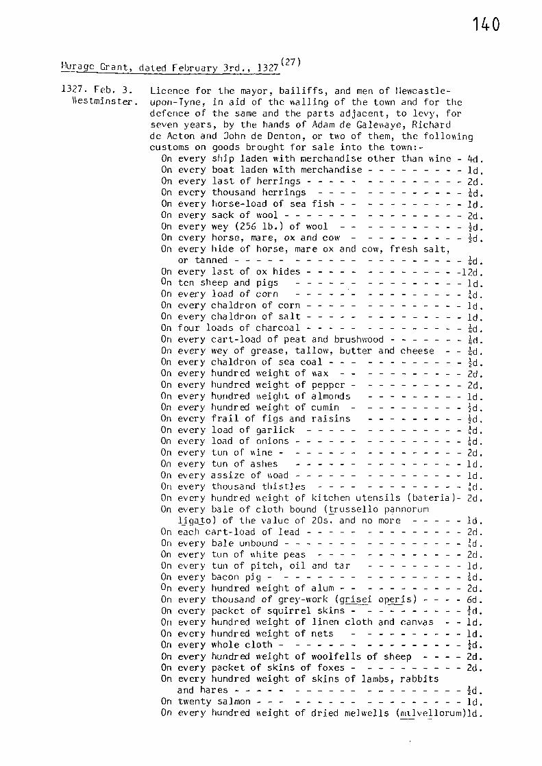
140
Hurage Grant, dated February 3rd., 1327(27)
1327. Feb. 3.‘4estm1nster.
Licence for the mayor, bailiffs, and men of Hewcastle-upon-Tyne, in aid of the walling of the town and for thedefence of the same and the parts adjacent, to levy, forseven years, by the hands of Adam de Galewaye, Richardde Acton and John de Denton, or two of them, the followingcustoms on goods brought for sale into the town:-
On every ship laden with merchandise other than wine - 4d.On every boat laden with merchandise id.On every last of herrings 2d.On every thousand herrings 4d.On every horse-load of sea fish id.On every sack of wool 2d.On every wey (256 lb.) of wool Id.On every horse, mare, ox and cow ;d.On every hide of horse, mare ox and cow, fresh salt,
or tanned 4d.On every last of ox hides 12d.On ten sheep and pigs ld.On every load of corn 4d.On every chaldron of corn ld.On every chaldron of salt ld.On four loads of charcoal 4d.On every cart-load of peat and brushwood 4d.On every wey of grease, tallow, butter and cheese - - TA.On every chaldron of sea coal Id.On every hundred weight of wax 2d.On every hundred weight of pepper 2d.On every hundred weight of almonds id.On every hundred weight of cumin Id.On every frail of figs and raisins Id.On every load of garlick 4d.On every load of onions 4d.On every tun of wine 2d.On every tun of ashes ld.On every assize of woad id.On every thousand thistles 4d.On every hundred weight of kitchen utensils (bateria)- 2d.On every bale of cloth bound (trussello pannorum
ligato) of the value of 20s. and no more ld.On each cart-load of lead 2d.On every bale unbound 4d.On every tun of white peas 2d.On every tun of pitch, oil and tar ld.On every bacon pig 4d.On every hundred weight of alum 2d.On every thousand of grey-work (grisei opens) - - - - 6d.On every packet of squirrel skins Id.On every hundred weight of linen cloth and canvas - - Id.On every hundred weight of nets ld.On every whole cloth Id.On every hundred weight of woolfells of sheep - - - - 2d.On every packet of skins of foxes 2d.On every hundred weight of skins of lambs, rabbits
and hares Id.On twenty salmon id.On every hundred weight of dried melwells (mtivellorum)1d.
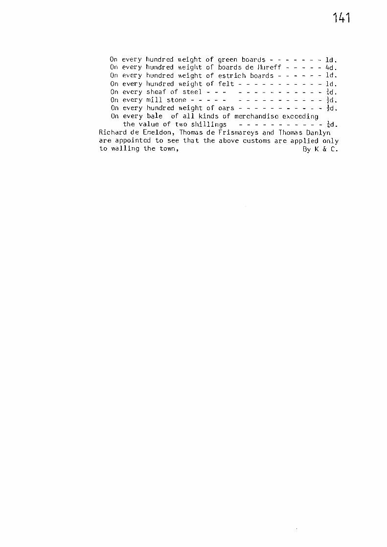
14.1
On every hundred v‘eight of green boards ld.On every hundred Ineight of boards de Hureff 4d.On every hundred veight of estrich boards ld.
On every hundred seight of felt Id.On every sheaf of steel Id.On every mill stone Id.On every hundred %%eight of oars Id.On every bale of all kinds of merchandise exceeding
the value of two shillings Id.Richard de Emeldon, Thomas de Frismareys and Thomas Danlynare appointed to see that the above customs are applied onlyto walling the town, By K & C.
142
CHAPTER TEN THE RIVERS OF YORKSHIRE
An unusual feature of the Yorkshire river system is that, almost
without exception, the rivers eventually find an outlet to the North
Sea via one channel - the estuary of the River Humber. The catchment
area of this system is vast, stretching from the North York Moors to
the Midlands, and from the Pennines to the Yorkshire Wolds. This
chapter deals with the Yorkshire rivers, whilst the Trent and its
tributaries are dealt with in Chapter Eleven.
River Humber
The large river estuary of the Humber divides the historic counties
of York and Lincoln. It varies in breadth from 1 to 7 miles and is
about 35 miles long.
Being so wide, and hence not capable of being bridged until modern
times, the estuary of the Humber acted as a natural barrier to overland
routes and hence put a great emphasis on the various ferries which plied
between the two counties. The main crossing in the thirteenth and
early fourteenth centuries appears to have been that between Barton-
upon-Humber and Hessle. An order to the bailiff of Barton to cause
the King's 'great barge' appointed for the ferry between Barton and
Hessle to be repaired was issued in 1299.(1)
One year later a similar
order was issued relating to the repair of the King's 'smaller bargcl! 2)
In 1293, Edward I began to develop the port of Hull and hence created
the town of Kingston-upon-Hull, (3) and as its importance grew a ferry
to Barton was established. There was also a ferry between Barrow
Haven and Hull, and as Barrow is to the east of Barton this resulted
in a shorter crossing. Rivalry between the two ferries was fierce and
143
disputes were common.(4)
Another significant crossing was that
between forth and South Ferriby,(5)
and there were other ferries at
Winteringham,(6)
Pau1l,(7)
Brough and Faxfleet.(8)
To cater for the increase in trade brought about by the development
of the port of Hull, a new quay was ordered to be built in 1297,
"for loading, unloading and weighing goods andwares there." (9)
From this point on, to the close of the fourteenth century, there are
numerous references to the port of Hull.(10-24)
Although Hull, even before its development by Edward I, was a
prominent Humber port, Grimsby, Hedon, Barton and Immingham were all
active. An early indication of their relative importance can be gained
from comparing the amount of tax, known as the 'fifteenth', which the
merchants paid in each port. A Pipe Roll of 1204, in the sixth year
of the reign of King John ) when rearranged in decreasing value of tax
paid, is instructive. Allowing for all the complexities associated
with the interpretation of this kind of record, the list is nevertheless
indicative of the relative importance of these ports. The rearranged
list is given below in Table 10:1; Idth the Humberside ports underlined.
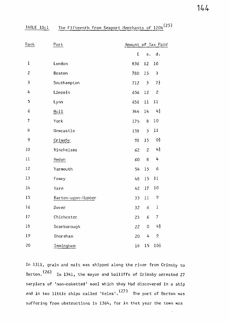
144
TABLE 10:1 The Fifteenth from Seaport Merchants of 1204(25)
Rank Port Amount of Tax Paid
£ s. d.
1 London 836 12 10
2 Boston 780 15 3
3 Southampton 712 3 71
4 Lincoln 656 12 2
5 Lynn 651 11 11
6 Hull 344 14 41
7 York 175 8 10
8 Newcastle 158 5 11
9 Grimsby 91 15 01
10 Winchelsea 62 2 41
11 Hedon 60 8 4
12 Yarmouth 54 15 6
13 Fowey 48 15 11
14 Yarm 42 17 10
15 Barton-upon-Humber 33 11 9
16 Dover 32 6 1
17 Chichester 23 6 7
18 Scarborough 22 0 41
19 Shoreham 20 4 9
20 Immingham 18 15 101
In 1311, grain and malt was shipped along the river from Grimsby to
Barton.(26)
In 1341, the mayor and bailiffs of Grimsby arrested 27
sarplars of 'non-coketted' wool which they hbd discovered in a ship
and in two little ships called 'Keles'.(27)
The port of Barton was
suffering from obstructions in 1364, for in that year the town was
145
allowed to take certain specified customs on goods brought to or from
tte port to be taken for three gears, in aid of the cleansing of their
port.(25)
Ravenserodd,a small town created in 1240 and located on a sandbank
somewhere in the vicinity of Spurnhead, also saw the benefit of
waterborre trade. In 1290, the men of Grimsby complained that
riaversexoddwas taking trade away from their port.
...ships laden with diverse kinds ofmerctandise began to unload and sell at thetown. And now, inasmuch as the island isnearer tte sea than Grinsbg and as shipscan urload ttere more easily, nearly allsips do stay, unload and sell there." (29)
howei,er, tte inundations of tUe water caused havoc at Ravenserodd, and
(30)113) 146 to thirds of the ton nad been oashed aoay.
Goods oere sometimes sold from 1,essels on the oater of the river
ratfer than being brought to land for sale. In 1314 it was said that
mercfants
"...dispose of tteir mercVandise in the oater,whereas tfe% sfould come to land as atLondor aid other places in England. therebytfe 'fig loses tis rents and tte profittich should come to fim and his people,..." (31)
Searches of vessels in the river were often carried out, as in
1341, when officers were appointed to
"search ships, and boats and other vesselsin the Humber ,....freighted with wool andother customable wares, coming from anyparts of coasts of the realm, and to takeinto tt-e King's hands in like manner alluncustomed wool or other wares foundtherein; (32)(33)
146
There is also evidence of the perils of navigating the river and
also the hazards of stormy weather. In 1360, Ralph of Alford was
giving evidence concerning the age of an heiress; he remembered her
birth well, because on the Monday after it his father had set off on
pilgrimage to the shrine of St. James of Compostella; he had made a vow
to do it
"on account of a danger in which he hadbeen in the waters of Humber." (34)
In 1366,
"...Thomas Smyth of Whittyn was taking certainmen in his boat over the water of Humbre toGaynesburgh, John Rymay of Notingham, 'mariner'sailing in his ship passed over the said boatand totally smashed it, whereby Thomas and theothers in the boat were in such peril thatthree of the men were drowned;. ...(35)
In 1386, herrings, oil and other merchandise were lost from a ship which
"was split by a storm in the river Humbre". (36)
River Hedon
The River Hedon, or Hedon Haven, is a narrow creek which cuts into
the marshy lowlands of Holderness between Spurn Head and Kingston-upon-
Hull.
The town of Hedon, 2 miles up-stream from the shores of the Humber,
was the first attempt at establishing a port in the area. The site
of the town was probably occupied soon after 1138, and in this respect
it pre-dates the foundation of Hull. (37)
147
A record of 1335 shows that the river was navigable up-stream of
Hedon, for a commission of that year, investigating an unlawful
diversion of the watercoarse, reported that ships and boats were unable
to pass to the town of Burstwick because of the diversion. (38)
In
1345, the keeper of the manor of 'Brustwyk' was ordered
'...to receive toll and custom in the parts ofHolderness from ships laden with merchandiseand other things coming there " (39)
Towards the end of the fourteenth century (post 1392), a jury of Hedon
was told that
...a ditch.. .whereby from time immemorialboats laden with merchandize passed fromthe high sea to the Humber, then to Hedon...and ought so to pass, has becom dry forlack of repair and cleaning and because ithas been stopped up, so that boats cannotpass along it.." (40)
Riser Hull
Pising to tte west of Great Driffield, which it then flows past
before turning south rear Vansford, tte Pier HAI follows a generally
north-soitt coarse past Berle, prior to ertering the Humber at Hull;
a total length of 25 miles.
Ns earls as the twelfth century, Archbishop Thurstan of York
persuaded the mercVants of Beserley to deepen the creek which led from
their town to the Riser Hull, thus enabling sea-going vessels to come
and go.(41)
Early in tUe thirteenth century the Archbishop of York
claimed right of passage in the river for a width of 24ft;(42)
and in
1265, or 1269, attempts were made to clear the river of obstructions.
148
In 1298, a member of the crew of a ship died on board whilst the
vessel was on the water of Hull near Beverley. The Archbishop of York
attempted to obtain money to allow the ship to proceed on its journey
by claiming that the crewman had died by misfortune; however, the
Archbishop's claim was rejected.(44)
Also during 1298, Yorkshire produce, including oats and peas was
(45)taken down the river to Hull from Wansford, Beverley and Leven.
In 1309, grain was taken overland from Halton and Pocklington to
(46)Wansford and then by river to Hull. Wool from the Vale of Pickering
was taken to W3nsford in 1338, prior to being taken to Beverley and Hull
(47)via the river. During the same year, the Archbishop of York again
claimed rights in the river, this time between Hull and Aike. ( 48)
Orders
"to arrest non-coketted and non-customed woolin ships in the water of Hul",
(49)were issued in 1342. In 1343, a ship was orderd to be sold
"as forfeit to the King, because wool foundtherein was not coketted or customed, n.,
the ship had been arrested near Grimsby and was taken to Hull, from
()where it was taken to Beverley and afterwards brought back to Hu1l.50
In 1361, a commission was appointed
"...to survey kiddies and weirs in the watersand rivers of Use, Ayre, Derwent, Querf, Yore,Swale, Nidd, Hull and Don, and to make inquisition....whether any of these obstruct the passage." (51)
The members of this same commission were also asked to determine whether
the owners, masters and mariners of ships and boats passing along the
rivers were guilty of charging
149
"excessive stipends, wages and other sums forcarriage in their ships and boats, contraryto the form of the statutes of labourers andworkmen, by covenants made in advance, andrefuse to carry for a reasonable sum." (52)
Although the River Hull did not present so great a physical
barrier to overland travel as the River Humber, there are records of
ferries across it.(53)
One such ferry linked the villages of
Brandesburton and Rotsea; this no doubt would be in the vicinity of
Hempholme, where lanes lead down to the riverside.
That the river was still used for the transport of merchandise
towards the end of the fourteerth century is revealed by a commission
set up in 1379
"to sursey all weirs, mills, pools, pales andkidels which hase been set up in the riverHull... to the obstruction of ships and boats". (54)
Riser Oise
Formed by the jurction of the Swale with the Ure near Boroughbridge,
the Riser Ouse flows soutl--east past York. Carood, Selby and Goole, 8
miles east of which it urites with tte Trent to form the estuary of the
Humber. Its total course is 60 miles, Nor!, being 45 miles up-river
from the corfluence with tte Trent and Humber.
From the very beginning of the medieval period there is reference
to navigation along the Riser Ouse, for in 1066, as the Domesday Book
informs us, the burgesses of Torksey near Lincoln on the River Trent,
had the duty of conducting the King's messengers to York with their
ships and other aids.(55)
150
In 1236, a charter was confirmed which gave the monks of 3f,rvailx
"...the liberty of the water from Boroughbridgeto York, so that they may bring and take allthings needful to them in one ship,...." (56)
During 1245, the constable of Pontefract was asked
"...to make two lime-kilns (rogos) wherever theymay be most sufficiently made and nearest tothe water in his bailiwick for the works ofYork castle, which the King has ordered to berefortified; and to carry the lime to the water,to be carried on to York castle by the sheriff." (57)
Both the Ouse and the Humber were utilised in 1256 when 36 tirs
of wine, bought on behalf of the King at Boston was taken to Nork
(by water and delivered to the sheriff.55)
In 1298, grain and cats wFTe taken by water from Cawcod to Hill;
malt from York to Hull; and grain and malt from Selb) and Howden to
Hull.(59)
Similarly, in 1301, oats were transported along tFe riser
()from Boroughbridge to Selb.60
A minister's account of 32 - 33 Edward I (1303-04), gises
details of freightage charges of boats caming rerchandise. and
(61)divers other things between Boroughbridge and Nod,.
In 1311-12, Queen Isabella journeyed along the Ouse between Nork
and Howden. Four boats were hired for herself, her damsels, squires
and the equipment of the small wardrobe, a trip which took the masters
and their assistant boatmen two days.(62)(63)
In 1331, it appears that a ship convesing the goods of the bishop
of Durham was wrecked at the junction of the Ouse and Humber; his
goods being cast ashore at Ousefleet, Blacktoft and Faxfleet.(64)
151
Shipbuilding was carried out in York, for in 1337, the mayor and
bailiffs of the city were requested
"..to cause a great barge with boats and all othernecessaries pertaining thereto to be constructedwith all possible speed in that city at the commonexpense of the men of the city for the defence ofthe realm.' (65)
Various references relate to the obstructions in the river, as in
1348, when presentments were made by jurors of Selby that the abbot of
York had let
"...part of the said water between Selby and theriver Wharfe..., and in a place called le Hardby Selby they have set nets across from midstreamto the bank, on the archbishops side to thegreat danger of passing ships." (66)
This type of obstruction seems to have presented a serious threat to
navigation for, towards the end of the fourteenth century (c1394), a
presentment by jurors of York relating to such obstructions over a
number of years is framed in the following language:-
"...whereas the water of Ouse is a highway andthe greatest of all the King's risers withinthe Kingdom of England, and is for the use ofmerchants in ships with divers merchandisefrom the high sea to the city of York and otherplaces within the county, to the great increaseof the Kingdom and especially of the King'scity of York and the county of York and of othercounties, cities, boroughs and towns in thenorthern parts of England, to it from thesea to the Humber, thence to the Trent, thenceto the Ouse and so to York, there are in thesaid waters divers hindrances, stoppages andweirs called fishgarths and in the said weirsare divers spaces called rowmes set stronglyacross the whole depth of water with poles,stones and hedges, whereby the common courseof the said river and the carriage ofmerchandise as aforesaid is wholly stopped fora few years now past and very often the saidspaces were endangered and submerged:.. .noship can pass in the summer season.. .by reasonof the obstruction... lost two ships fullyladen with woollen cloth to the value ofsixty pounds,..." (67)
152
Throughout the fourteenth century there are many references to
obstructions along the course of the river.(68-71)
Nevertheless, all the aforementioned obstacles to navigation must
have been overcome for, throughout the fourteenth century, there are
numerous references which testify to shipping movements along the
course of the river, together with extensive use of the port of York.
For example, in 1339, ships from Newark journeyed to York,(72)
and in 1341, a ship of York, laden with corn and other merchandise, was
sent to Kingston-upon-Hull to make a profit there.(73)
Grievances arose in 1350, for, in that year the abbot and convent
of St. Mary's, York, were given, in view of the insolence of the men
of the city of York and their accomplices, protection for carrying
their victuals and other things by the water of Ouse. (74)
Shipbuilding was still under way in 1358, as is revealed by a
record relating to a dispute over a plot of land which was situated
between the castle and the river. It was stated that the plot
"...is now occupied by Nicholas Taverner of York,INilliam de Crulle of York and Roger de Whiteleyof York, and many others who there carpenter(carpentant), make and work divers ships andboats,..." (75)
In 1369, the mayor and citizens of York were allowed to take
customs from goods for five years in
"...aid of maintenance of a quay newly builtin their city on the water of Use betweenthe bridge of that water and the inn of theFriars Minors."(76)
This grant was renewed in 1377 for three years, when details of the
charges are recorded,
153
"...from every ship of 20 tons burden andupwards, laden with goods for sale, 2d.,from every ship of 10 tons up to 20 tonsburden, so laden, id., and from every boatof less burden than 10 tons, Id." (77)
This first quay was probably made of wood, but by 1388 it appears that
stone was being used to make it anew, for in that year a grant was made
"...to the mayor, bailiffs and other citizens ofYork, who intend with stone and lime to strengthenand make a new quay between the house of theFriars Minors of that city and Use bridge, ofthe following customs as quayage for six years,viz:- (78)
For every quarter of corn brought by strangers to the cityFor every quarter of salt so broughtFor every thousand of turves or peats so broughtFor every foreign vessel of the burden of 20 tuns of wineand more, with whatever merchandise laden
6d
For every foreign vessel of less burden
3d.
In 1370, Tundu of York, was ordered to load 300 quarters
of wheat, 100 quarters of beans and peas and 300 quarters of malt in
(79)the water of Ouse, and bring them to London.
The aforementioned material was selected to demonstrate the fact
that throughout the medieval period, although periodically prone to
obstructions and the like, the River Ouse remained navigable throughout
its whole course. However, there is a wealth of surviving material
relating to activity along the river throughout the fourteenth century,
and this is given as reference (80) at the end of the chapter.
River Derwent
The River Derwent rises on Fylingdales Moor to the north-west of
Scarborough and initially flows in a southerly direction prior to
turning due west near Canton from where it passes by Yedingham to Halton.
154
From Halton the river flows in a southerly direction to Stamford Bridge
and on past Kexby, Elvington, Wheldrake, Ellerton, Bubwith and W.essle
to enter the Ouse at Barmby-on-the Marsh; a total length of 65 miles.
A record of a dispute relating to an incident which occurred in
1317 is revealing:-
"Robert Garinge of Halton by Kylingholm in adispute with Walter son of William Mekan ofLudington, killed himself with a pair of tongsin a ship of the abbot of Thorneton on Humbercalled 'Blome' on St. Martin in the winter of10 Edward II, in the water of Derwent nearWresill: neither the ship nor anything belongingthereto was in anyway the cause of the death ofthe said Walter; the ship was taken into theKing's hand by reason of the said felony in Lentfollowing, at Swinflete in the water of Ouse". (81)
Wressle is 3 miles up-river from the confluence with the Ouse.
An inquisition of 1332, relAting to obstructions, shows that the
river was navigable for at least 20 miles, to Stamford Bridge:-
"Ships and boats, laden with victuals :Ind cthergoods, used to pass by the water of Derwent toStaynfordbrig and elsewhere along the banks ofthe said water from time beyond memory." (82)
The record goes on to mention obstruction by weirs at specific places,
these being:- Duffield, Ellerton, Cottingworth, Wheldrake, Sutton and
Elvinciton all of which arc situated between the mouth of the Derwent
and Stamford Bridge. Obstructions in these same places are mentioned
again in 1356.(83)
Obstructions to navigation were mentioned in 1341, when it was
said that there were divers weirs, kiddies and sewers in the river in
the area of Stamford Bridge
155
"...so that ships and boats laden with merchandisecannot pass for the ccmmon good of the men ofthose parts, as they used to do..." (84)
It is this frequent reference to obstructions ‘‘hich probably led
to a number of surveys of Yorkshire rivers carried out between 1353 and
1361 which included the River Derwent.(85-88)
These surveys appear to
have been reasonably effective for, after 1361, records of obstructions
in the river diminish, and, apart from a weir at Bubwith and a stake
(89)at Wressle, the navigation appears to have stayed clear and it was
not until 1390-91 that the river was further obstructed and a subsequent
(90-92)survey commissioned.
It is likely that the River Derwent was navigahle 14 miles up-river
of Stamford Bridge, to Halton, during the medieval period.
River Foss
The River Foss rises in the Howardian Hills and flows in a
southerly direction through Stillington and Strensall and on to York,
there it enters the River Ouse after a course of 18 miles.
In 1314, the prior and friars in the city of York n%ere given
permission to
"...construct a quay in their own soil withintheir dwelling place (mansum) upon the bankof the King's stew of the 'Fosse', which theymay hold to them and their successors for ever,and further that they may have one boat in thestew to carry to their said dwelling placestone, brushwood and other necessaries of theirs,as well under the bridge pf the Fosse as elsewherein the stew.". (93)
The river was navigable for about 6 miles up-river towards
Strensall for, in 1323, the owners of land adjoining that part of the
156
river complained that the King's
"Keeper ought not to mow grass in the lands ormeadows adjoining thereto, and that neither theKing nor his Keeper ought to receive any otherprofit except from so much grass or rushes (cirpis)as the Keeper can mow from his boat in thesummer time by having one foot in the boat andone on shore;..." (94)
It is likely that the River Foss was navigable for a further 7 miles
up-river of Strensall to Stillington, during the medieval period.
River Swale
The River SINale rises in the hills to the north of Thwaite and
then flows east along Swaledale to emerge into the Vale of York at
Richmond, from \\here it folloNns a more southerly course past Catterick.
It passes within 4 miles of Northallerton and Thirsk before its
confluence lAith the Ure to the south of Boroughbridge; a total length of
53 miles.
Throughout the medieval period timber was regularly shipped from
Topcliffe, 9 miles up-river, to York.(95)
In 1317 mention is made of
a boat upon the water of Swale at Morton, 4 miles to the west of
Northallerton.(96)
Morton is 21 miles up-river from the confluence of
the Swale and Ure. In 1357, mention is also made of a boat at Myton on
Swale, which is a short distance up-river from the confluence with the
Ur e.
There is an interesting reference of 1380 which implies that the
river may have been navigable as far as the town of Richmond, 34 miles
up-river. In that year
157
"The King's bailiffs of the city of Lincolnwere attached to answer Peter de Sabaudiatouching his plea why they demand toll of hismen of the honor of Richemond coming intoLincoln with things for sale, they having beenheretofore quit of toll throughout Englandfrom the time of the Conquest. He complainsthat in the twelve years last past the saidbailiffs have demanded the following tolls fromthem, viz, for every horse sold or bought ld.,for every ox Id., for every cart 2d., forevery vessel (navi)4d.,..." (98)
It was finally agreed that the men of the honor of Richemond
"...will pay for every vessel with 'helmrother'coming within the metes of the city 2d., andfor every vessel with 'handrother' ld., and thisis to be understood of ships carrying merchandisepreviously bought by any merchants and afterwardsexposed for sale and not of other things." (99)
(100)Although the 'Honour of Richmond' was extensive, Richmond
Castle, situated atop a cliff beside the River Swale, was the centre
of its economic administration.
That the river was probably navigable for the greater part of its
course is hinted at by the commission of 1361 previously alluded to,
relating to obstructions, which included a survey of the River Swale.
River Ure
Rising near Hawes, the River Ure flows east through Wensleydale
then gradually turns to the south passing Middleham, Jervaulx Abbey,
Masham and Ripon to Boroughbridge, after which it is joined by the Swale
to form the River Ouse; a total length of 45 miles.
The town of Boroughbridge, which appears to have been founded
158
c1145, (101)
is 3 miles above the confluence with the Swale. The river
was certainly navigable to this point for, in 1218-19, the jurors at
the eyre of Boroughbridge declared that
"No ship can pass without payment" (102)
The charter of 1236 which gave the monks of Jervaulx
"...the liberty of the water from Boroughbridgeto York so that they may bring and take allthings needful to them in one ship...."
has already been alluded to. Throughout the medieval period lead was
regularly shipped from Boroughbridge to York.(103)
Of the lord's
income from Boroughbridge in 1300 the tolls of market and river freight
contributed almost a third.(104)
The abbot and convent of Fountains
Abbey were allowed to fish in the water between Boroughbridge and York
in 1312; they could use one fisherman and his servant together with
two boats and a drag-net provided they did not make weirs, nor fix
piles. The abbot and convent of Fountains were also allowed free
transit in the ater between Boroughbridge and York.(105)
w There is the
record of a ferry across the water of Ure at Boroughbridge.(106)
A
grant of 1310 records that the Earl of Cornwall and his wife Margaret
"...shall have the water of Yore and Use betweenthe said town of Boroughbridge and the city ofYork in several, so that none shall fish thereor pass in ships or boats without their licence." (107)
In 1318, Boroughbridge was burned and wasted by the Scots, and
this resulted in a reduction of revenue from freightage along the river
due to the fear of merchants.(108)
Similarly, in 1322, it was stated that
159
ships could not pass for fear of theKing's enemies " (109)
Wool was shipped from Milby, near Boroughbridge, to York in
1338.(110)
The chatter which gave the monks of Jervaulx Abbey the liberty
of the water between Boroughbridge and York in 1236 was granted by
Richard, earl of Cornwall who, as is shown by a similar grant of his
descendant in 1310, held the rights of the water between the two places.
This does not necessarily mean, therefore, that the monks of Jervaulx
only navigated the water between Boroughbridge and York, it only
confirms the rights of the earl of Cornwall to this section of the water
and it is very likely that the ship of the monks actually plied between
Jervaulx and York. The Abbey, which is situated mid-way between
Middleham and Masham, was built on the green levels adjacent to the
river. The commission of 1361 which called for a survey of Kiddles and
weirs in the water of re,(111)
and asked for information as to whether
any of these obstruct the passage; it is doubtful that this survey would
apply only to the 3 mile section of the river between its confluence
with the Swale and Boroughbridge. The terminology used in many of the
medieval references to Boroughbridge: 'no ships can pass'; 'ships
could not pass'; etc., implies that the river was navigable above the
town.
River Nidd
Rising on the slopes of Great Whernside, the River Nidd flows
in a south-easterly direction through Nidderdale to Pateley Bridge.
It then turns in a more easterly direction past Ripley and Knaresborough
160
to enter the River Ouse at Nun Monkton; a total length of 44 miles.
During the medieval period lead was the major commodity
associated with Nidderdale and the River Nidd. Lead was mined in the
hills around Pateley Bridge and also at Knaresborough.(112)
B.
Waites, in an article relating to the medieval trade of North-East
Yorkshire, says:-
"...lead was regularly sent from Nidderdaleto York and thence to Hull entirely bywater...." (113)
That the Nidd was navigable during the medieval period is -shown
by the number of surveys undertaken to ensure that the passage was
kept clear of obstructions.(85-88)
Exactly how far the river was navigable is not clear, but it
would be safe to assume that it would have been navigable to
Knaresborough, 15 miles up-river, and possibly as far as Pateley Bridge.
River Wharfe
From Oughtershaw Moss to the north of Pen-y-ghent, the River
Wharfe flows in a south-easterly direction past Kettlewell, Grassington
and Bolton Abbey before turning east past Ilkley, Otley, ‘Netherby and
Tadcaster to enter the River Ouse near Cawood; a total length of 65 miles.
In 1322, when the city walls of York were in need of repair,
stone was sent by water from a quarry near Tadcaster.(114)
Stone was
sent by water from Tadcaster again in 1333, when a writ of aid was
granted to one Thomas de Papeham

161
"...in buying stones in the quarry nearTadcastre for the King's use, for hisengines, and in carrying them to the waterof Wharf, near Tadcastre" (115)
In 1338, the collectors of wool in Lancashire were directed
to send an allocation to Hull; they transported it in carts to Tadcaster,
and then shipped it the rest of the way.(116)
A grant of 1346 makes it clear that the river was used to transport
all kinds of merchandise:-
"Grant to the good men of Tadcastre of pontagefor three years for repair of their bridge,to be taken by the hands of Adam, Vicar ofthe church of Berdeseye, and Robert de Bradeleyon wares coming to the town by land as well aswater". (117)
As with various other rivers of Yorkshire, the Wharfe was the
subject of a number of surveys undertaken to ensure that the passage
was kept clear of obstructions.(85-88)
Further obstructions are also
recorded; in 1362, there was a stake set in the riser at Kirkby Wharfe -
near Tadcaster;(118) in the same year the archbishop of York was
accused of setting up divers stakes across the mouth of the Wharfe -
in his defence the archbishop claimed that there had always been
n ....sufficient passage for ships...." (119)
That there was access for ships along the Wharfe, at least as
far as Tadcaster which is 8 miles up-river, has therefore been well
established; however, it is highly probable that the town of Wetherby,
6 miles further up-river and situated on the Great North Road, could
also have been reached by medieval vessels.
162
River Aire
Rising near Malham, to the south-east of Pen-y-ghent, the River
Aire flows in a south-easterly direction passing to the west of Skipton
andetn past Keighley, Bingley, Shipley, Leeds, Castleford (where it is
joined by the Calder), Ferrybridge, Knottingley and Snaith to enter the
Ouse near Hook; a total length of 70 miles.
Ferrybridge was the point at which the 'Great North Road' crossed
the river before dividing - one way to York, the other to Wetherby and
Boroughbridge.
In 1218-19, Rannulf de Fery accused Nigel de Fareburn, of drowning
Simon de Fareburn by throwing him overboard from a ship at Fairburn,(120)
which is some 20 miles up-river from the confluence with the Ouse.
Knottingley; the adjacent township, was a port and ship-building centre
throughout the medieval period, 2')
sending timber on numerous occasions
by water during the construction of York Minster.(122)
Pontefract, 2 miles from the river, was listed as a port in
(123)1274, and, as previously mentioned, the constable of Pontefract
was asked to send lime by water for the re-fortification of York Castle
in 1245.(57)
There is a record of wages paid to the Keepers of the King's
ships at Cowick, near Snaith, for the years 1324-25. (124)
A Pontage Grant of 1340 allowed the bailiffs and 'good men' of
Ferrybridge, near Knottingley, to take custom
"...on things for sale brought to their townas well by land as by water." (125)
163
A similar grant of 1359 allowed men of Pontefract and Ferrybridge to
take custom
"....on things for sale passing by thewater of Eyre from Kelynglsy to Queldaleas well as by the bridge of Ferybrigge forthe repair of that bridge and the causewaybetween the said town and Brotherton, whichare in a dangerous state." (126)
Wheldrake is situated 2 miles up-river of Ferrybridge, near Fairburn;
and Kellingley 3 miles down-river, near Beal.
Records of obstructions on the Aire are few; however, in post
1392, the jurors of York were told that a bridge called Tunbridge, by
Cowick,
"...is made so low that no ship can passbeneath it towards Ycrk and that the men ofCowick, Rawcliffe, Snaith and Hook ought toraise and mend it." (127)
The River Aire was included in the previously mentioned surveys of
Yorkshire rivers undertaken to ensure a clear navigational passage. (85-88)
In 1367, a man was assaulted at Brotherton, near Ferrybridge,
and his assailants were said to have
II ....chased him to the church of that townand besieged him there so that he dared notfor a long time come out for fear of death,took away his wagon with two oxen yoked therein;worth 60s., sank his ship there loaded withlime worth 20 1.,..." (128)
A record of 1394 reveals that there was a ferry at Airmyn,
near the confluence with the Ouse. (129)
There are indications that the River Aire was navigable up-river
164
of the Knottingley area. In 1246, buildings in the manor of Leeds
...which fell down through the cleaning ofthe waterways;..."(130)
had to be repaired. Much further up-river in the Skipton area, a
pontage grant of 1384 is recorded as follows:-
"Grant to Nicholas de Scardeburgh, John deMalghom and Robert Ledes of Skipton ofpontage for three years for repair of'Engeweybrigges' over the Eyre by Skipton inCraven, to be taken upon things for salepassing by that river between Cononlaye andConyston." (131)
Coniston is 6 miles up-river from where the Thornton-in-Craven to
Skipton road passes over the River Aire, and presumably where the
bridge mentioned in the pontage grant was located; Cononley is 4 miles
down-river from the bridging point. If this 10 mile stretch of the
upper river was navigable, and it appears from the detail given in the
record that it was, then in all probability the section of river between
Cononley and the known medieval port of Fairburn may have been navigable
also. This latter section of river covers a distance of 35 miles as
it flows past the townships of Keighley, Bingley, Shipley and Leeds
to Castleford, where it is joined by the River Calder, 3 miles from
Fairburn.
River Calder
Rising in the Pennines on the slopes of Boulsworth Hill, the
River Calder follows an easterly course via Hebden Bridge, Sowerby
Bridge, Brighouse, Dewsbury and Wakefield to join the River Aire at
Castleford after a course of 35 miles.
165
It is likely that the River Calder was navigable for the first
8 miles up-river from its confluence with the Aire, from Castleford to
Wakefield, during the medieval period.
River Don
The River Don rises in the Pennines near Dunford Bridge at the
border of Yorkshire and Cheshire. Initially, it flows due east to
Penistone then turns south to Sheffield from where it changes course to
a north-easterly direction and continues pastRotherham to Doncaster and
Stainforth after which, ih medieval times, it split into two different
courses. One course flowed due east from Stainforth via Thorne and the
Isle of Axholme to join the River Trent; the other course continued in
a northerly direction from Stainforth and entered the River Aire near
Snaith; a total length of 70 miles.
In 1314, the monks of Louth Park were given permission to cut turf
by the town of Slq nefleet and to
"...carry it and other goods to the watersof the Use and Don, and there load ships andtake them thence freely and without disturbance." (132)
In 1322, the
"King lately appointed Thomas de Roassale tokeep the bridge and water of Roderham, andto arrest the King's enemies trying to passthe same, together with their goods and chattels:-" (133)
That the river was navigable at least as far as Rotherham is confirmed by
the Fabric Rolls of York Minster, which show that timber was sent by
river from Aldviark, near Rotherham, to York Minster throughout the
medieval period.(134)

166
In 1326, the course of the Don between Thorne and the Isle of
Axholme and the River Trent was obstructed.(135)
This section of the
river was still suffering from obstructions in 1343 when a commission,
which refers to the earlier obstruction, was asked
"...to make inquisition in the counties of Yorkand Lincoln touching petitions of the men ofthe parts of Merskland, co. York, and theisland of Haxholme, co. Lincoln, before theKing and council in the present Parliament,shewing that Edward II at their suit settingforth that the river Done, which is the boundbetween these counties, where there used to be acourse of water for the passing of ships fromthe town of Donecastre to the water of Trent,and for making sewers for the adjacent lands,was then obstructed, by letters patent appointedJohn de Donecastre and others to remove theobstructions and cause the river to be brought backto its ancient course, and they caused the river tobe dug at the charges of the men of the saidparts from a place called 'Crullflethill' toa place called 'Donmyn' to a breadth of 16 feet andone grain of barley and the course of the water tobe brought back to the ancient course, and nowthe river is again obstructed by bridges, 14eirs andother things so that the said breadth is not kept,whereby the passing of ships is impeded and the landadjoining is flooded, and praying him to cause theobstructions to be removed." (136)
These obstructions, which relate to the dual use of rivers as a
means of transport and for drainage of the land, ‘Nere still being referred
to as late as 1382.(137)
Apart from these specific references to obstructions, the Don,
along with various other Yorkshire rivers, was the subject of a number of
surveys undertaken to ensure that the navigational passage of the river
was maintained.(85-88)
Yorkshire stone was used in the palace of Westminster, for, in 1394,
a certain William Rleburgh was appointed
167
...to arrest ships and other vessels sufficientfor the carriage of free stones from a placecalled 'Le Mar' by Doncastre to the palace ofWestminster by water for the King's works there,..." (138)
It is probable that the River Don was navigable 6 miles up-river
of Rotherham, to Sheffield, during the medieval period.
In a book dealing with the Don Navigation, T.S. Willan writes;
"The Don was one Of those rivers of easternEngland whose courses were radically chanoedby the land-drainage schemes of the seventeenthcentury. Before the drainage of Hatfield Chase,the Don had no direct outlet into the YorkshireOuse; one branch flowed into the Aire, and theother into the Trent. As part of his drainagescheme, Vermuyden cut off this latter branch andforced all the water of the Don into the Aire.This naturally caused flooding, and Vermuydenwas compelled to cut the Dutch River at a costof £20,000 to give the Don an outlet into theOuse." (139)
The rivers of Yorkshire are mapped in Figure 10:1, and their
navigational limits in medieval times, are indicated.
The general coastline, and the shoreline of the Humber Estuary
depicted in Figure 10:1 is the modern one. However, as with other areas
of the British Isles, there have been certain changes both during, and
since, the medieval period. The coast of Holderness has suffered constant
erosion since Anglo-Saxon times, and the distribution of alluvium shown on
the geological map indicates that in general, the land alonside the rivers
leading into the Humber Estuary was of a marshy nature. (140)
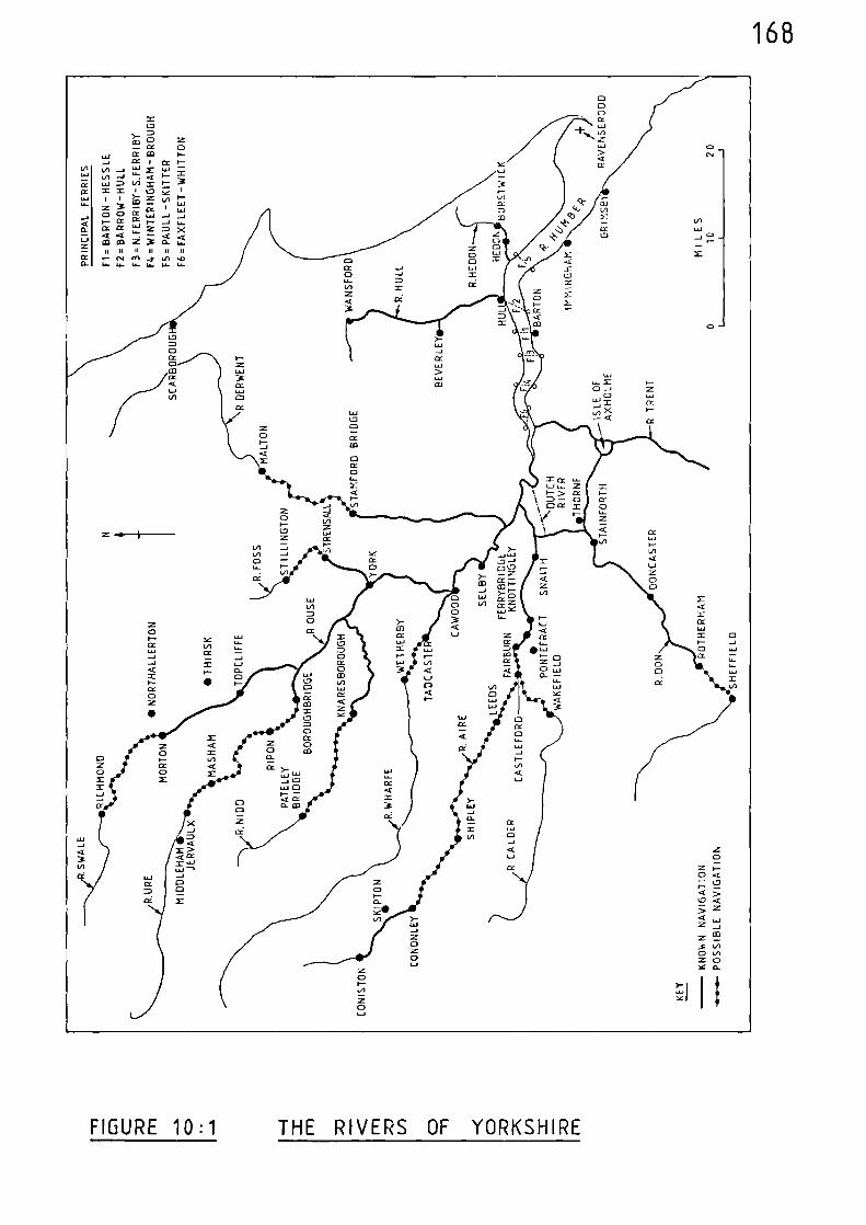
168
FIGURE 10:1 THE RIVERS OF YORKSHIRE
169
Notes and References
(1) Calendar of Close Rolls, 1296-1302. 232
(2) ibid, 336
(3) M. BERESFORD, New Towns of the Middle Ages (London 1967) 511.
(4) Calendar of Close Rolls, 1369-74, 241-42
(5) M.W. BARLEY,
'Lincolnshire Rivers in the Middle Ages'Lincolnshire Architectural and Archaeological Soc. Reports and Papers New Ser. 1 (1938) 4
(6) ibid, 3
(7) ibid, 6
(8) C.T. FLOWER, 'Public Works in Medieval Law' Vol. IISeldon Soc. 40 (1923) 306
(9) Calendar of Close Rolls, 1296-1302, 64
(10) Public Record Office, E101/597/3 (1298)
(11) Public Record Office, E101/597/5 (1301)
(12) Public Record Office, E101/597/17 (1309)
(13) Public Record Office, [101/568/30 (1311)
(14) Calendar of Close Rolls, 1318-23, 391
(15) J.F. WILLARD, 'Inland Transportation in England during theFourteenth Century' Speculum 1 (1926) 373.
(16) Calendar of Patent Rolls, 1338-40, 173
(17) Calendar of Patent Rolls, 1340-43, 212
(18) ibid, 306
170
(19) Calendar of Inquisitions Miscellaneous, 1307-49, 438 (1341)
(20) Calendar of Close Rolls, 1343-46, 490
(21) Calendar of Patent Rolls, 1370-74, 60
(22) ibid, 219
(23) Calendar of Patent Rolls, 1385-89, 405
(24) Calendar of Patent Rolls, 1399-1401, 467
(25) H.C. DARBY (ed.), An Historical Geography of Fngland before lsnn(Cambridge, 1936) 221
(26) Public Record Office, E101/568/30
(27) Calendar of Close Rolls, 1341-43, 157
(28) Calendar of Patent Rolls, 1361-64, 477-78
(29) M. BERESFORD 513(op cit)
(30) M. BERESFORD 514(op cit),
(31) Calendar of Chancery Warrants) 1244-1326, 400
(32) Calendar of Patent Rolls, 1340-43, 317
(33) Calendar of Close Rolls, 1341-43, 679
(34) M.W. BARLEY 12(op. cit.)
(35) Calendar of Patent Rolls, 1364-67, 298
(36) Calendar of Close Rolls, 1385-89, 289
(37) M. BERESFORD 510(op. cit.)
171
(38) Calendar of Patent Rolls, 1338-40, 66-67
(39) Calendar of Fine Rolls, 1337-47, 407
(40) C.T. FLOWER 356-58(op. cit.)
(41) B.F. DUCKHAM, Navigable Rivers of Yorkshire (Clapham 1964) 8
(42) ibid
(43) ibid, 8-9
(44) Calendar of Inquisitions Miscellaneous, 1219-1307, 492-93
(45) Public Record Office, E101/597/3
(46) Public Record Office, [101/597/17
(47) Pipe Roll, E372/183/47
(48) Calendar of Patent Rolls, 1338-40, 165-67
(49) Calendar of Close Rolls, 134143, 617
(50) Calendar of Close Rolls, 1343-46, 15
(51) Calendar of Patent Rolls, 1358-61, 553
(52) ibid
(53) C.T. FLOWFR 306-09(op. cit.)
(54) Calendar of Patent Rolls, 1377-61, 363
(55) H.C. DARBY, Domesday England (Cambridge 1977) 301
(56) Calendar of Charter Rolls, 1226-57, 223
172
(57) Calendar of Liberate Rolls, 1240-45, 300
(58) Calendar of Liberate Rolls, 1251-60, 298
(59) Public Record Office, E101/597/3
(60) Public Record Office, E101/597/5
(61) U.A. FORBES and - Our Waterways - A History of Inland Navigation W.H.R. ASHFORD, Considered as a Branch of Water Conservancy
(London 1906) 50
(62) M.W. LABARGE Medieval Travellers; The Rich and Restless (London 1982) 38
(63) F.D. BLACKLEY The Household Book of Queen Isabella of England, and G. HERMANSEN 1311-12 (Edmonton 1971( 121(eds.),
(64) Calendar of Patent Rolls, 1330-34, 130
(65) Calendar of Close Rolls, 1333-37, 644
(66) C.T. FLOWER 252(op. cit.),
(67) C.T. FLOWER 253(op. cit.),
(68) C.T. FLOWER esp. 251-70
(op. cit.),
(69) C.T. FLOWER 283-92
(op. cit.),
(70) C.T. FLOWER 293-300(op. cit.),
(71) C.T. FLOWER 300-06(op. cit.),
(72) Calendar of Patent Rolls, 1338-40, 173
173
(73) Calendar of Patent Rolls, 1340-43, 306
(74) Calendar of Patent Rolls, 1348-50, 496
(75) Calendar of Patent Rolls, 1358-61, 154
(76) Calendar of Patent Rolls, 1367-70, 271
(77) Calendar of Patent Rolls, 1377-81, 65
(78) Calendar of Patent Rolls, 1385-89, 427
(79) Calendar of Patent Rolls, 1367-70, 363
(80) Calendar of Charter Rolls, 1300-1326, 139-40 (Boroughbridge to York)
ibid, 253-54 (Swinefleet)
Calendar of Patent Rolls, 1301-07, 313 (Berlay)
ibid, 387 (York)
Calendar of Patent Rolls, 1307-13, 434-35 (Boroughbridge to York)
Calendar of Insquisitions Miscellaneous, 1307-49, 212 (Selby)
ibid, 323 (York)
ibid, 438 (Selby to Hull)
Public Record Office, E101/597/17 (York to Hull)
Calendar of Patent Rolls, 1313-17, 383 (Trent to York)
Calendar of Patent Rolls, 1317-21, 207 (Humber to York)
ibid, 218 (York)
ibid, 266 (Selby)
174
ibid, 302 (Humber to York)
ibid, 354 (Humber to York)
ibid, 597 (York)
Calendar of Patent Rolls, 1321-24, 86-87 (York)
ibid, 134 (York)
ibid, 212 (Newark to York)
ibid, 233 (Tadcaster to York)
ibid, 268 (York)
Calendar of Memoranda Rolls, 1326-27, 316 (Barlow)
ibid, 318 (Riccall)
Calendar of Patent Rolls, 1330-34, 206 (Ousefleet)
ibid, 366 (Newark to York)
ibid, 414 (York)
J.F. WILLARD 373 (1338) (Boroughbridge to York)(op. cit.),
Calendar of Fine Rolls, 1337-47, 149 (York)
Calendar of Patent Polls, 1340-43, 212 (Selby to Hull)
ibid, 317 (York to Humber)
Calendar of Close Rolls, 1341-222 (York)
Calendar of Patent Rolls, 1348-50, 584 (York)
175
Calendar of Patent Rolls, 1350-54, 292 (York)
ibid, 542 (General)
Calendar of Patent Rolls, 1354-58, 244 (York)
Calendar of Patent Rolls, 1358-61, 422 (General
ibid, 583 (General)
Calendar of Patent Rolls, 1370-74, 60 (York to Hull)
ibid, 111 (York to Trent)
Calendar of Patent Rolls, 1374-77, 110 (York)
Calendar of Patent Rolls, 1377-81, 363 (General)
ibid, 471 (General)
Calendar of Patent Rolls, 1385-89, 471 (General)
Calendar of Close Rolls, 1385-89, 665 (General)
Calendar of Patent Rolls, 1388-92, 272-73 (General)
Calendar of Close Rolls, 1389-92, 79 (General)
ibid, 96 (General)
Calendar of Patent Rolls, 1391-96, 308 (York)
Calendar of Inquisitions Miscellaneous, 1392-99, 76 (Cawood to Selby)
(81) Calendar of Inquisitions Miscellaneous, 1307-49, 159
(82) ibid, 320-21
176
(83) C.T. FLOWER 276-82(op. cit.),
(84) Calendar of Patent Rolls, 1340-43, 311-12
(85) Calendar of Patent Rolls, 1350-54, 542
(86) Calendar of Patent Rolls, 1354-58, 400
(87) Calendar of Patent Rolls, 1358-61, 422
(88) ibid, 583
(89) C.T. FLOWER 253(op. cit.),
(90) Calendar of Patent Rolls, 1388-92, 266-67
(91) ibid, 351
(92) Calendar of Close Rolls, 1389-92, 508
(93) Calendar of Patent Rolls, 1313-17, 185
(94) Calendar of Patent Rolls, 1321-24, 379
(95) M.W. BARLEY 17(op. cit.),
(96) Calendar of Close Rolls, 1313-18, 496
(97) Calendar of Patent Rolls, 1354-58, 557
(98) Calendar of Patent Rolls, 1377-81, 461
(99) ibid 462
(100) M. BERESFORD 518(op. cit.)
(101) M. BERESFORD 523(op. cit.),
177
(102) M. BERESFORD 524(op. cit.),
(103) M.W. BARLEY 17
(op. cit.),
(104) M. BERESFORD 524(op. cit.),
(105) Calendar of Patent Rolls, 1307-13, 434-35
(106) Calendar of Close Rolls, 1318-23, 66
(107) Calendar of Charter Rolls, 1300-26, 139
(108) Calendar of Inquisitions Miscellaneous, 1307-49, 95
(109) ibid, 121
(110) J.F. WILLARD 373(op. cit.),
(111) Calendar of Patent Rolls, 1358-61, 583
(112) Calendar of Close Rolls, 1313-18, 265
(113) B. I1AITES
'The Medieval Ports and Trade of forth-EastYorkshire' Mariners Mirror, vol. LXIII, (1977)147
(114) Calendar of Patent Rolls, 1321-24, 233
(115) Calendar of Close Rolls, 1333-37, 35
(116) J.F. WILLARD 373(op. cit.),
(117) Calendar of Patent Rolls, 1345-48, 197
(118) C.T. FLOWER 293(op. cit.),
178
(119) C.T. FLOWER 294
(op. cit.),
(120) M.L. FAULL and West Yorkshire: an archaeological survey to S. MOORHOUSE A.D. 1500, (Wakefield 1981) 197
(eds.),
(121) D. BLANCHARD Knottingley: its origins and industries,(ed.), (Knottingley 1979) II, 72-133
(122) M.W. BARLEY 17(op. cit.),
(123) Calendar of Close Rolls, 1272-79, 125
(124) Calendar of Memoranda Rolls, 1326-27, 316
(125) Calendar of Patent Rolls, 1338-40, 432
(126) Calendar of Patent Rolls, 1358-61, 296
(127) C.T. FLOWER 358(op. cit.),
(128) Calendar of Patent Rolls, 1367-70, 48
(129) C.T. FLOWER 306(op. cit.),
(130) Calendar of Liberate Rolls, 1245-51, 47
(131) Calendar of Patent Rolls, 1381-85, 414
(132) Calendar of Charter Rolls, 1300-1326, 254
(133) Calendar of Close Rolls, 1318-23, 472
(134) M.W. BARLEY 17(op. cit.),
(135) Calendar of Patent Rolls, 1324-27, 291
179
(136) Calendar of Patent Rolls, 1343-45, 91
(137) Calendar of Patent Rolls, 1381-85, 193
(138) Calendar of Patent Rolls, 1391-96, 419
(139) T.S. WILLAN, The Early History of the Don Navigation (Manchester 1965) 1
(140) H.C. DARBY (ed.) A New Historical Geography of England (Cambridge, 1973) 96
D. HILL An Atlas of Anglo-Saxon England (Oxford 1981) 10
R. MILLWARD and Landscapes of Britain (Newton Abbot, 1977) 44-45A. ROBINSON
180
CHAPTER ELEVEN THE TRENT AND THE OTHER RIVERS OF CENTRAL EASTERN
ENGLAND
The rivers considered in this chapter are those contained ithin
an area which stretches from the southern shores of the Humber Estuary
to the Wash, and from the eastern coast across most of Lincolnshire,
Nottinghamshire, Derbyshire and Staffordshire.
River Trent
From its Staffordshire source on Biddulph Moor, the River Trent
initially flows in a south-easterly direction to reach its most southerly
point near Alrewas, from where it turns north-eastward to Burton-upon-
Trent and Shardlow, after which it is joined first by the River Derwent
and then by the River Soar. The river proceeds to Nottingham and then
shortly before Newark, divides into two channels. These channels re-
unite after Newark and the river continues in a northerly direction to
Torksey - where it is joined by the artificial cut of the Foss Dyke.
After passing Gainsborough the Trent is joined by the River Idle and
continues to its confluence with the Riser Ouse and Humber Estuary.
The total length of the River Trent is 170 miles.
Throughout the medieval period the River Trent was regarded as a
major physical landmark. Terms such as "beyond Trent", and "this side
of Trent", were frequently used in medieval records, and various
stretches of the river formed the county boundaries between Lincolnshire
and Nottinghamshire; Derbyshire and Leicestershire; and Derbyshire and
Staffordshire.
181
Domesday Book informs us that, in 1066, messengers of the King
journeyed between Torksey and York in their ships.(1)
There was also
movement further up-river. The Domesday entry for Nottingham says
"the water of the Trent, and the Foss androad towards York are so regulated thatif anyone impedes the passage of boats orif anyone ploughs or makes a ditch withintwo perches of the King's road, he has topay a fine of £8" (2)
Further up-river still, past the confluence with the River Derwent,
there was a ferry at Weston-upon-Trent.(3)
Domesday also records three
ferries between Nottingham and Newark at Gunthorpe, Fiskerton, and another
to the east of Southwell.(4)
Further down-river, between Torksey and
Gainsborough, there was a ferry at Lea.(5)
In 1228, the lord of Torksey was entitled to take certain tolls
on the Trent between Susworth, near Scotter, and Hewton-upon-Trent.
Ships with oars paid 4d., those without oars 2d., and a small boat ld.
Various goods were listed for tolls and these included fish, corn, wine,
timber, stone, wool, ashes, woad, alum and teasels. However, the men of
London, Lincoln, Nottingham, York, Beverley and Torksey were exempt from
these tolls and nothing was charged on coal, turves, hay, manure, chalk
and thatch.(6)
During the period 1260-70, the export of wool was prohibited;
however, it appears that a large amount was shipped out from Torksey.(7)
In 1265, one Gilbert de Preston was commissioned
"...to enquire touching a complaint made onbehalf of the burgesses of Nottingham thatwhereas the waterway in the water of Trentbetween the town of Nottingham and Thorkeseought to be of the breadth of one perch oneach side of the middle of that water, certainpersons of those parts have raised weirs in divers
182
places in the said stream without theirassent and thereby so narrowed the waterwaythat ships cannot get to the said town asthey used to do; and to hear and correct thesaid trespasses..." (8)
Obstacles to navigation occurred on this same stretch of river in 1292
when it was said before a jury that
"Thomas de Chaworth has erected afresh andheightened his old weirs at Marnham, to thedamage of the town of Nottingham of half amark because ships cannot pass so convenientlyas they were wont; the master of Eykellikewise his weirs at Grettonhoke to itsdamage of 40s.; the master of the hospital ofNeuwerk likewise his weirs at Bersholmhoke toits damage of half a mark; the bishop ofLincoln likewise his weirs at Tolneybroketo its damage of 100s. The fishery of theKing's weir at Nottingham is not damaged bythe erection and heightening of any of thesaid weirs. The jurors know no other weirsbetween Thorkesey and Nottingham by which theancient course of the water (of Trent) isobstructed or slackened.'! (9)
The bishop of Lincoln, who was fined at the above mentioned hearing,
also had a free fishery on the Trent near Nev n ark and during the year
1292 he complained that certain persons had
"...carried away the boats, nets and engines whichhis men of the said manor (Newark) had there forthe capture of a porpoise there, fished therethemselves, took the said fish, and when hisbailiffs and men arrested the said fish and raisedthe hue and cry to attack them, assaulted them,recovered the said fish and carried it away." (10)
In 1298, the 'good men of Gainsborough l were allowed to take custom
on goods passing over their quay.(11)
The mayor and commonalty of Nottingham complained in 1299
"that whereas by charters of the King'sprogenitors, and confirmation thereof bythe King, they have the liberty that the

183
water-way of the Trent should be free forpersons navigating it for one perch on eachside of the middle of the stream, Williamde Colewyk has by weirs in mid-stream , madeby himself and his ancestors, prevented personsnavigating so that they cannot come to thetown and castle with goods and merchandise." (12)
(13) 4) (15)These same complaints were raised again in 1300, 1302,(1and 1303.
In 1307, John de Britannia, earl of Richmond, was ordered
"...to have in the King's forest of Shirewodetwelve oaks fit for timber of the King'sgift for the repair of his vessels that weresunk and broken at Torkeseye." (16)
In 1313, one Henry de Stuterville complained
"that John, parson of the church of Clifton, andJoilinus de Wodeburgh, with others, assaultedhim at Barton, co. Nottingham, and carriedaway a boat of his and his nets of the price often marks, cut the nets up into small pieces..." (17)
Barton (in Fabis) is 6 miles up-river from Nottingham and four
miles down river from the confluence betvleen the Trent and the Demsent.
In 1316, Walter de Chaumberlayn was given a protection grant for one
year for
"..carrying corn and other victuals to thecity of York by water from the Church ofEstdraiton, co. Nottingham, for the sustenanceof John de Merkyngfield and his household." (18)
The church of East Drayton is situated by a tributary of the Trent some
3 miles to the west of the main course of the river. This tributory
enters the Trent 2 miles up-river from Torksey and it appears from the
wording in the protection grant that it was used to transport the cargo.
184
Problems with weirs and obstructions, once again in the area of
Colwick, arose in 1316 when men of the counties of Nottingham and Derby
complained
"that, whereas the course of the river Trente,from the mid stream of the said river, from theriver Humbre, to the castle of Nottingham, oughtto be of the breadth of one perch at least, andof old time, whereof the memory of man exists not,was accustomed to be, so that ships laden Withgoods and merchandise could freely pass by thesaid river Trent from the Humber to the saidcastle, nevertheless, William de Colvvk and hisancestors diverted its course by weirs, and pilesfixed in its waters to his watermill at Overcolewykwhereby such ships cannot pass to the castle,and that by such weirs a great part of the profitwhich the King ought to receive from the fishery inhis weirs and mills at Nottingham have failed him,to his loss, and the loss of all dwelling in thoseparts." (19)
Although Colwick is only about 3 miles down-river from Nottingham, the
journey along the River Trent from the Humber Estuary to Colvqck is some
7? miles, therefore these obstructions must have proved extremely
frustrating for those wishing to proceed to Nottingham and beyond as is
borne out by their persistent complaints.
Apart from the hazards presented by physical obstructions the
navigators sometimes had to contend with more sombre distractions. In
1321 a ship was proceeding along the Trent with a cargo for Nottingham
and had only journeyed some 17 miles along the river %Nhen it was seized
by the men of Sir John de ttowbray at Kinnard Ferry.(20)
This sort of
incident must have led the King to issue merchants with grants of safe-
conduct especially when transporting cargoes for the Crown, the production
of which was probably enough to deter the less ardent evildoers from
engaging the wrath of the King. In 1322, Nicholas le Taverner of Newark
was granted safe-conduct for one year in
185
"going with his ship southwards to buy cornand victuals, and to bring the same to Newarkand from thence in his ship to York, he havingfound security that he will not take the goodselsewhere, and that he will not communicatewith the Scots or Flemings." (21)
Similarly, in 1332, John de Kelm of Newark was Granted safe-conduct for
one year for
"...his men and ships, while procuring and bringingto York corn, victuals and other goods for thesustenance of the King and others there." (22)
As in modern times, the masters of medieval ships would be
reluctant to return home with empty holds and they must have soJgft out
cargoes which they could sell in their local area. That this type of
two-way trade was carried on is shown by a protection grant of 1339,
"...for Almot Flemmying of Neuwerk or his men andservants going with certain ships to York andKyngeston-upon-Hull to sell corn there and buyherrings and other victuals to be brought toHeuwerk." (23)
It would appear that both channels of the riser in the sicinit),,
of Newark were navigable during the fourteen-h centur n . The course of
the Trent divides about 2 miles up-riser of Newark and re-unites about
the same distance down-river from that town. The eastern channel passes
through the town and the western channel through Kelham. Therefore, ships
visiting Newark would do so via the eastern channel. However, that the
western channel was also utilised is shown by a pontage grant of 1346:-
"Grant to the good men of Kelm by Newerk ofpontage for three years on wares for salepassing over or under their bridge...." (24)
186
Although sea-going vessels navigated the river, vessels constructed
solely for use on inland waterways were constantly in use. This
distinction is made clear by a writ of 1341 to the mayor and bailiffs of
Grimsby:-
"Twenty-five sarplers of wool were found in twoships, called 'Keles'of Newark, which belongedto William Peny and Thomas Croyser; these shipswere incapable of conveying the wool or othergoods beyond seas so as to be liable to custom.The wool ... came by the river Humber near to thewater of Hull, and was driven by a contrary windand the ebbtide to Iminghame Crik and thence toGrimesby, where the mayor arrested it, suspectingthat it was not cocketed,..." (25)
Throughout the remainder of the fourteenth century there are many
references to navigation along the River Trent, especially between
Nottingham and the Humber Estuary, and to prevent a repetitious text
these are given as reference (26).
Although Nottingham was an important port of call, the River
Trent was certainly navigable for a number of miles further up-river
during the medieval period. This is confirmed by a record of 1338 which
says:-
"Grant to the good men of Swerkeston of pontagefor four years, to be taken by Hugh del Calk andJohn son of Adam on things for sale coming to thetown as well by land as by water for repair oftheir bridge." (27)
This bridge is at the point where the Derby to Melbourne road crosses the
Trent.
Swarkeston is 18 miles up-river from Nottingham past the confluence
of the Soar and the Derwent, and only 9 miles from Burton-upon-Trent.
It would seem reasonable to conclude therefore, that if boats were reaching
187
the relatively small town of Swarkeston, they were also navigating at
least as far as the more important market centre at Burton.
River Soar
Commencing in Warwickshire to the north-east pf Coventry, the
River Soar flows in a generally northerly direction through Leicester
and Loughborough to enter the River Trent between Shardlow and Barton in
Fabis; a total length of 35 miles.
In 1318, various persons were appointed to take
"certain customs from goods for sale passing bythe bridge of Keggeworth and by the towns ofKeggeworth and Radeclif and the fields of thesame and coming to the town of Keggeworth tobe applied to the repair and maintenance of thesaid bridge...." (28)
Although this record does not specifically mention vessels, it
could be interpreted as including goods for sale being moved along the
river. Ratcliffe and Kegworth are 2 and 4 miles respectively up-river
from the confluence with the Trent.
It is likely that the River Soar was navigable for a further
6 miles up-river from Kegworth, to Loughborough, during the medieval
period.
River Derwent
Rising in the southern Pennines on the eastern slopes of Bleaklow
Hill, the River Derwent flows through hilly country in a generally
southerly direction to be joined by the River Wye at Rowsley; it then
flows through Matlock and passes to the east of Wirksworth, through Belper,
188
then on across much more level surroundings to Derby, from where it turns
more easterly to unite with the Trent near Shardlow; a total length of
55 miles.
In 1204, King John's charter to the town of Derby makes it clear
that the River Derwent was navigable directly to that town. He gave
the townsmen the right to use the
"Darent, navigable from ancient times" (29)
A grant of 1229, in which the burgesses of Derby were given
"all the free customs which the King's burgessesof Nottingham have and had in the time of KingHenry I and King Henry II;"
included the following:-
"...the Derwent shall be open to navigation bythe length of a pole on each side of mid-stream;" (30)
Towards the end of the thirteenth century Simon, abbot of Dale,
built his mills at Borrowash, between Derby and the Trent, and so
obstructed the river lAith weirs that no boat could pass; hmNever, ENard
I appears to have resolved this situation.(31)
There are indications that the Derwent was also navigable for about
10 miles up-river of Derby. During the reign of Edward II there were
lead mines in the vicinity of Wirksworth and Hartington. At this time
the mines were administered directly by the crown officers and there
survives from this period an account of one William of Birchover, who was
the deputy responsible for administering the accounts. His records of
1322 show that £143 was received for 65 barge-loads of lead which had
189
been sold to William de la Pole and Richard his brother.(32)
This works
out at 44s. the barge-load, which is exactly the rate recorded in a
record of 1325, referring to these same lead mines. On this occasion
the King had ordered that as much lead be delivered
11 ...as might be needed for covering certain housesin Nottingham castle at the price contained intheir commission, viz. 44S. the barge-load." (33)
It is therefore clear that this lead arrived at Nottingham aboard barges,
and although the initial stage of its journey was probably by road, one
can only conclude that the River Derwent must have been utilised somewhere
to the north of Belper, otherwise if the lead had been taken overland to
either Derby, or the Trent, then, when considering the distances involved,
it would have been more practical to have taken it directly to Nottingham
overland also.
It appears that the Derwent was still navigable in 1378, for in
that year the town of Derby was
"charged with making a balinger" (34)
for the crown, which after construction, would no doubt be floated the
9 miles down-river to the Trent, for delivery to the King's officers.
River Idle
The River Idle begins its course near Elkesley and flows through
Retford and Mattersey to Bawtry near which it is joined by the River
Ryton before turning east by Misson and Misterton to enter the Trent
at Stockwith; a total length of 25 miles.
190
Although, in earlier times, it is known that the Idle had three
outlets into the Trent, the chief and navigable course of the river was
that as outlined above.(35)
Consignments of wool were shipped from Bawtry during the period
1260-70,(36) and in 1267, the sheriff of York was asked
"...to receive 60 fothers of lead to be deliveredat Bautr' by the sheriff of Nottingham and Derby,and carry it by water to Westminster withoutdelay and without fail." (37)
In 1298, eighty-six quarters of grain and twenty-nine quarters of
malt were shipped from Bawtry to Hull and then on to Berwick.(38)
In 1322, one Thomas de Donestable was granted a
...common fishery in the water of Iddel, and hispasage over or within the water, in the town andterritory of Scaftworth and Marresey near Everton,co. Nottingham." (39)
Scaftworth, Mattersey (Marresey) and Everton are situated up-river from
Bawtry.
During 1337, various persons were accused of diverting the course
of the Idle at Sutton, which is 3 miles to the north of Retford.(40)
Wool and lead were again shipped from Bawtry in 1341, and taken
to Grimsby for transhipment to Holland.(41)
The port of Bawtry is 10 miles up-river from the confluence with
the Trent; however, it appears that the River Idle was completely
navigable throughout its course from Elkesley to the Trent as is shown by
commissions of 1363 and 1373 where various persons were asked
191
"...to make inquisition in the county ofNottingham touching the water of Ideldescending by the towns of Elkeslay, Gamelston,Eton, Ordeshale, Estretford, Westretford,Bolum, Tilne, Sutton, Lound, Mathersay, Thorp,Scoby, Skaftworth, Claworth, Everton, Harwelland Hayton, which, as the King is given tounderstand, is so obstructed by weeds andother dirt...." (42-43)
M. Beresford, in his description of the foundation of Bawtry,
comments that:-
"The Idle was navigable upstream intoNottinghamshire and downstream to theTrent;.." (44)
In 1380, Henry Marchant of Retford was granted a licence
"..to load one last of hides at each of theports of Newcastle-upon-Tyne, Hartilpool,Whiteby and Scardeburgh and take them toBautre..." (45)
Obstructions in the river are mentioned again in 1396, (46)and
(47)1397. The earlier reference imples that the Idle was navigable up-
river of Bawtry; it asks various persons
"...to inquire who have placed kidels, bridges,nuisances and other obstructions in the riverEdelle on the borders of the counties of Yorkand Nottingham flowing into the water ofBekerdyk and thence to the Trent, therebyhindering the common passage of ships and boatsto Bautre and other towns on the said river."
River Eau
Rising near Harpswell, to the west of Gainsborough, the River Eau
flows in a generally northerly direction to Scotter, where it turns
west then enters the River Trent near Susworth after a course of 14 miles.
192
In 1375, the abbot of Peterborough was accused of causing
obstructions in the river at Scotter. It was said that he had set piles
and stakes in the water there,
"so that passing ships have no notice thereof.." (48)
Scotter is 3 miles up-river from the confluence with the Trent.
River Ancholme
From near Market Rasen, the River Ancholme flows through that
town to Bishopbridge and proceeds in a northerly direction past the
town of Brigg to a junction with the River Humber between Winteringham
and Barton-upon-Humber; a total length of 31 miles.
The Ancholme was navigable during the thirteenth century as is
shown by a commission of 1290 when instructions were given
"...to clear of obstructions the water of Ancolnefrom Bishop's Bridge to the Humbre, at the costof those who M.11 benefit by such clearance, thesheriff having certified that if this is done shipsand boats laden with corn and other merchandisemight then go from Humbre to the parts of Lindeseye,as they were 1%ont to do." (49)
There are similar references to obstructions to the end of the
thirteenth and throughout the fourteenth centuries.(50-59)
Hence, although the river was definitely navigable from the
Humber to Bishopbridge a commission of 1375 stated that the water of
Ancholme should be
"40 feet broad from its source to the waterof Humbre." (60)
193
What the commission exactly meant by the 'source' of the river is not
clear, but it must have been in the vicinity of Market Rasen.
Bishopbridge and Market Rasen are 21 and 27 miles up-river from the
Humber, respectively. A record of 1395 shows that the river ought to
be 40 feet wide from West Rasen to the Humber.(61)
West Rasen is mid-my
between Market Rasen and Bishopbridge, therefore it is safe to conclude
that the river was navigable for at least 24 miles of its course and
probably to Market Rasen.
River Great Eau
The River Great Eau rises on the southern slopes of the
Lincolnshire Wolds and flows in a north-easterly direction through
Claythorpe, Withern and Theddlethorpe All Saints, to enter the sea at
Saltfleet; a total length of 14 miles.
A reference of 1347, although specifically referring to drainage,
implies that the river was navigable for 9 miles, from Withern to the
sea. Various persons were asked
"...to survey the course of the water by Htherne,which runs from the bridge of 4thern as far asHerleholm, thence to Thedelbrigge, thence toSalflethaven and so to the sea. For the safetyof the parts adjacent, the said water has ofancient time been ordained to be of a breadth anddepth defined by certain limits, but now is soobstructed and narrowed by the planting of treesand by dung and refuse thrown in in divers placesby men dwelling by the water that the lands andholdings adjoining the same are inundated. Theyare, therefore, to find by inquisition in the countyof Lincoln the names of those who have caused suchinundations and to distrain and compel all thosewhom they shall find to have caused the obstructionto enlarge the course of the water to its ancientsize." (62)
194
River Steeping
The River Steeping follows a south-easterly course from its source
at the southern end of the Lincolnshire Wolds and passes close to Spilsby
and on to Wainfleet before entering the sea to the south of Skegness; a
total length of 18 miles.
In 1301, various provisions were taken from Wainfleet, 4 miles
up the river, to Lincoln, entirely by water.(63)
River Witham
Rising shere the counties of Lincolnshire, Rutland and Leicestershire
meet, the River Witham flosss directly north to Grantham after sshich it
turns west for a short distance before resuming a northerly heading
through Claypole, Beckingham, and Bassingham to be joined by the River
Brant before reaching Lincoln. At Lincoln the artificial cut of the Foss
Dyke connects the river ssith the Trent, but the lqtham proceeds in ao
easterly direction to Bardney, and then floss in a south-easterly direction
by Stixwould, Kirkstead, Tattershall Bridge, Dogdke and Langrick to
Boston, before entering The ‘ash; a total length of 7S miles.
In 1066, the King's messengers navigated the lUtham from the
Wash to Lincoln and on through the Foss Dke to Torksey and the Trent.(64)
Foreign merchants %sere navigating the riser in the thirteenth
century for, in 1243, merchants of Rouen complained that they had been
robbed of £29 in the Witham at Langrick.(65)
Tolls were being taken on the river at Dogdyke in 1269,(66)
and
there was a wreck in the water near Fiskerton the following year.(67)
195
In 1272
"Sir Philip Marmeon and his men took twohundred and fourscore pieces of lead atBoston belonging to Robert Rast, burgessof Nottingham, in the name of Peter Cosyn,and took them by water to Lincoln..." (68)
In 1275 the bailiffs of Lincoln explained that the Lord of Kyme
had driven them away and forcibly seized the tolls they ought and used
to take.(69)
Lincoln and Boston were extremely busy ports during the thirteenth
and fourteenth centuries. Writing at the time of Henry I, William of
Malmesbury speaks of Lincoln as one of the most populous places in
England,
"an emporium of men coming by land and sea", (70)
The tax on seaport merchants at the commencement of the thirteenth
century, and previously alluded to, shows the relative importance of the
two ports, Boston ranking second only to London, and Lincoln ranking
fourth. (See Table 10:1).
During the period 1301 to 1336 much \aried produce was taken to
Lincoln and Boston by water from Stixwould, Wainfleet, Spalding, Crowland,
(71-73)Sutton, Kyme Eau, Catebridge and Sleaford.
In 1308, the earl of Richmond was given a grant
"of pontage and pavage for the town of Boston uponwares brought for sale into that town, either overor under the bridge." (74)
In 1323, certain persons
II ....took away four ships...in the water of Wymeat Tymberlond," (75)
196
(Timberland Dale is mid-way between Boston and Lincoln).
Lincoln is 36 miles up-river from the sea and the navigation to
this point during the medieval period is well established. However,
it appears that the Witham was navigable for a further 17 miles to
Claypole, as is implied by a commission of 1328 asking certain persons
to check
II ...on information that the water of Wythum andcertain dykes and places through which diverswaters in the moorland district in the Wapentakesof Lovedon, Newark, Boby, Grafhou, Flaxwell andLanghou, in the counties of Lincoln and Nottingham,flow from Claypol as far as Lincoln into the saidwater of Wythum, are so narrowed and obstructedwith earth, sand and gravel that on that account,as well as on account of certain wears and mill-ponds on the Wythum between these points,inundations frequently occur, and that bridgesand causeways are so broken up that in winterscarcely any passage is open - to survey thepremises, remove obstructions and, where necessary,enlarge the channel, so that it is made 40 or 30feet deep; also to enquire by whose default thisdamage has arisen..." (76)
(77)Similar references appear in 1363, and 1382.
(78)
A further indication that the river was navigable between Lincoln
and Claypole is given by a protection grant of 1336 to the men of
Thomas de Sibthorpe, parson of the church of Beckingham, Lincolnshire,
who was sending them
"...to York with a ship laden with corn for thesustenance of himself and others, and for theirmen and servants." (79)
Beckingham is situated at the point where the Newark to Sleaford road
crosses the Witham, 4 miles down-river from Claypole.
Throughout the fourteenth century there are many references relating
to navigation along the Witham, mainly between Boston and Lincoln,
197
and between these two places and the sea.(80)
Foss Dyke
Originally constructed by the Romans,(81)
the Foss Dyke is an
artificial channel some 10 miles long connecting Lincoln and the River
Witham with Torksey and the River Trent.
As previously mentioned, the Foss Dyke was being navigated in 1066.
It appears that by 1086 there may have been obstructions in its
channel;(82)
however, in the year 1121 it was cleared and reopened
for navigation. (83-84)
Tolls were being charged on the Foss Dyke in 1228, and some years
later the bailiffs of Torksey were accused of wrongly levying toll from
the ships of merchants of Lincoln; complaints were also raised around
this time against one Robert of Dunham who was accused of similar
offences.(85)
Early in the fourteenth century the evidence suggests that the
navigation as open only for small boats, for in 1299 and 1316 when the
Bursar of Durham was buying large amounts of cloth and provisions in
Boston the goods were taken to Lincoln by water and then transferred
to carts to be taken on to Torksey from %%here they once again vsere
loaded onto ships.(86)
Positive action was taken in 1335 to ensure that the channel would
be navigable for larger vessels, for in that year a commission was
asked
198
"... on petition by the men of the county ofLincoln before the King and council settingforth that the dyke called 'Fossedyke' fromthe city of Lincoln to the river Trente isso obstructed that the passage of boats andships is no longer possible, to survey thesame, to enquire by oath of good men of thecounty how and when it became obstructed, andto compel the persons interested to cleansethe same." (87)
Monies were raised later the same year from the parties responsible for
causing the obstruction and the channel was made navigable. However, it
appears that monies in excess of what was required to remove the
obstruction were appropriated by the collectors, for in evidence
given before the King it was stated
n ...that, whereas certain men of the counties ofLincoln and Nottingham have received divers sumsof money for removing an obstruction of the dykecalled 'Fossdyke' running through the said countiesfrom the city of Lincoln to the river Trente fromthose who caused the obstruction, they have convertedthe greater part thereof to their own use, tomake inquisition in those counties what menreceived the money, how much they applied in theremoval of the obstruction, and how much they retain." (88)
In 1365 obstructions are once again mentioned, (89)
and ten years
later, presentments to a jury emphasise the importance of the navigation
to the towns on the adjacent river systems, for they are told
"...that a dyke called Foss Dyke extending fromthe King's water of Trent at Torksey to Lincolnwas once open and full of water so that shipsfrom Nottingham and York and Kingston on Hulland elsewhere with victuals and other merchandisecould come thereby from the Trent to Lincoln andthence to Boston to the amendment of the King'scity of Lincoln and the adjacent country and isnow stopped for the lack of repair and cleaning,.
(90)
Towards the end of the fourteenth century, the city of Lincoln
asked to be exempt from certain payments and taxes due to the cost
incurred in
199
...scouring of a canal whereby boats come to thecity with divers victuals in greater numbers thanthey used to do..." (91)
In modern times a lock was constructed at Torksey to enable vessels
to rise from the Trent. How this change in level was catered for in
medieval times can only be guessed at for there is no surviving
documentary evidence which mentions a lock; however, some means of
access must have existed between the two waterways.
River Slea
The River Slea, or Kyme Eau as it is also called, rises to the
west of Ancaster, flows by that place, and follows an easterly course
through Wilsford to Sleaford after which it passes by Haverholme Priory
and South Kyme to its junction with the River Witham near Dogdyke; a
total length of 20 miles.
In 1311, produce was sent in bulk from Sleaford to Boston by land
and ship. (92) From Sleaford to Boston by water, via the Slea and
Witham, is about 24 miles, whereas the distance between the tm) places
by road is 17 miles. The greater part of the journey of 1311 must
therefore have been by water, otherwise it ould have been much more
practical to have made the complete journey overland. The river was
certainly navigable to within 3 miles of Sleaford in 1316, for, in that
year, the Prior of Haverholme had responsibility for its navigation
from Haverholme to South Kyme; and the navigation from South Kyme to
the Witham was under the auspices of one Philip of Kyme.(93)
There were
obstructions in the river at this time, but, in 1342, the earl of Angus
informed the King that as the Kyme Eau was so obstructed that ships laden
with merchandise could not pass as they used to do, he offered to scour
out the channel provided he was allowed to take certain dues from the
200
(94)goods passing in ships. His offer was accepted and he was granted
tolls which were fixed for vessels carrying cargoes of wool, wine, corn,
herrings, cattle or other goods.(95)
In 1375 his rights were questioned
but he was able to produce his grant which read as follows:-
"By a petition of Gilbert de Umframvyll, earlof Anegos, it is shewn that there is a passageby the water called 'le Ee' of Kyme, passingthrough the lordship of his manor of Kyme,between Dokdyk and Brentfen, as far as thewater of Wytham on both sides, very convenientfor ships and boats of those parts, but in thechannel thereof mud and sedge have increasedto such an extent that ships cannot pass unlessit be cleansed, and the banks are fallen in,so that when the water is swollen by rain, thereis no adequate passage for it, and that he willcleanse the said water and raise and keep inrepair the banks for the common good if theKing will grant to him and his heirs certaincustoms for their expenses herein, and the King,out of consideration for the earl, who has manytimes held a good plaoe in his affairs and forthe public good, after inquisition ad quod damnum,has granted to him and his heirs, lords of thesaid manor, for ever, certain specified customson ships and boats laden with goods andmerchandise passing by the said water throughthe lordship of the manor from Dokdyk to Brantfen." (96)
The customs on ships passing through the said manor were:- 4d. on
every sack of wool, 2d. on every pocket of wool, 4d. on every tun of
wine, 2d. on every pipe of wine, id. on every four quarters of corn,
td. on every thousand of herring, td. on every ship carrying cattle worth
over 6s. 8d. and td. on every additional sum of 6s. 8d. and Id. on
(97)every 5s. for ships carrying aught else.
There are indications that the river was navigable as far as the
town of Sleaford during the fourteenth century. In 1374, a certain
William Tolous broke open a barrel of herrings belonging to Adam de
Walton of Sleaford, on navigable water near that town. The herrings
had probably been bought at Boston and were being taken to Sleaford by
water.(98) In 1393, a jury heard that John Wadster of Sleaford had made
201
an unjust course of the common water between Haverholme and Sleaford.(99)
In the area to the west of Sleaford were the Ancaster stone
quarries and the close proximity of the river would have presented
an ideal medium for transporting such a heavy commodity; indeed, one
of the quarries was situated at Wilsford, directly on the river and
only 4 miles up-river from Sleaford.
River Bain
Rising on the Lincolnshire Wolds to the west of Louth, the River
Bain flows in a southerly direction by Donington and Hemingby to
Horncastle, from where it passes through Coningsby and Tattershall to
enter the Witham at Dogdyke; a total length of 24 miles.
Around 1200, Geoffrey the Fisherman of Coningsby,(2 miles up the
river)received from William of Keal the grant of a toft, in return for
which he was to carry the said William or his men by boat 'as far as
the sweet lAater of Witham '.(100)
The waterways outlined in this chapter are those known to have
been navigable during the medieval period as derived from documentary
evidence. However, apart from the rivers, there was, and is, an
extremely complex system of dykes and channels in the fens of South-
Lincolnshire. Many of these were used for drainage but they would no
doubt also have been utilised for their navigational capabilities.
For example, in 1301,(101)
and again in 1336,(102)
produce was taken
from Bridge End, mid-way betweem Boston and Grantham, to Boston entirely
by water. The navigable water used for these journeys was possibly that
of Hammond Beck which, in quite modern times, was utilised by the
inhabitants of Holland Fen to bring their dairy and other produce down
202
(103)to Boston market.
However, in the absence of any substantiating documentary evidence,
it is impossible to draw any firm conclusions regarding the exact
course of these navigable routes or the extent to which the various
dykes and channels may have been utilised during the medieval period.
The rivers of central-eastern England are mapped in Figure 11:1,
and their navigational limits, in medieval times, are indicated.
203
FIGURE 11:1 THE RIVERS OF CENTRAL EASTERN ENGLAND
204
Notes and References
(1) H.C. DARBY,
(2) ibid,
(3) ibid,
(4) ibid,
(5) ibid,
(6) M.W. BARLEY,
Domesday England (Cambridge 1977) 301
301
302
301-02
302
'Lincolnshire Rivers in the Middle Ages'Lincolnshire Architectural & Archaeological Soc.Reports & Papers New Ser. 1 (1938) 13-14
(7) ibid, 20
(8) Calendar of Patent Rolls, 1258-66, 480
(9) Calendar of Inquisitions Miscellaneous, 1219-1307, 442
(10) Calendar of Patent Rolls, 1281-92, 520
(11) Calendar of Patent Rolls, 1292-1301, 353
(12) ibid, 476-77
(13) ibid, 555
(14) Calendar of Patent Rolls, 1301-07, 94
(15) ibid, 269
(16) Calendar of Close Rolls, 1302-07, 486
(17) Calendar of Patent Rolls, 1313-17, 72
(18) ibid, 383
205
(19) ibid, 431
(20) M.W. BARLEY 13(op. cit.),
(21) Calendar of Patent Rolls, 1321-24, 212
(22) Calendar of Patent Rolls, 1330-34, 366
(23) Calendar of Patent Rolls, 1338-40, 173
(24) Calendar of Patent Rolls, 1345-48, 160
(25) Calendar of Inquisitions Miscellaneous, 1307-49, 437
(26) Calendar of Memoranda Rolls, 1326-27, 43 (Nottingham)
Calendar of Charter Rolls, 1327-41, 134-35 (General)
Calendar of Close Rolls, 1339-41, 521 (General)
Calendar of Patent Rolls, 1345-48, 237 (Nottingham to Torksey)
ibid, 398 (Nottingham to Torksey)
Calendar of Patent Rolls, 1348-50, 80-81 (Nottingham to Burton Stather)
Calendar of Close Rolls, 1349-54, 304 (Nottingham to Hull)
Calendar of Close Rolls, 1360-64, 362 (Nottingham)
Calendar of Patent Rolls, 1361-64, 449 (Near Nottingham)
Calendar of Patent Rolls, 1370-74, 104 (Nottingham to Kinnard's Ferry)
Calendar of Patent Rolls, 1374-77, 489 (Nottingham to Kinnard's Ferry)
Calendar of Patent Rolls, 1377-81, 147-48 (Nottingham)
ibid, 309 (General)
206
Calendar of Patent Rolls 1381-85, 189 (Hull to Nottingham)
ibid, 356 (Colwick)
C.T. FLOWER Public Works in Medieval Law, Seldon Soc. 40(1923) 112-14 (Colwick, Farndon and Sutton)
Calendar of Inquisitions Miscellaneous, 1387-93, 47 (Near Newark)
ibid, 53 (Near Torksey)
Calendar of Patent Rolls, 1388-92, 216 (Colwick)
ibid, 442-43 (Colwick)
ibid, 78-79 (Colwick)
Calendar of Inquisitions Miscellaneous, 1399-1422, 23 (Castle Donington)
(27) Calendar of Patent Rolls, 1338-40, 22
(28) Calendar of Close Rolls, 1313-18. 545
(29) C. HADFIELD, The Canals of the East Hidlands (Newton Abbot1966) 31
(30) Calendar of Charter Rolls, 1226-57, 96
(31) C. HADFIELD 31(op. cit.)
(32) Victoria County History, Derbyshire, vol. II, 328
(33) Calendar of Memoranda Rolls, 1326-27, 43
(34) Calendar of Patent Rolls, 1377-81. 147-48
(35) T.S. WILLAN, 'Yorkshire River Navigation 1600-1750'
Geography, vol. XXII, 1937, 191-92
207
(36) M.W. BARLEY 20(op. cit.)
(37) Calendar of Liberate Rolls, 1260-67, 256
(38) Public Record Office, E101/597/3
(39) Calendar of Close Rolls, 1318-23, 528
(40) C.T. FLOWER, 106
(op. cit.)
(41) Calendar of Inquisitions Miscellaneous, 1307-49, 437
(42) Calendar of Patent Rolls, 1361-64, 449-50
(43) Calendar of Patent Rolls, 1370-74, 395
(44) M. BERESFORD, New Towns of the Middle Ages (London 1967) 522
(45) Calendar of Patent Rolls, 1377-81, 486
(46) Calendar of Patent Rolls, 1391-96, 730
(47) Calendar of Close Rolls, 1396-99, 98
(48) C.T. FLOWER Public INorks in Medieval La n%, Seldon Soc. 32(1915) 294
(49) Calendar of Patent Rolls, 1281-1292, 400
(50) Calendar of Patent Rolls, 1292-1301, 113
(51) ibid, 161
(52) Calendar of Patent Rolls, 1307-13, 536
(53) Calendar of Patent Rolls, 1313-17, 57
(54) Calendar of Patent Rolls, 1327-30, 427
208
(55) Calendar of Patent Rolls, 1330-34, 141
(56) Calendar of Patent Rolls, 1343-45, 506
(57) Calendar of Patent Rolls, 1348-50, 322
(58) Calendar of Patent Rolls, 1354-58, 450
(59) Calendar of Patent Rolls, 1361-64, 213
(60) Calendar of Patent Rolls, 1374-77, 145
(61) C.T. FLOWER, (1915) 301-02(op. cit.)
(62) Calendar of Patent Rolls, 1345-48, 378
(63) Public Record Office, [101/568/4
(64) H.C. DARBY 301(op. cit.)
(65) Calendar of Close Rolls, 1242-47, 103
(66) M.W. BARLEY 14(op. cit.)
(67) ibid, 13
(68) Calendar of Inquisitions Miscellaneous, 1219-1307, 163
(69) Victoria County History, Lincolnshire, vol. II, 384
(70) ibid, 386
(71) Nblic Record Office E101/568/4
(7z) Public Record Office, E101/568/30
(73) Public Record Office, E101/569/3
209
(74) Calendar of Patent Rolls, 1307-13, 96
(75) Calendar of Patent Rolls, 1321-24, 372-73
(76) Calendar of Patent Rolls, 1327-30, 349
(77) Calendar of Patent Rolls, 1361-64, 371
(78) Calendar of Patent Rolls, 1381-85, 202
(79) Calendar of Patent Rolls, 1334-38, 220
(80) Calendar of Close Rolls, 1318-23, 89 (Boston)
Calendar of Patent Rolls, 1324-27, 311 (Boston)
Calendar of Patent Rolls, 1327-30, 248 (Boston)
Calendar of Patent Rolls, 1330-34, 166 (Boston)
Calendar of Close Rolls, 1341-43, 486 (Boston)
Calendar of Patent Rolls, 1370-74, 22 (Boston)
ibid, 233 (Lincoln)
Calendar of Patent Rolls, 1377-81, 461-62 (Lincoln)
Calendar of Patent Rolls, 1385-69, 405 (Boston)
Calendar of Patent Rolls, 1399-1401, 467 (Boston)
(61) W.G. HOSKINS English Landscapes (London 1973) 89
(82) H.C. DARBY 301(op. cit.)
(83) Victoria County History, Lincolnshire, vol. II, 383
210
(84) M.W. BARLEY 10(op. cit.)
(85) M.W. BARLEY 13-14(op. cit.)
(86) M.W. BARLEY 16-17(op. cit.)
(87) Calendar of Patent Rolls, 1334-38, 148
(88) ibid, 203
(89) Calendar of Patent Rolls, 1364-67, 138
(90) C.T. FLOWER (1915) 292(op. cit.)
(91) Calendar of Close Rolls, 1392-96, 414
(92) Public Record Office, E101/568/30
(93) M.W. BARLEY 18(op. cit.)
(94) Victoria County History, Lincolnshire, vol. II, 384
(95) M.W. BARLEY 14(op. cit.)
(96) Calendar of Patent Rolls, 1340-43, 576
(97) C.T. FLOWER(op. cit.)
(98) M.W. BARLEY(op. cit.)
(99) C.T. FLOWER(op. cit.)
(1915) 295
20
(1915) 297
211
(100) M.W. BARLEY 15(op. cit.)
(101) Public Record Office, E101/568/4
(102) Public Record Office, E101/569/3
(103) Victoria County History, Lincolnshire, vol. II, 384
212
CHAPTER TWELVE THE RIVERS OF THE FENS
The rivers considered in this chapter are the Welland, the Nene,
and the Great Ouse, together viith their tributaries.
These fenland rivers are interlinked with a complicated network of
drainage channels which have seen many alterations and diversions since
the early Middle Ages, culminating in the more ambitious drainage schemes
of the seventeenth century.(1)
It is known that even the courses of the
rivers themselves have undergone some change;(2)
therefore it is
impossible to ascertain, from the paucity of available documentary
evidence, the exact net‘wrk of navigable waterways existing during the
medieval period and where there is a lack of such evidence the modern
courses of the rivers are employed.
A consideration of the "complicated physical history" of the
southern Fenland rivers is given by H.C. Darby in his book The Medieval
Fenland.(3)
River Welland
Rising in Leicestershire, to the %%est of Harket Harborough, the
River Welland flov‘s in a generally north-easterly direction. It passes
through Stamford and Market Deeping and close to Crcwland, %%here in
medieval times, it ‘Nas joined by the South Eau, continues to Spalding
and is then joined by the River Glen near Surfleet to enter The Wash
below Fosdyke Bridge after a total course of 66 miles.
In 1301, 336 quarters of oats and a quantity of grain were sent
from Spalding, 13 miles up-river, to Lincoln and during the same year
victuals‘Nere also sent to Lincoln from Crowland, 22 miles up the river.(4)
213
The river was navigable for sea-going vessels as far as Stamford,
36 miles up-river for, in the winter of 1303, Eustace Malherbe, a
burgess and merchant of Stamford, sent a ship of his loaded with corn
and other wares to Brabant, Belgium;(5)
unfortunately, the ship was
entered by force whilst in the foreign port and taken away together with
its cargo.(6)
In 1311, 290 quarters of mixed grain, pats, beans, peas and malt were
sent from the abbeys of Spalding and Crowland to Lincoln by water. (7)
Spalding was listed as a maritime town in 1326,(8)
and later the
same year the King ordered
"all the owners of ships of that town of theburthen of 30 tuns and upwards to come withtheir ships, arms, victuals, and other necessariesto Erewell..." (9)
The Welland must have been a busy river in the fourteenth century
for, in 1332, no less than six boats, Olich must have been proceeding in
convoy, were arrested on the river near Crowland.(10)
An indication of the complexities associated with the many diverse
waterways within the fenlands is given by a commission of 1334 which
asks certain persons
"to survey divers lodes leading from the townsof Peterborough, Yakesle and Spaldying, in thegreat marsh of the county of Huntingdon, as faras the town of Lynn, whereby men, merchants,and others of that county and the counties ofNorfolk, Cambridge and Northampton time out ofmind have used to navigate their ships inwinter, which are now so obstructed thatnavigation on them is impossible at any seasonof the year to the great loss of persons passingwith ships by the waters of Ramesmere, Ubmere andWytlesmere, to make inquisition as to the personswho should cleanse and repair these lodes, and bywhose default the obstructions have been allowedto form, and to compel the persons who should
214
contribute to the removal of the same, whetheron account of lands which they hold, or of aright in the common pasture or fishery there,to have the work done." (11)
In 1336, 500 quarters of grain were shipped from Crowland to
Boston.(12)
In 1337, a petition was shown before the King stating that the ways
between Crowland and Spalding were in a very dangerous state. The
abbot of Crowland was asked to construct a causeway on his soil on the
understanding that he and his successors should take tolls for making
and maintaining it from the persons using it and the King commanded
the abbot to certify him whether he would bind himself to do this.
The abbot replied that it would be difficult to make a causeway by the
River Welland
"since the bank is liable to be flooded inwinter, the land whereon it would be madeis at such times greatly loosened as wellby the passing of sailors and boatment asby the force of the wind."
Bridges built would also have
"to be high enough for laden ships and boatsto pass under them." (13)
Stone was shipped from the large medieval quarries at Barnack,
mid-say between Stamford and Market Deeping, for the construction of
many medieval buildings. Ely Cathedral, for example, is built almost
entirely of Barnack stone which was brought to the building site by
water.(14)
In 1349, replying to a complaint regarding roads in the vicinity
of Crowland, the abbot stated
215
"that there was no King's road from theBrotherhous to Crowland except by the riverWelland for persons travelling by ships orboats:" (15)
Brotherhouse is some 4 miles down-river from Crowland.
In 1367,
...certain evildoers killed an unknown marinerat Fossedyk....discharged a ship of the samemariner, anchored in the water at Fossedyk, ofgoods which should have pertained to the King,Put up the same for sale and converted theproceeds to their own use..." (16)
The River Welland was probably navigable during the medieval
period for at least a further 5 miles up-river from Stamford, to
Duddington, where the Leicester to Peterborough road crosses the river.
River Glen
The River Glen rises to the south-east of Grantham and initially
flows in a southerly direction to where, 3 miles to the north-east of
Stamford, it turns north-east%ards and passes to the south of Bourne
and on to Pinchbeck and Surfleet - shortl! , after which it enters the
River Welland after a course of 34 miles.
In 1311 and again in 1336, grain as shipped from Catebridge to
Boston via the Glen, the Welland, The ‘\ash and the Witham.(17)
Catebridge
is 16 miles up-river from the confluence %ith the Welland at the point
where the Market Deeping to Bourne road crosses the river near Baston.
There is also the point %here the Roman Car Dyke cuts across the river
from which point it heads north to%ards Lincoln and south towards
Peterborough.
216
South Eau
It appears that South Eau was a navigable drainage channel connecting
the Welland with the Nene. It entered the Welland to the north of
Crowland and joined up with one of the courses of the Nene to the west
of Crowland, then continued to the south of Gedney Hill where the course
of the Nene turned south to Guyhirn and South Eau continued north-eastwards
to join up once again with the Nene to the east of Tydd St. Mary.
In 1349, presentments were made at Lincoln
"...that a sewer called Shepeau Currere used toflow out of South Eau from Dowesdale throughthe precinct and close of Crowland abbey andthence to an old sewer called Oldee, and thencewestward beneath the gates and bridge of theBrotherhous to the abbot's pond, and thatHenry abbot of Crowland has built a cowhouseover the course of the said water and sewer ofOldee, whereas it formerly ran into the Wellandto the advantage of the counties of Cambridge,Lincoln, Northampton, Huntingdon and of all thelands from Tydd St. Mary to Baston and Surfleet,and that it ought to be 20 feet hide, and thatthe obstruction of the sewer Shepeau vas firstmade by Richard abbot of Crovdand and maintainedby the present abbot:" (18)
The abbot replied
"...that the sewer of Oldee was not a commonsewer but a sewer to drain the precinct ofthe abbey:" (19)
The probable interpretation of this record is that South Eau was
navigable from the Nene, near Tydd St. Mary, to where it entered the
Welland to the north of Crowland, but that the sewer called 'Oldee' was
probably used as a short cut to the Welland via Crowland.
217
River Nene
The River Nene rises on the Northampton Uplands to the south-west
of Daventry and flows in an easterly direction to Northampton after which
it turns north-eastwards and passes to the east of Wellingborough and on
to Thrapston, Oundle, Wansford and Peterborough where it divides into
three courses:- one heading north-east to South Eau and Guyhirn then
on to Wisbech; one heading due east to a point north of Benwick then on
via March, Outwell and Wisbech; one heading south through Yaxley and
Holme to connect with the Great Ouse at Benwick before continuing to
join up with the previous course north of Benwick.
From Wisbech, the modern course of the Nene is due north to enter
The Wash, however, it appears
"that in the reign of King John the Ouse and Nenefollowed in their lower reaches the course of thepresent River Nene and that by the time of EckardI the present lower course of the Ouse had come tobe regarded as the estuary of both rivers. Althoughthe changes may have been to some extent ofnomenclature and not physical, it is obvious thatthe course of these two rivers through the marshlandarea has always been liable to diversion hetherby man or the forces of nature." (20)
From its source to Peterborough the distance is 60 miles, and from
Peterborough to Wisbech it is about 25 miles \ia South Eau and Guyhirn;
27 miles via the course to the north of Bermick: and 34 miles via Yaxley
and Holme. From Wisbech it is a further 11 miles to The Wash.
In 1147, when the abbey of Sawtry was founded, one of the first
works carried out by the monks was to make a navigable channel from
their site to Whittlesey Mere in order to provide contact with the
waterways of the fens.(21)
218
In 1184, a certain Thomas Bardolf commenced a voyage to France from
Wansford, 9 miles up-river from Peterborough.(22)
At Alwalton, mid-way between Wansford and Peterborough, the toll
of ships was granted in 1227 to the monks of 'Radinges'; who at this
same time, were also granted two ships in the vicinity of Whittlesey,
5 miles to the east of Peterborough.(23)
The toll of ships at Alwalton was later granted to other religious
foundations in the area:- in 1270 to Burgh(24);
in 1300 to
Peterborough (25) ; and in 1332 again to Burgh.(26)
The influence of the religious settlements in the fenland area is
also shown in 1348 when a certain grant was confirmed:-
"the grant of Gilbert son and heir of Johnclerk of Eylesworth to Odo late abbot andthe convent of Thorney of power to repaira quay on the soil of the said Gilbert whichabutts on the water between that quay and themill of Neuton at the head of a half acre ofmeadow lying in the meadow of Eylesworthewith free access to the said half acre ofmeadow for all passing by the boat of thesaid abbot at all times of the year M.thoutany refusal or claim from the said Gilbertand his heirs." (27)
Ailsworth and Water Newton are situated on the stretch of river bet nNeen
Peterborough and Wansford.
In 1228, wine was carried along the river from Yaxley to (King's)
(28)Lynn.
An interesting record of 1258 reveals the absolute reliance on
water for the transport of bulky commodities. The sheriff of
Cambridge was asked
219
” ...to carry 34 tuns of wine, which the Kinglately sent from Boston to Peterborough, toCambridge with all speed by water, and thenceby land to Ware, by view and testimony ofPhilip, yeoman of the buttery, the bearerhereof, for delivery to the sheriff of Essexto carry by water to Westminster as enjoined;not failing hereof as he loves himself andall his possessions." (29)
The combination of inland waterways used during this journey involved
the Rivers Nene, Great Ouse, Cam, Lea and Thames.
In 1314 complaints regarding an obstruction at Outwell were raised
and the King appointed commissioners to look into this:-
"Commission to John Butehurte, Robert deMaddingle and Walter de Mollesworthe, asthe King has heard that a certain river bywhich merchants were accustomed to pass fromLenne to Welle, and thence to divers partsof the counties of Cambridge, Huntingdon andNorthampton with their ships laden withvictuals, goods, wares and other necessaries,to the great gain of the men of those parts,and especially of the King's town of Holm, situatedupon that river, and of his market and fair there,has lately been obstructed at the town of Velle bysome men of those parts, so that no ship can passbeyond that town, to the great injury of the town,market, and fair of Holm. The commissioners areto view the obstructions, and to enquire by oathof good men of the counties on the confines ofwhich the obstruction was made touching thesam and the persons by whom it was erected." (30)
The river was again obstructed in 1329, (31)
and 1331, (32) thus
stopping the usual route to Lynn.
"The common passage of boats from the placesin the western fens such as Crowland, Peterborough,Holme and Yaxley, had been along South Eau orthe Nen to Outwell, and from there along WellCreek to the Ouse at Salters Lode; this passagewas no longer possible and boats were compelledto go from Outwell up the Oldcroft River by Welneyto the Ouse at Littleport - fifty leagues furtherthan necessary. The result, according to theverdict of Norfolk, was a rise in the price of thecommodities which used to go by water - corn, timber,fish, turves, stone, etc." (33)
220
The town of Wisbech was awarded a grant in 1316 which allmned for
the collection of tolls, to be taken towards the cost of paving the town,
on all wares brought there by land or water.(34)
In the winter of 1318 ships of March, mid-way between Benwick and
Outwell, were given protection for loading divers victuals in the counties
of Cambridge and Huntingdon, Norfolk and Suffolk, and elsewhere within
the realm.(35)
In 1322, the abbot of 'Thorneye' was ordered to cause
"proclamation to be made within his town of3akesle (Yaxley) and elsewhere... .prohibitingany one leading suspected men - at - arms,horsemen or footmen into the Isle of Ely byland or water...and not to permit any shipsor boats to go from that town by night to theIsle..." (36)
In 1325, when provisions were required by the King in Gascony,
30 quarters of oats were taken by water from Wisbech to King's Lynn
where they were transferred to a larger vessel for shipment overseas.(37)
There are notifications of obstructions to navigation in the
vicinity of Peterborough and Yaxley in 1334,(38)
and in the lodes near
(39)Sawtry in 1342.
In 1338, the abbot of Ramsey as appointed
"...to provide for the custody of the rivers andarms of the sea reaching to the marshes byRameseye that no ship or boat of aliens orenemies of the King may find an entrance to these.The King has appointed men to the custody ofports, coasts and places where ships can put inbut those appointed for this in the counties ofHuntingdon and Cambridge cannot conveniently getat the aforesaid marshes and places." (40)
221
Although it has been shown that the River Nene was navigable to
Wansford during the medieval period, it is likely that navigational
access continued for a further 16 miles, at least as far as Thrapston,
where the Kettering to Huntingdon road crosses the river. The previously
mentioned commission of 1314 which stated that merchants used the river
to pass
"to divers parts of the counties of Cambridge,Huntingdon, and Northampton,"
is indicative of navigation into the latter named county and Wansford
is at the county border from which point the river flows into
Northamptonshire.
Car Dyke
Originally constructed by the Romans, presumably for navigation and
drainage, the Car Dyke was a canal which linked Peterborough with Lincoln.
From Peterborough and its junction with the River Nene, it proceeded
north, cutting across the River Welland near Market Deeping and the
River Glen at Catebridge, from where it continued to the east of Bourne,
Swaton and Heckington. Near South Kyme it cut across the River Slea
then gradually turned west to Lincoln, where it gave access to the Foss
Dyke and the River Witham after a total course of 55 miles.
Some initial sections of its course are still intact today, however,
to the north of Bourne it gradually becomes lost in fields and from
Swaton towards Lincoln only short sections of its course are traceable.
Exactly which portions of the Car Dyke were in use during the
medieval period is difficult to ascertain. However, it appears that the
section between Swaton and Market Deeping was in use for it is mentioned
222
in a disafforestment grant of 1230.(41)
As most of the section between
Market Deeping and Peterborough is still in existence today, it is
reasonable to conclude that the Car Dyke was in use between Swaton and
Peterborough during the medieval period.
The only positive evidence pointing to the use of the Car Dyke
during the medieval period is that a boat-load of dressed stone was
found in its bed at Morton, 3 miles to the north of Bourne.(42)
As J.M. Steane points out, the link between the Welland and the
Nene would greatly have shortened the distance between Stamford and
Cambridge.(43)
The Great Ouse
Rising in Northamptonshire to the north-west of Brackley, the
Great Ouse flows in a north-easterly direction through Buckingham, Stony
Stratford, Newport Pagnell, Olney, Bedford, St. Neots, Huntingdon,
St. Ives, and Earith. In early medieval times, the course of the river
from Earith was to Benwick were it joined the previously described
course of the Nene to Outwell. From Oubsell there vas the outlet to
The Wash via Wisbech. However, by the time of Ethsard I, it appears
that the outlet to The Wash via Wisbech was silting up and that at this
same time, a small stream which had connected the Great Ouse with the
River Cam south of Ely, developed into a larger channel which could be
navigated.(44)
This channel, called the Old West River, gave access to
Ely and Littleport from where an artificial cut was made to the Little
Ouse at Brandon Creels and hence to Salters Lode and King's Lynn.
Littleport could also be reached from Outwell by the previously mentioned
Oldcroft River. About this same time, a connection with the combined
waters of the Rivers Cam, Little Ouse and Wissey was formed via the Well
223
Creek - between Outwell and Salters Lode, and hence to Downham Market,
King's Lynn and The Wash.
The total course of the Great Ouse via Earith, Berwick, Outwell,
Salters Lode and King's Lynn is 130 miles, and the course via Earith,
the Old West River, Ely, Littleport and Salters Lode is only a couple
of miles shorter.
In the tenth century, the Danes had penetrated probably as far
as Bedford, for they had constructed 'docks' at Willington 5 miles to
the east of the town.(45)
If Danish longboats, which had a draught of 2 to 3 feet, were in
the vicinity of Bedford, it is logical to conclude that shallow draught
medieval vessels could also operate in the same rivers.
In 1228, wine was carried by water from Yaxley to King's Lynn.(46)
As previously mentioned, Ely Cathedral is built almost entirely
of Barnack stone which was brought to the site by water.
The Isle of Ely, so called because the Great Ouse separated it from
the rest of the county of Cambridgeshire, was used as a retreat by the
King's enemies. In 1267, the King ordered that
"...the stronger and more approved men of thetowns of the said shore (of Norfolk and Suffolk)come to Len and go against the isle of Ely withbarges and men armed and well founded toaggrieve the King's enemies in that isle,..." (47)
In 1274, the King ordered the bishop of Ely
224
"...in consideration of the losses sustained bythe Kings father, the King, the bishop andothers by the last occupation of the isle ofEly, and of a secret attempt to occupy it now,as the King hears - to sink all boats alongthe water of that island, if necessary, keepwatches and ambushes day and night there, andarrest malefactors and suspected persons at hisdiscretion." (48)
In 1319, certain persons,
"...all of the town of Ely, men and tenants ofthe bishop of Ely, going with ships laden withale and other goods to the parts of Lenne, Boston,and elsewhere in the realm to trade, and topurchase other goods",
(49)were given safe-conduct for one year.
There were obstructions in the river in 1.287 when the men of the
borough of Huntingdon complained
"...that the water of the great river (aqua magne riparie) between the said borough and thetown of St. Ives is so diminished by reason ofwatercourses, therefrom and obstructions in thesaid stream, that ships and boats laden withmerchandise can no longer pass as they werewont,..." (50)
King's Lynn, 3 miles up the river, was an extremely busy port during
the medieval period and its history has been well documented. (51)
In 1300, the King issued an order
"...to restore to Baldwin de Insula, clerk anda servant in the King's court, his lands, goodsand chattels, which were taken into the Kingshands upon his being charged....with robbing twomerchants on the water near Littleport, as ....the King learns...that Baldwin is of good fame andwas never a public or notorious malefactor." (52)
225
In 1338, a large quantity of wool was sent from Huntingdon to St.
Ives in boats, and then transferred to shutes and shipped on to King's
Lynn.(53)
St. Ives was famous for its medieval fair and there was extensive
traffic coming up the Ouse at fair time from all parts of England and
western Europe.(54)
St. Neots, 15 miles further up-river from St. Ives, also held a
medieval fair which was visited by merchants in boats.(55)
It appears that the river was navigable 20 miles up-river of
Bedford for, in 1339, the abbot of Lavendon, near Olney, complained that
(56)various persons had buried a boat of his in the sand at Lavendon.
The diversity of merchants using the river for transport is shown
by a commission of 1370 which was asked to look into the complaints
"...by merchants and others of the counties ofLeicester, Derby, Northampton, Bedford andHuntingdon that very many weirs, mills and stankshave been newly placed and erected in the vtaterof Husee between the towns of Huntingdon andSt. Ives, through which ships and boats used topass with victuals and other merchandise, so thatby the erection thereof ne stream is totallyturned aside and obstructed,..." (57)
River Cam
From its source to the west of Thaxted in Essex, the River Cam
follows a northerly course passing to the west of Saffron Walden and on
via Cambridge to where, 4 miles south of Ely, it combines with the Old
West River after a course of 36 miles.
226
The transport of wine in 1258 from Peterborough to Cambridge by
water has already been mentioned; the route taken would no doubt have
been along the Nene via Yaxley and Nolme to Benwick, along the Great Ouse
to Earith, along the Old West River, then 13 miles down the River Cam to
Cambridge. In 1316, the servants of John de Sandale, the King's clerk,
were given safe-conduct in taking
...divers goods...from the ports of Lincoln toCambridge by water, and from thence to London." (58)
In 1322, the mayor and bailiffs of Cambridge were ordered
...not to permit any ships or boats to go fromthat town by night to the Isle" (of Ely). (59)
In 1325, 92 quarters of corn were taken from Burwell to King's Lynn
by water.(r0)
Burwell, and the adjacent hamlet of Reach 9 miles to the
north-east of Cambridge, were connected to the River Cam by an artificial
channel. This channel is known to have run parallel with the main
street of Burwell and running from it were a series of smaller inlets
to the back of the merchants houses,(61)
A quay at Reach is mentioned
(62)in a record of 1331. In 1382, the prior of Barnwell, Cambridge, as
accused of obstructing the Ri\er Cam
"...so that the course is much narrowed to thehurt of the whole community of Cambridgepassing there with ships and boats,...." (63)
A collection was taken in 1384 to provide for a measure
"to measure corn etc. in every ship or boatcoming to the town..." (64)
There are records of a ferry across the river operated by the prior
of Barnwell.(65)
In 1390, the masor and commonalty of Cambridge were
ordered by the Ring to deliver to John Angold of Chesterton
227
"...a boat of his, suffering him to have,use and enjoy a ferry over the river ofChesterton, according to a grant thereoflately made by the prior of Bernewelle tohim..." (66)
It appears that the River Cam was navigable for at least 3 miles
up-river from Cambridge and then for 4 miles along an un-named tributary
running in a westerly direction away from the main river; a record of
1397 mentions a boat worth 20s. which came from Great Eversden - 4 miles
up the un-named tributary.(67)
River Lark
From the south-east of Bury St. Edmunds, the River Lark flows
through that town and on in a north-westerly direction through Barton
Mills and Mildenhall to enter the Ouse between Ely and Littleport; a
total length of 33 miles.
An inquisition of 1253 stated that various persons, including
Adam the fisherman of Worlington,
...and others unknown, came on the Friday nightbefore St. Bartholomew to the park of Edmundde Sardelowe in Middehal and carried away hishay in boats." (68)
Mildenhall is 13 miles up-river from the confluence with the Ouse close
to where the Newmarket to Thetford road crosses the river; Worlington is
2 miles down-river from Mildenhall.
It is likely that the River Lark was navigable for a further 12
miles up-river from Mildenhall, to Bury St. Edmunds, during the medieval
period.
228
Little Ouse
The Little Ouse rises to the south-west of Diss and flows in a
north-westerly direction to Thetford and on to Brandon, after which it
meanders through the Hockwold Fens to enter the Ouse at Brandon Creek;
a total length of 37 miles.
It has been shown, from archaeological evidence, that Thetford,
21 miles up-river from the confluence with the Ouse, was a port in late
Saxon times,(69)
and also into the medieval period.(70)
River Wissey
From its source to the south-west of East Dereham, the River Wissey
flovbs in a south-westerly direction to Hundford and then turns north-
westwards to Stoke Ferry and Hilgay, after which it enters the Ouse
between Brandon Creek and Salters Lode; a total length of 34 miles.
The River Wissey was certainly navigable for the first 10 miles
of its course for, in 1325, 136 quarters of divers grains were transported
by boat from Oxborough, 2 miles up a tributary of the river which joined
the Wissey 2 miles up-river from Stoke Ferry, to King's Lynn.(71)
It is likely that the River Wissey was navigable for a further
6 miles, to Mundford, where the roads between Thetford and Stoke Ferry and
between Brandon and Swaffham meet.
229
River Nar
The River Nar rises between Fakenham and East Dereham and for most of
its course flows in a westerly direction. It passes through Castle Acre,
Narborough and Setchey after which it turns due north to join the Ouse
near King's Lynn; a total length of 24 miles.
In 1275, an inquisition was told that
"If the great hithe of Secheth was completelycleansed of wreck, rubbish and siltinos therewould be a wider watercourse towards the sea,...the weirs in the said hithe should be removed." (72)
Setchey is 5 miles up-river from the confluence with the Ouse.
However, the river was navigable for a further 13 miles up-river
of Setchey, to Castle Acre, for in 1304, 4 doles of wine were carried
from Castle Acre by boat to King's Lynn.(73)
The rivers of the Fens are mapped in Figure 12:1, and their
navigational limits in medieval times are indicated.
Because of the complexities associated n%ith the physical history
of the area it is impossible to present a static medieval picture of
Fenland navigation. Hence Figure 12:1 illustrates the general course
of the navigations as discussed in the aforegoing text.
The great tract of marshland contained within the fens saw a
continual programme of drainage and land reclamation throughout the
medieval period, much of this work being undertaken by the local
monasteries. The earliest seaward reclamation belongs to the period
1090-1110; reclamation in the medieval Fenland of Lincolnshire has been
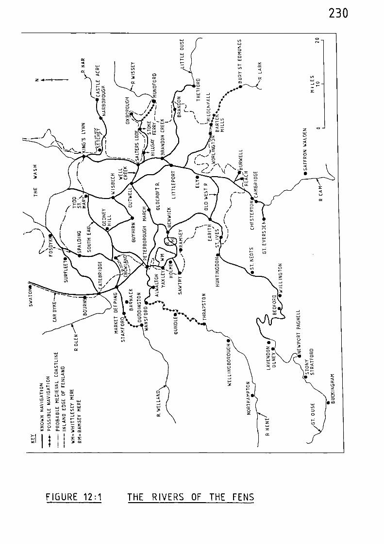
0C•J
LLI
•- -•
0 -1
cx
230
VI
01.40X01La..1
>- YI-W CCV11.11 ..tV/ )- -I_ 01 CCIX 0 CC1010
i.... co ___.......4_ccC)0mX
I-i.i.
▪
.1 .._i2 -i /v..
Z
2 Z
CDCC-, / / Z )
< L.ZLi I0 / 0 I- <
7 0 ^
, .... __, I Cx M 0in CD
1 72 C0 viX '•••0 \ X I- ..A
) LU Cc _,21 X
cc'..... .1 .\ ,
L0
kJ 0 \
\ l. ( LUz
—o 1
VICC ) i ',=,
,c)/ \-\
,,
...--<- 72._ „.,.-
z
cx-1 -
- 1
I oU..1
- •,,V1 1l .7s os
vo " i \ 1 _CO4.1
IQ
:: -4c ca,...Jc. CC
014.1 XX.... ...... ....• <I-- 1 L.1
\ Z
/ 0F-
./ CC
/4.1F-
_, ..- X1
VI
1..1
r .— \ =
Li)- VI iw / Cc w,n „/ < > 1X /- 4.1 -<I 1-
i1.4 I/1
1-\ CD
LULU
U..1 II/ 1 Z1-4.1
4--1 N. >__, n -I: ›... i
1-:,/,•
CC7
n i.,.., CP...
VI , X CC-1 < I-
>- "..-IC <
L.
▪
•
cc
cM
LLI cc
cc
X
4.1
111Z-- 11-vi 0-4 Z0 <uZ _,
0 ../ ZZ— _, 4.11- ••• 1.1->0 .1( 4.1 y_ U.1 01
,/7-. I-3; 0 0 CC1.1..1 Z0 < W 4.1 X
11.1.4- I
›.• Z M 0CI ).- CC
Z la.1 -1 LIJ WA W
X 3L.,a La
--i OD 1.1.1101 .-1 j- CLZ Cra < Z 1- 4.1in co a0 in 0 Z 0 CCSC CL 2 =- = a
3c ceI ii il
YI I I /1
II
III X Z
3 CC
FIGURE 12:1 THE RIVERS OF THE FENS
231
discussed by H.E. Hallam.(74)
As reclamation has continued up to the
present day the coastline around the Wash has been constantly changing
and continually moving seawards.
There were many islands in the fen, the largest of which was the
Isle of Ely. For reasons of clarity these are not shown in Figure 12:1,
but a localised picture depicting the Isle of Ely and its immediate
environs is given in Figure 12:2. This also shows three medieval
causeways which linked the island with the firmer ground at the edge of
the fen.(75)
Causeways, which were constructed from the twelfth century
onwards, have been defined as "bridges over dirt" (76)
and were usually
built up with earth, stone and timber, thus providing a roadway across
treacherous ground.
"Through the foul and treacherous mud of theFenland the causeways ran, making as much useas possible of the safer patches and of theislands." (77)
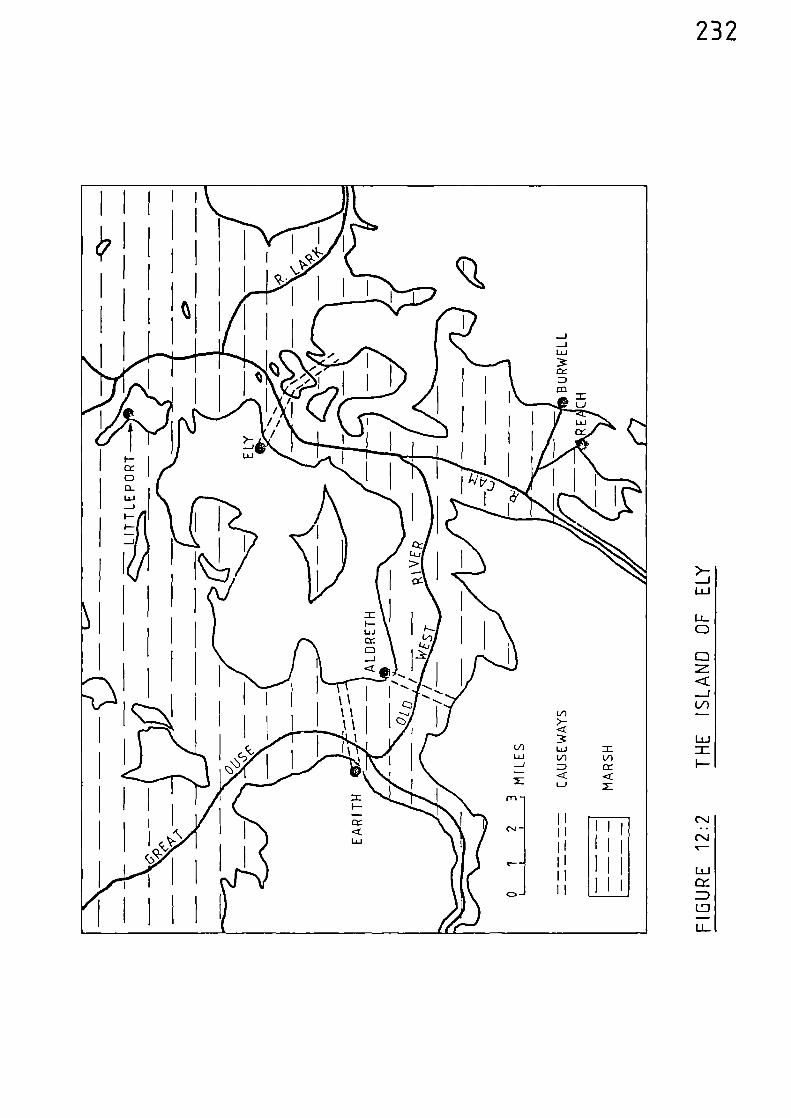
232
233
Notes and References
(1) D.W. LLOYD The Making of English Towns: 2000 years ofevolution Over Wallop 1984 118
(2) M.W. BARLEY, 'Lincolnshire Hivers in the Middle Ages'
Lincolnshire Architectural and Archaeological Soc. Reports and Papers New Ser. 1 (1938) 21
(3) H.C. DARBY, The Medieval Fenland (Cambridge 1940) 93-106
(4) S. UHLER, 'The Transportation of Produce in Lincolnshire,Yorkshire, Hampshire and Norfolk during theFourteenth Century, as revealed by the Sheriffs'Accounts', unpublished B. Phil. Dissertation,University of St. Andrews (1977) 13
(5) Calendar of Close Rolls, 1302-07, 110
(6) ibid, 152-53
(7) S. UHLER, 13(op. cit.)
(8) Calendar of Patent Rolls, 1324-27, 311
(9) Calendar of Close Rolls 1323-27, 613
(10) Calendar of Patent Rolls, 1330-34, 297-98
(11) Calendar of Patent Rolls, 1334-38, 70
(12) S. UHLER, 13(op. cit.)
(13) Calendar of Patent Rolls, 1334-38, 449-50
(14) S. EVANS, A Short History of Ely Cathedral (Cambridge 1933)6
(15) C.T. FLOWER, Public Works in Medieval Law, Seldon Soc.32 (1915) 311
234
(16) Calendar of Patent Rolls, 1364-67, 450
(17) S. UHLER, 13
(op. cit.)
(18) C.T. FLOWER 310
(op. cit.)
(19) ibid 311
(20) C.T. FLOWER Public Works in Medieval Law, Seldon Soc.,40(1923) 361
(21) M.W. BARLEY 17
(op. cit.)
(22) M.W. BARLEY 19
(op. cit.)
(23) Calendar of Charter Rolls, 1226-57, 20
(24) Calendar of Charter Rolls, 1257-1300, 142
(25) ibid, 485
(26) Calendar of Charter Rolls, 1327-41, 278
(27) Calendar of Charter Rolls, 1341-1417, 83
(28) Calendar of Liberate Rolls, 1226-40, 108
(29) Calendar of Liberate Rolls, 1251-60, 444
(30) Calendar of Patent Rolls, 1313-17, 241-42
40(1923) 360
8
9
(31) C.T. FLOWER(op. cit.)
(32) M.W. BARLEY(op. cit.)
(33) M.W. BARLEY
(op. cit.)
235
(34) Calendar of Patent Rolls, 1313-17, 574
(35) Calendar of Patent Rolls, 1317-21, 213, 253
(36) Calendar of Close Rolls, 1318-23, 515
(37) S. UHLER, 38(op. cit.)
(38) Calendar of Patent Rolls, 1334-38, 70
(39) Calendar of Patent Rolls, 1340.43, 552
(40) Calendar of Patent Rolls, 1338-40, 69
(41) Calendar of Charter Rolls, 1226-57, 122
(42) M.W. BARLEY 17(op. cit.)
(43) 3.M. STEANE,
(44) D. SUMMERS
(45) ibid,
The Northamptonshire Landscape, (London 1974)137
The Great Ouse - The History of a River Navigation (Newton Abbot 1973) 13
25
(46) Calendar of Liberate Rolls, 1226-40, 108
(47) Calendar of Patent Rolls, 1266-72, 44-45
(48) Calendar of Patent Rolls, 1272-81, 52
(49) Calendar of Patent Rolls, 1317-21, 311
(50) Calendar of Patent Rolls, 1281-92, 270
236
(51) H. CLARKE, 'The Archaeology, History and Architecture ofthe Medieval Ports of the East Coast of Englandwith Special Reference to King's Lynn, Norfolk'.Being Chapter 9 of The Archaeology of Medieval Ships and Harbours in Northern Europe, NationalMaritime Museum, Greermich, ArchaeologicalSeries No. 5, BAR International Series 66,1979 (Ed. S. McGrail). 155-165
(52) Calendar of Close Rolls, 1296-1302, 363
(53) J.F. WILLARD, 'Inland Transportation in England during theFourteenth Century' Speculum 1 (1926) 372
(54) M. BERESFORD New Towns of the Middle Ages (London 1967) 456
(55) ibid
(56) Calendar of Patent Rolls, 1335-40, 284-85
(57) Calendar of Patent Rolls, 1370-74, 35
(58) Calendar of Patent Rolls, 1313-17, 443
(59) Calendar of Close Rolls, 1315-23, 515
(60) S. UHLER, 43(op. cit.)
(61) Ii.G. HOSKINS, FieldiAork in Local History (London 1967) 62
(62) Calendar of Inquisitions Miscellareous, 1307-49, 290
(63) C.T. FLOWER 32 (1915) 43-44(op. cit.)
(64) Calendar of Close Rolls, 1351-55, 451
(65) Calendar of Close Rolls, 1359-92, 51
(66) ibid, 143
237
(67) Calendar of Inquisitions Miscellaneous, 1392-99, 98'
(68) Calendar of Inquisitions Miscellaneous, 1219-1307, 558
(69) B.K. DAVISON, 'The late Saxon town of Thetford: an interimreport on the 1964-66 excavations', Medieval
Archaeology, 11, 1967, 189-208
(70) H. CLARKE, 156, 158(op. cit.)
(71) S. UHLER 43(op. cit.)
(72) Calendar of Inquisitions Miscellaneous, 1219-1307, 304
(73) S. UHLER 43(op. cit.)
(74) H.E. HALLAM The new lands of Elloe (Leicester, 1954) 18
H.E. HALLAM
Settlement and Society: A Study of the Early Agrarian History of South Lincolnshire (Cambridge, 1965)
(75) H.C. DARBY 107(op. cit.)
(76) H.C. DARBY
106(op. cit.)
(77) H.C. DARBY 106(op. cit.)
238
CHAPTER THIRTEEN THE RIVERS OF THE COAST OF EAST ANGLTA
The rivers considered in this chapter are those of Norfolk,
Suffolk and Essex which discharge into the North Sea between the Wash
and the Thames Estuary.
The distribution of alluvium shown on the geological map indicates
that in earlier times the River Yare, together with the Waveney, Bure,
Ant andThurne, were part of a large estuary which had at least three
separate estuarine mouths discharging into the Horth Sea. The main
outlet was between Great Yarmouth and Caistor and was, in effect, the
lower estuary of the River Yare. There was another outlet near Loestoft
where the Waveney enters the sea, and another in the vicinity of Horsey
which connected with the River Thurne.(1)
Mention should also be made regarding the origins of a number of
inland lakes, collectively known as the 'Broads'. It was originally
thought that these were the result of natural processes but they have
since been shown to be flooded medieval peat - workings dug out by man.(2)
The peat industry flourished during the twelfth, thirteenth, and early
fourteenth centuries and demand was particularly heavy in the town of
Norwich. Some of the excavated peat was carried to its final destination
by water. (3)
River Yare
Rising between East Dereham and Watton, the River Yare follows an
easterly course and then passes around the southern precincts of Norwich,
239
after which it is joined by the combined waters of the Rivers Wensum and
Tud. It then follows a more south-easterly course to Reedham, before
turning north-east to be joined by the River Waveney at Burgh Castle.
The river widens into Breydon Water, no doubt a remnant of the earlier
larger estuary, before narrowing again near Great Yarmouth, where it is
joined by the River Bure. It then turns due south, passes through Great
Yarmouth, and enters the sea at Gorleston after a total course of 47 miles.
Norwich, situated just above the junction of the Yare and Wensum and
26 miles from the sea, was throughout the medieval period, an extremely
important trading town. In terms of population it is estimated to have
ranked third behind London and Winchester in 1086,(4)
and by 1348 it
ranked fourth behind London, York and Bristol.(5)
The River Yare was
therefore, a very important navigation which gave Norwich and its hinter-
land a far-reaching trading link. There was a daily market, and fairs were
held in the town twice a year which %%ere attended by foreign as well as
English merchants whose
"ships came up by an arm of the sea".(6)
It is difficult to assess the state of the river during medieval
times, but it seems that during the fourteenth century its estuary was
becoming narrower and gradually silting up making it ever more difficult
for sea-going vessels to reach the port of Norwich. By 1422, efforts
were being made to improve the obstructed navigation but trade, neverthe-
less, declined. (7)
Norwich Cathedral, which is built entirely of stone brought from
Caen in Normandy, was constructed during the period AD 1094 - 1178. (8)
The building stone was shipped along the Yare and Wensum to link up with
a short canal which had been made in order to facilitate the delivery of
240
the heavy blocks of stone directly to the building site. The entrance of
this canal was guarded by a water-gate which gave protection to the town
(9)precincts.
During 1256, the sheriff of Norfolk and Suffolk was ordered by the
King to buy
"30 last of good herrings"
in the town of Norwich
"and to carry it by water to Westminster for delivery tothe Keepers of the larder".(10)
Further purchases of herring were made in Norwich for the royal
household the following year, and these were also taken to Westminster by
water.(11)
These journeys would obviously involve navigating the River
Yare to the sea, followed by a coast-hugging voyage to the Thames Estuary
and hence up that river to Westminster. There was also much localised
traffic on the river, and in 1270 a millstone was taken from Yarmouth to
(12)Norwich by water at a cost of 4d. In 1295 one Robert de Halteby was
appointed to take into his custody
"...the maritime parts of the city of Norwich ...with power tocompel all persons to assist in the defence."(13)
During 1316, Norwich Cathedral Priory purchased 400,000 peat turves
and many of these would undoubtedly have been delivered by water.(14)
"At the beginning of the fourteenth century, Yarmouth began tobe a rival port to Norwich, and levied duties on vessels andgoods passing up to Norwich. But after much litigation, Yarmouthwas for a time compelled to desist from exacting such tolls."(15)
241In 1325, the village of Posbsick, 6 miles down-river from Norvdch,
sent oats to Yarmouth by boat and also oats, grain and peas to Norwich.(16)
During the same year produce was sent by water from Yarmouth to Nonnich and
to Yarmouth from Beccles.(17)
Much diverse produce was also shipped between Norwich and Yarmouth in
(18)1340.
Conflict between Great Yarmouth and Norwich regarding the export of
wool from the latter place came to a head in 1333, when the King ordered
that the bailiffs of Great Yarmouth should
"desist from such hindering and to permit merchants and othersto take their ships and boats by that port to the staple atNorwich,... "(19)
In 1343, a large boat travelling between Yarmouth and Norwich, loaded
with various commodities and carrying 40 people capsized, resulting in a
total loss of life and merchandise. (20)
In 1375, licences were granted to certain citizens of London enabling
them to load 100 quarters of barley, 100 quarters of %%heat, and 50 quarters
of peas and beans in the city of Hon\ich and to take the same to London
by ‘Nater.(2
1)
It is likely that the River Yare was navigable for a further 14 miles
from its confluence vdth the Wensum near Morvdch, to Coston.
River Wensum
From the west of Fakenham, the River Wensum passes by that place and
follows a south-easterly course through Guist and Attlebridge to Hellesdon,
where it is joined by the River Tud. It continues to Norwich, shortly after
which it enters the Yare, after a total course of 33 miles.
242
The river was certainly navigable for at least 7 miles above
Norwich to Taverham, for, in 1295, that village as listed as a 'maritime'
(22)place.
It is likely that the river was navigable for a further 4 miles
above Taverham to Attlebridge, where the Norwich to Fakenham road crosses
the river.
River Tud
Commencing near East Dereham, the River Tud flows due east to
Honingham and on to join the River Wensum at Hellesdon; a total length
of 15 miles.
It is likely that during the medieval period, the River Tud was
navigable for 7 miles, to Honingham, where the Nonnich to East Dereham
road crosses the river.
River Waveney
From the east of Thetford, the River Vaveney floss east through
Diss and then turns north-eastwards to pass through Harleston, Bungay and
Beccles after which it is connected to Oulton Broad and the North Sea at
Lowestoft and also continues in a northerly direction to join the River
Yare at Burgh Castle. The total length of the river from its source to
Burgh Castle is 46 miles.
Throughout the entire length of its course the River Waveney forms
the county boundary between Norfolk and Suffolk.
243
The river was navigable for at least 28 miles of its course from
Burgh Castle, for, in 1309, mention is made of a theft of boats at
Mendham, near Harleston.(23)
In 1306, the river, and its combined waters with the Yare are
partly described in a charter of Edward I to the burgesses of Great Yarmouth;
"There is a single water descending from the high seabetween the towns of Great and Little Yarmouth toBeclys and Bungeye, which divides the counties of Norfolkand Suffolk, and there is a landing place for ships aswell on the side of Little Yarmouth and Gorleston as on theside of Great Yarmouth."(24)
In 1325, 600 hurdles ),Nere transported from Beccles, 18 miles up the
river, by boat.(25)
There as a ferry across the Waveney near St. Olaves Priory to the
south-west of the village of Fritton. It is mentioned in a record of
1378 which goes on to say;-
"The King's highway from Little nernemuth to Nom‘ichand other parts of Norfolk extends to this ferry; anda quay 34 feet long and 18 feet wide has been builtfor the ferry in the %,ater on the King's land....There was never a bridge across the said water, butthere has been a ferry in this place ever since thetime of King 3ohn..."(26)
It is likely that the River Waveney was navigable to a point 8
miles up-river of Mendham, where the Norwich to Ipswich road crosses the
river.
244
River Sure
Rising to the east of Fakenham, the River Bure flows south-
eastwards to Aylsham, then on to Coltishall, Wroxham and Horning, shortly
after which it is joined first by the River Ant and then by the River
Thurne. It continues and passes to the north-east of Acle, and then
enters the combined waters of the Yare and Waveney at Great Yarmouth;
a total length of 43 miles.
In 1360, there were several fisheries in
"the town of Horning"(27)
and at a later date, in 1437, 1001 quarters of barley were taken by water
from Wroxham, 20 miles up-river to Great Yarmouth.(28)
The Riser Bure as probably navigable for a further 10 miles up-river
of Wroxham, to Aylsham, where the Horwich to Cromer road crosses the river.
Riser Ant
Commencing near to Horth l‘alsham, the River Ant flows in a south-
easterly direction passing to the east of forth N1sham and continuing to
Smallburgh, after which it enters Barton Broad. On leaving Barton Broad
it continues to its confluence with the River Bure to the south-east of
Horning; a total length of 17 miles.
A presentment before the sheriff of Horfolk in 1360 %as concerned
with 'the stoppage of a river called Smalee'. It was said that
245
"...the riser fell out of use at the time of thepestilence and nothing was carried on it so thatweeds continually grew in it from that time until thepresent time; that it was not known who ought to cleanit because none had cleaned it since the memory of man;that the towns that had advantage and profit from thesaid river were Stalham, Sutton, Catfield, Ludham,Smallburgh, Barton Turf and Irstead: and that fromWord Bridge to Barton Geoffre), son of Miser 11yth,Knight, has a seseral fishery, and the fishery betweenBarton and Catfield belongs to %alter le Smyth,William de Smallburgh and the Countess of Huntingdon,and the fishery of the remainder of the riser toMellcroft stakes in Ludham belongs to the abbot ofSt. Benet Holme in seseralty."(29)
It was further said that the abbot of St. Benet Polme
"...has stopped and resersed the course of a watercalled Smale Ee for twenty ),ears past between Ludhamand his several fishery and the town of Horningand refuses to amend it, though man). presentrentshave been made."(30)
From the description of the riser called "S7alee m gisen in the
presentment it is clear, from the silldoes r-rtiored, that U r e riser in
question is in fact the Riser Ant. Also, 1ayford Bridge is a bridge
oser the Riser Ant between Smallburgh and Stalham.
It would appear, therefore, that prior to the Black Death of
1345-9 there was traffic on the river at least as far as the most
northerly place named, which is Smallburgh, 7 miles up the riser from
its confluence with the River Bure.
246
There are indications that the river was navigable to dthin
the vicinity of North 11alsham. In 1367 complaints %ere made that
the prior of Bromholme had
"...stopped and diverted a common watercourse...between Ridlington and Witton."(31)
Both these places are situated to the east of forth lalsham.
The v%atercourse in question was probably a navigable channel leading
into the River Ant.
At East Ruston 1 bet%Neen Smallburgh and forth Ikalsham, to
boats %%ere damaged in 1374.(32)
247
River Thurne
The River Thurne commences very close to the coast near Horsey,
and is connected into Horsey Mere and the broads of Hickling and Martham.
It flows south-west by Potter Heigham and enters the River Bure near
Thurne; a total length of 7 miles.
Hickling Broad and the River Thurne is about the same distance
from the village of Sutton as is the River Ant. Therefore, grain, oats
and peas transported from Sutton, presumably to Yarmouth, in 1325,(33)
could just as easily have passed along the River Thurne as the River
Ant.
River Blyth
The River Blyth rises near Laxfield and flows north-eastwards to
Halesworth and then due east to Blythburgh and on to enter the sea at
Walberswick. Prior to entering the sea it is joined by another watercourse
which keeps parallel to the coast and flows from Dunwich 4 miles to the
south. In early medieval times, Dunwich was a flourishing port at the
point where the Rivers Blyth and Dunwicl entered the sea; however, the
port was always susceptable to erosion. In 1336, tons of sand and shingle
were thrown up across the harbour mouth and this had the effect of
reversing the flow of the River Blyth back to Walberswick where it found
its way into the sea. This drastically affected the town's trade and
in time Dunwich was abondoned to the elements.
From its source to where it enters the sea at Walberswick the length
of the river is 15 miles.
248
The original course of the River Myth, viz.;- flowing from
Walberswick to Dunwich - and entering the sea there, is graphically
described in a record of 1281;-
"...touching a complaint by the burgesses and other men of Dunwich,that whereas they hold the town to farm and merchandise,victuals and other goods for sale putting in their port, ought,as in other ports, first to be exposed for sale in their port,before being taken to market or other towns, and to pay thecustomary toll, some men of Walberdeswik of Robert son of Roger,putting on there with their ships laden with fish, frequentlygo up by the channel of the river of the port to the said Roger'stown, where there is no market or fair, and sell there, wherebybuyers render toll to Robert to the loss of the men of Dunwich;and touching a complaint by the said Robert that some men ofDunwich lately came to his said town and carried aay sails,anchors and other goods."(34)
Similar complaints were being made in 1331 when the bishop of Nomsich
was asked
"... to settle all disputes betvieen John de Claveryng who claimsto have a right to the port or hithe at Walberdeswyk, co.Suffolk, and to receive anchorage and other dues from ships puttingin there, and the burgesses of Durmich nNho assert that such shipsshould discharge at the port of their ton; ..."(35).
Following the disaster of 1336, the burgesses of Durmich found it
increasingly difficult to pay their taxes to the crown and, in 1357, they
were discharged of their arrears and their current rates were reduced.(36)
The River Blyth was navigable to Blythburgh, 4 miles from the sea,
for men of that place are mentioned in 1390 as having
"...ships, vessels and boats laded with fish and othermerchandise ..."(37).
249
It is likely that the river was navigable for a further 4 miles,
to Halesworth, where the Bungay to Saxmundham road crosses the river.
River Aide
Rising to the south of Laxfield, the River Aide flosNs in a south-
easterly direction between the towns of Framlingham and Saxmundham to
Rendham and Stratford St. Andrew. At Snape the river broadens and then
turns due south near Aldburgh, running parallel with the coast to Orford,
after which it is joined by the River Butley, the combined waters of
nshich form the River Ore - vshich enters the sea near Hollesley; after a
total course of 28 miles.
At various times throughout the medieval period, Orford is mentioned
(4)as a port; for example in 1309,
(38) 1322,
(39 and 1342
) . 0Orford is
7 miles up-river from the sea.
The River Alde must have been navigable for 16 miles to Snape -
after which it narros, and probably for a further 3 miles to Stratford
St. Andrevs; l‘hilst the River Butley was probably navigable for 3 miles
from its confluence with the Aide, to Chillesford.
River Deben
From near Debenham, the River Deben flows through that place and
on in a south-easterly direction to Wickham Market and Woodbridge from
where its estuary proceeds by Hemley and Ramsholt to enter the sea to the
north of Felixstowe; a total length of 26 miles.
250
In 1349,
"...two crayers laden with corn, tan and other customable waresnot customed,"(41)
were arrested in the waters of the town of Woodbridge, 9 miles
up-river from the sea.
In 1390, ships loaded with corn were arrested at Woodbridge and
accused of evading customs duty. (42)
It is likely that the river was navigable for a further 6 miles
up-river of Woodbridge, to Wickham Market, where the Woodbridge to
Saxmundham road crosses the river.
River Orwell
Formed by the waters of the Ri\er Gipping - which runs down from
Rattlesden and through Stowmarket to Ipswich, the River Orwell is an
expanse of estuarine water extending for 12 miles from Ipswich to a
confluence with the River Stour and the sea near Harwich.
Throughout the medieval period the port of Ipswich, at the head of
the river, was an important centre of trade and commerce.
In 1301, 'the bailiffs and good men' of Ipswich were asked to send
two ships to Berwick-upon-Tweed to assist Edward I in his Scottish
Campaigns.(43)
251
In 1322, Ipswich was again asked to prepare two ships
"to be prepared and found with men-at-arms, victuals, and othernecessaries ..."(44)
Ships in excess of 50 tons were ordered to leave the port of Ipswich
in 1326 and join the rest of the English fleet at Portsmouth.(45)
A commission of 1335 was asked to make inquisition
"touching a petition of the burgesses of Ipswich that, whereasthey be charters of the King's progenitors, Kings of England,hold their town of the King at fee farm, with all the liberties,free customs and other things pertaining to the same, by therent of 601. at the Exchequer, and their port of Orwell, withthe arm of the sea and the river leading from the mouth ofthe port towards the sea as far as the town, belongs to theKing and his said town, and whereas they receive divers customsand profits in aid of their said farm on the ships andmerchandise coming to the town and port, and have used to lecei‘ethese from the time of the making of the charters, but the portand river are not specified in the charters, the King willconfirm their charters and in such confirmation specify theport and river, and grant the burgesses shall hold the port andriver as annexed to the town, and shall receive customs andprofits on ships and merchandise as hitherto;"(46)
The River Orwell is often referred to as the 'port of Orwell'
which, in effect, as is confirmed by the previous reference, relates to
all places along its shores from its mouth to Ipswich.
An important reference of 1340 relates to the course of the Pivers
Gipping and Orwell and lists details of various commodities passing through
the port; therefore, it is worth relating the relevant content of this
reference;-
252"The port of Erewell with all the arm of the sea...to Ipswich belongs to that town and to the crown, andin all past times so belonged. The port takes its name froma well called 'Erewell', in Ratlesdene, 15 leagues fromIpswich towards ft. Edmund's, forming a runningriverthroughthe midst of the town; which was firstappointed the capital of Suffolk by reason of the portby a pagan King, 'Ypus' by name, who called the
town Ypeswich. The bailiffs and ministers of the King'sancestors all the time the town has been in the hands of theKings have made distraints and attachments in the port and armof the sea and have taken there toll and customs on importedand exported goods as belonging to the town, viz, from everytun, pipe or barrel of wine, honey, vinegar, ointment, cider, ale,wood, ashes, copperas, teasels, steel, orchil, and such likemerchandise 2d.; from every load, barrow, or truss of cloth,canvas, or linen cloth, bound with cords 4d., not so bound 2d.;from every last of wool or millstones 8d.; from every last ofhand millstones, and bale of alum, brazil, almonds, and suchlike merchandise 4d.; from every ship with shelter and 100 ofgross salt 4d.; from every ship with benches and bilges 2d.;from every boat with rowlocks 2d.; from every boat with oarpinsId.; from every last of herrings and 100 of estrich board 4d.;"(47)
In 1373, the town of Ipswich was asked to construct
'I a barge fit for war made for the defence of the realm,,
It is likely that the River Gipping was navigable for small vessels
to Stowmarket, 12 miles up-river from Ipswich.
River Stour
Rising to the south of Newmarket, the River Stour flows in a
generally south-easterly direction through Clare, Sudbury, Bures, Nayland
and Stratford St. Mary to Maningtree - from where the broad expanse of
its estuary proceeds to a confluence with the River Orwell and the sea
at Harwich; a total length of 54 miles.
Ships in excess of 50 tons were ordered to leave the port of
Maningtree in 1326 and were then directed to Portsmouth to join the English
253
fleet whichwas assembling there.(49)
Maningtree is 11 miles up-river from the sea, at the point where
the estuary narrows.
In 1349, ships laden with various assorted victuals were ordered
to be arrested at Maningtree.(50)
In 1371, a ship loaded with wool in the water at Maningtree was
said to have attempted to escape custom duties,(51)
and in 1378, the town
of Maningtree was charged, along with various other places, with making
a balinger for the King.(52)
The River Stour was probably navigable for small vessels to Bures,
15 miles upriver from Maningtree, where the Colchester to Sudbury road
crosses the river.
River Come
From the south-east of Haverhill, the River Colne follows a
south-easterly course through Halstead, Earls Colne, West Bergholt and
Colchester, to be joined by the River Roman at Wivenhoe. At Wivenhoe
the river broadens into an estuary containing many creeks, and continues
past Brightlingsea and Mersea Island to enter the sea after a course of
35 miles.
Colchester, the oldest recorded town and the first major Roman
settlement in Britain, was an important port during the medieval period.
254
In 1326, various persons were appointed in certain ports, including
Colchester, to ensure that ships were sent to join a fleet which was
assembling in the north.(53)
In 1341, deputies were appointed in the River Colne between Colchester
and the sea with the power
"to search ships and boats and arrest as forfeit any wool,wool-fells and otherwares liable to custom, whereon customhad not been paid, found in any ships or boats, together withthe ship or boat."(54)
The evasion of customs duty on wool was still rife in 1351 when
the King's serjeant at arms was ordered -
"on information that very many wools, hides and woolfellsare daily loaded in ships and boats on the water of Colneand elsewhere on the sea-coast in Essex without being customedor coketted, and are taken across to foreign ports to the lossand deception of the King, - to arrest as forfeit all such wools,hides and woolfells found in ships, craers or boats on thewater of Colne and elsewhere on the said sea-coast, together withthe vessels in which they are placed, and bring them to Londonfor delivery to the treasurer there."(55)
Complaints were made by the burgesses of Colchester in 1353 when
they petitioned the King
"complaining of forestalling of wines and other victuals intheir town and of the obstruction of the King's river thereby wears, mills, stanks, palings and kiddles contrary to theact of 25 Edward III and to punish pursuant to the act such asare found guilty herein."(56)
255
This reference clearly demonstrates the strong measures put fon%ard
by Edward III in 1351, when he passed an act for the removal of all
obstructions placed in rivers since the time of Edward I.(57)
A reference of 1361 highlights some of the diverse cargoes carried
by small river and coastal vessels. A petition of that year stated
that a certain John Spogg and William le Hunte
"loaded a small crayer in the port of Colcestre with coalsand herring for transport to the town of Middelton, andhaving discharged and sold the said cargo at Middelton theyloaded the crayer with 40 quarters of wheat and 10 quartersof barley which they had bought in the county of Kent fortransport to Colcestre, ..."(58)
The place referred to in this reference, 'Middelton', is in fact
the village of Milton, near Sittingbourne which is situated at the head
of Milton Creek which runs into the River Swale opposite the Isle of
Sheppey.
Indications that the River Colne as navigable up-river of
Colchester are contained in a reference of 1365 which states that a
certain Lionel de Bradenham and others,
"made divers purprestures, stoppages and obstructions by raisingweirs, driving stakes, enclosures and other works ...in...watersflowing down to the port of Colcestre,..."(59).
Colchester is 4 miles from where the river narrows at Wivenhoe and
12 miles from the sea; however, it is probable that the River Colne was
256
navigable to Halstead, a further 13 miles up-river from Colchester and
at the point where the Braintree to Sudbury road crosses the river.
The River Roman, which joins the Colne at Wivenhoe, was probably
navigable to Stanway, where the Colchester to Braintree road crosses
the river.
River Blackwater
The River Blackwater begins to the east of Braintree and is formed
by the waters of the River Pant. From Braintree the river flows through
Coggeshall to Witham, where it is joined by the River Brain. It
continues to Maldon, near which it is joined by the River Chelmer, then
enters a broad estuary which leads into the sea to the south of Hersea
Island; after a total course from Braintree of 30 miles.
Maldon, at the head of the Blackater Estuary, was described as a
port in 1326,(60)
and in 1378 was asked to construct a 'balinger' for
the King.(61)
Heybridge, in the suburbs of Maldon, was another place vahere ships
put in. In 1338, an order was issued permitting
"merchants, mariners, and others, who are crossing with theirships by the inlet at Hebregg to load and unload their shipsupon the land within the precinct of the manor of Hebregge atwill,.. ."(62)
Maldon and Heybridge are some 12 miles from the sea but it is
257
probable that the river was navigable for a further 6 miles to Witham,
where the Chelmsford to Colchester road crosses the river.
Chelmsford, 10 miles by water from Maldon, was also within the
reach of small river vessels.
River Crouch
Rising to the south-east of Brentwood, the River Crouch flows in
an easterly direction to Wickford and Battlesbridge after which it widens
and proceeds by Hullbridge and North and South Fambridge to Burnham-on-
Crouch after which it is joined by the River Roach, the joint waters of
which enter the sea between Foulness Island and Holliwell point; a
total course of 26 miles.
The river would certainly be navigable for 17 miles, to Battlesbridge,
and probably for a further 3 miles, to Wickford.
River Roach
The River Roach commences near Rayleigh and flows through that place
in an easterly direction to Rochford. It then widens and flows past
Potton Island, where a number of creeks lead southwards to the sea. On
the northern side of the river, and opposite Potton Island, is Paglesham
Creek, a navigable inlet which flows down from Paglesham 3 miles to the
north. The River Roach continues to where, after a course of 15 miles,
it joins the River Crouch.
258
In 1267, Master William de Saundon, the King's cook, was given
permission to transport 50 quarters of corn from Wallingford to his house
at Rayleigh by water. (63)
This journey would be via the River Thames,
on which Wallingford is situated, and then out into the Thames Estuary
and into the River Roach, probably through the creeks to Potton Island -
then along the River Roach to Rayleigh.
The rivers of the coast of East Anglia are mapped in Figure 13:1.
and their navigational limits in medieval times are indicated.
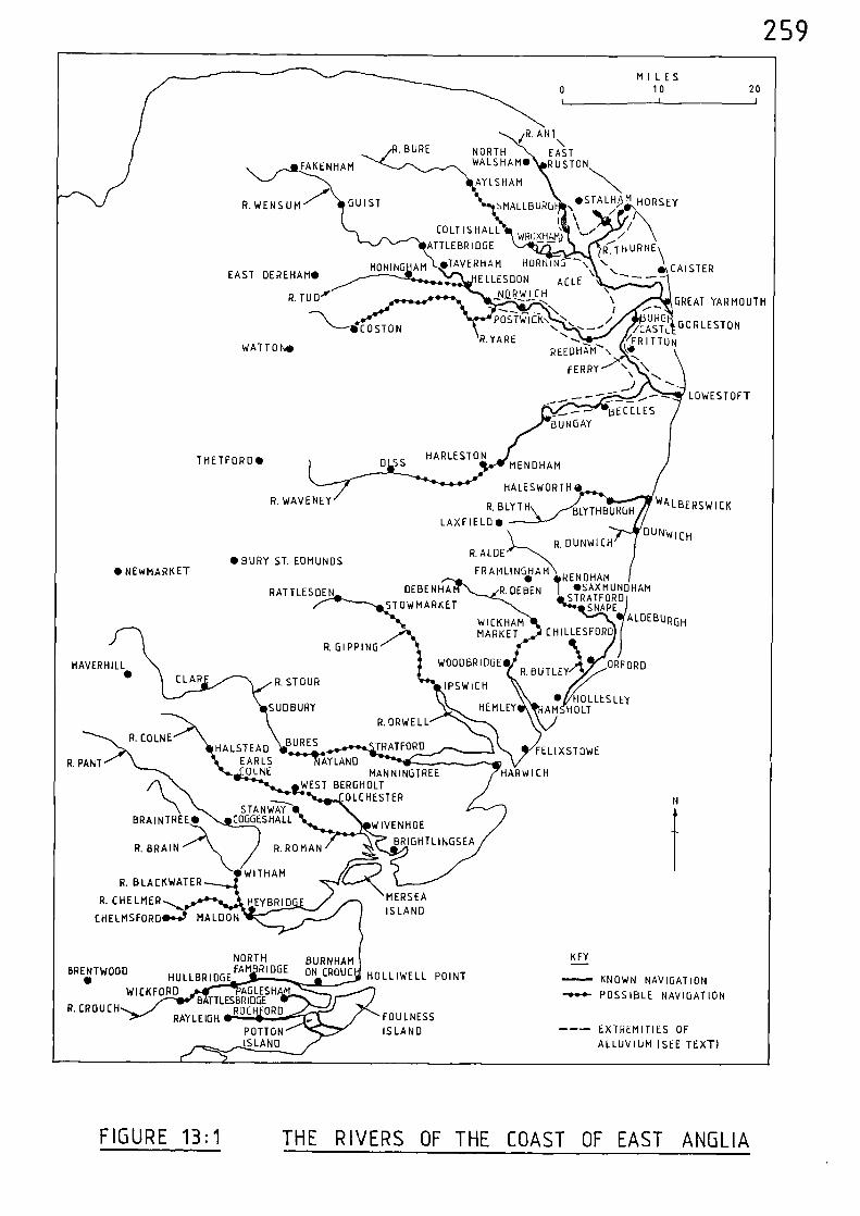
MILES0 10 20
HARLESTONMENDHAM
HALESWORTH•
R.BLYTH
LAXFIELD•BLYTH BURGH
R. DUNWICH
HAVER HILLCLAP R. STOUR
SUDBURY
WOODBRIDGE•
IPSWICH
HEM LEY• HOLLESLEY
AM HOLT
P. PANT AY LANDMANNINGTREE HARWICH
WEST BERGHOLTOLCHESTER
HALSTEADEARLS
OLNE
R.COLNE
R. BRAIN
MERSEAIS
R. ROMAN
WITHAM
EYBRID E
STANWAYBRAINTREE• COGGESHALL
R. BLACKWATER
R. C
CHELMSFORD MALCION
WIVENHOE
BRIGHTLINGSEA
NORTHBRENTWOOD FAM R DGE
•I
HULLBRIDGE
WICKFORD AGLESHB TTLESBRIDGE
R. CROUCH
ROC ORDRAYLEIGH
POTIONISLAND
HOLLIWELL POINT
FOULNESS
ISLAND
BURNHAMON CROUC
R. DIPPING
ORFORDR.BUTLEY
R.ORWELL
• BURY ST. EDMUNDS•NEWMARKET
RATTLESDEN OEBENHA
STOWMARKET
R.ALDE
FRAMLINGHAM
.DEBEN. rt E HAM..ND
R •SAXMUNDHAMSTRATFORD
SNAPEALDEBURGH
CHILLESFORDWICK HAMMARKET
BORES TRATFORD FELIXSTOWE
KEY
KNOWN NAVIGATION
POSSIBLE NAVIGATION
--- EXTREMITIES OF
ALLUVIUM (SEE TEXT)
I I, ‘COLTISHALL \ / /
WROXHAM) /
EAST DEREHAM•HONING AM
ELLESDON
e\..T.....HU_RNE\ATTLEBRIDGE
eTAVERHAM HORNING --N. CAISTER
R.YARE
ACLE \\I
/FRA:31UTRT6ON
/CASTL GORLESTON
R.TUD'y NaRWICHGREAT YARMOUTH..----
WATTON• REEDHZM-- \ ‘1,0\,.
.-,..\ \FERRY
_..--- LOWESTOFT_I --...
_.--- BECCLESBUN GAY
/R. ANT
R.BURE NORTHEAST
FAKENHAM WALSHAM•
SMALLBURRGUS‘To
ON
STALW HORSEYR.WENSUM7'' GUIST
AYLSHAM
/
STHETFORD•
R.WAVENEY WALBERSWICK
DUNwicH
—..\--- COSTONPOSTWICK\ 's-
.. s--.... ....._--/
259
FIGURE 13:1 THE RIVERS OF THE COAST OF EAST ANGLIA
260
Notes and References
(1) H.C. DARBY (ed.), A New Historical Geography of England (Cambridge;
1973) 96
D. HILL, An Atlas of Anglo-Saxon England (Oxford, 1981) 10
J.W. DAY, Portrait of the Broads (London, 1967) 22
(2) R. MILLWARD and A. ROBINSON, Landscapes of Britain (Newton Abbot,
1977) 86
(3) ibid, 87
(4) J.C. RUSSELL, British Medieval Population (Albuquerque, 1948)50-1
(5) ibid, 140-3
(6) W.T. JACKMAN, The Development of Transportation in Modern England
(Cambridge, 1916, 2nd Ed. London 1962) 25
(7) ibid
(8) B.E. DORMAN, Norfolk (London, 1972) 45
(9) ibid, 69
(10) Calendar of Liberate Rolls, 1251-60, 342
(11) ibid, 351 & 1402
261
(12) J.E.T. ROGERS, A History of Agriculture and Prices in England
Vol. II, (Oxford, 1866) 600
(13) Calendar of Patent Rolls, 1292-1301, 169
(14) B.E. DORMAN (op. cit.), 69
(15) W.T. JACKMAN (op. cit.), 25
(16) S. UHLER, 'The Transportation of Produce in Lincolnshire,
Yorkshire, Hampshire and Norfolk during the
Fourteenth Century as revealed by the
Sheriffs Accounts', unpublished B. Phil.
Dissertation, University of St. Andres,
(1977) 41
(17) ibid, 42
(18) ibid, 41
(19) Calendar of Close Rolls, 1333-37, 102
(20) S. UHLER (op. cit,), 40
(21) Calendar of Close Rolls, 1374-77, 119
Calendar of Patent Rolls, 1374-77, 70-71
(22) Calendar of Patent Rolls, 1292-1301, 169
262
(23)
(24)
(25)
(26)
(27)
(28)
(29)
(30)
(31)
(32)
(33)
(34)
(35)
(36)
Calendar of Patent Rolls, 1307-13, 123
(1923) 88
Calendar of Inquisitions Miscellaneous, 1307-49, 294
Public Record Office, E101/574/33
Calendar of Inquisitions Miscellaneous, 1377-88, 32-33
C.T. FLOWER, Public Works in Medieval Law, Seldon Soc. 40
J.E.T. ROGERS (op. cit.), vol. III (1882)
C.T. FLOWER (op. cit.), 88
C.T. FLOWER (op. cit.), 88
C.T. FLOWER (op. cit.), 97
Calendar of Patent Rolls, 1370-74, 491
Calendar of Close Rolls, 1374-77, 220-21
S. UHLER (op. cit.), 42
Calendar of Patent Rolls, 1272-81, 470
Calendar of Patent Rolls, 1330-34, 199
Calendar of Fine Rolls, 1356-68, 36
263
(37) Calendar of Close Rolls, 1389-92, 228
(38) Calendar of Patent Rolls, 1307-13, 243
(39) Calendar of Close Rolls, 1318-23, 670
(40) Calendar of Close Rolls, 1341-43, 485
(41) Calendar of Fine Rolls, 1347-56, 108
(42) Calendar of Close Rolls, 1389-92, 140
(43) Calendar of Patent Rolls, 1292-1301, 583
(44) Calendar of Close Rolls, 1318-23, 463
(45) Calendar of Patent Rolls, 1324-27, 310-11
(46) Calendar of Patent Rolls, 1334-38, 213-14
(47) Calendar of Inquisitions Miscellaneous, 1307-49, 421
(48) Calendar of Patent Rolls, 1370-74, 355
(49) Calendar of Patent Rolls, 1324-27, 310-11
(50) Calendar of Fine Rolls, 1347-56, 108
(51) Calendar of Patent Rolls, 1361-64, 371
264
(52) Calendar of Patent Rolls, 1377-81, 200
(53) Calendar of Patent Rolls, 1324-27, 311
(54) Calendar of Patent Rolls, 1340-43, 256
(55) Calendar of Fine Rolls, 1347-56, 302
(56) Calendar of Patent Rolls, 1350-54, 509
(57) W.T. JACKMAN (op. cit.), 23
(58) Calendar of Fine Rolls, 1356-68, 149
(59) Calendar of Close Rolls, 1364-68, 156-57
(60) Calendar of Patent Rolls, 1324-27, 311
(61) Calendar of Patent Rolls, 1377-81, 200
(62) Calendar of Close Rolls, 1337-39, 448
(63) Calendar of Patent Rolls, 1266-72, 26
265
CHAPTER FOURTEEN THE RIVER THAMES AND ITS TRIBUTARIES
River Thames
Having a length of 210 miles, the River Thames is the longest river
in England. It rises to the north of Malmesbury from where its infant
course flows eastwards to Cricklade and Lechlade - near which point the
combined waters of a number of lesser streams, flowing down from the
eastern side of the Cotswold Hills, unite to produce a significant flow.
From Lechlade the river passes under Radcot Bridge and continues to
meet the combined waters of the Cherwell and Ray at Oxford. The river
proceeds via Wallingford, Reading and Windsor to London, then on past
Gravesend to where it receives the River Medway - shortly after which
it merges with the North Sea off the Isle of Sheppey.
The chronicle of Abingdon Abbey, written at the time of the
Norman Conquest, relates that
"Abingdon monastery has the Thames flowing alongits southward parts, up and down 1Nhich navigationis conducted." (1)
Domesday Book informs us that navigation was carried out at Wallingford
and Reading in 1066.(2) A charter of 1197 put the care of the river
in the hands of the 'City of London'. It is possible that the whole
course of the river was intended, but in practice the city's jurisdiction
did not extend beyond Staines.)(3
In 1205, the river was navigable
between Oxford and London for, during that year, one William, son of
Andrew, was granted freedom from toll and hindrance for one ship between
Oxford and London.(4)
Magna Carta, signed and sealed alongside the Thames
at Runnymede in 1215, states as its twenty-third clause:-
266
"all weirs from henceforth shall be utterly putdown in Thames and Medway, and through allEngland, except only by the sea coasts." (5)
In 1227, twelve tuns of Gascony wine was taken in ships from Sandwich
to Westminster and there transferred to a boat for transport to Windsor.(6)
In 1238, bucks and does from Havering Park were taken south by cart to
the River Thames and loaded aboard ships for the voyage to Flanders. (7)
Brushwood, to be used as fuel, was taken by river from London to
Windsor in 1239. (8) In 1243, five boat-loads of sea-rushes were transported
from Kent to Westminster. (9) In 1246, the bailiff of Kenington was
ordered
"to make a barge to carry horses and peopleacross the Thames." (10)
Wine was carried in four boats from the port of Sandwich to London in
1249.(11)
Two thousand boards were carried by water from London to
(12Windsor in l253.2) In 1254, 5 fothers of lead, and 2000 pounds of tin
(13)were shipped from London to Reading; and two shiploads of corn were
taken by the river from Goring to the capital.(14)
In 1256, two pipes
of clove-scented wine Isere carried by water from London to Henley;(15)
and during the same year herrings were taken from Norwich to Westminster
by water.(16)
In 1258, the keeper of the forest of Windsor was ordered
"to let the keepers of the King's works atWestminster have 6 boatloads of brushwoodfrom old leafless trunks in the forest, andto carry them by the water of Thames toWestminster for delivery to the said keepersto make a limekiln fortheir works." (17)
Sixty-three fothers of lead were shipped from Boston to Westminster in
(18)1259, and the following year coals and firewood from Windsor,
(19)
and venison from Scarborough,(20)
were also shipped to Westminster.
267
Apart from Westminster, some building work was also being carried out
at the Tower of London. In 1261, the sheriff of Kent was asked
"to send 20 boatloads of good freestone and 20other boatloads of stone and chalk withoutdelay by the water of Thames to the Tower ofLondon to make a turret there.." (21)
Lead was transported from Boston to the Tower later the same year,
entirely by water.(22)
There was a lock in the river at Bray near Maidenhead, for, in
1265, Thomas de la Lok - farmer of the lock, received compensation of
26s. 8d.
"sustained by reason of the prohibition ofthe use of locks on the Thames during thedisturbance in the realm, so that shipscould not cross or go down to London as theyused to do in past times..." (23)
This prohibition does not appear to have lasted for any great length of
time for, early the next year, ships were passing down the river from
4)Wallingford to the Thames Estuary.
(2The lock referred to at Bray
would probably be a 'flash' lock - whereby a head of water was formed by
holding back the flo%‘ of the river, usually with timber boards. Once
the boards were removed, the subsequent rush, or 'flash' of v nater
could be utilised to enable vessels to negotiate shallow, or rock-strewn,
riverbeds.
The River Thames was probably navigable to Lechlade, 6 miles up-
river from Radcot Bridge. It was certainly navigable for the first
185 miles of its course during the thirteenth century, to Radcot, as is
shown by a record of 1271 when Matthias de Bezilles, the King's yeoman,
was granted
268
"the boat wherein Gilbert son of Walter le Messerwas lately drowned by misadventure in the Thamesat a place called 'La Juresherd' within the saidMatthias's liberty of Radecote, with 51 quartersof wheat, an iron chain, a lock and eleven sacksfound in the said boat". (25)
Throughout the fourteenth century, navigation continued as far as
Radcot Bridge as is shown by numerous surveys of the river and the
consequent removal of all
"weirs, mills, stanks, stakes and kiddies wherebythe passage of ships and boats may by hindred...in the river Thames between Rotecote...and London." (26)
Ships regularly plied between London and Oxford during the
thirteenth and fourteenth centuries(27)
; a distance of 113 miles.
When examining the records of the period relating to navigation
on the River Thames one feature always emerges - the predominance of
London. In an early account of the city, written some time before 1183,
William FitzStephen said:-
"To this city, from every nation that is underheaven, merchants rejoice to bring their tradein ships." (28)
Below London, the Thames must have been a very busy river, catering
for the movements of foreign, coastal, and river vessels.
At the capital itself there was also a large amount of local
traffic; and on the numerous occasions when the treasure of the crown
was transferred from Westminster to the Tower of London boats were always
utilised for this purpose.(29)
In 1272, safe conduct was granted to the men of Master John de
Chishull, dean of St. Paul's, London, who were
269
"bringing his corn and other goods from his churchof Browatre to St. Paul's London, by sea." (30)
During the same year, timber belonging to the King was carried by ship
from Kent to Westminster. (31)
With so much traffic plying to and fro, it was inevitable that
accidents should occur and in 1279 a ship was wrecked ' by accident'
near London Bridge.(32)
In 1282, millstones were taken from London to Faversham by water. (33)
The ease of access which the River Thames gave to London was, in
times of conflict a problem. This is shown by a record of 1295 when
David le Graunt, the King's clerk, was appointed to the custody of the
priory of Lewisham,
"as the number of foreigners staying there constitutesa danger to the realm in these days, on account ofthe situation of the priory on the river Thames, whichleads to the sea; and he is to render an accountof the issues to the Exchequer." (34)
In 1310, a pontage grant was made
"upon all goods passing under or over"
the bridge at Marlow(35)
; and in 1314, the keepers of the King's ships
and boats were commanded
"that as often as they, or any one of them,with his ships or boats shall pass through thebridge of Windsor towards London, indenturesor tallies are to be made with the King'sbailiffs of the town of the custom from shipsand boats due to the men of the town, so thatit can be known to what sum the said customso due, which the keepers wish to retain intheir power, amounts to every year." (36)
270
The charge for passing under the bridge at Marlow was
"one penny for each vessel passing under thebridge laden with goods for sale exceeding invalue 40s." (37);
and at Windsor:-
"Every ship passing under the bridge, laden withwares for sale exceeding the value of 100s., isto pay two pence." (38)
Charges were also made at the bridge of Maidenhead:-
"id. on every ship or boat laden with merchandisepassing under it." (39)
Charges were also made at London Bridge on vessels passing beneath it.(40)
In 1330, a ship was loaded with five millstones at London and
these were transported up-river to Henley;(41)
later the same year
21 cart-loads of lead were shipped downthe river and on to Sandwich.(42)
Whenever there appeared to be a risk of hostilities the river
could, in effect, be closed off. This is shmsn by a record of 1338
when the mayor, aldermen and sheriffs of London ere ordered
"to cause that city to be defended on the water sidewith stone or bords, with all possible speed, againsthostile attacks, and to cause piles to be fixedacross the river Thames..." (43)
The River Thames was utilised for the transport of wool and, in
1338, part of the wool of Oxfordshire was taken from Henley and shipped
to London in 'shutes'. (44)
The Crown appointed officers to search and inspect cargoes which
were due for export to ensure that customs duty was not evaded. In
1342, a certain Andrewde Shorne was accused of taking two sacks of
271
'non-customed' wool in his own boat to the parish of Lessness between
Erith and Woolwich.(45)
The risks of attempting to evade customs duty
were high, and owners could have their vessels confiscated; officers
were ordered
"to make scrutiny of ships crossing to partsbeyond the sea, by the River Thames, and totake into the King's hand as forfeit all shipsin which wool, fells or hides are found notcoketted or customed,..." (46)
Complaints were made in 1348
"that, whereas the four great rivers, Thames,Severn, Ouse and Trente, from ancient time havebeen open for the passage of ships and boatsfor the common profit of the people, of late,in the river Thames, between London and Henlee,co. Oxford, and in the other rivers aforesaid thereBre so many and so great obstructions and
Impediments by undue erections, building ofwears and mills, and fixing of piles and palingsathwart the rivers by magnates and others havinglands contiguous to such rivers that ships orboats can only pass to London or other citiesand good towns of the realm by these rivers intime of excessive abundance of water, and diversransoms imposed at will and unaccustomeo areexacted from those passing with ships and boatsat the wears and levied by grievous distraints,and so the common carriage of victuals by ship isgreatly impeded and victuals daily grow dearer,.." (47)
Although, as is shown by the records of numerous shipping movements
along the upper river, these complaints may have been somewhat exaggerated,
the weirs being erected by mill-owners were becoming a definite nuisance
to navigation. However, the culmination of such complaints was the
strong measures put forward by Edward III in 1351, when he passed an act
for the removal of obstructions placed in all rivers since the time of
Edward I.(48)
Throughout the thirteenth and fourteenth centuries there are
numerous references relating to navigation on the River Thames both
272
above, and below, London; therefore, to prevent a repititious text,
these are given as reference (49).
The Swale
Although not a river in the conventional sense, The Swale connects
the estuary of the River Medway at Queenborough with the North Sea at
Whitstable and hence separates the Isle of Sheppey from the mainland.
It gives acces to Milton, and hence Sittingbourne via Milton Creek;
there is also a navigable channel leading to Faversham; and another
leading into the interior of the Isle of Sheppey.
The distance between Queenborough and Whitstable is 15 miles.
The port of Faversham is included in many early lists recording
ports and maritime places. The transport of millstones from London to
Faversham in 1282 has already been mentioned.
In 1342, the mayor and bailiffs of Faversham were ordered
"to permit the attorny of John de Pulteneye,who has mainperned before the King in chancerythat he will take the 43 sarplarc of woolwhich he has in that town, from thence to London,by water, to be coketted there and not elsewhere,to place that wool in a ship in the port ofFaversham and take it thence to London by thesaid mainprise." (50)
In 1357, one Reynold de Sholdham - who had been appointed to make
search in the port of London and the River Thames for wool, hides and
other customable merchandise, not coketted or customed - was ordered
"to deliver to Giles Baterel and William Godewynof Sidyngbourne, tanner, the boat and hidesarrested by him and to permit William to takethose hides and 3 other ox-hides bought by himin that city, to the town of Sidyngbourne, to be
273
tanned there, as the King ordered Reynold tocertify why he arrested a boat of the saidGiles with 32 ox-hides of William, and Reynoldreturned that he had arrested the boat andhides because Giles and William had takenthem towards the sea in the River Thameswithout warrant, and Giles and William havemade oath before the council that they tookthe hide to the town of Sidyingbourne to betanned and not elsewhere, and did not intendto defraud the King of the custom and subsidy,.." (51)
The route taken for these Voyages between Faversham and London
could have been by one of two routes; west to Queenborough, the Medway
Estuary and the River Thames; or initially east towards Whitstable and
then north-west to join the Thames Estuary.
In Chapter Thirteen, under the heading of the River Colne,
reference was made to the transport, in 1361, of coal, herrings, wheat
and barley to and from Milton - which is situated two miles from The
Swale, at the head of Milton Creek, and within one mile of Sittingbourne.
In 1361, a grant was made to the prioress and convent of the Isle of
Sheppey - which was situated at Minster on the seward side of the island
- of two wells
"by the water of Swale in Wlich the rainviaterfalls and is received."
Licence was given for the prioress and convent
"to draw off the water or part thereof at anytime of the year as they will and carry thesame by ships or boats...and bring the waterto the priory or other places as they will." (52)
In 1364, when orders were issued
"that 00o.lecross the sea from the realm withoutthe King's special licence,
274
Faversham was included in the list of maritime places. (53)
A licence was issued in 1388
"notwithstanding the late prohibition against any vessel,barge or balinger passing out of any port in thekingdom, for Richard Nevill of London, 'grosser' topass out of Favershanwith his three crayers ladenwith fruit, one for Boston, one for Hull and the thirdfor London;..." (54)
River Medway
From its source to the south-east of East Grinstead, the River
Medway flows between the North Downs and the Forest Ridges through
Tonbridge, Yalding, Maidstone, Aylesford and Rochester, after which it
widens into an estuary at Gillingham, and then enters the Thames
Estuary between the Isles of Grain and Sheppey; a total length of
65 miles.
The reference to putting down obstructions in the River Medway
at the time of Magna Carta (1215) has already been mentioned, and further
(55)orders of a similar nature were issued in 1251 and again in 1286.
In 1282, when Rochester Bridge vas broken, the prior and convent
of Rochester were allowed
"to receive and 1Nere wont to receive the fourthpenny from the ferry over the water there,...It is provided that they shall satisfy theKing for the crossing or passage of their thingsor men over the water, as others passing there do,except corn, victuals and other necessaries ofthe prior and convent that they cause to becarried from their places and manors by thewater to their priory,..." (56)
Rochester Bridge was broken again in 1310 as is shown by a grant to
275
"Otto Ferre, King's yeoman, of the ferry overthe Medewaye at Rochester, the rights of otherspreserved, until the bridge, now broken, shallbe repaired. He is to find and maintain boatsand other necessaries." (57)
In 1326, Maidstone, 27 miles up the river, was included as a port
in a list of towns and places where all
"ships over 50 tons"
were ordered to join a fleet which was gathering at Portsmouth.(58)
During
the same year, timber was felled
"in Tonbrugge forest"
then carried to the river and shipped to Rochester Castle.(59)
Tonbridge
is a further 16 miles up-river from Maidstone and hence 43 miles from
the mouth of the river.
At Aylesford, 3 miles dovm-river from Maidstone, a grant of
pontage was made in 1331
"on wares passing over or under the bridge overthe river Medeweye." (60)
In 1349, a ship was loaded at Gillingham - 10 miles from the mouth
of the river,
"nith 10 quarters of wheat, 3 quarters of rye,21 sacks of wool, 10 cloves of lamb's wool and307 wool-fells...and 42 quarters of barley...to be taken to Sandwich..." (61)
Stone was shipped to London from quarries in the vicinity of
Maidstone and Aylesford during 1354.(62)
276
In 1356,
"a small ship"
of Maidstone was arrested in the River Medway whilst on its way to
Westminster.(63)
During the same year an order was issued to the bailiffs
of Rochester
"to permit all ships and crayers which serve forbringing to the palace of Westminster timberand stone for the King's works in that palaceto pass through that bailiwick without hinderingthem at the bridge of Medeweye or taking anythingfrom the masters or mariners of those ships andbarges for their passage under that bridge." (64)
At this same time, the constable of Rochester Castle was ordered
"to cause all obstructions at the bridge of thattown in the water of Medeway whereby the passageof ships is impeded to be amoved without delay,..." (65)
Timber was also shipped at this same time from New Hythe, near Aylesford,
to Westminster.(66)
In 1379, wool was taken by ship from Maidstone to estminster,
and the following year a ship loaded %%ith "salt fish" 'as arrested and
held at New Hythe.(67)
An interesting feature of the bridge at Rochester is revealed in
a record of 1388 when the sheriff of Kent was ordered
"to cause proclamation to be made in the cityof Rochester and elsewhere, that all who willbring ships, crayers, barges, balingers, boatsor other vessels through Rochester bridge shallunder pain of forfeiture thereof bring themthrough the drawbridge and through no otherpart of it." (68)
277
It appears that pilots were sometimes used to guide ships through
the estuary of the River Medway. Towards the end of the fourteenth
century, in 1390, a ship was wrecked off the Isle of Grain near the
mouth of the river
"through lack of a pilot...and all the mentherein but one came safe to land on theisle of Crean. Lawrence Hendyman had onetun of wine from the ship when shwas lost,John atte Mersch of Gillingham one tunand John Wepere of Faversham two pipes." (69)
River Len
The River Len rises near Lenham and flows in a north-westerly
direction past Leeds Castle to Maidstone where it joins the River Medway
after a course of 10 miles.
The river was navigable for 5 miles of its course to Leeds Castle
for, in 1359
"timber, stone, iron, boards, tiles, charcoaland all other necessaries"
were taken to that place
"by land and water". (70)
River Darent
Rising near Westerham, the River Darent flows eastwards through
that place and then turns northwards near Sevenoaks and passes through
Otford, Shoreham, Eynsford, and Farningham to Dartford, after which it
enters the River Thames to the west of Erith; a total length of 23 miles.
278
The river was certainly navigable to Dartford, 3 miles up-river,
for, in 1376, certain persons were ordered
"to take carpenters, hewers of stone and othercraftsmen and labourers for the repair of a'wharf' in Dertford..." (71)
It is likely that the river was navigable for at least a further
4 miles, to Farningham, where the London to Maidstone road crosses the
river.
River Ingrebourne
The River Ingrebourne flows in a southerly direction from a point
to the west of Brentwood and passes through Havering and Rainham, after
which it enters the River Thames after a course of 10 miles.
In 1266, timber felled at Havering, 6 miles up-river, was taken
by water, via the Ingrebourne and Thames, to Westminster.(72)
In the period 1351-52 mention is made relating to the 'cleansing'
of the river between Havering and Rainham.(73)
River Lea
Rising in the Chiltern Hills to the north-west of Dunstable, the
River Lea flows in a south-easterly direction through Luton to Hatfield
from where it turns north-east to Hertford and Ware. After Ware the
river turns due south and passes Hoddeson, Waltham, Tottenham and
Walthamstow to enter the River Thames after a total course of 51 miles.
279
The earliest record of navigation on the River Lea is contained in
a grant of 1220 0 when Margaret, Countess of Winchester, allowed the
Canons of Holy Trinity free passage for their corn between Ware and
London.(74)
In 1258, 34 tuns of wine were transported from Ware, 26 miles up-
river, to Westminster by water.(75)
In 1268, one Robert Walleraund was reimbursed the sum of 60s.
"lent by him to the King....for carrying hiswines. .by water to the abbey"
of Stratford, 3 miles up the river.(76)
In 1300, there was rivalry between the towns of Hertford and Ware,
and the men of Ware caused obstructions in the river. Hence a commission
was set up
"to survey.. .the obstructions leading fromthe town of Ware to the Thames, caused bymariners and boatmen placing their vesselsacross the water and purposely keeping themso as to prevent merchants coming with theirgoods and victuals to London, and to havethem removed." (77)
Thus the men of Hertford, 29 miles up-river, would once again be able, on
removal of these obstructions, to navigate down to London.
In 1344, there were further complaints regarding obstructions in
the river. It was said that the prioress of Stratford had
"set eighteen piles in the said river byStratford Bridge"
and that a former abbot of Stratford had diverted the river
"for a space of twelve and a half perches of sixteenfeet in length and the earth so raised that ships
280
can scarcely pass and fish can scarcely enterthe Thames." (78)
A commission was set up in 1355
"to enforce the statute of 25 Edward III of theremoval of obstructions of rivers, in the waterof Leye between Ware and London..." (79)
These are set out in some detail in another record, which shows that at
the mouth of the river the abbot of Stratford had made a barrier of piles
in midstream
"so that neither fish nor boats can pass".
The prior of the Hospital of Hackney had made a new bridge
"in consequence there is a 'sandbed' inmidstream to the nuisance of ships".
Also at Hackney the bishop of London had a weir
"the foundation whereof is so high that boatscan scarcely pass";
he also had a second vleir below the first which was in midstream
"to the great danger of ships".
Near Nazeing there was
"a watercourse called 'Pypelory' which ought tobe open for the passage of boats on three daysa week, but is open throughout the week."
Also as Nazeing there were "kiddies" and a weir
"too narrow for the passage of boats by twofeet"
and an unrestrained watercourse
281
"to the serious damage of boats".
At Roydon there was a
"Kiddie.. .which is an impediment to boats,"
near which was a weir
"not sufficiently deep for the passage of boats".
At Stanstead Abbots the abbot of Waltham had
"a weir out of repair and his mill is so muchdilapidated that the water of 'la leygh' cannotbe arrested by either, as used to happen, andboats are unable to pass." (80)
In 1360, a commission was asked
"to survey some sluices on the river of La[eye... by the breaking of which the passageof the river is now totally obstructed,..." (81)
Obstructions between Ware and London were again the subject of
surveys in 1364(82)
and 1396(83)
.
In 1366, a commission was set up to determine
"the names of those who have taken tolls, customsor other prises, on their own authority andwithout title, of all ships and boats passing...also of all owners of ships and boats, shoots,of all masters, governors and mariners who havetaken excessive wages, against the statute oflabourers, or excessive payment for carriage ofgoods by the said river,..." (84)
Similar complaints wereagainraised in 1369(85),1380 (86) , 1382
(87)
and 1388(88).
282
River Fleet
Although today it is little more than a half-hidden stream, the
River Fleet, which flows south from Hampstead to central London, was
used for navigation during the medieval period.
The earliest record of navigation along the river dates from between
1110 and 1133, when building stone was transported to 'Old' St. Paul's.(89)
In 1307, a commission was set up to
"survey the water-course of Flete running under thebridge of Holeburn to the Thames, which is saidto be obstructed and straitened by mud and filthbeing thrown into it and by the new raising of aquay by the master and brethren of the New Temple,London, for their mills on the Thames by CastleBaignard, so that boats with corn, wine, firewoodand other necessaries cannot go from the Thames bymeans of the water-course as they have beenaccustomed, and to cause the obstructions to beremoved by those they think liable, and the water-course to be made as broad and deep as ancientlyit used to be." (90)
Vessels used to navigate the river to Holborn Bridge, about half
a mile from the confluence with the Thames, and there "discharge cargo".(91)
In 1338, one John le Brewere, a thief, escaping from his victims,
some merchants,
"took to flight to the quay of St. Paul's and theriver Thames, and intending to escape by the riverupon the quays to the Flete Bridge, plunged intothe water and was drowned under the quays by therising tide." (92)
A ditch, which left the Fleet in an eastward direction and turned
again westward to rejoin it further down its course, completely surrounded
the Fleet Prison. In 1355, it was said
283
"that the Fleet ditch ought of right be tenfeet wide and to run in such volume towardsthe east and back towards the west thatboats laden with a tun of wine can floattheron." (93)
Welsh cheeses were brought up the river in 1377
"and disposed of...secretly against the ancientcustom of selling openly either at Leadenhallor Newgate shambles." (94)
River Effra
Another of London's 'half-hidden' rivers, the Effra flows north
from Norwood to Brixton, after which it enters the River Thames near
Lambeth Palace.
Although direct documentary evidence relating to navigation along
the Effra during the medieval period is lacking, both King Canute and
Queen Elizabeth in the eleventh and sixteenth centuries respectively,
sailed up the river for two miles - to Brixton.(95)
Therefore it is safe to conclude that the same stretch of river
would be utilised during the medieval petiod.
Rivers Cherwell and Ray
From its source to the north of Banbury, the River Cheniell flows
due south through that place and on to Steeple Aston and Islip - where
it is joined by the River Ray. It then continues to Oxford, where it
enters the River Thames to the south of the city after a course of 35 miles.
The River Ray rises to the north-west of Aylesbury and flows in a
south-westerly direction to Blackthorn, Ot Moor and Islip, where it
flows into the River Cherwell; a total length of 18 miles.
284
The River Cherwell was navigable for 7 miles, from its junction'
with the Thames to Islip, where it is joined by the River Ray; the
latter river was navigable to Ot Moor, 3 miles up-river from its
confluence with the Cherwell. These details are revealed by a commission
of 1294 which was instructed
"to view the gorces and weirs in the Thamesin the counties of Middlesex, Surrey, Berks,Buckingham and Oxford, as it appears thatdivers magnates and others having tenementsby the river Thames and the river of the moorof Ottemor, between the city of London and thesaid moor, have erected gorces and weirs wherethey were not wont to be, and have straitenedand raised the height of others, and thatfishermen and others take small fish with narrownets and kidels contrary to the assize in theseparts and other rivers in the said counties; byreason whereof vessels cannot pass as they werewont. They are to remove all weirs made orraised contrary to the assize, and to burn suchnets and destroy the kidels." (96)
A commission was set up in 1375
"to survey the hythe called La Ree of Ottemore, co.Oxford, vthich is said to be so choked in diversplaces by the planting of trees and making ofsluices of timber, stone and earth therein thatthe water is flowing out every‘shere in theneighbourhood and meadows and lands are inundated;and to make inquisition in the said county touchingthose who have made such obstructions and compel bydistraints, amercements and otherwise those whoought to repair the hythe to do so." (97)
It is likely that the River Cherwell was navigable for a further
9 miles from Islip, to Steeple Aston, where the road from Middleton
Stoney to Chipping Norton crosses the river.
River Kennet
The River Kennet flows off the Marlborough Downs and passes through
the town of Marlborough and on in an easterly direction through Hungerford
285
and Newbury to Reading, where it enters the Thames after a course of
almost 50 miles.
It is likely that, during the medieval period, the River Kennet
was navigable for 17 miles from Newbury, to its confluence with the
Thames at Reading.
River Wey
The River Wey follows a north-easterly course from its source
near Alton, to Farnham, Guildford and Weybridge, where it flows into
the Thames after a course of 40 miles.
During the medieval period the River Wey was probably navigable for
14 miles, from the Thames to Guildford.
Apart from the aforementioned tributaries of the River Thames,
there are many others along which navigation during the medieval period
would have been quite feasible but vn hich have an absence of documentary
evidence. The following rivers fall into this category:- Beault, Brent,
Colne, Evenlode, Loddon, Mole, Roding, Thame, Viindrush and V,ye.
The River Thames together with its tributaries are mapped in
Figure 14:1, and their navigational limits, in medieval times, indicated.
The coastline depicted in Figure 14:1 is that existing at the
present time. However, the distribution of alluvium shown on the
geological map indicates the extremities of the coastline in earlier
times.(98)
Exactly what stage the coastal profile had reached during
the medieval period is difficult to ascertain, except that it appears that
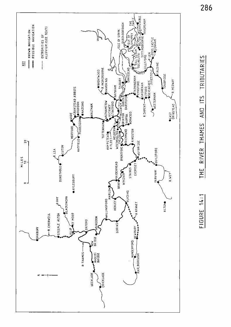
LaLU
0-
J
<
286LaJ
Li -1-1 CO
W .< <2 217 I- VI VICDCD
:z cc
▪ alcco :G LLJ
LL.1 Z _, LIJ3 UJO CD
CD -I M V- I
▪
.<W --: 0-1 2- ci3 < =VI 0 V Z
VI/ Z VI -1X - 0< I- Z W3' CC I- VU-I
- 0 Cr-1
- 1 ..1 ,
I-. ,
,..3I
„J.- L. , z
L.1 1/4 C)
cr >-,e 0
0 Z \ f, -•- - ..,f <- 1
0 Ct
0 M 1/4 ,L12, N. CD >-
0 I-
,_3' 2 ) > X VI
ci DC: Z: CC
i <to•• la.1 LD
VII-0CO
1.1 Lo
• ‘z ><X X
< I-XZ CC
Mco-1
CC1313
V -14: JX< C u _I:: C: iCti i 1 L:C---
Z CL X az
L4-. n
a] :::-C WI = k- LLJ m< CC v., 0 in <
X ° X
<3: 0
X 01
- 0
1LU0 ,_ CY CC
1 = ..1 J I-I- 0 Z X I--VI 0 < F- >- 0 ) 1-.),.n cc
= M Z i- -.- .2 L.J<VI 1.1-1 LL.
X ›- IV -2] 0LaJ
< X
...-.1 ,c12 Ec (=> CC
< 0 < I- < se < cc1-wcc CC- zVI • • a 1-.1 CC
F-. 8= „,t CD°I-<<0
I L/1
Q • I CIC- - rz c.=acD Z • alIn < I
0 L..., 2cc 0 a •
0 a z
cc 0V 0 LLJI- 2
CC 0 = 0<
-
aCC I- l 'it' C, F-M v)
•CD < c-5' v)Ly, 2 0L.1
2 I- U-1 I- =Z -, Z
0 I-
J V) w = CC Y-1.1 a- -I VI
LT- X LY 4-4
i' < • "2. CI
< x cc CC....
2 0L.I-ZcLJCCCla
U-1
CC
LiLL )
L.1
._ I'La-1Z CDa I-....., -1Y <
wLU Loz LJ Q
< CC- Cc aDce
287
the Thames and Medway were wider than at present in their lower reaches,
and the Swale, which separates the Isle of Sheppey from the mainland,
was also wider. Although some of this extra width was no doubt occupied
by marshland, it is probable that Faversham, Milton, Rochester and the
mouth of the Medway were more accessible to vessels during medieval times
than at present.
288
Notes and References
(1) F.S. THACKER, The Thames Highway - General History (London 1914) 13
M. DENNEY, London's Waterways (London 1977) 11
(2) H.C. DARBY, Domesday England (Cambridge 1977) 301
(3) F.S. THACKER, 14-15(op. cit.)
C. HADFIELD, The Canals of South and South-East England (Newton Abbot 1969) 188
(4) F.S. THACKER 15-16(op. cit.)
(5) F.S. THACKER 16(op. cit.)
(6) Calendar of Liberate Rolls, 1226-40, 38-39
(7) ibid, 354
(8) ibid, 404
(9) Calendar of Liberate Rolls, 1240-45, 197
(10) Calendar of Liberate Rolls, 1245-51, 83
(11) ibid, 243
(12) Calendar of Liberate Rolls, 1251-60, 108
(13) ibid, 161
(14) Calendar of Patent Rolls, 1247-58, 369
(15) Calendar of Liberate Rolls, 1251-60, 309
289
(16) ibid, 342
(17) Ibld, 419
(18) ibid, 458
(19) ibid, 498
(20) Calendar of Liberate Rolls, 1260-67, 6
(21) ibid, 23
(22) ibid, 46
(23) ibld, 190
(24) Calendar of Patent Polls, 1266-72,26
(25) ibid, 610
(26) Calendar of Patent Rolls, 1350-54, 204
Calendar of Patent Rolls, 1367-70, 346-47
Calendar of Close Polls, 1369-74, 11
(27) Calendar of Close Polls, 1272-79, 216
Calendar of Patent Rolls, 1301-07, 55-59
ibid, 406
Calendar of Patent Rolls, 1317-21, 547
Calendar of Patent Rolls, 1327-30, 150
Calendar of Patent Rolls, 1350-54, 93
Calendar of Patent Rolls, 1361-64, 545
290
Calendar of Close Rolls, 1374-77, 508
(28) H.C. DARBY, 'The Economic Geography of England, AD1000-1250'being a chapter of H.C. DARBY (ed.) AnHistorical Geography of England before 1800 (Cambridge 1936) 222.
(29) J.F. WILLARD 'Inland Transportation in England during theFourteenth Century' Speculum 1 (1926) 370-71
(30) Calendar of Patent Rolls, 1266-72, 618
(31) ibid, 633
(32) Calendar of Close Rolls, 1272-79, 533
(33) J.E.T. ROGERS A History of Agriculture and Prices in England vol. II (Oxford 1866) 600
(34) Calendar of Patent Rolls, 1292-1301, 151
(35) Calendar of Patent Rolls, 1307-13, 226
(36) Calendar of Patent Rolls, 1313-17, 109-10
(37) ibid, 281
(38) ibid, 198
(39) Calendar of Patent Rolls, 1334-38, 545
(40) Calendar of Patent Rolls, 1313-17, 295
ibid, 654
Calendar of Patent Rolls, 1317-21. 517
(41) J.E.T. ROGERS 603(op. cit.)
(42) J.E.T. ROGERS, 603(op. cit.)
291
(43) Calendar of Close Rolls, 1337-39, 612
(44) J.F. WILLARD 370(op. cit.)
(45) Calendar of Close Rolls, 1341-43, 633
(46) ibid 701
(47) Calendar of Patent Rolls, 1348-50. 76
(48) W.T. JACKMAN, The Development of Transportation in Modern England (Cambridge, 1916; Second Ed. (Revised)1962) 23
(49) Calendar of Liberate Rolls, 1240-45, 163 (Windsor)
Calendar of Liberate Rolls, 1251-60, 205 (Kempton)
ibid, 351, 402, 503 (London and Windsor)
Calendar of Patent Rolls, 1258-66, 587 (Windsor to London)
Calendar of Liberate Rolls, 1260-67, 11 (Southwark)
ibid,
ibid,
ibid,
ibid,
ibid,
ibid,
27 (Tov,er of London)
42-43 (London to Weybridge)
56, 81, 130-31, 140 (London to Windsor)
67 (Kingston to Southwark)
101 (Westminster, from Harden)
256 (Westminster, from Bawtry)
Calendar of Patent Rolls, 1266-72, 214 (Merton, Windsor, Tower)
ibid, 654 (Windsor to Westminster)
292
Calendar of Liberate Rolls, 1267-72, 17 (London to Windsor)
ibid, 106 (London to Weybridge)
ibid, 174 (London to Kempton)
Calendar of Inquisitions Miscellaneous, 1219-1307, 155 (Bray)
Calendar of Fine Rolls, 1307-19, 214 (Wallingford)
Calendar of Patent Rolls, 1317-21, 31 (London)
ibid, 113 (Kingston)
ibid, 502-03 (Marlow)
Calendar of Patent Rolls, 1324-27, 322 (London)
Calendar of Close Rolls, 1327-30, 580 (Westminster)
Calendar of Close Rolls, 1330-33, 102 (Westminster)
Calendar of Close Rolls, 1333-37, 619 (Windsor, Tmler)
Calendar of Patent Rolls, 1338-40, 149 (various counties)
Calendar of Close Rolls, 1341-43, 684 (London)
Calendar of Patent Rolls, 1343-45, 279 (Windsor to London)
ibid, 283 (Gravesend to Henley)
ibid, 385-86 (Westminster to Staines)
Calendar of Patent Rolls, 1348-50, 353 (London)
Calendar of Inquisitions Miscellaneous, 1348-77, 20 (Oxford)
ibid, 342 (Bisham)
293
Calendar of Patent Rolls, 1350-54, 8 (Kingston)
ibid, 136 (Bray, Cookham)
ibid, 276 (London to Henley; London to Yanlet Creek)
ibid, 497 (Marlow)
ibid, 511 (Westminster)
Calendar of Patent Rolls, 1354-58, 96, 278 (Bray; Cookham to London)
Calendar of Close Rolls, 1354-60, 246 (Westminster)
ibid, 292 (London)
Calendar of Fine Rolls, 1356-68, 2, 32 (London to Gravesend)
Calendar of Patent Rolls, 1358-61, 276 (Windsor)
ibid, 519 (Westminster)
Calendar of Close Rolls, 1360-64, 237 (Westminster)
ibid, 524-25 (London)
Calendar of Close Rolls, 1364-68, 335 (Lambeth)
Calendar of Patent Rolls, 1367-70, 266 (Henley to Radcot)
ibid, 362-63 (London)
Calendar of Close Rolls, 1369-74, 402, 531 (London)
Calendar of Patent Rolls, 1370-74, 22 (London)
ibid, 347 (Windsor)
Calendar of Patent Rolls, 1374-77, 70-71 (London)
294
Calendar of Close Rolls, 1374-77, 119 (London)
ibid, 533 (Hambledon)
Calendar of Close Rolls, 1377-81, 77 (Warning Beacons)
ibid, 402-03 (Barking)
Calendar of Patent Rolls, 1381-85, 147 (Westminster)
ibid, 250, 351 (Wallingford to Goring)
Calendar of Close Rolls, 1381-85, 383 (London)
Calendar of Patent Rolls, 1385-89, 98, 243, 405-06 (London)
Calendar of Close Rolls, 1385-89, 20 (River Thames to Sand%ich)
ibid, 485 (Wallingford to Goring)
Calendar of Patent Rolls, 1388-92, 400-01 (Westminster, Windsor)
Calendar of Close Rolls, 1389-92, 510-11 (Wallingford to Goring)
Calendar of Patent Rolls, 1391-96, 55 (London)
ibid, 419 (Westminster, from Dorcaster)
Calendar of Fine Rolls, 1391-99, 275 (Hayresmore)
Calendar of Close Rolls, 1392-96, 262 (Egham)
Calendar of Patent Rolls, 1396-99, 466 (Maynesmore)
Calendar of Close Rolls, 1396-99, 272-73 (estminster)
ibid, 321-22 (Maynesmore)
295
C.T. FLOWER, Public Works in Medieval Law, Seldon Soc.40 (1923) 124-129 (Gives details of locksat various places, plus a winch at Henley).
Calendar of Patent Rolls, 1399-1401, 467 (London to Gravesend)
ibid, 476 (London)
ibid, 542 (Gravesend to London)
(50) Calendar of Close Rolls, 1341-43, 684
(51) Calendar of Close Rolls, 1354-60, 292
(52) Calendar of Patent Rolls, 1361-64, 27
(53) Calendar of Patent Rolls, 1364-67, 76
(54) Calendar of Patent Rolls, 1385-89, 405-06
(55) F.S. THACKER 19-20(op. cit.)
(56) Calendar of Close Rolls, 1279-88, 152-53
(57) Calendar of Patent Rolls, 1307-13, 233
(58) Calendar of Patent Rolls, 1324-27, 310
(59) Calendar of Memoranda Rolls, 1326-27, SO
(60) Calendar of Patent Rolls, 1330-34, 70
(61) Calendar of Close Rolls, 1349-54, 83
(62) Calendar of Patent Rolls, 1354-58, 96
(63) Calendar of Close Rolls, 1354-60, 246
(64) ibid, 268
296
(65) ibid, 268
(66) Calendar of Patent Rolls, 1354-58, 379
(67) Calendar of Close Rolls, 1377-81, 192
ibid, 386-87
(68) Calendar of Close Rolls, 1385-89, 482
(69) Calendar of Inquisitions Miscellaneous, 1387-93, 158
(70) Calendar of Patent Rolls, 1358-61, 187
(71) Calendar of Patent Rolls, 1374-77, 233
(72) Calendar of Liberate Rolls, 1260-67, 203
(73) C.T. FLOWER, Public Works in Medieval Law, Seldon Soc.32 (1915) 77
(74) M. DENNEY 35(op. cit.)
(75) Calendar of Liberate Rolls, 1251-60, 444, 447
(76) Calendar of Liberate Rolls, 1267-72, 50
(77) Calendar of Patent Rolls, 1292-1301, 547
(78) C.T. FLOWER 40 (1923) 12-13(op. cit.)
(79) Calendar of Patent Rolls, 1354-58, 234
(80) Calendar of Inquisitions Miscellaneous, 1348-77, 70-73
(81) Calendar of Patent Rolls, 1358-61, 409
(82) Calendar of Patent Rolls, 1361-64, 532, 547
297
(83) Calendar of Close Rolls, 1396-99, 54
(84) Calendar of Patent Rolls, 1364-67, 282
(85) Calendar of Patent Rolls, 1367-70, 345-46
(86) Calendar of Patent Rolls, 1377-81, 474
(87) Calendar of Patent Rolls, 1381-85, 144
(88) Calendar of Patent Rolls, 1385-89, 472-73
(89) N. BARTON The Lost Rivers of London (Leicester 1962) 74
(90) Calendar of Patent Rolls, 1301-07, 548
(91) Calendar of Patent Rolls, 1307-13, 38
(92) Calendar of Close Rolls, 1337-39, 570-71
(93) C.T. FLOWER 40 (1923) 32-36(op. cit.)
(94) N. BARTON 75
(op. cit.)
(95) H. DEMEY 34(op. cit.)
(96) Calendar of Patent Rolls, 1292-1301, 114
(97) Calendar of Patent Rolls, 1374-77, 157
(98) H.C. DARBY (ed.) A New Historical Geography of England (Cambridge 1973) 34 & 96
D. HILL, An Atlas of Anglo-Saxon England (Oxford, 1981) 10
298
CHAPTER FIFTEEN THE RIVERS OF THE SOUTH COAST OF ENGLAND
The rivers considered in this chapter are those which find their
outlets into the sea in the counties of Kent, Sussex, Hampshire and
Dorset.
There have been many changes to the coastline of south-east England
especially in the areas of Sandwich, Hastings, Romney and Pevensey. (1)
As D. Hill points out:-
"as yet there is no definitive work on the •changes of the coast of South-east England," (2)
therefore, the modern coastline is the one shown on the river map.
However, coastal changes are discussed where they affect the navigational
courses of rivers.
The Great Stour and Wantsum Channel
Rising to the south of Ashford, the Great Stour floss through
that place and on in a north-easterly direction through Canterbury and
Fordwich. The river turns due east at its confluence with the Wantsum
near Sarre, and then winds south past Richborough to Sandvach - after
which it turns due north and enters the sea at Pepell Bay after a total
course of 40 miles.
In Roman times, the channel formed by the Great Stour and the
Wantsum was much wider than it is today with the result that the Isle of
Thanet was a true island. The Romans constructed substantial fortresses
at Richborough and Reculver to guard each end of this channel, which was
an important navigable link to the River Thames and London. The Wantsum
299
Channel was navigable during the Anglo-Saxon period but appears to have
silted up between Sarre and Reculver some time during the second half of
the eleventh century, leaving the Great Stour as the main naivgational
waterway during medieval times.(3)
Fordwich, 19 miles up the Great Stour and within 3 miles of
Canterbury, was reached by sea-going vessels during the thirteenth century.
In 1246, 10 tuns of wine
"from the port of Fordwiz"
was housed in the cellar of the archbishop of Canterbury for the Ving. (4)
The records show that the river was also navigable to Canterbury,
but probably for smaller vessels. In 1264, the Friars Minors of
Canterbury were given permission
"to build a bridge over the water of Stoure,...so that little ships may pass under itwithout impediment:" (5)
Forty-five years later, in 1309, these same friars were again given
permission to build a bridge
"to be so built as to allow a clear passage forboats underneath it" (6)
Sandwich, 5 miles up the river and, along with Hastings, Romney,
Hythe and Dover, one of the Cinque Ports, was an extremely busy port
during the medieval period. In 1249, for example, the sheriff of Kent
was ordered to ensure that 74 tuns of wine were carried from Sandwich to
London and to
"hire 4 boats therefor." (7)
300
The port of Sandwich is mentioned in the records throughout the medieval
period. (8) An interesting record of 1330, relating to the transport of
lead, shows that the cargo was carried from London to Sandwich by water
and then transferred, presumably to smaller vessels, before being taken
to Fordwich. (9)
Sarre, between Fordwich and Sandwich, was also classed as a port.
In 1313, one William de Insula, a merchant, complained that a ship he
had loaded
"at Landon with cloths, wines, spices andother wares"
which he had sent to Sarre was boarded near that place and siezed
"with all his goods and wares and carried....away". (10)
In 1364, both Fordwich and Sarre were still listed as ports. (11)
It is likely that during the medieval period the river was
navigable for a further 10 miles up-river of Canterbury, to Wye, for
it is known that boats were reaching this place in the sixteenth
(12)century.
Rivers Rother and Brede
The River Rother rises to the south-west of Hayfield and flows
in an easterly direction via Etchingham, Robertsbridge, Udiam, Bodiam
and Newenden. After Newenden, the main course of the river turns south-
east towards Rye, but there is a link with Appledore by a circuitous;
channel which forms the Isle of Oxney. There was also a link with New
Romney and the At Rye the Rother is joined by the River Brede
301
which flows down from Winchelsea. Two miles after Rye the river enters
the sea at Camber. The length of the main course of the river, between
Mayfield and the sea, via Rye, is 33 miles.
In 1243, the King ordered the sheriff of Sussex
"to enlarge the building at La Rye where the King'sgalleys are stored, so that it may contain 7galleys, and then to store the King's galleystherein with all their equipment". (14)
Galleys and barges were also constructed at Winchelsea during this period.(15)
In 1258, the port of Romney was silting up and it was recorded
that
"the course of the river of Newenden upon whichthe said port was founded"....
"is diverted." (16)
It appears that about 1300, a trench was cut to link Appledore
with Romney in an attempt to overcome the problems associated with the
(17)silting up of the river. However, by 1337, this trench ‘sas
"so obstructed by shingle and sand that shipscan no longer pass by it to Romeneye (fromAppledore) as they used to do, as there isanother trench made by the sea better adaptedfor the passage of ships." (18)
In 1327, timber and stone as carried by ships betineen Newenden
and Dover.(19)
There were also problems with the inundations of the sea at
Winchelsea. In 1287 a storm rendered th old port Uninhabitable and
the residents were transferred to Hew Winchelsea near Iham on the River
302
Brede.20)
In 1344 the King sent the following order to the bailiffs
of Winchelsea:-
"The men of the town of Ihamme near Wynchelsehave shown the King that although they andtheir predecessors from time out of mind havehad free access and egress by the port of waterleading from their town to the sea, with theirships and boats, for fishing and other affairsand to return to that town at will, yet thebailiffs strive to prevent them from doing soby putting stakes in the water and iron chains,wherefor those men have besought the King toprovide a remedy: the King therefore ordersthe bailiffs to desist from such impediment,and to permit those men to come and go as theyand their predecessors have been wont to do.." (21)
The river was certainly navigable for 23 miles of its course to
Etchingham, 3 miles up-river from Robertsbridge. This is revealed by
a commission of 1348 which was investigating the building of a wall across
the river, when it was said that
"it will be to the great damage of the King...especially as by the passage of shipsand boats with victuals from divers. .manors
to (the) manor of Echyngham will behindered, as well as to the destruction of(the) market town of Salehurst, situated onthat water..." (22)
Small Hythe, which is situated on the north side of the Isle of
Oxney, between Appledore and the main course of the Rother, was visited
in 1354 by ships and boats carrying cargoes of wool and brushwood.(23)
Firewood was taken by ships to Bodiam and Newenden in 1357 - for
sale to the local community. This practice had been carried out over
a number of years.(24)
In 1382, certain persons petitioned the King
"alleging that divers goods of the King's enemiesin ships, some belonging to the King's friends
303
.and some to his enemies, captured by themin war in the year 46 Edward III (1373) andtaken to Dover, Rye and Apoldre, were unjustlytaken from them by Richard Lyons, now deceased,and that no restitution has been made by him orhis executors..." (25)
The King ordered that Robert de Asshton, constable of Dover Castle and
Warden of the Cinque Ports should look into the matter.
By the close of the fourteenth century the main course of the
river, between the sea at Camber and on up to Bodiam, was being
obstructed by ballast thrown overboard from ships and a commission was
set up in 1400
"to survey the port of Wynchelse from a placecalled Camer to Bodyham and appoint certainconvenient places where stones, sand and otherballast may be shot and to proclaim that suchshall not be shot in the channel, which in thismanner been filled up and blocked, and tocertify thereon to the King." (26)
River Ouse
From its source to the south-west of East Crinstead, the River
Ouse flows in a generally southerly direction by Lindfield, Isfield,
Offham and Lewes to Hewhaven, shortly after Olich it enters the sea
after a course of 30 miles.
The town of Lees, an important centre of the wool trade and 8
miles up the river from the sea, was a frequent port of call during the
medieval period.(27)
At the turn of the fourteenth century there were 'quarrels and
debates' between the archbishop of Canterbury and the earl of Arundel
regarding certain ancient rights in the river. It was said that the
304
earl had been hindering the arrival of vessels in the river near the
town of Lewes. The King's Bench confirmed that
"every man coming with a boat or boats or othervessel in the said river may freely arrive"
and that the earl should desist from any such hindering in the future.
It was further stated
"that no custom shall be taken of thearchbishop, his tenants or any other, or bepaid for any arrival on the side of the riverby the town or hamlet of Clyve, and as to theside towards Lewes they will be advised. 0 (28)
Clyve or Cliffe, was situated on the opposite side of the river to
Lewes and both places were interconnected by a bridge.(29)
River Adur
From a point to the south of Horsham, the River Adur flows south
by Knepp Castle and Bines Green to Bramber, 5 miles after vOlich it enters
the sea near Shoreham after a course of 17 miles.
The river was navigable to Bramber, for, in 1304, William de
Brewosa - lord of the castle of Bramber, complained that he ought to
(30)receive the 'dock dues taken from vessels berthing at that place.
River Arun
From its source to the north-east of Horsham, the River Arun
flows through that place in a westerly direction and then turns south
to pass Billingshurst, Pulborough and Arundel - 5 miles after which it
enters the sea at Littlehampton after a course of 35 miles.
305
The river was navigable to Arundel,(31)
and probably for a
further 10 miles to Pulborough, where there was a ferry across the river. 02)
River Hamble
The estuary of the River Hamble, which flows into Southampton
Water between Hamble and Warsash, would have been navigable for 6 miles,
to Botley, during the medieval period.
River Itchen
Rising near Bramdean, the River Itchen initially flows in a
northerly direction to Ovington near where it is joined by the River
Aire. It then turns west and then south to pass through Winchester and
Bishopstoke and on between the easterly suburbs of Southampton and
Itchen, to enter Southampton Water after a course of 26 miles.
The River Itchen was made navigable up to New Alresford in about
1200.(33)
The River Alre was canalised for about one mile, and a
reservoir constructed at the head of the navigation to provide the
necessary water supply. The bishop of Winchester, one Godfrey de Lucy,
was the driving force behind this work and King John rewarded him with
the right to collect tolls on goods;
"that shall or may hereafter be conveyed upor down the river Itchen which the saidBishop hath now caused to be first trenchedand made navigable at his own expense." (34)
Thus the canal wharves at New Alresford, which is 21 miles from the sea
and 8 miles up-river from Winchester, created a market centre on the
road between Winchester and London. 35)
306
Mills were built across the River Itchen at Winchester during
the medieval period and hence, in common with other rivers on which
such obstacles existed, goods were probably trans-shipped in order to
continue navigation on the upper reaches of the river.
Apart from Southampton, Winchester and New Alresford, the port
of Itchen, one mile from the mouth of the river, was receiving ships
in 1326.(36)
River Test
Flowing down from the southern slopes of the Hampshire Downs
the River Test flows in a generally southerly direction through
Whitchurch, Stockbridge, Romsey and Redbridge, after which it broadens
into an estuary and joins with the River Itchen at Southampton to form
Southampton Water. The total course of the river is 35 miles.
Although not considered as a river port within the context of
the current work, Southampton was the greatest medieval port on the
south coast. Its history, trading links and especially is associations
with the wine and Isool trades during the medieval period have been
comprehensively discussed by others.(37)
Romsey, 7 miles up the river from Southampton, was the
collection centre for grain and oats which, it appears i was sent down the
river in 1339. (38)
Redbridge, at the point where the river narrows and 3 miles up-
river from Southampton, is mentioned in a grant of 1358 which allowed
pontage to be taken
"on things for sale passing over or under thebridge of Rudbrigge." (39)
307
River Medina (Isle of Wight)
The River Medina, which flows due north from the southern side
of the Isle of Wight, was navigable during the medieval period for the
final 5 miles of its course - between Newport and The Solent; for
Newport is given as a port in various medieval port lists. (4o)
River Beaulieu
From its source to the west of Lyndhurst, the River Beaulieu
flows in an easterly direction through that place and then turns south
to Beaulieu, where it widens, and enters The Solent near Lepe after
a course of 15 miles.
The river was navigable for the 5 miles between The Solent and
Beaulieu, for, in 1272, the men of Master John de Chishull, dean of St.
Paul's London, were granted safe conduct for
"bringing his corn and other goods from hischurch of Brawatre to St. Paul's, London, bysea, and to the abbey of Beaulieu." (41)
River Avon
The River Avon, which flows in a southerly direction from the Vale
of Pewsey, passes through Upavon, Amesbury, Salisbury, Fordingbridge,
Ringwood and Christchuch, shortly after which it enters the sea after
a course of 48 miles.
The river was navigable for the final 16 miles of its course -
between Fordingbridge and the sea, as is shown by the Sheriff of
Hampshiret.Accounts. (42)
308
It also appears that the river was navigated for a further 12
miles up-river of Fordingbridge, to Salisbury. In 1372, the King
ordered that a barge
"be made at Salisbury...to resist the maliceof his enemies of France." (43)
As this order specifically states that the barge 'be made at Salisbury'
it must be concluded that the waters of the River Avon were utilised to
enable the barge to reach the sea. In 1378
"the mayor, bailiffs, and good men of Salisbury"
were given exemption from
"making a small barge, called a 'balinger'for the King's fleet now at sea."
as the earl of Salisbury had undertaken to carry out the worl< instead.(44)
Whether Salisbury was ever established as an inland port during
the medieval period is difficult to ascertain, although certain later
records do hint at this possibility. In 1405, the bailiffs of Gloucester
were ordered to set free one John Milbourne who had been imprisoned for
obstructing the Avon by setting certain pales
"in the bed of the river at New Sarum". (45)
Eight years earlier, certain persons were ordered
"to make inquisition by whose default the passageof ships and boats in the rivers of Wiltesir washindered." (46)
This latter reference would most likely include at least part of the
course of the River Avon.
309
Although documentary evidence is rather thin, the town of
Salisbury would be accessible to small vessels.(47)
In 1623, and prior
to any previously known improvement schemes to the navigation, a
certain John Taylor demonstrated the navigability of the River Avon by
taking his wherry from London to Christchurch and on up the river to
Salisbury.(48)
River Frome
Rising to the south of Evershot, the River Frome initially flows
in a south-easterly direction to Maiden Newton and then bears east to
Dorchester and Wareham shortly after which it enters Poole Harbour after
a course of 30 miles.
Wareham, 2 miles up the river from Poole Harbour, was a port
during the medieval period. However, as the size of vessels increased
it appears that trade gradually declined due to the difficulties
experienced by the larger vessels attempting to navigate the narrow
access channel of the river.(49)
Dorchester, 16 miles further up-river from Wareham, was probably
reached by small vessels during the medieval period. It appears that,
in much earlier times, the Romans carried stone, which had been
quarried in the Swanage area, to Dorchester by water. (50)
The rivers of the south coast of England are mapped in Figure 15:1,
and their navigational limits, in medieval times, are indicated.
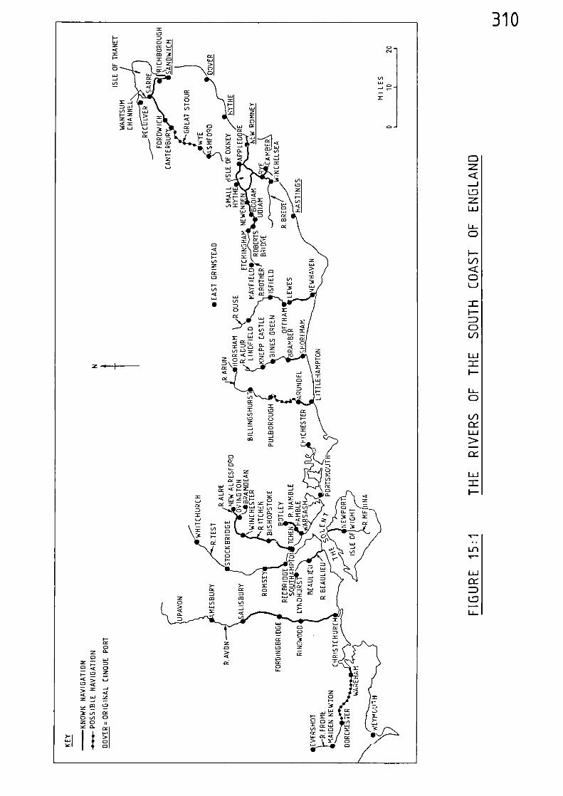
310
South-East England - The Channel Coastlands (1) R. MILLWARD andA. ROBINSON, (London, 1973)
311
Notes and References
(2) D. HILL An Atlas of Anglo-Saxon England (Oxford, 1981) 15
(3) R. MILLWARD and 184-191A. ROBINSON (op. cit.)
D. HILL 14(op. cit.)
(4) Calendar of Liberate Rolls, 1245-51, 47
(5) Calendar of Patent Rolls, 1258-66, 342
(6) Calendar of Patent Rolls, 1307-13, 178
(7) Calendar of Liberate Rolls, 1245-51, 243
(8) Calendar of Close Rolls, 1272-79, 483-84
Calendar of Close Rolls, 1296-1302, 100
Calendar of Patent Rolls, 1324-27, 310
Calendar of Patent Rolls, 1330-34, 166
Calendar of Close Rolls, 1349-84, 83
Calendar of Patent Rolls, 1364-67, 76
Calendar of Patent Rolls, 1399-1401, 468
(9) J.E.T. ROGERS, A History of Agriculture and Prices in England Vol. II (Oxford 1866) 603
(10) Calendar of Patent Rolls, 1307-13, 548
(11) Calendar of Patent Rolls, 1364-67, 77
312
(12) W.G. HOSKINS, Fieldwork in Local History (London, 1967) 60
(13) M. BERESFORD, New Towns of the Middle Ages (London 1967)459
(14) Calendar of Liberate Rolls, 1240-45, 201
(15) Calendar of Liberate Rolls, 1251-60, 399-400
(16) Calendar of Patent Rolls, 1247-58, 635-36, 662
(17) Calendar of Close Rolls, 1323-27, 209
(18) Calendar of Patent Rolls, 1334-38, 457
(19) Calendar of Memoranda Rolls, 1326-27, 339-40
(20) P. BRANDON, The Sussex Landscape (London 1974) 218
(21) Calendar of Close Rolls, 1343-46, 446
(22) Calendar of Patent Rolls, 1348-50, 80, 177-78
(23) Calendar of Patent Rolls, 1354-58, 70
Calendar of Close Rolls, 1354-60, 37
(24) Calendar of Patent Rolls, 1354-58, 578-79
(25) Calendar of Patent Rolls, 1381-85, 144
(26) Calendar of Patent Rolls, 1399-1401, 346
(27) A. FORBES and
Our Waterways - A History of Inland Navigation W.H.R. ASHFORD
Considered as a Branch of Water Conservancy (London 1906) 45-46
(28) Calendar of Close Rolls, 1409-13, 183-85
313
(29) ibid, 185
(30) Calendar of Patent Rolls, 1301-07, 287
(31) Calendar of Close Rolls, 1405-09, 305
(32) ibid, 78
Calendar of Close Rolls, 1399-1402, 186
(33) C.T. FLOWER, Public Works in Medieval Law, Seldon Soc.
M. BERESFORD,(op. cit.)
40 (1923) xxiii
109-110
(34) C. HADFIELD, The Canals of South and South-East England (Newton Abbot 1969) 160
(35) M. BERESFORD 110
(Op. cit.)
(36) Calendar of Memoranda Rolls, 1326-27, 220
(37) S. REYNOLDS An Introduction to the History of English Medieval Towns (Oxford 1977) 221
(38) S. UHLER 'The Transportation of Produce in Lincolnshire,Yorkshire, Hampshire and Norfolk during theFourteenth Century as revealed by the SheriffsAccounts', unpublished B.Phil. Dissertation University of St. Andress (1977), 36
(39) Calendar of Patent Rolls, 1358-61, 29
(40) Calendar of Close Rolls, 1296-1302, 82,101
Calendar of Close Rolls, 1330-33, 398
Calendar of Close Rolls, 1341-43, 486
314
(41) Calendar of Patent Rolls, 1266-72, 618
(42) S. UHLER, 36-37(op. cit.)
(43) Calendar of Patent Rolls, 1370-74, 219
(44) Calendar of Patent Rolls, 1377-81, 108
(45) Calendar of Close Rolls, 1405-09, 332
(46) Calendar of Close Rolls, 1399-1402, 518
(47) J. CHANDLER, Endless Street: A History of Salisbury and Its People (Salisbury 1983) 128
(48) ibid, 128
(49) D.A. HINTON Alfred's Kingdom; Wessex and the South 800-1500 (London 1977) 182
(50) R.A. DODGSHON and An Historical Geography of England and Wales
R.A. BUTLIN (eds.), (London 1978) 44
315
CHAPTER SIXTEEN THE RIVERS OF SOUTH-WESTERN ENGLAND
The rivers considered in this chapter are those contained within
the counties of Cornwall, Devonshire and Somerset.
River Exe
Rising on Exmoor, the River Exe flows in a south-easterly direction
to Exton, and then turns due south via Tiverton, Exeter and Topsham--
where it broadens into an estuary which narrows as it enters the sea
at Exmouth, after a course of 55 Miles.
The River Exe was navigable for 10 miles, from the sea to the
city of Exeter, during the reign of Edward I. However, towards the
end of the thirteenth century, a weir was built across the channel
above Topsham which prevented vessels from visiting Exeter. An
inquisition of 1290 ordered that an opening should be made in this weir
to allow vessels to pass.(1)
This restored navigational access to the
city and Exeter once again received goods brought in by water.
In 1317, the citizens of Exeter complained
"that although they had received by their bailiffstolls and anchorage and divers other customs inthe port of Toppesham, co. Devon, within theliberty of their city from all ships putting inthere, and that they and their ancestors wereaccustomed to be quit of such tolls for theirown ships or boats putting into the said port, andfor their wares laden or unladen there, certainmen of those parts hinder them from collecting thesame, and distrain from such toll, anchorage andother customs upon the ships and boats of thecitizens of Exeter putting in there, and upontheir wares laden or unladen in the port ofToppesham as though that port did not pertain tothe city of Exeter." (2)
316
Topsham was thus becoming a serious rival for the trade brought up
the river. However, it appears that vessels were still reaching Exeter
in 1320 for, in that year, the city was granted pavage for two years
"upon all wares for sale brought into that cityby land or water." (3)
Exeter eventually succumbed to the rivalry of Topsham however,
for by 1327, the river between the two places was once again obstructed
by weirs.(4)
(5)Hence Topsham, some 4 miles down-river became Exeter's port.
River Dart
Formed by a number of streams flowing down off Dartmoor, the River
Dart follows a south-easterly course to Buckfastleigh and Totnes after
which it widens and then enters the sea shortly after passing between
Dartmouth and Kingswear; a total length of 30 miles.
Apart from the places on the estuary, Totnes, 10 miles up the
river from the sea, was sustained during the medieval period by the
traffic on the River Dart.(6)
River Tamar
The River Tamar rises to the north-east of Bude and forms, for
virtually its whole course, the boundary between the counties of
Devonshire and Cornwall. During its southerly course it passes close
to Launceston and within 3 miles of Tavistock to Gunnislake. It
gradually widens into an estuary and is joined by the River Tavy after
which it passes Saltash, is then joined by the River Lynher, and enters
Plymouth Sound near the port of Plymouth after a course of 50 miles.
317
From the twelfth century onwards the river was navigable for at
least 12 miles to Morwellham, below Gunnislake, and this place, in
effect, acted as the port of Tavistock. (7)
In 1339; an inquisition, dealing with land near a silver mine
which belonged to the King, stated that
"The abbot of Tavystoke has the wood of Morwelham,which is nearest the King's mine on the other sideand contains 80 acres, whereof 30 are appraisedfor the King's use at 40s. an acre.. .beginning froma way from Tavystok towards the quay of the waterof Tamar on the north side, and thence in lengthand breadth on the north side until the King hasreceived 30 acres." (8)
Vessels were constructed at Saltash towards the end of the fourteenth
century,(9)
and at this same place there was a ferry across the river.(10)
River FolNey
Flowing down from the southern slopes of Bodmin Moor, the River
Fowey swings west, then south, to Lostwithiel and Fowey - shortly after
which it enters the sea after a course of 24 miles.
The 6 miles between Lostwithiel and the sea were navigated by
medieval vessels. In 1326, Lostwithiel as listed as a port where
"all owners and masters of ships of smaller burthenthan 50 tuns to keep, under pain of forfeiture,all such ships in their ports, and not leave theports for the sake of fishing, trading, or for anyother cause, and not to send the ships anywhere,and the mayor and bailiffs are ordered not topermit any such ships to leave the ports untilfurther orders." (11)
318
River Torridge
From its source to the south-west of Clovelly, the River Torridge
flows in a south-easterly direction to %here, near Hatherleigh, it
turns northwards and passes through Great Torrington and Bideford,
after which its estuary merges with that of the River Taw and enters
the sea after a course of 42 miles.
Bideford, 5 miles up the river from the sea was asked in 1364,
along with many other maritime places
"that no one cross the sea from the realm withoutthe King's special licence and that in the case ofall persons who cross diligent scrutiny be made thatthey do not take with them gold or silver in moneyor mass, jewels or letters of exchange, and that,in case any such be found on any one crossing onthe sea or an arm of the sea or on water running tothe sea, the bearer shall be arrested and sentbefore the King and council,..." (12)
The River Torridge was probably navigable during the medieval
period for a further 7 miles up-river of Bideford, to Taddiport and
Great Torrington. The river as certainly navigable for 4 miles up-river
of Bideford prior to the canal age:- %hen coal and limestone %ere
carried to Weare Gifford to be burnt in the kilns there.(13)
River Taw
From the northern slopes of Dartmoor, the River Tan follons a
generally north to north-easterly course via !forth Tanton, Egoesford,
Bishops Tawton and Barnstaple, after which its estuary merges with that
of the River Torridge and enters the sea after a course of 45 miles.
319
Barnstaple, 8 miles up the river from the sea, is mentioned in
a port-list of 1331,(14) and was also one of the maritime places given
in the previously mentioned record excluding the export of gold and
silver etc., in 1364.
In 1383 a commission was set up to inquire into
"the construction of divers weirs, mills, pools,stakes and kiddels in the river Towe." (15)
Similar obstructions are again mentioned in 1394.(16)
These obstructions
were in that part of the river up-stream of Barnstaple. Just how far
the river was navigable is difficult to ascertain, but it was certainly
na0.gable 3 miles up-river of Barnstaple, to Bishops Taveton, for in
1398, there is a record of boats at that place.
River Parrett
Rising to the south-east of Crewkerne, the River Parrett follows
a northerly course to Langport, at inhich point it is joined by the
River Yeo flov$ing down from Ilchester. The river then follows a north-
westerly course through Stathe to Burrow Bridge, where it joins with the
River Tone which flows down from Taunton. The river continues to
Bridgwater, after which it gradually widens and winds to enter the sea
to the south of Burnham after a course of 38 miles.
In 1233, the tiny port of Stathe, 21 miles up the river from the
sea, and 4 miles below Langport, is mentioned in an episcopal record.(18)
In 1301,
"the bailiffs and good men"
of Bridgwater were asked to expedite the sending of a ship to Berwick-
320
upon-Tweed
"which the King ordered to be preparedagainst the Scots" (19)
The town also supplied a ship for the same purpose the following year.(20)
Bridgwater, 13 miles up the river, was a busy port during the
fourteenth century. In 1317, sea-going vessels were venturing from the
port to France,
"to carry wine and other goods." (21)
In 1347, the constable, mayor, bailiffs and lawful men of
'Briggewauter' were ordered
"to cause ships coming to that town laden withmerchandise of value and passing thence withwool, hides and wool-fells, to be laded andunladen at the quay of the town or at the quayof Bristoll, and not elswhere, as the King isinformed that he is defrauded of a great partof the customs due on such merchandise becausesuch ships are laded and unladed in the RiverPeret and not at the quay of the town, as iscustomary in other ports of England." (22)
In 1365, certain persons were given a licence
"to take from the port of Bruggewauter 100quarters of wheat and 200 quarters of beansand peas to the city of Bayonne, and 100quarters of beans and peas to Ireland, andsell them to buy other merchandise there." (23)
In 1371, a certain Walter Blaunkpayn was given a licence
"to load 300 quarters of beans in the port ofBriggewauter and carry them to the ports ofWales to make his profit thereof;" (24)
Bridgewater was certainly the premier port, but as the River
Parrett is tidal for almost 25 miles, to near Langport, (25) it would
321
be safe to conclude that vessels were reaching that place during the
medieval period.
River Tone
The 11 mile course of the River Tone, which flows in a north-
easterly direction between Taunton and its confluence with the River
Parrett at Burrow Bridge, was navigable during the fourteenth century.
In 1384, it was said that the abbot of Glastonbury
"maintains in Monketon trees hanging over the Toneright across it, so that boats cannot pass asthey were wont." (26)
Monkton is 2 miles down-river from the to of Taunton. At the same
hearing it vsas said that Richard de Acton, Knight, had caused an
obstruction by erecting a fulling mill in the same river such that
"the passage of boats and fish between Bridgev.aterand Taunton alike (is) prevented" (27)
Both parties answered that they had, since the hearing, remoNed the
ob3tructions.
Early in the next century (1414), an inquisition ‘sas informed
that
"Before, within and after the time of memory %alter,last predecessor of the present abbot ofGlastonbury, valile abbot made a water-gate in apond of a mill.. .on the King's soil at Tauntonadjoining and annexed to the mill, making it sohigh and narrow by fixing of timbers and heapingof stones across the middle of the King's deepriver running from Taunton to the town and portof Bridgewater that boats and small ships called'botes' and 'trowys' suitably laden with diverswares called 'avoir de poirs' and other necessaries,viz, wood for fuel, timber, coal, pitch, salt, iron,
322
lime, grain, malt, wine and other victuals,for the King's people in the tom of Tauntonand the country adjoining, which used to bebrought up to Taunton from Bridgwater by theforce of the water from time immemorial, tothe great relief and aid of the said peopleand country, could not be so brought in anyway since the said water-gate was evilly madeso high and narrow on account of the saidpurpresture, to the manifest enfeeblement ofthe King's right and the great and grievousnuisance and public damage of the people andcountry..." (28)
This latter reference, although recorded early in the fifteenth
century, is retrospective, and is important as it details many of the
diverse commodities which were carried by river. It implies that the
transport of such commodities, in bulk, was extremely difficult by any
other method.
River Yeo
It is likely that the 7 mile course of the River Yeo, which flows
in a north-westerly direction between Ilchester and Langport, was
navigable during the medieval period.
Apparently, in much earlier times, the Romans ascended the river
to Ilchester, for the remains of two wharves from that period have been
(29)found there.
The Rivers Axe and Brue
The River Axe rises to the north-west of Wells and runs in a north-
westerly direction through Panborough and Weare, passes close to Axbridge,
and enters the sea to the south of Weston-super-Mare after a course of
21 miles.
323
In 1189, Richard I granted a charter which enabled the bishop of
Bath to create the port and borough of Radeclive, now Rackley, which is
some 10 miles up the river from the sea and about a mile downstream
fromWeare.(30)
The course of the river has altered somewhat in this
area and Rackley is now isolated and away from the main course of the
river. In 1347, the sheriff of Somerset was ordered
"to cause proclamation to be made that no merchantor other person whatsoever shall cause any shipsor boats to be laded or unladed with wool, hidesand merchandise in the water of Radecliff,... inthat county, or elsewhere except at the quay ofBriggewauter or Bristol upon pain of the forefeitureof such wool and merchandise, and if he find anydoing this after the proclamation, he shall causethem to be arrested together with the ships, wooland merchandise, and kept safely until furtherorder, and he shall not omit this upon pain offorefeiture, as the King is informed that he isdefrauded of a great quantity of the customs andsubsidies on wool, hides, fells and merchandisebecause several ships are laded and unladed inthe said waters': (31)
A record of 1390 shows that ships docked at Rackley loaded with salt,
iron, fish and other cargoes.(32) The river was also used for shipping
lead from the Mendip mines and small vessels could reach Panborough,
some 7 miles further up-river from Rackley.(33)
The River Brue rises to the east of Bruton, flows through that
place, and continues in a westerly direction past Glastonbury and Meare
to enter the sea to the south of Burnham after a course of 35 miles.
The waterways in this area have seen a number of changes since the
medieval period. In medieval times the Rivers Axe and Brue were inter-
connected by a channel which ran for 3 miles in a south-westerly
direction from a point on the River Axe mid-way between Weare and the
sea; to Rooks Bridge. From Rooks Bridge what was known as the Pillrow
324
Cut ran south to Mark and then south-east to join the River Brue near
Burtlef the length of the Pillrow Cut between Rooks Bridge and Burtle
being about 6 miles. It appears that the section between Mark and
Rooks Bridge was canalised for both navigation and drainage during the
first half of the fourteenth century. It also seem likely that the
Pillrow Cut was not connected with the present lower course of the River
Brue but took the water from the upper course of the river, and the
outlet of a lake called Meare Pool.(34)
Thus navigational access to Glastonbury Abbey was achieved, and
many varied goods could be carried on the 16 miles of waterway linking
the abbey with the River Axe.(35)
In later times the Pillrow Cut and
Meare Pool slowly disappeared, and the Rivers Axe and Brue were separated.
The landscape of the coastal region of central Somerset was,
during medieval times, similar in nature to that of the Fen. Much of
it was marshy and waterlogged and considerable drainage and reclamation
work was carried out, mainly by the local abbeys.(36)
Navigable Inlets
The rugged coastline in the south-west also has many navigable
inlets which gave access to the sea. Kingsbridge, on the long
estuary which enters the sea near Salcombe is named as a port in 1347;
Penryn, near Falmouth, and Truro further up the main estuary are also
listed as ports in the same record. (37I
Ships would also have reached Newton Abbot on the Teign; St.
Germans on the Lynher; Gweek on the Helford and Wadebridge on the Camel.
325
The rivers of south-western England are mapped in Figure 16:1,
and their navigational limits, in medieval times, are indicated.
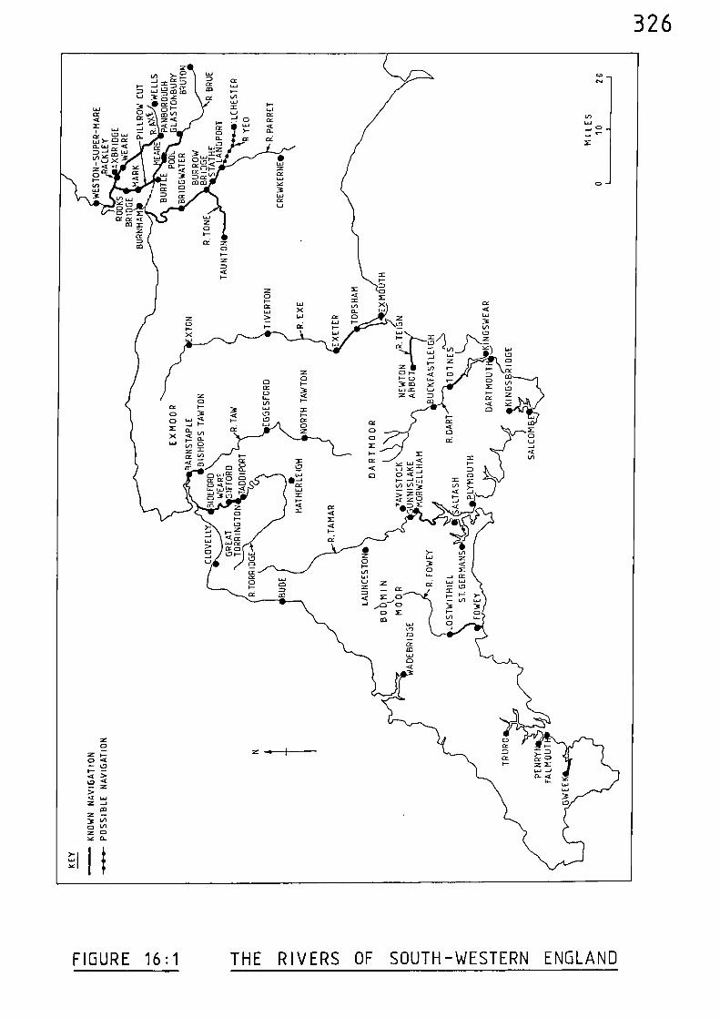
326
FIGURE 16:1 THE RIVERS OF SOUTH-WESTERN ENGLAND
327
Notes and References
(1) C. HADFIELD, The Canals of South-West England (Newton Abbot)19
(2) Calendar of Patent Rolls, 1317-21, 91
(3) ibid, 526
(4) C. HADFIELD 19(op. cit.)
(5) Calendar of Patent Rolls, 1330-34, 166
Calendar of Patent Rolls, 1364-67, 77, 167
(6) M. BERESFORD,
(7) C. HADFIELD(op. cit.)
H.P.R. FINBERG
New Towns of the Middle Ages (London 1967) 116
124, 127
Tavistock Abbey: A Study in the Social and Economic History of Devon (2nd Ed. NewtonAbbot 1969) 44-49
(8) Calendar of Inquisitions Miscellaneous, 1307-49, 406
(9) Calendar of Patent Rolls, 1391-96, 45
(10) Calendar of Inquisitions Miscellaneous, 1399-1422, 54
(11) Calendar of Close Rolls, 1323-27, 640-42
(12) Calendar of Patent Rolls, 1364-67, 76-78
(13) C. HADFIELD 135(op. cit.)
(14) Calendar of Patent Rolls, 1330-34, 166
(15) Calendar of Patent Rolls, 1381-85, 355
328
(16) Calendar of Close Rolls, 1392-96, 274-75
(17) Calendar of Patent Rolls, 1396-99, 438
(18) W.G. HOSKINS, Fieldwork in Local History (London 1967) 61-62
(19) Calendar of Patent Rolls, 1292-1301, 583-84
(20) Calendar of Patent Rolls, 1301-07, 75
(21) Calendar of Close Rolls, 1313-18. 565
(22) Calendar of Close Rolls, 1346-49, 180
(23) Calendar of Patent Rolls, 1364-67, 61
(24) Calendar of Patent Rolls, 1370-74, 94
(25) C. HADFIELD 83(op. cit.)
(26) Calendar of Patent Rolls, 1381-85, 511
(27) ibid 512
(28) Calendar of Inquisitions Miscellaneous, 1399-1422, 259
(29) C. HADFIELD 83(op. cit.)
(30) M. BERESFORD 484-85(op. cit.)
(31) Calendar of Close Rolls, 1346-49, 242
(32) W.G. HOSKINS 61(op. cit.)
(33) C. HADFIELD 76(op. cit.)
329
(34) C. HADFIELD 76(op. cit.)
(35) W.G. HOSKINS 61(op. cit.)
(36) H.C. DARBY (ed.), A New Historical Geography of ingland (Cambridge, 1973) 105
(37) Calendar of Close Rolls, 1346-49. 328
330
CHAPTER SEVENTEEN THE RIVER SEVERN AND ITS TRIBUTARIES
River Severh
The River Severn rises on the eastern slopes of Plynlimon in
Montgomeryshire and initially pursues a north-easterly course through
Newtown and Welshpool, after which it turns due east to Shrewsbury.
The river gradually turns south to Bridgnorth and then passes through
Bewdley, Stourport and Worcester, shortly before which it is joined by
the River Salwarpe flowing down from Droitwich. Below Worcester the
Severn receives the River Teme and continues to Tewkesbury where it is
joined by the Warwickshire Avon. The river flows past Gloucester and
then begins to widen and receives the River Wye near Chepstow; it then
receives the Bristol Avon and merges with the Bristol Channel after a
total course approaching 210 miles.
Henry II, between 1163 and 1174, granted a charter to the city
of Gloucester which stated that
"all those who wished to use the river Severn,were to have the right of free passage alongthe waterway with their coal, wood, timber,and other merchandise, without any disturbancefrom anyone." (1)
The privileges regarding the free passage on the Severn given by Henry II
were confirmed by Richard I in 1194.(2)
The river was used for the conveyance of passengers in the twelfth
century; in 1198 the Sheriff of Shropshire paid 6s. 3d. for the hire of
a barge to carry the wife of one Griffin ap Rese from Bridgnorth to
Gloucester. (3)
331
Shrewsbury, 138 miles up the river, was receiving ships in the
thirteenth century. In 1228, the Sheriff of Shropshire was asked
"to take with him lawful men of the town ofShrewsbury and go in his own person to thebridge of Shrewsbury, and to cause to beappraised by their oath for the King's use5 tuns of wine that are there in a ship thatlately came from Worcester by the King's order,"..(4)
During the same year there is a record which shows that 20 tuns of wine
were carried along the river between the same two places.
Wine was conveyed up the river to Gloucester Castle in 1240 and
stored in the King's cellar there.(6)
In 1270, there was a dispute between the abbots of Pershore and
Flaxley regarding fishing rights in the vicinity of Gloucester Castle.
A weir had been used to trap the fish, but this had been damaged some
time before and it was said that
"When the weir was whole it stretched acrossthe stream, so that the said abbots fishedthere with nets only;...since the weir wasbroken, they have fished there with netsfrom boats." (7)
Weirs such as this were an obvious hazard to navigation on the river,
and in 1277, the Sheriff of Gloucester was ordered
"to enlarge and open the banks of the Severnnear certain weirs and elsewhere, so thatthere may be everywhere twenty-six feet ofwidth near the said banks, by the view andtestimony of two lawful men of the town ofGloucester and two others of the city ofWorcester, specially elected for the purposeby the aforesaid counties, the King havingbeen informed that, owing to the narrowness ofthe said weirs, ships and boats cannot passthrough the said river without impediment anddanger; such persons as resist the said sheriffin the matter to be brought before the King inParliament on the quinzaine of Easter to receivethe penalties to be provided against their contempt." (8)
332
At Montford Bridge, 10 miles up the river from Shrewsbury, the
Sheriff of Shropshire was granted, in 1284,
"the power of fining, by view of lawful men,rafts of firewood or timber damaging thebridge." (9)
Apart from these rafts, trading vessels were passing Montford Bridge
as is revealed by the tolls taken there between 1285 and 1412. These
tolls record a wide range of goods being traded, including Spanish
leather, tin, iron, wool, lead, and Cyprus silks and spices.(10)
There were problems with obstructions again in 1286 when a
commission was set up
"to enquire touching the magnates and otherswho have narrowed and increased in heighttheir weirs on the river Severn between thetowns of Gloucester and Shrewsbury, so thatvessels cannot pass through as they werewont, and to pull the same down wherenecessary." (11)
In 1292, a charter was confirmed in favour of the abbot and monks
of Buildwas Abbey, mid-way between Shrewsbury and Bridgnorth. This
confirmed their rights to have
"access to the Severn for washing their sheep,and loading and unloading ships." (12)
In 1326, when works were being carried out at Hanley Castle,
9 miles below Worcester, the "King's boat" was "assigned for carriage"
and was employed in carrying various building materials to the site.(13)
Goods were exported from the various ports along the river. For
example, in 1333, John Gorewy, a merchant of Worcester, was given a
licence
"to export 500 quarters of corn from Worcester to Ireland" (14)
333
During the same year, the collectors of the customs of wool, hides and
wool-fells in the port of Shrewsbury were ordered
"to arrest all wool, hides and wool-fells whichthey shall henceforth find merchants or othersto be carrying out of the said port unless thecustom, due to the King thereupon, has beenpaid, and to detain them under arrest untilfurther orders, and to inform the King of thenames of those who so carried away their wool,and of those who have carried them away intimes past, and to whom the said wool belong,because the King understands that diversmerchants, and others carry their wool out ofthe said port without having satisfied the Kingfor the custom due thereupon, and that theycontinue to do so to the King's damage, andagainst the ordinance of the staple made there-upon by the King and his council". (15)
The town of Shrewsbury was allowed to take pontage in 1336, and
again in 1346,
"on goods for sale coming to the town by landand water, for the repair of the bridge called'Walshebrugge', now in a dangerous state forthose passing over or under it." (16)
The estuary of the river could be a dangerous place for the
boatmen as is shown by a record of 1365 regarding the ownership of
twelve tuns of wine vthich had come from
"a boat wherein were the said tuns was by a stormsunk in the river Severn between the lordship ofBerkeley and the forest of Dene, when no manescaped alive therefrom." (17)
In 1387, in a presentment before the King at Gloucester, it was
said that the course of the River Severn had been stopped at Elmore,
5 miles below Gloucester. One Anselm le Gyse was accused of building a
weir across the river
"to the damage of all passing by that river".
334
In his defence the accused stated
"that the Severn had from time immemorial beena river in which many weirs were built, a spaceof eighteen feet in breadth being alwaysreserved for the passage of boats, and that heand his ancestors, lords of the manor of Elmore,had from time immemorial a weir... eighteen feetbeing left far the passage of boats on the westside of the river."
The accused was acquiited of the charge in 1389 when it was confirmed
that a passage of eighteen feet had indeed been maintained for the
passage of boats.(18)
The prevalent practice of customs evasion led to the setting up of
a commission in 1387
"on information that very many goods and waresare often taken from the town of Gloucesterand the adjacent parts by the water of Severnto foreign parts, and vice versa, withoutpayment of customs, subsidies or other duties,-to search in person or by deputies all ships andboats passing to or from the realm through thesaid water, compel the merchants and marinerstherof to find security that they will notimport or export any goods or wares through thesaid water without payment of customs, and arrestas forfeit to the King all customable goods andwares which they shall find being imported orexported in the said water." (19)
Similar commissions were again set up in 1388,(20)
1396 (21) and 1398
(22).
The limit of navigation on the River Severn during the medieval
period was probably as high as Welshpool, 166 miles up the river.
Vessels were passing Montford Bridge, 18 miles below Welshpool certainly
from the late thirteenth century onwards, and in order to justify the
tolls paid at this bridge it must be concluded that they proceeded at least
as far as the next important market centre above Shrewsbury; which would
have been Welshpool.
335
River Avon (Bristol)
Rising near Tetbury, the River Avon flows south through Malmesbury
and Chippenham to Melksham, after which it turns west through Bradford
on Avon and Bath to Bristol. From Bristol the river passes through the
high cliffs of the Avon Gorge and merges with the confluence of the
River Severn and Bristol Channel after a course of 68 miles.
The port of Bristol, 8 miles up the river, was a prosperous port
from early times. During the reign of King Stephen (1135-1154) it was
described as
"nearly the richest of all cities of the country,receiving merchandise by sailing vessels fromforeign countries; placed in the most fruitfulpart of England, and by the very situation ofthe place the best defended of all the cities ofEngland." (23)
The port of Bristol during the medieval period has been %ell documented.(24)
Apart from foreign trade, shipping movements between Bristol and the
various ports along the River Severn were frequent during the thirteenth
and fourteenth centuries.
In 1228, the bailiffs of Bristol were ordered
"to cause to be bought at Bristol for the King'suse 20 tuns of wine, and to place them in goodbarges, and to cause them to be carried withspeed to Worcester for the King's use." (25)
In 1245, 40 tuns of wine were taken by water from Bristol to
(26)Shrewsbury, and later the same year, 12 cables
"for hoisting timber were taken in the same mannerfrom Bristol to Bridgnorth." (27)
336
In 1266, 50s. was spent in loading, unloading and transporting
20 tuns of wine by boat between Bristol and Worcester.(28)
The perils of the Severn Estuary in stormy weather is revealed
by the record of a commission of 1284
"touching a complaint by Robert de Handesun, burgessof Gloucester, that, having lately freighted twolittle ships with wines, cloths and fish at Bristolfor Gloucester, the said ships were in danger ofbeing cast away in a tempest near the town of Aure(Oare), and the said goods having been washed ashore,.came into the hands of the burgesses there, from whomhe cannot recover them, although he has followed themin due course; and to cause the same to be restoredunless they prove to belong to the King as wreck." (29)
In 1308, a vessel which had been loaded at Bewdley with
"brushwood, merchandise and goods for Bristol",
was
"seized in the River Severn, near Worcester." (30)
In 1348, a commission was asked to investigate allegations that,
although merchants and others daily shipped corn at Tevikesbury for
Bristol, instead of always selling it there
"they have often taken such corn to great ships andcrayers, anchored at sea before the port of Bristol",
to be carried to the King's enemies.(31)
Apart from the frequent interaction between the Avon below Bristol
and the Severn, there was shipping movements up-river of Bristol. This
is revealed by a record of 1276 which was in the form of an order
"to cause the banks of the water of Avene near theweirs mentioned below and elsewhere to be widenedand opened by the view and testimony of two men
337
of Bath and two of Bristol specially electedby the men of those parts, so that boats andships may freely pass without hindrance ordanger throughout the whole water in thoseparts, as the King understands that he and hismen sustain considerable damage and that dangerthreatens those passing because ships and boatscannot pass by the water of Avene between thecity of Bath and the town of Bristol by reasonof the narrowness of the weirs of that water;provided that the opening and widening of thewater do not damage or prejudice the men ofthe adjoining parts." (32)
The navigation between Bath and Bristol was again obstructed in
1365
"by weirs, piles and palings and land raised onboth sides of it that the adjacent lands,meadows and pastures are flooded and the passageof crayers and boats with victuals impeded." (33)
Similar obstructions are again mentioned in 1383.(34)
Bath is 17 miles up-river from Bristol and 25 miles from the
confluence with the River Severn and Bristol Channel.
River Avon (Warwickshire)
Rising to the west of Market Harborough, the River Avon flows in
a south-westerly direction and passes close to Coventry and Kenilworth,
then on through Warwick, Stratford-upon-Avon, Evesham and Pershore to
Tewkesbury, where it enters the River Severn after a course of 90 miles.
M. Beresford, in his New Towns of the Middle Ages, acknowledges
that the prime advantage of Stratford-upon-Avon, 45 miles up-river from
Tewkesbury, was its position at the junction of a number of roadsiwith
the navigable Avon, then a part of the great waterway system of the Severn
valley, looking to Bristol and Gloucester'. (35)
338
In 1266, during the Baron's War, Kenilworth Castle was subjected
to seige which lasted for six months. The castle had extensive water
defences in the form of a large lake which had been created by blocking
a stream which flowed through the area. During the seige, it is known
that barges were carried overland from Chester to be used in a naval
assault carried out from the lake.(36) However, apart from these barges,
which would be small and hence capable of being carried overland, a ship
was brought to the seige from the Gloucester area.(37) It seems likely
that this vessel would have been used to transport supplies rather than
to take part in the assault, and its obvious route from the Gloucester
area would be along the Severn to Tewkesbury and then up the Avon for
about 60 miles, to the vicinity of Kenilworth.
In 1348, during an enquiry into the responsibility for the repair
of Pershore bridge it was said
"that the abbot of Westminster ought to repairit for carts, waggons, horsemen and footmen,and that the soil on which it stood and on eitherside of it and the course and profits of theriver Avon there belonged to the said abbot, andthat none could ssork in the said soil and riverwithout the aforesaid abbot's licence,..." (38)
The accounts of the monastery at Pershore, as analysed by J.E.T. Rogers,
describe the purchase of goods at Evesham, Tesskesbury and Bristol sshich
Isere transported to the monastery by water; these goods included salmon
and oil. (39) Evesham and Pershore are 28 and 15 miles respectively
up the river from Tewkesbury
It is probable that, during the medieval period, the River Avon
was navigable for 10 miles up river of Kenilworth, to Bretford, where
the Foss Way crosses the river; this probability is also hinted at by
Beresford.(40)
339
River Salwarpe
The River Salwarpe, which enters the Severn above Worcester, was
navigable for 6 miles to Droitwich, for, in 1378, Richard II granted to
the bailiffs of that town the right to levy tolls on the river.(41)
River Teme'
Entering the Severn below Worcester, the River Teme would certainly
have been navigable for at least 4 miles, to Bransford Bridge - where
the Worcester to Hereford road crosses the river.
River Wye
As with the River Severn, the River Wye rises on the eastern
slopes of Plynlimon in Montgomeryshire. The river initially flovis in a
south-easterly direction through Rhayader and Builth Wells and then
turns north-eastwards to Hay-on-Wye after which it bears east to
Hereford. After Hereford, the river pursues a more southerly course
and is joined by the River Lugg, then winds its %ay through Ross-on4ye
and Monmouth where it is joined by the %aters of the River Monno%. After
Monmouth, the river flows past Tintern Abbey to Chensto% and then enters
the estuary of the River Severn after a course of 130 miles.
Shipping in the vicinity of Chepstow, 3 miles up the river from
the Severn, is mentioned in Domesday Book. (42)
In 1171, Henry II gave orders for a fleet to be constructed near
Chepstow which later sailed for Ireland.(43)
In 1228, the bailiffs of Bristol were ordered
340
"to buy,...50 tuns of wine at Bristol for theKing's use, and to cause them to be carriedin good barges to Munemuthe,..." (44)
Monmouth is 17 miles up the river from Chepstow, and 20 miles from the
Severn Estuary.
(45)Wine was carried to Monmouth in barges in 1241, and again in
1245, when it was brought from Gloucester.(46)
Tintern Abbey was used for the storage of wine taken up the Wye
on its way to Monmouth Castle in 1258, when a warehouse charge of 2d. a
day was made.(47)
The Abbot of Tintern had other investments in the
river trade as is shown by an inquiry of 1267 set up to discover
"what men of Bristol and elsewhere seized andplundered a ship of the said abbot on the Wye." (48)
It was subsequently recorded that
"the ship was seized by Robert Arken of Bristoland others, and taken to Bristol." (49)
A cormission of 1301 reveals that during the thirteenth century
the River Wye was navigable for at least 63 miles of its course, from
its confluence with the River Severn, to Hereford. Various persons
were asked
"to survey the weirs, dykes and stakes in thewater of Weye between Hereford and Monemuth,as it appears that ships and boats cannot passas they were wont by reason of the erectionthereof so that they extend into the channel,..." (50)
Obstructions occurred again when
"a new weir was raised by Gilbert, last earl ofGloucester, in the year 5 Edward II across thewhole of the river Weie at Gayeshom,...to theincalculable damage and nuisance of others
341
of the adjacent parts because their way isobstructed thereby so that they cannot carrytheir victuals and merchandise by the saidriver to Monmouth and elsewhere in the marchand to the great danger of the forest of Denebecause in case of war the Welsh could go andreturn by the said weir at will and rob anddestroy the said forest." (51)
The weir at Wyesham(Cayeshom) was situated below Monmouth and from this
point down-river the Wye formed the boundary between England and %ales
which accounts for the apprehension relating to the Welsh expressed in
this record.
There were further problems with weirs in the river; between
1331 and 1334 the Abbot of Tintern was accused by the Earl of Lancaster
of raising eight weirs between Chepstow and Monmouth, and various persons
were appointed to survey these weirs and to determine whether they
"had been raised and enhanced to the common damageof Henry, earl of Lancaster, and of all the menof those parts and to the annoyance of men wishingto pass with boats and ships by that water,...and to cause them to be brought back to theirformer state if they found that they had beenraised,...and that the abbot by raising of theweirs had obstructed certain openings thatalways used to stand open in all the weirs...tothe depth of the water and that ought to be open,to the disturbance of men with boats and shipswishing to pass by the said water." (52)
In 1342, the King appointed officers
"to collect, during pleasure, his custody, to nit
1 mark on each sack, a mark on each last of hides,T mark on every 300 wool-fells and other smallcustoms and prests on all things taken out of theport of Cheppestowe..." (53)
However, merchants were continually attempting to evade customs duty and
in 1347 the King was
342
"informed that divers merchants and others ladewool, hides and fells to no small quantity atthe town of Chepstowe and at other places inWales, defrauding him of the custom and subsidythereon." (54)
The King proclaimed that the penalty for such evasion was to be the
forfeiture of goods and vessels.
It appears that the river continued to be navigable as far as
Hereford well into the fourteenth century for, in 1375 a vessel was
constructed for the King at that place.(55)
The River Severn and its tributaries are mapped in Figure 17:1, and
their navigational limits, in medieval times, are indicated.
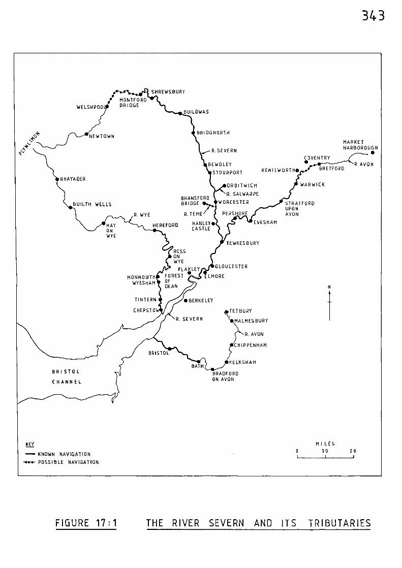
• BERKELEY
NEWTOWN
BRETFORD
WELSHP00
K EN I LW 0 RI H•
RHAYADERWARWICK
STRATFORDUPONAVON
BUILTH WELLS
EVESHAMHANLEY•CASTLE
TEWKESBURY
GLOUCESTER
ELMORE
ROSSONWYE
FLAX LEY
FOREST •OFDEAN
DROITWICH
R. SALWARPEBRANSFORDBRIDGE WORCESTER
R. TEME PERSHORE
HAY HEREFORDONWYE
R. WYE
CHEPSTOW TETBURY
MALMES BURY
R. AVON
CHIPPENHAM
R SEVERN
BRISTOL
BRISTOL
CHANNEL
MELKSHAMBATH
BRADFORDON AVON
COVENTRY•
MARKETHARBOROUGH•
R. AVON
MONTFORDBR I DOE
MONMOUTHWY ES HAM
TIN TERN
MI L ES
0 10 20
KEY
- KNOWN NAVIGATION
-••••- POSSIBLE NAVIGATION
BUILDWAS
BRIDG NORTH
R. SEVERN
BEWDLEY
STOURPORT
343
SHREWSBURY
FIGURE 17:1 THE RIVER SEVERN AND ITS TRIBUTARIES
344
Notes and References
(1) W.T. JACKMAN, The Development of Transportation in Modern England (Cambridge 1916, 2nd Ed. London 1962)26-27.
(2) ibid, 27
(3) T. ROWLEY, The Shropshire Landscape (London 1972) 236
(4) Calendar of Liberate Rolls, 1226-40, 99
(5) ibid, 99
(6) ibid, 466
(7) Calendar of Inquisitions Miscellaneous, 1219-1307, 129
(8) Calendar of Patent Rolls, 1272-81, 195
(9) Calendar of Patent Rolls, 1281-92, 116
(10) T. ROWLEY 235(op. cit.)
(11) Calendar of Patent Rolls, 1281-92, 257
(12) Calendar of Charter Rolls, 1257-1300, 418-19
(13) Calendar of Memoranda Rolls, 1326-27, 361
(14) Calendar of Patent Rolls, 1330-34, 430
(15) Calendar of Close Rolls, 1333-37, 53
(16) Calendar of Patent Rolls, 1334-38, 228
Calendar of Patent Rolls, 1345-48, 45
345
(17) Calendar of Close Rolls, 1364-68, 103
(18) C.T. FLOWER Public Works in Medieval Law, Seldon Soc., 32 (1915) 154-57
Calendar of Close Rolls, 1385-89, 544
(19) Calendar of Fine Rolls, 1383-91, 178
(20) Calendar of Patent Rolls, 1385-89, 547
(21) Calendar of Close Rolls, 1396-99, 52
(22) Calendar of Patent Rolls, 1396-99, 306
(23) E.M. CARUS-WILSON Medieval Merchant Venturers (London 1954,2nd Ed. 1967) 2
(24) J.W. SHERBORNE, The Port of Bristol in the Middle Ages (Bristol 1965)
(25) Calendar of Liberate Rolls, 1226-40, 95
(26) Calendar of Liberate Rolls, 1240-45, 313
(27) ibid, 314
(28) Calendar of Liberate Rolls, 1260-67, 235-36
(29) Calendar of Patent Rolls, 1281-92, 201
(30) Calendar of Patent Rolls, 1307-13, 87
(31) Calendar of Patent Rolls, 1348-50, 67-68
(32) Calendar of Close Rolls, 1272-79, 354
(33) Calendar of Patent Rolls, 1364-67, 140-41
(34) Calendar of Patent Rolls, 1381-85, 259
346
(35) M. BERESFORD, New Towns of the Middle Ages (London 1967) 501
(36) J. FORDE-JOHNSTON, A guide to theCastles of England and Wales (London 1981) 159
(37) Calendar of Liberate Rolls, 1260-67, 289
(38) C.T. FLOWER, Public Works in Medieval Law, Seldon Soc. 40 (1923) 361-62
(39) J.E.T. ROGERS, A History of Agriculture and Prices in England, vol. iv (Oxford, 1882) 696-97
(40) M. BERESFORD 499(op. cit.)
(41) L.T.C. ROLT, The Inland Waterways of England (London 1950) 32
(42) I. WATERS The Port of Chepstow (Chepstow 1977) 5
(43) ibid, 6
(44) Calendar of Liberate Rolls, 1226-40, 96
(45) Calendar of Liberate Rolls, 1240-45, 65
(46) ibid, 317
(47) I. WATERS 7(op. cit.)
(48) Calendar of Inquisitions Miscellaneous, 1219-1307, 119
(49) ibid, 120
(50) Calendar of Patent Rolls, 1292-1301, 627
(51) Calendar of Inquisitions Miscellaneous, 1307-49, 48-49
(52) Calendar of Close Rolls, 1330-33, 370-71
347
Calendar of Patent Rolls, 1330-34, 201 & 572
Calendar of Close Rolls, 1333-37, 304-05
(53) Calendar of Close Rolls, 1341-43, 647-48
(54) Calendar of Close Rolls, 1346-49, 176
(55) Calendar-of-Patent-Rolls, 1377-81, 134
348
CHAPTER EIGHTEEN THE RIVERS OF WALES
Compared with England, there was very little inland navigation
along the Welsh rivers during the medieval period. The mountainous
interior of the country produces, in general, fast-flowing and steeply
descending rivers which precluded much penetration by medieval vessels.
River Usk
From its source on the northern slopes of the Brecon Beacons, the
River Usk flows east to Brecon and then south-east to Abergavenny after
which it follows a more southerly course to Usk, Caerleon and Newport,
prior to entering the Bristol Channel after a course of 69 miles.
The River Usk was navigable for 20 miles during medieval times, to
(1)Usk, for the town is listed as a port in 1297, 1324 and 1342.(2)
In 1324, the bailiffs of Usk were ordered
"to cause all the ships of that port and of its members,capable of carrying 40 tuns of wine and upwards, to beprepared and found without delay, so that they shall beready to set out in the King's service on three days'summons, and not to permit such ships to go to partsbeyond sea hereafter, and to cause such ships as are nowwithout the port to be retained and prepared as above upontheir return, certifying the King of the number of suchships now in the port and outside the port, and to warnthe mariners and others of the port who are absent toproceed cautiously during their stay and return so thatthey do not fall into the hands of their adverversaries,pirates, or others."(3)
349
Rivers Taff, Neath, Tawe, Loughor, Taf and Gwendraeth
Along the coast of South Wales it appears that the River Taff
was navigable for about 2 miles to Cardiff, the River Neath for 5 miles
to Aberdulais, the River Tawe for 4 miles to Morriston, the River
Loughor for 4 miles to Pontardulais, and the River Taf for 7 miles to
St. Clears.(4)
The estuary of the River Gwendraeth was navigable for
3 miles, to Kidwelly, in 1297.(5)
River Towy
Rising on the southern slopes of the Cambrian Mountains to the
east of Tregaron, the River Towy flows south to Llandovery, and then
south-west to Llandeilo and Carmarthen, after which it turns south and
enters Carmarthen Bay betrieen the estuaries of the Rivers Taf and
Gwendraeth after a course of 60 miles.
The River Towy was navigable for 10 miles, from the sea to Carmarthen,
during the thirteenth century. In 1244, the bailiffs of Bristol were
asked
"to choose and pay for 40 tuns of wine in the town ofBristol by the view and in the presence of Peter the Poitevin,to buy 200 quarters of wheat and 200 pigs there, to put thewhole on board one or two good ships, and to carry one-halft6 the castle of Kaermerdin (Carmarthen) and the other tothat of Kardigan for the equipment thereof."(6)
Towards the end of the thirteenth century, in 1297, the King
sent a request to a number of places asking that all ships of the burthen
of 40 tuns and upwards assemble at Winchelsea; the port of Carmarthen was
350
included in this request.(7)
In 1326, there was a ferry across the river at Carmarthen,
for in that year the bailiffs were given a licence
"for them to have for three years in the water oftheir town a boat for the passage of those who wishto pass over there and to apply the profits arisingfrom such passage to the repair of their bridge, whichis broken down."(8)
Carmarthen was functioning as a port in 1342 when close scrutiny
of all those wishing to travel overseas was undertaken. (9)
Milford Haven Estuary
The long inlets of the Western Cleddau and Eastern Cleddau,
together with the River Pembroke, flow into and form the estuary of
Milford Haven.
During the medieval period ships could pass up the River Pembroke
(to Pembroke,
(10) the Western Cleddau to Haverfordwest,
11) and the Eastern
Cleddau to Canaston Bridge;-(12)
which are 10, 21 and 20 miles from
the sea respectively.
River Teifi
From its source on the western slopes of the Cambrian Mountains to
the north-east of Tregaron, the River Teifi flows in a south-westerly
351
direction through that place and on to Lampeter, after which it gradually
turns westwards and passes through Newcastle Emlyn and Cardigan before
it widens and enters the sea after a course of 70 miles.
The port of Cardigan, 5 miles up the river, is frequently mentioned
in medieval records; the transport of wheat and pigs from Bristol in
1244 being an example. (See River Towy).
However, the river was navigable above Cardigan and past Cilgerran
to Cenarth, where a waterfall in the course of the river would have
precluded further navigational progress. Cenarth is 3 miles below
Newcastle Emlyn and 14 miles from the sea. A record of 1314 states;-
"As the ancestors of John de Hastynges had a weir at Kilgaran,in the river Theyvy ... until the time of King Edward I, whocaused the weir to be levelled because he was given tounderstand that the weir was very prejudicial to the townand castle of Cardigan, because stone, brushwood and timbercould not on account of it be carried by water to the townand castle for the works, as is now found by an inquisitionmade by Roger de Montuo Mari, justice of Wales, and as bythe same inquisition King Edward II understands that it isnot to his prejudice, or to that of any other person, if aweir should be constructed anew in the place in which the
weir was' before, provided that a sufficient passage is leftfor ships and boats, except in this, that the King's weir ofKennarth and fisheries of that place and Leyghtred would beof less value by the year by 20s. than they are now worth,the King, wishing to do John de Hastynges a special favour,grants him leave to erect a weir in the same place, provideda sufficient passage is left for boats and ships, and that heand his heirs shall render yearly at the Exchequer ofKaermerdyn 20s ..."(13)
The river was obstructed at the weir of Cilgerran in 1340, (14)
and in 1383 the King issued an order
352
"to cause the water or river running beneath Kilgarencastle in Wales, ...to be made and kept wide and open,making no weirs therein, according to an agreement madebetween the late prince of Wales and a deceased earl ofPembroke, whereby it ought to be kept open, so that shipsand boats may pass to and fro, andwO.rs formerly thereinmade ought to be abated and removed as the King is particularlyinformed that they now are, none being new made". (15)
Rivers Dovey, Mawddach and Traeth Bach
Along the coast of Cardigan Bay, the estuary of the River Dovey
would be navigable for 8 miles to the vicinity of Pennal, the Mawddach
for 9 miles towards Cymmer Abbey, and Traeth Bach for 7 miles towards
Maentwrog.
In 1288, in an order to his Welsh castles, Edward I mentions
"his spies on the water of Dewy",(16)
or Dovey.
River Conwy
In North Wales, the River Conwy rises near Glasfryn, flows north-
westwards to Betws-y-Coed and then northwards to Llanrwst. It gradually
widens into an estuary and passes the town of Conwy, shortly after which
it empties into Conwy Bay after a course of 33 miles.
The river would have been navigable for 15 miles, to Llanrwst, for
in 1332, the King appointed
353
"William de Swynmor, on information that men of Snoudon,Coneway, Creudyn and parts adjacent cause the timber andbrushwood in the King's forest and woods of Snoudon to betaken away by the river Coneway and otherwise, to arrestall timber and brushwood conveyed along the river by anypersons whatsoever, and to keep the same in safe custodyuntil sufficient proof of purchase be shown."(17)
Llanrwst would be the nearest navigable place for loading the
timber in the area mentioned in this record.
River Clwyd
The final 21 miles of the River Clwyd, between Rhuddlan and the
sea, were canalized by Edward I in 1277. (18) This provided a direct link
for sea-going vessels which would allow ships to sail right up to the
castle to discharge their cargoes.
In 1279, the canal and 'port' of Rhuddlan were inspected by the
King's clerk with a view to having them cleaned. (19)
In 1280, a barge sailed from Rhuddlan and was given protection for
buying
"the things thatarenecessary ... during the King's pleasure.u(20)
River Dee
Rising in Bala Lake, the River Dee flows north-eastwards to Corwen,
then eastwards through Llangollen and Overton, where it turns northwards.
354-
The river then passes through Holt and reaches Chester, at which point
it turns north-westwards then broadens into a wide estuary which separates
Flintshire from the Wirral and discharges into Liverpool Bay between Point
of Ayr on the Flintshire side and Hilbre Point. For some of its course
the River Dee forms the boundary between England and Wales and its total
length is about 80 miles.
At the time of Domesday, Chester, 22 miles up-river from the sea,
was an established port. It was, at this time, under the jurisdiction of
Earl Hugh and his successors, and as such was the administrative centre
of a large earldom.(21)
The entries for the City of Chester in the
Domesday Book give an indication of shipping movements into the port.
"If ships arrived at the City port or left port without the King'spermission, the King and the Earl had 40s. from each manin the ships. If a ship arrived against the King's peace anddespite his prohibition, the King and the Earl had both theship itself and its crew, together with everything in it.But if it came with the King's peace and permission, thosein it sold what they had without interference. But when itleft the King and the Earl had 4d. from each cargo; if theKing's reeve instructed those who had marten-skins not to sellto anyone until they were first shown to him and he made hispurchase, whoever did not observe this instruction was fined40s.".(22)
In 1241, when Henry III was encamped at Rhuddlan, 3 tuns of wine
and various 'wooden works', were carried to him by water from Chester. (23)
In 1245, the bailiffs of Bristol were given the option of carrying
355
"to Chester by land or by sea, as may best and most safelybe done, 40 tuns of wine, which Peter the Poitevin willtake for the King,..."(24)
Lead and victuals were carried by water from Chester to Deganwy
in 1246,(25)
and during the same year the prioress and nuns of St. Mary,
Chester, were granted
"the right to have a boat on the water of Chester to fish wherethey will above or below the bridge ..."(26)
In 1257, 2000 salt congers and 6000 hake were brought to the port
of Chester by sea from Devon,(27)
and
"corn and.victuals by water from Bristol to Chester against thearrival of the King and his army, ..."(28)
In 1282, during his campaigns in Wales, Edward I issued an order
to the warden of the Cinque Ports
"to cause to be chosen by the counsel of the barons of thoseports as shall seem most expedient ten or twelve good andstrong carpenters, discreet and skilled in making bargesand punts, whom he shall cause to take the road to Chesterwith their tools."
These carpenters were instructed to make
"two good and new barges, each being thirty-two oared, which ...
356
shall ... be manned with strong and able men, and shall ...come thus manned to the King with the said barons andtheir service to Wales".(29)
Chester had trading links with Ireland during the thirteenth
century. In 1284, protection and safe-conduct were granted to
"the men whom Reginald de Grey is sending to Ireland witha ship to buy corn and victuals, and to return to Chesterwith the same for the maintenance of himself and his family".(30)
As well as Ireland and North Wales, waterborne traffic came to
Chester from Spain and Gascony, carrying such commodities as timber, lead,
coal, skins, wines and cloth.(31)
In the spring of 1322 a ship loaded
"with 105 tuns and seven pipes of wine and other goods",
was attacked near Anglesey whilst on a voyage from Bordeaux to Chester.(32)
In 1342 theport of Chester came under an order from the King which
encompassed all the Welsh ports. Collectors were appointed
"to collect, during pleasure, his custody, to wit1 mark on each sack, a mark on each last of hides, 1 markon every 300 wool-fells and other small customs and prestson all things taken out of the port of Cheppstowe and allplaces thence to Chester."(33)
357
Throughout the remainder of the fourteenth century there are frequent
references to the port of Chester. (34)
In the Dee Estuary and prior to later silting, there were small
ports at Burton,(35)
Shotwick,(36)
and also in the vicinity of Hoylake.(37)
On the Welsh side the castle at Flint could, in common with many of the
other castles built in Wales by Edward I, be supplied by sea. (38) In
1394, a ship was commandeered in the Dee Estuary and used for the passage
of the King's clerk to Ireland.
The River Dee appears to have been navigable for 20 miles above
Chester, to Overton, during the medieval period, for there are records
of an occasional quantity of timber being sent down the river to Chester
from that place.(40)
There are also details relating to fishing boats in the vicinity of
Eaton, 4 miles above Chester, for in 1330, the abbey of Pulton and the
monks there were granted
"a boat to be had by them free in the water of Chester, forfishing below and above the bridge of Chester, whereverany of the other free boats fishes, with all kinds of netsin the water of De by night and day at Ethun and elsewhere; ..."(41)
The rivers of Wales are mapped in Figure 18:1, and their
navigational limits, in medieval times, are indicated.
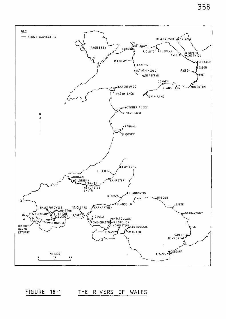
CORWENC---,--$2--)
•LLANGOLLEN OVERTONMAENTWROG
358
HI LBRE POINT • HOYLAKE
DEGANWY
R. CLWYD • H UDD LANFLINT.
CONW
R. CONWY--'
LLANRWST
BETWS-Y-COED
N----.GLASFRYN
CHESTER
• EATON
HOLT
TRAETH BACH\BALA LAKE
.BURTON•SHOT WICK
R. DEE---..,
KEY
— KNOWN NAVIGATION
•CYMMER ABBEY
N
R. MAWODACH
i
•PENNAL
R. DOVEY
•TREG ARONR. TE I Fl
ROIGANCILGERRAN LAMPE TER
CENAR H
N WCASTLEEM LYN
LLANDOVERYR. TOWY
BRECON
LLANDEILO R. USK
e•
MILFORDHAVENESTUARY
HAVERFORDWEST ST. CLEARS CARMARTHENCANASTONBRIDGE
E.CLEDDAU R. TA F KID WELLYPUN TAR DU LA IS
PEMBROKE R.GWENDRAETH •-R. LOUGHORMORRIST ON ABERDULA IS
R. NEATH
ABERGAVENNY
USK
CAR LEONNEWPORT.
CARDIFFMILES
R. TAFF--'0 10 20t I 1
FIGURE 18:1 THE RIVERS OF WALES
359
Notes and References
(1) fialoadar_sd_fautjasala, 1296-1302, 81-83
ibid, 100-102
(2) Calendar of Close Rolls, 1341-43, 485-88
(3) Calendar of Close Rolls, 1323-27, 183-84
(4) C. HADFIELD, The Canals of South Wales and the Border (Newton Abbot 1967) 15
(5) Calendar of Close Rolls, 1296-1302, 83
(6) Calendar of Liberate Rolls, 1240-45, 276
(7) Calendar of Close Rolls, 1296-1302, 102
(8) Calendar of Patent Rolls, 1324-27, 278
(9) Calendar of Close Rolls, 1341-43, 486
(10) Calendar of Close Rolls, 1296-1302, 83
(11) ibid, 500
(12) C. HADFIELD (op. cit.), 15
(13) Calendar of Patent Rolls, 1313-17, 99
(14) Calendar of Inquisitions Miscellaneous, 1307-49, 420
(15) Calendar of Close Rolls, 1381-85, 314-15
(16) Calendar of Chancery Rolls, Various, 1277-1326, 322
(17) Calendar of Patent Rolls, 1330-34, 367
360
(18) J. FORDE-JOHNSTON, A guide to the Castles of England and Wales (London 1981) 252-55
M. BERESFORD, New Towns of the Middle Ages (London 1967) 551-52
(19) Calendar of Chancery Rolls, Various, 1277-1326, 178
(20) ibid, 183
(21) D. SYLVESTER, A History of Cheshire (London 1971, 2nd Ed. 1980) 42
(22) P. MORGAN, ed., Domesday Book - Cheshire (Chichester 1978) 262c
(23) Calendar of Liberate Rolls, 1240-45, 69-70
(24) ibid, 312
(25) Calendar of Liberate Rolls, 1245-51, 58
(26) Calendar of Charter Rolls, 1226-57, 310
(27) Calendar of Liberate Rolls, 1251-60, 382
(25) ibid, 355-86
(29) Calendar of Chancery Rolls, Vari ou5 .1277-1326, 251
(30) Calendar of Patent Rolls, 1281-92, 116
(31) D. SYLVESTER (op. cit.) 52
(32) Calendar of Close Rolls, 1318-23, 453-54
(33) Calendar of Close Rolls, 1341-43, 647-48
(34) ibid, 487
Calendar of Patent Polls, 1396-99, 438
361
Calendar of Patent Rolls, 1399-1401, 296-97
(35) Calendar of Close Rolls, 1369-74, 520
(36) Calendar of Chancery Warrants, 1244-1326, 53
(37) Calendar of Charter Rolls, 1341-1417, 258-59
(38) 3. FORDE-JOHNSTON (op. cit.), 250
(39) Calendar of Patent Rolls, 1391-96, 522
(40) H.J. HEWITT, Medieval Cheshire (Manchester 1929) 75
(41) Calendar of Charter Rolls, 1327-1341, 155-56
362
CHAPTER NINETEEN THF RI\ERS OF NORTH-WESTERN ENGLAND
The risers considered in this chapter are those Oich discharge
into the sea in the counties of Cheshire, Lancashire, Westmorland and
Cumberland. The area cosered stretches from the Dee Estuary to the
Scottish Border.
Because the north-nest was economically unimportant during the
mediespal period, there %as little navigation along its rivers.
Riser Verse
Formed by the %aters of the Risers Ethero%, Goyt and Tame flowing
dorm from the estern slopes of the Pennines, the River Mersey flows in
a westerl y direction through Stockport. It receives the River Irwell
and proceeds sia Irlam and Warrington after which it gradually widens
then expands into an estuary at Runcorn. The estuary receives the Riser
easer and turns north-miest%ards %here it separates the Wirral from
LancasVire. The estuar), narrohs slightly between Liverpool and Birkenhead
and then enters Liserpool Ba after a course of 55 miles. (It should be
no7,..ed that eighteenth certur), impro\cmentE, together %ith construction
of the Manchester Ship Canal in the late nineteenth century - %hen
portions of the Risers Hersey and Ir%ell sere absorbed into it - have
altered to some extent the original courses of these rivers).
The infant port of Liverpool, founded by King John in 1207, (1) and
barely 4 miles from the open sea, vas visited by a few boats (2) Oich had
ventured across the Irish Sea.
In 1297, the bailiffs of Liverpool were told that
363
"the King wills that no one, whosoever he maybe, clerk or laymen, shall go out of the realmin any way without his special licence, heorders them not permit anyone to pass thesea from the port without such licence". (3)
There was a ferry between Liverpool and Birkenhead and in 1318
Edward II gave permission for
"the prior and convent of Birkheved to constructand hold, in their own soil at Birkeved at theferry, or as near thereto as convenient,sufficient houses for the entertainment of...travellers, and that the men about to remainin the houses may buy and sell, withouthindrance, victuals for the sustenance of thepersons about to cross the arm of the sea." (4)
Edward II himself is known to have sailed the 11 miles up the estuary
between Liverpool and Ince.(5)
During the fourteenth century the River Mersey was certainly
navigable to Warrington, 27 miles from the sea, as is shown by a record
of 1367:-
"On the petition of John Danyel, Knight, showingthat he has three boats often loaded withvictuals, timber and stone for the constructionof a bridge between Weryngton and Lacheford,and with goods, passing on the water of Mersebetween Lacheford and Werynoton for the quietand recreation of the people of those parts, theKing has taken the said boats and their mariners,and the victuals, timber, stone and goods intohis protection for two years." (6)
The Mersey is also shown to have been navigable for at least a
further 7 miles up-river of Warrington to Warburton, as is revealed by
a record of 1364 which also relates to the construction of a bridge:-
"Protection for one year for John le Botiller,Geoffrey de Werburton and Matthew de Rixton,who purpose to build a bridge over the water
364
of Mercy in their lordship, and for thecarpenters, masons, hewers of stone andother workmen employed, a boat called laCristofre which they are ordering for thecarriage of stone, lime and other thingsrequired and the mariners in it." (7)
This type of record obviously relates to the use of conventional
medieval vessels; however, the earliest medieval evidence relating to
the use of vessels on the River Mersey is that provided by the extant
remains of logboats.
Of thirteen logboats discovered in the environs of the river, and
described by S. McGrail, eleven were in the vicinity of Warrington,
together with finds at Irlam, and Barton on the River Irwell. (8)Very
little remains of four of these boats, but samples for radiocarbon dating
were taken from the surviving remains of the others. These samples were
taken near to the outside of the original log in order to get as close
as possible to the felling date. The results revealed that six boats,
including those from Irlam and Barton, could be assigned to the period
AD 1060 to AD 1205. (9) A seventh boat is probably of an even later date
(10)but still within the medieval period.
It is safe to conclude therefore that navigation on the River
Mersey extended at least to its confluence with the River Irwell 40 miles
from the open sea, during the medieval period.
River Irwell
As is shown by the surviving evidence of logboat finds, the River
Irwell was navigable for at least the final 3 miles of its course, from
Barton to its confluence with the River Mersey, during the medieval period.
365
River Weaver
Rising to the south of Audlem, the River Weaver flows northwards
via Nantwlch and Northwich at which point it turns north-westwards and
continues to Frodsham - 3 miles after which it enters the estuary of
the River Mersey below Runcorn, after a course of 40 miles.
The port of Frodsham, 3 miles from the confluence with the River
Mersey, recorded profits valued at £10 per annum from the tolls of ships
in 1280. (11)
Trading links between Frodsham and Ireland are evident from a
record of 1309 relating to quayage rights in the port. It was said
"that nobody ought to load or unload merchandisethere...and certain Irish and other merchantshave come there in ships laden with corn andother merchandise..." (12)
In 1324, Frodsham was included in a port-list, together with
Liverpool, whereby ships capable of carrying 40 tuns and upwards were
ordered
"to be prepared and found without delay, so thatthey shall be ready to set out in the King'sservice." (13)
It appears that the River Weaver as navigable for 9 miles above
Frodsham, to Weaverham, for there is a record relating to fishing on
the river there in 1241.(14)
It is likely that the River Weaver was navigable for a further 4
miles up-river of Weaverham, to Northwich, during the medieval period.
366
River Ribble
Formed by the confluence of a number of small streams to the
north-west of Peny-y-Ghent, the River Ribble flows generally south and
south-west through Settle and close by Clitheroe to Preston, after which
it gradually expands into an estuary and flows into the Irish Sea after
a course of 75 miles.
"In 1359, Adam de Skillycorn, coroner for thecounty, took a lease for six years of thefishings near Preston, and in consequence ofhis exercise of this right certain of the justiceswere appointed in 1360 to enquire into thestoppages of the passages in the Ribble, whichnot only injured the fisheries, butimpededships on their way to the Port of Preston. Thisis direct evidence that Preston was at this timea port frequented by ships, although probably ofsmall tonnage and not very numerous." (15)
Thus writes 3. Barron regarding the earliest record relating to navigation
along the River Ribble.
Towards the end of the fourteenth century, in 1398, the King
gave
"Exemption until further order, by advice ofthe Council, of the Knights, esquires,burgesses, merchants and commonalty of thecounty of Lancaster, on their petition, fromcustoms and imposts to be paid and levied tothe King's use on corn, malt, flesh and fishimported at Lancaster, Preston..." (16)
Although vessels were reaching Preston, 16 miles from the open
sea, it is likely that small medieval vessels could also have reached
Ribchester, 10 miles further up-river.
367
River Wyre
The estuary of the River Wyre, which cuts into the Fylde and
enters the sea to the east of Fleetwood, would have been navigable at
least as far as Out Rawcliffe - 8 miles from the sea.
River Lune
Rising to the east of Tebay, the River Lune turns due south and
on to Kirkby Lonsdale. The river gradually turns south-westwards and
passes through Hornby and Lancaster, after which it widens and enters
the sea after a course of 50 miles.
From the end of the thirteenth century, the port of Lancaster,
7 miles up the river from the sea, is frequently referred to in medieval
records.(17)
A record of 1365 indicates that the Lune was navigable for at least
a further 18 miles up-river of Lancaster, to Kirkby Lonsdale, for, during
that year, a grant was made to
"Richard de Wisebeche, vicar of the church ofKirkeby in Lonesdale, and Thomas Banes, ofpontage for six years in aid of the repairof the bridge of Kirkeby in Lonesdale on thingsfor sale passing by or under that bridge betweenthe priory of Horneby and Gratrehals." (18)
The exact location of the place called Gratrehals is not certain but
from the description given in the record it appears to have been up-river
of Kirkby Lonsdale.
368
River Kent
The estuary of the River Kent, which enters Morecambe Bay below
Arnside, would be navigable almost to Levens - 12 miles from the sea.
River Leven
Flowing out of Lake Windermere and descending past Low Wood, the
River Leven broadens into an estuary which enters Morecambe Bay to the
south-east of Ulverston.
The estuary of the river would be navigable almost to Low Wood -
8 miles from the sea.
River Duddon
The estuary of the River Duddon, which enters the Irish Sea to
the south-west of Millom, would be navigable for 9 miles to Broughton.
An indication that the Rivers Kent, Leven and Duddon were
navigated during the medieval period is given by the inclusion of Dalton-
in- Furness and Cartmel in a general order to a number of English ports
in 1323.(19)
River Esk
The small estuary of the River Esk was navigable for 2 miles to
Ravenglass, for, in 1324 ships capable of carrying 40 tuns of wine and
upwards were ordered to be prepared at that place.(20)
369
River Dement
From its source above Derwent Water the River Derwent flows into
Derwent Water then enters Bassenthwaite Lake from where it flows in a
westerly direction through Cockermouth to Workington, at which place
it enters the sea after a course of 28 miles.
Workington, and Cockermouth - 11 miles up the river, were
included in the previously mentioned record of 1324 asking for various
places to prepare ships capable of carrying 40 tuns of wine and upwards.
An inquisition of 1394 was informed that William de Albmarle,
formerly lord of Cockermouth, and his descendants, were entitled to
certain liberties within the precincts of the lordship. One of these
liberties was that
"they have had search,...and amendment of thewater of Derwent...from the sea to the headof those waters, as well in mill-ponds aselsewhere (with power) to close the said watersin close time and to punish transgressors byburning their nets and other engines andimprisonment and other punishments as the Kingand his ministers do elsewhere, taking the fines,amercements and other profits to their own use.Of every ship coming within the precinct of themanor they have had an anchorage-due called'yeveltol', and no ship may unload therewithout leave of the lord or his ministers." (21)
River Waver
The final 5 miles of the River Waver, from Abbey Town to
Moricambe Bay on the Solway Firth, were navigable during the medieval
period.
Abbey Town was previously called Holm Cultram, and in 1322,
370
safe conduct was granted to
"Ralph de Warham, merchant of Aymer de Valencia,earl of Pembroke, whom the earl is sending witha ship called La Garlsund of Holm to the southof the realm and to foreign parts to buy cornand other goods and to bring the same to theearl in the north or elsewhere." (22)
Holm Cultram was included in the previously mentioned record of
1324 asking for various places to prepare ships capable of carrying 40
tuns of wine and upwards.
River Eden
Rising to the south of Kirkby Stephen, the River Eden pursues a
north-westerly course through Appleby, Langwathby,Lazonby, and Warwick
after which it turns wesbsards via Carlisle and Beaumont to enter the
Solway Firth after a course of 65 miles.
In 1373, two boats were destroyed at Beaumont, 5 miles up the
river from the Solway Firth.(23)
There were obstructions in the river in 1399, (24) and in 1401
there is a record which relates to further obstructions and 'customable
merchandise' being taken to Scotland via the river from Carlisle to the
sea(25)
.
It is likely that, during the fourteenth century, the River Eden
was navigable for a further 7 miles up-river of Carlisle, to Warwick
Bridge - where the Carlisle to Brampton road crosses the river.
371
River Esk
For the most part a river of Scotland, the River Esk flows through
England for the final 10 miles of its course prior to entering the Solway
Firth above the estuary of the River Eden. It was probably navigable
for at least 7 miles to Longtown, during the medieval period.
The rivers of north-western England are mapped in Figure 19:1,
and their navigational limits, in medieval times, indicated. This
figure also shows the possible limit of Roman navigation according to
R. Selkirk, as discussed in Chapter Nine.
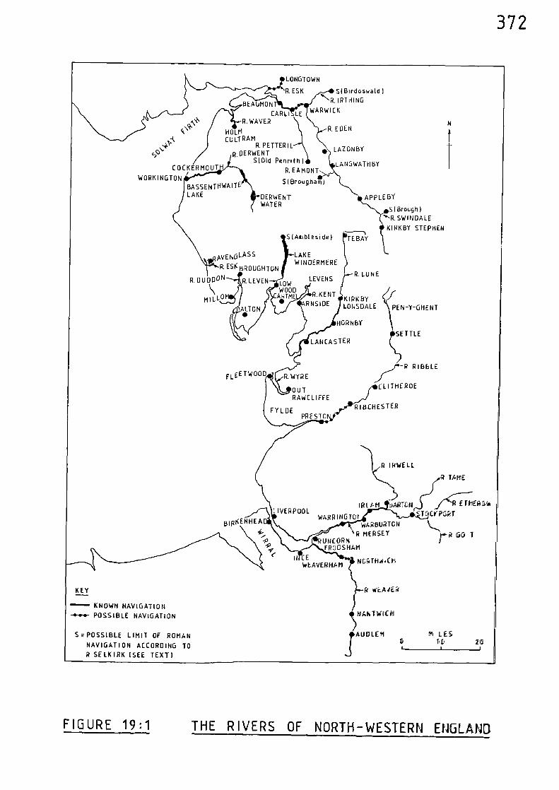
\R-HOLMCULTRAM
R. PETTER I LR.OERWENT •
S101d Penruth ICOCKERMOUT R. EAMONT
WORKINGTON
SI Brougham)BASSENTHWAITELAKE
LONGTOWN
R. ESK SI Birdoswald
."13. IRTHINGBEAUMON
CARLI LE WARWICKR. WAVER
DERWENTWATER
APPLE BY
Brough)"^-R.SWINDALE
KIRKBY STEPHEN
R IRWELL
TAME
IRL tMLIVERPOOL
WARRING TO
BIP(ENHEAI WARBURTON
R MERSEYUt/CORN
-P FRODSHAM
It CE NORTN-NiCHWEAVERHAM
...7<E;111EIRD)iii
cTGCMPDRT
rP GO) I
ftt LES1I060
WEAJER
NTWOCil
1
AUD LEN
KEY
KNOWN NAVIGATION
-•-•-•- POSSIBLE NAVIGATION
S = POSSIBLE LIMIT OF ROMAN
NAVIGATION ACCORDING TO
R SELKIRK (SEE TEXT]
R. EDEN
LAZ ON BY
LA NO WAT H BY
S(Ambleside)
TEBAY
LEVENS
MILL
LAKEWINDERMERE
AVENOLASS
R. ESI( BROUGHTON
R. DUDD" R.LEVEN LOW
WOODCAHTM•
HORNBY
SETTLELANCASTER
WYRE
OUTRAWCLIFFE
FY LHPRESTO
FLE E TWOOD
R. LUNE
KIRKBYLONSDALE PEN-Y-GHE NT
R BBLE
CL ITHE ROE
R I BCHES TER
372
FIGURE 19:1 THE RIVERS OF NORTH-WESTERN ENGLAND
373
Notes and References
(1) M. BERESFORD, New Towns of the Middle Ages (London 1967) 124
(2) H.J. HEWITT, Medieval Cheshire (Manchester 1929) 76
(3) Calendar of Close Rolls, 1296-1307, 81-83
(4) Calendar of Patent Rolls, 1317-21, 108-09
(5) H.J. HEWITT 76(op. cit.)
(6) Calendar of Patent Rolls, 1364-67, 379
(7) Calendar of Patent Rolls, 1361-64, 518
(8) S. McGRAIL and Medieval Logboats of the River Mersey - AR. SWITSUR, Classification Study - Being Chapter 6 of
'The Archaeology of Medieval Ships and Harbours in Northern Europe'. National MaritimeMuseum, Greenwich, Archaeological Series No.5,BAR International Series 66, (1979)
(9) ibid, 105
(10) ibid, 104
(11) H.J. HEWITT 76(op. cit.)
(12) Calendar of Inquisitions Miscellaneous, 1307-49, 15
(13) Calendar of Close Rolls, 1323-27, 183
(14) Calendar of Liberate Rolls, 1240-45, 21
(15) J. BARRON, A History of the Ribble Navigation From Preston to the Sea (Preston 1938) 46
(16) Calendar of Patent Rolls, 1396-99, 329
374
(17) Calendar of Close Rolls, 1296-1302, 81-83 and 100-102
Calendar of Close Rolls, 1323-27. 183
Calendar of Close Rolls, 1341-43, 485-88
Calendar of Patent Rolls, 1396-99, 329
(18) Calendar of Patent Rolls, 1364-67, 129
(19) Calendar of Close Rolls, 1323-27, 147-48
(20) ibid, 183-84
(21) Calendar of Inquisitions Miscellaneous, 1392-99, 23-24
(22) Calendar of Patent Rolls, 1321-24, 107
(23) Calendar of Patent Rolls, 1370-74, 311
(24) Calendar of Close Rolls, 1396-99, 437
(25) Calendar of Close Rolls, 1399-1402, 317
375
CHAPTER TWENTY 'THE NAVIGABLE RIVERS OF MEDIEVAL ENGLAND AND WALES
All the aforementioned regional evidence mentioned in Part Three
of this thesis can now be brought together in an attempt to produce a
national picture of inland navigable waterways existing during the
medieval period.
The rivers for which there is documentary historical evidence of
navigation are given as follows in Table 20:1, together with their
corresponding heads of navigation.
Table 20:1 The Navigable Rivers of Medieval England and Wales
and their Heads of Navigation
River Head of Navigation
1 Tweed Roxburgh Castle
2 Coquet Warkworth
3 Tyne Prudhoe
4 Wear Chester-le-Street
5 Tees Stapleton
6 Humber River Ouse
7 Hedon Burstwick
8 Hull Wansford
9 Beverley Beck Beverley
10 Ouse Rivers Swale and Ure
11 Derwent Stamford Bridge
12 Foss Strensall
13 Swale Morton
14 Ure Boroughbridge
376
River Head of Navigation
15 Nidd Knaresborough
16 Wharfe Tadcaster
17 Aire Fairburn (plus Cononley to Coniston)
18 Don Rotherham (plus Thorne to River Trent)
19 Trent Swarkeston
20 Soar Kegworth
21 Derwent Belper
22 Idle Elkesley
23 Eau Scotter
24 Ancholme Market Rasen
25 Great Eau Withern
26 Steeping Wainfleet
27 Witham Claypole'
28 Foss Dyke Lincoln to Torksey
29 Slea Sleaford
30 Bain Coningsby
31 Welland Stamford
32 Glen Catebridge
33 South Eau Crmaand to Tydd St. Mary
34 Nene Wansford
35 Car Dyke Peterborough to Swaton
36 Great Ouse Lavendon
37 Well Creek Outwell to Salters Lode
38 Oldcroft Outwell to Littleport
39 Old West Great Ouse to River Cam
40 Cam Great Eversden
41 Lark Mildenhall
42 Little Ouse Thetford
377
River Head of Navigation
43 Wissey Oxborough
44 Nar Castle Acre
45 Yare River Wensum
46 Wensum Taverham
47 Waveney Mendham
48 Bure Wroxham
49 Ant North Walsham
50 Thurne Horsey
51 Blyth Blythburgh
52 Alde Snape
53 Deben Woodbridge
54 Orwell Ipswich
55 Stour Maningtree
56 Colne Colchester
57 Blackwater Maldon
58 Crouch Battlesbridge
59 Roach Rayleigh
60 Thames Radcot Bridge
61 Swale Whitstable to River Medway
62 Medway Tonbridge
63 Len Leeds Castle
64 Darent Dartford
65 Ingrebourne Havering
66 Lea Hertford
67 Fleet Holborn
68 Effra Brixton
69 Cherwell Islip
70 Ray Ot Moor
378
River Head of Navigation
71 Great Stour Canterbury
72 Wantsum Great Stour to Sarre
73 Rother Etchingham
74 Brede Winchelsea
75 Ouse Lewes
76 Adur Bramber
77 Arun Arundel
78 Hamble Botley
79 Itchen New Alresford
80 Test Romsey
81 Medina Newport
82 Beaulieu Beaulieu
83 Avon Salisbury
84 Frome Wareham
85 Exe Exeter
86 Teign Newton Abbot
87 Dart Totnes
88 Tamar Morwellham
89 Lynher St. Germans
90 Fowey Lostwithiel
91 Truro Truro
92 Penryn Penryn
93 Helford Gweek
94 Camel Wadebridge
95 Torridge Weare Gifford
96 Taw Bishops Tawton
97 Parrett Langport
98 Tone Taunton
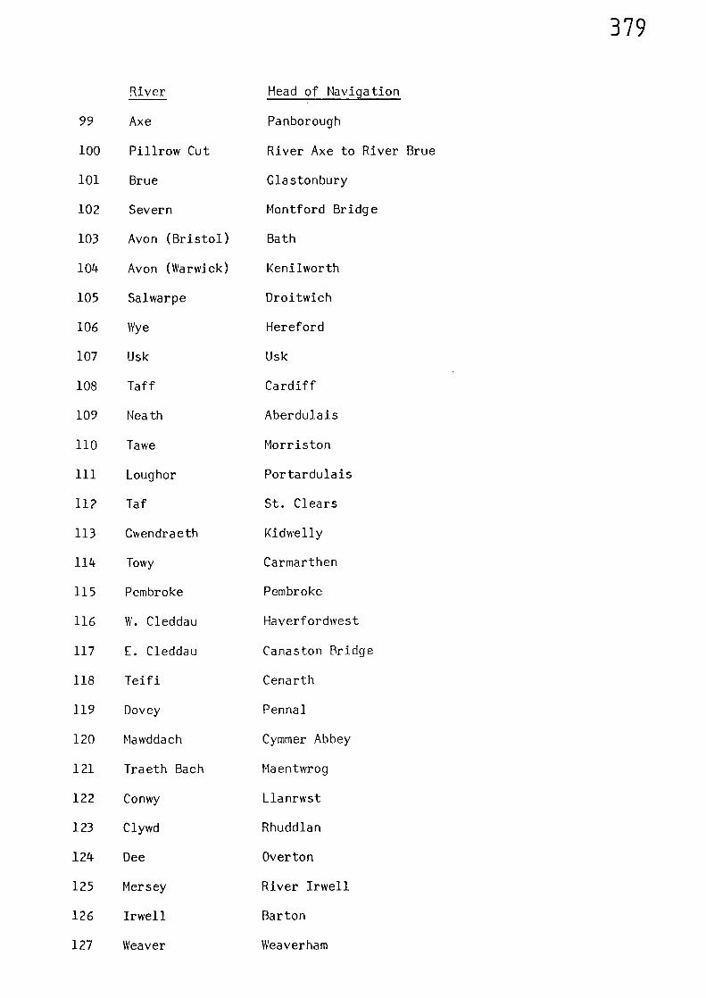
379
River Head of Navigation
99 Axe Panborough
100 Pillrow Cut River Axe to River Brue
101 Brue Glastonbury
102 Severn Montford Bridge
103 Avon (Bristol) Bath
104 Avon (Warwick) Kenilworth
105 Salwarpe Droitwich
106 Wye Hereford
107 Usk Usk
108 Taff Cardiff
109 Neath Aberdulais
110 Tawe Morriston
111 Loughor Portardulais
112 Taf St. Clears
113 Gwendraeth Kidwelly
114 Towy Carmarthen
115 Pembroke Pembroke
116 W. Cleddau Haverfordwest
117 E. Cleddau Canaston Bridge
118 Teifi Cenarth
119 Dovey Pennal
120 Mawddach Cymmer Abbey
121 Traeth Bach Maentwrog
122 Conwy Llanrwst
123 Clywd Rhuddlan
124 Dee Overton
125 Mersey River Irwell
126 Irwell Barton
127 Weaver Weaverham

380
River Head of Navigation
128 Ribble Preston
129 Wyre Out Rawcliffe
130 Lune Kirkby Lonsdale
131 Kent Levens
132 Leven Low Wood
133 Duddon Broughton
134 Esk Ravenglass
135 Derwent Cockermouth
136 Waver Holm Cultram
137 Eden Carlisle
The rivers given in Table 20:1 are mapped in Figure 20:1. For
clarity of presentation, the individual rivers are identified by the
corresponding numbers given in Table 20:1.
The national net ,nork of navigable rivers, produced by plotting
the regional evidence, is a minimum one. As discussed in the previous
chapters, it is likely that many rivers were navigable above the heads
of navigation determined by historical evidence. Other rivers, for which
evidence is lacking, were also possibly utilised, perhaps, as appears to
be the case with the River Aire in Yorkshire, along local stretches of
navigable water below vihich navigation may not have been continuous.
However, only the navigations as determined from historical evidence are
included in Figure 20:1 which shows about 2400 miles of navigable inland
water along which medieval cargoes were carried.
Analysis of the Movement of Goods by River
Apart from revealing the extent of inland navigable water utilised
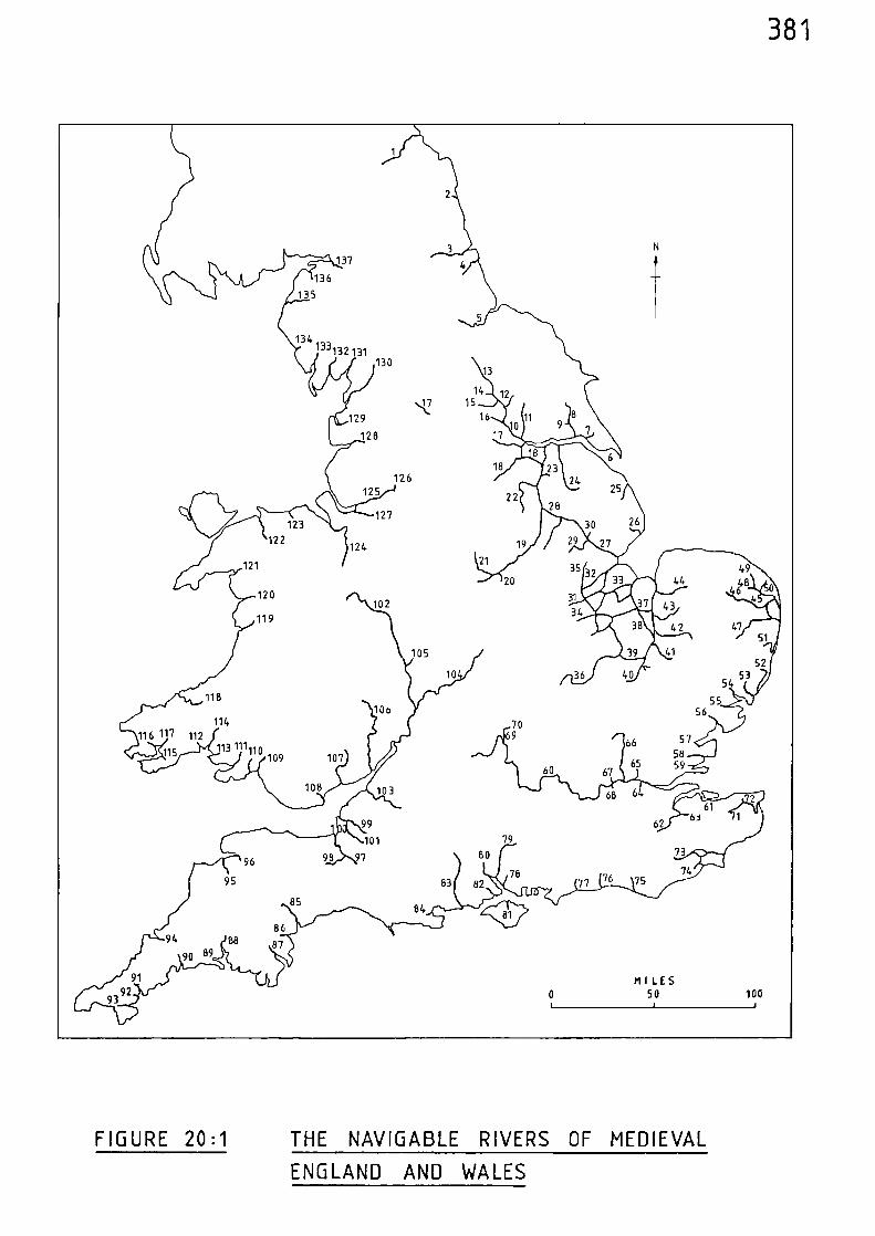
137
136135
134132 131
36 40 5354
10
Ivo61
99101
98 97
6362
73 1St76
7475
7883 82 77
8694 Be
8790 69
91
MILES
3 92
50
100
68108 103
7980
96
95
13
14‘• 17 15
10
12
816 11
130
129
128 17
18
22
19
126125
127
124 29
105
21
2035
44
31 43 Se 43
34
42Pig
4948
46
4751
5241
123122
121
120
119102
8584
5510o 56
116 11766
112
115 109 107 6560 67
7069 57
5859
381
FIGURE 20:1 THE NAVIGABLE RIVERS OF MEDIEVAL
ENGLAND AND WALES
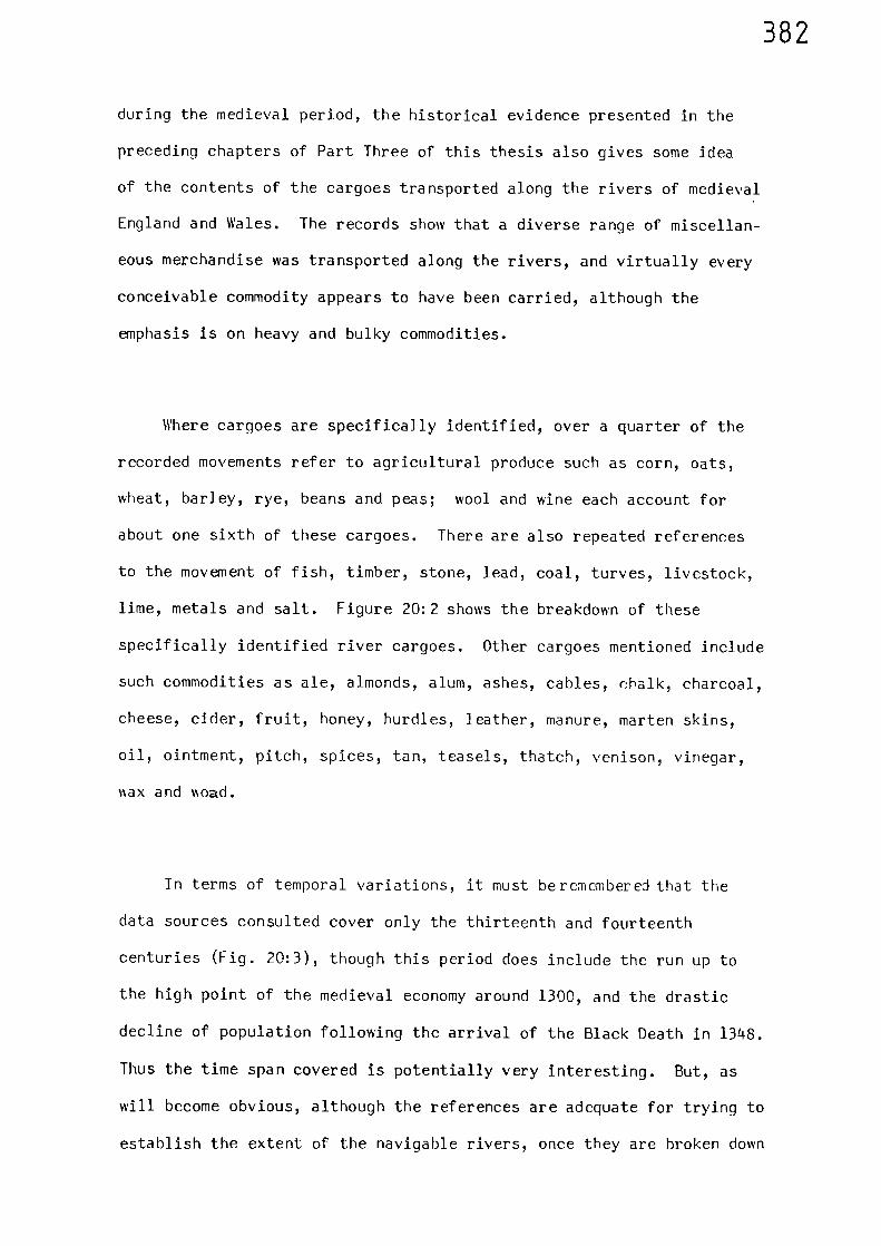
382
during the medieval period, the historical evidence presented in the
preceding chapters of Part Three of this thesis also gives some idea
of the contents of the cargoes transported along the rivers of medieval
England and Wales. The records show that a diverse range of miscellan-
eous merchandise was transported along the rivers, and virtually every
conceivable commodity appears to have been carried, although the
emphasis is on heavy and bulky commodities.
Where cargoes are specifically identified, over a quarter of the
recorded movements refer to agricultural produce such as corn, oats,
wheat, barley, rye, beans and peas; wool and wine each account for
about one sixth of these cargoes. There are also repeated references
to the movement of fish, timber, stone, lead, coal, turves, livestock,
lime, metals and salt. Figure 20:2 shows the breakdown of these
specifically identified river cargoes. Other cargoes mentioned include
such commodities as ale, almonds, alum, ashes, cables, chalk, charcoal,
cheese, cider, fruit, honey, hurdles, leather, manure, marten skins,
oil, ointment, pitch, spices, tan, teasels, thatch, venison, vinegar,
viax and oad.
In terms of temporal variations, it must beremembereJ that the
data sources consulted cover only the thirteenth and fourteenth
centuries (Fig. 20:3), though this period does include the run up to
the high point of the medieval economy around 1300, and the drastic
decline of population following the arrival of the Black Death in 1348.
Thus the time span covered is potentially very interesting. But, as
will become obvious, although the references are adequate for trying to
establish the extent of the navigable rivers, once they are broken down
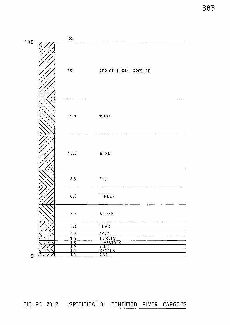
383
1000/0
25.1 AGRICULTURAL PRODUCE
40
15.8 WOOL
4
15.8 WINE
8.5 FISH
66‘, .<>>
8.5 TIMBER
8.5 STONE
Or i.,5.0 LEAD
Lik n 3.8 COALTr A 1.9 TURVESRh, 1 1.9 LIVESTOCKlir A 1.9 LIMEn b L\ 1.9 METALSlip, A 1.4 SALT
FIGURE 20:2 SPECIFICALLY IDENTIFIED RIVER CARGOES
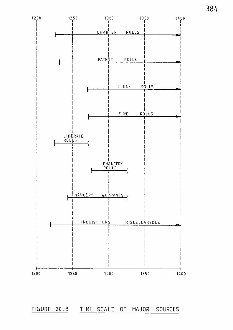
1200 1250 1300 1350 1400
1200 1250 13501300i
I
CHARTER ROLLS
PATE T ROLLS
CLOSE ROLLS
FINE ROLLS
I i I
I CHANCERY WARRANTS 1
INQUISITIONS MISCELLANEOUS
1400
•1
1
1 40.1
sol-I1
BE RATE
I ROLLS i
CHANCERYROLLS
1 Ian
384
FIGURE 20:3 TIME-SCALE OF MAJOR SOURCES
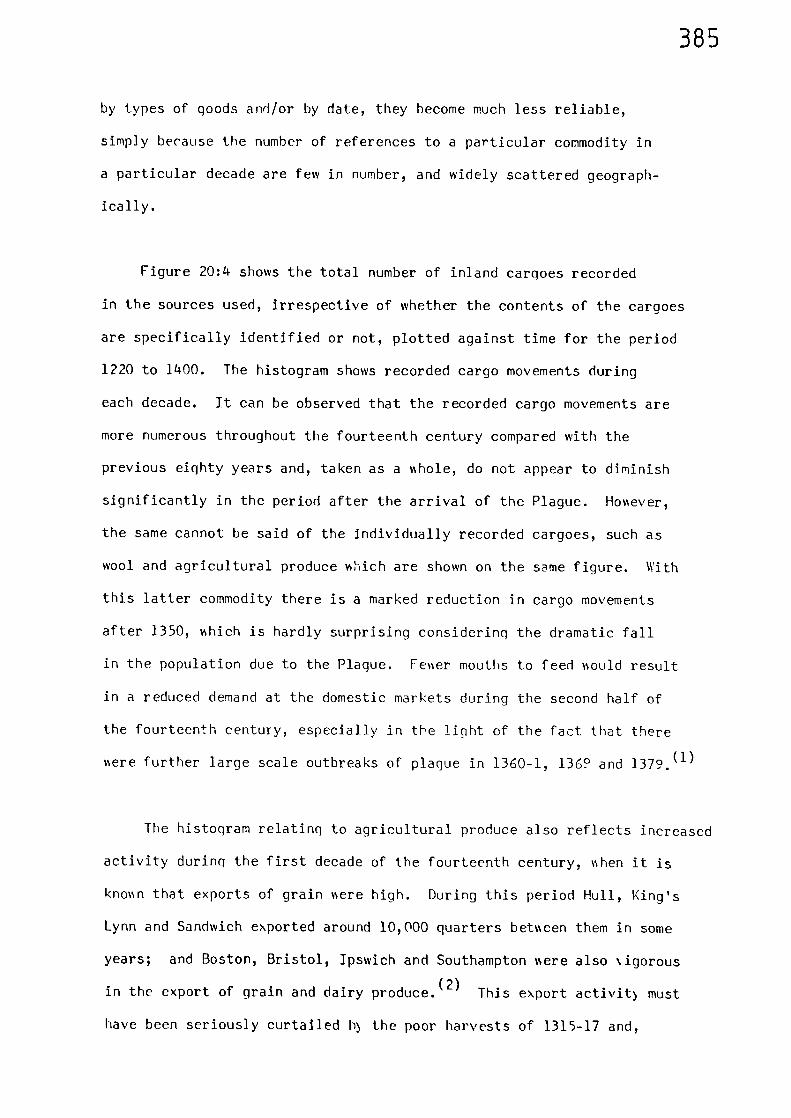
385
by types of goods and/or by date, they become much less reliable,
simply because the number of references to a particular commodity in
a particular decade are few in number, and widely scattered geograph-
ically.
Figure 20:4 shows the total number of inland cargoes recorded
in the sources used, irrespective of whether the contents of the cargoes
are specifically identified or not, plotted against time for the period
1220 to 1400. The histogram shows recorded cargo movements during
each decade. It can be observed that the recorded cargo movements are
more numerous throughout the fourteenth century compared with the
previous eighty years and, taken as a sshole, do not appear to diminish
significantly in the period after the arrival of the Plague. Holsever,
the same cannot be said of the individually recorded cargoes, such as
wool and agricultural produce which are shown on the same figure. With
this latter commodity there is a marked reduction in cargo movements
after 1350, %%Filch is hardly surprising considering the dramatic fall
in the population due to the Plague. Fever mouths to feed Isould result
in a reduced demand at the domestic markets during the second half of
the fourteenth century, especially in the light of the fact that there
%sere further large scale outbreaks of plague in 1360-1, 1369 and 1379.(1)
The histogram relating to agricultural produce also reflects increased
activity during the first decade of the fourteenth century, Ishen it is
knowl that exports of grain %sere high. During this period Hull, King's
Lynn and Sandwich exported around 10,000 quarters bebseen them in some
years; and Boston, Bristol, Ipswich and Southampton %%ere also ‘igorous
in the export of grain and dairy produce. (2) This export activity must
have been seriously curtailed b) the poor harvests of 1315-17 and,
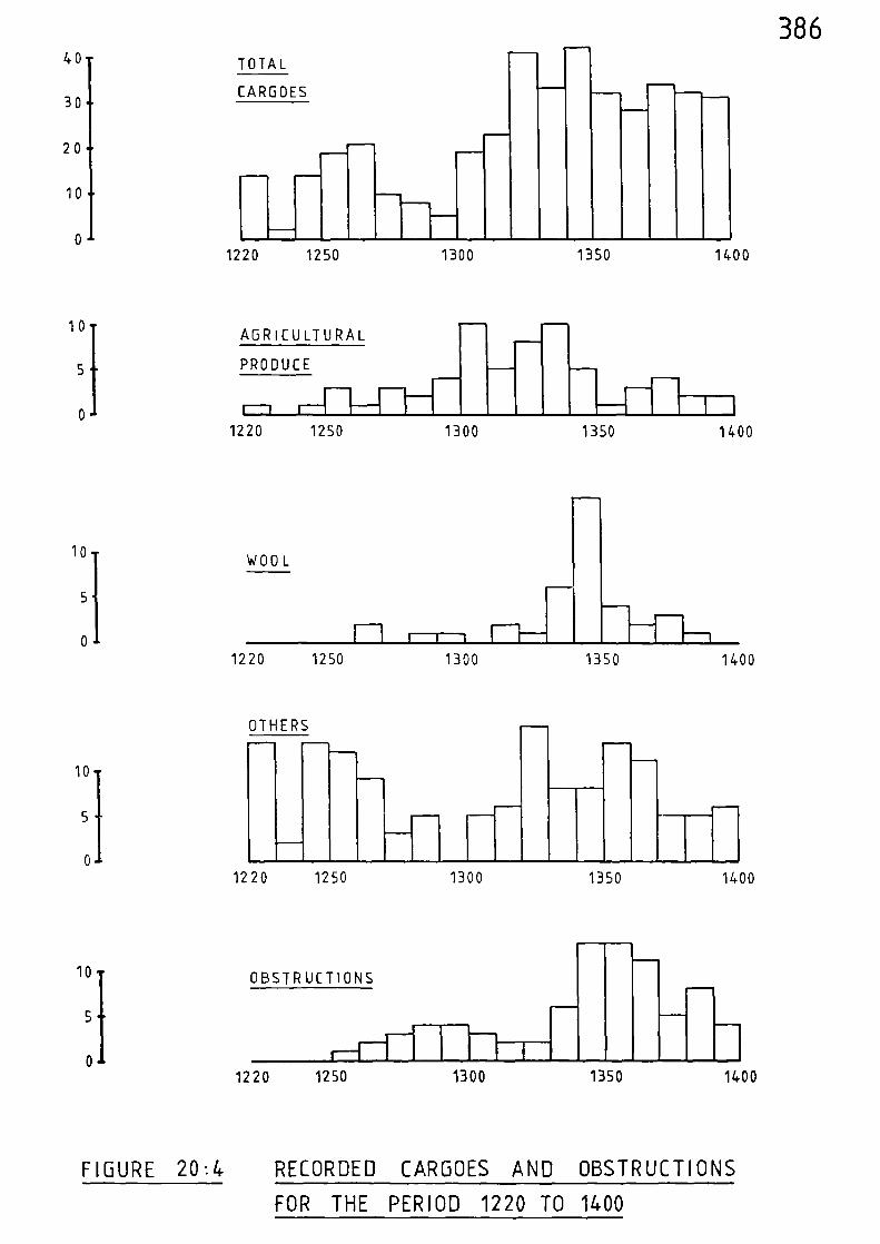
TOTAL
CARGOES
••n•=,
1220 1250 1300 1350 1400
.1nEF.
AGRICULTURAL
PRODUCE
1-11220 1250 1300 1350
--T11400
WOOL
1220 1250 1300 1350 1400
OTHERS
1220 1250 1300 1350 1400
OBSTRUCTIONS
-1 1
1220 1250 1300 1350 1400
40-
30
2 0
10
0 -
10/
5
0
10 1
5
0
10/
5
0
10/
5
0
386
FIGURE 20:4 RECORDED CARGOES AND OBSTRUCTIONS
FOR THE PERIOD 1220 TO 1400
387
although attempts were made to import agricultural produce from such
places as France and Spain, there appears to have been a deficiency
at the domestic markets resulting in a reduction in cargoes (both
domestic and foreign), a trend that is shown for the second decade of
the fourteenth century in the histogram.
Although the histogram for agricultural produce would appear to
fit in approximately with the known changes in fortunes experienced
during the thirteenth and fourteenth centuries, the dangers inherent
in the attempted manipulation of such meagre and fragmented evidence
is clearly shown by observing the trends of the recorded evidence for
the cargoes of wool (Fig. 20:4). Inland waterborne movements of wool
are scarcely mentioned in the records prior to the 1330's yet it is
known that exports reached an avera ge approaching 36,000 sacks yearly
in the first decade of the fourteenth century and were still running at
over 30,000 sacks a year in the 1350's. (3) Therefore, it is reasonable
to assume that we mould have expected to observe sustained activity in
the movement of wool along the navigable rivers to the various customs
ports during the first decades of the fourteenth century. This activity
is not reflected in the histogram for wool and the reason is, quite
clearly, that there are simply too few recorded instances of its trans-
port along the inland rivers to enable any meaningful trends to be
observed, making it virtually impossible to arrive at any firm conclusions
regarding the possible variation in waterborne movements across the time-
scale under consideration. These same comments viould also apply to the
other commodities taken on an individual basis, as their recorded cargoes
are even less frequently mentioned than those of wool (see Fig. 20:2),
thus making any further analysis along similar lines futile.
388
Figure 2n :4 also shows the recorded instances of obstructions to
inland navigation. The numher peaks in the two decades between 1340
and 1360. The increase in complaints during the 1340's must have
greatly increased the pressure on the King to provide legislation in an
attempt to rectify the situation which culminated in the statute of
1351 when Edward III passed an act for the removal of obstructions
placed in all rivers since the time of Edward I. The maintained level
of surveys and commissions mentioned during the 1350's and 1360's
reflects the pressure brought to bear by navigators and ship-ossners ihho
would no doubt be anxious to exercise their rights under the new
legislation.
In order to observe any possible regional variations, the specif-
ically identified river cargoes can be tabulated in relation to geograph-
ical location. Table 20:2 lists these cargoes by quantity and ident-
ifies the regions in which they are recorded, these being the same regions
used in Chapters Nine to Nineteen. Although the evidence on valich it
draws is far from extensive, Table 20:2 is instructive because it sho nNs
that certain commodities were transported along the medieval inland
waterways in virtually every region of England and 111es. Commodities
in this category are:- agricultural produce, wool, %%ine, fish, and the
basic building materials of timber, stone and lead.
There would be no point in attempting to enter into a comprehensive
description of the medieval industries involved in the production of
these commodities; this has been accomplished elsewhere. However,
certain aspects of their conclusions are relevant and assist in evaluat-
ing the geographical distribution of the various cargoes.
389
Z0_
LOLIJ
2 1—
I— V)CG LU0Z
-4- .t— %— .— CV .-•
V)UJJ<
.4- Ln Ln n-- ry1 a- a- a- CV
ZcCI-1-1>LUV)
CV Lil N. (NI CV %- c-- %-
= I—I—
= V)li_l
Q-.V) --'
rn CV CV CV ‘-• .--- .-- CV %-- CV CV
= I-F- V)= <0 C)(.4 LJ
rn CnI C.-1 CV CV %- .-
V)Li j
<=I--
No LI1 .0 (*NI 1_11 L11 (V .- CV %---
CL1.-- <CA :-.A1< t—i
=1.1.1<
cr. -4- (-4 --t .— (-NJ r- T- C-
V)=IllLi_
%.--%--
rn ......t r- %-- rn •— l—
1--•ZLJJCCI-
C,%-- C--- fil rri CV CV m .-- .— .--
Vicc0
>-
r--- .0 -4. CV rri rn .- CV rrt %—
= I—I—
CC V)0 <Z U-I
va cv U1 CV .- %-- a- ....t
).-I-_00ZZ
CD
Li
LULi
IZI0CCCI_
I---:_JDt__,—cc
Li<
—Icz)
0____->
Lu=—
=v)
U.-
CCwCC1z
—1---
I-1-1
0
I—V)
,..1=1...4ft
LU—I
_....,H..1.CoLi
V)w
>cc
D1-•
Li
0I--VI
U-I•••,..
--_-
-J
1-1-j
—J
(i)—1
<I-(-1-1Z
I--J<V)
ccLU>_cc
0
Cs4
C=,CV
LU_JCO
<I-
390
In the primarily agricultural society of medieval England and Wales,
supply and demand for agricultura] produce vbould fluctuate in relation
to the size of the harvest and to any geographical variations in it
which there might have been. In years of surplus, such as the first
decade of the fourteenth century, there would be an increase in the
number of cargoes to the customs ports for export. Conversely, in years
when the harvest was poor, and attempts were made to obtain produce
from abroad, vessels would be carrying such cargoes in the opposite
direction, as imports. Apart from cargoes that were stimulated by
external market forces there was trade in agricultural produce between
different regions of the country. Travelling merchants, traders in
corn and victuals came into local districts and transported their
purchases to other localities to be sold.(4)
Also, in some years, a
portion of the harvest might be taken by the King's purveyors seeking
sustenance for the army or navy, as was shown during the various
campaigns of Edward I for example. It has been estimated that towards
the end of the thirteenth century, about forty per-cent of England's
peasant population were small-holders ‘Nho, in order to feed their families,
had to buy corn on the market using money obtained by working as Isage
labourers for lords and the relatively ne‘N class of wealthier peasants.(5)
This type of situation would generate movement of agricultural produce
not only involving local market centres but also others which were
sometimes a considerable distance away. For example, when various
cargoes of corn were taken by water from Newark to York in the 1330's,
the distance travelled was in excess of 100 miles.(6)
As with agricultural produce, wool was produced to a greater or
lesser extent all over England and Wales, and by the close of the thirteenth
century it has been estimated that there were more sheep in
391
Britain than people.(7)
Both lay and ecclesiastical landowners increased
their flocks of sheep through the twelfth and thirteenth centuries %ith
a view to the export of wool abroad. (8)The high export of wool at the
beginning of the fourteenth century has already been mentioned; London
handled almost half of this, followed by Boston, Hull, Southampton,
Ipswich, King's Lynn, Newcastle and Yarmouth. (9)The bulk of the wool
of the larger producers, having first been inspected and bought by
foreign merchants, appears to have been despatched directly to agreed
shipping points rather than disposed of through local markets,(10)
and
there is evidence to show that the navigable rivers %ere employed. For
example, in 1338 when a large export order was fulfilled, part of the
wool of Oxfordshire was assembled at Henley and then sent down the
Thames to London; Yorkshire wool was sent down the Hull, tire, wharfe and
Ouse to Hull; and the rivers of the Fen were utilised to transport
(11)%ool gathered at Huntingdon to King's Lynn.
Although there is evidence to confirm the domestic production of
wine in England during the medieval period, Gascon lanes had captured
the English market; by the early fourteenth century some 20,000 tuns %ere
coming into England each year.(12)
(one tun = 252 gallons). Although
the main importing centres sere London, Hull, Southampton and Bristol,
(13)%ine vias brought into ports all around the coast of England and Wales.
It %as a fragile and awkward commodity to carry overland and a cart
carrying a tun of wine might require as many as six horses at a time.(14)
Thus, for reasons of both preservation and cost, transport via navigable
water would be an attractive method of distribution to medieval merchants;
hence it is not surprising to observe that cargoes of wine were to be
found on the navigable rivers in every region of England and Wales.
The early fourteenth century accounts of the royal butler show that wine
392
was generally transported via navigable water and it was usually only
the last stage of the journey that was completed by road.(15)
For
example, the waterways radiating from the River Humber were utilised
in the early fourteenth century when the royal butler bought wine in
bulk at Hull and distributed it throughout a wide range of royal
manors, castles and religious houses. In this way wine was sent to
Burstwick, Colwick, Nottingham Castle and on by road to the manors of
Clipston and Sherwood; it was also sent from Hull to Pontefract, York,
Rievaulx, Knaresborough and Durham Abbey.(16)
Cargoes of fish, from both river and sea, were also carried along
the navigable waterways in every region throughout the medieval period.
Even though the Domesday Book gives only scant mention to sea-fisheries
it does record inland fisheries along the Thames, the Severn, the Nene,
the Trent, the Great Ouse, the Dee, the Medway and others; salmon were
caught in the Severn, the Dee and the Dart, nshilst the Fenland rivers
produced great numbers of eels.(17)
River fishing continued apace
during the remainder of the medieval period as the number of obstructions
to navigation caused by the various devices employed by the fishermen,
and mentioned in the aforegoing chapters, can testify. Apart from these
inland fisheries, which in themselves would generate a trade in fresh-
water fish, there were countless places all around the coast involved
in sea-fishing. Many coastal towns had monopolies or exclusive rights
of landing and selling fish, taking toll from the boats which came in
with fish. For example, during the middle years of the fourteenth
century the bailiff at King's Lynn demanded two salmon from ships
carrying thirty-two or more salmon and even attempted to take money from
boats laden with fish which were passing through that port on their way
to Cambridgeshire, Northamptonshire, or elsewhere.(18)
Herrings %sere
393
a popular catch of the east coast ports and a large industry was centered
on Yarmouth. Consignments of herrings were regularly sent from Norwich
to Westminster entirely by water during the thirteenth century.(19)
The widespread medieval trade in fish is born out by the remains of sea-
fish at inland sites. At Barnard Castle, Durham, fragments of six
different types of sea-fish were found in a blocked-4) drain; whilst at
Northampton the remains of herring, cod, ling and flatfish have been
discovered.(20)
The heavy basic building materials of timber, stone and lead were
obvious candidates for transport by water. Although timber and stone
would quite often be available locally, these materials were sometimes
transported considerable distances for the construction of the more
important medieval buildings. The Tower of London has Kentish ragstone
and stone from Caen in Normandy in its walls, all of which was shipped
up the River Thames.(21)
Caen stone was also shipped to Norwich between
1094 and 1178 for the construction of the cathedral. The great medieval
quarries at Rarnack, near Stamford, provided stone which was taken by
boat for the building of abbeys at Ramsey, Crmdand, Sawtry, Bury St.
Edmunds and Peterborough.(22)
Stone from near Tadcaster as shipped to
York Minster, and Purbeck marble was taken up the Thames to Westminster.
Cotswold stone from Taynton, near Burford, was taken down the Thames to
Windsor and London, whereas the stone extracted from the Bath quarries
was mainly used locally.(23)
When building operations of any importance
were undertaken, it was usual to build a limekiln for burning the lime
to produce mortar. Lime burnt in this way was transported from
Pontefract to the works at York Castle in 1245.(24) Lead used for
roofing and piping, was mined in several areas during the medieval
period. The mines in the Peak District of Derbyshire appear to have been
394
the most important,and there were other mines in Weardale, Teesdale,
Wensleydale, Wharfedale, Rossendale, North Wales, Mid-Wales, the
Mendips and Devon.(25)
During the twelfth century, lead, from the
mines of Alston Moor on the borders of Cumberland, Yorkshire, and North-
umberland, dominated the market. However, following the Scottish
incursions of 1172-3 the output of the more southerly mines increased.
The thirteenth and fourteenth centuries witnessed lead from the Welsh
mines passing along the Severn and the Dee; that from the Yorkshire
and Derbyshire mines passing along the Tees, the Yorkshire rivers,
the Trent, the Dement, the Idle and the Witham; that from the Mendip
mines passing down the Axe; whilst the bulk of the export trade was
conducted via London, which received shipments from all the lead produc-
ing areas.(26)
In considering the overall picture of inland trade it must be said
in conclusion that although the references relating to the internal
movement of waterborne cargoes exposed in Part Three of this thesis are
invaluable in determining the extent of inland navigable water utilised
during the medieval period, and hence add to our knovdedge of internal
trade, they are not sufficient to allow much detailed analysis of
spatial or temporal variations of different types of cargo.
Having determined the minimum extent of inland navigable water
utilised during the medieval period and examined the types of cargoes
carried, the next logical step is to consider the medieval coasting
trade, and to attempt to discover something about the vessels which
plied along inland and coastal waters.
395
Notes and References
(1) T. ROWLEY, The High Middle Ages 1200-1550 (London, 1986) 21
(2) E. MILLER and J. HATCHER, Medieval England - Rural Society and Economic Change 1086-1348 (London, 1978)82
(3) ibid, 81-2
(4) J.F. WILLARD, 'Inland Transportation in England during theFourteenth Century' Speculum, 1(1926) 364
(5) L.M. SMITH (ed.), The Making of Britain - The Middle Ages (London, 1985) 92
(6) See Chapter Eleven
(7) L.M. SMITH (ed.) )(op.cit.),I26
(8) J.M. STEANE, The Archaeology of Medieval England and Wales (London, 1984) 249
(9) H.C. DARBY (ed.), A New Historical Geography of England (Cambridge, 1973) 177
(10) ibid, 121
(11) See Chapters Ten, Twelve and Fourteen.
(12) M.K. JAMES, Studies in the Medieval Wine Trade (Oxford, 1971)9-10
(13) ibid, 151-53
(14) ibid, 147
(15) ibid, 147
(16) ibid, 180-81
396
(17) H.C. DARBY (ed.), (op.cit.), 57
(18) L.F. SALZMAN, English Industries of the Middle Ages (London, 1964)275
(19) See Chapter Thirteen.
(20) J.M. STEANE (op.cit.), 261
(21) J.M. STEANE, (op.cit.)9,
(22) J.M. STEANE, (op. cit.), 226
(23) T. ROWLEY (op. cit.), 163
(24) See Chapter Ten
(25) I.S.W. BLANCHARD, 'Lead mining and smelting in medievalEngland and Wales', being a chapterin CBA Research Report Mo. 40,1981 72-84
(26) T. ROWLEY, (op.cit.), 161
397
CHAPTER TWENTYOME THE MEDIEVAL COASTING TRADE, COASTAL PORTS,
AND VESSELS
.Although this thesis is directed towards internal transport, the
internal trade of the realm was, by its very nature, supplemented by the
coasting trade. When navigable rivers were at hand goods were frequently
moved to and from the coastal ports by that means, or taken from one
river system to another via coastal waters. Coastal movements were often
integrated with overseas voyages and cargoes were often transferred to,
and from, sea-going ships using small coastal and river vessels. Although
the medieval coastal trade could be given a very exhaustive and segregated
treatment in its own right, this is not the place for such a study, and
it is the object of the current chapter only to give an insight into such
trade, to identify coastal ports, and to give a brief description of
medieval vessels.
The Coasting Trade
The previous chapters, apart from highlighting the navigability of
a number of waterways, also cited many examples relating to the coasting
trade;- the medieval coal trade of north-eastern England and the shipment
of lead and stone out of the Tees, the shipment of Yorkshire produce to
various places around the coast, the transport of provisions out of the
many ports of the east coast, the interaction between the ports of the
south coast, the links between the ports of the south-nest and Wales; all
around the coast there are examples of local shipping movements. To
these previous examples others can be added, in order to demonstrate the
use of coastal waters.
Apart from its obvious connections with inland mterways, coastal
trade was often directly associated with voyages to and from foreign parts -
398
as in 1227, when wine shipped to the port of Sandwich from Gascony was
then transferred into small boats for its onward journey to Windsor.(1)
Heavy cargoes such as lead were often carried via coastal waters -
as in 1259 when the commodity was carried from Boston to Westminster
"...for the King's works there." (2)
Venison was carried by water from Scarborough to Westminster in 1260 (3)
and the next year stone was transported from Kent to the capital using
the same method.(4)
Timber was carried by water from the forest of Essex
to Dover in 1261, (5) and from Portchester to Corfe during the same year.
(6)
In June 1274, a ship was loaded
"...at Hedon with 15 sacks of wool, 23 cartloadsof lead, and a last of hides, and on the_sameday the ship started towards Sandwich.(7)
Corn and other victuals were conveyed by water from the towns of Bridgwater,
Totnes and Dartmouth to Pembroke, Carmarthen, Kidwelly and Swansea in
1277.(8)
Throughout the fourteenth century there are many recorded examples
relating to the coasting trade. Grain, peas, beans and barley %ere shipped
between North Coates and Saltfleet in 1311. (9) Two ships loaded with
various victuals were sent from King's Lynn to Berwick in 1315.(10)
In 1329, a small ship conveyed victuals from Falmouth to Fowey, %here a
'great ship was loaded.(11)
Protection was granted in 1338 to
"Stephen de Hexham of Newcastle-upon-Tyne,merchant, who has the King's licence tobuy 300 quarters of wheat in the county ofKent and ship the same..." (12)
Certain merchants of Norfolk were granted safe-conduct in 1350 for
399
"..crops, malt and other victuals loaded in somesmall boats in the said county and brought by seato London..." (13)
A licence was granted in 1361 to the parson of the church of Huntspill
in Somerset allowing him
"to put the crops arising from his church inships and boats and take them by water toWales to sell them there for his profit." (14)
Hides were shipped from Newcastle-upon-Tyne and Hartlepool to Blyth in
(15)Northumberland in 1366, and during the same year 300 quarters of
corn were taken by ship from Liverpool to Scotland.(16)
Hides were also
shipped from Newcastle-upon-Tyne to King's Lynn, Yarmouth and London in
1368(17)
and malt and flour was taken from Great Yarmouth to Newcastle-
upon-Tyne during the next year.(18)
Various cargoes of wheat, malt and
barley were shipped from Norfolk and Lincoln to London in 1370,(19)
and
during the same year 300 quarters of beans were loaded in the port of
Bridgwater and carried to Wales for sale.(20)
During 1382, Robert
Gamelston of Retford, a mason, was
"appointed by the King to take two ships andas many mariners, masons, quarrymen and diggersas may be necessary for the carriage of the stonewhich he has agreed to bring from the counties ofYork and Nottingham to Westminster for the King'suse." (21)
This same mason was again appointed to procure stone in a similar manner
in 1391.(22)
In 1384, wool was transported by ship from Shorham to
Southampton,(23)
and during the next year this same commodity was taken
by water to the capital from the Isle of Thanet.(24)
During 1387 an order
was issued:-
"To the collectors of customs and subsidies inthe port of London. Order... to lade twelveshort cloths in two packs, two cloths of'raye', sixteen pieces of strait cloths of
400
Essex containing four cloths, and one pieceof cloth of 'raye' of 'candelwykstrete' forlivery of the King's hired soldiers and ofhis household..., two beds of 'worstede' iro one'clothseke', and one barrel with two saddles ...in a ship... in that port, and without takingcustom or subsidy thereupon, to suffer himto take them to Newcastle-upon-Tyne." (25)
A licence was granted in 1388
u ...notwithstanding the late prohibition againstany vessel, barge or balinger passing out ofany port in the Kingdom, for Richard Nevill ofLondon, 'grosser', to pass out of Faversham withhis three crayers laden with fruit, one forBoston, one for Hull and the third for London;...after discharging them at the said places, thesaid Nevill will with all haste bring them to theDounes by Sandwich, there to await the King'scommands." (26)
The variety of produce transported via the coasting trade is given
by a record dating from the spring of 1391, when the sale of such produce
in the port of Kingston-upon-Hull was exempt from paying the subsidy of
12d. in the pound. The collectors in the port were ordered
"to suffer merchants whatsoever, native and alien,and others who will bring thither wheat, barley,malt, rye, oats, beans, pease, fresh fish and othervictuals for relief of the people to sell the samewithout further order, taking no custom or subsidyto the King's use or their own or to the use of anyother; as in consideration of the daily increasingdearness of corn and victuals in the realm,..." (27)
Berwick-upon-Tweed was supplied with victuals from Hull, Barton-upon-
Humber and Grimsby in 1391.(28)
A licence was granted in 1392
"for John Ray of Bristol to buy 36 sacks of woolof the growth of la Westmarche by Carlisle, loada balinger of Dertemuth, whereof John Kent ismaster, therewith, and bring the same to Bristolfor purposes of gain." (29)
401
It is well worth quoting in its entirety. the final paragraph from
T.S. Willan; introduction to hi book, River Navigation in England 1600-
1750, as it so succinctly puts into perspective the relationship between
river navigation and the coasting trade, and would apply, in general
terms, to the medieval period:-
It[ is not so much the importance of the coastingtrade that must be emphasized as its connexionwith river navigation. The physical connexion isindeed obvious. Coal that left the staithes atNewcastle was unloaded from barges at Cambridgeor Abingdon, cheese from Cheshire either passeddown the Dee and the west coast, or the Trent, theHumber, and the east coast, to London; butter fromthe Yorkshire dales reached the metropolis by theOuse and the sea; London goods for Beverley Fairwent north by coasting vessel, by the Humber, theHull, and Beverley Beck. Even where this physicalconnexion did not exist, it must be emphasized that,paradoxical as it may sound, coasting trade andriver carriage were both different aspects of thesame system of inland navigation. These aspectsmay be separated for convenience of treatment, butbasically they are indivisble. From the point ofview of inland navigation the sea becomes merely ariver round England, a river with peculiar dangers,peculiar conditions, and peculiar advantages. Thisfact, economically so obvious, geographically soabsurd, has not entered into the judgements of thosewho dismiss so lightly the water transport of Englandin all but its overseas connexion. Yet any considerationof the importance of inland navigation, any attemptto show what area of the country was within a day'sjourney of navigable water, must take into accountboth the rivers and the sea. Only when this inter-connexion is realized can inland navigation be placedin its correct perspective in the general development ofEnglish economic life." (30)
Coastal Ports
The notion that inshore waters could be considered as a river
around the coast is substantiated by the numerous places listed in
medieval records which were classed as either 'ports', or 'places
where ships may call'. As M. Beresford points out:-

402
"The multiplication of sea ports in the twelfth andthirteenth centuries was stimulated not only by theexport trade in corn, wool and minerals from thehinterlands of these ports but also by the use of thesea as a highway linking one place in England withanother." (31)
The most graphic method of demonstrating that such a highway
existed is by plotting these coastal maritime places(32)
on a map.
By adding these to the navigable river map of Figure 20:1; the resultant
representation given in Figure 21:1 also graphically illustrates the
obvious physical connection between the coasting trade and river
navigation.
The Vessels
Although medieval waterborne trade was of three distinct types,
it is difficult, in many ways, to make a distinction between inland,
coastal, and sea-going vessels. The interdependence betliseen the three
types of waterborne trade has already been discussed, and this
interdependence also applied to the vessels. \there a distinction can
be made however, is between sea-going vessels and those vessels which
did not venture out of the rivers. Sea-going vessels viould no doubt
make use of the great tidal reaches of certain rivers to assist their
passage; the River Severn was certainly tidal to Worcester, the Trent
to Newark, the Ouse to York, and the Wye to Tintern for example. Although
sea-going vessels were capable of penetrating many of the navigable rivers,
there were other types of vessel whose design restricted them to the
inland waterways.
River Vessels
It must be said that evidence relating to medieval river-type
vessels is scant, and one can only obtain, from the surviving records,
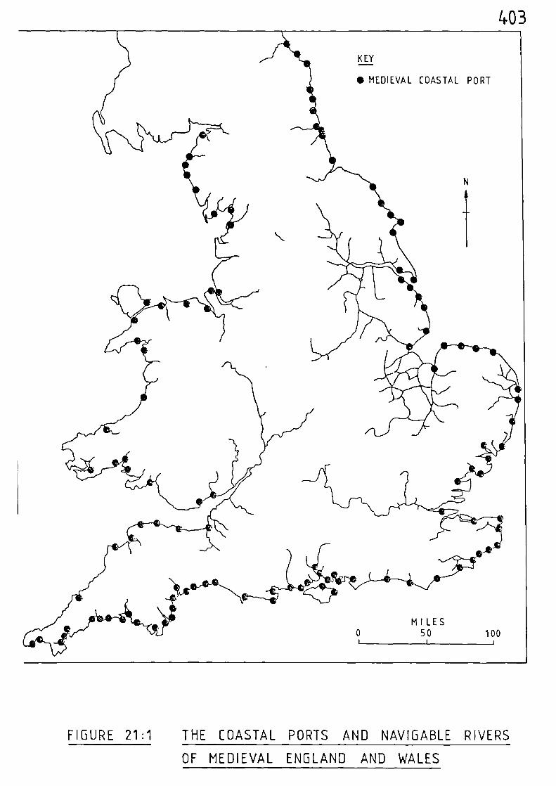
MILES0 50 100
1 1 1
403
FIGURE 21:1 THE COASTAL PORTS AND NAVIGABLE RIVERS
OF MEDIEVAL ENGLAND AND WALES
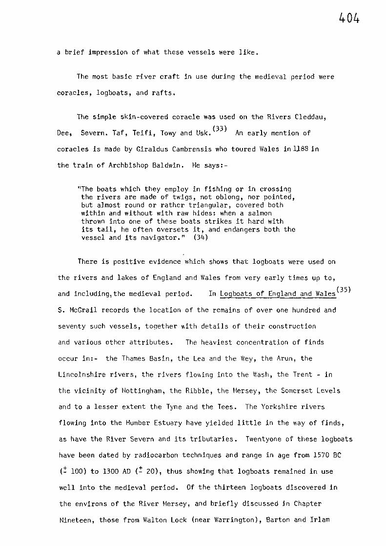
404
a brief impression of what these vessels were like.
The most basic river craft in use during the medieval period were
coracles, logboats, and rafts.
The simple skin-covered coracle was used on the Rivers Cleddau,
Dee, Severn. Taf, Teifi, Towy and Usk.(33)
An early mention of
coracles is made by Giraldus Cambrensis who toured Wales in 1188 in
the train of Archbishop Baldwin. He says:-
"The boats which they employ in fishing or in crossingthe rivers are made of twigs, not oblong, nor pointed,but almost round or rather triangular, covered bothwithin and without with raw hides: when a salmonthrown into one of these boats strikes it hard withits tail, he often oversets it, and endangers both thevessel and its navigator." (34)
There is positive evidence which shows that logboats were used on
the rivers and lakes of England and Wales from very early times up to,
and including,the medieval period. In Logboats of England and Wales
S. McGrail records the location of the remains of over one hundred and
seventy such vessels, together with details of their construction
and various other attributes. The heaviest concentration of finds
occur in:- the Thames Basin, the Lea and the Wey, the Arun, the
Lincolnshire rivers, the rivers flowing into the Wash, the Trent - in
the vicinity of Nottingham, the Ribble, the Hersey, the Somerset Levels
and to a lesser extent the Tyne and the Tees. The Yorkshire rivers
flowing into the Humber Estuary have yielded little in the way of finds,
as have the River Severn and its tributaries. Twentyone of these logboats
have been dated by radiocarbon techniques and range in age from 1570 BC
(-+ to 1300 AD ( t 20), thus showing that logboats remained in use
well into the medieval period. Of the thirteen logboats discovered in
the environs of the River Mersey, and briefly discussed in Chapter
Nineteen, those from Walton Lock (near Warrington), Barton and Irlam
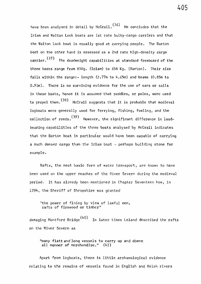
405
have been analysed in detail by McGrail.(36)
He concludes that the
Irlam and Walton Lock boats are 1st rate bulky-cargo carriers and that
the Walton Lock boat is equally good at carrying people. The Barton
boat on the other hand is assessed as a 2nd rate high-density cargo
carrier.(37)
The deadweight capabilities at standard freeboard of the
three boats range from 85Kg. (Irlam) to 658 Kg. (Barton). Their size
falls within the range:- length (2.77m to 4.65m) and beams (0.85m to
0.91m). There is no surviving evidence for the use of oars or sails
in these boats, hence it is assumed that paddles, or poles, were used
to propel them.(38)
McGrail suggests that it is probable that medieval
logboats were generally used for ferrying, fishing, fowling, and the
collection of reeds.(39)
However, the significant difference in load-
bearing capabilities of the three boats analysed by McGrail indicates
that the Barton boat in particular would have been capable of carrying
a much denser cargo than the Irlam boat - perhaps building stone for
example.
Rafts, the most basic form of water transport, are known to have
been used on the upper reaches of the River Severn during the medieval
period. It has already been mentioned in Chapter Seventeen how, in
1284, the Sheriff of Shropshire has granted
"the power of fining by view of lawful men,rafts of firewood or timber"
damaging Montford Bridge(40)
In later times Leland described the rafts
on the River Severn as
"many flattandlong vessels to carry up and dbwneall manner of merchandise." (41)
Apart from logboats, there is little archaeological evidence
relating to the remains of vessels found in English and Welsh rivers
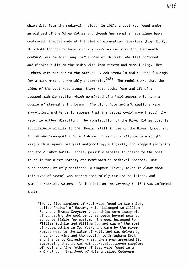
406
which date from the medieval period. In 1824, a boat was found under
an old bed of the River Rother and though her remains have since been
destroyed, a model made at the time of excavation, survives (Fig. 21:2).
This boat thought to have been abandoned as early as the thirteenth
century, was 64 feet long, had a beam of 14 feet, was flat bottomed
and clinker built on the sides with iron rivets and moss luting. Her
timbers were secured to the strakes by oak trenails and she had fittings
for a main mast and probably a bowsprit.(42)
The model shows that the
sides of the boat were steep, there were decks fore and aft of a
stepped midship section which consisted of a hold across which ran a
couple of strengthening beams. The blunt fore and aft sections were
symmetrical and hence it appears that the vessel could move through the
water in either direction. The construction of the River Rother boat is
surprisingly similar to the 'Keels' still in use on the River Humber and
for inland transport into Yorkshire. These generally carry a single
mast with a square mainsail andsometimes a topsail, are stepped amidships
and are clinker built. Keels, possibly similar in design to the boat
found in the River Rother, are mentioned in medieval records. One
such record, briefly mentioned in Chapter Eleven, makes it clear that
this type of vessel lAas constructed solely for use on inland, and
perhaps coastal, waters. An inquisition at Grimsby in 1341 vas informed
that:-
"Twenty-five sarplers of wool were found in two ships,called 'Keles' of Newark, which belonged to WilliamPeny and Thomas Croyser; these ships were incapableof conveying the wool or other goods beyond seas soas to be liable for custom. The wool belonged toWilliam Suthirn and William Ode and was of the sortof Houdenschire in Co. York, and came by the riverHumber near to the water of Hull, and was driven bya contrary wind and the ebbtide to Iminghame Crikand thence to Grimesby, where the mayor arrested it,suspecting that it was not cocketed,...seven sarplersof wool and five fothers of lead were found in aship of 3ohn Swartheek of Noland called Godeyere
ok •00:01tair •
•
fl'!1
•
4-144.41'51- t
d.bos,v-v
•.V.q
407
,
,T;I:74-1:77""7cJ-
FIGURE 21:2 A MODEL OF THE RIVER ROTHER BARGE
FIGURE 21:3 SCENE FROM THE BAYEUX TAPESTRY
408
which was capable of conveying them beyond seas,... the wool and lead were placed in a lugger atBautre and conveyed by William Ryvet and John deButtirwik by the river Humbre to Grimesby, wherethey were transhipped into the said ship ofHolland..." (43)
This reference, apart from showing that'Keles' were operating on the
Rivers Trent and Humber, makes it clear that such vessels were not
capable of undertaking voyages on the open sea. Therefore it must be
concluded that this type of vessel was restricted to inland, and
perhaps coastal waters. This same conclusion is probably applicable
to the 'lugger' which is mentioned in the same record. This vessel
had taken lead and wool from Bawtry to Grimsby via the Rivers Idle,
Trent, and Humber; the cargo then being 'transhipped' to the sea-going
vessel. J. Hornell describes the building of a large fishing lugger
which he observed under construction at Rye in Sussex. He was impressed
by the very close resemblance the boat had to those constructed by the
Vikings. The boat was built on the clinker system having a high stem
(44)and stern post. Very little in the way of plans are used by these
Sussex boatbuilders and one can only speculate as to the origins of
such traditional vessels. Perha ps the vessel referred to in the
reference of 1341 was a smaller version of this type of vessel.
"Small ships called 'botes' and 'trowys' suitablyladen with divers wares" (45)
were operating on the Rivers Parrett and Tone. Trows were also in use
on the River Severn. The name 'trow' has, over the centuries, been used
to describe a wide variety of craft, but generally refers to a sailing
(46)barge, As A. Burton points out, the earliest barges were little
more than flat-bottomed wooden boxes, with a central mast and a single
(47)square sail. This simple vessel was ideal for river work for it
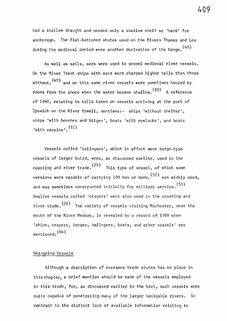
409
had a shallow draught and needed only a shallow shelf or 'hard' for
anchorage. The flat-bottomed shutes used on the Rivers Thames and Lea
during the medieval period were another derivative of the barge.(48)
As well as sails, oars were used to propel medieval river vessels.
On the River Trent ships with oars were charged higher tolls than those
without,(49)
and on this same river vessels were sometimes hauled by
ropes from the shore when the water became shallow.(50)
A reference
of 1340, relating to tolls taken on vessels arriving at the port of
Ipswich on the River Orwell, mentions:- ships 'without shelter',
ships 'with benches and bilges', boats 'with rowlocks', and boats
(51)with oarpins'.
Vessels called 'balingers', which in effect were barge-type
vessels of larger build, were, as discussed earlier, used in the
coasting and river trade.(29)
This type of vessel, of which some
versions were capable of carrying 100 men or more,(52)
was widely used,
and was sometimes constructed initially for military service.(53)
Smaller vessels called 'crayers' were also used in the coasting and
river trade.(26)
The variety of vessels visiting Rochester, near the
mouth of the River Medway, is revealed by a record of 1388 when
'ships, crayers, barges, balingers, boats, and other vessels' are
mentioned.(54)
Sea-going Vessels
Although a description of overseas trade routes has no place in
this chapter, a brief mention should be made of the vessels employed
in this trade, for, as discussed earlier in the text, such vessels were
quite capable of penetrating many of the larger navigable rivers. In
contrast to the distinct lack of available information relating to
410
river vessels, the development of sea-going vessels has, from early
times and throughout the medieval period, been well documented.(55)
The influence of the longships of the Viking Age is apparent at
the commencement of the medieval period. The ships used by William of
Normandy were, if the evidence of the Bayeux Tapestry can be accepted,
longships(56)
(Fig. 21:3). As time went on, the clinker-built vessels
following on from the Viking Age became larger and more complicated.
Thirteenth century seals of British seaport towns depict large clinker-
built vessels; a seal of Winchelsea, dated AD 1274, (Fig. 21:4) shows
(57)a double-ended ship with quarter rudder. The wreck of a clinker-
built merchant ship found in Bergen and dating from AD 1250 was 85 feet
long and almost 30 feet wide.(58)
Warships continued to be made as
round-hulled, clinker-built vessels, but were at a disadvantage compared
with a new type of vessel which was coming into use. This new vessel
was called a cog, whose high, usually clinker-built sides, meant that
her occupants could direct their arrows directly down onto the old
longships. In an effort to overcome this the longships were fitted
with 'castles' at stem and stern. Hmsever, the cogs also had castles
built into their design which effectively brought the era of the
clinker-built warship to an end during the fourteenth century. The cog
was the leading merchant ship of North Europe throughout the thirteenth
and fourteenth centuries and, in contrast to the round-hulled clinker-
built vessels, was a flat-bottomed, high-sided, deep draughted sailing
vessel. The cog was probably able to carry more cargo than the round-
hulled types in the same overall length and was more suited to shallow
tidal waters.(59)
A cog, dating from AD 1400, was excavated at Bremen,
Germany, in 1962. She was 77 feet long and 23 feet wide.(60)
It is
fitting that this well preserved example of a cog was discovered in
Germany, for in that country, during the thirteenth century, was set up
a. 00),- -
oot
‘,.1\
4
N.•
FIGURE 21:4 THE SECOND SEAL OF WINCHELSEA (1274)
FIGURE 21:5 THE SEAL OF KIEL ( c 1365 )
4-11
412
a federation of maritime towns which became known as the Hanseatic
League.
"The main method of stimulating and attractingtrade was to set up 'hansas' in the tradingcountries and, bargaining from federated strength,extract preferential treatment and, if possible,monopolies in certain classes of gods. Asearly as 1226 the merchants of Cologne set up ahansa in London, followed in 1266 and 1267 byhansas established by the merchants of Hamburgand Labeck. Eventually, all three combined in1282 to form the Gild-hall of the Germans, inorder to speak with a single voice.--- All thesehansas enjoyed special trade facilities, theGild-hall in London setting up 'counters', ortrading settlements, in Lynn, Boston, Hull, York,Norwich, Ipswich, Yarmouth and Bristol, virtuallycontrolling most of the foreign trade in thesetowns." (61)
The vessel evolved by the members of the federation to carry out their
seaborne trade was the 'Hansa cog'. This type of vessels is depicted
on various town seals of the period, the illustrations of %Filch are
similar to the vessel excavated at Bremen.(62)
(Figs. 21:5 and 21:6).
Another type of merchant vessel in use during the medieval period
as the hulk.
"She was curved both longitudinally and transversely,sometimes, probably, with a long narrow flatbottom curved up at the ends and without a stem orstern post, her general form determined at least toa degree by the treatment of the plank ends. Thetype is illustrated on the font at WinchesterCathedral...(Fig. 21:7). Most of the illustrationssuggest clinker-laid planking. Although the evidenceis so scanty it suggests that the hulk developed toa point at which in the late 1300s it began toreplace the cog, as the cog had replaced the round-hulled clinker-built ship. This was perhaps becauseit was more seaworthy and trade was expanding, andbecause the type was susceptible to development intolarger vessels than the cog, a form which has definitesize limits. At this stage, with the development ofcommerce, vessels with greater cargo-carrying capacitywere beginning to be needed." (63)
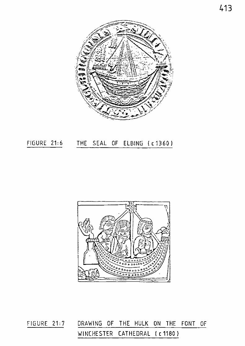
413
••••.- •,0 • •N
• - •
FIGURE 21:6 THE SEAL OF ELBING ( c 1360)
FIGURE 21:7 DRAWING OF THE HULK ON THE FONT OF
WINCHESTER CATHEDRAL ( c 1180 )
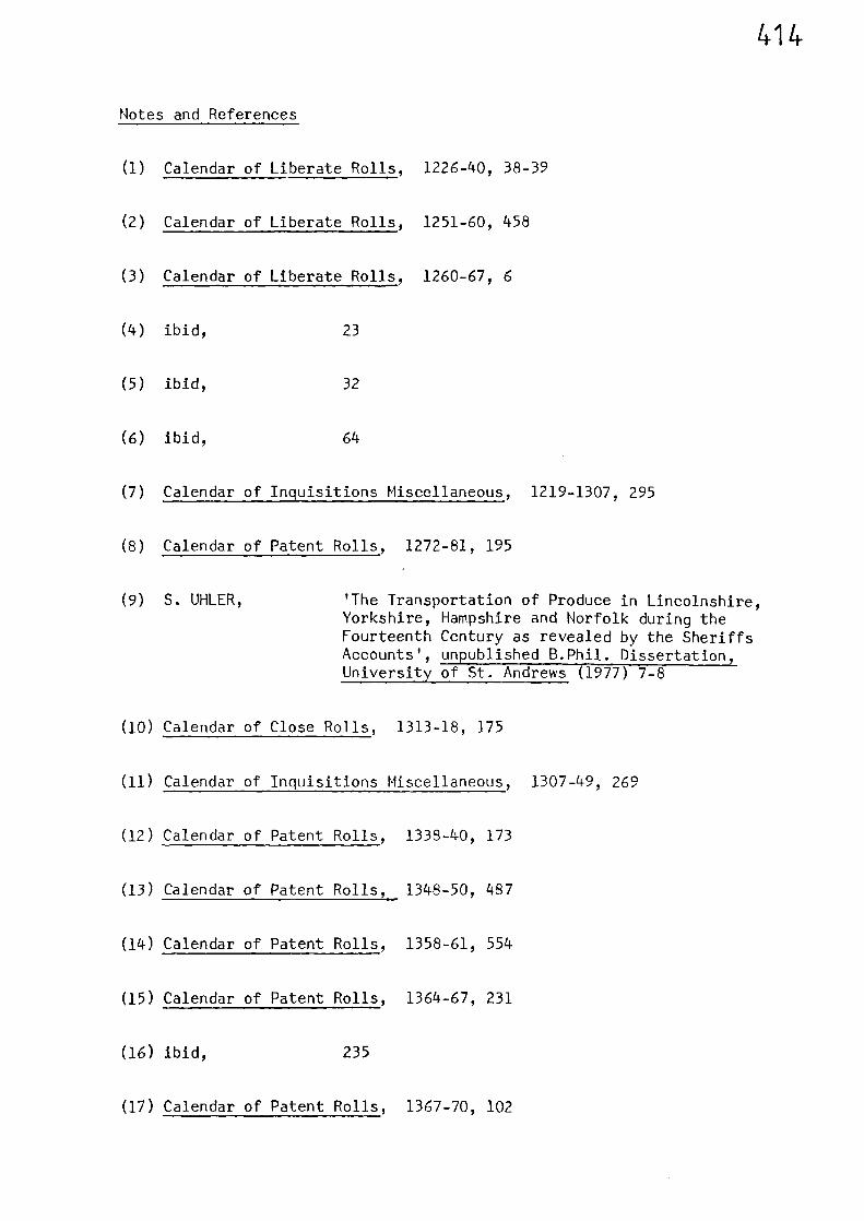
414
Notes and References
(1) Calendar of Liberate Rolls, 1226-40, 38-39
(2) Calendar of Liberate Rolls, 1251-60, 458
(3) Calendar of Liberate Rolls, 1260-67, 6
(4) ibid, 23
(5) ibid, 32
(6) ibid, 64
(7) Calendar of Inquisitions Miscellaneous, 1219-1307, 295
(8) Calendar of Patent Rolls, 1272-81, 195
(9) S. UHLER, 'The Transportation of Produce in Lincolnshire,Yorkshire, Hampshire and Norfolk during theFourteenth Century as revealed by the SheriffsAccounts', unpublished B.Phil. Dissertation, University of St. Andrews (1977) 7-8
(10) Calendar of Close Rolls, 1313-18, 175
(11) Calendar of Inquisitions Miscellaneous, 1307-49, 269
(12) Calendar of Patent Rolls, 1338-40, 173
(13) Calendar of Patent Rolls, 1348-50, 487
(14) Calendar of Patent Rolls, 1358-61, 554
(15) Calendar of Patent Rolls, 1364-67, 231
(16) ibid, 235
(17) Calendar of Patent Rolls, 1367-70, 102
415
(18) ibid, 209
(19) ibid, 362-63 & 416
Calendar of Patent Rolls, 1370-74, 22
(20) ibid, 94
(21) Calendar of Patent Rolls, 1381-85, 147
(22) Calendar of Patent Rolls, 1388-92, 400-01
(23) Calendar of Close Rolls, 1381-85, 383
(24) ibid, 630
(25) Calendar of Close Rolls, 1385-89, 349
(26) Calendar of Patent Rolls, 1385-89, 405-06
(27) Calendar of Close Rolls, 1389-92, 257
(28) ibid, 330
(29) Calendar of Patent Rolls, 1391-96, 152-53
(30) T.S. WILLAN, River Navigation in England 1600-1750 (London 1936, New Imp. 1964) 4-5
(31) M. BERESFORD, New Towns of the Middle Ages (London 1967) 119
(32) Calendar of Liberate Rolls, 1226-40, 162
Calendar of Close Rolls, 1288-96, 261
Calendar of Close Rolls, 1296-92, 77, 81-83, 100-02, 121-22,390-91, 482-83
Calendar of Close Rolls, 1302-07, 76 & 79
416
Calendar of Close Rolls, 1313-18,
1318-23,
1323-27,
1327-37,
1330-33,
1337-39,
1341-43,
1346-49,
1349-54,
498
369-70 & 670
147-48, 535-37,
347-48
318, 398, 480
379-80
485-88
328
207
640.42
Calendar of Close Rolls,
Calendar of Close Rolls,
Calendar of Fine Rolls,
Calendar of Close Rolls,
Calendar of Close Rolls,
Calendar of Close Rolls,
Calendar of Close Rolls,
Calendar of Close Rolls,
(33) O. HORNELL, Water Transport - Origins and Early Evolution (Cambridge, 1946) 111-133
(34) GIRALDUS de BARRI, The Itinerary of Archbishop Baldwin through Wales (ed. R.C. HOARE) 2 vols (1806) 11,332-3
(35) S. McGRAIL
(36) S. McGRAIL andR. SWITSUR,
The Logboats of England and Wales, NationalMaritime Museum, Greenwich, ArchaeologicalSeries No. 2, BR British Series 51(1), 2Parts, (1978)
Medieval Logboats of the River Mersey - AClassification Study - Being Chapter 6 of'The Archaeology of Medieval Ships and Harbours in Northern Europe, National Maritime Museum,Greenwich, Archaeological Series No. 5, BARInternational Series 66, (1979)
(37) ibid, 106
(3 8 ) ibid, 106
(39) ibid, 106
417
(40) Calendar of Patent Rolls, 1281-92, 116
(41) A. BURTON The Changing River (London, 1982) 56
(42) B. GREENHILL, Archaeology of the Boat (London, 1976) 362,264
(43) Calendar of Inquisitions Miscellaneous, 1307-49, 437
(44) J. HORNELL 195-98(op. cit.)
(45) Calendar of Inquisitions Miscellaneous, 1399-1422, 259
(46) A. BURTON 56(op. cit.)
(47) ibid
(48) J.F. WILLARD 'Inland Transportation in England during theFourteenth Century' Speculum 1 (1926) 370-71
(49) M.W. BARLEY
'Lincolnshire Rivers in the Middle Ages'Lincolnshire Architectural and Archaeological Soc. Reports and Papers, Ness Ser. 1 (1938) 14
(50) Calendar of Patent Rolls, 1381-85, 189
(51) Calendar of Inquisitions Miscellaneous, 1307-49, 421
(52) P. KEMP, The History of Ships, (London, 1978) 71
(53) Calendar of Close Rolls, 139-1402, 238-40
(54) Calendar of Close Rolls, 1385-89, 482
(55) R. and R.C. ANDERSON, The Sailing Ship (London, 1926)
R. and R.C. ANDERSON, Oared Fighting Ships (London, 1962)
G. BASS (ed.), A History of Seafaring based on Underviater Archaeology (London, 1972)
418
F.W. BROOKS, The English Naval Forces 1199-1272 (Manchester,1932)
E.H. BYRNE,
B. GREENHILL,(op. cit.)
3. HORNELL(op. cit.)
G.F. HOURANI,
Genoese Shipping in the Twelfth and Thirteenth Centuries Medieval Academy of America,(Cambridge, Mass, 1930)
Arab Seafaring in the Indian Ocean in Ancient and Medieval Times, Princeton Oriental StudiesVol. 13 (Princeton, 1951)
P. JOHNSTONE, The Archaeology of Ships (London, 1974)
P. JOHNSTONE, The Sea-craft of Prehistory (London, 1980)
P. KEMP,(op. cit.)
B. LANDSTROM, The Ship (London, 1961)
A.R. LEWIS, Naval Power and Trade in the Mediterranean A.D. 500-1100 (Princeton, 1951)
A.R. LEWIS, The Northern Seas. Shipping and Commerce in Northern Europe A.D. 300-1100 (Princeton, 1950
S. McGRAIL(op. cit.)
S. McGRAIL, Rafts, Boats and Ships, from Prehistoric Times to the Medieval Era National Maritime Museum,Greenwich, 'The Ship ' Series No. 1 (1981)
R.W. UNGER
The Ships in the Medieval Economy 600-1600 (London, 1980)
(56) P. KEMP
50
(op. cit.)
419
(57) B. GREENHILL 252(op. cit.)
(58) ibid, 250
(59) ibid, 259
(60) ibid, 261
(61) P. KEMP 56(op. cit)
(62) B. GREENHILL, 261(op. cit.)
(63) ibid, 283-85
Footnote
Correspondence between the author and Sean McGrail, Professor ofMaritime Archaeology at the Institute of Aracheology, Oxford, confirmedthe paucity of available information relating to river vessels datingfrom the medieval period. A new book by Professor McGrail, provisionallyentitled 'Ancient Boats in N.W. Europe - the archaeology of watertransport to AD 1500' and due to be published in 1987, would certainlyhave been included in the general reference list (55), had it beenpublished at the time of writing this thesis.
4-20
CHAPTER TWENTY-TWO
The Gough Map
CARTOGRAPHIC EVIDENCE
A striking feature of the Gough Map, which was discussed at
length in Part Two, is the representation upon it of a large number of
rivers. (See Figure 3:1). E.J.S. Parsons, in his introduction to the
facsimile of the map, makes the following observation:-
"As on many medieval maps, the rivers arenumerous and conspicuous. Drawn withrelatively widely spaced double lines,they occupy quite a considerable area ofthe map, and convey the impression that theyare a fundamental part of it: by contrastthe road pattern appears almost as an after-thought. The rivers have circular headsillustrating the medieval idea that allrivers had their sources'in lakes. Theyare indicated with fair accuracy, at least inEngland: though since they are represented asbeing nearly straight, or slightly curved,their courses are characterless. Near theirsources direction also tends to be erroneous,generally to avoid entanglement with theheadwaters of neighbouring rivers. The Thames,for example, does not show the northern loopbetween Windsor and Reading nor the one uponmhich Oxford stands, but its chief tributariesare well represented. The main elements of theTrent system are delineated, though mith minorinaccuracies such as showing the Dove as flowinginto the Derwent, and the Isle of Axholme isstrongly emphasized. The same appreciation ofthe general pattern is shown in the delineationof the Great Ouse with the Isle of Ely, theYorkshire Ouse, and the Severn. An attempthas been made to indicate the windings of theWear at Durham. The map certainly embodiesmuch knowledge of the English rivers, a knowledgewhich could only have accumulated over a greatmany years." (1)
R.A. Donkin, writing about changes in the early Middle Ages,.comments:-
"It is significant that the Gough Map, compiledwith practical ends in mind, showed a largenumber of rivers." (2)
421
With few exceptions, the main rivers and their tributaries are
very well delineated, and one must agree with Parson's observation
that they convey the impression of being a fundamental part of the map.
Of the navigable rivers shown in Figure 20:1, very few cannot
be identified on the Gough Map, the main omissions being:- the Rivers
Slea, Glen, Waveney, Blyth, Colne, Tamar, Parrett, Tone, Brue and Weaver.
The Car Dyke and Pill row Cut are also omitted.
The River Slea is part of the Witham navigation system and although
it is not shown individually on the map, the fact that Sleaford is shown
adjacent to the River Witham would give the impression to any user of the
map that access to that town would, quite correctly, be via that river
system. An interesting point regarding the River Witham is that the
distance figure set down upon the map between Lincoln and Boston (XXVI),
could well refer directly to the river and not to a road. The distance
between Lincoln and Boston is 33 statute miles via the river, which
equates with the Gough mileage set down upon the map (see Appendix I).
It appears, at first sight, that the Foss Dyke - which links the Witham
with the Trent - is not depicted on the mop. However, close inspection
reveals what could be lines drawn between Lincoln and Torksey, although
these are intermingled with the written placenames of the latter place
making it difficult to arrive at a firm conclusion. The omission of the
River Glen and the Car Dyke is coupled with a rather simplistic
representation of the rivers of the Fen. This is perhaps understandable
for, as discussed in Chapter Twelve, the Fen has undergone a complex and
constantly changing physical history. The omission of the Rivers Waveney,
Blyth and Colne is disappointing; however, in the latter case Colchester
is shown adjacent to the River Stour, perhaps this was a cartographic
error on the part of the compiler of the map. The omission of the River
422
Tamar is surprising, especially as this river forms the ancient boundary
between Devonshire and Cornwall. The omission of the Rivers Parrett,
Tone and Brue, together with the Pillrow Cut in the Somerset Levels is
another surprise - although Bridgewater, Taunton and Glastonbury are all
depicted on the map. The fact that the Wirral Peninsula is not depicted
on the map may partially explain the omission of the River Weaver in
Cheshire; the omission of the Fylde from the map certainly accounts for
the exclusion of the River Wyre in Lancashire.
In general, the courses of the rivers shown on the Gough Map are
reasonably accurate, although some intertwining of upper reaches has
occurred in a number of cases. For example, the River Rother is shown
as part of the River Beault, and the River Usk in Wales is partly mixed
up with the upper reaches of the River Wye.
In contrast to the omission of certain rivers, others appear on
the Gough Map which are not portrayed on the navigable river map shown in
Figure 20:1. It would be pure conjecture to say if any of these rivers
were navigable during medieval times, but at the very least it can be
concluded that they are shown because they existed as physical features
in the landscape, and as such the Gough Map would have brought them to
the attention of medieval travellers. These rivers are given as follows
in Table 22:1, and are taken from the list as identified by parsons.
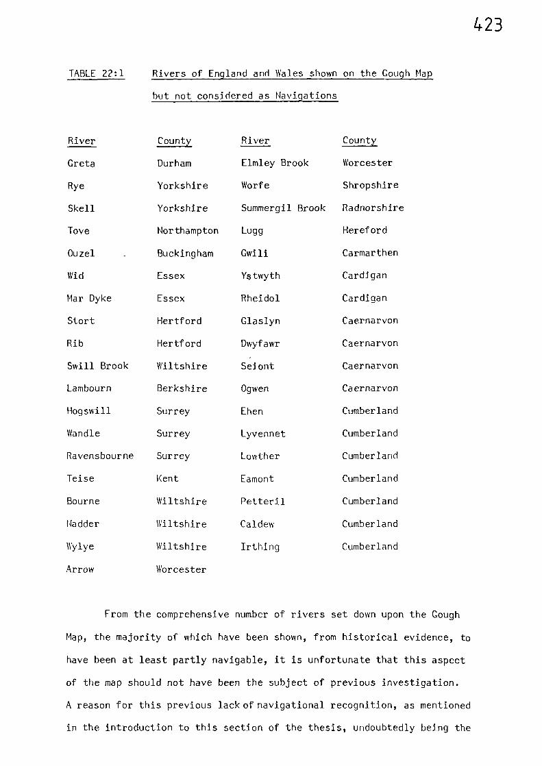
423
TABLE 22:1 Rivers of England and Wales shown on the Gough Map
but not considered as Navigations
River County River County
Greta Durham Elmley Brook Worcester
Rye Yorkshire Worfe Shropshire
Skell Yorkshire Summergil Brook Radnorshire
Tove Northampton Lugg Hereford
Ouzel Buckingham Gwili Carmarthen
Wid Essex Ystwyth Cardigan
Mar Dyke Essex Rheidol Cardigan
Stort Hertford Glaslyn Caernarvon
Rib Hertford Dwyfawr Caernarvon
Swill Brook Wiltshire Seiont Caernarvon
Lambourn Berkshire Ogwen Caernarvon
Hogswill Surrey Ehen Cumberland
Wandle Surrey Lyvennet Cumberland
Ravensbourne Surrey Lowther Cumberland
Teise Kent Eamont Cumberland
Bourne Wiltshire Petteril Cumberland
Madder Wiltshire Caldew Cumberland
Wylye Wiltshire Irthing Cumberland
Arrow Worcester
From the comprehensive number of rivers set down upon the Gough
Map, the majority of which have been shown, from historical evidence, to
have been at least partly navigable, it is unfortunate that this aspect
of the map should not have been the subject of previous investigation.
A reason for this previous lack of navigational recognition, as mentioned
in the introduction to this section of the thesis, undoubtedly being the
424
distinct paucity of published material relating to inland waterborne
movements.
The Maps of Matthew Paris
Four maps attributed to the thirteenth century monk of St. Albans,
and dating from c1250, were mentioned in Part Two. Although these maps
are rather crude in comparison to the Gough Map, certain physical
features are clearly discernable (see Figures 3:4 and 3:5). Many rivers
are depicted and form an integral part of the maps, and, although their
delineation is not comparable with those shown on the Gough Map, the
courses of the major river networks can be clearly identified.
425
Notes and References
(1) E.J.S. PARSONS The Map of Great Britain, circa A.D. 1360 known as the Gough Map Memoir with amendedreprint of part of paper by F.M. Standen (1936)and a colour facsimile (Oxford, Bodleian Library,1958) 8.
(2) R.A. DONKIN
'Changes in the Early Middle Ages', being achapter of H.C. DARBY (ed.) A New Historical Geography of England (Cambridge 1973) 119.
(3) E.J.S. PARSONS 32-34(op. cit.),
426
THE NAVIGABLE MEDIEVAL WATERWAYS - CONCLUSIONS
Of the many separate sources used during the preparation of Part
Three of this thesis, the various State Rolls, the volumes relating to
Public Works,(1)
and the various Sheriff's Accounts(2)
were a particularly
useful source of contemporary evidence.
The bringing together of the regional evidence produced a national
picture of inland navigable waterways existing during the medieval period.
The resultant map of Figure 20:1 depicts one hundred and thirty-seven
separate waterways which have been shown to have been navigable, or partly
navigable, at some time during the medieval period. This map reveals a
network which, it must be said, is a minimum, of 2400 miles of navigable
inland waterways.
Although the navigable rivers of the north-east are few and far
between, those flowing into the Humber Estuary and the Wash form a large
interlinked system of inland waterways serving an area covering much of
Yorkshire, Derbyshire, Nottinghamshire, Lincolnshire, Leicestershire,
Northamptonshire, Bedfordshire, FLIntingdon and Peterborough, Cambridgeshire
and the Isle of Ely, and into the western borders of Norfolk and Suffolk.
The coast of East Anglia is well served, whilst the dominant feature in
the south is the River Thames and its tributaries. In the south-east and
south-west there is only moderate penetration although in the latter case
this is only to be expected due to the rugged nature of the coastline.
The River Severn and its tributaties, together with the other rivers
discharging into the Bristol Channel, are a dominant feature, whilst the
rivers of Wales reflect the mountainous interior of that country - which
precluded penetration by medieval vessels. The rivers of the north-west
although more numerous than those of the north-east, reflect the relative
unimportance of the area during medieval times.
427Although the references relating to the internal movement of
waterborne cargoes were invaluable in determining the extent of inland
navigable water utilised during the medieval period, they were not
sufficient to allow much detailed analysis of spatial or temporal
variations of different types of cargo.
The importance of the interconnection between inland and coastal
navigation supported the notion that inshore waters could be considered
as 'a river around the coast'.
Investigations into the type of vessels used to carry out water-
borne trade revealed a distinct lack of evidence relating to those used
exclusively on inland waterways. From the scant information available it
appears that river vessels were, in general, flat-bottomed barges, having
clinker-built sides and using a simple sail, and/or oars, as the method
of propulsion.
An examination of cartographic evidence revealed that very few
of the navigable waterways could not be identified on the Gough Map.
Many other water,nays, apart from those %shich are known to have been
navigable, appear on the Gough Map, but it %,$ould be pure conjecture to
use this as evidence of navigation during medieval times. However, it
can he concluded that not enough weight has previously been given to the
waterways depicted on the Gough Map - a cartographic record vihich as
probably equally as useful as a guide to navigable water as it was to
overland routes.
Having established a basic road network and the minimum extent of
navigable waters, Part Four attempts to present a synthesis of the
whole transport system utilised by travellers and merchants during the
medieval period.
428
Notes and References
(1) C.T. FLOWER 'Public Works in Medieval Law' Seldon Soc.32 and 40 (1915 and 1923)
(2) S. UHLER, 'The Transportation of Produce in Lincolnshire,Yorkshire, Hampshire and Norfolk during theFourteenth Century as revealed by the Sheriff'sAccounts,' unpublished B. Phil. Dissertation,University of St. Andrews (1977)
429
PART FOUR
THE COMBINED MEDIEVAL ROAD AND
WATERWAY NETWORKS
'Trade, like Religion, is %Nhateverybody talks of, but few understand'
Daniel Defoe,
A Plan of English Commerce, 1728
430
CHAPTFR TWENTY THREE COMBINING THE ROAD AND WATERWAY NETWORKS
Having established the basic road network and the minimum extent
of navigable water utilised during the medieval period, the next logical
step is to bring the two together.
However, before doing this, it is important to also have some
indication of the more prominent places existing during the medieval period,
as these would also have been the more important trading centres. An
indication of these places can be obtained by perusing certain published
lists. These are usually in the form of'ranking boroughs', placed in order
of diminishing population or assessed wealth. The complexities associated
with the compilation and interpretation of such medieval data are fraught
with difficulty and the subject of much scholarly debate. However, it is
not the intention here to enter into this debate - other than to say that
whatever its deficiencies the data relating to the ranked medieval
boroughs are indicative of the more prominent trading centres for, as
H.C. Darby points out, the most permanent characteristic of the borough
is "that of a trading centre."(1)
Thus tons, as centres of trade,
would rely on effective communications to sustain them (See Chapter One).
The Prominent Medieval Boroughs
Borough population figures for 1086 and 1348 have been estimated by
J.C. Russell who used the evidence of the Domesday Survey and the Poll
Tax Returns of 1377.(2)
Information about the boroughs in the Domesday
Survey is incomplete, and sometimes missing altogether.(3) For example,
there were no returns for Bristol and London; however, Russell estimates
their populations by multiplying their separate parishes by 210, which
he assumes to be the average parish population. Although Russells' list
431
continues down to Quatford in Shropshire with its population of 50, there
is a substantial gap in his figures after the forty-first town in his
ranking list which is Southampton. For his population estimates relating
to 1348, Russell compensated for the population losses suffered during the
Plague by multiplying the Poll Tax Returns of 1377 by a factor of 1.67.(4)
These returns included everyone over the age of fourteen and omitted only
the Counties Palatine of Cheshire and Durham, although Russell puts forward
an estimate for these which he derived from other sources.(5)
There is a
significant gap in the data after the fifty-fourth town in his list which
is Newport. Although the data are certainly more reliable and complete
than those of the Domesday Survey, his working list of town populations is
probably incomplete.
Another attempt at ranking the Domesday boroughs was that carried
out by C. Stephenson who generally based his list on the number of houses
recorded in the Domesday Survey.(6)
Unlike Russell, he does not put forward
estimates for London, Bristol and Winchester.
Stephenson also compiled a ranking list of boroughs for a later
period which was based on the average of the 'aids' levied during the
reign of Henry II (1154-89). (7) Bristol, being in baronial hands, does
not appear in this list; nor do Chester and Leicester; and the Cinque
Ports were exempted from such taxation.
Another source which has provided information resulting in boroughs
being placed in a ranking order is the Lay Subsidy of 1334. The palatine
counties of Cheshire and Durham were excluded from this tax, and the
counties of Cumberland, Westmorland and Northumberland were excused;
however, these latter three counties were taxed in 1336 so that their
earlier omission can be remedied. Also excluded were the moneyers of
432
London and Canterbury, the men of the Cinque Ports, and the stannary men
of the South West. These exclusions apart, the resulting records do
provide an indication of the more prominent towns. (8)
Table 23:1 is an assemblage of the data given in the aforementioned
sources, listed in order of rank.
Table 23:1 The Ranked Medieval Boroughs
Rank Domesday (9) Domesday(6)
1154-89 (7) 1334 (8) 1348(10)
1 London (London) London (London) London
2 Winchester York York Bristol York
3 Norwich Norwich Norwich York Bristol
4 York Lincoln Lincoln Newcastle Norwich
5 Lincoln Oxford Northampton Boston Plymouth
6 Thetford Thetford Dunwich Yarmouth Coventry
7 Bristol Ipswich Exeter Lincoln Lincoln
8 Gloucester Gloucester Winchester Norwich Salisbury
9 Cambridge Wallingford Gloucester Oxford Kings' Lynn
10 Chester Chester Oxford Shrewsbury Colchester
11 Hastings Huntingdon Canterbury Kings' Lynn Boston
12 Wallingford Leicester Cambridge Salisbury Beverley
13 Hereford Stamford Grimsby Coventry Newcastle
14 Hythe Cambridge Newcastle Ipswich Canterbury
15 Canterbury Colchester Doncaster Hereford Bury St.Edmunds
16 Dunwich Exeter Berkhamsted Canterbury Oxford
17 Dover Sandwich Nottingham Gloucester Hull
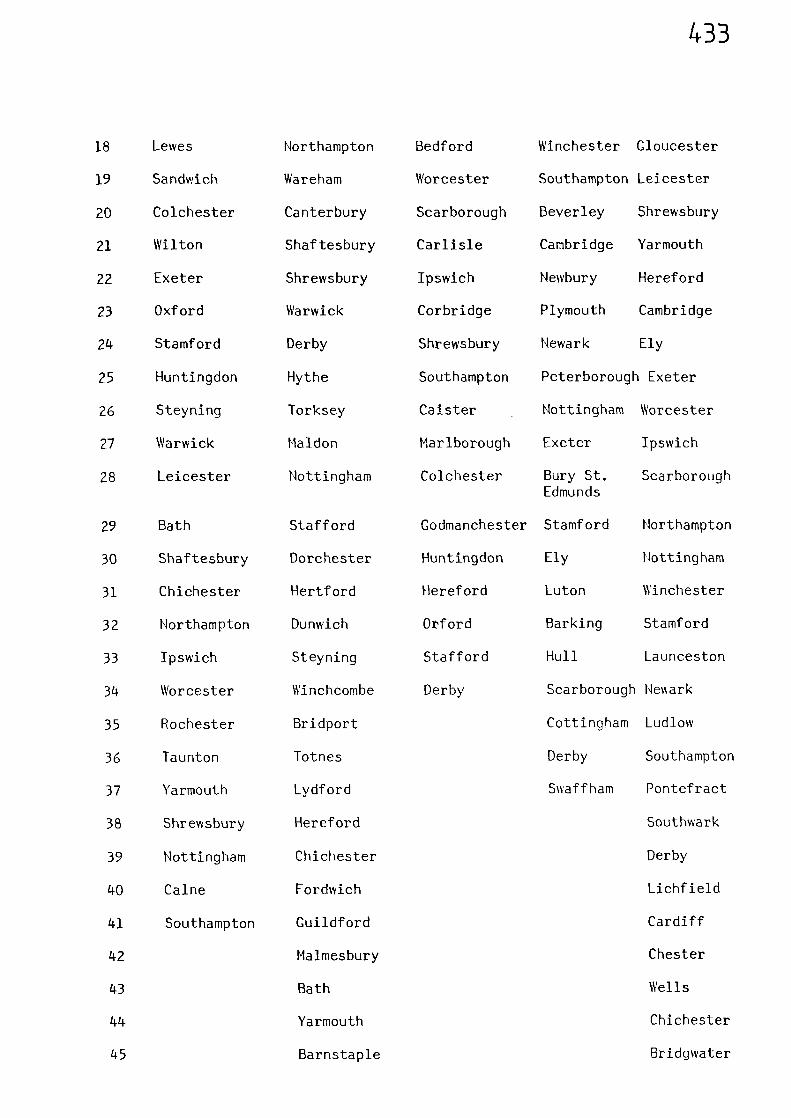
433
18 Lewes Northampton Bedford Winchester Gloucester
19 Sandwich Wareham Worcester Southampton Leicester
20 Colchester Canterbury Scarborough Beverley Shrewsbury
21 Wilton Shaftesbury Carlisle Cambridge Yarmouth
22 Exeter Shrewsbury Ipswich Newbury Hereford
23 Oxford Warwick Corbridge Plymouth Cambridge
24 Stamford Derby Shrewsbury Newark Ely
25 Huntingdon Hythe Southampton Peterborough Exeter
26 Steyning Torksey Caister Nottingham Worcester
27 Warwick Maldon Marlborough Exeter Ipswich
28 Leicester Nottingham Colchester Bury St. ScarboroughEdmunds
29 Bath Stafford Godmanchester Stamford Northampton
30 Shaftesbury Dorchester Huntingdon Ely Nottingham
31 Chichester Hertford Hereford Luton Winchester
32 Northampton Dunwich Orford Barking Stamford
33 Ipswich Steyning Stafford Hull Launceston
34 Worcester Winchcombe Derby Scarborough Neark
35 Rochester Bridport Cottingham Ludlow
36 Taunton Totnes Derby Southampton
37 Yarmouth Lydford Swaffham Pontefract
38 Shrewsbury Hereford Southwark
39 Nottingham Chichester Derby
40 Caine Fordwich Lichfield
41 Southampton Guildford Cardiff
42 Malmesbury Chester
43 Bath Wells
44 Yarmouth Chichester
45 Barnstaple Bridgwater
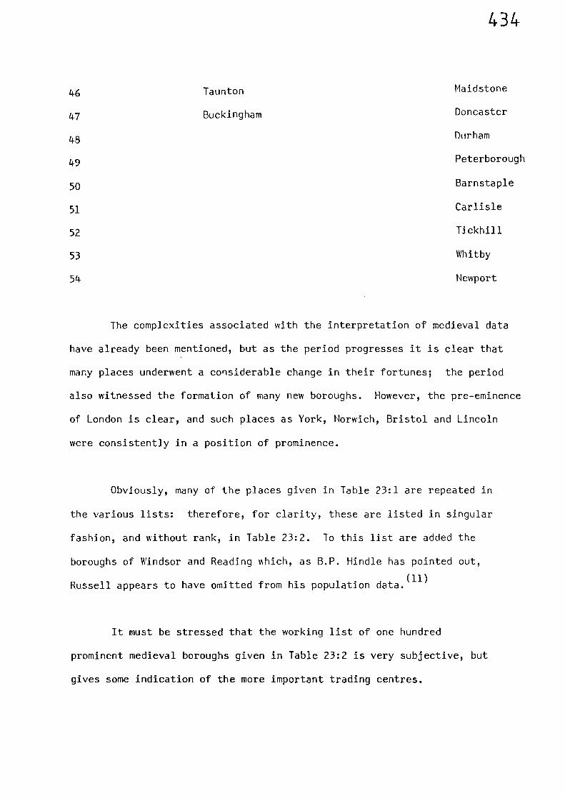
46
47
48
49
50
51
52
53
54
Maidstone
Doncaster
Durham
Peterborough
Barnstaple
Carlisle
Tickhill
Whitby
Newport
Taunton
Buckingham
434
The complexities associated with the interpretation of medieval data
have already been mentioned, but as the period progresses it is clear that
many places underwent a considerable change in their fortunes; the period
also witnessed the formation of many new boroughs. However, the pre-eminence
of London is clear, and such places as York, Norwich, Bristol and Lincoln
were consistently in a position of prominence.
Obviously, many of the places given in Table 23:1 are repeated in
the various lists: therefore, for clarity, these are listed in singular
fashion, and without rank, in Table 23:2. To this list are added the
boroughs of Windsor and Reading Mlich, as B.P. Hindle has pointed out,
Russell appears to have omitted from his population data.(11)
It must be stressed that the working list of one hundred
prominent medieval boroughs given in Table 23:2 is very subjective, but
gives some indication of the more important trading centres.
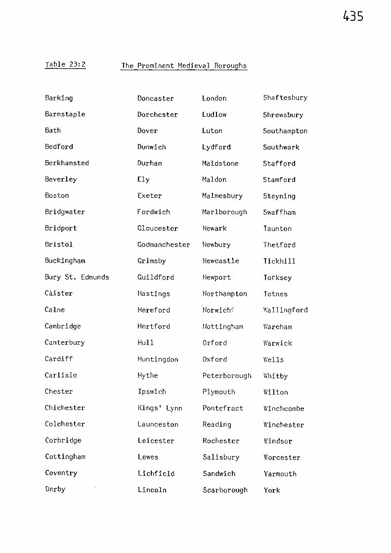
435
Table 23:2 The Prominent Medieval Boroughs
Barking Doncaster London Shaftesbury
Barnstaple Dorchester Ludlow Shrewsbury
Bath Dover Luton Southampton
Bedford Dunwich Lydford Southwark
Berkhamsted Durham Maidstone Stafford
Beverley Ely Maldon Stamford
Boston Exeter Malmesbury Steyning
Bridgwater Fordwich Marlborough Swaff ham
Bridport Gloucester Newark Taunton
Bristol Godmanchester Newbury Thetford
Buckingham Grimsby Newcastle Tickhill
Bury St. Edmunds Guildford Newport Torksey
Caister Hastings Northampton Totnes
Caine Hereford Norwichf Wallingford
Cambridge Hertford Nottingham Wareham
Canterbury Hull Orford Warwick
Cardiff Huntingdon Oxford Wells
Carlisle Hythe Peterborough Whitby
Chester Ipswich Plymouth Wilton
Chichester Kings' Lynn Pontefract Winchcombe
Colchester Launceston Reading Winchester
Corbridge Leicester Rochester Windsor
Cottingham Lewes Salisbury Worcester
Coventry Lichfield Sandwich Yarmouth
Derby Lincoln Scarborough York
436
The Combined Road and Waterway Networks
Having obtained an indication of the more prominent medieval
trading centres, it was observed that only three (Corbridge, Luton, and
Lydford), were not directly linked into the basic road network of Figure
8:1 or the navigable waterways of Figure 20:1. As discussed in Chapter N'ne,
the River Tyne is likely to have been navigable to Corbridge, and possibly
even further. Only 3 miles separate Luton from the Gough Map route
between St. Albans and Dunstable, and Lydford is a similar distance from
the Gough Map route between Okehampton and Launceston. It is highly
likely that Lydford was situated, as it is today, by a route connecting
Plymouth with Okehampton (via Tavistock).
Assuming that all the prominent places were accessible via overland
routes, the basic road network can be extended by the simple process of
linking the isolated prominent places to the nearest place in the road
network. In the majority of cases this only involves very short distances;
for example, the isolated prominent places on the south coast are all
very close to the Gough Map route connecting Southampton with Canterbury.
Short links also connect Wareham with Bere Regis, and Totnes with Newton
Abbot. The longest additional link in the south-west is that between
Barnstaple and Exeter, which would follow the modern road via Crediton -
whilst short links connect Taunton with Wells and Bridgwater. Across the
Bristol Channel, Cardiff can be linked with Newport, Chepstow, St.
Briavels and Gloucester (a route used by Edward II). The road between
Dunstable and Luton can be continued to Bedford (a route used by Henry III),
and on to Huntingdon; whilst a short link connects Peterborough with the
Great North Road at Wansford. In East Anglia, the route between London
and Snape Bridge can be extended to Dunwich, and Orford can be linked to
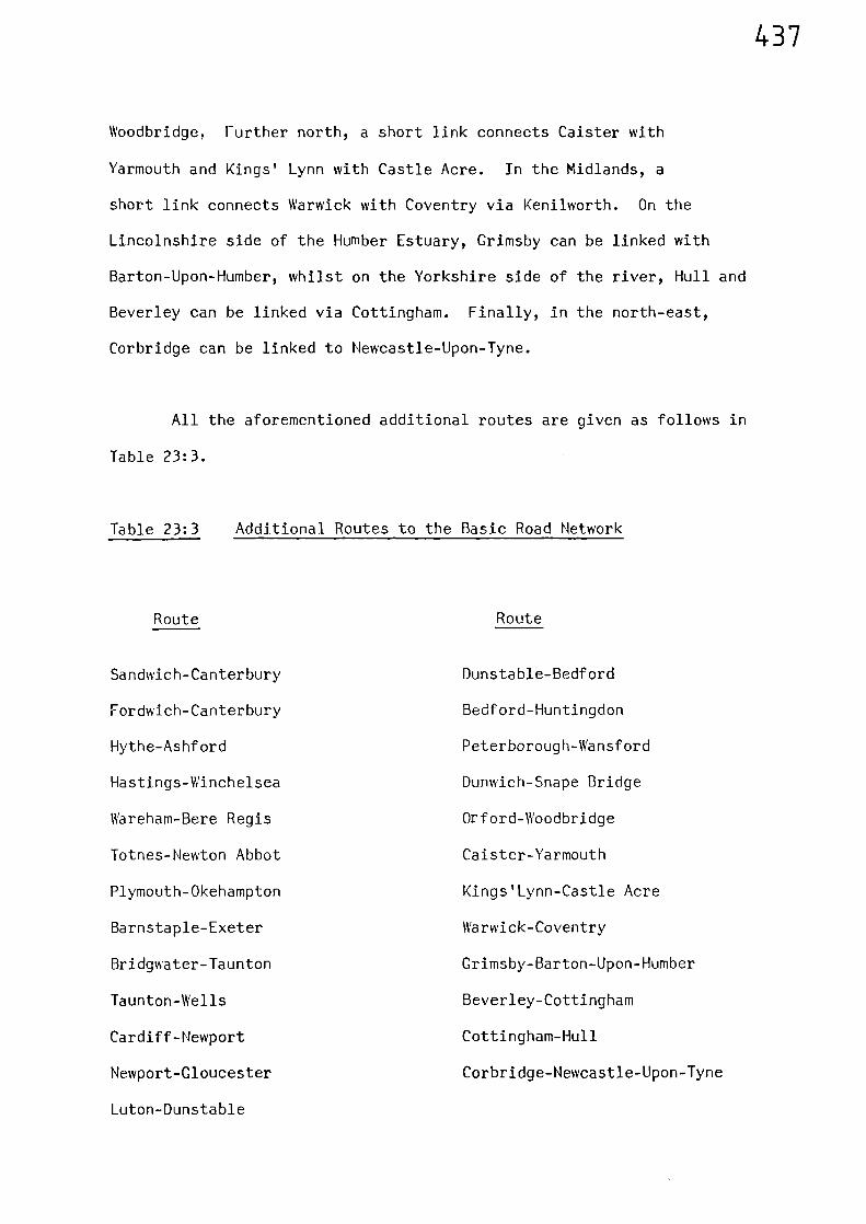
437
Woodbridge. Further north, a short link connects Caister with
Yarmouth and Kings' Lynn with Castle Acre. In the Midlands, a
short link connects Warwick with Coventry via Kenilworth. On the
Lincolnshire side of the Humber Estuary, Grimsby can be linked with
Barton-Upon-Humber, whilst on the Yorkshire side of the river, Hull and
Beverley can be linked via Cottingham. Finally, in the north-east,
Corbridge can be linked to Newcastle-Upon-Tyne.
All the aforementioned additional routes are given as follows in
Table 23:3.
Table 23:3
Additional Routes to the Basic Road Network
Route
Route
Sandwich-Canterbury
Fordwich-Canterbury
Hythe-Ashford
Hastings-Winchelsea
Wareham-Bere Regis
Totnes-Newton Abbot
Plymouth-Okehampton
Barnstaple-Exeter
Bridgwater-Taunton
Taunton-Wells
Cardiff-Newport
Newport-Gloucester
Luton-Dunstable
Dunstable-Bedford
Bedford-Huntingdon
Peterborough-Wansford
Dunwich-Snape Bridge
Orford-Woodbridge
Caister-Yarmouth
Kings 'Lynn-Castle Acre
Warwick-Coventry
Grimsby-Barton-Upon-Humber
Beverley-Cottingham
Cottingham-Hull
Corbridge-Newcastle-Upon-Tyne
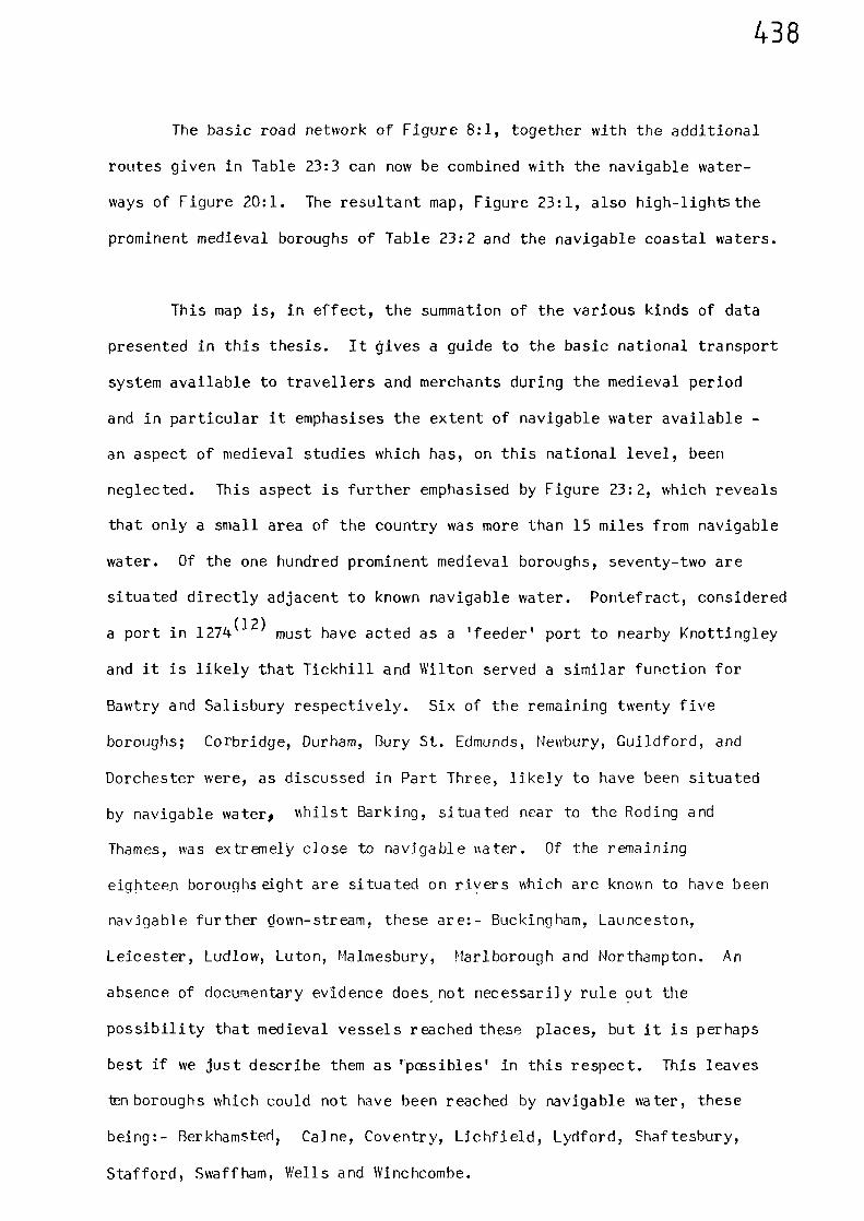
438
The basic road network of Figure 8:1, together with the additional
routes given in Table 23:3 can now be combined with the navigable water-
ways of Figure 20:1. The resultant map, Figure 23:1, also high-lightsthe
prominent medieval boroughs of Table 23:2 and the navigable coastal waters.
This map is, in effect, the summation of the various kinds of data
presented in this thesis. It gives a guide to the basic national transport
system available to travellers and merchants during the medieval period
and in particular it emphasises the extent of navigable water available -
an aspect of medieval studies which has, on this national level, been
neglected. This aspect is further emphasised by Figure 23:2, which reveals
that only a small area of the country was more than 15 miles from navigable
water. Of the one hundred prominent medieval boroughs, seventy-two are
situated directly adjacent to known navigable water. Pontefract, considered
a port in 1274(12)
must have acted as a 'feeder' port to nearby Knottingley
and it is likely that Tickhill and Wilton served a similar function for
Bawtry and Salisbury respectively. Six of the remaining twenty five
boroughs; Corbridge, Durham, Bury St. Edmunds, Newbury, Guildford, and
Dorchester were, as discussed in Part Three, likely to have been situated
by navigable water, Ailst Barking, situated near to the Roding and
Thames, was extremely close to navigable water. Of the remaining
eighteen boroughs eight are situated on rivers which are known to have been
navigable further clown-stream, these are:- Buckin g ham, Launceston,
Leicester, Ludlow, Luton, Malmesbury, Marlborough and Northampton. An
absence of documentary evidence does not necessarily rule out the
possibility that medieval vessels reached these places, but it is perhaps
best if we just describe them as r pcssibles i in this respect. This leaves
ten boroughs which could not have been reached by navigable water, these
being:- Berkhamsted l Caine, Coventry, Lichfield, Lydford, Shaftesbury,
Stafford, Swaffham, Wells and Winchcombe.
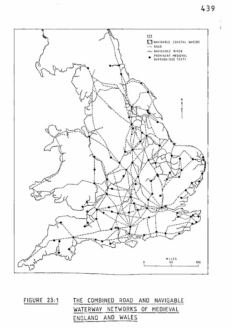
KEY
El NAVIGABLE COASTAL WATERS
--- ROAD
NAVIGABLE RIVER
PROMINENT MEDIEVAL•
BOROUGH (SEE TEXT)
,%
S. Y S
1 s I kn
//Mt \ . I n
I
/ 11,1• n/ g, ,\, I
: \ i , 1, ....
......., n
n I t n \ ,,/ . ...k.
\\
1I
n\
N. \\ \
Nt1n,\ n
I
I \II //n
I, . i‘
,
/
A
\
\I'
I . ,*1\ j i ‘ t%
..., \I % i t
ai..., \ I 1 v i \ I*.
\ /' N. 1/'. /\ ' \
fAllO1 \ s'...\ / 1 \1
%
1 \ 7, //11,;, t-,/
1'1
,
'\
\‘‘)L,,),,-
i).,, ,i,
. 11011
1 e-- V - INI ui \1 u % 1 1,, • \e---•I 1 ,
%n
-----, •I
t111 1:)INC/.n ‘ I \
/
5' I A
. .... ,--,..... ,, , , ,,, 1 \
\ • o W -1 / ‘ 1\ V
,i \-. ..... .........1_1_ A, 1( 1\ n41111
I
i I / - s‘.5 ‘‘,.1 \ \i \/ \ 1 / I % "...„. w,
I\
/
\ ....,4„, A •' I .... N-- /- -.. t, I '-.•
/ ....--- /, / i ,․)....__' --- --46.- \
\---_
,./
MILES0 50 100
Y... 1‘ I't,.... I \ ,•••
A .....r. -----i \
, xr.._ ... .......---=,=4. \1 % 'S1
1 n 11
.1
4._--
N I ,
5' , \ ,.
. %, ‘, / ,
„ ,„
-IN,
,
, 1 ,. \Li
\N....
N. 1\ 1
n
./
/"- - -0, n ///\___ _.... ... /; , 4- 1- --I /I —,,----.....1.. T / % /- //I / ` \ -1- 71- - -V. -.--1,
• n 1, •/.., • ‘ 1 / /_II 1t‘
/ \ .. • 0 7 . I I,/ % -,•.; / /,"/ t
n 1,n ._ ,
/\ 1- /
_1- --- ,/- /
•
n
I
1 IItII
t
439
FIGURE 23:1 THE COMBINED ROAD AND NAVIGABLE
WATERWAY NETWORKS OF MEDIEVAL
ENGLAND AND WALES
MI LES0 SO 100I I i
440
FIGURE 23:2 THE PARTS OF ENGLAND AND WALES MORE
THAN 15 MILES FROM NAVIGABLE WATER
441
The connection between the prominent medieval boroughs and
navigable water can therefore be broken down as follows:- seventyfive per-
cent of the boroughs had direct access to it, seven per-cent probably
had access, a further eight per-cent possibly had access, whilst only
ten per-cent did not have access to it.
In Chapter One, during the discussion relating to internal trade
and urban growth, the importance of siting a new town or developing an
existing one where good communications were available was acknowledged.
Good access is one of the most important qualifications for a town site,
and if that access can be gained by both land and water, then the
foundations for growth are laid. It has been shown that at least seventy-
five per-cent of the prominent medieval boroughs had this dual mode of
access, and of the ten prominent boroughs which could not have been
reached by navigable water only one, Coventry, attained any degree of
eminence. It was the thirteenth richest town in 1334, and estimated to
have been the sixth most populous in 1348. Coventry had developed quite
steadily during the twelfth and thirteenth centuries, and it now seems
that a traditionally held view, that the division between two lords held
back its development until 1345, was of limited significance.(13)
Early
in the fourteenth century the town had a fair number of prosperous wool
merchants, and by the close of that century its growing cloth industry
had far-ranging trading links. Whilst cloth and wool seem to have
been the major trades, other craftsmen were involved with the metal,
victualling and leather trades.(14)
If we accede to the view that the availability of navigable
water was a contributory factor in the growth and prosperity of medieval
towns, why did a place such as Coventry, which did not have this facility,
succeed? Ai-though the town was only six miles from the navigable Avon,

442
and it did have an adequate water supply (in the form of lesser streams),
which was Smportant for its industries, its major advantage was that it
as sited at the junction of two important overland routes. During
medieval times, very few roads crossed the country from southwest to
northeast - a point which is made clear by referring to the cartographic
evidence of the Gough Map (Figure 3;2). The map shows only two such
roads and one of these (53), links Bristol with the Great Morth Road at
Grantham, from where, as is clear from other evidence, it continued to
Lincoln. Between Bristol and Grantham the road set down upon the Gough
Map crosses two of the main roads which radiate from London. It
crosses the London to St. David's road at Gloucester, and the London to
Carlisle road at Coventry. Coventry therefore, was situated at a major
crossing point of overland routes in the Midlands. Geographically, its
situation was ideal, being at the cross-roads of routes linking the major
trading areas including London and Bristol; it also had tradiag links
with Ireland via the road connecting it with the port of Chester.(15)
During the fourteenth century, Coventry was at the hub of overland
trade routes which linked the wealthiest places in England and this must
have been a major factor in the development of the town and helped to
sustain its continued expansion. In terms of population, Coventry had
climbed from a position of obscurity at the time of Domesday to sixth
position by 1348, having an estimated population in excess of -Nel\e
(10)thousand people. Apart from natural processes, this apparently
rather sudden increase in population (and wealth), must ha‘e been
caused by an influx of immigrants. It is known that the fortunes of
nearby Warwick declined; it ranked twentyse\enth at the time of the
Domesday Survey yet it does not appear In any subsequent list of major
towns. Perhaps the population of Coventry Increased, at least in part,
at the expense of Warwick.
443
Turning to the changing fortunes of other places, we can use the
estimates of changing population and wealth to give a guide to changes in
relative importance. Having already mentioned the complexities and
omissions associated with the compilation and interpretation of such data
it has to be admitted that this is a rather crude exercise. The rankings
are little more than a general guide; however, in the absence of anything
more substantial they can at least be used to observe trends. The two
sets of data for both estimates of population and assessed wealth are
given in Table 23:4; the towns are listed in order of rank. The
population figures for 1086 are those of Russell, in the
financially based list of 1154-89, Bristol is shown as ranking fourth,
equal with Lincoln. By linking adjacent pairs of places which appear in
each list, an idea of the relative change in importance can be observed.
The cut-off point of Table 23:4'is at rank fortyfour,which includes all
the financially ranked towns, together with those which can be linked
together using the population data for 1086 and 1348. Although the
connection between the prosperity and population of a town is complex,(16)
the comparison of these data sets is of interest. The position of
London is supreme, whilst York remains relatively stable - climbing from
fourth to second place in terms of population, whilst dropping only one
place from second to third, in terms of wealth. The fortunes of
virtually all the other towns follow similar trends in both sets of data,
only Canterbury, Hereford and Nottingham are exceptions. In terms of
population, Canterbury climbs one place from fifteenth to fourteenth,
but in terms of wealth appears to drop from eleventh to sixteenth place.
However, it must be remembered that the moneyers of Canterbury were
excluded from the Lay Subsidy of 1334; had they been included, it is
certain that Canterbury would have been placed higher than sixteenth,
no doubt resulting in the trends following those of population. The
comparisons between population and wealth for both Hereford and Nottingham
00 0 0
444TABLE 23:4 THE CHANGING FORTUNES OF THE PROMINENT MEDIEVAL BOROUGHS
POPULATION
WEALTH
1086 13 48
RANK
1154-89 1334.
LONDONWI NC HESTERNOYORKLINCOLNTHETFORDBRISTOL
GLOUCESTERCAMBRIDGECHESTERHASTI NG SWALLINGFORDHEREFORD
HY THECANTERBURYDUN WIC HDOVERLEWESSANDWICHCOLCHESTERWI LTONEXETEROXFORDSTAMFORDHUNTINGDONSTEYNINGWARWICKLEICESTERBATHSHAFTESBURYCHI CHESTERNORTHAMPTONIPSWICHWORCESTERROCHESTERTAUNTONYARMOUTHSHREWSBURYNOTTINGHAMCALNESOUTHAMPTON
1234
PLYMOUTH 5 NORTHAMPTON
COVENTRY 6 DUNW I CH
7SALISBURY 8
KINGS LYNN 910
BOSTON 11
BEVERLEY 12
NEWCASTLE 13 GRIMSBY
14B. ST. EDMUNDS 15 DONCASTER
16 BERKHAMSTED
HULL 1718 BEDFORD19 WORCESTER20
21 CARLISLE2223 CORBRIDGE
ELY 2425
26 CAI STER27 MARLBOROUGH
SCARBOROUGH 28 COLCHESTER29 G.MANCHESTER30 HUNTINGDON31
32 ORFORD
LAUNCESTON 33 STAFFORD
NEWARK 34
LUDLOW 3536
PONTEFRACT 37SOUTHWARK 38DERBY 39LICHFIELD 40
CARDIFF 4162
WELLS 4344
LONDONBRISTOLYORKNEWCASTLEBOSTONYARMOUTHLINCOLN
NORWICHOXFORD
SHREWSBURYKINGS LYNNSALISBURYCOVENTRYIPSWICHHEREFORDCANTERBURYGLOUCESTERWINCHESTERSOUTHAMPTONBEVERLEY
CAMBRIDGENEWBURY
PLYMOUTHNEWARKPETERBOROUGHNOTEXETERB. ST, EDMUNDSSTAMFORDE LYLU TON
BARKINGHULLSCARBOROUGHCOTTINGHAMDERBYSWAFFHAM
445
appear to paint conflicting pictures. Hereford declines in terms of
relative population but ascends in terms of relative wealth; whilst
the exact opposite happens to Nottingham. Reference to the Domesday
population rankings of Stephenson (Table 23:1), reveal a significant
difference between his rankings for both Hereford and Nottingham when
compared with Russell. He has Hereford in thirtyeighth position and
Nottingham twentyeighth— positions which would have meant that the
trends in population and wealth would have been similar for both places
had they appeared in these positionsin Table 23:4. These anomalies apart,
it is clear from the evidence relating to the towns ‘ihich appear in bath
sets of data in Table 23:4 that their relative prosperity fluctuates in
direct proportion to fluctuations in their porvlatious,
Let us now turn to the broader aspects of Table 23:4. Of the
consistently prominent places, five are never outside the top eight in
any list; these being London, York, Bristol, Norwich, and Lincoln.
The question we must now ask is:- what assets did these consistently
prominent places possess to enable them to maintain their pre-eminence?
All five places had early foundations, three i\ere on Roman sites, and all
%%ere hurhs in the n;Ath and i?nth centuries;indeed, at the time of
the Norman Conquest, they vlould have been the first places of any
significance that a vessel would reach during a voyage up each respective
river on which they were situated. This would have given them a head
start when the medieval period commenced. Another common factor is
that they were all established at bridging points. Their early bridges
were the focal points of early overland routes, while the navigable
stretches of river above them brought trade from the more inland parts
of the country. Also there would be little incentive, especially for
sea-going vessels, to voyage any further than they had to in order to
discharge and/or take on cargo. Thus, it would be an attractive
446
proposition for 'foreign' captains to engage in trade at such places, where
safe anchorages combined with effective distribution networks were
available. The majority of traders between England and Europe in the late
Saxon and early medieval periods seem to have concentrated their activities
across the North Sea to the Rhineland; pottery from the Rhineland has
been found on the south coast and as far up the east coast as York. (17)
London, York, Norwich and Lincoln were therefore in the most advantageous
positions geographically; they were situated inland, but they were, in
effect, sea ports, their navigable estuaries being the main inlets into
the country from the continent. Further west, Bristol's main advantage
4‘, as that it %vas a focal point for the West Country - the Bristol Channel
hardly faced the right way for European trade - although it was used for
trade with western France, Spain, and Italy, and also with Ireland.
Although the Norman Conquest naturally tended to move trade towards the
Channel, the trading bases of the five major towns were by this time well
established, and their links with mainland Europe continued to flourish.
As the medieval period progressed, both Lincoln and Norwich became
increasingly engaged in competition for trade with the developing towns of
Boston and Yarmouth respectively; there is some evidence to suggest that
progressive silting of their respective rivers made it increasingly more
difficult for the larger sea-going ships to reach them, thus increasing
the potential of the towns nearer to the coast. In terms of assessed we,alth,
both Boston and Yarmouth had risen above Lincoln and Norwich by 1334.
The important connection between navigable water, overland routes,
and the changing fortunes of the prominent medieval boroughs is brought out
by comparing Table 23:4 with Figure 23:1. Although the map presents a
static picture, the table gives an idea of temporal changes. It would be
virtually impossible to attempt to explain the changing fortunes of all the
places given in Table 23:4, therefore it is perhaps best to high-light
447
some of the more prominent places, arid those which appear to have undergone
the most dramatic change.
Winchester, the former capital and a major route centre, declined.
In 1086 it was probably the second most populous place behind London, but
had dropped to thirtyfirst position by 1348; in terms of wealth it declined
from eighth place in 1154-89, to eighteenth place by 1334. This relative
decline undoubtedly reflects the shift in political and administrative
centres; also, the navigation of the River Itchen was suffering from
obstacles in the form of mills (see Chapter Fifteen), and this no doubt
further reduced the trading position of the town. Thus Southampton, with
its sheltered port near the mouth of the River Itchen and close to the head
of Southampton Water, grew. This growth during the twelfth century was
also due to the geopolitical fact that England's trade, as part of the
Norman and Angevin Empires, was more firmly established across the Channel.
The town of Plymouth was also at an advantage in this respect; it grew in
relative importance compared with the Cinque ports. 8)
Thetford, estimated to be the sixth largest town in 1056, does not
appear in any subsequent list. It was a port in late Saxon times, and
also into the medieval period; however, its decline (as mentioned in
Chapter One), appears to have been linked with the increasing fortunes of
nearby Bury St. Edmunds and King's Lynn. Founded between 1086 and 1095,
King's Lynn was at the mouth of the river system leading to Thetford,
Cambridge, Ely, Huntingdon, Peterborough and Stamford. It was the ninth
largest town in 1348 and the eleventh most wealthy by 1334. On the other
hand, Cambridge had lost ground in terms of both population and wealth.
It was the ninth largest town in 1086, but was only twentythird by 1348; in
terms of wealth it had dropned from twelfth to twentyfirst position.
448
The increasing relative importance of places such as King's Lynn
can, in part, be attributed to advances in the technology of ship-building.
As discussed in Chapter Twentyone, the evidence makes it clear that there
existed a class of vessel that was used exclusively on the rivers, and as
such, these craft were not capable of undertaking voyages on the open sea.
On the other hand, sea-going vessels were capable of navigating many of
the rivers. However, as the technology of ship-building progressed, the
sea-going vessels increased in size. These larger vessels would not be so
suited to river navigation as were their earlier, and smaller, predecessors,
with the result that they would tend to terminate their voyages at places
where there was an interface between the sea and inland navigation. We
have already seen this pattern developing at places like Boston (for
Lincoln), Yarmouth (for Norwich), and Southampton (for Winchester); the
developing town of Kingston-upon-Hull, which had always been effectively the
port for Beverley, was also taking an increasing share of imports away from
York. All this does not mean that the rivers ceased to exist as effective
means of transportation; the evidence in the preceding chapters proves
otherwise. It is, however, indicative of a shift in the centres of sea-
borne trade; as the sea-going ships grew in size these trading points moved
down-river. The simultaneous increase in urhan growth and European trade,
alluded to in Chapter One, put a greater emphasis on those places 'facing'
the continent; hence the east coast ports in particular grew in relative
importance. Apart from the places already mentioned, the fortunes of
Beverley, Ipswich and Colchester were growing, whilst in the north-east the
coal trade of Newcastle expanded rapidly. Scarborough and Grimsby however,
had declined, and Dunwich, after a promising start, had been entirely
destroyed by the sea.
On the western side of the country the dominance of Bristol was
supreme. The relative importance of Gloucester diminished, that of Worcester
449
improved, whilst Shrewsbury, much further up the River Severn, experienced
dramatic growth. The wealth of Shrewsbury was based on its dealings in
the wool trade (it was also an important cattle droving centre). It was
ideally situated to obtain the highly valued Welsh wool, and it is clear
from the references in Chapter Seventeen, that much of this was shipped
along the River Severn. By 1334, the town had reached the top ten in terms
of wealth and was the twentieth largest town in 1348. Shrewsbury also had
strong overland links with Ludlow and Hereford, these places also being
much involved with the wool trade; indeed, Hereford had risen from a lowly
position to become the fifteenth richest town by 1334. On the other hand,
Chester, the tenth most populated town in 1086, had been relegated to
fortysecond place by 1348. Its strongest overseas trading links were vdth
Ireland, but in terms of overseas trade it faced the wrong way and was
thus overtaken by the more advantageously sited places to the south and
east. Progressive silting of the River Dee also affected its capability to
attract the larger sea-going vessels.
In the south-west, Exeter suffered from two major problems.
From 1290 onwards its navigational access was impeded, and the neighbcuring
town of Topsham was taking a n%ay its trade (see Chapter Sixteen). These
problems must have contributed to Exeter's relative decline; it as down
in twentyseventh position in terms of wealth in 1334, whereas in 1154-89
it had been as high as seventh. Further to the east, the neI,N ton of
Salisbury was in the top twelve in terms of both size and wealth during
the fourteenth century. It was on the main road connecting London with the
south-west, had strong overland ties with Southampton, Shaftesbury,
Marlborough and Winchester, and also possessed navigable water. In 1244
a new bridge was built across the River Avon at Salisbury. This
contributed to the demise of Wilton, for the old county town,which was
the twentyfirst largest in 1086, was thereafter bypassed by the main
450
road to the south-west.(19)
Wallingford, the twelfth largest town in
1086, does not appear in any subsequent list. Although one of the largest
anglo-saxon burhS it gradually lost its prosperity during the thirteenth
and fourteenth centuries, and by 1416, when a new bridge at Abingdon
caused the diversion of the main road from London to Gloucester, its
downfall was all but complete. Oxford, just a few miles further up the
River Thames, improved its relative position in terms of both Population and
vealth. It marginally increased its prosperity, moving from tenth to ninth
position. It was at a major junction of overland routes and was also
served by the navigable waters of the Thames. Ships regularly plied
between London and Oxford during the thirteenth and fourteenth centuries
(see Chapter Fourteen).
Having obtained an idea of the relative changing fortunes of the
more prominent medieval boroughs we can return again to Figure 23:1 for
some additional general observations. The map puts into cartographic
form the points brought out in the preceding text. The interconnection
between the roads and navigable water is obvious, as is the siting of
so many major towns at the confluence of road and river routes. Of the
eight principal road centres identified in Part Two, only one, Marlborough,
is not situated on a known medieval navigable river. The main route
between London and Berwick-upon-Tweed, for the most part the Great North
Road, crosses no less than twenty navigable rivers, and it coincides in
many instances with their navigable limits. Ware, Sawtry, Wansford,
Stamford, Elkesley, Bawtry, Doncaster, POntefract, Wetherby, Boroughbridge,
and Chester-le-Street are all at, or near, the navigable limits on the rivers
on which they are situated. This same observation also applies to the road
which runs along the south coast between Southampton and Canterbury, to
the road between London and Dunwich, and to that between London and Norwich,
via Cambridge.
451
It is clear, that as the medieval period progressed, the towns
having direct involvement in international trade grew and flourished;
the expanding commercial links forged during the twelfth and thirteenth
centuries - especially with Gascony, Spain and the Baltic, coupled with
an increase in trade via the sea route from the Mediterranean to northern
waters, guaranteed their growth and ensured their prosperity. However,
we must not lose sight of the fact that expansion in international trade
was directly linked to a simultaneous increase in urban growth overall,
and associated with this urban growth was a corresponding expansion in
internal trade (see Chapter One). All of this commercial activity,
both on the domestic and international fronts, could not have taken place
had there been any inadequacies in the transport and communications network
needed to sustain it. All the evidence relating to both overland and
waterborne movements mentioned in this thesis suggest that road, river, and
sea transport was fully capable of meeting the demands placed upon it.
Any further attempt to describe the interconnection between the
roads and navigable waterways would be tedious; enough has already been
said in Part Two regarding the basic road network, and the preceding
discussion outlining trends in the changing fortunes of the prominent
medieval boroughs puts into perspective temporal fluctuations and hence
highlights the changing importance of the routes leading to them.
Having thus attained some idea of the basic transport system, the
next, and final step, is to look at some further examples of its use.
452
Notes and References
(1) H.C. DARBY, 'The Economic Geography of England, AD1000-1250'
being Chap. 5 of H.C. DARBY (ed.), An Historical
Geography of England before AD 1800 (Cambridge
1936) 215.
(2) J.C. RUSSELL, British Medieval Population (Albuquerque, 1948)
282-314
(3) ibid, 283-7
(4) ibid, 273-80
(5) ibid, 143 et seq.
(6) C. STEPHENSON, Borough and Town (Cambridge, Mass., 1933) 221
(7) ibid, 225
see also: R.A. DONKIN, 'Changes in the Early Middle Ages' being
Chap. 3 of H.C. DARBY (ed.) A New Historical Geography
of England (Cambridge, 1973) 132-5
(8) R.E. GLASSCOCK, 'England circa 1334' being Chap. 4 of H.C. DARBY
(ed.), A New Historical Geography of England (Cambridge)
1973) 184
(9) J.C. RUSSELL (op. cit.) 50-1
453
(11) B.P. HINDLE, ' A Geographical Synthesis of the Road Network of
Medieval England and Wales', Unpublished Ph.D.
Thesis, University of Salford (1973) 121.
(12) Calendar of Close Rolls, 1272-79, 125
(13) S. REYNOLDS, An Introduction to the History of English Medieval
Towns (Oxford, 1977) 156
(14) ibid, 156
(15) See Figures 3:2, 3:3 and 8:1
(16) S. REYNOLDS (op. cit.), 144-45
(17) J.M. STEAME, The Archaeology of Medieval England and Wales
(London, 1984) 130
See also: R. HODGES, Dark Age Economics (London, 1982)
(18) J.M. STEANE, (op. cit.), 131
(19) ihid, 115.
454
CHAPTER TWENTY FOUR THE COMBINED TRANSPORT SYSTEM:SOME FURTHER EXAMPLES OF ITS USE
Although there is no comprehensive evidence relating to the
internal movement of goods and personnel during the medieval period,
some scattered references do record movements where the combined use
of both roads and waterways is made.
During the winter of 1258, Henry III granted 34 tuns of nine to
Eleanor, his queen. This wine, which had been imported at Roston,
was currently in store at Peterborough. The King ordered the Sheriff
of Cambridge to transport the wine
"to Cambridge with all speed by water, and thence by landto Ware". (1)
At Ware, responsibility for delivery of the wine was to be
undertaken by the Sheriff of Essex and Herts, who as to take the
cargo
from Ware by water to Westminster"(2)
From Peterborough, the cargo was to be taken along the Riser
Nene to Renwick. A choice of routes was available here; via the
easterly course of the river to combine with the Great Ouse north of
Renwick, or via the south-easterly course through Yaxley and Holme.
From Renwick the Great Ouse would be navigated to Earith where the Old
West River gave access to the River Cam and Cambridge. The oserland
part of the journey would then be via the course of the Gough Map route
455
between Cambridge and Ware, via Barkway. At Ware, the cargo was
transferred to boats for its journey down the River Lea and on up
the Thames to Westminster.
The routes associated with this journey are given in Figure 24:1,
where the reliance on navigable water is clearly demonstrated.
Peterborough is only 5 miles from the well-used medieval road linking
Wansford with London via Ware, and yet the wine was taken just as far
towards its final destination as possible utilising the navigable
waterways. Even when Ware was reached the journey did not continue
along the road into London but the cargo was taken along the Lea and
the Thames to Westminster. It is clear that every available stretch of
navigable water was utilised between Peterborough and Westminster for
the transport of this cargo. The reasons for this emphasis on the use
of navigable water can be put down to cost and convenience. Carriage
by water, as will be mentioned shortly, appears to have been much cheaper
than by land. Also, bulky cargoes were cumbersome to carry overland and
were frequently obtained from the nearest point to which they could be
brought by water.
"This tapping of water carriage at the nearest availablepoint must have been common to many goods. It is areminder that land and water carriage were ofteninterdependent." (3)
A similar route to that previously described was no doubt used in
1316 when safe-conduct was granted to
"the servants whom John de Sandale, King's Clerk, theChancellor, is sending with Jivers goods of his from theparts of Lincoln to Cambridge by water, and from thence toLondon." (4)
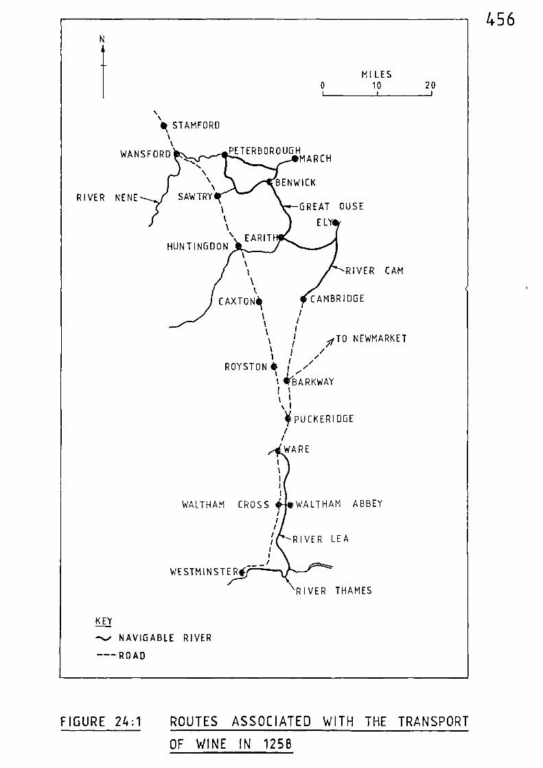
RIVER NENE
WANSF ORD..
\\\
SAW TRY
PETERBOROUGHMARCH
BENWICK
GREAT OUSE
ELY
t%
11111
WALTHAM CROSS WALTHAM ABBEYrt
rrr
t1,
WESTMINSTERi
RIVER THAMES
RIVER LEA
456
MILES0 10 20
I I 1
‘Ilk STAMFORD
HUNTINGDON\ EARIT
(
%1
RIVER CAM1\l
CAXTONik CAMBRIDGE
I /1 1
tr
/
i fiTO NEWMARKET11 , ,
ROYSTON • I ///'
1 '
\ firBA R K WAYIt1 1n I
PUCKERIDGE
//
WARE
KEY
-- NAVIGABLE RIVER
--- ROAD
FIGURE 24:1 ROUTES ASSOCIATED WITH THE TRANSPORT
OF WINE IN 1258
457
The Sheriffs' Accounts' for the counties of Yorkshire, Lincolnshire,
Norfolk and Hampshire recount many instancesof the movement of produce
using both roads and navigable water, with heavy reliance upon the
latter. (5) An example involving roads, inland waterways and coastal
waters is recorded in 1309. During that year, 40 quarters of grain were
taken from Sherburn-in-Elmet and carried overland to York via Tadcaster
(a route already highlighted by the royal itineraries). At York, the
grain was ground into flour and placed in a ship which sailed down the
River Ouse into the Humber, and on to Hull. At Hull, the flour was
transferred to another vessel and carried to Berwick-upon-Tweed.(6)
The route associated with this journey is given in Figure 24:2. The
fact that the flour was transferred to another vessel at Hull probably
means that the vessel which had made the voyage from York was not capable
of undertaking a voyage on the open sea; perhaps it was a Keel, or
lugger, similar to the types mentioned in Chapter Twenty One.
Another interesting example from 1309, apart from illustrating the
use of a combination of local roads and navigable waterways, also allows
a direct comparison between overland and waterborne transport costs.
During that year, 30 quarters of grain were taken overland from Malton
to Wansford, at the head of the River Hull; a distance given in the
account as 14 leucae. (7)
Similarly, 18 quarters of grain were taken
overland to Wansford from Pocklington, and again, a distance of 14
leucae was recorded for the length of the journey. The combined cargo
of 48 quarters of grain was then shipped down the river to the port of
Hull. The distance between Wansford and Hull via the river is approx-
imately the same as that between Malton and Wansford and Pocklington and
Wansford. Fortunately, the transport costs for this particular series of
journeys were recorded and showed that the cost of overland carriage
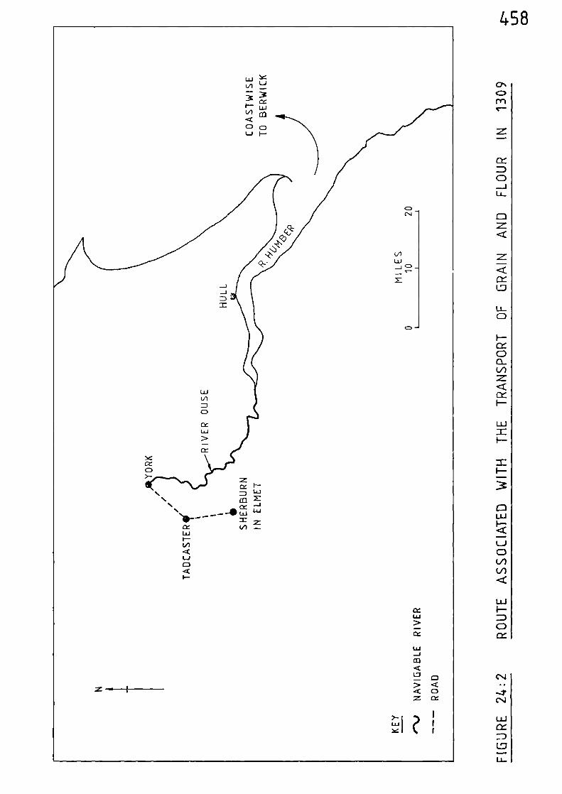
458
UJI-=0CC
C)<cocc
NI-L.LJ
z—ILi
--
0 -
CII-
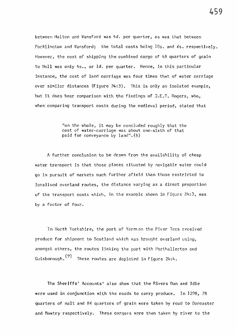
459
between Halton and Wansford was 4th per quarter, as was that between
Pocklington and Wansford; the total costs being 10s. and 6s. respectively.
However, the cost of shipping the combined cargo of 48 quarters of grain
to Hull was only 4s., or id. per quarter. Hence, in this particular
instance, the cost of land carriage was four times that of water carriage
over similar distances (Figure 24:3). This is only an isolated example,
but it does bear comparison with the findings of J.E.T. Rogers, who,
when comparing transport costs during the medieval period, stated that
"on the whole, it may be concluded roughly that thecost of water-carriage was about one-sixth of thatpaid for conveyance by land".(8)
A further conclusion to be drawn from the availability of cheap
water transport is that those places situated by navigable water could
go in pursuit of markets much further afield than those restricted to
localised overland routes, the distance varying as a direct proportion
of the transport costs which, in the example shown in Figure 24:3, was
by a factor of four.
In Horth Yorkshire, the port of Yarnlon the Piver Tees received
produce for shipment to Scotland which vas brought overland using,
amongst others, the routes linking the port with Porthallerton and
Guisborough.(9)
These routes are depicted in Figure 24:4.
The Sheriffs' Accounts' also show that the Rivers Don and Idle
were used in conjunction with the roads to carry produce. In 1298, 28
quarters of malt and 86 quarters of grain were taken by road to Doncaster
and Rawtry respectively. These cargoes were then taken by river to the
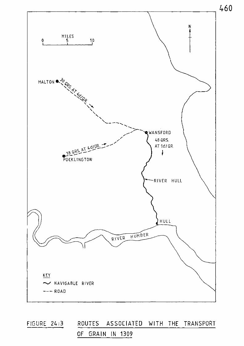
KEY
--..• NAVIGABLE RIVER
--- ROAD
_--- RIVER HUMBER
// 48 QRS./
AT 1d/ QR.
460
MILES0 5 10
1 1 i
J>MALT ON L 0,,\ .4....o
\ " IT\* 4),
\ '‘.1:7.....<9,,,
(e\\\
\\ n\ ......_ ----.--.S
.------. WANSFORD....-'/ \AB
GRS- '-'-- ---0---POCK L ING TON
i
RIVER HULL
7-\HULL
FIGURE 24:3 ROUTES ASSOCIATED WITH THE TRANSPORT
OF GRAIN IN 1309
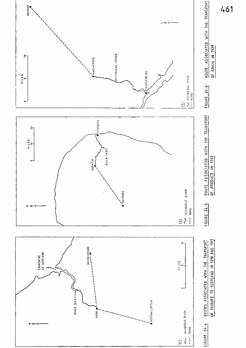
461
CCID
1./.1
CDCC
U-CD
sC)
LJACc
1.7
I—CC
U-L/)
•kLCCO-
W
I-
S
0 I
CD1J-1
/—
CD
4.0
.‹C
14./Li
CD
LA-
LiJ
CDCC
Ui
ID
CD
VI
LA in Iva
0Ui
IA LA•IC /—0 0
t2
C.4s-
- J
I/1
CD
14.1
CD
0-
z
▪ •-•
462
port of Hull prior to being taken on to Berwick-upon-Tweed via coastal
waters.(10)
During 1311 and 1336, grain was transported along the
Gough Map route linking Caistor with Barton-upon-Humber, prior to ship-
ment to Scotland.(11)
Part of the road between Lincoln and Burton-on-
Stather was used in 1311, when 131 quarters of produce were sent from
Bishop Norton, near Kirton-in-Lindsey, to be loaded in a ship at Burton-
on-Stather.(12) The produce was then taken to Berwick-upon-Tweed via
the maters of the Trent and Humber, and by coastal waters.
In 1311, a total of 38 quarters of grain and 41 quarters of malt
were taken along the road linking Wagby with Lincoln. From Lincoln
the cargo was shipped down the River Witham to Boston then on to Berwick-
upon-Tweed. (13)
In Norfolk, produce was carried overland from Thetford via the road
linking it with Norwich, from where it was taken down the River Yare to
Yarmouth.(14)
Figure 24:5 shows the route taken by produce between
Thetford and Yarmouth in 1340.
In Hampshire, it appears that the roads converging on Winchester
were used to carry a varied amount of produce which was then sent on to
Southampton, either by road or via the River Itchen.(15)
Figure 24:6
shows the route taken by grain between Odiham and Southampton in 1339.
Apart from goods and produce, the roads and navigable waterways were
also used by individuals and groups of travellers. The shortest medieval
route from Lincoln to York was north to Burton-on-Stather, by boat along
463
the Trent and up the Ouse to Howden then on to York by road. This route
was used by Robert of Nottingham during the winter of 1324-5, when he was
(16)buying wheat for the King.
During 1319, Edward II invited a number of scholars of King's Hall,
Cambridge, to spend Christmas with him at York.(17)
The scholars were
divided into two parties, one party travelling entirely by road, and the
other using a combination of roads and navigable rivers. This latter
party spent the first two days of the journey travelling from Cambridge
to Spalding in two hired boats. The exact route used for this part of
the journey went unrecorded and they would have had a number of route
options open to them. The most direct would have been down the Cam,
up the Old West River, along the Great Ouse to Benwick, up the Nene to
Peterborough, then on to the Welland via South Eau to arrive at Spalding.
From Spalding, the party travelled overland to Boston - a route shown on
the Gough Map. At Boston they hired a single large boat and travelled
up the River Witham to Lincoln. The next part of the journey was made
along the Foss Dyke in two hired boats where, on reaching Torksey, they
transferred to a large boat and voyaged down the Trent and up the Ouse to
York. The probable route taken for this journey is outlined in Figure
24:7.
Part of the previously described route was used by the Exchequer in
1322, when it was transferred from London to York.(18)
This transfer
involved a considerable number of personnel; officials, clerks, grooms,
servants and others, together with a large baggage train. The route was
initially overland along the Great North Road via Ware, Royston, Huntingdon
and Wansford to Grantham. From there, the route continued overland to
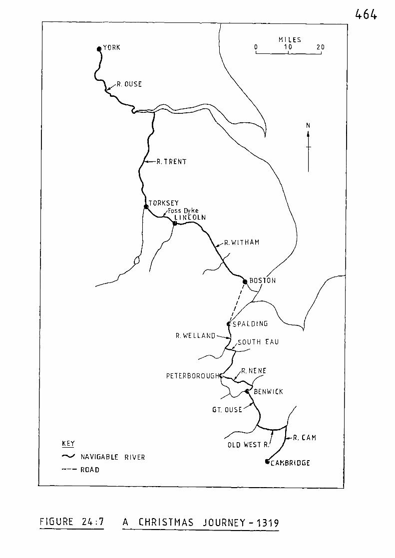
MILES0 10 20
1 1 1YORK
R. OUSE
N
i
R. TRENT
TORKSEYFoss Dyke
LINCOLN
//
//
1/
1SPALDING
R. WELL ANDSOUTH EAU
PETERBOROUGHR. NENE
BENWICK
GT. OUSE
R CAMKEY
-- ' NAVIGABLE RIVER
- -- ROAD
OLD WEST R.
CAMBRIDGE
R.WIT HAM
BOSTON
464
FIGURE 24:7 A CHRISTMAS JOURNEY - 1319
465
Lincoln and Torksey. At Torksey, the personnel and baggage embarked
and sailed down the River Trent to Burton-on-Stather, where they %ere
delayed by a storm. The journey was completed by sailing up the River
Ouse to York.
When the Bursar of Durham purchased large quantities of cloth and
provisions at Boston Fair between 1299 and 1316 his return journey
involved the use of both roads and rivers.(19)
From Boston, the
purchases were taken along the River Witham to Lincoln, then overland by
cart to Torksey where boats were once again employed on the navigable
Trent and Ouse. On passing York and nearing Boroughbridge, the party
once again took to the roads for the remainder of the journey to Durham,
presumably following the route which passed through Horthallerton. It
is interesting to note that when similar purchases were made in 1336,
the goods were taken from Boston to Newcastle-Upon-Tyne by coast%ise
traffic and completed the remaining 15 miles to Durham by road.(2°)
The routes associated with these journeys are given in Figure 24:8.
During 1326, fagots %ere taken from Chippenham to the Thames and
then by water to the Tower of London.(21)
The overland part of this
journey was probably via the route linking Nalmesbury %ith Faringdon and
Radcot Bridge. The probable route taken for this journey is outlined in
Figure 24:9.
The combined use of both roads and waterways was made in 1371 when
lead, for the purpose of roofing parts of the castle buildings at
Odiham, was initially taken up the Thames to Windsor prior to its over-
land journey to Odiham. ( " ) (The overland part of this particular journey
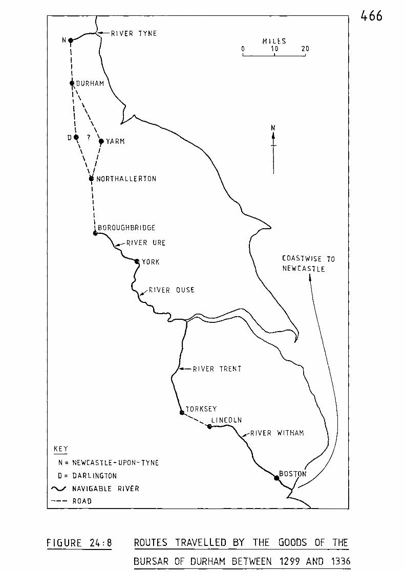
466-e-RIVER TYNE
IIII
ikEIURHAM
I \i 1‘I ‘I \I \I \
D ,‘ 7 \I,YARM
\ /\ /\ /‘ /10 NORTHALLERTON
IIiIII
BOROUGHBRIDGE
A--RIVER URE
YORK
MILES0 10 20I
N
COASTWISE TO
NEWCASTLE
"RIVER OUSE
-4--RIVER TRENT
TORKSEY
., LINCOLN
A-RIVER WITHAM
KEY
N = NEWCASTLE-UPON-TYNE
D = DARLINGTON
,N.../ NAVIGABLE RIVER
--- ROAD
BOSTON
FIGURE 24:8 ROUTES TRAVELLED BY THE GOODS OF THE
BURSAR OF DURHAM BETWEEN 1299 AND 1336
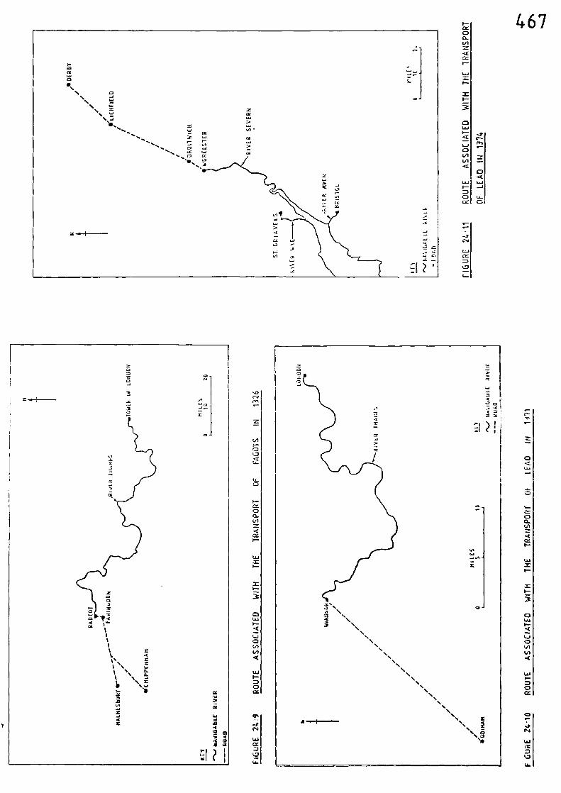
...
t•-n
467
CC
X,..; cc
vi LAJ
,...% 41 CC C”..re ......
4n
•—• I-
iflv.1
n LaJ.... a ....I
..... , fl CZ
Li
..111 st..7
:A•
z.
.43
Cn1
Cr1
67,
A
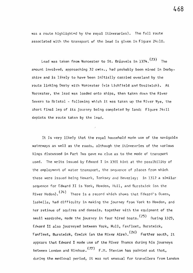
468
was a route highlighted by the royal itineraries). The full route
associated with the transport of the lead is given in Figure 24:10.
Lead was taken from Worcester to St. Briavels in 1374.(23)
The
amount involved, approaching 32 cwts., had probably been mined in Derby-
shire and is likely to have been initially carried overland by the
route linking Derby with Worcester (via Lichfield and Droi-Nich). At
Worcester, the lead was loaded onto ships, then taken don the River
Severn to Bristol - following which it was taken up the River Wye, the
short final leg of its journey being completed by land; Figure 24:11
depicts the route taken by the lead.
It is very likely that the royal household made use of the navigable
waterways as well as the roads, although the itineraries of the various
Kings discussed in Part Two gave no clue as to the mode of transport
used. The writs issued by Edward T in 1301 hint at the possibility of
the employment of water transport, the sequence of places from which
these were issued being Hewark, Torksey and Beverley; in 1312 a similar
sequence for Edward II is York, Howden, Hull, and Burs-Nick (on the
River Hedon).(24)
There is a record vdlich shows that Fdward's Oueen,
Isabella, had difficulty in making the journey from York to Howden, and
her retinue of squires and damsels, together with the equipment of the
small wardrobe, made the journey in four hired boats.(25)
During 1323,
Edward II also journeyed between York, Hull, Faxfleet, Burstwick,
Faxfleet, Burstwick, Cowick (on the River Aire).(26)
Further south, it
appears that Edward I made use of the River Thames during his journeys
between London and l'andsor.(27)
F.M. Stenton has pointed out that,
during the medieval period, it was not unusual for travellers from London
469
to Canterbury, or the ports of Kent, to use the River Thames as far as
Gravesend.(28)
In 1325, when the Warden of Merton College, Oxford,
visited London, he completed his journey by taking a boat at Kingston.
During his nine day stay in the capital he took a boat daily, sometimes
to Westminster, and sometimes towards the Surrey manors.(29)
All this evidence suggests that, whenver possible, for reasons of
both cost and convenience, the heaviest and most cumbersome goods were
sent by water instead of road. Furthermore, individuals, especially
those with a large volume of baggage, made use of the navigable rivers
where this means of travel was available.
470
Notes and References
(1) Calendar of Liberate Rolls, 1251-60, 444
(2) ibid, 447
(3) T.S. WILLAN, The Inland Trade, ( 1 anchester, 1976) 25
(4) Calendar of Patent Rolls, 1313-17, 443
(5) S. UHLER, 'The Transportation of Produce in Lincolnshire,Yorkshire, Hampshire and Norfolk duringthe Fourteenth Century as revealed bythe Sheriff's Accounts' unpublished B. Phil. Dissertation, University of St. Andrews (1977) 44
(6) ibid, 27
(7) ibid, 29
(8) J.E.T. ROGERS, A History of Agriculture and Prices in England,Vol. I, (Oxford, 1866), 663
(9) S. UHLER (op. cit.), 33 (See Figure 7 also)
(10) ibid, 25
(11) ibid, 6
(12) ibid, 8
(13) ibid, 15
(14) ibid, Figure 14
(15) ibid, Figure 12
(16) Public Record Office, E101/309/29
471
(17) W.W. ROUSE BALL, Cambridge Papers (London, 1916) 154-60
(18) D.M. BROOME, 'Exchequer Migrations to York in the Thirteenthand Fourteenth Centuries', Essays inMedieval History, presented to T.F. Tout (Manchester, 1925) 291-300
(19) C. PLATT, The English Medieval Town (London, 1976) 81
(20) M.W. BARLEY, 'Lincolnshire Rivers in the Middle Ages'Lincolnshire Architectural and Archaeological Soc. Reports and Papers New Ser. 1 (1938) 17
(21) J.E.T. ROGFPS (op. cit.,) Vol. I, 662-3
(22) J.E.T. ROGERS (op. cit.), Vol. I, 659
(23) J.E.T. ROGERS (op. cit.) Vol. II, 604
(24) M.W. BARLEY (op. cit), 16
(25) M.W. LABARGE, Medieval Travellers: The Rich and Restless (London, 1982) 38
(26) C.H. HARTSHORNE, An Itinerary of Edward the Second (Private Distribution, 18611 2S
(27) B.P. HINDLE, 'A Geographical Synthesis of the Road Het‘Norkof Medieval England and Vales, Unpublished Ph.D. Thesis, University of Salford (1973)65-6
(28) F.M. STENTOM, 'The Road System of Medieval England'Economic History Review, Vol. VII, Ho. 1(1936) 19-20
(29) G.H. MARTIN, 'Road Travel in the Middle Ages -Some Journeys by the Warden and Fellowsof Merton College, Oxford, 1315-1470,3ourn. Transport History, Vol. III(1975-76) 166
472
CHAPTER TWENTY FIVE JOURNEYS' END
The justification for this research was the lack of a previous
geographical study of the whole transport system of medieval England
and Wales, and in particular a paucity of systematic work dealing with
navigable waterways and their relationship with the road network.(1)
Previously published work relating to medieval transport concentrates
mainly on the roads, although some consideration is given to the utilisation
of various navigable waterways, albeit in a rather localised way.(2)
The previously defined framework of a national network of medieval
roads relies heavily on the cartographic record of the Gough Map, and to
a lesser extent on those of Mathew Paris, (3) supplemented by the
interpretation of the royal itineraries of John, Edward I, and Edward II,
together with a theoretical approach based on borough population figures.
Although itineraries do not prove the physical existence of routes, they
do provide direct evidence of the movement of individuals, which is of
great significance . These individuals obviously journeyed
from place to place by some means or other and the options available
to them would be, to walk, to ride, to travel by carriage or cart, or to
travel by boat - if navigable water was to hand.
An additional source of information, the itinerary of Henry III,
enables a plot of his travels to be made, which has a significant influence
on the minimum aggregate network based on the itineraries of the other
three Kings. In terms of royal travels it also fills a gap of 56 years in
the previously analysed itineraries.(4)
473
The Premonstratension Itineraries from Titchfield Abbey are a rich
and valuable source covering a fair proportion of the country, fanning
out in all directions from Titchfield. As such, they are an extremely
useful contribution towards the attempted reconstruction of a national
route network as they do not suffer from a typical fault associated with
the more usual ecclesiastical itineraries - that of only staying within
the precincts of a particular diocese.(5)
The fact that inter-place
distances are recorded in these itineraries enables direct comparison
with the routes of the Gough Map - which shows that both sets of evidence
are derived from different sources. Statistical analyses of both sets of
data, both of which are of similar size and values, produces extremely
close correlation in terms of the average figure in statute miles for each
medieval unit of distance - which, by the early fourteenth century had
stabilised into a distance approximating to 10 furlongs.(6)
The perusal of additional itineraries, coupled with direct
documentary evidence, which is often to be found in legal presentments,
assist in establishing certain routes and are a useful aid towards filling
any gaps in the national network. (7) Analysis of all these journeys is
advantageous, because it is impossible to conclude, especially from
the evidence of itineraries, whether a traveller journeyed directly
from one place to another; therefore, it is only \\hen repeated use of a
particular route is observed that a degree of confidence can be applied
to its specific course. These limitations do not apply to the same extent
when considering itineraries where the inter-place distances are recorded,
as in the Titchfield Abbey Itineraries, because these recorded distances
can be used to establish the directness, or otherwise, of a particular
route. (8)
474
The mapping of the various itineraries confirms many of the common
lines of travel set down upon the Gough and Mathew Paris maps. Additional
lines of travel are also identified, which, when added to the cartographic
evidence, expand the network shown on those maps. A significant
addition to the network is the route which connects the Channel ports
with the Midlands via Northampton, Brackley, Oxford and Newbury, through
Winchester and Southampton. The itineraries also support the existence
of a number of previously inferred Gough Map routes and link York and
Lincoln into the route network in a positive manner, as well as high-
lighting the link between Leicester and Doncaster, via Nottingham.
A limitation associated with itineraries is that, unless specifically
mentioned, there is no way of knowing whether stretches of navigable water
were employed during a particular journey. This same limitation applies,
to a lesser degree, when dealing with some of the cartographic evidence.
For example, the Gough Map route between Lincoln and Boston which follows
the course of the River Witham, and the rcutes alongside the Severn and
the Thames, could just as easily refer to those waterways as to terra
firma. There are also the problems associated with missing data and the
difficulties of interpreting, deciphering, and locating certain places,
especially the Welsh places shown on the Gough Map.(9)
Regarding the
Gough Map, there is some evidence to suggest that its origins may date
from the last quarter of the thirteenth century, with later additions.(10)
Although the basic network of routes derived from these separate
sources possibly includes some stretches of navigable water, it is, without
question, predominantly land-based and therefore, the final map depicting
it (Fig. 8:1), is described as a 'road' network.(11)The basic road
network also provides a means of estahlishing the most likely routes
475
taken for the overland movement of goods and produce where only the
starting point and destination are recorded in the documentary evidence(12)
Turning to the extent of navigable water in use during the medieval
period, the various State Rolls, supplemented by the volumes relating to
Public Works and the Sheriffs' Accounts', are particularly useful sources
of contemporary evidence.(13)
The bringing together of all the regional evidence produces a map
(Fig. 20:1) which, it is suggested, is the first comprehensive attempt
at describing the navigable rivers of medieval England and Wales. Although
many of the rivers depicted on this map were previously known, or presumed,
to have been navigable, the extent of navigable water is expanded in
certain areas, whilst in others presumption has been replaced by historical
fact.(14)
Although the references relating to the internal movement of
waterborne cargoes are invaluable in determining the extent of inland
navigable water utilised during the medieval period, they are not sufficient
to allow much detailed analysis of spatial or temporal variations of
different types of cargo.(15)
Historical evidence also substantiates the
physical connection between the coasting trade and river navigation;
there is, however, a disappointing lack of evidence relating to the
vessels employed on the rivers.(16)
Although an apparent line of travel combined with an associated
distance can, when shown on a map, be used to confirm overland routes,
the fact that a river is shown on a map does not confirm its navigability.
However, it is interesting to observe that the Gough Map shows, albeit
rather crudely in some areas, most of the rivers determined to be navigable
during the medieval period.(17)
The availability of navigable water was
certainly a contributory factor in the growth and prosperity of many
476
medieval towns; the importance of having navigable water at hand is borne
out by the fact that at least three-quarters of the one hundred prominent
(18boroughs of the medieval period has direct access to it t8) them
a distinct economic advantage in the distribution of goods and produce. (19)
Trends in the changing fortunes of the prominent medieval boroughs puts
into perspective temporal fluctuations and hence highlights the changing
importance of the routes leading to them.(20)
The final map, showing the combined roads and navigable waterways
(Fig. 23:1) is an approach to the hasic structure of the transport system
at a national level. Its merit, it is suggested, is that it is the
first comprehensive attempt at describing the whole transport system
of medieval England and Wales.
Because this research has been carried out at the national level
it tends to lack some of the finer detail that a study covering a much
smaller area might produce. However, it is hoped that a base has been
formed onto which further research at the local level can build in order
to disclose more about medieval transport, an aspect of life which was
so important to the developing economy of the nation.
477
Notes and References
(1) see Chapter One
(2) see Chapter Two
(3) see Chapter Three
(4) see Chapter Four
(5) see Chapter Five
(6) see Chapter Six and Appendix I
(7) see Chapter Seven
(8) see Chapter Eight
(9) see Appendix II
(10) see Appendix III
(11) see The Medieval Road Network-Conclusions
(12) see Chapter Eight
(13) see Chapters Nine to Nineteen inclusive
(14) see Chapter Twenty especially Table 20:1
478
(15) see Chapter Twenty
(16) see Chapter Twenty One
(17) see Chapter Twenty Two
(18) see Chapter Twenty Three
(19) see Chapter Twenty Four
(20) see Chapter Twenty Three
479
APPENDIX I THE MEDIEVAL UNIT OF DISTANCE
The degree of similarity resulting from the analysis of the two
separate sources of evidence considered in Chapter Six is too close to
be the result of chance. It is therefore reasonable to assume that the
average units of distance set down upon the Gough Hap and given in the
Titchfield Abbey Itineraries are representative of the unit of distance
employed during the medieval period.
Before considering what these units of distance may represent, it
is well worth analysing an itinerary which survives in the form of a
business document and is important because records of this type recording
journeys from the medieval period expressed in ierms of distance are
extremely rare. It is an isolated record of this type which giAes the
account of one Robert of Nottingham - who was buying wheat for tFe King
in the winter of 1324-5.(1)
The outline of his journey, tiVich commenced
at Nottingham, involved visits to:- Lincoln, York, Doncaster, Grantham,
Stamford, Huntingdon and London. For each stage of his joarnes he
recorded the distance in units which he describes as leucae. Some of
his journey follows part of the Gough Hap routes and, although ifte
Gough Map does not indicate what its inter-stace distances represent. it
is revealing to compare its data, where applicable, with Robert of
Nottingham's Itinerary (Table I:1). The itinerary is mapped in
Figure I:l. There are four similar stages; those between Powden - lork;
Grantham - Stamford; Stamford - Huntingdon: tansford Bridge - Stamford,
and all agree exactly in terms of units of distance. The addition of
the two stages between Huntingdon and London on the outuard journey falls
short by only one unit of distance of that distributed in fie stages
between the same places on the Gough Map. Howe\er, when considering the
return journey, the addition of the stage distances between London and
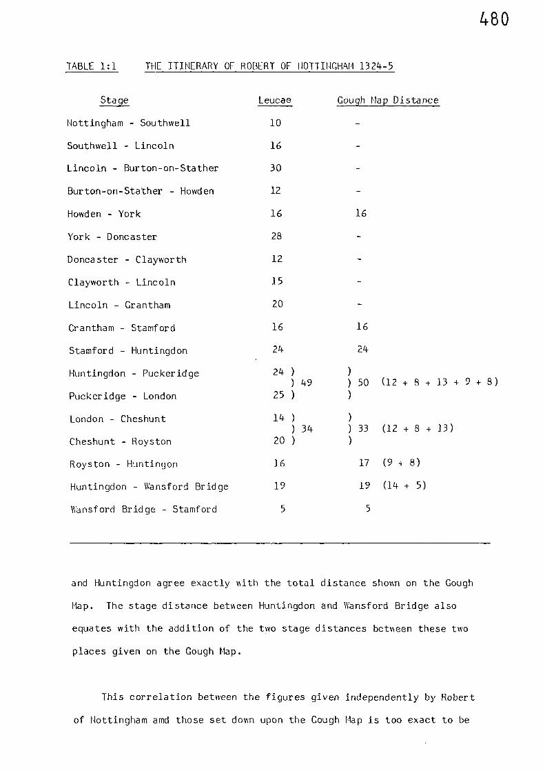
480
TABLE I:1 THE ITINERARY OF ROBERT OF NOTTINGHAM 1324-5
Stage Leucae Gough Map Distance
Nottingham - Southwell 10 -
Southwell - Lincoln 16 -
Lincoln - Burton-on-Stather 30 -
Burton-on-Stather - Howden 12 -
Howden - York 16 16
York - Doncaster 28
Doncaster - Clayworth 12 -
Clayworth - Lincoln 15 -
Lincoln - Grantham 20 -
Grantham - Stamford 16 16
Stamford - Huntingdon 24 24
Huntingdon - Puckeridge 24 ) ))k9 ) 50 (12 + 8 + 13 + 9 + 8)
Puckeridge - London 25 ) )
London - Cheshunt 14 ) )) 34 ) 33 (12 + 8 + 13)
Cheshunt - Royston 20 ) )
Royston - Huntingon 16 17 (9 + 8)
Huntingdon - Wansford Bridge 19 19 (14 + 5)
Wansford Bridge - Stamford 5 5
and Huntingdon agree exactly with the total distance shown on the Gough
Map. The stage distance between Huntingdon and Wansford Bridge also
equates with the addition of the two stage distances between these two
places given on the Gough Map.
This correlation between the figures given independently by Robert
of Nottingham amd those set down upon the Gough Map is too exact to be
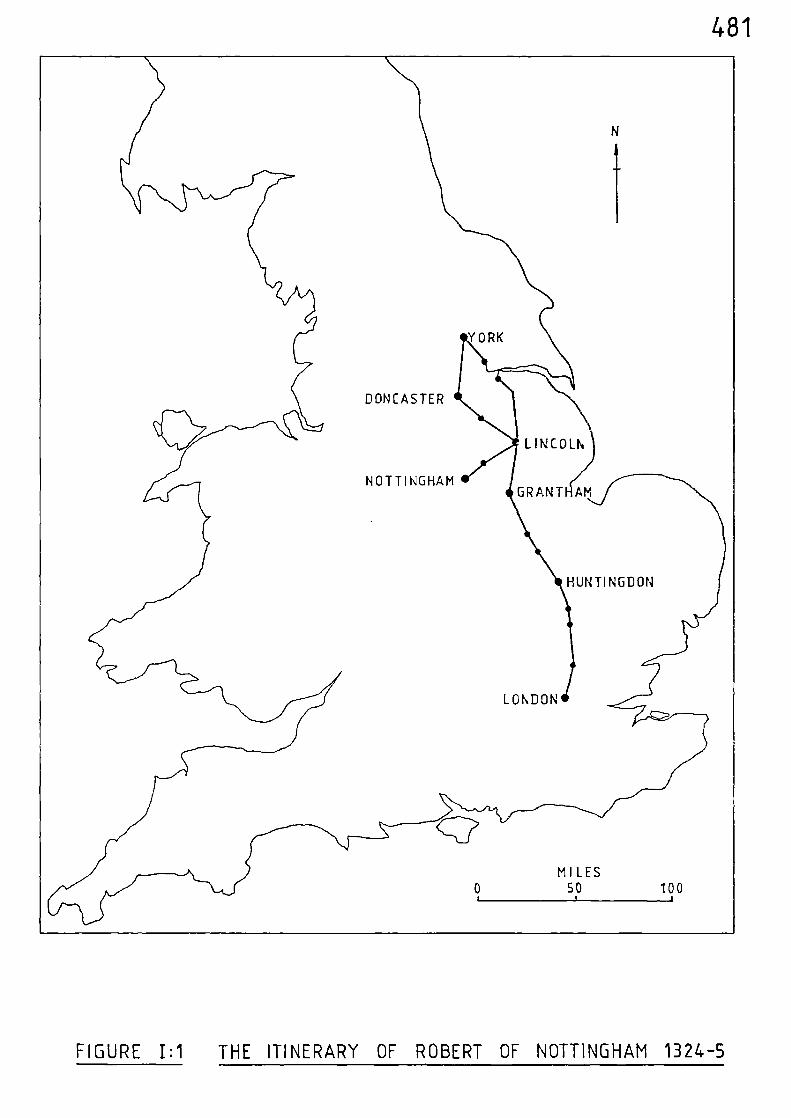
481
FIGURE I:1 THE ITINERARY OF ROBERT OF NOTTINGHAM 1324-5
482
the result of coincidence. We know that the distances recorded by Robert
of Nottingham are leucae, because he tells us so in his account, therefore
in view of his evidence, it must be concluded that the units of distance
set down upon the Gough Map also represent leucae.
It is also significant that the Lincolnshire Sheriff's Accounts for
the year 1301(2)
records distances between Grantham and Lincoln and
between Stamford and Lincoln as being 20 and 36 leucae respectively;
which by subtraction equates exactly with the 16 leucae given in Table I:1
for the stage between Grantham and Stamford. The addition of mileages
betvn een Grantham and Lincoln given in the Titchfield Abbey Itineraries
also equates exactly with the 20 leucae given for this stage in the
Account of Robert of Nottingham.
The average Gough Map unit of distance of 1.27 statute miles compares
closely vdth that of 1.28 statute miles of the Titchfield Abbey Itineraries;
hence it must be concluded that all these units of distance are the same.
A statistical check of those stages given by Robert of Nottingham %\hich
are not the same as those of the Gough Hap produced an average unit of
distance equivalent to 1.24 statute miles %%hen comparing measured statute
mileages benseen the same places.
Therefore, it would appear that the medieval unit of distance as
approximately lt statute miles.
Sir Charles Close, in a study of the old English mile, concluded
that its value was equivalent to 10 furlongs during the fourteenth
century.(3)
J.B.P. Karslake, in a folio up paper, suggests that the
fourteenth century mile as 11 furlongs.(4)
He bases his deduction on
the evidence of Higden, v n ho, in his Pol)chronicon of 1344 states that
483
"Dover is 12 English miles asunder from Canterburyof English accountage". (5)
Karslake goes on to point out that some three hundred years later, in
1633, this same old Dover road was measured by the 8 furlong mile then
being brought into use to determine mileage rates for post-office purposes,
and we are told that
"the post-masters deputies and the hackneymen ofDover and Canterbury have ad-measured the highwaybetween the two places and have set up posts atevery mile and expressed the same to be 15t miles".
Karslake then says that
"This measurement gives the 12 miles of 'Englishaccountage' of 1344 a length of exactly 11 furlongs" (6)
However, a check of Karslake's arithmetic does not bear out his conclusion.
The distance between Dover and Canterbury measured in 1633 at 15t miles,
produces a total of 122 furlongs at 8 furlongs per mile (8 x 15t = 122).
If this figure is then divided by the 12 miles given by Higden, we obtain
an answer of 10.16, not 11, furlongs. The modern distance by the very
direct road between Dover and Canterbury is exactly 15 miles.(7) The
modern mileage between the two places of 120 furlongs (8 x 15), results
in a mile of exactly 10 furlongs when divided by 12. The record of
Higden is therefore further supporting evidence that the fourteenth
century unit of distance was of the order of 10 furlongs, or lt statute
miles.
Sir Flinders Petrie draws attention to the relationship between the
old French mile and the unit of distance given on the Cough Map.(8)
This mile was based on the medieval foot of 13.22 inches and had the
484
relationship:- 6 feet = I fathom; 10 fathoms = 1 chain; 10 chains =
1 furlong; 10 furlongs = 1 mile (9)
Substituting 13.22 inches in the
1above relationship produces a mile of 22031 yards, vihich exceeds the
110 furlong mile by only 3T yards. This means that if the medieval foot
was reduced by 20 thousandths of an inch, then the overall computation
would equate exactly!
From Saxon times the leuga had been in use in England as a unit of
maximum linear measure.(10) This unit was initially based on a distance
of 1500 passus or paces, and was originally introduced into Britain by
1)the Belgic Gauls, 0and hence, considering its origins, it is probable
that it was directly related to the old French mile. Its ancestry is
probably associated 1%ith the Roman mile of 1000 passus, which approximated
(12)to 1616 yards; but precisely what the leuga initially represented in
terms of distance is not exactly clear.
Conclusions
It appears from the available evidence that, at least by the early
fourteenth century, the medieval unit of distance had stabilised into
a distance approximating to 10 furlongs.
The terminology used to describe the medieval unit of distance
appears to have gone through a transitional period during the fourteenth
century. In 1301 the Sheriff of Lincoln refers to leucae; as does
Robert of Nottingham in 1324-5; but by 1344 Higden mentions English miles.
The Titchfield Abbey Itineraries, copied down at the end of the fourteenth
(13)century record these units as miliaria, or miles. It was not until an
act of 1592 that there is any official record of the 8 furlong statute
mile, and even this had no statutory force outside the London area.(14)
485
The old mile seems to have continued in use for a considerable time
after this, as many sixteenth and seventeenth century maps can testify;(15)
and numerous mileages given by Ogilby in his 'Britannia" of 1675 match
those shown on the Gough Map. It was not until as late a date as 1824,
under the Act of that year for 'ascertaining and establishing Uniformity
of Weights and Measures', that the mile of 1760 standard yards became the
legal mile for all purposes within the United Kingdom.(16)
486
Notes and References
(1) F. M. STENTON, 'The Road System of Medieval Fngland',Fconomic History Review, vol.vii, No.1(1936) 14
(2) S. UHLER 'The Transportation of Produce in LincolnshireYorkshire, Hampshire and Norfolk during theFourteenth Century as revealed by theSheriffs Accounts'. unpublished B.Phil,Dissertation, University of St. Andrews(1977) appendix.
(3) C. CLOSE 'The Old English Mile'. Geographical Journ.76 (1930) 338-42.
(4) J.B.P. KARSLAKE 'Further Notes on the Old English Mile'Geographical Journ. 77 (1931)358-60.
(5) ibid 358
(6) ibid 358
(7) Road Atlas-Britain (Edinburgh 1973) 13
(8) W.M. PETRIE 'The Old English Mile'. Proc. Royal Soc.of Edinburgh 12 (1883-84) 254
(9) C. CLOSE (op. cit.), 342
(10) J.B.P. KARSLAKE 358(op. cit.)
(11) J.B.P. KARSLAKE 358(op. cit.)
(12) J.B.P. KARSLAKE 359(op. cit.)
(13) B. DICKENS Premonstratensian Itineraries from aTitchfield Abbey MS. at Welbeck, Proc.Leeds Philosophical Soc. 4(1938) 352-61.
(14) J.B.P. KARSLAKE 359(op. cit.)
487
(15) C. CLOSE (op. cit.) 342
(16) J.B.P. KARSLAKE 359(op. cit.)
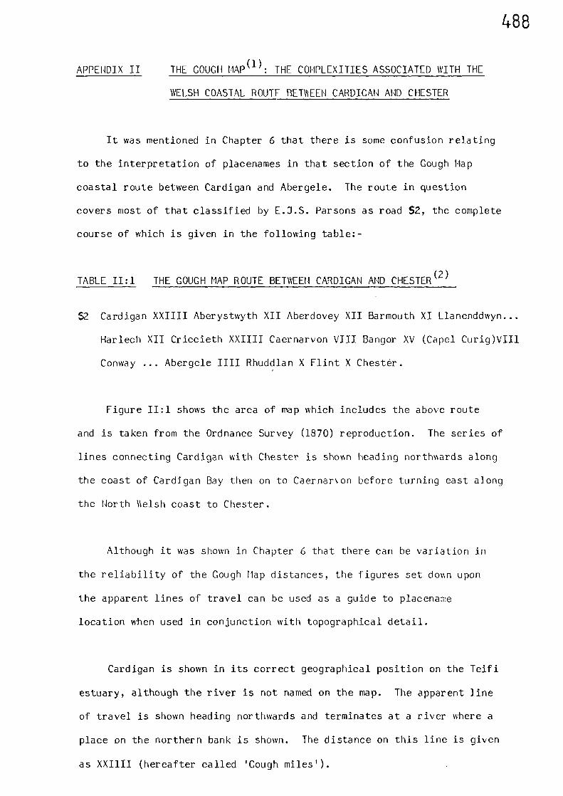
APPENDIX II
488
THE COUCH MAP ' : THE COMPLEXITIES ASSOCIATED WITH THE
WELSH COASTAL ROUTE BETWEEN CARDIGAN AND CHESTER
It was mentioned in Chapter 6 that there is some confusion relating
to the interpretation of placenames in that section of the Gough Map
coastal route between Cardigan and Abergele. The route in question
covers most of that classified by E.J.S. Parsons as road 52, the complete
course of which is given in the following table:-
TABLE II:1 THE COUCH MAP ROUTE BETWEEN CARDIGAN AND CHESTER(2)
$2 Cardigan XXIIII Aberystwyth XII Aberdovey XII Barmouth XI Llanenddwyn...
Harlech XII Criccieth XXIIII Caernarvon VIII Bangor XV (Capel Curig)VIII
Conway ... Abergele 1111 Rhuddlan X Flint X Chester.
Figure II:1 shows the area of map which includes the above route
and is taken from the Ordnance Survey (1870) reproduction. The series of
lines connecting Cardigan with Chester is shown heading northwards along
the coast of Cardigan Bay then on to Caernar n on before turning east along
the North 11elsh coast to Chester.
Although it was shown in Chapter 6 that there can be variation in
the reliability of the Gough Map distances, the figures set down upon
the apparent lines of travel can be used as a guide to placename
location when used in conjunction with topographical detail.
Cardigan is shown in its correct geographical position on the Teifi
estuary, although the river is not named on the map. The apparent line
of travel is shown heading northwards and terminates at a river where a
place on the northern bank is shown. The distance on this line is given
as XXIIII (hereafter called 'Gough miles').
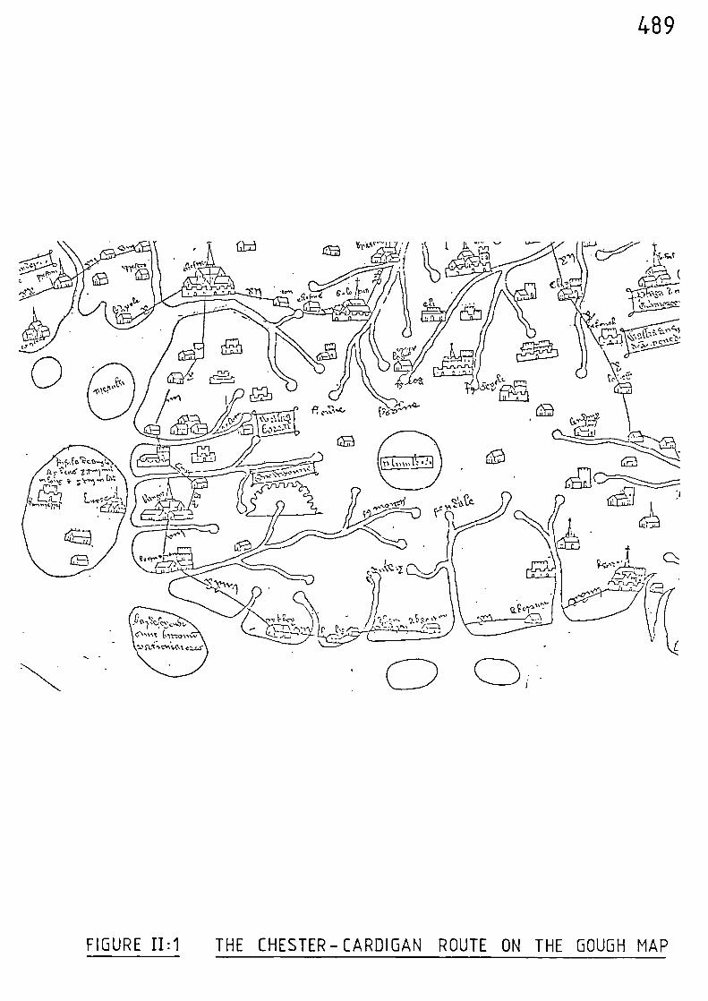
489
Viso"-
• t ry,
(2
0
FIGURE I1:1 THE CHESTER-CARDIGAN ROUTE ON THE GOUGH MAP
490
Parsons, apart from classifying the roads, also used an ultra-violet
light technique in an attempt to decipher information written on the
original It is obvious that he experienced difficulty in
attempting to decipher some Welsh names, not least because of the very
similar ways in which some Welsh placenames begin, viz; Llan..., Aber...,
etc. The first placename after Cardigan he identifies as Aberystwyth (4) and
therefore assumes that the river shown at this place must be the
Ystwyth.(5)
The river is not named on the map but it can be seen that
the placename shown on its norther bank begins Aber... A castle symbol
is shown, a little further up river and close by the name Lanmihangel is
vnritten on the map. Further inland still, and on the southern side of the
river, there is a placename where only a couple of letters can be
deciphered. From this scant evidence Parsons assumes that the place is
Strata Florida,(6)
however, this is far from conclusive. Parsons also
assumes that the castle symbol depicts Castell Gwalter, (7) but Gwalter is
43 statute miles to the north of Cardigan, near the coast, which does
not fit the topographical detail shorm on the map. There is a place
called Llanfihangel - geneur - glyn close by Castell Gwalter, and
because of this Parsons probably assigns Gwalter to the castle symbol
sho lAn on the map.
The first river of any consequence to the north of Cardigan is the
Aeron, which flows into Cardigan Bay at Aberaeron and is 22 statute
miles from Cardigan via the direct modern coastal road. Some 7 statute
miles up river, and on its northern bank, is the site of a castle which
matches the castle symbol shown on the Gough Map. The site is that of
Castle Trefilan, which was built in 1233,(8)
and is knmsn to have still
been in use vsell into the thirteenth century. (9) Across the river from
the site of this castle is the place called Llanfihangel Ystrad, which
closely resembles the name written by the castle symbol sholAn on the map.
491
Further to the east, Lampeter is shown in its correct geographical
location relative to Cardigan, and is styled ...beder, the old name for
Lampeter being Llanbedr Pont Stephan.(10)
The topographical detail, the placename assignments, and to a
lesser extent the Gough mileage - support the assumption that the first
stage place along the coast route from Cardigan is Aberaeron, and not
Aberystwyth.
The next place along the route is shown at the head of a river which
is clearly identified on the map as the Ridale (Rheidol). Parsons assigns
Aberdovey to this place and says that the compiler of the map made an
error in his positioning of the Rheidol.(11)
However, if we consider
the next river of consequence in a northward direction from Aberaeron
we arrive at the united entry of the rivers Rheidol and Ystwyth into
Cardigan Bay at the place called Aberystmith. The inter place distance
from the previous place is given as XII Gough miles on the map, which
equates favourably with the 16 statute miles between Aberaeron and
Aberystwyth via the direct modern coastal road. (It was shown in Chapter
6 that the Gough mile approximates to lt statute miles).
Hence, the Gough Hap river name, topography and mileage support the
assumption that the second route place is Aberystwyth.
The next place along the route must have been at, or close by, the
crossing place over the River Dovey. The Dovey is clearly identified
on the map and the Gough mileage of XII equates with the modern distance
of 16 statute miles between Aberystwyth and the castle at Derwen Las.
This castle was strategically sited, being close to where the estuary
narrows - which is the obvious location for guarding the crossing place
492
over the Dovey. This ancient ford is mentioned by J.E. Lloyd in his
History of Wales(12)
and the castle of Derwen Las is mentioned in
contemporary records between 1066 and 1215 AD.(13)
Parsons assigns
Barmouth (AbermaW) to this place and concludes that the Dovey is wrongly
named and should be the Maw or Month.(14)
However, the topography once again agrees with the compiler of the
map, this being further supported by the correct geographical positioning
of Plimilemon (Plynlimon), inland between the heads of the rivers Dovey
and Rheidol. Also, Barmouth is on the northern side of the Hawddach and
the place shown on the map is positioned on the southern side of a river.
Parsons agrees that the next place shown on the route is clearly
(15)named Towyn, but assigns LlanenddWyn to this place. As Llanenddwyn
is some 31 miles to the north of Towyn one can only assume that Parsons
does this to keep his previous series of placenames intact. However,
Towyn fits the topography and this is supported by the close agreement
between the inter-stage distance of XI Gough miles shown on the map and
the modern distance between Derwen Las and Town of 13 statute miles.
From Towyn to the next place on the Gough Map route there is no
indication of distance written upon the map. It appears that the name of
this next place ends with(16)
log. Parsons assigns Harlechto this place,
in order that his previous name sequence remains intact, but the most
likely place is Arthog, which is 14 statute miles from Towyn.
Beyond Arthog, the next place on the route is located across an
unidentified river at a distance of XII Cough miles from the previous
place. This place is identified as 'Crskkey', and hence Criccieth, on
the Ordnance Survey print of the Gough Hap and Parsons probably accepted
493
this because it fitted in with his previous sequence of placename
assignments. However, the topography, location, and Gough mileage,
coupled with the fact that Dyffryn and Crykkey both look similar when
written down, point to this place being Dyffryn. In this case the
unidentified river is the Mawddach, which presents similar problems to
the traveller as did the Dovey. The first convenient crossing point is
approximately 51 statute miles from Arthog, and then it is a further 111
statute miles to Dyffryn, via Barmouth; the addition of these distances
being similar to the XII Gough miles shown on the map.
An interesting point relating to the apparent lines of travel as set
down on the Gough Map is that these lines appear to show only the
distance travelled between two adjacent places and are not indicative of
the actual ropte travelled. This is high-lighted by analysis of the lines
as drawn across the Mawddach and Dovey estuaries. It has been shown that
the probable Gough Map routes involved travelling 'up-stream' to a
convenient crossing place followed by a 'down-stream' journey along the
opposite bank. However, the lines across these estuaries are shown
straight and do not 'kink' to take account of the considerable di\ersions
involved in travelling to convenient crossing places.
Caernarvon is clearly identified as being the next place on the route
and is shown XXIflI Gough miles from the previous place (Dyffryn). The
distance line is shown passing over two rivers, one adjacent to Caernarvon
and the other to the north of Dyffryn. The river on which Caernarvon
stands is the Seiont, the far inland reaches of which are identified on
the Gough Map. The intervening land mass is consistent with that at
the base of the Lleyn Peninsula, although the peninsula itself is not
shown. A further pointer to this intervening land mass representing the
494
base of the Lleyn Peninsula is that fact that Bardsey Island is shown
located directly off this base. The indications are therefore that the
river shown to the north of Dyffryn is theDwyryd - which flows into the
large estuary of Traeth Bach. The crossing place was probably a little
to the west of Maentrog, where the estuary narrows, from where a direct
northerly valley route cuts through the mountains to the west of Snowdon
and reaches Caernarvon via Beddgelert and Betws Garmon. The distance
between Dyffryn and Caernarvon via this route is 32 statute miles, which
compares closely with Gough mileage of 301 statute miles.
The distance between Criccieth and Caernarvon is 16 statute miles
via the direct route to the west of Carnedd goch, which approximates to
only half the distance recorded on the map. Clearly, Parsonsiassumption,
that the place prior to Caernarvon is Criccieth, is not supported by
either the topography as shown on the map - or by the associated mileages.
Bangor is clearly shown as the next place on the route after
Caernarvon, and the interplace distance of VIII Gough miles compares
favourably with the 9 statute miles between these places via the direct
modern coastal road.
The next placename is indecipherable, but is shown XV Gough miles
from Bangor. The route appears to deviate inland to this place, which
Parsons suggests is Capel Curig,(17)
although he probably bases this
assumption on the fact that Capel Curig is 15 statute miles from Bangor
via the direct modern A5 road. As far as is known there was no route,
medieval or Roman, connecting Bangor with Capel Curig.(18)
The minor
Roman fortress of Caer-Llugwy, two miles to the east of Capel Curig,
(19)was on a north-south route, and the road connecting Bangor with Capel
Curig was constructed during 1791 when- Lord Penrhyn, the owner of the
495
large slate quarry at Bethesda, built a road up the Hant Ffrancon and
(20)then on to his estate at Capel Curig. The reason for the inland
deviation on this predominantly coastal route is probably due to the
physical barrier presented by the great buttress headlands of
Penmaenmawr and Penmaenbach. The Romans overcame this problem by
constructing a road which cut inland at Aber, 6 statute miles to the east
of Bangor, and then ascended to the col of Bwlch y Ddeufan before
descending to their fort at Canovium (Caerhun) in the Conwy Valley.
Blasting techniques have enabled the engineers of more recent times to
circumnavigate these headlands by constructing a road on theirseaward side.
However, the Roman route between Aber and Caerhun has been traced almost
in its entirety, and survives as part trackway and path which is still in
use as a public right of way.(21).
It seems reasonable to assume therefore, that the medieval route
from Bangor to the Conwy Valley would have been via this Roman road which
cut inland and so skillfully avoided the physical barriers on the coast.
The assumption that the next Gough Hap stageplace after Bangor is in the
region of Caerhun is also supported by the recorded mileage. The
distance between Bangor and Caerhun via the Roman road is about 17 statute
miles, which equates favourably with the XV Gough miles recorded on the
map.
Having assumed that the place recorded on the Gough Nap after Bangor
is in the region of Caerhun, there is a problem relating to the next
place shown on the map. Parsons identifies this next place as Cony, (22)
but does not comment on the omission from the map of the River Conwy,
or the fact that the place he identifies as Cony is shown situated on
the east bank of the Ogwayn (Ogwen), a river which flows into the Henai
496
Straight close to Bangor. The fact that the River Conwy is not identified
on the Gough Map is extremely difficult to understand, the Conwy Valley
being such a prominent physical feature. The River Cony is mentioned in
the Patent Rolls of 1332, when timber and brushwood conveyed along the
river from the King's forest and woods of Snowdon was ordered to be
arrested until proof of purchase had been shown.(23)
Hence, it appears,
judging by the inter-place distance of XV Gough miles coupled with the
known Roman route as previously discussed, that the river shown on the
map as the Ogwen is in fact the River Conwy. In this case the place
partially identified under ultra-violet light by Parsons as Conwy, is either
wrongly located, or the place depicted is actually situated on the east
bank of the river. (Conwy is situated on the west bank of the River Conwy).
Across the estuary from Conwy, and on the east bank of the river, is
Deganwy; which was made a chartered borough in 1252(24)
and where there are
the remains of a castle built by Henry III during the autumn of 1245.(25)
The symbol shown on the Gough Map for the second stage-place after Bangor
appears to include a castle. From Caerhun, where the Roman route crossed
the River Convey and continued in the general direction of St. Asaph. it is
about 9 statute miles to Degarmy via the east bank of the river; and this
compares favourably with the VIII Gough miles shovIn on the map. It should
be noted that the shortest possible route benNeen Capel Curig and Cony is
about 15 statute miles, which does not compare with the stated Gough
mileage. Another topographical feature supporting the assumption that the
river shown on the Gough Map as the Open is in fact the Conwy, and the
second stage-place after Bangor is Deganwy, is shown by the position of
Gwytherin on the map. Gwytherin is situated inland to the south-east of
Deganwy between the Conwy and Clwyd rivers; and this is exactly the
picture portrayed by the map in its relation to the river named Open and
the second-stage place after Bangor.
497
It is probable,. therefore, that due to the fact that Deganwy and
Conwy share some common letters, the place Parsons partially identifies
as Conwy is in fact Deganwy.
The Gough Map route continues and crosses the River Clwyd which is
styled 'clotte' on the map. Denbigh is shown in its correct geographical
position in relation to the river and St. Asaph is also depicted. The
next placename on the route is given as Abergele, although the distance
from the previous place is not given on the map. A distance of 1111
Gough miles is given to the next stage-place, Rhuddlan, and this compares
favourably with the distance of 51 statute miles between these places via
the direct modern road.
The route continues to Flint, which is shown on the penultimate place
before Chester, at a distance of X Gough miles from Rhuddlan - which
compares with the modern distance between these two places of 15 miles,
via Gorsedd and Holywell.
The final leg of the route leads directly to Chester and by-passes
Hawarden, which is indicative of a straight route alongside the Dee
estuary. The route is then shown crossing what is obviously the River
Dee, prior to terminating at Chester. The distance from Flint is given
as X Gough miles on the map, which compares with the modern distance of
13 statute miles along this route.
The following table lists the inferred route placenames in
chronological order from Cardigan, together with their associated Gough
mileages. The computed equivalent statute mileages, using the
computation one Gough mile = 1.27 statute miles are also shown, as are
the modern interplace distances along similar routes.
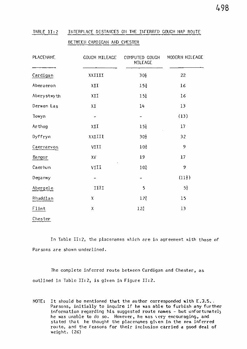
498
TABLE I1:2 INTERPLACE DISTANCES ON THE INFERRED COUCH MAP ROUTE
BETWEEN CARDIGAN AND CHESTER
PLACENAME COUCH MILEAGE COMPUTED COUCH MODERN MILEAGEMILEAGE
Cardigan XXIIII 301 22
Aberaeron XII 15* 16
Aberystwyth XII 15* 16
Derwen Las XI 14 13
Towyn - (13)
Arthog XII 15* 17
Dyffryn XXIIII 301 32
Caernarvon VIII 101 9
Bangor XV 19 17
Caerhun VIII 10* 9
Deganwy - alp
Abergele IIII 5 51
Rhuddlan X 12* 15
Flint X 12* 13
Chester
In Table 11:2, the placenames which are in agreement with those of
Parsons are shown underlined.
The complete inferred route between Cardigan and Chester, as
outlined in Table 11:2, is given in Figure II:?.
NOTE: It should be mentioned that the author corresponded with E.J.S..Parsons, initially to inquire if he as able to furbish any furtherinformation regarding his suggested route names - but unfortunatelyhe was unable to do so. However, he as \ery encouraging, andstated that he thought the placenames gi\en in the new inferredroute, and the reasons for their inclusion carried a good deal ofweight. (26)
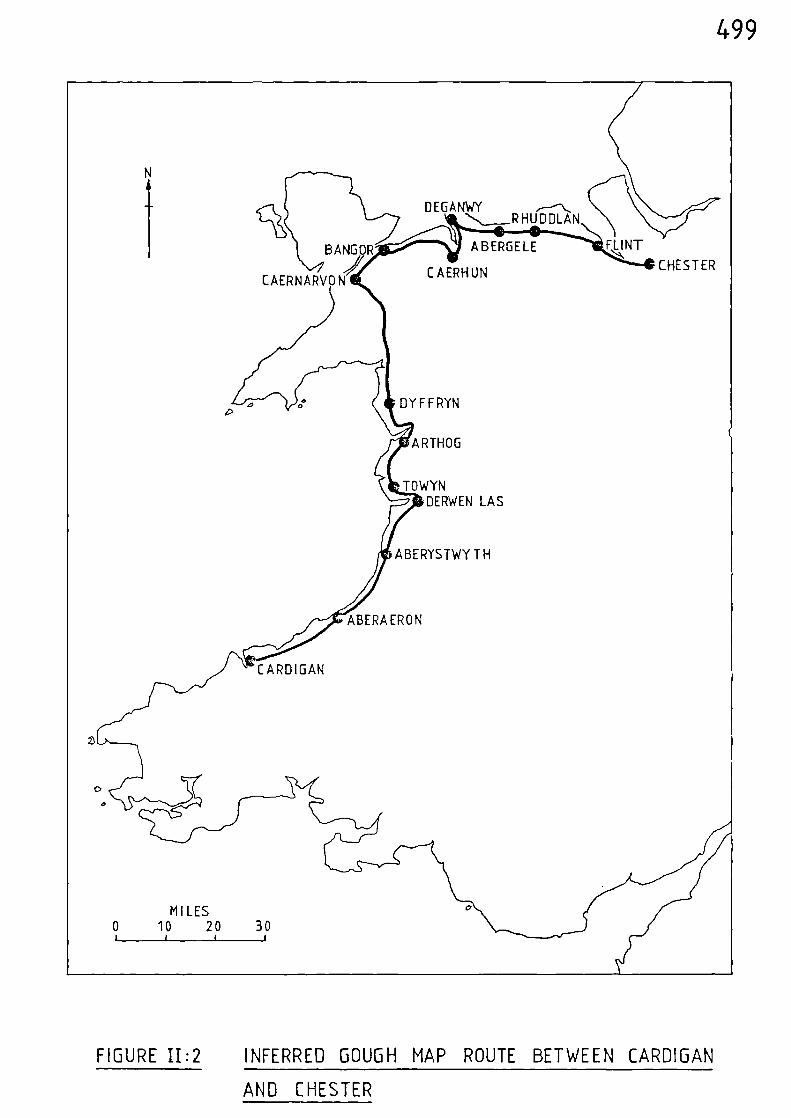
CHESTER
DYFFRYN
C A ERH UN
ABERGELE
i '' AR THUG
u TO WINDERWEN LAS
IABERAERON
FIGURE 11:2 INFERRED GOUGH MAP ROUTE BETWEEN CARDIGAN
ABERYSTWY TH
CARDIGAN
499
AND CHESTER
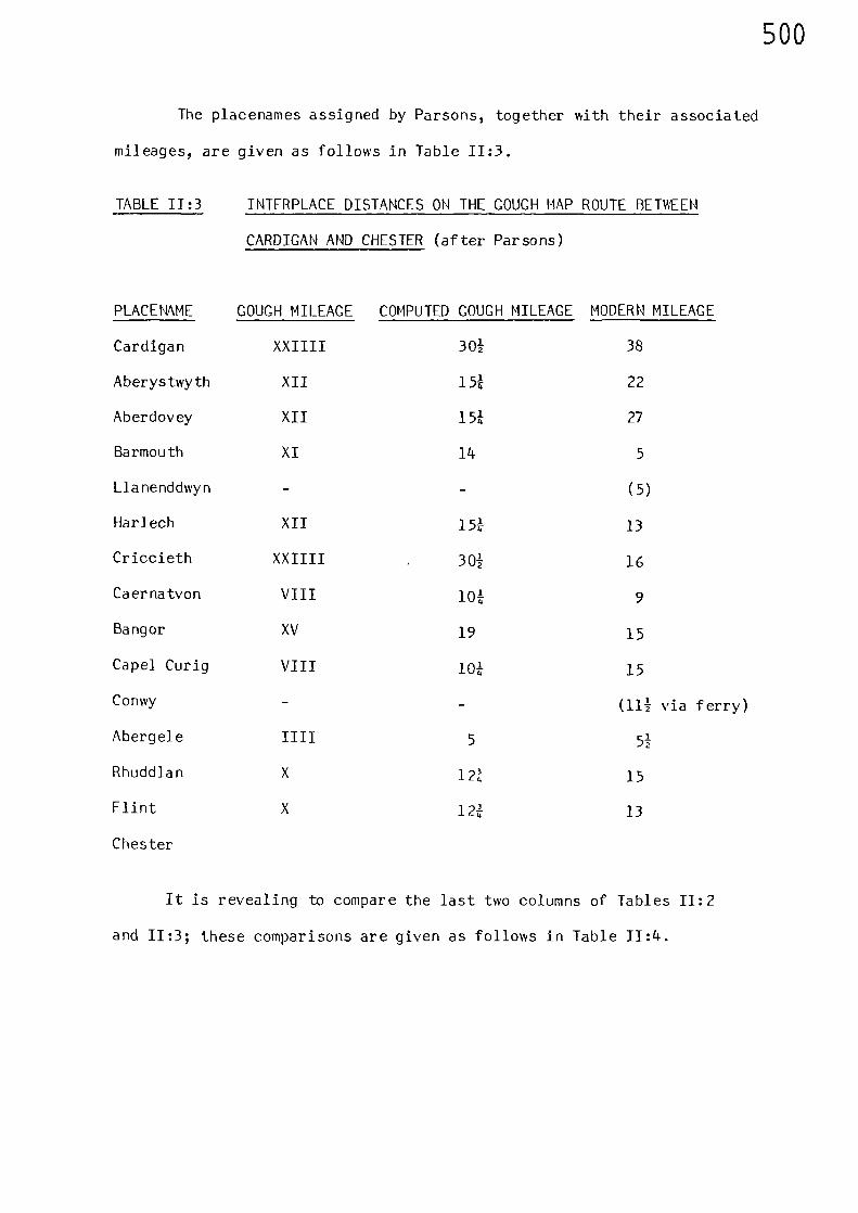
500
The placenames assigned by Parsons, together with their associated
mileages, are given as follows in Table 11:3.
TABLE 11:3 INTERPLACE DISTANCES ON THE COUGH MAP ROUTE BETWEEN
CARDIGAN AND CHESTER (after Parsons)
PLACENAME COUGH MILEAGE COMPUTED COUGH MILEAGE MODERN MILEAGE
Cardigan XXIIII 30i 38
Aberystwyth XII 15t 22
Aberdovey XII 15t 27
Barmouth XI 14 5
Llanenddwyn - - (5)
Harlech XII 151 13
Criccieth XXIIII 30+ 16
Caernatvon VIII 10t 9
Bangor XV 19 15
Capel Curig VIII 10t 15
Conwy - - all via ferry)Abergele IIII 5 5+
Rhuddlan X 12Z 15
Flint X 12Z 13
Chester
It is revealing to compare the last two columns of Tables 11:2
and 11:3; these comparisons are given as follows in Table 11:4.
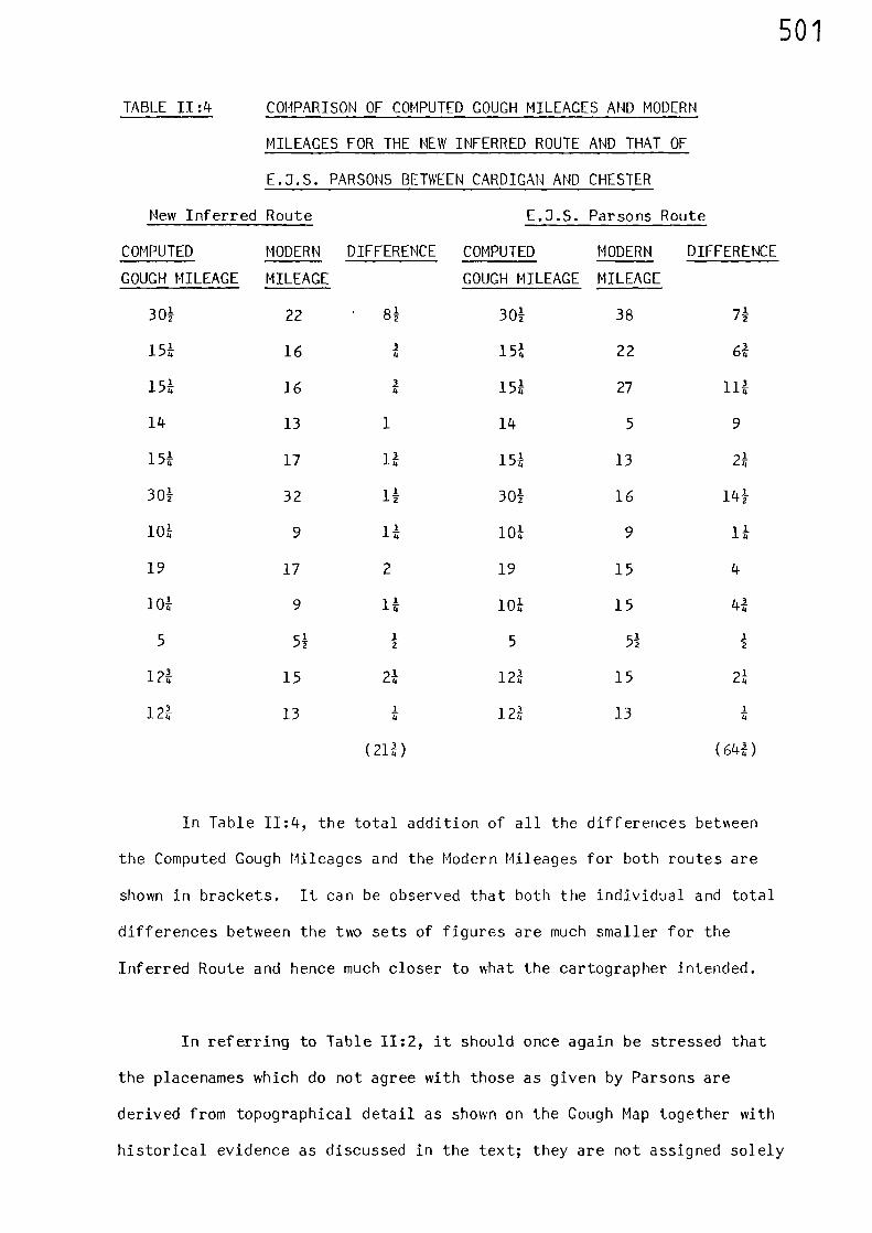
501
TABLE 11:4 COMPARISON OF COMPUTED COUCH MILEAGES AND MODERN
MILEAGES FOR THE NEW INFERRED ROUTE AND THAT OF
E.J.S. PARSONS BETWEEN CARDIGAN AND CHESTER
New Inferred Route E.J.S. Parsons Route
COMPUTED MODERN DIFFERENCE COMPUTED MODERN DIFFERENCE
COUCH MILEAGE MILEAGE COUCH MILEAGE MILEAGE
301 22 81 301 38 71
15* 16 15* 22 6*
15* 16 15* 27 11*
14 13 1 14 5 9
15* 17 1* 15* 13 2t
301 32 11 301 16 141
10* 9 1* 10* 9 1*
19 17 2 19 15 4
10* 9 1* 10* 15 4*
5 5112 5 51
12
12* 15 2* 12* 15 2*
12* 1314 12* 13 *
(21fl (6411)
In Table 11:4, the total addition of all the differences between
the Computed Gough Mileages and the Modern Mileages for both routes are
shown in brackets. It can be observed that both the individual and total
differences between the two sets of figures are much smaller for the
Inferred Route and hence much closer to what the cartographer intended.
In referring to Table 11:2, it should once again be stressed that
the placenames which do not agree with those as given by Parsons are
derived from topographical detail as shown on the Gough Map together with
historical evidence as discussed in the text; they are not assigned solely
502
to fit in with the inter-place Gough mileages.
Conclusions
A new inferred Gough Map route between Cardigan and Chester was
derived. This was based on the topography and detail shown on the apparent
lines of travel as set down on the map, coupled with other supporting
historical evidence.
Inevitably, there is little physical evidence left on the ground,
most of the route being covered by modern roads or lost beneath fields.
However, the old Roman route from Aber over the col of Bwlch-y-Ddeufan
and into the Conwy Valley is a partial survivor, being part trackway and
path which is still in use as a public right of way.
503
Notes and References
(1) R. COUCH, British Topography, 2 vols (1780)
(2) E.J.S. PARSONS. The Map of Great Britain, circa A.D. 1360 Known as The Gough Map Memoir with amendedreprint of part of paper by F.M. Stenton(1936) and a colour facsimile (Oxford,Bodleian Library, 1958) 36.
(3) ibid, Preface
(4) ibid, 27
(5) ibid, 33
(6) ibid, 27
(7) ibid, 27
(8) A.M.A. HOGG and Masonry Castles in Wales and the MarchesD.J.C.KING Archaeologia Cambrensis 116 (1967) 129.
(9) ibid, 78
(10) L.R. MUIRHEAD, ed. Wales (London 1953) 277
(11) E.3.5. PARSONS 33(op. cit.)
(12) J.E. LLOYD, A History of Wales (London 1912) (II) 427
(13) A.M.A. HOGG, and Early Castles in Wales and the MarchesD.J.C. KING, Archaeologia Cambrensis 112 (1963) 77-124.
(14) E.J.S. PARSONS 33(op. cit.)
(15) ibid, 28
(16) ibid, 28
504
(17) ibid, 27
(18) R. MILLWARD and Landscapes of North Wales (Newton AbbottA. ROBINSON 1978) 159
(19) ORDNANCE SURVEY Map of Roman Britain (1978)
(20) R. MILLWARD and 159A ROBINSON(op. cit.)
(21) ORDNANCE SURVEY(op. cit.)
(22) E.J.S. PARSONS 27(op. cit.)
(23) Calendar of Patent Rolls, 1330-34, 367
(24) J.E. LLOYD 709(op. cit.)
(25) ibid, 703
(26) Correspondence vdth E.J.S. PARSONS, 9th April, 1983.
505
APPENDIX III The Date of the Gough Map
It became apparent when perusing the various papers written about
the Gough Map that there is a diversity of opinion relating to when
the map was actually compiled.
E.J.S. Parsons assigns the map to the mid-fourteenth century
(A.D. 1360),(1)
basing his opinion on the work of paleographers,
supported by three other points:- 1) The town of Sheppey changed its
name to Queensborough in 1366 in honour of Queen Philippa, and Sheppey
is the name given on the map. 2) The ship shown wrecked off Orkney
appears to be a fourteenth century warship. 3) Outside Britain, the
only 'foreign' town shown by a vignette is Calais - probably because
Calais was regarded as an 'English' town after 1347.
Although paleographers have suggested that the writing on the map
appears to be consistent with that of the mid-fourteenth century, this
is far from conclusive. Paleography is not an exact science and is
usually an opinion, based on the trends and styles in use over a
particular period. It is an extremely difficult task to assert, with
total certainty, that a writing style dates from say the late thirteenth
or mid-fourteenth centuries, unless of course the writing is dated,
which unfortunately that on the Gough Hap is not. For example, it would
have been quite feasible for a young scribe pursuing his trade during
the last quarter of the thirteenth century to have still been alive and
producing work in his own inherent style during the third quarter of
the fourteenth century - thus demonstrating that one particular style
of writing could cover a period in excess of sixty years. Further
paleographic problems arise in connection with the Gough Map because
as Parsons says:-
506
"Many names have been overwritten in a later hand:in some cases this has made them difficult toread, in others both forms are clearly visible.The symbols have also been inked over in a numberof cases". (2)
The fact that Sheppey appears on the map, and not Queensborough,
is only indicative of a pre - 1366 dating.
An examination of the representation of the ship wrecked off
Orkney shows that the vessel had battlemented forecastle and aftercastle,
a centrally located mast (shown broken), and a bowsprit complete vdth
hanging bowlines. (Figure III:1 depicts this vessel).
It was during the time of the early Crusades that the Roman
habit of building 'castles' on ships was revived. The thirteenth
century seal of New Shoreham shows a ship with battlemented 'castles'
both at stem and stern, and a centrally located mast. The ship depicted
on the New Shoreham seal also shows a very early representation of a
bowsprit, complete ‘Nith bowlines (3) . The Mnchelsea seal, also dating
from the thirteenth century, bears a ship %thich has an even more
(4)elaborate 'forecastle' and 'aftercastle'. The evidence afforded by
these seals relates only to ‘Narships or vessels capable of being used as
such. The humble medieval tramp, or trading vessel, was probably not
considered dignified enough for representation.
Parsons argument, that Calais is represented by a vignette on the
Gough Map because it was regarded as an 'English' town after 1347, is
not a very strong one. Calais may well have been shown this way because
of its geographical position - being the nearest 'foreign' port to the
British Isles, and therefore must have been an important thoroughfare
for traffic and trade, to and from the continent.
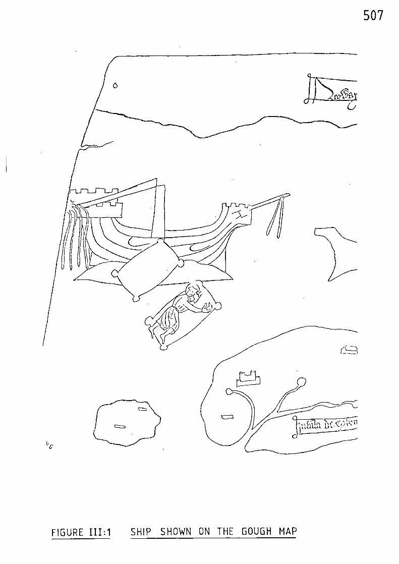
507
FIGURE III:1 SHIP SHOWN ON THE GOUGH MAP
t ‘4.1t}t-t. /11..
508
Others have attempted to assess the date of compilation; J.
Lelewelascribes the map to the twelfth century,(5)
but offers no
supporting evidence for this dating - whilst at the other end of the
dating time-scale E. Moritz assigns the map to the sixteenth century.(6)
Sir Frank Stenton, in his account of the road system of medieval England
makes the point that since Hessle, not Hull, is regarded as the northern
landing-stage of the main ferry across the Humber, it would be unwise to
place the date later than 1350. (7) W.B. Sanders formed the opinion that
the map was drawn up around 1300, and based his argument on:- 1) Bridges
shown at Perth and Achmore, but no mention of the bridge over the River
Don built by Bishop Cheyne of Aberdeen in 1329; 2) No mention of ancient
bridge built over the River Torridge at Bideford in the early part of
the fourteenth century; 3) Many Scottish earldoms marked, but not
Douglas and Crawford, which were created later (c.1400); 4) ftiting on
Bardsey Island refers to Bards of the Britons, who may be said to
have been extinguished during the subjugation of Wales by Edward I in
1284.(8)
As R.A. Pelham quite rightly points out, the absence of
bridges is not a very strong argument to use.(9)
Very few bridges are
shown on the map, but we are certainly not to assume that these were
the only ones in existence when the map was compiled; and the omission
of the Scottish earldom is also inconclusive. Omissions are poor
evidence when attempting to date a map; however, Sanders final point is
a stronger argument in favour of an earlier dating. Pelham suggests
that the construction of the map commenced during the reign of Edward I
and suspects that it was not all drawn at the same time. He points
to the example of Coventry, which is depicted on the map as a town
surrounded by a wall. He goes on to say that Coventry did not have a
wall in Edward I's time and that the first stone was not laid until
1355, and it was many years until the wall was completed.(10)
The
example of Coventry would, at first sight, indicate that the map must
509
have been drawn after 1355. However, B.P. Hindle has clearly demonstrated
(11)that the symbols shown on the map are inconsistent. For example,
Holm Cultram and Haworth in Cumberland are both shown as having town
walls - but neither ever had them.(12)
Pelham speculates that Edward I,
towards the end of his reign, may have conceived the idea of having a map
made of the whole of his realm, a realm that had been enlarged by the
conquest of fresh territory in Wales and Scotland - and hence extending
communications over a larger area than before.(13)
If it is to be assumed that the majority of the map was constructed
during the latter part of Edward I's reign or later, then a perusal of
the Gough Map route between Cardigan and Chester, the complexities of
which were discussed in Appendix I, reveals some curious anomalies.
Although it was stated earlier that omissions are poor evidence when
attempting to date a map and the fact that the symbols shown on the
Gough Map are inconsistent, certain glaring anomolies are obvious. The
mighty Edwardian castles at Harlech (completed 1289), Rhuddlan (1281),
Aberystwyth (1289) and Criccieth (remodelled 1289) are not depicted; and
it has already been shown in Appendix I that the castle symbol between
Bangor and Abergele is more likely to represent Deganwy (1245) than Conwy
(1287). The only Edwardian castle that can be positively identified is
that at Beaumaris, which was founded during the year 1295 but not finally
completed until 1323.(14)
The castle symbol and name (Beaumorres) are
shown located towards the west side of Anglesey instead of on the east
coast opposite Bangor. The east coast site where we would expect to find
Beaumaris is occupied by a multi-building symbol representing the town
of Llanfaes. Prior to the construction of Beaumaris Castle and town,
Llanfaes was a flourishing Welsh settlement. (15)Perhaps it posed a
threat to the new 'English' town and for this reason Edward I decided to
move its inhabitants to the other side of the island where Hewborough was
510
established and granted its charter in 1303.(16) N°wborough is not
depicted on the Gough Map. This suggests that the symbol depicting
Llanfaes was drawn when the place was a flourishing town prior to 1295,
and that the castle symbol depicting Beaumaris was added later; its
incorrect geographical location being due to the prior positioning of
Llanfaes. Pelham opined that the map was not all drawn up at the same
time and also points out that Sanders had observed several place names
which had been inked over at a later date and that at least one new
symbol had been added, together with additions, such as a spire to an
)existing church.
(17)Parsons also makes similar observations. (18
The representation of Caernarvon Castle with a symbol showing
what appears to be a single tower is surprising, as we might expect to
see a multi-tower representation as is shown at Painscastle (c 1231) in
Radnorshire. The symbol shown is more in line with the earlier Norman
castle which preceded the large majestic castle of Edward I. The town
wall, which was constructed at the same time as the Edwardian castle
(c 1283), is also not shown.
Harlech Castle, which even today dominates the coastal landscape
to the north of Dyffryn, is another surprising omission.
Edward I was also well acquainted with the Lleyn Peninsula. He
)visited Aberdaron and Bardsey Island,
(19both of which are situated
at the extreme tip of the peninsula, and had a military base at
Criccieth Castle. If the map had initially been drawn after the
subjugation of Wales by Edward I then the omission of the Lleyn
Peninsula together with a symbol representing Criccieth Castle is
difficult to explain.
511
This same line of argument can also be applied to the omission
from the map of the Wirral; Edward I visited Birkenhead and Bromborough
in 1277 and Bromborough again in 1278 and 1283.(20)
If the origins of the Gough Map do belong to the reign of King
Edward I then it is tempting, from scrutiny of the detail shown on the
route between Cardigan and Chester, to conclude that the map must have
been compiled prior to the major campaigns in Wales as part of the
preparations for Conquest. This would put the date around the early part
of the last quarter of the thirteenth century, and prior to 1284 when the
subjugation of Wales took place. If we accept the aforementioned reasons
for the inclusion of Beaumaris, then the fact that Flint is named on the
map would put the earliest date at 1277; this being when construction of
the town and castle first commenced - there being no pre-existing town
or vi1lage.(21)
The task of Flint was to hold the coastal road from
Chester into North Wales and to guard the Dee estuary.(22)
Apart from Flint, Edward I was also concerned at this time mith
the planning of Rhuddlan and Aberystmyth. Although Edmard remained in
the vicinity of Rhuddlan, Flint and Chester, Edmund the King's brother
accompanied by an army, proceeded to Aberystmyth.(23)
This activity tomards the south and along the coast of Cardigan
Bay could possibly account for the initial inclusion of the route
depicted on the map - because it shows the road around the coast -
prior to the subjugation of the Welsh tribes mho tended to mithdraw
into the Welsh hills.
In Chapter 7 and Appendix I, reference as made to a business
account and associated itinerary which, although concerned mith a
512
different part of Britain, hints at the possibility that the Gough Map,
or a copy of it, was in use during the first quarter of the fourteenth
century. It is the account of Robert of Nottingham, who was buying
wheat for King Edward II during the winter of 1324-25(24)
. Apart from
his route, he also recorded the distance between the places he visited
(See Figure I:1, and Table 1:1). It was demonstrated that the
correlation between the distances recorded by Robert of Nottingham
and those set down upon the Gough Map over similar routes were too
exact to be the result of coincidence. As Sir Frank Stenton comments:-
"In view of the evidence of Robert of Nottingham,it seems clear that the figures entered on theGough Map represent, not guesses, nor academiccomputations, but genuine estimates of distance,such as were current among contemporary travellers.The correspondence between the figures givenindependently by Robert of Nottingham and theGough Map show that these estimates were tendingto become stereotyped already in the fourteenthcentury." (25)
Having previously stated that it would be unwise to place the date of
the Gough Map later than 1350, it is surprising that Stenton does not
suggest that Robert of Nottingham could have used the map, or a copy
of it, during his journeys of 1324-25.
The isolated distance obtained by subtraction between Grantham
and Stamford as recorded in the Lincolnshire Sheriff's Account for the
year 1301 also equates with the distance between these two places as
given in the account of Robert of Nottingham and as set down upon the
Gough Map.(26)
(See Appendix I).
513
Conclusions
There is some evidence to suggest that the origins of the Gough
Hap may date from c 1277, with later additions.
However, the author wishes to emphasise that a full and critical
in-depth analysis of the complete map would be necessary in order to
provide further evidence in support of this tentative assessment and
this, unfortunately, was outside the scope of the present work.
514
Notes and References
(1) E.J.S. PARSONS The Map of Great Britain, circa A.D.1360Known as The Gough Hap Memoir withammended reprint of part of paper by F.M.Stenton (1936) and a colour facsimile(Oxford, Bodleian Library, 1958) 2.
(2) ibid, 3
(3) R.W. UNGER, The Ship in the Medieval Economy 600-1600(London, 1980) 145.
(4) H. WHEELER The Wonderful Story of the Sea
(5)
(Gen. Ed.),
J. LELEWEL
(London, 1937) 34.
Geographie du moyen age, Bruxelles, 1852,vol. ii.
(6) E. MORITZ Entwickelung des Kartenbildes der NordundOstseel gnder bis auf Mercator. Diss. Hallea. 5., 1908.
(7) F.M. STENTON, 'The Road System of Medieval England'Economic History Rev. VII/1 (1936) 7.
(8) W.B. SANDERS Map of England and Scotland (author unknown)preserved in the Bodleian Library, probabledate about A.D. 1300 (Southampton 1895).
(9) R.A. PELHAM 'The Cough Map' Ceocraphical Journ. 81,(1933) 35.
(10) ibid, 36
(11) B.P. HINDLE The Towns and Roads of the Gough nap (c.1360)Manchester Geographer 1/1 (1980) 35-49.
(12) ibid
(13) R.A. PELHAM(op. cit.) 39
(14) J.G. EMARDS 'Edward I's Castle Building in \Wes'Proc. British Acadcm), 32 (1946) 15-81.
515
(15) R. MILLWARD and Landscapes of North Wales (Newton Abbot 1978)A. ROBINSON 36
(16) ibid 78
(17) R.A. PELHAM(op. cit.) 36
(18) E.J.S. PARSONS(op. cit.) 3
(19) H. COUCH Itinerary of King Edward the First 2 vols(Paisley 1900) ii.
(20) ibid
(21) M. BERESFORD New Towns of the Middle Ages (London 1967)
39
(22) ibid 40
(23) ibid 41
(24) F. M. STEMTON,(op. cit.)
14
(25) ibid
(26) S. UHLER 'The Transportation of Produce inLincolnshire, Yorkshire, Hampshire andNorfolk during the Fourteenth Century asrevealed by the Sheriffs' Accounts'.unpublished B.Phil. Dissertation, Universityof St. Andrews (1977), appendix.
516
APPENDIX IV BIBLIOGRAPHY
Works not directly referred to in the text of the thesis arefollowed by an asterisk (*)
R. and R.C. ANDERSON, The Sailing Ship (London, 1926)
R. and R.C. ANDERSON, Oared Fighting Ships (London, 1962)
A.R.H. BAKER, 'Changes in the Later Middle Ages' being a chapterof H.C. DARBY (ed.). A New Historical Geography of England (Cambridge 1973)*
W.W. ROUSE BALL, Cambridge Papers, (London 1918) 154-60
M.W. BARLEY, 'Lincolnshire Rivers in the Middle Ages'Lincolnshire Architectural and Archaeological Soc. Reports and Papers, New Ser. 1 (1938)1-22
J. BARRON, A History of the Ribble Navigation From Preston to the Sea (Preston, 1938)
N. BARTON, The Lost Rivers of London (Leicester 1962)
G. BASS (ed.), A History of Seafaring based on Underwater Archaeology (London, 1972)
H. BELLOC, The Old Road (1904)*
H. BELLOC, The Road (1923)*
M.W. BERESFORD and J.K.S. ST. JOSEPH, Medieval England,An Aerial Survey (Cambridge 1958)*
M. BERESFORD, New Towns of the Middle Ages (London 1967)
M.W. BERESFORD and H.P.R. FINBERG, English Medieval Boroughs - A Handlist (Newton Abbot, 1973)*
F.D. BLACKLEY and G. HERMANSEN, The Household Book of Queen Isabella of England, 1311-12 (Edmonton 1071)
517
J.B. BLAKE, 'The Medieval Coal Trade of North-East England:Some Fourteenth Century Evidence'Northern History, Vol. II (1967), 1-26
D. BLANCHARD (ed.), Knottingley: its origins and industries,(Knottingley 1979) II, 72-133
I.S.W. BLANCHARD, 'Lead mining and smelting in medieval Englandand Wales' CBA Research Report No. 40, 1981,72-84
P. BRANDON, The Sussex Landscape (London 1974)
British National Archives - Sectional List 24 (Revised Jan. 1984, HMSO)
F.W. BROOKS, The English Naval Forces 1199-1272 (Manchester, 1932)
D.M. BROOME, 'Exchequer Migrations to York in the Thirteenth andFourteenth Centuries', Essays in Medieval History, presented to T.F. Tout (Manchester,1929), 291-300
A. BURTON, The Changing River (London, 1982)
E.H. BYRNE, Genoese Shipping in the T%$elfth and Thirteenth Centuries Medieval Academy of America, (Cambridge, Mass.1930)
Calendar of Chancery Rolls, Various, 1277-13?6
Calendar of Chancery Warrants, 1244-1326
Calendar of Charter Rolls, 1226-1417
Calendar of Close Rolls, 1271-1441
Calendar of Fine Rolls, 1272-1405
Calendar of Inquisitions Miscellaneous, 1219-1422
Calendar of Liberate Rolls, 1226-1272
Calendar of Memoranda Rolls, 13?6-1327
Calendar of Patent Rolls, 1232-1401
518
W. CAMDEN, Britannia (ed. P. HOLLAND) (1637)*
E.H. CARUS-WILSON, Medieval Merchant Venturers (London 1954,2nd Ed. 1967)
E.M. CARUS-WILSON, 'Towns and Trade' in A.L. POOLE (ed.)Medieval England (1958)i,*
J. CHANDLER, Endless Street: A History of Salisbury and Its People (Salisbury 1983)
H. CLARKE, 'The Archaeology, History and Architecture of theMedieval Ports of the East Coast ofEngland with Special Reference toKing's Lynn, Norfolk'. Being Chapter 9of The Archaeology of Medieval Ships and Harbours in Northern Europe, NationalMaritime Museum, Greenwich, ArchaeologicalSeries No. 5, BAR International Series 66,1979 (ed. S. McGrail). 155-165.
C. CLOSE, 'The Old English Mile'. Geographical Journ. 76 (1930)338-42.
R.H. COX, The Green Roads of England (1923)*
T. CRAIB, Itinerary of Henry III, 1215-1272 (Typescript)Public Record Office, Roundroom Press 22/44(1923)
W.G. CRUMP, 'Saltways from the Cheshire Witches' Lancashire and Cheshire Antiquarian Soc. 54 (1939)*
H.C. DARBY, 'The Economic Geography of England, AD1000-1250'being a chapter of H.C. DARBY (ed.)An Historical Geography of England before 1800 (Cambridge 1936)
H.C. DARBY, The Medieval Fenland (Cambridge, 1940)
H.C. DARBY (ed), A New Historical Geography of England (Cambridge,1973)
H.C. DARBY, Domesday England (Cambridge 1977)
519
B.K. DAVISON, 'The late Saxon town of Thetford: an interimreport on the 1964-66 excavations',Medieval Archaeology, 11, 189-208
J.W. DAY, Portrait of The Broads (London, 1967)
M. DENNEY, London's Waterways (London 1977)
B. DICKINS, Premonstratension Itineraries from a Titchfield AbbeyMS. at Welbeck Proc. Leeds Philosophical Soc. 4 (1938) 349-61
R.A. DODGSHON and R.A. BUTLIN (eds.), An Historical Geography of England and Wales (London 1978)
R.A. DONKIN, 'Changes in the Earley Middle Ages', being a chapterof H.C. DARBY (ed.) A New Historical Geography of England (Cambridge 1973)*
B.E. DORMAN, Norfolk (London, 1972)
D.C. DOUGLAS (ed.), English Historical Documents, Vol. III,1189-1327 (London 1975)
B.F. DUCKHAM, Navigable Rivers of Yorkshire (Clapham, 1964)
J.F. EDWARDS, Cheshire Walks for Motorists (London, 1975)
J.F. EDWARDS, Further Cheshire Walks for Motorists (London, 1981)
J.F. EDWARDS, Shropshire and the North Welsh Borders - Walks for Motorists (London, 1983)
J.G. EDWARDS, 'Edward I's Castle Building in Wales'Proc. British Academy 32 (1946)
S. EVANS, A Short History of Ely Cathedral (Cambridge 1933)
520
M.L. FAULL and S. MOORHOUSE (eds.), West Yorkshire: an Archaeological Survey to A.D. 1500, (Wakefield 1981)
H.P.R. FINBERG, Tavistock Abbey: A Study in the Social and Economic History of Devon (2nd Ed. Newton Abbot 1969)
C.T. FLOWER, 'Public Works in Medieval Law' Seldon Soc.,32 and 40 (1915 and 1923)
U.A. FORBES and W.H.R. ASHFORD, Our Waterways - A History of InlandNavigation Considered as a Branch of Water Conservancy (London 1906)
J. FORDE-3OHNSTON, A guide to the Castles of England and Wales (London 1981)
H.G. FORDHAM, John Ogilby (1600-1676), his Britannia, and the British Itineraries of the Eighteenth Century (1925)*
H.G. FORDHAM, The Earliest Tables of the Highways of England and Wales (1927)*
H.S.A. FOX, ' Going to Town in Thirteenth Century England'Geographical Magazine 42 (1970)4
GIRALDUS de BARRI, The Itinerary of Archbishop Baldwin through Wales (ed. R.C. HOARE) 2 vols. (1806)
R.E. GLASSOCK, 'England circa 1334' being a chapter of H.C. DARBY(ed.) A New Historical Geography of England (Cambridge 1973)*
H. COUCH, Itinerary of King Edward the First Throughout His Reign A.D. 1271-1307 2 vols (Paisley 1900)
R. COUCH, British Topography, 2 vols. (1780)
B. GREENHILL, Archaeology of the Boat (London, 1976)
521
E.L. GUILFORD, Travellers and Travelling in the Middle Ages (1924)*
J. GUTHRIE, The River Tyne - Its History and Resources (London, 1880)
C. HADFIELD, The Canals of South Wales and the Border (Newton Abbot 1967)
C. HADFIELD, The Canals of the East Midlands (Newton Abbot 1966)
C. HADFIELD, The Canals of South and South-East England (Newton Abbot 1969)
C. HADFIELD, The Canal Age (London 1971)
C. HADFIELD, The Canals of South-West England (Newton Abbot)
D.J. HALL, English Medieval Pilgrimages (1968)*
H.E. HALLAM, The New Lands of Elloe (Leicester, 1954)
H.E. HALLAM, Settlement and Society: A Study of the Early Agrarian History of South Lincolnshire (Cambridge, 1965)
W. HARRISON, Description of England (1586) see R. HOLINSHED*
W. HARRISON, 'Pre-Turnpike Highways in Lancashire and Cheshire'Lancashire and Cheshire Antiquarian Soc. 9 (1891)*
C.H. HARTSHORNE, An Itinerary of Edward the Second (PrivateDistribution, 1861)
J.H. HARVEY (ed.)., William Worcestre - Itineraries (Oxford 1969)
522
S. HELMFRID, 'Historical Geography in Scandinavia', in A.R.H. BAKER (ed.)Progress in Hisrot;cal Geography, (Newton Abbot,1972)
H.J. HEWITT, Medieval Cheshire (Manchester 1929)
D. HILL, An Atlas of Anglo-Saxon England (Oxford 1981)
B.P. HINDLE, 'Networks and Roman Roads' Area 4 (1972) 138-9*
B.P. HINDLE, 'A Geographical Synthesis of the Road Network ofMedieval England and Wales', Unpublished Ph.D. Thesis, University of Salford (1973)
B.P. HINDLE, 'The Towns and Roads of the Gough Map (c.1360)'Manchester Geographer. 1/1 (1980)
B.P. HINDLE, Medieval Roads (Aylesbury, 1982)*
B.P. HINDLE, Roads and Trackways of the Lake District, (Ashbourne 1984)
G. HINDLEY, A History of Roads (1971)*
D.A. HINTON, Alfred's Kingdom; Wessex and the South 800-1500 (London 1977)
R. HODGES, Dark Age Economics, (London, 1982)
A.H.A. HOGG and D.J.C. KING, Early Castles in Wales and the MarchesArchaeologia Cambrensis 112 (1963)
A.H.A. HOGG and D.3.C. KING, Masonry Castles in Wales and the MarchesArchaeologia Cambrensis 116 (1967)
R. HOLINSHEAD, Chronicles (ed. A. HARRISON) (1556)*
J. HORNELL, Water Transport - Origins and Earl.. Bolution (Cambridge) 1946)
W.G. HOSKINS, The Making of the English Landscape (1955)*
W.G. HOSKINS, Fiel&ork in Local History (London, 1967)
W.G. HOSKINS, English Landscapes (London 1973)
523G.F. HOURINI, Arab Seafaring in the Indian Ocean in Ancient Medieval Times.
Princeton Oriental Studies, Vol. 13, PriC—TttorMTY–._.
W.T. JACKMAN, The Development of Transportation in modern England (Cambridge, 191 .6,. 2nd. Ed. London, 1962)
M.K. JAMES, Studies in the Medieval Wine Trade (Oxford, 1971)
E. JERVOISE, Ancient Bridges of the South of England (1930)*
E. JERVOISE, Ancient Bridges of the North of England (1931)*
E. JERVOISE, Ancient Bridges of Wales and Western England (1936)*
P. JOHNSTONE, The Archaeology of Ships (London, 1974)
P. JOHNSTONE, The Sea-craft of Pre-history (London, 1980)
J.J. JUSSERAND, English Wayfaring Life in the Middle Ages (1889)*
J.B.P. KARSLAKE, 'Further Notes on the Old English Mile'Geographical Journ. 77 (1931) 358-60
P. KEMP, The History of Ships (London, 1978)
M.W. LABARGE, Medieval Travellers; The Rich and Restless (London 1982)
B. LANDSTROM, The Ship (London, 1961)
J. LELAND, Itinerary, 1535-43 (ed. L.T. SMITH) 5 \ols (1906-10)*
J. LELEWEL, Geographie du moyen age, Bruxelles, 1852, vol. ii
A.R. LEWIS, Naval PolNer and Trade in the Mediterranean A.D. 500-1100 (Princeton, 1951)
A.R. LEWIS, The Northern Seas, Shipping and Commerce in Northern Europe, A.D. 300-1100 (Princeton, 1958)
D.W. LLOYD, The Making of English Towns: 2000 sears of evolution (Over %311op 1984)
524
J.E. LLOYD, A History_ of Wales (London 1912)
I.D. MARGARY, Roman Roads in Britain (1967)*
G.H. MARTIN, 'Road Travel in the Middle Ages - Some Journeysby the Warden and Fellows of MertonCollege, Oxford, 1315-1470', Journ.Transport History, Vol. III (1975-6)159-78
S. McGRAIL, The Logboats of England and Wales, National MaritimeMuseum, Greenwich, Archaeological SeriesNo. 2, BAR British Series 51 (1), 2 Parts,(1978)
S. McGRAIL and R. SWITSUR, Medieval Logboats of the River Mersey -A Classification Study - Being Chapter 6of 'The Archaeology of Medieval Ships and Harbours iR Northern Europe'. NationalMaritime Museum, Greenwich, ArchaeologicalSeries No. 5, BAR International Series 66,(1979)
S. McGRAIL I Rafts, Boats and Ships. From Prehistoric Times to the Medieval Era. National Maritime Museuum,Greenwich, 'The Ship' Series No. 1 (1981)
E. MILLER and J. HATCHER, Medieval Fnciland - Rural Society and Fconomic Change 1056-1348 (London, 1978)
R. MILLWARD and A. ROBINSON, South-Fast Fffiland - The Channel Coastlands (London, 1973)
R. HILLWARD and A. ROBINSON, Landscapes of Britain (Newton Abbot, 1977)
R. MILLWARD and A. ROBINSON, Landscapes of North Wales (Newton Abbot, 1978)
J.B. MITCHELL, 'The Matthew Paris Maps' Geographical Journ.81 (1933) 27-34
S. MOORHOUSE, 'Communications', and 'Features associated withCommunications', being Chapters 23and 24 of M.L. FAULLand S. MOORHOUSF(eds.), West Yorkshire: an Archaeological Survey to A.D. 15n0 (Wakefield, 1981) 614-55
525
R. MORDEN, The County Maps from William Camden's Britannia, 1695
(Newton Abbot, 1972)*
P. MORGAN, ed., Domesday Book - Cheshire (Chichester 1978)
E. MORITZ, Entwickelung des Kartenbildes der Nordund OstseelMnderbis auf Mercator. Diss. Halle a. 5., 1908
L.R. MUIRHEAD, ed. Wales (London 1953)
A.R. MYERS, England in the Late Middle Ages, 1307-1536 (1952)*
A.P. NEWTON, Travel and Travellers in the Middle Ages (1926)*
W. NORTON, Historical Analysis in Geography (New York, 1984)*
J. OGILBY, Britannia (1675)*
J. OLIVER, The Ancient Roads of England (1936)*
ORDNANCE SURVEY, Monastic Britain (1954)*
ORDNANCE SURVEY, Map of Roman Britain (1978)
E.J.S. PARSONS, The Map of Great Britain, c A.D. 1360, known as the Gough Map, Memoir with amended reprintof part of paper by F.H. Stenton (1936)and a colour facsimile (Oxford, BodleianLibrary, 1958)
R.A. PELHAM, 'The Gough Map' Geographical Journ. 81, (1933)
R.A. PELHAM, 'Fourteenth Century England' being Chapter 6of H.C. DARBY (ed.) An Historical Geography of England before A.D. 1800 (Cambridge, 1936)*
W.M. PETRIE, 'The Old English Mile'. Proc. Royal Soc. ofEdinburgh 12 (1883-84)
526
C. PLATT, Medieval Southampton (London 1973)
C. PLATT, The English Medieval Town (London, 1976)
H. POOLE and J.P. GIBSON, Four Maps of Great Britain designed by Matthew Paris about A.D. 1250.(British Museum, 1928)
M. POSTAN and E.E. RICH, Trade and Industry in the Middle Ages (Cambridge Economic History of Europe, vol. 2(1952)*
F.M. POWICKE, The Thirteenth Century (Oxford History of England,vol. 4), (1953)*
E.A. PRATT, A History of Inland Transport and Communication (1912)*
Public Record Office, E101/308/18
Public Record Office, F101/568/4
Public Record Office, E101/568/30
Public Record Office, F101/569/3
Public Record Office, Elo1/597/3
Public _Record Office, Flo1/597/5
Public Record Office, E101/597/17
Public Record Office, E372/183
S. REYNOLDS, An Introduction to the History of English Medieval Towns (Oxford 1977)
Road Atlas-Britain (Edinburgh 1973)
J.E.T. ROGERS, A History of Agriculture and Prices in England,Vol. I, (Oxford, 1866)
J.E.T. ROGERS, A History of Agriculture and Prices in England,Vol. II (Oxford 1866)
J.E.T. ROGERS, A History of Agriculture and Prices in England,Vol. III, (Oxford 1882)
J.E.T. ROGERS, A History of Agriculture and Prices in England,Vol. IV, (Oxford, 1882)
L.T.C. ROLT, The Inland Waterways of England (London 1950)
527
T. ROWLEY, The High Middle Ages 1200-1550 (London, 1986)
T. ROWLEY, The Shropshire Landscape (London 1972)
J.C. RUSSELL, British Medieval Population (Albuquerque, 1948)
L.E. SALZMAN, English Industries of the Middle Ages (London, 1964)
L.F. SALZMAN, English Trade in the Middle Ages (Oxford, 1931)*
W.B. SANDERS, Map of England and Scotland (author unknown) preserved in the Bodleian Library, probable date about A.D. 1300 (Southampton 1895)
R. SELKIRK, The Piercebridge Formula: A Dramatic New View ofRoman Britain (Cambridge, 1983)
J.W. SHERBORNE, The Port of Bristol in the Middle Ages (Bristol 1965)
L.M. SMITH (ed.), The Making of Britain - The Middle Ages (London, 1985)
J.M. STEANE, The Archaeology of Medieval England and Wales (London, 1984)
J.M. STEANE, The Northamptonshire Landscape, (London 1974)
D.M. STENTON, English Society in the Middle Ages, 10E6-1307 (1951)*
F.M. STEHTON, 'The Road System of Medieval England',Economic History Reviem, Vol. vii, Ho. 1(1936) 1-21
C. STEPHENSON, Borough and Town (Cambridge, Mass., 1933)
G. STRETTON, 'Some Aspects of Medieval Travel' Po n,a1 Historic Soc.4th Ser. 7 (1924)*
D. SUMMERS, The Great Ouse - The History of A River Navigation (Newton Abbott, 1973)
D. SYLVESTER, A History of Cheshire (London 1971, 2nd Ed., 1980)
F.S. THACKER, The Thames Hiqhmay - General Histor (London, 1914)
S. Uhler, 'The Transportation of Produce in Lincolnshire, lorkshire,Hampshire and Norfolk durin g the Fourteenth Centur n , asrevealed by the Sheriff's Accounts', unpublisled B.Phil,Dissertati6n. Uni\ersit% of St. 11drews—r-rt=1---------
528
R.W. UNGER, The Ship in the Medieval Economy 600-1600 (London, 1980)
Victoria County History, Derbyshire, vol. II, 328
Victoria County History, Lincolnshire, vol. II, 384
B. WAITES, 'The Medieval Ports and Trade of North-East Yorkshire',Mariners Mirror, vol. LXIII (1977) 137-149
I. WATERS, The Port of Chepstow (Chepstow 1977)
H. WHEELER (Gen. Ed.), The Wonderful Story of the Sea (London, 1937)
T.S. WILLAN, River Navigation in England 1600-1750 (London, 1936,New Imp. 1964)
T.S. WILLAN, The Early History of ' the Don Navigation (Manchester 1965)
T.S. WILLAN, The Inland Trade (Manchester, 1976)
T.S. 'WILLAN, 'Yorkshire River Navigation 1600-1750'Geography vol. XXII, 1937, 191-92
J.F. WILLARD, 'Inland Transportation in England during theFourteenth Century' Speculum, 1(1926) 361-74
Related Documents