EMGA Mitchell McLennan PWCS The Terminal 4 Project Referral of Proposed Action Prepared for Port Waratah Coal Services Limited - June 2011

Welcome message from author
This document is posted to help you gain knowledge. Please leave a comment to let me know what you think about it! Share it to your friends and learn new things together.
Transcript
EMGA MitchellMcLennan�������������� ��������� �����
PWCS
The Terminal 4 ProjectReferral of Proposed ActionPrepared for Port Waratah Coal Services Limited - June 2011
������������ �
Environment Protection and Biodiversity Conservation Act 1999
001 Referral of proposed action vNOV09 i
Referral of proposed action What is a referral? The Environment Protection and Biodiversity Conservation Act 1999 (the EPBC Act) provides for the protection of the environment, especially matters of national environmental significance (NES). Under the EPBC Act, a person must not take an action that has, will have, or is likely to have a significant impact on any of the matters of NES without approval from the Australian Government Environment Minister or the Minister’s delegate. (Further references to ‘the Minister’ in this form include references to the Minister’s delegate.) To obtain approval from the Environment Minister, a proposed action should be referred. The purpose of a referral is to obtain a decision on whether your proposed action will need formal assessment and approval under the EPBC Act.
Your referral will be the principal basis for the Minister’s decision as to whether approval is necessary and, if so, the type of assessment that will be undertaken. These decisions are made within 20 business days, provided that sufficient information is provided in the referral.
Who can make a referral? Referrals may be made by or on behalf of a person proposing to take an action, the Commonwealth or a Commonwealth agency, a state or territory government, or agency, provided that the relevant government or agency has administrative responsibilities relating to the action.
When do I need to make a referral? A referral must be made for actions that are likely to have a significant impact on the following matters protected by Part 3 of the EPBC Act: � World Heritage properties (sections 12 and 15A) � National Heritage places (sections 15B and 15C) � Wetlands of international importance (sections 16 and 17B) � Listed threatened species and communities (sections 18 and 18A) � Listed migratory species (sections 20 and 20A) � Protection of the environment from nuclear actions (sections 21 and 22A) � Commonwealth marine environment (sections 23 and 24A) � Great Barrier Reef Marine Park (sections 24B and 24C) � The environment, if the action involves Commonwealth land (sections 26 and 27A), including:
� actions that are likely to have a significant impact on the environment of Commonwealth land (even if taken outside Commonwealth land);
� actions taken on Commonwealth land that may have a significant impact on the environment generally;
� The environment, if the action is taken by the Commonwealth (section 28) � Commonwealth Heritage places outside the Australian jurisdiction (sections 27B and 27C)
You may still make a referral if you believe your action is not going to have a significant impact, or if you are unsure. This will provide a greater level of certainty that Commonwealth assessment requirements have been met.
To help you decide whether or not your proposed action requires approval (and therefore, if you should make a referral), the following guidance is available from:
� the Policy Statement titled Significant Impact Guidelines 1.1 – Matters of National Environmental Significance. Additional sectoral guidelines are also available.
� the Policy Statement titled Significant Impact Guidelines 1.2 - Actions on, or impacting upon, Commonwealth land, and actions by Commonwealth agencies.

Environment Protection and Biodiversity Conservation Act 1999
001 Referral of proposed action vNOV09 ii
� the interactive map tool (enter a location to obtain a report on what matters of NES may occur in that location).
Can I refer part of a larger action?
In certain circumstances, the Minister may not accept a referral for an action that is a component of a larger action and may request the person proposing to take the action to refer the larger action for consideration under the EPBC Act (Section 74A, EPBC Act). If you wish to make a referral for a staged or component referral, read ‘Fact Sheet 6 Staged Developments/Split Referrals’ and contact the Referral Business Entry Point (1800 803 772).
Do I need a permit?
Some activities may also require a permit under other sections of the EPBC Act or another law of the Commonwealth. Information is available on the Department’s web site. Is your action in the Great Barrier Reef Marine Park? If your action is in the Great Barrier Reef Marine Park it may require permission under the Great Barrier Reef Marine Park Act 1975 (GBRMP Act). If a permission is required, referral of the action under the EPBC Act is deemed to be an application under the GBRMP Act (see section 37AB, GBRMP Act). This referral will be forwarded to the Great Barrier Reef Marine Park Authority (the Authority) for the Authority to commence its permit processes as required under the Great Barrier Reef Marine Park Regulations 1983. If a permission is not required under the GBRMP Act, no approval under the EPBC Act is required (see section 43, EPBC Act). The Authority can provide advice on relevant permission requirements applying to activities in the Marine Park. The Authority is responsible for assessing applications for permissions under the GBRMP Act, GBRMP Regulations and Zoning Plan. Where assessment and approval is also required under the EPBC Act, a single integrated assessment for the purposes of both Acts will apply in most cases. Further information on environmental approval requirements applying to actions in the Great Barrier Reef Marine Park is available from http://www.gbrmpa.gov.au/ or by contacting GBRMPA's Environmental Assessment and Management Section on (07) 4750 0700. The Authority may require a permit application assessment fee to be paid in relation to the assessment of applications for permissions required under the GBRMP Act, even if the permission is made as a referral under the EPBC Act. Further information on this is available from the Authority: Great Barrier Reef Marine Park Authority 2-68 Flinders Street PO Box 1379 Townsville QLD 4810 AUSTRALIA Phone: + 61 7 4750 0700 Fax: + 61 7 4772 6093 www.gbrmpa.gov.au
What information do I need to provide? Completing all parts of this form will ensure that you submit the required information and will also assist the Department to process your referral efficiently.
You can complete your referral by entering your information into this Word file.
Instructions
Instructions are provided in green text throughout the form.
Attachments/supporting information
The referral form should contain sufficient information to provide an adequate basis for a decision on the likely impacts of the proposed action. You should also provide supporting documentation, such as environmental reports or surveys, as attachments.
Coloured maps, figures or photographs to help explain the project and its location should also be submitted with your referral. Aerial photographs, in particular, can provide a useful perspective and context. Figures should be good quality as they may be scanned and viewed electronically as black and white documents. Maps should be of a scale that clearly shows the location of the proposed action and any environmental aspects of interest.
Environment Protection and Biodiversity Conservation Act 1999
001 Referral of proposed action vNOV09 iii
Please ensure any attachments are below two megabytes (2mb) as they will be published on the Department’s website for public comment. To minimise file size, enclose maps and figures as separate files if necessary. If unsure, contact the Referral Business Entry Point for advice. Attachments larger than two megabytes (2mb) may delay processing of your referral.
Note: the Minister may decide not to publish information that the Minister is satisfied is commercial-in-confidence.
How do I submit a referral? Referrals may be submitted by mail, fax or email.
Mail to: Referral Business Entry Point Environment Assessment Branch Department of the Environment, Water, Heritage and the Arts GPO Box 787 CANBERRA ACT 2601 � If submitting via mail, electronic copies of documentation (on CD/DVD or by email) are appreciated.
Fax to: 02 6274 1789 � Faxed documents must be of sufficiently clear quality to be scanned into electronic format. � Address the fax to the mailing address, and clearly mark it as a ‘Referral under the EPBC Act’. � Follow up with a mailed hardcopy including copies of any attachments or supporting reports.
Email to: [email protected] � Clearly mark the email as a ‘Referral under the EPBC Act’. � Attach the referral as a Microsoft Word file and, if possible, a PDF file. � Follow up with a mailed hardcopy including copies of any attachments or supporting reports.
What happens next? Following receipt of a valid referral (containing all required information) you will be advised of the next steps in the process, and the referral and attachments will be published on the Department’s web site for public comment.
The Department will write to you within 20 business days to advise you of the outcome of your referral and whether or not formal assessment and approval under the EPBC Act is required. There are a number of possible decisions regarding your referral:
The proposed action is NOT LIKELY to have a significant impact and does NOT NEED approval No further consideration is required under the environmental assessment provisions of the EPBC Act and the action can proceed (subject to any other Commonwealth, state or local government requirements).
The proposed action is NOT LIKELY to have a significant impact IF undertaken in a particular manner The action can proceed if undertaken in a particular manner (subject to any other Commonwealth, state or local government requirements). The particular manner in which you must carry out the action will be identified as part of the final decision. You must report your compliance with the particular manner to the Department.
The proposed action is LIKELY to have a significant impact and does NEED approval
If the action is likely to have a significant impact a decision will be made that it is a controlled action. The particular matters upon which the action may have a significant impact (such as World Heritage values or threatened species) are known as the controlling provisions.
The controlled action is subject to a public assessment process before a final decision can be made about whether to approve it. The assessment approach will usually be decided at the same time as the controlled action decision. (Further information about the levels of assessment and basis for deciding the approach are available on the Department’s web site.)
Environment Protection and Biodiversity Conservation Act 1999
001 Referral of proposed action vNOV09 iv
The proposed action would have UNACCEPTABLE impacts and CANNOT proceed
The Minister may decide, on the basis of the information in the referral, that a referred action would have clearly unacceptable impacts on a protected matter and cannot proceed.
Compliance audits If a decision is made to approve a project, the Department may audit it at any time to ensure that it is completed in accordance with the approval decision or the information provided in the referral. If the project changes, such that the likelihood of significant impacts could vary, you should write to the Department to advise of the changes. If your project is in the Great Barrier Reef Marine Park and a decision is made to approve it, the Authority may also audit it. (See “Is your action in the Great Barrier Reef Marine Park,” p.2, for more details).
For more information � call the Department of the Environment, Water, Heritage and the Arts Community Information Unit on
1800 803 772 or � visit the web site www.environment.gov.au/epbc
All the information you need to make a referral, including documents referenced in this form, can be accessed from the above web site.
T4 Project Referral of Proposed Action 28 June 2011 1
Referral of proposed action
Project title: The Terminal 4 Project
1 Summary of proposed action NOTE: You must also attach a map/plan(s) showing the location and approximate boundaries of the area in which the project is to occur. Maps in A4 size are preferred. You must also attach a map(s)/plan(s) showing the location and boundaries of the project area in respect to any features identified in 3.1 & 3.2, as well as the extent of any freehold, leasehold or other tenure identified in 3.3(j).
1.1 Short description Use 2 or 3 sentences to uniquely identify the proposed action and its location.
Port Waratah Coal Services Limited (PWCS) proposes to develop and operate a new coal export terminal at the Port of Newcastle, New South Wales (NSW) (see Figures 1 and 2). The proposed action is known as the Terminal 4 Project (T4 Project).The T4 Project includes new rail infrastructure, coal stockyard, conveyors and ancillary facilities (‘land based facilities’) on Kooragang Island, adjacent to the existing Kooragang Coal Terminal (KCT), and wharves, berths, ship loaders and ancillary facilities (‘marine facilities’) along the north and south banks of the Hunter River South Arm, to the south of the land-based facilities. The T4 Project is expected to have a maximum throughput of 120 million tonnes per annum (Mtpa). The proposed action also includes dredging in the Hunter River South Arm to create shipping channels and berths required for the T4 Project. Aerial photographs showing the location and boundaries of the T4 project area are attached as Figures 1 and 2. �
1.2 Latitude and longitude Latitude and longitude details are used to accurately map the boundary of the proposed action. If these coordinates are inaccurate or insufficient it may delay the processing of your referral.
The boundary of the proposed action (the T4 project area) is mapped on Figures 1 and 2. It is within the following area co-ordinates:
Location point
Latitude Longitude
1 -32° 51' 49.0386" 151° 42' 59.1150" 2 -32° 51' 51.2778" 151° 46' 42.9810" 3 -32° 53' 23.9130" 151° 46' 41.7108" 4 -32° 53' 21.6702" 151° 42' 57.7794"
T4 Project Referral of Proposed Action 28 June 2011 2
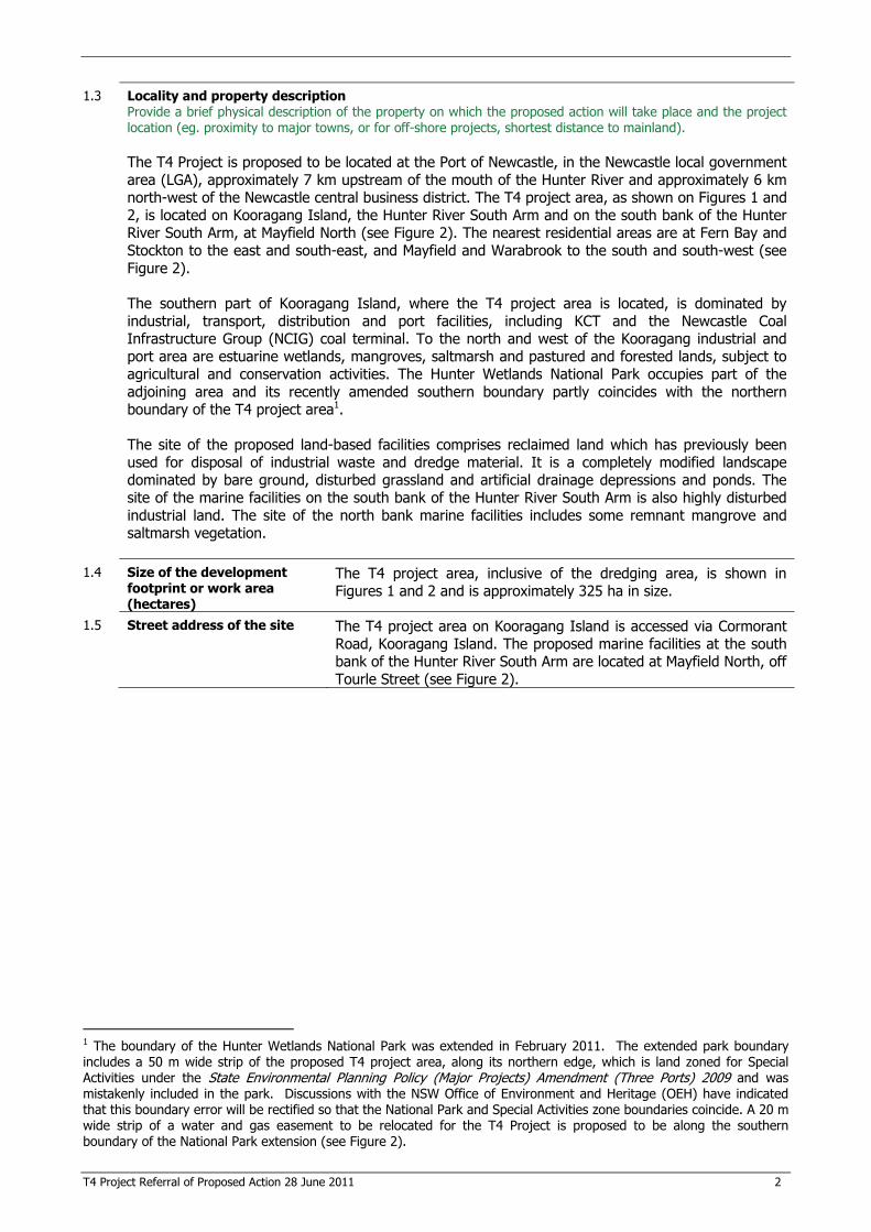
1.3 Locality and property description Provide a brief physical description of the property on which the proposed action will take place and the project location (eg. proximity to major towns, or for off-shore projects, shortest distance to mainland).
The T4 Project is proposed to be located at the Port of Newcastle, in the Newcastle local government area (LGA), approximately 7 km upstream of the mouth of the Hunter River and approximately 6 km north-west of the Newcastle central business district. The T4 project area, as shown on Figures 1 and 2, is located on Kooragang Island, the Hunter River South Arm and on the south bank of the Hunter River South Arm, at Mayfield North (see Figure 2). The nearest residential areas are at Fern Bay and Stockton to the east and south-east, and Mayfield and Warabrook to the south and south-west (see Figure 2).
The southern part of Kooragang Island, where the T4 project area is located, is dominated by industrial, transport, distribution and port facilities, including KCT and the Newcastle Coal Infrastructure Group (NCIG) coal terminal. To the north and west of the Kooragang industrial and port area are estuarine wetlands, mangroves, saltmarsh and pastured and forested lands, subject to agricultural and conservation activities. The Hunter Wetlands National Park occupies part of the adjoining area and its recently amended southern boundary partly coincides with the northern boundary of the T4 project area1.
The site of the proposed land-based facilities comprises reclaimed land which has previously been used for disposal of industrial waste and dredge material. It is a completely modified landscape dominated by bare ground, disturbed grassland and artificial drainage depressions and ponds. The site of the marine facilities on the south bank of the Hunter River South Arm is also highly disturbed industrial land. The site of the north bank marine facilities includes some remnant mangrove and saltmarsh vegetation.
1.4 Size of the development footprint or work area (hectares)
The T4 project area, inclusive of the dredging area, is shown in Figures 1 and 2 and is approximately 325 ha in size.
1.5 Street address of the site
The T4 project area on Kooragang Island is accessed via Cormorant Road, Kooragang Island. The proposed marine facilities at the south bank of the Hunter River South Arm are located at Mayfield North, off Tourle Street (see Figure 2).
1 The boundary of the Hunter Wetlands National Park was extended in February 2011. The extended park boundary includes a 50 m wide strip of the proposed T4 project area, along its northern edge, which is land zoned for Special Activities under the State Environmental Planning Policy (Major Projects) Amendment (Three Ports) 2009 and was mistakenly included in the park. Discussions with the NSW Office of Environment and Heritage (OEH) have indicated that this boundary error will be rectified so that the National Park and Special Activities zone boundaries coincide. A 20 m wide strip of a water and gas easement to be relocated for the T4 Project is proposed to be along the southern boundary of the National Park extension (see Figure 2).
T4 Project Referral of Proposed Action 28 June 2011 3
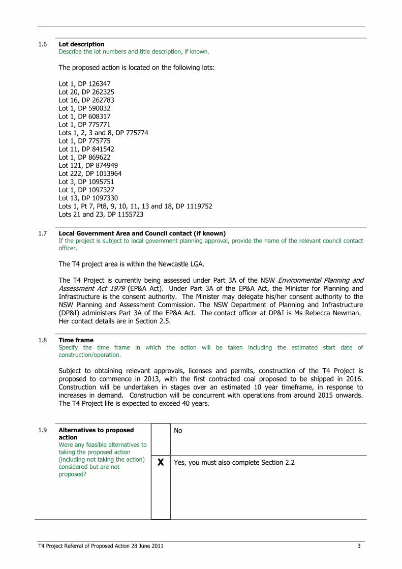
1.6 Lot description Describe the lot numbers and title description, if known.
The proposed action is located on the following lots:
Lot 1, DP 126347 Lot 20, DP 262325 Lot 16, DP 262783 Lot 1, DP 590032 Lot 1, DP 608317 Lot 1, DP 775771 Lots 1, 2, 3 and 8, DP 775774 Lot 1, DP 775775 Lot 11, DP 841542 Lot 1, DP 869622 Lot 121, DP 874949 Lot 222, DP 1013964 Lot 3, DP 1095751 Lot 1, DP 1097327 Lot 13, DP 1097330 Lots 1, Pt 7, Pt8, 9, 10, 11, 13 and 18, DP 1119752 Lots 21 and 23, DP 1155723
1.7 Local Government Area and Council contact (if known) If the project is subject to local government planning approval, provide the name of the relevant council contact officer.
The T4 project area is within the Newcastle LGA.
The T4 Project is currently being assessed under Part 3A of the NSW Environmental Planning and Assessment Act 1979 (EP&A Act). Under Part 3A of the EP&A Act, the Minister for Planning and Infrastructure is the consent authority. The Minister may delegate his/her consent authority to the NSW Planning and Assessment Commission. The NSW Department of Planning and Infrastructure (DP&I) administers Part 3A of the EP&A Act. The contact officer at DP&I is Ms Rebecca Newman. Her contact details are in Section 2.5.
1.8 Time frame Specify the time frame in which the action will be taken including the estimated start date of construction/operation.
Subject to obtaining relevant approvals, licenses and permits, construction of the T4 Project is proposed to commence in 2013, with the first contracted coal proposed to be shipped in 2016. Construction will be undertaken in stages over an estimated 10 year timeframe, in response to increases in demand. Construction will be concurrent with operations from around 2015 onwards. The T4 Project life is expected to exceed 40 years.
1.9 Alternatives to proposed
action Were any feasible alternatives to taking the proposed action (including not taking the action) considered but are not proposed?
No
X Yes, you must also complete Section 2.2
T4 Project Referral of Proposed Action 28 June 2011 4
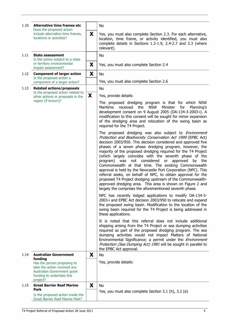
1.10 Alternative time frames etc Does the proposed action include alternative time frames, locations or activities?
No
X Yes, you must also complete Section 2.3. For each alternative, location, time frame, or activity identified, you must also complete details in Sections 1.2-1.9, 2.4-2.7 and 3.3 (where relevant).
1.11 State assessment Is the action subject to a state or territory environmental impact assessment?
No
X Yes, you must also complete Section 2.4
1.12 Component of larger action Is the proposed action a component of a larger action?
X No
Yes, you must also complete Section 2.6
1.13 Related actions/proposals Is the proposed action related to other actions or proposals in the region (if known)?
No
X Yes, provide details:
The proposed dredging program is that for which NSW Maritime received the NSW Minister for Planning’s development consent on 9 August 2005 (DA-134-3-2003-i). A modification to this consent will be sought for minor expansion of the dredging area and relocation of the swing basin as required for the T4 Project.
The proposed dredging was also subject to Environment Protection and Biodiversity Conservation Act 1999 (EPBC Act) decision 2003/950. This decision considered and approved five phases of a seven phase dredging program, however, the majority of the proposed dredging required for the T4 Project (which largely coincides with the seventh phase of the program) was not considered or approved by the Commonwealth at that time. The existing Commonwealth approval is held by the Newcastle Port Corporation (NPC). This referral seeks, on behalf of NPC, to obtain approval for the proposed T4 Project dredging upstream of the Commonwealth-approved dredging area. This area is shown on Figure 2 and largely the comprises the aforementioned seventh phase.
NPC has recently lodged applications to modify DA-134-3-2003-i and EPBC Act decision 2003/950 to relocate and expand the proposed swing basin. Modification to the location of the swing basin required for the T4 Project is being addressed in these applications.
It is noted that this referral does not include additional shipping arising from the T4 Project or sea dumping activities required as part of the proposed dredging program. The sea dumping activities would not impact Matters of National Environmental Significance; a permit under the Environment Protection (Sea Dumping Act) 1981 will be sought in parallel to the EPBC Act approval.
1.14 Australian Government funding Has the person proposing to take the action received any Australian Government grant funding to undertake this project?
X No
Yes, provide details:
1.15 Great Barrier Reef Marine Park Is the proposed action inside the Great Barrier Reef Marine Park?
X No Yes, you must also complete Section 3.1 (h), 3.2 (e)

T4 Project Referral of Proposed Action 28 June 2011 5
2 Detailed description of proposed action NOTE: It is important that the description is complete and includes all components and activities associated with the action. If certain related components are not intended to be included within the scope of the referral, this should be clearly explained in section 2.6. 2.1 Description of proposed action This should be a detailed description outlining all activities and aspects of the proposed action and should reference figures and/or attachments, as appropriate.
PWCS owns and operates KCT at Kooragang Island and the Carrington Coal Terminal (CCT) at Carrington, both in the Port of Newcastle. Additional coal export capacity is required at the port to accommodate the contracted and projected future coal exports from the Hunter Valley and broader NSW. This is underpinned by requirements of the Australian Competition and Consumer Commission (ACCC) endorsed Capacity Framework Arrangements, which form a critical part of the long term export plan for coal produced in the region.
The Capacity Framework Arrangements provide that PWCS must expand existing operations to cover any predicted capacity shortfall (see discussion in Section 2.4). If PWCS capacity cannot be expanded sufficiently to meet the shortfall, then PWCS must build a new terminal elsewhere. PWCS contracted allocations are forecast to exceed capacity in approximately 2015. Therefore, to fulfil its contractual obligations, PWCS is proposing to construct and operate the T4 Project, being a coal export terminal on land adjoining KCT.
The T4 Project would include dredging and some land reclamation activities, followed by construction and operation of a rail loop, coal stockyard, conveyor system, wharves, berths, shiploaders and ancillary facilities. Ancillary use of KCT’s existing facilities, for example administration, is also proposed. Dredging and land reclamation are proposed to take place at the outset and the coal terminal infrastructure would then be developed in stages, in response to demand. The maximum coal throughput capacity of the T4 Project would be progressively increased from 35 Mtpa in the first stage to 120 Mtpa at full development. The T4 Project components are intended to be constructed generally in accordance with Figure 2, subject to detailed feasibility studies and an environmental analysis which will be outlined in an environmental assessment (EA) report. The EA will include conservative assessments of potential impacts. The components of the T4 Project are described in further detail below.
Dredging and land reclamation
Dredging will be undertaken in the Hunter River South Arm to create shipping channels and berths required to service the T4 Project. Sand recovered from the dredging process will be used as engineering fill on the T4 site.
NSW Maritime has development consent (DA-134-3-2003-i) under Part 4 of the EP&A Act for expansion of port facilities in the Hunter River South Arm; this covers the majority of the proposed T4 dredging footprint. Dredging will be undertaken in accordance with the existing consent. For the minor additional dredging areas/ depths an application to modify the consent will be submitted. Whilst NPC previously prepared a referral under the EPBC Act for the state-approved dredging program (EPBC reference 2003/950), most of which was approved, the majority of the proposed dredging footprint which coincides with the T4 project area was not considered or approved by the Commonwealth at that time. As mentioned in Section 1.13, this referral seeks to obtain approval for the proposed T4 Project dredging upstream of the Commonwealth-approved dredging area. This area is shown on Figure 2. It is also noted that the swing basin is proposed to be relocated downstream of its previously approved location. This is being dealt with separately by NPC.
Dredged sand will be pumped to the proposed stockyard area on Kooragang Island to ultimately provide pre-load and fill material for parts of the stockyard, rail corridor and wharf area. Reclamation ponds will be constructed for hydraulic placement of dredged material and settlement ponds will be used for managing return water and settling out fines prior to discharge of return water back into the Hunter River (under licence). Dredged material other than sand, including mud, silts, clay and rock will be disposed of at licensed offshore disposal areas in accordance with the relevant approvals and permits. The proposed disposal areas are within State waters. A permit under the Environment Protection (Sea Dumping Act) 1981 will be sought in parallel to the EPBC Act approval.
T4 Project Referral of Proposed Action 28 June 2011 6
As part of the initial works phase of the T4 Project, closure and capping of licensed waste emplacement areas located within the T4 project area will be undertaken in accordance with NSW Office of Environment and Heritage (OEH) Environmental Protection Licence (EPL) requirements. The proposed capping of the site by PWCS provides an ability to implement a long term solution to potential contamination legacies on the site and facilitate development of a beneficial, high value land use. PWCS developing the site also avoids significant NSW government expenditure on capping.
Bulk earthworks will mostly be fill, using the dredged sand and some engineering fill (rock) trucked in from elsewhere. However, some excavation is proposed as part of the T4 Project including earthworks to support rail dump stations, a conveyor tunnel and water management ponds.
Rail
All coal will be received by rail. Rail tracks and embankments will be constructed generally along the same alignment as the existing rail lines servicing Kooragang Island (see Figure 2). At full development, there is proposed to be eight T4 Project arrival tracks leading into four dump stations. At the dump stations the rail wagons will drop coal into bins in a subsurface structure constructed below track level. These bins will be emptied by a feeder conveyor and recovery conveyors will carry the coal from there to the surface for transfer to the coal stockyard. Once empty, coal trains will proceed onto one of eight T4 Project departure sidings which will combine into a single T4 Project departure track around the outside of the existing KCT rail loop. It is intended that the T4 Project departure track will rejoin Kooragang Island’s single departure track over the Hunter River (see Figure 2).
Stockyard and conveyor system
Development will include a stockyard bench and machine and coal containment berms for up to seven coal stockpiles, with up to eight combined stacker/reclaimers and two stackers for stacking and reclaiming coal. Inbound and outbound sample stations will be provided. A system of coal conveyors, feeders and transfer stations will be installed that extend throughout the stockyard to deliver coal from the dump stations to the stockpiles, and to the wharves (via buffer bins) to deliver coal to the shiploaders. Coal handling infrastructure will include elevated conveyor crossings of NCIG’s rail loop, Cormorant Road and in later stages, the Hunter River (see Figure 2).
Wharves, berths and shiploaders
It is intended that wharf and berth facilities will be developed on both sides of the Hunter River South Arm (as generally indicated in Figure 2). At the maximum throughput capacity of 120 Mtpa, five berths and four shiploaders are proposed which accommodate vessels ranging from Handy size to Cape size.
Ancillary and shared facilities and activities
There will be various ancillary facilities to support the T4 Project, including:
� electricity supply, a new 33kV/ 11kV substation and switchrooms;
� dust suppression and fire fighting systems;
� water and wastewater management systems, including drainage works, a series of settling ponds, water tanks and a pump station;
� fences, security stations and gatehouses;
� IT and data links;
� amenities;
� landscaping;
� internal access roads and car parking areas; and
T4 Project Referral of Proposed Action 28 June 2011 7
� potentially, washdown facilities, refuelling facilities, administration and workshop buildings and external access road(s).
The proposed location of the T4 Project will enable optimisation of synergies with the existing infrastructure, systems and workforce at KCT. This will include some sharing of facilities and environmental management and monitoring systems, including existing KCT administration and maintenance facilities.
Construction of the T4 Project will require relocation of some existing infrastructure and services, potentially including electricity transmission lines, gas lines, water lines, fibre optic cable, ship navigation aides, the existing KCT rail tracks and the Ausgrid wind turbine. Minor modification to local roads may also be required. Infrastructure relocations will generally be within the T4 project area shown on Figure 2.
Habitat creation and enhancement
PWCS is working on opportunities to create and enhance habitat in and around the T4 project area. Apart from some avoidance activities which are proposed, the following opportunities for habitat creation for species such as the green and golden bell frog (Litoria aurea) and migratory shorebirds are being considered:
� re-creation of habitats on parts of the T4 project area which are not subject to development;
� re-creation and enhancement of habitats on adjacent lands; and
� purchase of third party land with existing or potential habitat creation opportunities. 2.2 Alternatives to taking the proposed action This should be a detailed description outlining any feasible alternatives to taking the proposed action (including not taking the action) that were considered but are not proposed (note, this is distinct from any proposed alternatives relating to location, time frames, or activities – see section 2.3).
As described in Section 2.1, under the provisions of the Capacity Framework Arrangements, new coal export capacity is required and PWCS has a contractual obligation to ensure capacity and build the T4 Project, either at the currently proposed location or at an alternative location within the Port of Newcastle. To not do so would avoid PWCS spending billions of dollars in capital investment and environmental management and monitoring and would avoid the potential environmental impacts of the T4 Project. However, this is not considered feasible as:
� PWCS would not meet its contractual obligations under the Capacity Framework Arrangements, which include that ‘construction of a new terminal must be finalised within four years of the capacity shortfall being formally acknowledged’.
� PWCS’s port facilities would not be able to adequately service future coal exports, with significant negative consequences for coal producers in the Hunter Valley and Gunnedah basin which would be unable to ship product coal to market; to the workforces and communities supported by these coal producers; and to local, state and national government revenues from lost tax and royalties. From a revenue perspective, coal is NSW’s and Australia’s largest commodity export and the greatest portion of NSW coal is shipped from the Port of Newcastle.
� The growing international demand for Hunter Valley and Gunnedah basin coal would not be adequately met, with potential flow-on effects to the economies of consumer countries.
� The benefits of the Capacity Framework Arrangements would not be realised. These include providing a solution to the uncertainty and capacity constraints experienced in the Hunter Valley Coal Chain, reducing offshore vessel queues and associated demurrage costs and environmental and safety risks, and maintaining or improving the international reputation and performance of the NSW coal industry.
� Other benefits of the T4 Project would not be realised, including substantial capital investment into the local area, tax payments, increased employment (direct and indirect) and beneficial use of a large flat port-side area previously used for waste disposal.
T4 Project Referral of Proposed Action 28 June 2011 8
Development of the coal export terminal at an alternative location would avoid some of the potential environmental impacts associated with the T4 project area. However, PWCS has not been able to identify a suitable alternative location, which requires the following characteristics:
� a substantial flat area next to sheltered harbour, which is not constrained for development by having high environmental values;
� rail infrastructure linked to the coal fields or the capacity to provide these at reasonable cost;
� vacant land zoned for port development; and
� land owned by PWCS or over which PWCS could obtain freehold title or lease agreement.
In addition, no alternative location, including at the Port of Newcastle, would offer the same synergistic benefits from its proximity to the existing KCT facilities, which enables sharing of infrastructure, workers and management systems. The T4 project area also has the substantial advantage of being predominately highly disturbed land and located some distance from residential areas.
Numerous design options for the key T4 Project components have been investigated as part of the Concept, Order of Magnitude and Pre-feasibility studies. These have included alternative stockyard, rail, berthing and pond locations and configurations, generally within and adjacent to the T4 project area shown on Figure 2. However, the proposed action subject of this referral is the preferred project when considering a combination of operational, environmental and economic factors. Other options have been dismissed on these grounds. Notably this included selection of a rail alignment which avoids ponds near the western boundary of the T4 project area, which are known to provide habitat for the threatened green and golden bell frog (Litoria aurea).
2.3 Alternative locations, time frames or activities that form part of the referred action If you have identified that the proposed action includes alternative time frames, locations or activities (in section 1.9) you must complete this section. Describe any alternatives related to the physical location of the action, time frames within which the action is to be taken and alternative methods or activities for undertaking the action. For each alternative location, time frame or activity identified, you must also complete (where relevant) the details in sections 1.2-1.9, 2.4-2.7, 4 and 3.3. Please note, if the action that you propose to take is determined to be a controlled action, any alternative locations, time frames or activities that are identified here may be subject to environmental assessment and a decision on whether to approve the alternative.
The construction schedule is anticipated to be staged over an approximate 10 year period. The timing for various construction stages will vary in response to demand, which will be established by the throughput predictions supplied annually to PWCS by coal producers, managed through the Capacity Framework Arrangements.
PWCS has examined ways in which the development timeframe for the T4 Project could be altered. Activities such as modifying existing operations are under consideration. However these modifications if implemented would only provide incremental throughput increases and do not eliminate the need for PWCS to increase terminal capacity to the extent required by the industry. These modifications are not part of this referral and even if pursued, demand from the industry is expected to require the T4 Project to be able to receive coal by 2015.
A range of environmental management, monitoring and mitigation measures are being investigated as part of the EA being prepared under the NSW EP&A Act process, including measures to address matters of national environmental significance (MNES). These are being developed in consultation with stakeholder groups and will be presented in the EA.
As described in Section 2.2 a number of alternative locations and configurations of key project components have been considered in development of the T4 Project. However, feasibility studies have progressed to the point where there are no longer options, but rather a preferred project, which is the subject of this referral and the EA being undertaken for the state approval process.
T4 Project Referral of Proposed Action 28 June 2011 9
2.4 Context, planning framework and state/local government requirements Explain the context in which the action is proposed, including any relevant planning framework at the state and/or local government level (e.g. within scope of a management plan, planning initiative or policy framework). Describe any Commonwealth or state legislation or policies under which approvals are required or will be considered against.
The State Environmental Planning Policy (Major Projects) Amendment (Three Ports) 2009 identified the three major ports in NSW – Newcastle, Port Botany and Port Kembla – as state significant sites, collectively known as the ‘Three Ports Site’, to highlight their importance to the state’s economy. Land on which the T4 project area is situated is designated as land within the ‘Three Ports Site – Newcastle Port’ and is therefore a state significant site for the purposes of the EP&A Act. Other relevant environmental planning instruments are the State Environmental Planning Policy (SEPP) (Major Development) 2005, SEPP No.14 (Coastal Wetlands), SEPP No.33 (Hazardous and Offensive Development), SEPP No.55 (Remediation of Land) and SEPP No. 71 (Coastal Protection).
The T4 Project has been declared a Major Development to which Part 3A of the NSW EP&A Act applies. Therefore the consent authority is the NSW Minister for Planning and Infrastructure. The minister may delegate consent authority to the Planning and Assessment Commission, but this is yet to be determined.
As discussed in Sections 1.13 and 2.1, the proposed dredging program does not form part of the proposed Part 3A state approval. Dredging will be carried out in accordance with NSW Maritime’s existing consent (DA-134-3-2003-i) under Part 4 of the EP&A Act, which will be modified as required. Further, as described in Sections 1.13 and 2.1, the dredging activity was also subject to EPBC Act decision 2003/950. This decision considered and approved five phases of a seven phase dredging program. The existing Commonwealth consent is held by NPC. This referral seeks on behalf of NPC, to obtain approval for the proposed T4 Project dredging upstream of the Commonwealth-approved dredging area. This area is shown on Figure 2 and largely comprises the aforementioned seventh phase. Phases already approved may be commenced prior to approval of dredging proposed in this referral.
In addition to the approval under Part 3A of the EP&A Act, section 75V of the EP&A Act lists the authorisations and licences under other legislation that must be obtained but cannot be refused if they are necessary for carrying out projects approved under Part 3A. Of relevance to the T4 Project these are:
� an EPL under the Protection of the Environment Operations Act 1997;
� a consent under section 138 of the Roads Act 1993; and
� a licence under the Pipelines Act 1967.
A sea dumping permit will be sought under section 19 of the Commonwealth Environment Protection (Sea Dumping) Act 1981 for offshore disposal of dredge material unsuitable for use as engineering fill.
The T4 Project is underpinned by the requirements of the Capacity Framework Arrangements for the Port of Newcastle, which were approved by the ACCC in 2009. The Capacity Framework Arrangements were developed following extensive discussions and negotiations between the NSW Government and the Hunter Valley coal industry, and form a critical part of the long term coal export plan for the region. They took effect on 1 January 2010 and apply until 31 December 2024. Additional detail on their provisions is given in Section 2.1.
2.5 Environmental impact assessments under Commonwealth, state or territory legislation If you have identified that the proposed action will be or has been subject to a state or territory environmental impact statement (in section 1.10) you must complete this section. Describe any environmental assessment of the relevant impacts of the project that has been, is being, or will be carried out under state or territory legislation. Specify the type and nature of the assessment, the relevant legislation and the current status of any assessments or approvals. Where possible, provide contact details for the state/territory assessment contact officer. Describe or summarise any public consultation undertaken, or to be undertaken, during the assessment. Attach copies of relevant assessment documentation and outcomes of public consultations (if available).
An EA is currently being prepared under the NSW EP&A Act process. A preliminary environmental assessment (PEA) was prepared and lodged with the DP&I in November 2010. A Planning Focus Meeting was held in Newcastle on 9 December 2010 to discuss the T4 Project. The Director-General’s Requirements (DGRs) for the EA were issued on 14 March 2011. Ecology, contamination, groundwater, surface water,
T4 Project Referral of Proposed Action 28 June 2011 10
visual, air quality, greenhouse gas, social, economics, traffic, acoustics and heritage assessments are being undertaken as part of the EA. The detailed methodologies for these studies will be set out in the EA.
Separate environmental assessments will be prepared for the necessary modification to the NSW Maritime consent (DA-134-3-2003-i) for additional dredging in the Hunter River South Arm. These assessments have not yet commenced. The relevant contact for the NSW planning assessment process is: Name: Ms Rebecca Newman Position: Senior Planning Officer, Infrastructure Projects Agency: Department of Planning and Infrastructure Phone No: (02) 9228 6340 Fax No: (02) 9228 6355 Email: [email protected]
A rigorous public consultation and community engagement programme is being undertaken as part of the EA, a summary which is provided in the following section.
2.6 Public consultation (including with Indigenous stakeholders) Your referral must include a description of any public consultation that has been, or is being, undertaken. Where Indigenous stakeholders are likely to be affected by your proposed action, your referral should describe any consultations undertaken with Indigenous stakeholders. Identify the relevant stakeholders and the status of consultations at the time of the referral. Where appropriate include copies of documents recording the outcomes of any consultations.
Public consultation and engagement regarding the T4 Project commenced in 2010 and is also being undertaken as part of the EA. It will continue to be undertaken throughout development and implementation of the T4 Project. This includes consultation on the project design, proposed mitigation measures and assessment methodologies. Stakeholders consulted to date and proposed for ongoing engagement broadly comprise:
� local, state and Commonwealth government agencies;
� environment and nature groups;
� local community groups and residents from surrounding suburbs, including at Warabrook, Mayfield, Mayfield East, Tighes Hill, Carrington, Wickham, Stockton and Fern Bay;
� special interest groups, such as representatives of local Progress Associations and Alliances;
� PWCS employees;
� neighbouring industry, industry representative groups and business groups;
� state and Commonwealth members and ministers; and
� the media.
A range of consultation tools are being used including phone calls, face-to-face meetings and briefing sessions with key stakeholders; community perception phone surveys; information sheets; community information sessions and public displays; and media releases. In addition a T4 Project webpage has been included on PWCS’s website which provides information on the T4 Project and access points to raise concerns or request further information. The webpage is regularly updated.
A Planning Focus Meeting was held on 9 December 2010, attended by representatives of the DP&I, NPC, OEH, Department of Sustainability, Environment, Water, Population and Communities (DSEWPC), Commonwealth Department of Transport and Infrastructure, NSW Maritime, NSW Office of Water, Industry & Investment NSW, Roads and Traffic Authority (NSW), Australian Rail Track Corporation, Newcastle City Council and the Hunter-Central Rivers Catchment Management Authority. All these agencies provided
T4 Project Referral of Proposed Action 28 June 2011 11
comment on the draft DGRs. Additional meetings on the project and assessment methodologies have been held with all of these agencies as well as Fisheries.
As part of the formal consultation process the EA will be reviewed for adequacy by government agencies and once deemed adequate, will be placed on public exhibition. Public comment can then be submitted to the DP&I and a response to submissions report would be prepared.
Aboriginal consultation is being undertaken in accordance with the NSW Department of Environmental, Climate Change and Water (DECCW) - now OEH guidelines: Aboriginal Cultural Heritage Consultation Requirements for Proponents 2010. The following Aboriginal parties have been contacted personally and by letter, provided with a description of the proposed T4 Project and asked to offer their views as to the Aboriginal heritage values of the T4 project area:
� Awabakal Local Aboriginal Land Council;
� Worimi Local Aboriginal Land Council;
� Nur-Run-Gee Pty Ltd;
� Moo-Roo-Ma Inc;
� Cacatua Culture Consultants;
� Awabakal Traditional Owners Aboriginal Corporation;
� Awabakal Descendants Traditional Owners Aboriginal Corporation;
� Maaiangal Aboriginal Heritage; and
� Gimbay Gatigaan.
To date no socio-cultural heritage values specific to the T4 project area have been identified through correspondence or in personal meetings. Several Aboriginal parties have expressed an interest in being involved in paid archaeological survey fieldwork and some difference of opinion has been expressed over the appropriate parties who have a right to be involved in any fieldwork. All parties have been afforded the opportunity to view the T4 project area.
In accordance with the NSW DECCW (now OEH) (2010) guidelines, Aboriginal consultation has involved stages of identification of stakeholders (including advertising in the local press), presentation of T4 Project information, offers of meetings to describe the presentation (taken up by four parties) and offer of field visit. The lack of archaeological potential and the nil archaeological survey results have been communicated. A technical report describing results of archaeological investigation and Aboriginal consultation and Aboriginal heritage value is currently being completed and will be distributed to Aboriginal stakeholders for review and comment as per the NSW guidelines.
Consultation with stakeholders on the T4 Project is ongoing and the outcomes will be reported in detail in the EA.
2.7 A staged development or component of a larger project If you have identified that the proposed action is a component of a larger action (in section 1.11) you must complete this section. Provide information about the larger action and details of any interdependency between the stages/components and the larger action. You may also provide justification as to why you believe it is reasonable for the referred action to be considered separately from the larger proposal (eg. the referred action is ‘stand-alone’ and viable in its own right, there are separate responsibilities for component actions or approvals have been split in a similar way at the state or local government levels). Not applicable. The T4 Project is not a component of a larger action.
T4 Project Referral of Proposed Action 28 June 2011 12
3 Description of environment & likely impacts 3.1 Matters of national environmental significance Describe the affected area and the likely impacts of the proposal, emphasising the relevant matters protected by the EPBC Act. Refer to relevant maps as appropriate. The interactive map tool can help determine whether matters of national environmental significance or other matters protected by the EPBC Act are likely to occur in your area of interest. Your assessment of likely impacts should refer to the following resources (available from the Department’s web site): � specific values of individual World Heritage properties and National Heritage places and the ecological character of
Ramsar wetlands; � profiles of relevant species/communities (where available), that will assist in the identification of whether there is
likely to be a significant impact on them if the proposal proceeds; � Significant Impact Guidelines 1.1 – Matters of National Environmental Significance; and � associated sectoral and species policy statements available on the web site, as relevant. Note that even if your proposal will not be taken in a World Heritage area, Ramsar wetland, Commonwealth marine area, the Great Barrier Reef Marine Park or on Commonwealth land, it could still impact upon these areas (for example, through downstream impacts). Consideration of likely impacts should include both direct and indirect impacts.
3.1 (a) World Heritage Properties
Description
There are no World Heritage properties in close proximity to the T4 project area. The nearest is the Greater Blue Mountains Area, located over 50 km to the west.
Nature and extent of likely impact Address any impacts on the World Heritage values of any World Heritage property.
Not applicable. The proposed action will not affect the World Heritage values of any World Heritage property.
3.1 (b) National Heritage Places
Description There are no National Heritage Places near the T4 project area.
Nature and extent of likely impact Address any impacts on the National Heritage values of any National Heritage place.
Not applicable. The proposed action will not affect the National Heritage values of any National Heritage place.
3.1 (c) Wetlands of International Importance (declared Ramsar wetlands)
Description
The proposed action will occur near the Hunter Estuary Wetlands (HEW) Ramsar site (see Figures 1 and 2). The proposed action is not located within 50 km of any other Ramsar wetland. The HEW Ramsar site comprises two areas approximately 2.5 km apart, being the former Kooragang Nature Reserve (now part of the Hunter Wetlands National Park) and Wetlands Centre Australia, with the former Kooragang Nature Reserve located closest to the proposed action (see Figure 1). The HEW Ramsar site was listed as a Wetland of International Importance in 1984 under The Convention on Wetlands of International Importance 1971 (Ramsar Convention) due to the unique mix of wetland types, the importance of the wetland for maintaining biological diversity and specifically because of its value for the conservation of migratory shorebirds. The HEW Ramsar site supports habitat for at least 42 of the 66 species listed under
T4 Project Referral of Proposed Action 28 June 2011 13
international migratory species Conventions and Agreements including the Convention on the Conservation of Migratory Species of Wild Animals (Bonn Convention), China Australia Migratory Bird Agreement 1988 (CAMBA), Japan Australia Migratory Bird Agreement 1981 (JAMBA) and Republic of Korea Australia Migratory Bird Agreement 2007 (ROKAMBA). The Ramsar Convention’s nine criteria for identifying Wetlands of International Importance, as set out in the ‘Framework and guidelines for the future development of the List of Wetlands of International Importance of the Convention on Wetlands (Ramsar, Iran, 1971)’ are:
"Criterion 1: A wetland should be considered internationally important if it contains a representative, rare, or unique example of a natural or near-natural wetland type found within the appropriate biogeographic region.
Criterion 2: A wetland should be considered internationally important if it supports vulnerable, endangered, or critically endangered species or threatened ecological communities.
Criterion 3: A wetland should be considered internationally important if it supports populations of plant and/or animal species important for maintaining the biological diversity of a particular biogeographic region.
Criterion 4: A wetland should be considered internationally important if it supports plant and/or animal species at a critical stage in their life cycles, or provides refuge during adverse conditions.
Criterion 5: A wetland should be considered internationally important if it regularly supports 20,000 or more waterbirds.
Criterion 6: A wetland should be considered internationally important if it regularly supports 1% of the individuals in a population of one species or subspecies of waterbird.
Criterion 7: A wetland should be considered internationally important if it supports a significant proportion of indigenous fish subspecies, species or families, life-history stages, species interactions and/or populations that are representative of wetland benefits and/or values and thereby contributes to global biological diversity.
Criterion 8: A wetland should be considered internationally important if it is an important source of food for fishes, spawning ground, nursery and/or migration path on which fish stocks, either within the wetland or elsewhere, depend.
Criterion 9: A wetland should be considered internationally important if it regularly supports 1% of the individuals in a population of one species or subspecies of wetland-dependent non-avian animal species."
The HEW Ramsar site meets four of the Ramsar Convention’s nine criteria for identifying Wetlands of International Importance: Criterion 1: The Wetlands Centre Australia component of the HEW Ramsar site is unique as it has a combination of high conservation value near-natural wetlands, for example Melaleuca Swamp Forest dominated by broad-leaved paperbark (Melaleuca quinquenervia), and high conservation value artificial wetlands. It is the only complex of this type found within the Sydney Basin biogeographic region. The Melaleuca Swamp Forest in particular represents a wetland type that, although once very widespread, is poorly represented in the Sydney Basin biogeographic region. Criterion 3: The HEW Ramsar site is ecologically diverse and maintains a high biological diversity. For example, the former Kooragang Nature Reserve has particularly good examples of mangrove and saltmarsh communities. The Wetlands Centre Australia also contains remnant Melaleuca Swamp Forest. The HEW Ramsar site is also important for maintaining a high diversity of birds within the biogeographic region.
T4 Project Referral of Proposed Action 28 June 2011 14
Criterion 4: The HEW Ramsar site provides important habitat for many migratory bird species listed under Bonn Convention, CAMBA, JAMBA and ROKAMBA. Some of these species also utilise the T4 project area as a migration stopover and foraging habitat, although the Hunter River North Arm supports the most important habitat for these species. The HEW Ramsar site supports a large number of species at a critical seasonal stage of their breeding cycle. Further, the HEW Ramsar site provides refuge during periods of inland drought for a number of species including the Australian pelican (Pelecanus conspicillatus), freckled duck (Stictonetta naevosa), glossy ibis (Plegadis falcinellus) and pink-eared duck (Malacorhynchus membranaceus). Criterion 6: The former Kooragang Nature Reserve component of the HEW Ramsar site regularly supports between 2% and 5% of the East Asian-Australasian Flyway population of eastern curlew (Numenius madagascariensis). The eastern curlew breeds in eastern Russia and north-eastern China and the bulk of the population is considered to spend the non-breeding period in Australia, particularly the Hunter Estuary, where significant numbers have been observed (Bamford et al. 2008).
Nature and extent of likely impact
There are a number of surface drainage features across the T4 project area that ultimately drain to the Hunter River South Arm where the marine facilities will be located. Currently some localised drainage from within the proposed rail corridor flows into the wetlands located to the north of the T4 project area. The proposed surface water management system has been designed so that most runoff will be captured, treated and re-used on site with discharges continuing to be directed into the Hunter River South Arm, and not toward the HEW Ramsar site, which will minimise the potential for impacts to it. Similarly, where practical, stormwater runoff from catchment areas external to the site will be directed around the site, toward the Hunter River. Groundwater beneath the T4 project area is present in two principal aquifers, an upper unconfined aquifer within the fill strata, and a semi-confined aquifer within the estuarine sediments. The proposed action has potential to alter the groundwater recharge and flow regimes beneath the T4 project area, including in association with alterations to the surface water regime, which could contribute to localised changes in the groundwater regime immediately surrounding the site. During the initial pre-loading and filling stage of construction there is potential for saline water from dredged material placed on the site and the associated return water in the reclamation ponds to infiltrate the water table. However, water bodies in the HEW Ramsar site are tidally influenced and not subject to influence from groundwater or surface water bodies in the T4 project area. Any off-site effects are likely to be limited to areas immediately adjacent to the T4 project area and the T4 Project is not likely to impact the HEW Ramsar site. Surface water, groundwater and contamination assessments are being undertaken as part of the EA, inclusive of quantitative modelling, to confirm this. The results will be reported in the EA.
An assessment of whether the action is likely to have a significant impact on the HEW Ramsar site is provided in Appendix 1, using criteria from the Department of the Environment, Water, Heritage and the Arts (DEWHA - now DSEWPC) (2009a) Significant Impact Guidelines 1.1.
3.1 (d) Listed threatened species and ecological communities Description Prior to reclamation and development in the 1960s the T4 project area likely supported a range of estuarine systems which co-existed with early agricultural activities. Today it includes a mix of wetland systems, associated fringing native vegetation and exotic grasslands which support a range of native flora and fauna. A substantial proportion of these areas occur on reclaimed land which is characterised by industrial waste landfills and dredge material that was placed over the estuarine islands, creating the Kooragang Island landform. Threatened species, endangered populations and endangered ecological communities (EECs) recorded or considered likely to occur within 10 km of the T4 project area were identified by searches of the DSEWPC Protected Matters Search Tool and the OEH Atlas of NSW Wildlife Database and review of studies conducted on or near the T4 project area. The identified species and communities which are threatened under the
T4 Project Referral of Proposed Action 28 June 2011 15
EPBC Act, and are therefore MNES, are listed in Appendix 2. Of these, three species were identified as having potential to be impacted by the T4 Project, and are described below. An assessment of the proposed locations of the marine facilities and dredge area within the Hunter River South Arm indicated that there were no threatened marine or estuarine piscivores or invertebrates likely to occur in proximity to the proposed action due to a lack of habitat. Further, there are no records of any terrestrial protected species being observed on the south bank of the Hunter River South Arm, where wharves and berths are proposed to be developed.
Australasian bittern Botaurus poiciloptilus – E
Ecology The Australasian bittern (Botaurus poiciloptilus) favours permanent freshwater wetlands with tall, dense vegetation, particularly bullrushes (Typha spp.) and spikerushes (Eleoacharis spp.). The species hides during the day amongst dense reeds or rushes and feeds mainly at night on invertebrates. Feeding platforms may be constructed over deeper water from reeds trampled by the bird and are often littered with prey remains (OEH 2011). Presence in the T4 project area
Targeted surveys for the Australasian bittern conducted for the T4 Project resulted in no confirmed sightings within the T4 project area. Historic records indicate this species has previously been recorded in the vicinity of the T4 project area (see Figure 4), however, its current use of the area is not known. Notwithstanding, due to the historic records and potentially suitable habitat provided by the artificial freshwater wetlands in the T4 project area, this referral addresses the Australasian bittern.
Nature and extent of likely impact
If the Australasian bittern utilises the T4 project area, the proposed action may result in some impact on it due to a reduction in freshwater wetland habitat and therefore its potential area of occupancy. However, an assessment of significance in accordance with the DEWHA (now DSEWPC) (2009a) Significant Impact Guidelines 1.1 (refer Appendix 3) indicates that the proposed action is unlikely to result in a significant impact on the species.
Green and golden bell frog Litoria aurea - V
Ecology
The green and golden bell frog (Litoria aurea) inhabits freshwater or brackish ponds and streams. Populations utilise large and ephemeral waters and call and breed predominately in summer. Disease and predation by fish and interactions with other frog species significantly affect populations of the species. The species has been the focus of substantial research, including studies conducted in and around the T4 project area over recent years. Presence in the T4 project area
The T4 project area supports part of an extant population of green and golden bell frogs and numerous records for this species exist on and around the T4 project area (see Figure 5). This population is the subject of past and ongoing research and is considered to be a large population in the region. The core habitat for the species is concentrated around specific ponds (see Figure 5) although records indicate that frog dispersal occurs across the T4 project area (see extent of records on Figure 5). The species has also been recorded in areas adjacent to the T4 project area, although ongoing development in the general area means that some of these records may not reflect current occupancy. There has also been work undertaken by others around the T4 project area that have enhanced frog habitat. Nature and extent of likely impact An assessment using the DEWHA (now DSEWPC) (2009a) guidelines (refer Appendix 3) found that an impact on the green and golden bell frog is likely to occur as a result of the proposed action. This impact is due to a loss of habitat, reduction in the area of occupancy of an important population, increased fragmentation of an important population and an adverse effect on habitat of the species.
T4 Project Referral of Proposed Action 28 June 2011 16
Grey-headed flying-fox Pteropus poliocephalus – V
Ecology
This species occurs in subtropical and temperate rainforests, tall sclerophyll forests and woodlands, mangroves, heaths and swamps as well as urban gardens and cultivated fruit crops. Important habitat components include roosting and foraging sites. Roosting sites are generally located in moist forests, but roosting also occurs in urban parklands. Winter foraging (winter flowering trees) are particularly important habitat components for the grey-headed flying-fox (Pteropus poliocephalus). Presence in the T4 project area
The grey-headed flying-fox has been recorded flying over the T4 project area (see Figure 6), although most of the T4 project area and adjacent areas lack trees and are of limited habitat value. Mangroves located near the fringes of the T4 project area (see Figure 7) may provide potential habitat for this species, although none were recorded there during recent surveys in the T4 project area. Nature and extent of likely impact No significant impact will occur on the grey-headed flying-fox as the T4 project area is unlikely to support a population of the species due to a general lack of roosting and foraging habitat (refer Appendix 3). 3.1 (e) Listed migratory species Description Searches of the DSEWPC Protected Matters Search Tool and the OEH Atlas of NSW Wildlife Database and reviews of previous studies conducted in proximity to the T4 project area identified a range of migratory species that have been recorded or could occur at the T4 project area. A total of 42 migratory species listed under the EPBC Act have been recorded in the Hunter Estuary. These species are listed in Appendix 2. The following species listed under the Bonn Convention, CAMBA, JAMBA and ROKAMBA have been recorded within or immediately adjacent to the T4 project area and for which the T4 project area is therefore considered to constitute important habitat (Herbert 2007): � bar-tailed godwit (Limosa lapponica); � common greenshank (Tringa nebularia); � curlew sandpiper (Calidris ferruginea); � double-banded plover (Charadrius bicinctus); � Lathams snipe (Gallinago hardwickii); � marsh sandpiper (Tringa stagnatilis); � pectoral sandpiper (Calidris melanotos); � red-necked stint (Calidris ruficollis) � ruff (Philomachus pugnax); and � sharp-tailed sandpiper (Calidris acuminata). Additionally, the following threatened migratory species have been recorded within 10 km of the T4 project area, based on database searches: � Antipodean albatross (Diomedea antipodensis); � black-browed albatross (Thalassarche melanophrys); � Campbells albatross (Thalassarche impavida); � Tristan albatross (Diomedea dabbenena); � Gibsons albatross (Diomedea gibsoni); � leathery turtle (Dermochelys coriacea); � northern giant petrel (Macronectes halli); � Salvins albatross (Thalassarche salvini);
T4 Project Referral of Proposed Action 28 June 2011 17
� shy albatross (Diomedea cauta); and � white-capped albatross (Thalassarche steadi). Nature and extent of likely impact
The following migratory listed species are unlikely to be impacted by the action as they do not have preferred habitat within the T4 project area (see Appendix 2): � Antipodean albatross (Diomedea antipodensis); � black-browed albatross (Thalassarche melanophrys); � Campbells albatross (Thalassarche impavida); � Gibsons albatross (Diomedea gibsoni); � leathery turtle (Dermochelys coriacea); � northern giant petrel (Macronectes halli); � Salvins albatross (Thalassarche salvini,); � shy albatross (Diomedea cauta); � Tristan albatross (Diomedea dabbenena); and � white-capped albatross (Thalassarche steadi). The action could potentially impact upon migratory species, in particular migratory wader species that have been recorded in the T4 project area and utilise habitat associated with Deep Pond. This potentially includes the:
� bar-tailed godwit (Limosa lapponica); � common greenshank (Tringa nebularia); � curlew sandpiper (Calidris ferruginea); � double-banded plover (Charadrius bicinctus); � Lathams snipe (Gallinago hardwickii); � marsh sandpiper (Tringa stagnatilis); � pectoral sandpiper (Calidris melanotos); � red-necked stint (Calidris ruficollis) � ruff (Philomachus pugnax); and � sharp-tailed sandpiper (Calidris acuminata). These species have been recorded at Deep Pond which is located in the T4 project area (Herbert 2007) (Figures 4 to 6). These species may be impacted by habitat loss, although there are a number of other habitat areas for shorebirds in the Hunter Estuary.
3.1 (f) Commonwealth marine area (If the action is in the Commonwealth marine area, complete 3.2(c) instead. This section is for actions taken outside the Commonwealth marine area that may have impacts on that area.)
Description
The proposed action is not located in a Commonwealth marine area.
Nature and extent of likely impact Address any impacts on any part of the environment in the Commonwealth marine area.
Not applicable. The proposed action will not affect a Commonwealth marine area.
T4 Project Referral of Proposed Action 28 June 2011 18
3.1 (g) Commonwealth land (If the action is on Commonwealth land, complete 3.2(d) instead. This section is for actions taken outside Commonwealth land that may have impacts on that land.)
Description If the action will affect Commonwealth land also describe the more general environment. The Policy Statement titled Significant Impact Guidelines 1.2 - Actions on, or impacting upon, Commonwealth land, and actions by Commonwealth agencies provides further details on the type of information needed. If applicable, identify any potential impacts from actions taken outside the Australian jurisdiction on the environment in a Commonwealth Heritage Place overseas.
The proposed action is not located on Commonwealth land. Nature and extent of likely impact
Address any impacts on any part of the environment in the Commonwealth land. Your assessment of impacts should refer to the Significant Impact Guidelines 1.2 - Actions on, or impacting upon, Commonwealth land, and actions by Commonwealth agencies and specifically address impacts on: � ecosystems and their constituent parts, including people and communities; � natural and physical resources; � the qualities and characteristics of locations, places and areas; � the heritage values of places; and � the social, economic and cultural aspects of the above things.
Not applicable. The proposed action will not affect Commonwealth land.
3.1 (h) The Great Barrier Reef Marine Park Description
The proposed action is not located in the Great Barrier Reef Marine Park. Nature and extent of likely impact
Address any impacts on any part of the environment of the Great Barrier Reef Marine Park
Note: If your action occurs in the Great Barrier Reef Marine Park you may also require permission under the Great Barrier Reef Marine Park Act 1975 (GBRMP Act). If so, section 37AB of the GBRMP Act provides that your referral under the EPBC Act is deemed to be an application under the GBRMP Act and Regulations for necessary permissions and a single integrated process will generally apply. Further information is available at www.gbrmpa.gov.au
Not applicable. The proposed action will not impact the Great Barrier Reef Marine Park.
3.2 Nuclear actions, actions taken by the Commonwealth (or Commonwealth agency), actions taken in a Commonwealth marine area, actions taken on Commonwealth land, or actions taken in the Great Barrier Reef Marine Park You must describe the nature and extent of likely impacts (both direct & indirect) on the whole environment if your project: � is a nuclear action; � will be taken by the Commonwealth or a Commonwealth agency; � will be taken in a Commonwealth marine area; � will be taken on Commonwealth land; or � will be taken in the Great Barrier Reef marine Park. Your assessment of impacts should refer to the Significant Impact Guidelines 1.2 - Actions on, or impacting upon, Commonwealth land, and actions by Commonwealth agencies and specifically address impacts on: � ecosystems and their constituent parts, including people and communities; � natural and physical resources; � the qualities and characteristics of locations, places and areas; � the heritage values of places; and � the social, economic and cultural aspects of the above things.
T4 Project Referral of Proposed Action 28 June 2011 19
3.2 (a) Is the proposed action a nuclear action? X No
Yes (provide details below)
If yes, nature & extent of likely impact on the whole environment 3.2 (b) Is the proposed action to be taken by the
Commonwealth or a Commonwealth agency?
X No
Yes (provide details below)
If yes, nature & extent of likely impact on the whole environment 3.2 (c) Is the proposed action to be taken in a
Commonwealth marine area? X No
Yes (provide details below)
If yes, nature & extent of likely impact on the whole environment (in addition to 3.1(f)) 3.2 (d) Is the proposed action to be taken on
Commonwealth land? X No
Yes (provide details below)
If yes, nature & extent of likely impact on the whole environment (in addition to 3.1(g)) 3.2 (e) Is the proposed action to be taken in the
Great Barrier Reef Marine Park? X No
Yes (provide details below)
If yes, nature & extent of likely impact on the whole environment (in addition to 3.1(h))
3.3 Other important features of the environment Provide a description of the project area and the affected area, including information about the following features (where relevant to the project area and/or affected area, and to the extent not otherwise addressed above). If at Section 2.3 you identified any alternative locations, time frames or activities for your proposed action, you must complete each of the details below (where relevant) for each alternative identified.
3.3 (a) Flora and fauna Flora
As described in Section 1.3 and shown on Figure 2, the T4 project area is situated on Kooragang Island, the Hunter River South Arm and the southern side of the Hunter River South Arm, immediately east of the Tourle Street bridge. Kooragang Island is predominantly composed of estuarine and freshwater wetland communities and exotic pastures associated with previous agricultural activity and clearing of woodlands. Kooragang Island now contains significant industrial development. The area on the south bank of the Hunter River is an industrial site with limited native vegetation (see Figure 2). Over 150 flora species have been recorded within the HEW Ramsar site. Six vegetation communities have been mapped by McDonald (2001) as occurring in or near the T4 project area: � Casuarina complex;
� disturbed grassland;
� freshwater wetlands;
� mangrove (Avicennia marina subsp. marina) complex;
� Phragmites swamp; and
� Saltmarsh.
Bare ground also makes up some of the T4 project area.
The following T4 project area flora descriptions are based on the vegetation mapping undertaken for this project and shown in Figure 7.
T4 Project Referral of Proposed Action 28 June 2011 20
Disturbed Land
The majority of the T4 project area (approximately 161 ha) comprises either bare ground or disturbed grassland dominated by exotic grass, shrub and forbs (see Figure 7). This community is considered to have low to very low conservation value in a local and regional context. Freshwater Wetlands
Two freshwater wetland variants are present in the T4 project area, being ephemeral freshwater wetlands dominated by common reed (Phragmites australis) and cumbungi (Typha orientalis), and ephemeral sedge swamps dominated by marsh clubrush (Boboschoenus fluviatalis). Approximately 28 ha of the T4 project area has been mapped as freshwater wetlands (see Figure 7). Due to the reclaimed nature of the T4 project area, the freshwater wetlands are a result of human activity and were not a naturally occurring community on the island(s) prior to reclamation. These wetlands are not listed under the EPBC Act. Mangrove Forest
The mangrove complex occurs along the river’s edge (approximately 9 ha) at the northern shoreline of the Hunter River South Arm and in the northern areas of the T4 project area (approximately 40 ha). There are no mangroves on the southern bank of the Hunter River South Arm; a rock wall has previously been constructed at this location. The community is dominated by grey mangrove (Avicennia marina subsp. australascica) with scattered river mangrove (Aegiceras corniculatum). The mangrove complex is largely a natural remnant, although some disturbance may have occurred in the past. Mangrove forests are considered to be regionally significant, however, the community is not listed under the EPBC Act. Saltmarsh
Areas of saltmarsh vegetation are in the T4 project area, near its northern extent and a small portion near the Tourle Street bridge on the northern bank of the Hunter River South Arm. This community is dominated by saltwater couch (Sporobolus virginicus), samphire (Sarcocornia quinqueflora) and Suaeda australis. There is approximately 18 ha of saltmarsh mapped as occurring on the T4 project area (see Figure 7). The saltmarsh community is an EEC listed under the NSW Threatened Species Conservation Act 1995 (TSC Act). It is not listed under the EPBC Act. Tree Planting
A line of planted trees about 20 m wide occurs in the southern part of the T4 project area and comprises native trees, shrubs and a predominantly native ground cover (see Figure 7). Swamp Oak Closed Forest There is a line of swamp oak (Casuarina glauca) adjacent to the tree planting, at the edge of a wetland (see Figure 7). Fauna The Lower Hunter Estuary contains some of the most significant wetlands in NSW and has exceptional conservation significance (DECCW – now OEH 2009). The estuary supports a large number of species at a critical seasonal stage of their breeding cycle and provides a key refuge during inland drought for species such as the Australian pelican, freckled duck, glossy ibis and pink-eared duck (DECCW – now OEH 2009). Aquatic and terrestrial fauna occur throughout the Hunter Estuary. Major faunal groups include crustaceans (eg prawns), benthic invertebrates, fish, native amphibian, reptilian and mammalian populations and residential, seasonal and migratory avifaunal communities. Much of the native fauna has been displaced as a
T4 Project Referral of Proposed Action 28 June 2011 21
result of habitat removal or modification and predation by exotic species. Faunal habitats closely follow the floral habitat types of the estuary, with additional faunal habitat types including tidal flats, fresh and saline open water bodies, artificial structures and bare sandy sites. The T4 project area provides habitat for terrestrial threatened and migratory species listed under the EPBC Act and TSC Act (see Appendix 2). However, there have been no recorded sightings of threatened species on the south bank of the Hunter River South Arm or in the marine footprint of the T4 Project. Grassland Habitats
Grassland habitats are expected to provide habitat for few native fauna species, however, may provide habitat for the eastern grass owl (Tyto longimembris), which is listed in the TSC Act. The eastern grass owl occurs on Ash Island, the Tomago wetlands and Hexham Swamp (Herbert 2007). Monitoring of the grassland habitat over the previous two seasons (autumn and winter 2010) has, however, not detected eastern grass owl in this habitat on the T4 project area. Further it is not listed under the EPBC Act. Dispersal of some other fauna species may occur across these grasslands. Estuarine Habitats
Estuarine habitats are limited to approximately 49 ha of mangrove forest and approximately 18 ha of saltmarsh habitat. These estuarine habitats are expected to provide a small (relative to adjacent habitats) area of habitat for threatened micro-bats and estuarine dependent species such as migratory waders. Wetland Habitats
A number of wetlands occur within the T4 project area, the largest being Deep Pond (Figures 4 to 6). An additional smaller area of wetland habitat is the four ponds located east of Deep Pond, labelled Ponds 9, 10, 11 and 12 on Figures 4 to 6. These wetlands are habitat for part of a significant population of the green and golden bell frog (Litorea aurea). Deep Pond is a freshwater impoundment that provides habitat for deep diving duck species, migratory waders and wetland dependent species. It has been monitored monthly for migratory waders by the Hunter Bird Observers Club (HBOC) since September 2000 (Herbert 2007). The shallow southern shore of the pond provides foraging habitat for a variety of shorebirds (Avifauna Research and Services 2006; Herbert 2007). Among other locations in the Hunter Estuary, Deep Pond is considered an important wetland for shorebirds and other water birds. Locations in the Hunter Estuary for significant shorebird species include: � Stockton Sandspit; � Kooragang Dykes; � Swan Pond; � Hunter Wetlands Centre; � Deep Pond; � Pambalong Nature Reserve; � Stockton Channel; � Wader Pond; � Hexham Swamp; and � Fern Bay (Herbert, 2007). Deep Pond is also considered to comprise a drought refuge for inland water bird species in a local and regional context.
3.3 (b) Hydrology, including water flows The T4 project area is located within the Hunter River catchment. Kooragang Island was previously a series of low-lying deltaic islands, which have been joined and modified by land reclamation. As such the majority of the proposed action is being undertaken on an artificially modified landform that has been subject to land reclamation and/ or development.
T4 Project Referral of Proposed Action 28 June 2011 22
Surface water features in the T4 project area comprise artificially formed drainage depressions and ponds associated with the existing Kooragang Island mainline rail embankment and former waste emplacement facilities, which intermittently fill with water in response to rainfall runoff. Groundwater beneath the T4 project area is present in two principal aquifers, an upper unconfined aquifer within the fill strata, and a semi-confined aquifer within the estuarine sediments. The hydrology of estuarine areas around the T4 project area is predominantly tidal. Surface water and groundwater assessments are being undertaken as part of the EA, inclusive of quantitative modelling, which are characterising site hydrology, including water flows, and assessing the potential for hydrologic impacts. The results will be reported in the EA.
3.3 (c) Outstanding natural features The majority of the original landscape of the T4 project area was buried under landfill over previous decades and the predominant landscape features of the T4 project area cannot be regarded as natural features. However, there is a small area of mangroves and saltmarsh on the northern bank of the Hunter River South Arm which is natural. To the west and north of the existing Kooragang Island railway line there are also areas of saltmarsh and mangroves, some of which will be affected by the proposed action. It should be noted that the mangrove communities within the Hunter River have significantly expanded over the last 50 years due to modification of the environment. The remaining natural landscape that surrounds the T4 project area consists of a mix of estuarine systems which includes riverine and wetland systems. Ecosystems across most of the T4 project area have colonised an area that has been landfilled with industrial waste and material dredged from the Hunter River. This has raised the height of the T4 project area above natural levels and vegetation differs from that found in the surrounding natural estuarine areas. The proposed location of marine facilities on the southern bank of the Hunter River South Arm has also been heavily disturbed and provides no real natural features. Wetlands in the T4 project area, including Deep Pond and a series of smaller wetlands, have been shaped by past development and are therefore not natural. The T4 project area contains few landscape features which can be regarded as of outstanding value and natural. The mangroves, saltmarsh and intertidal areas are natural and provide habitat for some fauna, but could not be regarded as outstanding given that they occur elsewhere in the Hunter Estuary.
3.3 (d) Remnant native vegetation The vegetation of the T4 project area has been described in Section 3.3(a) and is mapped in Figure 7. The only remnant native vegetation identified in the T4 project area are the mangrove forest (approximately 49 ha) and saltmarsh (approximately 18 ha) communities mentioned previously. Descriptions of these communities are provided in Section 3.3(a). Mangrove forests are considered to be regionally significant, and saltmarsh is an EEC listed under the TSC Act, however, neither vegetation community is listed under the EPBC Act.
3.3 (e) Current state of the environment The T4 project area (approximately 325 ha) occurs on Kooragang Island, the Hunter River South Arm and the south bank of the Hunter River South Arm immediately east of the Tourle Street bridge, on the lower reaches of the Hunter River. The southern bank of the Hunter River South Arm is mostly unvegetated, due to past industrial development. The river bed within the T4 project area has also been modified through dredging downstream and by the placement of flood gates upstream which have modified the estuarine environment over time. The substrate is predominantly sand, silt and mud. Kooragang Island is predominantly reclaimed land created by joining a series of low-lying deltaic islands, including Ash, Dempsey, Mosquito and the Spectacle Islands. Kooragang Island is located within the Hunter River Estuary, which is one of the largest estuaries in NSW, extending some 75 km inland from the coast. The Lower Hunter Estuary contains some of the most significant wetlands in NSW and is considered to be of
T4 Project Referral of Proposed Action 28 June 2011 23
exceptional conservation significance (DECCW – now OEH 2009). The proposed action is located on the southern portion of Kooragang Island on a parcel of land that represents the island’s last significant parcel of industrial land available for development. The majority of the T4 project area is heavily disturbed and is covered by artificial drainage depressions and ponds, bare ground and disturbed grasslands dominated by exotic grass and herb species. The T4 project area has a history as a waste disposal facility (see Section 3.3(j) for further detail). The T4 project area is known to have areas of contamination and the majority of its native vegetation has colonised the area post-disturbance. There are however, small pockets of native vegetation and wetlands within the T4 project area that represent habitat for fauna and support a diversity of bird species. Management of contaminated materials on the site and protection of biodiversity are important considerations being addressed in the project design and management measures are being developed accordingly, which will be reported in the EA. Development of the T4 project area provides an opportunity for the contamination on the site to be addressed.
3.3 (f) Commonwealth Heritage Places or other places recognised as having heritage values
There are no Commonwealth Heritage Places or other places recognised as having heritage values in the T4 project area. The nearest Commonwealth Heritage Place is Fort Wallace, which is located at Stockton more than 2 km to the east. The wetlands adjacent the T4 Project boundary are a registered place on the Register of the National Estate, under the title ‘Hunter Estuary Wetlands’, due to their ecological features.
3.3 (g) Indigenous heritage values
The T4 project area is significantly altered and disturbed to the extent that no Aboriginal archaeological sites survive. Although all land is generally viewed as important to Aboriginal people in the region, there are no particular identified Aboriginal heritage values pertaining to the T4 project area specifically. An indigenous heritage assessment will be provided in the EA report.
3.3 (h) Other important or unique values of the environment Describe any other key features of the environment affected by, or in proximity to the proposed action (for example, any national parks, conservation reserves, wetlands of national significance etc).
The T4 project area is at the edge of the Hunter Wetlands National Park and SEPP 14 listed wetlands (see Figure 1). As stated in the footnote in Section 1.3, the boundary of the Hunter Wetlands National Park was extended in February 2011. The extended park boundary includes a 50 m wide strip of the proposed T4 project area which is land zoned for Special Activities under the SEPP (Major Projects) Amendment (Three Ports) 2009 and was mistakenly included in the park. Discussions with OEH indicate that it plans to have this boundary error rectified so that the National Park and Special Activities zone boundaries coincide. A 20 m wide strip of land required for a water and gas easement which to be relocated as part of the T4 Project is proposed along the southern boundary of the National Park extension.
The former Kooragang Nature Reserve, which is part of the Hunter Wetlands National Park, adjoins the T4 project area (see Figures 1 and 2). The Wetlands Centre Australia is approximately 1.75 km to the west and Hexham Swamp Nature Reserve is approximately 2 km to the north-west (see Figure 1). Kooragang Nature Reserve and the Wetlands Centre Australia comprise the Hunter Estuary Wetlands Ramsar site, which is listed under the Ramsar Convention on Wetlands of International Importance. Kooragang Nature Reserve, Hexham Swamp Nature Reserve, Wetlands Centre Australia and the SEPP 14 listed wetlands associated with the Lower Hunter River Estuary are listed on the Register of the National Estate.
3.3 (i) Tenure of the action area (eg freehold, leasehold)
Land tenure of the T4 project area is shown on Figure 3. The T4 project area is located on freehold land owned by PWCS, freehold land owned by OneSteel Manufacturing Pty Ltd and on Crown land, most of which is managed by NPC. Exceptions are Crown land in the existing rail corridor, which is owned by Country Rail Infrastructure Authority, Pacific National and the Minister for Commerce; land to the north and west of the rail corridor, which is owned by OEH; road reserve owned by the State Property Authority; and the Hunter River bed which is owned by NSW Maritime. PWCS has a formal agreement with NPC for a long term lease
T4 Project Referral of Proposed Action 28 June 2011 24
of Crown land, provided PWCS can demonstrate that it can successfully build and operate a coal terminal on the site. Further, PWCS has access to all other land in the T4 project area except for land owned by OneSteel and by OEH. Negotiations are currently in place with both these parties regarding tenure/ access and will be concluded before this aspect of the project is finalised.
3.3 (j) Existing land/marine uses of area
The site of the proposed land based facilities on Kooragang Island predominately comprises former landfills, and has been used for disposal of industrial waste and dredge material. The former Kooragang Island Waste Emplacement Facility, which is licensed as a Solid Waste Class 2 landfill, operated in the T4 project area from 1972 until 1999. An area known as the Delta EMD site, also licensed as a waste emplacement area, was used for disposal of waste from an electrolysis manganese dioxide (EMD) plant from 1989 until late 2009. These waste emplacement facilities are no longer in use. There is a licensed fines disposal facility in the T4 project area, just west of KCT, which is currently operational and receives dredged fine materials associated with expansion works at KCT.
Public services and infrastructure within the T4 project area which may be relocated as part of the T4 Project are identified in Section 2.1.
The 50 m wide strip of the T4 project area recently included in the National Park is currently proposed for conservation activities. As mentioned in Section 3.3(h), this is planned to be rectified so that the National Park and Special Activities zone boundaries coincide. PWCS is currently in discussions with OEH regarding relocation of a water and gas easement into a 20 m wide area along the southern boundary of the National Park extension.
The proposed location of the marine facilities on the south bank of the Hunter River South Arm is on land owned by OneSteel. OneSteel operates a steel manufacturing and distribution facility at this site. The portion of the site where the T4 project area is located includes some laydown and stockpiling areas and internal roads, but most is not currently in active use (see Figure 2).
The T4 project area has no other known existing landuse.
3.3 (k) Any proposed land/marine uses of area
The proposed site of the land-based facilities on the south bank of the Hunter River South Arm is currently part of the OneSteel site. No development applications have been submitted for this land and no alternative uses are known. PWCS and OneSteel have had discussions on access and these will be concluded before this aspect of the project is finalised. There are no other known proposed land/ marine uses of the T4 project area apart from the coal export terminal.

T4 Project Referral of Proposed Action 28 June 2011 25
4 Measures to avoid or reduce impacts Note: If you have identified alternatives in relation to location, time frames or activities for the proposed action at Section 2.3 you will need to complete this section in relation to each of the alternatives identified. Provide a description of measures that will be implemented to avoid, reduce, manage or offset any relevant impacts of the action. Include, if appropriate, any relevant reports or technical advice relating to the feasibility and effectiveness of the proposed measures. For any measures intended to avoid or mitigate significant impacts on matters protected under the EPBC Act, specify: � what the measure is, � how the measure is expected to be effective, and � the time frame or workplan for the measure. Examples of relevant measures to avoid or reduce impacts may include the timing of works, avoidance of important habitat, specific design measures, or adoption of specific work practices. Provide information about the level of commitment by the person proposing to take the action to implement the proposed mitigation measures. For example, if the measures are preliminary suggestions only that have not been fully researched, or are dependent on a third party’s agreement (e.g. council or landowner), you should state that, that is the case. Note, the Australian Government Environment Minister may decide that a proposed action is not likely to have significant impacts on a protected matter, as long as the action is taken in a particular manner (section 77A of the EPBC Act). The particular manner of taking the action may avoid or reduce certain impacts, in such a way that those impacts will not be ‘significant’. More detail is provided in the Guideline on Particular Manner Decisions under the EPBC Act available at the Department’s web site. For the Minister to make such a decision (under section 77A), the proposed measures to avoid or reduce impacts must: � clearly form part of the referred action (eg be identified in the referral and fall within the responsibility of the person
proposing to take the action), � be must be clear, unambiguous, and provide certainty in relation to reducing or avoiding impacts on the matters
protected, and � must be realistic and practical in terms of reporting, auditing and enforcement. More general commitments (eg preparation of management plans or monitoring) and measures aimed at providing environmental offsets, compensation or off-site benefits CANNOT be taken into account in making the initial decision about whether the proposal is likely to have a significant impact on a matter protected under the EPBC Act. (But those commitments may be relevant at the later assessment and approval stages, including the appropriate level of assessment, if your proposal proceeds to these stages). Refer to the Guideline on Particular Manner Decisions under the EPBC Act available at the Department’s web site.
A number of avoidance and mitigation measures will be used to minimise impacts of the proposed action and a number of offsets are under consideration. The measures currently proposed include:
1. The T4 Project footprint has been modified with the aim to reduce potential impacts on important habitat for the green and golden bell frog (Litorea aurea). Notably a significant modification has been made to the rail alignment, at significant cost to the project, to avoid habitat occupied by the green and golden bell frog. Modifications to the T4 Project will be further refined based on the information provided during the environmental studies.
2. Habitat creation is proposed on parts of the T4 project area that are not being developed. Primarily, this proposed work is targeted at providing habitat for the green and golden bell frog and will include the construction of pond habitat that will provide a corridor across the southern and western parts of the T4 project area. This work will enhance and link areas that are currently being developed by other port users to allow for green and golden bell frog dispersal across a large habitat area.
3. Habitat creation and/or enhancement of areas on Ash Island. The NSW National Parks and Wildlife Service (NPWS) is currently undertaking works on Ash Island to improve habitat for a variety of species such as migratory shorebirds and saltmarsh communities. PWCS has consulted with NPWS on a number of projects that could be undertaken to create habitat for not only threatened species but a range of species.

T4 Project Referral of Proposed Action 28 June 2011 26
4. PWCS is in the initial stages of investigating potential sites through the purchase of land that could be used to create habitat for saltmarsh and shore birds and potentially some other species. Studies are currently being undertaken of potential areas that could be utilised that would provide suitable habitat.
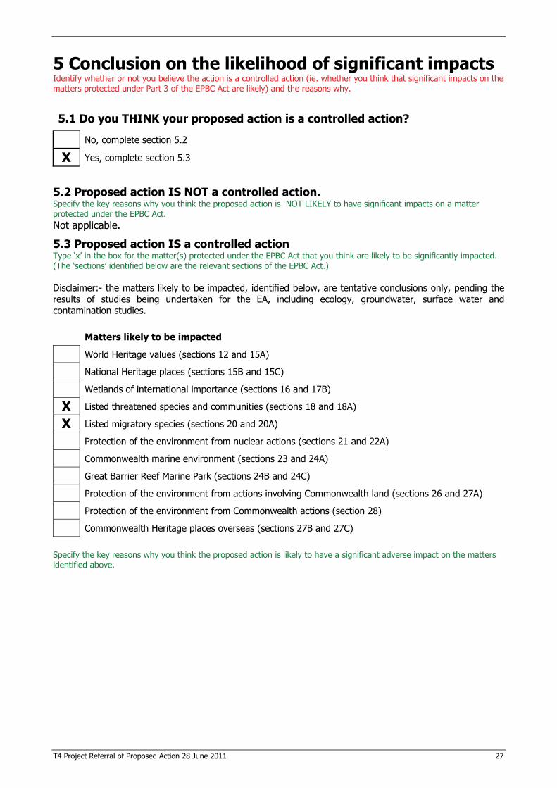
T4 Project Referral of Proposed Action 28 June 2011 27
5 Conclusion on the likelihood of significant impacts Identify whether or not you believe the action is a controlled action (ie. whether you think that significant impacts on the matters protected under Part 3 of the EPBC Act are likely) and the reasons why.
5.1 Do you THINK your proposed action is a controlled action?
No, complete section 5.2
X Yes, complete section 5.3
5.2 Proposed action IS NOT a controlled action. Specify the key reasons why you think the proposed action is NOT LIKELY to have significant impacts on a matter protected under the EPBC Act. Not applicable.
5.3 Proposed action IS a controlled action Type ‘x’ in the box for the matter(s) protected under the EPBC Act that you think are likely to be significantly impacted. (The ‘sections’ identified below are the relevant sections of the EPBC Act.)
Disclaimer:- the matters likely to be impacted, identified below, are tentative conclusions only, pending the results of studies being undertaken for the EA, including ecology, groundwater, surface water and contamination studies. Matters likely to be impacted
World Heritage values (sections 12 and 15A)
National Heritage places (sections 15B and 15C)
Wetlands of international importance (sections 16 and 17B)
X Listed threatened species and communities (sections 18 and 18A)
X Listed migratory species (sections 20 and 20A)
Protection of the environment from nuclear actions (sections 21 and 22A)
Commonwealth marine environment (sections 23 and 24A)
Great Barrier Reef Marine Park (sections 24B and 24C)
Protection of the environment from actions involving Commonwealth land (sections 26 and 27A)
Protection of the environment from Commonwealth actions (section 28)
Commonwealth Heritage places overseas (sections 27B and 27C)
Specify the key reasons why you think the proposed action is likely to have a significant adverse impact on the matters identified above.
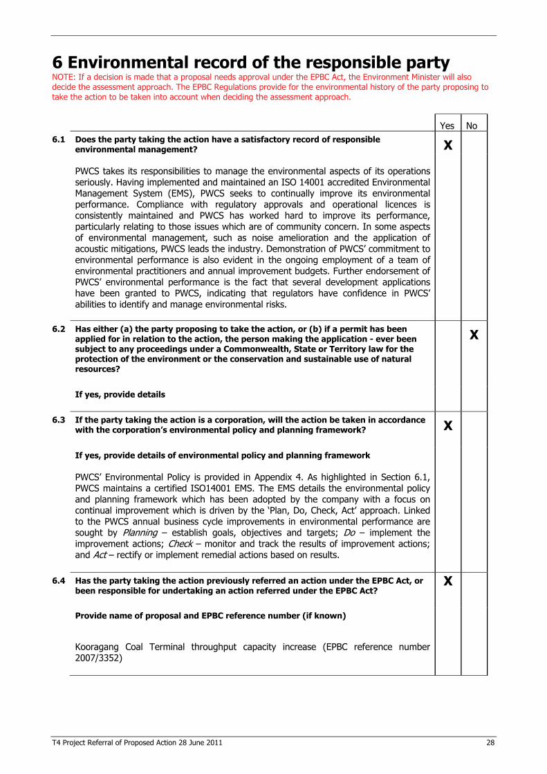
T4 Project Referral of Proposed Action 28 June 2011 28
6 Environmental record of the responsible party NOTE: If a decision is made that a proposal needs approval under the EPBC Act, the Environment Minister will also decide the assessment approach. The EPBC Regulations provide for the environmental history of the party proposing to take the action to be taken into account when deciding the assessment approach. Yes No 6.1 Does the party taking the action have a satisfactory record of responsible
environmental management? X
PWCS takes its responsibilities to manage the environmental aspects of its operations seriously. Having implemented and maintained an ISO 14001 accredited Environmental Management System (EMS), PWCS seeks to continually improve its environmental performance. Compliance with regulatory approvals and operational licences is consistently maintained and PWCS has worked hard to improve its performance, particularly relating to those issues which are of community concern. In some aspects of environmental management, such as noise amelioration and the application of acoustic mitigations, PWCS leads the industry. Demonstration of PWCS’ commitment to environmental performance is also evident in the ongoing employment of a team of environmental practitioners and annual improvement budgets. Further endorsement of PWCS’ environmental performance is the fact that several development applications have been granted to PWCS, indicating that regulators have confidence in PWCS’ abilities to identify and manage environmental risks.
6.2 Has either (a) the party proposing to take the action, or (b) if a permit has been applied for in relation to the action, the person making the application - ever been subject to any proceedings under a Commonwealth, State or Territory law for the protection of the environment or the conservation and sustainable use of natural resources?
X
If yes, provide details
6.3 If the party taking the action is a corporation, will the action be taken in accordance with the corporation’s environmental policy and planning framework?
X
If yes, provide details of environmental policy and planning framework PWCS’ Environmental Policy is provided in Appendix 4. As highlighted in Section 6.1, PWCS maintains a certified ISO14001 EMS. The EMS details the environmental policy and planning framework which has been adopted by the company with a focus on continual improvement which is driven by the ‘Plan, Do, Check, Act’ approach. Linked to the PWCS annual business cycle improvements in environmental performance are sought by Planning – establish goals, objectives and targets; Do – implement the improvement actions; Check – monitor and track the results of improvement actions; and Act – rectify or implement remedial actions based on results.
6.4 Has the party taking the action previously referred an action under the EPBC Act, or been responsible for undertaking an action referred under the EPBC Act?
X
Provide name of proposal and EPBC reference number (if known)
Kooragang Coal Terminal throughput capacity increase (EPBC reference number 2007/3352)
T4 Project Referral of Proposed Action 28 June 2011 29
7 Information sources and attachments (For the information provided above)
7.1 References � List the references used in preparing the referral. � Highlight documents that are available to the public, including web references if relevant.
Avifauna Research and Services 2006, Shorebird study and Habitat Assessment NCIG Project, Kooragang Island.
Bamford, M, Watkins, D, Bancroft, W, Tischler, G and Wahl, J 2008, Migratory Shorebirds of the East Asian - Australasian Flyway: Population Estimates and Internationally Important Sites, Wetlands International – Oceania, Canberra.
DECCW (now OEH) 2010, Aboriginal cultural heritage consultation requirements for proponents 2010 Department of Environment, Climate Change and Water, Sydney.
DECCW (now OEH) 2009, Lower Hunter Regional Conservation Plan, Department of Environment, Climate Change and Water NSW, Sydney.
DEWHA (now DSEWPC) 2009a, Matters of National Environmental Significance, Significant Impact Guidelines 1.1, Commonwealth of Australia, ACT.
DEWHA (now DSEWPC) 2009b, Significant impact guidelines for 36 migratory shorebird species, migratory species, EPBC Act Policy Statement 3.21, Department of Environment, Water, Heritage and the Arts, ACT.
DSEWPC 2011. Wetlands of international importance (Ramsar wetlands), viewed May 2011, http://www.environment.gov.au/cgi-bin/wetlands/ramsardetails.pl?refcode=24.
Herbert, C 2007, Distribution, Abundance and Status of Birds in the Hunter Estuary - Hunter Bird Observers Club, Special Report No. 4. Prepared for Newcastle City Council.
MacDonald, T 2001, Investigating the Estuarine Wetlands of the Lower Hunter River: Rehabilitation Potential of Tidal Reinstatement following Degradation caused by Tidal Restriction. A thesis submitted for the Degree of Doctor of Philosophy of the University of Newcastle, NSW.
NSW Government 2010, BioNet, Search and Map Species, viewed 2010, <http://www.bionet.nsw.gov.au/ Area.cfm>.
OEH 2002, White box yellow box Blakely's red gum woodland - endangered ecological community listing NSW Scientific Committee - final determination, viewed 2011, http://www.environment.nsw.gov.au/determinations/BoxgumWoodlandEndComListing.htm.
OEH 2011, Australasian Bittern Botaurus poiciloptilus - endangered species listing NSW Scientific Committee - final determination, viewed May 2011, http://www.environment.nsw.gov.au/determinations/austbitternFD.htm.
7.2 Reliability and date of information For information in section 3 specify: � source of the information; � how recent the information is; � how the reliability of the information was tested; and � any uncertainties in the information. The information provided in this referral is based on sources outlined in Section 7.1 as well as information supplied by Umwelt Australia, including outcomes of fieldwork undertaken from 2009 to 2011 by its ecologists. At the date of completion of this referral all information was reliable and up to date.
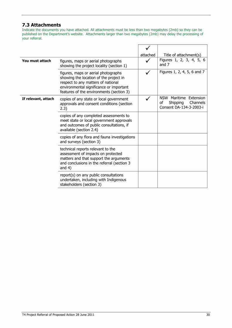
T4 Project Referral of Proposed Action 28 June 2011 30
7.3 Attachments Indicate the documents you have attached. All attachments must be less than two megabytes (2mb) so they can be published on the Department’s website. Attachments larger than two megabytes (2mb) may delay the processing of your referral.
�attached Title of attachment(s)
You must attach
figures, maps or aerial photographs showing the project locality (section 1)
� Figures 1, 2, 3, 4, 5, 6 and 7
figures, maps or aerial photographs showing the location of the project in respect to any matters of national environmental significance or important features of the environments (section 3)
� Figures 1, 2, 4, 5, 6 and 7
If relevant, attach
copies of any state or local government approvals and consent conditions (section 2.3)
� NSW Maritime Extension of Shipping Channels Consent DA-134-3-2003-i
copies of any completed assessments to meet state or local government approvals and outcomes of public consultations, if available (section 2.4)
copies of any flora and fauna investigations and surveys (section 3)
technical reports relevant to the assessment of impacts on protected matters and that support the arguments and conclusions in the referral (section 3 and 4)
report(s) on any public consultations undertaken, including with Indigenous stakeholders (section 3)
T4 Project Referral of Proposed Action 28 June 2011 32
8.2 Person preparing the referral information (if different from 8.1) Individual or organisation who has prepared the information contained in this referral form.
Name EMGA Mitchell McLennan Title - ACN / ABN (if applicable) 281 417 365 58 Postal address EMGA Mitchell McLennan
Ground floor Suite 01 20 Chandos Street ST LEONARDS NSW 2065
Telephone 02 9493 9500 Email [email protected]
Declaration I declare that the information contained in this form is, to my knowledge, true and not misleading.
Signature
Date 28 June 2011
T4 Project Referral of Proposed Action 28 June 2011 33
REFERRAL CHECKLIST NOTE: This checklist is to help ensure that all the relevant referral information has been provided. It is not a part of the referral form and does not need to be sent to the Department. HAVE YOU:
� Completed all required sections of the referral form?
� Included accurate coordinates (to allow the location of the proposed action to be mapped)?
� Provided a map showing the location and approximate boundaries of the project area?
� Provided a map/plan showing the location of the action in relation to any matters of NES?
� Provided complete contact details and signed the form?
� Provided copies of any documents referenced in the referral form?
� Ensured that all attachments are less than two megabytes (2mb)?
� Sent the referral to the Department (electronic and hard copy preferred)?
T4 Project Referral of Proposed Action 28 June 2011 34
Appendix 1 – Hunter Estuary Wetlands Ramsar Site
Significant Impact Criteria The Environment Protection and Biodiversity Conservation Act 1999 (EPBC Act) Significant Impact Guidelines (DEWHA 2009a) outline five criteria that indicate whether an action has, will have, or is likely to have a significant impact on Wetlands of International Importance. An assessment of the proposed action against these is provided below. An action is likely to have a significant impact on the ecological character of a declared Ramsar wetland if there is a real chance or possibility that it will result in: � areas of the wetland being destroyed or substantially modified;
No part of the Hunter Estuary Wetlands (HEW) Ramsar site will be destroyed by the proposed action. The proposed action is not located within a HEW Ramsar site and will not result in any modification of it. � a substantial and measurable change in the hydrological regime of the wetland, for example a
substantial change to the volume, timing, duration and frequency of ground and surface water flows to and within the wetland;
The T4 project area is located in proximity to the former Kooragang Nature Reserve section of the HEW Ramsar site (see Figures 1 and 2).
There are a number of surface drainage features across the T4 project area that ultimately drain to the Hunter River South Arm where the marine facilities will be located. Currently some localised drainage from within the proposed rail corridor flows into the wetlands located to the north of the T4 project area. The proposed surface water management system has been designed so that most runoff will be captured, treated and re-used on site with discharges continuing to be directed into the Hunter River South Arm, and not toward the HEW Ramsar site, which will minimise the potential for impacts to it. Similarly, where practical, stormwater runoff from catchment areas external to the site will be directed around the site, toward the Hunter River. Groundwater beneath the T4 project area is present in two principal aquifers, an upper unconfined aquifer within the fill strata, and a semi-confined aquifer within the estuarine sediments. The proposed action has potential to alter the groundwater recharge and flow regimes beneath the T4 project area, including in association with alterations to the surface water regime, which could contribute to localised changes in the groundwater regime immediately surrounding the site. During the initial pre-loading and filling stage of construction there is potential for saline water from dredged material placed on the site and the associated return water in the reclamation ponds to infiltrate the water table. However, water bodies in the HEW Ramsar site are tidally influenced and not subject to influence from groundwater or surface water bodies in the T4 project area. Any off-site effects are likely to be limited to areas immediately adjacent to the T4 project area and the T4 Project is not likely to impact the HEW Ramsar site. It is considered unlikely that the proposed action would result in a substantial and measurable change in the hydrological regime of the HEW Ramsar site. Surface water, groundwater and contamination assessments are being undertaken as part of the environmental assessment (EA), inclusive of quantitative modelling, to confirm this. The results will be reported in the EA. � the habitat or lifecycle of native species, including invertebrate fauna and fish species, dependent upon
the wetland being seriously affected;
It is considered unlikely that the invertebrate and fish fauna of the HEW Ramsar site will be affected by the proposed action. Wetlands in the T4 project area are utilised by migratory shorebird species which are also likely to use the HEW Ramsar site. Shorebirds may move between the HEW Ramsar site and Deep Pond according to tidal variations, for example when mud flats are covered with water in the HEW Ramsar site, Deep Pond mud flats, which are not tidal, might be used). The species that utilise the HEW Ramsar site and also utilise Deep Pond, may be affected by the loss of Deep Pond, however, there are a number of other wetlands in the
T4 Project Referral of Proposed Action 28 June 2011 35
Hunter Estuary which provide shorebird habitat. Appendix 3 provides an assessment of significance for migratory species. � a substantial and measurable change in the water quality of the wetland – for example, a substantial
change in the level of salinity, pollutants, or nutrients in the wetland, or water temperature which may adversely impact on biodiversity, ecological integrity, social amenity or human health; or
The proposed action is not likely to result in a substantial and measurable change in the water quality of the HEW Ramsar site. � an invasive species that is harmful to the ecological character of the wetland being established (or an
existing invasive species being spread) in the wetland.
The proposed action is not expected to result in any introduction of invasive species to the HEW Ramsar site or an exacerbation of the presence or extent of an existing invasive species in the HEW Ramsar site.
T4 Project Referral of Proposed Action 28 June 2011 36
Appendix 2 – Threatened species and ecological communities Threatened species and ecological communities listed under the Environment Protection and Biodiversity Conservation Act 1999 (EPBC Act) that have been recorded or considered likely to occur within 10 km of the T4 project area have been identified. Resources used to identify these include the Department of Sustainability, Environment, Water, Population and Communities (DSEWPC) Protected Matters Search Tool, Office of Environment and Heritage (OEH) Atlas of NSW Wildlife Database and results of ecological studies conducted in proximity to the T4 project area. Table 1 contains the results of these searches for threatened flora species. Table 2 contains the results of the searches related to threatened ecological communities (TECs). Table 3 contains the results of the searches for threatened fauna species. Tables 1, 2 and 3 contain relevant ecological details for threatened flora, TECs and threatened fauna, including habitat requirements, known range and reservation within conservation reserves in the region, as well as an assessment as to whether the entity is likely to occur within the T4 project area and whether there is any real potential to be impacted by the proposed action. The 42 listed migratory species known to occur in the Hunter Estuary are identified in Table 4. The following 10 species are those listed under the Bonn Convention and JAMBA/CAMBA/ROKAMBA which have been recorded within or immediately adjacent to the T4 project area and for which the T4 project area is therefore considered to constitute habitat (Herbert 1997):
� bar-tailed godwit (Limosa lapponica); � common greenshank (Tringa nebularia); � curlew sandpiper (Calidris ferruginea); � double-banded plover (Charadrius bicinctus); � Lathams snipe (Gallinago hardwickii); � marsh sandpiper (Tringa stagnatilis); � pectoral sandpiper (Calidris melanotos); � red-necked stint (Calidris ruficollis); � ruff (Philomachus pugnax); and � sharp-tailed sandpiper (Calidris acuminata).
The remaining 32 species are considered to have some potential to occur, although surveys have not detected these species (see Table 4).
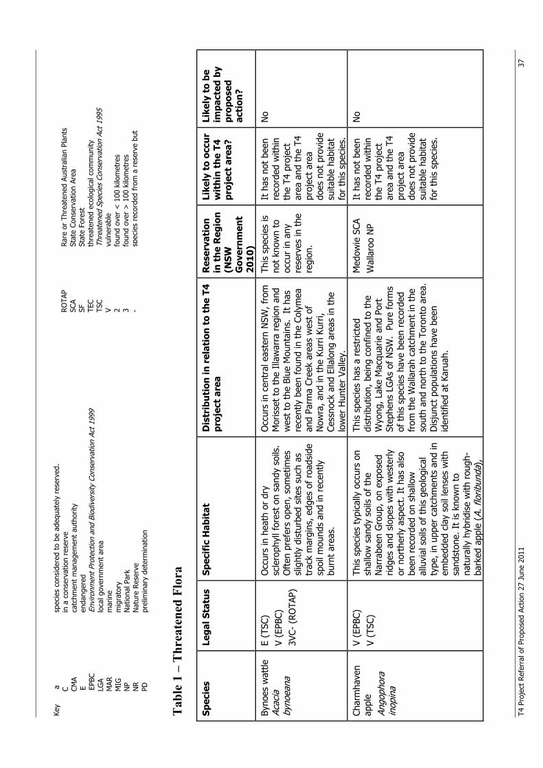
T4 P
roje
ct R
efer
ral o
f Pr
opos
ed A
ctio
n 27
Jun
e 20
11
37
Key
a
spec
ies
cons
ider
ed t
o be
ade
quat
ely
rese
rved
.
C
in a
con
serv
atio
n re
serv
e
CM
A ca
tchm
ent
man
agem
ent
auth
ority
E en
dang
ered
EPBC
En
viro
nmen
t Pro
tect
ion
and
Biod
iver
sity
Con
serv
atio
n Ac
t 199
9
LGA
loca
l gov
ernm
ent
area
MAR
m
arin
e
MIG
m
igra
tory
NP
Nat
iona
l Par
k
NR
Nat
ure
Rese
rve
PD
pr
elim
inar
y de
term
inat
ion
T
able
1 –
Thr
eate
ned
Flor
a Sp
ecie
s Le
gal S
tatu
s Sp
ecif
ic H
abit
at
Dis
trib
utio
n in
rel
atio
n to
the
T4
proj
ect
area
R
eser
vati
on
in t
he R
egio
n (N
SW
Gov
ernm
ent
2010
)
Like
ly t
o oc
cur
wit
hin
the
T4
proj
ect
area
?
Like
ly t
o be
im
pact
ed b
y pr
opos
ed
acti
on?
Byno
es w
attle
Ac
acia
by
noea
na
E (T
SC)
V (E
PBC)
3V
C- (
ROTA
P)
Occ
urs
in h
eath
or
dry
scle
roph
yll f
ores
t on
san
dy s
oils
. O
ften
pre
fers
ope
n, s
omet
imes
sl
ight
ly d
istu
rbed
site
s su
ch a
s tr
ack
mar
gins
, edg
es o
f ro
adsi
de
spoi
l mou
nds
and
in r
ecen
tly
burn
t ar
eas.
Occ
urs
in c
entr
al e
aste
rn N
SW, f
rom
M
oris
set
to t
he I
llaw
arra
reg
ion
and
wes
t to
the
Blu
e M
ount
ains
. It
has
re
cent
ly b
een
foun
d in
the
Col
ymea
an
d Pa
rma
Cree
k ar
eas
wes
t of
N
owra
, and
in t
he K
urri
Kurr
i, Ce
ssno
ck a
nd E
llalo
ng a
reas
in t
he
low
er H
unte
r Va
lley.
This
spe
cies
is
not
know
n to
oc
cur
in a
ny
rese
rves
in t
he
regi
on.
It h
as n
ot b
een
reco
rded
with
in
the
T4 p
roje
ct
area
and
the
T4
proj
ect
area
do
es n
ot p
rovi
de
suita
ble
habi
tat
for
this
spe
cies
.
No
Char
mha
ven
appl
e An
goph
ora
inop
ina
V (E
PBC)
V
(TSC
) Th
is s
peci
es t
ypic
ally
occ
urs
on
shal
low
san
dy s
oils
of
the
Nar
rabe
en G
roup
, on
expo
sed
ridge
s an
d sl
opes
with
wes
terly
or
nor
ther
ly a
spec
t. I
t ha
s al
so
been
rec
orde
d on
sha
llow
al
luvi
al s
oils
of
this
geo
logi
cal
type
, in
uppe
r ca
tchm
ents
and
in
embe
dded
cla
y so
il le
nses
with
sa
ndst
one.
It
is k
now
n to
na
tura
lly h
ybrid
ise
with
rou
gh-
bark
ed a
pple
(A.
flor
ibun
da),
This
spe
cies
has
a r
estr
icte
d di
strib
utio
n, b
eing
con
fined
to
the
Wyo
ng, L
ake
Mac
quar
ie a
nd P
ort
Step
hens
LG
As o
f N
SW.
Pure
for
ms
of t
his
spec
ies
have
bee
n re
cord
ed
from
the
Wal
lara
h ca
tchm
ent
in t
he
sout
h an
d no
rth
to t
he T
oron
to a
rea.
D
isju
nct
popu
latio
ns h
ave
been
id
entif
ied
at K
arua
h.
Med
owie
SCA
W
alla
roo
NP
It h
as n
ot b
een
reco
rded
with
in
the
T4 p
roje
ct
area
and
the
T4
proj
ect
area
do
es n
ot p
rovi
de
suita
ble
habi
tat
for
this
spe
cies
.
No
ROTA
P
Rare
or
Thre
aten
ed A
ustr
alia
n Pl
ants
SC
A
Stat
e Co
nser
vatio
n Ar
ea
SF
St
ate
Fore
st
TEC
th
reat
ened
eco
logi
cal c
omm
unity
TS
C
Thre
aten
ed S
peci
es C
onse
rvat
ion
Act 1
995
V
vuln
erab
le
2
foun
d ov
er <
100
kilo
met
res
3
foun
d ov
er >
100
kilo
met
res
-
s pec
ies
reco
rded
fro
m a
res
erve
but
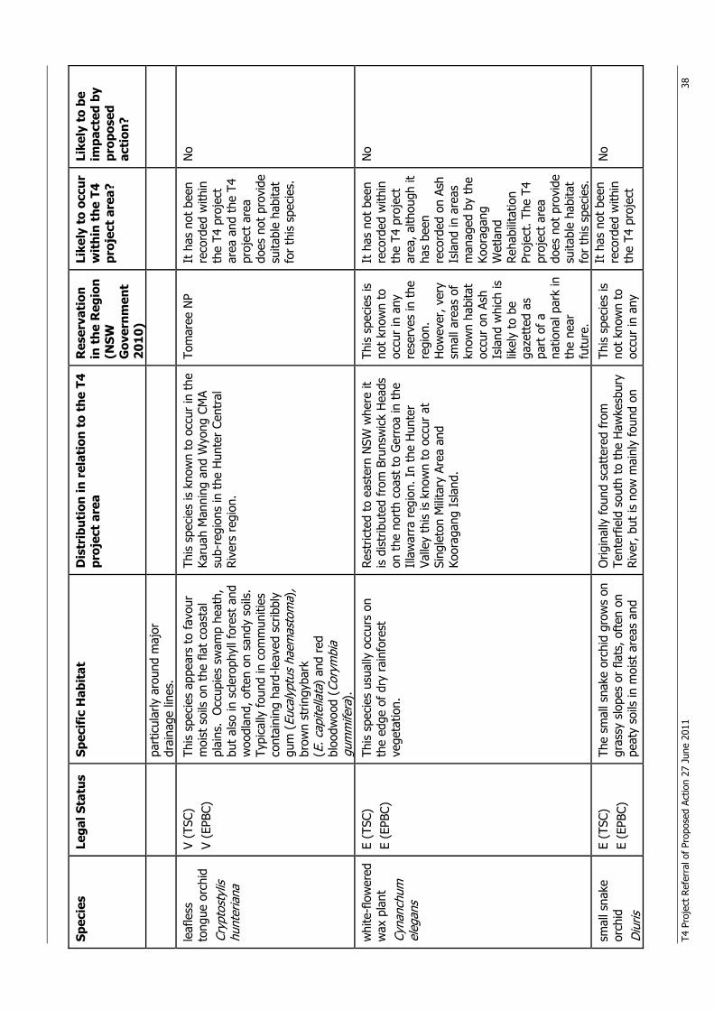
T4 P
roje
ct R
efer
ral o
f Pr
opos
ed A
ctio
n 27
Jun
e 20
11
38
Spec
ies
Lega
l Sta
tus
Spec
ific
Hab
itat
D
istr
ibut
ion
in r
elat
ion
to t
he T
4 pr
ojec
t ar
ea
Res
erva
tion
in
the
Reg
ion
(NSW
G
over
nmen
t 20
10)
Like
ly t
o oc
cur
wit
hin
the
T4
proj
ect
area
?
Like
ly t
o be
im
pact
ed b
y pr
opos
ed
acti
on?
part
icul
arly
aro
und
maj
or
drai
nage
line
s.
leaf
less
to
ngue
orc
hid
Cryp
tost
ylis
hu
nter
iana
V (T
SC)
V (E
PBC)
Th
is s
peci
es a
ppea
rs t
o fa
vour
m
oist
soi
ls o
n th
e fla
t co
asta
l pl
ains
. O
ccup
ies
swam
p he
ath,
bu
t al
so in
scl
erop
hyll
fore
st a
nd
woo
dlan
d, o
ften
on
sand
y so
ils.
Typi
cally
fou
nd in
com
mun
ities
co
ntai
ning
har
d-le
aved
scr
ibbl
y gu
m (
Euca
lypt
us h
aem
asto
ma)
, br
own
strin
gyba
rk
(E. c
apite
llata
) an
d re
d bl
oodw
ood
(Cor
ymbi
a gu
mm
ifera
).
This
spe
cies
is k
now
n to
occ
ur in
the
Ka
ruah
Man
ning
and
Wyo
ng C
MA
sub-
regi
ons
in t
he H
unte
r Ce
ntra
l Ri
vers
reg
ion.
Tom
aree
NP
It h
as n
ot b
een
reco
rded
with
in
the
T4 p
roje
ct
area
and
the
T4
proj
ect
area
do
es n
ot p
rovi
de
suita
ble
habi
tat
for
this
spe
cies
.
No
whi
te-f
low
ered
w
ax p
lant
Cy
nanc
hum
el
egan
s
E (T
SC)
E (E
PBC)
Th
is s
peci
es u
sual
ly o
ccur
s on
th
e ed
ge o
f dr
y ra
info
rest
ve
geta
tion.
Rest
ricte
d to
eas
tern
NSW
whe
re it
is
dis
trib
uted
from
Bru
nsw
ick
Hea
ds
on t
he n
orth
coa
st t
o G
erro
a in
the
Ill
awar
ra r
egio
n. I
n th
e H
unte
r Va
lley
this
is k
now
n to
occ
ur a
t Si
ngle
ton
Mili
tary
Are
a an
d Ko
orag
ang
Isla
nd.
This
spe
cies
is
not
know
n to
oc
cur
in a
ny
rese
rves
in t
he
regi
on.
How
ever
, ver
y sm
all a
reas
of
know
n ha
bita
t oc
cur
on A
sh
Isla
nd w
hich
is
likel
y to
be
gaze
tted
as
part
of
a na
tiona
l par
k in
th
e ne
ar
futu
re.
It h
as n
ot b
een
reco
rded
with
in
the
T4 p
roje
ct
area
, alth
ough
it
has
been
re
cord
ed o
n As
h Is
land
in a
reas
m
anag
ed b
y th
e Ko
orag
ang
Wet
land
Re
habi
litat
ion
Proj
ect.
The
T4
proj
ect
area
do
es n
ot p
rovi
de
suita
ble
habi
tat
for
this
spe
cies
.
No
smal
l sna
ke
orch
id
Diu
ris
E (T
SC)
E (E
PBC)
Th
e sm
all s
nake
orc
hid
grow
s on
gr
assy
slo
pes
or f
lats
, oft
en o
n pe
aty
soils
in m
oist
are
as a
nd
Orig
inal
ly f
ound
sca
tter
ed fr
om
Tent
erfie
ld s
outh
to
the
Haw
kesb
ury
Rive
r, b
ut is
now
mai
nly
foun
d on
This
spe
cies
is
not
know
n to
oc
cur
in a
ny
It h
as n
ot b
een
reco
rded
with
in
the
T4 p
roje
ct
No
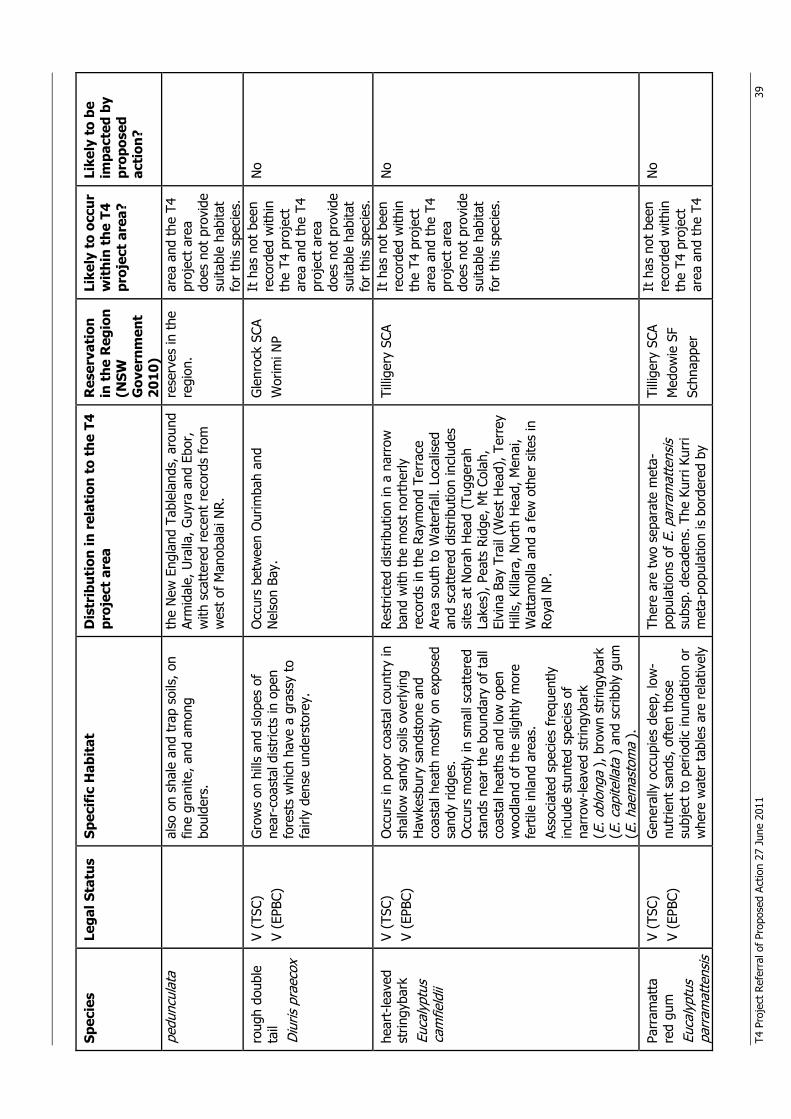
T4 P
roje
ct R
efer
ral o
f Pr
opos
ed A
ctio
n 27
Jun
e 20
11
39
Spec
ies
Lega
l Sta
tus
Spec
ific
Hab
itat
D
istr
ibut
ion
in r
elat
ion
to t
he T
4 pr
ojec
t ar
ea
Res
erva
tion
in
the
Reg
ion
(NSW
G
over
nmen
t 20
10)
Like
ly t
o oc
cur
wit
hin
the
T4
proj
ect
area
?
Like
ly t
o be
im
pact
ed b
y pr
opos
ed
acti
on?
pedu
ncul
ata
also
on
shal
e an
d tr
ap s
oils
, on
fine
gran
ite, a
nd a
mon
g bo
ulde
rs.
the
New
Eng
land
Tab
lela
nds,
aro
und
Arm
idal
e, U
ralla
, Guy
ra a
nd E
bor,
w
ith s
catt
ered
rec
ent
reco
rds
from
w
est
of M
anob
alai
NR.
rese
rves
in t
he
regi
on.
area
and
the
T4
proj
ect
area
do
es n
ot p
rovi
de
suita
ble
habi
tat
for
this
spe
cies
.
roug
h do
uble
ta
il D
iuris
pra
ecox
V (T
SC)
V (E
PBC)
G
row
s on
hill
s an
d sl
opes
of
near
-coa
stal
dis
tric
ts in
ope
n fo
rest
s w
hich
hav
e a
gras
sy t
o fa
irly
dens
e un
ders
tore
y.
Occ
urs
betw
een
Our
imba
h an
d N
elso
n Ba
y.
Gle
nroc
k SC
A
Wor
imi N
P
It h
as n
ot b
een
reco
rded
with
in
the
T4 p
roje
ct
area
and
the
T4
proj
ect
area
do
es n
ot p
rovi
de
suita
ble
habi
tat
for
this
spe
cies
.
No
hear
t-le
aved
st
ringy
bark
Eu
caly
ptus
ca
mfie
ldii
V (T
SC)
V (E
PBC)
O
ccur
s in
poo
r co
asta
l cou
ntry
in
shal
low
san
dy s
oils
ove
rlyin
g H
awke
sbur
y sa
ndst
one
and
coas
tal h
eath
mos
tly o
n ex
pose
d sa
ndy
ridge
s.
Occ
urs
mos
tly in
sm
all s
catt
ered
st
ands
nea
r th
e bo
unda
ry o
f ta
ll co
asta
l hea
ths
and
low
ope
n w
oodl
and
of t
he s
light
ly m
ore
fert
ile in
land
are
as.
Asso
ciat
ed s
peci
es f
requ
ently
in
clud
e st
unte
d sp
ecie
s of
na
rrow
-leav
ed s
trin
gyba
rk
(E. o
blon
ga )
, bro
wn
strin
gyba
rk
(E. c
apite
llata
) a
nd s
crib
bly
gum
(E
. hae
mas
tom
a ).
Rest
ricte
d di
strib
utio
n in
a n
arro
w
band
with
the
mos
t no
rthe
rly
reco
rds
in t
he R
aym
ond
Terr
ace
Area
sou
th t
o W
ater
fall.
Loc
alis
ed
and
scat
tere
d di
strib
utio
n in
clud
es
site
s at
Nor
ah H
ead
(Tug
gera
h La
kes)
, Pea
ts R
idge
, Mt
Cola
h,
Elvi
na B
ay T
rail
(Wes
t H
ead)
, Ter
rey
Hill
s, K
illar
a, N
orth
Hea
d, M
enai
, W
atta
mol
la a
nd a
few
oth
er s
ites
in
Roya
l NP.
Tilli
gery
SCA
It h
as n
ot b
een
reco
rded
with
in
the
T4 p
roje
ct
area
and
the
T4
proj
ect
area
do
es n
ot p
rovi
de
suita
ble
habi
tat
for
this
spe
cies
.
No
Parr
amat
ta
red
gum
Eu
caly
ptus
pa
rram
atte
nsis
V (T
SC)
V (E
PBC)
G
ener
ally
occ
upie
s de
ep, l
ow-
nutr
ient
san
ds, o
ften
tho
se
subj
ect
to p
erio
dic
inun
datio
n or
w
here
wat
er t
able
s ar
e re
lativ
ely
Ther
e ar
e tw
o se
para
te m
eta-
popu
latio
ns o
f E. p
arra
mat
tens
is
subs
p. d
ecad
ens.
The
Kur
ri Ku
rri
met
a-po
pula
tion
is b
orde
red
by
Tilli
gery
SCA
M
edow
ie S
F Sc
hnap
per
It h
as n
ot b
een
reco
rded
with
in
the
T4 p
roje
ct
area
and
the
T4
No
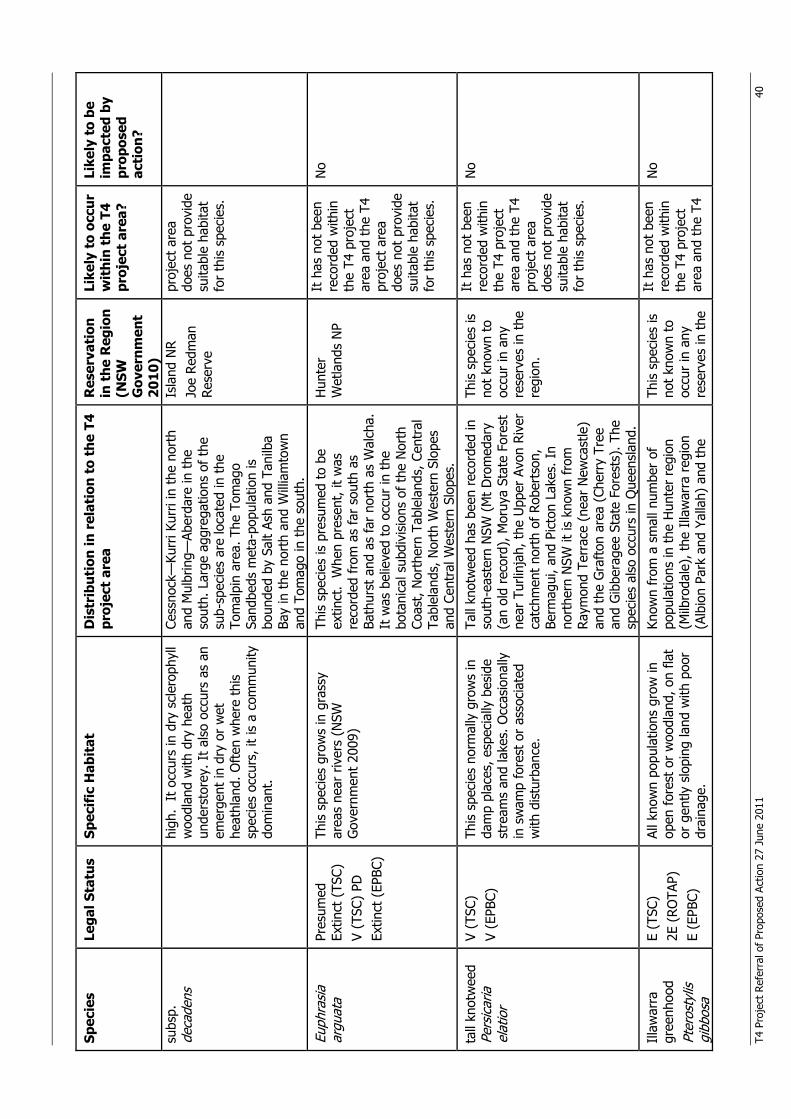
T4 P
roje
ct R
efer
ral o
f Pr
opos
ed A
ctio
n 27
Jun
e 20
11
40
Spec
ies
Lega
l Sta
tus
Spec
ific
Hab
itat
D
istr
ibut
ion
in r
elat
ion
to t
he T
4 pr
ojec
t ar
ea
Res
erva
tion
in
the
Reg
ion
(NSW
G
over
nmen
t 20
10)
Like
ly t
o oc
cur
wit
hin
the
T4
proj
ect
area
?
Like
ly t
o be
im
pact
ed b
y pr
opos
ed
acti
on?
subs
p.
deca
dens
hi
gh.
It o
ccur
s in
dry
scl
erop
hyll
woo
dlan
d w
ith d
ry h
eath
un
ders
tore
y. I
t al
so o
ccur
s as
an
emer
gent
in d
ry o
r w
et
heat
hlan
d. O
ften
whe
re t
his
spec
ies
occu
rs, i
t is
a c
omm
unity
do
min
ant.
Cess
nock
—Ku
rri K
urri
in t
he n
orth
an
d M
ulbr
ing—
Aber
dare
in t
he
sout
h. L
arge
agg
rega
tions
of
the
sub-
spec
ies
are
loca
ted
in t
he
Tom
alpi
n ar
ea. T
he T
omag
o Sa
ndbe
ds m
eta-
popu
latio
n is
bo
unde
d by
Sal
t As
h an
d Ta
nilb
a Ba
y in
the
nor
th a
nd W
illia
mto
wn
and
Tom
ago
in t
he s
outh
.
Isla
nd N
R Jo
e Re
dman
Re
serv
e
proj
ect
area
do
es n
ot p
rovi
de
suita
ble
habi
tat
for
this
spe
cies
.
Euph
rasi
a ar
guat
a Pr
esum
ed
Extin
ct (
TSC)
V
(TSC
) PD
Ex
tinct
(EP
BC)
This
spe
cies
gro
ws
in g
rass
y ar
eas
near
riv
ers
(NSW
G
over
nmen
t 20
09)
This
spe
cies
is p
resu
med
to
be
extin
ct.
Whe
n pr
esen
t, it
was
re
cord
ed f
rom
as
far
sout
h as
Ba
thur
st a
nd a
s fa
r no
rth
as W
alch
a.
It w
as b
elie
ved
to o
ccur
in t
he
bota
nica
l sub
divi
sion
s of
the
Nor
th
Coas
t, N
orth
ern
Tabl
elan
ds, C
entr
al
Tabl
elan
ds, N
orth
Wes
tern
Slo
pes
and
Cent
ral W
este
rn S
lope
s.
Hun
ter
Wet
land
s N
P It
has
not
bee
n re
cord
ed w
ithin
th
e T4
pro
ject
ar
ea a
nd t
he T
4 pr
ojec
t ar
ea
does
not
pro
vide
su
itabl
e ha
bita
t fo
r th
is s
peci
es.
No
tall
knot
wee
d Pe
rsic
aria
el
atio
r
V (T
SC)
V (E
PBC)
Th
is s
peci
es n
orm
ally
gro
ws
in
dam
p pl
aces
, esp
ecia
lly b
esid
e st
ream
s an
d la
kes.
Occ
asio
nally
in
sw
amp
fore
st o
r as
soci
ated
w
ith d
istu
rban
ce.
Tall
knot
wee
d ha
s be
en r
ecor
ded
in
sout
h-ea
ster
n N
SW (
Mt
Dro
med
ary
(an
old
reco
rd),
Mor
uya
Stat
e Fo
rest
ne
ar T
urlin
jah,
the
Upp
er A
von
Rive
r ca
tchm
ent
nort
h of
Rob
erts
on,
Berm
agui
, and
Pic
ton
Lake
s. I
n no
rthe
rn N
SW it
is k
now
n fr
om
Raym
ond
Terr
ace
(nea
r N
ewca
stle
) an
d th
e G
raft
on a
rea
(Che
rry
Tree
an
d G
ibbe
rage
e St
ate
Fore
sts)
. The
sp
ecie
s al
so o
ccur
s in
Que
ensl
and.
This
spe
cies
is
not
know
n to
oc
cur
in a
ny
rese
rves
in t
he
regi
on.
It h
as n
ot b
een
reco
rded
with
in
the
T4 p
roje
ct
area
and
the
T4
proj
ect
area
do
es n
ot p
rovi
de
suita
ble
habi
tat
for
this
spe
cies
.
No
Illaw
arra
gr
eenh
ood
Pter
osty
lis
gibb
osa
E (T
SC)
2E (
ROTA
P)
E (E
PBC)
All k
now
n po
pula
tions
gro
w in
op
en f
ores
t or
woo
dlan
d, o
n fla
t or
gen
tly s
lopi
ng la
nd w
ith p
oor
drai
nage
.
Know
n fr
om a
sm
all n
umbe
r of
po
pula
tions
in t
he H
unte
r re
gion
(M
ilbro
dale
), t
he I
llaw
arra
reg
ion
(Alb
ion
Park
and
Yal
lah)
and
the
This
spe
cies
is
not
know
n to
oc
cur
in a
ny
rese
rves
in t
he
It h
as n
ot b
een
reco
rded
with
in
the
T4 p
roje
ct
area
and
the
T4
No
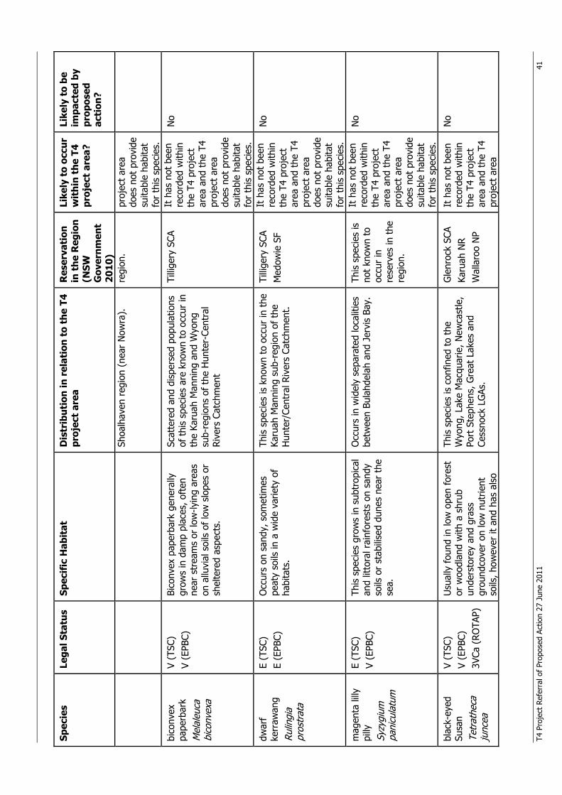
T4 P
roje
ct R
efer
ral o
f Pr
opos
ed A
ctio
n 27
Jun
e 20
11
41
Spec
ies
Lega
l Sta
tus
Spec
ific
Hab
itat
D
istr
ibut
ion
in r
elat
ion
to t
he T
4 pr
ojec
t ar
ea
Res
erva
tion
in
the
Reg
ion
(NSW
G
over
nmen
t 20
10)
Like
ly t
o oc
cur
wit
hin
the
T4
proj
ect
area
?
Like
ly t
o be
im
pact
ed b
y pr
opos
ed
acti
on?
Shoa
lhav
en r
egio
n (n
ear
Now
ra).
re
gion
. pr
ojec
t ar
ea
does
not
pro
vide
su
itabl
e ha
bita
t fo
r th
is s
peci
es.
bico
nvex
pa
perb
ark
Mel
aleu
ca
bico
nvex
a
V (T
SC)
V (E
PBC)
Bi
conv
ex p
aper
bark
gen
eral
ly
grow
s in
dam
p pl
aces
, oft
en
near
str
eam
s or
low
-lyin
g ar
eas
on a
lluvi
al s
oils
of
low
slo
pes
or
shel
tere
d as
pect
s.
Scat
tere
d an
d di
sper
sed
popu
latio
ns
of t
his
spec
ies
are
know
n to
occ
ur in
th
e Ka
ruah
Man
ning
and
Wyo
ng
sub-
regi
ons
of t
he H
unte
r-Ce
ntra
l Ri
vers
Cat
chm
ent
Tilli
gery
SCA
It
has
not
bee
n re
cord
ed w
ithin
th
e T4
pro
ject
ar
ea a
nd t
he T
4 pr
ojec
t ar
ea
does
not
pro
vide
su
itabl
e ha
bita
t fo
r th
is s
peci
es.
No
dwar
f ke
rraw
ang
Rulin
gia
pros
trat
a
E (T
SC)
E (E
PBC)
O
ccur
s on
san
dy, s
omet
imes
pe
aty
soils
in a
wid
e va
riety
of
habi
tats
.
This
spe
cies
is k
now
n to
occ
ur in
the
Ka
ruah
Man
ning
sub
-reg
ion
of t
he
Hun
ter/
Cent
ral R
iver
s Ca
tchm
ent.
Tilli
gery
SCA
M
edow
ie S
F
It h
as n
ot b
een
reco
rded
with
in
the
T4 p
roje
ct
area
and
the
T4
proj
ect
area
do
es n
ot p
rovi
de
suita
ble
habi
tat
for
this
spe
cies
.
No
mag
enta
lilly
pi
lly
Syzy
gium
pa
nicu
latu
m
E (T
SC)
V (E
PBC)
Th
is s
peci
es g
row
s in
sub
trop
ical
an
d lit
tora
l rai
nfor
ests
on
sand
y so
ils o
r st
abili
sed
dune
s ne
ar t
he
sea.
Occ
urs
in w
idel
y se
para
ted
loca
litie
s be
twee
n Bu
lahd
elah
and
Jer
vis
Bay.
Th
is s
peci
es is
no
t kn
own
to
occu
r in
re
serv
es in
the
re
gion
.
It h
as n
ot b
een
reco
rded
with
in
the
T4 p
roje
ct
area
and
the
T4
proj
ect
area
do
es n
ot p
rovi
de
suita
ble
habi
tat
for
this
spe
cies
.
No
blac
k-ey
ed
Susa
n Te
trat
heca
ju
ncea
V (T
SC)
V (E
PBC)
3V
Ca (
ROTA
P)
Usu
ally
fou
nd in
low
ope
n fo
rest
or
woo
dlan
d w
ith a
shr
ub
unde
rsto
rey
and
gras
s gr
ound
cove
r on
low
nut
rient
so
ils, h
owev
er it
and
has
als
o
This
spe
cies
is c
onfin
ed t
o th
e W
yong
, Lak
e M
acqu
arie
, New
cast
le,
Port
Ste
phen
s, G
reat
Lak
es a
nd
Cess
nock
LG
As.
Gle
nroc
k SC
A Ka
ruah
NR
W
alla
roo
NP
It h
as n
ot b
een
reco
rded
with
in
the
T4 p
roje
ct
area
and
the
T4
proj
ect
area
No
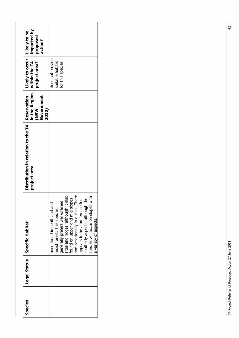
T4 P
roje
ct R
efer
ral o
f Pr
opos
ed A
ctio
n 27
Jun
e 20
11
42
Spec
ies
Lega
l Sta
tus
Spec
ific
Hab
itat
D
istr
ibut
ion
in r
elat
ion
to t
he T
4 pr
ojec
t ar
ea
Res
erva
tion
in
the
Reg
ion
(NSW
G
over
nmen
t 20
10)
Like
ly t
o oc
cur
wit
hin
the
T4
proj
ect
area
?
Like
ly t
o be
im
pact
ed b
y pr
opos
ed
acti
on?
been
fou
nd in
hea
thla
nd a
nd
moi
st fo
rest
. Thi
s sp
ecie
s ge
nera
lly p
refe
rs w
ell-d
rain
ed
site
s an
d rid
ges,
alth
ough
it a
lso
foun
d on
upp
er a
nd m
id-s
lope
s an
d oc
casi
onal
ly in
gul
lies.
The
re
appe
ars
to b
e a
pref
eren
ce f
or
sout
herly
asp
ects
, alth
ough
the
sp
ecie
s w
ill o
ccur
on
slop
es w
ith
a va
riety
of
aspe
cts.
does
not
pro
vide
su
itabl
e ha
bita
t fo
r th
is s
peci
es.
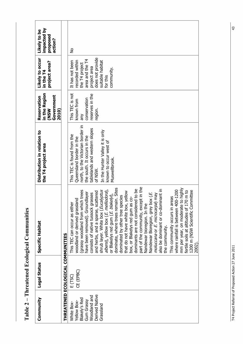
T4 P
roje
ct R
efer
ral o
f Pr
opos
ed A
ctio
n 27
Jun
e 20
11
43
Tab
le 2
– T
hrea
tene
d E
colo
gica
l Com
mun
ities
C
omm
unit
y Le
gal S
tatu
s Sp
ecif
ic H
abit
at
Dis
trib
utio
n in
rel
atio
n to
th
e T4
pro
ject
are
a R
eser
vati
on
in t
he R
egio
n (N
SW
Gov
ernm
ent
2010
)
Like
ly t
o oc
cur
in t
he T
4 pr
ojec
t ar
ea?
Like
ly t
o be
im
pact
ed b
y pr
opos
ed
acti
on?
THR
EATE
NED
EC
OLO
GIC
AL
CO
MM
UN
ITIE
S W
hite
Box
-Ye
llow
Box
-Bl
akel
y's
Red
Gum
Gra
ssy
Woo
dlan
d an
d D
eriv
ed N
ativ
e G
rass
land
E (T
SC)
CE (
EPBC
)
This
TEC
can
occ
ur a
s ei
ther
w
oodl
and
or d
eriv
ed g
rass
land
(g
rass
y w
oodl
and
from
whi
ch t
rees
ha
ve b
een
rem
oved
). G
roun
dlay
er
cons
ists
of
nativ
e tu
ssoc
k gr
asse
s an
d he
rbs,
and
a s
pars
e, s
catt
ered
sh
rub
laye
r. W
hite
box
(Eu
caly
ptus
al
bens
), y
ello
w b
ox (
E. m
ellio
dora
),
or B
lake
lys
red
gum
(E.
bla
kely
i),
dom
inat
e, w
here
tre
es r
emai
n. S
ites
dom
inat
ed b
y ot
her
tree
spe
cies
th
at d
o no
t ha
ve w
hite
box
, yel
low
bo
x, o
r Bl
akel
ys r
ed g
um a
s co
-do
min
ants
are
not
con
side
red
to b
e pa
rt o
f th
e co
mm
unity
, exc
ept
in t
he
Nan
dew
ar b
iore
gion
. In
the
Nan
dew
ar B
iore
gion
, gre
y bo
x (E
. m
oluc
cana
or
E. m
icro
carp
a) m
ay
also
be
dom
inan
t or
co-
dom
inan
t in
th
e co
mm
unity
. Th
is c
omm
unity
occ
urs
in a
reas
w
here
rai
nfal
l is
betw
een
400-
1200
m
m p
er y
ear,
on
mod
erat
e to
hig
hly
fert
ile s
oils
at
altit
udes
of
170
m t
o 12
00 m
(N
SW S
cien
tific
Com
mitt
ee
2002
).
This
TEC
is f
ound
fro
m t
he
Que
ensl
and
bord
er in
the
no
rth,
to
the
Vict
oria
n bo
rder
in
the
sout
h. I
t oc
curs
in t
he
tabl
elan
ds a
nd w
este
rn s
lope
s of
NSW
. In
the
Hun
ter
Valle
y it
is o
nly
know
n to
occ
ur w
est
of
Mus
wel
lbro
ok.
This
TEC
is n
ot
know
n fr
om
any
cons
erva
tion
rese
rves
in t
he
regi
on.
It h
as n
ot b
een
reco
rded
with
in
the
T4 p
roje
ct
area
and
the
T4
proj
ect
area
do
es n
ot p
rovi
de
suita
ble
habi
tat
for
this
co
mm
unity
.
No
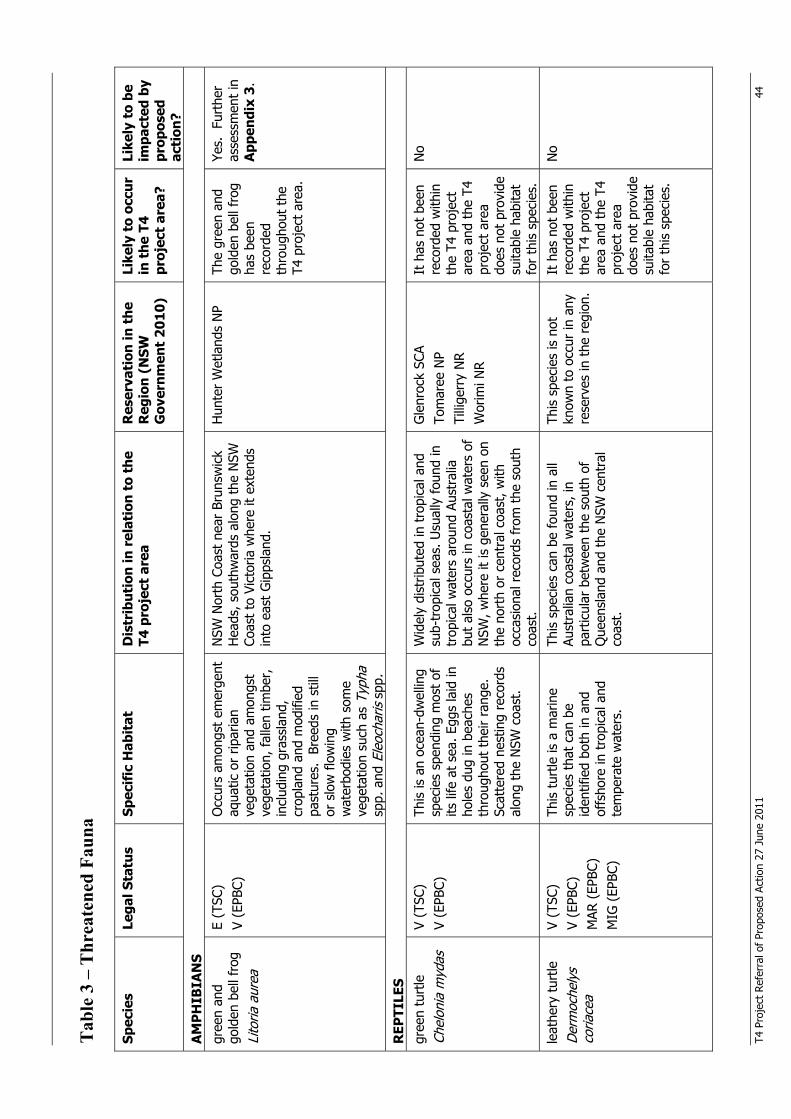
T4 P
roje
ct R
efer
ral o
f Pr
opos
ed A
ctio
n 27
Jun
e 20
11
44
Tab
le 3
– T
hrea
tene
d Fa
una
Sp
ecie
s Le
gal S
tatu
s Sp
ecif
ic H
abit
at
Dis
trib
utio
n in
rel
atio
n to
the
T4
pro
ject
are
a R
eser
vati
on in
the
R
egio
n (N
SW
Gov
ernm
ent
2010
)
Like
ly t
o oc
cur
in t
he T
4 pr
ojec
t ar
ea?
Like
ly t
o be
im
pact
ed b
y pr
opos
ed
acti
on?
AM
PH
IBIA
NS
gree
n an
d go
lden
bel
l fro
g
Lito
ria a
urea
E (T
SC)
V (E
PBC)
O
ccur
s am
ongs
t em
erge
nt
aqua
tic o
r rip
aria
n ve
geta
tion
and
amon
gst
vege
tatio
n, fa
llen
timbe
r,
incl
udin
g gr
assl
and,
cr
opla
nd a
nd m
odifi
ed
past
ures
. Br
eeds
in s
till
or s
low
flo
win
g w
ater
bodi
es w
ith s
ome
vege
tatio
n su
ch a
s Ty
pha
spp.
and
Ele
ocha
ris s
pp.
NSW
Nor
th C
oast
nea
r Br
unsw
ick
Hea
ds, s
outh
war
ds a
long
the
NSW
Co
ast
to V
icto
ria w
here
it e
xten
ds
into
eas
t G
ipps
land
.
Hun
ter
Wet
land
s N
P
The
gree
n an
d go
lden
bel
l fro
g ha
s be
en
reco
rded
th
roug
hout
the
T4
pro
ject
are
a.
Yes.
Fur
ther
as
sess
men
t in
A
ppen
dix
3.
REP
TILE
S gr
een
turt
le
Chel
onia
myd
as
V (T
SC)
V (E
PBC)
This
is a
n oc
ean-
dwel
ling
spec
ies
spen
ding
mos
t of
its
life
at
sea.
Egg
s la
id in
ho
les
dug
in b
each
es
thro
ugho
ut t
heir
rang
e.
Scat
tere
d ne
stin
g re
cord
s al
ong
the
NSW
coa
st.
Wid
ely
dist
ribut
ed in
tro
pica
l and
su
b-tr
opic
al s
eas.
Usu
ally
fou
nd in
tr
opic
al w
ater
s ar
ound
Aus
tral
ia
but
also
occ
urs
in c
oast
al w
ater
s of
N
SW, w
here
it is
gen
eral
ly s
een
on
the
nort
h or
cen
tral
coa
st, w
ith
occa
sion
al r
ecor
ds f
rom
the
sou
th
coas
t.
Gle
nroc
k SC
A To
mar
ee N
P Ti
llige
rry
NR
Wor
imi N
R
It h
as n
ot b
een
reco
rded
with
in
the
T4 p
roje
ct
area
and
the
T4
proj
ect
area
do
es n
ot p
rovi
de
suita
ble
habi
tat
for
this
spe
cies
.
No
leat
hery
tur
tle
Der
moc
hely
s co
riace
a
V (T
SC)
V (E
PBC)
M
AR (
EPBC
) M
IG (
EPBC
)
This
tur
tle is
a m
arin
e sp
ecie
s th
at c
an b
e id
entif
ied
both
in a
nd
offs
hore
in t
ropi
cal a
nd
tem
pera
te w
ater
s.
This
spe
cies
can
be
foun
d in
all
Aust
ralia
n co
asta
l wat
ers,
in
part
icul
ar b
etw
een
the
sout
h of
Q
ueen
slan
d an
d th
e N
SW c
entr
al
coas
t.
This
spe
cies
is n
ot
know
n to
occ
ur in
any
re
serv
es in
the
reg
ion.
It h
as n
ot b
een
reco
rded
with
in
the
T4 p
roje
ct
area
and
the
T4
proj
ect
area
do
es n
ot p
rovi
de
suita
ble
habi
tat
for
this
spe
cies
.
No
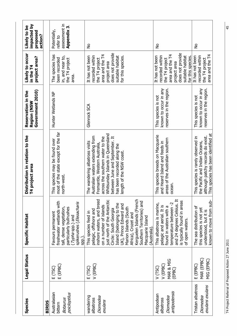
T4 P
roje
ct R
efer
ral o
f Pr
opos
ed A
ctio
n 27
Jun
e 20
11
45
Spec
ies
Lega
l Sta
tus
Spec
ific
Hab
itat
D
istr
ibut
ion
in r
elat
ion
to t
he
T4 p
roje
ct a
rea
Res
erva
tion
in t
he
Reg
ion
(NSW
G
over
nmen
t 20
10)
Like
ly t
o oc
cur
in t
he T
4 pr
ojec
t ar
ea?
Like
ly t
o be
im
pact
ed b
y pr
opos
ed
acti
on?
BIR
DS
Aust
rala
sian
bi
tter
n
Bota
urus
po
icilo
ptilu
s
E (T
SC)
E (E
PBC)
Fa
vour
s pe
rman
ent
fres
hwat
er w
etla
nds
with
ta
ll, d
ense
veg
etat
ion,
pa
rtic
ular
ly b
ullru
shes
(T
ypha
spp
.) a
nd
spik
erus
hes
(Ele
oach
aris
sp
p.).
This
spe
cies
may
be
foun
d ov
er
mos
t of
the
sta
te e
xcep
t fo
r th
e fa
r no
rth-
wes
t.
Hun
ter
Wet
land
s N
P Th
e sp
ecie
s ha
s be
en r
ecor
ded
in, a
nd n
ear
to,
the
T4 p
roje
ct
area
.
Pote
ntia
lly,
refe
r to
as
sess
men
t in
A
ppen
dix
3.
wan
derin
g al
batr
oss
Dio
med
ea
exul
ans
E (T
SC)
V (E
PBC)
Th
is s
peci
es fe
ed in
pe
lagi
c, o
ffsh
ore
and
insh
ore
wat
ers,
and
bre
ed
on a
num
ber
of is
land
s ju
st n
orth
of
the
Anta
rctic
Ci
rcle
: So
uth
Geo
rgia
Is
land
(be
long
ing
to t
he
UK)
, Prin
ce E
dwar
d an
d M
ario
n Is
land
s (S
outh
Af
rica)
, Cro
zet
and
Kerg
uele
n Is
land
s (F
renc
h So
uthe
rn T
errit
orie
s) a
nd
Mac
quar
ie I
slan
d (A
ustr
alia
).
The
wan
derin
g al
batr
oss
visi
ts
Aust
ralia
n w
ater
s ex
tend
ing
from
Fr
eman
tle, W
este
rn A
ustr
alia
, ac
ross
the
sou
ther
n w
ater
to
the
Whi
tsun
day
Isla
nds
in Q
ueen
slan
d be
twee
n Ju
ne a
nd S
epte
mbe
r. I
t ha
s be
en r
ecor
ded
alon
g th
e le
ngth
of
the
NSW
coa
st.
Gle
nroc
k SC
A
It
has
not
bee
n re
cord
ed w
ithin
th
e T4
pro
ject
ar
ea a
nd t
he T
4 pr
ojec
t ar
ea
does
not
pro
vide
su
itabl
e ha
bita
t fo
r th
is s
peci
es.
No
Antip
odea
n al
batr
oss
Dio
med
ea
antip
oden
sis
V (T
SC)
V (E
PBC)
M
AR &
MIG
(E
PBC)
This
alb
atro
ss is
mar
ine,
pe
lagi
c an
d ae
rial.
It is
fo
und
in w
ater
s w
ith a
te
mpe
ratu
re b
etw
een
-2
and
24 d
egre
es C
elsi
us. I
t is
typ
ical
ly f
ound
in a
reas
of
ope
n w
ater
s.
This
spe
cies
bre
eds
on M
acqu
arie
an
d H
eard
Isl
and
and
feed
s in
ar
eas
of t
he A
ustr
alia
n so
uthe
rn
ocea
n.
This
spe
cies
is n
ot
know
n to
occ
ur in
any
re
serv
es in
the
reg
ion.
It h
as n
ot b
een
reco
rded
with
in
the
T4 p
roje
ct
area
and
the
T4
proj
ect
area
do
es n
ot p
rovi
de
suita
ble
habi
tat
for
this
spe
cies
.
No
Tris
tan
alba
tros
s D
iom
edea
ex
ulan
s ex
ulan
s
E (E
PBC)
M
AR (
EPBC
) M
IG (
EPBC
)
The
sea
dist
ribut
ion
of
this
spe
cies
is n
ot y
et
unde
rsto
od, b
ut it
is
know
n to
mov
e fr
om s
ub-
This
spe
cies
is r
arel
y ob
serv
ed in
th
e Pa
cific
and
Ind
ian
Oce
ans,
al
thou
gh p
atch
y re
cord
s do
exi
st.
This
spe
cies
has
bee
n id
entif
ied
at
This
spe
cies
is n
ot
know
n to
occ
ur in
any
re
serv
es in
the
reg
ion.
It h
as n
ot b
een
reco
rded
with
in
the
T4 p
roje
ct
area
and
the
T4
No
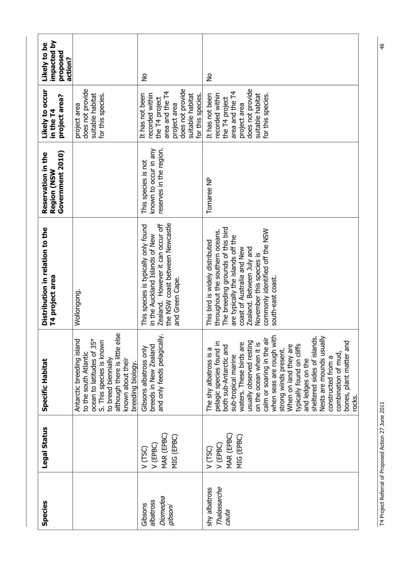
T4 P
roje
ct R
efer
ral o
f Pr
opos
ed A
ctio
n 27
Jun
e 20
11
46
Spec
ies
Lega
l Sta
tus
Spec
ific
Hab
itat
D
istr
ibut
ion
in r
elat
ion
to t
he
T4 p
roje
ct a
rea
Res
erva
tion
in t
he
Reg
ion
(NSW
G
over
nmen
t 20
10)
Like
ly t
o oc
cur
in t
he T
4 pr
ojec
t ar
ea?
Like
ly t
o be
im
pact
ed b
y pr
opos
ed
acti
on?
Anta
rctic
bre
edin
g is
land
to
the
sou
th A
tlant
ic
ocea
n to
latit
udes
of
35°
S. T
his
spec
ies
is k
now
n to
bre
ed b
ienn
ially
al
thou
gh t
here
is li
ttle
els
e kn
own
abou
t th
eir
bree
ding
bio
logy
.
Wol
long
ong.
pr
ojec
t ar
ea
does
not
pro
vide
su
itabl
e ha
bita
t fo
r th
is s
peci
es.
Gib
sons
al
batr
oss
Dio
med
ea
gibs
oni
V (T
SC)
V (E
PBC)
M
AR (
EPBC
) M
IG (
EPBC
)
Gib
sons
alb
atro
ss o
nly
bree
ds in
New
Zea
land
an
d on
ly f
eeds
pel
agic
ally
.
This
spe
cies
is t
ypic
ally
onl
y fo
und
in t
he A
uckl
and
Isla
nds
of N
ew
Zeal
and.
How
ever
it c
an o
ccur
off
th
e N
SW c
oast
bet
wee
n N
ewca
stle
an
d G
reen
Cap
e.
This
spe
cies
is n
ot
know
n to
occ
ur in
any
re
serv
es in
the
reg
ion.
It h
as n
ot b
een
reco
rded
with
in
the
T4 p
roje
ct
area
and
the
T4
proj
ect
area
do
es n
ot p
rovi
de
suita
ble
habi
tat
for
this
spe
cies
.
No
shy
alba
tros
s Th
alas
sarc
he
caut
a
V (T
SC)
V (E
PBC)
M
AR (
EPBC
) M
IG (
EPBC
)
The
shy
alba
tros
s is
a
pela
gic
spec
ies
foun
d in
bo
th s
ub-A
ntar
ctic
and
su
b-tr
opic
al m
arin
e w
ater
s. T
hese
bird
s ar
e us
ually
obs
erve
d re
stin
g on
the
oce
an w
hen
it is
ca
lm o
r so
arin
g in
the
air
whe
n se
as a
re r
ough
with
st
rong
win
ds p
rese
nt.
Whe
n on
land
the
y ar
e ty
pica
lly f
ound
on
cliff
s an
d le
dges
on
the
shel
tere
d si
des
of is
land
s.
Nes
ts a
re m
ound
s us
ually
co
nstr
ucte
d fr
om a
co
mbi
natio
n of
mud
, bo
nes,
pla
nt m
atte
r an
d ro
cks.
This
bird
is w
idel
y di
strib
uted
th
roug
hout
the
sou
ther
n oc
eans
. Th
e br
eedi
ng g
roun
ds o
f th
is b
ird
are
typi
cally
the
isla
nds
off t
he
coas
t of
Aus
tral
ia a
nd N
ew
Zeal
and.
Bet
wee
n Ju
ly a
nd
Nov
embe
r th
is s
peci
es is
co
mm
only
iden
tifie
d of
f th
e N
SW
sout
h-ea
st c
oast
.
Tom
aree
NP
It h
as n
ot b
een
reco
rded
with
in
the
T4 p
roje
ct
area
and
the
T4
proj
ect
area
do
es n
ot p
rovi
de
suita
ble
habi
tat
for
this
spe
cies
.
No
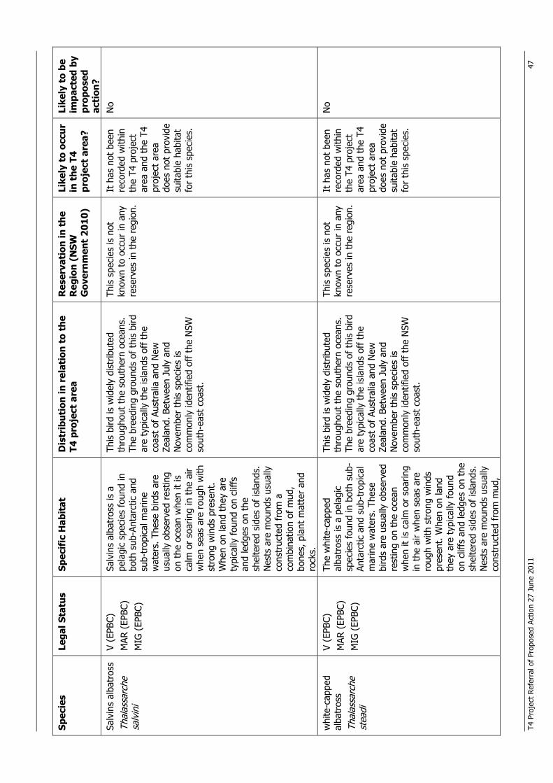
T4 P
roje
ct R
efer
ral o
f Pr
opos
ed A
ctio
n 27
Jun
e 20
11
47
Spec
ies
Lega
l Sta
tus
Spec
ific
Hab
itat
D
istr
ibut
ion
in r
elat
ion
to t
he
T4 p
roje
ct a
rea
Res
erva
tion
in t
he
Reg
ion
(NSW
G
over
nmen
t 20
10)
Like
ly t
o oc
cur
in t
he T
4 pr
ojec
t ar
ea?
Like
ly t
o be
im
pact
ed b
y pr
opos
ed
acti
on?
Salv
ins
alba
tros
s Th
alas
sarc
he
salv
ini
V (E
PBC)
M
AR (
EPBC
) M
IG (
EPBC
)
Salv
ins
alba
tros
s is
a
pela
gic
spec
ies
foun
d in
bo
th s
ub-A
ntar
ctic
and
su
b-tr
opic
al m
arin
e w
ater
s. T
hese
bird
s ar
e us
ually
obs
erve
d re
stin
g on
the
oce
an w
hen
it is
ca
lm o
r so
arin
g in
the
air
whe
n se
as a
re r
ough
with
st
rong
win
ds p
rese
nt.
Whe
n on
land
the
y ar
e ty
pica
lly f
ound
on
cliff
s an
d le
dges
on
the
shel
tere
d si
des
of is
land
s.
Nes
ts a
re m
ound
s us
ually
co
nstr
ucte
d fr
om a
co
mbi
natio
n of
mud
, bo
nes,
pla
nt m
atte
r an
d ro
cks.
This
bird
is w
idel
y di
strib
uted
th
roug
hout
the
sou
ther
n oc
eans
. Th
e br
eedi
ng g
roun
ds o
f th
is b
ird
are
typi
cally
the
isla
nds
off t
he
coas
t of
Aus
tral
ia a
nd N
ew
Zeal
and.
Bet
wee
n Ju
ly a
nd
Nov
embe
r th
is s
peci
es is
co
mm
only
iden
tifie
d of
f th
e N
SW
sout
h-ea
st c
oast
.
This
spe
cies
is n
ot
know
n to
occ
ur in
any
re
serv
es in
the
reg
ion.
It h
as n
ot b
een
reco
rded
with
in
the
T4 p
roje
ct
area
and
the
T4
proj
ect
area
do
es n
ot p
rovi
de
suita
ble
habi
tat
for
this
spe
cies
.
No
whi
te-c
appe
d al
batr
oss
Thal
assa
rche
st
eadi
V (E
PBC)
M
AR (
EPBC
) M
IG (
EPBC
)
The
whi
te-c
appe
d al
batr
oss
is a
pel
agic
sp
ecie
s fo
und
in b
oth
sub-
Anta
rctic
and
sub
-tro
pica
l m
arin
e w
ater
s. T
hese
bi
rds
are
usua
lly o
bser
ved
rest
ing
on t
he o
cean
w
hen
it is
cal
m o
r so
arin
g in
the
air
whe
n se
as a
re
roug
h w
ith s
tron
g w
inds
pr
esen
t. W
hen
on la
nd
they
are
typ
ical
ly f
ound
on
clif
fs a
nd le
dges
on
the
shel
tere
d si
des
of is
land
s.
Nes
ts a
re m
ound
s us
ually
co
nstr
ucte
d fr
om m
ud,
This
bird
is w
idel
y di
strib
uted
th
roug
hout
the
sou
ther
n oc
eans
. Th
e br
eedi
ng g
roun
ds o
f th
is b
ird
are
typi
cally
the
isla
nds
off t
he
coas
t of
Aus
tral
ia a
nd N
ew
Zeal
and.
Bet
wee
n Ju
ly a
nd
Nov
embe
r th
is s
peci
es is
co
mm
only
iden
tifie
d of
f th
e N
SW
sout
h-ea
st c
oast
.
This
spe
cies
is n
ot
know
n to
occ
ur in
any
re
serv
es in
the
reg
ion.
It h
as n
ot b
een
reco
rded
with
in
the
T4 p
roje
ct
area
and
the
T4
proj
ect
area
do
es n
ot p
rovi
de
suita
ble
habi
tat
for
this
spe
cies
.
No
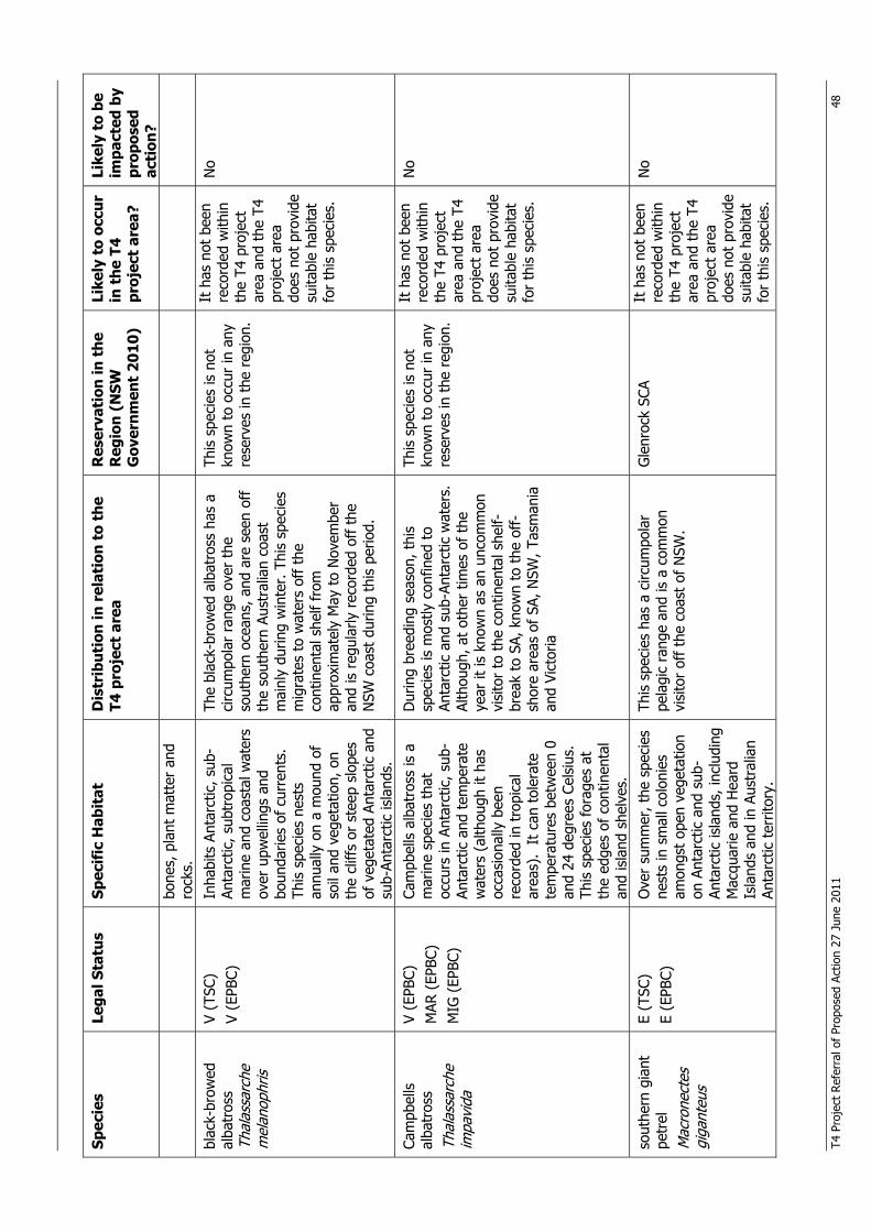
T4 P
roje
ct R
efer
ral o
f Pr
opos
ed A
ctio
n 27
Jun
e 20
11
48
Spec
ies
Lega
l Sta
tus
Spec
ific
Hab
itat
D
istr
ibut
ion
in r
elat
ion
to t
he
T4 p
roje
ct a
rea
Res
erva
tion
in t
he
Reg
ion
(NSW
G
over
nmen
t 20
10)
Like
ly t
o oc
cur
in t
he T
4 pr
ojec
t ar
ea?
Like
ly t
o be
im
pact
ed b
y pr
opos
ed
acti
on?
bone
s, p
lant
mat
ter
and
rock
s.
blac
k-br
owed
al
batr
oss
Thal
assa
rche
m
elan
ophr
is
V (T
SC)
V (E
PBC)
In
habi
ts A
ntar
ctic
, sub
-An
tarc
tic, s
ubtr
opic
al
mar
ine
and
coas
tal w
ater
s ov
er u
pwel
lings
and
bo
unda
ries
of c
urre
nts.
Th
is s
peci
es n
ests
an
nual
ly o
n a
mou
nd o
f so
il an
d ve
geta
tion,
on
the
cliff
s or
ste
ep s
lope
s of
veg
etat
ed A
ntar
ctic
and
su
b-An
tarc
tic is
land
s.
The
blac
k-br
owed
alb
atro
ss h
as a
ci
rcum
pola
r ra
nge
over
the
so
uthe
rn o
cean
s, a
nd a
re s
een
off
the
sout
hern
Aus
tral
ian
coas
t m
ainl
y du
ring
win
ter.
Thi
s sp
ecie
s m
igra
tes
to w
ater
s of
f th
e co
ntin
enta
l she
lf fr
om
appr
oxim
atel
y M
ay t
o N
ovem
ber
and
is r
egul
arly
rec
orde
d of
f th
e N
SW c
oast
dur
ing
this
per
iod.
This
spe
cies
is n
ot
know
n to
occ
ur in
any
re
serv
es in
the
reg
ion.
It h
as n
ot b
een
reco
rded
with
in
the
T4 p
roje
ct
area
and
the
T4
proj
ect
area
do
es n
ot p
rovi
de
suita
ble
habi
tat
for
this
spe
cies
.
No
Cam
pbel
ls
alba
tros
s Th
alas
sarc
he
impa
vida
V (E
PBC)
M
AR (
EPBC
) M
IG (
EPBC
)
Cam
pbel
ls a
lbat
ross
is a
m
arin
e sp
ecie
s th
at
occu
rs in
Ant
arct
ic, s
ub-
Anta
rctic
and
tem
pera
te
wat
ers
(alth
ough
it h
as
occa
sion
ally
bee
n re
cord
ed in
tro
pica
l ar
eas)
. It
can
tol
erat
e te
mpe
ratu
res
betw
een
0 an
d 24
deg
rees
Cel
sius
. Th
is s
peci
es fo
rage
s at
th
e ed
ges
of c
ontin
enta
l an
d is
land
she
lves
.
Dur
ing
bree
ding
sea
son,
thi
s sp
ecie
s is
mos
tly c
onfin
ed t
o An
tarc
tic a
nd s
ub-A
ntar
ctic
wat
ers.
Al
thou
gh, a
t ot
her
times
of
the
year
it is
kno
wn
as a
n un
com
mon
vi
sito
r to
the
con
tinen
tal s
helf-
brea
k to
SA,
kno
wn
to t
he o
ff-
shor
e ar
eas
of S
A, N
SW, T
asm
ania
an
d Vi
ctor
ia
This
spe
cies
is n
ot
know
n to
occ
ur in
any
re
serv
es in
the
reg
ion.
It h
as n
ot b
een
reco
rded
with
in
the
T4 p
roje
ct
area
and
the
T4
proj
ect
area
do
es n
ot p
rovi
de
suita
ble
habi
tat
for
this
spe
cies
.
No
sout
hern
gia
nt
petr
el
Mac
rone
ctes
gi
gant
eus
E (T
SC)
E (E
PBC)
O
ver
sum
mer
, the
spe
cies
ne
sts
in s
mal
l col
onie
s am
ongs
t op
en v
eget
atio
n on
Ant
arct
ic a
nd s
ub-
Anta
rctic
isla
nds,
incl
udin
g M
acqu
arie
and
Hea
rd
Isla
nds
and
in A
ustr
alia
n An
tarc
tic t
errit
ory.
This
spe
cies
has
a c
ircum
pola
r pe
lagi
c ra
nge
and
is a
com
mon
vi
sito
r of
f th
e co
ast
of N
SW.
Gle
nroc
k SC
A It
has
not
bee
n re
cord
ed w
ithin
th
e T4
pro
ject
ar
ea a
nd t
he T
4 pr
ojec
t ar
ea
does
not
pro
vide
su
itabl
e ha
bita
t fo
r th
is s
peci
es.
No
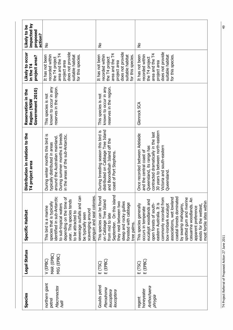
T4 P
roje
ct R
efer
ral o
f Pr
opos
ed A
ctio
n 27
Jun
e 20
11
49
Spec
ies
Lega
l Sta
tus
Spec
ific
Hab
itat
D
istr
ibut
ion
in r
elat
ion
to t
he
T4 p
roje
ct a
rea
Res
erva
tion
in t
he
Reg
ion
(NSW
G
over
nmen
t 20
10)
Like
ly t
o oc
cur
in t
he T
4 pr
ojec
t ar
ea?
Like
ly t
o be
im
pact
ed b
y pr
opos
ed
acti
on?
nort
hern
gia
nt
petr
el
Mac
rone
ctes
ha
lli
V (E
PBC)
M
AR (
EPBC
) M
IG (
EPBC
)
This
bird
is a
mar
ine
spec
ies
that
is t
ypic
ally
id
entif
ied
in s
ub-A
ntar
ctic
to
sub
-tro
pica
l wat
ers
depe
ndin
g on
the
tim
e of
ye
ar. T
his
spec
ies
tend
s to
be
attr
acte
d to
se
wer
age
outf
alls
and
can
be
typ
ical
ly s
een
scav
engi
ng a
roun
d pe
ngui
n an
d se
al c
olon
ies.
Dur
ing
win
ter
mon
ths
this
bird
is
typi
cally
dis
trib
uted
in a
reas
ar
ound
the
Aus
tral
ian
mai
nlan
d.
Dur
ing
sum
mer
mon
ths
it br
eeds
in
the
are
as o
f th
e su
b-An
tarc
tic.
This
spe
cies
is n
ot
know
n to
occ
ur in
any
re
serv
es in
the
reg
ion.
It h
as n
ot b
een
reco
rded
with
in
the
T4 p
roje
ct
area
and
the
T4
proj
ect
area
do
es n
ot p
rovi
de
suita
ble
habi
tat
for
this
spe
cies
.
No
Gou
lds
petr
el
Pter
odro
ma
leuc
opte
ra
leuc
opte
ra
E (T
SC)
E (E
PBC)
Th
is s
peci
es c
an b
e fo
und
on C
abba
ge T
ree
Isla
nd
from
mid
to
late
Se
ptem
ber.
On
this
isla
nd
they
nes
t be
twee
n tw
o st
eep
and
rock
y gu
llies
fo
rest
ed w
ith c
abba
ge
tree
pal
ms.
Dur
ing
bree
ding
sea
son
this
bird
is
dist
ribut
ed o
n Ca
bbag
e Tr
ee I
slan
d an
d Bo
onde
lbah
Isl
and
off t
he
coas
t of
Por
t St
ephe
ns.
This
spe
cies
is n
ot
know
n to
occ
ur in
any
re
serv
es in
the
reg
ion.
It h
as n
ot b
een
reco
rded
with
in
the
T4 p
roje
ct
area
and
the
T4
proj
ect
area
do
es n
ot p
rovi
de
suita
ble
habi
tat
for
this
spe
cies
.
No
rege
nt
hone
yeat
er
Anth
ocha
era
phry
gia
E (T
SC)
E (E
PBC)
Th
is s
peci
es g
ener
ally
oc
curs
in t
empe
rate
eu
caly
pt w
oodl
ands
and
op
en f
ores
ts o
f so
uth-
east
ern
Aust
ralia
. It
is
com
mon
ly r
ecor
ded
from
bo
x-iro
nbar
k eu
caly
pt
asso
ciat
ions
, wet
low
land
co
asta
l for
ests
dom
inat
ed
by s
wam
p m
ahog
any,
sp
otte
d gu
m a
nd r
iver
ine
casu
arin
a w
oodl
ands
. An
appa
rent
pre
fere
nce
exis
ts fo
r th
e w
ette
st,
mos
t fe
rtile
site
s w
ithin
Onc
e re
cord
ed b
etw
een
Adel
aide
an
d th
e ce
ntra
l coa
st o
f Q
ueen
slan
d, it
s ra
nge
has
cont
ract
ed d
ram
atic
ally
in t
he la
st
30 y
ears
to
betw
een
nort
h-ea
ster
n Vi
ctor
ia a
nd s
outh
-eas
tern
Q
ueen
slan
d.
Gle
nroc
k SC
A It
has
not
bee
n re
cord
ed w
ithin
th
e T4
pro
ject
ar
ea a
nd t
he T
4 pr
ojec
t ar
ea
does
not
pro
vide
su
itabl
e ha
bita
t fo
r th
is s
peci
es.
No
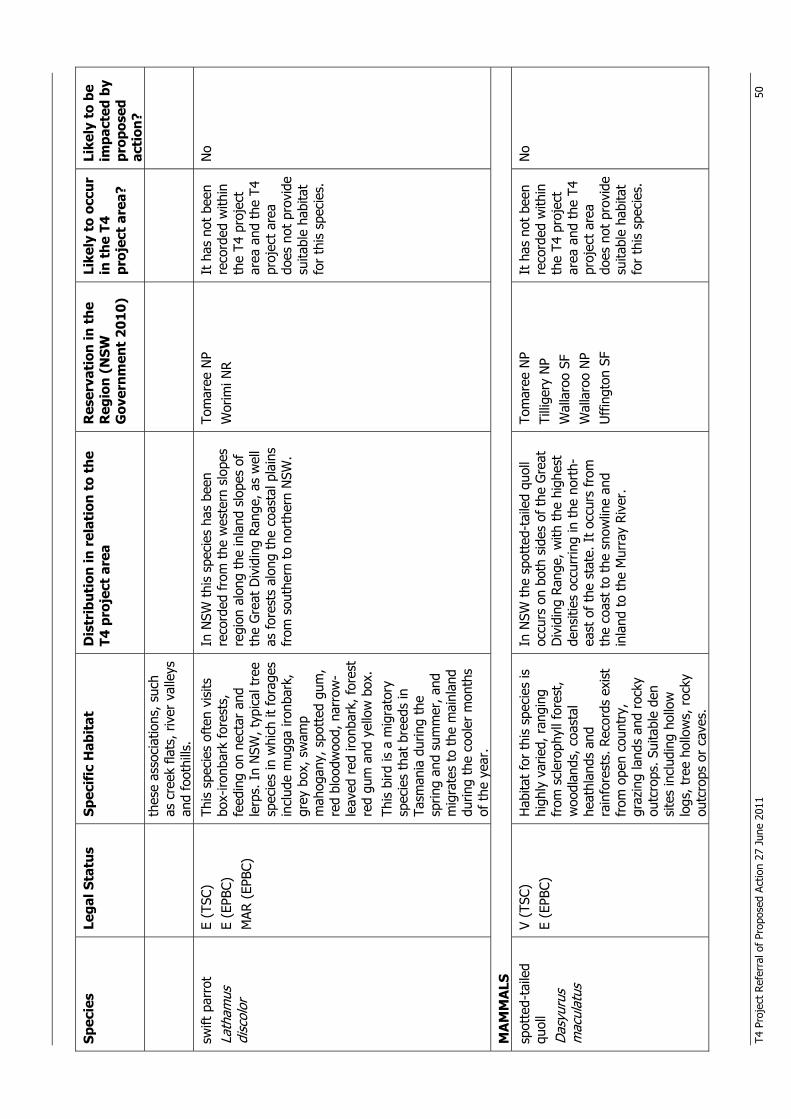
T4 P
roje
ct R
efer
ral o
f Pr
opos
ed A
ctio
n 27
Jun
e 20
11
50
Spec
ies
Lega
l Sta
tus
Spec
ific
Hab
itat
D
istr
ibut
ion
in r
elat
ion
to t
he
T4 p
roje
ct a
rea
Res
erva
tion
in t
he
Reg
ion
(NSW
G
over
nmen
t 20
10)
Like
ly t
o oc
cur
in t
he T
4 pr
ojec
t ar
ea?
Like
ly t
o be
im
pact
ed b
y pr
opos
ed
acti
on?
thes
e as
soci
atio
ns, s
uch
as c
reek
fla
ts, r
iver
val
leys
an
d fo
othi
lls.
swift
par
rot
Lath
amus
di
scol
or
E (T
SC)
E (E
PBC)
M
AR (
EPBC
)
This
spe
cies
oft
en v
isits
bo
x-iro
nbar
k fo
rest
s,
feed
ing
on n
ecta
r an
d le
rps.
In
NSW
, typ
ical
tre
e sp
ecie
s in
whi
ch it
for
ages
in
clud
e m
ugga
iron
bark
, gr
ey b
ox, s
wam
p m
ahog
any,
spo
tted
gum
, re
d bl
oodw
ood,
nar
row
-le
aved
red
iron
bark
, for
est
red
gum
and
yel
low
box
. Th
is b
ird is
a m
igra
tory
sp
ecie
s th
at b
reed
s in
Ta
sman
ia d
urin
g th
e sp
ring
and
sum
mer
, and
m
igra
tes
to t
he m
ainl
and
durin
g th
e co
oler
mon
ths
of t
he y
ear.
In N
SW t
his
spec
ies
has
been
re
cord
ed f
rom
the
wes
tern
slo
pes
regi
on a
long
the
inla
nd s
lope
s of
th
e G
reat
Div
idin
g Ra
nge,
as
wel
l as
fore
sts
alon
g th
e co
asta
l pla
ins
from
sou
ther
n to
nor
ther
n N
SW.
Tom
aree
NP
Wor
imi N
R It
has
not
bee
n re
cord
ed w
ithin
th
e T4
pro
ject
ar
ea a
nd t
he T
4 pr
ojec
t ar
ea
does
not
pro
vide
su
itabl
e ha
bita
t fo
r th
is s
peci
es.
No
MA
MM
ALS
sp
otte
d-ta
iled
quol
l D
asyu
rus
mac
ulat
us
V (T
SC)
E (E
PBC)
H
abita
t fo
r th
is s
peci
es is
hi
ghly
var
ied,
ran
ging
fr
om s
cler
ophy
ll fo
rest
, w
oodl
ands
, coa
stal
he
athl
ands
and
ra
info
rest
s. R
ecor
ds e
xist
fr
om o
pen
coun
try,
gr
azin
g la
nds
and
rock
y ou
tcro
ps. S
uita
ble
den
site
s in
clud
ing
hollo
w
logs
, tre
e ho
llow
s, r
ocky
ou
tcro
ps o
r ca
ves.
In N
SW t
he s
pott
ed-t
aile
d qu
oll
occu
rs o
n bo
th s
ides
of
the
Gre
at
Div
idin
g Ra
nge,
with
the
hig
hest
de
nsiti
es o
ccur
ring
in t
he n
orth
-ea
st o
f th
e st
ate.
It
occu
rs f
rom
th
e co
ast
to t
he s
now
line
and
inla
nd t
o th
e M
urra
y Ri
ver.
Tom
aree
NP
Tilli
gery
NP
Wal
laro
o SF
W
alla
roo
NP
Uff
ingt
on S
F
It h
as n
ot b
een
reco
rded
with
in
the
T4 p
roje
ct
area
and
the
T4
proj
ect
area
do
es n
ot p
rovi
de
suita
ble
habi
tat
for
this
spe
cies
.
No
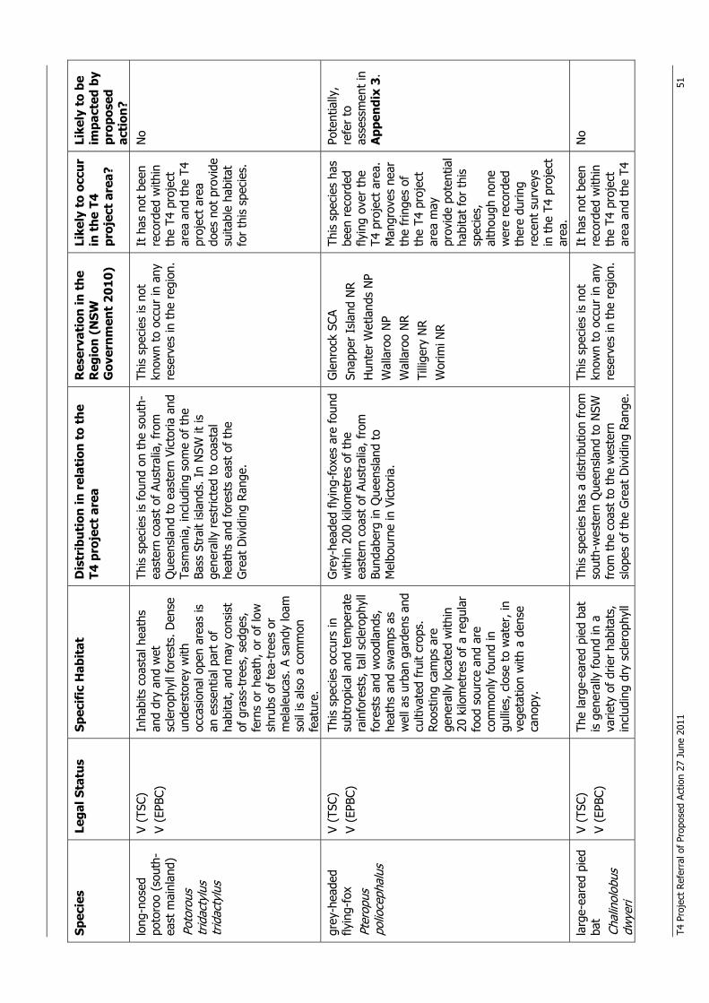
T4 P
roje
ct R
efer
ral o
f Pr
opos
ed A
ctio
n 27
Jun
e 20
11
51
Spec
ies
Lega
l Sta
tus
Spec
ific
Hab
itat
D
istr
ibut
ion
in r
elat
ion
to t
he
T4 p
roje
ct a
rea
Res
erva
tion
in t
he
Reg
ion
(NSW
G
over
nmen
t 20
10)
Like
ly t
o oc
cur
in t
he T
4 pr
ojec
t ar
ea?
Like
ly t
o be
im
pact
ed b
y pr
opos
ed
acti
on?
long
-nos
ed
poto
roo
(sou
th-
east
mai
nlan
d)
Poto
rous
tr
idac
tylu
s tr
idac
tylu
s
V (T
SC)
V (E
PBC)
In
habi
ts c
oast
al h
eath
s an
d dr
y an
d w
et
scle
roph
yll f
ores
ts. D
ense
un
ders
tore
y w
ith
occa
sion
al o
pen
area
s is
an
ess
entia
l par
t of
ha
bita
t, a
nd m
ay c
onsi
st
of g
rass
-tre
es, s
edge
s,
fern
s or
hea
th, o
r of
low
sh
rubs
of
tea-
tree
s or
m
elal
euca
s. A
san
dy lo
am
soil
is a
lso
a co
mm
on
feat
ure.
This
spe
cies
is f
ound
on
the
sout
h-ea
ster
n co
ast
of A
ustr
alia
, fro
m
Que
ensl
and
to e
aste
rn V
icto
ria a
nd
Tasm
ania
, inc
ludi
ng s
ome
of t
he
Bass
Str
ait
isla
nds.
In
NSW
it is
ge
nera
lly r
estr
icte
d to
coa
stal
he
aths
and
fore
sts
east
of
the
Gre
at D
ivid
ing
Rang
e.
This
spe
cies
is n
ot
know
n to
occ
ur in
any
re
serv
es in
the
reg
ion.
It h
as n
ot b
een
reco
rded
with
in
the
T4 p
roje
ct
area
and
the
T4
proj
ect
area
do
es n
ot p
rovi
de
suita
ble
habi
tat
for
this
spe
cies
.
No
grey
-hea
ded
flyin
g-fo
x Pt
erop
us
polio
ceph
alus
V (T
SC)
V (E
PBC)
Th
is s
peci
es o
ccur
s in
su
btro
pica
l and
tem
pera
te
rain
fore
sts,
tal
l scl
erop
hyll
fore
sts
and
woo
dlan
ds,
heat
hs a
nd s
wam
ps a
s w
ell a
s ur
ban
gard
ens
and
culti
vate
d fr
uit
crop
s.
Roos
ting
cam
ps a
re
gene
rally
loca
ted
with
in
20 k
ilom
etre
s of
a r
egul
ar
food
sou
rce
and
are
com
mon
ly fo
und
in
gulli
es, c
lose
to
wat
er, i
n ve
geta
tion
with
a d
ense
ca
nopy
.
Gre
y-he
aded
flyi
ng-f
oxes
are
fou
nd
with
in 2
00 k
ilom
etre
s of
the
ea
ster
n co
ast
of A
ustr
alia
, fro
m
Bund
aber
g in
Que
ensl
and
to
Mel
bour
ne in
Vic
toria
.
Gle
nroc
k SC
A Sn
appe
r Is
land
NR
Hun
ter
Wet
land
s N
P W
alla
roo
NP
Wal
laro
o N
R Ti
llige
ry N
R W
orim
i NR
This
spe
cies
has
be
en r
ecor
ded
flyin
g ov
er t
he
T4 p
roje
ct a
rea.
M
angr
oves
nea
r th
e fr
inge
s of
th
e T4
pro
ject
ar
ea m
ay
prov
ide
pote
ntia
l ha
bita
t fo
r th
is
spec
ies,
al
thou
gh n
one
wer
e re
cord
ed
ther
e du
ring
rece
nt s
urve
ys
in t
he T
4 pr
ojec
t ar
ea.
Pote
ntia
lly,
refe
r to
as
sess
men
t in
A
ppen
dix
3.
larg
e-ea
red
pied
ba
t
Chal
inol
obus
dw
yeri
V (T
SC)
V (E
PBC)
Th
e la
rge-
eare
d pi
ed b
at
is g
ener
ally
foun
d in
a
varie
ty o
f dr
ier
habi
tats
, in
clud
ing
dry
scle
roph
yll
This
spe
cies
has
a d
istr
ibut
ion
from
so
uth-
wes
tern
Que
ensl
and
to N
SW
from
the
coa
st t
o th
e w
este
rn
slop
es o
f th
e G
reat
Div
idin
g Ra
nge.
This
spe
cies
is n
ot
know
n to
occ
ur in
any
re
serv
es in
the
reg
ion.
It h
as n
ot b
een
reco
rded
with
in
the
T4 p
roje
ct
area
and
the
T4
No
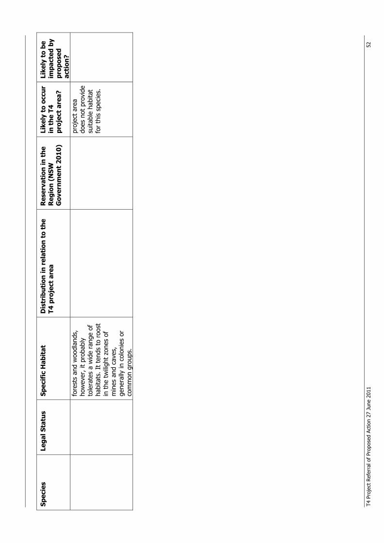
T4 P
roje
ct R
efer
ral o
f Pr
opos
ed A
ctio
n 27
Jun
e 20
11
52
Spec
ies
Lega
l Sta
tus
Spec
ific
Hab
itat
D
istr
ibut
ion
in r
elat
ion
to t
he
T4 p
roje
ct a
rea
Res
erva
tion
in t
he
Reg
ion
(NSW
G
over
nmen
t 20
10)
Like
ly t
o oc
cur
in t
he T
4 pr
ojec
t ar
ea?
Like
ly t
o be
im
pact
ed b
y pr
opos
ed
acti
on?
fore
sts
and
woo
dlan
ds,
how
ever
, it
prob
ably
to
lera
tes
a w
ide
rang
e of
ha
bita
ts. I
t te
nds
to r
oost
in
the
tw
iligh
t zo
nes
of
min
es a
nd c
aves
, ge
nera
lly in
col
onie
s or
co
mm
on g
roup
s.
proj
ect
area
do
es n
ot p
rovi
de
suita
ble
habi
tat
for
this
spe
cies
.
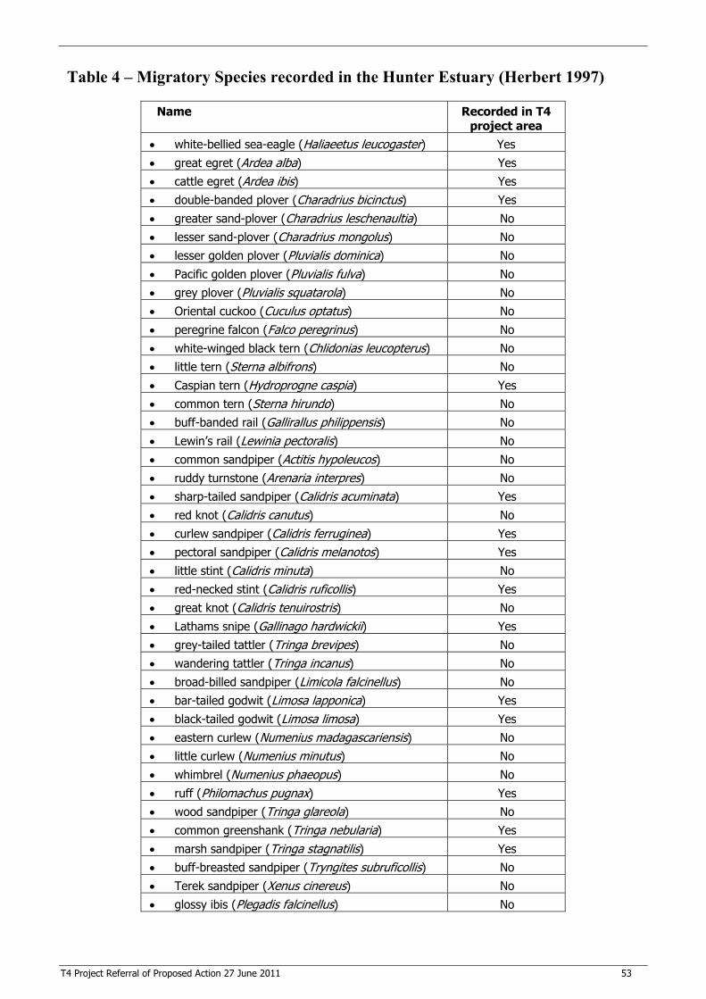
T4 Project Referral of Proposed Action 27 June 2011 53
Table 4 – Migratory Species recorded in the Hunter Estuary (Herbert 1997)
Name Recorded in T4 project area
� white-bellied sea-eagle (Haliaeetus leucogaster) Yes
� great egret (Ardea alba) Yes � cattle egret (Ardea ibis) Yes � double-banded plover (Charadrius bicinctus) Yes
� greater sand-plover (Charadrius leschenaultia) No � lesser sand-plover (Charadrius mongolus) No � lesser golden plover (Pluvialis dominica) No
� Pacific golden plover (Pluvialis fulva) No � grey plover (Pluvialis squatarola) No � Oriental cuckoo (Cuculus optatus) No
� peregrine falcon (Falco peregrinus) No � white-winged black tern (Chlidonias leucopterus) No � little tern (Sterna albifrons) No
� Caspian tern (Hydroprogne caspia) Yes � common tern (Sterna hirundo) No � buff-banded rail (Gallirallus philippensis) No
� Lewin’s rail (Lewinia pectoralis) No � common sandpiper (Actitis hypoleucos) No � ruddy turnstone (Arenaria interpres) No � sharp-tailed sandpiper (Calidris acuminata) Yes
� red knot (Calidris canutus) No � curlew sandpiper (Calidris ferruginea) Yes � pectoral sandpiper (Calidris melanotos) Yes
� little stint (Calidris minuta) No � red-necked stint (Calidris ruficollis) Yes � great knot (Calidris tenuirostris) No
� Lathams snipe (Gallinago hardwickii) Yes � grey-tailed tattler (Tringa brevipes) No � wandering tattler (Tringa incanus) No
� broad-billed sandpiper (Limicola falcinellus) No � bar-tailed godwit (Limosa lapponica) Yes � black-tailed godwit (Limosa limosa) Yes
� eastern curlew (Numenius madagascariensis) No � little curlew (Numenius minutus) No � whimbrel (Numenius phaeopus) No
� ruff (Philomachus pugnax) Yes � wood sandpiper (Tringa glareola) No � common greenshank (Tringa nebularia) Yes
� marsh sandpiper (Tringa stagnatilis) Yes � buff-breasted sandpiper (Tryngites subruficollis) No � Terek sandpiper (Xenus cinereus) No
� glossy ibis (Plegadis falcinellus) No
T4 Project Referral of Proposed Action 27 June 2011 54
Appendix 3 - Assessment of Significance under the Environment Protection and Biodiversity Conservation Act 1999 The Environment Protection and Biodiversity Conservation Act 1999 (EPBC Act) requires the completion of an assessment of significance relating to the potential impacts of a proposed action on listed Matters of National Environmental Significance (MNES). Threatened Ecological Communities No threatened ecological communities (TECs) listed under the EPBC Act occur in the T4 project area. Endangered Species One endangered species listed under the EPBC Act, the Australasian bittern (Botaurus poiciloptilus), has previously been recorded in the vicinity of the T4 project area. Targeted surveys for the T4 Project did not result in any confirmed Australasian bittern sightings. Whilst its current use of the T4 project area is not known, if the Australasian bittern does use the area, it may be impacted by the proposed action and as such has been subject to an assessment of significance. Vulnerable Species Two vulnerable species previously recorded within or flying over the T4 project area, are considered to have the potential to be impacted by the proposed action and as such have been subject to an assessment of significance. These are the green and golden bell frog (Litoria aurea) and grey-headed flying-fox (Pteropus poliocephalus). Migratory Species Forty-two migratory species listed under the EPBC Act have been recorded in the Hunter Estuary. Some of these migratory species have been recorded within the T4 project area. A list of the 42 migratory species recorded within the Hunter Estuary is provided in Table 4 of Appendix 2. The following migratory species have been recorded on, or in proximity to the T4 project area: � bar-tailed godwit (Limosa lapponica); � common greenshank (Tringa nebularia); � curlew sandpiper (Calidris ferruginea); � double-banded plover (Charadrius bicinctus); � Lathams snipe (Gallinago hardwickii); � marsh sandpiper (Tringa stagnatilis); � pectoral sandpiper (Calidris melanotos); � red-necked stint (Calidris ruficollis) � ruff (Philomachus pugnax); and � sharp-tailed sandpiper (Calidris acuminata). Additionally database searches indicate that the following threatened migratory species have been recorded within a broader 10 km radius of the T4 project area: � Antipodean albatross (Diomedea antipodensis); � black-browed albatross (Thalassarche melanophrys); � Campbell’s albatross (Thalassarche impavida); � Tristan albatross (Diomedea dabbenena); � Gibsons albatross (Diomedea gibsoni); � leathery turtle (Dermochelys coriacea); � northern giant petrel (Macronectes halli); � Salvins albatross (Thalassarche salvini); � shy albatross (Diomedea cauta); and
T4 Project Referral of Proposed Action 27 June 2011 55
� white-capped albatross (Thalassarche steadi).
Assessment of Significance under EPBC Act Under the EPBC Act, approval from the Commonwealth Minister for Sustainability, Environment, Water, Population and Communities is required for any action that may have a significant impact on MNES. These matters are:
� World Heritage properties;
� National Heritage places;
� Ramsar wetlands of international importance;
� listed threatened species and ecological communities;
� migratory species protected under international agreements;
� the Commonwealth marine environment; and
� nuclear actions. An assessment of the potential impact of the proposed action on listed threatened species and ecological communities and migratory species protected under international agreements is provided below. The aim of this assessment is to determine whether the proposed action is likely to have a significant impact on MNES, thus requiring approval from the Minister. Critically Endangered and Endangered Ecological Communities
No critically endangered or endangered ecological communities occur within the T4 project area.
An action is likely to have a significant impact on a critically endangered or endangered ecological community if there is a real chance or possibility that it will:
� reduce the extent of an ecological community: Not applicable. No critically endangered or endangered ecological communities occur within the T4 project area.
� fragment or increase fragmentation of an ecological community, for example by clearing vegetation for roads or transmission lines;
Not applicable. No critically endangered or endangered ecological communities occur within the T4 project area.
� adversely affect habitat critical to the survival of an ecological community; Not applicable. No critically endangered or endangered ecological communities occur within the T4 project area.
� modify or destroy abiotic (non-living) factors (such as water, nutrients, or soil) necessary for an ecological community’s survival, including reduction of groundwater levels, or substantial alteration of surface water drainage patterns;
Not applicable. No critically endangered or endangered ecological communities occur within the T4 project area.
� cause a substantial change in the species composition of an occurrence of an ecological community, including causing a decline or loss of functionally important species, for example through regular burning or flora or fauna harvesting;
Not applicable. No critically endangered or endangered ecological communities occur within the T4 project area.
� cause a substantial reduction in the quality or integrity of an occurrence of an ecological community, including, but not limited to:
o assisting invasive species, that are harmful to the listed ecological community, to become established; or
o causing regular mobilisation of fertilisers, herbicides or other chemicals or pollutants into the ecological community which kill or inhibit the growth of species in the ecological community; or
Not applicable. No critically endangered or endangered ecological communities occur within the T4 project area.
T4 Project Referral of Proposed Action 27 June 2011 56
� interfere with the recovery of an ecological community. Not applicable. No critically endangered or endangered ecological communities occur within the T4 project area. Conclusion
No critically endangered or endangered ecological communities listed under the EPBC Act will be impacted by the proposed action. Critically Endangered and Endangered Species
One endangered species listed under the EPBC Act has previously been recorded in the vicinity of the T4 project area (see Figure 4): the Australasian bittern (Botaurus poiciloptilus). It should be noted that recent targeted surveys for the Australasian bittern conducted for the T4 Project resulted in no confirmed sightings within the T4 project area and its current use of the area is not known In this case, a population means:
� a geographically distinct regional population, or collection of local populations; or
� a regional population, or collection of local populations, that occurs within a particular bioregion. It is possible that Australasian bitterns (Botaurus poiciloptilus) recorded historically in the vicinity of the T4 project area form part of a geographically distinct regional population, centred on the freshwater wetlands of the lower Hunter region. The ecological assessment being undertaken as part of the environmental assessment (EA) includes assessments to determine if this is the case. An action is likely to have a significant impact on a critically endangered or endangered species if there is a real chance or possibility that it will:
� lead to a long-term decrease in the size of a population; or Freshwater wetlands in the T4 project area will be impacted by the proposed action. However, there are only a relatively small number of Australasian bittern sightings in and around the T4 project area, with no confirmed sightings during ecological investigations for the T4 Project. The loss of freshwater wetland habitat may affect one or more individuals, however the species is mobile and the proposed action is unlikely to lead to a long-term decrease in the size of the population.
� reduce the area of occupancy of the species; or The loss of freshwater wetland habitat as a result of the proposed action will result in a reduction in the potential area of occupancy of the species.
� fragment an existing population into two or more populations; or The proposed action is unlikely to result in the fragmentation of the population as the species is mobile.
� adversely affect habitat critical to the survival of a species; or The proposed action is unlikely to affect habitat critical to the survival of the species.
� disrupt the breeding cycle of a population; or The proposed action is unlikely to disrupt the breeding cycle of the population.
� modify, destroy, remove, isolate, or decrease the availability or quality of habitat to the extent that the species is likely to decline; or
The proposed action is unlikely to modify, destroy, remove, isolate, or decrease the availability or quality of habitat to the extent that the species is likely to decline.
� result in invasive species that are harmful to a critically endangered or endangered species becoming established in the endangered or critically endangered species’ habitat; or
The proposed action will not result in invasive species that are harmful to a critically endangered or endangered species becoming established in the endangered or critically endangered species’ habitat.
� interfere with the recovery of the species. The proposed action will not interfere with the recovery of the species.
Conclusion
The proposed action is unlikely to result in a significant impact on the Australasian bittern (Botaurus poiciloptilus).
T4 Project Referral of Proposed Action 27 June 2011 57
Vulnerable Species
Two vulnerable species, the green and golden bell frog (Litoria aurea) and the grey-headed flying-fox (Pteropus poliocephalus), have been recorded within the T4 project area, although the grey-headed flying-fox has only been observed flying over it. In this case, an important population is a population that is necessary for a species’ long-term survival and recovery. This may include populations that are: � key source populations either for breeding or dispersal; or � populations that are necessary for maintaining genetic diversity, and/or � populations that are near the limit of the species range. The population of the green and golden bell frog (Litoria aurea) within the T4 project area is recognised as an important population.
The grey-headed flying-fox (Pteropus poliocephalus) has only been observed flying over the T4 project area. There may be potential roosting habitat for the species in the mangroves along the Hunter River, however, the T4 project area is not expected to support an important population of the grey-headed flying-fox. An action has, will have, or is likely to have a significant impact on threatened species if it does, will, or is likely to: � lead to a long-term decrease in the size of an important population of a species; The only relevant important population identified within the T4 project area is the green and golden bell frog (Litoria aurea). The proposed action will remove a portion of known habitat for the green and golden bell frog. This habitat area includes habitat and associated fringing vegetation as well as grassland areas which have lesser importance for the species but still provide a dispersal pathway. Some habitat and dispersal pathways across the T4 project area will be removed. The action may lead to a long-term decrease in the size of an important population of the green and golden bell frog. It should be noted that compared to historic records, recent data suggests that the local population may already be in decline and may continue to decline in the absence of the T4 Project. The action will not lead to a long-term decrease in the size of an important population of the grey-headed flying-fox (Pteropus poliocephalus). � reduce the area of occupancy of an important population, or;
The only relevant important population identified on site is the green and golden bell frog (Litoria aurea). In the absence of mitigation the proposed action will reduce the area of occupancy of an important population of the green and golden bell frog (Litoria aurea). The proposed action will not reduce the area of occupancy of an important population of the grey-headed flying-fox (Pteropus poliocephalus). � fragment an existing important population into two or more populations, or;
The only relevant important population identified on site is the green and golden bell frog (Litoria aurea).
The proposed action is likely to contribute to the fragmentation of an existing population of the green and golden bell frog (Litoria aurea); however recent approved works (eg an approved rail corridor) are likely to have already contributed to the fragmentation of this population to some degree. The species been recorded dispersing across the rail corridor and may utilise an existing underpass to the railway. Notwithstanding this, the proposed action is likely to exacerbate the fragmentation of the population as the species may exist in habitat to the north of the site and in habitat that is being remediated to the south of the T4 project area. There may remain some connectivity across the site after its development, and the engineering design and habitat re-creation is being reassessed to improve connectivity outcomes.
It is therefore likely that increased fragmentation of an important population of the green and golden bell frog (Litoria aurea) may result leading to the fragmentation of an existing population into two or more populations.
T4 Project Referral of Proposed Action 27 June 2011 58
The proposed action will not result in the fragmentation of an important population of the grey-headed flying-fox (Pteropus poliocephalus) into two or more populations. � adversely affect habitat critical to the survival of a species, or;
The proposed action will remove habitat for the green and golden bell frog (Litoria aurea). Whilst there is a large amount of identified potential habitat in the Lower Hunter area, the species is only known to occupy a small portion of this potential habitat. Habitat occupancy by the species is not fully understood. Therefore the habitat on site may be important to the survival of the population in the Lower Hunter and adversely affecting this population may adversely affect the species. The grey-headed flying-fox is not known to exist within the T4 project area based on recent survey effort. The majority of the T4 project area does not constitute habitat for the species as no trees occur in this area. Mangroves in the T4 project area may be considered potential habitat for the grey-headed flying-fox. This area is not critical habitat for the grey-headed flying fox. Consequently, the T4 Project will not adversely affect habitat that is critical to the survival of the grey-headed flying-fox. � disrupt the breeding cycle of an important population, or;
The only relevant important population identified on the T4 project area is the green and golden bell frog (Litoria aurea). The proposed action will reduce the area of known occupied habitat for the important population, as the majority of current habitats in the T4 project area will be removed. This may reduce the population in number. Consequently, the T4 Project is likely to disrupt the breeding cycle of an important population of the green and golden bell frog. The T4 Project will not disrupt the breeding cycle of an important population of the grey-headed flying-fox (Pteropus poliocephalus). � modify, destroy, remove or isolate or decrease the availability or quality of habitat to the
extent that the species is likely to decline, or; The proposed action, without mitigation or offsetting, is likely to modify, destroy, remove or isolate or decrease the availability or quality of habitat to the extent that the green and golden bell frog (Litoria aurea) may continue to decline further. It is worth noting that the local population is already in decline and may continue to decline in the absence of the T4 Project. However mitigation and offsetting will be employed to minimise impacts and seek to ensure that, overall, the green and golden bell frog (Litoria aurea) does not decline as a species. The T4 Project will not modify, destroy, remove or isolate or decrease the availability or quality of habitat to the extent that the grey-headed flying-fox (Pteropus poliocephalus) is likely to decline. � result in invasive species that are harmful to a vulnerable species becoming established in
the vulnerable species’ habitat, or; Green and golden bell frog (Litoria aurea) populations can be impacted by the amphibian chytrid fungus (Batrachochytrium dendrobatidis). However, the proposed action is unlikely to exacerbate the spread of this pathogen particularly in the areas where the green and golden bell frog currently exist. The mosquito fish (Gambusia holbrooki) is an invasive species that has also been associated with the decline of the green and golden bell frog (Litoria aurea). However, the proposed action is unlikely to exacerbate the spread of this species. � interferes substantially with the recovery of the species.
The proposed action will remove existing habitat for an important population of the green and golden bell frogs (Litoria aurea). This may interfere substantially with the recovery of this species. No effect on the recovery of the grey-headed flying-fox (Pteropus poliocephalus) is likely. Conclusion
When assessing the proposed action against significant impact criteria in the DEWHA (now DSEWPC) (2009a) guidelines, it can be concluded that, without mitigation, a significant impact on the green and golden bell frog (Litoria aurea) is likely to occur from the proposed action. This will be offset by a range of measures, including provision of alternative habitats.
T4 Project Referral of Proposed Action 27 June 2011 59
No significant impact is predicted for the grey-headed flying-fox (Pteropus poliocephalus).
Migratory Species
Table 4 in Appendix 2 identifies the 42 migratory species which have been recorded in the Hunter Estuary. In addition, one threatened turtle and nine threatened pelagic bird species identified in Table 3 of Appendix 2 are also listed as migratory. As discussed above, the T4 project area does not provide potential habitat for these species and they will not be impacted by the proposed action. The T4 project area is considered to possibly constitute important habitat for several migratory wader and shorebird species listed in Appendix 2. An action is likely to have a significant impact on a migratory species if there is a real chance or possibility that it will: � substantially modify (including by fragmenting, altering fire regimes, altering nutrient
cycles or altering hydrological cycles), destroy or isolate an area of important habitat for a migratory species;
The DEWHA (now DSEWPC) (2009b) Significant impact guidelines for 36 migratory shorebird species (EPBC Act Policy Statement 3.21) contains a flow diagram (Figure 2) for assessing if a site is important habitat. This diagram was used to determine the status of the T4 project area. It was found that as Deep Pond has been recorded to exceed the threshold of 0.1% of the Australian population of a single migratory shorebird (600 sharp-tailed sandpiper (Calidris acuminate) have been recorded there - Herbert 2007), it is considered important habitat for migratory shorebirds. The proposed action will remove important habitat for migratory waders and shorebirds due to the removal of Deep Pond. � result in an invasive species that is harmful to the migratory species becoming
established in an area of important habitat for the migratory species; or The proposed action is unlikely to introduce any invasive species harmful to the identified migratory species. Additionally, the works are very unlikely to result in any habitat modification that will favour an invasive species that would impact on migratory species. � seriously disrupt the lifecycle (breeding, feeding, migration or resting behaviour) of an
ecologically significant proportion of the population of a migratory species. The proposed action will remove important habitat for migratory waders. Deep Pond is regarded as a foraging and roosting site for a large number of shorebirds and waterfowl, including migratory waders. The proposed action is therefore likely to disrupt the lifecycle of an ecologically significant proportion of a population of a migratory species. This would particularly apply to sharp-tailed sandpipers (Calidris acuminata) because of the large numbers recorded at the site.
The Hunter Estuary Wetlands Ramsar site constitutes important habitat for migratory species. Deep Pond, although not part of the RAMSAR listed wetlands, can support shorebirds when tides are high and therefore some species which use the RAMSAR wetlands can also use Deep Pond. A number of the 42 migratory species listed in the EPBC Act are shorebirds and Appendix 2 identifies the following as potentially impacted by the proposed action:
� black-tailed godwit (Limosa limosa); � broad-billed sandpiper (Limicola falcinellus); � greater sand plover (Charadrius leschenaultia); � lesser sand plover (Charadrius mongolus); � great knot (Calidris tenuirostris); and � Terek sandpiper (Xenus cinereus). An ecologically significant proportion is: � listed migratory species cover a broad range of species with different life cycles and
population sizes. Therefore, what is an ‘ecologically significant proportion’ of the population varies with the species (each circumstance will need to be evaluated). Some factors that should be considered include the species’ population status, genetic distinctiveness and species specific behavioural patterns (for example, site fidelity and dispersal rates).
Deep Pond is considered likely to support an ecologically significant proportion of migratory species.
T4 Project Referral of Proposed Action 27 June 2011 60
The population of a migratory species: � means the entire population or any geographically separate part of the population of any
species or lower taxon of wild animals, a significant proportion of whose members cyclically and predictably cross one or more national jurisdictional boundaries including Australia.
The migratory species utilising the T4 project area would not constitute a whole or distinct sub-population of these species. Conclusion
The action could potentially impact upon a number of migratory species, in particular migratory wader species that have been recorded in the T4 project area and utilise habitat associated with Deep Pond. This potentially includes the: � bar-tailed godwit (Limosa lapponica); � common greenshank (Tringa nebularia); � curlew sandpiper (Calidris ferruginea); � double-banded plover (Charadrius bicinctus); � Lathams snipe (Gallinago hardwickii); � marsh sandpiper (Tringa stagnatilis); � pectoral sandpiper (Calidris melanotos); � red-necked stint (Calidris ruficollis) � ruff (Philomachus pugnax); and � sharp-tailed sandpiper (Calidris acuminata). However, based on current records, only the sharp-tailed sandpiper exceeds the 0.1% threshold of a flyway population that triggers the site being recognised important habitat for migratory species. This assumes that the development site acts as an “entire (discrete) area of contiguous habitat” (EPBC Act Policy Statement 3.21, DEWHA (now DSEWPC) 2009b). Deep Pond is a discrete water body bounded by development.
T4 Project Referral of Proposed Action 27 June 2011 61
Appendix 4 – PWCS Environmental Policy
Environmental Policy
Uncontrolled if printed PWCS Environmental Management System
Review No.: R2 Version No.: V2 Review Date: Nov 2009 Review Due: Nov 2011 Document ID: PWCS_UCM_P278110-2 Authorised: Graham Davidson
Port Waratah Coal Services will perform its activities in a manner which prevents pollution, promotes
sustainability and minimises impacts on the environment and local community. PWCS expects
everyone - employees and contract organisations, to act environmentally responsibly in performing
their work.
Port Waratah Coal Services is specifically committed to the following
• Providing information and resources to all employees and contract organisations to ensure
that they:
o Understand the environmental risks of their tasks;
o Understand their responsibilities and accountabilities;
o Have the knowledge and skills to perform their work with respect to the environment;
o Have the knowledge and skills to report and respond responsibly to environmental
incidents and emergencies; and
o Have the resources, training and documentation to perform their work in accordance
with this Policy, the Environmental Management System and associated programs
and procedures.
• Establishing and implementing effective communication regarding the environment with
employees, contract organisations, regulatory authorities, stakeholders and the community.
• Identifying and analysing environmental risks and implementing control measures to mitigate
against these.
• Implementing, maintaining and continually improving an Environmental Management System
and related programs that are compliant with certification requirements of AS/NZS ISO 14001.
• Establishing and implementing Environmental Objectives and Targets and related
Environmental Improvement Programs that drive continual improvement in environmental
performance.
• Developing and implementing programs to continually improve environmental performance in
relation to issues such as greenhouse gas emissions (in accordance with the PWCS’
Greenhouse Gas and Energy Policy), waste, noise, air and water.
• Producing systems to monitor PWCS’ environmental performance and regularly report this
information in sustainability and environmental reports.
• Managing its operations in compliance with all applicable laws, regulations and statutory
requirements relating to the environment.
To protect the environment, all employees
and contract organisations working at Port
Waratah Coal Services facilities are required
to undertake their duties and meet their
accountabilities in accordance with this
Policy and the Environmental Management
System.
Graham Davidson
General Manager
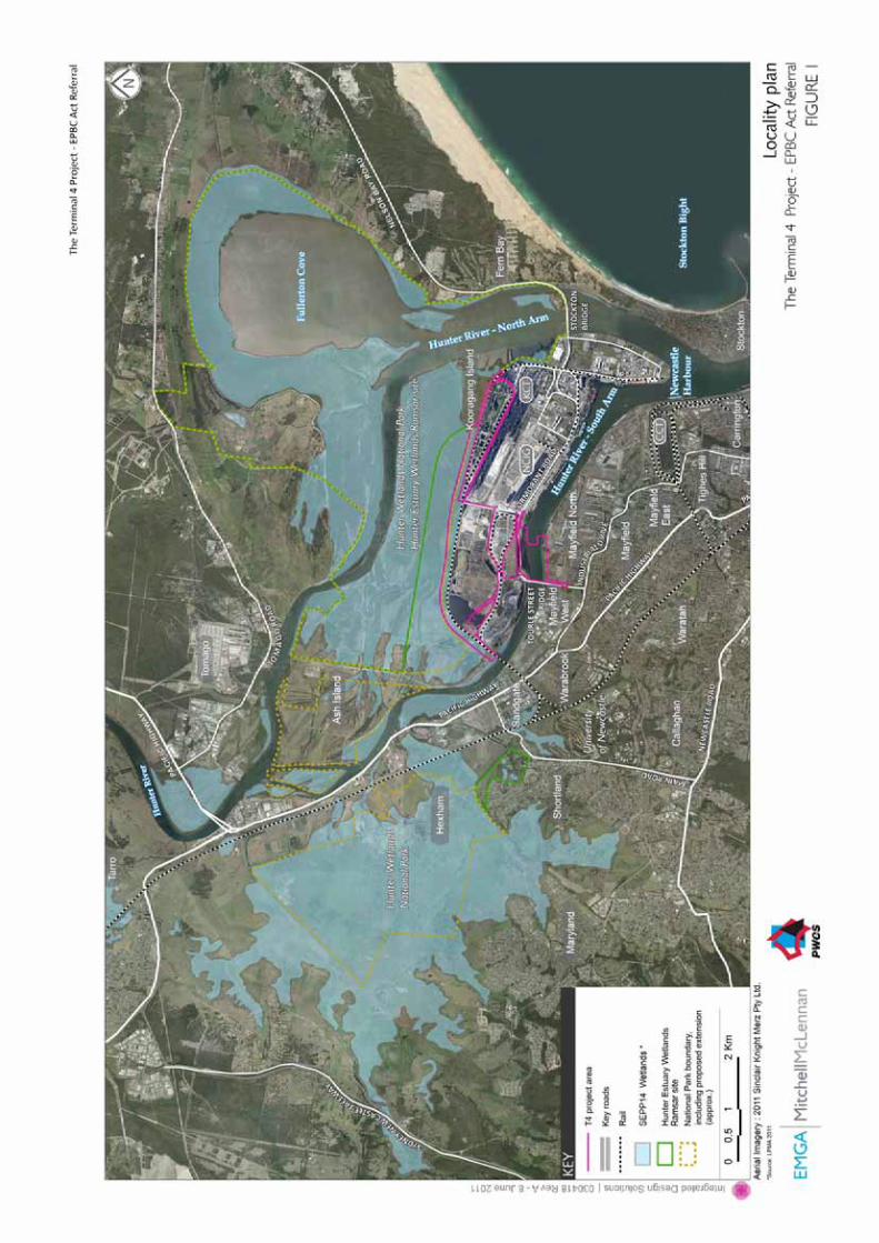
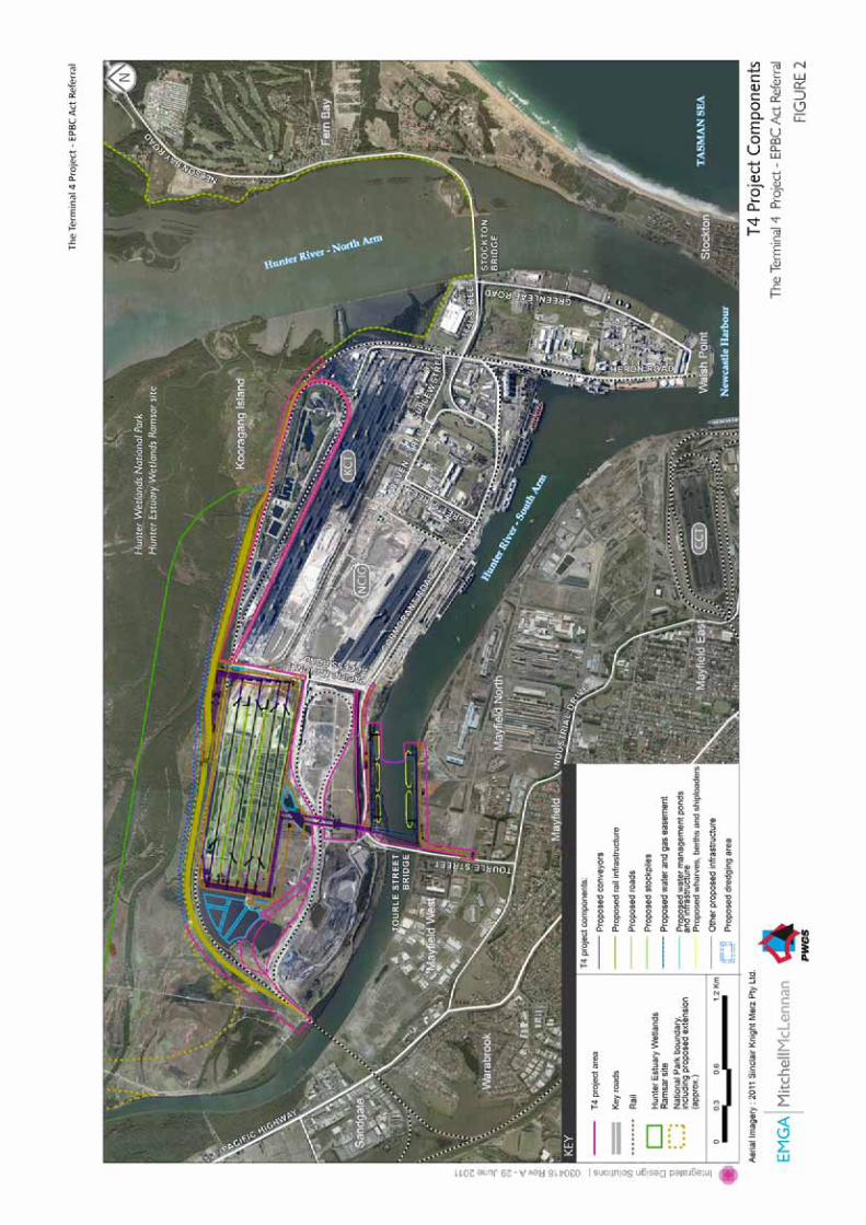
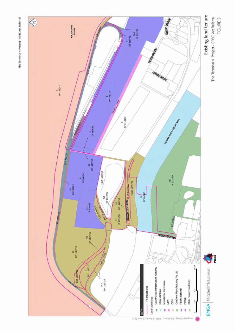

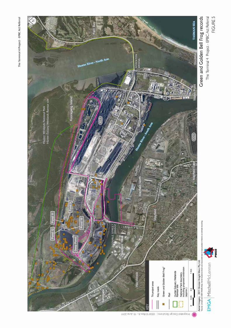
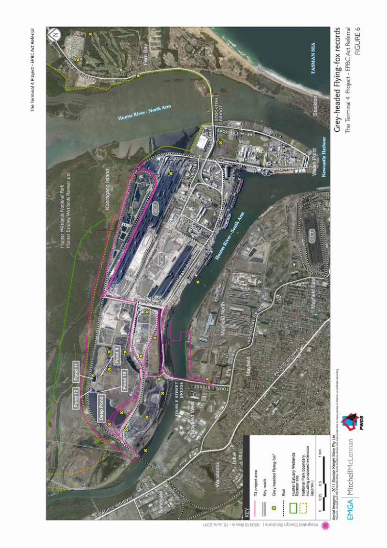
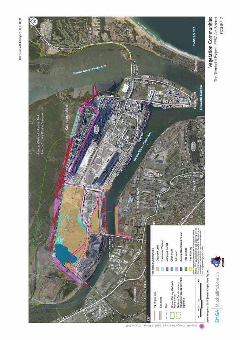
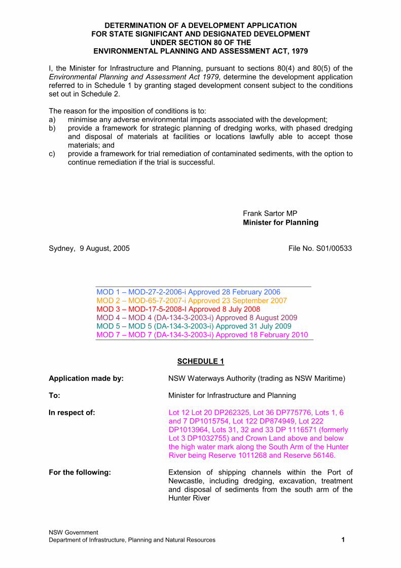
NSW Government Department of Infrastructure, Planning and Natural Resources 1
DETERMINATION OF A DEVELOPMENT APPLICATION FOR STATE SIGNIFICANT AND DESIGNATED DEVELOPMENT
UNDER SECTION 80 OF THE ENVIRONMENTAL PLANNING AND ASSESSMENT ACT, 1979
I, the Minister for Infrastructure and Planning, pursuant to sections 80(4) and 80(5) of the Environmental Planning and Assessment Act 1979, determine the development application referred to in Schedule 1 by granting staged development consent subject to the conditions set out in Schedule 2.
The reason for the imposition of conditions is to: a) minimise any adverse environmental impacts associated with the development; b) provide a framework for strategic planning of dredging works, with phased dredging
and disposal of materials at facilities or locations lawfully able to accept those materials; and
c) provide a framework for trial remediation of contaminated sediments, with the option to continue remediation if the trial is successful.
Frank Sartor MP Minister for Planning
Sydney, 9 August, 2005 File No. S01/00533
MOD 1 – MOD-27-2-2006-i Approved 28 February 2006 MOD 2 – MOD-65-7-2007-i Approved 23 September 2007 MOD 3 – MOD-17-5-2008-I Approved 8 July 2008 MOD 4 – MOD 4 (DA-134-3-2003-i) Approved 8 August 2009 MOD 5 – MOD 5 (DA-134-3-2003-i) Approved 31 July 2009 MOD 7 – MOD 7 (DA-134-3-2003-i) Approved 18 February 2010
SCHEDULE 1
Application made by: NSW Waterways Authority (trading as NSW Maritime)
To: Minister for Infrastructure and Planning
In respect of: Lot 12 Lot 20 DP262325, Lot 36 DP775776, Lots 1, 6 and 7 DP1015754, Lot 122 DP874949, Lot 222 DP1013964, Lots 31, 32 and 33 DP 1116571 (formerly Lot 3 DP1032755) and Crown Land above and below the high water mark along the South Arm of the Hunter River being Reserve 1011268 and Reserve 56146.
For the following: Extension of shipping channels within the Port of Newcastle, including dredging, excavation, treatment and disposal of sediments from the south arm of the Hunter River
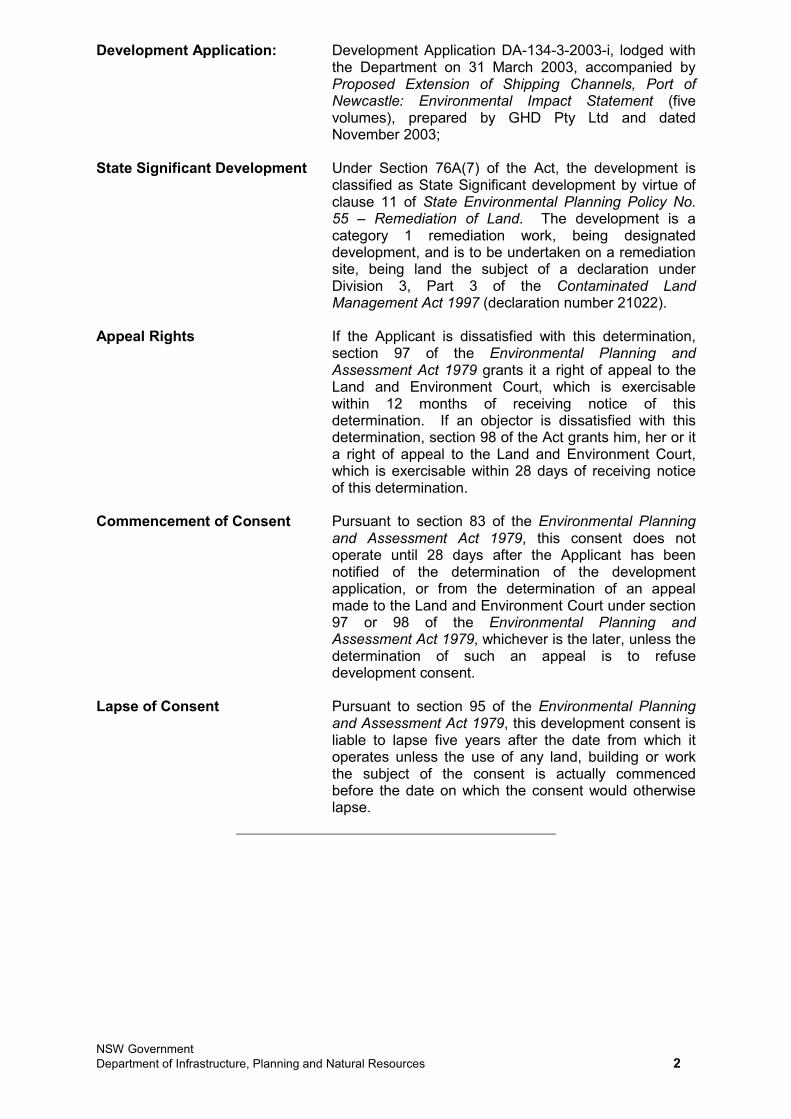
NSW Government Department of Infrastructure, Planning and Natural Resources 2
Development Application: Development Application DA-134-3-2003-i, lodged with the Department on 31 March 2003, accompanied by Proposed Extension of Shipping Channels, Port of Newcastle: Environmental Impact Statement (five volumes), prepared by GHD Pty Ltd and dated November 2003;
State Significant Development Under Section 76A(7) of the Act, the development is classified as State Significant development by virtue of clause 11 of State Environmental Planning Policy No. 55 – Remediation of Land. The development is a category 1 remediation work, being designated development, and is to be undertaken on a remediation site, being land the subject of a declaration under Division 3, Part 3 of the Contaminated Land Management Act 1997 (declaration number 21022).
Appeal Rights If the Applicant is dissatisfied with this determination, section 97 of the Environmental Planning and Assessment Act 1979 grants it a right of appeal to the Land and Environment Court, which is exercisable within 12 months of receiving notice of this determination. If an objector is dissatisfied with this determination, section 98 of the Act grants him, her or it a right of appeal to the Land and Environment Court, which is exercisable within 28 days of receiving notice of this determination.
Commencement of Consent Pursuant to section 83 of the Environmental Planning and Assessment Act 1979, this consent does not operate until 28 days after the Applicant has been notified of the determination of the development application, or from the determination of an appeal made to the Land and Environment Court under section 97 or 98 of the Environmental Planning and Assessment Act 1979, whichever is the later, unless the determination of such an appeal is to refuse development consent.
Lapse of Consent Pursuant to section 95 of the Environmental Planning and Assessment Act 1979, this development consent is liable to lapse five years after the date from which it operates unless the use of any land, building or work the subject of the consent is actually commenced before the date on which the consent would otherwise lapse.
NSW Government Department of Infrastructure, Planning and Natural Resources 3
KEY TO CONDITIONS
A1. GENERAL 5Scope of Development 5Statutory Requirements 6
A2. STAGING AND TIMING OF WORKS 6Staging of Development 6Application of Consent to Development Stages 7Timing of Development Stages 7
A3. COMMUNITY INFORMATION, CONSULTATION AND INVOLVEMENT 7Complaints Procedure 7
B1. DREDGING GENERAL REQUIREMENTS 10Application of Sub-Schedule 10Strategic Planning of Dredging Works 10Compliance Certification 11
B2. DREDGING ENVIRONMENTAL PERFORMANCE 11Contaminated Material Dredging Requirements 11Air Quality Impacts 13Soil and Water Quality Impacts 14Traffic, Transport and Infrastructure Impacts 16Noise and Vibration Impacts 17Impacts on Flora and Fauna 19Hazards and Risk Impacts 19Waste Generation and Management 19Socio-Economic Impacts 20
B3. DREDGING ENVIRONMENTAL MONITORING AND AUDITING 20Water Quality Monitoring 20Odour Monitoring Program 21Groundwater Monitoring Program 21Ecosystem Monitoring Program 21
B4. DREDGING ENVIRONMENTAL MANAGEMENT AND REPORTING 22Incident Reporting 22Environmental Representative 22Environmental Training 22Dredging Environmental Management Plan 23
C1. REMEDIATION GENERAL REQUIREMENTS 25Application of Sub-Schedule 25Scope of Remediation Works 25Compliance Certification 26
C2. REMEDIATION ENVIRONMENTAL PERFORMANCE 27Air Quality Impacts 27Soil and Water Quality Impacts 27Noise Impacts 28Traffic and Transport Impacts 29Waste Generation and Management 30Hazards and Risk Impacts 30
C3. REMEDIATION ENVIRONMENTAL MONITORING AND AUDITING 30Monitoring of Plant and Equipment 30Treated Materials Monitoring Program 30Odour Monitoring Program 31
C4. REMEDIATION ENVIRONMENTAL MANAGEMENT AND REPORTING 31Incident Reporting 31Environmental Representative 31Environmental Training 31Remediation Environmental Management Plan 32Application of Sub-Schedule 34Compliance Certification 34
NSW Government Department of Infrastructure, Planning and Natural Resources 4
D1. REMEDIATION GENERAL REQUIREMENTS 33 Application of Sub-Schedule 33 Complaince Certification 33
D2. REMEDIATION DESIGN REQUIREMENTS 34 D3. REMEDIATION ENVIRONMENTAL PERFORMANCE 35
Air Quality Impacts 35Soil and Water Quality Impacts 36Noise Impacts 36Ecological Impacts 37Traffic and Transport Impacts 38Waste Generation and Management 38Hazards and Risk 39Property Impacts 39Visual Amenity Impacts 39
D4. REMEDIATION ENVIRONMENTAL MONITORING AND AUDITING 39Groundwater Monitoring 39Environmental Monitoring and Cell Maintenance Program 39Construction Quality Assurance 40
D5. REMEDIATION ENVIRONMENTAL MANAGEMENT AND REPORTING 40Incident Reporting 40Environmental Representative 41Remediation Environmental Management Plan 41
SCHEDULE 2
In this consent, except in so far as the context or subject-matter otherwise indicates or requires, the following terms have the meanings indicated: Act Environmental Planning and Assessment Act 1979Applicant NSW Maritime Authority DECC NSW Department of Environment and Climate
Change Department NSW Department of Planning development the development to which this consent applies Director-General Director-General of the NSW Department of
Planning, or nominee DPI NSW Department of Primary Industries dust any solid material that may become suspended in air EPA NSW Environment Protection Authority, as part of
the NSW Department of Environment and Climate Change
EPL Environment Protection Licence issued under the Protection of the Environment Operations Act 1997
Minister Minister for Planning, or nominee publicly available available for inspection by a member of the general
public (for example available on an internet site or at a display centre).
site the land to which this consent applies, including both dry-land and wet-land components of the site
NSW Government Department of Infrastructure, Planning and Natural Resources 5
SUBSCHEDULE ASCOPE OF DEVELOPMENT WORKS AND GENERAL PROVISIONS
A1. GENERAL Scope of Development A1.1 The development shall be carried out generally in accordance with:
a) Development Application DA-134-3-2003-i, lodged with the Department on 31 March 2003;
b) Proposed Extension of Shipping Channels, Port of Newcastle: Environmental Impact Statement (five volumes), prepared by GHD Pty Ltd and dated November 2003;
c) Proposed Extension of Shipping Channels, Port of Newcastle: Environmental Impact Statement – Supplementary Report, prepared by GHD Pty Ltd and dated November 2004;
d) modification application MOD-27-2-2006-i, relating to the extension of trial remediation works;
e) modification application MOD-65-7-2007-i, relating to staging of ecological and water quality monitoring, accompanied by correspondence for the Newcastle Coal Infrastructure Group Pty Ltd to the Department, dated 1 May 2007;
f) modification application MOD-17-5-2008-i, relating to an Optimisation Study, accompanied by: i) Supplementary Report to Accompany BHP Billiton’s Application to
Modify DA-134-3-2003-i: Optimisation Study for the Hunter River Remediation Project, prepared by CH2M HILL Australia Pty Ltd and dated March 2008; and
ii) additional information provided by email dated 17 June 2008, relating generally to odour issues, complaints handling and site layout;
g) modification application DA-134-3-2003-i MOD 5, relating to the installation of a permanent onshore sheet pile wall and accompanied by: i) Statement of Environmental Effects for Onshore Sheet Pile Wall,
prepared by ENSR Australia Pty Ltd and dated 28 May 2009; and ii) additional information provided by email dated 1 July 2009, relating
generally to contamination, water quality, excavated material and waste issues;
h) modification application DA-134-3-2003-i MOD 4, relating to progression to Stage 2 of the development and accompanied by Environmental Assessment: BHP Billiton’s Hunter River Remediation Project: Application for Approval to Proceed to Stage 2 (two volumes), prepared by ENSR Australia Pty Ltd and dated 19 December 2008; and
i) the conditions of this consent.
A1.2 In the event of an inconsistency between: a) the conditions of this consent and any document listed from condition A1.1a)
to A1.1h) inclusive, the conditions of this consent shall prevail to the extent of the inconsistency; and
b) any document listed from condition A1.1a) to A1.1h) inclusive, and any other document listed from condition A1.1a) to A1.1h) inclusive, the most recent document shall prevail to the extent of the inconsistency.
A1.3 To avoid any doubt, this consent permits dredging and excavation works as generally described in Proposed Extension of Shipping Channels, Port of Newcastle: Environmental Impact Statement (five volumes), prepared by GHD Pty Ltd and dated November 2003, including channel dredging, all berth boxes and swing basin components.
NSW Government Department of Infrastructure, Planning and Natural Resources 6
Statutory Requirements A1.4 All licences, permits and approvals shall be obtained and maintained as required
throughout each phase of the development. No condition of this consent removes the obligation to obtain, renew or comply with such licences, permits or approvals.
A2. STAGING AND TIMING OF WORKS Staging of Development A2.1 Pursuant to sections 80(4) and 80(5) of the Environmental Planning and Assessment
Act 1979, the development shall be undertaken in stages, as follows: a) Stage 1A comprising all dredging works of clean and contaminated materials,
and transfer of those materials off-site for treatment and/or disposal; b) Stage 1B comprising all works associated with the remediation of up to
6500m3 of contaminated material from Stage 1A, including handling and transfer of treated materials off-site for further treatment and/ or disposal; and
c) Stage 2 comprising all works associated with remediation of contaminated materials from Stage 1A not the subject of Stage 1B works.
A2.1A To avoid any doubt, the Optimisation Study as defined in the document referred to under condition A1.1f) of this consent forms part of Stage 1B of the development.
A2.1B The Optimisation Study referred to in the document under condition A1.1f) of this consent may include trials, testing, optimisation and related activities for cement stabilisation and/ or bioremediation methods, subject to such works and activities meeting the requirements of this consent. Details of all such works and activities shall be provided as part of the Optimisation Study Program required under condition C1.3A.
A2.2 Stage 2 works shall be subject to further approval, as follows: a) where Stage 1B works are successful in achieving the remediation outcomes
specified under this consent, the Minister’s approval may be sought to continue Stage 1B works as Stage 2, without the need for a new modification or development application under the Environmental Planning and Assessment Act 1979;
b) where Stage 1B works are successful in achieving the remediation outcomes specified under this consent, but require minor modification(s) prior to implementation as Stage 2, the Minister’s approval may be sought to continue Stage 1B works as Stage 2 concurrently with lodgement of a modification application under the Environmental Planning and Assessment Act 1979 for the Minister’s determination; or
c) where Stage 1B works are unsuccessful in achieving remediation outcomes specified under this consent, or require substantial changes before implementation as Stage 2, a new development application under the Environmental Planning and Assessment Act 1979 shall be lodged for the Minister’s determination.
A2.3 In seeking the Minister’s approval to continue Stage 1B works as Stage 2 under condition A2.2a) of this consent, the following matters must be demonstrated to the Minister’s satisfaction: a) all conditions of this consent applicable to remediation works have been
complied with and will continue to be complied with during Stage 2; b) the Stage 1B works can be applied without change to the achievement of
remediation outcomes during Stage 2, including demonstration that the remediation works will not require expansion beyond the physical footprint of the Stage 1B works;
c) all mitigation, management and monitoring measures applied to the Stage 1B works have been updated to reflect application to Stage 2;
NSW Government Department of Infrastructure, Planning and Natural Resources 7
d) the DEC has been consulted in relation to continuation of Stage 1B works as Stage 2, and that the DEC is satisfied with the application of Stage 1B works to Stage 2.
A2.4 In seeking the Minister’s approval to continue Stage 1B works, with minor modification(s) as Stage 2 under condition A2.2b) of this consent, the following matters must be demonstrated to the Minister’s satisfaction:
a) how the Stage 1B works and relevant conditions of this consent are to be modified to achieve acceptable remediation outcomes during modified application to Stage 2;
b) the modified Stage 1B works can be applied to the achievement of remediation outcomes during Stage 2, including demonstration that the modified remediation works will not require expansion beyond the physical footprint of the Stage 1B works; and
c) the DEC has been consulted in relation to continuation of modified Stage 1B works as Stage 2, and that the DEC is satisfied with the application of modified Stage 1B works to Stage 2.
A2.5 If, under condition A2.2c), a development application is lodged with and approved by the Minister for a substantial modification in remediation approach between Stage 1B and Stage 2, sub-schedule C of this consent shall cease to operate and this consent shall cease to permit any remediation works from the date of operation of the new development consent granted Minister.
Note: to avoid any doubt, this development consent in itself does not authorise the application of thermal desorption technology for the remediation of contaminated sediments. Should thermal desorption be proposed as the preferred remediation approach for Stage 2, separate development consent would be required.
Application of Consent to Development Stages A2.6 Stage 1A of the development shall be undertaken in accordance with the conditions
specified in Sub-Schedule A (general conditions) and Sub-Schedule B (dredging-specific conditions) of this consent.
A2.7 Stage 1B of the development shall be undertaken in accordance with the conditions specified in Sub-Schedule A (general conditions) and Sub-Schedule C (remediation-specific conditions) of this consent.
A2.8 Stage 2 of the development shall be undertaken in accordance with the conditions specified in Sub-Schedule A (general conditions) and Sub-Schedule D (full-scale remediation conditions) of this consent.
Timing of Development Stages A2.9 Subject to compliance with the relevant conditions of this consent applicable prior to
the commencement of Stage 1A and Stage 1B respectively, Stage 1A and Stage 1B may commence from the date of operation of this consent.
A2.10 Stage 2 shall not commence until the relevant approval from the Minister is obtained under condition A2.2, and that approval commences to operate.
A3. COMMUNITY INFORMATION, CONSULTATION AND INVOLVEMENT A3.1 Subject to confidentiality, all documents required under this consent shall be made
available for public inspection on request.
Complaints Procedure A3.2 Prior to the commencement of any works the subject of this development consent,
the following shall be established and made available for community complaints:
NSW Government Department of Infrastructure, Planning and Natural Resources 8
a) a telephone number, available to receive complaints on a 24-hour basis, on which complaints about the development may be registered;
b) a postal address to which written complaints may be sent; and c) an email address to which electronic complaints may be transmitted.
The telephone number, the postal address and the email address shall be advertised on at least one occasion prior to the commencement of any works on the site, by a printed notice which is legible from a public place or road. These details shall also be provided on the relevant internet site(s), should one exist. The above means shall continue to be made available for community complaints during each phase of the development until conclusion of all works permitted by this development consent, unless otherwise agreed by the Director-General. This condition does not apply during periods of inactivity between phases of the development, in which no works are being undertaken under this consent for an extended period.
A3.3 Details of all complaints received through the means listed under condition A3.2 of this consent shall be recorded in an up-to-date Complaints Register. The Register shall record, but not necessarily be limited to: a) the date and time, where relevant, of the complaint; b) the means by which the complaint was made (telephone, mail or email); c) any personal details of the complainant that were provided, or if no details
were provided, a note to that effect; d) the nature of the complaint; e) any action(s) taken in relation to the complaint, including any follow-up
contact with the complainant; and f) if no action was taken in relation to the complaint, the reason(s) why no action
was taken.
The Complaints Register shall be made available for inspection by the DEC and the Director-General upon request. Summaries of the Register, without details of the complainants, shall also be made available to the public for inspection upon request.
A3.4 Prior to the commencement of any works on the site, the parties undertaking the dredging and the remediation works shall cooperatively develop and submit for the approval of the Director-General, a Complaints Handling and Response Protocol, detailing how public complaints will be managed and addressed in an appropriate and timely manner. The Protocol shall be implemented from the commencement of any works the subject of this consent and shall specifically focus on: a) procedures and processes for the receipt of complaints, with specific
reference to the requirements listed under condition A3.2 of this consent; b) details of how complaints will be handled and responded to in a timely
manner; c) procedures and processes for management and maintenance of the
Complaints Register required under condition A3.3 of this consent; d) management and reporting structures and responsibilities in relating to
complaints handling and response; e) specific procedures to be followed in the event of many or recurrent
complaints; f) procedures for review of the effectiveness of complaints handling and
response mechanisms; and g) mechanisms and procedures for coordinating responses to community
inquiries and complaints between the parties undertaking dredging and remediation works.
NSW Government Department of Infrastructure, Planning and Natural Resources 9
A4. COORDINATION OF DREDGING AND REMEDIATION WORKS
A4.1 The Applicant may seek the Director-General’s approval to prepare and submit any management plan or monitoring program required under this development on a staged or progressive basis. Where a management plan or monitoring program is required before the carrying out of any development phase or stage, the plans/ programs may be prepared and submitted in relation to either discrete components or for a specified time period.
A4.2 In the event that the development the subject of this consent is to be undertaken by more than one party, the Applicant shall develop a program to track and coordinate compliance with the conditions of this consent. The program shall clearly identify the responsibilities of each party with respect to each relevant condition of consent, and indicate how the Applicant will ensure consistent and coordinated approaches to development works and compliance with this consent. The program shall also clearly indicate how the preparation and submission of any staged or progressive management plans and monitoring programs will be coordinated and managed. The Applicant shall provide a copy of the program to the Director-General and the EPA by 31 December 2007, unless otherwise agreed by the Director-General. Updated copies of the program shall be submitted to the Director-General and the EPA if amendments are made to the program from time to time.
NSW Government Department of Infrastructure, Planning and Natural Resources 10
SUBSCHEDULE BCONDITIONS RELATING TO DREDGING WORKS
B1. DREDGING GENERAL REQUIREMENTS Application of Sub-Schedule B1.1 The conditions in this sub-schedule of the consent relate to:
a) all dredging activities and associated works; b) all works within the Hunter River and connected bodies of water; and c) the handling, management and transport of clean and contaminated materials
to locations lawfully permitted to accept the materials (but not necessarily the subsequent transport of treated or untreated materials from the initial point of delivery).
B1.2 To avoid any doubt, the conditions in this sub-schedule of the consent must be complied with by the Applicant, or any party undertaking the activities and works referred to under condition B1.1.
Strategic Planning of Dredging Works B1.3 Prior to the commencement of any dredging or excavation works, other than those
works associated with dredging and supply of materials for Stage 1B (refer to condition A2.1), a Strategic Dredging Program shall be developed and implemented to provide a framework for strategic planning of dredging works. The Program shall include, but need not be limited to:
a) a phased work program for undertaking all dredging and excavation works, with timeframes for each phase of the works;
b) a schedule of quantities of materials to be dredged or excavated during each phase of the works, including details of the quality of the materials in the context of likely disposal/ reuse routes (i.e. clean fill, off-shore disposal, landfill disposal or remediation treatment);
c) a schedule of identified potential destinations for materials from each phase of the works, with details of required approvals for each destination, including development consents, environment protection licences and landowners’ approvals; and
d) a strategic program to ensure planning for and delivery of the necessary approvals referred to under c), for each of the phase and material combination under a) and b).
The Program shall be kept up-to-date and shall reflect the changing strategic direction of dredging works that may occur from time to time, in response to the need to deliver Port berthing opportunities or in response to the availability of treatment and disposal opportunities for dredged materials.
B1.4 Prior to the commencement of each phase of dredging works identified under the Strategic Dredging Program required under condition B1.3 of this consent, the following matters must be demonstrated to the satisfaction of the Director-General:
a) all relevant regulatory approvals have been obtained in relation to the facility or location to which the dredged materials for the particular phase are to be directed, including but not necessarily limited to development consent and an environment protection licence, where relevant;
b) an agreement to accept dredged materials has been established with the owner and/or operator of the facility or location to which the dredged materials for the particular phase are to be directed; and
c) a detailed Traffic Management Program for the particular phase has been submitted to and approved by the Roads and Traffic Authority in accordance with condition B2.29.
NSW Government Department of Infrastructure, Planning and Natural Resources 11
Commencement of each phase of the dredging works shall not commence until written confirmation has been received from the Director-General that this condition has been complied with in relation to the particular phase.
Compliance Certification B1.5 Prior to each of the events listed from a) to d) below, or within such period otherwise
agreed by the Director-General, documentation certifying that all conditions of this consent applicable prior to that event have been complied with shall be submitted to the satisfaction of the Director-General. Where an event is to be undertaken in stages, submission of compliance certification may be staged consistent with the staging of activities relating to that event, subject to the prior agreement of the Director-General.
a) commencement of dredging works to obtain materials Stage 1B (refer to condition A2.1);
b) commencement of each phase of dredging works established under the program required under condition B1.3;
c) commencement of excavation works associated with the Swing Basin; and d) completion of dredging and excavation works.
B1.6 Notwithstanding condition B1.5 of this consent, the Director-General may require an update report on compliance with all, or any part, of the conditions of this consent. Any such update shall meet the requirements of the Director-General and be submitted within such period as the Director-General may agree.
B2. DREDGING ENVIRONMENTAL PERFORMANCE Contaminated Material Dredging Requirements B2.1 All contaminated materials in the bed of, or associated with, the Hunter River in the
Principal and Secondary Contaminated Areas meeting or exceeding either of the criteria listed below shall be dredged or otherwise removed for off-site treatment and/ or disposal. The Principal Contaminated Area is defined under condition B2.3, and may be modified by condition B2.4. The Secondary Contaminated Area is defined under conditions B2.5 and B2.6. The remediation criteria under this condition are:
a) a total polycyclic aromatic hydrocarbon (PAH) concentration of 75mgkg-1, normalised to 1% total organic carbon (TOC), when sampled in accordance with Contaminated Sites: Sampling Design Guidelines (EPA, 1995), or as otherwise agreed by the DEC, and analysed using a methodology acceptable to the DEC; or
b) a 95% upper confidence limit (UCL) of the mean total polycyclic aromatic hydrocarbon (PAH) concentration of 15mgkg-1, when sampled in accordance with Contaminated Sites: Sampling Design Guidelines (EPA, 1995), or as otherwise agreed by the DEC, and analysed using a methodology acceptable to the DEC.
B2.2 Nothing in this consent relieves the obligation to remove materials meeting or exceeding the criteria specified under condition B2.1 of this consent, if testing data, or interpolation or extrapolation of that data, indicates that materials outside the Principal Contaminated Area and the Secondary Contaminated Area meet or exceed those criteria.
Principal Contaminated Area B2.3 For the purpose of condition B2.1 of this consent, the Principal Contaminated Area is
defined as that area within the coordinates in ISG 56/1 projection listed in Table 1 below.
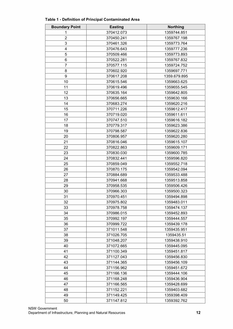
NSW Government Department of Infrastructure, Planning and Natural Resources 12
Table 1 - Definition of Principal Contaminated Area
Boundary Point Easting Northing 1 370412.073 1359744.851 2 370450.241 1359767.198 3 370461.326 1359773.764 4 370476.643 1359777.236 5 370509.466 1359773.893 6 370522.281 1359767.832 7 370577.115 1359724.752 8 370602.920 1359697.771 9 370617.208 1359.679.895 10 370615.546 1359663.625 11 370619.496 1359655.545 12 370635.164 1359642.805 13 370656.665 1359630.166 14 370683.274 1359620.216 15 370711.226 1359612.417 16 370719.020 1359611.611 17 370747.510 1359616.182 18 370779.317 1359623.386 19 370798.587 1359622.836 20 370806.957 1359620.280 21 370816.046 1359615.107 22 370822.863 1359609.171 23 370830.030 1359600.785 24 370832.441 1359596.820 25 370859.049 1359552.718 26 370870.175 1359542.094 27 370884.689 1359533.488 28 370941.668 1359513.858 29 370958.535 1359506.426 30 370966.303 1359500.323 31 370970.451 1359494.898 32 370975.802 1359483.011 33 370978.758 1359474.137 34 370986.015 1359452.893 35 370992.197 1359444.557 36 370999.722 1359439.178 37 371011.548 1359435.951 38 371026.705 1359435.51 39 371048.207 1359438.910 40 371072.665 1359445.095 41 371100.349 1359451.817 42 371127.043 1359456.830 43 371144.365 1359456.109 44 371156.962 1359451.672 45 371166.136 1359444.106 46 371168.248 1359436.904 47 371166.565 1359428.699 48 371152.221 1359403.682 49 371149.425 1359398.409 50 371147.812 1359392.762
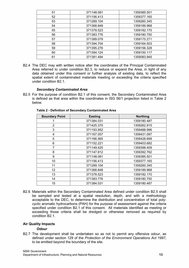
NSW Government Department of Infrastructure, Planning and Natural Resources 13
51 371148.081 1359385.501 52 371156.413 1359377.165 53 371289.104 1359260.345 54 371368.848 1359189.968 55 371378.523 1359182.170 56 371383.776 1359180.750 57 371389.079 1359175.271 58 371394.704 1359164.503 59 371395.276 1359156.328 60 371394.124 1359150.117 61 371381.494 1359083.945
B2.4 The DEC may with written notice alter the coordinates of the Principal Contaminated Area referred to under condition B2.3, to reduce or expand the Area, in light of any data obtained under this consent or further analysis of existing data, to reflect the spatial extent of contaminated materials meeting or exceeding the criteria specified under condition B2.1.
Secondary Contaminated Area B2.5 For the purpose of condition B2.1 of this consent, the Secondary Contaminated Area
is defined as that area within the coordinates in ISG 56/1 projection listed in Table 2 below.
Table 2 - Definition of Secondary Contaminated Area
Boundary Point Easting Northing 1 371384.031 1359180.487 2 371425.370 1359262.915 3 371193.952 1359488.996 4 371167.057 1359431.097 5 371166.565 1359428.699 6 371152.221 1359403.682 7 371149.425 1359398.409 8 371147.812 1359392.762 9 371148.081 1359385.501 10 371156.413 1359377.165 11 371289.104 1359260.345 12 371368.848 1359189.968 13 371378.523 1359182.170 14 371383.776 1359180.750 15 371384.031 1359180.487
B2.6 Materials within the Secondary Contaminated Area defined under condition B2.5 shall be sampled and tested at a spatial resolution, depth, and with a methodology acceptable to the DEC, to determine the distribution and concentration of total poly-cyclic aromatic hydrocarbons (PAH) for the purpose of assessment against the criteria specified under condition B2.1 of this consent. All materials identified as meeting or exceeding those criteria shall be dredged or otherwise removed as required by condition B2.1.
Air Quality Impacts Odour
B2.7 The development shall be undertaken so as not to permit any offensive odour, as defined under section 129 of the Protection of the Environment Operations Act 1997, to be emitted beyond the boundary of the site.
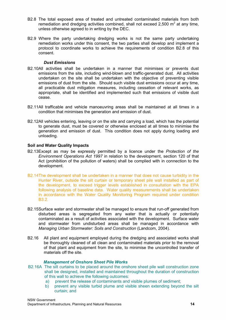
NSW Government Department of Infrastructure, Planning and Natural Resources 14
B2.8 The total exposed area of treated and untreated contaminated materials from both remediation and dredging activities combined, shall not exceed 2,500 m2 at any time, unless otherwise agreed to in writing by the DEC.
B2.9 Where the party undertaking dredging works is not the same party undertaking remediation works under this consent, the two parties shall develop and implement a protocol to coordinate works to achieve the requirements of condition B2.8 of this consent.
Dust Emissions B2.10All activities shall be undertaken in a manner that minimises or prevents dust
emissions from the site, including wind-blown and traffic-generated dust. All activities undertaken on the site shall be undertaken with the objective of preventing visible emissions of dust from the site. Should such visible dust emissions occur at any time, all practicable dust mitigation measures, including cessation of relevant works, as appropriate, shall be identified and implemented such that emissions of visible dust cease.
B2.11All trafficable and vehicle manoeuvring areas shall be maintained at all times in a condition that minimises the generation and emission of dust.
B2.12All vehicles entering, leaving or on the site and carrying a load, which has the potential to generate dust, must be covered or otherwise enclosed at all times to minimise the generation and emission of dust. This condition does not apply during loading and unloading.
Soil and Water Quality Impacts B2.13Except as may be expressly permitted by a licence under the Protection of the
Environment Operations Act 1997 in relation to the development, section 120 of that Act (prohibition of the pollution of waters) shall be complied with in connection to the development.
B2.14The development shall be undertaken in a manner that does not cause turbidity in the Hunter River, outside the silt curtain or temporary sheet pile wall installed as part of the development, to exceed trigger levels established in consultation with the EPA following analysis of baseline data. Water quality measurements shall be undertaken in accordance with the Water Quality Monitoring Program required under condition B3.2.
B2.15Surface water and stormwater shall be managed to ensure that run-off generated from disturbed areas is segregated from any water that is actually or potentially contaminated as a result of activities associated with the development. Surface water and stormwater from undisturbed areas shall be managed in accordance with Managing Urban Stormwater: Soils and Construction (Landcom, 2004).
B2.16 All plant and equipment employed during the dredging and associated works shall be thoroughly cleaned of all clean and contaminated materials prior to the removal of that plant and equipment from the site, to minimise the uncontrolled transfer of materials off the site.
Management of Onshore Sheet Pile Works B2.16A The silt curtains to be placed around the onshore sheet pile wall construction zone
shall be designed, installed and maintained throughout the duration of construction of this wall to achieve the following outcomes: a) prevent the release of contaminants and visible plumes of sediment; b) prevent any visible turbid plume and visible sheen extending beyond the silt
curtain; and
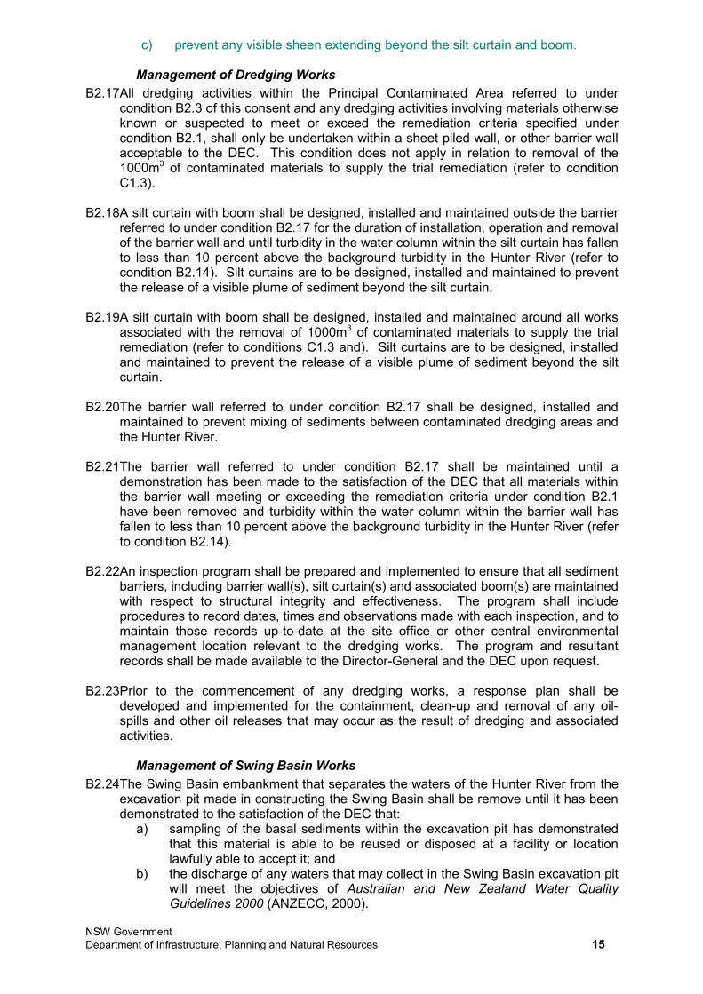
NSW Government Department of Infrastructure, Planning and Natural Resources 15
c) prevent any visible sheen extending beyond the silt curtain and boom.
Management of Dredging Works B2.17All dredging activities within the Principal Contaminated Area referred to under
condition B2.3 of this consent and any dredging activities involving materials otherwise known or suspected to meet or exceed the remediation criteria specified under condition B2.1, shall only be undertaken within a sheet piled wall, or other barrier wall acceptable to the DEC. This condition does not apply in relation to removal of the 1000m3 of contaminated materials to supply the trial remediation (refer to condition C1.3).
B2.18A silt curtain with boom shall be designed, installed and maintained outside the barrier referred to under condition B2.17 for the duration of installation, operation and removal of the barrier wall and until turbidity in the water column within the silt curtain has fallen to less than 10 percent above the background turbidity in the Hunter River (refer to condition B2.14). Silt curtains are to be designed, installed and maintained to prevent the release of a visible plume of sediment beyond the silt curtain.
B2.19A silt curtain with boom shall be designed, installed and maintained around all works associated with the removal of 1000m3 of contaminated materials to supply the trial remediation (refer to conditions C1.3 and). Silt curtains are to be designed, installed and maintained to prevent the release of a visible plume of sediment beyond the silt curtain.
B2.20The barrier wall referred to under condition B2.17 shall be designed, installed and maintained to prevent mixing of sediments between contaminated dredging areas and the Hunter River.
B2.21The barrier wall referred to under condition B2.17 shall be maintained until a demonstration has been made to the satisfaction of the DEC that all materials within the barrier wall meeting or exceeding the remediation criteria under condition B2.1 have been removed and turbidity within the water column within the barrier wall has fallen to less than 10 percent above the background turbidity in the Hunter River (refer to condition B2.14).
B2.22An inspection program shall be prepared and implemented to ensure that all sediment barriers, including barrier wall(s), silt curtain(s) and associated boom(s) are maintained with respect to structural integrity and effectiveness. The program shall include procedures to record dates, times and observations made with each inspection, and to maintain those records up-to-date at the site office or other central environmental management location relevant to the dredging works. The program and resultant records shall be made available to the Director-General and the DEC upon request.
B2.23Prior to the commencement of any dredging works, a response plan shall be developed and implemented for the containment, clean-up and removal of any oil-spills and other oil releases that may occur as the result of dredging and associated activities.
Management of Swing Basin Works B2.24The Swing Basin embankment that separates the waters of the Hunter River from the
excavation pit made in constructing the Swing Basin shall be remove until it has been demonstrated to the satisfaction of the DEC that:
a) sampling of the basal sediments within the excavation pit has demonstrated that this material is able to be reused or disposed at a facility or location lawfully able to accept it; and
b) the discharge of any waters that may collect in the Swing Basin excavation pit will meet the objectives of Australian and New Zealand Water Quality Guidelines 2000 (ANZECC, 2000).
NSW Government Department of Infrastructure, Planning and Natural Resources 16
Stockpile Management B2.25All contaminated materials shall be stored in an impervious bunded area(s) with
sufficient volume to accommodate the materials and any leachate and contaminated water than may be generated from those materials alone and through storm events.
B2.26Deleted.
B2.27Except as may be expressly provided under an Environment Protection Licence for the development, the Applicant shall ensure that the discharge of any supernatant and run-off water from stockpiles, handling and placement areas complies with section 120 of the Protection of the Environment Operations Act 1997, which prohibits the pollution of waters.
Traffic, Transport and Infrastructure Impacts Protection of Tourle Street Bridge
B2.28Prior to the commencement of any dredging or excavation works within 100 metres of the existing or proposed new alignment of Tourle Street Bridge, a detailed structural integrity assessment shall be undertaken in consultation with the Roads and Traffic Authority. The assessment shall be undertaken by an independent, qualified structural/ civil engineer, and shall specifically address the potential for dredging and excavation works to destabilise the existing or proposed new Tourle Street Bridge. Where lateral movement of sediment, or other result of dredging or excavation works is identified as having potential to destabilise the Bridge, the assessment shall specify mitigation options to address this potential, including additional structural works in relation to the Bridge, and/ or modification of the western extent of dredging and excavation works. The assessment shall be undertaken to the satisfaction of the Roads and Traffic Authority, and shall be submitted to the Director-General prior to the commencement of any dredging or excavation works within 100 metres of the existing or proposed new alignment of Tourle Street Bridge.
Dredged Material Transport Strategy B2.29Prior to the commencement of any dredging or excavation works, other than those
works associated with dredging and supply of materials for Stage 1B (refer to condition A2.1), a Dredged Material Transport Strategy shall be developed and submitted for the approval of the Roads and Traffic Authority. The Strategy shall be prepared in consultation with the Authority and Newcastle City Council, and shall include, but not necessarily be limited to:
a) a strategic transport plan for the transport of dredged and excavated materials off-site, consistent with phases identified as part of the Strategic Dredging Program required under condition B1.3;
b) identification of the quantities of materials, transport mode and number of traffic movements necessary to remove materials from the dredge/ excavation area(s) relevant to each phase;
c) establishment of a road hierarchy for transport of materials from each phase, having due consideration to destination of materials, road capacity restrictions, peak traffic flows, sensitive road users (including public transport and school-related traffic), and restrictions of the use of B-doubles;
d) establishment of traffic movement scheduling to avoid conflicts with peak traffic flows, sensitive road users and to distribute traffic flows to distribute impacts to the greatest extent reasonably possible;
e) identification and commitment to alternatives to road haulage of materials, including where feasible, conveyance of materials by pipe, rail and sea;
f) identification and commitment to the installation and maintenance of any necessary road safety infrastructure and management measures, with specific reference to intersection management;
NSW Government Department of Infrastructure, Planning and Natural Resources 17
g) proactive and reactive measures for traffic monitoring, planning and management over the life of the development; and
h) specific consideration of coordination provisions to avoid concurrent peak impacts associated with dredging and remediation works.
Noise and Vibration Impacts Restrictions to Hours
B2.30All activities associated with sheet piling installation and removal, that could potentially exceed the noise and vibration criteria under conditions B2.34 and B2.36, shall only be undertaken within the hours specified below. This condition does not apply in the event of an emergency (to protect the human and biophysical environments) or under direction from a relevant authorised public authority. All sheet piling activities shall be restricted to the following hours:
a) between 09:00 and 17:00 on Mondays to Fridays; b) between 09:00 and 17:00 on Saturdays; and c) at no time on Sundays or public holidays.
B2.31All dry-land activities associated with the excavation of the swing basin shall only be undertaken within the hours specified below. This condition does not apply in the event of an emergency (to protect the human and biophysical environments) or under direction from a relevant authorised public authority. All dry-land activities shall be restricted to the following hours:
a) between 08:00 and 18:00 on Mondays to Fridays; b) between 08:00 and 18:00 on Saturdays; and c) at no time on Sundays or public holidays.
B2.32All activities associated with blasting operations shall only be undertaken within the hours specified below. This condition does not apply in the event of an emergency (to protect the human and biophysical environments) or under direction from a relevant authorised public authority. All blasting operations shall be restricted to the following hours:
a) between 09:00 and 17:00 on Mondays to Fridays; b) between 09:00 and 17:00 on Saturdays; and c) at no time on Sundays or public holidays.
B2.33The time restrictions specified under conditions B2.30, B2.31 and B2.32 of this consent may be varied with the Director-General's agreement with the proposed variation in times, including the results of any community consultation that the Director-General may require to be undertaken, and after considering any information necessary for the Director-General to reasonably determine that activities undertaken during the varied hours will not adversely impact on the acoustic amenity of receptors in the vicinity of the site.
Noise Limits B2.34All dredging, excavation and associated works shall be undertaken such that the noise
contributed from those works to the background acoustic environment does not exceed the maximum noise contribution limits (as LAeq(15 minute)) specified in Table 3, at the locations indicated, and during the periods specified. The noise limits specified under this condition only apply under the following meteorological conditions:
a) wind speeds up to 3ms-1 at 10 metres above ground level; or b) under temperature inversion conditions of up to 3oC per 100 metres and wind
speeds up to 2ms-1 at 10 metres above ground level.
NSW Government Department of Infrastructure, Planning and Natural Resources 18
Table 3 - Maximum Allowable Noise Contributions
Location Day 07:00 to 18:00 Mondays
to Saturdays08:00 to 18:00 Sundays/
public holidays
Evening 18:00 to 22:00 any day
Night 22:00 to 07:00 Mondays
to Saturdays22:00 to 08:00 Sundays/
public holidays
NM1 – 21 Crebert Street, Mayfield
62 58 53
NM2 – 52 Arthur Street, Mayfield
56 55 48
NM3 – 1 Arthur Street, Mayfield
51 51 48
NM4 – Mayfield East Public School
52 50 47
NM5 – Cnr Wye Street and Avon Street, Mayfield
50 50 47
NM6 – 45 Simpson Circuit, Mayfield
51 54 51
B2.35For the purpose of assessment of noise contributions specified under condition B2.34, noise from the development shall be:
a) measured at the most affected point on or within the boundary of the most- affected noise sensitive locations; and
b) subject to the modification factors provided in Section 4 of the New South Wales Industrial Noise Policy (EPA, 2000), where applicable.
Notwithstanding, should direct measurement of noise from the development be impractical, an alternative noise assessment method deemed acceptable by the DEC (refer to Section 11 of the New South Wales Industrial Noise Policy (EPA, 2000)) may be employed. Details of such an alternative noise assessment method accepted by the DEC shall be submitted to the Director-General prior to the implementation of the assessment method.
Blasting and Vibration Limits B2.36Overpressure from blasting activities shall not exceed:
a) 115 dB (Lin Peak) for more than 5% of the total number of blasts conducted in any 12-month period; and
b) 120 dB (Lin Peak) at any time.
The overpressure limits specified under this condition apply when measured with equipment having a lower cut-off frequency of 2Hz or less. If the equipment has a higher cut-off frequency than 2Hz, then a correction of 5dB shall be added to the measured value. Equipment with a lower cut-off frequency exceeding 10Hz shall not be used in measuring overpressure for the purposes of this condition.
B2.37Ground vibration peak velocity from blasting activities shall not exceed: a) 5mms-1 for more than 5% of the total number of blasts conducted in any 12-
month period; and b) 10mms-1 at any time.
For the purpose of determining compliance with this condition, ground peak particle velocity shall be measured at any point within one metre of the boundary of any affected residential premises or other noise-sensitive location (such as schools and hospitals).
NSW Government Department of Infrastructure, Planning and Natural Resources 19
Impacts on Flora and Fauna B2.38Prior to the commencement of any works associated with the development within 50
metres of mangrove areas (as mapped on Figure 5 of Appendix G of the document referred to under condition A1.1b) of this consent), the Applicant shall delineate the limit of development works with flagging tape or other suitable temporary markers to restrict the extent of clearing of mangroves only to those areas required for the development and to minimise the potential for overclearing or accidental damage to surrounding vegetation.
B2.39Prior to the commencement of any phase of the dredging or excavation works, that will result in the removal of mangroves, wetland vegetation or saltmarsh communities (as mapped on Figure 5 of Appendix G of the document referred to under condition A1.1b) of this consent), a compensatory habitat package shall be established in consultation with and to the satisfaction of the DEC and the DPI. The package shall include one or more of the following compensatory measures:
a) provision of no less than 15 hectares of compensatory habitat, whether new or restored, comprising Saltmarsh Endangered Ecological Community; or
b) equivalent financial contribution to a wetland rehabilitation project in the Lower Hunter Region; or
c) equivalent provision of new or maintained intertidal feeding areas and roosting habitats for waters in the Hunter River Estuary; or
d) any other form of compensatory habitat agreed by the DEC and DPI.
Funding or works associated with the compensatory habitat package shall commence prior to the commencement of any phase of the dredging or excavation works, that will result in the removal of mangroves, wetland vegetation or saltmarsh communities. This condition does not apply with respect to dredging to supply materials to Stage 1B (refer to condition A2.1b)).
Hazards and Risk Impacts B2.40Class 1 dangerous goods, as defined under the Australian Dangerous Goods Code,
shall only be brought to the site on an as-needs basis, and stored inventories on the site shall be minimised at all times. Class 1 dangerous goods shall be transported and stored in strict accordance with relevant Australian Standards.
B2.41All liquid hazardous substances, including but not limited to diesel, lubrication oil and hydraulic fluid shall be stored in an impervious bunded area(s) with volume equivalent to no less than 110% of the largest single container within the bund.
Waste Generation and Management B2.42Wastes generated by the development or from outside the site shall not be caused,
permitted or allowed to be received at the site for storage, treatment, processing, reprocessing, or disposal on the site, except as expressly permitted by a licence issued under the Protection of the Environment Operations Act 1997. This condition only applied to the storage, treatment, processing, reprocessing to disposal of wastes where such a licence is required.
B2.43All materials removed from the Hunter River and associated areas, as the result of dredging or excavation, including excavation of the Swing Basin, shall be reused, disposed of or treated at a facility or location lawfully able to accept it.
B2.43A Any works associated with the construction of the onshore sheet pile wall must not adversely affect any works or environmental controls that have been or are to be implemented, as part of the remediation of the ‘Closure Area’ (Lots 31-33 DP 1116571).
B2.43B Materials excavated from the Closure Area (Lots 31- 33 DP 1116571) and the One Steel site (Lot 222 DP 1013964) associated with the construction of the
NSW Government Department of Infrastructure, Planning and Natural Resources 20
onshore sheet pile wall shall be managed in accordance with an approved Remediation Action Plan. This requirement is waived should a Site Auditor accredited under the Contaminated Land Management Act 1997 endorse the use of the excavated material management measures (with or without modification) proposed in the documents identified in condition A1.1g as being suitable for the proposed works and in accordance with relevant site and legislative requirements.
Where material is determined to be suitable for storage or reuse on the site, the storage or reuse shall be agreed to by the affected land owner.
B2.43C The disposal of materials off site associated with the construction of the onshore sheet pile wall (including the temporary rock platform) shall be assessed, classified, managed and disposed of in accordance with the Waste Classification Guidelines (DECC, 2008). All waste materials removed from the site shall only be directed to a waste management facility lawfully permitted to accept the materials.
Socio-Economic Impacts B2.44Prior to the commencement of any dredging or excavation works, other than those
works associated with dredging and supply of materials for Stage 1B (refer to condition A2.1), a Public and Commercial Access Protocol shall be established in consultation with public and commercial users of the south arm of the Hunter River, including the Newcastle Fisherman’s Cooperative. The Protocol shall establish notification, communication and coordination procedures with users of the Hunter River potentially affected by exclusion or restriction resulting from the dredging and excavation works, and mechanisms to resolve conflicts between those parties’ activities, should they occur. The Protocol shall include, but not necessarily be limited to the scope and content detailed in section 20.4 of the document referred to under condition A1.1 of this consent.
B3. DREDGING ENVIRONMENTAL MONITORING AND AUDITING Water Quality Monitoring B3.1 For the purposes of monitoring turbidity during dredging, excavation and other works
within the Hunter River, at least one in-stream representative reference monitoring point up-stream and down-stream of dredging, excavation and other works within the Hunter River shall be identified and established. The monitoring points shall lie up-stream and down-stream of the extent of works identified in Figure C.1 of the document referred to under condition A1.1 of this consent and shall be established prior to the commencement of works within the Hunter River. The DEC and the Director-General shall be notified of the location of the monitoring points prior to the commencement of any works within the Hunter River, and if required by either the DEC or the Director-General, modify the location of the monitoring points to reflect a representative reference location(s).
B3.2 Prior to the commencement of any works within the Hunter River, a Water Quality Monitoring Program to monitor turbidity and polycyclic aromatic hydrocarbon (PAH) concentrations in the River and changes to those concentrations as a result of the development shall be developed and submitted for the approval of the DEC and DPI. The Program shall include, but not necessarily be limited to:
a) establishment of water quality criteria, consistent with any requirements of this consent and the Environment Protection Licence for the development, against which the water quality performance of the development within the Hunter River will be assessed;
b) procedures for monitoring of turbidity at the monitoring points established under condition B3.1 of this consent;
c) procedures for monitoring PAH concentrations in the Hunter River as a result of the development;
NSW Government Department of Infrastructure, Planning and Natural Resources 21
d) assessment and management processes to establish whether water quality criteria are being exceeded, or are likely to be exceeded as a result of the development; and
e) contingency measures in the event that elevated turbidity or PAH levels are detected, including modification or cessation of the contributing works.
Once the Program is approved, it shall be implemented for the duration of each phase of the works within the Hunter River, and for at least twelve months after the cessation of each phase of those works, unless otherwise agreed by the DEC and DPI.
Odour Monitoring Program B3.3 Prior to the commencement of any dredging works an Odour Monitoring Program
shall be developed and implemented, to monitor and assess the odour performance of the dredging works against the assumptions and predictions detailed in the documents referred to under condition A1.1 of this consent. The monitoring shall include specific provisions for the assessment of cumulative odour impacts with remediation activities, and shall provide sufficient information to support continuation of the trial remediation as Stage 2 of the development, as may be relevant.
Groundwater Monitoring Program B3.4 Prior to the commencement of any works associated with excavation of the Swing
Basin, a Groundwater Monitoring Program shall be developed and implemented, to identify and monitor groundwater contaminants and to assess the impacts of Swing Basin construction on groundwater hydrology, particularly the migration of groundwater contaminants towards the Hunter River. The Program shall be developed in consultation with the Department and the DEC, and shall include a contingency plan to mitigate identified and predicted adverse contaminated groundwater impacts. The Program shall specifically focus on the effects of the excavation of the Swing Basin and associated works during construction and operation.
Ecosystem Monitoring Program B3.5 Prior to the commencement of each phase of dredging or excavation works, other than
in relation to dredging of materials for the Stage 1B (refer to condition A2.1b)), an Ecosystem Monitoring Program shall be developed and implemented. The Program shall be developed in consultation with and to the satisfaction of the DEC and the DPI, and shall include, but not necessarily be limited to:
a) sampling and data collection on at least two occasions prior to the commencement of dredging and excavation works to establish baseline ecological health upstream and downstream of the development, and within the Hunter River estuary;
b) a sampling, data collection and assessment regime to monitor ecological health during the dredging and excavation works, with specific reference to threatened species, migratory bird populations and overall habitat and biodiversity outcomes;
c) identification and establishment of an ecological monitoring network with specific provision for monitoring in the north and south arms of the Hunter River, deep and shallow monitoring and taking into account spatial variability in species types and distribution;
d) criteria against which the health and viability of the Hunter River and estuary ecological health will be assessed, including distribution of mangrove and saltmarsh communities upstream of the development and with the overall Hunter River estuary;
e) water quality monitoring in the context of potential ecological impacts, particularly in relation to salinity, turbidity, temperature and dissolved oxygen;
f) mitigation measures to be implemented in the event that reduced ecological health is identified with reference to established assessment criteria; and
NSW Government Department of Infrastructure, Planning and Natural Resources 22
g) monitoring for ecological health and biodiversity outcomes following dredging and excavation activities, and for the recovery of biodiversity within the areas directly and indirectly affected by the development.
The Program shall be continued for at least twelve months following completion of each phase of dredging and excavation works, unless otherwise agreed by the DEC and the DPI.
B4. DREDGING ENVIRONMENTAL MANAGEMENT AND REPORTINGIncident Reporting B4.1 The Director-General shall be notified of any incident with actual or potential significant
off-site impacts on people or the biophysical environment within 24 hours of the Applicant, or other relevant party undertaking the development, becoming aware of the incident. Full written details of the incident shall be provided to the Director-General within seven days of the date on which the incident occurred. The Director-General may require additional measures to be implemented to address the cause or impact of any incident, as it relates to this consent, reported in accordance with this condition, within such period as the Director-General may require.
Environmental Representative B4.2 Prior to the commencement of each phase of dredging or associated works, a suitably
qualified and experienced Environmental Representative(s) shall be nominated to and approved by the Director-General. The Environmental Representative(s) shall be employed for the duration of each phase of the dredging and associated works, or as otherwise agreed by the Director-General. The Environmental Representative shall be:
a) the primary contact point in relation to the environmental performance of the dredging and associated works;
b) responsible for all Management Plans and Monitoring Programs required under this consent, in relation to dredging and associated works;
c) responsible for considering and advising on matters specified in the conditions of this consent, and all other licences and approvals relating to the environmental performance and impacts of the dredging and associated works;
d) responsible for the management of procedures and practices for receiving and responding to complaints and inquiries in relation to the environmental performance of the dredging and associated works;
e) required to facilitate an induction and training program for relevant persons involved with the development (refer to condition B4.3 of this consent); and
f) given the authority and independence to require reasonable steps be taken to avoid or minimise unintended or adverse environmental impacts, and failing the effectiveness of such steps, to direct that relevant actions be ceased immediately should an adverse impact on the environment be likely to occur.
Environmental Training B4.3 Prior to the commencement of any dredging or associated works an Environmental
Training Program shall be developed and implemented to establish a framework in which relevant employees will be trained in environmental management and the operation of plant and equipment, including pollution control equipment, where relevant. The Program shall include, but not necessarily be limited to:
a) identification of relevant employment positions associated with the development that have an operational or management role related to environmental performance;
b) details of appropriate training requirements for relevant employees; c) a program for training relevant employees in operational and/ or management
issues associated with environmental performance; and
NSW Government Department of Infrastructure, Planning and Natural Resources 23
d) a program to confirm and update environmental training and knowledge during employment of relevant persons.
Dredging Environmental Management Plan B4.4 Prior to the commencement of each phase of dredging or excavation works, a
Dredging Environmental Management Plan shall be prepared for that phase and submitted for the approval of the Director-General. The Plan shall outline environmental management practices and procedures to be followed during the particular phase of dredging and excavation works and shall include, but not necessarily be limited to:
a) a description of all activities to be undertaken during dredging, excavation and associated activities;
b) statutory and other obligations that must be fulfilled during dredging, excavation and associated activities, including all approvals, consultations and agreements required from authorities and other stakeholders, and key legislation and policies;
c) a description of the roles and responsibilities for all relevant employees involved in the dredging and excavation works;
d) details of how the environmental performance of the development will be monitored, and what actions will be taken to address identified adverse environmental impacts. In particular, the following environmental performance issues shall be addressed in the Plan: i) measures to monitor and manage dust emissions; ii) measures to monitor and minimise soil erosion and the discharge of
sediment and other pollutants to lands and/ or waters; iii) measures to monitor and manage contaminated sediments/ materials; iv) measures to monitor and control noise emissions during operation; v) measures to monitor and control air emissions during handling of
contaminated materials; and e) the Management Plans listed under condition B4.5 of this consent; f) arrangements for community consultation and complaints handling
procedures during dredging and excavation works.
B4.5 As part of the Dredging Environmental Management Plan required under condition B4.4 of this consent, the following Management Plans shall be prepared and implemented:
a) an Odour Management Plan to outline measures to minimise odour impacts associated with the dredging and excavation works. The Plan shall include, but not necessarily be limited to: i) identification of all point and diffuse sources of odour associated with
the dredging and excavation works; ii) a detailed description of the odour mitigation methods and management
practices that will be used throughout the dredging and excavation works to ensure offensive odour impacts do not occur off site;
iii) details of the implementation of best practice management measures to ensure potential odour impacts are managed;
iv) a detailed description of the methods used for monitoring the effectiveness of the odour mitigation methods and management practices for all point and diffuse sources of odour associated with the dredging and excavation works;
v) details of proposed contingency measures should odour impacts occur; vi) a procedure for handling potential odour complaints that includes
recording, investigating, reporting and follow-up action; and vii) processes and procedures for coordination with the party undertaking
remediation works to ensure a consistent and coordinated approach to project-specific and cumulative odour impacts.
b) a Soil and Water Management Plan to outline measures that will be employed to manage surface water and groundwater, to minimise soil erosion
NSW Government Department of Infrastructure, Planning and Natural Resources 24
and the discharge of sediments and other pollutants to lands and/ or waters for the duration of dredging and excavation work. The Plan shall include, but not necessarily be limited to: i) consideration of all reasonable options to avoid discharge to ground
and/or ambient waters including methods to minimise the volume of contaminated water and effluent generated, recycling and reusing water and effluent (eg. covering excavated material and stockpiles, diversion of ‘clean’ water away from contaminated areas, etc);
ii) identification of clean and dirty water areas on site maps for different stages of the development;
iii) identification of criteria for nomination of areas as clean or dirty; iv) details of water management measures to be implemented for clean
and dirty waters; v) details of the remedial actions to be taken by site operators in response
to an exceedence of concentration limits or other performance criteria for water management controls, including: • procedures and contingency actions associated with the
installation, operation and removal of the temporary sheet piled wall, silt curtains and booms;
• contingency actions for flood, heavy rainfall and storm-surges into dredging and excavation areas or damage to sheet piled walls, silt curtains or booms; and
• contingency actions for failure of any sediment controls. vi) identification of management responses to activities that could cause
soil erosion or result in the discharge of sediments and/or other pollutants;
vii) specification of performance criteria for erosion, sediment, and pollution control measures (eg. parameters, testing frequency, duration and location and test methods); and
viii) actions and measures to be implemented to control sediments, and how they will be monitored during the works, clearly indicating who will conduct the monitoring, how the results of this monitoring will be recorded; and, if any non-compliance is detected, what corrective action will be taken.
c) an Acid Sulfate Soil Management Plan to detail measures to be implemented in relation to the management and handling of any potential or actual acid sulfate soils on the site. The Plan shall be prepared in accordance with guidance provided in Acid Sulfate Soil Manual (Acid Sulfate Soil Management Advisory Committee, 1998).
NSW Government Department of Infrastructure, Planning and Natural Resources 25
SUBSCHEDULE CCONDITIONS RELATING TO REMEDIATION AND OPTIMISATION WORKS
C1. REMEDIATION GENERAL REQUIREMENTS Application of Sub-Schedule C1.1 The conditions in this sub-schedule of the consent relate to remediation of
contaminated materials on land identified as “Hunter River Sediment Treatment Pilot Study Sites” in Figure 6.1 of the document referred to under condition A1.1 consent.
C1.2 To avoid any doubt, the conditions in this sub-schedule of the consent must be complied with by the Applicant, or any party undertaking the activities and works referred to under condition C1.1.
C1.2A The conditions in this Sub-Schedule apply to works associated with the trial remediation and optimisation study (as defined under conditions C1.3 and C1.3A). Stage 2 works (full-scale remediation activities) are subject to the conditions in Sub-Schedule A and Sub-Schedule D.
Scope of Remediation Works C1.3 This consent permits the trial remediation of no more than 2,000m3 of
contaminated materials, dredged or otherwise obtained in accordance with this consent, unless and until continuation of the remediation is approved by the Minister in accordance with condition A2.2 of this consent.
C1.3A Notwithstanding condition C1.3 of this consent, an additional 4,500 m3 of contaminated materials may be removed from the Hunter River for the purpose of an Optimisation Study. Any such Optimisation Study shall be undertaken in accordance with an Optimisation Study Program, developed in consultation with the DECC, and approved by the Director-General prior to removal of the contaminated materials from the River. The Program shall clearly specify the aims of the Optimisation Study and a program of works to achieve those aims, including, but not necessarily limited to: a) identification of information requirements specified under this consent,
and as may be specified by the DECC, necessary for demonstrating acceptable remediation outcomes sufficient for informing any application to proceed to Stage 2 of the development;
b) strategies for testing and treating sediments to achieve the most reliable stabilisation outcomes for the range of contaminant concentrations and physical/ chemical properties of sediments likely to be encountered; and
c) details of how the requirements for an immobilisation approval (as described in Waste Classification Guidelines Part 2: Immobilisation of Waste (DECC, 2008) and Immobilisation Technical Note 2: Cement-based Solidification/ Stabilisation Treatment of Organic Chemical Contaminants in Waste (DECC, 2008), or as otherwise agreed by the DECC) will be satisfied through the Optimisation Study.
C1.4 All works associated with the remediation of contaminated materials shall be carried out in a manner that does not cause contamination of existing capped or other ground surfaces. The Proponent shall minimise disturbance to, and cross-contamination of, the existing capped and other ground surfaces, and shall promptly reinstate all affected areas to pre-disturbance condition, or other condition agreed by the DECC and the landowner. Where remediation works occur, the Proponent shall minimise the potential for ingress of any water through the underlying subgrade soils by installing a surface layer with a maximum as-constructed permeability of 10-9 ms-1 over and above the existing capping/ ground surface layer. The additional layer shall be of adequate
NSW Government Department of Infrastructure, Planning and Natural Resources 26
durability and thickness to withstand traffic and equipment movements where these occur as part of the remediation works.
C1.4A The Proponent shall engage a Site Auditor, accredited under the Contaminated Land Management Act 1997, to confirm the adequacy of the additional surface layer required under condition C1.4 following its installation.
Completion of Trial and Continuation of Works C1.5 Within six months of the completion of the Optimisation Study (refer to condition
C1.3A of this consent), or within such period as otherwise agreed by the Director-General, a report shall be submitted to the Director-General and the DEC assessing the success of the trial remediation and the ability of remediation works to continue for treatment of remaining contaminated materials to be removed from the Hunter River. The report shall include, but need not be limited to: a) an assessment of the trial remediation against the predictions detailed in
the documents listed under condition A1.1 his consent; b) an assessment of the trial remediation against the requirements of this
consent, with details of any non-compliances and how these were addressed or will be addressed;
c) a detailed assessment of the performance of mixing equipment, with particular focus on the demonstrated ability of the mixing equipment to uniformly mix additives with contaminated materials;
d) a detailed assessment of the suitability of the treated materials for uses proposed in the documents listed under condition A1.1 of this consent, and any other uses for the treated materials that may be identified during the course of the trial remediation;
e) a detailed assessment of odour monitoring conducted during the trial remediation (refer to condition C3.3), including in relation to handling, treatment and trial placement activities. The assessment shall be undertaken with reference to the odour assumptions and predictions detailed in documents listed under condition A1.1 of this consent;
f) details of any alterations that may be necessary to physical aspects or management measures applied to the trial remediation before implementation of the remediation approach to Stage 2 of the development, as may be relevant.
C1.6 The report referred to under condition C1.5 shall form the basis of the Minister’s considerations under condition A2.2, in addition to any further information or clarification of information that may be required by the Minister in this regard.
Compliance Certification C1.7 Prior to each of the events listed from a) to c) below, or within such period
otherwise agreed by the Director-General, documentation certifying that all conditions of this consent applicable prior to that event have been complied with shall be submitted to the satisfaction of the Director-General. Where an event is to be undertaken in stages, submission of compliance certification may be staged consistent with the staging of activities relating to that event, subject to the prior agreement of the Director-General. a) receipt of materials for the trial remediation (refer to condition A2.1); b) commencement of the trial remediation; and c) completion of the trial remediation.
C1.8 Notwithstanding condition C1.7 of this consent, the Director-General may require an update report on compliance with all, or any part, of the conditions of this consent. Any such update shall meet the requirements of the Director-General and be submitted within such period as the Director-General may agree.
NSW Government Department of Infrastructure, Planning and Natural Resources 27
C2. REMEDIATION ENVIRONMENTAL PERFORMANCE Air Quality Impacts
Odour C2.1 The development shall be undertaken so as not to permit any offensive odour,
as defined under section 129 of the Protection of the Environment Operations Act 1997, to be emitted beyond the boundary of the site.
C2.2 The total exposed area of treated and untreated contaminated materials from both remediation and dredging activities combined, shall not exceed 2,500 m2 at any time, unless otherwise agreed to in writing by the DEC.
C2.3 Where the party undertaking dredging works is not the same party undertaking remediation works under this consent, the two parties shall develop and implement a protocol to coordinate works to achieve the requirements of condition C2.2 of this consent.
Dust Emissions C2.4 All activities shall be undertaken in a manner that minimises or prevents dust
emissions from the site, including wind-blown and traffic-generated dust. All activities undertaken on the site shall be undertaken with the objective of preventing visible emissions of dust from the site. Should such visible dust emissions occur at any time, all practicable dust mitigation measures, including cessation of relevant works, as appropriate, shall be identified and implanted such that emissions of visible dust cease.
C2.5 All trafficable and vehicle manoeuvring areas shall be maintained at all times in a condition that minimises the generation and emission of dust.
C2.6 All vehicles entering, leaving or on the site and carrying a load, which has the potential to generate dust, must be covered or otherwise enclosed at all times to minimise the generation and emission of dust. This condition does not apply during loading and unloading.
Soil and Water Quality Impacts C2.7 Except as may be expressly permitted by a licence under the Protection of the
Environment Operations Act 1997 in relation to the development, section 120 of that Act (prohibition of the pollution of waters) shall be complied with in connection to the development.
C2.8 Surface water and stormwater shall be managed to ensure that run-off generated from disturbed areas is segregated from any water that is actually or potentially contaminated as a result of activities associated with the development. Surface water and stormwater from undisturbed areas shall be managed in accordance with Managing Urban Stormwater: Soils and Construction (Landcom, 2004).
C2.9 All plant and equipment employed during the dredging and associated works shall be thoroughly cleaned of all clean and contaminated materials prior to the removal of that plant and equipment from the site.
Trial Placements of Treated Materials C2.10 All trial placements of treated materials associated with the trial remediation
referred to under condition C1.3 shall be undertaken on an impervious surface, bunded to exclude the influx of water from uncontaminated areas and to ensure collection of all leachate and drainage from the trial placements, unless otherwise approved by the DEC.
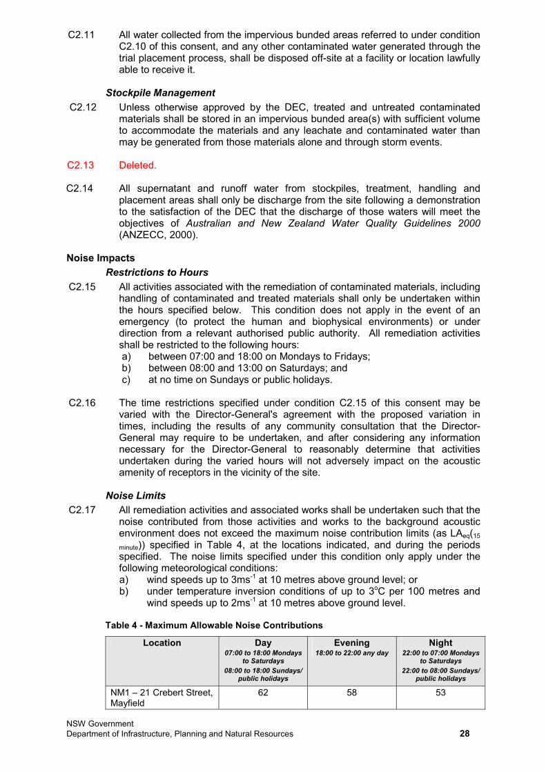
NSW Government Department of Infrastructure, Planning and Natural Resources 28
C2.11 All water collected from the impervious bunded areas referred to under condition C2.10 of this consent, and any other contaminated water generated through the trial placement process, shall be disposed off-site at a facility or location lawfully able to receive it.
Stockpile Management C2.12 Unless otherwise approved by the DEC, treated and untreated contaminated
materials shall be stored in an impervious bunded area(s) with sufficient volume to accommodate the materials and any leachate and contaminated water than may be generated from those materials alone and through storm events.
C2.13 Deleted.
C2.14 All supernatant and runoff water from stockpiles, treatment, handling and placement areas shall only be discharge from the site following a demonstration to the satisfaction of the DEC that the discharge of those waters will meet the objectives of Australian and New Zealand Water Quality Guidelines 2000(ANZECC, 2000).
Noise Impacts Restrictions to Hours
C2.15 All activities associated with the remediation of contaminated materials, including handling of contaminated and treated materials shall only be undertaken within the hours specified below. This condition does not apply in the event of an emergency (to protect the human and biophysical environments) or under direction from a relevant authorised public authority. All remediation activities shall be restricted to the following hours: a) between 07:00 and 18:00 on Mondays to Fridays; b) between 08:00 and 13:00 on Saturdays; and c) at no time on Sundays or public holidays.
C2.16 The time restrictions specified under condition C2.15 of this consent may be varied with the Director-General's agreement with the proposed variation in times, including the results of any community consultation that the Director-General may require to be undertaken, and after considering any information necessary for the Director-General to reasonably determine that activities undertaken during the varied hours will not adversely impact on the acoustic amenity of receptors in the vicinity of the site.
Noise Limits C2.17 All remediation activities and associated works shall be undertaken such that the
noise contributed from those activities and works to the background acoustic environment does not exceed the maximum noise contribution limits (as LAeq(15
minute)) specified in Table 4, at the locations indicated, and during the periods specified. The noise limits specified under this condition only apply under the following meteorological conditions: a) wind speeds up to 3ms-1 at 10 metres above ground level; or b) under temperature inversion conditions of up to 3oC per 100 metres and
wind speeds up to 2ms-1 at 10 metres above ground level.
Table 4 - Maximum Allowable Noise Contributions
Location Day 07:00 to 18:00 Mondays
to Saturdays08:00 to 18:00 Sundays/
public holidays
Evening 18:00 to 22:00 any day
Night 22:00 to 07:00 Mondays
to Saturdays22:00 to 08:00 Sundays/
public holidays
NM1 – 21 Crebert Street, Mayfield
62 58 53
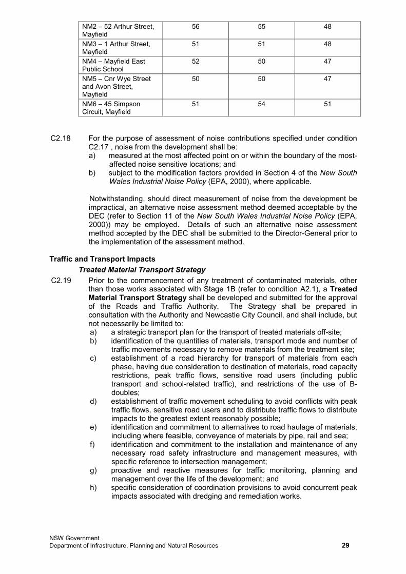
NSW Government Department of Infrastructure, Planning and Natural Resources 29
NM2 – 52 Arthur Street, Mayfield
56 55 48
NM3 – 1 Arthur Street, Mayfield
51 51 48
NM4 – Mayfield East Public School
52 50 47
NM5 – Cnr Wye Street and Avon Street, Mayfield
50 50 47
NM6 – 45 Simpson Circuit, Mayfield
51 54 51
C2.18 For the purpose of assessment of noise contributions specified under condition C2.17 , noise from the development shall be: a) measured at the most affected point on or within the boundary of the most-
affected noise sensitive locations; and b) subject to the modification factors provided in Section 4 of the New South
Wales Industrial Noise Policy (EPA, 2000), where applicable.
Notwithstanding, should direct measurement of noise from the development be impractical, an alternative noise assessment method deemed acceptable by the DEC (refer to Section 11 of the New South Wales Industrial Noise Policy (EPA, 2000)) may be employed. Details of such an alternative noise assessment method accepted by the DEC shall be submitted to the Director-General prior to the implementation of the assessment method.
Traffic and Transport Impacts Treated Material Transport Strategy
C2.19 Prior to the commencement of any treatment of contaminated materials, other than those works associated with Stage 1B (refer to condition A2.1), a Treated Material Transport Strategy shall be developed and submitted for the approval of the Roads and Traffic Authority. The Strategy shall be prepared in consultation with the Authority and Newcastle City Council, and shall include, but not necessarily be limited to: a) a strategic transport plan for the transport of treated materials off-site; b) identification of the quantities of materials, transport mode and number of
traffic movements necessary to remove materials from the treatment site; c) establishment of a road hierarchy for transport of materials from each
phase, having due consideration to destination of materials, road capacity restrictions, peak traffic flows, sensitive road users (including public transport and school-related traffic), and restrictions of the use of B-doubles;
d) establishment of traffic movement scheduling to avoid conflicts with peak traffic flows, sensitive road users and to distribute traffic flows to distribute impacts to the greatest extent reasonably possible;
e) identification and commitment to alternatives to road haulage of materials, including where feasible, conveyance of materials by pipe, rail and sea;
f) identification and commitment to the installation and maintenance of any necessary road safety infrastructure and management measures, with specific reference to intersection management;
g) proactive and reactive measures for traffic monitoring, planning and management over the life of the development; and
h) specific consideration of coordination provisions to avoid concurrent peak impacts associated with dredging and remediation works.
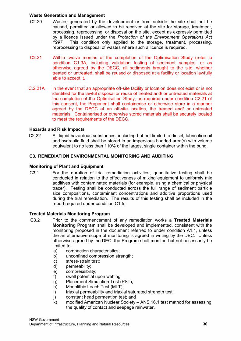
NSW Government Department of Infrastructure, Planning and Natural Resources 30
Waste Generation and Management C2.20 Wastes generated by the development or from outside the site shall not be
caused, permitted or allowed to be received at the site for storage, treatment, processing, reprocessing, or disposal on the site, except as expressly permitted by a licence issued under the Protection of the Environment Operations Act 1997. This condition only applied to the storage, treatment, processing, reprocessing to disposal of wastes where such a licence is required.
C2.21 Within twelve months of the completion of the Optimisation Study (refer to condition C1.3A, including validation testing of sediment samples, or as otherwise agreed by the DECC, all sediments brought to the site, whether treated or untreated, shall be reused or disposed at a facility or location lawfully able to accept it.
C.2.21A In the event that an appropriate off-site facility or location does not exist or is not identified for the lawful disposal or reuse of treated and/ or untreated materials at the completion of the Optimisation Study, as required under condition C2.21 of this consent, the Proponent shall containerise or otherwise store in a manner agreed by the DECC at an off-site location, the treated and/ or untreated materials. Containerised or otherwise stored materials shall be securely located to meet the requirements of the DECC.
Hazards and Risk Impacts C2.22 All liquid hazardous substances, including but not limited to diesel, lubrication oil
and hydraulic fluid shall be stored in an impervious bunded area(s) with volume equivalent to no less than 110% of the largest single container within the bund.
C3. REMEDIATION ENVIRONMENTAL MONITORING AND AUDITING
Monitoring of Plant and Equipment C3.1 For the duration of trial remediation activities, quantitative testing shall be
conducted in relation to the effectiveness of mixing equipment to uniformly mix additives with contaminated materials (for example, using a chemical or physical tracer). Testing shall be conducted across the full range of sediment particle size compositions, contaminant concentrations and additive proportions used during the trial remediation. The results of this testing shall be included in the report required under condition C1.5.
Treated Materials Monitoring Program C3.2 Prior to the commencement of any remediation works a Treated Materials
Monitoring Program shall be developed and implemented, consistent with the monitoring proposed in the document referred to under condition A1.1, unless the an alternative scope of monitoring is agreed in writing by the DEC. Unless otherwise agreed by the DEC, the Program shall monitor, but not necessarily be limited to: a) compaction characteristics; b) unconfined compression strength; c) stress-strain test; d) permeability; e) compressibility; f) swell potential upon wetting; g) Placement Simulation Test (PST); h) Monolithic Leach Test (MLT); i) triaxial permeability and triaxial saturated strength test; j) constant head permeation test; and k) modified American Nuclear Society – ANS 16.1 test method for assessing
the quality of contact and seepage rainwater.
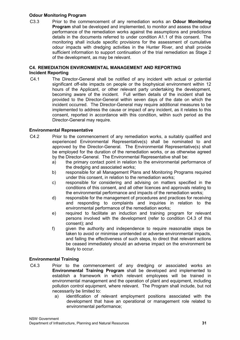
NSW Government Department of Infrastructure, Planning and Natural Resources 31
Odour Monitoring Program C3.3 Prior to the commencement of any remediation works an Odour Monitoring
Program shall be developed and implemented, to monitor and assess the odour performance of the remediation works against the assumptions and predictions details in the documents referred to under condition A1.1 of this consent. The monitoring shall include specific provisions for the assessment of cumulative odour impacts with dredging activities in the Hunter River, and shall provide sufficient information to support continuation of the trial remediation as Stage 2 of the development, as may be relevant.
C4. REMEDIATION ENVIRONMENTAL MANAGEMENT AND REPORTING Incident Reporting C4.1 The Director-General shall be notified of any incident with actual or potential
significant off-site impacts on people or the biophysical environment within 12 hours of the Applicant, or other relevant party undertaking the development, becoming aware of the incident. Full written details of the incident shall be provided to the Director-General within seven days of the date on which the incident occurred. The Director-General may require additional measures to be implemented to address the cause or impact of any incident, as it relates to this consent, reported in accordance with this condition, within such period as the Director-General may require.
Environmental Representative C4.2 Prior to the commencement of any remediation works, a suitably qualified and
experienced Environmental Representative(s) shall be nominated to and approved by the Director-General. The Environmental Representative(s) shall be employed for the duration of the remediation works, or as otherwise agreed by the Director-General. The Environmental Representative shall be: a) the primary contact point in relation to the environmental performance of
the dredging and associated works; b) responsible for all Management Plans and Monitoring Programs required
under this consent, in relation to the remediation works; c) responsible for considering and advising on matters specified in the
conditions of this consent, and all other licences and approvals relating to the environmental performance and impacts of the remediation works;
d) responsible for the management of procedures and practices for receiving and responding to complaints and inquiries in relation to the environmental performance of the remediation works;
e) required to facilitate an induction and training program for relevant persons involved with the development (refer to condition C4.3 of this consent); and
f) given the authority and independence to require reasonable steps be taken to avoid or minimise unintended or adverse environmental impacts, and failing the effectiveness of such steps, to direct that relevant actions be ceased immediately should an adverse impact on the environment be likely to occur.
Environmental Training C4.3 Prior to the commencement of any dredging or associated works an
Environmental Training Program shall be developed and implemented to establish a framework in which relevant employees will be trained in environmental management and the operation of plant and equipment, including pollution control equipment, where relevant. The Program shall include, but not necessarily be limited to: a) identification of relevant employment positions associated with the
development that have an operational or management role related to environmental performance;
NSW Government Department of Infrastructure, Planning and Natural Resources 32
b) details of appropriate training requirements for relevant employees; c) a program for training relevant employees in operational and/ or
management issues associated with environmental performance; and d) a program to confirm and update environmental training and knowledge
during employment of relevant persons.
Remediation Environmental Management Plan C4.4 Prior to the commencement of any remediation works, a Remediation
Environmental Management Plan shall be prepared and submitted for the approval of the Director-General. The Plan shall outline environmental management practices and procedures to be followed during the remediation works and shall include, but not necessarily be limited to: a) a description of all activities to be undertaken in relation to the
remediation works; b) statutory and other obligations that must be fulfilled in relation to the
remediation works, including all approvals, consultations and agreements required from authorities and other stakeholders, and key legislation and policies;
c) a description of the roles and responsibilities for all relevant employees involved in the remediation works and a program for how these employees will be trained in responsibilities identified in the plan;
d) details of how the environmental performance of the remediation works will be monitored, and what actions will be taken to address identified adverse environmental impacts. In particular, the following environmental performance issues shall be addressed in the Plan:
i) measures to monitor and manage dust emissions; ii) measures to monitor and minimise soil erosion and the discharge
of sediment and other pollutants to lands and/ or waters; iii) measures to monitor and manage contaminated soils/ materials; iv) measures to monitor and control noise emissions during
operation; v) measures to monitor and control air emissions during handling of
contaminated materials; e) an Odour Management Plan as required under condition C4.5 of this
consent; f) arrangements for community consultation and complaints handling
procedures for the life of the remediation works.
C4.5 An Odour Management Plan shall be prepared as part of the Remediation Environmental Management Plan required under condition C4.4 of this consent, to outline measures to minimise odour impacts associated with the dredging and excavation works. The Plan shall include, but not necessarily be limited to:
a) identification of all point and diffuse sources of odour associated with the dredging and excavation works;
b) a detailed description of the odour mitigation methods and management practices that will be used throughout the dredging and excavation works to ensure offensive odour impacts do not occur off site;
c) details of the implementation of best practice management measures to ensure potential odour impacts are managed;
d) a detailed description of the methods used for monitoring the effectiveness of the odour mitigation methods and management practices for all point and diffuse sources of odour associated with the dredging and excavation works;
e) details of proposed contingency measures should odour impacts occur; f) a procedure for handling potential odour complaints that includes
recording, investigating, reporting and follow-up action; and
NSW Government Department of Infrastructure, Planning and Natural Resources 33
g) processes and procedures for coordination with the party undertaking remediation works to ensure a consistent and coordinated approach to project-specific and cumulative odour impacts.
NSW Government Department of Planning 34
SUBSCHEDULE DCONDITIONS RELATING TO FULL-SCALE REMEDIATION AND REMEDIATED
MATERIALS HANDLING
D1. REMEDIATION GENERAL REQUIREMENTS Application of Sub-Schedule D1.1 The conditions in this Sub-Schedule apply to works associated with the Stage 2
remediation activities. Stage 1B works (trial remediation and remediation optimisation) are subject to the conditions in Sub-Schedule C.
Compliance Certification D1.2 Prior to each of the events listed from a) to c) below, or within such period otherwise
agreed by the Director-General, documentation certifying that all conditions of this consent applicable prior to that event have been complied with shall be submitted to the satisfaction of the Director-General. Where an event is to be undertaken in stages, submission of compliance certification may be staged consistent with the staging of activities relating to that event, subject to the prior agreement of the Director-General: a) commencement of the Stage 2 treatment works; b) first emplacement of Stage 2 remediation materials in the Kooragang Waste
Emplacement Facility or other facility lawfully able to accept the materials; and c) completion of the Stage 2 remediation works.
D1.3 Notwithstanding condition D1.2 of this consent, the Director-General may require an update report on compliance with all, or any part, of the conditions of this consent. Any such update shall meet the requirements of the Director-General and be submitted within such period as the Director-General may agree.
D2. REMEDIATION DESIGN REQUIREMENTS D2.1 In addition to the design standards and controls detailed in Hunter River Sediment
Remediation Project Concept Design Report – Placement Area RLMC Kooragang island Site Newcastle (BHPB, URS, Douglas Partners & Connell Hatch, 30 January 2007), the containment cell(s) for treated materials from the Stage 2 remediation shall be designed, constructed and maintained to achieve the following, unless otherwise approved by the Director-General in consultation with the DECC: a) the treated materials shall be placed in a containment cell that has a basal and
side wall liner consisting of a 1.5-millimetre thick geo membrane (high density polyethylene) liner, sloping on its base by at least 1% to a sump and riser. The basal 1.5-millimetre thick high density polyethylene liner shall be suitably protected on both sides. A leachate drainage layer with a transmissivity of not less than 3 x 10⁻⁴ m2s-1 shall be installed above the high density polyethylene liner. The liner shall be chemically resistant to the leachate and be able to withstand the weight of the overlying materials and any structures proposed to be constructed on the cell(s) cap(s);
b) the cell(s) shall have a leachate level management system that allows for the level of leachate within the cell(s) to be maintained at no greater than 300 millimetres above the upper surface of the cell’s basal liner. The system shall be automated and shall include: i) an alarm system that is activated if the leachate within the cell rises to a
level that is more than 300 millimetres above the cell’s basal liner; and ii) interlocks to prevent leachate being pumped out of the cell in the event
that any leachate receiving structure could overflow; c) the cell(s) shall have leachate storage capacity to contain leachate, in a
structure ex-situ the cell(s) after it is capped, and stormwater that may be contaminated by the emplaced treated materials or other pollutants before the cell(s) is capped. Any leachate dam shall be lined with a 1.5-millimetre thick high density polyethylene liner. The leachate storage requirements shall be calculated using a water balance that estimates leachate generation and
NSW Government Department of Planning 35
disposal rates, in monthly increments, during the 90th percentile wet year in year 1 and average monthly rainfall conditions in each subsequent year. Justification shall be provided for absorptive (field) capacity of emplaced compacted treated materials and calculations based on the following assumptions, unless suitably justified and agreed by the Director-General: i) 95% of rainfall falling on the pre-capped emplaced treated materials
becomes leachate in the form of contaminated run-off water; and ii) 1% of rainfall becomes leachate post capping;
d) all storage dams shall have a freeboard added to their volume to contain direct rainfall on the dam from a 1 in 25 year ARI rainfall event of 24 hours duration;
e) storage and disposal methods for predicted volumes of leachate generated shall be approved by the Director-General, in consultation with the DECC, prior to the commencement of construction of the containment cell(s);
f) a gas relief system shall be installed in the cap of the cell(s) to prevent the build-up of pressure within the containment cell(s) which could damage the linear low density polyethylene capping barrier;
g) the linear low density polyethylene liner in the cap shall have a nominal thickness of 1.5 millimetres; and
h) the revegetation layer over the cap shall not include any sulfidic material that could cause acid drainage water to infiltrate the cell.
D2.2 The basal liner of the containment cell(s) shall be placed no less than 1.5 metres above the highest recorded groundwater level on the site, or as otherwise approved by the Director-General in consultation with the DECC.
D2.3 Prior to the commencement of construction of the containment cell(s) or any emplacement of treated materials on the site, the Applicant shall engage a suitably qualified and experienced person or team, approved by the Director-General to review the final design of the containment cell(s) and certify that the containment cell’s liner integrity will not be compromised as a result of the settlement of natural sediment or fill material under or around the containment cell(s). A copy of this certification shall be provided to Director-General and the DECC prior to the commencement of construction of the containment cell(s).
D3. REMEDIATION ENVIRONMENTAL PERFORMANCE Air Quality Impacts
Odour D3.1 The development shall be undertaken so as not to permit any offensive odour, as
defined under section 129 of the Protection of the Environment Operations Act 1997, to be emitted beyond the boundary of the site(s).
D3.2 The total exposed area of treated and untreated contaminated materials at the Mayfield site from both remediation and dredging activities combined, shall not exceed 7,000 m2
at any time, unless otherwise agreed to in writing by the Director-General.
Dust Emissions D3.3 All activities shall be undertaken in a manner that minimises or prevents dust
emissions from the site(s), including wind-blown and traffic-generated dust. All activities undertaken on the site(s) shall be undertaken with the objective of preventing visible emissions of dust from the site(s). Should such visible dust emissions occur at any time, all practicable dust mitigation measures, including cessation of relevant works, as appropriate, shall be identified and implemented such that emissions of visible dust cease.
D3.4 All trafficable and vehicle manoeuvring areas shall be maintained at all times in a condition that minimises the generation and emission of dust.
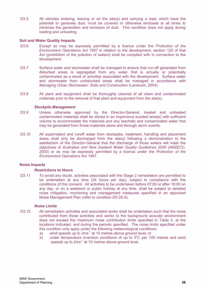
NSW Government Department of Planning 36
D3.5 All vehicles entering, leaving or on the site(s) and carrying a load, which have the potential to generate dust, must be covered or otherwise enclosed at all times to minimise the generation and emission of dust. This condition does not apply during loading and unloading.
Soil and Water Quality Impacts D3.6 Except as may be expressly permitted by a licence under the Protection of the
Environment Operations Act 1997 in relation to the development, section 120 of that Act (prohibition of the pollution of waters) shall be complied with in connection to the development.
D3.7 Surface water and stormwater shall be managed to ensure that run-off generated from disturbed areas is segregated from any water that is actually or potentially contaminated as a result of activities associated with the development. Surface water and stormwater from undisturbed areas shall be managed in accordance with Managing Urban Stormwater: Soils and Construction (Landcom, 2004).
D3.8 All plant and equipment shall be thoroughly cleaned of all clean and contaminated materials prior to the removal of that plant and equipment from the site(s).
Stockpile Management D3.9 Unless otherwise approved by the Director-General, treated and untreated
contaminated materials shall be stored in an impervious bunded area(s) with sufficient volume to accommodate the materials and any leachate and contaminated water that may be generated from those materials alone and through storm events.
D3.10 All supernatant and runoff water from stockpiles, treatment, handling and placement areas shall only be discharged from the site(s) following a demonstration to the satisfaction of the Director-General that the discharge of those waters will meet the objectives of Australian and New Zealand Water Quality Guidelines 2000 (ANZECC, 2000) or as may be expressly permitted by a licence under the Protection of the Environment Operations Act 1997.
Noise Impacts Restrictions to Hours
D3.11 To avoid any doubt, activities associated with the Stage 2 remediation are permitted to be undertaken at any time (24 hours per day), subject to compliance with the conditions of this consent. All activities to be undertaken before 07:00 or after 18:00 on any day, or on a weekend or public holiday at any time, shall be subject to detailed noise mitigation, monitoring and management measures specified in an approved Noise Management Plan (refer to condition D5.D5.6).
Noise Limits D3.12 All remediation activities and associated works shall be undertaken such that the noise
contributed from those activities and works to the background acoustic environment does not exceed the maximum noise contribution limits specified in Table 4, at the locations indicated, and during the periods specified. The noise limits specified under this condition only apply under the following meteorological conditions: a) wind speeds up to 3ms-1 at 10 metres above ground level; or b) under temperature inversion conditions of up to 3oC per 100 metres and wind
speeds up to 2ms-1 at 10 metres above ground level.
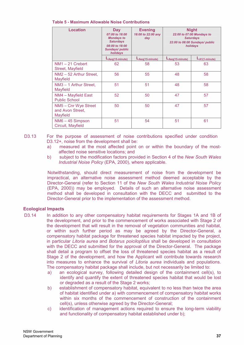
NSW Government Department of Planning 37
Table 5 - Maximum Allowable Noise Contributions
Day 07:00 to 18:00 Mondays to Saturdays
08:00 to 18:00 Sundays/ public
holidays
Evening 18:00 to 22:00 any
day
Night 22:00 to 07:00 Mondays to
Saturdays22:00 to 08:00 Sundays/ public
holidays
Location
LAeq(15-minute) LAeq(15-minute) LAeq(15-minute) LA1(1-minute)
NM1 – 21 Crebert Street, Mayfield
62 58 53 63
NM2 – 52 Arthur Street, Mayfield
56 55 48 58
NM3 – 1 Arthur Street, Mayfield
51 51 48 58
NM4 – Mayfield East Public School
52 50 47 57
NM5 – Cnr Wye Street and Avon Street, Mayfield
50 50 47 57
NM6 – 45 Simpson Circuit, Mayfield
51 54 51 61
D3.13 For the purpose of assessment of noise contributions specified under condition D3.12+, noise from the development shall be: a) measured at the most affected point on or within the boundary of the most-
affected noise sensitive locations; and b) subject to the modification factors provided in Section 4 of the New South Wales
Industrial Noise Policy (EPA, 2000), where applicable.
Notwithstanding, should direct measurement of noise from the development be impractical, an alternative noise assessment method deemed acceptable by the Director-General (refer to Section 11 of the New South Wales Industrial Noise Policy(EPA, 2000)) may be employed. Details of such an alternative noise assessment method shall be developed in consultation with the DECC and submitted to the Director-General prior to the implementation of the assessment method.
Ecological Impacts D3.14 In addition to any other compensatory habitat requirements for Stages 1A and 1B of
the development, and prior to the commencement of works associated with Stage 2 of the development that will result in the removal of vegetation communities and habitat, or within such further period as may be agreed by the Director-General, a compensatory habitat package for threatened species habitat impacted by the project, in particular Litoria aurea and Botarus poiciloptilus shall be developed in consultation with the DECC and submitted for the approval of the Director-General. The package shall detail a program to offset the loss of threatened species habitat as a result of Stage 2 of the development, and how the Applicant will contribute towards research into measures to enhance the survival of Litoria aurea individuals and populations. The compensatory habitat package shall include, but not necessarily be limited to: a) an ecological survey, following detailed design of the containment cell(s), to
identify and quantify the extent of threatened species habitat that would be lost or degraded as a result of the Stage 2 works;
b) establishment of compensatory habitat, equivalent to no less than twice the area of habitat identified under a) with commencement of compensatory habitat works within six months of the commencement of construction of the containment cell(s), unless otherwise agreed by the Director-General;
c) identification of management actions required to ensure the long-term viability and functionality of compensatory habitat established under b);
NSW Government Department of Planning 38
d) the establishment of a board, trust or other mechanism that provides a sound and legally enforceable means of allocating adequate resources for the on-going adaptive management of the compensatory habitat;
e) research into factors that may contribute to the long-term survival of Litoria aureaindividuals and populations within its range, identified in consultation with relevant ecological groups and researchers;
f) consideration of coordinating compensatory habitat works with similar requirements for other developments, including the Newcastle Coal Infrastructure Group coal export terminal (MP 06_0009, approved by the Minister for Planning on 13 April 2007); and
g) timing and responsibilities for implementation of the program.
Traffic and Transport Impacts Remediated Materials Transport Strategy
D3.15 Prior to the commencement of the transport off-site of remediated materials, a Remediated Materials Transport Strategy shall be developed and submitted for the approval of the Director-General. The Strategy shall be prepared in consultation with the Roads and Traffic Authority and Newcastle City Council, Newcastle Ports Corporation, and shall include, but not necessarily be limited to: a) a strategic transport plan for the transport of treated materials on and off-site; b) identification of the quantities of materials, transport mode and number of traffic
movements necessary to remove materials from the treatment site; c) establishment of a road hierarchy for transport of materials from each phase,
having due consideration to destination of materials, road capacity restrictions, peak traffic flows, cumulative traffic impacts, sensitive road users (including public transport and school-related traffic), and restrictions of the use of B-doubles;
d) establishment of traffic movement scheduling to minimise conflicts with peak traffic flows, sensitive road users and to distribute traffic flows to distribute impacts to the greatest extent reasonably possible;
e) identification and assessment of alternatives to road haulage of materials, including where feasible, conveyance of materials by pipe, rail and sea;
f) identification and commitment to the installation and maintenance of any necessary road safety infrastructure and management measures, with specific reference to intersection management;
g) proactive and reactive measures for traffic monitoring, planning and management over the life of the development; and
h) specific consideration of coordination provisions to avoid concurrent peak impacts associated with dredging and remediation works.
D3.16 Condition D3.15 of this consent may be satisfied by demonstrating to the satisfaction of the Director-General that an approved Treated Material Transport Strategy prepared for Stage 1B of the development has been updated to reflect progression to Stage 2 of the development. The Remediated (or Treated) Materials Transport Strategy can be incorporated within the Dredged Material Transport Strategy (required under the existing consent condition B2.29) and be submitted as a single document for Director-General approval.
Waste Generation and Management D3.17 Wastes generated by the development or from outside the site(s) shall not be caused,
permitted or allowed to be received at the site(s) for storage, treatment, processing, reprocessing, or disposal on the site(s), except as expressly permitted by a licence issued under the Protection of the Environment Operations Act 1997. This condition only applies to the storage, treatment, processing, reprocessing to disposal of wastes where such a licence is required.
NSW Government Department of Planning 39
D3.18 Sediments, whether treated or untreated, shall not be stored on the Mayfield site for longer than 12 months from the date of receipt of the sediments, including testing and validation, without the prior written approval of the Director-General.
D3.19 Treated sediments shall be emplaced at the Kooragang Waste Emplacement Facility, or other facility lawfully able to accept the treated sediments.
Hazards and Risk D3.20 The Proponent shall store and handle all dangerous goods, as defined by the
Australian Dangerous Goods Code, and all fuels, oils chemicals or other environmentally hazardous materials strictly in accordance with: a) all relevant Australian Standards; b) for liquids, a minimum bund volume requirement of 110% of the volume of the
largest single stored volume within the bund; and c) the EPA's Environment Protection Manual Technical Bulletin Bunding and Spill
Management.
In the event of an inconsistency between the requirements listed from a) to c) above, the most stringent requirement shall prevail to the extent of the inconsistency.
Property Impacts D3.21 Where utilities, services and access is to be affected by the development,
requirements for the use, alteration, diversion, protection and/or support, shall be determined by negotiation and agreement with the provider and/or owner.
Visual Amenity Impacts D3.22 The Proponent shall ensure that all external lighting associated with the project is
mounted, screened, and directed in such a manner so as not to create a nuisance to the surrounding environment, port operations, properties and public roadways. The lighting shall be the minimum level of illumination necessary and shall comply with AS 4282(INT) 1997 – Control of Obtrusive Effects of Outdoor Lighting.
D4. REMEDIATION ENVIRONMENTAL MONITORING AND AUDITING Groundwater Monitoring D4.1 Prior to the commencement of construction of the containment cell(s), a Groundwater
Monitoring Program shall be developed and implemented to identify and monitor groundwater contaminants and to assess the impacts of the containment cell(s) construction and operation on groundwater hydrology and quality, particularly the migration of groundwater contaminants towards the Hunter River. The Program shall be developed in consultation with the Department and the DECC, and shall include a contingency plan to mitigate identified and predicted adverse contaminated groundwater impacts. The Program shall specifically focus on the effects of the works associated with containment cell(s) and associated infrastructure during construction and operation.
D4.2 For the purpose of condition D4.1 of this consent, the Applicant shall establish groundwater trigger values against which the performance of the containment cell(s) will be monitored and assessed. The groundwater trigger values shall encompass the substances and their concentrations that will be used to assess the performance of the containment cell(s) with respect to groundwater quality. Groundwater trigger values shall be developed in consultation with the DECC, and to the satisfaction of the Director-General.
Environmental Monitoring and Cell Maintenance Program D4.3 Prior to the commencement of construction of the containment cell(s), the Applicant
shall develop and submit for the approval of the Director-General, an Environmental Monitoring and Cell Maintenance Program detailing monitoring and maintenance
NSW Government Department of Planning 40
procedures for the construction and operation of the containment cell(s). The Program shall be developed in consultation with the DECC and shall include, but not necessarily be limited to: a) procedures for monitoring of surface water, groundwater, leachate and gaseous
emissions from the containment cell(s); b) procedures for the maintenance of the containment cell’s cap, leachate collection,
conveyance and management systems and other relevant works; c) assessment and management of processes to establish whether groundwater
trigger values (refer to conditions D4.1 and D4.2) are being exceeded, or are likely to be exceeded as a result of the containment cell(s); and
d) management actions and contingency measures to be implemented in the event that elevated groundwater values, or the activation of trigger values during either construction or operation of the containment cell(s).
Construction Quality Assurance D4.4 Prior to the commencement of construction of the containment cell(s), the Applicant
shall prepare and submit for the approval of the Director-General, details of the containment cell’s design, construction, operation, monitoring and contingencies for rehabilitation works. Documentation shall include, but not necessarily be limited to drawings ‘for construction’ and construction quality assurance (CQA) procedures to ensure that works will be installed in accordance with design specifications.
D4.5 Prior to the emplacement of any treated materials within the containment cell(s), the Applicant shall submit for the approval of the Director-General a CQA report. The CQA report shall include, but not necessarily be limited to: a) ‘as constructed’ drawings, prepared from field surveys depicting at a suitable
scale, with elevations using AHD of the cell’s floor, the following: i) the upper surface of the basal liner (including that for any leachate dam); ii) the upper surface of the leachate collection drainage layer and pipe
grades; iii) the upper and lower surface of each of the layers in the cap; iv) the perimeter of the cell and cross-sections of the basal features of the
cell (in plan view); v) the leachate levels within the riser(s) that will trigger leachate extraction
(in plan view); and vi) the visual alarm in the event that the leachate head is greater than 300
millimetres (in plan view); b) CQA procedures, including:
i) tests and frequencies to demonstrate that each component of the cell’s infrastructure was installed in accordance with design specifications; and
ii) a report by a suitably qualified and experienced person to confirm that the cell(s) was constructed in accordance with its design specifications.
D5. REMEDIATION ENVIRONMENTAL MANAGEMENT AND REPORTING
Incident Reporting D5.1 The Director-General shall be notified of any incident with actual or potential significant
off-site impacts on people or the biophysical environment within 12 hours of the Applicant, or other relevant party undertaking the development, becoming aware of the incident. Full written details of the incident shall be provided to the Director-General within seven days of the date on which the incident occurred. The Director-General may require additional measures to be implemented to address the cause or impact of any incident, as it relates to this consent, reported in accordance with this condition, within such period as the Director-General may require.
NSW Government Department of Planning 41
Environmental Representative D5.2 Prior to the commencement of Stage 2 remediation works, a suitably qualified and
experienced Environmental Representative(s) shall be nominated to and approved by the Director-General. An approved Environmental Representative(s) shall be employed for the duration of the remediation works, or as otherwise agreed by the Director-General. The Environmental Representative shall be: the primary contact point in relation to the environmental performance of the remediation and associated works; a) responsible for all Management Plans and Monitoring Programs required under
this consent, in relation to the remediation works;b) responsible for considering and advising on matters specified in the conditions
of this consent, and all other licences and approvals relating to the environmental performance and impacts of the remediation works;
c) responsible for the management of procedures and practices for receiving and responding to complaints and inquiries in relation to the environmental performance of the remediation works; and
d) given the authority and independence to require reasonable steps be taken to avoid or minimise unintended or adverse environmental impacts, and failing the effectiveness of such steps, to direct that relevant actions be ceased immediately should an adverse impact on the environment be likely to occur.
Remediation Environmental Management Plan D5.3 Prior to the commencement of Stage 2 treatment works, a Remediation
Environmental Management Plan shall be prepared and submitted for the approval of the Director-General. The Plan shall outline environmental management practices and procedures to be followed during the remediation and emplacement works and shall include, but not necessarily be limited to: a) a description of all activities to be undertaken in relation to the remediation
works; b) statutory and other obligations that must be fulfilled in relation to the
remediation works, including all approvals, consultations and agreements required from authorities and other stakeholders, and key legislation and policies;
c) a description of the roles and responsibilities for all relevant employees involved in the remediation works and a program for how these employees will be trained in responsibilities identified in the plan;
d) identification, management and disposal of existing contaminants and wastes at the emplacement cell site;
e) the management of potential acid sulphate soils and acid generation from fill materials at the emplacement cell site;
f) details of how the environmental performance of the works will be monitored, and what actions will be taken to address identified adverse environmental impacts. In particular, the following environmental performance issues shall be addressed in the Plan:
i) measures to monitor and manage dust emissions; ii) measures to monitor and minimise soil erosion and the discharge of
sediment and other pollutants to lands and/ or waters; iii) measures to monitor and manage contaminated soils/ materials; iv) measures to monitor and control noise emissions during operation; v) measures to monitor and control air emissions during handling of
contaminated materials; g) an Odour Management Plan as required under condition D5.5 of this consent; h) a Noise Management Plan as required under condition D5.6 of this consent;;
and i) arrangements for community consultation and complaints handling procedures
for the life of the remediation works.
NSW Government Department of Planning 42
D5.4 Condition D5.3 of this consent may be satisfied by demonstrating to the satisfaction of the Director-General that an approved Remediation Environmental Management Plan for Stage 1B of the development has been updated to reflect progression to Stage 2 of the development.
D5.5 An Odour Management Plan shall be prepared as part of the Remediation Environmental Management Plan required under condition D5.3 of this consent, to outline measures to minimise odour impacts associated with the Stage 2 treatment and emplacement works. The Plan shall include, but not necessarily be limited to: a) inclusion of the results, conclusions and recommendations from the Stage 1B
remediation works (including associated optimisation studies); b) identification of all point and diffuse sources of odour associated with the
Stage 2 treatment and emplacement works; c) a detailed description of the odour mitigation methods and management
practices that will be used throughout the treatment and emplacement works to ensure offensive odour impacts do not occur off site;
d) details of the implementation of best practice management measures to ensure potential odour impacts are managed;
e) a detailed description of the methods used for monitoring the effectiveness of the odour mitigation methods and management practices for all point and diffuse sources of odour associated with the treatment and emplacement works;
f) implementation of instrumentation to measure and record wind speed and direction at the project site, in accordance with the “Approved Methods for the Sampling and Analysis of Air Pollutants in New South Wales” DEC, 2006, Method No. AM-1 and AM-2;
g) details of proposed contingency measures should odour impacts occur; h) a procedure for handling potential odour complaints that includes recording,
investigating, reporting and follow-up action; and i) processes and procedures for coordination with the party undertaking
remediation works to ensure a consistent and coordinated approach to project-specific and cumulative odour impacts.
D5.6 A Noise Management Plan shall be prepared as part of the Remediation Environmental Management Plan required under condition D5.3 of this consent, to outline measures to minimise noise impacts associated with the Stage 2 remediation works. The Plan shall include, but not necessarily be limited to: a) inclusion of the results, conclusions and recommendations from the Stage 1B
remediation works (including associated optimisation studies); b) details of remediation activities and a schedule for remediation works; c) identification of remediation activities that have the potential to generate noise
and/or vibration impacts on surrounding sensitive receivers, particularly residential areas and other sensitive land uses;
d) a detailed description of what actions and measures would be implemented to ensure that these works would comply with the relevant noise and vibration criteria/ guidelines, including the identification of these;
e) procedures for notifying residents of remediation activities that are likely to affect their noise and vibration amenity, as well as procedures for dealing with and responding to noise complaints; and
f) a description of how the effectiveness of these actions and measures would be monitored during the proposed works, clearly indicating how often this monitoring would be conducted, how the results of this monitoring would be recorded, and if any non-compliance is detected.

PWCS
SYDNEY �� ����� ����������������!"��� �����������#� �������$���� ��"�%��������&'(����)*)+�)'�����,����)*)+�)'))
$%!��(# #��������&�- �� ��������$����������$���� ��"�%�������+��(����*)�.��'�&���,����*)�&��+��
EMGA MitchellMcLennan�������������� ��������� �����
������������ �
Related Documents