The Spatial Semantic Hierarchy implemented with an omnidirectional vision system Emanuele Menegatti a Giovanni Aneloni a Mark Wright b Enrico Pagello a,c a Department of Informatics and Electronics, University of Padua, Italy b Edinburgh Virtual Environment Center, University of Edinburgh, UK c Institute ISIB of CNR, Padua, Italy Abstract In this paper, we propose a new approach to the map building task: the implementation of the Spatial Semantic Hierarchy (SSH), proposed by B. Kuipers, on a real robot fitted with an omnidirectional camera. The original Kuiper’s formulation of the SSH was slightly modified, in order to manage in a more efficient way the knowledge the real robot collects while moving in the environment. The sensory data experienced by the robot are trans- formed by the different levels of the SSH in order to obtain a compact representation of the environment. This knowledge is stored in the form of a topological map and, eventually, of a metrical map. The aim of this paper is to show that a catadioptric omnidirectional camera is a good sensor for the SSH and nicely couples with several elements of the SSH. The panoramic view and rotational invariance of our omnidirectional camera makes the iden- tification and labelling of place a simple matter. A deeper insight is that the tracking and identification of events on an omnidirectional image such as occlusions and alignments can be used for the segmentation of continuous sensory image data into discrete topological and metric elements of robot maps. Such a combination of the SSH and omnidirectional vision provides a powerful general framework for robot map making and indeed new insights into the concept of ”place” in such activities. Some preliminary experiments performed with a real robot in a unmodified office environment are presented. Key words: Spatial Semantic Hierarchy, omnidirectional vision, map building, localization PACS: * Emanuele Menegatti Email address: [email protected] (Emanuele Menegatti). URL: http://www.dei.unipd.it/ricerca/airg (Emanuele Menegatti). Preprint submitted to Elsevier 22 May 2007

Welcome message from author
This document is posted to help you gain knowledge. Please leave a comment to let me know what you think about it! Share it to your friends and learn new things together.
Transcript

The Spatial Semantic Hierarchy implemented with anomnidirectional vision system
Emanuele Menegatti a Giovanni Aneloni a Mark Wright b
Enrico Pagello a,c
aDepartment of Informatics and Electronics, University of Padua, ItalybEdinburgh Virtual Environment Center, University of Edinburgh, UK
cInstitute ISIB of CNR, Padua, Italy
Abstract
In this paper, we propose a new approach to the map building task: the implementationof the Spatial Semantic Hierarchy (SSH), proposed by B. Kuipers, on a real robot fittedwith an omnidirectional camera. The original Kuiper’s formulation of the SSH was slightlymodified, in order to manage in a more efficient way the knowledge the real robot collectswhile moving in the environment. The sensory data experienced by the robot are trans-formed by the different levels of the SSH in order to obtain a compact representation of theenvironment. This knowledge is stored in the form of a topological map and, eventually, ofa metrical map. The aim of this paper is to show that a catadioptric omnidirectional camerais a good sensor for the SSH and nicely couples with several elements of the SSH. Thepanoramic view and rotational invariance of our omnidirectional camera makes the iden-tification and labelling of place a simple matter. A deeper insight is that the tracking andidentification of events on an omnidirectional image such as occlusions and alignments canbe used for the segmentation of continuous sensory image data into discrete topological andmetric elements of robot maps. Such a combination of the SSH and omnidirectional visionprovides a powerful general framework for robot map making and indeed new insights intothe concept of ”place” in such activities. Some preliminary experiments performed with areal robot in a unmodified office environment are presented.
Key words: Spatial Semantic Hierarchy, omnidirectional vision, map building,localizationPACS:
∗ Emanuele MenegattiEmail address: [email protected] (Emanuele Menegatti).URL: http://www.dei.unipd.it/ricerca/airg (Emanuele Menegatti).
Preprint submitted to Elsevier 22 May 2007

1 Introduction
In several application a mobile robot does not need a map of the environment toperform its tasks. This is especially true if the environment is very simple or highlyengineered and the robot can move using some form of reactive strategy. However,if the robot’s task requires an understanding of the world, the robot has to answerthe three questions posed by Levitt and Lawton [21]: “Where am I?”, “How doI get to other places from here?”, “Where are other places relative to me?”. Inother words, the robot needs some kind of map of its world. Since the beginning ofmobile robotics, the map building problem has been a fundamental problem [12].A wide spectrum of solutions have been proposed using a wide range of sensors.There is a wide range of different maps a robot can use. Different kinds of mapsanswer the three basic questions using different properties of the environment. Wehave to keep in mind that the distance which separates two objects is only one ofthe properties of the space in which the two objects are immersed. The choice ofwhich property to exploit, and therefore, which kind of map to use, depends on thetask of the robot.
Metric maps and qualitative maps are two extreme examples of this idea. They usevery different properties of the space. In metric maps the space is represented in asingle global coordinate system. The relations between different places are metricalrelations described in terms of measures of distances and angles. Conversely, inqualitative maps, the environment is represented as a set of places connected bypaths. There is no metric or geometric information, such as distances, angles, etc.,but only the notion of proximity and order [12]. Depending on the robot’s taskqualitative maps can use very different representations [3] [7].
One of the most effective qualitative representations of an environment is the socalled topological map. This is a qualitative map which extracts from the environ-ment the topological relationships between the different places and paths. One ofthe key issues in the generation of topological maps is the abstraction of a discreteset of distinct places from the continuous sensorial experience. Topological mapscan be transformed into metric maps by adding metric information to the placesand to the relationships between paths and places. Therefore, a map can be seenas a hierarchal structure built layer by layer. Benjamin Kuipers created a formali-sation of this intuition: the Spatial Semantic Hierarchy (SSH). To the best of ourknowledge, so far the SSH was only implemented either on simulated robots oron real robots with very simple sensors, like sonars. No attempt to use a visionsensor has been made. In the last years, omnidirectional vision systems have beenexploited successfully in robot navigation and map building [33]. The success ofthis kind of sensors is explained by the wide field of view achievable [10]. Omnidi-rectional cameras offer in one shot a global view of the surroundings. The purposeof this paper is to present an implementation of the SSH on an autonomous robotfitted with an omnidirectional camera in order to build a map of a building. Our
2
final aim is to use this approach to create a SLAM (Simultaneous Localization andMapping) algorithm based on the framework of the SSH combined with an om-nidirectional vision system. The preliminary experiments presented in this workshow the approach is sound and promising. In fact, event though the robot infersthe environmental structure from the vision data only, without exploiting the infor-mation on the robot motion coming from the encoders, the environment structureis correctly retrieved.
However, at this stage of the work our results are not comparable with the resultsobtained by other SLAM approaches. Just to cite a few of them. Lemair et Lacroixpresented a successful approach to 3D bearings-only SLAM using an omnidirec-tional camera [20]. Salient points are detected and matched between consecuitiveimages. Se et al [30] used SIFT visual landmarks from the stareo camera to builda 3-D map of the environment and to localize the robot. In [5] localization is ob-tained via mapping of a sparse set of features observed from a single camera. Kimand Chung used an omnidirectional stereo vision system which combined structurefrom motion and stereo algorithms [11]. The work presented in this paper was de-veloped as SLAM was emerging. In hindsight, SLAM approaches in combinationwith powerful feature detectors, such as SIFT, have become the dominant paradigm.However, the framework we propose is independent of feature detection methods,and these could be incorporated into our SSH based approach. For example, pla-nar patches detected by SIFT could be tracked for emergence, occlusion and othertopological events.
1.1 The assumptions
The discussion in the next sections and the experiments are based on some assump-tions that are worth making explicit here.
• The robot is moving in a indoor environment;• The objects present in the scene are static: they do not change their positions;• The floor is almost flat and horizontal;• The walls and the objects present in the scene have vertical edges and surfaces;• The robot can only turn on the spot or move along a straight line. It cannot make
more complex movements;
The last assumption is strong, but greatly simplifies the image sequence interpreta-tion and the robot control.
3

(a) (b) (c)
Fig. 1. (a) The robot on which the SSH has been implemented. (b) A closer view of theomnidirectional mirror mounted on the robot.(c) An omnidirectional image grabbed by therobot.
2 The Spatial Semantic Hierarchy
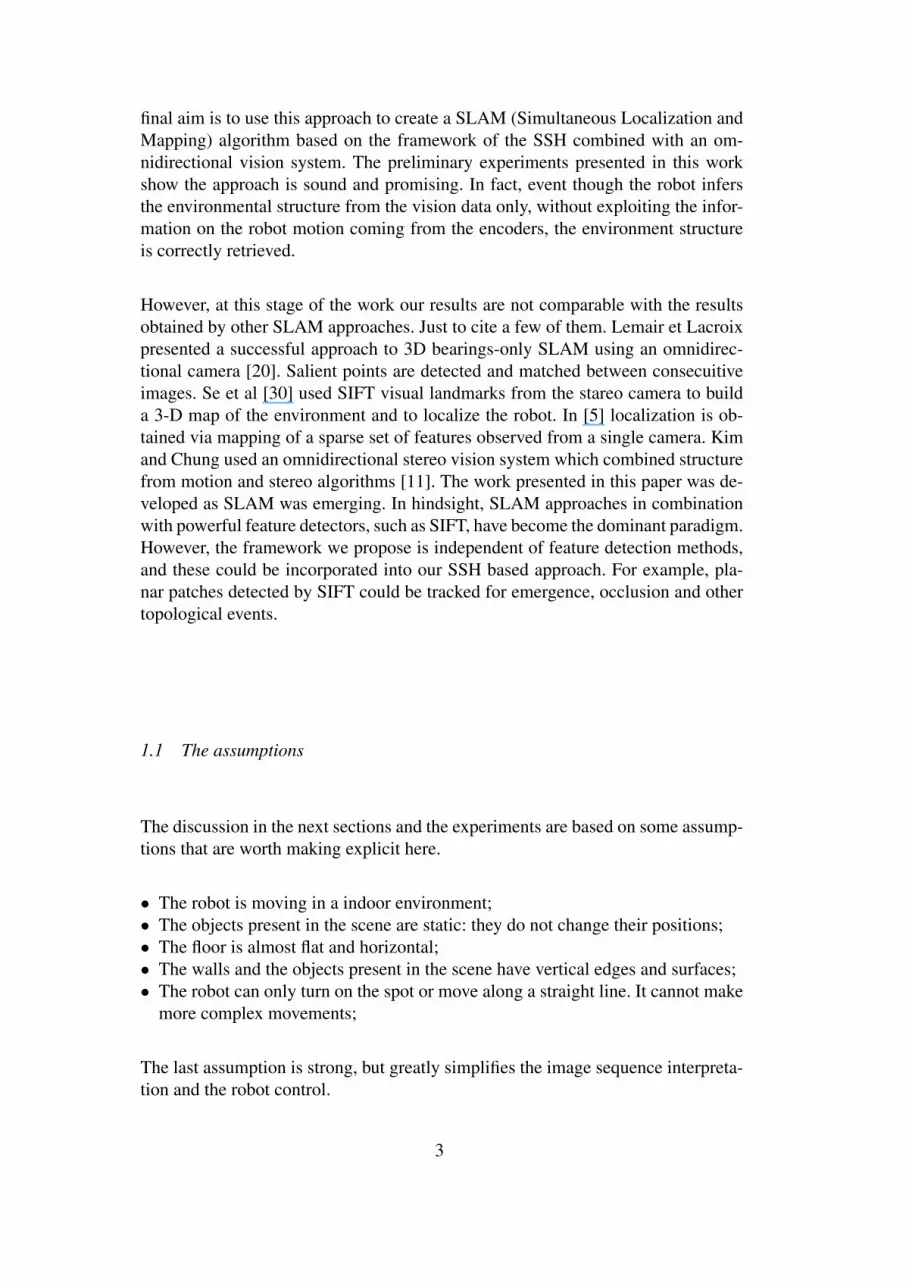
The SSH is a model of the way humans organise their knowledge of a large en-vironment. A large environment is defined by Kuipers as an environment that ex-tends beyond the sensorial horizon of the perceiving agent, i.e. an environment withsections that are not directly perceptible. This model was proposed by BenjaminKuipers [15] [16] [17] [18] [27] and it is intended to serve as a “method for robotexploration and map building” [14]. The SSH is composed of several layers (seeFig.2): the sensory level, the control level, the causal level, the topological and themetrical level. Each layer can be implemented independently, even if they stronglyinteract. In the following we will describe each layer in detail:
2.1 The Sensory Level
The sensory level is the interface with the agent’s sensory system. It extracts theuseful environmental features from the continuous flow of information it receivesfrom the robots’ sensors.
2.2 The Control Level
The control level describes the world in terms of continuous actions called controllaws. A control law is a function which relates the sensory input with the motoroutput. Each control law has conditions for its appropriateness and termination. Aselected control law is retained until a transition of state is detected. These transi-tions can be detected with a function called a distinctiveness measure. The distinc-
4
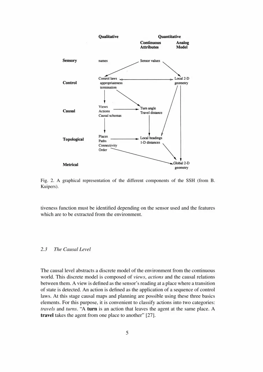
Fig. 2. A graphical representation of the different components of the SSH (from B.Kuipers).
tiveness function must be identified depending on the sensor used and the featureswhich are to be extracted from the environment.
2.3 The Causal Level
The causal level abstracts a discrete model of the environment from the continuousworld. This discrete model is composed of views, actions and the causal relationsbetween them. A view is defined as the sensor’s reading at a place where a transitionof state is detected. An action is defined as the application of a sequence of controllaws. At this stage causal maps and planning are possible using these three basicselements. For this purpose, it is convenient to classify actions into two categories:travels and turns. “A turn is an action that leaves the agent at the same place. Atravel takes the agent from one place to another” [27].
5

2.4 The Topological Level
The topological level represents the environments as places, paths and regions, withdetails of how they are connected or contained one in the other. To use Kuipers’swords:
The topological model of the environment is constructed by the non-monotonicprocess of abduction, infering the minimal set of places and paths needed toexplain the regularities observed among views and actions at the causal level.
2.5 The Metrical Level
The metrical level augments the topological representation of the environment byincluding metric properties such as distance, direction, shape, etc. At this stage, itis possible to build a global geometric map of the environment in a single frame ofreference.
3 Omnidirectional vision and map building
Omnidirectional cameras produce images with a wide angle of view, but with lowresolution. As many authors have already observed, this is not a problem in the caseof a map building robot [7] [28]. For map building, a camera with high resolutionis not so useful. It is not necessary to capture the details of objects and surfaces, butonly to estimate their positions and dimensions. By using an omnidirectional cam-era, the robot does not need to take several shots to understand the surroundings. Itdoes not need to turn and take a look around. It does not need to be fitted with mov-ing parts (camera or mirrors) to increment its field of view. However, beside thesethat can be seen just as implementation considerations, there are more fundamentalaspects supporting the use of an omnidirectional sensor in the process of building amap with the SSH.
For instance, an omnidirectional image captures at once all the objects visible fromthe robot location, see Fig. 1c. This image has a strict connection with the viewsintroduced in the causal level of the SSH, i.e. with the sensor reading at a distinctplace.
In addition, for the particulary geometry of our omnidirectional camera, the verticaledges in the scene are mapped on the image plane as radial lines originating fromthe point corresponding to the tip of the mirror. (The assumption which underliesthis fact is that the axes of the mirror and camera are vertical and aligned.) Thus, itis very simple to extract vertical edges from the images by searching the image for
6
P1 P2
P3
P5
P4Fig. 3. The “exploring around the block” problem. The problem of recognising the sameplace under different state labels [14].
radial lines. The azimuth of a radial line in the image corresponds to the azimuthof the vertical edge in the scene, as viewed from the optical axis of the camera. Ina man-made environment, the vertical edges in the environment provide an optimalfeature to divide the environment into topologically different places. Some exam-ples of vertical edges in a building are: door-posts, corners between two walls, thelateral edges of furniture, etc. In the SSH framework, vertical edges can be used togenerate a distinctiveness measure to identify transition of state in the robot ontol-ogy.
Another advantage of this omnidirectional vision system is its rotational invariance.If the robot rotates a certain angle about the optical axis of the camera, the relativeposition of the objects in the image does not change. The image is only rotatedand the objects appear to have experienced an azimuthal shift equal to the angle ofrotation. This permits a straightforward solution to the problem of exploring aroundthe block [14], i.e. of recognising the same place under different state labels, seeFig. 3. Here the robot is moving around the block following the arrows. When therobot reaches Place 5 from Place 4, it is very difficult to recognize Place 5 as thepreviously visited Place 1 when using a perspective camera or a frontal sonar array.This is because the robot experiences very different sensory input in the same placecoming from different directions. On the other hand, if the robot is equipped withan omnidirectional camera and it makes use of the rotational invariance the sensoryexperience is the same. In other words, using the SSH terminology, it is easy tospot whether the current view is the same it has experienced before and thereforeto consider this view, not as a different place, but as the same place reached from adifferent direction.
Another problem which is easily solved by omnidirectional vision is to discrimi-nate the type of movement the robot is performing at a given time. Using opticalflow techniques, Svoboda showed that with an omnidirectional vision system it isvery easy to discriminate between a small rotational movement and a small trans-lational movement [31]. This task is very difficult for a vision system fitted witha perspective camera. Moreover, using active vision on an omnidirectional vision
7

system it is possible to estimate precisely the motion of a robot. See again [31] fora literature review.
4 SSH Implementation
In this section we will present our implementation of the SSH proposed by B.Kuipers. We will refer to the terminology introduced in Section 2. As we will see,our implementation is a little different from the original one proposed by Kuipers.This is because of the use of very different sensors in the two implementations.One example is the fact that we joined the Causal Level and the Control Level ina single level that better suited our omnidirectional vision system. In fact, in ourimplementation, the Control Level and the Causal Level both obtain data from thesame source. To convey a clear understanding of the details of the implementationwe will start by describing the robot used in the experiments.
4.1 Robot description
The robot used in this implementation is depicted in Fig. 1. This is a robot origi-nally built to serve as goalkeeper in the RoboCup competitions. The robot has twodriven wheels and two spherical wheels (for balance). The robot can rotate on thespot around the optical axis of the camera. The omnidirectional camera is com-posed of a standard perspective camera (a SONY XC-999) and a convex mirrorwith a specially designed profile. The design of this mirror was inspired by thework of Marchese and Sorrenti [22]. The shape of the mirror is designed in orderto maximize the image resolution in the regions of interest [23]. This new shapeexploits all information it is possible to gather from the environment with respectto the mirror we used in previous work [26], in addition of being smaller and lighterthan the old one.
The area close to the center of the image is strongly deformed, because of thederivative’s discontinuity at the vertex of the mirror, see Fig. 4. The body of therobot appears distorted in the shape of a black cross (the cross’s arms correspondto the corners of the robot body). For our application, this is not a disadvantage,because, even if the central part and the periphery of the image (the regions markedwith small diamonds in Fig. 4) are not be used for measurement purposes due tothe strong distortion, they can be used to discriminate between vertical edges andaccidentally apparent radial edges.
The omnidirectional camera is calibrated. Thus, a mapping function is known,which associates the coordinates of every single pixel in the image to a 3D rayin space and, thus, to the coordinate of a corresponding point in the world (assum-
8

Fig. 4. The region of the image used to measure the position of the objects. The regionsmarked with small diamonds are not used in measuring distances due to high distortion.
ing a flat ground plane or other known world geometry). The calibration procedurealso associates every pixel of the image with the average error encountered whenestimating the position of an object in the world. When the position of an objectis measured, the corresponding measurement error is associated with this measure-ment. In addition, a likelihood index is associated to every measure. This index isincremented if the same object is also detected in the following frames. Converselyit will be decremented.
An overview of our implementation of the SSH is given in Fig. 5. The figure showsthe classical SSH of Fig.. 2 overlayed with the software modules which encodethem. In the following, our implementation of each level is presented in detail.
4.2 The implemented Sensory Level
As stated in Sec. 2, the sensory level extracts the useful environmental featuresfrom the continuous flow of information of the robot’s sensors. Our only sensor isan omnidirectional camera and the information flow is a sequence of omnidirec-tional images. As environmental features we used the vertical edges present in theenvironment. Several authors selected features that strictly speaking are not presentin the environment but only in the pictures of the environment, like brightness pat-tern or other features only loosely related to the objects in the world. Usually, thesefeatures are extracted from the images with the use of heavy mathematical tools[7] [13] [32]. We decided not to follow this approach, but to select features that arestrictly bound to the objects in the real world, these features are the vertical edgesexisting in the environment. When the robot moves, the edges appear to move inthe image. Analysing this motion, it is possible to extract information both on thetopology of the environment and on the robot’s movements.
9
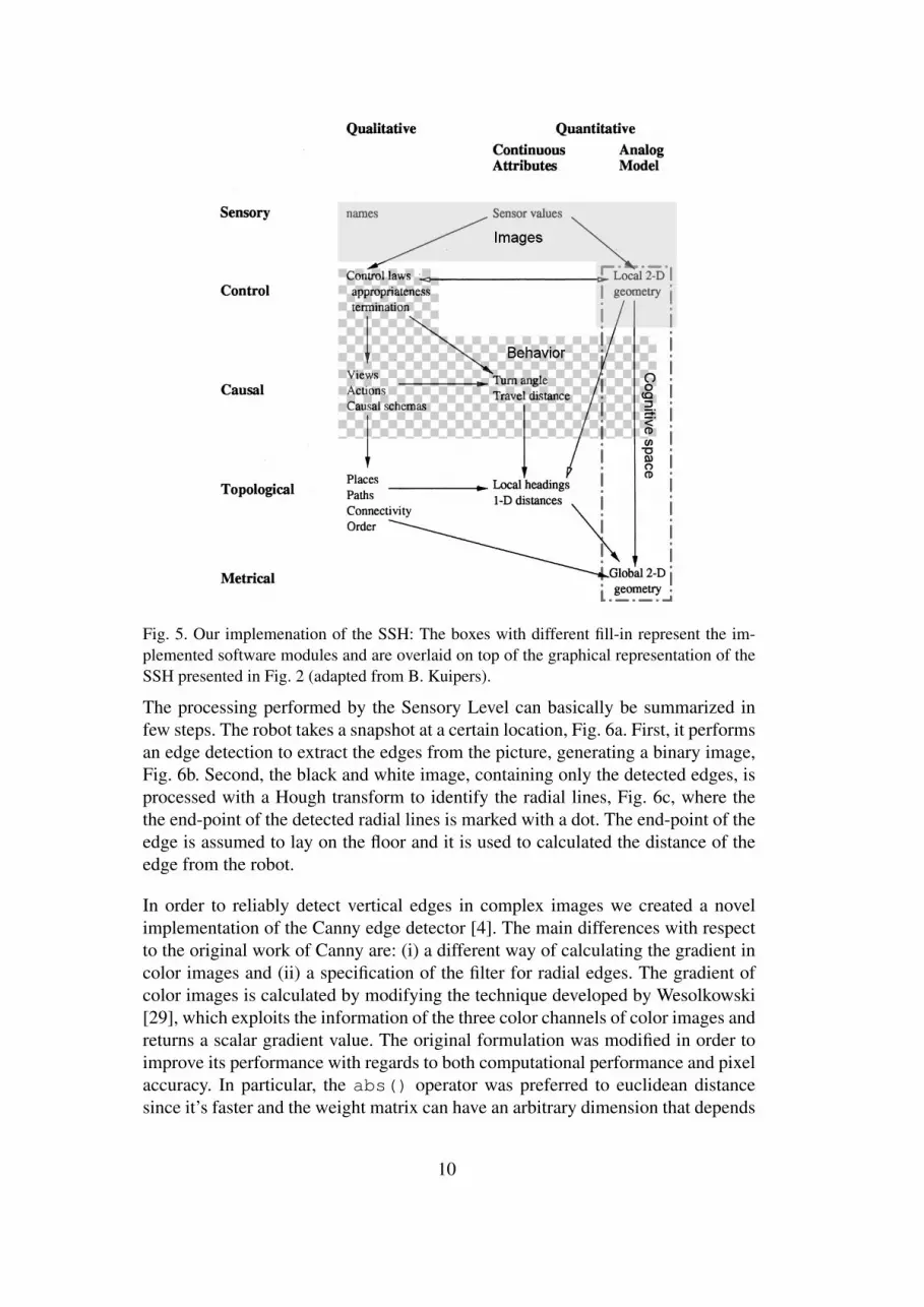
Fig. 5. Our implemenation of the SSH: The boxes with different fill-in represent the im-plemented software modules and are overlaid on top of the graphical representation of theSSH presented in Fig. 2 (adapted from B. Kuipers).
The processing performed by the Sensory Level can basically be summarized infew steps. The robot takes a snapshot at a certain location, Fig. 6a. First, it performsan edge detection to extract the edges from the picture, generating a binary image,Fig. 6b. Second, the black and white image, containing only the detected edges, isprocessed with a Hough transform to identify the radial lines, Fig. 6c, where thethe end-point of the detected radial lines is marked with a dot. The end-point of theedge is assumed to lay on the floor and it is used to calculated the distance of theedge from the robot.
In order to reliably detect vertical edges in complex images we created a novelimplementation of the Canny edge detector [4]. The main differences with respectto the original work of Canny are: (i) a different way of calculating the gradient incolor images and (ii) a specification of the filter for radial edges. The gradient ofcolor images is calculated by modifying the technique developed by Wesolkowski[29], which exploits the information of the three color channels of color images andreturns a scalar gradient value. The original formulation was modified in order toimprove its performance with regards to both computational performance and pixelaccuracy. In particular, the abs() operator was preferred to euclidean distancesince it’s faster and the weight matrix can have an arbitrary dimension that depends
10

(a) (b) (c)
Fig. 6. The image processing sequence on an example image. (a) The original omnidirec-tional image. (b) The result of the edge detector. (c) The vertical edges and their supportpoint.
1 1 2 1 1
1 2 3 2 1
2 3 0 3 2
1 2 3 2 1
1 1 2 1 1Table 1The kernel used in the edge-detector filter.
on the number of pixels around the one currently processed. The best results wereobtained with the kernel values reported in Table 1. In order to specialize the filterfor radial edges in the image, the classical non-maxima suppression phase of theCanny’s filter has been modified putting a bias on following pixels along a radialdirection. This was implemented with dynamic programming, as suggested in theparagraph “Edge following as dynamic programming” in [8]. The basic idea is tostart a hysteresis cycle when a pixel on an edge is found and pixels lying on radiallines are preferred for edge continuation. The threshold and the radial tolerance aredynamically redefined during the process. Even if this approach is computationallyintensive, it offers high quality and flexibility. We compensated the time requiredby the more complex elaboration, by eliminating the promote/demote cycles of thepixels. The resultant processing is only a few milliseconds slower than the originalCanny algorithm, while providing better results.
To select the radial edges among the edges identified by the edge detector, a Houghtransform was used. The geometry of the image enables a major simplificationof the Hough algorithm [9]. If the edge pixels are projected from the Cartesiancoordinate system into a polar coordinate system with the origin in the centre ofthe image, a radial line can be described as a set of pixels with the same angularcoordinate and with varying radial coordinate. By looking at the histogram of thepixels’ angular values, we can spot the radial lines as those where the histogram
11

count is over a certain threshold. The threshold corresponds to the minimal length(in pixels) of the radial lines that we consider as vertical edges. The choice of thethreshold for the minimal length of a vertical edge is a critical parameter. A lowthreshold can also detect pixels that accidentally have the same angular coordinate,but do not belong to the same line. On the other hand, a high threshold missessome vertical edges, especially when they are far away and they appear as smallsegments. The threshold has been set empirically to 60 pixels.
4.3 The implemented Control and Causal Level
When the robot moves in the environment, the vertical edges appear to move inthe image sequence. It is possible to identify some “events” in the edge motionthat are topologically meaningful. These events happen at single points or lines inthe space, therefore they can be used to identify distinct points or boundaries in thatspace. This is the key idea that permits us to extract from the continuous world a setof distinct places as required by the Causal level of the SSH. Based on these events,we also created some distinctiveness measures used to trigger appropriate controllaws, as required by the Control level. We have two control laws: translations androtations. The events we identify in the edge motion during a translation of therobot are:
• A new edge exits from occlusion;• An edge disappears, because occluded by another object;• The two vertical edges are 180 deg. apart in the image;• Two pairs of vertical edges are 180 deg. apart in the image;
The third event is particularly related to the natural topology of the environment,because it happens when the robot is passing through a door or is exiting/enteringa corridor, see Fig. 7. Every time one of these events is detected, the robot cre-ate a new distinct place and stores the local view relative to this position, i.e. theomnidirectional image see Fig. 6a.
When the robot performs a rotation (i.e. it turns on the spot), the distance of therobot from the objects does not change, so the objects do not change their shape inthe image, see Fig. 8. The events we identify in the edge motion are:
• The vertical edges of the scene appear as radial lines that move only by changingtheir azimuth;
• All the edges experience the same azimuthal shift;• The number of visible edges is constant: no edges appear or disappear;
The last consideration comes from the fact that there is no relative displacementbetween the robot and the objects. Therefore, the occlusions do not change. In otherwords, the image does not change, it appears only rotated around its centre. The
12

Fig. 7. The sequence of the robot passing through a door. In the first frame, the posts of thedoor are not yet at 180 deg. In the second frame, they are at 180 deg. In the third, they arenot longer at 180 deg.
Fig. 8. The sequence of images acquired by the omnidirectional camera of the robot whileit turns on the spot
topological consideration we can draw from the rotation sequence is that nothingchanges. Therefore, in the jargon of the SSH, all the views that differ only for arotation around the centre of the image have to be associated to the same place.
In the original SSH formulation, the causal level abstracts a discrete model of theenvironment from the continuous world. Our discrete model of the environment iscomposed by storing a local view, i.e. an omnidirectional image, for each distinctpoint. The omnidirectional images are linked by the actions (i.e. sequences of con-trol laws (translations and rotations) to be applied to reach the next location fromthe current one. Using the stored omnidirectional images, one could also implementhill-climbing control laws proposed by Kuipers at the Control Level [14]. The hill-climbing strategy can be based on visual homing algorithms for omnidirectionalimages such as the ones proposed by Franz et. al [6] or by Argyros et al. [2] (or onadapted homing algorithms for standard cameras such as the one proposed by Rizziet al. [1]).
In the environment exploration phase, the robot selects a sequence of control lawsto move in the environment, using the map generated at the Metrical Level (seeSec. 4.5), in order to determine the free space. When a new action is initiated, therobot aims at the mid-point of the line connecting the two closest vertical edges not
13
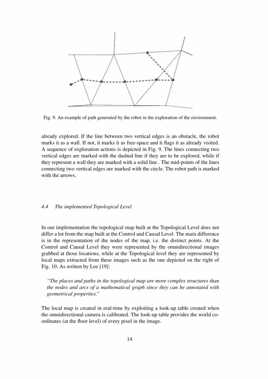
Fig. 9. An example of path generated by the robot in the exploration of the environment.
already explored. If the line between two vertical edges is an obstacle, the robotmarks it as a wall. If not, it marks it as free-space and it flags it as already visited.A sequence of exploration actions is depicted in Fig. 9. The lines connecting twovertical edges are marked with the dashed line if they are to be explored, while ifthey represent a wall they are marked with a solid line . The mid-points of the linesconnecting two vertical edges are marked with the circle. The robot path is markedwith the arrows.
4.4 The implemented Topological Level
In our implementation the topological map built at the Topological Level does notdiffer a lot from the map built at the Control and Causal Level. The main differenceis in the representation of the nodes of the map, i.e. the distinct points. At theControl and Causal Level they were represented by the omnidirectional imagesgrabbed at those locations, while at the Topological level they are represented bylocal maps extracted from these images such as the one depicted on the right ofFig. 10. As written by Lee [19]:
“The places and paths in the topological map are more complex structures thanthe nodes and arcs of a mathematical graph since they can be annotated withgeometrical properties.”
The local map is created in real-time by exploiting a look-up table created whenthe omnidirectional camera is calibrated. The look-up table provides the world co-ordinates (at the floor level) of every pixel in the image.
14

Fig. 10. The construction of a local metrical map (right) from an omnidirectional image(left).
4.5 The implemented Metrical Level
At the Metrical Level the topological map is augmented with metrical informationon the relations and distances among the nodes. In our implementation this is doneby estimating the robot motion and inferring the robot location at each motion step.This is done by matching the visible edges in the image with the edges of the localmap. The matching is performed purely on the geometric information exploitingthe fact that only two kinds of motion are possible: translation or rotation. First,a rotation is assumed and a matching is tried. This is done by finding the rota-tion angle that provides the overlap with the minimum error of all visible verticaledges in the image with all edges in the map. As we will see in the experimentalsection, this process is very robust because of the small error associated with themeasurement of the azimuth of the vertical edges and the one-to-one matching. Ifthe matching is not successful, a translation is assumed. A new match is tried byfinding the translation vector that minimizes the mean squared error in the overlapbetween the support point of the vertical edges in the image and the edges positionin the map. In this case the matching is a little more complex, because there is notnot a one-to-one relationship between the vertical edges in the image and the edgesin the map. In the case of translation, new edges can appear in the image and edgescan disappear because of occlusion. The matching is complicated also by the factthat the measurement of the distance of the support point of the vertical edge fromthe robot is affected by an error that depends on the distance between the edge andthe robot.
As already stated in Sec 4.1, the measurement of the location of a vertical edge inthe environment is associated with a corresponding measurement and a likelihoodindex. Once an edge is detected several times in the frame sequence, its likelihoodindex increases and its true position is calculated as the average of the measured
15

Fig. 11. A sketch representing the fusion of two local maps (left and middle) into a singleglobal map (right).
positions weighted by the errors associated with these measurements.
At the Metrical Level, the local map generated at the Topological Level is enhancedby distinguishing the space lying between two vertical edges as either being a wallor free-space. This is done mainly by evaluation of the reciprocal relationshipsbetween vertical edges and by exploiting the information given by the motion ofthe robot. The rules regarding the vertical edges are:
(1) a new wall cannot be created between two vertical edges if there is already athird vertical edge in the middle;
(2) a new wall cannot cross another wall;(3) a new wall cannot occlude a visible vertical edge;(4) walls not connected to any vertical edge, and edges not connected to a wall,
are eliminated from the map
The rules regarding the robot motion are:
(1) a wall cannot be created if it intersects the previous path of the robot(2) a wall cannot create if it intersects the robot’s body
The local maps generated at the Topological Level are merged into an incrementalglobal metrical map exploiting the information on the position of the vertical edges,on the position of the walls and on the estimated motion of the robot. An example isshown in Fig. 11, in which two simplified local maps are fused into a single globalmap, by solving small misalignment as the one indicated by the arrow on the topof the image. Rotation and translation movements, estimated using the techniquespreviously explained, are annotated in the global map.
5 Experimental Results
To test our implementation of the SSH, we performed some preliminary experi-ments in the corridors of our department. The final experiment was performed inthe corridor depicted in Fig. 12. This corridor has white walls and wooden doorsand no artificial landmarks. The robot is the black box in the middle of the corridor
16
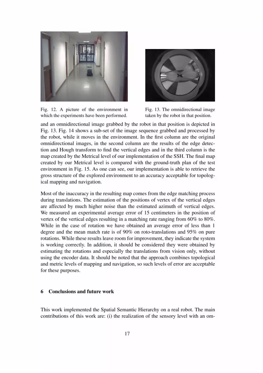
Fig. 12. A picture of the environment inwhich the experiments have been performed.
Fig. 13. The omnidirectional imagetaken by the robot in that position.
and an omnidirectional image grabbed by the robot in that position is depicted inFig. 13. Fig. 14 shows a sub-set of the image sequence grabbed and processed bythe robot, while it moves in the environment. In the first column are the originalomnidirectional images, in the second column are the results of the edge detec-tion and Hough transform to find the vertical edges and in the third column is themap created by the Metrical level of our implementation of the SSH. The final mapcreated by our Metrical level is compared with the ground-truth plan of the testenvironment in Fig. 15. As one can see, our implementation is able to retrieve thegross structure of the explored environment to an accuracy acceptable for topolog-ical mapping and navigation.
Most of the inaccuracy in the resulting map comes from the edge matching processduring translations. The estimation of the positions of vertex of the vertical edgesare affected by much higher noise than the estimated azimuth of vertical edges.We measured an experimental average error of 15 centimeters in the position ofvertex of the vertical edges resulting in a matching rate ranging from 60% to 80%.While in the case of rotation we have obtained an average error of less than 1degree and the mean match rate is of 90% on roto-translations and 95% on purerotations. While these results leave room for improvement, they indicate the systemis working correctly. In addition, it should be considered they were obtained byestimating the rotations and especially the translations from vision only, withoutusing the encoder data. It should be noted that the approach combines topologicaland metric levels of mapping and navigation, so such levels of error are acceptablefor these purposes.
6 Conclusions and future work
This work implemented the Spatial Semantic Hierarchy on a real robot. The maincontributions of this work are: (i) the realization of the sensory level with an om-
17
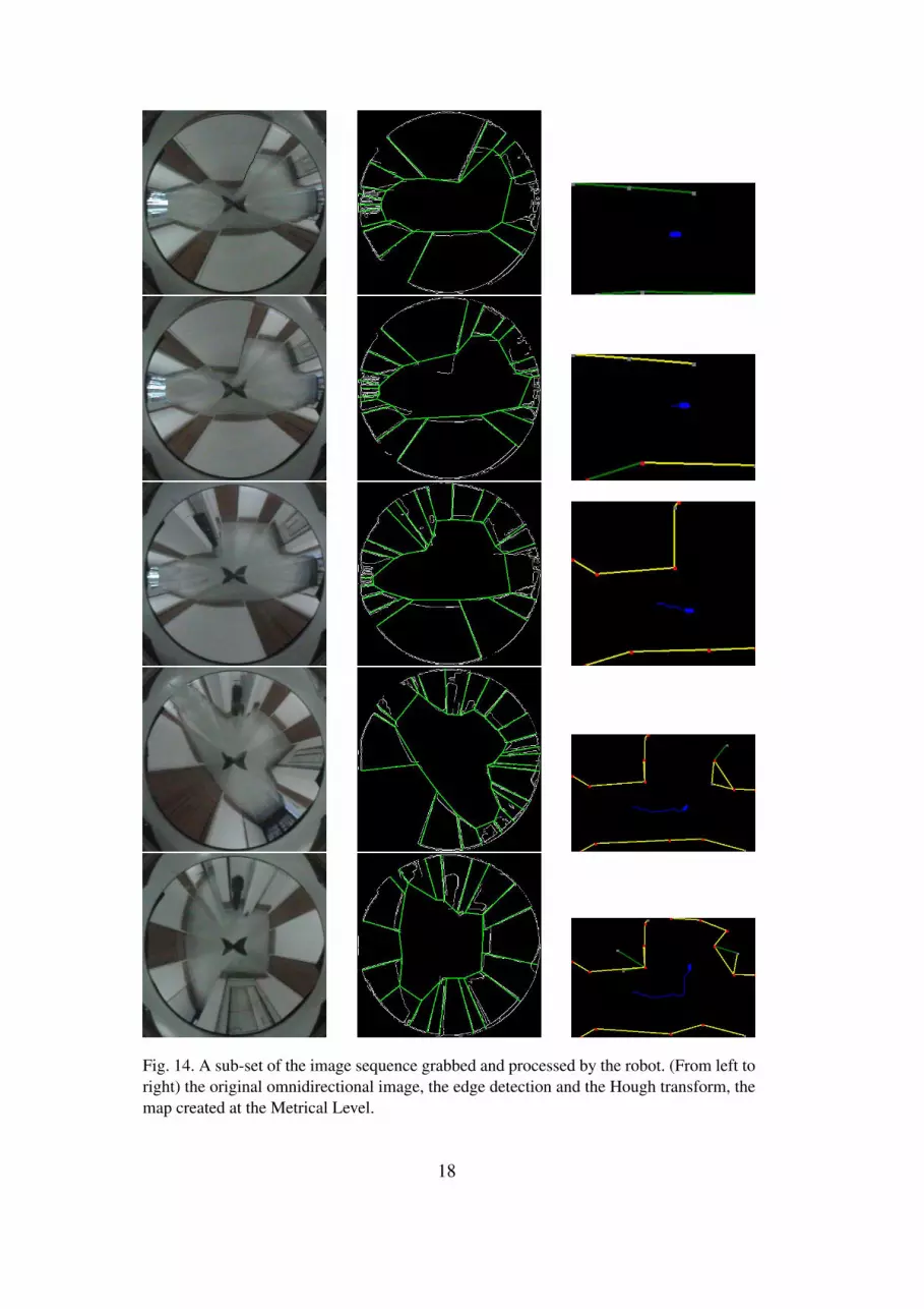
Fig. 14. A sub-set of the image sequence grabbed and processed by the robot. (From left toright) the original omnidirectional image, the edge detection and the Hough transform, themap created at the Metrical Level.
18

Fig. 15. The resulting map compared with the ground-truth of the explored environment.
nidirectional vision system, (ii) we showed that an omnidirectional vision systemis a good sensor for the SSH, (iii) we pointed out which of the features present ina omnidirectional image can be used to detect the transitions of state needed bythe control level of the SSH and we showed the existence of a strict link betweenthe views of the SSH and the image taken by an omnidirectional sensor. In Sec 5,we presented some preliminary experiments that showed the feasibility of the ap-proach using only the omnidirectional camera as the unique sensor and revealedsome limitations of the implementation.
This work was formulated over a period of time while other approaches, mostnotably SLAM (Simultaneous Landmark and Mapping), were developing. SLAMidentifies landmarks and builds a map in order to reduce and put bounds on errorsin the mapping process. SLAM and SSH can be seen to share certain philisophicalsimilarities. Inthe next works, we will consider what crossover there may be be-tween the two approaches. In particular we will look at the topological aspects ofour approach. Some works on SLAM already includes topological elements.
In the future, in addition to improving the robustness of the implementation byimproving the matching algorithm and by exploiting the data collected by the wheelencoders, we will work to extend our approach to multi-robot systems. The basicidea is that every robot builds the local map of the portion of environment it visited.When two robots meet, they share their portions of the map, fusing them into aglobal map. Some preliminary ideas and experiments were presented in [24] [25].
We will seek to relax the contraints of motion to rotation or translation only. Itis well known in the computer vision literature that rotational and translationalcomponents of planar pin hole cameras can be decomposed into rotational andtranslational components. We will seek to extend this to our sensor geometry.
We will seek to extend our approach to include new and very powerful and ro-bust landmarking techniques such as SIFT (Scale-Invariant Feature Transform).Any such feature may be incorporated by tracking occlusions and other topologicaltransitions of such features using new visual odometry techniques.
19
References
[1] R. C. A. Rizzi, G. Bianco. A bee-inspired visual homing using color images. Roboticsand Autonomous Systems, 25(3):pp. 159–164, 1998.
[2] A. Argyros, C. Bekris, S. Orphanoudakis, and L. Kavraki. Robot homing by exploitingpanoramic vision. Journal of Autonomous Robots, vol. 19(no. 1):pp. 7–25, July 2005.
[3] G. Bianco and A. Zelinsky. Biologically-inspired visual landmark learning andnavigation for mobile robots. Proc. of the 1999 IEEE/RSJ Int. Conf. on IntelligentRobots and Systems, 1999.
[4] J. Canny. A computational approach to edge detection. In Transactions on PatternAnalysis and Machine Intelligence, volume 8, pages 679–697. IEEE, 1986.
[5] A. Davison. Real-time simultaneous localisation and mapping with a single camera.Computer Vision, 2003. Proceedings. Ninth IEEE International Conference on, pages1403–1410, 2003.
[6] B. S. Franz, M. and H. H. Blthoff. Where did i take that snapshot? scene-based homingby image matching. Biological Cybernetics, 79:191–202, 1998.
[7] M. O. Franz, B. Schlkopf, H. A. Mallot, and H. H. Blthoff. Learning view graph forrobot navigation. Autonomous Robots, 5:pp. 111–125, 1998.
[8] G.X.Ritter and J.N.Wilson:. Handbook of computer vision image algebra. CRC Press,1996.
[9] P. Hough. Method for recognizing complex patterns. Technical report, US Patent3069654, 1962.
[10] H. Ishiguro. Development of low-cost compact omnidirectional vision sensors. InR. Benosman and S. Kang, editors, Panoramic Vision, chapter 3, pages pp. 23–38.Springer, 2001.
[11] J. Kim and M. Chung. Slam with omni-directional stereo vision sensor. IntelligentRobots and Systems, 2003.(IROS 2003). Proceedings. 2003 IEEE/RSJ InternationalConference on, 1, 2003.
[12] D. Kortenkamp, P. Bonasso, and R. Murphy, editors. Artificial Intelligence and MobileRobotics. AAAI Press/ MIT Press, 1998.
[13] B. Krse, N. Vlassis, R. Bunschoten, and Y. Motomura. Feature selection forappareance-based robot localization. Proc. 2000 RWC Symposium, 2000.
[14] B. Kuipers. The spatial semantic hierarchy. Artificial Intelligence, 119:pp. 191–233,February 2000.
[15] B. Kuipers. An intellectual history of the spatial semantic hierarchy. In M. Jefferiesand A. W.-K. Yeap, editors, Robot and Cognitive Approaches to Spatial Mapping,page (To appear). Springer Verlag, 2006.
20

[16] B. J. Kuipers and Y.-T. Byun. A robot exploration and mapping strategy based on asemantic hierarchy of spatial representations. Journal of Robotics and AutonomousSystems, 8:pp. 47–63, 1991.
[17] B. J. Kuipers and Y.-T. Byun. A robot exploration and mapping strategy based on asemantic hierarchy of spatial representations. Journal of Robotics and AutonomousSystems, 8:pp. 47–63, 1991.
[18] B. J. Kuipers and T. Levitt. Navigation and mapping in large scale space. AI Magazine,9(2):pp. 25–43, 1988. Reprinted in Advances in Spatial Reasoning, Volume 2, Su-shing Chen (Ed.), Norwood NJ: Ablex Publishing, 1990, pages 207–251.
[19] W. Y. Lee, Ph.D. Spatial Semantic Hierarchy for a Physical Mobile Robot. PhD thesis,The University of Texas at Austin, 1, 1996.
[20] T. Lemaire and S. Lacroix. SLAM with Panoramic Vision. Technical report,Technical report, LAAS-CNRS, 2006. submitted to the Journal for Fields Roboticin the special issue SLAM in the Fields. Available from: http://www. laas.fr/tlemaire/publications/lemaireJFR2006 SLAM. pdf.
[21] T. S. Levitt and D. T. Lawton. Qualitative navigation for mobile robots. ArtificialIntelligence Journal, 44(3):pp. 305–361, 1990.
[22] F. Marchese and D. G. Sorrenti. Omni-directional vision with a multi-part mirror. InP. Stone, T. Balch, and G. Kraetzschmar, editors, RoboCup 2000: Robot Soccer WorldCup IV, LNCS. Springer, 2001.
[23] E. Menegatti, F. Nori, E. Pagello, C. Pellizzari, and D. Spagnoli. Designing anomnidirectional vision system for a goalkeeper robot. In A. Birk, S. Coradeschi, andS. Tadokoro, editors, RoboCup-2001: Robot Soccer World Cup V., L. N. on A. I, pagespp. 78–87. Springer, 2002.
[24] E. Menegatti and E. Pagello. Omnidirectional distributed vision for multi-robotmapping. In Proc. of the 6th International Symposium on Distributed AutonomousRobotic Systems (DARS02), pages pp. 279–288, Fukuoka, Japan, June 2002.
[25] E. Menegatti and E. Pagello. Toward a topological mapping with a multi-robot team.In Proc. of the Workshop on Cooperative Robotics, A. Saffiotti Organizer IEEE/RSJInternational Conference on Intelligent Robots and Systems (IROS02-WS7), pagespp.V/1–V/7, Lausanne, October 2002.
[26] E. Menegatti, M. Wright, and E. Pagello. A new omnidirectional vision sensor forthe spatial semantic hierarchy. In IEEE/ASME Int. Conf. on Advanced IntelligentMechatronics (AIM ’01), pages pp. 93–98, July 2001.
[27] K. Pierce and B. Kuipers. Map learning with uninterpreted sensors and effectors.Artificial Intelligence, 92:pp. 169–227, 1997.
[28] A. Rizzi and R. Cassinis. A robot self-localization system based on omnidirectionalcolor images. Robotics and Autonomous Systems, Elsevier, 34(1):pp. 23–38, 2001.
[29] S.B.Wesolkowski. Color image edge detection and segmentation, a comparison ofthe vector angle and the euclidean distance color similarity. Master’s thesis, SystemsDesign Engineering, Faculty of Engineering, University of Waterloo, Canada, 1999.
21

[30] S. Se, D. Lowe, and J. Little. Vision-based global localization and mapping for mobilerobots. Robotics, IEEE Transactions on [see also Robotics and Automation, IEEETransactions on], 21(3):364–375, 2005.
[31] T. Svoboda, T. Pajdla, and V. Hlavac. Motion estimation using central panoramiccameras. IEEE Conf. on Intelligent Vehicles, Stuttgart, Germany, October 1998.
[32] N. Winters and J. Santos-Victor. Mobile robot navigation using omni-directionalvision. 3rd Irish Machine Vision and Image Processing Conf. IMVIP99, Dublin,Ireland, September 1999.
[33] Y. Yagi, Y. Nishizawa, and M. Yachida. Map-based navigation for a mobile robot withomnidirectional image sensor copis. IEEE Transaction on Robotics and automation,VOL. 11(NO. 5):pp. 634–648, October 1995.
22
Related Documents