The southern Laurentide Ice Sheet David M. Mickelson 1 and Patrick M. Colgan 2 1 Department of Geology and Geophysics, University of Wisconsin Madison, Weeks Hall, 1215 West Dayton Street, Madison, WI 53706-1692, USA; [email protected] 2 Department of Geology, Grand Valley State University, 1 Campus Drive, Allendale, MI 49401, USA; [email protected] Changing Attitudes and Approaches The publication of the Quaternary of the United States (Wright & Frey, 1965) for the 1965 INQUA Congress in Den- ver was a milestone that summarized our knowledge of the Quaternary of the U.S. in a single volume. Glacial geology was a major component of the volume, and it contained 125 pages on the Laurentide Ice Sheet (LIS) in the U.S. In the present volume, almost 40 years later, many fewer pages are devoted to the same topic, indicating the vast increase in other aspects of Quaternary studies. In the U.S., glacial geology has expanded greatly in knowledge and interest, and now glacial geologists have a much richer field and variety of techniques with which to study Quaternary history. The other chapters in this book are a clear indication of the diversity of fields that now make up what traditionally was classified as glacial geology or did not exist before 1965. Radiocarbon dating remains the most important tool for determining the chronology of the last glaciation. Accelerator mass spectrometry (AMS) has allowed dating of smaller and somewhat older samples. Tree-ring calibration of the radiocarbon time scale has resulted in dating accuracy not possible 40 years ago. Newer dating methods such as thermo- luminescence, amino-acid racemization, paleomagnetism, and cosmogenic-isotope methods have yielded mixed results, but have the potential to improve our interpretations of glacial chronology, especially those of the pre-late Wisconsin. There have been revolutionary changes in the way we study glacial sediments and reconstruct their depositional environments. Genetic classifications have been replaced by descriptive lithofacies approaches, which focus on modern-process analogs for interpretations of depositional environments. Correlations of till units from one area to another are now approached with more caution, and the use of facies models facilitates the understanding of complex glacial sequences. Geophysical techniques have been used to explore lake basins and subsurface stratigraphy. Models of glacial landform genesis are also driven by modern analogs and interpretations made in modern glacier settings. There have been major changes in our understanding of pre-late Wisconsin events since 1965. The terms “Nebraskan” and “Kansan” are no longer used, and now there is evidence of at least six pre-Illinoian glaciations in the continental record. Flint (1971), in a widely used textbook, hinted that there might be problems with correlations of what was called “Nebraskan Drift,” but nevertheless used the terminology accepted at that time. Based on the oxygen-isotope record from the oceans, we now know that there were clearly more than four glacial and interglacial episodes during the Pleistocene. Much work remains to be done to unravel this continental record of early glaciations and correlate them to the ocean record. There has been debate about the extent of the early Wisconsin Glaciation as well. In many areas, particularly in northern Illinois and southern Wisconsin, deposits thought to be of this age now appear to be older. Probably one reason for our rather poor understanding of pre-late Wisconsin glacial events is the decline of purely stratigraphic studies from the 1980s through the 1990s. State geologic surveys have in many cases reduced their staff and mapping has been displaced by topical studies and an empha- sis on applied research related to groundwater and mineral extraction. In academia, traditional mapping and glacial stratigraphy have not been as common in the last 40 years as previously. Instead they have been replaced by, or combined with, studies of sediment genesis, glacial process, develop- ment of conceptual and quantitative models, and details of local chronology, and integrative studies of glacial deposits and other aspects of Quaternary history such as ice-marginal lakes, paleoclimatology, loess, soils, and the paleontologic record. In the 1990s the U.S. Geological Survey began to fund mapping projects in academia (EDMAP) and state geologic surveys (STATEMAP), and this has revitalized mapping of glacial deposits in the northern U.S. Since the late 1990s the Great Lakes Mapping Coalition, a joint effort of the U.S. Geological Survey and several state geologic surveys, has focused on detailed three-dimensional mapping that includes subsurface investigation. If this program continues to grow, it may re-stimulate interest in mapping glacial deposits. Much of our improved understanding of the southern LIS has come from studies of the new field of paleoglaciology. Reconstruction of ice-sheet surfaces, interpretation of former bed conditions and discussions of sliding vs. subglacial deforming beds, estimates of sediment fluxes, interpretations of the nature and distribution of subglacial meltwater, new interpretations of landform genesis, and modeling have all been major areas of research in the last 40 years. There have been several extensive compilations of the glacial record of the southern LIS since 1965 and we make no attempt to repeat these here. Instead, we highlight what we view as advances in our understanding of the southern LIS and its deposits since publication of the Quaternary of the United States in 1965. Events and processes along the southern margin of the LIS are closely tied to the behavior of the ice sheet in Canada, but much of this literature is not discussed here because of the scope of the book. Likewise, we refrain from discussing ancillary topics, like loess and DEVELOPMENT IN QUATERNARY SCIENCE VOLUME 1 ISSN 1571-0866 DOI:10.1016/S1571-0866(03)01001-7 1 © 2003 ELSEVIER B.V. ALL RIGHTS RESERVED

Welcome message from author
This document is posted to help you gain knowledge. Please leave a comment to let me know what you think about it! Share it to your friends and learn new things together.
Transcript

The southern Laurentide Ice Sheet
David M. Mickelson1 and Patrick M. Colgan2
1 Department of Geology and Geophysics, University of Wisconsin Madison, Weeks Hall, 1215 West Dayton Street,Madison, WI 53706-1692, USA; [email protected]
2 Department of Geology, Grand Valley State University, 1 Campus Drive, Allendale, MI 49401, USA; [email protected]
Changing Attitudes and Approaches
The publication of the Quaternary of the United States(Wright & Frey, 1965) for the 1965 INQUA Congress in Den-ver was a milestone that summarized our knowledge of theQuaternary of the U.S. in a single volume. Glacial geologywas a major component of the volume, and it contained 125pages on the Laurentide Ice Sheet (LIS) in the U.S. In thepresent volume, almost 40 years later, many fewer pages aredevoted to the same topic, indicating the vast increase in otheraspects of Quaternary studies. In the U.S., glacial geology hasexpanded greatly in knowledge and interest, and now glacialgeologists have a much richer field and variety of techniqueswith which to study Quaternary history. The other chaptersin this book are a clear indication of the diversity of fieldsthat now make up what traditionally was classified as glacialgeology or did not exist before 1965.
Radiocarbon dating remains the most important tool fordetermining the chronology of the last glaciation. Acceleratormass spectrometry (AMS) has allowed dating of smallerand somewhat older samples. Tree-ring calibration of theradiocarbon time scale has resulted in dating accuracy notpossible 40 years ago. Newer dating methods such as thermo-luminescence, amino-acid racemization, paleomagnetism,and cosmogenic-isotope methods have yielded mixed results,but have the potential to improve our interpretations of glacialchronology, especially those of the pre-late Wisconsin.
There have been revolutionary changes in the way westudy glacial sediments and reconstruct their depositionalenvironments. Genetic classifications have been replacedby descriptive lithofacies approaches, which focus onmodern-process analogs for interpretations of depositionalenvironments. Correlations of till units from one area toanother are now approached with more caution, and the useof facies models facilitates the understanding of complexglacial sequences. Geophysical techniques have been used toexplore lake basins and subsurface stratigraphy. Models ofglacial landform genesis are also driven by modern analogsand interpretations made in modern glacier settings.
There have been major changes in our understanding ofpre-late Wisconsin events since 1965. The terms “Nebraskan”and “Kansan” are no longer used, and now there is evidenceof at least six pre-Illinoian glaciations in the continentalrecord. Flint (1971), in a widely used textbook, hinted thatthere might be problems with correlations of what was called“Nebraskan Drift,” but nevertheless used the terminologyaccepted at that time. Based on the oxygen-isotope recordfrom the oceans, we now know that there were clearly
more than four glacial and interglacial episodes during thePleistocene. Much work remains to be done to unravel thiscontinental record of early glaciations and correlate themto the ocean record. There has been debate about the extentof the early Wisconsin Glaciation as well. In many areas,particularly in northern Illinois and southern Wisconsin,deposits thought to be of this age now appear to be older.
Probably one reason for our rather poor understandingof pre-late Wisconsin glacial events is the decline of purelystratigraphic studies from the 1980s through the 1990s. Stategeologic surveys have in many cases reduced their staff andmapping has been displaced by topical studies and an empha-sis on applied research related to groundwater and mineralextraction. In academia, traditional mapping and glacialstratigraphy have not been as common in the last 40 years aspreviously. Instead they have been replaced by, or combinedwith, studies of sediment genesis, glacial process, develop-ment of conceptual and quantitative models, and details oflocal chronology, and integrative studies of glacial depositsand other aspects of Quaternary history such as ice-marginallakes, paleoclimatology, loess, soils, and the paleontologicrecord. In the 1990s the U.S. Geological Survey began to fundmapping projects in academia (EDMAP) and state geologicsurveys (STATEMAP), and this has revitalized mapping ofglacial deposits in the northern U.S. Since the late 1990s theGreat Lakes Mapping Coalition, a joint effort of the U.S.Geological Survey and several state geologic surveys, hasfocused on detailed three-dimensional mapping that includessubsurface investigation. If this program continues to grow,it may re-stimulate interest in mapping glacial deposits.
Much of our improved understanding of the southern LIShas come from studies of the new field of paleoglaciology.Reconstruction of ice-sheet surfaces, interpretation of formerbed conditions and discussions of sliding vs. subglacialdeforming beds, estimates of sediment fluxes, interpretationsof the nature and distribution of subglacial meltwater, newinterpretations of landform genesis, and modeling have allbeen major areas of research in the last 40 years.
There have been several extensive compilations of theglacial record of the southern LIS since 1965 and we makeno attempt to repeat these here. Instead, we highlight whatwe view as advances in our understanding of the southernLIS and its deposits since publication of the Quaternary ofthe United Statesin 1965. Events and processes along thesouthern margin of the LIS are closely tied to the behaviorof the ice sheet in Canada, but much of this literature is notdiscussed here because of the scope of the book. Likewise,we refrain from discussing ancillary topics, like loess and
DEVELOPMENT IN QUATERNARY SCIENCEVOLUME 1 ISSN 1571-0866DOI:10.1016/S1571-0866(03)01001-7
1
© 2003 ELSEVIER B.V.ALL RIGHTS RESERVED
2 D.M. Mickelson & P.M. Colgan
the history of ice-marginal lakes, because these are coveredelsewhere in the volume.
Mapping and Compilations of Glacial Geology andGeomorphology Since 1965
Since 1965 there have been several comprehensive reviewsof the geology and geomorphology of the southern LIS. The“state-of-knowledge” was summarized by Flint in 1971 inpart of his classic text. At this time, the deep marine recordwas only beginning to be discovered. Our understanding ofmodern ice-sheet dynamics in Greenland and Antarctica wasin its infancy, and an understanding of surging glaciers andmodern glacial environments was just emerging. Records ofglobal climate change such as ice cores, pollen databases,loess records, and lake cores were fragmentary, few, andfar between. Much of what was known was based on theincomplete terrestrial record of continental and mountainglaciation.
Throughout the 1970s and 1980s numerous records of thelast glaciation were collected, analyzed, and combined into
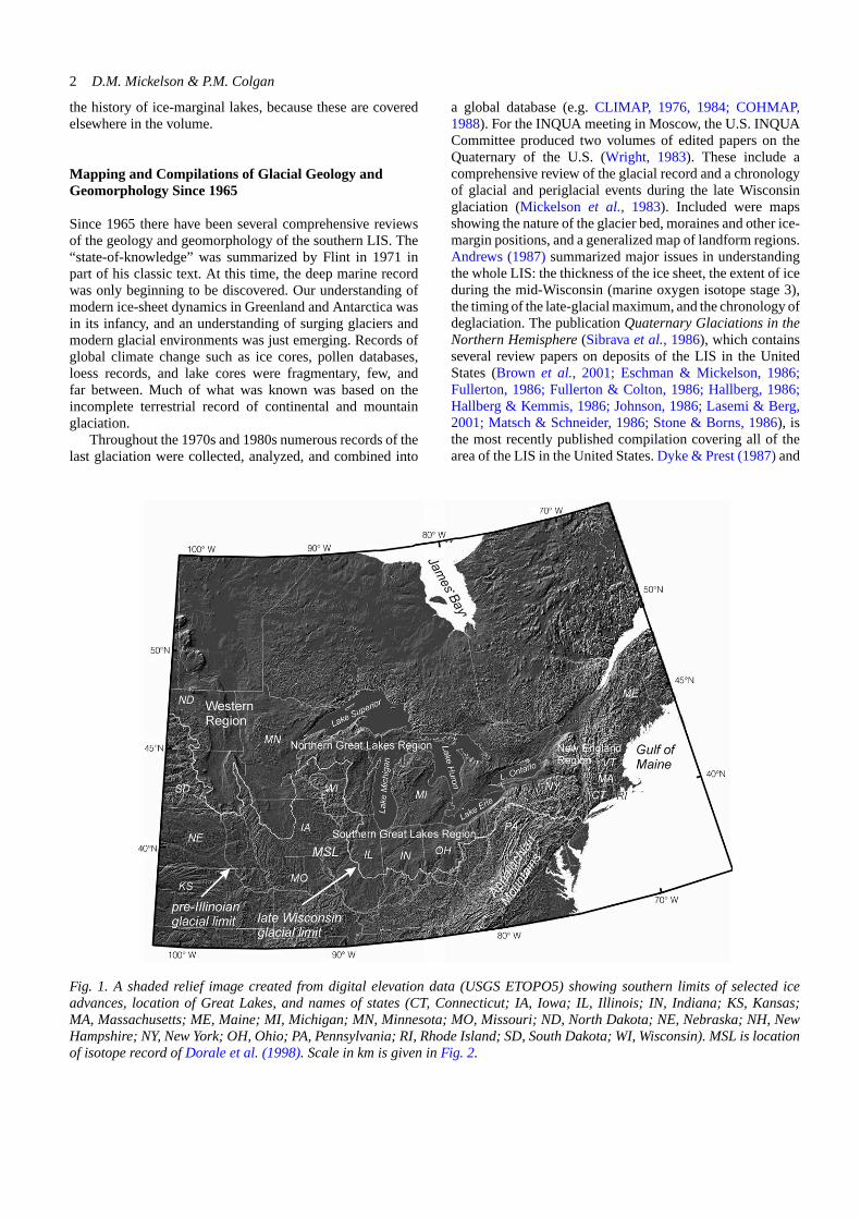
Fig. 1. A shaded relief image created from digital elevation data (USGS ETOPO5) showing southern limits of selected iceadvances, location of Great Lakes, and names of states (CT, Connecticut; IA, Iowa; IL, Illinois; IN, Indiana; KS, Kansas;MA, Massachusetts; ME, Maine; MI, Michigan; MN, Minnesota; MO, Missouri; ND, North Dakota; NE, Nebraska; NH, NewHampshire; NY, New York; OH, Ohio; PA, Pennsylvania; RI, Rhode Island; SD, South Dakota; WI, Wisconsin). MSL is locationof isotope record ofDorale et al. (1998). Scale in km is given inFig. 2.
a global database (e.g. CLIMAP, 1976, 1984; COHMAP,1988). For the INQUA meeting in Moscow, the U.S. INQUACommittee produced two volumes of edited papers on theQuaternary of the U.S. (Wright, 1983). These include acomprehensive review of the glacial record and a chronologyof glacial and periglacial events during the late Wisconsinglaciation (Mickelson et al., 1983). Included were mapsshowing the nature of the glacier bed, moraines and other ice-margin positions, and a generalized map of landform regions.Andrews (1987) summarized major issues in understandingthe whole LIS: the thickness of the ice sheet, the extent of iceduring the mid-Wisconsin (marine oxygen isotope stage 3),the timing of the late-glacial maximum, and the chronology ofdeglaciation. The publication Quaternary Glaciations in theNorthern Hemisphere(Sibrava et al., 1986), which containsseveral review papers on deposits of the LIS in the UnitedStates (Brown et al., 2001; Eschman & Mickelson, 1986;Fullerton, 1986; Fullerton & Colton, 1986; Hallberg, 1986;Hallberg & Kemmis, 1986; Johnson, 1986; Lasemi & Berg,2001; Matsch & Schneider, 1986; Stone & Borns, 1986), isthe most recently published compilation covering all of thearea of the LIS in the United States. Dyke & Prest (1987) and

The southern Laurentide Ice Sheet3
Dyke et al.(2002) summarize what is currently known aboutthe extent and timing of the entire LIS during the last glacialmaximum.
A major contribution to our understanding of regionalaspects of the glacial record is the compilation of Quaternarygeologic maps at 1:1,000,000 scale for all of the area.Organized by G.M. Richmond and D.S. Fullerton, thesemaps, with many authors, are published as U.S. GeologicalSurvey Miscellaneous Investigations Series I-1420. All ofthe southern LIS is covered by these maps, and althoughthey were in most cases compiled from older mapping, theyrepresent the most up-to-date regional maps available. Soller(1998) and Soller & Packard (1998) published a map of thethickness and character of surficial deposits across the areaof the U.S. covered by the LIS. It portrays very thick depositsfilling pre-late Wisconsin valleys and in interlobate areas.
Many states have mapping programs that have addedto our knowledge of glacial deposits and several differentmap scales are being used. Much of this mapping has beendriven by the need for geologic information to help solveenvironmental problems or to help locate groundwater andmineral resources. Many states (Fig. 1) also have developedspecific derivative maps (e.g. contamination potential,aggregate resources) based on maps of Quaternary deposits.Almost all states have glacial or Quaternary geology maps at1:500,000 or smaller. A summary of recently active mappingprograms is shown in Table 1.
Massachusetts and Connecticut (Fig. 1) have beenmapped mostly by the U.S. Geological Survey in cooperationwith state agencies, and many of these maps are available at ascale of 1:24,000 as open file reports. Several states have hadmore limited recent mapping of glacial deposits (Vermont,New Hampshire, Michigan, Iowa, and South Dakota).The U.S. Geological Survey in cooperation with Ohio,Indiana, Illinois, and Michigan recently formed the CentralGreat Lakes Geologic Mapping Coalition. They are sharingresources to produce detailed (1:24,000) three-dimensionalmaps of Quaternary deposits in the southern Great Lakesarea. This effort is reinvigorating interest in mapping ofglacial deposits in the area, and in the future it may extendacross all of the area covered by the LIS.
Table 1. Typical map scales used in states with recent pub-lished mapping and a representative reference to each.
Illinois 1:100,000 or1:24,000
Curry et al. (1997), Grimley(2002)
Indiana 1:24,000 Brown & Jones (1999)Maine 1:24,000 Thompson (1999)Minnesota 1:100,000 Hobbs (1995)New Jersey 1:24,000 Stanford et al. (1998)New York 1:250,000 Muller & Cadwell (1986)North Dakota 1:125,000 or
1:250,000Harris & Luther (1991)
Ohio 1:62,500 Totten (1988)Vermont 1:24,000 DeSimone & Dethier (1992)Wisconsin 1:100,000 Clayton (2001)
New Data Sources
During the last four decades the number of new data sourceswith which to study Quaternary landforms and sedimentshas increased greatly. These include better topographicmaps, digital raster graphics, digital elevation models,remotely sensed data acquired by satellite-based systems,and improved drilling and geophysical techniques. Most ofthe advances in this area have been driven by advances insatellite technology, low-cost computing power, the increasedavailability of geographic information systems (GIS), andthe efforts of government agencies in creating large spatialdatabases.
A new series of 1:24,000 U.S.G.S topographic quadranglemaps has made it possible to compare landforms over all ofthe glaciated United States. These maps are now availableas digital raster graphics (DRG) for the conterminous UnitedStates, Hawaii and portions of Alaska. By far the most impor-tant new data source is the digital elevation model (DEM).These arrays of elevations have revolutionized the way topog-raphy can be visualized, categorized, and analyzed. The first 3arc-second DEMs (1 × 1 degree) were created from the pro-cessing of 1:250,000 scale topographic maps and, as a result,had relatively low spatial resolution (90 × 90 m), and con-tained numerous processing artifacts. The most recent seriesof 30- and 10-meter DEMs have improved on these problems.DEMs allow classification of slope, aspect, and many otherparameters of interest to Quaternary scientists. Imagesderived from the raw DEMs allow the creation of visuallystunning shaded-relief views, contour maps, and orthographicperspective views with overlying drapes of color-coded con-tour intervals or satellite images. Fairly subtle geomorphicfeatures (such as small moraines and flutes) have been discov-ered from these DEMs. They have also allowed recognition ofregional patterns by allowing areas much larger than a single7.5-minute quadrangle to be viewed at once. An early exam-ple of a shaded relief image is the Digital Shaded Relief Mapof the Conterminous United States(Thelien & Pike, 1989),and a smaller scale one is portrayed in Fig. 1. In the last 10years numerous workers have used DEMs for mapping glacialfeatures.
Satellite images such as those from the Landsat Multi-spectral Scanner and Thematic Mapper have been used in afew studies (e.g. Boulton & Clark, 1990), but their use hasbeen limited because of their relatively low spatial resolu-tion (∼80 and 30 m respectively) compared to traditionallow-altitude aerial photography (<1 m). In addition, thereare now many other satellite image systems available, pro-ducing visible bands, infrared, and radar images. Traditionallow-altitude aerial photographs, although still essential formapping landforms, have always been limited by their lackof georeferencing. Image processing and GIS software nowallow all aerial photos (and stereopairs) to be rectified andgeoreferenced. Traditional low-altitude aerial photographsare very useful because they are available back into the 1930sand can be used in determining land use changes as well asmapping subtle geomorphic features, which are only visibleduring certain times of the year. Computer mapping from

4 D.M. Mickelson & P.M. Colgan
digital sources is now routinely used as GIS software hasadvanced and because many data sources are now in digitalformat. This combination of digital data, GIS, and cheapcomputing power has led to regional scale mapping andlandform genesis studies that focus on an entire continent(e.g. Aber et al., 1995; Soller & Packard, 1998).
Geophysical methods have been used to study lakedeposits and subsurface geology. Probably the best exampleis the work of Mullins & Hinchey (1989) and Mullins et al.(1996). They used seismic reflection techniques to describethe sediment filling the Finger Lakes of New York. Thesediment fills the deep bedrock valleys to depths as great as306 meters below present sea level. Coleman et al. (1989)also provided geophysical data from Lake Michigan toshow the thickness of glacial sediment in the south end ofthe lake.
Advances in Glacial Sedimentology andGeomorphology
In the last 40 years, there have been major advances in theway glacial sediments are studied. In the 1960s classificationof glacial sediments was commonly driven by a genetic termi-nology based on interpretations of depositional environment.Much of the descriptive information about boreholes andoutcrops was never published leaving later workers little onwhich to judge these classifications. Research carried out inmodern glacier environments (e.g. Anderson & Sollid, 1971;Boulton, 1970a, b, 1971; Clayton, 1964; Goldthwait, 1974;Hooke, 1970, 1973; Lawson, 1979, 1981) helped to focusglacial geologists’ attention on the reconstruction of pastdepositional environments (e.g. Gustavson & Boothroyd,1987). In the 1970s and 1980s glacial geologists began to uselithofacies analysis and modern-process approaches similarto those being used by sedimentologists in other fields. At thistime the term “diamicton” was more widely used as a purelydescriptive term for the several genetic types of till (e.g.lodgment till, meltout till). The papers included within specialvolume 23 published by the Society of Economic Paleontol-ogists and Mineralogists exemplify the trend toward modernsedimentologic methods in glacial geology (Jopling &McDonald, 1975). Eyles et al.(1983) presented an importantsynthesis of the lithofacies approach and Johnson & Hansel(1990) have since applied this method to the glacial sequencein Illinois.
As advances in glacial sedimentology followed moderntrends, so did interpretations of landform genesis. An im-portant early paper by Clayton & Moran (1974) establishedthe idea of the process-form model in glacial geology. Theyemphasized that glacial-landscape form is directly relatedto the glacial processes active in the past. They also stressedthe fact that glacial environments are composites, includingboth palimpsest landforms (landforms partially hidden bylater forms) and superimposed forms (most recent forms).Finally, they showed that postglacial processes must beunderstood in order to understand the current form of glaciallandscapes.
Our expanding knowledge of the Antarctic and Greenlandice sheets has greatly influenced our current interpretationsof the southern LIS margin (e.g. Hughes et al., 1985). Papersincluded in a 1987 Journal of Geophysical Research SpecialVolume on fast glacier flow helped to focus attention onthe physics of real ice sheets, especially the ice streams andoutlet glaciers that drain modern ice sheets (e.g. Bentley,1987; Clarke, 1987; Raymond et al., 1987; Whillans et al.,1987). Interpretations of the southern LIS have also beeninfluenced by new discoveries on the mechanics of surgingglaciers as well as the sediment and bed conditions beneaththese enigmatic glaciers (e.g. Clarke et al., 1984; Kambet al., 1985). The use of modern analogs as a guide to theinterpretation of past ice sheets has led to the developmentof a new field in glacial geology called paleoglaciology.
Paleoglaciology Comes of Age
The study of the physical nature of past glaciers, what is nowcalled paleoglaciology, has blossomed in the last 40 years.There has been a major focus on understanding the paleo-climate, flow dynamics, and physical processes responsiblefor the landforms and deposits that we see along the southernLIS margin. There are clearly different landform zones acrossthe area covered by the southern LIS (Colgan et al., 2003;Mickelson et al., 1983), but confidently ascribing the for-mation of certain landforms to a certain set of glaciologicalconditions has been elusive.
Although there had been a few attempts to reconstructphysical characteristics of the southern LIS previous to 1965(e.g. Harrison, 1958), Wright’s (1973) suggestion that theSuperior lobe had a low ice-surface profile and Mathews’(1974) reconstruction of ice-surface profiles in the southwestpart of the ice sheet were the first modern attempts atreconstructing ice-surface slopes of lobes of the LIS basedon glacial geomorphic data. They represented a major stepforward in understanding ice dynamics of the southern LIS.Because ice-surface slope is controlled by, among otherthings, resistance at the bed, the shape of the ice surface isintimately tied to bed conditions. Was there water present?Was the bed soft and deforming or hard and rigid? Was theice surging? Were there ice streams? Were there large areasof stagnant ice near the margin or did ice remain active duringretreat? Did the nature of the bed control the formation ofdrumlins, tunnel channels and other landforms? How muchwere ice-margin fluctuations controlled by climate, and howmuch was climate controlled by the ice? All of the abovequestions have been asked and speculated upon from variouspoints of view and we review these below.
Deforming Bed or Sliding of Basal Debris-Rich Ice?
Subglacial sediment transport mechanisms have been a focusof research all over the world, and the southern LIS is noexception. Since the importance of a soft deforming bed wassuggested by, among others, Boulton & Jones (1979) and
The southern Laurentide Ice Sheet5
Boulton & Hindmarsh (1987), for glaciers in general, andAlley et al. (1986, 1987) for Whillans Ice Stream (formerlyIce Stream B), the extent and thickness of a wet, deformingbed beneath the southern LIS have been debated. Boulton &Jones (1979) suggested that the south margin of the LIS wasvery thin because of low basal shear stress (ca. 5 kPa). Beget(1986) suggested a conceptual model for the Lake Michiganlobe that incorporated a combination of sliding and softsediment deformation. He suggested that deforming till witha low yield strength (ca.8 kPa) produced ice-surface profileswith an ice thickness of only 500 m about 200 km northof the terminus. Alley (1991) hypothesized that all of thesouthern LIS was underlain by a thick deforming layer andfurther argued that thick till in ice marginal areas could onlybe explained by the high sediment fluxes produced by a softdeforming bed. Clark (1992a), building on the approach ofMathews (1974), stressed the widespread distribution of lowice-surface slopes and related these to the existence of a softdeforming bed. This concept was expanded (Clark, 1994,1997) when he pointed out the interrelationships between thedistribution of sedimentary bedrock, and the continuity ofsoft, fine-grained sediments, low driving stresses, and relativelack of eskers that would have formed in “R” channels.Colgan & Mickelson (1997) and Colgan (1999a) showed thatice-surface profiles in the Green Bay lobe changed with timeand profiles were probably steepest during the LGM and
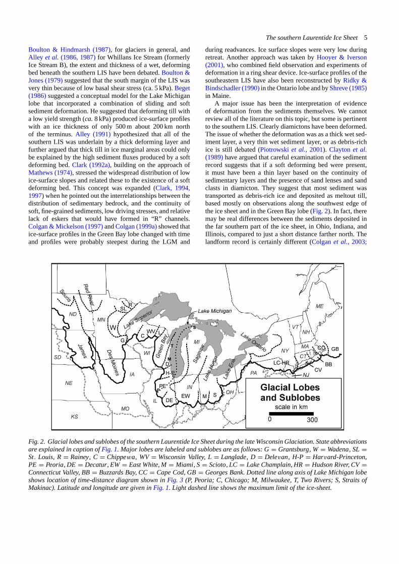
Fig. 2. Glacial lobes and sublobes of the southern Laurentide Ice Sheet during the lateWisconsin Glaciation. State abbreviationsare explained in caption ofFig. 1. Major lobes are labeled and sublobes are as follows: G= Grantsburg, W= Wadena, SL=St. Louis, R= Rainey, C= Chippewa, WV= Wisconsin Valley, L= Langlade, D= Delevan, H-P= Harvard-Princeton,PE= Peoria, DE= Decatur, EW= East White, M= Miami, S= Scioto, LC= Lake Champlain, HR= Hudson River, CV=Connecticut Valley, BB= Buzzards Bay, CC= Cape Cod, GB= Georges Bank. Dotted line along axis of Lake Michigan lobeshows location of time-distance diagram shown inFig. 3 (P, Peoria; C, Chicago; M, Milwaukee, T, Two Rivers; S, Straits ofMakinac). Latitude and longitude are given inFig. 1. Light dashed line shows the maximum limit of the ice-sheet.
during readvances. Ice surface slopes were very low duringretreat. Another approach was taken by Hooyer & Iverson(2001), who combined field observation and experiments ofdeformation in a ring shear device. Ice-surface profiles of thesoutheastern LIS have also been reconstructed by Ridky &Bindschadler (1990) in the Ontario lobe and by Shreve (1985)in Maine.
A major issue has been the interpretation of evidenceof deformation from the sediments themselves. We cannotreview all of the literature on this topic, but some is pertinentto the southern LIS. Clearly diamictons have been deformed.The issue of whether the deformation was as a thick wet sed-iment layer, a very thin wet sediment layer, or as debris-richice is still debated (Piotrowski et al., 2001). Clayton et al.(1989) have argued that careful examination of the sedimentrecord suggests that if a soft deforming bed were present,it must have been a thin layer based on the continuity ofsedimentary layers and the presence of sand lenses and sandclasts in diamicton. They suggest that most sediment wastransported as debris-rich ice and deposited as meltout till,based mostly on observations along the southwest edge ofthe ice sheet and in the Green Bay lobe (Fig. 2). In fact, theremay be real differences between the sediments deposited inthe far southern part of the ice sheet, in Ohio, Indiana, andIllinois, compared to just a short distance farther north. Thelandform record is certainly different (Colgan et al., 2003;

6 D.M. Mickelson & P.M. Colgan
Mickelson et al., 1983), and modeling (discussed below)also suggests there were substantially different subglacialconditions from north to south in the southern LIS.
There have been relatively few detailed sediment de-scriptions, and even then, they describe deformation featureswithout a definitive demonstration of conditions under whichthe sediments were deformed. Hicock & Dreimanis (1992a)examined three widespread diamicton units on the north sidesof Lakes Ontario, Erie, and Superior where pre-advance lakesediment was overridden and incorporated into the sediment.They found evidence of viscous, ductile and brittle deforma-tion based on fold types and orientation, fractures, the natureof striations on clasts, distribution of sand clasts, and othersedimentary features and concluded that there was evidencefor soft-sediment deformation, but also deposition by lodge-ment of basal melt-out. They suggest that the evidence of therelative importance of deforming soft bed and sediment depo-sition from debris-rich glacial ice is indeterminate. Based onlaboratory measurements, reconstructed ice-surface profiles,effective stress reconstructions, and clast fabrics, Hooyer &Iverson (2003) suggest that plowing was an important processat the base of the Des Moines Lobe (Fig. 2). In the area coveredby the southern Lake Michigan lobe (Fig. 2), diamicton gen-esis has been studied extensively at Wedron, Illinois (Hansel& Johnson, 1987; Hansel et al., 1987; Johnson & Hansel,1990) and later at other sites (Hansel & Johnson, 1999).Although these authors point out that there is still room fordoubt about the origin of much of the diamicton in morainesin Illinois, they favor accumulation of subglacially deformedwet sediment as a primary mechanism of deposition. Theybase this on the consistency of their observations withtheoretical predictions of what the sedimentary record shouldresemble. In particular, they cite the uniformity of the till, thelack of supraglacial sediment in moraines, local derivation ofhomogeneous diamicton, characteristics of multiple channelfills, orientation of pebbles plunging down ice or into chan-nels, and pebble concentrations on contacts as evidence of adeforming bed.
The deforming bed model has also been incorporated intotwo-dimensional numerical simulations of ice-sheet behavioralong the Lake Michigan lobe flow line (Clark et al., 1996;Jensen et al., 1995, 1996) by assuming no sliding and aviscoplastic behavior of subglacial sediment. Hard bed anddeforming bed were two end member conditions used, andstrength properties of the subglacial sediments were assumedto be similar to properties of the present day till measured byVela (1994). As predicted by Boulton & Jones (1979) (the“bowler hat” model), the ice surface on the up-ice, hard-bedend of the profile has a steeper ice-surface gradient and higherdriving stress than the deforming soft bed. Modeling ofsediment flux indicates that there would be sufficient velocityto produce the large sediment fluxes estimated by Johnsonet al. (1991) only under a fairly narrow range of subglacialpore pressures. An important contribution of the modelingis the suggestion that the rapid ice-margin fluctuations docu-mented in the southern part of the Lake Michigan lobe mightbe controlled by slight changes in subglacial sediment vis-cosity as opposed to being directly driven by climate change.
The physical behavior of southern LIS lobes is still poorlyknown and recent numerical reconstructions of the LGM LISby Marshall et al. (2002) fail to reproduce the known con-figuration of the southern margin because present numericalmodels do not reproduce all the lobe-scale processes of areal ice sheet.
Temperature Conditions at the Glacier Bed
There appear to have been distinct differences in the natureof the glacier bed across the southern LIS (Colgan et al.,2003; Mickelson et al., 1983) in addition to the “hard bed/softbed” differences described above. In the far southern area(Ohio, Indiana, and Illinois), and in younger readvance de-posits around the Great Lakes, the landscape is dominated bywide moraines with low internal relief. Between the morainesare flat till plains with only a few low flutes locally present(Hansel & Johnson, 1999). North of about the latitude ofChicago (Fig. 1), the end moraines have higher relief, anddrumlins dominate the landscape between moraines. Tunnelchannels (or valleys) are abundant to the north and rare, orabsent, farther south. Drumlins and tunnel channels occur inareas where there was a soft bed as well as a hard bed, sosome other explanation for the huge differences in landscapemust be involved.
An explanation for this remarkable difference in sub-glacial landscape is likely the presence or absence ofpermafrost during ice advance, and therefore basal icetemperatures in the marginal zone of the ice sheet. Thelast twenty years has seen growth in our knowledge of theextent and effects of permafrost along the south marginof the LIS. The most convincing evidence of permafrostincludes fossil ice-wedge casts and ice-wedge polygonsseen in aerial photographs (Pewe, 1983). Such features arerelatively common in Ohio (Konen, 1995), Illinois (Johnson,1990), Wisconsin (Clayton et al., 2001), Minnesota (Mooers,1990b), Iowa (Walters, 1994), and in the Dakotas (Claytonet al., 1980) and have been dated at between 21,000 and16,000 14C yr B.P. Baker et al. (1986) showed that a borealforest/tundra transition zone was present in southeast Iowaat between 18,090 and 16,710 14C yr B.P. based on abundantplant and animal fossils preserved in a silt-filled swale.In the east, an extensive permafrost zone is suggested bynumerous periglacial phenomena in the Appalachian Plateauand Ridge and Valley province just south of the glacial border(Clark & Ciolkosz, 1988).
Ice-wedge casts on till surfaces in the southern parts of theLake Michigan, Saginaw, and Huron lobes (Fig. 2) (Johnson,1990) indicate the presence of permafrost, but it seems likelythis was established during retreat from the glacial maxi-mum, not during advance. Numerous radiocarbon dates onPiceawood indicate a lack of continuous permafrost duringadvance to the maximum. Ice-wedge casts are widespreadfarther north in Wisconsin and presumably in the remainderof the northern part of the U.S. covered by the LIS (Pewe,1983). Recently, a two-dimensional model has been adaptedto the topography and reconstructed climate of the Green Bay
The southern Laurentide Ice Sheet7
lobe in eastern Wisconsin. The climate record used to drivethe advancing ice is a speleothem record from the vicinity ofSt. Louis (MSL on Fig. 1) (Dorale et al., 1998). The modelclearly demonstrates the development of permafrost in frontof the advancing ice and that the permafrost slowly disappearsafter being covered by ice, taking several thousand years to doso (Cutler et al., 2000, 2001). The model is at present beingadapted to other southern LIS lobes, but the use of models foranything but the most crude representations of what actuallytook place is limited by our lack of good climate information.Although there are several fossil-derived climate records inthe southern LIS area that extend back into or beyond thelate Wisconsin (Baker et al., 1986; Birks, 1976; Curry &Baker, 2000), they only constrain temperature somewhatand provide almost no information about precipitation. Sofar, the only semi-quantative information on precipitation iswhat is generated by global climate models.
It seems likely that distribution of drumlins and tunnelchannels, and the internal relief of end moraines are closelytied to the difference in permafrost history from north to south.Although there are some small drumlins that may be deposi-tional features, many drumlins show evidence that widespreadsubglacial erosion carved them out of pre-existing sedimentsby freeze-on to the base of the ice, by streaming subglacialsediment, or flowing water (Attig et al., 1989; Boyce &Eyles, 1991; Colgan, 1999a; Newman & Mickelson, 1994;Whittecar & Mickelson, 1979). The drumlins in the northernpart of the area covered by the southern LIS may have formedduring disappearance of the frozen bed beneath the ice sheet,which would have produced an inhomogeneous bed allowingthe drumlins to form by differential erosion and deposition(Cutler et al., 2000; Stanford & Mickelson, 1985). Colgan &Mickelson (1997; Colgan, 1999a) demonstrated that advancesof the Green Bay lobe that produced drumlins had steeperice-surface profiles than advances that did not produce them,suggesting that driving stress and therefore bed resistance,was higher in the drumlin forming areas than in areas of flattill plains.
It has also been suggested that the permafrost wedgenear the glacier margin was instrumental in the developmentof tunnel valleys or channels, although there is continuingdebate about the genesis of these features. Wright (1973) sug-gested that tunnel valleys drained water catastrophically frombeneath a wet bed glacier that had a frozen bed zone aroundits edge. Much the same explanation for these features wasused by Patterson (1994), Clayton et al. (1999), and Cutleret al. (2002). Mooers (1989), however, has argued that thetunnel valleys in the area covered by the Superior lobe (Fig. 2)are valleys that were cut by relatively small, non-catastrophicflows that eroded their banks as channels migrated laterally,producing a wide channel under wet bed conditions. Neitherof these interpretations of tunnel channel formation requiresthe huge, widespread, sheet flows of water that are discussedbelow.
The nature of internal relief in moraines also increasesfrom south to north in the area covered by the southern LIS.The internal relief apparently is related to the thickness ofsediment that accumulated on the ice surface during still
stands of the ice margin. It has been postulated that thisthick supraglacial sediment was a result of a frozen bednear the ice margin which caused compressive flow andupward movement of sediment within the ice. Subsequentmelting out would have produced a thick sediment coverover stagnant ice that later collapsed (Ham & Attig, 1996).
Extent and Thickness of a Subglacial Water Layer
The presence of subglacial water, its abundance, and itsimportance in forming large-scale subglacial landforms hasbeen much debated in the last 40 years. Although probablyaccepted by only a minority of researchers, the idea thatlarge subglacial floods (megafloods) occurred under muchof the southern LIS has been argued on theoretical grounds(Shoemaker, 1992a, b, 1999) and from field evidence (Shaw,1989; Shaw et al., 1989; Shaw & Gilbert, 1990; Shaw &Sharpe, 1987). These papers interpret drumlins and a varietyof other streamlined and transverse forms as bed forms de-veloped by a sheet of subglacial water flowing rapidly towardthe margin for a relatively short time. In southern Ontario,a series of interdrumlin channels, called tunnel channels byBrennand & Shaw (1994), appear to be distinctly differentthan tunnel channels described by Clayton et al. (1999).Brennand & Shaw (1994) suggest that the channels wereeroded by waning flows of the thick water layer as the glacierbed came back into contact with the landsurface. The questionremains: Were there deep water sheet flows from beneath thesouthern LIS or were these catastrophic flows confined totunnel channels? Clearly there were catastrophic floods ofsubglacial water, but most evidence suggests that the flowswere channelized in tunnels or valleys (Clayton et al., 1999;Pair, 1997) and were not widespread water layers tens-of-meters thick.
Other Aspects of Ice Dynamics
Along with the concepts of gentle ice-surface slopes anddeforming beds, the idea that advances of lobes of thesouthern LIS were surges or longer lasting ice streams hasbeen argued. Unfortunately the chronology of advances andretreats, even where relatively well controlled by radiocarbonage determinations, is not detailed enough to accuratelydetermine advance and retreat rate in most places. Claytonet al. (1985) estimated glacier margin advance and retreatrates during deglaciation in the southwestern area coveredby the LIS of about 2 km/yr, somewhat higher than 0.7 km/yrestimated by Mickelson et al. (1981). These rapid rates arecalculated for the later stages of deglaciation, after about14,000 14C yr B.P. It has been suggested by many that asclimate warmed during deglaciation, bed conditions changed,and that there were numerous retreats and readvances ina relatively short time, indicating very active, fast-flowingice. This change in bed conditions appears to have migratednorthward between 14,000 and 11,000 14C yr B.P., producinga different landform record than earlier advances (Mickelson

8 D.M. Mickelson & P.M. Colgan
et al., 1983; Mooers, 1990a, b) when temperatureswere colder.
Another indicator of former surges in the southwesternpart of the ice sheet is the sediment and landform record.Thrust masses (Bluemle & Clayton, 1984) and thicksupraglacial sediment (usually indicated by high-reliefhummocky topography) indicate compressive flow andupward movement of sediment that was melted out at the icesurface. These features are common in modern glaciers thathave surged and have been used as an indicator of surgingin the southwest part of the LIS where clayey till is present(Clayton et al., 1985; Colgan et al., 2003). Evans et al.(1999) have attributed similar features, farther to the northin Alberta, Canada, to surging of the ice sheet by analogywith Icelandic glaciers. Ice streams feeding the Des Moinesand James lobes (Fig. 2) have also been proposed for thesouthwestern part of the LIS by Patterson (1998).
The origin of high-relief hummocky topography, whichis widespread in the area covered by the southern LIS,continues to be an issue of debate. The traditional view thatit reflects thick supraglacial sediment (Clayton & Moran,1974; Gravenor & Kupsch, 1959) has been challenged byresurrecting an older alternate hypothesis (Stalker, 1960) thatsuggests that hummocks are pressed forms developed on asoft deforming bed (Eyles et al., 1999a, b). It has also beenproposed that they were eroded by a megaflood beneath theice (Munro-Stasiuk & Sjogren, 1999).
Chronology and Climate History
Since publication of Quaternary of the United States(Wright& Frey, 1965) there have been many advances in ourunderstanding of the timing of events along the southernmargin of the LIS. These advances include knowledge of thenumber and timing of pre-Wisconsin glaciations, the extentof an early Wisconsin glaciation, and details of the timing oflate Wisconsin advances.
By the late 1960s and early 1970s it was becoming clearthat the classic four-fold North American Stage terminologyhad become inadequate to describe the complexity of pre-Wisconsin glacial deposits (e.g. Dort, 1966; Reed & Dreezan,1965). During the 1970s, fission-track dating applied toYellowstone ashes interbedded between glacial tills of thecentral plains, showed that the terms Nebraskan and Kansanhad little stratigraphic meaning, since five pre-Illinoian tillswere documented, at least one older than 2 million years(Boellstorff, 1973, 1978). In Iowa and Nebraska, some tillspreviously classified as Kansan were proven to be older thanthose called Nebraskan (Boellstorff, 1973, 1978). During the1980s, paleomagnetism (Easterbrook & Boellstorff, 1984)further helped to define the till stratigraphy in the classictype areas of the Nebraskan and Kansan sediments now in-formally referred to as pre-Illinioan (Hallberg, 1986) or earlyto middle Pleistocene (Richmond & Fullerton, 1986). As itstands now, at least six till units are recognized in the centralplains region and tephrochronology, paleomagnetism, andpaleopedology are increasingly being used to shed light on
the pre-Illinoian record of the southern LIS (e.g. Aber, 1991;Colgan, 1999b; Guccione, 1983; Rovey & Keane, 1996).
The interpretation of younger Illinoian and Wisconsinstratigraphy has also experienced change in the last twodecades. Tills formerly thought to be early Wisconsin haverecently been reinterpreted as Illinoian in many key locationswhere they were first described, such as Illinois, Indiana, andOhio (Fig. 1) (Clark, 1992b; Clark et al., 1993; Goldthwait,1992). These conclusions are based on reinterpretations ofloess records and paleosols (Curry, 1989), and new datingtechniques such as thermoluminescence and amino-acidmethods (Miller et al., 1992; Szabo, 1992). Because absolutedates are few and these methods are still problematic, manyof these reinterpretations need to be tested. Debate has alsofocused on the extent of the early Wisconsin (OIS 4) LISnear Lake Ontario with some arguing that ice remained northof the lake (Eyles & Eyles, 1993), and others arguing thatice was grounded in the lake and advanced south of the lake(Dreimanis, 1992; Hicock & Dreimanis, 1989, 1992b). InNew England (Fig. 1), tills older than late Wisconsin havebeen interpreted as both Illinoian (Newman et al., 1990;Oldale & Coleman, 1992) and early Wisconsin (Colgan& Rosen, 2001; Stone & Borns, 1986). Unfortunately, theproblem of the extent of an early Wisconsin advance isand will continue to be plagued by a lack of reliable datingmethods that are effective beyond the 50,000-year range ofradiocarbon. Hopefully future investigations with new datingmethods will help solve the uncertainty in the extent of theearly Wisconsin LIS.
The late Wisconsin history of ice advance and retreatcontinues to be refined with more radiocarbon dates, and newradiocarbon methods. A recent compilation of radiocarbondates shows that the LGM southern LIS margin continues tobe the best-dated ice margin in the world (Dyke et al., 2002).Accelerator mass spectrometry (AMS) has allowed forsmaller sample sizes and dates in areas where wood samplesare rare (e.g. Maher et al., 1998), but with smaller samplesizes come the problems of contamination and reworkingof older materials. Tree-ring and coral-based calibration ofradiocarbon dates has greatly improved the accuracy of datesyounger than ∼20,000 14C yr B.P. (Stuvier & Reimer, 1993;Stuiver et al., 1998a, b). As was suggested by Mickelson et al.(1983), much less is known about the initial advance of the icemargin to its LGM position than is known about its subsequentretreat.
Much of the late Wisconsin chronology detailed byMickelson et al. (1983) remains the same. Ice advanced intothe northern U.S. about 26,000 14C yr B.P., yet the LGMextent was reached at different times in different places.Lobes in the Great Lakes and New England regions reachedtheir maximum well before 21,000 14C yr B.P. Rapid decayof the ice sheet began after 14,500 14C yr B.P. Althoughlobes to the west of the Great Lakes also advanced before21,000 14C B.P., they reached their maximum extent at about14,000 14C yr B.P., out of phase with the rest of the ice-sheetmargin (Hallberg & Kemmis, 1986). Readvance of lobes,some perhaps as surges, are recorded all along the southernLIS margin at 13,000 14C yr B.P., 11,800 14C yr B.P., and

The southern Laurentide Ice Sheet9
9800 14C yr B.P. Ice retreated out of the northern U.S. shortlyafter 9800 14C yr B.P.
Advances in our knowledge of ice sheet chronology haveoccurred in New England also. In southern New Englandthe date of the earliest advance is recorded by the youngestdates (∼21,750 14C yr B.P.) found in the ice-thrust morainesof Long Island (Sirken & Stuckenrath, 1980). Retreat of theice began at about 15,600 14C yr B.P. based on the numberof varve years recorded in Glacial Lake Hitchcock andAMS dates at the north end of the lake (Ridge & Larsen,1990; Ridge et al., 2001). Numerous dates in coastal Mainehave continued to refine ice-retreat history, retreat rates, andsea-level history (see papers in Retelle & Weddle, 2001).
In the Great Lakes regions, new dates have refined ourknowledge of the deglaciation chronology (Attig et al.,1985; Ekberg et al., 1993; Hansel & Johnson, 1996) andrevisions to the long established stratigraphic classificationin Illinois have been adopted (Johnson et al., 1997; Karrowet al., 2000). The Lake Michigan lobe may have advancedto a maximum position as early as ∼26,000 14C yr B.P.along its northwest edge (Hansel & Johnson, 1996), andthen, subsequently retreated and readvanced to near its LGMposition at ∼22,500, 18,500, 17,500, and 15,500 14C B.P.Hansel & Johnson (1992) produced a time-distance diagramfor the axis of the Lake Michigan lobe that is reproducedwith slight modification in Fig. 3. It shows slightly differentmaximum advance times. Mickelson et al. (1983) assumed
Fig. 3. Time-distance diagram showing glacial phases during the late Wisconsin glaciation in the Lake Michigan lobe. Repre-sentative radiocarbon age control (not calender years) is shown. Locations of the flow line and points on the flow line are shownin Fig. 2. Modified fromHansel & Johnson (1992).
that glacial retreats and readvances along the southern LISmargin were synchronous because they could see no clearevidence otherwise. Lowell et al. (1999) have recentlyshown that most of the glacial retreats in this region weresynchronous based on analyses of numerous radiocarbondates. Lowell et al. (1999) and Clark et al. (2001) also showthat advances and retreats of the southern LIS margin canbe correlated with climate events recorded in the Greenlandice cores. This suggests that both the southern LIS and theGreenland Ice Sheet were responding to changes in NorthAtlantic climate. Although their results are convincing, as inthe past, it has been extremely difficult to prove synchronybecause of the inherent uncertainty in the radiocarbon method(as much as 1500 years in samples older than 10,000 years).
Cosmogenic isotope methods have recently been appliedto late Wisconsin landscapes in New England (Larsen, 1996),the Great Lakes region (Colgan et al., 2002), and along thesouthwestern LIS margin (Jackson et al., 1997, 1999). Larsen(1996) dated a boulder resting on the LGM end moraine inNew Jersey and estimated its exposure time as about 21,500yr, consistent with the radiocarbon chronology. Colgan et al.(2002) sampled striated bedrock overridden by the Green Baylobe in Wisconsin and found that ice began to retreat from itsLGM margin probably well before 17,000 yr ago. They alsofound that bedrock near the ice margin contained inheritedisotopes that made cosmogenic dating near (within 30 km)the margin impossible. Jackson et al. (1997, 1999) showed
10 D.M. Mickelson & P.M. Colgan
that the southwestern LIS margin reached its greatest extentduring the LGM sometime before 18,000 yr ago. Thesemethods hold the promise of more closely limiting the age ofglacial events if the problems of inheritance can be overcome,and uncertainty in isotope production rates can be reduced.
The amount of information about global climate historyhas exploded in the last 40 years. The deep-ocean drillingprogram of the late 1960s to the present has provided adetailed record of glacial and interglacial stages over thelast 2.4 million years (e.g. Broecker & van Donk, 1970;Shackelton & Opdyke, 1973). The variations in ice sheetsize and sea level history have been tied to changes in solarinsolation driven by changes in Earth’s orbit (e.g. Hays et al.,1976). Ice cores from both Antarctica and Greenland havealso produced detailed records with both excellent resolutionand age control (e.g. Stuvier & Grootes, 2000). These recordssuggest that climate is driven by changes in solar insolation,internal ice sheet dynamics, changes in ocean currents, andchanges in atmospheric composition (Mayewski et al., 1997).
It is also apparent, based on the ocean record, that theLIS has discharged massive numbers of icebergs about every5000–7000 years into the North Atlantic (Broecker et al.,1992; Heinrich, 1988). Workers along the southern margin ofthe LIS have correlated local ice-lobe behavior to Heinrichevents (Mooers & Lehr, 1997; Mullins et al., 1996). Rapiddrawdown in ice over Hudson Bay may have shifted icedivides and caused retreats along the southern LIS margin(Mooers & Lehr, 1997). It is clear from what we know aboutthe chronology that ice retreated in many southern lobesshortly after the three youngest Henrich events ∼21,000(H2), 14,500 (H1), and 11,000 yr ago (H0 or Younger Dryas).These new studies that link southern LIS behavior to thatof other ice sheets and major climate events is beginning toilluminate how the LIS responded to and influenced globalclimate. Future work along the LIS will continue to try tolink the advances and retreats of lobes to both internal andexternal forcing mechanisms.
Conclusions
Glacial mapping and new data sources have led to a renewedinterest in Quaternary mapping. Applied research helps tosupport new mapping initiatives. Glacial geology has becomemuch more diverse, more oriented to global issues, and moreconnected to modern studies in paleoclimatology, glaciology,and sedimentology than in the past. Glacial sedimentology hasflowered and embraced modern-process analogs and work inmodern glacial environments.
Glacial geologists have used new information about thephysics of modern ice sheets and glaciers to found a newdiscipline called paleoglaciology. This field has led theway in producing new models of past ice sheets. The lateWisconsin southern LIS consisted of thin, gently slopinglobes with low driving stresses. The southernmost lobes hada wet bed to the margin and surges were probably common.Ice lobes in lowlands may have been fed by ice streams.Farther north, ice advanced over permafrost and had a frozen
bed near the margin. Not until after the late glacial maximumdid ice warm to the margin. There are profound differencesin the distribution and character of landforms such asmoraines, drumlins and tunnel channels and likely there weredifferences in subglacial processes, with a soft deformingbed occurring in places, and sliding dominating in others.
There is general agreement that the pre-Wisconsinstratigraphic record is much more complex than thought in1965. The terms “Nebraskan” and “Kansan” are no longerused, and the term “pre-Illinoian” is used in their place.The extent of early Wisconsin and mid-Wisconsin ice isnow thought to have been less extensive than previouslyinterpreted. A wide array of global climate records showsthat the LIS responded to climate changes and may havealso caused changes in climate because of discharges ofmeltwater and icebergs into the North Atlantic. Heinrichevents may be correlated to major retreats of the southernLIS margin at about 21,000, and 14,500 14C yr B.P.
Acknowledgments
We thank Ardith Hansel and Thomas Lowell for theircomments and constructive ideas on the manuscript. RichardBerg and Donald Luman also provided helpful comments,especially on the GIS and mapping discussion. CorneliaWinguth, Ben Laabs, Hans Hinke, and Steve Kostka kindlyread and corrected near final drafts of the manuscript. Weapologize to the many scientists who have contributed toour knowledge of the LIS during the last 40 years, butwho are not cited here. Space limitations required that onlyrepresentative references be cited.
References
Aber, J.S. (1991). The glaciation of northeastern Kansas.Boreas, 20, 297–314.
Aber, J.S., Bluemle, J.P., Brigham-Grette, J., Dredge, L.A.,Sauchyn, D.J. & Ackerman, D.L. (1995). Glaciotectonicmap of North America. 1:6,500,000. Geological Society ofAmerica, Maps and Charts Series, MCH079.
Alley, R.B. (1991). Deforming-bed origin for southern Lau-rentide till sheets? Journal of Glaciology, 37, 67–76.
Alley, R.B., Blankenship, D.D., Bentley, C.R. & Rooney, S.T.(1986). Deformation of till beneath Ice Stream B, WestAntarctica. Nature, 322, 8921–8929.
Alley, R.B., Blankenship, D.D., Bentley, C.R. & Rooney, S.T.(1987). Till beneath Ice Stream B, 3. Till deformation: Ev-idence and implications. Journal of Geophysical Research,92(B9), 8921–8929.
Anderson, L. & Sollid, J.L. (1971). Glacial chronology andglacial geomorphology in the marginal zones of the glaciers,Midtdalsbreen and Nigardsbreen, south Norway.NorskGe-ologisk Tidsskrift, 25, 1–38.
Andrews, J.T. (1987). The late Wisconsin glaciation anddeglaciation of the Laurentide Ice Sheet. In: Ruddiman,W.F. & Wright, H.E., Jr. (Eds),NorthAmerica andAdjacent

The southern Laurentide Ice Sheet11
Oceans During the Last Deglaciation. Boulder, Colorado,Geological Society of America, 13–37.
Attig, J.W., Clayton, L. & Mickelson, D.M. (1985). Cor-relation of late Wisconsin glacial phases in the westerngreat lakes area. Geological Society of America Bulletin,96, 1585–1593.
Attig, J.W., Mickelson, D.M. & Clayton, L. (1989). Late Wis-consin landform distribution and glacier- bed conditions inWisconsin. Sedimentary Geology, 62, 399–405.
Baker, R.G., Rhodes, R.S., II, Schwert, D.P., Ashworth, A.C.,Frest, T.J., Hallberg, G.R. & Janssens, J.A. (1986). A full-glacial biota from southeastern Iowa, U.S.A. Journal ofQuaternary Science, 1, 91–107.
Beget, J.E. (1986). Modeling the influence of till rheology onthe flow and profile of the Lake Michigan Lobe, southernLaurentide Ice Sheet, U.S.A. Journal of Glaciology, 32,235–241.
Bentley, C.R. (1987). Antarctic ice streams: A review. Journalof Geophysical Research, 92, 8843–8858.
Birks, H.J.B. (1976). Late-Wisconsinan vegetational historyat Wolf Creek, central Minnesota.Ecological Monographs,46, 395–429.
Bluemle, J.P. & Clayton, L. (1984). Large-scale glacial thrust-ing and related processes in North Dakota.Boreas, 13, 279–299.
Boellstorff, J. (1973). Tephrochronology, petrology, andstratigraphy of some Pleistocene deposits in the centralplains, U.S.A. [Ph.D. thesis]. Lousiana State University, 197pp.
Boellstorff, J. (1978). A need for redefinition of the NorthAmerican Pleistocene stages. Transactions of the Societyof the Gulf coast Association of Geological Societies, 28,65–74.
Boulton, G.S. (1970a). On the deposition of subglacial andmelt-out tills at the margins of certain Svalbard glaciers.Journal of Glaciology, 9, 231–245.
Boulton, G.S. (1970b). On the origin and transport ofenglacial debris in Svalbard Glaciers. Journal of Glaciol-ogy, 9, 213–229.
Boulton, G.S. (1971). Till genesis and fabric in Svalbard,Spitzbergen. In: Goldthwait, R.P. (Ed.), Till, a Symposium(pp. 41–72). Ohio State University Press.
Boulton, G.S. & Clark, C.D. (1990). A highly mobile Lau-rentide Ice Sheet revealed by satellite images of glacial lin-eations. Nature, 346, 813–817.
Boulton, G.S. & Hindmarsh, R.C.A. (1987). Sediment defor-mation beneath glaciers: Rheology and geological conse-quences. Journal of Geophysical Research, 92, 9059–9082.
Boulton, G.S. & Jones, A.S. (1979). Stability of temperate icecaps and ice sheets resting on beds of deformable sediments.Journal of Glaciology, 24, 29–43.
Boyce, J.I. & Eyles, N. (1991). Drumlins carved by deformingtill streams below the Laurentide Ice Sheet. Geology, 19,787–790.
Brennand, T.A. & Shaw, J. (1994). Tunnel channels and asso-ciated landforms, south-central Ontario: Their implicationsfor ice-sheet hydrology.CanadianJournal ofEarthScience,31, 505–522.
Broecker, W.S. & van Donk, J. (1970). Insolation changes,ice volumes and the 18O record in deep-sea cores. Reviewsof Geophysics and Space Physics, 8, 169–197.
Broecker, W.S., Bond, G., McManus, J., Klar, M. & Clark,E. (1992). Origin of the North Atlantic’s Heinrich events.Climate Dynamics, 6, 265–273.
Brown, S.E, Bleuer, N.K., O’Neal, M.A., Olejnik, J. & Rupp,R. (2001). Glacial terrain explorer. Indiana Geological Sur-vey Open-File Studies, OD-08, CD-Rom.
Brown, S.E. & Jones, H. (1999). Glacial Terrains of the Stroh,Indiana 7.5-Minute Quadrangle. Indiana Geological SurveyOpen-File Studies, OFS99–12, 4 pl.
Clark, P.U. (1992a). Surface form of the southern Lauren-tide Ice Sheet and its implications to ice-sheet dynamics.Geological Society of America Bulletin, 104, 595–605.
Clark, P.U. (1992b). The last interglacial-glacial transitionin North America: Introduction. In: Clark, P.U. & Lea,P.D. (Eds), The last interglacial-glacial transition in NorthAmerica. Geological Society of America, Special Paper270, 1–12.
Clark, P.U. (1994). Unstable behavior of the Laurentide IceSheet over deforming sediment and its implications for cli-mate change. Quaternary Research, 41, 19–25.
Clark, P.U. (1997). Sediment deformation beneath theLaurentide Ice Sheet. In: Martini, I.P. (Ed.), Lateglacial and postglacial environmental changes. Quater-nary, Carboniferous-Permian, and Proterozoic, 81–97. NewYork, Oxford University Press.
Clark, M.G. & Ciolkosz, E.J. (1988). Periglacial Geomor-phology of the Appalachian Highlands and interior high-lands south of the glacial border – A review. Geomorphol-ogy, 1, 191–220.
Clark, P.U., Clague, J.J., Curry, B.B., Dreimanis, A., Hicock,S., Miller, G.H., Berger, G.W., Eyles, N., Lamonthe, M.,Miller, B.B., Mott, R.J., Oldale, R.N., Stea, R.R., Szabo,J.P., Thorleifson, L.H. & Vincent, J.S. (1993). Initiation anddevelopment of the Laurentide and Cordelleran Ice Sheetsfollowing the last interglaciation. Quaternary Science Re-views, 12, 79–114.
Clark, P.U., Licciardi, J.M., MacAyeal, D.R. & Jensen, J.W.(1996). Numerical reconstruction of a soft-bedded Lauren-tide Ice Sheet during the last glacial maximum. Geology,23, 679–682.
Clark, P.U., Marshall, S.W., Clarke, G.K.C., Licciardi, J.W.& Teller, J.T. (2001). Freshwater forcing of abrupt climatechange during the last glaciation. Science, 293, 283–286.
Clarke, G.K.C. (1987). Fast Glacier Flow: Ice streams, surg-ing, and tidewater glaciers. Journal of Geophysical Re-search, 92, 8835–8841.
Clarke, G.K.C., Collins, S.G. & Thompson, D.E. (1984).Flow, thermal structure, and subglacial conditions of asurge-type glacier.Canadian Journal of Earth Sciences, 21,232–240.
Clayton, L. (1964). Karst topography on stagnant glaciers.Journal of Glaciology, 5, 107–112.
Clayton, L. (2001). Pleistocene geology of Waukesha County.Wisconsin Geological and Natural History Survey Bulletin,99, 33 pp. Plus map at 1:100,000 and cross sections.

12 D.M. Mickelson & P.M. Colgan
Clayton, L., Attig, J.W. & Mickelson, D.M. (1999). Tun-nel channels in Wisconsin. In: Mickelson, D.M. & Attig,J.W. (Eds), Glaciers Past and Present, Geological Societyof America Special Paper 337, 69–82.
Clayton, L., Attig, J.W. & Mickelson, D.M. (2001). Effects oflate Pleistocene permafrost on the landscape of Wisconsin,USA. Boreas, 30, 173–188.
Clayton, L. & Moran, S.R. (1974). A glacial process-formmodel. In: Coates, D.R. (Ed.), Glacial Geomorphology.Binghampton, NY, State University of New York at Bing-hamton, 89–120.
Clayton, L., Moran, S.R. & Bluemle, J.P. (1980). Geologicmap of North Dakota. U.S. Geological Survey Map.
Clayton, L., Mickelson, D.M. & Attig, J.W. (1989). Evidenceagainst pervasively deformed bed material beneath rapidlymoving lobes of the southern Laurentide Ice Sheet. Sedi-mentary Geology, 62, 203–208.
Clayton, L., Teller, J.T. & Attig, J.W. (1985). Surging of thesouthwestern part of the Laurentide Ice Sheet. Boreas, 14,235–241.
CLIMAP (1976). The surface of ice age Earth. Science, 191,1131–1137.
CLIMAP (1984). The last interglacial ocean. Quaternary Re-search, 21, 123–224.
COHMAP (1988). Climatic changes of the last 18,000years: Observations and model simulations. Science, 241,1043–1052.
Coleman, S.M., Clark, J.A., Clayton, L., Hansel, A.K. &Larsen, C.E. (1989). Deglaciation, lake levels, and melt-water discharge in the Lake Michigan basin. QuaternaryScience Reviews, 13, 879–890.
Colgan, P.M. (1999a). Reconstruction of the Green Bay lobe,Wisconsin, United States, from 26,000 to 13,000 radiocar-bon years B.P. In: Mickelson, D.M. & Attig, J.W. (Eds),Glaciers Past and Present, Geological Society of AmericaSpecial Paper 337, 137–150.
Colgan, P.M. (1999b). Early middle Pleistocene Glaciation(780,000 to 610,000 B.P.) of the Kansas city area, north-western Missouri, USA. Boreas, 28, 477–489.
Colgan, P.M. & Mickelson, D.M. (1997). Genesis of stream-lined landforms and flow history of the Green Bay lobe,Wisconsin, U.S.A. Sedimentary Geology, 111, 7–25.
Colgan, P.M. & Rosen, P.S. (2001). Quaternary historyof the Boston Harbor Islands, Massachusetts. In: Bailey,R.H. & West, D.R. (Eds), Geological Society of America,2001 Meeting in Boston, U.S.A., Field Trip Guidebook,I-1–20.
Colgan, P.M., Bierman, P.R., Mickelson, D.M. & Caffee, M.(2002). Variation in glacial erosion near the southern marginof the Laurentide Ice Sheet, south-central Wisconsin, USA:Implications for cosmogenic dating of glacial terrains. Ge-ological Society of America Bulletin, 114, 1581–1591.
Colgan, P.M., Mickelson, D.M. & Cutler, P.M. (2003, inpress). Glacial landsystems of the southern Laurentide IceSheet. In: Evans, D. (Ed.), Glacial Landsystems. EdwinAllen.
Curry, B.B. (1989). Absence of Altonian Glaciation in Illi-nois. Quaternary Research, 31, 1–13.
Curry, B.B. & Baker, R.G. (2000). Palaeohydrology, vegeta-tion, and climate since the late Illinois episode (∼130 ka)in south-central Illinois.Palaeogeography, Palaeoclimatol-ogy, Palaeoecology, 155, 59–81.
Curry, B.B., Berg, R.C. & Vaiden, R.C. (1997). Geologic map-ping for environmental planning, McHenry County, Illinois,Illinois Geological Survey Circular, 559, 76 pp.
Cutler, P.M., Colgan, P.M. & Mickelson, D.M. (2002). Sed-imentologic evidence for outburst floods from the Lauren-tide Ice Sheet margin in Wisconsin, USA: Implications fortunnel-channel formation. Quaternary International, 90,23–40.
Cutler, P.M., MacAyeal, D.R., Mickelson, D.M., Parizek, B.R.& Colgan, P.M. (2000). A numerical investigation of ice-lobe-permafrost interaction around the southern LaurentideIce Sheet. Journal of Glaciology, 46, 311–325.
Cutler, P.M., Mickelson, D.M., Colgan, P.M., MacAyeal, D.R.& Parizek, B.R. (2001). Influence of the great lakes on thedynamics of the southern Laurentide Ice Sheet: NumericalExperiments. Geology, 29, 1039–1042.
DeSimone, D.J. & Dethier, D.P. (1992). Surficial Geology ofthe Pownal and North Pownal area, Vermont, 64, 2 plates,scale 1:24000.
Dorale, J., Edwards, R.L., Gonzalez, L.A. & Ito, E. (1998).Mid-continent oscillations in climate and vegetation from75 to 25 ka: A speleothem record from Crevice Cave, south-east Missouri, USA. Science, 282, 1871–1874.
Dort, W., Jr. (1966). Nebraskan and Kansan Stades: Complex-ity and importance. Science, 154, 771–772.
Dreimanis, A. (1992). Early Wisconsinan in the north-central part of the Lake Erie basin: A new interpretation.In: Clark, P.U. & Lea, P.D. (Eds), The last interglacial-glacial transition in North America. Boulder, Colorado,Geological Society of America Special Paper 270, 109–118.
Dyke, A.S. & Prest, V.K. (1987). Late Wisconsinan andHolocene history of the Laurentide Ice Sheet. GeographiePhysique et Quaternaire, 41, 237–263.
Dyke, A.S., Andrews, J.T., Clark, P.U., England, J.H., Miller,G.H., Shaw, J. & Veillette, J.J. (2002). The Laurentide andInnuitian ice sheets during the Last Glacial Maximum.Qua-ternary Science Reviews, 21, 9–31.
Easterbrook, D.J. & Boellstorff, J. (1984). Paleomagnetismand chronology of early Pleistocene tills in central UnitedStates. In: Mahaney, W.C. (Ed.), Correlation of Qua-ternary Chronologies. Norwich, England Geo Books,73–90.
Ekberg, M.P., Lowell, T.V. & Stuckenrath, R. (1993). LateWisconsin glacial advance and retreat patterns in south-western Ohio, USA. Boreas, 22, 189–204.
Eschman, D.F. & Mickelson, D.M. (1986). Correlation ofglacial deposits of the Huron, Lake Michigan, and GreenBay lobes in Michigan and Wisconsin. Quaternary ScienceReviews, 5, 53–58.
Evans, D.J.A., Lemmen, D.S. & Rea, B.A. (1999). Glaciallandsystems of the southwest Laurentide Ice Sheet; modernIcelandic analogues. Journal of Quaternary Science, 14,673–691.
The southern Laurentide Ice Sheet13
Eyles, C.H. & Eyles, N. (1993). Sedimentation in a large lake:A reinterpretation of the late Pleistocene stratigraphy of theScarborough Bluffs, Ontario, Canada. Geology, 11, 146–152.
Eyles, N., Boyce, J.I. & Barendregt, R.W. (1999a). Hum-mocky moraine; sedimentary record of stagnant LaurentideIce Sheet lobes resting on soft beds. Sedimentary Geology,123, 163–174.
Eyles, N., Boyce, J.I. & Barendregt, R.W. (1999b). Hum-mocky moraine; sedimentary record of stagnant LaurentideIce Sheet lobes resting on soft beds; reply.Sedimentary Ge-ology, 129, 169–171.
Eyles, N., Eyles, C.H. & Miall, A.D. (1983). Lithofacies typesand vertical profile models: An alternative approach to de-scription of glacial diamict and diamict sequences. Sedi-mentology, 30, 393–410.
Flint, R.F. (1971). Glacial and Quaternary geology. NewYork, Wiley and Sons, 892 pp.
Fullerton, D.S. (1986). Stratigraphy and correlation of glacialdeposits from Indiana to New York and New Jersey. Qua-ternary Science Reviews, 5, 23–38.
Fullerton, D.S. & Colton, R.B. (1986). Stratigraphy and corre-lation of glacial deposits on the Montana plains.QuaternaryScience Reviews, 5, 69–82.
Goldthwait, R.P. (1974). Rates of formation of glacial featuresin Glacier Bay, Alaska. In: Coates, D.R. (Ed.), Glacial Ge-omorphology. State University of New York, Binghamton,163–185.
Goldthwait, R.P. (1992). Historical overview of early Wiscon-sin glaciation. In: Clark, P.U. & Lea, P.D. (Eds), The LastInterglacial-Glacial Transition in North America. Boulder,Colorado, Geological Society of America Special Publica-tion 270, 13–18.
Gravenor, C.P. & Kupsch, W.O. (1959). Ice-disintegrationfeatures in western Canada. Journal of Geology, 67, 48–64.
Grimley, D.A. (2002). Surficial geology map, Elsah 7.5minute Quadrangle (Illinois portion), Jersey and MadisonCounties, Illinois. Illinois Geological Survey, GeologicalQuadrangle, Elsah-SG, scale 1:24,000.
Guccione, M. (1983). Quaternary sediments and their weath-ering history in north central Missouri. Boreas, 12, 217–226.
Gustavson, T.C. & Boothroyd, J.C. (1987). A depositionalmodel for outwash, sediment sources, and hydrologic char-acteristics, Malaspina Glacier, Alaska: A modern analog ofthe southeastern margin of the Laurentide Ice Sheet. Geo-logical Society of America Bulletin, 99, 187–200.
Hallberg, G.R. & Kemmis, T.J. (1986). Stratigraphy and cor-relation of the glacial deposits of the Des Moines and Jameslobes and adjacent areas in North Dakota, South Dakota,Minnesota and Iowa. Quaternary Science Reviews, 5, 65–68.
Hallberg, G.R. (1986). Pre-Wisconsin glacial stratigraphy ofthe central plains region in Iowa, Nebraska, Kansas, andMissouri. In: Sibrava, V., Bowen, D.Q. & Richmond, G.M.(Eds),QuaternaryGlaciations in theNorthernHemisphere.Oxford, Pergamon Press, 11–16.
Ham, N.R. & Attig, J.W. (1996). Ice wastage and landscapeevolution along the southern margin of the Laurentide IceSheet, north-central Wisconsin. Boreas, 25, 171–186.
Hansel, A.K. & Johnson, W.H. (1987). Ice-marginal sed-imentation in a late Wisconsinan end moraine complex,northeastern Illinois, U.S.A. In: van der Meer, J.M.J. (Ed.),Tills and Glaciotectonics. Rotterdam, A.A. Balkkema,97–104.
Hansel, A.K. & Johnson, W.H. (1992). Fluctuations of theLake Michigan lobe during the late Wisconsin subepisode.Geological Survey of Sweden, Series Ca 81, 133–144.
Hansel, A. & Johnson, H.K. (1996). Wedron and masongroups. Lithostratigraphic reclassification of deposits of theWisconsin Episode, Lake Michigan lobe area. Illinois Ge-ological Survey, Bulletin 104, 116 pp.
Hansel, A.K. & Johnson, W.H. (1999). Wisconsin EpisodeGlacial Landscape of Central Illinois: A Product of Sub-glacial Deformation Processes? In: Mickelson, D.M. &Attig, J.W. (Eds), Glacial Processes Past and Present,Geological Society of America Special Paper337,121–135.
Hansel, A.K., Johnson, W.H. & Socha, B.J. (1987). Sedimen-tological characteristics and genesis of basal tills at Wedron,Illinois. In: Kujansu, R. & Saarnisto, M. (Eds), INQUA, TillSymposium, Finland 1985. Geological Survey of FinlandSpecial Paper 3, 11–21.
Harris, K.L. & Luther, M.R. (1991). Surface geology of thegoose river map area.North Dakota Geological Survey, At-las Series 14-A1, scale 1:250,000.
Harrison, W. (1958). Marginal zones of vanished glaciers re-constructed from preconsolidation-pressure values of over-ridden silts. Journal of Glaciology, 66, 72–95.
Hays, J.D., Imbrie, J. & Shackleton, N.J. (1976). Variationsin earth’s orbit: Pacemaker of the ice ages. Science, 194,1121–1132.
Heinrich, H. (1988). Origin and consequences of cyclic icerafting in the northwest Atlantic Ocean during the past130,000 years. Quaternary Research, 29, 142–152.
Hicock, S.R. & Dreimanis, A. (1989). Sunnybrook drift in-dicates a grounded early Wiscosinan glacier in the LakeOntario basin. Geology, 17, 169–172.
Hicock, S.R. & Dreimanis, A. (1992a). Deformation till inthe great lakes region; implications for rapid flow along thesouth-central margin of the Laurentide Ice Sheet.CanadianJournal of Earth Sciences, 29, 1565–1579.
Hicock, S.R. & Dreimanis, A. (1992b). Sunnybrook drift inthe Toronto area, Canada: Reinvestigation and Reinterpreta-tion. In: Clark, P.U. & Lea, P.D. (Eds),The last interglacial-glacial transition inNorthAmerica. Boulder, Colorado, Ge-ological Society of America Special Paper 270, 163–170.
Hobbs, H.C. (1995). Geologic atlas of Rice County. Min-nesota. Minnesota Geological Survey, County Atlas Series,C-9, Part A, Scale 1:100,000.
Hooke, R.L. (1970). Morphology of the ice-sheet margin nearThule, Greenland. Journal of Glaciology, 9, 303–324.
Hooke, R.L. (1973). Flow near the margin of the Barnes IceCap, and the development of ice-cored moraines. Geologi-cal Society of America Bulletin, 84, 3929–3948.
14 D.M. Mickelson & P.M. Colgan
Hooyer, T.S. & Iverson, N.R. (2001). Diffusive mixing be-tween shearing granular layers: Constraints on bed defor-mation from till contacts. Journal of Glaciology, 46, 641–651.
Hooyer, T.S. & Iverson, N.R. (2003, in press). Flow mecha-nism of the Des Moines Lobe of the Laurentide Ice Sheet.Journal of Glaciology.
Hughes, T.J., Denton, G.H. & Fastook, J.L. (1985). TheAntarctic Ice Sheet: An analog for Northern Hemispherepaleo-ice sheet? In: Woldenberg, M.J. (Ed.), Models in Ge-omorphology. Boston, Allen & Unwin, 25–72.
Jackson, L.E., Jr., Phillips, F.M. & Little, E.C. (1999). Cos-mogenic 36Cl dating of the maximum limit of the Lauren-tide Ice Sheet in southwestern Alberta. Canadian Journalof Earth Sciences, 36, 1347–1356.
Jackson, L.E., Jr., Phillips, F.M., Shimamura, K. & Little, E.C.(1997). Cosmogenic 36Cl dating of the Foothills ErraticsTrain, Alberta, Canada. Geology, 25, 195–198.
Jensen, J.W., Clark, P.U., MacAyeal, D.R., Ho, C. & Vela,J.C. (1995). Numerical modeling of advective transport ofsaturated deforming sediment beneath the Lake MichiganLobe, Laurentide Ice Sheet. In: Harbor, J.M. (Ed.), GlacialGeomorphology; Process and Form Development. Amster-dam, Netherlands, Elsevier, 157–166.
Jensen, J.W., MacAyeal, D.R., Clark, P.U., Ho, C.L. & Vela,J.C. (1996). Numerical modeling of subglacial sediment de-formation; implications for the behavior of the Lake Michi-gan Lobe, Laurentide Ice Sheet. Journal of GeophysicalResearch, B, Solid Earth and Planets, 101, 8717–8728.
Johnson, W.H. (1986). Stratigraphy and correlation of glacialdeposits of the lake Michigan lobe prior to 14 ka B.P. Qua-ternary Science Reviews, 5, 17–22.
Johnson, W.H. (1990). Ice-wedge casts and relict patternedground in central Illinois and their environmental signifi-cance. Quaternary Research, 33, 51–72.
Johnson, W.H. & Hansel, A.K. (1990). Multiple glacigenic se-quences at Wedron, Illinois. Journal of Sedimentary Petrol-ogy, 60, 26–41.
Johnson, W.H., Hansel, A.K. & Stiff, B.J. (1991). Glacialtransport rates, late Wisconsin Lake Michigan lobe in cen-tral Illinois. Implications for transport mechanisms and icedynamics [abs.]. Geological Society of America Abstractswith Program, 23, 5, A-61.
Johnson, W.H., Hansel, A.K., Bettis, E.A., III, Karrow,P.F., Larson, G.J., Lowell, T.V. & Schneider, A.F. (1997).Late Quaternary temporal and event classifications, greatlakes region, North America. Quaternary Research, 47,1–12.
Jopling, A.V. & McDonald, B.C. (Eds) (1975). Glaciofluvialand glaciolacustrine sedimentation. Society of EconomicPaleontologists andMineralogists, Special Publication, 23,320 pp.
Kamb, B., Raymond, C.F., Harrison, W.D., Englehardt, H.,Echelmeyer, K.A., Humphrey, N., Brugman, M.M. & Pfef-fer, T. (1985). Glacier surge mechanism: 1982–1983 surgeof Variegated Glacier, Alaska. Science, 227, 469–479.
Karrow, P.F., Dreimanis, A. & Barnett, P.J. (2000). A proposeddiachronic revision of Late Quaternary time-stratigraphic
classification in the eastern and northern great lakes area.Quaternary Research, 54, 1–12.
Konen, M.E. (1995). Morphology and distribution of polyg-onal patterned ground and associated soils in Drake andMiami Counties, Ohio [M.S. Thesis]. The Ohio State Uni-versity, Columbus, 200 pp.
Larsen, P.L. (1996). In-situ production rates of cosmogenic10Be and 26Al over the past 21,500 years determined fromthe terminal moraine of the Laurentide Ice Sheet, north-central New Jersey [M.S. thesis]. Burlington, University ofVermont, 129 pp.
Lasemi, Z. & Berg, R.C. (2001). Three-dimensional geologicmapping: A pilot program for resource and environmentalassessment in the Villa Grove Quadrangle, Douglas County,Illinois. Illinois Geological Survey Bulletin, 106, 117 pp.
Lawson, D.E. (1979). A comparison of the pebble orientationsin ice and deposits of the Matanuska, Alaska. Journal ofGeology, 87, 629–645.
Lawson, D.E. (1981). Distinguishing characteristics of di-amictons at the margin of the Matanuska Glacier, Alaska.Annals of Glaciology, 2, 78–84.
Lowell, T.V., Hayward, R.K. & Denton, G.H. (1999). Role ofclimate oscillations in determining ice-margin position. In:Mickelson, D.M. & Attig, J.W. (Eds), Glacial ProcessesPast and Present, Geological Society of America SpecialPaper337, 193–203.
Maher, L.J., Jr., Miller, N.G., Baker, R.G., Curry, B.B. &Mickelson, D.M. (1998). Paleobiology of the sand beneaththe Valders diamicton at Valders, Wisconsin. QuaternaryResearch, 49, 208–221.
Marshall, S.J., James, T.S. & Clarke, G.K.C. (2002). NorthAmerican Ice Sheet reconstructions at the Last Glacial Max-imum. Quaternary Science Reviews, 21, 175–192.
Mathews, W.H. (1974). Surface profiles of the Laurentide IceSheet in its marginal areas. Journal of Glaciology, 13, 37–43.
Matsch, C.L. & Schneider, A.F. (1986). Stratigraphy and cor-relation of the glacial deposits of the glacial lobe complexin Minnesota and Wisconsin. Quaternary Science Reviews,5, 59–64.
Mayewski, P.A., Meeker, L.D., Twickler, M.S., Whitlow, S.I.,Yang, Q., Lyons, W.B. & Prentice, M. (1997). Major fea-tures and forcing of high latitude Northern Hemisphere at-mospheric circulation over the last 110,000 years. Journalof Geophysical Research, 102, 345–366.
Mickelson, D.M., Acomb, L.A. & Bentley, C.R. (1981). Pos-sible mechanisms for the rapid advance and retreat of thelake Michigan lobe between 13,000 and 11,000 years ago.Annals of Glaciology, 2, 185–186.
Mickelson, D.M., Clayton, L., Fullerton, D.S. & Borns, H.W.,Jr. (1983). The late Wisconsin glacial record of the Lauren-tide Ice Sheet in the United States. In: Porter, S.C. (Ed.),TheLate Pleistocene, United States. Minneapolis, University ofMinnesota Press, 3–37.
Miller, B.B., McCoy, W.D., Wayne, W.J. & Brockman, C.S.(1992). Ages of the Fairhaven and Whitewater tills in south-western Ohio and southeastern Indiana. In: Clark, P.U. &Lea, P.D. (Eds), The Last Interglacial-Glacial Transition

The southern Laurentide Ice Sheet15
in North America. Geological Society of America SpecialPaper 270, 89–98.
Mooers, H.D. (1989). Drumlin formation: A time transgres-sive model. Boreas, 18, 99–107.
Mooers, H.D. (1990a). A glacial-process model: The role ofspatial and temporal variations in glacier thermal regime.Geological Society of America Bulletin, 102, 243–251.
Mooers, H.D. (1990b). Ice-marginal thrusting of drift andbedrock: Thermal regime, subglacial aquifers, and glacialsurges. Canadian Journal of Earth Sciences, 27, 849–862.
Mooers, H.D. & Lehr, J.D. (1997). Terrestrial record of Lau-rentide ice sheet reorganization during Heinrich events.Ge-ology, 25, 987–990.
Muller, E.H. & Cadwell, D.H. (1986). Surficial geologic mapof New York, Finger Lakes sheet: Albany, New York StateGeological Survey, scale 1:250,000.
Mullins, H.T. & Hinchey, E.J. (1989). Erosion and infill ofthe New York Finger Lakes: Implications for LaurentideIce Sheet deglaciation. Geology, 17, 622–625.
Mullins, H.T., Hinchey, E.J., Wellner, R.W., Stephens, D.B.,Anderson, W.T., Jr., Dwyer, T.R. & Hine, A.C. (1996). Seis-mic stratigraphy of the Finger Lakes: A continental recordof Heinrich event H-1 and Laurentide ice sheet instabil-ity. In: Mullins, H.T. & Eyles, N. (Eds), Subsurface Geo-logic Investigations of New York Finger Lakes: Implicationfor Quaternary Deglaciation and Environmental Change.Boulder, Colorado, Geological Society of America, Spe-cial Paper 311, 1–35.
Munro-Stasiuk, M.J. & Sjogren, D.B. (1999). Hummockymoraine sedimentary record of stagnant Laurentide IceSheet lobes resting on soft beds; discussion. SedimentaryGeology, 129, 165–168.
Newman, W.A., Berg, R.C., Rosen, P.S. & Glass, H.D. (1990).Pleistocene stratigraphy of the Boston Harbor drumlins,Massachusetts. Quaternary Research, 34, 148–159.
Newman, W.A. & Mickelson, D.M. (1994). Genesis of BostonHarbor drumlins, Massachusetts.SedimentaryGeology, 91,333–343.
Oldale, R.N. & Coleman, S.M. (1992). On the age of thepenultimate full glaciation of New England. In: Clark, P.U.& Lea, P.D. (Eds), The Last Interglacial-Glacial Transitionin North America. Geological Society of America SpecialPaper 270, 163–170.
Pair, D.L. (1997). Thin film, channelized drainage, or sheet-floods beneath a portion of the Laurentide Ice Sheet; anexamination of glacial erosion forms, northern New YorkState, USA. Sedimentary Geology, 111, 199–215.
Patterson, C.J. (1994). Tunnel-valley fans of the St. Croixmoraine, east-central Minnesota, U.S.A. In: Warren, W.P.& Croot, D.G. (Eds),FormationandDeformationofGlacialDeposits. Rotterdam, A.A. Balkema, 59–87.
Patterson, C.J. (1998). Laurentide glacial landscapes: The roleof ice streams. Geology, 26, 643–646.
Pewe, T.L. (1983). The periglacial environment in NorthAmerica during Wisconsin time. In: Wright, H.E. & Porter,S.C. (Eds), Late Quaternary Environments of the UnitedStates. In: Porter, S.C. (Ed.), The Late Pleistocene. Min-neapolis, Minnesota Press, 1, 157–189.
Piotrowski, J.A., Mickelson, D.M., Tulaczyk, S.,Krzyszkowski, D. & Junge, F.W. (2001). Were de-forming subglacial beds beneath past ice sheets reallywidespread? Quaternary International, 86, 139–150.
Raymond, C., Johannesson, T., Pfeffer, T. & Sharp, M. (1987).Propagation of a glacier surge into stagnant ice. Journal ofGeophysical Research, 92, 9037–9049.
Reed, E.C. & Dreezan, V.H. (1965). Revision of the classi-fication of the Pleistocene deposits in Nebraska. NebraskaGeological Survey Bulletin, 23, 65 pp.
Retelle, W.J. & Weddle, T.K. (2001). Deglacial history andrelative sea-level changes. Northern New England and Ad-jacent Canada: Geological Society of America, Special Pa-per 351, 292 pp.
Richmond, G.M. & Fullerton, D.S. (1986). Summation ofQuaternary glaciations in the United States. In: Sibrava,V., Bowen, D.Q. & Richmond, G.M. (Eds), QuaternaryGlaciations in the Northern Hemisphere. Oxford, Perga-mon Press, 183–196.
Ridge, J.C. & Larsen, F.D. (1990). Reevaluation of Antev’sNew England varve chronology and new radiocarbon datesof sediments from glacial Lake Hitchcock. Geological So-ciety of America Bulletin, 102, 889–899.
Ridge, J.C., Canwell, B.A., Kelly, M.A. & Kelley, S.Z.(2001). Atmospheric 14C chronology for late Wisconsi-nan deglaciation and sea-level change in eastern New Eng-land using varve and paleomagnetic records. In: Retelle,W.J. & Weddle, T.K. (Eds), Deglacial History and RelativeSea-Level Changes, Northern New England and AdjacentCanada. Geological Society of America Special Paper 351,171–190.
Ridky, R.W. & Bindschadler, R.A. (1990). Reconstructionand dynamics of the Late Wisconsin “Ontario” ice dome inthe Finger Lakes region, New York. Geological Society ofAmerica Bulletin, 102, 1055–1064.
Rovey, C.W. & Keane, W.F. (1996). Pre-Illinoian tills in north-central Missouri. Quaternary Research, 45, 17–29.
Shackelton, N.J. & Opdyke, N.D. (1973). Oxygen isotopeand paleomagnetic stratigrpahy of eequatorial Pacific coreV28–238: Oxygen isotope temperatures and ice volumes ona 105 ka-year time scale. Quaternary Research, 3, 39–55.
Shaw, J. (1989). Drumlins, subglacial metltwater floods, andocean responses. Geology, 17, 853–856.
Shaw, J. & Gilbert, R. (1990). Evidence for large scale sub-glacial meltwater flood events in southern Ontario andnorthern New York State. Geology, 18, 1169–1172.
Shaw, J., Kvill, D. & Rains, B. (1989). Drumlins and catas-trophic subglacial floods. Sedimentary Geology, 62, 177–202.
Shaw, J. & Sharpe, D.R. (1987). Drumlin formation by sub-glacial meltwater erosion. Canadian Journal of Earth Sci-ence, 24, 2316–2322.
Shoemaker, E.M. (1992a). Water sheet outburst floods fromthe Laurentide Ice Sheet. Canadian Journal of Earth Sci-ences, 29, 1250–1264.
Shoemaker, E.M. (1992b). Subglacial floods and the origin oflow relief ice sheet lobes. Journal of Glaciology, 38, 105–112.

16 D.M. Mickelson & P.M. Colgan
Shoemaker, E.M. (1999). Subglacial water-sheet floods,drumlins and ice-sheet lobes. Journal of Glaciology, 45,201–213.
Shreve, R.L. (1985). Late Wisconsin ice-surface profile cal-culated from esker paths and types, Katahdin esker system,Maine. Quaternary Research, 23, 27–37.
Sibrava, V., Bowen, D.Q. & Richmond, G.M. (Eds) (1986).Quaternary Glaciations of the Northern Hemisphere. Qua-ternary Science Reviews, 5, 514 pp.
Sirken, L. & Stuckenrath, R. (1980). The Portwashingtonianwarm interval in the northern Atlantic Coastal Plain. Geo-logical Society of America Bulletin, 91, 332–336.
Soller, D.R. (1998). Map showing the thickness and characterof Quaternary sediments in the glaciated United States eastof the Rocky Mountains: W.S. Geological Survey, Miscel-laneous Investigations Series, Map I-1970 A and B, Scale1:1,000,000.
Soller, D.R. & Packard, P.H. (1998). Digital representationof a map showing the thickness and character of Quater-nary sediment in the glaciated United States east of theRocky Mountains.U.S. Geological Survey Digital Data Se-ries DDS-38.
Stalker, A. M. (1960). Ice-pressed drift forms and associateddeposits in Alberta. Geological Survey of Canada Bulletin,57, 38 pp.
Stanford, S.D., Harper, D.P. & Stone, B.D. (1998). SurficialGeology of the Hamburg Quadrangle, Sussex County, NewJersey: New Jersey Geological Survey, Geologic Map Se-ries 98–1, Scale 1 to 24,000.
Stanford, S.D. & Mickelson, D.M. (1985). Till fabric anddeformational structures in drumlins near Waukesha, Wis-consin, U.S.A. Journal of Glaciology, 31, 220–228.
Stone, B.D. & Borns, H.W., Jr. (1986). Pleistocene glacialand interglacial stratigraphy of New England, Long Island,and adjacent Georges Bank and Gulf of Maine.QuaternaryScience Reviews, 5, 39–52.
Stuvier, M. & Grootes, P.M. (2000). GISP2 oxygen isotoperatios. Quaternary Research, 53, 277–284.
Stuvier, M. & Reimer, P.J. (1993). Extended 14C databaseand revised CALIB radiocarbon calibration program. Ra-diocarbon, 35, 215–230.
Stuiver, M., Reimer, P.J., Bard, E., Beck, J.W., Burr, G.S.,Hughen, K.A., Kromer, B., McCormac, F.G., v. d. Plicht,
J. & Spurk, M. (1998a). INTCAL98 Radiocarbon agecalibration 24,000–0 cal BP. Radiocarbon, 40, 1041–1083.
Stuiver, M., Reimer, P.J. & Braziunas, T.F. (1998b). High-precision radiocarbon age calibration for terrestrial and ma-rine samples. Radiocarbon, 40, 1127–1151.
Szabo, J. (1992). Reevaluation of early Wisconsinan stratig-raphy of northern Ohio. In: Clark, P.U. & Lea, P.D. (Eds),The Last Interglacial-Glacial Transition in North Amer-ica. Geological Society of America Special Paper 270,99–107.
Thelien, ?? & Pike, ?? (1989). Digital shade relief map ofthe conterminous United States. United States GeologicalSurvey, scale 1:2,000,000.
Thompson, W.B. (1999). Surficial Geology of the Fryeburg7.5’ Quadrangle, Cumberland County, Maine: Augusta,Maine Geological Survey, Surficial Geology Report 99–8,20 pp. and accompanying map, 99–7 (1:24,000).
Totten, S.M. (1988). Glacial geology of Medina County, Ohio.Ohio Geological Survey Report of Investigations, 141, 38pp., plus color map (1 inch equals about 1 mile).
Vela, J.C. (1994). Rheological testing of subglacial till mate-rial [M.S. Thesis]. Pullman, Washington State University,189 pp.
Walters, J.C. (1994). Ice-wedge casts and relict polygonalpatterned ground in north-east Iowa, U.S.A.Permafrost andPeriglacial Processes, 5, 269–282.
Whillans, I.M., Bolzan, J. & Shabtaie, S. (1987). Velocity ofice streams B and C, Antarctica. Journal of GeophysicalResearch, 92, 8895–8902.
Whittecar, G.R. & Mickelson, D.M. (1979). Composition, in-ternal structure, and a hypothesis of formation for drumlins,Waukesha County, Wisconsin, U.S.A. Journal of Glaciol-ogy, 22, 357–371.
Wright, H.E., Jr. (1973). Tunnel valleys, glacial surges, andsubglacial hydrology of the Superior Lobe, Minnesota. Ge-ological Society of America Memoir, 136, 251–276.
Wright, H.E. (1983).The late quaternary of theUnitedStates.Minneapolis, University of Minnesota Press, 2 vols, 277plus 407 pp.
Wright, H.E., Jr. & Frey, D.G. (1965). The Quaternary ofthe United States. New Jersey, Princeton University Press,922 pp.
Related Documents


![[별첨3] 7-2-1. 민간경상보조 - provin.gangwon.kr전통시장 감자원정대 운영 (재)강원도경제진흥원 (강원도전통시장지원센터) 250,000 250,000 문화와](https://static.cupdf.com/doc/110x72/5f195a783de87920df259021/e3-7-2-1-eeefe-oe-eeoe-eeeoe.jpg)