crossroads asia Working Paper Series Bonn, January 2013 ISSN 2192-6034 The Significance of Geopolitical Issues for Internal Development and Intervention in Mountainous Areas of Crossroads Asia 07 Hermann Kreutzmann

Welcome message from author
This document is posted to help you gain knowledge. Please leave a comment to let me know what you think about it! Share it to your friends and learn new things together.
Transcript
cro
ssro
ads
asi
a Wo
rkin
g Pa
per
Ser
ies
Bonn, January 2013ISSN 2192-6034
The Significance of Geopolitical Issues for Internal Development and Intervention in
Mountainous Areas of Crossroads Asia
07
H e r m a n n Kre u t z m a n n

Crossroads Asia Working Papers
Competence Network Crossroads Asia: Conflict – Migration – Development
Editors: Ingeborg Baldauf, Stephan Conermann, Anna-Katharina Hornidge, Hermann Kreutzmann, Shahnaz Nadjmabadi, Dietrich Reetz, Conrad Schetter and Martin Sökefeld.
How to cite this paper
Kreutzmann, Hermann (2013): The Significance of Geopolitical Issues for Internal Develop-ment and Intervention in Mountainous Areas of Crossroads Asia. In: Crossroads Asia Working Paper Series, No. 7.
Partners of the Network:
Imprint
Competence Network Crossroads Asia: Conflict – Migration – Development
Project Office
Center for Development Research/ZEFa
Department of Political and Cultural Change
University of Bonn
Walter-Flex Str. 3
D-53113 Bonn
Tel: + 49-228-731722
Fax: + 49-228-731972
Email: [email protected]
Homepage: www.crossroads-asia.de

i
The Significance of Geopolitical Issues for Internal Development and Intervention in Mountainous Areas of Crossroads Asia
Hermann Kreutzmann1
1 Author’s address: Prof. Dr. Hermann Kreutzmann, Centre for Development Studies - Geographic Sciences. Freie Universitaet Berlin, Malteserstr. 74-100, House K, D-12249 Berlin, Germany. Ph. +49-30-838 70 224; Fax +49-30 838 70 757
Table of Contents
Abstract ii
List of Figures iii
1. Introduction - routes and roads 1
2. Ecological structure and spatial utilisation patterns 5
3. The ‘Great Game’ in Crossroads Asia 7
4. Development of Central Asian trade and attenuated exchange relations in the aftermath
of the ‘Great Game’ 11
5. Boundary-making and its long-lasting effects 13
6. The Kashmir stalemate - origin and perspectives 19
7. Conclusion 23
References 25
Information on the competence network Crossroads Asia 29
ii
Abstract
This working paper illustrates the process of territorial transformation in time and space. From the
period of Silk Road networks to imperial designs for spatial control in Crossroads Asia, external inter-
ests for local and regional resources were the driving forces for superpower confrontation. The Great
Game is the 19th century highpoint of confrontation leading to boundary-making and restricted trade
relations. Decisions taken in far away locations – capitals of superpowers of their time – had significant
effects on the most remote corners of Crossroads Asia, from participation excluded communities and
populations that were forced to adapt to changing circumstances, political affiliation, contested loyal-
ties and power relations. The border regimes – in terms of communication, mobility and trade – high-
light the effects of diplomatic negotiations, forceful encounters and manoeuvring in niches and spaces
of neglect. Exchange across boundaries came to a stand-still with the commencement of the Cold
War. In this paper constraining factors from geopolitics and internal developments within and between
nation-states are presented in order to discuss the development gap with which we are confronted in
this high mountainous and remote region of Crossroads Asia.
Taking the establishment of ethnonymous Central Asian republics within the Soviet Union as a starting
point, the long-lasting consequences for the now independent states of Central Asia are discussed. The
concepts of autonomy and national segregation led to the configuration of republics without historical
antecedents. The independent nation-states of Middle Asia are now faced with numerous border dis-
putes, severe communication and exchange constraints and insufficient traffic infrastructures, which
were originally established for a larger union and do not comply with the needs of sovereign states
of smaller size. Tajikistan’s border impasse with the People’s Republic of China represents a case of
communication and trade gaps. Afghanistan is a case in point for external interests and shaping of a
nation-state regardless of ethnic and historical considerations. The factors leading to buffer state de-
velopment and the consequences resulting from imperial domination are discussed on different levels
and illustrated with examples from Badakhshan. The Pashtunistan dispute led to a form of irredentism
that has affected Afghan-Pakistan relations until today. Pakistan in itself devotes bitterly needed funds
for rural development to border disputes, of which the Kashmir stalemate with India is the most costly.
The importance of reconciliation for future mutual understanding, improved exchange relations, in-
frastructure development, and bi- and multi-lateral cooperation is underpinned by this scrutiny and
investigation in past developments. The foundation of the Shanghai Cooperation Organisation (SCO)
might be a first step leading to more reconciliation in border disputes and enhanced trust and exchange
among neighbouring states. Physically feasible and recognizable is the extension of the road network
linking and bridging neighbours and the region.
iii
List of Figures
Figure 1: Karakoram Highway as main road link between the Indian subcontinent and the Tarim Basin 4
Figure 3: Traditional trade routes and lines of communication in the Silk Road network 6
Figure 2: Marco Polo’s route of travels 6
Figure 4: Upper section: Imperial expansion in Central Asia in the early phase of the Great Game (app. 1865); lower section: Consolidation of British and Russian spheres of influence at the time of the Anglo Russian Convention (1907) 8
Figure 5: Urumchi and Kabul represent centres of political instability in Lattimore’s and Hauner’s models respectively (adapted from Kreutzmann 2013: 162) 10
Figure 6: Important trade routes in Crossroads Asia around 1935 11
Figure 7: Indo-Xinjiang trade 1895-1934 12
Figure 8: Demarcation of Afghanistan‘s boundaries and the partition of the Pashtun settlement region 13
Figure 9: Disputed territories and constitutional peculiarities in Western High Asia 14
Figure 10: The spatial outline of Pashtunistan irredentism 16
Figure 11: Chinese territorial claims towards Tajikistan 17
Figure 12: Isolated exclaves in the borderlands of Tajikistan, Kyrgyzstan and Usbekistan 18
Figure 13: Conflicting demands and realities in the dispute over Kashmir 20
Figure 14: Constitutional setup of spaces and bodies in Pakistan 21
Figure 15: Transformation of landownership and property rights in Tajikistan 24

1
1. Introduction - routes and roads
In the Central Asian context geopolitics have played a major role in socio-economic development in
the arena between different spheres of influence. The specific interests of superpowers of their time
had far-reaching as well as long-lasting effects into the spatial and economic periphery. Exogenously
stimulated developments resulted often in transformed local living conditions. When discussing the
significance of colonial intervention and geopolitical interference we have to keep in mind external
strategies and their implementation versus regional and local responses. The present-day perception
of Afghanistan, Tajikistan, Kyrgyzstan and Pakistan as nation-states is strongly linked to their political af-
filiation in the 20th century in general and during the Cold War in particular. Kirghiz as a Turkic language
and Tajik, an Iranian language, are written in Cyrillic script, while the Tajik of Afghanistan, Dari, is writ-
ten in the Arabo-Persian script, in a similar manner as Urdu in Pakistan (Landau and Kellner-Heinkele
2001; Rzehak and Weinreich 2003). The differences in the scripts, lexemes and loan words in Tajik and
Dari reflect the distinct socio-political backgrounds of the two languages, both originating from Persian
(Fragner 1999). The same applies for a number of minority languages spoken in the Pamirs and the
Hindukush mountains. The Turkic idiom of Uigur experienced a shift from a Persian script to Latin and
back. In each instance a political move was involved. Presently script changes are again being discussed
in some countries – as a way to symbolize independence, traditional values and a break with colonial
and geopolitical legacies.
A second case in point is the role of communication across borders. Mountain regions can be perceived
as corridors enabling exchange between communities and partners. At the same time mountain ranges
have been interpreted as barriers to the same. Boundaries and roads can be taken as symbols repre-
senting both forms of interaction. Two developments seem to be counteracting when communication
across borders is concerned. On the one hand, international boundaries clearly demarcate spaces of
nation-states and indicate that borders are meant to exclude others from interference. On the other
hand, modern communication in the shape of railways and roads has improved at a fast pace since the
mid-19th century and is crossing the Himalayan Arc, which was perceived by Kenneth Mason (1936) as
a ‘barrier to modern communication’. But even his contemporaries were dreaming of a time when the
physical, orographic obstacle of a mountain mass could be traversed by heavy railroads. The imperial
mountaineer Martin Conway was a pioneering and daring visionary when he predicted a substantial
impact of rail traffic crossing the Karakoram mountains at the end of the 19th century: “Gilgit must grow
to be an important trade centre, and possibly [...] a railway junction on the line from India to Kashgar,
where the Samarkand branch will turn off!” (Conway 1894: 144). At present Pakistan and the PR of
China have agreed to cooperate in establishing a trans-Karakoram railway line, bringing Conway’s vision
forward. Kashgar was linked to the Chinese railway network in 2000, while in Pakistan the railheads are
still located at the foot of the Hindukush, Himalaya and Karakoram. The renaissance of rail traffic as a
modern means of communication has not stopped at the foot of the Asian mountain arc. Geopoliti-
cal considerations have to be taken into account when present-day developments are grounded in an
historical context.
In the twentieth century motorised transport developed at a fast pace to become the appropriate
technology and it revolutionised communication. The advent of motor vehicles and the construction of
roads in the mountain belt begin in a singular mode and require different planning than railways. Some
regions were already connected to motor traffic during colonial times.

2
The first motor vehicle reached Pamirski Post (nowadays Murghab in the Eastern Pamirs) in 1928. The
Soviet regime had given the task to a contractor from Tashkent who achieved a pioneering feat that
was greatly admired by competitors and stimulated enhanced activities of their own. The initiative to
establish links between mountain regions and plains areas in South and Central Asia has been unceas-
ing since. The modernisation project and the incorporation of far-flung areas were mediated through
infrastructure development with a high symbolic significance. In other parts of the high mountain arc,
‘explorers’ ventured to cross those extremely high ranges. The Citroen expedition of 1931 aimed at
crossing the Karakoram on pristine ground on its route from Beirut to Beijing via the 4765 m high
Kilik Pass (Audouin-Dubreuil 2002). Two years after Pakistan’s independence, the first motor vehicle
made its journey into Gilgit, connecting lower lying supply stations with the Karakoram (Kreutzmann
2006, 2009). At the same time camel caravans reached Gilgit Bazaar from Kashgar; four years later the
Mintaka and Kilik passes were closed to the exchange of goods and people. The political change termi-
nated the age-old caravan traffic between Central and South Asia. Political interference and revolutions
in combination with technological advances are driving forces for the integration of remote mountain
regions into mainstream societies. The October Revolution provided an impetus for the construction of
the ‘highest roads on earth’ which began in the Pamirs.
The Pamir Highway as an artery of communication and goods exchange was completed in 1932 linking
Osh in Kyrgyzstan with Khorog, the central place of Gorno-Badakhshan in Tajikistan via the 4655m high
Akbaytal pass. British spies enviously observed Soviet engineers tackling one of the most difficult high
mountain passages across the Pamirs. William Strang reported to the Foreign Office in the summer of
1932 on developments described in the ‘Pravda’:
“A new air line has been operating regularly since the middle of July between Stalinabad (Dynsham-be), the captal of Tajikistan, and Khorog, in the Badakshan Autonomous Area. The route is said to be one of the most difficult in the world. […] The journey, which by road takes about a month, is completed by air in from 3 ½ to 4 hours. […]
[S]uccessful progress is being made in the construction of a road from Osh in the Eastern part of the Fergansk valley, via Pamirski village, to Khorog, across the Kyzyl-Art (Zaalaisky Range). The road is 702 kilometres long and will cross four mountain ranges. It is stated to be the first metalled road to be constructed in the Badakshan area. As soon as traffic is working over the Kyzyl-Art, work will be begun on the pass over Ak-Baital leading to Pamirski vilage.” 2
About one year later Strang gives an update on road construction, based on reports in the ‘Izvestiya’
of June 5, 1933:
“One of the most difficult sections of the Pamir mountain road has been opened […] between Osh and Sarytash and […] 185 km in length. The Murghab-Khorog section is said to be now well under way and on the 1st September it should be possible to travel by car from Osh to Khorog. This road is said to be the highest of any length road in the world, its average altitude being some 11,500 feet [3505m] above sea level.” 3
By October 1933 the ‘Izvestiya’ confirmed:
“In the construction in the Pamir of the high mountain motor road Osh-Khorog, all the work on the two most difficult passes Ak Baital (4,700 metres) and Kyzyl-Art (4,200 metres) has been accom-plished at a wonderfully quick speed, and the whole road, the highest in the world, will soon be ready.”4
2 The quote is taken from a report by the British Embassy Moscow to Sir John Simon in the Foreign Office in London dated 2.8.1932 (IOL/P&S/12/2276).
3 William Strang again reported for the Foreign Office 5.6.1933 (IOL/P&S/12/2276).
4 Translation from Izvestiya 3.10.1932 (IOL/P&S/12/2276).

3
Finally, with the beginning of the travelling season in 1935, the Pamir Highway commenced its regular
operation:
“Automobile traffic in the Pamirs over the Osh-Murghab road started on May 10th. The heights of Taldyk, Kyzylat [Kzyl Art] and Abaital [Akbaital] – 3,500 to 4,650 metres above sea level – have been cleared of snow. From May 20th a regular motor service will commence between Khorog […] and the villages in the Alichur valley. By the end of May through communication from Khorog to Osh will open.”5
The British observers were quite disturbed by the speed at which Soviet engineers mobilised, access-
ing formerly remote mountain regions. Military strategists realised that the military headquarters in
the Eastern Pamirs – Murghab – and the administrative centre of Badakhshan – Khorog – were now
connected to the important supply lines in Kyrgyzstan through the most modern technology. Their con-
cerns grew when they learned that the Sary Tash–Irkeshtam road was connected with the traffic system
at the same time. From Khorog a road was planned to the north where two new motor roads were to
be reached in the near future: Stalinabad–Kurgan Tyube and Stalinabad–Garm.6 The Soviet Union had
definitely taken the lead and shown to the world by constructing the Pamir Highway that high moun-
tain regions could be accessed by motor traffic and air links. The Irkeshtam road was unique compared
to those connecting remote corners with the Soviet Union, in that it represented an opening towards
China and the Kashgar oasis at a time when the internal political situation in Xinjiang deteriorated and
led to the subsequent closure of borders.7
The planning of monumental roads did not stop during World War II. In contrast, the significance of
road connections for territorial control, defence of established spheres of influence, and backing and
rescue of affiliated and loyal allies dramatically increased. British blueprints existed for connecting
Kashmir and Xinjiang in order to support the armed units of the Guomindang and their leader General
Chiang Kai-shek. This primarily strategic enterprise aimed to provide military support against Japanese
occupation forces in China and Mao Zedong’s Red Army. In addition, Soviet influences in Xinjiang were
to be controlled; thus a giant project involving 70,000 labourers and army staff was planned on the
basis of nine million man-days within a span of one year for the section between Gilgit and Kilik Pass
alone.8 Coinciding with the end of the war, this project did not materialize. After the lapse of half a
century, this was the first serious attempt to relize what Captain Medley predicted in 1896: “The road
[Punjab-Gilgit-Yarkand] will in fact become the Grand Trunk road from Central Asia to India.”9 But for
implementation further changes in the structure of regional politics were needed. The major road link
between the Grand Trunk Road of South Asia and the Central Asian highways was only realized after
Pakistan’s independence and the Chinese Revolution. Connecting the Grand Trunk road with the South-
5 The opening was reported by the ‘Moscow Daily News’ on 12.5.1935 (IOL/P&S/12/2276).
6 Cf. IOL/P&S/12/2276. It took another five years until in 1940 Khorog was connected with the Dushanbe–Garm road via Tawildara and Khaburabot (Sagirdasht Pass 3252m). Due to snowfall the road is seasonal, closed in winter.
7 Cf. Bovingdon 2010; Forbes 1986; Millward 2007 who provide the context for the crucial developments in Eastern Turkestan/Xinjiang by the mid-1930s.
8 IOL/P&S/12/4609: India Office Library & Records: Departmental Papers: Political & Secret Internal Files & Col-lections 1931-1947: Memorandum on the proposed motor road from North West India to Sinkiang via Gilgit, Chungking, 8.6.1944: pp. 6-15; Anonymous 1951: 81.
9 IOR/2/1064/45: India Office Records: Crown Representative‘s Records - Indian State Residencies: Kashmir Residency Files: Indo-Chinese Turkistan trade. Report by S. H. Godfrey, Political Agent Gilgit, to A. C. Talbot, Resident Kashmir, Gilgit 17.12.1896: quotation from Captain E. T. Medley, commanding the troops at Gilgit.
4
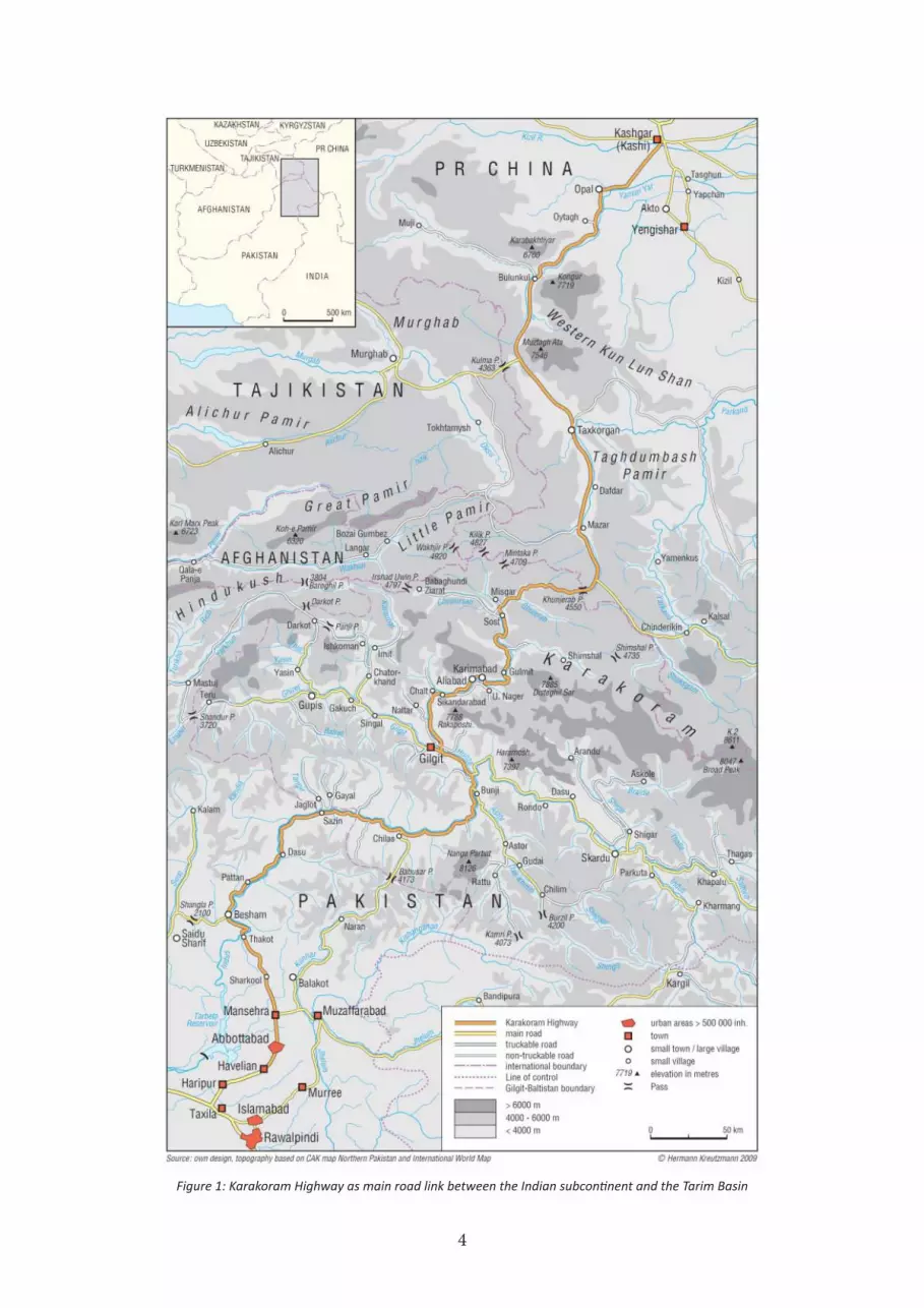
Figure 1: Karakoram Highway as main road link between the Indian subcontinent and the Tarim Basin
5
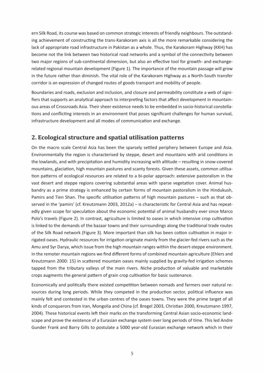
ern Silk Road, its course was based on common strategic interests of friendly neighbours. The outstand-
ing achievement of constructing the trans-Karakoram axis is all the more remarkable considering the
lack of appropriate road infrastructure in Pakistan as a whole. Thus, the Karakoram Highway (KKH) has
become not the link between two historical road networks and a symbol of the connectivity between
two major regions of sub-continental dimension, but also an effective tool for growth- and exchange-
related regional mountain development (Figure 1). The importance of the mountain passage will grow
in the future rather than diminish. The vital role of the Karakoram Highway as a North-South transfer
corridor is an expression of changed routes of goods transport and mobility of people.
Boundaries and roads, exclusion and inclusion, and closure and permeability constitute a web of signi-
fiers that supports an analytical approach to interpreting factors that affect development in mountain-
ous areas of Crossroads Asia. Their sheer existence needs to be embedded in socio-historical constella-
tions and conflicting interests in an environment that poses significant challenges for human survival,
infrastructure development and all modes of communication and exchange.
2. Ecological structure and spatial utilisation patterns
On the macro scale Central Asia has been the sparsely settled periphery between Europe and Asia.
Environmentally the region is characterised by steppe, desert and mountains with arid conditions in
the lowlands, and with precipitation and humidity increasing with altitude – resulting in snow-covered
mountains, glaciation, high mountain pastures and scanty forests. Given these assets, common utilisa-
tion patterns of ecological resources are related to a bi-polar approach: extensive pastoralism in the
vast desert and steppe regions covering substantial areas with sparse vegetation cover. Animal hus-
bandry as a prime strategy is enhanced by certain forms of mountain pastoralism in the Hindukush,
Pamirs and Tien Shan. The specific utilisation patterns of high mountain pastures – such as that ob-
served in the ‘pamirs’ (cf. Kreutzmann 2003, 2012a) – is characteristic for Central Asia and has repeat-
edly given scope for speculation about the economic potential of animal husbandry ever since Marco
Polo’s travels (Figure 2). In contrast, agriculture is limited to oases in which intensive crop cultivation
is linked to the demands of the bazaar towns and their surroundings along the traditional trade routes
of the Silk Road network (Figure 3). More important than silk has been cotton cultivation in major ir-
rigated oases. Hydraulic resources for irrigation originate mainly from the glacier-fed rivers such as the
Amu and Syr Darya, which issue from the high mountain ranges within the desert-steppe environment.
In the remoter mountain regions we find different forms of combined mountain agriculture (Ehlers and
Kreutzmann 2000: 15) in scattered mountain oases mainly supplied by gravity-fed irrigation schemes
tapped from the tributary valleys of the main rivers. Niche production of valuable and marketable
crops augments the general pattern of grain crop cultivation for basic sustenance.
Economically and politically there existed competition between nomads and farmers over natural re-
sources during long periods. While they competed in the production sector, political influence was
mainly felt and contested in the urban centres of the oases towns. They were the prime target of all
kinds of conquerors from Iran, Mongolia and China (cf. Bregel 2003, Christian 2000, Kreutzmann 1997,
2004). These historical events left their marks on the transforming Central Asian socio-economic land-
scape and prove the existence of a Eurasian exchange system over long periods of time. This led Andre
Gunder Frank and Barry Gills to postulate a 5000 year-old Eurasian exchange network which in their

6
opinion was instrumental for the development of China and Europe (Frank 1992, 1998; Gills and Frank
1991). Consequently both authors observed an early emergence of a ‘world system’ in Central Asia.
In the 19th century the na-
ture of external influence
changed significantly and the
‘Great Game’ emerged, char-
acterized by a polarisation
that was stimulated by the
prime interests of the two
superpowers at that time
(Figure 4). Direct influence in
the form of boundary-making
and economic exploitation
replaced the former pattern
of indirect control and tax-
taking in a feudal system. For Figure 3: Traditional trade routes and lines of communication in the Silk Road network
Figure 2: Marco Polo’s route of travels

7
the understanding of the present transformation process in Central Asia and the performance of inde-
pendent states, the geopolitical dimension of the ‘Great Game’ and subsequent territorial demarca-
tions needs to be discussed in greater detail.
3. The ‘Great Game’ in Crossroads Asia
A marking point for changing tides in Central Asian affairs was the year 1877, when Queen Victoria
appropriated the title of Empress of India. Consequently, Russian diplomats and military strategists
engaged in a debate about the importance of Central Asia from a Russian perspective. Colonel Michail
Ivanovich Veniukoff vindicated “the gradual movement of Russia in Central Asia” as “the re-establish-
ment of extension of the sway of the Aryan race over countries which for a long period were subject to
peoples of Turk and Mongol extraction”.10 Veniukoff advocates a diffusion theory in which he identifies
“the mountainous countries at the sources of the Indus and the Oxus to be the cradle of the Aryan or
Indo-European race.” He adds: “From this birthplace our ancestors spread far and wide”11 After some
deliberations about the spread of people, Veniukoff concludes that the Russian advances in Central
Asia can be interpreted as “this ‘return’ of part of the Slavs to the neighbourhood of their prehistoric
home.” He continues:
“We are not Englishmen, who in India do their utmost to avoid mingling with the natives, and who moreover, sooner or later, may pay for it by the loss of that country, where they have no ties of race […] It is desirable that this historical result should not be forgotten also in the future, especially on our arrival at the sources of the Oxus, where we must create an entirely Russian border-country as the sole guarantee of stability of our position in Turkestan.”12
The interests and justifications for the advance of the two dominating powers were distinct. Strategies
for ‘remigration’ into an ancestral homeland typified the Russian approach, while the British demon-
strated exploitative interest in the wealth of Asia. Consequently, two types of colonies were created:
Russian settlement colonies and British colonies of extraction. Nevertheless, the commonalities of
both powers were discussed as well:
“Possibly time will produce a radical change in the sentiments of the English, and then both great European nations will advance to meet the other in Asia, not with bitter suspicions and reproaches, but with confidence and benevolence as workers in the same historical mission – the civilization of the Far East. But will that time come soon? Russia, in any case, without awaiting it, must complete her mission: the occupation of the whole of Turkestan. This, unquestionably, will prove not disad-vantageous in that respect as well, that it will force England to be more on her guard in other lines of universal policy, in which she is ever antagonistic to the views of Russia.”13
At the turn from the 19th to the 20th century the British Viceroy in India, Lord Curzon, identified the Cen-
tral Asian countries and territories in his famous statement as “pawns on a chessboard”. British India
and Russia were the players who gambled about their influence in Transcaspia, Transoxania, Persia, and
Afghanistan (cf. Figure 4). But this battle was not solely about regional control; it was a contest about
the world domination of imperial powers. Great Britain had already achieved maritime supremacy, and
thereafter the last land-locked area – Central Asia – came into focus. From a British viewpoint Central
10 Political and Secret Department Memoranda: The Progress of Russia in Central Asia by Colonel M. J. Veniukoff (translated from the ‚Sbornik Gosudarstvennikh Zuanyi‘ 1877 (= IOL/P&S/18/C 17: 1).
11 Political and Secret Department Memoranda (= IOL/P&S/18/C 17: 1).
12 Political and Secret Department Memoranda (= IOL/P&S/18/C 17: 2).
13 Political and Secret Department Memoranda (= IOL/P&S/18/C 17: 22).

8
Asia posed the ‘buffer region’ to protect more than pawns: the ‘jewel of the crown’, a synonym for their
possessions in India. From a Russian perspective expansion towards the east and the south had been
a consequential endeavour ever since Peter the Great mentioned in his testimony that Russia’s future
was linked to Asia (cf. Hauner 1989). Both superpowers expected sufficient wealth to be exploited from
Central Asia to pay for their exploring adventures and military expenditure.
During the 19th century both superpowers reached a state of confrontation over contested suprema-
cy in Central Asia. Both had literary celebrities justifying their cause and in both countries contempo-
rary bourgeois debate highlighted the civilizing mission to be accomplished. Great Britain had Rudyard
Figure 4: Upper section: Imperial expansion in Central Asia in the early phase of the Great Game (app. 1865); lower section: Consolidation of British and Russian spheres of influence at the time of the Anglo Russian Convention (1907)

9
Kipling who was one of the foremost advocates of the ‘Great Game’ and had coined the term of a
‘white man’s burden’ (cf. Kreutzmann 1997). With missionary zeal and state authorisation, civil society
measures were to be promoted in Asia grounded in European standards. His Russian counterpart was
Fjodor M. Dostojevsky who published an essay on the importance of Asia for Russia’s future in which
he justified the Asian conquest as a mission for the promotion of civilisation. Dostojevsky compared the
colonial expansion into Central Asia with the European conquest of North America (cf. Hauner 1989,
1992; Sahni 1997). The second half of the 19th century experienced a heated debate in political and
academic circles about the effects of the Anglo-Russian rivalry in Central Asia.
In Russia the Gorchakov Memorandum of 1865 marks the beginning of the animated phase of the
‘Great Game’ (cf. Figure 4, upper section). The British Premier Disraeli responded in his famous speech
at Crystal Palace 1872 in which he announced the imperial policies for further expansionism. Immediate
results were the ‘forward policy’ in the Afghan borderlands and the subsequent crowning of Queen
Victoria as Empress of India (1877). Russia and Great Britain fought this ‘game’ in the remote mountains
of the Hindukush, Karakoram and Pamirs where their spies-cum-explorers met in unexpected locations.
At the same time there was competition among the diplomatic staff posted in Central Asian centres.
Notably Kashgar became one of the hotspots of confrontation where a weak Chinese administration
personified by a Taotai fell prey to the powerful representatives of the superpowers: the Russian
Consul M. Petrovsky and his British counterpart George Macartney. These protagonists reported
to their respective governments in detailed reports which give us historical evidence on the socio-
economic conditions in Central Asia in addition to strategic and military intelligence during their rivalry.
The ‘Great Game’ in its narrow definition came to an end in 1907 without any military encounter and
no loss of lives. Russia and Great Britain came to terms and consented to the text of the so-called
Anglo-Russian Convention in which respective spheres of influence, buffer states and regions of non-
interference were agreed upon (cf. Figure 4, lower section). The accord was highly influenced by the
‘heartland theory’ which drew geopolitical significance towards Central Asia.
The geographer Halford Mackinder formulated his ‘heartland theory’ in 1904 which ever since has been
one of the most significant texts of the geopolitical debate. Mackinder drew prime attention towards
Central Asia as he stated that Tsarist regional dominance was linked to their equestrian tradition from
nomadic Asian backgrounds. From the safe retreat of the Inner Asian steppe regions, conquests had
taken off towards Europe, Persia, India and China. He described European civilisation as the result of a
secular battle against Asian invasions (Mackinder 1904: 423). The naval predominance of Great Britain
and imperial control of world trade had been modified through a shift in terrestrial traffic structures.
The Russian railways were perceived as the successors of the equestrian mobile forces. Central Asia had
become the arena of contest, all the more as a Russian-German and/or a Sino-Japanese alliance could
contribute to a shift of world affairs to the ‘heartland’ of the Eurasian continent which he perceived
as a ‘geographical pivot of history’ (Mackinder 1904: 436). He predicted the transformation of Central
Asia from a steppe region with little economic power into a region of prime geostrategic importance.
Culture and geography would contribute to the key region. Mackinder identified four adjacent regions
encompassing the heartland of ‘pagan’ Turan in the shape of a crescent and denominated by religious
affiliations: Buddhism, Brahmanism, Islam and Christianity (Mackinder 1904: 431). With the passage of
time Mackinder modified his theory under the impression of events during the First and Second World
Wars and influenced the thoughts of Karl Haushofer and other geo-politicians of his time.

10
Similar ideas of a Central Asian ‘heartland’ or a pivotal role stimulated Owen Lattimore’s perceptions in
his book ‘Pivot of Asia’ (1950). Bearing in mind the experiences of World War II, Lattimore drew a circle
with a diameter of 1000 miles around Urumchi and identified Central Asia as a ‘whirlpool’ stirred-up by
“political currents flowing from China, Russia, India and the Middle East” (Lattimore 1950: 3). By
following the same Central Asian-centred approach, Milan Hauner shifted the centre in the 1980s to
Kabul (Figure 5), drew a similar circle and identified a world of “even greater contrasts” which “touches
upon the volatile and oil-rich region of the Middle East” (Hauner 1989: 7). The last statement has
remained valid through the dissolution of the Soviet Union, the Taliban rule in Afghanistan and in the
aftermath of 9/11 and the Iraq crisis. The fact that Ahmed Rashid (2000) subtitled his book on the
Taliban as ‘Islam, Oil and the New Great Game in Central Asia’ is only one case in point for the reference
to the ‘Great Game’ connotation of contemporary geopolitical problems in the region (cf. Kreutzmann
1997, 2004, 2013; Roy 2000). The presence of American and Russian troops on airports and along
borders in Central Asia proves the continuing geopolitical significance of the region and its linkage to
contemporary crises zones. The epicentres seem to be shifting. The eccentric geopolitical analyst
Robert Kaplan promoted in his recent book an ‘Iranian Pivot’ (Kaplan 2012: 269) which he identified
centred on the Iranian Plateau.
What are the effects of
certain lines of thought
and resulting political
actions on Central Asia
and why do we still
refer to the metaphor
of a ‘Great Game’ when
discussing contemporary
strategic interference
and socio-economic
transformations in
geopolitical contexts?
B o u n d a r y - m a k i n g
and its impact on
nation-building and
economic and political
participation severely
influenced socio-
economic developments
in the mountainous
areas of Central Asia.
Some cases in point
need to be introduced
for the understanding of
the far-reaching consequences of imperial border delineations. First of all, the practical impact on trade
relations and economic exchange need to be investigated.
Figure 5: Urumchi and Kabul represent centres of political instability in Lattimore’s and Hauner’s models respectively (adapted from Kreutzmann 2013: 162)
�������
�����
����������
��������
�������
�������
���
������
���������������
������� �
����������
����
���������
��������
������� �������
�������
�������
����
�������
������
��� ����
�������
������
����
��� �������
��������� ��
�� ��
��������
�����
�������
�����
�������
������
������
�����
����
������
�������
��������
���� �
��
����
������
�����
������
����������
������
��� ���
����
���������
������� � �������
�������
���� �
�����������������
������
� � � � � �
�����������
����������
�����������
������������
������
�����
������
�����
� � � �����
������
��
���
����������
��������
���������� � � � � � � � �
������
�������
� � � �������
���
�����
����
���
����
����
�
����
�������
������������������������������ ��� ���������
� ������
����������������� ��� ����� ���� �������������������������������������������� ��������������������������������������������������� ������������������

11
4. Development of Central Asian trade and attenuated exchange rela-tions in the aftermath of the ‘Great Game’
In Central Asia, the ‘Great Game’ resulted in the demarcation of international boundaries separating
the spheres of influence of the super powers of the time. Besides executing direct control and dom-
ination in the core areas of their empires, Great Britain and Russia had created buffer states at the
periphery such as Persia and Afghanistan (Figure 4, lower section). In their negotiations they had
excluded Kashgaria or Eastern Turkestan which nominally was under Chinese administration. Trade
between South and Central Asia was affected by this constellation and a rivalry had developed since
British commercial interests entered this sector in 1874 (cf. Davis and Huttenback 1987; Kreutzmann
1998). Both superpowers competed for dominance on the valuable markets in the urban oases of
the Silk Road such as Kashgar and Yarkand. According to the theory of imperialism, the merchants of
the industrializing countries tried to purchase raw materials such as cotton, pashmina wool, and
hashish while, in exchange, textiles and manufactured products were offered in the bazaars (cf.
Kreutzmann 1998). Russia had an advantage as access was easier. From the railhead at Andijan in the
Ferghana Valley, which was linked to the Middle Asian Railway in 1899, the distance to Kashgar (554
km) could be covered in twelve marches via Osh, Irkeshtam, and Ulugchat by crossing only one major
pass, Terek Dawan (3870 m). On the other hand trade caravans from British India had to follow either
of three trans-montane passages – the Leh, Gilgit, and Chitral routes – which were much longer and
more difficult (Figure 6).
Figure 6: Important trade routes in Crossroads Asia around 1935

12
The competition for the Central Asian markets continued after the October Revolution, which caused
the closure of the Russian/Soviet Consulate in Kashgar from 1920-1925. This event affected the Soviet
commerce with Kashgaria detrimentally while the British share soared. Overall trade significantly de-
clined due to the disturbances in Chinese Turkestan after 1935 and later due to World War II and the
Chinese Revolution. Central Asian trade was an important factor in cross-boundary relations affecting
the economies in the regions traversed for a period of forty years. The total annual volume of Indo-
Xinjiang commercial exchange surpassed the two million rupees level for most of the era between 1895
and 1934 (Figure 7).
At the end of the 19th century, George Macartney, the British Consul-General in Kashgar, summarised
the situation:
“The demand for Russian goods is without doubt ever increasing. Cotton prints of Moscow manu-facture, as cheap as they are varied and pretty, are very largely imported. The bazaars of every town are overstocked with them, as well as with a multitude of other articles, amongst the most important of which may be mentioned lamps, candles, soap, petroleum, honey, sugar, sweetmeats, porcelain cups, tumblers, enameled iron plates, matches, knives and silks. These articles, with few exceptions, could, but for the competition, be supplied from India. But we have gradually had to relinquish our position in favour of Russia, until at last our trade has to confine itself chiefly to articles of which we are the sole producers and in which there is no competition.”14
British interests in securing a substantial share in this commercial exchange governed their imperial
designs and had an impact on the mountain societies involved. At the turn of the century, Ladakh and
Baltistan were dominated by the Maharaja of Kashmir and Gilgit had become an agency (re-established
in 1889) under the joint adminis-
tration of a British Political Agent
and a Kashmiri Wazir-i-Wazarat.
Principalities such as Hunza and
Nager were affiliated after their
defeat in the 1891 encounters,
which were fought in the inter-
est of opening the Gilgit route for
commercial purposes. At the same
time the Mehtar of Chitral trans-
ferred his sovereignty in external
affairs to a British Agent and was
remunerated with an annual sub-
sidy and a supply of arms.
This part of the region under study
was controlled and de facto com-
mercially incorporated in the Brit-
ish Indian exchange system. Trade
with Afghanistan followed its own
rules and became part of the spe-
14 Report of George Macartney of 1st October 1898, quoted from Captain K. C. Packman, Consul-General at Kashgar 1937: Trade Report. In: India Office Library & Records: Departmental Papers: Political & Secret Internal Files & Collections 1931-1947: IOL/P&S/12/2354, p. 1.
Figure 7: Indo-Xinjiang trade 1895-1934

13
cial arrangements with the ruling Amir in Kabul. The major hiatus occurred in the aftermath of the
October Revolution when a process of separation and isolation began. The economic relations of the
Soviet-dominated Central Asian regions were re-directed and amplified towards Russia while at the
same time international borders were sealed and became effective barriers for trade. This process
took time and lasted until the mid-1930s. With growing alienation between the Soviet Empire and the
Chinese-dominated part of Eastern Turkestan, a nearly complete interruption of exchange relations be-
tween Tajikistan-Kyrgyzstan and Kashgaria came to a halt by 1930 (Kreutzmann 1996: 179). The under-
cutting of bazaar prices through the provision of cheaper commodities of the same quality in kolkhoz
shops led to the termination of trade in this sector. Similar developments affected the Soviet border
with Afghanistan during the 1930s:
“During the past few years, the effect of Soviet policy has been to restrict, in an increasing degree, traffic, excepting state-controlled trade, from Soviet Central Asia across the Afghan frontier on the River Oxus. [... M]ore European Russian officers have been appointed to ensure that the frontier is effectively closed.” (IOL/P&S/12/2275, dated 13.10.1939)
The result was that border delineation and the establishment of different socio-political regimes ef-
fected a collapse of trade and exchange in this Central Asian region that lasted for nearly 60 years until
the end of the Cold War. With few exceptions traditional trade links and exchange routes were inter-
rupted for two generations and are only being reanimated at a slow pace.
5. Boundary-making and its long-lasting effects
A few cases in point from the turn of the century may illustrate how mountain regions have been in-
volved in the demarcation of spheres of influence. The contenders of the ‘Great Game’ in High Asia
agreed to lay down
boundaries in the com-
paratively sparsely
populated regions of
the Hindukush and
Pamir. Sometimes
these borders were de-
scribed as natural fron-
tiers, scientific bound-
aries and dialect
borders. The Durand
Line of 1893 separating
Afghanistan from Brit-
ish India/Pakistan epit-
omises such an effort
and has continued to
function as the symbol
of colonial border de-
lineation referred to as
the ‘dividing line’ Figure 8: Demarcation of Afghanistan‘s boundaries and the partition of the Pashtun settlement region

14
(Felmy 1993). In order to safeguard the physical separation of two imperial opponents, international
borders were outlined and Afghanistan was created as a buffer state (Figure 8). Local livelihoods and
regional interests were neglected and of secondary importance. The Pashtun settlement region was
divided into two parts following an arbitrary line through the Hindukush ranges. The traditional migra-
tory paths of seasonal nomads between the Central Afghanistan highlands and the Indus lowlands
were intersected along the Hindukush passes. Numerous clashes between tribal groups and imperial
troops in the borderlands characterised the political relations in the frontier that served as a buffer belt
on the fringe of the empire (Fraser-Tytler 1953). Now a special legal status has been assigned to these
regions (Figure 9) as they are administrated as Federally or Provincially Administered Tribal Areas (FATA
or PATA). The movement of nomads (powindah) and their herds now depends on bilateral political rela-
tions and has been restricted, but has not ceased.
Figure 9: Disputed territories and constitutional peculiarities in Western High Asia
15
(i) Wakhan as the symbol of division
The Wakhan Corridor of northeastern Afghanistan symbolises colonial border delineation. The south-
ern limit is formed by the Durand Line (south) while the northern part came into existence as a result
of the Pamir Boundary Commission of 1895 in which Russian and British officers negotiated the align-
ment, and Afghan officials assisted in the demarcation. This narrow 300 km-long and only 15-75 km
wide strip was created to separate Russian and British spheres of influences and fulfilled the function
to avoid direct military action between the two superpowers of that period and region. Part of the
boundary follows the course of the Pjandsh (Amu Darya River), which was in accordance with the fash-
ion of the time. The ‘stromstrich’ boundary followed a role model tested in other regions of the world
previously. The price for this colonial endeavour was the spatial partition of regional semi-autonomous
principalities like Badakhshan, Darwaz, Wakhan, Shughnan, and Roshan. Subsequently both parts of
each former principality experienced quite diverse socio-economic developments as part of greater
political entities. Today we find regional units of the mentioned toponyms in Afghanistan and Tajikistan.
The creation of these boundaries resulted in immediate refugee movements by ethnic minorities. In
recent years relatives separated by century-old borders have re-established their relationship and the
bridges across the Pjandsh River in Langar, Ishkashim and Khorog symbolise those endeavours. The
Langar and Ishkashim bridges were built to enable the Soviet army to invade Afghanistan (1979) and to
safeguard their supplies from the Soviet Union for the control of Badakhshan. Meanwhile the function
of the Ishkashim bridge has changed. For years during the war in Afghanistan, support for the Northern
Alliance and humanitarian aid for the suffering civilians were transported across this bridge. The island
in the river near Ishkashim became a storehouse for humanitarian aid such as wheat flour, milk powder
and vegetable oil. The Khorog bridge was built by AKDN in order to link the cut-off Shughnan region
of Afghanistan with Tajik Shughnan and to establish market access. More bridge projects are planned
in Darwaz and along the Amu Darya. Nevertheless, the effect of partition is felt in all areas, especially
when international borders are closed and strictly controlled as has happened since the Cold War.
Afghan Wakhan is suffering substantially from its dead-end location, which causes a lack of through
trade and exchange with neighbours (Felmy and Kreutzmann 2004). Similar observations are valid for
Shughnan and Roshan.
(ii) Irredentism about Pashtunistan
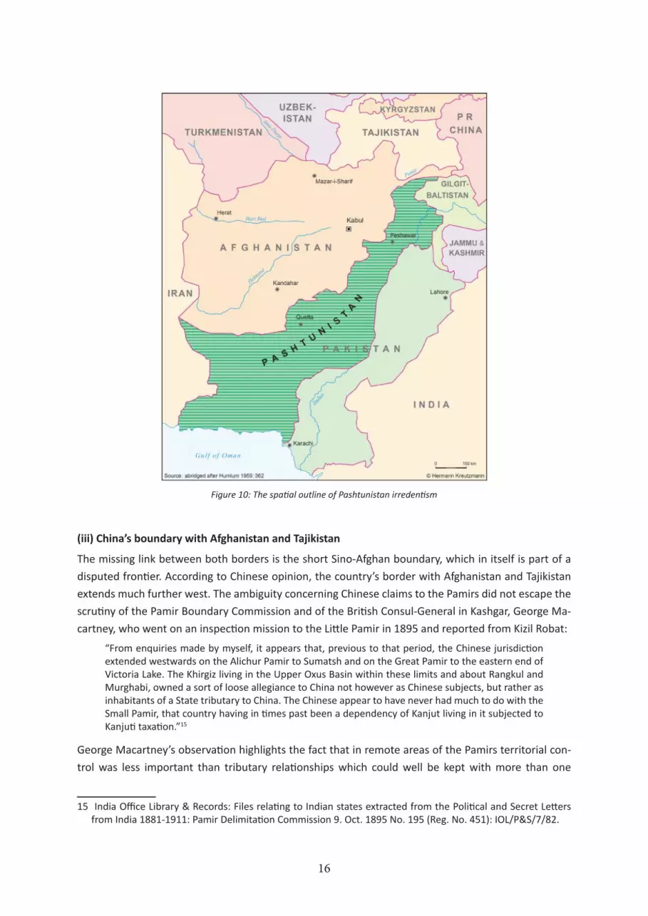
Continuing border disputes and conflicts like the irredentist movement for ‘Pashtunistan’ (Figure 10)
are still alive, and one of the main squares in Kabul has continued to be named after this Pak-Afghan
dispute despite the many winds of change since the 1960s. The Afghan demand for a territory named
Pashtunistan – consisting of the Pakistan North-West Frontier Province (NWFP) and Baluchistan (in-
cluding the tribal areas) – is the result of the imperial design that led to the creation of the Durand
Line and the referendum at the end of British Rule in India. Pashtun representatives have taken these
incidents as a basis to mobilise a followership for the cause of Pashtunistan. Imperial legacies and
losses function as a measure of identity and supply the ideological platforms of charismatic leaders
who aspire to re-write history. The Durand Line as an acknowledged international boundary has been
a cause for discontent and political crises between the neighbours Afghanistan and Pakistan, and will
remain so in the future.
16
(iii) China’s boundary with Afghanistan and Tajikistan
The missing link between both borders is the short Sino-Afghan boundary, which in itself is part of a
disputed frontier. According to Chinese opinion, the country’s border with Afghanistan and Tajikistan
extends much further west. The ambiguity concerning Chinese claims to the Pamirs did not escape the
scrutiny of the Pamir Boundary Commission and of the British Consul-General in Kashgar, George Ma-
cartney, who went on an inspection mission to the Little Pamir in 1895 and reported from Kizil Robat:
“From enquiries made by myself, it appears that, previous to that period, the Chinese jurisdiction extended westwards on the Alichur Pamir to Sumatsh and on the Great Pamir to the eastern end of Victoria Lake. The Khirgiz living in the Upper Oxus Basin within these limits and about Rangkul and Murghabi, owned a sort of loose allegiance to China not however as Chinese subjects, but rather as inhabitants of a State tributary to China. The Chinese appear to have never had much to do with the Small Pamir, that country having in times past been a dependency of Kanjut living in it subjected to Kanjuti taxation.”15
George Macartney’s observation highlights the fact that in remote areas of the Pamirs territorial con-
trol was less important than tributary relationships which could well be kept with more than one
15 India Office Library & Records: Files relating to Indian states extracted from the Political and Secret Letters from India 1881-1911: Pamir Delimitation Commission 9. Oct. 1895 No. 195 (Reg. No. 451): IOL/P&S/7/82.
Figure 10: The spatial outline of Pashtunistan irredentism

17
mighty neighbour. To claim territory based on these changing loyalties is as futile as is the notion of
clear-cut boundaries at the time. Over time the boundaries have become visible and changed the fate
of the abutters. The dispute about the delineation of the international boundaries between China and
Tajikistan has been carried into recent times (Figure 11). The factual contemporary boundary has been
agreed to by China‘s neighbours since 2004. The price paid for the agreement – which enabled the re-
opening of trans-border exchange in the Eastern Pamirs via Kulma Pass – was the transfer of about 980
km2 from Tajikistan to China in the Rangkul area (cf. Kraudzun 2011: 176; Kreutzmann 2013).
(iv) Border disputes within the Soviet Union and thereafter
The attempt of Soviet nationalities’ policies was to create new republics, which should represent the
ethnic groups of Central Asia in adequate spatial and administrative settings. Consequently by 1929
ethnonymous republics were created to represent Kazakhs, Kirghiz, Tajiks, Usbeks and Turkmens. The
new republics did not have any boundaries in common with their predecessors, the Khanate of Khiva,
the Khanate of Bukhara and the Turkestan Governorate-General. If the term ‘artificial boundaries’
could be appropriate in any context, it would be here. The newly defined republics consisted of a spa-
tial nucleus, but very often they had in addition satellite territories of enclaves and exclaves within the
territory of neighbouring republics (Figure 12). While this phenomenon did not pose grave differences
during the period of the Soviet Union, (given that basically all territories were under the central com-
mand of the Kremlin and only international boundaries with neighbouring countries such as China and
Figure 11: Chinese territorial claims towards Tajikistan

18
Afghanistan were of any importance and hermetically sealed), another cause of germinated dissent
erupted after independence in the early 1990s. Republican boundaries within the Soviet Union became
international borders of sovereign states such as Uzbekistan, Tajikistan and Kyrgyzstan. In a survey two
years after independence, the Moscow Institute of Political Geography recorded 180 border and terri-
torial disputes in the aftermath of the dissolution of the Soviet Union (Halbach 1992: 5). Central Asia
was no exception in this regard and these conflicts have increased since. According to a recent report
of the International Crisis Group (ICG 2002), there is no Central Asian country without border disputes
with its neighbours. To illustrate the scope of conditions and demands a few cases are listed: Irredentist
movements in Turkmenistan expect Uzbekistan to ‘return’ the territory of the Khanates of Khiva and
Khorezm. Tajik nationalists demand the ‘return’ of Samarkand and Bukhara. Uzbekistan lays claim on
the Eastern part of the Ferghana Valley, i.e. the Osh Oblast, the present-day economic and commercial
centre of Southern Kyrgyzstan. The Uzbekistan government does not permit colleagues from neigh-
bouring republics to consult the archival material in Tashkent, which documents the boundary deci-
sions from the 1920s. Rental arrangements and the production of natural resources in exclaves from
Soviet times are under dispute such as the Uzbek exploitation of oil and gas fields in Southern Kyrgyz-
stan and the deviation of irrigation water from the Andijan reservoir towards the Ferghana Valley (Fig-
ure 12). The Ferghana Valley alone contains seven enclaves through which major traffic routes are
leading. The freedom of
travel is more restricted
than before as new visa
regulations for travel
have been introduced.
Some of these measures
have been justified in the
aftermath of attacks from
Afghanistan-trained reb-
els, who plundered Tajik
and Kirghiz villages on
their way to the Ferghana
Valley in 1999 and 2000.
The future of rented
lands and exclaves that were created for the protection of ethnic minorities is at stake, and neighbour-
ing governments are discussing options for forced evacuation and migration to initiate population ex-
change.
(v) Future prospects and conflict resolution
The hope for friendly relations and mutual understanding has suffered several setbacks in recent years.
All negotiating partners are interested in most favourable results from their national perspective. On
a regional scale hope emerged with the Shanghai Cooperation Organisation (SCO) in 1996. Originally
named the Shanghai-5 (Russia, PR of China, Kazakhstan, Kyrgyzstan, Tajikistan), the SCO became a fully-
fledged organisation in 2001 when Usbekistan joined. Its mandate is to improve mutual relations and
to improve Central Asia’s economic competitiveness in a globalised world. Therefore the SCO has sup-
ported the opening of new trade corridors between the PR of China and Kyrgyzstan (Irkeshtam Road)
Figure 12: Isolated exclaves in the borderlands of Tajikistan, Kyrgyzstan and Usbekistan

19
and Tajikistan (Khulma Road) respectively. The two major regional players – Russia and PR of China
– are cooperating with the European Union to link the Central Asian republics with Europe through a
road network (TRACEA route) via the Caucasus. The participation in regional and international trade
may be one of the prime stimulants to overcoming the legacies of previous geopolitical interference
and reflects the economic interests of the big economic players of today in the future of Central Asia.
Nevertheless, the region under study suffered not only directly from Cold War confrontation but from
regional problems as well, which remain a colonial legacy, but have developed into a conflict between
neighbours. After more than 50 years of independence, India and Pakistan are still engaged in military
confrontation that is affecting economic exchange tremendously and keeps the mountain regions of
the Karakoram and Western Himalaya in a state of dispute and uncertainty.
6. The Kashmir stalemate - origin and perspectives
The continuing dispute between India, Pakistan and the people of Kashmir about the constitutional
and territorial status of the formerly largest princely state of the Indian Empire originates from two
perspectives.
First, the implementation of the so-called ‘two-nation theory’ has failed in Kashmir. The Maharaja of
Kashmir, Hari Singh who belonged to the Hindu Dogra dynasty, ruled over a population the majority
of which followed the Muslim faith. Exceptions to this rule occurred in Buddhist-dominated Ladakh/
Zanskar and Hindu-dominated Jammu. According to the last census before partition (1941), which was
taken as the data reference for the ‘two-nation theory’, the population of Jammu and Kashmir was
calculated at 4.02 million inhabitants. The religious composition was given as 77.1 % Muslim, 20.1 %
Hindu, 1.7 % Sikh, 1.0 Buddhist, 0.1 % Christians. Playing for independence from India and Pakistan,
Maharaja Hari Singh deliberately postponed any decision about accession to either side. The story of
the 1947-48 Kashmir war, interference of troops from Pakistan and India, and a UN-negotiated peace
treaty have repeatedly been dealt with (cf. Kreutzmann 1995, 2012; Lamb 1991 for further references).
The first Kashmir war broke out shortly after independence in 1947 and the Indian army as well as the
Pakistan army were commanded by British high-ranking officers, which led to a paradoxical confronta-
tion: in October 1947 Field Marshal Sir Claude Auchinleck was the Commander-in-Chief of both the
Indian and Pakistan Armies. Some authors suggest that this fact led to the early involvement of the
United Nations in peace negotiations (Tariq Ali 1983: 65; Lamb 1994: 69). According to Lamb (1994:
71-72) “the opinion of most [contemporary] British observers [...] was that the best solution lay in a
partition of the old state of Jammu & Kashmir, essentially with Ladakh and much of Jammu going to
India and the rest to Pakistan.” The concept of partition was reiterated by the British UN representative
in 1950 but rejected by India and Pakistan in favour of a unitary plebiscite in all of Kashmir.
This confrontation resulted in a cease-fire line separating Indian and Pakistani spheres of influence.
With minor deviations it survived the 1965 war, which saw Kashmir as the major military theatre.
The Tashkent agreement of January 1966, negotiated between Prime Minister Lal Bahadur Shastri and
President Ayub Khan with the Soviet Prime Minister Aleksei Kosygin as a mediator, confirmed the status
quo and the retreat of troops behind the actual line of control. During the third Indo-Pakistan war of
1971, Kashmir experienced a secondary role, and the 1972 Simla Conference extended the status quo
again. Since then all demands for an impartial and internationally supervised referendum/plebiscite on
20
the future status of Kashmir have been postponed.
Since the mid-1980s fighting for the control of the Siachin glacier region between specially trained
army units has taken place every summer. The barren tracks of the uninhabited Siachin region form a
challenging and remote battle-ground where both sides are fighting because land surveyors and diplo-
mats tend toward ambiguity in a commercially unproductive territory. Unfortunately servicemen from
the mountain regions who are adapted to, and who are able to survive in altitudes above 5,000 m have
become the victims of this senseless fight year after year. The Kashmir wars have bound huge amounts
of armoury in the Northern regions for a battle between two independent states where local residents
are pawns in a competition no side might ever totally win. In 1999 another war between the two con-
testants nearly arose when the ‘Kargil Crisis’ led to military encounters, territorial gains and losses, and
to numerous victims among the soldiers who mainly originate from the mountain regions. Some de-
nominate it as the ‘third war over Kashmir’ (cf. Kreutzmann 2012b; Mato Bouzas 2011).
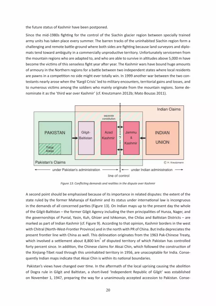
A second point should be emphasised because of its importance in related disputes: the extent of the
state ruled by the former Maharaja of Kashmir and its status under international law is incongruous
in the demands of all concerned parties (Figure 13). On Indian maps up to the present day the whole
of the Gilgit-Baltistan – the former Gilgit Agency including the then principalities of Hunza, Nager, and
the governorships of Punial, Yasin, Kuh, Ghizer and Ishkoman, the Chilas and Baltistan Districts – are
marked as part of Indian Kashmir (cf. Figure 9). According to that opinion, Kashmir borders in the west
with Chitral (North-West-Frontier Province) and in the north with PR of China. But India depreciates the
present frontier line with China as well. This delineation originates from the 1963 Pak-Chinese Treaty,
which involved a settlement about 8,800 km2 of disputed territory of which Pakistan has controlled
forty percent since. In addition, the Chinese claims for Aksai Chin, which followed the construction of
the Xinjiang-Tibet road through this uninhabited territory in 1956, are unacceptable for India. Conse-
quently Indian maps indicate that Aksai Chin is within its national boundaries.
Pakistan’s views have changed over time. In the aftermath of the local uprising causing the abolition
of Dogra rule in Gilgit and Baltistan, a short-lived ‘Independent Republic of Gilgit’ was established
on November 1, 1947, preparing the way for a unanimously accepted accession to Pakistan. Conse-
Figure 13: Conflicting demands and realities in the dispute over Kashmir

21
quently, the official version of the Pakistan Government distinguishes between Kashmir on the one
hand and the Gilgit Agency (Gilgit-Baltistan) on the other (cf. Figure 13). This viewpoint is supported
by a lengthy historical investigation and legal interpretation within colonial files regarding the status of
certain territories in the Gilgit Agency. In 1941 an internal decision binding for administrative purposes
summarised the results of a previous discussion for two exemplar principalities in question, Hunza and
Nagir: “Though these are under the suzerainty of the Kashmir State, they are not part of Kashmir but
separate states.” (IOR/2/1086/303).
This deliberate uncertainty in the formulation of the legal status is one of the obstacles to a negoti-
ated solution. The Government of Pakistan has treated the Northern Areas or Gilgit-Baltistan space
respectively and the Kashmir issue as separate entities, which is reflected in different constitutional
configurations (Figure 14). Azad Kashmir (AK) is governed by an own President elected from an assem-
bly composed of the AK Parliament and the AK Council. In contrast, Gilgit-Baltistan has been granted
neither provincial status within Pakistan nor a similar semi-autonomous parliamentary setup like Azad
Figure 14: Constitutional setup of spaces and bodies in Pakistan
22
Kashmir. In recent years there have been attempts by Azad Kashmir politicians to link Gilgit-Baltistan to
their issue of pressing for a plebiscite to be held in all of Kashmir. Although this move seems to enhance
their chances for a vote in favour of Pakistan – if a referendum about the aspired affiliation to either
side were ever to be held – the representatives of Gilgit-Baltistan refuse to cooperate. In their opinion
the struggle for independence succeeded in casting-off any relation to Kashmir. In recent times the
federal government has moved to combine both regions. These plans have been rejected with the rea-
soning that there are no ethnic and regional similarities, no traffic links, and no economic exchanges.
As the population of Azad Kashmir rises above three million, the inhabitants of Gilgit-Baltistan (app. 1.2
million according to latest estimates) fear domination again by Kashmiri bureaucrats. Therefore they
advocate an independent province with similar civil rights and representation as in the other provinces
and not a separate constitution like in the case of Azad Kashmir.
Both India and Pakistan claim to be the rightful representatives of the people of Kashmir but in re-
cent years Kashmiri nationalists have promoted the creation of an independent Kashmir composed of
Pakistan-controlled Azad Kashmir and Indian-held Jammu & Kashmir Province. This is strongly rejected
by both India and Pakistan who have strategic interests in the region and demand their share in the
economic wealth of Kashmir. The third option might be the driving force for the peace-talks and the
reconciliation process, which were initiated by then President Pervez Musharraf and Indian Prime Min-
ister Atal Bihari Vajpayee. In contrast to earlier attempts it seems that their initiative started negotia-
tions that might lead to an agreement in the near future. Both countries are now in a position that they
cannot afford a continuing interruption of economic exchange and communication. The line of control
between India and Pakistan still remains one of the international boundaries with the least economic
permeability.
The legal framework in the case of Azad Kashmir applies to other high mountain regions of Pakistan
as well (cf. Figure 9). The Northern Areas were governed directly from Islamabad under the auspices
of the Federal Minister for Kashmir Affairs, Northern Areas and Frontier Regions. At the same time
the Minister was the Chief Executive, the highest representative and an un-elected member of the
Northern Areas Council. Although slight shifts occurred in the aftermath of the name change to Gilgit-
Baltistan and some reforms in 2007, the inhabitants remain disenfranchised in general elections and
have no representation in the National Assembly – symbolizing continuing regional disparities in the
legal status of peripheral regions (Kreutzmann 2012).
The so-called Tribal Areas are differentiated into federally (FATA) and provincially (PATA) administered
entities (cf. Figure 9) in which no federal or provincial legislation is enacted unless the President of
Pakistan or under him the Provincial Governor directs through the appointed Political Agent. The spe-
cial status of the tribal areas was highlighted when the central government started military operations
in Waziristan and other tribal areas in search for insurgents and Taliban strongholds. In Pakistan’s do-
mestic policies the special status of the tribal areas was maintained over long periods as the so-called
‘Frontier Crimes Regulations’ originating from 1872 continued to be applied until recent times and the
Government left internal affairs to the tribal leaders (malik, sardar).
Summing up, the mountain regions of Pakistan in the Hindukush, Karakoram and Himalaya are charac-
terised by a state of uncertainty comprising a special legal status, direct and indirect rule, and a limited
validity of certain civil rights. All these peculiarities are linked to colonial and geopolitical legacies. On

23
the other hand huge amounts of subsidies have been allocated for the uplift of these regions, which
fare much worse than the rest of the country when average provincial incomes are compared. Azad
Kashmir and Gilgit-Baltistan have been allocated substantial funds for regional development. These
aspects need to be highlighted when it comes to a discussion of participation, governance and civil
society.
7. Conclusion
The starting point of our deliberations was the exogenous interest in the Central Asian periphery with
long-lasting implications for the livelihoods of people. The major impact seen until today is the delinea-
tion of international boundaries and internal borders. Most of the mountain region became an even
greater periphery after border demarcation and lost its economic value as a transit region for traders.
The deadlock situation has partly changed since the end of the Cold War, but not in a great style of
regional cooperation.
The second exogenous intervention had even greater impact especially on Kyrgyzstan and Tajikistan.
About 70 years ago the major transformation of socio-economic conditions took place. The Soviet
modernisation project changed lifestyles and civil rights. To quote contemporary sources on the con-
tents of the project:
“The CPC of the Tajik S.S.R. is drawing up a plan for agriculture in the Pamirs, the idea being thereby to transform the migrant tribes into stationary inhabitants, and to encourage them to grow their own food instead of importing it. A biological station on the Pamirs, at a height of 4,000 metres above sea-level, is just being started”.16
The ‘Pravda’ told the truth: modernisation meant the sedentarisation of nomads and was executed
with great force and rigour. The effects of settlement and the introduction of ‘modern’ animal hus-
bandry can be observed in all areas north of the Amu Darya while, on the Southern bank of the river,
‘traditional’ forms of livestock-keeping prevail.
Similar developments could be observed in people’s organisation, education and agriculture. To quote
another source from 1934:
“Khorog is the capital town of the Soviet Pamir, and there has been held there the 5th congress of the Soviets of the mountainous Badakhshan region. On foot on horses, on yaks, on donkeys, along mountain tracks hanging over precipices, the delegates come from the distant Murghab, Borgang [Bartang], Bakhan [Wakhan], and other places in the S. and E. edges of the U.S.S.R. that border with Afghanistan, India and Western China. The 110 delegates elected were 78 Tajiks, 16 Kirghiz, and 16 Russians. In the conference hall were many women in their white garments of homespun silk. Khorog is now lit with electricity that was started and first seen by the Pamir people in the spring of this year. The president of the congress, Faisilbekov, spoke of the wonderful things that have taken place in the Soviet Pamir. Aeroplanes are flying over inaccessible mountain ranges, a splendid au-tomobile road has been made from Khorog to Osh, 700 km long, that now links the Pamir with the rest of the U.S.S.R. formerly there was only 1 school in the whole of the Pamirs - now there are 140, and a training school for teachers: instead of dark smoky earth huts or skin tents, European houses are now being built: collective farms are established in the Pamirs, and they are growing and getting good crops of wheat, millet and beans; and now they know how to manure their fields and be sure of good crops.”17
It is the irony of history that now a transformation process has started that is attempting to revert these
16 Pravda 7.5.1934, quoted after IOL/P&S/12/2273.
17 Izvestia 29. 11.1934, quoted after IOL/P&S/12/2273.

24
reforms and to privatise collectivised property (Figure 15) again. Households are expected to return to
the farming practices of their grandfathers, and the traditional knowledge of neighbouring countries is
being adapted as a measure to overcome food crises and to minimise risks. In this respect external in-
terference in Central Asia can be seen as a failed attempt to implement modernisation theory, although
in many other aspects it has succeeded. The transition beginning with the independence of sovereign
nation-states in Central Asia has failed so far to continue the path of modernisation.
The lesson to be learnt from geopolitical interventions in peripheral mountain areas could be that deci-
sions made in the core of empires always affect the livelihoods of people who have not been involved
in the decision-making process. Socio-political interference during the Cold War led to the creation of
an arena of confrontation in the Pamirs, Hindukush and Himalaya, which was one of least permeable
frontier regions in the world. Present developments might result in a convergence of living conditions,
income patterns and indicators of human development. Especially mountain farmers and breeders can
learn from the experiences of their counterparts, and entrepreneurs might profit from trans-border
exchanges in a way which was impossible for more than two generations.
Figure 15: Transformation of landownership and property rights in Tajikistan
25
ReferencesAli, Aamir (2002): A Siachen Peace Park. The Solution to a Half-Century of International Conflict? In: Mountain Research and Development 22 (4): 316-319.
Anonymous (1951): The Sinkiang-Hunza Frontier. In: Journal of the Royal Central Asian Society 38: 73-81.
Audouin-Dubreuil, Ariane (2002): La Croisière Jaune - Sur la route de la soie. Grenoble: Éditions Glénat.
Bregel, Yuri (2003): An Historical Atlas of Central Asia. Leiden, Boston: Brill (= Handbook of Oriental Studies, Section 8: Central Asia, Vol. 9).
Christian, David (2000): Silk roads or steppe roads? The silk roads in world history. In: Journal of World History 11 (1): 1-26.
Conway, William Martin (1894): Climbing and exploration in the Karakoram-Himalayas. London: T. F. Unwin.
Davis, Lance E. and Robert M. Huttenback (1987): Mammon and the pursuit of Empire: The political economy of British Imperialism, 1860-1912. Cambridge: Cambridge University Press.
Ehlers, Eckart and Hermann Kreutzmann (eds.) (2000): High mountain pastoralism in Northern Pakistan. Stuttgart: Franz Steiner-Verlag (= Erdkundliches Wissen 132).
Gardner, Bovingdon (2010): The Uyghurs: Strangers in Their Own Land. New York: Columbia University Press.
Felmy, Sabine (1993): The Dividing Line. In: Newsline 5 (5-6): 72-78.
Felmy, Sabine and Hermann Kreutzmann (2004): Wakhan Woluswali in Badakhshan. Observations and reflections from Afghanistan‘s periphery. In: Erdkunde 58 (2): 97-117.
Forbes, Andrew D. W. (1986): Warlords and Muslims in Chinese Central Asia. A Political History of Republican Sinkiang 1911-1949. Cambridge: Cambridge University Press
Fragner, Bert G. (1999): Die ‘Persophonie’: Regionalität, Identität und Sprachkontakt in der Geschichte Asiens. Berlin: Das Arabische Buch (= ANOR 5).
Frank, Andre Gunder 1992: The Centrality of Central Asia. Amsterdam: VU University Press (= Comparative Asian Studies 8).
Frank, Andre Gunder 1998: ReOrient: Global Economy in the Asian Age. Berkeley: University of California Press.
Fraser-Tytler, William Kerr (1953): Afghanistan. A study of political developments in Central and Southern Asia. London, New York, Toronto: Oxford University Press.
Gillard, David (1977): The Struggle for Asia 1828-1914. A Study in British and Russian Imperialism. London: Methuen.
Gills, Barry K. and Andre Gunder Frank (1991): 5000 years of World System History: The Cumulation of Accumulation. In: Chase-Dunn, Christopher and Thomas Hall (eds.): Precapitalist Core-Periphery Relations. Boulder: Westview Press: 66-111.
Halbach, Uwe (1992): Ethno-territoriale Konflikte in der GUS (= Berichte des Bundesinstituts für ostwissenschaftliche und internationale Studien 31-1992). Köln: Selbstverlag.

26
Hauner, Milan (1989): Central Asian Geopolitics in the Last Hundred Years: A Critical Survey from Gorchakov to Gorbachev. In: Central Asian Survey 8: 1-19
Hauner, Milan (1992): What is Asia to us? Russia’s heartland yesterday and today. London: Routledge.
India Office Library & Records: Files relating to Indian states extracted from the Political and Secret Letters from India 1881-1911: Pamir Delimitation Commission 9. Oct. 1895 No. 195 (Reg. No. 451). (=IOL/P&S/7/82).
India Office Library & Records: Departmental Papers: Political & Secret Internal Files & Collections 1931-1947: Report of George Macartney of 1st October 1898, quoted from Captain K. C. Packman, Consul-General at Kashgar 1937: Trade Report. (=IOL/P&S/12/2354).
India Office Library & Records: Departmental Papers: Political & Secret Internal Files & Collections 1931-1947: Memorandum on the proposed motor road from North West India to Sinkiang via Gilgit, Chungking, 8.6.1944 (=IOL/P&S/12/4609).
India Office Library & Records: Translation of a newspaper clipping from ‘Izvestiya’ 3.10.1932 (=IOL/P&S/12/2276).
India Office Library & Records: Report by the British Embassy Moscow to Sir John Simon in the Foreign Office in London dated 2.8.1932 (=IOL/P&S/12/2276).
India Office Library & Records: Departmental Papers: Newspaper clipping from the ‘Moscow Daily News’ on 12.5.1935 (=IOL/P&S/12/2276).
India Office Library & Records: Political and Secret Department Memoranda: The Progress of Russia in Central Asia by Colonel M. J. Veniukoff (translated from the “Sbornik Gosudarstvennikh Zuanyi” 1877 [Collection of Governmental Knowledge] (=IOL/P&S/18/C17).
India Office Library & Records: Crown Representative’s Records - Indian State Residencies: Kashmir Residency Files: Indo-Chinese Turkistan trade. Report by S. H. Godfrey, Political Agent Gilgit, to A. C. Talbot, Resident Kashmir, Gilgit 17.12.1896: quotation from Captain E. T. Medley, commanding the troops at Gilgit (=IOR/2/1064/45).
India Office Library & Records. Crown Representative’s Records - Indian States Residencies - Gilgit, Chilas, Hunza and Nagir Files (Confidential) 1941: Status of Hunza, Nagir ... vis-a-vis the Kashmir State. Decision that these territories are not part of the Kashmir State. Number of Proceedings 17-C/41(=IOR/2/1086/303).
International Crisis Group (2002): Central Asia: Border disputes and conflict potential. Osh, Brussels (= ICG Asia Report No. 33).
Kaplan, Robert D. (2012): The revenge of geography. What the map tells us about coming conflicts and the battle against fate. New York: Random House.
Kraudzun, Tobias (2011): From the Pamir frontier to international borders: Exchange relations of the borderland population. In: Bruns, Bettina and Judith Miggelbrink (eds.): Subverting borders. Doing research on smuggling and small-scale trade. Wiesbaden: VS Verlag für Sozialwissenschaften: 171-191.
Kreutzmann, Hermann (1995): Globalization, spatial integration and sustainable development in Northern Pakistan. In: Mountain Research and Development 15 (3): 213-227.
Kreutzmann, Hermann (1996): Ethnizität im Entwicklungsprozeß. Die Wakhi in Hochasien. Berlin: Dietrich Reimer-Verlag.
27
Kreutzmann, Hermann (1997): Vom Great Game zum Clash of Civilizations? Wahrnehmung und Wirkung von Imperialpolitik und Grenzziehungen in Zentralasien. In: Petermanns Geographische Mitteilungen 141 (3): 163-186.
Kreutzmann, Hermann (1998): The Chitral Triangle: Rise and Decline of Trans-montane Central Asian Trade, 1895-1935. In: Asien-Afrika-Lateinamerika 26 (3): 289-327.
Kreutzmann, Hermann (2003): Ethnic minorities and marginality in the Pamirian knot. Survival of Wakhi and Kirghiz in a harsh environment and global contexts. In: The Geographical Journal 169 (3): 215-235.
Kreutzmann, Hermann (2004): Ellsworth Huntington and his perspective on Central Asia. Great Game experiences and their influence on development thought. In: GeoJournal 59: 27-31.
Kreutzmann, Hermann (ed.) (2006): Karakoram in transition. Culture, development and ecology in the Hunza Valley. Oxford, New York, Karachi: Oxford University Press.
Kreutzmann, Hermann (2008): Kashmir and the Northern Areas of Pakistan: Boundary-making along contested frontiers. In: Erdkunde 62 (3: 201-219.
Kreutzmann, Hermann (2009): The Karakoram Highway as a prime exchange corridor between Pakistan and China. In: Kreutzmann, Hermann, Ghulam Amin Beg, Lu Zhaohui and JürgenRichter (eds.): Integrated tourism concepts to contribute to sustainable development in mountain regions. Bonn: InWEnt:13-36 (translated and published in Chinese 2012)
Kreutzmann, Hermann (ed.) (2012a): Pastoral practices in High Asia. Agency of ‘development’ effected by modernisation, resettlement and transformation. Dordrecht: Springer.
Kreutzmann, Hermann (2012b): Democracy for Gilgit-Baltistan? Kasmir’s legacy and administrative challenges on route to equal rights within Pakistan. In: Hermann Kreutzmann and Talat Mahmood (eds.): Understanding Pakistan. Berlin: Wissenschaftsverlag Berlin: 211-245
Kreutzmann, Hermann (2013): Boundary-making as a strategy for risk reduction in conflict-prone spaces. In: Müller-Mahn, Detlef (ed.): The spatial dimension of risk. How geography shapes the emergence of riskscapes. London: Routledge: 154-171.
Lamb, Alastair (1991): Kashmir. A Disputed Legacy 1846-1990. Hertingfordbury: Roxford Books (reprint: Karachi: Oxford University Press 1992).
Lamb, Alastair (1994): The Indian claim to Jammu & Kashmir: conditional accession, plebiscites and the reference to the United Nations. In: Contemporary South Asia 3 (1): 67-72.
Landau, Jacob M. and Barbara Kellner-Heinkele (2001): Politics of language in the ex-Soviet Muslim states. Azerbayjan, Uzbekistan, Kazakhstan, Kyrgyzstan, Turkmenistan and Tajikistan. Ann Arbor: University of Michigan Press.
Lattimore, Owen (1950): Pivot of Asia. Sinkiang and the Inner Asian Frontiers of China and Russia. Boston: Little, Brown & Co.
Mackinder, Halford J. (1904): The Geographical Pivot of History. In: The Geographical Journal 23 (4): 421-444.
Mato Bouzas, Antía (2011): Kashmir: Perceptions of conflict from the border. In: Geisteswissenschaftliche Zentren Berlin e.V.: Bericht über das Forschungsjahr 2010. Berlin: 83-96.
Millward, James A. (2007): Eurasian crossroads. A history of Xinjiang. New York: Columbia University Press.
Rashid, Ahmed (2000): Taliban. Islam, Oil and the New Great Game in Central Asia. London, New
28
York: Tauris.
Roy, Olivier (2000): The new Central Asia. The creation of nations. London, New York: Tauris.
Rzehak, Lutz and Matthias Weinreich (2003): Mehrsprachigkeit und Schrift. Betrachtungen zur Entwicklung von Schriftsystemen iranischer Sprachen im sowjetischen Mittelasien. In: Iran and the Caucasus 7 (1-2): 209-250.
Sahni, Kalpana (1997): Crucifying the Orient. Russian Orientalism and the Colonization of Caucasus and Central Asia. Bangkok: White Orchid Press.
Sökefeld, Martin (2005): From colonialism to postcolonial colonialism: Changing modes of domination in the Northern Areas of Pakistan. In: Journal of Asian Studies 64 (4): 939-973.
Tariq, Ali (1983): Can Pakistan Survive? The death of a state. Harmondsworth: Penguin.

29
Information on the competence network Crossroads Asia
The competence network Crossroads Asia derives its name from the geographical area extending from
eastern Iran to western China and from the Aral Sea to northern India. The scholars collaborating in the
competence network pursue a novel, ‘post-area studies’ approach, making thematic figurations and
mobility the overarching perspectives of their research in Crossroads Asia. The concept of figuration
implies that changes, minor or major, within one element of a constellation always affect the constel-
lation as a whole; the network will test the value of this concept for understanding the complex struc-
tures framed by the cultural, political and socio-economic contexts in Crossroads Asia. Mobility is the
other key concept for studying Crossroads Asia, which has always been a space of entangled interaction
and communication, with human beings, ideas and commodities on the move across and beyond cul-
tural, social and political borders. Figurations and mobility thus form the analytical frame of all three
main thematic foci of our research: conflict, migration, and development.
• Five sub-projects in the working group “Conflict” will focus upon specific localized conflict-figura-
tions and their relation to structural changes, from the interplay of global politics, the erosion of
statehood, and globalization effects from above and below, to local struggles for autonomy, urban-
rural dynamics and phenomena of diaspora. To gain a deeper understanding of the rationales and
dynamics of conflict in Crossroads Asia, the sub-projects aim to analyze the logics of the genesis
and transformation of conflictual figurations, and to investigate autochthonous conceptions of,
and modes of dealing with conflicts. Particular attention will be given to the interdependence of
conflict(s) and mobility.
• Six sub-projects in the working group “Migration” aim to map out trans-local figurations (networks
and flows) within Crossroads Asia as well as figurations extending into both neighboring and distant
areas (Arabian Peninsula, Russia, Europe, Australia, America). The main research question address-
es how basic organizational and functional networks are structured, and how these structures af-
fect what is on the move (people, commodities, ideas etc.). Conceptualizing empirical methods for
mapping mobility and complex connectivities in trans-local spaces is a genuine desideratum. The
aim of the working group is to refine the method of qualitative network analysis, which includes
flows as well as their structures of operation, and to map mobility and explain mobility patterns.
• In the “Development”-working group four sub-projects are focusing on the effects of spatial move-
ments (flows) and interwoven networks at the micro level with regard to processes of long-term
social change, and with a special focus on locally perceived livelihood opportunities and their po-
tential for implementation. The four sub-projects focus on two fundamental aspects: first, on struc-
tural changes in processes of transformation of patterns of allocation and distribution of resources,
which are contested both at the household level and between individual and government agents;
secondly, on forms of social mobility, which may create new opportunities, but may also cause the
persistence of social inequality.
The competence network understands itself as a mediator between the academic study of Crossroads
Asia and efforts to meet the high demand for information on this area in politics and the public. Find-
ings of the project will feed back into academic teaching, research outside the limits of the compe-
tence network, and public relations efforts. Further information on Crossroads Asia is available at
www.crossroads-asia.de.
30
Publications in the Crossroads Asia Working Paper Series
• Marsden, Magnus (2011): Mobile Life on the Frontiers of Crossroads Asia. In: Crossroads Asia
Working Paper Series, No. 1.
• Schetter, Conrad (2012): Translocal Lives. Patterns of Migration in Afghanistan. In: Crossroads Asia
Working Paper Series, No. 2.
• Hill, Joe (2012): A Post-Area Studies Approach to the Study of Hill Irrigation across the Alai – Pamir
– Karakoram – Himalaya. In: Crossroads Asia Working Paper Series, No. 3.
• Ismailbekova, Aksana (2012): Coping Strategies: Public Avoidance, Migration, and Marriage in the
Aftermath of the Osh Conflict, Fergana Valley. In: Crossroads Asia Working Paper Series, No. 4.
• Ibrahimi, Niamatullah (2012): Shift and Drift in Hazara Ethnic Consciousness. The Impact of Conflict
and Migration. In: Crossroads Asia Working Paper Series, No. 5.
• Jamali, Hafeez (2013): The Anxiety of Development: Megaprojects and the Politics of Place in Gwa-
dar, Pakistan. In: Crossroads Asia Working Paper Series, No. 6.
Crossroads Asia Concept Papers
• Working Group Conflict (2012): Conflict Research on Crossroads Asia – A Conceptual Approach. In:
Crossroads Asia Concept Paper Series, No. 1.
• Working Group Development (2012): Development at the Crossroads. Development Research on
Crossroads Asia – a conceptual approach. In: Crossroads Asia Concept Paper Series, No. 2.
• Working Group Migration (2012): Crossroads Asia through the Lens of Mobility and Migration: A
Conceptual Approach. In: Crossroads Asia Concept Paper Series, No. 3.
Related Documents