THE ROLE OF THE MALACCA STRAIT IN THE ONE BELT, ONE ROAD INITIATIVE Ventura Jariod, Elisenda (I)*, F.X. Martínez de Osés (I) (I) Department of Nautical Science and Engineering. Barcelona School of Nautical Studies. Technical University of Catalonia - BarcelonaTech, Pla de Palau, 18, 08003 Barcelona, Catalonia (SPAIN). *Corresponding author: [email protected] Abstract: The Strait of Malacca is a commercial step of utmost importance, where 60% of international maritime trade passes; it is crucial for global commerce but its geographic position makes it a dangerous chokepoint. In 2013 China unveiled its project of the One Belt, One Road Initiative (OBOR). This project is in part aimed to consolidate the Chinese strategic position in Southeast Asia, promoting alternative routes to secure the traffic of energy resources while reducing the Chinese dependence on the Strait of Malacca. The main objective of this paper is to examine the geopolitical and economic impact of the OBOR Initiative in South East Asian Nation economies through an appraisal of the traffic in the Malacca Strait as well as highlight and justify why the One Belt, One Road Initiative is so crucial for the region. Even when China is actively seeking to reduce its dependence on the Strait, the calculations carried on this study show the Malacca Strait as the best route compared to its feasible alternatives. Keywords: Malacca Strait; chokepoint; energy security; alternative routes. INTRODUCTION Nowadays, over 90 percent of the world’s trade is carried by sea. Maritime industry is an important economic sector as it has a direct impact on the prosperity of a region, providing a source of income and employment for many developing countries 1 . The Southeast Asian region has played an important role in the development of global maritime economy and, at the same time, the sea has also played a pivotal role in the Southeast Asia’s economic and political development. Since the early days, the strategic position of Southeast Asia region favoured the boosting of its maritime trade as it is home to several international shipping lanes that straddle the territorial waters of numerous States. The Malacca Straits was then already a critical trade route linking the Indian Ocean to the South China Sea and Pacific Ocean. Now, it is a commercial step of great importance and one of the main oil transportation routes 2 . Among all the strategic routes that offer

Welcome message from author
This document is posted to help you gain knowledge. Please leave a comment to let me know what you think about it! Share it to your friends and learn new things together.
Transcript
THE ROLE OF THE MALACCA STRAIT IN THE ONE BELT, ONE
ROAD INITIATIVE
Ventura Jariod, Elisenda (I)*, F.X. Martínez de Osés (I)
(I) Department of Nautical Science and Engineering. Barcelona School of Nautical
Studies. Technical University of Catalonia - BarcelonaTech, Pla de Palau, 18, 08003
Barcelona, Catalonia (SPAIN).
*Corresponding author: [email protected]
Abstract:
The Strait of Malacca is a commercial step of utmost importance, where 60% of
international maritime trade passes; it is crucial for global commerce but its geographic
position makes it a dangerous chokepoint. In 2013 China unveiled its project of the One
Belt, One Road Initiative (OBOR). This project is in part aimed to consolidate the Chinese
strategic position in Southeast Asia, promoting alternative routes to secure the traffic of
energy resources while reducing the Chinese dependence on the Strait of Malacca.
The main objective of this paper is to examine the geopolitical and economic impact of
the OBOR Initiative in South East Asian Nation economies through an appraisal of the
traffic in the Malacca Strait as well as highlight and justify why the One Belt, One Road
Initiative is so crucial for the region. Even when China is actively seeking to reduce its
dependence on the Strait, the calculations carried on this study show the Malacca Strait
as the best route compared to its feasible alternatives.
Keywords:
Malacca Strait; chokepoint; energy security; alternative routes.
INTRODUCTION
Nowadays, over 90 percent of the world’s trade is carried by sea. Maritime industry is
an important economic sector as it has a direct impact on the prosperity of a region,
providing a source of income and employment for many developing countries1.
The Southeast Asian region has played an important role in the development of global
maritime economy and, at the same time, the sea has also played a pivotal role in the
Southeast Asia’s economic and political development. Since the early days, the strategic
position of Southeast Asia region favoured the boosting of its maritime trade as it is home
to several international shipping lanes that straddle the territorial waters of numerous
States.
The Malacca Straits was then already a critical trade route linking the Indian Ocean to the
South China Sea and Pacific Ocean. Now, it is a commercial step of great importance
and one of the main oil transportation routes2. Among all the strategic routes that offer
entry into the South China Sea, the Strait of Malacca is by far the most widely used. It is
the shortest and therefore most economical passageway between the Pacific and Indian
Oceans. The high concentration of commercial goods flowing through it has raised
concerns about its vulnerability as a strategic chokepoint.
Nowadays China accounts the 19% of global economic activity. Its economy is now so
large that it pretty much determines the global price of a huge range of products. Even
though its economy has been showing a slowdown after three decades of rapid growth,
deepened by its trade war with U.S., its energy needs are expected to increase
exponentially in the coming decades3. Since more than 80 % of the crude oil and almost
30 % of the natural gas imports of China come through the Malacca Straits4, that leaves
China in a vulnerable position and with the need to decrease its dependency on the region
and its littoral for supplying their energy needs5.
In order to overcome this weakness, in 2013 Chinese President Xi Jinping unveiled plans
for two massive infrastructure networks connecting East Asia with Europe: the “One Belt,
One Road” (OBOR) Initiative, which comprises the Maritime Silk Road (MSR) and the
Silk Road Economic Belt (SREB). The project is a system of roads, power grids, ports
and other infrastructural projects destined to create a more connected trade and a
commercial zone between the countries in East Asia, Southeast Asia and Africa6. The 21
Century Maritime Silk Road is not the first maritime initiative that China has undertaken
to consolidate its strategic position in the geopolitics of the Indian Ocean Region (IOR)7.
Projects such as is China's trans-Myanmar oil and gas pipelines, the Pakistan-China
Economic Corridor or the proposals to develop two land-bridges - including an oil
pipeline and a railway - linking ports on the west and east coasts of the Malay Peninsula
are aimed to bypass the Malacca Straits8.
Despite the uncertain global political and economic environment, the ASEAN states and
China have become, in the last decades, key partners regarding trade, investment, and
infrastructure development9, 10, 11. The prevalence of the Belt and Road Initiative as the
only existing major integration initiative with a global framework, have increased the
willingness of the countries and regions to cooperate in its economic alliance12.
Recently, coverage of the OBOR Initiative in papers and mass media has been steadily
expanding. To date, aside from providing background information, literature has largely
examined the opportunities and the economic and political significance of China’s
plans13. However, many analyses are policy prescriptions and the facts exposed are
distorted or biased by the public’s opinion of China and the motivations behind their
initiative rather than showing the facts objectively. The truth is that China's OBOR
Initiative is not fully understood from the international perspective, and it is not
comprehensive enough to predict future development.
To address this subject objectively this paper focuses on the Strait of Malacca to make an
early assessment of the impact of the OBOR Initiative on it. Despite considering the
geopolitics, the foreign policy or the economic relationship between the states involved
as important, this paper follows an analytical approach examining the traffic volume, the
tendency of growth and other variables capable to give a more objective image of the
effects of this project on the region. Furthermore, this paper wants to highlight and justify
why the OBOR Initiative is so crucial for the region assessing the other feasible
alternatives available at this moment, trying to judge its adequacy as well as its capacity
to be enough in the future in conjunction with the Malacca Strait.
In order to do so, this paper contemplates, first, the data obtained with the STRAITREP
and provided by the Marine Department of Malaysia, to study the growth tendency of the
Malacca Strait in order to try to predict the risk of congestion on the Strait. After that, the
estimated cost of rerouting the traffic from the Strait to the other two alternatives is
calculated. Finally, through the Liner Shipping Connectivity Index, the impact of the
OBOR Initiative in the ASEAN region is overviewed. The paper concludes with some
remarks about the relevance of this project for the Strait of Malacca and ends outlining
future lines of work to further the investigation.
1. METHODOLOGY
First, an assessment of the actual situation of the Malacca Strait was made by reviewing
the number and type of vessel reporting to Klang VTS in 2018, which resulted in the
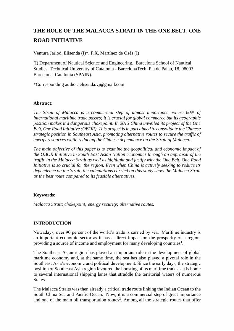
following figure (Figure 1). With that information, its tendency of growth was studied.
Figure 1. Type of vessel reporting Klang VTS in 2018.
Also, to highlight the importance of the OBOR Initiative for the Malacca Strait an analysis
of a case scenario was presented. Literature shows the Straits of Sunda and Lombok as
feasible alternatives to the chokepoint14. One of the objectives of this study was to check
weather these two other routes where a feasible alternative by calculating the estimated
cost of rerouting the traffic from the Strait of Malacca to them; the assessment of the real
costs in the scenarios proposed are the same as the models established in literature by
different authors such as Cullinane and Khanna (2000)15, Stopford (2008)16 or Gkonis
and Psaraftis (2010)17.
In order to do so, a hypothetical Liner Company which sees one of its service schedules
affected by the closure was proposed. In the assessment of the cost assumed by the Liner
Company, six components of liner service costs were identified: service schedule, ship
costs, port charges, container operations, container costs, and administration.
Regarding service schedule, it concerns the service frequency, the number of port calls
and the distance, as well as the required number of ships in weekly string. The ship cost
is usually expressed in terms of unit slot cost. Operating, capital and fuel costs are
important elements, since fuel consumptions is a particularly important variable. Port
charges are beyond the control of the ship-owner and vary around the world. Container
VLCC
TANKER Vessel
LNG & LPG Carrier
Cargo Vessel
Container Vessel
Bulk Carrier
Ro-Ro
Passenger Vessel
Livestock Carrier
operations costs depend on the mix of container types, container turnaround time and
empty containers that must be repositioned. Container costs include daily cost,
maintenance, repair, and handling, among others. Administrations costs are related to
management, logistics, financial, and commercial aspects of the business.
The object of study was a Container ship of 4.300 TEU as container vessels were the
largest users of the strait in 2018. For cost calculation purposes, a characteristic ship was
obtained from averaging data of some vessel with similar particulars and schedules and
some assumptions were made. For instance:
1. In the calculations it was assumed that a year has 360 days.
2. The Bunker price was selected on 24rd of May 2019 in Singapore
(Shipandbunker.com) reaching for IFO380 the 413,5 $/ton.
3. It was assumed a 20% of inter-zone repositioning as an estimation of what
industry demands nowadays.
4. It was assumed a 20% as the estimated amount the ship-owner would carry out
the inland intermodal transport.
5. It was considered a 10% of cargo claims.
6. For administration cost, only were considered the employee costs, depreciating
the other costs.
Due to that the major part of the costs remained constant, the time taken on the voyage
and the distance travelled on that voyage were the two causal factors which had a strong
effect on costs when considering a detour.
It is important to remark that for the sake of the comparison the total number of voyages
per annum remained constant, even when a greater distance means more sailing time and
consequently less voyage per year. It was assumed in that way to show what would
suppose in terms of costs for the ship-owner to maintain the same conditions of service.
As this study also pretended to offer an early assessment of the impact of the OBOR
Initiative in the ASEAN region, the Liner Shipping Connectivity Index for the different
countries conforming it was studied and compared with the first top ranking countries,
for instance, China and Singapore.
2. RESULTS
In the last four years, daily transit reports to Klang VTS increased from 222 vessels per
day in 2015 to 233 vessels per day in 2018. This equates to nearly 10 vessels entering or
leaving the straits every hour, or one vessel every six minutes.
In 2018, container vessels accounted for 30,8% (Figure 1) and remained the largest users
of the strait despite rapid growth in the size of containers on the trade with lines.
Overall tanker traffic, including VLCCs, saw 28127 transits in 2018, an increase of 787
compared to 27340 transits in 2017, showing a continuous growth. Tankers alone
accounted the second, with a 24,4% of the traffic. Bulk Carrier traffic in the strait saw a
steady growth too reflecting East Asia’s import of raw materials such as iron, ore, and
coal. On the other hand, LNG and LPG vessel traffic saw a small increase in transits too,
showing a slow but constant growth.
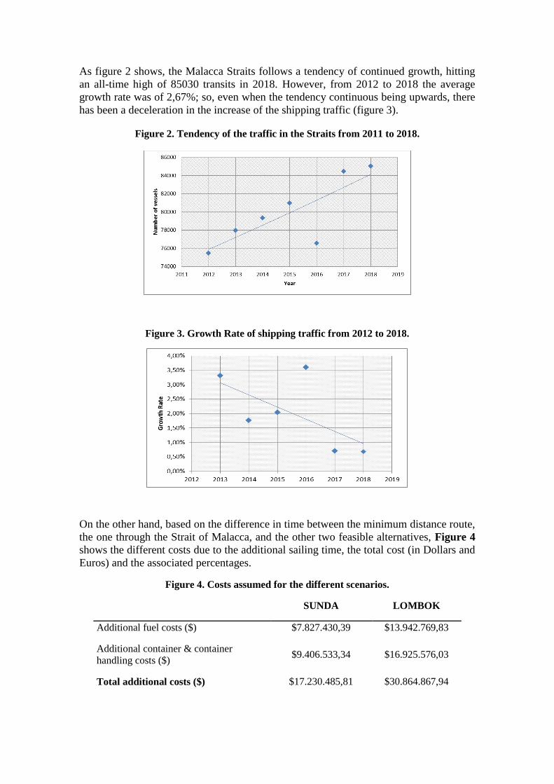
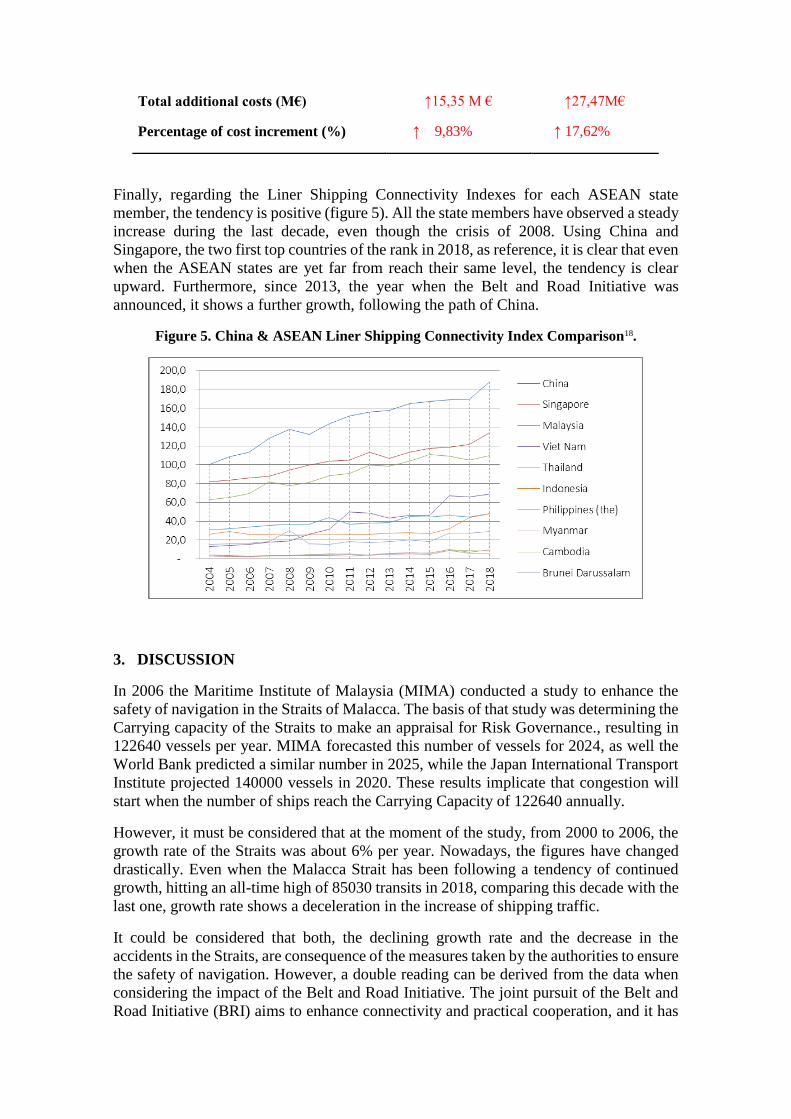
As figure 2 shows, the Malacca Straits follows a tendency of continued growth, hitting
an all-time high of 85030 transits in 2018. However, from 2012 to 2018 the average
growth rate was of 2,67%; so, even when the tendency continuous being upwards, there
has been a deceleration in the increase of the shipping traffic (figure 3).
Figure 2. Tendency of the traffic in the Straits from 2011 to 2018.
Figure 3. Growth Rate of shipping traffic from 2012 to 2018.
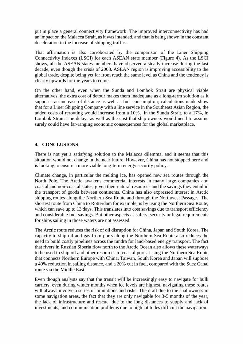
On the other hand, based on the difference in time between the minimum distance route,
the one through the Strait of Malacca, and the other two feasible alternatives, Figure 4
shows the different costs due to the additional sailing time, the total cost (in Dollars and
Euros) and the associated percentages.
Figure 4. Costs assumed for the different scenarios.
SUNDA LOMBOK
Additional fuel costs ($) $7.827.430,39 $13.942.769,83
Additional container & container
handling costs ($) $9.406.533,34 $16.925.576,03
Total additional costs ($) $17.230.485,81 $30.864.867,94
Total additional costs (M€) ↑15,35 M € ↑27,47M€
Percentage of cost increment (%) ↑ 9,83% ↑ 17,62%
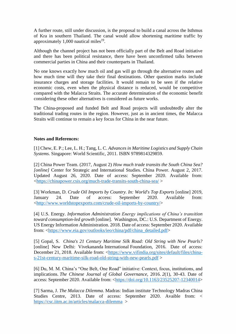
Finally, regarding the Liner Shipping Connectivity Indexes for each ASEAN state
member, the tendency is positive (figure 5). All the state members have observed a steady
increase during the last decade, even though the crisis of 2008. Using China and
Singapore, the two first top countries of the rank in 2018, as reference, it is clear that even
when the ASEAN states are yet far from reach their same level, the tendency is clear
upward. Furthermore, since 2013, the year when the Belt and Road Initiative was
announced, it shows a further growth, following the path of China.
Figure 5. China & ASEAN Liner Shipping Connectivity Index Comparison18.
3. DISCUSSION
In 2006 the Maritime Institute of Malaysia (MIMA) conducted a study to enhance the
safety of navigation in the Straits of Malacca. The basis of that study was determining the
Carrying capacity of the Straits to make an appraisal for Risk Governance., resulting in
122640 vessels per year. MIMA forecasted this number of vessels for 2024, as well the
World Bank predicted a similar number in 2025, while the Japan International Transport
Institute projected 140000 vessels in 2020. These results implicate that congestion will
start when the number of ships reach the Carrying Capacity of 122640 annually.
However, it must be considered that at the moment of the study, from 2000 to 2006, the
growth rate of the Straits was about 6% per year. Nowadays, the figures have changed
drastically. Even when the Malacca Strait has been following a tendency of continued
growth, hitting an all-time high of 85030 transits in 2018, comparing this decade with the
last one, growth rate shows a deceleration in the increase of shipping traffic.
It could be considered that both, the declining growth rate and the decrease in the
accidents in the Straits, are consequence of the measures taken by the authorities to ensure
the safety of navigation. However, a double reading can be derived from the data when
considering the impact of the Belt and Road Initiative. The joint pursuit of the Belt and
Road Initiative (BRI) aims to enhance connectivity and practical cooperation, and it has
put in place a general connectivity framework The improved interconnectivity has had
an impact on the Malacca Strait, as it was intended, and that is being shown in the constant
deceleration in the increase of shipping traffic.
That affirmation is also corroborated by the comparison of the Liner Shipping
Connectivity Indexes (LSCI) for each ASEAN state member (Figure 4). As the LSCI
shows, all the ASEAN states members have observed a steady increase during the last
decade, even though the crisis of 2008. ASEAN region is improving accessibility to the
global trade, despite being yet far from reach the same level as China and the tendency is
clearly upwards for the years to come.
On the other hand, even when the Sunda and Lombok Strait are physical viable
alternatives, the extra cost of detour makes them inadequate as a long-term solution as it
supposes an increase of distance as well as fuel consumption; calculations made show
that for a Liner Shipping Company with a line service in the Southeast Asian Region, the
added costs of rerouting would increase from a 10%, in the Sunda Strait, to a 17%, in
Lombok Strait. The delays as well as the cost that ship-owners would need to assume
surely could have far-ranging economic consequences for the global marketplace.
4. CONCLUSIONS
There is not yet a satisfying solution to the Malacca dilemma, and it seems that this
situation would not change in the near future. However, China has not stopped here and
is looking to ensure a more viable long-term energy security policy.
Climate change, in particular the melting ice, has opened new sea routes through the
North Pole. The Arctic awakens commercial interests in many large companies and
coastal and non-coastal states, given their natural resources and the savings they entail in
the transport of goods between continents. China has also expressed interest in Arctic
shipping routes along the Northern Sea Route and through the Northwest Passage. The
shortest route from China to Rotterdam for example, is by using the Northern Sea Route,
which can save up to 13 days. This translates into cost savings due to transport efficiency
and considerable fuel savings. But other aspects as safety, security or legal requirements
for ships sailing in those waters are not assessed.
The Arctic route reduces the risk of oil disruption for China, Japan and South Korea. The
capacity to ship oil and gas from ports along the Northern Sea Route also reduces the
need to build costly pipelines across the tundra for land-based energy transport. The fact
that rivers in Russian Siberia flow north to the Arctic Ocean also allows these waterways
to be used to ship oil and other resources to coastal ports. Using the Northern Sea Route
that connects Northern Europe with China, Taiwan, South Korea and Japan will suppose
a 40% reduction in sailing distance, and a 20% cut in fuel, compared with the Suez Canal
route via the Middle East.
Even though analysts say that the transit will be increasingly easy to navigate for bulk
carriers, even during winter months when ice levels are highest, navigating these routes
will always involve a series of limitations and risks. The draft due to the shallowness in
some navigation areas, the fact that they are only navigable for 3-5 months of the year,
the lack of infrastructure and rescue, due to the long distances to supply and lack of
investments, and communication problems due to high latitudes difficult the navigation.
A further route, still under discussion, is the proposal to build a canal across the Isthmus
of Kra in southern Thailand. The canal would allow shortening maritime traffic by
approximately 1,000 nautical miles19.
Although the channel project has not been officially part of the Belt and Road initiative
and there has been political resistance, there have been unconfirmed talks between
commercial parties in China and their counterparts in Thailand.
No one knows exactly how much oil and gas will go through the alternative routes and
how much time will they take their final destinations. Other question marks include
insurance charges and storage facilities. It would remain to be seen if the relative
economic costs, even when the physical distance is reduced, would be competitive
compared with the Malacca Straits. The accurate determination of the economic benefit
considering these other alternatives is considered as future works.
The China-proposed and funded Belt and Road projects will undoubtedly alter the
traditional trading routes in the region. However, just as in ancient times, the Malacca
Straits will continue to remain a key focus for China in the near future.
Notes and References:
[1] Chew, E. P.; Lee, L. H.; Tang, L. C. Advances in Maritime Logistics and Supply Chain
Systems. Singapore: World Scientific, 2011. ISBN 9789814329859.
[2] China Power Team. (2017, August 2) How much trade transits the South China Sea?
[online] Center for Strategic and International Studies. China Power. August 2, 2017.
Updated August 26, 2020. Date of access: September 2020. Available from:
<https://chinapower.csis.org/much-trade-transits-south-china-sea/ >
[3] Workman, D. Crude Oil Imports by Country. In: World's Top Exports [online] 2019,
January 24. Date of access: September 2020. Available from:
<http://www.worldstopexports.com/crude-oil-imports-by-country/>
[4] U.S. Energy. Information Administration Energy implications of China’s transition
toward consumption-led growth [online]. Washington, DC.: U.S. Department of Energy.
US Energy Information Administration. 2018. Date of access: September 2020. Available
from: <https://www.eia.gov/outlooks/ieo/china/pdf/china_detailed.pdf>
[5] Gopal, S. China's 21 Century Maritime Silk Road: Old String with New Pearls?
[online] New Delhi: Vivekananda International Foundation, 2016. Date of access:
December 21, 2018. Available from: <https://www.vifindia.org/sites/default/files/china-
s-21st-century-maritime-silk-road-old-string-with-new-pearls.pdf >
[6] Du, M. M. China’s “One Belt, One Road” initiative: Context, focus, institutions, and
implications. The Chinese Journal of Global Governance, 2016. 2(1), 30-43. Date of
access: September 2020. Available from: <https://doi.org/10.1163/23525207-12340014>
[7] Sarma, J. The Malacca Dilemma. Madras: Indian institute Technology Madras China
Studies Centre, 2013. Date of access: September 2020. Avaible from: <
https://csc.iitm.ac.in/articles/malacca-dilemma >
[8] Liss, C. The Privatization of Maritime Security-Maritime Security in Southeast Asia:
Between a rock and a hard place? [s.l.]: Asia Research Centre, 2007.
[9] Oh, Y. China’s Economic Ties with Southeast Asia. World Economic Brief [online] .
[s.l.]: Korea Institute for International Economic Policy, 2017. Vol. 7 No. 18. ISSN 2233-
9140. Date of access: September 2020. Available from: <https://think-
asia.org/bitstream/handle/11540/7468/WEB%2017-18.pdf?sequence=1>
[10] Thayer, C. A. (2010). Southeast Asia: Patterns of security cooperation. Barton,
Australia: Australian Strategic Policy Institute, 2010. ISBN 9781921302572. Date of
access: September 2020. Available from: < https://s3-ap-southeast-2.amazonaws.com/ad-
aspi/import/Southeast_Asia_patterns_security.pdf?wJOev7d4XHnc1_qhzGvURbNX7y
vgPqOH >
[11] Zhong, Y. (2016). The Importance of the Malacca Dilemma in the Belt and Road
Initiative. Journal of policy science. Kioto, Japan: Ritsumeikan University. The Policy
Science Association, 2016. Vol.10, pp.85-109. Date of access: September 2020.
Available from: < https://core.ac.uk/download/pdf/60551684.pdf >
[12] Rodríguez, J. A. The Belt and Road Initiative: A Geopolitical Approach [online].
Doctoral dissertation, Hugvísindasvið Háskóla Íslands, 2018. Date of access: September
2020. Available from:
<https://skemman.is/bitstream/1946/29434/1/Jos%C3%A9%20Alam%C3%A1%20Rod
r%C3%ADguez.pdf >
[13] Blanchard, J. M. F.; Flint, C. The geopolitics of China’s maritime silk road initiative.
Geopolitics. Taylor & Francis, 2017. Vol.2 Issue 2. Date of access: September 2020.
Available from: < https://doi.org/10.1080/14650045.2017.1291503 >
[14] Amri, A. A. Maritime Security Challenges in Southeast Asia: Analysis of
International and Regional Legal Frameworks [online]. Doctoral thesis, University of
Wollongong, 2016. Date of access: September 2020. Available from: <
https://ro.uow.edu.au/cgi/viewcontent.cgi?article=5890&context=theses >
[15] Cullinane, K.; Khanna, M. Economies of scale in large containerships: optimal size
and geographical implications. Journal of Transport Geography. New York, NY :
Elsevier Science, 2000. Vol. 8: 181-195. Date of access: September 2020. Available
from: < https://doi.org/10.1016/S0966-6923(00)00010-7 >
[16] Stopford, M. Maritime Economics. 2nd edition. London [etc.]: Routledge, 2004.
ISBN 9780415275583.
[17] Gkonis, K. G.; Psaraftis, H. N. Some key variables affecting liner shipping
costs. Laboratory for Maritime Transport, National Technical University of Athens, 2010.
[18] United Nations Conference on Trade and Development. UNCTDSTAT. [online].
Geneva, Switzerland: United Nations Conference on Trade and Development. Date of
access: September 2020. Available from:
<https://unctadstat.unctad.org/wds/TableViewer/tableView.aspx?ReportId=92 >

[19] Rahman, N. A.; Saharuddin, A. H.; Rasdi, R. Effect of the northern sea route opening
to the shipping activities at Malacca straits. International Journal of e-Navigation and
Maritime Economy. Mokpo, South Korea: Mokpo National Maritime University, Korea
Advanced Institute for Maritime Safety and Technology. Elsevier, 2014. Vol.1, 85-98.
Date of access: September 2020. Available from:
<https://doi.org/10.1016/j.enavi.2014.12.008 >
Related Documents