THE PREFERRED ORIENTATION OF IROQUOIAN LONGHOUSES IN ONTARIO G. B. NORCLIFFE and C. E. HEIDENREICH INTRODUCTION Archaeology is one of a number of disciplines which include amongst their tasks the job of reconstructing how extinct systems and organizations functioned, using only fragmentary information. In essence the problem is to make statements about processes using formal evidence. Pleistocene geomorphologists, for instance, use evidence relating to cirques, drumlins and a variety of other observable landforms in theorizing about the flow of ice sheets and glaciers (Evans, 1972). Likewise archaeologists are able to re- approximate the workings of extinct societies using formal evidence together with argument by analogy (for example, with comparable present -day societies) and some sound intuition. This paper is concerned with the preferred orientation of Ontario Iroquois longhouses. By applying inferential statistics developed to analyze azimuthal data, we are able to identify a marked orientational preference: the results indicate that it is highly improbable that the observed orientation in the sample we used occurred by chance. In searching for an explanation of why this significant orientation preference is found, a variety of climatic data relating to wind direction was examined. The coincidence between certain types of wind conditions and the preferred orientation of longhouses lead us to suggest, albeit tentatively, that longhouses were oriented mainly NW- SE or NNW-SSE on account of the greater thermal efficiency gained from this layout. THE DATA Every effort was made to gather as large a sample of longhouse data as possible from the published and unpublished literature. Not all the unpublished sources could be tracked down, but the authors are fairly confident that their sample of 96 longhouses and portions of longhouses is fairly representative of existing information. Since, for the purposes of this study, only the orientation of the longhouse was important, it was possible to include data on partially excavated longhouses. A glance at Figure 1 shows that the study sample is heavily biased in favour of sites from the Late Ontario Iroquois sequence. The Middle Ontario Iroquois sequence is represented by one site and the Early Ontario Iroquois sequence by three sites. Furthermore, the sites are best represented in the historic Huron area (Map 1). This chronological and areal bias is inevitable because, until recently, archaeological activities have tended to focus on the development of the Huron sequence. A decision was made to include the underrepresented areas when the authors discovered that their inclusion made little difference to the results. The underrepresented chronological sequences were included to suggest speculative trends in the data. The Early Ontario Iroquois stage is represented by 17 longhouses from the Porteous (Noble and Kenyon, 1972), Miller (Kenyon, 1968) and Bennett (Wright and Anderson, 1969) sites (Figure 1). All three sites appear to have been semi -permanent villages occupied during the entire season. Of the 17 houses, the ones from the Miller and Porteous sites and three from the Bennett site were completely excavated. In size the sites ranged from the Miller site at 1.2 acres and the Porteous site at 1.3 acres to the Bennett site at 2.5 to 3 acres. Both the Miller and Norcliffe and Heidenreich: IROQUOIAN LONGHOUSES 3

Welcome message from author
This document is posted to help you gain knowledge. Please leave a comment to let me know what you think about it! Share it to your friends and learn new things together.
Transcript
THE PREFERRED ORIENTATION OF IROQUOIAN
LONGHOUSES IN ONTARIO
G. B. NORCLIFFE and C. E. HEIDENREICH
INTRODUCTION
Archaeology is one of a number of disciplines which include amongst their tasks the job ofreconstructing how extinct systems and organizations functioned, using only fragmentaryinformation. In essence the problem is to make statements about processes using formal evidence.Pleistocene geomorphologists, for instance, use evidence relating to cirques, drumlins and a varietyof other observable landforms in theorizing about the flow of ice sheets and glaciers (Evans, 1972).Likewise archaeologists are able to re-approximate the workings of extinct societies using formalevidence together with argument by analogy (for example, with comparable present-day societies)and some sound intuition.
This paper is concerned with the preferred orientation of Ontario Iroquois longhouses. Byapplying inferential statistics developed to analyze azimuthal data, we are able to identify a markedorientational preference: the results indicate that it is highly improbable that the observedorientation in the sample we used occurred by chance. In searching for an explanation of why thissignificant orientation preference is found, a variety of climatic data relating to wind direction wasexamined. The coincidence between certain types of wind conditions and the preferred orientationof longhouses lead us to suggest, albeit tentatively, that longhouses were oriented mainly NW-SEor NNW-SSE on account of the greater thermal efficiency gained from this layout.
THE DATA
Every effort was made to gather as large a sample of longhouse data as possible from thepublished and unpublished literature. Not all the unpublished sources could be tracked down, butthe authors are fairly confident that their sample of 96 longhouses and portions of longhouses isfairly representative of existing information. Since, for the purposes of this study, only theorientation of the longhouse was important, it was possible to include data on partially excavatedlonghouses.
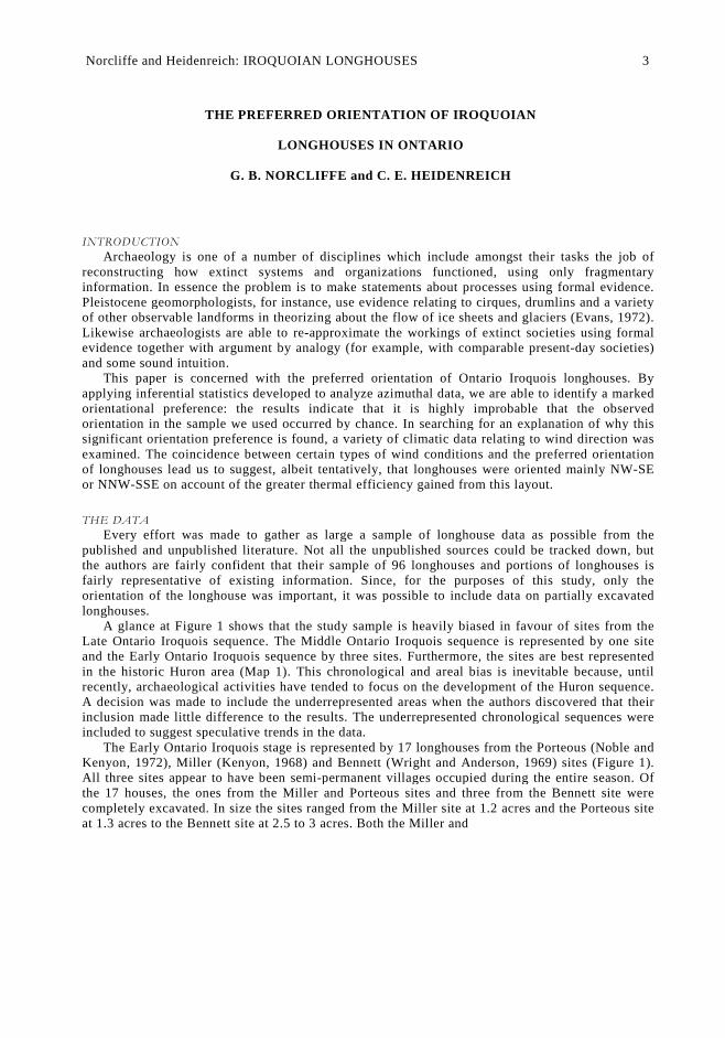
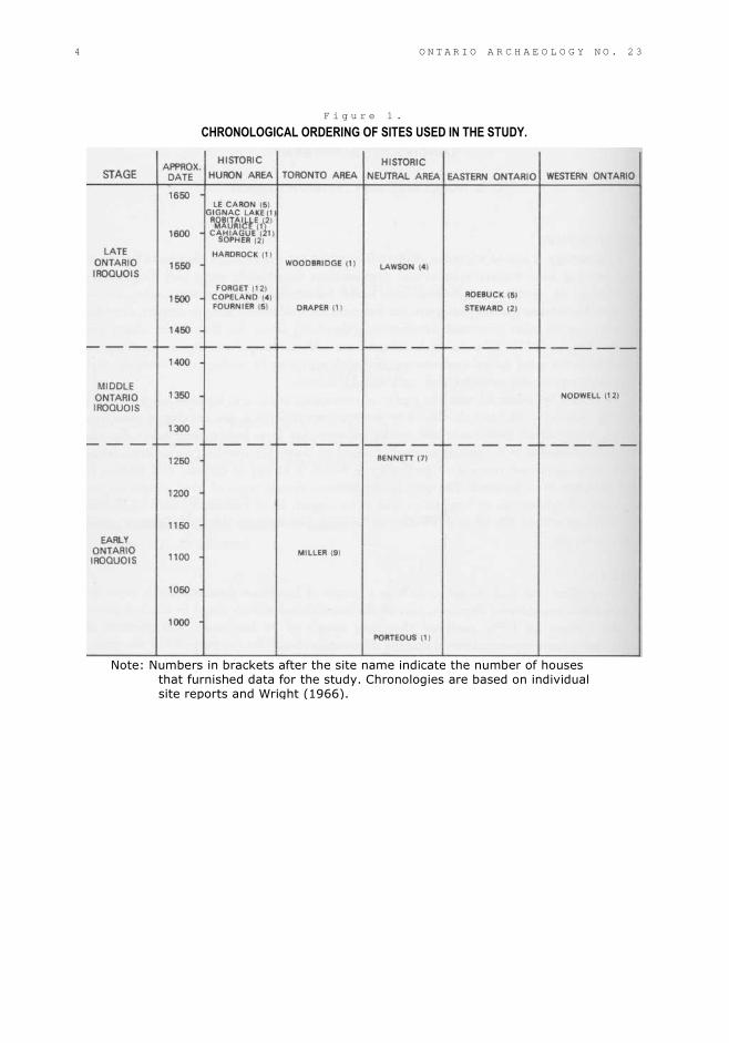
A glance at Figure 1 shows that the study sample is heavily biased in favour of sites from theLate Ontario Iroquois sequence. The Middle Ontario Iroquois sequence is represented by one siteand the Early Ontario Iroquois sequence by three sites. Furthermore, the sites are best representedin the historic Huron area (Map 1). This chronological and areal bias is inevitable because, untilrecently, archaeological activities have tended to focus on the development of the Huron sequence.A decision was made to include the underrepresented areas when the authors discovered that theirinclusion made little difference to the results. The underrepresented chronological sequences wereincluded to suggest speculative trends in the data.
The Early Ontario Iroquois stage is represented by 17 longhouses from the Porteous (Noble andKenyon, 1972), Miller (Kenyon, 1968) and Bennett (Wright and Anderson, 1969) sites (Figure 1).All three sites appear to have been semi-permanent villages occupied during the entire season. Ofthe 17 houses, the ones from the Miller and Porteous sites and three from the Bennett site werecompletely excavated. In size the sites ranged from the Miller site at 1.2 acres and the Porteous siteat 1.3 acres to the Bennett site at 2.5 to 3 acres. Both the Miller and
Norcliffe and Heidenreich: IROQUOIAN LONGHOUSES 3
F i g u r e 1 .
CHRONOLOGICAL ORDERING OF SITES USED IN THE STUDY.
Note: Numbers in brackets after the site name indicate the number of housesthat furnished data for the study. Chronologies are based on individualsite reports and Wright (1966).
4 O N T A R I O A R C H A E O L O G Y N O . 2 3
Norcliffe and Heidenreich: IROQUOIAN LONGHOUSES 5
Bennett sites were palisaded. The presence or absence of a palisade at the Porteous site has as yetnot been established.
The Middle Ontario Iroquois stage is represented by the Nodwell site (Wright, 1971).
This is a palisaded two-acre site containing twelve house structures. The entire site has been
excavated and is presently being reconstructed.In the Late Ontario Iroquois stage, two villages are represented from eastern Ontario; the
eight-acre palisaded Roebuck site with five fragmentary structures (Wintemberg, 1936) and theSteward site with two excavated longhouses (Wright, 1972). Of these the Roebuck site is a semi-permanent village and the Steward site probably a seasonal fishing camp. The heavily fortifiedfive-acre Lawson site (Wintemberg, 1939) is the only Late Ontario Iroquois village from theNeutral area in our sample. It furnished information on five partly excavated houses. Both theWoodbridge (McKenzie) (Emerson, 1954) and the Draper (Latta and Konrad, 1972) sites arelocated on the northern fringes of Metro Toronto. They were both fortified and each furnished onecompletely excavated longhouse. In total fourteen houses were excavated at the 2.5-acreWoodbridge site, all apparently running NW to SE; however only data from the one house whoseexact orientation is known, was included in this study.
The pre-contact and contact Huron villages comprised 56 per cent of our house sample and 68per cent of our villages. Le Caron is a palisaded village of some 4.7 acres dating to the Jesuit period(Rexe, 1971; 1972). Portions from five houses were uncovered, all running parallel to each other.Test excavations at the Gignac Lake site, a late contact village of some three acres, uncovered thewall of one house (O'Brien, 1972). The Robitaille and Maurice sites, about six and 1.5 acres insize respectively, were both tested by the University of Toronto (Tyyska, 1969). Each yielded onecomplete house. An additional house was discovered at the Robitaille site through soil chemicalanalysis (Heidenreich and Konrad, 1973). Both villages were palisaded. Few sites in Ontario havereceived as much attention as Cahiague (Warminster site). To date twenty-one longhouses havebeen excavated in the 8.5-acre northern component of the village (Tyyska, 1968; Russell, personalcommunication, 1973). In addition, a host of bits and pieces from many other houses have beendiscovered through trenching. All of these are more or less parallel to each other. Cahiague datesto the early period of direct French contact in Huronia. The Sopher site is a 3.7-acre, unpalisaded,early contact Huron village (Noble, 1968). Two parallel houses have been excavated, spaced some35 to 40 feet apart. The Hardrock site was probably a very small fishing station or "portage site"(Emerson, 1954). One house has been completely excavated at this site. Forget, Copeland andFournier are all pre-contact villages. Forget was completely excavated by the University of WesternOntario. The village was 1.8 acres in size, palisaded and included twelve longhouses. Data on thesite was obtained from a display at the University of Toronto. The Copeland site was alsopalisaded and yielded four houses to its excavators (Channen and Clarke, 1965). The Fournier sitehas been briefly reported on by Russell (1967). It appears to have been a two-component site, oneof which was a fishing station. To date five longhouses have been partially and completelyexcavated (Russell, personal communication, 1973). It is not known whether the site waspalisaded.
In summary, the ninety-six longhouses used in this study come from palisaded andunpalisaded villages ranging in size from less than one acre to 8.5 acres for the northerncomponent of the 15-acre Cahiague village. All except Steward and perhaps Hardrock andFournier appear to have been semi-permanent villages continuously occupied for a number ofyears. The three exceptions were probably occupied in the spring, summer or fall only.
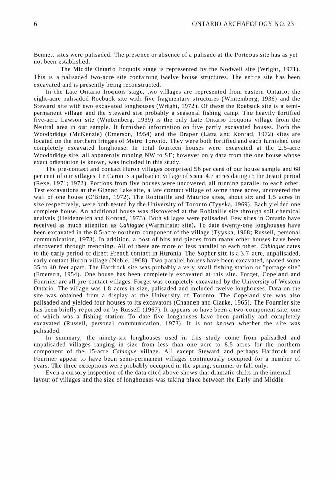
Even a cursory inspection of the data cited above shows that dramatic shifts in the internallayout of villages and the size of longhouses was taking place between the Early and Middle
6 ONTARIO ARCHAEOLOGY NO. 23
Figure 2.THE LENGTH OF ONTARIO IROQUOIS LONGHOUSES.
(Each dot represents one Ionghouse)
Norcliffe and Heidenreich: IROQUOIAN LONGHOUSES 7
Iroquois stages (Figure 2). This observation, as well as changes in the internal layout of thelonghouses has been discussed by Noble (1968:268-269; 1969:18-19). The cause of thesechanges, Noble reasons, is linked to changes in Iroquoian social and political structure that tookplace sometime around 1300 A.D. Because of these changes a decision was made to analyze thedata in a series of steps:Series A includes all ninety-six longhouses in our sample.Series B includes the Middle and Late Ontario Iroquois stages. The sample has now been reduced
to seventy-nine longhouses.Series C examines only the Late Ontario Iroquois stage. In other words, the twelve longhouses
from the Nodwell site were excluded. The internal structure of this village more closelyapproximates the earlier villages while the length of the houses as well as their internal layoutis closer to the later ones.
Series D includes the Late Ontario Iroquois stage but excludes the Steward site which was onlyseasonally occupied. Since the seasonality of Hardrock and Fournier have not been clearlyestablished, they were included in the sample.
Series E examines only the fifty-four longhouses from the Huron area. Unfortunately the
longhouse sample from the other areas was not large enough to treat these separately.
METHOD OF ANALYSIS AND RESULTSAs early as 1880, the eminent mathematician J. W. Strutt (later Lord Rayleigh) was
publishing papers relating to the pitch and phase of vibrations: much of the present statisticaltheory on orientation grew out of Rayleigh's work, and appropriately, one of the statistical testshas been named after him. Rayleigh's work dealt with random vibrations in one, two, and threedimensions. In the present case, however, we are concerned with two-dimensional data, hence theobjective is to identify deviations from randomness on a plane.
The data discussed in the previous section were converted into a form suitable for statisticalanalysis by placing diagrams of each archaeological site on a map digitizer. The co-ordinates(easting and northing) of both ends of a longhouse were recorded by the digitizer on computercards, which in turn were processed using a programme prepared by one of the authors.
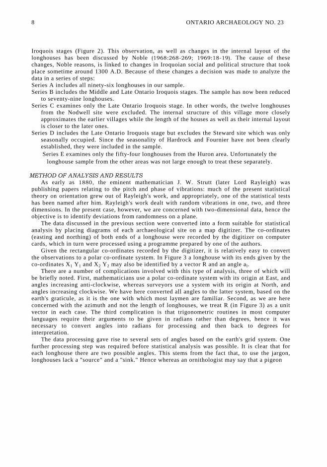
Given the rectangular co-ordinates recorded by the digitizer, it is relatively easy to convertthe observations to a polar co-ordinate system. In Figure 3 a longhouse with its ends given by theco-ordinates X1 Y1 and X2 Y2 may also be identified by a vector R and an angle al.
There are a number of complications involved with this type of analysis, three of which willbe briefly noted. First, mathematicians use a polar co-ordinate system with its origin at East, andangles increasing anti-clockwise, whereas surveyors use a system with its origin at North, andangles increasing clockwise. We have here converted all angles to the latter system, based on theearth's graticule, as it is the one with which most laymen are familiar. Second, as we are hereconcerned with the azimuth and not the length of longhouses, we treat R (in Figure 3) as a unitvector in each case. The third complication is that trigonometric routines in most computerlanguages require their arguments to be given in radians rather than degrees, hence it wasnecessary to convert angles into radians for processing and then back to degrees forinterpretation.
The data processing gave rise to several sets of angles based on the earth's grid system. Onefurther processing step was required before statistical analysis was possible. It is clear that foreach longhouse there are two possible angles. This stems from the fact that, to use the jargon,longhouses lack a "source" and a "sink." Hence whereas an ornithologist may say that a pigeon
8 ONTARIO ARCHAEOLOGY NO. 23
Figure 3.THE RECTANGULAR AND POLAR CO-ORDINATES
OF A HYPOTHETICAL LONGHOUSE.
Norcliffe and Heidenreich: IROQUOIAN LONGHOUSES 9
flew from a release point (source) towards the horizon (sink) at an angle of, say, 2500, anarchaeologist cannot say that a longhouse began at one end and ended at the other: the reversemay be equally true. In Figure 3, the longhouse could be characterized by two angles, either a1
(320°) or by a2 (140°). A similar problem is faced by stratigraphers in studying the orientation ofpebbles: a pebble oriented to the east is also oriented to the west. If both angles are recorded, thenone ends up with a central symmetric distribution where any 1800 segment is the mirror image ofthe other. Clearly, angles are only unique over a 1800 arc, hence it is necessary to use thefollowing simple manipulation proposed by Krumbein (1939). Any angle exceeding 180° isreduced by 180°, so that in Figure 3, the angle would be 320° - 1800
= 140°. The resulting anglesare then doubled to restore them to a range 0 - 360°, this being necessary for the purposes ofstatistical analysis. This method is known, logically enough, as "the doubling of angles."
The first type of statistical test we applied were chi square tests, comparing the observedazimuths to a uniform distribution. These tests were performed by classifying the data into twelvearcs each of 300. The results permit one to make statements as to whether the azimuths are or arenot uniformly distributed, but they do not identify the preferred orientation.
The preferred direction is represented by the azimuth of the mean vector which was computed
as follows. If ai represents the azimuth of the i th longhouse, then the northing of the mean vector
is given by
the easting is given by
and by Pythagoras we have the length of the mean vector
The angle of the mean vector (which is interpreted as the preferred orientation) is θ where
10 ONTARIO ARCHAEOLOGY NO. 23
Bearing in mind that we are dealing with a central symmetric distribution and that all the angleshave been doubled, then we must halve θ to obtain the two preferred orientations, 1/2 θ and 1/2 θ+180°
The significance of this finding can be determined using the test named after Rayleigh. One has
to compute the quantity z, where
z = n r ²
and compare this to a set of tables published by Greenwood and Durand (1955).
Two other measures are indicative of the presence of a directional preference. The measure r, as
defined above, can be expressed as a percentage to represent the magnitude of the mean vector. The
second measure is the mean angular deviation, s, which is given by
This measure is the circular equivalent of the familiar standard deviation and has similar statistical
properties.
One final statistic which is of use is the second trigonometric moment (a measure of skewness)
G: if we define
then we have
G vanishes in the case of a symmetrical distribution, and increases with increasing skewness.In discussing the data sources, several problems were reviewed. In the light of these problems,
it seemed appropriate to analyze not one set of longhouses, but several to see how consistent theresults were. Accordingly, the following series were examined (for details, see Figure 1):
Series A: All longhouses listed in Figure 1 (N = 96) - see Figure 4;
Series B: Middle and Late Ontario Iroquois (N = 79) - see Figure 5;Series C: Late Ontario Iroquois (N =67) - see Figure 6;Series D: Late Ontario Iroquois, excluding the Steward site (N = 65) - see Figure 7;Series E: Huron longhouses (N = 54) - see Figure 8.The results are summarized in Table 1 and will be commented upon briefly.
Norcliffe and Heidenreich: IROQUOIAN LONGHOUSES 11
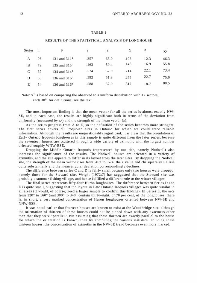
TABLE 1
RESULTS OF THE STATISTICAL ANALYSIS OF LONGHOUSE
Series n θ r s G zX2
A 96 131 and 311° .357 65.0 .103 12.3 46.3
B 79 135 and 315° .463 59.4 .148 16.9 55.8
C 67 134 and 314° .574 52.9 .214 22.1 73.4
D 65 136 and 316° .592 51.8 .255 22.7 75.0
E 54 136 and 316° .588 52.0 .312 18.7 80.5
Note: x2 is based on comparing the observed to a uniform distribution with 12 sectors,
each 300: for definitions, see the text.
The most important finding is that the mean vector for all the series is almost exactly NW-SE, and in each case, the results are highly significant both in terms of the deviation from
uniformity (measured by x2) and the strength of the mean vector (z).As the series progress from A to E, so the definition of the series becomes more stringent.
The first series covers all Iroquoian sites in Ontario for which we could trace reliableinformation. Although the results are unquestionably significant, it is clear that the orientation ofEarly Ontario Iroquois longhouses in this sample is quite different from the later series, becausethe seventeen houses are scattered through a wide variety of azimuths with the largest numberoriented roughly WNW-ESE.
Dropping the Middle Ontario Iroquois (represented by one site, namely Nodwell) alsoincreases the significance of the results. The Nodwell houses are oriented in a variety ofazimuths, and the site appears to differ in its layout from the later sites. By dropping the Nodwellsite, the strength of the mean vector rises from .463 to .574, the z value and chi square value risequite substantially and the mean angular deviation correspondingly declines.
The difference between series C and D is fairly small because only two houses were dropped,namely those for the Steward site. Wright (1972:7) has suggested that the Steward site wasprobably a summer fishing village, and hence fulfilled a different role to the winter villages.
The final series represents fifty-four Huron longhouses. The difference between Series D andE is quite small, suggesting that the layout in Late Ontario Iroquois villages was quite similar inall areas (it would, of course, need a larger sample to confirm this finding). In Series E, the arcsfrom 120° to 160° (and 300° to 340° contain thirty-eight, or 70 per cent, of the longhouses; thereis, in short, a very marked concentration of Huron longhouses oriented between NW-SE andNNW-SSE.
It was noted earlier that fourteen houses are known to exist at the Woodbridge site, althoughthe orientation of thirteen of these houses could not be pinned down with any exactness otherthan that they were "parallel." But assuming that these thirteen are exactly parallel to the housefor which the orientation is known, then by computing the various statistics including thesethirteen houses, the concentration of azimuths in the NW-SE trend becomes even more marked.
12 ONTARIO ARCHAEOLOGY NO. 23
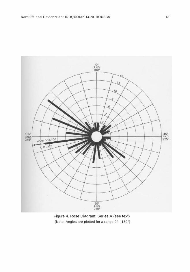
Figure 4. Rose Diagram: Series A (see text)
(Note: Angles are plotted for a range 0°—180°)
Norcliffe and Heidenreich: IROQUOIAN LONGHOUSES 13

Figure 5. Rose Diagram: Series B (see text)
(Note. Angles are plotted for a range 00—180°)
1 4 ONTARIO ARCHAEOLOGY NO. 23
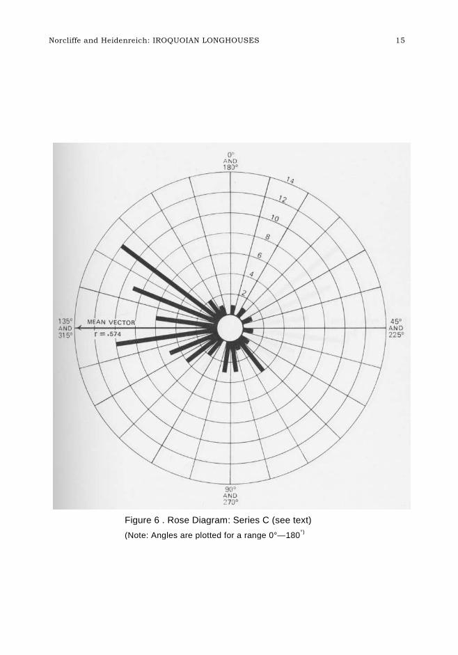
Figure 6 . Rose Diagram: Series C (see text)
(Note: Angles are plotted for a range 0°—180°)
Norcliffe and Heidenreich: IROQUOIAN LONGHOUSES 15
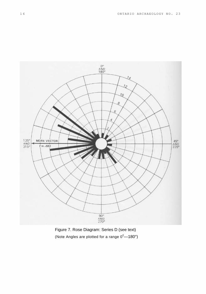
Figure 7. Rose Diagram: Series D (see text)
(Note Angles are plotted for a range 00—180°)
1 6 ONTARIO ARCHAEOLOGY NO. 23
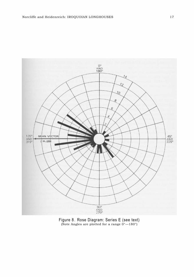
Figure 8 . Rose Diagram: Series E (see text)(Note Angles are plotted for a range 0°—180°)
Norcliffe and Heidenreich: IROQUOIAN LONGHOUSES 17
We have established that in statistical terms, it is exceedingly improbable that Late OntarioIroquois longhouses are randomly oriented: rather, there appears to be a deliberate concentrationof houses oriented either to the NW or NNW, or conversely, to the SE or SSE. We will nowexplore possible explanations of this arrangement.
INTERPRETATIONHaving established almost beyond doubt that Late Iroquois longhouses in Ontario display a
preferred orientation, the question arises as to why this should be the case. There are a number ofpossible hypotheses, four of which will be considered here, namely:
(a) This orientation has some religious/symbolic significance.(b) This orientation is designed to reduce structural damage to longhouses by strong winds.(c) This orientation minimizes the hazard of fires.(d) This orientation maximizes the thermal efficiency of longhouses.
There is a well established precedent for supposing that orientation may have some sort ofcultural significance, for this is found in both primitive and modern societies. For instance, inRoman Catholic and Anglo Catholic churches, the "East End" and the "altar" are synonymous.Most primitive societies navigate by the sun and stars and are intensely aware of azimuths; thefamous monument of Stonehenge, for example, appears to be an elaborate sun temple with manystones and pointers having a directional and seasonal meaning. Could this also apply tolonghouses?
The evidence would seem to indicate that the established orientation does not have symbolicsignificance: there are too many exceptions. One of the characteristics of structures oriented to agiven direction for symbolic reasons is the high level of conformity with the required patternwithin the culture area. The number of exceptions found here make this explanation fairlyimprobable. Furthermore, there is nothing in the seventeenth-century ethno-historic literaturewhich would suggest that any of the Iroquoian groups assigned symbolic value to any particularcompass direction. Similarly, the size of a site and the presence or absence of a palisade do notseem to be related to longhouse orientation.
The three remaining hypotheses were examined with reference to recent wind data, and thereasons for this deserve some explanation. The problem is that in seeking to explain orientation inclimatological terms, weather data relating to the Huron period is obviously not available,although Heidenreich (1973) has suggested that in most respects the climate of Huronia in theearly seventeenth century appears to have been similar to the present. There are dangers in makingcomparisons to weather data for a different period because of fluctuations, some cyclical, some aperiodic, in weather patterns. For instance, Roman settlement in Britain coincided with a phasethat was relatively warmer than today, witness the success of Roman viticulture in SouthernBritain. Shorter periodicities of seven and eleven years are also well documented in climaticseries. It would appear, however, that more confidence can be attached to comparisons for certainspecific wind conditions than for temperature data, because wind conditions are associated with airmasses whose behaviour is fairly constant over time. In Huron times, gale force winds almostcertainly came mainly from the W and SW because, like today, they are associated with thepassage of deep depressions. Likewise intensely cold winter winds came and still come from thenortherly quarter, and are associated with polar continental air masses. However, the percentagedistribution of wind directions may well be more variable so that the comparisons discussed belowmust be viewed as tentative.
A further problem in selecting a standard for wind data lay in choosing an appropriate
18 ONTARIO ARCHAEOLOGY NO. 23
norm. The longhouses examined here are dispersed over quite a wide area, yet wind conditions(measured in terms of wind roses) vary locally. The wind roses for Toronto Malton and TorontoDownsview Airports vary in certain respects quite markedly.
The appropriate source for wind data is Volume 5 of the Climatic Normals, published by the
Meteorological Branch (Canada Department of Transport, 1968). It appears that quite a few of
the weather stations have obstructions creating eddies which alter wind direction patterns: Mount
Forest is affected by a recently constructed, two-storey building, Downsview by a hangar, and
Muskoka by trees.
The norm that was selected was Toronto Malton Airport. This station has two advantages: it
is relatively central in relation to the study area and it has unobstructed air flow from all
directions with flat terrain. The normals for this station are based on the period 1955 to 1966,
inclusive, while individual tabulations based on daily records (prepared specifically for this
study) were for the period April, 1960, to April, 1973.
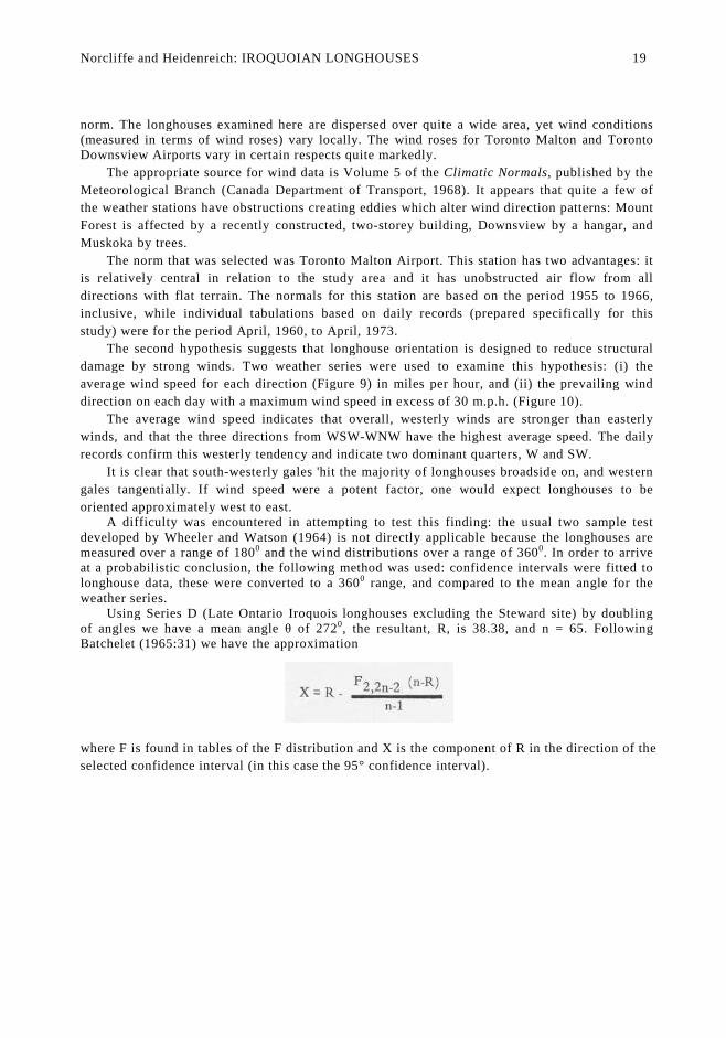
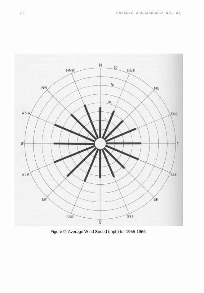
The second hypothesis suggests that longhouse orientation is designed to reduce structural
damage by strong winds. Two weather series were used to examine this hypothesis: (i) the
average wind speed for each direction (Figure 9) in miles per hour, and (ii) the prevailing wind
direction on each day with a maximum wind speed in excess of 30 m.p.h. (Figure 10).
The average wind speed indicates that overall, westerly winds are stronger than easterly
winds, and that the three directions from WSW-WNW have the highest average speed. The daily
records confirm this westerly tendency and indicate two dominant quarters, W and SW.
It is clear that south-westerly gales 'hit the majority of longhouses broadside on, and western
gales tangentially. If wind speed were a potent factor, one would expect longhouses to be
oriented approximately west to east.A difficulty was encountered in attempting to test this finding: the usual two sample test
developed by Wheeler and Watson (1964) is not directly applicable because the longhouses aremeasured over a range of 1800 and the wind distributions over a range of 3600. In order to arriveat a probabilistic conclusion, the following method was used: confidence intervals were fitted tolonghouse data, these were converted to a 3600 range, and compared to the mean angle for theweather series.
Using Series D (Late Ontario Iroquois longhouses excluding the Steward site) by doublingof angles we have a mean angle θ of 2720, the resultant, R, is 38.38, and n = 65. FollowingBatchelet (1965:31) we have the approximation
where F is found in tables of the F distribution and X is the component of R in the direction of the
selected confidence interval (in this case the 95° confidence interval).
Norcliffe and Heidenreich: IROQUOIAN LONGHOUSES 19
2 0 ONTARIO ARCHAEOLOGY NO. 23
Figure 9, Average Wind Speed (mph) for 1955-1966.
N
Figure 10. Wind Rose (expressed in percentages) for Days with a
Maximum Wind Speed Greater than 30 mph, April 1960—April 1973.
orcliffe and Heidenreich: IROQUOIAN LONGHOUSES 21
Here
A s we have doubled the angles, we now convert the series back to a 180° range so that Bbecomes 135.70 (or 315.7°) and the 95 per cent confidence interval is ±7.4° around the meanangle. The 95 per cent confidence interval for θ +180° is 308.3° to 323.1° and the mean angle forthe wind data (270.6°) falls well outside this range.
The mean angle for the wind data is itself a sample parameter about which confidence limitsmay be placed: the 95 per cent confidence interval for the wind series is 12.1°, hence the upperinterval for the wind, 270.6° + 12.1° = 282.7° and well below 308.3°, which is the lowerconfidence limit for the longhouses. On the basis of these confidence intervals we conclude thatthe two mean angles 315.7° and 270.6° are significantly different from one another.
The third hypothesis suggests that the orientation of longhouses was designed to minimize therisk of fires. The location of a series of fire pits in each longhouse coupled with the use of fireoutside the huts made fire a real risk. Indeed many of the ethnohistoric sources comment on thefrequency of village fires and the dread with which the inhabitants regarded them (Thwaites,1959, Vol. 8:93-95, 105; Vol. 10:35; Vol. 14:43-45; Biggar, 1929:125; Wrong, 1939:95). Giventhat the villages were mainly occupied from roughly mid-October to mid-May, and assuming thatthe fire pits were banked highest during the coldest season, then data on the percentage frequencyof winds from December to February may be of some relevance. The wind data given in Figure 11records the percentage frequency that winds flow from- each direction from December toFebruary inclusive. The mean angle is 2870 or slightly north of west, and the distribution isbimodal with north, and west to southwest winds being most frequent. In the light of this data, thefire hazard hypothesis is not implausible, but nor is it very convincing; the dominant winds areeither west or north and would likely have fanned burning fragments from one longhouse toanother, and therefore spread a conflagration. On balance, this hypothesis does not appear to offeran adequate explanation of longhouse orientation although it may be a part of some largerexplanation.
The final hypothesis suggests that the preferred orientation of longhouses maximizes theirthermal efficiency. Records indicate that keeping warm during cold periods was not unimportantto the Iroquois: for instance, in winter they slept huddled together around the fire pits, close toeach other and to the fires for warmth. The longhouses themselves, with their birch, cedar and elmbark cladding, would not be very well insulated. Insofar as heat loss is a function of the surfacearea presented to the wind, the loss of heat from a longhouse could be reduced by minimizing thesurface area presented to prevailing cold winds.
2 2 ONTARIO ARCHAEOLOGY NO. 23
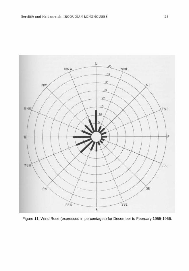
Figure 11. Wind Rose (expressed in percentages) for December to February 1955-1966.
Norcliffe and Heidenreich: IROQUOIAN LONGHOUSES 23
2 4 ONTARIO ARCHAEOLOGY NO. 22
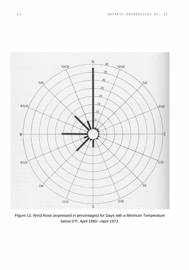
Figure 12. Wind Rose (expressed in percentages) for Days with a Minimum Temperature
below 0°F, April 1960—April 1973.
Figure 12 is a rose diagram for days on which the minimum temperature was below zeroFahrenheit between April, 1960 and April, 1973 (figures in the rose diagram are given inpercentages). Not surprisingly, the dominant direction is north and the mean angle is 3200, and verysimilar to the mean angle of the longhouses.
Again the difference between mean angles is examined using confidence intervals. For Series D(late Ontario Iroquois excluding the Steward site) the 95 per cent confidence interval for θ +180°was 308.30 to 3230: the mean angle for wind direction on days with a minimum temperature belowzero was 3200 which falls well within this confidence interval. The 95 per cent confidence intervalof the mean angle for the wind series is 309.9° to 330.10, which overlaps extensively with thecorresponding confidence interval for the longhouse data. It would seem safe to conclude that themean angles are not significantly different from one another.
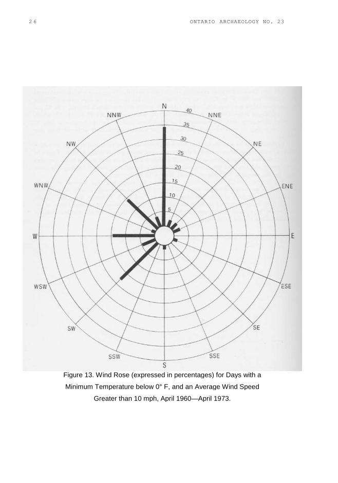
Exploring this hypothesis further, one more series was tabulated, namely, days on which thetemperature was below zero, and the average wind speed greater than 10 m.p.h. (figures in the rosediagram are again given in percentages) (Figure 13). This is quite similar to the previous seriesexcept that the wind speed constraint brings in a slightly more western bearing. The mean angle forthis sample is 3150, almost exactly that of the longhouses.
The results provide the necessary conditions in support of the thermal efficiency hypothesis.Two caveats should be attached: first we have not and cannot provide the sufficient conditions insupport of this hypothesis. Second, and on a different tack, the sample distributions being comparedare both skewed and in different ways, hence the validity of the results may be weakened, althoughStephens (1962) has indicated that the test is robust for deviations from circular normality.
Norcliffe and Heidenreich: IROQUOIAN LONGHOUSES 25
2 6 ONTARIO ARCHAEOLOGY NO. 23
Figure 13. Wind Rose (expressed in percentages) for Days with a
Minimum Temperature below 0° F, and an Average Wind Speed
Greater than 10 mph, April 1960—April 1973.
C
Oplv
tm(hcdpf
arli
IW
W
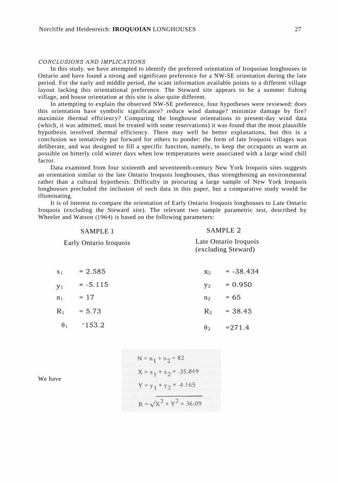
ONCLUSIONS AND IMPLICATIONS
In this study. we have attempted to identify the preferred orientation of Iroquoian longhouses inntario and have found a strong and significant preference for a NW-SE orientation during the lateeriod. For the early and middle period, the scant information available points to a different villageayout lacking this orientational preference. The Steward site appears to be a summer fishingillage, and house orientation at this site is also quite different.
In attempting to explain the observed NW-SE preference, four hypotheses were reviewed: doeshis orientation have symbolic significance? reduce wind damage? minimize damage by fire?aximize thermal efficiency? Comparing the longhouse orientations to present-day wind data
which, it was admitted, must be treated with some reservations) it was found that the most plausibleypothesis involved thermal efficiency. There may well be better explanations, but this is aonclusion we tentatively put forward for others to ponder: the form of late Iroquois villages waseliberate, and was designed to fill a specific function, namely, to keep the occupants as warm asossible on bitterly cold winter days when low temperatures were associated with a large wind chillactor.
Data examined from four sixteenth and seventeenth-century New York Iroquois sites suggestsn orientation similar to the late Ontario Iroquois longhouses, thus strengthening an environmentalather than a cultural hypothesis. Difficulty in procuring a large sample of New York Iroquoisonghouses precluded the inclusion of such data in this paper, but a comparative study would belluminating.
It is of interest to compare the orientation of Early Ontario Iroquois longhouses to Late Ontarioroquois (excluding the Steward site). The relevant two sample parametric test, described by
heeler and Watson (1964) is based on the following parameters:
SAMPLE 1
Early Ontario Iroquois
SAMPLE 2
Late Ontario Iroquois(excluding Steward)
x1 = 2.585 x2 = -38.434
y1 = -5.115 y2 = 0.950
n1 = 17 n2 = 65
R1 = 5.73 R2 = 38.45
θ1=153.2 θ2 =271.4
Norcliffe and Heidenreich: IROQUOIAN LONGHOUSES 27
e have
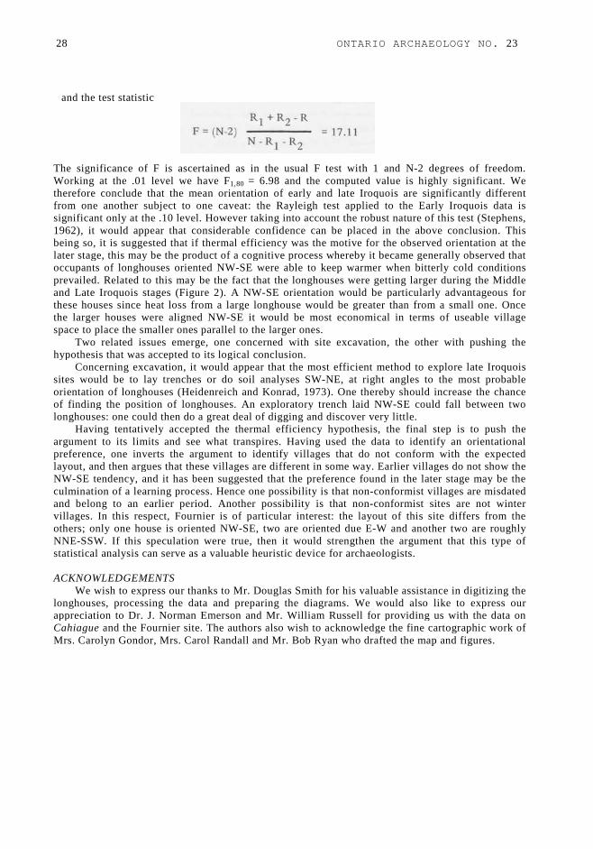
and the test statistic
The significance of F is ascertained as in the usual F test with 1 and N-2 degrees of freedom.Working at the .01 level we have F1,80 = 6.98 and the computed value is highly significant. Wetherefore conclude that the mean orientation of early and late Iroquois are significantly differentfrom one another subject to one caveat: the Rayleigh test applied to the Early Iroquois data issignificant only at the .10 level. However taking into account the robust nature of this test (Stephens,1962), it would appear that considerable confidence can be placed in the above conclusion. Thisbeing so, it is suggested that if thermal efficiency was the motive for the observed orientation at thelater stage, this may be the product of a cognitive process whereby it became generally observed thatoccupants of longhouses oriented NW-SE were able to keep warmer when bitterly cold conditionsprevailed. Related to this may be the fact that the longhouses were getting larger during the Middleand Late Iroquois stages (Figure 2). A NW-SE orientation would be particularly advantageous forthese houses since heat loss from a large longhouse would be greater than from a small one. Oncethe larger houses were aligned NW-SE it would be most economical in terms of useable villagespace to place the smaller ones parallel to the larger ones.
Two related issues emerge, one concerned with site excavation, the other with pushing thehypothesis that was accepted to its logical conclusion.
Concerning excavation, it would appear that the most efficient method to explore late Iroquoissites would be to lay trenches or do soil analyses SW-NE, at right angles to the most probableorientation of longhouses (Heidenreich and Konrad, 1973). One thereby should increase the chanceof finding the position of longhouses. An exploratory trench laid NW-SE could fall between twolonghouses: one could then do a great deal of digging and discover very little.
Having tentatively accepted the thermal efficiency hypothesis, the final step is to push theargument to its limits and see what transpires. Having used the data to identify an orientationalpreference, one inverts the argument to identify villages that do not conform with the expectedlayout, and then argues that these villages are different in some way. Earlier villages do not show theNW-SE tendency, and it has been suggested that the preference found in the later stage may be theculmination of a learning process. Hence one possibility is that non-conformist villages are misdatedand belong to an earlier period. Another possibility is that non-conformist sites are not wintervillages. In this respect, Fournier is of particular interest: the layout of this site differs from theothers; only one house is oriented NW-SE, two are oriented due E-W and another two are roughlyNNE-SSW. If this speculation were true, then it would strengthen the argument that this type ofstatistical analysis can serve as a valuable heuristic device for archaeologists.
ACKNOWLEDGEMENTSWe wish to express our thanks to Mr. Douglas Smith for his valuable assistance in digitizing the
longhouses, processing the data and preparing the diagrams. We would also like to express ourappreciation to Dr. J. Norman Emerson and Mr. William Russell for providing us with the data onCahiague and the Fournier site. The authors also wish to acknowledge the fine cartographic work ofMrs. Carolyn Gondor, Mrs. Carol Randall and Mr. Bob Ryan who drafted the map and figures.
28 ONTARIO ARCHAEOLOGY NO. 23
REFERENCES
Batschelet, E.
1965 Statistical Methods for the Analysis of Problems in Animal Orientation andCertain Biological Rhythms. American Institute of Biological Sciences. Biggar, H. P.(ed.)1929 The Works of Samuel de Champlain. Vol. 3. Toronto: The Champlain Society.
Canada, Department of Transport—Meteorological Branch
1968 Climatic Normals. Vol. 5: Wind.Channen, E. R., and N. D. Clarke
1965 "The Copeland Site." National Museum of Canada, Anthropology Papers, No. 8,Ottawa, 27 pp.
Emerson, J. N.1954 "Archaeology of the Ontario Iroquois." Ph.D. dissertation, University of
Chicago.Evans, I. S.
1972 "Inferring Process from Form: The Asymmetry of Glaciated Mountains."
International Geography 20:17-19.Heidenreich, C. E.
1973 Huronia: A History and Geography of the Huron Indians, 1600-1650. Toronto:McClelland and Stewart.
Heidenreich, C. E., and V. A. Konrad1973 "Soil Analysis at the Robitaille Site: A Method Useful in Determining theLocation of Longhouse Patterns." Ontario Archaeology, No. 20, pp. 33-62. Kenyon, W.A.1968 "The Miller Site." Royal Ontario Museum, Occasional Paper 14, Toronto.
Krumbein, W. C.1939 "Preferred Orientation of Pebbles in Sedimentary Deposits." Journal of Geology
47:673-706.Latta, M., and V. A. Konrad
1972 "The 1972 O.A.S. Salvage Project." Arch Notes, Ontario Archaeological SocietyNewsletter, No. 72-8 (October), pp. 2-6.
Noble, W. C.
1968 "Iroquois Archaeology and the Development of Iroquois Social Organization
(1000-1650 A.D.): A Study in Culture Change Based on Archaeology,
E t h n o h i s t o r y and E t h n o l o g y . " Ph.D. dissertation, Department of
Archaeology, University of Calgary.
1969 "Some Social Implications of the Iroquois `In Situ' Theory." OntarioArchaeology, No. 13, pp. 16-28.
Noble, W. C., and I. T. Kenyon1972 "Porteous (AgHb-1): A Probable Early Glen Meyer Village in Brant County,
Ontario." Ontario Archaeology, No. 19 (1972), pp. 11-38.O'Brien, R.
1972 "Archaeological Survey of Methodist Point Park Reserve." Ministry of Natural
Resources, Ontario, Research Report.
Norcliffe and Heidenreich: IROQUOIAN LONGHOUSES 29
Rexe, P.1971 "Preliminary Report on the Le Caron Site, Northern Simcoe County, Prepared by
Trent University Archaeological Field School." Typewritten manuscript,Midland.
1972 "Preliminary Report on the Le Caron Site, Northern Simcoe County, Prepared byTrent University Archaeological Field School." Trent University, Departmentof Anthropology, August, 1972.
Russell, W. A.
1967 "Report on the Fournier Site." Arch Notes, Ontario Archaeological Society
Newsletter, No. 67-9 (November), pp. 1-2.Stephens, M. A.
1962 "The Statistics of Directions." Unpublished Ph.D. thesis, University of
Toronto.Thwaites, R. G. (ed.)
1959 The Jesuit Relations and Allied Documents. 73 vols. New York: Pageant.
Tyyska, A. E.1968 "Settlement Patterns at Cahiague." Report submitted to the Archaeological
and Historic Sites Board of the Province of Ontario, 12 pp.1969 "Archaeology of the Penetang Peninsula." In Palaeoecology and Ontario
Preh is to ry, by W. Hurley and C. E. Heidenreich, Department of
Anthropology, University of Toronto, Research Report No. 1, pp. 61-88.
Wheeler, S., and G. S. Watson
1964 "A Distribution-Free Two-Sample Test on a Circle." Biometrika 51:256-257.
Wintemberg, W. J.
1936 "The Roebuck Prehistoric Village Site, Grenville County, Ontario." National
Museum of Canada Bulletin, No. 83, Ottawa.Wright, J. V.
1966 "The Ontario Iroquois Tradition." National Museum of Canada Bulletin, No.
210, Ottawa.
1971 "The Nodwell Site: A Mid-14th Century Iroquois Village." Royal Ontario
Museum Archaeological Newsletter, New Series, No. 78 (November, 1971 ),pp . 4.
1972 " S e t t l e m e n t P a t t e r n at the Steward Site." Arch Notes, Ontario
Archaeological Society Newsletter, No. 72-10 (December), pp. 6-8. Wright, J. V., and
J. E. Anderson
1969 "The Bennett Site." National Museum of Canada Bulletin, No. 229, Ottawa.
Wrong, G. M. (ed.)
1939 Sagard: The Long Journey to the Country of the Hurons. Toronto: T he
Champlain Society.
30 ONTARIO ARCHAEOLOGY NO. 23
Related Documents