1 The Politics of Scale: a comparative study of Greek geography textbooks, 1970-2010 Anestis Kokkinidis Dissertation submitted in partial fulfillment for the degree of Master of Arts in Geography in Education Faculty of Culture and Pedagogy September 2010 19,982 words Institute of Education, University of London This dissertation may be made available to the general public for borrowing, photocopying or consultation without the prior consent of the author.

Welcome message from author
This document is posted to help you gain knowledge. Please leave a comment to let me know what you think about it! Share it to your friends and learn new things together.
Transcript
1
The Politics of Scale: a comparative study of Greek geography textbooks, 1970-2010
Anestis Kokkinidis Dissertation submitted in partial fulfillment for the degree of Master of Arts in Geography in Education Faculty of Culture and Pedagogy September 2010 19,982 words
Institute of Education, University of London
This dissertation may be made available to the general public for
borrowing, photocopying or consultation without the prior consent of
the author.

2
ABSTRACT
Over recent decades, a body of literature has come to the fore with respect to
scale. It is widely seen as a concept of importance that changes forms.
Further, the ‘politics of scale’ can be discerned in Greek geography textbooks
within a context of historical, socio-political and economic change in terms of
serving different purposes and this can account for the importance of this
study. Therefore, a comparative analysis is conducted between textbooks
dated since the 1970s to date and from qualitative data it is concluded that in
textbooks after 1990s a shift from a scale that lays emphasis on the notion of
the ‘nation state’ towards addressing global citizenship can be discerned. I
argue that, while it is socially constructed, scale can be utilised to address
problems such as the global financial crisis. In this way, students can make
use of this concept through their geography textbooks and being helped at
becoming critical thinkers through relational thinking. However, this may form
the basis for further research.
3
Acknowledgements
My thanks to:
DR JOHN MORGAN, my tutor, for his assistance and support and PROF DAVID
LAMBERT, for inspiration with their thought-provoking book
DR CLARE BROOKES, for the MA course and especially the reading research module,
which is to a large extent account for learning how to conduct a literature review
DR NIKOS LAMBRINOS, for teaching me geography while in university, two decades
ago
CAPLITS lecturer CHRISTIE GOODALL for helping me with advice on the writing
during group and individual workshops
Last but not least, to MY PARENTS and MY FAMILY, as they have
supported me during the task.

4
Table of contents
Abstract……………………………………………………………………………...2
Acknowledgements……………………………………………………………......3
Table of contents…………………………………………………………………..4
Chapter 1: Introduction……………………………………………………………6
1.1 The importance of scale……………………………………………...8
1.2 The scale of physical geography…………………………………..9
1.3 The cartographic scale in schools…………………………………11
1.4 A paradigm of the non-cartographic scale………………………..13
1.5 Young people’s scales……………………………………………...16
1.6 Conclusion……………………………………………... ……… … 19
Chapter 2: Literature review: The politics of scale in textbooks……………..21
2.1 Introduction: Taylor’s politics of scale………….……………..… 21
2.2 Textbook bias ………..…………………………………………... 22
2.3 Scale and its politics: Debate…………………………… …….26
2.4 Nationalism: the idea of nation-state ……………………………..32
2.5 Political geography and scales…………………………………... 38
2.6 Conclusion……………………………………………... …………... 40

5
Chapter 3: Comparative analysis: Three examples of three different periods in
presentation of scale in Greek geography textbooks ……………………..41
3.1 Introduction……………………………………………................. 41
3.2 Scale in the geography curriculum of Greece………………..41
3.3 The politics of scale in the 1970s textbooks of geography ……43
3.4 The 1980s and 1990s textbooks…………………………………. 54
3.5 The 2002 textbook……………………………………………... 58
3.6 The current textbooks…………………….…………………... 61
3.7 Conclusion………………………………………...……… 67
Chapter 4: Methodology………………………………………………………….69
4.1 Introduction……………………………………………………….… 69
4.2 Method…………………………………………………………….…...69
4.3 Limitations of the research.…………… ………………………… 73
4.4 Conclusion………………………………………………. …………………. 75
Chapter 5: Discussion…………………………………………………………... 76
5.1 Introduction……………………………………………………….… …….. 76
5.2 Trends in the comparative analysis of the textbooks of Greek geography
(1970 to date)………………… ……………………….…..... 76
5.3 Utilising the politics of scale?.…………………………………………. . 80
Chapter 6: Conclusion………………………………………………………… 82
References………………………………………………………………… 84
Appendix (tables and textbook pictures)…………………………………95
6
Chapter 1: Introduction
The concept of geographical scale has become a buzzword of
sorts in recent debates among political, economic and urban
geographers.
Brenner (2001: 591)
Over the past decades, researchers have come to identify the importance of
scale. It is worth noting that the concept has been widely used in the
geography classroom and was not restricted to the latter, as it can be seen as
a component of an array of other disciplines, such as mathematics and music.
It appears to be part and parcel in science and even in daily life, since it is
widely applied in mapwork, to cite perhaps the most common example of use
of the concept for educational purposes. However, modern geographers have
come to lay emphasis on a different understanding of scale, which is
interconnected with power relations.
Recently, geographers have argued that whatever the commonplace of
scale, the idea comes in a wide range of types serving different purposes. For
example, Lambert and Morgan (2010) point out that there is a need for
understanding scale in diverse ways. These ways are in terms of the technical
or operational scale, which is related to the idea of the cartographic and
geographic one. The latter has to do with spatial patterns and distributions
and can be seen as widely known and used in the classroom. However, the
idea of scale has been theorised and came to become an idea used to serve
political or other interests. Such scale is socially constructed and in this
dissertation I argue that what can be referred as ‘the politics of scale’ can be
7
discerned in school textbooks. There are divisions of scale, such as local,
global and national. Each of those can be regarded as serving a different
purpose, despite their close relationship. Therefore, when it comes to
education, scalar construction stems not only from teachers but also from
people who use those scales.
Further, scale appears to be as contentious as its diversity, reflecting
on a wide range of uses. It is interconnected with social practice and this is
perhaps the main reason for being regarded as useful. A scale of the home
and the body, referred to as ‘micro scale’ along with the ‘virtual global scale’
have also been identified as deepening scales of experience, useful for young
people. Therefore, it is imperative to focus on the politics of scale as it is used
in geography textbooks. It is worth noting that to look into the latter attention
should be paid to the individuals or collective factors that are concerned with
education and thus politics and economy. In this dissertation a comparative
study is conducted between geography textbooks of Greece over the past 40
years and it is argued that the politics of scale can be discerned mostly in the
content of those books, with respect to the notion of nation-state and the
concept of global citizenship.
In what follows, I will draw on the significance of scale referring to the
different kinds of it, ranging from the most common and discernible , which is
the one of physical geography and the cartographic one, to the socially
constructed one, which appears to be well obscured. To clarify the latter, an
example is provided coming from daily life, which highlights to some extent
the effects of scale on three levels: global, national and local. From the
paradigm given, an account of the shaping of our life by scales is provided.
8
1.1 The importance of scale
As it has been already mentioned, scale can be seen as a contentious
concept. The Proteus-like scale changes forms, as the sea god, son of
Oceanus and Tethys, was known for his ability to assume different forms and
to prophesy. Scale has come to be seen as important as its charm is; it
served even as a music album and a song title by British electronic musician
Matthew Herberts and the American post-punk revival band Interpol,
respectively. In what is next, reference will be made to different scales to
point out the significance of scale as a whole.
There have been recent developments in how scale has embraced a wide
range of disciplines, other than geography and mathematics. For example,
scale has expanded to environmental education and ecological economics, as
the usage of the term ‘sustainable scale’ shows. In particular, the latter refers
to the way that 'the physical size of the global economy creates an
unprecedented and potentially disastrous impact on the life support services
of global ecosystems and human civilization'(Santa-Barbara Family
Foundation 2003). Further, the idea of ‘sustainable scale’ is identified as ‘one
of three defining goals (along with efficient allocation and just distribution) of
ecological economy’ (Egan 2010) and is interconnected with global economy
(Daly and Farley 2004).
It is beyond the scope of this dissertation to describe and discuss in detail
all the known types of scale, as it embraces a wide range of disciplines and
factors, ranging from daily life and music to mathematics, geography, botany,

9
economy and ecology. Therefore, what is to be discussed next is the usage of
scale that is common in schools.
Before drawing on the politics of scale, it is necessary to look into the scale
that can be seen as a commonplace both in its importance and its widespread
use. This is the scale that is widely used in physical geography.
1.2 The scale of physical geography
We have seen from the previous section that scale as a concept is both
contentious and of importance. There is a wide range of scales used in
different sciences including mathematics, economics, history, statistics and of
course geography. In this section, we attempt to look into the scale that is
widely used in physical geography.
Researchers (for example Marston 2000) have pointed out that the
basic concept for physical geography that scale entails can to some extent
account for its overseeing by physical geographers themselves. In other
words, the idea of scale in physical geography is overlooked by the people
who practice it. This can be seen as a reason to focus on the politics of scale.
An interesting observation is that scale is often used in technical or
operational terms in physical geography. This refers to the nature of questions
about it, which is seen as very important. There are studies on a small scale
or on a large scale, for instance. The former tend to concentrate on specific
dynamics of a process, as opposed to studies conducted on a global scale,
for instance, that can lay emphasis on the description and analysis of
10
statistical data. Hence, there is a challenge that modern physical geographers
appear to have come to the grips with: this is the need for applying the results
from one scale of analysis to different scales, in terms of downscaling and
upscaling (Burt 2003). That occurs, as Burt suggests, because physical
geographers have never been restricted themselves to one and only scale;
citing Haggett (1965) he points out that there can be invalid conclusions at
one scale and more reliable at another, or there can be generalisations at one
scale that hold and they do not hold at another. The paradigm mentioned
above with small and large scales can be seen as a manifestation of scale as
operational or technical scale. That is to say when reference is made about
small-scale or large-scale studies, there is reference to scales where the
operation of relevant processes occurs.
In another way of conceptualization of scale, with respect to physical
geography, Lam and Quattrochi (1992) refer to two scales:
- the geographic scale, which, in some sense is relevant to the common
meaning that scale entails: this is the scale of our daily life and it
implies ‘the spatial extent of a phenomenon or distribution’ (Lambert
and Morgan 2010: 98)
- the cartographic scale, which can be seen as the scale that students
use in schools in the way of using and reading a map. It is imperative
to point out that these two scales are distinct, at least according to Lam
and Quattrochi.
This section has attempted to show that scale as a basic concept has
been used by physical geographers as a self-evident one. In the next section

11
reference is to be made in the usage of scale as a system of representation
and the so-called ‘cartographic’ scale.
1.3 The cartographic scale in schools
As a system of representation, scale can refer to an array of fields. It has to
do with time intervals (duration scale) and measurement, while a function of
time which represents the expansion of the universe is known as ‘scale factor’
(Weinberg 2008) and a numerical parameter in statistics is called ‘scale
parameter’. Listening to the news or reading a newspaper when an
earthquake occurs, we read that it is measured on the Richter (the usual one)
scale. Social research also uses the term to refer to the way that entities are
measured or ordered regarding quantitative attributes or traits.
What appears to be more common though and as far as geography
education is concerned, is the scale of a map. Such scale can be expressed
in words as a ratio or as a fraction. It is qualified as large or small and form
the basis for lessons in geography and in mathematics as well, for example in
activities where students are asked to make a drawing or a sketch of a large
room (for example their classroom) on a specific scale (1:1000, 1:100,000
etc.). It is difficult as well as obsolete to imagine a classroom without a map
hanging in a visible point for all the participants in the learning process. The
students observe the map and learn about scale, not only to read the map
(map-reading) but also to make it (map-making). Thus, it can be seen as part
and parcel for teaching and learning geography. The scale ratio encompasses
mathematics, to make reference only to one discipline concerned.

12
Many countries came to put emphasis on scale and the presence of the latter
is evident in their schooling. The term has been included in secondary
national curricula of geography in countries such as the United Kingdom,
along with space and other key concepts (QCA 2010).In particular, the
geographical study attracts the interest of children as the latter wonder about
places. The young people are assisted to understand a complex and a world
that changes dynamically. That is to say it provides explanation on places and
landscapes and the ways they are formed, the interaction between people
and their environment and the relationship between a wide range of societies,
economies and environments. However, with respect to scale, the National
Curriculum of the United Kingdom makes clear that Geography 'builds on
pupils’ own experiences to investigate places at all scales, from the personal
to the global' (QCA 2010). This geographical scale is not only the cartographic
one, but the scale which is mentioned in the paradigm provided in the next
section (1.4) of this chapter.
Tracing the term in a dictionary, anyone can find a wide range of
definitions for scale, confirming its diversity. Oxford Dictionary lists among
phrases with scale: 'the scales fall from someone's eyes' which denotes that
someone is no longer deceived [with biblical reference to
Acts 9:18]
Oxford Dictionary (2010)
Ironically, the politics of scale which are discussed in this dissertation can
'deceive' the people that they address, mostly students and
teachers.Therefore, there is a different scale, other than the cartographic one,
13
that can be seen as important. Such an importance have been stressed by
geographers; it has to do with scale at general, regional and local level.
Strohmayer (1997) identifies the potential of geography to become a noted
discipline within the academic realm. As he points out:
At once general, regional and local, geography as undisciplined
discipline could thus bring the human sciences closer together;
a task which would be, quite possibly, less satisfying than the
construction of theories, although certainly more necessary.
Strohmayer (1997: 390)
In these words, the significance of scale can be seen and its contribution
to human geography, related to other human sciences. While the relationship
between geography and the latter is mentioned, Strohmayer also stresses the
importance of the constructed theories. Such construction could encompass
the social construction of scale. It is worth noting again that this scale has
nothing to do with the cartographic scale, that has been mentioned above.
1.4 A paradigm of the non-cartographic scale
From what have preceded so far, it is evident that scale entails a basic
concept and one of central concern for geographers. In its diverse meanings,
scale can encompass an array of disciplines, as those mentioned above.
However, emphasis has been laid in recent years though at a smaller level, to
the scale which can be applied to serve different interests and thus is different

14
comparing to the scale used in physical geography. This kind of scale
concerns primarily human geography. In order to clarify what such scale
entails, or to what extent it differs from the cartographic scale, I will refer to an
example in what follows.
This example comes from personal experience and the recent
developments following the global financial crisis which spread into Greece. I
opted for a paradigm coming from this country, because my comparative
analysis of textbooks in a forthcoming chapter is conducted within the
historical and economic context of Greece. The paradigm presented
acknowledges that there are three scales; the local or urban, related to
experience, the national, linked to ideology and the global, which is
interconnected with reality. These divisions are generally accepted by
geographers for operational reasons, in terms of the studying of the social and
financial world.
The same divisions (local, global and national scale) are adopted by
Taylor (1993), whose 1985 book is used as a starting point in my literature
review chapter of this dissertation. However, researchers such as Lambert
and Morgan (2010) refer to a fourth one (regional scale) when they pose the
question of using these scales in order to make use a pre-existing system for
understanding the world and criticise this approach for failing to conceptualise
the nature of scale as an idea. In other words, the failure of this approach to
scale lies within a treatment of the concept

15
…as if it were an external ‘fact’ just waiting to be discovered and
used, and in itself essentially neutral and simply a matter of
operational choice…
(2010:99)
Whereas they point out the aforementioned shortcoming, Lambert and
Morgan cite the paradigm of nation-states that are not simply a fact. The
process of nation building is ongoing, as the recent example of Kosovo (it
declared its independence from Serbia in 2008) demonstrates, and even the
industrial giants such as Germany are recent examples, whose boundary
were finalised only two decades ago. The idealistic view of four scales is listed
here in size order; the global scale, the national scale, the regional scale and
the local scale (Herod 2003).In what is next, I will consider and use only the
three scales that Taylor (1985) uses.
First, I will provide a modern paradigm of scales as socially
constructed. Mary is a single mother and works as a teacher in Berlin,
Germany. She lives there with her only child. However, she is forced to return
to her island, Chios, Greece, because of her difficulty to afford the life in the
German capital. Moreover, a government decision follows stating that the
wages of all public sector workers – including teachers as Mary – are
drastically slashed by 20 per cent. The rationale provided by the government
for this has to do with the financial crisis that has affected Greece over the
recent months. There are many individuals like Mary of the example in same
or similar condition.

16
To understand the aforementioned paradigm, it is imperative to be aware
of the global implication of the situation described. In other words, Mary’s
decision to return to her island and seek another job can be seen as part of a
global issue. This is the scale of reality (the global scale). The latter calls also
for the national scale and with the addition of local, all three scales are
interconnected. It can be seen as a chain:
Mary decides to leave Germany (local/ experience)
The government decides pay cuts for all public sector workers
(national/ ideology)
This situation is triggered by the global financial crisis, that spreads to
Greece (global/ reality).
As the example with the fictitious person demonstrates, scale affects our
daily life and thus it can be seen as important within the social, economic and
cultural context. The next section will attempt to illuminate alternative scales,
with respect to young people of today.
1.5 Young people’s scales
Over the past decades researchers have looked into different scales within a
wide range of realms, including school. In relation to the latter, it is notable to
lay emphasis on the need for considering alternative scales for the young
people.
There have been discussions on geographies for the young people,
referring to those that address the needs of those individuals. Projects, such
as YPG (Young People’s Geographies), that currently runs under the

17
auspices of the Geographical Association, show that there is a growing
interest into this direction. Considering scales for the young people can relate
to their needs. What should those alternative scales entail?
If it is to understand the need for additional scales for the young
people, it could be noted that the scales of experience, as described by Taylor
(1985), should be expanded and include three realms that can be seen as
relevant to young people’s life: the body, the home and the community. That
is to say there is no elevation of the global scale here, but the expansion of
the scales. Lambert and Morgan (2010: 104) attempt to reconstruct the
concept of scale and pose the question of ‘universal scale’ and ‘virtual worlds’.
Before looking into this question, it is useful to draw on and explain what the
body, the home and the community entail when it comes to scales and the
young people’s life.
The body is socially constructed as it can be seen as the realm of our
identity. We all construct our space and this action takes place and is
interrelated partly with the social space. Therefore, the scale of body includes
race, age, sexual orientation and ethnicity, among a wide range of aspects.
For example, a young gay or lesbian artist that is of Algerian origin while was
born in France can construct their own space and this example refers to the
scale of the body.
Another scale is this of the home. As such can be considered the scale
where social reproduction occurs. That is to say that a wide range of actions
occur in home, ranging from sleeping to making friends. The scaled meaning

18
of home could be utilised if it is to be explored within the context of young
people’s needs and matters.
The third ‘alternative scale’ referred is the scale of community. This has
been identified by researchers as problematic and complex in its definition
(Smith 1993). It can be found in the impact of digital technology and the media
to the lives of young people (Kirby 2001). As the latter at an early age are
engaged with computers, social networks, mobiles and so on, they can
communicate with different people coming from a wide range of places and
ages and, in some cases they do not know them, as in the paradigm of
Facebook ‘friends’. Therefore, Kirby explains, the revolution of the Internet
led to the identification of a new realm that is virtual ‘that both transcends and
seemingly undermines the more formal social and political constructions that
have determined our previous concepts of scale’ (2001: 3) Further, Kirby
discerns a ‘universal’ scale that goes beyond the world scale by making
reference to popular culture with respect to young people. He goes on by
explaining that this new scale appears to change the importance of the global
scale (2002: 171). The problem of understanding reality at other scales is also
discussed and its nature is attributed to the ‘tyranny of the global scale’ (2002:
174). In other worlds, the global scale appears to be emphasised at the
expense of alternative scales. This refers to global issues, such as poverty or
soil erosion. What is needed is to put the global in its place by including the
virtual worlds of the Internet with today’s practice. As Lambert and Morgan
(2010) put it:
What we seem to have in the early twenty-first century is the
creation of globalism; but at the same time, we can from our

19
favourite armchairs, zoom in and zoom out, land here and put
down there. Google Earth symbolizes the universal scale we
now inhabit and our ability to fragment it.
Lambert and Morgan (2010: 105)
That is to say the global scale appears to govern our life today. However,
another scale, that can be called as ‘universal scale’ is also present and could
be fragmented. This scale stems from the expansion of the scale of
experience and includes the global perspective but simultaneously the virtual
world of the technology.
1.6 Conclusion
The cartographic scale can be seen as the most widely used in the
classroom. This can be regarded as more different than the scale that is
socially constructed via textbooks though as obscured as it can be. Such can
be seen as the paradigm provided above with a fictitious person. We also
considered the expansion of scales in a way that address the needs of the
young people and encompass even their virtual world, rather than elevating
the global scale, which is interconnected with the local scale and is often
emphasised. Such alternative scales could be those of the body, the home
and the community. The idea of scale has been recently theorised and
subsequently came to become recognisable with respect to its own agency.
20
This refers to the potential of using different scales in order to serve political
or other interests. Researchers over the last three decades have discussed
this politics of scale. Therefore, it is important to look into the politics of scale
as it has been described in the bibliography.

21
Chapter 2: Literature review:the politics of scale in textbooks
As noted, textbooks can be seen as a means to socially construct scale and
communicate different messages both to students and teachers, reflecting
political and personal interests. They have been the focus of researchers
over the past decades. The literature review includes history and geography
textbooks. This chapter attempts to focus on the politics of scale in textbooks
of such disciplines. Using Peter Taylor’s thought-provoking book ‘Political
Geography: World-economy, Nation-state and Locality‘ as a starting point, in
the next section (2.1) light will be shed to the scale which can be discerned in
textbooks as well as to its hidden politics. Further, after presenting what kind
of bias in textbooks can be found, there is a section on the debates for and
against the notion that scale is socially constructed. In the last section, the
concept of scale is contextualised in terms of the nation-state and nationalism.
2.1 Introduction:Taylor’s politics of scale
As it has been mentioned above, cartographic scale appears to be the focus
of interest in schools today. Over the past 3 decades, there has been
research on the politics of scale and debates as well.
Peter Taylor (1985) was among the first to describe three geographical
scales, namely experience, ideology and reality. These refer to the local, the
national and the global, respectively. The last out of these (the global) refers
to the often obscured forces that shape the world we live. However, the
relationship and the boundaries between those three are as contentious as
the world issues can be. In particular, Taylor puts emphasis on the global
scale. However, this scale is linked to the local, as the paradigm provided in

22
the previous chapter (1.4) has showed. Further, the third scale (national) is
also related to the two scales (local and global).
However, there is one scale that has been emphasised over the past
decades. This is the global scale, though it is linked to the daily activities of
our life. Braudel (1973), for example, acknowledges that everyday practice is
the structure where the events that shaping our world take place. That is to
say that there is an integral relationship between the scale of experience and
the world economy.
In what follows, the way in which the politics of scale has been
highlighted in school textbooks of geography and history is described.
2.2. Textbook bias
It is worth noting that one aspect which can be regarded as eminent in
bibliography is textbook bias. Clammer (1986) provides an analysis of
textbooks under an internationalist perspective. Citing Billington (1966), he
reflects on 5 different kinds of bias, namely: bias of inertia, unconscious
falsification, bias by omission, in the use of language (e.g. use of derogatory
words) and cumulative implication, which refers to assigning credit only to
your country and ignore any contribution by the rest of the world (Clammer
1986: 60). Such kind of bias can be discerned in geography textbooks of
Greece over the past decades, as the comparative analysis in the forthcoming
chapter shows.
Clammer also distinguishes the two main problems for textbook writers
as deciding what to say and finding interesting ways to say it. He assumes

23
that the reason for those problems may be ‘the fact that textbook writers
maybe out of touch with developments in scholarship ’(1986: 60). In other
words, the writers of textbooks are often teachers, who are scholars in their
own right, yet they do not operate as investigators but as compilers and as
distributors of primary knowledge. Hence, if it is to look into the textbook
writers and their motives, including how the latter work, significant
improvements could be made.
With respect to another major problem raised, which is how to make a
textbook interesting, this can be linked to stereotypes. The latter reflect the
efforts by the writers to make the content of textbooks more accessible to the
students and to assist them in memorising it. For Clammer, stereotypes could
be seen as ‘aide memoire ‘. To provide an example, the Greeks with their
traditional ‘tsolias’(Greek soldier) dress, or the Cypriots with their ‘haloumi’
cheese may assist children in telling the general from the specific and
therefore to formulate a mental picture of the world.
There are falsifications and representations of religious and ethnic
nature in textbooks of other countries, that can be regarded as textbook bias.
For instance, Tobin and Ybarra (2008) discern misstatements in textbooks
about Jewish theology and the history of Israel. In particular, a distorted
picture of Jews and Israel is described in textbooks. Likewise, Johnston
(1986) suggests that much of what is taught in schools with regards to
geography – including textbooks – aims at providing the young people with a
global view that is not realistic and partial. This results, Johnston continues, in
preventing the students from ‘developing the deeper levels of understanding
that might help them make sense of the world’ (Johnston, cited by Morgan
24
and Lambert, 2005: 51).
Further, Ahier (1988) looks into the reasons for the significance of the
way that the urban and the rural are described to young people over a wide
range of historical periods. He noted that in English textbooks of history life in
the countryside is relatively excluded. The latter can be ascribed to the need
for the construction of a ‘national past’.
More recently, researchers have identified bias and stereotypes in
geography textbooks. For example, Waugh (2000) describes how bias can be
found in any place or example that is selected by the author in English
textbooks. He provides the paradigm of the usage of specific countries in the
National Curriculum of the United Kingdom, which requires the study of two
countries who should be in different state of development. Further, when a
specific example is required in terms of how one economic activity is
distributed, there is the danger of oversimplification and stereotyping. Another
problem that is pointed out is how data is presented as well as opinions.
Therefore, Waugh (2000: 99-100) proposes the presentation of a balanced
view by teachers to their students. He also identifies and expresses concern
on the problem of providing contemporary information.
As we can see in our comparative analysis chapter, Greek textbooks of
geography can be regarded as out of date, given the apparent failure to keep
up with the current events that are rapidly ongoing. Koulouri (1995) finds the
narrative in Greek textbooks of 1976 ethnocentric to a large extent, with the
belief in the ideal of Fatherland recurring from the previous years. In her
comparative study she samples textbooks dating back to 1967-1974 with
those from 1974-early 1980s. Whereas she acknowledges the ethnocentrism
25
that can be found in post-1976 textbooks, Koulouri suggests the recognition of
national identity, the feeling of belonging to one community and the
subsequent safety offered by the idea of collective power can be regarded as
the first stage of manifestation of fanaticism, without resulting to it at first. At a
later stage, belief in nation-state is dogmatic and the development of feelings
for xenophobia and narcissism follows with the nation-state as a point of view.
She goes on to distinguish between fanaticism and indoctrination, although
the latter can entail ‘doses of fanaticism’. That is to say the boundary of
violence is what distinguishes the two. Although both (indoctrination and
fanaticism) advocate the commitment to a principle, idea or doctrine and the
simultaneous rejection of any different interpretation or proposal, fanaticism
entails violence and aggressiveness , justifying the sacrifice and killings in the
name of the absolute belief, whereas the rejection of the ‘others’ beyond the
limits of intolerance and leads to hatred. Therefore, Koulouri lays emphasis on
the need to define specific and continuous criteria when it comes to the
analysis of fanaticism in Greek school textbooks. In these criteria a wide
range of ratings that can result in fanaticism could be discerned, ranging from
the establishment and acceptance of a national identity to indoctrinated
nationalism and lastly, to fanaticism and chauvinism.
In sum, textbook bias has been acknowledged as a danger, not only in
those of geography but also in those of other disciplines. As the next section
will attempt to demonstrate, the politics of scale can be discerned in such bias
or omissions. Hence, there has been debate surrounding this social
construction.
26
2.3 Scale and its politics: Debate
As noted above, the idea of scale has turned to be a contentious one. There
have been critical researchers that came to put emphasis on scale and its
politics as well as others that came to argue against it. In what is next, an
attempt is undertaken to refer to the common debates surrounding scale as a
concept and its politics.
Some researchers came to pose the ‘scale question’ (Lefebrve 1991)
with respect to social and political contestation as well as social production.
Geographers have also explored scale which resides in the virtual world and
on the other hand the microscale of home and the body.
Before delving into the scale as presented in textbooks, it is important
to consider what a body of literature explain about the concept. Attempting to
identify some aspects that scale entails, it should be noted that the concept
has its politics and it is widely seen as related to space. Moreover, it is
acknowledged that there is a hierarchy in the way that it is organised and it is
linked with place.
As Massey (2005) argues, space has its politics as well. It is beyond
the scope of this dissertation to draw on the issue of space, although scale
and space are interconnected, as it can be seen in the national curriculum in
the United Kingdom, where scale and space are two of the seven key
concepts of geography (Jackson 2006: 199).Further, geographers have
discussed the link between space/scale and identity. For example, Tuan
(1999) points out the connection between spatial scales and the places of
personal meaning, such as ‘neighbourhood’. This paradigm can show there is

27
a hierarchy in scale as a concept , while we can also discern that place and
space can be regarded as inseparable. Despite this fact, the relationship
between those ideas is deep. The hierarchical organization of scale has been
identified, in its broad sense, by earlier researchers (see Harvey, 1982).
Strohmayer (1997: 390) points out the importance of the role which
Geography itself appears to play with respect to the process of people’s
thinking. He explains this, by making reference to the paradigm of the
alteration of our access to the real if it is to have a change to scale. He goes
on to cite an example of thinking of geography ‘as historical in substance’.
There is but one geography and this geography will be historical
or it will not be at all.
(1997: 390)
Recent bibliography has come to the fore on the social construction of
scale in textbooks. First and foremost, it is fair to acknowledge that geography
teachers appear to have failed in incorporating aspects of political education
into their teaching. Machon (1987) points out that the continuing emphasis on
the content and the apparent public approval of the notion that issues such as
politics are not appropriate for children, can account for this failure. This
entails a danger for both students and teachers; the former are ‘bombarded’
with nationalist and socially authoritarian themes via textbooks and the latter
become transmitters of such messages. To make reference to a paradigm
from the United Kingdom, in early 1990s the educational policy of the
conservative government aimed at a curriculum unification around such
themes as those mentioned above (Jones 2001). In particular, textbooks from

28
this period undermined the new ‘kinds of knowledge’ such as media literacy
and instead, put emphasis on how central the role of national history as well
as European art is.
Kelly (1997) also views scales as socially constructed and serving
political interests. He uses a case study from the Philippines to argue that
globalisation makes for a political debate in order to make power relations
legitimate. Using this island nation as an example, he traces 'the translation of
globalization discourse into development policies based on place marketing,
investment incentives and infrastructure provision' (1997:151).For Cox (1996)
it is scale that ‘makes the difference’ and for Brenner (1998) the concept
involves the so-called ‘re-scaling’- (a critical dimension within a context of
global capitalist restructuring ) and is methodologically significant as a unit of
analysis for time and space. Further, scale can be seen as a strategy of socio-
political transformation and as a ‘metaphorical weapon in the struggle for
hegemony over social and political space’ (1998: 4). Swyngedouw (1996)
argues for the social and political construction of scale (he uses the levels of
regional, local and global). He lays the emphasis on the way that the local,
the global and other levels of scale come as a result of processes relevant to
the society and space. For him, the local and the global are ‘deeply
intertwined and mutually constitutive’ (1996: 137). He also accepts the
concept of ‘glocalisation’ to refer on the moving from the global to the local at
the same time as a result of the nature of globalisation.
Likewise, the social construction of scale has been recognised in the
literature (Harvey 1982, 1989; Brenner 1998, 1999 ; Jessop 2000) as a
feature of capitalism in a context of globalisation. Swyngedouw (1996)

29
recognises the dynamics of scale and its fluidity. For Smith (1993) scale
contributes to the demarcation of the socially contested sites. Hence, different
scales are ‘different levels of territory’, regarding the struggle for social space.
They can continue fighting over or ‘carving out anew’ (Robertson 2002: xxi).
Smith (1993: 99) also views scale ‘as a criterion of difference not so much
between places as between different kinds of places’ (emphasis in the
original). He claims that
…Scale contains social activity and at the same time provides
an already partitioned geography within which social activity
takes place’.
(Smith 1993: 101)
Howitt(1998) argues that scale is created, providing a different view
from the scale of Kantian idealism described above. It should be understood
not as a product of geographical relations but as an element that builds
geographical totalities. For him, scale is a ‘relational element in a complex
mix’ where space, place and environment are also included, rather than a
naturalised category. As Marston (2000:220-1) explains, all of those
components ‘interactively make the geographies we live in and study’.
Therefore, the global scales are interconnected with other scales:
‘Global’ has a pre-existing meaning in the sense that it denotes the
given limits of the planet Earth… It is this additional meaning that is
brought into being. Different scales may become more important at

30
different times in order to communicate a particular meaning or view of
the world and how it ‘works’.
Lambert and Morgan (2010: 100)
Likewise, the interconnectivity between different scales is recognised by
Jackson, who argues that a way of understanding the world and making
connections between scales entails thinking geographically (2006: 199).
Apart from the recognised link between the global and the local scale,
the concept has been discussed with respect to social class relations for
teachers. Robertson (2002) uses the concept of scale along with space and
territory to delve into the social class relations for teachers coming from
restructuring within the global economy and nation states ‘along with the
strategic implications for organised political struggles by teachers and
traditional means of presenting their interests' (2002 :xvii). She argues that
scale that moves up, down and out is relevant to the teachers' social class
relations that change 'as a result of pressures arising from the unfolding wave
of restructuring...on teachers' class assets' (2002: xvii).
The politics of scale appear to have encompassed all realms of our
daily life. It is present even in environmental struggles (Goodman et al. 2008).
This is confirmed and acknowledged by many researchers. However, there
have been also researchers to reject the argument that scale is socially
constructed. For example, Graves (1975) acknowledged that textbooks are

31
relevant to powerful interests, whereas he did not support the argument of
social geographers who pointed out that knowledge –thus scale- is socially
constructed.
In his critique of Sally Marston’s 2000 article on the social construction
of scale, Brenner (2001) argues that continuing research on the concept led to
the latter being blended into other pivotal geographical concepts, such as
place, space, territory and locality. He delves into this methodological pitfall
and suggests to cope with the problem by sorting out scaling processes from
other capitalist features of social and spatial structuration.
More recently, alternative scales have been proposed, given the
complex nature of the concept. For example, Sayer (1992) refers to scale as a
chaotic conception. Likewise, Marston et al. (2005) argue against using the
scale continuously in human geography and they propose to eliminate it from
the latter as a concept and replace it with a different ontology that flattens the
scale by rendering it unnecessary (2005: 416). They point out that there is no
agreed definition on scale and criticise the hierarchical conception of it, which
appears to dominate. In their critique, they conclude that a human geography
without scale can include interesting political implications. Similarly. Jackson
(2006: 200) points out the emphasis on the connections between scales as an
alternative rather than focusing on the hierarchy of scales.
Kaiser and Nikiforova (2008) acknowledge that there are problems with the
way that scale has been 'conceptualized and operationalized'. They call for
attention to 'the political genealogy of scale ontologies, defined ... as the
historically contextualized analysis of the social production of scaled
32
knowledge'. Their approach of performativity delves into 'the reiterative and
citational practices through which scale effects are socially produced'. In
particular, they trace the practices that have naturalised and sedimented a
series of scalar effects in Narva, Estonia and look into 'the consequences of
these discursive rescalings for the articulation of place and identity' (2008:
537).
As nationalism (the idea of nation-state) can be discerned in geography
textbooks in countries such as Greece and the United Kingdom, it is useful to
provide a review of how this trait is discussed and what its relationship with
scale. I will draw on Taylor once again, as he gives an account of nationalism
in political geography and the way that is used in textbooks.
2.4 Nationalism: the idea of nation-state
Having referred to the social construction of scale as it is acknowledged or not
in the literature, it is imperative to discuss how the bibliography deals with the
idea of nation-state and nationalism as a strand. I will make reference to
Greece and the United Kingdom, specifically. This section aims to trace how
social research and political geographers have responded to this strand.
There appears to be a paradox with respect to how political geography treats
nationalism. The latter is regarded, in general terms, as a political movement
of outmost importance. However, researchers came to ignore it as a topic
while conducting their research (Knight 1982). Taylor (1985) points out that
traditionally, political geography‘ was largely organized around the trilogy of
territory-state-nation so that behind every successful territorial state there was
a vibrant nation’. Therefore, the state turns into a ‘nation-state’ and this is how

33
the political will of nationalism is ideally expressed. That is to say that ‘political
geography can be understood and ‘is imbued with nationalism’(1985: 171).
This can be justified if anyone considers what Anderson (1986: 117)
suggests: for him, the concept of nation-state is an expression of the fact that
nations share territoriality with the modern state, rather than simply having
spatial occupation, similar to social organisations or institutions. In a nutshell,
nationalism is a political strategy (Breuilly 1985).
How these are linked to space at its three scales? The next paragraph
attempts to shed some light to this addressing this question in terms of
political geography.
The explicit territoriality of nation and nationalism in their nature could
account, to some extent, for how the scale of reality (the global scale) is
separated from the one of experience (the local). Taylor explains that the
scale of reality is represented in the territorial state as nation-state. Extending
this notion while looking into ideologies of nationalism, he concludes that
nationalism is related to political practices rather than ‘an eternal expression
of the nation through the ages’. (1985: 172)
With respect to the use of history by nationalists, Hobsbawm (1987) provides
examples of the celebrations of anniversaries such as centennials for the first
time. For example, the first centenary of the French Revolution of 1789 was
celebrated with the opening of a world fair, where also Eiffel’s Tower was
presented. Similarly, USA marked its 100 years of independence in 1876,
whereas people in other countries (Hungary, Poland, Switzerland) found a
flexible date for the origin of their nation, based on history; for example,
34
Switzerland opted for 1291 as the date of founding and San Marino was
traditionally set to be founded on September 3, 301, following the emigration
of Saint Marinus from the Dalmatian island of Rab. Such celebrations were
appealing to the national community.
Taylor refers to history of Greece as an example of favouring one specific
action of the future over another and this has to do with textbooks. As the
comparative analysis in the next chapter shows, nationalism and traits such
as those referred in this section are discernible, especially in the Geography
books of the 1970s. One of the mythologies that is evident in 1970s is referred
to as a ‘golden age’ (dating back to classical Greece, where the nation-state
is in ‘the territory of peninsular’) and has to do with the promotion of a policy of
nation-building (1985: 178). Such mythologies are connected with the future
as they imply it, by referring to the past.
The political geographer goes on to identify five types of nationalism in
practice: those are proto-nationalism, unification nationalism, separation
nationalism, liberation nationalism and renewal nationalism. The first
nationalism (proto-nationalism) can be found in Shakespeare’s plays and the
latter can be seen as an example of early patriotism. He includes England
and other countries as nation-states. It can be concluded that nation came
first and nationalism followed. The unification nationalism was used as a
vehicle to justify the unification of cultural areas into nation-states, such as in
the paradigms of Germany and Italy. Separation nationalism refers to the
disintegration of states that existed since the 19th century. Greece is included
in this nationalism as the Greek War of Independence in 1821, which led to
the creation of a new state and it was followed by other countries in the

35
Balkans and in Europe. However, the most common form of nationalism can
be rendered as liberation nationalism, referring to liberation movements
ranging from those in Latin America in the 19th century to South Africa and
English and French colonies in Africa. Finally, renewal nationalism can be
considered an emulation of unification nationalism and proto-nationalism, in
terms of politics. That is to say there were empires that disintegrated into new
states where a new nationalism started to build on. Such paradigms could be
rendered Turkey and Japan. A second type of nationalism can be found in the
examples of attempts to create a new state identity, reflected in modern
revolutions, such as in the cases of Iran, Soviet Union under Stalin, Mexico,
China and Egypt, where there were attempts to redefine the link between the
state to the world-economy.
To sum up, there is a wide range of nationalisms, with the aforementioned
main types and even sub-types, which they can add to their complexity. In
what follows, reference will be made to a different practice of nationalism,
that can be found within an area of interest, as it stretches to Greece and
other Balkan countries.
Wilkinson (1951) looked into the change of language maps in order to reflect
the state. His study was centred in more than 70 ethnographic maps of
Macedonia spanning almost three centuries, from the 18th century to the end
of Second World War. He discussed Cvijic’s extension of territory for Serbia
incorporating previously Bulgarian areas, as depicted in the Serbian
geographer’s maps , which reflect political interests. This physical geographer
also is credited to have coined the term ‘ Macedo-Slavs ‘ for a specific region
to refer to indicate that Serbians were at the time neither Bulgarians nor
36
Serbians. Despite the bias that was discerned in Cvijic’s maps, his ideas
reflect the right of Serbs to retain Macedonia because of their nationalism and
were adopted in later maps. This paradigm clearly – not to say exclusively-
demonstrates the way that one man (a physical geographer as Cvijic was)
can exert influence on the definition of a nation. Therefore, what eventually
came, was the boundaries of states in Macedonia (in the first half of the 20th
century), that reflect the politics of nationalism. In other words, this example
shows that nations are created rather than come to existence via a process of
self-determination of nation-states. The politics whereby they are made is
reflected in the creation of nations.
Modern geographers have attempted to find examples of nation states and
identified a wide range of relationships between the nation and the state. For
some, what is a characteristic of nation states is the cultural purity and their
homogeneous population. In Europe what they can be called as ‘single-
nation-states’ including the United Kingdom are states dominated by an ethnic
group, but they are not close to the ideal of ‘nation-state’(Nielsson 1985;
Mikesell 1983). Taylor (1985) adopts the loose definition concerning the
population of a country: that is to say a nation-state is where over 60% of the
people living there belong to one ethnic group. For example, Iceland can be
regarded as a nation-state, if it is to embrace this definition. The new
nationalisms occurring today and their politics are problematic in their
definition. Further, as key minority ethnic groups resided in the category of
‘single-nation-states’ in these states over the recent years some of the main
examples of ‘ethnic resurgency’ have occurred (1985: 191). The new politics
of nationalism can be seen as complex and are reflected in separatist

37
movements, which include violent or non-violent actions (for example, the
autonomists in Corsica and the Ulster conflict in the United Kingdom, the
Basque struggle in Spain etc.). Taylor concludes that there is a relative
political stability in modern world in the 1980s and this cannot be attributed to
the comprehending of the nation-state ideal, but to the power politics (1985:
193).
With respect to textbooks in Britain, Morgan (2003) looks into the role of
school textbooks in social reproduction, through a ‘hidden curriculum’ (2003:
444). In particular, he considers the ‘imagined geographies’ as they can be
found in school geography textbooks of Britain in the postwar period. Given
the centralisation of the National Curriculum in Britain, there have been
arguments from 1990s to date that geography teaching is linked with attempts
‘to make it serve the needs of the nation-state’ via the imagined geographies’
and also for the consolidation of national identities at all scales, such as
global, regional , national or local (Hall 1990; Ball 1994; Radcliffe 1999;
Sharp 2000). That is the process of ‘nation-building’ could be regarded as one
of the processes where school geography is implicated. If we agree with what
Anderson (1991) claims, an example of ‘imagined community’is the nation.
Therefore, school textbooks of geography can account for the cultural
transmission (Apple 1988) and can be seen as one example related to
technology that serves the purpose of maintaining this imagined community
and reproducing it time to time (Morgan 2003: 453).As the next chapter
(Chapter 3) shows, the idea of nation-state has been used in textbooks of
Greece as well. Before coming to analyse the content of Greek textbooks, it is
fair to make reference to the link between scales and political geography.
38
2.5 Political geography and scales
As we have seen in the previous section, there is a wide range of
nationalisms, as found in the bibliography. The idea of nation-state and its
development was also explained. In this section, I will go back to the scales
as defined and discussed by Taylor in his 1985 book ‘Political Geography:
world-economy, nation-state and locality’.
We will consider firstly the scale of experience or local scale. The scale of
experience refers to daily activities of our life. It can be seen as a pedagocical
device and it is related to world economy (Braudel 1973), as any individual
belongs to a nation-state and is a participator who produces and consumes.
This scale is integrally equal to the global scale (the scale of reality).
Taylor (1985: 253) points out the significance of local studies and comes to
the conclusion that there could be no urban theory. In fact his criticism
towards the ‘ecological heritage’ of urban studies results in locality, as a
general idea as a replacement for the urban. This is connected with the
world-economy and the nation-state that encompass locality (relating to the
scale of experience). He traces this relationship to the nature of the way that
socialization reappears in sense of the concept of ‘neighbourhood effects’.
Delving into the latter, Taylor transcends inter-personal relations and argues
for ideology and culture. By laying emphasis not on attitudes and ideas but on
political practices, a new theory of politics in localities comes to light.
With respect to the relationship between nation-state and political scales,
many geographical scales seem to exist within the institutions of
contemporary nation-states. That is to say state institutions operate at local
39
scale and a variety of functions including education are organized at the same
scale. Therefore, state activity could be referred as ‘local state’ as opposed to
the ‘central state’, which has to do with activities at the territorial scale.
The concept of the local state was firstly used in the late 1970s by Cockburn
(1977). Since then it developed and included the tension with the central state
within a context of British politics.
Further, the struggle of space over scale is acknowledged. For example
Harvey (1989) suggests that the processes of capital accumulation result in
changing scales of activity. This does not come without struggles, as nation
states, capital and para-state organisations are among the players and
interests that seek to ‘carve out and command space’ (Robertson 2002: xix).
Harvey (1982) calls this aspect as ‘territorialisation’. The latter can entail de-
territorialisation or re-territorialisation. As Robertson explains, such processes
involve:
‘strategic relational moves by actors to work beyond the boundaries of
existing institutionalised relations that represented various interests in
various ways to ‘fix’ a new hierarchical pattern and set of boundaries’.
(Robertson 2002: xix)
40
2.6 Conclusion
This chapter has attempted to provide a literature review on the politics of
scale as described by Taylor (1985). The latter could be discerned in
textbooks of geography and history. Types of bias and stereotypes have been
analysed and some of them can be seen in the Greek textbooks sampled in
the comparative analysis of the next chapter. Further, there have been voices
for and against the argument that scale is socially constructed. The ideas of
nation-state, the local state and strands of nationalism have been also
discussed in relation to scale. Moreover, the different scales that are socially
constructed are related to political geography. In what follows, a comparative
study on how scale is being socially constructed via Greek geography
textbooks over the past 40 years is presented.

41
Chapter 3: Comparative analysis:Examples in presentation of scale in
Greek geography textbooks 1970-2010
3.1 Introduction
Over the past decades, researchers have come to acknowledge the
relationship between curriculum and culture (Inglis 1985). This is relevant to
the textbooks as well and the historical and financial context. The aim of this
chapter is to outline the shift in the textbooks of Geography in Greece from
those that appear to promote nationalism to the ones that communicate global
citizenship. If it is to discern changes in the textbooks that can be regarded
as a product of ‘cultural interpretation’ and as a response to crisis (financial or
political), we should focus on such omissions and characteristics of bias,
nationalism and the direction towards a change to those as the decades go
by. Thus, it is imperative to provide paradigms from textbooks dating from
three different periods.
In what follows, the presentation of scale in the geography curriculum of
Greece is discussed, based on content from Greek geography textbooks. It is
found that reference to scale is made exclusively in its cartographic sense and
not in the sense of the ‘politics of scale’. However, I argue that the politics of
scale can be found through the strands of the textbooks, reflecting on three
different periods (1970s, 1990s and 2000s).
3.2 Scale in the geography curriculum of Greece
It is fair to say that scale as politics cannot be easily discerned in the
curriculum of Greece. However, anyone could notice that scale in curricula is
42
mentioned as a geographical and mathematical concept, hiding in this way
the real ‘politics of scale’ which I provide an analysis for in the forthcoming
sections.
Tracing the scale in geography curriculum more recently, it is evident
that there are references both in teacher’s and in student’s book on the term
and the latter is limited to its mathematical and cartographical meaning.
Citing one example from teacher’s book related to geography for year 5 it
defines the aims of the subunit as:
After the end of this lesson, children should be able to:
Identify scale and its significance.
Use scale.
Utilise data provided by scale in order to calculate
distances on a map.
Galani et al. (2002: 41)
Further, the term ‘scale’ (Greek: κλίμακα) is restricted in maps, which
are recommended by the authors of the book as a means for teaching. The
subunit attempts to help teachers in assisting children to find that all maps are
not constructed on the same scale and the more the scale, the more details
provided on the map and vice versa. It is also noted that children are
expected to recall their knowledge coming from mathematics, through
activities aiming at the interpretation and the calculation of scale (for example,
they convert cm to m or m to km by conducting mathematical operations such
as divisions).
43
Therefore, it should be noted that no reference appears to be made to
the ‘other’ scale, this different scale that is socially constructed. Ironically, the
same teacher’s book notes that ‘the selection of scale is based on the needs
we want to meet’ (2002: 41). This could be seen as a hint that there is another
scale but this is described in a cryptic way which is almost impossible to be
comprehended by the teachers (as this book is written for them and is heavily
based on the imperative curriculum).
On the other hand, reference is made in the 2002 geography
curriculum (appeared in Teacher’s book once again) to scale when it comes
to the general aims of Geography. In particular, among those aims the
understanding of geographical knowledge and practice on individual and
social scale is included (2002: 11). However, the absence of global citizenship
issues is discernable.
3.3. The politics of scale in the 1970s textbooksof geography
Having made reference to the curriculum in Greece and to what extent scale
is addressed within it, it is notable to look into some examples of the usage of
scale in textbooks coming from different periods. As it can be concluded, any
book out of those sampled reflects the conflicts that characterise the decade
where it comes from. The oldest geography book sampled in this dissertation
dates back to 1970 and was used for students of year 5, corresponding to
ages of 10-11 years old.

44
Regarding scale, the year 5 book of geography makes reference to
scale within the mathematical context that can be seen as common: this is the
scale that is used in maps. Scale is defined as the ratio of a distance on the
map to the corresponding distance on the ground. One of its expressions is as
a fraction, for example 1: 500.000. It provides two examples of the assessing
of scale and the conversions of metres into centimetres and vice versa. To
make students comprehend the assessment of scale it gives examples for the
scale in distances between two locations in Greece (Volos and Thessaloniki)
and between one location in Greece (Athens) and one in the rest of Europe
(Rome). (Gerimoglou1970: 26-27). This is the common usage of scale in its
mathematical and map-reading context and is found in later textbooks, though
it is mostly explicit in terms of its relationship with mathematics. However, the
social construction of scale can be evident in this 1970 textbook. Apart from
this, there is a reference in this textbook on the Greek economy.
What is notable here is the term ‘national’ that reflects to the concept of
‘nation-state’, as explained in the previous chapter of this dissertation. The
textbook reads:
Greece remains an agricultural country with wheat, cotton, rice,
raisin, tobacco, olive oil and fruit as its main crops. Livestock in
Greece is being developed , as apiculture and aviculture.
Industry makes for another branch of national economy of
Greece.
Gerimoglou(1970: 30)

45
In this extract, the repetition of the word ‘Greece’ can be discerned. This can
be traced in the nationalism that can be regarded as a component not to say
‘part and parcel’ for the textbooks. In only 4 lines, Greece is referred three
times and most of all, there is a pleonasm with the usage of the word
‘national’ and the possessive ‘ of Greece ‘. As we will see in the next
comparison of a textbook of the same decade (1970s), the idea of fatherland
or nation-state is present in the content of geography textbooks.
There is also the usage of superlative adjectives and excess words to
point out the superiority of the nation, which refers to the country of the
students that the textbook addresses. For example, when it describes the
climate of Greece, the 1970 textbook reads that Greece has ‘among the best
climates in the world’. This can be seen as an attempt to show the superiority
of the nation-state or the country or the Fatherland, even in a sector where it
is not common to make comparisons, let alone in a scientific book.
Three examples of the superiority of the nation, the government and
the Greek culture, as shown in the textbook of geography are provided:
[Greece]… has already become sixth in the world with her ships
not included, which they sail with registered flags from other
countries, and they wave the blue and white flag, thanks to the
special measures taken by the National Government of 21st
April.
…………………………………………………………………………………
46
Over the last years, the construction of hydroelectric plants and
power stations and the regional electrification have contributed
to the improval of manufacturing and industry. The continuous
efforts by the National Government for the industrialisation of the
country, the restructuring of the crops and the execution of
public works will result soon in the increasing of Gross National
Product and the prosperity in general of Greek people .Over the
last three years works in Greece in an array of sectors, have
made it a vast project.
…………………………………………………………………………………..
Greece has enough universities and higher education schools.
The intellectual level of the people in Greece is on the rise.
Gerimoglou(1970: 31)
On the other hand, this deluge of adjectives and references to the
nation-state can be explained to some extent if we consider the period when
the young students read this textbook and learn geography. 1970 marks the
beginning of a new decade and the military government (referred in the
textbook as The National Government (sic) in Greece that seized power in a
1967 coup seeks to consolidate its power. Their propaganda is served by
education as well which is highly centralised and manipulated. Textbooks in
all disciplines reflect the military government’s ideals: the nation-state (Patris),
the religion (Thriskia) and the family (Ecogenia). The discipline of geography

47
could not be an exception to this rule. The notion of a nation-state under
threat reflects the need for keeping it mighty and powerful. Therefore, the
required love to the Fatherland is imperative and comes with the continuously
repeated words for the nation (Greece, Fatherland etc.), the usage of first
person in the plural (Our Country), the usage of capital letters when referring
to the notions aforementioned (Country, Nation, National etc.) and pleonasms
as those in the aforementioned extract.
There is a second book sampled in this analysis. This dates back to
1974 (though the available edition reads 1976). It is different than the 1970
book. This reflects a turbulent period of Greek history, as the year of the first
edition of the book marks the ending of a seven-year military regime and the
restoration of democracy. Therefore, in the geography textbook of this period,
aspects of nationalism can be found both in the content and in the messages
that the textbook attempts to communicate. This can confirm the
aforementioned acceptance of the relationship between culture and the
curriculum (Inglis 1985). In what follows, I will make an attempt to provide an
explanation for those strands observed.
One of the main commonalities with the previous sampled book is the
repetition of the notion of ‘nation-state’ which is present in chapters ranging
from general and mathematical geography topics to the description of the
European countries. ‘Our Country’ is repeated throughout the textbook, as in
the 1970 book earlier sampled (Christias 1976: 14, 1976: 15, 1976: 60, 1976:
62, 1976:63, 1976: 67, 1976: 70, 1976: 77).The word ‘Πατρίδα’(Fatherland) is
widely used throughout the book and its significance is denoted by the usage
of capital letter.

48
It is notable that there is another commonality in the 1970s textbooks.
The usage of superlative is also present in the 1976 textbook, though the
military government is not in charge and thus its absence from the book and
the cover. Page 58 of the 1976 textbook of geography for Year 6 (students
aged 12-13 years old) shows this commonality. The first sentence is written
in bold and reads:
The climate of Greece is among the best in Earth. Greece
owes its wonderful climate to her latitude and sea… It is
the climate of Greece among the best in the world, with
relatively moderate temperatures and with a sky almost
always clear.
Christias(1976: 58)
The overestimated picture of Greece, combined with the repeatingly used
Fatherland and the use of pronoun in the first person of plural are present in
both textbooks, although they come from different governments and
government types. It is worth noting the exact words are commonality when
textbooks make reference to climate of Greece.
Likewise, in the sections of the 1976 book talking about the economy
of Greece, ‘strong’ words are widely used to put emphasis on the aspects that
the country ‘‘boasts of’’ (this phrase, put here in inverted commas, is used
when reference is made to Greek merchant marine).
On the other hand, such omissions and over-estimations can be
justified to some extent, because of the need to stress the importance of
49
issues that are related to the nation. Greek fledgling democracy is on its third
year, if we consider the third (1976) edition of the same book (1974 book).
The historical context and the understanding of the rise of nationalism during
this period are needed in order to provide an explanation to these aspects. In
1974 the 7-year dictatorial regime (1967-1974) came to an end and the
restoration of democracy followed in July. This marks a new era that is called
‘Metapolitefsi’ (polity or regime change) which is widely regarded as drawing
to a close in 2010, in the wake of the financial crisis (Mottas 2010). The
beginning of this year marks a change within the realm of education
(culminated in 1976 educational reform) including the change of textbooks.
Those new textbooks appear to have no elements of fanaticism, despite the
fact that bias is present in terms of the nation-state (Koulouri 1995). There
are indirect references and the nation is the pivotal point in the narrative.
However, such references cannot be regarded as fanatic words. The belief to
the ideal of fatherland remains untouched.
However, this period marks a chapter in the history of Greek people
which has been marred by the invasion of Cyprus by the Turks and the
subsequent influx of refugees. The war in Albania (1913-1941) and the
Northern Hepiros issue are also presented in the textbook of geography for
year 6 of Primary School. These events led to the deterioration in relations
between Greece and Turkey and the former and Albania and this is reflected
in the textbooks.
The following extracts from page 77 of the textbook edited in 1976
show such reflections and appear to attempt to ‘resurrect’ Greek youths on
concerning national issues at the time: the notion of Fatherland is evident
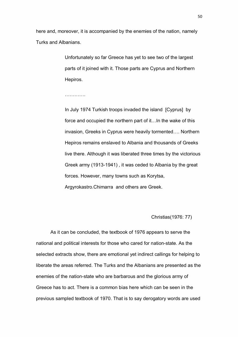
50
here and, moreover, it is accompanied by the enemies of the nation, namely
Turks and Albanians.
Unfortunately so far Greece has yet to see two of the largest
parts of it joined with it. Those parts are Cyprus and Northern
Hepiros.
………….
In July 1974 Turkish troops invaded the island [Cyprus] by
force and occupied the northern part of it…In the wake of this
invasion, Greeks in Cyprus were heavily tormented…. Northern
Hepiros remains enslaved to Albania and thousands of Greeks
live there. Although it was liberated three times by the victorious
Greek army (1913-1941) , it was ceded to Albania by the great
forces. However, many towns such as Korytsa,
Argyrokastro.Chimarra and others are Greek.
Christias(1976: 77)
As it can be concluded, the textbook of 1976 appears to serve the
national and political interests for those who cared for nation-state. As the
selected extracts show, there are emotional yet indirect callings for helping to
liberate the areas referred. The Turks and the Albanians are presented as the
enemies of the nation-state who are barbarous and the glorious army of
Greece has to act. There is a common bias here which can be seen in the
previous sampled textbook of 1970. That is to say derogatory words are used

51
when the book talks about foreigners (people other than Greeks) and
enemies.
However, when refers to Greece and the rest of the world, the 1976
textbook points out the geographical position of the country as a crossroad
between the Middle East, Africa and Europe, hence Greek interests lie within
this specific region of the world. This reference is followed by an urging to
forging diplomatic, educational and trade relations with any country, but most
of all with the European countries that share the realm with. This short (two-
page) reference in the 1976 textbook of geography can be regarded as a
contradiction in comparison to the previous nationalist references when it
comes to the so-called enemies of the country. The same reference can be
seen as a very distant calling for global citizenship. The textbook explains
(and this is repeated in an exercise that summarises the main points of the
lesson) that for any country and in order to have a peaceful world it is useful
to forge cordial relations and enjoy a membership in international
organisations (Christias 1976: 78-79). However, there is a monolithic listing of
organisations where Greece was a member of at the time: United Nations,
World Health Organisation, UNESCO, NATO, EEC (later European Union)
and the Council of Europe. As can be seen from this listing, the doctrine ‘We
belong to the West’ advocated and spread by the Greek government at the
time, is disguised in the geography textbook.
This is also demonstrated although in an obscure way, on the reverse of
the textbook. There a map of Europe is depicted, though partially: the
omission of the then Soviet Union (the European part of Russia) can be
discerned and regarded as bias against the Eastern part of Europe (see

52
Picture 1.2 in the Appendix, p. 95). This kind of bias can be found in the
references to countries with socialist regime or countries widely regarded as
those of the Eastern bloc. For example, Albania is described as a socialist
country and the relations with Greece are described as ‘initially not friendly’
(1976: 81) . The description of Albanians can be seen as derogatory , as the
book (see Picture 2.2 in the Appendix, p. 98) reads that
Albania is a small and mountainous country.
………………………………………………………..
Albanians have developed no notable civilization. Most of all
are farmers and breeders.
Christias(1976 : 80-81)
Turkey is also described in the geography textbook within its European
realm exclusively. What can be considered as of interest is the reference to
Eastern Thrace along with the European Turkey. Referring to Istanbul, the
book reads on Eastern Thrace, which had been a Greek part for thousands of
years, dates back to the ancient and Byzantine years of glory (330-1453). In
particular, it narrates how Byzantium was built by colonists from Megara. It
was the same location where Istanbul (Constantinoupolis) was built by
Constantine the Great. Istanbul was the capital of the Byzantine Empire and
had been the centre of Greeks and the ‘queen of the cities’ for a hundred
years. However, it was occupied by Ottomans in 1453. Despite this,
throughout the Turkish occupation remained to be the centre of Orthodoxy
and Hellenism (1976: 98). It makes reference to Ecumenical Patriarchate that
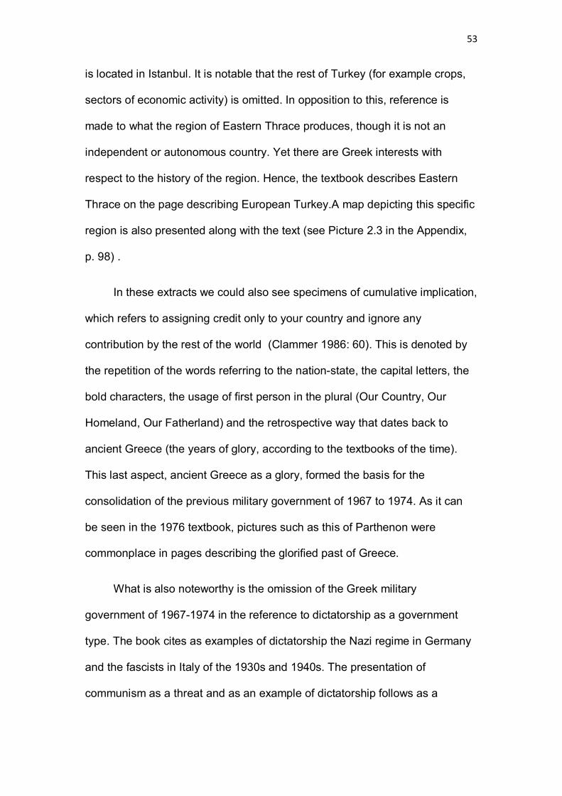
53
is located in Istanbul. It is notable that the rest of Turkey (for example crops,
sectors of economic activity) is omitted. In opposition to this, reference is
made to what the region of Eastern Thrace produces, though it is not an
independent or autonomous country. Yet there are Greek interests with
respect to the history of the region. Hence, the textbook describes Eastern
Thrace on the page describing European Turkey.A map depicting this specific
region is also presented along with the text (see Picture 2.3 in the Appendix,
p. 98) .
In these extracts we could also see specimens of cumulative implication,
which refers to assigning credit only to your country and ignore any
contribution by the rest of the world (Clammer 1986: 60). This is denoted by
the repetition of the words referring to the nation-state, the capital letters, the
bold characters, the usage of first person in the plural (Our Country, Our
Homeland, Our Fatherland) and the retrospective way that dates back to
ancient Greece (the years of glory, according to the textbooks of the time).
This last aspect, ancient Greece as a glory, formed the basis for the
consolidation of the previous military government of 1967 to 1974. As it can
be seen in the 1976 textbook, pictures such as this of Parthenon were
commonplace in pages describing the glorified past of Greece.
What is also noteworthy is the omission of the Greek military
government of 1967-1974 in the reference to dictatorship as a government
type. The book cites as examples of dictatorship the Nazi regime in Germany
and the fascists in Italy of the 1930s and 1940s. The presentation of
communism as a threat and as an example of dictatorship follows as a

54
reminiscent of the years when communists were included in the textbooks of
Greece as enemies of the nation-state.
One kind of dictatorship is communism, where the power
belongs to no-one but only to the communist party.
Opposition is not allowed.
Christias (1976 :205)
From this extract, the notion of the enemy from the East recurs and is a
reminiscent of the textbooks of history and geography, produced during the 7-
year military regime. Despite the fact that the Communist Party of Greece had
been legalized, the scale of construction appears to impose the power of the
politics in the way that the recent dictatorial regime is omitted(see Picture 2.4
in the Appendix, p. 98).
In a nutshell, geography textbooks of this period in Greece can be
regarded as promoting nationalism and reflecting the political context of the
period, despite no reference (update) is made to the latest events following
the fall of the dictatorship and the Turkish invasion of Cyprus. For example, no
reference is made to diplomatic efforts to resolve the Cyprus issue.
3.4 The 1980s and 1990s textbooks
The 1970s textbooks reflected a turbulent period of Greek history as
described in the previous section (3.3). Features ranging from promotion of
nationalism and ethno-centrism to fanaticism and serving of political
propaganda have been identified. The 1980s showed a change to the Greek
society and politics as well. Despite the fact that textbooks from that decade

55
are not found and thus are not included in my comparative study, it is fair to
refer to this period as well, to avoid the pitfall of a disjunction in my analysis ,
as between 1976 and 1992 there have been important developments
surrounding education in Greece among other factors. Therefore, in what is
next I will attempt to outline 1980s developments in Greece.
The first years of ‘Metapolitefsi’ were crucial for the fledgling
democracy of Greece. The 1974 and 1977 national elections resulted in a
conservative government as well as the legalisation of the Communist Party
and the rising percentages of the socialist party. 1981 election saw the first
socialist government in Greece, which came along with drastic changes to
society and politics, as well as economy. 1981 also marks the year that
Greece joined European Union (then European Economic Community) and
the need for including globalism into the textbooks appears to be imperative.
Despite those socio-political changes, geography as a lesson in the primary
curriculum is marginal, undermined and based on rote learning. With respect
to geography textbooks of the 1980s, I will attempt to fill the gap by referring
to my personal experience as an individual who learned via those textbooks at
the time, in the methodology chapter, in a section about limitations of my
research.
Having referred to the decade of 1980s, I will provide an analysis of the
geography textbooks from 1990s. I will use both books for year 5 and 6 ,
though they were published in different years (1992 and 1995).
Firstly, the 1992 book for year 5 of Primary School refers to scale again
in its common usage. This is the one that can be written as 1: 100, 1: 1000

56
and so on. Similar to the 1970s book, there is an exercise on assessing
distances between two locations on a map scale (Christias et al. 1992: 25).
However, as opposed to the books of the 1970s, the 1992 and 1995 books for
year 5 and year 6 respectively begin with the presentation of the world and
not Greece. The nation state appears to be absent, at least in the content and
a short reference is made in the book for year 5 after a 40-page presentation
of the continents of the Earth: Europe, Africa, Asia, America and Oceania.
The last five pages of the book for year 5 are devoted to Greece, which is
presented within a global context and position. Words like ‘Fatherland’ and
‘Our Country ‘ that were repeated in the 1970s books now have been
eliminated or replaced by the word ‘Greece’. There are no superlatives or
exaggerations; the strategic importance of the country’s geographical position
is described without evident bias:
[Greece] … lies within that place, where three continents,
Europe, Asia and Africa, approach each other. In its seas sea
routes are intersected that are important for global transport
and communications.
Christias et al. (1992: 85)
The book goes on to lay emphasis on the specific locations in Greece
that can account for this geographical importance. In particular, Crete lies
where Western Europe and the Middle East and Indian Ocean nations are
met, the Aegean Sea islands account for the sea routes of the Black Sea to
the Mediterranean Sea and Corfu lies where the Adriatic Sea joins the rest of
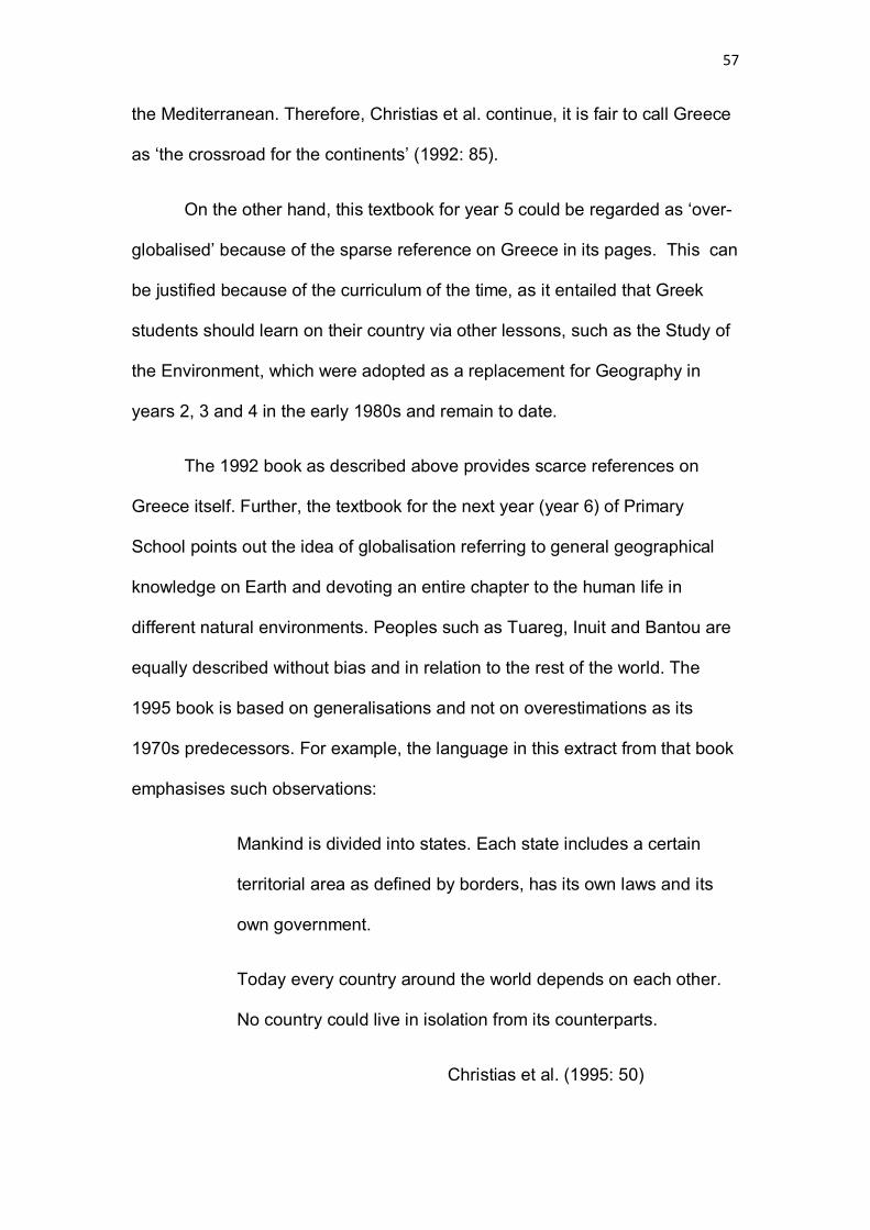
57
the Mediterranean. Therefore, Christias et al. continue, it is fair to call Greece
as ‘the crossroad for the continents’ (1992: 85).
On the other hand, this textbook for year 5 could be regarded as ‘over-
globalised’ because of the sparse reference on Greece in its pages. This can
be justified because of the curriculum of the time, as it entailed that Greek
students should learn on their country via other lessons, such as the Study of
the Environment, which were adopted as a replacement for Geography in
years 2, 3 and 4 in the early 1980s and remain to date.
The 1992 book as described above provides scarce references on
Greece itself. Further, the textbook for the next year (year 6) of Primary
School points out the idea of globalisation referring to general geographical
knowledge on Earth and devoting an entire chapter to the human life in
different natural environments. Peoples such as Tuareg, Inuit and Bantou are
equally described without bias and in relation to the rest of the world. The
1995 book is based on generalisations and not on overestimations as its
1970s predecessors. For example, the language in this extract from that book
emphasises such observations:
Mankind is divided into states. Each state includes a certain
territorial area as defined by borders, has its own laws and its
own government.
Today every country around the world depends on each other.
No country could live in isolation from its counterparts.
Christias et al. (1995: 50)

58
The idea of nation-state can be discerned in only one chapter, that
covers 10 pages, referring to Greeks, history of Greece and some
encyclopedical facts on this country, such as population, capital,
administrative divisions and so on. There is also one page talking about the
island of Cyprus and the occupation of the northern part of the island by the
Turks is also described, although without derogatory words or words that
inspire hatred, such as in the 1970s book. The 1995 book states that the
declaration of a Turkish-Cypriot state in 1983 was illegal (1995: 89). In the
only reference to Greece as a homeland, page 91 describes the life and
traditions of Greeks who live abroad and they ‘are in contact with the
Motherland Greece’ (1995: 91).
In sum, the 1990s books of Geography for years 5 and 6 appear to be
‘globalised’ as well as ‘distanced’. The social construction of scale can be
discerned in their content and in their cover as well (a globe, common for both
books). This scale is the global scale, with respect to globalisation and long-
term global citizenship. As the 2002 textbook demonstrates, the latter
concept has gradually developed, in accordance with developments in the
socio-political and economic sector.
3.5 The 2002 textbook
So far the analysis has focused on the Greek geography textbooks and the
1970s to 1990s. The next geography textbook to compare is the one of 2002
for year 5 of Primary School (1st ed.). The age of the children of this year is
10 to 11 years old. This textbook is written in accordance with the 2001
curriculum within the highly centralised educational system of Greece.
59
Therefore, it is imperative to look into the national curriculum at the time
(2002) and to make reference to the social, political and economic context of
that time. I will attempt to focus only on those aspects that are relevant to the
discussion and to the social construction of scale. As such could be regarded
global citizenship, the nation-state (or how Greece is presented in the
geography textbook versus the other nations) as well as issues of
development.
To look into the curriculum of Greece and specifically to the geography
curriculum reflects the specific period. 2001 marks an important year for the
socio-political history of Greece and its financial history as well. The beginning
of this year sees the adoption of euro by Greeks as a joint currency for the EU
members. The previous years also appear to have affected the geographical
matter: for example, the 4 analytical lessons on the movements of Earth,
changes on its surface, earthquakes and volcanoes, as well as the natural
disasters in Greece, show the need for providing better understanding of such
geographical aspects, given the recent earthquake in Athens (September
1999), which resulted in over 140 deaths and massive destruction. The years
1999, 2000 and 2001 also saw flooding and natural disasters not only in
Greece but also in other parts of the world. Therefore, students are required
to learn on what to do at an occasion of an earthquake or a similar disaster.
With respect to global citizenship, it is notable that it can be discerned
once again in general sentences and references to the ‘world’. The bulk of
the book talks about Greece (not calling it as “Fatherland” as in the 1970s
books) but the cover of it can be regarded as preparatory for the global
citizenship concept: it has a man is depicted waving two flags: the flag of
60
Greece in one hand and in the other, for the first time, the flag of the
European Union with the 12 stars (see Appendix, p. 96, picture 1.4).
Despite the fact that the 2002 textbook seems to be based on
globalisation, there is a commonality with the 1990s books surrounding the
way that underlines the geographical position of Greece. As Teacher’s book
(Galani et al. 2002) explains:
Greece lies where Europe, Asia and Africa approach each other.
Therefore it is called as ‘the crossroad of civilisations’.
Galani et al. (2002: 58)
The idea of nation-state can be discerned here though in disguise. One
instant observation can be the commonplace with the 1995 book, where
Greece was described as a crossroad of continents as well. However, in the
2002 book the nation-state is described in cultural terms.
Another aspect that can be discerned is that of development and the
way it is addressed in the textbook. The division of the world in ‘less
developed’ and ‘more developed’could be seen in the textbook of this period.
This global division functions as Smith explains, in terms of scale by providing
‘geographically fixed (relatively) sources of wage labor, one at the
international scale and the other under the more direct control of the national
capital’ (1984: 145). Smith provides this example as one of demonstrating
how capitalism operates over space.
I will not provide more references to the 2002 book, as there can be
considered as similar to the 1990s books. Rather than providing a detailed

61
picture, I opted for focusing on the aforementioned aspects and the way that
they are addressed in the early 2000s book. In what follows, I will conclude
my brief and restricted comparative study with the current textbooks, referring
to the year 2010.
3.6 The current textbooks
In this section the geography textbooks for years 5 and 6 have been sampled
and analysed in terms of how scale and global citizenship are addressed.
What is also described are the potential problems coming from their
omissions and their failure to keep up with the contemporary world.
The current (2010) textbooks can be regarded as lacking the negative
features that were described in the comparative analysis for the previous
decades. However, they appear to fail to address vital economic and global
issues, or they lay emphasis on other issues for scale reasons. In other
words, the social construction of scale can be discerned even in the most
recent textbooks of geography.
One of the main problems of the late 2000s geography textbooks is
that of providing up to date information. Waugh (2000) identified similar
problems with dating the published material. He attempts to provide a
justification for this outdating, citing limitations of time as several months or
longer are needed for the authors to complete the textbooks and there is
another requirement of allowing at least 6 months for the publisher to publish
the material. As he explains:

62
… It is inevitable that a geography textbook is already out of
date well before it reaches the market. With recent
improvements in global communications and the increase in the
quality and quantity of available information, this means that the
effective life of a geography textbook is about three or four
years… (2000: 100)
However, the philosophy which the newest books were based on can
be seen as this of making global citizens. The concept of global citizenship
appears to have been consolidated in this book and seems to be stronger
than the 1990s geography textbooks.
For example, in the textbook of geography for year 5 of Primary School
(2010) there are lessons devoted to Greece and its relation with international
organisations, more specifically to the European Union. However, this book
fails to keep the reader up to date regarding the expansion of the European
Union. To cite an example, (Koutsopoulos et al. 2010: 141) Cyprus is not
highlighted in orange on the map on the countries belonging to the Eurozone
(see Appendix, p. 99, Picture 2.6). This omission can be justified as explained
by Waugh (2000) above.
Contrary to the 1970s and 1990s textbooks, the issue of the occupation
of Cyprus by the Turks is presented along with Cyprus and Greeks abroad in
a specific unit and in a different way. Reference is made for the Turkish-
Cypriot minority, which ‘significantly rose after the Turkish invasion in 1974’.
(2010 : 148)
63
With respect to scale, it is again mentioned in the 2010 book for year 5
in its mathematical sense (1: 1,000,000). In particular, there is a whole unit
(unit 4 belonging to the chapter ‘Maps’) and this is devoted to scale. The
students are engaged in activities where they are asked to find the real
distance between two locations using the scale on a given map (Koutsopoulos
et al. 2010: 20). As noted above, such usage of scale entails a commonplace
in textbooks of geography in Greece dating back to the 1970s books. This can
be seen as an effort to keep the social construction of scales in disguise.
Further, the notion of nation-state recurs in this book (2010: 24), in
terms of a reference which is noted that is not required to teach. It is included
as an encyclopedical reference under the title ‘if you would like, you can read
this as well’… However, a passage such as this, describes Greece in a way
that could be seen as ultra-nationalist and biased. The ends of the country
(Ormenio, Othonoi, Gavdos and Megisti) and within this context of the nation-
state, are described with the usage of words that overestimate them. To cite
an example, Megisti, which is the eastern end of Greece is described as ‘ the
first to wave to the sunrise and smiles at the neighbours, recalling that the
wins blow freely and the Greeks’ chests are full of independence!’ (2010: 24)
This can be regarded as a reminiscent of the constructed scale that
was more evident in the 1970s as well as textbooks from later decades. This
passage is signed by anonymous authors, which can be seen as another
evidence of a socially constructed passage. However, the non-compulsory
reading is one and only example of such overestimation of the notion of
nation-state. If it is to provide any justification on this bias, reference should
be made once again to the socio-political context. Over the past years and
64
even currently, Greece’s national sovereignty has been threatened by issues
involving its neighbours. For example, Turkish aircrafts violated the airspace
of Greece in several cases and the issue surrounding the name of Macedonia
– which strained the relations between FYROM and Greece over the past two
decades- is also ongoing. Therefore, this extract can be seen as alerting the
readers on the need to be vigilant for any threats for the sovereignty of the
nation-state.
The nation-state as a notion appears another time in one activity on the
significance of Greece’s geographical position. As noted in the textbooks of
geography from the past decades, the nation-state is described as the
‘crossroad of the continents’ in a citation of a French author (Andre Bonard).
The Mediterranean Sea is a Greek Lake with common
routes. The towns around its coasts resemble ‘frogs in a
marsh ‘, as Plato says…
Koutsopoulos et al. (2010: 31)
This description appears to be fair and less coloured because the citation is
from a non-Greek author. However, there is an activity on the same page of
this 2010 textbook for year 6 that asks from the children to explain ‘why our
country is regarded as a crossroad of peoples and cultures’ . The students are
also asked to consider if this connection between peoples and cultures entails
any weaknesses as well (2010: 31). The ‘strengths and weaknesses’ game
appears to reflect the interests from the textbook writers to disseminate the
socially constructed scale, on a national as well as a global level. That is to
say there is a hidden reference on the tension between Greece and its
65
neighbouring states, when the students are asked to consider the
aforementioned weaknesses.
Apart from the book of geography for year 5 it is interesting to focus on
the cover and the content of the 2010 textbook for the next year (year 6). The
textbook of year 5 is based on its nation-related content , hence a tree in a
nightly Greek location on the cover. However, the cover of the 2010 textbook
for geography of year 6 appears to reflect the concept of global citizenship. It
depicts a globe that is turned and there are also two globes depicted(see
Picture 1.5 in the Appendix, p. 97 and Picture 1.6 on the same page for the
covers of 2010 textbooks for years 5 and 6 respectively ). The latter show the
part of the Earth where Asia, Australia and Oceania (the first globe) and the
Americas (the second globe). The global citizenship concept can be
discerned though is not clear, but is denoted in the way that the globes are
presented without bias or emphasis on one hemisphere or the other. The
world is equally presented to the students of 12 years.
Further, the scale of globalisation that it is promoted through the book
is evident from the very first pages of the textbook for the last year of the
Primary School in Greece. There is a preface for the children, written by the
authors of the textbook and aiming at preparing the readers for the content
and the matter of the reading. The students are informed of the aims of the
textbook, that are mainly to learn ‘our Earth’ and to travel around ‘our planet’
(Koutsopoulos et al. 2010a: 9). In comparison to the 1970s books, in the
2010 ones we can see the usage of the first plural person (our) not about the
nation-state, the motherland or the fatherland or the country, but about the
Earth, the world.
66
Moreover, the textbook for year 6 involves group activities where
children are asked to imagine themselves as ‘global citizens’, though it is not
termed in this way. For example, a group yet non-compulsory activity (2010a:
20) asks from any student to imagine that as an individual is a resident of a
different country on Earth speaking their native language exclusively. Once
they select a city of that country, they have to write where the former is
located in terms of geographical coordinates.
Despite the fact that the globalisation effect seems to be present in the
content of the textbook for year 6, there appears to be bias as well in terms of
the selection of countries. In particular, reference is made in an example of
languages in those that are spoken in countries other than Greece. It can be
seen here that no native languages or regional ones are mentioned and the
languages of under-developed or even developing countries are omitted. The
selected example is the phrase ‘I love my friends’ in 6 languages to show the
diversity of them. However, the ones selected are: English, French, Italian and
Japanese (2010 a: 68). I do not believe that Suahili, Latvian or even
Portuguese are not mentioned because of the author’s ‘lapse’. The local scale
and the global scale can be discerned here, once again in disguise; all
countries referred to are members of G8 (except for Greece of course, as
Greek is the language of the nation-state).
Further, there is a problem of keeping the students up to date with the
developments, especially when it comes to the European Union or some re-
namings of countries. For instance, the 2010 textbook for geography (year 6)
presents the European Union comprising of 25 member states and not 27
(see Picture 2.5 in Appendix, p. 99), though the most recent expansion took
67
place in the year 2007, three years before the edition of the textbook (2010a:
114). Another example can be provided in the wrong naming of the DRC as
Zaire on a map depicted (see Appendix, p. 100, Picture 2.7)in the short
African section of the book (2010b: 125). The African nation was renamed
from Zaire to Democratic Republic of Congo in 1997. However, the authors of
the book appear not to take notice of a change that took place over a decade
ago or they could simply regarded as not useful for the students to learn
(perhaps because of the fact that DRC is not listed as a ‘rich’ country?).
Likewise, the overestimation of Europe versus Asia, Africa, Americas and the
Oceania is evident in the textbook and could be seen as a bias. On the other
hand, Greece is in Europe and a member of the European Union, thus the
textbook wants to remind the children of their ‘european citizenship’ as well.
3.7 Conclusion
I have identified among the problems of the current textbooks their failure to
provide contemporary information. Therefore, as Waugh points out, there is a
need for revisions, rewritings or replacements of the textbooks ‘at increasingly
shorter intervals’ (2000: 100). Such actions it is fair to say they should take
place following debate with the participation of all agents of education in the
Primary School. In other words, how textbooks can be improved unless
teachers and students do not have their say about them in contrast to the
government and some publishers that are commissioned to write textbooks?
Perhaps it is the politics of scale that appears to prevent such actions and
preserve this information that is out of date. The findings of the comparative
study conducted in this chapter are presented and discussed in the fifth

68
chapter (Chapter 5) of this dissertation. In the next chapter (Chapter 4) the
methodology and the limitations of the research presented are described.
69
Chapter 4:Methodology
4.1 Introduction
In this chapter I aim to describe how I have conducted my research and what
my method was. My research question was related to scale and the way that
is socially constructed in geography textbooks of Greece. The data was
collected by geography textbooks dating from 1970 to 2010. The sampling
was based on the availability of the textbooks. In this chapter I provide a
tabulation of the main findings of my research based on the qualitative data
and reference is made on how textbooks were defined regarding my own
research. Further, this chapter considers the restrictions that I faced while
conducting my research. The method that was used for the latter is analysed
in the next section.
4.2 Method
With respect to the research question, the central one that I have attempted to
look into is ‘How scale is socially constructed in Greek geography textbooks?’.
As Flick suggests, some research questions can describe processes, which
means the way that something is developed (Flick 2002: 50). Therefore, my
research question develops throughout the dissertation and the processes
reflect the different socio-political and economic contexts of the periods where
the sampled textbooks come from. For example, the 1976 book comes from
the period of ‘Metapolitefsi’ in Greece and its content, the cover as well as its
scope reflect the aims and interests of the years following the fall of
dictatorship (after 1974). Changes to society, politics and economy at the time
are put into the respective context throughout the analysis: hence, the

70
development of the question of my research entails a process interconnected
with the political, social and economic conditions in Greece at the time.
The data collection came from the textbooks, mostly based on their
content. However, the covers of the textbooks were also used to show how
socio-political changes or trends are reflected, as in the example of the
textbooks from 1970s, where the symbols of the military regime are evident
and the doctrine that excels the Western bloc is disguised.
In sum, as Table 1 shows, the comparative study of geography textbooks in
Greece demonstrate a wide range of strands, reflecting the decade when the
textbook was compiled and taught.
With respect to the presentation of data, it is worth noting that there are
more than one ways for the analysis and the presentation of qualitative data
(Cohen et al 2007: 461). However, in this dissertation my aim was to discover
commonalities and differences in the content of geography textbooks in
Greece, in terms of how nation-state and globalism are addressed. Such traits
have been analysed because they go back to the research question, which is
how scale is socially constructed via Greek geography textbooks. Therefore, I
opted for organizing my analysis of data by research question. As Cohen et al
put it:
This is a very useful way of organizing data, as it draws together
all the relevant data for the exact issue of concern to the
researcher, and preserves the coherence of the material.
Cohen et al (2007: 468)
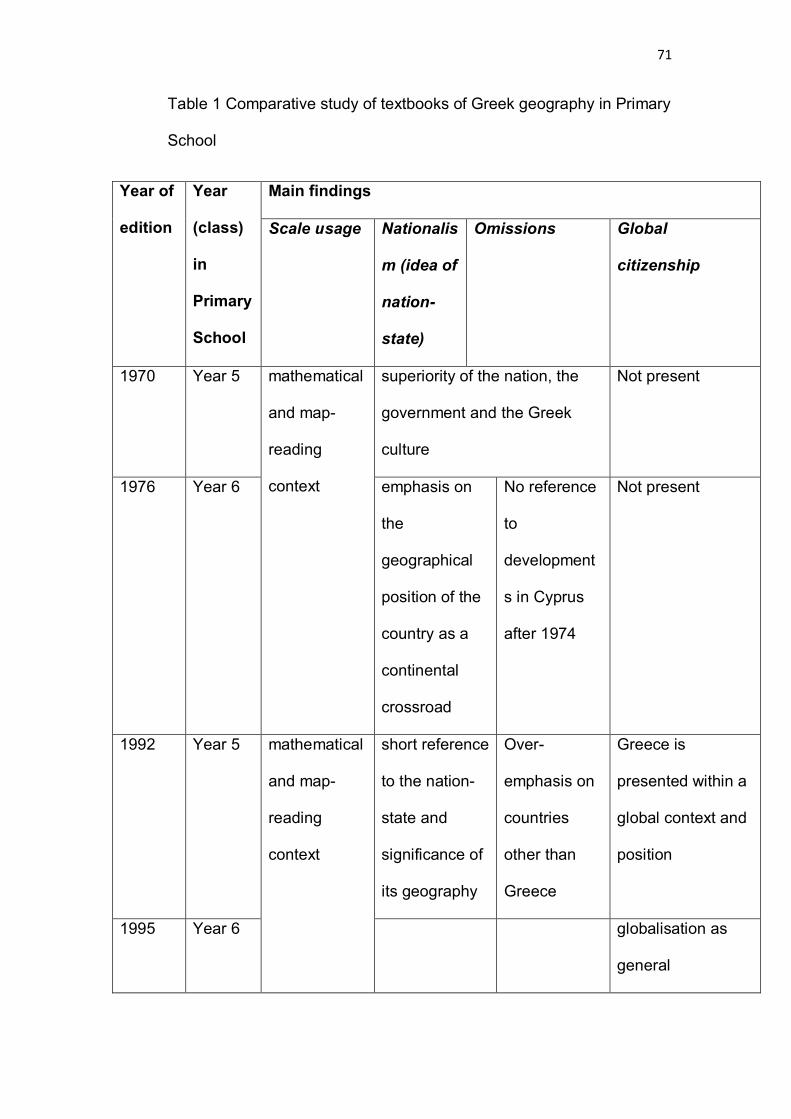
71
Table 1 Comparative study of textbooks of Greek geography in Primary
School
Year of
edition
Year
(class)
in
Primary
School
Main findings
Scale usage Nationalis
m (idea of
nation-
state)
Omissions Global
citizenship
1970 Year 5 mathematical
and map-
reading
context
superiority of the nation, the
government and the Greek
culture
Not present
1976 Year 6 emphasis on
the
geographical
position of the
country as a
continental
crossroad
No reference
to
development
s in Cyprus
after 1974
Not present
1992 Year 5 mathematical
and map-
reading
context
short reference
to the nation-
state and
significance of
its geography
Over-
emphasis on
countries
other than
Greece
Greece is
presented within a
global context and
position
1995 Year 6 globalisation as
general

72
geographical
knowledge on
Earth
2002 Year 6 Mathematical
, map-reading
and utilisation
context
underlines the
geographical
position of
Greece
discernible in
terms of
references to the
‘world’
2010 Year 5 overestimation
of nation-state
fail to
address
economic
and global
issues
consolidated and
stronger than the
1990s geography
textbooks
Year 6 first plural
person (our)
about the
world
problem of
keeping
students up
to date
Table 1 Comparative study of textbooks of Greek geography in Primary
School
My findings were tabulated in terms of the main strands in textbooks
that are relevant to my research question. The literature review provided in
Chapter 2 is also relevant. I attempted to be focused and critical while
conducting the latter (Silverman 199: 297). It is fair to say that there can be
73
more features in the Greek geography textbooks out of those sampled, but for
space and relevance concerns I decided not to include then in the tabulation
of the data.
It can be seen as important to clarify how textbooks are defined in this
dissertation. This has been done in accordance with the country that the
sampled textbooks come from and its socio-political and economic context.
Apart from how researchers have defined them, textbooks in Greece and
elsewhere have included the publisher’s definition of any material that can be
available to the readers in multiple packages (Waugh 2000). The way that
textbooks are used in Greece also encompasses Lambert’s (1999)
identification of diverse roles attributed to textbooks.
4.3.Limitations of the research
It is clearly evident that my research has been restricted in terms of an array
of factors. In particular, the study conducted is limited because of time and
space restrictions that a dissertation entails. However, the samples of
textbooks aimed at representing specific periods relating to different decades
from the Greek history.
There have been some limitations having to do with the samples of
geography textbooks. In particular, there appears to be a gap in one decade,
the 1980s. That is because I did not manage to find textbooks from that period
either for year 5 or for year 6 for Primary School. However, I will make a
personal reference citing my memories when I was a pupil in the 1980s in
74
order to be fair with including the 1980s textbooks of geography in my
dissertation. I opted for searching for textbooks from Greece reflecting key
periods in the recent Greek history. Therefore, the sampling was deliberate
and purposive, rather than probability sampling (Punch 2005: 187).
I was taught geography by reading those books when I was in the
Primary School. The year 5 geography textbook talked about Europe and had
the flag of each European country in the beginning of the chapter describing
and discussing this specific country. The 1980s textbook for year 6 was green
, with a globe in its cover and might be found only in old curiosity shops.
However, I did not manage to find even a page related to those books, both in
my literature review and searching throughout the Internet and the Greek old
shops, at least where I went to. What I can recall is the first chapters talking
about the Earth and its features and the multi-coloured flags of the world
countries, a commonplace in geography textbook for year 5 at the time. I
cannot recall if there was scale as a mathematical or geographical concept
included in these books. What I can only recall is the rote learning that was
imperative at the time and the absence of multimedia, computers and
alternative teaching material in general.
I have made reference to the 1980s book citing my own experience as
a student in order to include this period in my study, though the shortage of
textbooks could not justify any hypothesis regarding the social construction of
scale at the time. However, even geography textbooks that I found have been
subject to some limitations. In some cases, there was a need to resort to a
split within the same decade, as the samples reflect different aspects and
diverse characteristics have been discerned from textbook to textbook. For

75
example, whereas the 1970s books have been analysed in the same section
of Chapter 3, their counterparts of the 2000s had to be split in two separate
sections. This was imperative to do because of the need to clarify the
differences between the textbooks of the different period (though same
decade) and due to the different features of the period, regarding Greek
society, economy and politics. 2002 and 2009-10 can be seen as distant
regarding the developments that occur within a short period of 7-8 years. For
example, for Greece, 2002 showed the advent of euro as well as the
preparations for the staging of the 2004 Olympic Games, whereas 2009-10
was marred by the spreading of global economic crisis to Greece. Between
2002 and 2009 Greece has already staged three national elections, resulting
in two government changes. As the educational system is highly centralised in
Greece, government change means changes to the textbooks as well. As
noted throughout this dissertation, such developments are reflected in the
textbooks of geography and that is to say the social construction of scale is
based on those.
4.4. Conclusion
In this chapter there was an attempt to explain the methodology that was used
in order to look into the social construction of scale in geography textbooks of
Greece in Primary School. The method that was used was a comparative
analysis and the data was collected by the textbooks (based in some cases
on their covers and on their content). In what follows, a discussion of the
findings is provided.
76
Chapter 5:Discussion
5.1 Introduction
Having compared samples of Greek geography textbooks from 1970 to date,
it is imperative to point out how the former deal with ideas such as the nation-
state and reflect the contemporary concept of global citizenship among other
features.
If it is to discuss the findings of the textbook analysis, we can focus on
some specific characteristics. The main strands that could be found following
the comparative study on samples of textbooks can be summarised in the
reflection of the socio-political developments, the interests of the authors who
write them and the way they deal with concepts such as global citizenship and
notions such as the nation-state (see Table 1, pages 70-71).
5.2. Trends in the comparative analysis of the textbooks of Greek
geography (1970 to date)
First of all, the 1970s books sampled in the comparative analysis section,
reflect their era. It is worth noting that the cover of the textbook can show how
the textbook writers serve the government propaganda. The bias in the
textbook is present from the cover to the content. The cover, as shown in
picture 1.1 (see Appendix, p. 95), is the symbol of the military regime: a
phoenix (the mythological bird) which is born again from his ashes and this
denotes the need for change which the military junta of Greece (1967-1974)
was based on. The bird is accompanied and guarded by a Greek soldier,
representing the military junta. Over the bird there is the word ‘Hellas ‘

77
(ΕΛΛΑΣ) the nation-state . Below the picture there is the date of the
‘revolution’. (21 April), referring to the date when the coup took place in 1967.
This can be seen as an evident showing of government propaganda served
by education. The phoenix was a subculture at the time and was a trademark
of the dictatorship. It was a work by a far-right government, within a populist
framework. It could be seen as another way to impose their ideals and to
manipulate the people of Greece and prevent them from thinking critically.
Further, the ideals of Fatherland, nation-state and Greek culture versus
the foreigners are presented in the content. This presentation is shown by the
selected pictures .For example, the picture of Parthenon (see Picture 2.1 in
the Appendix, p. 98) reflects to the idea of the glory of the past. Greece is
described monolithically and the other countries are presented in a way that
can be seen as diminutive.
As noted above , the 1980s books could be regarded having
commonalities with the 1970s, although traces of globalism might be
discerned given the omission of words such as ‘Fatherland’ and descriptions
of other nations (other than Greeks) in a non-derogatory way. However, as I
did not have at my disposal those 1980s books any conclusion is tentative
and hypothetical.
The 1990s books of geography could be seen as more ‘globalised’ or
‘over-globalised’ ones. The title (‘ Our Earth’) , the cover, which is a globe in
an elliptic shape(see Picture 1.3 in the Appendix, p. 96) and the sparsely
referenced Greece, can account for such observations. It is worth noting that
the author who compiled the 1976 book sampled in this dissertation is the

78
same (leader of the team) who wrote the 1992 and 1995 books as well.
However, the references to nation-state, Fatherland and the bias against
other nations with respect to their financial or political state are absent. This
can be attributed to the shift that occurs following the 1991 Maastricht Treaty
and the growing presence of Greece within the European Union (for example
in 1994 Greece assumed the presidency of the European Council for a 6-
month tenure). The concept of globalisation and perhaps that of ‘global
citizenship’ (though at its embryonic stage) could be discerned in the
aforementioned features of the 1990s books.
In relation to the global citizenship specifically, it should be noted that
the concept stems from a ‘global dimension’ to education. As Blum et al
(2010) suggest, an understanding of an array of social, cultural and
ideological influences is needed so that to add such a dimension to school
geography. That is to say that the students are ‘global citizens’. This includes
the addressing of global issues such as social inequalities, the financial crisis
and social justice. However, those issues appear to be absent from the
textbooks in Greece at least to early 2000s. As noted above, if we look into
the political, historical and financial context at the time, there would be
justification on such omissions.
Apart from what has been mentioned above, it is worth noting that any
changes discerned in textbooks could be attributed to editors as well. In
particular, over recent years there has been a shift, with respect to the
editorial process, from ‘a diverse market place to a disciplined homogenised
one’ (Kington 2004:6). As a result, editors of textbooks appear not to seek to
provide novel responses to the educational opportunities. This argument

79
considers the educational landscape in the United Kingdom. However, the
same traits could be traced in Greece as well, given the high centralisation of
the National Curriculum of that nation. Kington, as an editor himself, goes on
to argue that ‘editorial process is more about bidding contracts’ (2004: 9). His
words can be seen in accordance with the recent developments in Greece,
where textbooks have been compiled and distributed by contract, following
the official approval by the government.
These observations mentioned above can be regarded as useful to
understand how scale is socially constructed via textbooks. The highly
centralised educational system in Greece, combined with the process of
producing textbooks (including those of geography in primary and secondary
education) at a frequency analogous to government changes, demonstrate
that people with powerful interests have come to construct scale via textbooks
over the decades. While some traits reflecting the past (nationalism,
ethnocentrism, references to the ‘others’ in terms of countries other than the
nation) appear to have been gradually eliminated, the effect of the division of
scales can be seen as ongoing. In other words, the local, the national and the
global appear to be eminent in social, cultural and economic context, via
geography textbooks. That is to say that people with powerful interests may
be regarded as the agents of scales as they are socially constructed and
reflect their interests. The shift from the nation-state and the ideology to ideas
such as global citizenship can be discerned in the most recent textbooks,
although the cryptic presence of people who use them to communicate
messages that are related with their interests can to some extent confirm the
negative aspect of the social construction of scales.

80
5.3 Utilising the politics of scale?
Despite the well-obscured scale and the way it is instilled into the students in
means of textbooks, it can be noted that there is a potential of utilising scale in
its entirety regarding its divisions. Local, national and global scales can be
seen as useful for the students to address crises. This comes to and can be
regarded as noteworthy given the global financial crisis, which encompassed
many countries, including the United Kingdom and Greece. There have been
researchers and commentators that discussed how to address 2008 ‘credit
crunch’ ‘in terms of the possible actions of nation states’ (Skidelski 2009,
cited in Lambert and Morgan 2010: 101).
Scale may be utilised for students through relational thinking. Such
thinking refers to what Jackson describes as thinking about commonalities
and differences ‘by contrasting geographies of self and other’ (2006: 201). He
goes on to define relational thinking as something that
suggests that constructions of us and them, self and other, East and
West often demonstrate a complicated mix of desire and dread, so that
the object of fear also becomes an object of fascination, whose power
to seduce and enthral needs to be tamed and controlled.
Jackson (2006: 201)
Likewise, Morgan (2003: 124) makes reference to the ‘politics of
knowledge’ that can be seen as relevant to the politics of scale. He provides a
framework for the analysis of the social geography taught in schools by
teachers. In particular, he points out the wide range of conceptions for the
81
relationship between space and society and the different messages that the
latter convey in terms of the nature of society and social change.
To my point of view, the ‘politics of scale’ as defined in this dissertation,
can be seen as a means to this purpose. However, it calls for developing
students with critical understanding and this can be considered in the future
years of their education (Secondary School). In other words, scale in
geography textbooks of the last years in Primary School as socially
constructed can form the basis for critical thinking and understanding for the
students at a later stage.
However, this argument can be treated with skepticism as well, given
the pitfalls that the politics of scale entails, in terms of the powerful interests
of those that are behind it. I will conclude with an extract from Gilbert’s
interesting book ‘The Impotent Image: Reflections of Ideology in the
Secondary School Curriculum’ (1984). In this book, the author looks into the
trends that can be found in the content of school textbooks of history in the
past. He concludes this chapter by making reference to scales as a prejudice:
While it may be true that ‘No subject tears away the scales of
prejudice and shortness of sight so readily and completely…’
this is not necessarily a comforting thought.
Gilbert (1984: 178)

82
Chapter 6:Conclusion
This dissertation makes the case for an alternative approach to scale. That is
to say that attention should be given not to the cartographic scale, but to the
scale on global, national and local level. Therefore, the social construction of
scale via Greek geography textbooks has been looked into through a
comparative analysis of the latter, dating back to the early 1970s.
The features that have been emphasised in my analysis are based on a
sample of textbooks, coming from different decades and reflect on issues that
can be seen as contemporary given the continuous centralisation of the
education system in Greece. However, such an analysis cannot predict how
the agents of geography education (mainly teachers and students) will
respond to those features.
In this dissertation I have argued that there is room for using scale in
textbooks in order to think critically. If it is to lay emphasis on the global scale,
what is needed is to help young people to unravel messages that are hidden
in textbooks. The students should be made to develop their own values and
attitudes and make their decisions. This utilisation of socially constructed
scale could become via relational thinking.
However, this could be a topic for further research. I opted for focusing here
on specific aspects of scale as can be discerned in geography textbooks
(nationalism and fanaticism, global citizenship, nation-state as a notion). This
is not to fetishise scale as the same comes to space, a similar concept which
is beyond my purpose to look into.
83
I hope that this dissertation will stimulate debate not only at Greek level but at
worldwide one, so as to understand the need for utilising the social
construction of scale in the geography classroom.

84
References
Ahier, J. (1988) ‘Industry, Children and the Nation’.London: Falmer Press.
Anderson, B (1991) ‘Imagined Communities’. London: Verso.
Anderson, J. (1986) ‘Nationalism and Geography’ in J. Anderson (ed.) The
Rise of the Modern State.Wheatsheaf: Brighton, UK.
Apple, M (1988) ‘Teachers and Texts’. London: Routledge.
Ball, S (1994) ‘Education Reform: A Poststructural Approach’. London:
Routldedge.
Billington, R. A. (1966) ‘The Historian’s Contribution to Anglo-American
Misunderstanding’.Routledge and Kegan Paul.
Blum, N., Bourn, D. and Edge, K. (2010) ‘Making sense of the global
dimension: The role of research’ in Brooks, C. (ed.) Studying PGCE
Geography at M level. London: Routledge.
Braudel, F. (1973) ‘Capitalism and Material Life 1400-1800’. Weidenfield and
Nicholson: London.
Brenner, N. (1998) 'Between fixity and motion: accumulation, territorial
organisation and the historical geography of spatial scale'. Environment and
Planning D: Society and Space. 16 (1), pp. 459-81.

85
Brenner, N. (1999) ‘Globalisation as reterritorialisation: the rescaling of urban
governance in the European Union’.Urban Studies. 36 (3), pp. 431-51.
Brenner N (2001) ‘The limits to scale? Methodological reflections on scalar
structuration’. Progress in Human Geography, 25 (4), pp. 591-614.
Breuilly, J (1985) ‘Nationalism and the state’. Manchester University Press:
Manchester, UK.
Burt, T. (2003) ‘Scale: upscaling and downscaling in physical geography’ in S.
Holloway, S. Rice and G. Valentine (eds) Key Concepts in Geography.
London: Sage Publications.
Christias, J. (1976) ‘Geography of Europe ‘ for Year 6 of Primary Schools.
Athens: Institute for Educational Books.
Christias, J., Klonari E., Alexopoulos, V. and Papamanolis, K. (1992) ‘ IGi
mas’ (Our Earth), Geography for Year 5 of Primary School.4thedn.Athens:
Institute for Educational Books.
Christias, J., Klonari E., Alexopoulos, V. and Papamanolis, K. (1995) ‘ IGi
mas’ (Our Earth), Geography for Year 6 of Primary School.6thedn.Athens:
Institute for Educational Books.
Clammer, D. G. (1986) ‘Textbook research an internationalist perspective’.
The School of Education.University of East Anglia.

86
Cockburn, C. (1977) ‘The Local State’. Pluto: London.
Cohen, L., Manion, L. and Morrison, K. (2007) ‘Research methods in
education’. London: Routledge.
Cox, K. (ed.) (1996) ‘Spaces of Globalisation. Reasserting the Power of the
Local’. Guildford Press: Surrey, UK.
Daly, H. E. and Farley, J C (2004) 'Ecological economics: principles and
applications'. IslandPress.
Egan, A. R. (2010) 'Sustainable scale' entry on Encyclopedia of Earth, Last
updated 18 February 2010. Online. Available at
http://www.eoearth.org/article/Sustainable_scale [accessed 29 July 2010]
Flick, U. (2002) ‘An Introduction to Qualitative Research’. London: SAGE.
Galani. L, Katsaros, Y., Katsikis, A. and Tsounakos, T. (2002) ‘Gnorizo tin
Ellada‘ (I Learn on Greece), Teacher’s Book, Year 5 (Primary School).
Athens: Institute for Educational Books.
Galani. L, Katsaros, Y., Katsikis, A. and Tsounakos, T. (2002) ‘Gnorizo tin
Ellada‘ (I Learn on Greece), Work Book, Year 5 (Primary School).
Athens: Institute for Educational Books.
Gerimoglou. J. (1970) ‘Geografiadia tin E Taxi ton DimotikonSholion’,

87
(‘Geography for Year 5 of Primary Schools’). Athens: Institute for Educational
Books.
Gilbert, R. (1984) ‘The Impotent Image: Reflections of Ideology in the
Secondary School Curriculum’, London: FalmerPress.
Goodman, M. K., Boykoff, M T and Evered, K T (Eds) (2008) 'Contentious
geographies: environmental knowledge, meaning, scale'. Ashgate.
GRReporter, ‘2010 brings economic growth on a global scale but Greece
remains in recession’, 20 Nov 2009.
Online. Available at
http://www.grreporter.info/en/2010_brings_economic_growth_global_scale_gr
eece_remains_recession/1546 [accessed 10 Jun 2010]
Graves, N. (1975) ‘Geography in Education’. Heinemann Educational.
Haggett, P. (1965) ‘Locational Analysis in Human Geography’. London:
Edward Arnold.
Hall, D (1990) ‘The national curriculum and the two cultures: Towards a
humanistic perspective’. Geography 75 (4), pp. 313-324.
Harvey, D. (1982) ‘ The Limits to Capital‘, 2nd ed. London: Verso.
Harvey, D. (1989) ‘The Condition of Post Modernity’. Oxford: Blackwells.

88
Herod, A. (2003) ‘Scale: the local and the global’, in S. Holloway, S. Rice and
G. Valentine (eds) Key Concepts in Geography. London: Sage Publications.
Hobsbawm, E. J. (1987) ‘The Age of Empire, 1875-1914’ . Guild: London.
Howitt, R (1998) ‘Scale as relation:musical metaphors of geographical scale’.
Area 30, pp. 49-58.
Inglis, F. (1985) ‘The Management of Ignorance: a Political Theory of the
Curriculum’, Oxford: Basil Blackwell.
Jackson, P. (2006) ‘Thinking Geographically’ Geography, 91 (3), pp. 199-204.
Jessop, B. (2000) ‘The Changing Governance of Welfare: Recent Trends in
its Primary Functions, Scale and Modes of Coordination’. Social Policy and
Administration, 33 (4), pp. 346-59.
Johnston, R. (1986) ‘On Human Geography’, Oxford: Blackwell.
Jones, K. (2001) ‘Reculturing the school: The New Labour project in context’
The School Field, 12 (5/6), pp. 43-57.
Kaiser R. and Nikiforova E. (2008) 'The performativity of scale: the social
construction of scale effects in Narva, Estonia. Environment and Planning D:
Society and Space 26(3) 537 – 562.
Kelly, P. (1997) 'Globalization, power and the politics of scale in the

89
Philippines', Geoforum, 28 (2), pp. 151-171.
Online. Available at
http://www.sciencedirect.com/science?_ob=ArticleURL&_udi=B6V68-
3SX1GCW-
3&_user=10&_coverDate=05%2F31%2F1997&_rdoc=1&_fmt=high&_orig=se
arch&_sort=d&_docanchor=&view=c&_searchStrId=1417103072&_rerunOrigi
n=scholar.google&_acct=C000050221&_version=1&_urlVersion=0&_userid=1
0&md5=4397ab0f4fed979450442a4533668d01 [accessed 30 July 2010]
Kington, C. (2004) ‘You can’t judge a book by its cover’, Geography 89 (1) pp.
6-17.
Kirby, A. (2001) ‘ Reconfiguring scale: The spaces of popular culture’ paper
presented to the conference Theorizing Space and Time at the Millennium,
Athens, GA, April 1999.
Kirby, A. (2002) ‘Popular culture, academic discourse and the incongruities of
scale’, in A, Herod and M. Wright (eds) Geographies of Power: Placing scale.
Oxford: Blackwell.
Knight, D. B. (1982) ‘Identity and territory:geographical perspectives on
nationalism and regionalism’ Annals, Association of American Geographers,
72, 514-31.
Koulouri, C. (1995) ‘Elements of fanaticism in school textbooks’. First
presented in a discourse with topic: ‘Fanaticism’. Nov. 1995.
Koutsopoulos, K., Sotirakou M. and Tastsoglou, M. (2010)
‘Mathenogia tin Ellada’ (I Learn on Greece), Geography for Year 5 in Primary
90
School. Athens: EllinikaGrammata.
Koutsopoulos, K., Sotirakou M. and Tastsoglou, M. (2010a)
‘MathenogiatiGi’ (I Learn on Earth), Geography for Year 6 in Primary
School. Athens: EllinikaGrammata.
Lam, N. and Quattrochi, D. A. (1992) ‘On the issues of scale, resolution and
fractal analysis in the mapping sciences’, Professional Geographer, 44, pp.
88-98.
Lambert, D. (1999) ‘Exploring the use of textbooks in the KS3
Geography classroom: a small scale study’, Curriculum Journal. 10. 1: 85-
105.
Lambert, D. and Morgan, J. (2010) ‘Teaching Geography 11-18: A conceptual
approach’. Open University Press.
Lefebrve, H. (1991) ‘The Production of Space’ (published 1974, translated by
D. Nicholson Smith). Blackwells: Oxford.
Machon, P. (1987) ‘ Teaching controversial issues: some observations and
suggestions’ in P. Bailey and T. Binns (eds) A Case for Geography, Sheffield:
Geographical Association, pp. 38-41.
Marston, S. (2000) ‘The social construction of scale: a review and critique’ ,
Progress in Human Geography, 24 (2), pp. 219-42.

91
Marston, S., Jones J. and Woodward, K.(2005) 'Human geography without
scale' Transactions of the Institute of British Geographers, 30, pp.416 – 432.
Massey, D. (2005) ‘For space’. SAGE.
Mikesell, M. W. (1983) ‘The myth of the nation-state’.Journal of Geography,
82, 257-60.
Morgan, J (2003) ‘Teaching Social Geographies: Representing Society and
Space’.Geography, 88 (2), pp. 124-134.
Morgan, J (2003) ‘Imagined Country: National Environmental Ideologies in
School Geography Textbooks’.Antipode, 35 (3), pp. 444-462.
Morgan, J. and Lambert, D. (2005) ‘Geography: Teaching School Subjects
11-19’ . London: Routledge
Mottas, N. (2010) ‘The Tragic End of Metapolitefsi’, American Chronicle. On
line. Available at
http://www.americanchronicle.com/articles/view/155140[ accessed 2 Aug
2010]
Nielsson , G P (1985) ‘States and “nation groups”: a global taxonomy’. In E.A.
Tiryakian& R. Rogowski (eds) New Nationalisms of the Developed West.
Allen and Unwin: London.

92
Oxford Advanced Learner's Dictionary (2010). 8thedn., Oxford University
Press.
Punch, K. (2005) ‘Introduction to Social Research:Quantitative and
Qualitative approaches’. 2ndedn, London: SAGE.
QCA (2010) The National Curriculum, Secondary curriculum: Key stage 3 &
Key stage 4.Online. Available at
http://curriculum.qca.org.uk/key-stages-3-and-4/subjects/key-stage-
3/geography/programme-of-study/index.aspx [accessed 20 July 2010]
Radcliffe, S (1999) ‘Popular and state discourse of power’. In J. Allen, P
Sarrey and D. Massey (eds) Human Geography Today, Cambridge, UK:
Polity Press, pp 219-242.
Robertson, S. L. (2002) ‘The Politics of Re-Territorialisation: Space, Scale and
Teachers as a Professional Class’.On line. Available at
http://www.curriculosemfronteiras.org/vol2iss2articles/robertsonen.pdf
[accessed 2 August 2010]
Santa-Barbara Family Foundation (2003) ‘The Sustainable Scale Project’.
Online. Available at
http://www.sustainablescale.org/ [accessed 19 July 2010]
Sayer, A. (1992) ‘Method in social science: a realist approach.’ 2ndedn.
London: Routledge.

93
Sharp, J (2000) ‘Refiguring geopolitics: The Reader’s Digest and popular
geographies of danger at the end of the Cold War’. In K. Dodds and D
Atkinson (eds) Geopolitical Traditions: A Century of Geopolitical Thought.
London: Routledge, pp. 332-352.
Silverman, D. (1999) ‘Doing Qualitative Research: A practical handbook’.
Sage.
Skidelski, R (2009) ‘Where do we go from here?’Prospect, 154: 36-40.
Smith, A D (1979) ‘Nationalism in the Twentieth Century’. Robertson: Oxford,
UK.
Smith, N. (1984) ‘Uneven Development: nature, capital and the production of
space’. Oxford: Blackwell.
Smith, N. (1993) ‘Homeless/global:Scaling places’, in J. Bird, B. Curtis, T.
Putman, G. Robertson and L. Tickner (eds) Mapping the Future: Local
Cultures, Global Change. London: Routledge, pp. 87-119.
Strohmayer, U. ‘Forget the Delivery, or What Post are we talking About?’ In
G.Benko, and U Strohmayer, (Eds) (1997) Space and Social Theory
Interpreting Modernity and Postmodernity. Malden, USA:Blackwell Publishers,
pp. 383-392.
Swyngedouw, E. 'Neither Global nor Local: Globalization and the Politics of
94
Scale' in Cox, K. (ed.)(1996) Spaces of Globalization: Re-asserting the Power
of the Local, New York: Guilford.
Taylor, P. J. (1985) ‘Political Geography: world-economy, nation-state and
locality’. 2ndedn. London: Longman.
Taylor, P. (1993) ‘Political Geography: World Economy, Nation State and
Locality’.3rdedn. Harlow: Longman.
Tivey, L. (1981) ‘States, nations and economies’. In L. Tivey (ed.) The Nation-
State. Robertson: Oxford, UK.
Tobin,G.A. and Ybarra, D R (2008) 'The trouble with textbooks:distorting
history and religion'. Lexington Books.
Tuan, Y. (1999) ‘Who am I? ‘Madison: Wisconsin University Press.
Waugh, D. (2000) ‘Writing geography textbooks’ in C. Fisher and T. Binns
(Eds), Issues in geography teaching, pp. 93-107.
Weinberg, S. (2008) ‘Cosmology’. Oxford University Press.
Wilkinson, H R (1951) ‘Maps and Politics: A Review of the Ethnographic
Cartography of Macedonia‘. University Press: Liverpool.

95
Appendix (tables and textbook pictures)
Tables Page
Table 1Comparative study of textbooks of Greek geography in Primary School
71-72
Scanned pages from the geography textbooks
1. Covers from the textbooks
The 1970s
Picture 1.1 1970 textbook cover Picture 1.2 1976 textbook cover and reverse

96
The 1990s
Picture 1.3
1995 textbook cover (year 6)
The 2000s
Picture 1.4 The 2002 cover of Workbook

97
Picture 1.5 The cover of 2010 textbook (year 5)
Picture 1.6 The cover of 2010 textbook (year 6)

98
2. Original pages from the textbooks containing
extracts/pictures/maps included in the references
Picture 2.1 Extract from 1970 textbook (p. 32)Picture 2.2 Extract from 1976 textbook (p.
80)
Picture 2.3 Extract from 1976 textbook (p. 97)- Picture 2.4 Extract from the 1976
textbook talking about dictatorship (p. 205)

99
Picture 2.5 The map with the EU member countries as depicted on page 137 of the
textbook for year 5. Only 25 are highlighted in orange (whereas the member states
were 27 at the time when the book was published)
Picture 2.6 The map with the EU member countries belonging to Eurozone, as depicted
on page 141 of the textbook for year 5.

100
Picture 2.7 The map of Africa with the old name of the Democratic Republic of Congo
(Zaire, in green, spelled ΖΑΪΡ) as depicted in the year 6 geography textbook of 2010 (p.
125)
Related Documents