CONFERENCE PROCEEDINGS MARCH 23-24, 2018, LAU - BEIRUT CAMPUS

Welcome message from author
This document is posted to help you gain knowledge. Please leave a comment to let me know what you think about it! Share it to your friends and learn new things together.
Transcript

CONFERENCE PROCEEDINGSMARCH 23-24, 2018, LAU - BEIRUT CAMPUS
VENICE LOGO OPTION 1#

PARTICIPANTS
Yaser AbunnasrNayla Al-AklDavid AouadMonica BasbousNour BachachaYasmina El-ChamiChristy ChaoulAdib DadaStéphanie DadourMichael Davie Habib DebsBoulos DouaihyMohammad Al-ZeinReem FayyadSandra FremJocelyne GérardDalila GhodbaneMazen HaidarMaha IssaLynn JabriAbdallah KahilCarla KhaterSébastien LamyCarole LevesqueFadi Mansour Joe Nasr Riccardo PedrazzoliIsabelle PeillenDima RachidJoseph RustomSalwa Al-SabbaghMarwan SakrAbir Saksouk-SassoNayla TamrazArnaud ThomasSalwa Tohmé TawkPaola Viganò Rita ZaarourClément ZakhiaMarwan Zouein

CONFERENCE PROCEEDINGSMARCH 23-24, 2018 THE DEPARTMENT OF ARCHITECTURE AND DESIGN AT THE LEBANESE AMERICAN UNIVERSITY • BEIRUT

TABLE OF CONTENTS

INTRODUCTION 4Hala YOUNES
ESSAYS URBAN CEMETERIES IN BEIRUT: RE-QUESTIONING THE LANDSCAPES OF DEATH 9Nayla M. AL-AKL, Mohammad S. AL-ZEIN
BEIRUT’S RIVERSIDE MARGINAL LANDSCAPE: FROM ABANDONED AGRICULTURAL SPACES TO FORSAKEN INDUSTRIAL HERITAGE: THE CASE STUDY OF MKALLES INDUSTRIAL AREA 11David AOUAD
URBAN CRACKS IN BEIRUT URBAN LANDSCAPE: THE POTENTIAL OF LEFTOVER PLOTS TO ENHANCE DENSELY BUILT NEIGHBORHOODS 15Nour BACHACHA, Yaser ABUNNASR
THE PLACE BEYOND THE COAST: A SPATIO-POLITICAL HISTORY OF MOUNT LEBANON’S INTERIOR 17Yasmina EL-CHAMI
THE REMAINING GREEN SPACES IN THE BEIRUT METROPOLITAN AREA 20Christy CHAOUL, Jocelyne ADJIZIAN GERARD, Rita ZAAROUR, Nada BADARO SALIBA
BEIRUT RIVERLESS 22Adib DADA
FROM THE REGULATORY “UN-BUILT” TO THE UNBUILT POTENTIALITIES OF BEIRUT 25Stéphanie DADOUR, Mazen HAIDAR
THE UN-BUILT LEBANON: FROM A ROMANTIC GAZE TO JUST DEFERRED URBANIZATION (AND BACK AGAIN)? 28Michael F. DAVIE
FROM SETBACK TO OPEN SPACE: ALTERNATIVE SPATIAL TYPOLOGIES FOR RESIDENTIAL DEVELOPMENTS IN UNPLANNED TOWNS 33Boulos DOUAIHY
MUSHA‘ LANDS: “SAVING WHAT REMAINS”: THE CASE OF TIBNEEN 36Reem FAYYAD
PROSTHETIC ECOLOGIES: ALTERNATIVE STRATEGIES FOR THE LEBANESE COASTAL RIVERS’ SYSTEM 39Sandra FREM
CONSOLIDATING CORNICHE EL-NAHR’S UNBUILT ENVIRONMENT 44Dalila GHODBANE, Arnaud THOMAS
RECLAIMING RIVER PUBLIC DOMAIN AS A COMMUNAL SPACE: THE CASE OF AMLEH-SAIDA 48Lyne JABRI
TERRITORIAL MANAGEMENT IN LEBANON: HOW TO DEAL WITH COMPLEX SOCIOPOLITICAL CONSTRAINTS 51Carla KHATER, Isabelle PEILLEN, Clément ZAKHIA
THE MUSHA‘ LAND LEGAL FRAMEWORK: OVERVIEW AND PERSPECTIVES 53Sébastien LAMY
A SLIT THROUGH THUNDEROUS CLOUDS 55Carole LÉVESQUE
FROM TRASH DUMP TO DREAMLAND: SOLID WASTE MACHINE: AN ENTANGLED HISTORY OF TOXICITY AND CAPITAL 57Fadi MANSOUR
EMPTY, UNBUILT, LEFTOVER, IDLE, WORTHLESS, HIDDEN: ON INVISIBLE AND VESTIGIAL PLACES AND LANDSCAPES 60Joe NASR
UNLET, UNSOLD, UNUSED BEIRUT: A RESOURCE FOR THE FUTURE? 63Riccardo PEDRAZZOLI
RE-TOOLING RELEASED TERRITORIES: PRODUCTIVE DESIGNED ECOLOGIES IN THE DEMINED LITANI WATERSHED 66Dima RACHID
HOW MUCH LAND DOES A CITY NEED? WAQF AND PUBLIC SPACE IN BEIRUT AFTER THE PROMULGATION OF THE OTTOMAN BUILDING CODE OF 1882 69Joseph RUSTOM
SALVAGING SAIDA’S CULTURAL LANDSCAPE HERITAGE: THE ECOLOGICAL LANDSCAPE APPROACH 71Salwa AL-SABBAGH
THE LEGAL REGIME OF WAQF IN LEBANON: AN OVERVIEW 74Marwan SAKR
MASTER PLANNING IN LEBANON: MANUFACTURING LANDSCAPES OF INEQUALITY 77Abir SAKSOUK, Monica BASBOUS, Nadine BEKDACHE
GEORGES SCHEHADÉ: THE AVAILABLE LANDSCAPE 80Nayla TAMRAZ
DYNAMICS OF “CROPPING SYSTEMS” IN GREATER BEIRUT AND ALONG THE NORTHERN COASTAL AREA OF LEBANON: PROSPECTS FOR SUSTAINING DIFFERENT TYPES OF AGRICULTURE. 82Salwa TOHMÉ TAWK
URBAN INTERSTITIAL SPACES AS COMMONS 85Marwan ZOUEIN, Maha ISSA
COMMITTEES 90
CREDITS 92

INTRODUCTION

5
LAU BEIRUT MARCH 23–24, 2018In line with Freespace, the theme of the 16th International Architecture Exhibition in Venice, the aim of this conference was to reflect on the Places that Remain in the Lebanese territory, unbuilt spaces, their qualities, their histories and their potential.
The conference was the first milestone of the Lebanese Pavilion in the 2018 edition of the Architecture Biennale, it was convened by Hala Younes the curator of the pavilion and organized by the School of Architecture and Design at the Lebanese American University jointly with the Department of Urbanism at the Lebanese University, the Lebanese Landscape Association, and the Arab Center for Architecture.
Four overlapping themes serve to guide the reflection on The Place That Remains.
TOPIC 1
CONTEMPORARY LANDSCAPE TRANSFORMATIONS: URBAN DEVELOPMENT AND RURAL ABANDONMENTThe continuous agricultural decline is transforming the Lebanese territory. Intensive cultivation has now given place to fallow farmlands and abandoned fields, altered ecosystems, and abandoned terraces overtaken by dense vegetation. Surprisingly, Lebanon is much greener today than a century ago. A “third landscape” is emerging, where spontaneous vegetation and re-naturalization of fallow farmlands are creating new undefined landscapes. Appreciation and valuation of these new landscapes are yet to be defined and articulated. Re-naturalization of the Lebanese territories opens the way to new perspectives, even though the status of abandonment leaves the territory with no other perspective other than its buildability or “build-ability.”
What are the alternative “abilities” of those spaces? How to define them, how to name them, in other ways beside their unbuilt status? How to look at them and how to inhabit them? How are they integrated in the new city?
TOPIC 2
LANDSCAPE HERITAGE: CULTURAL VALUES AND LAND MANAGEMENT POLICIESAbandoned territories are waiting for new uses and new representations. The public sector and civil societies evaluate the territory differently; as natural realm, traditional agricultural landscape, a resource of local development, scenery, touristic potential, historical and cultural heritage, and so on. These representations are sometimes far away from the reality of the territory. They are often in contradiction if not in conflict. Meanwhile, boundaries are shifting, landscape awareness is growing, and new uses and representations are taking place, even though the strategies for protection are evolving very slowly.
What are the drivers of the public policies? What constitutes a “heritage landscape” for the civil society? What are the values that deserve to be protected? What are the legal tools, how do we evaluate their limits, horizons and means of implementation? How can they pave the way to an evolution of the mentalities?
TOPIC 3
COMMUNAL LANDS AND PUBLIC SPACES: REALITY AND EXPECTATIONS OF USAGE AND LEGISLATIVE FRAMEWORKCommunal lands, that is land classified as neither private nor semi-private, include a wide range of ownership types: Machaa, Wakf, Public Domain, and similar. What is communal is not always public. Most of the country’s real estate remains the property of rural communities, religious institutions, communities or families, all of which constitute an important portion of the unbuilt.
In fact, the intricate status of the ownership removes the territory from the real-estate market. But communal and/or public domains are subject to specific types of speculation and appropriation, different from the idea of spared and accessible spaces. For instance, large portions of religious waqf (mortmain properties) are being transformed into quarries, super malls, or food courts. In order to conceive of this diversity as publicly accessible spaces, it is necessary to identify and reclaim these spaces.
Who owns what? How is it managed and what to expect from its management?
TOPIC 4
ARCHITECTURE OF THE GROUND: THE UNBUILT WITHIN THE BUILDING LOTIn most cases, building regulations permit utilizing 30–80% of a plot for building, or the building footprint. The regulatory “unbuilt” is meant to preserve green spaces, healthy environment and privacy. The regulation is supposed to generate virtuous practices. In fact, it creates a homogeneous urban landscape of small, scattered buildings. The “unbuilt” is often neglected, management of inclined terrain forgotten and accessibility limited to cars The setbacks are useless spaces with the exception of the street front. In contrast, vernacular architecture offers numerous examples of space settings that could be followed and adapted in order to make use of the regulatory unbuilt.
How can we imagine the regulatory unbuilt as an architecture of the ground? How can we make use of the interstitial spaces? How to inhabit them? How to transform them into meaningful spaces?
CONFERENCE AT THE LEBANESE AMERICAN UNIVERSITY

THE LEBANESE PAVILION CURATORIAL STATEMENT
7
The Artistic Directors designated by the Venice Foundation for the 2018 edition, Yvonne Farrell and Shelley McNamara, have chosen Freespace as the theme for the 16th International Architecture Exhibition. They have invited participants from every national pavilion to bring to Venice their Freespace, so “together we may reveal the diversity, specificity and continuity in architecture based on people, place, time, history, to sustain the culture and relevance of architecture on this dynamic planet.”
Accordingly, and considering the specific geography of our country and the density of our built environment, the idea of Freespace has been interpreted as “The Place that Remains,” thus putting emphasis on the unbuilt spaces, their qualities and their potential.
DENSITY AND INSULARITYLebanon is an overcrowded place. It is one of the most densely populated countries in the world, in a region plagued by war and political instability. This situation of extreme vulnerability is bound to call to mind a century earlier when the crisis and isolation had led to the Great Famine of World War I. It makes us contemplate the narrowness of our territory and the scarcity of its resources. The single-crop farming of mulberry that took over Mount Lebanon then, in addition to the locust devastation and war blockade of maritime and land routes, had caused one of the greatest tragedies of our history.
On this gruesome commemoration, it is time to evaluate the situation of our territory. The past silkworm-rearing that had taken place at the expense of food agriculture, has been replaced by the real-estate market; agriculture is abandoned more than ever, and building seems to be the only purpose for any space.
One century ago, Lebanon had suffered the early repercussions of globalization. Today, with the refugee crisis, it is suffering its latest aftermath before the big reversal that seems to be taking off, namely, the re-emergence of national identities and the reification of national frontiers.
In such circumstances, we have to assess the resilience of our territory—its capacity to shelter us. We have to evaluate the place that remains, the place that would still host our dreams and expectations. This place that still remains is a precious resource for creating a meaningful territory, and allowing its poetic appropriation.
At the moment, the territory takes the form of a vast diffuse, and informal urban sprawl. Its underlying logic cannot be understood solely from the morphology of the objects built or the shapes of the corresponding networks, because the underlying bedrock is not unruffled—it is loaded with tensions and with different narratives and promises.
The “urban” flows along routes, like water that rushes in to fill all empty spaces, every tiny cranny, drawn by gravity. The logic of real-estate development seems clear: to build closer, faster, higher! And as visible as possible: before the others, in front of the others, and above the others. Nevertheless, this is not enough to figure out the shape and motives of the new city.
The objective of this exhibition is to provide an alternative perspective on the urban reality through identifying the “unbuilt.” Instead of pinpointing the driving forces of this sprawl and the forms it can take, the project aims to shed light on the logics of inertia and resistance that may channel or divert the urban sprawl. It aims to identify the unspoken in the urban discourse.
The project implicitly reveals the urban pattern—between the lines-within the blanks of the built etching. It draws the powerful inverted image that hosts the telluric forces of the territory. This image is made up of steep, slippery and loose terrains, deep and incised valleys that are murky and inaccessible, and windy and misoriented slopes. It is made up as well of industrial backyards, polluted soils, abandoned quarries, and remnants of huge infrastructures left deserted. There are isolated landlocked and useless terrains, agricultural wastelands, lost and forsaken villages, and spaces that are drowning in the city. But there also exist cherished common spaces, where the ownership is unclear, and those places that are too precious to be built upon at the moment, thus protected temporarily through speculation. All of these diverse spaces comprise multiple resources and breathe the same winds of freedom. The project we ought to build aims at identifying and piecing together those fragments of our country, thus refurbishing what is left—those forgotten treasures buried in the folds of the territory—and weaving the canvas of the future. This project for the 16th Venice International Architecture Exhibition is a first milestone in the path of identifying and highlighting these places that remain.
Hala YOUNES, Assistant Professor at the Lebanese American University, curator of the Lebanese Pavilion at the 16th international Architecture Exhibition - La Biennale di Venezia.

ESSAYS

9
URBAN CEMETERIES IN BEIRUTRE-QUESTIONING THE LANDSCAPES OF DEATH Nayla M. AL-AKL (Presenting Author and PI)Mohammad S. AL-ZEIN (Co-PI)
American University of Beirut [email protected]
Throughout history there have been extensive examples of the moving of cemeteries from town centers to the city outskirts, allowing them to be redesigned and re-conceptualized as parks for leisure as well as places of bereavement. The Mount Auburn and Père Lachaise cemeteries are examples of the rural cemetery movement, which looked at burial grounds as green spaces, respectful and appropriate for the dead as well as attractive to mourners and city dwellers alike (French, 1974). They are primarily designed with intentions beyond their role as spaces for burial, and perceived as green spaces with botanical value allowing for recreation and education opportunities, in addition to their traditional role of burial and bereavement. Today, they have become points of attraction for residents and tourists alike, and have developed into unquestioned city landmarks.
In Beirut on the other hand, cemeteries remain undervalued and neglected entities of the urban fabric. They constitute some of the few remaining green and open spaces in the city. They are most often located in
prime locations, enclosed with high walls and hidden from the public eye. Since cemeteries are often perceived primarily as places for burial and landscapes of death, evoking negative feelings as dark, fearful and unhealthy spaces, they are undermined as urban spaces and often forgotten or erased from memory as urban entities and important spaces within the city fabric. Today, with densification and real estate development, these spaces have become threatened and face an uncertain future and an unclear present. Historic cemeteries such as Al-Sintiyeh have already been destroyed. However, cemeteries in Beirut possess a rich history and provide the city with some of its few remaining green patches, and hence need to be recognized.
This study will argue in favor of redefining cemeteries as conservation sites, critical to urban dwellers, nature and the city. It will look at cemeteries not only as remaining spaces within the city, but also as places of “remains”: they are main “grounds” for the conservation of memory, unfolding social, cultural and historical layers. They are also potential grounds for the conservation of native and canonical species, protecting and preserving natural, ecological and environmental urban landscapes.
CEMETERIES AS GROUNDS FOR THE CONSERVATION OF MEMORYCemeteries are perceived as cultural landscapes in multiple ways: they represent the community’s beliefs and values, they provide an ordered relationship between the living and the dead, and their material artifacts “help maintain the on-going individuality of the dead and allow them a place in living time and space” (Francis, 2003).
Urban cemeteries in Beirut are places of transition, frozen in their present state. They are places that allow one to lament the past, experience the present and wonder about the future. They thus act as “conservation sites” for memories of the city, its history, its narratives, its heroes and its residents.
Beirut’s cemeteries are grounds for the conservation of the memory of the city. They serve as landmarks for
mapping city growth and old urban fabrics. They highlight road networks and city boundaries and hint at old urban relations and forgotten spatial features that were once critical to the survival of its people. They are also grounds of conservation of a more natural urban identity that once revolved around an extensive pine forest, lost over time to deforestation and urban encroachment.
Beirut’s cemeteries reveal, through their terrain, identity and name, historic facts and narratives of remarkable events as they hold the power to transform their grounds to respond to the socio-political context. Heavily influenced by wars, violence and anthropogenic disasters, their grounds have had the capacity to transform into battlefields, memorial sites and places of commemoration, honoring the dead and celebrating martyrdom.
Cemeteries are also reflections of society as socio-cultural relations and of the important personalities that have influenced it. Through monumentalization and spatial and architectural form, they hint at social hierarchy and social relations. They highlight political affiliations and cultural and religious beliefs through tombstone design, religious and political markings, as well as introduced objects that animate their grounds. They lastly solidify belonging and family ties, and render immortal family identities and social belongings.
Finally, cemeteries conserve the memory of the human being, the person and the individual narrative, through their engraved tombstones, photographs and personalized objects and interventions. They also conserve an unbroken bond between the living and the deceased by providing a place for encounter and continued interaction through prayer and offering.
CEMETERIES AS GROUNDS FOR THE CONSERVATION OF HABITATS AND SPECIESCemeteries mirror people’s relationship with nature. Their landscape reflects society’s interest in plants that stems from different reasons, including their aesthetic, cultural and ideological values. While some cemeteries, namely those influenced by international trends in cemetery design, tend to be highly managed and maintained, others portray a variety of maintenance levels. Different management approaches and intensities are key to species richness, habitat heterogeneity and conservation (Kowarik, 2016). Moreover, cemeteries limit human impacts on their wildlife, making them havens for birds and plants.
With rapid urbanization, cemeteries have thus become increasingly valuable for biodiversity conservation. They act as habitat islands for some native species. Their role in urban biodiversity conservation is often linked to their size, habitat heterogeneity and habitat continuity (Kowarik, 2016). They also provide ecosystem services, Figure 1 Figure 3

10
including climate regulation and combat of pollution and the heat island effect, and contribute to general public health and well-being (Shanahan et al., 2015).
In this study, the potential of cemeteries as conservation sites for native and canonical (native and non-native) plants will be investigated. Plant species abound in the canonical texts of world religions, some of which not surprisingly appear in cemeteries. Although several scholars have attempted to identify and understand the symbolism of these plants, some publishing prolifically on the identity, lore and significance of holy flora, the ex-situ conservation of such vegetation, particularly in/by religious communities that cherish them, has rarely been addressed (Musselman, 2007). This may be attributed to the fact that most biodiversity conservation programs are based on secular “western” conservation sciences, and therefore seldom take into account the importance to local people of plants of holy and religious writings (Al-Zein et al., 2005). Though many people may argue that plants of Muslim and Christian Holy Scriptures are not rare, threatened or endangered per se, the conservation of their genetic diversity remains a major issue, particularly in the case of agriculturally important crops (wheat, barley, onions, date palms, lentils, etc.). We also evaluate the feasibility of incorporating native and non-native plants of the Bible and the Quran, as well as other canonical Islamic and Christian texts, in the landscaping of these grounds, as an alternative method for circum-situm conservation of these plants.
CONCLUSIONAs rapid urbanization continues to threaten and compromise natural and built heritage in cities like Beirut, cemeteries, “places of remains”, have proven to be resilient “remaining places”. They therefore constitute excellent examples of neglected and underestimated sites for the conservation of memory, habitats as well as species. Thus, we will be redefining the landscapes of death and places of life; socio-cultural and ecological spaces that are key to the health and well-being of the city.
Figure 2
FIGURESFigure 1. Photo by E.Karaan – Copyright Nayla M. Al-Akl
Figure 2. Photo by E.Karaan – Copyright Nayla M. Al-Akl
Figure 3. Photo by J. Souaid – Copyright Nayla M. Al-Akl
BIBLIOGRAPHY:Al Zein, M., Musselman, L. J., Sampson, T. R., and Tennakoon, K. (2005). Cultural and religious keystone species: The need to resacralize nature. Online presentation, available at: http://ww2. odu.edu/~lmusselm/plant/bible/AleppoApril2005.pdf.
Francis, D. (2003). Cemeteries as cultural landscapes. Mortality, 8(2): 222-227.
French, S. (1974). The cemetery as cultural institution: The establishment of Mount Auburn and the “rural cemetery” movement. American Quarterly, 26(1): 37-59.
Kowarik, I., Buchholz, S., von der Lippe, M., and Seitz, B. (2016). Biodiversity functions of urban cemeteries: Evidence from one of the largest Jewish cemeteries in Europe. Urban forestry & urban greening, 19: 68-78.
Musselman, L. J. (2007). Figs, dates, laurel, and myrrh: Plants of the Bible and the Quran. Timber Press.
Shanahan, D. F., Lin, B. B., Bush, R., Gaston, K. J., Dean, J. H., Barber, E., & Fuller, R. A. (2015). Toward improved public health outcomes from urban nature. American Journal of Public Health, 105(3): 470-477.
AUTHORSNayla M. AL-AKL is Assistant Professor at the Department of Landscape Design and Ecosystem Management at the American University of Beirut, and is a co-founding and administrative member of the Lebanese Landscape Association (LELA). She has worked on a number of landscape architecture, planning and urban design projects in the Middle East, the United States and China. Her research interests lie in the interactions between humans and their environment, and in the role of urban greening in transforming underutilized spaces into multifunctional landscapes that promote human and ecological health and well-being. Nayla holds a Master of Landscape Architecture from the Harvard University Graduate School of Design, and a Bachelor of Architecture from the American University of Beirut.
Mohammad S. AL-ZEIN was born in a small village in the Lebanese mountains, to a family that cherishes books, gardens and nature. It was only natural that he ended up specializing in plant biology and ecology. He is interested in the diversity and conservation of plants and their associated insects, in addition to the history of natural history in the Levant. He currently teaches at the Department of Biology, American University of Beirut. In the past, he taught at several universities in Lebanon and abroad and conducted and still conducts fieldwork in several countries in Southwest Asia and Arabia. He has authored/co-authored more than fifteen papers, book chapters and technical reports.

11
BEIRUT’S RIVERSIDE MARGINAL LANDSCAPE FROM ABANDONED AGRICULTURAL SPACES TO FORSAKEN INDUSTRIAL HERITAGE: THE CASE STUDY OF MKALLES INDUSTRIAL AREADavid AOUADLebanese American University, Department of Architecture & Design, Beirut, Lebanon [email protected]
INTRODUCTIONThere is an odd case of cohabitation happening along the riverside of Beirut, a situation in which what remains of the agricultural lands now residual and unused, floats around the remains of an industrial area already in decay. Throughout continuous and progressive urbanization along with a sense of necessity for industrialization, the riverside area of Mkalles have witnessed a complete mutation from an agricultural area to a densely urbanized industrial one. This paper aims to problematize the marginal nature of Riverside areas such as Mkalles industrial area (MIA), in comparison to the existence of somehow “active” industrial activity located within its edges surrounded by what remains from the agricultural heritage now given place to unused terraces and abandoned fields overtaken by dense vegetation. This paper builds on a review of approaches towards the concept of appropriation of marginalized urban spaces focusing on re-naturalization as a specific mode of space transformation. By examining the specificities of unused vacant land and degrading industrial facilities and the role they could play in enhancing the relationship of the area to its context, this paper will attempt to examine the impact of these urban transformations on cities’ urban fabric and the sustainable revitalization this form of transformation might have on society. Throughout this paper, the re-naturalization process in the form of space appropriation and the components necessary for the activation of such residual spaces will be defined, and new urban strategies will be discussed. Moreover, this paper will attempt to shed some light upon the status
of historical industrial structures v/s the agricultural heritage or what’s left of it along Riverside Beirut. Moreover, this paper will attempt to seek the main actors and interest groups fueling the discussion about industrial/agricultural heritage, and what arguments are being used in the discourse.
THE MODERN MOVEMENT LEGACY The concepts of the Modern Movement and their undeniable impact on the image and structure of today’s cities, have succeeded through the Charter of Athens and the efforts and ingenuity of its creators, to build a solid legacy of city planning tools. However, these tools could be facing some limitations regarding quantitative and qualitative measurements of more delicate interventions (Van den Heuvel 2008). The constant juggling between the different scales (urban mega structures, neighborhoods and parcels) is persistently blurring the lines that define the connectivity of small local interventions to the broader city network.
Tools such as the master plan and the national physical master plan of the Lebanese territory (NPMPLT) have generalized and flew over real needs of the population. Their limitation rest in the case that they ignore the different emerging drivers behind decaying areas such as the MIA. While processes for their development diverge, master plans are most helpful when they represent a vision that brings simultaneously the concerns of different interest groups, and their recommendations create a rapid growth of community and political support. The master plan may have become too rigid and top down of a strategy to be acknowledged from many different organizations, communities or municipalities that may be impacted by a specific facility. On the other hand, valuable master plans could develop to become more flexible, involving, since its beginnings, the community and other stakeholders, giving the plan a legitimate base, and a better chance to be implemented. While circumstances vary from place to place, the decision to develop a master plan is often determined by the need to understand the current conditions of the area, to generate and build community interest and participation, to create a new and common vision for the area’s future, and/or to develop a clear and solid set of recommendations and implementation strategy (Project for Public Spaces 2000).
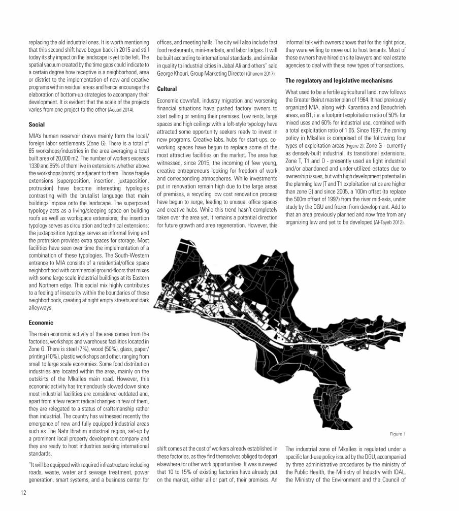
THE SHIFTToday, Mkalles Industrial Area (MIA) is a forsaken part on the edge of the city paying the high price for ineffective modernist planning tools such as zoning and lack of authorities’ decision making and smart action planning, hence, the high percentage (almost 65%) of unused/abandoned/residual spaces within its fabric (Figure 1). The area started shifting from agricultural land to industrial
by attracting limited but large-scale industrial factories and warehouses as early as the 1960’s. What used to be a fully-fledged river-front industrial destination that holds within its fabric different types of land-uses like high-tension electric poles, power stations zones and local/foreign labor settlements, portrays today an urban situation full of contradictions.
Subject to speculative industrial development and physical and environmental degradation, MIA, since the 1960’s, have seen itself slowly isolated from its context. Its unique location on the Beirut riverside, and on the edges of the city, have been undermined. What could be today categorized as Industrial Heritage is nothing more than an under-utilized land that fails to connect to its context (Al-Tayeb 2012). Moreover, MIA has yet to attract new opportunity seekers to investigate and invest, mainly due to its limitations in terms of zoning and ineffective planning decisions, turning it to a residual area in constant degradation. Underutilized lots versus built space, disconnected roads and a sensitive environmental condition has turned MIA into marginalized urban spaces. However, MIA holds within its realm all the right precursors for an effective and genuine re-naturalization process.
THE RE-NATURALIZATION PROCESSThe re-naturalization process in the form of space appropriation is driven by undeniable social, economic, political and regulatory factors (Bishop and Williams 2012).
THE DRIVERS
Spatial
The physical manifestation of cities features certain elements such as density, transportation, infrastructure, parcels and the built. The examination of these elements must acknowledge those that have the greatest impact on individual urban fabrics and thereby on the development of the entire city. Studio Urban Catalyst (Studio Urban Catalyst 2003) acknowledges that urban development processes in Europe produces time gaps. These time gaps are where the former use comes to an end whereas the future use has not yet started. In another word time gaps are times where the urban context is shifting from one state to another, resulting from crisis. Large-scale residual spaces such as the abandoned Mkalles industrial area, have the potential to generate time gaps and spatial vacuums, hence attract the implementation of urban regenerating programs. The first shift was after 1964, when MIA began its industrialization process and rapidly agriculture land was replaced by factories and warehouses; the second shift is slowly taking its toll on the industrial area, and it will be shown later how new creative and bottom-up strategies/programs are
12
replacing the old industrial ones. It is worth mentioning that this second shift have begun back in 2015 and still today its shy impact on the landscape is yet to be felt. The spatial vacuum created by the time gaps could indicate to a certain degree how receptive is a neighborhood, area or district to the implementation of new and creative programs within residual areas and hence encourage the elaboration of bottom-up strategies to accompany their development. It is evident that the scale of the projects varies from one project to the other (Aouad 2014).
Social
MIA’s human reservoir draws mainly form the local/foreign labor settlements (Zone G). There is a total of 65 workshops/industries in the area averaging a total built area of 20,000 m2. The number of workers exceeds 1330 and 85% of them live in extensions whether above the workshops (roofs) or adjacent to them. Those fragile extensions (superposition, insertion, juxtaposition, protrusion) have become interesting typologies contrasting with the brutalist language that main buildings impose onto the landscape. The superposed typology acts as a living/sleeping space on building roofs as well as workspace extensions; the insertion typology serves as circulation and technical extensions; the juxtaposition typology serves as informal living and the protrusion provides extra spaces for storage. Most facilities have seen over time the implementation of a combination of these typologies. The South-Western entrance to MIA consists of a residential/office space neighborhood with commercial ground-floors that mixes with some large scale industrial buildings at its Eastern and Northern edge. This social mix highly contributes to a feeling of insecurity within the boundaries of these neighborhoods, creating at night empty streets and dark alleyways.
Economic
The main economic activity of the area comes from the factories, workshops and warehouse facilities located in Zone G. There is steel (7%), wood (50%), glass, paper/printing (10%), plastic workshops and other, ranging from small to large scale economies. Some food distribution industries are located within the area, mainly on the outskirts of the Mkalles main road. However, this economic activity has tremendously slowed down since most industrial facilities are considered outdated and, apart from a few recent radical changes in few of them, they are relegated to a status of craftsmanship rather than industrial. The country has witnessed recently the emergence of new and fully equipped industrial areas such as The Nahr Ibrahim industrial region, set-up by a prominent local property development company and they are ready to host industries seeking international standards.
“It will be equipped with required infrastructure including roads, waste, water and sewage treatment, power generation, smart systems, and a business center for
offices, and meeting halls. The city will also include fast food restaurants, mini-markets, and labor lodges. It will be built according to international standards, and similar in quality to industrial cities in Jabal Ali and others” said George Khouri, Group Marketing Director (Ghanem 2017).
Cultural
Economic downfall, industry migration and worsening financial situations have pushed factory owners to start selling or renting their premises. Low rents, large spaces and high ceilings with a loft-style typology have attracted some opportunity seekers ready to invest in new programs. Creative labs, hubs for start-ups, co-working spaces have begun to replace some of the most attractive facilities on the market. The area has witnessed, since 2015, the incoming of few young, creative entrepreneurs looking for freedom of work and corresponding atmospheres. While investments put in renovation remain high due to the large areas of premises, a recycling low cost renovation process have begun to surge, leading to unusual office spaces and creative hubs. While this trend hasn’t completely taken over the area yet, it remains a potential direction for future growth and area regeneration. However, this
shift comes at the cost of workers already established in these factories, as they find themselves obliged to depart elsewhere for other work opportunities. It was surveyed that 10 to 15% of existing factories have already put on the market, either all or part of, their premises. An
informal talk with owners shows that for the right price, they were willing to move out to host tenants. Most of these owners have hired on site lawyers and real estate agencies to deal with these new types of transactions.
The regulatory and legislative mechanisms
What used to be a fertile agricultural land, now follows the Greater Beirut master plan of 1964. It had previously organized MIA, along with Karantina and Baouchrieh areas, as B1, i.e. a footprint exploitation ratio of 50% for mixed uses and 60% for industrial use, combined with a total exploitation ratio of 1.65. Since 1997, the zoning policy in Mkalles is composed of the following four types of exploitation areas (Figure 2): Zone G - currently as densely-built industrial, its transitional extensions, Zone T, T1 and O - presently used as light industrial and/or abandoned and under-utilized estates due to ownership issues, but with high development potential in the planning law (T and T1 exploitation ratios are higher than zone G) and since 2005, a 100m offset (to replace the 500m offset of 1997) from the river mid-axis, under study by the DGU and frozen from development. Add to that an area previously planned and now free from any organizing law and yet to be developed (Al-Tayeb 2012).
The industrial zone of Mkalles is regulated under a specific land-use policy issued by the DGU, accompanied by three administrative procedures by the ministry of the Public Health, the Ministry of Industry with IDAL, the Ministry of the Environment and the Council of
Figure 1

13
Ministers. The current zoning is very strict and does not allow for future expansions and flexibility in allocating future lots, moreover the 100m axis from the river is not accompanied with a clear map and could create confusion in future developments towards the river.
FACING THE CHALLENGES
The stakes
Poor safety measures and outdated facilities have put at risk the landscape of MIA. Recently, an oil factory on the northern edge of MIA have caught fire and almost one week after the incident took place, the old factory has been demolished (Figure 3). Incidents like these, not only are a direct hazard to neighboring residents, but also an indirect one to the micro-climate of the area. Residents and passers have been suffering from polluted air and oil residues for the past two weeks. The green area along the river of Beirut includes several types of green spaces and ecological features making it a vulnerable space. It is threatened by development and does not follow a management plan since it is partly considered previously classified in the Greater Beirut master plan. Therefore, it is characterized as a sensitive site and hence, needs to be protected from massive urban sprawl. A gentrification (in the most objective sense of the word) process is slowly taking place in the area, where local/foreign workers and facility owners are migrating leaving place for a young and creative crowd. But most importantly, the absence of planning and governmental guidance as to how this area will develop, leaving owners and developers with a blurred vision of the future, hence maintaining a status quo that could have a very high cost on the region.
Urban strategies and new emerging approaches
Residual spaces in the form of environmental degradation, inflicted partly by modernist planning tools, require new types of urbanism. Today’s emergence of integrated approaches to planning, City Form Labs and Design Labs are leading the digital revolution, betting on worldwide mobility, dealing with migration and increasing environmental awareness. New digital tools are being harnessed to create new means of involving citizens in the urban planning process, integrating a non-expert but practiced layer of knowledge to an already full-fledged array of expertise.
City form labs
Globally, 70% of today’s urban growth occurs outside the formal planning process with the expertise to create a well-planned city being seldom available thus far. The City Form Research Group at MIT has developed the only free tool available to help urban planners understand how the spatial patterns in cities affect the people who live there. The launch of the Urban Network Analysis, an open-sourced software inspired by social networks and
mathematical network analysis methods, is changing the way we look at urban environments. The tool measures traits such as reach, gravity, betweenness, closeness, and straightness (Cruz 2011). The tools are aimed at urban designers, architects, planners, geographers, and spatial analysts who are interested in studying the spatial configurations of cities, and their related social, economic, and environmental processes (MIT 2013). MIA’s current and future planners could benefit from the use of such tools as the development process proves to be more delicate and the stakes could be about jeopardizing a crucial area along the river.
Shared multidisciplinary platforms
Planners must still consider many land-use issues to achieve good city building, particularly in expanding cities where competition for land is intense. This includes factors such as environmental risks, protected green spaces, land values, in addition to social issues such as accessibility and segregation. Planners face an enormous number of factors, domains and issues that interact with and feed back to one another in very complex ways. Using integrated urban models provides simplified representations of the real world, and can help understanding the impact of various spatial planning policies in a systematic way. A typical integrated urban model allocates predicted numbers of buildings and work-places spatially according to a specific planning policy, thereby creating a new urban landscape. Because one very important consequence of a new urban configuration is the change that can be expected in travel behavior, these urban models, applied to MIA, consider transport issues either by considering them in conjunction with a transport model or by integrating the two themes into a single model. The consequences of the future allocations can then be quantified in several ways (e.g. future land consumption, loss of green spaces, or identification of land-use conflict areas).
An integrated modeling system provides several parallel benefits to planners when they formulate strategic policy decisions. Apart from their explanatory role in understanding the dynamics of urban systems, they have a predictive role by enabling virtual experimentation of various development scenarios. This allows planners to visualize and measure the future impacts of different spatial planning strategies to determine which one’s lead to the achievement of planning goals. Additionally, they can be used to stimulate thinking and to facilitate discussion, which means they are powerful tools to facilitate participatory processes of collaborative decision-making (Weber 2014).
Smart cities
By using the planning information modeling (PIM) tool, urban planners will have a single platform to engage with stakeholders such as politicians, government departments, consultants and the public. The shared multidisciplinary platform will enable considered and
sustainable solutions for planning and upgrades in public transport, recreational areas, public buildings, water and waste technology and noise pollution, and will significantly speed up and clarify the planning process, the company claims. Design changes can be immediately reflected on plans and end the need for the exporting, importing, re-calculating and re-sharing of documents. It will create a greater understanding for dependencies between the parameters. Currently in development, the long-term goal for the integrated PIM platform is to connect various technical, economic and social urban planning disciplines to the 3D base tool. Any developer will be able to create extensions to the tool within their field of expertise, increasing the number of parameters for users to consider. This allows for more complex operations and high-detail analysis, resulting in viable proposals for the built environment of the future (Smart Cities World 2017).
UN-Habitat and Design Labs
Launched in 2014, UN-Habitat’s Urban Planning and Design Lab proposes and implements urban planning projects from neighborhood to city-wide scale worldwide. The Lab supports local, regional and national authorities to implement policies, plans and designs through participatory planning processes for more compact, better integrated and connected cities that foster equitable sustainable urban development and are resilient to climate change. Many cities in the developing world struggle with managing the explosive growth of their populations and built-up areas. The Lab was created as a response to the growing demand from local, regional and national governments for assistance in sustainable urban planning.
It translates UN-Habitat’s sustainable urban planning principles into practice by developing plans and designs that can be implemented locally. It also enhances the implementation of these plans and designs by linking the
legal, financial and planning instruments Furthermore the Lab engages in the process design that helps to leverage political commitment. The Lab is an integrative facility that, with a clear project oriented approach, integrates
Figure 2

14
a variety of knowledge such as legal, economic urban planning and design expertise and brings together governments, specialists and UN agencies around urban interventions (UN Habitat 2016).
CONCLUSIONAs regions, such as the MIA, struggle to adapt to the changes in society, culture, technology and the economy, they are confronted to an array of new problems that planning departments are often unable to address. With today’s migration of industrial spaces from dense neighborhoods to more adequate and equipped areas, planners and governments need to shift towards a more dynamic, flexible or adaptive urbanism, built around the ideas of connectivity, mobility, energy and sustainability. This new urbanism requires new approaches to planning that can create, navigate and accelerate the urban strategies and transformative projects to implementation within a complex set of actors and technical realities.
The odd cohabitation that is currently seen between the remains of agricultural land and the decaying industrial facilities in MIA, is one situation to be taken advantage of. It was not the objective of this paper to provide clear and practical solutions for the future of the region, but rather to highlight throughout the display of the array of problems MIA is faced with, the different approaches towards the concept of appropriation of marginalized urban spaces focusing on re-naturalization as a specific mode of space transformation. Even though integrated urban models are not intended to provide definite or
predictive statements about the future, they can be a very powerful tool-box to quantify several aspects of the complex urban system coherently and systematically, and to facilitate the design and assessment of appropriate plans and policies for green growth. That said, and given that these organizations cite a lack of understanding of the availability and benefits of integrated models as the main reason for not using them, more convincing information on the use and benefits of such models is required. This is particularly true for those integrated models that are easy to apply, relatively inexpensive, and proven to provide realistic and insightful outputs that foster deliberation within participatory planning processes.
FIGURESFigure 1. Mkalles Industrial Area, Abandoned / Residual Spaces
Figure 2. Mkalles Industrial Area. Current zoning
Figure 3. Mkalles Industrial Area’s endangered landscape
BIBLIOGRAPHYAl-Tayeb, Abir. 2012. Quality based zoning for riverfront industrial sites: Tcase study of Mkalles. Thesis, Department of Architecture and Design, American University of Beirut, Beirut: AUB.
Aouad, David. 2014. “Non-constructible parcels within the boundaries of Municipal Beirut: The case study of Saif, Bachoura, Zokak El-Blat.” Thesis, Urban Planning Institute, Université de Balamand, Beirut.
Bishop, Peter, and Lesley Williams. 2012. The temporary City. London, New York: Routledge.
Cruz, Trisha. 2011. MIT’s Open-Sourced Urban Planning Tool To Help Build Smarter Cities. 12 October. Accessed December 16, 2017. https://tech.co/mit-open-sourced-urban-planning-tool-2011-10.
El-Achkar, Elie. 1998. Réglementation et formes urbaines : le cas de Beyrouth. Beirut: CERMOC.
Ghanem, Rania. 2017. Industrial zone at Nahr Ibrahim. 1 November. Http://www.businessnews.com.lb/cms/Story/StoryDetails.aspx?ItemID=6286.
MIT. 2013. City Form Lab. 27 September. Accessed December 13, 2017. Http://cityform.mit.edu.
Project for Public Spaces. 2000. Public Parks, Private Partners. Publication, New York: Project for Public Spaces.
Smart Cities World. 2017. “Atkins to build digital urban planning tool.” Smart Cities World. 30 March. Accessed December 13, 2017. Https://smartcitiesworld.net/news/news/atkins-to-build-digital-urban-planning-tool-1535.
Studio Urban Catalyst. 2003. “Urban Catalysts. Strategies for temporary uses-potential for development of urban residual areas in European metropolises. Final report.” Templace. Accessed 8 13, 2013. http://www.templace.com/think-pool/attach/download/1_UC_finalR_synthesis007b.pdf.
UN Habitat. 2016. Urban Planning and Design Labs tools for integrated and participatory urban planning. UN Habitat.
Van den Heuvel, Mesman, Quist. 2008. The Challenge of Change : Dealing with the Legacy of the Modern Movement. Amsterdam: IOS Press.
Weber, Berglund, Fredricsson. 2014. “Urban Form and Sustainability: the Planner’s Toolbox.” Nordregio. Accessed December 13, 2017. http://www.nordregio.se/en/Metameny/Nordregio-News/2014/Planning-Tools-for-Urban-Sustainability/Context/.
AUTHORDavid AOUAD is an architect and an urban planner. He holds a Master’s degree in Urban Planning from Alba University and a Bachelor degree in Architecture from the University of Montreal. Aouad is an adjunct faculty member at LAU where he teaches comprehensive and final year design studios. His research circulates around three areas; residual spaces, industrial heritage, and practice/academia conflicts and challenges. He co-founded DJAH|HANDS; a design practice committed to design excellence and sustainable building practices, celebrating the complexity of the architectural process through dialogue with clients and consultants from complimentary disciplines. He has recently co-founded sURf; a multidisciplinary curatorial platform dealing with art, design and architecture. He is a professional member of the Order of Engineers and Architects in Tripoli and a member of the Municipal Council of Hasroun. His research and practice has been published and exhibited internationally.
Figure 3

15
URBAN CRACKS IN BEIRUT’S URBAN LANDSCAPE:THE POTENTIAL OF LEFTOVER PLOTS TO ENHANCE DENSELY BUILT NEIGHBORHOODSNour BACHACHA (First Author) Yaser ABUNNASR (Corresponding Author)
First Author, Department of Landscape Design and Ecosystem Management, American university of Beirut, [email protected] Author, Department of Landscape Design and Ecosystem Management, American university of Beirut, [email protected]
KEYWORDSLeftover spaces, urban landscape, interstitial spaces, livability, public open spaces
ABSTRACTLeftover plots within urban fabrics represent an opportunity to enhance the social and environmental dimension of densely built urban neighborhoods. These plots represent scattered “cracks” and fragments in the urban landscape that can be transformed into amenity spaces to enhance the social and environmental attributes of communities. This ongoing research project will investigate the potential of these spaces in the neighborhoods Mouseitbeh and Bachoura in Beirut.
Leftover plots are a result of urban planning dynamics. They exist in older and existing cities because of planning processes that are imposed on the existing fabric, including the widening of streets, property realignment, easements and property subdivision. In the context of Beirut, the superimposition of planned streets from the fifties and the continuous process of street widening have resulted in leftover plots from private and public properties. The typology of these plots can be categorized into leftover buildings (buildings half demolished to make space for streets) or small unbuildable plots as per zoning and building regulations. In this research, we are concerned with unbuildable plots. Some are left vacant; others are informally appropriated by adjacent uses, or form property edges with no designated use and vehicular islands. These spaces are left in the fabric, not part of a specific property, yet with an owner. In this research,
we name these spaces “urban cracks”. In Middle Eastern cities that have grown organically over time with little formal public space, “urban cracks” are a land resource that is not tapped into. The Mouseitbeh-Bachoura-area is considered one of the earlier extensions of the walled city of Beirut. It has grown in a somewhat vernacular fashion with a dense urban fabric. The only open spaces are the streets, cemeteries and few small gardens as a result of the only public space development in Beirut during the 1950s. The neighborhood is characterized by low to middle-income working communities that include some traditional Beiruti families. In the past couple of decades, and due to demographic change following civil strife, the neighborhood was further densified, with migrant communities settling in and replacing traditional communities. In its current state, the neighborhood is congested, lacking open space and a minimal tree cover with social space for residents to interact and socialize in.
“Urban cracks” represent an opportunity to support the neighborhood through extending the public realm by transforming these spaces into platforms for social exchange and opportunities to increase tree cover. We see these cracks as a modest way to re-stitch the public realm and provide nodes of activity along streets. These nodes are conceptualized as multi-functional spaces that programmatically respond to and support surrounding uses. Depending on the location and surrounding context, the cracks are transformed into gathering spaces, local transportation nodes, children’s playgrounds, vegetated areas, and in many areas simply seating spaces. As
nodes, they are envisioned as extensions of the surrounding social and cultural context, connected by the improved pedestrian part of the streets. As such, “urban cracks” are envisioned as catalysts for an improved neighborhood life.
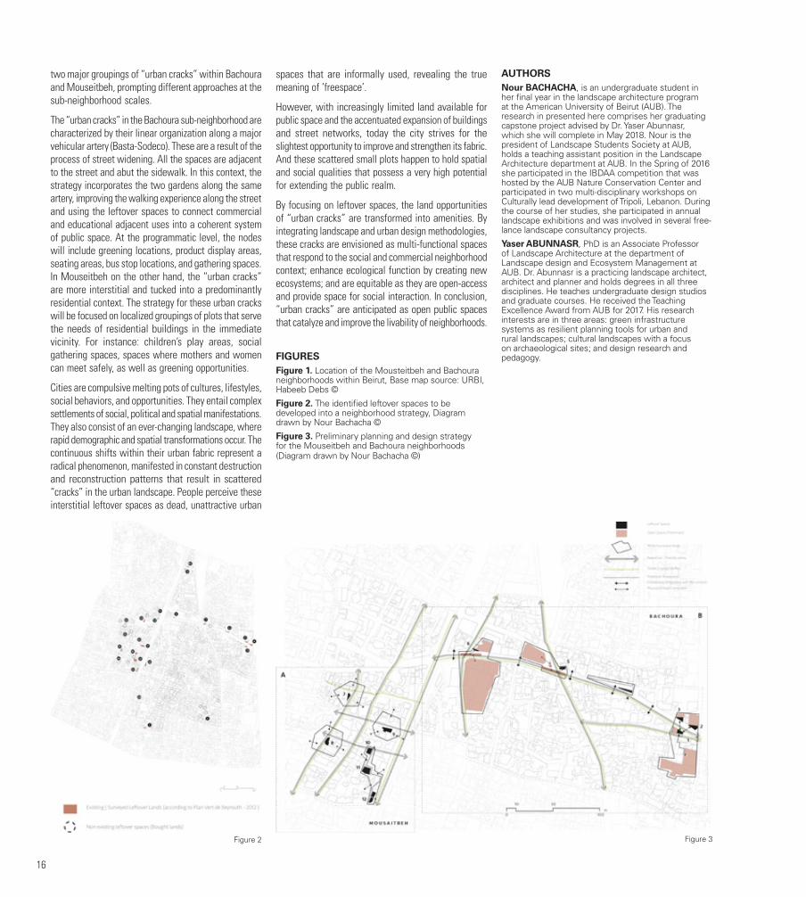
To identify viable “urban cracks” suitable for the purpose of the study, in-depth research was conducted that included the desktop analysis of planning documents, field surveys, spatial and social data collection, a SWOT-analysis and the development of an overall design strategy. The cadastral maps of Beirut Municipality and plot ownership records for the neighborhood were obtained, and a full analysis of all leftover plots was conducted based on the following criteria: ownership, public vs. private, location, contextual inventory, land use, adjacent landmarks, circulation, nodes, view sheds, current function, accessibility aspects, edge, and adjacent physical typology. Of the original 24 plots, twelve were identified as potential “urban cracks”, as these are owned by the municipality of Beirut and therefore can be designated as public. The data collected for the selected plots showed that leftover spaces are either hidden, unexploited, fenced in by the municipality as a small neglected green island, or used informally/illegally by neighboring users. These plots were further analyzed using SWOT-analysis to determine their potential contribution to public life based on a set of criteria: accessibility, physical typologies, visibility, pedestrian flow, vehicular flow, openness, enclosure, maintenance, management, potential program, and other observations. The conclusion of this analysis showed
Figure 1
16
two major groupings of “urban cracks” within Bachoura and Mouseitbeh, prompting different approaches at the sub-neighborhood scales.
The “urban cracks” in the Bachoura sub-neighborhood are characterized by their linear organization along a major vehicular artery (Basta-Sodeco). These are a result of the process of street widening. All the spaces are adjacent to the street and abut the sidewalk. In this context, the strategy incorporates the two gardens along the same artery, improving the walking experience along the street and using the leftover spaces to connect commercial and educational adjacent uses into a coherent system of public space. At the programmatic level, the nodes will include greening locations, product display areas, seating areas, bus stop locations, and gathering spaces. In Mouseitbeh on the other hand, the “urban cracks” are more interstitial and tucked into a predominantly residential context. The strategy for these urban cracks will be focused on localized groupings of plots that serve the needs of residential buildings in the immediate vicinity. For instance: children’s play areas, social gathering spaces, spaces where mothers and women can meet safely, as well as greening opportunities.
Cities are compulsive melting pots of cultures, lifestyles, social behaviors, and opportunities. They entail complex settlements of social, political and spatial manifestations. They also consist of an ever-changing landscape, where rapid demographic and spatial transformations occur. The continuous shifts within their urban fabric represent a radical phenomenon, manifested in constant destruction and reconstruction patterns that result in scattered “cracks” in the urban landscape. People perceive these interstitial leftover spaces as dead, unattractive urban
spaces that are informally used, revealing the true meaning of ‘freespace’.
However, with increasingly limited land available for public space and the accentuated expansion of buildings and street networks, today the city strives for the slightest opportunity to improve and strengthen its fabric. And these scattered small plots happen to hold spatial and social qualities that possess a very high potential for extending the public realm.
By focusing on leftover spaces, the land opportunities of “urban cracks” are transformed into amenities. By integrating landscape and urban design methodologies, these cracks are envisioned as multi-functional spaces that respond to the social and commercial neighborhood context; enhance ecological function by creating new ecosystems; and are equitable as they are open-access and provide space for social interaction. In conclusion, “urban cracks” are anticipated as open public spaces that catalyze and improve the livability of neighborhoods.
FIGURESFigure 1. Location of the Mousteitbeh and Bachoura neighborhoods within Beirut, Base map source: URBI, Habeeb Debs ©
Figure 2. The identified leftover spaces to be developed into a neighborhood strategy, Diagram drawn by Nour Bachacha ©
Figure 3. Preliminary planning and design strategy for the Mouseitbeh and Bachoura neighborhoods (Diagram drawn by Nour Bachacha ©)
AUTHORSNour BACHACHA, is an undergraduate student in her final year in the landscape architecture program at the American University of Beirut (AUB). The research in presented here comprises her graduating capstone project advised by Dr. Yaser Abunnasr, which she will complete in May 2018. Nour is the president of Landscape Students Society at AUB, holds a teaching assistant position in the Landscape Architecture department at AUB. In the Spring of 2016 she participated in the IBDAA competition that was hosted by the AUB Nature Conservation Center and participated in two multi-disciplinary workshops on Culturally lead development of Tripoli, Lebanon. During the course of her studies, she participated in annual landscape exhibitions and was involved in several free-lance landscape consultancy projects.
Yaser ABUNNASR, PhD is an Associate Professor of Landscape Architecture at the department of Landscape design and Ecosystem Management at AUB. Dr. Abunnasr is a practicing landscape architect, architect and planner and holds degrees in all three disciplines. He teaches undergraduate design studios and graduate courses. He received the Teaching Excellence Award from AUB for 2017. His research interests are in three areas: green infrastructure systems as resilient planning tools for urban and rural landscapes; cultural landscapes with a focus on archaeological sites; and design research and pedagogy.
Figure 2 Figure 3
17
THE PLACE BEYOND THE COAST:A SPATIO-POLITICAL HISTORY OF MOUNT LEBANON’S INTERIORYasmina EL-CHAMI
A particular characteristic of the Lebanese territory is its geographic and topographic organization in linear strips of varying widths parallel to the Mediterranean coast. The coast, the Mount Lebanon range, the Beqaa Valley, and the Anti-Lebanon range: each form a geographic entity distinct not only in its natural features, but also, as this paper argues, in its historical social, political, and economic modes of governance.
Within the contemporary borders of the Lebanese state, we only consider these geographic bodies of the territory as separate to the extent that they straddle multiple districts of administration, and sometimes belong to more than one governorate. The following paper is an attempt to investigate this ambiguous relationship between these distinct geographic and administrative entities of the Lebanese territory, concentrating on the series of landscapes, inter-rural areas, and undefined natural sites that straddle Mount Lebanon, yet seem to fall outside its legible governance. However, to understand the contemporary nature of the territory, it is necessary to reconsider its history, if only to recognize what has been rejected and what has remained from the past (Jackson, 2000).
The history of these distinct geographic entities, read through an analysis of the political and economic processes that have articulated their relationship—within the long succession of empires and colonial forces that have controlled the region—is one of enduring conflict and dependence. What emerges then is a complex reality of a territory of connected parts, within which the future of one part can only be conceived
through a reconsideration of the territory as a whole. The linear topographic composition of the Lebanese territory has historically resulted in patterns of settlement and inhabitation that are both longitudinal and transversal. Coastal cities have developed on the north-south axis along the Mediterranean border, while villages have grown east of this final land frontier, along transversal routes. These routes traverse and intersect all four fundamental elements of the Lebanese topography and geographic landscape: They begin at the coast, travel up Mount Lebanon’s chain of mountains, cross over its ridges down into the Beqaa Valley, and continue onto Anti-Lebanon’s slopes, often extending into the Syrian hinterland. Their history is hinted at by the many artifacts and material traces left by the succession of civilizations that have used them. From Phoenician temples and Aramaic shrines to Roman aqueducts, bridges, and associated urban sites, a first layer of ruins highlights and evidences the importance of these routes from the earliest times. Connecting Jounieh to the Beqaa, through Faqra, Afqa to Baalbeck, through Niha, Beirut to Broumana, through Zbaydeh, and Bickfaya to Zahleh, through Jabal el Knaiseh, these routes and the landmarks that dot them recount the narrative of the territory as a network, within the larger empires to which it belonged. They also allude to particular relationships between the entities or regions they have historically connected.
For example, within the Phoenician civilization’s trade history, these routes developed as primary facilitators of the circulation of goods for commercial purposes. Used to transport wine from its place of production in the Beqaa Valley to the coastal cities for its export, they embodied a specific rapport of commercial necessity between the valley and the coast. Meanwhile the mountain stood in the background, or rather middle ground, as a through-passage. In Roman times, these roads acquired a different dimension. As manifested in Cicero’s treatise “De Oficiis”, Roman civilization’s economic focus and human aim was agrarian life: “Of all the occupations by which gain is secured, none is better than agriculture, none more profitable, none more delightful, none more becoming to a free man” (Cicero, 1913: 150-151). This denoted a very specific relationship of man to nature, where nature was not only conceived of as a means to an economic end, but also as the basis of a moral and good life in itself. Roman trade arose out of the need to deliver
the necessities grown from the land and distribute them across the Empire, not primarily for economic gain but within an intrinsic notion of subsistence, tied to the land.
Within this history, Mount Lebanon’s role was twofold: It continued to act as a passageway, connecting the Beqaa, now the granary of the Romans, to the coast; yet it also acquired a productive identity in itself, as the pastoral setting for Roman agrarian life. This dichotomy between nature as a means for a subsistence economy, and nature as a tool for commercial economy, has continued to define both the nature of the mountain itself, and its relationship to the other geographic entities that surround it. It is embodied in the physicality of these roads, which have persistently mediated and articulated this defining relationship.
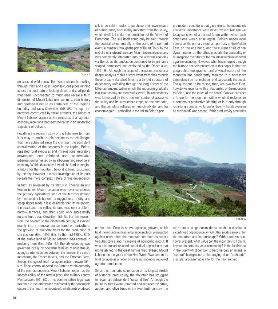
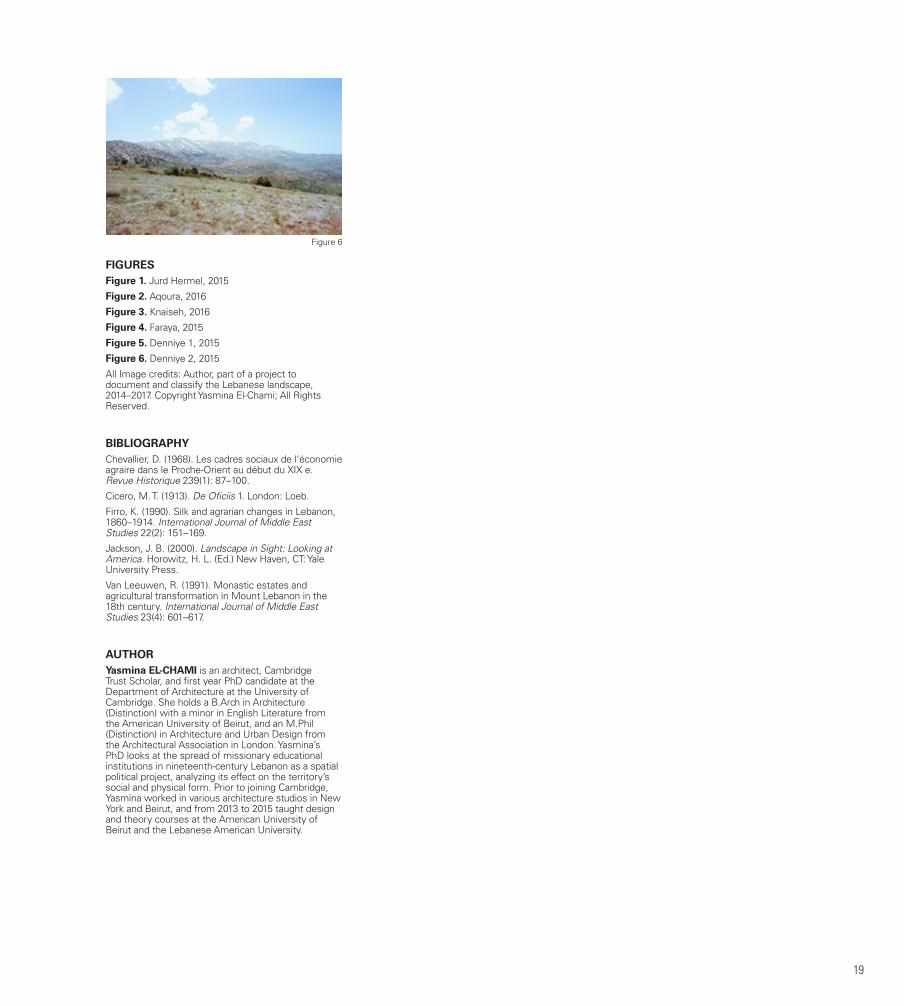
In contradistinction to these enduring roads and network lie the landscapes of non-urbanity and unfettered nature that these very roads traverse: the ridges of Mount Lebanon, the lines on the map that define districts, the physical areas that lie beyond the legality of villages, on either side. Here, a different type of landscape emerges: After the last village’s signs of life have disappeared, and the agricultural terraces have turned into arid wilderness, before the descent into the Beqaa or the coast, and the beginnings of a new village’s signs of existence, a vast seemingly untouched nature unfurls. The ridges of Mount Lebanon, although cartographically represented as simple lines, are in fact often vast plateaus, of varying flatness, aridity, and ruggedness. This thickness of Mount Lebanon’s heights is hard to define; its boundaries are blurred, its nature likewise often disrupted, despite its ostensible abandonment.
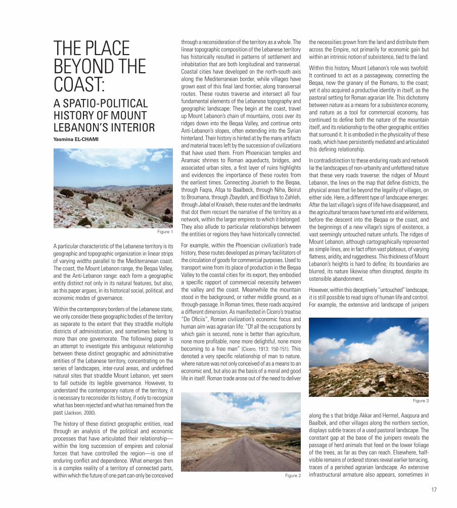
However, within this deceptively “untouched” landscape, it is still possible to read signs of human life and control. For example, the extensive arid landscape of junipers
along the s that bridge Akkar and Hermel, Aaqoura and Baalbek, and other villages along the northern section, displays subtle traces of a used pastoral landscape. The constant gap at the base of the junipers reveals the passage of herd animals that feed on the lower foliage of the trees, as far as they can reach. Elsewhere, half-visible remains of ordered stones reveal earlier terracing, traces of a perished agrarian landscape. An extensive infrastructural armature also appears, sometimes in
Figure 1
Figure 2
Figure 3
18
unexpected wilderness. Thin water channels trickling through thick arid slopes, inconspicuous pipes running across the most natural-looking plains, and small ponds that seem unconnected to much else reveal a third dimension of Mount Lebanon’s summits: their history and geological nature as containers of the region’s humidity and rains (Chevallier, 1968: 88). Through the narrative constructed by these artifacts, the ridges of Mount Lebanon appear as intrinsic sites of an agrarian economy, albeit one that seems to be set in an impending trajectory of oblivion.
Recalling the recent history of the Lebanese territory, it is easy to attribute this decline to the challenges that have subsisted since the civil war; the persistent centralizsation of the economy in the capital, Beirut; repeated rural exoduses and intra-national migratory movements; and unbridled and uncontrollable urbanization harnessed by an all-consuming neo-liberal economy. Within this reality, it would be hard to imagine a future for the mountain, beyond it being subsumed by the city. However, a closer investigation of its past reveals the more complex nature of this dependency.
In fact, as revealed by its status in Phoenician and Roman times, Mount Lebanon was never considered the primary agricultural land of the territory defined by modern-day Lebanon. Its ruggedness, aridity, and steep slopes made it less desirable than its neighbors, the coast and the valley; its land was only arable in narrow terraces, and then could only successfully nurture fruit trees (Chevallier, 1968: 88). For this reason, from the seventh to the nineteenth century, it evolved mainly into a monoculture centered on sericulture, the growing of mulberry trees for the production of silk cocoons (Firro, 1990: 151). By the mid-1800s, 80% of the arable land of Mount Lebanon was covered in mulberry trees (Firro, 1990: 152) The silk economy was governed locally by powerful families of Muqataa’jis, acting as intermediaries between the farmers, the Beiruti merchants, the French buyers, and the Ottoman Porte, through the logic of fiscal management (Van Leeuwen, 1991: 602). Fiscal control allowed the Porte to retain authority of the semi-autonomous Mount Lebanon region, as the inaccessibility of the terrain precluded military control (Van Leeuwen, 1991: 603). This administrative logic was inscribed in the territory and reinforced by the geographic nature of the land. The mountain’s inhabitants produced
silk to be sold in order to purchase their own means of subsistence, necessarily imported from the valley, which itself fell under the jurisdiction of the Vilayet of Damascus. The silk itself could only be sold through the coastal cities, initially in the ports of Tripoli but eventually mainly through the port of Beirut. Thus, by the end of the nineteenth century, Mount Lebanon’s economy was completely integrated into the western economy via Beirut, as its production continued to be primarily shaped, harnessed, and exploited by the French (Firro, 1990: 166). Although the scope of this paper precludes a deeper analysis of this history, what transpires through these broadly sketched lines is a tri-fold structure of dependency unfolding through the long history of the Ottoman Empire, within which the mountain gradually lost its autonomy and means of survival. This dependency was formalized by the Ottomans’ control of access to the valley and its subsistence crops, on the one hand, and the complete reliance on French silk demand for economic gain—embodied in the link to Beirut’s port—
on the other. Once these two opposing powers, which held the mountain’s fragile balance in place, were pitted against each other, the mountain lost both its access to subsistence and its means of economic output. It was this precarious condition of dual dependency that ultimately led to the great famine that ravaged Mount Lebanon in the years of the First World War, and to its final collapse as an economically autonomous region of agrarian production.
Since this traumatic culmination of its longest stretch of historical productivity, the mountain has struggled to regain an independent ‘raison d’être’. Although the mulberry trees were uprooted and replaced by citrus, apples, and olive trees in the twentieth century, the
pre-modern conditions that gave rise to the mountain’s economic importance were never revived. Nor can we today conceive of a desired future within which such conditions would arise again. Beirut’s unequivocal demise as the primary merchant port-city of the Middle East, on the one hand, and the current crisis of the Syrian interior on the other, preclude the possibility of re-imagining the future of the mountain within a renewed agrarian economy. However, what has emerged through the historic analysis presented in this paper is that the geographic, topographic, and physical nature of the mountain has consistently resulted in a necessary dependence on its neighbors, and particularly the coast. The questions to be raised, then, are two-fold: First, how do we reconceive this relationship of the mountain to Beirut, and the cities of the coast? Can we consider a future for the mountain within which it reclaims an autonomous productive identity, or is it only through rethinking a productive future for the city that its own can be reclaimed? And second, if this productivity precludes
the return to an agrarian mode, as one that necessitates a continued dependence, which other mode can exist for the mountain and its landscape? Within today’s neo-liberal present, what value can the mountain still claim, beyond its potential as a commodity? Is the landscape in the twenty-first century to become only an image, a “natural” background to the staging of an “authentic” lifestyle, a consumable site for the new archaic?
Figure 4
Figure 5
19
FIGURESFigure 1. Jurd Hermel, 2015
Figure 2. Aqoura, 2016
Figure 3. Knaiseh, 2016
Figure 4. Faraya, 2015
Figure 5. Denniye 1, 2015
Figure 6. Denniye 2, 2015
All Image credits: Author, part of a project to document and classify the Lebanese landscape, 2014–2017. Copyright Yasmina El-Chami; All Rights Reserved.
BIBLIOGRAPHYChevallier, D. (1968). Les cadres sociaux de l‘économie agraire dans le Proche-Orient au début du XIX e. Revue Historique 239(1): 87–100.
Cicero, M. T. (1913). De Oficiis 1. London: Loeb.
Firro, K. (1990). Silk and agrarian changes in Lebanon, 1860–1914. International Journal of Middle East Studies 22(2): 151–169.
Jackson, J. B. (2000). Landscape in Sight: Looking at America. Horowitz, H. L. (Ed.) New Haven, CT: Yale University Press.
Van Leeuwen, R. (1991). Monastic estates and agricultural transformation in Mount Lebanon in the 18th century. International Journal of Middle East Studies 23(4): 601–617.
AUTHORYasmina EL-CHAMI is an architect, Cambridge Trust Scholar, and first year PhD candidate at the Department of Architecture at the University of Cambridge. She holds a B.Arch in Architecture (Distinction) with a minor in English Literature from the American University of Beirut, and an M.Phil (Distinction) in Architecture and Urban Design from the Architectural Association in London. Yasmina’s PhD looks at the spread of missionary educational institutions in nineteenth-century Lebanon as a spatial political project, analyzing its effect on the territory’s social and physical form. Prior to joining Cambridge, Yasmina worked in various architecture studios in New York and Beirut, and from 2013 to 2015 taught design and theory courses at the American University of Beirut and the Lebanese American University.
Figure 6
20
THE REMAINING GREEN SPACES IN THE BEIRUT METROPOLITAN AREAChristy CHAOUL, Jocelyne ADJIZIAN GERARD, Rita ZAAROUR, Nada BADARO SALIBADepartment of Geography, Faculty of Literature and
Human Sciences, Saint Joseph University
ABSTRACTUrban expansion is one of the major environmental problems affecting Lebanon: 73.5% of the Lebanese population resides in urban areas (Worldmeters, 2017), and the Lebanese urban front continues to extend over the coastline and even on the mountain ridges (Faour et al., 2005). Thus, urbanization and its extension are shown to be crucial problems threatening green spaces. Inhabited areas extend over green areas, covering a radius between 5 to 15 km around the city of Beirut (Davie and Drouaot, 2000). Since the war, The Lebanese population has migrated from urban areas to green spaces. People have migrated to areas on the outskirts of villages, in mid-level mountains, coastal areas and even steep slopes (Davie and Drouaot, 2000). Construction spanned the peripheral area of the littoral, medium slopes (30%) and even the steeper slopes (greater than 60%) (Arnaud, 1997; Bou Kheir, 2001). Thus, urban extension is considered a significant factor of the Lebanese landscape. For this
reason it is important to preserve forests, that occupy a fairly important part of the Lebanese cover. Hence, it seems necessary to understand the phenomenon of urban extension (especially towards green spaces) and to analyze its mechanisms. To fully understand this highly important topic, a study area representing the city/forest interface forms the subject of a meticulous investigative work. Since the suburbs surrounding the capital Beirut are the areas most affected by the extension of buildings, we have chosen the following study area: The Metropolitan Area of Beirut, known as the “Greater Beirut Area”, comprising the city of Beirut (Beirut Governorate) and the adjacent municipalities in Mount Lebanon Governorate. The adopted approach employ a territorial dynamics component (the spatial component of the territory). This technique depends on a diachronic analysis of satellite images, seeking a better qualification of the built-up areas evolution to the detriment of green spaces. This approach will focus on promoting and valuing the forests located at the edge of urban areas.
First, we proceeded to download the required images: Landsat images of 30 m resolution. The chosen images clearly show the Greater Beirut Area. We chose images from 1985, 2000, and 2016. The image dating from 1985 was processed, since, based on an image dating back to this almost ancient period, we were able to visualize the presence of a large percentage of green areas (forests and agriculture areas). We decided to process the image dating back to the year 2000 as a representative of the post-reconstruction period following the civil war (1975-1990). This image represents an intermediate period between our base image dating from 1985 and the recent one dating from the year 2016. This latest one represents the current situation of urban extension in Lebanon. These images and their databases were analyzed in the Aeronautical Reconnaissance Coverage Geographic Information System (ARC GIS). In this system, we began by importing the Lebanese Map, the Greater Beirut Area’s Map, the registration land division map of the municipalities belonging to the two governorates constituting the Greater Beirut Area (Beirut and Mount Lebanon), and finally the different downloaded images. These images were taken by different Landsat satellites (Landsat 5, 8). In order to observe the affected areas and determine the areas most affected by this phenomenon, we analyzed the Normalized Difference Vegetation Index (NDVI) of each satellite image. This index is a data processing method, allowing us to describe the stage of plant growth, identify and monitor the vegetation dynamic. The image processing using this index, displays pixels with different values ranging from 0 to 255 (or -1 as 0 to +1 as 255)
It should be noted that the Landsat 8-images are of a better resolution than those taken by the Landsat 7 and 5, probably due to some improvements in the Landsat- instruments. These improvements constitute significant progress in the ability to detect changes on the earth’s
surface, which are captured better than with the previous Landsat satellites. Therefore, it becomes imperatively important to calculate a relationship equation between the Landsat 7 image (the image used to estimate the value of the minimal green pixel) and the Landsat 8 image (the image for which we wanted to obtain a minimal green pixel value equal to the minimal green pixel value in Landsat 7). Hence, we imported two satellite images (Landsat 7 and Landsat 8) into ARC GIS, taken at close dates during the same year (May 2016). Subsequently, we sampled random values of the pixels on these two images processed by the analysis of the vegetation index. Based on the collected data, a graph was developed that shows the variation of the Landsat 8 image’s pixels value compared to the Landsat 7 image’s pixels value, in order to seek an equation. The developed equation “y=0.812x + 36.33”is a linear function that we have used to calculate the theoretical values. The variation between the observed values and the calculated ones provided us with a residue. Afterwards, the calculated residues were analyzed, by developing a graph showing the variation of the residues according to the sampled Landsat 7 values. The average value of all the residues is 2.890571429. The standard deviation of these values is 3.899170946. The majority of the calculated values are within ± 3.899170946. Thus, the standard deviation made us accept the calculated values, and therefore our findings were accepted and applicable. Hence, this equation allowed us to determine the value of the minimal greenery pixel in the Landsat Image 8, corresponding to the value “103” estimated on the Landsat 7 image.
While estimating the value of the minimal threshold of pixels representing the green spaces in Landsat images 4 and 5, and calculating the minimum value of the green pixels in the satellite image taken by the Landsat satellite 8, we used the “tabulate area” tool, which calculates the surface area of the pixels of each value. In Excel, data resulting from this tool can be processed. We calculated the sum (of the surface) of green pixels, starting from the minimal pixel value for each Landsat image, and the total surface area of each municipality (the sum of all the surface-area of the pixels), in order to be able to calculate the percentage of green spaces present in the Greater Beirut Area. We continued by calculating the variation of the percentages of green spaces in each municipality between the years 1985 and 2016. In this way, the software allowed us to deduce the decrease in green spaces in these regions. This same procedure was used to calculate the percentage of urban spaces within the same study area, but in a reverse way. We have calculated the sum of the surface of non-green pixels ranging from the maximal threshold pixel value for each Landsat image (considered 103 in Landsat 7) and the total surface area of each municipality (the sum of all the surface area of the pixels), in order to be able to calculate the percentage of the urban spaces invading our study area. Figure 1
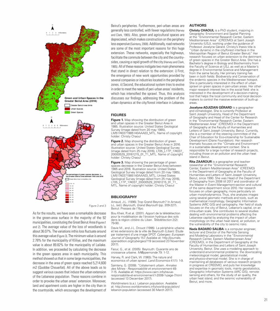
21
As for the results, we have seen a remarkable decrease in the green-area surface in the majority of the 92 municipalities, constituting the Great Beirut Area (Figures1 and 2). The average value of the loss of woodlands is about 36.07%. The variations inthis loss fluctuate around this average value (Figure 3). The minimum value is around 2.78% for the municipality of Kliliye, and the maximum value is about 89.82% for the municipality of Lailake. In addition, we proceeded by calculating the decrease in the green spaces area in each municipality. This method showed us that in some large municipalities, the decrease in the area of green space reached 5,214,600 m2 (Quobbe Choueifat). All of the above leads us to suggest various causes that induce the urban extension of the Lebanese population. These reasons combine in order to provoke the urban areas’ extension. Moreover, land and apartment costs are higher in the city than in the countryside, which encourages the development of
Beirut’s peripheries. Furthermore, peri-urban areas are generally less controlled, with fewer regulations (Harvey and Clark, 1965). Also, green and agricultural spaces are depreciated, which makes construction on the periphery less expensive (Sainteny, 2008). Additionally, road networks are some of the most important reasons for this huge extension. These networks, especially the highways, facilitate the commute between the city and the country-sides, causing a rapid growth of the city (Harvey and Clark, 1965). All of these reasons instigate two main phenomena that stand in direct relation to the extension: i) First, the emergence of new work opportunities provided by several companies or industries located in the peripheral zones. ii) Second, the educational system tries to evolve in order to meet the needs of peri-urban areas’ residents, which has intensified the sprawl. Thus, this analysis discusses our findings, addressing the problem of the urban dynamics at the city/forest interface in Lebanon.
FIGURESFigure 1. Map showing the distribution of green and urban spaces in the Greater Beirut Area in 1985. Illustration source: United States Geological Survey (image dated from 20 may 1985), LM51740371985140AAA03_MTL. Name of copyright holder: Christy Chaoul
Figure 2. Map showing the distribution of green and urban spaces in the Greater Beirut Area in 2016. Illustration source: United States Geological Survey (image dated from 25 may 2016), LT05_L1TP_174037_20000529_20161215_01_T1_MTL. Name of copyright holder: Christy Chaoul
Figure 3. Map showing the percentage of green spaces decrease in the Greater Beirut Area between 1985 and 2016. Illustration source: United States Geological Survey (image dated from 20 may 1985), LM51740371985140AAA03_MTL; United States Geological Survey (image dated from 25 may 2016), LT05_L1TP_174037_20000529_20161215_01_T1_MTL. Name of copyright holder: Christy Chaoul
BIBLIOGRAPHYArnaud, J-L. (1996). Trop Grand Beyrouth? In Arnaud, L-L. (ed.) Beyrouth, Grand Beyrouth (pp. 209-227). Beirut: Presses de l’Ifpo.
Bou Kheir, R.et al. (2001). Apport de la télédétection pour la modélisation de l’érosion hydrique des sols dans la région côtière du Liban. Télédétection 2(2): 79-90.
Davie M., and J-L. Drouot (1996). La périphérie urbaine et les extensions de la ville de Beyrouth (Liban): Étude par traitement d’une image SPOT. Cybergeo: European Journal of Geography 157. Availabe at: http://journals.openedition.org/cybergeo/719 (accessed 23 November 2017).
Faour, G., et al. (2005). Beyrouth: Quarante ans de croissance urbaine. M@ppemonde 79: 1-12.
Harvey, R. and Clark, W. (1965). The nature and economics of urban sprawl. Land Economics 41(1): 1-9.
Sainteny, G. (2008). “L’étalement urbain. Annales des Mines - Responsabilité et environnement 49: 7-15. Available at: https://www.cairn.info/revue-responsabilite-et-environnement1-2008-1-page-7.html (accessed 13 December 2017).
Worldmeters (s.a.). Lebanon population. Available at: http://www.worldometers.info/world-population/lebanon-population (acceesed 30 March 2017).
AUTHORSChristy CHAOUL is a PhD student, majoring in Geography: Environment and Spatial Planning at the “Environmental Research Center, Eastern Mediterranean Area” (CREEMO) at Saint Joseph University (USJ), working under the guidance of Professor Jocelyne Gérard. Christy’s thesis title is “Urban dynamic in the city/forest interface in the Metropolitan Region of Beirut (Greater Beirut).” Her research focuses on urban extension to the detriment of green spaces in the Greater Beirut Area. She has a Bachelor’s degree in Biology and Biochemistry from the Faculty of Science at USJ, as well as a Master’s degree in Environmental Science and Management from the same faculty. Her primary training has been in both fields: Biodiversity and Conservation of the endemic species in the Mediterranean hotspot. She is particularly interested in the effect of urban sprawl on green spaces in peri-urban areas. Her other major research interest lies in the social field: she is interested in the development of a decision-making tool that helps the local community and local decision-makers to control the massive extension of built-up areas.
Jocelyne ADJIZIAN GÉRARD is a geographer and climatologist. She is currently Professor at Saint Joseph University, Head of the Department of Geography and Head of the Center for Research in the “Environmental Research Center, Eastern Mediterranean Area” (CREEMO) in the Department of Geography at the Faculty of Humanities and Letters of Saint Joseph University, Beirut. Currently, she is a member of the steering committee of the Chair of Education for Eco-citizenship for Sustainable Development (Diane Foundation). Her research thematic focuses on the “Climate and Environment” in a sustainable development context. She is responsible for a large number of research projects, including those on air pollution and the urban heat island in Beirut.
Rita ZAAROUR is a geographer and teacher-researcher at the “Environmental Research Center, Eastern Mediterranean Area” (CREEMO) in the Department of Geography at the Faculty of Humanities and Letters of Saint Joseph University, Beirut, since 1990. She was Head of the Department of Geography from 2008 till 2017 and coordinator of the Master in Event Management-section and cultural of the same department since 2010. Her research focuses on urban geography, more particularly on urban morphodynamics. Thus, she analyzes images using several geomatic methods and tools, such as mathematical morphology, Geographic Information Systems (ARC GIS) and cartography. Her field of study focuses on the city of Beirut, Lebanon’s capital, on an intra-urban scale. She contributes to several studies dealing with environmental problems affecting the Lebanese capital by analyzing the impact of urban morphology on the urban heat island, air pollution, or the vulnerability of the city to seismic risks.
Nada BADARO SALIBA is a computer engineer, lecturer and Director of the Remote Sensing and Modeling Laboratory in the “Environmental Research Center, Eastern Mediterranean Area” (CREEMO), in the Department of Geography at the Faculty of Humanities and Letters of Saint Joseph University, Beirut. She uses a modeling approach to understand environmental problems: the downscaling meteorological model, geostatistical model, and physico-chemical model. She is in charge of maintaining all databases of various research projects in progress at CREEMO, and puts her knowledge and expertise in geomatic tools, mainly geostatistics, Geographic Information Systems (ARC GIS), remote sensing and others, for the study of air quality, the urban heat island, and the seismic vulnerability of Beirut, and more.
Figure 2 and 3

22
BEIRUT RIVERLESSAdib DADAFounder and Lead Architect at theOtherDada [email protected]
Beirut RiverLESS aims to address the deterioration of the Beirut River and its negative impact on the surrounding communities and environment, by developing a holistic response plan for the Beirut River Watershed. The goal is to bring Beirut River back to life by following a Landscape Ecology approach and by enabling local governance, leading to innovative and ecological interventions.
Beirut River, the city’s largest open river, originates 30 kilometers inland at an altitude of around 1900 meters, from two springs in Hammana and Tarchiche.
Back in 50 B.C., the Romans diverted some of its water to the Roman city of Berytus through a system of dams, canals, aqueducts and tunnels. Due to human intervention that began in 1934, the flow of the water was interrupted and the ecological system started to break down quickly.
In 1968 the river was transformed from a natural, healthy and functioning ecosystem to a canalized infrastructure, becoming an open sewer for domestic and industrial wastewater that posed numerous health risks to its neighbors.
This resulted in “killing” the river by disconnecting it from its larger natural ecosystem, and “killing” it again by disconnecting it from the human communities that used to enjoy it and care for it.
The river thus became a no-man’s-land and a dumping ground affected by every crisis the city has gone through: the dumping of slaughterhouse waste when the illegal slaughterhouses scandal came to light; the dumping of garbage during the nine-month long garbage crisis; a regular dumping ground for textile dyes, which turn the river bright red; even an unloved crocodile pet was dumped and found living there. Not to mention the raw sewage infrastructure that is directly connected to the river. (Figure 1)
After passing through and affecting the urban neighborhoods downstream, all of this pollution is dumped into the Mediterranean Sea, making it a local problem with a major global impact.
In 2013, theOtherDada initiated Beirut RiverLESS with the purpose of identifying the challenges facing Beirut River, and developing a bottom-up plan to bring it back to life.
ECOLOGY OF THE RIVER: WHY IS THE RIVER IMPORTANT?Naturally, Beirut River has played an important role in providing ecological and social values. In the natural section upstream, the watershed incorporates a functional ecosystem that provides benefits called “ecosystem services”1. These services include:
•Provisioning Services, where the river provides fresh water for irrigation in the area of Daychounieh and potable water to the city through the Roman aqueducts, as well as transporting sediments, organisms and nutrients.
•Regulating Services, where the basin treats and stores water, controls erosion to mitigate the impact of floods and storms, and filters waste through natural processes.
•Supporting Services, where the river offers food, shelter, and water to living organisms, and also acts as a vital migratory path for more than 70,000 soaring birds, not to mention that its valley is officially listed as an Important Bird Area [IBA]2.
•Cultural Services, where the river provides a space for recreation and cultural activities for local communities, such as the renowned water festival “Vardavar” during which Armenians traditionally gathered around the river and drenched themselves in water.
CURRENTLY, THE SYSTEM IS BROKEN Over the years, human interventions have interrupted the natural flow of water from the mountains to the Mediterranean Sea. Once it reaches the urban section, the river no longer functions as a healthy water body; it does not provide clean water, a space for flood retention, or a habitat for biodiversity, and most importantly it prevents cultural and social activities. People no longer have access to the river, and it also lost its recreational and social function.
We witness the degradation of the Beirut River and connected infrastructure, resulting in a negative impact on the surrounding communities and environment. After studying the urban section of the river we noticed three major problems:
• High population density: Over time, the riverbanks became increasingly densely populated and the area has also witnessed a growing presence of migrant workers. Lately, it has become the destination of some 20,000 Syrian refugees, thus increasing the neighborhood density by an estimated 40% since 2011.
• Illegal dumping of waste and raw sewage into the river basin.
• Loss of ecosystem services due to canalization and the dam upstream.
To identify the roots of the problems, we laid down the challenges facing the river, its current status, the living conditions in its surrounding neighborhoods and transgressions to its environment3. All the challenges lead back to the following:
• Poor governance due to poor communication between communities and local authorities, a social disconnect between the Badawi Neighborhood and Bourj Hammoud, Figure 1
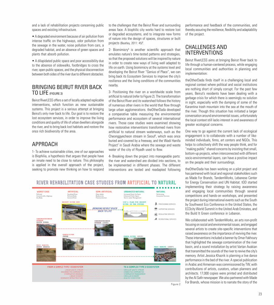
23
and a lack of rehabilitation projects concerning public spaces and existing infrastructure.
• A degraded environment because of air pollution from intense traffic on the highways, odor pollution from the sewage in the water, noise pollution from cars, a degraded habitat, and an absence of green spaces and plants that absorb pollution.
• A dilapidated public space and poor accessibility due to the absence of sidewalks, footbridges to cross the river, open public spaces, and the physical disconnection between both sides of the river due to different obstacles.
BRINGING BEIRUT RIVER BACK TO LIFE (FIGURE 3)
Beirut RiverLESS offers a set of locally adapted replicable interventions, which function as new sustainable systems. This project is a serious attempt at bringing Beirut’s only river back to life. Our goal is to restore the lost ecosystem services, in order to improve the living conditions and quality of life of urban dwellers alongside the river, and to bring back lost habitats and restore the once rich biodiversity of the area.
APPROACH1- To achieve sustainable cities, one of our approaches is Biophilia, a hypothesis that argues that people have an innate need to be close to nature. This philosophy is applied in the overall approach of the project, seeking to promote new thinking on how to respond
to the challenges that the Beirut River and surrounding areas face. A biophilic city works hard to restore lost or degraded ecosystems, and to integrate new forms of nature into the design of spaces, structures or built projects (Beatley, 2011: 45)4.
2- Biomimicry5 is another scientific approach that emulates nature’s time‐tested patterns and strategies, so that the proposed solutions will be inspired by nature in order to create new ways of living well adapted to life on earth. Using biomimicry at the systems level and developing the Beirut River “Genius of Place”, we can bring back its Ecosystem Services to improve the city’s resilience and the living conditions of the communities nearby.
3- Positioning the river on a worldwide scale from artificial to natural (refer to Figure 2). The transformation of the Beirut River and its watershed follows the history of numerous other rivers in the world that flow through large urban agglomerations. theOtherDada developed a comparative table measuring the environmental performance and ecosystem of several international rivers. Those case studies were examined showing how restorative interventions transformed rivers from artificial to natural stream waterways, such as the Cheonggyecheon stream in Seoul6, which was once buried and covered by a freeway, and the Wadi Hanifa Project7 in Saudi Arabia where the sewage and waste water of the city of Riyadh used to flow.
4- Breaking down the project into manageable parts: the river and watershed are divided into sections, to be implemented in different phases. The different interventions are tested and readapted following
performance and feedback of the communities, and thereby assuring the resilience, flexibility and adaptability of the project.
CHALLENGES AND INTERVENTIONSBeirut RiverLESS aims at bringing Beirut River back to life through a human-centered process, while engaging local communities and authorities in planning and implementation:
theOtherDada finds itself in a challenging local and regional context where political and social institutions are nothing short of simply corrupt. For the past few years, Beirut’s residents have been dealing with a garbage crisis for which there is seemingly no solution in sight, especially with the dumping of some of the Karantina trash mountain into the sea at the mouth of the river. Though this situation has initiated a larger conversation around environmental issues, unfortunately the local context still lacks interest in and awareness of greater ecological concerns.
One way to go against the current lack of ecological engagement is to collaborate with a number of like-minded individuals, firms, art centers and NGOs. This helps to collectively shift the way people think, and for “making public” shared concerns by insisting that small, bottom-up projects, when interconnected with different socio-environmental layers, can have a positive impact on the people and their surroundings.
theOtherDada has been working on a pilot project and has partnered with local and regional stakeholders such as Made For Brands, TandemWorks, Lebanese Center for Energy Conservation and UN Habitat. tOD started implementing their strategy by raising awareness and engaging local communities through several competitions and hands-on workshops, and presented the project during international events such as the South by Southwest Eco Conference in the United States, the ECOcity World Summit in the United Arab Emirates, and the Build It Green conference in Lebanon.
We collaborated with TandemWorks, an arts non-profit focusing on social and environmental issues, and engaged several artists to create site-specific interventions that raised awareness on the importance of reviving the river. These interventions included a banner by Omar Fakhoury that highlighted the sewage contamination of the river basin, and a sound installation by artist Vartan Avakian that transmitted the sounds of the river to revive the city’s memory. Artist Jessica Khazrik is planning a live dance performance in the bed of the river. A special publication in Arabic and Armenian was commissioned by TW, with contributions of artists, curators, urban planners and architects. 17,000 copies were printed and distributed by the Al Safir newspaper. We also partnered with Made For Brands, whose mission is to narrate the story of the
Figure 2

24
Beirut River project in the most effective and impactful way through visuals, animations, and printed leaflets.
As part of the Beirut Design Week 2016, theOtherDada gathered more than twenty volunteers to create an installation on a site that used to serve as an informal dumping ground next to Beirut River. They worked for ten consecutive days to translate the proposed interventions into site-specific solutions, and were able to clean the lot and collect soil that they used to plant around 400 native species, breathing life into a barren land and providing a much-needed and engaging public space.
On the environmental level, the project proposes small-scale urban interventions such as Blue-Green streets, to reduce pollution and manage floods affecting the nearby economic hub; utilizing rooftops for rainwater collection and solar energy; and providing public parks for recreational activities, all while engaging the local community in the process.
NEXT STEPSConsidering the urban environment of Beirut River’s flood plains, we recognize that we cannot re-naturalize the urban section of the river; hence our approach is to bring back the lost ecosystem services by increasing green surfaces for a biodiversity habitat, enhancing public spaces for the communities, and managing storm water to relieve pressure on ageing infrastructure and recharge groundwater.
Currently, our goal is to reach out to stakeholders, talent and resources, and to develop a watershed management and maintenance plan based on a landscape ecology
approach. This sets a framework specifying the responsibilities of the different consultants and stakeholders and insuring the environmental stewardship for the overall project development.
Beirut RiverLESS promotes a set of interventions that will require the emergence of community responsibility and small-scale green entrepreneurship, and facilitate the potential participation of parts of the informal economy. Although it is not seen as strategic for the national economy, the informal economy ensures the income and market participation of many poor communities. In these neighborhoods, which suffer from weak governance at the national and a level of “neglect” by local authorities in cases where the neighborhoods are informal, local authorities will be better equipped to tackle challenges of service provision, and demand will be reduced through interlinked and holistic solutions responding to their mandate area.
Based on collaborations with local small businesses, NGOs, artists and practices, and applying soft green interventions, the project will bring social, environmental and economic resilience to the neighborhoods along Beirut River.
FOOTNOTES1. Ecosystem Services (2015). The economics of ecosystems & biodiversity. Available at: http://www.teebweb.org/resources/ecosystem-services/ (accessed 8 September 2015).
2. BirdLife International (2015). Important Bird Areas factsheet: Beirut River Valley. Available at: http://www.birdlife.org (accessed 26 June 2015).
3. Challenges recorded through field observations and interviews conducted on October 9 and 23, 2014; December 16 and 22, 2014; and February 2, 2015.
4. T. Beatley, Biophilic Cities: Integrated Nature into Urban Design and Planning, USA, Island Press, 2011, p. 45.
5. Biomimicry Institute (2015). What is biomimicry? Available at: http://biomimicry.org/what-is-biomimicry/ (accessed 8 September 2015).
6. The Preservation Institute (2007). Removing freeways - restoring cities. Available at: http://www.preservenet.com/freeways/FreewaysCheonggye.html (accessed 15 December 2014).
7. Inhabitat (2010). Aga Khan Award for Architecture: Wadi Hanifa Wetlands. Available at: https://inhabitat.com/aga-khan-award-for-architecture-wadi-hanifa-wetlands/ (accessed 16 December 2014).
FIGURESFigure 1. Challenges
Figure 2. Case Studies Diagrams
Figure 3. Interventions
BIBLIOGRAPHYBeatley, T. (2011). Biophilic Cities: Integrating Nature into Urban Design and Planning. Washington DC: Island Press.
AUTHORAdib DADA is the founder of theOtherDada [tOD] Integrated Architecture Lab. Adib earned a Bachelor in Architecture at the American University of Beirut, a Master’s Degree in the Interactive Telecommunications Program at New York University, and completed a Biomimicry Graduate Certificate from the Biomimicry 3.8 Institute and Arizona State University. Based on Biomimicry, tOD’s work promotes a symbiotic relationship between nature and the built environment by exploring new ways of creating generous and regenerative buildings and projects; in essence developing creative solutions with a positive impact. As a fervent supporter of Beirut’s art scene, Adib serves on the Supporting Committee of the Beirut Art Center, sits on the Board of Tandem Works and was recognized in GOOD Magazine’s GOOD 100 for 2016. Adib is a Fellow of the fifth class of the Middle East Leadership Initiative and a member of the Aspen Global Leadership Network.
Figure 3
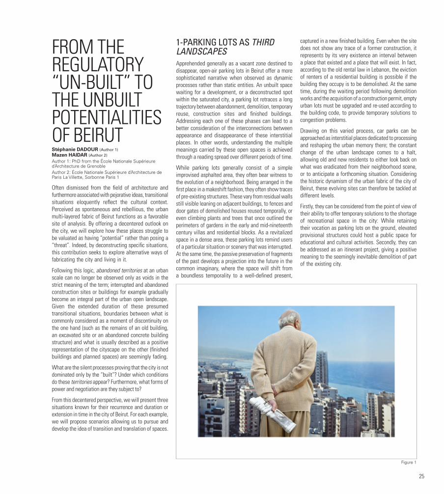
25
FROM THE REGULATORY “UN-BUILT” TO THE UNBUILT POTENTIALITIES OF BEIRUTStéphanie DADOUR (Author 1)Mazen HAIDAR (Author 2)
Author 1: PhD from the École Nationale Supérieure d’Architecture de GrenobleAuthor 2: École Nationale Supérieure d’Architecture de Paris La Villette, Sorbonne Paris 1
Often dismissed from the field of architecture and furthermore associated with pejorative ideas, transitional situations eloquently reflect the cultural context. Perceived as spontaneous and rebellious, the urban multi-layered fabric of Beirut functions as a favorable site of analysis. By offering a decentered outlook on the city, we will explore how these places struggle to be valuated as having “potential” rather than posing a “threat”. Indeed, by deconstructing specific situations, this contribution seeks to explore alternative ways of fabricating the city and living in it.
Following this logic, abandoned territories at an urban scale can no longer be observed only as voids in the strict meaning of the term; interrupted and abandoned construction sites or buildings for example gradually become an integral part of the urban open landscape. Given the extended duration of these presumed transitional situations, boundaries between what is commonly considered as a moment of discontinuity on the one hand (such as the remains of an old building, an excavated site or an abandoned concrete building structure) and what is usually described as a positive representation of the cityscape on the other (finished buildings and planned spaces) are seemingly fading.
What are the silent processes proving that the city is not dominated only by the “built”? Under which conditions do these territories appear? Furthermore, what forms of power and negotiation are they subject to?
From this decentered perspective, we will present three situations known for their recurrence and duration or extension in time in the city of Beirut. For each example, we will propose scenarios allowing us to pursue and develop the idea of transition and translation of spaces.
1-PARKING LOTS AS THIRD LANDSCAPESApprehended generally as a vacant zone destined to disappear, open-air parking lots in Beirut offer a more sophisticated narrative when observed as dynamic processes rather than static entities. An unbuilt space waiting for a development, or a deconstructed spot within the saturated city, a parking lot retraces a long trajectory between abandonment, demolition, temporary reuse, construction sites and finished buildings. Addressing each one of these phases can lead to a better consideration of the interconnections between appearance and disappearance of these interstitial places. In other words, understanding the multiple meanings carried by these open spaces is achieved through a reading spread over different periods of time.
While parking lots generally consist of a simple improvised asphalted area, they often bear witness to the evolution of a neighborhood. Being arranged in the first place in a makeshift fashion, they often show traces of pre-existing structures. These vary from residual walls still visible leaning on adjacent buildings, to fences and door gates of demolished houses reused temporally, or even climbing plants and trees that once outlined the perimeters of gardens in the early and mid-nineteenth century villas and residential blocks. As a revitalized space in a dense area, these parking lots remind users of a particular situation or scenery that was interrupted. At the same time, the passive preservation of fragments of the past develops a projection into the future in the common imaginary, where the space will shift from a boundless temporality to a well-defined present,
captured in a new finished building. Even when the site does not show any trace of a former construction, it represents by its very existence an interval between a place that existed and a place that will exist. In fact, according to the old rental law in Lebanon, the eviction of renters of a residential building is possible if the building they occupy is to be demolished. At the same time, during the waiting period following demolition works and the acquisition of a construction permit, empty urban lots must be upgraded and re-used according to the building code, to provide temporary solutions to congestion problems.
Drawing on this varied process, car parks can be approached as interstitial places dedicated to processing and reshaping the urban memory there; the constant change of the urban landscape comes to a halt, allowing old and new residents to either look back on what was eradicated from their neighborhood scene, or to anticipate a forthcoming situation. Considering the historic dynamism of the urban fabric of the city of Beirut, these evolving sites can therefore be tackled at different levels.
Firstly, they can be considered from the point of view of their ability to offer temporary solutions to the shortage of recreational space in the city: While retaining their vocation as parking lots on the ground, elevated provisional structures could host a public space for educational and cultural activities. Secondly, they can be addressed as an itinerant project, giving a positive meaning to the seemingly inevitable demolition of part of the existing city.
Figure 1
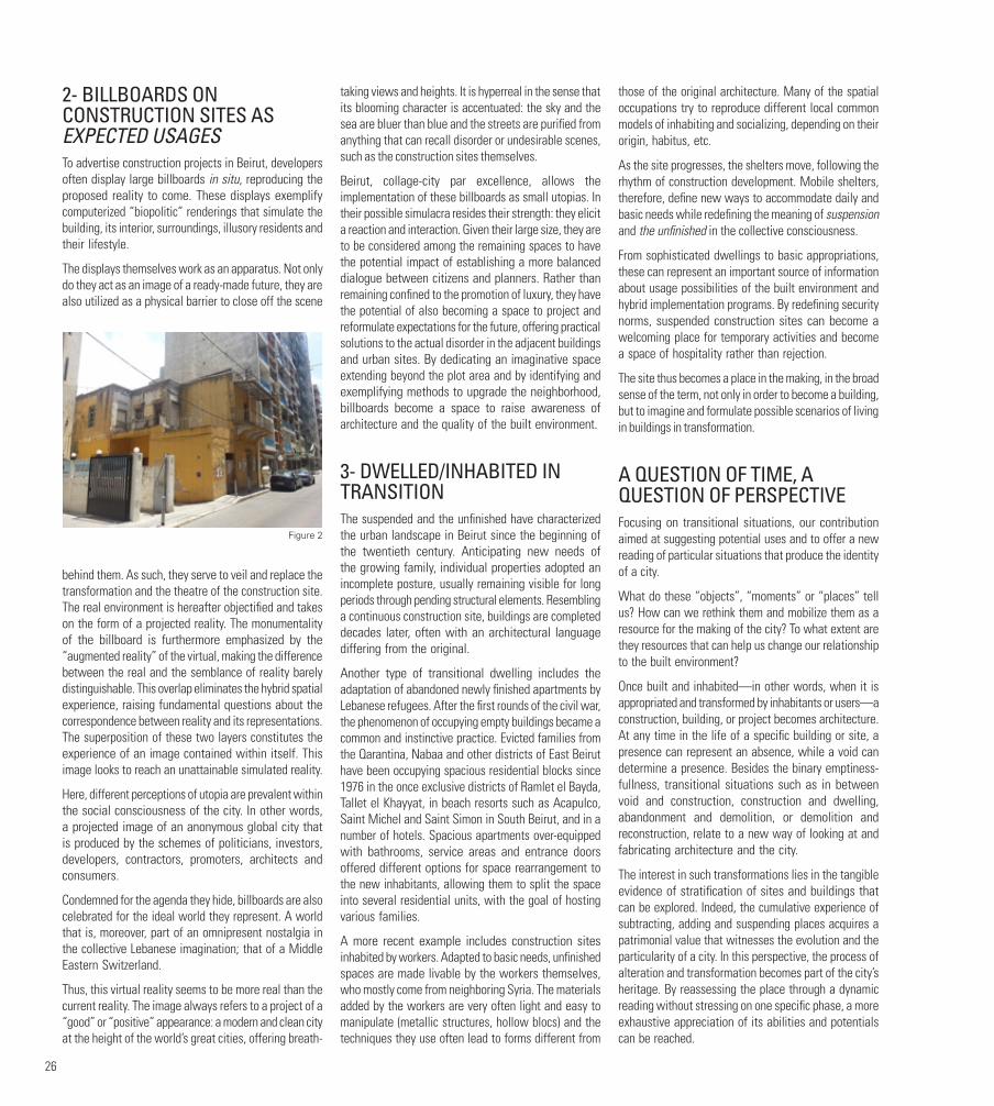
26
2- BILLBOARDS ON CONSTRUCTION SITES AS EXPECTED USAGESTo advertise construction projects in Beirut, developers often display large billboards in situ, reproducing the proposed reality to come. These displays exemplify computerized “biopolitic” renderings that simulate the building, its interior, surroundings, illusory residents and their lifestyle.
The displays themselves work as an apparatus. Not only do they act as an image of a ready-made future, they are also utilized as a physical barrier to close off the scene
behind them. As such, they serve to veil and replace the transformation and the theatre of the construction site. The real environment is hereafter objectified and takes on the form of a projected reality. The monumentality of the billboard is furthermore emphasized by the “augmented reality” of the virtual, making the difference between the real and the semblance of reality barely distinguishable. This overlap eliminates the hybrid spatial experience, raising fundamental questions about the correspondence between reality and its representations. The superposition of these two layers constitutes the experience of an image contained within itself. This image looks to reach an unattainable simulated reality.
Here, different perceptions of utopia are prevalent within the social consciousness of the city. In other words, a projected image of an anonymous global city that is produced by the schemes of politicians, investors, developers, contractors, promoters, architects and consumers.
Condemned for the agenda they hide, billboards are also celebrated for the ideal world they represent. A world that is, moreover, part of an omnipresent nostalgia in the collective Lebanese imagination; that of a Middle Eastern Switzerland.
Thus, this virtual reality seems to be more real than the current reality. The image always refers to a project of a “good” or “positive” appearance: a modern and clean city at the height of the world’s great cities, offering breath-
taking views and heights. It is hyperreal in the sense that its blooming character is accentuated: the sky and the sea are bluer than blue and the streets are purified from anything that can recall disorder or undesirable scenes, such as the construction sites themselves.
Beirut, collage-city par excellence, allows the implementation of these billboards as small utopias. In their possible simulacra resides their strength: they elicit a reaction and interaction. Given their large size, they are to be considered among the remaining spaces to have the potential impact of establishing a more balanced dialogue between citizens and planners. Rather than remaining confined to the promotion of luxury, they have the potential of also becoming a space to project and reformulate expectations for the future, offering practical solutions to the actual disorder in the adjacent buildings and urban sites. By dedicating an imaginative space extending beyond the plot area and by identifying and exemplifying methods to upgrade the neighborhood, billboards become a space to raise awareness of architecture and the quality of the built environment.
3- DWELLED/INHABITED IN TRANSITIONThe suspended and the unfinished have characterized the urban landscape in Beirut since the beginning of the twentieth century. Anticipating new needs of the growing family, individual properties adopted an incomplete posture, usually remaining visible for long periods through pending structural elements. Resembling a continuous construction site, buildings are completed decades later, often with an architectural language differing from the original.
Another type of transitional dwelling includes the adaptation of abandoned newly finished apartments by Lebanese refugees. After the first rounds of the civil war, the phenomenon of occupying empty buildings became a common and instinctive practice. Evicted families from the Qarantina, Nabaa and other districts of East Beirut have been occupying spacious residential blocks since 1976 in the once exclusive districts of Ramlet el Bayda, Tallet el Khayyat, in beach resorts such as Acapulco, Saint Michel and Saint Simon in South Beirut, and in a number of hotels. Spacious apartments over-equipped with bathrooms, service areas and entrance doors offered different options for space rearrangement to the new inhabitants, allowing them to split the space into several residential units, with the goal of hosting various families.
A more recent example includes construction sites inhabited by workers. Adapted to basic needs, unfinished spaces are made livable by the workers themselves, who mostly come from neighboring Syria. The materials added by the workers are very often light and easy to manipulate (metallic structures, hollow blocs) and the techniques they use often lead to forms different from
those of the original architecture. Many of the spatial occupations try to reproduce different local common models of inhabiting and socializing, depending on their origin, habitus, etc.
As the site progresses, the shelters move, following the rhythm of construction development. Mobile shelters, therefore, define new ways to accommodate daily and basic needs while redefining the meaning of suspension and the unfinished in the collective consciousness.
From sophisticated dwellings to basic appropriations, these can represent an important source of information about usage possibilities of the built environment and hybrid implementation programs. By redefining security norms, suspended construction sites can become a welcoming place for temporary activities and become a space of hospitality rather than rejection.
The site thus becomes a place in the making, in the broad sense of the term, not only in order to become a building, but to imagine and formulate possible scenarios of living in buildings in transformation.
A QUESTION OF TIME, A QUESTION OF PERSPECTIVEFocusing on transitional situations, our contribution aimed at suggesting potential uses and to offer a new reading of particular situations that produce the identity of a city.
What do these “objects”, “moments” or “places” tell us? How can we rethink them and mobilize them as a resource for the making of the city? To what extent are they resources that can help us change our relationship to the built environment?
Once built and inhabited—in other words, when it is appropriated and transformed by inhabitants or users—a construction, building, or project becomes architecture. At any time in the life of a specific building or site, a presence can represent an absence, while a void can determine a presence. Besides the binary emptiness-fullness, transitional situations such as in between void and construction, construction and dwelling, abandonment and demolition, or demolition and reconstruction, relate to a new way of looking at and fabricating architecture and the city.
The interest in such transformations lies in the tangible evidence of stratification of sites and buildings that can be explored. Indeed, the cumulative experience of subtracting, adding and suspending places acquires a patrimonial value that witnesses the evolution and the particularity of a city. In this perspective, the process of alteration and transformation becomes part of the city’s heritage. By reassessing the place through a dynamic reading without stressing on one specific phase, a more exhaustive appreciation of its abilities and potentials can be reached.
Figure 2

27
These places are often not physically free but they constitute an open field of action, a moment of suspension, dream or even of purification of memories and forgetfulness, becoming an essential part of the historical landscape of Beirut. This makes it possible to identify the existing gaps or what can potentially nest in these unfinished spaces that can be looked at, according to a different reading, as places of the infinite.
FIGURESFigure 1. ©Randa Mirza (Beirut is back and it is beautiful)
Figure 2 and 3. © Mazen Haidar
AUTHORSStéphanie DADOUR holds a PhD from the École Nationale Supérieure d’Architecture de Grenoble and is an architectural historian and writer based in Paris. She is an associate professor at the École Nationale Supérieure d’Architecture de Grenoble in “Histoires et Cultures Architecturales,” member of the “Laboratoire des Métiers de l’Histoire de l’Architecture (ENSAG)” and the “Laboratoire Architecture, Culture et Société” (ENSA Paris-Malaquais). Her research projects deal with various themes, such as the divide between theory and practice, feminist theories and architecture as a domain of cultural representation. She has been awarded fellowships from the FQRSC and the Centre Pompidou, and took a Visiting Scholar position at Columbia University in New York.
Mazen HAIDAR, École Nationale Supérieure d’Architecture de Paris La Villette, Sorbonne Paris 1. Architect in conservation who graduated from “La Sapienza” Rome, Italy, where he lived for over ten years. As a practicing architect, he is currently involved in several conservation projects in Lebanon and has taught in several academic institutions, including the Lebanese American University, the American University of Beirut and the Académie Libanaise des Beaux-Arts (ALBA). His ongoing PhD project at Paris 1, La Sorbonne, deals with the history of the residential building in Beirut and the practices of appropriation of architecture from the “modern movement”.
Figure 3

28
THE UN-BUILT LEBANONFROM A ROMANTIC GAZE TO JUST DEFERRED URBANIZATION (AND BACK AGAIN)?Michael F. DAVIE Department of Geography, University of Tours (France) and CNRS-UMR « Espace, Nature et Culture », Paris
From the moment Lebanon comes into view through the plane’s window, the visitor cannot but wonder, or shudder, at the very high density of the country‘s urban spaces. Everything seems to be built up, with hardly a plot of land left open; open space is rare, usually in a very sorry state of abandonment—even the seafront is almost everywhere visually absent. While this urban filling-in is commonplace elsewhere in the World, it does pose a series of questions in a country, which was lauded as an island of greenery and natural beauty nestled in the vast, barren, and monotonous Middle East, to the point of becoming a tourist cliché. One could expect that natural landscapes would be ingrained in the country’s identity, and that its citizens would relate to views with intense pride.
After all, the Cedars of Lebanon are mentioned 12 times in the Bible, and in the 64 times the word ‘Lebanon’ is used, many verses refer to its beauty, while the country’s very name is claimed to be linked to the snow-capped mountains. ‘Lebanon’ and ‘unspoilt nature’ seem to go together and the metaphorical visitor expects to see ‘pure’ scenery everywhere, from the deep-blue Mediterranean through the dark green pine forests up to the immaculate white snow-clad mountain summits (Brown J.P. 1969 ; Freyha A. 1972 ; Wardini É. 2001). ‘Lebanon’ and ‘unspoilt nature’ seem to go together and the metaphorical visitor expects to see ‘pure’ scenery everywhere, from the deep-blue Mediterranean through the dark green pine forests up to the immaculate white snow-clad mountain summits. Everywhere, only faint signs of the built-up should be seen, ideally limited to quaint villages placed in improbable places in steep valleys. Human activity, such as agriculture, would be almost indistinguishable from the natural landscape; the country’s population would be the manifestation of this special relationship between Nature and the spiritual, or even with the divine, a ‘message’ (Hager A. 2017). The un-built, the ‘natural’ would be a central topos, an obvious synonym of Lebanon.
‘BUILT’, ‘UN-BUILT’, SPACE AND PLACEBut identifying, conceptualising and locating the ‘un-built’ is no easy task in the Social sciences, as all the words or notions used, from ‘space’ to ‘built’, ‘territory’ or ‘landscape’ are semantically polymorph and chaotic (Bertrand G. 1978). The ‘un-built’ is quintessentially inseparable from the built, as one side of a sheet of paper cannot be detached from the other. The word says nothing about the fact itself; it just states its negation—that this particular space is not built, with the latter apparently being the norm—while nothing is known about its current physical state, function or future. The only clear statement is that the un-built can be located, as it’s a different objective reality from the built. To make a parallel with linguistics, ‘just as the word, for Saussure, is the union of a concept with a delimited ‹chunk› of sound, so the place is the union of a symbolic meaning with a delimited block of the earth‘s surface. Spatial differentiation implies spatial segmentation.’ (Ingold T. 1993) The only clear statement is that the un-built can be located, as it has a different objective reality from the built, and we’re used to the idea of un-built space as a sort of neutral backdrop, the scene where things happen. Geographers study what humans do to this backdrop, identifying organizational spaces, networks, relationships of power stakes, that all produce ‘real’ spaces, those of everyday life, those that we use, like or hate. What do architects do? They conceive, plan and build on ‘empty’ space, leftover, useless or made ‘free’ by the destruction of once-built spaces. Urban planners organize the whole show and try to adapt laws and by-laws, with differing degrees of success. Landscape specialists try to give some semblance of sense and of aesthetic value to space, while all the Social sciences try to understand who does what, why and where. But the key word is ‘built’, not the un-built. The ‘built’ would be space produced by the hand of Man, a thing manifestly unlike natural processes, although both are deeply loaded with symbolic meaning.
This spatial division implies (wrongly) that only built space is a product of human activity. But as all space is a social product (Lefebvre H. 1974) ‘natural’ space is also part of the human experience through its gaze. The ‘un-built’ is as much a social construct as the ‘built’, even though our representations are quite different: historically, the ‘un-built’ is the ideal landscape perceived through our culturally-biased eyes, being even the essential component of a landscape. However, the dichotomy between the two is fallacious, as both are perpetually under construction: the ‘un-built’ (in Lebanon or elsewhere) makes sense only when it corresponds to our pre-conceived image, and is ‘finished’ when it is in conformity with this image produced by a specific society at a precise moment in time. Ingold neatly explains this terminological difficulty: ‘So the thing itself and its image are expressed by the same concept. […] Whereas space and environment are more or less physical and abstract
concepts, the concept of landscape is cultural and more concrete: it is nature or space perceived and totalized by man. Thus, landscape belongs neither to nature nor to culture, but it is rather their mediation or alliance. Landscape is nature domesticated and appropriated by man. […] Landscape is nature and culture at the same time, it is their mediation, synthesis or alliance.’ (Ingold T. 1997) The un-built is thus partially natural and cultural: the forests of Mount-Lebanon are in fact just abandoned agricultural terraces recolonized by pine-trees, and many un-built and vegetation-free valley slopes were once covered by agriculture, while whole villages lie buried under thick sediments, to the joy of archaeologists.
Being appropriated by man, the un-built has commercial, aesthetic or symbolic value, and can also be part of larger geopolitical stakes. We can state, with Mitchell, that the un-built, just as landscape, ‘is a medium of exchange between the human and the natural, the self and other. As such, it is like money: good for nothing in itself, but expressive of a potentially limitless reserve of value. Like money, landscape is social hieroglyph that conceals the actual basis of its value. It does so by naturalizing its conventions and conventionalizing its nature. Landscape is a natural scene mediated by culture. It is both a represented and presented space, both a signifier and a signified, both a frame and what a frame contains, both real place and its simulacrum, both a package and the commodity inside the package.’ (Mitchell W. J. T. 2002) Through having value, the un-built becomes a central topos in the narrative on the topography of capitalism through the landscape it produces. ‘The landscape tells—or rather is—a story. It enfolds the lives and times of predecessors who, over the generations, have moved around in it and played their part in its formation. To perceive the landscape is therefore to carry out an act of remembrance, and remembering is not so much a matter of calling up an internal image, stored in the mind, as of engaging perceptually with an environment that is itself pregnant with the past.’ (Ingold T. 1993). The landscape is thus the territory of ghosts (Blanco M. del P. et Peeren E. 2013 ; Mills S. 2013 ; Nagle J. 2017) The un-built can thus ‘the homeland of thoughts’ (Merleau-Ponty M. 1945), the locus of many-layered meanings which require fine-tuned geographical methodologies, not least a humanistic approach (Cosgrove D. 1989 ; Tuan Y.-F. 1977, 1974, 1976), or a pensée complexe (Morin E. 1990). And, of course, the un-built has a cacophony of meanings, of constructions of meaning, of memory and stakes, all leading to the invention of tradition (Hobsbawm E.J. et Ranger T.O. 1983) and heritage. Space, and especially place, is just congealed time at the crossroads of the production of riches, emotions, values, beliefs and power (Cresswell T. 2015). Briefly then, space has value through its other values: symbolic, un-measurable, and unexplainable intimate ones, which are essential to forging the identities and cultures of each and everyone of us. As for the concept of ‘culture’, it can be reduced to what people do, and the traces they leave behind in a conscious or unintended way, producing forms of

29
space and place. This means that what we do, the way we act and move, how we produce place and space, are all social constructs, inherited from a long series of actions and reactions, of habits and constraints, of norms which we accept or refuse, and which are produced by ourselves, by our immediate social environment, and also by actors in a position of power. Space, now a ‘place’—is the space that has, or makes, sense—and which we recognize and identify ourselves to. It’s central to identity, to the degree of interaction with others. We claim to be part of those who think and act like ourselves, we share a common idea of ourselves; we are part of a community—an imagined community, of course. This, in turn, allows us to project ourselves into the past, and identify objects, spaces, or landscapes, which are ‘part of us’, our heritage. And, as we are different from those who do not share our values, then their heritage and history must be different from ours. Being unlike them, they are excluded from our frames of reference. Interestingly, these very frames are often defined by the State and imposed on the population through education—the role of history classes cannot be minimized. The end result is the creation of the citizen who should ideally and wholeheartedly adhere to the ideology of the Nation or the State. So, heritage, invented communities, and cultural values all relate; but they must have some form of material visibility. This brings us back to the question of the un-built, to its very existence and to its cultural value.
Finally, and just to complicate further the meanings of the word, ‘un-built’ is the past of to un-build, i.e. to demolish. Are un-built spaces just those that have been reduced to rubble? But were all ‘un-built’ spaces once built?
This paper examines the way the spaces of the un-built in Lebanon have been represented, by both Lebanese and foreign observers, between the beginning of the 19th century and today. As stated above, the ‘un-built’ is just the product of a particular gaze by individuals or by society on part of the landscape. It postulates that space was once natural, untouched by humans, and as time passed, this natural environment was progressively transformed into a wholly artificial one. Only small islands or oases were left behind, and these now constitute the craved-for ‘un-built’. This narrative has a history, that of a product of the West’s late-18th century Weltanschauung; in Lebanon, it was both adopted and adapted, to be replaced in the 20th century by partially overlapping capitalist and postmodern narratives. Briefly, the first period can be placed between the middle of the 19th century and the last years of the French Mandate; the second spanned the first 25 years of the country’s independence and the Lebanese civil war, while the third can be placed between the 1990s and today. Differentiated according to scale, each period gave diverse values to both built and un-built spaces.
THE UN-BUILT AND ROMANTIC LEBANONExported to Lebanon, the way of looking at its space is very clearly romantic, in the sense given to the 18th and 19th century western literary and artistic current. It refers to scenes of unspoilt nature, to the mountains and valleys barely touched by human activities, a sort of a-historical scene of Man and Nature living in idyllic harmony, the crucible of the authentic Lebanese national identity. The Lebanese would be moulded by this majestic space located between the white snowy uplands and the blue Mediterranean Sea. In all cases, the villages (i.e. the rural ‘built’) were portrayed as being in perfect symbiosis with Nature, while the cities were pushed into the side-lines; there, life was dirty, corrupting, and degrading, just as those in Europe’s Industrial revolution. The West, in fact, had created and imposed on all its own definitions (i.e. the ‘romantic’) and geography through its technological apparatus, while, clearly, there is no starting point for the existence of a particular landscape. But suddenly, Lebanon was aesthetically beautiful, a unique piece of land between the sea and the desert, the only mountain between the Mediterranean and Turkey and Persia. This aesthetic experience was further popularised through the recently invented fashion of the ‘Grand Tour’, which all well-educated persons had to ritually accomplish once in their lifetimes. To visit Lebanon was to observe, in situ, where history had taken place: the Cedars and Solomon’s temple, the miracle at Cana, the myth of Adonis, the legend of Saint George, Alexander the Great and the siege of Tyre, the Roman empire, the Phoenicians, Jonas and the whale, Saint Paul and Beirut, the Crusades, etc. These descriptions were followed by paintings or engravings highlighting an escape from the cluttered towns and cities (de Laborde L. 1837 ; Musée Nicolas Sursok 2013 ; The British Lebanese Association 1986), and thanks to the new medium of photography, an exotic vision of the Orient was popularized (Debbas F. 1994, 1996 ; Debbas F.C. 2001). This clearly orientalist model produced an imagined landscape and population that never existed. In Western eyes, the Lebanon (reduced here to its mountains) was un-built and pure, in direct contrast with the coastal cities or with the semi-desert interior and its caravan hubs. In fact, the West’s Zeitgeist had invented the Orient and the Mediterranean according to its own set of values, fears, desires and dreams. (Cohen W.I. 1983 ; Garcia-Ramón M.D., Kirby A., Luna A.[et al.] 2004 ; Said E.W. 1979 ; Bourguet M.-N., Lepetit B. et Nordman D. 1998).
Progressively, through the usual acculturation processes, even the Levant’s local inhabitants were drawn into this romantic framework: at the very local scale, the gardens—the un-built—that surrounded the new Beiruti ‘three arched house’ were a variation on the theme of unspoilt Nature. Here, the local bourgeoisie adopted the Western aesthetic norms for the new residential quarters and very clearly rejected the local, ‘traditional’ architecture (Davie M.F. 2003, 2016 ; Khater A. 2003 ; Mollenhauer A. 2003, 2002 ; Davie M. F. 2003 ; Hauser
J., Lindner C. B. et Möller E. 2016). It was as if the outward movement from Beirut’s historical centre towards the agricultural periphery required metaphorically taming this un-built space in order to incorporate it into the bourgeoisie’s values. The modernized city thus became the epitome of civilization—with undertones of being a civitas—with the outside natural environment slowly becoming associated to being ‘wild’ and possibly ‘dangerous’. Simultaneously, this same class also adopted the West’s romantic gaze on the sea and the mountains: the three-arched house opened up to the North and the sea, and the mountains were always visible from the balcony. Arabic-language literature also followed suit, presenting the rural parts of the country to an interested public. Relayed by foreign schools, the West’s regime of truth, anchored in the Enlightenment (Clement V. 2017) and relayed by the Nahda, despised the un-built as being economically ‘useless’ and ‘primitive’, requiring investment by modern capitalism to make it ‘civilized’, ‘developed’ and profitable.
In turn, the descriptions fed the nation’s self-depiction, and consolidated the local nationalism and nationalist ideologies: the French Mandate and Lebanese Republic flag showing the mountain cedar is a case in point. Also, how better to describe a Lebanese on his way to the mahjar, as a courageous peasant who had left behind the terraces, orchards and forests close to the snow-capped summits? Writing back to relatives left behind, he (or she) would lament this loss of the familiar, ancestral, landscape; his wish would be to be buried in the space he loved contemplating in his youth.
Briefly then, the new local economic and power structures that emerged at the end of the 19th century (the Nahda and the Tanzimâts, the inclusion of the Levant into capitalism’s sphere) adopted the West’s gaze on the un-built, further confirming that Lebanon was ‘different’ from the other spaces around it. This was instrumental in identifying the particularities necessary for the invention of new countries at the end of the First World War. Lebanon being unique by its landscapes, it was obviously a different country from its neighbours, justifying new ex nihilo frontiers—the Lebanese un-built could not be compared to the Syrian desert, nor to the plains and hills of Palestine. The country could now be politically detached from its historical environment by European powers that had imposed a different gaze on its space. Being different, Lebanon was also transformed into a tourist destination, especially during the Mandate: innumerable postcards and photographs were taken of the un-built parts of the country, and colonial literature is replete with descriptions of the Cedars, of hidden valleys and of their secretive but proud populations; in a sense, this Romantic vision continued well into the 20th century. Built-up Beirut was given only glancing attention.
Perhaps this turning point paradoxically saved the villages in the rural parts of the country: they became active only during the summer, with visits by the descendants of the muhâjirîn, who craved for a ‘return’ to ‘traditional cultural
30
values’. They re-invented the village and its identity (Khater A. 2001 ; Hourani A. et Shehadi N. 1992), and glorified the landscape in poems, songs and literature. It became a marketing asset, a sort of branding of Lebanon. The un-built was the core of the country’s projected identity, and this pleased both the new local tourist industry and the new political élite.
These same cultural values were central in consolidating a sort of consensual national identity in the face of regional or of international ideologies. Between the late 1930s and the early 1950s, its cultural values were stated as not being identical to those of the wider Arab nation, nor could they be merged into narrower nationalistic ones. Surely, neither Palestinian nationalism, nor the pan-Arab or Greater Syria ideologies could have any points in common with the Lebanese identity.
THE UN-BUILT AND THE DRIVE TO MODERNITYThe major change in this romantic depiction of Lebanon occurred just after the country’s independence and it’s rapid integration into the new post-WW2 economy dominated by the USA. Suddenly space, and especially the un-built, was no longer just the frame for an idealized Lebanese identity, but instead had real material value. The un-built was postulated as antagonistic to modernity, and space was part and parcel of the technical aim of placing Lebanon among the developed countries. This modernity was based in the cities, and primarily in Beirut, which had to be urbanised, ‘filled in’ and criss-crossed by roads and communication infrastructures. New residential quarters with high-rise buildings became the obvious norm, both in the city’s municipal limits and its once-rural suburbs, and the tamed nature of the private gardens of the ‘three-arched-house’ to be replaced by concrete. The more un-built space was filled in, the more modern the country would be, a trend encouraged by both the Point 5 and IRFED plans (Institut de recherche et de formation en vue du développement 1963a, 1963b, Malsagne S. 2002, 2011).
At this point in history, ‘un-built’ meant only land waiting to be built, in a form of dialectical relationship. To build, to fill in the gaps, to uproot forests and level hilltops meant being part of the developed World; to work the land as a peasant meant being hopelessly in the past.
During this same post-Independence period, maps were central to the identification of the un-built parts of Lebanon; they were vital in building a discourse on the usefulness and profitability of space (Edney M.H. 1997 ; Goren H. 2000 ; Jacob C. 1992 ; Bord J.-P. et Baduel P. R. 2004). They pursued capitalism’s vision of the world through colonial forms of control of independent countries (Césaire A. 1950 ; Deprest F. 2014 ; Singaravélou P. 2011). The un-built belonged to the ‘white spaces’ on the map that had to be erased and included in ‘normal’ space.
At this moment, nostalgia slid in with a longing for the romantic, now lost, Lebanon: Fayrouz sang Lubnan al-Akhdar or Hkili hkili ‘an baladi, and village life and rural personæ were popularised in operettas and TV series (Stone C.R. 2008, 2014). Even the cinema took up this topic, such as Nasser’s Ila ‘ayn? (Davie D.F. et Davie M.F. 2017 ; Koteit G. 2017), edging close to a melancholic local saudade. Another tilting-point can be identified during and the Lebanese war (1975-1990). With the destruction of parts of Beirut and with the spreading of insecurity, the un-built parts of the country suddenly became strategically important—they were ‘safe’. The coast between Beirut and Jbail absorbed populations from all parts of the mountain (Davie M.F. 1994); Tripoli spread into the Koura; Chtaura extended to Masnaa; Saida covered the overlooking hills; the olive groves close to Choueifat disappeared and were replaced by completely new residential quarters collectively named ‘Dâhiyé’. Even forgotten villages in the Akkar or the Jabal Aamel spread uncontrolled. New University campuses and gated communities sprung up everywhere, the further from the cities, the safer. Un-built space was just merchandise, bought, sold or stolen, transformed and remodelled according to the labyrinthine whims of pure capitalistic offer and demand. Un-built space could have no other value, be it symbolic or emotional, while built space signified facts on the ground, ‘we are here to stay’, ‘this is now ours’ it seem to state. Put otherwise, the built expressed power and privilege, with the flip side of exploitation and domination being the un-built; the un-built was a sort of island, which could potentially be used by the dangerous Other. By metaphorically ‘filling in’ the island, the enemy could no longer be within; the un-built, even in this context, is perceived as un-natural, un-desirable, un-healthy and dangerous. This process of building the un-built continued well after the official end of the war, unchecked and uncontrollable, producing an amorphous dystopia inhabited by a disorientated population, but paradoxically confined to clearly delimited religious or ethnic territories.
THE UN-BUILT AND A YEARNED ROMANTIC RETURN TO THE PASTBut it was in the post-war years that a new attitude emerged. With the questioning of once clear political, religious, spatial and cultural identities imposed by the war, with the uprooting and forced internal migrations of populations of whole areas, the question of the value of un-built space was posed. What national or local identities could be maintained or created in a built (and in an un-planned) environment? Could individuals, groups or communities live without some form of romantic space linked to myths surrounding their origins? Granted, all communities are imagined; but what would Lebanon represent to the Lebanese if the un-built was pockmarked by untidy and free-for-all urbanization? How could the
past be used to explain the present if no past (the rural or ‘natural’ Lebanon) was visible? With the coast now completely built up, with the mountain scarred by large residential complexes and huge gated leisure complexes planned for the upper mountains, with every valley now marked by multi-storey buildings and the forests already planned for future housing projects, the un-built has become a prized commodity. The un-built plots in cities, towns and villages are reduced to parking lots or garbage dumps, while whole non ædificandi areas are mysteriously built over thanks to complacent politicians and unscrupulous architects. Only the powerful now have access to the view of the un-built, as the gated and defended built rise ever higher, especially in the capital: Sama’ Bayroût reaches for the un-built sky, the next horizon, while those living near ground-level zero are forced to exist in a panoptical dense space ordered by full-spectral surveillance domination. The built and the un-built all point to forms of power imposed on space
In this self-doubting moment, postmodern attitudes have emerged: NGOs have sprouted in defence of forests, of national parks, of natural environments, of beaches, of views. Nature is ‘rediscovered’ by hiking groups, while the questions of rural and natural heritage are put forward and forcefully defended by new political groups as vital for the political, social and economic survival of the country; nature and images of nature are valued (Debarbieux B. 1996).
The destroyers of forests, the builders of visual scabs are named and shamed, irrespective of their political or religious affiliation. Suddenly, the un-built is more valuable than its commercial value: the country’s identity (or distinctness) requires protection, attention and re-enchantment (Kitson J. et McHugh K. 2015), and even the question of gender has invited itself into the debate: the perceptions by women of the value of the un-built differ from those of men’s, and various social or religious minorities have also expressed their position on the matter.
The un-built seems to indicate a vital need for some form of freedom, of a return to normalcy, to a redefined, convivial, stable and timeless but complex and multilayered, Lebanon. What buildings do (Gieryn T.F. 2002) is mirrored by what their absence can do. The un-built is becoming the ‘place of condensation of the nation’ (Debarbieux B. 2010), with a romantic Lebanon 2.0 presented as both trendy and strategic for the country’s survival. In a sense, the un-built relates to the ghosts of the past that force all to reconsider the past (Maddern J.F. et Adey P. 2008 ; Matless D. 2008 ; Nagle J. 2017 ; von Hirschhausen B. 2017) in a struggle against amnesia. The un-built is evolving into the unbuildable (Harbison R. 1991) and through these notions, new forms of empowerment—and thus of democracy—have crystallized, questioning the undisputed race to ‘modernity’ and urban sprawl, both of which have lead the country to disaster. Perhaps a new breed of citizen has been born, unless, of course, ‘landscape’ and the
31
un-built are just newer profitable items for the oligarchs in control of the country’s neoliberal economy.
CONCLUSIONThe un-built, just as the built, expresses ‘relations of power and discipline […] inscribed into the apparently innocent spatiality of social life… human geographies become filled with politics and ideology.’ (Soja E.W. 1989). What we look at as being just empty space is in fact loaded with significance: it can only exist if it combines material form, performance and affect (Duff C. 2017), immanence and memory (Jones O. 2011). The un-built exists only in the eye of the beholder; it has value and meaning only in a particular moment in time, either in the short term or in the longue durée, and under particular social, political and economic contexts. Should the un-built in Lebanon be protected because of its position in memory, heritage or nostalgia, or should it be an asset, a key element in the quest for modernity and progress through the invisible hand of the economy? In this struggle between actors, the un-built is clearly a geopolitical object, forcing a debate around democratic values and shared futures, and very far from simple aesthetic considerations. The un-built simply makes visible the very complex crises Lebanon has (and still is) going through (Davie M.F. 2018).
BIBLIOGRAPHYBertrand G. 1978 : « Le paysage entre la Nature et la Société » [en ligne]. Revue géographique des Pyrénées et du Sud-Ouest. 1978, vol. 49, no 2, pp. 239-258. Disponible sur : http://www.persee.fr/doc/rgpso_0035-3221_1978_num_49_2_3552, DOI < 10.3406/rgpso.1978.3552 > [consulté le : 30 novembre 2017].
Blanco M. del P., & Peeren E. 2013 : « Introduction: Conceptualizing spectralities ». in : The spectralities reader. Ghosts and Haunting in contemporary culture theory. New York : Bloomsbury, pp. 1-27.
Bord J.-P., & Baduel P. R., (dir.) 2004 : Les cartes de la connaissance. Paris : Karthala & URBAMA, 689 p.
Bourguet M.-N., Lepetit B., & Nordman D., (dir.) 1998 : L’invention scientifique de la Méditerranée Égypte, Morée, Algérie. Paris (« Recherches d’histoire et de sciences sociales », 77), 325 p.
Brown J. P. 1969 : The Lebanon and Phoenicia : ancient texts illustrating their physical geography and native industries. Volume 1 The physical setting and the forest. vol. 1. Beirut : American University of Beirut (« American University of Beirut Centennial publications » ), 220 p.
Césaire A. 1950 : Discours sur le colonialisme. Paris : Présence Africaine, 63 p p.
Clement V. 2017 : « Beyond the sham of the emancipatory Enlightenment: Rethinking the relationship of Indigenous epistemologies, knowledges, and geography through decolonizing paths » [en ligne]. Progress in Human Geography. 15 décembre 2017, pp. 0309132517747315. Disponible sur : https://doi.org/10.1177/0309132517747315, DOI < 10.1177/0309132517747315 > [consulté le : 20 décembre 2017].
Cohen W. I. 1983 : Reflections on orientalism : Edward Said, Roger Besnahan, Surjit Dulai, Edward Graham, and Donald Lammers. [East Lansing, Mich.] : Asian Studies Center, Michigan State University, 62 p. p.
Cosgrove D. 1989 : « Geography is everywhere: Culture and symbolism in Human Landscapes ». in : Gregory, & Walford, (dir.). Horizons in human geography. 6. Basingstoke : Macmillan Press Ltd, pp. 118-135.
Cresswell T. 2015 : Place: an introduction. Chichester, West Sussex ; Malden, MA : Wiley, Blackwell, 220 p. Second edition.
Davie D. F., & Davie M. F. 2017 : « Le Liban dans les films de Georges Nasser : représentations et valeur documentaire ». in : Koteit, (dir.). Georges Nasser. Le cinéma intérieur. Beyrouth : Université de Balamand. Académie Libanaise des Beaux-Arts, pp. 81-101.
Davie M. F. 1994 : « Guerres, idéologies et territoires : l’urbanisation récente de la côte libanaise entre Jbayl et Sayda ». Annales de Géographie. février 1994, vol. 575, pp. 57-73.
——— 2003 : « La “maison aux trois arcs” de Beyrouth, une construction patrimoniale idéologique » [en ligne]. in : Davie, (dir.). La maison beyrouthine aux trois arcs. Une architecture bourgeoise du Levant. Beyrouth & Tours : Académie libanaise des Beaux-arts & Centre de Recherches et d’Études sur l’Urbanisation du monde arabe, pp. 343-369. Disponible sur : https://hal.archives-ouvertes.fr/hal-01075513.
———, (dir.) 2003 : La maison beyrouthine aux trois arcs. Une architecture bourgeoise du Levant. Beyrouth & Tours : Académie libanaise des Beaux-arts & Centre de Recherches et d’Études sur l’Urbanisation du monde arabe, 461 p.
——— 2016 : « Local and Western Educational Institutions in Beirut: Topographical and Symbolic Dominations ». in : Hauser, Lindner, & Möller, (dir.). Entangled education: Foreign and local schools in Ottoman Syria and Mandate Lebanon (19-20th centuries). Würzburg : Ergon-Verlag GmbH & Orient
Institut Beirut (Max Weber Stiftung) (« Beiruter Texte und Studien », 137), pp. 49-72. (« Beiruter Texte und Studien », 137).
——— 2018 : « Paysages, crises et représentations : en guise de Conclusion ». in : Yengué, & Sfeir, (dir.). Territoires en crise : paysage, image, conflit. Tours : Presses Universitaires François-Rabelais (« Perspectives Ville et Territoire » ). (« Perspectives Ville et Territoire » ).
de Laborde L. 1837 : Léon de Laborde, voyageur d’Orient. Les planches libanaises. [Beyrouth] : Dar an-Nahar, Saad Kiwan & Cie, Banque Libano-Française.
Debarbieux B. 1996 : « De la nature aux images de la nature ». Espaces et Sociétés. 1996, vol. 80, pp. 37-52.
——— 2010 : « Imaginaires nationaux et post-nationaux du lieu » [en ligne]. Communications. 2010, vol. 87, no 2, pp. 27. Disponible sur : http://www.cairn.info/revue-communications-2010-2-page-27.htm, DOI < 10.3917/commu.087.0027 > [consulté le : 8 janvier 2017].
Debbas F. 1994 : Beyrouth, notre mémoire. Promenade guidée à travers la collection de cartes postales anciennes. Paris : Éditions Henri Berger, 256 p. 3ème édition revue et corrigée.
——— 1996 : Le Mont-Liban, photographies anciennes. London : Folios (« Collection “Photographies anciennes du Proche-Orient” » ).
Debbas F. C. 2001 : Des photographes à Beyrouth. 1840-1918. Paris : Marval (« Collection-Passion » ), 180 p.
Deprest F. 2014 : « La géographie, ça sert à coloniser ? Des géographes en situation coloniale ». in : Bouchène, Peyroulou, Siary-Tengour[et al.], (dir.). Histoire de l’Algérie à la période coloniale. Paris : La Découverte (« Poche Essais » ), pp. 274-278. (« Poche Essais » ).
Duff C. 2017 : « The affective right to the city » [en ligne]. Transactions of the Institute of British Geographers. décembre 2017, vol. 42, no 4, pp. 516-529. Disponible sur : http://doi.wiley.com/10.1111/tran.12190, DOI < 10.1111/tran.12190 > [consulté le : 23 février 2018].
Edney M. H. 1997 : Mapping an Empire: The Geographical Construction of British India, 1765–1843. Chicago : The University of Chicago Press, 458 p.
Freyha A. 1972 : A dictionary of the names of towns and villages in lebanon. Beirut : Librairie du Liban, 191 p.
Garcia-Ramón M. D., Kirby A., Luna A.[et al.] 2004 : « The Occidental tourist: Said, Orientalism, and the Mediterranean ». The Arab World Geographer. spring-summer 2004, vol. 7, no 1-2, pp. 65-78.
Gieryn T. F. 2002 : « What buildings do ». Theory and Society. 2002, vol. 31, pp. 35-74.
Goren H. 2000 : « Pioneer surveying and mapping of the Galilee and the Hauran : The map of the sources of the Jordan river (1841) and the map of the Ledja (1838) (in Hebrew) ». Qatedrah-le-toldot-Eres-Yisra’el-el-we-yissubah. 2000, vol. 96, pp. 111-130.
Hager A. 2017 : « ‘Lebanon is more than a nation, more than a country. It is a message.’ Lebanon as a model of Christian–Muslim relations » [en ligne]. Journal of Beliefs & Values. 2 septembre 2017, vol. 38, no 3, pp. 286-295. Disponible sur : https://doi.org/10.1080/13617672.2017.1317523, DOI < 10.1080/13617672.2017.1317523 >.
Harbison R. 1991 : The built, the unbuilt, and the unbuildable: in pursuit of architectural meaning. Cambridge, Mass : MIT Press, 192 p. 1st MIT Press ed.
Hauser J., Lindner C. B., & Möller E., (dir.) 2016 : Entangled education: Foreign and local schools in Ottoman Syria and Mandate Lebanon (19-20th centuries). Würzburg : Ergon Verlag GmbH & Orient

32
Institut Beirut (« Beiruter Texte und Studien », 137), 290 p.
Hobsbawm E. J., & Ranger T. O. 1983 : The invention of tradition. Cambridge, London & New York : Cambridge university press (« Past and present publications » ), 320 p.
Hourani A., & Shehadi N., (dir.) 1992 : The Lebanese in the world : a century of emigration. London : Centre for Lebanese Studies in association with I.B. Tauris & Co., 741 p.
Ingold T. 1997 : « The picture is not the terrain. Maps, paintings and the dwelt-in world » [en ligne]. Archaeological Dialogues. 1997, vol. 4, no 1, pp. 29-31. Disponible sur : https://www.cambridge.org/core/article/picture-is-not-the-terrain-maps-paintings-and-the-dweltin-world/26BB528DB715D4452EEC564517905232, DOI < 10.1017/S1380203800000866 >.
——— 1993 : « The temporality of the landscape » [en ligne]. World Archaeology. 1993, vol. 25, no 2, pp. 152-174. Disponible sur : http://links.jstor.org/sici?sici=0043-8243%28199310%2925%3A2%3C152%3ATTOTL%3E2.0.CO%3B2-S [consulté le : 27 novembre 2017].
Institut de recherche et de formation en vue du développement 1963a : Besoins et possibilités de développement du Liban : étude préliminaire. Mission IRFED-Liban, 1960-1961. [Beyrouth] : Helio Electronic Press. 3 volumes (361p., 510p., 540p.) vol.
——— 1963b : Le Liban face à son développement. Présentation condensée de la première étude, IRFED 1960-1961. Beyrouth : Institut de formation en vue du développement, 340 p.
Jacob C. 1992 : L’empire des cartes. Approche théorique de la cartographie à travers l’histoire. Paris : Albin Michel (« Bibliothèque Albin Michel » ), 537 p.
Jones O. 2011 : « Geography, memory and non-representational geographies » [en ligne]. Geography Compass. 2011, vol. 5, no 12, pp. 875-885. Disponible sur : http://eprints.uwe.ac.uk/15851, DOI < 10.1111/j.1749-8198.2011.00459.x >.
Khater A. 2003 : « Building Class: Emigration, the Central Hall House and the Construction of a Rural Middle Class in Lebanon, 1890-1914 ». in : Davie, (dir.). La maison beyrouthine aux trois arcs. Une architecture bourgeoise du Levant. Beyrouth & Tours : Académie libanaise des Beaux-arts & Centre de Recherches et d’Études sur l’Urbanisation du monde arabe, pp. 371-393.
——— 2001 : Inventing Home: Emigration, Gender, and the Middle Class in Lebanon, 1870–1920. Berkeley/Los Angeles/London : University of California Press, 257 p.
Kitson J., & McHugh K. 2015 : « Historic enchantments – materializing nostalgia » [en ligne]. Cultural Geographies. 2015, vol. 22, no 3, pp. 487-508. Disponible sur : http://cgj.sagepub.com/content/22/3/487.abstractN2 - Efforts to remedy existential anxiety and the sense of ‘homelessness’ permeating modern life invariably invoke ideas and practices swirling around dwelling and nostalgia. Geographies probing the materiality of loss and memory have elaborated and critiqued nostalgia in both regressive and progressive postures. We argue that amorphous and sensual qualities of nostalgia make it a propulsive force in dwelling. Moving beyond nostalgia as a representation of, or personal longing for, ‘the past’ or ‘home’, we engage historic practice as transpersonal, affective currents coursing through bodies, objects, and things. Nostalgia is an enchantment with distance that cannot be bridged. We explore nostalgic distance vis-a-vis practices in residential historic preservation in the Coronado district in Phoenix, Arizona. Practice, performance, and materiality of historic inhabitation illuminate nostalgic distance as an undertow in the making of historic sensibilities, subjectivities, and places. The elusiveness
of nostalgia whispers enchantments, engendering attentiveness to what is near, to sensing closely. Nostalgic practice, performance, and materiality give rise to an everyday aesthetic of pastness, an embodied ethics of care rather than strict adherence to historic preservation codes and guidelines. We contribute to rethinking nostalgia and residential historic preservation as modes of sensing in which all bodies, objects, and things – human–nonhuman, animate–inanimate – have capacities to affect and to be affected.
Koteit G., (dir.) 2017 : Georges Nasser. Le cinéma intérieur. Beyrouth : Université de Balamand. Académie Libanaise des Beaux-Arts, 230 p.
Lefebvre H. 1974 : La production de l’espace. Paris : Anthopos (« Ethnosociologie » ), 485 p. 4ème édition.
Maddern J. F., & Adey P. 2008 : « Editorial: spectro-geographies » [en ligne]. cultural geographies. juillet 2008, vol. 15, no 3, pp. 291-295. Disponible sur : http://journals.sagepub.com/doi/10.1177/1474474008091328, DOI < 10.1177/1474474008091328 > [consulté le : 3 février 2018].
Malsagne S. 2011 : Fouad Chéhab 1902-1973. Une figure oubliée de l’histoire libanaise. Paris & Beyrouth : Éditions Karthala & Institut français du Proche-Orient, 688 p.
——— 2002 : « La technocratie libanaise sous Fouad Chéhab : réalités et limites (1959-1964) ». Travaux et Jours. printemps 2002, vol. 69, pp. 77-130.
Matless D. 2008 : « A geography of ghosts: the spectral landscapes of Mary Butts » [en ligne]. Cultural geographies. juillet 2008, vol. 15, no 3, pp. 335-357. Disponible sur : http://journals.sagepub.com/doi/10.1177/1474474008091331, DOI < 10.1177/1474474008091331 > [consulté le : 3 février 2018].
Merleau-Ponty M. 1945 : Phénoménologie de la perception. Paris : Gallimard (« Bibliothèque des idées » ), 531 p. 2e édition.
Mills S. 2013 : « Cultural-historical geographies of the archive: fragments, objects and ghosts » [en ligne]. Geography Compass. 2013, vol. 7, no 10, pp. 701-713. DOI < 10.1111/gec3.12071 >.
Mollenhauer A. 2003 : « Reading Late-Ottoman architecture: Exterior Expression and Interior Organization of Central-Hall Houses between Beirut and Lattakia ». in : Davie, (dir.). La maison beyrouthine aux trois arcs. Une architecture bourgeoise du Levant. Beyrouth & Tours : Académie libanaise des Beaux-arts & Centre de Recherches et d’Études sur l’Urbanisation du monde arabe, pp. 115-135.
——— 2002 : « The central hall house: regional commonalities and local specificities. A comparison between Beirut and al-Salt ». in : Hanssen, Philipp, & Weber, (dir.). The Empire in the City. Arab provincial capitals in the Late Ottioman Empire. Beirut : Orient Institut der DMG Beirut & Ergon Verlag Würzburg, pp. 275-296., 88).
Morin E. 1990 : Introduction à la pensée complexe. vol. 534. Paris : Éditions du Seuil (« Communication et complexité » ), 158 p.
Musée Nicolas Sursok 2013 : Regards sur Beyrouth. 160 ans d’images. 1800 - 1960. Beyrouth : Musée Nicolas Sursok, 389 p.
Nagle J. 2017 : « Ghosts, Memory, and the Right to the Divided City: Resisting Amnesia in Beirut City Centre: Ghosts, Memory, and the Right to the Divided City » [en ligne]. Antipode. 2017, vol. 49, no 1, pp. 149-168. Disponible sur : http://doi.wiley.com/10.1111/anti.12263, DOI < 10.1111/anti.12263 > [consulté le : 5 janvier 2017].
Said E. W. 1979 : Orientalism. New York : Vintage Books, 369 p.
Singaravélou P. 2011 : Professer l’Empire. Les « sciences coloniales » en France sous la IIIe
République. Paris : Publications de la Sorbonne (« Histoire Contemporaine », 3), 409 p.
Soja E. W. 1989 : Postmodern geographies: the reassertion of space in critical social theory. London & New York : Verso, 266 p.
Stone C. R. 2014 : « Le festival de Baalbek,Fairouz et les frères Rahbani » [en ligne]. Cahiers d’Ethnomusicologie. 2014, vol. 27, pp. 155-166. Disponible sur : http://journals.openedition.org/ethnomusicologie/2172 [consulté le : 23 décembre 2017].
——— 2008 : Popular culture and nationalism in Lebanon: the Fairouz and Rahbani nation. London & New York : Routledge (« Routledge studies in Middle Eastern literatures », 18), 226 p.
The British Lebanese Association 1986 : Romantic Lebanon. The European View 1700-1900. Leighton House, 10 February-8 March 1986. London : The British Lebanese Association, 96 p.
Tuan Y.-F. 1976 : « Humanistic geography ». Annals of the Association of American Geographers. juin 1976, vol. 66, no 2, pp. 266-276.
——— 1974 : « Space and place: humanistic perspective ». Progress in Geography. 1974, vol. 6, pp. 233-246.
——— 1977 : Space and place: the perspective of experience. London : Edward Arnold, 226 p.
von Hirschhausen B. 2017 : « De l’intérêt heuristique du concept de “fantôme géographique” pour penser les régionalisations culturelles » [en ligne]. L’Espace géographique. 2017, vol. 46, no 2, pp. 106-125. Disponible sur : http://www.cairn.info/revue-espace-geographique-2017-2-page-106.htm, DOI < 10.3917/eg.462.0106 >.
Wardini É. 2001 : A Glimpse of Yesterday. A Typology of Regional Variations and Continuity in Lebanese Place-Names (Mount-Lebanon and North Lebanon). Oslo : University of Oslo, 718 p.
AUTHORMichael DAVIE is currently Professor of Geography at the University of Tours in France, and researcher at the UMR-CNRS unit “Espace, Nature et Culture” at the Paris-4 Sorbonne University. His current research is on the spatial identities of various urban groups in the Middle East. Heritage and geopolitical questions are at the center of his investigations, which have been expressed through different mapping techniques. Michael Davie has extensively published on Lebanon in books and academic journals; he also participates in research activities with various Lebanese universities and supervises PhD students in Geography on the Middle East.
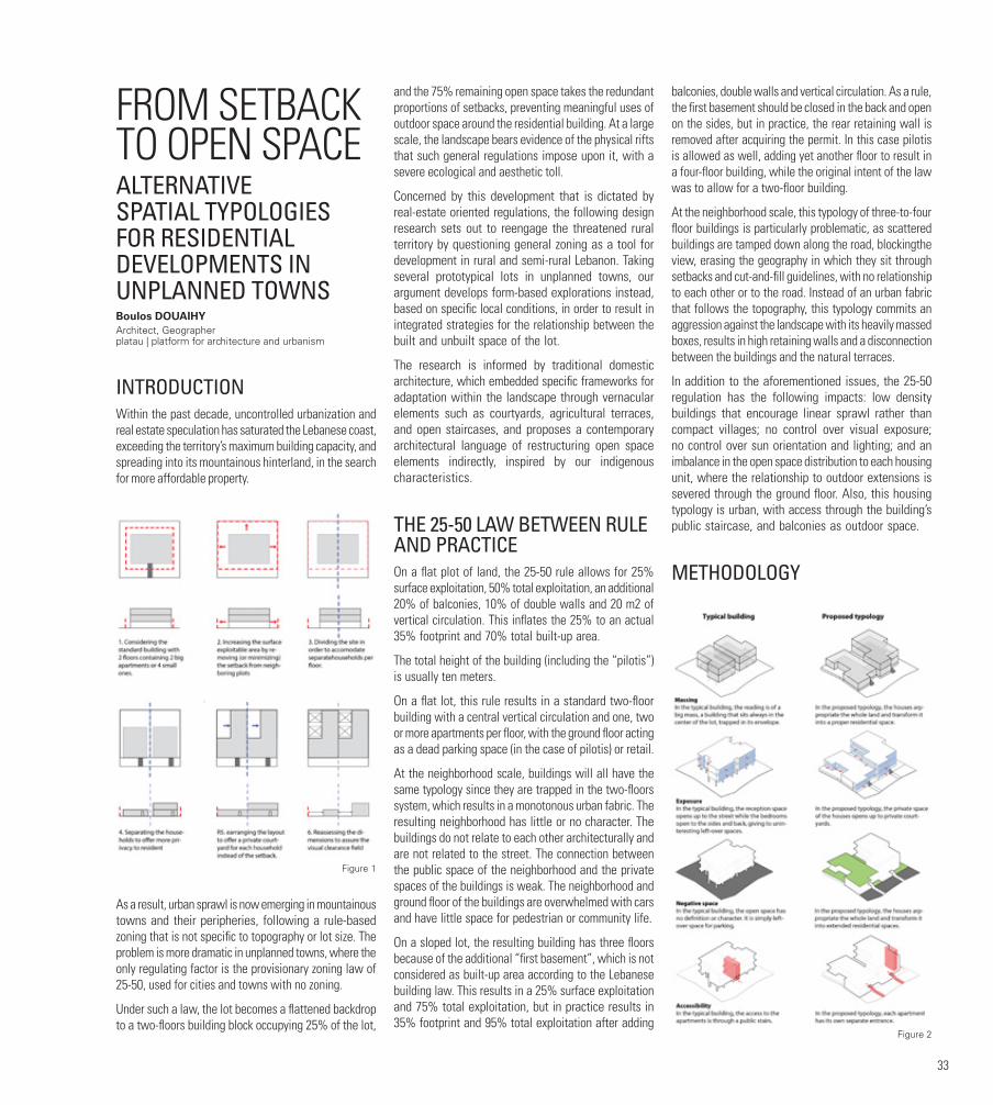
33
FROM SETBACK TO OPEN SPACEALTERNATIVE SPATIAL TYPOLOGIES FOR RESIDENTIAL DEVELOPMENTS IN UNPLANNED TOWNSBoulos DOUAIHYArchitect, Geographer platau | platform for architecture and urbanism
INTRODUCTIONWithin the past decade, uncontrolled urbanization and real estate speculation has saturated the Lebanese coast, exceeding the territory’s maximum building capacity, and spreading into its mountainous hinterland, in the search for more affordable property.
As a result, urban sprawl is now emerging in mountainous towns and their peripheries, following a rule-based zoning that is not specific to topography or lot size. The problem is more dramatic in unplanned towns, where the only regulating factor is the provisionary zoning law of 25-50, used for cities and towns with no zoning.
Under such a law, the lot becomes a flattened backdrop to a two-floors building block occupying 25% of the lot,
and the 75% remaining open space takes the redundant proportions of setbacks, preventing meaningful uses of outdoor space around the residential building. At a large scale, the landscape bears evidence of the physical rifts that such general regulations impose upon it, with a severe ecological and aesthetic toll.
Concerned by this development that is dictated by real-estate oriented regulations, the following design research sets out to reengage the threatened rural territory by questioning general zoning as a tool for development in rural and semi-rural Lebanon. Taking several prototypical lots in unplanned towns, our argument develops form-based explorations instead, based on specific local conditions, in order to result in integrated strategies for the relationship between the built and unbuilt space of the lot.
The research is informed by traditional domestic architecture, which embedded specific frameworks for adaptation within the landscape through vernacular elements such as courtyards, agricultural terraces, and open staircases, and proposes a contemporary architectural language of restructuring open space elements indirectly, inspired by our indigenous characteristics.
THE 25-50 LAW BETWEEN RULE AND PRACTICEOn a flat plot of land, the 25-50 rule allows for 25% surface exploitation, 50% total exploitation, an additional 20% of balconies, 10% of double walls and 20 m2 of vertical circulation. This inflates the 25% to an actual 35% footprint and 70% total built-up area.
The total height of the building (including the “pilotis”) is usually ten meters.
On a flat lot, this rule results in a standard two-floor building with a central vertical circulation and one, two or more apartments per floor, with the ground floor acting as a dead parking space (in the case of pilotis) or retail.
At the neighborhood scale, buildings will all have the same typology since they are trapped in the two-floors system, which results in a monotonous urban fabric. The resulting neighborhood has little or no character. The buildings do not relate to each other architecturally and are not related to the street. The connection between the public space of the neighborhood and the private spaces of the buildings is weak. The neighborhood and ground floor of the buildings are overwhelmed with cars and have little space for pedestrian or community life.
On a sloped lot, the resulting building has three floors because of the additional “first basement”, which is not considered as built-up area according to the Lebanese building law. This results in a 25% surface exploitation and 75% total exploitation, but in practice results in 35% footprint and 95% total exploitation after adding
balconies, double walls and vertical circulation. As a rule, the first basement should be closed in the back and open on the sides, but in practice, the rear retaining wall is removed after acquiring the permit. In this case pilotis is allowed as well, adding yet another floor to result in a four-floor building, while the original intent of the law was to allow for a two-floor building.
At the neighborhood scale, this typology of three-to-four floor buildings is particularly problematic, as scattered buildings are tamped down along the road, blockingthe view, erasing the geography in which they sit through setbacks and cut-and-fill guidelines, with no relationship to each other or to the road. Instead of an urban fabric that follows the topography, this typology commits an aggression against the landscape with its heavily massed boxes, results in high retaining walls and a disconnection between the buildings and the natural terraces.
In addition to the aforementioned issues, the 25-50 regulation has the following impacts: low density buildings that encourage linear sprawl rather than compact villages; no control over visual exposure; no control over sun orientation and lighting; and an imbalance in the open space distribution to each housing unit, where the relationship to outdoor extensions is severed through the ground floor. Also, this housing typology is urban, with access through the building’s public staircase, and balconies as outdoor space.
METHODOLOGY
Figure 1
Figure 2
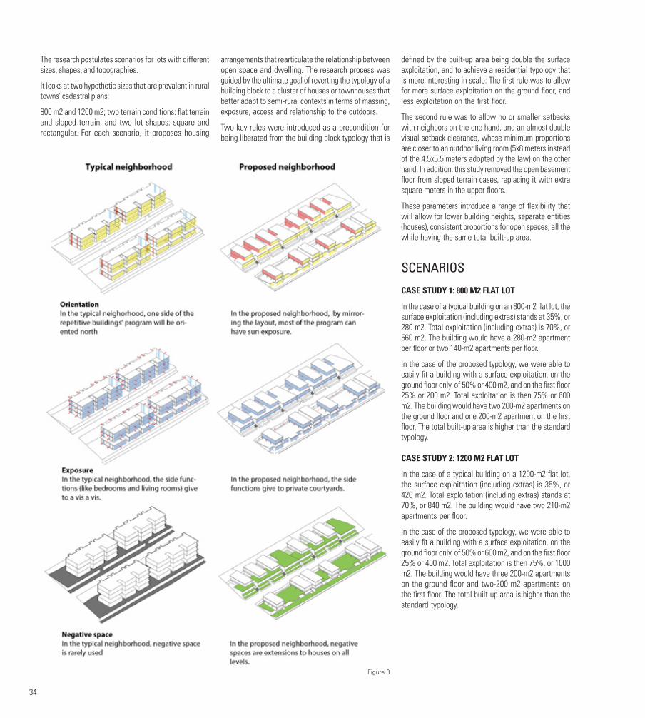
34
The research postulates scenarios for lots with different sizes, shapes, and topographies.
It looks at two hypothetic sizes that are prevalent in rural towns’ cadastral plans:
800 m2 and 1200 m2; two terrain conditions: flat terrain and sloped terrain; and two lot shapes: square and rectangular. For each scenario, it proposes housing
arrangements that rearticulate the relationship between open space and dwelling. The research process was guided by the ultimate goal of reverting the typology of a building block to a cluster of houses or townhouses that better adapt to semi-rural contexts in terms of massing, exposure, access and relationship to the outdoors.
Two key rules were introduced as a precondition for being liberated from the building block typology that is
defined by the built-up area being double the surface exploitation, and to achieve a residential typology that is more interesting in scale: The first rule was to allow for more surface exploitation on the ground floor, and less exploitation on the first floor.
The second rule was to allow no or smaller setbacks with neighbors on the one hand, and an almost double visual setback clearance, whose minimum proportions are closer to an outdoor living room (5x8 meters instead of the 4.5x5.5 meters adopted by the law) on the other hand. In addition, this study removed the open basement floor from sloped terrain cases, replacing it with extra square meters in the upper floors.
These parameters introduce a range of flexibility that will allow for lower building heights, separate entities (houses), consistent proportions for open spaces, all the while having the same total built-up area.
SCENARIOS
CASE STUDY 1: 800 M2 FLAT LOT
In the case of a typical building on an 800-m2 flat lot, the surface exploitation (including extras) stands at 35%, or 280 m2. Total exploitation (including extras) is 70%, or 560 m2. The building would have a 280-m2 apartment per floor or two 140-m2 apartments per floor.
In the case of the proposed typology, we were able to easily fit a building with a surface exploitation, on the ground floor only, of 50% or 400 m2, and on the first floor 25% or 200 m2. Total exploitation is then 75% or 600 m2. The building would have two 200-m2 apartments on the ground floor and one 200-m2 apartment on the first floor. The total built-up area is higher than the standard typology.
CASE STUDY 2: 1200 M2 FLAT LOT
In the case of a typical building on a 1200-m2 flat lot, the surface exploitation (including extras) is 35%, or 420 m2. Total exploitation (including extras) stands at 70%, or 840 m2. The building would have two 210-m2 apartments per floor.
In the case of the proposed typology, we were able to easily fit a building with a surface exploitation, on the ground floor only, of 50% or 600 m2, and on the first floor 25% or 400 m2. Total exploitation is then 75%, or 1000 m2. The building would have three 200-m2 apartments on the ground floor and two-200 m2 apartments on the first floor. The total built-up area is higher than the standard typology.
Figure 3
35
NEIGHBORHOOD ON A FLAT TERRAIN
Typical neighborhood
In the typical neighborhood, buildings are large in scale and are not connected to the road; monotony, repetition and detachment prevail. The exposure of the different elevations of this typology is confined to the centrality of the building and has always one side to the north (without sun). The different rooms open up to face each other or to the back. The negative spaces are all dedicated to parking or remain unused.
Proposed neighborhood
In the proposed neighborhood, there are houses, not buildings. Their scale is closer to the pedestrian. Flexibility and architectural variety as well as personalization are key. The exposure of the houses is more flexible. There is always a possibility to allow the sun to enter all rooms by rotating or mirroring the layouts. The open spaces on the ground as well as first floors can all be appropriated as livable space.
NEIGHBORHOOD ON A SLOPED TERRAIN
Typical neighborhood
In the typical neighborhood on sloped terrain, the buildings’ scale is even more exaggerated because of the additional first basement. The resulting negative spaces are deep terraces with high retaining walls. In the typical neighborhood, buildings have a large scale and are not connected to the road; monotony, repetition and detachment prevail. The exposure of the different elevations of this typology is confined to the centrality of the building and has always one side to the north (without sun). The different rooms open up to face each other or to the back. The negative spaces are all dedicated for parking or unused. In the orientation diagrams, the blue represents the openings that face northwards and therefore have no sun, while the red represents the ones that face southwards.
Proposed neighborhood
In the proposed neighborhood on sloped terrain, the scale of the buildings is reduced considerably by allowing the massing to follow the slope. The flexibility of the layout allows for better exposure towards the sun via courtyards. The negative space of the lot joins with the roof of the lower floors to become wide terraces for the upper floor.In the proposed neighborhood, there are houses, not buildings. Their scale is closer to the pedestrian. Flexibility and architectural variety, as well as personalization, are key. The exposure of the houses is more flexible. There is always a possibility to allow
the sun to enter all rooms by rotating or mirroring the layouts. The open spaces on the ground as well as first floors can all be appropriated as livable space.
CONCLUSIONThis design research was intended as an exploration that can form the basis for tangible revisions to code and regulation, and proved that a similar built-up area can be achieved with alternative forms that give shape and use to the unbuilt and open spaces of the lot, adapt to topography, and create new architectural inscriptions within the landscape.
With the ongoing defacing of the cultural landscapes and architectural character of the mountains, it is essential for architects to deploy design as a method for researching alternative ways of building in the rural territory, test the potentials and limitations of guidelines through design, and reintroduce zoning-specific regulations for mountain towns that guide development and protect culturally and ecologically sensitive resources.
FIGURESFigure 1. Rethinking typologies: From building to house, from apartment to residence. Source: Boulos Doueihy
Figure 2. Comparative analysis of a typical versus a proposed typology building on a flat lot. Source: Boulos DoueihyFigure 3. Comparative analysis of a typical versus a proposed neighborhood on a sloped terrain. Source: Boulos Doueihy
BIBLIOGRAPHYDarles, C. (1996). Types architecturaux et marché foncier dans le Metn durant les trente dernières années In Beyrouth, Grand Beyrouth [en ligne]. Beirut: Presses de l’Ifpo, 1996. Available at: http://books.openedition.org/ifpo/3250.DOI: 10.4000/books.ifpo.3250.
Ragette, F. (1974). Architecture in Lebanon: The Lebanese House during the 18th and 19th Centuries. Caravan Books.
Tabet, J. (s.a.). Arab architectural heritage between mirrors and idols. Available at: http://www.aljadid.com/content/arab-architectural-heritage-between-mirrors-and-idols#sthash.qAUzU1sN.dpuf (accessed 1 November 2017).
AUTHORBoulos DOUAIHY is an architect, urbanist, geographer and co-founder of platau | platform for architecture and urbanism. He holds a DES in architecture from the Lebanese University, 2004, and a Master in “Environnement et Aménagement du Territoire” from the Saint Joseph University, 2005. Boulos is interested in a multidisciplinary approach to architecture, involving domains that vary from geography and sociology to parametric design and art installations. Before founding platau, Boulos collaborated with leading architectural firms like DW5 / Bernard Khoury and Hashim Sarkis Studios, where he worked on several projects of various types and scales and was responsible for managing projects from design phases to execution. He is currently active in several local development NGOs and has lectured about his work in several conferences.
36
MUSHA‘ LANDS: “SAVING WHAT REMAINS”THE CASE OF TIBNEENReem FAYYAD
With the growing awareness of environmental challenges, scarcity and degradation of natural resources, and reconsidering of historic land classification, musha‘ is increasingly being considered in sustainable community-inclusive use of land resources. The Arabic literal definition of the term Musha‘ is “undivided common land”. However, the term Musha‘ is used to designate several forms of landholding in legal and popular parlance, making its use frequently controversial. Given that this popular term has never been adopted as a property category or form of ownership in the Lebanese official land registries, only limited documentation exists about its use and management (Clerc-Huybrechts, 2008). Some scholars associate the word Musha‘ with specific land tenure: “collective land acquisition” (Schaebler, 2000, p243), while others define it as a “system of communal land holding” (Said and Lim, 2006). Within a context where public spaces and agricultural areas are threatened by rapidly sprawling building activities, recovering Musha‘ may constitute an important step towards sustainable management and the conservation of cultural and natural heritage. Along these lines, this presentation will argue that researching the environmental, economic and socio-cultural significance of Musha‘ land contributes to the identification and revival of this forgotten asset, while exploring new ways of protecting Lebanese rural cultural landscapes.
Accepting that Musha’ lands are undervalued and mismanaged, the first step is to articulate new interpretations of these lands, ones that are community-inclusive and ecologically sound. The aim of this research is to:
•Emphasize the sociocultural dimension of Musha‘ lands and redefine the concept of Musha‘ in the twenty-first century as an essential asset of the Lebanese rural cultural landscapes;
•Ensure a rational sustainable use, management, and governance of Musha‘ in the rural zones of Lebanon through proposing regulatory guidelines at the national level, coupled with strategic short-term action plans at the local scale;
•Set a strategic institutional structure that manages issues related to landownership, governance and the use of Musha‘ lands by integrating local communities, non-governmental organizations, international organizations, municipalities as well a governmental authorities.
Having outlined the general scope of the research, this paper summarizes the historic evolution of the term Musha’, discusses the failure of the Lebanese public agencies in upholding a clear legal and planning framework to govern Musha‘ lands and elaborates the socioeconomic and political consequences. The study will also apply the principles of the ecological landscape approach to the case study of Tibneen, as a dynamic, participatory, and holistic framework that promotes land management, ecological integrity and sustainable development. As a bottom-up approach, the ecological landscape framework is inclusive of the local community, responsive to the specificity of the local context, while contributing to its economic and social betterment.
MUSHA‘ LANDS: EVOLUTION AND SIGNIFICANCE IN THE LEBANESE CONTEXTDrawing on an extensive investigation of Lebanese property records, Clerc-Huybrechts (2008) explains that in the Lebanese context, the term Musha’ was historically used in two principle ways, namely (i) the “village musha’” and (ii) the “matrouke murfeke”. The former term (village musha’) was associated with a special type of landholding, one where land was held in an undivided collective form, with rights translated into transferable shares. Typically, every three years, without any change in the right of ownership, land lots were combined and redistributed in a process of periodic rotation. In this form of rural communal ownership, families sharing a similar “commons” or “Musha‘” were allocated different parcels, with every rotation securing access and use of land proportionally to one’s shares. The term Musha‘ was also used to designate a specific category of lands named metrouke murfeke (Clerc-Huybrechts, 2008). These lands belonged to the state, where the right of use generally belonged to the inhabitants of the village in which they were located. The term metrouke murfeke officially appeared during the Ottoman cadastral reform in the code of 1858, to designate one of two land categories called metrouke, which means “left for the public use” (as battlefields, grazing lands or wood supply).
In Lebanon, the evolution of Musha’ lands was drastically affected by the modernization of land tenure systems during the Ottoman and French mandate periods. During the Arab conquest, the term Musha‘ signified a form of group landownership, especially in Palestine and “Belad el Sham”. At the time, Musha‘ lands were labeled “amiriyye” (also known as Mirri lands), referring to state-owned lands belonging to Ameer Al Muslimeen that were dedicated to the benefit of the Islamic community (likhidmat al omma al islamiyah) represented by the imperial treasury (Clerc-Huybrechts, 2008). During the Ottoman era, before the initiation of the 1858 land code, Musha‘ lands changed from a term representing land title into a system characterized by the periodic redistribution of plots among peasant cultivators (Al Salim,
2011). In 1858, when the Ottoman property code was enacted, landholders required ownership registration. This privatization process continued during the French mandate, where the remaining Musha‘ lands fell under the category of “metrouke murfeke” as the private domain of the state.
BUREAUCRATIC APPROACH AND NEO-LIBERAL APPROPRIATION OF MUSHA‘ LANDSMusha‘ lands fell between the cracks of the administrative bureaucratic legislative differences between various Lebanese authorities, who attempted to revitalize, sustainably manage and govern these lands as rural, cultural and natural heritage. In a collaboration between the Ministry of Agriculture and Ministry of Environment, efforts were deployed to revitalize these abandoned, undermined areas in sixty-six villages through a reforestation project that was part of a national initiative called “Mashrou‘ Al Akhdar”. In another attempt, Musha‘ lands were also part of the National Physical Master Plan of the Lebanese Territories (NPMLT) prepared by the Council for Development and Reconstruction (CDR) under the supervision of the Directorate General of Urban Planning (DGU). The final report of the NPMLT categorized Musha‘ lands under Protected Areas (PA)1, without recognizing them as a category of land with sociocultural, environmental and historical value in Lebanese rural landscapes. Despite their importance, both initiatives, Mashrou‘ Al Akhdar and the NPMPLT completely neglected the social dimension that was historically considered a key differentiating character, distinguishing Musha‘ lands from other land categories. Both projects dealt with Musha‘ lands from a narrow perspective, without emphasizing their potential as active communal spaces with environmental, ecological and sociocultural value. Hence, all attempts by Lebanese public agencies (e.g. the MoA, MoE, DGU, and CDR) have fallen short in attaining an ecologically sound and communally integrated vision for the a long-term sustainable development of Musha‘ lands.
The absence of a solid framework and clear urban planning strategy was further aggravated by political and economic pressure, resulting in the privatization of the public domain, degradation of natural resources and the unjust exclusion of the community from their rights to their land, catering to the privileged few. Considering the contested land registry status of communal lands, the inaccuracies and vagueness of property rights are leading to land exploitation. It also becomes “an added asset, a legal loophole, seized upon by neo-liberal politics to acquire prime landscapes for large scale developments” (Makhzoumi, 2011, p.230). Zinet Sanine is one of several projects that are economically and politically driven, stretching out to embrace the municipal

37
boundaries of four villages, namely Kaa El Rim, El Mtein, Slouki and Bednayel. Large portions of musha‘ lands were purchased and then merged, forming an area of 9,600 hectares, advertised to be 1% of Lebanon’s total area. Ruled by profit, this huge portion of the Lebanese mountain landscape was completely destroyed and replaced with a high-end touristic resort, with an extensive sports, recreation and business facilities.
Considering the environmental and ecological throwbacks, the Sanine Zineth project contributes to the destruction of ecological integrity and natural processes, fragmentation and the wasteful use of natural resources, as well as the interruption of visual, physical and ecological corridors. Sannine is the second largest aquifer in Lebanon and lies on the path of migratory birds. Hence, the project will “invariably disrupt recharge of Sannine aquifer” (Makhzoumi, 2011, p.236) and threatens wildlife habitat beyond the existing local flora and fauna. The expected high financial return of the project renders the abuse of nature totally legitimate. While it dismisses the ecological significance, the local economic benefit of this large-scale development is questionable as well. The fact is that the developing company is non-Lebanese, hence the capital investment and financing do not necessarily cater to the development of local communities and the economy.
As the state refrains from fulfilling its role as a protector of social rights, the Lebanese environmental assets and landscape sceneries are slowly being converted into marketable goods, catering to the economic interests of the fortunate elite. Moreover, the failure of the state to uphold legal articles/decrees, in addition to the continuous deterioration of the rural economies, forced marginal communities to relinquish their rights to communal lands and natural resources that are integral to the Lebanese national identity and collective heritage.
ECOLOGICAL LANDSCAPE APPROACH- THE CASE OF TIBNEEN Accepting the sociocultural and ecological significance of Musha‘ land and considering the current political and economic pressures, it is essential to adopt an integrative and holistic planning approach to revive and re-conceptualize communal lands within an ecologically sustainable development framework. It is argued that by adopting the ecological landscape approach, landscape becomes a medium for interpreting natural heritage, unfolding cultural values and understanding ecological processes. The ecological landscape framework maintains its solid foundation through the understanding of existing conditions and processes, minimizing environmental degradation, stressing on ecological integrity and guiding urban development by responding to environmental pressures and urban needs. Hence, this expansive framework offers several advantages
when applied to rural cultural landscapes. First, the approach and method are integrative of the totality of rural landscapes, being at once natural and cultural. Second, being a bottom-up approach, landscape design is responsive to place and inclusive of local community needs, aiming for economic and social betterment.
To test this assumption, the ecological landscape approach will be applied to the case study of Tibneen, a village located in South Lebanon, which retains at its outskirts two prominent natural components forming a greenbelt confining the existing urban fabric of the village. Through Tibneen the research will investigate the commons away from its legal status as a registered land category with associated property rights. Alternatively, it will tackle the concept of musha based on the sociocultural dimension grounded by the communal sense of belonging, collective understanding of the place and the shared responsibility to sustainably maintain, preserve and manage the landscape and its resources for the sake of the common good, ensuring the ecological integrity of the town. Hence, the research will focus on the one hand, on the village’s forest being one of the remaining few and largest musha lands in the region, legally registered as Matrouke Murtfakah. The forest was subject to several transformations where a UNIFIL camp was established during the late 1990s at the upper entrance of the forest, characterized by harsh security perimeters of high concrete walls strung with spools of wire enclosing all sides of the camp, tall gates and guards, in addition to a sports and recreational complex occupying 3.66% of the forest. On the other hand, the study will include the agricultural fields that were historically the agricultural commons of the village and were afterwards converted into privately owned lands maintaining agriculture as the land use. Today the fertile agricultural valley, which occupying 66% of Tibneen total area, is valued as scenic landscape, as a shared public green space providing recreational opportunities and promoting social networking as well as a place that revives memories and anchors the sense of belonging. Despite the fact that the agricultural fields are privately owned plots, it is publicly perceived by the local community with an evident and strong sense of communality transcending individual property rights.
Despite the centrality of the agricultural fields to the livelihood of more than 60% of the local permanent inhabitants, the approved master plan classified most of the agricultural fields as mixed use reducing their spread from 66% of Tibneen total area to 8% only. Unfortunately the land use planning scenario in the case of Tibneen is typical to other villages in Lebanon where “predefined understanding of the landscape as propertied shapes the outcome of the planning process to serve propertied interests.”(M. Fawaz, 2016) hence, “the (private) interests of property owners take precedence over the (shared) interest of town-dwellers to protect cultural landmarks and “agricultural commons.” (M. Fawaz, 2016). The proposed master plan was designed
to support the propertied interests of those who value their lands as a real estate asset aiming at increasing their market value with a higher building coefficient.
It is on his last point that the study will place the most emphasis, where the ecological landscape approach will be adopted in an attempt to overcome the fragmented compartmentalized approach of the traditional planning process. It is believed that the expansive, responsive and dynamic framework of the ecological landscape approach will contribute to a sound planning strategy that maintains the landscape integrity, being both ecological and cultural, promotes sustainable development and reinforces the natural and cultural spirit of the place. The revival of Musha‘ will allow for re-conceptualizing the relationship between villagers and their natural landscapes, and perhaps formulate an innovative way that strengthens shared forms of ownership that can protect the natural environment. It hence contributes to restoring and preserving the sociocultural values and practices related to Lebanese cultural landscapes.

38
FOOTNOTES1. “A protected area is a clearly defined geographical space, recognized, dedicated and managed, through legal or other effective means, to achieve the long term conservation of nature with associated ecosystem services and cultural values” (IUCN Definition 2008).
BIBLIOGRAPHYMakhzoumi, J. (2011). Colonizing mountain, paving sea: Neoliberal politics and the right to landscape in Lebanon. In Egoz, S., Makhzoumi, J. and Pungetti, G. (Eds.) The Right to Landscape: Contesting Landscape and Human Rights, pp. 227-242. Ashgate: London.
Fawaz, M. (2016). Planning and the making of a propertied landscape. Planning Theory & Practice, 18(3), 365-384.
Shayya, F. (2007). Ecological landscape design as an alternative urban design approach on the Lebanese mountain settlements: Case study of Sawfar. MA Thesis, American University of Beirut, Lebanon.
NPMPLT (National Physical Master Plan of the Lebanese Territories) (2005). Final report. Beirut: Council of Development and Reconstruction.
Makhzoumi, J., Talhouk, S., Zurayk, R., and Sadek, R. (2012). Landscape approach to bio-cultural diversity conservation in rural Lebanon. In Tiefenbacher, J. (Ed.) Perspectives on Nature Conservation - Patterns, Pressures and Prospects, (pp. 179-198). INTECH.
Al Salim, F. (2011.). Landed property and elite conflict in Ottoman Tulkarm. Jerusalem Quarterly 47: p.65-80, www.palestine-studies.org/sites/default/files/jq-articles/47-_Landed_Proerty_2.pdf.
Clerc-Huybrechts, V. (2008). Les Quartiers Irréguliers de Beyrouth. Beirut: Institut Français du Proche-Orient.
Makhzoumi, J., and Pungetti, G. (1999). Ecological Landscape Design and Planning The Mediterranean Context. New York: Routledge.
Owen, R. (2000). Introduction. In. Owen, R. (Ed.) New Perspectives on Property and Land in the Middle East. Cambridge, MA: Harvard University Press.
Sait, S., and Lim, H. (2006). Land, Law and Islam: Property and Human Rights in the Muslim World. London and New York: Zed Books.
Schaebler, B. (2000) ‘Practicing Musha: Common Lands and the Common Good in Southern Syria under the Ottomans and the French’ R. Owen (ed) New Perspectives on Property and Land in the Middle East (Cambridge, Mass: Harvard University Press)
AUTHORReem FAYYAD graduated in 2010 from the American University of Beirut (AUB) with a BS in Landscape Design and Eco-system Management and a Diploma in Agricultural Engineering. After receiving her undergraduate degree, she was enrolled in the Master’s program of Urban Design at AUB. During her educational years, Reem participated in several urban design workshops and conferences, including “The Urban Design Workshop in Historic Context, the Northwestern Edge of Historic Cairo,” Cairo (BTU Cottbus University in coordination with Cairo University), “Occupation City,” the case of Porto Fluviale, an informal settlement in Rome, Italy (“the Bartlett Department of Planning Unit, London), and the AA international workshop “Exploring Several Urbanization Aspects on Coastlines,” in addition to a series of “City Debates” conferences at the American University of Beirut.

39
PROSTHETIC ECOLOGIES ALTERNATIVE STRATEGIES FOR THE LEBANESE COASTAL RIVERS’ SYSTEMSandra FREMArchitect, Urbanist platau | platform for architecture and urbanism
INTRODUCTIONThis paper focuses on the Lebanese coastal river system as a strategic place that remains. Comprising a total of seventeen rivers, this system is currently undergoing major urban stresses and physical amputations, such as the tightening of floodplains, the discontinuation of hydrological systems, and a loss of river space to urban development; a predicament worsened by an unraveling water crisis and an outdated approach to water infrastructure (Figure 1).
The paper opposes the ongoing approaches to waterworks on coastal rivers, which are resulting in massive infrastructure such as concrete channels in lower basins and dams in upper basins. Not only does such infrastructure erase the local ecologies and cultural landscapes which they inscribe, but their mono-functional design does not adapt them to shifting hydrological, social and climatic conditions. Furthermore, their centralized modes of governance are leading to their technical failure, including high implementation costs, high risks in case of failure and no possibility for water reclamation. Considering the abovementioned challenges, and recognizing water and open space as increasingly valuable resources for the future, the paper proposes a “prosthetic” approach that rethinks the rivers’ role as an answer to some of the coast’s intricate challenges, combining water harvesting and water reclamation with opportunities for public space and new ecologies, all embedded in an open space landscape framework (Figure 1).
Borrowing from the medical behavior of prosthetics, artificial limbs that replace missing body parts in order to yield resilience, the approach proposes the deployment of multi-functional water structures along the coastal rivers that remedy the different types of stresses, in addition to harvesting and reclaiming rainwater and wastewater independently. As they are situated in the upper and lower basin of the coastal rivers, the different structures are more easily upgraded and controlled at the municipal level, allowing local water reclamation and reuse for the respective towns, and creating
closed water loops that meet future water demand. Coming in different soft typologies, the proposed water structures act as prosthetics that adapt to site-specific conditions, providing local scales of public realm, communal experiences and water reclamation that large infrastructures lack. Through the collaborative efforts of the small-scale structures, the overall network will yield ecological resilience and integrated water management to each watershed system.
The paper takes the Beirut River lower basin, the Beirut River upper valley and the Bisri River Dam as test sites for the abovementioned approach, demonstrating how a catalogue of small-scale prosthetic structures can be integrated into different scenarios as alternatives to concrete canals, dams, and as water-harvesting grounds that preserve the spaces that remain.
FROM LIFELINES TO BORDERLANDS TO PLACES THAT REMAINSituated between the Mediterranean Sea and Mount Lebanon, the coastal rivers’ system organizes the linear territory in successive adjacent watersheds, with the rivers acting as hydrological lifelines that drain Mount Lebanon of snow each year and recharge the aquifers. Since the fifteenth century, such rivers came to play an important socioeconomic role, as watermills that allowed the processing of grains into flour became hubs for commercial and social encounters.
This socio-ecological metabolism changed drastically in the mid-twentieth century, when fast-paced urban development overlaid the system’s lower basins, casting major stress on the rivers as they became the physical
Figure 1
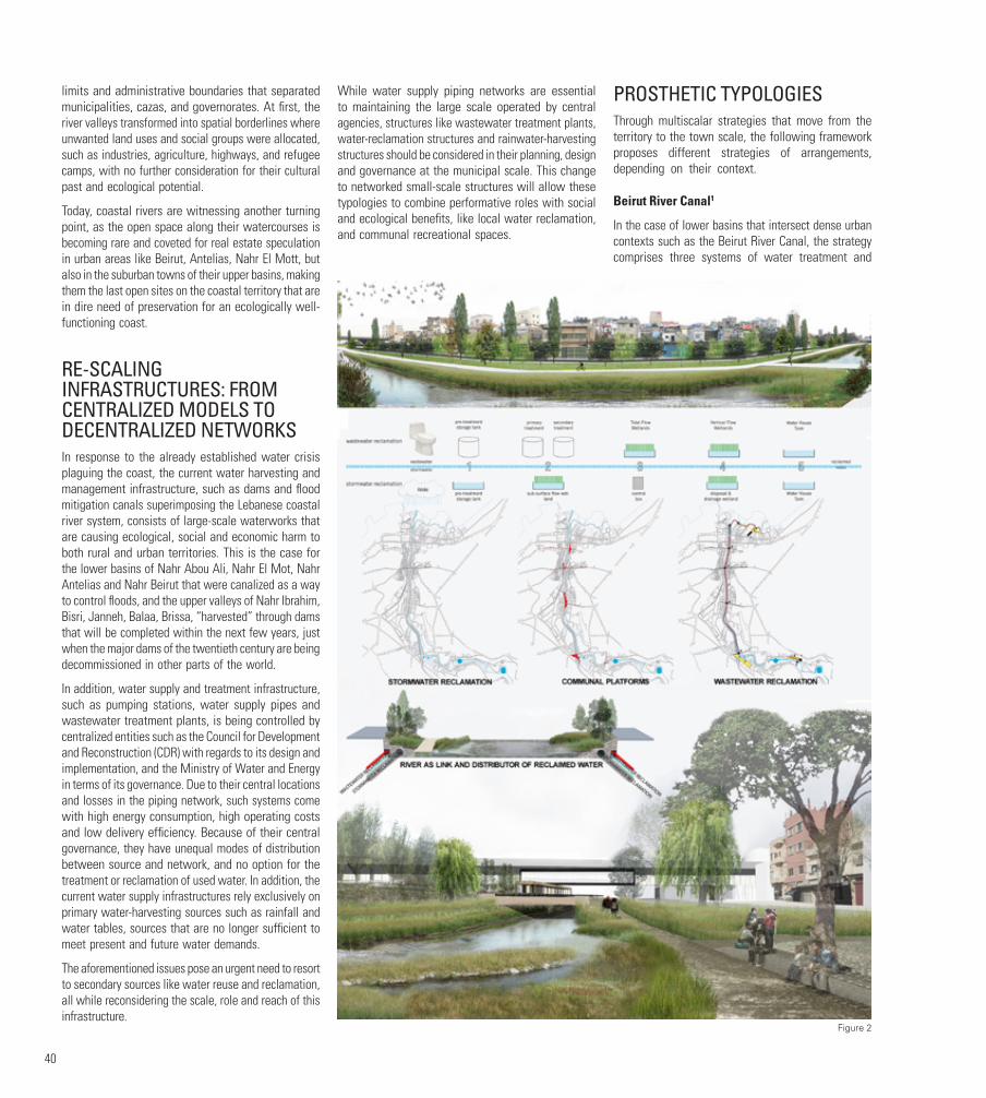
40
limits and administrative boundaries that separated municipalities, cazas, and governorates. At first, the river valleys transformed into spatial borderlines where unwanted land uses and social groups were allocated, such as industries, agriculture, highways, and refugee camps, with no further consideration for their cultural past and ecological potential.
Today, coastal rivers are witnessing another turning point, as the open space along their watercourses is becoming rare and coveted for real estate speculation in urban areas like Beirut, Antelias, Nahr El Mott, but also in the suburban towns of their upper basins, making them the last open sites on the coastal territory that are in dire need of preservation for an ecologically well-functioning coast.
RE-SCALING INFRASTRUCTURES: FROM CENTRALIZED MODELS TO DECENTRALIZED NETWORKS In response to the already established water crisis plaguing the coast, the current water harvesting and management infrastructure, such as dams and flood mitigation canals superimposing the Lebanese coastal river system, consists of large-scale waterworks that are causing ecological, social and economic harm to both rural and urban territories. This is the case for the lower basins of Nahr Abou Ali, Nahr El Mot, Nahr Antelias and Nahr Beirut that were canalized as a way to control floods, and the upper valleys of Nahr Ibrahim, Bisri, Janneh, Balaa, Brissa, “harvested” through dams that will be completed within the next few years, just when the major dams of the twentieth century are being decommissioned in other parts of the world.
In addition, water supply and treatment infrastructure, such as pumping stations, water supply pipes and wastewater treatment plants, is being controlled by centralized entities such as the Council for Development and Reconstruction (CDR) with regards to its design and implementation, and the Ministry of Water and Energy in terms of its governance. Due to their central locations and losses in the piping network, such systems come with high energy consumption, high operating costs and low delivery efficiency. Because of their central governance, they have unequal modes of distribution between source and network, and no option for the treatment or reclamation of used water. In addition, the current water supply infrastructures rely exclusively on primary water-harvesting sources such as rainfall and water tables, sources that are no longer sufficient to meet present and future water demands.
The aforementioned issues pose an urgent need to resort to secondary sources like water reuse and reclamation, all while reconsidering the scale, role and reach of this infrastructure.
While water supply piping networks are essential to maintaining the large scale operated by central agencies, structures like wastewater treatment plants, water-reclamation structures and rainwater-harvesting structures should be considered in their planning, design and governance at the municipal scale. This change to networked small-scale structures will allow these typologies to combine performative roles with social and ecological benefits, like local water reclamation, and communal recreational spaces.
PROSTHETIC TYPOLOGIESThrough multiscalar strategies that move from the territory to the town scale, the following framework proposes different strategies of arrangements, depending on their context.
Beirut River Canal1
In the case of lower basins that intersect dense urban contexts such as the Beirut River Canal, the strategy comprises three systems of water treatment and
Figure 2
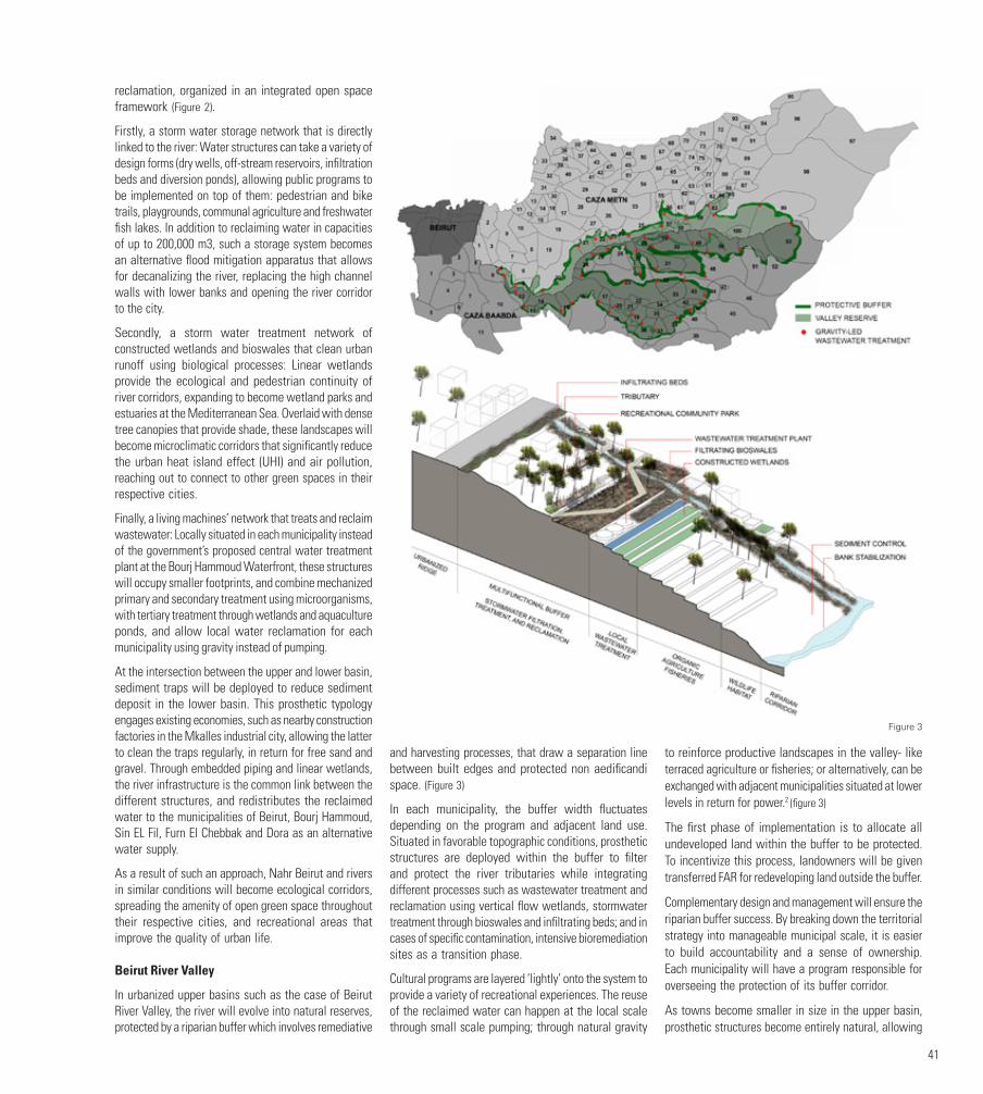
41
reclamation, organized in an integrated open space framework (Figure 2).
Firstly, a storm water storage network that is directly linked to the river: Water structures can take a variety of design forms (dry wells, off-stream reservoirs, infiltration beds and diversion ponds), allowing public programs to be implemented on top of them: pedestrian and bike trails, playgrounds, communal agriculture and freshwater fish lakes. In addition to reclaiming water in capacities of up to 200,000 m3, such a storage system becomes an alternative flood mitigation apparatus that allows for decanalizing the river, replacing the high channel walls with lower banks and opening the river corridor to the city.
Secondly, a storm water treatment network of constructed wetlands and bioswales that clean urban runoff using biological processes: Linear wetlands provide the ecological and pedestrian continuity of river corridors, expanding to become wetland parks and estuaries at the Mediterranean Sea. Overlaid with dense tree canopies that provide shade, these landscapes will become microclimatic corridors that significantly reduce the urban heat island effect (UHI) and air pollution, reaching out to connect to other green spaces in their respective cities.
Finally, a living machines’ network that treats and reclaim wastewater: Locally situated in each municipality instead of the government’s proposed central water treatment plant at the Bourj Hammoud Waterfront, these structures will occupy smaller footprints, and combine mechanized primary and secondary treatment using microorganisms, with tertiary treatment through wetlands and aquaculture ponds, and allow local water reclamation for each municipality using gravity instead of pumping.
At the intersection between the upper and lower basin, sediment traps will be deployed to reduce sediment deposit in the lower basin. This prosthetic typology engages existing economies, such as nearby construction factories in the Mkalles industrial city, allowing the latter to clean the traps regularly, in return for free sand and gravel. Through embedded piping and linear wetlands, the river infrastructure is the common link between the different structures, and redistributes the reclaimed water to the municipalities of Beirut, Bourj Hammoud, Sin EL Fil, Furn El Chebbak and Dora as an alternative water supply.
As a result of such an approach, Nahr Beirut and rivers in similar conditions will become ecological corridors, spreading the amenity of open green space throughout their respective cities, and recreational areas that improve the quality of urban life.
Beirut River Valley
In urbanized upper basins such as the case of Beirut River Valley, the river will evolve into natural reserves, protected by a riparian buffer which involves remediative
and harvesting processes, that draw a separation line between built edges and protected non aedificandi space. (Figure 3)
In each municipality, the buffer width fluctuates depending on the program and adjacent land use. Situated in favorable topographic conditions, prosthetic structures are deployed within the buffer to filter and protect the river tributaries while integrating different processes such as wastewater treatment and reclamation using vertical flow wetlands, stormwater treatment through bioswales and infiltrating beds; and in cases of specific contamination, intensive bioremediation sites as a transition phase.
Cultural programs are layered ‘lightly’ onto the system to provide a variety of recreational experiences. The reuse of the reclaimed water can happen at the local scale through small scale pumping; through natural gravity
to reinforce productive landscapes in the valley- like terraced agriculture or fisheries; or alternatively, can be exchanged with adjacent municipalities situated at lower levels in return for power.2 (figure 3)
The first phase of implementation is to allocate all undeveloped land within the buffer to be protected. To incentivize this process, landowners will be given transferred FAR for redeveloping land outside the buffer.
Complementary design and management will ensure the riparian buffer success. By breaking down the territorial strategy into manageable municipal scale, it is easier to build accountability and a sense of ownership. Each municipality will have a program responsible for overseeing the protection of its buffer corridor.
As towns become smaller in size in the upper basin, prosthetic structures become entirely natural, allowing
Figure 3
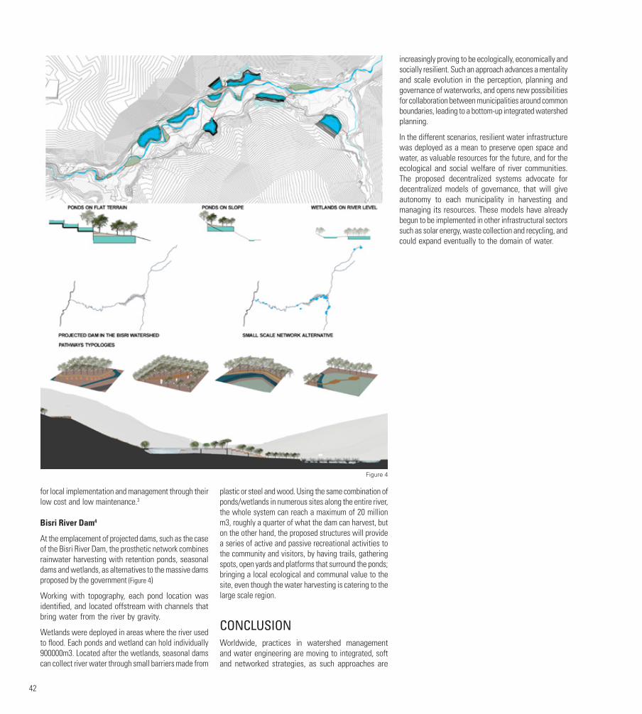
42
for local implementation and management through their low cost and low maintenance.3
Bisri River Dam4
At the emplacement of projected dams, such as the case of the Bisri River Dam, the prosthetic network combines rainwater harvesting with retention ponds, seasonal dams and wetlands, as alternatives to the massive dams proposed by the government (Figure 4)
Working with topography, each pond location was identified, and located offstream with channels that bring water from the river by gravity.
Wetlands were deployed in areas where the river used to flood. Each ponds and wetland can hold individually 900000m3. Located after the wetlands, seasonal dams can collect river water through small barriers made from
plastic or steel and wood. Using the same combination of ponds/wetlands in numerous sites along the entire river, the whole system can reach a maximum of 20 million m3, roughly a quarter of what the dam can harvest, but on the other hand, the proposed structures will provide a series of active and passive recreational activities to the community and visitors, by having trails, gathering spots, open yards and platforms that surround the ponds; bringing a local ecological and communal value to the site, even though the water harvesting is catering to the large scale region.
CONCLUSIONWorldwide, practices in watershed management and water engineering are moving to integrated, soft and networked strategies, as such approaches are
increasingly proving to be ecologically, economically and socially resilient. Such an approach advances a mentality and scale evolution in the perception, planning and governance of waterworks, and opens new possibilities for collaboration between municipalities around common boundaries, leading to a bottom-up integrated watershed planning.
In the different scenarios, resilient water infrastructure was deployed as a mean to preserve open space and water, as valuable resources for the future, and for the ecological and social welfare of river communities. The proposed decentralized systems advocate for decentralized models of governance, that will give autonomy to each municipality in harvesting and managing its resources. These models have already begun to be implemented in other infrastructural sectors such as solar energy, waste collection and recycling, and could expand eventually to the domain of water.
Figure 4
43
FOOTNOTES1. Case study developed by the author as a graduate thesis in architecture and urbanism at the Massachusetts Institute of Technology. See Frem, S. 2009. Nahr Beirut: Projections on an Infrastructural Landscape. MS Thesis, Massachusetts Institute of Technology, Department of Architecture.
2. A suggestion made by Mr. Rached Sarkis in reference to the Remhalla water treatment and reclamation project.
3. That is the case of Remhalla Municipality’s wastewater treatment, a pilot project of water treatment and reclamation completed in 2012, consisting of constructed wetlands on a municipal land to treat the town’s wastewater, and resulting with a municipal tree nursery, that is irrigated from the reclaimed wastewater.
4. Case study by Rani Chamseddine (2017), developed during the final year project course at the American University of Beirut, Landscape Department, advised by Sandra Frem, Nayla.Al Akl, and Beata Dreksler. R.Chamseddine.
LIST OF FIGURESFigure 1. Above, the Lebanese Coastal River system showing administrative boundaries (red) and rivers ( white). Middle, a catalogue of prosthetic structures. Below, networks of water structures collecting storm water, treating wastewater, and distributing reclaimed water. Author: Sandra Frem.
Figure 2. Above, photomontage of the new canal along the Beirut River after the deployment of a supportive storm water mitigation system. Middle, mechanisms of storm water and wastewater treatment and reclamation in the dense urban contexts of the lower basins. Below, a typical plan and section showing non-prescriptive deployment of prosthetic structures along coastal rivers. Author: Sandra Frem
Figure 3 and 4. Above, alternative water-harvesting system for the Bisri River Dam. Middle: the Bisri River with dam, and with proposed alternative water system. Below: typologies of trails that overlay the water system. Author: Rani Chamseddine
REFERENCESChamseddine, R. (2017). An alternative landscape vision for Bisri: Rethinking the dam. Final Year Project, American University of Beirut, Lebanon.
Fawaz, M. and Zein, P. (1965). L’aménagement du Nahr Beyrouth. Horizons Techniques du Moyen Orient 5: 24–36.
Frem, S. (2009). Nahr Beirut: Projections on an infrastructural landscape. MS Thesis, Massachusetts Institute of Technology, United States.
https://water.fanack.com/ar/lebanon/water-infrastructure/ (accessed 1 November 2017).
http://www.cdr.gov.lb/eng/progress_reports/pr102013/Ewaste.pdf (accessed 1 November 2017).
http://www.apipnm.org/swlwpnr/reports/y_nr/z_lb/lbmp311.htm (accessed 1 November 2017).
Ministry of Environment/LEDO (2001). Waste water management. Lebanon state of the environment report. Available at: http://www.unep.org/dewa/westasia/Assessments/national_SOEs/west%20asia/ Lebanon/Chap15WastewaterManagement.pdf.
Yamout, G. and El-Fadel, M. (2005). An optimization approach for multi-sectoral water supply management in the Greater Beirut Area. Water Resources Management 19(6): 791–812.
AUTHORSandra FREM is an urbanist, architect, educator, and co-founder of platau | platform for architecture and urbanism. Her design research investigates resilient cities and systems, infrastructural landscapes, and the relationship between cities and water, more particularly in the Mediterranean context. In her practice, Sandra is interested in exploring new expressions of architecture and landscape, as well as leading urban initiatives, in collaboration with municipalities and NGOs, that propose meaningful transformations for streets, public spaces and territories. Since 2016, she holds an academic appointment at the American University of Beirut, where she teaches final-year projects in Landscape Design and Ecosystems Management.
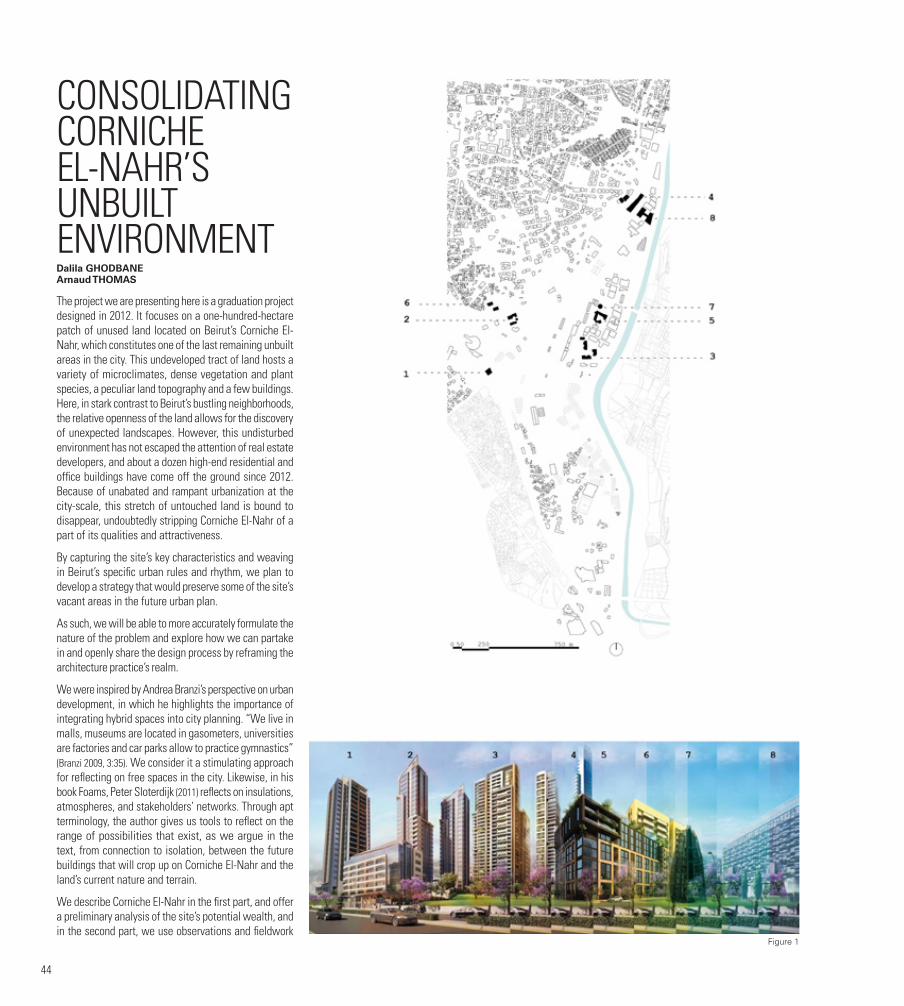
44
CONSOLIDATING CORNICHE EL-NAHR’S UNBUILT ENVIRONMENTDalila GHODBANE Arnaud THOMAS
The project we are presenting here is a graduation project designed in 2012. It focuses on a one-hundred-hectare patch of unused land located on Beirut’s Corniche El-Nahr, which constitutes one of the last remaining unbuilt areas in the city. This undeveloped tract of land hosts a variety of microclimates, dense vegetation and plant species, a peculiar land topography and a few buildings. Here, in stark contrast to Beirut’s bustling neighborhoods, the relative openness of the land allows for the discovery of unexpected landscapes. However, this undisturbed environment has not escaped the attention of real estate developers, and about a dozen high-end residential and office buildings have come off the ground since 2012. Because of unabated and rampant urbanization at the city-scale, this stretch of untouched land is bound to disappear, undoubtedly stripping Corniche El-Nahr of a part of its qualities and attractiveness.
By capturing the site’s key characteristics and weaving in Beirut’s specific urban rules and rhythm, we plan to develop a strategy that would preserve some of the site’s vacant areas in the future urban plan.
As such, we will be able to more accurately formulate the nature of the problem and explore how we can partake in and openly share the design process by reframing the architecture practice’s realm.
We were inspired by Andrea Branzi’s perspective on urban development, in which he highlights the importance of integrating hybrid spaces into city planning. “We live in malls, museums are located in gasometers, universities are factories and car parks allow to practice gymnastics” (Branzi 2009, 3:35). We consider it a stimulating approach for reflecting on free spaces in the city. Likewise, in his book Foams, Peter Sloterdijk (2011) reflects on insulations, atmospheres, and stakeholders’ networks. Through apt terminology, the author gives us tools to reflect on the range of possibilities that exist, as we argue in the text, from connection to isolation, between the future buildings that will crop up on Corniche El-Nahr and the land’s current nature and terrain.
We describe Corniche El-Nahr in the first part, and offer a preliminary analysis of the site’s potential wealth, and in the second part, we use observations and fieldwork
Figure 1
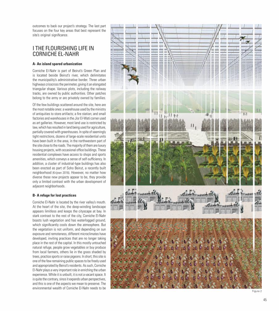
45
outcomes to back our project’s strategy. The last part focuses on the four key areas that best represent the site’s original significance.
I THE FLOURISHING LIFE IN CORNICHE EL-NAHR
A- An island spared urbanization
Corniche El-Nahr is part of Beirut’s Green Plan and is located beside Beirut’s river, which delimitates the municipality’s administrative border. Three urban highways crisscross the perimeter, giving it an elongated triangular shape. Various plots, including the railway tracks, are owned by public authorities. Other patches belong to the army or are privately owned by families.
Of the few buildings scattered around the site, here are the most notable ones: a warehouse used by the ministry of antiquities to store artifacts; a fire station; and small factories and warehouses in the Jisr El-Wati corner used as art galleries. However, most land use is restricted by law, which has resulted in land being used for agriculture, partially covered with greenhouses. In spite of seemingly tight restrictions, dozens of large-scale residential units have been built in the area, in the northwestern part of the site close to the roads. The majority of them are luxury housing projects, with occasional office buildings. These residential complexes have access to shops and sports amenities, which conveys a sense of self-sufficiency. In addition, a cluster of industrial-type buildings has also been erected as part of Soho Beirut, a recently built neighborhood (Krijnen 2016). However, no matter how diverse these new projects appear to be, they provide only a limited contrast with the urban development of adjacent neighborhoods.
B- A refuge for lost practices
Corniche El-Nahr is located by the river valley’s mouth. At the heart of the site, the deep-winding landscape appears limitless and keeps the cityscape at bay. In stark contrast to the rest of the city, Corniche El-Nahr boasts lush vegetation and has waterlogged ground, which significantly cools down the atmosphere. But the vegetation is not uniform, and depending on sun exposure and remoteness, different microclimates have developed, inviting practices that are no longer taking place in the rest of the capital. In this mostly untouched natural refuge, people grow vegetables or buy produce from local farmers, others lie in the grass shaded by trees, practice sports or raise pigeons. In short, this site is one of the few remaining public spaces to be freely used and appropriated by Beirut’s residents. As such, Corniche El-Nahr plays a very important role in enriching the urban experience. While it is unbuilt, it is not a vacant space. It is quite the contrary, since it expands urban perspectives, and this is one of the aspects we mean to preserve. The environmental wealth of Corniche El-Nahr needs to be
Figure 2

46
protected and enhanced to maintain its metropolitan importance and relevance well into the future.
II ENCLOSE TO DISCLOSE: A PRE-EXISTING LOGIC AS PROJECT STRATEGY
A- Pockets of nature amidst developers’ fortresses
Given its specific natural attributes, Corniche El-Nahr is akin to an island adrift in Beirut’s concrete ocean, irresistibly seeping into any vacant spot.
That is what will most probably happen in Corniche El-Nahr. Plot after plot, the area will be built up with autonomous edifices. This model is similar to the concept of ‘absolute island’ described by Sloterdijk in Foams, as it seeks to be an environment in an object and not an object in an environment. Our project offers a relevant alternative to the actual urban production on that site, trying to seize its mechanisms in order to complement and enrich the city it produces. We do not pretend to control real estate pressure, but rather to channel the expansion of buildings by imposing physical limits on the project’s territory, like dikes, within which projects corresponding to the needs of the whole city will be developed. These pockets of nature would ensure the sustainability of Corniche El-Nahr’s existing human practices, bound to disappear if future urban development is left to real estate developers alone.
We have selected four sites for this project that account for Corniche El-Nahr’s appeal: a cluster of greenhouses, La Sagesse University, the Armenian cemetery and the old train tracks. Each of these locations will pursue the legacy of Corniche El-Nahr into the future.
B- “Disruption of programmed functions”
Apart from Corniche El-Nahr, satellites pictures reveal the existence of only three other significant pockets of greenery in the entire city: the American University, the hippodrome and the park of Horsh Beirut. These spaces fulfill clearly defined functions and their limits are clearly delineated by walls.
Similarly, our project will enclose these hotspots and designate their specific functions to ensure their preservation. While the land within the dikes has initial functions, these can be diverted into other uses. For example, parking lots are often prime locations for circus tents, flea-markets of romantic rendezvous. In Corniche El-Nahr, the future university campus, the greenhouse, the car park and the waste pond could be used for other practices, following Branzi’s ‘disruption of programmed functions’ idea.
Ensuring that spaces invite multiple uses is a prerequisite for their appropriation. It is an open invitation to take part in the city’s making, and share rights and
responsibilities in its transformation. With this project, we are not planning to oppose the transformation of the space by private developers. Rather, our intention is to influence the process and contribute to consolidating these atmospheric islands, since we are convinced of their crucial role in shattering the city’s homogeneity by offering reservoirs of fertile disruption.
III SAFEGUARDING CORNICHE EL-NAHR THROUGH ITS ISLANDS
A- A greenhouse, a pool, a car park and a campus
The planned greenhouse, car park, university campus and waste stabilization pond will perform their original functions as key infrastructure for the residents, but could also host a variety of other uses. The greenhouse meant for urban agriculture could become a space where vegetables and seeds are traded or could be involved in research programs carried out by the nearby university. The old train tracks’ shape could support the development of a state-of-the-art landscaped wastewater treatment plant. The water reflections from the plant would add to the surrounding natural beauty of the hill of Ashrafieh and of the harbor. In the east, the cemetery is adorned by a tall pine tree canopy that would be extended for the planned car park that would serve the entire area. As unbuilt space par excellence, this shaded car park would be hospitable to a large variety of uses. Lastly, the La Sagesse university, which currently has a single building, would expand into a vast cloister enclosing a portion of Corniche El-Nahr’s territory, and become one of the country’s most important campuses.
B- Unbuilt spaces as necessary infrastructure to the city
The feasibility of this project relies on consensus, and as such has to fulfill the demands and expectations of the project’s multiple stakeholders: the financiers, users, public authorities, and managers, with overlapping and interchangeable roles and interests. In the project’s logic, the four spaces have to serve the surrounding buildings by producing food, treating water or producing energy, for example. In this productive exchange, these islands and the various uses they offer would be preserved, perpetuating the heritage of Corniche El-Nahr at the heart of the built and unbuilt space.
Indeed, the absolute islands advertised by private developers are a model towards which they can only partially tend. The infrastructure can only work if connected to energy and sewage networks and served by roads connecting it to other islands. In that case, Sloterdijk (2011) speaks of “connected isolation”. More precisely, the atmospheric islands consolidate unbuilt spaces and built areas by acting as connection
infrastructure. As a case in point, developers can mutualize the treatment of wastewater by funding the waste stabilization pond and get clean water in return, in the same way that they already pay for roads. The greenhouse can recycle organic waste generated by residents and produce heat, as well as energy through solar panels.
The urbanization and progressive densification of Corniche El-Nahr will reveal the territory’s unbuilt fragments that our project is keen to preserve. These islands will support the necessary infrastructure development envisioned by developers and enable the residents to benefit from one of the city’s few green spaces. At a later stage, it is possible to imagine that new actors would appear, such as new populations, industries, cooperatives, etc. Group initiatives can only appear through the fruitful interactions allowed by these islands’ public spaces, and we are hopeful that this project would renew interactions between urban dwellers and participate in modifying the city’s social structures.

47
FIGURESFigure 1. Source, authorship & copyright: Arnaud Thomas et Dalila Ghodbane. Caption: Buildings in Corniche El-Nahr
Figure 2. Source, authorship & copyright: Arnaud Thomas et Dalila Ghodbane. Caption: The greenhouse
BIBLIOGRAPHY* The authors wish to deeply thank Hala El-Moussawi and Louise Sarant for their support in editing and translating this text.
Branzi, A. (2009). Conference at the Centre Georges Pompidou, December 2, 2009, Paris. Available at: https://www.dailymotion.com/video/xayic5?playlist=x148oe
Krijnen, M. (2016). The urban transformation of Beirut: An investigation into the movement of capital. PhD Thesis, Ghent University, Belgium.
Sloterdijk, P. (2011). Foams: Spheres Volume III: Plural Spherology. Semiotext(e) Foreign Agents Series. Los Angeles, CA: Semiotext(e).
AUTHORSDalila GHODBANE started a PhD in 2016 at the Academy of Architecture in Mendrisio, University of Italian Switzerland, in the research program titled “Passive Climate Control and the City (SNSF).” During her studies at the École d’Architecture Paris-La-Villette, she investigated urban renewal mechanisms in Beirut, with an emphasis on the involvement of different actors. She went on to do international development studies at the French Institute of Urbanism. Her current research builds on her previous work, questioning sustainable architecture expertise and specifically passive climatization by addressing the daily practices of residents in the old buildings of Islamic Cairo.
Arnaud THOMAS graduated in 2012 from the École d’Architecture Paris-La-Villette. In addition, he was trained in wood carpentry with “Les Companions du Devoir” in Angers. As a carpenter, he worked on projects at different scales, from housing, to the dismantling of the temporary Comédie Française. Back in Paris since 2015, he collaborates with the architecture office Chartier Dalix Architecte, where he experiments with approaches related to landscape and architecture.

48
RECLAIMING RIVER PUBLIC DOMAIN AS A COMMUNAL SPACE:THE CASE OF AMLEH-SAIDALyne JABRIUrbanist and architect
ABSTRACT:Many activists in Lebanon lament the loss of communal land and public spaces. Their strategies for defending these spaces against different threats and encroachments are based on notions of the right to the city and to a healthy environment. This paper will look at one specific type of communal land – that of rivers - and reflect on activist strategies for their reclamation.
I choose to focus on the Amleh River in Greater Saida, for two main reasons. Firstly, I am part of an activist initiative –Lil-madina Initiative- that is conducting extensive study of and work on this specific river. Thus, I have an insider’s perspective on the challenges that urban activists face when reclaiming such spaces. Secondly, the Amleh
represents an interesting example of a public domain that used to have a socioeconomic and ecological value and is today considered a curse (because of all the sewage it contains). Discussing the case of Amleh provides us with the possibility of assessing what remains of river space, perhaps what future it can hold, and what kind of strategies can be used to reach that future in the absence of strong public institutions that have clear
policies for managing and protecting rivers. The area of Greater Saida receives six rivers: two main rivers and four smaller streams, all of which cross different municipalities, communities and sociopolitical divides. When discussing the rivers in Saida many people state that “there are no more rivers in Saida”, “there is no more water in these rivers, only sewage”. In 2006, in an attempt to create a sewage network in Greater Saida, the Council for Development and Reconstruction (CDR) used a loan from the Japanese government to execute sewage lines in the middle of the river beds. The rivers were public domain (masha’a) and did not need any expropriation fees, however the project proved to be disastrous: the lines and the manholes keep on getting damaged by the water currents. From that point onwards, the rivers are only treated as public sewers that need to be covered up and buried in concrete culverts. In fact, the municipalities are not willing to cooperate with each other to solve sewage issues that transcend their municipal borders, due to political and sectarian rifts.
In 2014, we were working as the Lil-madina Initiative to convince officials and planners, who were developing a land pooling and re-subdivision project in Saida, to protect and even expand the space given to rivers within the project. Since these arteries have a natural ecological function, we argued that they do not need much to be successful public spaces. While the officials of Saida’s municipality seemed to agree with this logic, we discovered that they were planning to turn a part of the Amleh River within municipal Saida into a culvert, with funding from UNDP/UN-habitat. This is when we decided to direct our efforts towards addressing the sewage problems upstream within Haret Saida and Majdelyoun municipalities, and push for a different reality for the river. With this aim in mind, several strategies were followed:
STRATEGY 1: ANALYZING/DOCUMENTING/MAPPINGAs a first step of the urbanistic endeavor and perhaps the most important strategy that we followed was the analysis we conducted of the Amleh. The aim was to gain knowledge about this common and to understand how it was practiced/used, its problems, etc.
Moreover, it was a good opportunity to meet people who agreed with our aspirations and who would become our allies in our battles for the river.
STRATEGY 2: RAISING AWARENESSThe second strategy was to work on reviving the memory of the rivers and putting them on the agenda of the city. The study and analysis of Amleh was compiled into a book that we distributed in the city. Moreover, we gave talks about Amleh and rivers in general in several places
in Saida. We also organized public site visits, walks and hikes along rivers of the city.
STRATEGY 3: CONTESTING AND STOPPING MALPRACTICESWe worked on stopping several malpractices around Amleh. One of them was to fight against the municipalities turning the river into culverts. Here the strategy was to go and talk to the donors who were usually international agencies, and convince them based on their credos of environmental sustainability that incasing a river is not a very environmental strategy. This put our relations with the municipalities at risk many times.
Moreover, we worked on halting the dumping of rubble and garbage in the river public domain. For one section of the river where a lot rubble was being dumped, we agreed that one of the neighbors, whom we had met while conducting interviews, would guard the site; it proved to be more effective than talking to the municipalities.
There was another case further upstream where a real estate developer was completely landfilling a whole chunk of the valley to reach his plot and flatten it for construction. The only way to stop him was to offer him an alternative proposal. We did the same for another owner who was planning on asphalting the river domain to reach his plot, which otherwise did not have a right of way. This brings me to the activists’ fourth strategy of proposing alternatives and creating consensus.
STRATEGY 4: PROPOSING ALTERNATIVESIn order to create an alternative to how the river space is being produced, we had to convince the parties who are currently controlling and affecting the space: the real estate owners and developers and the municipalities. In order to invent a public space on the river, we had to think of a space that adds value to private properties, and open up the possibility for municipalities to have their municipal parks there.
Figure 1
Figure 2

49
STRATEGY 5: SELF-REFLECTINGWhile going through the long back-and-forth of negotiations between the different parties, we somehow did not reach the point of pondering over what it was exactly that we were doing. Which kind of public space were we aiming for? And for whom? Actually, the aim of participating in the conference “The Place that Remains” is to start this reflection process on what public space is for the urban activist.
Amongst Saida’s officials, there is a general fear of public space in its free and democratic form, as advocated by Don Mitchell (2003) and others in the West (Madanipour, 2013; Parkinson, 2012; Hoskyns, 2014). Almost all the land plots that were planned as public parks were given up to different institutions (schools, hospitals, courthouse, etc.). Public parks are always gated, and there is a tendency to delegate their management to private entities and NGOs. In fact, during several occasions we heard officials from the General Directorate of Urban Planning and deputies of the city state that “public space in Saida becomes a garbage dump”, “it attracts the ‘nawar’ (wretched) and the poor” and “is full of drugs and wrongdoings”. And this is why “it is better to give these spaces to the private sector, to manage them as part of hotels and restaurants”. Is there any truth in the view of these officials? What does the urban activist do when public state institutions and officials do not want to bear the responsibility for public spaces? Can we learn something from the “public” river spaces of the past that we as urban activists are nostalgic/utopic about? And how does that affect our visions and strategies for these spaces?
If we reflect on what made the Amleh a successful common space in the past, it is the fact that people living around it had appropriated it as their own. Like any logic of traditional landscapes in our region, control over space was a matter of use and proximity (Akbar 1997). Each section and element belonged to a party or a group who were its protectors. For example: the space around
the Naba’a (water spring) of Majdelyoun belonged to the people of Majdelyoun village. It was around the “naba’a” that women used to gather to do the laundry, and very often they would take some mezzeh with them to picnic with their children. Every person who was in Majdelyoun prior to 1985 remembers the two “jemayezeh” trees (or sycamore trees) next to the “naba’a”. In fact, each branch of these trees had a name, and its fruits would be picked by specific families from Majdelyoun.
There was also a pool that used to gather water from the “naba’a” for irrigation purposes. “All the children used to bathe and play in this pool” Pierre Haddad remembers, since the pool belonged to the loquat orchard (“bostan akedine”) that his parents were working in. “They would open a canal coming from the naba’a to fill the pool with water and then open it to irrigate the loquat trees by gravity. They had to use the water for only a certain amount of time, as other people from Haret Saida, downstream, needed it for irrigation too.”
The river water in Greater Saida was the property of all the communities that were benefiting from it. People had developed a system and timetables for managing the water and there were mutual agreements to preserve it in terms of flow and cleanliness. Interestingly, the dabbaghat (tanneries), that are known to pollute the water, were installed at the bottom of the Amleh River, next to the sea, where they bothered no one.
Transgressors onto the different properties or passersby such as bird hunters or gatherers were allowed through, but they had to abide by certain informal rules and norms imposed by whichever group had appropriated the river space. One of the people from Haret Saida, Mohamad Zeidan, who used to go bird hunting on the Amleh, told us in one interview how they were allowed to hunt on the river, but some people would be annoyed by their presence, as he explains: “The father of the mokhtar used to scream and swear from far away when he would hear us enter his orchard: He didn’t want us to pick from his fruit trees”.
According to Jamel Akbar (1997), the condition of commons (and the built environment in general) in our region started deteriorating after the introduction of modern land regulations and planning laws. When sharia was worked with, people owned their commons (including their rivers). The first step towards the erosion of these commons was their designation as public domain. The management and fate of commons before the modern era was the responsibility of their users, and was based on consent and agreements between them and rules related to precedence and harm. Since the users of commons owned and controlled them at the same time, these elements were in their best condition.
Based on Akbar’s reasoning, I would like to argue that the condition of rivers in Saida started deteriorating when people stopped using and appropriating them. The first blow came in the 1960s, when water reached the houses in Greater Saida and people stopped using the rivers for bathing and washing. Another blow came with the drastic expansion of the city of Saida during the Civil War in the late 1970s and 1980s. The agricultural plots around the Amleh gained a real estate value. Real estate developers started constructing around the river, and there was a shift in use and of population around the river. This was reinforced when some of the communities were displaced; for example, the “naba’a” (water source) of Majdelyoun disappeared under the asphalt of a land-parceling project while the people of Majdelyoun were absent.
Today, we are able to trigger the imagination of the mayor of Majdelyoun to dig out the “naba’a”: “It would be nice if we add a pool, like the one we used to swim in when we were children”, he said, commenting about our park proposal for the river public domain where the loquat orchard was located. But whose pool and park is it going to be? And, who is going to be responsible for this park? What is the role of these river spaces in our modern time and current urban context? What could be a space that negotiates between modern cities’ need of open/green/safe public space, and the idea of space that can be appropriated, and thus protected and maintained by its users?
Figure 3

50
FIGURESFigure 1. The current situation of the Amleh River public domain. Retrieved from: نهر القملة يف صيدا الكربى، حكايات .Published by: Lil-madina Initiative اختفائه ومحاوالت اسرتجاعهDate: 2017. Place: Saida. Photograph taken by: Ismael Sheikh Hassan. Copyright holder: Lil-madina Initiative
Figure 2. Proposed section for the river park. Retrieved from: نهر القملة يف صيدا الكربى، حكايات اختفائه ومحاوالت اسرتجاعه. Published by: Lil-madina Initiative. Date: 2017. Place: Saida. Drawing produced by: Lyne Jabri and Ismael Sheikh Hassan. Copyright holder: Lil-madina Initiative
Figure 3. The Majdelyoun Naba’a. Retrieved from: :Published by .نهر القملة يف صيدا الكربى، حكايات اختفائه ومحاوالت اسرتجاعهLil-madina Initiative. Date: 2017. Place: Saida. Drawing produced by: Razan Khalaf. Copyright holder: Lil-madina Initiative
Figure 4. Catchment map
BIBLIOGRAPHYAkbar, J. (1997). Crisis in the Built Environment: The Case of the Muslim City. Leiden: Brill Academic Publishers.
Hoskyns, T. (2014). The Empty Place: Democracy and Public Space.London: Routledge.
Madanipour, A. (2013). Whose Public Space?: International Case Studies in Urban Design and Development. London: Routledge.
Mitchell, D. (2003). The Right to the City: Social Justice and the Fight for Public Space. New York: Guilford Press.
Parkinson, J. (2012). Democracy and Public Space: The Physical Sites of Democratic Performance. Oxford: Oxford University Press.
AUTHORLyne JABRI is an urbanist/architect. She is one of the founders of the LilMadina Initiative: a professional, research and activist platform advocating for better urban planning practices in the Greater Saida region. She holds a Bachelor of Architecture from the American University of Beirut and a Master of Urbanism and Strategic Planning from KU Leuven, with a Master’s thesis on water and urbanism in Greater Saida. She previously worked on the reconstruction project of the Nahr el Bared Refugee camp with UNRWA and the Nahr el Bared Reconstruction Commission.
Figure 4
51
TERRITORIAL MANAGEMENT IN LEBANON:HOW TO DEAL WITH COMPLEX SOCIOPOLITICAL CONSTRAINTSCarla KHATER, Isabelle PEILLEN, Clément ZAKHIAAssociation Mada, Beirut - Lebanon
The present article presents a reflection on the involvement of local communities and other decision-makers (local, national, public and private) in the socioeconomic development of territories and environmental protection. It will analyze different partnership configurations, leading to the preparation of sustainable-territory charters taking into account the various characteristics and needs of the territories concerned.
The paper is based on different approaches to territorial management adopted by a Lebanese association, Mada. The main principles of these approaches led Mada to partner with concerned ministries to draw and adapt the legal and administrative framework needed to manage protected areas, among which sustainable territories.
Created in 1999, the Mada association works in Lebanon, with a specific focus on the north of the country, in various development sectors (environment, socioeconomic, including agriculture and education) with different stakeholders (local, national, public and private). Mada strives to reach a long-term mobilization in favor of societal change, based on endogenous and inclusive dynamics, and regulation patterns adapted to local realities.
MADA’S EXPERIENCE IN TERRITORIAL MANAGEMENTSince its creation, Mada has supported four territories (Jord el Hermel, Upper Akkar, Upper Metn, and Jezzine Union), aiming at the protection of their natural and cultural resources and their socioeconomic development.
During this process, Mada first worked with the local communities directly (Jord El Hermel), then through the municipalities (Upper Akkar), and finally as a consultant and territorial facilitator (Upper Metn and Jezzine Union).
A first experience took place in the high mountains (Jord) of North Lebanon (Akkar, Hermel and Donnieh), an area inhabited by transhumant population during
the summer only and characterized by remarkable landscapes. Between 1999 and 2004, Mada partnered with urban investors and tribes’ representatives to jointly develop an ecotourism project that would benefit the local communities and protect natural resources. The governance in the concerned area was mainly based on tribal traditions, with rare or nonexistent state or governmental intervention. Permanent conflicts due to divergences in approaches and practices led to the dissolution of this young, and maybe too idealistic, partnership.
Striving to take these lessons into consideration, and in partial continuity with this first experience (in terms of geography and the protection-and-development approach), the association decided then, in 2004, to start working with municipalities on the development of a natural park in the Upper Akkar-region. That park was planned in the National Master Plan for the Lebanese Territory (Schéma d’aménagement du territoire libanais – SDATL), along with six other natural parks.
Upper Akkar is a mostly deprived rural and mountainous area in North Lebanon, where exceptional natural resources are abundant.
The adopted territorial approach aimed at guiding two local unions of municipalities, Jord el Keitta and El Joumeh and the municipality of Qobayat, towards a preliminary territorial charter for sustainable development, aiming to improve socioeconomic conditions as well as to protect and showcase the territory’s exceptional environment. We conducted studies and dialogues between municipalities with the aim of formulating a common vision for their territory and developing tangible projects or activities on the ground, while building trust with the communities.
Mada also involved the concerned ministries (Environment, Agriculture, Urban Planning and Interior) and the Council for Development and Reconstruction (CDR). In 2010, tensions between the municipalities concerning conflicting land ownership, the absence of a strong political power to carry the park project, as well as the absence of a legal framework to back up the initiative of establishing a Natural Park in Upper Akkar, resulted in the project being put on hold. However, Mada maintained its presence in the territory via other developmental projects.
Between 2009 and 2011, Mada provided methodological and technical support to the Union of Municipalities of the Upper Metn in the development of a charter for sustainable development in the concerned region. The Upper Metn is a mountainous, half peri-urban-half rural region, located on the slopes of the Beirut river basin, east of the Lebanese capital. The charter was drafted and signed by all concerned municipalities, but in the absence of a strong political commitment, dedicated funding, and a legal framework to enable the creation of a natural park, the project was halted.
From 2015 to 2017, Mada cooperated with the Jezzine municipalities’ Union as an advisor and expert as they developed a sustainable territorial management charter. Located in South Lebanon, the district of Jezzine is a touristic region, known for its luxuriant forests. The charter that was developed, upon the request of the Union of municipalities, is still waiting to be signed by all municipalities and mokhtars (which is planned for June 2018).
The development of the three charters was supported or prompted by French public agencies (at the region-level) with a strong expertise in the creation and management of natural parks.
TOWARDS A LEGAL FRAMEWORK FOR PROTECTED AREAS IN LEBANONIn parallel with the above-mentioned experiences, Mada has been lobbying since 2004 for the drafting of a common legal and administrative framework for protected areas in Lebanon (among which natural parks). In 2011, at the request of the CDR and the Ministry of Environment, and in strong cooperation with both public agencies, Mada reviewed existing regulations, and analyzed the existing territorial sustainable-development projects implemented in Lebanon, and the different schemes and models used worldwide. These different steps aimed at developing a legal and regulatory framework adapted to the Lebanese context.
This mission led to the drafting of a framework law and a draft decree on protected areas, including natural parks, but also nature reserves, sites and monuments. The draft framework law has considered an additional three categories next to “nature reserve”, enabling the scope of protected areas to be widened to include sustainable socioeconomic development of territories in line with environmental protection. The draft decree foresees the operational management of the four categories.
The resulting framework covers the creation, funding, and management of natural parks by local mixed committees. The draft law is currently sitting in parliament, awaiting its adoption.
HOW TO DEAL WITH COMPLEX SOCIOPOLITICAL CONSTRAINTS: CHALLENGES AND LESSONSAfter fifteen years of experience working within various territories on development and protection, Mada can outline the main challenges it faced. Some are due to the character of the association itself (small, independent NGO, external to the regions it worked with), while others are related to the local context and its various constraints

52
The challenges include: Time and the availability of funds, as the appropriation of an idea by individuals and communities takes time. Building trust with all stakeholders, national or local, requires sustained exchanges: on the field, a regular presence, special attention to details, patience and discretion are crucial. Local conflicts are common, and to ensure neutrality towards local tensions or disputes and therefore the success of the approach/project, an excellent understanding of the local context is required. The lack of a strong political will at local and national levels constitutes serious limits.
In addition, the territorial projects need to be backed by a legal framework to move from vision to implementation.
The main challenge will still reside in the difficulty of bringing different actors to work together to build a shared project, rather than “shares of a project”.
AUTHORSCarla KHATER, Isabelle PEILLEN, Clément ZAKHIA (Mada Association). Mada Association is a non-partisan, non-sectarian Lebanese NGO which aims at reinforcing the relationship between local communities and their natural environment for the satisfaction of their needs. Mada was established in Lebanon in 2000 and acts as a local development agency in North Lebanon. It provides consultancy in various development fields and supports independent initiatives

53
THE MUSHA‘ LAND LEGAL FRAMEWORK: OVERVIEW AND PERSPECTIVESSébastien LAMYPh.D in Law, Research Associate at Majal, Academic Urban Observatory of Alba, Balamand University.
INTRODUCTIONPublic spaces are land plots mostly owned by the state or municipalities. When such land plots are allocated towards the use of the public, they fall under the status of public domain.
The public domain is natural (the shore of the sea to the highest winter flow, the beaches of sand or pebble and rivers) or artificial (roads, public squares and gardens, etc.). It is inalienable and imprescriptible.
In Arabic, it is common to designate the public domain as amlak aamoumiyé, but it is legally more correct, under the land property law, to speak of land that is metrouké mehmié.
It is easy to recognize the public domain since it is not registered as cadastral parcels. These are not numbered plots, and they are not attached to any real estate records (ifédé aaqarié).
But not all public spaces are located on the public domain. Likewise, not every public domain is assigned to the use of the public. Some parts of the public domain may be dedicated to a public service and are therefore closed to the public. Similarly, other parts of the public domain, particularly in coastal zones, may be privately occupied.
In addition, all land belonging to the state or municipalities is not necessarily public domain. Some may be considered private when they are reserved for private use. Others would hold a separate status, the musha‘, when they are designated with the purpose of collective use.
1. THE LAND STATUS OF MUSHA‘:Musha’ land plots are either owned by the state or municipalities, and assigned to the common use of a group of people. However, this right of use is not a “right in rem” (aainia). It is simply a plurality of personal rights, collectively granted to members of a community, usually
village inhabitants. The term musha‘ is used in current language, while legally, it is referred to as métrouké murféké land.
It therefore leads to some confusion (Kilzi, 2002). The term musha‘, which means “undivided”, corresponds to a land status when it is understood in the sense of land that is métrouké murféké.
On the other hand, the term shuyu’a, which corresponds to “co-ownership”, is a right in rem that relates to ordinary private property on mulk land. It is typically a case where several members of the same family collectively own the property through inheritance (Article 20 of the land property law). Co-ownership can similarly relate to a right of tessarouf when the land is amirié.
Musha‘ status should also not be confused with the regime of joint property (mulkié muchtaraké) pertaining to Legislative Decree No. 88 of September 16, 1983, which is the system of division inside a building or a group of buildings on the same plot.
The musha‘ land, when understood as metrouké murféké land, applies to a special tenure covering large spaces in rural areas, traditionally assigned to agricultural activities.
The organization of these spaces may vary from one musha‘ land to another. The rules are not codified uniformly for the whole territory.
Article 7 of the land property law, with the wording now in force, results from Law No. 47 of June 24 1971, and states that the métrouké murféké lands are:
“Those who, belonging to the state, are subject, in favor of a collectivity, to a right of use whose characteristics and extent are specified by local practices or administrative regulations” (translation by the author).
The same article adds that these lands are:
“Considered as private property of municipalities if they are located within their perimeter.”
When musha‘ lands belong to the state, they are managed by a special commission whose members are designated by a promulgated decree proposed by the Minister of Agriculture. If these lands are wooded, the committee’s decisions are subject to approval by the caïmacam and the Ministry of Agriculture (Clerc-Huybrechts, 2009).
When such lands belong to a municipality, the Municipal Council manages them.
2. THE ORIGINS OF THE MUSHA‘ LAND STATUS:The origins of the status of these land plots have been the subject of several research works. It was also treated by Camille Duraffourd, Head of the Land Registry Service of the Levant States under the French mandate from
1926 to 1941, in a document entitled “Instruction on the dismemberment of Musha’ land (collective indivision)” (Duraffourd, 1933, p. 1). He notes that:
“According to studies and surveys carried out to date and findings from some villages, Musha‘ land plots were formerly a kind of communal domain whose breakdown was carried out each year between the inhabitants, on the pro-rata of the number of households (...)” (translation from the author).
He indicates in this regard that when a “male individual” dies or leaves the village, his rights disappear and fall back to the community. Equally, when a “male individual” is born, he is included the following year in land distribution and his share is added to those of other male individuals in the same household.
With regards to the distribution of uses among inhabitants, it appears from this document that for reasons of equity, zones (maoukas or maksam) were delimited according to the nature of the land. Each household then received a parcel in each of these zones.
The distribution was temporary, and each household could regularly be reassigned to other plots, every three or ten years. Reallocation of parcels was carried out by a random draw.
He also states that this tenure resulted from very old customs, but had never been recognized by the Ottomans, and thus had never previously been subject to special legislation.
This statement, however, is contradicted by another author, who notes that the term métrouké murféké appears officially during the land reform of 1858, to designate one of the two categories of métrouké land, “left for public use” (Young, 1906).
Article 5 of the previous land property law, dating from 1858, adds that these lands are those “which, like pastures, are put to the general service of the inhabitants of a community” (translation from the author).
Nevertheless, Camille Duraffourd indicates that the Ottoman Government tried to end this practice towards the end of the nineteenth century during the general census of the lands (yoklama), at which time individual titles were delivered to co-owners of musha‘ land, in zones occupied respectively by each of them. This measure is substantiated by other authors (Dubar and Nasr, 1976, p. 34) according to whom:
“In the 1880s, on the occasion of the general census of the properties, the musha‘ possessions were in principle stabilized and the terroirs divided according to the actual situation of that time; land titles were delivered in which the properties were delineated in feddan or shares of feddan” (translation from the author).
In spite of this measure, the temporary distribution of musha‘ lands went on and on. This resulted in a great deal of legal uncertainty, since the individual titles that
54
had been issued no longer corresponded to reality.
The creation of the land registry by decision No. 186 of March 15, 1926, and the consequent land delineation put an end to a certain number of difficulties, although we can still see musha‘ land plots today, in areas that are not covered by cadastral maps.
Camille Duraffourd was clearly not very supportive of the conservation of musha‘ lands. He considered this system as archaic and as allowing for economic and social progress, particularly in terms of agricultural yield. Their status has, however, been recognized by the Land Property law approved by decision No. 3339 of November 30, 1930.
Despite this recognition, he worked to ensure that the musha‘ lands were dismembered so as to constitute parcels under the status of private individual property. The latter was the subject of the abovementioned “Instruction”, but also of a notice that was published on an undefined date (Duraffourd, s.a.).
Hence, for example, the large agricultural areas formerly located on the coastal plain of southern Beirut, previously under musha‘-status, have gradually become mulk-plots (Clerc-Huybrechts, 2009). However, some musha‘ land plots have survived to this day, mostly in rather isolated areas. In the absence of official statistics, it is difficult to determine their exact number or area.
3. THE MUSHA‘ LAND PLOTS TODAYMost of the remaining musha‘ land plots nowadays are in escheat. This situation can be explained by the decline in agricultural activity, particularly in Mount Lebanon, but also by the fact that a certain number of people registered on the electoral lists of their hometowns, and thus likely to benefit of a right of use, no longer reside there.
When these land plots are not unexploited, they serve more or less informal or even illegal activities, such as landfills or quarries. Musha‘ plots could, however, be a lever for rural development if they were subjected to the right policies.
Indeed, they constitute important land reserves that could be planned for ecotourism projects, whose profitability would benefit their community. The jobs created would also benefit the local population.
Different modes of management could be envisioned:
• The municipality grants the exploitation of an ecotourism activity to a company within the framework of a public-private partnership, by fixing its conditions and by benefiting from a part of the profits, which would then be reinvested to finance local development projects;
• The villagers themselves, with the agreement of the municipality, form a cooperative association that would exploit an ecotourism activity;
• The municipality itself operates the activity by directly involving the villagers.
In all cases, the municipality would set the contract specifications, stipulating that potential operators are required to take action in favor of ecology, biodiversity or local development (reforestation, trail development, fauna and flora monitoring, experimenting with new farming methods, etc.).
Hence, if well-managed, these lands would constitute one of the last bulwarks against the galloping urbanization of the rural areas, by protecting spaces where nature could prosper again, while promoting economic development and social bonds.
The musha‘ land status could in that sense be usefully linked to the status of “Natural Park”.
BIBLIOGRAPHY:Boustani, E. (1983). Code de la Propriété Foncière, avec l’Exposé des Motifs des Principaux Textes Législatifs. Beirut: Librairie Antoine-Beyrouth.
Clerc-Huybrechts, V. (2009). Les Quartiers Irréguliers de Beyrouth. Beirut: Presses de l’IFPO.
Dubar, C. and Nasr, S. (1976). Les Classes Sociales au Liban. Paris:Presses de la Fondation Nationale des Sciences Politiques.
Duraffourd, C. (1933). Instruction sur le démembrement des terres « Mouchaa » (en indivision collective). Centre des archives diplomatiques de Nantes.
Duraffourd, C. (s.a.). Notice sur le démembrement et l’aménagement des terres « Mouchaa » possédées dans l’indivision collective. Centre des archives diplomatiques de Nantes.
Kilzi, J. (2002). Le Cadastre, le Registre Foncier et les Propriétés Foncières au Liban. Beirut: Imprimerie Chemaly.
Young, G. (1906). Corps de Droit Ottoman; Recueil des Codes, Lois, Règlements, Ordonnances et Actes les plus Importants du Droit Intérieur, et d’Études sur le Droit Coutumier de l’Empire Ottoman, Volume VI. Oxford: The Clarendon Press.
AUTHORSébastien LAMY is a Doctor of Law. He completed his PhD at Aix-Marseille University (2016), graduated with a Master’s degree from the Panthéon-Sorbonne University (2006) and another Master’s degree in urban planning from Académie Libanaise des Beaux-Arts (ALBA), University of Balamand, Lebanon (2008). He is specialized in the field of urban planning regulations and governance. He used to practice as a legal expert at the architects association and the land surveyors association, both in Paris, France. He currently works in a French lawyer’s office specialized in Public Law. He is also a lecturer in the Institute for Real Estate (Cnam: Conservatoire National des Arts et Métiers). He published a range of books on legal issues in Lebanon as a researcher at MAJAL (Academic Urban Observatory of ALBA, University of Balamand), where he also provides seminars (Urban Planning Institute of ALBA, University of Balamand).
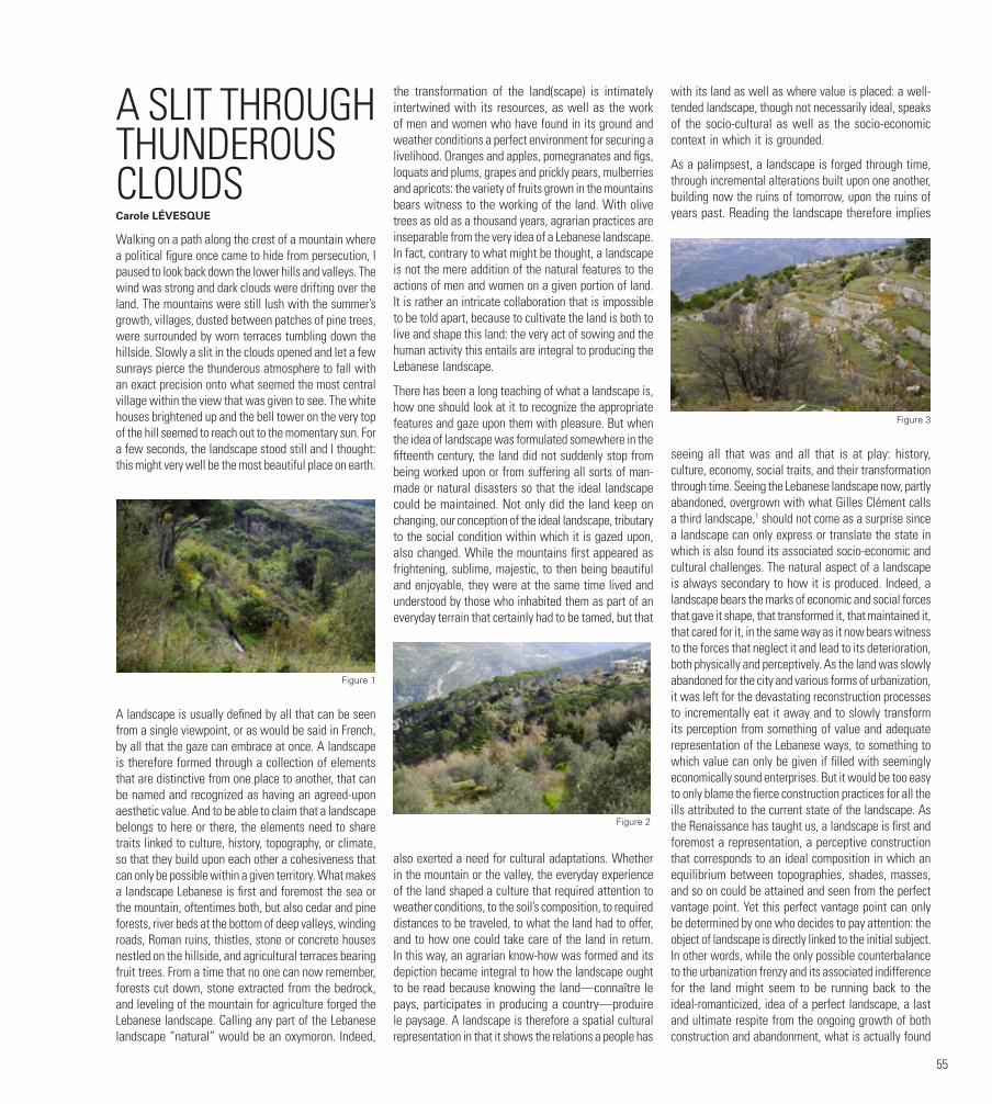
55
A SLIT THROUGH THUNDEROUS CLOUDSCarole LÉVESQUE
Walking on a path along the crest of a mountain where a political figure once came to hide from persecution, I paused to look back down the lower hills and valleys. The wind was strong and dark clouds were drifting over the land. The mountains were still lush with the summer’s growth, villages, dusted between patches of pine trees, were surrounded by worn terraces tumbling down the hillside. Slowly a slit in the clouds opened and let a few sunrays pierce the thunderous atmosphere to fall with an exact precision onto what seemed the most central village within the view that was given to see. The white houses brightened up and the bell tower on the very top of the hill seemed to reach out to the momentary sun. For a few seconds, the landscape stood still and I thought: this might very well be the most beautiful place on earth.
A landscape is usually defined by all that can be seen from a single viewpoint, or as would be said in French, by all that the gaze can embrace at once. A landscape is therefore formed through a collection of elements that are distinctive from one place to another, that can be named and recognized as having an agreed-upon aesthetic value. And to be able to claim that a landscape belongs to here or there, the elements need to share traits linked to culture, history, topography, or climate, so that they build upon each other a cohesiveness that can only be possible within a given territory. What makes a landscape Lebanese is first and foremost the sea or the mountain, oftentimes both, but also cedar and pine forests, river beds at the bottom of deep valleys, winding roads, Roman ruins, thistles, stone or concrete houses nestled on the hillside, and agricultural terraces bearing fruit trees. From a time that no one can now remember, forests cut down, stone extracted from the bedrock, and leveling of the mountain for agriculture forged the Lebanese landscape. Calling any part of the Lebanese landscape “natural” would be an oxymoron. Indeed,
the transformation of the land(scape) is intimately intertwined with its resources, as well as the work of men and women who have found in its ground and weather conditions a perfect environment for securing a livelihood. Oranges and apples, pomegranates and figs, loquats and plums, grapes and prickly pears, mulberries and apricots: the variety of fruits grown in the mountains bears witness to the working of the land. With olive trees as old as a thousand years, agrarian practices are inseparable from the very idea of a Lebanese landscape. In fact, contrary to what might be thought, a landscape is not the mere addition of the natural features to the actions of men and women on a given portion of land. It is rather an intricate collaboration that is impossible to be told apart, because to cultivate the land is both to live and shape this land: the very act of sowing and the human activity this entails are integral to producing the Lebanese landscape.
There has been a long teaching of what a landscape is, how one should look at it to recognize the appropriate features and gaze upon them with pleasure. But when the idea of landscape was formulated somewhere in the fifteenth century, the land did not suddenly stop from being worked upon or from suffering all sorts of man-made or natural disasters so that the ideal landscape could be maintained. Not only did the land keep on changing, our conception of the ideal landscape, tributary to the social condition within which it is gazed upon, also changed. While the mountains first appeared as frightening, sublime, majestic, to then being beautiful and enjoyable, they were at the same time lived and understood by those who inhabited them as part of an everyday terrain that certainly had to be tamed, but that
also exerted a need for cultural adaptations. Whether in the mountain or the valley, the everyday experience of the land shaped a culture that required attention to weather conditions, to the soil’s composition, to required distances to be traveled, to what the land had to offer, and to how one could take care of the land in return. In this way, an agrarian know-how was formed and its depiction became integral to how the landscape ought to be read because knowing the land—connaître le pays, participates in producing a country—produire le paysage. A landscape is therefore a spatial cultural representation in that it shows the relations a people has
with its land as well as where value is placed: a well-tended landscape, though not necessarily ideal, speaks of the socio-cultural as well as the socio-economic context in which it is grounded.
As a palimpsest, a landscape is forged through time, through incremental alterations built upon one another, building now the ruins of tomorrow, upon the ruins of years past. Reading the landscape therefore implies
seeing all that was and all that is at play: history, culture, economy, social traits, and their transformation through time. Seeing the Lebanese landscape now, partly abandoned, overgrown with what Gilles Clément calls a third landscape,1 should not come as a surprise since a landscape can only express or translate the state in which is also found its associated socio-economic and cultural challenges. The natural aspect of a landscape is always secondary to how it is produced. Indeed, a landscape bears the marks of economic and social forces that gave it shape, that transformed it, that maintained it, that cared for it, in the same way as it now bears witness to the forces that neglect it and lead to its deterioration, both physically and perceptively. As the land was slowly abandoned for the city and various forms of urbanization, it was left for the devastating reconstruction processes to incrementally eat it away and to slowly transform its perception from something of value and adequate representation of the Lebanese ways, to something to which value can only be given if filled with seemingly economically sound enterprises. But it would be too easy to only blame the fierce construction practices for all the ills attributed to the current state of the landscape. As the Renaissance has taught us, a landscape is first and foremost a representation, a perceptive construction that corresponds to an ideal composition in which an equilibrium between topographies, shades, masses, and so on could be attained and seen from the perfect vantage point. Yet this perfect vantage point can only be determined by one who decides to pay attention: the object of landscape is directly linked to the initial subject. In other words, while the only possible counterbalance to the urbanization frenzy and its associated indifference for the land might seem to be running back to the ideal-romanticized, idea of a perfect landscape, a last and ultimate respite from the ongoing growth of both construction and abandonment, what is actually found
Figure 1
Figure 2
Figure 3

56
is a land forgotten by what initially shaped it, terraces overtaken by wild growth, tumbled-down structures, derelict aqueducts, and so on. Not the ideal landscape and not an easy lesson to swallow, perhaps. But what are the ideal landscape and ideal vantage point anyway? What if the ideal representation renewed itself in an acknowledgment that the state in which the landscape is now found is tributary to what was done of it and that what was done of it has not yet completely destroyed everything good about it? What remains—fragments of the longed-for ideal scattered through the neglected conditions—is part of the same cycle as are cultural shifts: it largely depends on where value is given and how we transform our discourses and representations of what is before us. If the actualization of the idealized landscape is no longer possible, necessarily, a new ideal has to emerge, one that is encompassing of the state of what is left.
To challenge the romanticized ideal and see the landscape anew, a representation has to be made, one that speaks of the present and one that shows the diversity and wealth of what is there. Instead of longing for an ideal perception that no longer matches most of what remains, and allow passively the actual landscape be overtaken by urban development and other forms of demolition, new vantage points have to be found so that we can begin to see, again, the layers embedded in the landscape, layers that still show signs of how much care was once given to the land, and how much care it needs once more. To do so, one must be forced into reflecting upon the causes underlying the state of abandonment the landscape has fallen into, and recognize the unbridgeable distance between the lost ideal and the present state of what remains, as might point out Sophie Lacroix.2 While this process might seem to require long and arduous
efforts, it may in fact be as simple as being attentive to what the French definition proposes when it says that a landscape is all that the gaze can embrace at once: embracing all that is given to see infers that we look upon the landscape with the fondness of a longtime accomplice, even if what is seen does not immediately correspond to expectations. Embracing the land suggests that we be standing far enough to grasp it in its entirety, so as to understand its variations and attributes. But as it is with the embrace of a long-lost friend, it most certainly also implies a closeness, a warm and loving proximity, in which every aspect of the physical presence can be felt. Embracing all that is given to see thus necessitates a direct engagement with the land through a genuine practice of the land, seeking compositions between the sweeping view and the near details, finding again colors, textures, and slits through thunderous clouds, so that we restore value to the land(scape) that remains, brush away the yearning for something that no longer is, and begin to see the leftover landscape as something culturally worthy.
FOOTNOTES1. Gilles Clément, Manifeste du Tiers-paysage (Paris: Sujet Objet, 2004).
2. Sophie Lacroix, Ruine (Paris: Éditions La Villette, 2008).
FIGURESFigures 1,2,3 and 4. The Thin Lines Between the River and Me ©2018 CCATTARUZZA
AUTHORCarole LÉVESQUE holds a technical degree in architecture, an undergraduate degree in Design de l’Environnement, a Master of Architecture from the University of British Columbia as well as a PhD in the History and Theory of Architecture from the University of Montreal. Concerned with temporary architecture as a means to articulate exploratory and alternative discourses on the city and as a tool with which to engage architectural education, she published “A Propos de l’Inutile en Architecture,” where these issues are explored at length. Her current work and research revolves around the architectural representation of derelict and vague spaces within the city as a means to challenge our acceptance of the derelict in our conception of what constitutes an acceptable urban landscape. She taught at the University of Montreal, the American University of Beirut and she is now full professor at the School of Design at the University of Quebec in Montreal.
Figure 4
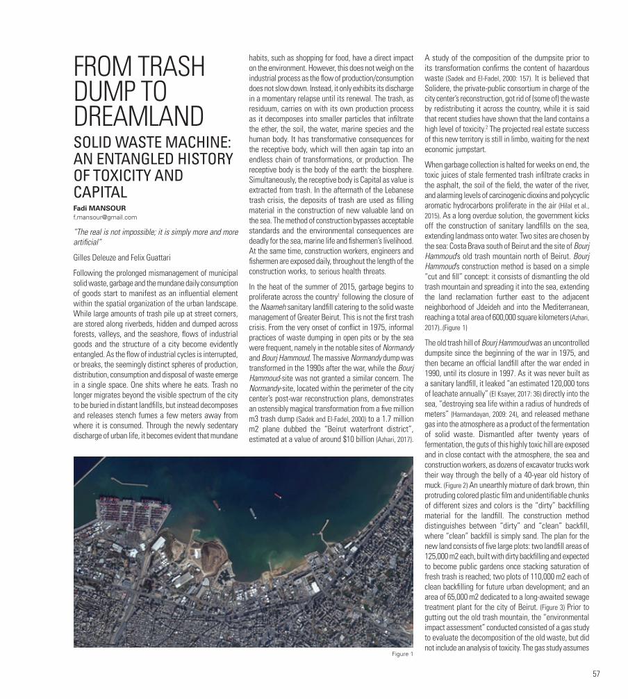
57
FROM TRASH DUMP TO DREAMLANDSOLID WASTE MACHINE: AN ENTANGLED HISTORY OF TOXICITY AND CAPITAL Fadi [email protected]
“The real is not impossible; it is simply more and more artificial”
Gilles Deleuze and Felix Guattari
Following the prolonged mismanagement of municipal solid waste, garbage and the mundane daily consumption of goods start to manifest as an influential element within the spatial organization of the urban landscape. While large amounts of trash pile up at street corners, are stored along riverbeds, hidden and dumped across forests, valleys, and the seashore, flows of industrial goods and the structure of a city become evidently entangled. As the flow of industrial cycles is interrupted, or breaks, the seemingly distinct spheres of production, distribution, consumption and disposal of waste emerge in a single space. One shits where he eats. Trash no longer migrates beyond the visible spectrum of the city to be buried in distant landfills, but instead decomposes and releases stench fumes a few meters away from where it is consumed. Through the newly sedentary discharge of urban life, it becomes evident that mundane
habits, such as shopping for food, have a direct impact on the environment. However, this does not weigh on the industrial process as the flow of production/consumption does not slow down. Instead, it only exhibits its discharge in a momentary relapse until its renewal. The trash, as residuum, carries on with its own production process as it decomposes into smaller particles that infiltrate the ether, the soil, the water, marine species and the human body. It has transformative consequences for the receptive body, which will then again tap into an endless chain of transformations, or production. The receptive body is the body of the earth: the biosphere. Simultaneously, the receptive body is Capital as value is extracted from trash. In the aftermath of the Lebanese trash crisis, the deposits of trash are used as filling material in the construction of new valuable land on the sea. The method of construction bypasses acceptable standards and the environmental consequences are deadly for the sea, marine life and fishermen’s livelihood. At the same time, construction workers, engineers and fishermen are exposed daily, throughout the length of the construction works, to serious health threats.
In the heat of the summer of 2015, garbage begins to proliferate across the country1 following the closure of the Naameh sanitary landfill catering to the solid waste management of Greater Beirut. This is not the first trash crisis. From the very onset of conflict in 1975, informal practices of waste dumping in open pits or by the sea were frequent, namely in the notable sites of Normandy and Bourj Hammoud. The massive Normandy dump was transformed in the 1990s after the war, while the Bourj Hammoud-site was not granted a similar concern. The Normandy-site, located within the perimeter of the city center’s post-war reconstruction plans, demonstrates an ostensibly magical transformation from a five million m3 trash dump (Sadek and El-Fadel, 2000) to a 1.7 million m2 plane dubbed the “Beirut waterfront district”, estimated at a value of around $10 billion (Azhari, 2017).
A study of the composition of the dumpsite prior to its transformation confirms the content of hazardous waste (Sadek and El-Fadel, 2000: 157). It is believed that Solidere, the private-public consortium in charge of the city center’s reconstruction, got rid of (some of) the waste by redistributing it across the country, while it is said that recent studies have shown that the land contains a high level of toxicity.2 The projected real estate success of this new territory is still in limbo, waiting for the next economic jumpstart.
When garbage collection is halted for weeks on end, the toxic juices of stale fermented trash infiltrate cracks in the asphalt, the soil of the field, the water of the river, and alarming levels of carcinogenic dioxins and polycyclic aromatic hydrocarbons proliferate in the air (Hilal et al., 2015). As a long overdue solution, the government kicks off the construction of sanitary landfills on the sea, extending landmass onto water. Two sites are chosen by the sea: Costa Brava south of Beirut and the site of Bourj Hammoud’s old trash mountain north of Beirut. Bourj Hammoud’s construction method is based on a simple “cut and fill” concept: it consists of dismantling the old trash mountain and spreading it into the sea, extending the land reclamation further east to the adjacent neighborhood of Jdeideh and into the Mediterranean, reaching a total area of 600,000 square kilometers (Azhari, 2017)..(Figure 1)
The old trash hill of Bourj Hammoud was an uncontrolled dumpsite since the beginning of the war in 1975, and then became an official landfill after the war ended in 1990, until its closure in 1997. As it was never built as a sanitary landfill, it leaked “an estimated 120,000 tons of leachate annually” (El Ksayer, 2017: 36) directly into the sea, “destroying sea life within a radius of hundreds of meters” (Harmandayan, 2009: 24), and released methane gas into the atmosphere as a product of the fermentation of solid waste. Dismantled after twenty years of fermentation, the guts of this highly toxic hill are exposed and in close contact with the atmosphere, the sea and construction workers, as dozens of excavator trucks work their way through the belly of a 40-year old history of muck. (Figure 2) An unearthly mixture of dark brown, thin protruding colored plastic film and unidentifiable chunks of different sizes and colors is the “dirty” backfilling material for the landfill. The construction method distinguishes between “dirty” and “clean” backfill, where “clean” backfill is simply sand. The plan for the new land consists of five large plots: two landfill areas of 125,000 m2 each, built with dirty backfilling and expected to become public gardens once stacking saturation of fresh trash is reached; two plots of 110,000 m2 each of clean backfilling for future urban development; and an area of 65,000 m2 dedicated to a long-awaited sewage treatment plant for the city of Beirut. (Figure 3) Prior to gutting out the old trash mountain, the “environmental impact assessment” conducted consisted of a gas study to evaluate the decomposition of the old waste, but did not include an analysis of toxicity. The gas study assumes
Figure 1

58
that the main constituent of the hill is organic matter and thus only studies the decomposition of this inert matter, which is the least toxic component. What the study also shows, without mentioning it in the report, is that almost all of the gases were released into atmosphere, although they should have been captured and burned while the leachates were dumped in the sea.3 There is no analysis of the chemical composition of the landfill, nor of the solid matter that was extracted or the leachates, of which only the level was measured.4
Regardless of the lack of toxicity tests on the old waste, the consequences for sea life are evident, as testified by the fishermen of Bourj Hammoud’s port. The fishermen, protesting against the project since its inception, are the ones suffering the direct consequences for their health and livelihood, along with sea and marine life. Chemist Dr. Najat Saliba explains that the most obvious toxic waste in the old mountain consists of metal components, pesticides, oil transformers such
as PCB polycyclic biphenyl from industrial plants, and chlorinated substances from the degradation of plastics.5 She explains that because of leachate leaks, there is an abundance of nitrate in the sea. As a result, there is an ample increase of phytoplankton microorganisms that float on the top layer of seawater, forming a layer that blocks sunlight, ensuing in oxygen depletion of the water body.6
The industrial coast of Bourj Hammoud has been perpetually subjected to lethal expansive pollution, from untreated sewage discharge for decades, to animal organ remains from the nearby slaughterhouse, to the flushing of oil pipes directly into the sea from nearby hydrocarbon companies, to the illegal smuggling of toxic hazardous waste during the war (Hamdan, 1997). Proponents of the project say that an extra 3.5 million m3 of old waste would not make a major difference to the
already ruinously polluted sea. It evidently aggravated the situation, as testified by the fishermen who have engaged with this sea for decades and witnessed the different degradation degrees of marine life (Marsi, 2017). This situation is by no means particular to this specific site, as ecological disaster has inadvertently become a recurrent phenomenon across the globe, to the extent where it is met with a lack of concern.7
There is still a general tendency to believe that the ecological faux pas will be redeemed. This false belief operates within a particular perception of a world, one of a capitalist profit economy that predates our understanding of global warming. This would be a world that posits capital and nature as the essence of reality. Timothy Morton (2013: 115) calls it “capitalist essentialism,” where the concept of nature is the accomplice of capital, as “both exist in an ethereal beyond. Over here, where we live, is an oil spill. But don’t worry. The beyond will take care of it.” He gives the example of the aftermath of the
BP Deepwater Horizon oil spill and the unsympathetic response of the CEO towards the disaster, saying that “the Gulf of Mexico was a huge body of water, and that the spill was tiny by comparison. Nature would absorb the industrial accident” (Morton, 2013: 115). Morton points to the metaphysics involved in the BP CEO’s claim, hinting at the inherent belief that nature would solve the issue by itself. Lebanon’s minister of environment reacted in a similarly callous manner, pointing out the inevitability of the situation by way of a divine-like disjunctive syllogism: “The agreement between the contractor and the (governmental) Council for Development and Reconstruction requires reclaiming the sea. Therefore, waste should be buried in the sea” (No Author, 2017). Such a comment can be dismissed as nonsensical, biased and corrupt, but this is exactly how the project was led to fruition: as a disjunctive synthesis.
The chemical breakdown of decades-old trash, whilst discharging toxic leachates and methane gas into the sea and air, led to the creation of a composite material that later formed a substitute for soil in the production of new land. In addition to this new alchemical matter, fresh trash piles from a prolonged solid waste mismanagement were also added to the fill. This new spread onto the sea, whose dismissed lingering toxicity pursues ecological mutations, will be applauded as a successful real estate endeavor and coastal urban regeneration. The production process of this new land undeniably consummates an intimate relationship with flows of toxicity at all stages of its coming into being and into the future. The Normandy land reclamation is the precedent and the libidinal drive to the creation of its successor, and could very well keep on fulfilling this role. Ever since its completion, the Normandy, through its celebratory evaluation, was essentially becoming anticipatory, in as much as it was being redeemed for its flawed production process.8 What outlives the Normandy disaster is a clean stretch of land praised for its value, while its toxic history is rendered invisible. In order to break away from a potential repetition of the same process, I believe it is important to work on the invisibility of the Bourj Hammoud-Jdeideh transformation, where the inscription of the project within the urban narrative should remain connected to its material composition and process.
Figure 2 Figure 3
59
FOOTNOTES1. See Solidere’s comment on that in The Chronicle, Solidere Annual report 2012, 26. http://www.solidere.com/sites/default/files/attached/ar2012.pdf.
2. This is mentioned in Lea Nassif El Ksayer’s master’s thesis (2017: 30), however I was not able to find evidence.
3. Elias Azzi, expert in waste management systems and PhD-candidate in industrial ecology at KTH Sweden, e-mail exchange where he kindly shared his personal analysis and remarks on the gas and geotechnical reports, August 2017.
4. ibid.
5. Najat Saliba - AUB Chemistry department, notes taken during a meeting and email exchange, August 17, 2017.
6. ibid.
7. See Saskia Sassen’s “Expulsions…” on the extent of dead land and dead water due to pollution of all sorts, on a scale our planet has never seen before, and in relation to a systemic deepening of advanced capitalism.
8. For evaluation as anticipation, see Gilles Deleuze and Felix Guattari (2013).
FIGURESFigure 1. Illustration source: Google earth. Name of copyright holder: Google earth. Caption: Bourj Hammoud-Jdeideh land reclamation in process
Figure 2. Illustration source: “Dreamland” video still, 2017. Name of photographer or artist: Fadi Mansour. Name of copyright holder: Fadi Mansour. Caption: Dismantling the Bourj Hammoud trash mountain
Figure 3. Illustration source: Lebanese Republic Council for Development and Reconstruction. Name of copyright holder: Lebanese Republic Council for Development and Reconstruction. Caption: Plan of the Bourj Hammoud-Jdeideh sanitary landfill and land reclamation project
BIBLIOGRAPHYAzhari, T. (2017). The lucrative history of land reclamation. The Daily Star, 19 July. Available at: https://www.dailystar.com.lb/News/Lebanon-News/2017/Jul-19/413250-the-lucrative-history-of-lebanese-land-reclamation.ashx#.
Deleuze, G. and Guattari, F. (2013).,7000 BC: Apparatus of Capture. In A Thousand Plateaus: Capitalism and Schizophrenia (pp. 493-550). London: Bloomsbury.
El Ksayer, L. N. (2017). Can co-production partnerships lead to new forms of sustainable urban governance? Waste management under conditions of enduring political crisis in Beirut. MA Thesis, Technische Universität Berlin, Germany.
Hilal N., Fadlallah, R., Jamal, D. and El-Jardali, F. (2015). K2P evidence summary: approaching the waste crisis in Lebanon: Consequences and insights into solutions. Beirut: Knowledge to Policy (K2P) Center. Available at: https://www.aub.edu.lb/k2p/products/Documents/K2P%20Evidence%20Summary%20Waste%20Management_Final_%20Dec%2014%202015.pdf.
Hamdan, F. (1997). Toxic attack against Lebanon, case one: Toxic waste from Italy. Available at: http://www.fouadhamdan.org/cms/upload/pdf/ItalianToxicWasteInLebanon_GreenpeaceChronology1987_1997_FouadHamdan_ENGLISH_May1997.pdf.
Harmandayan, D. (2009). Bourj Hammoud brief city profile. APEC, prepared for the Municipality of Bourj Hammoud. Available at: http://www.bourjhammoud.gov.lb/sites/default/files/public/SBH-REPORT-F-
shrinked.pdf
Marsi, F. (2017). Fishermen sound alarm over waste in sea. The Daily Star, July 10.
Morton, T. (2013). Hyperobjects: Philosophy and Ecology after the End of the World. Minneapolis: University of Minnesota Press.
No author (2017). This Lebanese minister’s solution to the garbage crisis? Dump in the sea. The New Arab, June 14. Available at: https://www.alaraby.co.uk/english/blog/2017/6/14/video-lebanon-admits-to-dumping-garbage-into-the-sea.
Sadek, S. and El-Fadel, M. (2000). The Normandy landfill: A case study in solid waste management. Journal of Natural Resources & Life Sciences Education 29: 155-161.
AUTHORFadi MANSOUR is an architect, artist and researcher based in Beirut. He graduated from the Centre for Research Architecture at Goldsmiths University of London in 2017 and from the Architectural Association in 2009. He was a teacher, guest lecturer and invited critic at the Bartlett UCL, NDU and AUB. His research work, visual art practice and writing lies at the intersection of techno-capitalism, colonial violence and ecology.

60
EMPTY, UNBUILT, LEFTOVER, IDLE, WORTHLESS, HIDDEN:ON INVISIBLE AND VESTIGIAL PLACES AND LANDSCAPESJoe NASRIndependent scholar. Lecturer and Associate, Centre for Studies in Food Security. Ryerson University. Toronto, Canada. [email protected]
Histories of architecture, landscape architecture, urban planning and allied fields tend to concentrate on built objects, crafted landscapes, planned zones, etc. Yet such material phenomena, while they are most noticed by those who inhabit metropolitan spheres, encapsulate countless spaces and objects that tend to be left out of such histories. This publication tackles a subject that is often neglected in the history of the professions that deal with the environment in which we live, particularly in and near cities: those parts of this environment that are invisible, left behind, ignored, or otherwise absent from the discourse on its creation.
SOURCES FOR THIS ARGUMENTTo illustrate this statement, I will rely on various episodes of my own eclectic research history over the past three decades, both locally in Lebanon as well as internationally. I will group these into two distinct clusters.
I will draw on my work around postwar reconstruction processes, illustrated in three episodes:
1. I will discuss various relevant aspects taken from my dissertation, which examined postwar reconstruction in France, West Germany and East Germany after World War II (Nasr 1997), including the assessment of destruction as well as the fate of different structural (street patterns, parcel division patterns…) and infrastructural systems.
2. In follow-up research conducted on British reconstruction (Larkham and Nasr, 2012; Larkham and Nasr, 2004), the case study of how vestiges of London’s churches were assessed and consequently how their survival was impacted by this assessment and other factors can offer some useful lessons.
3. In the case of Lebanon, a comparison between the transformations in Beirut’s central area and those in Berlin (Nasr, 1996) provides a good illustration of the impact of assumptions and representations of pre-existing conditions, from street patterns to property ownership.
I will also extract some lessons from a very different, major area of my research during the past decades: urban agriculture – and beyond that, on what is starting to be referred to as city-region food systems. Across this particular research as well as in my experience elsewhere, a number of observations have recurred, around idle land, marginal activity, invisible property, insignificant actors and temporary usage. I have been working in this field for a quarter century on different scales and in different regions:
1. My involvement in this topic started internationally, through a global survey of urban agriculture back in the early 1990s, leading to an early book on this subject (Smit, Ratta and Nasr, 1996).
2. Later, I organized a research program that considered the interface between agriculture and urbanization in coastal Lebanon, ultimately resulting in a book that examined this relationship across the Middle East and North Africa (Nasr and Padilla, 2005).
3. In the past decade, I was one of the coordinators of an initiative called “Carrot City” that examined how design can shape and support urban agriculture (Gorgolewski, Komisar and Nasr, 2011; www.carrotcity.org).
This paper will draw primarily on these two clusters of issues that I have worked on in the past three decades. I now realize that my seemingly highly disparate research topics have in common an interest in areas within the urban sphere that can be seen (and are often represented) as blank.
FORMS OF ABSENCEBehind the perception of the blank slate lies an assumption of an absence – or rather, of a number of absences. These absences may take different forms. I suggest that it can be useful to distinguish these different forms, which can be found in different situations, in
different urban landscapes – though they are certainly interlocking absences. I will briefly analyze six forms of absence here, including some examples that illustrate these different forms.
• Urban landscapes may contain vast areas that are empty – their existence may not capture attention, they come to be understood as containing nothing. Indeed, the principle of the tabula rasa (blank slate) is commonly found in reference to vast areas within and around urban areas. Vast stretches of agricultural or biodiversity-rich land have often been shown on maps as simply empty spaces awaiting future development – commonly marked in white on land-use plans, as illustrated by a broad linear area of prime agriculture between the Greater Toronto Area and Ontario’s Greenbelt that has come to be referred to as the “white belt”, meant for the expansion of the metropolis. Often, the availability of land is discussed in terms of “opportunity” (a recurring word I encountered in much of my research). This ranges from cases of war destruction inside the city (illustrated by Europe after World War II and Beirut and many other cities in the Middle East in recent years) to agricultural landscape (as seen dramatically in the creation of the Fair grounds in Tripoli, sliced out of orange groves adjacent to the city).
• Voids between built-up areas often tend to be ignored – their unbuilt nature making them appear as gaps between the solidity of built objects. This is most commonly seen with urban open spaces like parks,
racecourses, river valleys, etc. While these voids are commonly regarded as green lungs, breathing spaces, and other similar metaphors, they are also frequently seen as prime development opportunities for mega-projects that can make fuller use of underused, consolidated urban land. Such spaces range from extensive monoliths like fairgrounds, older airports and golf courses, to more fragmented spaces such as abandoned industrial districts, to much smaller gaps in the urban fabric such as older houses with large gardens and surviving farms surrounded by built fabric.
• In both built-up areas and “open spaces”, a range of remnants from past buildings, activities, or other Figure 1
Figure 2

61
presences are leftover, vestiges that may or may not evoke memories of what came before. In contrast to the open spaces mentioned above, these remnants have a physical built presence. These are inherently isolated in some way –they may have particular value if they have historical value or serve as a monument or memorial, but typically they are simply surviving remnants without a particular value assigned to them.
• Voids and vestiges – and even built forms that are low-density or otherwise considered to be below their full-use potential – tend be regarded as idle, as existing in space on a temporary basis until a project of some sort makes fuller use of such a site. The concept of “use” is central in this regard – terms such as “unused” or “underused” are the most obvious indicators of such judgment, but other, less obvious ones can be flagged, such as “fallow lands” (part of what I focused on in the study I undertook within the above-mentioned research program on coastal Lebanon), or “total destruction” (which was very commonly, yet loosely used in all reconstruction writings that I came across during and after my dissertation). The earliest article I co-wrote on urban agriculture (Smit and Nasr, 1992) also focused on how the concept of “waste” can be converted into that of “resource” in multiple ways through the lens of urban agriculture.
• Associated with such an emphasis on “use” is the importance given to “value” – thus, in the metropolitan sphere countless mechanisms exist to define what is valuable, and conversely, to identify the worthless, or at least undervalued and unproductive. It is easiest to deem a building worthless when it is “totally destroyed”, as just mentioned, but when this label cannot be assigned, then efforts to undertake damage assessment in a professional way are usually needed in order to estimate the worth of remnants – however, my research on what to do with churches in London, as well as my examination of varying techniques for mapping destruction during and after World War II, has shown me how laden with judgment such assessments are, and what the consequences of the determination of worthy or worthless are in relation to any vestige.
Landscapes, both intra-urban and peri-urban, are crisscrossed by numerous systems that structure them. While some of them are highly visible, such as highways and riverbeds, many of them are less noticeable, if not totally invisible (especially when belowground). Hidden systems thus structure landscapes, not only within cities, but even in more remote areas that are under the influence of cities. There is a great variety of such more or less hidden structures and infrastructures, ranging from agricultural parceling and water and other facilities to zoning and property ownership patterns. The presence of belowground infrastructure in cities has been shown to survive war destruction, even where much of the aboveground built fabric is damaged or destroyed. My dissertation research also showed that the morphology underlying urban patterns significantly
impacted reconstruction in some places, and much less so in others, seen most clearly when comparing West Germany to East Germany.
COUNTERING THE IMAGE OF URBAN VOIDS AND BLANK SLATESThe discussion in this paper has focused on the range of ways in which spaces inside and outside cities are commonly represented as unproductive voids. This does not mean that there are no other representations for the parts of cities and their regions that are not built, dense, active, expensive, etc. There are indeed many other ways for plots of land and structures to be “productive”. I proffer a far broader interpretation of the term “productivity” here to designate the many ways in which a function, a service, a use can be provided – whether through food production, ecosystem service, slow mobility, memory activation, mental reflection, physical exercise, or more. In this short section, I will share a few thoughts on how the image of urban voids and blank slates outlined above has been countered by other representations and realities.
• What is suggested here is nothing new; there has been a very long history of the productive use of land in and around cities, in fact as long as cities have existed.
• While current built-environment practitioners often approach such spaces in the terms mentioned in the previous section, not all the foundational thinkers of these professions approached them in this way. In fact, a number of key theoreticians from the history of planning, design and landscape – from Ebenezer Howard to Patrick Geddes to Frank Lloyd Wright and even Le Corbusier (to
some extent) – have made a number of proposals that use spaces in and around urban settlements “productively”.
• By changing the lens from “empty” or “leftover” to a broader meaning of “productive”, large parts of cities can be seen as core functions in the urban landscape. Moreover, given the pressures that exist on open spaces that are formally maintained by public authorities such as parks, other forms of open spaces such as urban and peri-urban agriculture (UPA) can be regarded as the new urban landscape, where individuals and groups are performing a service by productively maintaining some unbuilt areas.
• At the same time, the temporality of forms of open space such as UPA is necessarily different from that of more static spaces such as parks – UPA is inherently a more dynamic landscape.
• While private stakeholders tend to dominate such alternative forms of productive open spaces, these often require support from different actors – from municipalities and civil society organizations to research and training bodies – who can offer a variety of support forms to make leftover, open spaces productive.
• While many productive urban landscapes are fragmentary in nature, productivity is much greater if such spaces are scaled up or connected to each other. For this reason, concepts such as continuous productive urban landscapes (CPULs) and pollination corridors have recently emerged, building on older concepts like greenbelts and green wedges.
Figure 3
62
SOME CONCLUDING QUESTIONSThe absences mentioned in this paper can be seen in both space and time. They can be summarized in terms of invisibility (no presence in space) and vestigiality (remnant from an earlier time, awaiting a fuller use by an activity and materiality with higher value). Moreover, the centrality of the idea of “productive use” (or perhaps the narrow productivist ideology) hovers over the recognition, and ultimately the fate, of any “place that remains” within a metropolitan sphere.
I will conclude by considering three fundamental questions. First, why are so many places and landscapes seen as empty, unbuilt, leftover, idle, worthless? Second, what are the consequences of such a view, in terms of power, appropriation, neglect? Third, what are the implications of such different ways of seeing for professionals of the built (and unbuilt) environment? The places that remain can gain visibility and be seen as multifunctional contributors to the metropolitan realm.
FIGURESFigure 1. Farms at the mouth of the Awwali River near Saidas
Figure 2. St Mary Aldermanbury memorial garden, London
Figure 3. Tripoli Fair, now surrounded by the expansion of a neighborhood of the city
BIBLIOGRAPHYAll the works cited are by the author, alone or mostly with others. They are listed here in chronological order.
Gorgolewski, M., Komisar, J. and Nasr, J. (2011). Carrot City: Creating Places for Urban Agriculture. New York: Monacelli Press.
Larkham, P. and Nasr, J. (2004). The rebuilding of British Cities: Exploring the post-Second World War reconstruction. Working Papers series, no. 90. Birmingham, UK: University of Central England, School of Planning and Housing.
Larkham, P. and Nasr, J. (2012). Decision making under duress: The treatment of London churches as special buildings after the Second World War. Urban History 39(2): 285-309.
Nasr, J. Beirut/Berlin (1996). Choices in planning for the suture of two divided cities. Journal of Planning Education and Research 16(1): 27-40.
Nasr, J. (1997). Reconstructing or constructing cities?: Stability and change in urban form in post-World War II France and Germany. PhD Thesis, University of Pennsylvania, United States.
Nasr, J. and Padilla, M. (Eds.) (2005). Interfaces: Agricultures et Villes à l’Est et au Sud de la Méditerranée. Beirut: Editions Delta and IFPO (2004). Distribution outside the Arab world by INRA Editions (Paris). Arabic edition: Beirut: American University of Beirut, 2005.
Smit, J. and Nasr,. J. (1992). Urban agriculture for sustainable cities: Using wastes and idle land and water bodies as resources. Environment and Urbanisation 4(2): 141-152. Reprinted in: Satterthwaite, D. (Ed.) (1999). The Earthscan Reader in Sustainable Cities (pp. 221-233). London: Earthscan Publications.
Smit, J., Ratta, A. and Nasr, J. (1996). Urban Agriculture: Food, Jobs and Sustainable Cities. United Nations Development Programme publication series for Habitat II, vol. 1. New York: UNDP. 2nd edition completed in 2001 (available at: www.jacsmit.com/book).
AUTHORJoe NASR is an independent scholar, lecturer and consultant based in Toronto, who has been exploring urban agriculture and food security issues, as well as planning history and urban morphology, for over a quarter century. His work has covered the global, regional (Middle East, Europe, and North America), as well as local scales (particularly Toronto and Beirut). He holds a doctorate in urban and regional planning from the University of Pennsylvania and has received several fellowships over the years. He is an associate of Ryerson University’s Center for Studies in Food Security, and co-curator of the traveling exhibition, book, and website “Carrot City: Designing for Urban Agriculture.” Joe is co-founder of Toronto Urban Growers and member of the Toronto Food Policy Council. He is co-author or co-editor of four books and dozens of articles, including the seminal book “Urban Agriculture”; he is also co-editor of the Springer Urban.
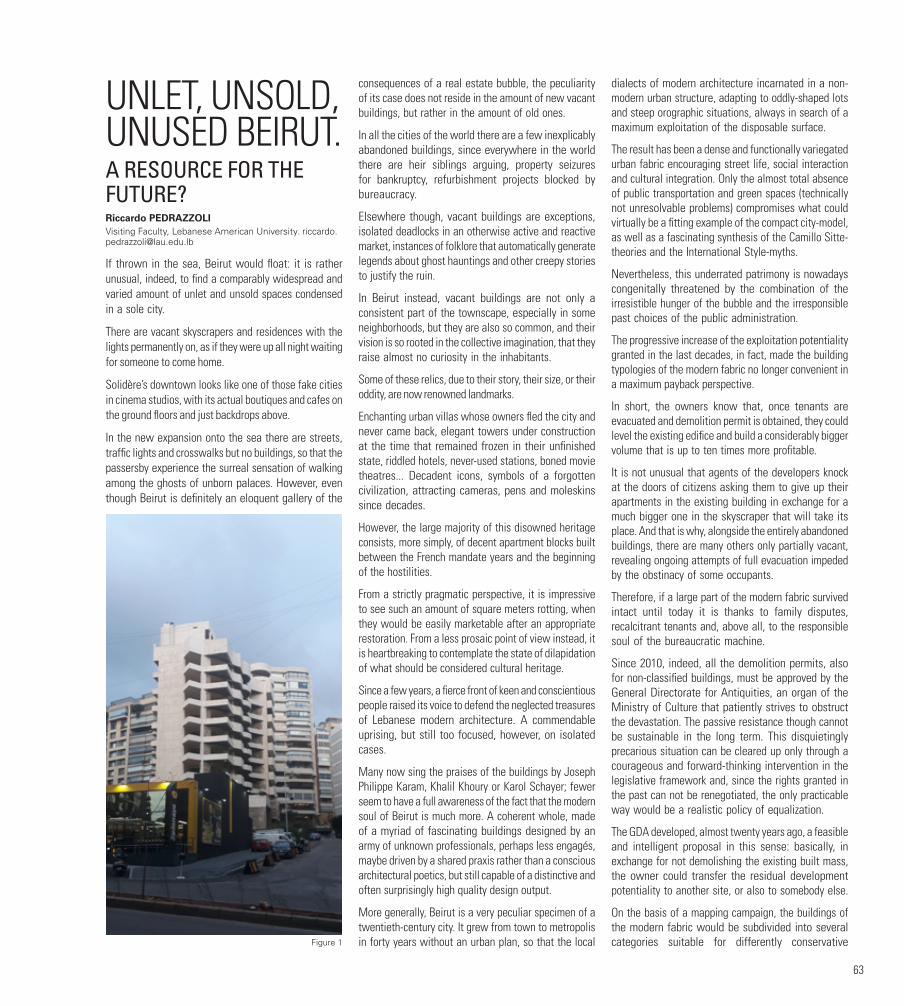
63
UNLET, UNSOLD, UNUSED BEIRUT.A RESOURCE FOR THE FUTURE?Riccardo PEDRAZZOLIVisiting Faculty, Lebanese American University. [email protected]
If thrown in the sea, Beirut would float: it is rather unusual, indeed, to find a comparably widespread and varied amount of unlet and unsold spaces condensed in a sole city.
There are vacant skyscrapers and residences with the lights permanently on, as if they were up all night waiting for someone to come home.
Solidère’s downtown looks like one of those fake cities in cinema studios, with its actual boutiques and cafes on the ground floors and just backdrops above.
In the new expansion onto the sea there are streets, traffic lights and crosswalks but no buildings, so that the passersby experience the surreal sensation of walking among the ghosts of unborn palaces. However, even though Beirut is definitely an eloquent gallery of the
consequences of a real estate bubble, the peculiarity of its case does not reside in the amount of new vacant buildings, but rather in the amount of old ones.
In all the cities of the world there are a few inexplicably abandoned buildings, since everywhere in the world there are heir siblings arguing, property seizures for bankruptcy, refurbishment projects blocked by bureaucracy.
Elsewhere though, vacant buildings are exceptions, isolated deadlocks in an otherwise active and reactive market, instances of folklore that automatically generate legends about ghost hauntings and other creepy stories to justify the ruin.
In Beirut instead, vacant buildings are not only a consistent part of the townscape, especially in some neighborhoods, but they are also so common, and their vision is so rooted in the collective imagination, that they raise almost no curiosity in the inhabitants.
Some of these relics, due to their story, their size, or their oddity, are now renowned landmarks.
Enchanting urban villas whose owners fled the city and never came back, elegant towers under construction at the time that remained frozen in their unfinished state, riddled hotels, never-used stations, boned movie theatres... Decadent icons, symbols of a forgotten civilization, attracting cameras, pens and moleskins since decades.
However, the large majority of this disowned heritage consists, more simply, of decent apartment blocks built between the French mandate years and the beginning of the hostilities.
From a strictly pragmatic perspective, it is impressive to see such an amount of square meters rotting, when they would be easily marketable after an appropriate restoration. From a less prosaic point of view instead, it is heartbreaking to contemplate the state of dilapidation of what should be considered cultural heritage.
Since a few years, a fierce front of keen and conscientious people raised its voice to defend the neglected treasures of Lebanese modern architecture. A commendable uprising, but still too focused, however, on isolated cases.
Many now sing the praises of the buildings by Joseph Philippe Karam, Khalil Khoury or Karol Schayer; fewer seem to have a full awareness of the fact that the modern soul of Beirut is much more. A coherent whole, made of a myriad of fascinating buildings designed by an army of unknown professionals, perhaps less engagés, maybe driven by a shared praxis rather than a conscious architectural poetics, but still capable of a distinctive and often surprisingly high quality design output.
More generally, Beirut is a very peculiar specimen of a twentieth-century city. It grew from town to metropolis in forty years without an urban plan, so that the local
dialects of modern architecture incarnated in a non-modern urban structure, adapting to oddly-shaped lots and steep orographic situations, always in search of a maximum exploitation of the disposable surface.
The result has been a dense and functionally variegated urban fabric encouraging street life, social interaction and cultural integration. Only the almost total absence of public transportation and green spaces (technically not unresolvable problems) compromises what could virtually be a fitting example of the compact city-model, as well as a fascinating synthesis of the Camillo Sitte-theories and the International Style-myths.
Nevertheless, this underrated patrimony is nowadays congenitally threatened by the combination of the irresistible hunger of the bubble and the irresponsible past choices of the public administration.
The progressive increase of the exploitation potentiality granted in the last decades, in fact, made the building typologies of the modern fabric no longer convenient in a maximum payback perspective.
In short, the owners know that, once tenants are evacuated and demolition permit is obtained, they could level the existing edifice and build a considerably bigger volume that is up to ten times more profitable.
It is not unusual that agents of the developers knock at the doors of citizens asking them to give up their apartments in the existing building in exchange for a much bigger one in the skyscraper that will take its place. And that is why, alongside the entirely abandoned buildings, there are many others only partially vacant, revealing ongoing attempts of full evacuation impeded by the obstinacy of some occupants.
Therefore, if a large part of the modern fabric survived intact until today it is thanks to family disputes, recalcitrant tenants and, above all, to the responsible soul of the bureaucratic machine.
Since 2010, indeed, all the demolition permits, also for non-classified buildings, must be approved by the General Directorate for Antiquities, an organ of the Ministry of Culture that patiently strives to obstruct the devastation. The passive resistance though cannot be sustainable in the long term. This disquietingly precarious situation can be cleared up only through a courageous and forward-thinking intervention in the legislative framework and, since the rights granted in the past can not be renegotiated, the only practicable way would be a realistic policy of equalization.
The GDA developed, almost twenty years ago, a feasible and intelligent proposal in this sense: basically, in exchange for not demolishing the existing built mass, the owner could transfer the residual development potentiality to another site, or also to somebody else.
On the basis of a mapping campaign, the buildings of the modern fabric would be subdivided into several categories suitable for differently conservative Figure 1

64
approaches. Simultaneously, specific zones of the urban territory would be designated as an intensive exploitation zone, generating the necessary outlet for the relocated potentiality.
The proposal has been submitted to parliament several times and, until now, was always rejected. Recently, though, there have been encouraging signs of openness.
In case it would finally turn into a law, this reform will represent a crucial stance by the Lebanese res publica for at least two reasons.
First of all, a tutelage addressed not just at single remarkable objects but rather at a widely distributed heritage would ratify an unprecedented commitment by the state in defense of a shared environmental quality and, even more remarkable, in defense of a shared identity.
Secondly, even if only for the fact of affecting such a vast situation, the new norm will indirectly earn the scale of an urban planning action, creating the premises for a long-awaited programmatic design of Beirut’s future evolution.
Notwithstanding this, however, to limit the destructive tendency of the investors on the mere base of a fair counteroffer would still sound somehow as a “gently coercive” action. Private stakeholders would probably hail the initiative positively, just because of the offered compensation, but they would not comprehend (and mind) the intents at its base.
What is intended as an encouragement to refurbish the preexisting buildings could be freely interpreted as a purely quantitative and non-qualitative issue.
Hence, a regimentation of the private initiative “from above”, even if virtuous in its intentions, will not be effective in absence of a parallel communicative action aiming to achieve a wide recognition by the public opinion of the cultural, historical and documentary value of this distributed architectural heritage of the twentieth century.
Indeed, what is really singular in way Beirut is perceived by its own inhabitants is the almost unanimous disregard towards the intrinsic historical value of the modern fabric.
Most citizens cry at the demolition of a triple-arched house, mourning the loss of a not well defined romantic past. Many approve with satisfaction the new glass towers, that mushroom on the skyline and strengthen, day after day, the postcard of a third millennium metropolis. Few seem to be proud instead of the architectural vestiges of the true heydays of Beirut.
The iconography of swinging prewar Lebanon implies Sabah, Fayrouz, Don Pepe Abed, some old posters of the Festival of Baalbek and a handful of old photos in Ektachrome depicting crowds of beehive-haired ladies and tarboosh and moustaches-wearing old men roaming among polished trams and flowerbeds in bloom.
The architectural scenery that framed that radiant Lebanon is mostly still in place, but the majority of the population sees it merely as “old dusty stuff”.
It is a contradiction, even when seen from a prosaic, profit-oriented point of view. There are old theatres and venues, closed for decades, that in Europe would raise an enthusiastic hysteria, while here they are sadly waiting to be turned into malls or clothes boutiques. And it is not rare to witness the paradoxical scene of marvelous shops that seem to have emerged from a time machine being obliterated to make room for fake-old hipster bars.
If public opinion is not made cognizant of the goldmine it is sitting on, any attempt to preserve this patrimony will be a frustrating effort that has to go against the current.
In light of this all, the case of unused buildings could and should be seen as a precious opportunity to instigate, in one fell swoop, a wider process of reevaluating modern heritage within a coherent and aware framework.
If the law proposed by the GDA were to be approved, plenty of impasse situations would witness a sudden breakthrough, resulting in an impromptu wave of renovation works.
It would be fundamental to supervise and influence this delicate phase through an awareness campaign and an advising service, promoting coherent restoration as a good practice and popularizing its results to encourage a process of emulation.
This is a ponderous operation, one that would require the involvement of universities and associations fielding their know-how and their scientific interest, in addition to a necessary and committed patronage by the government.
However, the key factor for the success of the whole initiative would be the prefiguration, and then the promotion, of the marketability of restored modern heritage. The contextualization of single architectural objects in an official and certified listing and their recognition as part of a valuable heritage should be strongly advertised to the public, from potential investors to future customers, making the restoration an economically attractive option, worth an adequate investment.
There should be media coverage, involvement in touristic promotion, visibility and support from abroad.
In short, the redevelopment plan should be envisioned as an authentic urban marketing operation. It might appear trivial, but the catchphrase should sound like “modern Beirut is cool”, or something similar.
The gentrification hazard will be, unavoidably, present, but it could be outflanked by including historical commercial activities in the intrinsic value of the buildings, as well as by granting the residual old tenants the right to stay, since restoration works would not necessarily imply their evacuation.
Past experience, in this case, should have taught us a lot.
Not necessarily, though, only in a negative sense. Indeed, paradoxically, the hopefully imminent rediscovery of modern heritage could also treasure the
Figure 2
Figure 3
65
most controversial project of postwar Lebanon. While it is awkward to say, Solidère has been the sole large project of the postwar era to deal with the theme of publicly accessible space, the only one (unbelievably) to include pedestrian areas and the sole project, that is the issue, centered on the communicative power of heritage intended as an environment, rather than as a catalogue.
Solidère has been, as is widely acknowledged, a failure from many points of view, but there is the risk that the vivid memory of its failure ostracizes tout court the crucial aspect of commercial sustainability from the debate on the rescue of the modern heritage.
The Lebanese are smart, modern Beirut is a treasure.
It is just an issue of matching the two factors.
FIGURESFigure 1. An empty building in Ain el Tineh
Figure 2. An evacuated building in Hamra
Figure 3. An uncommon example of recently restored modern building, side by side with a completely vacant one in Snoubra
CREDITSPrecious contributions to this article have come from conversations I have had with Sarkis Khoury (General Director) and Khaled Rifai (Architect-in-Chief of the Department of Monuments) of the General Directorate for Antiquities, who explained to me the mission, the philosophy and the recent initiatives of the organ they represent, and Walid Moussa, President of the Real Estate Syndicate of Lebanon, who offered me an overview of the Beirut market and gave me, at the beginning of my path, crucial advice on how to go forward with my research.
AUTHORRiccardo PEDRAZZOLI is an Italian architect and interior designer. He studied at the Department of Architecture of Ferrara University, and at the Chalmers Tekniska Högskola of Gothenburg (Sweden). He graduated in 2004 and worked as a freelance designer prior to founding the Bologna-based studio MIRO in 2009. The office, which is also active in China and the Middle East, combines a solid experience in the field of interior design with wider-range interests, attested by its constant participation in architectural competitions. From 2005 to 2015 he taught Architectural Design at Ferrara University. He has also tutored and lectured in several architecture and urban planning workshops in Italy, Austria, Turkey, India, and Iran. Since 2016 he is a visiting professor at the Lebanese American University.
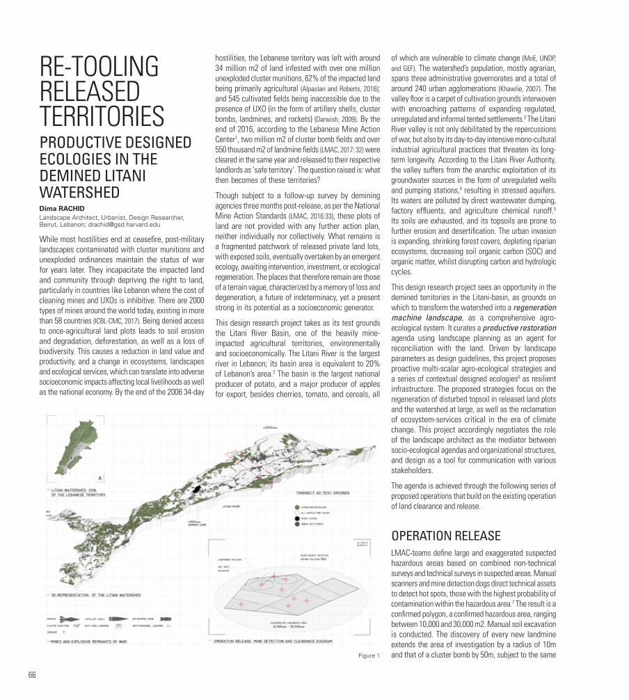
66
RE-TOOLING RELEASED TERRITORIESPRODUCTIVE DESIGNED ECOLOGIES IN THE DEMINED LITANI WATERSHEDDima RACHIDLandscape Architect, Urbanist, Design Researcher, Beirut, Lebanon; [email protected]
While most hostilities end at ceasefire, post-military landscapes contaminated with cluster munitions and unexploded ordinances maintain the status of war for years later. They incapacitate the impacted land and community through depriving the right to land, particularly in countries like Lebanon where the cost of cleaning mines and UXOs is inhibitive. There are 2000 types of mines around the world today, existing in more than 58 countries (ICBL-CMC, 2017). Being denied access to once-agricultural land plots leads to soil erosion and degradation, deforestation, as well as a loss of biodiversity. This causes a reduction in land value and productivity, and a change in ecosystems, landscapes and ecological services, which can translate into adverse socioeconomic impacts affecting local livelihoods as well as the national economy. By the end of the 2006 34-day
hostilities, the Lebanese territory was left with around 34 million m2 of land infested with over one million unexploded cluster munitions, 62% of the impacted land being primarily agricultural (Alpaslan and Roberts, 2016); and 545 cultivated fields being inaccessible due to the presence of UXO (in the form of artillery shells, cluster bombs, landmines, and rockets) (Darwish, 2009). By the end of 2016, according to the Lebanese Mine Action Center1, two million m2 of cluster bomb fields and over 550 thousand m2 of landmine fields (LMAC, 2017: 32) were cleared in the same year and released to their respective landlords as ‘safe territory’. The question raised is: what then becomes of these territories?
Though subject to a follow-up survey by demining agencies three months post-release, as per the National Mine Action Standards (LMAC, 2016:33), these plots of land are not provided with any further action plan, neither individually nor collectively. What remains is a fragmented patchwork of released private land lots, with exposed soils, eventually overtaken by an emergent ecology, awaiting intervention, investment, or ecological regeneration. The places that therefore remain are those of a terrain vague, characterized by a memory of loss and degeneration, a future of indeterminacy, yet a present strong in its potential as a socioeconomic generator.
This design research project takes as its test grounds the Litani River Basin, one of the heavily mine-impacted agricultural territories, environmentally and socioeconomically. The Litani River is the largest river in Lebanon; its basin area is equivalent to 20% of Lebanon’s area.2 The basin is the largest national producer of potato, and a major producer of apples for export, besides cherries, tomato, and cereals, all
of which are vulnerable to climate change (MoE, UNDP, and GEF). The watershed’s population, mostly agrarian, spans three administrative governorates and a total of around 240 urban agglomerations (Khawlie, 2007). The valley floor is a carpet of cultivation grounds interwoven with encroaching patterns of expanding regulated, unregulated and informal tented settlements.3 The Litani River valley is not only debilitated by the repercussions of war, but also by its day-to-day intensive mono-cultural industrial agricultural practices that threaten its long-term longevity. According to the Litani River Authority, the valley suffers from the anarchic exploitation of its groundwater sources in the form of unregulated wells and pumping stations,4 resulting in stressed aquifers. Its waters are polluted by direct wastewater dumping, factory effluents, and agriculture chemical runoff.5 Its soils are exhausted, and its topsoils are prone to further erosion and desertification. The urban invasion is expanding, shrinking forest covers, depleting riparian ecosystems, decreasing soil organic carbon (SOC) and organic matter, whilst disrupting carbon and hydrologic cycles.
This design research project sees an opportunity in the demined territories in the Litani-basin, as grounds on which to transform the watershed into a regeneration machine landscape, as a comprehensive agro-ecological system. It curates a productive restoration agenda using landscape planning as an agent for reconciliation with the land. Driven by landscape parameters as design guidelines, this project proposes proactive multi-scalar agro-ecological strategies and a series of contextual designed ecologies6 as resilient infrastructure. The proposed strategies focus on the regeneration of disturbed topsoil in released land plots and the watershed at large, as well as the reclamation of ecosystem-services critical in the era of climate change. This project accordingly negotiates the role of the landscape architect as the mediator between socio-ecological agendas and organizational structures, and design as a tool for communication with various stakeholders.
The agenda is achieved through the following series of proposed operations that build on the existing operation of land clearance and release.
OPERATION RELEASE LMAC-teams define large and exaggerated suspected hazardous areas based on combined non-technical surveys and technical surveys in suspected areas. Manual scanners and mine detection dogs direct technical assets to detect hot spots, those with the highest probability of contamination within the hazardous area.7 The result is a confirmed polygon, a confirmed hazardous area, ranging between 10,000 and 30,000 m2. Manual soil excavation is conducted. The discovery of every new landmine extends the area of investigation by a radius of 10m and that of a cluster bomb by 50m, subject to the same Figure 1

67
sequence of field operations. The process of clearance for landmines and cluster munitions through manual excavation disturbs no less than 20cm of topsoil (per national standards, with 13cm being the international standard).8
OPERATION RISK SCENARIO Operation Risk Scenario uses Geographic Information System (GIS) to analyze available remotely-sensed geospatial data9, aiming at spatially defining scenarios of vulnerability across the watershed. This operation is focused on spatializing data from a literature review (national reports on the vulnerability of Lebanon to climate change, on mitigation and recommendations, projections of regional models for climate change, etc.) overlaid with current geospatial data on terrain, surface and subsurface conditions (example: surface and subsurface water, soils, erosion, desertification index, flooding). The current spatial distribution of agricultural fields and the associated practices are closely studied in relation to projected climate changes over time, with a focus on the most vulnerable watershed crops (cherry, apple, potato, tomato, cereal, and banana). The result is a spatialized catalogue of scenarios. It emphasizes the need for site-specific mitigation measures.
OPERATION REGENERATEOperation Regenerate responds to each of the identified scenarios by deploying a toolkit of agro-ecological strategies that change over time. These strategies are mostly focused on terrain geometries and vegetal
processesas active agents of topsoil regeneration and ecosystem services reclamation.
With access to accurate locations of the released polygons denied (because of the sensitive nature of the data itself), the study assumes a transect of 5km by 20km as test ground. The selected transect falls in a previously heavily contaminated area, that also covers a range of the above risk scenarios.
Vegetal agents selected for root performance such as perennial grasses and species are deployed for phytoremediation in scenarios where fertilizer-intensive agriculture (for example potato) drains its agriculture runoff in the river system. The terrain is engineered as a constructed wetland (30m width) to allow for bio-filtration, a diverse vegetal structure, and to mitigate flooding. The introduction of vegetal cover by the river edge (150m buffer) potentially brings back the lost riparian ecosystem and improves the water quality. In scenarios where land in proximity to the river is prone to erosion, the same approach can be applied. In scenarios where agriculture fields are at a high risk of erosion and dust storms are possible, trees such as the Tamarix-species (resistant to drought and poor soils) perform as dust collector. Trees can be combined with cover crops inter-planted with the agricultural crops. Cover crops retain soil moisture, increase organic matter and stabilize soils. Similarly, nitrogen-fixing species such as legumes contribute to regenerating soils while also providing nitrogen. Furthermore, in scenarios of exhausted, poor, and saline soils, halophytic species, massively seeded in intensive crop areas, help extract excessive salts and reduce the fertilization pressure on the soils for a period of five years. Meanwhile, production in controlled
environments, and soilless practices like hydroponics and aquaponics10 could be erected temporarily on the same stressed lots. By the fifth year, remediated soils can be replanted following the same intercropping, cover crop, no-till guidelines. In scenarios additionally facing a depleted water table, densification with trees helps preserve the water level. No-till, dry-land farming and integrated cropping like permaculture combine fruit trees with low-growing shrubs to further reduce stress on soil as well as water resources. Cherry trees, except drought-resistant cherry cultivars, currently planted below 1300 meters above sea level, are relocated to higher elevations. Apple trees are combined with pest-deterring, soil-enriching productive grasses such as lemongrass and dill. Land-forming and micro-terracing on higher elevations control erosion on the one hand, and on the other hand help create micro-climate conditions favorable to tomato. Vermiculture at a household and industrial scale produces an alternative organic soil amendment. Apiculture deploys bee-feeding vegetation masses as continuous corridors. Sentient agriculture (like smart irrigation systems and drone-mapping) allows for the optimized production and allocation of limited resources in areas with large-scale stressed soils. In scenarios where the soil suitable for agriculture is located in proximity to nature reserves and fragmented woodland patches, densification with trees in the form of agroforestry is highly recommended. Agroforestry maintains agriculture production while simultaneously contributing to a larger scale national mass forestation project.11 Agroforestry maintains a flow between habitats across the territory. As for the areas evaluated as less suitable for long-term agriculture, future typologies of medium-rise high-density urban settlement could be tested along with ag-production in controlled environments.
OPERATION EXPANDAs the operations above expand at the watershed scale, a further nuanced understanding of the terrain and water resources is necessary. Given the accelerated advent of climate change and the indeterminacy of our landscape, it becomes more critical to address the role of landscape as a guide to land management, structuring urban growth in association with questions of food security (Belanger, 2011) in a paradigm shift away from the traditional zoning approach. Could the urgency to simultaneously sequester carbon, reduce the heat effect, replenish the ground table, and feed the nation finally become the guiding parameter of our urban and spatial decisions at a territorial scale?
With ecological agents such as resilient infrastructure, this design research project provokes a speculative spatial model to begin rethinking our agriculture. It capitalizes on the role of the landscape architect as the converging element, connecting spatial data analysis and local stakeholders in an agenda that is in line with
Figure 2

68
the mission of the concerned authorities to maintain a safe and resilient land and community. Determining the fate of reclaimed cleared territories for the purpose of adaptive reuse is not confined to a polygon-to-polygon programming. The place that remains therefore is a strategic network of productive terrains capable of performing collectively towards a resilient contemporary constructed ecosystem.
FOOTNOTES1. The Lebanese Mine Action Center (LMAC) was founded in 1998 and falls under the Engineering Regiment of the Lebanese Army Forces (LAF).
2. Litany River Authority, 2018, http://www.litani.gov.lb/en/?page_id=71 (accessed 15 February 2018).
3. The current population includes a minimum of 350,000 registered Syrian refugees, according to UNHCR.
4. Litany River Authority, 2018, http://www.litani.gov.lb/en/?page_id=71 (accessed 15 February 2018).
5. Litany River Authority, 2018, http://www.litani.gov.lb/en/?page_id=71 (accessed 15 February 2018).
6. Designed Ecologies, as described by Christof Girot (2016), corresponds to a universal language, detached from local cultural or historical contexts, and a new approach to the curation of nature for the purpose of performance in restoration ecology in particular, to reverse environmental deterioration.
7. Land Release in Humanitarian Mine Action, Norwegian People’s Aid Humanitarian Disarmament, Published on April 19, 2016, https://www.youtube.com/watch?v=NSfEbAlvHCM.
8. Makki, Major A. interviewed by Dima Rachid, 2017-2018, Lebanese Mine Action Center, Chukri Ghanem Military School, Fayadieh, Lebanon.
9. Raw geospatial data obtained from the National Center for Remote Sensing (NCRS); other data digitized from reports, for example the National
Physical Master Plan of the Lebanese Territory, Final Report, Lebanon, 2005.
10. Agriculture technology like hydroponics and smart irrigation is starting to grow locally in the form of ag-tech startups.
11. The Lebanese Reforestation Initiative (www.lri-lb.org) works with local communities to support native tree planting across Lebanon, mainly foresting public lands, religious-endowment land, and abandoned lots.
FIGURESFigure 1. Operation Release: Mine Detection and Clearance
Figure 2. Operation Risk Scenario: Mapping Scenarios of Vulnerability Across the Watershed)
Figure 2. Operation Regenerate: Transect as Test Grounds
BIBLIOGRAPHYAlpaslan, O. and Roberts, R. (2016). Challenging Post-Conflict Environments: Sustainable Agriculture. London Routledge.
Belanger, P. and Roth, C. (2011). The Agronomic Landscape.
Darwish, M. et al. (2009). The 2006 war and its inter-temporal economic impact on agriculture in Lebanon. Disasters 33(4): 629–644.
Girot, C. (2016). Designed ecologies. FS 2018 V02. Landscape Architecture. Theory Lab Lecture Series, Zurich: Institute of Landscape Architecture.
ICBL-CMC (International Campaign to Ban Landmines-Cluster Munition Coalition) (2017). Landmine Monitor 2017. Available at: http://www.the-monitor.org/en-gb/reports/2017/landmine-monitor-2017 (accessed 10 March 2018).
Khawlie, M. et al. (2007). Towards an ecosystem approach to the sustainable management of the Litani Watershed- Lebanon: Final technical Report to IDRC. Lebanon.
LMAC (Lebanese Mine Action Center) (2017). Annual Report 2016. Lebanon.
MoE, UNDP, and GEF (2016). Lebanon’s third national communication to the UNFCCC. Lebanon.
AUTHORDima RACHID is a landscape architect, urbanist, and design researcher. Throughout her education and practice she engaged in multi-scalar design research, design-build, and mapping projects in landscape and urbanism across the United States, Lebanon, Southeast Asia, West Africa, and Latin America. Dima received her Master in Landscape Architecture from the Harvard University Graduate School of Design in 2015 and was the recipient of the American Society of Landscape Architects Graduation Award for Excellence, for cumulative academic work. She received her Bachelor in Landscape Design from the American University of Beirut, where she currently lectures on urban landscape infrastructure. Prior to returning to Lebanon in 2017 to establish a practice in landscape and urbanism (“Studio Libani”), she practiced with ahbe landscape architects in Los Angeles.
Figure 3
69
HOW MUCH LAND DOES A CITY NEED? WAQF AND PUBLIC SPACE IN BEIRUT AFTER THE PROMULGATION OF THE OTTOMAN BUILDING CODE OF 1882Joseph RUSTOM Lebanese Academy of Fine Arts
“Our only trouble is that we haven’t land enough.
If I had plenty of land, I shouldn’t fear the Devil himself.”1
Inalienable charitable endowments, in Arabic called waqf, have shaped the urban space and economy of traditional Arab cities for centuries. Mosques, churches, madrasas, hospitals, caravanserais, and water supply systems were all founded as waqf. Furthermore, these religious and charitable institutions were accompanied by the construction of economic infrastructure like shops and houses, and hence they owned entire souks and residential quarters, whose revenues financed these institutions, both on the physical and human levels.
In the middle of the nineteenth century, a series of modernization reforms promulgated by the Ottoman central authorities, the Tanzimat, brought a radical shift to the management of waqf, as it was considered to be hampering urban development and immobilizing land property inside the city. During this period, Beirut was witnessing unprecedented economic growth, which led to its transformation into one of the major port cities of the Eastern Mediterranean.2 This growth was accompanied by the implementation of Western political, social, and urban standards largely fostered by the Tanzimat, that opposed the waqf’s interests.
I argue that, since inalienability is the main characteristic of all waqf - i.e. the fact that waqf, to become valid, must be taken out of the sphere of commercial transaction, that of purchase and sale - waqf in Late Ottoman Beirut was the place that remains par excellence, remaining here referring to perpetual, not residual.
THE LAWSThe Ottoman Land Code of 1858 brought a first change to waqf and, more generally, to the notion of property, by emancipating it from any juridical or administrative obstacles that limited its free circulation. It entailed two radical shifts in both the definition of land and of state
power: Land was not a territory producing foodstuffs and tax revenues any longer, but became a commodity, a thing to be bought and sold.
The Building Code of 1882 brought a second crucial change through a series of key measures. Its annotated translation in Arabic, qãnun al-’abnia, accompanied by the Resolution on the Expropriation of Property for Reasons of Public Benefit of 1879, qarãr al-’istimlãk li ’ajl ’l-manãfi’ ’l-‘umumiyya, is the first set of urban regulations specific to Beirut. Published by the engineer of the municipality, Amine Abdelnour in 1896, it is an exceptional account of the economic, legislative, and social situation in the city at the turn of the nineteenth century, as well as of the changes that the law introduced (see Abdelnour, 1896).
Through a simple text structure3 and a remarkable talent for persuasion, Abdelnour subtly introduces the changes in the process of space production and in spatial practices as decided by the central authority from the one side, and establishes the authority of the newly created institution he represents from the other side, namely the municipality. Surveys, drawings, space schedules, and construction permits were established as new sources of information and regulation of the built environment in the city, while a team of qualified technicians, headed by the municipal engineer [muhandis dã’irat ‘l-baladiyya], was hired to plan, manage, control, and archive all urban interventions.
WAQFAccording to Abdelnour, Beirut had to adapt to the “modern taste” [al-dhawq al-‘asri] by means of the Beaux-Arts urban concepts of circulation, hygiene, and embellishment. For instance, dead-ends and arched bridges over the roads should be forbidden as “the inhabitants of cities with narrow and covered streets were correspondingly pale and unable to articulate clearly.” The law in fact ended the prerogatives of groups [jamã‘ãt] to control communal space, as dead-ends were community spaces par excellence in traditional Arab cities. Indeed, beyond the spaces themselves, all forms of authority related to them were targeted, and all intermediate forms of space and authority between the individual and the state, and the private and the public, were abolished. The individual was given a new role in the creation of urban space, outside any allegiance to groups or any other form of social hierarchy. All matters relating to urban space no longer fell under the jurisdiction of the religious tribunals [al-mahãkim al-shar‘iyya], but directly under that of the municipality. These standards opposed an age-old modus operandi of the city, in which waqf played a major role.
By making a clear separation between public and private, and individual and state authority, the Building Code left very little space for the waqf as an urban authority and a privileged landowner. Having kept the religious tribunals
out of all urban decisions, it obliterated de facto religious authority in urban space. The law purposefully made no mention of waqf land inside the city. As for waqf buildings, Abdelnour splits them into two categories: religious and charitable buildings [al-’abnia al-khayriyya], considered as public buildings, and buildings endowed to support them [al-’abnia al-waqfiyya], considered as private. This categorization clearly aimed at dissolving the particular status of waqf and the dissociation it upheld between a property and its usufruct. I argue that the absence of special recommendations concerning waqf property left it in an awkward position, which could have been profitable and harmful to both parties at the same time, since it marginalized the waqf but also gave it a certain room to maneuver, as I demonstrate later.
PUBLIC SPACEThe marginalization of waqf in Abdelnour’s translation should be put next to the definition that the author gives of public space. Within this category, he subsumes the roads, the courtyards of places of worship [bãhãt al-ma‘ãbid], seaports [al-’asãkil], coasts, squares, and promenades. Before the city’s sudden development in the middle of the nineteenth century, public space existed naturally: squares were used as meeting places to spend free time, celebrate marriages, funerals, religious and seasonal holidays, and to receive important visitors to the city.
Open spaces in the direct vicinity of religious buildings were used as a natural extension to house large crowds on special days. Coasts, riversides, and lakesides were used for temporary storage before and after shipments, for repairing boats, watering the cattle, or washing clothes. Curiously enough, Abdelnour does not classify these public spaces into one of the five categories of real estate property as defined by the Ottoman Land Code,4 and designates them rather as “’arãdi ghayr mamlãka”, i.e. land plots that are not owned. It therefore seems that these public spaces had no clear legal status, but were simply undisputed remaining spaces, in the sense of residual here, used by everybody.
With the demographic growth of the city and the construction boom, and more specifically the construction of customs, large warehouses, and important religious buildings, public spaces progressively lost their traditional use. Nevertheless the contemporary lifestyle inspired by that of “civilized countries” [al-buldãn al-mutamaddina] required open spaces for the celebration of religious and seasonal holidays, playgrounds for the children of the poor, refuges in case of fire or an earthquake, and also enough open space to purify the air, embellish the city, and “entertain the stranger” [tasliyat al- gharïb]. But with the rapid increase of the price of land, public spaces were threatened by the greed of powerful landowners and the employees of the administration, who tried to transform them into private land.

70
Although the law granted the municipality with the role of protecting these remaining spaces, it seems that their existence, at least in the form and function that they had before the Tanzimat, was as threatened as that of waqf.
CONCLUSION With the Building Code of 1882, the urban space of Beirut was for the first time conceived as a whole entity.5 Remaining space in both senses of the word, perpetual and residual, could not be afforded anymore and had to disappear. Affected by the new market economy and the rise of new urban dynamics, waqf authorities had to reconsider the way in which they managed their property and their role within the city. In this new market economy, in which land became a commodity, the need for land was only limited by the lust of the individual. As proven by the hero of Leo Tolstoy’s novel “How much Land does a Man Need?”, written in 1886, this lust has no limits and could have disastrous consequences. Allowed to have all the land he could walk around in one day for one thousand rubles, Pahom walks until he falls dead, reminding us that “six feet from [our] head to [our] heels was all [we] needed”.
This vision of property clearly opposed the separation between usufruct and land that waqf promoted, and in which land belonged to God and its usufruct to men. Interestingly enough, this vision is to be found among Enlightenment thinkers, starting with Jean-Jacques Rousseau’s (1754: 192) famous stance that “the fruits of the earth belong to us all, and the earth itself to nobody.”
For waqf authorities, the law became the place that remains, a place for negotiation while shifting from one system of space production to another that provided them, as well as all other protagonists, with the vocabularies, idioms, and concepts for communication and deliberation. This remaining place eventually allowed the waqf institutions, and the various religious communities that they represented, to sustain their interests in the city and remain the biggest landowners in Lebanon until today. The main reason behind the survival of waqf is also the fact that the city’s families of notables, who provided both the new urban institutions, like the municipality, and the waqf with their protagonists, were keen on sustaining old and new structures of power within the city, to serve their needs in an optimal way. A more pessimistic view is to consider the religious community as the remaining place left for the Lebanese to negotiate the physical remains of their land, if laws and regulations are not revised and revived to again take this role.
FOOTNOTES1. Tolstoy, Leo. 2001. How Much Land Does a Man Need? Brooklyn, N.Y.: Crocodile Books.
2. Beirut’s transformation started under the short but very significant Egyptian rule of Ibrahim Pasha, son of Muhammad Ali Pasha, from 1831 to 1840. In
the following decades, the change was accelerated through a series of key measures and events: The construction of a casern and a quarantine area in 1835; the creation of the Beirut-Damascus road in 1857; the rise of the press, starting with a first local newspaper in 1858; the arrival of an important, mainly Christian, migratory wave in the aftermath of the sectarian strife in Mount Lebanon and Damascus in 1860; the creation of the first municipal council in 1863; the nomination of the city as the capital of a wilãya (governorate) that ranged from Palestine to Lattakia in 1888; and finally the construction of a new port in 1895. Along with the abovementioned key events, the city witnessed a growing presence of foreign representation in support of national commercial interests and in the proliferation of missionary schools. This progressively led to the formation of an intellectual middle class in Beirut that instigated a real cultural renaissance, the Nahda, largely modeled on the Egyptian renaissance model that flourished in the wake of the reformist drive of Muhammad Ali Pasha at the beginning of the nineteenth century.
3. Each article’s translation is followed by the interpretation of the author written in smaller characters.
4. The mahmiyya, matrüka, mushã‘, mawãt and waqf. See Young (1905-07).
5. The perception of the city as one entity was even more emphasized by the demolition of the city walls that led to the creation of new spatial perceptions: Like a building, the city now had façades, the main one being the maritime façade perceived by the visitors (merchants, industrials, diplomats, writers, etc.) arriving by boat.
BIBLIOGRAPHYAbdelnour, A. (1896). Tarjamat wa sharh qãnun al-’abnia wa qarãr al-’istimlãk [Translation and Explanation of the Building Code and the Resolution on Expropriation of Property]. Beirut: Al-Matba’a al-’Adabiyya.
Rousseau, J.-J. (1754). Discourse on the Basis and Origin of Inequality among Men. London: Dent, 1966.
Young, G. (1905-07). Corps du Droit Ottoman. 7 vols. Oxford: Clarendon Press.
AUTHOR Joseph RUSTOM holds a Master of Architecture from the Lebanese Academy of Fine Arts from 2000, a Master of Advanced Studies in the Preservation of Archaeological Sites and Monuments from the Marc Bloch University in Strasbourg, 2001, a Master of Advanced Studies in Urban Archaeology from the François Rabelais University in Tours, 2004, and a Doctoral Degree in Urban Planning from the BTU Cottbus-Senftenberg from 2016, with a thesis on the impact of religious endowments on urban projects in Late Ottoman and French Mandate Beirut. He is a Fellow at the Saint Joseph University, Beirut, in the framework of the research project “Atlas of the Religious Spaces of Lebanon,” and a Fellow of the Forum Transregionale Studien, Berlin, in the framework of the research project “Global Prayers: Redemption and Liberation in the City.” He is also a lecturer in cultural heritage studies at the School of Architecture of the Lebanese Academy of Fine Arts since 2003. Between 2000 and 2008, he was a conservation architect, at Youssef Haidar Architects and Dagher, Hanna, and Partners Architects successively, where he managed several conservation and rehabilitation projects, among them the Omari Mosque, the American University Archaeological Museum in Beirut, and the Soap Museum in Saida.
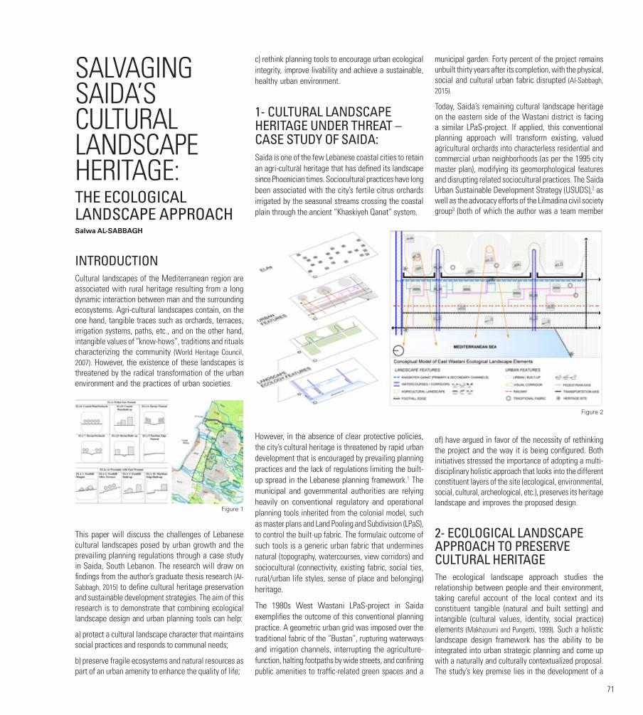
71
SALVAGING SAIDA’S CULTURAL LANDSCAPE HERITAGE:THE ECOLOGICAL LANDSCAPE APPROACHSalwa AL-SABBAGH
INTRODUCTION Cultural landscapes of the Mediterranean region are associated with rural heritage resulting from a long dynamic interaction between man and the surrounding ecosystems. Agri-cultural landscapes contain, on the one hand, tangible traces such as orchards, terraces, irrigation systems, paths, etc., and on the other hand, intangible values of “know-hows”, traditions and rituals characterizing the community (World Heritage Council, 2007). However, the existence of these landscapes is threatened by the radical transformation of the urban environment and the practices of urban societies.
This paper will discuss the challenges of Lebanese cultural landscapes posed by urban growth and the prevailing planning regulations through a case study in Saida, South Lebanon. The research will draw on findings from the author’s graduate thesis research (Al-Sabbagh, 2015) to define cultural heritage preservation and sustainable development strategies. The aim of this research is to demonstrate that combining ecological landscape design and urban planning tools can help:
a) protect a cultural landscape character that maintains social practices and responds to communal needs;
b) preserve fragile ecosystems and natural resources as part of an urban amenity to enhance the quality of life;
c) rethink planning tools to encourage urban ecological integrity, improve livability and achieve a sustainable, healthy urban environment.
1- CULTURAL LANDSCAPE HERITAGE UNDER THREAT – CASE STUDY OF SAIDA: Saida is one of the few Lebanese coastal cities to retain an agri-cultural heritage that has defined its landscape since Phoenician times. Sociocultural practices have long been associated with the city’s fertile citrus orchards irrigated by the seasonal streams crossing the coastal plain through the ancient “Khaskiyeh Qanat” system.
However, in the absence of clear protective policies, the city’s cultural heritage is threatened by rapid urban development that is encouraged by prevailing planning practices and the lack of regulations limiting the built-up spread in the Lebanese planning framework.1 The municipal and governmental authorities are relying heavily on conventional regulatory and operational planning tools inherited from the colonial model, such as master plans and Land Pooling and Subdivision (LPaS), to control the built-up fabric. The formulaic outcome of such tools is a generic urban fabric that undermines natural (topography, watercourses, view corridors) and sociocultural (connectivity, existing fabric, social ties, rural/urban life styles, sense of place and belonging) heritage.
The 1980s West Wastani LPaS-project in Saida exemplifies the outcome of this conventional planning practice. A geometric urban grid was imposed over the traditional fabric of the “Bustan”, rupturing waterways and irrigation channels, interrupting the agriculture-function, halting footpaths by wide streets, and confining public amenities to traffic-related green spaces and a
municipal garden. Forty percent of the project remains unbuilt thirty years after its completion, with the physical, social and cultural urban fabric disrupted (Al-Sabbagh, 2015).
Today, Saida’s remaining cultural landscape heritage on the eastern side of the Wastani district is facing a similar LPaS-project. If applied, this conventional planning approach will transform existing, valued agricultural orchards into characterless residential and commercial urban neighborhoods (as per the 1995 city master plan), modifying its geomorphological features and disrupting related sociocultural practices. The Saida Urban Sustainable Development Strategy (USUDS),2 as well as the advocacy efforts of the Lilmadina civil society group3 (both of which the author was a team member
of) have argued in favor of the necessity of rethinking the project and the way it is being configured. Both initiatives stressed the importance of adopting a multi-disciplinary holistic approach that looks into the different constituent layers of the site (ecological, environmental, social, cultural, archeological, etc.), preserves its heritage landscape and improves the proposed design.
2- ECOLOGICAL LANDSCAPE APPROACH TO PRESERVE CULTURAL HERITAGE The ecological landscape approach studies the relationship between people and their environment, taking careful account of the local context and its constituent tangible (natural and built setting) and intangible (cultural values, identity, social practice) elements (Makhzoumi and Pungetti, 1999). Such a holistic landscape design framework has the ability to be integrated into urban strategic planning and come up with a naturally and culturally contextualized proposal. The study’s key premise lies in the development of a
Figure 1
Figure 2
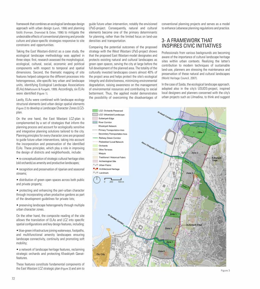
72
framework that combines an ecological landscape design approach with urban design (Lynch, 1996) and planning tools (Forman, Dramstad & Oslan, 1996) to mitigate the undesirable effects of conventional planning and provide culture and place-specific strategies responsive to site constrains and opportunities.
Taking the East Wastani-district as a case study, the ecological landscape methodology was applied in three steps: first, research assessed the morphological, ecological, cultural, social, economic and political components with respect to temporal and spatial dimensions. Second, the thematic mapping of site features helped categorize the different processes into heterogeneous, site-specific key urban and landscape units, identifying Ecological Landscape Associations (ELAs) (Makhzoumi & Pungetti, 1999). Accordingly, six ELAs were identified (Figure 1).
Lastly, ELAs were combined with landscape ecology structural elements (and urban design spatial elements (Figure 2) to develop a Landscape Character Zones (LCZ)-plan.
On the one hand, the East Wastani LCZ-plan is complemented by a set of strategies that inform the planning process and account for ecologically sensitive and integrative planning solutions tailored to the city. Planning principles for every character zone are proposed to guide future urban interventions, taking into account the incorporation and preservation of the identified ELAs. These principles, which play a role in improving the design of districts and neighborhoods, include:
• re-conceptualization of strategic cultural heritage sites (old orchards) as amenity and productive landscapes;
• recognition and preservation of riparian and seasonal streams;
• distribution of green open spaces across both public and private property;
• protecting and enhancing the peri-urban character through incorporating urban productive gardens as part of the development guidelines for private lots;
• preserving landscape heterogeneity through multiple urban character zones.
On the other hand, the composite reading of the site allows the translation of ELAs and LCZ into specific spatial configurations and key design features, including:
• blue-green infrastructure joining waterways, footpaths, and multifunctional amenity landscapes ensuring landscape connectivity, continuity and promoting soft mobility;
• a network of landscape heritage features, reclaiming strategic orchards and protecting Khaskiyeh Qanat-features.
These features constitute fundamental components of the East Wastani LCZ strategic plan (Figure 3) and aim to
guide future urban intervention, notably the envisioned LPaS-project. Consequently, natural and cultural elements become one of the primary determinants for planning, rather than the limited focus on land-use densities and transportation.
Comparing the potential outcomes of the proposed strategy with the West Wastani LPaS-project shows that the proposed East Wastani-model designates and protects existing natural and cultural landscapes as green open spaces, serving the city at large before the full development of the planned area. The totality of the culturally invested landscapes covers almost 40% of the project area and helps protect the site’s ecological integrity and distinctiveness, minimizing environmental degradation, raising awareness on the management of environmental resources and contributing to social betterment. Thus, the applied model demonstrates the possibility of overcoming the disadvantages of
conventional planning projects and serves as a model to enhance Lebanese planning regulations and practice.
3- A FRAMEWORK THAT INSPIRES CIVIC INITIATIVES Professionals from various backgrounds are becoming aware of the importance of cultural landscape heritage sites within urban contexts. Realizing the latter’s contribution to modern techniques of sustainable land-use, planners are stressing the maintenance and preservation of these natural and cultural landscapes (World Heritage Council, 2007).
In the case of Saida, the ecological landscape approach, adopted also in the city’s USUDS-project, inspired local designers and planners concerned with the city’s urban projects such as Lilmadina, to think and suggest
Figure 3
73
alternative solutions for a healthy urban environment. The Lilmadina-initiative started by documenting and archiving sites of cultural value and conducted a series of workshops and focused discussions with experts to propose strategies that can help alleviate threats and promote such sites. The initiative also engaged with the municipality and governmental authorities through providing recommendations and alternative solutions for practices threatening the city’s cultural landscapes. Finally, and since the protection of the cultural landscape cannot be successful without the participation and engagement of civic societies and local inhabitants, the initiative organized awareness campaigns to talk about the importance of such sites in defining the city’s identity, reviving cultural practices and values and ensuring a healthy living environment.
In conclusion, the paper’s methodological significance lies in the development of a model that combines the ecological landscape approach and urban design with planning disciplines to provide an alternative way to think about urban development and quality living. The proposed model succeeded in the development of planning strategies that complement and enhance existing Lebanese planning tools, and thus salvage what remains of Lebanese natural and cultural landscapes without compromising on urban development needs.
FOOTNOTES1. Article 17 of Lebanese building law: allows construction everywhere in the Lebanese territory, even within areas that have no zoning ordinances or master-plans.
2. Saida Urban Sustainable Development Strategy, a MEDcities project commissioned by the Municipality of Saida, 2012-2014
3. Lilmadina a group of activists from Saida with different professional backgrounds, concerned with the protection of the city of Saida’s heritage and its urban development.
FIGURESFigure 1. East Wastani Ecological Landscape Associations (Al-Sabbagh 2015).
Figure 2. Conceptual Model of Ecological Landscape Composite. Elements (Al-Sabbagh, 2015).
Figure 3. East Wastani LCZ Strategic Plan (Al-Sabbagh, 2015)
BIBLIOGRAPHY:Al-Sabbagh, S. (2015). Rethinking planning tools through the ecological landscape design approach: Saida Case Study. MS Thesis, American University of Beirut, Lebanon. Available at: https://scholarworks.aub.edu.lb/handle/10938/10932?show=full.
Forman, R., Dramstad, W. and Oslan, J. (1996). Landscape Ecology Principles in Landscape Architecture and Land-use Planning. Washington: Harvard University Press.
Harithy, H., Makhzoumi, J., Hallaj, O., Hamadeh, K. and Srour, I. (2013): Urban sustainable development strategy. Strategic Framework Report, MEDCities. Saida. Available at: http://www.medcities.org/documents/22116/42242/13.11.12.Saida+USUDS+Strategic+Framework+Report_finalGG+-+Copy.pdf/7efb5852-d4bb-4740-8f42-8575b5b32bf7.
Lynch, K. (1996). The city image and its elements. In Reader, T. C., Le Gates, R.T. and Stout F. (Eds.) The City Reader (pp. 98-102). London: Routledge.
Makhzoumi, J. and Pungetti, G. (1999). Ecological Landscape Design and Planning: The Mediterranean Context. New York: Routlege.
Makhzoumi, J. (2015). The greening discourse ecological landscape design and city regions in the Mashreq. In Saliba, R. (Ed.) Urban Design in the Arab World: Reconceptualizing Boundaries (pp. 65-82). London: Ashgate.
Meyrueis, L. (2007). Thematic meeting of experts on the agro-pastoral cultural landscapes in the Mediterranean, France, September 20-22. Available at: http://whc.unesco.org/en/events/489 [accessed on 04 March 2017]
World Heritage Council (2007). http://whc.unesco.org/en/culturallandscape/
UNHABITAT (2012). The state of Arab cities 2012. Challenges of urban transition. Available at: http://www.unhabitat.org/pmss/listItemDetails.aspx?publicationID=3320 (accessed: 25 November 2017).
AUTHORSSalwa AL-SABBAGH graduated from the American University of Beirut with an MS in Urban Design (2015) and a BS in Landscape Design and Eco-system Management (2011). She is currently working at Unit 44 (Beirut) and is a founding member of the Lebanese Landscape Association. Salwa has worked
on large-scale architecture, urban projects, and city development strategies in Lebanon and the MENA-region. With Dr. Jala Makhzoumi, she researched various topics related to landscape, public space, urban development and planning policies in Lebanon and the Middle East. Al-Sabbagh also participated in a number of local and international workshops tackling heritage, ecological, urban and informality issues to attain comprehensive solutions to deal with problematic conditions in the Mediterranean region.
74
THE LEGAL REGIME OF WAQF IN LEBANON:AN OVERVIEW Marwan SAKR LLM, FCIArb, C.Arb∗
A HISTORICAL AND COMPARATIVE INTRODUCTION TO THE LAW OF WAQFOne of the five pillars of Islamic faith is the principle of charity. Because a Muslim is obligated to perform charitable acts, an independent body of law has developed governing the use of property for charitable purposes based on a Hadith between the Prophet and Omar ibn Al-Khattab.1 When property is used for such purposes, it is known as a Waqf or also habous in some North African countries.2
As it transpires from its Arabic name (Waqf from the verb “waqaf” -to stop- or habous from “habass” - to detain), the law of Waqf forbids the sale or disposition of real property when property rights are created for the benefit of a charitable enterprise (in effect the direct opposite of the rule against perpetuities). Furthermore, the many similarities of the law of Waqf with the English/American law based trust and the Roman-Germanic law based fiducia con amico or with the modern French and German laws concepts of fondation or stiftung, have been highlighted by legal scholars in their perpetual search for new asset management techniques based on trust and confidence3 that go beyond the traditional approach related to the management real property and estates to reach modern financial assets and the development of financial markets.4
This paper will focus on the legal regime of Waqfs in Lebanon.
After the establishment of the French Mandate, the High Commissioner reorganised the law of Waqfs in Lebanon. Yet, because Waqfs at that time were based essentially upon Qur’anic law rather than secular law, a special legislation was required to maintain both the spirit of the Sharia and the independence of the Islamic community in its use and administration of Waqfs.5
In addition to the Islamic charitable Waqf, the Christian communities have also adopted a similar concept of Waqf regulated by each community’s specific law.6
However, not all Waqfs are of a charitable nature. When property is initially alienated for the benefit of certain relatives of the founder (or other specified persons) and will subsequently benefit a charitable enterprise, the alienation is known as a Waqf zurry (or ahli); a family Waqf that is regulated in Lebanon by a secular law enacted in 1947.7 There is also a Waqf known as a mixed Waqf.8
Although the legal regime of family Waqf may be more interesting to explore in the present context, this paper will focus on both the Islamic charitable Waqf (which is the main type of charitable Waqf which has inspired other types Waqfs) and the family Waqf. It will address the legal characteristics and nature common to all categories of Waqfs (I), before turning to some specificities of the legal regimes relating to charitable (II) and family Waqfs (III).
I. COMMON CHARACTERISTICS OF WAQF AND ITS LEGAL NATURE
1. General characteristics of Waqf
A Waqf immobilizes property and prevents its disposal by sale, donation, mortgage, surety, partition or seizure.
In addition, one cannot acquire ownership of such property by prescription. The alienated property can, however, be acquired for public use, by pre-emption.
The creation of a Waqf also creates a legal person which has a special patrimony owner of the alienated property. Case law recognises the legal personality of an alienated Waqf property.9
A charitable Waqf, once established, becomes obligatory. However, the new Waqf zurry is no longer obligatory,10 as the founder is allowed to reverse his decision.11
A Waqf is a property right and as such must conform to the legal requirements pertinent to all property rights.
2. Formal conditions required to establish a valid Waqf
For a Waqf to be considered valid and to have legal effect, a written document must be executed and registered in the Real Property Register.
The creation of a Waqf is completed and has legal effect as soon as it is issued from the waqef (the founder). However, the beneficiary can refuse it, in which case, the Waqf goes to another beneficiary and then to the charitable institution as indicated by the Waqf deed.
II. THE CHARITABLE WAQF (WAQF KHEIRI)A charitable Waqf (Waqf kheiri) is that whose profits are to be used for charity (e.g., payment to mosques, churches, hospitals, asylums etc..).
1. Control of the Waqf
Islamic Waqfs are administered by the High Council of Islamic Waqfs,12 which makes general policy decisions and, in particular, decides how the income derived from Waqf property will be used.
Local committees send their grievances to the Council for consideration. The Council is assisted by a General Committee for the Islamic Waqfs,13 which is acts as a consultant and makes unbinding recommendations. Decisions of either the High Council or the General Committee are made by majority vote. The General Comptroller14 carries out the decisions of the High Council; controls the way funds are spent, reports illegalities, issues instructions to local Waqf directors; and proposes a budget to the High Council.
2. Lease, exchange and partition of charitable Waqfs
A usufruct can be obtained from an alienated Waqf property in accordance with either the conditions set by the founder or the nature of the property, in which case, the usufruct is limited to what has been stipulated (e.g., mosques, schools, cemeteries).
If the founder imposes conditions upon the use of the property, his stipulations must be respected if they are not illegal. However, the founder may not indicate how the property shall be used as a general principle. Also, there is a particular way of exploiting agricultural property15.
In 1926, a law was enacted16 to limit the leasing of Waqfs17. Another provision which subjects all leases to state authority represents a major intervention of the state in the administration of Waqfs.18
Waqf property can be exchanged for another property or sold with the proceeds being used to purchase other lands.
Each parcel that is exchanged should be equal in value to that which is received. Also, there is a right of pre-emption for the lessor in the event of an exchange.
A Waqf may be divided into independent lots19 to enable each beneficiary, which becomes its trustee, to receive the proceeds from a separate portion of the property.

75
3. Authority to expropriate property for charitable purposes
Under Islamic law, Waqfs are intended to serve the public; Ottoman law provided for the expropriation of real property for charitable purposes. This law has been maintained in Lebanon.
4. Use of profits from the Waqf
Waqfs apply to non-profit organisations in Islamic countries. To carry out their functions, they have an internal organisation that was originally delineated by the Ottoman law20 and is still essentially in force in Lebanon today.
III. THE FAMILY WAQF
1. Nature and establishment
The profit in a family Waqf is initially distributed among the family members of the founder. It is possible, however, to find mixed Waqfs which are part charitable and part family. Rules for the establishment, division and termination of Waqfs were set forth in the law enacted in 1947. Any Waqf established after the effective date of this law should be administered in accordance with its provisions, otherwise the Waqf is null and void.21 According to the 1947 law, a Waqf cannot be made for more than two generations thereafter, the property goes back to the beneficiary of the initial inheritance. If there is no beneficiary, the family Waqf become a charitable Waqf.
Any condition in the establishment of the Waqf contrary to its purpose is null. The Waqf may be in the form of real property or any other property.
The division of a family Waqf is subject to the general rules applicable to any other legal division of property. The shares are divided according to the will of the donor or the value of the Waqf’s property.
2. Beneficiaries and administration
The beneficiaries of a family Waqf can include the founder himself, his children, his relatives, or even third parties; whether individuals or corporations. No affiliation to a particular religion or sect is required.
Any single person with no children can establish a Waqf using his entire property. If he has prospective heirs, however, the amount of the donation may be limited to what is permitted by the inheritance laws of his religious community.22
Since a Waqf is deemed to be a legal person, it becomes necessary to appoint a natural person, which acts as a trustee, to represent it, to manage its interests, to make proper use of the property, to distribute the proceeds to the beneficiaries, and to carry out the wishes of the founder. If the founder does not appoint such person,
he will act himself as the trustee either directly or through a representative. But the founder must appoint a person to act as a trustee after the founder’s death, otherwise, a local judge becomes the legal trustee and subsequently manages the Waqf directly or through someone he appoints. A family Waqf is managed by one of the beneficiaries appointed by the religious court. The administrator is liable for any action he takes which may diminish the value of the Waqf. He is required to present relevant data to the religious authorities on a regular basis and to enforce all decisions of the religious court. The laws relating to family Waqfs apply only to Christian and Jewish Waqfs. Islamic family Waqfs are still administered in accordance with Islamic tradition.
3. Termination of family Waqf
In principle, a charitable Waqf is considered to be perpetual. The Waqf zurry and the mixed Waqf, however, became temporary since 1947.23
If the founder specifies a period of alienation, the Waqf terminates on the specified date, unless each of the beneficiaries predeceases him, in which case it terminates upon the death of the last beneficiary to die.24
If the Waqf is to continue for the life of the beneficiaries, it will terminate upon the death of the last surviving beneficiary.25 A Waqf zurry can be revoked by the founder.26 A Waqf terminates when the property becomes materially useless or the proceeds therefrom become negligible27. A request for the termination of a Waqf can be made by any of the parties28 before the civil court. At the end of the Waqf, full ownership reverts to the founder if still alive, or if he has deceased, to his heirs, otherwise, it reverts to a charitable institution when stipulated and, if not, reverts to the state.
CONCLUSION AND SUGGESTIONSThe Waqf system has played a significant socioeconomic role throughout history of Islamic civilization. It has been submitted by economists that the Waqf system can significantly contribute towards the ultimate goals of a modern economy, by providing essential services to society at zero cost to the state.29 In Lebanon, Waqf could restore distribution of income and wealth and play a vital role in socioeconomic development, which could be achieved in modern times by comprehensively improving some prerequisites as follows:30
a) Issuing a new legal framework that imparts a clear definition of Waqf, organises this institution effectively, and regulates its social and economic roles, providing necessary legal protection for the Waqf properties and governing the repossession of all those that were diverted to other public and/ or private persons.
b) Revising the management of Waqf, especially its investment kind and providing technical, managerial
and financing support to the Waqf management to help it increase the productivity of Waqf properties; in order to: (i) increase the efficiency and productivity of the Waqf properties; and (ii) minimize the potential of dishonest practices and corruption by the Waqf managers.
c) Revising the classical concept of Waqf to accommodate many new forms of potential Waqf particularly in the area of Waqf of usufruct and Waqf of non-physical properties, although this is currently possible for family Waqf under Lebanese law. Similarly, the concept of temporary Waqf also needs to be expanded.
d) Redefining the roles of the Waqf authorities by making them agents of support and catalysts of help in the development of Waqf rather than administrative managers of Waqf properties.
76
FOOTNOTES1. Imam Muslim, Sahih Muslim, volume: The Book of Bequests (Kitab Al-Wasiyya), at 4006
2. Joseph Luccioni, Le habouss ou wakf (rites malékite et hanéfite), Thèse de droit, Alger, 1942 ; Abdelfattah Eddahbi, Les biens publics en droit marocain, Editions Afrique-Orient, Casablanca, 1992.
3. See e.g., David Powers, The Islamic Family Endowment (Waqf), (1999) 32 Vanderbilt Journal of Transnational Law 1167; Jeffrey A. Schoenblum, The Role of Legal Doctrine in the Decline of the Islamic Waqf: A Comparison with the Trust, (1999) 32 Vanderbilt Journal of Transnational Law 1191; Thomas P. Gallanis, The Contribution of Fiduciary Law, University of Iowa Legal Studies Research Paper, Number 12-05, January, 2012, in L. Smith (ed.), The Worlds of the Trust, Cambridge University Press, (2013) available at http://ssrn.com/abstract=1970440 (visited on 31 December 2017); Bichara Tabbah, Propriété privée et registre foncier, LGDJ, Paris 1947, vol. 1, p. 399;Tahar Khalfoune, Le Habous, le domaine public et le Trust, Revue internationale de droit comparé (RIDC), 2/2005, pp. 442 et seq; Marwan Sakr, Droit de propriété, wakfs, fiducie et trust anglo-saxon. Convergence et divergence, a paper presented to the conference: Droit et propriété au Liban : explorations empiriques, Institut français du Proche-Orient, Beirut, 14 June2012 http://www.ifporient.org/node/1127.
4. See e.g., The World Bank Group and Islamic Development Bank Group, Global Report on Islamic Finance: Islamic Finance - A Catalyst for Shared Prosperity? Washington, DC, 2017: World Bank. © Islamic Development Bank Group. Available at https://openknowledge.worldbank.org/handle/10986/25738 License: CC BY 3.0 IGO
5. High Commissioner’s Decision (arrêté) No. 753 of 1922
6. See e.g., Code of Canons of the Eastern Churches (Cath.), Canon 1007 et seq; also, Law on Personal Status of the Catholic Communities, article 255 et seq.
7. Law on Waqf, 10 March 1947, article 1.
8. Id. article 2. For example, if a property is alienated for the construction of a mosque or a church, and upon completion of the building, the proceeds of the alienated property go to specified persons.
9. See, Menassa v Waqf of Mar Rouhana, Cass. Civ. 4th ch., Judgement No. 10 dated 30 March 1988, Baz 1988, p. 259
10. Law on Waqf, 10 March 1947, article 2.
11. Id.
12. The Council is vested with both legislative and administrative authority and meets twice a year. Its members include high-ranking judges from the largest cities of the country, the President of the Islamic Supreme Court (or his delegate) and the General Comptroller of Islamic waqfs.
13. Composed of the President of the High Council of waqfs, another Counsel, the directors of the local waqfs, a delegate from each district and the General Comptroller of waqfs in Lebanon.
14. Appointed according to the law by the High Commissary of the French Republic, although, since the expiration of the French Mandate, the Prime Minister now possesses all authority previously vested in the High Commissary regarding Islamic law.
15. This is done by leasing the land to a peasant, who cultivates it and gives part of the crops obtained to the trustee.
16. Decree No. 80 of 29 January 1926.
17. In fact, as mentioned above, as the High Council of waqfs is authorised to make decisions regarding the leasing of waqf property, some radical actions taken between 1919 and 1926 (some of these leases had been made for periods as long as ninety-nine years)
18. Decree No. 79 of 29 January 1926.
19. Law on Waqf, 10 March 1947
20. 1331 A.H. (Hejri calendar).
21. Id. article 4.
22. These laws may contain substantial differences with respect to the amount which may be donated, since the various religious communities are ruled by different inheritance laws.
23. Law on Waqf, 10 March 1947
24. Unless there is some stipulation naming a successor beneficiary in case of death
25. Law on Waqf, 10 March 1947, article 10.
26. Id. article 7.
27. The proceeds will be deemed to be negligible when the crop is too poor, or the number of beneficiaries has become too great.
28. Including charitable party i.e. the religious community to which belongs the founder of the waqf that receives 15% of the value of the terminated waqf, according to Law on Waqf of 10 March 1947 article 34.
29. Mochammad Arif Budiman, The Significance of Waqf for Economic Development, (2014) Journal Equilibrium, Vol. 2, No.1, June 2014, pp 19-34. Available at SSRN: https://ssrn.com/abstract=2995473
30. M. Kahf, Financing the development of awqaf property, a paper prepared for the Seminar on Development of Awqaf organized by IRTI, Kuala Lumpur, Malaysia, March 2-4, 1998.
AUTHORMarwan SAKR is a practicing lawyer at the Beirut and Paris Bar Associations and an advocate before the courts of the Dubai International Financial Centre. He is an adjunct professor of law at Saint Joseph University, Beirut, a Fellow of the Chartered Institute of Arbitrators in London and a member of the British Institute of International and Comparative Law.

77
MASTER PLANNING IN LEBANON:MANUFACTURING LANDSCAPES OF INEQUALITYAbir SAKSOUK, Monica BASBOUS, Nadine BEKDACHEPublic Works Studio
Over the past decade, many urban geographers have engaged with the relationship between law and geography, in an attempt to clarify the connections between these two increasingly complex concepts. The convergence of legal and geographical perspectives on the city has changed our understanding of both “space” and “law”, and new questions and research topics have emerged (Blomley et al., 2001: xvii). In Lebanon, law has often been seen as a process that is devoid of a social dimension. In fact, it has been reduced to how the political class influences legislation, a process that has had a deep impact on planning and urban development.
This research paper documents the practice of master planning in Lebanon, and takes a critical look at land-use maps, studying the mechanisms that produced them, and investigating the ways in which they have impacted people and landscapes. By focusing on the towns of Damour and Debbiyeh, we explore how planning interventions replicate existing inequalities and power relations, and maintain the dominance of the privileged few over the landscape.
On the local level, although municipal councils - elected to guarantee representation and residents’ interests - take part in the making of master plans, it is common knowledge that they are rarely elected by local residents, and end up representing the patriarchal dynasty of landowners who originate from the area. On the national level, a review of the urban planning law also underscores the absence of any mention of the principle of participation in master planning, which reinforces a purely administrative and technocratic practice, and contributes to the proliferation of different forms of corruption, including favoritism and clientelism. If we look at the performance of the General Directorate for Urban Planning, we find that it has put aside the primary role of master plans, as having “a social purpose” in organizing communal life. In fact, based on a comprehensive database of all master plans approved in Lebanon by virtue of a decree from 1954 to date, we were able to draw a map of planned regions in Lebanon. We found that unplanned areas today account for 85% of the Lebanese territory. These are arbitrarily neglected,
as they have several partial plans, and are subjected to a multitude of illegal decisions, which allows for the misuse of authority at the local level.
MASTER PLANS AND THE VILLAGES ON THE CHOUF COASTAt the onset of the Lebanese Civil War, the coastal Chouf areas and Iqlim El-Kharroub witnessed a geographical transformation and a sudden displacement of their residents due to massacres and military battles. After the end of the Civil War and with the beginning of the
capital’s reconstruction, the rising cost of real estate in Beirut led to a flow of residents moving to settle in the Iqlim, which had the benefit of being close to the city and the real estate projects there. This rapid process of construction was launched in the absence of just development policies and a local framework. Not only was the contribution of the construction and real estate sector to the local development of the municipalities on the Chouf coast and in the Iqlim very limited, but it also strained resources, which fueled political and sectarian tensions. Real estate developers from outside the area took advantage of the relatively low-priced plots of land on the coast of the Iqlim and Chouf. These quick changes in the rural environment stoked fears of a change in the
Figure 1

78
identity and social fabric of the area, which were instilled by a history of sectarian violence and massacres.
How did the local authorities in Damour and Debbiyeh deal with this historical reality? And how did they manage urban planning in the two towns?
DAMOUR: CLASS-ORIENTED VISION AND ECONOMIC INTERESTS UNDER A SECTARIAN COVERDamour is a coastal city south of Beirut, historically famous for its silk production and later its orange and banana plantations. The first master plan for Damour was developed in 1968 to reflect the situation of the town at the time: two mixed zones for commerce and residency, a residential area, the agricultural valley, an industrial region and a touristic region. The old town had the highest allowed built-up area, to curb the expansion of urban development into agricultural and natural lands.
When the Lebanese civil war broke out, and in the wake of a painful bloodbath in Damour in 1976, the town witnessed some quick changes and the sudden forced displacement of citizens. Around 620 buildings were destroyed, the agricultural valley was evacuated, and sand removal from Damour’s beach shrunk its surface significantly.1
The war greatly changed the demographic composition of the city. Only a few Christian families returned home after it ended, as they had adapted to living in countries other than Lebanon. Moreover, a study conducted by UNDP
(2017) shows a sharp division between Christian Damour and Sunni Saadiyat (which is within the municipal area of Damour). Saadiyat’s citizens demanded separation from Damour. In parallel, citizens from diverse social groups moved to Damour and the surrounding villages to escape the high cost of living in Beirut. Sectarian tensions worsened, and the intimidation discourse escalated.
Forty years after Damour’s first master plan, a new plan was released in 2008. A municipality member said: “We created the new plan to serve the best interests of Damour and its citizens in terms of reducing investments and expanding the residential apartments’ area, to be in line with our vision for the city. The old plan included an industrial area that was canceled. We established an area along the coastal line (where we can see resorts now) that had a touristic classification.”
The new map of the master plan shows that the areas by and large have relatively low investment rates, compared to the surrounding municipalities. When we asked the member of the municipality about the reason for this, he stated: “We want Damour to be organized and to attract people from abroad. Imagine if we allowed the construction of buildings with two, three or four apartments per floor. The town would become low-income, and this is not our vision.”
With these words, it becomes clear that the vision of the municipality for the future of Damour is a classist vision, with economic interests. Those who cannot afford the cost of buying a house and living in the “new” Damour are unwanted citizens, especially so since the majority of people who want to move to Damour are Muslims. In fact, a contractor who works in Debbiyeh and Damour told us in an interview: “Damour is dubbed a desert because building permits for non-Christians are forbidden, to prevent them from construction works, except for Saadiyat,” which is located in the southern part of Damour and has a majority of Muslim residents.
Under this sectarian cover, beach resorts emerged, and the new master plan encouraged exclusive residential complexes. Additionally, newspaper articles considered the case of the Mtill real estate project (gated community) as a direct motive for releasing the 2008 master plan. Through a political partnership between Damour mayor Charles Ghafari and MP Elie Aoun, the “Real Estate Development and Investment Company” of Saudi owner Tariq Al-Rasen and MP Elie Aoun managed to acquire a plot of land in Damour. It is building several huge residential projects on plots where construction was previously not allowed. The 2008 masterplan changed the classification of properties that are part of the project, angering Damour’s residents, who asked: “Why sell our land and build projects where we do not live?”
The Mtill-project was the talk of the town until the 2016 municipal elections, for which parties ran with slogans like “Damour land is not for sale” and “Damour for Damouris”. Ghafari’s rivals were using the Mtill-project to show that it included 300 residential apartments,
and that it would lead to a demographic imbalance in Damour. Sadly, yet not unexpectedly, landownership and its authenticity (from a sectarian lens) became the subject of electoral battles and inflammatory debates in and over Damour, when in fact we argue that the real gist of the matter is fair local development for everyone (be they original citizens or residents).
DEBBIYEH’S NEW MASTER PLAN: BETWEEN PUBLIC FEARS AND PRIVATE INTERESTSLocated 30 km south of Beirut, Debbiyeh represents the coastal entrance to Iqlim El-Kharroub in Chouf. Its historical village sits on the high slopes, surrounded by green hills and highlands overlooking the sea. Since the 1990s, the establishment of the Beirut Arab University campus and the Lebanese University’s Faculty of Architecture played an essential role in stimulating Debbiyeh’s economy and urban expansion. Despite this moderate growth, the town retained its characteristic green expanses over the years, until a 2.1 million square meters gated community emerged on its western slopes in 2017.
1998: A failed attempt to populate the western slopes of Debbiye
In 1998, the first master plan for Debbiyeh was released, in light of “a specialized study conducted by the municipality to preserve the rural, environmental, traditional and architectural character of the town and its identity and history,” explains attorney Chadi El-Boustani (Al-Boustani, 2016).
However, according to architect and developer Jalal al-Ali,2 the large proportion of subdivided lands in the plan aimed to attract residents to Debbiyeh, in an attempt to revive its economy after the end of the war. “There was more openness and readiness to sell in areas like Debbiyeh and Jiyeh, where residents are more diverse compared to Damour,” he said. “Many Christians did not return to Debbiyeh after their displacement in the 1980s. They also do not hesitate to sell their properties and immigrate.” Moreover, Debbiyeh’s eastern slopes, that are facing the sea, form an attractive site for real estate development. However, despite the planning of vast land-subdivision areas, demand was much smaller. They remain, for the most part, unbuilt.
Fear, politics and loopholes: the covert sale of Dalhamiyah Hill
In the early 2000s, “strangers” flocked to the town to buy land (Atallah, 2014). “Since the 1990s, everyone bought land on the Debbiyeh-coast,” Al-Ali says. “Many politicians have plots of land, so do Shiite expatriates living in Africa.” During that time, the Boustani family was looking to sell one of its properties, Dalhamiyah Hill: a green hill overlooking the sea, and extending over 3.5
Figure 2

79
million square meters (Mansour, 2013). Part of the land (around one million square meters) contained a golf club, and appeared in Debbiyeh’s first master plan (1998) as a “protected area” that was almost unbuildable.
When Ali Taj Al-Din, a Shiite businessman, expressed interest in buying the land, Debbiyeh’s residents asked the Maronite Patriarch to intervene. The Patriarch asked wealthy businessman Robert Mouawad to buy the land, instead of Taj Al-Din. However, Bahij Abu Hamze, Walid Jumblatt’s advisor at the time, interfered with Mouawad’s project for the land, leading Mouawad to cede his shares in the Dalhamiyah Development Company (DCC) to Taj Al-Din in 2011 (Akiki, 2016). Through this process, landownership was transferred without the knowledge of the municipality, as the effective ownership transfer took place at the level of the company,3 not the land (Akiki, 2016) – a common legal loophole. The deal triggered a largely sectarian discourse in the media, which either adopted or exaggerated the town’s concerns. Furthermore, the deal was seen as part of an underlying strategic plan for the wider area.
Profit-driven planning: the DCC redraws Debbiyeh’s landscape
In 2012, upon the request of the DCC, the Debbiyeh municipal council held a meeting to vote on amending the 1998 master plan. The council voted against the amendment (6 vs. 5) that aimed to increase the exploitation ratio in the newly acquired Dalhamiye Hill. In 2013, a second session was held to reconsider the request. The council voted in favor after an opposing council member was swayed. This situation led opposing council members to resign from the municipality, effectively dissolving it. In the following weeks, and after an electoral battle polarized between those in favor and those against the amendment requested by DCC, the municipal list in favor of the amendment was voted into the municipality. On July 6, 2013, a municipal decision requested increased exploitation ratios for the hills of Dalhamiyah and Al-Halyouni. In response, the Higher Council for Urban Planning ratified an overall increase of exploitation ratios in Debbiyeh. The municipal council rejected this decision, officially reverting to the original master plan of 1998.
In 2016, the new Debbiyeh municipal council requested a period of six months to prepare an objective study of DCC’s amendment request.4 Meanwhile, the situation was used to fuel a sectarian discourse that played on collective fears of demographic change, pushing aside questions of public good and private interests, or about such a project’s environmental impact on the town and its limited infrastructure, or the binding nature of master plans. By the end of 2016, days after Hariri’s nomination of Michel Aoun to the presidency, the ratification of a new master plan for Debbiyeh reflected shifting sectarian alliances on the national scale. Today, the once protected Dalhamiyah Hill sits enclosed in construction boards, watching “Medyar, a city” rise.
CONCLUSIONProtecting local resources in any planning process is not about curbing investment based on social class and sect. The places in Damour and Debiyye that remain open today and that constitute a large percentage of the land - in light of the current master plans - embody existing power relations and reinvent inequalities on multiple levels.
FOOTNOTES1. Coastal area management program camp‐Lebanon – July 2004
2. Has been living and working in the town for 36 years. Excerpt from an interview conducted by Public Works.
3. Janoubia (2011). Debbiyeh municipality was not informed of the land sale on its outskirts, December 27th. Available at: https://goo.gl/9C517K
4. Proposal of Minister Azzi in cabinet about the master plan of Debbiyeh, August 18, 2016. Available at: goo.gl/irqeFx.
FIGURESFigure 1. Map of Planned Areas (in yellow) in Lebanon, Public Works Studio, creative commons.
Figure 2. Context Map for Damour and Debiyye, Public Works Studio, creative commons.
Figure 3. Photo taken along the Beirut-Saida highway, Public Works Studio, creative commons.
BIBLIOGRAPHYAkiki, V. (2016). Dalhamiyah project, rumination on the theory of threatened Christian existence. Al-Akhbar, August 23. Available at: http://www.al-akhbar.com/node/263548.
Al-Boustani, C. (2016). No valid reasons to amend the classification of Debbiye. An-Nahar, August 31. Available at: goo.gl/A7eQV9.
Atallah, P. (2014). Debbiyeh is the victim of brokers and traders (…). An-Nahar, May 9.
Mansour, A. (2013). Debbiyeh: Sale of land and amendment of the master plan take center stage in the municipal battle. Al-Iklim, March 2. Available at: goo.gl/7abrt5.
UNDP (2017). An urban suburb with the capacities of a village: The social stability context in the coastal Chouf area. Beirut: UNDP.
UN Environment Programme, Mediterranean Action Plan, Ministry of Environment, “Coastal Area Management Program” report, July 2004
Nicholas Blomley (Author), David Delaney (Editor), Richard T. Ford (Editor),The Legal Geographies Reader: Law, Power and Space, 2001
AUTHORSAbir SAKSOUK, Monica BASBOUS, Nadine BEKDACHE. Public Works Studio is a multidisciplinary research and design studio that engages critically and creatively with a number of urban and public issues. The studio initiates research projects that study, shape, and implement counterstrategies to urban planning and policy making in Lebanon. It also offers commissioned professional services in graphic design, architecture, development planning and consultancy within a communal work environment. Work and research initiated are rooted in the belief that all dwellers have the right to play an active role in creating the future of their desired city. Our projects aim to forge possibilities that make urban planning a democratic process where ordinary citizens can understand, judge, and take decisions to make interesting, viable and just spaces.
Figure 3

80
GEORGES SCHEHADÉ:THE AVAILABLE LANDSCAPENayla TAMRAZSaint Joseph University of Beirut
“Quand les yeux se perdent dans le sommeil
Comme au fond d’un puits les visages
Il vient un songe avec ses paysages”
Georges Schehadé, Le Nageur d’un seul amour, XVIII
Georges Schehadé did not consider himself a Lebanese writer specifically, but he did not consider himself a French writer either. He used to say that in Beirut he missed Paris, and in Paris he missed Beirut. For the French-language writer of Lebanese origins, born in Alexandria in 1905, the question of identity, space of belonging, and thus of territory, is definitely relevant. If the Lebanese identity is multiple, as we know, and if such an issue, strictly speaking, stops being “problematic” in times of globalized culture, still, at the time Schehadé wrote the verses that are among the most significant of French-language Lebanese poetry, this issue used to arise in a much deeper way. The authors of the catalogue published in conjunction with the exhibition “Georges Schehadé, poète des deux rives, Beyrouth-Paris” (1999) say that they have chosen this title “because he (Georges Schehadé) is probably the only one to have succeeded in this unlikely operation: making invisible the frontier between the two cultures that drive him. There’s no tension, no identity conflict in writing, but only the natural, spontaneous merging of the two worlds (…) East and West.” Of course, we should first consider the fact that Schehadé’s East has no links to what post-colonial criticism and today’s reader give as meaning to this entity. Far from the fantasy of exoticism clichés, Schehadé’s East corresponds to an abstract concept. Considering that the landscape is above all a view of the country, which representation of the country does the Schehadé-landscape offer? The aim is finally not so much to try and identify the tangible territorialities in Schehadé’s poems, as we would have tried to do with the paintings of Onsi, Farroukh or George Cyr who was his friend, but to approach the concept of territory based on his abstract content. The Schehadé-territory would finally offer itself as a metaphor, providing perhaps another access to what we call “the available space” today in Lebanon.
Then it is around the topos of homeland that a play like L’Émigré de Brisbane1 is to be read. The play starts with the arrival of a coachman bringing a man to his homeland village of Belvento in Sicily. However, the emigrant died
before he met the son he once had from a girl from this village and to whom he wanted to leave his fortune. In the last scene, we understand that the emigrant was not actually in his village; the same coachman in fact brings another emigrant to Belvento, this village that is not his, “for the love of aesthetics” (Schehadé, 1965: 183). But it does not matter; all villages look alike, the coachman seems to think, all the more reason to choose the most beautiful one… because the country that the emigrant was looking for is a country that does not exist. Even if Georges Schehadé prohibited himself from any regionalism and from almost any explicit reference to Lebanon, his country of origin, rejecting any anchoring, preferring imaginary towns as a setting, we still understand that this plot of money and honor looks closely like a similar plot that could have happened in a village in Mount Lebanon. Because indeed, all villages look alike the moment the one we are seeking is in a “lost country”, a country that is everywhere and nowhere, and that, even if it sometimes matches the shape of a small village like Belvento, or like Paola Scala, Mr. Bobl’le’s village, is still elsewhere. This is because Schehadé’s theatre is more about poesis than mimesis.
Therefore, the same thing applies, more broadly, to Schehadé’s poetry that suggests, more than it describes, elements of landscape that we can perceive as an evocation of the country. And in that way, the poetic representation is necessarily abstract. It is based on the “said” as much as on the “non-said”, just like in painting where the fullness refers to the void whose presence, at the heart of the space of representation, is as important as the fullness presence that it has to reveal, to designate. In poetry, the “said” designates the “non-said”, and vice versa.
In addition, the designation of places being deliberately elliptical in Schehadé’s work, the mental landscape that results is then doubly abstract, scattered across a constellation of metaphors that, while designating it, dissolve its objective shape. These metaphors allow the poet to anchor in a non-defined space, although it would be more accurate to talk, by recalling the words of Michel Chiha (1938), about an “intuition” of landscape or, anyhow, about a landscape whose essence is poetic.
Therefore the poetry of Georges Schehadé gives shape to a topography of the “homeland” that a certain number of periphrases refer to: “La Terre heureuse” (the happy land), “la terre natale” (the native land), “ce souvenir d’un autre monde” (the memory of another world), “le pays lointain” (the faraway country) or “le pays rêvé” (the dreamt country), also called “le pays d’infortune” (the country of misfortune), which is metaphorically designated as “un jardin sans pays” (a countriless garden)… At the heart of Schéhadé’s poetry, the topos of the garden activates a nostalgic feeling of the lost paradise, associated with and backed by a constellation of places: “la Montagne” (the mountain), “les vergers d’exil” (the orchards of exile), “les plages familières” (the familiar beaches), “la prairie” (the prairie) and more.
The use of these topos sometimes narrows to recall “la Maison” (the house), or “la Chambre” (the room), then dissolves again in an “Asie joliment longue” (a beautifully long Asia), whose limits have become blurred, taken in the distance of space and time. In a certain way, if the symbolic material of the Schehadé paradise relates to the Lebanese reality, the space that we are discussing is to be further considered as space of memory, a built space, certainly a transfigured representation of known or dreamt spaces. Rather than a territory, a reverie of lost spaces takes shape, and that helps an imaginary geography to emerge, one of a territoriality that could be called “poetic”. The only territory that Schehadé’s poetry seems to claim is the territory of words. It is decidedly abstract, understood in the conceptual meaning but also in the pictorial one: a landscape where figures are eventually nothing but figures of speech.
If we consider finally that the country in Schehadé’s poetry is ontologically abstract, in the sense that its essence itself prohibits it from materializing in a territory, and that it only makes sense because it does not exist, then the representation of the country that reaches us is subject to a process of derealization that, in fact, places its reality on bail. The available space that Schehadé’s poetry talks about is primarily deterritorialized.
The work of Georges Schehadé continues to tell us to this day about the lost country, about this garden from another time, in this “beautifully long Asia” in which we live, because the work of Schehadé has accents of universality. And the questions his work raises, related to identity and exile, are more than ever current. Schehadé’s work is then also deeply anchored in the contemporary.
From there, the available landscape is the one that delivers the poetry that nourishes our hinterland with presence absence. If we are looking for real territories, turning to this presence is an approach that brings disenchantment because it leads to absence. It is the place where the landscape is lost, and thus where we get lost. There is therefore no access to territory through the Schehadé poetry, as if his poetry was its definitive and radical denial. Because there is nothing more than poetry to look for in Schehadé’s poetry. It is this poetry that we are intended to live in, as Hölderlin, and Heidegger after him, invite us to do.
Conversely though, if we turn to this absence, we might be able to spot presence and find the way back. The return to the country, to its real or fantasized territorialities, and to what this concept still contains of possible availability.

81
FOOTNOTES1. The play was published for the first time in 1965 by Gallimard and played for the first time in Munich in 1965, then at the Théâtre National de Belgique in 1966 and at the Comédie-Française in 1967, directed by Jacques Mauclair. It was remounted in Arabic (in a new version by Issa Makhlouf) in 2004, in the frame of the Baalbek International Festival, by Nabil El Azan, and was accompanied on piano by Zad Moultaka.
BIBLIOGRAPHYChiha, M. (1938). Les “Poésies” de Georges Schehadé. Editorial, March 21.
Schehadé, G. (1963). L’Émigré de Brisbane. Paris : Gallimard.
AUTHORNayla TAMRAZ is a Lebanese writer, art critic, curator, researcher and professor of Literature and Art History at Saint Joseph University of Beirut. She obtained her PhD in Comparative Literature (Literature and Art) from the New Sorbonne University (Paris III) in 2004. Along with teaching Literature and Art History, Nayla Tamraz has also been, from 2008 to 2017, the Head of the French Literature Department at Saint Joseph University of Beirut. In 2010, she created and launched the MA in Art Criticism and Curatorial Studies that she heads. She has also designed, organized, curated and co-curated several cultural events including the symposium “Littérature, Art et Monde Contemporain: Récits, Histoire, Mémoire” (2014, Beirut) and the exhibition “Poetics, Politics, Places” that took place in Tucumán, Argentina, from September 22 to December 2017, in the frame of the International Biennale of Contemporary Art of South America (BienalSur). Nayla Tamraz‘ current research explores the issues related to the comparative theory and aestetics of literature and art, which brings her to the topics of history, memory and narratives in literature and art in post-war Lebanon. Since 2014, she‘s been developing a multi-disciplinary seminar and research platform on the paradigm of modernity. Her research leads her to question the relationship between poetics and politics as well as the representations associated to the notion of territory.
82
DYNAMICS OF “CROPPING SYSTEMS” IN GREATER BEIRUT AND ALONG THE NORTHERN COASTAL AREA OF LEBANONPROSPECTS FOR SUSTAINING DIFFERENT TYPES OF AGRICULTURE.Salwa TOHMÉ TAWK
KEYWORDSurban agriculture, cropping system, sustainable agriculture
INTRODUCTIONAgricultural production in and around cities is integral to Mediterranean cultural landscapes and has been a long-standing traditional practice in the MENA-region (Nasr and Padilla, 2004). The Middle East has one of the highest urbanization rates in the developing world, but, despite the increasing demand for land and water, crop cultivation and animal husbandry remain common throughout the region’s cities. Fertile agricultural areas are still considerable and are expected to remain productive for years to come. Nevertheless, land-use and zoning plans do not include agriculture as an activity in urban development, although city greening is accepted as part of city beautification and landscaping. Today, conventional interactions cities, open spaces, and agriculture are being reshaped. Governing urban open spaces sustainably is crucial to ensure food security for the growing urban populations. Urban agriculture (UA) is hence progressively being valued as a tool for attaining urban food security (Sanyé-Mengual et al., 2016). UA takes many forms, varying from rooftop gardens and community farms to urban orchards, and can be productive assets of cities, providing significant environmental services (Lin et al., 2015).
In cities across the United States, UA is gaining recognition as a productive use of degraded vacant land. Municipal governments and others are promoting it and seeking its sustainability. UA should be recognized as a provider of ecosystem services, food security and urban resilience; it requires integrated planning across sectors.1 In the MENA-region, Urban Agriculture still plays an important role; however, it lacks a policy and institutional framework and recognition by city planners, agriculturists, policymakers and researchers. City planning and architecture that consider food production a fundamental requirement of design result in more edible landscapes that can be tended by institutions and residents (Irvine, 2012).
INSTITUTIONAL FRAMEWORK FOR URBAN AGRICULTUREPolicymakers have seen UA as incompatible with urban development, and because of their dominant view on urban planning, policies on UA were mainly restrictive, and agriculture was temporally tolerated as a reserve area for future urban expansion. However, an increasing number of national and local authorities have come to understand the role urban farmers can play in various urban policy areas, such as in local economic development (production, income, enterprise development); health (food security and nutrition, food safety); urban environmental management (urban greening, climate and biodiversity, waste recycling; reduction of ecological footprint of the city); and social development (poverty alleviation, social inclusion of disadvantaged groups, recreational functions) (Van Veenhuizen, 2006).
Although UA occurs under varying sociopolitical conditions and policy regimes (Bakker et al., 2000), urban policymakers and support institutions, both governmental and non-governmental, can substantially contribute to the formal acceptance of UA as an urban land use, hence creating a conducive policy environment and enhancing access to vacant open urban spaces.
Many local and national governments are formulating or reformulating policies that facilitate and regulate UA through the involvement of direct stakeholders in the analysis of problems and the joint development of workable solutions. Multi-stakeholder efforts are needed to find effective ways to integrate UA into urban sector policies and urban land-use planning. It is particularly important since it integrates a great diversity of systems and related actors (e.g. input providers, producers, entrepreneurs, middlemen and traders) and touches on many urban management areas (e.g. land-use planning, environment, economic development, public health, social and community development…). Adequate information on such issues and transparency in decision-making are crucial (Dubbeling and de Zeeuw, 2006). To facilitate this, institutional frameworks at the national,
municipal and local levels must be created to give UA a formal framework, and ensure the active participation of direct and indirect stakeholders in the formulation and implementation of urban agriculture policies and action programs to enhance food production in urban settings.
Amman, Jordan, offers an example where governments and communities have successfully addressed urbanization and food security through an approach that focuses on UA (Tohmé Tawk, Abi Saiid and Hamadeh, 2014). The participatory multi-stakeholder process, involving governmental institutions and the community, proved to be successful in mainstreaming UA, bringing it to policy level and finding solutions to meet varied needs. Consequently, UA was institutionalized through a specialized bureau at the municipality and was integrated in the development strategy of the city from 2000 until 2015 (Tohmé Tawk, Moussa and Hamadeh, 2015). This led to the financing and implementation of an array of development projects. The change in municipal governance and the impact of the Syrian crisis have slowed down the efforts.
TYPES OF CROPPING SYSTEMS AND THE FACTORS INFLUENCING THEM: THE CASE OF GREATER BEIRUT AND THE NORTHERN COASTAL STRIP OF BEIRUTA study was conducted on the belt around Beirut and the extended northern coastal strip of Lebanon to identify and locate different “cropping systems” where the urbanization is high and related factors change rapidly (Tohmé Tawk, 2004). A cropping system is mainly characterized by the type and sequence of crops grown on one field. A production system at farm level designates the combination of one or more cropping systems and or animal production systems.
The study was based on quantitative and qualitative data and GIS mapping. The selected area has a double geographic gradient: one is the distance from the city of Beirut, and the other, orthogonal to the first, is the altitude. The region was divided into three main sectors according to the degree of urbanization, and into homogeneous sub-regions defined according to the morphology of the land (plain, slope, and valley) and their degree of urbanization. Twenty-four production zones were identified (Figure 1).
The results showed that there is a large diversity of crops at the regional level but a specialization at the farm level. The identified cropping systems are annuals and perennials, such as vegetables grown under plastic houses, open field crop production, fruit trees, or ornamental plants. Pine forests were excluded from the study.
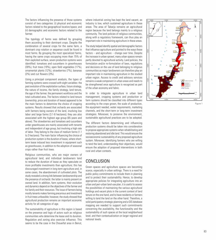
83
The factors influencing the presence of those systems consist of two categories: (i) physical and economic factors related to the geographical location/space; and (ii) demographic and economic factors related to the farmer.
The typology of farms was defined by grouping them according to their dominant crops. Despite the combination of several crops for the same farm, a dominant crop rotation or sequence could be found in most farms. By grouping the most specialized farms, having the same crops occupying more than 75% of their exploited surface, seven production systems were identified: tomatoes and cucumbers in greenhouses (39%), fruit trees (19%), open field vegetables (17%), ornamental plants (12%), strawberries (7%), bananas (3%) and cut flowers (3%).
Using a principal component analysis, the types of farming systems were crossed with eight variables: the past evolution of the exploitation surface, future strategy, the nature of income, the family strategy, land tenure, the age of the farmer, the permanent workforce and the total cultivated area. The factors related to land tenure (ownership, price and duration of lease) appeared to be the main factors to determine the choice of cropping systems. Results showed that orchards are associated with farmers being owners of the land, involving low labor and large farms (3.1-6 hectares); they are also associated with the highest age group (65 years and above). The strawberries and tomatoes and cucumbers under greenhouses are mainly associated with tenants and independent of age group, but involving a high rate of labor. They belong to the class of medium farms (1.1 to 3 hectares). The main factor influencing the choice of production system is the duration of lease, where short-term lease induced less investment in equipment such as greenhouses, in addition to the adoption of seasonal crops rather than fruit trees.
Religious communities, who are major owners of agricultural land, and individual landowners tend to reduce the duration of lease as they speculate on more profitable investments than agriculture; this has discouraged investment in long-term agriculture and, in some cases, the abandonment of cultivated plots. The study revealed a strong link between landownership and the presence of orchards: the latter is mainly present on owned land. In addition, farm systems, their evolution and dynamics depend on the objectives of the farmer and his family and their resources. The issue of farmers being mostly tenants makes farming precarious and investment in fruit trees unfeasible; however, the study showed that agricultural production remains an important economic activity for all categories of age.
The sustainability of agriculture in this region is based on the presence and logic of actors such as religious communities who determine the lease and its duration. Regulation and zoning also exercise influence. This seems to be the case in the Choueifat area in Beirut,
where industrial zoning has kept the land vacant, as industry is low, which sustained agriculture in these areas. The area of Tabarja remains an agricultural region because the land belongs mainly to a religious community. The land policies of religious communities, along with a regulatory framework, can thus play an important role in maintaining agriculture in these areas.
The study helped identify spatial and demographic factors that influence agriculture and pointed to the ways these factors – and agriculture – change over time. Despite the increase in urban sprawl, many urban spaces remain partly devoted to agricultural activity. Land policies, the formulation and/or re-formulation of laws, regulations and decisions on the use of land belonging to religious communities as major landowners can therefore play an important role in maintaining agriculture in the studied urban region. Access to credit and advisory services remains a weak component in urban areas and needs to be strengthened once agriculture is recognized as part of the urban economy and fabric.
In order to integrate agriculture in urban land management, cropping systems and production or farm systems should be classified into different types according to the crops grown, the scale of production, the equipment needed, water requirements, marketing channels, and the short-term or long-term investment strategies. Moreover, to preserve the environment, sustainable agricultural practices are to be adopted.
The different factors determining and influencing production systems should be taken into consideration to propose appropriate systems when rehabilitating and restoring abandoned and idle land. This would ensure the socioeconomic sustainability of any proposed agriculture system. Moreover, identifying farmers who are willing to tend the land, understanding their objectives, would ensure the adoption of proposed interventions in both rural and urban contexts.
CONCLUSIONGreen spaces and agriculture spaces are becoming scarce, especially in urban settings. There is a need for public policy commitments to include them in planning and to protect their sustainability. Hence, to develop appropriate policies for integrating agriculture into an urban and peri-urban land-use plan, it is useful to assess the possibilities of maintaining the various agricultural holdings and vacant plots in the current context of land tenure on the one hand, and to have residents or farmers willing to tend the land on the other hand. Therefore, a solid participatory strategic planning and a GIS database mapping are needed to support such commitments concerning the availability, the functionality and the sustainability of such spaces at the local neighborhood level, and their contextualization on larger regional and national levels.
Figure 1
84
FOOTNOTES Factsheets: Urban agriculture: landscapes connecting people, food and biodiversity. Factsheet 7 Urbes-project. Available at:
https://www.iucn.org/sites/dev/files/import/downloads/urbes_factsheet_07_web_2.pdf.
FIGURESFigure 1. Sectors and agriculture zones of the study area (sector 1: “high density urban fabric; sector 2: “medium density urban fabric; sector 3: “low density urban fabric). Source: author, based on map prepared by the Lebanese National Center for Remote Sensing.
BIBLIOGRAPHYBakker, N., Dubbeling, M., Guendel, S., Sabel Koschella, U. and de Zeeuw, H. (Eds.). (2000). Growing Cities, Growing Food, Urban Agriculture on the Policy Agenda. DSE, Feldafing.
Dubbeling M.. and de Zeeuw, H. (2006). Interactive policy formulation for sustainable urban agriculture development. Urban Agriculture Magazine 16: Formulating Effective Policies on Urban Agriculture. Leusden: RUAF.
Irvine, S. (2012). Carrot city: Creating places for urban agriculture. Journal of Urbanism: International Research on Placemaking and Urban Sustainability 5(2-3): 273-275.
Lin, B. B., Stacy, Philpott, M. and Shalene J. (2015). The future of urban agriculture and biodiversity-ecosystem services: Challenges and next steps. Basic and Applied Ecology 16(3): 189-201.
Nasr, J. and Padilla, M. (2004). Interfaces: Agriculture et Villes à l’Est et au Sud de la Méditerranée. Beirut: Delta.
Sanyé-Mengual, E. et al. (2016). Resolving differing stakeholder perceptions of urban rooftop farming in Mediterranean cities: Promoting food production as a driver for innovative forms of urban agriculture. Agriculture and Human Values 33(1): 101-120.
Tohmé Tawk, S. (2004). L’évolution spatiale des systèmes de culture de la bande côtière du Mont Liban. In Nasr, J. and Padilla, M. (Eds.) Interfaces: Agriculture et Villes à l’Est et au Sud de la Méditerranée (pp. 313-342). Beirut : Delta.
Tohmé Tawk, S., Abi Saiid, M. and Hamadeh, S. (2014). Urban agriculture and food security in the Middle Eastern context: A case study from Lebanon and Jordan. In Babar, Z. and Mirgani, S. (Eds.) Food Security in the Middle East (pp. 161-186). Hurst (UK) and Oxford University Press (US). Available at http://www.hurstpublishers.com/book/food-security-in-the-middle-east/
Tohmé Tawk, S., Moussa, Z. and Hamadeh, S. (2015). Mainstreaming urban agriculture in the Middle East and North Africa: A multi-stakeholder approach. IFSA Proceedings. The Environment and Sustainable Development Unit, Faculty of Agricultural and Food Sciences, American University of Beirut, Lebanon. Available at http://ifsa.boku.ac.at/cms/fileadmin/Proceeding2014/WS_2_8_Tawk.pdf.
Van Veenhuizen, R. (2006). Cities Farming for the Future, Urban Agriculture for Green and Productive Cities. ETC Urban Agriculture. Leusden, the Netherlands.
Figure 1: Sectors and agriculture zones of the study area (sector 1: “high density urban fabric; sector 2: “medium density urban fabric; sector 3: “low density urban fabric).
Source: author, based on map prepared by the Lebanese National Center for Remote Sensing.
AUTHORSalwa TOHME TAWK studied at the American University of Beirut and completed a M.Sc. in Plant Production and Protection; she holds a “Diplôme en Etudes Approfondies” and PhD in Farming Systems and Sustainable Development from the «Institut National de Recherche Agronomique Paris-Grignon France.» She is currently an Associate Professor at the Lebanese University, Department of Agricultural Economy, Faculty of Agriculture, and serves as an associate member of the Faculty of Agricultural and Food Sciences at the American University of Beirut (2005 to present). Her research interests focus mainly on sustainable farming systems in urban and rural contexts and food loss assessment, with a proven track record in the field of rural development. Dr. Tawk consulted and/or trained in various development projects covering countries in the Middle East and North Africa-region (Lebanon, Jordan, Syria, and Yemen). She is a member of the Environment and Sustainable Development Unit at the American University of Beirut, member of the Lebanese NGO “Al Shouf Cedar Society,” and a member and former president of the board of the Lebanese NGO “Mada.”

85
URBAN INTERSTITIAL SPACES AS COMMONSMarwan ZOUEINMaha ISSA
1. INTRODUCTIONThe richness and multiplicity of meaning contained in the concept of boundary comes from the ambivalence of the human act of marking a limit. Pier Vittorio Aureli quotes Carl Schmitt as saying that it is also the beginning of any type of law. Marking the territory, establishing borders are not only primordial modes of giving shape to colonization, but also ways of regulating the coexistence of populations and the formation of any type of power “based on new spatial divisions, new enclosures...”. This frontier has taken different forms throughout history, but always tended towards a political and often defensive objective. During Antiquity and the Middle Ages, city and countryside shared a dual vision based on the idea of the city as a place of identity, thought and a protective island against the unknown of the outside worlds. The founding of a city is also the authoritarian constitution of an interiority, of a sealed and controlled “inside”.
Economic and demographic growth pushed the city out of its administrative boundaries, embracing the unknown outside. The ideals of the industrial revolution and the modernist vision of urban renewal guided a rational planning of the new districts. As in Le Corbusier’s “Radiant city” or in the “Plan voisin”, transportation networks had to be upgraded to link center and periphery at national and international scales. The technocratic approach to urbanism produced major interior urban transformations at the expense of the consolidated neighborhoods. This brief summary recalls the disagreements, during CIAM1-meetings, between the young generation headed by Van Eyck, the Smithsons, Bakema, Candilis and Woods (later to become the team-10 meetings) and the original founders at the time of the Charte d’Athènes, in 1943. The schism paved the way for the Charte de l’Habitat, proposed in 1953.2 A common desire was that cities should aim to create environments that encourage relations between inhabitants, between a building and its environment, and that accommodate the cultural needs of people. New phenomena such as residents’ participation and the controversy surrounding urban renewal would then become central concerns of the group.
The modernist planning of the territory, the reconstruction of the center of the war-torn city, and the rise of land
prices across metropolitan Beirut testify to a vision that did not include the human scale in urban planning and demonstrated the failure of municipal governance. The erasure of the traces of historical neighborhoods dismantled embedded social complexity and led to the slow exclusion of the urban poor and middle classes. Working-class markets, narrow passages and streets are being hastily destroyed to allow for car-oriented zoning, removing unplanned areas in the historical center. This neoliberal approach has created open spaces whose
appropriation is hampered by private security agents, thus preventing the city from providing its protective “inside”.
Inhabitants are now profoundly unable to identify with their surroundings, and a growing need to find alternative open spaces in lieu of the ones imposed by the ruling hierarchy. The idea of a city oriented towards the common good, as expressed in antiquity, is no longer a fundamental principle for the governing bodies.
Figure 1
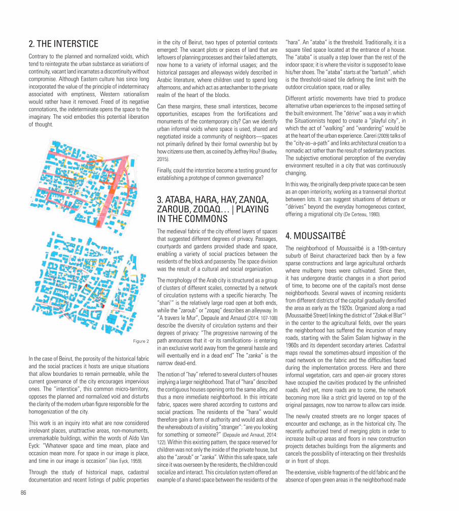
86
2. THE INTERSTICEContrary to the planned and normalized voids, which tend to reintegrate the urban substance as variations of continuity, vacant land incarnates a discontinuity without compromise. Although Eastern culture has since long incorporated the value of the principle of indeterminacy associated with emptiness, Western rationalism would rather have it removed. Freed of its negative connotations, the indeterminate opens the space to the imaginary. The void embodies this potential liberation of thought.
In the case of Beirut, the porosity of the historical fabric and the social practices it hosts are unique situations that allow boundaries to remain permeable, while the current governance of the city encourages impervious ones. The “interstice”, this common micro-territory, opposes the planned and normalized void and disturbs the clarity of the modern urban figure responsible for the homogenization of the city.
This work is an inquiry into what are now considered irrelevant places, unattractive areas, non-monuments, unremarkable buildings, within the words of Aldo Van Eyck: “Whatever space and time mean, place and occasion mean more. For space in our image is place, and time in our image is occasion” (Van Eyck, 1959).
Through the study of historical maps, cadastral documentation and recent listings of public properties
in the city of Beirut, two types of potential contexts emerged: The vacant plots or pieces of land that are leftovers of planning processes and their failed attempts, now home to a variety of informal usages; and the historical passages and alleyways widely described in Arabic literature, where children used to spend long afternoons, and which act as antechamber to the private realm of the heart of the blocks.
Can these margins, these small interstices, become opportunities, escapes from the fortifications and monuments of the contemporary city? Can we identify urban informal voids where space is used, shared and negotiated inside a community of neighbors—spaces not primarily defined by their formal ownership but by how citizens use them, as coined by Jeffrey Hou? (Bradley, 2015).
Finally, could the interstice become a testing ground for establishing a prototype of common governance?
3. ATABA, HARA, HAY, ZANQA, ZAROUB, ZOQAQ… | PLAYING IN THE COMMONSThe medieval fabric of the city offered layers of spaces that suggested different degrees of privacy. Passages, courtyards and gardens provided shade and space, enabling a variety of social practices between the residents of the block and passersby. The space division was the result of a cultural and social organization.
The morphology of the Arab city is structured as a group of clusters of different scales, connected by a network of circulation systems with a specific hierarchy. The “shari’” is the relatively large road open at both ends, while the “zaroub” or “zoqaq” describes an alleyway. In “A travers le Mur”, Depaule and Arnaud (2014: 107-108) describe the diversity of circulation systems and their degrees of privacy: “The progressive narrowing of the path announces that it -or its ramifications- is entering in an exclusive world away from the general hassle and will eventually end in a dead end” The “zanka” is the narrow dead-end.
The notion of “hay” referred to several clusters of houses implying a larger neighborhood. That of “hara” described the contiguous houses opening onto the same alley, and thus a more immediate neighborhood. In this intricate fabric, spaces were shared according to customs and social practices. The residents of the “hara” would therefore gain a form of authority and would ask about the whereabouts of a visiting “stranger”: “are you looking for something or someone?” (Depaule and Arnaud, 2014: 122). Within this existing pattern, the space reserved for children was not only the inside of the private house, but also the “zaroub” or “zanka”. Within this safe space, safe since it was overseen by the residents, the children could socialize and interact. This circulation system offered an example of a shared space between the residents of the
“hara”. An “ataba” is the threshold. Traditionally, it is a square tiled space located at the entrance of a house. The “ataba” is usually a step lower than the rest of the indoor space; it is where the visitor is supposed to leave his/her shoes. The “ataba” starts at the “bartush”, which is the threshold-raised tile defining the limit with the outdoor circulation space, road or alley.
Different artistic movements have tried to produce alternative urban experiences to the imposed setting of the built environment. The “dérive” was a way in which the Situationnists hoped to create a “playful city”, in which the act of “walking” and “wandering” would be at the heart of the urban experience. Careri (2009) talks of the “city-as–a-path” and links architectural creation to a nomadic act rather than the result of sedentary practices. The subjective emotional perception of the everyday environment resulted in a city that was continuously changing.
In this way, the originally deep private space can be seen as an open interiority, working as a transversal shortcut between lots. It can suggest situations of detours or “dérives” beyond the everyday homogeneous context, offering a migrational city (De Certeau, 1980).
4. MOUSSAITBÉThe neighborhood of Moussaitbé is a 19th-century suburb of Beirut characterized back then by a few sparse constructions and large agricultural orchards where mulberry trees were cultivated. Since then, it has undergone drastic changes in a short period of time, to become one of the capital’s most dense neighborhoods. Several waves of incoming residents from different districts of the capital gradually densified the area as early as the 1920s. Organized along a road (Moussaitbé Street) linking the district of “Zokak el Blat”3 in the center to the agricultural fields, over the years the neighborhood has suffered the incursion of many roads, starting with the Salim Salam highway in the 1960s and its dependent secondary arteries. Cadastral maps reveal the sometimes-absurd imposition of the road network on the fabric and the difficulties faced during the implementation process. Here and there informal vegetation, cars and open-air grocery stores have occupied the cavities produced by the unfinished roads. And yet, more roads are to come, the network becoming more like a strict grid layered on top of the original passages, now too narrow to allow cars inside.
The newly created streets are no longer spaces of encounter and exchange, as in the historical city. The recently authorized trend of merging plots in order to increase built-up areas and floors in new construction projects detaches buildings from the alignments and cancels the possibility of interacting on their thresholds or in front of shops.
The extensive, visible fragments of the old fabric and the absence of open green areas in the neighborhood made
Figure 2

87
Moussaitbé the ideal location for testing the theoretical assumptions we formulated.
Four situations were identified, all direct consequences of the penetration of the road network into the urban fabric, and located on public property.
Site A: A dead-end mostly used as a parking space. The planned road was supposed to connect the Wassef Baroudi and Hassan Medawar-streets, and has not yet been implemented.
There is a pedestrian connection linking the north and south streets through a staircase at the end of the dead-end. A concrete bench has been installed in the change of levels. A pocket garden is maintained in the center between the buildings, and trucks delivering water and vegetables reach to the core of the dead-end. Windows and balconies overlook the open spaces and building entrances lead to the common space.
Site B: Also located between the Wassef Baroudi and Hassan Medawar-streets, this site is parallel to site A. A newly paved road cuts through the existing fabric, producing slivers of residual spaces yearning for a second chance. The leftover spaces on either side today are derelict and not yet appropriated. Blank party walls and fences share a space with no other users than the cars parked next to the unusually wide sidewalks.
Site C: An L-shaped pedestrian alley going through a block next to the Salim Salam highway. The space is now partly used as a parking lot and includes a derelict area where an abandoned old house sits. The whole area will soon disappear, since a wider road is planned and some of the buildings have been expropriated. As in the traditional urban fabric (zanka, zaroub), this site is appropriated by children and becomes a space of socialization and play.
Site D: Three small plots (728, 738, and 739) sit in front of the Salim Salam mosque, between the boulevard and a construction site. The plots are still vacant and sometimes used as informal parking. Their size and shape make them an ideal location for a garden or a playground for children.
5. CONCLUSIONThis ongoing research stems from previous work that looked at the spatial practices taking place on the staircases of working-class neighborhoods in Beirut. It argued that the staircases were important not only as pedestrian routes offering gathering points, calm open areas away from the busy street, but also because they acted as social generators for the residents living in the immediate vicinity. Through meetings with neighbors, we found that a shared feeling of belonging had emerged, and that there was a fundamental need to protect and manage this shared common space. In the case of Moussaitbé, there is an urgency to halt the destruction and shed light on the everyday use of the
spaces and the actual needs of the residents. Sites A and B provide a before and after side-by-side inside a city block. Under the current status quo, the whole block could be reimagined as real-size pedagogical tool and in-situ laboratory, where alternative scenarios could be tested and proposed. As a recommendation, an updated regulatory environment is required to avoid excessive destruction and gentrification, with four key principals emerging to protect the public sphere: stabilizing the existing social renting-pattern through
regulation addressing low-income family’s needs; working towards the preservation of the day-economy and the importance of the street as a zone of exchange; protecting the traditional urban fabric; and improving the general quality of life and the quality of the shared space.
Otherwise density will continue to increase through the construction of taller buildings, and the open shared space will be increasingly occupied and gradually absorbed into the private sphere.
Figure 3

88
FOOTNOTES1. The Congrès internationaux d’architecture modern. CIAM’s early attitudes towards town planning were severe: “Urbanization cannot be conditioned by the claims of a pre-existent aestheticism; its essence is of a functional order… the chaotic division of land, resulting from sales, speculations, inheritances, must be abolished by a collective and methodical land policy.”
2. “Man may readily identify himself with his own hearth, but not easily with the town within which it is placed. ‘Belonging’ is a basic emotional need- its associations are of the simplest order. From ‘belonging’- identity- comes the enriching sense of neighbourliness. The short narrow street of the slum succeeds where spacious redevelopment frequently fails.” Team X response to CIAM 8 report, 1951 (Frampton,1992: 271.
3. Zokak el Blat is located in the center of Beirut and is one the first sites of Beirut’s urban expansion beyond its boundaries.
FIGURESFigure 1. Interstitial situations in the historical fabric. Left: Massad Stairs, Rmeil. Right: Rmeil. Beirut.
Figure 2. Area of Study in Moussaitbe with Street penetration in the 1960’s on the Left. Right: Current situation with pending streets in red.
Figure 3. Comparison of parallel situations between Wassef Baroudi Street and Hassan Medawar. Above: Sita A. Interstitial space is not widened and transformed into a street. Below: Site B. Situation post street widening.
Figure 4. Daily informal Market occupy the street until the planned prolongation towards the north is executed.
BIBLIOGRAPHYBradley, K. (2015). Open-source urbanism: Creating, multiplying and managing urban commons. In Footprint journal, Commoning as Differentiated Publicness, pp. 91-108
Chevallier, D. (Ed.) (1979). L’Espace Social de la Ville Arabe. Paris: Maisonneuve et Larose.
De Certeau, M. (1980). L’Invention du Quotidien. Paris: Gallimard.
Depaule, J. Ch. (1989). Espaces des limites. Maghreb-Machrek #123.
Depaule, J. Ch. and Arnaud, J-L. (2014). A Travers le Mur. Marseille: Éditions Parenthèses, coll. «eupalinos».
Habermas, J. (1978). L’Espace Public. Paris: Payot.
Raymond, A. (1989). Espaces publics et espaces privés dans les villes arabes traditionnelles. Maghreb-Machrek 123.
Vigano, P. (2006). The porous city: prototypes of idiorrhythmical conglomerates. Comment vivre ensemble
AUTHORMarwan ZOUEIN is a practicing architect and an Assistant Professor at the School of Architecture and Design, Lebanese American University. He holds a DPLG from the École Nationale Supérieure d’Architecture de Paris-Belleville, and a DEA from the Polytechnic University of Madrid, ETSAM. He is a founder of the Spanish architecture office (casaleganitos) that works between Beirut, Madrid and London and operates on a variety of scales, from furniture design and ephemeral events to architecture and long-term urban strategies. His research interests include the everyday, Ignasi de Sola Morales’ “terrain vague”, the unplanned, the evolution of domestic space, and the role representation plays in the construction of these environments, in particular through photography and film. His work has been published in Pasajes magazine, Arquia catalogue, EPFL, online journals and was exhibited at several venues in Spain, such as Matadero, Ateneo de Madrid, Fondation ICO, and Puertas de Castilla in Murcia.
Maha ISSA co-founded Atelier Hamra in 2008: a landscape architecture office that allows for experiments in design, architecture and landscape architecture using extensive research that covers all aspects of the site: history, cultural identity, topography, climate, and biodiversity. She holds a DPLG from the École d’Architecture Paris-Villemin, 1998. She joined the landscape architecture firm “Agence Ter” in Paris from 2001 to 2005. During that period, she worked on projects of various scales, ranging from small urban interventions to large territory planning projects. Upon returning to Lebanon, Maha taught landscape design in the department of landscape design and eco-system management, LDEM, at the American University of Beirut, from 2005 to 2011.
Figure 4

COMMITTEES
91
GEORGE ARBIDArchitect. Founding Member and Director of the Arab Center for Architecture in Beirut
George Arbid holds a Diplôme d’Études Supérieures en Architecture from ALBA and a Doctor of Design degree from Harvard University. He taught design studios and courses in the history and theory of architecture at ALBA and the American University of Beirut. Dr. Arbid has lectured widely about modern architecture in Lebanon and the Arab world. Among his publications is the award-winning book Architecture from the Arab World, 1914-2014, a Selection, published at the occasion of the Venice Architecture Biennale in 2014 where he co-curated the Pavilion of Bahrain.
JIHAD FARAHAssociate Professor in Architecture and Urban Planning at the Lebanese University
Jihad Farah holds a Ph.D. in Urban Planning from University of Liege. His thesis focused on governance and urban fragmentation in the suburbs of Beirut. In his post-doctoral research at the University of Lyon, he studied uses of ICT technologies in the context of environmental projects by Lyon and Brussels cities’ authorities. At the Lepur research center at the University of Liege, he worked as researcher on European action–research projects tackling sustainable urban development
and green infrastructure issues. His more recent research activities in Lebanon focus on governance of environmental (solid waste management, climate change) and contested public space issues especially at the local level.
ELIE HADDADDean, School of Architecture and Design, Lebanese American UniversityProfessor, School of Architecture and Design, Lebanese American University
Elie Haddad holds a Ph.D. in Architecture from University of Pennsylvania USA, M.Sc. in Architecture from University of Pennsylvania USA, M.Sc. in Architecture from University of Cincinnati USA, and Bachelor of Architecture from Boston Architectural College USA. Dr. Elie G. Haddad is the dean of the School of Architecture and Design since Fall 2012. He joined LAU in Fall 1994, as an Assistant Professor in architecture. He served as Chair of the Department of Architecture & Interior Design from 2000 to 2005, and as Assistant Dean in the newly founded School of Architecture & Design from 2009 to 2012. Besides his administrative and academic duties, Dr. Haddad remains actively involved in research, and has recently co-edited a survey on contemporary architecture around the world, published by Ashgate in 2014.
JALA MAKHZOUMIAffiliate faculty, American University of BeirutCo-founder and President of the Lebanese Landscape Association (LELA)Founding Member and Senior Fellow in the Cambridge Center for Landscape and People
Jala Makhzoumi studied architecture in Baghdad, holds a Ph.D. in Landscape Architecture from Sheffield University and a Master in Environmental Design from Yale University. Jala advocates an expansive, developmental landscape approach to mediate community needs with ecosystem health, biodiversity protection and landscape heritage conservation. Her professional and academic expertise includes postwar recovery, energy efficient site planning and sustainable urban greening. Her publications include Ecological Landscape Design and Planning: the Mediterranean context (co-author Pungetti, Spon, 1999) and The Right to Landscape: contesting landscape and human rights (co-editors Egoz and Pungetti, Ashgate, 2012). In 2013, Jala co-established UNIT44 a Lebanon based practice offering services in architecture, landscape architecture, ecological planning and urban design.
ROULA EL-KHOURYAssistant Professor, School of Architecture and Design, Lebanese American University
Roula El Khoury is an assistant professor and the coordinator of the second-year studios in architecture. Roula also teaches foundation-level design studios and drawing classes. Her research interests include ‘Representation and Design’, ‘Representation of Capital in the City’ and ‘Representation of Alternatives Public Spaces in the City’. Roula received her Master’s in Urban Planning from the GSD at Harvard University and a Bachelor in Architecture with a Minor in Political Sciences from AUB. She has participated in several local and international conferences and was also recognized by numerous awards such as the Peter Cook Honorable mention, the Azar and the Areen Award. She also received mentions in several competitions of which “Revisiting Dalieh” and the design of a Municipal headquarters in Fidar. Alongside her full-time position, Roula is a practicing Architect who works on small to medium projects from conception to execution.
HALA YOUNESConference Initiator
Assistant Professor in Architecture and Landscape Design, School of Architecture and Design, Lebanese American University
Hala Younes graduated in 1993 as Architect, D.P.L.G. from the ENSA Paris la Seine in Paris and holds a D.E.A. in Geography and Planning from La Sorbonne Paris 4, focusing on urban dynamics in Mont Lebanon. As educator, Hala Younes leads design studios and courses involving the relation between architecture and landscape. Before LAU, she taught at UQAM, Canada, the Lebanese University, AUB, and ENSA Marne la Vallée in France. Hala Younes is also an architect, practicing in France and Lebanon since 1994 with particular attention to history and cultural landscape as design initiators in architecture as well as in landscape and urban design.
MARWAN ZOUEINAssistant Professor, School of Architecture and Design, Lebanese American University
Marwan Zouein is a practicing Architect. He teaches intermediate studios and follows final year students in their final thesis and project. He holds a D.P.L.G. from the Ecole National Supérieure d’Architecture de Paris-Belleville, and a D.E.A. from the Polytechnic University of Madrid - ETSAM. He is a founder of the Spanish architecture office [casaleganitos] that works between Beirut, Madrid and London and operates in a variety of scales, from furniture design and ephemeral events to architecture and long-term urban strategies. His research interests include the everyday, Ignasi de Sola Morales’ terrain vague, the unplanned, the evolution of the domestic space, and the role representation plays in the construction of these environment, in particular through photography and film. His current research focuses on the porosity of the traditional urban fabric of the city of Beirut. His work has been published in Pasajes magazine, Arquia catalogue, online journals and was exhibited at several venues in Spain such as Matadero, Ateneo de Madrid, Fondation ICO, Puertas de Castilla in Murcia, etc.
SCIENTIFIC COMMITTEE
ORGANIZING COMMITTEE

CREDITS
93
This compilation was made possible through the collective efforts of the architecture program faculty and staff at the Lebanese American University.
© 2018 copyright Lebanese American University. All rights reserved. No part of this publication may be reproduced or transmitted by any means, electronic or mechanical, including photocopy, recording or any information retrieval system, without permission in writing from the Lebanese American University.
Any views or opinions presented in this catalog are solely those of the artist and do not represent those of the Lebanese American University in any form or manner. The Lebanese American University disclaims any liability regarding any implied or stated views or opinions.
Co Editors: Hala Younes & Marwan ZoueinDesign and layout: Danielle KattarVisual identity of the conference: Jana TraboulsiText editing: Marieke KrijnenPrint: Aleph Printing PressTypeface: Univers typeface familyISBN: 9953-461-47-3EAN: 978-995346147-2
The conference on The Place that Remains was held with the support of the School of Architecture & Design at the Lebanese American University.
http://sard.lau.edu.lb/theplacethatremains


Related Documents