Geological Society of America Bulletin doi: 10.1130/0016-7606(1990)102<0054:TNKSOT>2.3.CO;2 1990;102, no. 1;54-62 Geological Society of America Bulletin MARIO PASINI and KANWAR SABIR ALI KHAN MAURIZIO GAETANI, EDUARDO GARZANTI, FLAVIO JADOUL, ALDA NICORA, ANDREA TINTORI, The north Karakorum side of the Central Asia geopuzzle Email alerting services this article to receive free e-mail alerts when new articles cite www.gsapubs.org/cgi/alerts click Subscribe America Bulletin to subscribe to Geological Society of www.gsapubs.org/subscriptions/ click Permission request to contact GSA http://www.geosociety.org/pubs/copyrt.htm#gsa click presented in this publication do not reflect official positions of the Society. scientists worldwide, regardless of their race, citizenship, gender, religion, or political viewpoint. Opinions citation. GSA provides this and other forums for the presentation of diverse opinions and positions by on their own or their organization's Web site providing the posting includes a reference to the article's full science. This file may not be posted to any Web site, but authors may post the abstracts only of their articles unlimited copies of items in GSA's journals for noncommercial use in classrooms to further education and use a single figure, a single table, and/or a brief paragraph of text in subsequent works and to make employment. Individual scientists are hereby granted permission, without fees or further requests to GSA, to Copyright not claimed on content prepared wholly by U.S. government employees within scope of their Notes Geological Society of America on March 14, 2014 gsabulletin.gsapubs.org Downloaded from on March 14, 2014 gsabulletin.gsapubs.org Downloaded from

Welcome message from author
This document is posted to help you gain knowledge. Please leave a comment to let me know what you think about it! Share it to your friends and learn new things together.
Transcript
Geological Society of America Bulletin
doi: 10.1130/0016-7606(1990)102<0054:TNKSOT>2.3.CO;2 1990;102, no. 1;54-62Geological Society of America Bulletin
MARIO PASINI and KANWAR SABIR ALI KHANMAURIZIO GAETANI, EDUARDO GARZANTI, FLAVIO JADOUL, ALDA NICORA, ANDREA TINTORI, The north Karakorum side of the Central Asia geopuzzle
Email alerting servicesthis article
to receive free e-mail alerts when new articles citewww.gsapubs.org/cgi/alertsclick
SubscribeAmerica Bulletin
to subscribe to Geological Society ofwww.gsapubs.org/subscriptions/click
Permission request to contact GSAhttp://www.geosociety.org/pubs/copyrt.htm#gsaclick
presented in this publication do not reflect official positions of the Society.scientists worldwide, regardless of their race, citizenship, gender, religion, or political viewpoint. Opinions citation. GSA provides this and other forums for the presentation of diverse opinions and positions byon their own or their organization's Web site providing the posting includes a reference to the article's full science. This file may not be posted to any Web site, but authors may post the abstracts only of their articlesunlimited copies of items in GSA's journals for noncommercial use in classrooms to further education and use a single figure, a single table, and/or a brief paragraph of text in subsequent works and to makeemployment. Individual scientists are hereby granted permission, without fees or further requests to GSA, to Copyright not claimed on content prepared wholly by U.S. government employees within scope of their
Notes
Geological Society of America
on March 14, 2014gsabulletin.gsapubs.orgDownloaded from on March 14, 2014gsabulletin.gsapubs.orgDownloaded from
The north Karakorum side of the Central Asia geopuzzle
Dipartimento di Scienze della Terra, Via Mangiagalli 34, 20133 Milano, Italia
MAURIZIO GAETANI EDUARDO GARZANTI FLAVIO JADOUL ALDA NICORA ANDREA TINTORI MARIO PASINI Istituto di Geologia, Via delle Cerchie 3, Siena, Italia KANWAR SABIR ALI KHAN Geological Survey of Pakistan, Islamabad, Pakistan
ABSTRACT
An Italian geological team visited a remote and in part never studied area in the northern Hunza region (Pakistan), which represents the link between the Karakorum and Pamir Ranges. The north Karakorum sequence commences in the Permian with terrigenous sediments, followed by shallow- to deep-marine carbonates deposited on a newly formed passive margin. Deep-water sedimen-tation continued till the end of the Middle Triassic, when carbonate platform conditions resumed. An episode of deltaic red sand-stones with orogenic provenance is inter-bedded in the Liassic, and it is transgressed by a Middle to ?Upper Jurassic shallow-water marine unit. Eventually, all of the se-quence was faulted and folded, with weak metamorphic imprint, before fluviatile red polygenic conglomerates sealed the succes-s ion^ a spectacular unconformity.
The north Karakorum provides an exam-ple of a microplate that rifted away from Gondwana in the Permian, reached deep-marine conditions in the Early Triassic, and marginally recorded compressive movements in the Liassic. A subsequent orogenic episode points to a reorganization of the southern Asian margin possibly around middle Cre-taceous time. Finally, the north Karakorum was affected by strong fold-thrust deforma-tion and low- to very low-grade metamor-phism in the Cainozoic, related to the India-Asia collision.
INTRODUCTION
During the summer of 1986, an Italian geo-logical expedition visited the Upper Hunza re-
gion, including the restricted areas of the Chapursan and Misgar Valleys, in order to un-ravel the geologic history of this key area situ-ated between Karakorum and Little Pamir. The geographical boundary between these two ranges is in fact located along the Chapursan and Khunjerab Valleys (Mason, 1938). Twenty-five years after Desio's 1963 expedition, this was the only foreign team allowed to study the restricted area, and most of the results presented herein are totally new.
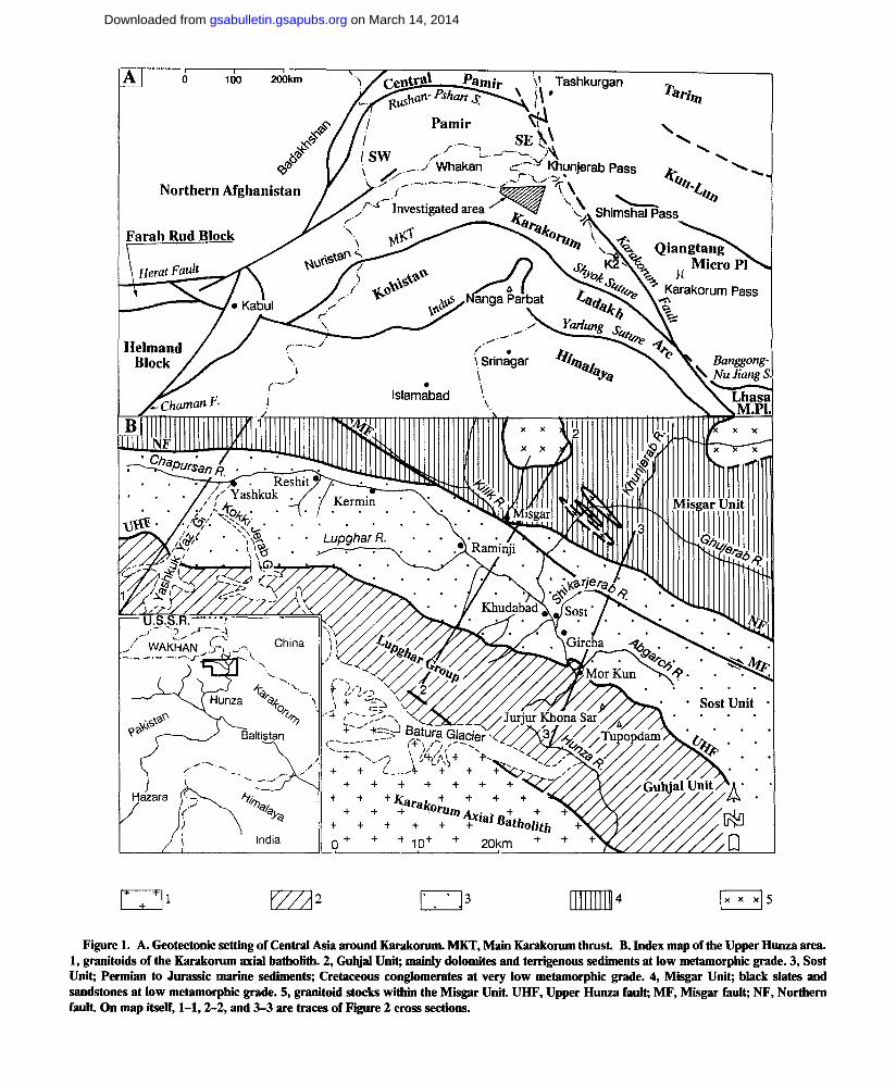
South to north, the north Karakorum lies be-tween two recognized sutures, the Shyok suture or Main Karakorum thrust (MKT), which sepa-rates the Kohistan arc from the Karakorum (Coward and others, 1986), and the Rushan-Pshart suture zone, which divides the southeast Pamir from the central Pamir (Shvolman, 1981; Ruzhentsev and Shvolman, 1981). Because in several paleogeographic reconstructions the Rushan-Pshart is parallel to the Banggong-Nu Jiang suture in Tibet, the north Karakorum should be equivalent to the Lhasa block. Sim-ilarly, the Farah Rud block and/or the Helmand block in central Afghanistan can be compared to Karakorum (Tapponnier and others, 1981; Bou-lin, 1981; §engor, 1984; Montenat and others, 1986). The presence of very significant strike-slip and shear zones, like the Karakorum fault and the Chaman fault, however, introduces con-sistent interpretation when the Karakorum/ Pamir transect is correlated with the Afghanis-tan or Tibet transects. In the present paper, we will focus on the Karakorum/Pamir transect.
GEOLOGIC SETTING OF THE NORTH KARAKORUM
Rocks that crop out to the north of the Kara-korum axial batholith, to the Chinese and
Wakhan (Afghanistan) borders, may be subdi-vided into three east-west-striking tectonic belts (Fig. 1).
Southern Belt (Guhjal Unit)
The southern Guhjal Unit consists of yellow to gray thick-bedded dolomites with subordinate dark slates and gray sandstones. The dolomites form the rugged peaks of the Guhjal Range and were deformed at low metamorphic grade. ? Carboniferous to Cretaceous ages were pro-posed for part of this sequence (Schneider, 1957; Casnedi and Mosna, 1979; Desio and Martina, 1972); however, this conclusion, drawn mostly on facies analogies, is not supported by biostrat-igraphic evidence.
Intermediate Belt (Sost Unit)
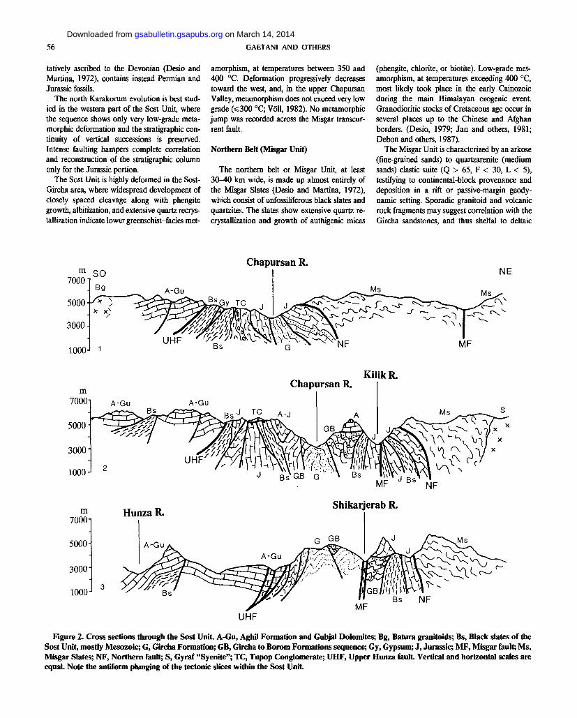
The intermediate Sost Unit is bounded to the south by the Upper Hunza fault (Desio, 1979) and to the north by a north-dipping fault system, the "Northern fault," which crosses the Chapur-san and Misgar Valleys (recognized and named for the first time herein; Fig. 2). The northern boundary is complicated by a younger strike-slip fault system, the Misgar fault, which has dextral throw of some kilometers at least.
The Sost Unit is made up of sedimentary rocks cropping out from the Shimshal Pass in the east, through the Abgarch Valley and the Sost-Gircha area in Hunza, to the Chapursan Valley and up to the Afghan Wakhan in the west. The belt consists of several tectonic slices (at least five) arranged in a wide antiform, which apparently plunges to the south. The sedimen-tary sequence spans from Permian to Jurassic; the Cretaceous is disputed. The tectonized se-quence of the Kilik River valley, which was ten-
Geological Society of America Bulletin, v. 102, p. 54-62, 7 figs., January 1990.
54
on March 14, 2014gsabulletin.gsapubs.orgDownloaded from
CentraL___Pam i'r ^ Tashkurgan r
•v/ " v
< * Khunjerab Pass
Shimshal Pass
^ Qiangtang Micro PI
, v k >< Karakorum Pass
* —A
Banggong-^ Nu JiangS.
X X X 5
Figure 1. A. Geotectonic setting of Central Asia around Karakorum. MKT, Main Karakorum thrust. B. Index map of the Upper Hunza area. 1, granitoids of the Karakorum axial batholith. 2, Guhjal Unit; mainly dolomites and terrigenous sediments at low metamorphic grade. 3, Söst Unit; Permian to Jurassic marine sediments; Cretaceous conglomerates at very low metamorphic grade. 4, Misgar Unit; black slates and sandstones at low metamorphic grade. 5, granitoid stocks within the Misgar Unit. UHF, Upper Hunza fault; MF, Misgar fault; NF, Northern fault. On map itself, 1-1,2-2, and 3-3 are traces of Figure 2 cross sections.
on March 14, 2014gsabulletin.gsapubs.orgDownloaded from
56 GAETANI AND OTHERS
tatively ascribed to the Devonian (Desio and Martina, 1972), contains instead Permian and Jurassic fossils.
The north Karakorum evolution is best stud-ied in the western part of the Sost Unit, where the sequence shows only very low-grade meta-morphic deformation and the stratigraphie con-tinuity of vertical successions is preserved. Intense faulting hampers complete correlation and reconstruction of the stratigraphie column only for the Jurassic portion.
The Sost Unit is highly deformed in the Sost-Gircha area, where widespread development of closely spaced cleavage along with phengite growth, albitization, and extensive quartz recrys-tallization indicate lower greenschist-facies met-
amorphism, at temperatures between 350 and 400 °C. Deformation progressively decreases toward the west, and, in the upper Chapursan Valley, metamorphism does not exceed very low grade (s=300 °C; Voll, 1982). No metamorphic jump was recorded across the Misgar transcur-rent fault.
Northern Belt (Misgar Unit)
The northern belt or Misgar Unit, at least 30-40 km wide, is made up almost entirely of the Misgar Slates (Desio and Martina, 1972), which consist of unfossiliferous black slates and quartzites. The slates show extensive quartz re-crystallization and growth of authigenic micas
(phengite, chlorite, or biotite). Low-grade met-amorphism, at temperatures exceeding 400 °C, most likely took place in the early Cainozoic during the main Himalayan orogenic event. Granodioritic stocks of Cretaceous age occur in several places up to the Chinese and Afghan borders. (Desio, 1979; Jan and others, 1981; Debon and others, 1987).
The Misgar Unit is characterized by an arkose (fine-grained sands) to quartzarenite (medium sands) clastic suite (Q > 65, F < 30, L < 5), testifying to continental-block provenance and deposition in a rift or passive-margin geody-namic setting. Sporadic granitoid and volcanic rock fragments may suggest correlation with the Gircha sandstones, and thus shelfal to deltaic
m SO 70001
5000
3000
1000J 1
Chapursan R.
5000-
3000
1000 J
A-Gu m
7000
5000-
3000-
1000-
m Hunza R. 7000
Chapursan R. KilikR.
A-Gu
J BsVGB G » B s
Shikar erab R.
MF J B S N F
UHF
Figure 2. Cross sections through the Sost Unit. A-Gu, Aghil Formation and Guhjal Dolomites; Bg, Batura granitoids; Bs, Black slates of the Sost Unit, mostly Mesozoic; G, Gircha Formation; GB, Gircha to Borom Formations sequence; Gy, Gypsum; J, Jurassic; MF, Misgar fault; Ms, Misgar Slates; NF, Northern fault; S, Gyraf "Syenite"; TC, Tupop Conglomerate; UHF, Upper Hunza fault. Vertical and horizontal scales are equal. Note the antiform plunging of the tectonic slices within the Sost Unit.
on March 14, 2014gsabulletin.gsapubs.orgDownloaded from

KARAKORUM SIDE OF CENTRAL ASIA GEOPUZZLE 57
Agh i l Fm.
B o r o m Fm.
unnamed Mb. 3
Mb. 2
Mb. 1
Mb. 3
"O c
Mb. 2
Mb. 1
sz « xz CO c to
Q .
500m
Gi rcha Fm.
Figure 3. Stratigraphy of the Permian-Triassic units, mainly based on data from the Chapursan Valley and tributaries.
D
sedimentation in a rift trough fed from granitoid source rocks located to the south. The occur-rence of Early Triassic conodonts in similar rocks from Wakhan (Buchroithner, 1980), however, indicates that the Misgar Slates may also represent the continental-rise deposits of the later passive-margin stage.
A further hypothesis is that the Misgar Unit represents a furrow within the north Karakorum-southeast Pamir microplate be-cause similar black slates are reported in southeast Pamir, facing Wakhan, where they are considered as the transition belt from a
Triassic carbonate platform complex to deeper-water deposits (Shvolman, 1981; Dronov and others, 1982). The origin of the Misgar sedi-ments still represents a major unsolved problem in Karakorum/Little Pamir geology.
HISTORY OF THE NORTHERN KARAKORUM
The Permian-Triassic Rifting Event
The Permian-Triassic sequence (Fig. 3) starts with the Gircha Formation (more than 1,000 m
thick). This unit consists of dark pelites alternat-ing with cross-laminated channelized sandstones and contains thickening-upward bodies display-ing ripples and parallel to hummocky lamina-tion. Sedimentary features and occurrence of sporadic shell lags (one bioclastic layer at the base of the unit yielded Spiriferid brachiopods of Early Permian age) point to deposition in storm-dominated shallow-water environments. In the upper part of the unit, 6- to 11-m-thick fining-upward sandstone bodies, showing scoured base, trough cross-lamination, and lateral accre-tion bedding, are interpreted as point bars, sug-gesting fluviatile to deltaic settings.
As to petrography, the Gircha sandstones are arkoses to quartzarenites, with composition vary-ing from Q = 40, F = 54, L = 6 to Q = 99, F = 1 (main petrographic parameters after Dickinson, 1970); invariably negligible polycrystalline quartz (C/Q < 10%); and subequal amounts of plagioclase and potassium feldspars. Rock fragments are abundant only in coarser samples (L as much as 14), with common igneous grains (granitoid, hypabyssal, felsitic, and particularly lathwork types) and very subordinate sedimen-tary (siltstone) or metamorphic (phyllite) clasts. Detrital modes fall within the continental-block field (Dickinson, 1985). They are thus consistent with deposition in rapidly subsiding rift troughs and with provenance being granitoid source rocks uplifted on the shoulders of the rift. Vol-canic grains point to active basaltic to bimodal basaltic-rhyolitic magmatism. Paleocurrent di-rections suggest sediment dispersal toward the northwest.
The fully marine Permian transgression (Panjshah Formation) occurred in the Early Ar-tinskian. Hybrid arenites and siltstones contain-ing reworked phosphatic nodules are inter-bedded with crinoidal calcarenites yielding a scattered brachiopod fauna dominated by Eli-vina tibetana. They are followed by calcarenites with abundant bryozoans. A 20- to 90-m-thick calcarenitic interval extremely rich in primitive Parafusulinids (abundant Monodiexodina van-neri, Pseudofusulina quasigrupensis, and Schwa-gerina nipponica) follows. In the upper part of this level, Nankinella and Reichelina appear. The suggested age is Middle-Late Artinskian. The sequence shallows upward with peritidal ooidal cyclothems, capped by laminated apha-nitic dolomites. A thick terrigenous interval (50-60 m), consisting of very fine-grained hy-brid arenites laterally grading into marly silt-stones, occurs in the middle part of the Panjshah carbonates. Hummocky cross-lamination points to storm deposition on a shallow-water shelf. The local occurrence of cross-bedded sandstone bodies suggests higher-energy near-shore envi-ronments. Transgressive open-shelf calcarenites
on March 14, 2014gsabulletin.gsapubs.orgDownloaded from
58 GAETANI AND OTHERS
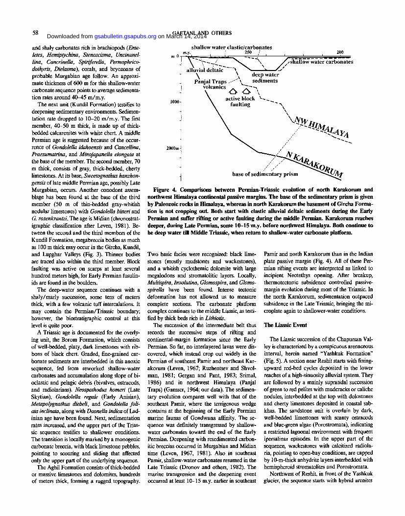
Figure 4. Comparisons between Permian-Triassic evolution of north Karakorum and northwest Himalaya continental passive margins. The base of the sedimentary prism is given by Paleozoic rocks in Himalaya, whereas in north Karakorum the basement of Gircha Forma-tion is not cropping out. Both start with clastic alluvial deltaic sediments during the Early Permian and suffer rifting or active faulting during the middle Permian. Karakorum reaches deeper, during Late Permian, some 10-15 m.y. before northwest Himalaya. Both continue to be deep water till Middle Triassic, when return to shallow-water carbonate platform.
and shaly carbonates rich in brachiopods (Ente-letes, Hemiptychina, Stenoscisma, Uncinunel-lina, Cancrinella, Spiriferella, Permophrico-dothyris, Dielasma), corals, and bryozoans of probable Murgabian age follow. An approxi-mate thickness of 600 m for this shallow-water carbonate sequence points to average sedimenta-tion rates around 40-45 m/m.y.
The next unit (Kundil Formation) testifies to deepening sedimentary environments. Sedimen-tation rate dropped to 10-20 m/m.y. The first member, 40-50 m thick, is made up of thick-bedded calcarenites with white chert. A middle Permian age is suggested because of the occur-rence of Gondolella idahoensis and Cancellina, Praesumatrina, and Minojapanella elongate at the base of the member. The second member, 70 m thick, consists of gray, thick-bedded, cherty limestones. At its base, Sweetognathus hanzhon-gensis of late middle Permian age, possibly Late Murgabian, occurs. Another conodont assem-blage has been found at the base of the third member (50 m of thin-bedded gray-whitish nodular limestones) with Gondolella bitten and G. rosenkrantzi. The age is Midian (chronostrat-igraphic classification after Leven, 1981). Be-tween the second and the third members of the Kundil Formation, megabreccia bodies as much as 100 m thick may occur in the Gircha, Kundil, and Lupghar Valleys (Fig. 3). Thinner bodies are traced also within the third member. Block faulting was active on scarps at least several hundred meters high, for Early Permian fusulin-ids are found in the boulders.
The deep-water sequence continues with a shaly/marly succession, some tens of meters thick, with a few volcanic tuff intercalations. It may contain the Permian/Triassic boundary; however, the biostratigraphic control at this level is quite poor.
A Triassic age is documented for the overly-ing unit, the Borom Formation, which consists of well-bedded, platy, dark limestones with rib-bons of black chert. Graded, fine-grained car-bonate sediments are interbedded in this anoxic sequence, fed from reworked shallow-water carbonates and accumulation along slope of bi-oclastic and pelagic debris (bivalves, ostracods, and radiolarians). Neospathodus homeri (Late Skytian), Gondolella regale (Early Anisian), Metapolygnathus diebeli, and Gondolella foli-ata inclinata, along with Daonella indica of Lad-inian age have been found. Next, sedimentation rates increased, and the upper part of the Trias-sic sequence testifies to shallower conditions. The transition is locally marked by a monogenic carbonate breccia, with black limestone pebbles, pointing to scouring and sliding that affected only the upper part of the underlying sequence.
The Aghil Formation consists of thick-bedded or massive limestones and dolomites, hundreds of meters thick, forming a rugged topography.
Two basic facies were recognized: black lime-stones (mostly mudstones and wackestones), and a whitish cyclothemic dolomite with large megalodons and stromatolitic layers. Locally, Multispira, Involutina, Glomospira, and Glomo-spirella have been found. Intense tectonic deformation has not allowed us to measure complete sections. The carbonate platform complex continues to the middle Liassic, as testi-fied by thick beds rich in Lithiotis.
The succession of the intermediate belt thus records the successive steps of rifting and continental-margin formation since the Early Permian. So far, no interlayered lavas were dis-covered, which instead crop out widely in the Permian of southeast Pamir and northeast Kar-akorum (Leven, 1967; Ruzhentsev and Shvol-man, 1981; Gergan and Pant, 1983; Srimal, 1986) and in northwest Himalaya (Panjal Traps) (Gansser, 1964; our data). The sedimen-tary evolution compares well with that of the southeast Pamir, where the terrigenous wedge contains at the beginning of the Early Permian marine faunas of Gondwana affinity. The se-quence was definitely transgressed by shallow-water carbonates toward the end of the Early Permian. Deepening with resedimented carbon-itic breccias occurred in Murgabian and Midian time (Leven, 1967, 1981). Also in southeast Pamir, shallow-water carbonates resumed in the Late Triassic (Dronov and others, 1982). The marine transgression and the deepening event occurred at least 10-15 m.y. earlier in southeast
Pamir and north Karakorum than in the Indian plate passive margin (Fig. 4). All of these Per-mian rifting events are interpreted as linked to incipient Neotethys opening. After breakup, thermotectonic subsidence controlled passive-margin evolution during most of the Triassic. In the north Karakorum, sedimentation outpaced subsidence in the Late Triassic, bringing the mi-croplate again to shallower-water conditions.
The Liassic Event
The Liassic succession of the Chapursan Val-ley is characterized by a conspicuous arenaceous interval, herein named "Yashkuk Formation" (Fig. 5). A section near Reshit starts with fining-upward red-bed cycles deposited in the lower reaches of a high-sinuosity alluvial system. They are followed by a mainly supratidal succession of green to red pelites with mudcracks or caliche nodules, interbedded at the top with dolostones and cherty limestones deposited in coastal sab-khas. The sandstone unit is overlain by dark, well-bedded limestones with scanty ostracods and blue-green algae (Porostromata), indicating a restricted lagoonal environment with frequent ipersalinar episodes. In the upper part of the sequence, wackestones with calcitized radiola-ria, pointing to open-bay conditions, are capped by 10-m-thick anhydrite layers interbedded with hemispheroid stromatolites and Porostromata.
Northwest of Reshit, in front of the Yashkuk glacier, the sequence starts with hybrid arenites
on March 14, 2014gsabulletin.gsapubs.orgDownloaded from
KARAKORUM SIDE OF CENTRAL ASIA GEOPUZZLE 59
UPPER MIDDLE
JURASSIC
,UPPER ' LIASSIC
— ? — 9 —
MIDDLE LIASSIC
LOWER LIASSIC
UPPER TRIASSIC
Reshit Fm
Megalodon beds
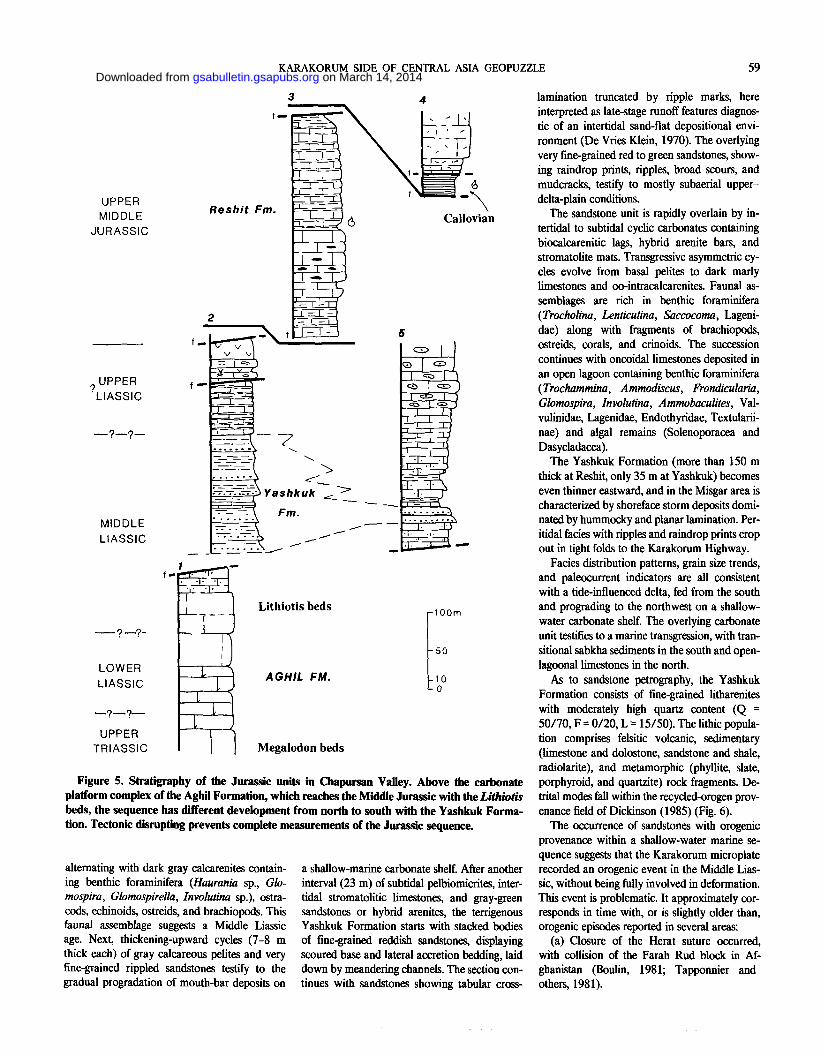
Figure 5. Stratigraphy of the Jurassic units in Chapursan Valley. Above the carbonate platform complex of the Aghil Formation, which reaches the Middle Jurassic with the Lithiotis beds, the sequence has different development from north to south with the Yashkuk Forma-tion. Tectonic disrupting prevents complete measurements of the Jurassic sequence.
alternating with dark gray calcarenites contain-ing benthic foraminifera (Haurania sp., Glo-mospira, Glomospirella, Involutina sp.), ostra-cods, echinoids, ostreids, and brachiopods. This faunal assemblage suggests a Middle Liassic age. Next, thickening-upward cycles (7-8 m thick each) of gray calcareous pelites and very fine-grained rippled sandstones testify to the gradual progradation of mouth-bar deposits on
a shallow-marine carbonate shelf. After another interval (23 m) of subtidal pelbiomicrites, inter-tidal stromatolitic limestones, and gray-green sandstones or hybrid arenites, the terrigenous Yashkuk Formation starts with stacked bodies of fine-grained reddish sandstones, displaying scoured base and lateral accretion bedding, laid down by meandering channels. The section con-tinues with sandstones showing tabular cross-
lamination truncated by ripple marks, here interpreted as late-stage runoff features diagnos-tic of an intertidal sand-flat depositional envi-ronment (De Vries Klein, 1970). The overlying very fine-grained red to green sandstones, show-ing raindrop prints, ripples, broad scours, and mudcracks, testify to mostly subaerial upper-delta-plain conditions.
The sandstone unit is rapidly overlain by in-tertidal to subtidal cyclic carbonates containing biocalcarenitic lags, hybrid arenite bars, and stromatolite mats. Transgressive asymmetric cy-cles evolve from basal pelites to dark marly limestones and oo-intracalcarenites. Faunal as-semblages are rich in benthic foraminifera (Trocholina, Lenticulina, Saccocoma, Lageni-dae) along with fragments of brachiopods, ostreids, corals, and crinoids. The succession continues with oncoidal limestones deposited in an open lagoon containing benthic foraminifera (Trochammina, Ammodiscus, Frondkularia, Glomospira, Involutina, Ammobaculites, Val-vulinidae, Lagenidae, Endothyridae, Textularii-nae) and algal remains (Solenoporacea and Dasycladacea).
The Yashkuk Formation (more than 150 m thick at Reshit, only 35 m at Yashkuk) becomes even thinner eastward, and in the Misgar area is characterized by shoreface storm deposits domi-nated by hummocky and planar lamination. Per-itidal facies with ripples and raindrop prints crop out in tight folds to the Karakorum Highway.
Facies distribution patterns, grain size trends, and paleocurrent indicators are all consistent with a tide-influenced delta, fed from the south and prograding to the northwest on a shallow-water carbonate shelf. The overlying carbonate unit testifies to a marine transgression, with tran-sitional sabkha sediments in the south and open-lagoonal limestones in the north.
As to sandstone petrography, the Yashkuk Formation consists of fine-grained litharenites with moderately high quartz content (Q = 50/70, F = 0/20, L = 15/50). The lithic popula-tion comprises felsitic volcanic, sedimentary (limestone and dolostone, sandstone and shale, radiolarite), and metamorphic (phyllite, slate, porphyroid, and quartzite) rock fragments. De-trital modes fall within the recycled-orogen prov-enance field of Dickinson (1985) (Fig. 6).
The occurrence of sandstones with orogenic provenance within a shallow-water marine se-quence suggests that the Karakorum microplate recorded an orogenic event in the Middle Lias-sic, without being fully involved in deformation. This event is problematic. It approximately cor-responds in time with, or is slightly older than, orogenic episodes reported in several areas:
(a) Closure of the Herat suture occurred, with collision of the Farah Rud block in Af-ghanistan (Boulin, 1981; Tapponnier and others, 1981).
on March 14, 2014gsabulletin.gsapubs.orgDownloaded from
60 GAETANI AND OTHERS
(b) Gray and then red conglomerates and sandstones unconformably truncate the upper-most Triassic of all southeast Pamir paleogeo-graphic subzones (Dronov and others, 1982, Table 1).
(c) Thick orogenic red beds of Jurassic age are reported from the Qiangtang microplate, de-rived from the erosion of the Kun Lun Moun-tains (Chang and others, 1986).
(d) Similar red sandstones were observed in the Aghil Range interbedded with Middle Juras-sic deposits (our data).
(e) Jurassic metamorphism is reported from the northern Lhasa block (Xu and others, 1985; Coulon and others, 1986).
The Middle Jurassic Transgression
The Middle Jurassic part of the sequence is affected by intense faulting, which hampers stratigraphic correlation. South of Reshit, two slices contain shallow-marine rocks of Middle and possibly Late Jurassic age. The first one is a monotonous sequence (300 m, herein named "Reshit Formation") of dark gray mudstone-wackestone in layers 10-30 cm thick, in some cases amalgamated to metric beds. Clay content may be abundant in the upper part, and cherty nodules also occur. Fossil content is poor and represented by Lenticulina, Spirillina, Trochol-ina, Protopeneroplis, Saccocoma, Valvulinidae, Lagenidae, ostracods, crinoids, echinoids, radio-laria, and dasycladaceans. A Perisphinctid am-monite was found in the central part of this sequence, as well as a few Kallirhynchia and numerous large Monsardithyrid brachiopods. They probably indicate a late Middle Jurassic age. In the topmost part, very abundant Nassel-laria and Spumellaria radiolarians, rarer Dicty-
Q
onina, Trocholina sp., Miliolids, and coral frag-ments might represent the Callovian.
A second type of sedimentary sequence consists of biointraclastic packstones with fragmentary brachiopods, Porostromata, Thau-matoporella, foraminifera (Trocholina, Textula-riidae), crinoids, and echinoids. They are inter-fingered with biointraclastic calcarenites in lenticular beds yielding Thaumatoporella, Dasy-cladaceans, sessil and benthic vagile foramin-ifera, radiolaria, and sponge spicules. They alternate with dark gray, thin-bedded basinal limestones with deformed ammonites, including the heteromorph Parapathoceras (identification by G. Pavia, Torino), still of Callovian age.
At the top of this tectonized sequence, thick black slates and quartzose hybrid arenites are observed. The occurrence of hummocky or par-allel lamination and shallow-water fauna (scler-actinians, echinoids, bryozoans, and bivalves) suggests a storm-dominated shelfal environment; however, turbiditic sandstones with flute and groove casts (Reshit) or basaltic layers (Yashkuk glacier) were also found in this part of the section.
These different sequences show that the north Karakorum microplate was still characterized by marine conditions during the Middle and perhaps the Late Jurassic. There is no paleonto-logical evidence of younger marine deposits.
Early Deformation of the Karakorum Microplate
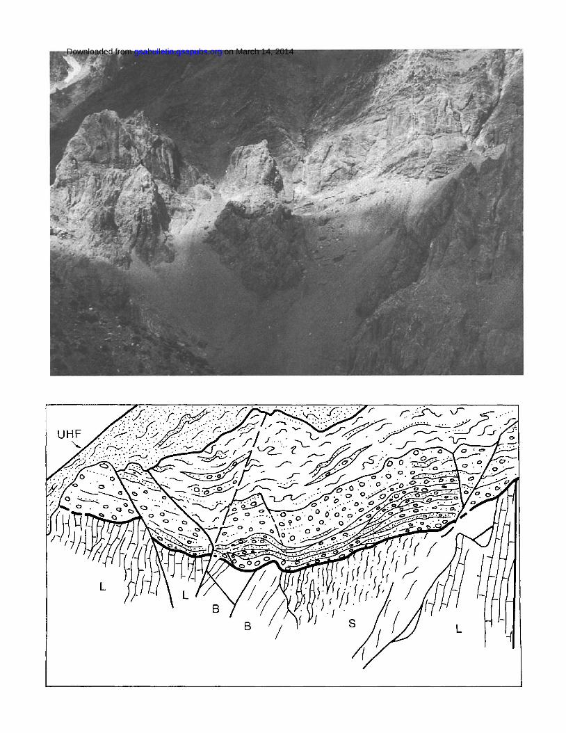
The Permian to Jurassic succession of Upper Hunza is truncated by a spectacular 90° angular unconformity, which separates recrystallized limestones, siltstones, and anorogenic pillow basalts, showing steeply dipping foliation and closely spaced subvertical faults, from the over-lying Tupop Formation (Fig. 7). This unit con-sists of channelized red cobble conglomerates, in
Figure 7. Spectacular 90° angular uncon-formity in the upper Tupop Valley. The cob-ble conglomerates of the Tupop Formation, with boulders as much as 2 m in size, sharply overlie limestones (L), siltstones (S), and pil-low basalts (B) affected by steeply dipping foliation and subvertical faults. UHF, Upper Hunza fault.
amalgamated beds as much as several tens of meters thick and with boulders as much as 2 m in size, interbedded with sandstones and unfos-siliferous red and gray nodular limestones. Conglomerates are in many cases arranged in fining-upward cycles and are mainly poorly sorted, matrix rich, and characterized by crude gTaded bedding. Imbricate, moderately sorted, and framework-supported conglomerates are subordinate. Rare megaripple cross-lamination points to a southward transport direction. Sedimentary features and occurrence of mud-cracks and caliche nodules suggest semiarid climate and a subaerial alluvial-fan depositional environment.
As to clastic petrography, the terrigenous lay-ers are invariably sedimentary litharenites, con-taining predominant carbonate rock fragments along with terrigenous clasts (sandstone, silt-stone, and shale) and felsic volcanic lithics. The pebble population comprises all underlying Permian, Triassic, and Jurassic lithologies, de-formed and uplifted prior to conglomerate depo-sition, as shown by recrystallization of limestone clasts and well-developed cleavage in argillite rock fragments.
Erosional truncation of previously foliated and faulted igneous to sedimentary rocks and sharp superposition of prograding red fanglom-erates with recycled-orogen provenance (Dick-inson, 1985) attest to uplift and low-grade metamorphism of Permian-Mesozoic sedimen-tary sequences. This early tectonic episode af-fected north Karakorum prior to the Tertiary collision of Asia with India, when the whole north Karakorum sedimentary succession un-derwent intense fold-thrust deformation. The main metamorphic event in fact postdates depo-sition of the Tupop conglomerates, as shown by strong elongation of limestone pebbles, transpo-sition of bedding planes, and development of a schistosity that crosscuts the basal unconformity.
The early deformation event (Garzanti and others, 1987a) cannot be dated directly, for the conglomeratic unit lacks fossils, but it may be tentatively ascribed to the middle Cretaceous. Post-Early Cretaceous ages are in fact suggested for equivalent lithologic units cropping out in adjacent regions (Reshun Conglomerate of Hayden, 1916; Casnedi, 1979; Casnedi and Mosna, 1979; Desio, 1975; slightly metamor-
GIRCHA • & MISGAR o
SANDSTONES YASHKUK v
SANDSTONES
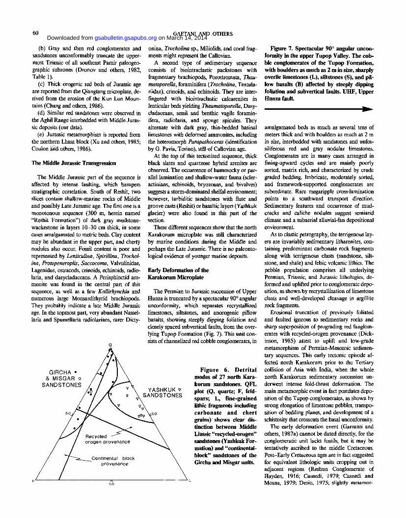
Figure 6. Detrital modes of 27 north Kara-korum sandstones. QFL plot (Q, quartz; F, feld-spars; L, fine-grained lithic fragments including carbonate and chert grains) shows clear dis-tinction between Middle Liassic "recycled-orogen" sandstones (Y ashkuk For-mation) and "continental-block" sandstones of the Gircha and Misgar units.
on March 14, 2014gsabulletin.gsapubs.orgDownloaded from
on March 14, 2014gsabulletin.gsapubs.orgDownloaded from
62 GAETANI AND OTHERS
phic Shanoz Conglomerate of Schneider, 1957; Desio and Martina, 1972; Awi Conglomerate of Tahirkheli, 1982), as they contain Orbitolina-bearing pebbles. In the Sost Unit, however, neither Orbitolina limestones nor Orbitolina-bearing pebbles have been found.
Also, a major intrusive event in the west Nuristan-Karkorum region is recorded in the Early Cretaceous by granodiorites in Afghani-stan (Desio and others, 1964; Desio, 1979; Debon, 1987) and northernmost Pakistan (Le Fort and others, 1983; Debon and others, 1987; Rex in Jan and others, 1981; Rex and others, 1988).
This early event may be related to initial colli-sion of the Karakorum microplate with the Kohistan-Dras island arc and formation of Koh-istan northern suture during the middle Creta-ceous (Petterson and Windley, 1985; Coward and others, 1986; Searle and others, 1987).
The early deformation event may also be re-lated to collision of southern and central Pamir blocks in the Early Cretaceous (§engor, 1984, who envisaged a northward subduction of the Waser-Tanggula Ocean) or in the middle Cre-taceous (Debon and others, 1987, who instead suggested that formation of the Rushan-Pshart suture was related to southward subduction un-derneath Karakorum).
The lack of Orbitolina limestones and pebbles in north Karakorum does not allow us to estab-lish to which event the Tupop conglomerate is related.
Early deformation prior to collision of Tibet with India is also recorded in the Lhasa block, where the Lingzizong ignimbrites unconform-ably overlie eroded folds of the Lower Cretaceous Takena red beds (Burg and others, 1983; Chang and others, 1986). The early deformation events recorded north of the Indus-Yarlung-Tsangpo suture may thus testify to a major tectonic episode affecting the whole southern margin of Eurasia, related to the accretion of the Lhasa-Shyok-Kohistan-Helmand blocks to the Asian landmass (§engor, 1984; Girardeau and others,
. 1984; Srimal, 1986).
Subsequently, the site of subduction shifted to the present position of the Indus-Yarlung suture, and the TransHimalayan region was converted into an Andean-type continental margin, charac-terized i by calc-alkaline magmatism until the final closure of the Neotethys Ocean in the Eo-cene (Garzanti and others, 1987b).
CONCLUSIONS
The Permian to Cainozoic history of north Karakorum shows the following events:
• Late Early Permian marine transgression on a passive continental margin.
• Block faulting and downwarping to deeper conditions toward the end of the middle Permian.
• Rifting of the north Karakorum microplate away from the Gondwanian margin without significant volcanism.
• Oxic to anoxic deep-water environments from Late Permian to Middle Triassic.
• Shallow-water conditions from Late Trias-sic to Middle Liassic.
• Middle Liassic deformation event, as testified by occurrence of recycled-orogen sandstones.
• Middle and possibly Late Jurassic shallow-water carbonates with abundant mud supply.
• Major orogenic event associated with dep-osition of huge conglomeratic alluvial fans, probably in Cretaceous time.
• Cainozoic Himalayan orogeny, with in-tense folding and thrusting and up to low-grade metamorphism.
• Continuing deformation along recent strike-slip fault systems.
ACKNOWLEDGMENTS
We are deeply grateful to the Government of Pakistan for permission to carry out geologic work in the northern restricted areas. Professor A. Desio encouraged the expedition and gave precious advice; Professor A. Gansser discussed with us possible correlations with Tibet. G. Pavia and Y. Almeras helped in the Jurassic fossil identification. Critical reviews of the manuscript were by A.M.C. §engòr and K. Burke.
REFERENCES CITED
Boulin, J., 1981, Afghanistan structure. Greater India concept and eastern Tethys evolution: Tectonophysics, v. 72, p. 261-287.
Buchroithner, M. F., 1980, An outline of the geology of the Afghan Pamirs: Tectonophysics, v. 62, p. 13-35.
Burg, J.-P., Proust, F„ Tapponnier, P., and Chen, G. M„ 1983, Deformation phases and tectonic evolution of the Lhasa block (southern Tibet, China): Ectogae Geologicae Helvetiae, v. 76/3, p. 643-665.
Casnedi, R., 1979, Stratigraphical outline of the area between Karakorum and Hindu Kush with probable occurrence of a Hercynian geosynclinal stage: Bollettino Società Geologica Italiana, v. 20, p. 277-287.
Casnedi, R., and Mosna, S„ 1979, Upper Palaeozoic and Mesozoic sedimentary rocks in the high Karambar Valley (Pakistan-Afghan border): Rivista Italiana Paleontologia Stratigrafia, v. 85, p. 285-296.
Chang, C., and othets (27 authors), 1986, Preliminary conclusions of the Royal Society and Academia Sinica 1985 geotraveise of Tibet: Nature, v. 323, p. 501-507.
Coulon, C , Maluski, H„ Bollinger, C., and Wang, S , 1986, Mesozoic and Cenozoic volcanic rocks from central and southern Tibet: 39Ar-*°Ar dating, petrologie«! characteristics and geodynamic significanoe: Earth and Planetary Science Letters, v. 79, p. 281-302.
Cowaid, M. P., Windley, B. F., Broughton, R„ Luff, I. W, Petterson, M. G., Pudsey, C., Rex, D., and Khan, M. A., 1986, Collision tectonics in the NW Himalaya, in Coward, M. P., and Ries, A., eds., Collision tectonics: Geological Society of London Special Publication 19, p. 203-219.
Debon, F., 1987, Plutonism west of the Himalaya-Karakorum: The Nuristan (Afghanistan) standpoint [abs.J: Himalaya-Karakorum workshop, Nancy, France, p. 21-22.
Debon, F., Le Fort, P., Dautel, D., Sonet, J., and Zimmermann, J. L., 1987, Granites of western Karakorum and northern Kohistan (Pakistan): A composite Mid-Cretaceous to Upper Cenozoic magmatism: Lithos, v. 20, p. 19-40.
Desio, A., 1975, Some geological notes and problems on the Chitral Valley (North-West Pakistan): Accademia Nazionale Lincei, v. 58, p. 1-7. 1979, Geologic evolution of the Karakorum, in Farah, A., and De Jong, K. A., eds.. Geodynamics of Pakistan: Quetta, Pakistan, Geological Survey of Pakistan, p. 111 -124.
Desio, A., and Martina, E., 1972, Geology of the Upper Hunza Valley, Karako-rum, West Pakistan: Bollettino Società Geologica Italiana, v. 91, p. 283-314.
Desio, A., Tongiorgi, E., and Ferrara, G., 1964, On the geological age of some granites of the Karakorum, Hindu Kush and Badakhshan, Central Asia: International Geological Congress, 22nd, New Delhi, India, Proceed-ings, section 11, p. 479-496.
De Vries Klein, G-, 1970, Tidal origin of a Precambrian quartzite—The lower fine-grained quartzite (Middle Dalradian) of Islay, Scotland: Journal of Sedimentary Petrology, v. 40, p. 973-985.
Dickinson, W. R., 1970, Interpreting detrita] modes of graywacke and arkose: Journal of Sedimentary Petrology, v. 40, p. 695-707. 1985, Interpreting provenance relations from detrital modes of sand-stones, in Zuffa, G. G., ed., Provenance of arenites: Dordrecht, the Netherlands, Reidei, NATO ASI Series, v. 148, p. 333-361.
Dronov, V. I., Gazdzicki, A., and Melnikova, G. K„ 1982, Die triadische Rifle in siidösdicher Pamir: Fades, v. 6, p. 107-128.
Gansser, A., 1964, Geology of the Himalayas: London, United Kingdom, Wiley Interscience, p. 289.
Garzanti, E., Gaetani, M., Jadoul, F., Nicora, A., Tintori, A., and Kanwar, A. K., 1987a, Early deformation of the northern margin of Neotethys in Karakorum (Pakistan): Terra Cognita, v. 7, p. 113.
Garzanti, E., Baud, A., and Mascle, G., 1987b, Sedimentary record of the northward flight of India and its collision with Eurasia (NW Himalaya, India): Geodynamica Acta, v. 1, p. 87-102.
Gergan, J. T., and Pant, P. C., 1983, Geology and stratigraphy of eastern Karakoram, Ladakh, in Thakur, V. C., and Sharma, K. K., eds.. Geol-ogy of Indus suture zone of Ladakh: Dehra Dun, India, Wadia Insti-tute, p. 99-106.
Girardeau, J., Marcoux, J., Allègre, C. J., Bassoullet, J. P., Youking, T., Xu-chang, X., Yougong, Z. and Xibin, W., 1984, Tectonic environment and geodynamic significance of the Neo-Cimmerian Donqiao ophiolite, Bangong Nujiang suture zone, Tibet: Nature, v. 307, p. 27-31.
Hayden, H. H., 1916, Notes on the geology of Chitral, Gilgit, and the Pamirs: Records of the Geological Survey of India, v. 45, p. 271-335.
Jan, M. Q„ Asif, M., Tahirkheli, T., and Kamal, M, 1981, Tectonic subdivision of granitic rocks of North Pakistan: University of Peshawar Geological Bulletin, v. 14, p. 159-182.
Le Fort, P., Michard, A., Sonet, J., and Zimmermann, J. L., 1983, Petrography, geochemistry and geochronology of some samples from the Karakoram axial batholith (northern Pakistan), in Shams, F. A., ed., Granites of the Himalayas, Karakoram and Hindu Kush: Lahore, Pakistan, Punjab Univeisity Institute of Geology, p. 377-387.
Leven, E. Ys., 1967, Stratigraphy and fusulinids of Permian deposits of the Pamirs: Akademiya Nauk SSSR, Geologicheskiy Institut Trudy, v. 167, p. 1-215 (in Russian). 1981, Permian-Tethys stage scale and correlation of sections of the Mediterranean-Alpine folded belt, in Karamata, S-, and Sassi, F. P., International Geological Correlation Program n°5 Newsletter, v. 3, p. 100-112.
Mason, K., 1938, Karakorum nomenclature: Himalayan Journal, v. 10, p. 86-125.
Montenat, C., Girardeau, J., and Marcoux, J., 1986, La ceinture ophiolitique Néo-Cimmérienne au Tibet, dans les Pamirs et an Afghanistan: Evolu-tion géodinamique comparative: Sciences de la Terre Mémoire 47, p. 229-252.
Petterson, M. G, and Windley, B. F., 1985, Rb-Sr dating of the Kohistan atc-batholith in the Trans-Himalaya of north Pakistan, and tectonic implications: Earth and Planetary Science Lettere, v. 74, p. 45-57.
Rex, A. J , Searle, M. P., Tirrul, R„ Crawford, M. B„ Prior, D. J., Rex, D. C, and Bamicoat, A., 1988, The geochemica! and tectonic evolution of the central Karakoram, north Pakistan: Royal Society of London Philo-sophical Transactions, series A 326, p. 229-255.
Ruzhentsev, S. V., and Shvolman, V. A., 1981, Tectonics and structure of Pamir metamorphics, in Saklani, P. S., ed., Metamorphic tectonites of the Himalaya: New Delhi, India, Today and Tomorrow Publishers, p. 27-41.
Schneider, H. J., 1957, Tektonik und Magmatismus in NW-Karakonim: Geo-logische Rundschau, v. 46, p. 426-477.
Searle, M. P., Windley, B. F, Coward, M. P., Cooper, D J.W., Rex, A. J., Rex, D., Tingdong, L., Xuchang, X., Jan, M. Q., Thakur, V. C., and Kumar, S., 1987, The closing of Tethys and the tectonics of the Himalaya: Geological Society of America Bulletin, v. 98, p. 678-701.
Çengôr, A.M.C., 1984, The Cimmeride orogenic system and the tectonics of Eurasia: Geological Society of America Special Paper 195, p. 74.
Shvolman, V. A., 1981, Relicts of the Mesotethys in the Pamiis: Himalayan Geology, v. 8 (1979), p. 369-378.
Srimal, N., 1986, India-Asia collision: Implications from the geology of the eastern Karakoram: Geology, v. 14, p. 523-527.
Tahirkheli, R.A.K., 1982, Geology of Himalaya, Karakorum and Hindukush in Pakistan: University of Peshawar Geological Bulletin, v. 15, p. 51.
Tapponnier, P., Mattauer, M., Proust, F., and Cassaigneau, C-, 1981, Mesozoic ophiolites, sutures and large-scale tectonic movements in Afghanistan: Earth and Planetary Science Letters, v. 52, p. 355-371.
Voll, G., 1982, Bewegung von Korngrenzen in Gesteinen: Tübingen, Germany, Vortrag, DFG "Gesteinskinetic-Sitzung," 24.4.82.
Xu, R.-H., Schärer, U., Allègre, C. J., 1985, Magmatism and metamorphism in the Lhasa block (Tibet): A geochronological study: Journal of Geology, v. 93, p. 41-57.
MANUSCRIPT RECEIVED BV THE SOCIETY MAY 6 , 1 9 8 8
REVISED MANUSCRIPT RECEIVED M A R C H 3 , 1 9 8 9
MANUSCRIPT ACCEPTED APRIL 3 , 1 9 8 9
PROJECT 4 0 % M P I GEOLOGIA DEL N W HIMALAYA E DEL KARAKORUM
Printed in U.S.A.
on March 14, 2014gsabulletin.gsapubs.orgDownloaded from
Related Documents


