The Nature of Maps & Spatial Databases A Cartography Refresher Course

Welcome message from author
This document is posted to help you gain knowledge. Please leave a comment to let me know what you think about it! Share it to your friends and learn new things together.
Transcript

The Nature of Maps &
Spatial Databases
A Cartography Refresher Course

Viewing the world• What are some of the different ways people
view the world, and how does this effect the way we represent spatial data?

A Map as an Information Source
• What characteristics does a map have which makes it different to other sources of information?

Modelling the natural world
• What is spatial modelling and how is it used?

Reference Framework• Why it is important to supply a reference
framework for the display of land information.

Representation in a computer database
• What makes a digital cartographic database different from a digital spatial database?

The quality of information (good and bad spatial information products)

Conversion from Spatial Entity to Object to Graphic Element
• Taking 'real world' entities (windmill, road, lake) and converting them to objects in a database (nodes, arcs and polygons) and then to graphic elements (point symbol, line symbol, area symbol).
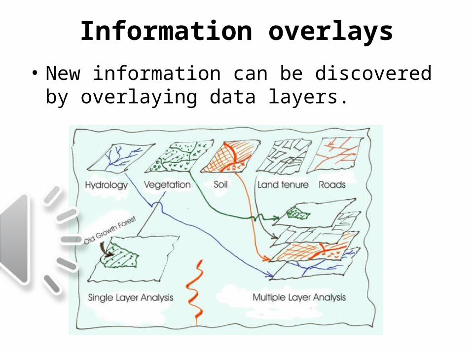
Information overlays
• New information can be discovered by overlaying data layers.

Spatial Analysis Functions• Overlay, buffer, proximity, connectivity and Boolean logic are
some basic analysis functions.

Mapping Project Example• Application of spatial analysis to a specific
land management problem.SUITABILITY MODEL The user can create a campground suitability model using the spatial analysis functions.---------------------------------------------------------------------------------------------------------------------------------------------------------------- Suitability may be a function of elevation, roads and water. Primary Layer Derived layer After analysis of data layers
Elevation Slope Preferred slope (eg. Flat surface) Roads Proximity to roads Preferred roads (eg. Site within 1km of road) Water Proximity to water Preferred water (eg. Potable water nearby) Elevation Views Preferred views (eg. View of lake)
Elevation Aspect Preferred aspect (eg. North facing) ---------------------------------------------------------------------------------------------------------------------------------------------------------------SUITABILITY MAP
Created by locating site (if any) that satisfies all suitability requirements.

Extra resources• The Geospatial Revolution• GO TO LINK: >• http://www.youtube.com/watch?v=ZdQjc30YPOk&feature=relmfu• The Geospatial Revolution – Episode 1• GO TO LINK: >• http://www.youtube.com/watch?v=poMGRbfgp38• The Geospatial Revolution – Episode 2• GO TO LINK: >• http://www.youtube.com/watch?v=GXS0bsR0e7w&feature=relmfu• The Geospatial Revolution – Episode 3• GO TO LINK: >• http://www.youtube.com/watch?v=OePOK6nzcaY&feature=relmfu• The Geospatial Revolution – Episode 4• GO TO LINK: >• http://www.youtube.com/watch?v=9F7z9LLYxf8&feature=relmfu

Test your knowledge(Refer back to the slides after each attempt)
a. What are some of the different ways people view the world?
b. Explain the process of the conversion of a spatial entity, to an object, then to a graphic element?
c. What does it mean that information gained through the visual analysis of a map is greatly enhanced when digital analysis is also undertaken?
d. Explain the statement “The geometry of selected features on the surface of the earth can be converted into coordinates representing nodes (points) and arcs (line segments).”
e. What does the term ‘Reference Framework” mean?
f. What makes a digital cartographic database different from a digital spatial database?
g. Demonstrate why “good” data are a prerequisite for “good” decisions.
h. When it comes to spatial analysis what is the advantage of storing spatial data as themed layers in a spatial database?
i. Define the following terms: Overlay, buffer, proximity, network, and Boolean logic.
Related Documents