The modern Po Delta system: Lobe switching and asymmetric prodelta growth Annamaria Correggiari * , Antonio Cattaneo 1 , Fabio Trincardi ISMAR (CNR), v. Gobetti 101, 40129 Bologna, Italia Accepted 15 June 2005 Abstract The modern Po Delta system, comprising five main delta lobes, has been investigated by integrating VHR seismic surveys, recorded offshore from water depths as shallow as 5 m to the toe of the prodelta in about 30 m, with accurate historical cartography extending back several centuries. Previous studies give sedimentological and geochronological information from precisely positioned sediment cores. This combined historical and stratigraphic reconstruction of the modern Po prodelta allows volumetric reconstructions indicating an average sediment load of 9.4 10 6 t yr 1 for Po di Pila and Po di Goro-Gnocca lobes. This estimate is remarkably consistent with the total sediment load of 11.5 10 6 t yr 1 available for parts of the last century from a gauge station at the apex of the delta plain (in Pontelagoscuro). These integrated stratigraphic studies allow to explain the key characters of the Po delta system: a) the marked asymmetry of the whole delta-prodelta system reflecting prevailing sediment dispersal to the south of each individual delta outlet; b) the shore- parallel overlapping of successive prodelta lobes fed by distinct river outlets of ever changing relative importance; c) the delta outlets being artificially forced in a fixed position so that natural avulsion is prevented and delta lobes undergo headland retreat leaving a marked erosion on the prodelta; d) the presence of prodelta lobes showing widespread bcut-and-fillQ features (ranging from 100 to 300 m and depths up to 4–5 m filled with massive silt to very fine sand) offshore of short-lived very active distributary channels (e.g.: Po di Tolle lobe) and suggesting that, in some particular interval, short-lived episodes of submarine erosion are induced by catastrophic increases in river discharge (of natural origin or induced by human maintenance). The seismic stratigraphy of the modern Po Delta documents that markedly distinct prodelta architectures form when a newly activated lobe is located updrift (north, in this case) or downdrift (south) of the one that is retreating: in the first case the abandoned lobe becomes sheltered by the new, rapidly advancing, one; in the opposite case the retreating lobe is updrift and a substantial portion of the sediment is cannibalized and transported to the new lobe, downdrift. D 2005 Elsevier B.V. All rights reserved. Keywords: Po Delta; prodelta lobes; subaqueous channels; seismic stratigraphy; Adriatic; Little Ice Age 0025-3227/$ - see front matter D 2005 Elsevier B.V. All rights reserved. doi:10.1016/j.margeo.2005.06.039 * Corresponding author. Tel.: +39 051 6398869; fax: +39 051 6398940. E-mail address: [email protected] (A. Correggiari). 1 Present address: Ifremer-Brest-GM, BP70 29280 Plouzane ´, France. Marine Geology 222–223 (2005) 49 – 74 www.elsevier.com/locate/margeo

Welcome message from author
This document is posted to help you gain knowledge. Please leave a comment to let me know what you think about it! Share it to your friends and learn new things together.
Transcript
www.elsevier.com/locate/margeo
Marine Geology 222–2
The modern Po Delta system: Lobe switching
and asymmetric prodelta growth
Annamaria Correggiari *, Antonio Cattaneo 1, Fabio Trincardi
ISMAR (CNR), v. Gobetti 101, 40129 Bologna, Italia
Accepted 15 June 2005
Abstract
The modern Po Delta system, comprising five main delta lobes, has been investigated by integrating VHR seismic surveys,
recorded offshore from water depths as shallow as 5 m to the toe of the prodelta in about 30 m, with accurate historical
cartography extending back several centuries. Previous studies give sedimentological and geochronological information from
precisely positioned sediment cores. This combined historical and stratigraphic reconstruction of the modern Po prodelta allows
volumetric reconstructions indicating an average sediment load of 9.4 106 t yr�1 for Po di Pila and Po di Goro-Gnocca lobes.
This estimate is remarkably consistent with the total sediment load of 11.5 106 t yr�1 available for parts of the last century from
a gauge station at the apex of the delta plain (in Pontelagoscuro).
These integrated stratigraphic studies allow to explain the key characters of the Po delta system: a) the marked asymmetry of
the whole delta-prodelta system reflecting prevailing sediment dispersal to the south of each individual delta outlet; b) the shore-
parallel overlapping of successive prodelta lobes fed by distinct river outlets of ever changing relative importance; c) the delta
outlets being artificially forced in a fixed position so that natural avulsion is prevented and delta lobes undergo headland retreat
leaving a marked erosion on the prodelta; d) the presence of prodelta lobes showing widespread bcut-and-fillQ features (rangingfrom 100 to 300 m and depths up to 4–5 m filled with massive silt to very fine sand) offshore of short-lived very active
distributary channels (e.g.: Po di Tolle lobe) and suggesting that, in some particular interval, short-lived episodes of submarine
erosion are induced by catastrophic increases in river discharge (of natural origin or induced by human maintenance). The
seismic stratigraphy of the modern Po Delta documents that markedly distinct prodelta architectures form when a newly
activated lobe is located updrift (north, in this case) or downdrift (south) of the one that is retreating: in the first case the
abandoned lobe becomes sheltered by the new, rapidly advancing, one; in the opposite case the retreating lobe is updrift and a
substantial portion of the sediment is cannibalized and transported to the new lobe, downdrift.
D 2005 Elsevier B.V. All rights reserved.
Keywords: Po Delta; prodelta lobes; subaqueous channels; seismic stratigraphy; Adriatic; Little Ice Age
0025-3227/$ - s
doi:10.1016/j.m
* Correspondi
E-mail addre1 Present addr
23 (2005) 49–74
ee front matter D 2005 Elsevier B.V. All rights reserved.
argeo.2005.06.039
ng author. Tel.: +39 051 6398869; fax: +39 051 6398940.
ss: [email protected] (A. Correggiari).
ess: Ifremer-Brest-GM, BP70 29280 Plouzane, France.
A. Correggiari et al. / Marine Geology 222–223 (2005) 49–7450
1. Introduction
Increasing concern about the fate of river-borne
pollutants is fueling detailed studies on sediment
distribution in prodelta deposits, their geochemical
composition and their faunal content. Improved
understanding of the evolution of prodelta deposits
is necessary to direct environmental studies and may
help identify the impact of human activities on river
catchments, delta plains and adjacent coastal systems
(Stanley and Warne, 1994; Stanley, 2001). In parti-
cular, late Holocene prodelta systems are potential
archives for reconstructing these short-term environ-
mental changes over the last few millennia. Exploit-
ing prodelta systems as stratigraphic archives for
short-term environmental change requires a detailed
analysis of their internal geometry and a precise
chronological assessment of each elementary deposi-
tional unit. A significant improvement in our under-
standing of delta and prodelta systems may derive
from an integration of geophysical records and pre-
cisely positioned cores, offshore, with historical
information, on land, including old maps (in some
deltas spanning the last few centuries), and written
accounts (Trincardi et al., 2004). In the Mediterra-
nean, fine-grained prodelta deposits are typically 20–
30 m thick and can be used to complement recon-
structions of the evolution of their parent delta
systems (Bellotti et al., 1994; Cattaneo et al.,
2003; Correggiari et al., 2005).
In shore-normal sections, late Holocene prodelta
deposits show a relatively simple and laterally uniform,
wedge-shaped geometry. Offshore major delta systems,
however, a much more complex picture can be detected,
particularly if shore-parallel profiles are taken into
account and the spatial resolution between shore-normal
profiles is increased. The modern Po Delta system,
deposited during the last ca. 500 yr, includes an exten-
sive prodelta composed of multiple prodelta lobes each
extending to the south and coalescing into an undiffer-
entiated distal prodelta system (Correggiari et al.,
2005). These prodelta units evolved under the impact
of short-term climate change, river avulsion and delta
lobe switching as well as increasing anthropogenic
forcing (Ciabatti, 1967; Nelson, 1970; Cencini, 1998;
Castiglioni et al., 1999; Roveri et al., 2001).
The overall evolution of the Po Delta system during
the last few thousands of years was presented by
Correggiari et al. (2005) defining the major phases of
delta and prodelta outbuilding since the Bronze Age
(3500 yr BP) and emphasizing the shore-parallel com-
ponent of prodelta growth based on reconstructions of
sedimentary facies and geochronological information
(mainly AMS 14C dates) from sediment cores in the
prodelta and one borehole taken from a coastal lagoon.
This paper focuses on the growth of the modern Po
Delta during the last 500 yr by combining ancient
cartographic data, on land, with seismic-stratigraphic
and core data, offshore. Based on this data integration,
a detailed reconstruction of the evolutionary phases of
the main elementary delta lobes is proposed and the
following aspects are discussed: 1) the geometric rela-
tionships among prodelta lobes to reconstruct the
major phases of delta and prodelta outbuilding during
the last 500 yr; 2) a semi-quantitative estimate of the
volumes of individual delta and prodelta lobes and
their offshore distribution; 3) the impact of human
activities on the delta and their consequences for pro-
delta construction; and 4) the possible differences in
style of sediment transport during distinctive phases of
delta growth. We anticipate that thickness reconstruc-
tions from seismic profiles, offshore, only record the
net accumulation that is preserved after possible epi-
sodes of lobe retreat and offshore erosion; they are
therefore minimum estimates for each interval of delta
growth and prodelta lobe activity.
2. Background
2.1. Po River basin and delta
The Po River basin is elongated East–West,
bounded by the Alps to the North and West and by
the Apennines to the South, and opens to the Adriatic
Sea to the East. The total area of the Po basin’s
watershed is 74,500 km2, of which 30,790 km2 are
above 200 m in elevation and the remainder is an
aggrading alluvial plain (Nelson, 1970). About half
of the Po plain is below 50 metres of elevation. The
Po River is 691 km long and has a relatively steep
gradient upstream of Pontelagoscuro (located 100 km
landward of the present delta mouth of Po di Pila),
where the river enters the coastal region and flattens
considerably. The Po Delta is located at the eastern end
of the Po plain. The area of the modern Po Delta is 380
A. Correggiari et al. / Marine Geology 222–223 (2005) 49–74 51
km2. At the time of maximummarine transgression (ca.
5–6 kyr BP; Trincardi et al., 1996; Cattaneo et al.,
2003), the shoreline was on the order of 30 km inland
with respect to its present location (Castiglioni et al.,
1990; Bondesan et al., 1995a,b; Correggiari et al.,
1996; Amorosi and Milli, 2001). The Po Delta formed
after the present sea level highstand was attained,
represents the major component of the late Holocene
highstand systems tract (HST) and is genetically related
to the rapidly deposited mud wedge that accumulated
on the shelf for 600 km along the Adriatic coast of Italy
(Trincardi et al., 1996; Cattaneo et al., 2003).
2.2. Po Delta geomorphology
The Po Delta plain occupies a broad area extending
east of Ferrara and along a coastal area of ca. 120 km
between the Adige and Reno rivers (Fig. 1). Most of
the lower delta plain (ca. 1550 km2) is below mean
sea level and half of it is deeper than 2 m below sea
level (Bondesan et al., 1995a). The delta plain is
poorly supplied with sediments because all of the
branches of the Po River have major artificial levees.
The lower delta plain includes N–S elongated topo-
graphic highs (typically less than 2 m above sea level)
that correspond to ancient stranded beach ridges.
Fresh- or brackish-water deposits occur between the
ridges. The present-day delta is undergoing retreat and
is evolving towards a wave-dominated, cuspate mor-
phology (Dal Cin, 1983). Decreasing sediment load
over the last few decades was caused primarily by
intensive sand excavation within the river (up to
690�106 m3 between 1958 and 1981; Dal Cin,
1983; Cencini, 1998). Today, five active branches of
the Po have estimated water and sediment discharge
as follows (Fig. 1): Goro (8% water, 8% sediment
discharge), Gnocca (16%, 11%), Tolle (12%, 7%),
Pila (61%, 74%), Maestra (3%, 1%; data from Nelson
(1970)). Two additional regulated branches, south of
the modern delta, are Po di Volano and Po di Primaro
(occupied today by the diverted Reno River).
2.3. Subsidence
The Adriatic shelf is a shallow semi-enclosed basin
that corresponds to the most recent Apennine foreland
(Ori et al., 1986). Structural and seismic-stratigraphic
studies indicate that the coastal-plain area surrounding
the modern Po Delta has been affected by high rates of
subsidence and sediment compaction during the Plio-
Quaternary (Selli and Ciabatti, 1977; Pieri and
Groppi, 1981). Natural land subsidence (tectonic,
sediment load and compaction) is on the order of
1.1 mm yr�1 in the Po Delta and 2.5 mm yr�1 in
the area of Ravenna (Gambolati and Teatini, 1998).
This combined subsidence results in a relative sea
level rise that may be as much as 1–2 m at the scale
of the life span of an individual delta lobe. Model
predictions for the next 100 yr indicate rates of sub-
sidence of 0.5 mm yr�1 in the Venice lagoon, 2.5 mm
yr�1 in the Ravenna area, and as much as 5 mm yr�1
in the Po Delta (Gambolati and Teatini, 1998).
Anthropogenic subsidence, resulting mainly from
groundwater withdrawal and enhanced by gas produc-
tion on land and offshore, is up to 10 cm yr�1, locally
and over short intervals (Selli and Ciabatti, 1977;
Castiglioni et al., 1990; Bau et al., 2000).
2.4. Discharge regime
The Alpine and Apennine tributaries of the Po
River display distinctive characters. The Alpine tribu-
taries flow through former glacial valleys, while the
Apennine rivers include only a short stretch of high
altitude course and have lower courses with low gra-
dients. Tributaries from the Alps have high discharges
linked to snow melt; tributaries from the Apennines
provide larger amounts of sediment reflecting the
higher erodibility of the Apennines and the lack of a
depositional zone upflow of the junction with the Po
River (Tomadin and Varani, 1998). This picture is
further complicated by seasonal asynchronous flood
cycles affecting distinctive reaches of the Po catch-
ment (Tomadin and Varani, 1998), and resulting in a
bimodal river discharge with a peak in spring and one
in autumn (Correggiari et al., 2005).
The mean annual rainfall on the Po watershed is
1107 mm, but reaches twice this value if calculated for
the Apennine tributaries only (Correggiari et al.,
2005). The historical river discharge fluctuates
between 275 and 11,580 m3 s�1 with an average of
1480 m3 s�1 that correspond to a mean annual runoff
of 668 mm (Nelson, 1970; Po River Basin Authority,
2005). The greatest concentrations of suspended load
are reached in April and November, when the Apen-
nine tributaries reach peak discharge. The Western
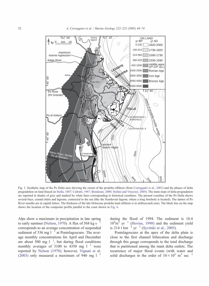
10ms
20ms 0m
s
2ms
4ms
-30m
-20m
-10m
Porto Viro
Mesola
Adria
-30m
Ravenna
km0 10
SCARDOVARI 1BOREHOLE
maximummarine ingression
Adige River
Po River(Po Grande)
Po di Volano
extent of prodelta muddy w
edge
Venicelagoon ON LAND
Reno River, formerPo di Primaro
0-130
130-214
214-360
360-420
1500-2500
2500-3000
3000-4000
4000-5500
420-1500
yr BP1820-2000
Bronze Age
Roman Age
middle ages(5th-15th sec.)
1530-1590
1590-1736
1736-1820
yr AD
Iron Age
44˚
40'
45˚
00'
12˚ 20'12˚ 00'
12˚ 40'
N
LEVANTE
MAESTRA
GORO
GNOCCA
TOLLE
PILA
ancientbeach ridges
Comacchiolagoon
LOCATION FIG. 6
Fig. 1. Synthetic map of the Po Delta area showing the extent of the prodelta offshore (from Correggiari et al., 2001) and the phases of delta
progradation on land (based on Stella, 1887; Ciabatti, 1967; Bondesan, 2000; Stefani and Vincenzi, 2005). The main steps of delta progradation
are reported in shades of grey and marked by white lines corresponding to historical coastlines. The present coastline of the Po Delta shows
several bays, coastal inlets and lagoons, connected to the sea (like the Scardovari lagoon, where a long borehole is located). The names of Po
River mouths are in capital letters. The thickness of the late Holocene prodelta mud offshore is in milliseconds (ms). The black line on the map
shows the location of the composite profile parallel to the coast shown in Fig. 6.
A. Correggiari et al. / Marine Geology 222–223 (2005) 49–7452
Alps show a maximum in precipitation in late spring
to early summer (Nelson, 1970). A flux of 568 kg s�1
corresponds to an average concentration of suspended
sediment of 336 mg l�1 at Pontelagoscuro. The aver-
age monthly concentrations for April and December
are about 500 mg l�1, but during flood conditions
monthly averages of 3100 to 4350 mg l�1 were
reported by Nelson (1970); however, Vignati et al.
(2003) only measured a maximum of 940 mg l�1
during the flood of 1994. The sediment is 10.4
106m3 yr�1 (Hovius, 1998) and the sediment yield
is 214 t km�2 yr�1 (Syvitski et al., 2005).
Pontelagoscuro at the apex of the delta plain is
close to the first channel bifurcation and discharge
through this gauge corresponds to the total discharge
that is partitioned among the main delta outlets. The
recurrence of major flood events (with water and
solid discharges in the order of 10�103 m3 sec�1
A. Correggiari et al. / Marine Geology 222–223 (2005) 49–74 53
and 24�106 t yr�1, respectively) shows a sub-dec-
adal variability (three-day average value from Gian-
dotti (1933) and annual mean value from IDROSER
(1983)). The change in river discharge pattern
occurred in the mid 20th century is illustrated in
Fig. 2: the average annual sediment load from 1918
to 1944 and from 1956 to 1987 is 11.5�106 t yr�1
at Pontelagoscuro station. Although the average
annual water discharge is similar for the period
before and after 1960, the average sediment load
decreases significantly in the second period, likely
in response to changes in agricultural pattern, refor-
estation over the past 50 yr and river-bed mining for
sand and gravel.
2.5. Oceanography
The Adriatic Sea is a shallow epicontinental basin
dominated by a cyclonic thermohaline circulation
with strong seasonal variability (Malanotte-Rizzoli
and Bergamasco, 1983). The Adriatic has a microtidal
35
30
25
20
15
10
5
0
1918
1922
1926
1930
1934
1938
1942
1944
data
gap
period 1918-1960avg annual sed. load (tons x 106)avg annual water discharge (km3)
Ann
ual S
edim
ent l
oad
(ton
s x
106 )
Fig. 2. Time series of averaged annual sediment load (istogram) and annual
1918 and 1987 AD with a data gap between 1945 and 1955 AD. The scale
diagram, respectively. The year 1960 AD marks a sharp decrease in sedimen
regime and is wave-influenced, with storm-driven
waves that may exceed 9 m in amplitude (Cavaleri,
2000). Fresh water input from rivers is 5700 m3 s�1,
more than half of which enter the northern Adriatic,
and affects the basin circulation causing heat loss and
low-salinity water gain (Artegiani et al., 1997a,b).
River runoff and wind forcing vary strongly, both
seasonally and inter-annually (Nittrouer et al., 2004,
Sherwood et al., 2004). The Po River runoff accounts
for ca. 1 /4 (in winter) to 1 /3 of the total river runoff
(Raicich, 1994; Kourafalou, 1999).
Scirocco is the dominant storm wind blowing from
the SE along the major axis of the basin. During
winter, the strong katabatic Bora wind, coming from
the NE, generates two large gyres that affect the whole
water column with a southeastwards component along
the Italian coast (Zore Armanda and Gacic, 1987;
Gacic et al., 1999). In the present conditions, the
outbulge morphology of the Po Delta affects the
evolution of buoyant river plumes by enhancing
their ability to reach offshore areas, where the geos-
90
80
70
60
50
40
30
20
10
0
1956
1960
1964
1968
1972
1978
1982
1986
period 1961-1987
48.29.3
49.613.3
Ann
ual W
ater
Dis
char
ge (
km3 )
water discharge (black line) for the Po River for the period between
s and units for each of these variables are on the left and right of the
t load likely caused by increased human impact in the Po catchment.
A. Correggiari et al. / Marine Geology 222–223 (2005) 49–7454
trophic current is able to advect sediment to the south
(Tomadin, 1979; Cattaneo et al., 2003).
3. Materials and methods
This paper is based on the interpretation of a dense
grid of VHR seismic profiles (mostly CHIRP-sonar
profiles accompanied by older 3.5-kHz and UNI-
BOOM profiles) in water depths ranging between 30
and 5 m. This dataset allows resolving offshore seis-
mic units of minimum thickness of 1 m. Stratigraphic
data on the youngest prodelta lobes are integrated by
sediment budget calculations based on bathymetric
and hydrologic studies carried out by the Ufficio
Idrografico del Po since the beginning of the 20th
century (Visentini and Borghi, 1938; Visentini, 1940).
The volume of the three most recent Po prodelta lobes
are calculated by combining direct measurements of
the thickness distribution from seismic profiles, off-
shore, and interpolation across the lower delta plain
based on the relative position of dated shorelines. In
making these estimates, an uncertainty is related to the
unknown dip of the delta foresets and the depth of the
foundation surface on which each prodelta lobe is
built. However, such foundation surface cannot be
deeper than the ravinement surface (27–30 m)
detected on seismic profiles, offshore, and in bore-
holes on the delta plain (Amorosi et al., 2005; Stefani
and Vincenzi, 2005). Geochronological control comes
from sediment cores, discussed in previous studies,
and correlation to dated historical geomorphological
and bathymetric maps. This information is comple-
mented by AMS 14C dates (reported in calibrated
years BP) discussed in previous studies (Correggiari
et al., 2005).
The time steps chosen for this work are dictated by
the availability of historical maps and a preliminary
quality control on those that are available: we use the
maps from Visentini and Borghi (1938) for 1811,
1860, 1905 and 1932 AD. An additional map for
1886 was constructed from a very accurate grid of
single-point bathymetric measurements from Stella
(1887). All contour maps are geo-referenced to a
common set of reference points, that likely remained
fixed in position (villages, houses, artificial levees),
and superimposed onto modern bathymetric data col-
lected during our cruises.
4. Results
The modern Po Delta system formed during the
last ca. 500 yr and records the fastest interval of delta
growth with a shoreline progradation of about 30 km
(Fig. 3). The modern Po Delta system includes an
extensive delta plain, a wave-influenced delta front
with five main outlets, and a broad asymmetric pro-
delta. This prodelta can be subdivided in elementary
prodelta lobes defined as the main depocentres that
can be traced as identifiable seismic-stratigraphic
units at the termini of the main river outlets. As a
whole, the Po River prodelta is thicker and broader in
the south because individual prodelta lobes emanating
from the southward oriented delta outlets are more
easily preserved compared to those advancing episo-
dically to the NE. The prodelta lobes overlap laterally
and can be traced offshore on distances that vary with
the sediment flux from land. A comparison of old
maps available for the delta area allows to readily
identify the significant changes in the relative impor-
tance of individual prodelta lobes, defining phases of
lobe advance and lobe retreat (Figs. 3,4). Offshore,
prodelta lobes can be traced as identifiable seismic-
stratigraphic units by using very high resolution
CHIRP-sonar profiles (Fig. 4). Using this tool and
the seismic-stratigraphic approach, significant varia-
tions in prodelta lobe geometry and acoustic facies
can also be reconstructed (Figs. 5,6).
4.1. Summary of the pre-Modern Age Po Delta history
Landward of the modern Po Delta, older subdeltas
were identified by correlation of borehole data (Amor-
osi et al., 1999; Amorosi and Milli, 2001). These
systems advanced in shallow embayments. In the
most landward positions, at least 30 km landward of
the present shoreline, the base of the delta deposits
consists of clay and peat deposits dated ca. 5300 cal.
years BP overlying extensive lagoon deposits dated
ca. 6000 cal. years BP (Amorosi and Milli, 2001).
Since the Bronze Age (ca. 3500 cal. years BP), the
Po Delta occupied a broad stretch of coastal area
extending from Ravenna to Adria with several river
branches and outlets that evolved through natural
avulsions (Figs. 1,3; Ciabatti, 1967). Until the Middle
Ages, the Po River discharge was dispersed through
several distributary outlets that nourished cuspate del-
7.5
9
15m
1.5
04.5
6
3
15
4.5
31.5
2002 ADisobaths
-25m
-2m
0
20
10
30
C D E1530
1592
1685
1736
1811
2002
yr A
D
modern seafloor
km0 10
m
Sca
rdov
ari1
seafloor ca. 1500 AD
1530
1592
1685
1736
1811
2002
1886
yr A
D0
20
28
10
km0 10
modern seafloor
A B
ravinement surface + mfs
m
km0 10
1530
AD
coas
tline
1592
AD
1685
AD
1736
AD
1811
AD
N
A B
C
D
E
seawardextent ofPo prodelta
prodeltathickness
(m)
Legend 1592
AD
1736
AD
Scardovari1 boreholecoastline progradationcoastline retreat
Fig. 3. Schematic sections of the Po Delta based on dated shorelines, depth of the base of the delta (from boreholes and seismic profiles
offshore) and inferred steepness of the clinoforms (based on modern delta-front and prodelta morphology). Inset map shows the ages of the
shorelines, the thickness of the modern delta (post 1600 AD; from Stella, 1887; Nelson, 1970; Bondesan, 2000), the �2 and �25 m modern
contour lines and the location of the Scardovari1 borehole (Roveri et al., 2001; Correggiari et al., 2005).
A. Correggiari et al. / Marine Geology 222–223 (2005) 49–74 55
tas; this cuspate morphology, with well-preserved
beach ridges, suggests that these deltas were wave-
dominated (Visentini, 1931; Bondesan et al., 1995a,b;
Correggiari et al., 2005).
The Po di Primaro was a large cuspate (wave-
dominated) delta detectable on historical maps and
traced offshore in high resolution seismic profiles
into a set of buried sandy clinoforms (Correggiari et
al., 2005; Fig. 1). Seismic profiles and sediment cores
through the Middle Age Po di Primaro delta show
sandy clinoforms that downlap seaward on older trans-
gressive deposits in water depths of about 25 m (Cor-
reggiari et al., 2005), and are draped by fine-grained
sediment dated ca. 1200 AD (ca. 750 cal. years BP),
indicating deposition after the end of the Middle Ages
(Amorosi et al., 1999). Between 1150 and 1200 AD
(800 and 750 yr BP), a major avulsion (Rotta di
Ficarolo; see Correggiari et al. (2005)) placed the
main trunk of the Po in its northernmost position and
the Po di Primaro became less important (Toniolo,
1924; Visentini, 1931). The late Middle Ages and
Renaissance (800–450 yr BP) were a prolonged inter-
val of climatic deterioration with more humid summers
and colder winters, heralding the onset of the Little Ice
Age (Veggiani, 1990; Grove, 2001). River floods
increased in frequency and magnitude and resulted in
A. Correggiari et al. / Marine Geology 222–223 (2005) 49–7456
A. Correggiari et al. / Marine Geology 222–223 (2005) 49–74 57
repeated episodes of flooding of the Po alluvial plain.
Recurrent avulsions affected the entire Po alluvial and
delta plain and also affected several Apennine tribu-
taries of the Po (Veggiani, 1990). Following the aban-
donment of the Po di Primaro delta, active deposition
shifted further north and resulted in the growth of
wave-dominated late Middle Ages and Renaissance
deltas (Correggiari et al., 2005). On seismic profiles,
an extensive tabular unit with plane-parallel reflectors
forms the foundation of the modern Po prodelta and
extends to the south draping the abandoned Po di
Primaro prodelta (Figs. 5,6).
4.2. Evolution of the Modern Age Po Delta
The Modern Age multi-lobe Po Delta onset after
the Porto Viro diversion (1600–1604 AD, ca. 350 yr
BP) endorsed by the Venice Republic. This diversion
took place after a 100 yr interval of engineering
activities on both the river and the delta (Visentini
and Borghi, 1938). After this diversion, historical
maps show a dramatic change in coastal morphology
with the growth of the Po Delta and a complete
reshaping of the northern Adriatic shoreline (Fig.
7). This supply dominated phase of the Po Delta
has no equivalent in the previous history of the
delta and impacted the entire Adriatic dispersal sys-
tem, down to the Gargano peninsula (Cattaneo et al.,
2003). Considered as a whole, this is a sustained
phase of delta construction; however, even during
this phase individual lobes underwent brief intervals
of significant retreat when abandoned or regulated.
Unprecedented rates of delta construction (Visentini,
1940) were likely brought about by a climatic change
that lead to increased runoff and sediment load during
the Little Ice Age (ca. 1450–1850 AD; 500–100 yr
BP). This change in runoff was accompanied by
increased anthropogenic forcing on the Po River
regime, that included rapid deforestation and con-
struction of artificial levees, enhancing the seaward
out-building of the delta (Veggiani, 1990; Correggiari
et al., 2005).
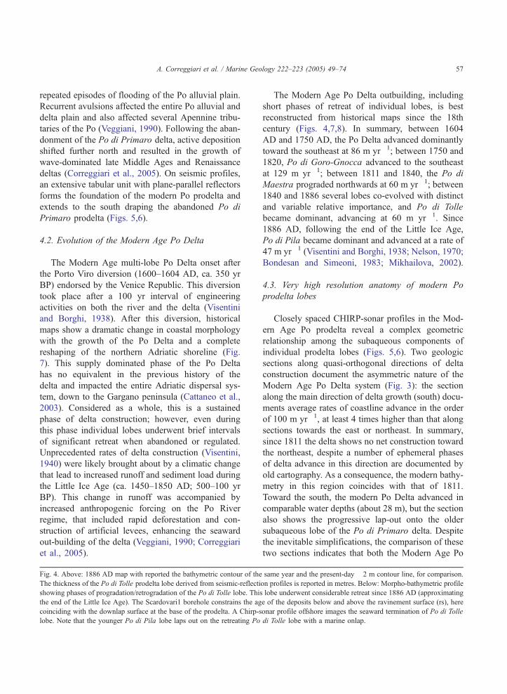
Fig. 4. Above: 1886 AD map with reported the bathymetric contour of the
The thickness of the Po di Tolle prodelta lobe derived from seismic-reflecti
showing phases of progradation/retrogradation of the Po di Tolle lobe. This
the end of the Little Ice Age). The Scardovari1 borehole constrains the ag
coinciding with the downlap surface at the base of the prodelta. A Chirp-s
lobe. Note that the younger Po di Pila lobe laps out on the retreating Po
The Modern Age Po Delta outbuilding, including
short phases of retreat of individual lobes, is best
reconstructed from historical maps since the 18th
century (Figs. 4,7,8). In summary, between 1604
AD and 1750 AD, the Po Delta advanced dominantly
toward the southeast at 86 m yr�1; between 1750 and
1820, Po di Goro-Gnocca advanced to the southeast
at 129 m yr�1; between 1811 and 1840, the Po di
Maestra prograded northwards at 60 m yr�1; between
1840 and 1886 several lobes co-evolved with distinct
and variable relative importance, and Po di Tolle
became dominant, advancing at 60 m yr�1. Since
1886 AD, following the end of the Little Ice Age,
Po di Pila became dominant and advanced at a rate of
47 m yr�1 (Visentini and Borghi, 1938; Nelson, 1970;
Bondesan and Simeoni, 1983; Mikhailova, 2002).
4.3. Very high resolution anatomy of modern Po
prodelta lobes
Closely spaced CHIRP-sonar profiles in the Mod-
ern Age Po prodelta reveal a complex geometric
relationship among the subaqueous components of
individual prodelta lobes (Figs. 5,6). Two geologic
sections along quasi-orthogonal directions of delta
construction document the asymmetric nature of the
Modern Age Po Delta system (Fig. 3): the section
along the main direction of delta growth (south) docu-
ments average rates of coastline advance in the order
of 100 m yr�1, at least 4 times higher than that along
sections towards the east or northeast. In summary,
since 1811 the delta shows no net construction toward
the northeast, despite a number of ephemeral phases
of delta advance in this direction are documented by
old cartography. As a consequence, the modern bathy-
metry in this region coincides with that of 1811.
Toward the south, the modern Po Delta advanced in
comparable water depths (about 28 m), but the section
also shows the progressive lap-out onto the older
subaqueous lobe of the Po di Primaro delta. Despite
the inevitable simplifications, the comparison of these
two sections indicates that both the Modern Age Po
same year and the present-day �2 m contour line, for comparison.
on profiles is reported in metres. Below: Morpho-bathymetric profile
lobe underwent considerable retreat since 1886 AD (approximating
e of the deposits below and above the ravinement surface (rs), here
onar profile offshore images the seaward termination of Po di Tolle
di Tolle lobe with a marine onlap.
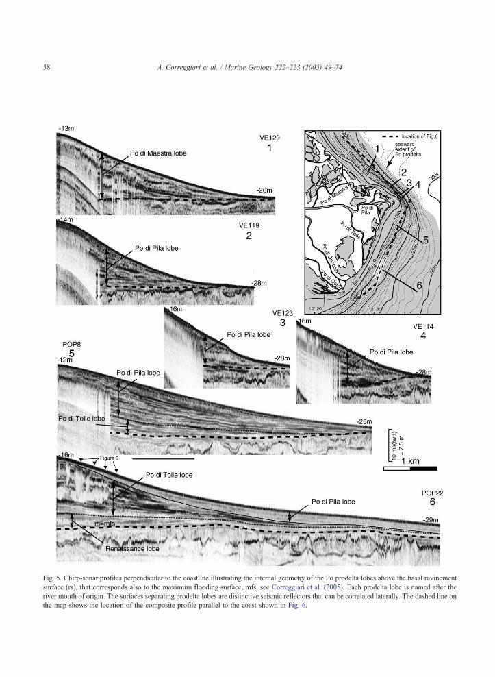
Fig. 5. Chirp-sonar profiles perpendicular to the coastline illustrating the internal geometry of the Po prodelta lobes above the basal ravinement
surface (rs), that corresponds also to the maximum flooding surface, mfs, see Correggiari et al. (2005). Each prodelta lobe is named after the
river mouth of origin. The surfaces separating prodelta lobes are distinctive seismic reflectors that can be correlated laterally. The dashed line on
the map shows the location of the composite profile parallel to the coast shown in Fig. 6.
A. Correggiari et al. / Marine Geology 222–223 (2005) 49–7458
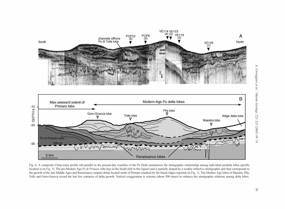
Fig. 6. A composite Chirp-sonar profile sub-parallel to the present-day coastline of the Po Delta summarizes the stratigraphic relationship among individual prodelta lobes (profile
location is on Fig. 5). The pre-Modern Age Po di Primaro lobe lays in the South (left in this figure) and is partially draped by a weakly reflective stratigraphic unit that corresponds to
the growth of the late Middle Ages and Renaissance cuspate deltas located north of Primaro (marked by the beach ridges reported on Fig. 1). The Modern Age lobes of Maestra, Pila,
Tolle and Goro-Gnocca record the last few centuries of delta growth. Vertical exaggeration is extreme (about 500 times) to enhance the stratigraphic relations among delta lobes.
A.Correg
giariet
al./Marin
eGeology222–223(2005)49–74
59
A. Correggiari et al. / Marine Geology 222–223 (2005) 49–7460
Delta and the prodelta are markedly asymmetric with
a dominant sediment accumulation toward the SE.
This picture is further complicated if the history of
individual distributary outlets and prodelta lobes is
-20m
-15m
-10m
-5m
-30m
-25m
1.5m
34 65
2
1530
AD
coa
stlin
e
1736
AD1685
AD
2002
AD
coas
tline
km0 10N
Cà Venier
Po di Maestra
Po di Pila
Po di Tolle
Po di Gnocca
Po diVolano
Po di LevantePortoViro
Gorolagoon
Adige R.P
o di Goro
GORO-GNOCCAPROFILE
PV
PV
-2m
-10m-15m
-20m
-25m-5m
1.5m34.5
67.5
9
10.5
12
1.5m
9
3
1530
AD
coa
stlin
e
1685
AD
1736
AD
1886
AD
coa
stlin
e
Po di Maestra
Po di Pila
Po di TollePo di Gnocca
Po diVolano
Po di LevantePortoViro
Gorolagoon
Adige R.
Po di G
oro
km0 10
N
TOLLE
PR
OFILE
-2m w.d. 2002AD
-25m w.d. 2002AD
PV
A
C
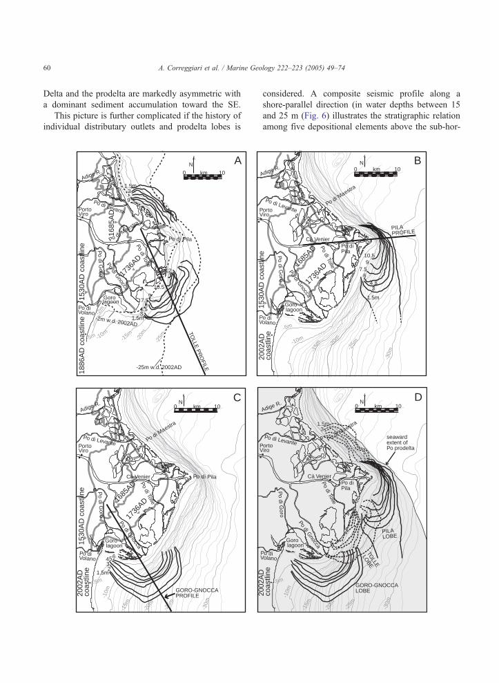
considered. A composite seismic profile along a
shore-parallel direction (in water depths between 15
and 25 m (Fig. 6) illustrates the stratigraphic relation
among five depositional elements above the sub-hor-
-20m
-15m
-10m
-5m
-30m
-25m
1.5m
34.5
67.5
910.5
1530
AD
coa
stlin
e
1736
AD1685
AD
2002
AD
coas
tline
km0 10N
Cà Venier
PILAPROFILE
Po di Maestra
Po diPila
Po di Tolle
Po di Gnocca
o diolano
Po di Levanteortoiro
Gorolagoon
Adige R.
Po di G
oro
1.5m
9
3
-20m
-15m
-10m
-5m
-30m
-25m
2002
AD
coas
tline
km0 10N
Cà Venier
Po di Maestra
Po di Tolle
Po di Gnocca
Po diVolano
Po di Levanteortoiro
Gorolagoon
Adige R.
Po di G
oro
GORO-GNOCCALOBE
Po diPila
PILALOBE
TOLLE
LOBE
seawardextent ofPo prodelta
B
D
A. Correggiari et al. / Marine Geology 222–223 (2005) 49–74 61
izontal transgressive ravinement surface, here coincid-
ing with the maximum flooding surface (rs+mfs, in
Fig. 6). The oldest depocentre corresponds to the
growth of the Po di Primaro in the south. The weakly
reflective unit above it correlates to the wave-domi-
nated deltas that formed north of Primaro before the
onset of the Modern Age delta. This weakly reflective
unit extends as a thin tabular deposit at the base of the
three younger prodelta lobes: the slightly older Po di
Tolle (in a central position), and the overlying Po di
Goro-Gnocca (to the southwest) and Po di Pila (to the
northeast). Each of these three lobes presents a dis-
tinctive internal architecture that likely reflects differ-
ences in discharge regime and in the exposure to
storms and marine currents (Fig. 6). In the next sec-
tion we focus on the detailed reconstruction of three of
such prodelta lobes, namely the Po di Tolle, the Po di
Goro-Gnocca, the Po di Pila and the Po di Maestra.
4.3.1. Po di Tolle prodelta lobe
The Po di Tolle was the dominant distributary of
the Po Delta at the end of the Little Ice Age. Ancient
geo-referenced maps through the 19th century (Figs.
4,7A,8) indicate that the Po di Tolle lobe advanced
significantly between 1811 and 1886, advancing at
60 m yr�1 between 1840 and 1886 AD (Visentini
and Borghi, 1938; Fig. 4). Fig. 7A shows the thick-
ness distribution of Po di Tolle and Po di Maestra
prodelta lobes (conservatively defined as the area
characterized by a thickness greater than 1.5 m). Po
di Tolle lobe extends over 120 km2 and exceeds 10 m
in thickness only over about 10 km2. Assuming a dip
of 18 for the basal foresets (not detectable in the
southwest area), a conservative volume estimate for
the lobe is ca. 0.5 km3.
The Scardovari1 borehole (Roveri et al., 2001;
Trincardi and Argnani, 2001) located in the lagoon
between Po di Gnocca and Po di Tolle recovered
about 30 m of shoaling upward deltaic deposits
above a 5 m-thick transgressive continental and mar-
Fig. 7. A) Thickness map of the Po di Tolle and Po di Maestra prode
bathymetric and coastline map of 1886 AD, when a major retreat of this lo
Pila lobe is shown on the modern bathymetry of the Po prodelta. The majo
(see Fig. 8). The thickness plotted on the map above refers to this latter pha
reduced compared to the Po di Pila and Po di Tolle lobes and the extent of
advection component and a more sheltered position with respect to the dom
and thickness (in metres) of the four lobes shown separately in A, B and C.
they are older and partially buried by the other two lobes. The extent of t
ine record. AMS 14C dates constrain the age of the
sandy and bioclastic transgressive record between
11,000 and 9000 BP cal. years, and yielded 750
cal. years BP (i.e. 1200 AD) at 27 m below the
core top (Correggiari et al., 2005). These dates are
consistent with the ancient cartographic data and
indicate that prodelta deposits reached this site and
advanced seaward in relatively recent times (Fig. 4).
In the lower delta plain, the Po di Tolle outlet
branches into several distributary channels (Fig. 9)
likely because artificial levees extend less far down-
river than in all other Po outlets, allowing a more
bnaturalQ behaviour of the outlet. A comparison of
historical maps with the present-day bathymetry
indicates that the Po di Tolle system underwent
retreat since 1886. This retreat was accompanied
by partial erosion offshore (Bondesan and Simeoni,
1983), but a distinctive mounded deposit can still be
recognized on seismic profiles (Fig. 9). This deposit
downlaps seaward on older units and displays a bi-
directional downlap on shore-parallel profiles.
The Po di Tolle prodelta lobe shows the best evi-
dence of subaqueous distributary channels in the pro-
delta. A set of CHIRP-sonar profiles parallel to the
bathymetric contour indicates that these subaqueous
channels are between 150 and 300 m wide and
between 2 and 4 m deep, have markedly erosional
bases and are filled by deposits with acoustically
transparent seismic facies. These subaqueous channels
likely evolved as cut-and-fill features during the over-
all construction of the downlapping lobe and the pre-
sence of discontinuous seismic reflectors suggest a
multi-phase history of erosion and fill. Preservation
of steep incision flanks suggests that erosion was
followed immediately by deposition of the transparent
facies. The channel fill does not prevent the penetra-
tion of the acoustic signal, indicating that its lithology
is likely fine-grained and homogenous (Fig. 9). Cores
through the upper part of the acoustically transparent
channel fill yielded homogenous and structure-less
lta lobes based on seismic profiles offshore, superimposed on the
be initiated. B) The shore-parallel thickness distribution of the Po di
r phases of advance are 1685–1736, 1860–1886 and after 1905 AD
se only. C) The thickness of the Po di Goro-Gnocca prodelta lobe is
the deposit is broader and more uniform, likely reflecting a reduced
inant southerly current compared to the other two lobes. D) Overlap
The Po di Tolle and Po di Maestra lobes have a dashed line because
he Po Delta and prodelta is in grey.
0
10
20
5
15
25
1811
1860 20
0219
05
1860
1886
1932
1685
1736
1 2 3 4km0
1932
1886
1905
1886
modernseafloor
(2002AD)
yr A
D
CGORO - GNOCCA
Cà
Zul
iani
Cà
Ven
ier
0
10
20
30
5
15
25
1685
1811
1860
1886
1736
1905
1932
PILA
1 2 3 4km0
2002
modernseafloor
(2002AD)
yr A
D
B
0
10
20
30
5
15
2518
11
1860
1886
1736
1905
1932
TOLLE
1 2 3 4km0
Cà
Zul
iani
yr A
D
modern seafloor (2002AD)
2002
A
Fig. 8. Bathymetric profiles based on the position of dated shorelines showing phases of progradation/retrogradation of the Po di Tolle (A), Po di
Pila (B), and Po di Goro-Gnocca (C). Location in Fig. 7. Black dots near the date denote delta progradation, open circles indicate retreat. In the Po
di Goro-Gnocca, coastlines and bathymetric profiles between 1860 and 2002 almost coincide while deposition has occurred in the prodelta lobe.
A. Correggiari et al. / Marine Geology 222–223 (2005) 49–7462
sandy silt (Correggiari et al., 2005). Three stacked cut-
and-fill units are visible in the Po di Tolle lobe, and
appear progressively more confined landward suggest-
ing a progressive reduction in river discharge (Fig. 9).
4.3.2. Po di Pila prodelta lobe
The Po di Pila became dominant after 1886 AD,
following the end of the Little Ice Age, and also in
response to the artificial E–W straightening of the
main feeding river trunk. The Po di Pila lobe
advanced at rates up to 47 m yr�1 (Visentini and
Borghi, 1938), but has undergone partial retreat over
the last few decades in response to damming, river
excavation and artificial breaching during peak
floods to reduce delta plain inundation. Beside
these human impacts, Cencini (1998) also docu-
Fig. 9. CHIRP-sonar profiles (spaced about 500 m) roughly parallel to the shoreline showing subacqueous channels and channel fills in the Po di Tolle prodelta lobe. These
channels are sharp-based, have acoustically transparent fill and record repeated phases of erosion and deposition. The older channels extend farther seaward compared to the last
generation. Key reflectors (either black or white lines depending on the dominant background) are traced to indicate the maximum flooding surface (dashed line at the base of
prodelta lobes) here coinciding with the ravinement surface (mfs+rs), the base of Po di Tolle lobe (dotted line), and the base of Po di Pila and Po di Goro-Gnocca lobes
(continuous line).
A.Correg
giariet
al./Marin
eGeology222–223(2005)49–74
63
A. Correggiari et al. / Marine Geology 222–223 (2005) 49–7464
ments the relevance of land reclamation particularly
between 1870 and 1960 AD. The Po di Pila pro-
delta lobe advanced directly onto the much older
transgressive record following a significant hiatus.
This lobe reflects phases of advance and retreat
accompanied by consistent net sediment transport
to the south. The best control on thickness variations
comes from the last century (net difference in bathy-
metric surveys between 1905 and 1953; Fig. 10,
modified from Visentini and Borghi (1938), and
3.54.54.5
3.5
3.5
1.50.5
0-0.5
1.5
1.5
0.5
2.5
0.50.5
1.5
1.5
1.5
1.501.51.5
1.5
2.5
0
10.5
3m
6m
1992AD bathymetry
6m3m
1530
AD
coas
tline
1685
AD
1736
AD
1905
AD
coas
tline
Ancient coastlines (yr AD)
Pila and Goro-Gnoccaprodelta lobe thickness (m)
Po di Maestr
a
Po di PilaPo di Tolle
Po di Gnocca
Po di Goro
Po di Volano
Po di LevantePortoViro
Scardovari
lagoonGorolagoon
Adige R.
Po G
rande
-2 m
-25
m
retreat/erosion
retreat / erosion
km0 10N
LEGEND
0 m
0.5 m and steps of 1 m(1.5; 2.5; etc) = deposition
-0.5 m and steps of -1 m(-1.5; -2.5; etc) = erosion
Difference in bathymetry 1953-1905AD:
Fig. 10. Map reporting the net bathymetric difference from 1905 to
1953 AD (modified from Bondesan and Simeoni, 1983). Within this
time interval, positive values (shaded areas) indicate deposition,
negative values (white areas offshore) denote erosion. The areas
of maximum deposition in this interval correspond to the Po di Pila
and Po di Goro-Gnocca prodelta lobes (thick lines).
Bondesan and Simeoni (1983)). These data indicate
that the net deposition at the Po di Pila mouth was
18.5 m in 48 yr (Figs. 7B,8). The thickness distribu-
tion of this delta lobe exceeds 10 m over an area of
ca. 25 km2 and 1.5 m over an area of ca. 200 km2
(Fig. 7B). A conservative volume estimate is there-
fore ca. 1.5 km3.
On seismic-reflection profiles, the internal reflec-
tor geometry and lateral distribution of the Po di Pila
prodelta lobe around the feeder channel is markedly
asymmetric (Fig. 6). A rapid thinning of the deposit
(from 15 m to nil) occurs in the northeast and east
directions and is accompanied by internal reflectors
downlapping onto older condensed prodelta deposits
with a maximum inclination of ca. 18 (Fig. 6).
Toward the south, the Po di Pila lobe shows a
gradual downlap onto the slightly older Po di Tolle
lobe. This downlap occurs at very low angle on a
surface that is transverse to the modern coast. Down-
lap terminations are particularly clear where the
underlying Po di Tolle lobe is characterized by a
mounded upper surface (Figs. 6,9).
4.3.3. Po di Goro-Gnocca prodelta lobe
At a seismic-stratigraphic scale, the last outbuild-
ing phase of the Po di Pila is coeval to the reactiva-
tion of the Po di Goro-Gnocca lobes that are
advancing onto the previous Po di Tolle system,
although at a reduced rate compared to Po di Pila
(Fig. 6). The Po di Goro-Gnocca outlets are sub-
parallel and closely spaced making it relatively dif-
ficult to disentangle individual prodelta lobes off-
shore. Both distributaries were active since the
onset of the modern Po Delta progradation, as
shown by the substantial seaward advance of the
bathymetric profile between 1685 and 1886 (Figs.
7C,8). In 1770 a dyke was constructed on Po Grande
to divert the Po di Gnocca branch to the south
(Visentini and Borghi, 1938). From 1886 to 2002
the sediment supplied through the Po di Goro-
Gnocca outlets fed a large coastal sand spit elon-
gated to the southwest (Simeoni et al., 2000). Off-
shore, VHR seismic profiles identify the Po di Goro-
Gnocca prodelta lobe over an area of ca. 250 km2
(Fig. 7C). The lobe pinches out to the south with a
downlap termination onto the older Po di Primaro
deposit, and to the northeast, against the Po di Tolle
prodelta lobe (Fig. 6). Based on its thickness dis-
A. Correggiari et al. / Marine Geology 222–223 (2005) 49–74 65
tribution, an estimate that the volume of the Po di
Goro-Gnocca lobe is in the order of 0.6 km3.
4.3.4. Most recent depositional unit in the Po prodelta
CHIRP-sonar profiles allow identification of an
upper unit within the Po di Pila prodelta, where
recent flood events accumulated over the last few
decades (Palinkas et al., 2005). This deposit,
resolved in seismic-reflection profiles only where
thicker than about 1 m, has a shore-parallel distribu-
tion to the southwest, like the older seismic-strati-
graphic units that compose the prodelta (Correggiari
et al., 2005, their Fig. 15). Locally, and depending
on the underlying prodelta morphology, the upper-
most muddy deposit shows a marine onlap termina-
tion in the landward direction. Barmawidjaja et al.
(1995) confirm this evidence documenting an
increase of sediment accumulation rates in the distal
prodelta during the last few decades. Particulate Al
(20–200 mg l�1) concentrations in the bottom waters
and 210Pb sediment accumulation rates also indicate
southward dispersal (Price et al., 1999).
4.3.5. Quantitative estimate of sediment accumulation
in the most recent Po Delta lobes
The volumes of the Po di Pila and Goro-Gnocca
lobes are estimated from the interval since 1886 AD.
In the shallow areas that cannot be investigated by
seismic profiles, the base of each lobe is interpolated
assuming a clinoform steepness similar to that
observed in the present-day prodelta and may there-
fore be inaccurate. However, the precision in this kind
of estimate is limited by the uncertainties in the
knowledge of the actual clinoform dips on land. Our
estimate of the delta growth rates relies on the dates of
the successive shorelines and on the assumption that
the clinoform dip, on average, resembles the range of
dips that can be observed today.
Assuming a density of 2.65 g cm�3 and an 80%
porosity, the volume of the Po di Pila lobe is
1.47�109 m3, and the total sediment accumulation
is in the order of 779�106 tons, and the Po di Goro-
Gnocca lobe has an estimated volume of 0.558�109
m3 and a total sediment accumulation of 296�106
tons. This gives an average mass accumulation rate of
6.8�106 tons yr�1 for Po di Pila and 2.6�106 tons
yr�1 for Po di Goro-Gnocca. These estimates are
consistent with sediment supply rates measured at
Pontelagoscuro station (closure point approximating
the apex of the delta plain) from the IDROSER (1983)
and Eurodelta databases, which give a 57-yr average
of sediment load of 11.5�106 tons yr�1. This value
includes sediment delivered to other, less active, lobes
or bypassing the proximal prodelta and advected to
the SE by the dominant long-shore current system.
5. Discussion
River sediments accumulate in deltaic depositional
sequences defining alternated regressive (construc-
tional) and transgressive (destructive) phases; this
alternation defines delta cycles (sensu Scruton, 1960;
see also Amorosi et al., 2005). Popular delta models
developed over the last 30 yr emphasize variations in
the proportion of wave-, tide-, and river-influence as
primary controls on transgressive/regressive cycles,
delta morphology and facies assemblage (Wright and
Coleman, 1973; Galloway, 1975; Orton and Reading,
1993). Where deltas are observed at very high spatial
and temporal resolution, this tripartite subdivision
proves more difficult to apply because multiple,
quasi-synchronous, delta lobes may be characterized
by contrasting discharge regimes and orientation rela-
tive to the coast and prevailing direction of wave and
currents (McManus, 2002; Trincardi et al., 2004; Cor-
reggiari et al., 2005).
Based on the data presented, five main aspects of
prodelta lobe stratigraphy and sediment dynamics are
discussed: 1) the growth of individual prodelta lobes
as a function of sediment supply fluctuations, includ-
ing artificial channel regulation; 2) the asymmetry of
prodelta lobes and the implications on 3D prodelta
architecture; 3) the impact of short phases of erosion
retreat; 4) the implications in high resolution geochro-
nology of delta and prodelta systems; and 5) the origin
of shallow water channels within prodelta lobes.
5.1. Modern Po Delta system: growth patterns and
volume variations
Estimates of growth pattern and volume variation
in prodeltas should take into account volume reduc-
tions induced by sediment compaction and erosion.
The best estimates of the depth of erosion caused by
a reduction in sediment discharge to a prodelta lobe
A. Correggiari et al. / Marine Geology 222–223 (2005) 49–7466
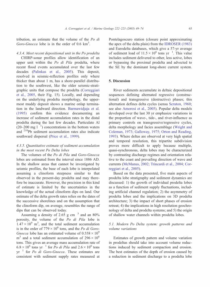
comes from Fig. 10, where areas of net accumula-
tion vs. erosion are defined by subtracting two
bathymetric surveys from 1905 and 1953 (Bondesan
and Simeoni, 1983). This map shows the areas of
net accumulation (Po di Pila and Po di Goro-
Gnocca) and of net erosion (Po di Maestra and
Po di Tolle) where fixed river outlets receive
decreased sediment loads becoming vulnerable to
headland retreat.
The depositional complexity deriving from the
changing relative importance of quasi-contempora-
neous delta lobes is best illustrated by the shoreline
variations from 1811 to 1935 compiled by Visentini
and Borghi (1938). A set of 54 bathymetric transects
perpendicular to the coast, repeated between 1811
and 1935 (Fig. 11B), documents the changes in sedi-
ment volumes (in 106 m3) of the main delta lobes
with time steps of 25 to 50 yr (Visentini and Borghi,
1938; Fig. 11C). Each lobe records alternating retreat
and advance on a decadal time scale. Fig. 11 shows
clearly the phase relationship between lobe advance
at one site and lobe retreat in an adjacent site. This is
the case of the interval 1811–1860 when the Po di
Pila lobe loses more than 300 106 m3 while the Tolle
lobe advances substantially. In other cases, two or
more lobes advance contemporaneously, though at
different rates. The cumulative volume variations
between 1811 and 1935 (Fig. 11D) show that the
southern half of the delta has substantially advanced,
regardless of the short-term variations illustrated in
Figs. 8,11C.
5.2. Asymmetry of the Po Delta and prodelta system
Bhattacharya and Giosan (2003) recently intro-
duced the concept of the asymmetric delta to
account for the complexity of wave-influenced del-
tas. The modern Po Delta system, including its thick
prodelta, represents a particular case of asymmetric
delta. Indeed, the subaerial delta is more developed
Fig. 11. A) Reference map of the Po Delta. B) Reference map of Visen
Quantitative estimate of sediment volume variations of the Po prodelta lob
up, to south) measured in four time intervals as indicated (modified from
entire interval between 1811 and 1935 AD. Note that the Po di Pila lobe
values) in the North, and net progradation in the South. The southern half
variations in discharge at each delta outlet. In C and D, shaded grey area
number of bathymetric section marked in B.
south of the main trunk (the Po Grande; Figs. 1,3).
This asymmetry may well reflect the impact of
diversions and other continued human intervention
and flow regulations (Correggiari et al., 2005). A
semi-quantitative estimate of this asymmetric sedi-
ment partitioning in the delta is given in Fig. 11 and
shows highest accumulation south of Tolle and
Goro-Gnocca outlets. In other examples of asym-
metric deltas, the growth of individual prograda-
tional lobes may even result in the formation of
sheltered bbay-likeQ areas (Bhattacharya and Giosan,
2003).
In the Po system, not only the overall prodelta
distribution is asymmetric but also individual pro-
delta lobes grow as asymmetric deposits that appear
dominated by shore-parallel, southward, advection of
finer-grained sediment. This preferential advection of
sediment can be observed at the scale of the entire
Modern Age delta (Figs. 3,11D), or parts of it, like
the most recent deposit of the Po di Pila (Fig. 7B). In
a multi-lobe delta such as the Po, each prodelta lobe
tends to generate relief on the sea floor, particularly
in a downdrift location, and this trend limits the
available space for any younger prodelta lobe. The
shore-normal extent of prodelta lobes tends to
broaden downdrift of the feeding delta outlet and to
pinch out against pre-existing prodeltas lobes. The
cartoon of Fig. 12, illustrates schematically two main
kinds of lap out termination in distal prodelta lobes.
In the first case, deposition in a distal prodelta lobe
reflects lateral advection by bottom currents against
the clinoform of a pre-existing prodelta lobe located
downdrift (Fig. 12 A). In this case the lap out termi-
nation of the younger distal prodelta lobe is a case of
marine onlap. In case B of Fig. 12, instead, the
presence of a distal tabular drape deposit, associated
with an older prodelta lobe, limits the accommoda-
tion that remains available for a younger prodelta
lobe to prograde. The older tabular deposit can be
rather thick, like in the case of the post-Primaro unit
tini (1940) with location of the bathymetric sections measured. C)
es calculated from the difference of bathymetric profiles (from north,
Visentini, 1940). D) Cumulative value of sediment volume over the
shows a marked change with dominant retreat and erosion (negative
of the delta has substantially advanced, regardless of the short-term
s highlight the position of the main Po Delta lobes referred to the
A. Correggiari et al. / Marine Geology 222–223 (2005) 49–74 67
of the modern Po Delta (Fig. 6 and Correggiari et al.,
2005). It is possible to represent such complex rela-
tionships between prodelta lobes in space (Fig. 6) and
-10-15
-20
-25m
coastline and bathymetry 1886 AD
-2 -5 -25m
1736
AD
1530
AD
1685
AD
old coastline
Tagliodi Po
Po di Maestra
Po di Pila
Po di Tolle
Po di Gnocca
Po di Goro
Po di Volano
Po di LevantePortoViro
Mesola
GoroScardovari
lagoon
Gorolagoon
Adige River
Po di Goro
Po Grande
Adria
Chioggia
Venicelagoon
-2 m
w.d
.
2002
AD
-25
m w
.d.
2002
AD
km0 10
N
A
-10
4
8
12
16
20
24
28
32
36
40
44
48
52
2
6
10
14
18
22
26
30
34
38
42
46
50
54
-150 -100 -50 0 50 100 1500
4
8
12
16
20
24
28
32
36
40
44
48
52
106 m32
6
10
14
18
22
26
30
34
38
42
46
50
54
NU
MB
ER
S R
EF
ER
TO
TR
AK
S O
N M
AP
B
1811-1860
1860-1886
1886-1905
1905-1935
sediment volumeC
A
also in time, in a chronostratigraphic diagram based
on the same seismic line (Fig. 13, discussed more in
detail below).
12
34
56
7
8
9
19
25
26
42
33
21
20
29
-10-15
-20
-25m
coastline and bathymetry 1886 AD
-2 -5 -25m
Tagliodi Po
Po di Maestra
Po di Pila
Po di Tolle
Po di Gnocca
Po di Goro
Po di Volano
Po di LevantePortoViro
Mesola
GoroScardovari
lagoon
Gorolagoon
Adige River
Po di Goro
Po Grande
dria
Chioggia
Venicelagoon
-2 m
w.d
.
2002
AD
-25
m w
.d.
2002
AD
km0 10
N
Pila lobe
Tolle lobe
Goro-Gnocca lobe
20000 -50 0 50 100 150 250
Maestra lobe
1811 to 1935 ADcumulative
sediment volume106 m3
from Visentini, 1938
D
B
Case A
PHASE I - lobe progradation
PHASE II - advection from source located updrift and marine onlap onto older lobetime
Legend
sea surface older deposits
younger deposits
Case B
PHASE I - advection and marine onlap, accommodation is "consumed"
PHASE II - lobe progradation on top of a risen foundation surfacetime
main direction of sediment transport
direction of shelf currents
Fig. 12. Idealized stratigraphic schemes showing the geometric and
phase relationship between progradational prodelta lobes and land-
ward-onlapping prodelta deposits suggesting deposition by shore-
parallel bottom currents. A: the lobe located bupdriftQ activates afterthe lobe located downdrift is abandoned. This is the case of the
younger Po di Pila deposits lapping out onto the slightly older Po di
Tolle lobe. B: the younger lobe is located downdrift of the aban-
doned lobe and, consequently, finds a reduced accommodation in its
toe region. This is the case of the Po di Goro-Gnocca prodelta lobe
downlapping onto the abandoned Po di Tolle lobe.
A. Correggiari et al. / Marine Geology 222–223 (2005) 49–7468
5.3. Role of sediment erosion in prodelta lobe shaping
Combined seismic stratigraphy and historical data
indicate that, at any stage, the growth of the modern
Po Delta occurred through the contemporaneous
advance of two or more delta lobes (Figs. 6 and 11).
Since avulsion is no longer possible, due to human
control, any change in delta morphology and strati-
graphy results only from changes in sediment flux to
individual prodelta lobes rather that from delta lobe
switching. The observed changes in delta morphol-
ogy, over this relatively short interval, reflect primar-
ily changes in the partitioning of river discharge
among the different delta outlets (Figs. 7 and 11).
Under these semi-artificial conditions, lobe retreat
takes place not in response to avulsion processes,
but rather because any dearth in supply to a specific
delta mouth results inevitably in lobe retreat and
downdrift sediment redistribution since, on short-
term, the overall oceanographic conditions remain
constant. This tendency has two consequences: 1) it
enhances the tendency of the delta to become asym-
metric, as erosion and transport result in preferential
accumulation to the south (downdrift), and 2) it results
in the deposition of super-expanded sections inter-
rupted by very subtle, but important, diastemic sur-
faces that may be difficult to detect at sediment-core
scale.
When the delta and prodelta lobe that becomes
abandoned is located up current of a new advancing
lobe, the sediment that is cannibalized from the older
lobe may significantly contribute to the new one,
reflecting the importance of shore-parallel sediment
advection. When, instead, the lobe that becomes aban-
doned is located down current with respect to the new
lobe, a sheltering effect allows a greater preservation
of the old lobe. Our data document how lobe canni-
balization and downdrift transport play a key role in
the construction of the delta system. The example of
Po di Pila lobe is typical of the role exerted by
sediment erosion and redistribution.
5.4. Chronostratigraphy of Po prodelta lobes
The geometric relationship between prodelta lobes
is best imaged on shore-parallel profiles showing in
detail the lap out patterns of seismic reflectors (Fig. 6).
Schematic chronostratigraphic diagrams (Wheeler dia-
grams, originally developed to represent stratigraphic
relations among sequences encompassing millions of
years) help clarify the complex relation among delta
lobes and between the delta as a whole and the units
underlying it. Fig. 13 summarizes the chronological
information available in the area (limited 14C dates
and ages of prodelta lobes inferred from their position
relative to dated shoreline from historical maps). Two
complementary chronostratigraphic diagrams are pro-
vided for the entire Holocene (ca. 11,000 cal. years;
mfs=rs TST
5 km
Max seaward extent of Primaro lobe
Renaissance lobes
Modern-Age Po delta lobes
Pila lobeGoro-Gnocca lobe
Tolle lobe
Maestra lobe
Primaro lobe
-10 m
-20
-30
Adige delta lobe(not shown above)
DE
PT
H
5001500250035004500
6500 5500
cal. yr BP
750085009500
10500
TST
mfs condensed interval
HST
0100200300400500600700
800900
yr BP
1950
1850
1750
1650
1550
1450
1350
1250
1150
1050
yr AD
TIM
ET
IME
(ex
pand
ed)
non deposition
non deposition
erosion or non deposition
Renaissance lobes Modern-Age Po delta lobesPrimaro lobe
erosion or non deposition
erosion or non deposition
Primaro lobe
Renaissance lobes
Tolle lobe
erosion or non deposition
erosion or non deposition
A
B
C
Maestra lobe
Pila lobeGoro-Gnocca lobe
Litt
le Ic
e A
ge
Fig. 13. A, B Chronostratigraphic diagrams based on the seismic profile shown in Fig. 6 (and reported here in C) with age constrains from dated
old maps and 14C dates. Progressively lighter grey shading represents progressively younger prodelta lobes; the white areas depict intervals of
non-deposition or erosion and time lines are horizontal. Exploiting all the very high stratigraphic resolution available, the reconstruction on a
100-yr scale (A) allows appreciating the stacking pattern of the prodelta lobes and identifying very minor but diagnostic hiatuses among them.
This representation also indicates that the most complete stratigraphic record in this setting would have to be a composite from cores taken
through each lobe for each time step. At a lower (500 yr) resolution (B) only the overall progradational trend is captured and deposition results
apparently more continuous.
A. Correggiari et al. / Marine Geology 222–223 (2005) 49–74 69
Fig. 13B) and the last 1000 yr (Fig. 13A). In the
former diagram (Fig. 13B), a prolonged interval of
erosion records most of the relative sea level rise, and
no deposition characterizes most of the last ca. 5500
cal. years of sea level highstand. The complex history
of the Po Delta in the last 500 yr is not resolved unless
the chronological resolution is increased to quantify
short intervals and restricted areas characterized by
A. Correggiari et al. / Marine Geology 222–223 (2005) 49–7470
erosion or lack of sedimentation. Note that the erosion
documented atop Po di Tolle lobe is accompanied by
deposition on both Po di Pila and Po di Goro-Gnocca
lobes.
In the case of several Mediterranean deltas, accu-
rate historical cartography (Provansal et al., 1999;
Correggiari et al., 2005) allows defining the age of
individual prodelta lobes with resolutions that are
better than a few decades. For the late stages of
delta growth, a relative chronology is reconstructed
based on the stratigraphic superposition of prodelta
lobes, on seismic profiles, and on reconstructed shor-
elines. With time steps of 50 yr, a chronostratigraphic
diagram can summarize shifts or advance/retreat
phases of individual delta lobe through since the
onset of the Little Ice Age (Fig. 13A).
Despite differences in the absolute sediment flux
to, and resulting thickness of, individual lobes, the
chronostratigraphic diagram captures two main char-
acters of the Modern Age and Recent Po Delta: 1) the
shift of the entry points tends to generate laterally
juxtaposed delta lobes that only partially stack onto
each other; and 2) at this very short scale of observa-
tion, the main changes in the growth patterns of the Po
Delta do not coincide with the onset or shutdown of
individual lobes, but rather record short-lived changes
in the relative importance of each system. The case of
the Po di Pila, Po di Tolle and Po di Goro-Gnocca
prodelta lobes during the 19th century is a clear
example and can be depicted on a Wheeler diagram
by reporting the location of the depocentre for each
lobe based on the physical correlation of correlative
seismic units (Fig. 13A). At the base, the diagram
shows the Po di Primaro prodelta lobe; when this
prodelta lobe was active, no deposition is documented
in the other areas further north along the chosen tract,
because deposition from other outlets was confined
further onshore.
5.5. Submarine channels in prodelta lobes
Channel fill features are not commonly detected in
modern prodelta environments, partly because, if pre-
sent, they occur in shallow waters where geophysical
surveys yield poor quality data (Correggiari et al.,
2005). Off the Po Delta, seismic profiles show cut-
and-fill features off the Po di Tolle mouth, within a
depositional lobe that records a rapid phase of delta
outbuilding at the end of the LIA (Fig. 9). Other
possible occurrences are in a poorly preserved rem-
nant of the Po di Maestra prodelta lobe, in the North,
and in the topset of the recent-most unit of the Po di
Primaro (Correggiari et al., 2005, their Fig. 11C). In
all cases, these features form during short intervals of
increased water discharge and sediment load during a
phase of overall outbuilding of the prodelta lobe. In
the case of the Po di Tolle prodelta lobe, seismic
stratigraphy suggests that three distinct cut-and-fill
phases occurred during a brief interval of prodelta
lobe advance (Fig. 9). The bases of the channels are
as deep as 24 m below mean sea level with each
individual cut-and-fill phase about 4 m thick and
composed of homogenous silty deposits, at least in
the upper part that was cored (Correggiari et al.,
2005). It is possible that hyperpycnal flows generated
a set of shallow subaqueous channels off the river
mouth through erosion and fill (Correggiari et al.,
2005), as it was observed elsewhere (Fulthorpe and
Austin, 2004). This mechanism was documented in
other prodelta environments, when river flows enter a
basin with a higher density than the ambient body of
water (Wright et al., 1986, 1988). The Po is among
rivers that seldom produce hyperpycnal flows (Milli-
man and Syvitski, 1992; Syvitski et al., 2005).
Whether, and over what distance, these flows erode
the seafloor is hotly debated (Mulder and Syvitski,
1995). In the case of the Po Delta, it is difficult to
prove a physical connection of the observed channels
with terminal distributary channels in the subaerial
delta, because of a lack of data in waters shallower
than 10 m. Anthropogenic causes (artificially increa-
sed water discharge) or jokulhlaups-like natural events
(perhaps generated by breaching of natural dams at
the end of the Little Ice Age) may have led to cata-
strophic increases in discharge and sediment load
capable of generating hyperpycnal flows across the
outbuilding prodelta. During the Fall-2002 Po River
flood, sediment concentration higher than 10 mg l�1
were considered close to the critical value for gener-
ating density currents (Nittrouer et al., 2004). In the
case of Po di Primaro, the formation of subaqueous
channels corresponds to the reactivation of the delta
when the Reno River was diverted into the old Po
branch of Primaro (dated 1763 AD; Correggiari et al.,
2005), confirming the role of man-induced sudden
changes in water discharge.
A. Correggiari et al. / Marine Geology 222–223 (2005) 49–74 71
6. Conclusions
The modern Po Delta is a composite depositional
system that includes several lobes built over an area of
380 km2 during the last 500 yr. Individual prodelta
lobes (the subaqueous part of a delta lobe) underwent
constructional and retreat phases forced by diversions
or, more commonly, short-term changes in sediment
supply rather than avulsion. Combining the compila-
tion of historical cartography on the Po Delta plain
with VHR seismic-stratigraphic data in the prodelta,
supports the following conclusions:
1) The Modern Age Po Delta is the result of a marked
phase of river-dominated growth, where increased
sediment flux derived from climatic change and by
human impact both on the catchment (deforesta-
tion) and on the delta (diversions to the south
accompanied by construction of artificial levees
to maintain a fixed channel network).
2) The Modern Age delta shows an asymmetric thick-
ness distribution and facies partitioning reflecting
the fact that lobes emanating from the southern part
of the delta advance faster or are better preserved.
The distribution of the prodelta lobe reinforces this
asymmetry showing greater extent and thicker
deposits to the south, consistent with the dominant
alongshore dispersal by waves and currents.
3) The distributary branches of the delta have become
fixed in response to the construction of artificial
levees and avulsion is no longer possible. As a con-
sequence, the growth of the Modern Age Po Delta
reflects repeated changes in the relative importance of
individual delta lobes that advance/retreat during
each interval, depending on the balance between
oceanographic regime and sediment supply.
4) When the delta lobe that becomes abandoned is
located up current of the new lobe, a significant
component of the sediment that is cannibalized
from the old apparatus is delivered to the new
one, reflecting the importance of shore-parallel
sediment advection. When the lobe that becomes
abandoned is down current of the new lobe, a
sheltering effect allows a greater preservation of
the old one and a marine onlap forms on top of the
abandoned lobe.
5) Distal prodelta deposits are more uniform with
extensive, sub-parallel or seaward-converging,
reflector packages. Beyond 25 m water depth,
no individual source can be identified based on
seismic-stratigraphic criteria (localized thickness
increases of distinctive seismic units). Distal
deposits tend to drape older low-angle deposi-
tional relief and act as significant permeability
barriers.
6) Reflector geometries and facies assemblages within
the Modern Age Po prodelta record two distinctive
styles of deposition: the first consists of laterally
continuous and weakly converging reflector
packages and alternating fine sand or silt flood
layers observed in cores (Correggiari et al.,
2005), suggesting deposition from hypopycnal
flows; the second is characterized by the formation
of shore-normal cut-and-fill features (4 m deep and
as much as 300 m wide, extending seaward to the
20 m isobath) filled with massive silt during phases
of major prodelta lobe construction and suggest
deposition from hyperpycnal flows.
7) A crude estimate of the sediment accumulated in
the last ca. 120 yr for the most active Po di Pila
and Goro-Gnocca lobes is 779�106 and 296�106
tons, respectively. Converted in sediment accumu-
lations rates, these values give 6.8�106 and
2.6�106 t yr�1, for each lobe. These estimates
are consistent with the 57-yr average sediment load
measured at Pontelagoscuro (11.5�106 t yr�1)
because these lobes make 92% of the total Po
sediment load.
Acknowledgments
Data from the recent Po River floods and the last 90
yr of discharge data collected by Magistrato del Po di
Parma were kindly made available by Dr. Allodi.
Support to this research came from the European
Commission through the projects EURODELTA (Con-
tract N8: EVK3-CT-2001-20001) and EUROSTRATA-FORM (Contract N8: EVK3-CT-2002-20079). We
would like to thank J.P.M. Syvitski, guest editor of
this special volume, and reviewers Phil Hill and T.
Tornqvist for their comments and advices. Finally,
this is also an occasion to acknowledge all the partici-
pants of the COMDELTA conference and in particular
our French hosts in Aix en Provence. This is ISMAR
(CNR)- Bologna contribution no. 1459.
A. Correggiari et al. / Marine Geology 222–223 (2005) 49–7472
References
Amorosi, A., Milli, S., 2001. Late Quaternary depositional archi-
tecture of Po and Tevere river deltas (Italy) and worldwide
comparison with coeval deltaic successions. Sediment. Geol.
144, 357–375.
Amorosi, A., Colalongo, M.L., Pasini, G., Preti, D., 1999. Sedi-
mentary response to Late Quaternary sea-level changes in the
Romagna coastal plain (northern Italy). Sedimentology 46,
99–121.
Amorosi, A., Centineo, M.C., Colalongo, M.L., Fiorini, F., 2005.
Millennial-scale depositional cycles reconstructed from core
data (Holocene of the Po Plain, Italy). Marine Geology
222–223, 7–18 (this volume).
Artegiani, A., Bregant, D., Paschini, E., Pinardi, N., Raicich, F.,
Russo, A., 1997a. The Adriatic Sea general circulation: Part I.
Air–sea interactions and water mass structure. J. Phys. Ocea-
nogr. 27, 1492–1514.
Artegiani, A., Bregant, D., Paschini, E., Pinardi, N., Raicich, F.,
Russo, A., 1997b. The Adriatic Sea general circulation:
Part II. Baroclinic circulation structure. J. Phys. Oceanogr.
27, 1515–1532.
Barmawidjaja, D.M., van der Zwaan, G.J., Jorissen, F.J., Puskaric,
S., 1995. 150 years of euthrophication in the northern Adriatic
Sea: evidence from a benthic foraminiferal record. Mar. Geol.
122, 367–384.
Bau, D., Gambolati, G., Teatini, P., 2000. Residual land subsidence
near abandoned gas fields raises concern over northern Adriatic
coastland. Eos Transactions AGU 81, 245, 248, 249.
Bellotti, P., Chiocci, F.L., Milli, S., Tortora, P., Valeri, P., 1994.
Sequence stratigraphy and depositional setting of the Tiber
Delta; integration of high-resolution seismics, well logs, and
archeological data. J. Sediment. Res. 64, 416–432.
Bhattacharya, J.P., Giosan, L., 2003. Wave-influenced deltas: geo-
morphological implications for facies reconstructions. Sedimen-
tology 50, 187–210.
Bondesan, M., 2000. Guida all’escursione nel delta del Po. Atti del
convegno TLe pianure – conoscenza e salvaguardia – il contri-
buto delle scienze della terrar. Regione Emilia-Romagna, Italia,
pp. 381–393, English translation at http://www.regione.emilia-
romagna.it/geologia/econv_pia.htm.
Bondesan, M., Simeoni, U., 1983. Dinamica e analisi morfologica
statistica dei litorali del delta del Po e alle foci dell’Adige e del
Brenta. Mem. Sci. Geol. 36, 1–48.
Bondesan, M., Castiglioni, G.B., Elmi, C., Gabbianelli, G., Mar-
occo, R., Pirazzoli, P.A., Tomasin, A., 1995a. Coastal areas at
risk from storm surges and sea-level rise in northeastern Italy. J.
Coast. Res. 11, 1354–1379.
Bondesan, M., Favero, V., Vinals, M.J., 1995b. New evidence on
the evolution of the Po-delta coastal plain during the Holocene.
Quat. Int. 29/30, 105–110.
Castiglioni, G.B., Bondesan, M., Elmi, C., 1990. Geomorphological
mapping of the Po Plain (Italy), with an example in the area of
Ravenna. Z. Geomorph. N.F. 80, 35–44.
Castiglioni, G.B., Biancotti, A., Bondesan, M., Cortemiglia, G.C.,
Elmi, C., Favero, V., Gasperi, G., Marchetti, G., Orombelli, G.,
Pellegrini, G.B., Tellini, C., 1999. Geomorphological map of the
Po plain, Italy, at a scale of 1 :250,000. Earth Surf. Process.
Landfa. 24, 1115–1120.
Cattaneo, A., Correggiari, A., Langone, L., Trincardi, F., 2003. The
late-Holocene Gargano subaqueous delta, Adriatic shelf: sedi-
ment pathways and supply fluctuations. Mar. Geol. 193, 61–91.
Cavaleri, L., 2000. The oceanographic tower Acqua Alta — activity
and prediction of sea states at Venice. Coast. Eng. 39, 29–70.
Cencini, C., 1998. Physical processes and human activities in the
evolution of the Po Delta, Italy. J. Coast. Res. 14, 774–793.
Ciabatti, M., 1967. Ricerche sullTevoluzione del delta padano. G.
Geol. 34/1966, 381–410.
Correggiari, A., Roveri, M., Trincardi, F., 1996. Late-Pleistocene
and Holocene evolution of the North Adriatic Sea. Il Quater-
nario. Ital. J. Quat. Sci. 9, 697–704.
Correggiari, A., Trincardi, F., Langone, L., Roveri, M., 2001. Styles
of failure in heavily sedimented highstand prodelta wedges on
the Adriatic shelf. J. Sediment. Res. 71, 218–236.
Correggiari, A., Cattaneo, A., Trincardi, F., 2005. Depositional
patterns in the Late-Holocene Po delta system. In: Bhattacharya,
J.P., Giosan, L. (Eds.), Concepts, Models and Examples, SEPM
Special Publication, vol. 83, pp. 365–392.
Dal Cin, R., 1983. I litorali del delta del Po e alle foci dell’Adige e
del Brenta: caratteri tessiturali e dispersione dei sedimenti, cause
dell’arretramento e previsioni sull’evoluzione futura. Boll. Soc.
Geol. Ital. 102, 9–56.
Fulthorpe, C.S., Austin Jr., J.A., 2004. Shallowly buried, enig-
matic seismic stratigraphy on the New Jersey outer shelf:
evidence for latest Pleistocene catastrophic erosion? Geology
32, 1013–1016.
Gacic, M., Civitarese, G., Ursella, L., 1999. Spatial and seasonal
variability of water and biogeochemical fluxes in the Adriatic
sea. In: Malanotte-Rizzoli, P., Eremeev, V.N. (Eds.), The Eastern
Mediterranean as a Laboratory Basin for the Assessment
of Contrasting Ecosystems. Kluwer Academic Publishers,
pp. 335–357.
Galloway, W.E., 1975. Process framework for describing the mor-
phologic and stratigraphic evolution of deltaic depositional
systems. In: Broussard, M.L. (Ed.), Deltas, Models for Explora-
tions. Houston Geological Society, pp. 87–98.
Gambolati, G., Teatini, P., 1998. Numerical analysis of land
subsidence due to natural compaction of the Upper Adriatic
Sea basin. CENAS, Coastline Evolution of the Upper Adria-
tic Sea due to Sea Level Rise and Natural and Anthropo-
genic Land Subsidence, Water Science and Technology
Library, vol. 28. Kluwer Academic Publishers, Dordrecht,
pp. 103–131.
Giandotti, M., 1933. Le Piene del Po e i provvedimenti di difesa.
Publicazione della Commissione italiana per lo studio delle
grandi calamita. Accademia Nazionale dei Lincei, Firenze,
vol. IV. part I.
Grove, A.T., 2001. The Little Ice Age and its geomorphological
consequences in Mediterranean Europe. Clim. Change 48,
121–136.
Hovius, N., 1998. Controls on sediment supply by large rivers. In:
Shanley, K.W., McCabe, P.J. (Eds.), Relative Role of Eustasy,
Climate and Tectonism in Continental Rocks, SEPM Special
Publication, vol. 59, pp. 3–16.
A. Correggiari et al. / Marine Geology 222–223 (2005) 49–74 73
IDROSER, 1983. Piano progettuale per la difesa della costa adria-
tica Emiliano-Romagnola – Vol.IV Il trasporto fluviale nei
bacini tributari dell’Adriatico. 429 pp.
Kourafalou, V.H., 1999. Process studies on the Po River plume,
North Adriatic Sea. Journal of Geophysical Research 104/C12,
29,963–29,985.
Malanotte-Rizzoli, P., Bergamasco, A., 1983. The dynamics of the
coastal region of the northern Adriatic Sea. J. Phys. Oceanogr.
13, 1105–1130.
McManus, J., 2002. Deltaic responses to changes in river regimes.
Mar. Geochem. 79, 155–170.
Mikhailova, M.V., 2002. The hydrological regime and the peculia-
rities of formation of the Po river delta. Water Resour. 29, 370–
380 (Translated from Vodnye Resursy, 29/4 2002 405–415).
Milliman, J.D., Syvitski, J.P.M., 1992. Geomorphic/tectonic control
of sediment discharge to the ocean: the importance of small
mountainous rivers. J. Geol. 100, 525–544.
Mulder, T., Syvitski, J.P.M., 1995. Turbidity currents generated at
river mouths during exceptional discharges to the world oceans.
J. Geol. 103, 285–299.
Nelson, B.W., 1970. Hydrography, sediment dispersal and recent
historical development of the Po river delta, Italy. In: Morgan,
J.P. (Ed.), Deltaic Sedimentation, Modern and Ancient, SEPM
Special Publication, vol. 15, pp. 152–184.
Nittrouer, C.A., Miserocchi, S., Trincardi, F., 2004. The PASTA
Project: investigation of Po and apennine sediment transport and
accumulation. Oceanography 17, 46–57.
Ori, G.G., Roveri, M., Vannoni, F., 1986. Plio-Pleistocene sedimen-
tation in the Apenninic–Adriatic foredeep (Central Adriatic sea,
Italy). In: Allen, P.A., Homewood, P. (Eds.), Foreland Basins,
IAS Special Publication, vol. 8, pp. 183–198.
Orton, G.J., Reading, H.G., 1993. Variability of deltaic processes in
terms of sediment supply, with particular emphasis on grain size.
Sedimentology 40, 475–512.
Palinkas, C.M., Nittrouer, C.A., Wheatcroft, R.A., Langone, L.,
2005. The use of Be-7 to identify event and seasonal sedimen-
tation near the Po River delta, Adriatic Sea. Marine Geology
222–223, 95–112 (this volume).
Pieri, M., Groppi, G., 1981. Subsurface Geological Structure of the
Po Plain, Italy. Progetto finalizzato Geodinamica, vol. 414.
C.N.R., Pubbl. 23 pp.
Po River Basin Authority, 2005 (available at http://www.adbpo.it/).
Price, N.B., Brand, T., Pates, J.M., Mowbray, S., Theocharis, A.,
Civitarese, G., Miserocchi, S., Heussner, S., Lindsay, F., 1999.
Horizontal distributions of biogenic and lithogenic elements of
suspended particulate matter in the Mediterranean Sea. Prog.
Oceanogr. 44, 191–218.
Provansal, M., Berger, J.F., Bravard, J.P., Salvador, P.G., Arnaud-
Fassetta, G., Bruneton, H., Verot-Bourrely, A., 1999. Le regime
du Rhone dans l’Antiquite et au Haut Moyen-Age. Gallia 56,
13–32.
Raicich, F., 1994. Note on the flow rates of the Adriatic rivers.
Technical Report RF 02/94, CNR Istituto Sperimentale Talasso-
grafico, Trieste. 8 pp.
Roveri, M., Asioli, A., Correggiari, A., Trincardi, F., 2001. Ultra
high-resolution marine record of paleoenvironmental changes in
the last 5000 years. Arch. Oceanogr. Limnol. 22, 223–234.
Scruton, P.C., 1960. Delta building and the deltaic sequence. In:
Shepard, F.P., Phleger, F.B., van Andel, T.H. (Eds.), Recent
Sediments, Northwest Gulf of Mexico. AAPG Symposium,
Tulsa, Oklahoma, pp. 82–102.
Selli, R., Ciabatti, M., 1977. L’abbassamento del suolo della zona
litoranea ravennate. (Land subsidence in the littoral zone of
Ravenna). G. Geol. 42, 1–47.
Sherwood, C.S., Carniel, S., Cavaleri, L., Chiggiato, J., Das, H.,
Doyle, J.D., Harris, C.K., Niedoroda, A.W., Pullen, J., Reed,
C.W., Russo, A., Sclavo, M., Signell, R.P., Traykovski, P.,
Warner, J.C., 2004. Sediment dynamics in the Adriatic
Sea investigated with coupled models. Oceanography 17,
58–69.
Simeoni, U., Dal Cin, R., Fontolan, G., Tessari, U., 2000. Morfo-
genesi ed evoluzione dello Scanno di Goro (Delta del Po). In:
Simeoni, U. (Ed.), La Sacca di Goro, vol. 2. Studi Costieri,
Firenze, pp. 5–20.
Stanley, J.D., 2001. Dating modern deltas: progress, problems, and
prognostics. Annu. Rev. Earth Planet. Sci. 29, 257–294.
Stanley, D.J., Warne, A.G., 1994. Worldwide initiation of Holocene
marine deltas by deceleration of sea-level rise. Science 265,
228–231.
Stefani, M., Vincenzi, S., 2005. Holocene stratiraphic architecture
and depositional evolution of the Po. Marine Geology 222–223,
19–48 (this volume).
Stella, A., (Ed.), 1887. Delta del fiume Po — stato alla fine del 1886
con indicazione delle variazioni subite dal 1530 in poi. Carta
alla scala 1:100,000, Regio Ufficio Geologico d’Italia.
Syvitski, J.P.M., Kettner, A.J., Correggiari, A., Nelson, B.W., 2005.
Impact of distributary channels on sediment dispersal Delta
system. Marine Geology 222–223, 75–94 (this volume).
Tomadin, L., 1979. Clay mineralogy of recent sediments around the
Po River delta. G. Geol. 43, 249–275.
Tomadin, L., Varani, L., 1998. Provenance and downstream miner-
alogical evolution of the muds transported by the Po River
(Northern Italy). Mineral. Petrogr. Acta 41, 205–224.
Toniolo, A.R., 1924. Le grandi bonifiche del Ravennate e del
Ferrarese. L’Universo, 144–194.
Trincardi, F., Argnani, A., 2001. Note illustrative della Carta Geo-
logica dei Mari Italiani alla scala 1 :250,000, Foglio JOG NL33-
10 bRavennaQ, Selca, Firenze. 108 pp.
Trincardi, F., Cattaneo, A., Asioli, A., Correggiari, A., Langone, L.,
1996. Stratigraphy of the late-Quaternary deposits in the central
Adriatic basin and the record of short-term climatic events.
Mem. Ist. Ital. Idrobiol. 55, 39–70.
Trincardi, F., Cattaneo, A., Correggiari, A., 2004. Mediterranean
prodelta systems: natural evolution and human impact investi-
gated by EURODELTA. Oceanography 17, 34–45.
Veggiani, A., 1990. Fluttuazioni climatiche e trasformazioni
ambientali nel territorio imolese dall’alto medioevo all’eta mod-
erna. In: Mancini, F., Gioberti, M., Veggiani, A. (Eds.), Imola
nel Medioevo. Imola, pp. 41–102.
Vignati, D., Pardos, M., Diserens, J., Ugazio, G., Thomas, R.,
Dominik, J., 2003. Characterisation of bed sediments and sus-
pension of the river Po (Italy) during normal and high flow
conditions. Water Res. 37, 2847–2864.
Visentini, M., 1931. Notizie sulle variazioni del delta del Po.
A. Correggiari et al. / Marine Geology 222–223 (2005) 49–7474
Bulletin du Conseil International de Recherches. Union Geod.
Geophys. Int. 16, 3–9.
Visentini, M., 1940. Ricerche Idrografiche nel delta del Po. Ufficio
Idrografico del Po-Parma 14/2. Istituto Poligrafico dello Stato,
Roma, p. 175.
Visentini, M., Borghi, G., 1938. Le spiagge padane. Ricerche
sulle variazioni delle spiagge italiane, CNR Report, Roma,
vol. 7, p. 137.
Wright, L.D., Coleman, J.M., 1973. Variations in morphology of
major river deltas as functions of ocean wave and river dis-
charge regimes. AAPG Bull. 57, 370–398.
Wright, L.D., Yang, Z.S., Bornhold, B.D., Keller, G.H., Prior, D.B.,
Wiseman Jr., W.J., 1986. Hyperpycnal plumes and plume fronts
over the Huanghe (Yellow River) delta front. Geo Mar. Lett. 6,
97–105.
Wright, L.D., Wiseman, W.J., Bornhold, B.D., Prior, D.B., Suhayda,
J.N., Keller, G.H., Yang, Z.S., Fan, Y.B., 1988. Marine dispersal
and deposition of Yellow River silts by gravity-driven under-
flows. Nature 332, 629–632.
Zore Armanda, M., Gacic, M., 1987. Effects of the Bura on the
circulation in the North Adriatic. Ann. Geophys. 5B, 93–102.
Related Documents