The investigation of the Sistan River morphology using Rosgen classification 1 Naser Hafezi Moghaddas, 2 * Reza Jalilvand and 3 Hamid Reza Soloki 1 Department of Geology, Ferdowsi University of Mashhad, Mashhad, Iran 2* Department of Geology, Zahedan Branch, Islamic Azad University, Zahedan, Iran 3 Department of Geology, University of Sistan and Baluchestan, Zahedan, Iran 1 [email protected]@yahoo.com , 2 * [email protected], 3 [email protected] Abstract The Sistan River, located in southeast of the Sistan Plain in Iran and Afghanistan border, branched off the Hirmand River and after passing distance around 72 km, reaches to Lake Hamoon of the Hirmand. In this study, the morphological classification of Sistan River in the distance between Kahak dam and Hirmand Hamoon Lake (with the length of 72 km) was examined using the Rosgen classification. It should be noted that the classification of rivers was conducted at levels I and II of the Rosgen Classification. In the level I, the shape, pattern and gradient of the river were extracted using only field visits as well as satellite images and maps; and river morphology was determined in eight types of A-G using them. Then in the level I, in addition to the parameters in the level I, the clas- sification was completed using other features such as the entrenchment factor, width to depth ratio, sinuosity factor and the diameter of the size of particles in the riverbed; and the classification of this river was conducted by comprehensive classification system in the next step. Under this method, the pattern of the river is of type C5c and C6c. Keywords: Sistan River, Morphology, Rosgen, Sistan 1. Introduction The flow of water is the most important phenomenon in the skin processes of the Earth; and rivers not only have a role in the global feature of the Earth, but they also determine the shape of the life of man on earth (Morisow, 1968). Rivers are major fac- tors in in the morphological change of the Earth (Alipour Kohne- ki, 1998). Rivers and channels are completely dynamic systems whose position, shape and morphological characteristics are constantly changing over time (Rangzan et al., 2008). The topic of morphology (or the study of the behavior of rivers) specifies the action and reaction or behavior of river in different situations (Talebi and Bayazidi, 2008). In the past one hundred years or so, great progress has been made in river geomorphology. River morphology, focusing on meander and braided river, has been one of the most important parts in river geomorphology. Geo- metric parameter of modern rivers is a key to palaeohydrologic reconstruction and river evolution (Dury, 1976); studies of river morphology also supply geomorphologic basis to protect river landscapes and environment, and to exploit hydraulic resources (Zhang et al., 2008). Morphological change in river channels primarily consists of adjustments to channel width, depth, local channel slope, and planform. Channel adjustment depends on available stream power-a function of discharge and valley slope- the size and volume of bed load, and resistance provided by ri- parian vegetation and bank materials (Labbe et al., 2011). A change in one of the variables disrupts a series of existing balances, and can cause changes in other variables and ultimately change in the course of rivers (Porasaf, 2007). In addition to the above cases, human interventions (channelization of the river’s course, reforestation, utilization of the sediments of rivers, con- struction of dams) also play a role in changing the course of riv- ers (Surian et al., 2009). Familiarity with the topics of geomor- phology and performing these studies are important to identify and analyze the morphology. Lack of attention to the science of geomorphology in the management and organization of river ba- sins will create severe erosion, degradation and destruction of our natural resources (Rostami et al., 2008). Rivers have been classified from different perspectives, including the classification based on topography, slope, discharge of flow, age of river and the pattern in plan. In this study, the classification system of riv- ers has been presented from a different and comprehensive per- spective, which includes the best features of most previous stud- ies. This classification that was presented to the society of river engineering by a American researcher Rosgen (1994), attempted to withdraw from the description of the logic of the classification system of rivers, and while enjoying qualitative issues, it also considers the quantitative criteria of engineering. Therefore, in this sense, it would be possible to predict the behavior of rivers in a more appropriate manner (Sabzivand, 2007). The study of river morphology using the Rosgen classification system is necessary to understand the current situations and potential future changes in the river, through which normal behavior of rivers can be pre- dicted with respect to natural changes or actions resulting from the implementation of different projects on river engineering. Indian Journal of Science and Technology Vol: 6 Issue: 2 February 2013 ISSN:0974-6846 www.indjst.org 4029 55

Welcome message from author
This document is posted to help you gain knowledge. Please leave a comment to let me know what you think about it! Share it to your friends and learn new things together.
Transcript
The investigation of the Sistan River morphology using Rosgen classification
1 Naser Hafezi Moghaddas, 2* Reza Jalilvand and 3 Hamid Reza Soloki
1 Department of Geology, Ferdowsi University of Mashhad, Mashhad, Iran
2* Department of Geology, Zahedan Branch, Islamic Azad University, Zahedan, Iran3Department of Geology, University of Sistan and Baluchestan, Zahedan, Iran
1 [email protected]@yahoo.com , 2* [email protected], 3 [email protected]
Abstract The Sistan River, located in southeast of the Sistan Plain in Iran and Afghanistan border, branched off the Hirmand River and after passing distance around 72 km, reaches to Lake Hamoon of the Hirmand. In this study, the morphological classification of Sistan River in the distance between Kahak dam and Hirmand Hamoon Lake (with the length of 72 km) was examined using the Rosgen classification. It should be noted that the classification of rivers was conducted at levels I and II of the Rosgen Classification. In the level I, the shape, pattern and gradient of the river were extracted using only field visits as well as satellite images and maps; and river morphology was determined in eight types of A-G using them. Then in the level I, in addition to the parameters in the level I, the clas-sification was completed using other features such as the entrenchment factor, width to depth ratio, sinuosity factor and the diameter of the size of particles in the riverbed; and the classification of this river was conducted by comprehensive classification system in the next step. Under this method, the pattern of the river is of type C5c and C6c.
Keywords: Sistan River, Morphology, Rosgen, Sistan
1. IntroductionThe flow of water is the most important phenomenon in the
skin processes of the Earth; and rivers not only have a role in the global feature of the Earth, but they also determine the shape of the life of man on earth (Morisow, 1968). Rivers are major fac-tors in in the morphological change of the Earth (Alipour Kohne-ki, 1998). Rivers and channels are completely dynamic systems whose position, shape and morphological characteristics are constantly changing over time (Rangzan et al., 2008). The topic of morphology (or the study of the behavior of rivers) specifies the action and reaction or behavior of river in different situations (Talebi and Bayazidi, 2008). In the past one hundred years or so, great progress has been made in river geomorphology. River morphology, focusing on meander and braided river, has been one of the most important parts in river geomorphology. Geo-metric parameter of modern rivers is a key to palaeohydrologic reconstruction and river evolution (Dury, 1976); studies of river morphology also supply geomorphologic basis to protect river landscapes and environment, and to exploit hydraulic resources (Zhang et al., 2008). Morphological change in river channels primarily consists of adjustments to channel width, depth, local channel slope, and planform. Channel adjustment depends on available stream power-a function of discharge and valley slope-the size and volume of bed load, and resistance provided by ri-parian vegetation and bank materials (Labbe et al., 2011).
A change in one of the variables disrupts a series of existing balances, and can cause changes in other variables and ultimately
change in the course of rivers (Porasaf, 2007). In addition to the above cases, human interventions (channelization of the river’s course, reforestation, utilization of the sediments of rivers, con-struction of dams) also play a role in changing the course of riv-ers (Surian et al., 2009). Familiarity with the topics of geomor-phology and performing these studies are important to identify and analyze the morphology. Lack of attention to the science of geomorphology in the management and organization of river ba-sins will create severe erosion, degradation and destruction of our natural resources (Rostami et al., 2008). Rivers have been classified from different perspectives, including the classification based on topography, slope, discharge of flow, age of river and the pattern in plan. In this study, the classification system of riv-ers has been presented from a different and comprehensive per-spective, which includes the best features of most previous stud-ies. This classification that was presented to the society of river engineering by a American researcher Rosgen (1994), attempted to withdraw from the description of the logic of the classification system of rivers, and while enjoying qualitative issues, it also considers the quantitative criteria of engineering. Therefore, in this sense, it would be possible to predict the behavior of rivers in a more appropriate manner (Sabzivand, 2007). The study of river morphology using the Rosgen classification system is necessary to understand the current situations and potential future changes in the river, through which normal behavior of rivers can be pre-dicted with respect to natural changes or actions resulting from the implementation of different projects on river engineering.
Indian Journal of Science and Technology Vol: 6 Issue: 2 February 2013 ISSN:0974-6846
www.indjst.org402955
Sistan River has had many changes in its path in two in-tervals from 1956 to 2012, and has caused a lot of damage to adjacent lands. The main objective of this study is to evaluate the degree of sensitivity of the river to disturbance, the rate of redox potential, the rate of sediment supply, the rate of erosion potential in the banks and the effect of vegetation on the stability of chan-nel to determine the morphology of Sistan River based on quanti-tative and qualitative characteristics of the Rosgen classification system, from the place of ups to the estuary of the river, so that one can identify the behavior of the river using administrative interpretations of the Rosgen classification and try to improve conditions for its stability.
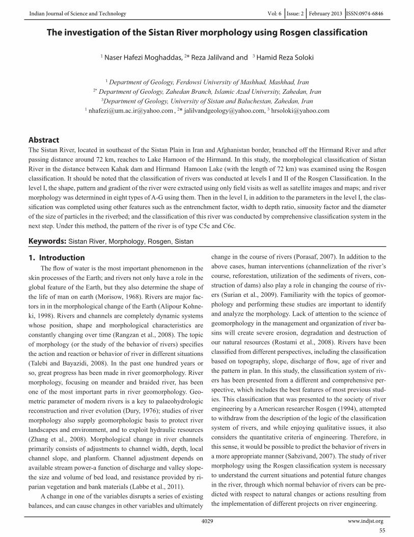
2. Location of the study areaSistan plain area is 15000 Km2 and locates in north of Sistan
and Baloochestan province of Iran and has 2 cities, 6 parts, 6 townships and 937 villages. Its population estimated about 420000 persons in 2008 which half of them work in agricultural and domesticated fields. Climate of region evaluated totally dry. Mean annual precipitation is 52.3 mm and in fully rain years this rate reaches to 120 mm rarely and in dry year there is no pre-cipitation (such as 9 mm for water year 2001-2002). This little precipitation makes impossible any kind of dry farming. Even regional natural vegetations, seldom grow, if do not locate near ground water. In this condition only an external water resource could make alive region and Hirmand Trans Boundary River has such role. Totally could say environment of Sistan is very vulnerable and depends on Hirmand River (Najafi and Vatan-fada, 2011). Hirmand River is an evident example of a flow of Endorheism from an Endorheic region. After passing a distance of about 1100 km, The river is divided into two main branches of Paryan Moshtarek and Sistan at a place called Jarikeh bor-dering Iran and Afghanistan. As one of two main branches of the Hirmand River, Sistan River is the main source of water in Sistan which is responsible for 70 percent of irrigated farmland in Sistan plain. The general slope of the river is about 0.2- to 0.6-thousandt. Important structures such as channel feeder, Ko-hak dam, Zahak-Niatak flood barrier, Zahak dam, Hedris canal, Sistan dam, Nohoorab Bridge and numerous irrigation channels, several villages and also the city of Zabol are located along the river, each of which has a significant impact on hydraulic process of the river. Sistan River is rare among the world’s rivers because concentration of the suspended load of the river’s flood flow var-ies mainly from 10 to 50 grams per liter. Low slope of the Sistan River’s bed makes it prone to sedimentation; and on other hand, the negative effects of building Zahak and Kohak dams have sparked and increased the sedimentation. The particles forming the riverbed are very fine, and are mostly in the range of fine sand, clay and silt. The average diameter of particles forming the bed is about 0.02 mm (Torabi, 2001). Figure 1 shows an over-view of the position of Sistan and Sistan River.
Fig.1. Position of Sistan region and plan of Sistan River
Review of aerial photographs and satellite images of Sistan River plan show that the meanders of Sistan River have a lot of changes due to the construction of longitudinal and transverse structures, erosion and other similar natural process, and have created several deltas in some cases. These changes also now continue with the relocation, increase or sometimes reduction of sandy islands. For the reasons mentioned above and therefore the reduction of water flow and increase of the amount of sedimenta-tion in the riverbed, these natural and permanent changes have intensified the speed of these developments.
3. Materials and methodsAttempts to classify rivers have a long history. In general,
the classification can be done on the basis of certain similarities and/or relationships and correlations. The classification can pro-vide us with specific perceptions and more understanding of the characteristics and features of each group (Zidali, 2010).
The most useful and most effective classification system is based on quantitative and qualitative criteria so that it can pro-vide the purpose for which a researcher groups rivers. Based on a review of 450 rivers in U.S. and Canada, David Rosgen (1994) gave a comprehensive classification in four levels according to geomorphic characteristics, morphological descriptions and flow conditions. Now in U.S., Canada, Australia, and other devel-oped countries in the world. This classification is used in many projects on watershed management, nurture and protection of aquatic animals, etc. (Talebi and Bayazidi, 2008). In this classifi-cation, the type of river can be classified by field measurements and determining the existing processes of the river. One of the objectives of Rosgen for classification and management of river systems is the ability to predict the behavior of river depend-ing on the form and extract data from types of the same rivers. The Rosgen classification system has four goals by which overall qualitative descriptions will lead to quantitative evaluations by providing details. These four objectives are :
Vol: 6 Issue: 2 February 2013 ISSN:0974-6846 Indian Journal of Science and Technology
www.indjst.org 403056
• Predicting the future behavior of rivers using its current ap-pearance
• The development of hydraulic and sediment relationshipsdepending on the type and condition of channel morphology
• Providing a mechanism for communicating information ordata collected from the nature about the types and similarfeatures of rivers
• Formulation of a logical framework using system resourcesassociated with the river systems for specialized uses
To manage and improve the situation of rivers, Rosgen hasprovided administrative interpretations that evaluate the types of river in terms of sensitivity to change, redox potential, sediment transfer, effect of vegetation control and potential of erodibility in banks. This interpretation can be applied in cases such as the evaluation of potential effects, risk analysis and orientation of system management depending on the type of river. This inter-pretation, which is based on the type of river, can be used to develop the guidelines for coastal management, management of catchment and river banks that includes activities such as use of marginal lands, sand and gravel extraction, as well as guidelines for coastal management, debris management, flood plain man-agement, analysis of cumulative effects, regulating the flow of reservoir and diversion dams and so on (Sabzivand et al., 2007).
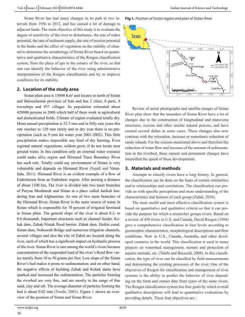
In this study, the map of morphological changes of Sistan River was prepared after information gathering and review of aerial photographs and satellite images of the region. Then, the levels I and II of the Rosgen classification were used to classify Sistan River in terms of geomorphology. In the first level, the shape of the valley, river cross-sections and the pattern of the river plan are classified into main categories of A to G according to the specifications of longitudinal profiles. Figure 2 shows a view of the form of plan, longitudinal profile and cross-sections of river patterns in the first level of Rosgen classification.
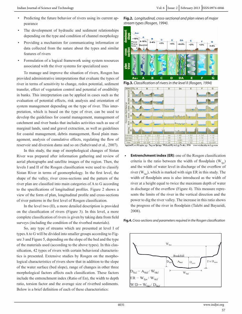
In the level two (II), a more detailed description is provided on the classification of rivers (Figure 3). In this level, a more complete classification of rivers is given by taking data from field surveys (including the condition of the riverbed materials).
So, any type of streams which are presented at level I of types A to G will be divided into smaller groups according to Fig-ure 3 and Figure 5, depending on the slope of the bed and the type of the materials used (according to the above types). In this clas-sification, 42 types of rivers with certain behavioral characteris-tics is presented. Extensive studies by Rosgen on the morpho-logical characteristics of rivers show that in addition to the slope of the water surface (bed slope), range of changes in other three morphological factors affects each classification. These factors include the entrenchment index (Ratio of En), the width to depth ratio, torsion factor and the average size of riverbed sediments. Below is a brief definition of each of these characteristics:
Fig.2. Longitudinal, cross-sectional and plan views of major stream types (Rosgen, 1994).
Fig.3. Classification of rivers in the level II (Rosgen, 1994)
• Entrenchment index (ER): one of the Rosgen classificationcriteria is the ratio between the width of floodplain (Wfpa)and the width of water level in discharge of the overflow ofriver (Wbkf), which is marked with sign ER in this study. Thewidth of floodplain area is also introduced as the width ofriver at a height equal to twice the maximum depth of waterin discharge of the overflow (Figure 4). This measure repre-sents the limits of the river in the vertical direction and thepower to dig the river valley. The increase in this ratio showsthe progress of the river in floodplain (Talebi and Bayazidi,2008).
Fig.4. Cross-sections and parameters required in the Rosgen classification
Indian Journal of Science and Technology Vol: 6 Issue: 2 February 2013 ISSN:0974-6846
www.indjst.org403157
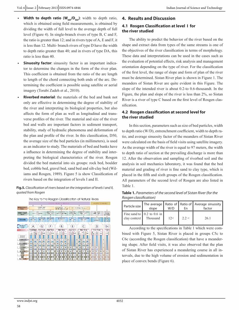
• Width to depth ratio (Wbkf/Dbkf): width to depth ratio, which is obtained using field measurements, is obtained by dividing the width of full level to the average depth of full level (Figure 4). In single-branch rivers of type B, C and F, the ratio is greater than 12; and in rivers type of A, E and F, it is less than 12. Multi- branch rivers of type D have the width to depth ratio greater than 40; and in rivers of type DA, this ratio is less than 40.
• Sinuosity factor: sinuosity factor is an important indica-tor to determine the changes in the form of the river plan. This coefficient is obtained from the ratio of the arc length to length of the chord connecting both ends of the arc. De-termining the coefficient is possible using satellite or aerial imagery (Torabi Zadeh et al., 2010).
• Riverbed material: the materials of the bed and bank not only are effective in determining the degree of stability of the river and interpreting its biological properties, but also affects the form of plan as well as longitudinal and trans-verse profiles of the river. The material and size of the river bed and walls are important factors in sediment transport, stability, study of hydraulic phenomena and deformation of the plan and profile of the river. In this classification, D50, the average size of the bed particles (in millimeters), is used as an indicator to study. The materials of bed and banks have a influence in determining the degree of stability and inter-preting the biological characteristics of the river. Rosgen divided the bed material into six groups: rock bed, boulder bed, cobble bed, gravel bed, sand bed and silt-clay bed (Wil-iams and Rosgen, 1989). Figure 5 is show Classification of rivers based on the integration of levels I and II.
Fig.5. Classification of rivers based on the integration of levels I and II, quoted from Rosgen
4. Results and Discussion
4.1 Rosgen Classification at level I for the river studied
The ability to predict the behavior of the river based on the shape and extract data from types of the same streams is one of the objectives of the river classification in terms of morphology. These data and interpretations can be used in the cases such as the evaluation of potential effects, risk analysis and management orientation depending on the type of river. For the classification of the first level, the range of slope and form of plan of the river must be determined. Sistan River plan is shown in Figure 1. The meanders of Sistan River are quite evident in this Figure. The slope of the intended river is about 0.2-to 0.6-thousandt. In the Figure, the plan and slope of the river is less than 2%, so Sistan River is a river of type C based on the first level of Rosgen clas-sification.
4.2 Rosgen classification at second level for the river studied
In this section, parameters such as size of bed particles, width to depth ratio (W/D), entrenchment coefficient, width to depth ra-tio, and average sinuosity factor of the meanders of Sistan River were calculated on the basis of field visits using satellite imagery. As the average width of the river is equal to 97 meters, the width to depth ratio of section at the prevailing discharge is more than 12. After the observation and sampling of riverbed soil and the analysis in soil mechanics laboratory, it was found that the bed material and grading of river is fine sand to clay type, which is placed in the fifth and sixth groups of the Rosgen classification. All parameters of the second level of Rosgen are also listed in Table 1.
Table 1. Parameters of the second level of Sistan River (for the Rosgen classification)
Average sinuosity factor
Ratio of En
Ratio of W/D
The average slopeParticle size
26.12.2 <12<0.2 to 0.6 in
ThousandFine sand to clay context
According to the specifications in Table 1 which were com-bined with Figure 5, Sistan River is placed in groups C5c to C6c (according the Rosgen classification) that have a meander-ing shape. After field visits, it was also observed that the plan of Sistan River has experienced a meandering course in all in-tervals, due to the high volume of erosion and sedimentation in place of convex bends (Figure 6).
Vol: 6 Issue: 2 February 2013 ISSN:0974-6846 Indian Journal of Science and Technology
www.indjst.org 403258
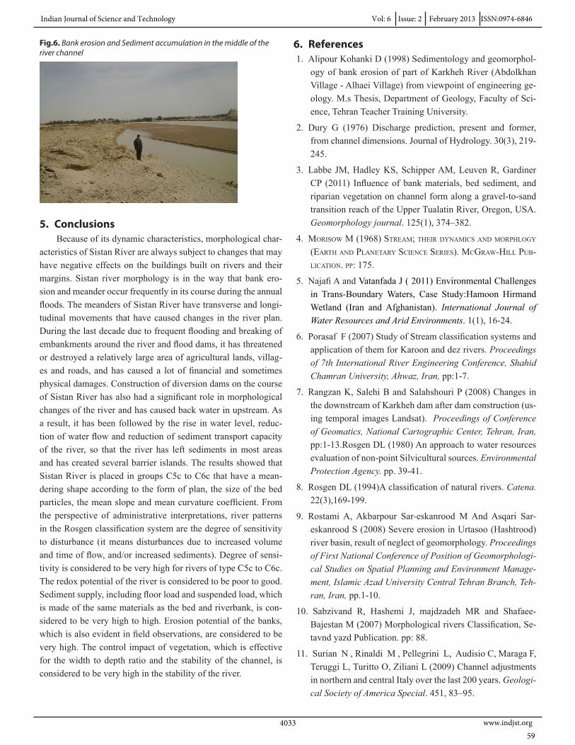
Fig.6. Bank erosion and Sediment accumulation in the middle of the river channel
5. ConclusionsBecause of its dynamic characteristics, morphological char-
acteristics of Sistan River are always subject to changes that may have negative effects on the buildings built on rivers and their margins. Sistan river morphology is in the way that bank ero-sion and meander occur frequently in its course during the annual floods. The meanders of Sistan River have transverse and longi-tudinal movements that have caused changes in the river plan. During the last decade due to frequent flooding and breaking of embankments around the river and flood dams, it has threatened or destroyed a relatively large area of agricultural lands, villag-es and roads, and has caused a lot of financial and sometimes physical damages. Construction of diversion dams on the course of Sistan River has also had a significant role in morphological changes of the river and has caused back water in upstream. As a result, it has been followed by the rise in water level, reduc-tion of water flow and reduction of sediment transport capacity of the river, so that the river has left sediments in most areas and has created several barrier islands. The results showed that Sistan River is placed in groups C5c to C6c that have a mean-dering shape according to the form of plan, the size of the bed particles, the mean slope and mean curvature coefficient. From the perspective of administrative interpretations, river patterns in the Rosgen classification system are the degree of sensitivity to disturbance (it means disturbances due to increased volume and time of flow, and/or increased sediments). Degree of sensi-tivity is considered to be very high for rivers of type C5c to C6c. The redox potential of the river is considered to be poor to good. Sediment supply, including floor load and suspended load, which is made of the same materials as the bed and riverbank, is con-sidered to be very high to high. Erosion potential of the banks, which is also evident in field observations, are considered to be very high. The control impact of vegetation, which is effective for the width to depth ratio and the stability of the channel, is considered to be very high in the stability of the river.
6. References1. Alipour Kohanki D (1998) Sedimentology and geomorphol-
ogy of bank erosion of part of Karkheh River (Abdolkhan Village - Alhaei Village) from viewpoint of engineering ge-ology. M.s Thesis, Department of Geology, Faculty of Sci-ence, Tehran Teacher Training University.
2. Dury G (1976) Discharge prediction, present and former, from channel dimensions. Journal of Hydrology. 30(3), 219-245.
3. Labbe JM, Hadley KS, Schipper AM, Leuven R, Gardiner CP (2011) Influence of bank materials, bed sediment, and riparian vegetation on channel form along a gravel-to-sand transition reach of the Upper Tualatin River, Oregon, USA. Geomorphology journal. 125(1), 374–382.
4. Morisow M (1968) streaM; their dynaMics and Morphlogy (earth and planetary science series). Mcgraw-hill pub-lication. pp: 175.
5. Najafi A and Vatanfada J ( 2011) Environmental Challenges in Trans-Boundary Waters, Case Study:Hamoon Hirmand Wetland (Iran and Afghanistan). International Journal of Water Resources and Arid Environments. 1(1), 16-24.
6. Porasaf F (2007) Study of Stream classification systems and application of them for Karoon and dez rivers. Proceedings of 7th International River Engineering Conference, Shahid Chamran University, Ahwaz, Iran, pp:1-7.
7. Rangzan K, Salehi B and Salahshouri P (2008) Changes in the downstream of Karkheh dam after dam construction (us-ing temporal images Landsat). Proceedings of Conference of Geomatics, National Cartographic Center, Tehran, Iran, pp:1-13.Rosgen DL (1980) An approach to water resources evaluation of non-point Silvicultural sources. Environmental Protection Agency. pp. 39-41.
8. Rosgen DL (1994)A classification of natural rivers. Catena. 22(3),169-199.
9. Rostami A, Akbarpour Sar-eskanrood M And Asqari Sar-eskanrood S (2008) Severe erosion in Urtasoo (Hashtrood) river basin, result of neglect of geomorphology. Proceedings of First National Conference of Position of Geomorphologi-cal Studies on Spatial Planning and Environment Manage-ment, Islamic Azad University Central Tehran Branch, Teh-ran, Iran, pp.1-10.
10. Sabzivand R, Hashemi J, majdzadeh MR and Shafaee-Bajestan M (2007) Morphological rivers Classification, Se-tavnd yazd Publication. pp: 88.
11. Surian N , Rinaldi M , Pellegrini L, Audisio C, Maraga F, Teruggi L, Turitto O, Ziliani L (2009) Channel adjustments in northern and central Italy over the last 200 years. Geologi-cal Society of America Special. 451, 83–95.
Indian Journal of Science and Technology Vol: 6 Issue: 2 February 2013 ISSN:0974-6846
www.indjst.org403359
12. Talebi l, Bayazidi S (2008) A Study on morphological changes of river using the Rosgen classification (case study: Sabzekooh River). Proceedings of 7th Iranian Hydraulic Conference, University of Power and Water Industry (Sha-hid Abbaspour), Iran, pp:1-10.
13. Torabi S, Tajrishi M, Sarang S and Burqa’ei S (2001) Sistan River hydraulic analysis of one-dimensional flow. Proceed-ings of 6Th Iranian Hydraulic Conference, Tehran Univer-sity, Iran, pp:1-13.
14. Torabizadeh A, Bina M, Shafai-bajestan M (2010) Mor-phological evaluation of the reach of Zohreh River by us-ing Rosgen classification. Proceedings of 8th International River Engineering Conference, Shahid Chamran University, Ahwaz, Iran, pp:1-10.
15. Wiliams G and Rosgen D (1989) Measured total sediment loads (suspended loads and bed loads) for 93 united states streams. Open File Report 89-67. U. s. Geological Survey, U.S. Govemment Printing Office, WAshington, D.C. pp:128.
16. Zhang B , Ai N , Huang ZW , Yi Ch and Qin F (2008) Meanders of the Jialing River in China: Morphology and formation, Chinese Science Bulletin. 53(2), 267-281, DOI: 10.1007/s11434-007-0516-2 .
17. Zidali M (2010) Engineering Khorramabad River based on geomorphic indicators (from Tang Shabikhon Up to Cham Anjir). M.s Thesis, Department of Geography, Islamic Azad University of Najaf Abad.
Vol: 6 Issue: 2 February 2013 ISSN:0974-6846 Indian Journal of Science and Technology
www.indjst.org 403460
Related Documents