THE IMPACT OF LAND USE IN THE CATCHMENT OF BATANG AI AND RESERVOIR FISHERIES ON BATANG AI HYDRO-ELECTRIC POWER (HEP) LAKE MANCHA ANAK BAGAT A thesis submitted in fulfillment of the requirements for the degree of Master of Environmental Science in Land Use and Water Resource Management Faculty of Resource Science and Technology UNIVERSITI MALAYSIA SARAW AK 2005

Welcome message from author
This document is posted to help you gain knowledge. Please leave a comment to let me know what you think about it! Share it to your friends and learn new things together.
Transcript

THE IMPACT OF LAND USE IN THE CATCHMENT OF
BATANG AI AND RESERVOIR FISHERIES ON BATANG AI
HYDRO-ELECTRIC POWER (HEP) LAKE
MANCHA ANAK BAGAT
A thesis submitted
in fulfillment of the requirements for the degree of
Master of Environmental Science in Land Use and Water Resource Management
Faculty of Resource Science and Technology
UNIVERSITI MALAYSIA SARA W AK
2005
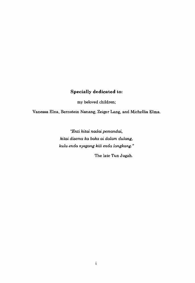
Specially dedicated to:
my beloved children;
Vanessa Elna, Bernstein Nanang, Zeiger Lang, and Michellia Elma.
"Enti kitai nadai pemandai,
kitai disema ka baka ai dalam dulang,
kulu enda nyegang kili enda langkang. "
The late Tun Jugah.
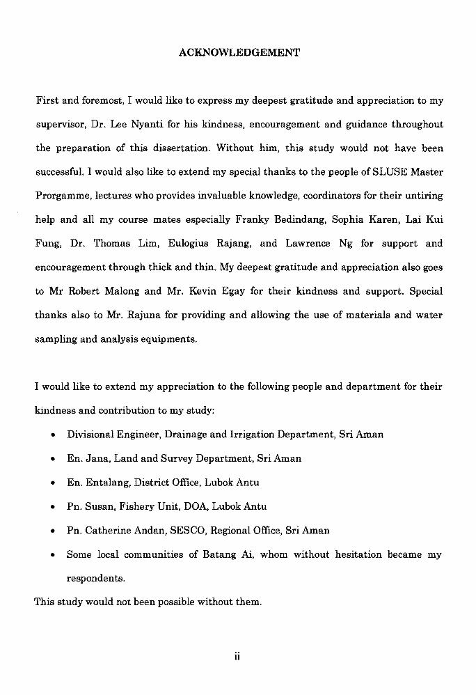
ACKNOWLEDGEMENT
First and foremost, I would like to express my deepest gratitude and appreciation to my
supervisor, Dr. Lee Nyanti for his kindness, encouragement and guidance throughout
the preparation of this dissertation. Without him, this study would not have been
successful. I would also like to extend my special thanks to the people of SLUSE Master
Prorgamme, lectures who provides invaluable knowledge, coordinators for their untiring
help and all my course mates especially Franky Bedindang, Sophia Karen, Lai Kui
Fung, Dr. Thomas Lim, Eulogius Rajang, and Lawrence Ng for support and
encouragement through thick and thin. My deepest gratitude and appreciation also goes
to Mr Robert Malong and Mr. Kevin Egay for their kindness and support. Special
thanks also to Mr. Rajuna for providing and allowing the use of materials and water
sampling and analysis equipments.
I would like to extend my appreciation to the following people and department for their
kindness and contribution to my study:
• Divisional Engineer, Drainage and Irrigation Department, Sri Aman
• En. Jana, Land and Survey Department, Sri Aman
• En. Entalang, District Office, Lubok Antu
• Pn. Susan, Fishery Unit, DOA, Lubok Antu
• Pn. Catherine Andan, SESCO, Regional Office, Sri Aman
• Some local communities of Batang Ai, whom without hesitation became my
respondents.
This study would not been possible without them.
ii

2005
Last but not least, I would like to dedicate my deepest gratitude and love to my beloved
wife and children for their understanding throughout my study. Finally, thanks also to
all my brothers, sisters, relatives, and friends for their support and encouragement.
Mancha anak Bagat
III

Pusat Khidmat Maklumat Akademik UNIVElItSfTI MALAYS'A SARAWAK
TABLE OF CONTENTS
Dedication
Acknow ledgement
Table of Contents
List of Appendices
List of Tables
List of Figures
Abstract
Abstrak
Chapter 1 INTRODUCTION
1.1. Background of Batang Ai, Lubok Antu
1.2. The construction of Batang Ai Hydro-electric Power Station
, I
Chapter 2 LITERATURE REVIEW
2.1. Water Quality
2.2. Water Quality Parameters
2.2.1. Physical Variables
2.2.1.1.
2.2.1.2.
2.2.1.3.
2.2.1.4.
2.2.1.5.
2.2.1.6.
Temperature
Total Suspended Solids (TSS)
Conductivity
Turbidity
Color
Redox
2.2.2. Chemical Variables
2.2.2.1. Dissolved Oxygen (DO)
2.2.2.2. Biological Oxygen Demand (BOD6)
2.2.2.3. Chemical Oxygen Demand (COD)
2.2.2.4. pH
Page
I
II
IV
viii
iv
x
Xl
xii
1
4
6
7
7
7
8
9
10
11
11
12
12
13
13
14
tV
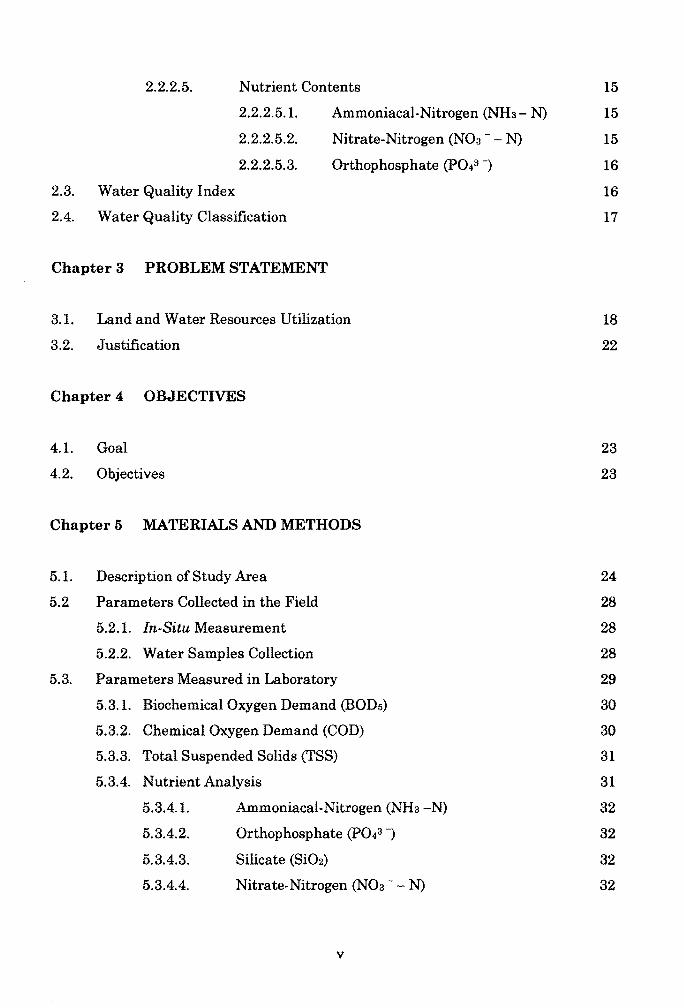
2.2.2.5. Nutrient Contents 15
2.2.2.5.1. Ammoniacal.Nitrogen (NH3 - N) 15
2.2.2.5.2. Nitrate.Nitrogen (NOa - - N) 15
2.2.2.5.3. Orthophosphate (P043 -) 16
2.3. Water Quality Index 16
2.4. Water Quality Classification 17
Chapter 3 PROBLEM STATEMENT
3.1. Land and Water Resources Utilization 18
3.2. Justification 22
Chapter 4 OBJECTIVES
4.1. Goal 23
4.2. Objectives 23
Chapter 5 MATERIALS AND METHODS
5.1. Description of Study Area 24
5.2 Parameters Collected in the Field 28
5.2.1. In-Situ Measurement 28
5.2.2. Water Samples Collection 28
5.3. Parameters Measured in Laboratory 29
5.3.1. Biochemical Oxygen Demand (BOD5) 30
5.3.2. Chemical Oxygen Demand (COD) 30
5.3.3. Total Suspended Solids (TSS) 31
5.3.4. Nutrient Analysis 31
5.3.4.1. Ammoniacal·Nitrogen (NH3-N) 32
5.3.4.2. Orthophosphate (P043 -) 32, t 5.3.4.3. Silicate (Si02) 32
5.3.4.4. Nitrate.Nitrogen (NOa - - N) 32
v

5.4. Land Uses 33
5.5. Fish Fauna and Lake Fisheries 33
5.6 Statistical Analyses 34
Chapter 6 RESULTS
6.1. Water Sample Analysis 35
6.1.1. Temperature 35
6.1.2. Dissolved Oxygen (DO) 38
6.1.3. pH 40
6.1.4. Conductivity 42
6.1.5. Redox 44
6.1.6. Turbidity 46
6.1.7. Total Suspended Solid (TSS) 47
6.1.8. Biological Oxygen Demand (BOD5) 48
6.1.9. Chemical Oxygen Demand (COD) 49 "'..'::,:6.1.10. Ammoniacal-Nitrogen (NH3 -N) 50
"~t
6.1.11. Orthophosphate (P043-) 51 l'
":'6.1.12. Silicate (Si02) 52 '. :. ~I
6.1.13. Nitrate-Nitrogen (N03 - - N) 53 11 '. " ~ ~6.1.14. True Color (ptCo) 54 ,
6.2. Water Quality Indices (WQI) 55 i' " '" :t
6.3. Cage Culture 56 l
6.4. Fishing 59
6.5. Land Use 65
Chapter 7 DISCUSSION
7.1. Water Quality 68
7.2. Agriculture Activities 71
7.3. Reservoir Fisheries 73
7.4. Changes in Fish Species 73
VI

Chapter 8 RECOMMENDATIONS
8.1. Water Quality 75
8.2. Reservoir Fisheries and Fish Resource Management 75
8.3. Agriculture Activities 77
8.4. Tourism 77
Chapter 9 CONCLUSION 78
REFERENCES 80
APPENDICES 85
"" ~;
vii

LIST OF APPENDICES
APPENDIX A: PROPOSED INTERIM NATIONAL WATER QUALITY 85 STANDARDS (INWQS) FOR MALAYSIA (DOE, 1993).
APPENDIX B: MALAYSIAN INTERIM WATER QUALITY STANDARD 90 CLASSIFICATION.
APPENDIX C: METHOD FOR CALCULATION FOR DOE - WQI. 91
APPENDIX D: GENERAL RATING SCALE FOR WATER QUALITY 92 INDEX.
APPENDIX E: POPULATION AT BATANG AI THAT WAS RELOCATED 93 TO ACCOMMODATE THE CONSTRUCTION OF HYDROELECTRIC POWER PROJECT.
APPENDIX F: LIST OF PLATES. 94
Vlll

LIST OF TABLES
Table 1.1: Population of Lubok Antu District, 2002.
Table 8.1: Iban longhouse communities found at higher ground of the partially "danger zone", 1984.
Table 5.1: Population of Lubok Antu above the Batang Ai HEP Lake.
Table 5.2: Location of water sampling stations (WSS).
Table 6.1: Water Quality Indices (WQI) for the five sampling stations.
Table 6.2: Cage culture operators and number of cages at Batang Ai HEP Lake during the starting year of 1998.
Table 6.8: Cage culture operators and number of cages at Batang Ai HEP Lake in 2002.
Table 6.4: Cage culture operators and number of cages at Batang Ai HEP Lake in 2005.
Table 6.5: Fish species ofBatang Ai HEP Lake.
Table 6.6: Fishing resources at Batang Ai HEP Lake and its tributaries based on the most popular catch.
Table 6.7: Some agriculture activities near the main dam.
3
19
26
29
55
57
57
58 •" if,IIi If60 .: f(
64 ,I
if I~ ,)I'
jt 66 I,
I,
t~ I, l'
" l~ ~ : j'., (:
ix

LIST OF FIGURES
Figure 1.1: Lubok Antu District which is divided into Engkilili and 2 Lubok Antu Sub-districts.
Figure 5.1: Map showing the location of water sampling stations. 25
Figure 6.1: Temperature values recorded at the five sampling stations. 36
Figure 6.2: DO values recorded at the five sampling stations. 38
Figure 6.3: pH values recorded at the five sampling stations. 40
Figure 6.4: Conductivity values recorded at the five sampling stations. 42
Figure 6.5: Redox values recorded at the five sampling stations. 45
Figure 6.6: Turbidity values recorded at the five sampling stations. 46
Figure 6.7: TSS values recorded at the five sampling stations. 47
Figure 6.8: BOD6 values recorded at the five sampling stations. 48
Figure 6.9: COD values recorded at the five sampling stations. 49
Figure 6.10: Ammoniacal-nitrogen values recorded at the five sampling 50 stations.
Figure 6.11: Orthophosphate values recorded at the five sampling 51 stations.
Figure 6.12: Silicate values recorded at the five sampling stations. 52
Figure 6.13: Nitrate-nirogen values recorded at the five sampling 53 stations.
Figure 6.14: True color values recorded at the five sampling stations. 54
Figure 6.15: Preferred fishing location in the study area. 61
Figure 6.16: Reasons for fishing in the study area. 62
Figure 6.17: Origin of the fishermen in the study area. 62•I
Figure 6.18: Main occupation of fishermen in the study area. 63
x
l I
j 1
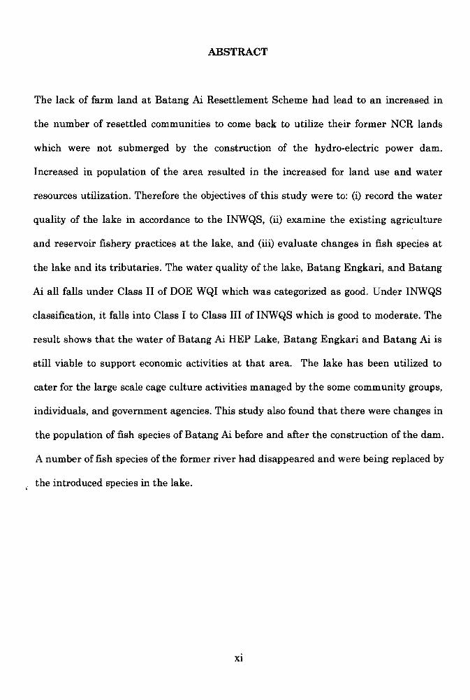
ABSTRACT
The lack of farm land at Batang Ai Resettlement Scheme had lead to an increased in
the number of resettled communities to come back to utilize their former NCR lands
which were not submerged by the construction of the hydro-electric power dam.
Increased in population of the area resulted in the increased for land use and water
resources utilization. Therefore the objectives of this study were to: (i) record the water
quality of the lake in accordance to the INWQS, (ii) examine the existing agriculture
and reservoir fishery practices at the lake, and (iii) evaluate changes in fish species at
the lake and its tributaries. The water quality of the lake, Batang Engkari, and Batang
Ai all falls under Class II of DOE WQI which was categorized as good. Under INWQS
classification, it falls into Class I to Class III of INWQS which is good to moderate. The
result shows that the water of Batang Ai HEP Lake, Batang Engkari and Batang Ai is
still viable to support economic activities at that area. The lake has been utilized to
cater for the large scale cage culture activities managed by the some community groups,
individuals, and government agencies. This study also found that there were changes in
the population of fish species of Batang Ai before and after the construction of the dam.
A number of fish species of the former river had disappeared and were being replaced by
the introduced species in the lake.
Xl

ABSTRAK
Kekurangan tanah pertanian di Skim Penempatan Semula Batang Ai menyebabkan
bertambahnya bilangan penduduk untuk kembali semula mengerjakan bekas tanah
hak adat bumiputra mereka yang tidak ditenggelami air akibat pembinaan empangan
janakuasa hidro-elektrik. Pertambahan bilangan penduduk setempat menyebabkan
pertambahan penggunaan sumber tanah dan air. Maka objektif kajian ini adalah
untuk: (i) merekod kualiti air tasik mengikut INWQS, (n) memeriksa amalan semasa
pertanian dan perikanan di tasik, dan (iii) mentaksir perubahan spesies ikan di tasik
dan sungai-sungainya. Kualiti air di tasik, Batang Engkari dan Batang Ai adalah
dibawah Kelas II indeks kualiti air Jabatan Alam Sekitar yang mengkategorikannya
sebagai baik. Di bawah pengkelasan sungai (I NWQS) , ia adalah dikelaskan kepada
Kelas I hingga Kelas III iaitu baik hingga sederhana. Keputusan yang diperolehi
menunjukkan air di Tasik Janakuasa Hidro-elektrik Batang Ai, Batang Engkari dan
Batang Ai masih boleh menampung aktiviti ekonomi setempat. Tasik tersebut telah
digunakan untuk ternakan ikan dalam sangkar secara besar-besaran yang diusahakan
sesetengahnya secara usahasama penduduk setempat, individu dan agensi-agensi
kerajaan. Kajian ini juga telah mengenal pasti bahawa berlakunya perubahan pada
populasi spesies ikan di Batang Ai sebelum dan selepas pembinaan empangan.
Beberapa daripada spesies ikan semasa sungai dalam keadaan asal telah pupus dan
digantikan oleh spesis yang diperkenalkan di tasik.
xu

Chapter 1
INTRODUCTION
1.1 Background of Batang Ai, Lubok Antu
Batang Ai and Batang Lupar are parts of the same river system. Batang Ai is the upper
part of Batang Lupar, beginning right at the mouth of Batang Skrang, another
tributary of Batang Ai, up to the source of the river. Batang Lupar implies only to the
lower part of the river from Sri Arnan down stream to the mouth that meet South China
Sea near Lingga. Batang Lupar is famously associated with Sri Arnan town together
with the tidal bore phenomenon. On the other hand, Batang Ai is best known to be
associated with Engkilili town at the lower part and Lubok Antu town at the upper end.
Lubok Antu town is located near the Sarawak·Kalimantan border, about 82 km from Sri
Aman town and 300 km from Kuching (Figure 1.1). Administratively, Lubok Antu is a
district under Sri Arnan Division, which is further divided into two sub-districts of
Lubok Antu and Engkilili. It covers an area of 2,338.4 km2 and with a population of
30,377 (Table 1.1) which comprises almost entirely the Iban community that are found
living in longhouses along the Batang Ai and the main roads. The Chinese and Malays
communities live in the towns of Lubok Antu and Engki1ili and the nearby area.
1

--. \~ ~ ......\~~~., ,J. ,;';;,;':"; .....
~. .... r..
~~;.:.-:, ~\ k Antu Town'._- Lubo
EngkiWi Town Kalimantan (Indonesia)
N
\" r' ; . . :;.::t,.
Figure 1.1: Lubok Antu District which is divided into Engkilili and Lubok Antu Sub-districts.

Table 1.1: Population ofLubok Antu District, 2002.
No. DistrictlSub~istrict Iban Chinese Malay Others Total
1 LubokAntu 9,048 498 149 87 9,782
2 Engkilili 17,387 2,858 220 130 20,595
Total 26,435 3,356 369 217 30,377
Percentage 87.3 11 1.2 0.58 100
(Others: Bidayuh, Melanau and other Bumiputra working in the district)
The main economic activity is subsistence agriculture where the main crop is hill padi,
pepper and rubber. Commercial agriculture also covers a large area of land where few
oil palm plantations which was developed by SALCRA are expanding. Like any other
places in Sarawak, the Iban are farmers, managed both subsistent and cash crops like
hill padi, rubber, and pepper. The Chinese and Malays are involved in some commercial
activities in town and also as farmers and administrators in various government offices.
The climate is classified as tropical equatorial and is generally warm and humid all year
round. The average daily rainfall is at a maximum of about 85 mm with a total annual
rainfall generally above 3,000 mm. The drier period is from February to August when
the South-East Monsoon that blows across the mainland does not carry much moisture.
From September to January, that is during the North-East Monsoon, the amount of
rainfall and the corresponding number of rainy days increase where the maximum
, rainfall is normally exceeding 300 mm monthly. Mean relative humidity is in the range
of 80% to 90% and temperature is relatively uniform between 23°C to 30 °C.
I ~
I
3
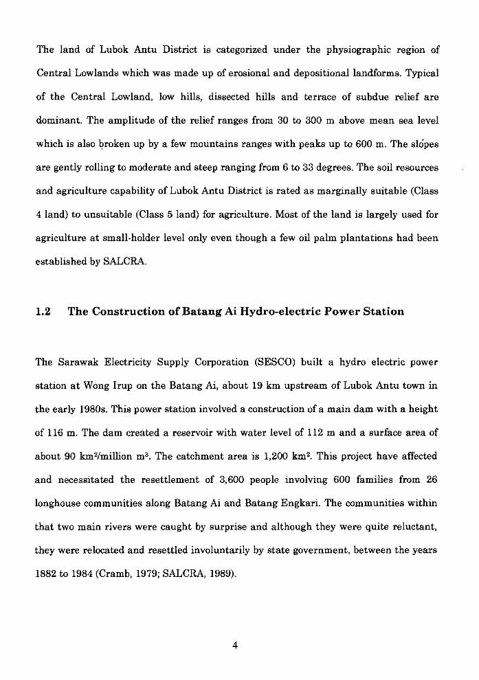
The land of Lubok Antu District is categorized under the physiographic region of
Central Lowlands which was made up of erosional and depositional landforms. Typical
of the Central Lowland, low hills, dissected hills and terrace of subdue relief are
dominant. The amplitude of the relief ranges from 30 to 300 m above mean sea level
which is also 1?roken up by a few mountains ranges with peaks up to 600 m. The slopes
are gently rolling to moderate and steep ranging from 6 to 33 degrees. The soil resources
and agriculture capability of Lubok Antu District is rated as marginally suitable (Class
4 land) to unsuitable (Class 5 land) for agriculture. Most of the land is largely used for
agriculture at small· holder level only even though a few oil palm plantations had been
established by SALCRA.
1.2 The Construction of Batang Ai Hydro-electric Power Station
The Sarawak Electricity Supply Corporation (SESCO) built a hydro electric power
station at Wong Irup on the Batang Ai, about 19 km upstream of Lubok Antu town in
the early 1980s. This power station involved a construction of a main dam with a height
of 116 m. The dam created a reservoir with water level of 112 m and a surface area of
about 90 km2/million m3• The catchment area is 1,200 km2• This project have affected
and necessitated the resettlement of 3,600 people involving 600 families from 26
longhouse communities along Batang Ai and Batang Engkari. The communities within
that two main rivers were caught by surprise and although they were quite reluctant,
they were relocated and resettled involuntarily by state government, between the years
1882 to 1984 (Cramb, 1979; SALCRA, 1989).
4

Pusat Knidmat Maklumat Abdemik . "vr..SlTI MALAYSIA SAItAWAK
The relocation concept was that the people were regrouped in an area where they were
provided with modern facilities such as treated water, electricity, roads, and schools.
Their natural preference to retain the longhouse style of living with a measure of
'isolation from other longhouses can be accommodated to some extent by relocating the
whole longhouse 'en bloc' with their farm lands acting as buffers between different
longhouses.
5
Chapter 2
LITERATURE REVIEW
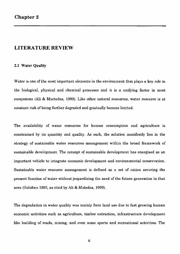
2.1 Water Quality
Water is one of the most important elements in the environment that plays a key role in
the biological, physical and chemical processes and it is a unifying factor in most
ecosystems (Ali & Murtedza, 1999). Like other natural resources, water resource is at
constant risk of being further degraded and gradually become limited.
The availability of water resources for human consumption and agriculture is
constrained by its quantity and quality. As such, the solution manifestly lies in the
strategy of sustainable water resources management within the broad framework of
sustainable development. The concept of sustainable development has energized as an
important vehicle to integrate economic development and environmental conservation.
Sustainable water resource management is defined as a set of cation securing the
present function of water without jeopardizing the need of the future generation in that
area (Golubeu 1993, as cited by Ali & Mutedza, 1999).
The degradation in water quality was mainly from land use due to fast growing human
economic activities such as agriculture, timber extraction, infrastructure development
like building of roads, mining, and even some sports and recreational activities. The
l 6 I
\

common and critical impact on water quality resulting from land use include: changes in
suspended sediment load, organic mater and biological (and chemical) oxygen demand,
bacteria and viruses, nutrient loads, temperature, acidification (PH), salinization, heavy
metals, toxins such as pesticides and herbicides, and changes in the water flow itself
(Perry & Venderklein, 1996).
Water quality is important to sustain both human and aquatic life of the water bodies.
The critical water quality parameters used to determine water quality of the lake
includes pH, dissolved oxygen, temperature, suspended solids, biological oxygen
demand, ammonical-nitrogen, nitrate, silicate, and phosphorus.
2.2 Water Quality Parameters
2.2.1 Physical Variables
2.2.1.1 Temperature
Water temperature affects some of the important physical properties and characteristic
of water quality such as density, specific weight, surface tension, thermal capacity, and
some chemical properties.
Water temperature is the environmental parameter having the greatest effect on fish.
Water temperature greatly influences physiological processes such as respiration rates,
efficiency of feeding and assimilation, growth, behavior, and reproduction (Meade, 1989;
Tucker and Robinson, 1990). Temperature also affects oxygen solubility and causes
7
interactions of several other water quality parameters (Lawson,1995). A temperature
increase of 10 oC will generally cause rates of chemical and biological reactions to double
or triple. For example, fish will consume two to three times as much oxygen at 30 oC
than they would at 20 oC, and their biochemical reactions will double or triple. Because
of this, dissolved oxygen requirements are more critical in warm water than cold water.
Temperature also indirectly affects those water quality variables besides regulating
some biological activities (Boyd & Tucker, 1998). The relationship between temperature
and water quality variables can be attributed to temperature-dependence of chemical
reaction rates, equilibrium constants, solubility products, gas behaviors, and other
physiochemical processes.
2.2.1.2 Total Suspended Solids (TSS)
TSS is the total amount of tiny particles (normally tiny particles of eroded soil or small
organic matters) held in water. Suspended solids in water can be described as the
filterable components of solids present, in which fine particles are held in suspension for
long periods, depending on the intensity of water turbulence. The suspended solids
comprise the suspended soil particles and particulate organic matter resulting from
degradation of dead branches and leaves, detritus and sewage. According to Ali and
Murtedza (1999), the measurement of total suspended solids (TSS) is used to determine
soil erosion of that area. All organic and non-organic materials which can be filtered by
using filter paper are termed suspended solids (Cheremisinoff, 1993). The high TSS
value shows that the area experience high rate of erosion. High TSS can block light from
reaching submerged vegetation. The reduction of light passing through water will slow
8
i r
down the photosynthesis process of some aquatic plants. This will lead to the decrease
in release of oxygen by aquatic plants in the water. The cutting of vegetation of the
riverine environment directly or indirectly contribute towards soil erosion.
Sedimentation of the suspended solids result in siltation, changes in color of the water,
the river become shallower, and these in turn influenced water use and valuation.
2.2.1.3 Conductivity
Electrical conductance is a measure of the dissolved mineral content of the water and
changes in direct proportion to salinity (Lawson, 1995). The greater the proportion of
ions in water, the higher the conductivity. Because water ionizes so slowly, it acts as an
insulator and is a poor conductor of electricity. Chapman (1996) stated that conductivity
is the ability of the water to produce electrical current. Liquid that contains more
organic materials is a good conductor. On the other hand, some unrelated organic
molecules in aqueous solution produce little electricity (APHA, 1998). The unit of
conductivity is microsiemens per centimeter (f.1Scm·1) or micromho per centimeter
(Ilmholcm). Distilled water has a conductivity of about 1 f.1Scm·1 while natural
freshwater have conductivities ranging from 20 1,500 f.1Scm- 1 <Boyd, 1990).
Conductance can be used to reliable estimates salinity or TSS. Conductivity can also be
used to determine pollution zone especially in the area that receives high runoff
(Chapman, 1996).
9

2.2.1.4 Turbidity
Turbidity is a measure of light penetration in water. It is produced by dissolved and
suspended substances, such as clay particles, humic substances, silt, plankton, and
colored compounds (Lawson, 1995). The cloudy or muddy appearance is mainly an
indicative of the amount of solids suspended in the water and, to a lesser extent, the
color of the water. The denser the substances, the higher will be the turbidity and the
murkier the water. Turbidity may be the result of soil erosion, waste discharge, urban
runoff, or the presence of excess nutrients that result in algal growth.
Turbidity caused by suspended clay and other colloidal particles is undesirable. Clay
turbidity that restricts visibility to 30 cm or less can inhibit the development of good
plankton blooms (Romaire, 1985). Excessive runoff from the surrounding watershed can
often cause clay and silt loads to exceed 20,000 mg/I. This is a cause for alarm since
these particles can clog the gills of small fish and invertebrates, settle onto and smother
fish eggs, and shield food organisms. However, fish seem less affected at concentrations
below 20,000 mgll for short periods (Lawson, 1995).
Turbidity caused by suspended solids appears to affect aquatic life especially fish more
than clay turbidity. Cold water fish have been killed as a result of exposure to 500 to
1,000 mg/l suspended solids for three to four days (Alabaster and Lloyd, 1982). Good to
moderate fish production can result at suspended solids concentrations between 25 and
80 mg/l, but 80 mg/l is recommended as a maximum (Lawson, 1995). Tucker and
Robinson (1990) found out that channel catfish seem to be more tolerant as both
10
fingerling and adults can survive long term exposure to 100,000 mgll suspended solids.
However, they had also noticed that some behavioral changes occurs at 20,000 mgll.
2.2.1.5 Color
Color is the result of the interaction of incident light and impurities in the water. Pure
water appears blue in white light since the blue colors of the spectrum travel further in
water than others and is scattered more (Wheaton, 1977). The addition of humic
substances in water imparts a tea-colored or reddish blue. Heavily manured ponds or
ponds in wooded areas or swamp lands are often high in dissolved humic substances
(Lawson, 1995). Iron associated with humic substances can impart a yellow color.
Certain alga impart a color dependent upon the species (i.e., the presence of green alga
makes water appear green in color).
Water color in highly productive waters like fish ponds is largely dependent on the color
of the predominant species of phytoplankton. Unproductive waters generally have a
bluish color and are very transparent since color is caused by light scattering as it hits
dissolved particles in the water (Wheaton et al., 1979). Impending oxygen shortages in
the water can often be detected by changes in color (Lawson, 1995).
2.2.1.6 Redox
This is the ability of oxygen potential. High redox reading shows high oxidation
processes. The surface and ground water usually contains dissolved oxygen between the
range of redox 100 m V - 500 m V (Chapman, 1996). This parameter is measured in-situ
11
Related Documents

![Bertambahnya Nilai Kebaikan dengan Mendidik Anak Perempuanebooks-islam.fuwafuwa.info/[Muhammad bin Ali al-'Arfaj] Bertambahnya... · 4 manfaat bagi kami. Sesungguhnya Engkau Maha](https://static.cupdf.com/doc/110x72/5dd11bfed6be591ccb64441f/bertambahnya-nilai-kebaikan-dengan-mendidik-anak-perempuanebooks-islam-muhammad.jpg)