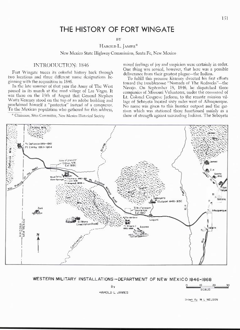
Site of present ---- Grants N.M. Est. 1882 n. del Gallo EI Moro (Inscription Rock) I:2. 1888 Ft. Wingate io <Cr Z o N crlw et 1Z .? ,Z v•-■■ .X<A, `,;---,j':m• 2 . • Seboyeta (Outpost 1846-1851) Wirt Chu l ka Mts. Ft. Defiance 1851-1861 Ft. Canby 1863- 1864 Site of present Gallup, N.M. Est 1880 Shosh '13 Tow -11181 (Bear Springs) FL Fclun'lltrot 11160 Ft. Lyon 18 81 Ft. WingoteII 18 68— ti Zun 1-• Zuni Laguna Acoma - A_Zi a er dot S anta A no 0,. Son S Felipe Sandia Jemez THE HISTORY OF FORT WINGATE BY HAROLD L. JAMES* New Mexico State Highway Commission, Santa Fe, New Mexico 151 INTRODUCTION: 1846 Fort Wingate traces its colorful history back through two locations and three different name designations be- ginning with the acquisition in 1846. In the late summer of that year the Army of The West paused in its march at the mud village of Las Vegas. It was there on the 15th of August that General Stephen Watts Kearney stood on the top of an adobe building and proclaimed himself a "protector" instead of a conqueror. To the Mexican population who gathered for this address, * Chairman, Sites Committee, New Mexico Historical Society mixed feelings of joy and suspicion were certainly in order. One thing was sensed, however, that here was a possible deliverance from their greatest plague—the Indian. To fulfill this promise Kearney directed his first efforts toward the troublesome "Nomads of The Redrocks"—the Navajo. On September 18, 1846, he dispatched three companies of Missouri Volunteers, under the command of Lt. Colonel Cosgreve Jackson, to the remote mission vil- lage of Seboyeta located sixty miles west of Albuquerque. No name was given to this frontier outpost and the gar- rison which was stationed there functioned mainly as a show of strength against marauding Indians. The Seboyeta WESTERN MILITARY INSTALLATIONS—DEPARTMENT OF NEW MEXICO 1846-1868 By 0 10 20 SCALE HAROLD L. JAMES Drawn By, M L NELSON

Welcome message from author
This document is posted to help you gain knowledge. Please leave a comment to let me know what you think about it! Share it to your friends and learn new things together.
Transcript
Site of present----Grants N.M.
Est. 1882n. del Gallo
EI Moro(Inscription Rock) I:2.
1888Ft. Wingate
io<CrZoNcrlwet 1Z
.? ,Z v•-■■
.X<A,
`,;---,j':m• 2. • Seboyeta(Outpost 1846-1851)
Wirt
Chu lka Mts.
Ft. Defiance 1851-1861Ft. Canby 1863- 1864
Site of presentGallup, N.M.
Est 1880
Shosh '13 Tow -11181(Bear Springs) FL Fclun'lltrot 11160Ft. Lyon 18 81Ft. WingoteII 18 68—
ti
Zun
1-•
Zuni
Laguna
Acoma
-
A_Zi a
er dotSanta A no
0,.
Son SFelipe
Sandia
Jemez
THE HISTORY OF FORT WINGATEBY
HAROLD L. JAMES*
New Mexico State Highway Commission, Santa Fe, New Mexico
151
INTRODUCTION: 1846
Fort Wingate traces its colorful history back throughtwo locations and three different name designations be-ginning with the acquisition in 1846.
In the late summer of that year the Army of The Westpaused in its march at the mud village of Las Vegas. Itwas there on the 15th of August that General StephenWatts Kearney stood on the top of an adobe building andproclaimed himself a "protector" instead of a conqueror.To the Mexican population who gathered for this address,
* Chairman, Sites Committee, New Mexico Historical Society
mixed feelings of joy and suspicion were certainly in order.One thing was sensed, however, that here was a possibledeliverance from their greatest plague—the Indian.
To fulfill this promise Kearney directed his first effortstoward the troublesome "Nomads of The Redrocks"—theNavajo. On September 18, 1846, he dispatched threecompanies of Missouri Volunteers, under the command ofLt. Colonel Cosgreve Jackson, to the remote mission vil-lage of Seboyeta located sixty miles west of Albuquerque.No name was given to this frontier outpost and the gar-rison which was stationed there functioned mainly as ashow of strength against marauding Indians. The Seboyeta
WESTERN MILITARY INSTALLATIONS—DEPARTMENT OF NEW MEXICO 1846-1868
By 0 10 20
SCALEHAROLD L. JAMES
Drawn By, M L NELSON

152
NEW MEXICO GEOLOGICAL SOCIETY—EIGHTEENTH FIELD CONFERENCE
FIGURE 2.
This excellent photograph, taken by James Mooney of the Bureau of Ethnology, shows the fort as it appeared in the win-ter of 1893. Photo Courtesy: Smithsonian Institute.
guard failed to impress the Indians. Incursions and depre-dations continued to increase. In the weeks that followed,the situation worsened to the point where Kearney wascontinually besieged with delegations from communitiesall demanding protection from the Navajo menace. Achanged course of action appeared necessary.
In November, 1846, a treaty approach was tried. ColonelAlexander W. Doniphan, representing General Kearney,met with the chiefs of The People on November 22nd ata noted rendezvous point in the northern foothills of theZuni Mountains called Shash 'B Tow (Bear Springs). Informal terms it was stated that the Navajos would swearallegiance with the Americans, and that all residents ofthe now acquired territory would be administered by theUnited States government. Further it was stipulated thatthe Indians would cease all warlike activities against theresidents of New Mexico. Also included were provisionsfor full restoration of all stolen property and livestock,
and the release of all Mexican captives. The Indians madetheir mark upon a treaty paper. However, their outwardshow of friendship and goodwill was misleading. Theiranimosities toward the Mexicans were too deeply-seatedto be simply dissolved by the signing of a document.
THE WARS: 1847-1862The Doniphan Treaty proved to be a failure. Further-
more, the presence of a foreign military power in theirhomeland served only to incite the Indians. During theyears 1847 to 1850 incursions and hostilities reachedenormous proportions. Fort Marcy at Santa Fe becamenothing more than a huge staging area for outfitting ex-peditions into Navajoland. More treaties were signed.More treaties were broken. Several peace negotiationsfailed even before the treaty expedition had returned toSanta Fe. It became an endless frustrating game to whicha solution seemed impossible.
NEW MEXICO GEOLOGICAL SOCIETY—EIGHTEENTH FIELD CONFERENCE
153
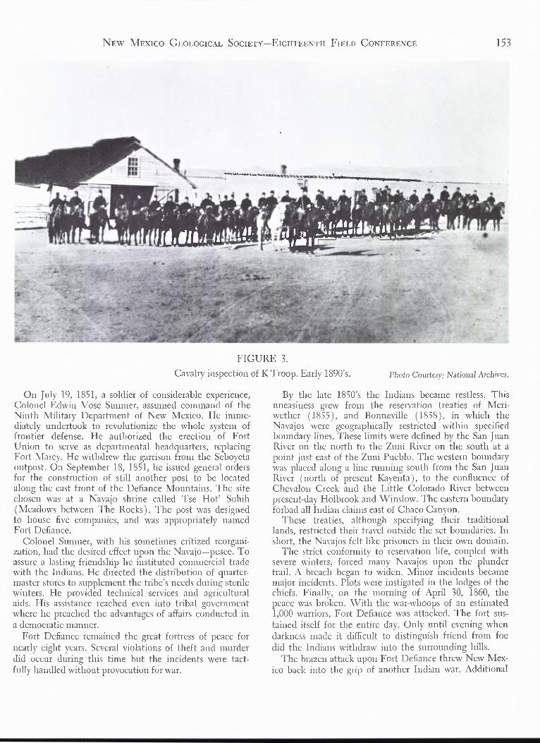
FIGURE 3.
Cavalry inspection of K Troop. Early 1890's. Photo Courtesy: National Archives.
On July 19, 1851, a soldier of considerable experience,Colonel Edwin Vose Sumner, assumed command of theNinth Military Department of New Mexico. He imme-diately undertook to revolutionize the whole system offrontier defense. He authorized the erection of FortUnion to serve as departmental headquarters, replacingFort Marcy. He withdrew the garrison from the Seboyctaoutpost. On September 18, 1851, he issued general ordersfor the construction of still another post to be locatedalong the east front of the Defiance Mountains. The sitechosen was at a Navajo shrine called Tse Hot' Sohih(Meadows between The Rocks). The post was designedto house five companies, and was appropriately namedFort Defiance.
Colonel Sumner, with his sometimes critized reorgani-zation, had the desired effect upon the Navajo—peace. Toassure a lasting friendship he instituted commercial tradewith the Indians. He directed the distribution of quarter-master stores to supplement the tribe's needs during sterilewinters. He provided technical services and agriculturalaids. His assistance reached even into tribal governmentwhere he preached the advantages of affairs conducted ina democratic manner.
Fort Defiance remained the great fortress of peace fornearly eight years. Several violations of theft and murderdid occur during this time but the incidents were tact-fully handled without provocation for war.
By the late 1850's the Indians became restless. Thisuneasiness grew from the reservation treaties of Meri-wether (1855), and Bonneville (1858 ), in which theNavajos were geographically restricted within specifiedboundary lines. These limits were defined by the San JuanRiver on the north to the Zuni River on the south at apoint just east of the Zuni Pueblo. The western boundarywas placed along a line running south from the San JuanRiver (north of present Kayenta ), to the confluence ofChcvalon Creek and the Little Colorado River betweenpresent-day Holbrook and Winslow. The eastern boundaryforbad all Indian claims east of Chaco Canyon.
These treaties, although specifying their traditionallands, restricted their travel outside the set boundaries. Inshort, the Navajos felt like prisoners in their own domain.
The strict conformity to reservation life, coupled withsevere winters, forced many Navajos upon the plundertrail. A breach began to widen. Minor incidents becamemajor incidents. Plots were instigated in the lodges of thechiefs. Finally, on the morning of April 30, 1860, thepeace was broken. With the war-whoops of an estimated1,000 warriors, Fort Defiance was attacked. The fort sus-tained itself for the entire day. Only until evening whendarkness made it difficult to distinguish friend from foedid the Indians withdraw into the surrounding hills.
The brazen attack upon Fort Defiance threw New Mex-ico back into the grip of another Indian war. Additional

154 NEW MEXICO GEOLOGICAL SOCIETY—EIGHTEENTH FIELD CONFERENCE
FIGURE 4.
Enlisted mens barracks north of parade ground. Early 1890's. Photo Courtesy: National Archives.
troops of calvary reinforced the redrock perimeters. An-other post was established (August 31, 1860), on thegrounds of the old Doniphan Treaty site at Bear Springs.It was named for the present Department Commander,Colonel Thomas Turner (Little Lord) Fauntleroy.Throughout the remainder of 1860 and the early part of1861 the United States Army engaged in a full-scaleIndian campaign, the likes of which the territory hadnever before witnessed.
In the Spring of 1861 the Military Department of NewMexico faced still another peril brought about by thesecession of the southern states, and the apparent Con-federate plan to invade the desert-southwest. To meetthis threatened invasion of the territory, the newly ap-pointed Department Commander, Colonel Edward S.Canby, set the Indian problem aside and began concen-trating his defenses closer to the Rio Grande. Fort De-fiance was abandoned on April 25th, its garrison transfer-red to Fort Fauntleroy.
By the summer of 1861 the impending Confederatethreat became a reality. On July 27th, Lt. Colonel John R.Baylor, C.S.A., struck north from El Paso and capturedFort Fillmore ( south of present-day Las Cruces ). Baylordeclared all New Mexico below Socorro to be Confederateterritory, designating Mesilla as its capitol.
On September 28, 1861, a general order of the U.S.Department of the Army changed the name of FortFauntleroy to Fort Lyon; Colonel Fauntleroy had resignedhis commission to join the Confederacy. The post's new
name honored General Nathaniel Lyon who had beenkilled weeks earlier at the battle of Wilson Creek,Missouri.
Three months later, on December 10th, Fort Lyon wasabandoned and the garrison was used to strengthen theforces at Fort Craig, below Socorro.
On February 14, 1862, the Texas Army, CSA, underthe command of Brig. General Henry H. Sibley, who hadreplaced Col. Baylor, began its tidal march up the RioGrande valley. It defeated the Union forces at Fort Craigin the historic Battle of Valverde on February 21st. Con-tinuing intact, Gen. Sibley's army swept up the RioGrande, engulfed Albuquerque on March 2nd and SantaFe on March 23rd. Their dreams of conquest were shat-tered, however, when they were badly defeated by Uniontroops, reinforced by Colorado Volunteers, at the Battleof Gloricta Pass, southeast of Santa Fe, on March 26thand 28th.
The Civil War in New Mexico was short lived. TheConfederates, though badly beaten, were successful inavoiding capture by sustaining an agonizing, forced-marchretreat back to Texas.
FORT WINGATE I: 1862-1863
The Indians had taken full advantage of the militaryturmoil created by the Confederate invasion and theirraids greatly increased during that time. In the summerof 1862 the new Military Commander for New Mexico,

NEW MEXICO GEOLOGICAL SOCIETY—EIGHTEENTH FIELD CONFERENCE
155
FIGURE 5.
Officers Row south of parade ground. About 1895. Photo Courtesy: National Archives.
Brig. General James H. Carleton, turned his full atten-tion to the Indian problem. His plans for the completereduction of the Indian menace called for gathering allthe Navajos and placing them on a supervised militaryreservation. His "Indian Policy" included the authoriza-tion of a new post on the eastern slopes of the ZuniMountains to serve as the staging area for his "NavajoRoundup."
Gen. Carleton named the new post "Fort Wingate" tohonor Captain Benjamin A. Wingate, an infantry officerwho had served at Fort Lyon, and who died of woundssuffered during heroic conduct in the Battle of Valverde.
The site chosen for the fort was at Ojo del Gallo(Chicken Spring), near the present-day village of SanRafael. Construction began on September 30, 1862. Theactual erection of permanent buildings was a slow process,as materials were salvaged and hauled by wagon from oldFort Lyon 45 miles to the west. The fort was formallycommissioned on October 22, 1862.
On November 9, 1862, Carleton notified the War De-partment of the establishment of still another post, to benamed Fort Sumner in honor of the old campaigner ofthe 1850,'s Edwin Vose Sumner. The fort was located165 miles south of Santa Fe at a point on the east side ofthe Rio Pecos known as Basque Redondo (Round Grove).This post would supervise Carleton's great prison encamp-
ment of the Navajos.By the Spring of 1863 Fort Wingate was beginning to
take shape. Four companies of the Fourth New MexicoMounted Rifles and one company of California Volun-teers, under the command of Lt. Colonel Jose FranciscoChavez, had taken up their quarters. In addition to thesetroops the garrison was further strengthened by ColonelChristopher "Kit" Carson's E, F, and H companies of theFirst New Mexico Volunteers.
Carleton was now ready to take the field against theNavajo. In his first movement, on July 28, 1863, he di-rected Carson to set up a basis of operation at the ruinsof old Fort Defiance (renamed Fort Canby). He thensent word to all chiefs of The People that total war wasto commence, and that all Navajos not wishing to engagein these hostilities could surrender at either Fort Wingateor Fort Canby. Some Indians, observing the strengthbuilding of the "white man," and the proclamation of avigorous war, began surrendering in small groups. By fallthe count was 180 tribesmen, a figure quite short ofCarleton's idea of total supression.
In mid-October, 1863, Carleton released the full fury ofhis "Indian Policy." He undertook a chastisement the likesof which the Indians had never dreamed. Carson's troopspursued them night and day, week after week; over mesasand deserts, under boiling suns and through drifts of

156
NEW MEXICO GEOLOGICAL SOCIETY—EIGHTEENTH FIELD CONFERENCE
FIGURE 6.
Guard Mount at Fort Wingate. Early 1890's. Photo Courtesy: National Archives.
wintcr snows. The military pursuit included the ruthlessdestruction of planting fields, grain storages, the burningof hogans and orchards, and the wanton slaughter of sheepand cattle. By the end of 1863 the Navajos found them-selves in a desperate state. To worsen matters they lay inthe grip of a severe winter faced with complete extermina-tion, not only by the saber but from exposure and hunger.On January 12, 1864, Carson delivered the final blow byattacking their only remaining stronghold—Canyon deChelly. There, huddled together, demoralized, too weakto resist, the once great Lords of The Canyonlands sub-mitted to the will of the white man.
BOSOUE REDONDO: 1864-1868On March 4, 1864, more than two thousand Navajos
filed out of Fort Canby and began the infamous trek toFort Sumner that is known in history today as the "LongWalk," a 350-mile journey to the Rio Pecos. The "LongWalk" soon became a stream of ragged humanity thatcontinued throughout 1864. The moccasined pathway wasplainly marked by the remains of hundreds of Indianswho crawled to the wayside to die a lingering deaththrough dysentery and exposure.
Carleton had envisioned his 40 square-mile reservation
to be self-supporting, but the 6,000 acres set aside fortilling were found to be impregnated with alkali and as aconsequence the yield of crops was low. By the beginningof 1865 the population had grown in excess of 9,000 andincluded some 400 renegade Apaches sent over from FortStanton. The large population, coupled with the first yearscrop failure, began to tax the Army's Quartermaster in itsquest for food.
From the beginning, the troubles at Bosque Redondowere compounded by disscntion and natural disorders.Conflicts broke out between Navajos and Apaches, Indianagents and the military, and between civil authorities andthe military. Inadequate food and clothing was a primecause of disorder. The confined were undernourished andplagued by disease. The brackish water from the river re-sulted in mass dysentery. Desertions and "runaways" werefrequent. Added to this, the prisoners in unprotected sec-tors became the targets of bands of Comanches and Kiowaswho roamed the vast Llano Estacado.
Bosque Redondo became nothing more than a hugeconcentration camp without regard to the preservation ofhuman life. It soon fell under attack by civic leaders of theterritory who demanded a complete investigation of condi-tions. The shameful disgrace of the encampment reflectedon the people of the Territory and aroused political feelings

NEW MEXICO GEOLOGICAL SOCIETY—EIGHTEENTH FIELD CONFERENCE
157
FIGURE 7.This rare photograph shows the partial destruction of the fort during the Great Fire on July 2, 1896.
Photo Courtesy . National Archives.
to the point where candidates and parties were labeledeither "pro"-Bosque or "anti"-Bosque. Editorials were de-manding the resignation of General Carleton.
The plight of the Navajos began attracting national at-tention that could no longer be ignored. On March 3,1865, a Joint Special Committee composed of membersof both houses of Congress was appointed to investigateconditions along the Rio Pecos. The committee, headedby chairman, James R. Doolittle of Wisconsin, personallyinspected Bosque Redondo during the month of July.Their findings resulted in a report which recommendedthat the care of the Indians be transferred from militarycontrol to one of civil authority, namely, the Depart-ment of the Interior.
Charges and countercharges were hurled in both direc-tions over the report. In early 1866, the Territorial As-sembly in Santa Fe joined the controversy by publiclycondemning Carleton's "Indian Policy." They adopted aresolution which was personally forwarded to PresidentAndrew Johnson, urging the removal of the DepartmentCommander.
After much debate, the government slowly began togrind out a solution. Finally, on September 19, 1866, thefirst steps were taken. General James H. Carleton wasrelieved as Department Commander of New Mexico andreplaced by General G. W. Getty. On December 31st thecontrol of the Indians was assigned to a Commissioner ofIndian Affairs under the Department of Interior. Themilitary was instructed to give assistance in Indian prob-lems only when requested by the Commissioner.
The Secretary of Interior and the Commissioner of In-dian Affairs, with the authority delegated by Congress,entertained the proposition of returning the Navajo totheir homeland. The Interior Department appointed acommittee to survey the resources of their original reserva-tion in hopes of re-locating them on their native soil.When all reports were favorably accepted, a Peace Com-mission, headed by Lt. General William Tecumseh Sher-man, was selected to negotiate a Navajo treaty. Shermanarrived at Fort Sumner on May 28, 1867. Three days latera treaty was drafted which was accepted by the dejectedand homesick Indians. They were now allowed to reversethe "Long Walk." At sunrise, on the morning of June18, 1868, a column of Indians which reportedly stretchedfor 10 miles, began the return to their beloved redrocks.
FORT WINGATE II: 1868-1918
With the transfer of the Navajos back to western NewMexico, it was felt that Fort Wingate was too far removedfrom areas of re-settlement to assist adequately in theirsupervision. General Getty explored the possibility of re-establishing the garrison further to the west. Fort Canby,which was abandoned after the "Navajo Roundup" (Oc-tober 8, 1864), would have been the ideal relocation. Thepost, however, was in a state of complete ruin. Further-more, being located 35 miles north of the main east-westroad, it would have been economically unfeasible for thereceiving and distribution of supplies. General Getty de-
158 NEW MEXICO GEOLOGICAL SOCIETY—EIGHTEENTH FIELD CONFERENCE
cided, therefore, that the median point lay at Bear Springs,and subsequently ordered the reactivitation of Fort Lyon(old Fort Faunticroy ), but calling it "Fort Wingate."Gctty clarified the naming by issuing a general order stat-ing that the stockade remains at Ojo del Gallo wouldhenceforth be known as "old" Fort Wingate.
After 1868 Fort Wingate entered into an era of routinegarrison life. Primary duties consisted of patrols, militarysurveys, and escort functions. The fort also served as aheadquarters and outfitting center for southwestern eth-nological and archaelogical expeditions.
On February 18, 1870, President Ulysses S. Grantdeclared a 100-square mile military reservation to accom-pany the site of the fort. On March 26, 1881, the WarDepartment approved an additional 30-square miles to thesouth. This later tract, which now lies in the reserve of theZuni National Forest, was added to provide firewood andbuilding materials for the fort.
Most of the early buildings at the fort were constructedof adobe and lumber cut and milled from prime timberfound in the nearby forests. Later construction was mostlyof sandstone, also a locally abundant commodity. In 1896the wooden buildings provided the fuel for a disastrousfire that swept through the fort on July 2.
Fort Wingate was deactivated on February 4, 1911, andplaced in charge of a caretaker.
For a short period during 1914-15 the fort served as adetention center for 4,000 Mexican Federalist troops andtheir families who had fled the Pancho Villa Uprising.The Mexicans were the remnants of an army that wererouted and chased across the border at Marfa, Texas.Their leaders requested asylum in the United States.Fearing there might be rebel loyalists among the group,the army moved them away from the border at El Pasoand transferred them to Fort Wingate. The Mexicanswere billeted in tents on the flat valley below the fort.The camping area was surrounded by barbed wire in aneffort to hold the refugees until the Mexican rebellionwas put down. Infantry troops from Fort Bliss werehoused in the deserted barracks of the fort and providedthe guard for the foreign cantonment.
LATER YEARS: 1918 - 1967
The Ordnance Department took command of thc mili-tary reservation in 1918 as a storage area for excess muni-tions and high explosives being returned from Europeafter World War I. Magazines and revetments were con-structed two miles west of the old fort. Between 1918 and1920 the compound became the largest storage depot ofmunitions in the world. In 1921 additional magazineswere constructed along with barracks and administrationbuildings. The post was designated Wingate OrdnanceReserve Depot.
In 1925 the grounds containing the old fort were trans-ferred to the Bureau of Indian Affairs for utilization as aboarding school for Zuni and Navajo children. The bar-racks buildings were used as classrooms and dormitories.Officers Row provided homes for federally staffed per-
sonnel. The old parade ground was converted into a base-ball field.
Other than the general outline of the fort, there islittle to remind today's visitor of the old cavalry activities.Nearly all of the pre-1900 structures were destroyed by thefire of 1896. Portions of Officers Row remained intact upuntil 1958 when they were razed to make room for addi-tional dormitories. The oldest remaining building con-structed for army use was built in 1906 for a post exchangeand recreation hall. It has now been converted into a boysdormitory called "The Hogan."
A short distance to the northwest of the fort standsthe newly constructed Fort Wingate Senior High School.Completed in 1965, at a cost of six million dollars, themodern campus-style school boards and educates nearlyone thousand Indian students on the secondary level.
EPILOGUE
Great and colorful names arc always associated with thedevelopment of frontiers. Fort Wingate certainly had itsshare with the register of "Kit" Carson, J. FranciscoChavez, and Ben Wingate. Other notables who served atthe fort included General Samuel T. Cushing, Wash-ington Matthews (who later became Surgeon General ofthe United States), and Captain Henry R. Selden. JohnJ. Pershing was stationed at the post as a 2nd Lieutenantduring the years 1889-90. Major F. E. Pershing, a nephewto "Black Jack," served at the Ordnance Depot in 1942.Douglas MacArthur lived at the fort as an infant while hisfather, Maj. Arthur MacArthur commanded the 13th In-fantry in 1881-82.
Such is the history of the evolution of the fort to itspresent location. From its infancy at Seboyeta, through an-cestors called Fauntleroy, Lyon, and Canby, the name"Fort Wingate" still stands—majestically as the "red-rocks" which face it.
On a high knoll overlooking the fort from the southStands a large arch. The inscription reads in part:—DEDICATED TO THE PROUD HISTORY OFFORT WINGATE AND TO THE HORSE SOL-DIERS WHO SERVED HERE. TO THE INDIANPEOPLE WHO WATCHED THEM COME—FIRSTIN DOUBT, THEN IN FRIENDSHIP. "IN BEAUTYIT IS FINISHED—from the Navajo."
REFERENCES CITED
Adjutant General's Office, Chronology Report of Fort Wingate,N.M., National Archives, Record Group No. 94, Washington,D.C., 1930.
Bailey, L. R., The Long Walk: Los Angeles, Westernlore Press, 1964.IIiggins, E. W., The Bcar Springs Story (unpublished), Fort Win-
gate Army Depot, Gallup, 1964.Horn & Wallace (ed.), Union Army Operations in The Southwest:
Albuquerque, I horn & Wallace, 1961.Hughest, J. T., Doniphan's Expedition: Chicago, Rio Grande Press,
1962.Twitchell, R. E., Leading Facts of New Mexico History: Albuquer-
que, Horn & Wallace, 1963.
Related Documents