The Highway Methodology Workbook Supplement Wetland Functions and Values A Descriptive Approach US Army Corps of Engineers New England District R

Welcome message from author
This document is posted to help you gain knowledge. Please leave a comment to let me know what you think about it! Share it to your friends and learn new things together.
Transcript
TheHighwayMethodologyWorkbookSupplement
Wetland Functions and ValuesA Descriptive Approach
US Army Corpsof EngineersNew England District
R
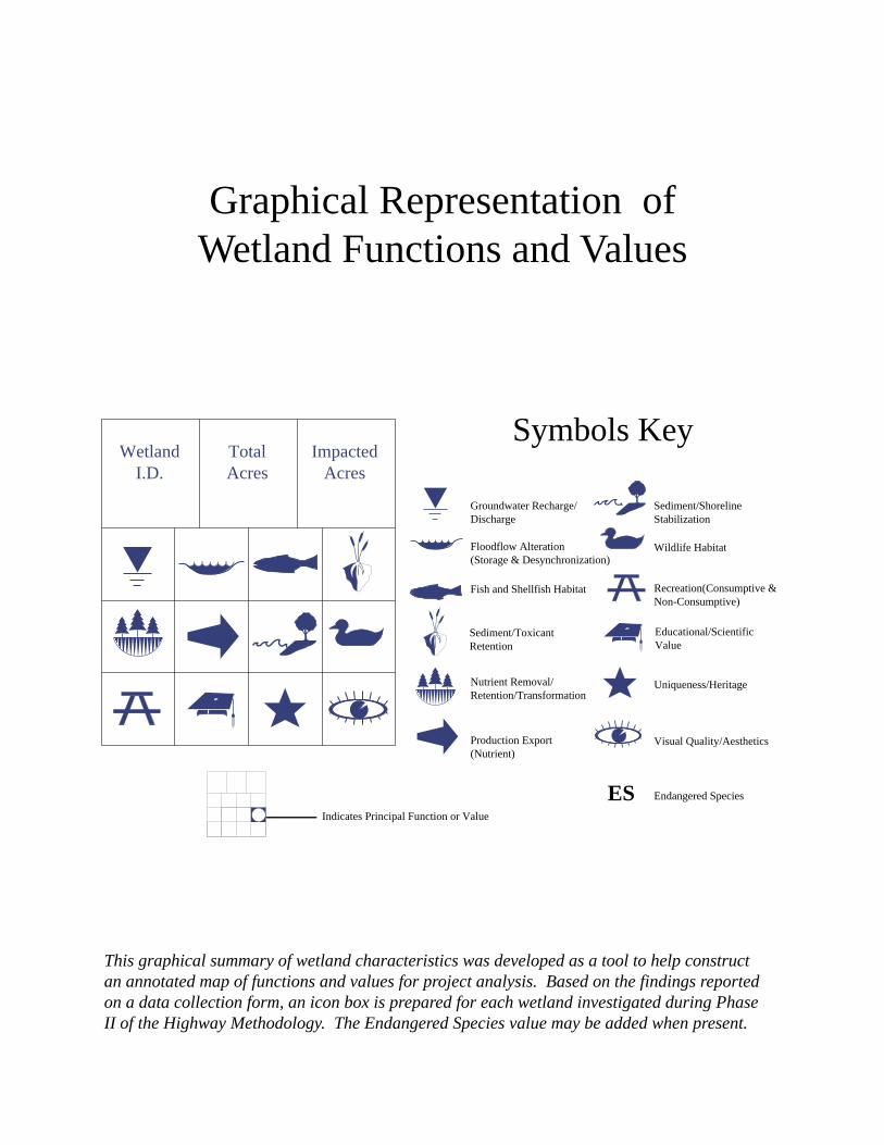
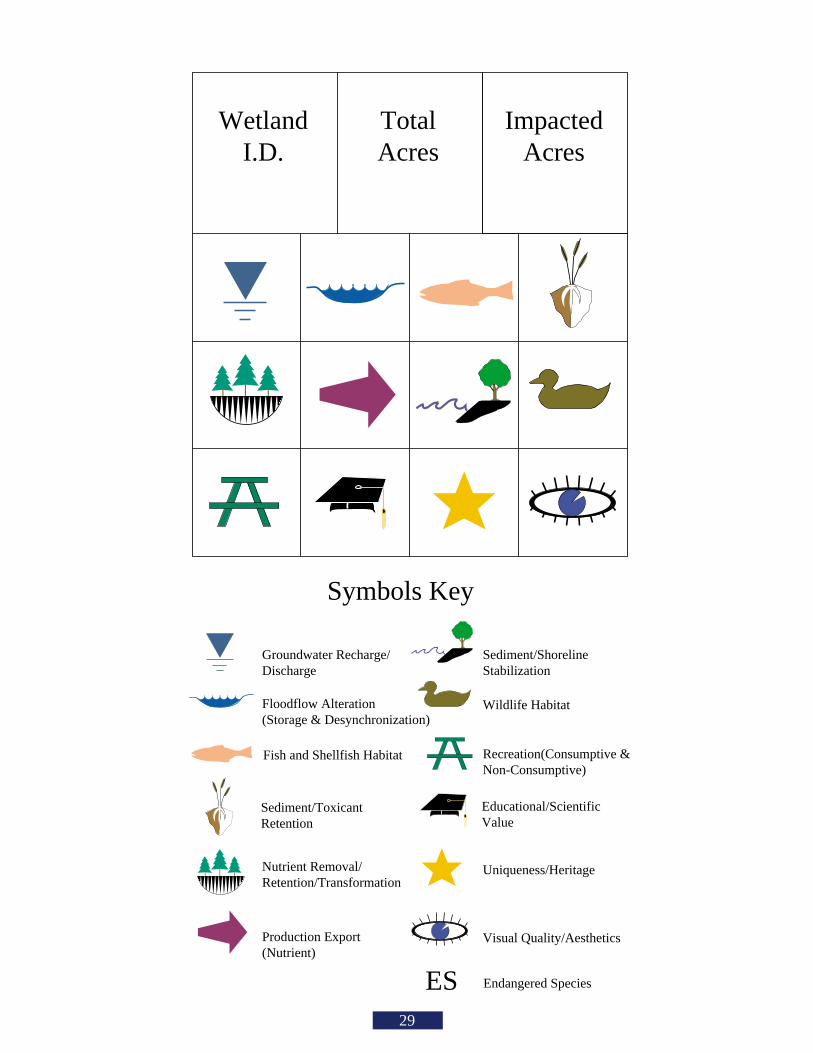
Symbols Key
Groundwater Recharge/Discharge
Floodflow Alteration(Storage & Desynchronization)
Production Export (Nutrient)
Sediment/ToxicantRetention
Nutrient Removal/Retention/Transformation
Sediment/ShorelineStabilization
Wildlife Habitat
Recreation(Consumptive &Non-Consumptive)
Uniqueness/Heritage
Visual Quality/Aesthetics
Indicates Principal Function or Value
TotalAcres
WetlandI.D.
ImpactedAcres
Endangered SpeciesES
Educational/ScientificValue
Fish and Shellfish Habitat
This graphical summary of wetland characteristics was developed as a tool to help constructan annotated map of functions and values for project analysis. Based on the findings reportedon a data collection form, an icon box is prepared for each wetland investigated during PhaseII of the Highway Methodology. The Endangered Species value may be added when present.
Graphical Representation ofWetland Functions and Values
Contents
We wish to acknowledge both the Connecticut and New Hampshire Department of
Transportation for the opportunities they provided to develop ideas and acquire experience
reflected in this booklet. Detailed questions regarding information contained in this booklet
may be directed to Regulatory Branch, at the Corps, New England District at 1-800-362-4367
(within Massachusetts) or 1-800-343-4789 (outside Massachusetts).
• Preface
• Introduction
• What are wetland functions and values?
• What wetland functions and values are consideredby the Corps in its Section 404 permit process?
• How are wetland functions and values applied tothe Regulatory Program?
• What wetland evaluation method does theCorps accept?
• Does the Corps have a prescribed format forwetland evaluation?
• How are the phases of the Highway Methodology incorporated?
• Are there good examples to follow?
• How are resources other than wetlandsconsidered in the Corps permit decision?
• Appendix A
• Bibliography
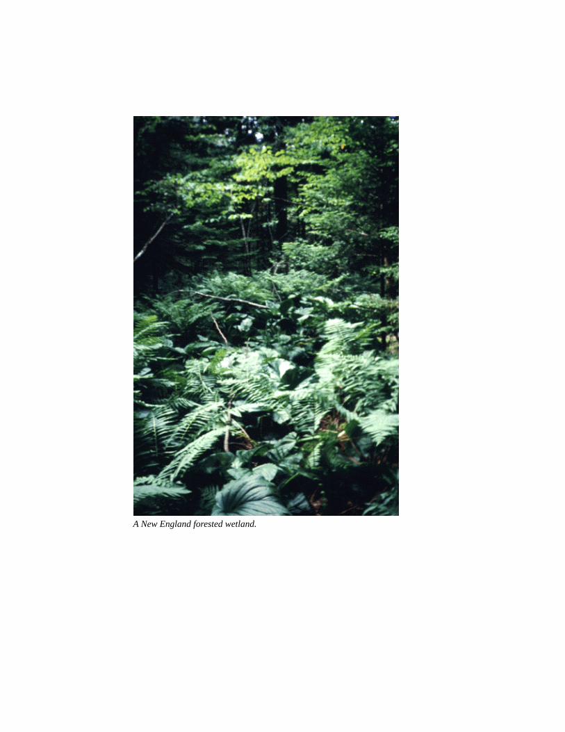
A New England forested wetland.

Preface
This booklet provides guidance to permit applicants, consultants, and U.S.Army Corps of Engineers project managers on how to identify and displaywetland functions and values acceptable for the Corps New England DistrictRegulatory Program. It is a supplement to the Highway Methodology Workbookpublished by the Regulatory Branch in 1993, which defines procedures tointegrate Section 404 permit requirements with highway planning and engineeringand the National Environmental Policy Act (NEPA). The evaluation of wetlandfunctions and values is an integral part of the overall phased approach of theHighway Methodology. Use of this booklet for highway projects, and otherprojects with anintegrated planningprocess, should bepreceded by review ofthe HighwayMethodologyWorkbook. The wetlandfunctions and values"Descriptive Approach"presented in thisbooklet, however, canbe used for any projectwhere thecharacterization ofwetland resources isnecessary for Section404 permitrequirements. It isimportant to note that,although wetlandevaluations form thebase from which impactassessments are made,they are two distinctprocesses. Impactassessment is onlybriefly addressed inthis booklet. Wetlands add diversity and beauty to the landscape.
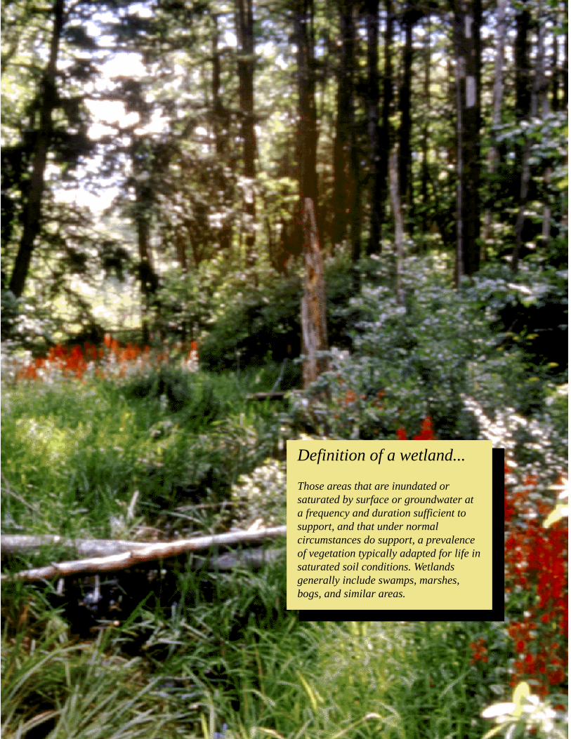
Definition of a wetland...
Those areas that are inundated orsaturated by surface or groundwater ata frequency and duration sufficient tosupport, and that under normalcircumstances do support, a prevalenceof vegetation typically adapted for life insaturated soil conditions. Wetlandsgenerally include swamps, marshes,bogs, and similar areas.
Introduction
1
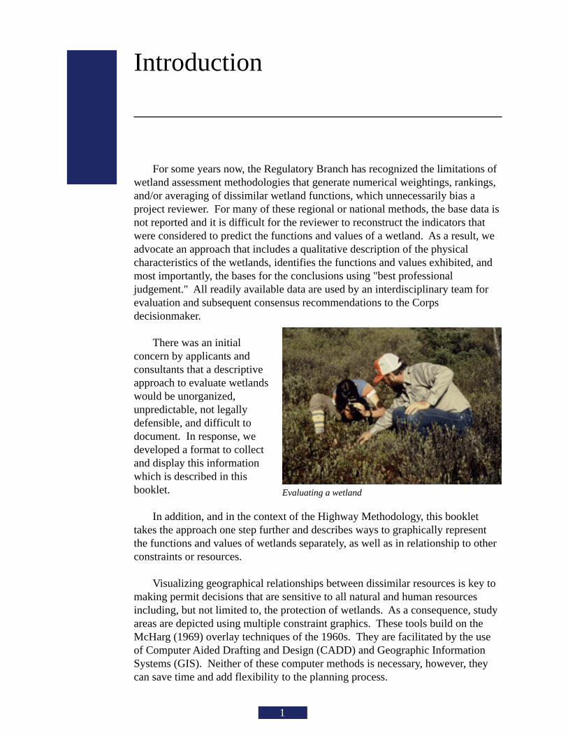
For some years now, the Regulatory Branch has recognized the limitations ofwetland assessment methodologies that generate numerical weightings, rankings,and/or averaging of dissimilar wetland functions, which unnecessarily bias aproject reviewer. For many of these regional or national methods, the base data isnot reported and it is difficult for the reviewer to reconstruct the indicators thatwere considered to predict the functions and values of a wetland. As a result, weadvocate an approach that includes a qualitative description of the physicalcharacteristics of the wetlands, identifies the functions and values exhibited, andmost importantly, the bases for the conclusions using "best professionaljudgement." All readily available data are used by an interdisciplinary team forevaluation and subsequent consensus recommendations to the Corpsdecisionmaker.
There was an initialconcern by applicants andconsultants that a descriptiveapproach to evaluate wetlandswould be unorganized,unpredictable, not legallydefensible, and difficult todocument. In response, wedeveloped a format to collectand display this informationwhich is described in thisbooklet.
In addition, and in the context of the Highway Methodology, this booklettakes the approach one step further and describes ways to graphically representthe functions and values of wetlands separately, as well as in relationship to otherconstraints or resources.
Visualizing geographical relationships between dissimilar resources is key tomaking permit decisions that are sensitive to all natural and human resourcesincluding, but not limited to, the protection of wetlands. As a consequence, studyareas are depicted using multiple constraint graphics. These tools build on theMcHarg (1969) overlay techniques of the 1960s. They are facilitated by the useof Computer Aided Drafting and Design (CADD) and Geographic InformationSystems (GIS). Neither of these computer methods is necessary, however, theycan save time and add flexibility to the planning process.
Evaluating a wetland
What are wetland functionsand values?
Great Blue Heron
2
Wetland functions and values form a very important part of Section 404permit decisions by the Corps. Functions are self-sustaining properties of awetland ecosystem that exist in the absence of society. Functions result from bothliving and non-living components of a specific wetland. These include allprocesses necessary for the self-maintenance of the wetland ecosystem such asprimary production and nutrient cycling. Therefore, functions relate to theecological significance of wetland properties without regard to subjective humanvalues.
For example, a wetland that has slowly moving water performs the function ofretaining sediments and toxicants. That is, the physical characteristic of a wetlandthat causes surface water to move slowly serves to let suspended particulatessettle out of that water. This function traps sediments carried to it in runoff fromuplands or upstream areas and clarifies the water. Identification of that functionhelps the Corps evaluate (1) whether the impacts of a project may impair thatfunction and (2) whether such impacts are permissible.
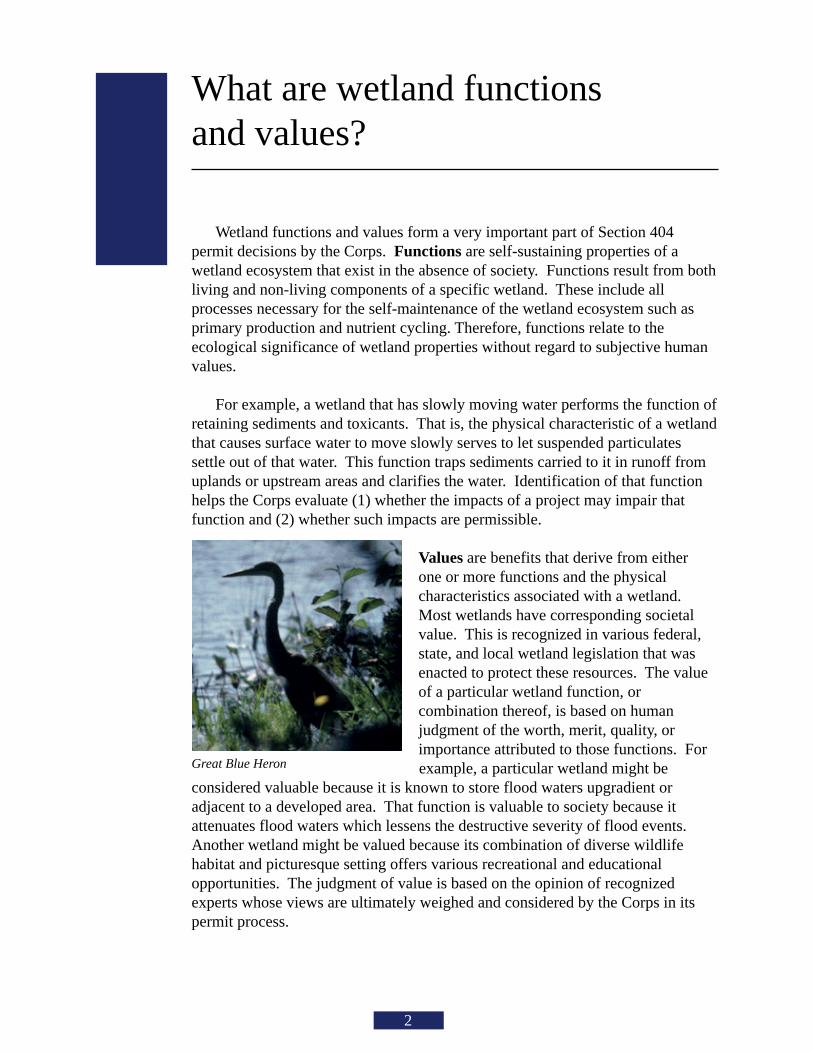
Values are benefits that derive from eitherone or more functions and the physicalcharacteristics associated with a wetland.Most wetlands have corresponding societalvalue. This is recognized in various federal,state, and local wetland legislation that wasenacted to protect these resources. The valueof a particular wetland function, orcombination thereof, is based on humanjudgment of the worth, merit, quality, orimportance attributed to those functions. For
example, a particular wetland might beconsidered valuable because it is known to store flood waters upgradient oradjacent to a developed area. That function is valuable to society because itattenuates flood waters which lessens the destructive severity of flood events.Another wetland might be valued because its combination of diverse wildlifehabitat and picturesque setting offers various recreational and educationalopportunities. The judgment of value is based on the opinion of recognizedexperts whose views are ultimately weighed and considered by the Corps in itspermit process.
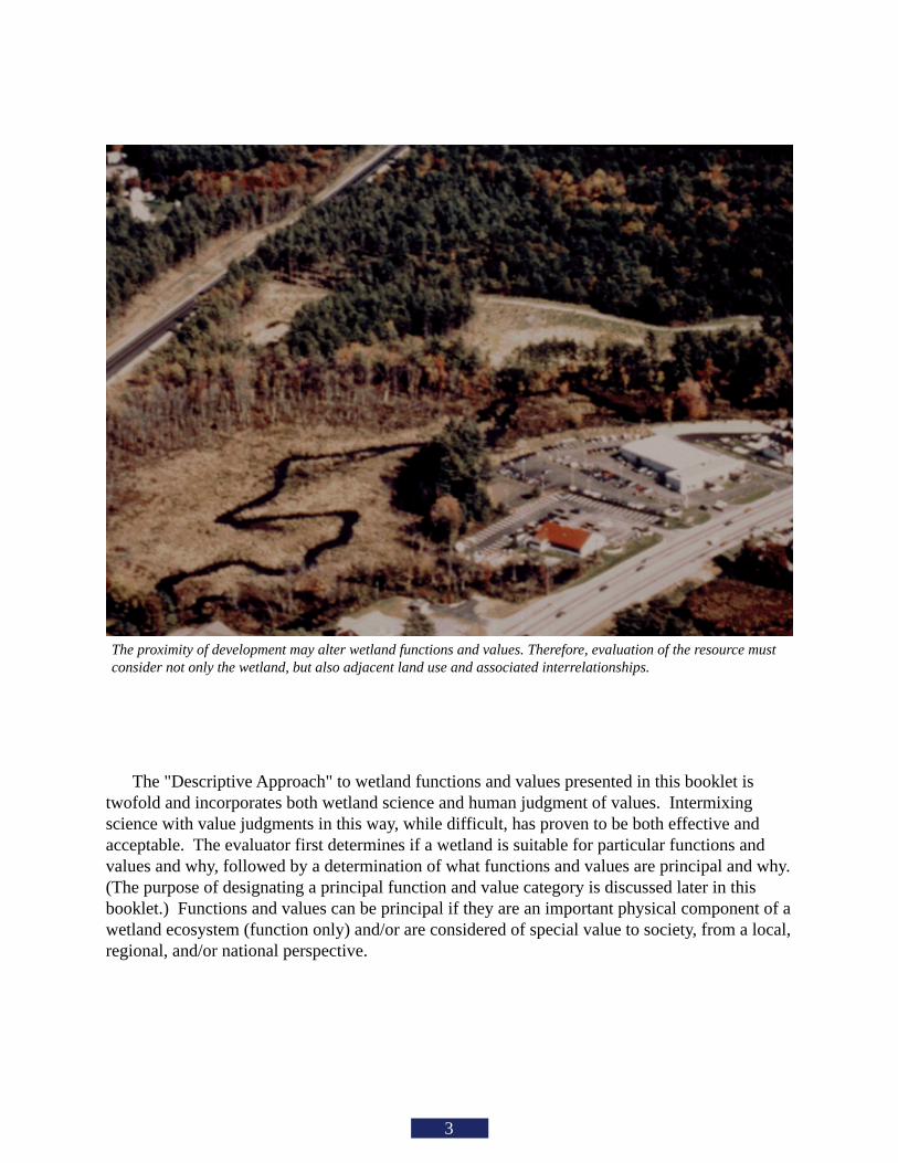
The proximity of development may alter wetland functions and values. Therefore, evaluation of the resource mustconsider not only the wetland, but also adjacent land use and associated interrelationships.
3
The "Descriptive Approach" to wetland functions and values presented in this booklet istwofold and incorporates both wetland science and human judgment of values. Intermixingscience with value judgments in this way, while difficult, has proven to be both effective andacceptable. The evaluator first determines if a wetland is suitable for particular functions andvalues and why, followed by a determination of what functions and values are principal and why.(The purpose of designating a principal function and value category is discussed later in thisbooklet.) Functions and values can be principal if they are an important physical component of awetland ecosystem (function only) and/or are considered of special value to society, from a local,regional, and/or national perspective.
What wetland functions and valuesare considered by the Corps in itsSection 404 permit process?
4
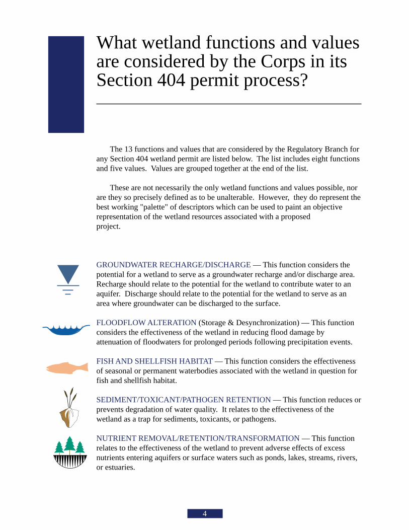
The 13 functions and values that are considered by the Regulatory Branch forany Section 404 wetland permit are listed below. The list includes eight functionsand five values. Values are grouped together at the end of the list.
These are not necessarily the only wetland functions and values possible, norare they so precisely defined as to be unalterable. However, they do represent thebest working "palette" of descriptors which can be used to paint an objectiverepresentation of the wetland resources associated with a proposedproject.
GROUNDWATER RECHARGE/DISCHARGE — This function considers thepotential for a wetland to serve as a groundwater recharge and/or discharge area.Recharge should relate to the potential for the wetland to contribute water to anaquifer. Discharge should relate to the potential for the wetland to serve as anarea where groundwater can be discharged to the surface.
FLOODFLOW ALTERATION (Storage & Desynchronization) — This functionconsiders the effectiveness of the wetland in reducing flood damage byattenuation of floodwaters for prolonged periods following precipitation events.
FISH AND SHELLFISH HABITAT — This function considers the effectivenessof seasonal or permanent waterbodies associated with the wetland in question forfish and shellfish habitat.
SEDIMENT/TOXICANT/PATHOGEN RETENTION — This function reduces orprevents degradation of water quality. It relates to the effectiveness of thewetland as a trap for sediments, toxicants, or pathogens.
NUTRIENT REMOVAL/RETENTION/TRANSFORMATION — This functionrelates to the effectiveness of the wetland to prevent adverse effects of excessnutrients entering aquifers or surface waters such as ponds, lakes, streams, rivers,or estuaries.
ES
5
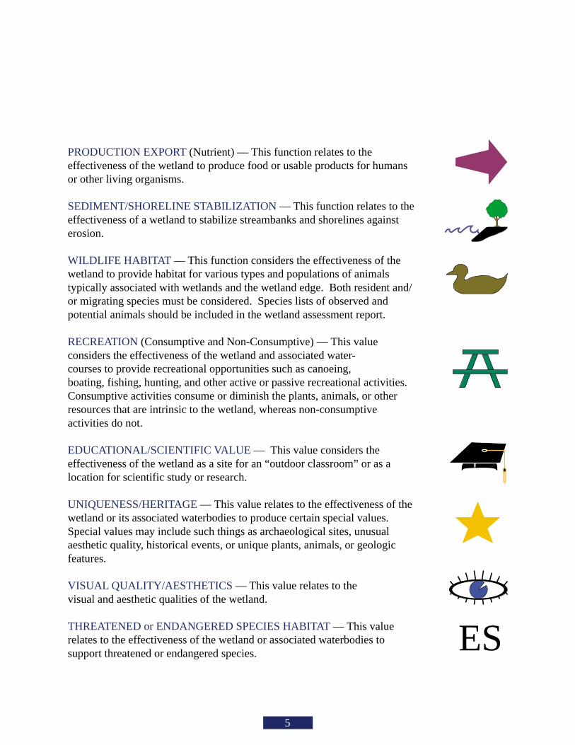
PRODUCTION EXPORT (Nutrient) — This function relates to theeffectiveness of the wetland to produce food or usable products for humansor other living organisms.
SEDIMENT/SHORELINE STABILIZATION — This function relates to theeffectiveness of a wetland to stabilize streambanks and shorelines againsterosion.
WILDLIFE HABITAT — This function considers the effectiveness of thewetland to provide habitat for various types and populations of animalstypically associated with wetlands and the wetland edge. Both resident and/or migrating species must be considered. Species lists of observed andpotential animals should be included in the wetland assessment report.
RECREATION (Consumptive and Non-Consumptive) — This valueconsiders the effectiveness of the wetland and associated water-courses to provide recreational opportunities such as canoeing,boating, fishing, hunting, and other active or passive recreational activities.Consumptive activities consume or diminish the plants, animals, or otherresources that are intrinsic to the wetland, whereas non-consumptiveactivities do not.
EDUCATIONAL/SCIENTIFIC VALUE — This value considers theeffectiveness of the wetland as a site for an “outdoor classroom” or as alocation for scientific study or research.
UNIQUENESS/HERITAGE — This value relates to the effectiveness of thewetland or its associated waterbodies to produce certain special values.Special values may include such things as archaeological sites, unusualaesthetic quality, historical events, or unique plants, animals, or geologicfeatures.
VISUAL QUALITY/AESTHETICS — This value relates to thevisual and aesthetic qualities of the wetland.
THREATENED or ENDANGERED SPECIES HABITAT — This valuerelates to the effectiveness of the wetland or associated waterbodies tosupport threatened or endangered species.
How are wetland functions andvalues applied to the RegulatoryProgram?
6
Wetland functions and values are used by the Corps in a variety of ways including to:
• describe site characteristics• compare project alternatives• avoid and minimize project impacts• determine significance of impacts• weigh environmental impacts against project benefits• design and monitor compensatory mitigation
These required uses come from various statutes, regulations, and policies including:
• Corps permit regulations, Title 33 Code of Federal Regulations (CFR) Parts 320 through 330
• public notice and other permit decision documents including special conditions for compensatory mitigation.
• National Environmental Policy Act, 40 CFR, Parts 1500 - 1508 and Corps Appendix B implementing regulations.
• environmental assessment or environmental impact statement.
• Clean Water Act Section 404(b)(1) Guidelines, 40 CFR, Part 230.• compliance determination including selection of the least environmentally damaging practicable alternative (LEDPA), significance of impacts and appropriate mitigation.
• Environmental Protection Agency / Department of the Army Memorandum of Agreement on Mitigation.
• sequencing process to avoid, minimize, and only as a last resort, compensate for aquatic resource values impacted.• strive for no overall net loss of wetland functions and values.
13.1
38.1
28.2
Symbols Key
Groundwater Recharge/Discharge
Floodflow Alteration(Storage & Desynchronization)
Production Export (Nutrient)
Sediment/ToxicantRetention
Nutrient Removal/Retention/Transformation
Sediment/ShorelineStabilization
Wildlife Habitat
Recreation(Consumptive &Non-Consumptive)
Uniqueness/Heritage
Visual Quality/Aesthetics
Endangered SpeciesES
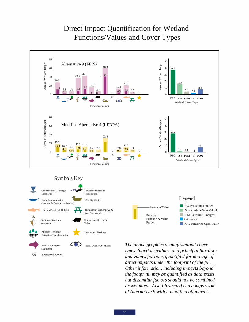
Direct Impact Quantification for Wetland Functions/Values and Cover Types
Alternative 9 (FEIS)
Modified Alternative 9 (LEDPA)
ES0
20
40
60
80
Acr
es o
f W
etla
nd I
map
ct
Functions/Values
10.4
2.5 0
8.4
0
ES0
20
40
60
80
Acr
es o
f W
etla
nd I
map
ct
Functions/Values
19.5
10.7 9.216.2 13.5
0.16.7
0 0.9 0
0
Acr
es o
f W
etla
nd I
map
ct
39.5
8.1
15.4
5.4 2.6
Acr
es o
f W
etla
nd I
map
ct
Wetland Cover Type
29.2
10
20
30
40
50
0
10
20
30
40
50
PEMPSSPFO R POW
PFO POW
Wetland Cover Type
9
PEMPSS R
1.4 1.1 0.1
8.1 7.6
42.0
16.0
60.3
6.512.3
42
4.30
6.80.1 0.50
PEM-Palustrine Emergent
PSS-Palustrine Scrub-Shrub
PFO-Palustrine Forested
R-Riverine
POW-Palustrine Open Water
Legend
Function/Value
PrincipalFunction & ValuePortion
32.8
12.44.8
0.017.9 5.9
0.17.8 7.8
25.4
21.7
7.6
7.812.32.9
0.1
Fish and Shellfish Habitat
Educational/ScientificValue
The above graphics display wetland covertypes, functions/values, and principal functionsand values portions quantified for acreage ofdirect impacts under the footprint of the fill.Other information, including impacts beyondthe footprint, may be quantified as data exists,but dissimilar factors should not be combinedor weighted. Also illustrated is a comparisonof Alternative 9 with a modified alignment.
7
What wetland evaluation methoddoes the Corps accept?
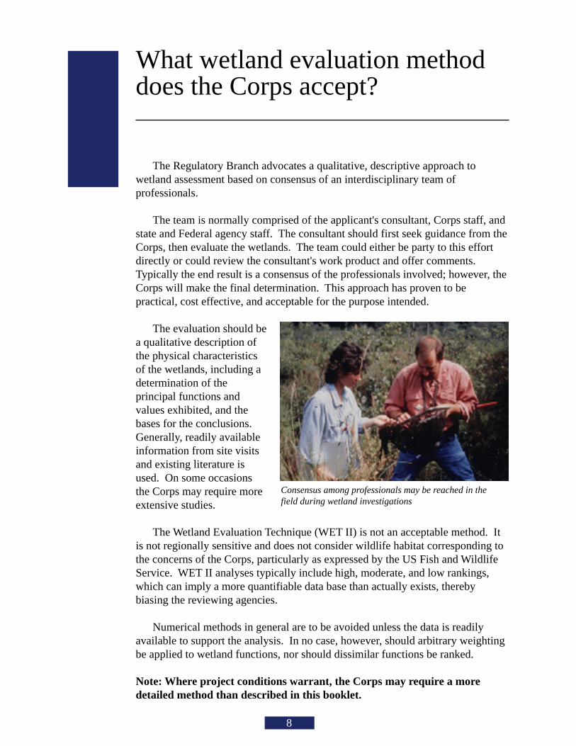
Consensus among professionals may be reached in thefield during wetland investigations
8
The Regulatory Branch advocates a qualitative, descriptive approach towetland assessment based on consensus of an interdisciplinary team ofprofessionals.
The team is normally comprised of the applicant's consultant, Corps staff, andstate and Federal agency staff. The consultant should first seek guidance from theCorps, then evaluate the wetlands. The team could either be party to this effortdirectly or could review the consultant's work product and offer comments.Typically the end result is a consensus of the professionals involved; however, theCorps will make the final determination. This approach has proven to bepractical, cost effective, and acceptable for the purpose intended.
The evaluation should bea qualitative description ofthe physical characteristicsof the wetlands, including adetermination of theprincipal functions andvalues exhibited, and thebases for the conclusions.Generally, readily availableinformation from site visitsand existing literature isused. On some occasionsthe Corps may require moreextensive studies.
The Wetland Evaluation Technique (WET II) is not an acceptable method. Itis not regionally sensitive and does not consider wildlife habitat corresponding tothe concerns of the Corps, particularly as expressed by the US Fish and WildlifeService. WET II analyses typically include high, moderate, and low rankings,which can imply a more quantifiable data base than actually exists, therebybiasing the reviewing agencies.
Numerical methods in general are to be avoided unless the data is readilyavailable to support the analysis. In no case, however, should arbitrary weightingbe applied to wetland functions, nor should dissimilar functions be ranked.
Note: Where project conditions warrant, the Corps may require a moredetailed method than described in this booklet.
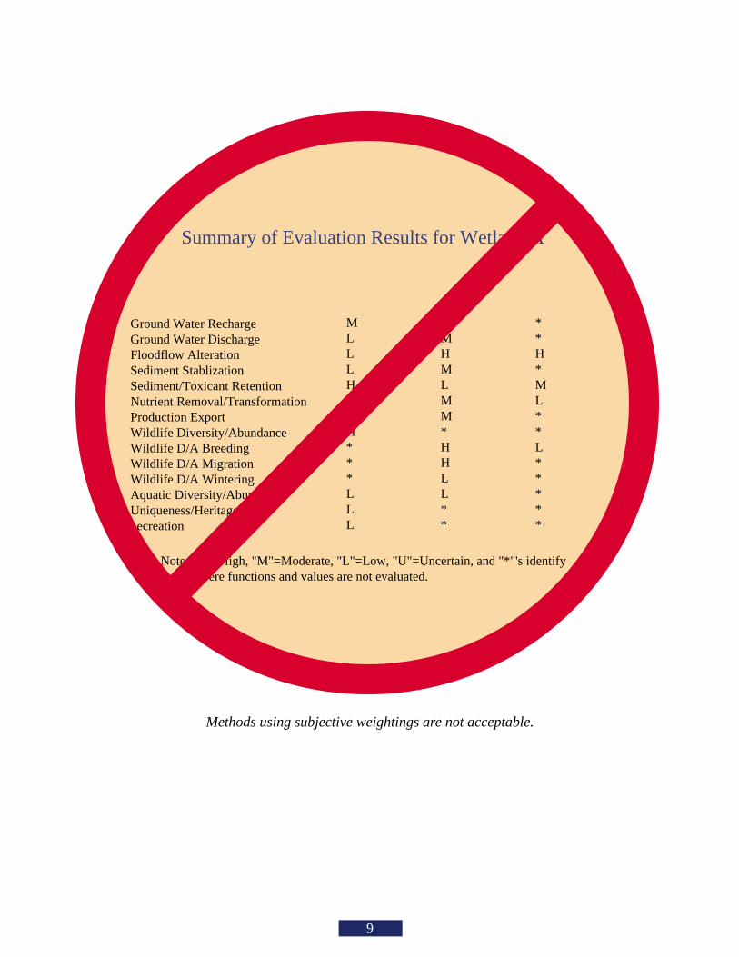
Social Significance Effectiveness Opportunity
Ground Water RechargeGround Water DischargeFloodflow AlterationSediment StablizationSediment/Toxicant RetentionNutrient Removal/TransformationProduction ExportWildlife Diversity/AbundanceWildlife D/A BreedingWildlife D/A MigrationWildlife D/A WinteringAquatic Diversity/AbundanceUniqueness/Heritage ecreation
MLLLHL*H***LLL
UMHMLMM*HHLL**
**H*ML**L*****
Summary of Evaluation Results for Wetland A
Note: "H"=High, "M"=Moderate, "L"=Low, "U"=Uncertain, and "*"'s identify ere functions and values are not evaluated.
Methods using subjective weightings are not acceptable.
9
Does the Corps have a prescribedformat for wetland evaluation?
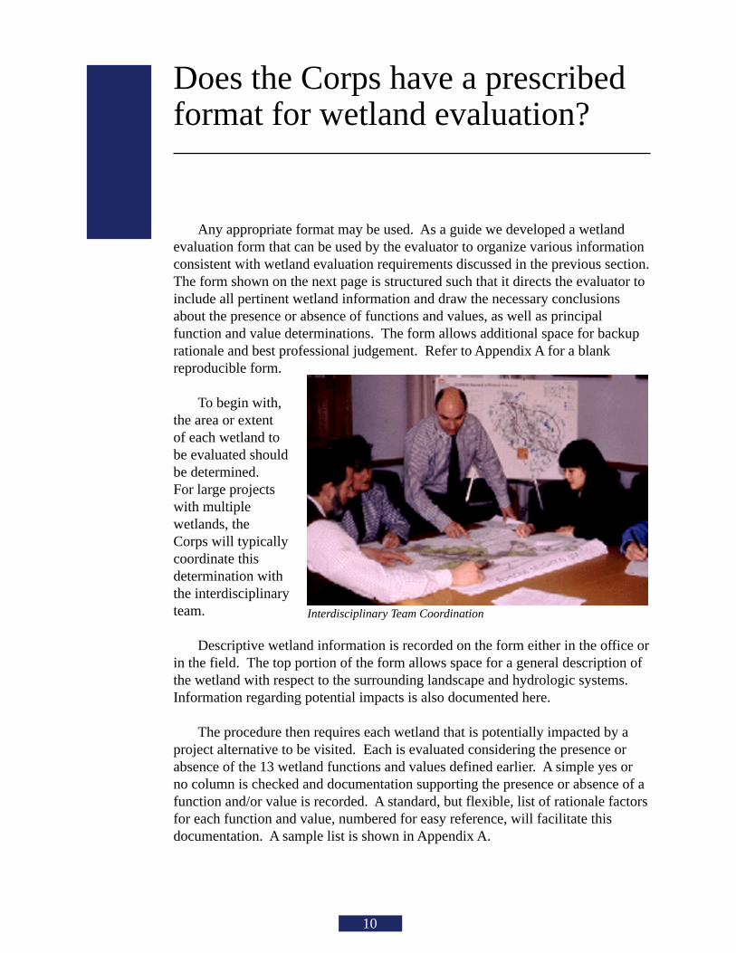
Interdisciplinary Team Coordination
10
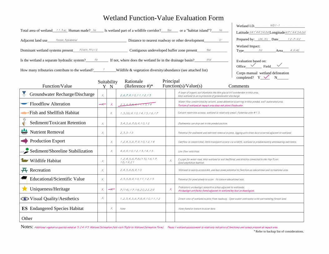
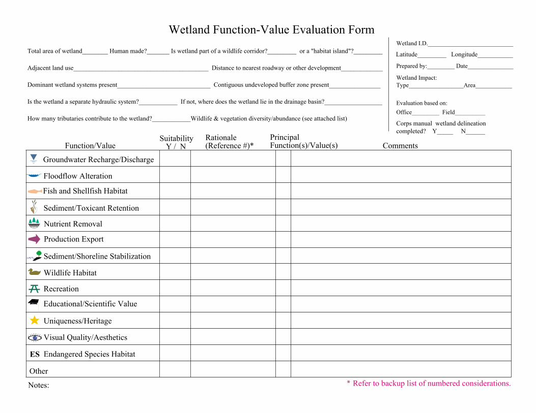
Any appropriate format may be used. As a guide we developed a wetlandevaluation form that can be used by the evaluator to organize various informationconsistent with wetland evaluation requirements discussed in the previous section.The form shown on the next page is structured such that it directs the evaluator toinclude all pertinent wetland information and draw the necessary conclusionsabout the presence or absence of functions and values, as well as principalfunction and value determinations. The form allows additional space for backuprationale and best professional judgement. Refer to Appendix A for a blankreproducible form.
To begin with,the area or extentof each wetland tobe evaluated shouldbe determined.For large projectswith multiplewetlands, theCorps will typicallycoordinate thisdetermination withthe interdisciplinaryteam.
Descriptive wetland information is recorded on the form either in the office orin the field. The top portion of the form allows space for a general description ofthe wetland with respect to the surrounding landscape and hydrologic systems.Information regarding potential impacts is also documented here.
The procedure then requires each wetland that is potentially impacted by aproject alternative to be visited. Each is evaluated considering the presence orabsence of the 13 wetland functions and values defined earlier. A simple yes orno column is checked and documentation supporting the presence or absence of afunction and/or value is recorded. A standard, but flexible, list of rationale factorsfor each function and value, numbered for easy reference, will facilitate thisdocumentation. A sample list is shown in Appendix A.
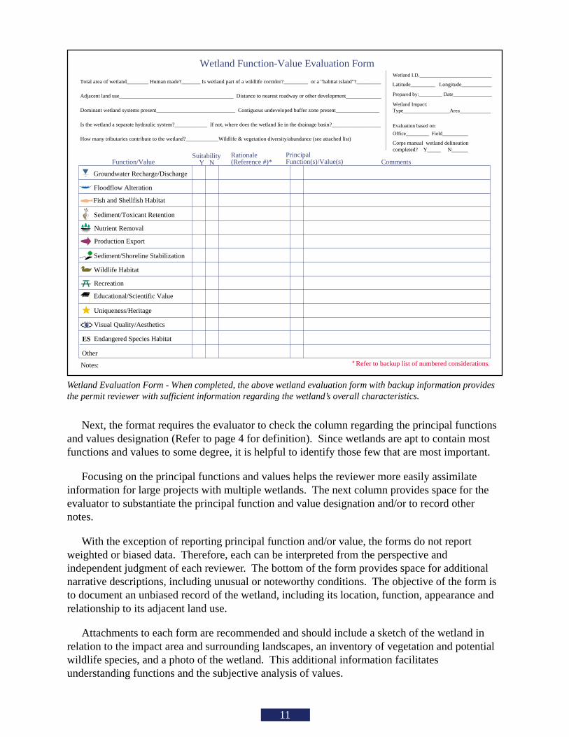
Total area of wetland________ Human made?_______ Is wetland part of a wildlife corridor?_________ or a "habitat island"?_________
Adjacent land use__________________________________________ Distance to nearest roadway or other development_____________
Dominant wetland systems present_____________________________ Contiguous undeveloped buffer zone present________________
Is the wetland a separate hydraulic system?____________ If not, where does the wetland lie in the drainage basin?__________________
How many tributaries contribute to the wetland?____________Wildlife & vegetation diversity/abundance (see attached list)
Latitude_________ Longitude___________
Wetland I.D.____________________________
Prepared by:_________ Date_______________
Wetland Impact:Type__________________Area____________
Evaluation based on:
Office_________ Field__________
Corps manual wetland delineation completed? Y_____ N______
Groundwater Recharge/Discharge
Floodflow Alteration
Production Export
Sediment/Toxicant Retention
Nutrient Removal
Sediment/Shoreline Stabilization
Wildlife Habitat
Recreation
Uniqueness/Heritage
Visual Quality/Aesthetics
Endangered Species Habitat
Wetland Function-Value Evaluation Form
Function/Value Suitability
Y NRationale(Reference #)*
PrincipalFunction(s)/Value(s) Comments
Notes: * Refer to backup list of numbered considerations.
ES
Other
Educational/Scientific Value
Fish and Shellfish Habitat
Wetland Evaluation Form - When completed, the above wetland evaluation form with backup information providesthe permit reviewer with sufficient information regarding the wetland’s overall characteristics.
11
Next, the format requires the evaluator to check the column regarding the principal functionsand values designation (Refer to page 4 for definition). Since wetlands are apt to contain mostfunctions and values to some degree, it is helpful to identify those few that are most important.
Focusing on the principal functions and values helps the reviewer more easily assimilateinformation for large projects with multiple wetlands. The next column provides space for theevaluator to substantiate the principal function and value designation and/or to record othernotes.
With the exception of reporting principal function and/or value, the forms do not reportweighted or biased data. Therefore, each can be interpreted from the perspective andindependent judgment of each reviewer. The bottom of the form provides space for additionalnarrative descriptions, including unusual or noteworthy conditions. The objective of the form isto document an unbiased record of the wetland, including its location, function, appearance andrelationship to its adjacent land use.
Attachments to each form are recommended and should include a sketch of the wetland inrelation to the impact area and surrounding landscapes, an inventory of vegetation and potentialwildlife species, and a photo of the wetland. This additional information facilitatesunderstanding functions and the subjective analysis of values.
CORPS HIGHWAYMETHODOLOGY
NEPA EIS PROCESS
Scoping Draft EIS Final EIS RODEPA NEPA Review for CEQ EPA NEPA Review for CEQ
Federal RegisterAnnouncement
DEISIssued
PublicHearing
Federal AgencyDecision (Earliest)FEIS
Issued
Avoidance
Phase I Phase II CompensationMinimization
Corps DeterminesBasic Project Purpose
Functions and Values Assessmentof Practicable Alternatives
Corps SelectsLeast DamagingPracticable Alternative
Monitoring
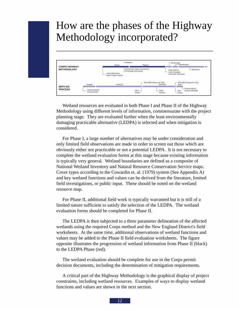
How are the phases of the HighwayMethodology incorporated?
12
Wetland resources are evaluated in both Phase I and Phase II of the HighwayMethodology using different levels of information, commensurate with the projectplanning stage. They are evaluated further when the least environmentallydamaging practicable alternative (LEDPA) is selected and when mitigation isconsidered.
For Phase I, a large number of alternatives may be under consideration andonly limited field observations are made in order to screen out those which areobviously either not practicable or not a potential LEDPA. It is not necessary tocomplete the wetland evaluation forms at this stage because existing informationis typically very general. Wetland boundaries are defined as a composite ofNational Wetland Inventory and Natural Resource Conservation Service maps.Cover types according to the Cowardin et. al. (1979) system (See Appendix A)and key wetland functions and values can be derived from the literature, limitedfield investigations, or public input. These should be noted on the wetlandresource map.
For Phase II, additional field work is typically warranted but it is still of alimited nature sufficient to satisfy the selection of the LEDPA. The wetlandevaluation forms should be completed for Phase II.
The LEDPA is then subjected to a three parameter delineation of the affectedwetlands using the required Corps method and the New England District's fieldworksheets. At the same time, additional observations of wetland functions andvalues may be added to the Phase II field evaluation worksheets. The figureopposite illustrates the progression of wetland information from Phase II (black)to the LEDPA Phase (red).
The wetland evaluation should be complete for use in the Corps permitdecision documents, including the determination of mitigation requirements.
A critical part of the Highway Methodology is the graphical display of projectconstraints, including wetland resources. Examples of ways to display wetlandfunctions and values are shown in the next section.
Total area of wetland________ Human made?_______ Is wetland part of a wildlife corridor?_________ or a "habitat island"?_________
Adjacent land use__________________________________________ Distance to nearest roadway or other development_____________
Dominant wetland systems present_____________________________ Contiguous undeveloped buffer zone present________________
Is the wetland a separate hydraulic system?____________ If not, where does the wetland lie in the drainage basin?__________________
How many tributaries contribute to the wetland?____________Wildlife & vegetation diversity/abundance (see attached list)
Latitude___________Longitude___________
Wetland I.D.____________________________
Prepared by:_________ Date_______________
Wetland Impact:Type__________________Area____________
Evaluation based on:
Office_________ Field__________
Corps manual wetland delineation completed? Y_____ N______
X
X
X
X
X
X
X
Groundwater Recharge/Discharge
Floodflow Alteration
Production Export
Sediment/Toxicant Retention
Nutrient Removal
Sediment/Shoreline Stabilization
Wildlife Habitat
Recreation
Uniqueness/Heritage
Visual Quality/Aesthetics
Endangered Species Habitat
Wetland Function-Value Evaluation Form
Function/Value Suitability
Y NRationale(Reference #)*
PrincipalFunction(s)/Value(s) Comments
Notes:
Portion of wetland at impact area does not store floodwater.
Archaelogic artifacts found adjacent to wetland by local archaeologist.
Phase II wetland assessment is relatively indicative of functions and values present at impact area.Additional vegetative species noted at 3/24/93 Wetland Delineation field visit (Refer to Wetland Delineation Form).
ES
Other
Mid
11.3 ac. YesNo No
Forest, Residential 0'
POWH, PF01E Yes
No
1
N41o44'54.86 W71o44'54.86
WD1-1
LDC, JCL
Fill
12-7-92
4.9 AC
Educational/Scientific Value
X
X X
1,2,3,4,5,6,7,8,9,10,11,12
None
2,6,7,9,10,11,12,13
2,5,6,7,8,9,11,13,14
4,6,9,10,12,13,14,15
3,4,5,6,7,8,9,10,12
2,3,5-15
1,2,4,5,6,7,9,10,12,14
1,2,4,5,6,7,8,(13),16,17,18,19,21
2,4,5,6,8,9,10
7,(14),17,18,20,22,29
X
X
X
X
X
2,3,5,8,9,10,11,12,13X
1,5,(6),9,10,14,15,16,17X
A layer of organic soil blankets the thin glacial till overburden in this area, this wetland is an expression of groundwater discharge.
Low flow velocities.
Sediments can drop out in the ponded section.
Potential for sediment and nutrient removal exists, logging activities have occurred adjacent to wetland.
Outflow is constricted, little transport occurs via wildlife, wetland is predominantly attenuating nutrients.
Except for minor road, this wetland is well buffered, and directly connected to the Hop River. Good amphibian habitat.
Wetland is easily accessible, and has some potential to function as educational and recreational area.
Prehistoric archaelogic sensitive sites adjacent to wetlands.
Direct view of wetland exists from roadway. Open water contrasts with surrounding forest land.
None found or known to occur here.
Water flow constricted by culvert, some detention occurring in this ponded, well-saturated area.
Potential for pond study to occur. No known educational use.
Culvert restricts access, wetland is relatively small, fisheries site #15.Fish and Shellfish Habitat
* Refer to backup list of considerations.
Are there good examples to follow?
14
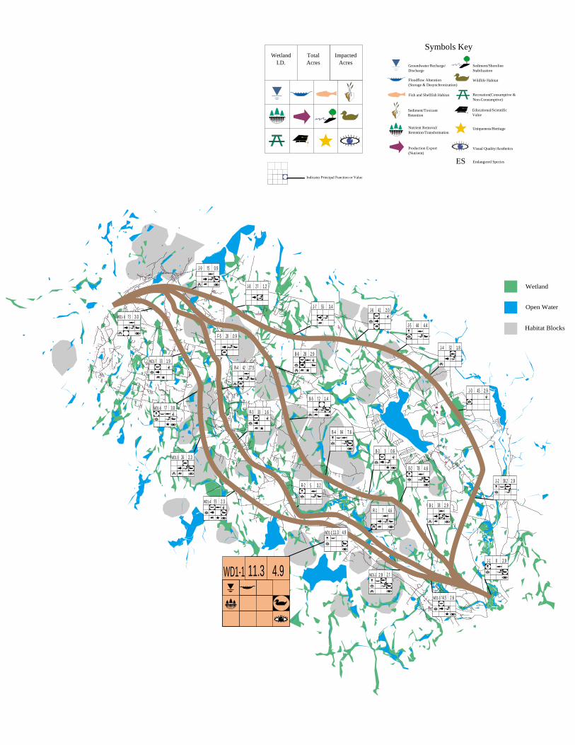
Good examples describe the wetland system and its individual componentsclearly with factual supporting data at an appropriate scale and level of detailcommensurate with the project development stage. The objective is to graphicallydisplay complex wetland information in a format that facilitates assimilation byreviewers and expedites regulatory decisions. The figures in this section representsome good examples of wetland evaluation graphics at various phases in theprocess.
The figure on the next page defines a portion of an 80 square mile Phase Istudy area and illustrates the general distribution and configuration of wetlandsbased on data from National Wetland Inventory and Natural ResourceConservation Service (formerly Soil Conservation Service) maps augmented withapproximately two person weeks of field investigations. Principal functions andvalues that can be identified using existing literature or limited field investigationsare shown.
The figure on the following page illustrates the various aspects of the wetlandevaluation process, including the completed wetland evaluation form withcorresponding backup information and an entire study area graphic that includesinformation on the functions and values for all wetlands evaluated. This graphicis an example of what is used in Phase II of the Highway Methodology to faciliatethe LEDPA decision.
From this graphic, a reviewer can analyze such things as wetland position inthe landscape, configuration, cover type, and corresponding functions andvalues. Potential impacts to each system can be implied by the relative locationof the highway with respect to each wetland, considering typical impactsassociated with highways (e.g., runoff, noise, habitat fragmentation).
To make a complete, informed decision regarding other project impacts andthe practicability of an alternative, multiple constraints must also be shown andevaluated.
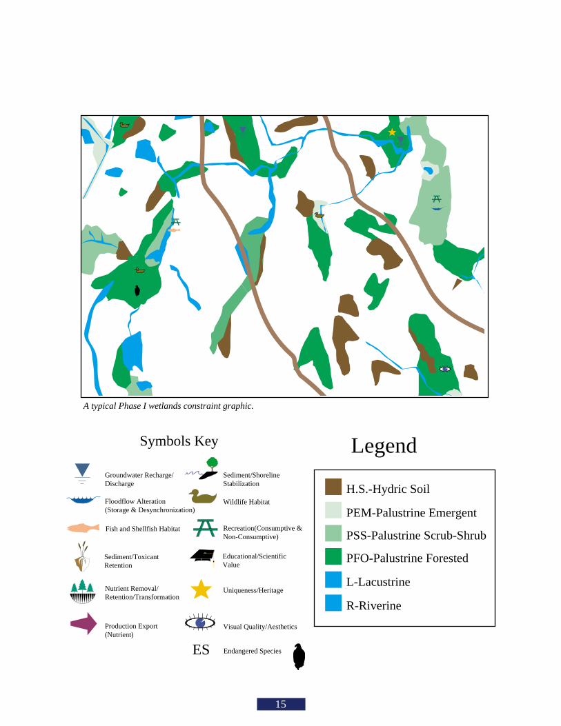
A typical Phase I wetlands constraint graphic.
Symbols Key
Groundwater Recharge/Discharge
Floodflow Alteration(Storage & Desynchronization)
Production Export (Nutrient)
Sediment/ToxicantRetention
Nutrient Removal/Retention/Transformation
Sediment/ShorelineStabilization
Wildlife Habitat
Recreation(Consumptive &Non-Consumptive)
Uniqueness/Heritage
Visual Quality/Aesthetics
Endangered SpeciesES
Fish and Shellfish Habitat
Educational/ScientificValue
H.S.-Hydric Soil
PEM-Palustrine Emergent
PSS-Palustrine Scrub-Shrub
PFO-Palustrine Forested
L-Lacustrine
R-Riverine
Legend
15
US Army Corpsof EngineersNew England District
Graphical Approachto Wetland Evaluation
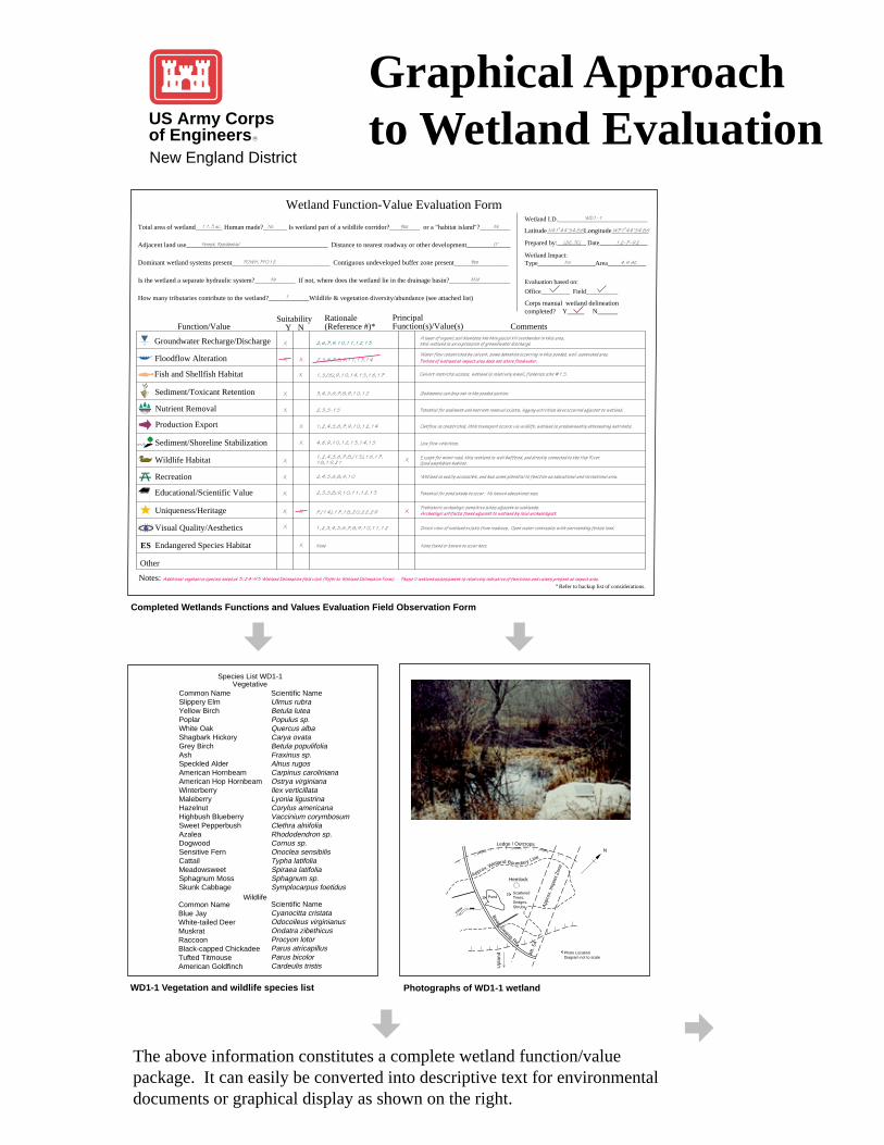
Completed Wetlands Functions and Values Evaluation Field Observation Form
WD1-1 Vegetation and wildlife species list Photographs of WD1-1 wetland
The above information constitutes a complete wetland function/valuepackage. It can easily be converted into descriptive text for environmentaldocuments or graphical display as shown on the right.
Ledge / Outcrops
Approx. Wetland Boundary Line
Hemlock
ScatteredTrees,Sedges. Shrubs
2
Photo LocationDiagram not to scale
App
rox.
Impa
ctZo
ne
Alt.
54
Pond1
Upl
and
Bear
Swam
p Rd.
N
Flow
Common NameSlippery ElmYellow BirchPoplarWhite OakShagbark HickoryGrey BirchAshSpeckled AlderAmerican HornbeamAmerican Hop HornbeamWinterberryMaleberryHazelnutHighbush BlueberrySweet PepperbushAzaleaDogwoodSensitive FernCattailMeadowsweetSphagnum MossSkunk Cabbage
Scientific NameUlmus rubraBetula luteaPopulus sp.Quercus albaCarya ovataBetula populifoliaFraxinus sp.Alnus rugosCarpinus carolinianaOstrya virginianaIlex verticillataLyonia ligustrinaCorylus americanaVaccinium corymbosumClethra alnifoliaRhododendron sp.Cornus sp.Onoclea sensibilisTypha latifoliaSpiraea latifoliaSphagnum sp.Symplocarpus foetidus
Species List WD1-1Vegetative
WildlifeCommon NameBlue JayWhite-tailed DeerMuskratRaccoonBlack-capped ChickadeeTufted TitmouseAmerican Goldfinch
Scientific NameCyanocitta cristataOdocoileus virginianusOndatra zibethicusProcyon lotorParus atricapillusParus bicolor Cardeulis tristis
Total area of wetland________ Human made?_______ Is wetland part of a wildlife corridor?_________ or a "habitat island"?_________
Adjacent land use__________________________________________ Distance to nearest roadway or other development_____________
Dominant wetland systems present_____________________________ Contiguous undeveloped buffer zone present________________
Is the wetland a separate hydraulic system?____________ If not, where does the wetland lie in the drainage basin?__________________
How many tributaries contribute to the wetland?____________Wildlife & vegetation diversity/abundance (see attached list)
Latitude___________Longitude___________
Wetland I.D.____________________________
Prepared by:_________ Date_______________
Wetland Impact:Type__________________Area____________
Evaluation based on:
Office_________ Field__________
Corps manual wetland delineation completed? Y_____ N______
X
X
X
X
X
X
X
Groundwater Recharge/Discharge
Floodflow Alteration
Production Export
Sediment/Toxicant Retention
Nutrient Removal
Sediment/Shoreline Stabilization
Wildlife Habitat
Recreation
Uniqueness/Heritage
Visual Quality/Aesthetics
Endangered Species Habitat
Wetland Function-Value Evaluation Form
Function/Value Suitability
Y NRationale(Reference #)*
PrincipalFunction(s)/Value(s) Comments
Notes:
Portion of wetland at impact area does not store floodwater.
Archaelogic artifacts found adjacent to wetland by local archaeologist.
Phase II wetland assessment is relatively indicative of functions and values present at impact area.Additional vegetative species noted at 3/24/93 Wetland Delineation field visit (Refer to Wetland Delineation Form).
ES
Other
Mid
11.3 ac. YesNo No
Forest, Residential 0'
POWH, PF01E Yes
No
1
N41o44'54.86 W71o44'54.86
WD1-1
LDC, JCL
Fill
12-7-92
4.9 AC
Educational/Scientific Value
X
X X
1,2,3,4,5,6,7,8,9,10,11,12
None
2,6,7,9,10,11,12,13
2,5,6,7,8,9,11,13,14
4,6,9,10,12,13,14,15
3,4,5,6,7,8,9,10,12
2,3,5-15
1,2,4,5,6,7,9,10,12,14
1,2,4,5,6,7,8,(13),16,17,18,19,21
2,4,5,6,8,9,10
7,(14),17,18,20,22,29
X
X
X
X
X
2,3,5,8,9,10,11,12,13X
1,5,(6),9,10,14,15,16,17X
A layer of organic soil blankets the thin glacial till overburden in this area, this wetland is an expression of groundwater discharge.
Low flow velocities.
Sediments can drop out in the ponded section.
Potential for sediment and nutrient removal exists, logging activities have occurred adjacent to wetland.
Outflow is constricted, little transport occurs via wildlife, wetland is predominantly attenuating nutrients.
Except for minor road, this wetland is well buffered, and directly connected to the Hop River. Good amphibian habitat.
Wetland is easily accessible, and has some potential to function as educational and recreational area.
Prehistoric archaelogic sensitive sites adjacent to wetlands.
Direct view of wetland exists from roadway. Open water contrasts with surrounding forest land.
None found or known to occur here.
Water flow constricted by culvert, some detention occurring in this ponded, well-saturated area.
Potential for pond study to occur. No known educational use.
Culvert restricts access, wetland is relatively small, fisheries site #15.Fish and Shellfish Habitat
* Refer to backup list of considerations.
R
B-6 281.9WD1-7 33
1.6R-3 33
2.9J-3 45
J-6
2.3WD1-4 55
.0.9F-5 20
27.5R-4 42
3.0WD1- 8 13
J-8
2.9B-1 38
B-5 12
J-7
1.8J-4 32
2.3WD1-5 26
7R-1 4.6
4.6B-2 78
3.2R-2 52.9J-2 38.2
4.4J-5
2.9WD1-2 2.1
7.6B-4 84
3.0WD1-6 17
2.9J-1 8
0.6B-3 3
WD1-3 14.5
Wetland
Open Water
Habitat Blocks
WD1-1 4.911.3
WD1-1 4.911.3
15 0.9
1.227
3.45542 2.0
44
2.6
2.9
1.4
J-9
WetlandI.D.
ImpactedAcres
TotalAcres
Symbols Key
Groundwater Recharge/Discharge
Floodflow Alteration(Storage & Desynchronization)
Production Export (Nutrient)
Sediment/ToxicantRetention
Nutrient Removal/Retention/Transformation
Sediment/ShorelineStabilization
Wildlife Habitat
Recreation(Consumptive &Non-Consumptive)
Uniqueness/Heritage
Visual Quality/Aesthetics
Endangered SpeciesES
Fish and Shellfish Habitat
Educational/ScientificValue
Indicates Principal Function or Value
How are resources other thanwetlands considered in the Corpspermit decision?
cem
Wildlife Habitat Block
Open Water
Aquifer
Wetlands
Historic District
Community Center
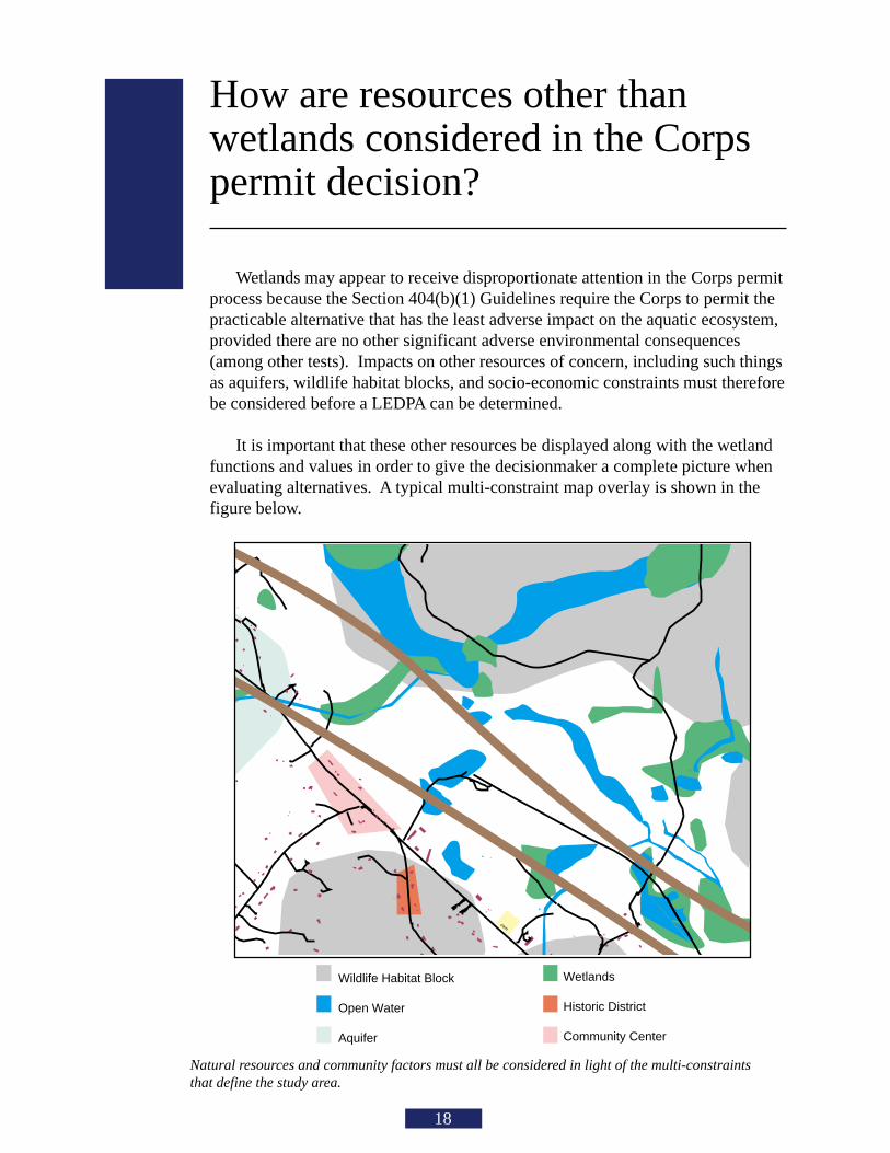
Natural resources and community factors must all be considered in light of the multi-constraintsthat define the study area.
18
Wetlands may appear to receive disproportionate attention in the Corps permitprocess because the Section 404(b)(1) Guidelines require the Corps to permit thepracticable alternative that has the least adverse impact on the aquatic ecosystem,provided there are no other significant adverse environmental consequences(among other tests). Impacts on other resources of concern, including such thingsas aquifers, wildlife habitat blocks, and socio-economic constraints must thereforebe considered before a LEDPA can be determined.
It is important that these other resources be displayed along with the wetlandfunctions and values in order to give the decisionmaker a complete picture whenevaluating alternatives. A typical multi-constraint map overlay is shown in thefigure below.
19

Appendix A
Wetland evaluation supportingdocumentation; Reproducibleforms.
20
Below is an example list of considerations that was used for a NewHampshire highway project. Considerations are flexible, based on bestprofessional judgment and interdisciplinary team consensus. This exampleprovides a comprehensive base, however, and may only need slight modificationsfor use in other projects.
GROUNDWATER RECHARGE/DISCHARGE— This function considers thepotential for a wetland to serve as a groundwater recharge and/or discharge area.It refers to the fundamental interaction between wetlands and aquifers, regardlessof the size or importance of either.
CONSIDERATIONS/QUALIFIERS1. Public or private wells occur downstream of the wetland.2. Potential exists for public or private wells downstream of the wetland.3. Wetland is underlain by stratified drift.4. Gravel or sandy soils present in or adjacent to the wetland.5. Fragipan does not occur in the wetland.6. Fragipan, impervious soils, or bedrock does occur in the wetland.7. Wetland is associated with a perennial or intermittent watercourse.8. Signs of groundwater recharge are present or piezometer data
demonstrates recharge.9. Wetland is associated with a watercourse but lacks a defined outlet or
contains a constricted outlet.10. Wetland contains only an outlet, no inlet.11. Groundwater quality of stratified drift aquifer within or downstream
of wetland meets drinking water standards.12. Quality of water associated with the wetland is high.13. Signs of groundwater discharge are present (e.g., springs).14. Water temperature suggests it is a discharge site.15. Wetland shows signs of variable water levels.16. Piezometer data demonstrates discharge.17. Other
FLOODFLOW ALTERATION (Storage & Desynchronization) — This functionconsiders the effectiveness of the wetland in reducing flood damage by waterretention for prolonged periods following precipitation events and the gradualrelease of floodwaters. It adds to the stability of the wetland ecological system orits buffering characteristics and provides social or economic value relative toerosion and/or flood prone areas.
21
CONSIDERATIONS/QUALIFIERS1. Area of this wetland is large relative to its watershed.2. Wetland occurs in the upper portions of its watershed.3. Effective flood storage is small or non-existent upslope of or above the wetland.4. Wetland watershed contains a high percent of impervious surfaces.5. Wetland contains hydric soils which are able to absorb and detain water.6. Wetland exists in a relatively flat area that has flood storage potential.7. Wetland has an intermittent outlet, ponded water, or signs are present of variable water level.8. During flood events, this wetland can retain higher volumes of water than under normal or average
rainfall conditions.9. Wetland receives and retains overland or sheet flow runoff from surrounding uplands.10. In the event of a large storm, this wetland may receive and detain excessive flood water from
a nearby watercourse.11. Valuable properties, structures, or resources are located in or near the floodplain
downstream from the wetland.12. The watershed has a history of economic loss due to flooding.13. This wetland is associated with one or more watercourses.14. This wetland watercourse is sinuous or diffuse.15. This wetland outlet is constricted.16. Channel flow velocity is affected by this wetland.17. Land uses downstream are protected by this wetland.18. This wetland contains a high density of vegetation.19. Other
FISH AND SHELLFISH HABITAT (FRESHWATER) — This function considers the effectivenessof seasonal or permanent watercourses associated with the wetland in question for fish andshellfish habitat.
CONSIDERATIONS/QUALIFIERS1. Forest land dominant in the watershed above this wetland.2. Abundance of cover objects present.STOP HERE IF THIS WETLAND IS NOT ASSOCIATED WITH A WATERCOURSE3. Size of this wetland is able to support large fish/shellfish populations.4. Wetland is part of a larger, contiguous watercourse.5. Wetland has sufficient size and depth in open water areas so as not to freeze solid and retain
some open water during winter.6. Stream width (bank to bank) is more than 50 feet.7. Quality of the watercourse associated with this wetland is able to support healthy fish/shellfish
populations.8. Streamside vegetation provides shade for the watercourse.9. Spawning areas are present (submerged vegetation or gravel beds).10. Food is available to fish/shellfish populations within this wetland.11. Barrier(s) to anadromous fish (such as dams, including beaver dams, waterfalls, road crossing)
are absent from the stream reach associated with this wetland.12. Evidence of fish is present.13. Wetland is stocked with fish.14. The watercourse is persistent.15. Man-made streams are absent.16. Water velocities are not too excessive for fish usage.17. Defined stream channel is present.18. Other
Although the above example refers to freshwater wetlands, it can also be adapted for marineecosystems. The following is an example provided by the National Marine Fisheries Service(NMFS) of an adaptation for the fish and shellfish function.
22
FISH AND SHELLFISH HABITAT (MARINE) — This function considers theeffectiveness of wetlands, embayments, tidal flats, vegetated shallows, and otherenvironments in supporting marine resources such as fish, shellfish, marinemammals, and sea turtles.
CONSIDERATIONS/QUALIFIERS1. Special aquatic sites (tidal marsh, mud flats, eelgrass beds) are present.2. Suitable spawning habitat is present at the site or in the area.3. Commercially or recreationally important species are present or suitable habitat
exists.4. The wetland/waterway supports prey for higher trophic level marine organisms.5. The waterway provides migratory habitat for anadromous fish.6. Essential fish habitat, as defined by the 1996 amendments to the Magnuson-Stevens
Fishery & Conservation Act, is present (consultation with NMFS may be necessary).7. Other
SEDIMENT/TOXICANT/PATHOGEN RETENTION — This function reduces orprevents degradation of water quality. It relates to the effectiveness of the wetlandas a trap for sediments, toxicants, or pathogens in runoff water from surroundinguplands or upstream eroding wetland areas.
CONSIDERATIONS/QUALIFIERS1. Potential sources of excess sediment are in the watershed above the wetland.2. Potential or known sources of toxicants are in the watershed above the wetland.3. Opportunity for sediment trapping by slow moving water or deepwater habitat are
present in this wetland.4. Fine grained mineral or organic soils are present.5. Long duration water retention time is present in this wetland.6. Public or private water sources occur downstream.7. The wetland edge is broad and intermittently aerobic.8. The wetland is known to have existed for more than 50 years.9. Drainage ditches have not been constructed in the wetland.STOP HERE IF WETLAND IS NOT ASSOCIATED WITH A WATERCOURSE.10. Wetland is associated with an intermittent or perennial stream or a lake.11. Channelized flows have visible velocity decreases in the wetland.12. Effective floodwater storage in wetland is occurring. Areas of impounded open
water are present.13. No indicators of erosive forces are present. No high water velocities are present.14. Diffuse water flows are present in the wetland.15. Wetland has a high degree of water and vegetation interspersion.16. Dense vegetation provides opportunity for sediment trapping and/or signs of
sediment accumulation by dense vegetation is present.17. Other
NUTRIENT REMOVAL/RETENTION/TRANSFORMATION — This functionconsiders the effectiveness of the wetland as a trap for nutrients in runoff waterfrom surrounding uplands or contiguous wetlands and the ability of the wetland toprocess these nutrients into other forms or trophic levels. One aspect of thisfunction is to prevent ill effects of nutrients entering aquifers or surface waterssuch as ponds, lakes, streams, rivers, or estuaries.
CONSIDERATIONS/QUALIFIERS1. Wetland is large relative to the size of its watershed.2. Deep water or open water habitat exists.3. Overall potential for sediment trapping exists in the wetland.
23
4. Potential sources of excess nutrients are present in the watershed above the wetland.5. Wetland saturated for most of the season. Ponded water is present in the wetland.6. Deep organic/sediment deposits are present.7. Slowly drained fine grained mineral or organic soils are present.8. Dense vegetation is present.9. Emergent vegetation and/or dense woody stems are dominant.10. Opportunity for nutrient attenuation exists.11. Vegetation diversity/abundance sufficient to utilize nutrients.STOP HERE IF WETLAND IS NOT ASSOCIATED WITH A WATERCOURSE.12. Waterflow through this wetland is diffuse.13. Water retention/detention time in this wetland is increased by constricted outlet or thick vegetation.14. Water moves slowly through this wetland.15. Other
PRODUCTION EXPORT (Nutrient) — This function evaluates the effectiveness of the wetlandto produce food or usable products for humans or other living organisms.
CONSIDERATIONS/QUALIFIERS1. Wildlife food sources grow within this wetland.2. Detritus development is present within this wetland3. Economically or commercially used products found in this wetland.4. Evidence of wildlife use found within this wetland.5. Higher trophic level consumers are utilizing this wetland.6. Fish or shellfish develop or occur in this wetland.7. High vegetation density is present.8. Wetland exhibits high degree of plant community structure/species diversity.9. High aquatic vegetative diversity/abundance is present.10. Nutrients exported in wetland watercourses (permanent outlet present).11. “Flushing” of relatively large amounts of organic plant material occurs from this wetland.12. Wetland contains flowering plants that are used by nectar-gathering insects.13. Indications of export are present.14. High production levels occurring, however, no visible signs of export (assumes export is attenuated).15. Other
SEDIMENT/SHORELINE STABILIZATION — This function considers the effectiveness of awetland to stabilize streambanks and shorelines against erosion.
CONSIDERATIONS/QUALIFIERS1. Indications of erosion or siltation are present.2. Topographical gradient is present in wetland.3. Potential sediment sources are present up-slope.4. Potential sediment sources are present upstream.5. No distinct shoreline or bank is evident between the waterbody and the wetland or upland.6. A distinct step between the open waterbody or stream and the adjacent land exists (i.e., sharp
bank) with dense roots throughout.7. Wide wetland (>10’) borders watercourse, lake, or pond.8. High flow velocities in the wetland.9. The watershed is of sufficient size to produce channelized flow.10. Open water fetch is present.11. Boating activity is present.12. Dense vegetation is bordering watercourse, lake, or pond.13. High percentage of energy-absorbing emergents and/or shrubs border a watercourse, lake, or pond.14. Vegetation is comprised of large trees and shrubs that withstand major flood events or erosive
incidents and stabilize the shoreline on a large scale (feet).15. Vegetation is comprised of a dense resilient herbaceous layer that stabilizes sediments and the
shoreline on a small scale (inches) during minor flood events or potentially erosive events.16. Other
24
WILDLIFE HABITAT — This function considers the effectiveness of the wetlandto provide habitat for various types and populations of animals typically associatedwith wetlands and the wetland edge. Both resident and/or migrating species mustbe considered. Species lists of observed and potential animals should be includedin the wetland assessment report.1
CONSIDERATIONS/QUALIFIERS1. Wetland is not degraded by human activity.2. Water quality of the watercourse, pond, or lake associated with this wetland meets or
exceeds Class A or B standards.3. Wetland is not fragmented by development.4. Upland surrounding this wetland is undeveloped.5. More than 40% of this wetland edge is bordered by upland wildlife habitat (e.g.,
brushland, woodland, active farmland, or idle land) at least 500 feet in width.6. Wetland is contiguous with other wetland systems connected by a watercourse
or lake.7. Wildlife overland access to other wetlands is present.8. Wildlife food sources are within this wetland or are nearby.9. Wetland exhibits a high degree of interspersion of vegetation classes and/or open
water.10. Two or more islands or inclusions of upland within the wetland are present.11. Dominant wetland class includes deep or shallow marsh or wooded swamp.12. More than three acres of shallow permanent open water (less than 6.6 feet deep),
including streams in or adjacent to wetland, are present.13. Density of the wetland vegetation is high.14. Wetland exhibits a high degree of plant species diversity.15. Wetland exhibits a high degree of diversity in plant community structure (e.g., tree/
shrub/vine/grasses/mosses)16. Plant/animal indicator species are present. (List species for project)17. Animal signs observed (tracks, scats, nesting areas, etc.)18. Seasonal uses vary for wildlife and wetland appears to support varied population
diversity/abundance during different seasons.19. Wetland contains or has potential to contain a high population of insects.20. Wetland contains or has potential to contain large amphibian populations.21. Wetland has a high avian utilization or its potential.22. Indications of less disturbance-tolerant species are present.23. Signs of wildlife habitat enhancement are present (birdhouses, nesting boxes, food
sources, etc.).24. Other
1In March 1995, a rapid wildlife habitat assessment method was completed bya University of Massachusetts research team with funding and oversight providedby the New England Transportation Consortium. The method is called WEThings(wetland habitat indicators for non-game species). It produces a list of potentialwetland-dependent mammal, reptile, and amphibian species that may be presentin the wetland. The output is based on observable habitat characteristicsdocumented on the field data form. This method may be used to generate thewildlife species list recommended as backup information to the wetland evaluationform and to augment the considerations. Use of this method should first becoordinated with the Corps project manager. A computer program is also availableto expedite this process.
25
RECREATION (Consumptive and Non-Consumptive) — This value considers the suitabilityof the wetland and associated watercourses to provide recreational opportunities such ashiking, canoeing, boating, fishing, hunting, and other active or passive recreational activities.Consumptive opportunities consume or diminish the plants, animals, or other resources thatare intrinsic to the wetland. Non-consumptive opportunities do not consume or diminishthese resources of the wetland.
CONSIDERATIONS/QUALIFIERS1. Wetland is part of a recreation area, park, forest, or refuge.2. Fishing is available within or from the wetland.3. Hunting is permitted in the wetland.4. Hiking occurs or has potential to occur within the wetland.5. Wetland is a valuable wildlife habitat.6. The watercourse, pond, or lake associated with the wetland is unpolluted.7. High visual/aesthetic quality of this potential recreation site.8. Access to water is available at this potential recreation site for boating, canoeing, or fishing.9. The watercourse associated with this wetland is wide and deep enough to
accommodate canoeing and/or non-powered boating.10. Off-road public parking available at the potential recreation site.11. Accessibility and travel ease is present at this site.12. The wetland is within a short drive or safe walk from highly populated public and private areas.13. Other
EDUCATIONAL/SCIENTIFIC VALUE — This value considers the suitability of thewetland as a site for an “outdoor classroom” or as a location for scientific study or research.
CONSIDERATIONS/QUALIFIERS1. Wetland contains or is known to contain threatened, rare, or endangered species.2. Little or no disturbance is occurring in this wetland.3. Potential educational site contains a diversity of wetland classes which are accessible
or potentially accessible.4. Potential educational site is undisturbed and natural.5. Wetland is considered to be a valuable wildlife habitat.6. Wetland is located within a nature preserve or wildlife management area.7. Signs of wildlife habitat enhancement present (bird houses, nesting boxes, food sources, etc.).8. Off-road parking at potential educational site suitable for school bus access in or near wetland.9. Potential educational site is within safe walking distance or a short drive to schools.10. Potential educational site is within safe walking distance to other plant communities.11. Direct access to perennial stream at potential educational site is available.12. Direct access to pond or lake at potential educational site is available.13. No known safety hazards exist within the potential educational site.14. Public access to the potential educational site is controlled.15. Handicap accessibility is available.16. Site is currently used for educational or scientific purposes.17. Other
26
UNIQUENESS/HERITAGE — This value considers the effectiveness of thewetland or its associated waterbodies to provide certain special values. Thesemay include archaeological sites, critical habitat for endangered species, itsoverall health and appearance, its role in the ecological system of the area, itsrelative importance as a typical wetland class for this geographic location. Thesefunctions are clearly valuable wetland attributes relative to aspects of publichealth, recreation, and habitat diversity.
CONSIDERATIONS/QUALIFIERS1. Upland surrounding wetland is primarily urban.2. Upland surrounding wetland is developing rapidly.3. More than 3 acres of shallow permanent open water (less than 6.6 feet deep),
including streams, occur in wetlands.4. Three or more wetland classes are present.5. Deep and/or shallow marsh or wooded swamp dominate.6. High degree of interspersion of vegetation and/or open water occur in this wetland.7. Well-vegetated stream corridor (15 feet on each side of the stream) occurs in this
wetland.8. Potential educational site is within a short drive or a safe walk from schools.9. Off-road parking at potential educational site is suitable for school buses.10. No known safety hazards exist within this potential educational site.11. Direct access to perennial stream or lake exists at potential educational site.12. Two or more wetland classes are visible from primary viewing locations.13. Low-growing wetlands (marshes, scrub-shrub, bogs, open water) are visible from
primary viewing locations.14. Half an acre of open water or 200 feet of stream is visible from the primary viewing
locations.15. Large area of wetland is dominated by flowering plants or plants that turn vibrant
colors in different seasons.16. General appearance of the wetland visible from primary viewing locations is
unpolluted and/or undisturbed.17. Overall view of the wetland is available from the surrounding upland.18. Quality of the water associated with the wetland is high.19. Opportunities for wildlife observations are available.20. Historical buildings are found within the wetland.21. Presence of pond or pond site and remains of a dam occur within the wetland.22. Wetland is within 50 yards of the nearest perennial watercourse.23. Visible stone or earthen foundations, berms, dams, standing structures, or
associated features occur within the wetland.24. Wetland contains critical habitat for a state- or federally-listed threatened or
endangered species.25. Wetland is known to be a study site for scientific research.26. Wetland is a natural landmark or recognized by the state natural heritage inventory
authority as an exemplary natural community.27. Wetland has local significance because it serves several functional values.28. Wetland has local significance because it has biological, geological, or other
features that are locally rare or unique.29. Wetland is known to contain an important archaeological site.30. Wetland is hydrologically connected to a state or federally designated scenic river.31. Wetland is located in an area experiencing a high wetland loss rate.32. Other
ES
27
VISUAL QUALITY/AESTHETICS — This value considers the visual and aesthetic qualityor usefulness of the wetland.
CONSIDERATIONS/QUALIFIERS1. Multiple wetland classes are visible from primary viewing locations.2. Emergent marsh and/or open water are visible from primary viewing locations.3. A diversity of vegetative species is visible from primary viewing locations.4. Wetland is dominated by flowering plants or plants that turn vibrant colors in different seasons.5. Land use surrounding the wetland is undeveloped as seen from primary viewing locations.6. Visible surrounding land use form contrasts with wetland.7. Wetland views absent of trash, debris, and signs of disturbance.8. Wetland is considered to be a valuable wildlife habitat.9. Wetland is easily accessed.10. Low noise level at primary viewing locations.11. Unpleasant odors absent at primary viewing locations.12. Relatively unobstructed sight line exists through wetland.13. Other
ENDANGERED SPECIES HABITAT — This value considers the suitability of thewetland to support threatened or endangered species.
CONSIDERATIONS/QUALIFIERS1. Wetland contains or is known to contain threatened or endangered species.2. Wetland contains critical habitat for a state or federally listed threatened or endangered species.
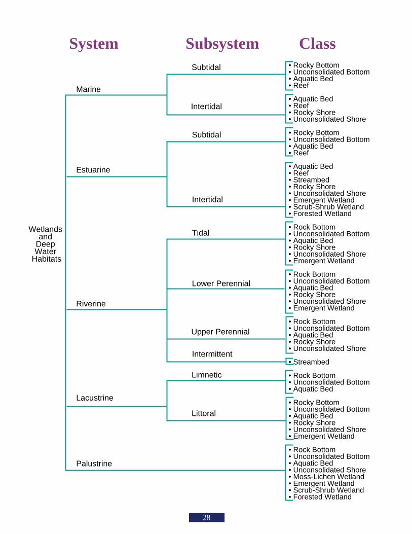
• Rocky Bottom• Unconsolidated Bottom• Aquatic Bed• Reef
• Aquatic Bed• Reef• Rocky Shore• Unconsolidated Shore
• Rocky Bottom• Unconsolidated Bottom• Aquatic Bed• Reef
• Aquatic Bed• Reef• Streambed• Rocky Shore• Unconsolidated Shore• Emergent Wetland• Scrub-Shrub Wetland• Forested Wetland
• Rock Bottom• Unconsolidated Bottom• Aquatic Bed• Rocky Shore• Unconsolidated Shore• Emergent Wetland
• Rock Bottom• Unconsolidated Bottom• Aquatic Bed• Rocky Shore• Unconsolidated Shore • Emergent Wetland
• Rock Bottom• Unconsolidated Bottom• Aquatic Bed• Rocky Shore• Unconsolidated Shore
• Streambed
• Rock Bottom• Unconsolidated Bottom• Aquatic Bed
• Rocky Bottom• Unconsolidated Bottom• Aquatic Bed• Rocky Shore• Unconsolidated Shore• Emergent Wetland
• Rock Bottom• Unconsolidated Bottom• Aquatic Bed• Unconsolidated Shore• Moss-Lichen Wetland• Emergent Wetland• Scrub-Shrub Wetland• Forested Wetland
Marine
Estuarine
Riverine
Palustrine
Subtidal
Subtidal
Tidal
Upper Perennial
Limnetic
Intertidal
Intertidal
Lower Perennial
Intermittent
Littoral
Lacustrine
System Subsystem Class
Wetlands and
Deep Water
Habitats
28
WetlandI.D.
ImpactedAcres
TotalAcres
Symbols Key
Groundwater Recharge/Discharge
Floodflow Alteration(Storage & Desynchronization)
Production Export (Nutrient)
Sediment/ToxicantRetention
Nutrient Removal/Retention/Transformation
Sediment/ShorelineStabilization
Wildlife Habitat
Recreation(Consumptive &Non-Consumptive)
Uniqueness/Heritage
Visual Quality/Aesthetics
Endangered SpeciesES
Fish and Shellfish Habitat
Educational/ScientificValue
29
Total area of wetland________ Human made?_______ Is wetland part of a wildlife corridor?_________ or a "habitat island"?_________
Adjacent land use__________________________________________ Distance to nearest roadway or other development_____________
Dominant wetland systems present_____________________________ Contiguous undeveloped buffer zone present________________
Is the wetland a separate hydraulic system?____________ If not, where does the wetland lie in the drainage basin?__________________
How many tributaries contribute to the wetland?____________Wildlife & vegetation diversity/abundance (see attached list)
Latitude_________ Longitude___________
Wetland I.D.____________________________
Prepared by:_________ Date_______________
Wetland Impact:Type__________________Area____________
Evaluation based on:Office_________ Field__________
Corps manual wetland delineation completed? Y_____ N______
Groundwater Recharge/Discharge
Floodflow Alteration
Production Export
Sediment/Toxicant Retention
Nutrient Removal
Sediment/Shoreline Stabilization
Wildlife Habitat
Recreation
Uniqueness/Heritage
Visual Quality/Aesthetics
Endangered Species Habitat
Wetland Function-Value Evaluation Form
Function/ValueSuitability
Y / NRationale(Reference #)*
PrincipalFunction(s)/Value(s) Comments
Notes: * Refer to backup list of numbered considerations.
ES
Other
Educational/Scientific Value
Fish and Shellfish Habitat
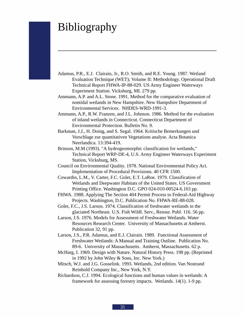
Bibliography
31
Adamus, P.R., E.J. Clairain, Jr., R.O. Smith, and R.E. Young. 1987. WetlandEvaluation Technique (WET); Volume II: Methodology. Operational DraftTechnical Report FHWA-IP-88-029. US Army Engineer WaterwaysExperiment Station. Vicksburg, MI. 279 pp.
Ammann, A.P. and A.L. Stone. 1991. Method for the comparative evaluation ofnontidal wetlands in New Hampshire. New Hampshire Department ofEnvironmental Services. NHDES-WRD-1991-3.
Ammann, A.P., R.W. Franzen, and J.L. Johnson. 1986. Method for the evaluationof inland wetlands in Connecticut. Connecticut Department ofEnvironmental Protection. Bulletin No. 9.
Barkman, J.J., H. Doing, and S. Segal. 1964. Kritische Bemerkungen undVorschlage zur quantitativen Vegetations analyse. Acta BotanicaNeerlandica. 13:394-419.
Brinson, M.M (1993). "A hydrogeomorphic classification for wetlands,"Technical Report WRP-DE-4, U.S. Army Engineer Waterways ExperimentStation, Vicksburg, MS.
Council on Environmental Quality. 1978. National Environmental Policy Act.Implementation of Procedural Provisions. 40 CFR 1500.
Cowardin, L.M., V. Carter, F.C. Golet, E.T. LaRoe. 1979. Classification ofWetlands and Deepwater Habitats of the United States. US GovernmentPrinting Office. Washington D.C. GPO 024-010-00524-6.103 pp.
FHWA. 1988. Applying The Section 404 Permit Process to Federal-Aid HighwayProjects. Washington, D.C. Publication No. FHWA-RE-88-028.
Golet, F.C., J.S. Larson. 1974. Classification of freshwater wetlands in theglaciated Northeast. U.S. Fish Wildl. Serv., Resour. Publ. 116. 56 pp.
Larson, J.S. 1976. Models for Assessment of Freshwater Wetlands. WaterResources Research Center. University of Massachusetts at Amherst.Publication 32, 91 pp.
Larson, J.S., P.R. Adamus, and E.J. Clairain. 1989. Functional Assessment ofFreshwater Wetlands: A Manual and Training Outline. Publication No.89-6. University of Massachusetts. Amherst, Massachusetts. 62 p.
McHarg, I. 1969. Design with Nature. Natural History Press. 198 pp. (Reprintedin 1992 by John Wiley & Sons, Inc. New York.)
Mitsch, W.J. and J.G. Gosselink. 1993. Wetlands, 2nd edition. Van NostrandReinhold Company Inc., New York, N.Y.
Richardson, C.J. 1994. Ecological functions and human values in wetlands: Aframework for assessing forestry impacts. Wetlands. 14(1). 1-9 pp.
32
Photo Credits:
• US Army Corps of Engineers• William Lawless• Richard Roach• Ruth Ladd
The National Wetlands Policy Forum. 1988. Protecting America’s Wetlands: anaction agenda. The Conservation Foundation, Washington, DC. 69 pp.
Tufte, E.R. 1983. The Visual Display of Quantitative Information. GraphicsPress. Cheshire, Connecticut. 197 pp.
Tufte, E.R. 1990, Envisioning Information. Graphics Press. Cheshire,Connecticut. 126 pp.
USACOE. 1986. Regulatory Programs of the Corps of Engineers. 33 CFR Parts320 through 330. Fed. Reg. 52(7):1182. 51(219):41206-41260.
USACOE. 1990. Memorandum—Section 404 Mitigation Memorandum ofAgreement. CECW-OR. Washington, D.C. 8 pp.
USACOE. 1991. Memorandum for Regulatory Staff—WET II AssessmentMethodology. CENED-OD-R (1145-2-303b) Waltham, Massachusetts
USACOE. 1991. Nationwide Permit Program Regulations and Issue, Reissue,and Modify Nationwide Permits. 33 CFR Part 330. Fed. Reg.56(226):59110-59147.
USACOE. 1993. The Highway Methodology Workbook. US Army Corps ofEngineers New England Division. 28 pp. NEDEP-360-1-30.
USACOE. 1993. Clean Water Act Regulatory Programs. 33 CFR Parts 323 and328. Fed. Reg. 58(163):45008-45038.
Wigley, T.B. and T.H. Roberts. 1994. Wildlife changes in southern bottomlandhardwoods due to forest management practices. Wetlands 14:(in press).

SEPTEMBER 1999NAEEP-360-1-30aThis brochure supercedes NEDEP-360-1-30aNOVEMBER 1995
Related Documents