Gardiner et al. Page 1 The Habitats Directive, Coastal Habitats and Climate Change – Case Studies from the South Coast of the UK Sarah Gardiner, Susan Hanson, Robert Nicholls – University of Southampton & Tyndall Centre for Climate Change Research, UK Zhong Zhang, Simon Jude, Andy Jones, University of East Anglia & Tyndall Centre for Climate Change Research, UK Julie Richards – ABP marine environmental research, Southampton, UK Alan Williams, Hampshire County Council, UK Tom Spencer, University of Cambridge, UK Samantha Cope, Malgosia Gorczynska, Andy Bradbury, Channel Coastal Observatory, UK Robin McInnes, Isle of Wight Centre for the Coastal Environment, UK Adam Ingleby, Helen Dalton, Environment Agency, UK Abstract A GIS-based approach has been used to assess existing and potential near-future coastal habitats under different sea-level rise and management scenarios. For six local case studies on the south coast of the UK, difficulties in meeting the requirements of the EC Habitats Directive within individual case study areas were found. The most significant issues were related to intertidal saltmarsh and mudflat areas, which decline under all the sea-level rise scenarios considered. Compensation for these losses in some localities could be achieved through the creation of replacement habitat by the managed realignment of sea defences, often in conjunction with engineered sediment supply to raise intertidal surfaces to levels conducive to vegetation establishment. However, historic land use decisions will restrict this approach in many areas. In particular, managed realignment will lead to a decline in coastal grazing marsh, also a designated habitat under the Directive. However, at wider scales potential exists to compensate for lost coastal grazing marsh with fluvial grazing marsh in adjoining river catchments. Spatial planning offers the potential for future land- banking of these areas, but its implementation may require a reinterpretation of the application of the Habitats Directive.

Welcome message from author
This document is posted to help you gain knowledge. Please leave a comment to let me know what you think about it! Share it to your friends and learn new things together.
Transcript
Gardiner et al. Page 1
The Habitats Directive, Coastal Habitats and Climate Change – Case Studies from the South Coast of theUK
Sarah Gardiner, Susan Hanson, Robert Nicholls – University of Southampton & Tyndall Centre for Climate Change Research, UKZhong Zhang, Simon Jude, Andy Jones, University of East Anglia & Tyndall Centre for Climate Change Research, UKJulie Richards – ABP marine environmental research, Southampton, UKAlan Williams, Hampshire County Council, UKTom Spencer, University of Cambridge, UKSamantha Cope, Malgosia Gorczynska, Andy Bradbury, Channel Coastal Observatory, UK Robin McInnes, Isle of Wight Centre for the Coastal Environment, UKAdam Ingleby, Helen Dalton, Environment Agency, UK
Abstract
A GIS-based approach has been used to assess existing and potential near-future coastal habitats under different sea-level rise and management scenarios. For six local case studies on the south coast of the UK, difficulties in meeting the requirements of the EC Habitats Directive within individual case study areas were found. The most significant issues were related to intertidal saltmarsh and mudflat areas, which decline under all the sea-level rise scenarios considered. Compensation for these losses in some localities could be achieved through the creation of replacement habitat by the managed realignment of sea defences, often in conjunction with engineered sediment supply to raise intertidal surfaces to levels conducive to vegetation establishment. However, historic land use decisions will restrict this approach in many areas. In particular, managed realignment will lead to a decline in coastal grazing marsh, also a designated habitat under the Directive. However, at wider scales potential exists to compensate for lost coastal grazing marsh with fluvial grazing marsh in adjoining river catchments. Spatial planning offers the potential for future land-banking of these areas, but its implementation may require a reinterpretation of the application of the Habitats Directive.
Gardiner et al. Page 2
Introduction
The setting back of sea defences to more landward locations – ‘managed realignment’ – is a response to the loss of saltmarsh and mudflat habitats (ENVIRONMENT AGENCY, 1999) and a recognition of natural flood defence on low-lying coasts (FRENCH, 1997). However, in many locations new defence lines impinge upon coastal grazing marsh areas which are themselves often designated (LEE, 2001; NICHOLLS and WILSON, 2001; PETHICK, 2002). This raises important questions for spatial planning and its relationship to shoreline management (DEFRA, 2006). BRANCH (Biodiversity Requires Adaptation in Northwest Europe under a CHanging climate, www.branchproject.org) is an EU-funded project with partners in France, Holland and the UK. The project advocates improved spatial planning mechanisms which would allow habitats to adapt to future climate change. Within this project, the coastal work package hasinvestigated the above issues in the UK and France at local to regional scales with particular reference to the obligation under the EC Habitats and Species Directive (Council Directive 92/43/EEC). This aims to maintain designated habitats in ‘a favourable condition’ but was drafted long before climate change emerged as a major issue in nature conservation.
In the UK, Coastal Habitat Management Plans (BRAY and COTTLE, 2003) aimed to identify change in coastal habitats and recommend measures to prevent further losses. The Solent Dynamic Coast Project (Cope et al. 2007a) and the Isle of Wight Mitigation Strategy (Atkins, 2006) have developed these results in detail to feed into the next round of Shoreline Management plans.
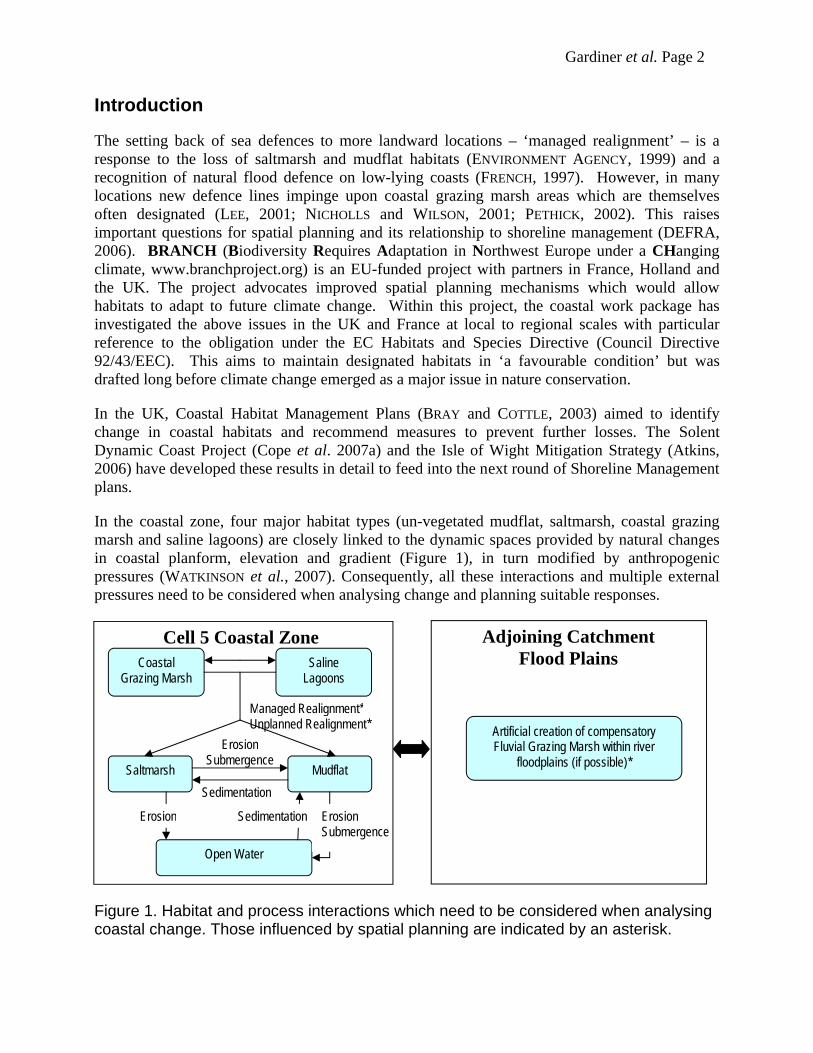
In the coastal zone, four major habitat types (un-vegetated mudflat, saltmarsh, coastal grazing marsh and saline lagoons) are closely linked to the dynamic spaces provided by natural changes in coastal planform, elevation and gradient (Figure 1), in turn modified by anthropogenic pressures (WATKINSON et al., 2007). Consequently, all these interactions and multiple external pressures need to be considered when analysing change and planning suitable responses.
Figure 1. Habitat and process interactions which need to be considered when analysing coastal change. Those influenced by spatial planning are indicated by an asterisk.
Managed Realignment*Unplanned Realignment*
Sedimentation
ErosionSubmergence
Saltmarsh Mudflat
Open Water
Coastal Grazing Marsh
Saline Lagoons
Erosion Sedimentation ErosionSubmergence
Artificial creation of compensatory Fluvial Grazing Marsh within river
floodplains (if possible)*
Adjoining CatchmentFlood Plains
Cell 5 Coastal Zone

Gardiner et al. Page 3
Spatial planning aims to integrate planning policies and ensure the most efficient use of land by balancing competing demands within the context of sustainable development (ODPM, 2004). In the coastal zone this includes, the consideration of shoreline management (coastal defences), biodiversity designations and land use pressures. This paper presents the methodology used to assess the impact of sea-level rise on six local case studies and littoral Cell 5 on the south coast of the UK and discusses the implications raised for spatial planning. (It is recognised that the presence/absence of particular species change may change due to climate change, but this aspect is not considered in this paper.)
Local scale analysis
Within Coastal Cell 5 (Figure 2), six case studies were chosen to be representative of the range of coastal habitats and morphology found on the English south coast. Habitats present within these areas comprise shingle beaches, dunes, saltmarsh and mudflats, grazing marsh, saline lagoons, reed beds and coastal cliffs. Current management issues must deal with the impacts of shoreline erosion, land use (current and historic), land claim, dredging, and the constraints imposed by habitat designations. The methodology and data used to analyse and predict inter-tidal habitat changes within the case study areas is illustrated in Figure 3.
Figure 2. Coastal Cell 5 (DEFRA, 2006) from Selsey Bill to Portland Bill with undesignated land in river floodplains; case study sites (1. Studland, 2. Hurst to Lymington, 3. Isle of Wight Cliffs, 4. Newtown Estuary, 5. Hamble Estuary, 6. Langstone Harbour).

Gardiner et al. Page 4
Figure 3. Flow chart illustrating the methodology implemented to predict changes in intertidal habitats
Analysis of elevational (LIDAR) data for each case study site was undertaken using ArcGIS software. Urban, industrial and archaeologically sensitive areas were identified using data supplied by Hampshire County Council which were excluded from the analysis. The remaining high resolution topographic data was divided into broad vertical zones (Table 1) to classify the distribution of inter-tidal and non-intertidal habitats. Modelled areas were verified using aerial photographic interpretation data. Variations in area of up to +/- 10% were found which, due to the difference in data types (raster and vector), were felt to be within acceptable limits.
Table 1. Tidal criteria for modelling vertical zonation of inter-tidal areas (after BLOTT and PYE, 2004; CHAPMAN, 1960; LEGGETT and DIXON, 1994; PYE and FRENCH, 1993a)
The impact of sea-level rise on modelled intertidal habitat areas was then assessed using a range of sea-level rise scenarios (Table 2). These values were derived by combining the low, medium and high values from UKCIP ’02, including regional oceanographic effects (HULME et al., 2002), and regional land uplift/subsidence from SHENNAN and HORTON (2002). Knowledge of sediment supply scenarios and historic erosional trends, where available, were also included in the analysis to provide more realistic habitat changes.
Following the modelling of inter-tidal areas, the impact on other coastal habitats was assessed by evaluating the potential of a habitat to migrate or adapt in line with possible future management/adaptation options. The application of the methodology and results are illustrated
Coastal Habitats Criteria for habitat occurrence based on tidal level and elevation
Transitional marsh Highest astronomical tide (HAT) - Mean high water springs (MHWS)
Upper/mid saltmarsh Mean high water springs (MHWS) - Mean high water (MHW)
Pioneer saltmarsh Mean high water (MHW) - Mean high water neaps (MHWN)
Mudflats Mean high water neaps (MHWN) - Lowest astronomical tide (LAT)
Standing water < Lowest astronomical tide (LAT)
Gardiner et al. Page 5
here with reference to case study site 2 (see Figure 2) a site which exhibits many of the key issues affecting coastal habitats in this region.
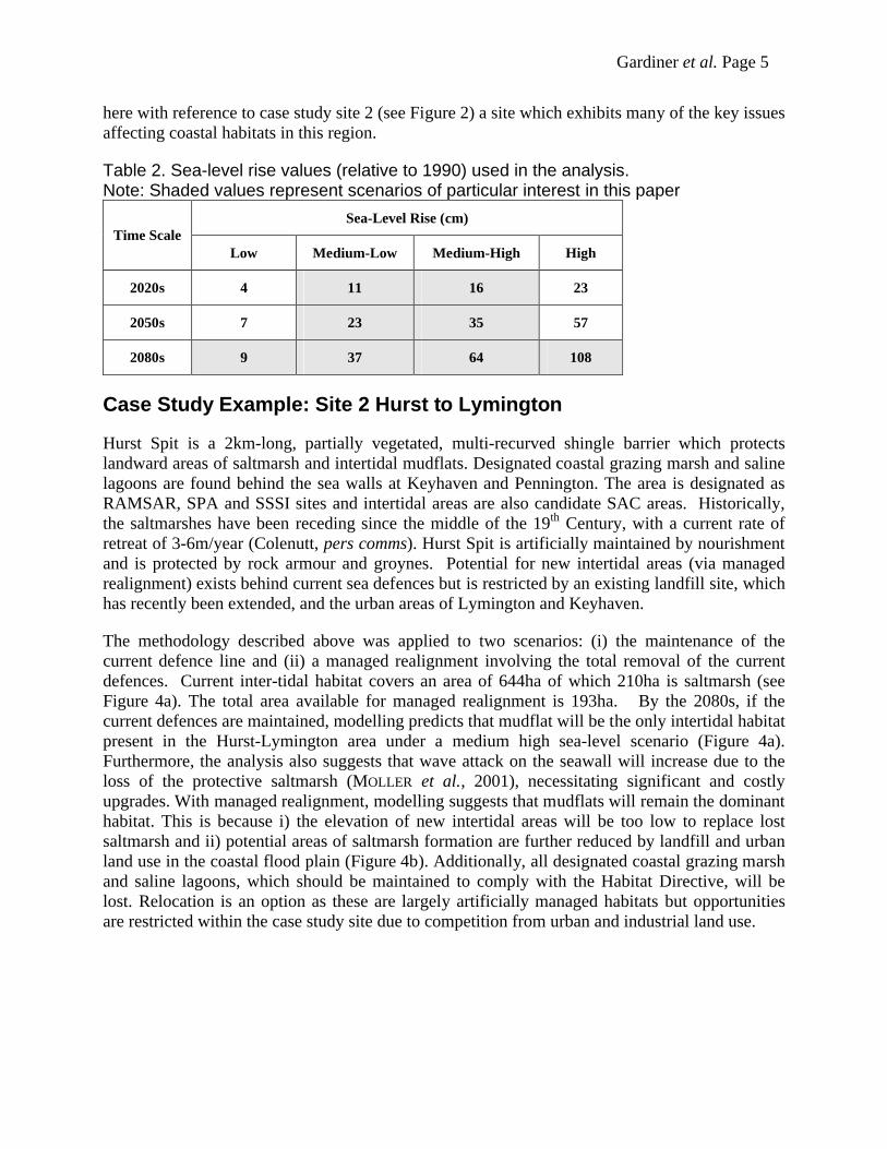
Table 2. Sea-level rise values (relative to 1990) used in the analysis. Note: Shaded values represent scenarios of particular interest in this paper
Sea-Level Rise (cm) Time Scale
Low Medium-Low Medium-High High
2020s 4 11 16 23
2050s 7 23 35 57
2080s 9 37 64 108
Case Study Example: Site 2 Hurst to Lymington
Hurst Spit is a 2km-long, partially vegetated, multi-recurved shingle barrier which protects landward areas of saltmarsh and intertidal mudflats. Designated coastal grazing marsh and saline lagoons are found behind the sea walls at Keyhaven and Pennington. The area is designated asRAMSAR, SPA and SSSI sites and intertidal areas are also candidate SAC areas. Historically, the saltmarshes have been receding since the middle of the 19th Century, with a current rate of retreat of 3-6m/year (Colenutt, pers comms). Hurst Spit is artificially maintained by nourishment and is protected by rock armour and groynes. Potential for new intertidal areas (via managed realignment) exists behind current sea defences but is restricted by an existing landfill site, which has recently been extended, and the urban areas of Lymington and Keyhaven.
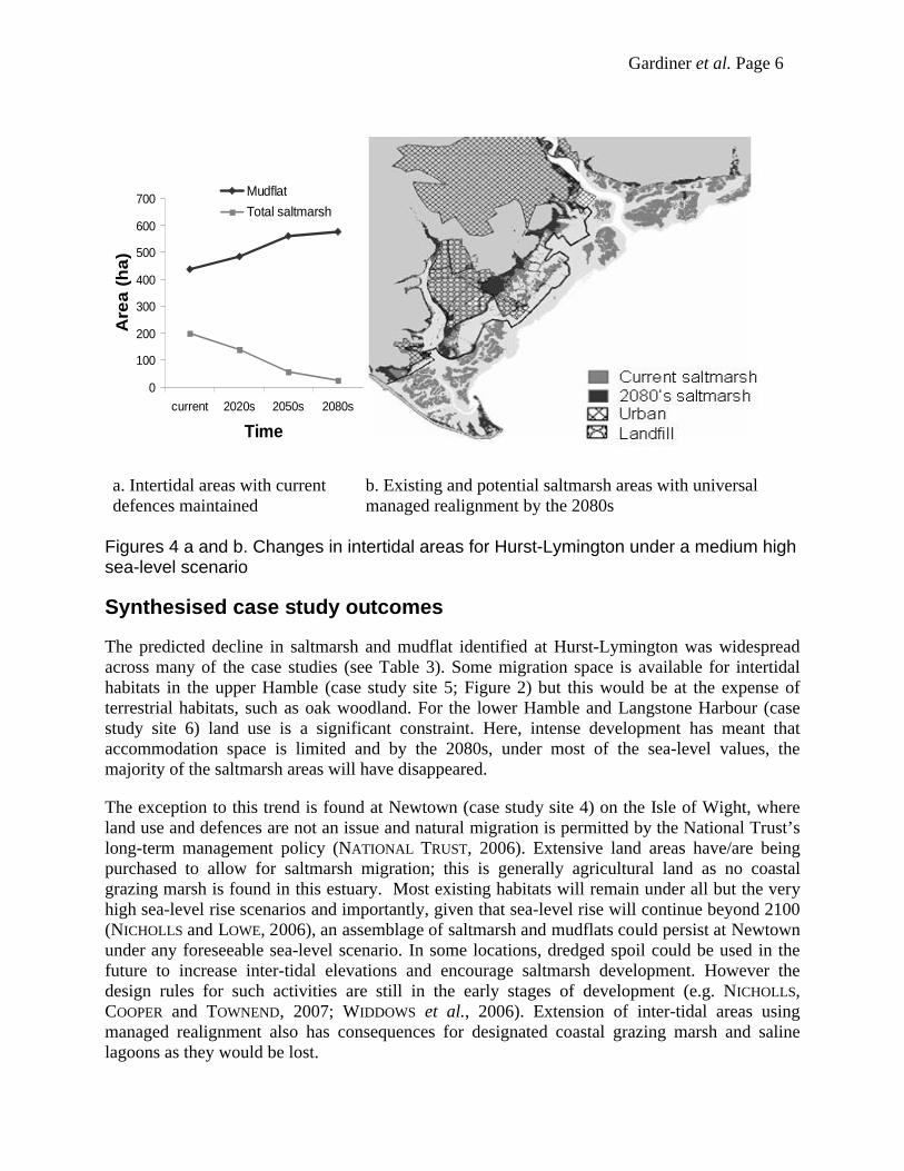
The methodology described above was applied to two scenarios: (i) the maintenance of the current defence line and (ii) a managed realignment involving the total removal of the current defences. Current inter-tidal habitat covers an area of 644ha of which 210ha is saltmarsh (see Figure 4a). The total area available for managed realignment is 193ha. By the 2080s, if the current defences are maintained, modelling predicts that mudflat will be the only intertidal habitat present in the Hurst-Lymington area under a medium high sea-level scenario (Figure 4a). Furthermore, the analysis also suggests that wave attack on the seawall will increase due to the loss of the protective saltmarsh (MOLLER et al., 2001), necessitating significant and costly upgrades. With managed realignment, modelling suggests that mudflats will remain the dominant habitat. This is because i) the elevation of new intertidal areas will be too low to replace lost saltmarsh and ii) potential areas of saltmarsh formation are further reduced by landfill and urbanland use in the coastal flood plain (Figure 4b). Additionally, all designated coastal grazing marsh and saline lagoons, which should be maintained to comply with the Habitat Directive, will be lost. Relocation is an option as these are largely artificially managed habitats but opportunities are restricted within the case study site due to competition from urban and industrial land use.
Gardiner et al. Page 6
Figures 4 a and b. Changes in intertidal areas for Hurst-Lymington under a medium high sea-level scenario
Synthesised case study outcomes
The predicted decline in saltmarsh and mudflat identified at Hurst-Lymington was widespread across many of the case studies (see Table 3). Some migration space is available for intertidalhabitats in the upper Hamble (case study site 5; Figure 2) but this would be at the expense of terrestrial habitats, such as oak woodland. For the lower Hamble and Langstone Harbour (case study site 6) land use is a significant constraint. Here, intense development has meant that accommodation space is limited and by the 2080s, under most of the sea-level values, the majority of the saltmarsh areas will have disappeared.
The exception to this trend is found at Newtown (case study site 4) on the Isle of Wight, where land use and defences are not an issue and natural migration is permitted by the National Trust’s long-term management policy (NATIONAL TRUST, 2006). Extensive land areas have/are being purchased to allow for saltmarsh migration; this is generally agricultural land as no coastal grazing marsh is found in this estuary. Most existing habitats will remain under all but the very high sea-level rise scenarios and importantly, given that sea-level rise will continue beyond 2100 (NICHOLLS and LOWE, 2006), an assemblage of saltmarsh and mudflats could persist at Newtown under any foreseeable sea-level scenario. In some locations, dredged spoil could be used in the future to increase inter-tidal elevations and encourage saltmarsh development. However the design rules for such activities are still in the early stages of development (e.g. NICHOLLS, COOPER and TOWNEND, 2007; WIDDOWS et al., 2006). Extension of inter-tidal areas using managed realignment also has consequences for designated coastal grazing marsh and saline lagoons as they would be lost.
0
100
200
300
400
500
600
700
current 2020s 2050s 2080s
Time
Are
a (
ha
)
Mudflat
Total saltmarsh
a. Intertidal areas with current defences maintained
b. Existing and potential saltmarsh areas with universal managed realignment by the 2080s
Gardiner et al. Page 7
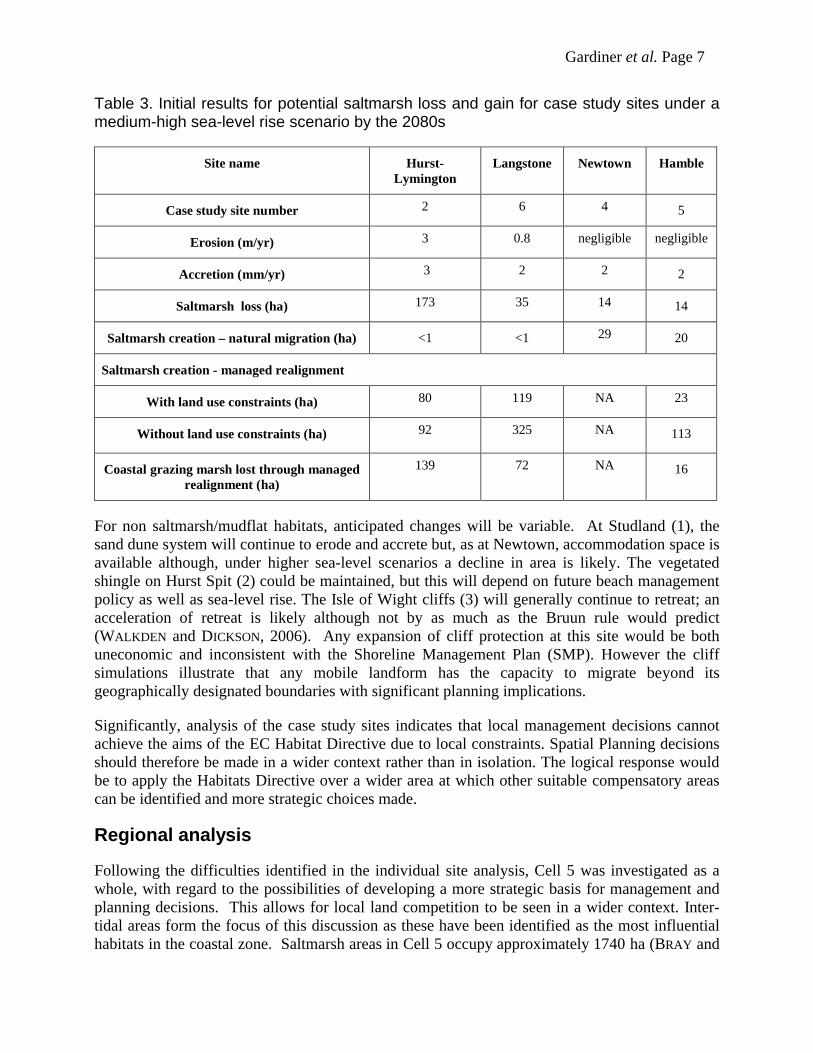
Table 3. Initial results for potential saltmarsh loss and gain for case study sites under a medium-high sea-level rise scenario by the 2080s
Site name Hurst-Lymington
Langstone Newtown Hamble
Case study site number 2 6 4 5
Erosion (m/yr) 3 0.8 negligible negligible
Accretion (mm/yr) 3 2 2 2
Saltmarsh loss (ha) 173 35 14 14
Saltmarsh creation – natural migration (ha) <1 <1 29 20
Saltmarsh creation - managed realignment
With land use constraints (ha) 80 119 NA 23
Without land use constraints (ha) 92 325 NA 113
Coastal grazing marsh lost through managed realignment (ha)
139 72 NA 16
For non saltmarsh/mudflat habitats, anticipated changes will be variable. At Studland (1), the sand dune system will continue to erode and accrete but, as at Newtown, accommodation space is available although, under higher sea-level scenarios a decline in area is likely. The vegetated shingle on Hurst Spit (2) could be maintained, but this will depend on future beach management policy as well as sea-level rise. The Isle of Wight cliffs (3) will generally continue to retreat; an acceleration of retreat is likely although not by as much as the Bruun rule would predict (WALKDEN and DICKSON, 2006). Any expansion of cliff protection at this site would be both uneconomic and inconsistent with the Shoreline Management Plan (SMP). However the cliff simulations illustrate that any mobile landform has the capacity to migrate beyond its geographically designated boundaries with significant planning implications.
Significantly, analysis of the case study sites indicates that local management decisions cannot achieve the aims of the EC Habitat Directive due to local constraints. Spatial Planning decisions should therefore be made in a wider context rather than in isolation. The logical response would be to apply the Habitats Directive over a wider area at which other suitable compensatory areas can be identified and more strategic choices made.
Regional analysis
Following the difficulties identified in the individual site analysis, Cell 5 was investigated as a whole, with regard to the possibilities of developing a more strategic basis for management and planning decisions. This allows for local land competition to be seen in a wider context. Inter-tidal areas form the focus of this discussion as these have been identified as the most influential habitats in the coastal zone. Saltmarsh areas in Cell 5 occupy approximately 1740 ha (BRAY and
Gardiner et al. Page 8
COTTLE, 2003; BURD, 1989; EDWARDS, 2004; PYE and FRENCH, 1993b) and losses over the next 100 years, if the current management policy is continued, are widely predicted (e.g. ATKINS, 2006; COPE et al., 2007b). This is reflected in the initial results from this research which indicate that within Cell 5 760 ha of saltmarsh could be lost by the 2080s under a Medium High scenario. Managed realignment could offset these losses, with 260 ha of potential saltmarsh created at the case studies and through the Isle of Wight Mitigation Strategy (ATKINS, 2006). Within the Solent, Cope et al., (2007b) have identified an initial area of around 760 ha at a suitable height for saltmarsh creation and an area of 430 ha suitable for mudflat creation. However this analysis does not take into account land use which will greatly reduce the area available for realignment, as illustrated for the case studies (Table 3). Moreover, realignment would put pressure on the stocks of coastal grazing marsh, saline lagoons and freshwater habitats (also designated habitats) as limited scope exists for re-creation of these habitats within the coastal zone.
The UK Environment Agency’s 1 in 100 year flood-map for Cell 5 was used as a basis to identify non-coastal floodplain which could be suitable as mitigation/compensation areas for coastal grazing marsh losses. Map analysis suggests that ca, 21,000 ha of fluvial floodplain, consisting mainly of agricultural land (Figure 2), could be considered as potential land banks – a spatial planning tool which allows the purchase of land identified as being useful for the adaptation and/or mitigation of habitats.
This exercise thus suggests that habitat recreation is possible at the Cell 5 level, but existing habitat assemblages will be difficult to maintain. Seen in a wider context, spatial planning has the capacity to maintain sufficient space for designated habitats at the present time and, over the longer (100 year) term, to maintain flexibility for policies such as the Habitats Directive, if a flexible and dynamic interpretation of the legislation can made.
Conclusions
The Habitat Directive regulations in the UK make it a requirement to maintain, restore and improve the management of features of the landscape for flora and flora including those aspects which are essential for migration, dispersal and genetic exchange of wild species. Long-term coastal land use planning at all levels has a role to play in achieving this aim. By identifying habitats at risk and potential mitigation areas, compensation sites can be land banked and appropriate management strategies implemented. This may help to maintain diversity of habitats, although local habitat assemblages may not be sustainable in their current form. Migration and retreat within available accommodation space requires that important choices need to be made in the coming decade, and implemented in the coming century. Such compensation is consistent with the DEFRA (2006) “Making Space for Water” policy. But which habitats have the greatest potential for sustainability? And is such an approach acceptable within the legislative framework of the EC Habitats Directive?, (which was drafted before climate change became an issue.)
Current and near-future land use decisions also have the potential to influence coastal response for a similar period into the future. Flexibility is therefore essential if future restrictions are to be avoided. Application of the EC Habitats Directive in a more responsive and dynamic manner, based on maintaining stocks of coastal habitats in broad areas with less emphasis on geographically-defined protected areas, may be a more appropriate model to follow in a changing world
Gardiner et al. Page 9
Acknowledgements
This work is part of BRANCH which is an Interreg IIIB funded project. Access granted to data and results of the Solent Dynamic Coast Project and the Isle of Wight Mitigation Strategy is gratefully acknowledged.
References
ATKINS 2006. Isle of Wight Mitigation Strategy. Ventnor, UK: Isle of Wight Council.
BLOTT, J. and PYE, K. 2004. Application of Lidar digital terrain modelling to predict intertidal habitat development at a managed retreat site: Abbotts Hall, Essex, UK. Earth Surface Processes and Landforms, 29, pp 893-905.
BRAY, M. J. and COTTLE, R. 2003. Solent Coastal Habitat Management Plan,Volumes 1 and 2. Report by Posford Haskoning and University of Portsmouthto English Nature and Environment Agency. Volume 1 Summary of HabitatChange 66p. Vol 2 Technical Report pp 219.
BURD, F. 1989. The Saltmarsh Survey of Great Britain. An Inventory ofBritish Saltmarshes. Research & survey in nature conservation, 17 NatureConservancy Council, Peterborough.
CHAPMAN, V. J. 1960. Saltmarshes and Salt deserts of the world. Aberdeen, UK: University Press, pp 392.
COPE, S.N., BRADBURY, A.P., GORCZYNSKA, M. 2007a. A Strategic Approach to Managing Mudflat and Saltmarsh loss in the Solent, U.K. International Conference on Coastal Management, 2007. In press.
COPE, S. N., BRADBURY, A. P., MCHUGH, K. and LAMBERT, C. 2007b. The urgent need for compensatory habitat across the Solent. 42nd Flood and Coastal Management Conference. 3-5 July, York University. In press.
DEFRA 2006. Shoreline management plan guidance. Volume 1: Aims and requirements. London, UK: Department For Environment, Food And Rural Affairs (DEFRA), 48p.
EDWARDS, B. 2004. The vegetation of Poole Harbour. Poole Harbour StudyGroup, Wareham, Dorset
ENVIRONMENT AGENCY 1999. The state of the environment of England and Wales: Coasts. London, UK: HMSO, pp 201.
FRENCH, P. W. 1997. Coastal and estuarine management. London, UK: Routledge, pp 251.
HULME, M., JENKINS, G. J., LU, X., TURNPENNY, J. R., MITCHELL, T. D., JONES, R. G., LOWE, J., MURPHY, J. M., HASSELL, D., BOORMAN, P., MACDONALD, R. and HILL, S. 2002. Climate-change scenarios for the UK. The UKCIP02 scientific report. Norwich, UK: Tyndall Centre for Climate Change Research, University of East Anglia. pp 118.
LEE, M. 2001. Coastal defence and the habitats directive: predictions of habitat change in England and Wales. The Geographical Journal, 167, (1), pp 39-56.

Gardiner et al. Page 10
LEGGETT, D. J. and DIXON, M. 1994. Management of the Essex saltmarshes for flood defence. In FALCONER, R. A. and GOODWIN, P. (Eds.) Wetland management. London, UK: Institution of Civil Engineers, pp 289.
MOLLER, I., SPENCER, T., FRENCH, J. R., LEGGETT, D. J. and DIXON, M. 2001. The sea-defence value of salt marshes: Field evidence from north Norfolk. Journal of the Chartered Institution of Water and Environmental Management, 15, (2), pp 109-116.
NATIONAL TRUST 2006. The National Trust Coastal Policy. Available at: www.national trust.org.uk. Accessed April 2007
NICHOLLS, R. J. and WILSON, T. 2001. Integrated impacts on coastal areas and river flooding. In HOLMAN, I. P. and LOVELAND, P. J. (Eds.) Regional Climate Change Impact and Response Studies in East Anglia and North West England (RegIS). Oxford, UK: UK Climate Impacts Programme (UKCIP), pp.54-103.
NICHOLLS, R. J. and LOWE, J. A. 2006. Climate stabilisation and impacts of sea-level rise. In SCHELLNHUBER, H. J., CRAMER, W., NAKICENOVIC, N., WIGLEY, T. M. L. and YOHE, G. (Eds.) Avoiding Dangerous Climate Change. Cambridge: Cambridge University Press, pp.195-202.
NICHOLLS, R. J., COOPER, N. C. and TOWNEND, I. T. 2007. The management of coastal flooding and erosion. In THORNE, C., EVANS, E. and PENNING-ROWSELL, E. (Eds.) Future Flood and Coastal Erosion Risks. London, UK: Thomas Telford, pp.392-413.
ODPM 2004. Planning Policy Statement 12: Local Development Frameworks. London, UK: Office of the Deputy Prime Minister (ODPM).
PETHICK, J. 2002. Estuarine and tidal wetland restoration in the United Kingdom: Policy versus practice. Restoration Ecology, 10, (3), pp 431-437.
PYE, K. and FRENCH, P. W. 1993a. Saltmarsh processes and morphology. Erosion and Accretion Processes on British saltmarshes. Vol. I. London, UK: Ministry of Agriculture Fisheries and Food (MAFF).
PYE, K. and FRENCH, P. W. 1993b. Targets for Coastal Habitat Recreation. EnglishNature Science Series No. 13, English Nature, Peterborough .
SHENNAN, I. and HORTON, B. 2002. Holocene land- and sea-level changes in Great Britain. Journal of Quaternary Science, 17, pp 511-526.
WALKDEN, M. and DICKSON, M. 2006. The response of soft rock shore profiles to increased sea-level rise. Working Paper 105. Norwich, UK: Tyndall Centre for Climate Change Research, University of East Anglia.
WATKINSON, A., NICHOLLS, R. J., SEAR, D. and LEDOUX, L. 2007. Environmental impacts of future flood risk. In THORNE, C., EVANS, E. and PENNING-ROWSELL, E. (Eds.) Future Flood and Coastal Erosion Risks. London, UK: Thomas Telford, pp.29-46.
WIDDOWS, J., BRINSLEY, M. D., POPE, N. D., STAFF, F. J., BOLAM, S. G. and SOMERFIELD, P. J.2006. Changes in biota and sediment erodability following the placement of fine dredged material on upper intertidal shores of estuaries. Marine Ecology-Progress Series, 319, pp 27-41
Related Documents